Embed Size (px)
Citation preview
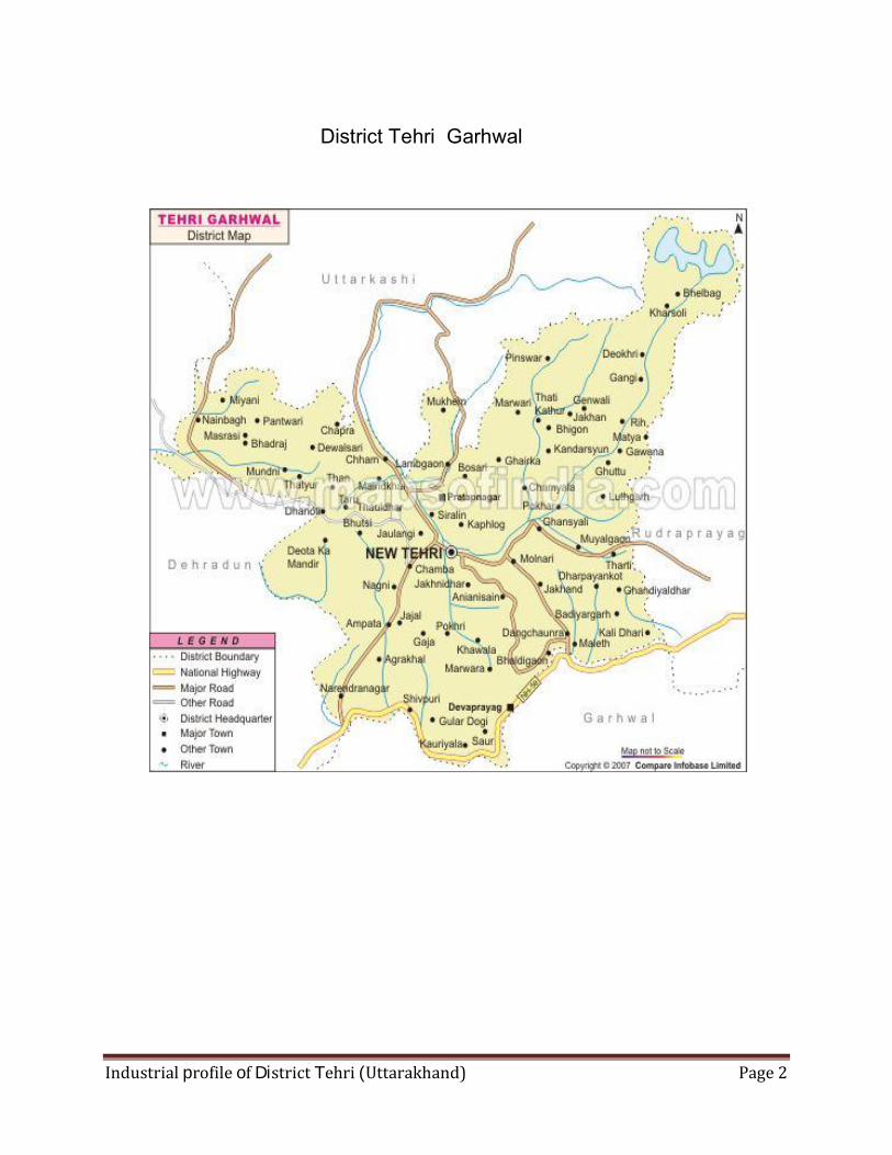
Industrial profile of District Tehri (Uttarakhand) Page 2
District Tehri Garhwal
Industrial profile of District Tehri (Uttarakhand) Page 3
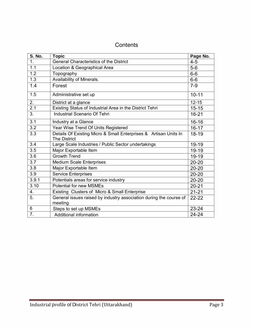
Contents
S. No. Topic Page No. 1. General Characteristics of the District 4-5 1.1 Location & Geographical Area 5-6 1.2 Topography 6-6 1.3 Availability of Minerals. 6-6 1.4 Forest 7-9
1.5 Administrative set up 10-11 2. District at a glance 12-15 2.1 Existing Status of Industrial Area in the District Tehri 15-15 3. Industrial Scenario Of Tehri 16-21 3.1 Industry at a Glance 16-16 3.2 Year Wise Trend Of Units Registered 16-17 3.3 Details Of Existing Micro & Small Enterprises & Artisan Units In
The District 18-19
3.4 Large Scale Industries / Public Sector undertakings 19-19 3.5 Major Exportable Item 19-19 3.6 Growth Trend 19-19 3.7 Medium Scale Enterprises 20-20 3.8 Major Exportable Item 20-20 3.9 Service Enterprises 20-20 3.9.1 Potentials areas for service industry 20-20 3.10 Potential for new MSMEs 20-21 4. Existing Clusters of Micro & Small Enterprise 21-21 5. General issues raised by industry association during the course of
meeting 22-22
6 23-247. 24-24
Steps to set up MSMEsAdditional information
Industrial profile of District Tehri (Uttarakhand) Page 4
Brief Industrial Profile of Tehri Garhwal District
1. General Characteristics of the District
Tehri Garhwal is one of the largest districts in the hill state of Uttarakhand, India. Its
administrative headquarters is at New Tehri. The district has a population of 604,747 (2001
census), a 16.15% increase over the previous decade. It is surrounded by Rudraprayag District
in the east, Dehradun District in the west, Uttarkashi District in the north, and Pauri Garhwal
District in the south.
Bhagirathi which runs through appears to divide the tehri district into two, while the
Bhilangna, Alaknanda, Ganga and Yamuna rivers border it on the east and west. Tehri's
neighbouring districts are Uttarkashi, Chamoli, Pauri, Rudraprayag and Dehradun. Tehri was a
former princely state of British India, named after its capital; area 4180 sq. m. It contained the
sources of both the Ganges and the Yamuna, which are visited by thousands of Hindu pilgrims.
According to the 2011 census Tehri Garhwal district has a population of 616,409,
roughly equal to the nation of Solomon Islands or the US state of Vermont. This gives it a
ranking of 520th in India (out of a total of 640). The district has a population density of 169
inhabitants per square kilometre (440 /sq mi). Its population growth rate over the decade 2001-
2011 was 1.93 %.Tehri Garhwal has a sex ratio of 1078 females for every 1000 males, and a
literacy rate of 75.1 %.
Hindus number 596,769; Muslims 6,390 (1.05%); and Sikhs 56
Administrative setup
The district of Tehri Garhwal is divided into two subdivisions: Kirti Nagar and Tehri-
Pratap Nagar. It has seven tehsils, one sub-tehsil, nine blocks, two municipalities and four town
area committees. The district covers 76 nyaya panchayats and 928 gram panchayats. It has
1,847 revenue villages and 2,508 clusters.
Industrial profile of District Tehri (Uttarakhand) Page 5
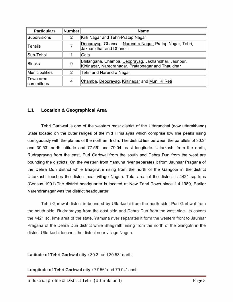
Particulars Number Name Subdivisions 2 Kirti Nagar and Tehri-Pratap Nagar
Tehsils 7 Deoprayag, Ghansali, Narendra Nagar, Pratap Nagar, Tehri, Jakhanidhar and Dhanolti
Sub-Tehsil 1 Gaja
Blocks 9 Bhilangana, Chamba, Deoprayag, Jakhanidhar, Jaunpur, Kirtinagar, Naredranagar, Pratapnagar and Thauldhar
Municipalities 2 Tehri and Narendra Nagar Town area committees 4 Chamba, Deoprayag, Kirtinagar and Muni Ki Reti
1.1 Location & Geographical Area
Tehri Garhwal is one of the western most district of the Uttaranchal (now uttarakhand)
State located on the outer ranges of the mid Himalayas which comprise low line peaks rising
contiguously with the planes of the northern India. The district lies between the parallels of 30.3`
and 30.53` north latitude and 77.56` and 79.04` east longitude. Uttarkashi from the north,
Rudraprayag from the east, Puri Garhwal from the south and Dehra Dun from the west are
bounding the districts. On the western front Yamuna river separates it from Jaunsar Pragana of
the Dehra Dun district while Bhagirathi rising from the north of the Gangotri in the district
Uttarkashi touches the district near village Nagun. Total area of the district is 4421 sq. kms
(Census 1991).The district headquarter is located at New Tehri Town since 1.4.1989, Earlier
Narendranagar was the district headquarter.
Tehri Garhwal district is bounded by Uttarkashi from the north side, Puri Garhwal from
the south side, Rudraprayag from the east side and Dehra Dun from the west side. Its covers
the 4421 sq. kms area of the state. Yamuna river separates it form the western front to Jaunsar
Pragana of the Dehra Dun district while Bhagirathi rising from the north of the Gangotri in the
district Uttarkashi touches the district near village Nagun.
Latitude of Tehri Garhwal city : 30.3` and 30.53` north
Longitude of Tehri Garhwal city : 77.56` and 79.04` east
Industrial profile of District Tehri (Uttarakhand) Page 6
1.2 Topography
The region has a sub-temperate to temperate climate, which remains pleasant throughout
the year.The climate of Pauri is very cold in winter and pleasant in summer. In rainy season the
climate is very cool & full of greeneries.
.
ECONOMY
In 2006 the Ministry of Panchayati Raj named Tehri Garhwal one of the country's 250
most backward districts (out of a total of 640).[4] It is one of the three districts in Uttarakhand
currently receiving funds from the Backward Regions Grant Fund Programme (BRGF).
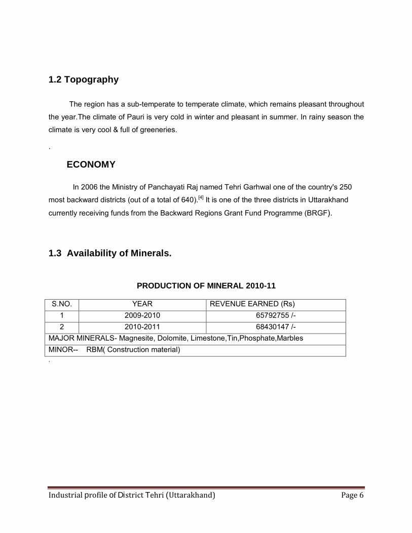
1.3 Availability of Minerals.
PRODUCTION OF MINERAL 2010-11
S.NO. YEAR REVENUE EARNED (Rs) 1 2009-2010 65792755 /- 2 2010-2011 68430147 /-
MAJOR MINERALS- Magnesite, Dolomite, Limestone,Tin,Phosphate,Marbles MINOR-- RBM( Construction material) ,
Industrial profile of District Tehri (Uttarakhand) Page 7
1.4 FOREST
The flora of the district includes the vast range found in the Himalayas, varying from the
sub-tropical species which grow in the outer ranges of low hills to the rich Alpine flowers in the
north. Still, it can reasonably be termed to consist of mostly such trees as grow in its forests
because large tracts of the land-surface in the district constitute forests. The pine, the oaks, the
conifers, the sal, the deodar, the haldlu. the yew, the cypress, the rhododendron, the birch, the
horse chestnut, the cycamore the willow, the alder and various types of fruit trees like the
cornel, the figs, the kaiPhal, the mulberry, the kingora, the raspberry, the blackberry, currants,
medlars, gooseberries, hazelnuts, apples, pears, cherries, apricots, plums, peaches, oranges,
limes, bananas, pomegranates and walnuts are found in the district besides a variety of herbal
plants bushes, scrubs and grass.
The flora of the district may be divided into six main botanical divisions : (1) the tropical dry
deciduous forests, (2) the sal forests (3) the chir forests, (4) the oak forests, (4) the deodar, fir
and spruce forests, and (5) the Alpine pastures.
Tropical Dry Deciduous Forests- These forests occur mostly near the confluence 0f the
Yamuna and the Aglar and on foothills and extend up to the altitudes 0f 1,200 m. The
predominant species are kuri, kemela, jhingan, and mandar. The chief undergrowths are the
dhaula, binda, basingha and the gandela.
Sal Forests- These forests exist up to the altitude 0f 1,066 m., their best growths being found in
the valley 0f the Chandan Rao in tahsil Devaprayag and in the valley 0f the Bandal in tahsil
Tehri. Small tracts 0f the sal forests may also be seen in the neighbourhood 0f Muni ki Reti and
Shivpuri in tahsil Devaprayag. Sal is highly gregarious. The upper limit of Sal is regulated to a
great extent by frost. In excessively dry localities, it gives way to more xerophytic species. It
does not extend beyond the outer ranges 0f the Himalayas even though the main river valleys in
the northern part of the district are much below the maximum elavation at which this species
may grow. It is commonly found up to the altitude of 762 m. on the southern aspects and 1,066
m. on the northern. The other chief trees found in these forests are sain, bakli, jhingan, haldu,
kanju, sandhan, rohini and amaltas. The bakli is utilised for preparing charcoal. The wood of the
sandhan is used for making agricultural implements. The khair trees are also met with in these
forests.
Industrial profile of District Tehri (Uttarakhand) Page 8
Grass abounds in sal forests, wherever sufficient light reaches the ground. In most sal forests,
sal comprises 80 to 90 percent of the dominant tree species and tends to form a dense
treecanopy, The sal forests had originally contained a much higher percentage of miscellaneous
species.
Chir Forests- These forests ordinarily extend on the southern aspects from 1,000 m. to 2,150
m. and on the northern aspects from 900 m. to 2,000 m. throughout the district, growing best in
the valleys of the Bhillangana and its tributaries, the Alaknanda and the Mandakini. Chir is found
On almost all geological formations though, On certain southern slopes with a limestone subsoil,
it is unable to exist on account or the dryness of the soil coupled with relatively high
temperatures. Nevertheless, chir forests can establish themselves on dry southern aspects
where owing to xerophytic conditions and the prevalence of fires, few other trees or shrub
species survive. In all chir forests, the pine is the dominant tree species present though, on the
northern aspects where, there is more moisture in the soil and fires are less destructive,
scattered trees of there species also occur. Chir forests are seldom very dense. The ground is
covered with grass, sometimes dense, whatever the aspect of density or overhead canopy, and
there is also a discontinuous undergrowth 0f shrubs, often so widely scattered that even from a
short distance their presence is scarcely noticeable. The open nature of these forests, the
absence of other tree species and the poverty of the undergrowth are attributable to fires which
have in the past swept annually throughout their length and breadth, to the xerophytic conditions
under which they grow and to the fact that the chir is often located near tracts under cultivation
which leads to its heavy lopping and felling. Towards its lower limit, chir gets mixed up with trees
of miscellaneous species and, less frequently, with sal forests. Towards its upper limits and in
moist and shady ravines, it gradually gives place to banj. The chir is tapped for resin and its
wood is used for building purposes. The seed also yields oil and, when baked, it becomes
edible. The dry leaves are- utilised for manuring.
Deodar Forests- These forests occur in the northern part of the district in tahsil Pratapnagar in
a small area, associated with blue pine and cypress between the altitudes 0f 1,520 m, and
2,150 m. above sea level. The forests are open and the trees do not attain great height. The
timber of deodar is the most highly prized of all the conifers for house. building, granaries, boat-
building and railway sleepers.
Industrial profile of District Tehri (Uttarakhand) Page 9
Fir and Spruce Forests- These forests occur in the northern part of the district between the
altitudes of 2,150 m. and 3,050 m. Wherever silver fir occurs, it is the dominant species
excepting when it occurs mixed with spruce even where, it is equally important. Parts of such
forests are covered with kharsu or moru.
Oak Forests- The three principal oaks are banj, moru and kharsu, each occupying more or less
a distinct altitudipal zone in the district.
Banj forests are ordinarily found between the heights 0f 1,800 m., and 2,150 m., above sea-
Ievel but they also occupy moist ravines running down into the chir zone where they reach
levels as low as 1,050 m. A notable feature of the banj is its capacity to establish itself on the
most unfavourable southern aspects. Those on the northern aspects are comparatively more
dense. On southern aspects, the ground is almost invariably clothed with dense grass, while on
northern aspects the incidence 0f grass is much less. The banj has a large number of shrubs
associated with it.
Moru forests are found at between 1,980 m. and 2,750 m. above sea-level and occupy an
intermediate zone between banj and kharsu, which form extensive forests on the southern
aspects, where the moru occurs sporadically. It attains its maximum development at elevations
between 2,125 m. and 2,450 m. on moist soils and especially where the subsoil is limestone. On
account 0f the density 0f growth and prevailing moist conditions, fires only penetrate into such
forests rarely. Some other species compete with morn for dominance, the commonest being the
deodar and the kharu.
Industrial profile of District Tehri (Uttarakhand) Page 10
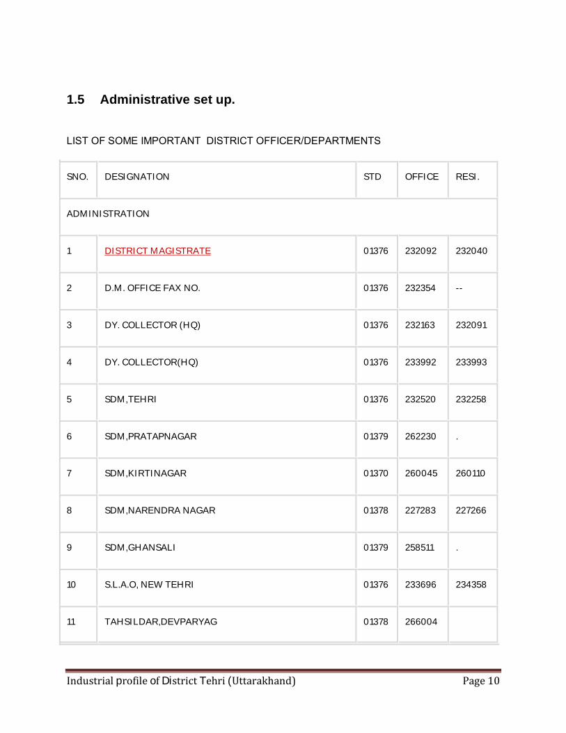
1.5 Administrative set up.
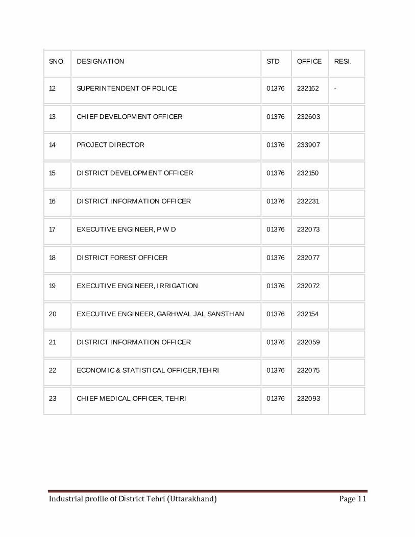
LIST OF SOME IMPORTANT DISTRICT OFFICER/DEPARTMENTS
SNO. DESIGNATION STD OFFICE RESI.
ADMINISTRATION
1 DISTRICT MAGISTRATE 01376 232092 232040
2 D.M. OFFICE FAX NO. 01376 232354 --
3 DY. COLLECTOR (HQ) 01376 232163 232091
4 DY. COLLECTOR(HQ) 01376 233992 233993
5 SDM,TEHRI 01376 232520 232258
6 SDM,PRATAPNAGAR 01379 262230 .
7 SDM,KIRTINAGAR 01370 260045 260110
8 SDM,NARENDRA NAGAR 01378 227283 227266
9 SDM,GHANSALI 01379 258511 .
10 S.L.A.O, NEW TEHRI 01376 233696 234358
11 TAHSILDAR,DEVPARYAG 01378 266004
Industrial profile of District Tehri (Uttarakhand) Page 11
SNO. DESIGNATION STD OFFICE RESI.
12 SUPERINTENDENT OF POLICE 01376 232162 -
13 CHIEF DEVELOPMENT OFFICER 01376 232603
14 PROJECT DIRECTOR 01376 233907
15 DISTRICT DEVELOPMENT OFFICER 01376 232150
16 DISTRICT INFORMATION OFFICER 01376 232231
17 EXECUTIVE ENGINEER, P W D 01376 232073
18 DISTRICT FOREST OFFICER 01376 232077
19 EXECUTIVE ENGINEER, IRRIGATION 01376 232072
20 EXECUTIVE ENGINEER, GARHWAL JAL SANSTHAN 01376 232154
21 DISTRICT INFORMATION OFFICER 01376 232059
22 ECONOMIC & STATISTICAL OFFICER,TEHRI 01376 232075
23 CHIEF MEDICAL OFFICER, TEHRI 01376 232093
Industrial profile of District Tehri (Uttarakhand) Page 12
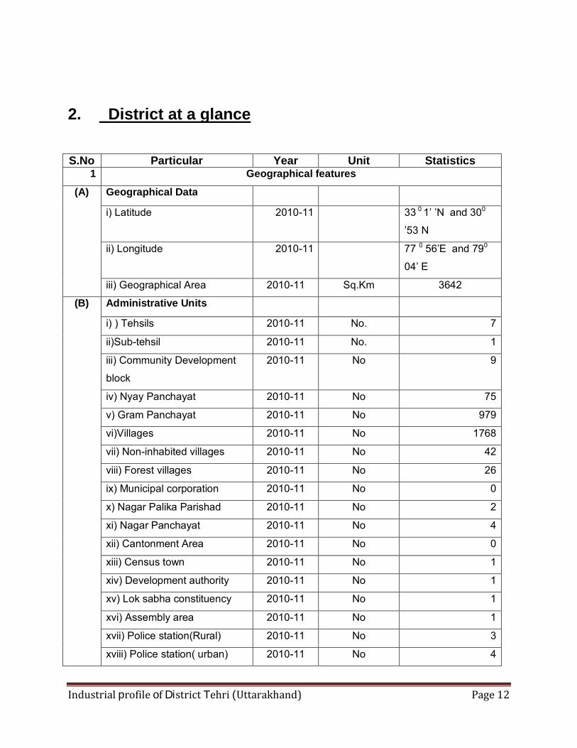
2. District at a glance
S.No Particular Year Unit Statistics 1 Geographical features
(A) Geographical Data
i) Latitude 2010-11 33 0 1’ ’N and 300
’53 N ii) Longitude 2010-11 77 0 56’E and 790
04’ E iii) Geographical Area 2010-11 Sq.Km 3642
(B) Administrative Units
i) ) Tehsils 2010-11 No. 7 ii)Sub-tehsil 2010-11 No. 1 iii) Community Development
block 2010-11 No 9
iv) Nyay Panchayat 2010-11 No 75 v) Gram Panchayat 2010-11 No 979 vi)Villages 2010-11 No 1768 vii) Non-inhabited villages 2010-11 No 42 viii) Forest villages 2010-11 No 26 ix) Municipal corporation 2010-11 No 0 x) Nagar Palika Parishad 2010-11 No 2 xi) Nagar Panchayat 2010-11 No 4 xii) Cantonment Area 2010-11 No 0 xiii) Census town 2010-11 No 1 xiv) Development authority 2010-11 No 1 xv) Lok sabha constituency 2010-11 No 1 xvi) Assembly area 2010-11 No 1 xvii) Police station(Rural) 2010-11 No 3 xviii) Police station( urban) 2010-11 No 4
Industrial profile of District Tehri (Uttarakhand) Page 13
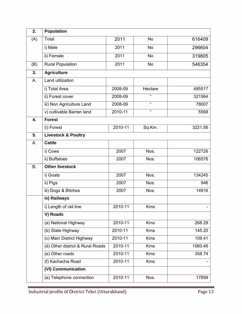
2. Population (A) Total 2011 No 616409
i) Male 2011 No 296604
ii) Female 2011 No 319805
(B) Rural Population 2011 No 546354
3. Agriculture A. Land utilization
i) Total Area 2008-09 Hectare 485517 ii) Forest cover 2008-09 “ 321564 iii) Non Agriculture Land 2008-09 “ 78007 v) cultivable Barren land 2010-11 “ 5568
4. Forest (i) Forest 2010-11 Sq.Km. 3221.56
5. Livestock & Poultry A. Cattle
i) Cows 2007 Nos. 122726 ii) Buffaloes 2007 Nos. 106576
B. Other livestock
i) Goats 2007 Nos. 134245 ii) Pigs 2007 Nos. 946 iii) Dogs & Bitches 2007 Nos. 14916
iv) Railways
i) Length of rail line 2010-11 Kms - V) Roads
(a) National Highway 2010-11 Kms 268.29 (b) State Highway 2010-11 Kms 145.20 (c) Main District Highway 2010-11 Kms 109.41 (d) Other district & Rural Roads 2010-11 Kms 1060.46 (e) Other roads 2010-11 Kms 358.74 (f) Kachacha Road 2010-11 Kms - (VI) Communication
(a) Telephone connection 2010-11 Nos. 17899
Industrial profile of District Tehri (Uttarakhand) Page 14
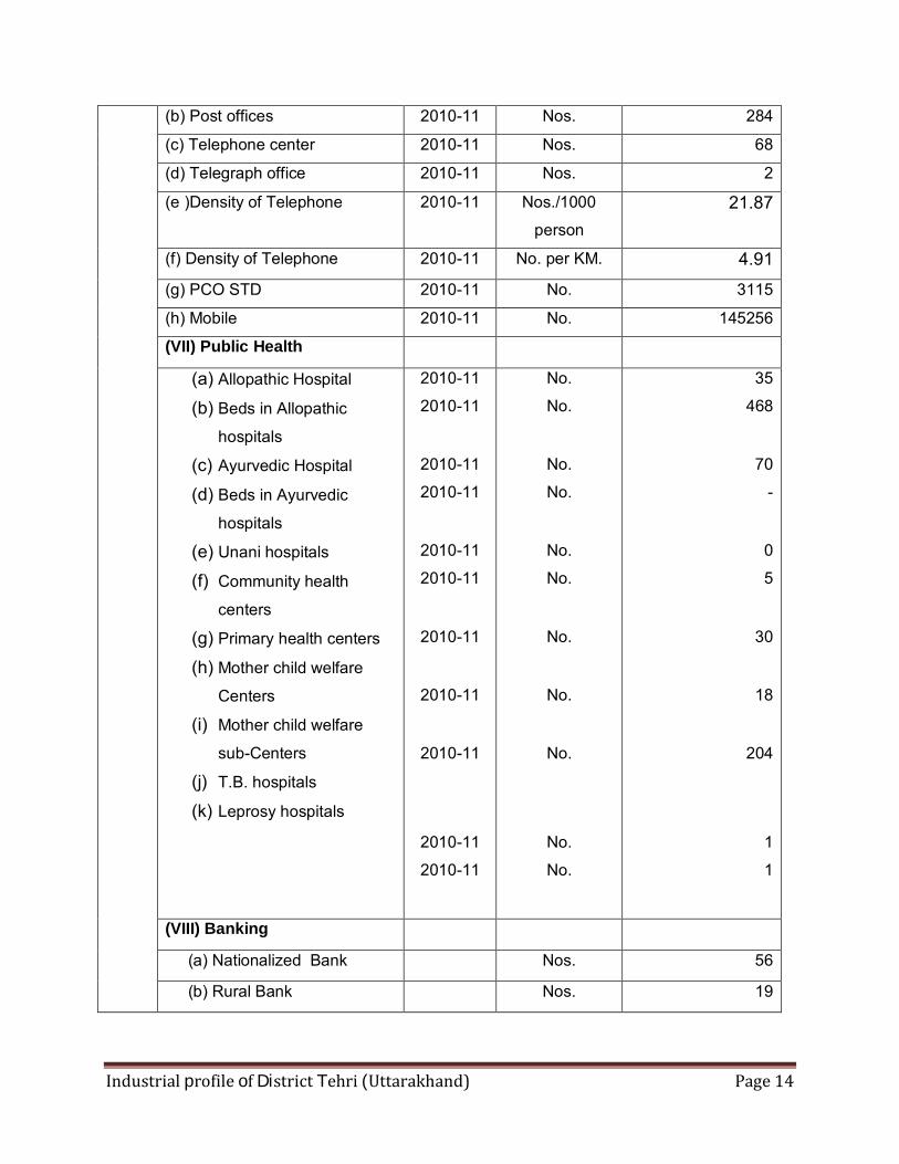
(b) Post offices 2010-11 Nos. 284 (c) Telephone center 2010-11 Nos. 68 (d) Telegraph office 2010-11 Nos. 2 (e )Density of Telephone 2010-11 Nos./1000
person 21.87
(f) Density of Telephone 2010-11 No. per KM. 4.91
(g) PCO STD 2010-11 No. 3115 (h) Mobile 2010-11 No. 145256 (VII) Public Health
(a) Allopathic Hospital (b) Beds in Allopathic
hospitals (c) Ayurvedic Hospital (d) Beds in Ayurvedic
hospitals (e) Unani hospitals (f) Community health
centers (g) Primary health centers (h) Mother child welfare
Centers (i) Mother child welfare
sub-Centers (j) T.B. hospitals (k) Leprosy hospitals
2010-11 2010-11
2010-11 2010-11
2010-11 2010-11
2010-11
2010-11
2010-11
2010-11 2010-11
No. No.
No. No.
No. No.
No.
No.
No.
No. No.
35 468
70
-
0 5
30
18
204
1 1
(VIII) Banking
(a) Nationalized Bank Nos. 56
(b) Rural Bank Nos. 19
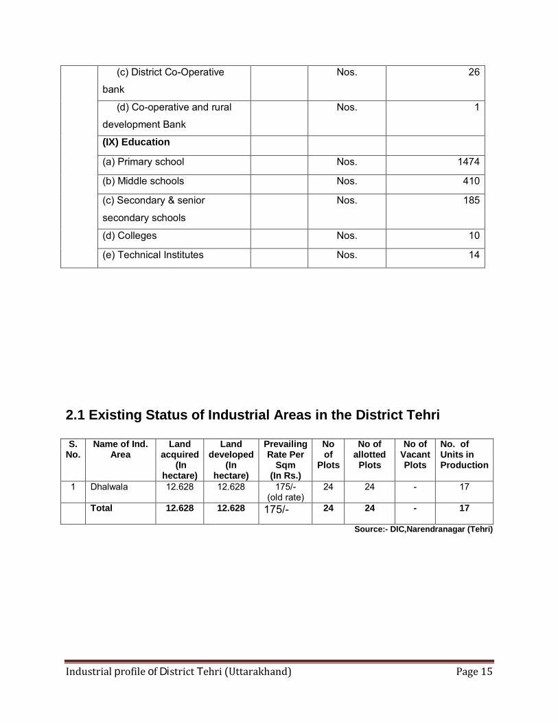
Industrial profile of District Tehri (Uttarakhand) Page 15
(c) District Co-Operative
bank Nos. 26
(d) Co-operative and rural
development Bank Nos. 1
(IX) Education
(a) Primary school Nos. 1474
(b) Middle schools Nos. 410
(c) Secondary & senior
secondary schools Nos. 185
(d) Colleges Nos. 10
(e) Technical Institutes Nos. 14
2.1 Existing Status of Industrial Areas in the District Tehri S.
No. Name of Ind.
Area Land
acquired (In
hectare)
Land developed
(In hectare)
Prevailing Rate Per
Sqm (In Rs.)
No of
Plots
No of allotted
Plots
No of Vacant Plots
No. of Units in Production
1 Dhalwala
12.628 12.628 175/- (old rate)
24 24 - 17
Total
12.628 12.628 175/- 24 24 - 17
Source:- DIC,Narendranagar (Tehri)
Industrial profile of District Tehri (Uttarakhand) Page 16
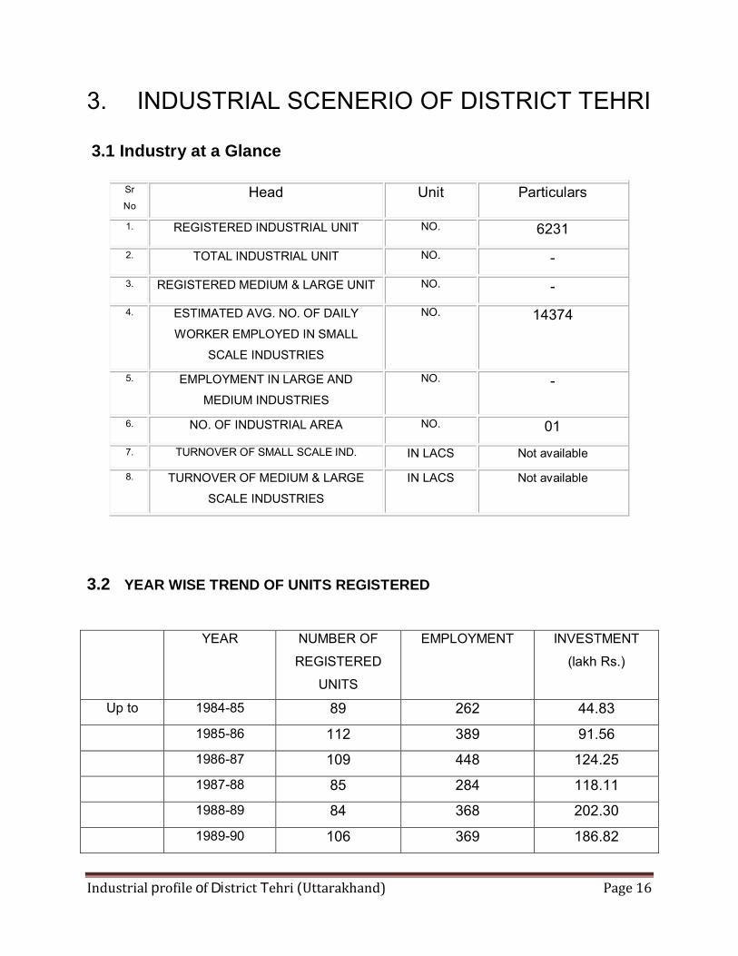
3. INDUSTRIAL SCENERIO OF DISTRICT TEHRI 3.1 Industry at a Glance
Sr
No Head Unit Particulars
1. REGISTERED INDUSTRIAL UNIT NO. 6231
2. TOTAL INDUSTRIAL UNIT NO. -
3. REGISTERED MEDIUM & LARGE UNIT NO. - 4. ESTIMATED AVG. NO. OF DAILY
WORKER EMPLOYED IN SMALL
SCALE INDUSTRIES
NO. 14374
5. EMPLOYMENT IN LARGE AND
MEDIUM INDUSTRIES NO. -
6. NO. OF INDUSTRIAL AREA NO. 01 7. TURNOVER OF SMALL SCALE IND. IN LACS Not available
8. TURNOVER OF MEDIUM & LARGE
SCALE INDUSTRIES IN LACS Not available
3.2 YEAR WISE TREND OF UNITS REGISTERED
YEAR NUMBER OF
REGISTERED
UNITS
EMPLOYMENT INVESTMENT
(lakh Rs.)
Up to 1984-85 89 262 44.83
1985-86 112 389 91.56
1986-87 109 448 124.25
1987-88 85 284 118.11
1988-89 84 368 202.30
1989-90 106 369 186.82
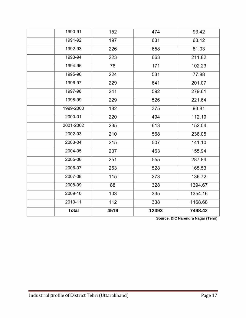
Industrial profile of District Tehri (Uttarakhand) Page 17
1990-91 152 474 93.42
1991-92 197 631 63.12
1992-93 226 658 81.03
1993-94 223 663 211.82
1994-95 76 171 102.23
1995-96 224 531 77.88
1996-97 229 641 201.07
1997-98 241 592 279.61
1998-99 229 526 221.64
1999-2000 182 375 93.81
2000-01 220 494 112.19
2001-2002 235 613 152.04
2002-03 210 568 236.05
2003-04 215 507 141.10
2004-05 237 463 155.94
2005-06 251 555 287.84
2006-07 253 528 165.53
2007-08 115 273 136.72
2008-09 88 328 1394.67
2009-10 103 335 1354.16
2010-11 112 338 1168.68
Total 4519 12393 7498.42 Source: DIC Narendra Nagar (Tehri)
Industrial profile of District Tehri (Uttarakhand) Page 18
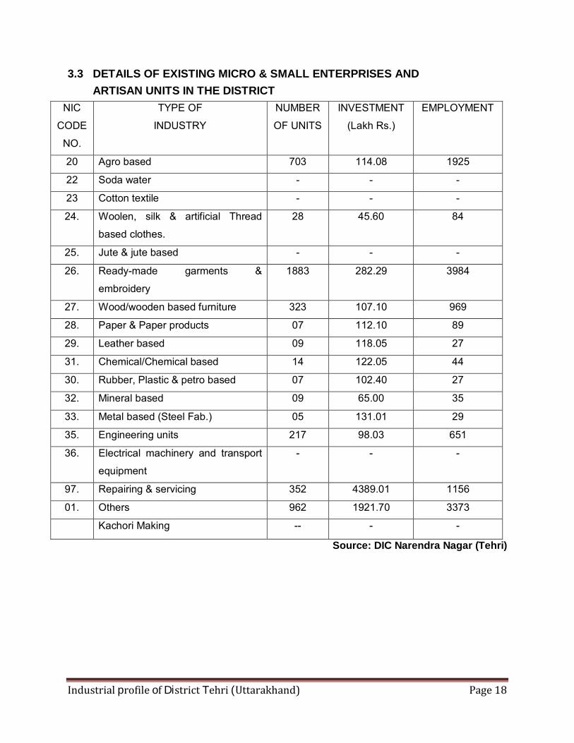
3.3 DETAILS OF EXISTING MICRO & SMALL ENTERPRISES AND ARTISAN UNITS IN THE DISTRICT
NIC
CODE
NO.
TYPE OF INDUSTRY
NUMBER
OF UNITS INVESTMENT
(Lakh Rs.) EMPLOYMENT
20 Agro based 703 114.08 1925 22 Soda water - - - 23 Cotton textile - - - 24. Woolen, silk & artificial Thread
based clothes. 28 45.60 84
25. Jute & jute based - - - 26. Ready-made garments &
embroidery 1883 282.29 3984
27. Wood/wooden based furniture 323 107.10 969 28. Paper & Paper products 07 112.10 89 29. Leather based 09 118.05 27 31. Chemical/Chemical based 14 122.05 44 30. Rubber, Plastic & petro based 07 102.40 27 32. Mineral based 09 65.00 35 33. Metal based (Steel Fab.) 05 131.01 29 35. Engineering units 217 98.03 651 36. Electrical machinery and transport
equipment - - -
97. Repairing & servicing 352 4389.01 1156 01. Others 962 1921.70 3373
Kachori Making -- - -
Source: DIC Narendra Nagar (Tehri)
Industrial profile of District Tehri (Uttarakhand) Page 19
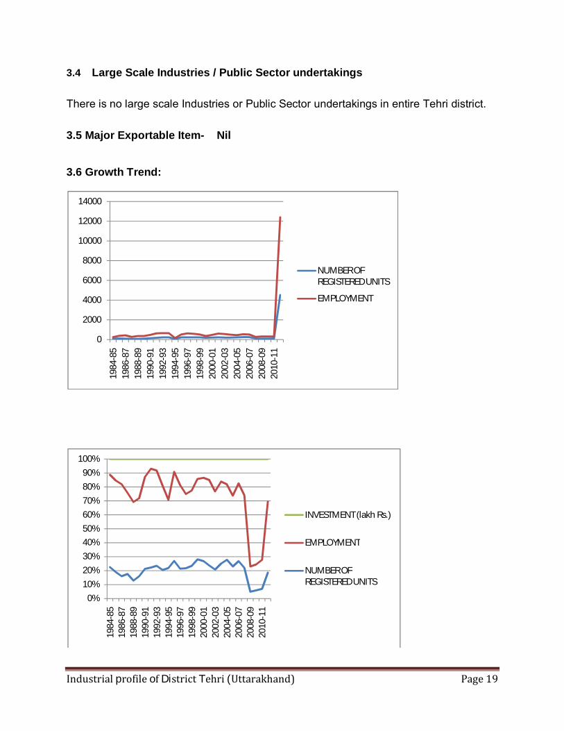
3.4 Large Scale Industries / Public Sector undertakings There is no large scale Industries or Public Sector undertakings in entire Tehri district.
3.5 Major Exportable Item- Nil
3.6 Growth Trend:
0
2000
4000
6000
8000
10000
12000
14000
1984
-85
1986
-87
1988
-89
1990
-91
1992
-93
1994
-95
1996
-97
1998
-99
2000
-01
2002
-03
2004
-05
2006
-07
2008
-09
2010
-11
NUMBER OF REGISTERED UNITS
EMPLOYMENT
0%10%20%30%40%50%60%70%80%90%
100%
1984
-85
1986
-87
1988
-89
1990
-91
1992
-93
1994
-95
1996
-97
1998
-99
2000
-01
2002
-03
2004
-05
2006
-07
2008
-09
2010
-11
INVESTMENT (lakh Rs.)
EMPLOYMENT
NUMBER OF REGISTERED UNITS
Industrial profile of District Tehri (Uttarakhand) Page 20
3.7 Medium Scale Enterprises
There is no Medium Scale Enterprise in entire Tehri district.
3.8 Major Exportable Item
Scope of Handloom and Handicraft products 3.9 Service Enterprises -- 3.9.1 Potentials areas for service industry: Tehri is one of the popular districts for its natural beauty. There is very good scope of tourism
base service industry like;
-Hotel
-Adventures,
-River rafting,
-Treakings
3.10 Potential for new MSMEs Major Strengths: Major Rivers Bhagirathi,Bhilangana,Alaknanda,Balganga Major Trees Chir,Deodar,Khair,Kharas,Moru,Bamboo,Banj,Oak,Sal,Kail,Spruce,Silver
fiv,Kharik,Tun. Important Crops Wheat,Rice,Tea,Maize,Barley,Tobaco Important Fruits Respberry,Gooseberry,Apples,Pear,Lime,Cherries,Apricots,Plums,Peachs
,Mango,Papaya Important Vegetables
Potato,Onion,Peas,Garlic,Ginger
Important Cereals Urd,Soyabean,Oilseds,Pea,Arhar,Masoor,Rapseeds Major Minerals Magnesite,Limestone,Dolomite,Tin,Phosphate,Marble. Important Lakes Apsara,Sahastradhara Major Tourist Places
Budha Kedar,Narendra Nagar,Dev Prayag,Sem Mukhim,KhatlingGalcier,Laxman Jhoola,and Tapovan,Muni Ki Reti,Bhilangana Valley,Dhanolti,Kunjapuri ,SukandaDevi,Chandravadani
Industrial profile of District Tehri (Uttarakhand) Page 21
Major Performance Fact
In Tehri district there are some fruit /vegetable cultivation zones. Fruits like apple,
apricot, pear, peach, amla, citrus fruits and vegetable like potatoes, ginger, garlic, peas, onion
etc.are grown by the people of this district. Therefore some enterprise can come up in the field
of fruits & vegetable base industries.
Handicraft & wool based industries, extraction of herbs; floriculture, mushroom
cultivation etc. have very good scope in this district.
Other suggested Investment Sectors - Mini Hydro Power Plants
- Forest based products- Lisa, wood carving,tin,wool
- Herbs & Medicinal Plants
- Fabrication
- Pre cast Building Material
- Fisheries
- Water related sports etc. around Tehri Dam Lake
- Off season vegetables
- Bee Keeping
4. Existing Clusters of Micro & Small Enterprise
There is no any cluster in this district however Hand loom, wood and wool based Handicraft
clusters can be developed in this district.
Industrial profile of District Tehri (Uttarakhand) Page 22
5. General issues raised by industry association during the course of meeting There is no Industries Association available in this district but constraints are as under
- Week Communications Network
- Infrastructure –Development of basic Infrastructure is hampered due to major areas
being forest.
- The district is a fragile and disaster prone zone.
- Lack of entrepreneurship
- Shortage of technically sound skilled manpower
- Fragmentation of Land holding and step type farming is only possible.
- Absence of integrated marketing Infrastructure (Pakaging, weight, collection centre etc.)
- Non availability of training facilities in internal location in the state.
- Shortage of Bank credit.

Industrial profile of District Tehri (Uttarakhand) Page 23
6. STEPS TO SET UP MSMEs Following are the brief description of different agencies for rendering assistance to the entrepreneurs. S.No
Type of assistance Name and address of agencies
1. Provisional Registration Certificate ( EM-1) & Permanent Registration Certificate ( EM-II)
District Industries Centre, Narendra Nagar (Tehri)
2. Identification of Project Profiles, techno-economic and managerial consultancy services, market survey and economic survey reports.
MSME-Development Institute,Kham Bangla,Kaladhungi Road, Haldwani (Nainital), DIC Narendra Nagar
3. Land and Industrial shed
Diractorate of Industries Patel Nagar Industrial Estate, Dehradun,DIC Narendra Nagar, SIDCUL,1-New Cantt Road,Dehradun
4. Financial Assistance
SIDBI,Nationalised banks
5. For raw materials under Govt. Supply
Directorate of Industries, Patelnagar, Dehradun,NSIC, Dehradun
6. Plant and machinery under hire / purchase basis.
The National Small Industries Corporation limited, 132,HIG-II,Indirapuram ,Dehradun
7. Power/ Electricity
Uttarakhand power corporation, Dehradun
8. Technical Know –how.
MSME-Development Institute,Kham Bangla,Kaladhungi Road, Haldwani (Nainital),IIT, Roorkee, G.B.Pant Nagar University
9. Quality & Standard
MSME-Development Institute Haldwani (Nainital),BIS,Shashtri Nagar, Dehradun
10. Marketing /Export Assistance
MSME-Development Institute Haldwani,DIC Narendra Nagar,Directorate of Industries, Dehradun.
11. Other Promotional Agencies
KVIC,GMS Road, Dehradun, Directorate of Industries, Patelnagar,Dehradun,Uttarakhand Khadi & Village Industries, Dehradun,DGFT,Patelnagar,Dehradun
Industrial profile of District Tehri (Uttarakhand) Page 24
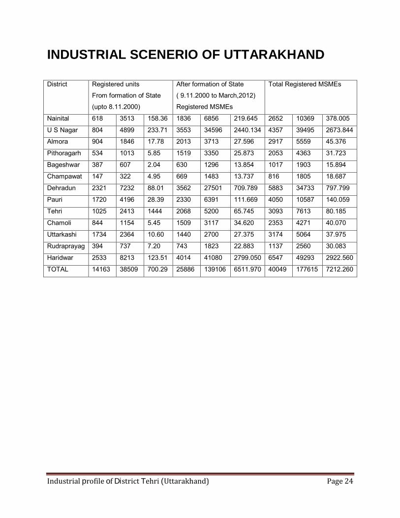
INDUSTRIAL SCENERIO OF UTTARAKHAND District Registered units
From formation of State
(upto 8.11.2000)
After formation of State
( 9.11.2000 to March,2012)
Registered MSMEs
Total Registered MSMEs
Nainital 618 3513 158.36 1836 6856 219.645 2652 10369 378.005
U S Nagar 804 4899 233.71 3553 34596 2440.134 4357 39495 2673.844
Almora 904 1846 17.78 2013 3713 27.596 2917 5559 45.376
Pithoragarh 534 1013 5.85 1519 3350 25.873 2053 4363 31.723
Bageshwar 387 607 2.04 630 1296 13.854 1017 1903 15.894
Champawat 147 322 4.95 669 1483 13.737 816 1805 18.687
Dehradun 2321 7232 88.01 3562 27501 709.789 5883 34733 797.799
Pauri 1720 4196 28.39 2330 6391 111.669 4050 10587 140.059
Tehri 1025 2413 1444 2068 5200 65.745 3093 7613 80.185
Chamoli 844 1154 5.45 1509 3117 34.620 2353 4271 40.070
Uttarkashi 1734 2364 10.60 1440 2700 27.375 3174 5064 37.975
Rudraprayag 394 737 7.20 743 1823 22.883 1137 2560 30.083
Haridwar 2533 8213 123.51 4014 41080 2799.050 6547 49293 2922.560
TOTAL 14163 38509 700.29 25886 139106 6511.970 40049 177615 7212.260