Embed Size (px)
Citation preview

RPS V7.2 - 2018 Part 9 - Schedules, Schedule 3 - Dictionary, Division 2 - Administrative Terms - Page 1
Division 2 - Administrative Terms Note - Index for Administrative Terms
Administrative Terms � Acceptable Solution � Access � Access Permeability � Accessway � Acid Sulfate Soils � Act � Active Transport � Adverse Flooding � Advertising Device � Affordable Housing � All Weather Road Access � Alternative Provision � Annual Exceedance Probability (AEP) � Aquaculture � Articulation � Assessable Development � Assessment Criteria � Asset Protection Zone � Australian Height Datum (AHD) � Average Recurrence Interval (ARI) � Average Width � Aviation Facilities � Background Noise Level � Basement � Biodiversity � Boundary Clearance � Buffer � Building � Building Format Plan � Building Frontage � Building Height � Building Work � Built to Boundary � Burra Charter � Bushfire � Bushfire Risk � Bushland Habitat Map � Canal and Lakeside Structures � Carrier � Centre � Circulation Aisles � Circulation Roads � Code Assessable � Commercial Place � Commercial Waste � Communications Structures � Community Infrastructure � Community Management Statement � Community Residence � Community Titles Scheme � Commuter Path � Connectivity � Corner Lot
Administrative Terms – continued � Crime Prevention Through Environmental
Design (CPTED) � Curtilage � Declared Plant � Defined Flood Event (DFE) � Demolition � Design Production Capacity � Design Speed � Design Vehicle � Development � Development Envelope Area � Development Footprint � Domestic Additions � Domestic Outbuilding � Domestic Waste � Drainage Constrained Land � Driveway Crossover � Dwelling Unit � Ecologic Niche � Ecological Sustainability � Electricity Easement Electricity
Infrastructure � Environmental Impact Statement � Environmental Management Plan � Environmental Nuisance � Environmental Relevant Activity � Environmental Values � Environmental Weed � Equivalent person, EP � Erosion Prone Area � Excavation and Fill � Exempt Development � Façade � Flood � Flood Prone Area � Floor Space Ratio � Footpath � Form � Frontage � Gross Floor Area (GFA) � Gross Leasable Area � Ground Level � Habitable Room � Habitat � Habitat Link � Habitat Values � Hazardous Materials � Heritage Place � Highest Astronomical Tide � Household � IDAS � Impact Assessable � Impervious area � Infill Development

Page 2 - Part 9 - Schedules, Schedule - Dictionary, Division 2 - Administrative Terms 3 RPS V7.2 - 2018
� Internal Lot � Irregular Lot
Roof
Administrative Terms - continued � Koala Habitat Trees � Land Application System � Landscaping � Legibility � Level of Assessment � Local Access Path � Lot � Low Impact Facility � Low-Rise Building � Major Reconfiguration � Material Change of Use � Mean High Water Spring Tide � Medium Reconfiguration � Mid-Rise Building � Mezzanine � Minor Building Work � Minor Drainage System � Minor Electricity Infrastructure � Minor Heritage Building Work � Minor Reconfiguration � Mixed Use � Movement Network � Native Animals � Native Plants � Natural Drainage Lines � Nature Based Recreation � Neighbourhood Density � Net Residential Density � Operational Work � Other Development � Outermost Projection � Out-of-Centre � Overall Outcomes � Overland Flow Path � Overlay � Parking Aisles � Permeable Surface � Plan Area � Planned density � Planning Scheme Area � Planning Scheme Policy � Plot Ratio � Premises � Primary Active Frontage � Private Open Space � Private Swimming Pool � Private Tennis Court � Probable Solutions � Queuing Area � Rainwater Harvesting � Rear Lot � Reconfiguring a Lot � Recreational Path � Recyclable Waste � Removable Structure � Retaining Wall � Revetment Wall � Riparian Vegetation � Risk
� Road � Road Hierarchy � Road Reserve
Administrative Terms - continued � Roof Water Hydraulic Drainage � Roof Water Mains � Scenic Values Schedules � Secondary Active Frontage � Secondary Dwelling � Self-Assessable Development � Sensitive Land Use � Service Aisles � Service Bay � Service Vehicle � Setback � Sewerage Hydraulic Drainage � Sewerage Mains (Sewerage Reticulation
Mains) � Short Term Accommodation � Side and Rear Boundary Clearance � Significant Centre Development � Silviculture � Site � Site Analysis Plan � Site Coverage � Site Density � Site Development Plan � Specific Outcome � Standard Format Plan of Survey � State-controlled Road � Storey � Storm Tide Area � Stormwater � Stormwater Management Plan (SMP) � Streetscape � Structure � Structure Plan � Sub-area � Substantially Completed � Swale � Table Drain � Tables of Assessment � Temporary Use � Transit Oriented Development � Trunk Infrastructure � Tidal Land � Ultimate Development � Use � Vegetation � Vehicle trips per day (vpd) � Utility Infrastructure � Verge � Volumetric Format Plan of Survey � Walkability � Walking Catchment � Waste Container � Wastewater System � Water Catchment � Watercourse � Wetland � Zone � Zone and Overlay Maps

RPS V7.2 - 2018 Part 9 - Schedules, Schedule 3 - Dictionary, Division 2 - Administrative Terms - Page 3
� Zone of Influence

Page 4 - Part 9 - Schedules, Schedule - Dictionary, Division 2 - Administrative Terms 3 RPS V7.2 - 2018
Administrative Term
Definition
Acceptable Solution Precise criteria that do not require the exercise of discretion to assess whether a proposed development complies.
Access The entry of persons and vehicles onto a lot, either existing or proposed, from a road which abuts the frontage of that lot.
Access Permeability Development that is accessible by a number of alternative paths but does not surround itself with or include barriers to movement.
Accessway A vehicle driveway used to access premises.
Acid Sulfate Soils (ASS)
Soil or sediment containing highly acidic horizons or layers affected by the oxidation of iron sulfides, known as actual ASS, and/or soil or sediment containing iron sulfides or other sulfidic material that has not been exposed to air and oxidised (potential acid sulphate soils). Note - definition from State Planning Policy 2/02
Act The Sustainable Planning Act 2009, as amended from time to time.
Active Transport Non-motorised travel such as walking and cycling
Adverse Flooding Flooding which may adversely affect the amenity, safety or use of a premises
Advertising Device Any permanent structure, device, or sign or the like intended for advertising purposes. It includes any framework, supporting structure or building feature that is provided exclusively or mainly as part of the advertisement.
Affordable Housing Housing that is appropriate to the needs of households with low to moderate incomes.
All Weather Road Access
Public road access to boundary of the subject land by a vehicular carriageway of sufficient standard, in terms of width, surface, gradient and structural capacity, to allow for the safe passage of conventional two wheel drive vehicles and safe trafficability during storm runoff.
Alternative Provision
For the purpose of building works, provisions that are:
(a) identified or stated in a planning scheme; (b) alternative to the provisions of the Queensland Development
Code, MP 1.1 and 1.2; (c) qualitative statements or quantifiable standards.
Annual Exceedance Probability (AEP)
The likelihood of occurrence of a flood of a given size or larger in any one year, usually expressed as a percentage. For example, if a peak flood discharge of 500 cubic metres per second has an AEP of 5 percent, it means that there is a 5 percent risk, that is the probability of 0.05 or a likelihood of 1 in 20, of a peak flood discharge of 500 cubic metres /second or larger occurring in any one year. The AEP of a flood event gives no indication of when a flood of that size will occur next. Note – Definition from State Planning Policy 1/03
Aquaculture Has the meaning in the Fisheries Act 1994 and includes the cultivation of live fisheries resources for sale other than in circumstances prescribed under a regulation.

RPS V7.2 - 2018 Part 9 - Schedules, Schedule 3 - Dictionary, Division 2 - Administrative Terms - Page 5
Administrative Term
Definition
Articulation
The treatment of a building form or façade that creates or contributes to visual character and an active frontage. Articulation may include -
(a) vertical and horizontal detail and/or projections; (b) variations in colours, materials, patterns and textures; (c) architectural elements such as openings, entry statements,
directional signage, exposure of fittings, distinction between levels of a building, awnings, planters, balconies and stepping of built form.
Assessable Development
Has the meaning given to it in the Sustainable Planning Act 2009.
Assessment Criteria
Those parts of the assessment provisions, comprising codes or otherwise, that establish the outcomes sought for self-assessable, assessable development, and development requiring compliance assessment, including overall outcomes, performance outcomes and acceptable outcomes.
Asset Protection Zone
An area surrounding development intended to reduce bushfire risk to an acceptable level. The width of the asset protection zone will vary with slope and aspect and consists of a fuel reduced and fuel free area.
Australian Height Datum (AHD)
The survey height datum adopted by the National Mapping Council as the datum to which all vertical control for mapping is to be referred. 0.0 metres AHD approximates mean sea level.
Average Recurrence Interval (ARI)
The average, or expected, value of the periods between exceedances of a given rainfall total accumulated over a given duration. It is implicit in this definition that the periods between exceedances are generally random. Note—for example, a 100 year ARI indicates an average of 100 years between exceedance of a given storm magnitude. Note—definition from Temporary State Planning Policy 1/11.
Average Width In regard to a lot, the distance between the midpoints of the side boundaries of the lot.
Aviation Facilities
Navigation, communication or surveillance installations provided to assist the safe and efficient movement of aircraft. Such facilities may be located on or off airport. Note - definition from State Planning Policy 1/02.
Background Noise Level
For a specified time interval, in relation to an investigation of a noise, the A-weighted sound pressure level that is equalled or exceeded for 90 percent of that part of the interval in which the investigated noise is absent.
Basement A storey either wholly or substantially below ground level where no part of the floor level projects more than one metre above ground level.
Biodiversity The natural diversity of wildlife, together with the environmental conditions necessary for their survival. The four levels of biodiversity are genetic, species, ecosystem and regional diversity.
Boundary Clearance
The shortest distance from the outermost projection of a structural part of the building or structure to the property boundary, including:
(a) if the projection is a roof and there is a fascia – the outside face of the fascia; or
(b) if the projection is a roof and there is no fascia – the roof structure.
The term does not include rainwater fittings or ornamental or architectural attachments.
Buffer An area of the land, including watercourses, required for maintaining separation distances:
(a) between different land uses; or

Page 6 - Part 9 - Schedules, Schedule - Dictionary, Division 2 - Administrative Terms 3 RPS V7.2 - 2018
Administrative Term
Definition
(b) from a major noise source; or (c) from a conservation area or a public recreation area; or (d) from a wetland or watercourse.
A buffer is not exclusive of other uses and may incorporate lower intensity activities that assist in mitigating the overall impact on external uses.
As a general principle a buffer is not extended over a third party’s property without their consent.
Building A fixed structure that is wholly or partly enclosed by walls and is roofed, and includes a floating building and any part of a building. Note-definition from the Sustainable Planning Act 2009.
Building Format Plan (of survey)
A building format plan of survey defines land using the structural elements of a building, including, for example, floors, walls and ceilings. Note—definition from the Land Title Act 1994.
Building Frontage The facade of a building that fronts the street or other public spaces.
Building Height The vertical distance from ground level to the highest point of the building and structures.
Building Work Has the meaning given to it in the section 10 of the Sustainable Planning Act 2009.
Built to Boundary Class 1 or Class 10 Building works undertaken within 750mm of the boundary of a lot
Burra Charter
The charter that provides guidance for the conservation and management of places of cultural significance and is based on the knowledge and experience of Australia ICOMOS members (ICOMOS - International Council on Monuments and Sites).
Bushfire An uncontrolled fire burning in forest, scrub or grassland vegetation, also referred to as a wildfire.
Bushfire Risk The chance of a bushfire igniting, spreading and causing damage to assets of value to the community. Assets include life, property such as buildings, stock, crops and forests, and the City’s natural and cultural heritage.
Bushland Habitat Map
For the purposes of section 24(b) of Local Law o. 6 - Protection of Vegetation, the Enhancement Area, Enhancement Link, Enhancement Corridor, Koala Habitat, Bushland Habitat and Marine Habitat depicted on the Bushland Habitat Overlay Map is the land described in section 24(b) as land which is or may be required for Greenspace indicated in a Development Control Plan, Local Area Plan or Strategic Plan.
Canal and Lakeside Structure
All development, including works associated with a building or structure, as defined by the Building Act 1975 (includes a wall or fence and anything fixed to or projecting from a building, wall, fence or other structure) where that development is within nine (9) metres of a revetment wall landward or seaward, and is on, or associated with, a property included in the Canal and Lakeside Structures Overlay. The term includes:
(a) a dwelling unit; or (b) a structure located on the same premises as a dwelling unit; or (c) a structure which is located seaward of a revetment wall but is
directly associated with a residential property; (d) is for the exclusive use of the residents and their visitors; (e) is strictly ancillary to the residential use of the site.
The term does not include marinas, ports or boat harbours.

RPS V7.2 - 2018 Part 9 - Schedules, Schedule 3 - Dictionary, Division 2 - Administrative Terms - Page 7
Administrative Term
Definition
Carrier The holder of a carrier licence granted by the Australian Communications Authority (ACA).
Centre
Means the City Centres geographically defined by the extent of the Centre zones in the case of District, Neighbourhood, Local, Point Lookout and SMBI Centres, and Diagram 12 Capalaba Principal Activity Centre, Diagram 13 Cleveland Principal Activity Centre and Diagram 14 Victoria Point Major Centre as depicted in Part 3: Division 2 Strategic Framework of the Redlands Planning Scheme.
Circulation Aisles Aisles performing the dual function of providing access to car parking spaces and providing access to other aisles.
Circulation Roads Roadways contained within a development site that do not provide direct access to carparking spaces, but distribute traffic between entrance/exit driveways, circulation aisles and service areas.
Code Assessable Has the meaning given to it in the Sustainable Planning Act 2009.
Commercial Place For the purpose of noise assessments any commercial, industrial or business premises, not being a sensitive receiving environment.
Commercial Waste
Waste, other than green waste, recyclable waste, interceptor waste or waste discharged to a sewer, produced as a result of the ordinary use or occupation of commercial premises. Note—as defined in the Environmental Protection (Interim Waste)Regulation 1996.
Communications Structures
The installation on an existing building or structure of any device used to receive or transmit telecommunications through the air, where the device is ancillary to the use of the premises. This includes satellite dishes, aerials and antennae. The term does not include the installation of “low impact facilities” as defined by the Telecommunications Act 1997, Telecommunications (Low Impact Facilities) Determination 1997 and Amendment No.1 of 1999. Note - Where the device is the use of the premises, it is a Telecommunications Facility.
Community Infrastructure
The community infrastructure prescribed under a regulation for section 200 of the Sustainable Planning Act 2009.
Community Management Statement
The identification of a community titles scheme. It is also a document that: (a) identifies land; (b) otherwise complies with the requirements of the Body Corporate
and (c) Community Management Act 1997 for a community management
statement. Note—as defined in the Body Corporate and Community Management Act 1997.
Community Residence
Any dwelling used for accommodation for a maximum of six persons comprising a single household who require assistance or support with daily living needs, share communal spaces and who may be unrelated. A support worker is permitted to reside on the premises at any time in addition to the maximum of six persons requiring assistance or support. The term does not include: multiple dwelling, hostel, residential care facility, short-term accommodation or aged care and special needs housing.
Community Titles Scheme
A single community management statement recorded by the registrar identifying land (the scheme land). Note—as defined in the Body Corporate and Community Management Act 1997.
Page 8 - Part 9 - Schedules, Schedule - Dictionary, Division 2 - Administrative Terms 3 RPS V7.2 - 2018
Administrative Term
Definition
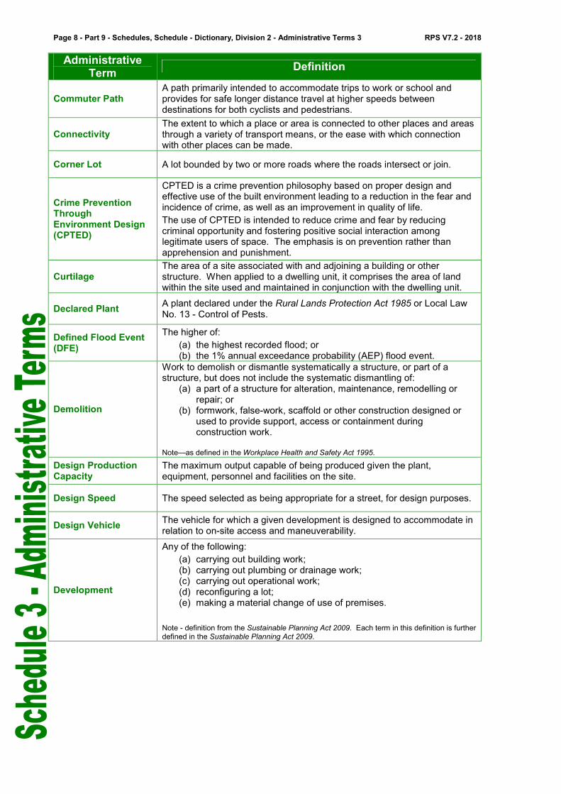
Commuter Path A path primarily intended to accommodate trips to work or school and provides for safe longer distance travel at higher speeds between destinations for both cyclists and pedestrians.
Connectivity The extent to which a place or area is connected to other places and areas through a variety of transport means, or the ease with which connection with other places can be made.
Corner Lot A lot bounded by two or more roads where the roads intersect or join.
Crime Prevention Through Environment Design (CPTED)
CPTED is a crime prevention philosophy based on proper design and effective use of the built environment leading to a reduction in the fear and incidence of crime, as well as an improvement in quality of life.
The use of CPTED is intended to reduce crime and fear by reducing criminal opportunity and fostering positive social interaction among legitimate users of space. The emphasis is on prevention rather than apprehension and punishment.
Curtilage The area of a site associated with and adjoining a building or other structure. When applied to a dwelling unit, it comprises the area of land within the site used and maintained in conjunction with the dwelling unit.
Declared Plant A plant declared under the Rural Lands Protection Act 1985 or Local Law No. 13 - Control of Pests.
Defined Flood Event (DFE)
The higher of:
(a) the highest recorded flood; or (b) the 1% annual exceedance probability (AEP) flood event.
Demolition
Work to demolish or dismantle systematically a structure, or part of a structure, but does not include the systematic dismantling of:
(a) a part of a structure for alteration, maintenance, remodelling or repair; or
(b) formwork, false-work, scaffold or other construction designed or used to provide support, access or containment during construction work.
Note—as defined in the Workplace Health and Safety Act 1995.
Design Production Capacity
The maximum output capable of being produced given the plant, equipment, personnel and facilities on the site.
Design Speed The speed selected as being appropriate for a street, for design purposes.
Design Vehicle The vehicle for which a given development is designed to accommodate in relation to on-site access and maneuverability.
Development
Any of the following:
(a) carrying out building work; (b) carrying out plumbing or drainage work; (c) carrying out operational work; (d) reconfiguring a lot; (e) making a material change of use of premises.
Note - definition from the Sustainable Planning Act 2009. Each term in this definition is further defined in the Sustainable Planning Act 2009.

RPS V7.2 - 2018 Part 9 - Schedules, Schedule 3 - Dictionary, Division 2 - Administrative Terms - Page 9
Administrative Term
Definition
Development Envelope Area
The area of a lot defined by metes and bounds within which all development including but not limited to a building, structure, private open space, accessway, car park, storage, on-site wastewater treatment and associated clearing of vegetation must be confined other than a boundary fence. The term does not include an accessway from a road to the development envelope area. Note - Development envelopes, previously described as ‘building envelopes’, are approved by the local government as - a condition of development on an approved plan of subdivision; or being identified as land outside a statutory covenant area on the property
title. In both instances a property search will identify the existence of an approved development (building) envelope.
Development Footprint
The location and extent of all development proposed on a site. This includes all buildings and structures, setbacks, open space, all associated facilities, landscaping, on-site stormwater drainage, on-site wastewater treatment, all areas of disturbance, on-site parking, access and manoeuvring areas.
Domestic Additions
Means the addition to or extension of the dwelling unit for - (a) rooms -
(i) on premises with an existing dwelling house; (ii) that are enclosed and roofed additions to the existing dwelling unit; (iii) that do not form an additional dwelling unit; or
(b) buildings or structures used for passive recreational purposes that are -
(i) roofed and unenclosed such as verandahs, decks, patios or the like; (ii) or provide roof-top recreational areas.
Domestic Outbuilding A Class 10a building as defined in the Building Code of Australia 1996 that is ancillary to a residential use on the same premises and is limited to non-habitable buildings for the purpose of a shed, garage and carport.
Domestic Waste Has the meaning given to it in the Environmental Protection (interim Waste) Regulation 1996.
Drainage Constrained Land
Land on the Southern Moreton Bay Islands that is likely to be constrained by drainage issues, such as overland flow path, high water table, seepage and all weather road access.
Driveway Crossover A vehicle driveway extending from the roadway to the property boundary.
Dwelling Unit
A building or part of a building used or capable of being used as a self-contained residence that must include the following:
(a) food preparation facilities; (b) a bath or shower; (c) a toilet and wash basin; (d) clothes washing facilities.
This term includes outbuildings, structures and works normally associated with a dwelling.

Page 10 - Part 9 - Schedules, Schedule - Dictionary, Division 2 - Administrative Terms 3 RPS V7.2 - 2018
Administrative Term
Definition
Ecologic Niche
The way a species interacts with all the components or resources of its habitat. The term includes not only the habitat occupied by an organism but also the organism’s functional role as a member of the community of indigenous plants and animals.
Ecological Sustainability
A balance that integrates: (a) protection of ecological processes and natural systems at local,
regional, (b) State and wider levels; (c) economic development; (d) maintenance of the cultural, economic, physical and social
wellbeing of (e) people and communities.
Note—definition from the Sustainable Planning Act 2009.
Electricity Easement
A right held by an electricity distribution provider over a lot or portion of a lot owned by another party. The right may include the ability to access, maintain, repair, rebuild and restrict development in the electricity easement.
Electricity Infrastructure
A building or structure used for electricity distribution.
Environmental Impact Statement
A document which may be required to be prepared to support a development application for development approval and which includes, in sufficient detail to allow an adequate assessment of the potential environmental impacts and the suitability of proposed mitigation measures, the following -
(a) a description of the development proposal; (b) a description of the existing environment and its values and
significance; (c) a statement of the likely impacts of the proposal on the existing
environment; (d) a statement of the measures to be used to avoid or mitigate
adverse impacts; (e) a statement of the means to be used to monitor the effectiveness
of the mitigation measures and to respond to accidents, emergencies and other non-conformances.
This term commonly includes an environmental management plan.
Environmental Management Plan
For development to which the EIS process applies, means a document prepared by the proponent that proposes conditions and mechanisms to manage the potential environmental impacts of the development. Note—definition from the Sustainable Planning Act 2009.
Environmental Nuisance
An unreasonable interference or likely interference with an environmental value caused by:
(a) noise, dust, odour, light; or (b) an unhealthy, offensive or unsightly condition because of
contamination; or (c) another way prescribed by regulation.
Note—definition from the Environmental Protection Act 1994.
Environmentally Relevant Activity (ERA)
Is:
(a) an agricultural ERA as defined under section 75 of the Environmental Protection Act 1994; or
(b) a mining activity as defined under section 147 of the Environmental Protection Act 1994; or
(c) a chapter 5A activity as defined under section 309A of the Environmental Protection Act 1994; or

RPS V7.2 - 2018 Part 9 - Schedules, Schedule 3 - Dictionary, Division 2 - Administrative Terms - Page 11
Administrative Term
Definition
(d) another activity prescribed under section 19 of the Environmental Protection Act 1994 as an environmentally relevant activity.
Note - definition from the Environmental Protection Act 1994.
Environmental Values
All of the components of a natural environment that maintain biodiversity and ecosystem processes and create opportunities for individual survival, population survival and the capacity for species to continue their evolutionary adaption, including -
(a) native vegetation and native animals, their habitat, habitat values and habitat links;
(b) the ecologic niche of native vegetation and native animals, that are the very specific areas in which they live and have important relationships with the physical environment, other native vegetation and native animals;
(c) the behaviour of native vegetation and native animals, that is the responses of an animal to its environment, responses that are not random, but are highly organised and intricate patterns of activity, including a native animal’s movement patterns through the landscape.
Environmental Weed
A plant which is not declared under the Rural Lands Protection Act 1985 or Local Law No. 13 Control of Pests, however due to its impact on the environment, particularly bushland/native fauna, is considered by the local government to be a weed.
Equivalent person, EP
The demand for infrastructure that is represented by an average person.
Erosion Prone Area
An area declared to be an erosion prone area under section 70(1) of the Coastal Protection and Management Act 1995. Note—definition from the Coastal Protection and Management Act 1995.
Excavation and Fill Removal or importation of material to, from or within a lot that will change the ground level of the land.
Exempt Development Has the meaning given to it in the Sustainable Planning Act 2009.
Façade The front of a building and more particularly its principal front.
Family Day Care
A dwelling unit used for the reception and minding or caring for children where such a service provides for home-based care. Home-based care means the use is undertaken as an ancillary use only in any dwelling. Operators must also be appropriately licenced and registered by the appropriate regulatory authority.
Flood The temporary inundation of land by expanses of water that overtop the natural or artificial banks of a watercourse such as a stream, creek, river, estuary, lake or dam.
Flood Prone Area An area that indicatively identifies the 1 percent Annual Exceedance Probability (AEP) flood event as shown on the Flood Prone, Storm Tide and Drainage Constrained Overlay where development is restricted.
Floor Space Ratio The ratio of floor area including basements, mezzanine and toilets to the area of the site.
Footpath A pavement intended only for pedestrians, separate from the road or street carriageway, either within or outside a road reserve.
Form In a streetscape context, the two-dimensional shape, outline or silhouette of a building.

Page 12 - Part 9 - Schedules, Schedule - Dictionary, Division 2 - Administrative Terms 3 RPS V7.2 - 2018
Administrative Term
Definition
Frontage
A boundary of a lot which abuts a road and includes an average width parallel to the road or angled frontages where the front boundary is not at 90
o to the side boundaries.
Gross Floor Area (GFA)
The total floor area of all storeys of the building, including any mezzanines, (measured from the outside of the external walls and the centre of any common walls of the building), other than areas used for:
(a) building services; or (b) a ground floor public lobby; or (c) a public mall in a shopping complex; or (d) parking, loading or manoeuvring of vehicles; or (e) balconies, whether roofed or not.
Note—definition from the Sustainable Planning Regulation 2009.
Gross Leasable Area The total floor area, inclusive of all walls and columns, capable of being occupied by separate tenants for their exclusive use, including basements, mezzanine and toilets.
Ground Level
The level of the natural ground or where the level of the natural ground has been changed, the level as lawfully changed. Note – Council does not maintain an up to date reference point for ground level. The ground level may be determined by a cadastral surveyor using best evidence such as: � 'as constructed' plans lodged with Redland City Council (RCC) at the
time of subdivision; � surveyed spot levels from Council's sewer maps; or � a site survey prepared by a cadastral surveyor. In circumstances where the natural ground level has been altered as a result of a development activity, the applicant must demonstrate that the ground level has been lawfully changed.
Habitable Room
A room used for normal domestic activities, and: (a) includes a bedroom, living room, lounge room, music room,
television room, kitchen, dining room, sewing room, study, playroom, family room, home theatre and sunroom; but
(b) excludes a bathroom, laundry, water closet, pantry, walk-in wardrobe, corridor, hallway, lobby, photographic darkroom, clothes-drying room, and other spaces of a specialised nature occupied neither frequently nor for extended periods.
Note—definition from the Building Code of Australia.
Line at 90O
angle to side boundary
Measuring frontage – non-standard lot Where the front boundary is not at 90
o to the side
boundaries.
RO
AD
Fro
nta
ge

RPS V7.2 - 2018 Part 9 - Schedules, Schedule 3 - Dictionary, Division 2 - Administrative Terms - Page 13
Administrative Term
Definition
Habitat The place where an organism lives, a physical area, some specific part of the earth’s surface, air, soil, water, or another organism. More than one animal may live in a particular habitat.
Habitat Link The area that connects two or more areas of habitat and provides a relatively safe area for movement and refuge for indigenous animals.
Habitat Values
Those characteristics of an area that make it suitable as a habitat or refuge for native plants and native animals. These characteristics include the physical structure, nutrient and energy flows, condition and extent of habitat and the location of the area in relation to other habitats. Note - Also refer to “Koala Habitat Type” under State Planning Policy 2/10 Koala Conservation in South East Queensland.
Hazardous Materials
A substance with potential to cause harm to persons, property or the environment because of 1 or more of the following—
(a) the chemical properties of the substance; (b) the physical properties of the substance; (c) the biological properties of the substance.
Without limiting the first paragraph, all dangerous goods, combustible liquids and chemicals are hazardous materials. Note—definition from the Dangerous Goods Safety Management Act 2001.
Heritage Place A place, area, land, landscape, building or work which is of cultural
heritage significance.
Highest Astronomical Tide
The highest tide level that can be predicted to occur under average meteorological conditions and any combination of astronomical conditions. This level will not be reached every year, and is less than extreme levels that can be caused by storm tides.
Household
An individual or a group of two or more related or unrelated people who reside in the same dwelling, with the common intention to live together on a long-term basis and who make common provision for food or other essentials for living
IDAS Has the meaning given to it in the Sustainable Planning Act 2009.
Impact Assessable Has the meaning given to it in the Sustainable Planning Act 2009.
Impervious area
The area of the premises that is impervious to rainfall or overland flow that results in the discharge of stormwater from the premises. Note— For Part 4—Local Government Infrastructure Plan, impervious area is measured in hectares, impervious hectares (imp ha).
Infill Development Development in existing areas usually involving the use of vacant land or the replacement or removal of existing uses to allow for new uses.
Internal Lot A freehold lot that has access to a street only by means of an access way or easement, where the lot is not part of a community title scheme.
Irregular Lot A lot that is not rectangular in shape. This term does not include an internal lot.
Koala Habitat Tree
Has the meaning given to it in the State Planning Policy 2/10 Koala Conservation in South East Queensland:
(a) a food tree of the Corymbia, Melaleuca, or Lophostemon or Eucalyptus genera; and
(b) a preferred shelter species such as Angophora
Page 14 - Part 9 - Schedules, Schedule - Dictionary, Division 2 - Administrative Terms 3 RPS V7.2 - 2018
Administrative Term
Definition
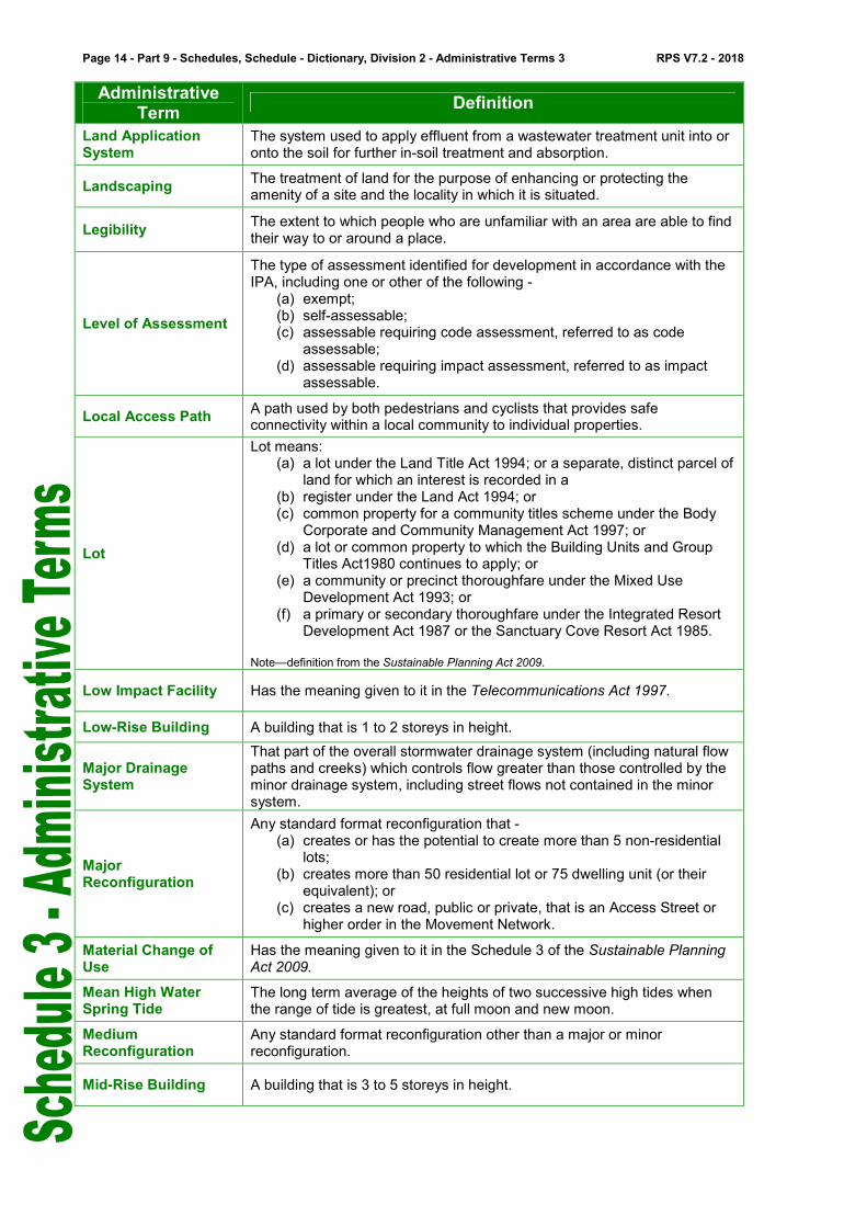
Land Application System
The system used to apply effluent from a wastewater treatment unit into or onto the soil for further in-soil treatment and absorption.
Landscaping The treatment of land for the purpose of enhancing or protecting the amenity of a site and the locality in which it is situated.
Legibility The extent to which people who are unfamiliar with an area are able to find their way to or around a place.
Level of Assessment
The type of assessment identified for development in accordance with the IPA, including one or other of the following -
(a) exempt; (b) self-assessable; (c) assessable requiring code assessment, referred to as code
assessable; (d) assessable requiring impact assessment, referred to as impact
assessable.
Local Access Path A path used by both pedestrians and cyclists that provides safe connectivity within a local community to individual properties.
Lot
Lot means: (a) a lot under the Land Title Act 1994; or a separate, distinct parcel of
land for which an interest is recorded in a (b) register under the Land Act 1994; or (c) common property for a community titles scheme under the Body
Corporate and Community Management Act 1997; or (d) a lot or common property to which the Building Units and Group
Titles Act1980 continues to apply; or (e) a community or precinct thoroughfare under the Mixed Use
Development Act 1993; or (f) a primary or secondary thoroughfare under the Integrated Resort
Development Act 1987 or the Sanctuary Cove Resort Act 1985.
Note—definition from the Sustainable Planning Act 2009.
Low Impact Facility Has the meaning given to it in the Telecommunications Act 1997.
Low-Rise Building A building that is 1 to 2 storeys in height.
Major Drainage System
That part of the overall stormwater drainage system (including natural flow paths and creeks) which controls flow greater than those controlled by the minor drainage system, including street flows not contained in the minor system.
Major Reconfiguration
Any standard format reconfiguration that - (a) creates or has the potential to create more than 5 non-residential
lots; (b) creates more than 50 residential lot or 75 dwelling unit (or their
equivalent); or (c) creates a new road, public or private, that is an Access Street or
higher order in the Movement Network.
Material Change of Use
Has the meaning given to it in the Schedule 3 of the Sustainable Planning Act 2009.
Mean High Water Spring Tide
The long term average of the heights of two successive high tides when the range of tide is greatest, at full moon and new moon.
Medium Reconfiguration
Any standard format reconfiguration other than a major or minor reconfiguration.
Mid-Rise Building A building that is 3 to 5 storeys in height.

RPS V7.2 - 2018 Part 9 - Schedules, Schedule 3 - Dictionary, Division 2 - Administrative Terms - Page 15
Administrative Term
Definition
Mezzanine An intermediate floor within a room. Note—definition from the Building Code of Australia.
Minor Building Work
Means -
(a) An alteration, addition or extension to an existing building where the floor area including balconies is less than five per cent of the building or twenty-five square meters, whichever is the lesser; or
(b) Building work identified as exempt or self-assessable development in accordance with Schedule 1 of the Building Regulation 2006.
This term does not include alterations to, demolition of or additions to an item listed in Schedule 4 - Heritage Place Register.
Minor Drainage System
That part of the overall stormwater drainage system which controls flows from the minor design storm event e.g. kerb and channel, inlets, underground drainage etc. for the purposes of providing pedestrian safety, convenience and vehicle access.
Minor Electricity Infrastructure
All aspects of development for an electricity supply network as defined under the Electricity Act 1994, (or for private electricity works that form an extension of, or provide service connections to properties from the network), if the network operates at standard voltages up to and including 66kV.) This includes:
− augmentations/upgrades to existing powerlines where the voltage of the infrastructure does not increase;
− augmentations to existing substations (including communication facilities for controlling works as defined under the Electricity Act 1994) where the voltage of the infrastructure does not increase, and where they are located on an existing substation lot.
Minor Heritage Building Work
Building work that - (a) is internal; or (b) is at the rear of the building, where it is not visible from a public
place; or (c) will not substantially change the external appearance of the place,
such as sun hoods, awnings, stairs and ramps.
Minor Reconfiguration
Standard format reconfiguration that does not create a road, public or private, or require a road to be constructed, widened or altered.
Mixed Use
A use of premises that integrates residential activities and tourist accommodation with commercial, retail or industry activities where a minimum of 30 percent of the total gross floor area is used for residential purposes.
Movement Network All road, pedestrian and cycleway corridors.
Native Animals
Terrestrial, arboreal and aquatic fauna that has and does occur naturally on the land, in the waters and in the sky of the Redland City area and neighbouring local government areas. This includes the progeny, larvae, pupae, eggs or genetic or reproductive material of an animal. Native Animals do not include:
• Animals that have been introduced to the Redlands after European arrival; or
• Declared pest species. All classes of native wildlife are protected under the Nature Conservation
Act 1992.

Page 16 - Part 9 - Schedules, Schedule - Dictionary, Division 2 - Administrative Terms 3 RPS V7.2 - 2018
Administrative Term
Definition
Native Plants
Locally native plants or trees, living or dead, and their allies that have evolved and existed naturally in the Redland City area and neighbouring local government areas. This includes the whole or any part of the flowers, seeds or genetic or reproductive material of a plant. Native Plants do not include:
• Plants or trees that are not locally native or that have been introduced to the Redlands after European arrival;
• Plants or trees planted for cultivation, harvesting or grown for commercial purposes;
• Declared weed species. All classes of native plants are protected under the Nature Conservation
Act 1992.
Natural Drainage Line
Means - (a) for the purposes of the planning scheme, natural drainage lines
which are identified on the Waterways, Wetlands and Moreton Bay Overlay Map; or
(b) a natural or modified tributary of a watercourse.
Nature Based Recreation
Means - (a) activities that include appreciation of nature as the key motivational
factor; (b) substantial modification of the natural environment is not required; (c) the natural environment is critical to the participation and
satisfaction of the participants; (d) activities that occur in, and are dependent upon settings which are
perceived by those pursuing recreation as not being significantly altered by recent human activity;
(e) activities that occur in, and are dependent upon, settings which are not under the direct control of participants.
Neighbourhood Density
The ratio of the number of dwelling units to the area of the land. The area includes internal public streets, all areas of public open space, local or neighbourhood shops, primary and secondary schools, local community services, local employment areas and half the width of adjoining arterial roads.
Net Residential Density
The ratio of the number of dwelling units to the area of land they occupy (including internal public streets) plus half the width of adjoining access roads that provide vehicular access to dwelling units.
Operational Work Has the meaning given to it in the Sustainable Planning Act 2009.

RPS V7.2 - 2018 Part 9 - Schedules, Schedule 3 - Dictionary, Division 2 - Administrative Terms - Page 17
Administrative Term
Definition
Other Development
Development other than a material change of use of premises and is confined to -
(a) reconfiguration for - (i) creating lots by subdividing another lot by standard format
plan; (ii) creating lots by subdividing another lot by -
a. building format plan; or b. volumetric format plan;
(iii) rearranging the boundaries of a lot; (iv) dividing land into parts by agreement; (v) creating an easement for access;
(b) building work for - (i) communications structures; (ii) [Blank]; (iii) a domestic outbuilding; (iv) [Blank]; (v) a private swimming pool; (vi) a private tennis court; (vii) addition or external alteration of a building other than a
domestic building; (c) operational works for -
(i) constructing a domestic driveway crossover; (ii) excavation and fill; (iii) operational work for reconfiguring a lot (by standard format
plan); (iv) placing an advertising device on premises; (v) private waterfront structure.
Outermost Projection
The outermost projection of any part of a building or structure including, in the case of a roof, the outside face of the fascia, or the roof structure where there is no fascia, or attached sunhoods or the like, but does not include retractable blinds, fixed screens, rainwater fittings, or ornamental attachments.
Out-of-Centre
A location that is clearly separate from a centre.
Note - land that is zoned with the word “centre” in the title is a centre for the purposes of the planning scheme.
Overall Outcomes Statements of desired outcomes that apply to the whole of a zone or overlay, or are the purpose of a code under s326(1) of the Sustainable Planning Act 2009, or both.
Overland Flow Path
Where a piped drainage system exists, the path where flood waters exceeding the capacity of the underground drainage system would flow. Where no piped drainage system or other form of defined watercourse exists, the path taken by surface run–off from higher parts of the catchment.
This does not include a watercourse or wetland.
Overlay
Specific provisions based on areas, places or sites having special attributes that affect the outcomes sought, as the attributes may -
(a) make those areas, places or sites sensitive to effects of development; or
(b) constrain development due to an environmental hazard or the value of a resource.
Parking Aisles The aisles used by vehicles to gain access to a carparking space.
Permeable Surface The treatment of a surface to allow rainwater to infiltrate to the soil, such as grass, gravel, landscaping or open paving.

Page 18 - Part 9 - Schedules, Schedule - Dictionary, Division 2 - Administrative Terms 3 RPS V7.2 - 2018
Administrative Term
Definition
Plan Area The vertical projection of all unenclosed structures at ground level and includes patios, decks, swimming pools, and associated paving and the like.
Plan Area The vertical projection of all unenclosed structures at ground level and includes patios, decks, swimming pools, and associated paving and the like.
Planned density The realistic development potential assumed for a premises.
Planning Scheme Policy
Has the meaning given to it in the Sustainable Planning Act 2009.
Plot Ratio The ratio of gross floor area to the area of the site.
Premises
Means:
(a) a building or other structure; or (b) land, whether or not a building or other structure is situated on the
land.
Note - definition from the Sustainable Planning 2009.
Primary Active Frontage
A building frontage that provides maximum interaction with the street through the provision of uses and tenancies which support high levels of pedestrian movement and activity. These uses are to be concentrated where possible on the ground and lower floors of a building with direct visual contact with the street. A primary frontage is one that -
(a) applies an appropriate combination of architectural design elements including windows, openings, surface articulation, entry statements, balconies, and awnings;
(b) uses an appropriate combination of external finishes and colours to provide visual interest and unify the centre’s streetscape;
(c) maximises opportunities for casual surveillance and interaction between different user groups;
(d) accommodates a mix of activities along the street frontage which contribute to pedestrian use over an extended period.
Private Open Space An outdoor space for the exclusive use of occupants of a building
Private Swimming Pool
The meaning given to it in the Building Code of Australia 1996 and - (a) is located on the same premises as a dwelling unit; (b) is for the exclusive use of the residents and their visitors; (c) the use of the swimming pool is strictly ancillary to the residential
use of the site.
Private Tennis Court
A single tennis court that is - (a) located on the same premises as a dwelling unit or units; (b) for the exclusive use of the residents and their visitors; (c) is strictly ancillary to the residential use of the site.
Probable Solutions The criteria or standards that provide a guide for achieving a specific outcome in whole or part, but do not necessarily establish compliance with a code.
Queuing Area An area of roadway between the entry or exit driveway and the first conflict point or traffic control point within a car parking area, available for the storage of vehicles in a queue.
Rainwater Harvesting The process of capturing and storing roof run-off for reuse.
Rear lot A lot which has access to a road by means only of an access strip which forms part of the lot, or by means only of an easement over adjoining land.

RPS V7.2 - 2018 Part 9 - Schedules, Schedule 3 - Dictionary, Division 2 - Administrative Terms - Page 19
Administrative Term
Definition
Reconfiguring a Lot Has the meaning given to it in the Sustainable Planning Act 2009.
Recreational Path A path that provides for recreational use and commuter use and includes support facilities such as toilets, seating, drinking fountains and shelter.
Recyclable Waste
Clean and inoffensive waste that is declared by the local government to be recyclable waste for the area. Note—definition from the Environmental Protection (Interim Waste) Regulation 1996.
Removable Structure A dwelling unit, building or structure including foundations, capable of being completely removed from site.
Retaining Wall Means either a structure that holds back or supports soil when the natural ground level has been altered.
Revetment Wall
Means a wall constructed along the bottom of an embankment to—
(a) protect the embankment from erosion; and (b) keep in place the materials that are landward of the wall.
(as defined under the Coastal Protection and Management Regulation 2003.)
Riparian Vegetation Vegetation that grows on, below or adjacent to watercourse.
Risk A concept used to describe the likelihood of harmful consequences arising from the interaction of hazards, community and the environment.
Road
An area of land, whether surveyed or unsurveyed:
(a) dedicated, notified or declared to be a road for public use; or (b) taken under an Act, for the purpose of a road for public use.
The term includes: (a) a street, esplanade, reserve for esplanade, highway, pathway,
thoroughfare, track or stock route; (b) a bridge, causeway, culvert or other works in, or, over or under a
road; (c) any part of a road.
Note - definition from the Land Act 1994.
Road Hierarchy A system in which roads are ranked in terms of their function, type and capacity to support different types of vehicles and volumes of traffic.
Road Reserve The land dedicated to the Crown for the purpose of a road or street, and incorporating the full width from property boundary to property boundary.
Roof water hydraulic drainage
Private roof water drainage constructed from the roof water legal point of discharge during the building works.
Roof water mains A roof water pipe installed during development works which may service one or more lots and may be covered under an easement.
Scenic Values
Elements valued by the community as being an important to the landscape and visual quality of the local government area. These elements include bushland, ridgelines, open and semi-open rural landscapes, coastal landscapes, water views and skylines.
Schedules Details that support the assessment categories or assessment criteria, or provide other information for their interpretation, such as the meaning of defined uses or other term used in the scheme.

Page 20 - Part 9 - Schedules, Schedule - Dictionary, Division 2 - Administrative Terms 3 RPS V7.2 - 2018
Administrative Term
Definition
Secondary Active Frontage
A building frontage that provides a minor but supporting role in stimulating pedestrian movement and activity. Uses and tenancies on these frontages will be concentrated at ground floor and offer some limited visual contact with the street. A secondary active frontage is one that -
(a) where possible, applies an appropriate combination of architectural design elements including windows, openings, balconies and awnings;
(b) sensitively uses an appropriate combination of external finishes and colours to provide visual interest and unify the centre’s streetscape;
(c) creates some opportunities for casual surveillance and interface between different user groups.
Secondary Dwelling
A dwelling, used in conjunction with, and subordinate to, a dwelling house on the same lot. A secondary dwelling may be constructed under a dwelling house , be attached to a dwelling house or be free standing.
Self-Assessable Development
Has the meaning given to it in the Sustainable Planning Act 2009.
Sensitive Land Use
Means each of the following defined uses: child care centre, community care centre, community residence, dual occupancy, dwelling house, educational establishment, health care services, hospital, hostel, multiple dwelling, office, relocatable home park, residential care facility, retirement facility, short-term accommodation, tourist park. Note—definition from SPP 5/10.
Service Aisles The proportion of roadway between the access driveway and the service area. Service aisles may form part of the internal circulating road system.
Service Bay A parking bay for service vehicles engaged in loading or unloading and where a loading dock may or may not be provided.
Service Vehicle A vehicle used to supply or remove goods or services to or from a development.
Setback For a building or structure other than a swimming pool, the shortest distance measured horizontally from the wall or balustrade of a building or structure to the vertical projection of the boundary of the lot.
Sewerage hydraulic drainage
Private drainage constructed from the sewer-house connection point during building works.
Sewerage mains (sewerage reticulation mains)
A main in a sewerage system that is a council asset, including the house connection point.
Short-Term Accommodation
The provision of temporary accommodation for tourists or travellers for a maximum period of eight weeks.
Side and Rear Boundary Clearance
For a building or structure on a lot, the shortest distance measured horizontally from the outermost projection of the building or structure to the vertical projection of the boundary of the lot but does not include a road boundary clearance.
Significant Centre Development
Centre development with a gross floor area over 4000m2, whether or not in
stages.
Silviculture
The practice of managing stands of trees by manipulation of all biological aspects of growing trees, to enhance growth and timber quality. Examples of silvicultural practices include planting, thinning, form pruning, harvesting, tending of weeds, fertilizing and spraying.

RPS V7.2 - 2018 Part 9 - Schedules, Schedule 3 - Dictionary, Division 2 - Administrative Terms - Page 21
Administrative Term
Definition
Site Any land on which development is carried out or is proposed to be carried out whether such land comprises the whole or part of one lot or more than one lot if each of such lots is contiguous..
Site Analysis Plan A plan that demonstrates an appreciation of a site and its context to identify opportunities and constraints for site layout and design.
Site Coverage
The proportion of the total site area expressed as a percentage to the area that is covered by buildings measured within the projection of the outer limits of the buildings onto a horizontal plane. This term also includes -
(a) balconies that extend more than 2.5 metres out from the wall of the building;
(b) balconies that have the ability to be enclosed by blinds, shutters, moveable panels or other architectural design features;
(c) outbuildings. The term does not include -
(a) any structure or part thereof included in a landscaped open space area such as a gazebo or shade structure;
(b) roof overhangs or sun hoods, or parts thereof which do not extend more than 2.5 metres out from the wall of a building;
(c) private balconies which are accessible only from one dwelling unit and where any part of the balcony is not more than 2.5 metres out from the wall of the building;
(d) building linkages which in total have a combined area of less than 5 percent of the lot area;
(e) basement car parking areas.
Site Density The ratio of dwellings to the area of the site occupied by the dwellings.
Site Development Plan
A diagram that identifies the location and extent of all development proposed on a site. This includes all buildings and structures, setbacks, open space, on-site parking and access, all associated facilities, landscaping, preliminary stormwater drainage design, floor plans, building elevations showing colours and finishes of building materials, cross-sections showing the relationship to existing and proposed topography that shows all excavation and fill.
Specific Outcome
Statements of desired outcomes that contribute to the achievement of overall outcomes and may relate to the use of land, the provision of infrastructure or specified effects of use or development on aspects of the environment. Development that achieves the specific outcomes of a code complies with the code.
Standard Format Plan of Survey
Defines land using a horizontal plane and references to marks on the ground. Note—definition from the Land Title Act 1994.
State-controlled Road
A road or land, or part of a road or land, declared under section 24 [of the Transport Infrastructure Act 1994] to be a State-controlled road, and, for chapter 6, part 5, division 2, subdivision 2 [of the Transport Infrastructure Act 1994], see section 53 [of the Transport Infrastructure Act 1994]. Note—definition from the Transport Infrastructure Act 1994.
Storey
A space within a building which is situated between one floor level and the floor level next above, or if there is no floor above, the ceiling or roof above, but not:
(a) a space that contains only:
− a lift shaft, stairway or meter room; or
− a bathroom, shower room laundry, water closet, or other sanitary
− compartment; or
Page 22 - Part 9 - Schedules, Schedule - Dictionary, Division 2 - Administrative Terms 3 RPS V7.2 - 2018
Administrative Term
Definition
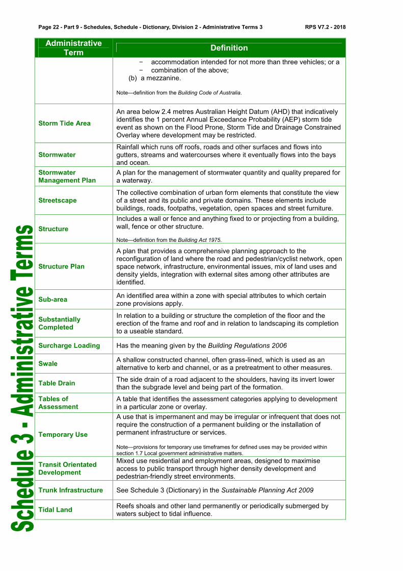
− accommodation intended for not more than three vehicles; or a
− combination of the above; (b) a mezzanine.
Note—definition from the Building Code of Australia.
Storm Tide Area
An area below 2.4 metres Australian Height Datum (AHD) that indicatively identifies the 1 percent Annual Exceedance Probability (AEP) storm tide event as shown on the Flood Prone, Storm Tide and Drainage Constrained Overlay where development may be restricted.
Stormwater Rainfall which runs off roofs, roads and other surfaces and flows into gutters, streams and watercourses where it eventually flows into the bays and ocean.
Stormwater Management Plan
A plan for the management of stormwater quantity and quality prepared for a waterway.
Streetscape The collective combination of urban form elements that constitute the view of a street and its public and private domains. These elements include buildings, roads, footpaths, vegetation, open spaces and street furniture.
Structure
Includes a wall or fence and anything fixed to or projecting from a building, wall, fence or other structure. Note—definition from the Building Act 1975.
Structure Plan
A plan that provides a comprehensive planning approach to the reconfiguration of land where the road and pedestrian/cyclist network, open space network, infrastructure, environmental issues, mix of land uses and density yields, integration with external sites among other attributes are identified.
Sub-area An identified area within a zone with special attributes to which certain zone provisions apply.
Substantially Completed
In relation to a building or structure the completion of the floor and the erection of the frame and roof and in relation to landscaping its completion to a useable standard.
Surcharge Loading Has the meaning given by the Building Regulations 2006
Swale A shallow constructed channel, often grass-lined, which is used as an alternative to kerb and channel, or as a pretreatment to other measures.
Table Drain The side drain of a road adjacent to the shoulders, having its invert lower than the subgrade level and being part of the formation.
Tables of Assessment
A table that identifies the assessment categories applying to development in a particular zone or overlay.
Temporary Use
A use that is impermanent and may be irregular or infrequent that does not require the construction of a permanent building or the installation of permanent infrastructure or services. Note—provisions for temporary use timeframes for defined uses may be provided within section 1.7 Local government administrative matters.
Transit Orientated Development
Mixed use residential and employment areas, designed to maximise access to public transport through higher density development and pedestrian-friendly street environments.
Trunk Infrastructure See Schedule 3 (Dictionary) in the Sustainable Planning Act 2009
Tidal Land Reefs shoals and other land permanently or periodically submerged by waters subject to tidal influence.

RPS V7.2 - 2018 Part 9 - Schedules, Schedule 3 - Dictionary, Division 2 - Administrative Terms - Page 23
Administrative Term
Definition
Ultimate Development
The year in which an area is estimated to be developed to its realistic
potential of the planning scheme in accordance with the planned density.
Use
In relation to premises, includes any use incidental to and necessarily associated with the use of the premises.
Note––definition from the Sustainable Planning Act 2009.
Utility Infrastructure
The following types of infrastructure - (a) water reticulation or supply; (b) energy supply; (c) telecommunications; (d) a sewerage system; (e) stormwater drainage; (f) road; (g) another system or service designed to improve the amenity, or
enhance the enjoyment, of premises or other land.
Vegetation
Is a native tree or plant other than the following:
(a) grass or non-woody herbage; (b) a plant within a grassland regional ecosystem prescribed under a
regulation; (c) a mangrove.
definition from the Vegetation Management Act 1999.
Vehicle trips per day (vpd)
For Part 4—Local government infrastructure plan, the demand unit for the transport network that is represented by vehicle trips per day.
Verge
That part of the street or road reserve between the carriageway and the boundary of the adjacent lot or other limit to the road reserve. The term may accommodate service provider utility infrastructure, footpaths, stormwater flows, street lighting poles and planting.
Volumetric Format Plan of Survey
Defines land using three dimensionally located points to identify the position, shape and dimensions of each bounding surface. Note—definition from the Land Title Act 1994.
Walkability The extent to which a place or an area enables and encourages walking
Walking Catchment
The area of land that is within walking distance, equivalent to the distance that can be covered in about 10 minutes comfortable walk time, of a particular location. Note—the walking catchment for a particular location can be defined according to local circumstances and shown in a planning scheme map (e.g. local plan, overlay). In relation to a boundary shown in a planning scheme map, walking catchment means the land within the relevant boundary in the planning scheme map. In relation to a particular location where a boundary has not been shown in a planning scheme map, walking catchment means the land within 800 metres distance along a walkable route from that particular location.
Waste Container Has the meaning given by ‘Standard Commercial Waste Container’ and ‘Standard Domestic Waste Container’ as defined under the Environmental Protection (Interim Waste) Regulation 1996.
Wastewater System An on-site domestic, commercial or industrial wastewater system that receives, treats and absorbs wastewater within the property boundaries of the site of generation of the wastewater.
Water Catchment An area that drains water to a common point.
Page 24 - Part 9 - Schedules, Schedule - Dictionary, Division 2 - Administrative Terms 3 RPS V7.2 - 2018
Administrative Term
Definition
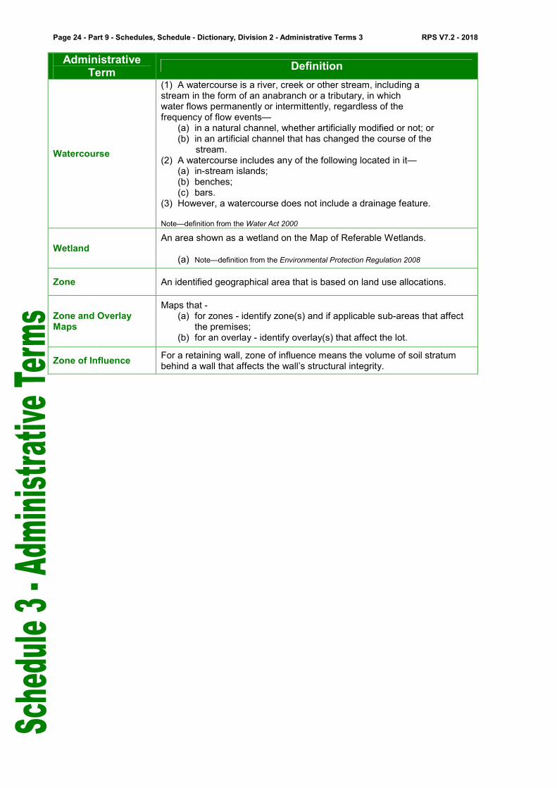
Watercourse
(1) A watercourse is a river, creek or other stream, including a stream in the form of an anabranch or a tributary, in which water flows permanently or intermittently, regardless of the frequency of flow events—
(a) in a natural channel, whether artificially modified or not; or (b) in an artificial channel that has changed the course of the stream.
(2) A watercourse includes any of the following located in it— (a) in-stream islands; (b) benches; (c) bars.
(3) However, a watercourse does not include a drainage feature. Note—definition from the Water Act 2000
Wetland An area shown as a wetland on the Map of Referable Wetlands.
(a) Note—definition from the Environmental Protection Regulation 2008
Zone An identified geographical area that is based on land use allocations.
Zone and Overlay Maps
Maps that - (a) for zones - identify zone(s) and if applicable sub-areas that affect
the premises; (b) for an overlay - identify overlay(s) that affect the lot.
Zone of Influence For a retaining wall, zone of influence means the volume of soil stratum behind a wall that affects the wall’s structural integrity.

RPS V7.2 - 2018 Part 9 - Schedules, Schedule 3 - Dictionary, Division 2 - Administrative Terms - Page 25
Note - Summary of commonly used terms from the Sustainable Planning Act 2009 and other legislation.
Term Other Terms Defined in Legislation
Building Work
Means - (a) building, repairing, altering, underpinning (whether by vertical or lateral
support), moving or demolishing a building or other structure; or (b) work regulated under the Standard Building Regulation 1993; or (c) excavating or filling -
(i) for, or incidental to, the activities mentioned in paragraph (a); or (ii) that may adversely affect the stability of a building or other
structure, whether on the land on which the building or other structure is situated or on adjoining land; or
(d) supporting (whether vertically or laterally) land for activities mentioned in paragraph (a).
“Building work”, for administrating IDAS under the Queensland Heritage Act 1992, includes any of the following -
(a) painting or plastering that substantially alters the appearance of the place; or
(b) renovation, alterations or additions to the place; or (c) excavations, disturbances or changes to landscape or natural features
of land that substantially alters the appearance of the place; or (d) work on furniture, fittings and other objects -
(i) associated with the place; (ii) that contributes to the place’s cultural heritage significance.
“Building work”, for administering IDAS under the Queensland Heritage Act 1992, does not include development for which an exemption certificate has been issued under that Act.
Code Assessment
Means the assessment of development by the assessment manager only against the common material and applicable codes (other than codes, or parts of codes, a concurrence agency is required to assess an application against).
Commercial Waste
Means waste (other than garden waste, recyclable waste, interceptor waste or waste discharged to a sewer) resulting from the use or occupation of any premises, or part thereof, being –
(a) a hotel, morel, caravan park, café, food store, canteen or like premises; or
(b) an assembly building, institutional building, school, kindergarten or child minding centre; or
(c) premises where any spectator sport or any game is played; or (d) an exhibition ground, showground, racecourse, or like premises; or (e) any office, shop or other premises whatsoever, where there is carried
on any business or work, other than a manufacturing procsss.
Erosion Prone Area
Means an area declared to be an erosion prone area under section 70(1) of the Coastal Protection and Management Act 1995.
Exempt Development
Means development other than assessable or self-assessable development.

Page 26 - Part 9 - Schedules, Schedule - Dictionary, Division 2 - Administrative Terms 3 RPS V7.2 - 2018
Term Other Terms Defined in Legislation
Habitable Room
Means a room used for normal domestic activities, and - (a) includes a bedroom, living room, lounge room, music room, television
room, kitchen, dining room, sewing room, study, playroom, family room and sunroom; but
(b) excludes a bathroom, laundry, water closet, pantry, walk-in-wardrobe, corridor, hallway, lobby, photographic darkroom, clothes-drying room, and other spaces of a specialised nature occupied neither frequently nor for extended periods.
IDAS Means the system detailed in Chapter 6 of the Sustainable Planning Act 2009 for integrating State and local government assessment and approval processes for development.
Impact Assessment
Means the assessment (other than code assessment) of - (a) the environmental effects of proposed development; (b) the ways of dealing with the effects.
Koala Habitat Trees
Means native vegetation and plants greater than 4 metres in height or with a diameter greater than 10 centimetres at 1.3 metres above the ground and includes non-eucalypt species that grow in association with the species used by koalas.
Material Change of Use
Means - (a) the start of a new use of the premises; or (b) the re-establishment on the premises of a use that has been
abandoned; or (c) a material change in the intensity or scale of the use of the premises.
Operational Work
Means - (a) extracting gravel, rock, sand or soil from the place where it occurs
naturally; or (b) conducting a forest practice; or (c) excavating or filling that materially affects premises or their use; or (d) placing an advertising device on premises; or (e) undertaking work (other than destroying or removing vegetation not on
freehold land) in, on, over or under premises that materially affects premises or their use; or
(f) clearing vegetation on freehold land; or (g) operations of any kind and all things constructed or installed that allow
taking, or interfering with, water (other than using a water truck to pump water) under the Water Act 2000;
but does not include building, drainage or plumbing work.
Planning Scheme Policy
Means an instrument that - (a) supports the local dimensions of a planning scheme; (b) supports local government actions under the Sustainable Planning Act
2009 for IDAS and for making or amending its planning scheme; (c) is made by a local government under Division 2 and part 5 of the
Sustainable Planning Scheme 2009.
Premises
Means - (a) a building or other structure; or (b) land (whether or not a building or other structure is situated on the
land).
RPS V7.2 - 2018 Part 9 - Schedules, Schedule 3 - Dictionary, Division 2 - Administrative Terms - Page 27
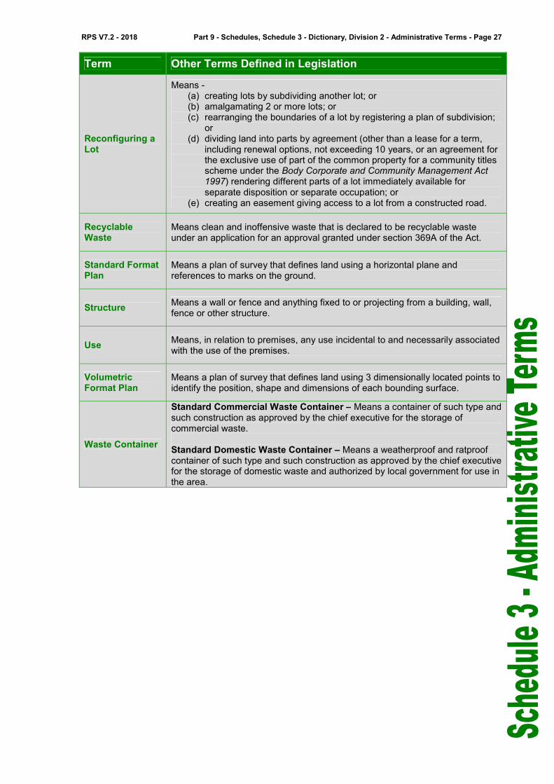
Term Other Terms Defined in Legislation
Reconfiguring a Lot
Means - (a) creating lots by subdividing another lot; or (b) amalgamating 2 or more lots; or (c) rearranging the boundaries of a lot by registering a plan of subdivision;
or (d) dividing land into parts by agreement (other than a lease for a term,
including renewal options, not exceeding 10 years, or an agreement for the exclusive use of part of the common property for a community titles scheme under the Body Corporate and Community Management Act 1997) rendering different parts of a lot immediately available for separate disposition or separate occupation; or
(e) creating an easement giving access to a lot from a constructed road.
Recyclable Waste
Means clean and inoffensive waste that is declared to be recyclable waste under an application for an approval granted under section 369A of the Act.
Standard Format Plan
Means a plan of survey that defines land using a horizontal plane and references to marks on the ground.
Structure Means a wall or fence and anything fixed to or projecting from a building, wall, fence or other structure.
Use Means, in relation to premises, any use incidental to and necessarily associated with the use of the premises.
Volumetric Format Plan
Means a plan of survey that defines land using 3 dimensionally located points to identify the position, shape and dimensions of each bounding surface.
Waste Container
Standard Commercial Waste Container – Means a container of such type and such construction as approved by the chief executive for the storage of commercial waste. Standard Domestic Waste Container – Means a weatherproof and ratproof container of such type and such construction as approved by the chief executive for the storage of domestic waste and authorized by local government for use in the area.

Page 28 - Part 9 - Schedules, Schedule - Dictionary, Division 2 - Administrative Terms 3 RPS V7.2 - 2018
Note - Summary of acronyms used in the Redlands Planning Scheme.
Acronyms
Government Departments and Agencies C.S.I.R.O. Commonwealth Scientific and Industrial Research Organisation
DSDIP Queensland Department of State Development, Infrastructure and Planning
DTMR Queensland Department of Transport and Main Roads
DAFF Queensland Department of Agriculture Fisheries and Forestry
DEHP Queensland Environmental and Heritage Protection
DNRM Queensland Department of Natural Resources and Mines
Guidelines / Standards AR&R Australian Rainfall and Run-off
AS Australian Standard
AUS-SPEC Specifications published by the AUS-SPEC joint venture
MUTCD Manual of Uniform Traffic Control Devices
NZS New Zealand Standard
QUDM Queensland Urban Drainage Manual
Legislation BCA Building Code of Australia 1996
CAMBA Agreement between the Government of Australia and the Government of the People’s Republic of China for the Protection of Migratory Birds and their Environment
DDA Disability Discrimination Act 1997
IDAS Integrated Development Assessment System
SPA Sustainable Planning Act 2009
JAMBA Agreement between the Government of Australia and the Government of Japan for the Protection of Migratory Birds in Danger of Extinction and their Environment
RAMSAR Wetlands designated as of international importance by the Ramsar Treaty
SBR Standard Building Regulation 1993
Organisations ARRB Australian Road Research Board
IPWEAQ Institute of Public Works Engineering Australia Queensland
RPEQ Registered Professional Engineer of Queensland
Other NSI North Stradbroke Island
SMBI Southern Moreton Bay Islands
Technical Terms AEP Annual Exceedance Probability
AHD Australian Height Datum
ARI Average Recurrence Interval
CBR California Bearing Ratio
EIS Environmental Impact Statement
EME Electromagnetic Emissions
ESA Equivalent Standard Axle
ESD Ecologically Sustainable Development
GFA Gross Floor Area
GQAL Good Quality Agricultural Land
GVM Gross Vehicle Mass
HAT Highest Astronomical Tide
RL Relative Level
SMP Stormwater Management Plan
VMP Vegetation Management Plan

![Don’t gamble with physical properties – Kein Glücksspiel ... · AspenTech, CHEMCAD ... x HCl [mol/mol] VLE HCl-H2O, Aspen V7.2 Aspen V7.2 Aspen V7.2 Othmer,D.F, Ind. Eng. Chem](https://img.pdfslide.net/doc/110x75/5b58ae057f8b9a4e1b8c50a7/dont-gamble-with-physical-properties-kein-gluecksspiel-aspentech.jpg)