Embed Size (px)
Citation preview
Doc 8126
Aeronautical Information Services Manual
Seventh Edition, 2021
Notice to Users
This document is an unedited version of an ICAO publication and has not yet been approved in final form. As its content may still be supplemented, removed, or otherwise modified during the editing process, ICAO shall not be responsible
whatsoever for any costs or liabilities incurred as a result of its use..
Approved by and published under the authority of the Secretary General
INTERNATIONAL CIVIL AVIATION ORGANIZATION

FOREWORD
1. The continuous growth of aviation has increased the demands on airspace capacity and efficiency in the services provisions, therefore emphasizing the need for greater equity in airspace access, improved access to timely and meaningful information for decision support and more autonomy in decision making. 2. An important step toward this goal and toward an integrated, responsive global air traffic management (ATM) system, relies on the migration of paper-based, product-centred aeronautical information services (AIS) to data-centric and digital aeronautical information management (AIM). To facilitate this transition, Annex 15 — Aeronautical Information Services provisions were restructured and amended to clarify the scope, role, main functions, products and services of AIM and the associated update mechanisms. 3. The 16th edition of Annex 15 contains high-level requirements and performance specifications for States. These requirements are organized such that data collection is decoupled from the definition of aeronautical products and will facilitate the modernization of the ATM environment according to the principles of system-wide information management (SWIM). 4. The Procedures for Air Navigation Services — Aeronautical Information Management (PANS-AIM, Doc 10066) contains operating practices that are too detailed for inclusion in the standards and recommended practices (SARPs) of Annex 15. The PANS-AIM provides a means for increased harmonization within the aeronautical information domain and accommodates emerging technical requirements. 5. This manual has been revised to provide guidance for the successful implementation of AIM. It explains the provisions contained in Annex 15 and PANS-AIM, provides background information on certain specifications, helps illustrate their meaning and exemplifies means by which these specifications can be met.
Structure of the manual
6. This manual is divided into four parts; the objective is to continue to provide guidance not only on legacy AIS processes, but also on new AIM practices, and to accommodate future developments within the context of SWIM. The target audience of this manual comprises AIS operational personnel, management bodies and regulatory authorities. The four parts are described below:
a) Part I — Regulatory Framework for Aeronautical Information Services explains AIS responsibilities and functions and provides guidance for the organizational development of AIS including the transition to AIM;
b) Part II — Processing Aeronautical Data provides guidance for processing aeronautical data and
aeronautical information while considering the operational provisions for the management of aeronautical information in a data-centric environment;
c) Part III — Aeronautical Information in a Standardized Presentation and Related Services provides
guidance for aeronautical information to be distributed in a standardized presentation; and d) Part IV — Digital Aeronautical Information Products and Related Services provides guidance for
the distribution of digital products and services (under development).
Future developments Comments on this manual are appreciated from all parties involved in the development and implementation of AIM processes and procedures, and should be addressed to: The Secretary General International Civil Aviation Organization 999 Robert Bourassa Boulevard Montréal, Quebec, H3C 5H7 Canada [email protected]
______________________
TABLE OF CONTENTS Page
Foreword ......................................................................................................................................................... (i)
Glossary and definitions .................................................................................................................................. (iv) PART I - Regulatory Framework for Aeronautical Information Services Chapter 1. Introduction ....................................................................................................................................... I-1-1
1.1 Purpose of Part I ...................................................................................................................................... I-1-1 1.2 Primary audience of Part I ......................................................................................................................... I-1-1 1.3 ICAO framework ....................................................................................................................................... I-1-1 1.4 AIM concept .............................................................................................................................................. I-1-2 1.5 Transition from AIS to AIM ........................................................................................................................ I-1-3 1.6 Data quality as a driver for change ........................................................................................................... I-1-3 1.7 Understanding terminology ....................................................................................................................... I-1-4
Chapter 2. States responsibilities and functions ................................................................................................. I-2-1
2.1 Introduction ............................................................................................................................................... I-2-1 2.2 CE-1: Primary Aviation Legislation ............................................................................................................ I-2-1 2.3 CE-2: Specific Operating regulations ........................................................................................................ I-2-2
2.3.1 General .................................................................................................................................... I-2-2 2.3.2 Transposition of the relevant ICAO provisions ........................................................................ I-2-2 2.3.3 Requirements for formal arrangements between the AIS provider and aeronautical data originators .................................................................................................... I-2-2 2.3.4 Requirements for aeronautical information services ............................................................... I-2-3 2.3.5 Requirements for quality management system ........................................................................ I-2-3 2.3.6 Copyright requirements ........................................................................................................... I-2-4 2.3.7 Disclaimers requirements ........................................................................................................ I-2-4
2.4 CE-3: State system and functions ............................................................................................................ I-2-4 2.4.1 Establishing a State civil aviation system ................................................................................ I-2-4
2.5 CE-4: Qualified technical personnel .......................................................................................................... I-2-5 2.6 CE-5: Technical guidance, tools and provision of safety critical information ............................................. I-2-5 2.7 CE-6: Licensing, certification, authorization and approval obligations ..................................................... I-2-5 2.7.1 General .................................................................................................................................... I-2-5 2.7.2 Coordination between States ................................................................................................... I-2-6 2.8 CE-7: Surveillance obligations ................................................................................................................. I-2-6 2.9 CE-8: Resolution of safety concerns ......................................................................................................... I-2-7
Chapter 3. AIS provider responsibilities and functions ....................................................................................... I-3-1
3.1 Responsibilities and functions of AIS ....................................................................................................... I-3-1
3.1.1 AIS provider responsibilities .................................................................................................... I-3-1 3.1.2 AIS provider core and non-core functions ............................................................................... I-3-2
3.2 Organization of AIS ................................................................................................................................... I-3-2 3.2.1 Modes of operations ................................................................................................................ I-3-2 3.2.2 Organizational setup ................................................................................................................ I-3-3 3.2.3 Resources................................................................................................................................ I-3-5 3.2.4 QMS for AIS ............................................................................................................................. I-3-6 3.2.5 AIS safety considerations ........................................................................................................ I-3-7 3.2.6 Establishing an AIS organization using a data-centric approach ............................................. I-3-8
3.3 Aeronautical information products and services ........................................................................................ I-3-11 3.3.1 Introduction .............................................................................................................................. I-3-11
Aeronautical Information Services Manual (iii)
3.3.2 Scope and type of information and associated aeronautical information products .................. I-3-11 3.3.3 Cost recovery ........................................................................................................................... I-3-12
3.4 Personnel .................................................................................................................................................. I-3-13 3.4.1 Personnel requirements ........................................................................................................... I-3-13 3.4.2 Competencies ............................................................................................................................ I-3-14 3.4.3 AIS competency framework ....................................................................................................... I-3-14 3.4.4 Application of the AIS competency framework .......................................................................... I-3-15
3.5 AIS key control elements .......................................................................................................................... I-3-17 3.5.1 Aeronautical Information Regulation and Control (AIRAC) ........................................................ I-3-17 3.5.2 The need for control .................................................................................................................. I-3-17 3.5.3 Regulated system ...................................................................................................................... I-3-18 3.5.4 Coordination .............................................................................................................................. I-3-19 3.5.5 Significance ............................................................................................................................... I-3-19
3.6 Planning automation in an AIS organization ............................................................................................. I-3-20 3.6.1 Introduction ................................................................................................................................ I-3-20 3.6.2 Workflow management .............................................................................................................. I-3-20 3.6.3 Software and tools to support AIS functions .............................................................................. I-3-21
Chapter 4. Aeronautical data originators’ responsibilities ................................................................................... I-4-1
4.1 Introduction .............................................................................................................................................. I-4-1 4.2 Scope ....................................................................................................................................................... I-4-1 4.3 Data quality requirements ......................................................................................................................... I-4-1 4.4 Formal arrangements ............................................................................................................................... I-4-1 4.5 Recommended steps for data originators to comply with data quality requirements ................................ I-4-2
Chapter 5. Aeronautical information management ............................................................................................. I-5-1
5.1 Introduction .............................................................................................................................................. I-5-1 5.2 Parties involved in AIM implementation .................................................................................................... I-5-1 5.3 AIM for State regulatory organizations ...................................................................................................... I-5-1 5.4 AIM for AIS organizations ......................................................................................................................... I-5-2
5.4.1 Introduction ............................................................................................................................. I-5-2 5.4.2 Key issues for AIS in an AIM environment ............................................................................... I-5-3
Appendix 1: AIS competency framework ............................................................................................................ I-A1-1 Appendix 2: Annex 15 compliance checklist ....................................................................................................... I-A2-1 Appendix 3: PANS-AIM compliance checklist ..................................................................................................... I-A3-1 PART II - Processing Aeronautical Data
Chapter 1. Introduction ....................................................................................................................................... II-1-1
1.1 Purpose of Part II ...................................................................................................................................... II-1-1 1.2 Primary audience of Part II ........................................................................................................................ II-1-1 1.3 Overview ................................................................................................................................................... II-1-1
Chapter 2. Scope of aeronautical data and general requirements ..................................................................... II-2-1
2.1 The scope of aeronautical data ................................................................................................................. II-2-1 2.2 Data quality requirements ......................................................................................................................... II-2-6 2.2.1 Accuracy .............................................................................................................................. II-2-6 2.2.2 Resolution ............................................................................................................................ II-2-7 2.2.3 Integrity ................................................................................................................................ II-2-7 2.2.4 Traceability ........................................................................................................................... II-2-7 2.2.5 Timeliness ............................................................................................................................ II-2-8
(iv) Aeronautical Information Services Manual
2.2.6 Completeness ...................................................................................................................... II-2-8 2.2.7 Format .................................................................................................................................. II-2-8 2.3 Metadata ................................................................................................................................................... II-2-9 2.3.1 General ................................................................................................................................ II-2-9 2.3.2 Metadata collected for processes and exchange points ...................................................... II-2-10 2.3.3 Metadata to be provided with each data set ........................................................................ II-2-10 2.4 Reference systems .................................................................................................................................. II-2-12 2.4.1 Horizontal reference system ................................................................................................ II-2-12 2.4.2 Vertical reference system .................................................................................................... II-2-13 2.4.3 Temporal reference system ................................................................................................. II-2-14
Chapter 3. Collection .......................................................................................................................................... II-3-1 3.1 Introduction ............................................................................................................................................... II-3-1 3.2 Use of the aeronautical data catalogue ..................................................................................................... II-3-1 3.3 Formal arrangements with data originators ............................................................................................... II-3-3
3.3.1 General ................................................................................................................................. II-3-3 3.3.2 Content of formal arrangements ........................................................................................... II-3-4
3.4 Handling collected data and information ................................................................................................... II-3-6
Chapter 4. Processing ......................................................................................................................................... II-4-1 4.1 Verification and validation ......................................................................................................................... II-4-2
4.1.1 General ................................................................................................................................. II-4-2 4.1.2 Verification ............................................................................................................................ II-4-3 4.1.3 Validation .............................................................................................................................. II-4-4
4.2 Integration ................................................................................................................................................. II-4-7
Chapter 5. Distribution ........................................................................................................................................ II-5-1
Chapter 6. Quality assurance and control .......................................................................................................... II-6-1 6.1 Introduction ............................................................................................................................................... II-6-1 6.2 Quality assurance ..................................................................................................................................... II-6-1
6.2.1 General aspects .................................................................................................................... II-6-1 6.2.2 Data error detection and reporting ........................................................................................ II-6-2
6.3 Quality control ........................................................................................................................................... II-6-5 6.3.1 Overview .............................................................................................................................. II-6-6 6.3.2 Quality checks to ensure compliance with product specifications ........................................ II-6-7 6.3.3 Consistency checks across the products ............................................................................. II-6-7 6.3.4 Control of nonconforming products ...................................................................................... II-6-7
Chapter 7. Automation ....................................................................................................................................... II-7-1 7.1 Introduction ............................................................................................................................................... II-7-1 7.2 Automation benefits and basic principles .................................................................................................. II-7-1 7.3 User’s operational requirements ............................................................................................................... II-7-2 7.4 Different levels of automation .................................................................................................................... II-7-3
7.4.1 Overview ............................................................................................................................... II-7-3 7.4.2 Level 0 — Manual ................................................................................................................. II-7-4 7.4.3 Level 1 — Data-centric ......................................................................................................... II-7-4 7.4.4 Level 2 — Automated workflow ............................................................................................ II-7-5 7.4.5 Level 3 — Full AIM integration .............................................................................................. II-7-6
7.5 Components of an automated AIM system ............................................................................................... II-7-7 7.5.1 Data input ............................................................................................................................. II-7-7 7.5.2 Core processing system ....................................................................................................... II-7-7 7.5.3 Data storage ......................................................................................................................... II-7-7
Aeronautical Information Services Manual (v)
7.5.4 Data product preparation ...................................................................................................... II-7-8 7.5.5 Service provision .................................................................................................................. II-7-9
7.6 Implementation planning for an automated AIM system ........................................................................... II-7-9 7.6.1 Understanding the improvements ......................................................................................... II-7-9 7.6.2 System requirements ............................................................................................................ II-7-9 7.6.3 Transition to higher-levels of automation ............................................................................. II-7-10
APPENDIX: Data provision agreement ................................................................................................................. II-A-1
PART III - Aeronautical Information in a Standardized Presentation and Related Services
Chapter 1. Introduction ........................................................................................................................................ III-1-1 1.1 Purpose of Part III ..................................................................................................................................... III-1-1 1.2 Primary audience of Part III ....................................................................................................................... III-1-1 1.3 Overview ................................................................................................................................................... III-1-1 1.4 Aeronautical Information Products ........................................................................................................... III-1-2 1.5 Aeronautical Information Services ............................................................................................................ III-1-3
Chapter 2. Aeronautical Information Publication (AIP) ........................................................................................ III-2-1 2.1 Introduction ............................................................................................................................................... III-2-1 2.2 Content and format ................................................................................................................................... III-2-1 2.3 Specimen AIP and explanatory notes ....................................................................................................... III-2-2 2.4 Compiling and editing ............................................................................................................................... III-2-2 2.5 Presentation of information ....................................................................................................................... III-2-3 2.6 Publication of differences in the AIP ......................................................................................................... III-2-5 2.7 AIP amendments ...................................................................................................................................... III-2-8 2.8 AIP supplements .................................................................................................................................... III-2-10 2.9 Electronic AIP ........................................................................................................................................ III-2-15
Chapter 3. Aeronautical Information Updates .................................................................................................... III-3-1 3.1 Permanent and temporary changes .......................................................................................................... III-3-1 3.2 Aeronautical Information Regulation and Control (AIRAC) ....................................................................... III-3-1
Chapter 4. Aeronautical Information Circulars (AIC) .......................................................................................... III-4-1 4.1 Contents .................................................................................................................................................... III-4-1 4.2 Checklist and annual review ..................................................................................................................... III-4-1 4.3 Distribution ................................................................................................................................................ III-4-1
Chapter 5. Provision of Aeronautical Information Products in Standardised Presentation ................................. III-5-1 5.1 Maintenance of a distribution list ............................................................................................................... III-5-1 5.2 Distribution ................................................................................................................................................ III-5-1 5.3 Mailing ....................................................................................................................................................... III-5-1 5.4 Sale of AIS documentation ........................................................................................................................ III-5-2
Chapter 6. NOTAM ............................................................................................................................................ III-6-1 6.1 Introduction ............................................................................................................................................... III-6-1 6.2 NOTAM format .......................................................................................................................................... III-6-1 6.3 Specification for NOTAM ........................................................................................................................... III-6-2
(vi) Aeronautical Information Services Manual
6.4 Cross-reference to AIP or AIP supplement ............................................................................................ III-6-23 6.5 Naming of locations ............................................................................................................................... III-6-23 6.6 Examples of NOTAM using the NOTAM format ..................................................................................... III-6-23 6.7 Trigger NOTAM ...................................................................................................................................... III-6-28 6.8 Checklist of NOTAM .............................................................................................................................. III-6-31
Chapter 7. SNOWTAM ........................................................................................................................................... III-7-1 7.1 Introduction ............................................................................................................................................... III-7-1 7.2 SNOWTAM Format ................................................................................................................................... III-7-1 7.3 Specification for SNOWTAM ..................................................................................................................... III-7-1
Chapter 8. ASHTAM ........................................................................................................................................... III-8-1 8.1 Introduction ............................................................................................................................................... III-8-1 8.2 ASHTAM Format ....................................................................................................................................... III-8-1 8.3 Specification for ASHTAM ......................................................................................................................... III-8-1
Chapter 9. Instructions for the Distribution of NOTAM Messages ...................................................................... III-9-1 9.1 Distribution ................................................................................................................................................ III-9-1 9.2 Predetermined distribution system for NOTAM ......................................................................................... III-9-3
Chapter 10. Pre-flight Information Services .................................................................................................... III-10-1 10.1 Provision of pre-flight information service ............................................................................................ III-10-1 10.2 Integrated pre-flight information service concept ................................................................................. III-10-3 10.3 Pre-flight Information Bulletins (PIB) .................................................................................................... III-10-8
Chapter 11. Post-flight Information Services .................................................................................................... III-11-1 11.1 Purpose of post-flight information ........................................................................................................ III-11-1 11.2 Collection of post-flight information ...................................................................................................... III-11-1
Appendix 1. EXPLANATORY NOTES ON THE SPECIMEN AIP .................................................................... III-A1-1
Appendix 2. AERONAUTICAL INFORMATION PUBLICATION ...................................................................... III-A2-1
Appendix 3. USE OF AUTOMATION IN THE COMPILATION, PROCESSING AND DISTRIBUTION OF NOTAM ................................................................................................................................... III-A3-1
Appendix 4. COMMON AIS QUERY PROCEDURES FOR SELF-BRIEFING BY END-USERS ...................... III-A4-1 Appendix 5. COMMON QUERY MESSAGES FOR THE INTERROGATION OF OTHER AIS
DATABASES ................................................................................................................................ III-A5-1
Appendix 6. USE OF NOTAM CODE AND ABBREVIATIONS .......................................................................... III-A6-1
Appendix 7. NOTAM SELECTION CRITERIA ................................................................................................ III-A7-1
Appendix 8. GUIDANCE ON THE USE OF THE AFS III-A8-1
Appendix 9. EXAMPLE BRIEFING FORMS ................................................................................................... III-A9-1
PART IV - Digital Aeronautical Information Products and Related Services ................................................. IV-1-1

Aeronautical Information Services Manual (vii)
GLOSSARY
(i) ACC Area control centre AFS Aeronautical fixed service AFTN Aeronautical fixed telecommunication network AIC Aeronautical information circular
AICM Aeronautical information conceptual model
AIP Aeronautical information publication AIRAC Aeronautical information regulation and control AIREP Air report AIRMET Airmen’s meteorological information AIS Aeronautical information services AIM Aeronautical information management AMD Aerodrome mapping data AMHS ATS message handling system
AMSL Above mean sea level
ANS Air navigation service
ANSP Air navigation services provider
ARO ATS reporting office ARP Aerodrome reference point ASBU Aviation system block upgrade ATM Air traffic management ATS Air traffic services CBTA Competency-based training and assessment CDM Collaborative decision making CE Critical elements CNS Communication, navigation and surveillance
CRC Cyclic redundancy check
DAIM Digital AIM DTD Document type definition
EGM-96 Earth Gravitational Model — 1996
FIC Flight information centre FIR Flight information region FMS Flight management system GAMET General Aviation METeorological forecast GANP Global air navigation plan GNSS Global navigation satellite system
HTML Hypertext Markup Language
IERS International Earth Rotation Service
IFR Instrument flight rules
ILS Instrument landing system
ISO International Organization for Standardization
METAR Meteorological Terminal Air Report
MSL Mean sea level
MWO Meteorological Watch Office NOF International NOTAM Office NOTAM Notice to airmen
(viii) Aeronautical Information Services Manual
OB Observable behaviour
OGC Open Geospatial Consortium
PANS Procedures for air navigation services PDF Portable document format PERM Permanent PIB Pre-flight information bulletin PNG Portable network QMS Quality management system RCR Runway condition report RNAV Area navigation SARPs Standards and Recommended Practices SCV Scalable vector graphics SIGWX Significant weather SMS Safety management system
SOA Service-oriented architecture
SPECI Aviation selected special weather report SSL Secure sockets layer SWIM System-wide information management TAF Terminal aerodrome forecast TCAS Traffic alert and collision avoidance system TIBA Traffic information broadcast by aircraft UAS Unmanned aircraft systems UIR Upper information region
UTC Coordinated Universal Time
UTM UAS traffic management VAACS Volcanic Ash Advisory Centers – Satellite VFR Visual flight rules W3C World Wide Web Consortium XML Extensible Markup Language
(ii)
(iii) DEFINITIONS When the following terms are used in this document, they have the following meanings: Aerodrome mapping data (AMD). Data collected for the purpose of compiling aerodrome mapping information.
Note.— Aerodrome mapping data is collected for purposes that include the improvement of the user’s situational awareness, surface navigation operations, training, charting and planning. Aeronautical chart. A representation of a portion of the Earth, its culture and relief, specifically designated to meet the
requirements of air navigation. Aeronautical data. A representation of aeronautical facts, concepts or instructions in a formalized manner suitable for
communication, interpretation or processing. Aeronautical fixed service (AFS). A telecommunication service between specified fixed points provided primarily for
the safety of air navigation and for the regular, efficient and economical operation of air services.
Aeronautical Information Services Manual (ix)
Aeronautical information. Information resulting from the assembly, analysis and formatting of aeronautical data. Aeronautical Information Circular (AIC). A notice containing information that does not qualify for the origination of a
NOTAM or for inclusion in the Aeronautical Information Publication (AIP), but which relates to flight safety, air navigation, technical, administrative or legislative matters.
Aeronautical information management (AIM). The dynamic, integrated management of aeronautical information
through the provision and exchange of quality-assured digital aeronautical data in collaboration with all parties. Aeronautical information product. Aeronautical data and aeronautical information provided either as digital data sets
or as a standardized presentation on paper or electronic media. Aeronautical information products include:
— Aeronautical Information Publications (AIP), including Amendments and Supplements; — Aeronautical Information Circulars (AIC); — aeronautical charts; — NOTAMs; and — digital data sets.
Note.— Aeronautical information products are intended primarily to satisfy international requirements for the
exchange of aeronautical information. Aeronautical Information Publication (AIP). A publication issued by or with the authority of a State and containing
aeronautical information of a lasting character essential to air navigation. Aeronautical information service (AIS). A service established within the defined area of coverage responsible for the
provision of aeronautical data and aeronautical information necessary for the safety, regularity and efficiency of air navigation.
AIP Amendment. Permanent changes to the information contained in the AIP. AIP Supplement. Temporary changes to the information contained in the AIP which are provided by means of special
pages. Air navigation services (ANS). Services provided to air traffic during all phases of operations including air traffic
management (ATM), communication, navigation and surveillance (CNS), meteorological services for air navigation (MET), search and rescue (SAR) and aeronautical information services (AIS).
AIRAC. An acronym (aeronautical information regulation and control) signifying a system aimed at advance notification,
based on common effective dates, of circumstances that necessitate significant changes in operating practices. Air traffic management (ATM). The dynamic, integrated management of air traffic and airspace (including air traffic
services, airspace management and air traffic flow management) — safely, economically and efficiently — through the provision of facilities and seamless services in collaboration with all parties and involving airborne and ground-based functions.
Application. Manipulation and processing of data in support of user requirements (ISO 19104†). Audit. A systematic, independent and documented process for obtaining evidence and evaluating it objectively to
determine the extent to which requirements and audit criteria are fulfilled. Civil aviation authority (CAA). The governmental entity or entities, however titled, that are directly responsible for the
regulation of all aspects of civil air transport, technical (i.e. air navigation and aviation safety) and economic (i.e. the commercial aspects of air transport).
Competency. A dimension of human performance that is used to reliably predict successful performance on the job.
† All ISO standards are listed at the end of this section
(x) Aeronautical Information Services Manual
A competency is manifested and observed through behaviours that mobilize the relevant knowledge, skills and attitudes to carry out activities or tasks under specified conditions. Data accuracy. A degree of conformance between the estimated or measured value and the true value. Data completeness. The degree of confidence that all of the data needed to support the intended use is provided. Data format. A structure of data elements, records and files arranged to meet standards, specifications or data quality
requirements. Data integrity (assurance level). A degree of assurance that an aeronautical data and its value have not been lost or
altered since the origination or authorized amendment. Data product. Data set or data set series that conforms to a data product specification (ISO 19131*). Data product specification. Detailed description of a data set or data set series together with additional information
that will enable it to be created, supplied to and used by another party (ISO 19131*).
Note.— A data product specification provides a description of the universe of discourse and a specification for mapping the universe of discourse to a data set. It may be used for production, sales, end-use or other purpose. Data quality. A degree or level of confidence that the data provided meets the requirements of the data user in terms
of accuracy, resolution, integrity (or equivalent assurance level), traceability, timeliness, completeness and format. Data resolution. A number of units or digits to which a measured or calculated value is expressed and used. Data set. Identifiable collection of data (ISO 19101*). Data set series. Collection of data sets sharing the same product specification (ISO 19115*). Data timeliness. The degree of confidence that the data is applicable to the period of its intended use. Data traceability. The degree that a system or a data product can provide a record of the changes made to that product
and thereby enable an audit trail to be followed from the end-user to the originator. Human performance. Human capabilities and limitations which have an impact on the safety, security and efficiency
of aeronautical operations. Inspection. An examination of specific activities, products or services of an aviation licence, certificate, approval or
authorization holder (or applicant) performed by civil aviation inspectors to confirm compliance with requirements for the licence, certificate, approval or authorization already issued (or being issued) by the State.
Inspector. A qualified person authorized by the State to carry out oversight activities for civil aviation. International airport. Any airport designated by the State in whose territory it is situated as an airport of entry and
departure for international air traffic, where the formalities incident to customs, immigration, public health, animal and plant quarantine and similar procedures are carried out.
International NOTAM office (NOF). An office designated by a State for the exchange of NOTAM internationally. Legislation. Generic term used to include primary aviation legislation and specific operating regulations, as defined in
Critical Elements 1 and 2 of a State safety oversight system, respectively. Metadata. Data about data (ISO 19115*). Note.— A structured description of the content, quality, condition or other characteristics of data. Next intended user. The entity that receives the aeronautical data or information from the aeronautical information
service. NOTAM. A notice distributed by means of telecommunication containing information concerning the establishment,
condition or change in any aeronautical facility, service, procedure or hazard, the timely knowledge of which is
Aeronautical Information Services Manual (xi)
essential to personnel concerned with flight operations. Obstacle. All fixed (whether temporary or permanent) and mobile objects, or parts thereof, that:
a) are located on an area intended for the surface movement of aircraft; or b) extend above a defined surface intended to protect aircraft in flight; or c) stand outside those defined surfaces and that have been assessed as being a hazard to air navigation.
Origination (aeronautical data or aeronautical information). The creation of the value associated with new data or
information or the modification of the value of existing data or information. Originator (aeronautical data or aeronautical information). An entity that is accountable for data or information
origination and/or from which the AIS organization receives aeronautical data and information. Position (geographical). Set of coordinates (latitude and longitude) referenced to the mathematical reference ellipsoid
which define the position of a point on the surface of the Earth. Post spacing. Angular or linear distance between two adjacent elevation points. Quality. Degree to which a set of inherent characteristics fulfils requirements (ISO 9000*). Note 1.— The term “quality” can be used with adjectives such as poor, good or excellent. Note 2.— “Inherent”, as opposed to “assigned”, means existing in something, especially as a permanent characteristic. Quality assurance. Part of quality management focused on providing confidence that quality requirements will be
fulfilled (ISO 9000*). Quality control. Part of quality management focused on fulfilling quality requirements (ISO 9000*). Quality management. Coordinated activities to direct and control an organization with regard to quality (ISO 9000*). Requirement. Need or expectation that is stated, generally implied or obligatory (ISO 9000*).
Note 1.— “Generally implied” means that it is custom or common practice for the organization, its customers and other interested parties, that the need or expectation under consideration is implied.
Note 2.— A qualifier can be used to denote a specific type of requirement, e.g. product requirement, quality
management requirement, customer requirement. Note 3.— A specified requirement is one which is stated, for example, in a document. Note 4.— Requirements can be generated by different interested parties.
Safety. The state in which risks associated with aviation activities, related to, or in direct support of the operation of
aircraft, are reduced and controlled to an acceptable level. Safety oversight. A function performed by a State to ensure that individuals and organizations performing an aviation
activity comply with safety-related national laws and regulations. SNOWTAM.† A special series NOTAM notifying the presence or removal of hazardous conditions due to snow, ice,
slush or standing water associated with snow, slush and ice on the movement area, by means of a specific format. SNOWTAM.†† A special series NOTAM given in a standard format providing a surface condition report notifying the
presence or cessation of hazardous conditions due to snow, ice, slush, frost, standing water or water associated with snow, slush, ice or frost on the movement area.
† Applicable until 3 November 2021. †† Applicable as of 4 November 2021.
(xii) Aeronautical Information Services Manual
Surveillance. The activities through which the State proactively verifies through inspections, audits and other activities
that aviation licence, certificate, authorization or approval holders continue to meet the established requirements and function at the level of competency and safety required by the State.
Terrain. The surface of the Earth containing naturally occurring features such as mountains, hills, ridges, valleys,
bodies of water, permanent ice and snow, and excluding obstacles. Traceability. Ability to trace the history, application or location of that which is under consideration (ISO 9000*). Note.— When considering product, traceability can relate to:
— the origin of materials and parts; — the processing history; and — the distribution and location of the product after delivery.
Validation. Confirmation, through the provision of objective evidence, that the requirements for a specific intended use
or application have been fulfilled (ISO 9000*). Verification. Confirmation, through the provision of objective evidence, that specified requirements have been fulfilled
(ISO 9000*). Note.— The term “verified” is used to designate the corresponding status.
______________________
* ISO Standard
9000 — Quality Management Systems — Fundamentals and Vocabulary
19101 — Geographic information — Reference model
19104 — Geographic information — Terminology
19115 — Geographic information — Metadata
19131 — Geographic information — Data product specification
I-1-1
Part I
Regulatory Framework for Aeronautical Information Services

I-1-1
Chapter 1
INTRODUCTION
1.1 PURPOSE OF PART I
1.1.1. The purpose of this manual is to assist the State authorities in establishing and managing an effective
and sustainable State safety oversight system of the aeronautical information services (AIS), implementing the
Standards and Recommended Practices (SARPs) contained in Annex 15 — Aeronautical Information Services and the
Procedures for Air Navigation Services — Aeronautical Information Management (PANS-AIM, Doc 10066).
1.2 PRIMARY AUDIENCE OF PART I
1.2.1. The primary audience of this manual includes:
a) State regulatory organizations dealing with the safety oversight aspects of AIS;
b) management personnel of AIS providers tasked with setting up, organizing and managing the
operations of AIS; and
c) management of aeronautical data originator organizations tasked with providing the aeronautical
data and aeronautical information to the AIS providers.
1.3 ICAO FRAMEWORK
1.3.1 The Global Air Traffic Management Operational Concept (Doc 9854) states that the ATM community
depends on the provision of quality-assured information to collaborate and make informed decisions. Sharing
information on a system-wide basis will allow the ATM community to conduct its business and operations in a safe and
efficient manner.
1.3.2 SARPs for aeronautical information services are published in Annex 15 in accordance with Article 37 of
the Convention on International Civil Aviation (Doc 7300) and reflect the obligation of States for the collection,
management and distribution of aeronautical information in the interest of safety, efficiency and economy of civil aviation.
The SARPs for aeronautical charts are provided in Annex 4 — Aeronautical Charts.
1.3.3 The PANS-AIM is complementary to the SARPs contained in Annex 15 and Annex 4. It specifies the
procedures to be applied by AIS providers in delivering aeronautical information services to other States and aviation
stakeholders.
1.3.4 Manuals are complementary to SARPs and PANS and provide guidance on how best to implement the
ICAO provisions. Guidance material is often used to explain the objective of specific requirements and provide
implementation examples, means of compliance and best practices.
1.3.5 States are responsible for establishing an appropriate safety oversight system to ensure that all applicable
SARPs and associated procedures are implemented, as laid out in Annex 19 — Safety Management.
I-1-2 Aeronautical Information Services Manual, Part I
1.4 AIM CONCEPT
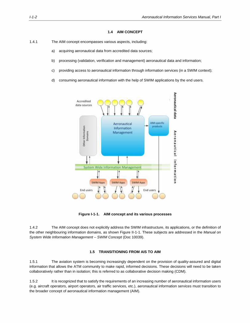
1.4.1 The AIM concept encompasses various aspects, including:
a) acquiring aeronautical data from accredited data sources;
b) processing (validation, verification and management) aeronautical data and information;
c) providing access to aeronautical information through information services (in a SWIM context);
d) consuming aeronautical information with the help of SWIM applications by the end users.
Figure I-1-1. AIM concept and its various processes
1.4.2 The AIM concept does not explicitly address the SWIM infrastructure, its applications, or the definition of
the other neighbouring information domains, as shown Figure II-1-1. These subjects are addressed in the Manual on
System Wide Information Management – SWIM Concept (Doc 10039).
1.5 TRANSITIONING FROM AIS TO AIM
1.5.1 The aviation system is becoming increasingly dependent on the provision of quality-assured and digital
information that allows the ATM community to make rapid, informed decisions. These decisions will need to be taken
collaboratively rather than in isolation; this is referred to as collaborative decision making (CDM).
1.5.2 It is recognized that to satisfy the requirements of an increasing number of aeronautical information users
(e.g. aircraft operators, airport operators, air traffic services, etc.), aeronautical information services must transition to
the broader concept of aeronautical information management (AIM).
Aeronautical Information Services Manual, Part I I-1-3
1.5.3 The traditional product-centric AIS must transition to a data-centric and service-oriented approach, in
which reliable aeronautical information is made available dynamically (e.g. via SWIM information services) for use in
applications that perform tasks like flight planning, flight management, navigation, separation assurance, CDM, or any
other strategic or tactical ATM activity.
1.5.4 The responsibilities of an AIS provider may not change, but the way in which business is conducted must
change. There is an increased emphasis on data distribution and data quality, which positions AIM to serve the ATM
community in a more efficient and cost-effective way in terms of their information management requirements. The
benefits include:
a) greater access to timely and meaningful aeronautical information for decision support and more
autonomy in decision making and conflict management;
b) enhanced safety of flight operations due to the access to timely and meaningful aeronautical
information;
c) greater equity in accessing airspace; and
d) better business delivery based on an appropriate safety network.
1.5.5 To successfully transition from AIS to AIM, all parties involved with setting up, organizing, providing and
managing services, as well as conducting safety oversight need to have a clear understanding of their respective roles
and responsibilities. This manual therefore provides guidance concerning these aspects.
1.6 DATA QUALITY AS A DRIVER FOR CHANGE
1.6.1 The increased need for quality-assured aeronautical data and aeronautical information is the main driver
for change, as the global AIM community moves away from a product-centric and paper-based environment. However,
the quality of aeronautical data and aeronautical information is often inconsistent. Problems with quality are often
attributed to unintended variability during the origination, processing and publication of the data or the medium and
format in which the data is provided, which is caused by a lack of standardization and monitoring. Inconsistent data
quality results in a lack of trust by the users in the aeronautical data and aeronautical information supplied.
1.6.2 Aeronautical data quality can also be compromised when States do not trace and document aeronautical
information processing activities. Without traceability, the AIS provider has limited means to determine the cause or
nature of data errors or corrupted data. The quality of aeronautical data should therefore be questioned whenever there
is no traceable connection between a State’s published aeronautical information and the method used for entering the
data into their data processing systems.
1.7 UNDERSTANDING TERMINOLOGY
1.7.1 In Annex 15 and PANS-AIM, AIS is defined as “a service established within the defined area of coverage
responsible for the provision of aeronautical data and aeronautical information necessary for the safety, regularity and
efficiency of air navigation”.
1.7.2 Throughout this manual, the terms “AIS”, “AIS provider” and “AIS organization” are used interchangeably
to describe the entity designated by the State to provide the aeronautical information service within the defined area of
coverage as designated by the State. The designated responsibility is published in the aeronautical information
publication (AIP).
1.7.3 In Annex 15 and PANS-AIM, AIM is defined as “the dynamic, integrated management of aeronautical

I-1-4 Aeronautical Information Services Manual, Part I
information through the provision and exchange of quality-assured digital aeronautical data in collaboration with all
parties”.
1.7.4 The term AIM is used in this manual to describe a quality-assured and digital data-centric environment
that an AIS organization has implemented or is about to implement.
______________________
I-2-1
Chapter 2
STATE RESPONSIBILITIES AND FUNCTIONS
2.1 INTRODUCTION
2.1.1 Annex 19 – Safety Management, Appendix 1 describes how a State is responsible for establishing a State
safety oversight (SSO) system consisting of the following critical elements (CEs):
a) CE-1: Primary aviation legislation;
b) CE-2: Specific operating regulations;
c) CE-3: State system and functions;
d) CE-4: Qualified technical personnel;
e) CE-5: Technical guidance, tools and provision of safety-critical information;
f) CE-6: Licensing, certification, authorization and approval obligations;
g) CE-7: Surveillance obligations; and
h) CE-8: Resolution of safety issues.
2.1.2 The following paragraphs explain how these critical elements apply to the provision of aeronautical
information services.
2.2 CE-1: PRIMARY AVIATION LEGISLATION
Note.— Additional information concerning CE-1 is provided in the Safety Oversight Manual, Part A — The
Establishment and Management of a State Safety Oversight System (Doc 9734), Section 3.1.
2.2.1 States must promulgate a comprehensive and effective aviation law, commensurate with the size and
complexity of their aviation activity and consistent with the requirements contained in the Convention on International
Civil Aviation (Doc 7300) to enable the oversight and management of civil aviation safety and the enforcement of
regulations through the relevant authorities or agencies established for that purpose.
2.2.2 It is required that every State provide a high-level statement in its primary aviation legislation clearly
establishing the responsibility concerning the provision of aeronautical information products and services.
2.2.3 The primary legislation must be applicable to all involved parties in the State. Aeronautical data originators
within a State are also considered parties in the State’s legislation and associated regulatory framework (see CE-2).
I-2-2 Aeronautical Information Services Manual, Part I
2.3 CE-2: SPECIFIC OPERATING REGULATIONS
Note.— Additional information concerning CE-2 is provided in the Safety Oversight Manual, Part A — The
Establishment and Management of a State Safety Oversight System (Doc 9734), Section 3.2.
2.3.1 General
2.3.1.1 Specific AIM operating regulations should include, but are not limited to:
a) transposition of the relevant ICAO provisions (e.g. Annex 4 — Aeronautical Charts, Annex 15 —
Aeronautical Information Services and the Procedures for Air Navigation Services — Aeronautical
Information Management (PANS-AIM, Doc 10066));
b) requirements for formal arrangements between the AIS and aeronautical data originators;
c) requirements for aeronautical information services;
d) Quality Management System (QMS) requirements; and
e) any other regulatory criteria to support the provision of aeronautical information services.
2.3.1.2 An effective regulatory framework recognizes and applies to all parties involved in providing aeronautical
information services as part of a State’s AIS function. It clarifies the specific roles and responsibilities of all parties
involved.
2.3.2 Transposition of the relevant ICAO provisions
2.3.2.1 In accordance with Article 37 of the Chicago Convention, Annex 15 is designed to promote uniformity in
the collection and distribution of aeronautical information, in the interest of the safety, regularity, and efficiency of
international civil aviation.
2.3.2.2 States are encouraged to transpose SARPs and PANS (including Annex 15, Annex 4, PANS-AIM and
other provisions) into their regulatory framework to secure the highest degree of uniformity in regulations, standards
and procedures in relation to the provision of aeronautical information services.
2.3.2.3 To support States in this exercise, compliance checklists are provided in Appendices 2 and 3. These
checklists provide a complete assessment of the provisions in Annex 15 and PANS-AIM compared to the previous
edition. This permits States to perform a gap analysis of their current AIM national regulations against the latest ICAO
provisions, and update their regulations, or identify differences.
2.3.3 Requirements for formal arrangements between AIS provider and aeronautical data originators
2.3.3.1 States must establish requirements for the identification of appropriate aeronautical data originators and
ensure that formal arrangements are put in place between the AIS provider and the aeronautical data originators.
2.3.3.2 Since the aeronautical data catalogue contains all data elements that the AIS manages, each one being
assigned an owner, the AIS can use the aeronautical data catalogue to systematically establish and document formal
arrangements with all identified data originators.
Note.— Additional information concerning the use of the aeronautical data catalogue is provided in Doc
8126, Part II — Processing Aeronautical Data.
Aeronautical Information Services Manual, Part I I-2-3
2.3.4 Requirements for aeronautical information services distribution services
2.3.4.1 States are responsible for establishing requirements in the AIS provider’s overall services portfolio for
distribution services which include:
a) aeronautical data and aeronautical information distribution service (i.e. aeronautical information
products);
b) pre-flight information services (i.e. automated pre-flight information service); and
c) post-flight information services.
2.3.4.2 The transition to AIM affects the way aeronautical information is distributed due to the increased
availability of digital products. The distribution service is moving from physical distribution media (e.g. paper or CD-
ROM) combined with aeronautical fixed service (AFS) distribution channels (e.g. aeronautical fixed telecommunication
networks (AFTN), air traffic services (ATS) message handling systems (AMHS)) to web-based information services,
online portals, etc. States should therefore define criteria on how to provide and access these services.
2.3.4.3 In addition to defining the requirements for distribution services, the means of accessing the service
should also be defined by the State. If the pre-flight information service is provided as an integrated service (e.g.
including AIS and MET), States should coordinate with the involved regulatory authorities (e.g. AIS and MET authorities).
In some States, the authorities are organizationally separated from each other, either as government departments or
as corporatized agencies, whereas in other States, the authorities are within the same organization. In the latter case,
the organizational structure may be centralized or there may be a network of offices, some of which may combine AIS,
MET and ARO functions.
2.3.4.4 It is recommended that States identify and assign roles and responsibilities to all parties involved in
providing pre-flight information services. This improves access to relevant pre-flight information required for the
planning and execution of a flight, irrespective of the source.
2.3.4.5 It is recommended that States develop a regulatory framework for the provision of pre-flight information
service covering all involved information sources, as well as the scope of the service. It is also recommended that
States designate the overall responsibility to one entity in the State, who would be responsible for the planning and
operation of the pre-flight information service in collaboration with the required information providers.
2.3.4.6 If one or more States want to jointly provide pre-flight information services, it is recommended that the
involved State authorities implement joint regulations addressing the requirements of all the States involved and agree
on a surveillance mechanism. In that case, all required information sources should be identified and designated as
authoritative source.
2.3.4.7 Regarding post-flight information services, the State should define the requirements of what information
is to be reported, as well as how and to whom this information should be disseminated. The post-flight information
service is described in more detail in Doc 8126, Part III — Aeronautical Information in a Standardized Presentation and
Services.
2.3.5 Requirements for quality management systems
States should establish requirements for a QMS in the AIS organization as part of the regulatory framework.
I-2-4 Aeronautical Information Services Manual, Part I
2.3.6 Copyright
2.3.6.1 The legal framework of a State may copyright protect the aeronautical information products provided by
that State. The application of copyright does not, however, affect the ability for States to exchange aeronautical
information products in accordance with Articles 28 c) and 37 of the Convention.
2.3.6.2 When established, the copyright protection applies to aeronautical information products, whether the
products are provided in a paper-based or digital format, so as to ensure control of their use.
2.4.6.3 In accordance with Annex 15 — Aeronautical Information Services, any aeronautical information product
that has been granted copyright protection by the State and has been provided to another State in conformance with
the specifications in the Annex, can only be made available to a third party on the condition that the third party has
been informed that the aeronautical information product is copyright protected.
2.3.6.4 In order to facilitate the reuse of aeronautical information products, States should establish requirements
for agreement between the State’s AIS and respective users, addressing copyright and contractual obligations.
2.4 CE-3: STATE SYSTEM AND FUNCTIONS
Note.— Additional information concerning CE-3 is provided in the Safety Oversight Manual, Part A — The
Establishment and Management of a State Safety Oversight System (Doc 9734), Section 3.3.
2.4.1 Establishing a State civil aviation system
2.4.1.1 For States to fulfil their obligations as outlined in the Chicago Convention, their national legislation should
provide for an appropriately organized, funded and empowered civil aviation system. This civil aviation system should
be structured such as to effectively fulfil the tasks that it is expected to undertake. In practice, it is necessary that States
establish an appropriate and practical organization and employ the needed personnel, including technical and support
personnel to carry out its safety oversight functions and duties.
2.4.1.2 With respect to the AIS domain, States are to establish the responsibilities, functions and duties of each
authority involved in the provision of aeronautical information services, separate from the regulatory authority.
2.4.1.3 The need for independence of the AIS provider (when AIS is provided by the ANSP) and its separation
from the overall safety oversight of the ANSP is essential and consistent with principles of good governance; the safety
oversight function must in fact be independent and transparent.
2.4.1.4 In the event that the safety oversight and service provision functions are provided by the State, a clear
separation of these functions must be established. This is crucial for maintaining a high degree of regulatory integrity
since only in this way it is possible to achieve a decision-making process that is objective, impartial, consistent, and
avoids the risks of conflict of interest, bias or improper influence.
2.4.1.5 In States where the size of the aviation industry is relatively small and the level of complexity relatively
simple, States may be able to fulfil their responsibilities in a cost-effective manner through arrangements with other
States for the provision of a joint service, or by delegating the authority to a non-governmental agency. For example, a
State can delegate the safety oversight function of the AIS to another State or a regional organization as defined within
its regulatory framework. Such delegation of functions must be appropriately documented with roles and responsibilities
clearly described. The delegating State should establish mechanisms to ensure that the State accepting the delegated
functions complies with the established regulations.
2.4.1.6 Independent from the chosen configuration, the safety oversight function must be performed in
accordance with the State regulatory framework as described in Annex 19.
Aeronautical Information Services Manual, Part I I-2-5
2.5 CE-4: QUALIFIED TECHNICAL PERSONNEL
Note.— Additional information concerning CE-4 is provided in the Safety Oversight Manual, Part A — The
Establishment and Management of a State Safety Oversight System (Doc 9734), Section 3.4.
2.5.1 States should establish minimum qualification requirements for the personnel involved in oversight
activities (“AIS inspectorate”) based on the functions they are to perform. All personnel in the AIS inspectorate should
have appropriate prior experience and subsequent training to maintain and enhance their competence(s) for the defined
function. This includes initial, advanced, recurrent, refresher and on-the-job training prior to any assignment of
operational tasks and responsibilities.
2.5.2 States should develop formal training programmes outlining the type of training that should be provided
to AIS inspectors in order to conduct adequate oversight functions. Periodic training plans should provide details and
prioritize the type of AIS training for each inspector during a specified period in accordance with the assigned functions
and the individual training requirements. In addition, the training programme should address special training needs as
required to support upcoming changes in the industry (e.g., digital data sets, SWIM, etc.).
2.5.3 States should ensure that defined qualifications are met by the AIS inspectorate. Appropriate training
records must be maintained in a systematic manner to provide evidence and to maintain the integrity of the records.
2.5.4 It often happens that AIS inspectors also perform oversight duties related to other areas (e.g. procedure
design, airspace management, etc.). Even if specialties are combined, it is required for States to ensure that each set
of qualification requirements is met.
2.6 CE-5: TECHNICAL GUIDANCE, TOOLS AND PROVISION OF SAFETY CRITICAL INFORMATION
Note.— Additional information concerning CE-5 is provided in the Safety Oversight Manual, Part A — The
Establishment and Management of a State Safety Oversight System (Doc 9734), Section 3.5.
2.6.1 States must provide the appropriate facilities, comprehensive and up-to-date technical guidance material
and procedures, tools (including software tools), equipment and transportation means, as applicable, to technical
personnel to perform their safety oversight functions effectively and in accordance with the established procedures.
2.6.2 State technical guidance material should specify how to evaluate compliance of aeronautical data and
aeronautical information with the quality requirements, including detailed procedures and checklists for ongoing
surveillance activities and how to implement applicable regulations, instructions and directives. Technical personnel
must be provided with procedures and checklists to approve aeronautical information products.
2.7 CE-6: LICENSING, CERTIFICATION, AUTHORIZATION AND APPROVAL OBLIGATIONS
Note.— Additional information concerning CE-6 is provided in the Safety Oversight Manual, Part A —
The Establishment and Management of a State Safety Oversight System (Doc 9734), Section 3.6.
2.7.1 General
2.7.1.1 According to Annex 15, States have some flexibility for establishing the authority for the provision of
aeronautical information products and services, depending on their particular circumstances. For example, a State can
arrange to share AIS responsibilities between one or more service providers within the State, with one or more other
I-2-6 Aeronautical Information Services Manual, Part I
States, or delegate the authority to a non-governmental agency.
2.7.1.2 There are different possible scenarios; for example, a State may assign certain responsibilities to an
agency within the State (e.g. data collection and data management due to applicable national regulations), whereas
other responsibilities are performed by another agency within the State (e.g. aeronautical charting) or by another State
(e.g. joint aeronautical publications together with another State). The AIS provider, given authorization through proper
documentation, is subject to surveillance to ensure continuous compliance with the requirements.
2.7.1.3 A State, prior to designating a new AIS provider, should ensure that the service provider complies with
applicable regulatory requirements. Deficiencies noted by the authority performing safety oversight should be brought
to the attention of the new AIS provider. The service provider should be given an opportunity to correct these
deficiencies. All deficiencies should be corrected to the satisfaction of the safety oversight authority.
2.7.1.4 As part of this process, States must establish within their regulatory framework the requirements for the
competency level of technical personnel in charge of various functions associated with the provision of AIS. It is
recommended to apply the guidance that is provided in Section 3.4 and Appendix 1 describing an ICAO competency
framework for AIS.
2.7.2 Coordination between States
2.7.2.1 Some aeronautical data may require coordination with one or more neighbouring States to ensure data
consistency. Especially changes to aeronautical data adjacent to borders of neighbouring States or even cross border
data (e.g. common airspace boundaries, significant points, navigational aids, route segment information, aerodrome
information or ATS unit COM frequencies) require coordination between States.
2.7.2.2 As the AIS collects data from data originators, it also acts as the focal point for the coordination and
harmonization of aeronautical data between States. It is therefore recommended that States establish formal bilateral
or multilateral working arrangements with the neighbouring States for aeronautical data requiring coordination to avoid
data inconsistencies.
2.7.2.3 When inconsistencies are detected, the receiving (neighbouring) State must inform the originating State
who must resolve the issues with the data originator. If at the publication date, data inconsistencies continue to exist,
the publication should be postponed.
2.7.2.4 The establishment of bilateral or multilateral working arrangements between one or more neighbouring
States offers an effective safety net for ensuring the consistency of aeronautical data across borders and facilitates the
identification of possible data inconsistencies due to insufficient communication between States (e.g. concerning
common airspace boundaries or cross-border routes).
2.8 CE-7: SURVEILLANCE OBLIGATIONS
Note.— Additional information concerning CE-7 is provided in the Safety Oversight Manual, Part A — The
Establishment and Management of a State Safety Oversight System (Doc 9734), Section 3.7.
2.8.1 States must implement well-documented surveillance processes by defining and planning inspections,
audits, and monitoring activities on a continuous basis. These surveillance processes serve to proactively assure that
the AIS providers continue to meet the established requirements. This includes the surveillance of personnel designated
by the State authority to perform safety oversight functions on its behalf.
2.8.2 States must continuously monitor performance and observe whether progress is being made in achieving
AIS performance objectives (as referenced in the Manual on Air Navigation Services Economics (Doc 9161)). The
division of such objectives into key performance areas and subsequent evaluation through specific key performance
Aeronautical Information Services Manual, Part I I-2-7
indicators tailored for each area may assist in assessing the AIS objectives.
2.8.3 As part of the surveillance activities, States must establish a surveillance programme and plans.
Surveillance activities should be carried out using standardized procedures and checklists, including the collection of
surveillance records and associated documentation, of the following main elements:
a) quality standards: States must ensure that the aeronautical information products and services are
delivered in accordance with the State regulatory framework;
b) formal arrangements with data originators: States must ensure that formal arrangements exist
between AIS providers and data originators;
c) QMS: States must ensure that a QMS is implemented at each function stage of the AIS process. This
is achieved by establishing an appropriate policy at the State level for QMS implementation
applicable to aeronautical data and aeronautical information origination, processing and
publication/provision. For the QMS to be effective, and for it to evolve, it is necessary to advocate,
create and maintain a culture inclined to meet the quality objectives. States should proactively create
awareness with all involved parties to promote the quality management culture required for an AIS
organization and apply QMS to the entire data chain. A State should also regularly review bilateral
or multilateral working arrangements with the neighbouring States to incorporate any changes,
feedback and evaluate performance and scope related to their QMS; and
Note.― Further guidance on applying QMS in AIS in the context of ANS safety considerations
can be found in Chapter 4.
d) validation and verification: States must conduct proper oversight to ensure that adequate validation
and verification procedures for aeronautical data and aeronautical information are put in place.
Note.― Examples of validation and verification techniques are provided in Doc 8126, Part II — Processing
Aeronautical Data.
2.9 CE-8: RESOLUTION OF SAFETY CONCERNS
Note.— Additional information concerning CE-8 is provided in the Safety Oversight Manual, Part A — The
Establishment and Management of a State Safety Oversight System (Doc 9734), Section 3.8.
2.9.1 States should establish effective mechanisms to identify non-compliance in the provision of aeronautical
information services by the AIS provider and for their effective and timely resolution.
2.9.2 In the case that a State discovers that the AIS provider has failed or is unable to meet or maintain the
required standards, appropriate follow-up action needs to be taken.
2.9.3 Based on the State’s regulatory framework, States should enforce policies and procedures for the AIS
provider, while also taking appropriate and progressive enforcement measures to promptly correct deficiencies.
______________________

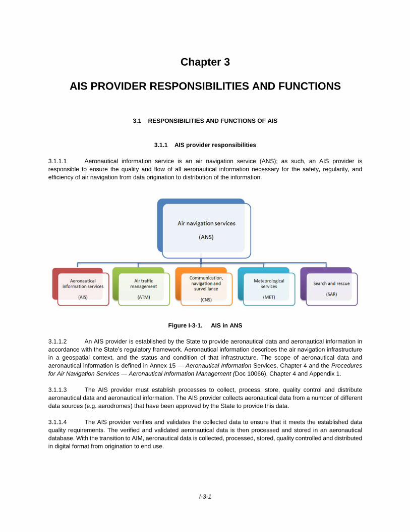
I-3-1
Chapter 3
AIS PROVIDER RESPONSIBILITIES AND FUNCTIONS
3.1 RESPONSIBILITIES AND FUNCTIONS OF AIS
3.1.1 AIS provider responsibilities
3.1.1.1 Aeronautical information service is an air navigation service (ANS); as such, an AIS provider is
responsible to ensure the quality and flow of all aeronautical information necessary for the safety, regularity, and
efficiency of air navigation from data origination to distribution of the information.
Figure I-3-1. AIS in ANS
3.1.1.2 An AIS provider is established by the State to provide aeronautical data and aeronautical information in
accordance with the State’s regulatory framework. Aeronautical information describes the air navigation infrastructure
in a geospatial context, and the status and condition of that infrastructure. The scope of aeronautical data and
aeronautical information is defined in Annex 15 — Aeronautical Information Services, Chapter 4 and the Procedures
for Air Navigation Services — Aeronautical Information Management (Doc 10066), Chapter 4 and Appendix 1.
3.1.1.3 The AIS provider must establish processes to collect, process, store, quality control and distribute
aeronautical data and aeronautical information. The AIS provider collects aeronautical data from a number of different
data sources (e.g. aerodromes) that have been approved by the State to provide this data.
3.1.1.4 The AIS provider verifies and validates the collected data to ensure that it meets the established data
quality requirements. The verified and validated aeronautical data is then processed and stored in an aeronautical
database. With the transition to AIM, aeronautical data is collected, processed, stored, quality controlled and distributed
in digital format from origination to end use.
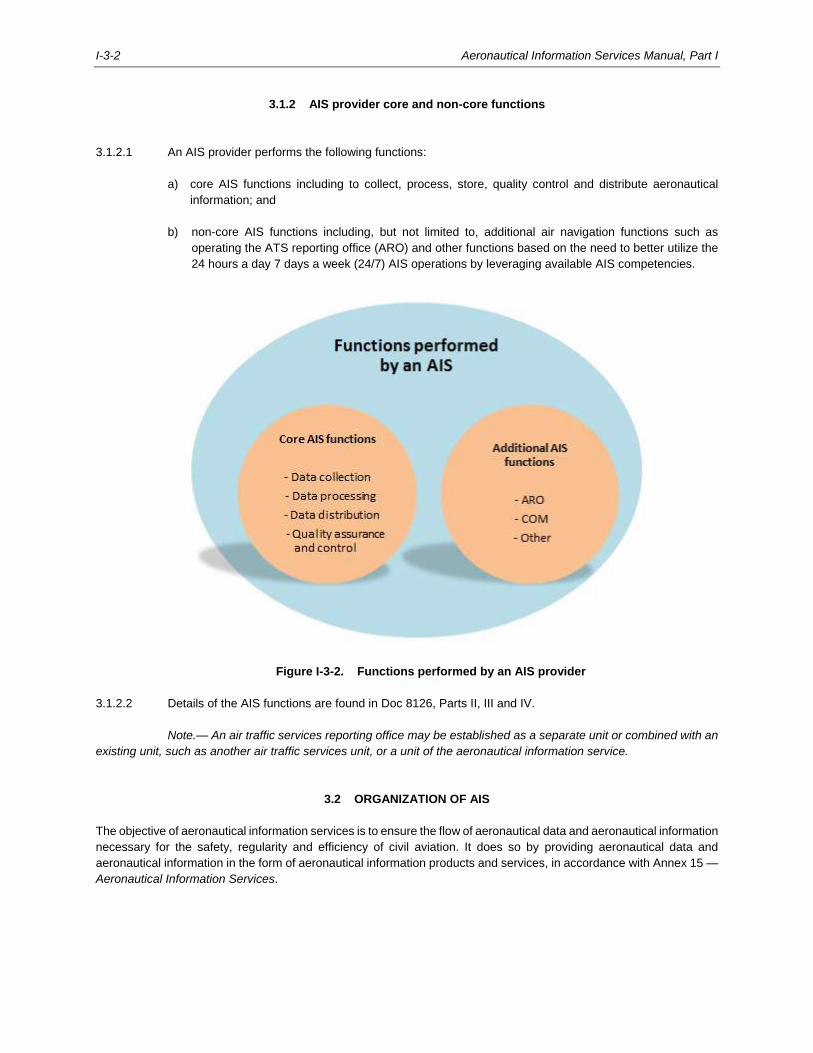
I-3-2 Aeronautical Information Services Manual, Part I
3.1.2 AIS provider core and non-core functions
3.1.2.1 An AIS provider performs the following functions:
a) core AIS functions including to collect, process, store, quality control and distribute aeronautical
information; and
b) non-core AIS functions including, but not limited to, additional air navigation functions such as
operating the ATS reporting office (ARO) and other functions based on the need to better utilize the
24 hours a day 7 days a week (24/7) AIS operations by leveraging available AIS competencies.
Figure I-3-2. Functions performed by an AIS provider
3.1.2.2 Details of the AIS functions are found in Doc 8126, Parts II, III and IV.
Note.— An air traffic services reporting office may be established as a separate unit or combined with an
existing unit, such as another air traffic services unit, or a unit of the aeronautical information service.
3.2 ORGANIZATION OF AIS
The objective of aeronautical information services is to ensure the flow of aeronautical data and aeronautical information
necessary for the safety, regularity and efficiency of civil aviation. It does so by providing aeronautical data and
aeronautical information in the form of aeronautical information products and services, in accordance with Annex 15 —
Aeronautical Information Services.
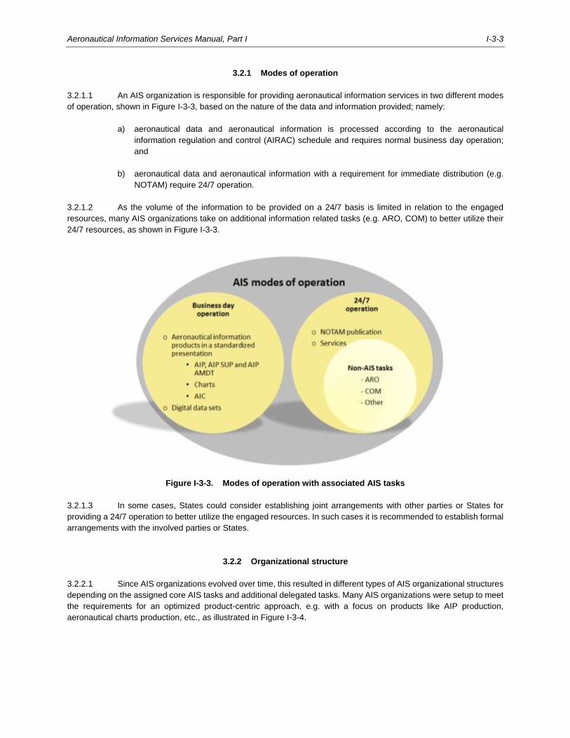
Aeronautical Information Services Manual, Part I I-3-3
3.2.1 Modes of operation
3.2.1.1 An AIS organization is responsible for providing aeronautical information services in two different modes
of operation, shown in Figure I-3-3, based on the nature of the data and information provided; namely:
a) aeronautical data and aeronautical information is processed according to the aeronautical
information regulation and control (AIRAC) schedule and requires normal business day operation;
and
b) aeronautical data and aeronautical information with a requirement for immediate distribution (e.g.
NOTAM) require 24/7 operation.
3.2.1.2 As the volume of the information to be provided on a 24/7 basis is limited in relation to the engaged
resources, many AIS organizations take on additional information related tasks (e.g. ARO, COM) to better utilize their
24/7 resources, as shown in Figure I-3-3.
Figure I-3-3. Modes of operation with associated AIS tasks
3.2.1.3 In some cases, States could consider establishing joint arrangements with other parties or States for
providing a 24/7 operation to better utilize the engaged resources. In such cases it is recommended to establish formal
arrangements with the involved parties or States.
3.2.2 Organizational structure
3.2.2.1 Since AIS organizations evolved over time, this resulted in different types of AIS organizational structures
depending on the assigned core AIS tasks and additional delegated tasks. Many AIS organizations were setup to meet
the requirements for an optimized product-centric approach, e.g. with a focus on products like AIP production,
aeronautical charts production, etc., as illustrated in Figure I-3-4.
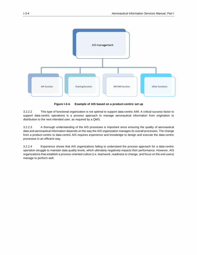
I-3-4 Aeronautical Information Services Manual, Part I
Figure I-3-4. Example of AIS based on a product-centric set up
3.2.2.2 This type of functional organization is not optimal to support data-centric AIM. A critical success factor to
support data-centric operations is a process approach to manage aeronautical information from origination to
distribution to the next intended user; as required by a QMS.
3.2.2.3 A thorough understanding of the AIS processes is important since ensuring the quality of aeronautical
data and aeronautical information depends on the way the AIS organization manages its overall processes. The change
from a product-centric to data-centric AIS requires experience and knowledge to design and execute the data-centric
processes in an efficient way.
3.2.2.4 Experience shows that AIS organizations failing to understand the process approach for a data-centric
operation struggle to maintain data quality levels, which ultimately negatively impacts their performance. However, AIS
organizations that establish a process-oriented culture (i.e. teamwork, readiness to change, and focus on the end users)
manage to perform well.
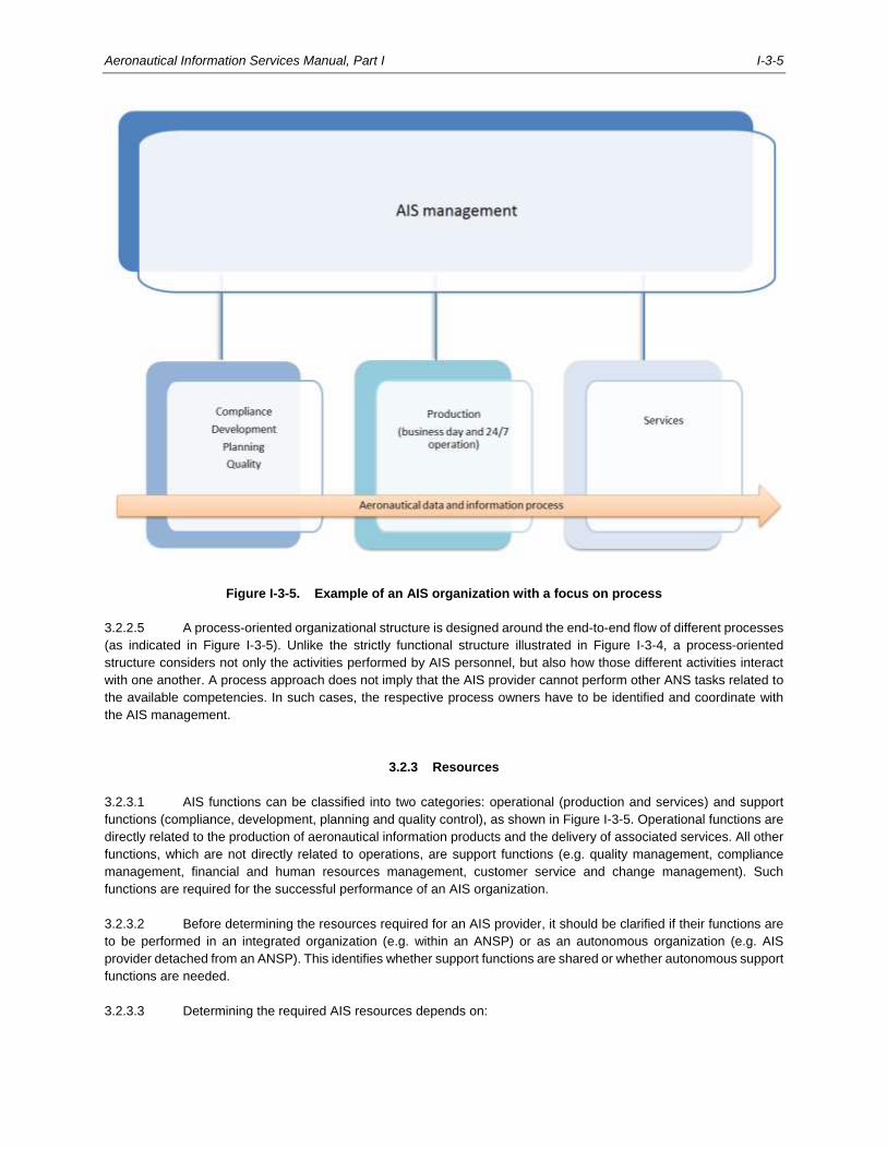
Aeronautical Information Services Manual, Part I I-3-5
Figure I-3-5. Example of an AIS organization with a focus on process
3.2.2.5 A process-oriented organizational structure is designed around the end-to-end flow of different processes
(as indicated in Figure I-3-5). Unlike the strictly functional structure illustrated in Figure I-3-4, a process-oriented
structure considers not only the activities performed by AIS personnel, but also how those different activities interact
with one another. A process approach does not imply that the AIS provider cannot perform other ANS tasks related to
the available competencies. In such cases, the respective process owners have to be identified and coordinate with
the AIS management.
3.2.3 Resources
3.2.3.1 AIS functions can be classified into two categories: operational (production and services) and support
functions (compliance, development, planning and quality control), as shown in Figure I-3-5. Operational functions are
directly related to the production of aeronautical information products and the delivery of associated services. All other
functions, which are not directly related to operations, are support functions (e.g. quality management, compliance
management, financial and human resources management, customer service and change management). Such
functions are required for the successful performance of an AIS organization.
3.2.3.2 Before determining the resources required for an AIS provider, it should be clarified if their functions are
to be performed in an integrated organization (e.g. within an ANSP) or as an autonomous organization (e.g. AIS
provider detached from an ANSP). This identifies whether support functions are shared or whether autonomous support
functions are needed.
3.2.3.3 Determining the required AIS resources depends on:
I-3-6 Aeronautical Information Services Manual, Part I
a) the processes and level of automation applied for providing the aeronautical information products
and services;
b) the number of tasks related to processes that are performed during business hours, and those
requiring 24/7 availability;
c) peak production requirements to comply with AIRAC for aeronautical information products or
timeliness requirements (e.g. NOTAMs);
d) unavailability of personnel (e.g. personnel on leave, annual training, retirement); and
e) contingency considerations.
3.2.3.4 AIS management is responsible for determining and ensuring that sufficient resources are available to
meet all applicable requirements. With the transition from AIS to AIM, it is recommended that AIS management, in
collaboration with the State, annually review the engaged AIS resources in terms of the required competencies in the
operational environment (e.g. an automated production environment may require other competencies than a
non-automated environment). Furthermore, it should be determined whether the AIS organization is sufficiently staffed
to handle demand during peak periods to comply with AIRAC.
3.2.4 QMS for AIS
3.2.4.1 A quality management system consists of a framework of policies, processes and procedures through
which an AIS provider manages the inter-related parts of its business to achieve its objectives. The management
system that has been implemented can impact aeronautical data quality, aeronautical data and aeronautical information
product or service quality and operational efficiency.
3.2.4.2 Annex 15 — Aeronautical Information Services requires the AIS provider to implement and maintain a
quality management system encompassing all functions of an AIS provider. The implementation of a QMS is critical for
the successful transition to data-centric AIM; it ensures that the aeronautical data and aeronautical information provided
to the next intended users will comply with specific quality standards. High-quality aeronautical information is essential
to the development of interoperable tools that directly support the safe and efficient operation of aircraft.
3.2.4.3 Annex 15 also recommends that the QMS follows the International Organization for Standardization (ISO)
9000 series of quality assurance standards and that it is certified by an accredited certification body. ISO 9000 defines
the QMS as a “management system that directs and controls an organization regarding quality. Activities generally
include the following: establishment of a quality policy and quality objectives, quality planning, quality control, quality
assurance and quality improvement”.
3.2.4.4 QMS supports an AIS organization by improving its performance and creating an organizational culture
that involves a continuous cycle of self-evaluation, correction and improvement of operations and processes through
effective feedback mechanisms. Regular audits are a vital part of the QMS as they enable AIS providers to verify
outputs versus objectives and show conformity to the standard.
3.2.4.5 Product and data quality is an important objective of AIM as it provides the users with aeronautical
information they can trust. Aeronautical data and aeronautical information must therefore align with the users’
perspective. The direct dependence of users on the quality of aeronautical data and aeronautical information is evident
from Annex 15, which states that using corrupt critical data creates a high probability that the safe flight of an aircraft
would be severely at risk or even end in a potential catastrophe. It is vital that the intended users of the aeronautical
data and aeronautical information are confident of using the data and information in an operational environment.
3.2.4.6 To demonstrate to users that the required quality of aeronautical data and aeronautical information has
been met, States’ AIS organizations must establish a QMS and put in place quality management procedures at all
Aeronautical Information Services Manual, Part I I-3-7
stages of the aeronautical data and aeronautical information process. The QMS must be documented and
demonstrable for each function stage, ensuring that the organizational structure, procedures, processes and resources
are in place in order to detect and remedy any data and information anomalies and errors during the phases of
production, maintenance and operational use. An explicit characteristic of a QMS is the ability to trace all data and
information from any point in the process, back through the preceding processes, to its origin.
3.2.4.7 Many States have used the ISO 9000 series of quality assurance standards as the basis for their QMS.
ISO 9000 accreditation is one way for a State’s AIS to demonstrate that a QMS is in place which will enable them to
meet established user requirements.
3.2.4.8 As an integral part of the QMS, all personnel should possess the required competencies necessary to
operate within the AIM environment. The objective of an effective competency framework is to foster a better link
between the objectives of the organization and those of personnel. Additional information in this aspect is provided in
Section 3.4 and Appendix 1.
3.2.4.9 To implement and continually improve QMS in an AIS organization, it is necessary to advocate, create
and maintain a culture dedicated to quality and safety. It is the responsibility of AIS management to establish the quality
and safety culture within the AIS.
3.2.5 AIS safety considerations
3.2.5.1 Given the increasing reliance on digital data supplied by an AIS provider, the air navigation system safety
considerations are of paramount importance. Corrupt, erroneous, late or missing aeronautical data and aeronautical
information can potentially affect the safety of air navigation.
3.2.5.2 Annex 19 – Safety Management requires certain service providers to implement a safety management
system (SMS) whose activities are directly related to flight operations, such as aerodromes operators, aeroplane or
helicopter operators, ATS providers, etc.
3.2.5.3 Although the SMS provisions in Annex 19 do not directly apply to AIS providers, AIS providers can make
a significant contribution to the safety of the products or services of other service providers that are required to have
an SMS. It is therefore recommended that mechanisms be established for contributing to the SMS process of those
service providers required to have one.
3.2.5.4 AIS organizations should consider the following aspects with respect to the safety management activities
and processes of other service providers they interface with:
a) SMS awareness and training, to ensure that AIS personnel are aware of the SMS within other service
providers;
b) safety communication, to ensure awareness of the SMS to a degree commensurate with their roles
and responsibilities;
c) hazard identification (in cooperation with other service providers), to effectively support other service
providers in identifying hazards associated with aviation products and services; and
d) safety risk assessment and mitigation (in coordination with other service providers), to support other
service providers analyse, assess and control the safety risks associated with the identified hazards.
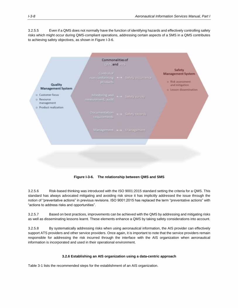
I-3-8 Aeronautical Information Services Manual, Part I
3.2.5.5 Even if a QMS does not normally have the function of identifying hazards and effectively controlling safety
risks which might occur during QMS-compliant operations, addressing certain aspects of a SMS in a QMS contributes
to achieving safety objectives, as shown in Figure I-3-6.
Figure I-3-6. The relationship between QMS and SMS
3.2.5.6 Risk-based thinking was introduced with the ISO 9001:2015 standard setting the criteria for a QMS. This
standard has always advocated mitigating and avoiding risk since it has implicitly addressed the issue through the
notion of “preventative actions” in previous revisions. ISO 9001:2015 has replaced the term “preventative actions” with
“actions to address risks and opportunities”.
3.2.5.7 Based on best practices, improvements can be achieved with the QMS by addressing and mitigating risks
as well as disseminating lessons learnt. These elements enhance a QMS by taking safety considerations into account.
3.2.5.8 By systematically addressing risks when using aeronautical information, the AIS provider can effectively
support ATS providers and other service providers. Once again, it is important to note that the service providers remain
responsible for addressing the risk incurred through the interface with the AIS organization when aeronautical
information is incorporated and used in their operational environment.
3.2.6 Establishing an AIS organization using a data-centric approach
Table 3-1 lists the recommended steps for the establishment of an AIS organization.
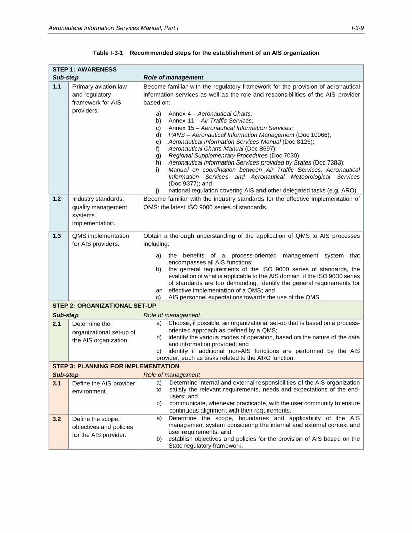
Aeronautical Information Services Manual, Part I I-3-9
Table I-3-1 Recommended steps for the establishment of an AIS organization
STEP 1: AWARENESS
Sub-step Role of management
1.1 Primary aviation law
and regulatory
framework for AIS
providers.
Become familiar with the regulatory framework for the provision of aeronautical
information services as well as the role and responsibilities of the AIS provider
based on:
a) Annex 4 – Aeronautical Charts; b) Annex 11 – Air Traffic Services; c) Annex 15 – Aeronautical Information Services; d) PANS – Aeronautical Information Management (Doc 10066); e) Aeronautical Information Services Manual (Doc 8126); f) Aeronautical Charts Manual (Doc 8697); g) Regional Supplementary Procedures (Doc 7030) h) Aeronautical Information Services provided by States (Doc 7383); i) Manual on coordination between Air Traffic Services, Aeronautical Information Services and Aeronautical Meteorological Services (Doc 9377); and j) national regulation covering AIS and other delegated tasks (e.g. ARO)
1.2 Industry standards:
quality management
systems
implementation.
Become familiar with the industry standards for the effective implementation of
QMS: the latest ISO 9000 series of standards.
1.3 QMS implementation
for AIS providers.
Obtain a thorough understanding of the application of QMS to AIS processes
including:
a) the benefits of a process-oriented management system that encompasses all AIS functions; b) the general requirements of the ISO 9000 series of standards, the evaluation of what is applicable to the AIS domain; if the ISO 9000 series of standards are too demanding, identify the general requirements for an effective implementation of a QMS; and c) AIS personnel expectations towards the use of the QMS.
STEP 2: ORGANIZATIONAL SET-UP
Sub-step Role of management
2.1 Determine the
organizational set-up of
the AIS organization.
a) Choose, if possible, an organizational set-up that is based on a process- oriented approach as defined by a QMS; b) identify the various modes of operation, based on the nature of the data and information provided; and c) identify if additional non-AIS functions are performed by the AIS provider, such as tasks related to the ARO function.
STEP 3: PLANNING FOR IMPLEMENTATION
Sub-step Role of management
3.1 Define the AIS provider
environment.
a) Determine internal and external responsibilities of the AIS organization to satisfy the relevant requirements, needs and expectations of the end- users; and b) communicate, whenever practicable, with the user community to ensure continuous alignment with their requirements.
3.2 Define the scope,
objectives and policies
for the AIS provider.
a) Determine the scope, boundaries and applicability of the AIS management system considering the internal and external context and user requirements; and b) establish objectives and policies for the provision of AIS based on the State regulatory framework.
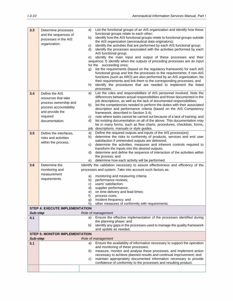
I-3-10 Aeronautical Information Services Manual, Part I
3.3 Determine processes
and the sequences of
processes in the AIS
organization.
a) List the functional groups of an AIS organization and identify how these functional groups relate to each other; b) identify how the AIS functional groups relate to functional groups outside the AIS organization (aeronautical data originators); c) identify the activities that are performed by each AIS functional group; d) identify the processes associated with the activities performed by each AIS functional group; e) identify the main input and output of these processes and their sequence; f) identify when the outputs of preceding processes are an input for the succeeding ones; g) list the requirements (based on the regulatory framework) for each AIS functional group and link the processes to the requirements; if non-AIS functions (such as ARO) are also performed by an AIS organization, list their requirements and link them to the corresponding processes; and h) identify the procedures that are needed to implement the listed processes.
3.4 Define the AIS
resources that take
process ownership and
process accountability
and provide the
required
documentation.
a) List the roles and responsibilities of AIS personnel involved. Note the differences between actual responsibilities and those documented in the job descriptions, as well as the lack of documented responsibilities; b) list the competencies needed to perform the duties with their associated description and performance criteria (based on the AIS Competency framework, described in Section 3.4); c) note where tasks cannot be carried out because of a lack of training; and d) list existing documentation on all of the above. This documentation may be in many forms, such as flow charts, procedures, checklists, forms, job descriptions, manuals or style guides.
3.5 Define the interfaces,
risks and activities
within the process.
a) Define the required outputs and inputs of the AIS process(es); b) determine the risks to conformity of products, services and end user satisfaction if unintended outputs are delivered; c) determine the activities, measures and inherent controls required to transform the inputs into the desired outputs; d) determine and define the sequence of interaction of the activities within the process; and e) determine how each activity will be performed.
3.6 Determine the
monitoring and
measurement
requirements.
Identify the validation necessary to assure effectiveness and efficiency of the
processes and system. Take into account such factors as:
a) monitoring and measuring criteria; b) performance reviews; c) users' satisfaction; d) supplier performance; e) on time delivery and lead times; f) process costs; g) incident frequency; and h) other measures of conformity with requirements.
STEP 4: EXECUTE IMPLEMENTATION
Sub-step Role of management
4.1 a) Ensure the effective implementation of the processes identified during the planning phase; and b) identify any gaps in the processes used to manage the quality framework and update as needed.
STEP 5: MONITOR IMPLEMENTATION
Sub-step Role of management
5.1 a) Ensure the availability of information necessary to support the operation and monitoring of these processes; b) measure, monitor and analyse these processes, and implement action necessary to achieve planned results and continual improvement; and c) maintain appropriately documented information necessary to provide confidence of conformity to the processes and resulting product.
Aeronautical Information Services Manual, Part I I-3-11
3.3 AERONAUTICAL INFORMATION PRODUCTS AND SERVICES
3.3.1 Introduction
3.3.1.1 In order to meet the requirements of the global ATM concept of operation, several aspects of the
aeronautical information services must be improved based on the evolving operational needs requiring use of
information technologies. The transition to AIM introduces a new concept for aeronautical information products and
services which transitions from product-centric and paper-based legacy processes, to a fully data-centric AIM. This will
provide new capabilities to airspace users in line with the objectives of the global air navigation plan (GANP), e.g. digital
AIM (DAIM) and SWIM elements of the aviation system block upgrades (ASBU).
3.3.1.2 The new requirements on aeronautical information encompass improved data quality (i.e. accuracy,
resolution, integrity, traceability, timeliness, completeness, and format), digital processing and exchange of information
and increased efficiency for the management of aeronautical information (avoiding, for example, manual data input,
duplicate data entries, etc.).
3.3.1.3 In this context, the purpose of an AIS organization as such does not change. However, the new demands
of the aviation community and the new technological capabilities change the way in which functions are currently
performed. Change management considerations are described in Chapter 5.
3.3.2 Scope and type of aeronautical information and associated aeronautical information products
3.3.2.1 The aeronautical data catalogue in the PANS-AIM provides a general description of the AIM data scope
and consolidates all aeronautical data and aeronautical information to be collected and maintained by an AIS
organization. The aeronautical data catalogue provides a means for States to help identify the organizations and
authorities responsible for the origination of the aeronautical data and aeronautical information. It also provides a
common language and thereby facilitates the formal arrangements between data originators and AIS.
3.3.2.2 The aeronautical data catalogue identifies the data quality requirements applicable from origination to
publication and describes all data and information needed to assemble the various types of aeronautical information
products and services.
3.3.2.3 As shown in Figure I-3-7, Annex 15 — Aeronautical Information Services identifies the following main
categories:
a) aeronautical information products with the following sub-categories:
1) those provided in a standardized presentation, consisting of the redefined legacy products (such
as AIP, including AIP amendments and AIP supplements, AIC, aeronautical charts and
NOTAM); and
2) those provided as digital data sets, consisting of a set of aeronautical data and aeronautical
information applied with a specific purpose (e.g. AIP data set, terrain and obstacle data sets,
aerodrome mapping data set, and instrument flight procedure data set);
b) distribution services with the following sub-categories:
1) elements of the aeronautical information products are distributed to the next intended user;
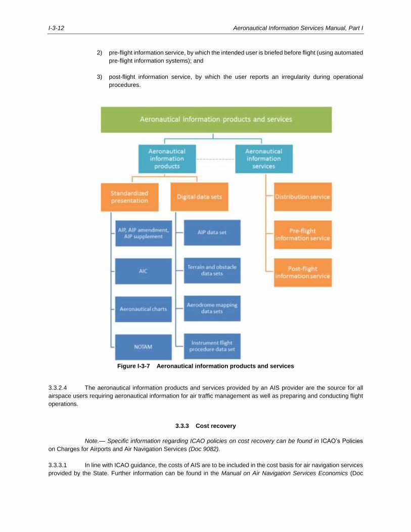
I-3-12 Aeronautical Information Services Manual, Part I
2) pre-flight information service, by which the intended user is briefed before flight (using automated
pre-flight information systems); and
3) post-flight information service, by which the user reports an irregularity during operational
procedures.
Figure I-3-7 Aeronautical information products and services
3.3.2.4 The aeronautical information products and services provided by an AIS provider are the source for all
airspace users requiring aeronautical information for air traffic management as well as preparing and conducting flight
operations.
3.3.3 Cost recovery
Note.— Specific information regarding ICAO policies on cost recovery can be found in ICAO’s Policies
on Charges for Airports and Air Navigation Services (Doc 9082).
3.3.3.1 In line with ICAO guidance, the costs of AIS are to be included in the cost basis for air navigation services
provided by the State. Further information can be found in the Manual on Air Navigation Services Economics (Doc
Aeronautical Information Services Manual, Part I I-3-13
9161) and the Airport Economics Manual (Doc 9562). The transition from paper-based products and services to data-
driven information services does not change the applicable charging principles for the AIS provider although the way
of providing information changes.
3.3.3.2 As aeronautical information products and services are provided to support all phases of flight and all
categories of users of the air navigation services, the AIS costs should be allocated to all users based on the use of
the information (i.e. based on the traffic numbers for aerodrome and en-route, or IFR and VFR split). The granularity of
allocating AIS costs must be defined in the State’s policy.
3.3.3.3 Depending on State policy, most of the costs incurred for providing aeronautical information products and
services of the State’s AIS are included in the AIS cost base, while in some cases on demand aeronautical information
products and services may be provided on a value-added basis to meet specific user requirements. Such an approach
may contribute to enabling innovation in the provision of aeronautical information services when transitioning to AIM.
States are responsible to establish the associated policies for AIS cost recovery.
3.3.3.4 Some aeronautical data that is required to be made available by the AIS provider, and that is listed in the
aeronautical data catalogue, e.g. terrain and obstacle data, may originate from parties not considered as part of the
aviation system in many States (e.g. geographic information service providers, or telecommunication tower owners and
operators). This may require cost recovery policies to be established at State level to cover the effort of collecting
aeronautical data from the various data originators in accordance with the required aeronautical data quality.
3.3.3.5 Since collecting aeronautical data and distributing aeronautical information relies increasingly on the
availability of digital services interfacing with the external environment of an ANSP, which typically operates in a
protected production environment, it is best practice to contain these costs in the AIS cost base. This includes the costs
for security of internet-based services, e.g. for information distribution services. One way to contain costs in a SWIM-
compliant environment is to use open-source and freely available internet platforms, but care must be taken to consider
the total cost of ownership versus commercially available software and systems.
3.3.3.6 AIS comprises the personnel, facilities and equipment or services to collect, process, store, quality control
and distribute aeronautical information covering the entire State, as well as any other areas for which it has undertaken
to provide air navigation services. In many States, third parties provide certain AIS support services, e.g. printing and
distribution of the AIP. These costs are considered part of AIS costs.
3.3.3.7 There is also an increased demand for aeronautical information by users not directly contributing to
recovering the costs of air navigation services (e.g. drone industry and UAS traffic management (UTM)). In this case,
it is necessary to determine a fair allocation of costs between aeronautical and non-aeronautical users.
3.3.3.8 It has become common practice for AIS organizations to make better use of their personnel in the air
navigation services context, based on economic considerations. This results in AIS providers not only performing AIS
tasks, but also additional information services associated with other air navigation functions such as providing
aeronautical data and aeronautical information to flight planning software vendors. It is recommended that such costs
are allocated to the respective information service consumer.
3.4 PERSONNEL
3.4.1 Personnel requirements
3.4.1.1 In line with the State’s requirements, an AIS provider must ensure that job descriptions, training programs,
training plans and training records are developed, maintained and continuously improved based on the ICAO
competency framework.
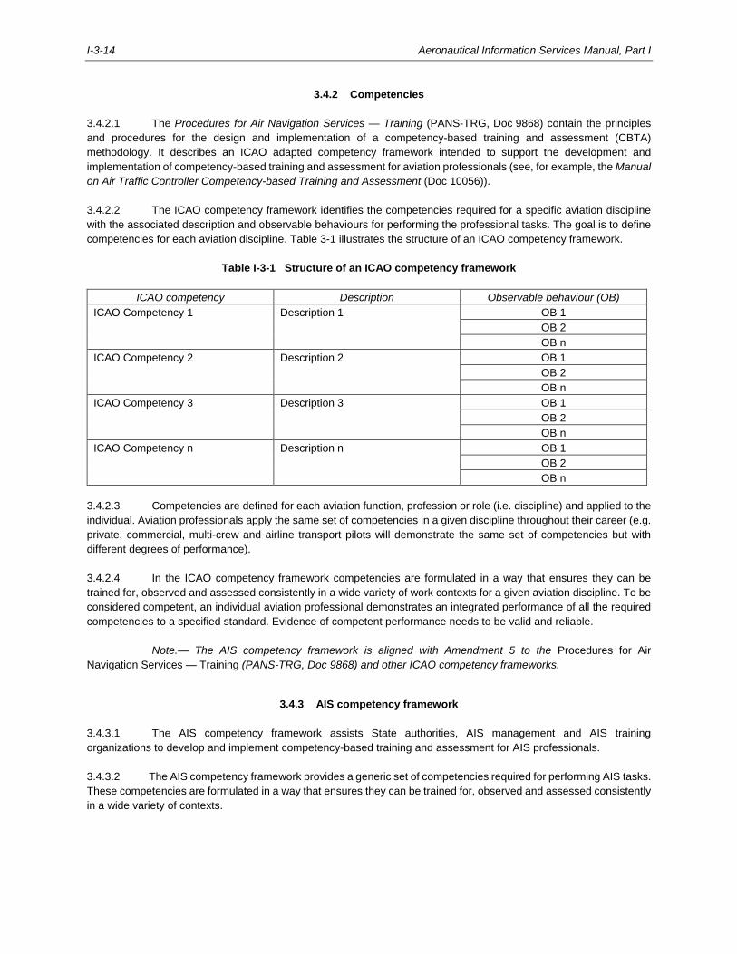
I-3-14 Aeronautical Information Services Manual, Part I
3.4.2 Competencies
3.4.2.1 The Procedures for Air Navigation Services — Training (PANS-TRG, Doc 9868) contain the principles
and procedures for the design and implementation of a competency-based training and assessment (CBTA)
methodology. It describes an ICAO adapted competency framework intended to support the development and
implementation of competency-based training and assessment for aviation professionals (see, for example, the Manual
on Air Traffic Controller Competency-based Training and Assessment (Doc 10056)).
3.4.2.2 The ICAO competency framework identifies the competencies required for a specific aviation discipline
with the associated description and observable behaviours for performing the professional tasks. The goal is to define
competencies for each aviation discipline. Table 3-1 illustrates the structure of an ICAO competency framework.
Table I-3-1 Structure of an ICAO competency framework
ICAO competency Description Observable behaviour (OB)
ICAO Competency 1 Description 1 OB 1
OB 2
OB n
ICAO Competency 2 Description 2 OB 1
OB 2
OB n
ICAO Competency 3 Description 3 OB 1
OB 2
OB n
ICAO Competency n Description n OB 1
OB 2
OB n
3.4.2.3 Competencies are defined for each aviation function, profession or role (i.e. discipline) and applied to the
individual. Aviation professionals apply the same set of competencies in a given discipline throughout their career (e.g.
private, commercial, multi-crew and airline transport pilots will demonstrate the same set of competencies but with
different degrees of performance).
3.4.2.4 In the ICAO competency framework competencies are formulated in a way that ensures they can be
trained for, observed and assessed consistently in a wide variety of work contexts for a given aviation discipline. To be
considered competent, an individual aviation professional demonstrates an integrated performance of all the required
competencies to a specified standard. Evidence of competent performance needs to be valid and reliable.
Note.— The AIS competency framework is aligned with Amendment 5 to the Procedures for Air
Navigation Services — Training (PANS-TRG, Doc 9868) and other ICAO competency frameworks.
3.4.3 AIS competency framework
3.4.3.1 The AIS competency framework assists State authorities, AIS management and AIS training
organizations to develop and implement competency-based training and assessment for AIS professionals.
3.4.3.2 The AIS competency framework provides a generic set of competencies required for performing AIS tasks.
These competencies are formulated in a way that ensures they can be trained for, observed and assessed consistently
in a wide variety of contexts.
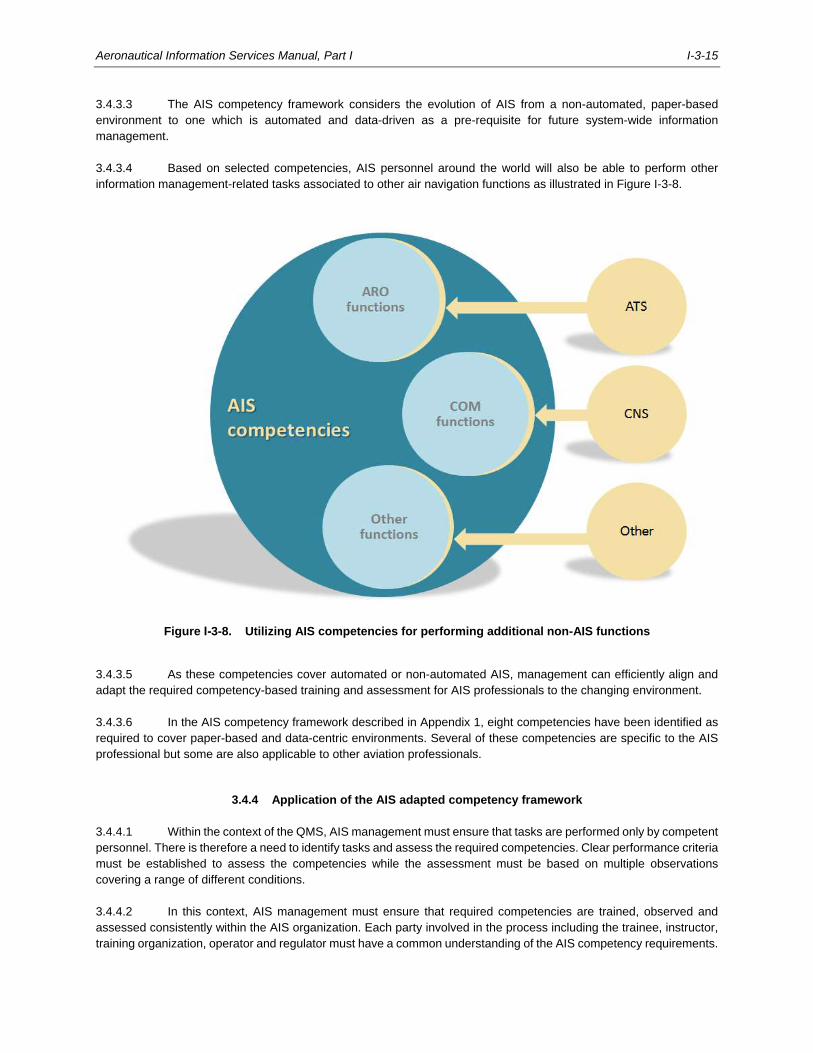
Aeronautical Information Services Manual, Part I I-3-15
3.4.3.3 The AIS competency framework considers the evolution of AIS from a non-automated, paper-based
environment to one which is automated and data-driven as a pre-requisite for future system-wide information
management.
3.4.3.4 Based on selected competencies, AIS personnel around the world will also be able to perform other
information management-related tasks associated to other air navigation functions as illustrated in Figure I-3-8.
Figure I-3-8. Utilizing AIS competencies for performing additional non-AIS functions
3.4.3.5 As these competencies cover automated or non-automated AIS, management can efficiently align and
adapt the required competency-based training and assessment for AIS professionals to the changing environment.
3.4.3.6 In the AIS competency framework described in Appendix 1, eight competencies have been identified as
required to cover paper-based and data-centric environments. Several of these competencies are specific to the AIS
professional but some are also applicable to other aviation professionals.
3.4.4 Application of the AIS adapted competency framework
3.4.4.1 Within the context of the QMS, AIS management must ensure that tasks are performed only by competent
personnel. There is therefore a need to identify tasks and assess the required competencies. Clear performance criteria
must be established to assess the competencies while the assessment must be based on multiple observations
covering a range of different conditions.
3.4.4.2 In this context, AIS management must ensure that required competencies are trained, observed and
assessed consistently within the AIS organization. Each party involved in the process including the trainee, instructor,
training organization, operator and regulator must have a common understanding of the AIS competency requirements.
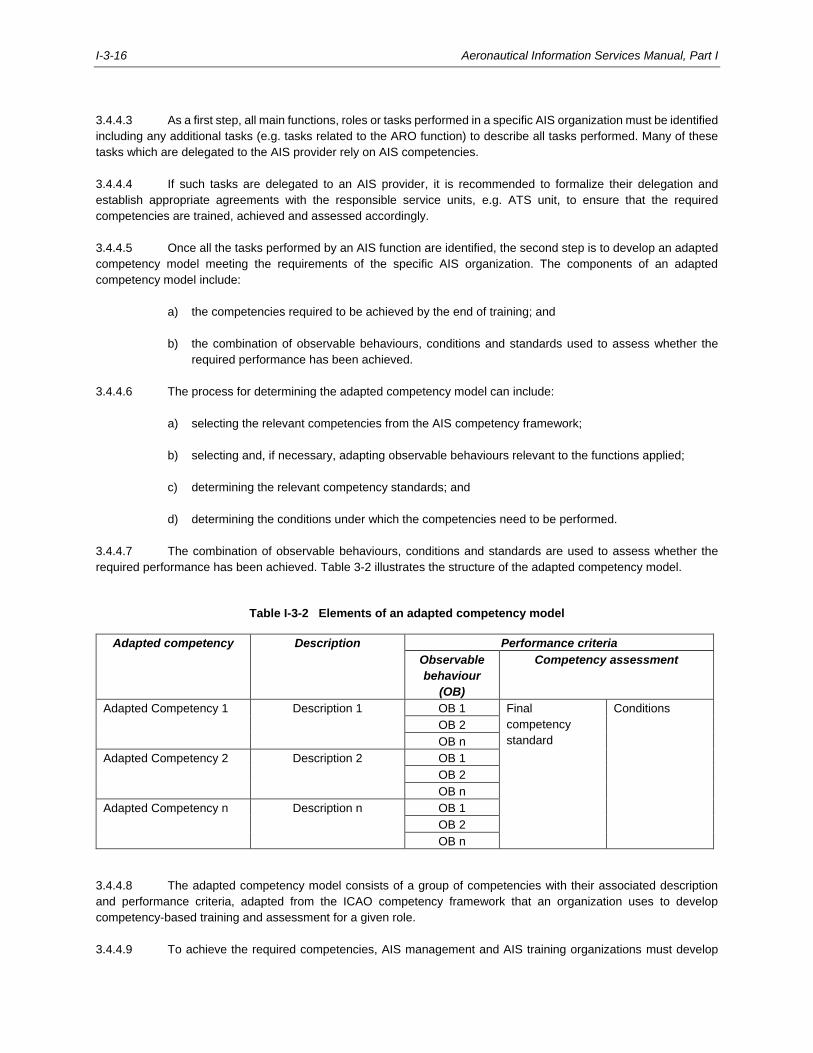
I-3-16 Aeronautical Information Services Manual, Part I
3.4.4.3 As a first step, all main functions, roles or tasks performed in a specific AIS organization must be identified
including any additional tasks (e.g. tasks related to the ARO function) to describe all tasks performed. Many of these
tasks which are delegated to the AIS provider rely on AIS competencies.
3.4.4.4 If such tasks are delegated to an AIS provider, it is recommended to formalize their delegation and
establish appropriate agreements with the responsible service units, e.g. ATS unit, to ensure that the required
competencies are trained, achieved and assessed accordingly.
3.4.4.5 Once all the tasks performed by an AIS function are identified, the second step is to develop an adapted
competency model meeting the requirements of the specific AIS organization. The components of an adapted
competency model include:
a) the competencies required to be achieved by the end of training; and
b) the combination of observable behaviours, conditions and standards used to assess whether the
required performance has been achieved.
3.4.4.6 The process for determining the adapted competency model can include:
a) selecting the relevant competencies from the AIS competency framework;
b) selecting and, if necessary, adapting observable behaviours relevant to the functions applied;
c) determining the relevant competency standards; and
d) determining the conditions under which the competencies need to be performed.
3.4.4.7 The combination of observable behaviours, conditions and standards are used to assess whether the
required performance has been achieved. Table 3-2 illustrates the structure of the adapted competency model.
Table I-3-2 Elements of an adapted competency model
Adapted competency Description Performance criteria
Observable
behaviour
(OB)
Competency assessment
Adapted Competency 1 Description 1 OB 1 Final
competency
standard
Conditions
OB 2
OB n
Adapted Competency 2 Description 2 OB 1
OB 2
OB n
Adapted Competency n Description n OB 1
OB 2
OB n
3.4.4.8 The adapted competency model consists of a group of competencies with their associated description
and performance criteria, adapted from the ICAO competency framework that an organization uses to develop
competency-based training and assessment for a given role.
3.4.4.9 To achieve the required competencies, AIS management and AIS training organizations must develop
Aeronautical Information Services Manual, Part I I-3-17
and implement CBTA for its AIS personnel. This is accomplished by establishing a training plan which describes how
the required competencies are met and an assessment plan for gathering valid and reliable evidence during training.
Note.— For more information concerning competency-related provisions refer to the Procedures for Air
Navigation Services — Training (PANS-TRG, Doc 9868).
3.5 AIS KEY CONTROL ELEMENTS
3.5.1 Aeronautical information regulation and control
3.5.1.1 Aeronautical information is constantly changing: airspace structures and routes are revised, navigation
aids change, flight procedures are amended, and runway and taxiway information changes. It is essential for efficiency
and safety that airlines, pilots, air traffic controllers and air traffic flow managers all use the same aeronautical
information at the same time.
3.5.1.2 AIRAC is a system established by Annex 15 — Aeronautical Information Services and based on common
effective dates to ensure that changes to aeronautical information are made in a consistent manner by States around
the world. As a result, States are working with globally agreed timelines when it comes to making aeronautical
information available, allowing all further actors in the data chain to perform their obligations in a timely manner.
3.5.2 The need for control
3.5.2.1 As AIS providers are responsible for the flow of aeronautical information necessary for the safety,
regularity and efficiency of air navigation, all information concerning changes in facilities, services or procedures need
to be processed in a timely manner. States are responsible to ensure that pre-determined coordination dates are met
by requiring AIS providers to work to a pre-arranged production programme for the timely provision of the required
aeronautical information products and services.
3.5.2.2 By meeting the AIRAC dates, amendments to airline operations manuals or other documents produced
by data integrators can be updated in a timely manner. If AIP amendments or AIP supplements concerning such
information were published indiscriminately with a variety of effective dates, it would be impossible to keep the manuals
and other documents consistent and up to date.
3.5.2.3 With a schedule of predetermined dates on which changes become effective throughout the year, States
are responsible for arranging an AIS production programme considering these predetermined dates to provide
operationally significant aeronautical information and data in a timely manner according to the AIRAC time schedule,
as per Annex 15 — Aeronautical Information Services.
3.5.2.4 States are encouraged to establish the required regulatory framework in support of AIRAC adherence
and create sufficient awareness with data originators, who may not understand the consequences associated with
delays in the availability of information.
3.5.2.5 The benefits of the AIRAC system are directly dependent upon the degree to which the AIRAC procedures
are applied and monitored by the authorities responsible for originating changes in facilities, services or procedures.
3.5.2.6 Further guidance on AIRAC can be found in Doc 8126, Part III — Aeronautical Information in a
Standardized Presentation and Services.
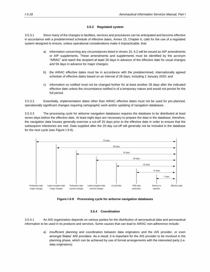
I-3-18 Aeronautical Information Services Manual, Part I
3.5.3 Regulated system
3.5.3.1 Since many of the changes to facilities, services and procedures can be anticipated and become effective
in accordance with a predetermined schedule of effective dates, Annex 15, Chapter 6, calls for the use of a regulated
system designed to ensure, unless operational considerations make it impracticable, that:
a) information concerning any circumstances listed in Annex 15, 6.2 will be issued as AIP amendments
or AIP supplements. These amendments and supplements must be identified by the acronym
“AIRAC” and reach the recipient at least 28 days in advance of the effective date for usual changes
and 56 days in advance for major changes;
b) the AIRAC effective dates must be in accordance with the predetermined, internationally agreed
schedule of effective dates based on an interval of 28 days, including 2 January 2020; and
c) information so notified must not be changed further for at least another 28 days after the indicated
effective date unless the circumstance notified is of a temporary nature and would not persist for the
full period.
3.5.3.2 Essentially, implementation dates other than AIRAC effective dates must not be used for pre-planned,
operationally significant changes requiring cartographic work and/or updating of navigation databases.
3.5.3.3 The processing cycle for airborne navigation databases requires the database to be distributed at least
seven days before the effective date. At least eight days are necessary to prepare the data in the database; therefore,
the navigation data houses generally exercise a cut-off 20 days prior to the effective date in order to ensure that the
subsequent milestones are met. Data supplied after the 20-day cut-off will generally not be included in the database
for the next cycle (see Figure I-3-9).
Figure I-3-9 Processing cycle for airborne navigation databases
3.5.4 Coordination
3.5.4.1 An AIS organization depends on various parties for the distribution of aeronautical data and aeronautical
information to be used in its products and services. Some causes that can lead to AIRAC non-adherence include:
a) insufficient planning and coordination between data originators and the AIS provider, or even
amongst States’ AIS providers. As a result, it is important for the AIS provider to be involved in the
planning phase, which can be achieved by use of formal arrangements with the interested party (i.e.
data originators);
Aeronautical Information Services Manual, Part I I-3-19
b) misalignment in communication, i.e. the use of different file formats, translation of aeronautical data
in another language, distribution delays;
c) failure to comply with AIRAC system, i.e. missing State regulations requiring AIRAC adherence;
d) corrections applied to aeronautical data and information; and
e) software or hardware malfunction of the automated AIM system.
3.5.4.2 In order for the AIRAC system to operate satisfactorily, it is essential that State authorities create
awareness amongst the data originators responsible for supplying information to the AIS provider. These parties should
be familiar with the AIRAC system and must particularly be aware of not only the effective and publication dates but
also the latest cut-off dates on which the information must reach the AIS provider in order for information to be made
available and reach recipients at least 28 days in advance of the effective date.
3.5.4.3 It is the responsibility of the AIS provider to determine the latest date for making information available in
order to meet the corresponding AIRAC effective dates. The best way of informing data originators of the cut-off dates
for information to be received by the AIS provider is to include the dates in the formal arrangements with the data
originators, e.g. service level agreements or data product specifications. These formal arrangements should be
reviewed and updated on a regular basis. In addition, the AIS provider should regularly publish, usually in the form of
an AIC or online, a list of AIRAC effective dates, publication dates and latest reception dates on which the aeronautical
information has to reach the AIS provider.
3.5.4.4 Concerned parties should endeavour to forward information to the AIS provider as early as possible and
not wait until the latest date. This applies particularly to situations where significant changes, e.g. major airspace
changes, ATS route restructuring, or new international airports are involved. Timely receipt of aeronautical data and
aeronautical information will allow AIS providers to process the data at a normal speed, whereas late receipt can rush
the process, increasing the possibility of errors being introduced.
3.5.5 Significance
3.5.5.1 It should be apparent from the above examples that the benefits of the AIRAC system are directly
dependent upon the degree to which the AIRAC effective dates are observed and used by the authorities that are
responsible for originating changes in facilities, services or procedures. Such changes must be anticipated by these
authorities, and AIRAC effective dates must be selected from the schedule of AIRAC effective dates sufficiently in
advance to permit issue of the relevant information in a timely and controlled manner.
3.5.5.2 It should also be noted that AIRAC effective dates are used by ICAO, when appropriate, as the date of
implementation for amendments to its standards, recommended practices and procedures.
3.5.5.3 The adherence to AIRAC is an important step in achieving and maintaining the reliability and efficiency
of the aeronautical information products and services, and the air navigation system in general. Not following the AIRAC
system may produce irregularities (i.e. incorrect information being published, or unawareness of updated information)
which may create issues for all airspace users having access to the same aeronautical data and aeronautical
information at the same time.
3.6 PLANNING AUTOMATION IN AN AIS ORGANIZATION
3.6.1 Introduction
3.6.1.1 It is recommended that adequate research and planning is conducted prior to the acquisition of an
I-3-20 Aeronautical Information Services Manual, Part I
automated AIM system. The following guidance should help AIS providers in their planning efforts.
Note.— Doc 8126, Part II — Processing Aeronautical Data provides additional information on how to plan
and implement automation in AIS organizations.
3.6.2 Workflow management
3.6.2.1 In the AIS domain, the application of workflow management has become best practice to support and
model aeronautical data processes by using appropriate tools, either standard office applications or specialized
workflow management tools. A workflow management tool assists to document the processes as a sequence of tasks
or steps. Business rules govern the transition from one step to the next and make it possible to validate the submitted
aeronautical data and aeronautical information.
3.6.2.2 The use of a workflow management tool makes it possible to define workflows that fit the needs of the
AIS organization with the added benefits of providing traceability and valuable inputs for planning. There are two distinct
workflows within an AIS organization: one for event-driven aeronautical information (e.g. NOTAMs), and another for
creating or updating aeronautical information describing the aeronautical infrastructure (e.g. aerodrome data, airspace
data, ATS and other routes data, etc.).
3.6.2.3 To effectively use workflow management tools, it is important to first determine the functions of an AIS
organization, its main processes and procedures, to what standards those processes and procedures are completed,
and its main roles and responsibilities. This is called “process mapping” and it helps organizations become more
efficient. Process mapping is a methodology to visualize all the steps and decisions in the process. It describes the flow
of aeronautical information, displays the tasks associated with each process step, shows the decisions that need to be
made along the way, and exposes the relationships between the process steps.
3.6.2.4 Process maps (see Table 3-3) can be used to show compliance with regulatory standards and serve as
a valuable resource for internal and external audits.
3.6.2.5 A solid understanding of the aeronautical data and aeronautical information processes is an important
preparatory step before acquiring automation tools and software. Properly documenting the workflows and processes
that will be used in the future AIM organization is also an important part of the specification and requirements for
tendering software and tools. The goal is to ensure that the implemented software and tools fit the needs of a State’s
AIS.
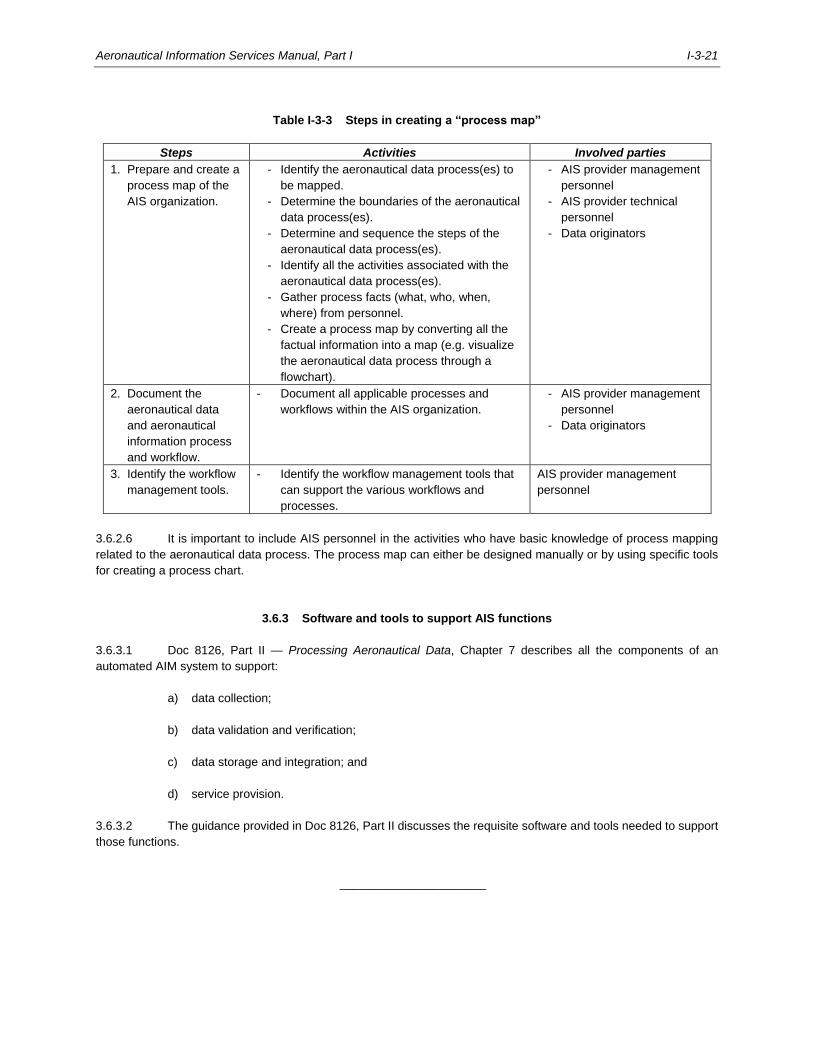
Aeronautical Information Services Manual, Part I I-3-21
Table I-3-3 Steps in creating a “process map”
Steps Activities Involved parties
1. Prepare and create a
process map of the
AIS organization.
- Identify the aeronautical data process(es) to
be mapped.
- Determine the boundaries of the aeronautical
data process(es).
- Determine and sequence the steps of the
aeronautical data process(es).
- Identify all the activities associated with the
aeronautical data process(es).
- Gather process facts (what, who, when,
where) from personnel.
- Create a process map by converting all the
factual information into a map (e.g. visualize
the aeronautical data process through a
flowchart).
- AIS provider management
personnel
- AIS provider technical
personnel
- Data originators
2. Document the
aeronautical data
and aeronautical
information process
and workflow.
- Document all applicable processes and
workflows within the AIS organization.
- AIS provider management
personnel
- Data originators
3. Identify the workflow
management tools.
- Identify the workflow management tools that
can support the various workflows and
processes.
AIS provider management
personnel
3.6.2.6 It is important to include AIS personnel in the activities who have basic knowledge of process mapping
related to the aeronautical data process. The process map can either be designed manually or by using specific tools
for creating a process chart.
3.6.3 Software and tools to support AIS functions
3.6.3.1 Doc 8126, Part II — Processing Aeronautical Data, Chapter 7 describes all the components of an
automated AIM system to support:
a) data collection;
b) data validation and verification;
c) data storage and integration; and
d) service provision.
3.6.3.2 The guidance provided in Doc 8126, Part II discusses the requisite software and tools needed to support
those functions.
______________________

I-4-1
Chapter 4
AERONAUTICAL DATA ORIGINATORS’ RESPONSIBILITIES
4.1 INTRODUCTION
4.1.1 All parties originating aeronautical data and aeronautical information are responsible for providing the
aeronautical data with the defined data quality requirements to meet the user needs that were determined and agreed
with the State. The origination of aeronautical data is a critical process with respect to initiating data quality since
subsequent processing of that data cannot improve its quality but only maintains it, and may possibly degrade it.
4.2 SCOPE
4.2.1 States are responsible for defining the scope of the aeronautical data and aeronautical information to be
collected from a data originator. The scope of the aeronautical data and aeronautical information that a data originator
must provide is described in the aeronautical data catalogue and in the contents of the AIP, as described in the
Procedures for Air Navigation Services — Aeronautical Information Management (PANS-AIM, Doc 10066), Appendices
1 and 2.
4.2.2 The aeronautical data catalogue is a reference for all provisions related to aeronautical data origination
and publication including data quality requirements; it provides a common language and facilitates formal arrangements
between data originators and the AIS provider. Similarly, the contents of the AIP provide the basis of the formal
arrangements with data originators, mainly in relation to the State authorities responsible for facilitation and air
navigation services, e.g. entry, transit and departure of aircraft/passengers/crew/cargo, MET, ATS, CNS and SAR
services.
Note.— Further guidance on the aeronautical data catalogue can be found in Doc 8126, Part II —
Processing Aeronautical Data.
4.3 DATA QUALITY REQUIREMENTS
4.3.1 The aeronautical data catalogue contains the data quality requirements which need to be reflected in the
formal arrangements between data originators and the AIS provider. Data originators must have verification and
validation processes and procedures in place to ensure the required data quality is met when aeronautical data is
provided to the AIS.
4.3.2 Many data originators are also subject to pre-existing safety regulations (e.g. aerodrome operators,
instrument flight procedure designers, airspace planners, etc.).
Note.— Further guidance on data quality requirements can be found in Doc 8126, Part II — Processing
Aeronautical Data.
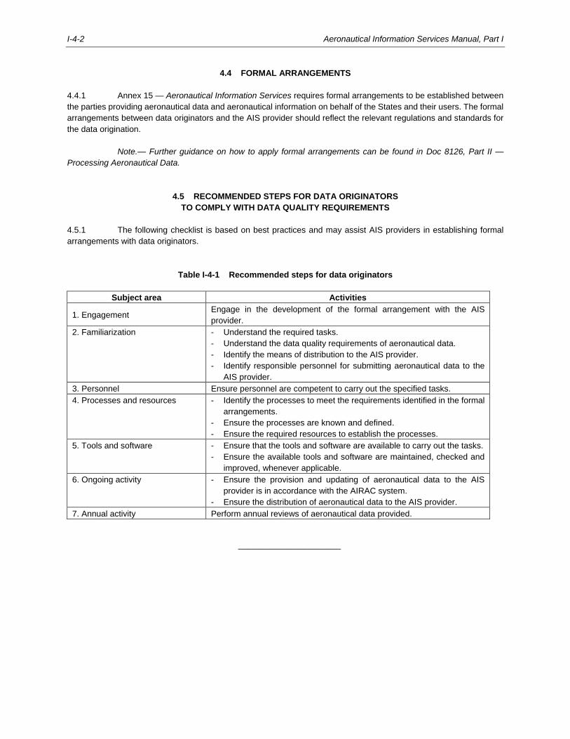
I-4-2 Aeronautical Information Services Manual, Part I
4.4 FORMAL ARRANGEMENTS
4.4.1 Annex 15 — Aeronautical Information Services requires formal arrangements to be established between
the parties providing aeronautical data and aeronautical information on behalf of the States and their users. The formal
arrangements between data originators and the AIS provider should reflect the relevant regulations and standards for
the data origination.
Note.— Further guidance on how to apply formal arrangements can be found in Doc 8126, Part II —
Processing Aeronautical Data.
4.5 RECOMMENDED STEPS FOR DATA ORIGINATORS
TO COMPLY WITH DATA QUALITY REQUIREMENTS
4.5.1 The following checklist is based on best practices and may assist AIS providers in establishing formal
arrangements with data originators.
Table I-4-1 Recommended steps for data originators
Subject area Activities
1. Engagement Engage in the development of the formal arrangement with the AIS
provider.
2. Familiarization - Understand the required tasks.
- Understand the data quality requirements of aeronautical data.
- Identify the means of distribution to the AIS provider.
- Identify responsible personnel for submitting aeronautical data to the
AIS provider.
3. Personnel Ensure personnel are competent to carry out the specified tasks.
4. Processes and resources - Identify the processes to meet the requirements identified in the formal
arrangements.
- Ensure the processes are known and defined.
- Ensure the required resources to establish the processes.
5. Tools and software - Ensure that the tools and software are available to carry out the tasks.
- Ensure the available tools and software are maintained, checked and
improved, whenever applicable.
6. Ongoing activity - Ensure the provision and updating of aeronautical data to the AIS
provider is in accordance with the AIRAC system.
- Ensure the distribution of aeronautical data to the AIS provider.
7. Annual activity Perform annual reviews of aeronautical data provided.
______________________
I-5-1
Chapter 5
AERONAUTICAL INFORMATION MANAGEMENT
5.1 INTRODUCTION
5.1.1 This chapter addresses the change management aspects of a State’s transition from traditional
product-centric aeronautical information service to data-centric and digital aeronautical information management. It is
important to understand that various parties in a State are affected by this transition. All aspects related to how this
transition impacts the different parties are addressed in this chapter.
5.2 PARTIES INVOLVED IN AIM IMPLEMENTATION
5.2.1 AIM implementation requires a systematic approach by all involved parties in a State, namely:
a) oversight bodies (typically, the civil aviation authority);
b) AIS provider(s) (typically, part of the ANSP);
c) data originators (typically, aerodromes, surveyors, cadastral data provider); and
d) data service providers and integrators (typically, commercial providers of aeronautical information
products and aeronautical databases).
5.2.2 In addition to the above-mentioned parties, aeronautical information users should also be considered in
the AIM implementation process. The ultimate objective of AIM is to offer functional and operational benefits, both
tangible and intangible, to the aviation community, including secure online access to aeronautical information products,
aeronautical information products used in electronic flight bags, and aeronautical navigation databases used in global
navigation satellite systems (GNSS) and flight management systems (FMS).
5.3 AIM FOR STATE REGULATORY ORGANIZATIONS
5.3.1 Based on the assumption that primary legislation exists and clearly establishes the responsibility of a
State for providing aeronautical information products and services (CE-1, Section 2.2), the following oversight activities
are important to the successful implementation of AIM:
a) establish an effective regulatory framework for AIS provision and aeronautical data quality;
b) define a national strategy for ensuring that the integrity of aeronautical data and aeronautical
information is maintained throughout the entire aeronautical data process, that is, from origination to
consumption by the end user;
c) establish and perform surveillance activities of aeronautical data activities.
5.3.2 Table 5-1 provides details concerning these oversight activities.
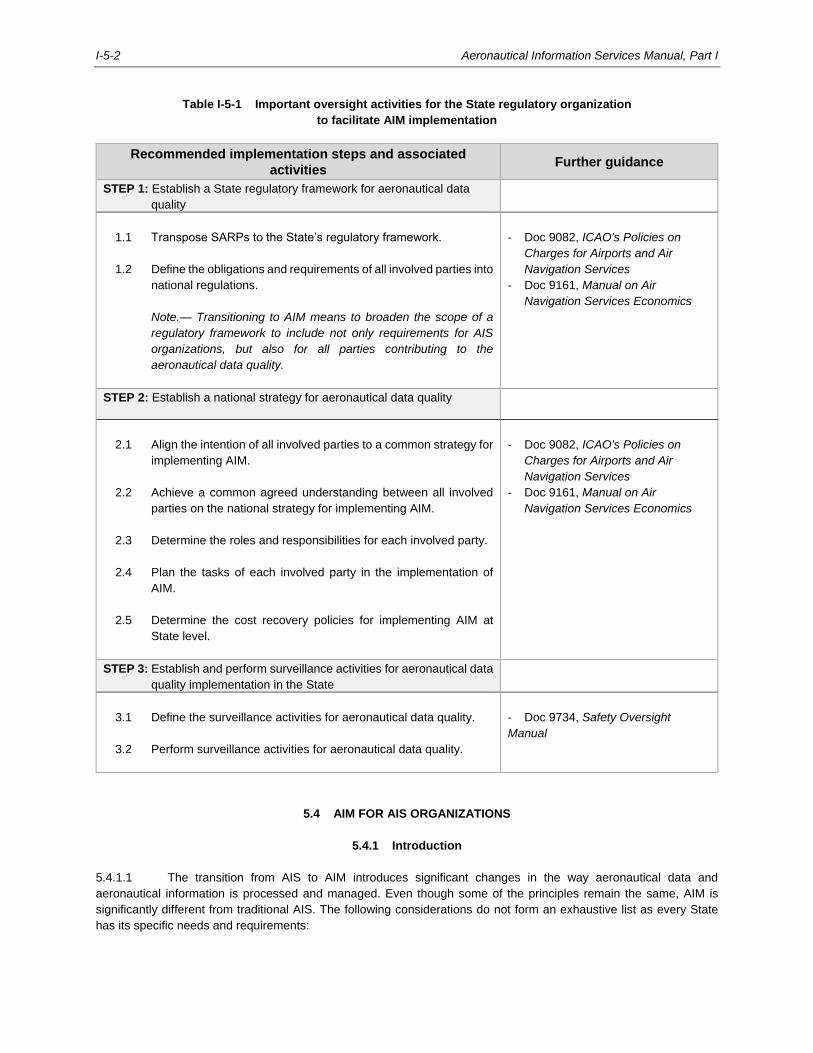
I-5-2 Aeronautical Information Services Manual, Part I
Table I-5-1 Important oversight activities for the State regulatory organization
to facilitate AIM implementation
Recommended implementation steps and associated
activities Further guidance
STEP 1: Establish a State regulatory framework for aeronautical data
quality
1.1 Transpose SARPs to the State’s regulatory framework.
1.2 Define the obligations and requirements of all involved parties into
national regulations.
Note.— Transitioning to AIM means to broaden the scope of a
regulatory framework to include not only requirements for AIS
organizations, but also for all parties contributing to the
aeronautical data quality.
- Doc 9082, ICAO's Policies on
Charges for Airports and Air
Navigation Services
- Doc 9161, Manual on Air
Navigation Services Economics
STEP 2: Establish a national strategy for aeronautical data quality
2.1 Align the intention of all involved parties to a common strategy for
implementing AIM.
2.2 Achieve a common agreed understanding between all involved
parties on the national strategy for implementing AIM.
2.3 Determine the roles and responsibilities for each involved party.
2.4 Plan the tasks of each involved party in the implementation of
AIM.
2.5 Determine the cost recovery policies for implementing AIM at
State level.
- Doc 9082, ICAO's Policies on
Charges for Airports and Air
Navigation Services
- Doc 9161, Manual on Air
Navigation Services Economics
STEP 3: Establish and perform surveillance activities for aeronautical data
quality implementation in the State
3.1 Define the surveillance activities for aeronautical data quality.
3.2 Perform surveillance activities for aeronautical data quality.
- Doc 9734, Safety Oversight
Manual
5.4 AIM FOR AIS ORGANIZATIONS
5.4.1 Introduction
5.4.1.1 The transition from AIS to AIM introduces significant changes in the way aeronautical data and
aeronautical information is processed and managed. Even though some of the principles remain the same, AIM is
significantly different from traditional AIS. The following considerations do not form an exhaustive list as every State
has its specific needs and requirements:
Aeronautical Information Services Manual, Part I I-5-3
a) implementation of a QMS in the overall processes and procedures;
b) transition towards digital aeronautical data and aeronautical information;
c) authentication of all data sources;
d) introduction of data validation and verification procedures; and
e) implementation of feedback mechanisms.
5.4.1.2 The transition from AIS to AIM introduces not only automation into the current paper-based environment,
but also the required business transformation to make the change to a data-centric environment. The transition is not
just about automation, however, or inserting new technologies into the existing AIS processes, nor is it about replacing
paper or people in the current AIS environment. The goal is to create and distribute quality assured aeronautical data
and aeronautical information in digital form to satisfy the more stringent demands of an ever increasing number of users.
It is therefore necessary for AIS organizations to apply a change management strategy with the objective to align its
people, processes and technological initiatives with this vision.
5.4.2 Key issues for AIS in the AIM environment
5.4.2.1 Focus on aeronautical data quality
5.4.2.1.1 The objective of AIM is to provide users with aeronautical information they can trust. As a result, the
transition from a product-centric to a data-centric environment must focus on the processes to ensure the required
quality of the aeronautical data is established and maintained.
5.4.2.1.2 Aeronautical data can be defined, measured and checked by using the data quality requirements, i.e.
accuracy, resolution, integrity, traceability, timeliness, completeness, and format. By establishing a regulatory
framework around these requirements, all involved parties can be assured of the quality of the aeronautical data. For
example, metadata enables traceability which permits to pinpoint faults to a particular step in the process. By having
access to metadata, improvements can be applied to the aeronautical data process to reduce errors and corrupt data.
Note.— Further guidance regarding data quality can be found in Doc 8126, Part II — Processing
Aeronautical Data.
5.4.2.2 Quality management system
5.4.2.2.1 As described in Chapter 3, 3.2.4, QMS is essential as it directs and controls an organization with respect
to quality through documented and predictable processes. A desired result is in fact achieved more efficiently when
activities and related resources are managed as a process. Effective QMS implementation is crucial to control quality
in aeronautical data and aeronautical information and ensure the satisfaction of the end user.
5.4.2.2.2 A process is a set of interrelated or interacting activities that transform input into output. A QMS can be
thought of as a single large process that uses many inputs to generate many outputs. In turn, this large process is
made up of many smaller processes. All activities and resources related to AIM, including operational and administrative,
must be managed as processes.
5.4.2.2.3 A process approach is important because its key characteristic is not to just correct identified errors, but
to create effective processes to prevent the occurrence of errors through root cause analysis.
5.4.2.2.4 For AIS organizations, establishing a process approach means to identify a process for:
I-5-4 Aeronautical Information Services Manual, Part I
a) reviewing the requirements related to each product;
b) supplying each product; and
c) monitoring the quality of each product.
If these processes are set up effectively, the objective of meeting the expectations of the end user will be achieved.
5.4.2.2.5 The process approach model starts and finishes with the end users in mind. It is important to consider
their needs as it serves as feedback into the monitoring and evaluation phases which, in turn, are a measure of the
overall performance.
5.4.2.2.6 The continuous review and improvement of performance should be a permanent objective of QMS
implementations. Specifically, the effectiveness and suitability of QMS must be evaluated and areas of improvement
must be identified and rectified.
5.4.2.3 Digitalization
5.4.2.3.1 An AIM organization introduces the concept of a data-centric environment through digitalization.
Digitalization represents the use of digital technology in its business model, i.e. converting the information into a digital
format, providing digital products and services.
5.4.2.3.2 The benefit of digitalization is that it permits handling vast amounts of aeronautical data and aeronautical
information (sometimes of critical and essential significance to flight operations) in a safe, efficient and reliable way.
5.4.2.3.3 Therefore, digitalization should be applied in all aeronautical data processes from origination to end use,
from collection to processing, storing, quality control and distribution. As a result, AIM becomes a fully digital, data-
centric environment, with a minimum of manual interaction with the aeronautical data being involved in its data
management processes. Digitalization is supported by aeronautical information exchange models, web-based services,
verification rules, etc.
5.4.2.3.4 The digital environment can only be sustained by introducing new technical infrastructure, i.e. hardware,
software and systems. Thus, AIM requires a systems-oriented approach to digitalization; it is based on service-oriented
architecture, databases, workflows and rule engines. It is essential for these automation systems to be interoperable.
5.4.2.4 Feedback mechanisms
5.4.2.4.1 Feedback mechanisms are an important aspect of QMS implementation. Feedback consists of
procedures such as error detection and reporting. The first step is the prompt identification of erroneous or corrupt data
and information. The AIS provider is responsible to notify the intended users and responsible originators of the errors
in the data and products. Another step is to document the event(s) for record-keeping and traceability. After reporting
the event(s), corrective actions are to be taken to modify any procedures which caused the aeronautical data and
aeronautical information to become corrupted.
5.4.2.4.2 The value of the feedback mechanism is the improved quality of aeronautical data and aeronautical
information. Moreover, it provides traceability by use of appropriate documentation and metadata.
5.4.2.4.3 Further guidance for applying feedback mechanisms can be found in Doc 8126, Part II — Processing
Aeronautical Data.
5.4.2.5 Change management considerations when transitioning to AIM
Aeronautical Information Services Manual, Part I I-5-5
5.4.2.5.1 To properly transition to AIM, organizations need to revise and rethink their business structure and model
from a digital transformation point of view; a process is needed to support the transition to AIM. The reason for change
is represented by the constant evolution and innovation of technology and systems and by the increasing demands for
better productivity and better services which can only be sustained by providing aeronautical data and aeronautical
information in a digital environment.
5.4.2.5.2 Change management is applied where organizational change is recognized as being required and
achieved by targeting of activities, personnel and systems. It redefines the resources, the use of those resources, and
other operations and procedures within an organization. Therefore, change management is a method to support the
AIS provider on the way to transitioning to an AIM environment.
5.4.2.5.3 During the transitioning process, AIS providers must be aware of the challenges which they are likely to
encounter, such as:
a) new technology might require a new set of competencies, infrastructure and rethinking of the entire
organizational processes;
b) change management might require consistent and continuous adaptation over time; and
c) personnel may naturally resist the change.
5.4.2.5.4 Therefore, the change management process should be thoroughly thought through and clearly expressed
to ensure a smooth transition from AIS to AIM. The process should determine the necessity behind the transition and
then plan for it. Implementing the plan, sustaining and continuously adapting the plan should naturally follow.
5.4.2.5.5 To sustain such a comprehensive project, some of the following key points need to be addressed:
a) identify the necessity for transitioning, considering the evolving technological environment of air
navigation and its needs;
b) assess the capabilities and resources already present in an AIS organization, thus establishing a
base line for the maturity of the AIS organization regarding digitalization;
c) prepare a plan on how to achieve the transition, by using several methods such as:
1) analysing the changes brought by digitalization;
2) determining the priorities of the plan; and
3) expressing the transition plan in a digital way (e.g. with use cases);
d) prepare an implementation plan and consider a realistic period of time to achieve digitalization, thus
completing the transition to AIM.
5.4.2.6 Preparing for AIM implementation
5.4.2.6.1 Table 5-2 is based on best practice experience and lists the most important aspects for preparing to
implement AIM:
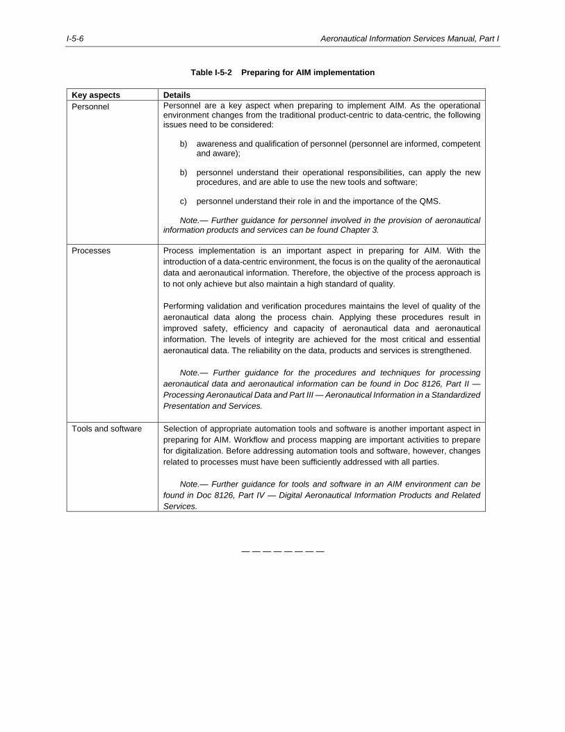
I-5-6 Aeronautical Information Services Manual, Part I
Table I-5-2 Preparing for AIM implementation
Key aspects Details
Personnel Personnel are a key aspect when preparing to implement AIM. As the operational environment changes from the traditional product-centric to data-centric, the following issues need to be considered:
b) awareness and qualification of personnel (personnel are informed, competent and aware);
b) personnel understand their operational responsibilities, can apply the new
procedures, and are able to use the new tools and software; c) personnel understand their role in and the importance of the QMS.
Note.— Further guidance for personnel involved in the provision of aeronautical information products and services can be found Chapter 3.
Processes Process implementation is an important aspect in preparing for AIM. With the
introduction of a data-centric environment, the focus is on the quality of the aeronautical
data and aeronautical information. Therefore, the objective of the process approach is
to not only achieve but also maintain a high standard of quality.
Performing validation and verification procedures maintains the level of quality of the
aeronautical data along the process chain. Applying these procedures result in
improved safety, efficiency and capacity of aeronautical data and aeronautical
information. The levels of integrity are achieved for the most critical and essential
aeronautical data. The reliability on the data, products and services is strengthened.
Note.— Further guidance for the procedures and techniques for processing
aeronautical data and aeronautical information can be found in Doc 8126, Part II —
Processing Aeronautical Data and Part III — Aeronautical Information in a Standardized
Presentation and Services.
Tools and software Selection of appropriate automation tools and software is another important aspect in
preparing for AIM. Workflow and process mapping are important activities to prepare
for digitalization. Before addressing automation tools and software, however, changes
related to processes must have been sufficiently addressed with all parties.
Note.— Further guidance for tools and software in an AIM environment can be
found in Doc 8126, Part IV — Digital Aeronautical Information Products and Related
Services.
— — — — — — — —
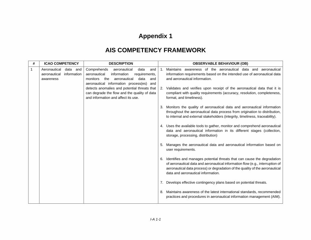
I-A 1-1
Appendix 1
AIS COMPETENCY FRAMEWORK
# ICAO COMPETENCY DESCRIPTION OBSERVABLE BEHAVIOUR (OB)
1 Aeronautical data and
aeronautical information
awareness
Comprehends aeronautical data and
aeronautical information requirements,
monitors the aeronautical data and
aeronautical information process(es) and
detects anomalies and potential threats that
can degrade the flow and the quality of data
and information and affect its use.
1. Maintains awareness of the aeronautical data and aeronautical
information requirements based on the intended use of aeronautical data
and aeronautical information.
2. Validates and verifies upon receipt of the aeronautical data that it is
compliant with quality requirements (accuracy, resolution, completeness,
format, and timeliness).
3. Monitors the quality of aeronautical data and aeronautical information
throughout the aeronautical data process from origination to distribution,
to internal and external stakeholders (integrity, timeliness, traceability).
4. Uses the available tools to gather, monitor and comprehend aeronautical
data and aeronautical information in its different stages (collection,
storage, processing, distribution)
5. Manages the aeronautical data and aeronautical information based on
user requirements.
6. Identifies and manages potential threats that can cause the degradation
of aeronautical data and aeronautical information flow (e.g., interruption of
aeronautical data process) or degradation of the quality of the aeronautical
data and aeronautical information.
7. Develops effective contingency plans based on potential threats.
8. Maintains awareness of the latest international standards, recommended
practices and procedures in aeronautical information management (AIM).
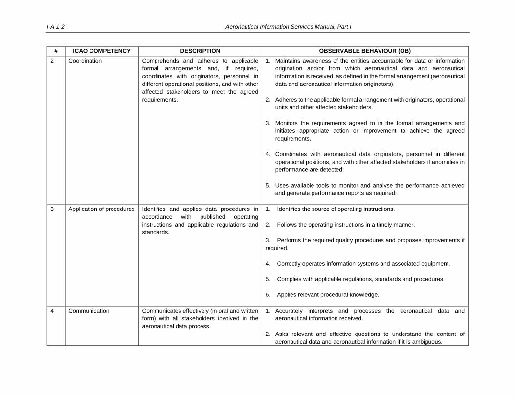
I-A 1-2 Aeronautical Information Services Manual, Part I
# ICAO COMPETENCY DESCRIPTION OBSERVABLE BEHAVIOUR (OB)
2 Coordination Comprehends and adheres to applicable
formal arrangements and, if required,
coordinates with originators, personnel in
different operational positions, and with other
affected stakeholders to meet the agreed
requirements.
1. Maintains awareness of the entities accountable for data or information
origination and/or from which aeronautical data and aeronautical
information is received, as defined in the formal arrangement (aeronautical
data and aeronautical information originators).
2. Adheres to the applicable formal arrangement with originators, operational
units and other affected stakeholders.
3. Monitors the requirements agreed to in the formal arrangements and
initiates appropriate action or improvement to achieve the agreed
requirements.
4. Coordinates with aeronautical data originators, personnel in different
operational positions, and with other affected stakeholders if anomalies in
performance are detected.
5. Uses available tools to monitor and analyse the performance achieved
and generate performance reports as required.
3 Application of procedures Identifies and applies data procedures in
accordance with published operating
instructions and applicable regulations and
standards.
1. Identifies the source of operating instructions.
2. Follows the operating instructions in a timely manner.
3. Performs the required quality procedures and proposes improvements if
required.
4. Correctly operates information systems and associated equipment.
5. Complies with applicable regulations, standards and procedures.
6. Applies relevant procedural knowledge.
4 Communication Communicates effectively (in oral and written
form) with all stakeholders involved in the
aeronautical data process.
1. Accurately interprets and processes the aeronautical data and
aeronautical information received.
2. Asks relevant and effective questions to understand the content of
aeronautical data and aeronautical information if it is ambiguous.
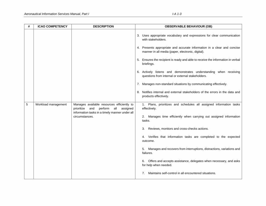
Aeronautical Information Services Manual, Part I I-A 1-3
# ICAO COMPETENCY DESCRIPTION OBSERVABLE BEHAVIOUR (OB)
3. Uses appropriate vocabulary and expressions for clear communication
with stakeholders.
4. Presents appropriate and accurate information in a clear and concise
manner in all media (paper, electronic, digital).
5. Ensures the recipient is ready and able to receive the information in verbal
briefings.
6. Actively listens and demonstrates understanding when receiving
questions from internal or external stakeholders.
7. Manages non-standard situations by communicating effectively.
8. Notifies internal and external stakeholders of the errors in the data and
products effectively.
5 Workload management Manages available resources efficiently to
prioritize and perform all assigned
information tasks in a timely manner under all
circumstances.
1. Plans, prioritizes and schedules all assigned information tasks
effectively.
2. Manages time efficiently when carrying out assigned information
tasks.
3. Reviews, monitors and cross-checks actions.
4. Verifies that information tasks are completed to the expected
outcome.
5. Manages and recovers from interruptions, distractions, variations and
failures.
6. Offers and accepts assistance, delegates when necessary, and asks
for help when needed.
7. Maintains self-control in all encountered situations.
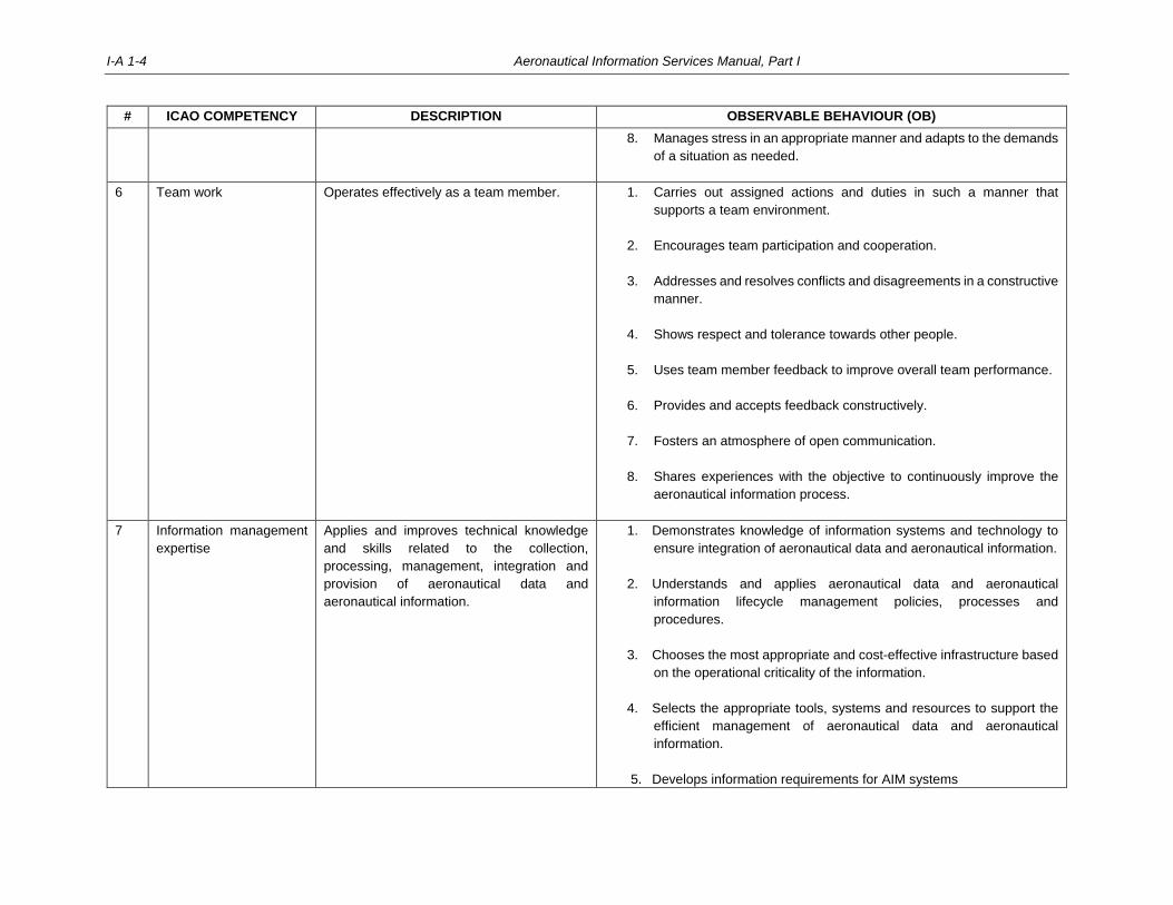
I-A 1-4 Aeronautical Information Services Manual, Part I
# ICAO COMPETENCY DESCRIPTION OBSERVABLE BEHAVIOUR (OB)
8. Manages stress in an appropriate manner and adapts to the demands
of a situation as needed.
6 Team work Operates effectively as a team member. 1. Carries out assigned actions and duties in such a manner that
supports a team environment.
2. Encourages team participation and cooperation.
3. Addresses and resolves conflicts and disagreements in a constructive
manner.
4. Shows respect and tolerance towards other people.
5. Uses team member feedback to improve overall team performance.
6. Provides and accepts feedback constructively.
7. Fosters an atmosphere of open communication.
8. Shares experiences with the objective to continuously improve the
aeronautical information process.
7 Information management
expertise
Applies and improves technical knowledge
and skills related to the collection,
processing, management, integration and
provision of aeronautical data and
aeronautical information.
1. Demonstrates knowledge of information systems and technology to
ensure integration of aeronautical data and aeronautical information.
2. Understands and applies aeronautical data and aeronautical
information lifecycle management policies, processes and
procedures.
3. Chooses the most appropriate and cost-effective infrastructure based
on the operational criticality of the information.
4. Selects the appropriate tools, systems and resources to support the
efficient management of aeronautical data and aeronautical
information.
5. Develops information requirements for AIM systems
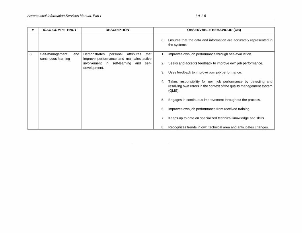
Aeronautical Information Services Manual, Part I I-A 1-5
# ICAO COMPETENCY DESCRIPTION OBSERVABLE BEHAVIOUR (OB)
6. Ensures that the data and information are accurately represented in
the systems.
8 Self-management and
continuous learning
Demonstrates personal attributes that
improve performance and maintains active
involvement in self-learning and self-
development.
1. Improves own job performance through self-evaluation.
2. Seeks and accepts feedback to improve own job performance.
3. Uses feedback to improve own job performance.
4. Takes responsibility for own job performance by detecting and
resolving own errors in the context of the quality management system
(QMS).
5. Engages in continuous improvement throughout the process.
6. Improves own job performance from received training.
7. Keeps up to date on specialized technical knowledge and skills.
8. Recognizes trends in own technical area and anticipates changes.
___________________

I-A 2-1
Appendix 2
ANNEX 15 COMPLIANCE CHECKLIST
See Excel data sheet


I-A 3-1
Appendix 3
PANS-AIM COMPLIANCE CHECKLIST
See Excel data sheet


PART II
Processing Aeronautical Data
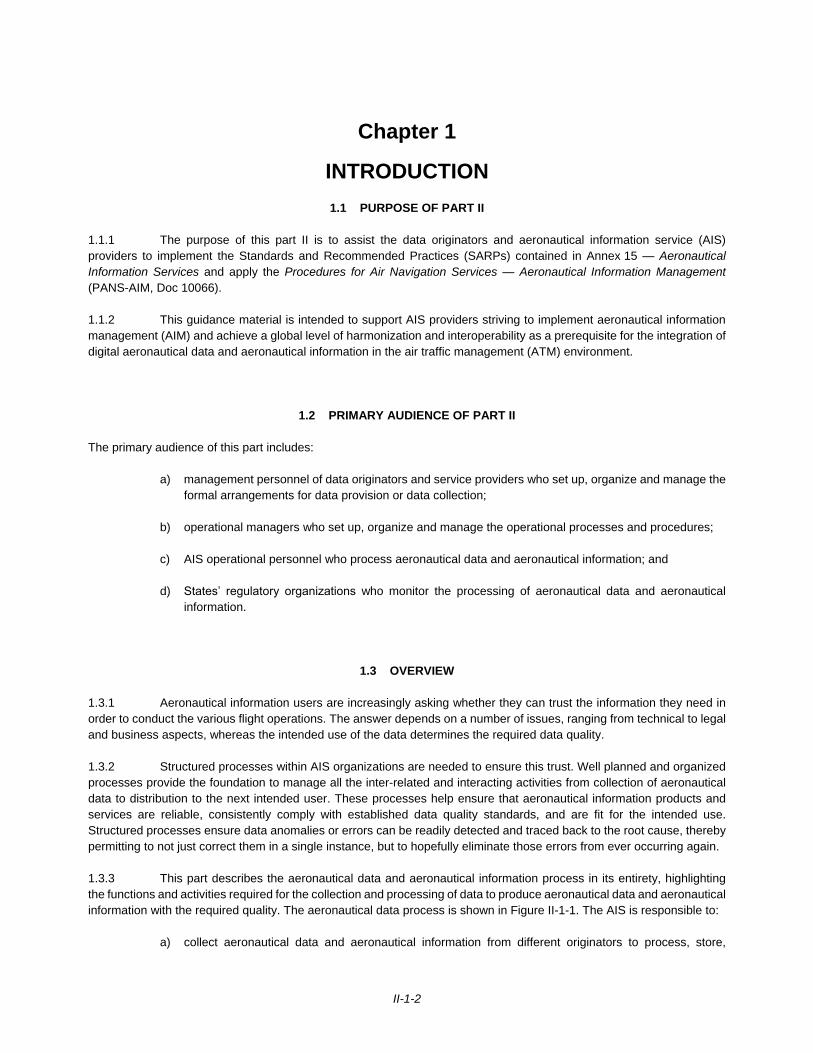
II-1-2
Chapter 1
INTRODUCTION
1.1 PURPOSE OF PART II
1.1.1 The purpose of this part II is to assist the data originators and aeronautical information service (AIS)
providers to implement the Standards and Recommended Practices (SARPs) contained in Annex 15 — Aeronautical
Information Services and apply the Procedures for Air Navigation Services — Aeronautical Information Management
(PANS-AIM, Doc 10066).
1.1.2 This guidance material is intended to support AIS providers striving to implement aeronautical information
management (AIM) and achieve a global level of harmonization and interoperability as a prerequisite for the integration of
digital aeronautical data and aeronautical information in the air traffic management (ATM) environment.
1.2 PRIMARY AUDIENCE OF PART II
The primary audience of this part includes:
a) management personnel of data originators and service providers who set up, organize and manage the
formal arrangements for data provision or data collection;
b) operational managers who set up, organize and manage the operational processes and procedures;
c) AIS operational personnel who process aeronautical data and aeronautical information; and
d) States’ regulatory organizations who monitor the processing of aeronautical data and aeronautical
information.
1.3 OVERVIEW
1.3.1 Aeronautical information users are increasingly asking whether they can trust the information they need in
order to conduct the various flight operations. The answer depends on a number of issues, ranging from technical to legal
and business aspects, whereas the intended use of the data determines the required data quality.
1.3.2 Structured processes within AIS organizations are needed to ensure this trust. Well planned and organized
processes provide the foundation to manage all the inter-related and interacting activities from collection of aeronautical
data to distribution to the next intended user. These processes help ensure that aeronautical information products and
services are reliable, consistently comply with established data quality standards, and are fit for the intended use.
Structured processes ensure data anomalies or errors can be readily detected and traced back to the root cause, thereby
permitting to not just correct them in a single instance, but to hopefully eliminate those errors from ever occurring again.
1.3.3 This part describes the aeronautical data and aeronautical information process in its entirety, highlighting
the functions and activities required for the collection and processing of data to produce aeronautical data and aeronautical
information with the required quality. The aeronautical data process is shown in Figure II-1-1. The AIS is responsible to:
a) collect aeronautical data and aeronautical information from different originators to process, store,
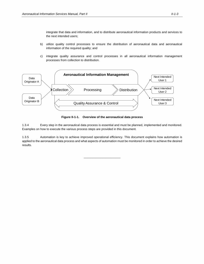
Aeronautical Information Services Manual, Part II II-1-3
integrate that data and information, and to distribute aeronautical information products and services to
the next intended users;
b) utilize quality control processes to ensure the distribution of aeronautical data and aeronautical
information of the required quality; and
c) integrate quality assurance and control processes in all aeronautical information management
processes from collection to distribution.
Figure II-1-1. Overview of the aeronautical data process
1.3.4 Every step in the aeronautical data process is essential and must be planned, implemented and monitored.
Examples on how to execute the various process steps are provided in this document.
1.3.5 Automation is key to achieve improved operational efficiency. This document explains how automation is
applied to the aeronautical data process and what aspects of automation must be monitored in order to achieve the desired
results.
______________________
Aeronautical Information Management
Collection Processing Distribution
Data
Originator A
Data
Originator B
Next Intended
User 1
Next Intended
User 2
Next Intended
User 3Quality Assurance & Control

II-2-1
Chapter 2
SCOPE OF AERONAUTICAL DATA AND GENERAL REQUIREMENTS
2.1 THE SCOPE OF AERONAUTICAL DATA
2.1.1 The aeronautical data catalogue in the Procedures for Air Navigation Services — Aeronautical Information
Management (PANS-AIM, Doc 10066), Appendix 1, provides a general description of the aeronautical information
management (AIM) data scope. It consolidates the aeronautical data and aeronautical information to be collected and
maintained, as a minimum, by an aeronautical information service. The aeronautical data catalogue is data-focused and
provides a description of data separately from the description of the derived information products (e.g. AIP, etc.).
2.1.2 As aeronautical information service transitions from a product-centric to a data-centric environment for
managing aeronautical information, the concept of separating data origination requirements from data distribution is being
challenged. Users of data should not have to rely exclusively on the structure and format of data, but should be able to
further manipulate it, if needed, and combine it with data from other information services, e.g. meteorological or flight
information, to obtain a more complete picture of the situation according to their operational needs.
2.1.3 Thus, the aeronautical data catalogue allows data origination to be decoupled from the consumption of the
aeronautical information products and services, which is a fundamental principle of system-wide information management
(SWIM).
2.1.4 The aeronautical data catalogue has been assembled based on an assessment of several ICAO annexes in
order to identify the data elements to be provided to the AIS. The aeronautical data catalogue therefore defines the AIM
data scope rather than simply being an inventory of data to be collected.
Note.— The aeronautical data catalogue (columns G to K) consolidates all data quality requirements
published in previous editions of the following annexes, namely:
Annex 4 — Aeronautical Charts (Appendix 6);
Annex 11 — Air Traffic Services (Appendix 5);
Annex 14 — Aerodromes, Volume I — Aerodrome Design and Operations (Appendix 4);
Annex 14 — Aerodromes, Volume II — Heliports (Appendix 1);
Annex 15 — Aeronautical Information Services (Appendices 7, 8); and
Procedures for Air Navigation Services — Aircraft Operations, Volume II — Construction of Visual and
Instrument Flight Procedures (PANS-OPS, Doc 8168).
2.1.5 The aeronautical data catalogue provides a common data description and facilitates the creation of formal
arrangements between data originators and the aeronautical information service. It includes data quality requirements for
some aeronautical data properties and sub-properties applicable from origination through to publication.
Note.— The use of the aeronautical data catalogue in formal arrangements is described in Chapter 3.
2.1.6 The aeronautical data catalogue is divided into the following sub-domains:
a) aerodrome data;
II-2-2 Aeronautical Information Services Manual, Part II
b) airspace data;
c) air traffic services (ATS) and other routes data;
d) instrument flight procedure data;
e) radio navigation aids/systems data;
f) obstacle data;
g) terrain data;
h) geographic data; and
i) national and local regulations, services and procedures.
2.1.7 Each sub-domain is composed of a list of subjects. For every subject, the aeronautical data catalogue lists
the data (referred to as either properties or sub-properties) to be collected, and the corresponding data types and data
quality requirements.
Note.— The aeronautical data catalogue is designed to adapt to future quality requirements for the remaining
aeronautical data properties and sub-properties.
2.1.8 Table A1-8 of the aeronautical data catalogue (PANS-AIM, Appendix 1) describing the numerical
requirements of the terrain data is organized differently compared to other data catalogue sub-domains. Since digital
terrain data consists of continuous elevation values at intersections of a defined grid, the catalogue entries define the post
spacing of the grid and the overall data quality requirements.
2.1.9 Special considerations also apply to the sub-domain labelled national and local regulations, services and
procedures contained in Table A1-10. This table defines all textual information an AIS collects from different sources and
originators, i.e. normally the State authorities responsible for facilitation and for providing services within a State including
AIS, ATS, communications, navigation, and surveillance (CNS), meteorology (MET) and search and rescue (SAR) for
inclusion in the aeronautical information products and services. Being textual in nature, there are no specific quality
requirements defined for this kind of information.
2.1.10 The classification of a data element as property or sub-property does not impose a certain data structure or
data model. Data elements that logically belong together have been grouped into sub-properties. There is no difference
in the origination and processing of properties and sub-properties.
2.1.11 Every property and sub-property is described through a data type. The data types of the properties and sub-
properties are described in Table A1-9 of the aeronautical data catalogue.
2.1.12 The data type describes the nature and characteristics of the data (e.g. a point has a different characteristic
than a magnetic bearing) and supports the validation of the data (e.g. the data element latitude of a point can only have a
valid value between -90° and +90°; the value of a magnetic bearing must be between 0° and 360°).
2.1.13 The data types also allow the aeronautical data catalogue entries to be concise and easy to read. For
example, the data type “point” of the horizontal position of an obstacle means that latitude, longitude, horizontal reference
system and the accuracy information of the obstacle have to be collected.
2.1.14 Table A1-9 defines the data types and specifies what data elements must be collected according to the data
type of the property or sub-property.
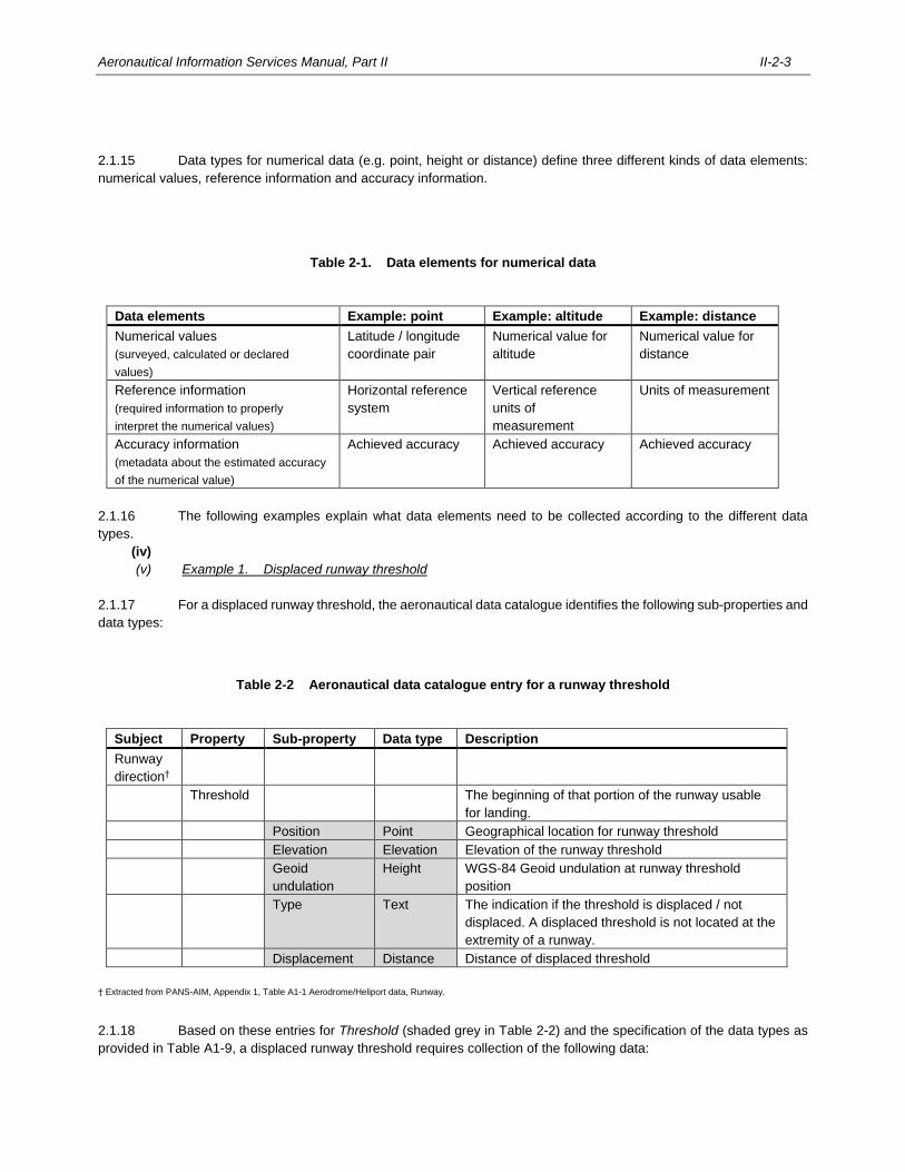
Aeronautical Information Services Manual, Part II II-2-3
2.1.15 Data types for numerical data (e.g. point, height or distance) define three different kinds of data elements:
numerical values, reference information and accuracy information.
Table 2-1. Data elements for numerical data
Data elements Example: point Example: altitude Example: distance
Numerical values
(surveyed, calculated or declared
values)
Latitude / longitude
coordinate pair
Numerical value for
altitude
Numerical value for
distance
Reference information
(required information to properly
interpret the numerical values)
Horizontal reference
system
Vertical reference
units of
measurement
Units of measurement
Accuracy information
(metadata about the estimated accuracy
of the numerical value)
Achieved accuracy Achieved accuracy Achieved accuracy
2.1.16 The following examples explain what data elements need to be collected according to the different data
types.
(iv)
(v) Example 1. Displaced runway threshold
2.1.17 For a displaced runway threshold, the aeronautical data catalogue identifies the following sub-properties and
data types:
Table 2-2 Aeronautical data catalogue entry for a runway threshold
Subject Property Sub-property Data type Description
Runway
direction†
Threshold
The beginning of that portion of the runway usable
for landing.
Position Point Geographical location for runway threshold
Elevation Elevation Elevation of the runway threshold
Geoid
undulation
Height WGS-84 Geoid undulation at runway threshold
position
Type Text The indication if the threshold is displaced / not
displaced. A displaced threshold is not located at the
extremity of a runway.
Displacement Distance Distance of displaced threshold
† Extracted from PANS-AIM, Appendix 1, Table A1-1 Aerodrome/Heliport data, Runway.
2.1.18 Based on these entries for Threshold (shaded grey in Table 2-2) and the specification of the data types as
provided in Table A1-9, a displaced runway threshold requires collection of the following data:
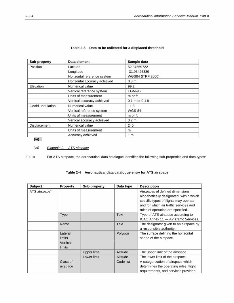
II-2-4 Aeronautical Information Services Manual, Part II
Table 2-3 Data to be collected for a displaced threshold
Sub-property Data element Sample data
Position Latitude 52.37559722
Longitude -31.96426389
Horizontal reference system WGS84 (ITRF 2000)
Horizontal accuracy achieved 0.3 m
Elevation Numerical value 99.2
Vertical reference system EGM-96
Units of measurement m or ft
Vertical accuracy achieved 0.1 m or 0.1 ft
Geoid undulation Numerical value 11.5
Vertical reference system WGS-84
Units of measurement m or ft
Vertical accuracy achieved 0.2 m
Displacement Numerical value 240
Units of measurement m
Accuracy achieved 1 m
(vi)
(vii) Example 2. ATS airspace
2.1.19 For ATS airspace, the aeronautical data catalogue identifies the following sub-properties and data types:
Table 2-4 Aeronautical data catalogue entry for ATS airspace
Subject Property Sub-property Data type Description
ATS airspace† Airspaces of defined dimensions,
alphabetically designated, within which
specific types of flights may operate
and for which air traffic services and
rules of operation are specified.
Type Text Type of ATS airspace according to
ICAO Annex 11 — Air Traffic Services.
Name Text The designator given to an airspace by
a responsible authority.
Lateral
limits
Polygon The surface defining the horizontal
shape of the airspace.
Vertical
limits
Upper limit Altitude The upper limit of the airspace.
Lower limit Altitude The lower limit of the airspace.
Class of
airspace
Code list A categorization of airspace which
determines the operating rules, flight
requirements, and services provided.
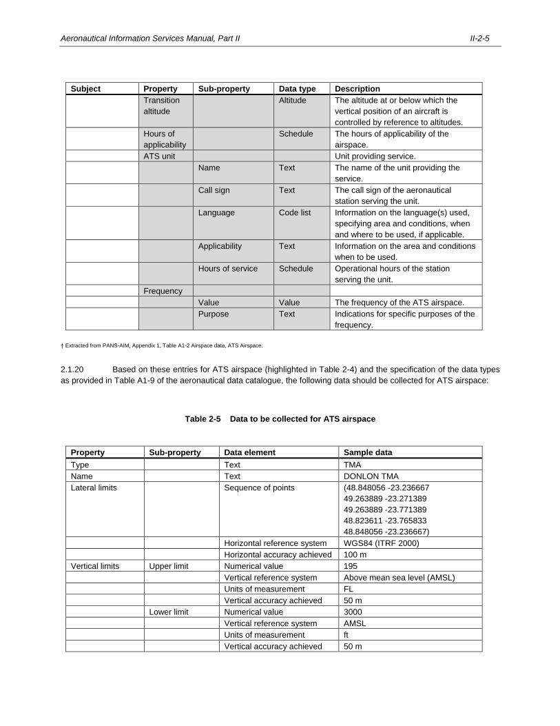
Aeronautical Information Services Manual, Part II II-2-5
Subject Property Sub-property Data type Description
Transition
altitude
Altitude The altitude at or below which the
vertical position of an aircraft is
controlled by reference to altitudes.
Hours of
applicability
Schedule The hours of applicability of the
airspace.
ATS unit Unit providing service.
Name Text The name of the unit providing the
service.
Call sign Text The call sign of the aeronautical
station serving the unit.
Language Code list Information on the language(s) used,
specifying area and conditions, when
and where to be used, if applicable.
Applicability Text Information on the area and conditions
when to be used.
Hours of service Schedule Operational hours of the station
serving the unit.
Frequency
Value Value The frequency of the ATS airspace.
Purpose Text Indications for specific purposes of the
frequency.
† Extracted from PANS-AIM, Appendix 1, Table A1-2 Airspace data, ATS Airspace.
2.1.20 Based on these entries for ATS airspace (highlighted in Table 2-4) and the specification of the data types
as provided in Table A1-9 of the aeronautical data catalogue, the following data should be collected for ATS airspace:
Table 2-5 Data to be collected for ATS airspace
Property Sub-property Data element Sample data
Type Text TMA
Name Text DONLON TMA
Lateral limits Sequence of points (48.848056 -23.236667
49.263889 -23.271389
49.263889 -23.771389
48.823611 -23.765833
48.848056 -23.236667)
Horizontal reference system WGS84 (ITRF 2000)
Horizontal accuracy achieved 100 m
Vertical limits Upper limit Numerical value 195
Vertical reference system Above mean sea level (AMSL)
Units of measurement FL
Vertical accuracy achieved 50 m
Lower limit Numerical value 3000
Vertical reference system AMSL
Units of measurement ft
Vertical accuracy achieved 50 m
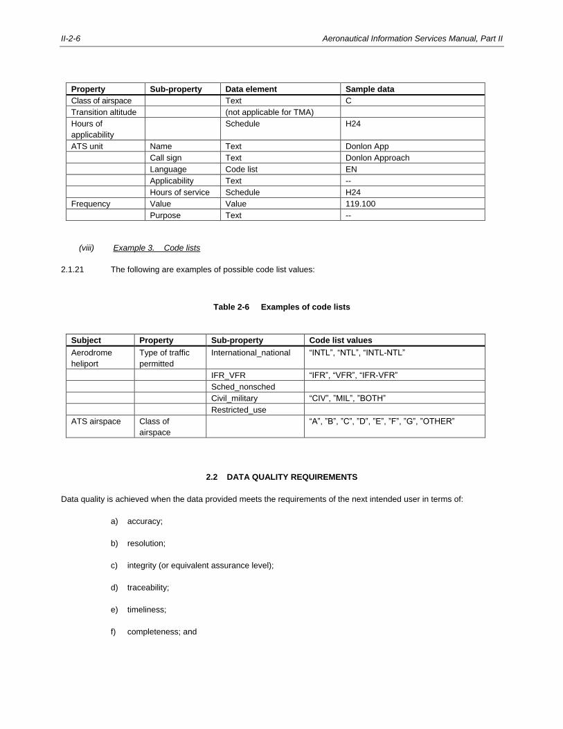
II-2-6 Aeronautical Information Services Manual, Part II
Property Sub-property Data element Sample data
Class of airspace Text C
Transition altitude (not applicable for TMA)
Hours of
applicability
Schedule H24
ATS unit Name Text Donlon App
Call sign Text Donlon Approach
Language Code list EN
Applicability Text --
Hours of service Schedule H24
Frequency Value Value 119.100
Purpose Text --
(viii) Example 3. Code lists
2.1.21 The following are examples of possible code list values:
Table 2-6 Examples of code lists
Subject Property Sub-property Code list values
Aerodrome
heliport
Type of traffic
permitted
International_national “INTL”, “NTL”, “INTL-NTL”
IFR_VFR “IFR”, “VFR”, “IFR-VFR”
Sched_nonsched
Civil_military “CIV”, ”MIL”, ”BOTH”
Restricted_use
ATS airspace Class of
airspace
“A”, ”B”, ”C”, ”D”, ”E”, ”F”, ”G”, ”OTHER”
2.2 DATA QUALITY REQUIREMENTS
Data quality is achieved when the data provided meets the requirements of the next intended user in terms of:
a) accuracy;
b) resolution;
c) integrity (or equivalent assurance level);
d) traceability;
e) timeliness;
f) completeness; and
Aeronautical Information Services Manual, Part II II-2-7
g) format.
2.2.1 Accuracy
2.2.1.1 The accuracy requirements for a subject’s properties and sub-properties are specified in the aeronautical
data catalogue in PANS-AIM, Appendix 1.
2.2.1.2 For data elements without an accuracy value specified in the aeronautical data catalogue, the required
accuracy should be established between the AIS and the next intended users of the data. This requirement should then
be passed on to the originators of those data elements in the formal arrangements.
2.2.1.3 The effect that any transformation, translation or reformatting of the data has on accuracy should be
evaluated. The algorithms and techniques used must be carefully chosen to avoid negative impact on the accuracy
requirements. For example, the algorithms used for the transformation or calculation of geographical coordinates must
preserve enough digits to assure the accuracy is not compromised.
2.2.2 Resolution
2.2.2.1 The publication and chart resolution for geographical position data (latitude and longitude) are applicable to
coordinates formatted in degrees, minutes and seconds. As listed in the tables in the aeronautical data catalogue (see
PANS-AIM, Appendix 1), the publication resolution (column J) represents the resolution of the data as text in products like
the AIP; the chart resolution (column K) represents the resolution of the data as text on aeronautical charts. The formal
arrangements between AIS and data originators can specify higher accuracy and resolution levels for collection,
processing and distribution if a need is identified by the end users of the aeronautical data.
2.2.2.2 When a different format is used (such as degrees with decimals for digital data sets) and when the data is
stored in a database or when the location is significantly further to the North/South, the resolution must be commensurate
with the accuracy requirements; digital data must have sufficient resolution to maintain accuracy. Typically, if an accuracy
of 0.1 units is needed, then a resolution of 0.01 or .001 units would enable a data chain to preserve the accuracy without
issue.
Example. Latitude / longitude of an aerodrome navaid
Accuracy: 3 m, publication resolution: 1/10 sec.
Resolution of digital data commensurate with accuracy: 0.0000001 degrees.
Latitude/longitude published in the AIP: 52 22 44.4N 031 55 36.4W.
Latitude/longitude in the AIP data set: 52.3790000-31.9267778.
2.2.3 Integrity
2.2.3.1 The integrity classification is specified in the tables in the aeronautical data catalogue (column H); see also
PANS-AIM, Appendix 1.
2.2.3.2 Further guidance on maintaining the integrity of aeronautical data and aeronautical information is provided
in Chapter 4.
II-2-8 Aeronautical Information Services Manual, Part II
2.2.4 Traceability
2.2.4.1 Traceability is the ability to determine the origin and transaction points of data and information.
2.2.4.2 Keeping a record of the changes made to the data enables an audit trail to be created from the end-user to
the data originator, which enables identification of the root cause of any anomalies or errors detected in the data.
2.2.4.3 Traceability is ensured by recording all interactions with the data, including:
a) data origination (survey, calculation, declaration);
b) data transformation;
c) data reformatting;
d) data verification activities; and
e) data validation activities.
2.2.4.4 Recordings for traceability are readily achieved using an automated processing system (see Chapter 7);
otherwise, the traceability logs must be maintained manually.
2.2.4.5 Traceability information is collected as metadata; further guidance on metadata is provided in Chapter 4.
2.2.4.6 Traceability must be maintained on each data element throughout its period of validity. However, traceability
should be maintained (or archived) beyond the validity for a data element or for any data element calculated or derived
from it, whichever is later, to support subsequent analysis which may be needed, for example, during an incident or
accident investigation.
2.2.5 Timeliness
2.2.5.1 Data timeliness is the degree of confidence that the data is applicable during the period of its intended use
which means that the effective period of the data has to be defined.
Note.— The term timeliness is also used to express the availability of data on time. Although this is not how
the term is defined in Annex 15 — Aeronautical Information Services, timely availability of the data must be assured.
Timely availability means that the data must be available to the users in advance of its effective period.
2.2.5.2 Timeliness can be assured by including any limits on the effective period with the data elements. These
limits may be associated with individual data elements or data sets. If the effective period is defined for a data set, it must
account for the effective dates of all of the individual data elements.
Note.— For further details see RTCA DO-200B/EUROCAE ED-76A — Standards for Processing
Aeronautical Data.
2.2.6 Completeness
Completeness of aeronautical data must be assured throughout the data chain:
Aeronautical Information Services Manual, Part II II-2-9
a) origination: validation procedures should be implemented to assure all data is originated (e.g. relevant
aerodrome data is being captured);
b) processing: procedures and tools must be implemented to assure that no data is lost in the process;
and
c) distribution: procedures and tools must be implemented to assure that data selected for distribution is
complete.
2.2.7 Format
2.2.7.1 Even though Annex 15 — Aeronautical Information Services does not define a data format, it specifies that
when exchanging or distributing data, the format of the data must be consistent with the intended use.
2.2.7.2 The format requirements should be specified in a written agreement between the providers of the data and
the users.
2.2.7.3 Different formats are used for numerical data depending on whether the data has to be read and interpreted
by humans, or whether the data is digitally exchanged and processed by automated systems.
2.2.7.4 Aeronautical information products provided in a standardized presentation are expressed in a human-friendly
format (e.g. latitude and longitude in degrees, minutes and seconds), while aeronautical information products provided as
a digital data set are formatted according to the data exchange specification (e.g. latitude and longitude in decimal
degrees). The examples below illustrate the different formats that are used across different aeronautical information
products.
Example. Expressing geographical coordinates in different aeronautical information products and formats:
AIP: 52 22 18 N 031 56 58 W
NOTAM: Item Q).../5222N03157W
AIXM: <gml:pos>52.3716666666667 -31.9494444444444</gml:pos>
Example. Expressing date-time group in different aeronautical information products and formats:
AIP: 26 MAR 2020 or AIRAC 26 MAR 2020
NOTAM: Item B) 2003261200
SNOWTAM: Item B) 03261200
AIXM: <gml:beginPosition>2020-03-26T12:00:00Z</gml:beginPosition>
2.2.7.5 To achieve interoperability and to contribute to a seamless data chain, a digital format should be chosen
whenever possible.
2.2.7.6 The Aeronautical Information Exchange Model (AIXM) is considered as best practice for formatting and
exchanging digital aeronautical data.
II-2-10 Aeronautical Information Services Manual, Part II
2.3 METADATA
2.3.1 General
2.3.1.1 Metadata describes the content, quality, condition and other characteristics of the data.
2.3.1.2 The purpose of metadata is to:
a) serve as one of the primary information sources of the AIS to validate the data;
b) facilitate traceability by providing information on what interactions have been applied to the data, by
whom and when; and
c) allow users to decide if the data meets the requirements and is fit for the intended use.
2.3.1.3 Annex 15 defines different requirements regarding metadata, namely:
a) metadata to be collected for aeronautical data processes and exchange points (Annex 15, 4.2.1); and
b) metadata to be provided with each data set (Annex 15, 5.3.1.2).
Aeronautical Information Services Manual, Part II II-2-11
2.3.2 Metadata collected for processes and exchange points
2.3.2.1 According to Annex 15, 4.2.2, metadata has to be collected at every stage of the aeronautical data chain
from origination to distribution.
2.3.2.2 The following metadata must be collected at processes and exchange points:
a) name of organization performing any actions on the data, including:
1) organization and unit; and
2) persons interacting with the data (e.g. use of an encoded staff ID may be an alternative if privacy
laws prohibit the recording of personal data);
b) actions, including:
1) data origination (including surveying and calculation methods, etc.);
2) amendments made to the data;
3) details of any algorithms and techniques (along with its parameters) applied to the data subjected
to conversion or transformation; and
4) verification and validation of the data that has been performed;
c) date and time the action was performed.
2.3.2.3 To assure that metadata is collected for data origination, the metadata requirements should be part of the
formal arrangements between the AIS and the data originator (see Chapter 3, 3.3 for details about formal arrangements
with data originators).
2.3.2.4 When actions are performed on data sets (e.g. transformation of geographical coordinates of a set of
obstacles) the metadata can be recorded for the data set, but must be traceable to each data element.
2.3.2.5 The metadata documenting actions must be stored and maintained by the AIS and is usually provided to the
user upon request only (e.g. for accident and incident investigations).
2.3.2.6 Metadata collected for processes and exchange points are best collected in an automated workflow
management and tracking system; further guidance on automation can be found in Chapter 7.
2.3.3 Metadata to be provided with each data set
2.3.3.1 Metadata is used to identify the provider of the data set, its validity and use restrictions.
2.3.3.2 The following minimum set of metadata must be included with every data set:
a) name of the organizations or entities providing the data set;
b) date and time when the data set was provided;
c) period of validity of the data set; and
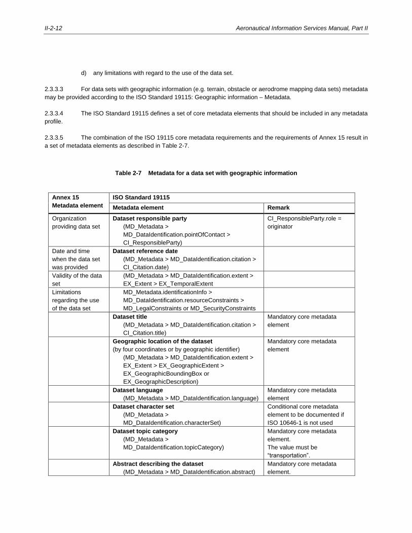
II-2-12 Aeronautical Information Services Manual, Part II
d) any limitations with regard to the use of the data set.
2.3.3.3 For data sets with geographic information (e.g. terrain, obstacle or aerodrome mapping data sets) metadata
may be provided according to the ISO Standard 19115: Geographic information – Metadata.
2.3.3.4 The ISO Standard 19115 defines a set of core metadata elements that should be included in any metadata
profile.
2.3.3.5 The combination of the ISO 19115 core metadata requirements and the requirements of Annex 15 result in
a set of metadata elements as described in Table 2-7.
Table 2-7 Metadata for a data set with geographic information
Annex 15
Metadata element
ISO Standard 19115
Metadata element Remark
Organization
providing data set
Dataset responsible party
(MD_Metadata >
MD_DataIdentification.pointOfContact >
CI_ResponsibleParty)
CI_ResponsibleParty.role =
originator
Date and time
when the data set
was provided
Dataset reference date
(MD_Metadata > MD_DataIdentification.citation >
CI_Citation.date)
Validity of the data
set
(MD_Metadata > MD_DataIdentification.extent >
EX_Extent > EX_TemporalExtent
Limitations
regarding the use
of the data set
MD_Metadata.identificationInfo >
MD_DataIdentification.resourceConstraints >
MD_LegalConstraints or MD_SecurityConstraints
Dataset title
(MD_Metadata > MD_DataIdentification.citation >
CI_Citation.title)
Mandatory core metadata
element
Geographic location of the dataset
(by four coordinates or by geographic identifier)
(MD_Metadata > MD_DataIdentification.extent >
EX_Extent > EX_GeographicExtent >
EX_GeographicBoundingBox or
EX_GeographicDescription)
Mandatory core metadata
element
Dataset language
(MD_Metadata > MD_DataIdentification.language)
Mandatory core metadata
element
Dataset character set
(MD_Metadata >
MD_DataIdentification.characterSet)
Conditional core metadata
element to be documented if
ISO 10646-1 is not used
Dataset topic category
(MD_Metadata >
MD_DataIdentification.topicCategory)
Mandatory core metadata
element.
The value must be
“transportation”.
Abstract describing the dataset
(MD_Metadata > MD_DataIdentification.abstract)
Mandatory core metadata
element.

Aeronautical Information Services Manual, Part II II-2-13
Annex 15
Metadata element
ISO Standard 19115
Metadata element Remark
Metadata point of contact
(MD_Metadata.contact > CI_ResponsibleParty)
Mandatory core metadata
element.
Metadata date stamp
(MD_Metadata.dateStamp)
Mandatory core metadata
element.
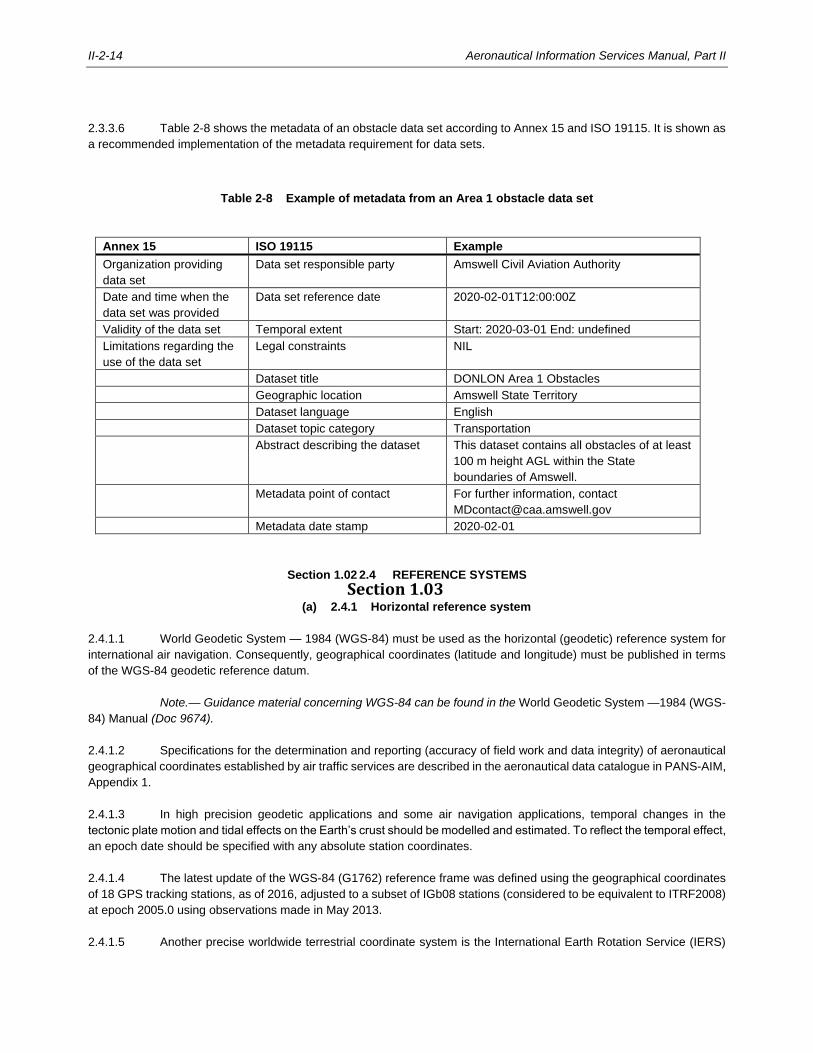
II-2-14 Aeronautical Information Services Manual, Part II
2.3.3.6 Table 2-8 shows the metadata of an obstacle data set according to Annex 15 and ISO 19115. It is shown as
a recommended implementation of the metadata requirement for data sets.
Table 2-8 Example of metadata from an Area 1 obstacle data set
Annex 15 ISO 19115 Example
Organization providing
data set
Data set responsible party Amswell Civil Aviation Authority
Date and time when the
data set was provided
Data set reference date 2020-02-01T12:00:00Z
Validity of the data set Temporal extent Start: 2020-03-01 End: undefined
Limitations regarding the
use of the data set
Legal constraints NIL
Dataset title DONLON Area 1 Obstacles
Geographic location Amswell State Territory
Dataset language English
Dataset topic category Transportation
Abstract describing the dataset This dataset contains all obstacles of at least
100 m height AGL within the State
boundaries of Amswell.
Metadata point of contact For further information, contact
Metadata date stamp 2020-02-01
Section 1.02 2.4 REFERENCE SYSTEMS
Section 1.03 (a) 2.4.1 Horizontal reference system
2.4.1.1 World Geodetic System — 1984 (WGS-84) must be used as the horizontal (geodetic) reference system for
international air navigation. Consequently, geographical coordinates (latitude and longitude) must be published in terms
of the WGS-84 geodetic reference datum.
Note.— Guidance material concerning WGS-84 can be found in the World Geodetic System —1984 (WGS-
84) Manual (Doc 9674).
2.4.1.2 Specifications for the determination and reporting (accuracy of field work and data integrity) of aeronautical
geographical coordinates established by air traffic services are described in the aeronautical data catalogue in PANS-AIM,
Appendix 1.
2.4.1.3 In high precision geodetic applications and some air navigation applications, temporal changes in the
tectonic plate motion and tidal effects on the Earth’s crust should be modelled and estimated. To reflect the temporal effect,
an epoch date should be specified with any absolute station coordinates.
2.4.1.4 The latest update of the WGS-84 (G1762) reference frame was defined using the geographical coordinates
of 18 GPS tracking stations, as of 2016, adjusted to a subset of IGb08 stations (considered to be equivalent to ITRF2008)
at epoch 2005.0 using observations made in May 2013.
2.4.1.5 Another precise worldwide terrestrial coordinate system is the International Earth Rotation Service (IERS)
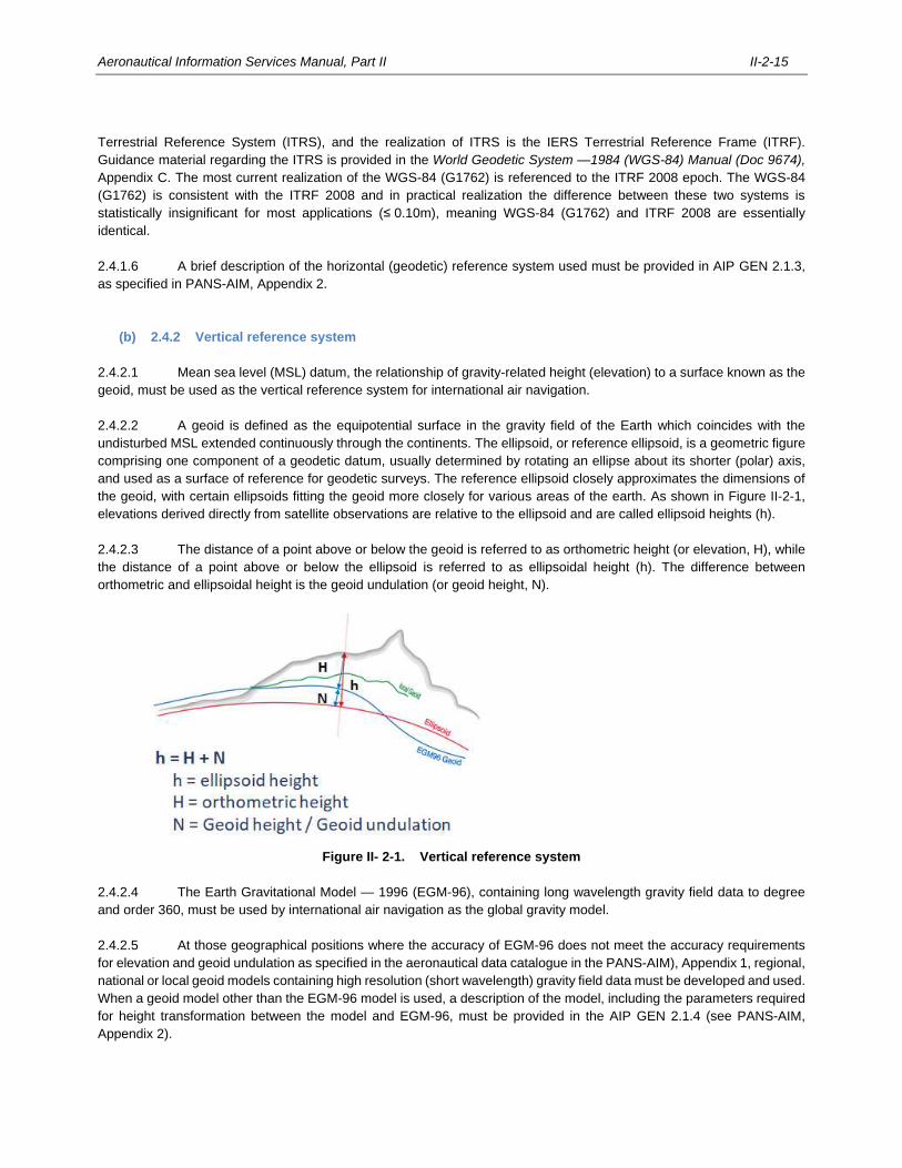
Aeronautical Information Services Manual, Part II II-2-15
Terrestrial Reference System (ITRS), and the realization of ITRS is the IERS Terrestrial Reference Frame (ITRF).
Guidance material regarding the ITRS is provided in the World Geodetic System —1984 (WGS-84) Manual (Doc 9674),
Appendix C. The most current realization of the WGS-84 (G1762) is referenced to the ITRF 2008 epoch. The WGS-84
(G1762) is consistent with the ITRF 2008 and in practical realization the difference between these two systems is
statistically insignificant for most applications (≤ 0.10m), meaning WGS-84 (G1762) and ITRF 2008 are essentially
identical.
2.4.1.6 A brief description of the horizontal (geodetic) reference system used must be provided in AIP GEN 2.1.3,
as specified in PANS-AIM, Appendix 2.
(b) 2.4.2 Vertical reference system
2.4.2.1 Mean sea level (MSL) datum, the relationship of gravity-related height (elevation) to a surface known as the
geoid, must be used as the vertical reference system for international air navigation.
2.4.2.2 A geoid is defined as the equipotential surface in the gravity field of the Earth which coincides with the
undisturbed MSL extended continuously through the continents. The ellipsoid, or reference ellipsoid, is a geometric figure
comprising one component of a geodetic datum, usually determined by rotating an ellipse about its shorter (polar) axis,
and used as a surface of reference for geodetic surveys. The reference ellipsoid closely approximates the dimensions of
the geoid, with certain ellipsoids fitting the geoid more closely for various areas of the earth. As shown in Figure II-2-1,
elevations derived directly from satellite observations are relative to the ellipsoid and are called ellipsoid heights (h).
2.4.2.3 The distance of a point above or below the geoid is referred to as orthometric height (or elevation, H), while
the distance of a point above or below the ellipsoid is referred to as ellipsoidal height (h). The difference between
orthometric and ellipsoidal height is the geoid undulation (or geoid height, N).
Figure II- 2-1. Vertical reference system
2.4.2.4 The Earth Gravitational Model — 1996 (EGM-96), containing long wavelength gravity field data to degree
and order 360, must be used by international air navigation as the global gravity model.
2.4.2.5 At those geographical positions where the accuracy of EGM-96 does not meet the accuracy requirements
for elevation and geoid undulation as specified in the aeronautical data catalogue in the PANS-AIM), Appendix 1, regional,
national or local geoid models containing high resolution (short wavelength) gravity field data must be developed and used.
When a geoid model other than the EGM-96 model is used, a description of the model, including the parameters required
for height transformation between the model and EGM-96, must be provided in the AIP GEN 2.1.4 (see PANS-AIM,
Appendix 2).
II-2-16 Aeronautical Information Services Manual, Part II
2.4.2.6 Specifications governing determination and reporting (accuracy of field work and data integrity) of elevation
and geoid undulation at specific positions at aerodromes/heliports are given in Annex 14, Volumes I and II, Chapter 2 and
in the aeronautical data catalogue in PANS-AIM, Appendix 1.
2.4.2.7 In addition to elevation referenced to the MSL (geoid), for the specific surveyed ground positions, geoid
undulation (referenced to the WGS-84 ellipsoid) for those positions specified in PANS-AIM, Appendix 2 must also be
published in the AIP.
2.4.2.8 The order of publication resolution of elevation and geoid undulation must be as specified in the aeronautical
data catalogue in PANS-AIM, Appendix 1.
2.4.2.9 A brief description of the vertical reference system used must be provided in AIP GEN 2.1.4 as specified in
PANS-AIM, Appendix 2.
(c) 2.4.3 Temporal reference system
2.4.3.1 For international civil aviation, the Gregorian calendar and Coordinated Universal Time (UTC) must be used
as the temporal reference system.
2.4.3.2 UTC is a time scale maintained by the Bureau International de l’Heure (BIH) and the IERS and forms the
basis of a coordinated dissemination of standard frequencies and time signals. See Annex 5 — Units of Measurement to
be Used in Air and Ground Operations, Attachment D for guidance material relating to UTC.
2.4.3.3 ISO Standard 8601 specifies the use of the Gregorian calendar and 24-hour local or UTC for information
interchange while ISO Standard 19108 prescribes the Gregorian calendar and UTC as the primary temporal reference
system for use with geographic information.
2.4.3.4 When a different temporal reference system is used for some applications, the feature catalogue, or the
metadata associated with an application schema or a data set, as appropriate, must include either a description of that
system or a citation for a document that describes that temporal reference system. ISO Standard 19108, Annex D,
describes some aspects of calendars that may have to be considered in such a description.
Note.— ISO Standard 19109 contains rules for application schema while ISO Standard 19110 describes the
feature cataloguing methodology for geographic information.
2.4.3.5 A description of the temporal reference system employed (calendar and time), as well as an indication of
whether or not daylight savings hours are employed, must be provided in AIP GEN 2.1.2 as specified in PANS-AIM,
Appendix 2.
______________________
II-3-1
Chapter 3
COLLECTION
3.1 INTRODUCTION
3.1.1 Transitioning to the AIM environment is to enable digital aeronautical data and aeronautical information of
the required quality to reach the next intended user.
3.1.2 Data and information quality starts at the origination and collection phases, which are the foundation of any
aeronautical data process. The AIS receives aeronautical data and aeronautical information from multiple originators; how
the data and information are received, verified and validated impacts the quality of the information along the process.
3.1.3 For the effective collection of aeronautical data and aeronautical information, the following practical steps
must be adhered to:
a) roles and responsibilities of all the stakeholders (air navigation services providers, airport authorities,
geospatial agencies, etc.) are identified;
b) working methods among the stakeholders are formalized;
c) competent resources are provided, especially in the transition to digital data environments: specific
technical expertise is required, mostly with respect to verifying and validating the data;
d) all interaction with the data are recorded for traceability; and
e) sufficient metadata is provided with the originated data, to facilitate its verification and validation.
3.1.4 The data collection is facilitated by the use of the aeronautical data catalogue which contains a common
data description for the data elements and data quality requirements.
3.2 USE OF THE AERONAUTICAL DATA CATALOGUE
3.2.1 The aeronautical data catalogue may be used as a tool to record the various data originators, as each data
element (subject, property and sub-property) can be mapped to an identified data originator. Table 3-1 refers.

II-3-2 Aeronautical Information Services Manual, Part II
Table 3-1 Example of a record of data originators responsible for national regulations
National regulation † Responsible organization
1.2 Aerodrome regulation and requirements
1.2.1
Name, contact information and description of the
State’s designated authority responsible for
aerodromes and heliports.
Ministry of transport, civil aviation authority
1.2.2 ICAO documents on which the operation of
aerodromes is based. Ministry of transport, civil aviation authority
1.2.3 General conditions under which aerodromes/heliports
and associated facilities are available for use. Ministry of transport, civil aviation authority
1.2.4
Criteria applied by the State in grouping aerodromes
or heliports must be provided for the production,
distribution, provision of information purposes (e.g.
international or national; primary or secondary; major
or other; civil/military; etc.).
Ministry of transport, civil aviation authority
1.2.5 Regulations concerning civil use of military air bases. Ministry of defence, military aviation authority
or ministry of transport, civil aviation authority
1.2.6
Rules governing the establishment of rescue and
firefighting services at aerodromes and heliports
together with an indication of rescue and firefighting
categories established by the State.
Ministry of transport, civil aviation authority
1.2.7
Information on general snow plan considerations for
aerodromes and heliports available for public use at
which snow conditions are normally liable to occur.
Ministry of transport, civil aviation authority
1.3. Customs regulation and requirements
1.3.1 Name, contact information and description of the
customs authorities.
The commissioner of customs and excise,
department of customs and excise
1.3.2 Customs regulations and requirements concerning
entry, transit and departure passengers and crew.
The commissioner of customs and excise,
department of customs and excise
1.3.3
Customs regulations and requirements concerning
entry, transit and departure of cargo and other
articles.
The commissioner of customs and excise,
department of customs and excise
1.4. Immigration regulation and requirements
1.4.1 Name, contact information and description of the
immigration authorities.
The controller of immigration, department of
immigration
1.4.2 Immigration regulations and requirements concerning
entry, transit and departure passengers and crew.
The controller of immigration, department of
immigration
1.5. Health regulation and requirements
1.5.1 Name, contact information and description of the
health authorities.
The director of health services, department of
health
1.5.2
Regulations and requirements concerning public
health measures applied to aircraft on entry, transit
and departure on international flights.
The director of health services, department of
health
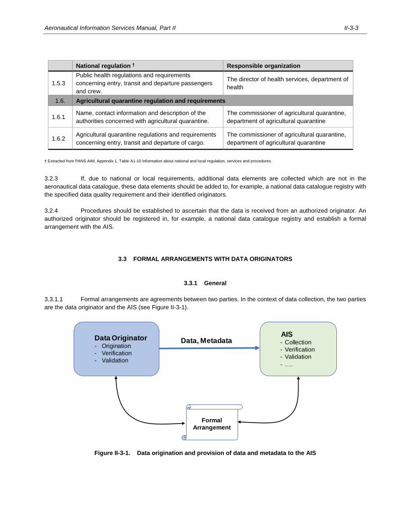
Aeronautical Information Services Manual, Part II II-3-3
National regulation † Responsible organization
1.5.3
Public health regulations and requirements
concerning entry, transit and departure passengers
and crew.
The director of health services, department of
health
1.6. Agricultural quarantine regulation and requirements
1.6.1 Name, contact information and description of the
authorities concerned with agricultural quarantine.
The commissioner of agricultural quarantine,
department of agricultural quarantine
1.6.2 Agricultural quarantine regulations and requirements
concerning entry, transit and departure of cargo.
The commissioner of agricultural quarantine,
department of agricultural quarantine
† Extracted from PANS-AIM, Appendix 1, Table A1-10 Information about national and local regulation, services and procedures.
3.2.3 If, due to national or local requirements, additional data elements are collected which are not in the
aeronautical data catalogue, these data elements should be added to, for example, a national data catalogue registry with
the specified data quality requirement and their identified originators.
3.2.4 Procedures should be established to ascertain that the data is received from an authorized originator. An
authorized originator should be registered in, for example, a national data catalogue registry and establish a formal
arrangement with the AIS.
3.3 FORMAL ARRANGEMENTS WITH DATA ORIGINATORS
3.3.1 General
3.3.1.1 Formal arrangements are agreements between two parties. In the context of data collection, the two parties
are the data originator and the AIS (see Figure II-3-1).
Figure II-3-1. Data origination and provision of data and metadata to the AIS
Data Originator- Origination
- Verification
- Validation
Formal
Arrangement
Data, MetadataAIS- Collection
- Verification
- Validation
- ….
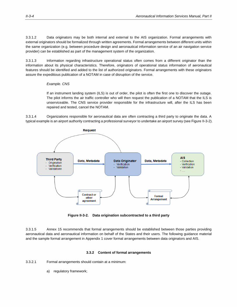
II-3-4 Aeronautical Information Services Manual, Part II
3.3.1.2 Data originators may be both internal and external to the AIS organization. Formal arrangements with
external originators should be formalized through written agreements. Formal arrangements between different units within
the same organization (e.g. between procedure design and aeronautical information service of an air navigation service
provider) can be established as part of the management system of the organization.
3.3.1.3 Information regarding infrastructure operational status often comes from a different originator than the
information about its physical characteristics. Therefore, originators of operational status information of aeronautical
features should be identified and added to the list of authorized originators. Formal arrangements with these originators
assure the expeditious publication of a NOTAM in case of disruption of the service.
Example. CNS
If an instrument landing system (ILS) is out of order, the pilot is often the first one to discover the outage.
The pilot informs the air traffic controller who will then request the publication of a NOTAM that the ILS is
unserviceable. The CNS service provider responsible for the infrastructure will, after the ILS has been
repaired and tested, cancel the NOTAM.
3.3.1.4 Organizations responsible for aeronautical data are often contracting a third party to originate the data. A
typical example is an airport authority contracting a professional surveyor to undertake an airport survey (see Figure II-3-2).
Figure II-3-2. Data origination subcontracted to a third party
3.3.1.5 Annex 15 recommends that formal arrangements should be established between those parties providing
aeronautical data and aeronautical information on behalf of the States and their users. The following guidance material
and the sample formal arrangement in Appendix 1 cover formal arrangements between data originators and AIS.
3.3.2 Content of formal arrangements
3.3.2.1 Formal arrangements should contain at a minimum:
a) regulatory framework;
Aeronautical Information Services Manual, Part II II-3-5
b) data origination;
c) quality assurance;
d) metadata and quality reporting;
e) data distribution (including format); and
f) error handling.
3.3.2.2 A sample formal arrangement which may be used as a template when formalizing the working arrangements
between the data originators and the AIS is provided in Appendix 1.
Regulatory framework
3.3.2.3 Formal arrangements should define the relevant regulations and standards for the origination of aeronautical
data.
3.3.2.4 References to relevant SARPs and guidance material for the data origination (e.g. World Geodetic System
— 1984 (WGS-84) Manual (Doc 9674) for geodetic surveys) should be included in the formal arrangements.
Data origination
3.3.2.5 The data to be originated must be clearly specified with respect to scope and quality.
3.3.2.6 The aeronautical data catalogue should be used as a reference for the specifications of data to be originated.
3.3.2.7 The valid codes for data elements should be defined in the formal arrangements according to the data
catalogue (examples are given in Chapter 2, Table 2-6).
Quality assurance
3.3.2.8 Data origination is an important process with respect to data quality since subsequent processing cannot
improve quality, but only maintains or may even degrade it. Therefore, the data originator must have verification and
validation processes in place to assure the required data quality is achieved.
3.3.2.9 Data origination and validation methods should be commensurate with the integrity classification of the data.
Whenever possible, critical data should be processed digitally without manual interaction.
Metadata and quality reporting
3.3.2.10 Since metadata is an important source of information for the verification, validation and understanding of the
data, the formal arrangement must include provisions concerning what metadata the originator has to record and provide
to the AIS.
3.3.2.11 The metadata can be distributed as structured data (based on ISO Standards 19115 and 19139) or be
provided as textual information in the quality report.
II-3-6 Aeronautical Information Services Manual, Part II
3.3.2.12 Guidance on the content and structure of a survey report can be found in the World Geodetic System —
1984 (WGS-84) Manual (Doc 9674, Chapter 5, Attachment C) and guidance on the documentation of a flight procedure
design in the Quality Assurance Manual for Flight Procedure Design, Volume 1 — Flight Procedure Design Quality
Assurance System (Doc 9906).
Data distribution
3.3.2.13 The formal arrangement should include as a minimum the following provisions:
a) details of the organization to which the data has to be distributed;
b) the means of distribution (namely, aeronautical data and aeronautical information should be distributed
in digital format via electronic transfer, or direct input into the automated AIM system; see Chapter 7,
7.5);
c) the format of the data and metadata; and
d) the date and time by which the data has to be distributed.
Error handling
3.3.2.14 The formal arrangement should include provisions on how data errors and inconsistencies are handled and
corrected by the originator and by the AIS in the event that a data error or inconsistency is discovered before as well as
after the data has been published.
3.4 HANDLING COLLECTED DATA AND INFORMATION
3.4.1 Before further processing, aeronautical data or aeronautical information received from an originator is
verified to ensure it has not been corrupted during transfer (see Chapter 4, 4.1.2).
3.4.2 Information received on paper is digitized by the AIS for further digital processing.
3.4.3 Verification methods must be in place to ensure that the manually entered data is accurate.
______________________

II-4-1
Chapter 4
PROCESSING
Processing aeronautical data consists of two major steps:
a) verification, validation, assembly of the received data; and
b) integration (translation, selection and formatting) of verified and validated data into aeronautical
information products and services.
II-4-2 Aeronautical Information Services Manual, Part II
Figure II-4-1 Data processing
Note 1.— In Figure II-4-1, data processing is broken down into the phases according to the data
processing model defined in RTCA Document DO-200B and European Organization for Civil Aviation Equipment
(EUROCAE) Document ED-76A — Standards for Processing Aeronautical Data.
Originator
Validate
Received data
Validated data
Receive
Assemble
Translate
Select
Format
Distribute
Next
intended
user
Stand.
Pres.Data set
Colle
ctio
nP
rocessin
gD
istrib
utio
n
V
V
V
V
V
Receive
Digitise
V
V
on paper digitally
Aeronautical Information Services Manual, Part II II-4-3
4.1 VERIFICATION AND VALIDATION
4.1.1 General
4.1.1.1 Verification and validation are defined by the ISO 9000 — Quality Management Systems — Fundamentals
and Vocabulary:
a) verification is defined as confirmation, through the provision of objective evidence, that specified
requirements have been fulfilled; whereas
b) validation is defined as confirmation, through the provision of objective evidence, that the requirements
for a specific intended use or application have been fulfilled.
4.1.1.2 To differentiate between the two terms is not obvious and requires further explanations.
4.1.1.3 The specified requirements mentioned in the verification definition can be considered as the specifications
of a process or actions on data. Such actions can be, for example, generating, modifying, reformatting or transferring of
data. Verification is applied to ensure that the output of the process is consistent with the input and the specifications of
the process.
Figure II-4-2. Verification
4.1.1.4 The requirements for the specific intended use of data depend on its application, which can vary widely. The
data quality requirements defined in Annex 15, Chapter 3, 3.2 and in the aeronautical data catalogue serves as reference
for data validation.
4.1.1.5 To provide evidence, the procedures for verification and validation should be documented in the quality
management system (QMS) and all verification and validation activities should be logged in the metadata for traceability
(see Chapter 2, 2.3).
4.1.1.6 Application of the verification and validation procedures depends on the integrity classification of the data.
For example, critical data elements require a more rigorous application of verification and validation than essential data,
whereas routine data requires the least rigorous.
4.1.1.7 If data elements of different integrity classification levels are processed together (e.g. routine data is
processed together with essential data), then the higher integrity level should be used for selecting the appropriate
verification or validation procedure, unless a more rigorous verification or validation is applied to the more critical data.
ProcessInput Output
Specification
II-4-4 Aeronautical Information Services Manual, Part II
4.1.1.8 Verification and validation activities do not generate data quality per se, but ensure that quality requirements
are met and maintained, thereby ensuring the integrity of the data. Since the quality of the data is established at the
beginning of the data chain, i.e. at origination, verification and validation procedures should be applied at the beginning
and continue throughout all subsequent stages of the data chain.
4.1.1.9 Good communication between the data originator and the AIS is essential. With the required data and its
quality specified in the formal arrangement, the originator is responsible for providing data according to the specified
requirements and needs to set-up data processes and tools accordingly. The originator is also responsible for verifying
and validating the data and subsequently transfers it together with the metadata to the AIS, as specified in the formal
agreement. The AIS receives the data and applies its own verification and validation procedures. Thus, the AIS
complements rather than simply duplicates the quality assurance activities of the data originator as described in the
following sections, thereby ensuring the integrity of the data.
Note.— Additional guidance material with respect to verification and validation of aeronautical data and
aeronautical information can be found in RTCA Document DO-200B and European Organisation for Civil Aviation
Equipment (EUROCAE) Document ED-76A — Standards for Processing Aeronautical Data.
4.1.2 Verification
4.1.2.1 By verifying all aeronautical data and aeronautical information, the AIS ensures that the output of the applied
processes or actions still conforms to the specified data quality requirements without having introduced errors. Examples
of verification activities are given in the PANS-AIM and include comparison, feedback and alternative calculations.
4.1.2.2 Verification also ensures that aeronautical data and aeronautical information has not been corrupted during
a transfer. Digital data error detection techniques that are employed should be based on the use of systematic cycling
codes, and include the use of hash functions and cyclic redundancy check (CRC). Another technique involves transferring
the data back to the originator prior to publication and thereby permitting an external comparison between the output and
the input.
4.1.2.3 Whenever data is entered manually, the data must be verified to ensure that no errors have been introduced.
In this case, the verification procedure has to be commensurate with the integrity classification of the data. Assuming a
human error rate of 10-3, the following verification procedures should be applied:
a) routine data requires single data entry, and checked at least once;
b) essential data requires the data entry to be independently checked at least once; and
c) critical data requires the data entry to be independently checked twice.
4.1.2.4 Alternatively, for critical data elements, a verification technique of “blind re-key” may be applied, meaning
that a data entry has to be made twice by different individuals with a subsequent comparison check by the automated AIM
system.
4.1.2.5 Whenever geographical coordinates must be transformed, the correct application of the transformation
formula should be verified using one of the following techniques:
a) reverse transformation of the output and comparison with the original coordinates;
b) independent calculations using another application or a recognised web-service of a geodetic institute;
or
Aeronautical Information Services Manual, Part II II-4-5
c) manual calculation.
4.1.2.6 When formatting aeronautical data, the correct application of the data representation rules must be verified.
In this case, the verification technique may be to conduct a visual check of the output.
4.1.2.7 Whenever one or more changes need to be made to a data product e.g. an AIP amendment, all the changes
must be verified. A verification technique can be to have the originator check the product, or by comparing the changes
with the originators’ original data submission.
4.1.2.8 A data element is often portrayed in different data products or in different parts of a particular product (for
example, the frequency of a navigational aid is contained in a data set, as well as mentioned in different sections of the
AIP and displayed on multiple charts). Verification procedures must be consistently applied across a range of different
data products.
4.1.2.9 It is therefore advisable that different data products are generated from a single centralized database with
an automated AIM system to ensure consistency across all products.
4.1.2.10 Verification is key to ensuring data quality. All systems and phases for processing of aeronautical data should
be designed in a way that each activity, whether manual or automated, is adequately verified and logged using the
metadata.
4.1.2.11 Whenever errors are detected during the verification procedure, these errors must be recorded and corrected
before proceeding to the next phase. Further guidance on error detection and reporting can be found in Chapter 6, 6.2.2.
4.1.3 Validation
4.1.3.1 By validating aeronautical data and aeronautical information, the AIS confirms and provides assurance that
the quality requirements for the intended use are fulfilled. The users of the data rely on that validation done by the AIS.
Note.— This fact is documented in RTCA Document DO-200B and European Organisation for Civil Aviation
Equipment (EUROCAE) Document ED-76A — Standards for Processing Aeronautical Data, relevant for organization
processing aeronautical data and aeronautical information: “It is important that any data flow through a formal state
publication (e.g. State Aeronautical Information Publication (AIP)) is considered an authoritative source and the validation
requirements would be inherently met with the published data set”.
4.1.3.2 Data should be validated as early as possible in the data chain. The sooner any non-compliance with the
required data quality is discovered, the less costly it is to correct the errors.
4.1.3.3 Any errors detected by the validation activity must be logged and corrected before continuing the processing;
see Chapter 6, 6.2.2 for further guidance on error detection and reporting.
4.1.3.4 There are two complementary types of validation activities:
a) validation based on metadata; and
b) plausibility check of the data.
II-4-6 Aeronautical Information Services Manual, Part II
4.1.3.5. Validation based on metadata
4.1.3.5.1 Metadata produced by the data originator is a source of information for the AIS when validating the data.
When analysing the incoming data for its fitness for use, the AIS depends on the verification and validation activities done
by the originator. The result of these activities is recorded in the metadata.
4.1.3.5.2 To validate the data, the AIS checks the metadata received from the originator and asks the following
questions:
— Is the data coming from an authoritative source (i.e. is the originator of the data on the list of authorized
originators)?
— Is the metadata complete and are the accompanying documents unambiguous and comprehensible?
— Have all applicable quality requirements as specified in the formal arrangement (e.g. accuracy,
resolution, integrity, format, etc.) been met?
4.1.3.6 Plausibility checks of the data
In addition to validating the data based on the metadata, the AIS should apply other methods as well, namely:
a) geographical coordinates can be validated by visualization in a geographic information system.
Topographic maps, orthophotos or satellite maps may serve as the geographic reference to compare
the data against;
b) distances and bearings can be checked by recalculating them from geographical coordinates (e.g.
route-segments or waypoints).
c) declared distances can be checked with other runway data such as runway end coordinates, threshold
coordinates, runway length, and the dimensions of stop ways or clear way; and
d) obstacle data can be checked against digital terrain data in a 3D-viewer, e.g. Google Earth. Thus,
erroneous obstacle data can appear to be either embedded within the terrain or floating above it.
4.1.3.7 Validation with data from neighbouring States
4.1.3.7.1 In some cases, the same aeronautical data or information is contained in aeronautical information products
and services of two or more States (e.g. common airspace boundaries, routes, waypoints, border points etc.). In those
situations, the responsible AIS should establish a mechanism to ensure consistency of the aeronautical data that is
common to two or more States.
4.1.3.7.2 The AIS of the State originating a change that may impact aeronautical data that is common to two or more
States should inform the neighbouring AIS to avoid inconsistencies.
4.1.3.7.3 If data inconsistencies exist at the publication target date, then publication should be postponed. However,
if the data has already been distributed according to the aeronautical information regulation and control (AIRAC) system,
then corrections must be published by NOTAM.
4.1.3.8 Assembling
Aeronautical Information Services Manual, Part II II-4-7
4.1.3.8.1 Data assembled from different originators should be validated for consistency, for example:
a) airspace changes should not be in conflict with neighbouring airspaces;
b) new routes should fit into the existing route network;
c) new or modified instrument flight procedures should connect to the existing route network; and
d) runway thresholds must be consistent with modified instrument approach procedures.
4.1.3.8.2 Once validated, data collected from the different originators (e.g. aerodrome authority, procedure designers)
is assembled into a database which then becomes the authoritative source for all aeronautical information products and
services.
4.2 INTEGRATION
4.2.1 Once all validated data is assembled and stored in a database, the data is integrated into aeronautical
information products and services by translating, selecting and formatting the data according to the appropriate product
specification.
4.2.2 When data must be translated (e.g. geographical coordinate transformations, procedure encoding)
verification must be applied to ensure the integrity of the original data is maintained after translation.
4.2.3 Specific data elements are then selected and included in aeronautical information products and services,
e.g. an AIP amendment or an AIP data set.
4.2.4 The selected data is converted to a format that is acceptable to the next intended user. Examples of data
interchange and file formats include AIXM and JSON for data sets, and HTML and PDF for electronic AIP.
4.2.5 Once the data has been formatted and verified, a digital data error detection technique, such as systematic
cycling codes, including the use of hash functions and CRC are applied to protect the data during transmission.
4.2.6 Guidance on preparing aeronautical information in a standardized presentation can be found in Volume III
— Aeronautical Information in a Standardized Presentation and Related Services.
___________________

II-5-1
Chapter 5
DISTRIBUTION
5.1 Distribution represents the last phase in the aeronautical data chain and involves distributing the aeronautical
information to the next intended users.
5.2 The preferred method of distribution of aeronautical information in a standardized presentation is by
electronic transmission rather than delivery of a physical package using, for example, postal services (refer to Part III —
Aeronautical Information in a Standardized Presentation and Related Services for further guidance).
5.3 The preferred method of distribution of aeronautical information provided as digital data sets is by secure
online access. It is anticipated that in the future, aeronautical information and digital data sets will be distributed by SWIM
information services.
Note.— The Manual on System-Wide Information Management (SWIM) Concept (Doc 10039) provides
further guidance on SWIM.
___________________

II-6-1
Chapter 6
QUALITY ASSURANCE AND QUALITY CONTROL
6.1 INTRODUCTION
6.1.1 Corrupt or erroneous aeronautical data and aeronautical information negatively affects the safety of air
navigation and can, in the case of critical data, severely impact the continued safe flight and landing of an aircraft because
of the direct dependence of airborne and ground-based systems on quality-assured data. It is therefore imperative for
each State to ensure that users (i.e. flight crews, air traffic controllers, dispatchers, air traffic services, aviation industry,
etc.) receive aeronautical data and aeronautical information with the quality and timeliness appropriate for its intended
use.
6.1.2 The integrity and validity of aeronautical data and aeronautical information should be questioned whenever
there is no traceable history to the creation of an aeronautical data or aeronautical information element.
6.1.3 To provide aeronautical data and aeronautical information the user can trust, and in order to be able to
demonstrate the quality of aeronautical data and aeronautical information to users, the AIS must establish a QMS.
6.1.4 ISO 9000 defines QMS as a “management system that directs and controls an organisation with regard to
quality. Activities generally include the following: establishment of a quality policy and quality objectives, quality planning,
quality control, quality assurance and quality improvement”.
6.1.5 Quality assurance and quality control are two quality management functions that must be embedded in the
aeronautical data process.
6.2 QUALITY ASSURANCE
6.2.1 General aspects
6.2.1.1 According to ISO 9000, quality assurance is part of quality management focused on providing confidence
that quality requirements will be fulfilled. Quality assurance therefore comprises the activities, methods and tools deployed
in all phases of the aeronautical data process (collection, processing and distribution) to ensure that the aeronautical
information products and services meet the quality requirements.
6.2.1.2 This represents a fundamental shift from the reactive approach of controlling quality by means of detection
and then fixing the errors, to a proactive approach of controlling and managing activities such as to prevent errors from
occurring in the first place.
6.2.1.3 Quality assurance starts with good process design, in which errors are avoided as much as possible.
Corresponding work instructions need to consider the criticality of the data being processed and address not only the
regular process steps, but also describe error handling. Process design and work instructions should be validated prior to
use.
6.2.1.4 The aeronautical data process should be regularly checked with test cases including some which trigger
error handling.
II-6-2 Aeronautical Information Services Manual, Part II
6.2.1.5 Additional integrity assurance processes should be applied to avoid potential corruption of critical data,
including:
a) multiple entries or multiple checks of manually entered data (see Chapter 4, 4.1.2);
b) tool qualification of the software tools that are used for checking or translating critical data; or
c) flight validation of new instrument flight procedures.
Note. — Standards for tool qualification can be found in EUROCAE ED-215 / RTCA DO-330 — Software
Tool Qualification Considerations with adaptations provided in EUROCAE ED-76A / RTCA DO-200B — Standards for
Processing Aeronautical Data.
6.2.1.6 Whenever manual input or human interpretation is involved in the aeronautical data process, the output after
the human intervention must be monitored for potential errors. Automated systems may also potentially introduce data
errors which need to be analysed whenever detected.
6.2.1.7 Every error should be analysed and possible root causes, once identified, eliminated by changing the
procedure, providing additional training to the staff, or by automating the entire process.
6.2.2 Data error detection and reporting
6.2.2.1 Error detection and reporting processes improve the reliability of data and strengthen the procedures for
checking and testing the output.
6.2.2.2 Data error detection and reporting procedures are applied when an error is detected by verification and
validation activities. An error may be detected while still within the aeronautical data process (e.g. by the final quality
control check) or, once the error has already left the AIS, by a user using a published product or data set.
6.2.2.3 Errors may be due to inconsistent data, missing data, corrupted data, or data not meeting quality
requirements, or due to faulty processing.
6.2.2.4 When an error is detected, the appropriate action to be taken depends on different criteria such as:
a) the criticality (the severity of the potential consequences) of the error;
b) the cause of the error (error in the data or in the processing);
c) the circumstances of the detected error (i.e. whether the error is detected before or after publication of
the aeronautical information products and services); and
d) the time required to fix the error.
6.2.2.5 When errors are detected, the following steps should be undertaken:
a) log the error;
b) analyse the error, i.e. has the error already been published, is it critical, is it a data error, is there a need
to notify originator?
Aeronautical Information Services Manual, Part II II-6-3
c) determine the root cause;
c) apply corrective action(s), e.g. update the data processing system where the error was initiated;
d) update the aeronautical information product which contains the error; and
e) update and close the error log.
6.2.2.6 Figure II-6-1 shows the error detection and reporting process.
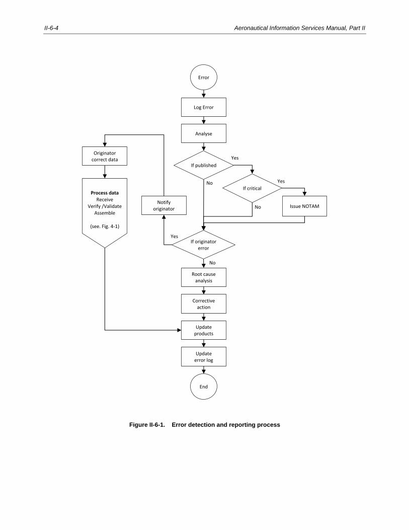
II-6-4 Aeronautical Information Services Manual, Part II
Figure II-6-1. Error detection and reporting process
Error
Log Error
Analyse
Update error log
Update products
If published
If originator error
If critical
Originator correct data
Process data
Receive
Verify /Validate
Assemble
(see. Fig. 4-1)
Issue NOTAM
End
No
Notify originator
Root cause analysis
Corrective action
No
No
Yes
Yes
Yes
Aeronautical Information Services Manual, Part II II-6-5
6.2.2.7 Error logging
6.2.2.7.1 To ensure continuous quality improvement, procedures must be in place to record and analyse errors, and
to implement corrective and preventative actions. It is important to properly document the error by referencing the particular
activity during processing when the error occurred.
6.2.2.7.2 The goal is early error identification. It is the responsibility of the AIS to notify the next intended users, if the
error was already published, or to notify the originator of the data if the error was detected while still within the aeronautical
data process. If it was an internal error the AIS is responsible for recording it appropriately.
6.2.2.8 Error analysis
6.2.2.8.1 To assist with error analysis, it is useful to establish the following error categories:
a) critical error implies that the error directly compromises the safety of air navigation, for example:
i. the error could compromise aircraft clearance from terrain, e.g. incorrect instrument approach
minima;
ii. an error in navigational or route information, e.g. incorrect track; and
iii. any error in the depiction or publication of airspace information, e.g. incorrect vertical limits;
b) major error implies information intended for communications or air navigation purposes is missing,
ambiguous or difficult to interpret, e.g. incorrect ATS frequency; and
c) minor error implies the erroneous data has no operational impact, i.e. any instance of typographical,
grammatical, printing or formatting deficiency which does not directly cause operational difficulties, but
does not meet expected standards.
6.2.2.8.2 During the analysis, it is important to determine the root cause of the error, i.e. whether the data error has
been introduced at origination, or whether the error has been introduced during subsequent internal processing.
6.2.2.8.3 The analysis also helps identify if the aeronautical data has already been made available to the users.
6.2.2.9 Corrective action
6.2.2.9.1 Once error analysis is completed, corrective actions must be applied to the erroneous data.
6.2.2.9.2 If the error was caused by internal processing, then it must be recorded and the data corrected. If the error
was introduced at origination, then the originator must be informed in order to correct the error. The corrected data should
then be processed as usual, i.e. the same procedures should be applied as if it never had to be corrected (see Chapter 4,
Figure II-4-1). No shortcuts should be applied due to time constraints.
6.2.2.9.3 If the corrective action cannot be completed within the available time before distribution, then the publication
date and the effective date need to be postponed until the error can be corrected.
6.2.2.9.4 A deviation from established data processing procedures should only be considered in exceptional
circumstances when a delay of the effective date is not possible.
II-6-6 Aeronautical Information Services Manual, Part II
6.2.2.9.5 If the aeronautical data has already been published, and the error category determined it to be a critical error,
the users must be informed as quickly as possible.
6.2.2.9.6 Appropriate corrective actions include to:
a) issue a NOTAM when the error is scheduled to be corrected with the next scheduled AIP amendment.
If the next scheduled amendment is not within 90 days, the corrected data should be published by AIP
supplement at the next available issue;
b) issue an AIP supplement when the error should only be corrected by AIP supplement when the affected
page or chart is not scheduled for reissue at the next scheduled AIP amendment;
c) issue an AIP amendment; and
d) correct the data error at the next scheduled issue of a page or chart.
6.2.2.9.7 Once the aeronautical data has been corrected and the aeronautical information products and services
updated, a corresponding entry is made in the error log and subsequently closed.
6.2.2.10 Preventative action
6.2.2.10.1 The error log should regularly be monitored and analysed. Thus, potential improvements of processes and
tools may be identified in order to prevent the same or similar error from happening again. This can be achieved by taking
the following steps:
a) documenting the error;
b) determining the root cause of the error;
c) performing the necessary action(s) to prevent the same or similar errors from occurring again; and
d) implementing the improvement actions on processes and tools.
6.3 QUALITY CONTROL
6.3.1 Overview
6.3.1.1 According to ISO 9000 quality control is a part of quality management focused on fulfilling quality
requirements. As such, quality control represents the processes by which the quality of a product or a service is verified
in order for the output to meet end user requirements.
6.3.1.2 Being an integral part of a QMS, quality control is applied through all phases of the aeronautical data process
(collection, processing, and distribution) by the organization or authority in charge of the data. Tools to enable quality
control may include testing, inspecting, and validating the product or service.
6.3.1.3 In addition to the verification and validation procedures depicted in the processing workflow (Chapter 4,
Figure II-4-1 refers), quality control of the aeronautical information products and services should be implemented
throughout the aeronautical data process.
Aeronautical Information Services Manual, Part II II-6-7
6.3.1.4 Quality control of the aeronautical information products and services include:
a) quality checks to ensure compliance with the product specification; and
b) consistency checks across the products.
6.3.2 Quality checks to ensure compliance with product specifications
6.3.2.1 Quality checks ensure that aeronautical data complies with all data quality requirements and data product
specifications. The various verification steps throughout the aeronautical data process are part of the quality control checks,
as described in Chapter 4.
6.3.2.2 Metadata is used to record the quality check results even if the aeronautical data conforms to the standards
and needs no further changes. Thus, the users are provided with further assurance that they can safely rely on the provided
data. However, if a data error is found, then the error detection and reporting procedures apply as mentioned in 6.2.2.
6.3.3 Consistency checks across the products
6.3.3.1 Consistency checks applied throughout the aeronautical data process assure the quality of the final products.
Validation procedures are established to ensure consistency in the values, data types and associations of the aeronautical
data (see Chapter 4).
6.3.3.2 Consistency is also achieved through updating or synchronization of changes in aeronautical information
products and services as changes appear. The objective is to avoid having updated data in one product or service and
not in another. Working off a single, centralized database facilitates consistency across all aeronautical information
products and services.
6.3.3.3 Aeronautical information products and services must be consistent also with those of other States.
Sometimes, duplicate data cannot simply be deleted, For example, the geographical coordinates of a common border
between two neighbouring States need to match, thereby ensuring the reliability of the data. Agreements between the
States are needed to publish common aeronautical data (e.g. values) consistently; see Chapter 4, 4.1.3 for further
guidance.
6.3.4 Control of nonconforming products
Aeronautical data and aeronautical information that are not conforming to the required standards, or are erroneous or
inconsistent, must not be used in aeronautical information products and services. Such products and services must be
deemed as ‘nonconforming’ by the AIS and corrective actions must be taken (see 6.2.2). Any nonconforming aeronautical
information product or service must be marked as such, and the nonconformity documented in the metadata.
___________________

II-7-1
Chapter 7
AUTOMATION
7.1 INTRODUCTION
7.1.1 Each State is requested to assess its current level of automation and gradually reduce human interaction
with its aeronautical data processes in order to transition towards an automated system. States that have already
automated certain procedures may follow the guidelines below to progress towards higher levels of automation.
7.1.2 To continually improve the quality of aeronautical data and aeronautical information, and to cope with the
ever increasing demands for more and better aeronautical information products and services, the transition from paper
to digital data and automated data processing is strongly encouraged. However, digital aeronautical information
products and services must continue to comply with the provisions of Annex 15 and PANS-AIM.
7.1.3 Additionally, PANS-AIM requires AIS to have an automated pre-flight briefing system for pilot self-briefing,
flight planning and flight information service purposes. The principles that apply to automation of aeronautical data
processing also apply to automated briefing systems.
7.2 AUTOMATION BENEFITS AND BASIC PRINCIPLES
7.2.1 The objective of implementing an automated AIM system is to improve the overall quality, efficiency,
responsiveness, and cost-effectiveness of the AIS.
7.2.2 Automation introduces control systems and information technologies which reduce the need for human
intervention throughout the aeronautical data process.
7.2.3 The benefits of automation include:
a) reducing user workload;
b) facilitating the allocation of product development tasks;
c) avoiding the duplication of activities;
d) reducing errors in the processing of aeronautical data;
e) performing tasks that are faster than human capabilities; and
f) ensuring compliance with Annex 15 and PANS-AIM.
7.2.4 Automation should be tailored to each State’s specific situation in order to establish simple, flexible and
efficient systems. For reasons of cost effectiveness, automated systems must strike a balance between level of
sophistication and impact on the overall performance of the organization.
II-7-2 Aeronautical Information Services Manual, Part II
7.2.5 Human factors should be considered during the implementation of automated procedures, as they may
influence the functioning of technological systems. Incorporating human factors into the system’s engineering allows
the users to become an integral part of an automated system, and considers their needs and requirements at all levels
for the system to perform effectively.
7.2.6 Leveraging new communication technology for the retrieval, exchange and distribution of aeronautical
information is beneficial for the transition towards automated systems. Information exchange models, such as AIXM,
FIXM and IWXXM facilitate seamless distribution and exchange of aeronautical information.
7.2.7 The development of an automated environment must also consider quality systems and procedures which
will ensure that the available aeronautical data and aeronautical information is of the appropriate quality for its intended
use.
7.3 USER’S OPERATIONAL REQUIREMENTS
7.3.1 An automated AIM system should be capable of supporting the main AIS functions, which include:
a) collection, verification and validation of aeronautical data and aeronautical information;
b) provision of a high-quality aeronautical information service;
c) supply of information and data which is accurate and consistent;
d) consistent updating of all required aeronautical information products and services; and
e) timely provision of quality-assured aeronautical information products and services.
7.3.2 An automated AIM system should comply with the following requirements:
a) provide for timely updates of the database and monitor the validity and quality of the aeronautical
information;
b) ingest and integrate data from a variety of different data originators;
c) manage temporality of aeronautical data and aeronautical information to ensure that all related
products are always up to date;
d) log all data activities and maintain metadata assuring traceability;
e) provide visualization tools for displaying geo-referenced data on digital maps and aerial photographs
for verification and validation purposes;
f) provide users with definable workflows, rules and templates to facilitate assembly of the aeronautical
information products and services; and
g) ensure that the aeronautical information products and services are equally accessible by humans
and computer systems, through specific digital formats for capturing and processing the information.
7.3.3 In anticipation of transitioning to SWIM, an automated AIM system should:
a) permit access by authorized users only through a suitable authentication service provided over the
internet;
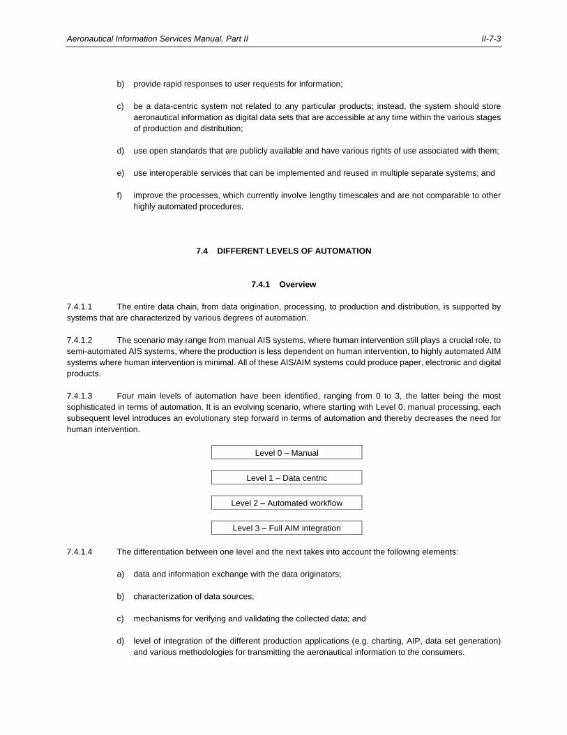
Aeronautical Information Services Manual, Part II II-7-3
b) provide rapid responses to user requests for information;
c) be a data-centric system not related to any particular products; instead, the system should store
aeronautical information as digital data sets that are accessible at any time within the various stages
of production and distribution;
d) use open standards that are publicly available and have various rights of use associated with them;
e) use interoperable services that can be implemented and reused in multiple separate systems; and
f) improve the processes, which currently involve lengthy timescales and are not comparable to other
highly automated procedures.
7.4 DIFFERENT LEVELS OF AUTOMATION
7.4.1 Overview
7.4.1.1 The entire data chain, from data origination, processing, to production and distribution, is supported by
systems that are characterized by various degrees of automation.
7.4.1.2 The scenario may range from manual AIS systems, where human intervention still plays a crucial role, to
semi-automated AIS systems, where the production is less dependent on human intervention, to highly automated AIM
systems where human intervention is minimal. All of these AIS/AIM systems could produce paper, electronic and digital
products.
7.4.1.3 Four main levels of automation have been identified, ranging from 0 to 3, the latter being the most
sophisticated in terms of automation. It is an evolving scenario, where starting with Level 0, manual processing, each
subsequent level introduces an evolutionary step forward in terms of automation and thereby decreases the need for
human intervention.
Level 0 – Manual
Level 1 – Data centric
Level 2 – Automated workflow
Level 3 – Full AIM integration
7.4.1.4 The differentiation between one level and the next takes into account the following elements:
a) data and information exchange with the data originators;
b) characterization of data sources;
c) mechanisms for verifying and validating the collected data; and
d) level of integration of the different production applications (e.g. charting, AIP, data set generation)
and various methodologies for transmitting the aeronautical information to the consumers.
II-7-4 Aeronautical Information Services Manual, Part II
7.4.1.5 The following sections describe the characteristics of each level of automation in relation to processing
and distribution of aeronautical information products and services. States should determine, according to their specific
requirements, the best approach for introducing automation to increase efficiency and create greater cost effectiveness,
and to improve safety.
7.4.2 Level 0 — Manual
7.4.2.1 At Level 0, the data and information is mostly handled manually, assisted by stand-alone software or
applications. This level is characterized by distributed sources, the manual generation and maintenance of aeronautical
data products that are provided in a paper or electronic format, and supported by manual validation processes.
7.4.2.2 At Level 0, the data and information coming from different originators is assembled and managed
manually.
7.4.2.3 Level 0 relies primarily on human intervention and it is only the expertise and experience of properly
trained staff that ensures the accurate ingestion and integration of diverse and distributed information sources. The
dynamic nature of aeronautical data and information, however, renders Level 0 more error prone; aeronautical data
often changes rapidly. It is, therefore, vitally important to be aware of the modifications and to put in place methodologies
which support the detection of updates and eventual inconsistencies or incompleteness of the data.
7.4.2.4 At Level 0, no automation is in place and all methodologies rely on manual handling, personnel
competency, good work organization, optimal quantitative and qualitative workloads, defined work roles, supportive
interaction and adequate strategies.
7.4.2.5 At Level 0, the same data often has to be entered into different software tools that are used to produce
different products (e.g. AIP amendments, charts, etc.). This process is error prone and may therefore lead to
inconsistencies between products.
7.4.2.6 Data validation is fundamentally a visual process, which may lead to missing the detection of data errors,
duplications, mistakes, and data inconsistencies. The process is time-consuming and potential errors may occur.
7.4.2.7 The output of this manual data process might be a traditional paper-based product, an electronic product
or a digital data set which needs to be submitted to finishing processes before being distributed.
7.4.2.8 Electronic and digital products bring a few benefits, though, since the generation, maintenance and
validation of these products (e.g. AIP amendments, charts, etc.) rely on functions embedded within the applications.
7.4.2.9 The aeronautical data products adhere to a 28-day revision (AIRAC) cycle and are re-issued on tight
schedules to avoid obsolete products, which would be detrimental to the safety of air navigation. Distribution services
may be provided to sales agencies, aeronautical data service providers, application providers, airlines, flight crews,
flight briefing offices and other States with the updated products. The AIS determines the quantity requirements,
manages orders and maintains customer mailing lists. The challenge is the timely distribution of the time-sensitive
products.
7.4.2.10 At Level 0, each procedure is labour intensive and involves considerable well-trained personnel. Complex
workflows with multiple, manual hand-offs are in place. With increasing work load and demands, the entire data process
may become more and more error-prone, inefficient and expensive.
7.4.2.11 The introduction of quality management systems (QMS) may significantly increase the efficiency of the
data product generation, maintenance and distribution processes, lower the error ratios and decrease the overall
expense of the operation.
Aeronautical Information Services Manual, Part II II-7-5
7.4.3 Level 1 — Data-centric
7.4.3.1 Level 1 is characterized by a data-centric architecture, automated origination and detection of changes,
and electronic and digital products. At Level 1, human intervention is decreased, improving the safety, efficiency and
cost of the entire data process.
7.4.3.2 At Level 1, the data-centric architecture is a system design with databases playing a central role. The
continuous evolution of database management systems has caused a steady development of applications which rely
on them. The data-centric approach is in contrast to file-based (whether paper or digital) data structures and access
methods.
7.4.3.3 Major advantages at this level can be obtained when using:
a) a dynamic table-driven logic which allows programmes and procedures to be simpler and more
flexible;
b) a shared database as the basis for communicating between parallel processes in distributed
applications which simplifies the design; and
c) transaction processing and indexing which results in a high degree of reliability, performance and
capacity.
7.4.3.4 At the centre is a database containing all the data necessary to generate the desired products and
services. The centralized storage is made of different types of features and attributes, geographically referenced,
allowing the automated system and all aeronautical information products and services real-time access to updated data.
These data come from different sources under the control of the AIS and are validated prior to being entered into the
centralized storage. As a result, metadata plays an important part by providing access to relevant information about
the aeronautical data.
7.4.3.5 Having a link between the centralized database and the aeronautical information products and services
ensures that the products and services are updated as soon as the data changes. This minimizes the potential for
errors, provides faster status updates, and enables automated access to the data.
7.4.3.6 At Level 1, the final output to be distributed might be either an electronic, digital or a paper product and
related services.
7.4.4 Level 2 — Automated workflow
7.4.4.1 At Level 2, the automation allows an automated workflow from data origination, to processing and
distribution to the next intended users. Its characteristics are a data-centric architecture, an automated collection of
data from the originator (with a digital transfer of data between originator and AIS), seamless processing, and the
provision of aeronautical information as digital products. At this level, the workflow is automated which can help improve
with safety, efficiency and cost of the entire data process.
7.4.4.2 Level 2 builds on features of Level 1, such as the data-centric architecture and the automated detection
of changes in the different products and services. The automation at this level is represented by the automated
exchange with the originators at the beginning of the data chain and a digital distribution to the next intended user that
still requires some human interaction.
7.4.4.3 The automated processing of data involves compliance to ISO standards (ISO 9001, ISO 19100 series).
Digital data are preferably using standardized formats, which can be maintained throughout the entire data process.
During its distribution, data must not be changed, be it accidentally or intentionally. Data are protected by systematic
cycling codes, including the use of hash functions and CRC. When required, data are encrypted to ensure integrity and
II-7-6 Aeronautical Information Services Manual, Part II
continually verified by the responsible organizations (aerodrome authority, air navigation services provider (ANSP), civil
aviation authority, etc.) or by the delegated agency.
7.4.4.4 The AIS receives the digital data and processes it with automated workflows to generate aeronautical
information products and services in a standardized presentation and digital data sets.
7.4.4.5 Digital data sets are then distributed to commercial providers (aeronautical data service providers, flight
management system (FMS) data application integrator, simulation data application provider) and either through them
to the end users (airlines, flight crews, other airspace users, flight briefing offices, other States), or directly to the end
users. Organizations may access the digital information and process it, encode the data (ARINC 424 Standards), or
translate it into a proprietary format that allows the target application to access the data.
7.4.5 Level 3 — Full AIM integration
7.4.5.1 Level 3 represents a highly automated AIM system and full AIM integration and thereby supports the
transition to SWIM. It is characterized by a single authoritative source (central database), service-oriented architecture
(SOA), web services and applications, and the ability of the end users to query and retrieve the information, including
creating user-defined requests. In a fully integrated AIM environment, aeronautical information is accessible to the
entire aviation community who can retrieve the information in real time through web services and applications.
7.4.5.2 A highly automated AIM system relies on SWIM information services as the means to access one or more
capabilities using prescribed interfaces, and in compliance with specific standards and policies. Service users may take
advantage of dedicated applications (e.g. web-based applications) to discover available SOA-based web services and
access the information, as needed, through various messaging mechanisms, and using common interfaces conforming
to established standards and practices.
7.4.5.3 The need for aeronautical data and aeronautical information, however, does not change; the skill that
goes into portraying data (be it geographic or tabular) is the capability to transform raw data into useful information that
can be readily used in a decision-support tool.
7.5 COMPONENTS OF AN AUTOMATED AIM SYSTEM
7.5.1 Data input
7.5.1.1 An AIM system should be capable of automatically ingesting aeronautical data and aeronautical
information in a standardized format directly into the system. In the case where it is not possible for aeronautical data
to be distributed in digital format via electronic transfer or direct input into the AIM system, it is acceptable to use email
if the following conditions are met:
a) use of designated email addresses;
b) data is provided in an attached file;
c) error-prone copy and paste actions or the retyping of data are avoided;
d) receipt of the data is confirmed to the data originator; and
e) the data is encrypted with a digital data error detection technique.
Aeronautical Information Services Manual, Part II II-7-7
7.5.1.2 An automated AIM system provides interfaces for ingesting data from the accredited sources (e.g.
surveyors, or from procedure and airspace design systems, etc.).
7.5.1.3 For information received on paper, the system provides a digitization function with verification and
validation mechanisms to assure data is entered without errors.
7.5.2 Core processing system
7.5.2.1 The core capabilities of an automated AIM system are to:
a) enter, modify and delete aeronautical data;
b) verify and validate the data;
c) assemble and store the data; and
d) translate, extract and format the data.
7.5.2.2 Two-dimensional or three-dimensional data visualization capabilities enable the validation of
geographically referenced aeronautical data and aeronautical information by superimposing it on top of geographical
maps, orthophotos or satellite imagery.
7.5.2.3 Systems supporting Level 2 automation (see 7.4.4) provide workflow management to control and
automate the entire data process.
7.5.2.4 The system logs all interactions with the data (e.g. origination, update, verification and validation) using
metadata for traceability.
7.5.3 Data storage
7.5.3.1 Automated AIM systems rely on central data storage designed to host all the necessary data and
information to generate the desired output.
7.5.3.2 A data storage system comprises, for example, a dynamic, structured database, preferably supporting a
standard conceptual model (e.g. aeronautical information conceptual model (AICM)), consisting of interrelated features
and attributes, and a geo-spatial database designed to store, query and manipulate geographic information and spatial
data which are managed as points, lines or polygon data types.
7.5.3.3 The scope of the data to be stored is defined in the aeronautical data catalogue.
7.5.3.4 Data storage is organized to facilitate generation of aeronautical information products and services. Also,
it ensures data quality by storing the data and associated metadata for as long as it is required, and enables data
traceability to its originator.
7.5.3.5 The AIS should have a contingency plan in place which is a complete, high-level loss of service or disaster
recovery strategy. It requires dependable data backup, restoration and recovery procedures to prevent data loss, and
to cope with hardware failures, operating system failures and application unavailability.
II-7-8 Aeronautical Information Services Manual, Part II
7.5.4 Data product preparation
7.5.4.1 Different aeronautical information products and services are generated with production subsystems using
data from the central data storage by selecting, extracting and formatting the data according to the data product
specifications.
7.5.4.2 Different production sub-systems in an integrated AIM system could include:
a) AIP production and editing sub-systems;
b) charting sub-systems;
c) NOTAM and meteorological information publication sub-systems; and
d) sub-systems to produce digital data sets.
7.5.4.3 An automated system should be configurable such that it is possible to choose how information is
presented to a specific group of users, or what kind of information they have access to. The benefits of a configurable
system are the flexibility to tailor the system to internal processes. This allows for establishing common settings (date
and time formats, units of measurements, access to the database, etc.) which are centralized and shared by all
applications. With a configurable system, the quality assurance remains focused on one version of applications and
tools; the system is therefore more stable and reliable.
7.5.5 Service provision
An automated AIM system provides information services for distribution of the aeronautical information products and
services. The services should be based on the TCP/IP protocol and the type of service depends on the representation
of the information (e.g. http for electronic AIP, Open Geospatial Consortium OGC web services for geographic
information). In the future, aeronautical information will be provided as SWIM information services.
7.6 IMPLEMENTATION PLANNING FOR AN AUTOMATED AIM SYSTEM
7.6.1 Understanding the improvements
Planning and implementing an automated AIM system means understanding and prioritizing the required improvements.
There can be different improvements such as reducing system incompatibilities and divergences, and reducing data
duplication, thereby ensuring the standardization of procedures, products and services. Improvements can be
introduced at different levels, as follows:
a) Process improvement. At the core of the automated AIM system are the functional processes to
maintain and process data, and to use that data to generate consistent output. Functional process
improvements may encourage the introduction of a centralized database, automated workflow
management, task management, change control, etc.;
b) System improvement. The introduction of new technologies, including new hardware, software and
applications for automating tasks, help improve the quality of information. In addition, system
improvements due to technology may facilitate compliance with criteria, e.g. automated procedure
design tools providing better support of the Procedures for Air Navigation Services — Aircraft
Operations (Doc 8168) provisions. Similarly, security software minimizes the damage caused by
unintentional or malicious updates to databases by unauthorized users, while improved
Aeronautical Information Services Manual, Part II II-7-9
telecommunication technologies provide easier or faster access to data and improve both its
accuracy and timeliness;
c) Data design improvement. The introduction of standard information conceptual and exchange
models facilitate data storage and exchange, database design improvements and enable stored
functions, privileges management, triggers, etc.; and
d) Policy and procedure improvement. Improvements in policies and procedures help ensure quality
processes, develop appropriate guidance and training for usage of the automated tools, and also
support the identification and selection of adequate personnel to manage the automated systems,
etc.
7.6.2 System requirements
7.6.2.1 To begin using a new automated AIM system, or to establish a new level of automation within an existing
system, the current output of the system and its future desired design must be analysed. This analysis will help identify
all the functional requirements in terms of input, processing and output, and to depict its application architecture.
Determining functional requirements
7.6.2.2 The hierarchy for determining functional requirements is: user or stakeholder request, feature, use case.
Use cases, once listed, are then transformed into business rules.
7.6.2.3 Within an automated AIM system, use cases must be developed as follows:
a) processing of change requests from data originators including collection, verification and validation
of the affected data;
b) data management;
c) preparing aeronautical information products and services and amendments to the products;
d) distributing the aeronautical information products and services to the next intended users; and
e) error reporting and processing.
Determining non-functional requirements
7.6.2.4 To determine non-functional requirements requires outlining the general behaviour of the system as a
whole, without identifying specific behaviours. The aim is to specify overall system characteristics which help determine
the technical architecture of the system.
7.6.2.5 The analysis of non-functional requirements within an automated AIM system should indicate how to
improve the performance and productivity of the whole system, how to expand the system to handle, for example, an
increase in data volume, and how predictable and reliable the system is.
Final assessment
7.6.2.6 Based on the analysis of functional and non-functional requirements, the system’s actual performance,
its scalability and capability, its reliability and the related costs to maintain it can be determined. It is therefore possible
to define a roadmap towards higher levels of system automation.
II-7-10 Aeronautical Information Services Manual, Part II
7.6.3 Transition to higher-levels of automation
7.6.3.1 Starting with a low level of automation, when most of the processes for handling aeronautical information
are manual, the initial step consists of setting up a reference central storage, introducing standard data models to
facilitate the storage and the digital exchange of aeronautical data and aeronautical information.
7.6.3.2 Independent of whether a data-centric architecture is already established, the objective is to ensure the
accuracy, consistency and integrity of the data by applying business rules and consistency checks or through the
introduction of data-protection algorithms for, e.g. geographical coordinates. All critical data may be tagged and
monitored (using systematic cycling codes, such as hash functions and CRC) while stored and transferred within the
system.
7.6.3.3 Another step in the transition to higher levels of system automation is to improve the workflow from data
origination to distribution. This may be done by introducing web-based forms for data originators or, for more advanced
systems, direct input of data into the automated AIM system by aerodrome authorities, airspace or ATS route designers,
instrument procedure design interfaces, etc.
Production environment
7.6.3.4 Increasing the level of automation within, for example, a production environment for aeronautical charting,
replaces routine manual activities with automated processes, as follows:
a) introducing tools and facilities that automate activities usually performed by the cartographer, e.g.
chart generation, chart changes detection;
b) initiating tools and facilities that support compliance with Annex 4 — Aeronautical Charts provisions
for aeronautical chart production;
c) preparing dynamic aeronautical chart templates and reference chart models to speed up the
production of aeronautical charts;
d) establishing business rules and de-cluttering rules in support of automatic symbolization and chart
finishing;
e) introducing applications that prevent unauthorized users from drawing on the basic chart, avoiding
an alteration of the content, and only allowing them to move shapes, change fonts, set borders, and
to overlay aeronautical charts with updated digital data; and
f) replacing the traditional means of distribution of aeronautical information and related products with
web services (e.g. catalogue services, web feature services, web map services, web coverage
services). Using these web services, common interfaces can be set up to query geographical data
and metadata, available digital products, specific services and potential resources, and to serve
geo-referenced chart images, or to request geographical coverage.
Test environment
7.6.3.5 The test environment of an automated AIM system runs a series of checks on the complete system to
ensure that all functional processes operate correctly and that their introduction does not downgrade the system
performance. Each individual test case verifies a particular operating condition, and places stress on the system to
provide evidence of eventual system weaknesses.
Aeronautical Information Services Manual, Part II II-7-11
7.6.3.6 The test environment is designed to be identical, or as close as possible, to the anticipated production
environment.
7.6.3.7 The test cases are based on specifically prepared data sets and are usually accompanied by a formal
description of the operational activities to be performed and of the expected results.
7.6.3.8 Within an automated AIM system, the following areas must be tested: system configuration management,
system security and access, users and associated tasks management, auditing processes, etc. In addition, testing of
the production processes include all tools related to data management and control, design environment, charting, AIP
and dataset production, digital libraries and repositories, etc.
Parallel operation
7.6.3.9 During the transition to higher levels of system automation, it is necessary to consider parallel operation
of the old and the new system for a certain period of time. The switch to the new automated system may then be made
at a specific point in time, or a step-wise transition be made, meaning that individual processes progressively transition
to the new operational environment.
Training
7.6.3.10 The introduction of automation necessitates new skills and abilities from the personnel running the system.
Consequently, staff training is a fundamental part of the transition to higher levels of automation.
7.6.3.11 The transition to an automated AIM system usually occurs over an extended period of time, covering
several stages, and possibly involves different styles of operation, including parallel operations. It takes time for
personnel to gain a thorough understanding of the new system and procedures. Recurrent training should be provided
to ensure that the personnel in charge of specific activities are aware of their responsibilities and are able to
continuously monitor the quality of their output.
______________________

II-A1-1
Appendix
DATA PROVISION AGREEMENT
Note.— Blue text is used to indicate where input is required, red text is used to indicate optional elements
which need to be completed, if selected.
DATA PROVISION AGREEMENT
between
[name of entity receiving the aeronautical data and aeronautical
information] (hereinafter “The AIS”)
and
[name of entity providing the aeronautical data and aeronautical
information] (hereinafter “The Data Originator”)
II-A-2 Aeronautical Information Services Manual, Part II
TABLE OF CONTENTS Page 1. INTRODUCTION ............................................................................................................................. II-A-3
1.1 Scope ............................................................................................................................ II-A-3 1.2 Parties to the Agreement ............................................................................................... II-A-3 1.3 Regulatory Requirements .............................................................................................. II-A-3 1.4 Entry into Force and Termination .................................................................................. II-A-3 1.5 Definitions and Conventions .......................................................................................... II-A-4
2. DATA PROVISION SERVICE ......................................................................................................... II-A-4 2.1 Service Description ........................................................................................................ II-A-4 2.2 Data Management ......................................................................................................... II-A-5 2.3 Demonstrating Compliance ........................................................................................... II-A-5 2.4 Data Errors or Inconsistencies ....................................................................................... II-A-6 2.5 Contingency ................................................................................................................... II-A-6
3. PROCEDURAL PROVISIONS ........................................................................................................ II-A-6 3.1 Entire Agreement ........................................................................................................... II-A-6 3.2 Liaison ........................................................................................................................... II-A-7
Attachment A AERONAUTICAL DATA AND AERONAUTICAL INFORMATION TO BE PROVIDED ..... II-A-8 Attachment B TIMELINESS REQUIREMENTS ......................................................................................... II-A-9 Attachment C METADATA REQUIREMENTS .......................................................................................... II-A-10 Attachment D DATA DISTRIBUTION ....................................................................................................... II-A-11 Attachment E DATA EXCHANGE FORMAT ............................................................................................. II-A-12
NO TABLE OF FIGURES ENTRIES FOUND.
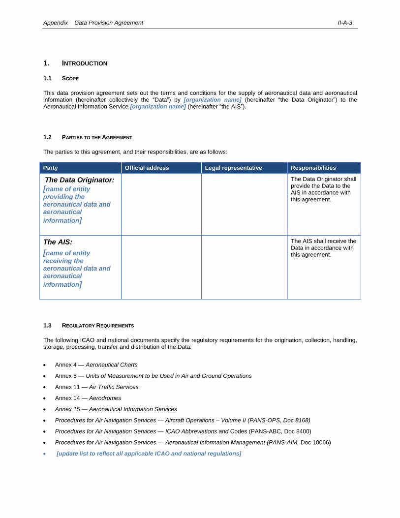
Appendix Data Provision Agreement II-A-3
1. INTRODUCTION
1.1 SCOPE
This data provision agreement sets out the terms and conditions for the supply of aeronautical data and aeronautical information (hereinafter collectively the “Data”) by [organization name] (hereinafter “the Data Originator”) to the Aeronautical Information Service [organization name] (hereinafter “the AIS”).
1.2 PARTIES TO THE AGREEMENT
The parties to this agreement, and their responsibilities, are as follows:
Party Official address Legal representative Responsibilities
The Data Originator: [name of entity
providing the aeronautical data and aeronautical
information]
The Data Originator shall provide the Data to the AIS in accordance with this agreement.
The AIS:
[name of entity
receiving the aeronautical data and aeronautical
information]
The AIS shall receive the Data in accordance with this agreement.
1.3 REGULATORY REQUIREMENTS
The following ICAO and national documents specify the regulatory requirements for the origination, collection, handling, storage, processing, transfer and distribution of the Data:
Annex 4 — Aeronautical Charts
Annex 5 — Units of Measurement to be Used in Air and Ground Operations
Annex 11 — Air Traffic Services
Annex 14 — Aerodromes
Annex 15 — Aeronautical Information Services
Procedures for Air Navigation Services — Aircraft Operations – Volume II (PANS-OPS, Doc 8168)
Procedures for Air Navigation Services — ICAO Abbreviations and Codes (PANS-ABC, Doc 8400)
Procedures for Air Navigation Services — Aeronautical Information Management (PANS-AIM, Doc 10066)
[update list to reflect all applicable ICAO and national regulations]
II-A-4 Aeronautical Information Services Manual, Part II
1.4 ENTRY INTO FORCE AND TERMINATION
1.4.1 This Agreement is valid from [enter start date] to [enter end date].
alternatively
1.4.1 This Agreement shall enter into force on the date of the later signature of the Parties and shall remain in force until terminated. This Agreement may be terminated by written agreement between the Parties, or by written advance notice of [add time period, e.g. x months] prior to termination by either Party.
1.5 DEFINITIONS AND CONVENTIONS
1.5.1 For the purpose of this agreement, the definitions in Annex 15 — Aeronautical Information Services and Procedures for Air Navigation Services — Aeronautical Information Management (PANS-AIM, Doc 10066) shall apply, including the following definitions:
a) ‘Agreement’ refers to this Data Provision Agreement;
b) ‘Data’ collectively refers to the aeronautical data and aeronautical information that the Data Originator is responsible to provide to the AIS under the terms of this Agreement;
c) ‘Data Originator’ refers to the legal entity responsible for the provision of aeronautical data and aeronautical information as set out in the terms of this Agreement;
d) ‘AIS’ refers to the legal entity responsible for receiving the aeronautical data and aeronautical information as set out in the terms of this Agreement; and
e) ‘Parties’ refer to the Data Originator and the AIS.
1.5.2 For the purpose of this agreement, the parties shall apply the following date and time conventions:
a) Co-ordinated Universal Time (UTC), as described in Annex 5 — Units of Measurement to be Used in Air and Ground Operations, Attachment D; and
b) the procedures for writing the date and time in all-numeric form as described in Annex 5 — Units of Measurement to be Used in Air and Ground Operations, Attachment E.
2. DATA PROVISION SERVICE
2.1 SERVICE DESCRIPTION
2.1.1 The Data Originator shall provide the Data to the AIS, incorporating all data items listed in Attachment A to this Agreement.
2.1.2 In case the Data Originator provides complete aeronautical features (e.g. runway threshold) to the AIS, Attachment A shall describe all individual data elements that compose the aeronautical feature (e.g. latitude and longitude shall be listed separately).
Appendix Data Provision Agreement II-A-5
2.1.3 The Data shall be provided in accordance with the data quality requirements described in Attachment A to this Agreement.
2.1.4 The Data shall be provided within the date and time limits described in Attachment B to this Agreement.
2.1.5 The Data shall be provided together with the metadata items described in Attachment C to this Agreement.
2.1.6 The Data shall be transferred between the Parties by the means described in Attachment D to this Agreement.
2.1.7 The Data shall be provided in accordance with the data exchange format described in Attachment E to this Agreement.
2.2 DATA MANAGEMENT
2.2.1 The Data Originator shall follow the recommendations of Annex 15 — Aeronautical Information Services, Chapter 6.2 concerning the advance notice of changes to the Data (for ATS providers refer to Annex 11 — Air Traffic Services, paragraph 2.22.4 and for aerodrome operators refer to Annex 14 — Aerodromes, Volume I, paragraph 2.13.4).
2.2.2 The Data Originator shall be responsible for the timely provision of the Data. The Data Originator accepts that the Data shall be subject to validation and verification by the AIS and that, if queries arise, this may delay final acceptance and hence publication in the aeronautical information products.
2.2.3 The Data Originator shall be responsible to submit the Data in sufficient time to meet the AIRAC publication cycle. The Data Originator acknowledges that if the Data is not provided on time, the Data shall not be released for publication. In exceptional circumstances, a NOTAM may need to be issued, if deemed necessary.
2.2.4 The Data Originator shall be responsible to maintain the validity of the Data. The Data Originator shall provide updates to the Data whenever required by [organisation name], national regulations, or whenever a change is made that requires an update of the Data.
2.2.5 The Data Originator shall be responsible for documenting any changes made to the Data.
2.2.6 If any third party is involved in the origination of the Data, or parts of the Data, the Data Originator shall remain responsible to ensure that the third party documents any changes made to the Data.
2.3 DEMONSTRATING COMPLIANCE
2.3.1 The Data Originator shall ensure that the Data is originated and processed in accordance with international best practices and guidelines, namely:
ICAO Doc 8168 Procedures for Air Navigation Services - Aircraft Operations
ICAO Doc 9674 World Geodetic System – 1984 (WGS-84) Manual
EUROCAE ED-77 / RTCA DO-201A, Standards for Aeronautical Information
EUROCAE ED-99D / RTCA DO-272D, User Requirements for Aerodrome Mapping Information
[update list to reflect all applicable standards, specifications, guidance material … ]
II-A-6 Aeronautical Information Services Manual, Part II
2.4 DATA ERRORS OR INCONSISTENCIES
2.4.1 In the event of the AIS discovering a data error or inconsistency in the Data, and provided that the Data is still subject to validation and verification by the AIS prior to publication or distribution, the AIS shall [describe the actions to be taken by the AIS when discovering a data error or inconsistency during validation and verification prior to publication or distribution].
2.4.2 In the event of the Data Originator receiving a notification from the AIS that the Data, which is still subject to validation and verification by the AIS prior to publication or distribution, contained a data error or inconsistency, the Data Originator shall [describe the actions to be taken by the Data Originator when notified that the Data contains a data error or inconsistency detected during validation and verification prior to publication or distribution].
2.4.3 In the event of the AIS discovering a data error or inconsistency in the Data, and provided that the Data has already been published or distributed, the AIS shall [describe the actions to be taken by the AIS when discovering a data error or inconsistency after publication or distribution].
2.4.4 In the event of the Data Originator receiving a notification from the AIS that the Data, which has already been published or distributed, contained a data error or inconsistency, the Data Originator shall [describe the actions to be taken by the Data Originator when notified that the Data contains a data error or inconsistency detected after publication or distribution].
2.5 CONTINGENCY
2.5.1 In the event that the Data Originator cannot guarantee the continuity of the provision of the Data, the Data Originator shall [describe the actions to be taken by the Data Originator when the Data Originator cannot guarantee the continuity of the provision of the Data].
2.5.2 In the event that the Data Originator cannot guarantee the continuity of the provision of the Data, the AIS shall [describe the actions to be taken by the AIS when the Data Originator cannot guarantee the continuity of the provision of the Data].
2.5.3 In the event that the AIS cannot guarantee the continuity of receipt and processing of the Data, the AIS shall [describe the actions to be taken by the AIS when the AIS cannot guarantee the continuity of receipt and processing of the Data].
2.5.4 In the event that the AIS cannot guarantee the continuity of receipt and processing of the Data, the Data Originator shall [describe the actions to be taken by the Data Originator when the AIS cannot guarantee the continuity of the receipt and processing of the Data].
3. PROCEDURAL PROVISIONS
3.1 ENTIRE AGREEMENT
3.1.1 This Agreement forms the entire agreement and understanding of the Parties and supersedes all previous agreements whether written or oral between the Parties, including any previous agreement or understanding varying or extending the same. There are no further or other agreements or understandings, written or oral, in effect between the Parties with respect to the scope of this Agreement.
3.1.2 Any amendments and modifications to this Agreement may be made at any time by written agreement by both Parties.
Appendix Data Provision Agreement II-A-7
3.2 LIAISON
3.2.1 The Data Originator shall appoint an Accountable Manager and the AIS shall appoint an Accountable Manager for the implementation and operation of this Agreement. These nominated managers will act as points of contact for all issues regarding the implementation and operation of this Agreement.
3.2.2 The Data Originator Accountable Manager and the AIS Accountable Manager shall have the authority to take decisions regarding the operation and distribution of the Data on behalf of their respective organisations. All communications between the parties regarding the implementation and operation of this Agreement shall be coordinated by these managers.
3.2.3 The Accountable Managers and their respective administrative contacts are:
Party Accountable Manager Administrative Contact
[Insert Data Originator details here]
[Insert Primary Contact details here, including name, job title, address, telephone and email]
[Insert Administrative Contact details here, including name, job title, address, telephone and email]
[Insert AIS details here] [Insert Primary Contact details here, including name, job title, address, telephone and email]
[Insert Administrative Contact details here, including name, job title, address, telephone and email]
Data Originator Accountable Manager:
Name
Title
Date
Signature
AIS Accountable Manager:
Name
Title
Date
Signature
II-A-8 Aeronautical Information Services Manual, Part II
Attachment A
Aeronautical Data and Aeronautical Information to be provided
Example: Refer to Procedures for Air Navigation Services — Aeronautical Information Management (PANS-AIM, Doc 10066), Appendix 1:
Table A1-1 Aerodrome data;
Table A1-2 Airspace data;
Table A1-3 ATS and other routes data;
Table A1-4 Instrument flight procedure data;
Table A1-5 Radio navigation aids/systems data;
Table A1-6 Obstacle data;
Table A1-7 Geographic data;
Table A1-8 Terrain data;
Table A1-9 Data types; and
Table A1-10 Information about national and local regulation, services and procedures.
— — — — — — — —
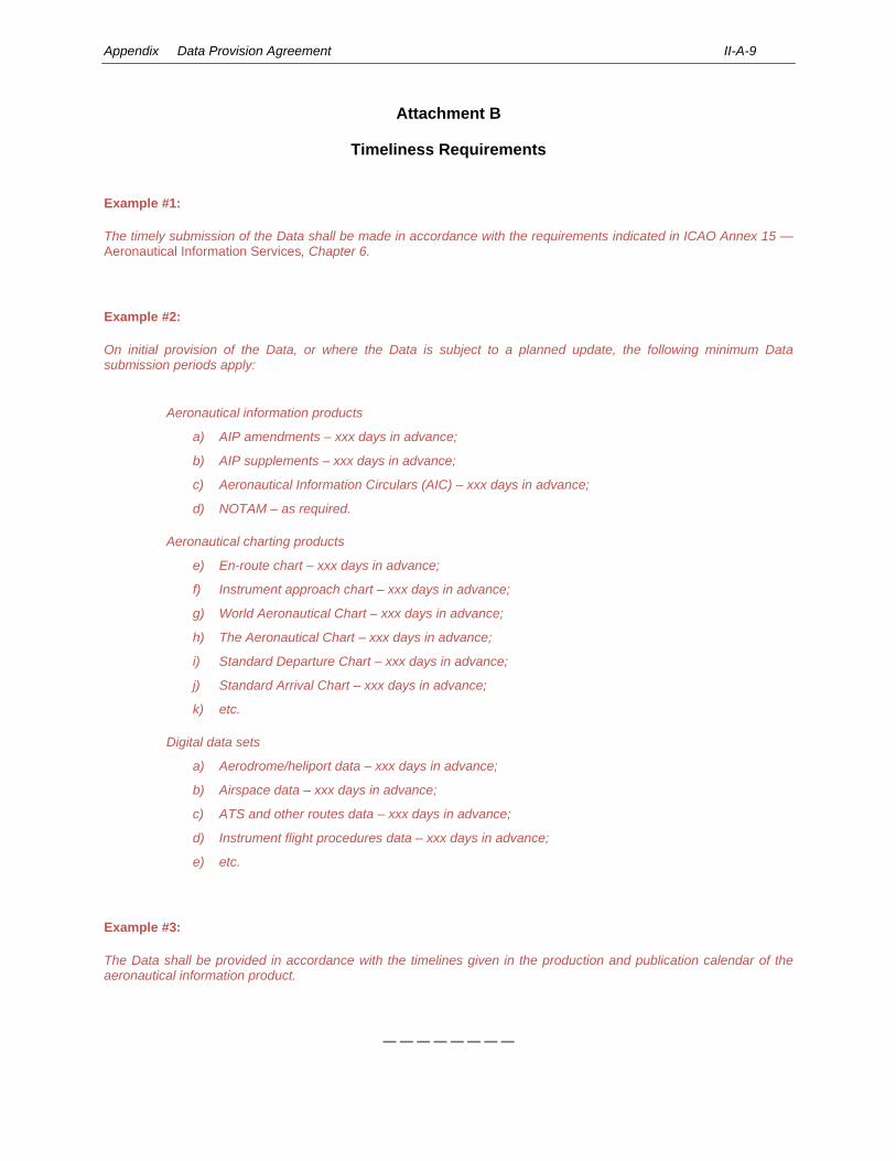
Appendix Data Provision Agreement II-A-9
Attachment B
Timeliness Requirements
Example #1:
The timely submission of the Data shall be made in accordance with the requirements indicated in ICAO Annex 15 — Aeronautical Information Services, Chapter 6.
Example #2:
On initial provision of the Data, or where the Data is subject to a planned update, the following minimum Data submission periods apply:
Aeronautical information products
a) AIP amendments – xxx days in advance;
b) AIP supplements – xxx days in advance;
c) Aeronautical Information Circulars (AIC) – xxx days in advance;
d) NOTAM – as required.
Aeronautical charting products
e) En-route chart – xxx days in advance;
f) Instrument approach chart – xxx days in advance;
g) World Aeronautical Chart – xxx days in advance;
h) The Aeronautical Chart – xxx days in advance;
i) Standard Departure Chart – xxx days in advance;
j) Standard Arrival Chart – xxx days in advance;
k) etc.
Digital data sets
a) Aerodrome/heliport data – xxx days in advance;
b) Airspace data – xxx days in advance;
c) ATS and other routes data – xxx days in advance;
d) Instrument flight procedures data – xxx days in advance;
e) etc.
Example #3:
The Data shall be provided in accordance with the timelines given in the production and publication calendar of the aeronautical information product.
— — — — — — — —
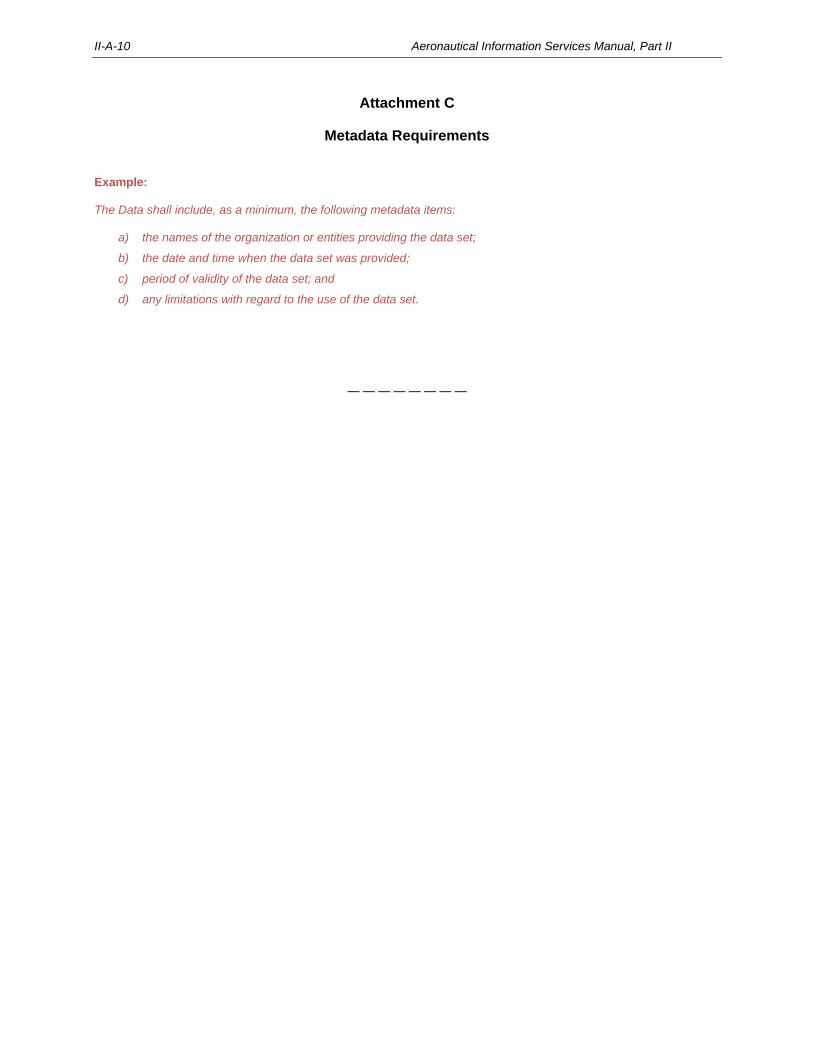
II-A-10 Aeronautical Information Services Manual, Part II
Attachment C
Metadata Requirements
Example: The Data shall include, as a minimum, the following metadata items:
a) the names of the organization or entities providing the data set;
b) the date and time when the data set was provided;
c) period of validity of the data set; and
d) any limitations with regard to the use of the data set.
— — — — — — — —
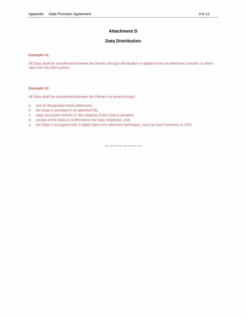
Appendix Data Provision Agreement II-A-11
Attachment D
Data Distribution
Example #1: All Data shall be transferred between the Parties through distribution in digital format via electronic transfer or direct input into the AIM system. Example #2: All Data shall be transferred between the Parties via email through:
a. use of designated email addresses;
b. the Data is provided in an attached file;
c. copy and paste actions or the retyping of the Data is avoided;
d. receipt of the Data is confirmed to the Data Originator; and
e. the Data is encrypted with a digital data error detection technique, such as hash functions or CRC.
— — — — — — — —
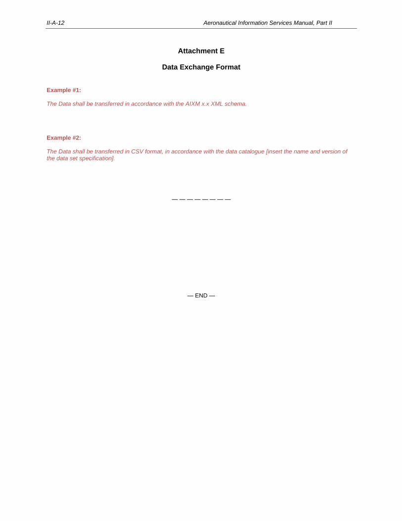
II-A-12 Aeronautical Information Services Manual, Part II
Attachment E
Data Exchange Format
Example #1: The Data shall be transferred in accordance with the AIXM x.x XML schema. Example #2: The Data shall be transferred in CSV format, in accordance with the data catalogue [insert the name and version of the data set specification].
— — — — — — — —
— END —

PART III
Aeronautical Information in a Standardized Presentation and Services

III-1-1
Chapter 1
INTRODUCTION
1.1 PURPOSE OF PART III
The purpose of this manual is to assist aeronautical information service (AIS) providers in implementing the Standards
and Recommended Practices (SARPs) contained in Annex 15 — Aeronautical Information Services and the Procedures
for Air Navigation Services — Aeronautical Information Management (PANS-AIM, Doc 10066). The objective is to achieve
a global level of standardization as a prerequisite for the digital integration of aeronautical data and aeronautical
information in the air traffic management (ATM) environment.
1.2 PRIMARY AUDIENCE OF PART III
The primary audience of Part III includes:
a) operational management tasked with setting up, organizing and managing the aeronautical information
products provided in a standardized presentation;
b) AIS operational personnel tasked with the production and distribution of aeronautical information
products provided in a standardized presentation; and
c) State regulators tasked with oversight of the aeronautical information products provided in a
standardized presentation.
1.3 OVERVIEW
1.3.1 Aeronautical data and aeronautical information is provided by and exchanged between States and other
parties, as aeronautical information products, either as a standardized paper presentation, electronic media, or digital data
sets. Aeronautical information products provided in a standardized presentation include aeronautical information
publications (AIP), including amendments and supplements, aeronautical information circulars (AIC), aeronautical charts
and NOTAM as shown in Figure III-1-1.
Note.— Further guidance for digital data sets are provided in Part IV — Digital Aeronautical Information
Products and Related Services.
1.3.2 Aeronautical information products in a standardized presentation are made available through the AIS. They
are provided by distribution services, pre-flight information services and post-flight information services, as shown in
Figure III-1-1 and further described in 1.5.
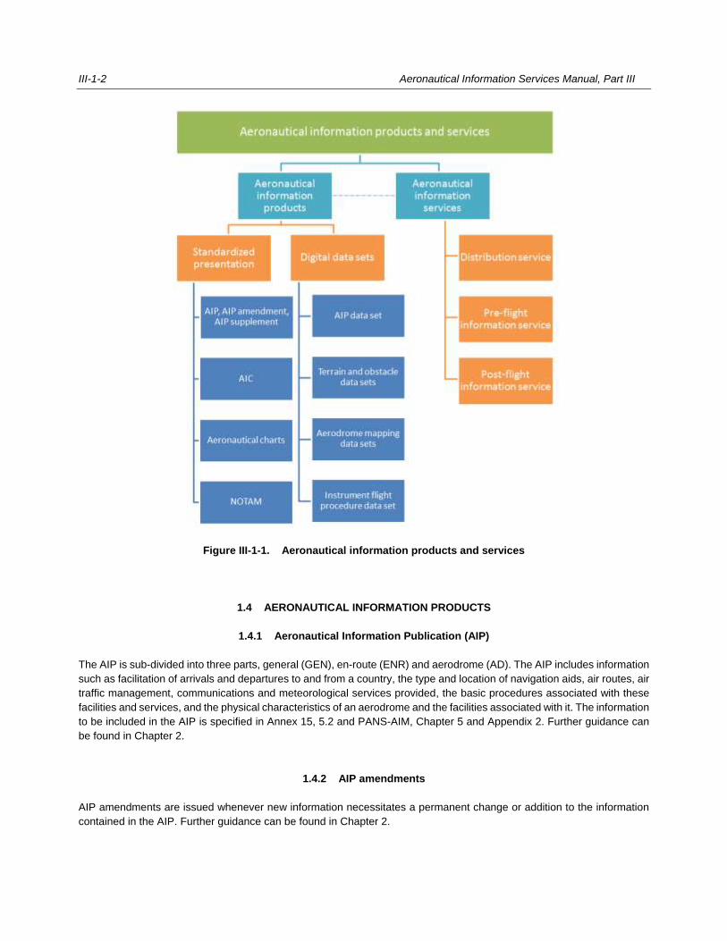
III-1-2 Aeronautical Information Services Manual, Part III
Figure III-1-1. Aeronautical information products and services
1.4 AERONAUTICAL INFORMATION PRODUCTS
1.4.1 Aeronautical Information Publication (AIP)
The AIP is sub-divided into three parts, general (GEN), en-route (ENR) and aerodrome (AD). The AIP includes information
such as facilitation of arrivals and departures to and from a country, the type and location of navigation aids, air routes, air
traffic management, communications and meteorological services provided, the basic procedures associated with these
facilities and services, and the physical characteristics of an aerodrome and the facilities associated with it. The information
to be included in the AIP is specified in Annex 15, 5.2 and PANS-AIM, Chapter 5 and Appendix 2. Further guidance can
be found in Chapter 2.
1.4.2 AIP amendments
AIP amendments are issued whenever new information necessitates a permanent change or addition to the information
contained in the AIP. Further guidance can be found in Chapter 2.
Aeronautical Information Services Manual, Part III III-1-3
1.4.3 AIP supplements
Temporary changes of long duration (more than three months), or changes requiring the issuance of extensive text or
graphics which affect the contents of the AIP are published and distributed as AIP supplements. Further guidance can be
found in Chapter 2.
1.4.4 Aeronautical information circulars (AIC)
To accommodate information that does not qualify for distribution via the AIP or NOTAM, the PANS-AIM includes
specifications for AIC. An AIC covers such matters as long-term advance notifications of major changes in procedures or
facilities, information of an explanatory or advisory nature, or information concerning administrative matters. Further
guidance can be found in Chapter 4.
1.4.5 Aeronautical charts
Aeronautical charts are a visual representation of a portion of the Earth, its culture, relief and hydrography, specifically
designated to meet the needs of air navigation. Some aeronautical charts are published and distributed as part of the AIP.
The different types of charts to be provided are specified in Annex 15, 5.2.5.
Note.— The Aeronautical Chart Manual (Doc 8697) provides guidance for aeronautical charts.
1.4.6 NOTAM
1.4.6.1 Some types of information deal with changes to facilities and services that are of a temporary nature and of
short duration. Notification of operationally significant changes of a temporary or permanent nature is sometimes required
to be published at short notice. Such information is issued in the form of a notice known as NOTAM and is distributed via
the aeronautical fixed service (AFS). For example, construction at an aerodrome may necessitate the temporary closure
of a runway, or a radio navigation aid may be removed from service for 24 hours for modification or maintenance, or a
visual aid may be permanently removed from service at short notice. The types of information to be distributed as NOTAM
are specified in Annex 15, Chapter 6. Further guidance can be found in Chapters 6 to 9.
1.4.6.2 However, major planned changes to the air navigation system, for example the permanent withdrawal of a
runway, taxiway or instrument flight procedure, must be distributed under the aeronautical information regulation and
control (AIRAC) system, as discussed in Chapter 3, 3.2 and Annex 15, 6.2.
1.5 AERONAUTICAL INFORMATION SERVICES
1.5.1 Distribution services
Distribution services permit the intended user access to the required aeronautical data and aeronautical information.
According to PANS-AIM, 5.4, distribution services are provided through one of two methods, physical or direct electronic
distribution. Further guidance can be found in Chapters 2 and 5 for the distribution of AIP, AIP amendments and AIP
supplements, in Chapter 4 for the distribution of AIC, and in Chapter 9 for the distribution of NOTAM.
III-1-4 Aeronautical Information Services Manual, Part III
1.5.2 Pre-flight information services
Pre-flight information services permit the intended user to access the required aeronautical data and aeronautical
information as part of the pre-flight briefing. This information usually includes aeronautical information, meteorological
information and flight information. Further guidance can be found in Chapter 10.
1.5.3 Post-flight information services
Post-flight information services permit flight crews to submit additional aeronautical data and aeronautical information
encountered or observed during their operation activity. Further guidance can be found in Chapter 11.
___________________
III-2-1
Chapter 2
AERONAUTICAL INFORMATION PUBLICATION (AIP)
2.1 INTRODUCTION
2.1.1 The AIP forms the basic element of aeronautical information products. It contains aeronautical data and
aeronautical information of a permanent nature and temporary changes to this information of long duration. It is the task
of the AIS to publish the AIP, to maintain it, and to make it readily accessible to its users.
2.1.2 The content of an AIP is described in PANS-AIM, Chapter 5 and Appendix 2; additional guidance is provided
in this manual. Due to the increased use of automation in AIS, the information contained in the AIP is arranged in such a
manner that automation can be used for its production, the production of an AIP data set or data subsets, as well as for
the creation of a database for retrieval of that information.
2.1.3 The basic structure and referencing must be common to all AIP around the world, but at the same time it
should allow for the specific requirements of individual States with respect to the amount and nature of information to be
included. Each of the compulsory reference numbers of a section and subsection must relate to the same topic in every
AIP, except that it might be noted as “not applicable” in some cases, or contain more or less information. A State may
decide to optionally provide additional referencing so that it may add types of information specific to its particular
circumstances.
2.2 CONTENT AND FORMAT
Note.— Procedures for the content and format of the AIP are provided in the PANS-AIM. Additional guidance
is provided in this manual.
2.2.1 The AIP must be self-contained and include a table of contents. It should be published in loose-leaf form
unless the complete publication is re-issued at frequent intervals.
2.2.2 The AIP is divided into three parts:
PART 1 — GENERAL (GEN) has five sections and contains information of a non-operational, regulatory
nature which does not require the issuance of NOTAM;
PART 2 — EN-ROUTE (ENR) has seven sections and contains, inter alia, information concerning visual and
instrument flight rules, airspace and its use; and
PART 3 — AERODROMES (AD) has four sections and contains information about aerodromes and heliports
and their use.
2.2.3 When an AIP is published in two or more volumes, each volume should indicate that additional information
is to be found in the other volume(s).
2.2.4 Each AIP must be dated. In the case of a hardcopy AIP which is issued in loose-leaf form, each page must
be dated. The date, consisting of the day, month (by name) and year, must be either the publication date or AIRAC effective
date of the information.
III-2-2 Aeronautical Information Services Manual, Part III
2.3 SPECIMEN AIP AND EXPLANATORY NOTES
2.3.1 The specimen AIP in Appendix 2 contains example AIP pages, tables and charts showing the format and
the required structure, division and classification. Appendix 1 provides guidance on the information to be included in the
AIP and, where appropriate, on its presentation.
2.3.2 The format and arrangement of an AIP, especially its tabular data, should be as close as possible to the
specimen AIP. Besides ensuring the desired uniformity in presentation, it minimizes the workload of units handling large
numbers of AIP and in general makes it easier for users to locate specific information. The headings used in the specimen
AIP are guides to the arrangement and location of information.
2.3.3 Particular care needs to be taken to apply the applicable referencing system shown in the specimen AIP in
order to facilitate electronic retrieval of AIP information.
2.4 COMPILING AND EDITING
Compiling and editing the AIP should be conducted with great care. Ensuring the accuracy and timeliness of the
information is critical. The AIP has to be edited so as to limit the amount of information to only that which is necessary for
achieving its purpose and to present it in the simplest form possible.
2.4.1 Language
The AIP including its amendments and supplements must be published in the English language. Consideration should be
given to those users who are not thoroughly familiar with the language to facilitate understanding and avoid possible
misinterpretation of the information. It is recognized that it may also be necessary to publish the AIP in local language(s)
in which case it may be more economical to produce a bilingual or multilingual edition rather than a separate edition for
each language. Thus, it offers users the possibility of comparing languages which may assist with the interpretation of text.
This is particularly true where the producing State is non-English speaking and the translation is into English.
2.4.2 Printing practices
2.4.2.1 It is considered best practice to prepare and provide the AIP by electronic means and in a digital format. In
this case, printing hardcopies becomes redundant. However, since some AIP are still provided in printed form, guidance
for printing practices is provided below.
Note.— Further guidance for electronic AIP can be found in Section 2.9.
2.4.2.2 While the preparation of an AIP in general conforms to the practices established for loose-leaf publications,
there are some practices peculiar to an aviation publication of this type that should be taken into consideration, namely:
a) print on both sides of the sheet;
b) do not use a sheet solely for the title page of a section — include any introductory material on the same
page;
c) use dividers sparingly, i.e. only for parts of the AIP that are composed of a significant number of pages;
d) since most pages will be replaced fairly frequently, do not use fine quality paper;
Aeronautical Information Services Manual, Part III III-2-3
e) quality reproduction should ensure that printing methods do not sacrifice speed;
f) when tabulating data, anticipate the space required to accommodate additional material in the future,
so that additions can be made without having to reprint or replace a series of pages;
g) choose a binder that is durable and allows replacement sheets to be inserted without difficulty.
2.5 PRESENTATION OF INFORMATION
Note.— Procedures for the presentation of information in the AIP are provided in the PANS-AIM. Additional
guidance is provided below.
2.5.1 The system of page numbering is specified in PANS-AIM, 5.2.3.1.9. This system has been used in the
specimen AIP and should be followed, with numbering as indicated therein reserved for pages containing the associated
information or tabulation. Any gaps in page sequence should be accounted for by the checklist of pages which appear on
AIP page GEN 0.4-1 (or included in ENR 0.4-1 and AD 0.4-1 if the AIP is issued in three separate volumes).
2.5.2 In addition to the PANS-AIM, 5.2.1.2.8 to 5.2.1.2.12, there are a number of practices common to the
presentation of information which have been omitted from the explanatory notes associated with each subject, i.e.:
— ICAO abbreviations should be used wherever they are appropriate and do not obfuscate the meaning.
— The spelling of place names must conform to local usage, transliterated where necessary into the
International Organization for Standardization (ISO) basic Latin alphabet. There should be a single
system of transliteration for any given language whether from ideograms, the Roman alphabet, syllabic
scripts or non-Roman script, and the objective should be to not distort names in either spelling or
pronunciation. This system should invariably be based on the standard system (where one has been
internationally adopted) for the romanization of a State’s geographical name(s). Since the accents and
diacritical signs which accompany the Roman letters of many languages are an integral part of the
spelling of these languages in that they express such essential features as tonic accent, the length and
degree of openness of vowels and other significant aspects of pronunciation and meaning, all
geographical names officially written in these alphabets by the States concerned should, for international
use, remain unmodified and keep their distinguishing marks even when they are written in capital letters.
— Hours of operation of various facilities and services should be given in terms of Coordinated Universal
Time (UTC) or by use of one of the following abbreviations:
HJ — sunrise to sunset;
HN — sunset to sunrise;
HO — service available to meet operational requirements;
HS — service available during hours of scheduled operations;
HX — no specific working hours; and
H24 — continuous day and night service.
— The units of measurement selected for use in the AIP, e.g. dimensions on aerodromes, distances,
elevations or altitudes, should be consistently followed and comply with Annex 5 — Units of
Measurement to be Used in Air and Ground Operations.
When more than one application uses the aeronautical data, the measured or calculated resolution must
support the more critical resolution (such as an approach segment taking prevalence over an en-route

III-2-4 Aeronautical Information Services Manual, Part III
segment). The resulting aeronautical data will then be used to provide a publication resolution in
accordance with the following rounding convention:
i) if the number in the extra decimal place is greater than or equal to 5 (i.e. 5, 6, 7, 8 or 9), the last
number of the final publication value will be rounded up by 1; for example, 3.15 will be rounded up
to 3.2; and
ii) if the number in the extra decimal place is less than 5, it and any other numbers that have been
extended in the calculation to additional decimal places shall be truncated; for example, 3.14 will
be truncated to read 3.1.
— Double rounding must be prevented. This can occur when the same calculated value is used for more
than one application, each having different publication resolution requirements, as specified in PANS-
AIM, Appendix 1. For example, the distance of an approach segment is normally calculated to two
decimal places and rounded to a published resolution of one tenth of a nautical mile for chart portrayal.
In many cases, this approach segment is also applied to an overlaying airway segment where the
published chart resolution is to the nearest nautical mile. During these calculations, decimal place values
of 0.45 to 0.49 will occasionally occur which will be rounded up for the approach segment to the next
single decimal value (e.g. 12.46 will be rounded up to 12.5). The en-route value must be rounded down
to the original two decimal places and not rounded up from the approach value.
2.5.3 Specifications for index maps and diagrams
Charts, maps and diagrams are to be substituted for tabulations and text whenever possible. They are also to be used
when necessary to elaborate upon or supplement tabulations or text.
Note.— Specifications for index maps and diagrams are provided in PANS-AIM, 5.2.1.2.13.
2.5.4 Charts to be included in the AIP
Note.— The charts to be included in the AIP are specified in Annex 15, 5.2.5. When available, they must
form part of the AIP, unless distributed through a separate subscription service.
2.6 PUBLICATION OF SIGNIFICANT DIFFERENCES IN THE AIP
2.6.1 Notifying ICAO of differences promotes safety, efficiency and regularity in air navigation by ensuring that
governmental and other agencies, including operators and service providers, concerned with international civil aviation
are made aware of all national rules and practices in so far as they differ from those prescribed in SARPs. When published
in the AIP, significant differences provide a clear picture of the operational significance of the differences to all users of
that document.
2.6.2 Annex 15 requires that States publish in the AIP significant differences between their national regulations
and practices and the related ICAO provisions. In addition, PANS-AIM requires States to publish in their AIP, Part 1 –
General (GEN), GEN 1.7, the list of significant differences with all Annexes, PANS and regional supplementary procedures
(SUPPs), and to thereby provide information which is essential to international operations, and which is not readily
available.
2.6.3 All significant differences notified to ICAO must also be included in the AIP in a form that will enable a user
to differentiate easily between the national rules and practices of a State and the related ICAO provisions.
Aeronautical Information Services Manual, Part III III-2-5
Note.— Guidance on notifying differences and what constitutes significant differences that are to be
published in the AIP are contained in the Manual on Notification and Publication of Differences (Doc 10055).
2.7 AIP AMENDMENTS
Note.— Procedures for the publication of AIP amendments are provided in PANS-AIM, 5.2. Additional
guidance is provided below.
2.7.1 Specifications for AIP amendments
2.7.1.1 Permanent changes and additions to information contained in the AIP are issued as AIP amendments. Any
information contained in a NOTAM or AIP supplement that renders necessary an amendment to the AIP must be confirmed
by a formal AIP amendment or revision.
2.7.1.2 Each AIP amendment must be allocated a serial number which must be consecutive and based on the
calendar year (e.g. AIP Amendment 5/20 for the fifth amendment of the year 2020). The normal method of amendment
must be by issue of replacement pages. The AIP must be amended or re-issued at such regular intervals as necessary to
ensure the information contained in the AIP is complete and up-to-date. In this respect, any operationally significant
changes to an AIP must be published in accordance with the regulated system (AIRAC) procedures and clearly identified
as such.
2.7.1.3 When an AIP amendment is issued, it must include references to the serial numbers of those elements, if
any, of the aeronautical information products that have been incorporated into the amendment. A brief indication of the
subjects affected by the amendment must be included on the AIP amendment cover page.
2.7.1.4 Specimens of AIP amendment cover pages are given in Figures III-2-1 and III-2-2.
2.7.2 Establishing a regular interval between amendments
2.7.2.1 Each State is free to establish a regular interval between amendments to its AIP, which should be selected
to meet the particular requirements, circumstances and capabilities of the State, taking into consideration:
a) the area covered by the AIP and the number of facilities and services contained in it;
b) the frequency at which the information is expected to change; and
c) the resources available to the AIS, such as personnel, reproduction and printing facilities.
Amendments regarding establishment, withdrawal or significant changes as defined in Annex 15, 6.2 must be published
under the regulated system (AIRAC).
2.7.2.2 The AIRAC effective dates should also be used as publication dates for non-AIRAC AIP amendments. A
choice can be made from thirteen dates per year (see Chapter 3, 3.2). It may be decided that one amendment every three
or six AIRAC periods is sufficient to keep the AIP up-to-date. Using as an example the AIRAC effective dates for 2020
(see Chapter 3, Table 3-1), the publication dates could be:
a) for an amendment every three AIRAC cycles:
III-2-6 Aeronautical Information Services Manual, Part III
27 February, 21 May, 13 August, 5 November;
b) for an amendment every six AIRAC cycles:
27 February, 13 August.
2.7.2.3 Publication of AIP amendments between established regular intervals should be limited to cases of urgent
necessity.
Note.— The specifications for the publication of the regular interval or publication dates of its AIP
amendments are given in PANS-AIM, 5.2.1.3.2.
2.7.2.4 The following are examples of the publication schedule given in GEN 3.1.3:
“Amendments to the AIP are issued on each of the AIRAC effective dates” or “on every fourth
AIRAC effective date including 30 January 2020”.
2.8 AIP SUPPLEMENTS
2.8.1 Specifications for AIP supplements
2.8.1.1 Temporary changes of long duration are to be published as an AIP supplement. AIP supplements that
contain operationally significant changes to the AIP must be published under the AIRAC system (see Chapter 3, 3.2).
2.8.1.2 An AIP supplement must be allocated a serial number which must be consecutive and based on the calendar
year (e.g. AIP Supplement 5/20 for the fifth supplement of the year 2020). The pages should be printed on coloured paper
(preferably yellow) in order to be conspicuous. The pages must be kept in the AIP as long as all or parts of their contents
remain valid. Although it is recommended that AIP supplement pages be retained as the first item in an AIP binder, it may
be more appropriate for States to issue the supplements divided into specific parts (e.g. GEN, ENR and AD) for insertion
in each AIP part, as necessary. This eliminates the need to continuously refer to the front of the AIP for required information
in cases where the supplement affects a number of AIP pages. Each AIP supplement page must show a publication date.
Each AIRAC AIP supplement page must show a publication date and an effective date.
2.8.1.3 Specimens of AIP supplements are given in Figures III-2-3 and III-2-4.
2.8.2 AIP Supplement replacing a NOTAM
Temporary changes anticipated to last less than three months are considered to be information of short duration, which is
distributed by NOTAM, unless the information contains extensive text or graphics. When this period is exceeded and
expected to last for an additional three months or more, an AIP supplement should be issued replacing the NOTAM.
Whenever an AIP supplement is issued as a replacement of a NOTAM, a reference to the series and number of the
NOTAM should be included, and a cancellation NOTAM issued referencing the AIP supplement.
2.8.3 Checklist of AIP Supplements
A checklist of all AIP supplements currently in force must be issued as part of the NOTAM checklist at intervals of not
more than one month.
Note.— Procedures for the NOTAM checklist are specified in PANS-AIM, 5.2.5.3.

Aeronautical Information Services Manual, Part III III-2-7
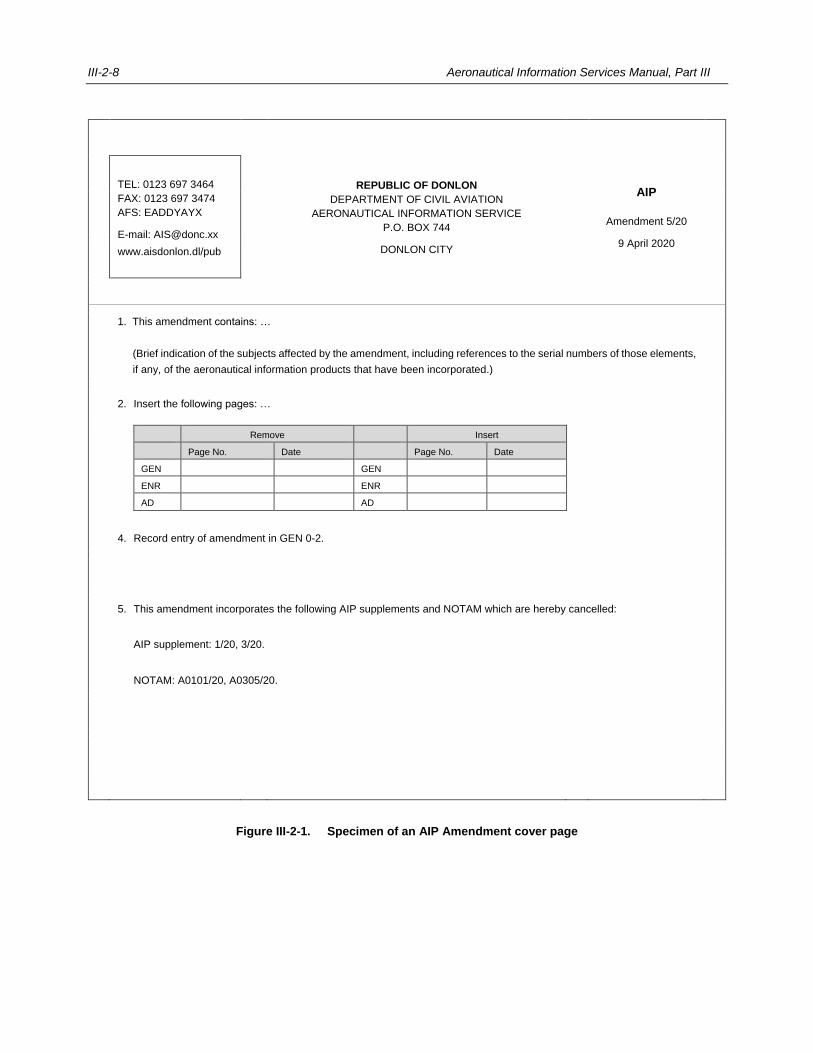
III-2-8 Aeronautical Information Services Manual, Part III
TEL: 0123 697 3464
FAX: 0123 697 3474
AFS: EADDYAYX
E-mail: [email protected]
www.aisdonlon.dl/pub
REPUBLIC OF DONLON
DEPARTMENT OF CIVIL AVIATION
AERONAUTICAL INFORMATION SERVICE
P.O. BOX 744
DONLON CITY
AIP
Amendment 5/20
9 April 2020
1. This amendment contains: …
(Brief indication of the subjects affected by the amendment, including references to the serial numbers of those elements,
if any, of the aeronautical information products that have been incorporated.)
2. Insert the following pages: …
Remove Insert
Page No. Date Page No. Date
GEN GEN
ENR ENR
AD AD
4. Record entry of amendment in GEN 0-2.
5. This amendment incorporates the following AIP supplements and NOTAM which are hereby cancelled:
AIP supplement: 1/20, 3/20.
NOTAM: A0101/20, A0305/20.
Figure III-2-1. Specimen of an AIP Amendment cover page
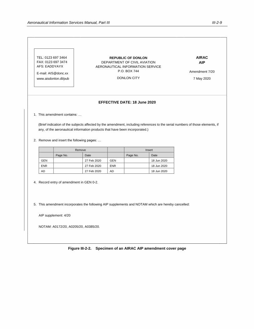
Aeronautical Information Services Manual, Part III III-2-9
TEL: 0123 697 3464
FAX: 0123 697 3474
AFS: EADDYAYX
E-mail: [email protected]
www.aisdonlon.dl/pub
REPUBLIC OF DONLON
DEPARTMENT OF CIVIL AVIATION
AERONAUTICAL INFORMATION SERVICE
P.O. BOX 744
DONLON CITY
AIRAC
AIP
Amendment 7/20
7 May 2020
EFFECTIVE DATE: 18 June 2020
1. This amendment contains: …
(Brief indication of the subjects affected by the amendment, including references to the serial numbers of those elements, if
any, of the aeronautical information products that have been incorporated.)
2. Remove and insert the following pages: …
Remove Insert
Page No. Date Page No. Date
GEN 27 Feb 2020 GEN 18 Jun 2020
ENR 27 Feb 2020 ENR 18 Jun 2020
AD 27 Feb 2020 AD 18 Jun 2020
4. Record entry of amendment in GEN 0-2.
5. This amendment incorporates the following AIP supplements and NOTAM which are hereby cancelled:
AIP supplement: 4/20
NOTAM: A0172/20, A0205/20, A0385/20.
Figure III-2-2. Specimen of an AIRAC AIP amendment cover page
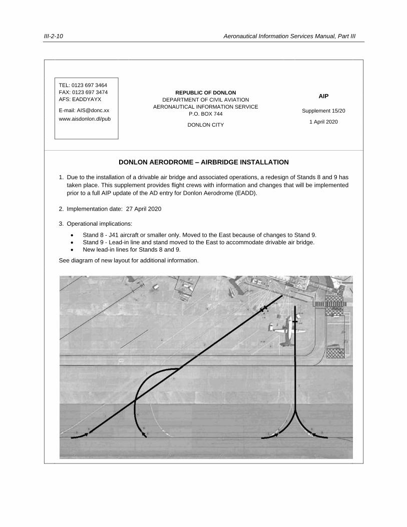
III-2-10 Aeronautical Information Services Manual, Part III
TEL: 0123 697 3464
FAX: 0123 697 3474
AFS: EADDYAYX
E-mail: [email protected]
www.aisdonlon.dl/pub
REPUBLIC OF DONLON
DEPARTMENT OF CIVIL AVIATION
AERONAUTICAL INFORMATION SERVICE
P.O. BOX 744
DONLON CITY
AIP
Supplement 15/20
1 April 2020
DONLON AERODROME – AIRBRIDGE INSTALLATION
1. Due to the installation of a drivable air bridge and associated operations, a redesign of Stands 8 and 9 has
taken place. This supplement provides flight crews with information and changes that will be implemented
prior to a full AIP update of the AD entry for Donlon Aerodrome (EADD).
2. Implementation date: 27 April 2020
3. Operational implications:
Stand 8 - J41 aircraft or smaller only. Moved to the East because of changes to Stand 9.
Stand 9 - Lead-in line and stand moved to the East to accommodate drivable air bridge.
New lead-in lines for Stands 8 and 9.
See diagram of new layout for additional information.

Aeronautical Information Services Manual, Part III III-2-11
Figure III-2-3. Specimen of an AIP supplement page
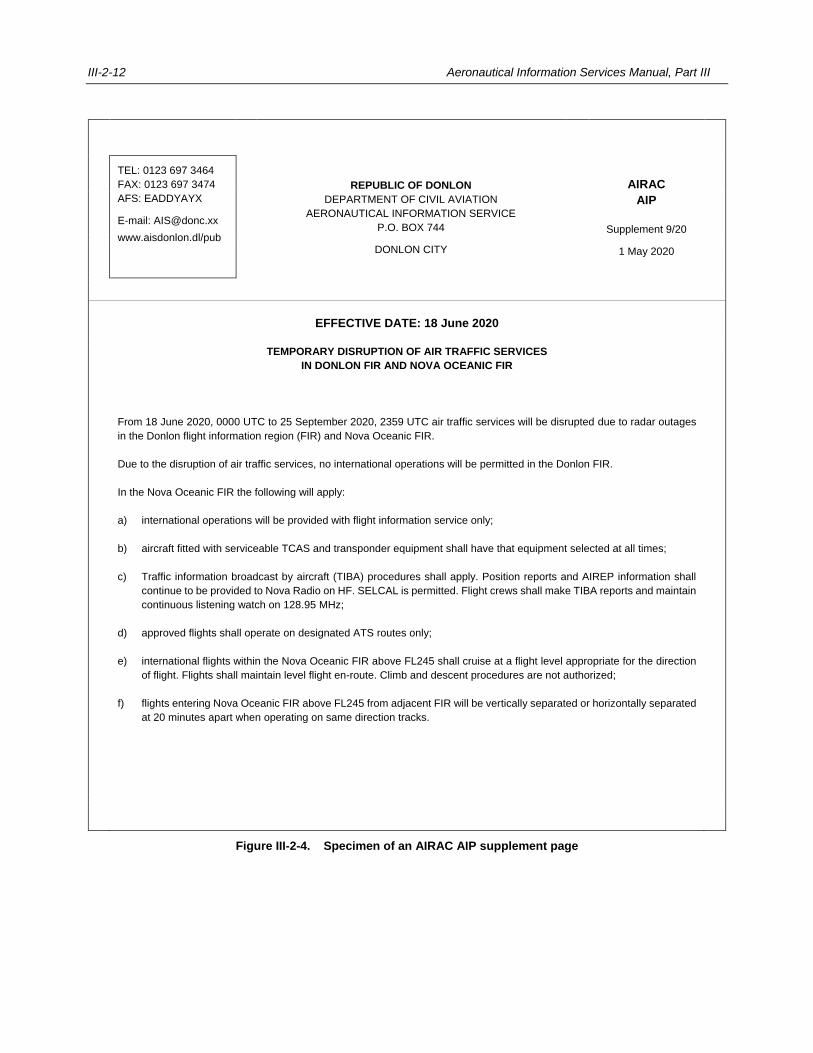
III-2-12 Aeronautical Information Services Manual, Part III
TEL: 0123 697 3464
FAX: 0123 697 3474
AFS: EADDYAYX
E-mail: [email protected]
www.aisdonlon.dl/pub
REPUBLIC OF DONLON
DEPARTMENT OF CIVIL AVIATION
AERONAUTICAL INFORMATION SERVICE
P.O. BOX 744
DONLON CITY
AIRAC
AIP
Supplement 9/20
1 May 2020
EFFECTIVE DATE: 18 June 2020
TEMPORARY DISRUPTION OF AIR TRAFFIC SERVICES
IN DONLON FIR AND NOVA OCEANIC FIR
From 18 June 2020, 0000 UTC to 25 September 2020, 2359 UTC air traffic services will be disrupted due to radar outages
in the Donlon flight information region (FIR) and Nova Oceanic FIR.
Due to the disruption of air traffic services, no international operations will be permitted in the Donlon FIR.
In the Nova Oceanic FIR the following will apply:
a) international operations will be provided with flight information service only;
b) aircraft fitted with serviceable TCAS and transponder equipment shall have that equipment selected at all times;
c) Traffic information broadcast by aircraft (TIBA) procedures shall apply. Position reports and AIREP information shall
continue to be provided to Nova Radio on HF. SELCAL is permitted. Flight crews shall make TIBA reports and maintain
continuous listening watch on 128.95 MHz;
d) approved flights shall operate on designated ATS routes only;
e) international flights within the Nova Oceanic FIR above FL245 shall cruise at a flight level appropriate for the direction
of flight. Flights shall maintain level flight en-route. Climb and descent procedures are not authorized;
f) flights entering Nova Oceanic FIR above FL245 from adjacent FIR will be vertically separated or horizontally separated
at 20 minutes apart when operating on same direction tracks.
Figure III-2-4. Specimen of an AIRAC AIP supplement page
Aeronautical Information Services Manual, Part III III-2-13
2.9 ELECTRONIC AIP
2.9.1 Introduction
2.9.1.1 Annex 15 specifies that the AIP, AIP amendment, AIP supplement and aeronautical information circular (AIC)
can be provided as an electronic document, referred to as an electronic AIP (eAIP), which is either complementing the
printed version of the AIP or represents the sole means of publication.
Note.— An example of guidance regarding the visualization of the contents of the AIP is given in
EUROCONTROL Specification for the Electronic Aeronautical Information Publication (eAIP)
(EUROCONTROL-SPEC-146).
2.9.1.2 The eAIP should be viewable on computer screens and be able to be printed on paper. It does not, however,
support the digital, computer to computer exchange of aeronautical information which is the purpose of the digital data
sets; these are covered in Part IV — Digital Aeronautical Information Products and Related Services.
2.9.1.3 The eAIP offers advantages for the users and for the AIS producing the electronic document.
2.9.1.4 The main advantages for the eAIP users include:
a) ease of browsing and searching, facilitated by Hypertext Markup Language (HTML) technology
(hyperlinks, tool tips, etc.);
b) increased ability to visualize changes;
c) automatic updates (eliminates physically replacing pages with every amendment);
d) easy access for all users (eliminates maintenance of expensive AIP library); and
e) easily archived.
2.9.1.5 The main advantages for the eAIP producer include:
a) enhanced usability;
b) increased consistency (HTML and portable document format (PDF) documents produced from the same
source);
c) reduction in costs (eliminates printing and postage costs since internal and external users are no longer
required to subscribe to paper amendments);
d) easily archived.
2.9.1.6 In order to fully benefit from an online eAIP, the following aspects should be considered:
a) the website hosting the eAIP, and the PDF version of the printable eAIP should be protected by a secure
sockets layer (SSL) certificate guaranteeing the authenticity and integrity of its content;
b) its use should not be limited by a disclaimer stating, for example, that it is “for information only” or that
the integrity, accuracy and completeness of the information is not reliable; and
c) a notification process should be made available for the users to be informed about updates and changes

III-2-14 Aeronautical Information Services Manual, Part III
to the eAIP (the requirement in Annex 15, 6.3.2.1 regarding trigger NOTAM still applies).
Note.— Guidance material on the use of the internet is contained in Guidelines on the Use of the Public
Internet for Aeronautical Applications (Doc 9855).
2.9.2 Production
2.9.2.1 An eAIP is produced using aeronautical information stored in a database. The data is extracted into a
structured document using dedicated eAIP editing software. Web technologies like Extensible Markup Language (XML)
and document type definition (DTD) are used in the process of creating a structured document that can subsequently be
transformed into HTML for on-screen display, or PDF for printing or download. Charts and graphics can be represented in
various formats; for example, using pdf, portable network graphics (PNG), or scalable vector graphics (SVG) formats.
Note.— The World Wide Web Consortium (W3C) is the main international standards organization for World
Wide Web technologies (see www.w3c.org).
2.9.3 Distribution
2.9.3.1 PANS-AIM specifies that, when provided, the eAIP should be made available on a physical distribution
medium or on the internet.
2.9.3.2 Making the eAIP available on the internet has the following advantages:
a) no postal delays, i.e. the updated eAIP is available to the user immediately after the online publication;
b) no costs for the production and distribution of the physical distribution medium; and
c) independent of technology changes of the physical distribution medium (CD-ROM, DVD, USB sticks,
etc. becoming obsolete).
2.9.3.3 Although internet publication can be immediate, AIRAC and NOTAM publication requirements still apply.
___________________
III-3-1
Chapter 3
AERONAUTICAL INFORMATION UPDATES
3.1 PERMANENT AND TEMPORARY CHANGES
3.1.1 Introduction
3.1.1.1 While the various elements of aeronautical information products are employed to distribute aeronautical data
and aeronautical information, specific criteria exist in Annex 15 — Aeronautical Information Services and the Procedures
for Air Navigation Services — Aeronautical Information Management (PANS-AIM, Doc 10066) for using and updating of
each element. The update criteria depend on the duration of the information (short-term or long-term), whether the changes
are operationally significant, and also depend on the advance notice required to announce the change of information.
3.1.1.2 Guidance regarding the different types of changes is summarized in Figure III-3-1, differentiating between
permanent changes and temporary changes of long or short duration, and is also further described below.
3.1.2 Permanent changes
3.1.2.1 The decision tree for permanent changes is shown in the left-hand box of Figure III-3-1. One of the first
decisions to take after the AIS receives a permanent change is to determine whether the information should be published
in the AIP or as a NOTAM. If it does not fall into either category, i.e. the information is more of an explanatory or advisory
nature, or concerning administrative matters, the information should be published as an aeronautical information circular,
as described in Chapter 4.
3.1.2.2 Following that, one must ask whether the aeronautical information is deemed significant to operations. To
help answer that question, one should consider if, as a result of the changes, flight crews cannot conclude a flight as
planned. The potential impact of operationally significant changes includes, among others, having to divert to a different
aerodrome, having to deviate from the originally planned route, or revise the calculated fuel on board.
3.1.2.3 Operationally significant changes are being dealt with under the AIRAC system. Permanent changes
determined to be operationally significant must be published as an AIRAC AIP amendment. Otherwise, when a permanent
change is not considered significant to flight operations, an AIP amendment is published which offers more flexibility
regarding publication since it is not constraint by AIRAC (see also 3.1.5). Information that qualifies for publication as an
AIP amendment should not be promulgated as NOTAM, since those address operationally significant changes only. States
should therefore establish efficient processes for the publication and dissemination of AIP amendments to avoid issuing
NOTAM on information that are not considered significant to flight operations.
3.1.2.4 Aeronautical information is deemed to be received on short notice when the change would normally qualify
for an AIRAC AIP amendment but there is insufficient time to process the information before it becomes effective. In that
case, a NOTAM is issued promptly to inform users of the changes until such time when the AIRAC AIP amendment can
be published. At this point, the NOTAM is cancelled. With proper planning, however, this situation can be avoided and the
normal process for the publication of an AIRAC AIP amendment should be followed. In either case, the AIRAC AIP
amendment is a publication under AIRAC and hence needs to be announced via trigger NOTAM. The requirements for
trigger NOTAM are contained in Annex 15, 6.3.2.1 and explained further in Chapter 6, 6.7.
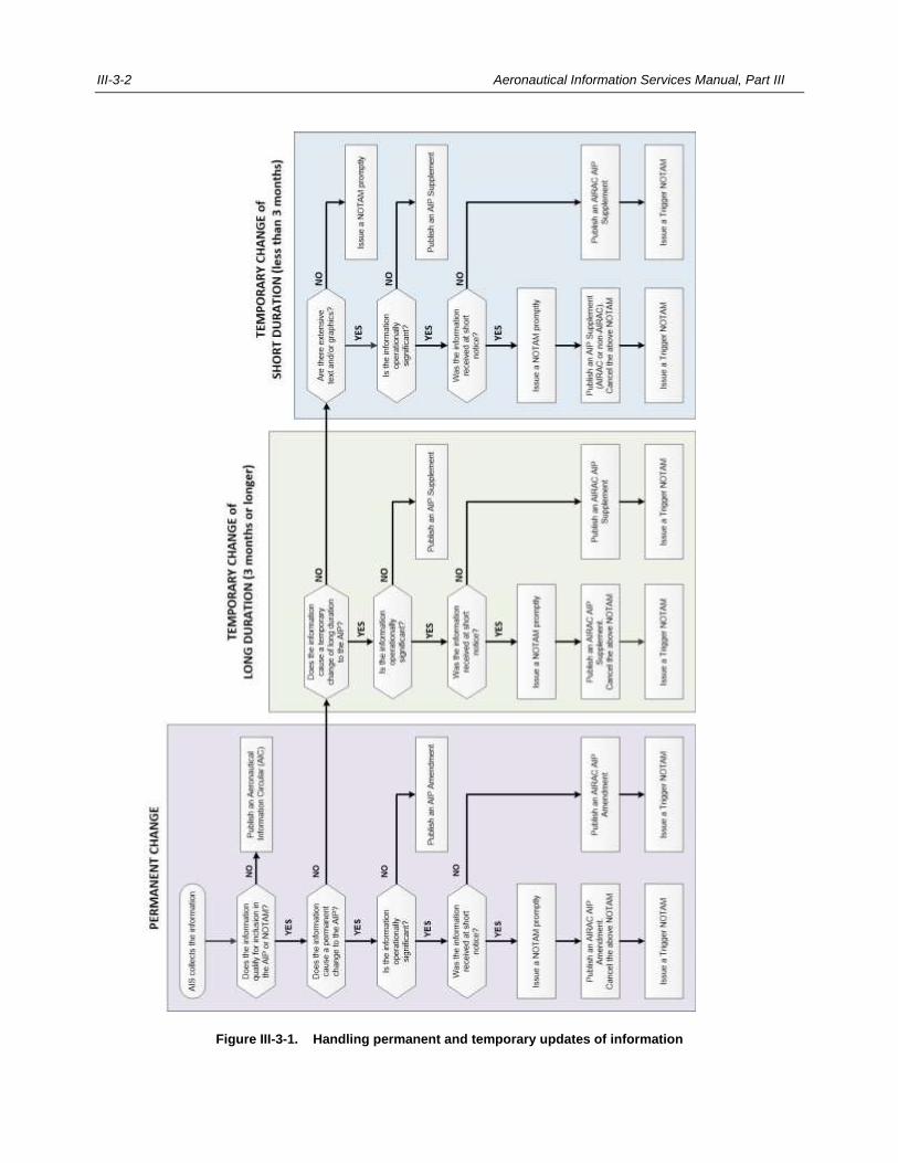
III-3-2 Aeronautical Information Services Manual, Part III
Figure III-3-1. Handling permanent and temporary updates of information
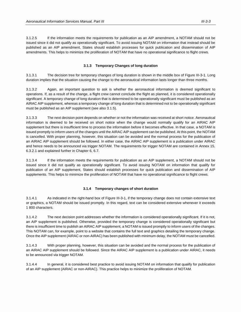
Aeronautical Information Services Manual, Part III III-3-3
3.1.2.5 If the information meets the requirements for publication as an AIP amendment, a NOTAM should not be
issued since it did not qualify as operationally significant. To avoid issuing NOTAM on information that instead should be
published as an AIP amendment, States should establish processes for quick publication and dissemination of AIP
amendments. This helps to minimize the proliferation of NOTAM that have no operational significance to flight crews.
3.1.3 Temporary Changes of long duration
3.1.3.1 The decision tree for temporary changes of long duration is shown in the middle box of Figure III-3-1. Long
duration implies that the situation causing the change to the aeronautical information lasts longer than three months.
3.1.3.2 Again, an important question to ask is whether the aeronautical information is deemed significant to
operations. If, as a result of the change, a flight crew cannot conclude the flight as planned, it is considered operationally
significant. A temporary change of long duration that is determined to be operationally significant must be published as an
AIRAC AIP supplement, whereas a temporary change of long duration that is determined not to be operationally significant
must be published as an AIP supplement (see also 3.1.5).
3.1.3.3 The next decision point depends on whether or not the information was received at short notice. Aeronautical
information is deemed to be received on short notice when the change would normally qualify for an AIRAC AIP
supplement but there is insufficient time to process the information before it becomes effective. In that case, a NOTAM is
issued promptly to inform users of the changes until the AIRAC AIP supplement can be published. At this point, the NOTAM
is cancelled. With proper planning, however, this situation can be avoided and the normal process for the publication of
an AIRAC AIP supplement should be followed. In either case, the AIRAC AIP supplement is a publication under AIRAC
and hence needs to be announced via trigger NOTAM. The requirements for trigger NOTAM are contained in Annex 15,
6.3.2.1 and explained further in Chapter 6, 6.7.
3.1.3.4 If the information meets the requirements for publication as an AIP supplement, a NOTAM should not be
issued since it did not qualify as operationally significant. To avoid issuing NOTAM on information that qualify for
publication of an AIP supplement, States should establish processes for quick publication and dissemination of AIP
supplements. This helps to minimize the proliferation of NOTAM that have no operational significance to flight crews.
3.1.4 Temporary changes of short duration
3.1.4.1 As indicated in the right-hand box of Figure III-3-1, if the temporary change does not contain extensive text
or graphics, a NOTAM should be issued promptly. In this regard, text can be considered extensive whenever it exceeds
1 800 characters.
3.1.4.2 The next decision point addresses whether the information is considered operationally significant. If it is not,
an AIP supplement is published. Otherwise, provided the temporary change is considered operationally significant but
there is insufficient time to publish an AIRAC AIP supplement, a NOTAM is issued promptly to inform users of the changes.
This NOTAM can, for example, point to a website that contains the full text and graphics detailing the temporary change.
Once the AIP supplement (AIRAC or non-AIRAC) has been published with minimum delay, the NOTAM must be cancelled.
3.1.4.3 With proper planning, however, this situation can be avoided and the normal process for the publication of
an AIRAC AIP supplement should be followed. Since the AIRAC AIP supplement is a publication under AIRAC, it needs
to be announced via trigger NOTAM.
3.1.4.4 In general, it is considered best practice to avoid issuing NOTAM on information that qualify for publication
of an AIP supplement (AIRAC or non-AIRAC). This practice helps to minimize the proliferation of NOTAM.
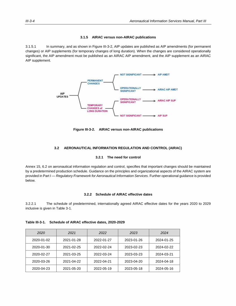
III-3-4 Aeronautical Information Services Manual, Part III
3.1.5 AIRAC versus non-AIRAC publications
3.1.5.1 In summary, and as shown in Figure III-3-2, AIP updates are published as AIP amendments (for permanent
changes) or AIP supplements (for temporary changes of long duration). When the changes are considered operationally
significant, the AIP amendment must be published as an AIRAC AIP amendment, and the AIP supplement as an AIRAC
AIP supplement.
Figure III-3-2. AIRAC versus non-AIRAC publications
3.2 AERONAUTICAL INFORMATION REGULATION AND CONTROL (AIRAC)
3.2.1 The need for control
Annex 15, 6.2 on aeronautical information regulation and control, specifies that important changes should be maintained
by a predetermined production schedule. Guidance on the principles and organizational aspects of the AIRAC system are
provided in Part I — Regulatory Framework for Aeronautical Information Services. Further operational guidance is provided
below.
3.2.2 Schedule of AIRAC effective dates
3.2.2.1 The schedule of predetermined, internationally agreed AIRAC effective dates for the years 2020 to 2029
inclusive is given in Table 3-1.
Table III-3-1. Schedule of AIRAC effective dates, 2020-2029
2020 2021 2022 2023 2024
2020-01-02 2021-01-28 2022-01-27 2023-01-26 2024-01-25
2020-01-30 2021-02-25 2022-02-24 2023-02-23 2024-02-22
2020-02-27 2021-03-25 2022-03-24 2023-03-23 2024-03-21
2020-03-26 2021-04-22 2022-04-21 2023-04-20 2024-04-18
2020-04-23 2021-05-20 2022-05-19 2023-05-18 2024-05-16
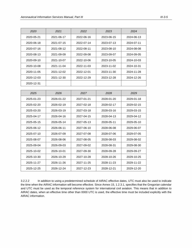
Aeronautical Information Services Manual, Part III III-3-5
2020 2021 2022 2023 2024
2020-05-21 2021-06-17 2022-06-16 2023-06-15 2024-06-13
2020-06-18 2021-07-15 2022-07-14 2023-07-13 2024-07-11
2020-07-16 2021-08-12 2022-08-11 2023-08-10 2024-08-08
2020-08-13 2021-09-09 2022-09-08 2023-09-07 2024-09-05
2020-09-10 2021-10-07 2022-10-06 2023-10-05 2024-10-03
2020-10-08 2021-11-04 2022-11-03 2023-11-02 2024-10-31
2020-11-05 2021-12-02 2022-12-01 2023-11-30 2024-11-28
2020-12-03 2021-12-30 2022-12-29 2023-12-28 2024-12-26
2020-12-31
2025 2026 2027 2028 2029
2025-01-23 2026-01-22 2027-01-21 2028-01-20 2029-01-18
2025-02-20 2026-02-19 2027-02-18 2028-02-17 2029-02-15
2025-03-20 2026-03-19 2027-03-18 2028-03-16 2029-03-15
2025-04-17 2026-04-16 2027-04-15 2028-04-13 2029-04-12
2025-05-15 2026-05-14 2027-05-13 2028-05-11 2029-05-10
2025-06-12 2026-06-11 2027-06-10 2028-06-08 2029-06-07
2025-07-10 2026-07-09 2027-07-08 2028-07-06 2029-07-05
2025-08-07 2026-08-06 2027-08-05 2028-08-03 2029-08-02
2025-09-04 2026-09-03 2027-09-02 2028-08-31 2029-08-30
2025-10-02 2026-10-01 2027-09-30 2028-09-28 2029-09-27
2025-10-30 2026-10-29 2027-10-28 2028-10-26 2029-10-25
2025-11-27 2026-11-26 2027-11-25 2028-11-23 2029-11-22
2025-12-25 2026-12-24 2027-12-23 2028-12-21 2029-12-20
3.2.2.2 In addition to using a predetermined schedule of AIRAC effective dates, UTC must also be used to indicate
the time when the AIRAC information will become effective. Since Annex 15, 1.2.3.1, specifies that the Gregorian calendar
and UTC must be used as the temporal reference system for international civil aviation. This means that in addition to
AIRAC dates, when an effective time other than 0000 UTC is used, the effective time must be included explicitly with the
AIRAC information.
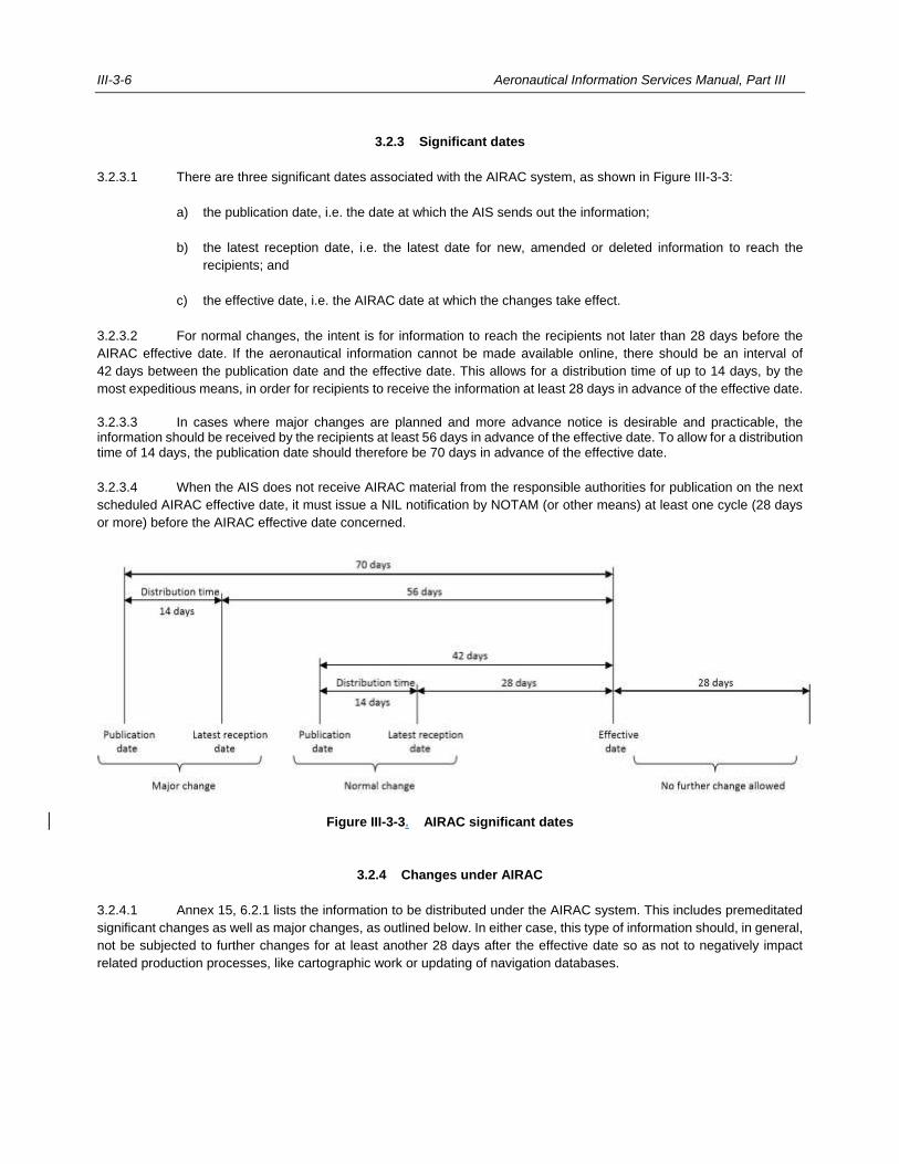
III-3-6 Aeronautical Information Services Manual, Part III
3.2.3 Significant dates
3.2.3.1 There are three significant dates associated with the AIRAC system, as shown in Figure III-3-3:
a) the publication date, i.e. the date at which the AIS sends out the information;
b) the latest reception date, i.e. the latest date for new, amended or deleted information to reach the
recipients; and
c) the effective date, i.e. the AIRAC date at which the changes take effect.
3.2.3.2 For normal changes, the intent is for information to reach the recipients not later than 28 days before the
AIRAC effective date. If the aeronautical information cannot be made available online, there should be an interval of
42 days between the publication date and the effective date. This allows for a distribution time of up to 14 days, by the
most expeditious means, in order for recipients to receive the information at least 28 days in advance of the effective date.
3.2.3.3 In cases where major changes are planned and more advance notice is desirable and practicable, the information should be received by the recipients at least 56 days in advance of the effective date. To allow for a distribution time of 14 days, the publication date should therefore be 70 days in advance of the effective date.
3.2.3.4 When the AIS does not receive AIRAC material from the responsible authorities for publication on the next
scheduled AIRAC effective date, it must issue a NIL notification by NOTAM (or other means) at least one cycle (28 days
or more) before the AIRAC effective date concerned.
Figure III-3-3. AIRAC significant dates
3.2.4 Changes under AIRAC
3.2.4.1 Annex 15, 6.2.1 lists the information to be distributed under the AIRAC system. This includes premeditated
significant changes as well as major changes, as outlined below. In either case, this type of information should, in general,
not be subjected to further changes for at least another 28 days after the effective date so as not to negatively impact
related production processes, like cartographic work or updating of navigation databases.
Aeronautical Information Services Manual, Part III III-3-7
3.2.5 Major changes
3.2.5.1 A State may decide to apply major changes to its air navigation system, or to parts of it, to improve safety
and efficiency.
3.2.5.2 Major changes typically affect key elements of the air navigation system, such as the introduction of or
premeditated changes to:
a) an international aerodrome;
b) a runway for instrument flight rules (IFR) operation at an international aerodrome with new approach
and departure procedures and corresponding airspace changes;
c) the design and structure of the air traffic services (ATS) route network;
d) the design and structure of a set of approach or departure procedure(s) at international aerodromes; or
e) circumstances listed in Annex 15, 6.2.7 if the entire State or any significant portion thereof is affected,
or if cross-border coordination is required.
3.2.5.3 Thus, major changes may greatly impact airspace users, while updating the aeronautical information related
to any such changes also require substantial time and resources since:
a) updates to the navigation databases may be complex and time consuming;
b) airline operations manuals may require updates; and
c) flight crews and air traffic controllers may require additional training.
3.2.5.4 To determine whether a change should be considered major, one should ask whether all affected parties
can safely implement the change within the regular cycle of 28 days (normal change) or whether a double cycle of 56 days
(major change) may be required.
3.2.6 Use of the AIRAC system during holiday periods
3.2.6.1 In some regions, the use of an AIRAC effective date that falls within major holiday periods (e.g.
Christmas/New Year, Easter, Hajj, summer vacations, etc.) creates difficulties in processing the material received because
of reduced staff during these periods. The increased burden on postal services during such periods frequently delays
delivery of AIRAC material, causing considerable problems to users.
3.2.6.2 To improve the situation during the year-end holiday period, it is recommended that the AIRAC cycle date
occurring in the 28-day period from 21 December to 17 January inclusive should not be used for AIRAC effective dates
for the introduction of significant operational changes. States experiencing similar problems during other holiday periods
may wish to adopt a comparable system.
3.2.6.3 It should be emphasized, however, that the AIRAC system provides for considerable flexibility in its
application, with a choice of thirteen AIRAC effective dates each calendar year. Considering that many significant changes
to facilities, services and procedures can be anticipated, a suitable effective date can be selected which does not conflict
with a major holiday period. A publication date can also be selected that provides for as much advance notice as possible.
Annex 15, 6.2.3, specifies that information provided under the AIRAC system must reach recipients at least 28 days in
advance of the effective date. Preferably such material should reach recipients more than 28 days before the effective
III-3-8 Aeronautical Information Services Manual, Part III
date (for instance, 42 or 56 days or more). Under the AIRAC system the maximum period of advance notification is
essential. If this policy is applied, it will give users ample time for processing changes to essential information, even if the
effective date falls within a major holiday period.
3.2.7 Aeronautical information in paper copy and electronic forms
3.2.7.1 The AIRAC system is an effective means of regulating and controlling the provision of aeronautical
information affecting operation of aircraft. It has also been used as a basic source of information for updating computer-
based navigation systems. States are increasingly introducing automation with the objective of improving the speed,
accuracy, efficiency and cost-effectiveness of aeronautical information services.
3.2.7.2 More and more, aeronautical information is provided to the users in digital format online and in real time.
However, some sectors of the aviation community may continue to require aeronautical information in paper copy form in
which case States could provide a capability for them to print their own paper copies.
3.2.7.3 When digital data sets are provided, the relevant sections of the AIP may be omitted. These information
elements are identified in PANS-AIM, Appendix 2 with the annotation “#AIP-DS#” or “#OBS-DS#”. However, the AIRAC
system applies to aeronautical information is provided in paper, electronic media and digital data sets.
3.2.7.4 Whenever aeronautical information is provided online, it must be available at least 28 days in advance of the
AIRAC effective date and 56 days for major changes. States with automated AIS systems must ensure that the AIRAC
effective dates of information in the database are the same as the effective dates for the information in paper copy form.
3.2.8 Example
3.2.8.1 As shown in Figure III-3-4, the following example outlines the steps of applying a permanent change to the AIP
under the AIRAC system:
a) on 4 December 2020 the appropriate authority of a State aviation administration decides that it will place
in service a new final approach aid at a particular aerodrome;
b) in consultation with the State aviation administration, the authority is informed that this change is
permanent and of operational significance and determines that 20 May 2021 is the most suitable
effective date for an AIRAC AIP amendment;
c) the authority then consults with AIS to determine the latest date for them to receive the information. In
this example, a cut-off date of 15 January 2021 was agreed when the information should be received
by the AIS in order to allow sufficient processing time to meet the publication date of 8 April 2021;
d) the information is provided to the AIS by the cut-off date and is published along with other similar
information on the publication date of 8 April 2021; all matters covered by this AIRAC AIP amendment
and other AIRAC AIP supplements become effective on the same effective date, namely 20 May 2021;
and
e) recipients of the AIRAC AIP amendments and AIRAC AIP supplements know that AIRAC material
published on 8 April 2021 usually takes one week to reach them and that they can plan on making the
necessary amendments to their publications on or about 15 April 2021. The latest reception date by the
recipients, however, is 22 April 2021. If several States have adopted this procedure, the recipients will
be able to prepare one amendment covering the information received from all such States.
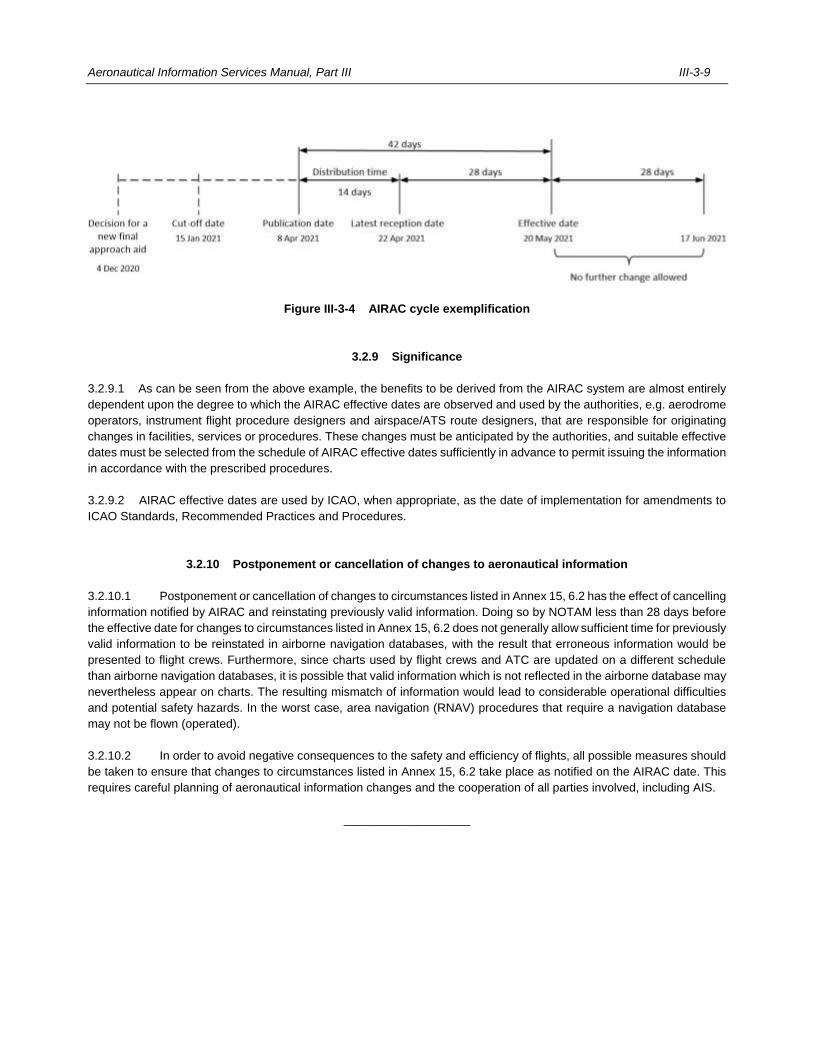
Aeronautical Information Services Manual, Part III III-3-9
Figure III-3-4 AIRAC cycle exemplification
3.2.9 Significance
3.2.9.1 As can be seen from the above example, the benefits to be derived from the AIRAC system are almost entirely
dependent upon the degree to which the AIRAC effective dates are observed and used by the authorities, e.g. aerodrome
operators, instrument flight procedure designers and airspace/ATS route designers, that are responsible for originating
changes in facilities, services or procedures. These changes must be anticipated by the authorities, and suitable effective
dates must be selected from the schedule of AIRAC effective dates sufficiently in advance to permit issuing the information
in accordance with the prescribed procedures.
3.2.9.2 AIRAC effective dates are used by ICAO, when appropriate, as the date of implementation for amendments to
ICAO Standards, Recommended Practices and Procedures.
3.2.10 Postponement or cancellation of changes to aeronautical information
3.2.10.1 Postponement or cancellation of changes to circumstances listed in Annex 15, 6.2 has the effect of cancelling
information notified by AIRAC and reinstating previously valid information. Doing so by NOTAM less than 28 days before
the effective date for changes to circumstances listed in Annex 15, 6.2 does not generally allow sufficient time for previously
valid information to be reinstated in airborne navigation databases, with the result that erroneous information would be
presented to flight crews. Furthermore, since charts used by flight crews and ATC are updated on a different schedule
than airborne navigation databases, it is possible that valid information which is not reflected in the airborne database may
nevertheless appear on charts. The resulting mismatch of information would lead to considerable operational difficulties
and potential safety hazards. In the worst case, area navigation (RNAV) procedures that require a navigation database
may not be flown (operated).
3.2.10.2 In order to avoid negative consequences to the safety and efficiency of flights, all possible measures should
be taken to ensure that changes to circumstances listed in Annex 15, 6.2 take place as notified on the AIRAC date. This
requires careful planning of aeronautical information changes and the cooperation of all parties involved, including AIS.
___________________

III-4-1
Chapter 4
AERONAUTICAL INFORMATION CIRCULARS (AIC)
4.1 CONTENTS
4.1.1 It will usually be found necessary to distribute some types of aeronautical information, mainly of an
administrative nature, which do not qualify for promulgation in AIP or NOTAM, such as:
a) a long-term forecast of any major change in legislation, regulations, procedures or facilities;
b) information of a purely explanatory or advisory nature likely to affect flight safety; and
c) information or notification of an explanatory or advisory nature concerning technical, legislative or purely
administrative matters.
4.1.2 In such cases, the information must be distributed by means of an AIC which is an element of the aeronautical
information products. The types of information appropriate to include in an AIC are specified in PANS-AIM, 5.2.2.1. The
format for an AIC is shown in Figure III-4-1.
4.1.3 Seasonal information supplementing the snow plan published in the AIP must be issued in an AIC and
contain the information as specified in PANS-AIM, 5.2.2.2.
4.1.4 This AIC must be issued not less than one month before the normal onset of winter conditions. The
information, or any part of it, listed under a), b), d), e) and f) at the above-mentioned reference may be included in the
snow plan published in the AIP, Part 3 – Aerodromes (AD), AD 1.2.2.
4.2 CHECKLIST AND ANNUAL REVIEW
Note.— Procedures for the checklist of AIC are specified in PANS-AIM, 5.2.2.
4.2.1 AIC should be numbered consecutively and based on the calendar year. A checklist of AIC that are currently
in force must be issued at least once a year, and distributed as AIC. If AIC are issued in more than one series, each series
must be identified by a letter (e.g. A 2/20, B 4/20, etc.). The format of an AIC is shown in Figure III-4-1.
4.2.2 AIC information can remain effective for long periods of time, sometimes several years, without the need for
amendment. To ensure that only valid AIC are included in the checklist, it is recommended to conduct an annual review
of AIC information and re-issue on a yearly basis.

III-4-2 Aeronautical Information Services Manual, Part III
4.3 DISTRIBUTION
Note.— Procedures for the distribution of AIC are specified in PANS-AIM, 5.2.2.
4.3.1 The originating State selects the AIC that are to be given international distribution. AIC thus selected must
be given the same distribution as the AIP, AIP amendments and AIP supplements.
4.3.2 Distribution of AIC on a national basis is left to the discretion of the originating State concerned.

Aeronautical Information Services Manual, Part III III-4-3
TEL: 0123 697 3464
FAX: 0123 697 3474
AFS: EADDYAYX
E-mail: [email protected]
www.aisdonlon.dl/pub
REPUBLIC OF DONLON
DEPARTMENT OF CIVIL AVIATION
AERONAUTICAL INFORMATION SERVICE
P.O. BOX 744
DONLON CITY
AIC
A 5/20
08 APR
Note.— Sheet size should be 21 × 27 cm (8 × 10½ in).
Figure III-4-1. Format for an aeronautical information circular
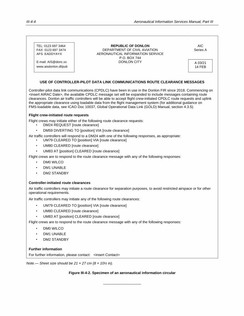
III-4-4 Aeronautical Information Services Manual, Part III
TEL: 0123 697 3464
FAX: 0123 697 3474
AFS: EADDYAYX
E-mail: [email protected]
www.aisdonlon.dl/pub
REPUBLIC OF DONLON
DEPARTMENT OF CIVIL AVIATION AERONAUTICAL INFORMATION SERVICE
P.O. BOX 744
DONLON CITY
AIC
Series A
A 03/21
14 FEB
USE OF CONTROLLER-PILOT DATA LINK COMMUNICATIONS ROUTE CLEARANCE MESSAGES Controller-pilot data link communications (CPDLC) have been in use in the Donlon FIR since 2018. Commencing on <insert AIRAC Date>, the available CPDLC message set will be expanded to include messages containing route clearances. Donlon air traffic controllers will be able to accept flight crew-initiated CPDLC route requests and uplink the appropriate clearance using loadable data from the flight management system (for additional guidance on FMS-loadable data, see ICAO Doc 10037, Global Operational Data Link (GOLD) Manual, section 4.3.5).
Flight crew-initiated route requests
Flight crews may initiate either of the following route clearance requests: • DM24 REQUEST [route clearance]
• DM59 DIVERTING TO [position] VIA [route clearance]
Air traffic controllers will respond to a DM24 with one of the following responses, as appropriate: • UM79 CLEARED TO [position] VIA [route clearance]
• UM80 CLEARED [route clearance]
• UM83 AT [position] CLEARED [route clearance]
Flight crews are to respond to the route clearance message with any of the following responses:
• DM0 WILCO
• DM1 UNABLE
• DM2 STANDBY
Controller-initiated route clearances
Air traffic controllers may initiate a route clearance for separation purposes, to avoid restricted airspace or for other operational requirements.
Air traffic controllers may initiate any of the following route clearances:
• UM79 CLEARED TO [position] VIA [route clearance]
• UM80 CLEARED [route clearance]
• UM83 AT [position] CLEARED [route clearance]
Flight crews are to respond to the route clearance message with any of the following responses:
• DM0 WILCO
• DM1 UNABLE
• DM2 STANDBY
Further information
For further information, please contact: <insert Contact>
Note.— Sheet size should be 21 × 27 cm (8 × 10½ in).
Figure III-4-2. Specimen of an aeronautical information circular
___________________
III-5-1
Chapter 5
PROVISION OF AERONAUTICAL INFORMATION PRODUCTS IN STANDARDIZED PRESENTATION
5.1 MAINTENANCE OF A DISTRIBUTION LIST
A distribution list for outgoing publications should include:
a) up-to-date lists of addressees and their requirements;
b) a current record of total quantities to be produced; and
c) a record of dispatches.
5.2 DISTRIBUTION
All AIP, AIP amendments and AIP supplements must be distributed to recipients by the most expeditious means available.
The current most expeditious means to distribute aeronautical information products is the internet.
5.3 MAILING
5.3.1 AIS documentation, in particular AIP amendments and AIP supplements, should not be folded but dispatched
flat inside an envelope. This ensures that the loose-leaf AIP material is received in good condition by the subscribers.
5.3.2 If aeronautical information products are distributed by mail, a distribution time of up to 14 days must be taken
into account to reach the recipients sufficiently in advance of the effective date (see Chapter 3, 3.2.3 for further details).
5.3.3 To expedite delivery of AIS material, envelopes should be suitably marked.
5.4 SALE OF AIS DOCUMENTATION
5.4.1 State AIS
Annex 15 requires the exchange of all elements of the aeronautical information products between States on a reciprocal,
no-cost basis. This requirement includes any aeronautical information products produced by a commercial agency on
behalf of a State.
III-5-2 Aeronautical Information Services Manual, Part III
5.4.2 Paid subscription
5.4.2.1 States can expect to receive subscription orders for aeronautical information products from organizations
such as airlines and chart-producing agencies. When calculating charges, only a reasonable proportion of production
costs should be recovered from paying subscribers. A reasonable formula would be to take annual production costs,
including editing, drafting and printing, and divide it by the total number of subscribers (paying and non-paying). An
individual annual production cost is thus arrived at, to which distribution costs plus a small handling charge can be added
to obtain the final price for a single paid subscription.
5.4.2.2 From the viewpoint of a subscription service, it is advantageous to calculate costs on an annually basis and
to then determine an appropriate cost recovery charge. In addition, it is desirable to establish a combined charge for AIP,
AIP amendments and AIP supplements since each subscriber of an AIP should also receive all related aeronautical
information products. Similar considerations should be applied when charging for digital data sets.
___________________
III-6-1
Chapter 6
NOTAM
6.1 INTRODUCTION
6.1.1 The basic purpose of NOTAM is the distribution of information in advance of the event to which it relates,
except in cases of unserviceable facilities or services, volcanic activity, or the release of radioactive material and toxic
chemicals that cannot be foreseen. Thus, the end user, e.g. flight crew or airline, must receive a NOTAM in sufficient time
to take any required action to realize its purpose. The value of a NOTAM lies in its up-to-date content.
6.1.2 NOTAM is intended to supplement AIP and serves as a fast medium for distributing aeronautical information
at short notice. NOTAM is originated, issued and distributed:
a) when the information is of a temporary nature, unplanned and of short duration; or
b) when operationally significant permanent changes, or temporary changes of long duration are made at
short notice.
6.1.3 The information of short duration containing extensive text or graphics is published as an AIP supplement.
Note 1.— Requirements addressing the duration of NOTAM are specified in the PANS-AIM, 6.1.4.
Note 2.— The information to be promulgated by NOTAM is specified in Annex 15, 6.3.2.3.
Note 3.— The information not to be promulgated by NOTAM is specified in Annex 15, 6.3.2.4.
6.2 NOTAM FORMAT
6.2.1 The NOTAM format consists of two parts:
a) the part for the communication service handling the AFS message, i.e. the part containing the priority
indicator, addresses, date and time of filing and the originator’s indicator (see Chapter 9); and
b) the part containing the NOTAM information.
6.2.2 The part containing the NOTAM information consists of the following:
a) message series, number and identifier which provide information about the NOTAM series (identified by
a letter from A to Z, excluding letters S and T), the NOTAM number (a consecutive four-digit number
based on the calendar year, followed by a stroke and a two-digit number for the year) and the type of
NOTAM (i.e. NOTAMN, NOTAMR or NOTAMC);
b) item Q) encodes the information in a set of predefined qualifiers, namely:
III-6-2 Aeronautical Information Services Manual, Part III
i) FIR;
ii) NOTAM Code;
iii) Traffic;
iv) Purpose;
v) Scope;
vi) Lower and Upper Limits; and
vii) Coordinates and Radius.
c) Item A) provides information about the affected area;
d) Item B) provides information about the start of the activity;
e) Item C) provides information about the end of the activity;
f) Item D) provides information about the time schedule of the activity, if needed;
g) Item E) provides information about a NOTAM in plain language (i.e. uniform abbreviated phraseology
and, where necessary, ICAO abbreviations, indicators, identifiers, designators, call signs, frequencies,
digits and plain language);
h) Item F) provides information about the lower limit of the affected area, if needed; and
i) Item G) provides information about the upper limit of the affected area, if needed.
6.2.3 The NOTAM format standardizes the presentation of the different types of information promulgated by
NOTAM in order to facilitate understanding of the message by the addressee. In developing this format, the need for
transcription of the information in the form of AFS messages has been taken into account. Therefore, the format includes
the special symbols that are used in composing the message (i.e. carriage return, line change, blank space, opening
parentheses before message identification and closing parentheses).
Note.— The NOTAM format is specified in the PANS-AIM, Appendix 3.
6.3 SPECIFICATION FOR NOTAM
Note.— General specifications regarding NOTAM are addressed in the PANS-AIM, 5.2.5. Additional guidance and
examples are provided below.
6.3.1 General
6.3.1.1 The format and the manner of specifying data must be closely adhered to.
6.3.1.2 Each NOTAM must be as brief as possible and so compiled that its meaning is clear without the need to
refer to another document. Each NOTAM must address only one subject and one condition concerning the subject.
Aeronautical Information Services Manual, Part III III-6-3
6.3.1.3 The text should be composed by the NOTAM office (NOF) in such a way that it will serve for PIB entry without
requiring additional processing by the receiving unit.
6.3.1.4 In many instances, AIS need to amplify, supplement or complete the NOTAM Code by addition of appropriate
significations and uniform abbreviated phraseology assigned to the NOTAM Code and abbreviations, frequencies, call
signs, identifiers, designators, etc., in order to convey the essential information. This recognized procedure is used in
keeping with the concept of the NOTAM Code and aeronautical telecommunication procedures, in preference to plain
language. Refer to the Procedures for Air Navigation Services — ICAO Abbreviations and Codes (PANS-ABC, Doc 8400)
for commonly used abbreviations.
Note.— Since the three letter Q-code (QDM, QFE, etc.) is primarily designed for air and ground request or
reply communications, it should be used with caution and only when there is no chance that the message might be
misunderstood.
6.3.1.5 When errors occur in a NOTAM, a NOTAM with a new number to replace the erroneous NOTAM is issued
or the erroneous NOTAM is cancelled and a new NOTAM issued. A corrected version of NOTAM must not be issued.
6.3.1.6 When a NOTAM is issued which cancels or replaces a previous NOTAM, the series and number of the
previous NOTAM must be indicated. The series, location indicator and subject of both NOTAM are the same. If the subject
is slightly changed, then a NOTAMC and a NOTAMN with the new subject should be issued (instead of a NOTAMR). A
NOTAM only cancels or replaces one NOTAM at a time.
6.3.1.7 The guidance and specifications below should be closely followed when completing the NOTAM format.
6.3.2 Message series, number and identifier
6.3.2.1 Each NOTAM must be allocated a series identified by a letter and a four-digit number, followed by a stroke
and a two-digit number for the year so that addressees may check continuity. The number must be consecutive and based
on the calendar year. Each series starts on 1 January with number 0001. If more than one series of NOTAM is issued,
each series must be separately identified by a letter. Letters A to Z, with the exception of S and T, may be used to identify
a NOTAM series. Renumbering of existing NOTAM (i.e. containing identical information, but with a new number) is not
allowed, nor are NOTAM to be renumbered at the beginning of each year.
6.3.2.2 In order to reduce distribution to meet different requirements of States, it may be found useful to arrange for
promulgation of NOTAM in two or more series to allow for selective distribution. For example, NOTAM may be classified
as follows:
Series A. Information on general rules, en-route navigation and communication facilities, airspace
restrictions and activities taking place above FL245, including information concerning major
international aerodromes.
Series B. Information on airspace restrictions, on activities taking place below FL245 and on other
international aerodromes at which IFR flights are permitted.
Series C. Information on other international aerodromes at which only visual flight rules (VFR) flights are
permitted.
Series D. Information on national aerodromes.
Series E. Information on heliports.

III-6-4 Aeronautical Information Services Manual, Part III
6.3.2.3 The allowed message identifiers are as follows:
a) NOTAMN refers to a NOTAM containing new information;
b) NOTAMR refers to a NOTAM replacing a previous NOTAM, followed by the series, number and year of
the NOTAM replaced (e.g. A0125/20 NOTAMR A0123/20);
c) NOTAMC refers to a NOTAM cancelling a previous NOTAM, followed by the series, number and year
of the cancelled NOTAM (e.g. A0460/20 NOTAMC A0456/20).
6.3.2.4 NOTAMR and NOTAMC are issued in the same series as the NOTAM to be replaced or cancelled. In the
following example, a new NOTAM (A0135/20) is replaced by NOTAM (A0137/20), and subsequently cancelled by another
NOTAM (A0139/20) prior to its end date and time.
Examples
A0135/20 NOTAMN
A0137/20 NOTAMR A0135/20
A0139/20 NOTAMC A0137/20
6.3.3. Item Q)
6.3.3.1 Item Q) is presented in the form “Q) FFFF/Qsscc/TT/PPP/SS/LLL/UUU/NNNNNEEEEEErrr”. Each field is
represented by a qualifier. All Item Q) qualifiers must be given a value for easy filtering for pre-flight information service;
default values should be used where appropriate. The qualifiers are selected from the NOTAM Selection Criteria tables
published in Appendix 7.
Qualifier FIR
6.3.3.2 Qualifier FIR is presented in the form “FFFF” and specifies the location in which the NOTAM event occurs;
valid entries are as follows:
a) If the subject of the information is located geographically within one FIR, then the ICAO location indicator
must be that of the FIR concerned.
Example
Q) EACC/
A) EACC
b) If an aerodrome is situated within the overlying FIR of another State, then the first field of Item Q) must
contain the code for that overlying FIR (e.g. Q) LFRR/… A) EGJJ);
c) If the subject of the information is located geographically within more than one FIR, then the qualifier
FIR must be composed of the ICAO nationality letters of the State originating the NOTAM, followed by
“XX”. The location indicator of the overlying upper information region (UIR) must not be used. The ICAO
location indicators of the FIRs concerned must then be listed in Item A) or indicator of State or non-
governmental agency which is responsible for the provision of air navigation service in more than one
State;
Aeronautical Information Services Manual, Part III III-6-5
Example of a NOTAM event for a restricted airspace along three States
Q) LSXX
A) LSAS LOVV LIMM
d) If one State issues a NOTAM affecting FIRs in a group of States, then the first two letters of the ICAO
nationality letters of the issuing State followed by XX must be inserted. The location indicators of the
FIRs concerned must then be listed in Item A) or indicator of State or non-governmental agency which
is responsible for provision of a navigation service in more than one State.
Example
Q) EAXX/
A) EDGG EBBU LFFF
Qualifier NOTAM Code
6.3.3.3 Qualifier NOTAM Code is presented in the form “Qsscc”. The first letter is always Q, “ss” identifies the subject
and “cc” identifies the status or condition of the subject.
6.3.3.4 The NOTAM Code selected describes the most important status or condition to be promulgated. In case an
appropriate NOTAM Code does not exist for the information to be promulgated, the letters "XX" shall be used for the
subject (e.g. QXXAK), the condition of the subject (e.g. QFAXX), or both (e.g. QXXXX), followed by a free selection of the
qualifiers traffic, purpose and scope.
Note.— The use of “XX” and “XXXX” in the NOTAM Code should be carefully assessed as it prevents users
from using the NOTAM Code as an effective filter mechanism.
6.3.3.5 NOTAMR and NOTAMC deal with the same subject as the NOTAM to be replaced or cancelled. Therefore,
the second and third letters of the NOTAM Code are the same as those in the NOTAM to be replaced or cancelled.
Examples
a) The subject NV refers to VOR and the condition AS refers to unserviceable (U/S):
Q) EACC/QNVAS/…
b) If text in Item E) reads “APRON CLSD DUE TO WIP”, then the subject MN refers to apron and the
condition LC refers to closed:
Q) EACC/QMNLC/…
Qualifier Traffic
6.3.3.6 Qualifier Traffic is presented as “TT” and specifies the type of traffic; valid entries are as follows:
I = IFR traffic
V = VFR traffic
IV = IFR and VFR traffic
K = Checklist of NOTAM
III-6-6 Aeronautical Information Services Manual, Part III
6.3.3.7 The NOTAM subject or condition may demand a different choice of the qualifier traffic. Thus, the entry is
determined according to NOTAM text.
Examples
a) The subject NV refers to VOR and relates to IFR and VFR traffic according to the NOTAM Selection
Criteria tables.
Q) EACC/QNVAS/IV/…
b) If text in Item E) reads “VFR REPORTING POINT ID CHANGED”, the NOTAM Code is “QAPCI”. For
this code, the given NOTAM Selection Criteria for the qualifier Traffic is “IV”. However, the reporting
point is for VFR use only. Therefore, only “V” is used as qualifier Traffic.
Q) EACC/QAPCI/V/BO/E/000/999....
Qualifier Purpose
6.3.3.8 Qualifier Purpose is presented as “PPP” and specifies the relevance of the NOTAM. Permissible
combinations are K, BO, NBO and M, as follows:
N = NOTAM selected for the immediate attention of flight crews
Due to their pertinent information, these NOTAM require immediate attention of flight crews. Flight
crews and flight information services may request specific delivery of such NOTAM or for their
inclusion in specific PIB containing only NOTAM related subjects selected for immediate attention.
NOTAM with qualifiers NBO will appear in the PIB.
B = NOTAM of operational significance selected for PIB entry
The NOTAM with qualifiers NBO or BO will appear in the PIB.
O = NOTAM concerning flight operations
The NOTAM with qualifiers NBO or BO will appear in the PIB.
M = Miscellaneous NOTAM; not subject for entry in PIB, but available on request
The NOTAM is for a miscellaneous purpose and will not appear in the PIB, unless specifically
requested.
K = Checklist of NOTAM
Example
The subject and condition refer to VOR unserviceable (QNVAS) and qualify the NOTAM as BO, i.e. of
operational significance for PIB entry and concerning flight operations.
Q) EACC/QNVAS/IV/BO/…
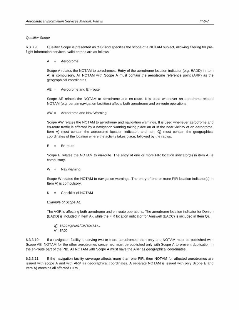
Aeronautical Information Services Manual, Part III III-6-7
Qualifier Scope
6.3.3.9 Qualifier Scope is presented as “SS” and specifies the scope of a NOTAM subject, allowing filtering for pre-
flight information services; valid entries are as follows:
A = Aerodrome
Scope A relates the NOTAM to aerodromes. Entry of the aerodrome location indicator (e.g. EADD) in Item
A) is compulsory. All NOTAM with Scope A must contain the aerodrome reference point (ARP) as the
geographical coordinates.
AE = Aerodrome and En-route
Scope AE relates the NOTAM to aerodrome and en-route. It is used whenever an aerodrome-related
NOTAM (e.g. certain navigation facilities) affects both aerodrome and en-route operations.
AW = Aerodrome and Nav Warning
Scope AW relates the NOTAM to aerodrome and navigation warnings. It is used whenever aerodrome and
en-route traffic is affected by a navigation warning taking place on or in the near vicinity of an aerodrome.
Item A) must contain the aerodrome location indicator, and Item Q) must contain the geographical
coordinates of the location where the activity takes place, followed by the radius.
E = En-route
Scope E relates the NOTAM to en-route. The entry of one or more FIR location indicator(s) in item A) is
compulsory.
W = Nav warning
Scope W relates the NOTAM to navigation warnings. The entry of one or more FIR location indicator(s) in
Item A) is compulsory.
K = Checklist of NOTAM
Example of Scope AE
The VOR is affecting both aerodrome and en-route operations. The aerodrome location indicator for Donlon
(EADD) is included in Item A), while the FIR location indicator for Amswell (EACC) is included in Item Q).
Q) EACC/QNVAS/IV/BO/AE/…
A) EADD
6.3.3.10 If a navigation facility is serving two or more aerodromes, then only one NOTAM must be published with
Scope AE. NOTAM for the other aerodromes concerned must be published only with Scope A to prevent duplication in
the en-route part of the PIB. All NOTAM with Scope A must have the ARP as geographical coordinates.
6.3.3.11 If the navigation facility coverage affects more than one FIR, then NOTAM for affected aerodromes are
issued with scope A and with ARP as geographical coordinates. A separate NOTAM is issued with only Scope E and
Item A) contains all affected FIRs.
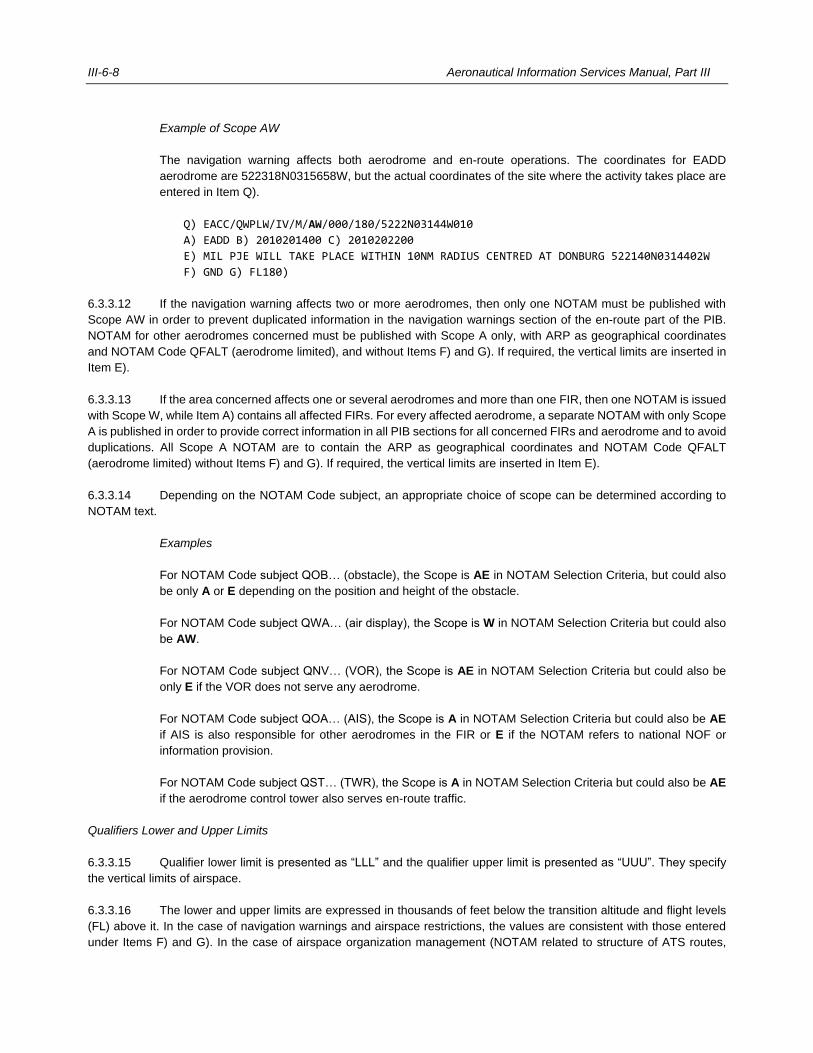
III-6-8 Aeronautical Information Services Manual, Part III
Example of Scope AW
The navigation warning affects both aerodrome and en-route operations. The coordinates for EADD
aerodrome are 522318N0315658W, but the actual coordinates of the site where the activity takes place are
entered in Item Q).
Q) EACC/QWPLW/IV/M/AW/000/180/5222N03144W010
A) EADD B) 2010201400 C) 2010202200
E) MIL PJE WILL TAKE PLACE WITHIN 10NM RADIUS CENTRED AT DONBURG 522140N0314402W
F) GND G) FL180)
6.3.3.12 If the navigation warning affects two or more aerodromes, then only one NOTAM must be published with
Scope AW in order to prevent duplicated information in the navigation warnings section of the en-route part of the PIB.
NOTAM for other aerodromes concerned must be published with Scope A only, with ARP as geographical coordinates
and NOTAM Code QFALT (aerodrome limited), and without Items F) and G). If required, the vertical limits are inserted in
Item E).
6.3.3.13 If the area concerned affects one or several aerodromes and more than one FIR, then one NOTAM is issued
with Scope W, while Item A) contains all affected FIRs. For every affected aerodrome, a separate NOTAM with only Scope
A is published in order to provide correct information in all PIB sections for all concerned FIRs and aerodrome and to avoid
duplications. All Scope A NOTAM are to contain the ARP as geographical coordinates and NOTAM Code QFALT
(aerodrome limited) without Items F) and G). If required, the vertical limits are inserted in Item E).
6.3.3.14 Depending on the NOTAM Code subject, an appropriate choice of scope can be determined according to
NOTAM text.
Examples
For NOTAM Code subject QOB… (obstacle), the Scope is AE in NOTAM Selection Criteria, but could also
be only A or E depending on the position and height of the obstacle.
For NOTAM Code subject QWA… (air display), the Scope is W in NOTAM Selection Criteria but could also
be AW.
For NOTAM Code subject QNV… (VOR), the Scope is AE in NOTAM Selection Criteria but could also be
only E if the VOR does not serve any aerodrome.
For NOTAM Code subject QOA… (AIS), the Scope is A in NOTAM Selection Criteria but could also be AE
if AIS is also responsible for other aerodromes in the FIR or E if the NOTAM refers to national NOF or
information provision.
For NOTAM Code subject QST… (TWR), the Scope is A in NOTAM Selection Criteria but could also be AE
if the aerodrome control tower also serves en-route traffic.
Qualifiers Lower and Upper Limits
6.3.3.15 Qualifier lower limit is presented as “LLL” and the qualifier upper limit is presented as “UUU”. They specify
the vertical limits of airspace.
6.3.3.16 The lower and upper limits are expressed in thousands of feet below the transition altitude and flight levels
(FL) above it. In the case of navigation warnings and airspace restrictions, the values are consistent with those entered
under Items F) and G). In the case of airspace organization management (NOTAM related to structure of ATS routes,
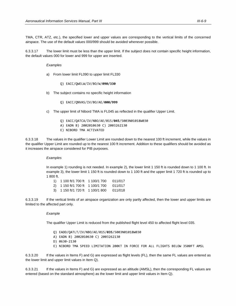
Aeronautical Information Services Manual, Part III III-6-9
TMA, CTR, ATZ, etc.), the specified lower and upper values are corresponding to the vertical limits of the concerned
airspace. The use of the default values 000/999 should be avoided whenever possible.
6.3.3.17 The lower limit must be less than the upper limit. If the subject does not contain specific height information,
the default values 000 for lower and 999 for upper are inserted.
Examples
a) From lower limit FL090 to upper limit FL330
Q) EACC/QWELW/IV/BO/W/090/330
b) The subject contains no specific height information
Q) EACC/QNVAS/IV/BO/AE/000/999
c) The upper limit of Nibord TMA is FL045 as reflected in the qualifier Upper Limit.
Q) EACC/QATCA/IV/NBO/AE/015/045/5003N01018W030
A) EADN B) 2002010630 C) 2003262130
E) NIBORD TMA ACTIVATED
6.3.3.18 The values in the qualifier Lower Limit are rounded down to the nearest 100 ft increment, while the values in
the qualifier Upper Limit are rounded up to the nearest 100 ft increment. Addition to these qualifiers should be avoided as
it increases the airspace considered for PIB purposes.
Examples
In example 1) rounding is not needed. In example 2), the lower limit 1 150 ft is rounded down to 1 100 ft. In
example 3), the lower limit 1 150 ft is rounded down to 1 100 ft and the upper limit 1 720 ft is rounded up to
1 800 ft.
1) 1 100 ft/1 700 ft 1 100/1 700 011/017
2) 1 150 ft/1 700 ft 1 100/1 700 011/017
3) 1 150 ft/1 720 ft 1 100/1 800 011/018
6.3.3.19 If the vertical limits of an airspace organization are only partly affected, then the lower and upper limits are
limited to the affected part only.
Example
The qualifier Upper Limit is reduced from the published flight level 450 to affected flight level 035.
Q) EADD/QATLT/IV/NBO/AE/015/035/5003N01018W030
A) EADN B) 2002010630 C) 2003262130
D) 0630-2130
E) NIBORD TMA SPEED LIMITATION 200KT IN FORCE FOR ALL FLIGHTS BELOW 3500FT AMSL
6.3.3.20 If the values in Items F) and G) are expressed as flight levels (FL), then the same FL values are entered as
the lower limit and upper limit values in Item Q).
6.3.3.21 If the values in Items F) and G) are expressed as an altitude (AMSL), then the corresponding FL values are
entered (based on the standard atmosphere) as the lower limit and upper limit values in Item Q).
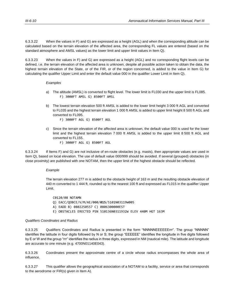
III-6-10 Aeronautical Information Services Manual, Part III
6.3.3.22 When the values in F) and G) are expressed as a height (AGL) and when the corresponding altitude can be
calculated based on the terrain elevation of the affected area, the corresponding FL values are entered (based on the
standard atmosphere and AMSL values) as the lower limit and upper limit values in Item Q).
6.3.3.23 When the values in F) and G) are expressed as a height (AGL) and no corresponding flight levels can be
defined, i.e. the terrain elevation of the affected area is unknown, despite all possible action taken to obtain the data, the
highest terrain elevation of the State, or of the FIR, or of the region concerned, is added to the value in Item G) for
calculating the qualifier Upper Limit and enter the default value 000 in the qualifier Lower Limit in Item Q).
Examples
a) The altitude (AMSL) is converted to flight level. The lower limit is FL030 and the upper limit is FL085.
F) 3000FT AMSL G) 8500FT AMSL
b) The lowest terrain elevation 500 ft AMSL is added to the lower limit height 3 000 ft AGL and converted
to FL035 and the highest terrain elevation 1 000 ft AMSL is added to upper limit height 8 500 ft AGL and
converted to FL095.
F) 3000FT AGL G) 8500FT AGL
c) Since the terrain elevation of the affected area is unknown, the default value 000 is used for the lower
limit and the highest terrain elevation 7 000 ft AMSL is added to the upper limit 8 500 ft AGL and
converted to FL155.
F) 3000FT AGL G) 8500FT AGL
6.3.3.24 If Items F) and G) are not inclusive of en-route obstacles (e.g. masts), then appropriate values are used in
Item Q), based on local elevation. The use of default value 000/999 should be avoided. If several (grouped) obstacles (in
close proximity) are published with one NOTAM, then the upper limit of the highest obstacle should be reflected.
Example
The terrain elevation 277 m is added to the obstacle height of 163 m and the resulting obstacle elevation of
440 m converted to 1 444 ft, rounded up to the nearest 100 ft and expressed as FL015 in the qualifier Upper
Limit.
C0120/08 NOTAMN
Q) EACC/QOBCE/V/M/AE/000/015/5101N03119W005
A) EADD B) 0802250557 C) 0806300000EST
E) OBSTACLES ERECTED PSN 510136N0311932W ELEV 440M HGT 163M
Qualifiers Coordinates and Radius
6.3.3.25 Qualifiers Coordinates and Radius is presented in the form “NNNNNEEEEEErrr”. The group “NNNNN”
identifies the latitude in four digits followed by N or S; the group “EEEEEE” identifies the longitude in five digits followed
by E or W and the group “rrr” identifies the radius in three digits, expressed in NM (nautical mile). The latitude and longitude
are accurate to one minute (e.g. 4700N01140E043).
6.3.3.26 Coordinates present the approximate centre of a circle whose radius encompasses the whole area of
influence.
6.3.3.27 This qualifier allows the geographical association of a NOTAM to a facility, service or area that corresponds
to the aerodrome or FIR(s) given in Item A).
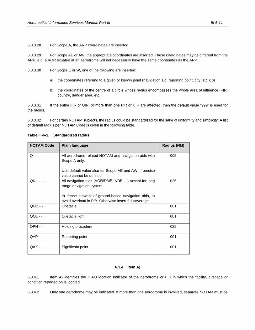
Aeronautical Information Services Manual, Part III III-6-11
6.3.3.28 For Scope A, the ARP coordinates are inserted.
6.3.3.29 For Scope AE or AW, the appropriate coordinates are inserted. These coordinates may be different from the
ARP, e.g. a VOR situated at an aerodrome will not necessarily have the same coordinates as the ARP.
6.3.3.30 For Scope E or W, one of the following are inserted:
a) the coordinates referring to a given or known point (navigation aid, reporting point, city, etc.); or
b) the coordinates of the centre of a circle whose radius encompasses the whole area of influence (FIR,
country, danger area, etc.).
6.3.3.31 If the entire FIR or UIR, or more than one FIR or UIR are affected, then the default value “999” is used for
the radius.
6.3.3.32 For certain NOTAM subjects, the radius could be standardized for the sake of uniformity and simplicity. A list
of default radius per NOTAM Code is given in the following table.
Table III-6-1. Standardized radius
NOTAM Code
Plain language
Radius (NM)
Q - - - - -
All aerodrome-related NOTAM and navigation aids with
Scope A only.
Use default value also for Scope AE and AW, if precise
value cannot be defined.
005
QN - - - -
All navigation aids (VOR/DME, NDB….) except for long
range navigation system.
In dense network of ground-based navigation aids, to
avoid overload in PIB. Otherwise insert full coverage.
025
QOB - -
Obstacle
001
QOL - -
Obstacle light
001
QPH - -
Holding procedure
025
QAP - -
Reporting point
001
QAX - -
Significant point
001
6.3.4 Item A)
6.3.4.1 Item A) identifies the ICAO location indicator of the aerodrome or FIR in which the facility, airspace or
condition reported on is located.
6.3.4.2 Only one aerodrome may be indicated. If more than one aerodrome is involved, separate NOTAM must be
III-6-12 Aeronautical Information Services Manual, Part III
issued. More than one FIR may be indicated when appropriate. The location indicator of the FIR to be included is that of
the area control centre (ACC) or flight information centre (FIC) providing air traffic services within the FIR.
Examples
The ICAO location indicator of the aerodrome Donlon/International is EADD, while the ICAO location
indicator of the Amswell FIR is EACC.
A) EADD
A) EACC
6.3.4.3 The number of FIRs in Item A) is restricted to seven by the length of an AFTN line. If more than seven FIRs
are affected, then a unique and unambiguous location indicator should be used that serves the purpose of publication of
NOTAM information related to more than seven FIRs (e.g. UUUU). If no such unique location indicator exists, then
additional NOTAM are to be published.
6.3.4.4 If information concerns the global navigation satellite system (GNSS), then the appropriate ICAO location
indicator allocated for a GNSS element or the common location indicator allocated for all elements of GNSS (except GBAS)
should be inserted.
Note.— In the case of GNSS, the location indicator may be used when identifying a GNSS element outage
(e.g. KNMH for a GPS satellite outage).
6.3.4.5 If an ICAO location indicator is not available, then the ICAO nationality letters of the State followed by “XX”
should be used. The name of the location has to be mentioned in the first line of Item E) in plain language. Item E) must
be completed in order to identify the location, facility or service concerned since some indicators already exist where
extensive use is made of the letter X (e.g. “DXXX” for Lomé/Tokoin). Failure to complete Item E) could therefore result in
unnecessary queries. By the same token, lack of an entry in Item E) would confirm the validity of the location indicator
used.
6.3.4.6 NOTAMR and NOTAMC have the same Item A) contents as the NOTAM to be replaced or cancelled.
6.3.5 Period of validity
6.3.5.1 Information must be provided on the duration of the reported hazard, change in the normal status of operation
or condition of the facilities being reported on. NOTAM notifying unserviceable aids to air navigation, facilities or
communication services should give the time at which restoration of service is expected or an estimate of the
unserviceability period.
6.3.5.2 The duration of a circumstance should be expressed clearly to avoid any misunderstandings.
6.3.5.3 Figure III-6-1 describes the relationship between the time-related expressions used in the NOTAM.
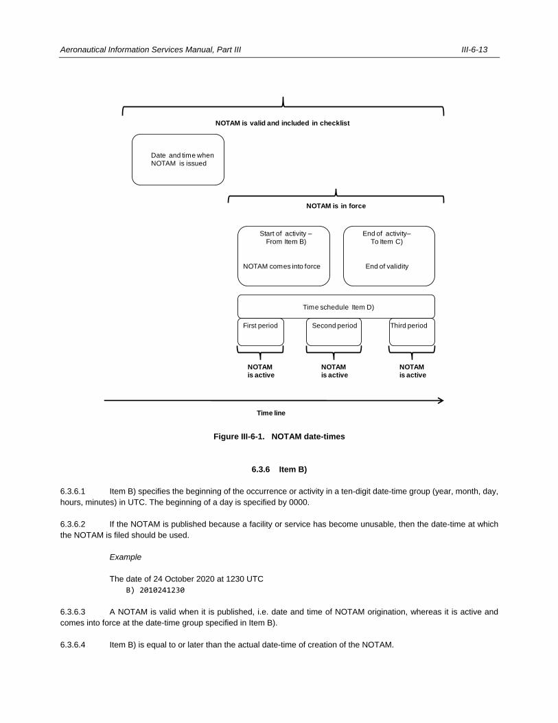
Aeronautical Information Services Manual, Part III III-6-13
Figure III-6-1. NOTAM date-times
6.3.6 Item B)
6.3.6.1 Item B) specifies the beginning of the occurrence or activity in a ten-digit date-time group (year, month, day,
hours, minutes) in UTC. The beginning of a day is specified by 0000.
6.3.6.2 If the NOTAM is published because a facility or service has become unusable, then the date-time at which
the NOTAM is filed should be used.
Example
The date of 24 October 2020 at 1230 UTC
B) 2010241230
6.3.6.3 A NOTAM is valid when it is published, i.e. date and time of NOTAM origination, whereas it is active and
comes into force at the date-time group specified in Item B).
6.3.6.4 Item B) is equal to or later than the actual date-time of creation of the NOTAM.
Date and time when NOTAM is issued
Start of activity –From Item B)
NOTAM comes into force
End of activity–To Item C)
End of validity
Time schedule Item D)
Time line
NOTAM is valid and included in checklist
NOTAM is in force
First period Second period Third period
NOTAM is active
NOTAM is active
NOTAM is active
III-6-14 Aeronautical Information Services Manual, Part III
6.3.6.5 The start of a day is specified by 0000. Abbreviations such as WIE or WEF are not to be used.
6.3.6.6 For NOTAMR and NOTAMC, the date-time group is the actual date and time of the NOTAM origination.
Future cancellation or replacement of a NOTAM is not to be issued to avoid possible misinterpretation about further
changes or existence of multiple NOTAM, with the same subject, at the same time.
6.3.7 Item C)
6.3.7.1 Item C) specifies the end of the occurrence or activity in a ten-digit date-time group (year, month, day, hours,
minutes) in UTC.
6.3.7.2 If the information is of a permanent nature, then the abbreviation PERM is inserted instead of the ten-digit
date-time group. PERM is solely for NOTAM information that will be incorporated in the AIP, and must be entered in the
AIP as soon as possible, but not later than within three months.
6.3.7.3 If the information on time is uncertain, then the approximate duration should be indicated by a date-time
group followed, without blank space, by the abbreviation EST. Any NOTAM using EST must be cancelled or replaced
before the date-time specified in Item C). Failure to cancel or replace a NOTAM using EST implies that the NOTAM will
continue to be promulgated for an indefinite period of time. Abbreviations such as UFN must not be used.
6.3.7.4 The end of a day is specified by 2359.
6.3.7.5 Item C) is not applicable for NOTAMC.
Examples
a) The end of the period of validity is 26 October 2021 at 2000 UTC.
C) 2110262000
b) The information is permanent and will be incorporated in AIP.
C) PERM
c) The approximate duration is until 26 October 2021 at 2000 UTC.
C) 2110262000EST
d) The aerodrome beacon at Donlon/International aerodrome became unserviceable at 0920 on
20 April 2020 and will remain out of service until 1800 hours UTC on 21 April 2020.
Q) EACC/QLBAS/V/M/A/000/999/4248N14140E005
A) EADD B) 2004200920 C) 2004211800
E) ABN U/S
6.3.8 Item D)
6.3.8.1 If applicable, Item D) specifies the time schedule or the period(s) during which an occurrence takes place
between the date-time groups in Items B) and C). If Item D) exceeds 200 characters, such information should be provided
in a separate, consecutive NOTAM.
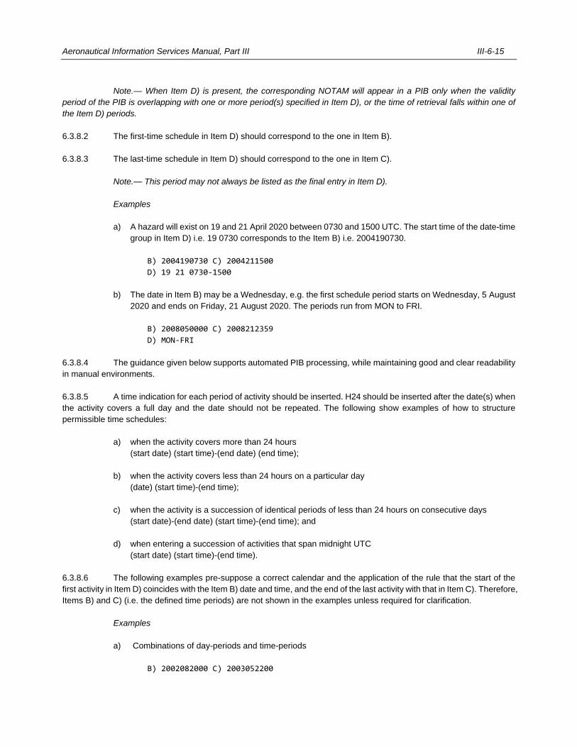
Aeronautical Information Services Manual, Part III III-6-15
Note.— When Item D) is present, the corresponding NOTAM will appear in a PIB only when the validity
period of the PIB is overlapping with one or more period(s) specified in Item D), or the time of retrieval falls within one of
the Item D) periods.
6.3.8.2 The first-time schedule in Item D) should correspond to the one in Item B).
6.3.8.3 The last-time schedule in Item D) should correspond to the one in Item C).
Note.— This period may not always be listed as the final entry in Item D).
Examples
a) A hazard will exist on 19 and 21 April 2020 between 0730 and 1500 UTC. The start time of the date-time
group in Item D) i.e. 19 0730 corresponds to the Item B) i.e. 2004190730.
B) 2004190730 C) 2004211500
D) 19 21 0730-1500
b) The date in Item B) may be a Wednesday, e.g. the first schedule period starts on Wednesday, 5 August
2020 and ends on Friday, 21 August 2020. The periods run from MON to FRI.
B) 2008050000 C) 2008212359
D) MON-FRI
6.3.8.4 The guidance given below supports automated PIB processing, while maintaining good and clear readability
in manual environments.
6.3.8.5 A time indication for each period of activity should be inserted. H24 should be inserted after the date(s) when
the activity covers a full day and the date should not be repeated. The following show examples of how to structure
permissible time schedules:
a) when the activity covers more than 24 hours
(start date) (start time)-(end date) (end time);
b) when the activity covers less than 24 hours on a particular day
(date) (start time)-(end time);
c) when the activity is a succession of identical periods of less than 24 hours on consecutive days
(start date)-(end date) (start time)-(end time); and
d) when entering a succession of activities that span midnight UTC
(start date) (start time)-(end time).
6.3.8.6 The following examples pre-suppose a correct calendar and the application of the rule that the start of the
first activity in Item D) coincides with the Item B) date and time, and the end of the last activity with that in Item C). Therefore,
Items B) and C) (i.e. the defined time periods) are not shown in the examples unless required for clarification.
Examples
a) Combinations of day-periods and time-periods
B) 2002082000 C) 2003052200
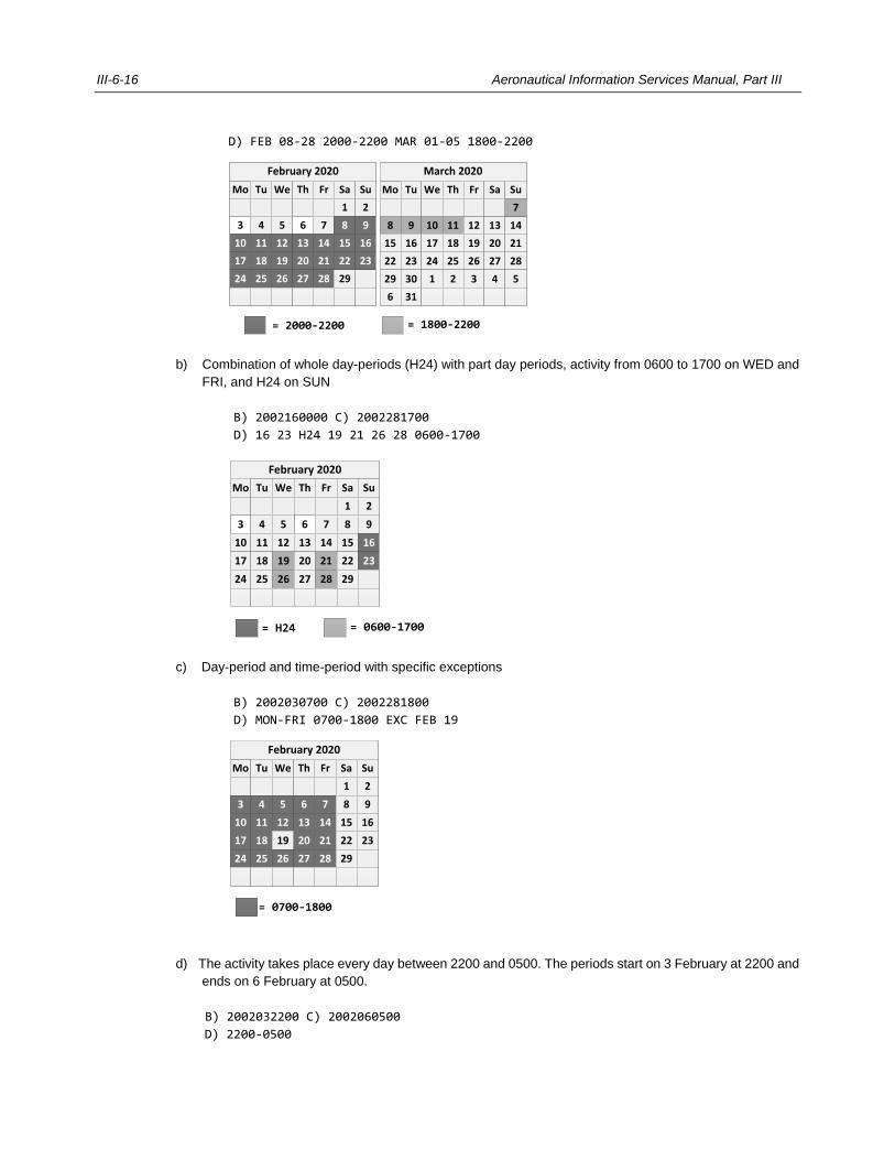
III-6-16 Aeronautical Information Services Manual, Part III
D) FEB 08-28 2000-2200 MAR 01-05 1800-2200
b) Combination of whole day-periods (H24) with part day periods, activity from 0600 to 1700 on WED and
FRI, and H24 on SUN
B) 2002160000 C) 2002281700
D) 16 23 H24 19 21 26 28 0600-1700
c) Day-period and time-period with specific exceptions
B) 2002030700 C) 2002281800
D) MON-FRI 0700-1800 EXC FEB 19
d) The activity takes place every day between 2200 and 0500. The periods start on 3 February at 2200 and
ends on 6 February at 0500.
B) 2002032200 C) 2002060500
D) 2200-0500
Mo
February 20
Tu We Th Fr Sa Su
1 2
3 4 5 6 7 8 9
10 11 12 13 14 15 16
17 18 19 20 21 22 23
24 25 26 27 28 29
February 2020
Mo
March 20
Tu We Th Fr Sa Su
7
8 9 10 11 12 13 14
15 16 17 18 19 20 21
22 23 24 25 26 27 28
29 30 1 2 3 4 5
6 31
= 2000-2200 = 1800-2200
March 2020
= H24 = 0600-1700
Mo
February 20
Tu We Th Fr Sa Su
1 2
3 4 5 6 7 8 9
10 11 12 13 14 15 16
17 18 19 20 21 22 23
24 25 26 27 28 29
February 2020
Mo
February 20
Tu We Th Fr Sa Su
1 2
3 4 5 6 7 8 9
10 11 12 13 14 15 16
17 18 19 20 21 22 23
24 25 26 27 28 29
= 0700-1800
February 2020
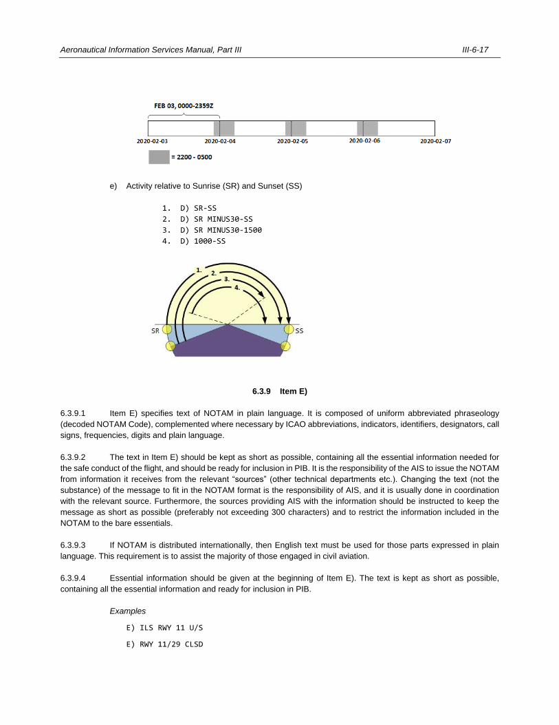
Aeronautical Information Services Manual, Part III III-6-17
e) Activity relative to Sunrise (SR) and Sunset (SS)
1. D) SR-SS
2. D) SR MINUS30-SS
3. D) SR MINUS30-1500
4. D) 1000-SS
6.3.9 Item E)
6.3.9.1 Item E) specifies text of NOTAM in plain language. It is composed of uniform abbreviated phraseology
(decoded NOTAM Code), complemented where necessary by ICAO abbreviations, indicators, identifiers, designators, call
signs, frequencies, digits and plain language.
6.3.9.2 The text in Item E) should be kept as short as possible, containing all the essential information needed for
the safe conduct of the flight, and should be ready for inclusion in PIB. It is the responsibility of the AIS to issue the NOTAM
from information it receives from the relevant “sources” (other technical departments etc.). Changing the text (not the
substance) of the message to fit in the NOTAM format is the responsibility of AIS, and it is usually done in coordination
with the relevant source. Furthermore, the sources providing AIS with the information should be instructed to keep the
message as short as possible (preferably not exceeding 300 characters) and to restrict the information included in the
NOTAM to the bare essentials.
6.3.9.3 If NOTAM is distributed internationally, then English text must be used for those parts expressed in plain
language. This requirement is to assist the majority of those engaged in civil aviation.
6.3.9.4 Essential information should be given at the beginning of Item E). The text is kept as short as possible,
containing all the essential information and ready for inclusion in PIB.
Examples
E) ILS RWY 11 U/S
E) RWY 11/29 CLSD
III-6-18 Aeronautical Information Services Manual, Part III
E) RWY 25R LOC RESUMED NORMAL OPS
E) ACFT STANDS 25 TO 30 AND 37 TO 40 CLSD DUE TO WIP ON APRON 1
E) CRANE ERECTED PSN 395117N1044053W 1.7NM NORTH OF THR RWY 35R ELEV 5546FT HGT
171FT AGL
E) CARRIAGE OF 8.33 CHANNEL SPACING RDO EQPT MANDATORY FOR ACFT OPR ABV FL195 REF
AIP GEN 1.5
6.3.9.5 Item E) may contain abbreviations contained in the Procedures for Air Navigation Services — ICAO
Abbreviations and Codes (PANS-ABC, Doc 8400) (e.g. FT, GND, AMSL, NM, DEG etc.). There is no blank space between
the value and the unit of measurement (e.g. 3000FT). There is a blank space between the reference datum and the unit
of measurement (e.g. 3000FT AMSL). Other characters (e.g. /, -...) must not be used.
6.3.9.6 Frequencies indicated in MHz always display all seven characters e.g. 112.650MHz. Frequencies indicated
in KHz display up to five characters. The ‘0’ after the dot may be omitted e.g. 312KHz, 310.5KHz.
6.3.9.7 Other abbreviations, including abbreviations listed in AIP GEN 2.2 but marked as ‘not included in Doc 8400’,
should not be used.
6.3.9.8 Cardinal directions (N, S, E, W) and ordinal directions (NE, SE, SW, NW) must not be abbreviated but spelled
out (e.g. NORTH, NORTHEAST, SOUTHWEST) when used in combination with aeronautical features that have similar
sounding designations when abbreviated, e.g. taxiways.
Example
E) TWY A AND C SOUTHWEST OF RWY 10/28 CLSD
E) USE CAUTION WHEN TAXIING DUE TO WIP EAST OF TWY F
6.3.9.9 The lateral limits of an area published in the AIP or AIP SUP are not to be repeated in Item E); instead, use
the name of that area.
6.3.9.10 If lateral limits of an area are not published in the AIP or AIP SUP, the coordinates must be expressed in
accordance with the following to ensure readability:
a) The points defining lateral limits of an irregular shape area must be enumerated in clockwise order
separated by a hyphen “–”. The last point on the list must be the same as the first point.
Example
E) AIR DISPLAY WILL TAKE PLACE WI LATERAL LIMITS 470812N0283830W –
470908N0283455W - 470445N0283647W - 470412N0283724W - 470812N0283830W
F) GND G) 3000FT AMSL)
b) A circular shape area is defined by the word “RADIUS” followed by the value of the radius and its
abbreviated unit of measurement followed by the words “CENTRE” followed by coordinates of the centre
of the circle.
Example
E) AIR DISPLAY WILL TAKE PLACE RADIUS 5KM CENTRE 4945N02405W (NIBORD AD)
F) GND G) 5000M AMSL
Aeronautical Information Services Manual, Part III III-6-19
c) In Item E) the latitude is presented in DDMM[SS.s]H where DD denotes degrees; MM denotes minutes;
SS optionally denotes seconds, s optionally denotes tenths of seconds; and H denotes hemisphere, N
for North or S for South.
d) In Item E) the longitude is presented in DDDMM[SS.s]H where DDD denotes degrees; MM denotes
minutes; SS optionally denotes seconds; s optionally denotes tenth of seconds; and H denotes
hemisphere, W for West or E for East.
e) The resolution used for coordinates must conform to the aeronautical data quality requirements listed in
Appendix 1 of PANS-AIM, e.g. tenth of a minute must not be used.
6.3.9.11 An e-mail address is inserted in Item E) with the @ symbol replaced by the string “(A)”, e.g. AIS(A)DONC.XX.
6.3.9.12 For airspace organization subjects, the name of airspace organization must be present whenever it is also
intended as en-route NOTAM (scope E and AE).
Example
E) TMA NIBORD SECTOR 14 DEACTIVATED.
6.3.9.13 Text in Item E) relates to one NOTAM subject only, except in case of a trigger NOTAM.
6.3.9.14 In the case of NOTAMC, a subject reference and status message should be included to enable accurate
plausibility checks.
6.3.10 Items F) and G)
6.3.10.1 Lower and upper limits are applicable to navigation warnings or airspace restrictions, but can be used for
any other applicable subjects, and are usually part of the PIB entry. Both lower and upper limits of activities or restrictions
should be inserted, clearly indicating the same reference datum and unit of measurement in both fields. Using different
units of measurement (i.e. metres and feet) is discouraged as this may lead to confusion.
6.3.10.2 Item F) is the lower limit expressed as an altitude either in metres or feet above mean sea level (AMSL), a
height above ground level (AGL), a flight level (FL), surface (SFC) or ground level (GND).
6.3.10.3 The value and the unit of measurement (M or FT) must be consecutive without a blank space. The reference
indication (AGL, AMSL) must follow the unit of measurement and be separated by a blank space. The value 000 is not to
be used.
Examples
a) Altitudes in metres and feet above mean sea level
F) 2000M AMSL
F) 6500FT AMSL
b) A height above ground level
F) 1000M AGL
c) A flight level
F) FL100
6.3.10.4 Item G) is the upper limit expressed as an altitude either in metres or feet above mean sea level, a height
III-6-20 Aeronautical Information Services Manual, Part III
above the ground, a flight level, or as unlimited (UNL) if applicable.
6.3.10.5 The value and the unit of measurement (M or FT) must be consecutive without a blank space. The reference
indication (AGL, AMSL) must follow the unit of measurement and be separated by a blank space. The value 999 is not to
be used.
Example
A ground level up to an altitude of 30 000 ft above mean sea level
F) GND G) 30000FT AMSL
6.4 CROSS-REFERENCE TO AIP OR AIP SUPPLEMENT
6.4.1 When a NOTAM contains permanent or temporary information of long duration, the text must include
an appropriate cross-reference to the affected AIP or AIP supplement and an annotation must be made accordingly. This
informs the user of the AIP or AIP supplement that there is information outstanding against a particular entry (e.g. REF.
AIP EADB AD 2.19).
6.4.2 When a NOTAM contains temporary information of short duration, AIP references should not be
annotated in the NOTAM. This informs the user of the NOTAM that the text of the NOTAM is conveying the totality of the
information.
6.5 NAMING OF LOCATIONS
Location indicators included in the text of NOTAM must be those contained in Location Indicators (Doc 7910) and curtailed
forms of these indicators must not be used. In NOTAM that contains information concerning a location that has not been
assigned an ICAO location indicator, the name of the location must be given in plain language, spelled in conformity with
local usage and transliterated where necessary into the ISO basic Latin alphabet.
6.6 EXAMPLES OF NOTAM USING THE NOTAM FORMAT
6.6.1 The following examples of NOTAM are for illustrative purposes only and do not have any operational value:
a) At DONLON/International from the 1st day of April 2020 at 0000 UTC until the 1st day of April 2020 at
0600 UTC, the distance measuring equipment will be unserviceable.
NOTAMN
Q) EACC/QNMAS/IV/BO/AE/000/999/5222N03222W025
A) EADD B) 2004010000 C) 2004010600
E) VOR/DME BOR 116.900MHZ/CH102X, DME U/S
b) At DONLON/International the VHF omnidirectional radio range on 116.400 MHz will be out of service
until approximately the 13th day of November 2019 at 0900 UTC.
NOTAMN
Q) EACC/QNVAS/IV/BO/AE/000/999/5226N03200W025
Aeronautical Information Services Manual, Part III III-6-21
A) EADD B) 1911020615 C) 1911130900EST
E) VOR DON 116.400MHZ U/S
c) At SIBY/Bistok the non-directional beacon on 243 kHz will be permanently withdrawn from service on 1
May 2020 at 0600 UTC. Add reference to AIP.
NOTAMN
Q) EACC/QNBAW/IV/BO/AE/000/999/4740N02942W025
A) EADB B) 2005010600 C) PERM
E) NDB BOR 243KHZ WITHDRAWN REF. AIP EADB AD 2.19
d) In the Amswell FIR gun firing will take place on the 21st day of February 2020 from 0800 hours UTC
until 1100 hours UTC within an area of 10 NM around the location 53°04’ North 25°05’ West from the
surface up to an altitude of 6 100 metres MSL.
NOTAMN
Q) EACC/QWMLW/IV/BO/W/000/200/5304N02505W010
A) EACC B) 2002210800 C) 2002211100
E) GUN FIRING WILL TAKE PLACE RADIUS 10NM CENTRE 5304N02505W
F) SFC G) 6100M AMSL
e) If a danger area EAD4 located at 4300N03800W with a radius of 50 NM (and affecting two FIR) is to be
activated up to 40 000 ft MSL on 3, 7, 12, 21, 24 and 28 April 2020, daily from 0730 to 1500 UTC and
up to 30 000 ft MSL on 19 and 20 April 2020 daily from 0730 to 1500 UTC, two NOTAM will be required,
as follows:
(A0623/20 NOTAMN
Q) EAXX/QRDCA/IV/BO/W/000/400/4300N03800W050
A) EACC EABB B) 2004030730 C) 2004281500
D) 03 07 12 21 24 28 0730-1500
E) DANGER AREA EAD4 ACT
F) GND G) 40000FT AMSL)
(A0624/20 NOTAMN
Q) EAXX/QRDCA/IV/BO/W/000/300/4300N03800W050
A) EACC EABB B) 2004190730 C) 2004201500
D) 19 20 0730-1500
E) DANGER AREA EAD4 ACT
F) GND G) 30000FT AMSL)
f) At DONLON/International on the 27th day of November 2019, basic GNSS is not available for NPA from
1723 to 1754 UTC, SBAS is not available for APV from 1731 to 1748 UTC and GBAS is not available
from 1735 to 1746 UTC.
(B0116/19 NOTAMN
Q) EACC/QGAAU/I/NBO/A/000/999/5222N03155W005
A) EADD B) 1911271723 C) 1911271754
E) BASIC GNSS NOT AVAILABLE FOR NPA 1723-1754 UTC
SBAS NOT AVAILABLE FOR APV 1731-1748 UTC
GBAS NOT AVAILABLE 1735-1746)
g) SBAS is not available for all APV operations in an area around DONLON/International with radius 25 NM
III-6-22 Aeronautical Information Services Manual, Part III
from 14 December 2019 at 2135 hours UTC until 15 December 2019 at 2135 hours UTC (estimated).
(A2500/19 NOTAMN
Q) EACC/QGWAU/I/NBO/AE/000/999/5222N03155W025
A) EADD B) 1912142135 C) 1912152135EST
E) SBAS NOT AVAILABLE FOR APV)
h) Basic GNSS, SBAS and GBAS will be unavailable for all en-route and aerodrome operations in an area
around DONLON/International with radius 460 km (250 NM) on 16 October 2019 at 1815 hours UTC
until 2315 hours UTC.
(A3546/19 NOTAMN
Q) EACC/QGWAU/I/NBO/AE/000/999/5222N03155W250
A) EADD B) 1910161815 C) 1910162315
E) BASIC GNSS SBAS AND GBAS NOT AVAILABLE)
6.6.2 Examples of completed NOTAM formats are given in Figures III-6-2 and III-6-3, and the meanings of the NOTAM
messages are included below together with the associated examples of AFS messages.
a) NOTAM Series A number 0068 replacing NOTAM Series A number 0062 of the current year.
HOLMSTOCK/Landa aerodrome closed for maintenance on the runway from 2300 hours UTC on the
8th day of May 2020 to approximately 0100 UTC on the 9th day of May 2020.
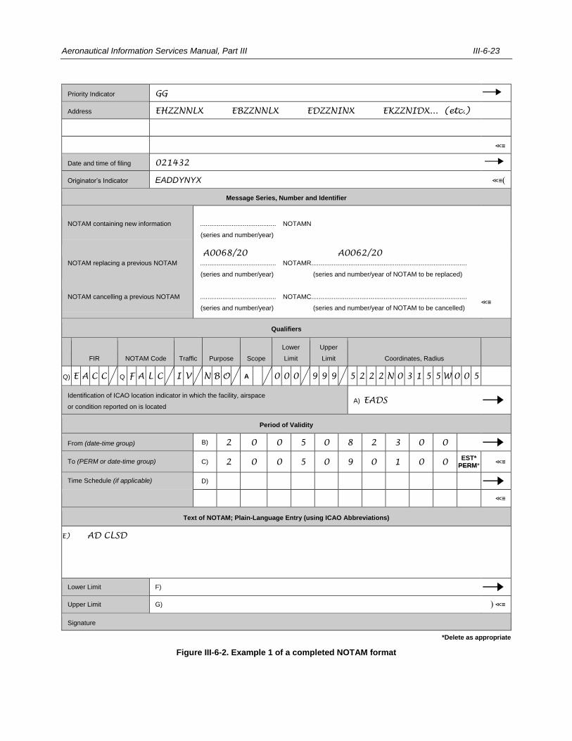
Aeronautical Information Services Manual, Part III III-6-23
Priority Indicator GG
Address EHZZNNLX EBZZNNLX EDZZNINX EKZZNIDX... (etc.)
≪≡
Date and time of filing 021432
Originator’s Indicator EADDYNYX ≪≡(
Message Series, Number and Identifier
NOTAM containing new information ......................................... NOTAMN
(series and number/year)
NOTAM replacing a previous NOTAM ......................................... NOTAMR ....................................................................................
(series and number/year) NOTAMR (series and number/year of NOTAM to be replaced)
NOTAM cancelling a previous NOTAM ......................................... NOTAMC ....................................................................................
(series and number/year) NOTAMC (series and number/year of NOTAM to be cancelled) ≪≡
Qualifiers
FIR NOTAM Code Traffic Purpose Scope
Lower
Limit
Upper
Limit Coordinates, Radius
Q) E A C C Q F A L C I V N B O A 0 0 0 9 9 9 5 2 2 2 N 0 3 1 5 5 W 0 0 5
Identification of ICAO location indicator in which the facility, airspace
or condition reported on is located A) EADS
Period of Validity
From (date-time group) B) 2 0 0 5 0 8 2 3 0 0
To (PERM or date-time group) C) 2 0 0 5 0 9 0 1 0 0 EST*
PERM* ≪≡
Time Schedule (if applicable) D)
≪≡
Text of NOTAM; Plain-Language Entry (using ICAO Abbreviations)
E) AD CLSD
≪≡
Lower Limit F)
Upper Limit G) ) ≪≡
Signature
*Delete as appropriate
Figure III-6-2. Example 1 of a completed NOTAM format
A0068/20 A0062/20
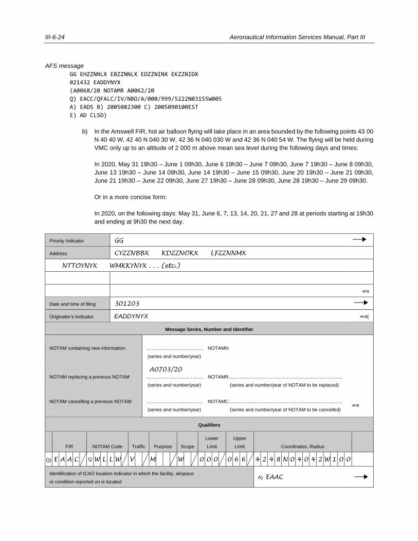
III-6-24 Aeronautical Information Services Manual, Part III
AFS message
GG EHZZNNLX EBZZNNLX EDZZNINX EKZZNIDX
021432 EADDYNYX
(A0068/20 NOTAMR A0062/20
Q) EACC/QFALC/IV/NBO/A/000/999/5222N03155W005
A) EADS B) 2005082300 C) 2005090100EST
E) AD CLSD)
b) In the Amswell FIR, hot air balloon flying will take place in an area bounded by the following points 43 00
N 40 40 W, 42 40 N 040 30 W, 42 36 N 040 030 W and 42 36 N 040 54 W. The flying will be held during
VMC only up to an altitude of 2 000 m above mean sea level during the following days and times:
In 2020, May 31 19h30 – June 1 09h30, June 6 19h30 – June 7 09h30, June 7 19h30 – June 8 09h30,
June 13 19h30 – June 14 09h30, June 14 19h30 – June 15 09h30, June 20 19h30 – June 21 09h30,
June 21 19h30 – June 22 09h30, June 27 19h30 – June 28 09h30, June 28 19h30 – June 29 09h30.
Or in a more concise form:
In 2020, on the following days: May 31, June 6, 7, 13, 14, 20, 21, 27 and 28 at periods starting at 19h30
and ending at 9h30 the next day.
Priority Indicator GG
Address CYZZNBBX KDZZNOKX LFZZNNMX
NTTOYNYX WMKKYNYX . . . (etc.)
≪≡
Date and time of filing 301203
Originator’s Indicator EADDYNYX ≪≡(
Message Series, Number and Identifier
NOTAM containing new information .......................................... NOTAMN
(series and number/year)
NOTAM replacing a previous NOTAM .......................................... NOTAMR ....................................................................................
(series and number/year) NOTAMR (series and number/year of NOTAM to be replaced)
NOTAM cancelling a previous NOTAM .......................................... NOTAMC ....................................................................................
(series and number/year) NOTAMC (series and number/year of NOTAM to be cancelled) ≪≡
Qualifiers
FIR NOTAM Code Traffic Purpose Scope
Lower
Limit
Upper
Limit Coordinates, Radius
Q) E A A C Q W L L W V M W 0 0 0 0 6 6 4 2 4 8 N 0 4 0 4 2 W 1 0 0
Identification of ICAO location indicator in which the facility, airspace
or condition reported on is located A) EAAC
A0703/20
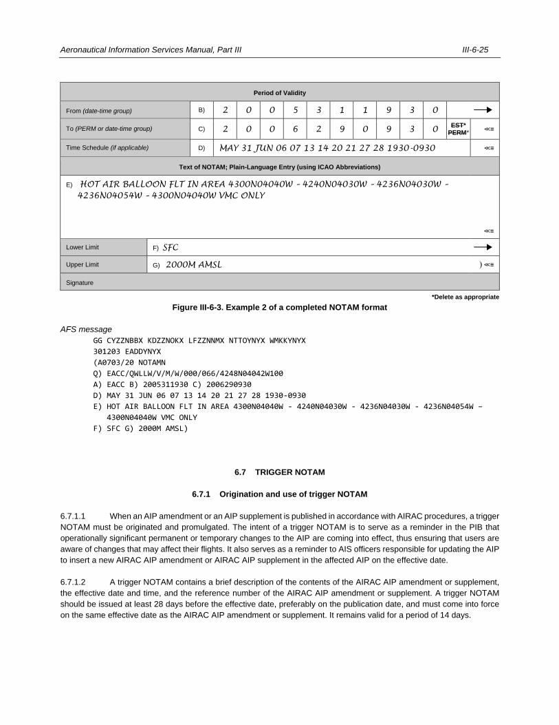
Aeronautical Information Services Manual, Part III III-6-25
Period of Validity
From (date-time group) B) 2 0 0 5 3 1 1 9 3 0
To (PERM or date-time group) C) 2 0 0 6 2 9 0 9 3 0 EST*
PERM* ≪≡
Time Schedule (if applicable) D) MAY 31 JUN 06 07 13 14 20 21 27 28 1930-0930 ≪≡
Text of NOTAM; Plain-Language Entry (using ICAO Abbreviations)
E) HOT AIR BALLOON FLT IN AREA 4300N04040W – 4240N04030W – 4236N04030W –
4236N04054W – 4300N04040W VMC ONLY
≪≡
Lower Limit F) SFC
Upper Limit G) 2000M AMSL ) ≪≡
Signature
*Delete as appropriate
Figure III-6-3. Example 2 of a completed NOTAM format
AFS message
GG CYZZNBBX KDZZNOKX LFZZNNMX NTTOYNYX WMKKYNYX
301203 EADDYNYX
(A0703/20 NOTAMN
Q) EACC/QWLLW/V/M/W/000/066/4248N04042W100
A) EACC B) 2005311930 C) 2006290930
D) MAY 31 JUN 06 07 13 14 20 21 27 28 1930-0930
E) HOT AIR BALLOON FLT IN AREA 4300N04040W - 4240N04030W - 4236N04030W - 4236N04054W –
4300N04040W VMC ONLY
F) SFC G) 2000M AMSL)
6.7 TRIGGER NOTAM
6.7.1 Origination and use of trigger NOTAM
6.7.1.1 When an AIP amendment or an AIP supplement is published in accordance with AIRAC procedures, a trigger
NOTAM must be originated and promulgated. The intent of a trigger NOTAM is to serve as a reminder in the PIB that
operationally significant permanent or temporary changes to the AIP are coming into effect, thus ensuring that users are
aware of changes that may affect their flights. It also serves as a reminder to AIS officers responsible for updating the AIP
to insert a new AIRAC AIP amendment or AIRAC AIP supplement in the affected AIP on the effective date.
6.7.1.2 A trigger NOTAM contains a brief description of the contents of the AIRAC AIP amendment or supplement,
the effective date and time, and the reference number of the AIRAC AIP amendment or supplement. A trigger NOTAM
should be issued at least 28 days before the effective date, preferably on the publication date, and must come into force
on the same effective date as the AIRAC AIP amendment or supplement. It remains valid for a period of 14 days.
III-6-26 Aeronautical Information Services Manual, Part III
6.7.2 Specification for trigger NOTAM
A trigger NOTAM follows, for the most part, the same instructions as any other NOTAM, but with a few exceptions as
outlined below. A trigger NOTAM is issued:
a) in the appropriate NOTAM series, according to the information it contains;
Note.— Trigger NOTAM are never published in Series T which is reserved for NOTAM processing
units in cases when basic operational information was not “triggered” by the issuing AIS.
b) for a single location (FIR or aerodrome) only but may include information on different subjects related
to the location in order to reduce the number of NOTAM to be published.
6.7.2.1 Item Q)
Qualifier NOTAM CODE
6.7.2.1.1 The second and third letters (subject) are selected from Appendix 7 and must never be the letters XX. If
there is no suitable selection, then FA for aerodromes and AF for FIR must be used. In the case of multiple subjects for
the same aerodrome or FIR, the second and third letters are selected according to the subject of highest operational
importance.
6.7.2.1.2 The fourth and fifth letters (condition) always contain the letters TT. This exclusive TT condition must be
used in trigger NOTAM regardless of the subject of NOTAM Code listed in Appendix 7.
Note.— Condition “TT” may be used to retrieve specific trigger NOTAM from any issuing AIS and can also
be used to include or exclude trigger NOTAM in or from PIB at a specific time before their effective date.
Qualifier Traffic
6.7.2.1.3 The following are valid entries as published in NOTAM Selection Criteria:
I = IFR
V = VFR
Qualifier Purpose
6.7.2.1.4 As trigger NOTAM are issued relative only to information of operational significance, the qualifier purpose
must be BO.
Qualifier Scope
6.7.2.1.5 The following are valid entries as published in NOTAM Selection Criteria:
A = Aerodrome
E = En-route
W = Nav Warning
6.7.2.1.6 In the case of multiple subjects for the same aerodrome or FIR, and even though only the subject of highest
operational significance is listed in the NOTAM Code, the qualifiers scope and traffic must be selected to cover all subjects.
Aeronautical Information Services Manual, Part III III-6-27
6.7.2.2 Items B) and C)
6.7.2.2.1 Items B) and C) specify the period of validity in a ten-digit date-time group in UTC.
6.7.2.2.2 Trigger NOTAM must contain in Item B) the AIRAC effective date and time of the AIRAC AIP amendment or
AIRAC AIP supplement.
6.7.2.2.3 As trigger NOTAM must remain valid for a period of 14 days after the effective date of an amendment or
supplement, Item C) must contain the AIRAC effective date and time plus 14 days. If the effective time of the trigger
NOTAM is defined to be the beginning of the day (first minute of the day is 0000), use 2359 as end-time of the 14-day
period.
Examples
B) 2006181000 (i.e. AIRAC effective date and time)
C) 2007021000 (i.e. AIRAC effective date and time + 14 days)
B) 2010080000 (i.e. AIRAC effective date and time)
C) 2010212359 (i.e. AIRAC effective date and time + 14 days)
6.7.2.2.4 When the information published by an AIRAC AIP supplement has a duration that is shorter than 14 days,
Item C) of a trigger NOTAM must have the date and time when the information published in the AIP supplement will expire.
6.7.2.2.5 A trigger NOTAM expires at the date-time specified in Item C). In case where the information contained in
an AIRAC AIP supplement is not valid anymore prior to this date, the trigger NOTAM may be cancelled or replaced.
6.7.2.3 Item E)
The text in Item E) should not exceed 300 characters and must always start with the words “TRIGGER NOTAM” (in the
case of an AIP amendment, followed by the abbreviation PERM), a reference number of the published AIRAC AIP
amendment or AIRAC AIP supplement concerned, the effective and end date of validity (or the effective date only in the
case of PERM) and a brief description of its content.
Note.— PERM or end of validity is inserted in Item E) to stress that the information published by the
referenced AIP amendment or AIP supplement is of a permanent nature or of planned duration respectively while the
trigger NOTAM contains an end date as per Item C).
6.7.3 Trigger NOTAM relative to AIRAC AIP amendments
AIRAC AIP amendments represent permanent operational changes to the AIP on a predefined AIRAC effective date. The
text in Item E) must include an indication that permanent changes are taking place.
Example of an AIRAC AIP amendment
Q) EACC/QARTT/I/BO/E/245/999/5223N03156E999
A) EACC B) 2003261000 C) 2004091000
E) TRIGGER NOTAM — PERM AIRAC AIP AMDT 32/20 WEF 26 MAR 2020
IMPLEMENTATION OF NEW ATS ROUTE UA15
III-6-28 Aeronautical Information Services Manual, Part III
6.7.4 Trigger NOTAM relative to AIRAC AIP supplements
6.7.4.1 AIRAC AIP supplements represent temporary operational changes of long duration (three months or longer)
or operational changes of short duration containing extensive text or graphics.
Example of an AIRAC AIP supplement
A0118/20 NOTAMN
Q) EACC/QFATT/IV/BO/A/000/999/5223N03156E005
A) EADA B) 2004231000 C) 2005071000
E) TRIGGER NOTAM — AIRAC AIP SUP 11/20 WEF 23 APR 2020 UNTIL 07 MAY 2020
USE OF AD RESTRICTED DUE TO WIP
6.7.4.2 Generally, changes to an AIRAC AIP supplement are announced by replacing it with another AIRAC AIP
supplement and the normal rules for trigger NOTAM apply. However, changes of short duration, of short notice or of
temporary nature, such as short notice notification of an earlier end of validity or notification of the activation of information
described in the AIP SUP are announced by NOTAM referring to the AIP SUP. Note that in Example 2, the end time in
Item C) is the original expiration time of the AIRAC AIP SUP 11/20, namely 07 May 2020.
Example 1
A0119/20 NOTAMN
Q) EACC/QMDCH/IV/BO/A/000/999/5223N03156E005
A) EADA B) 2004231000 C) 2005071000
E) RWY 03/21 TORA 2800M. REF AIRAC AIP SUP 11/20.
Example 2
A0120/20 NOTAMN
Q) EACC/QFALT/IV/BO/A/000/999/5223N03156E005
A) EADA B) 2005040000 C) 2005072359
E) REF AIRAC AIP SUP 11/20 WORKS COMPLETED.
RESTRICTIONS ON THE USE OF AD NO LONGER IN FORCE.
6.8 CHECKLIST OF NOTAM
A checklist showing all valid NOTAM is issued periodically in a standard format. The checklist assists recipients in verifying
that the right cancellations of NOTAM have been made. Cancelling by sole means of a checklist (i.e. by omitting NOTAM
to be cancelled) is not allowed. This checklist must be issued over AFS at intervals of not more than one month and
preferably to a fixed schedule so that recipients know when to expect it. For example, the checklist for each month could
be issued on the first day of the following month. A separate checklist must be issued for each NOTAM series to the same
distribution as the actual message series to which they refer.
Note.— Procedures for checklist of NOTAM are specified in the PANS-AIM, 5.2.5.3.
6.8.1 Specification for checklist of NOTAM
Checklists are issued as NOTAMR and are completed as follows:
Aeronautical Information Services Manual, Part III III-6-29
6.8.1.1 Item Q)
Qualifier FIR
6.8.1.1.1 The following must be inserted:
a) the ICAO location indicator of the FIR; or
b) the ICAO nationality letters of the State originating the NOTAM followed by “XX” or ‘XXX’ if there is more
than one FIR in a State; or
c) the ICAO nationality letters of the issuing AIS followed by “XX” or “XXX” if publishing for FIR in different
States.
Qualifier NOTAM Code
6.8.1.1.2 The dedicated NOTAM Code “QKKKK” must be inserted.
Qualifiers Traffic, Purpose and Scope
6.8.1.1.3 The letter ‘K’ must be inserted.
Note.— The NOTAM Code “QKKKK” and the qualifier “K” for Traffic, Purpose and Scope are used to allow
filtering of the checklist. This also prevents the checklist from appearing in the PIB.
Qualifiers Lower and Upper Limits
6.8.1.1.4 The default values “000” for lower limit and “999” for upper limit must be inserted.
Qualifiers Coordinates and Radius
6.8.1.1.5 The geographical coordinates of the centre of the FIR(s) listed in Item A) must be inserted in 11 characters
followed by the default radius value “999”.
6.8.1.2 Item A)
Item A) specifies the ICAO location indicator of the FIR or a list of all the FIRs to which the checklist relates.
6.8.1.3 Item B)
6.8.1.3.1 Item B) specifies the actual date and time of the origination of the NOTAM checklist in a ten-digit date-time
group in UTC.
6.8.1.3.2 The current checklist NOTAMR replaces the previous checklist with immediate effect.
III-6-30 Aeronautical Information Services Manual, Part III
6.8.1.4 Item C)
6.8.1.4.1 Item C) specifies the estimated validity of the NOTAM checklist in a ten-digit date-time group in UTC. It is
indicated as one month after the date of issue and is followed, without blank space, by EST.
6.8.1.4.2 The NOTAM checklist is issued with an estimated validity of not more than one month.
6.8.1.5 Item E)
6.8.1.5.1 Item E) contains information in plain language text. It is divided into three sections:
a) first section:
— begins with the keyword “CHECKLIST”;
— contains the list of the valid NOTAM numbers, which have been promulgated in the same series as
the checklist, in a format suitable for automatic and manual processing; and
Note 1.— The list must not contain the NOTAM number of the replaced NOTAM checklist or
its own NOTAM checklist number.
Note 2.— Each NOTAM number (always four digits) is separated by a blank space with no
other punctuation mark.
— groups NOTAM by year, using the word “YEAR” and the “=” sign, followed by the four-digit year of
publication without blank spaces (e.g. YEAR=2021);
Note 1.— Each indicator of a different year must start on a new line.
Note 2.— Checklists must contain the numbers of the NOTAM incorporated in a normal AIP
amendment or AIP supplement until the time that these NOTAM are cancelled by the publication of
a NOTAMC.
b) second section:
— begins with the words “LATEST AIP AMENDMENTS”; and
— contains the list of the latest AIP amendments
Note 1.— Whenever the numbering of AIP amendments takes place on a yearly basis, a
reference to the year of publication must be added to the number.
c) third section:
— begins with the words “CHECKLIST OF AIP SUP”; and
— contains the list of valid AIP supplements.

Aeronautical Information Services Manual, Part III III-6-31
Example
(A0037/20 NOTAMR A0016/20
Q) EAXX/QKKKK/K/K/K/000/999/4323N01205E999
A) EACC B) 2004010747 C) 2005012359EST
E) CHECKLIST
YEAR=2019 0674 0687
YEAR=2020 0004 0006 0009 0010 0011 0012 0014 0018 0025 0027 0029 0034 0035
LATEST AIP AMENDMENTS
AIRAC AIP AMDT 3/20 WEF 23 APR 2020
AIP AMDT 1/20 12 JAN 2020
CHECKLIST OF AIP SUP AND AIC
AIRAC AIP SUP: 2/20
AIP SUP: 1/20 3/20 4/20
AIC: A8/19 A1/20
Differentiating between IFR or VFR publications (volumes) can be stated, if so required:
AIP SUP VFR 1/20
AIP SUP IFR 2/20
AIRAC AIP AMDT IFR 1/20 EFFECTIVE 27 FEB 2020
6.8.1.6 Erroneous NOTAM checklists
6.8.1.6.1 When the published NOTAM checklist contains an error, namely, a valid NOTAM number was not inserted
in the NOTAM checklist, the following procedures apply:
a) if the omitted NOTAM is in force, a NOTAMR must be published replacing the omitted NOTAM with a
new number; and
b) if the omitted NOTAM is not yet in force, a NOTAMC and NOTAMN must be issued.
6.8.1.6.2 On the other hand, if an invalid NOTAM number was erroneously inserted in the NOTAM checklist, a revised
checklist (NOTAMR replacing the erroneous checklist) must be published without the invalid NOTAM number (no correct
version).
6.8.1.6.3 This procedure will allow for consistency of the data in the databases of all recipients, whatever the method
used to process NOTAM checklists.
___________________

III-7-1
Chapter 7
SNOWTAM
7.1 INTRODUCTION
7.1.1 Until 3 November 2021, a SNOWTAM is a special series NOTAM given in a standard format that is used to
notify the presence or removal of hazardous conditions on the movement area due to snow, ice, slush or water associated
with these conditions. As of 4 November 2021, the SNOWTAM will be used to disseminate the complete information in
the runway condition report (RCR) with the integrity of all its information intact. The information must be given in the order
shown in the SNOWTAM format, as outlined below.
7.1.2 A new SNOWTAM is issued whenever there is a new RCR. Appraisal of the situation should be made at
least once every eight hours, but preferably before the commencement of a major traffic movement. A new SNOWTAM is
required whenever there is a significant change in conditions. Detailed instructions for the completion of the SNOWTAM
format (both, the format valid until 3 November 2021 and the format valid as of 4 November 2021) are given in the
Procedures for Air Navigation Services — Aeronautical Information Management (PANS-AIM, Doc 10066), Appendix 4.
Note.— The origin of data, assessment process and the procedures linked to the RCR are prescribed in the
Procedures for Air Navigation Services — Aerodromes (PANS-Aerodromes, Doc 9981).
7.2 PRIOR ARRANGEMENT AND MEANS OF PROCESS
Prior arrangement between the aerodrome authority and the NOTAM office is required to define the means and process
of submission of the RCR and thereby the initiation of the SNOWTAM.
7.3 SNOWTAM FORMAT
7.3.1 The SNOWTAM format essentially consists of the following parts:
a) the part of interest to the communication service handling the aeronautical fixed service (AFS) message,
the COM heading, i.e. the priority indicator, addresses, date and time of filing and the originator’s
indicator;
b) the part for automatic processing in computer data banks, the abbreviated heading, i.e. the SNOWTAM
serial number, location, date and time of observation; and
c) the part containing the RCR information – origin; aerodrome operator.
Note. — The SNOWTAM format is specified in the Procedures for Air Navigation Services — Aeronautical
Information Management (PANS-AIM, Doc 10066), Appendix 4.
___________________

III-8-1
Chapter 8
ASHTAM
8.1 INTRODUCTION
8.1.1 ASHTAM, a special series NOTAM, is used to notify an operationally significant change in volcanic activity,
the location, date and time of volcanic eruptions and horizontal and vertical extent of volcanic ash cloud, including direction
of movement, flight levels and routes or portions of routes which could be affected. A standard format is prescribed for this
purpose. Use of the NOTAM Code and plain language is also permissible.
8.1.2 When the ASHTAM format is used, the information must be given in the order shown in that format. The
maximum period of validity of the ASHTAM is twenty-four hours. A new ASHTAM must be issued whenever there is a
change in the level of alert. Instructions for the completion of the ASHTAM format are given in this chapter.
8.1.3 Information about volcanic activity or the presence of volcanic ash plumes may also be reported by NOTAM.
To ensure speedy transmission of initial information to aircraft, the first ASHTAM or NOTAM issued may not contain more
information than the fact that an eruption or ash cloud is reported at a given location at a given date and time.
8.2 ASHTAM FORMAT
The ASHTAM format consists of the following parts:
a) the part of interest to the communication service handling the aeronautical fixed service (AFS) message,
the COM heading, i.e. the priority indicator, addresses, date and time of filing and the originator’s
indicator;
b) the part for automatic processing in computer data banks, the abbreviated heading, i.e. the ASHTAM
serial number, location, date and time of issuance; and
c) the part containing the ASHTAM information.
Note. — The ASHTAM format is specified in the Procedures for Air Navigation Services — Aeronautical
Information Management (PANS-AIM, Doc 10066), Appendix 5.
8.3 SPECIFICATION FOR ASHTAM
8.3.1 If an ASHTAM has to be created for a volcano not listed in the Manual on Volcanic Ash, Radioactive Material
and Toxic Chemical Clouds (Doc 9691) the “existence” of the volcano must be promulgated by NOTAM with Item C)
containing the abbreviation PERM.
8.3.2 Item K) —Any operationally significant information additional to the foregoing in plain English language.
Example
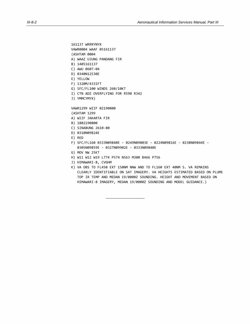
III-8-2 Aeronautical Information Services Manual, Part III
161137 WRRRYNYX
VAWR0004 WAAF 05161137
(ASHTAM 0004
A) WAAZ UJUNG PANDANG FIR
B) 1405161137
C) AWU 0607-04
D) 0340N12530E
E) YELLOW
F) 1320M/4331FT
G) SFC/FL100 WINDS 260/10KT
I) CTN ADZ OVERFLYING FOR R590 R342
J) YMMCYMYX)
VAWR1299 WIIF 02190800
(ASHTAM 1299
A) WIIF JAKARTA FIR
B) 1802190800
C) SINABUNG 2610-80
D) 0310N09824E
E) RED
F) SFC/FL160 0333N09840E – 0249N09803E – 0224N09816E – 0238N09844E –
0305N09859E – 0327N09902E – 0333N09840E
G) MOV NW 25KT
H) W11 W12 W19 L774 P574 N563 M300 B466 P756
J) HIMAWARI-8, CVGHM
K) VA OBS TO FL450 EXT 150NM NNW AND TO FL160 EXT 40NM S. VA REMAINS
CLEARLY IDENTIFIABLE ON SAT IMAGERY. VA HEIGHTS ESTIMATED BASED ON PLUME
TOP IR TEMP AND MEDAN 19/0000Z SOUNDING. HEIGHT AND MOVEMENT BASED ON
HIMAWARI-8 IMAGERY, MEDAN 19/0000Z SOUNDING AND MODEL GUIDANCE.)
___________________
III-9-1
Chapter 9
INSTRUCTIONS FOR THE DISTRIBUTION OF NOTAM MESSAGES
9.1 DISTRIBUTION
Note.— Provisions for the distribution of NOTAM are specified in the PANS-AIM and Annex 15. Additional
guidance is provided below.
To the extent practicable, NOTAM must be distributed via the AFS on the basis of a request. Each NOTAM
must be transmitted as a single telecommunication message.
9.1.1 Priority indicator
The priority normally given to messages sent over the AFS is GG. Under exceptional circumstances and when justified by
a requirement or special handling, a NOTAM may be given the higher DD priority.
9.1.2 Promulgation of transitory information
For information provided by NOTAM, it may be advantageous to exercise selectivity on a time basis to reduce NOTAM
traffic on the AFS and wasted effort in the handling of data that could become redundant in transit. Where the information
may be valid for only a few hours or subject to rapid change, and no other channel can ensure timely distribution,
arrangements should be made for the information to be provided directly to the relevant air traffic services units using,
where practicable, communication channels established for inter-ATS communications.
9.1.3 International distribution
9.1.3.1 Originating States are responsible for selecting the NOTAM to be given international distribution, but due
consideration must be given to any stated operational requirements of other States for both flight planning and pre-flight
information purposes.
9.1.3.2 NOTAM given international distribution must conform to the relevant provisions of the communication
procedures. When a NOTAM is distributed by means other than the AFS, a six-digit date-time group indicating the date
and time of filing the NOTAM and the identification of the originator must be given preceding the text.
9.1.3.3 Internationally distributed NOTAM are exchanged only as per mutual agreement between the international
NOTAM offices concerned, and between the NOTAM offices and multinational NOTAM processing units. ASHTAM or
NOTAM concerning volcanic activity must include in the address list the MWO associated with the origin as listed in Part 2
of the Handbook on the International Airways Volcano Watch (IAVW) — Operational Procedures and Contact List (Doc
9766), all VAACS and the SADIS/ISCS Gateway at EGRRYMYX and at KWBCYMYX.
III-9-2 Aeronautical Information Services Manual, Part III
9.1.4 Measures to reduce use of the AFS
9.1.4.1 In order to avoid excessive traffic on the AFS, NOTAM must be addressed only to NOF and further
distribution within the State made by or through delegation from the NOF concerned. In exceptional cases, the direct
exchange of SNOWTAM between adjacent aerodromes is permitted if it is operationally necessary and direct AFS circuits
are available. The exchanges between NOF should, as far as practicable, be limited to the pre-ascertained
requirements of the receiving States concerned by means of separate series for at least international and domestic flights.
9.1.4.2 The use of automation could improve distribution of NOTAM. With the computer technology now available it
is possible to store all NOTAM information (and all basic information) in a jointly-administered information facility in each
major operating area. This facility could be interrogated for pre-flight information, or route manual or aeronautical charting
purposes, by the State AIS, individual pre-flight information units or operating agencies, and could be programmed to print
up-to-date information on an area, route or terminal basis as required. Each State participating in such a facility would
feed information into the centre as the occasion demanded and distribution to other States would be at the option of the
ultimate recipient. In this way, only information required by the user would be distributed and unnecessary information that
now floods the AFS would cease to burden the AIS and CNS services.
9.1.5 NOTAM from other States
9.1.5.1 NOTAM received from other NOFs should be recorded in a signals log as soon as they are received. This
log should record:
a) State of origin;
b) originator indicator;
c) series and number;
d) time of receipt;
e) time of distribution; and
f) addresses to which redistributed.
9.1.5.2 These entries represent the minimum needed for successful operation and for the investigation of complaints
of late receipt or non-receipt. After NOTAM have been processed, they should be filed. The redistributed copy may be
attached to the original. The filing should be done by State and, where there is a large volume of traffic from any one State,
it may be considered advisable to further subdivide NOTAM by filing them under facilities or subjects within that State.
Where appropriate, NOTAM should also be used to annotate the relevant AIP. This annotation should include the series,
number and date of the NOTAM.
9.1.5.3 The procedure proposed in 9.1.5.1 and 9.1.5.2 is somewhat time-consuming and may only be suitable in a
large organization where extensive screening of incoming NOTAM can be performed before redistribution. For a smaller
unit, the following may be sufficient:
— At the communication station serving the NOF, each incoming message should be time-stamped
immediately upon receipt. After retransmission at the communication station, a copy of the message
should be time-stamped again.
— Each incoming message carrying the word “NOTAM” at the beginning of the text should then be passed
Aeronautical Information Services Manual, Part III III-9-3
on immediately by the teletypewriter operator at the communication station to the NOF,
aerodromes/heliport AIS units, aircraft operators, etc. by teletypewriter using tape relay and without
changing the address section of the NOTAM. Some screening would take place as all NOTAM are
passed on to the NOF. The NOF could delegate the screening responsibilities to the communication
station serving it or to a selected aerodrome or heliport AIS unit. As the message is tape-relayed all the
way from the originating station to the NOF, aerodrome or heliport AIS units, aircraft operators, etc., the
source of errors during transmission is eliminated. At the NOF and at the aerodrome or heliport AIS
units, all messages should be time-stamped upon receipt.
— If a NOTAM number is missing, or if the NOTAM is unreadable or some explanation is required, the
necessary steps must be taken by the NOF to rectify the inconsistency and the result or action should
automatically be transmitted to all concerned. If an AIS unit needs an explanation, the NOF may be able
to answer or may need to ask the originator.
— At the NOF and the aerodrome or heliport AIS units, NOTAM should be filed in simple binders, one for
each originating NOTAM office and the contents divided into suitable sections (consistent with the
division of information included in pre-flight information bulletins). In each binder there should be a
checklist containing only the series and number of each NOTAM and the section in the binder under
which the message is to be found. From that checklist it will be easy to determine if a NOTAM is missing.
On cancellation, the number should be struck out and the NOTAM removed from the binder. Thus, the
checklist will always show only the numbers of valid NOTAM and the binders will contain only valid
NOTAM.
9.2 PREDETERMINED DISTRIBUTION SYSTEM FOR NOTAM
9.2.1 General
Note.— Procedures for the predetermined distribution system for NOTAM are specified in the PANS-AIM,
Appendix 7. Additional guidance is provided below.
9.2.1.1 When it is agreed between AIS that incoming NOTAM (including SNOWTAM and ASHTAM) must be through
the AFS directly to designated addresses predetermined by the receiving State concerned, while concurrently being routed
to its AIS for checking and control purposes, an eight-letter addressee indicator constituted as follows should be used:
First and second letters. The first two letters of the location indicator for the AFS communication centre
associated with the relevant AIS of the receiving State.
Third and fourth letters. The letters “ZZ” indicating a requirement for special distribution.
Fifth letter. The letter “N” for NOTAM, the letter “S” for SNOWTAM and the letter “V” for ASHTAM.
Sixth and seventh letters. Each letter taken from the series A to Z and denoting the national and/or
international distribution list(s) to be used by the receiving AFS centre.
Note.— The fifth, sixth and seventh letters replace the three-letter designator YNY which, in the normal
distribution system, denotes an international NOTAM office.
Eighth letter. The letter “X” to complete the eight-letter addressee indicator.
9.2.1.2 States are to inform the States from which they receive NOTAM of the sixth and seventh letters to be used
III-9-4 Aeronautical Information Services Manual, Part III
under different circumstances to ensure proper routing.
9.2.1.3 The main objective of the system is to expedite the receipt of all NOTAM by eliminating the delay that occurs
when the receiving communication centre routes incoming NOTAM to its AIS for checking and control purposes and then
waits to receive them from the AIS for transmission to other internal addresses.
9.2.2 Checking and control
Whereas the NOF is normally the focal point in a State for the receipt and dispatch of NOTAM, under the predetermined
distribution system it shares the responsibility for checking incoming NOTAM with the aerodrome AIS units to which
NOTAM are destined. Its responsibility here is mainly one of liaison. It does not relieve the ultimate addressee, who is
most affected by any lack of timeliness, accuracy or completeness in the information it contains, from also checking for
obvious errors. The addressee nevertheless has special responsibility under this system to query any errors or omissions
through the receiving NOF.
9.2.3 Selectivity in the distribution of information
The success of the predetermined distribution system presupposes competent selection, by the originating State, to give
NOTAM international distribution and the use of selective distribution lists where practicable to prevent superfluous
distribution of information. The selectivity exercised by an originating State in the distribution process should be related to
the needs of the receiving States. Where NOTAM are issued in more than one series, selectivity is already implicit in the
division into series. Establishing routings at the receiving State will ensure that the aerodrome AIS units receive only the
series they require by rationalizing distribution arrangements within the State and preparing a routing guide for each
communication centre to cover the distribution of incoming NOTAM received under the system.
9.2.4 Rules for AFS addressing
9.2.4.1 Predetermined AFS distribution lists should be available at each multinational automated AIS system
containing the addresses or collective addresses of all States with which it intends to exchange NOTAM. It should also
have the distribution lists of associated States containing the required addresses to which they wish to send NOTAM (i.e.
States not on a pre-determined distribution list).
9.2.4.2 Based on the origination of the NOTAM, derived from the location indicator of the FIR qualifier field in Item
Q) of the arriving NOTAM or identified in the AFS message preamble, the collective addresses required for distribution
are entered (manually or automatically) in the preamble of the AFS message to be issued.
9.2.4.3 In some cases, the following procedures may be applicable:
a) distribution of NOTAM produced by a multi-national automated AIS system:
A multinational automated AIS system should use the distribution list prepared for promulgation of its
own NOTAM. The list should normally contain the addresses (or collective addresses) of:
— the relevant State(s) (NOF) in its area of responsibility;
— the relevant State(s) (NOF) and users in the associated States; and
— other multinational automated AIS systems which will each use their own list of addresses for
further distribution.
Aeronautical Information Services Manual, Part III III-9-5
b) distribution of NOTAM received from other national automated AIS system centres:
The multinational automated AIS system identifies the originator abbreviation in the preamble of the
arriving NOTAM or by the FIR qualifier in Item Q) and selects and applies the relevant distribution list
accordingly. The list should contain the addresses (or collective addresses) of:
— the States (NOF) in its area of responsibility;
— the AIS systems and users in the associated States; and
— other multinational automated AIS system centres with each having its own list of addresses
for further distribution.
___________________

III-10-1
Chapter 10
PRE-FLIGHT INFORMATION SERVICES
10.1 PROVISION OF PRE-FLIGHT INFORMATION SERVICE
10.1.1 General
10.1.1.1 Annex 15 specifies that aeronautical information must be made available for any aerodrome or heliport
normally used for international operations relative to the route stages originating at the aerodrome or heliport. This includes
all aerodromes or heliports designated for regular use by international commercial air transport as listed in the relevant
ICAO regional plans and any aerodromes or heliports serving as alternates to these regular aerodromes or heliports.
10.1.1.2 The following guidance material is intended to assist States in organizing their pre-flight information service.
It should be noted that this service is required by all operators and particularly those who have not made specific
arrangements to obtain such information. The service could also be offered to supplement existing arrangements where
these do not fully meet operator requirements.
10.1.2 User aspects
10.1.2.1 Users expect an efficient service for obtaining all required pre-flight information. From their point of view, the
provision of pre-flight information services should encompass not just aeronautical information, but also meteorological
information and facilitate submission of the flight plan. According to PANS-AIM, automated pre-flight information systems
must be implemented by the AIS to provide access to aeronautical and meteorological information and enable self-briefing,
submission of flight plans and provision of flight information services. Users commonly expect a single point of access for
all required pre-flight information services.
10.1.2.2 A single point of access of an automated system, like a web portal, should be made available for all pre-flight
information such that they can be accessed independent of location and using a portable device, like a laptop, mobile
phone or tablet. This requires States to adopt an integrated approach to gathering all required pre-flight information,
independent of whether they come from a multitude of different sources within a State.
10.1.2.3 Using an automated system for the provision of pre-flight information is important to realize integration and
customization of the information to fit the user’s need. Therefore, the provision of pre-flight information service in a
non-automated environment is only considered in the context of contingency arrangements. These could include
alternative means of access to the individual sources of the information, e.g. direct contact to the AIS briefing office via
telephone or access to the State meteorological authority website for obtaining meteorological information.
10.1.3 Requirements
The provision of pre-flight information services to flight crews should address the following:
a) provide pre-flight information relevant to a flight in the form of a PIB or pre-flight information package;
b) improve the mechanism for compilation and delivery of briefings;
III-10-2 Aeronautical Information Services Manual, Part III
c) reduce the time it takes to generate a briefing;
d) provide easy access to up-to-date information; and
e) provide information independent of time and location of the flight crew.
10.1.4 Roles and responsibilities
The roles and responsibilities for the provision of pre-flight information services are addressed in Part I — Regulatory
Framework for Aeronautical Information Services, 2.3.4.
10.2 INTEGRATED PRE-FLIGHT INFORMATION SERVICE CONCEPT
The integrated pre-flight information service should be provided via an automated pre-flight information service to facilitate
self-briefing by the user. Additional services as defined by the State (e.g. access to additional aeronautical and
meteorological data and products such as the State’s AIP) can be provided if the need exists.
10.2.1 Automated pre-flight information service
10.2.1.1 The automated pre-flight information service supports the concept of self-briefing which refers to the ability
for flight crews to enter their individual input criteria, like departure and destination aerodromes, as well as route information
(including possibly altitude of flight). The system then presents them with the relevant briefing and other elements of the
aeronautical information products according to their input criteria. This type of briefing is location independent and can be
obtained via a single point of access using a variety of different portable devices, e.g. laptop, mobile phone or tablet. Self-
briefing using an automated pre-flight information service provides a convenient and efficient method for flight crews to
obtain the required information.
10.2.1.2 The automated pre-flight information service provided in an integrated manner also includes meteorological
information and flight planning capability, as well as additional information services, as required. The notion of an
integrated automated pre-flight information service is shown in Figure III-10-1.
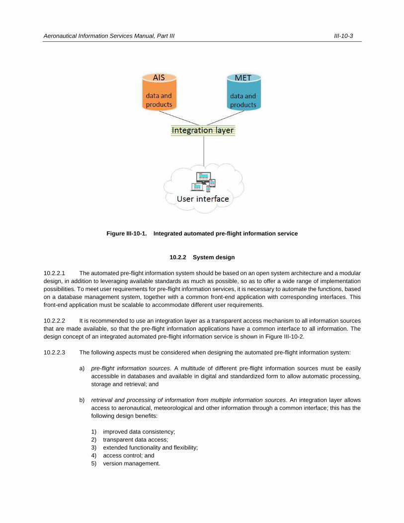
Aeronautical Information Services Manual, Part III III-10-3
Figure III-10-1. Integrated automated pre-flight information service
10.2.2 System design
10.2.2.1 The automated pre-flight information system should be based on an open system architecture and a modular
design, in addition to leveraging available standards as much as possible, so as to offer a wide range of implementation
possibilities. To meet user requirements for pre-flight information services, it is necessary to automate the functions, based
on a database management system, together with a common front-end application with corresponding interfaces. This
front-end application must be scalable to accommodate different user requirements.
10.2.2.2 It is recommended to use an integration layer as a transparent access mechanism to all information sources
that are made available, so that the pre-flight information applications have a common interface to all information. The
design concept of an integrated automated pre-flight information service is shown in Figure III-10-2.
10.2.2.3 The following aspects must be considered when designing the automated pre-flight information system:
a) pre-flight information sources. A multitude of different pre-flight information sources must be easily
accessible in databases and available in digital and standardized form to allow automatic processing,
storage and retrieval; and
b) retrieval and processing of information from multiple information sources. An integration layer allows
access to aeronautical, meteorological and other information through a common interface; this has the
following design benefits:
1) improved data consistency;
2) transparent data access;
3) extended functionality and flexibility;
4) access control; and
5) version management.
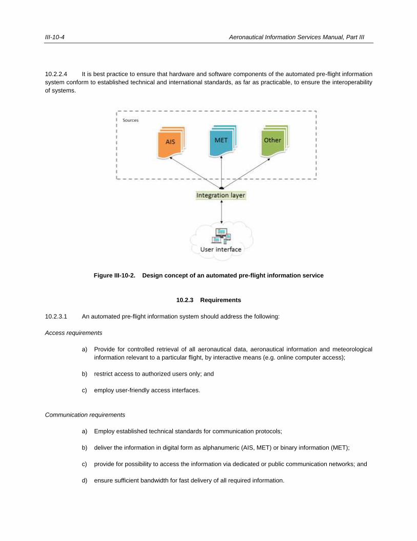
III-10-4 Aeronautical Information Services Manual, Part III
10.2.2.4 It is best practice to ensure that hardware and software components of the automated pre-flight information
system conform to established technical and international standards, as far as practicable, to ensure the interoperability
of systems.
Figure III-10-2. Design concept of an automated pre-flight information service
10.2.3 Requirements
10.2.3.1 An automated pre-flight information system should address the following:
Access requirements
a) Provide for controlled retrieval of all aeronautical data, aeronautical information and meteorological
information relevant to a particular flight, by interactive means (e.g. online computer access);
b) restrict access to authorized users only; and
c) employ user-friendly access interfaces.
Communication requirements
a) Employ established technical standards for communication protocols;
b) deliver the information in digital form as alphanumeric (AIS, MET) or binary information (MET);
c) provide for possibility to access the information via dedicated or public communication networks; and
d) ensure sufficient bandwidth for fast delivery of all required information.
Aeronautical Information Services Manual, Part III III-10-5
Information requirements
a) Information to be made available as printed documentation using standardized sequences of information;
b) presented in alphanumeric or graphical format for on-screen display; and
c) an indication be given to the user whenever an information source is not available, or when up-to-date
information is not available when requested (safety impact).
Data source requirements
a) Pre-flight information should be made available from authoritative data sources (e.g. State designated
data sources); and
b) using a common geographical reference, date and time before being stored in a database since these
are the only common attributes for retrieving the required data.
User support requirements
a) Using user experience best practices and good interface design techniques to assist the user throughout
the process of obtaining all required pre-flight information; and
b) provide dedicated phone support (also serving as a contingency measure).
Safety requirements
a) The user must be made aware whenever any components of the automated pre-flight information
service have failed or are not available; and
b) appropriate arrangements are made concerning contingency, redundancy, and fall-back to cope with
outages of automated pre-flight information system components, including designing operational
procedures.
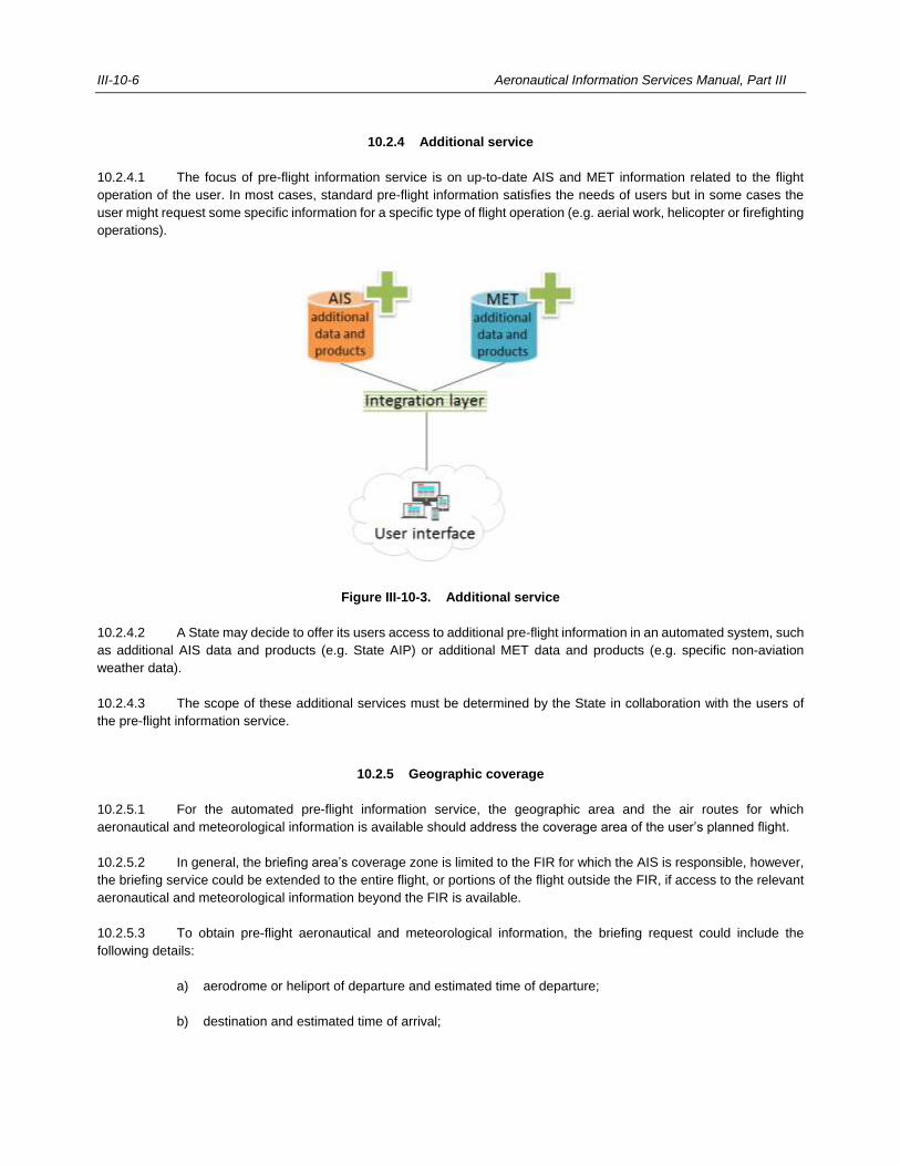
III-10-6 Aeronautical Information Services Manual, Part III
10.2.4 Additional service
10.2.4.1 The focus of pre-flight information service is on up-to-date AIS and MET information related to the flight
operation of the user. In most cases, standard pre-flight information satisfies the needs of users but in some cases the
user might request some specific information for a specific type of flight operation (e.g. aerial work, helicopter or firefighting
operations).
Figure III-10-3. Additional service
10.2.4.2 A State may decide to offer its users access to additional pre-flight information in an automated system, such
as additional AIS data and products (e.g. State AIP) or additional MET data and products (e.g. specific non-aviation
weather data).
10.2.4.3 The scope of these additional services must be determined by the State in collaboration with the users of
the pre-flight information service.
10.2.5 Geographic coverage
10.2.5.1 For the automated pre-flight information service, the geographic area and the air routes for which
aeronautical and meteorological information is available should address the coverage area of the user’s planned flight.
10.2.5.2 In general, the briefing area’s coverage zone is limited to the FIR for which the AIS is responsible, however,
the briefing service could be extended to the entire flight, or portions of the flight outside the FIR, if access to the relevant
aeronautical and meteorological information beyond the FIR is available.
10.2.5.3 To obtain pre-flight aeronautical and meteorological information, the briefing request could include the
following details:
a) aerodrome or heliport of departure and estimated time of departure;
b) destination and estimated time of arrival;
Aeronautical Information Services Manual, Part III III-10-7
c) route to be flown and estimated times of arrival at, and departure from, any intermediate aerodrome(s)
or heliport(s);
d) alternate aerodromes or heliports needed to complete the flight plan;
e) cruising level(s);
f) type of flight, i.e. whether visual or instrument flight rules;
g) type of meteorological information requested, whether flight documentation, briefing or consultation; and
h) time(s) at which briefing, or flight documentation are required.
10.3 PRE-FLIGHT INFORMATION BULLETINS (PIB)
10.3.1 Pre-flight information bulletins
The pre-flight information bulletin is a plain-language presentation of current NOTAM information of operational
significance, prepared prior to flight. The provision of daily bulletins is of primary significance in an automated pre-flight
briefing service. PIBs containing current information on the status of facilities and services should be provided.
10.3.2 Pre-flight information packages
10.3.2.1 The term “pre-flight information package” is used to emphasize the inclusion of AIS and MET information as
well as other information, as required, and distinguishes it from the pre-flight information bulletin.
10.3.2.2 NOTAM are the principal source of aeronautical information, while meteorological information includes
observations, reports, forecasts and warnings.
10.3.2.3 An important difference between AIS and MET messages is that AIS uses one type of message, namely
NOTAM, to express different conditions, while MET uses a number of different types of messages and charts.
Meteorological observations and reports are normally valid for a period of 30 to 60 minutes; the information will then either
be superseded or become obsolete. While forecasts have a defined period of validity and are issued at fixed times, NOTAM
are issued when needed and could have a fixed period of validity or an estimated end time.
10.3.2.4 Different message types do not require different retrieval methods in an integrated, automated pre-flight
information system. However, all messages are geographically coded and hence can be retrieved in relation to, for
example, an aerodrome, heliport, ATS route or area.
10.3.2.5 While NOTAM allow selective retrieval e.g. using the NOTAM selection criteria, meteorological information
is selected by type of messages and location indicators.
10.3.3 Scope of PIB
10.3.3.1 A PIB may simply contain a list of current NOTAM covering selected routes or areas, or, at the discretion of
the State, may be presented in a more elaborate form.
III-10-8 Aeronautical Information Services Manual, Part III
10.3.3.2 PIBs should be prepared for major traffic areas or air routes, the choice of areas or air routes being
dependent upon the needs of the major users and the degree to which it is feasible to provide a specialized service. For
example, a group of air routes extending in the same general direction may be treated collectively. To facilitate use of the
bulletins, the information for each area or air route may be divided into the following two categories and published as
separate bulletins:
a) navigation warnings, i.e. activation of areas over which the flight of aircraft is dangerous or restricted
(termed “NAV WARNINGS” — sample format given in Appendix 9, Figure III-A 9-3); and
b) information other than navigation warnings, i.e. routine serviceability reports, changes in procedures,
etc. (termed “GENERAL” — sample format given in Appendix 9, Figure III-A 9-4).
10.3.4 Navigation warning display
10.3.4.1 In an automated environment, the navigation warning could be in printed form or displayed on a graphical
user interface. A narrow route PIB facilitates the identification of navigation warnings affecting the flight route. In PIB,
navigation warnings are identified by their NOTAM number or AIP supplement.
10.3.4.2 The navigation warnings that appear in the navigation warning PIB may also be plotted on a chart. A 1:1 000
000 scale chart is suitable for this purpose, but the actual scale chosen will depend upon the coverage zone of the PIB.
The PIB coverage zone may be divided into areas (e.g. FIR or States) and each area allocated a letter. This letter should
be allocated to all navigation warnings in that area.
10.3.5 Information selection
10.3.5.1 The automated pre-flight information system should enable flight crews to select information for inclusion in
the bulletin, for example:
a) type of PIB: area, route, narrow route and aerodrome;
b) messages type(s): NOTAM, SNOWTAM, ASHTAM; if the integrated service is available, also include
METAR, TAF, SIGMET, AIRMET, GAMET, upper wind and upper-air temperature forecast, tables or
charts, SIGWX charts, volcanic ash and tropical cyclone advisory, in text or graphical form;
c) message filter: traffic, purpose, scope, lower and upper limits; and
d) flight crew data input e.g. flight details or specific intentions.
10.3.5.2 A system function may enable flexible entry of location indicators using the plain name, or ICAO code,
supported by a search feature.
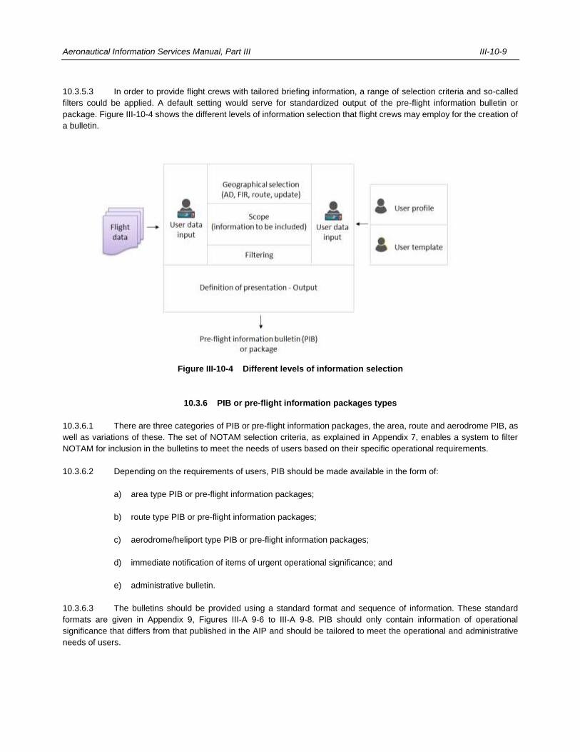
Aeronautical Information Services Manual, Part III III-10-9
10.3.5.3 In order to provide flight crews with tailored briefing information, a range of selection criteria and so-called
filters could be applied. A default setting would serve for standardized output of the pre-flight information bulletin or
package. Figure III-10-4 shows the different levels of information selection that flight crews may employ for the creation of
a bulletin.
Figure III-10-4 Different levels of information selection
10.3.6 PIB or pre-flight information packages types
10.3.6.1 There are three categories of PIB or pre-flight information packages, the area, route and aerodrome PIB, as
well as variations of these. The set of NOTAM selection criteria, as explained in Appendix 7, enables a system to filter
NOTAM for inclusion in the bulletins to meet the needs of users based on their specific operational requirements.
10.3.6.2 Depending on the requirements of users, PIB should be made available in the form of:
a) area type PIB or pre-flight information packages;
b) route type PIB or pre-flight information packages;
c) aerodrome/heliport type PIB or pre-flight information packages;
d) immediate notification of items of urgent operational significance; and
e) administrative bulletin.
10.3.6.3 The bulletins should be provided using a standard format and sequence of information. These standard
formats are given in Appendix 9, Figures III-A 9-6 to III-A 9-8. PIB should only contain information of operational
significance that differs from that published in the AIP and should be tailored to meet the operational and administrative
needs of users.
III-10-10 Aeronautical Information Services Manual, Part III
10.3.7 Area type PIB or pre-flight information packages
10.3.7.1 Area type PIB contain relevant information such as NOTAM and ASHTAM related to one or more FIR(s),
States, or a selected area, whereas an area type pre-flight information package also contains relevant meteorological
information as described in 10.3.2 for the requested area.
10.3.7.2 The following area type PIBs can be made available with an automated system:
a) all PIB information;
b) IFR/VFR PIB information;
c) OPSIG information;
d) IMMEDIATE NOTIFICATION information; and
e) any combination of the above.
10.3.7.3 The selected area can be based on:
a) one FIR or more FIR(s);
b) a group of FIRs or pre-defined (adjustable) areas or a group of States (e.g. Benelux);
c) a given airspace or special areas (TMA, CTR etc.); and
d) a polygon defined by coordinates, or aerodrome location indicator plus radius.
Note.— An area type PIB or pre-flight information package provides at least the following options: area
information only, aerodrome information for the selected area, aerodrome information for the selected aerodrome within
the area.
10.3.8 Route type PIB or pre-flight information packages
10.3.8.1 Route type PIB contain relevant information such as NOTAM, SNOWTAM, and ASHTAM related to a defined
route or flight path, whereas a route type pre-flight information package also contains relevant meteorological information
for the requested area. A route type PIB or pre-flight information package provides information based on a specific route
of flight as contained in the flight plan. It may also be based on a flight path, including departure aerodrome, destination
aerodrome and alternate aerodrome(s), with a defined width along the route. Only information that falls within the route
path is shown.
10.3.8.2 Route type PIB that can be made available with an automated system are the same as listed in 10.3.7.2.
10.3.8.3 The selected area of a route type PIB or pre-flight information package can be based on:
a) one or more aerodromes;
b) one or more FIR(s) covering the planned flight path; or
c) a pre-defined area, or a group of States (e.g. Benelux);
Aeronautical Information Services Manual, Part III III-10-11
Note.— A route type PIB or pre-flight information package provides at least the information for the selected
aerodromes and FIR(s).
10.3.9 Narrow route type PIB or pre-flight information packages
10.3.9.1 Narrow route type PIB contain relevant information such as NOTAM, SNOWTAM, and ASHTAM related to
selected aerodromes, one or more FIR(s), States, or a selected area encompassing the route of flight, whereas a route
type pre-flight information package also contains relevant meteorological information as described in 10.3.2 for the
requested area. Only information that falls within a narrowly defined route path is shown.
10.3.9.2 Narrow route type PIB that can be made available with an automated system are the same as those listed
in 10.3.7.2.
10.3.9.3 The selected area of a narrow route type PIB or pre-flight information package is based on:
a) departure aerodrome, destination aerodrome and alternate aerodrome(s);
b) one or more FIR(s) covering the planned flight path, by
1) manually entering the planned route, or
2) automatically retrieving the planned route from the related flight plan (Item 15);
c) defined radius around aerodromes, and width of corridor based on planned route; and
d) a group of FIRs or pre-defined (adjustable) areas or a group of States (e.g. Benelux);
Note.— A narrow route type PIB or pre-flight information package provides at least information for the
selected aerodromes and FIR(s). Only information that falls within the defined narrow route path and the defined radius
around the aerodromes is shown.
10.3.10 Aerodrome-type PIB or pre-flight information packages
10.3.10.1 An aerodrome type PIB or pre-flight information package contains information related to the selected
aerodromes or heliports, including SNOWTAM.
10.3.10.2 An aerodrome PIB or pre-flight information package provides information based on:
a) single aerodrome;
b) single aerodrome plus surrounding area (selection of aerodrome, plus range). If range is requested,
information irrespective of national boundaries is provided;
c) all aerodromes within a FIR (or other predefined area) or a group of FIRs; or
d) list of specified aerodromes (aerodrome information only).
III-10-12 Aeronautical Information Services Manual, Part III
10.3.11 Immediate automatic notification of items of urgent operational significance
10.3.11.1 Items of urgent operational significance, which are identified by NOTAM with Purpose N, must be brought to
the immediate attention of aircraft operators concerned even after the pre-flight briefing stage.
10.3.11.2 If providing integrated service items of urgent operational significance, then SIGMET, AIRMET and amended
TAF should be brought to the attention of flight crews in accordance with the agreement in place between the
meteorological authority and the appropriate air traffic service authority. Aircraft in flight under ATC control will be notified
immediately (or on request) of any changes of operational significance.
10.3.12 Administrative bulletins
10.3.12.1 The following administrative bulletins must be provided:
a) checklists of all currently valid NOTAM by State/FIR and aerodrome/heliport; and
b) all new NOTAM since a specified date-time group (note that this procedure facilitates briefings).
10.3.12.2 Additional filtering criteria enable more specific retrieval of information, for example:
a) NOTAM number, or range of numbers;
b) all active NOTAM (at time of retrieval, since last retrieval, or within a specified date/time group);
c) all PERM NOTAM;
d) trigger NOTAM (all valid; effective from AIRAC date, or as defined by flight crew);
e) company profile (or as option in flight crew profiles);
f) NOTAM by subject (based on NOTAM Code, or keyword);
g) EST NOTAM;
h) NOTAM processed (since a specified date-time group and by whom);
i) history, i.e. system history of changes, retrieved bulletins/ID or pre-flight information packages; and
j) administrator functions.
10.3.13 PIB format
10.3.13.1 The bulletin output must have the following characteristics:
a) NOTAM text in significations and uniform abbreviated phraseology assigned to the NOTAM Code
complemented by ICAO abbreviations, indicators, identifiers, designators, call signs, frequencies,
figures and plain language; and
b) NOTAM number to the right of text.
Aeronautical Information Services Manual, Part III III-10-13
10.3.13.2 Bulletins must be prepared in the following sequence:
a) a heading (identity of origination, area covered and for whom prepared);
b) aerodrome and heliport information;
c) flow control information, if available;
d) en-route information; and
e) navigation warnings.
10.3.13.3 Examples of a PIB standard format and sequence of information are given in Appendix 9, Figures III-A 9-4
to III-A 9-6. PIBs contain only information of operational significance which differs from information published in the AIP.
Integrated service example of pre-flight information packages standard format and sequence of information is given in
Appendix 9, Figure III-A 9-7. Administrative bulletins are foreseen mainly for NOTAM offices and other specialized
personnel who are familiar with NOTAM procedures and NOTAM format.
10.3.13.4 The following main sections and sequence in the PIB or pre-flight information package are included:
a) PIB or pre-flight information package header, including:
1) identity of origination;
2) area covered;
3) for whom it is prepared;
4) date and time for pre-flight information query;
5) PIB or pre-flight information packages validity time;
6) type of PIB or pre-flight information packages and content (e.g. requested aerodromes);
7) selection criteria and filters applied as well as any other information regarding the documents
content;
8) special symbols used, if applicable; and
9) the chosen time window clearly indicated as document validity, for example FROM 10 MAR 2020
1155 TO 12 MAR 2020 0600;
b) aerodrome and heliport section:
1) departure aerodrome;
2) destination aerodrome; and
3) alternate aerodrome(s);
c) en-route (FIR) section;
1) FIR of departure aerodrome;
2) FIR(s) in sequence of the flight; and
3) FIR of destination aerodrome;
d) navigation warnings;
e) flow information, if integrated service is provided; and
f) additional information such as:
III-10-14 Aeronautical Information Services Manual, Part III
1) charts; and
2) graphical information.
10.3.13.5 In addition to the default settings, more sorting options could be offered for all bulletin types; for example,
sorting according to the effective date, NOTAM Codes by subject groups, by flight route, etc.
10.3.13.6 Regarding the sorting of MET information, the latest information should be listed first:
a) aerodrome and heliport section:
1) METAR/SPECI; and
2) TAF/amended TAF;
b) en-route (FIR) section;
1) SIGMET;
2) AIRMET;
3) GAMET;
4) volcanic ash and tropical cyclone advisory information, text; and
5) upper wind and upper-air temperature forecast, tables;
c) additional information:
1) upper wind and upper-air temperature forecast charts;
2) SIGWX charts (high/medium/low level);
3) volcanic ash and tropical cyclone advisory information, graphical; and
4) space weather phenomena, when available.
10.3.13.7 Regarding the sorting of NOTAM, the latest NOTAM should be listed first. The same NOTAM text appears
only once (no duplicates over different FIRs). In further FIRs, only a reference to the NOTAM number is provided, if relevant:
a) aerodrome and heliport section:
1) SNOWTAM; and
2) NOTAM;
b) en-route (FIR) section;
1) NOTAM, to be differentiated between scope E and AE and W navigation warnings; and
2) ASHTAM.
10.3.13.8 In the general format, applicable to PIB and pre-flight information package, all items are presented in a self-
explanatory manner:
a) all alphanumerical meteorological messages are presented with the identification of message type
included in the format;
b) NOTAM text in significations and uniform abbreviated phraseology assigned to the NOTAM Code
complemented by ICAO abbreviations, indicators, identifiers, designators, call signs, frequencies,
figures and plain language;
Aeronautical Information Services Manual, Part III III-10-15
c) the Q-line, which serves for filtering, is omitted since it is not intended for flight crews;
d) item A), which is already present in the header, and/or item E);
e) identification of NOTAM items A) to E), including brackets are omitted;
f) insertion of NOTAM number to the right of the text;
g) indication in printed PIB the number of pages in the form of “page of pages” e.g. 01/15;
h) indication of “no data available” in the PIB for a requested aerodrome or FIR, if no NOTAM is valid and
in pre-flight documentation, if no SIGMET or AIRMET is valid;
i) indication of the end of the bulletin;
j) encoding date-times generally, e.g. 08 AUG 2020 0630 UTC; and
k) translation of location indicators into plain language, whenever possible.
10.3.14 Filtering: querying and retrieval of PIB or pre-flight information packages
10.3.14.1 Filtering is the selection of criteria for the creation of the PIB and pre-flight information package, apart from
the selection based on the type of PIB or pre-flight information package. The following filters may be applied to reduce
output:
a) validity period;
b) vertical criteria (applicable to scope E and W);
c) geographical criteria, for example:
1) Relevant aerodromes and FIRs; and
2) Flight route for narrow route PIB definition;
d) NOTAM qualifiers, for example:
1) NOTAM Code for inclusion or exclusion;
2) Traffic;
3) Purpose; and
4) Scope;
e) if integrated services are available, different type of meteorological information, for example:
1) METAR/SPECI for all or selected aerodromes in an area;
2) TAF for all or selected aerodromes in an area;
3) SIGMET/AIRMET;
4) SIGWX chart, different area;
5) GAMET or graphical low level forecast;
6) special air reports;
7) volcanic ash and tropical cyclone advisories; and
8) forecast of upper wind and upper-air temperature.
10.3.14.2 Definition of validity period of the PIB or pre-flight information package is important for tailored output, as
shown by the following examples of different time windows:
III-10-16 Aeronautical Information Services Manual, Part III
a) current date and time: valid information for overview or general planning to be used by, for example,
airport authorities, other NOTAM originators, flight dispatch, station manager, business aviation, or for
long term planning;
b) flight plan based (e.g. from estimated off-block time (EOBT) to estimated time of arrival (ETA) plus
4 hours): valid information usually contained in a route or narrow route PIB; or
c) any other time periods specified by the user (e.g. from current date-time to a given number of hours
thereafter): valid information for conducting a flight, specific overview used by flight crew, flight dispatch,
station managers, or for short term planning, etc.
10.3.14.3 NOTAM qualifiers and NOTAM Code act as filters to tailor PIB. The following are examples of selective
retrieval of NOTAM:
a) Traffic:
1) IFR – include all NOTAM with traffic I and IV;
2) VFR – include all NOTAM with traffic V and IV;
3) combination IFR/VFR – include all NOTAM with traffic I, V and IV; and
4) mixed flight rules: only NOTAM with the flight rules corresponding to the respective portion of flight
are included;
b) Purpose:
1) N - NOTAM for the immediate attention of flight crew;
2) B - NOTAM of operational significance selected for bulletin entry;
3) O – NOTAM concerning flight operations; and
4) M - NOTAM about miscellaneous information, which is not subject for a standard briefing but made
available on request;
c) Scope:
1) aerodrome – include all NOTAM with scope A, AE and AW, default for an aerodrome PIB;
2) en-route – include all NOTAM with scope E and AE; and
3) navigation warnings – include all NOTAM with scope W and AW.
d) lower/upper limit, e.g. vertical criteria (flight levels) tailor the PIB content to correspond to applicable
altitudes or flight levels (system selection by lower and upper limits in NOTAM qualifiers); and
e) NOTAM Code, e.g. option to exclude trigger NOTAM (system selection by condition “TT”), or exclude
obstacles (system selection by subjects “OB” and “OL”).
10.3.15 Provision of PIB and pre-flight information packages
10.3.15.1 PIB or pre-flight information packages may be provided to the flight crew, including scheduled delivery for
large scale users, in some of following ways:
a) for display on a graphical user interface of the pre-flight information system;
b) for display on a graphical user interface using a different application;
c) for display on electronic flight bag;
Aeronautical Information Services Manual, Part III III-10-17
d) for printing, including on a remote printer;
e) sent to a fax; or
f) sent as an e-mail.
10.3.15.2 Using the graphical user interface provides the flight crew with the functionality to:
a) perform searches;
b) request sorting of messages;
c) view original messages by selecting hyperlinks;
d) refine queries;
e) modify and store settings in the flight crew profile;
f) obtain an updated briefing;
g) obtain a history of interactions; and
h) edit the briefing online and transfer to other media.
___________________

III-11-1
Chapter 11
POST-FLIGHT INFORMATION SERVICES
11.1 PURPOSE OF POST-FLIGHT INFORMATION
11.1.1 The purpose of post-flight information is to ensure that inadequacies of facilities essential to the safety of
flight operations, and the presence of wildlife on or around the airport constituting a potential hazard to aircraft operations,
observed by flight crews during the flight, are reported without delay to the authority responsible for those facilities. Annex
6, Part I, Chapter 4, 4.1.2 and Part III, Section II, Chapter 2, 2.1.2 holds the flight crew responsible for reporting any
inadequacy.
11.1.2 Annex 15, 5.6 requires States to ensure that arrangements are made for aerodromes or heliports to receive
this information and to make it available to the AIS “for distribution as the circumstances necessitate”. This is the basis on
which the collection and distribution of post-flight information should be administered and should influence the formulation
of a format for the collection of such information.
11.2 COLLECTION OF POST-FLIGHT INFORMATION
11.2.1 In most cases, the inadequacy of a facility or the presence of a wildlife hazard is reported by a flight crew on
the appropriate ATS frequency. This information must be passed on to the responsible authority and to the AIS for required
action.
11.2.2 After landing, a flight crew may wish to submit in writing any observations or an initial report to the aerodrome
operator. A specimen post-flight report form is given in Appendix 9, Figure III-A 9-9. A space could also be provided on
the PIB to facilitate the reporting of such information at the aerodrome or heliport of destination.
11.2.3 Copies of the post-flight report form could also be made available in the airline operators’ offices at the
aerodrome or heliport or on a dedicated website to facilitate filing of post-flight reports by flight crews. The report must
subsequently be made available to the AIS without delay.
11.2.4 Additionally, wildlife strikes involving aircraft may need to be reported to the State’s authority for air transport
safety investigations.
___________________

III-A1-1
Appendix 1
EXPLANATORY NOTES ON THE SPECIMEN AIP 1. The Specimen AIP in Appendix 2 has been prepared in conformity with Annex 15 and PANS-AIM. It is divided into three parts:
Part 1 — General (GEN), contains information of an administrative and explanatory nature which is not of such significance that NOTAM need be issued;
Part 2 — En-route (ENR), contains information concerning airspace and its use; and Part 3 — Aerodromes (AD), contains information concerning aerodromes/heliports and their use.
2. The Specimen AIP, together with the explanations of each element provided in this appendix, is designed to cover problems associated with the selection of information to be contained in the AIP, the manner of presentation and the use of correct terminology and is directed towards uniformity in publication of the information. It is impossible to cover all contingencies in the Specimen AIP, particularly when the character of aviation administrations varies widely from State to State. 3. The numbered items listed in the explanatory notes are those found in Appendix 2 of PANS-AIM. When these items are listed in headings, either in subsections or in tables, a short description of the title may be used. In the following explanatory notes, only those items which have an explanation are listed. 4. Charts or diagrams designed to supplement or to take the place of tabular material are provided to a limited extent. Charts should be used, however, wherever they would contribute to a simple presentation of the required information (see Annex 15, Chapter 5, 5.2.5.1 and PANS-AIM Chapter 5, 5.2.1.2.7). 5. A “Remarks” column has been included in most tabular forms. Unless otherwise indicated, the purpose of this column is the inclusion of information additional to or exceptional to that shown in other columns of the form. Where the application of the information in the remarks column is not obvious, a symbol should be used to identify the relevant item.
III-A1-2 Aeronautical Information Services Manual, Part III
PART 1 — GENERAL (GEN)
Reference to Specimen AIP
Explanatory note
GEN 0.1 Preface
Brief description of the Aeronautical Information Publication (AIP), including: 1) Name of the publishing authority An indication of the authority responsible for publishing the AIP. 2) Applicable ICAO documents A list of ICAO documents relevant to the publication of the AIP and a
reference to the location in the AIP where differences, if any, are listed.
3) Publication media (i.e. printed, online or other electronic media) 4) The AIP structure and established regular amendment interval A description of the structure of the AIP, including a brief listing of the
content of its major components. In addition, a statement should be made regarding the established regular amendment interval.
5) Copyright policy A description of the State’s national copyright policy in relation to AIS
publications. 6) The service to contact in case of detected AIP errors or omissions An indication of the name and address of the service/office to be
contacted when errors and/or omissions are found in the content of the AIP and for general correspondence concerning AIS.
GEN 0.2 Record of AIP Amendments
A record of AIP Amendments and AIRAC AIP Amendments (which are amendments published in accordance with the AIRAC system). There should be two separate tables, each containing four columns, showing: 1) AIP Amendment number, which consists of the consecutive serial
number. 2) Publication date. 3) Date inserted, which contains the date inserted in the AIP (for the regular
AIP Amendments) or the effective date (for the AIRAC AIP Amendments).
4) The initials of the officer who inserted the amendment in the AIP (hard
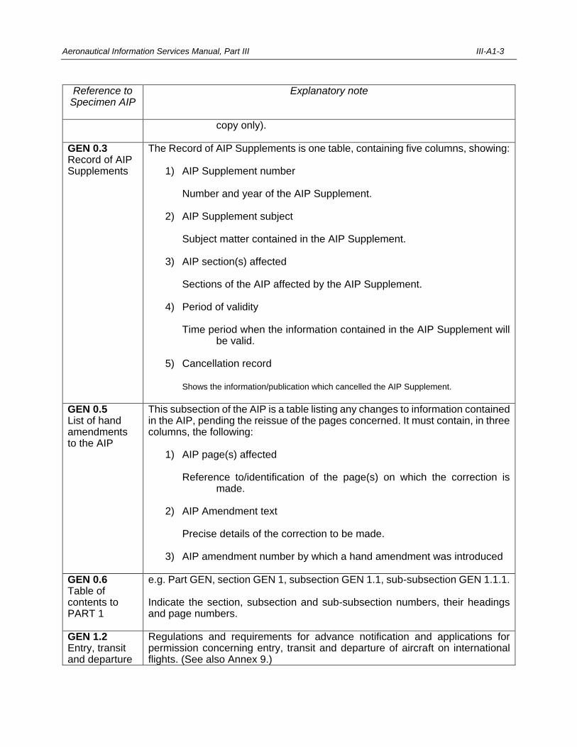
Aeronautical Information Services Manual, Part III III-A1-3
Reference to Specimen AIP
Explanatory note
copy only).
GEN 0.3 Record of AIP Supplements
The Record of AIP Supplements is one table, containing five columns, showing: 1) AIP Supplement number Number and year of the AIP Supplement. 2) AIP Supplement subject Subject matter contained in the AIP Supplement. 3) AIP section(s) affected Sections of the AIP affected by the AIP Supplement. 4) Period of validity Time period when the information contained in the AIP Supplement will
be valid. 5) Cancellation record Shows the information/publication which cancelled the AIP Supplement.
GEN 0.5 List of hand amendments to the AIP
This subsection of the AIP is a table listing any changes to information contained in the AIP, pending the reissue of the pages concerned. It must contain, in three columns, the following: 1) AIP page(s) affected Reference to/identification of the page(s) on which the correction is
made. 2) AIP Amendment text Precise details of the correction to be made. 3) AIP amendment number by which a hand amendment was introduced
GEN 0.6 Table of contents to PART 1
e.g. Part GEN, section GEN 1, subsection GEN 1.1, sub-subsection GEN 1.1.1. Indicate the section, subsection and sub-subsection numbers, their headings and page numbers.
GEN 1.2 Entry, transit and departure
Regulations and requirements for advance notification and applications for permission concerning entry, transit and departure of aircraft on international flights. (See also Annex 9.)
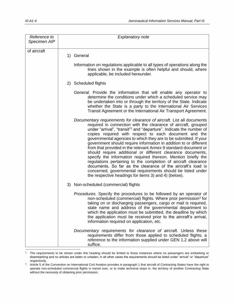
III-A1-4 Aeronautical Information Services Manual, Part III
Reference to Specimen AIP
Explanatory note
of aircraft 1) General Information on regulations applicable to all types of operations along the
lines shown in the example is often helpful and should, where applicable, be included hereunder.
2) Scheduled flights General. Provide the information that will enable any operator to
determine the conditions under which a scheduled service may be undertaken into or through the territory of the State. Indicate whether the State is a party to the International Air Services Transit Agreement or the International Air Transport Agreement.
Documentary requirements for clearance of aircraft. List all documents
required in connection with the clearance of aircraft, grouped under “arrival”, “transit”2 and “departure”. Indicate the number of copies required with respect to each document and the governmental agencies to which they are to be submitted. If your government should require information in addition to or different from that provided in the relevant Annex 9 standard document or should require additional or different clearance documents, specify the information required thereon. Mention briefly the regulations pertaining to the completion of aircraft clearance documents. So far as the clearance of the aircraft’s load is concerned, governmental requirements should be listed under the respective headings for items 3) and 4) (below).
3) Non-scheduled (commercial) flights Procedures. Specify the procedures to be followed by an operator of
non-scheduled (commercial) flights. Where prior permission3 for taking on or discharging passengers, cargo or mail is required, state name and address of the governmental department to which the application must be submitted, the deadline by which the application must be received prior to the aircraft’s arrival, information required on application, etc.
Documentary requirements for clearance of aircraft. Unless these
requirements differ from those applied to scheduled flights, a reference to the information supplied under GEN 1.2 above will suffice.
2. The requirements to be shown under this heading should be limited to those instances where no passengers are embarking or
disembarking and no articles are laden or unladen; in all other cases the requirements should be listed under “arrival” or “departure”
respectively. 3. Article 5 of the Convention on International Civil Aviation provides in paragraph 1 that aircraft of Contracting States have the right to
operate non-scheduled commercial flights in transit over, or to make technical stops in, the territory of another Contracting State
without the necessity of obtaining prior permission.
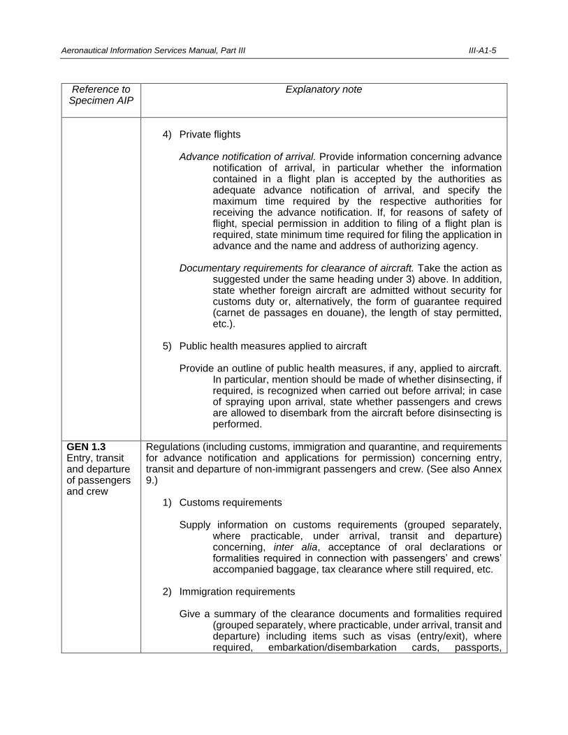
Aeronautical Information Services Manual, Part III III-A1-5
Reference to Specimen AIP
Explanatory note
4) Private flights Advance notification of arrival. Provide information concerning advance
notification of arrival, in particular whether the information contained in a flight plan is accepted by the authorities as adequate advance notification of arrival, and specify the maximum time required by the respective authorities for receiving the advance notification. If, for reasons of safety of flight, special permission in addition to filing of a flight plan is required, state minimum time required for filing the application in advance and the name and address of authorizing agency.
Documentary requirements for clearance of aircraft. Take the action as
suggested under the same heading under 3) above. In addition, state whether foreign aircraft are admitted without security for customs duty or, alternatively, the form of guarantee required (carnet de passages en douane), the length of stay permitted, etc.).
5) Public health measures applied to aircraft Provide an outline of public health measures, if any, applied to aircraft.
In particular, mention should be made of whether disinsecting, if required, is recognized when carried out before arrival; in case of spraying upon arrival, state whether passengers and crews are allowed to disembark from the aircraft before disinsecting is performed.
GEN 1.3 Entry, transit and departure of passengers and crew
Regulations (including customs, immigration and quarantine, and requirements for advance notification and applications for permission) concerning entry, transit and departure of non-immigrant passengers and crew. (See also Annex 9.) 1) Customs requirements Supply information on customs requirements (grouped separately,
where practicable, under arrival, transit and departure) concerning, inter alia, acceptance of oral declarations or formalities required in connection with passengers’ and crews’ accompanied baggage, tax clearance where still required, etc.
2) Immigration requirements Give a summary of the clearance documents and formalities required
(grouped separately, where practicable, under arrival, transit and departure) including items such as visas (entry/exit), where required, embarkation/disembarkation cards, passports,
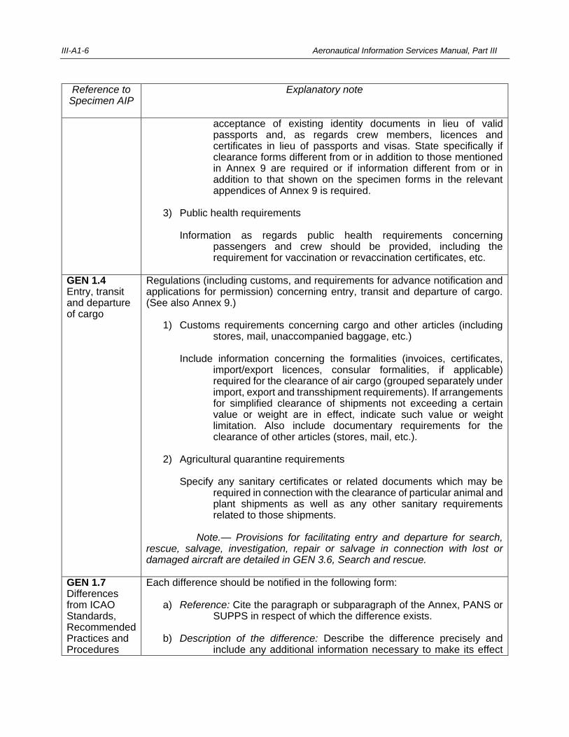
III-A1-6 Aeronautical Information Services Manual, Part III
Reference to Specimen AIP
Explanatory note
acceptance of existing identity documents in lieu of valid passports and, as regards crew members, licences and certificates in lieu of passports and visas. State specifically if clearance forms different from or in addition to those mentioned in Annex 9 are required or if information different from or in addition to that shown on the specimen forms in the relevant appendices of Annex 9 is required.
3) Public health requirements Information as regards public health requirements concerning
passengers and crew should be provided, including the requirement for vaccination or revaccination certificates, etc.
GEN 1.4 Entry, transit and departure of cargo
Regulations (including customs, and requirements for advance notification and applications for permission) concerning entry, transit and departure of cargo. (See also Annex 9.) 1) Customs requirements concerning cargo and other articles (including
stores, mail, unaccompanied baggage, etc.) Include information concerning the formalities (invoices, certificates,
import/export licences, consular formalities, if applicable) required for the clearance of air cargo (grouped separately under import, export and transshipment requirements). If arrangements for simplified clearance of shipments not exceeding a certain value or weight are in effect, indicate such value or weight limitation. Also include documentary requirements for the clearance of other articles (stores, mail, etc.).
2) Agricultural quarantine requirements Specify any sanitary certificates or related documents which may be
required in connection with the clearance of particular animal and plant shipments as well as any other sanitary requirements related to those shipments.
Note.— Provisions for facilitating entry and departure for search,
rescue, salvage, investigation, repair or salvage in connection with lost or damaged aircraft are detailed in GEN 3.6, Search and rescue.
GEN 1.7 Differences from ICAO Standards, Recommended Practices and Procedures
Each difference should be notified in the following form: a) Reference: Cite the paragraph or subparagraph of the Annex, PANS or
SUPPS in respect of which the difference exists. b) Description of the difference: Describe the difference precisely and
include any additional information necessary to make its effect
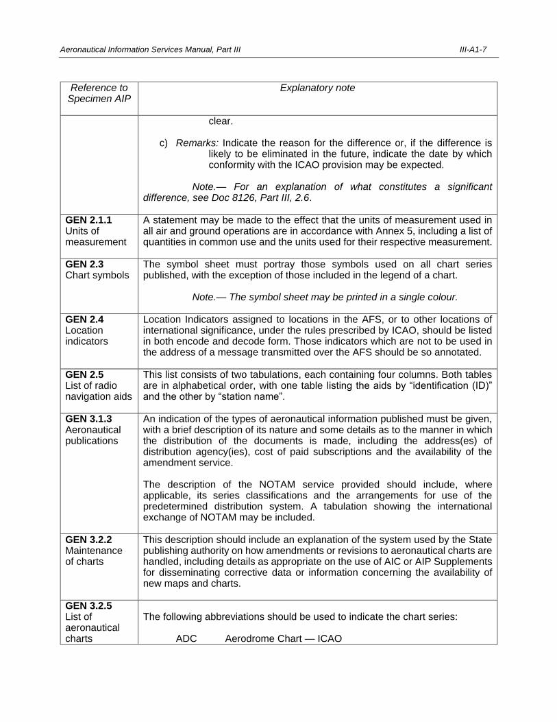
Aeronautical Information Services Manual, Part III III-A1-7
Reference to Specimen AIP
Explanatory note
clear. c) Remarks: Indicate the reason for the difference or, if the difference is
likely to be eliminated in the future, indicate the date by which conformity with the ICAO provision may be expected.
Note.— For an explanation of what constitutes a significant
difference, see Doc 8126, Part III, 2.6.
GEN 2.1.1 Units of measurement
A statement may be made to the effect that the units of measurement used in all air and ground operations are in accordance with Annex 5, including a list of quantities in common use and the units used for their respective measurement.
GEN 2.3 Chart symbols
The symbol sheet must portray those symbols used on all chart series published, with the exception of those included in the legend of a chart.
Note.— The symbol sheet may be printed in a single colour.
GEN 2.4 Location indicators
Location Indicators assigned to locations in the AFS, or to other locations of international significance, under the rules prescribed by ICAO, should be listed in both encode and decode form. Those indicators which are not to be used in the address of a message transmitted over the AFS should be so annotated.
GEN 2.5 List of radio navigation aids
This list consists of two tabulations, each containing four columns. Both tables are in alphabetical order, with one table listing the aids by “identification (ID)” and the other by “station name”.
GEN 3.1.3 Aeronautical publications
An indication of the types of aeronautical information published must be given, with a brief description of its nature and some details as to the manner in which the distribution of the documents is made, including the address(es) of distribution agency(ies), cost of paid subscriptions and the availability of the amendment service. The description of the NOTAM service provided should include, where applicable, its series classifications and the arrangements for use of the predetermined distribution system. A tabulation showing the international exchange of NOTAM may be included.
GEN 3.2.2 Maintenance of charts
This description should include an explanation of the system used by the State publishing authority on how amendments or revisions to aeronautical charts are handled, including details as appropriate on the use of AIC or AIP Supplements for disseminating corrective data or information concerning the availability of new maps and charts.
GEN 3.2.5 List of aeronautical charts
The following abbreviations should be used to indicate the chart series: ADC Aerodrome Chart — ICAO
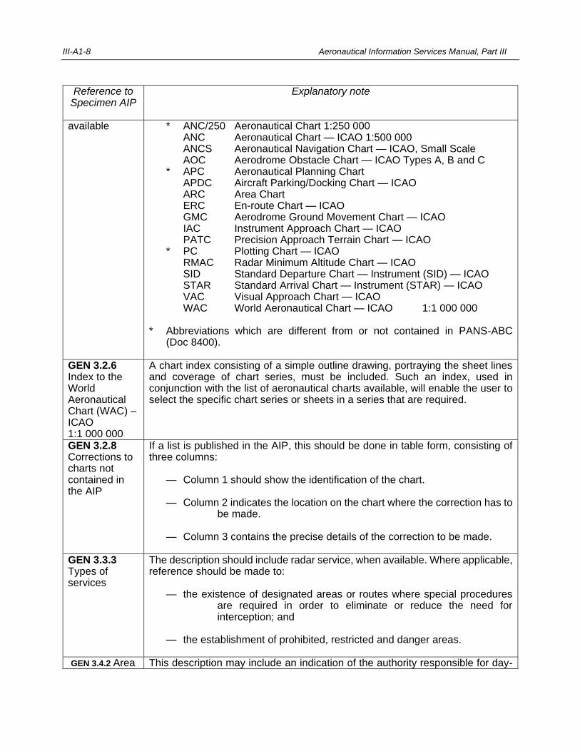
III-A1-8 Aeronautical Information Services Manual, Part III
Reference to Specimen AIP
Explanatory note
available * ANC/250 Aeronautical Chart 1:250 000 ANC Aeronautical Chart — ICAO 1:500 000 ANCS Aeronautical Navigation Chart — ICAO, Small Scale AOC Aerodrome Obstacle Chart — ICAO Types A, B and C * APC Aeronautical Planning Chart APDC Aircraft Parking/Docking Chart — ICAO ARC Area Chart ERC En-route Chart — ICAO GMC Aerodrome Ground Movement Chart — ICAO IAC Instrument Approach Chart — ICAO PATC Precision Approach Terrain Chart — ICAO * PC Plotting Chart — ICAO RMAC Radar Minimum Altitude Chart — ICAO SID Standard Departure Chart — Instrument (SID) — ICAO STAR Standard Arrival Chart — Instrument (STAR) — ICAO VAC Visual Approach Chart — ICAO WAC World Aeronautical Chart — ICAO 1:1 000 000 * Abbreviations which are different from or not contained in PANS-ABC
(Doc 8400).
GEN 3.2.6 Index to the World Aeronautical Chart (WAC) – ICAO 1:1 000 000
A chart index consisting of a simple outline drawing, portraying the sheet lines and coverage of chart series, must be included. Such an index, used in conjunction with the list of aeronautical charts available, will enable the user to select the specific chart series or sheets in a series that are required.
GEN 3.2.8 Corrections to charts not contained in the AIP
If a list is published in the AIP, this should be done in table form, consisting of three columns: — Column 1 should show the identification of the chart. — Column 2 indicates the location on the chart where the correction has to
be made. — Column 3 contains the precise details of the correction to be made.
GEN 3.3.3 Types of services
The description should include radar service, when available. Where applicable, reference should be made to: — the existence of designated areas or routes where special procedures
are required in order to eliminate or reduce the need for interception; and
— the establishment of prohibited, restricted and danger areas.
GEN 3.4.2 Area This description may include an indication of the authority responsible for day-
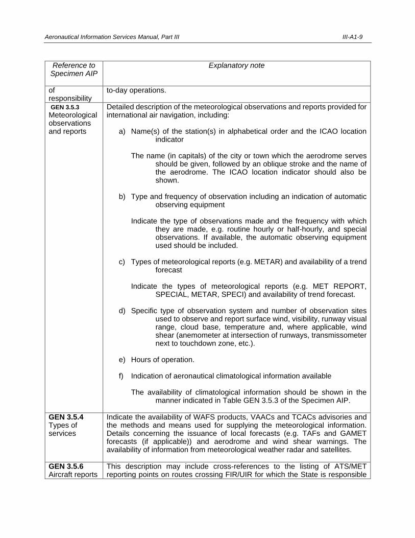
Aeronautical Information Services Manual, Part III III-A1-9
Reference to Specimen AIP
Explanatory note
of responsibility
to-day operations.
GEN 3.5.3
Meteorological observations and reports
Detailed description of the meteorological observations and reports provided for international air navigation, including: a) Name(s) of the station(s) in alphabetical order and the ICAO location
indicator The name (in capitals) of the city or town which the aerodrome serves
should be given, followed by an oblique stroke and the name of the aerodrome. The ICAO location indicator should also be shown.
b) Type and frequency of observation including an indication of automatic
observing equipment Indicate the type of observations made and the frequency with which
they are made, e.g. routine hourly or half-hourly, and special observations. If available, the automatic observing equipment used should be included.
c) Types of meteorological reports (e.g. METAR) and availability of a trend
forecast Indicate the types of meteorological reports (e.g. MET REPORT,
SPECIAL, METAR, SPECI) and availability of trend forecast. d) Specific type of observation system and number of observation sites
used to observe and report surface wind, visibility, runway visual range, cloud base, temperature and, where applicable, wind shear (anemometer at intersection of runways, transmissometer next to touchdown zone, etc.).
e) Hours of operation. f) Indication of aeronautical climatological information available The availability of climatological information should be shown in the
manner indicated in Table GEN 3.5.3 of the Specimen AIP.
GEN 3.5.4 Types of services
Indicate the availability of WAFS products, VAACs and TCACs advisories and the methods and means used for supplying the meteorological information. Details concerning the issuance of local forecasts (e.g. TAFs and GAMET forecasts (if applicable)) and aerodrome and wind shear warnings. The availability of information from meteorological weather radar and satellites.
GEN 3.5.6 Aircraft reports
This description may include cross-references to the listing of ATS/MET reporting points on routes crossing FIR/UIR for which the State is responsible
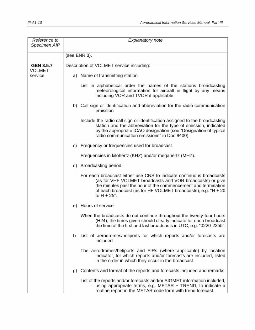
III-A1-10 Aeronautical Information Services Manual, Part III
Reference to Specimen AIP
Explanatory note
(see ENR 3).
GEN 3.5.7 VOLMET service
Description of VOLMET service including: a) Name of transmitting station List in alphabetical order the names of the stations broadcasting
meteorological information for aircraft in flight by any means including VOR and TVOR if applicable.
b) Call sign or identification and abbreviation for the radio communication
emission Include the radio call sign or identification assigned to the broadcasting
station and the abbreviation for the type of emission, indicated by the appropriate ICAO designation (see “Designation of typical radio communication emissions” in Doc 8400).
c) Frequency or frequencies used for broadcast Frequencies in kilohertz (KHZ) and/or megahertz (MHZ). d) Broadcasting period For each broadcast either use CNS to indicate continuous broadcasts
(as for VHF VOLMET broadcasts and VOR broadcasts) or give the minutes past the hour of the commencement and termination of each broadcast (as for HF VOLMET broadcasts), e.g. “H + 20 to H + 25”.
e) Hours of service When the broadcasts do not continue throughout the twenty-four hours
(H24), the times given should clearly indicate for each broadcast the time of the first and last broadcasts in UTC, e.g. “0220-2255”.
f) List of aerodromes/heliports for which reports and/or forecasts are
included The aerodromes/heliports and FIRs (where applicable) by location
indicator, for which reports and/or forecasts are included, listed in the order in which they occur in the broadcast.
g) Contents and format of the reports and forecasts included and remarks List of the reports and/or forecasts and/or SIGMET information included,
using appropriate terms, e.g. METAR + TREND, to indicate a routine report in the METAR code form with trend forecast.
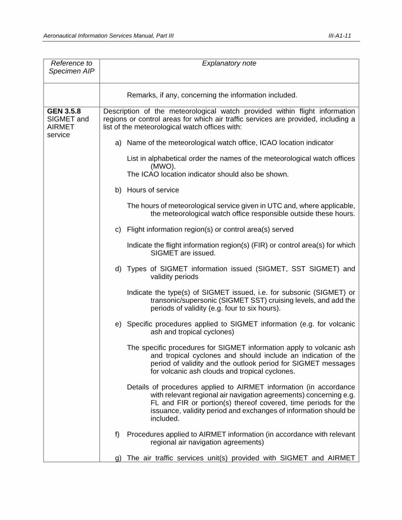
Aeronautical Information Services Manual, Part III III-A1-11
Reference to Specimen AIP
Explanatory note
Remarks, if any, concerning the information included.
GEN 3.5.8 SIGMET and AIRMET service
Description of the meteorological watch provided within flight information regions or control areas for which air traffic services are provided, including a list of the meteorological watch offices with: a) Name of the meteorological watch office, ICAO location indicator List in alphabetical order the names of the meteorological watch offices
(MWO). The ICAO location indicator should also be shown. b) Hours of service The hours of meteorological service given in UTC and, where applicable,
the meteorological watch office responsible outside these hours. c) Flight information region(s) or control area(s) served Indicate the flight information region(s) (FIR) or control area(s) for which
SIGMET are issued. d) Types of SIGMET information issued (SIGMET, SST SIGMET) and
validity periods Indicate the type(s) of SIGMET issued, i.e. for subsonic (SIGMET) or
transonic/supersonic (SIGMET SST) cruising levels, and add the periods of validity (e.g. four to six hours).
e) Specific procedures applied to SIGMET information (e.g. for volcanic
ash and tropical cyclones) The specific procedures for SIGMET information apply to volcanic ash
and tropical cyclones and should include an indication of the period of validity and the outlook period for SIGMET messages for volcanic ash clouds and tropical cyclones.
Details of procedures applied to AIRMET information (in accordance
with relevant regional air navigation agreements) concerning e.g. FL and FIR or portion(s) thereof covered, time periods for the issuance, validity period and exchanges of information should be included.
f) Procedures applied to AIRMET information (in accordance with relevant
regional air navigation agreements) g) The air traffic services unit(s) provided with SIGMET and AIRMET
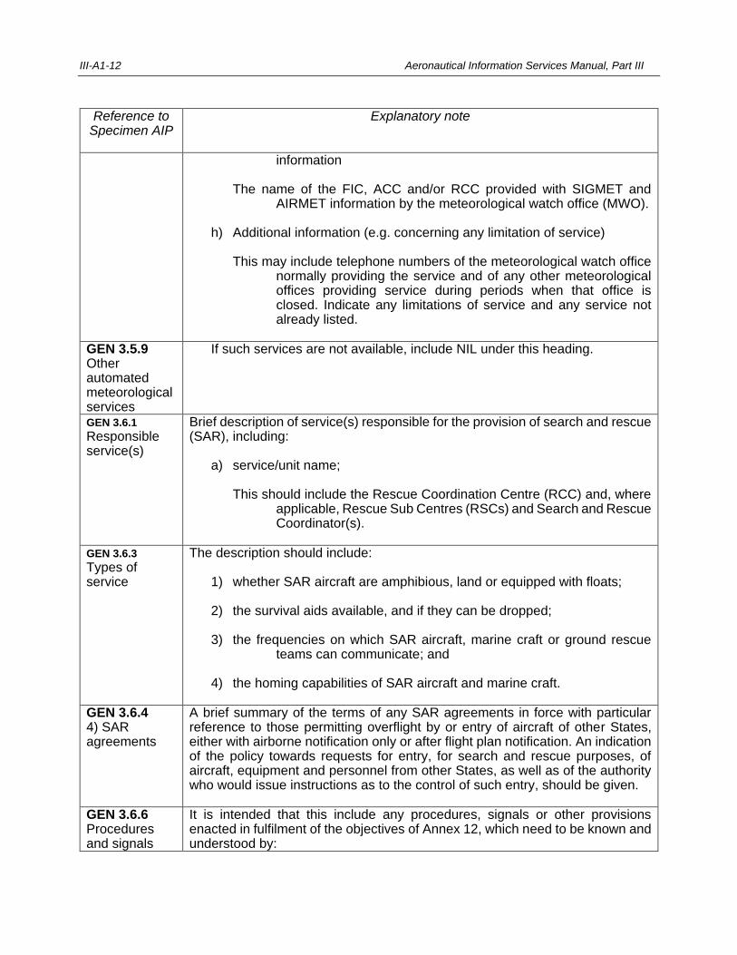
III-A1-12 Aeronautical Information Services Manual, Part III
Reference to Specimen AIP
Explanatory note
information The name of the FIC, ACC and/or RCC provided with SIGMET and
AIRMET information by the meteorological watch office (MWO). h) Additional information (e.g. concerning any limitation of service) This may include telephone numbers of the meteorological watch office
normally providing the service and of any other meteorological offices providing service during periods when that office is closed. Indicate any limitations of service and any service not already listed.
GEN 3.5.9 Other automated meteorological services
If such services are not available, include NIL under this heading.
GEN 3.6.1 Responsible service(s)
Brief description of service(s) responsible for the provision of search and rescue (SAR), including: a) service/unit name; This should include the Rescue Coordination Centre (RCC) and, where
applicable, Rescue Sub Centres (RSCs) and Search and Rescue Coordinator(s).
GEN 3.6.3 Types of service
The description should include: 1) whether SAR aircraft are amphibious, land or equipped with floats; 2) the survival aids available, and if they can be dropped; 3) the frequencies on which SAR aircraft, marine craft or ground rescue
teams can communicate; and 4) the homing capabilities of SAR aircraft and marine craft.
GEN 3.6.4 4) SAR agreements
A brief summary of the terms of any SAR agreements in force with particular reference to those permitting overflight by or entry of aircraft of other States, either with airborne notification only or after flight plan notification. An indication of the policy towards requests for entry, for search and rescue purposes, of aircraft, equipment and personnel from other States, as well as of the authority who would issue instructions as to the control of such entry, should be given.
GEN 3.6.6 Procedures and signals
It is intended that this include any procedures, signals or other provisions enacted in fulfilment of the objectives of Annex 12, which need to be known and understood by:
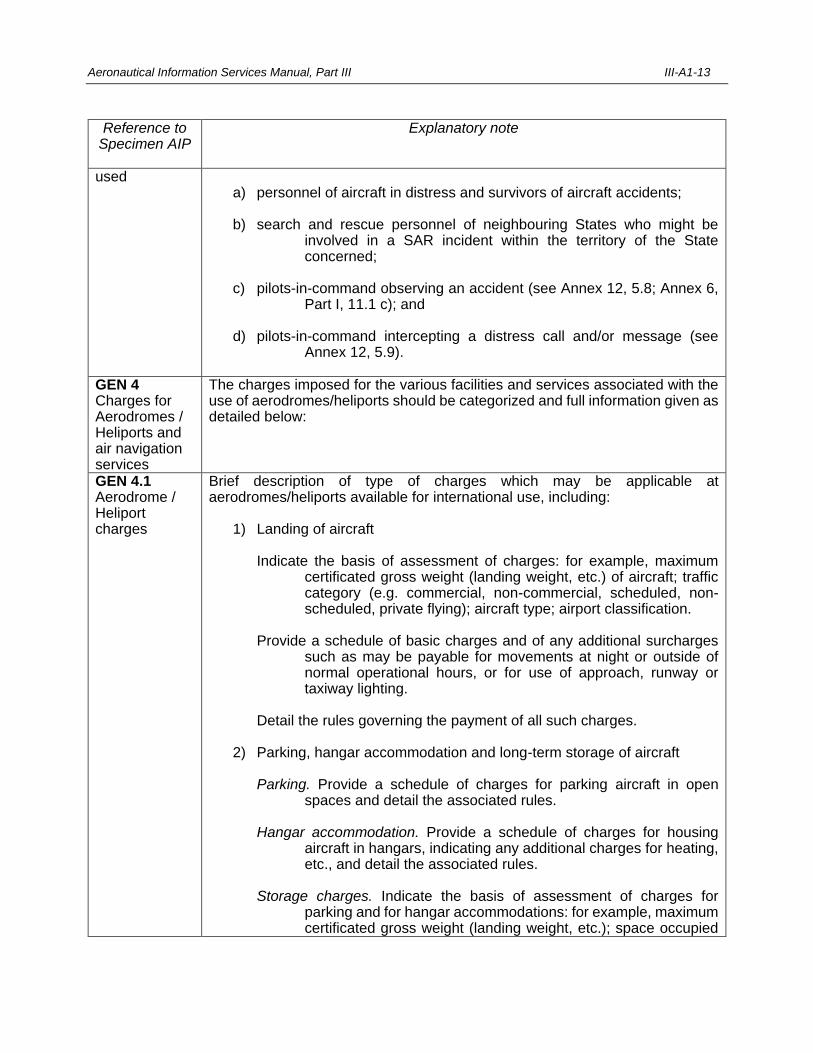
Aeronautical Information Services Manual, Part III III-A1-13
Reference to Specimen AIP
Explanatory note
used a) personnel of aircraft in distress and survivors of aircraft accidents; b) search and rescue personnel of neighbouring States who might be
involved in a SAR incident within the territory of the State concerned;
c) pilots-in-command observing an accident (see Annex 12, 5.8; Annex 6,
Part I, 11.1 c); and d) pilots-in-command intercepting a distress call and/or message (see
Annex 12, 5.9).
GEN 4 Charges for Aerodromes / Heliports and air navigation services
The charges imposed for the various facilities and services associated with the use of aerodromes/heliports should be categorized and full information given as detailed below:
GEN 4.1 Aerodrome / Heliport charges
Brief description of type of charges which may be applicable at aerodromes/heliports available for international use, including: 1) Landing of aircraft Indicate the basis of assessment of charges: for example, maximum
certificated gross weight (landing weight, etc.) of aircraft; traffic category (e.g. commercial, non-commercial, scheduled, non-scheduled, private flying); aircraft type; airport classification.
Provide a schedule of basic charges and of any additional surcharges
such as may be payable for movements at night or outside of normal operational hours, or for use of approach, runway or taxiway lighting.
Detail the rules governing the payment of all such charges. 2) Parking, hangar accommodation and long-term storage of aircraft Parking. Provide a schedule of charges for parking aircraft in open
spaces and detail the associated rules. Hangar accommodation. Provide a schedule of charges for housing
aircraft in hangars, indicating any additional charges for heating, etc., and detail the associated rules.
Storage charges. Indicate the basis of assessment of charges for
parking and for hangar accommodations: for example, maximum certificated gross weight (landing weight, etc.); space occupied
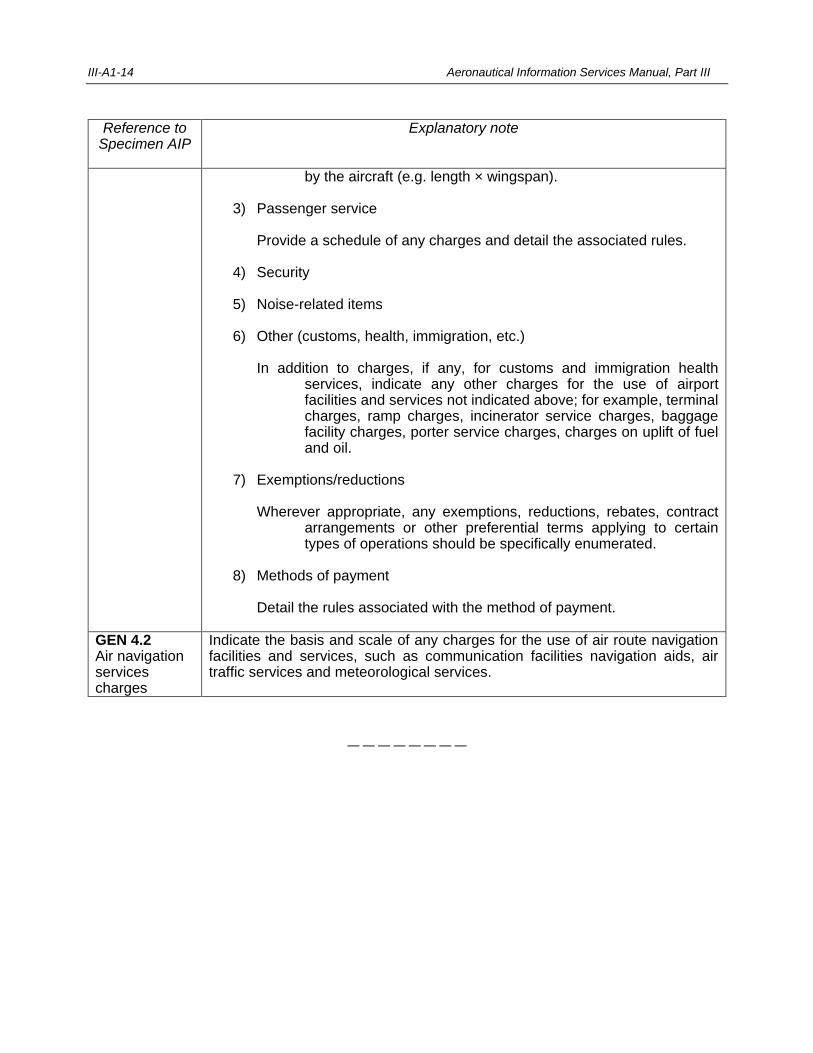
III-A1-14 Aeronautical Information Services Manual, Part III
Reference to Specimen AIP
Explanatory note
by the aircraft (e.g. length × wingspan). 3) Passenger service Provide a schedule of any charges and detail the associated rules. 4) Security 5) Noise-related items 6) Other (customs, health, immigration, etc.) In addition to charges, if any, for customs and immigration health
services, indicate any other charges for the use of airport facilities and services not indicated above; for example, terminal charges, ramp charges, incinerator service charges, baggage facility charges, porter service charges, charges on uplift of fuel and oil.
7) Exemptions/reductions Wherever appropriate, any exemptions, reductions, rebates, contract
arrangements or other preferential terms applying to certain types of operations should be specifically enumerated.
8) Methods of payment Detail the rules associated with the method of payment.
GEN 4.2 Air navigation services charges
Indicate the basis and scale of any charges for the use of air route navigation facilities and services, such as communication facilities navigation aids, air traffic services and meteorological services.
— — — — — — — —

III-A2-1
Appendix 2
AERONAUTICAL INFORMATION PUBLICATION
AIP
AERONAUTICAL INFORMATION PUBLICATION
____________________________________
(Name of State)
____________ EDITION
CONSULT NOTAM FOR LATEST INFORMATION
AERONAUTICAL INFORMATION SERVICE
DEPARTMENT OF CIVIL AVIATION
AIP
AERONAUTICAL INFORMATION PUBLICATION
____________________________________
(Name of State)
PART 1
GENERAL (GEN)
VOLUME NR (If more than one volume)
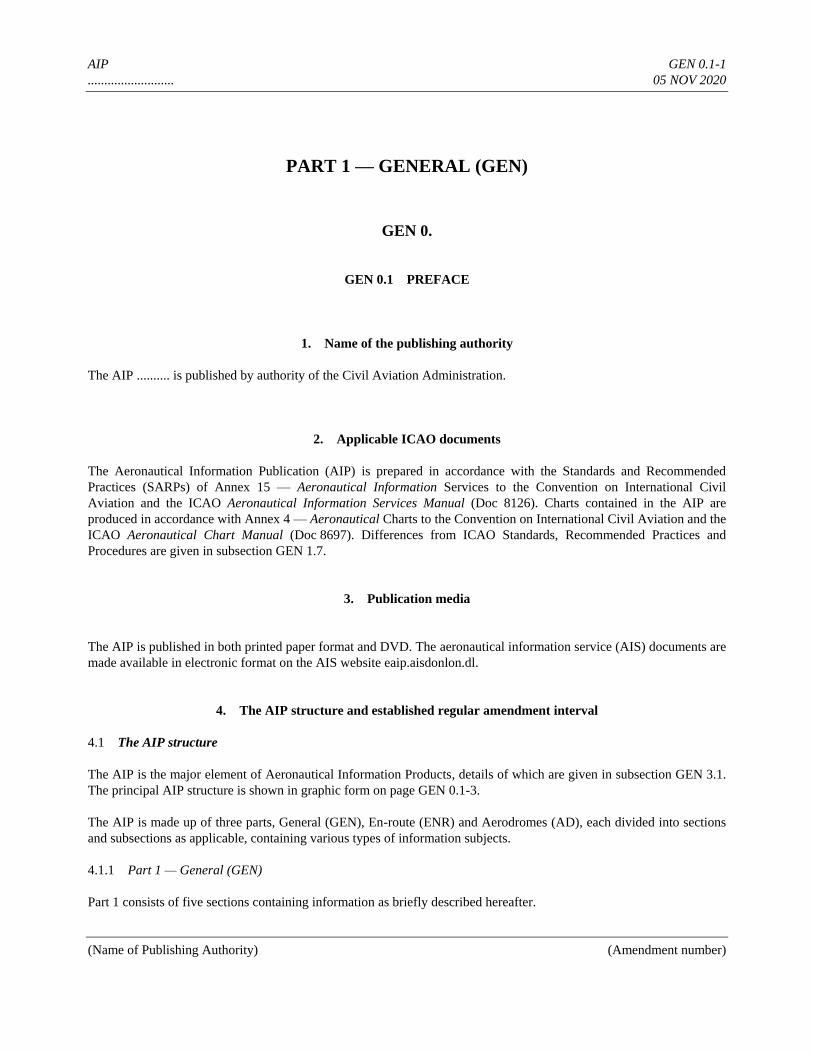
AIP GEN 0.1-1
.......................... 05 NOV 2020
(Name of Publishing Authority) (Amendment number)
PART 1 — GENERAL (GEN)
GEN 0.
GEN 0.1 PREFACE
1. Name of the publishing authority
The AIP .......... is published by authority of the Civil Aviation Administration.
2. Applicable ICAO documents
The Aeronautical Information Publication (AIP) is prepared in accordance with the Standards and Recommended
Practices (SARPs) of Annex 15 — Aeronautical Information Services to the Convention on International Civil
Aviation and the ICAO Aeronautical Information Services Manual (Doc 8126). Charts contained in the AIP are
produced in accordance with Annex 4 — Aeronautical Charts to the Convention on International Civil Aviation and the
ICAO Aeronautical Chart Manual (Doc 8697). Differences from ICAO Standards, Recommended Practices and
Procedures are given in subsection GEN 1.7.
3. Publication media
The AIP is published in both printed paper format and DVD. The aeronautical information service (AIS) documents are
made available in electronic format on the AIS website eaip.aisdonlon.dl.
4. The AIP structure and established regular amendment interval
4.1 The AIP structure
The AIP is the major element of Aeronautical Information Products, details of which are given in subsection GEN 3.1.
The principal AIP structure is shown in graphic form on page GEN 0.1-3.
The AIP is made up of three parts, General (GEN), En-route (ENR) and Aerodromes (AD), each divided into sections
and subsections as applicable, containing various types of information subjects.
4.1.1 Part 1 — General (GEN)
Part 1 consists of five sections containing information as briefly described hereafter.
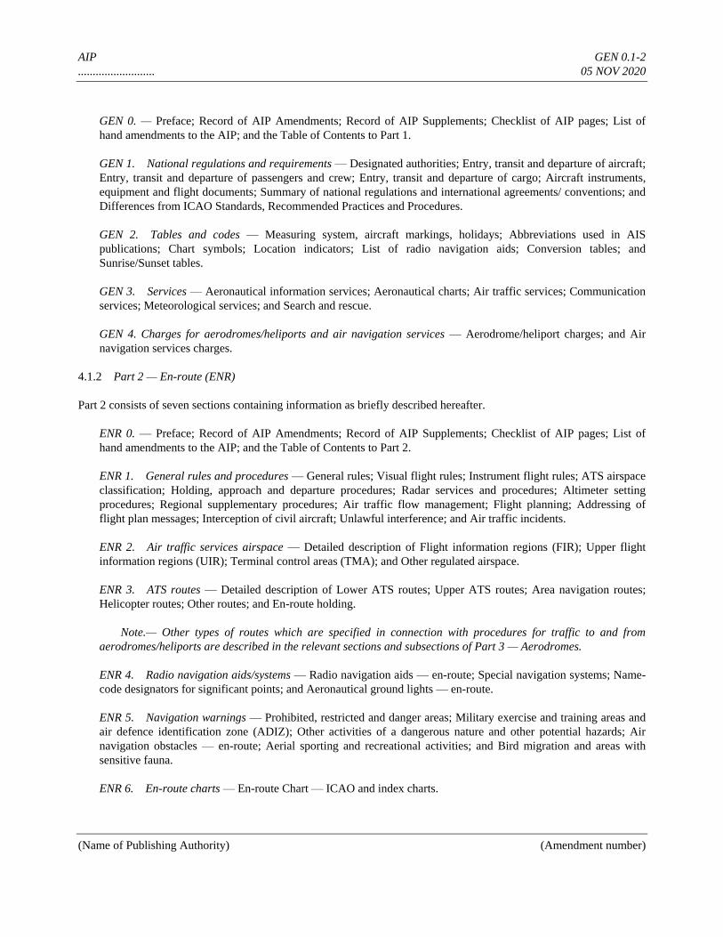
AIP GEN 0.1-2
.......................... 05 NOV 2020
(Name of Publishing Authority) (Amendment number)
GEN 0. — Preface; Record of AIP Amendments; Record of AIP Supplements; Checklist of AIP pages; List of
hand amendments to the AIP; and the Table of Contents to Part 1.
GEN 1. National regulations and requirements — Designated authorities; Entry, transit and departure of aircraft;
Entry, transit and departure of passengers and crew; Entry, transit and departure of cargo; Aircraft instruments,
equipment and flight documents; Summary of national regulations and international agreements/ conventions; and
Differences from ICAO Standards, Recommended Practices and Procedures.
GEN 2. Tables and codes — Measuring system, aircraft markings, holidays; Abbreviations used in AIS
publications; Chart symbols; Location indicators; List of radio navigation aids; Conversion tables; and
Sunrise/Sunset tables.
GEN 3. Services — Aeronautical information services; Aeronautical charts; Air traffic services; Communication
services; Meteorological services; and Search and rescue.
GEN 4. Charges for aerodromes/heliports and air navigation services — Aerodrome/heliport charges; and Air
navigation services charges.
4.1.2 Part 2 — En-route (ENR)
Part 2 consists of seven sections containing information as briefly described hereafter.
ENR 0. — Preface; Record of AIP Amendments; Record of AIP Supplements; Checklist of AIP pages; List of
hand amendments to the AIP; and the Table of Contents to Part 2.
ENR 1. General rules and procedures — General rules; Visual flight rules; Instrument flight rules; ATS airspace
classification; Holding, approach and departure procedures; Radar services and procedures; Altimeter setting
procedures; Regional supplementary procedures; Air traffic flow management; Flight planning; Addressing of
flight plan messages; Interception of civil aircraft; Unlawful interference; and Air traffic incidents.
ENR 2. Air traffic services airspace — Detailed description of Flight information regions (FIR); Upper flight
information regions (UIR); Terminal control areas (TMA); and Other regulated airspace.
ENR 3. ATS routes — Detailed description of Lower ATS routes; Upper ATS routes; Area navigation routes;
Helicopter routes; Other routes; and En-route holding.
Note.— Other types of routes which are specified in connection with procedures for traffic to and from
aerodromes/heliports are described in the relevant sections and subsections of Part 3 — Aerodromes.
ENR 4. Radio navigation aids/systems — Radio navigation aids — en-route; Special navigation systems; Name-
code designators for significant points; and Aeronautical ground lights — en-route.
ENR 5. Navigation warnings — Prohibited, restricted and danger areas; Military exercise and training areas and
air defence identification zone (ADIZ); Other activities of a dangerous nature and other potential hazards; Air
navigation obstacles — en-route; Aerial sporting and recreational activities; and Bird migration and areas with
sensitive fauna.
ENR 6. En-route charts — En-route Chart — ICAO and index charts.
AIP GEN 0.1-3
.......................... 05 NOV 2020
(Name of Publishing Authority) (Amendment number)
4.1.3 Part 3 — Aerodromes (AD)
Part 3 consists of four sections containing information as briefly described hereafter.
AD 0. — Preface; Record of AIP Amendments; Record of AIP Supplements; Checklist of AIP pages; List of hand
amendments to the AIP; and the Table of Contents to Part 3.
AD 1. Aerodromes/Heliports — Introduction — Aerodrome/heliport availability; Rescue and fire fighting
services and Snow plan; Index to aerodromes and heliports; and Grouping of aerodromes/heliports.
AD 2. Aerodromes — Detailed information about aerodromes, including helicopter landing areas, if located at
the aerodromes, listed under 24 subsections.
AD 3. Heliports — Detailed information about heliports (not located at aerodromes), listed under 23 subsections.
4.2 Regular amendment interval
Regular amendments to the AIP will be issued once every three months. The publication dates will be on the first day
of February, May, August and November of each year.
5. Copyright policy
This document is the copyright of Donlon Aviation Authority.
All rights reserved. No part of this publication may be reproduced, stored in a retrieval system, or transmitted, in any
form or by any means, electronic, mechanical, photocopying, recording, or otherwise, without the prior written
permission of the copyright owner.
6. Service to contact in case of detected AIP errors or omissions
In the compilation of the AIP, care has been taken to ensure that the information contained therein is accurate and
complete. Any errors and omissions which may nevertheless be detected, as well as any correspondence concerning the
Integrated Aeronautical Information Package, should be referred to:
Aeronautical Information Service
P.O. Box 744
1050 State Street
Donlon
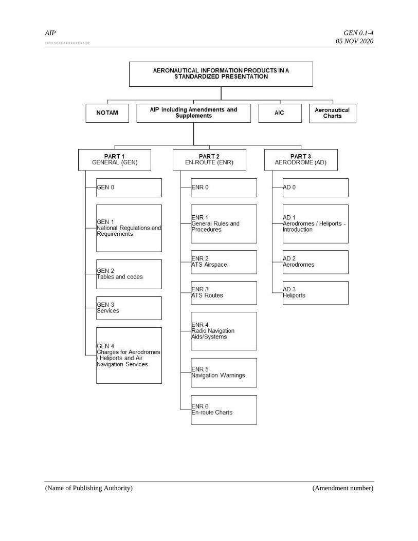
AIP GEN 0.1-4
.......................... 05 NOV 2020
(Name of Publishing Authority) (Amendment number)
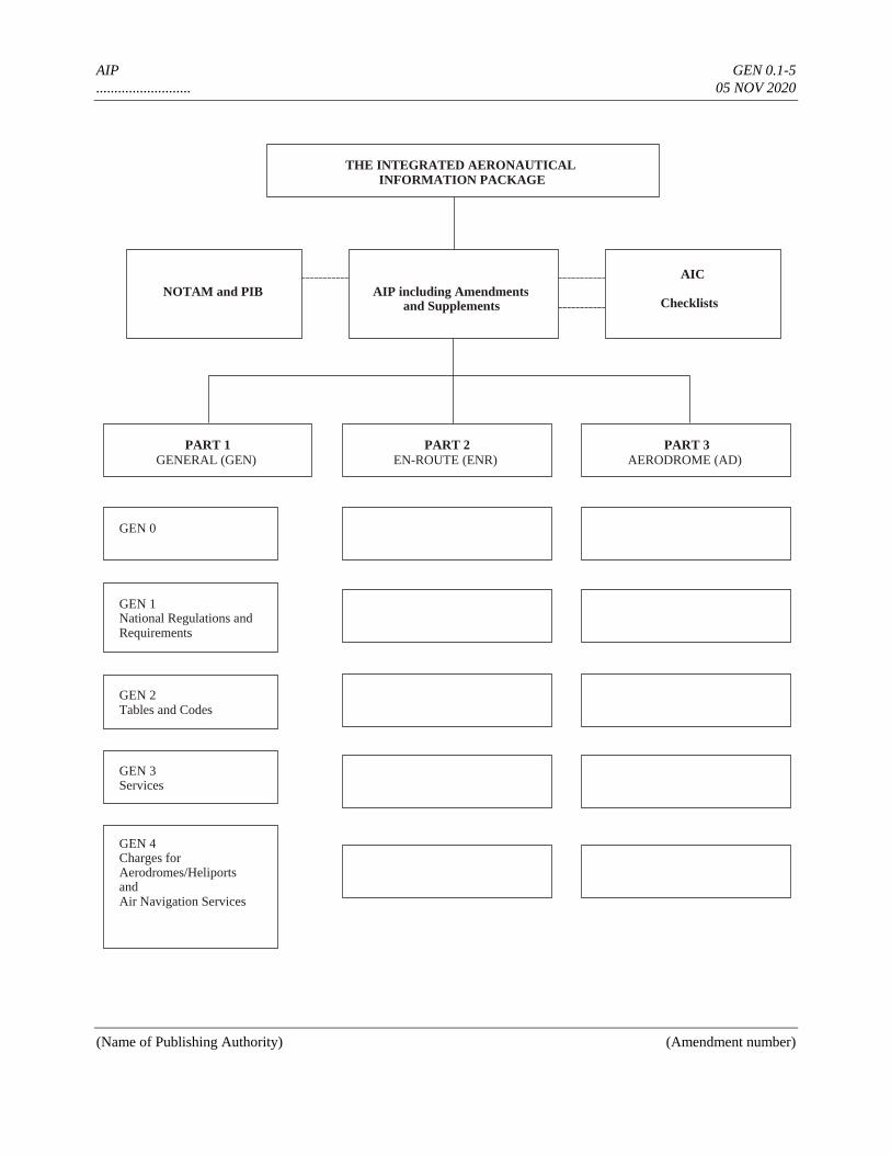
AIP GEN 0.1-5
.......................... 05 NOV 2020
(Name of Publishing Authority) (Amendment number)
THE INTEGRATED AERONAUTICAL
INFORMATION PACKAGE
AIP including Amendments and Supplements
AIC
Checklists NOTAM and PIB
PART 1 GENERAL (GEN)
GEN 0
GEN 1 National Regulations and Requirements
GEN 2 Tables and Codes
GEN 3 Services
GEN 4 Charges for Aerodromes/Heliports and Air Navigation Services
PART 2 EN-ROUTE (ENR)
PART 3 AERODROME (AD)
AIP GEN 0.2-1
.......................... 05 NOV 2020
(Name of Publishing Authority) (Amendment number)
GEN 0.2 RECORD OF AIP AMENDMENTS
AIP AMENDMENT AIRAC AIP AMENDMENT
NR/Year
Publication
date
Date
inserted
Inserted
by NR/Year
Publication
date
Effective
date
Inserted
by
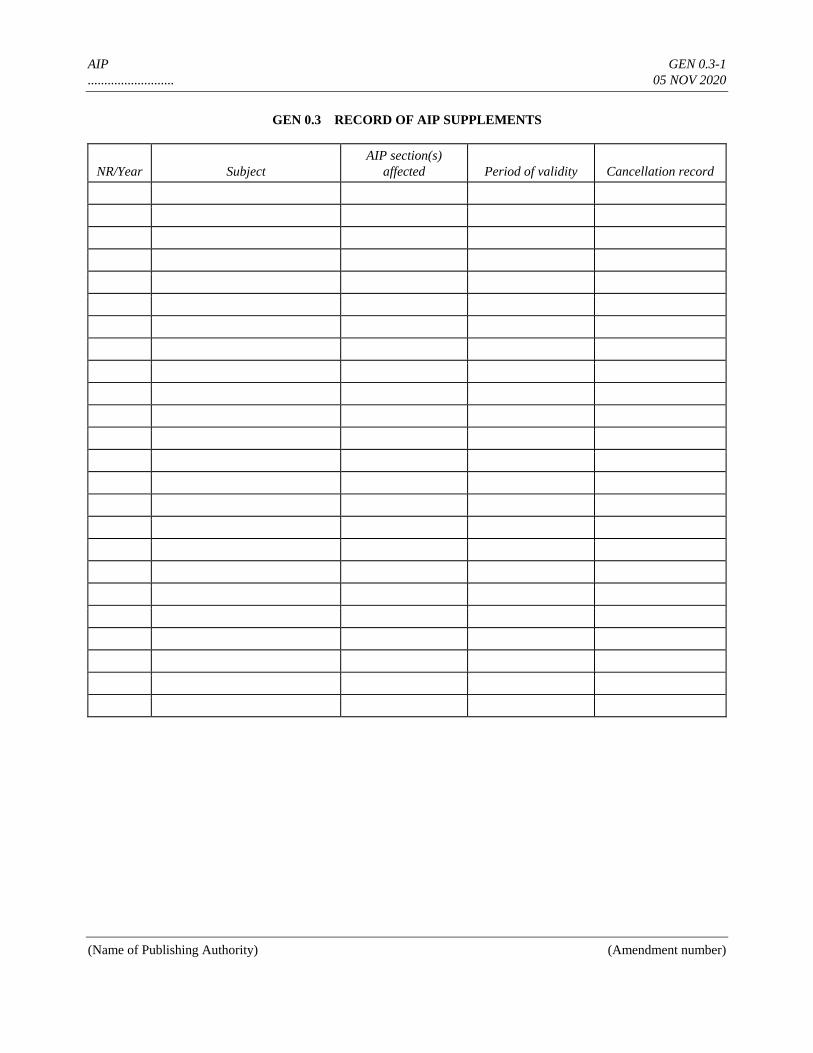
AIP GEN 0.3-1
.......................... 05 NOV 2020
(Name of Publishing Authority) (Amendment number)
GEN 0.3 RECORD OF AIP SUPPLEMENTS
NR/Year Subject
AIP section(s)
affected Period of validity Cancellation record
AIP GEN 0.4-1
.......................... 05 NOV 2020
(Name of Publishing Authority) (Amendment number)
GEN 0.4 CHECKLIST OF AIP PAGES
Page Date Page Date Page Date
PART 1 — GENERAL (GEN)
GEN 0
0.1-1 05 NOV 2020
0.1-2 05 NOV 2020
0.1-3 05 NOV 2020
0.2-1 05 NOV 2020
0.3-1 05 NOV 2020
0.4-1 05 NOV 2020
0.4-2 05 NOV 2020
0.5-1 05 NOV 2020
0.6-1 05 NOV 2020
0.6-2 05 NOV 2020
0.6-3 05 NOV 2020
GEN 1
1.1-1 05 NOV 2020
1.2-1 05 NOV 2020
1.2-2 05 NOV 2020
1.3-1 05 NOV 2020
1.4-1 05 NOV 2020
1.5-1 05 NOV 2020
1.6-1 05 NOV 2020
1.6-2 05 NOV 2020
1.7-1 05 NOV 2020
1.7-2 05 NOV 2020
1.7-3 05 NOV 2020
1.7-4 05 NOV 2020
GEN 2
2.1-1 05 NOV 2020
2.1-2 05 NOV 2020
2.2-1 05 NOV 2020
2.3-1 05 NOV 2020
2.3-2 05 NOV 2020
2.3-3 05 NOV 2020
2.4-1 05 NOV 2020
2.5-1 05 NOV 2020
2.6-1 05 NOV 2020
2.6-2 05 NOV 2020
2.7-1 05 NOV 2020
2.7-2 05 NOV 2020
2.7-3 05 NOV 2020
GEN 3
3.1-1 05 NOV 2020
3.1-2 05 NOV 2020
3.1-3 05 NOV 2020
3.1-4 05 NOV 2020
3.2-1 05 NOV 2020
3.2-2 05 NOV 2020
3.2-3 05 NOV 2020
3.2-4 05 NOV 2020
3.2-5 05 NOV 2020
3.2-6 05 NOV 2020
3.2-7 05 NOV 2020
3.2-8 05 NOV 2020
3.3-1 05 NOV 2020
3.3-2 05 NOV 2020
3.4-1 05 NOV 2020
3.4-2 05 NOV 2020
3.4-3 05 NOV 2020
3.4-4 05 NOV 2020
3.5-1 05 NOV 2020
3.5-2 05 NOV 2020
3.5-3 05 NOV 2020
3.5-4 05 NOV 2020
3.5-5 05 NOV 2020
3.5-6 05 NOV 2020
3.5-7 05 NOV 2020
3.5-8 05 NOV 2020
3.6-1 05 NOV 2020
3.6-2 05 NOV 2020
3.6-3 05 NOV 2020
GEN 4
4.1-1 05 NOV 2020
4.1-2 05 NOV 2020
4.2-1 05 NOV 2020
4.2-2 05 NOV 2020
4.2-3 05 NOV 2020
PART 2 — EN-ROUTE (ENR)
ENR 0
0.6-1 05 NOV 2020
0.6-2 05 NOV 2020
ENR 1
1.1-1 05 NOV 2020
1.1-2 05 NOV 2020
1.2-1 05 NOV 2020
1.2-2 05 NOV 2020
1.3-1 05 NOV 2020
1.3-2 05 NOV 2020
1.4-1 05 NOV 2020
1.4-2 05 NOV 2020
1.5-1 05 NOV 2020
1.6-1 05 NOV 2020
1.6-2 05 NOV 2020
1.6-3 05 NOV 2020
1.7-1 05 NOV 2020
1.7-2 05 NOV 2020
1.7-3 05 NOV 2020
1.7-4 05 NOV 2020
1.8-1 05 NOV 2020
1.9-1 05 NOV 2020
1.9-2 05 NOV 2020
1.10-1 05 NOV 2020
1.10-2 05 NOV 2020
1.10-3 05 NOV 2020
1.11-1 05 NOV 2020
1.12-1 05 NOV 2020
1.12-2 05 NOV 2020
1.12-3 05 NOV 2020
1.13-1 05 NOV 2020
1.14-1 05 NOV 2020
1.14-2 05 NOV 2020
1.14-3 05 NOV 2020
1.14-4 05 NOV 2020
1.14-5 05 NOV 2020
1.14-6 05 NOV 2020
1.14-7 05 NOV 2020
ENR 2
2.1-1 05 NOV 2020
2.2-1 05 NOV 2020
ENR 3
3.1-1 05 NOV 2020
3.2-1 05 NOV 2020
3.3-1 05 NOV 2020
3.4-1 05 NOV 2020
3.5-1 05 NOV 2020
3.6-1 05 NOV 2020
ENR 4
4.1-1 05 NOV 2020
4.2-1 05 NOV 2020
4.3-1 05 NOV 2020
4.4-1 05 NOV 2020
ENR 5
5.1-1 05 NOV 2020
5.2-1 05 NOV 2020
5.3-1 05 NOV 2020
5.4-1 05 NOV 2020
5.5-1 05 NOV 2020
5.6-1 05 NOV 2020
5.6-2 05 NOV 2020
ENR 6
6-1 05 NOV 2020
6-2 05 NOV 2020
6-3 05 NOV 2020
6-4 05 NOV 2020
6-5 05 NOV 2020
6-6 05 NOV 2020
6-7 05 NOV 2020
6-8 05 NOV 2020
6-9 05 NOV 2020
AIP GEN 0.4-2
.......................... 05 NOV 2020
(Name of Publishing Authority) (Amendment number)
PART 3 — AERODROMES
(AD)
AD 0
0.6-1 05 NOV 2020
0.6-2 05 NOV 2020
AD 1
1.1-1 05 NOV 2020
1.1-2 05 NOV 2020
1.1-3 05 NOV 2020
1.1-4 05 NOV 2020
1.2-1 05 NOV 2020
1.2-2 05 NOV 2020
1.2-3 05 NOV 2020
1.3-1 05 NOV 2020
1.3-2 05 NOV 2020
1.4-1 05 NOV 2020
1.5-1 05 NOV 2020
AD 2
2-1 05 NOV 2020
2-2 05 NOV 2020
2-3 05 NOV 2020
2-4 05 NOV 2020
2-5 05 NOV 2020
2-6 05 NOV 2020
2-7 05 NOV 2020
2-8 05 NOV 2020
2-9 05 NOV 2020
2-10 05 NOV 2020
2-11 05 NOV 2020
2-12 05 NOV 2020
2-13 05 NOV 2020
2-14 05 NOV 2020
2-15 05 NOV 2020
2-16 05 NOV 2020
2-17 05 NOV 2020
2-18 05 NOV 2020
2-19 05 NOV 2020
2-21 05 NOV 2020
2-23 05 NOV 2020
2-25 05 NOV 2020
2-27 05 NOV 2020
2-29 05 NOV 2020
2-31 05 NOV 2020
2-33 05 NOV 2020
2-35 05 NOV 2020
2-37 05 NOV 2020
2-39 05 NOV 2020
2-41 05 NOV 2020
AD 3
3-1 05 NOV 2020
3-2 05 NOV 2020
3-3 05 NOV 2020
3-4 05 NOV 2020
3-5 05 NOV 2020
3-6 05 NOV 2020
3-7 05 NOV 2020
AIP GEN 0.5-1
.......................... 05 NOV 2020
(Name of Publishing Authority) (Amendment number)
GEN 0.5 LIST OF HAND AMENDMENTS TO THE AIP
AIP page(s)
affected Amendment text
Introduced by AIP
Amendment NR
AIP GEN 0.6-1
.......................... 05 NOV 2020
Page
(Name of Publishing Authority) (Amendment number)
GEN 0.6 TABLE OF CONTENTS TO PART 1
GEN 0. TABLE OF CONTENTS TO PART 1
GEN 0.1 Preface ...................................................................................................................................... GEN 0.1-1
GEN 0.2 Record of AIP amendments ..................................................................................................... GEN 0.2-1
GEN 0.3 Record of AIP supplements ...................................................................................................... GEN 0.3-1
GEN 0.4 Checklist of AIP pages ............................................................................................................. GEN 0.4-1
GEN 0.5 List of hand amendments to the AIP ........................................................................................ GEN 0.5-1
GEN 0.6 Table of contents to GEN ......................................................................................................... GEN 0.6-1
GEN 1. NATIONAL REGULATIONS AND REQUIREMENTS
GEN 1.1 Designated authorities ................................................................................................................ GEN 1.1-1
GEN 1.2 Entry, transit and departure of aircraft ....................................................................................... GEN 1.2-1
GEN 1.3 Entry, transit and departure of passengers and crew .................................................................. GEN 1.3-1
GEN 1.4 Entry, transit and departure of cargo .......................................................................................... GEN 1.4-1
GEN 1.5 Aircraft instruments, equipment and flight documents .............................................................. GEN 1.5-1
GEN 1.6 Summary of national regulations and international agreements/conventions ............................ GEN 1.6-1
GEN 1.7 Differences from ICAO Standards, Recommended Practices and Procedures .......................... GEN 1.7-1
GEN 2. TABLES AND CODES
GEN 2.1 Measuring system, aircraft markings, holidays .......................................................................... GEN 2.1-1
GEN 2.1.1 Units of measurement .................................................................................................... GEN 2.1-1
GEN 2.1.2 Temporal reference system ............................................................................................ GEN 2.1-1
GEN 2.1.3 Horizontal reference system .......................................................................................... GEN 2.1-1
GEN 2.1.4 Vertical reference system .............................................................................................. GEN 2.1-2
GEN 2.1.5 Aircraft nationality and registration marks .................................................................... GEN 2.1-2
GEN 2.1.6 Public holidays .............................................................................................................. GEN 2.1-2
GEN 2.2 Abbreviations used in AIS publications ..................................................................................... GEN 2.2-1
GEN 2.3 Chart symbols ............................................................................................................................ GEN 2.3-1
AIP GEN 0.6-2
.......................... 05 NOV 2020
Page
(Name of Publishing Authority) (Amendment number)
GEN 2.4 Location indicators..................................................................................................................... GEN 2.4-1
GEN 2.5 List of radio navigation aids....................................................................................................... GEN 2.5-1
GEN 2.6 Conversion tables ....................................................................................................................... GEN 2.6-1
GEN 2.7 Sunrise/Sunset tables ................................................................................................................. GEN 2.7-1
GEN 3. SERVICES
GEN 3.1 Aeronautical Information Services ............................................................................................ GEN 3.1-1
GEN 3.1.1 Responsible service ....................................................................................................... GEN 3.1-1
GEN 3.1.2 Area of responsibility .................................................................................................... GEN 3.1-1
GEN 3.1.3 Aeronautical publications .............................................................................................. GEN 3.1-1
GEN 3.1.4 AIRAC System .............................................................................................................. GEN 3.1-3
GEN 3.1.5 Pre-flight information service at aerodromes/heliports ................................................. GEN 3.1-4
GEN 3.1.6 Electronic terrain and obstacle data ............................................................................... GEN 3.1-4
GEN 3.2 Aeronautical charts .................................................................................................................... GEN 3.2-1
GEN 3.2.1 Responsible service(s) ................................................................................................... GEN 3.2-1
GEN 3.2.2 Maintenance of charts ................................................................................................... GEN 3.2-1
GEN 3.2.3 Purchase arrangements .................................................................................................. GEN 3.2-1
GEN 3.2.4 Aeronautical chart series available ................................................................................ GEN 3.2-1
GEN 3.2.5 List of aeronautical charts available .............................................................................. GEN 3.2-5
GEN 3.2.6 Index to the World Aeronautical Chart (WAC) — ICAO 1:1 000 000 ......................... GEN 3.2-6
GEN 3.2.7 Topographical charts ..................................................................................................... GEN 3.2-7
GEN 3.2.8 Corrections to charts not contained in the AIP .............................................................. GEN 3.2-8
GEN 3.3 Air traffic services...................................................................................................................... GEN 3.3-1
GEN 3.3.1 Responsible service ....................................................................................................... GEN 3.3-1
GEN 3.3.2 Area of responsibility .................................................................................................... GEN 3.3-1
GEN 3.3.3 Types of services ........................................................................................................... GEN 3.3-1
GEN 3.3.4 Coordination between the operator and ATS ................................................................ GEN 3.3-1
GEN 3.3.5 Minimum flight altitude ................................................................................................ GEN 3.3-1
GEN 3.3.6 ATS units address list .................................................................................................... GEN 3.3-2
GEN 3.4 Communication services ............................................................................................................ GEN 3.4-1
GEN 3.4.1 Responsible service ....................................................................................................... GEN 3.4-1
GEN 3.4.2 Area of responsibility .................................................................................................... GEN 3.4-1
GEN 3.4.3 Types of service............................................................................................................. GEN 3.4-1
GEN 3.4.4 Requirements and conditions ........................................................................................ GEN 3.4-2
GEN 3.4.5 Miscellaneous ................................................................................................................ GEN 3.4-2
GEN 3.5 Meteorological services ............................................................................................................. GEN 3.5-1
GEN 3.5.1 Responsible service ....................................................................................................... GEN 3.5-1
GEN 3.5.2 Area of responsibility .................................................................................................... GEN 3.5-1
GEN 3.5.3 Meteorological observations and reports ....................................................................... GEN 3.5-2
AIP GEN 0.6-3
.......................... 05 NOV 2020
Page
(Name of Publishing Authority) (Amendment number)
GEN 3.5.4 Types of services ........................................................................................................... GEN 3.5-3
GEN 3.5.5 Notification required from operators ............................................................................. GEN 3.5-3
GEN 3.5.6 Aircraft reports .............................................................................................................. GEN 3.5-3
GEN 3.5.7 VOLMET service .......................................................................................................... GEN 3.5-4
GEN 3.5.8 SIGMET service ............................................................................................................ GEN 3.5-5
GEN 3.5.9 Other automated meteorological services ...................................................................... GEN 3.5-7
GEN 3.6 Search and rescue ....................................................................................................................... GEN 3.6-1
GEN 3.6.1 Responsible service(s) ................................................................................................... GEN 3.6-1
GEN 3.6.2 Area of responsibility .................................................................................................... GEN 3.6-1
GEN 3.6.3 Types of service............................................................................................................. GEN 3.6-1
GEN 3.6.4 SAR agreements ............................................................................................................ GEN 3.6-2
GEN 3.6.5 Conditions of availability .............................................................................................. GEN 3.6-2
GEN 3.6.6 Procedures and signals used .......................................................................................... GEN 3.6-2
GEN 4. CHARGES FOR AERODROMES/HELIPORTS AND AIR NAVIGATION SERVICES
GEN 4.1 Aerodrome/heliport charges ....................................................................................................... GEN 4.1-1
GEN 4.1.1 Landing of aircraft ......................................................................................................... GEN 4.1-1
GEN 4.1.2 Parking, hangarage and long-term storage of aircraft .................................................... GEN 4.1-1
GEN 4.1.3 Passenger service ........................................................................................................... GEN 4.1-1
GEN 4.1.4 Security.......................................................................................................................... GEN 4.1-2
GEN 4.1.5 Noise-related items ........................................................................................................ GEN 4.1-2
GEN 4.1.6 Other .............................................................................................................................. GEN 4.1-2
GEN 4.1.7 Exemptions and reductions ............................................................................................ GEN 4.1-2
GEN 4.1.8 Methods of payment ...................................................................................................... GEN 4.1-2
GEN 4.2 Air navigation services charges ................................................................................................. GEN 4.2-1
GEN 4.2.1 Approach control ........................................................................................................... GEN 4.2-1
GEN 4.2.2 Route air navigation services ......................................................................................... GEN 4.2-1
GEN 4.2.3 Cost basis for air navigation services and exemptions/reductions ................................. GEN 4.2-2
GEN 4.2.4 Methods of payment ...................................................................................................... GEN 4.2-3

AIP GEN 1.1-1
.......................... 05 NOV 2020
(Name of Publishing Authority) (Amendment number)
GEN 1. NATIONAL REGULATIONS AND REQUIREMENTS
GEN 1.1 DESIGNATED AUTHORITIES
The addresses of the designated authorities concerned with facilitation of international air navigation are as follows:
AIP GEN 1.2-1
.......................... 05 NOV 2020
(Name of Publishing Authority) (Amendment number)
1. Civil aviation
Ministry of Transport
Civil Aviation Administration
Government Square
Donlon
TEL: 0123 697 3434
Telefax: 0123 697 3445
E-Mail: [email protected]
AFS: EADDYAYX
Website: www.civilaviation.dl
2. Meteorology
Meteorological Bureau
101 West Avenue
Donlon
TEL: 0123 695 3333
Telefax: 0123 695 3344
E-Mail: [email protected]
AFS: EADDYMYX
Website: www.meteo.dl
3. Customs
The Commissioner of Customs and Excise
Department of Customs and Excise
Government Square
Donlon
TEL: 0123 697 1212
Telefax: 0123 697 1223
E-Mail: [email protected]
AFS: NIL
Website: www.customs.dl
4. Immigration
The Controller of Immigration
Department of Immigration
Government Square
Donlon
TEL: 0123 697 5555
Telefax: 0123 697 5655
E-Mail: [email protected]
AFS: NIL
Website: www.immigration.dl
5. Health
The Director of Health Services
Department of Health
Government Square
Donlon
TEL: 0123 697 4444
Telefax: 0123 697 4455
AIP GEN 1.2-2
.......................... 05 NOV 2020
(Name of Publishing Authority) (Amendment number)
E-Mail: [email protected]
AFS: NIL
Website: www.health.dl
6. En-route and aerodrome/heliport charges
The Ministry of Transport
Civil Aviation Administration
Government Square
Donlon
TEL: 0123 697 2222
Telefax: 0123 697 2233
E-Mail: [email protected]
AFS: EADDYAYH
Website: www.mininstrytransport.dl
7. Agricultural quarantine
The Commissioner of Agricultural Quarantine
Department of Agricultural Quarantine
Government Square
Donlon
TEL: 0123 697 6768
Telefax: 0123 697 6868
E-Mail: [email protected]
AFS: NIL
Website: www.agricultural.dl
8. Aircraft accident investigation
Aircraft Accident Investigation Board
45 Aviation Road, first floor
Donlon
TEL: 0123 696 7222
Telefax: 0123 696 7322
E-Mail: [email protected]
AFS: EADDYLYX
Website: www.accident.dl
GEN 1.2 ENTRY, TRANSIT AND DEPARTURE OF AIRCRAFT
1. General
1.1 International flights into, from or over ........ (State) territory shall be subject to the current ........ (State)
regulations relating to civil aviation. These regulations correspond in all essentials to the Standards and Recommended
Practices contained in Annex 9 to the Convention on International Civil Aviation.
1.2 Aircraft flying into or departing from ........ (State) territory shall make their first landing at, or final departure
from, an international aerodrome/heliport (see AIP ........ (State), AD 1.3, AD 2 and AD 3).
AIP GEN 1.2-3
.......................... 05 NOV 2020
(Name of Publishing Authority) (Amendment number)
2. Scheduled flights
2.1 General
2.1.1 For regular international scheduled flights operated by foreign airlines into or in transit across ........ (State),
the following requirements must be met:
a) the State of the airline must be a party to the International Air Services Transit Agreement and/or the
International Air Transport Agreement .............. (State) is a party to both Agreements;
b) the airline must be eligible to make the flights under the provisions of a bilateral or multilateral agreement to
which the State of the airline and ........... (State) are contracting parties and must have a permit to operate into
or in transit across ......... (State). Applications for such permits shall be submitted to .............. (name and
address of authority concerned) at least ............... (advance notification).
2.2 Documentary requirements for clearance of aircraft
2.2.1 It is necessary that the undermentioned aircraft documents be submitted by airline operators for clearance
on entry and departure of their aircraft to and from .......... (State). All documents listed below must follow the ICAO
standard format as set forth in the relevant appendices to Annex 9 and are acceptable when furnished in .......
(language(s)) and completed in legible handwriting. No visas are required in connection with such documents.
2.2.2 Aircraft documents required (arrival/departure)
Required by
General
declaration
(if still
required)
Passenger
manifest
Cargo
manifest
(List all govern-mental agencies) (Under each heading opposite the related
agency, show number of copies required.)
Notes.— a) One copy of the General Declaration is endorsed and returned by Customs, signifying clearance.
b) If no passengers are embarking (disembarking) and no articles are laden (unladen), no aircraft
documents except copies of the General Declaration need be submitted to the above authorities.
3. Non-scheduled flights
3.1 Procedures
3.1.1 If an operator intends to carry out a (series of) non-scheduled flight(s) in transit across, or making non-
traffic stops in, the territory of ........ (State), it is not necessary for the operator to obtain prior permission.
3.1.2 If an operator intends to perform a (series of) non-scheduled flight(s) into ........ (State) for the purpose of
taking on or discharging passengers, cargo or mail, it is necessary for the operator to apply to ............. (name and
address of authority concerned) for permission to carry out such operations not less than twenty-four hours in advance
of the intended landing. The application must include the following information in the order shown hereunder:
AIP GEN 1.2-4
.......................... 05 NOV 2020
(Name of Publishing Authority) (Amendment number)
a) name of operator;
b) type of aircraft and registration marks;
c) date and time of arrival at, and departure from ........ (aerodrome);
d) place or places of embarkation or disembarkation abroad, as the case may be, of passengers and/or freight;
e) purpose of flight and number of passengers and/or nature and amount of freight; and
f) name, address and business of charterer, if any.
3.2 Documentary requirements for clearance of aircraft
3.2.1 Same requirements as for SCHEDULED FLIGHTS.
4. Private flights
4.1 Advance notification of arrival
4.1.1 The information contained in the flight plan is accepted as adequate advance notification of the arrival of
incoming aircraft with the exception as stated in 4.1.2; such information must be transmitted so that it will be received
by the public authorities concerned at least two hours in advance of arrival; the landing must be carried out at a
previously designated international aerodrome.
4.1.2 For reasons of flight safety, special permission in addition to the filing of a flight plan is required under the
following circumstances: ......... (specify).
4.1.3 Application for special permission must be submitted to ......... (name and address of authority concerned)
at least ......... (specify) days in advance of the entry into the airspace over ......... (State).
4.2 Documentary requirements for clearance of aircraft
4.2.1 No documents, in addition to those mentioned under 2.2.2 above, are required in the case of an aircraft
remaining within ........ (State) for less than ......... (specify) days. For a stay beyond ......... (specify) days after the date
of arrival, a “carnet de passages en douane” will be accepted in lieu of a bond or of any other financial guarantee.
5. Public health measures applied to aircraft
5.1 No public health measures are required to be carried out in respect of aircraft entering .......... (State) with the
following exception: ......... (specify).
5.2 Aircraft arriving from ......... (region or State) may land at any international aerodrome in ......... (State)
provided that the aircraft has been disinfected approximately thirty minutes before arrival at the aerodrome. This action

AIP GEN 1.2-5
.......................... 05 NOV 2020
(Name of Publishing Authority) (Amendment number)
must be properly recorded in the Health Section of the General Declaration. The insecticide to be used is .........
(specify). If, in special circumstances, a second spraying of the aircraft to be carried out on the ground is deemed
necessary by the public health authorities, passengers and crew are permitted to disembark beforehand.
AIP GEN 1.3-1
.......................... 05 NOV 2020
(Name of Publishing Authority) (Amendment number)
GEN 1.3 ENTRY, TRANSIT AND DEPARTURE OF PASSENGERS AND CREW
1. Customs requirements
1.1 Baggage or articles belonging to disembarking passengers and crew are immediately released except for
those selected for inspection by the customs authorities. Such baggage will be cleared on the basis of an oral
declaration except in the case of returning citizens.
1.2 No customs formalities are normally required on departure.
2. Immigration requirements
2.1 No documents or visas are required of passengers arriving and departing on the same through flight or
transferring to another flight at the same or a nearby airport.
2.2 A person entering ........ (State) for the purpose of immigration must hold a valid passport and an immigration
visa, the latter being issued at ........ (State) consulates abroad. Temporary visitors must be in possession of a valid
passport, with the exception of the following nationals from whom existing official documents of identity, such as
expired passports, national registration cards or alien resident permits, are acceptable in lieu of a valid passport: .........
(specify).
(No) entrance visas are required from temporary visitors, with the exception of the nationals of the following
States: ......... (specify).
The standard ICAO embarkation/disembarkation card is (or is not) required from the following States: ......... (specify).
2.3 For flight crew members on scheduled services who keep possession of their licences when embarking and
disembarking, remain at the airport where the aircraft has stopped or within the confines of the cities adjacent thereto,
and depart on the same aircraft or on their next regularly scheduled flight out of ......... (State), the crew member licence
or certificate is accepted in lieu of a passport or visa for temporary admission into ......... (State). This provision is also
applicable if the crew member enters ........ (State) by other means of transport for the purpose of joining an aircraft.
2.4 No departure formalities are required for embarking passengers.
3. Public health requirements
3.1 Disembarking passengers are not required to present vaccination certificates except when coming directly
from an area infected with cholera, yellow fever or smallpox.
3.2 On departure, no health formalities are required.
AIP GEN 1.4-1
.......................... 05 NOV 2020
(Name of Publishing Authority) (Amendment number)
GEN 1.4 ENTRY, TRANSIT AND DEPARTURE OF CARGO
1. Customs requirements concerning
cargo and other articles
1.1 The following documents are required for the clearance of goods through customs: ............ (specify). No
documents are required in respect of shipments not exceeding the value (weight) of ....... (specify). No advance
notification is required but the documents must accompany the shipment.
1.1.1 The following customs documentation applies to shipments above the value (weight) of ........ (specify) but
not exceeding ......... (specify).
1.1.2 All air cargo shipments are free of consular formalities and charges.
1.2 As regards air cargo simply being trans-shipped from one flight to another flight at the same airport under
customs supervision, ....... (specify if any particular documents or procedures are required). In the case of cargo and
other articles being transferred to another international airport in ........ (State), the following procedures must be
adhered to: ......... (specify).
1.3 No clearance documents are required with respect to goods retained on board an aircraft for on-carriage to a
destination outside ......... (State).
1.4 Upon exportation, the following documents are required for the clearance of shipments to be exported by
air: ............ (specify).
2. Agricultural quarantine requirements
Sanitary certificates or related documents are required only in respect of the following animal and plant shipments in
the circumstances specified: ......... (specify).
AIP GEN 1.5-1
.......................... 05 NOV 2020
(Name of Publishing Authority) (Amendment number)
GEN 1.5 AIRCRAFT INSTRUMENTS, EQUIPMENT AND FLIGHT DOCUMENTS
1. General
Commercial air transport aircraft operating in ......... (State) must adhere to the provisions of Annex 6 — Operation of
Aircraft, Part I — International Commercial Air Transport — Aeroplanes, Chapter 6 (Aeroplane Instruments,
Equipment and Flight Documents) and Chapter 7 (Aeroplane Communication and Navigation Equipment).
2. Special equipment to be carried
2.1 In addition to the above-mentioned, all aircraft operating within Amswell FIR, whereby .......... (State)
territory is overflown, must adhere to the provisions detailed below in accordance with the type of flight.
2.2 Types of flight
2.2.1 Transiting
a) Flights transiting Amswell FIR, whereby .......... (State) territory is overflown.
b) Flights to and from ............. (State), whereby a maximum of two landings are made.
2.2.2 Internal
Flights conducted within ............ (specify) area, except such flights to and from ............ (specify), whereby a maximum
of two landings are made.
3. Equipment to be carried by all types of flights
The following radio and navigation equipment shall be carried within ....... (State or FIR): ....... (specify).
4. Equipment to be carried on all internal and on certain flights
4.1 On all internal flights and on flights with single-engined and multi-engined aircraft which are not capable of
maintaining the prescribed minimum safe altitude in the event of engine failure, the following emergency equipment
shall be carried.
4.2 Signalling equipment
a) An emergency locator transmitter (ELT);
b) Two signal flares of the day and night type;
AIP GEN 1.5-2
.......................... 05 NOV 2020
(Name of Publishing Authority) (Amendment number)
c) Eight red signal cartridges and a means of firing them;
d) A signal sheet (minimum 1 × 1 m) in a reflecting colour;
e) A signal mirror; and
f) An electric hand torch.
4.3 Survival equipment
a) A compass;
b) A knife;
c) A sleeping bag with waterproof inner lining or a rescue blanket (Astron) per person;
d) Four boxes of matches in waterproof containers;
e) A ball of string;
f) A cooking stove with fuel and the accompanying cooking and eating utensils.
During winter conditions and when flying over the icecap, the following shall also be carried;
g) A snow saw or snow shovel;
h) Candles with a burning time of about 2 hours per person. The minimum burning time of the candles shall not
be less than 40 hours; and
i) Tent(s) for all on board. If dinghies are carried, the tent(s) need not be carried.
Note.— It is recommended that a rifle and the necessary ammunition be carried when overflying areas where wild
animals can be expected. Personal clothing should be suitable for the climatic conditions along the route to be
overflown.
AIP GEN 1.6-1
.......................... 05 NOV 2020
(Name of Publishing Authority) (Amendment number)
GEN 1.6 SUMMARY OF NATIONAL REGULATIONS AND
INTERNATIONAL AGREEMENTS/CONVENTIONS
1. Following is a list of civil aviation legislation, air navigation regulations, etc., in force in ............. (State) and
on the ............ Islands. It is essential that anyone engaged in air operations be acquainted with the relevant regulations.
Copies of these documents may be obtained from the Aeronautical Information Service. (Their address can be found on
page GEN 3.1-1.)
1.1 Aviation Act (Statute Book 1958, NR 47), as amended
Article Regulations and Decrees pursuant to the
NR Aviation Act
1. Designation of machines that are not defined as aircraft as expressed in Article 1, sub b, of the Aviation Act
(St. B. 1981, NR 344).
6. Nationality and registration marks of civil aircraft. Order of 24 March 1966, NR LI/11430, as amended.
8. Regulations on the use of communication equipment in the ..., ... and ... control zones without a flight radio
telephone operator licence (St. G. 1988, NR 54).
9. Exemption for the use of radio equipment on behalf of aviation for recreation (St. G. 1983, NR 55).
11. Determination of a prohibited area on the occasion of the opening of the Parliament (St. G. 1959, NR 169).
14. Restriction or prohibition on the execution of civil aviation in certain areas (St. G. 1969, NR 63), as
amended.
19. Prohibition of civil aviation in certain areas with respect to military exercises. Order of 30 October 1984,
NR 065.127/ 044.771.
21. Restriction of civil aviation in military exercise area over .... Order of 12 March 1973, NR 832234/588979
(St. G. 1973, NR 57).
1.2 Air Navigation Regulation
Article Regulations and Decrees pursuant to the
NR Air Navigation Regulation
5. Data to be supplied with an application for entering an aircraft in or transferring of possession of an aircraft
to the register of civil aircraft (St. G. 1981, NR 223).
20. Regulation concerning the physical and mental fitness required for licences and ratings (St. G. 1988, NR
137).
23. Regulations concerning the knowledge, skill and experience required for licences and ratings (St. G. 1984,
NR 44), as amended.
AIP GEN 1.6-2
.......................... 05 NOV 2020
(Name of Publishing Authority) (Amendment number)
24. Regulations concerning the granting of exemptions from medical examinations (St. G. 1988, NR 28).
26. Determination of the manner of extension of the term of validity for licences and qualification certifications
(St. G. 1988, NR 37).
31. Regulations on rendering a foreign licence valid (St. G. 1988, NR 7).
1.3 Air Traffic Regulation 1980 (St. B. 1980, NR 786), as amended
Article Regulations and Decrees pursuant to the Air
NR Traffic Regulation 1980
8. Regulations on Air Traffic Services (St. G. 1985, NR 226), as amended.
9. Designation of areas for controlled VFR flights and aerodrome traffic zones (St. G. 1981, NR 223).
10. Establishment of special rules areas ...R7 and ...R10 in the vicinity of ... aerodrome (St. G. 1982, NR 32).
11. Designation of an aerodrome traffic zone (ATZ) ... (St. G. 1982, NR 13).
12. Circuit procedures for aerodrome traffic (St. G. 1982, NR 171).
13. Regulations to formalize approach and departure routes, procedures and traffic patterns for aerodrome
traffic (St. G. 1986, NR 13), as amended.
17. Regulations in relation to the use of altimeters and the determination of cruising levels (St. G. 1981, NR
164), as amended.
18. Exemption from the prohibition on aerial dropping and spraying (St. G. 1981, NR 164).
1.4 International agreements/conventions
Convention on International Civil Aviation (The Chicago Convention)
Convention for the Unification of Certain Rules Relating to International Carriage by Air (The Warsaw Convention)
International Air Services Transit Agreement
Multilateral Agreement relating to Certificates of Airworthiness for Imported Aircraft
Convention on the International Recognition of Rights in Aircraft
Convention on Offenses and Certain Other Acts Committed on Board Aircraft (The Tokyo Convention)
Convention for the Suppression of Unlawful Seizure of Aircraft (The Hague Convention)
International Agreement on the Procedures for the Establishment of Tariffs for the Scheduled Air Services
Convention for the Suppression of Unlawful Acts against the Safety of Civil Aviation (The Montreal Convention)
AIP GEN 1.6-3
.......................... 05 NOV 2020
(Name of Publishing Authority) (Amendment number)
Multilateral Agreement relating to Certificates of Airworthiness for Imported Aircraft
1.5 Miscellaneous
Regulations on the search and rescue service in ...... (State), Decree NR 83/507/005 dated 7 February 1984.
Act holding the collection of charges for the use of airspace (St. B. 1971, NR 719).
Act holding approval of the concluded Multilateral and Bilateral Agreement concerning the En-Route charges of
8 September 1970 at Brussels (St. B. 1971, NR 720).
Regulations concerning authorization of the use of radio transmitting installations operating in the aeronautical mobile
frequency bands (St. G. 1988, NR 254).
Regulations on aerodrome information by radio, 1983 (St. G. 1983, NR 42).
Regulations on the air transport of animals (St. G. 1989, NR 249 and St. G. 1990, NR 10).
Government inspection of ground stations transmitting on aeronautical mobile frequencies on behalf of uncontrolled
aerodromes (St. G. 1986, NR 169).
Government inspection of ground stations on behalf of aviation for recreation (St. G. 1986, NR 169).
AIP GEN 1.7-1
.......................... 05 NOV 2020
(Name of Publishing Authority) (Amendment number)
GEN 1.7 DIFFERENCES FROM ICAO STANDARDS,
RECOMMENDED PRACTICES AND PROCEDURES
1. ANNEX 1 — PERSONNEL LICENSING, ...... (specify) edition: NIL
2. ANNEX 2 — RULES OF THE AIR, ...... (specify) edition
Chapter 2
2.5 Use of intoxicating liquor, narcotics or drugs
Para. 2.5 of the ........ (State) Rules of the Air contains the following provision: No person shall perform or
attempt to perform such service on board an aircraft for which a licence is required in pursuance of
Section 35 of the ....... (State) Air Navigation Act while under the influence of intoxicating liquor, by
reason of which that person’s capacity so to act is impaired, apart from duties of secondary importance to
safety, in case there is a blood alcohol concentration of 0.40 per thousand or more.
Neither shall any person perform or attempt to perform such service on board an aircraft for which a
licence is required in pursuance of Section 35 of the ....... (State) Air Navigation Act if, on account of
illness, impairment, strain, lack of sleep, or the influence of narcotics or drugs, the ability to act safely on
board an aircraft is impaired.
Chapter 3
3.1 Protection of persons and property
In addition to para. 3.1 of Annex 2, the ...... (State) Rules of the Air contain the following provisions:
3.1.1.1 The pilot-in-command shall take care that other air traffic is not unnecessarily impeded or
disturbed.
3.1.1.2 The pilot-in-command shall take care that the flight interferes with the surroundings as little as
possible. This applies in particular when flying over built-up areas, recreational areas and areas with
sensitive fauna.
3.1.7 Acrobatic flight
In pursuance of para. 3.1.7 of Annex 2, the following provisions have been established:
3.1.7.1 No aircraft shall be flown acrobatically unless it is approved for such flight. Acrobatic flight shall
be conducted in such a manner as not to endanger life or property of others or other air traffic.
3.1.7.2 Unless permitted by the Civil Aviation Administration, acrobatic flight shall not be conducted:
a) over densely built-up areas including areas with summer houses, inhabited camping sites and areas
with large gatherings in the open;
AIP GEN 1.7-2
.......................... 05 NOV 2020
(Name of Publishing Authority) (Amendment number)
b) under instrument meteorological conditions; and
c) at a height less than 2 000 ft (600 m) above the highest obstacle within a radius of 1.5 km from the
aircraft.
3.2.5 Operation on and in the vicinity of an aerodrome
In addition to para. 3.2.5 of Annex 2, the ....... (State) Rules of the Air contain the following provision:
The runway in use determined by the appropriate ATS unit shall be used unless safety determines that
another runway be preferred.
3.7 Unlawful interference
In addition to para. 3.7 of Annex 2, the ....... (State) Rules of the Air contain the following provision:
On an aircraft which is equipped with an SSR transponder, the pilot-in-command shall, if possible, select
Mode A, Code 7500.
Chapter 4
4.1 Weather minima for VFR flights
In pursuance of para. 4.1 of Annex 2, the following provisions have been established within ....... (State):
Within a control zone, the appropriate ATS unit can permit special VFR flights to be conducted so that the
aircraft is flown with a flight visibility of not less than 1.5 km, clear of clouds and in sight of ground or
water.
Helicopters may operate, as special VFR flights, with a flight visibility of not less than 0.8 km, clear of
clouds and in sight of ground or water if manoeuvred at a speed that will give adequate opportunity to
observe other traffic or any obstructions in time to avoid collision.
Gliders may operate under instrument meteorological conditions within the specified airspaces provided
that clearance is obtained from the appropriate ATS unit and the conditions specified in Civil Air
Navigation Regulations are followed.
4.4 Minimum heights
In addition to para. 4.4 of Annex 2, the ....... (State) Rules of the Air contain the following provision:
Flying under bridges and under overhead lines or similar installations is prohibited unless specially
authorized by the Civil Aviation Administration.
PROCEDURES FOR AIR NAVIGATION SERVICES — AIR TRAFFIC MANAGEMENT (PANS-ATM, Doc 4444)
Chapter 7, 12 Special VFR flights will not be authorized when the cloud base is less than 200 m and visibility less than
prescribed minima.
AIP GEN 1.7-3
.......................... 05 NOV 2020
(Name of Publishing Authority) (Amendment number)
REGIONAL SUPPLEMENTARY PROCEDURES (Doc 7030)
The supplementary procedures in force are given in their entirety; differences are shown in bold.
1) Visual flight rules (VFR) (Annex 2, paras. 4.7 and 4.8 refer):
VFR flights to be operated within a control zone established at an aerodrome serving international
flights and in specified portions of the associated terminal control area shall:
a) have two-way radio communications;
b) obtain permission from the appropriate air traffic control unit; and
c) report positions, as required.
Note.— The phrase “specified portions of the associated terminal control area” is intended to
signify at least those portions of the TMA used by international IFR flights in association with
approach, holding, departure and noise abatement procedures.
2) Special application of instrument flight rules:
Flights shall be conducted in accordance with the instrument flight rules (even when not operating in
instrument meteorological conditions) when operated more than 90 km seaward from the shoreline.
3) Air traffic advisory service (PANS-ATM, Chapter 4):
All IFR flights shall comply with the procedures for air traffic advisory service when operating in
advisory airspace.
4) Adherence to flight plan (Annex 2, para. 3.6.2):
If an aircraft has inadvertently deviated from the route specified in its ATC clearance, it shall forthwith
take action to regain such route within ONE HUNDRED (100) nautical miles from the position at
which the deviation was observed.
3. ANNEX 3 — METEOROLOGICAL SERVICE FOR INTERNATIONAL AIR NAVIGATION, ...... (specify)
edition
Chapter 7
7.4.1 Wind shear warnings are prepared only for aerodromes on which a meteorological office is established and
only within the hours of operation of that office.
4. ANNEX 4 — AERONAUTICAL CHARTS, ...... (specify) edition
Chapter 7
7.2.1 This chart is not yet produced. However, the various elements specified to be depicted on the chart are
AIP GEN 1.7-4
.......................... 05 NOV 2020
(Name of Publishing Authority) (Amendment number)
shown on individual thematic charts contained in the AIP.
5. ANNEX 5 — UNITS OF MEASUREMENT TO BE USED IN AIR AND GROUND OPERATIONS, ..... (specify)
edition: NIL
6. ANNEX 6 — OPERATION OF AIRCRAFT, .... (specify) edition: NIL
7. ANNEX 7 — AIRCRAFT NATIONALITY AND REGISTRATION MARKS, .... (specify) edition: NIL
8. ANNEX 8 — AIRWORTHINESS OF AIRCRAFT, .... (specify) edition: NIL
9. ANNEX 9 — FACILITATION, .... (specify) edition: NIL
10. ANNEX 10 — AERONAUTICAL TELECOMMUNICATIONS, .... (specify) edition: NIL
11. ANNEX 11 — AIR TRAFFIC SERVICES, .... (specify) edition: NIL
12. ANNEX 12 — SEARCH AND RESCUE, .... (specify) edition: NIL
13. ANNEX 13 — AIRCRAFT ACCIDENT AND INCIDENT INVESTIGATION, .... (specify) edition: NIL
14. ANNEX 14 — AERODROMES, .... (specify) edition: NIL
15. ANNEX 15 — AERONAUTICAL INFORMATION SERVICES, .... (specify) edition: NIL
16. ANNEX 16 — ENVIRONMENTAL PROTECTION, .... (specify) edition: NIL
17. ANNEX 17 — SECURITY, .... (specify) edition: NIL
18. ANNEX 18 — THE SAFE TRANSPORT OF DANGEROUS GOODS BY AIR, .... (specify) edition: NIL
19. ANNEX 19 — SAFETY MANAGEMENT, .... (specify) edition: NIL
AIP GEN 2.1-1
.......................... 05 NOV 2020
(Name of Publishing Authority) (Amendment number)
GEN 2. TABLES AND CODES
GEN 2.1 MEASURING SYSTEM, AIRCRAFT MARKINGS, HOLIDAYS
GEN 2.1.1. Units of measurement
The table of units of measurement shown below will be used by aeronautical stations within AMSWELL FIR (and on
the Island of ............) for air and ground operations.
GEN 2.1.2. Temporal reference system
General
Co-ordinated Universal Time (UTC) and the Gregorian calendar are used by air navigation services and in publications
issued by the Aeronautical Information Service. Reporting of time is expressed to the nearest minute, e.g. 12:40:35 is
reported as 1241.
In the AIP and associated publications, the expression “summer period” will indicate that part of the year in which
“daylight saving time” is in force. The other part of the year will be named the “winter period”. Daylight saving time
in ...... (State) is UTC plus 1 hour. The “summer period” will be introduced every year on the last Sunday in MAR at
0100 UTC and it will cease on the last Sunday in SEP at 0100 UTC. Times applicable during the “summer period” are
given in brackets. Local time in ...... (State) is UTC.
GEN 2.1.3. Horizontal reference system
3.1 Name/designation of system
All published geographical coordinates indicating latitude and longitude are expressed in terms of the World Geodetic
System — 1984 (WGS-84) geodetic reference datum.
3.2 Parameters of the Projection
Projection is expressed in term of Universal Transverse Mercator (UTM).
For measurement of Units used
Distance used in navigation, position reporting, etc. Nautical miles and tenths
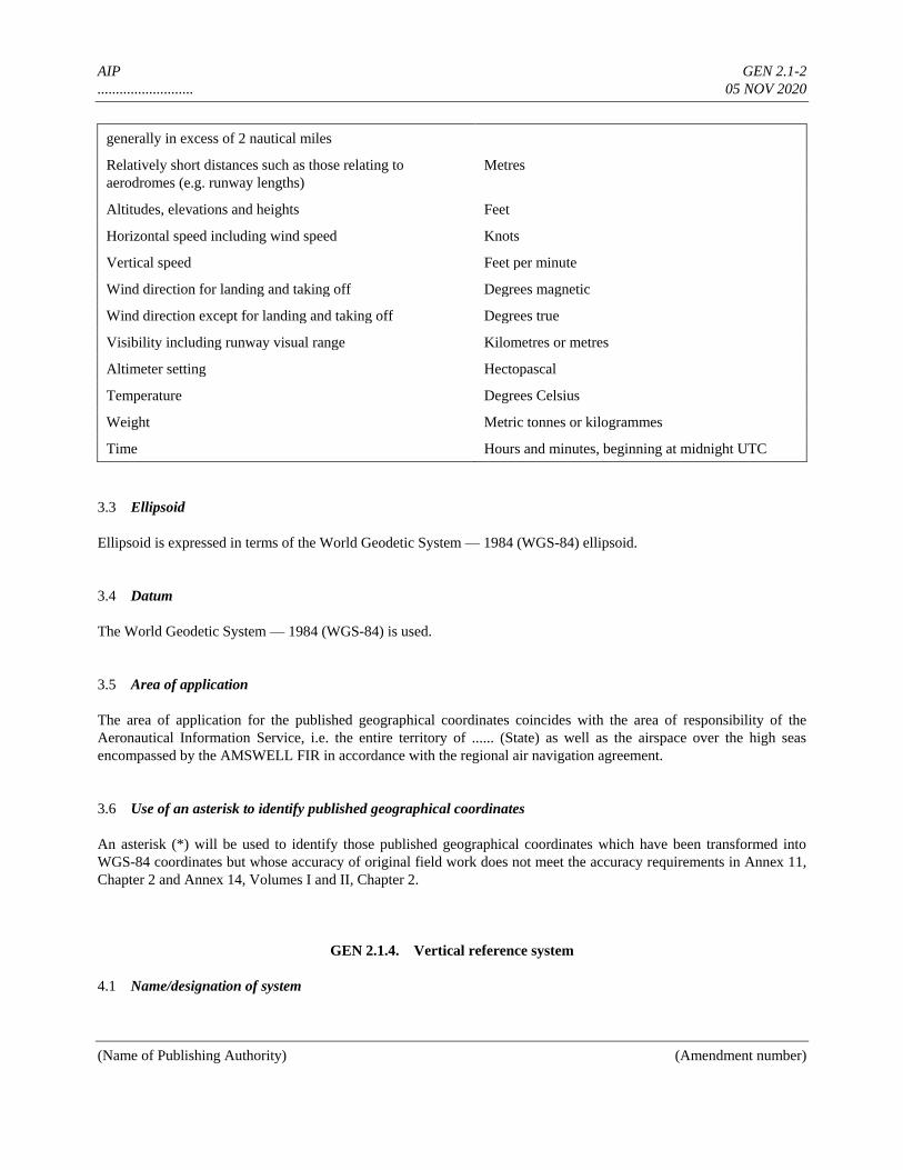
AIP GEN 2.1-2
.......................... 05 NOV 2020
(Name of Publishing Authority) (Amendment number)
generally in excess of 2 nautical miles
Relatively short distances such as those relating to
aerodromes (e.g. runway lengths)
Metres
Altitudes, elevations and heights Feet
Horizontal speed including wind speed Knots
Vertical speed Feet per minute
Wind direction for landing and taking off Degrees magnetic
Wind direction except for landing and taking off Degrees true
Visibility including runway visual range Kilometres or metres
Altimeter setting Hectopascal
Temperature Degrees Celsius
Weight Metric tonnes or kilogrammes
Time Hours and minutes, beginning at midnight UTC
3.3 Ellipsoid
Ellipsoid is expressed in terms of the World Geodetic System — 1984 (WGS-84) ellipsoid.
3.4 Datum
The World Geodetic System — 1984 (WGS-84) is used.
3.5 Area of application
The area of application for the published geographical coordinates coincides with the area of responsibility of the
Aeronautical Information Service, i.e. the entire territory of ...... (State) as well as the airspace over the high seas
encompassed by the AMSWELL FIR in accordance with the regional air navigation agreement.
3.6 Use of an asterisk to identify published geographical coordinates
An asterisk (*) will be used to identify those published geographical coordinates which have been transformed into
WGS-84 coordinates but whose accuracy of original field work does not meet the accuracy requirements in Annex 11,
Chapter 2 and Annex 14, Volumes I and II, Chapter 2.
GEN 2.1.4. Vertical reference system
4.1 Name/designation of system
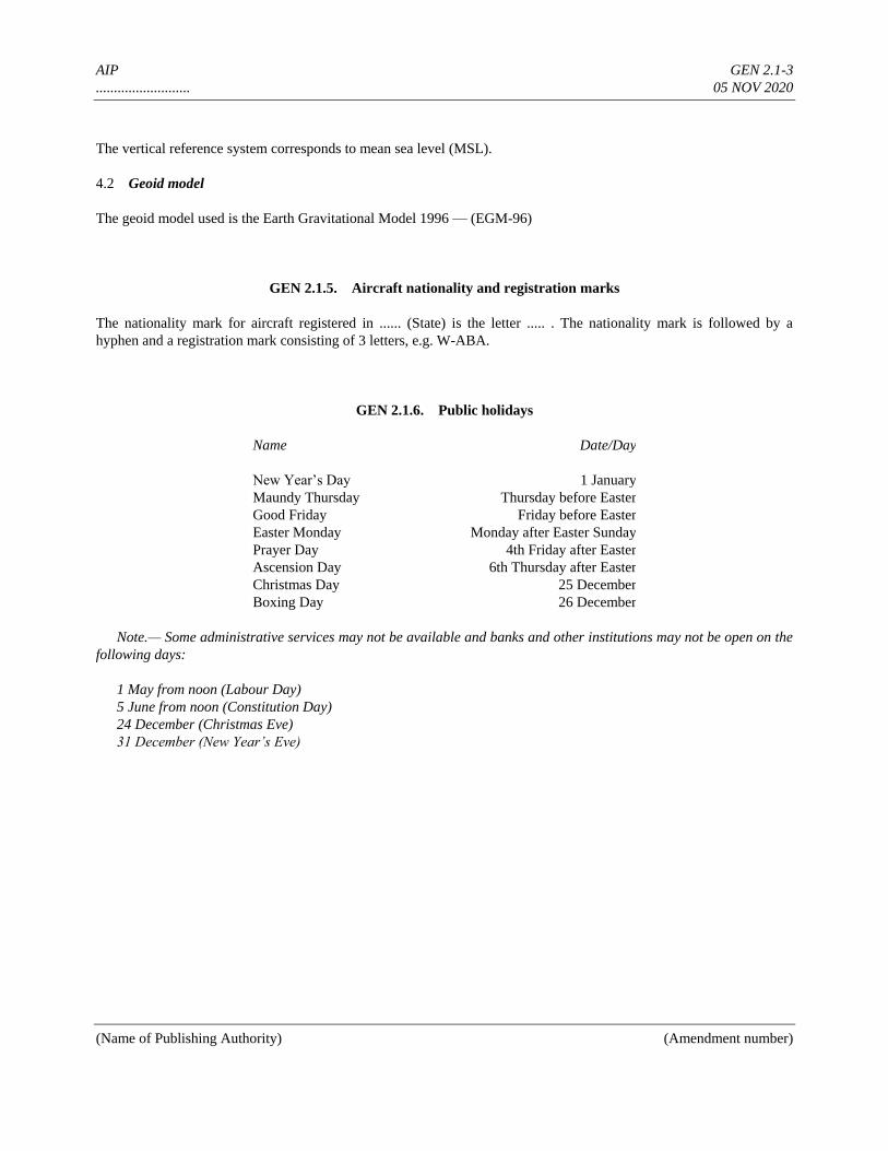
AIP GEN 2.1-3
.......................... 05 NOV 2020
(Name of Publishing Authority) (Amendment number)
The vertical reference system corresponds to mean sea level (MSL).
4.2 Geoid model
The geoid model used is the Earth Gravitational Model 1996 — (EGM-96)
GEN 2.1.5. Aircraft nationality and registration marks
The nationality mark for aircraft registered in ...... (State) is the letter ..... . The nationality mark is followed by a
hyphen and a registration mark consisting of 3 letters, e.g. W-ABA.
GEN 2.1.6. Public holidays
Name Date/Day
New Year’s Day 1 January
Maundy Thursday Thursday before Easter
Good Friday Friday before Easter
Easter Monday Monday after Easter Sunday
Prayer Day 4th Friday after Easter
Ascension Day 6th Thursday after Easter
Christmas Day 25 December
Boxing Day 26 December
Note.— Some administrative services may not be available and banks and other institutions may not be open on the
following days:
1 May from noon (Labour Day)
5 June from noon (Constitution Day)
24 December (Christmas Eve)
31 December (New Year’s Eve)

AIP GEN 2.2-1
.......................... 05 NOV 2020
(Name of Publishing Authority) (Amendment number)
GEN 2.2 ABBREVIATIONS USED IN AIS PUBLICATIONS
Abbreviations marked by an asterisk (*) are either different from or not contained in ICAO Doc 8400. These shall not
be used in NOTAM. A
A Amber
AAA (or AAB, AAC....etc. in sequence)
Amended meteorological message (message type
designator)
A/A Air-to-air
AAD Assigned altitude deviation
AAL Above aerodrome level
ABI Advance boundary information
ABM Abeam
ABN Aerodrome beacon
ABT About
ABV Above
AC Altocumulus
ACARS† (to be pronounced “AY-CARS”) Aircraft
communication addressing and reporting system
ACAS Airborne collision avoidance system
ACC‡ Area control centre or area control
ACCID Notification of an aircraft accident
ACFT Aircraft
ACK Acknowledge
ACL Altimeter check location
ACN Aircraft classification number
ACP Acceptance (message type designator)
ACPT Accept or accepted
ACT Active or activated or activity
AD Aerodrome
ADA Advisory area
ADC Aerodrome chart
ADDN Addition or additional
ADF‡ Automatic direction-finding equipment
ADIZ† (to be pronounced “AY DIZ”) Air defence
identification zone
ADJ Adjacent
ADO Aerodrome office (specify service)
ADR Advisory route
ADS Automatic dependent surveillance
ADS The address (when this abbreviation is used to
request a repetition, the question mark (IMI) precedes
the abbreviation, e.g. IMI ADS) (to be used in AFS as
a procedure signal)
ADSU Automatic dependent surveillance unit
ADVS Advisory service
ADZ Advise
AES Aircraft earth station
AFIL Flight plan filed in the air
AFIS Aerodrome flight information service
AFM Yes or affirm or affirmative or that is correct
AFS Aeronautical fixed service
AFT After..... (time or place)
AFTN‡ Aeronautical fixed telecommunication network
A/G Air-to-ground
AGA Aerodromes, air routes and ground aids
AGL Above ground level
AGN Again
AIC Aeronautical information circular
AIDC Air traffic services inter-facility data communication
AIP Aeronautical information publication
AIRAC Aeronautical information regulation and control
AIREP† Air report
AIRMET† Information concerning en-route weather phenomena
which may affect the safety of low-level aircraft
operations
AIS Aeronautical information services
ALA Alighting area
ALERFA‡ Alert phase
ALR Alerting (message type designator)
ALRS Alerting service
ALS Approach lighting system
ALT Altitude
ALTN Alternate or alternating (light alternates in colour)
ALTN Alternate (aerodrome)
AMA Area minimum altitude
AMD Amend or amended (used to indicate amended
meteorological message; message type designator)
AMDT Amendment (AIP Amendment)
AMSL Above mean sea level
AMSS Aeronautical mobile satellite service
ANC Aeronautical chart 1:500 000 (followed by name/title)
ANCS Aeronautical navigation chart — small scale
(followed by name/title and scale)
ANS Answer
AOC Aerodrome obstacle chart (followed by type and
name/title)
AP Airport
APAPI (to be pronounced “AY PAPI”) Abbreviated precision
approach path indicator
APCH Approach
APDC Aircraft parking docking chart (followed by name/title)
APN Apron
APP Approach control office or approach control or
approach control service
APR April
APRX Approximate or approximately
APSG After passing
APV Approve or approved or approval
ARC Area chart
*ARFOR Area forecast (in aeronautical meteorological code)
etc.
______________
† When radiotelephony is used, the abbreviations and terms are transmitted as spoken words.
‡ When radiotelephony is used, the abbreviations and terms are transmitted using the individual letters in non-phonetic form.

AIP GEN 2.3-1
.......................... 05 NOV 2020
(Name of Publishing Authority) (Amendment number)
GEN 2.3 CHART SYMBOLS
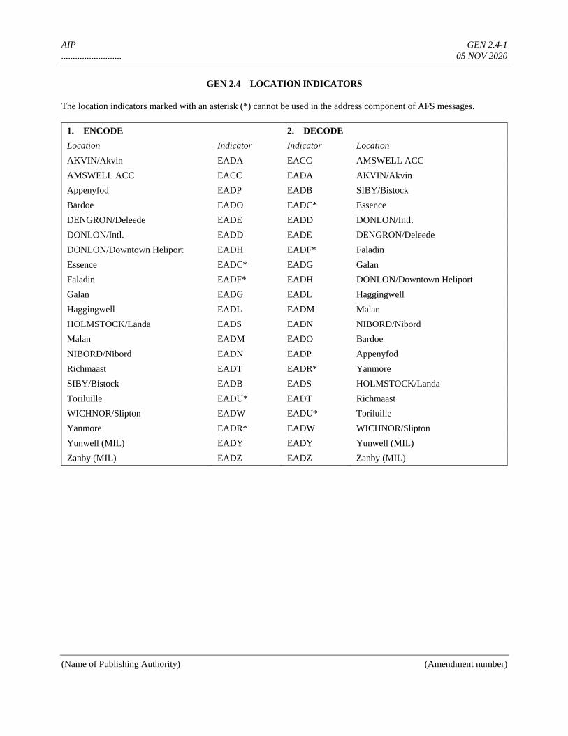
AIP GEN 2.4-1
.......................... 05 NOV 2020
(Name of Publishing Authority) (Amendment number)
GEN 2.4 LOCATION INDICATORS
The location indicators marked with an asterisk (*) cannot be used in the address component of AFS messages.
1. ENCODE 2. DECODE
Location Indicator Indicator Location
AKVIN/Akvin EADA EACC AMSWELL ACC
AMSWELL ACC EACC EADA AKVIN/Akvin
Appenyfod EADP EADB SIBY/Bistock
Bardoe EADO EADC* Essence
DENGRON/Deleede EADE EADD DONLON/Intl.
DONLON/Intl. EADD EADE DENGRON/Deleede
DONLON/Downtown Heliport EADH EADF* Faladin
Essence EADC* EADG Galan
Faladin EADF* EADH DONLON/Downtown Heliport
Galan EADG EADL Haggingwell
Haggingwell EADL EADM Malan
HOLMSTOCK/Landa EADS EADN NIBORD/Nibord
Malan EADM EADO Bardoe
NIBORD/Nibord EADN EADP Appenyfod
Richmaast EADT EADR* Yanmore
SIBY/Bistock EADB EADS HOLMSTOCK/Landa
Toriluille EADU* EADT Richmaast
WICHNOR/Slipton EADW EADU* Toriluille
Yanmore EADR* EADW WICHNOR/Slipton
Yunwell (MIL) EADY EADY Yunwell (MIL)
Zanby (MIL) EADZ EADZ Zanby (MIL)
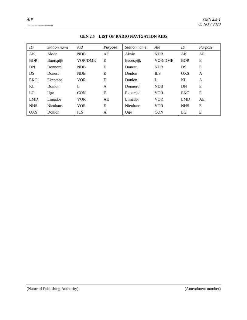
AIP GEN 2.5-1
.......................... 05 NOV 2020
(Name of Publishing Authority) (Amendment number)
GEN 2.5 LIST OF RADIO NAVIGATION AIDS
ID Station name Aid Purpose Station name Aid ID Purpose
AK Akvin NDB AE Akvin NDB AK AE
BOR Boorspijk VOR/DME E Boorspijk VOR/DME BOR E
DN Donnord NDB E Donest NDB DS E
DS Donest NDB E Donlon ILS OXS A
EKO Ekcombe VOR E Donlon L KL A
KL Donlon L A Donnord NDB DN E
LG Ugo CON E Ekcombe VOR EKO E
LMD Limador VOR AE Limador VOR LMD AE
NHS Nieuhans VOR E Nieuhans VOR NHS E
OXS Donlon ILS A Ugo CON LG E
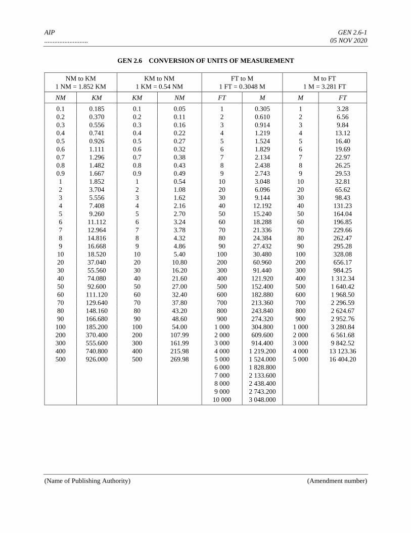
AIP GEN 2.6-1
.......................... 05 NOV 2020
(Name of Publishing Authority) (Amendment number)
GEN 2.6 CONVERSION OF UNITS OF MEASUREMENT
NM to KM
1 NM = 1.852 KM
KM to NM
1 KM = 0.54 NM
FT to M
1 FT = 0.3048 M
M to FT
1 M = 3.281 FT
NM KM KM NM FT M M FT
0.1 0.185 0.1 0.05 1 0.305 1 3.28
0.2 0.370 0.2 0.11 2 0.610 2 6.56
0.3 0.556 0.3 0.16 3 0.914 3 9.84
0.4 0.741 0.4 0.22 4 1.219 4 13.12
0.5 0.926 0.5 0.27 5 1.524 5 16.40
0.6 1.111 0.6 0.32 6 1.829 6 19.69
0.7 1.296 0.7 0.38 7 2.134 7 22.97
0.8 1.482 0.8 0.43 8 2.438 8 26.25
0.9 1.667 0.9 0.49 9 2.743 9 29.53
1 1.852 1 0.54 10 3.048 10 32.81
2 3.704 2 1.08 20 6.096 20 65.62
3 5.556 3 1.62 30 9.144 30 98.43
4 7.408 4 2.16 40 12.192 40 131.23
5 9.260 5 2.70 50 15.240 50 164.04
6 11.112 6 3.24 60 18.288 60 196.85
7 12.964 7 3.78 70 21.336 70 229.66
8 14.816 8 4.32 80 24.384 80 262.47
9 16.668 9 4.86 90 27.432 90 295.28
10 18.520 10 5.40 100 30.480 100 328.08
20 37.040 20 10.80 200 60.960 200 656.17
30 55.560 30 16.20 300 91.440 300 984.25
40 74.080 40 21.60 400 121.920 400 1 312.34
50 92.600 50 27.00 500 152.400 500 1 640.42
60 111.120 60 32.40 600 182.880 600 1 968.50
70 129.640 70 37.80 700 213.360 700 2 296.59
80 148.160 80 43.20 800 243.840 800 2 624.67
90 166.680 90 48.60 900 274.320 900 2 952.76
100 185.200 100 54.00 1 000 304.800 1 000 3 280.84
200 370.400 200 107.99 2 000 609.600 2 000 6 561.68
300 555.600 300 161.99 3 000 914.400 3 000 9 842.52
400 740.800 400 215.98 4 000 1 219.200 4 000 13 123.36
500 926.000 500 269.98 5 000 1 524.000 5 000 16 404.20
6 000 1 828.800
7 000 2 133.600
8 000 2 438.400
9 000 2 743.200
10 000 3 048.000
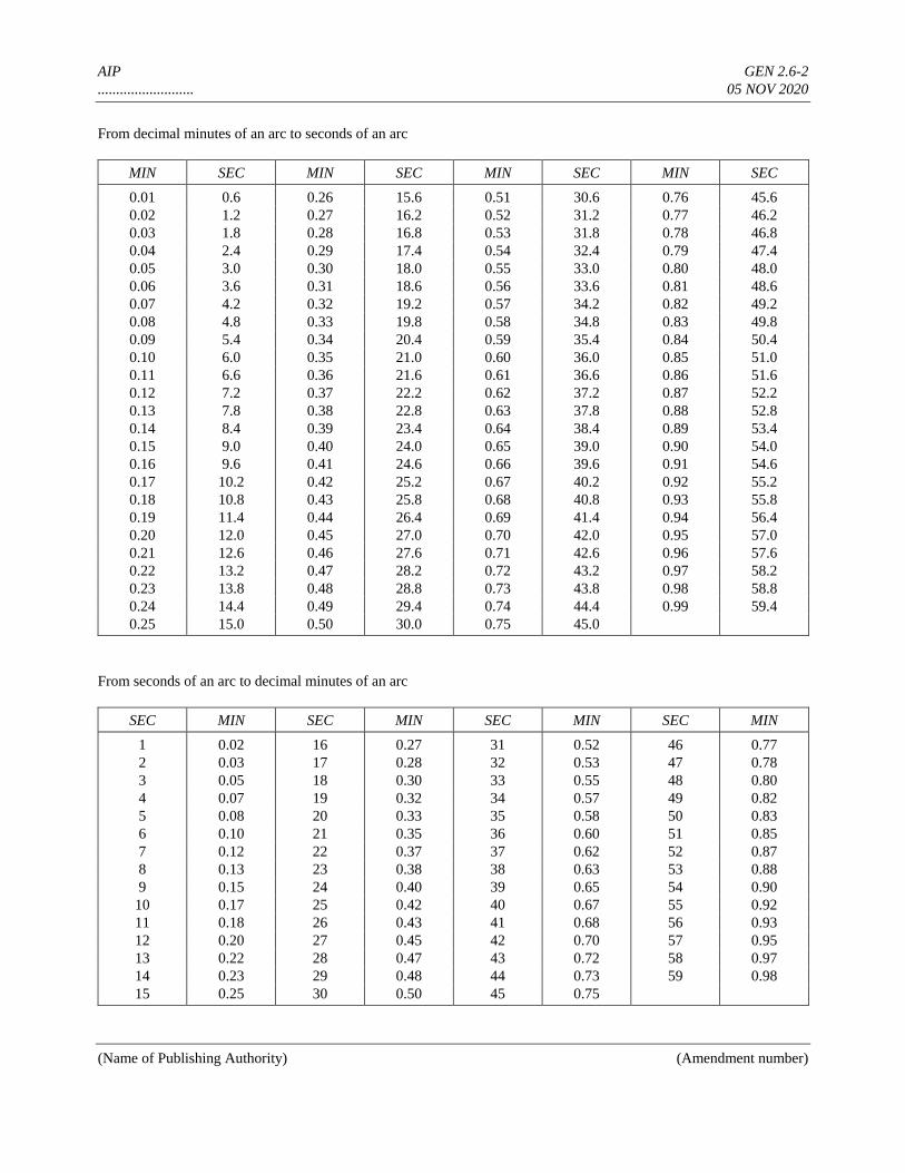
AIP GEN 2.6-2
.......................... 05 NOV 2020
(Name of Publishing Authority) (Amendment number)
From decimal minutes of an arc to seconds of an arc
MIN SEC MIN SEC MIN SEC MIN SEC
0.01 0.6 0.26 15.6 0.51 30.6 0.76 45.6
0.02 1.2 0.27 16.2 0.52 31.2 0.77 46.2
0.03 1.8 0.28 16.8 0.53 31.8 0.78 46.8
0.04 2.4 0.29 17.4 0.54 32.4 0.79 47.4
0.05 3.0 0.30 18.0 0.55 33.0 0.80 48.0
0.06 3.6 0.31 18.6 0.56 33.6 0.81 48.6
0.07 4.2 0.32 19.2 0.57 34.2 0.82 49.2
0.08 4.8 0.33 19.8 0.58 34.8 0.83 49.8
0.09 5.4 0.34 20.4 0.59 35.4 0.84 50.4
0.10 6.0 0.35 21.0 0.60 36.0 0.85 51.0
0.11 6.6 0.36 21.6 0.61 36.6 0.86 51.6
0.12 7.2 0.37 22.2 0.62 37.2 0.87 52.2
0.13 7.8 0.38 22.8 0.63 37.8 0.88 52.8
0.14 8.4 0.39 23.4 0.64 38.4 0.89 53.4
0.15 9.0 0.40 24.0 0.65 39.0 0.90 54.0
0.16 9.6 0.41 24.6 0.66 39.6 0.91 54.6
0.17 10.2 0.42 25.2 0.67 40.2 0.92 55.2
0.18 10.8 0.43 25.8 0.68 40.8 0.93 55.8
0.19 11.4 0.44 26.4 0.69 41.4 0.94 56.4
0.20 12.0 0.45 27.0 0.70 42.0 0.95 57.0
0.21 12.6 0.46 27.6 0.71 42.6 0.96 57.6
0.22 13.2 0.47 28.2 0.72 43.2 0.97 58.2
0.23 13.8 0.48 28.8 0.73 43.8 0.98 58.8
0.24 14.4 0.49 29.4 0.74 44.4 0.99 59.4
0.25 15.0 0.50 30.0 0.75 45.0
From seconds of an arc to decimal minutes of an arc
SEC MIN SEC MIN SEC MIN SEC MIN
1 0.02 16 0.27 31 0.52 46 0.77
2 0.03 17 0.28 32 0.53 47 0.78
3 0.05 18 0.30 33 0.55 48 0.80
4 0.07 19 0.32 34 0.57 49 0.82
5 0.08 20 0.33 35 0.58 50 0.83
6 0.10 21 0.35 36 0.60 51 0.85
7 0.12 22 0.37 37 0.62 52 0.87
8 0.13 23 0.38 38 0.63 53 0.88
9 0.15 24 0.40 39 0.65 54 0.90
10 0.17 25 0.42 40 0.67 55 0.92
11 0.18 26 0.43 41 0.68 56 0.93
12 0.20 27 0.45 42 0.70 57 0.95
13 0.22 28 0.47 43 0.72 58 0.97
14 0.23 29 0.48 44 0.73 59 0.98
15 0.25 30 0.50 45 0.75
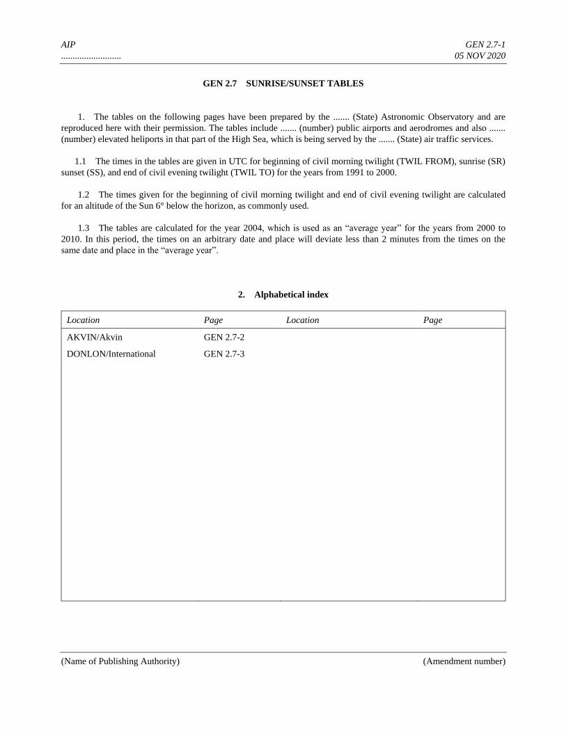
AIP GEN 2.7-1
.......................... 05 NOV 2020
(Name of Publishing Authority) (Amendment number)
GEN 2.7 SUNRISE/SUNSET TABLES
1. The tables on the following pages have been prepared by the ....... (State) Astronomic Observatory and are
reproduced here with their permission. The tables include ....... (number) public airports and aerodromes and also .......
(number) elevated heliports in that part of the High Sea, which is being served by the ....... (State) air traffic services.
1.1 The times in the tables are given in UTC for beginning of civil morning twilight (TWIL FROM), sunrise (SR)
sunset (SS), and end of civil evening twilight (TWIL TO) for the years from 1991 to 2000.
1.2 The times given for the beginning of civil morning twilight and end of civil evening twilight are calculated
for an altitude of the Sun 6° below the horizon, as commonly used.
1.3 The tables are calculated for the year 2004, which is used as an “average year” for the years from 2000 to
2010. In this period, the times on an arbitrary date and place will deviate less than 2 minutes from the times on the
same date and place in the “average year”.
2. Alphabetical index
Location Page Location Page
AKVIN/Akvin GEN 2.7-2
DONLON/International GEN 2.7-3

AIP GEN 2.7-2
.......................... 05 NOV 2020
(Name of Publishing Authority) (Amendment number)
3. Sunrise-Sunset tables
3.1
AKVIN/Akvin
EADA
52 36 06N
032 55 12W
AKVIN/Akvin
EADA
52 36 06N
032 55 12W
AKVIN/Akvin
EADA
52 36 06N
032 55 12W
MONTH/
DAY
TWIL
FROM SR SS
TWIL
TO
MONTH/
DAY
TWIL
FROM SR SS
TWIL
TO
MONTH/
DAY
TWIL
FROM SR SS
TWIL
TO
JAN
–
–
–
–
–
–
–
1
5
9
13
17
11
15
19
0702
0701
0700
0657
0654
0649
0644
0639
0749
0748
0746
0742
0738
0733
0727
0721
1504
1509
1515
1521
1528
1536
1544
1552
1551
1555
1601
1606
1613
1620
1627
1634
MAY
–
–
–
–
–
–
–
1
5
9
13
17
21
25
29
0302
0252
0243
0234
0225
0217
0210
0203
0346
0338
0330
0322
0315
0309
0303
0258
1855
1903
1910
1917
1924
1931
1937
1943
1940
1949
1958
2006
2015
2023
2031
2038
SEP
–
–
–
–
–
–
–
2
6
10
14
18
22
26
30
0352
0400
0408
0416
0424
0431
0439
0447
0432
0440
0447
0455
0502
0509
0517
0524
1812
1802
1752
1741
1731
1721
1711
1700
1851
1841
1830
1820
1809
1759
1748
1738
FEB
–
–
–
–
–
–
2
6
10
14
18
22
26
0632
0625
0618
0610
0602
0553
0544
0714
0706
0658
0650
0641
0632
0622
1600
1608
1617
1625
1634
1642
1650
1642
1649
1657
1705
1713
1721
1729
JUN
–
–
–
–
–
–
–
2
6
10
14
18
22
26
30
0158
0153
0150
0147
0146
0147
0148
0151
0254
0251
0248
0247
0246
0247
0248
0251
1948
1953
1957
2000
2002
2003
2003
2002
2045
2051
2056
2059
2102
2103
2103
2101
OCT
–
–
–
–
–
–
–
4
8
12
16
20
24
28
0454
0502
0509
0517
0524
0532
0540
0532
0540
0547
0555
0603
0611
0619
1650
1640
1630
1621
1611
1602
1553
1728
1718
1709
1659
1650
1641
1633
MAR
–
–
–
–
–
–
–
2
6
10
14
18
22
26
30
0535
0525
0515
0505
0455
0445
0435
0424
0613
0603
0553
0543
0533
0523
0513
0502
1658
1706
1714
1722
1730
1738
1746
1754
1736
1744
1752
1800
1808
1816
1824
1832
JUL
–
–
–
–
–
–
4
8
12
16
20
24
28
0155
0201
0207
0214
0221
0229
0237
0254
0258
0303
0308
0314
0320
0327
2000
1957
1953
1949
1943
1937
1931
2058
2054
2049
2043
2036
2028
2020
NOV
–
–
–
–
–
–
–
1
5
9
13
17
21
25
29
0547
0555
0602
0609
0617
0623
0630
0636
0627
0636
0644
0652
0700
0707
0715
0722
1545
1537
1529
1522
1515
1510
1504
1500
1625
1618
1611
1604
1558
1553
1549
1546
APR
–
–
–
–
–
–
3
7
11
15
19
23
27
0414
0403
0353
0342
0332
0322
0311
0452
0442
0432
0423
0413
0404
0355
1801
1809
1817
1824
1832
1840
1848
1840
1848
1857
1905
1914
1923
1931
AUG
–
–
–
–
–
–
–
1
5
9
13
17
21
25
29
0245
0254
0302
0311
0319
0328
0336
0344
0334
0341
0348
0355
0403
0410
0418
0425
1923
1916
1907
1859
1850
1841
1831
1822
2011
2002
1953
1943
1933
1923
1912
1902
DEC
–
–
–
–
–
–
–
3
7
11
15
19
23
27
31
0642
0647
0652
0655
0658
0701
0702
0702
0728
0734
0739
0743
0746
0748
0749
0750
1457
1454
1453
1453
1454
1455
1458
1502
1543
1541
1540
1540
1541
1543
1546
1550
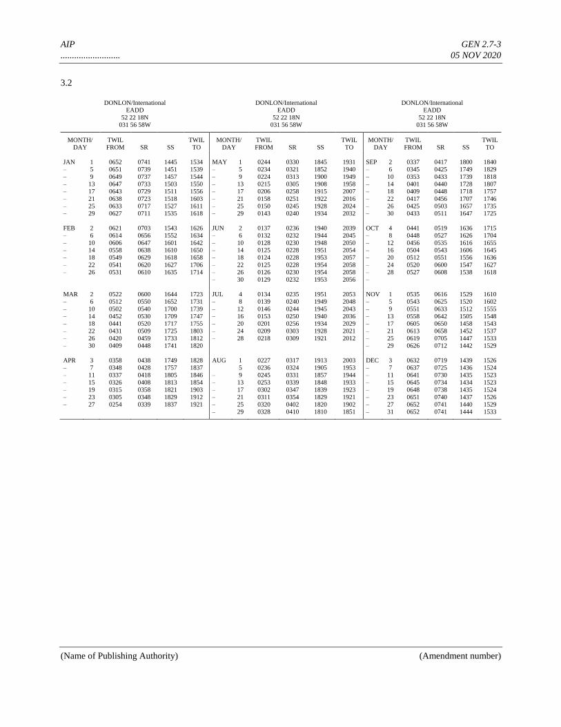
AIP GEN 2.7-3
.......................... 05 NOV 2020
(Name of Publishing Authority) (Amendment number)
3.2
DONLON/International
EADD
52 22 18N
031 56 58W
DONLON/International
EADD
52 22 18N
031 56 58W
DONLON/International
EADD
52 22 18N
031 56 58W
MONTH/
DAY
TWIL
FROM SR SS
TWIL
TO
MONTH/
DAY
TWIL
FROM SR SS
TWIL
TO
MONTH/
DAY
TWIL
FROM SR SS
TWIL
TO
JAN
–
–
–
–
–
–
–
1
5
9
13
17
21
25
29
0652
0651
0649
0647
0643
0638
0633
0627
0741
0739
0737
0733
0729
0723
0717
0711
1445
1451
1457
1503
1511
1518
1527
1535
1534
1539
1544
1550
1556
1603
1611
1618
MAY
–
–
–
–
–
–
–
1
5
9
13
17
21
25
29
0244
0234
0224
0215
0206
0158
0150
0143
0330
0321
0313
0305
0258
0251
0245
0240
1845
1852
1900
1908
1915
1922
1928
1934
1931
1940
1949
1958
2007
2016
2024
2032
SEP
–
–
–
–
–
–
–
2
6
10
14
18
22
26
30
0337
0345
0353
0401
0409
0417
0425
0433
0417
0425
0433
0440
0448
0456
0503
0511
1800
1749
1739
1728
1718
1707
1657
1647
1840
1829
1818
1807
1757
1746
1735
1725
FEB
–
–
–
–
–
–
2
6
10
14
18
22
26
0621
0614
0606
0558
0549
0541
0531
0703
0656
0647
0638
0629
0620
0610
1543
1552
1601
1610
1618
1627
1635
1626
1634
1642
1650
1658
1706
1714
JUN
–
–
–
–
–
–
–
2
6
10
14
18
22
26
30
0137
0132
0128
0125
0124
0125
0126
0129
0236
0232
0230
0228
0228
0228
0230
0232
1940
1944
1948
1951
1953
1954
1954
1953
2039
2045
2050
2054
2057
2058
2058
2056
OCT
–
–
–
–
–
–
–
4
8
12
16
20
24
28
0441
0448
0456
0504
0512
0520
0527
0519
0527
0535
0543
0551
0600
0608
1636
1626
1616
1606
1556
1547
1538
1715
1704
1655
1645
1636
1627
1618
MAR
–
–
–
–
–
–
–
2
6
10
14
18
22
26
30
0522
0512
0502
0452
0441
0431
0420
0409
0600
0550
0540
0530
0520
0509
0459
0448
1644
1652
1700
1709
1717
1725
1733
1741
1723
1731
1739
1747
1755
1803
1812
1820
JUL
–
–
–
–
–
–
4
8
12
16
20
24
28
0134
0139
0146
0153
0201
0209
0218
0235
0240
0244
0250
0256
0303
0309
1951
1949
1945
1940
1934
1928
1921
2053
2048
2043
2036
2029
2021
2012
NOV
–
–
–
–
–
–
–
1
5
9
13
17
21
25
29
0535
0543
0551
0558
0605
0613
0619
0626
0616
0625
0633
0642
0650
0658
0705
0712
1529
1520
1512
1505
1458
1452
1447
1442
1610
1602
1555
1548
1543
1537
1533
1529
APR
–
–
–
–
–
–
3
7
11
15
19
23
27
0358
0348
0337
0326
0315
0305
0254
0438
0428
0418
0408
0358
0348
0339
1749
1757
1805
1813
1821
1829
1837
1828
1837
1846
1854
1903
1912
1921
AUG
–
–
–
–
–
–
1
5
9
13
17
21
25
29
0227
0236
0245
0253
0302
0311
0320
0328
0317
0324
0331
0339
0347
0354
0402
0410
1913
1905
1857
1848
1839
1829
1820
1810
2003
1953
1944
1933
1923
1921
1902
1851
DEC
–
–
–
–
–
–
–
3
7
11
15
19
23
27
31
0632
0637
0641
0645
0648
0651
0652
0652
0719
0725
0730
0734
0738
0740
0741
0741
1439
1436
1435
1434
1435
1437
1440
1444
1526
1524
1523
1523
1524
1526
1529
1533
AIP GEN 3.1-1
.......................... 05 NOV 2020
(Name of Publishing Authority) (Amendment number)
GEN 3. SERVICES
GEN 3.1 AERONAUTICAL INFORMATION SERVICES
GEN 3.1.1. Responsible service
1.1 The Aeronautical Information Service, which forms part of the ........ (State) Division of the Civil Aviation
Administration, ensures the flow of information necessary for the safety, regularity and efficiency of international and
national air navigation within the area of its responsibility as indicated under GEN 3.1.2. It consists of AIS
Headquarters, International NOTAM Office (NOF) and AIS units established at certain aerodromes as listed under
GEN 3.1.5.
1.2 AIS Headquarters
Aeronautical Information Service
P.O. Box 744
1050 State Street
Donlon
TEL: 0123 697 3464
Telefax: 0123 697 3474
E-Mail: [email protected]
AFS: EADDYAYX
Website: www.aisdonlon.dl
1.3 International NOTAM office (NOF)
International NOTAM Office
Donlon Airport
134 Airport Road
Donlon
TEL: 0123 696 5698
Telefax: 0123 696 5788
E-Mail: [email protected]
AFS: EADDYNYX
Website: www.notamofficedonlon.dl
The service is provided in accordance with the provisions contained in Annex 15 — Aeronautical Information Services.
(Editorial note: If the service is not H24, this should be indicated here.)
GEN 3.1.2. Area of responsibility
The Aeronautical Information Service is responsible for the collection and dissemination of information for the entire
territory of ........ (State) and for the airspace over the high seas encompassed by the AMSWELL Flight Information
Region.
AIP GEN 3.1-2
.......................... 05 NOV 2020
(Name of Publishing Authority) (Amendment number)
GEN 3.1.3. Aeronautical publications
3.1 The aeronautical information is provided in the form of Aeronautical Information Products in a standardized
presentation consisting of the following elements:
— Aeronautical Information Publication (AIP);
— Amendment service to the AIP (AIP AMDT);
— Supplement to the AIP (AIP SUP);
— NOTAM ;
— Aeronautical Information Circulars (AIC); and
— Aeronautical Charts.
NOTAM and the related monthly checklists are issued via the Aeronautical Fixed Service (AFS).
3.2 Aeronautical Information Publication (AIP)
The AIP is the basic aviation document intended primarily to satisfy international requirements for the exchange of
permanent aeronautical information and long duration temporary changes essential for air navigation.
AIP ........ (State) is published in ........ (specify) volume(s).
The AIP is published in a loose-leaf form with bilingual text (English and ........) (or in English only) for use in
international and domestic operations, and applies to commercial and private flights.
3.3 Amendment service to the AIP (AIP AMDT)
Amendments to the AIP are made by means of replacement sheets. Two types of AIP AMDT are produced:
— regular AIP Amendment (AIP AMDT), issued in accordance with the established regular interval (ref. GEN
...) and identified by a light blue cover sheet, incorporates permanent changes into the AIP on the indicated
publication date; and
— AIRAC AIP Amendment (AIRAC AIP AMDT), issued in accordance with the AIRAC system and identified
by a pink cover sheet and the acronym — AIRAC, incorporates operationally significant permanent changes
into the AIP on the indicated AIRAC effective date.
A brief description of the subjects affected by the amendment is given on the AIP Amendment cover sheet. New
information included on the reprinted AIP pages is annotated or identified by a vertical line in the left margin (or
immediately to the left) of the change/addition.
Each AIP page and each AIP replacement page introduced by an amendment, including the amendment cover sheet, are
dated. The date consists of the day, month (by name) and year of the publication date (regular AIP AMDT) or of the
AIRAC effective date (AIRAC AIP AMDT) of the information. Each AIP amendment cover sheet includes references
to the serial number of those elements, if any, of the Aeronautical Information Products which have been incorporated
in the AIP by the amendment and are consequently cancelled.
AIP GEN 3.1-3
.......................... 05 NOV 2020
(Name of Publishing Authority) (Amendment number)
Each AIP AMDT and each AIRAC AIP AMDT are allocated separate serial numbers which are consecutive and based
on the calendar year. The year, indicated by two digits, is a part of the serial number of the amendment, e.g. AIP
AMDT 1/20; AIRAC AIP AMDT 1/20.
A checklist of AIP pages containing page number/chart title and the publication or effective date (day, month by name
and year) of the information is reissued with each amendment and is an integral part of the AIP.
3.4 Supplement to the AIP (AIP SUP)
Temporary changes of long duration (three months and longer) and information of short duration which consists of
extensive text and/or graphics, supplementing the permanent information contained in the AIP, are published as AIP
Supplements (AIP SUP). Operationally significant temporary changes to the AIP are published in accordance with the
AIRAC system and its established effective dates and are identified clearly by the acronym AIRAC AIP SUP.
AIP Supplements are separated by information subject (General — GEN, En-route — ENR and Aerodromes —AD)
and are placed accordingly at the beginning of each AIP Part. Supplements are published on yellow paper to be
conspicuous and to stand out from the rest of the AIP. Each AIP Supplement (regular or AIRAC) is allocated a serial
number which is consecutive and based on the calendar year, i.e. AIP SUP 1/20; AIRAC AIP SUP 1/20.
An AIP Supplement is kept in the AIP as long as all or some of its contents remain valid. The period of validity of the
information contained in the AIP Supplement will normally be given in the supplement itself. Alternatively, NOTAM
may be used to indicate changes to the period of validity or cancellation of the supplement.
The checklist of AIP Supplements currently in force is issued in the monthly printed plain-language list of valid
NOTAM.
3.5 NOTAM
NOTAM contain information concerning the establishment, condition or change in any aeronautical facility, service,
procedure or hazard, the timely knowledge of which is essential for personnel concerned with flight operations. The
text of each NOTAM contains the information in the order shown in the ICAO NOTAM Format and is composed of
the significations/uniform abbreviated phraseology assigned to the ICAO NOTAM Code complemented by ICAO
abbreviations, indicators, identifiers, designators, call signs, frequencies, figures and plain language. NOTAM are
originated and issued for Amswell FIR and are distributed in seven series identified by the letters A, B, C, D, E, S and
V.
Series A. General rules, en-route navigation and communication facilities, airspace restrictions and activities taking
place above FL 245 and information concerning major international aerodromes.
Series B. Information on airspace restrictions, on activities taking place at or below FL 245 and on other international
aerodromes at which IFR flights are permitted.
Series C. Information on other international aerodromes at which only VFR flights are permitted.
Series D. Information on national aerodromes.
Series E. Information on heliports.
AIP GEN 3.1-4
.......................... 05 NOV 2020
(Name of Publishing Authority) (Amendment number)
Series S (SNOWTAM). Information providing a surface condition report notifying the presence or cessation of
hazardous conditions due to snow, ice, slush, frost, standing water or water associated with snow, slush, ice or frost on
the movement area. SNOWTAM are prepared in accordance with PANS-AIM (Doc 10066), Appendix 4, and are
issued by the individual aerodrome directly, with separate serial numbers. Details are given in the snow plan in the
Aerodrome (AD) Part.
Series V (ASHTAM). Information concerning the activity of a volcano, a volcanic eruption and/or volcanic ash cloud
that is of significance to aircraft operations. It also provides information on the location, extent and movement of the
ash cloud and the air routes and flight levels affected. ASHTAM are prepared in accordance with PANS-AIM (Doc
10066), Appendix 5.
3.6 Aeronautical Information Circulars (AIC)
The Aeronautical Information Circulars (AIC) contain information on the long-term forecast of any major change in
legislation, regulations, procedures or facilities; information of a purely explanatory or advisory nature liable to affect
flight safety; and information or notification of an explanatory or advisory nature concerning technical, legislative or
purely administrative matters. AIC are divided by subject and are issued in two series (A and B). AIC Series A contains
information affecting international civil aviation and is given international distribution, while AIC Series B contains
information affecting national aviation only and is given national distribution.
Each AIC is numbered consecutively within each series on a calendar year basis. The year, indicated by two digits, is a
part of the serial number of the AIC, e.g. AIC A 1/20; AIC B 1/20. A checklist of AIC currently in force is issued as an
AIC twice a year.
3.7 Aeronautical Charts
Aeronautical charts are a visual representation of a portion of the Earth specifically designated to meet the needs of air
navigation.
3.8 Sale of publications
The said publications can be obtained from the Aeronautical Information Service. Purchase prices are published in AIC
Series A.
GEN 3.1.4. AIRAC System
4.1 In order to control and regulate the operationally significant changes requiring amendments to charts, route-
manuals etc., such changes, whenever possible, will be issued on predetermined dates according to the AIRAC System.
This type of information will be published as an AIRAC AIP AMDT or an AIRAC AIP SUP. If an AIRAC AMDT or
SUP cannot be produced due to lack of time, NOTAM clearly marked AIRAC will be issued. Such NOTAM will
immediately be followed by an AMDT or SUP.
4.2 The table below indicates AIRAC effective dates for the coming years. AIRAC information will be issued so
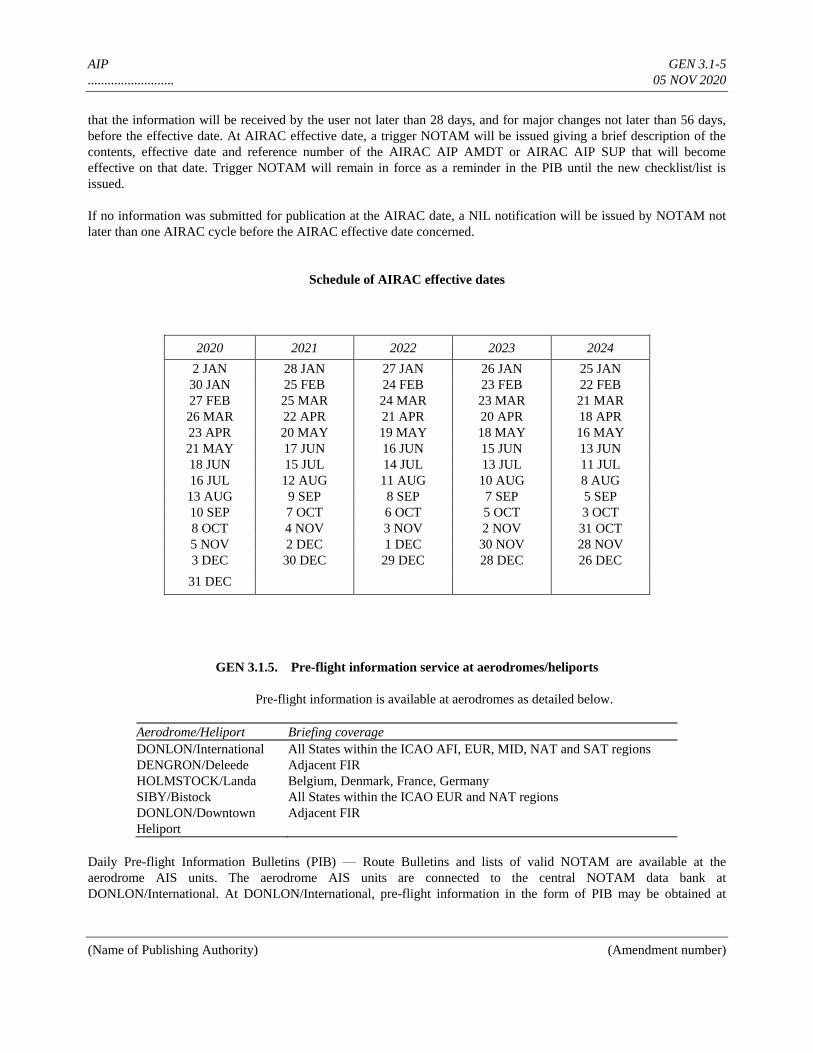
AIP GEN 3.1-5
.......................... 05 NOV 2020
(Name of Publishing Authority) (Amendment number)
that the information will be received by the user not later than 28 days, and for major changes not later than 56 days,
before the effective date. At AIRAC effective date, a trigger NOTAM will be issued giving a brief description of the
contents, effective date and reference number of the AIRAC AIP AMDT or AIRAC AIP SUP that will become
effective on that date. Trigger NOTAM will remain in force as a reminder in the PIB until the new checklist/list is
issued.
If no information was submitted for publication at the AIRAC date, a NIL notification will be issued by NOTAM not
later than one AIRAC cycle before the AIRAC effective date concerned.
Schedule of AIRAC effective dates
2020 2021 2022 2023 2024
2 JAN 28 JAN 27 JAN 26 JAN 25 JAN
30 JAN 25 FEB 24 FEB 23 FEB 22 FEB
27 FEB 25 MAR 24 MAR 23 MAR 21 MAR
26 MAR 22 APR 21 APR 20 APR 18 APR
23 APR 20 MAY 19 MAY 18 MAY 16 MAY
21 MAY 17 JUN 16 JUN 15 JUN 13 JUN
18 JUN 15 JUL 14 JUL 13 JUL 11 JUL
16 JUL 12 AUG 11 AUG 10 AUG 8 AUG
13 AUG 9 SEP 8 SEP 7 SEP 5 SEP
10 SEP 7 OCT 6 OCT 5 OCT 3 OCT
8 OCT 4 NOV 3 NOV 2 NOV 31 OCT
5 NOV 2 DEC 1 DEC 30 NOV 28 NOV
3 DEC 30 DEC 29 DEC 28 DEC 26 DEC
31 DEC
GEN 3.1.5. Pre-flight information service at aerodromes/heliports
Pre-flight information is available at aerodromes as detailed below.
Aerodrome/Heliport Briefing coverage
DONLON/International All States within the ICAO AFI, EUR, MID, NAT and SAT regions
DENGRON/Deleede Adjacent FIR
HOLMSTOCK/Landa Belgium, Denmark, France, Germany
SIBY/Bistock All States within the ICAO EUR and NAT regions
DONLON/Downtown
Heliport
Adjacent FIR
Daily Pre-flight Information Bulletins (PIB) — Route Bulletins and lists of valid NOTAM are available at the
aerodrome AIS units. The aerodrome AIS units are connected to the central NOTAM data bank at
DONLON/International. At DONLON/International, pre-flight information in the form of PIB may be obtained at
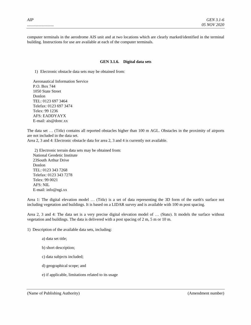
AIP GEN 3.1-6
.......................... 05 NOV 2020
(Name of Publishing Authority) (Amendment number)
computer terminals in the aerodrome AIS unit and at two locations which are clearly marked/identified in the terminal
building. Instructions for use are available at each of the computer terminals.
GEN 3.1.6. Digital data sets
1) Electronic obstacle data sets may be obtained from:
Aeronautical Information Service
P.O. Box 744
1050 State Street
Donlon
TEL: 0123 697 3464
Telefax: 0123 697 3474
Telex: 99 1236
AFS: EADDYAYX
E-mail: [email protected]
The data set … (Title) contains all reported obstacles higher than 100 m AGL. Obstacles in the proximity of airports
are not included in the data set.
Area 2, 3 and 4: Electronic obstacle data for area 2, 3 and 4 is currently not available.
2) Electronic terrain data sets may be obtained from:
National Geodetic Institute
23South Arthur Drive
Donlon
TEL: 0123 343 7268
Telefax: 0123 343 7278
Telex: 99 0021
AFS: NIL
E-mail: [email protected]
Area 1: The digital elevation model … (Title) is a set of data representing the 3D form of the earth's surface not
including vegetation and buildings. It is based on a LIDAR survey and is available with 100 m post spacing.
Area 2, 3 and 4: The data set is a very precise digital elevation model of … (State). It models the surface without
vegetation and buildings. The data is delivered with a post spacing of 2 m, 5 m or 10 m.
1) Description of the available data sets, including:
a) data set title;
b) short description;
c) data subjects included;
d) geographical scope; and
e) if applicable, limitations related to its usage
AIP GEN 3.1-7
.......................... 05 NOV 2020
(Name of Publishing Authority) (Amendment number)
2) Contact details of how data sets may be obtained, containing:
a) name of the individual, service or organization responsible;
b) street address and e-mail address of the individual, service or organization responsible;
c) telefax number of the individual, service or organization responsible;
d) contact telephone number of the individual, service or organization responsible;
e) hours of service (time period including time zone when contact can be made);
f) online information that can be used to contact the individual, service or organization; and
g) supplemental information, if necessary, on how and when to contact the individual, service or organization.
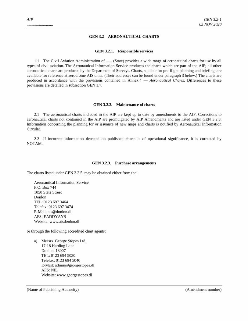
AIP GEN 3.2-1
.......................... 05 NOV 2020
(Name of Publishing Authority) (Amendment number)
GEN 3.2 AERONAUTICAL CHARTS
GEN 3.2.1. Responsible services
1.1 The Civil Aviation Administration of ...... (State) provides a wide range of aeronautical charts for use by all
types of civil aviation. The Aeronautical Information Service produces the charts which are part of the AIP; all other
aeronautical charts are produced by the Department of Surveys. Charts, suitable for pre-flight planning and briefing, are
available for reference at aerodrome AIS units. (Their addresses can be found under paragraph 3 below.) The charts are
produced in accordance with the provisions contained in Annex 4 — Aeronautical Charts. Differences to these
provisions are detailed in subsection GEN 1.7.
GEN 3.2.2. Maintenance of charts
2.1 The aeronautical charts included in the AIP are kept up to date by amendments to the AIP. Corrections to
aeronautical charts not contained in the AIP are promulgated by AIP Amendments and are listed under GEN 3.2.8.
Information concerning the planning for or issuance of new maps and charts is notified by Aeronautical Information
Circular.
2.2 If incorrect information detected on published charts is of operational significance, it is corrected by
NOTAM.
GEN 3.2.3. Purchase arrangements
The charts listed under GEN 3.2.5. may be obtained either from the:
Aeronautical Information Service
P.O. Box 744
1050 State Street
Donlon
TEL: 0123 697 3464
Telefax: 0123 697 3474
E-Mail: [email protected]
AFS: EADDYAYS
Website: www.aisdonlon.dl
or through the following accredited chart agents:
a) Messrs. George Stopes Ltd.
17-18 Harding Lane
Donlon, 18007
TEL: 0123 694 5030
Telefax: 0123 694 5040
E-Mail: [email protected]
AFS: NIL
Website: www.georgestopes.dl
AIP GEN 3.2-2
.......................... 05 NOV 2020
(Name of Publishing Authority) (Amendment number)
b) Department of Surveys
21 South Arthur Drive
Donlon
TEL: 0123 343 7267
Telefax: 0123 3437277
E-Mail: [email protected]
AFS: NIL
Website: www.surveys.dl
GEN 3.2.4. Aeronautical chart series available
4.1 The following series of aeronautical charts are produced:
a) World Aeronautical Chart — ICAO 1:1 000 000;
b) Plotting Chart — ICAO;
c) Aerodrome/Heliport Chart — ICAO;
d) Aerodrome Ground Movement Chart — ICAO;
e) Aircraft Parking/Docking Chart — ICAO;
f) Aerodrome Obstacle Chart — ICAO — Type A (for each runway);
g) Aerodrome Obstacle Chart — ICAO — Type C;
h) Precision Approach Terrain Chart — ICAO (precision approach Cat II and III runways);
i) En-route Chart — ICAO;
j) Area Chart — ICAO;
k) ATC Surveillance Minimum Altitude Chart — ICAO;
l) Standard Departure Chart — Instrument (SID) — ICAO;
m) Standard Arrival Chart — Instrument (STAR) — ICAO;
n) Instrument Approach Chart — ICAO (for each runway and procedure type);
o) Visual Approach Chart — ICAO.
The charts currently available are listed under GEN 3.2.5.
4.2 General description of each series
a) World Aeronautical Chart — ICAO 1:1 000 000. This series is constructed on Lambert Conical Orthomorphic
Projection up to 80°N and the Polar Stereographic Projection between 80°N and 90°N with the scales
matching at 80°N. The aeronautical data shown have been kept to a minimum, consistent with the use of the
chart for visual air navigation. It includes a selection of aerodromes, obstacles, elements of the ATS system,
prohibited, restricted and danger areas, and radio navigation aids. The chart provides information to satisfy
visual air navigation and is also used as a pre-flight planning chart.
b) Plotting Chart — ICAO. This series, covering the North Atlantic, Western Europe and North Africa, is
designed for in-flight long-range navigation and is constructed on Mercator’s projection with simple outline of
land areas at a scale of 1:5 000 000. Aeronautical data consist of major international aerodromes, selected
radio navigation aids, lattices of long-range electronic aids to navigation, FIR, CTA, CTR, reporting points,
etc. The chart is designed to provide a means of maintaining a continuous flight record of the aircraft position.
c) Aerodrome/Heliport Chart — ICAO. This chart contains detailed aerodrome/heliport data to provide flight
AIP GEN 3.2-3
.......................... 05 NOV 2020
(Name of Publishing Authority) (Amendment number)
crews with information that will facilitate the ground movement of aircraft:
— from the aircraft stand to the runway; and
— from the runway to the aircraft stand;
and helicopter movement:
— from the helicopter stand to the touchdown and lift-off area and to the final approach and take-off area;
— from the final approach and take-off area to the touchdown and lift-off area and to the helicopter stand;
— along helicopter ground and air taxiways; and
— along air transit routes.
It also provides essential operational information at the aerodrome/heliport.
d) Aerodrome Ground Movement Chart — ICAO. This chart is produced for those aerodromes where, due to
congestion of information, details necessary for the ground movement of aircraft along the taxiways to and
from the aircraft stands and for the parking/docking of aircraft cannot be shown with sufficient clarity on the
Aerodrome/Heliport Chart — ICAO.
e) Aircraft Parking/Docking Chart — ICAO. This chart is produced for those aerodromes where, due to the
complexity of the terminal facilities, the information to facilitate the ground movement of aircraft between the
taxiways and the aircraft stands and the parking/docking of aircraft cannot be shown with sufficient clarity on
the Aerodrome/Heliport Chart — ICAO or on the Aerodrome Ground Movement Chart — ICAO.
f) Aerodrome Obstacle Chart — ICAO — Type A (operating limitations). This chart contains detailed
information on obstacles in the take-off flight path areas of aerodromes. It is shown in plan and profile view.
This obstacle information, in combination with an Obstacle Chart — ICAO — Type C, provides the data
necessary to enable an operator to comply with the operating limitations of Annex 6, Parts I and II, Chapter 5.
g) Aerodrome Obstacle Chart — ICAO — Type C. This chart contains obstacle data necessary to enable an
operator to develop procedures to comply with the operating limitations of Annex 6, Parts I and II, Chapter 5,
with particular reference to information on obstacles that limit the maximum permissible take-off mass.
This chart must provide certain obstacle data and topographical information covering a distance of 45 km
(24 NM) from the aerodrome reference point.
Appropriate topographical charts which are available for the area around the airports, if supplemented with
“overprint” obstacle data and other significant aeronautical information, should be suitable for use as the
topographic base for the AOC — ICAO — Type C.
This chart is not produced if:
— the required obstacle data is included in the AIP; or
— no obstacles exist, and this fact is included in the AIP.
AIP GEN 3.2-4
.......................... 05 NOV 2020
(Name of Publishing Authority) (Amendment number)
h) Precision Approach Terrain Chart — ICAO. This chart provides detailed terrain profile information within a
defined portion of the final approach so as to enable aircraft operating agencies to assess the effect of the
terrain on decision height determination by the use of radio altimeters. This chart is produced for all precision
approach Cat II and III runways.
i) En-route Chart — ICAO. This chart is produced for the entire Amswell FIR. The aeronautical data include all
aerodromes, prohibited, restricted and danger areas and the air traffic services system in detail. The chart
provides the flight crew with information that will facilitate navigation along ATS routes in compliance with
air traffic services procedures.
j) Area Chart — ICAO. This chart is produced when the air traffic services routes or position reporting
requirements are complex and cannot be shown on an En-route Chart — ICAO.
It shows, in more detail, those aerodromes that affect terminal routings, prohibited, restricted and danger areas
and the air traffic services system. This chart provides the flight crew with information that will facilitate the
following phases of instrument flight:
— the transition between the en-route phase and the approach to an aerodrome;
— the transition between the take-off/missed approach and the en-route phase of flight; and
— flights through areas of complex ATS routes or airspace structure.
k) ATC Surveillance Minimum Altitude Chart — ICAO. This chart is supplementary to the Area Chart and
provides information which will enable flight crews to monitor and cross-check altitudes assigned while under
radar control.
l) Standard Departure Chart — Instrument (SID) — ICAO. This chart is produced whenever a standard
departure route — instrument has been established and cannot be shown with sufficient clarity on the Area
Chart — ICAO.
The aeronautical data shown include the aerodrome of departure, aerodrome(s) which affect the designated
standard departure route — instrument, prohibited, restricted and danger areas and the air traffic services
system. This chart provides the flight crew with information that will enable them to comply with the
designated standard departure route — instrument from the take-off phase to the en-route phase.
m) Standard Arrival Chart — Instrument (STAR) — ICAO. This chart is produced whenever a standard arrival
route —instrument has been established and cannot be shown with sufficient clarity on the Area Chart —
ICAO.
The aeronautical data shown include the aerodrome of landing, aerodrome(s) which affect the designated
standard arrival route — instrument, prohibited, restricted and danger areas and the air traffic services system.
This chart provides the flight crew with information that will enable them to comply with the designated
standard arrival route — instrument from the en-route phase to the approach phase.
n) Instrument Approach Chart — ICAO. This chart is produced for all aerodromes used by civil aviation where
instrument approach procedures have been established. A separate Instrument Approach Chart — ICAO has
been provided for each approach procedure.
The aeronautical data shown include information on aerodromes, prohibited, restricted and danger areas, radio
AIP GEN 3.2-5
.......................... 05 NOV 2020
(Name of Publishing Authority) (Amendment number)
communication facilities and navigation aids, minimum sector altitude, procedure track portrayed in plan and
profile view, aerodrome operating minima, etc.
This chart provides the flight crew with information that will enable them to perform an approved instrument
approach procedure to the runway of intended landing including the missed approach procedure and where
applicable, associated holding patterns.
o) Visual Approach Chart — ICAO. This chart is produced for aerodromes used by civil aviation where:
— only limited navigation facilities are available; or
— radio communication facilities are not available; or
— no adequate aeronautical charts of the aerodrome and its surroundings at 1:500 000 or greater scale are
available; or
— visual approach procedures have been established.
The aeronautical data shown include information on aerodromes, obstacles, designated airspace, visual
approach information, radio navigation aids and communication facilities, as appropriate.
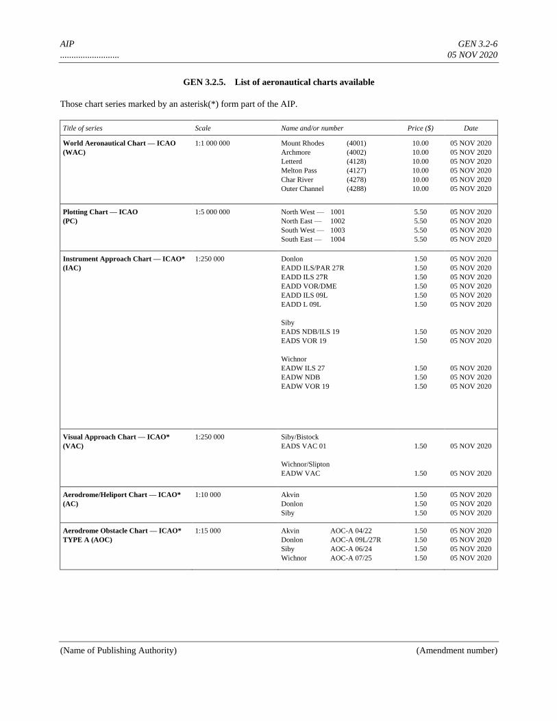
AIP GEN 3.2-6
.......................... 05 NOV 2020
(Name of Publishing Authority) (Amendment number)
GEN 3.2.5. List of aeronautical charts available
Those chart series marked by an asterisk(*) form part of the AIP.
Title of series Scale Name and/or number Price ($) Date
World Aeronautical Chart — ICAO
(WAC)
1:1 000 000 Mount Rhodes (4001)
Archmore (4002)
Letterd (4128)
Melton Pass (4127)
Char River (4278)
Outer Channel (4288)
10.00
10.00
10.00
10.00
10.00
10.00
05 NOV 2020
05 NOV 2020
05 NOV 2020
05 NOV 2020
05 NOV 2020
05 NOV 2020
Plotting Chart — ICAO
(PC)
1:5 000 000 North West — 1001
North East — 1002
South West — 1003
South East — 1004
5.50
5.50
5.50
5.50
05 NOV 2020
05 NOV 2020
05 NOV 2020
05 NOV 2020
Instrument Approach Chart — ICAO*
(IAC)
1:250 000 Donlon
EADD ILS/PAR 27R
EADD ILS 27R
EADD VOR/DME
EADD ILS 09L
EADD L 09L
Siby
EADS NDB/ILS 19
EADS VOR 19
Wichnor
EADW ILS 27
EADW NDB
EADW VOR 19
1.50
1.50
1.50
1.50
1.50
1.50
1.50
1.50
1.50
1.50
1.50
05 NOV 2020
05 NOV 2020
05 NOV 2020
05 NOV 2020
05 NOV 2020
05 NOV 2020
05 NOV 2020
05 NOV 2020
05 NOV 2020
05 NOV 2020
05 NOV 2020
Visual Approach Chart — ICAO*
(VAC)
1:250 000 Siby/Bistock
EADS VAC 01
Wichnor/Slipton
EADW VAC
1.50
1.50
05 NOV 2020
05 NOV 2020
Aerodrome/Heliport Chart — ICAO*
(AC)
1:10 000 Akvin
Donlon
Siby
1.50
1.50
1.50
05 NOV 2020
05 NOV 2020
05 NOV 2020
Aerodrome Obstacle Chart — ICAO*
TYPE A (AOC)
1:15 000 Akvin AOC-A 04/22
Donlon AOC-A 09L/27R
Siby AOC-A 06/24
Wichnor AOC-A 07/25
1.50
1.50
1.50
1.50
05 NOV 2020
05 NOV 2020
05 NOV 2020
05 NOV 2020

AIP GEN 3.2-7
.......................... 05 NOV 2020
(Name of Publishing Authority) (Amendment number)
Precision Approach Terrain Chart —
ICAO* (PATC)
1:2 500 Donlon
EADD PATC 27R
EADD PATC 09L
Siby
EADS PATC 19
1.50
1.50
1.50
05 NOV 2020
05 NOV 2020
05 NOV 2020

AIP GEN 3.2-8
.......................... 05 NOV 2020
(Name of Publishing Authority) (Amendment number)
GEN 3.2.6. Index to the World Aeronautical Chart (WAC) — 1:1 000 000
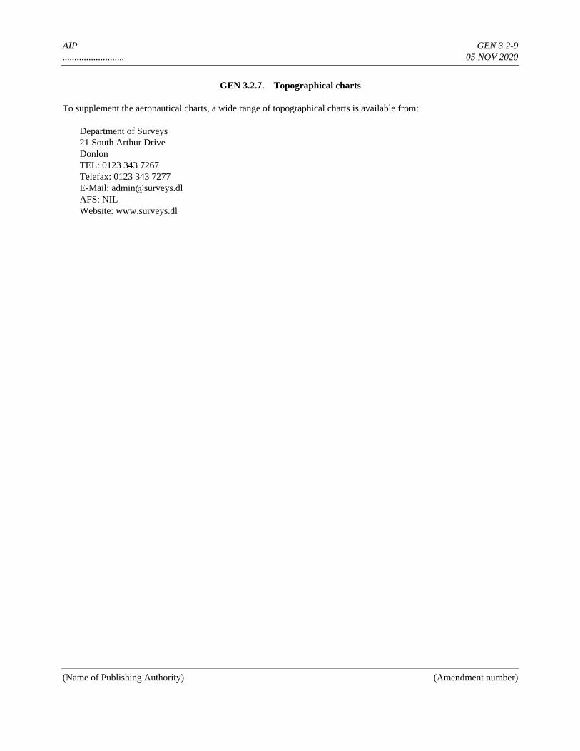
AIP GEN 3.2-9
.......................... 05 NOV 2020
(Name of Publishing Authority) (Amendment number)
GEN 3.2.7. Topographical charts
To supplement the aeronautical charts, a wide range of topographical charts is available from:
Department of Surveys
21 South Arthur Drive
Donlon
TEL: 0123 343 7267
Telefax: 0123 343 7277
E-Mail: [email protected]
AFS: NIL
Website: www.surveys.dl
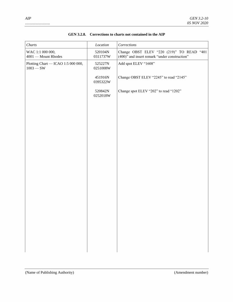
AIP GEN 3.2-10
.......................... 05 NOV 2020
(Name of Publishing Authority) (Amendment number)
GEN 3.2.8. Corrections to charts not contained in the AIP
Charts Location Corrections
WAC 1:1 000 000,
4001 — Mount Rhodes
520104N
0311737W
Change OBST ELEV “220 (219)” TO READ “401
(400)” and insert remark “under construction”
Plotting Chart — ICAO 1:5 000 000,
1003 — SW
525227N
0251008W
451916N
0395322W
520842N
0252018W
Add spot ELEV “1608”
Change OBST ELEV “2245” to read “2145”
Change spot ELEV “202” to read “1202”
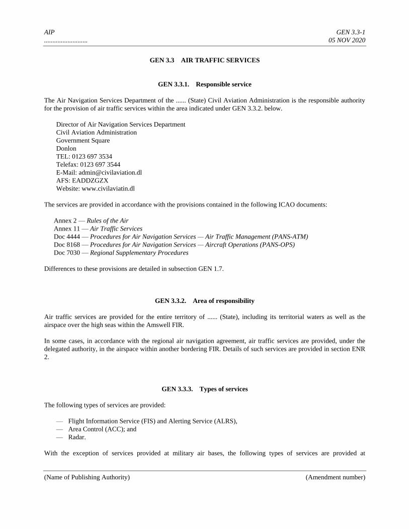
AIP GEN 3.3-1
.......................... 05 NOV 2020
(Name of Publishing Authority) (Amendment number)
GEN 3.3 AIR TRAFFIC SERVICES
GEN 3.3.1. Responsible service
The Air Navigation Services Department of the ...... (State) Civil Aviation Administration is the responsible authority
for the provision of air traffic services within the area indicated under GEN 3.3.2. below.
Director of Air Navigation Services Department
Civil Aviation Administration
Government Square
Donlon
TEL: 0123 697 3534
Telefax: 0123 697 3544
E-Mail: [email protected]
AFS: EADDZGZX
Website: www.civilaviatin.dl
The services are provided in accordance with the provisions contained in the following ICAO documents:
Annex 2 — Rules of the Air
Annex 11 — Air Traffic Services
Doc 4444 — Procedures for Air Navigation Services — Air Traffic Management (PANS-ATM)
Doc 8168 — Procedures for Air Navigation Services — Aircraft Operations (PANS-OPS)
Doc 7030 — Regional Supplementary Procedures
Differences to these provisions are detailed in subsection GEN 1.7.
GEN 3.3.2. Area of responsibility
Air traffic services are provided for the entire territory of ...... (State), including its territorial waters as well as the
airspace over the high seas within the Amswell FIR.
In some cases, in accordance with the regional air navigation agreement, air traffic services are provided, under the
delegated authority, in the airspace within another bordering FIR. Details of such services are provided in section ENR
2.
GEN 3.3.3. Types of services
The following types of services are provided:
— Flight Information Service (FIS) and Alerting Service (ALRS),
— Area Control (ACC); and
— Radar.
With the exception of services provided at military air bases, the following types of services are provided at

AIP GEN 3.3-2
.......................... 05 NOV 2020
(Name of Publishing Authority) (Amendment number)
aerodromes:
— Aerodrome Control (TWR);
— Aerodrome Flight Information Service (AFIS); and
— Automatic Terminal Information Service (ATIS), at certain aerodromes.
GEN 3.3.4. Coordination between the operator and ATS
Coordination between the operator and air traffic services is effected in accordance with Annex 11, 2.17.
GEN 3.3.5. Minimum flight altitude
The minimum flight altitudes on the ATS routes, as presented in section ENR 3, have been determined so as to ensure a
minimum vertical clearance above the controlling obstacle in the area concerned.
Note.— The navigation performance accuracy necessary for operation on air routes within Amswell FIR is
expressed as an RNP type. RNP type is a containment value expressed as a distance in NM from the intended position
within which flights would be for at least 95 per cent of the total flying time. For operation on the air routes in Amswell
FIR, the required navigation performance (RNP) is RNP 4. RNP 4 represents a navigation accuracy of plus or minus
7.4 km (4 NM) on a 95 per cent containment basis.
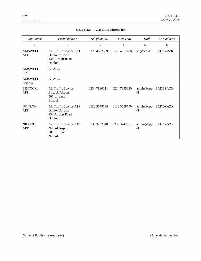
AIP GEN 3.3-3
.......................... 05 NOV 2020
(Name of Publishing Authority) (Amendment number)
GEN 3.3.6. ATS units address list
Unit name Postal address Telephone NR Telefax NR E-Mail AFS address
1 2 3 4 5 6
AMSWELL
ACC
Air Traffic Service/ACC
Donlon Airport
134 Airport Road
Donlon 1
0123 4567399 0123 4577288 [email protected] EADAZRZK
AMSWELL
FIS
As ACC
AMSWELL
RADIO
As ACC
BISTOCK
APP
Air Traffic Service
Bistock Airport
506 .... Lane
Bistock
0234 7890211 0234 7895220 admin@app.
dl
EADBZAZX
DONLON
APP
Air Traffic Service/APP
Donlon Airport
134 Airport Road
Donlon 1
0123 5678695 0123 5688750 admin@app.
dl
EADDZAZX
NIBORD
APP
Air Traffic Service/APP
Nibord Airport
308 .... Road
Nibord
0235 3232340 0235 3242351 admin@app.
dl
EADNZAZX
AIP GEN 3.4-1
.......................... 05 NOV 2020
(Name of Publishing Authority) (Amendment number)
GEN 3.4 COMMUNICATION SERVICES
GEN 3.4.1. Responsible service
The responsible service for the provision of telecommunication and navigation facility services in .......... (State) is the
Civil Aviation Administration.
Director of Communication Services
Civil Aviation Administration
Government Square
Donlon
TEL: 0123 697 5151
Telefax: 0123 697 5161
E-Mail: [email protected]
AFS: EADDYTYX
Website: www.civilaviation.dl
The service is provided in accordance with the provisions contained in the following ICAO documents:
Annex 10 — Aeronautical Telecommunications
Doc 8400 — Procedures for Air Navigation Services — ICAO Abbreviations and Codes (PANS-ABC)
Doc 8585 — Designators for Aircraft Operating Agencies, Aeronautical Authorities and Services
Doc 7030 — Regional Supplementary Procedures
Doc 7910 — Location Indicators
GEN 3.4.2. Area of responsibility
Communication services are provided for the entire AMSWELL FIR. Arrangements for such services on a continuing
basis should be made with the Director of Communication Services, who is also responsible for the application of the
regulations concerning the design, type and installations of aircraft radio stations. Responsibility for the day-to-day
operation of these services is vested in Station Communication Officers located at each international aerodrome.
Inquiries, suggestions or complaints regarding any telecommunication service should be referred to the relevant Station
Communication Officer or to the Director of Communication Services, as appropriate.
GEN 3.4.3. Types of service
3.1 Radio navigation services
The following types of radio aids to navigation are available:
LF/MF non-directional beacon (NDB)
Precision approach radar (PAR)
Instrument landing system (ILS)
VHF omnidirectional radio range (VOR)
Distance-measuring equipment (DME)
AIP GEN 3.4-2
.......................... 05 NOV 2020
(Name of Publishing Authority) (Amendment number)
Selected radio broadcasting stations are included as additional navigational facilities. The information is limited to
stations with a power of 10 kw or more. It should be noted that unserviceability of these stations will not be reported.
The coordinates listed refer to the transmitting antennas with the exception of direction-finding stations, for which the
coordinates of the receiving antennas are given.
According to the judgment of the direction-finding station, bearings are classified as follows:
Class A — accurate within ± 2 degrees
Class B — accurate within ± 5 degrees
Class C — accurate within ± 10 degrees
Direction-finding stations have authority to refuse to give bearings or headings to steer when conditions are
unsatisfactory or when bearings do not fall within the calibrated limits of the station, stating the reason at the time of
refusal. VOT on 113.9 MHz is available at DONLON/International.
3.2 Voice/data link services
Voice service
The aeronautical stations maintain a continuous watch on their stated frequencies during the published hours of service
unless otherwise notified.
An aircraft should normally communicate with the air-ground control radio station that exercises control in the area in
which the aircraft is flying. Aircraft should maintain a continuous watch on the appropriate frequency of the control
station and should not abandon watch, except in an emergency, without informing the control radio station.
Data link service
The messages to be transmitted over the Aeronautical Fixed Service (AFS) are accepted only if:
a) they satisfy the requirements of Annex 10, Vol. II, Chapter 3, 3.3;
b) they are prepared in the form specified in Annex 10;
c) the text of an individual message does not exceed 200 groups.
General aircraft operating agency messages are only accepted for transmission to countries that have agreed to accept
Class “B” traffic.
3.3 Broadcasting service
Sub-area meteorological broadcasts (VOLMET radio-telegraphy broadcasts) are available for the use of aircraft in
flight. Full details are given in subsection GEN 3.5.
3.4 Language used: English.
AIP GEN 3.4-3
.......................... 05 NOV 2020
(Name of Publishing Authority) (Amendment number)
3.5 Where detailed information can be obtained
Details of the various facilities available for the en-route traffic can be found in Part 2, ENR 4.
Details of the facilities available at the individual aerodromes can be found in the relevant sections of Part 3 (AD). In
cases where a facility is serving both the en-route traffic and the aerodromes, details are given in the relevant sections
of Part 2 (ENR) and Part 3 (AD).
GEN 3.4.4. Requirements and conditions
The requirements of the Directorate of Communication Services and the general conditions under which the
communication services are available for international use, as well as the requirements for the carriage of radio
equipment, are contained in the Air Navigation (Radio) Regulations of .......... (State). The main provisions are briefly
summarized below ........... (specify).
GEN 3.4.5. Miscellaneous
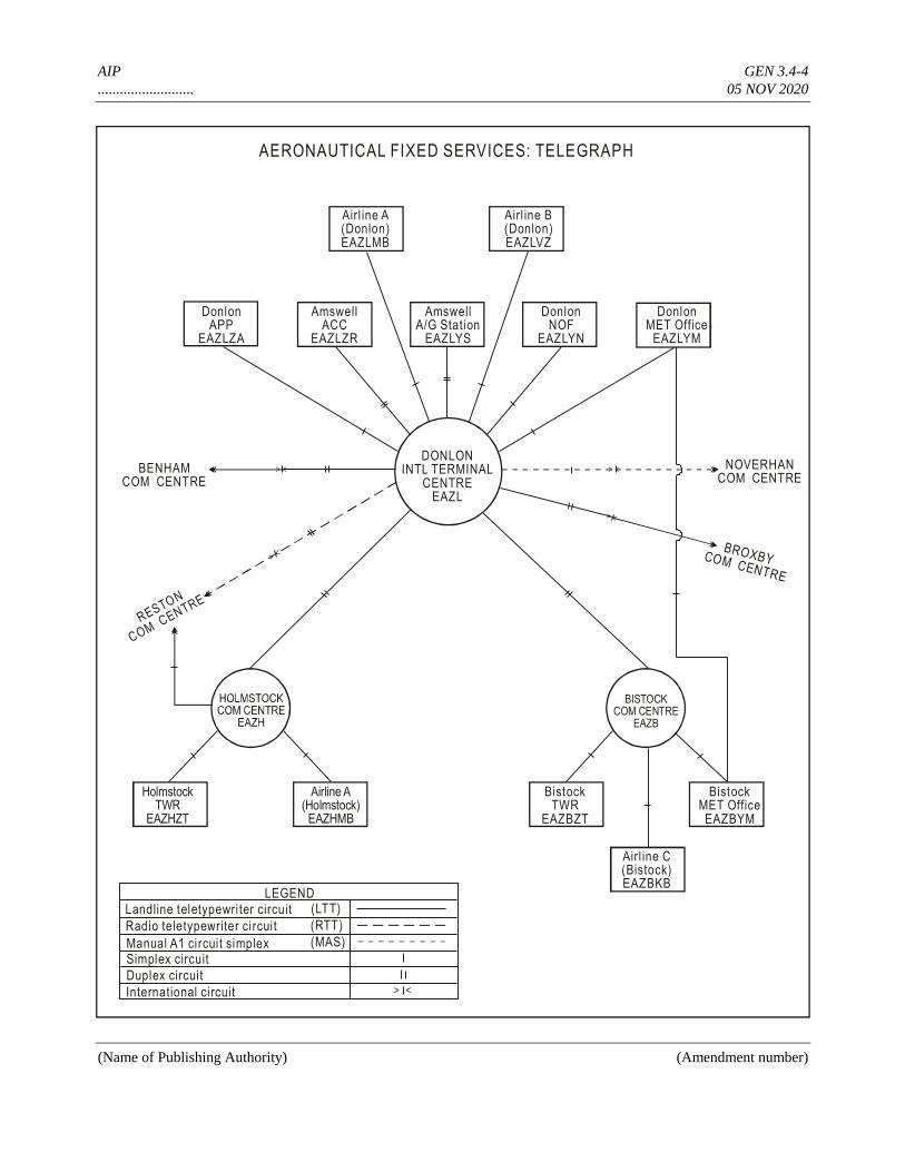
AIP GEN 3.4-4
.......................... 05 NOV 2020
(Name of Publishing Authority) (Amendment number)
> <
<>
<>
<>
<>
AERONAUTICAL FIXED SERVICES: TELEGRAPH
Airl ine A(Donlon)EAZLMB
DonlonAPP
EAZLZA
AmswellA/G Station
EAZLYS
AmswellACC
EAZLZR
DonlonNOF
EAZLYN
DonlonMET Office
EAZLYM
Airl ine B(Donlon)EAZLVZ
DONLONINTL TERMINAL
CENTREEAZL
BENHAMCOM CENTRE
RESTON
COM CENTRE
NOVERHANCOM CENTRE
BROXBYCOM CENTRE
BISTOCKCOM CENTRE
EAZB
HolmstockTWR
EAZHZT
Airline A(Holmstock)
EAZHMB
BistockTWR
EAZBZT
BistockMET OfficeEAZBYM
Airl ine C(Bistock)EAZBKB
LEGEND
Landline teletypewri ter circuit
Radio teletypewriter circui t
Manual A1 circui t simplexSimplex circuit
Duplex circui t
International circuit
(LTT)
(RTT)
(MAS)
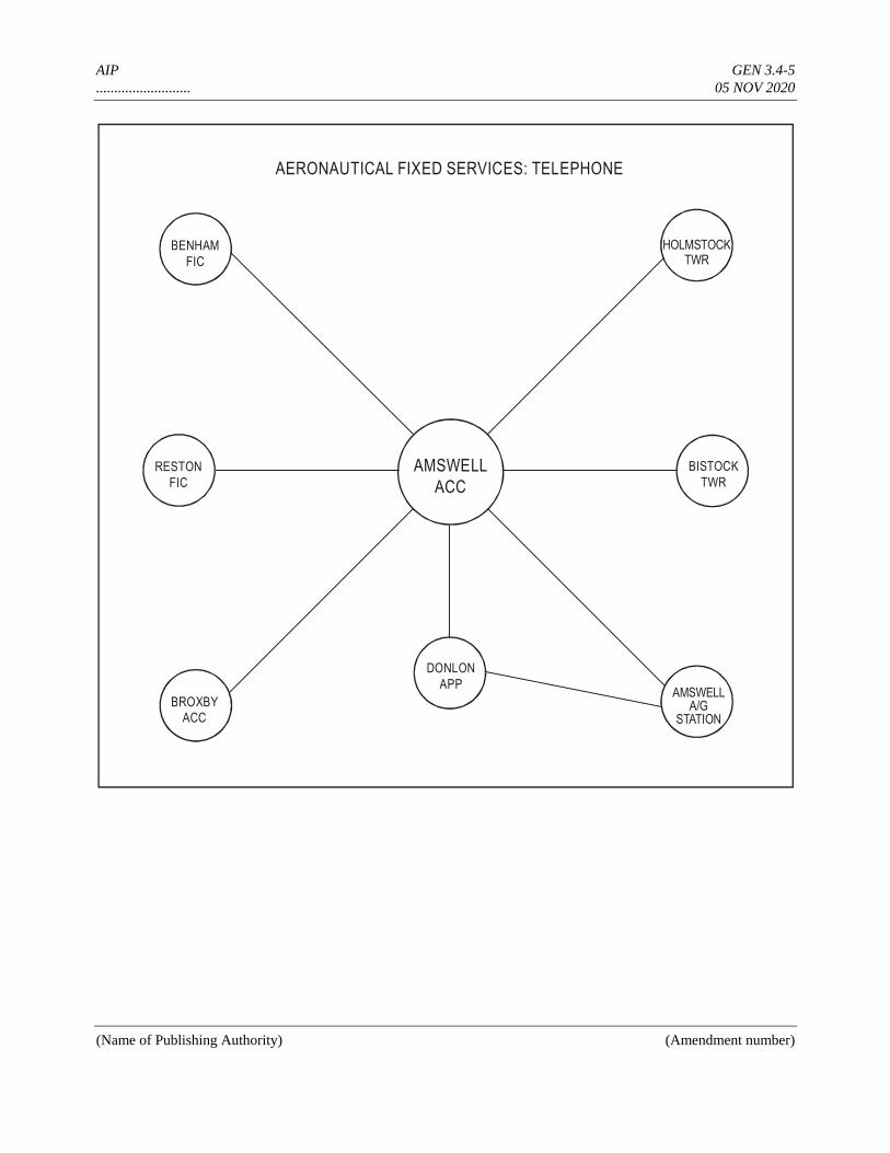
AIP GEN 3.4-5
.......................... 05 NOV 2020
(Name of Publishing Authority) (Amendment number)
AERONAUTICAL FIXED SERVICES: TELEPHONE
BENHAM
FIC
RESTON
FIC
BROXBY
ACC
AMSWELL
ACC
DONLON
APPAMSWELL
A/GSTATION
HOLMSTOCKTWR
BISTOCK
TWR
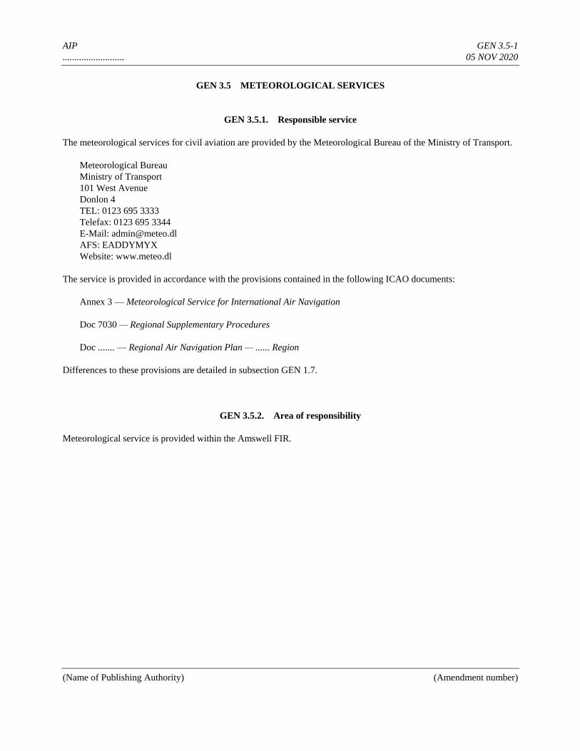
AIP GEN 3.5-1
.......................... 05 NOV 2020
(Name of Publishing Authority) (Amendment number)
GEN 3.5 METEOROLOGICAL SERVICES
GEN 3.5.1. Responsible service
The meteorological services for civil aviation are provided by the Meteorological Bureau of the Ministry of Transport.
Meteorological Bureau
Ministry of Transport
101 West Avenue
Donlon 4
TEL: 0123 695 3333
Telefax: 0123 695 3344
E-Mail: [email protected]
AFS: EADDYMYX
Website: www.meteo.dl
The service is provided in accordance with the provisions contained in the following ICAO documents:
Annex 3 — Meteorological Service for International Air Navigation
Doc 7030 — Regional Supplementary Procedures
Doc ....... — Regional Air Navigation Plan — ...... Region
Differences to these provisions are detailed in subsection GEN 1.7.
GEN 3.5.2. Area of responsibility
Meteorological service is provided within the Amswell FIR.

AIP GEN 3.5-2
.......................... 05 NOV 2020
(Name of Publishing Authority) (Amendment number)
GEN 3.5.3. Meteorological observations and reports
Table GEN 3.5.3 Meteorological observations and reports
Name of station/
Location indicator
Type & frequency
of observation/
automatic observing
equipment
Types of MET
reports &
availability of
trend forecasts
Observation system &
site(s)
Hours of
operation
Climatological
information
1 2 3 4 5 6
AKVIN/Akvin
EADA
Half hourly routine plus
special observations/
automatic: NIL
MET REPORT SFC wind sensors:
see AD chart
RVR EQPT:
see AD chart
Ceilometer:
see AD chart
Thermometer:
see AD chart
H24 Climatological
tables AVBL
DONLON/International
EADD
Half hourly routine plus
special observations/
automatic: NIL
METAR, SPECI
TREND
Cup Anemometer:
300 m FM THR 09L
RVR EQPT:
300 m FM RWY THR
Ceilometer:
at ILS MM
H24
*BTN
0600–1530
(0500–1430)
Climatological
tables AVBL
SIBY/Bistock
EADB
Half hourly routine plus
special observations/
automatic: NIL
METAR, SPECI Cup Anemometer:
300 m FM MID RWY
RVR EQPT:
300 m, 1 500 m and
2 600 m FM THR 05
Ceilometer:
close to Cup Anemometer
0430–2300
(0330–2200)
NIL
WICHNOR/Slipton
EADW
Hourly routine plus
special observations/
automatic: NIL
MET REPORT Complete observation station:
300 m S of THR 26
0530–1900 NIL
YANMORE/Runslip
EADR
Hourly routine plus
special observations/
automatic: NIL
METAR, SPECI
TREND
Pressure tube Anemometer:
on TWR
Ceilometer:
near ILS MM
0530–1900
(0430–1800)
NIL
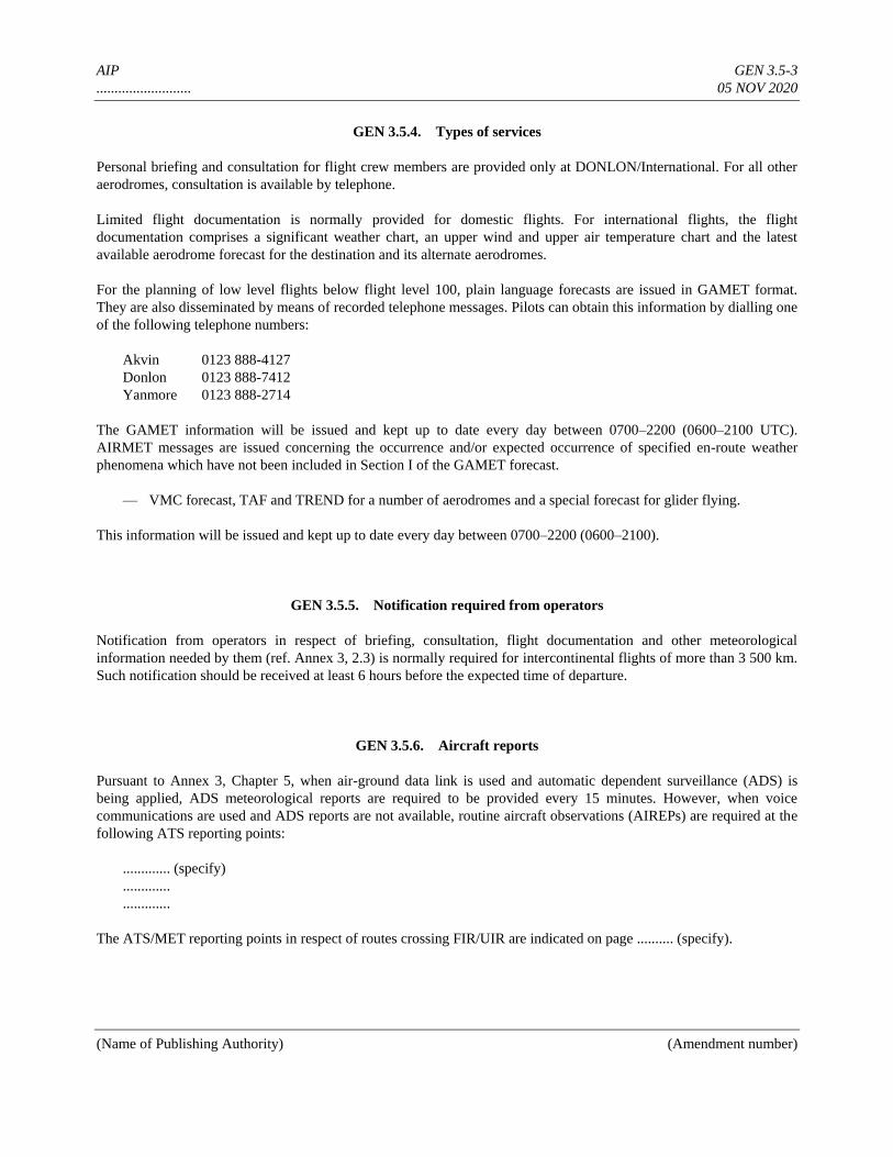
AIP GEN 3.5-3
.......................... 05 NOV 2020
(Name of Publishing Authority) (Amendment number)
GEN 3.5.4. Types of services
Personal briefing and consultation for flight crew members are provided only at DONLON/International. For all other
aerodromes, consultation is available by telephone.
Limited flight documentation is normally provided for domestic flights. For international flights, the flight
documentation comprises a significant weather chart, an upper wind and upper air temperature chart and the latest
available aerodrome forecast for the destination and its alternate aerodromes.
For the planning of low level flights below flight level 100, plain language forecasts are issued in GAMET format.
They are also disseminated by means of recorded telephone messages. Pilots can obtain this information by dialling one
of the following telephone numbers:
Akvin 0123 888-4127
Donlon 0123 888-7412
Yanmore 0123 888-2714
The GAMET information will be issued and kept up to date every day between 0700–2200 (0600–2100 UTC).
AIRMET messages are issued concerning the occurrence and/or expected occurrence of specified en-route weather
phenomena which have not been included in Section I of the GAMET forecast.
— VMC forecast, TAF and TREND for a number of aerodromes and a special forecast for glider flying.
This information will be issued and kept up to date every day between 0700–2200 (0600–2100).
GEN 3.5.5. Notification required from operators
Notification from operators in respect of briefing, consultation, flight documentation and other meteorological
information needed by them (ref. Annex 3, 2.3) is normally required for intercontinental flights of more than 3 500 km.
Such notification should be received at least 6 hours before the expected time of departure.
GEN 3.5.6. Aircraft reports
Pursuant to Annex 3, Chapter 5, when air-ground data link is used and automatic dependent surveillance (ADS) is
being applied, ADS meteorological reports are required to be provided every 15 minutes. However, when voice
communications are used and ADS reports are not available, routine aircraft observations (AIREPs) are required at the
following ATS reporting points:
............. (specify)
.............
.............
The ATS/MET reporting points in respect of routes crossing FIR/UIR are indicated on page .......... (specify).
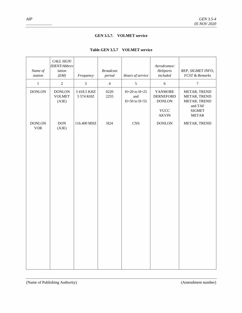
AIP GEN 3.5-4
.......................... 05 NOV 2020
(Name of Publishing Authority) (Amendment number)
GEN 3.5.7. VOLMET service
Table GEN 3.5.7 VOLMET service
Name of
station
CALL SIGN/
IDENT/Abbrev
iation
(EM) Frequency
Broadcast
period Hours of service
Aerodromes/
Heliports
included
REP, SIGMET INFO,
FCST & Remarks
1 2 3 4 5 6 7
DONLON DONLON
VOLMET
(A3E)
3 418.5 KHZ
5 574 KHZ
0220
2255
H+20 to H+25
and
H+50 to H+55
YANMORE
DERNEFORD
DONLON
YUCC
AKVIN
METAR, TREND
METAR, TREND
METAR, TREND
and TAF
SIGMET
METAR
DONLON
VOR
DON
(A3E)
116.400 MHZ H24 CNS DONLON METAR, TREND
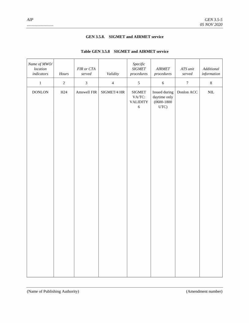
AIP GEN 3.5-5
.......................... 05 NOV 2020
(Name of Publishing Authority) (Amendment number)
GEN 3.5.8. SIGMET and AIRMET service
Table GEN 3.5.8 SIGMET and AIRMET service
Name of MWO/
location
indicators Hours
FIR or CTA
served Validity
Specific
SIGMET
procedures
AIRMET
procedures
ATS unit
served
Additional
information
1 2 3 4 5 6 7 8
DONLON H24 Amswell FIR SIGMET/4 HR SIGMET
VA/TC:
VALIDITY
6
Issued during
daytime only
(0600-1800
UTC)
Donlon ACC NIL

AIP GEN 3.5-6
.......................... 05 NOV 2020
(Name of Publishing Authority) (Amendment number)
8.1 General
For the safety of air traffic, the Meteorological Authority maintains a continuous watch over meteorological conditions
affecting flight operations within the lower and upper FIR and when necessary, SIGMET and AIRMET information is
issued by the Meteorological Watch Office (MWO). Furthermore, aerodrome warnings are issued to operators, in
accordance with local arrangements, by all aeronautical MET offices at aerodromes.
8.2 Meteorological watch
The meteorological watch is performed by the following MWOs: ....... (specify).
The MWOs issue SIGMET and AIRMET information in accordance with Annex 3, Chapter 7.
8.3 Aerodrome warnings
Aerodrome warnings for the protection of parked aircraft or of other equipment at the airport are issued by all
aerodrome meteorological offices, if one or several of the following phenomena are expected to occur at the airport:
— strong surface winds and gusts1
— thunderstorm
— hail
— frost2
— hoar frost or rime
— snow
— freezing precipitation
The aerodrome warnings are issued in English and are distributed in accordance with a distribution list agreed upon
locally.
8.4 Dissemination of SIGMET/AIRMET information to aircraft in flight
SIGMET and AIRMET information is disseminated, in addition to directed transmissions to aircraft general calls, as an
aeronautical broadcast between 0700 (0600 during legal summer time) until SS + 30
a) by the Area Control Centre Donlon for Donlon FIR;
b) by the ATS units for their own area of responsibility.
The information is repeated every half and full hour during the period of validity of the SIGMET and AIRMET
information.
___________
1. The warning is designated as “storm warning” and will be issued when the mean speed of the surface wind is expected to exceed 34 kt (Beaufort
Scale 8) or when gusts in excess of 41 kt (Beaufort Scale 9) are expected to occur.
2. A “frost warning” will be issued when the air temperature is expected to fall below 0ûC on those dates when protective measures have generally
not yet been taken and also when a substantial deposit of hoarfrost, e.g. on wing surfaces, is expected.
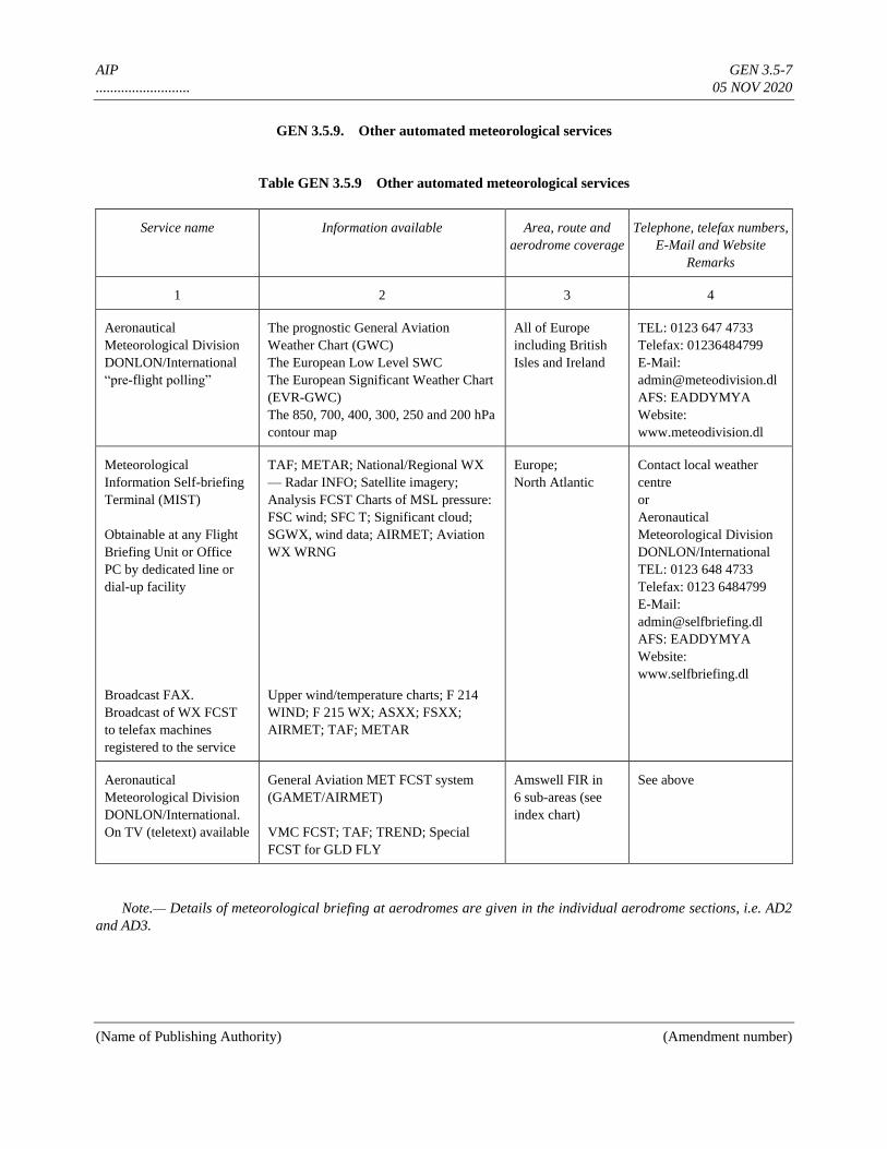
AIP GEN 3.5-7
.......................... 05 NOV 2020
(Name of Publishing Authority) (Amendment number)
GEN 3.5.9. Other automated meteorological services
Table GEN 3.5.9 Other automated meteorological services
Service name Information available Area, route and
aerodrome coverage
Telephone, telefax numbers,
E-Mail and Website
Remarks
1 2 3 4
Aeronautical
Meteorological Division
DONLON/International
“pre-flight polling”
The prognostic General Aviation
Weather Chart (GWC)
The European Low Level SWC
The European Significant Weather Chart
(EVR-GWC)
The 850, 700, 400, 300, 250 and 200 hPa
contour map
All of Europe
including British
Isles and Ireland
TEL: 0123 647 4733
Telefax: 01236484799
E-Mail:
AFS: EADDYMYA
Website:
www.meteodivision.dl
Meteorological
Information Self-briefing
Terminal (MIST)
Obtainable at any Flight
Briefing Unit or Office
PC by dedicated line or
dial-up facility
TAF; METAR; National/Regional WX
— Radar INFO; Satellite imagery;
Analysis FCST Charts of MSL pressure:
FSC wind; SFC T; Significant cloud;
SGWX, wind data; AIRMET; Aviation
WX WRNG
Europe;
North Atlantic
Contact local weather
centre
or
Aeronautical
Meteorological Division
DONLON/International
TEL: 0123 648 4733
Telefax: 0123 6484799
E-Mail:
AFS: EADDYMYA
Website:
www.selfbriefing.dl
Broadcast FAX.
Broadcast of WX FCST
to telefax machines
registered to the service
Upper wind/temperature charts; F 214
WIND; F 215 WX; ASXX; FSXX;
AIRMET; TAF; METAR
Aeronautical
Meteorological Division
DONLON/International.
On TV (teletext) available
General Aviation MET FCST system
(GAMET/AIRMET)
VMC FCST; TAF; TREND; Special
FCST for GLD FLY
Amswell FIR in
6 sub-areas (see
index chart)
See above
Note.— Details of meteorological briefing at aerodromes are given in the individual aerodrome sections, i.e. AD2
and AD3.

AIP GEN 3.5-8
.......................... 05 NOV 2020
(Name of Publishing Authority) (Amendment number)
GAME/AIRMET AREAS
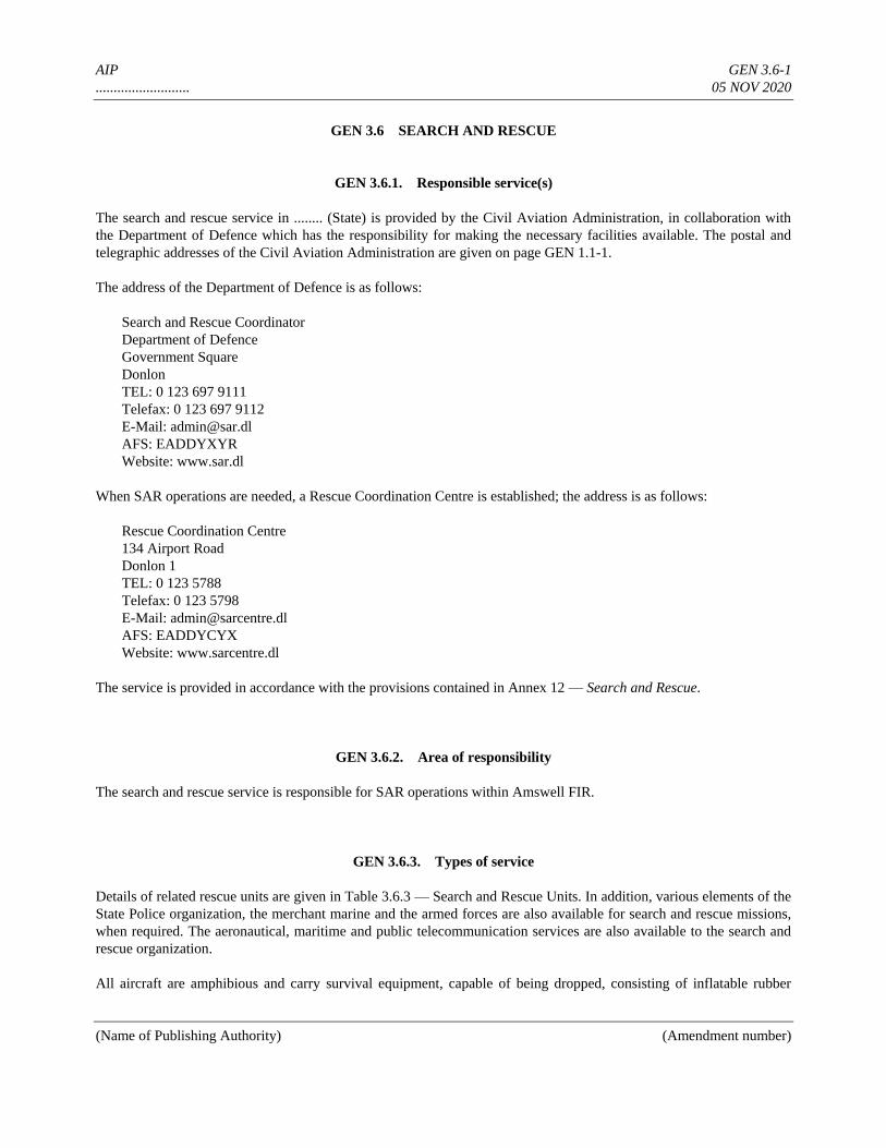
AIP GEN 3.6-1
.......................... 05 NOV 2020
(Name of Publishing Authority) (Amendment number)
GEN 3.6 SEARCH AND RESCUE
GEN 3.6.1. Responsible service(s)
The search and rescue service in ........ (State) is provided by the Civil Aviation Administration, in collaboration with
the Department of Defence which has the responsibility for making the necessary facilities available. The postal and
telegraphic addresses of the Civil Aviation Administration are given on page GEN 1.1-1.
The address of the Department of Defence is as follows:
Search and Rescue Coordinator
Department of Defence
Government Square
Donlon
TEL: 0 123 697 9111
Telefax: 0 123 697 9112
E-Mail: [email protected]
AFS: EADDYXYR
Website: www.sar.dl
When SAR operations are needed, a Rescue Coordination Centre is established; the address is as follows:
Rescue Coordination Centre
134 Airport Road
Donlon 1
TEL: 0 123 5788
Telefax: 0 123 5798
E-Mail: [email protected]
AFS: EADDYCYX
Website: www.sarcentre.dl
The service is provided in accordance with the provisions contained in Annex 12 — Search and Rescue.
GEN 3.6.2. Area of responsibility
The search and rescue service is responsible for SAR operations within Amswell FIR.
GEN 3.6.3. Types of service
Details of related rescue units are given in Table 3.6.3 — Search and Rescue Units. In addition, various elements of the
State Police organization, the merchant marine and the armed forces are also available for search and rescue missions,
when required. The aeronautical, maritime and public telecommunication services are also available to the search and
rescue organization.
All aircraft are amphibious and carry survival equipment, capable of being dropped, consisting of inflatable rubber
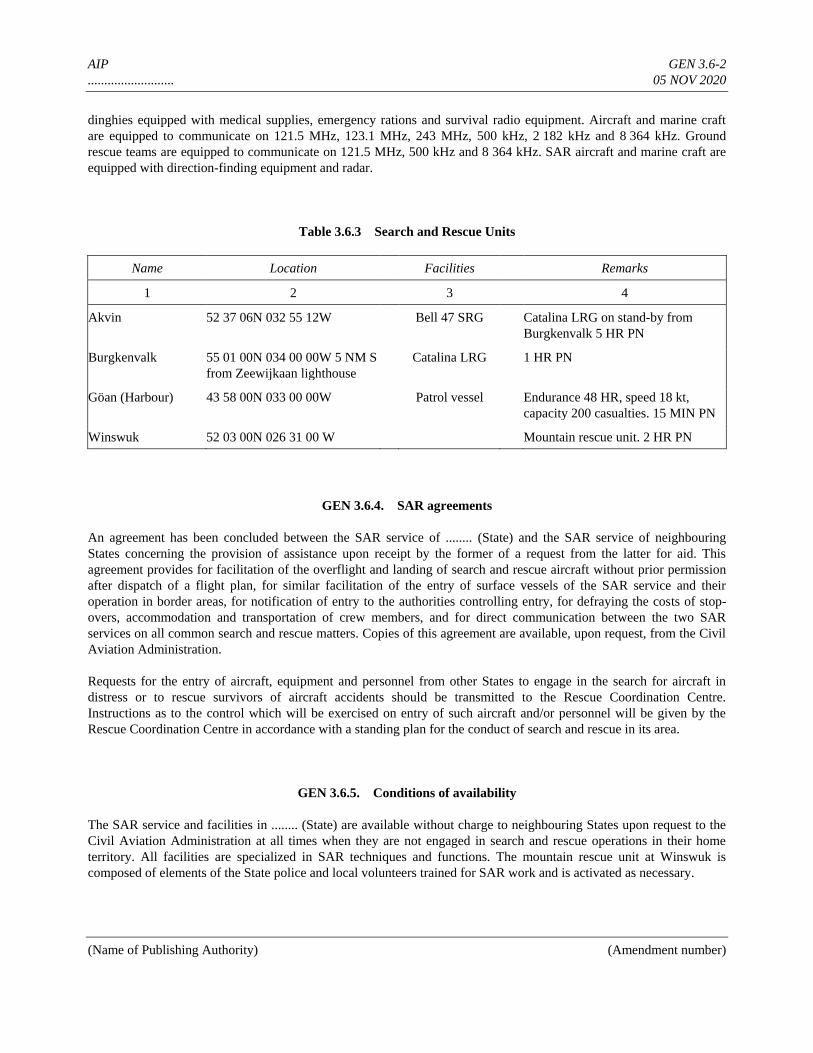
AIP GEN 3.6-2
.......................... 05 NOV 2020
(Name of Publishing Authority) (Amendment number)
dinghies equipped with medical supplies, emergency rations and survival radio equipment. Aircraft and marine craft
are equipped to communicate on 121.5 MHz, 123.1 MHz, 243 MHz, 500 kHz, 2 182 kHz and 8 364 kHz. Ground
rescue teams are equipped to communicate on 121.5 MHz, 500 kHz and 8 364 kHz. SAR aircraft and marine craft are
equipped with direction-finding equipment and radar.
Table 3.6.3 Search and Rescue Units
Name Location Facilities Remarks
1 2 3 4
Akvin 52 37 06N 032 55 12W Bell 47 SRG Catalina LRG on stand-by from
Burgkenvalk 5 HR PN
Burgkenvalk 55 01 00N 034 00 00W 5 NM S
from Zeewijkaan lighthouse
Catalina LRG 1 HR PN
Göan (Harbour) 43 58 00N 033 00 00W Patrol vessel Endurance 48 HR, speed 18 kt,
capacity 200 casualties. 15 MIN PN
Winswuk 52 03 00N 026 31 00 W Mountain rescue unit. 2 HR PN
GEN 3.6.4. SAR agreements
An agreement has been concluded between the SAR service of ........ (State) and the SAR service of neighbouring
States concerning the provision of assistance upon receipt by the former of a request from the latter for aid. This
agreement provides for facilitation of the overflight and landing of search and rescue aircraft without prior permission
after dispatch of a flight plan, for similar facilitation of the entry of surface vessels of the SAR service and their
operation in border areas, for notification of entry to the authorities controlling entry, for defraying the costs of stop-
overs, accommodation and transportation of crew members, and for direct communication between the two SAR
services on all common search and rescue matters. Copies of this agreement are available, upon request, from the Civil
Aviation Administration.
Requests for the entry of aircraft, equipment and personnel from other States to engage in the search for aircraft in
distress or to rescue survivors of aircraft accidents should be transmitted to the Rescue Coordination Centre.
Instructions as to the control which will be exercised on entry of such aircraft and/or personnel will be given by the
Rescue Coordination Centre in accordance with a standing plan for the conduct of search and rescue in its area.
GEN 3.6.5. Conditions of availability
The SAR service and facilities in ........ (State) are available without charge to neighbouring States upon request to the
Civil Aviation Administration at all times when they are not engaged in search and rescue operations in their home
territory. All facilities are specialized in SAR techniques and functions. The mountain rescue unit at Winswuk is
composed of elements of the State police and local volunteers trained for SAR work and is activated as necessary.
AIP GEN 3.6-3
.......................... 05 NOV 2020
(Name of Publishing Authority) (Amendment number)
GEN 3.6.6. Procedures and signals used
Procedures and signals used by aircraft
Procedures for pilots-in-command observing an accident or intercepting a distress call and/or message are outlined in
Annex 12, Chapter 5.
Communications
Transmission and reception of distress messages within the Amswell Search and Rescue Area are handled in
accordance with Annex 10, Volume II, 5.3.
For communications during search and rescue operations, the codes and abbreviations published in ICAO
Abbreviations and Codes (Doc 8400) are used.
The frequency 121.5 MHz is guarded continuously during the hours of service at all area control centres and flight
information centres. It is also available at Donlon/International approach control office. In addition, the aerodrome
control towers serving international aerodromes and international alternate aerodromes will, on request, guard the
frequency 121.5 MHz. All coast stations guard the international distress frequencies.
Rescue aircraft belonging to permanent Search and Rescue Units use both the call sign RESCUE and additional
identification marks (ALFA, BRAVO, CHARLIE, etc.) during rescue operations.
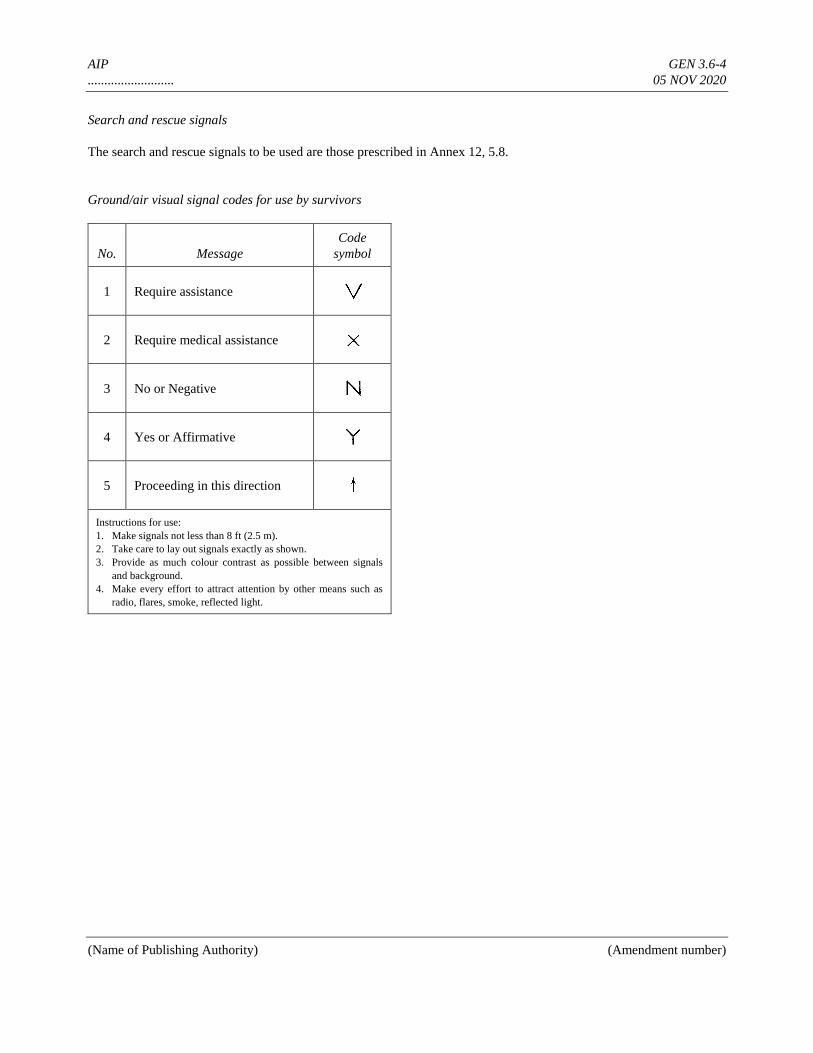
AIP GEN 3.6-4
.......................... 05 NOV 2020
(Name of Publishing Authority) (Amendment number)
Search and rescue signals
The search and rescue signals to be used are those prescribed in Annex 12, 5.8.
Ground/air visual signal codes for use by survivors
No. Message
Code
symbol
1 Require assistance
2 Require medical assistance
3 No or Negative
4 Yes or Affirmative
5 Proceeding in this direction
Instructions for use:
1. Make signals not less than 8 ft (2.5 m).
2. Take care to lay out signals exactly as shown.
3. Provide as much colour contrast as possible between signals
and background.
4. Make every effort to attract attention by other means such as
radio, flares, smoke, reflected light.
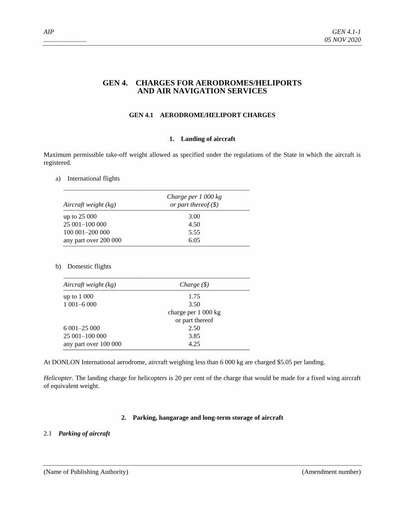
AIP GEN 4.1-1
.......................... 05 NOV 2020
(Name of Publishing Authority) (Amendment number)
GEN 4. CHARGES FOR AERODROMES/HELIPORTS AND AIR NAVIGATION SERVICES
GEN 4.1 AERODROME/HELIPORT CHARGES
1. Landing of aircraft
Maximum permissible take-off weight allowed as specified under the regulations of the State in which the aircraft is
registered.
a) International flights
Aircraft weight (kg)
Charge per 1 000 kg
or part thereof ($)
up to 25 000 3.00
25 001–100 000 4.50
100 001–200 000 5.55
any part over 200 000 6.05
b) Domestic flights
Aircraft weight (kg) Charge ($)
up to 1 000 1.75
1 001–6 000 3.50
charge per 1 000 kg
or part thereof
6 001–25 000 2.50
25 001–100 000 3.85
any part over 100 000 4.25
At DONLON International aerodrome, aircraft weighing less than 6 000 kg are charged $5.05 per landing.
Helicopter. The landing charge for helicopters is 20 per cent of the charge that would be made for a fixed wing aircraft
of equivalent weight.
2. Parking, hangarage and long-term storage of aircraft
2.1 Parking of aircraft
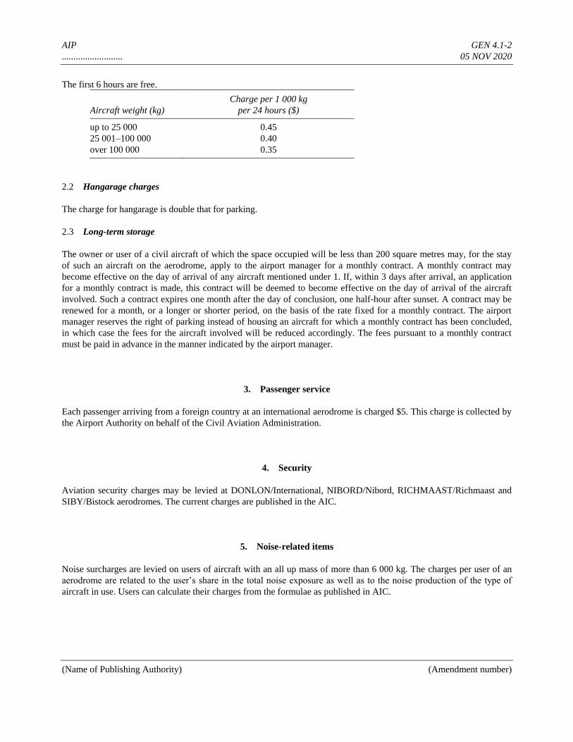
AIP GEN 4.1-2
.......................... 05 NOV 2020
(Name of Publishing Authority) (Amendment number)
The first 6 hours are free.
Aircraft weight (kg)
Charge per 1 000 kg
per 24 hours ($)
up to 25 000 0.45
25 001–100 000 0.40
over 100 000 0.35
2.2 Hangarage charges
The charge for hangarage is double that for parking.
2.3 Long-term storage
The owner or user of a civil aircraft of which the space occupied will be less than 200 square metres may, for the stay
of such an aircraft on the aerodrome, apply to the airport manager for a monthly contract. A monthly contract may
become effective on the day of arrival of any aircraft mentioned under 1. If, within 3 days after arrival, an application
for a monthly contract is made, this contract will be deemed to become effective on the day of arrival of the aircraft
involved. Such a contract expires one month after the day of conclusion, one half-hour after sunset. A contract may be
renewed for a month, or a longer or shorter period, on the basis of the rate fixed for a monthly contract. The airport
manager reserves the right of parking instead of housing an aircraft for which a monthly contract has been concluded,
in which case the fees for the aircraft involved will be reduced accordingly. The fees pursuant to a monthly contract
must be paid in advance in the manner indicated by the airport manager.
3. Passenger service
Each passenger arriving from a foreign country at an international aerodrome is charged $5. This charge is collected by
the Airport Authority on behalf of the Civil Aviation Administration.
4. Security
Aviation security charges may be levied at DONLON/International, NIBORD/Nibord, RICHMAAST/Richmaast and
SIBY/Bistock aerodromes. The current charges are published in the AIC.
5. Noise-related items
Noise surcharges are levied on users of aircraft with an all up mass of more than 6 000 kg. The charges per user of an
aerodrome are related to the user’s share in the total noise exposure as well as to the noise production of the type of
aircraft in use. Users can calculate their charges from the formulae as published in AIC.
AIP GEN 4.1-3
.......................... 05 NOV 2020
(Name of Publishing Authority) (Amendment number)
6. Other
Nil.
7. Exemptions and reductions
Exemptions
a) Diplomatic aircraft
b) Test flights
c) Emergency landings
Reductions
a) International flights — 20 per cent on landings in excess of 300 per month performed by aircraft of any one
operator.
b) Domestic flights — 20 per cent on landings in excess of 100 per month performed by aircraft of any one
operator.
Surcharges
An additional 10 per cent of the landing charge is levied for each landing made at night or outside of the published
operational hours of the aerodrome.
Night: 1 April–30 September 2000–0530 (UTC)
1 October–31 March 1700–0700 (UTC)
Cargo
Cargo charges are based on the gross weight of the cargo being loaded or unloaded. The charge is collected by the
airline operator on behalf of the Civil Aviation Administration. The rate of charge is $0.01 per kg.
8. Methods of payment
Landing charges and parking or hangar charges levied at daily rates are payable at the time the aerodrome is used or, in
the case of regular users, on demand at the end of each calendar month in respect of charges accruing during the month.
Hangar or parking charges levied at monthly or quarterly rates are payable in advance at the beginning of the period.
AIP GEN 4.2-1
.......................... 05 NOV 2020
(Name of Publishing Authority) (Amendment number)
GEN 4.2 AIR NAVIGATION SERVICES CHARGES
1. Approach control
1.1 Users of DONLON/International, NIBORD/Nibord, RICHMAAST/Richmaast and SIBY/Bistock
aerodromes will be charged for the services rendered by the ATC units of the above-mentioned aerodromes.
1.2 The charges will be collected by the aerodrome authorities, in addition to the landing fees.
1.3 The calculation of the charges will be made on the basis of the landing fees charged for use of these
aerodromes.
1.4 The charges will be assessed in accordance with the following regulations:
a) for an aircraft executing a training or test flight, a charge of 50% of the current landing fees, with a maximum
of U.S.$100 per landing.
b) for each other aircraft, a charge of 50% of the current landing fees, with a maximum of $500 per landing.
2. Route air navigation services
2.1 General
For aircraft with a Maximum Take-Off Mass (MTOM) exceeding 2 000 kg, flying en-route in accordance with the
Instrument Flight Rules (IFR) within AMSWELL Flight Information Region (FIR), a charge shall be paid for each
flight in accordance with the following stipulations:
2.2 Calculation formula
The charge per flight will be calculated in accordance with the following formula:
r = ti × N
in which r is the charge, ti the service unit rate, and N the number of service units corresponding to the actual flight in
AMSWELL FIR.
The number of service units (N) is obtained by applying the following formula:
N = d × P
in which d is the distance factor of the flight within AMSWELL FIR and P the weight factor for the aircraft concerned.
2.2.1 Distance factor
The distance factor shall be calculated on the basis of the total distance (great circle distance in kilometres) between
— aerodrome/airfield of departure within, or point of entry into, AMSWELL FIR and
AIP GEN 4.2-2
.......................... 05 NOV 2020
(Name of Publishing Authority) (Amendment number)
— aerodrome/airfield of arrival within AMSWELL FIR, or point of exit from AMSWELL FIR.
However, the distance to be taken into account shall be reduced by 20 kilometres for each take-off or landing,
considering that a separate charge is paid for the air navigation services and facilities at aerodromes. The distances to
be taken into account are published in an average distance catalogue; in case a distance is not shown in the catalogue,
the charge will be based on the actual flown distance.
The value of the distance factor (d) shall be calculated as 1/100 of the distance for which a charge is imposed.
2.2.2 Weight factor
The weight factor is defined as the square root of the quotient obtained by dividing the number of metric tonnes in the
maximum certificated take-off mass of the aircraft (as set out in the certificate of airworthiness) by 50:
50
MTOMP
For the calculation of the charge, the weight factor will be expressed with two decimals.
In those cases where an operator has informed the Civil Aviation Administration that two or more aircraft, which are
different versions of the same type, are in operation, the average of the maximum take-off mass of all aircraft of that
type shall be used for the calculation of the weight factor for each aircraft of that type. The calculation of this factor per
aircraft type and per operator will be effected at least once a year. If the operator has given no such indication, the
weight factor for an aircraft of any type shall be calculated by taking the mass of the heaviest aircraft of that type.
2.2.3 Service unit rate
The service unit rate, ti, is fixed at $33.50.
In order to illustrate the effect of the rules, some examples of IFR flights are given below.
a) Flight from .......... to .......... with DC-9-41
The distance is 238 km*
The distance factor, d = (238 – (2 × 20))/100 = 1.98
The mass (MTOM) is 52 tonnes
The weight factor, 52
1.0250
P
The number of service units, N = 1.98 × 1.02 = 2.02
Charge = 2.02 × $33.50 = $67.67
*The distance according to the catalogue is 198 km.
*The distance factor, d = 198/100 = 1.98.
b) Flight from ......... to ......... with Piper PA-28-140
AIP GEN 4.2-3
.......................... 05 NOV 2020
(Name of Publishing Authority) (Amendment number)
The mass of the aircraft (MTOM) is 1 000 kg
Therefore the flight is free of charge
c) Flight from .......... to .......... with Beech 200
The distance is 219 km*
The distance factor, d = (219 – (2 × 20))/100 = 1.79
The mass (MTOM) is 5.6 tonnes.
The weight factor, 5.6
0.3350
P
The number of service units, N = 1.79 × 0.33 = 0.59
Charge = 0.59 × $33.50 = $19.76
*The distance according to the catalogue is 179 km.
*The distance factor, d = 179/100 = 1.79.
3. Cost basis for air navigation services and exemptions/reductions
3.1 Cost basis for Air Navigation Services
The cost basis for Air Navigation Services is available on request from the Ministry of Transport, Civil Aviation
Administration (for address, see GEN 1.1.6).
3.2 Exemptions/reductions
The following categories of flights shall be exempted from payment of air navigation facility charges:
a) test flights made at the request of the Civil Aviation Administration;
b) technical check flights made by aircraft engaged in commercial aviation, with no remuneration being received
for passengers and goods, if such be on board;
c) flights made for search and rescue purposes;
d) technical return flights, i.e. take-off with forced return to the aerodrome of departure due to technical
disturbances, adverse weather conditions, and the like;
e) aircraft owned by the Civil Aviation Administration;
f) ........ (State) military aircraft;
g) foreign military aircraft and aircraft used solely for the transportation of the representatives of foreign States
or of United Nations personnel; and
h) aircraft owned by foreign States assigned to Police and Customs Authorities and navigation aid inspection.
AIP GEN 4.2-4
.......................... 05 NOV 2020
(Name of Publishing Authority) (Amendment number)
It is a condition for obtaining the exemption mentioned under a), b) and c) that special prior notification be made to the
Air Traffic Service, Donlon Area Control Centre (ACC).
4. Methods of payment
The owner and user of an aircraft are jointly and severally responsible for payment of the charge. Notification of the
charge will be made monthly by the Civil Aviation Administration by forwarding an invoice. Payment is due 30 days
after the date of the invoice. If payment is not made by that day (or if the payment day falls on a Saturday, Sunday or
holiday, then by the following weekday), the user/owner is bound to pay interest of 1% per month on overdue
payments commencing on the day payment of the charge was due.
If payments are not made,
a) collection can be done by distress,
b) permission to fly to or from ......... (State) territory can be denied, and
c) permission already granted can be withdrawn.

AIP
AERONAUTICAL INFORMATION PUBLICATION
____________________________________
(Name of State)
PART 2
GENERAL (ENR)
VOLUME NR (If more than one volume)
AIP ENR 0.6-1
.......................... 05 NOV 2020
(Name of Publishing Authority) (Amendment number)
PART 2 — EN-ROUTE (ENR)
ENR 0.
ENR 0.1 PREFACE — Not applicable
ENR 0.2 RECORD OF AIP AMENDMENTS — Not applicable
ENR 0.3 RECORD OF AIP SUPPLEMENTS — Not applicable
ENR 0.4 CHECKLIST OF AIP PAGES — Not applicable
ENR 0.5 LIST OF HAND AMENDMENTS TO THE AIP — Not applicable
ENR 0.6 TABLE OF CONTENTS TO PART 2
ENR 1. GENERAL RULES AND PROCEDURES
ENR 1.1 General rules ............................................................................................................................... ENR 1.1-1
ENR 1.2 Visual flight rules ........................................................................................................................ ENR 1.2-1
ENR 1.3 Instrument flight rules ................................................................................................................. ENR 1.3-1
ENR 1.4 ATS airspace classification and description................................................................................ ENR 1.4-1
ENR 1.4.1 ATS airspace classification .................................................................................................. ENR 1.4-1
ENR 1.4.2 ATS airspace description ..................................................................................................... ENR 1.4-1
ENR 1.5 Holding, approach and departure procedures .............................................................................. ENR 1.5-1
ENR 1.5.1 General ................................................................................................................................ ENR 1.5-1
ENR 1.5.2 Arriving flights .................................................................................................................... ENR 1.5-1
ENR 1.5.3 Departing flights .................................................................................................................. ENR 1.5-1
ENR 1.5.4 Other relevant information and procedures ......................................................................... ENR 1.5-1
ENR 1.6 ATS surveillance services and procedures .................................................................................. ENR 1.6-1
ENR 1.6.1 Primary radar ....................................................................................................................... ENR 1.6-1
ENR 1.6.2 Secondary surveillance radar (SSR) .................................................................................... ENR 1.6-2
ENR 1.6.3 Automatic dependent surveillance ....................................................................................... ENR 1.6-2
ENR 1.6.4 Oher relevant information and procedures .......................................................................... ENR 1.6-2
ENR 1.7 Altimeter setting procedures ....................................................................................................... ENR 1.7-1
ENR 1.8 Regional supplementary procedures (Doc 7030) ........................................................................ ENR 1.8-1
ENR 1.9 Air traffic flow management (ATFM) and airspace management .............................................. ENR 1.9-1
ENR 1.10 Flight planning ............................................................................................................................ ENR 1.10-1
ENR 1.11 Addressing of flight plan messages............................................................................................. ENR 1.11-1
ENR 1.12 Interception of civil aircraft ........................................................................................................ ENR 1.12-1
ENR 1.13 Unlawful interference ................................................................................................................. ENR 1.13-1
ENR 1.14 Air traffic incidents ..................................................................................................................... ENR 1.14-1
ENR 2. AIR TRAFFIC SERVICES AIRSPACE
ENR 2.1 FIR, UIR, TMA and CTA ........................................................................................................... ENR 2.1-1
ENR 2.2 Other regulated airspace ............................................................................................................. ENR 2.2-1
ENR 3. ATS ROUTES
AIP ENR 0.6-2
.......................... 05 NOV 2020
(Name of Publishing Authority) (Amendment number)
ENR 3.1 Lower ATS routes ....................................................................................................................... ENR 3.1-1
ENR 3.2 Upper ATS routes ....................................................................................................................... ENR 3.2-1
ENR 3.3 Area navigation (RNAV) routes ................................................................................................. ENR 3.3-1
ENR 3.4 Helicopter routes ......................................................................................................................... ENR 3.4-1
ENR 3.5 Other routes ................................................................................................................................. ENR 3.5-1
ENR 3.6 En-route holding ......................................................................................................................... ENR 3.6-1
ENR 4. RADIO NAVIGATION AIDS/SYSTEMS
ENR 4.1 Radio navigation aids — en-route .............................................................................................. ENR 4.1-1
ENR 4.2 Special navigation systems ......................................................................................................... ENR 4.2-1
ENR 4.3 Global navigation satellite system (GNSS) ................................................................................. ENR 4.3-1
ENR 4.4 Name-code designators for significant points ............................................................................. ENR 4.4-1
ENR 4.5 Aeronautical ground lights — en-route ....................................................................................... ENR 4.5-1
ENR 5. NAVIGATION WARNINGS
ENR 5.1 Prohibited, restricted and danger areas ....................................................................................... ENR 5.1-1
ENR 5.2 Military exercise and training areas and air defence identification zone (ADIZ) ....................... ENR 5.2-1
ENR 5.3 Other activities of a dangerous nature and other potential hazards ............................................. ENR 5.3-1
ENR 5.4 Air navigation obstacles — Area 1 ............................................................................................. ENR 5.4-1
ENR 5.5 Aerial sporting and recreational activities ................................................................................... ENR 5.5-1
ENR 5.6 Bird migration and areas with sensitive fauna ............................................................................ ENR 5.6-1
ENR 6. EN-ROUTE CHARTS................................................................................................................... ENR 6-1

AIP ENR 1.1-1
.......................... 05 NOV 2020
(Name of Publishing Authority) (Amendment number)
ENR 1. GENERAL RULES AND PROCEDURES
ENR 1.1 GENERAL RULES
EXAMPLE 1
(Reference to ICAO documents)
The air traffic rules and procedures applicable to air traffic in ......... (State) territory conform to Annexes 2 and 11 to
the Convention on International Civil Aviation and to those portions of the Procedures for Air Navigation Services —
Air Traffic Management applicable to aircraft and of the Regional Supplementary Procedures applicable to the .........
(specify) Region, except for the differences listed in GEN 1.7.
EXAMPLE 2
(Published in full)
1. Minimum safe height
Aircraft shall not be flown below the minimum safe height except when necessary for take-off and landing. The
minimum safe height is the height at which neither an unnecessary noise disturbance nor unnecessary hazards to
persons and property in the event of an emergency landing are to be feared; however, over cities, other densely
populated areas and assemblies of persons, this height shall be at least 300 m (1 000 ft) above the highest obstacle
within a radius of 600 m, and elsewhere at least 150 m (500 ft) above ground or water. Gliders and balloons may be
operated below a height of 150 m if necessary for the kind of operation and if danger to persons and property is not to
be feared. Aircraft shall not be flown below bridges and similar constructions nor below overhead lines and antennas.
For flights conducted for special purposes, the local aeronautical authority may grant exemptions.
2. Dropping of objects
The dropping or spraying of objects or other substances out of or from aircraft is prohibited. This does not apply to
ballast in the form of water or fine sand, fuel, tow ropes, tow banners and similar objects if dropped or discharged at
places where no danger to persons or property exists. The local aeronautical authority may grant exemptions to the
interdiction if no danger to persons or property exists.
The dropping of mail is controlled by the Postal Authority or by the designated unit, in agreement with the aeronautical
authority.
3. Acrobatic flying
Acrobatic flights are only permitted in visual meteorological conditions and with the explicit consent of all persons on
AIP ENR 1.1-2
.......................... 05 NOV 2020
(Name of Publishing Authority) (Amendment number)
board. Acrobatic flights are prohibited at heights of less than 450 m (1 500 ft) as well as over cities, other densely
populated areas, assemblies of persons, and airports. The local aeronautical authority may grant exemptions in
individual cases. Acrobatic flights conducted in the vicinity of aerodromes without an ATS unit require special
permission in addition to the air traffic control clearance.
4. Towing and advertising flights
Advertising flights with towed objects require permission from the local aeronautical authority in the area in which the
applicant is a resident. Permission shall be granted only if:
1) the pilot holds the rating for towing;
2) the aircraft is equipped with a calibrated barograph for recording altitudes during flight;
3) during the proposed flight not more than three aircraft are flying in formation, in which case a distance of at
least 60 m shall be maintained both between the towed object of the preceding aircraft and the following
aircraft, as well as between the aircraft;
4) the legal liability insurance also explicitly covers the towing of objects.
The above applies to the towing of objects for other than advertising purposes and subparagraph 2) does not apply to
aerial work of rotorcraft. Towing of gliders does not require permission, as the rating for towing will suffice.
For reasons of public safety or order and in particular for noise abatement, the authority granting permission may
impose conditions. This authority may assign higher minimum safe heights and impose time limitations.
Advertising flights, where advertising consists only of inscriptions on the aircraft, do not require permission. Flights for
advertising with acoustical means are prohibited.
5. Times and units of measurement
Co-ordinated Universal Time (UTC) and the prescribed units of measurement shall be applied to flight operations. The
Minister of Transport will establish the units of measurement to be used and they will be published in the Aeronautical
Information Publication (AIP).
6. Airspace structure
For the performance of the flight information service and the alerting service, the Minister of Transport establishes
flight information regions which are published in the AIP. Within the flight information regions, the Minister of
Transport establishes the controlled and uncontrolled airspace according to the extent of the air traffic services
maintained there, on the basis of the classification described in subsection ENR 1.4. Within controlled airspace, VFR
flights may be prohibited completely or partly by the air traffic services with regard to limitation of space and time if
urgently required by the degree of intensity of air traffic subject to air traffic control.
AIP ENR 1.1-3
.......................... 05 NOV 2020
(Name of Publishing Authority) (Amendment number)
7. Prohibited areas and flight restrictions
The Minister of Transport establishes prohibited and restricted areas, if necessary, for the prevention of danger to
public safety or order, especially for the safety of air traffic. The areas are published in the AIP.
An Air Defence Identification Zone (ADIZ SOUTH) has been established along the southern border of the AMSWELL
FIR. All aircraft entering ADIZ SOUTH must provide positive identification on the Amswell ACC frequency 120.300
MHZ, 10 minutes before entry. Unidentified aircraft will be intercepted by military aircraft. See ENR 1.12 —
Interception of civil aircraft.
8. Cloud flights with gliders
Cloud flights with gliders may be permitted by the air traffic services if the safety of air traffic can be maintained by
appropriate measures. Conditions may be attached to the permission.
9. Take-offs and landings of aeroplanes, rotorcraft, airships, powered gliders, gliders and
parachutists outside aerodromes admitted for them
For take-offs and landings of aeroplanes, rotorcraft and airships, permission from the local aeronautical authority is
required. For take-offs of powered gliders and gliders outside designated aerodromes, permission from the local
aeronautical authority is required; however, for landings of powered gliders and gliders on a cross-country flight,
permission is not required. This is to be applied analogously to landings of parachutists outside designated aerodromes.
The authority granting permission may ask the applicant to produce evidence of the consent of the terrain owner or of
other entitled parties.
10. Ascents of balloons, kites, self-propelled flying models and flying bodies
The ascent of a manned free balloon outside an aerodrome admitted for balloon ascents requires permission from the
local aeronautical authority.
The ascent of captive balloons is permitted only with the consent of the local aeronautical authority. For kites, this
consent is required if they are held by a rope of more than 100 m (300 ft) in length. Kite ascents within the construction
restriction zone of airports as well as within a distance of less than 3 km from the boundary of airfields and gliding sites
are prohibited. The local aeronautical authority may grant exemptions.
The mooring rope of captive balloons and kites, the ascent of which requires permission, shall be marked, at spacings
of 100 m (300 ft), by red/white flags during the day, and by red and white lights at night, in such a manner that it is
recognizable to other aircraft from all directions.
The ascent of flying models of less than 5 kg total weight requires no permission, with the exception of rocket-
propelled models. The operation of flying models with combustion engines within a distance of less than 1.5 km from

AIP ENR 1.1-4
.......................... 05 NOV 2020
(Name of Publishing Authority) (Amendment number)
housing areas is permitted only with the consent of the local aeronautical authority. The same applies to flying models
of all types within a distance of less than 1.5 km from the boundary of aerodromes. The operation of all types of flying
models on aerodromes is permitted only with the consent of the air traffic services.
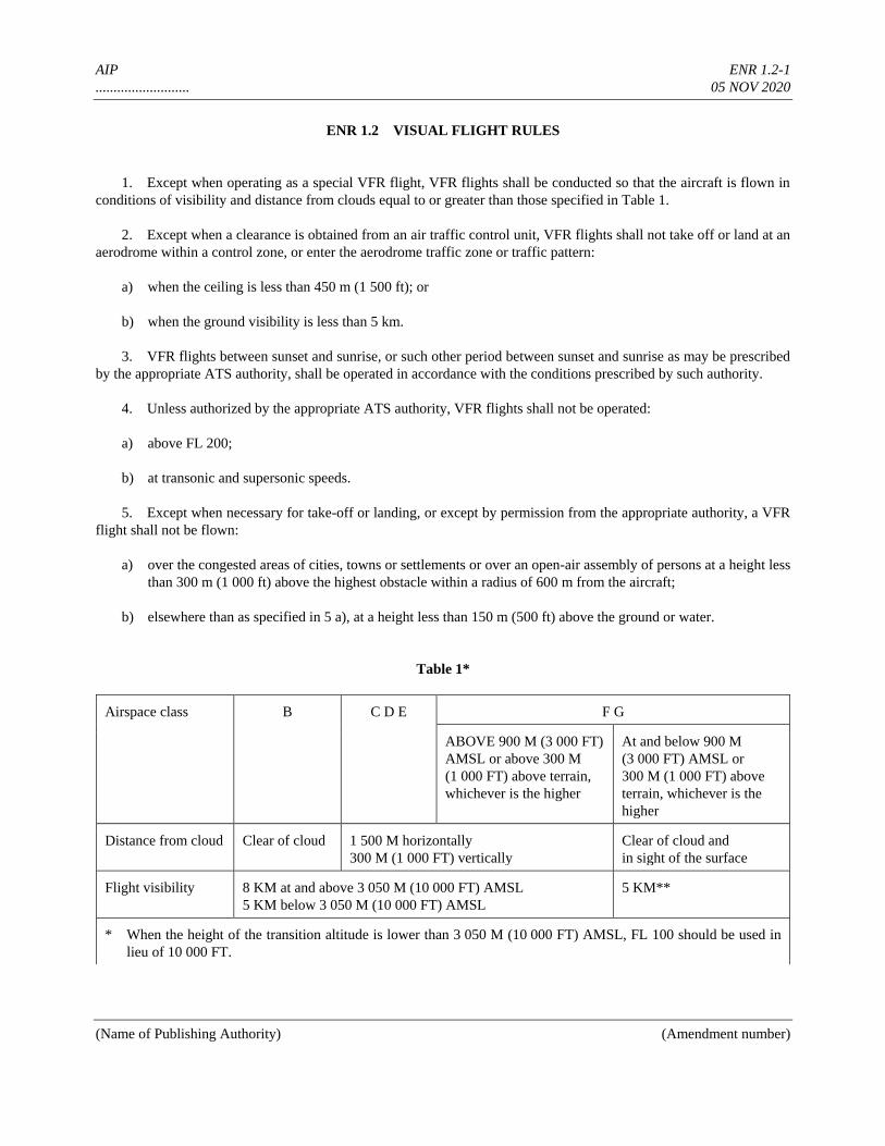
AIP ENR 1.2-1
.......................... 05 NOV 2020
(Name of Publishing Authority) (Amendment number)
ENR 1.2 VISUAL FLIGHT RULES
1. Except when operating as a special VFR flight, VFR flights shall be conducted so that the aircraft is flown in
conditions of visibility and distance from clouds equal to or greater than those specified in Table 1.
2. Except when a clearance is obtained from an air traffic control unit, VFR flights shall not take off or land at an
aerodrome within a control zone, or enter the aerodrome traffic zone or traffic pattern:
a) when the ceiling is less than 450 m (1 500 ft); or
b) when the ground visibility is less than 5 km.
3. VFR flights between sunset and sunrise, or such other period between sunset and sunrise as may be prescribed
by the appropriate ATS authority, shall be operated in accordance with the conditions prescribed by such authority.
4. Unless authorized by the appropriate ATS authority, VFR flights shall not be operated:
a) above FL 200;
b) at transonic and supersonic speeds.
5. Except when necessary for take-off or landing, or except by permission from the appropriate authority, a VFR
flight shall not be flown:
a) over the congested areas of cities, towns or settlements or over an open-air assembly of persons at a height less
than 300 m (1 000 ft) above the highest obstacle within a radius of 600 m from the aircraft;
b) elsewhere than as specified in 5 a), at a height less than 150 m (500 ft) above the ground or water.
Table 1*
Airspace class B C D E F G
ABOVE 900 M (3 000 FT)
AMSL or above 300 M
(1 000 FT) above terrain,
whichever is the higher
At and below 900 M
(3 000 FT) AMSL or
300 M (1 000 FT) above
terrain, whichever is the
higher
Distance from cloud Clear of cloud 1 500 M horizontally
300 M (1 000 FT) vertically
Clear of cloud and
in sight of the surface
Flight visibility 8 KM at and above 3 050 M (10 000 FT) AMSL
5 KM below 3 050 M (10 000 FT) AMSL
5 KM**
* When the height of the transition altitude is lower than 3 050 M (10 000 FT) AMSL, FL 100 should be used in
lieu of 10 000 FT.
AIP ENR 1.2-2
.......................... 05 NOV 2020
(Name of Publishing Authority) (Amendment number)
** When so prescribed by the appropriate ATS authority:
a) lower flight visibilities to 1 500 M may be permitted for flights operating:
1) at speeds that, in the prevailing visibility, will give adequate opportunity to observe other traffic or any
obstacles in time to avoid collision; or
2) in circumstances in which the probability of encounters with other traffic would normally be low, e.g. in
areas of low volume traffic and for aerial work at low levels.
b) HELICOPTERS may be permitted to operate in less than 1 500 M flight visibility, if manoeuvred at a speed
that will give adequate opportunity to observe other traffic or any obstacles in time to avoid collision.
6. Except where otherwise indicated in air traffic control clearances or specified by the appropriate ATS
authority, VFR flights in level cruising flight when operated above 900 m (3 000 ft) from the ground or water, or a
higher datum as specified by the appropriate ATS authority, shall be conducted at a flight level appropriate to the track
as specified in the tables of cruising levels.
7. VFR flights shall comply with the provisions of 3.6 of Annex 2:
a) when operated within Classes B, C and D airspace;
b) when forming part of aerodrome traffic at controlled aerodromes; or
c) when operated as special VFR flights.
8. An aircraft operated in accordance with the visual flight rules which wishes to change to compliance with the
instrument flight rules shall:
a) if a flight plan was submitted, communicate the necessary changes to be effected to its current flight plan, or
b) when so required by 3.3 of Annex 2, submit a flight plan to the appropriate air traffic services unit and obtain
a clearance prior to proceeding IFR when in controlled airspace.
AIP ENR 1.3-1
.......................... 05 NOV 2020
(Name of Publishing Authority) (Amendment number)
ENR 1.3 INSTRUMENT FLIGHT RULES
1. Rules applicable to all IFR flights
1.1 Aircraft equipment
Aircraft shall be equipped with suitable instruments and with navigation equipment appropriate to the route to be flown.
1.2 Minimum levels
Except when necessary for take-off or landing or when specifically authorized by the appropriate authority, an IFR
flight shall be flown at a level that is not below the minimum flight altitude established by the State whose territory is
overflown, or, where no such minimum flight altitude has been established:
a) over high terrain or in mountainous areas, at a level which is at least 600 m (2 000 ft) above the highest
obstacle located within 8 km of the estimated position of the aircraft;
b) elsewhere than as specified in a), at a level which is at least 300 m (1 000 ft) above the highest obstacle
located within 8 km of the estimated position of the aircraft.
Note.— The estimated position of the aircraft will take account of the navigational accuracy which can be
achieved on the relevant route segment, having regard to the navigational facilities available on the ground and in the
aircraft.
1.3 Change from IFR flight to VFR flight
1.3.1 An aircraft electing to change the conduct of its flight from compliance with the instrument flight rules to
compliance with the visual flight rules shall, if a flight plan was submitted, notify the appropriate air traffic services
unit specifically that the IFR flight is cancelled and communicate thereto the changes to be made to its current flight
plan.
1.3.2 When an aircraft operating under the instrument flight rules is flown in or encounters visual meteorological
conditions, it shall not cancel its IFR flight unless it is anticipated, and intended, that the flight will be continued for a
reasonable period of time in uninterrupted visual meteorological conditions.
2. Rules applicable to IFR flights within controlled airspace
2.1 IFR flights shall comply with the provisions of 3.6 of Annex 2 to the Convention on International Civil
Aviation when operated in controlled airspace.
2.2 An IFR flight operating in cruising flight in controlled airspace shall be flown at a cruising level, or, if
authorized to employ cruise climb techniques, between two levels or above a level, selected from:
a) the tables of cruising levels in Appendix 3 of Annex 2, or
b) a modified table of cruising levels, when so prescribed in accordance with Appendix 3 of Annex 2 for flight

AIP ENR 1.3-2
.......................... 05 NOV 2020
(Name of Publishing Authority) (Amendment number)
above FL 410,
except that the correlation of levels to track prescribed therein shall not apply whenever otherwise indicated in air
traffic control clearances or specified by the appropriate ATS authority in the Aeronautical Information Publication
(AIP).
3. Rules applicable to IFR flights outside controlled airspace
3.1 Cruising levels
An IFR flight operating in level cruising flight outside of controlled airspace shall be flown at a cruising level
appropriate to its track as specified in:
a) the tables of cruising levels in Appendix 3 of Annex 2, except when otherwise specified by the appropriate
ATS authority for flight at or below 900 m (3 000 ft) above mean sea level; or
b) a modified table of cruising levels, when so prescribed in accordance with Appendix 3 of Annex 2 for flight
above FL 410.
Note.— This provision does not preclude the use of cruise climb techniques by aircraft in supersonic flight.
3.2 Communications
An IFR flight operating outside controlled airspace but within or into areas, or along routes, designated by the
appropriate ATS authority in accordance with 3.3.1.2 c) or d) of Annex 2 shall maintain a listening watch on the
appropriate radio frequency and establish two-way communication, as necessary, with the air traffic services unit
providing flight information service.
3.3 Position reports
An IFR flight operating outside controlled airspace and required by the appropriate ATS authority to:
— submit a flight plan, and
— maintain a listening watch on the appropriate radio frequency and establish two-way communication, as
necessary, with the air traffic services unit providing flight information service
shall report position as specified in 3.6.3 of Annex 2 for controlled flights.
Note.— Aircraft electing to use the air traffic advisory service whilst operating IFR within specified advisory
airspace are expected to comply with the provisions of 3.6 of Annex 2, except that the flight plan and changes thereto
are not subjected to clearances and that two-way communication will be maintained with the unit providing the air
traffic advisory service.
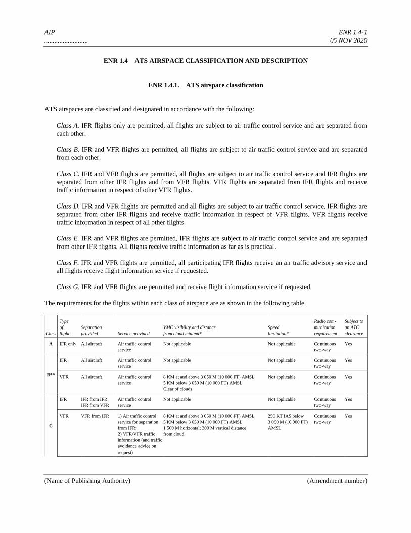
AIP ENR 1.4-1
.......................... 05 NOV 2020
(Name of Publishing Authority) (Amendment number)
ENR 1.4 ATS AIRSPACE CLASSIFICATION AND DESCRIPTION
ENR 1.4.1. ATS airspace classification
ATS airspaces are classified and designated in accordance with the following:
Class A. IFR flights only are permitted, all flights are subject to air traffic control service and are separated from
each other.
Class B. IFR and VFR flights are permitted, all flights are subject to air traffic control service and are separated
from each other.
Class C. IFR and VFR flights are permitted, all flights are subject to air traffic control service and IFR flights are
separated from other IFR flights and from VFR flights. VFR flights are separated from IFR flights and receive
traffic information in respect of other VFR flights.
Class D. IFR and VFR flights are permitted and all flights are subject to air traffic control service, IFR flights are
separated from other IFR flights and receive traffic information in respect of VFR flights, VFR flights receive
traffic information in respect of all other flights.
Class E. IFR and VFR flights are permitted, IFR flights are subject to air traffic control service and are separated
from other IFR flights. All flights receive traffic information as far as is practical.
Class F. IFR and VFR flights are permitted, all participating IFR flights receive an air traffic advisory service and
all flights receive flight information service if requested.
Class G. IFR and VFR flights are permitted and receive flight information service if requested.
The requirements for the flights within each class of airspace are as shown in the following table.
Class
Type
of
flight
Separation
provided Service provided
VMC visibility and distance
from cloud minima*
Speed
limitation*
Radio com-
munication
requirement
Subject to
an ATC
clearance
A IFR only All aircraft Air traffic control
service
Not applicable Not applicable Continuous
two-way
Yes
B**
IFR All aircraft Air traffic control
service
Not applicable Not applicable Continuous
two-way
Yes
VFR All aircraft Air traffic control
service
8 KM at and above 3 050 M (10 000 FT) AMSL
5 KM below 3 050 M (10 000 FT) AMSL
Clear of clouds
Not applicable Continuous
two-way
Yes
C
IFR IFR from IFR
IFR from VFR
Air traffic control
service
Not applicable Not applicable Continuous
two-way
Yes
VFR VFR from IFR 1) Air traffic control
service for separation
from IFR;
2) VFR/VFR traffic
information (and traffic
avoidance advice on
request)
8 KM at and above 3 050 M (10 000 FT) AMSL
5 KM below 3 050 M (10 000 FT) AMSL
1 500 M horizontal; 300 M vertical distance
from cloud
250 KT IAS below
3 050 M (10 000 FT)
AMSL
Continuous
two-way
Yes
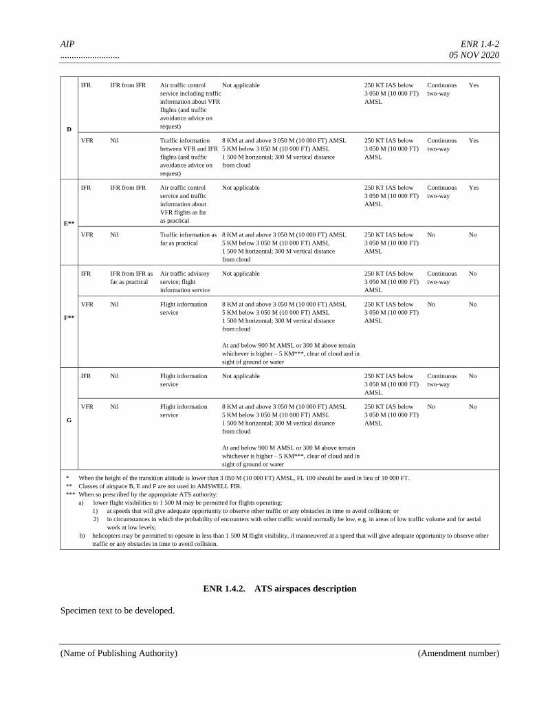
AIP ENR 1.4-2
.......................... 05 NOV 2020
(Name of Publishing Authority) (Amendment number)
D
IFR IFR from IFR Air traffic control
service including traffic
information about VFR
flights (and traffic
avoidance advice on
request)
Not applicable 250 KT IAS below
3 050 M (10 000 FT)
AMSL
Continuous
two-way
Yes
VFR Nil Traffic information
between VFR and IFR
flights (and traffic
avoidance advice on
request)
8 KM at and above 3 050 M (10 000 FT) AMSL
5 KM below 3 050 M (10 000 FT) AMSL
1 500 M horizontal; 300 M vertical distance
from cloud
250 KT IAS below
3 050 M (10 000 FT)
AMSL
Continuous
two-way
Yes
E**
IFR IFR from IFR Air traffic control
service and traffic
information about
VFR flights as far
as practical
Not applicable 250 KT IAS below
3 050 M (10 000 FT)
AMSL
Continuous
two-way
Yes
VFR Nil Traffic information as
far as practical
8 KM at and above 3 050 M (10 000 FT) AMSL
5 KM below 3 050 M (10 000 FT) AMSL
1 500 M horizontal; 300 M vertical distance
from cloud
250 KT IAS below
3 050 M (10 000 FT)
AMSL
No No
F**
IFR IFR from IFR as
far as practical
Air traffic advisory
service; flight
information service
Not applicable 250 KT IAS below
3 050 M (10 000 FT)
AMSL
Continuous
two-way
No
VFR Nil Flight information
service
8 KM at and above 3 050 M (10 000 FT) AMSL
5 KM below 3 050 M (10 000 FT) AMSL
1 500 M horizontal; 300 M vertical distance
from cloud
At and below 900 M AMSL or 300 M above terrain
whichever is higher – 5 KM***, clear of cloud and in
sight of ground or water
250 KT IAS below
3 050 M (10 000 FT)
AMSL
No No
G
IFR Nil Flight information
service
Not applicable 250 KT IAS below
3 050 M (10 000 FT)
AMSL
Continuous
two-way
No
VFR Nil Flight information
service
8 KM at and above 3 050 M (10 000 FT) AMSL
5 KM below 3 050 M (10 000 FT) AMSL
1 500 M horizontal; 300 M vertical distance
from cloud
At and below 900 M AMSL or 300 M above terrain
whichever is higher – 5 KM***, clear of cloud and in
sight of ground or water
250 KT IAS below
3 050 M (10 000 FT)
AMSL
No No
* When the height of the transition altitude is lower than 3 050 M (10 000 FT) AMSL, FL 100 should be used in lieu of 10 000 FT.
** Classes of airspace B, E and F are not used in AMSWELL FIR.
*** When so prescribed by the appropriate ATS authority:
a) lower flight visibilities to 1 500 M may be permitted for flights operating:
1) at speeds that will give adequate opportunity to observe other traffic or any obstacles in time to avoid collision; or
2) in circumstances in which the probability of encounters with other traffic would normally be low, e.g. in areas of low traffic volume and for aerial
work at low levels;
b) helicopters may be permitted to operate in less than 1 500 M flight visibility, if manoeuvred at a speed that will give adequate opportunity to observe other
traffic or any obstacles in time to avoid collision.
ENR 1.4.2. ATS airspaces description
Specimen text to be developed.
AIP ENR 1.5-1
.......................... 05 NOV 2020
(Name of Publishing Authority) (Amendment number)
ENR 1.5 HOLDING, APPROACH AND DEPARTURE PROCEDURES
ENR 1.5.1. General
1.1 The holding, approach and departure procedures in use are based on those contained in the latest edition of
ICAO Doc 8168 — Procedures for Air Navigation Services — Aircraft Operations (PANS-OPS).
1.2 The holding and approach procedures in use have been based on the values and factors contained in Parts III
and IV of Vol. I of the PANS-OPS. The holding patterns shall be entered and flown as indicated below.
ENR 1.5.2. Arriving flights
2.1 IFR flights entering and landing within a terminal control area will be cleared to a specified holding point and
instructed to contact approach control at a specified time, level or position. The terms of this clearance shall be adhered
to until further instructions are received from approach control. If the clearance limit is reached before further
instructions have been received, holding procedure shall be carried out at the level last authorized.
2.2 Due to the limited airspace available, it is important that the approaches to the patterns and the holding
procedures be carried out as precisely as possible. Pilots are strongly requested to inform ATC if for any reason the
approach and/or holding cannot be performed as required.
ENR 1.5.3. Departing flights
3.1 IFR flights departing from controlled aerodromes will receive initial ATC clearance from the local
aerodrome control tower. The clearance limit will normally be the aerodrome of destination. IFR flights departing from
non-controlled aerodromes must make arrangements with the area control centre concerned prior to take-off.
3.2 Detailed instructions with regard to routes, turns, etc. will be issued after take-off.
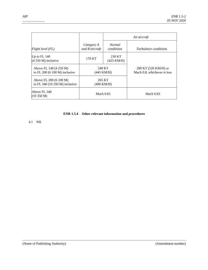
AIP ENR 1.5-2
.......................... 05 NOV 2020
(Name of Publishing Authority) (Amendment number)
Flight level (FL)
Category A
and B aircraft
Jet aircraft
Normal
conditions Turbulence conditions
Up to FL 140
(4 250 M) inclusive 170 KT
230 KT
(425 KM/H)
280 KT (520 KM/H) or
Mach 0.8, whichever is less
Above FL 140 (4 250 M)
to FL 200 (6 100 M) inclusive
240 KT
(445 KM/H)
Above FL 200 (6 100 M)
to FL 340 (10 350 M) inclusive
265 KT
(490 KM/H)
Above FL 340
(10 350 M) Mach 0.83 Mach 0.83
ENR 1.5.4 Other relevant information and procedures
4.1 NIL
AIP ENR 1.6-1
.......................... 05 NOV 2020
(Name of Publishing Authority) (Amendment number)
ENR 1.6 ATS SURVEILLANCE SERVICES AND PROCEDURES
ENR 1.6.1. Primary radar
1.1 Supplementary services
1.1.1 A radar unit normally operates as an integral part of the parent ATS unit and provides radar service to
aircraft, to the maximum extent practicable, to meet the operational requirement. Many factors, such as radar coverage,
controller workload and equipment capabilities, may affect these services, and the radar controller shall determine the
practicability of providing or continuing to provide radar services in any specific case.
1.1.2 A pilot will know when radar services are being provided because the radar controller will use the
following call signs:
a) aircraft under area control — “Amswell Radar”;
b) aircraft under approach control — “Donlon Director”;
c) aircraft carrying out a precision radar approach or ILS approach monitored by PAR — “Donlon Precision”.
1.1.3 Amswell area control service operates two radar stations:
a) LRR — station at Donby position 53 14N 033 15W, range 440 km;
b) LRR — station at Siby position 46 48N 028 50W, range 440 km.
1.1.4 Donlon approach control service operates:
a) TAR — station at Donlon Airport at position .........., range 100 km;
b) PAR — station at Donlon Airport at position .........., covering approach sector to RWY 27R.
1.2 The application of radar control service
1.2.1 Radar identification is achieved according to the provisions specified by ICAO.
1.2.2 Radar control service is provided in controlled airspaces to aircraft operating within the Donlon TMA and
along all AWYs, except the segment between WOBAN and ROCKBY of AWY A6. This service may include:
a) radar separation of arriving, departing and en-route traffic;
b) radar monitoring of arriving, departing and en-route traffic to provide information on any significant deviation
from the normal flight path;
c) radar vectoring when required;
d) assistance to aircraft in emergency;
e) assistance to aircraft crossing controlled airspace;
AIP ENR 1.6-2
.......................... 05 NOV 2020
(Name of Publishing Authority) (Amendment number)
f) warnings and position information on other aircraft considered to constitute a hazard;
g) information to assist in the navigation of aircraft;
h) information on observed weather.
1.2.3 The minimum horizontal radar separations are:
a) 9 km en route along airways;
b) 6 km in the Donlon TMA.
1.2.4 Levels assigned by the radar controller to pilots will provide a minimum terrain clearance according to the
phase of flight.
1.3 Radar and air-ground communication failure procedures
1.3.1 Radar failure
In the event of radar failure or loss of radar identification, instructions will be issued to restore non-radar standard
separation and the pilot will be instructed to communicate with the parent ATS unit.
1.3.2 Air-ground communication failure
1.3.2.1 The radar controller will establish whether the aircraft radio receiver is working by instructing the pilot to
carry out a turn or turns. If the turns are observed, the radar controller will continue to provide radar service to the
aircraft.
1.3.2.2 If the aircraft’s radio is completely unserviceable, the pilot should carry out the procedures for radio
failure in accordance with ICAO provisions. If radar identification has already been established, the radar controller
will vector other identified aircraft clear of its track until such time as the aircraft leaves radar cover.
1.4 Voice and CPDLC position reporting requirements
NIL
1.5 Graphic portrayal of area of radar coverage
Since the area of radar coverage is identical to that of SSR, see ENR 1.6.2.4 — Graphic portrayal of area of coverage of
radar/SSR.
ENR 1.6.2. Secondary surveillance radar (SSR)
2.1 Emergency procedures
2.1.1 Except when encountering a state of emergency, pilots shall operate transponders and select modes and
codes in accordance with ATC instructions. In particular, when entering Amswell FIR, pilots who have already
received specific instructions from ATC concerning the setting of the transponder shall maintain that setting until
AIP ENR 1.6-3
.......................... 05 NOV 2020
(Name of Publishing Authority) (Amendment number)
otherwise instructed.
2.1.2 Pilots of aircraft about to enter Amswell FIR who have not received specific instructions from ATC
concerning the setting of the transponder shall operate the transponder on Mode A/3, Code 20 (or 2000) before entry
and maintain that code setting until otherwise instructed.
2.1.3 If the pilot of an aircraft encountering a state of emergency has previously been directed by ATC to operate
the transponder on a specific code, this code setting shall be maintained until otherwise advised.
2.1.4 In all other circumstances, the transponder shall be set to Mode A/3, Code 77 (or 7700). Notwithstanding
the procedure in 2.1.1 above, a pilot may select Mode A/3, Code 77 (or 7700) whenever the nature of the emergency is
such that this appears to be the most suitable course of action.
Note.— Continuous monitoring of responses on Mode A/3, Code 77 is provided.
2.2 Air-ground communication failure and unlawful interference procedures
2.2.1 Radio communication failure procedure
In the event of an aircraft radio receiver failure, a pilot shall select Mode A/3, Code 76 (or 7600) and follow established
procedures; subsequent control of the aircraft will be based on those procedures.
2.2.2 Unlawful interference procedure
Pilots of aircraft in flight subjected to unlawful interference shall endeavour to set the transponder to Mode A, Code
7500 to make the situation known, unless circumstances warrant the use of Mode A/B, Code 77 (or 7700).
Note.— Mode A, Code 7500 is permanently monitored in the Amswell FIR/UIR.
2.3 System of SSR Code assignment
The following functional codes (first two digits) are assigned by Amswell ACC:
Departing traffic
Cruising level below FL 195 :04
Cruising level above FL 195 :21
Domestic flights :47
Arriving traffic
Donlon TMA :45/46
Other TMAs :47
Overflying traffic
Cruising level below FL 195 :04
Cruising level above FL 195 :21 (eastbound)
Cruising level above FL 195 :07 (westbound)
Test and training flights :47
Note.— Although the equipment of Amswell ACC and Donlon approach cannot as yet distinguish individual codes
AIP ENR 1.6-4
.......................... 05 NOV 2020
(Name of Publishing Authority) (Amendment number)
(only the first and second digits are decoded), four-digit codes are assigned for the benefit of adjacent centres and
civil-military coordination.
2.4 Voice and CPDLC position reporting requirements
NIL
2.5 Graphic portrayal of area of coverage of radar/SSR
TO BE DEVELOPED
ENR 1.6.3 Automatic dependent surveillance — broadcast (ADS-B)
To be developed
ENR 1.6.4 Other relevant information and procedures
NIL
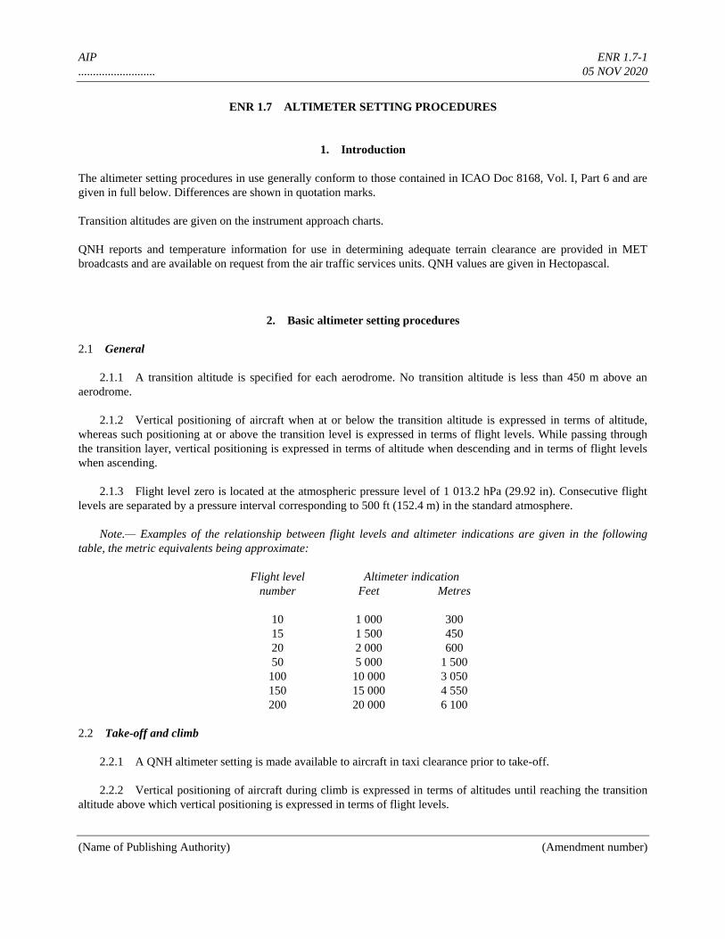
AIP ENR 1.7-1
.......................... 05 NOV 2020
(Name of Publishing Authority) (Amendment number)
ENR 1.7 ALTIMETER SETTING PROCEDURES
1. Introduction
The altimeter setting procedures in use generally conform to those contained in ICAO Doc 8168, Vol. I, Part 6 and are
given in full below. Differences are shown in quotation marks.
Transition altitudes are given on the instrument approach charts.
QNH reports and temperature information for use in determining adequate terrain clearance are provided in MET
broadcasts and are available on request from the air traffic services units. QNH values are given in Hectopascal.
2. Basic altimeter setting procedures
2.1 General
2.1.1 A transition altitude is specified for each aerodrome. No transition altitude is less than 450 m above an
aerodrome.
2.1.2 Vertical positioning of aircraft when at or below the transition altitude is expressed in terms of altitude,
whereas such positioning at or above the transition level is expressed in terms of flight levels. While passing through
the transition layer, vertical positioning is expressed in terms of altitude when descending and in terms of flight levels
when ascending.
2.1.3 Flight level zero is located at the atmospheric pressure level of 1 013.2 hPa (29.92 in). Consecutive flight
levels are separated by a pressure interval corresponding to 500 ft (152.4 m) in the standard atmosphere.
Note.— Examples of the relationship between flight levels and altimeter indications are given in the following
table, the metric equivalents being approximate:
Flight level Altimeter indication
number Feet Metres
10 1 000 300
15 1 500 450
20 2 000 600
50 5 000 1 500
100 10 000 3 050
150 15 000 4 550
200 20 000 6 100
2.2 Take-off and climb
2.2.1 A QNH altimeter setting is made available to aircraft in taxi clearance prior to take-off.
2.2.2 Vertical positioning of aircraft during climb is expressed in terms of altitudes until reaching the transition
altitude above which vertical positioning is expressed in terms of flight levels.
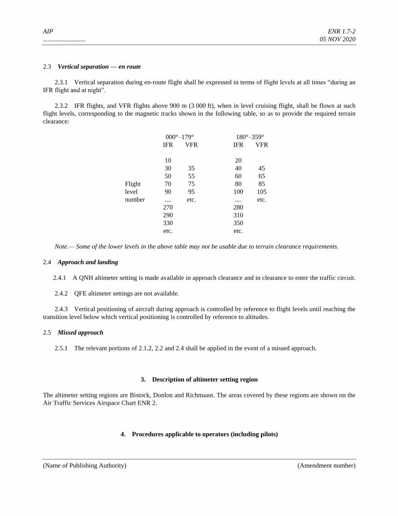
AIP ENR 1.7-2
.......................... 05 NOV 2020
(Name of Publishing Authority) (Amendment number)
2.3 Vertical separation — en route
2.3.1 Vertical separation during en-route flight shall be expressed in terms of flight levels at all times “during an
IFR flight and at night”.
2.3.2 IFR flights, and VFR flights above 900 m (3 000 ft), when in level cruising flight, shall be flown at such
flight levels, corresponding to the magnetic tracks shown in the following table, so as to provide the required terrain
clearance:
000°–179° 180°–359°
IFR VFR IFR VFR
10 20
30 35 40 45
50 55 60 65
Flight 70 75 80 85
level 90 95 100 105
number .... etc. .... etc.
270 280
290 310
330 350
etc. etc.
Note.— Some of the lower levels in the above table may not be usable due to terrain clearance requirements.
2.4 Approach and landing
2.4.1 A QNH altimeter setting is made available in approach clearance and in clearance to enter the traffic circuit.
2.4.2 QFE altimeter settings are not available.
2.4.3 Vertical positioning of aircraft during approach is controlled by reference to flight levels until reaching the
transition level below which vertical positioning is controlled by reference to altitudes.
2.5 Missed approach
2.5.1 The relevant portions of 2.1.2, 2.2 and 2.4 shall be applied in the event of a missed approach.
3. Description of altimeter setting region
The altimeter setting regions are Bistock, Donlon and Richmaast. The areas covered by these regions are shown on the
Air Traffic Services Airspace Chart ENR 2.
4. Procedures applicable to operators (including pilots)
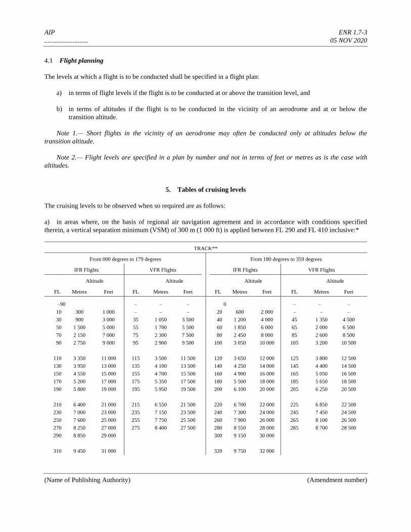
AIP ENR 1.7-3
.......................... 05 NOV 2020
(Name of Publishing Authority) (Amendment number)
4.1 Flight planning
The levels at which a flight is to be conducted shall be specified in a flight plan:
a) in terms of flight levels if the flight is to be conducted at or above the transition level, and
b) in terms of altitudes if the flight is to be conducted in the vicinity of an aerodrome and at or below the
transition altitude.
Note 1.— Short flights in the vicinity of an aerodrome may often be conducted only at altitudes below the
transition altitude.
Note 2.— Flight levels are specified in a plan by number and not in terms of feet or metres as is the case with
altitudes.
5. Tables of cruising levels
The cruising levels to be observed when so required are as follows:
a) in areas where, on the basis of regional air navigation agreement and in accordance with conditions specified
therein, a vertical separation minimum (VSM) of 300 m (1 000 ft) is applied between FL 290 and FL 410 inclusive:*
TRACK**
From 000 degrees to 179 degrees From 180 degrees to 359 degrees
IFR Flights VFR Flights IFR Flights VFR Flights
Altitude Altitude Altitude Altitude
FL Metres Feet FL Metres Feet FL Metres Feet FL Metres Feet
–90 – – – 0 – – –
10 300 1 000 – – – 20 600 2 000 – – –
30 900 3 000 35 1 050 3 500 40 1 200 4 000 45 1 350 4 500
50 1 500 5 000 55 1 700 5 500 60 1 850 6 000 65 2 000 6 500
70 2 150 7 000 75 2 300 7 500 80 2 450 8 000 85 2 600 8 500
90 2 750 9 000 95 2 900 9 500 100 3 050 10 000 105 3 200 10 500
110 3 350 11 000 115 3 500 11 500 120 3 650 12 000 125 3 800 12 500
130 3 950 13 000 135 4 100 13 500 140 4 250 14 000 145 4 400 14 500
150 4 550 15 000 155 4 700 15 500 160 4 900 16 000 165 5 050 16 500
170 5 200 17 000 175 5 350 17 500 180 5 500 18 000 185 5 650 18 500
190 5 800 19 000 195 5 950 19 500 200 6 100 20 000 205 6 250 20 500
210 6 400 21 000 215 6 550 21 500 220 6 700 22 000 225 6 850 22 500
230 7 000 23 000 235 7 150 23 500 240 7 300 24 000 245 7 450 24 500
250 7 600 25 000 255 7 750 25 500 260 7 900 26 000 265 8 100 26 500
270 8 250 27 000 275 8 400 27 500 280 8 550 28 000 285 8 700 28 500
290 8 850 29 000 300 9 150 30 000
310 9 450 31 000 320 9 750 32 000
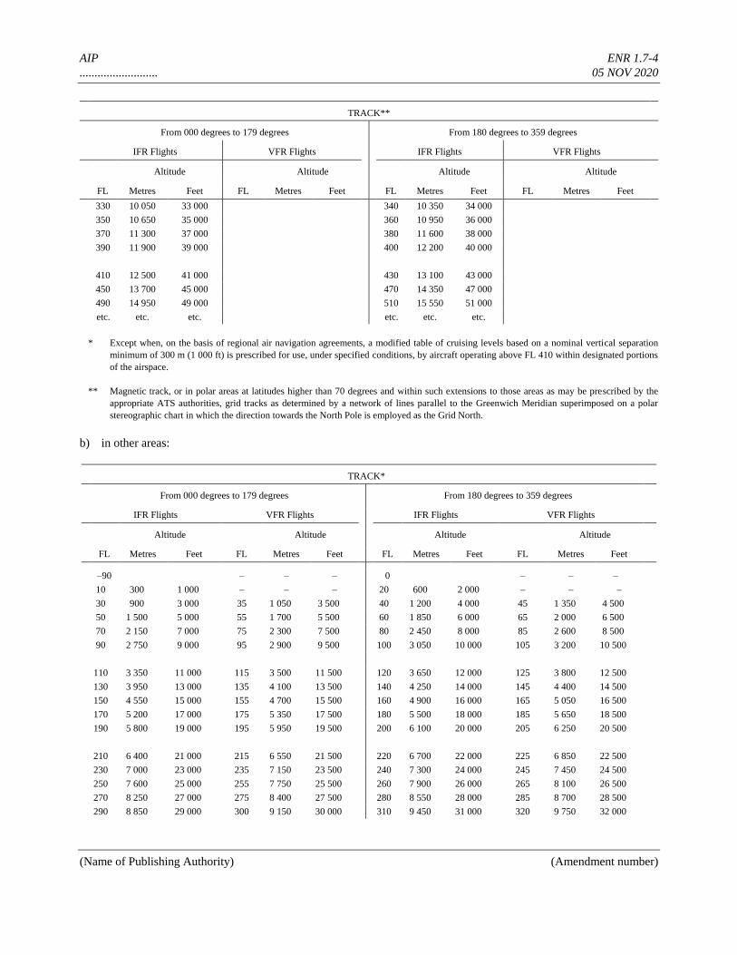
AIP ENR 1.7-4
.......................... 05 NOV 2020
(Name of Publishing Authority) (Amendment number)
TRACK**
From 000 degrees to 179 degrees From 180 degrees to 359 degrees
IFR Flights VFR Flights IFR Flights VFR Flights
Altitude Altitude Altitude Altitude
FL Metres Feet FL Metres Feet FL Metres Feet FL Metres Feet
330 10 050 33 000 340 10 350 34 000
350 10 650 35 000 360 10 950 36 000
370 11 300 37 000 380 11 600 38 000
390 11 900 39 000 400 12 200 40 000
410 12 500 41 000 430 13 100 43 000
450 13 700 45 000 470 14 350 47 000
490 14 950 49 000 510 15 550 51 000
etc. etc. etc. etc. etc. etc.
* Except when, on the basis of regional air navigation agreements, a modified table of cruising levels based on a nominal vertical separation
minimum of 300 m (1 000 ft) is prescribed for use, under specified conditions, by aircraft operating above FL 410 within designated portions
of the airspace.
** Magnetic track, or in polar areas at latitudes higher than 70 degrees and within such extensions to those areas as may be prescribed by the
appropriate ATS authorities, grid tracks as determined by a network of lines parallel to the Greenwich Meridian superimposed on a polar
stereographic chart in which the direction towards the North Pole is employed as the Grid North.
b) in other areas:
TRACK*
From 000 degrees to 179 degrees From 180 degrees to 359 degrees
IFR Flights VFR Flights IFR Flights VFR Flights
Altitude Altitude Altitude Altitude
FL Metres Feet FL Metres Feet FL Metres Feet FL Metres Feet
–90 – – – 0 – – –
10 300 1 000 – – – 20 600 2 000 – – –
30 900 3 000 35 1 050 3 500 40 1 200 4 000 45 1 350 4 500
50 1 500 5 000 55 1 700 5 500 60 1 850 6 000 65 2 000 6 500
70 2 150 7 000 75 2 300 7 500 80 2 450 8 000 85 2 600 8 500
90 2 750 9 000 95 2 900 9 500 100 3 050 10 000 105 3 200 10 500
110 3 350 11 000 115 3 500 11 500 120 3 650 12 000 125 3 800 12 500
130 3 950 13 000 135 4 100 13 500 140 4 250 14 000 145 4 400 14 500
150 4 550 15 000 155 4 700 15 500 160 4 900 16 000 165 5 050 16 500
170 5 200 17 000 175 5 350 17 500 180 5 500 18 000 185 5 650 18 500
190 5 800 19 000 195 5 950 19 500 200 6 100 20 000 205 6 250 20 500
210 6 400 21 000 215 6 550 21 500 220 6 700 22 000 225 6 850 22 500
230 7 000 23 000 235 7 150 23 500 240 7 300 24 000 245 7 450 24 500
250 7 600 25 000 255 7 750 25 500 260 7 900 26 000 265 8 100 26 500
270 8 250 27 000 275 8 400 27 500 280 8 550 28 000 285 8 700 28 500
290 8 850 29 000 300 9 150 30 000 310 9 450 31 000 320 9 750 32 000
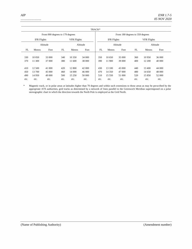
AIP ENR 1.7-5
.......................... 05 NOV 2020
(Name of Publishing Authority) (Amendment number)
TRACK*
From 000 degrees to 179 degrees From 180 degrees to 359 degrees
IFR Flights VFR Flights IFR Flights VFR Flights
Altitude Altitude Altitude Altitude
FL Metres Feet FL Metres Feet FL Metres Feet FL Metres Feet
330 10 050 33 000 340 10 350 34 000 350 10 650 35 000 360 10 950 36 000
370 11 300 37 000 380 11 600 38 000 390 11 900 39 000 400 12 200 40 000
410 12 500 41 000 420 12 800 42 000 430 13 100 43 000 440 13 400 44 000
450 13 700 45 000 460 14 000 46 000 470 14 350 47 000 480 14 650 48 000
490 14 950 49 000 500 15 250 50 000 510 15 550 51 000 520 15 850 52 000
etc. etc. etc. etc. etc. etc. etc. etc. etc. etc. etc. etc.
* Magnetic track, or in polar areas at latitudes higher than 70 degrees and within such extensions to those areas as may be prescribed by the
appropriate ATS authorities, grid tracks as determined by a network of lines parallel to the Greenwich Meridian superimposed on a polar
stereographic chart in which the direction towards the North Pole is employed as the Grid North.
AIP ENR 1.8-1
.......................... 05 NOV 2020
(Name of Publishing Authority) (Amendment number)
ENR 1.8 REGIONAL SUPPLEMENTARY PROCEDURES (DOC 7030)
The supplementary procedures in force are given in their entirety. Differences are shown in quotation marks.
1. Visual flights rules (VFR)
(Annex 2, 4.8)
VFR flights to be operated within a control zone established at an aerodrome serving international flights and in
specified portions of the associated terminal control area shall:
a) have two-way radio communications;
b) obtain permission from the appropriate air traffic control unit; and
c) report positions, as required.
Note.— The phrase “specified portions of the associated terminal control area” is intended to signify at least those
portions of the TMA used by international IFR flights in association with approach, holding, departure and noise
abatement procedures.
2. Special application of instrument flight rules
Flights shall be conducted in accordance with the instrument flight rules even when not operating in instrument
meteorological conditions, when operated more than 90 km seaward from the shoreline.
3. Air traffic advisory service
(PANS-ATM, 9.1.4)
All IFR flights shall comply with the procedures for air traffic advisory service when operating in advisory airspace.
4. Adherence to ATC approved route
(Annex 2, 3.6.2.2)
If an aircraft has inadvertently deviated from the route specified in its ATC clearance, it shall forthwith take action to
regain such route within “one hundred (100)” nautical miles from the position at which the deviation was observed.
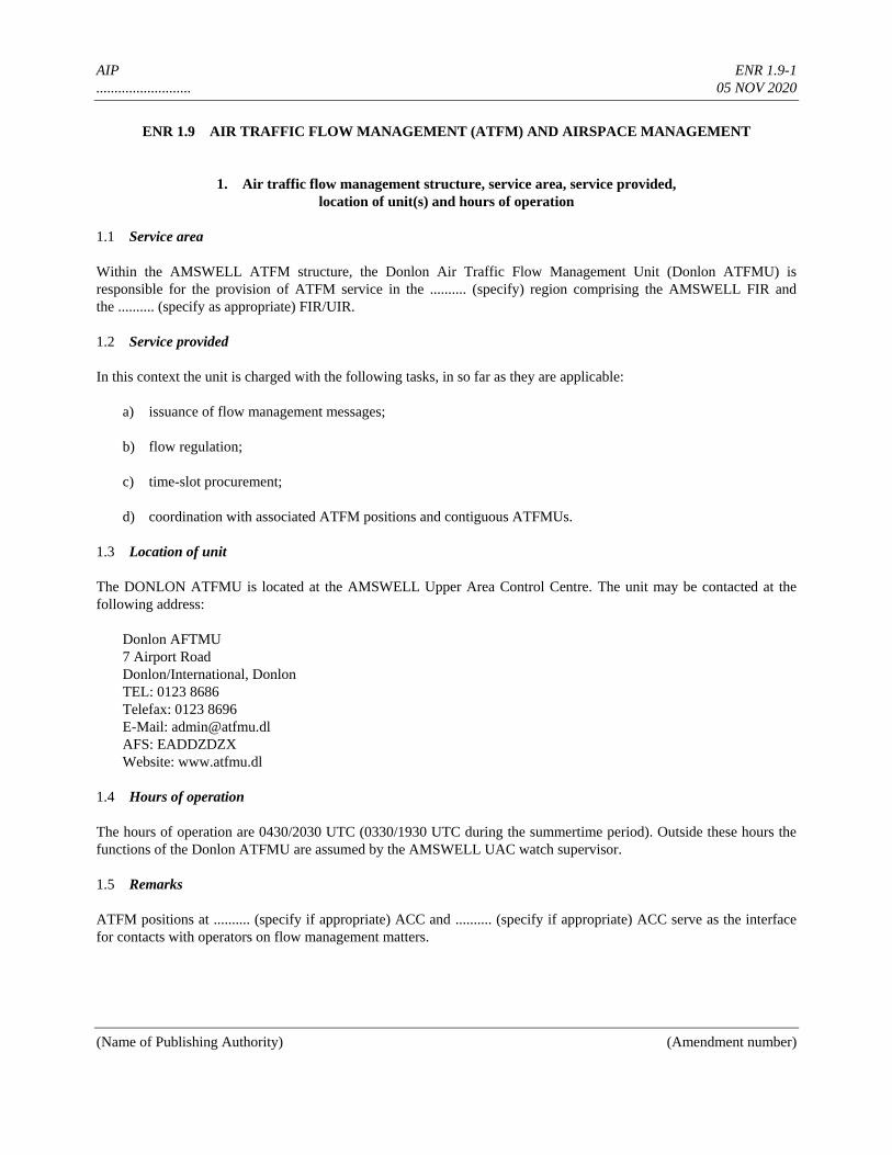
AIP ENR 1.9-1
.......................... 05 NOV 2020
(Name of Publishing Authority) (Amendment number)
ENR 1.9 AIR TRAFFIC FLOW MANAGEMENT (ATFM) AND AIRSPACE MANAGEMENT
1. Air traffic flow management structure, service area, service provided,
location of unit(s) and hours of operation
1.1 Service area
Within the AMSWELL ATFM structure, the Donlon Air Traffic Flow Management Unit (Donlon ATFMU) is
responsible for the provision of ATFM service in the .......... (specify) region comprising the AMSWELL FIR and
the .......... (specify as appropriate) FIR/UIR.
1.2 Service provided
In this context the unit is charged with the following tasks, in so far as they are applicable:
a) issuance of flow management messages;
b) flow regulation;
c) time-slot procurement;
d) coordination with associated ATFM positions and contiguous ATFMUs.
1.3 Location of unit
The DONLON ATFMU is located at the AMSWELL Upper Area Control Centre. The unit may be contacted at the
following address:
Donlon AFTMU
7 Airport Road
Donlon/International, Donlon
TEL: 0123 8686
Telefax: 0123 8696
E-Mail: [email protected]
AFS: EADDZDZX
Website: www.atfmu.dl
1.4 Hours of operation
The hours of operation are 0430/2030 UTC (0330/1930 UTC during the summertime period). Outside these hours the
functions of the Donlon ATFMU are assumed by the AMSWELL UAC watch supervisor.
1.5 Remarks
ATFM positions at .......... (specify if appropriate) ACC and .......... (specify if appropriate) ACC serve as the interface
for contacts with operators on flow management matters.
AIP ENR 1.9-2
.......................... 05 NOV 2020
(Name of Publishing Authority) (Amendment number)
2. Types of flow messages and descriptions of the formats
Messages containing information on ATFM measures, as distributed by the Donlon Air Traffic Flow Management Unit
by AFS, will be formatted as depicted below.
Note.— These AFS messages can be obtained on request to EADDYTYX.
All messages will be preceded by:
— Priority indicator, addressee indicator(s)
— Date/time group, originator indicator
a) FLOW CONTROL EXECUTION MESSAGE
1. Flow control execution MSG NR (sequence number) valid (date)
2. Due to (reason for restriction)
3. Period concerned (time) at ...... (slot reference point)
4. Traffic concerned (route, destination, etc.)
5. Flight level(s) concerned
6. SLAP ATFMU (name)
7. Communication and slot request procedure (indicates normally “according local procedures”)
8. Off-load route available (designation, conditions)
9. Remarks
b) FLOW CONTROL EXECUTION CANCELLATION MESSAGE
1. Flow control execution (date/time group) CNL
c) FLOW CONTROL EXECUTION CHANGE MESSAGE
1. Flow control execution CHG (item(s) to be changed)
d) FLOW MANAGEMENT INFORMATION MESSAGE
1. Flow management information (text as required)
3. Procedures applicable for departing flights
a) Service responsible for provision of information on applied ATFM measures
AIP ENR 1.9-3
.......................... 05 NOV 2020
(Name of Publishing Authority) (Amendment number)
Information with respect to ATFM measures can be obtained from the ATS Reporting Office (ARO) responsible for
the departure aerodrome.
b) Flight plan requirements
Non-repetitive (ICAO) flight plans to or via flow-restricted areas shall be submitted to the appropriate ARO at
least 3 hours before ETD.
Changes in ETD of more than 20 minutes and/or cancellation of both repetitive and non-repetitive flight plans shall be
reported immediately to the appropriate ARO.
c) Slot allocations
A request for a (departure) slot shall be made to the ATFM position AMSWELL ACC, telephone NR 0123 8686.
A slot request shall be made not earlier than 2 hours but not later than 30 minutes prior to ETD, using the following
phraseology:
“.......... (flight identification)
destination aerodrome .......... (specify)
ETD ..... (time)
REQUEST SLOT ”.
Operators shall ensure that the (departure) time slot can be met.
If it becomes apparent that an assigned slot is no longer required or cannot be met, the operator shall inform the slot
allocation position immediately (see above). A new time slot, if needed, shall be allocated in such a way that assigned
slots are not affected.
If the slot allocation for the planned route results in considerable delay, it may well be possible to select an alternative
routing to the same destination. Information can be obtained from the slot allocation position.
4. Information on overall responsibility regarding airspace management within FIR(s), details of civil/military
airspace allocation and management coordination, structure of manageable airspace (allocation and changes to
allocation) and general operating procedures.
4.1 Overall responsibility within FIR
4.2 Airspace Management Cell (AMC) location and contact information
4.3 Lead AMC responsibilities
4.4 Structure of manageable airspace (allocation and changes to allocation)
4.5 General operating procedures
AIP ENR 1.10-1
.......................... 05 NOV 2020
(Name of Publishing Authority) (Amendment number)
ENR 1.10 FLIGHT PLANNING
(Restriction, limitation or advisory information)
1. Procedures for the submission of a flight plan
A flight plan shall be submitted in accordance with Annex 2, 3.3.1, prior to operating:
a) any IFR flight;
b) any VFR flight:
— departing from or destined for an aerodrome within a control zone;
— crossing .......... (specify) CTR;
— operated along the designated VFR routes in the .......... (specify) TMA;
— across the FIR boundary, i.e. international flights.
Time of submission
Except for repetitive flight plans, a flight plan shall be submitted at least 30 minutes prior to departure, taking into
account the requirements of ATS units in the airspace along the route to be flown for timely information, including
requirements for early submission for Air Traffic Flow Management (ATFM) purposes.
Place of submission
a) Flight plans shall by submitted at the Air Traffic Services Reporting Office (ARO) at the departure aerodrome.
b) In the absence of such an office at the departure aerodrome, a flight plan shall be submitted by telephone or
teletype to the nearest ARO as listed below (except as indicated under c. and d.)
.......... (specify ARO) TEL: .......... (specify)
.......... (specify ARO) TEL: .......... (specify)
.......... (specify ARO) TEL: .......... (specify)
.......... (specify ARO) TEL: .......... (specify).
c) For VFR flights between uncontrolled aerodromes operating along designated VFR routes in the ..........
(specify) TMA, a flight plan shall be submitted by telephone to the ARO at .......... (specify).
d) For domestic flights from an uncontrolled to a controlled aerodrome, a flight plan shall be submitted by
telephone to the ARO at destination.
VFR flight plan for alerting service only
An alerting service is, in principle, provided to flights for which a flight plan has been submitted.
Contents and form of a flight plan
AIP ENR 1.10-2
.......................... 05 NOV 2020
(Name of Publishing Authority) (Amendment number)
a) ICAO flight plan forms are available at AROs and airport offices at uncontrolled aerodromes. The instructions
for completing those forms shall be followed.
b) Flight plans concerning IFR flights along ATS routes need not include FIR-boundary estimates. Inclusion of
FIR-boundary estimates is, however, required for off-route IFR flights and international VFR flights.
c) When a flight plan is submitted by telephone, teletype or telefax, the sequence of items in the flight plan form
shall be strictly followed.
Adherence to ATS route structure
No flight plans shall be filed for routes deviating from the published ATS route structure unless prior permission has
been obtained from the ....... (specify) ATC authorities.
Authorization for special flights
Flights of a specific character, such as survey flights, scientific research flights, etc., may be exempted from the
restriction specified above. A request for exemption shall be mailed so as to be received at least one week before the
intended day of operation to .................... (specify).
Maximum cruising levels for short-range flights
It is generally recommended not to select levels above FL 240 for flights up to a distance of 300 NM. Traffic from
the .............. (specify) TMA with a destination in the ............ (specify) TMA should file MAX FL 290.
2. Repetitive flight plan system
General
The procedures concerning the use of Repetitive Flight Plans (RPL) conform to ICAO Doc 7030 and the PANS-ATM.
RPL lists relating to flights in and to flights overflying the AMSWELL FIR shall be submitted at least two weeks in
advance, in duplicate, to the following address:
a) by airmail: .......... (specify)
b) via AFS: .......... (specify)
c) by E-Mail: .......... (specify)
RPL lists shall be replaced in their entirety by new lists prior to the introduction of the summer and winter schedules.
RPL will not be accepted for any flight conducted on 25 December between 0000 and 2400 UTC. On this day
individual flight plans shall be filed for all flights.
Incidental changes and cancellations of RPL
Incidental changes to and cancellations of RPL relating to departures from .......... (specify) shall be notified as early as
AIP ENR 1.10-3
.......................... 05 NOV 2020
(Name of Publishing Authority) (Amendment number)
possible and not later than 30 minutes before departure to the Flight Data Section .......... (specify), TEL: ..........
(specify). Incidental changes to and cancellations of RPL relating to departures from aerodromes other than ..........
(specify) shall be notified as early as possible and not later than 30 minutes before departure to the ARO serving the
departure aerodrome.
Delay
When a specific flight is likely to encounter a delay of one hour or more in excess of the departure time stated in the
RPL, the ATS unit serving the departure aerodrome shall be notified immediately. Delays relating to departures
from .......... (specify) shall be notified to the Flight Data Section .......... (specify), TEL: ......... (specify).
Note.— Failure to comply with this procedure may result in the automatic cancellation of the RPL for that specific
flight at one or more of the ATS units concerned.
ATS messages
For a flight operated on an RPL, no flight plan message (FPL) will be transmitted. Departure messages (DEP) or delay
messages (DLA) relating to such flights will not be transmitted to ATS units outside the AMSWELL FIR.
3. Changes to the submitted flight plan
All changes to a flight plan submitted for an IFR flight or a controlled VFR flight and significant changes to a flight
plan submitted for an uncontrolled VFR flight shall be reported as soon as possible to the appropriate ATS unit. In the
event of a delay in departure of 30 minutes or more for a flight for which a flight plan has been submitted, the flight
plan shall be amended or a new flight plan shall be submitted after the old plan has been cancelled.
Note 1.— If a delay in departure of a controlled flight is not properly reported, the relevant flight plan data may no
longer be readily available to the appropriate ATS unit when a clearance is ultimately requested, which will
consequently result in extra delay for the flight.
Note 2.— If a delay in departure (or cancellation) of an uncontrolled VFR flight is not properly reported, alerting
or search and rescue action may be unnecessarily initiated when the flight fails to arrive at the destination aerodrome
within 30 minutes after its current ETA.
Whenever a flight, for which a flight plan has been submitted, is cancelled, the appropriate ATS unit shall be informed
immediately.
Changes to a current flight plan for a controlled flight during flight shall be reported or requested, subject to the
provisions in Annex 2, 3.6.2. (Adherence to flight plan). Significant changes to a flight plan for an uncontrolled VFR
flight include changes in endurance or in the total number of persons on board and changes in time estimates of 30
minutes or more.
Arrival report (closing a flight plan)
A report of arrival shall be made at the earliest possible moment after landing to the airport office of the arrival
aerodrome by any flight for which a flight plan has been submitted except when the arrival has been acknowledged by
the local ATS unit. After landing at an aerodrome which is not the destination aerodrome (diversionary landing), the
local ATS unit shall be specifically informed accordingly. In the absence of a local ATS unit at the aerodrome of
AIP ENR 1.10-4
.......................... 05 NOV 2020
(Name of Publishing Authority) (Amendment number)
diversionary landing, the pilot is responsible for passing the arrival report to the destination aerodrome.
Arrival reports shall contain the following elements of information:
— aircraft identification
— departure aerodrome
— destination aerodrome
— time of arrival.
In the case of diversion, insert the “arrival aerodrome” between “destination aerodrome” and “time of arrival”.
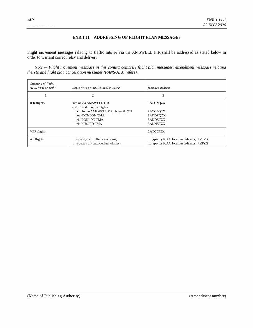
AIP ENR 1.11-1
.......................... 05 NOV 2020
(Name of Publishing Authority) (Amendment number)
ENR 1.11 ADDRESSING OF FLIGHT PLAN MESSAGES
Flight movement messages relating to traffic into or via the AMSWELL FIR shall be addressed as stated below in
order to warrant correct relay and delivery.
Note.— Flight movement messages in this context comprise flight plan messages, amendment messages relating
thereto and flight plan cancellation messages (PANS-ATM refers).
Category of flight
(IFR, VFR or both) Route (into or via FIR and/or TMA) Message address
1 2 3
IFR flights into or via AMSWELL FIR
and, in addition, for flights:
— within the AMSWELL FIR above FL 245
— into DONLON TMA
— via DONLON TMA
— via NIBORD TMA
EACCZQZX
EACCZQZX
EADDZQZX
EADDZTZX
EADNZTZX
VFR flights EACCZFZX
All flights .... (specify controlled aerodrome)
.... (specify uncontrolled aerodrome)
.... (specify ICAO location indicator) + ZTZX
.... (specify ICAO location indicator) + ZPZX
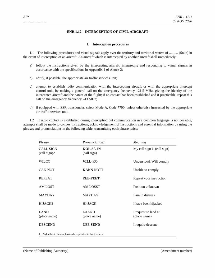
AIP ENR 1.12-1
.......................... 05 NOV 2020
(Name of Publishing Authority) (Amendment number)
ENR 1.12 INTERCEPTION OF CIVIL AIRCRAFT
1. Interception procedures
1.1 The following procedures and visual signals apply over the territory and territorial waters of .......... (State) in
the event of interception of an aircraft. An aircraft which is intercepted by another aircraft shall immediately:
a) follow the instructions given by the intercepting aircraft, interpreting and responding to visual signals in
accordance with the specifications in Appendix 1 of Annex 2;
b) notify, if possible, the appropriate air traffic services unit;
c) attempt to establish radio communication with the intercepting aircraft or with the appropriate intercept
control unit, by making a general call on the emergency frequency 121.5 MHz, giving the identity of the
intercepted aircraft and the nature of the flight; if no contact has been established and if practicable, repeat this
call on the emergency frequency 243 MHz;
d) if equipped with SSR transponder, select Mode A, Code 7700, unless otherwise instructed by the appropriate
air traffic services unit.
1.2 If radio contact is established during interception but communication in a common language is not possible,
attempts shall be made to convey instructions, acknowledgement of instructions and essential information by using the
phrases and pronunciations in the following table, transmitting each phrase twice:
Phrase Pronunciation1 Meaning
CALL SIGN
(call sign)2
WILCO
CAN NOT
REPEAT
AM LOST
MAYDAY
HIJACK3
LAND
(place name)
DESCEND
KOL SA-IN
(call sign)
VILL-KO
KANN NOTT
REE-PEET
AM LOSST
MAYDAY
HI-JACK
LAAND
(place name)
DEE-SEND
My call sign is (call sign)
Understood. Will comply
Unable to comply
Repeat your instruction
Position unknown
I am in distress
I have been hijacked
I request to land at
(place name)
I require descent
1. Syllables to be emphasized are printed in bold letters.
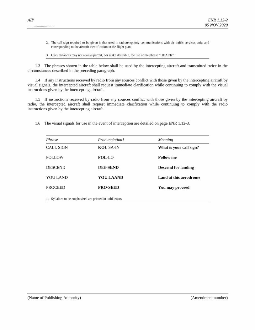
AIP ENR 1.12-2
.......................... 05 NOV 2020
(Name of Publishing Authority) (Amendment number)
2. The call sign required to be given is that used in radiotelephony communications with air traffic services units and
corresponding to the aircraft identification in the flight plan.
3. Circumstances may not always permit, nor make desirable, the use of the phrase “HIJACK”.
1.3 The phrases shown in the table below shall be used by the intercepting aircraft and transmitted twice in the
circumstances described in the preceding paragraph.
1.4 If any instructions received by radio from any sources conflict with those given by the intercepting aircraft by
visual signals, the intercepted aircraft shall request immediate clarification while continuing to comply with the visual
instructions given by the intercepting aircraft.
1.5 If instructions received by radio from any sources conflict with those given by the intercepting aircraft by
radio, the intercepted aircraft shall request immediate clarification while continuing to comply with the radio
instructions given by the intercepting aircraft.
1.6 The visual signals for use in the event of interception are detailed on page ENR 1.12-3.
Phrase Pronunciation1 Meaning
CALL SIGN
FOLLOW
DESCEND
YOU LAND
PROCEED
KOL SA-IN
FOL-LO
DEE-SEND
YOU LAAND
PRO-SEED
What is your call sign?
Follow me
Descend for landing
Land at this aerodrome
You may proceed
1. Syllables to be emphasized are printed in bold letters.
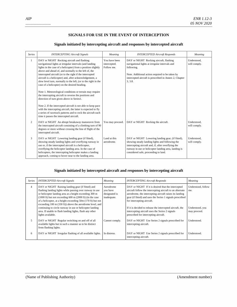
AIP ENR 1.12-3
.......................... 05 NOV 2020
(Name of Publishing Authority) (Amendment number)
SIGNALS FOR USE IN THE EVENT OF INTERCEPTION
Signals initiated by intercepting aircraft and responses by intercepted aircraft
Series INTERCEPTING Aircraft Signals Meaning INTERCEPTED Aircraft Responds Meaning
1 DAY or NIGHT Rocking aircraft and flashing
navigational lights at irregular intervals (and landing
lights in the case of a helicopter) from a position slightly
above and ahead of, and normally to the left of, the
intercepted aircraft (or to the right if the intercepted
aircraft is a helicopter) and, after acknowledgement, a
slow level turn, normally to the left, (or to the right in the
case of a helicopter) on the desired heading.
Note 1. Meteorological conditions or terrain may require
the intercepting aircraft to reverse the positions and
direction of turn given above in Series1.
Note 2. If the intercepted aircraft is not able to keep pace
with the intercepting aircraft, the latter is expected to fly
a series of racetrack patterns and to rock the aircraft each
time it passes the intercepted aircraft.
You have been
intercepted.
Follow me.
DAY or NIGHT Rocking aircraft, flashing
navigational lights at irregular intervals and
following.
Note. Additional action required to be taken by
intercepted aircraft is prescribed in Annex 2, Chapter
3, 3.8.
Understood,
will comply.
2 DAY or NIGHT An abrupt breakaway manoeuvre from
the intercepted aircraft consisting of a climbing turn of 90
degrees or more without crossing the line of flight of the
intercepted aircraft.
You may proceed. DAY or NIGHT Rocking the aircraft. Understood,
will comply.
3 DAY or NIGHT Lowering landing gear (if fitted),
showing steady landing lights and overflying runway in
use or, if the intercepted aircraft is a helicopter,
overflying the helicopter landing area. In the case of
helicopters, the intercepting helicopter makes a landing
approach, coming to hover near to the landing area.
Land at this
aerodrome.
DAY or NIGHT Lowering landing gear, (if fitted),
showing steady landing lights and following the
intercepting aircraft and, if, after overflying the
runway in use or helicopter landing area, landing is
considered safe, proceeding to land.
Understood,
will comply.
Signals initiated by intercepted aircraft and responses by intercepting aircraft
Series INTERCEPTED Aircraft Signals Meaning INTERCEPTING Aircraft Responds Meaning
4 DAY or NIGHT Raising landing gear (if fitted) and
flashing landing lights while passing over runway in use
or helicopter landing area at a height exceeding 300 m
(1000 ft) but not exceeding 600 m (2000 ft) (in the case
of a helicopter, at a height exceeding 50m (170 ft) but not
exceeding 100 m (330 ft)) above the aerodrome level, and
continuing to circle runway in use or helicopter landing
area. If unable to flash landing lights, flash any other
lights available.
Aerodrome
you have
designated is
inadequate.
DAY or NIGHT If it is desired that the intercepted
aircraft follow the intercepting aircraft to an alternate
aerodrome, the intercepting aircraft raises its landing
gear (if fitted) and uses the Series 1 signals prescribed
for intercepting aircraft.
If it is decided to release the intercepted aircraft, the
intercepting aircraft uses the Series 2 signals
prescribed for intercepting aircraft.
Understood, follow
me.
Understood, you
may proceed.
5 DAY or NIGHT Regular switching on and off of all
available lights but in such a manner as to be distinct
from flashing lights.
Cannot comply. DAY or NIGHT Use Series 2 signals prescribed for
intercepting aircraft.
Understood.
6 DAY or NIGHT Irregular flashing of all available lights. In distress. DAY or NIGHT Use Series 2 signals prescribed for
intercepting aircraft.
Understood.
AIP ENR 1.13-1
.......................... 05 NOV 2020
(Name of Publishing Authority) (Amendment number)
ENR 1.13 UNLAWFUL INTERFERENCE
1. General
The following procedures are intended for use by aircraft when unlawful interference occurs and the aircraft is unable
to notify an ATS unit of this fact.
2. Procedures
2.1 Unless considerations aboard the aircraft dictate otherwise, the pilot-in-command should attempt to continue
flying on the assigned track and at the assigned cruising level at least until notification to an ATS unit is possible or the
aircraft is within radar coverage.
2.2 When an aircraft subjected to an act of unlawful interference must depart from its assigned track or its
assigned cruising level without being able to make radiotelephony contact with ATS, the pilot-in-command should,
whenever possible:
a) attempt to broadcast warnings on the VHF emergency frequency and other appropriate frequencies, unless
considerations aboard the aircraft dictate otherwise. Other equipment such as on-board transponders, data
links, etc. should also be used when it is advantageous to do so and circumstances permit; and
b) proceed in accordance with applicable special procedures for in-flight contingencies, where such procedures
have been established and promulgated in ICAO Doc 7030 — Regional Supplementary Procedures; or
c) if no applicable regional procedures have been established, proceed at a level which differs from the cruising
levels normally used for IFR flight in the area by 300 m (1 000 ft) if above FL 290 or by 150 m (500 ft) if
below FL 290.
AIP ENR 1.14-1
.......................... 05 NOV 2020
(Name of Publishing Authority) (Amendment number)
ENR 1.14 AIR TRAFFIC INCIDENTS
1. Definition of air traffic incidents
1.1 “Air traffic incident” is used to mean a serious occurrence related to the provision of air traffic services, such
as:
a) aircraft proximity (AIRPROX);
b) serious difficulty resulting in a hazard to aircraft caused, for example, by:
1) faulty procedures
2) non-compliance with procedures, or
3) failure of ground facilities.
1.1.1 Definitions for aircraft proximity and AIRPROX.
Aircraft proximity. A situation in which, in the opinion of the pilot or the air traffic services personnel, the distance
between aircraft, as well as their relative positions and speed, has been such that the safety of the aircraft involved
may have been compromised. Aircraft proximity is classified as follows:
Risk of collision. The risk classification of aircraft proximity in which serious risk of collision has existed.
Safety not assured. The risk classification of aircraft proximity in which the safety of the aircraft may have been
compromised.
No risk of collision. The risk classification of aircraft proximity in which no risk of collision has existed.
Risk not determined. The risk classification of aircraft proximity in which insufficient information was available to
determine the risk involved, or inconclusive or conflicting evidence precluded such determination.
AIRPROX. The code word used in an air traffic incident report to designate aircraft proximity.
1.2 Air traffic incidents are designated and identified in reports as follows:
Type Designation
Air traffic incident Incident
as a) above AIRPROX (aircraft proximity)
as b) 1) and 2) above Procedure
as b) 3) above Facility
2. Use of the Air Traffic Incident Report Form
(See model on pages ENR 1.14-3 to 1.14-7)
The Air Traffic Incident Report Form is intended for use:
AIP ENR 1.14-2
.......................... 05 NOV 2020
(Name of Publishing Authority) (Amendment number)
a) by a pilot for filing a report on an air traffic incident after arrival or for confirming a report made initially by
radio during flight.
Note.— The form, if available on board, may also be of use in providing a pattern for making the initial
report in flight.
b) by an ATS unit for recording an air traffic incident report received by radio or telephone.
Note.— The form may be used as the format for the text of a message to be transmitted over the AFS
network.
3. Reporting procedures (including in-flight procedures)
3.1 The following are the procedures to be followed by a pilot who is or has been involved in an incident:
a) during flight, use the appropriate air/ground frequency for reporting an incident of major significance,
particularly if it involves other aircraft, so as to permit the facts to be ascertained immediately;
b) as promptly as possible after landing, submit a completed Air Traffic Incident Report Form
1) for confirming a report of an incident made initially as in a) above, or for making the initial report on such
an incident if it had not been possible to report it by radio;
2) for reporting an incident which did not require immediate notification at the time of occurrence.
3.2 An initial report made by radio should contain the following information:
a) aircraft identification;
b) type of incident, e.g. aircraft proximity;
c) the incident; 1. a) and b); 2. a), b), c), d), n); 3. a), b), c), i); 4. a), b);
d) miscellaneous: 1. e).
3.3 The confirmatory report on an incident of major significance initially reported by radio or the initial report on
any other incident should be submitted to The Aviation Safety Board, Government Square, Donlon or to the ATS
Reporting Office of the aerodrome of first landing for submission to The Aviation Safety Board. The pilot should
complete the Air Traffic Incident Report Form, supplementing the details of the initial reports as necessary.
Note.— Where there is no ATS Reporting Office, the report may be submitted to another ATS unit.
4. Purpose of reporting and handling of the form
4.1 The purpose of the reporting of aircraft proximity incidents and their investigation is to promote the safety of

AIP ENR 1.14-3
.......................... 05 NOV 2020
(Name of Publishing Authority) (Amendment number)
aircraft. The degree of risk involved in an aircraft proximity incident should be determined in the incident investigation
and classified as “risk of collision”, “safety not assured”, “no risk of collision” or “risk not determined”.
4.2 The purpose of the form is to provide investigatory authorities with as complete information on an air traffic
incident as possible and to enable them to report back, with the least possible delay to the pilot or operator concerned,
the result of the investigation of the incident and, if appropriate, the remedial action taken.
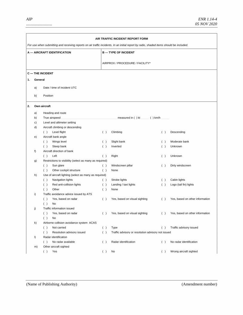
AIP ENR 1.14-4
.......................... 05 NOV 2020
(Name of Publishing Authority) (Amendment number)
AIR TRAFFIC INCIDENT REPORT FORM
For use when submitting and receiving reports on air traffic incidents. In an initial report by radio, shaded items should be included.
A — AIRCRAFT IDENTIFICATION B — TYPE OF INCIDENT
AIRPROX / PROCEDURE / FACILITY*
C — THE INCIDENT
1. General
a) Date / time of incident UTC
b) Position
2. Own aircraft
a) Heading and route
b) True airspeed ____________________________________ measured in ( ) kt _____ ( ) km/h _____
c) Level and altimeter setting
d) Aircraft climbing or descending
( ) Level flight ( ) Climbing ( ) Descending
e) Aircraft bank angle
( ) Wings level ( ) Slight bank ( ) Moderate bank
( ) Steep bank ( ) Inverted ( ) Unknown
f) Aircraft direction of bank
( ) Left ( ) Right ( ) Unknown
g) Restrictions to visibility (select as many as required)
( ) Sun glare ( ) Windscreen pillar ( ) Dirty windscreen
( ) Other cockpit structure ( ) None
h) Use of aircraft lighting (select as many as required)
( ) Navigation lights ( ) Strobe lights ( ) Cabin lights
( ) Red anti-collision lights ( ) Landing / taxi lights ( ) Logo (tail fin) lights
( ) Other ( ) None
i) Traffic avoidance advice issued by ATS
( ) Yes, based on radar ( ) Yes, based on visual sighting ( ) Yes, based on other information
( ) No
j) Traffic information issued
( ) Yes, based on radar ( ) Yes, based on visual sighting ( ) Yes, based on other information
( ) No
k) Airborne collision avoidance system ACAS
( ) Not carried ( ) Type ( ) Traffic advisory issued
( ) Resolution advisory issued ( ) Traffic advisory or resolution advisory not issued
l) Radar identification
( ) No radar available ( ) Radar identification ( ) No radar identification
m) Other aircraft sighted
( ) Yes ( ) No ( ) Wrong aircraft sighted
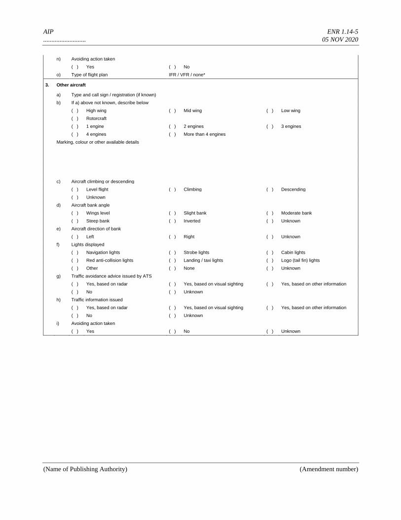
AIP ENR 1.14-5
.......................... 05 NOV 2020
(Name of Publishing Authority) (Amendment number)
n) Avoiding action taken
( ) Yes ( ) No
o) Type of flight plan IFR / VFR / none*
3. Other aircraft
a) Type and call sign / registration (if known)
b) If a) above not known, describe below
( ) High wing ( ) Mid wing ( ) Low wing
( ) Rotorcraft
( ) 1 engine ( ) 2 engines ( ) 3 engines
( ) 4 engines ( ) More than 4 engines
Marking, colour or other available details
c) Aircraft climbing or descending
( ) Level flight ( ) Climbing ( ) Descending
( ) Unknown
d) Aircraft bank angle
( ) Wings level ( ) Slight bank ( ) Moderate bank
( ) Steep bank ( ) Inverted ( ) Unknown
e) Aircraft direction of bank
( ) Left ( ) Right ( ) Unknown
f) Lights displayed
( ) Navigation lights ( ) Strobe lights ( ) Cabin lights
( ) Red anti-collision lights ( ) Landing / taxi lights ( ) Logo (tail fin) lights
( ) Other ( ) None ( ) Unknown
g) Traffic avoidance advice issued by ATS
( ) Yes, based on radar ( ) Yes, based on visual sighting ( ) Yes, based on other information
( ) No ( ) Unknown
h) Traffic information issued
( ) Yes, based on radar ( ) Yes, based on visual sighting ( ) Yes, based on other information
( ) No ( ) Unknown
i) Avoiding action taken
( ) Yes ( ) No ( ) Unknown

AIP ENR 1.14-6
.......................... 05 NOV 2020
(Name of Publishing Authority) (Amendment number)
4. Distance
a) Closest horizontal distance
b) Closest vertical distance
5. Flight weather conditions
a) IMC / VMC*
b) Above / below* clouds / fog / haze or between layers*
c) Distance vertically from cloud __________ m / ft* below __________ m / ft* above
d) In cloud / rain / snow / sleet / fog / haze*
e) Flying into / out of* sun
f) Flight visibility _______ m / km*
6. Any other information considered important by the pilot-in-command
D — MISCELLANEOUS
1. Information regarding reporting aircraft
a) Aircraft registration
b) Aircraft type
c) Operator
d) Aerodrome of departure
e) Aerodrome of first landing _______________________
destination
f) Reported by radio or other means to _______________________________________ (name of ATS unit) at time UTC
g) Date / time / place of completion of form
2. Function, address and signature of person submitting report
a) Function
b) Address
c) Signature
d) Telephone number
3. Function and signature of person receiving report
a) Function __________________________ b) Signature ________________________________________________________________
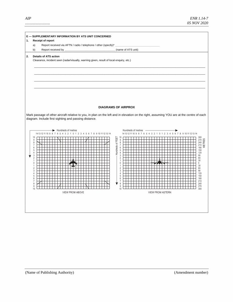
AIP ENR 1.14-7
.......................... 05 NOV 2020
(Name of Publishing Authority) (Amendment number)
E — SUPPLEMENTARY INFORMATION BY ATS UNIT CONCERNED
1. Receipt of report
a) Report received via AFTN / radio / telephone / other (specify)* ______________________________
b) Report received by __________________________________ (name of ATS unit)
2. Details of ATS action
Clearance, incident seen (radar/visually, warning given, result of local enquiry, etc.)
___________________________________________________________________________________________________________________
___________________________________________________________________________________________________________________
___________________________________________________________________________________________________________________
___________________________________________________________________________________________________________________
DIAGRAMS OF AIRPROX
Mark passage of other aircraft relative to you, in plan on the left and in elevation on the right, assuming YOU are at the centre of each
diagram. Include first sighting and passing distance.
109876543210123456789
10
109876543210123456789
10
3002702402101801501209060300306090120150180210240270300
0 01 12 23 34 45 56 67 78 89 910 1011 1112 1213 1314 141 12 23 34 45 56 67 78 89 910 1011 1112 1213 1314 14
VIEW FROM ABOVE VIEW FROM ASTERN
Hundreds of metres Hundreds of metres
Hu
nd
red
s o
f F
EE
T
ME
TR
ES
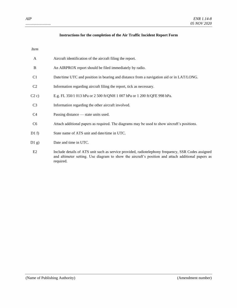
AIP ENR 1.14-8
.......................... 05 NOV 2020
(Name of Publishing Authority) (Amendment number)
Instructions for the completion of the Air Traffic Incident Report Form
Item
A Aircraft identification of the aircraft filing the report.
B An AIRPROX report should be filed immediately by radio.
C1 Date/time UTC and position in bearing and distance from a navigation aid or in LAT/LONG.
C2 Information regarding aircraft filing the report, tick as necessary.
C2 c) E.g. FL 350/1 013 hPa or 2 500 ft/QNH 1 007 hPa or 1 200 ft/QFE 998 hPa.
C3 Information regarding the other aircraft involved.
C4 Passing distance — state units used.
C6 Attach additional papers as required. The diagrams may be used to show aircraft’s positions.
D1 f) State name of ATS unit and date/time in UTC.
D1 g) Date and time in UTC.
E2 Include details of ATS unit such as service provided, radiotelephony frequency, SSR Codes assigned
and altimeter setting. Use diagram to show the aircraft’s position and attach additional papers as
required.
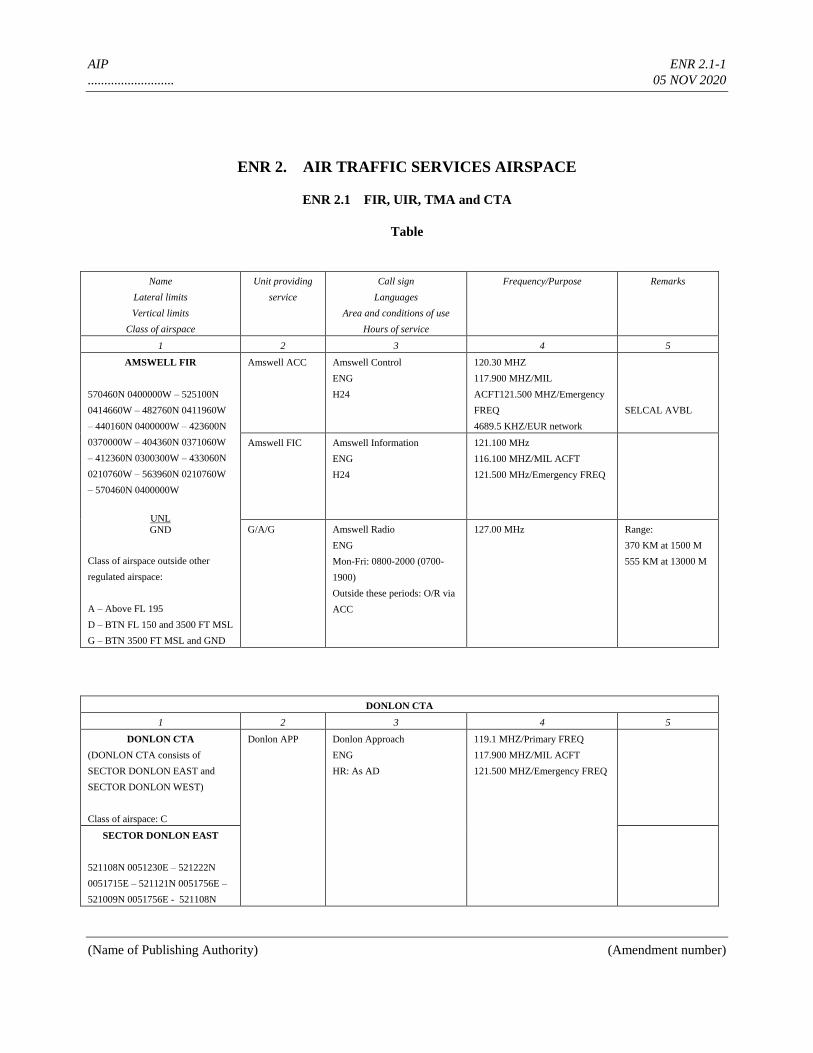
AIP ENR 2.1-1
.......................... 05 NOV 2020
(Name of Publishing Authority) (Amendment number)
ENR 2. AIR TRAFFIC SERVICES AIRSPACE
ENR 2.1 FIR, UIR, TMA and CTA
Table
Name
Lateral limits
Vertical limits
Class of airspace
Unit providing
service
Call sign
Languages
Area and conditions of use
Hours of service
Frequency/Purpose Remarks
1 2 3 4 5
AMSWELL FIR
570460N 0400000W – 525100N
0414660W – 482760N 0411960W
– 440160N 0400000W – 423600N
0370000W – 404360N 0371060W
– 412360N 0300300W – 433060N
0210760W – 563960N 0210760W
– 570460N 0400000W
UNL
GND
Class of airspace outside other
regulated airspace:
A – Above FL 195
D – BTN FL 150 and 3500 FT MSL
G – BTN 3500 FT MSL and GND
Amswell ACC Amswell Control
ENG
H24
120.30 MHZ
117.900 MHZ/MIL
ACFT121.500 MHZ/Emergency
FREQ
4689.5 KHZ/EUR network
SELCAL AVBL
Amswell FIC Amswell Information
ENG
H24
121.100 MHz
116.100 MHZ/MIL ACFT
121.500 MHz/Emergency FREQ
G/A/G Amswell Radio
ENG
Mon-Fri: 0800-2000 (0700-
1900)
Outside these periods: O/R via
ACC
127.00 MHz Range:
370 KM at 1500 M
555 KM at 13000 M
DONLON CTA
1 2 3 4 5
DONLON CTA
(DONLON CTA consists of
SECTOR DONLON EAST and
SECTOR DONLON WEST)
Class of airspace: C
Donlon APP Donlon Approach
ENG
HR: As AD
119.1 MHZ/Primary FREQ
117.900 MHZ/MIL ACFT
121.500 MHZ/Emergency FREQ
SECTOR DONLON EAST
521108N 0051230E – 521222N
0051715E – 521121N 0051756E –
521009N 0051756E - 521108N
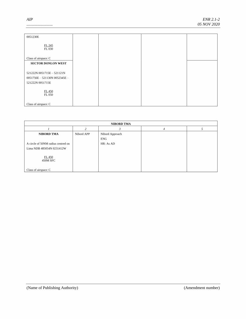
AIP ENR 2.1-2
.......................... 05 NOV 2020
(Name of Publishing Authority) (Amendment number)
0051230E
FL 245
FL 030
Class of airspace: C
SECTOR DONLON WEST
521222N 0051715E – 521121N
0051756E – 521130N 0052345E –
521222N 0051715E
FL 450
FL 050
Class of airspace: C
NIBORD TMA
1 2 3 4 5
NIBORD TMA
A circle of 50NM radius centred on
Lima NDB 485054N 0231412W
FL 450
450M SFC
Class of airspace: C
Nibord APP Nibord Approach
ENG
HR: As AD
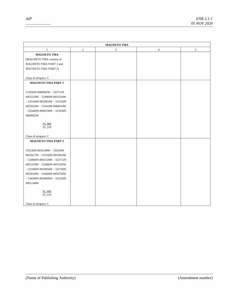
AIP ENR 2.1-1
.......................... 05 NOV 2020
(Name of Publishing Authority) (Amendment number)
MAGNETO TMA
1 2 3 4 5
MAGNETO TMA
(MAGNETO TMA consists of
MAGNETO TMA PART 1 and
MAGNETO TMA PART 2)
Class of airspace: C
MAGNETO TMA PART 1
515936N 0060002W – 522712N
0055210W – 524900N 0055324W
– 533160N 0055854W – 535336N
0055616W – 535418N 0060014W
– 535460N 0060558W – 515936N
0060002W
FL 460
FL 210
Class of airspace: C
MAGNETO TMA PART 2
535236N 0055148W – 535336N
0055617W – 533160N 0055854W
– 524860N 0055324W – 522712N
0055210W – 523060N 0055103W
– 523460N 0054954W – 531760N
0054518W – 534200N 0054720W
– 534306N 0054830W – 535236N
0055148W
FL 460
FL 210
Class of airspace: C
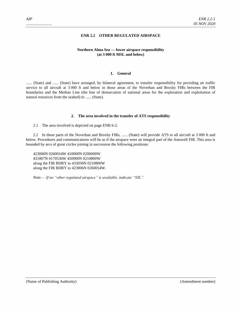
AIP ENR 2.2-1
.......................... 05 NOV 2020
(Name of Publishing Authority) (Amendment number)
ENR 2.2 OTHER REGULATED AIRSPACE
Northern Alma Sea — lower airspace responsibility
(at 3 000 ft MSL and below)
1. General
...... (State) and ...... (State) have arranged, by bilateral agreement, to transfer responsibility for providing air traffic
service to all aircraft at 3 000 ft and below in those areas of the Noverhan and Broxby FIRs between the FIR
boundaries and the Median Line (the line of demarcation of national areas for the exploration and exploitation of
natural resources from the seabed) to ...... (State).
2. The area involved in the transfer of ATS responsibility
2.1 The area involved is depicted on page ENR 6-2.
2.2 In these parts of the Noverhan and Broxby FIRs, ...... (State) will provide ATS to all aircraft at 3 000 ft and
below. Procedures and communications will be as if the airspace were an integral part of the Amswell FIR. This area is
bounded by arcs of great circles joining in succession the following positions:
423006N 0260054W 410000N 0200000W
431807N 0170536W 450000N 0210800W
along the FIR BDRY to 433030N 0210800W
along the FIR BDRY to 423006N 0260054W.
Note.— If no “other regulated airspace” is available, indicate “NIL”.

AIP ENR 3.1-1
.......................... 05 NOV 2020
(Name of Publishing Authority) (Amendment number)
ENR 3. ATS ROUTES
ENR 3.1 LOWER ATS ROUTES
Route designator (RNP/RNAV 1) Name of significant points Coordinates RCP/RSP specification
Track MAG
/
.
VOR RDL DIST (COP)
Upper limits Lower limits
or Minimum altitude 2
Airspace classification
Lateral limits KM
Direction of cruising levels
Navigation accuracy
requirement
Remarks Controlling unit channel Logon address SATVOICE number RCP/RSP specification limitations Odd Even
1 2 3 4 5 6 7
A4 (RNP 4) 3
For continuation, see AIP ..... (specify).
BARIM 423006N 0370006W WOBAN VOR (WOB) 424030N 0361024W EKCOMBE VOR (EKO) 470812N 0283830W LIMAD VOR (LMD) 484800N 0231300W
VEGAT 492130N 0210800W
074°/254° 69.3 KM
FL 195 900 M AMSL
(or) MEA = 1 200 M
Class C
18 +/- 4 NM
053°/233° 771.6 KM (489/282)
+/- 4 NM Amswell ACC channel: 120.300
064°/244° 446.0 KM
+/- 4 NM
064°/244° 163.2 KM
+/- 4 NM
For continuation, see AIP ..... (specify).
A6 (RNP 4)
For continuation, see AIP ..... (specify).
TEMPO (FIR BDRY) 565024N 0295136W RAINBY NDB (RNB) 553854N 0310400W DONNARD NDB (DON) 530218N 0320906W BOORSPIJK VOR/DME (BOR) 552206N 0322230W ROBINE NDB (ROB) 515900N 0323300W ROCKBY NDB (ROK) 473500N 0342942W WOBAN VOR (WOB) 424036N 0361024W
210°/030° 165.9 KM
FL 195 900 M AMSL
(or) MEA = 1 200 M
Class C
18 +/- 4 NM All flights between TEMPO and DONNARD shall file a flight plan, maintain two-way radio contact with Amswell ACC and report positions as instructed to eliminate or reduce the need for interception. Amswell ACC channel: 120.300
196°/016° 289.4 KM
+/- 4 NM
194°/014° 76.5 KM
+/- 4 NM
195°/015° 57.1 KM
FL 195 1 350 M AMSL
(or) MEA = 1 700 M
Class C
18
+/- 4 NM
For continuation, see AIP ..... (specify).
199°/017° 509.0 KM MOCA = 4 000 ft
Class C
18 +/- 4 NM
199°/019° 561.8 KM
+/- 4 NM
1. RNP = required navigation performance specification; RNAV = area navigation specification. 2. MEA = minimum en-route altitude; MOCA = minimum obstacle clearance altitude. 3. RNP 4 represents aircraft and operating requirements, including a 7.4 KM (4 NM) lateral performance, with on-board performance monitoring and alerting
that are detailed in the Performance-based Navigation (PBN) Manual (Doc 9613).
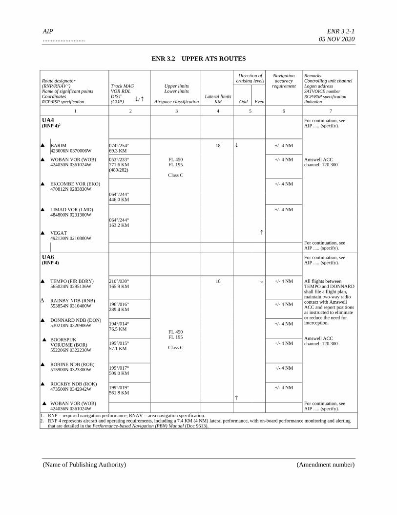
AIP ENR 3.2-1
.......................... 05 NOV 2020
(Name of Publishing Authority) (Amendment number)
ENR 3.2 UPPER ATS ROUTES
Route designator (RNP/RNAV 1) Name of significant points Coordinates RCP/RSP specification
Track MAG
/
.
VOR RDL DIST (COP)
Upper limits Lower limits
Airspace classification
Lateral limits KM
Direction of cruising levels
Navigation accuracy
requirement
Remarks Controlling unit channel Logon address SATVOICE number RCP/RSP specification
limitation Odd Even
1 2 3 4 5 6 7
UA4 (RNP 4)2
For continuation, see AIP ..... (specify).
BARIM 423006N 0370006W
074°/254° 69.3 KM
18 +/- 4 NM
WOBAN VOR (WOB) 424030N 0361024W
053°/233° 771.6 KM (489/282)
FL 450 FL 195
Class C
+/- 4 NM Amswell ACC channel: 120.300
EKCOMBE VOR (EKO) 470812N 0283830W
064°/244° 446.0 KM
+/- 4 NM
LIMAD VOR (LMD) 484800N 0231300W
064°/244° 163.2 KM
+/- 4 NM
VEGAT 492130N 0210800W
For continuation, see AIP ..... (specify).
UA6 (RNP 4)
For continuation, see AIP ..... (specify).
TEMPO (FIR BDRY) 565024N 0295136W
210°/030° 165.9 KM
FL 450 FL 195
Class C
18 +/- 4 NM All flights between TEMPO and DONNARD shall file a flight plan, maintain two-way radio contact with Amswell ACC and report positions as instructed to eliminate or reduce the need for interception. Amswell ACC channel: 120.300
RAINBY NDB (RNB) 553854N 0310400W
196°/016° 289.4 KM
+/- 4 NM
DONNARD NDB (DON) 530218N 0320906W
194°/014° 76.5 KM
+/- 4 NM
BOORSPIJK VOR/DME (BOR) 552206N 0322230W
195°/015° 57.1 KM
+/- 4 NM
ROBINE NDB (ROB) 515900N 0323300W
199°/017° 509.0 KM
+/- 4 NM
ROCKBY NDB (ROK) 473500N 0342942W
199°/019° 561.8 KM
+/- 4 NM
WOBAN VOR (WOB) 424036N 0361024W
For continuation, see AIP ..... (specify).
1. RNP = required navigation performance; RNAV = area navigation specification. 2. RNP 4 represents aircraft and operating requirements, including a 7.4 KM (4 NM) lateral performance, with on-board performance monitoring and alerting
that are detailed in the Performance-based Navigation (PBN) Manual (Doc 9613).
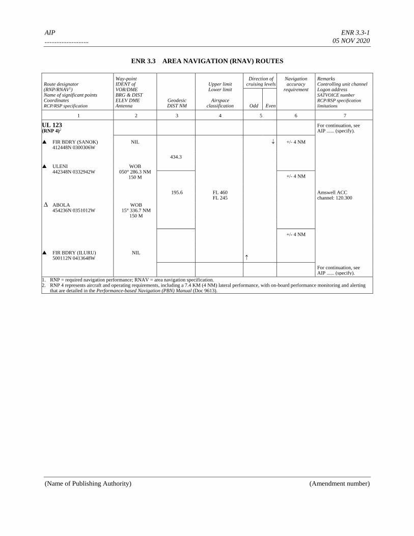
AIP ENR 3.3-1
.......................... 05 NOV 2020
(Name of Publishing Authority) (Amendment number)
ENR 3.3 AREA NAVIGATION (RNAV) ROUTES
Route designator (RNP/RNAV1) Name of significant points Coordinates RCP/RSP specification
Way-point IDENT of VOR/DME BRG & DIST ELEV DME Antenna
Geodesic DIST NM
Upper limit Lower limit
Airspace
classification
Direction of cruising levels
Navigation accuracy
requirement
Remarks Controlling unit channel Logon address SATVOICE number RCP/RSP specification
limitations Odd Even
1 2 3 4 5 6 7
UL 123 (RNP 4)2
For continuation, see AIP ...... (specify).
FIR BDRY (SANOK) 412448N 0300306W
NIL
+/- 4 NM
434.3
ULENI 442348N 0332942W
WOB 050° 286.3 NM
150 M
195.6
FL 460 FL 245
+/- 4 NM Amswell ACC channel: 120.300
ABOLA 454236N 0351012W
WOB 15° 336.7 NM
150 M
+/- 4 NM
FIR BDRY (ILURU) 500112N 0413648W
NIL
For continuation, see AIP ...... (specify).
1. RNP = required navigation performance; RNAV = area navigation specification. 2. RNP 4 represents aircraft and operating requirements, including a 7.4 KM (4 NM) lateral performance, with on-board performance monitoring and alerting
that are detailed in the Performance-based Navigation (PBN) Manual (Doc 9613).
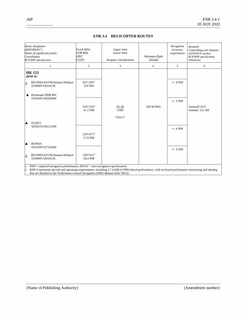
AIP ENR 3.4-1
.......................... 05 NOV 2020
(Name of Publishing Authority) (Amendment number)
ENR 3.4 HELICOPTER ROUTES
Route designator
(RNP/RNAV1)
Name of significant points
Coordinates RCP/RSP specification
Track MAG
VOR RDL
DIST
(COP)
Upper limit
Lower limit
Airspace classification
Minimum flight
altitude
Navigation
accuracy
requirement
Remarks
Controlling unit channel SATVOICE number
RCP/RSP specification
limitations
1 2 3 4 5 6
HK 123 (RNP 4)2
RICHMAAST/Richmaast Heliport
555006N 0263412E
021°/201°
9.8 NM
+/- 4 NM
Richmaast NDB RIC
555918N 0262830W
+/- 4 NM 016°/195°
41.2 NM
FL 85
GND
Class C
300 M MSL Amswell ACC
channel: 121.100
OLNEV
563921N 0261133W
+/- 4 NM 259°/077°
57.8 NM
BONDA
562524N 0275242W
+/- 4 NM
RICHMAAST/Richmaast Heliport
555006N 0263412E
130°/311°
56.4 NM
1. RNP = required navigation performance; RNAV = area navigation specification.
2. RNP 4 represents aircraft and operating requirements, including a 7.4 KM (4 NM) lateral performance, with on-board performance monitoring and alerting
that are detailed in the Performance-based Navigation (PBN) Manual (Doc 9613).
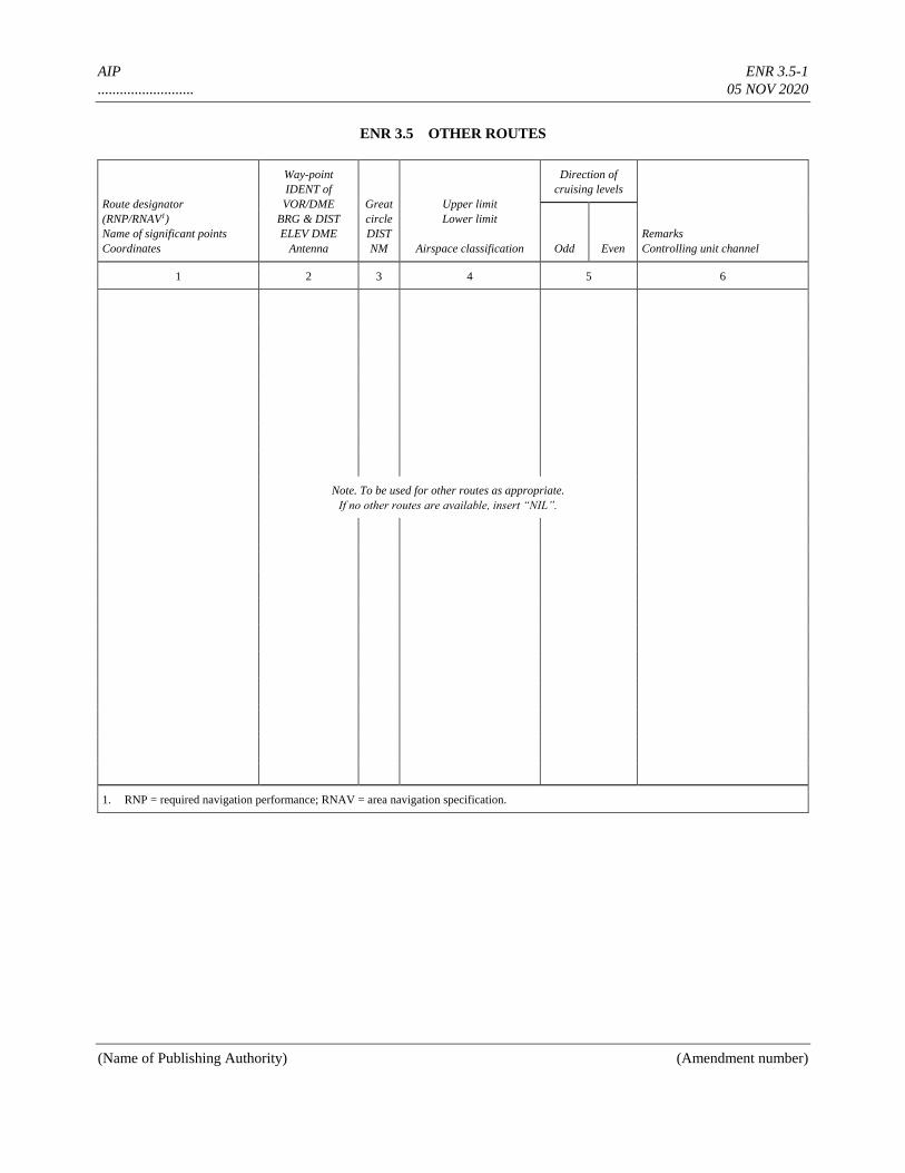
AIP ENR 3.5-1
.......................... 05 NOV 2020
(Name of Publishing Authority) (Amendment number)
ENR 3.5 OTHER ROUTES
Route designator
(RNP/RNAV1)
Name of significant points
Coordinates
Way-point
IDENT of
VOR/DME
BRG & DIST
ELEV DME
Antenna
Great
circle
DIST
NM
Upper limit
Lower limit
Airspace classification
Direction of
cruising levels
Remarks
Controlling unit channel Odd Even
1 2 3 4 5 6
Note. To be used for other routes as appropriate.
If no other routes are available, insert “NIL”.
1. RNP = required navigation performance; RNAV = area navigation specification.
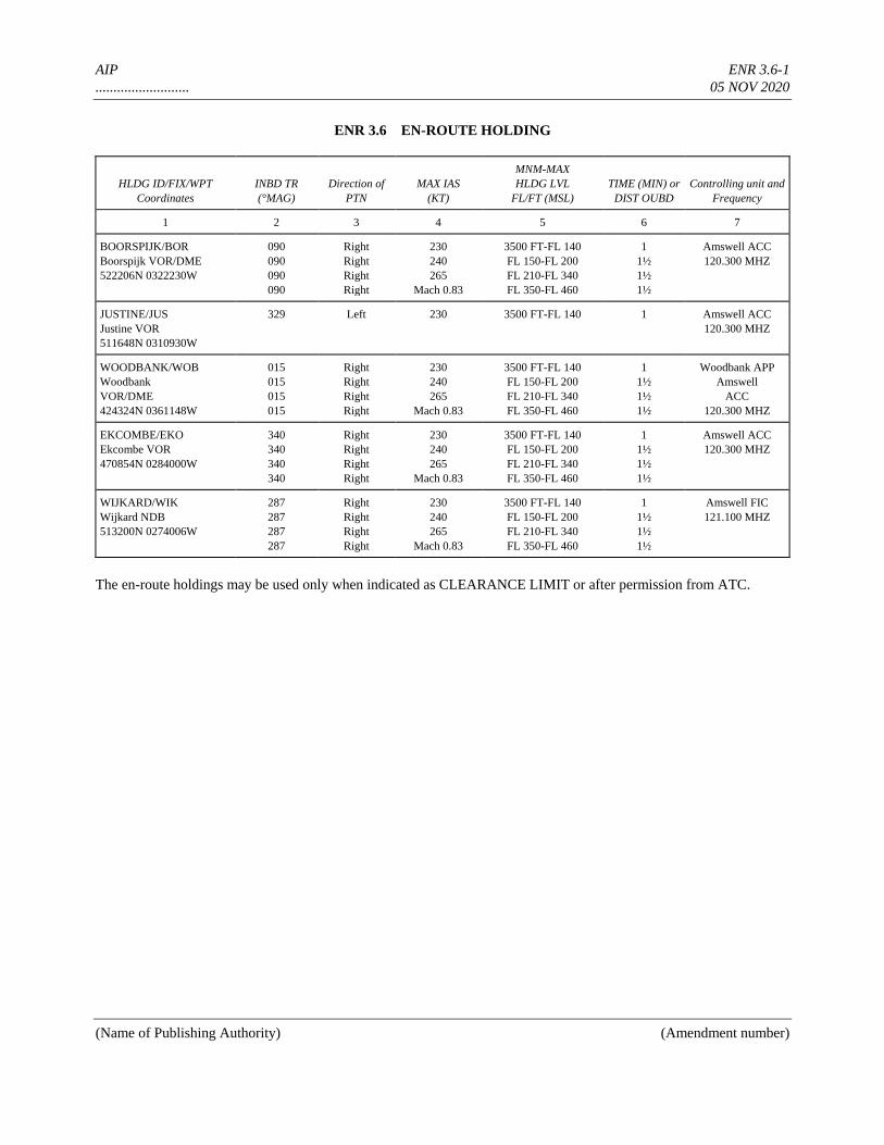
AIP ENR 3.6-1
.......................... 05 NOV 2020
(Name of Publishing Authority) (Amendment number)
ENR 3.6 EN-ROUTE HOLDING
HLDG ID/FIX/WPT
Coordinates
INBD TR
(°MAG)
Direction of
PTN
MAX IAS
(KT)
MNM-MAX
HLDG LVL
FL/FT (MSL)
TIME (MIN) or
DIST OUBD
Controlling unit and
Frequency
1 2 3 4 5 6 7
BOORSPIJK/BOR
Boorspijk VOR/DME
522206N 0322230W
090
090
090
090
Right
Right
Right
Right
230
240
265
Mach 0.83
3500 FT-FL 140
FL 150-FL 200
FL 210-FL 340
FL 350-FL 460
1
1½
1½
1½
Amswell ACC
120.300 MHZ
JUSTINE/JUS
Justine VOR
511648N 0310930W
329 Left 230 3500 FT-FL 140 1 Amswell ACC
120.300 MHZ
WOODBANK/WOB
Woodbank
VOR/DME
424324N 0361148W
015
015
015
015
Right
Right
Right
Right
230
240
265
Mach 0.83
3500 FT-FL 140
FL 150-FL 200
FL 210-FL 340
FL 350-FL 460
1
1½
1½
1½
Woodbank APP
Amswell
ACC
120.300 MHZ
EKCOMBE/EKO
Ekcombe VOR
470854N 0284000W
340
340
340
340
Right
Right
Right
Right
230
240
265
Mach 0.83
3500 FT-FL 140
FL 150-FL 200
FL 210-FL 340
FL 350-FL 460
1
1½
1½
1½
Amswell ACC
120.300 MHZ
WIJKARD/WIK
Wijkard NDB
513200N 0274006W
287
287
287
287
Right
Right
Right
Right
230
240
265
Mach 0.83
3500 FT-FL 140
FL 150-FL 200
FL 210-FL 340
FL 350-FL 460
1
1½
1½
1½
Amswell FIC
121.100 MHZ
The en-route holdings may be used only when indicated as CLEARANCE LIMIT or after permission from ATC.
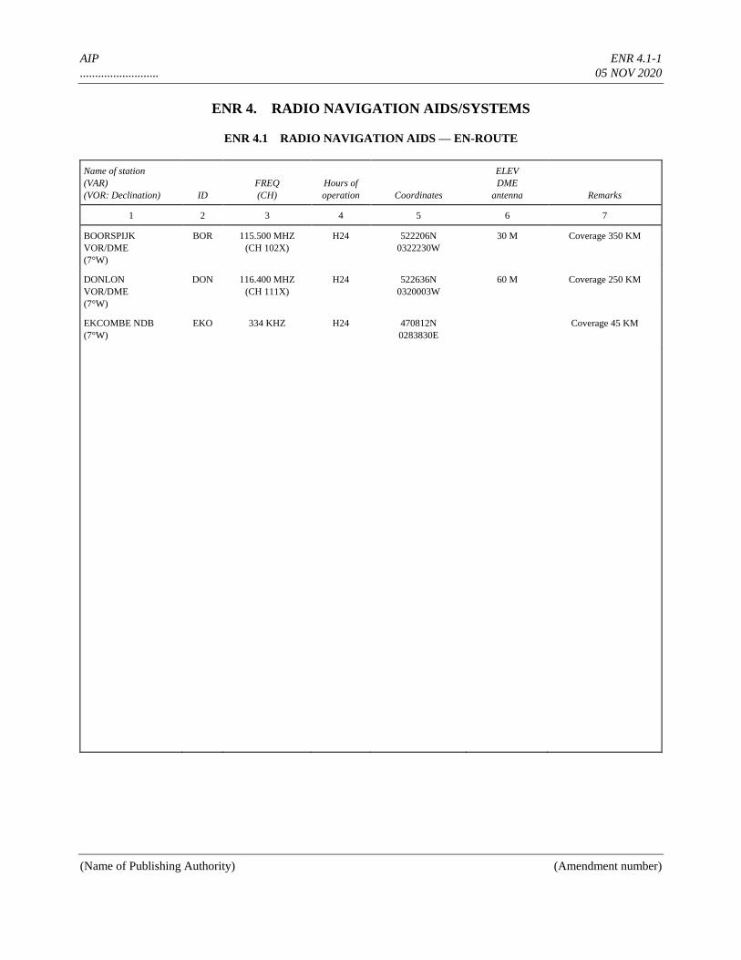
AIP ENR 4.1-1
.......................... 05 NOV 2020
(Name of Publishing Authority) (Amendment number)
ENR 4. RADIO NAVIGATION AIDS/SYSTEMS
ENR 4.1 RADIO NAVIGATION AIDS — EN-ROUTE
Name of station
(VAR)
(VOR: Declination) ID
FREQ
(CH)
Hours of
operation Coordinates
ELEV
DME
antenna Remarks
1 2 3 4 5 6 7
BOORSPIJK
VOR/DME
(7°W)
BOR 115.500 MHZ
(CH 102X)
H24 522206N
0322230W
30 M Coverage 350 KM
DONLON
VOR/DME
(7°W)
DON 116.400 MHZ
(CH 111X)
H24 522636N
0320003W
60 M Coverage 250 KM
EKCOMBE NDB
(7°W)
EKO 334 KHZ H24 470812N
0283830E
Coverage 45 KM
AIP ENR 4.2-1
.......................... 05 NOV 2020
(Name of Publishing Authority) (Amendment number)
ENR 4.2 SPECIAL NAVIGATION SYSTEMS
Name of station (ID)
or chain Type of SVC Frequency
Hours of
operation
Coordinates
TRANS STN Remarks
1 2 3 4 5 6
NIL
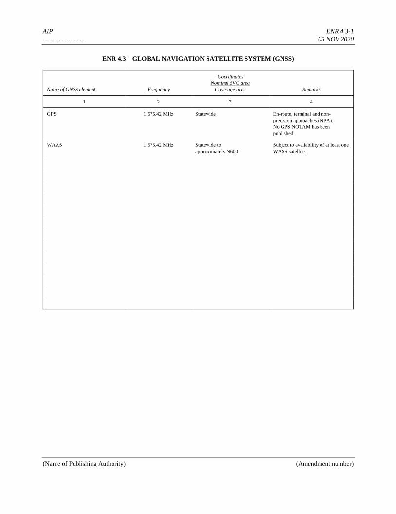
AIP ENR 4.3-1
.......................... 05 NOV 2020
(Name of Publishing Authority) (Amendment number)
ENR 4.3 GLOBAL NAVIGATION SATELLITE SYSTEM (GNSS)
Name of GNSS element Frequency
Coordinates
Nominal SVC area
Coverage area Remarks
1 2 3 4
GPS 1 575.42 MHz Statewide En-route, terminal and non-
precision approaches (NPA).
No GPS NOTAM has been
published.
WAAS 1 575.42 MHz Statewide to
approximately N600
Subject to availability of at least one
WASS satellite.
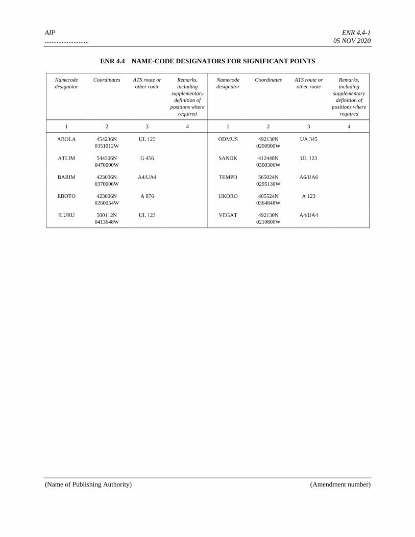
AIP ENR 4.4-1
.......................... 05 NOV 2020
(Name of Publishing Authority) (Amendment number)
ENR 4.4 NAME-CODE DESIGNATORS FOR SIGNIFICANT POINTS
Namecode
designator
Coordinates ATS route or
other route
Remarks,
including
supplementary
definition of
positions where
required
Namecode
designator
Coordinates ATS route or
other route
Remarks,
including
supplementary
definition of
positions where
required
1 2 3 4 1 2 3 4
ABOLA 454236N
0351012W
UL 123 ODMUS 492130N
0200900W
UA 345
ATLIM 544306N
0470000W
G 456 SANOK 412448N
0300306W
UL 123
BARIM 423006N
0370006W
A4/UA4 TEMPO 565024N
0295136W
A6/UA6
EBOTO 423006N
0260054W
A 876 UKORO 405524N
0364848W
A 123
ILURU 500112N
0413648W
UL 123 VEGAT 492130N
0210800W
A4/UA4
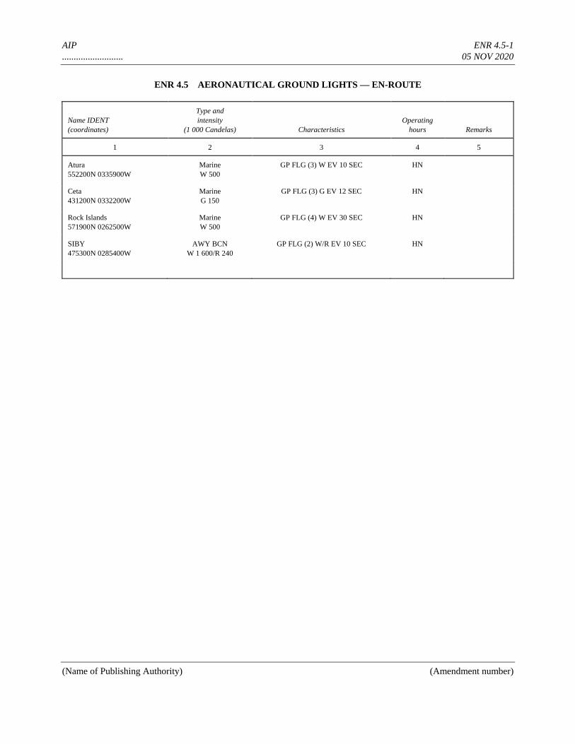
AIP ENR 4.5-1
.......................... 05 NOV 2020
(Name of Publishing Authority) (Amendment number)
ENR 4.5 AERONAUTICAL GROUND LIGHTS — EN-ROUTE
Name IDENT
(coordinates)
Type and
intensity
(1 000 Candelas) Characteristics
Operating
hours Remarks
1 2 3 4 5
Atura
552200N 0335900W
Marine
W 500
GP FLG (3) W EV 10 SEC HN
Ceta
431200N 0332200W
Marine
G 150
GP FLG (3) G EV 12 SEC HN
Rock Islands
571900N 0262500W
Marine
W 500
GP FLG (4) W EV 30 SEC HN
SIBY
475300N 0285400W
AWY BCN
W 1 600/R 240
GP FLG (2) W/R EV 10 SEC HN
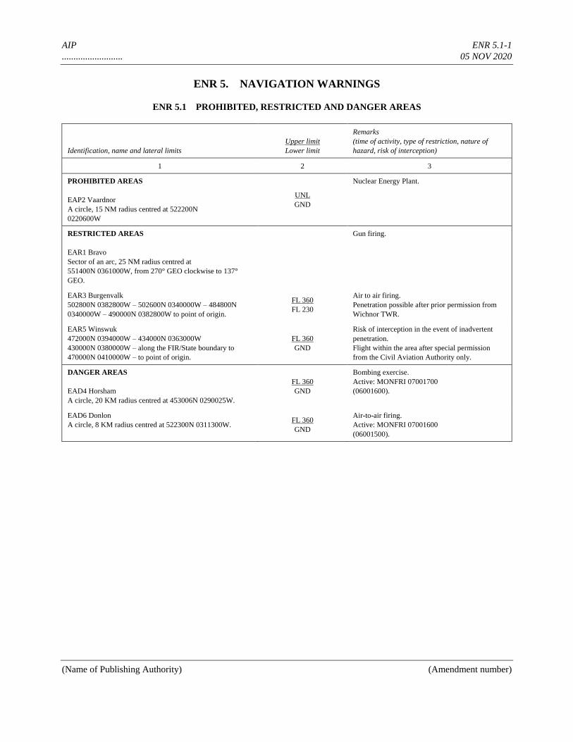
AIP ENR 5.1-1
.......................... 05 NOV 2020
(Name of Publishing Authority) (Amendment number)
ENR 5. NAVIGATION WARNINGS
ENR 5.1 PROHIBITED, RESTRICTED AND DANGER AREAS
Identification, name and lateral limits
Upper limit
Lower limit
Remarks
(time of activity, type of restriction, nature of
hazard, risk of interception)
1 2 3
PROHIBITED AREAS
EAP2 Vaardnor
A circle, 15 NM radius centred at 522200N
0220600W
UNL
GND
Nuclear Energy Plant.
RESTRICTED AREAS
EAR1 Bravo
Sector of an arc, 25 NM radius centred at
551400N 0361000W, from 270° GEO clockwise to 137°
GEO.
Gun firing.
EAR3 Burgenvalk
502800N 0382800W – 502600N 0340000W – 484800N
0340000W – 490000N 0382800W to point of origin.
FL 360
FL 230
Air to air firing.
Penetration possible after prior permission from
Wichnor TWR.
EAR5 Winswuk
472000N 0394000W – 434000N 0363000W
430000N 0380000W – along the FIR/State boundary to
470000N 0410000W – to point of origin.
FL 360
GND
Risk of interception in the event of inadvertent
penetration.
Flight within the area after special permission
from the Civil Aviation Authority only.
DANGER AREAS
EAD4 Horsham
A circle, 20 KM radius centred at 453006N 0290025W.
FL 360
GND
Bombing exercise.
Active: MONFRI 07001700
(06001600).
EAD6 Donlon
A circle, 8 KM radius centred at 522300N 0311300W. FL 360
GND
Air-to-air firing.
Active: MONFRI 07001600
(06001500).

AIP ENR 5.2-1
.......................... 05 NOV 2020
(Name of Publishing Authority) (Amendment number)
ENR 5.2 MILITARY EXERCISE AND TRAINING AREAS AND
AIR DEFENCE IDENTIFICATION ZONE
Name
Lateral limits
Upper/lower limits and system/
means of activation announcement
INFO for CIV FLT
Remarks
Time of ACT
Risk of interception (ADIZ)
1 2 3
TRAINING AREAS
NORTH EAST I
534052N 0291042W 534052N 0250532W
522056N 0250532W – 522056N 0291042W
534052N 0291042W
NORTH EAST II
534052N 0250532W – 534052N 0210805W
523315N 0210805W – 522056N 0250532W
534052N 0250532W
SOUTH EAST III
464447N 0264521W – 464447N 0210805W
461233N 0210805W – 452942N 0264521W
464447N 0264521W
FL450
700 M GND
Rules of the air not always complied
with. Controlled FLT separated from
training flights by ACC Amswell. Non-
controlled flights call Amswell
information on 121.100MHZ for
information on ACT.
ACT: MONTHU 07001600
ACT: FRI 07001500
EXERCISE AREAS
BLUE ANGEL SOUTH
In Amswell FIR and Broxby FIR/CTA in the North Alma
Sea BTN 15°W and 30°W and 40°N and 45°N
BLUE ANGEL NORTH
In Amswell FIR and Denham FIR in the Caybis Sea north of
56°N and up to 60°N
Information on activation including
upper and lower limits and contact
authority provided by NOTAM.
Non-exercise ACFT should avoid areas.
If area cannot be avoided, detailed INFO
on actual activities can be obtained from
Amswell ACC or Denham FIC.
SAR exercise/operations in VMC
only.
Dates and times promulgated by
NOTAM ten days in advance.
AIR DEFENCE IDENTIFICATION ZONE
(ADIZ)
ADIZ SOUTH
4331N 02108W – 4124N 03003W – 4044N
03711W – 4220N 03700W – Along the coastline
to – 4505N 02115W – 4331N 02108W
UNL
SFC
Provide identification 10 MIN BFR
entry.
H24
Unidentified ACFT will be
intercepted.
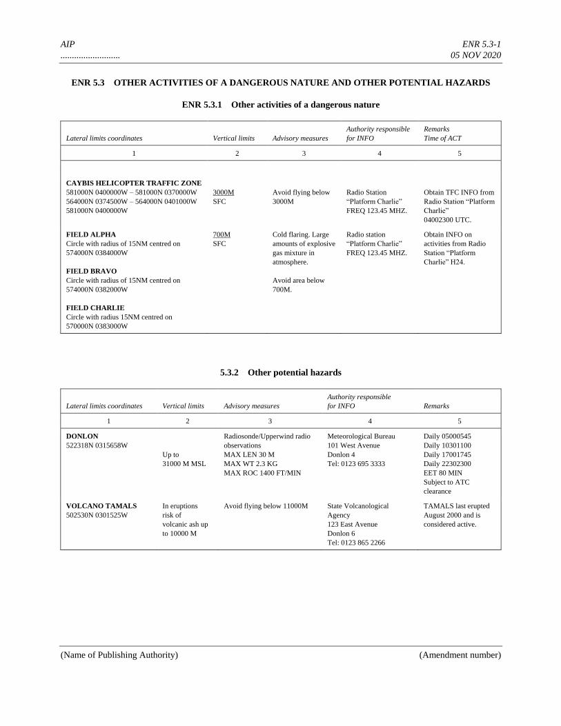
AIP ENR 5.3-1
.......................... 05 NOV 2020
(Name of Publishing Authority) (Amendment number)
ENR 5.3 OTHER ACTIVITIES OF A DANGEROUS NATURE AND OTHER POTENTIAL HAZARDS
ENR 5.3.1 Other activities of a dangerous nature
Lateral limits coordinates Vertical limits Advisory measures
Authority responsible
for INFO
Remarks
Time of ACT
1 2 3 4 5
CAYBIS HELICOPTER TRAFFIC ZONE
581000N 0400000W – 581000N 0370000W
564000N 0374500W – 564000N 0401000W
581000N 0400000W
3000M
SFC
Avoid flying below
3000M
Radio Station
“Platform Charlie”
FREQ 123.45 MHZ.
Obtain TFC INFO from
Radio Station “Platform
Charlie”
04002300 UTC.
FIELD ALPHA
Circle with radius of 15NM centred on
574000N 0384000W
FIELD BRAVO
Circle with radius of 15NM centred on
574000N 0382000W
FIELD CHARLIE
Circle with radius 15NM centred on
570000N 0383000W
700M
SFC
Cold flaring. Large
amounts of explosive
gas mixture in
atmosphere.
Avoid area below
700M.
Radio station
“Platform Charlie”
FREQ 123.45 MHZ.
Obtain INFO on
activities from Radio
Station “Platform
Charlie” H24.
5.3.2 Other potential hazards
Lateral limits coordinates Vertical limits Advisory measures
Authority responsible
for INFO Remarks
1 2 3 4 5
DONLON
522318N 0315658W
Up to
31000 M MSL
Radiosonde/Upperwind radio
observations
MAX LEN 30 M
MAX WT 2.3 KG
MAX ROC 1400 FT/MIN
Meteorological Bureau
101 West Avenue
Donlon 4
Tel: 0123 695 3333
Daily 05000545
Daily 10301100
Daily 17001745
Daily 22302300
EET 80 MIN
Subject to ATC
clearance
VOLCANO TAMALS
502530N 0301525W
In eruptions
risk of
volcanic ash up
to 10000 M
Avoid flying below 11000M State Volcanological
Agency
123 East Avenue
Donlon 6
Tel: 0123 865 2266
TAMALS last erupted
August 2000 and is
considered active.
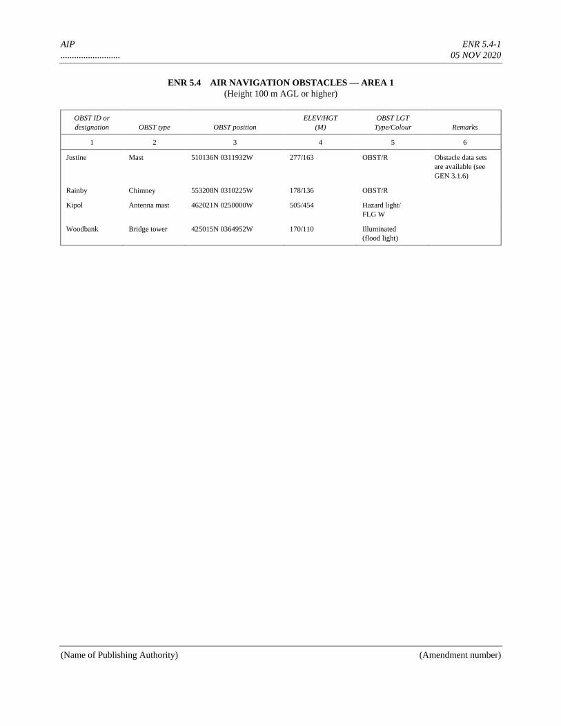
AIP ENR 5.4-1
.......................... 05 NOV 2020
(Name of Publishing Authority) (Amendment number)
ENR 5.4 AIR NAVIGATION OBSTACLES — AREA 1
(Height 100 m AGL or higher)
OBST ID or
designation OBST type OBST position
ELEV/HGT
(M)
OBST LGT
Type/Colour Remarks
1 2 3 4 5 6
Justine Mast 510136N 0311932W 277/163 OBST/R Obstacle data sets
are available (see
GEN 3.1.6)
Rainby Chimney 553208N 0310225W 178/136 OBST/R
Kipol Antenna mast 462021N 0250000W 505/454 Hazard light/
FLG W
Woodbank Bridge tower 425015N 0364952W 170/110 Illuminated
(flood light)
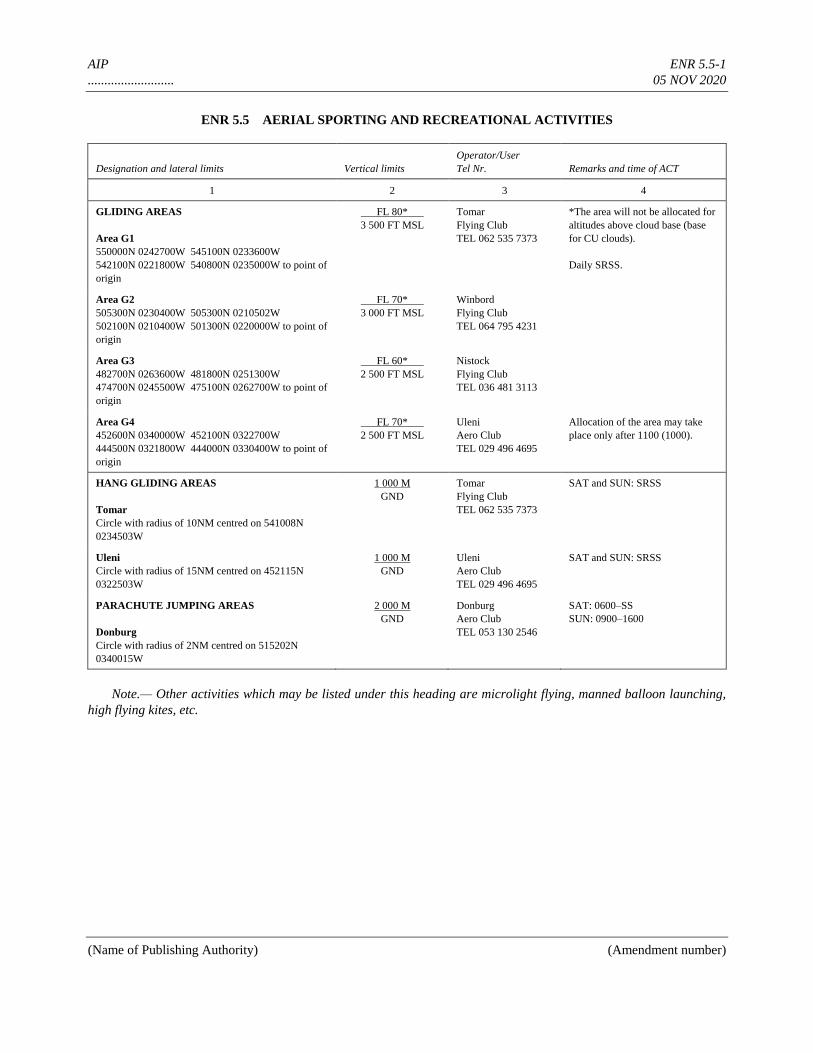
AIP ENR 5.5-1
.......................... 05 NOV 2020
(Name of Publishing Authority) (Amendment number)
ENR 5.5 AERIAL SPORTING AND RECREATIONAL ACTIVITIES
Designation and lateral limits Vertical limits
Operator/User
Tel Nr. Remarks and time of ACT
1 2 3 4
GLIDING AREAS
Area G1
550000N 0242700W 545100N 0233600W
542100N 0221800W 540800N 0235000W to point of
origin
FL 80*
3 500 FT MSL
Tomar
Flying Club
TEL 062 535 7373
*The area will not be allocated for
altitudes above cloud base (base
for CU clouds).
Daily SRSS.
Area G2
505300N 0230400W 505300N 0210502W
502100N 0210400W 501300N 0220000W to point of
origin
FL 70*
3 000 FT MSL
Winbord
Flying Club
TEL 064 795 4231
Area G3
482700N 0263600W 481800N 0251300W
474700N 0245500W 475100N 0262700W to point of
origin
FL 60*
2 500 FT MSL
Nistock
Flying Club
TEL 036 481 3113
Area G4
452600N 0340000W 452100N 0322700W
444500N 0321800W 444000N 0330400W to point of
origin
FL 70*
2 500 FT MSL
Uleni
Aero Club
TEL 029 496 4695
Allocation of the area may take
place only after 1100 (1000).
HANG GLIDING AREAS
Tomar
Circle with radius of 10NM centred on 541008N
0234503W
1 000 M
GND
Tomar
Flying Club
TEL 062 535 7373
SAT and SUN: SRSS
Uleni
Circle with radius of 15NM centred on 452115N
0322503W
1 000 M
GND
Uleni
Aero Club
TEL 029 496 4695
SAT and SUN: SRSS
PARACHUTE JUMPING AREAS
Donburg
Circle with radius of 2NM centred on 515202N
0340015W
2 000 M
GND
Donburg
Aero Club
TEL 053 130 2546
SAT: 0600–SS
SUN: 0900–1600
Note.— Other activities which may be listed under this heading are microlight flying, manned balloon launching,
high flying kites, etc.

AIP ENR 5.6-1
.......................... 05 NOV 2020
(Name of Publishing Authority) (Amendment number)
ENR 5.6 BIRD MIGRATION AND AREAS WITH SENSITIVE FAUNA
1. Bird migration
1.1 Bird migration occurs during the whole year but culminates during the periods March to May (spring
migration) and September to November (autumn migration). Bird densities are measured by radar and the scale 0 to 8 is
used as follows:
0 = No birds observed
8 = Bird density very high.
1.2 Spring migration
Spring migration culminates during the period March to May, and peak numbers for most species occur in April with
densities very frequently above 5. The most important factors inducing heavy migration are a rise in temperature, light
winds and southerly winds.
Migration patterns and altitudes
During the night, migration is generally on a broad front covering the whole country and its surrounding waters, with
general direction from N to NE. During the day, migration tends to concentrate along coastlines. Generally night
migration is higher than day migration. During the night, the average altitude is APRX 1 000–1 500 m; during the day,
APRX 300– 1 000 m.
1.3 Autumn migration
Autumn migration culminates during the period September to November, and peak numbers for most species occur in
October with densities frequently above 5. The most important factor inducing heavy migration is a fall in temperature.
High densities are also correlated with winds from N to NE, light winds, little cloud cover and high pressure.
Migration patterns and altitudes
During the night, migration is on a broad front covering the whole country and its surrounding waters, with general
direction south. During the day, migration tends to concentrate in the central part of ........ (specify) and along coastlines.
Generally night migration is higher than day migration. During the night, the average altitude is APRX 1 000–1 500 m;
during the day, APRX 300–1 000 m.
1.4 Number of birds
At least 100 million birds pass over .......... (specify) and the surrounding waters during autumn. Smaller passerines are
dominating, and several species occur in great densities and are very hazardous to aircraft, e.g.: starlings, thrushes and
finches. Crowbirds, ducks, gulls, waders, pigeons and birds of prey are also hazardous and very numerous (tens of
thousands to several million).
1.5 Information on densities
On weekdays, MON–FRI at 0700, 0930 and 1130 UTC, the flight information service will issue information if the bird
density is 5 or more. Such information will be available at the briefing office at Donlon, comprising the following:
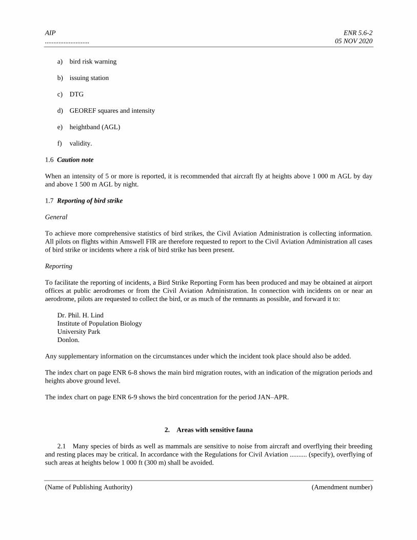
AIP ENR 5.6-2
.......................... 05 NOV 2020
(Name of Publishing Authority) (Amendment number)
a) bird risk warning
b) issuing station
c) DTG
d) GEOREF squares and intensity
e) heightband (AGL)
f) validity.
1.6 Caution note
When an intensity of 5 or more is reported, it is recommended that aircraft fly at heights above 1 000 m AGL by day
and above 1 500 m AGL by night.
1.7 Reporting of bird strike
General
To achieve more comprehensive statistics of bird strikes, the Civil Aviation Administration is collecting information.
All pilots on flights within Amswell FIR are therefore requested to report to the Civil Aviation Administration all cases
of bird strike or incidents where a risk of bird strike has been present.
Reporting
To facilitate the reporting of incidents, a Bird Strike Reporting Form has been produced and may be obtained at airport
offices at public aerodromes or from the Civil Aviation Administration. In connection with incidents on or near an
aerodrome, pilots are requested to collect the bird, or as much of the remnants as possible, and forward it to:
Dr. Phil. H. Lind
Institute of Population Biology
University Park
Donlon.
Any supplementary information on the circumstances under which the incident took place should also be added.
The index chart on page ENR 6-8 shows the main bird migration routes, with an indication of the migration periods and
heights above ground level.
The index chart on page ENR 6-9 shows the bird concentration for the period JAN–APR.
2. Areas with sensitive fauna
2.1 Many species of birds as well as mammals are sensitive to noise from aircraft and overflying their breeding
and resting places may be critical. In accordance with the Regulations for Civil Aviation .......... (specify), overflying of
such areas at heights below 1 000 ft (300 m) shall be avoided.

AIP ENR 5.6-3
.......................... 05 NOV 2020
(Name of Publishing Authority) (Amendment number)
2.2 The areas are shown on the index charts on pages ENR 6-9 to ENR 6-....... (specify) and at Aeronautical
Chart — ICAO 1:500 000 ....... (specify name of chart).
AIP ENR 6-1
.......................... 05 NOV 2020
(Name of Publishing Authority) (Amendment number)
ENR 6. EN-ROUTE CHARTS
(including index charts)
ENR6_INDEX01 Air Traffic Services Airspace – Index Chart
ENR6_INDEX02 Prohibited, Restricted and Danger Areas – Index Chart
ENR6_INDEX03a Military Exercise Training Areas and AIDZ – Index Chart
ENR6_INDEX03b Other Activities of a Dangerous Nature – Index Chart
ENR6_INDEX04 Aerial, Sporting and Recreational activities – Index Chart
ENR6_INDEX05 Radio Facility – Index Chart
ENR6_INDEX06a Bird Migration Routes – Index Chart
ENR6_INDEX06b Bird Concentrations and Areas with Sensitive Fauna (JAN-
APR) – Index Chart

AIP ENR 6-2
.......................... 05 NOV 2020
(Name of Publishing Authority) (Amendment number)
AIR TRAFFIC SERVICES AIRSPACE - INDEX CHART
TO BE DEVELOPED

AIP ENR 6-3
.......................... 05 NOV 2020
(Name of Publishing Authority) (Amendment number)
PROHIBITED, RESTRICTED AND DANGER AREAS – INDEX CHART

AIP ENR 6-4
.......................... 05 NOV 2020
(Name of Publishing Authority) (Amendment number)
MILITARY EXERCISE TRAINING AREAS AND AIDZ – INDEX CHART

AIP ENR 6-5
.......................... 05 NOV 2020
(Name of Publishing Authority) (Amendment number)
OTHER ACTIVITIES OF A DANGEROUS NATURE – INDEX CHART

AIP ENR 6-6
.......................... 05 NOV 2020
(Name of Publishing Authority) (Amendment number)
AERIAL, SPORTING AND RECREATIONAL ACTIVITIES – INDEX CHART

AIP ENR 6-7
.......................... 05 NOV 2020
(Name of Publishing Authority) (Amendment number)
RADIO FACILITY - INDEX CHART
TO BE DEVELOPED

AIP ENR 6-8
.......................... 05 NOV 2020
(Name of Publishing Authority) (Amendment number)
BIRD MIGRATION ROUTES – INDEX CHART

AIP ENR 6-9
.......................... 05 NOV 2020
(Name of Publishing Authority) (Amendment number)
BIRD CONCENTRATIONS AND AREAS WITH SENSITIVE FAUNA (JAN-APR) – INDEX CHART
AIP
AERONAUTICAL INFORMATION PUBLICATION
____________________________________
(Name of State)
PART 3
GENERAL (AD)
VOLUME NR (If more than one volume)
AIP AD 0.6-1
.......................... 05 NOV 2020
PART 3 — AERODROMES (AD)
AD 0.
AD 0.1 PREFACE — Not applicable
AD 0.2 RECORD OF AIP AMENDMENTS — Not applicable
AD 0.3 RECORD OF AIP SUPPLEMENTS — Not applicable
AD 0.4 CHECKLIST OF AIP PAGES — Not applicable
AD 0.5 LIST OF HAND AMENDMENTS TO THE AIP — Not applicable
AD 0.6 TABLE OF CONTENTS TO PART 3
Page
AD 1. AERODROMES/HELIPORTS — INTRODUCTION .................................................................. AD 1.1-1
AD 1.1 Aerodrome/heliport availability and conditions of use .................................................................. AD 1.1-1
AD 1.1.1 General conditions ................................................................................................................ AD 1.1-1
AD 1.1.2 Use of military air bases ...................................................................................................... AD 1.1-2
AD 1.1.3 Low visibility procedures (LVP) ......................................................................................... AD 1.1-4
AD 1.1.4 Aerodrome operating minima ............................................................................................... AD 1.1-5
AD 1.1.5
Other information .............................................................................................................................................. AD 1.1-6
AD 1.2 Rescue and fire fighting services and snow plan ........................................................................... AD 1.2-1
AD 1.2.1 Rescue and fire fighting services .......................................................................................... AD 1.2-1
AD 1.2.2 Snow plan ............................................................................................................................. AD 1.2-1
AD 1.3 Index to aerodromes and heliports ................................................................................................. AD 1.3-1
AD 1.4 Grouping of aerodromes/heliports ................................................................................................. AD 1.4-1
AD 1.5 Status of certification of aerodromes ............................................................................................. AD 1.5-1
AD 2. AERODROMES
EADD AD 2.1 Aerodrome location indicator and name .................................................................... AD 2.EADD-1
EADD AD 2.2 Aerodrome geographical and administrative data ...................................................... AD 2.EADD-1
EADD AD 2.3 Operational hours ....................................................................................................... AD 2.EADD-1
EADD AD 2.4 Handling services and facilities ................................................................................. AD 2.EADD-2
EADD AD 2.5 Passenger facilities ..................................................................................................... AD 2.EADD-2
EADD AD 2.6 Rescue and fire fighting services ............................................................................... AD 2.EADD-2
EADD AD 2.7 Seasonal availability — clearing ................................................................................ AD 2.EADD-2
EADD AD 2.8 Aprons, taxiways and check locations/positions data ................................................ AD 2.EADD-3
EADD AD 2.9 Surface movement guidance and control system and markings ................................. AD 2.EADD-3
EADD AD 2.10 Aerodrome obstacles .................................................................................................. AD 2.EADD-4
EADD AD 2.11 Meteorological information provided ........................................................................ AD 2.EADD-5
EADD AD 2.12 Runway physical characteristics ................................................................................ AD 2.EADD-6
AIP AD 0.6-2
.......................... 05 NOV 2020
EADD AD 2.13 Declared distances...................................................................................................... AD 2.EADD-6
EADD AD 2.14 Approach and runway lighting ................................................................................... AD 2.EADD-7
EADD AD 2.15 Other lighting, secondary power supply .................................................................... AD 2.EADD-7
EADD AD 2.16 Helicopter landing area .............................................................................................. AD 2.EADD-8
EADD AD 2.17 ATS airspace .............................................................................................................. AD 2.EADD-8
EADD AD 2.18 ATS communication facilities .................................................................................... AD 2.EADD-8
EADD AD 2.19 Radio navigation and landing aids ............................................................................. AD 2.EADD-9
EADD AD 2.20 Local aerodrome regulations ...................................................................................... AD 2.EADD-10
EADD AD 2.21 Noise abatement procedures ...................................................................................... AD 2.EADD-12
EADD AD 2.22 Flight procedures ....................................................................................................... AD 2.EADD-16
EADD AD 2.23 Additional information ............................................................................................... AD 2.EADD-17
EADD AD 2.24 Charts related to an aerodrome .................................................................................. AD 2.EADD-18
AD 3. HELIPORTS
EADH AD 3.1 Heliport location indicator and name ......................................................................... AD 3.EADH-1
EADH AD 3.2 Heliport geographical and administrative data ........................................................... AD 3.EADH-2
EADH AD 3.3 Operational hours ....................................................................................................... AD 3.EADH-2
EADH AD 3.4 Handling services and facilities ................................................................................. AD 3.EADH-2
EADH AD 3.5 Passenger facilities ..................................................................................................... AD 3.EADH-2
EADH AD 3.6 Rescue and fire fighting services ............................................................................... AD 3.EADH-3
EADH AD 3.7 Seasonal availability — clearing ................................................................................ AD 3.EADH-3
EADH AD 3.8 Aprons, taxiways and check locations/positions data ................................................ AD 3.EADH-3
EADH AD 3.9 Markings and markers ................................................................................................ AD 3.EADH-3
EADH AD 3.10 Heliport obstacles ....................................................................................................... AD 3.EADH-3
EADH AD 3.11 Meteorological information provided ........................................................................ AD 3.EADH-4
EADH AD 3.12 Heliport data ............................................................................................................... AD 3.EADH-4
EADH AD 3.13 Declared distances...................................................................................................... AD 3.EADH-5
EADH AD 3.14 Approach and FATO lighting .................................................................................... AD 3.EADH-5
EADH AD 3.15 Other lighting, secondary power supply .................................................................... AD 3.EADH-5
EADH AD 3.16 ATS airspace .............................................................................................................. AD 3.EADH-6
EADH AD 3.17 ATS communication facilities .................................................................................... AD 3.EADH-6
EADH AD 3.18 Radio navigation and landing aids ............................................................................. AD 3.EADH-6
EADH AD 3.19 Local heliport regulations .......................................................................................... AD 3.EADH-7
EADH AD 3.20 Noise abatement procedures ...................................................................................... AD 3.EADH-7
EADH AD 3.21 Flight procedures ....................................................................................................... AD 3.EADH-7
EADH AD 3.22 Additional information ............................................................................................... AD 3.EADH-7
EADH AD 3.23 Charts related to a heliport ......................................................................................... AD 3.EADH-7
AIP AD 1.1-1
.......................... 05 NOV 2020
AD 1. AERODROMES/HELIPORTS — INTRODUCTION
AD 1.1 AERODROME/HELIPORT AVAILABILITY AND CONDITIONS OF USE
AD 1.1.1. General conditions
Commercial flights are not permitted to take off from or land at any aerodrome/heliport not listed in this AIP except in
cases of real emergency or when special permission has been obtained from the Civil Aviation Administration.
In addition to the aerodromes/heliports available for public use listed in this AIP, a number of other
aerodromes/airfields are located throughout the country. These aerodromes/airfields are available only for private
flights and are subject to permission for use by the owner. Details about these aerodromes/airfields can be obtained
through the ............ Aero Club at the following address.
........... Aero Club
........... Airfield
Falcon Road
...........
Landings made other than at an international aerodrome/heliport
or a designated alternate aerodrome/heliport
If a landing is made other than at an international aerodrome/heliport or a designated alternate aerodrome/heliport, the
pilot-in-command shall report the landing as soon as practicable to the health, customs and immigration authorities at
the international aerodrome/heliport at which the landing was scheduled to take place. This notification may be made
through any available communication link.
The pilot-in-command shall be responsible for ensuring that:
a) if pratique has not been granted to the aircraft at the previous landing, contact between other persons on
the one hand and passengers and crew on the other is avoided;
b) cargo, baggage and mail are not removed from the aircraft except as provided below;
c) any foodstuff of overseas origin or any plant material is not removed from the aircraft except where local food
is unobtainable. All food refuse including peelings, cores, stones of fruit, etc. must be collected and returned to
the galley refuse container, the contents of which should not be removed from the aircraft except for hygiene
reasons; in that circumstance the contents must be destroyed either by burning or by deep burial.
Traffic of persons and vehicles on aerodromes
Demarcation of zones
The grounds of each aerodrome are divided into two zones:
AIP AD 1.1-2
.......................... 05 NOV 2020
a) a public zone comprising the part of the aerodrome open to the public; and
b) a restricted zone comprising the rest of the aerodrome/heliport.
Movement of persons
Access to the restricted zone is authorized only under the conditions prescribed by the special rules governing the
aerodrome/heliport. The customs, police, and health inspection offices and the premises assigned to transit traffic are
normally accessible only to passengers, to staff of the public authorities and airlines and to authorized persons in
pursuit of their duty. The movement of persons having access to the restricted zone of the aerodrome/heliport is subject
to the conditions prescribed by the air navigation regulations and by the special rules laid down by the aerodrome
administration.
Movement of vehicles
The movement of vehicles in the restricted zone is strictly limited to vehicles driven or used by persons carrying a
traffic permit or an official card of admittance. Drivers of vehicles, of whatever type, operating within the confines of
the aerodrome/heliport must respect the direction of the traffic, the traffic signs and the posted speed limits and
generally comply with the provisions of the highway code and with the instructions given by the competent authorities.
Policing
Care and protection of aircraft, vehicles, equipment and goods used at the aerodrome/heliport are not the responsibility
of the State or any concessionaire; they cannot be held responsible for loss or damage which is not incurred through
action by them or their agents.
Use of the heliports
Unless other permission has been granted by the Civil Aviation Administration, the heliports may be used only for
flights in accordance with Visual Flight Rules (VFR).
The direction of TKOF zones at the individual heliport refers only to zones, which for flight with helicopters of the
type .......... (specify) are determined to be free of obstructions. Pilots shall, before using a heliport, ensure that a clear
approach and departure can be carried out and, in case of an emergency, that suitable landing sites are available along
the planned track, taking into consideration the performance of the helicopter.
Landing, parking and storage of aircraft
on aerodromes/heliports under the control of
the Civil Aviation Administration
The conditions under which aircraft may land and be parked, housed or otherwise dealt with at any of the
aerodromes/heliports under the control of the Civil Aviation Administration are as follows:
a) The fees and charges for the landing, parking or housing of aircraft shall be those published from time to time
by the Civil Aviation Administration (hereinafter referred to as “CAA”) in the AIP or AIC.
The fees or charges for any supplies or services which may be furnished to aircraft by or on behalf of the CAA
AIP AD 1.1-3
.......................... 05 NOV 2020
at any aerodrome/heliport under the control of the CAA shall, unless otherwise agreed before such fees or
charges are incurred, be such reasonable fees and charges as may from time to time be determined by the CAA
for that aerodrome/heliport. The fees and charges referred to shall accrue from day to day and shall be payable
to the CAA on demand.
b) The CAA shall have a lien on the aircraft, its parts and accessories, for such fees and charges as aforesaid.
c) If payment of such fees and charges is not made to the CAA within 14 days after a letter demanding payment
thereof has been sent by post addressed to the registered owner of the aircraft, the CAA shall be entitled to
sell, destroy or otherwise dispose of the aircraft and any of its parts and accessories and to apply the proceeds
from so doing to the payment of such fees and charges.
d) Neither the CAA nor any servant or agent of the government shall be liable for loss or damage to the aircraft,
its parts or accessories or any property contained in the aircraft, howsoever such loss and damage may arise,
occurring while the aircraft is on any aerodrome/heliport under the control of the CAA or is in the course of
landing at or taking off from any such aerodrome/heliport.
AD 1.1.2. Use of military air bases
General
Use of military air bases in ........... (State) by other than State-registered aircraft may be made solely when prior
permission has been obtained. The use of military air bases as alternate aerodromes may likewise be made solely when
prior permission thereto has been obtained. ............ (specify) Air Base is not affected by these regulations. Permission
to use ........... (specify) and ........... (specify) Air Bases will be granted unless special conditions apply. Permission may
at any time be withdrawn with immediate effect, should circumstances so require.
Submission of application
Application in writing for permission to use a military air base shall be submitted directly to the air base concerned well
in advance of the date of flight. The addresses are as follows:
......... Air Base
20 Highland Road
......... UJ1 WT2
Tel: 0123 6930304
Telefax: 0123 6930314
Telex: 99 5757
AFS: NIL
Rules and conditions
Operations on the air base must be carried out in accordance with the rules and conditions stated below with due regard
to such other conditions as may have been stipulated for each individual permission.
a) A flight plan shall be submitted for each flight. During flight in controlled air space and during operations on
AIP AD 1.1-4
.......................... 05 NOV 2020
the manoeuvring area, the pilot-in-command shall closely observe the directions given.
b) The Commander of the air base establishes the rules which are to be observed by flight crew members and
passengers concerning security measures, traffic and stays at the air base.
As regards the air bases ........ (specify) and ........ (specify), photographing from the air as well as on the
ground is prohibited. At the remaining air bases, the local ban on photography will apply as posted. Flight
crew members and ground personnel shall immediately report any violations.
c) The Defence Forces shall not be liable for the theft of and fire-, water- or other damage to aircraft, their
equipment, flight crew members, passengers, cargo, etc. caused during stays at the air base.
The Defence Forces reserve the right to claim compensation for damage caused by civil aircraft, flight crew
members or passengers to Air Force material, buildings and personnel within the area of an air base.
d) Landing and other charges will be collected in accordance with the provisions of the current “Tariff
Regulations applying to Public State-operated Airports”, approved by the Ministry of Transport.
AD 1.1.3. Low visibility procedures (LVP)
Promulgation of an aerodrome as available for Category II or Category III operations means that it is suitably equipped
and that procedures appropriate to such operations have been determined and are applied when relevant.
Promulgation implies that at least the following facilities are available:
ILS — certificated to relevant performance category.
Lighting — suitable for category promulgated.
RVR system — may be automatic or manned system for Category II; will be automatic system for Category III.
Special procedures and safeguards will be applied during Category II and III operations. In general, these are intended
to provide protection for aircraft operating in low visibilities and to avoid disturbance of the ILS signals.
Protection of ILS signals during Category II or III operations may dictate that pre-take-off holding positions be more
distant from the runway than the holding positions used in good weather. Such holding positions will be appropriately
marked and will display signs conforming to the specifications in Annex 14, Volume I, on one or both sides of the
taxiway; there may also be a stop bar of red lights. For aircraft taxiing off the runway during Category III operations,
exit taxiway centre line lights are colour-coded to facilitate notification of runway vacation; the colour coding ends at
the boundary of the ILS critical/ sensitive area. Pilots are required to make a “Runway Vacated” call on RTF when the
aircraft has reached the colour code of part of the exit taxiway centre line lights, due allowance being made for aircraft
size to ensure that the entire aircraft is clear of the ILS critical/sensitive area.
In actual Category II or III weather conditions, pilots will be informed by ATC of any unserviceabilities in the
promulgated facilities so that they can amend their minima, if necessary, according to their operations manual. Pilots
who wish to carry out a practice Category II or Category III approach are to request Practice Category II (or
Category III) Approach on initial contact with Approach Control. For practice approaches there is no guarantee that the
full safeguarding procedures will be applied and pilots should anticipate the possibility of a resultant ILS signal
disturbance.
AIP AD 1.1-5
.......................... 05 NOV 2020
AD 1.1.4. Aerodrome operating minima
VFR Flights
Take-off and landing may be prohibited for reason of low ceiling and/or bad visibility.
IFR Flights
A controlled aerodrome will not be closed to IFR traffic for reason of low ceiling and/or bad visibility.
A pilot on IFR flight plan shall not take off when the reported RVR or visibility, as appropriate, is below the minimum
value published in the AIP. ATC will issue the official weather report (see note 1 below). Neither taxi instructions nor
take-off clearance will be issued. Following phraseology will be used: "RVR or visibility (as appropriate) ... meters.
This is below published minima for take-off on runway ... (runway designation). ... (call sign) taxi instructions and
take-off clearance not issued".
ATC will ensure that any information essential for the pilot's decision to continue or discontinue an approach is brought
to his attention without delay, such as:
application of special safeguards and procedures, when necessary;
any known unserviceability of aids or facilities;
official weather report including any significant changes transmitted to each aircraft;
RVR information including any significant changes transmitted to each aircraft.
When on an aerodrome in … (State) the reported RVR and/or visibility, as appropriate, are below the published
aerodrome minima, ATC will inform the pilot accordingly and request him to state his intentions using the following
phraseology: “Reported RVR and/or visibility is .... This is below published minima. Advise your intentions".
Unless a holding for weather improvement or a diversion is requested or holding for implementation of special
safeguards and procedures is imposed, ATC will issue approach instructions and landing clearance and, if necessary,
will assist the pilot during his manoeuvre.
Note 1: Reports of routine and special observations including RVR reading and/or visibility, as appropriate, made at
aerodromes by an official weather officer (or by the airport authority, if no such officer is available), constitute the
official weather report.
Note 2: The clearance issued does not relieve a pilot of any responsibility in case of violation of applicable rules and
regulations.
Note 3: A pilot on an instrument approach procedure shall not descend below his DH / MDH, if the pilot has not
established the required visual reference to continue the approach-to-land.
Note 4: Possible adverse consequences for aircraft and its occupants as well as for persons and property on the surface,
resulting from a landing attempted and made under conditions below the published minima, cannot be ascribed to ATC
assistance. ATC clearances are solely based on known traffic conditions.
Note 5: A pilot in emergency will be allowed to land regardless the conditions of the aerodrome and aerodrome
facilities.

AIP AD 1.1-6
.......................... 05 NOV 2020
AD 1.1.5. Other information
NIL.
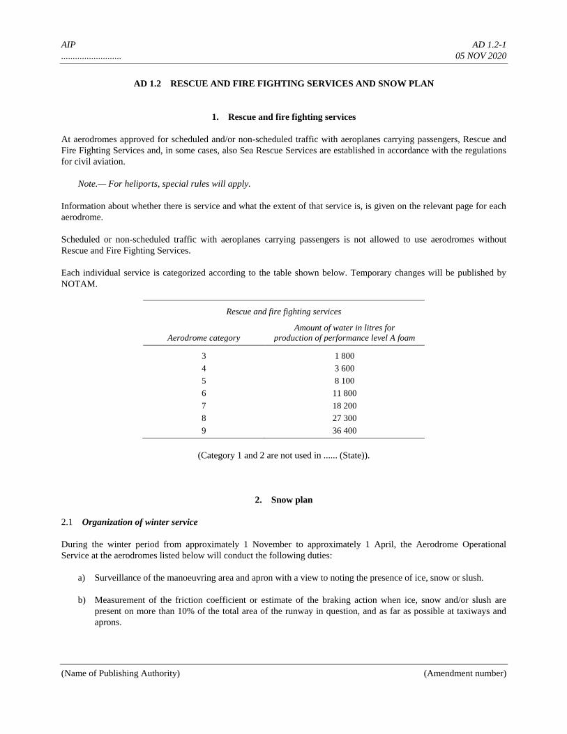
AIP AD 1.2-1
.......................... 05 NOV 2020
(Name of Publishing Authority) (Amendment number)
AD 1.2 RESCUE AND FIRE FIGHTING SERVICES AND SNOW PLAN
1. Rescue and fire fighting services
At aerodromes approved for scheduled and/or non-scheduled traffic with aeroplanes carrying passengers, Rescue and
Fire Fighting Services and, in some cases, also Sea Rescue Services are established in accordance with the regulations
for civil aviation.
Note.— For heliports, special rules will apply.
Information about whether there is service and what the extent of that service is, is given on the relevant page for each
aerodrome.
Scheduled or non-scheduled traffic with aeroplanes carrying passengers is not allowed to use aerodromes without
Rescue and Fire Fighting Services.
Each individual service is categorized according to the table shown below. Temporary changes will be published by
NOTAM.
Rescue and fire fighting services
Aerodrome category
Amount of water in litres for
production of performance level A foam
3 1 800
4 3 600
5 8 100
6 11 800
7 18 200
8 27 300
9 36 400
(Category 1 and 2 are not used in ...... (State)).
2. Snow plan
2.1 Organization of winter service
During the winter period from approximately 1 November to approximately 1 April, the Aerodrome Operational
Service at the aerodromes listed below will conduct the following duties:
a) Surveillance of the manoeuvring area and apron with a view to noting the presence of ice, snow or slush.
b) Measurement of the friction coefficient or estimate of the braking action when ice, snow and/or slush are
present on more than 10% of the total area of the runway in question, and as far as possible at taxiways and
aprons.
AIP AD 1.2-2
.......................... 05 NOV 2020
(Name of Publishing Authority) (Amendment number)
c) Implementation of measures to maintain the usability of the runway, etc.
d) Reporting of the conditions mentioned in a) to c) above.
Winter service is established at the following aerodromes:
Akvin Siby
Dengron Wichnor
Donlon Yanmore
2.2 Surveillance of movement areas
The Aerodrome Operational Service monitors the condition of the manoeuvring area and the apron within the published
aerodrome hours of service.
2.3 Measuring methods and measurements taken
2.3.1 The depth of a layer of snow or slush is measured by an ordinary measuring rod. Measurements will be
taken at a large number of places and a representative mean value calculated. On a runway, the mean value will be
calculated for each third of the runway. For removal of ice and compacted snow which cannot be removed with
mechanical equipment, chemicals are used.
2.3.2 Friction coefficients
2.3.2.1 Whenever information on braking action promulgated in accordance with this snow plan in terms of
friction coefficients is used as a basis for assessing the stopping and manoeuvring capability of an aircraft, it is of
utmost importance to keep in mind that these friction coefficients pertain to a measuring device and therefore, as
objective parameters, are valid for that specific device only.
2.3.2.2 The following methods of measurement will apply:
a) Continuous method whereby the friction coefficient is recorded continuously by means of special devices
(MU-meter (MUM) and surface friction tester (SFT))
b) Retardation measurements with the use of an instrument that only indicates the peak value of the retardation
reached during each braking (Tapley meter (TAP)).
All measurements and calibrations are accomplished in accordance with the instructions given by the manufacturer for
the proper use of the instruments. Measurements are taken, approximately 4 m apart, on each side of the centre line of
the runway.
2.3.2.2.1 An SFT is used at Akvin, Dengron and Donlon Aerodromes. An MUM is used at Siby Aerodrome and
at military air bases. A TAP is used at the remaining aerodromes listed in 2.1. Some aerodromes have reserve
instruments. If a reserve instrument of a type other than the primary is used, it will be announced by ATS and by ATIS
where this is available.
2.3.2.2.2 Braking action will be estimated if the friction coefficient cannot be measured due to lack of equipment
or for other reasons.
2.3.2.2.3 When ice, snow or slush is present on 10% or less of the total area of a runway, the friction coefficient
will not be measured and braking action will not be estimated. If in such a situation water is present, the runway will be
AIP AD 1.2-3
.......................... 05 NOV 2020
(Name of Publishing Authority) (Amendment number)
reported WET. Where only water is present on a runway and periodic measurements so indicate, the runway will be
reported as “WET”.
2.4 Actions taken to maintain the usability of movement areas
2.4.1 Snow clearance and measures to improve braking action will be implemented and maintained as long as
conditions at the movement area impede the safety and regularity of air traffic.
2.4.2 Snow clearance, etc. will normally be carried out in the following order:
1. Runway in use and access road from the fire station.
2. Taxiway(s) to runway in use.
3. Apron.
4. Other runways and areas.
Measures will be taken to clear the runways to full width but in special cases conditions may dictate that wide runways
be opened temporarily for traffic even if cleared to a width of 30 m only. Snow clearance will not be considered
completed until the runway is cleared to full width.
2.4.3 Measures to improve braking action will be implemented when the friction coefficient on runways and
taxiways is below the maintenance planning level shown in Annex 14, Volume I, Attachment A, Section 7.
The following chemicals have been approved by the Civil Aviation Administration:
For spraying: UCAR and a mixture of pure ethylene glycol and isopropyl alcohol.
For spreading: UREA (CO(NH2)2).
Chemical de-icing of runways will be carried out to a width of not less than 15 m on each side of the centre line of the
runway.
2.4.3.1 Improvement of the braking action by spreading sand with a grain size of not less than 1 mm and not
exceeding 5 mm will take place. The sand will be spread out to a width of not less than 15 m on each side of the
runway centre line.
2.5 System and means of reporting
2.5.1 The Aerodrome Operational Service will use the SNOWTAM form for the reporting which will be
delivered to the Aerodrome Reporting Office/Air Traffic Service unit for further dissemination.
2.5.1.1 When ice, snow or slush no longer prevail and chemicals are no longer used, the reporting will cease after
the issuance of a cancellation SNOWTAM. A new SNOWTAM will not be issued until winter conditions appear again.
2.5.2 The following definitions have been adopted:
Slush. Water-saturated snow which with a heel-and-toe slap-down motion against the ground will be displaced with a
splatter; specific gravity: 0.5 up to 0.8.
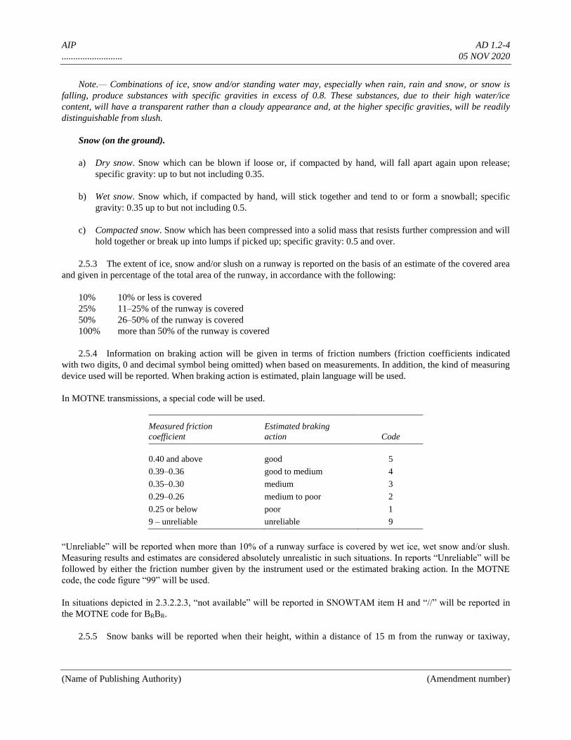
AIP AD 1.2-4
.......................... 05 NOV 2020
(Name of Publishing Authority) (Amendment number)
Note.— Combinations of ice, snow and/or standing water may, especially when rain, rain and snow, or snow is
falling, produce substances with specific gravities in excess of 0.8. These substances, due to their high water/ice
content, will have a transparent rather than a cloudy appearance and, at the higher specific gravities, will be readily
distinguishable from slush.
Snow (on the ground).
a) Dry snow. Snow which can be blown if loose or, if compacted by hand, will fall apart again upon release;
specific gravity: up to but not including 0.35.
b) Wet snow. Snow which, if compacted by hand, will stick together and tend to or form a snowball; specific
gravity: 0.35 up to but not including 0.5.
c) Compacted snow. Snow which has been compressed into a solid mass that resists further compression and will
hold together or break up into lumps if picked up; specific gravity: 0.5 and over.
2.5.3 The extent of ice, snow and/or slush on a runway is reported on the basis of an estimate of the covered area
and given in percentage of the total area of the runway, in accordance with the following:
10% 10% or less is covered
25% 11–25% of the runway is covered
50% 26–50% of the runway is covered
100% more than 50% of the runway is covered
2.5.4 Information on braking action will be given in terms of friction numbers (friction coefficients indicated
with two digits, 0 and decimal symbol being omitted) when based on measurements. In addition, the kind of measuring
device used will be reported. When braking action is estimated, plain language will be used.
In MOTNE transmissions, a special code will be used.
Measured friction
coefficient
Estimated braking
action Code
0.40 and above good 5
0.39–0.36 good to medium 4
0.35–0.30 medium 3
0.29–0.26 medium to poor 2
0.25 or below poor 1
9 – unreliable unreliable 9
“Unreliable” will be reported when more than 10% of a runway surface is covered by wet ice, wet snow and/or slush.
Measuring results and estimates are considered absolutely unrealistic in such situations. In reports “Unreliable” will be
followed by either the friction number given by the instrument used or the estimated braking action. In the MOTNE
code, the code figure “99” will be used.
In situations depicted in 2.3.2.2.3, “not available” will be reported in SNOWTAM item H and “//” will be reported in
the MOTNE code for BRBR.
2.5.5 Snow banks will be reported when their height, within a distance of 15 m from the runway or taxiway,
AIP AD 1.2-5
.......................... 05 NOV 2020
(Name of Publishing Authority) (Amendment number)
exceeds 60 cm.
2.5.6 When information on runway conditions is given section-wise, it is given in the order in which the
conditions in question are encountered at take-off or in landing in the runway direction which is indicated by the
runway number. In instructions to landing and departing aircraft, the order of section-wise information of the runway in
use will thus always be in accordance with the order in which the conditions in question are encountered during take-
off and landing.
2.6 Cases of runway closure
In cases where a postponement of clearance operations would involve a definite risk of the situation developing into a
crisis, e.g. when a fall in temperature causes water or slush to become solid ice, the snow clearance service is
authorized to demand that sections of the movement areas be closed to traffic.
2.7 Distribution of information about snow conditions
Information on snow conditions at Akvin, Dengron, Donlon, Siby and Wichnor Aerodromes will be distributed directly
from the individual aerodrome in a separate series of NOTAM (SNOWTAM). SNOWTAM will be prepared in
accordance with Annex 15, Appendix 2. Information on snow conditions at aerodromes other than those mentioned
above can be obtained at the aerodrome concerned or will be available at the Briefing Office at Donlon Aerodrome.
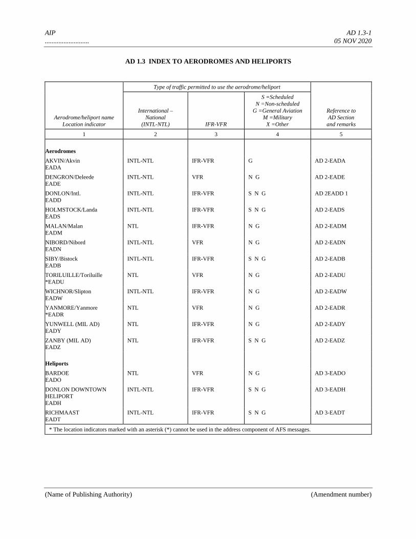
AIP AD 1.3-1
.......................... 05 NOV 2020
(Name of Publishing Authority) (Amendment number)
AD 1.3 INDEX TO AERODROMES AND HELIPORTS
Aerodrome/heliport name
Location indicator
Type of traffic permitted to use the aerodrome/heliport
Reference to
AD Section
and remarks
International –
National
(INTL-NTL) IFR-VFR
S =Scheduled
N =Non-scheduled
G =General Aviation
M =Military
X =Other
1 2 3 4 5
Aerodromes
AKVIN/Akvin
EADA
INTL-NTL IFR-VFR G AD 2-EADA
DENGRON/Deleede
EADE
INTL-NTL VFR N G AD 2-EADE
DONLON/Intl.
EADD
INTL-NTL IFR-VFR S N G AD 2EADD 1
HOLMSTOCK/Landa
EADS
INTL-NTL IFR-VFR S N G AD 2-EADS
MALAN/Malan
EADM
NTL IFR-VFR N G AD 2-EADM
NIBORD/Nibord
EADN
INTL-NTL VFR N G AD 2-EADN
SIBY/Bistock
EADB
INTL-NTL IFR-VFR S N G AD 2-EADB
TORILUILLE/Toriluille
*EADU
NTL VFR N G AD 2-EADU
WICHNOR/Slipton
EADW
INTL-NTL IFR-VFR N G AD 2-EADW
YANMORE/Yanmore
*EADR
NTL VFR N G AD 2-EADR
YUNWELL (MIL AD)
EADY
NTL IFR-VFR N G AD 2-EADY
ZANBY (MIL AD)
EADZ
NTL IFR-VFR S N G AD 2-EADZ
Heliports
BARDOE
EADO
NTL VFR N G AD 3-EADO
DONLON DOWNTOWN
HELIPORT
EADH
INTL-NTL IFR-VFR S N G AD 3-EADH
RICHMAAST
EADT
INTL-NTL IFR-VFR S N G AD 3-EADT
* The location indicators marked with an asterisk (*) cannot be used in the address component of AFS messages.

AIP AD 1.3-2
.......................... 05 NOV 2020
(Name of Publishing Authority) (Amendment number)
AERODROMES AND HELIPORTS – INDEX CHART
AIP AD 1.4-1
.......................... 05 NOV 2020
(Name of Publishing Authority) (Amendment number)
AD 1.4 GROUPING OF AERODROMES/HELIPORTS
The criteria applied by ...... (State) in grouping aerodromes/heliports for the provision of information in this AIP are as
follows:
Primary/major international aerodrome/heliport
The aerodrome/heliport of entry and departure for international air traffic, where all formalities concerning customs,
immigration, health, animal and plant quarantine and similar procedures are carried out and where air traffic services
are available on a regular basis.
Secondary/other international aerodrome/heliport
Another aerodrome/heliport available for the entry or departure of international air traffic, where the formalities
concerning customs, immigration, health and similar procedures and air traffic services are made available, on a
restricted basis, to flights with prior approval only.
National aerodrome/heliport
An aerodrome/heliport available only for domestic air traffic, including those military aerodromes/heliports where civil
air traffic is allowed under certain conditions.
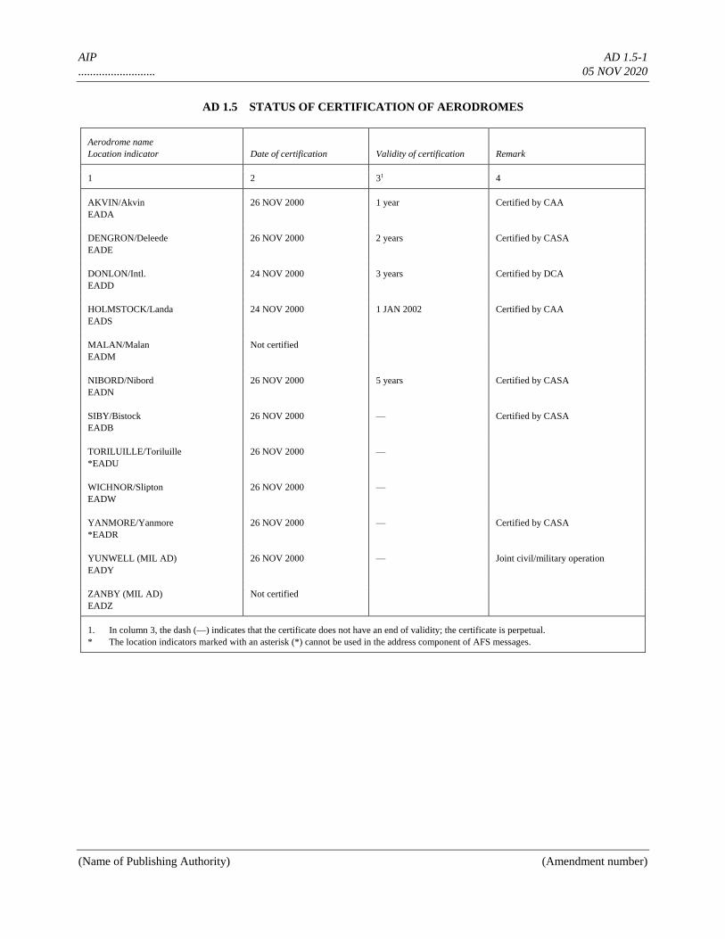
AIP AD 1.5-1
.......................... 05 NOV 2020
(Name of Publishing Authority) (Amendment number)
AD 1.5 STATUS OF CERTIFICATION OF AERODROMES
Aerodrome name
Location indicator Date of certification Validity of certification Remark
1 2 31 4
AKVIN/Akvin
EADA
26 NOV 2000 1 year Certified by CAA
DENGRON/Deleede
EADE
26 NOV 2000 2 years Certified by CASA
DONLON/Intl.
EADD
24 NOV 2000 3 years Certified by DCA
HOLMSTOCK/Landa
EADS
24 NOV 2000 1 JAN 2002 Certified by CAA
MALAN/Malan
EADM
Not certified
NIBORD/Nibord
EADN
26 NOV 2000 5 years Certified by CASA
SIBY/Bistock
EADB
26 NOV 2000 — Certified by CASA
TORILUILLE/Toriluille
*EADU
26 NOV 2000 —
WICHNOR/Slipton
EADW
26 NOV 2000 —
YANMORE/Yanmore
*EADR
26 NOV 2000 — Certified by CASA
YUNWELL (MIL AD)
EADY
26 NOV 2000 — Joint civil/military operation
ZANBY (MIL AD)
EADZ
Not certified
1. In column 3, the dash (—) indicates that the certificate does not have an end of validity; the certificate is perpetual.
* The location indicators marked with an asterisk (*) cannot be used in the address component of AFS messages.
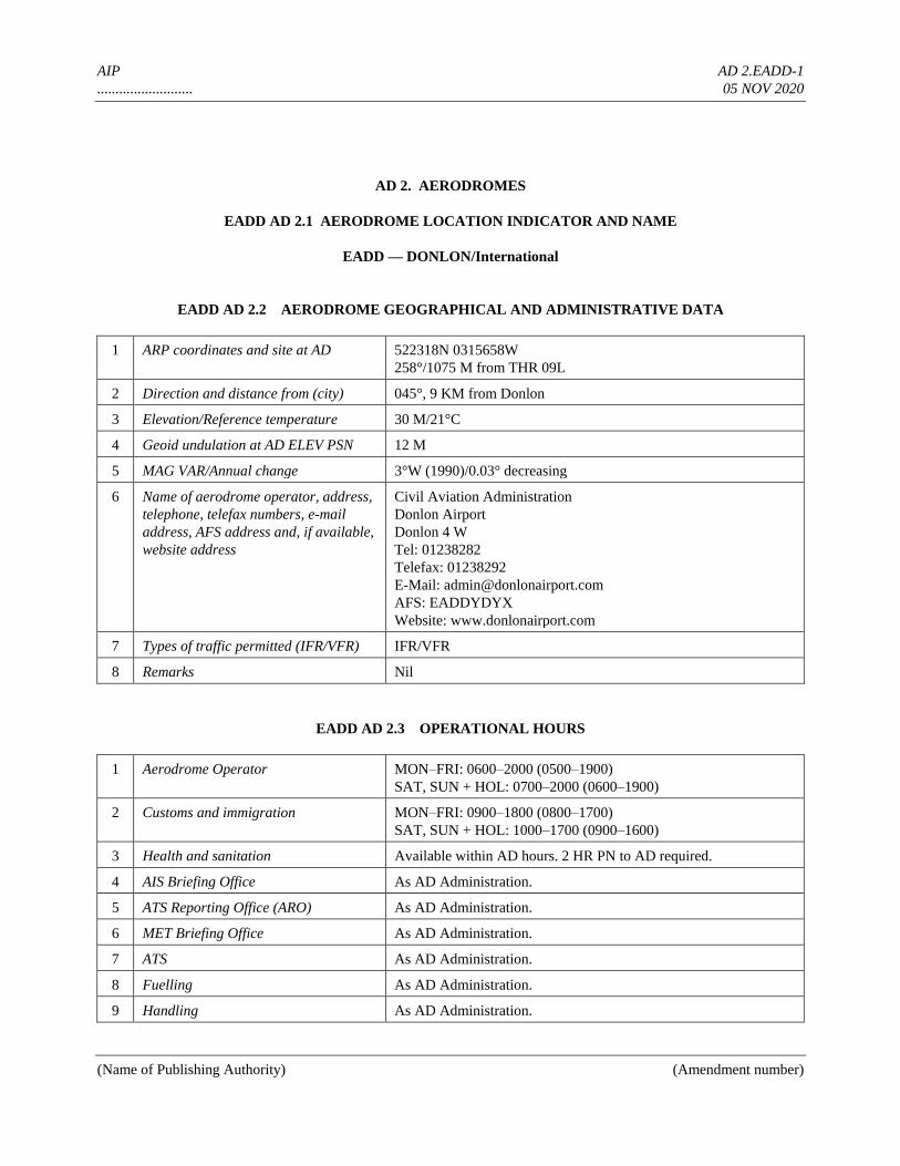
AIP AD 2.EADD-1
.......................... 05 NOV 2020
(Name of Publishing Authority) (Amendment number)
AD 2. AERODROMES
EADD AD 2.1 AERODROME LOCATION INDICATOR AND NAME
EADD — DONLON/International
EADD AD 2.2 AERODROME GEOGRAPHICAL AND ADMINISTRATIVE DATA
1 ARP coordinates and site at AD 522318N 0315658W
258°/1075 M from THR 09L
2 Direction and distance from (city) 045°, 9 KM from Donlon
3 Elevation/Reference temperature 30 M/21°C
4 Geoid undulation at AD ELEV PSN 12 M
5 MAG VAR/Annual change 3°W (1990)/0.03° decreasing
6 Name of aerodrome operator, address,
telephone, telefax numbers, e-mail
address, AFS address and, if available,
website address
Civil Aviation Administration
Donlon Airport
Donlon 4 W
Tel: 01238282
Telefax: 01238292
E-Mail: [email protected]
AFS: EADDYDYX
Website: www.donlonairport.com
7 Types of traffic permitted (IFR/VFR) IFR/VFR
8 Remarks Nil
EADD AD 2.3 OPERATIONAL HOURS
1 Aerodrome Operator MON–FRI: 0600–2000 (0500–1900)
SAT, SUN + HOL: 0700–2000 (0600–1900)
2 Customs and immigration MON–FRI: 0900–1800 (0800–1700)
SAT, SUN + HOL: 1000–1700 (0900–1600)
3 Health and sanitation Available within AD hours. 2 HR PN to AD required.
4 AIS Briefing Office As AD Administration.
5 ATS Reporting Office (ARO) As AD Administration.
6 MET Briefing Office As AD Administration.
7 ATS As AD Administration.
8 Fuelling As AD Administration.
9 Handling As AD Administration.
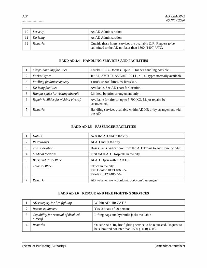
AIP AD 2.EADD-2
.......................... 05 NOV 2020
(Name of Publishing Authority) (Amendment number)
10 Security As AD Administration.
11 De-icing As AD Administration.
12 Remarks Outside these hours, services are available O/R. Request to be
submitted to the AD not later than 1500 (1400) UTC.
EADD AD 2.4 HANDLING SERVICES AND FACILITIES
1 Cargo-handling facilities Trucks 1.5–3.5 tonnes. Up to 10 tonnes handling possible.
2 Fuel/oil types Jet A1, AVTUR, AVGAS 100 LL, oil, all types normally available.
3 Fuelling facilities/capacity 1 truck 45 000 litres, 50 litres/sec.
4 De-icing facilities Available. See AD chart for location.
5 Hangar space for visiting aircraft Limited, by prior arrangement only.
6 Repair facilities for visiting aircraft Available for aircraft up to 5 700 KG. Major repairs by
arrangement.
7 Remarks Handling services available within AD HR or by arrangement with
the AD.
EADD AD 2.5 PASSENGER FACILITIES
1 Hotels Near the AD and in the city.
2 Restaurants At AD and in the city.
3 Transportation Buses, taxis and car hire from the AD. Trains to and from the city.
4 Medical facilities First aid at AD. Hospitals in the city.
5 Bank and Post Office At AD. Open within AD HR.
6 Tourist Office Office in the city.
Tel: Donlon 0123 4863559
Telefax: 0123 4863569
7 Remarks AD website: www.donlonairport.com/passengers
EADD AD 2.6 RESCUE AND FIRE FIGHTING SERVICES
1 AD category for fire fighting Within AD HR: CAT 7
2 Rescue equipment Yes, 2 boats of 40 persons
3 Capability for removal of disabled
aircraft
Lifting bags and hydraulic jacks available
4 Remarks Outside AD HR, fire fighting service to be requested. Request to
be submitted not later than 1500 (1400) UTC.
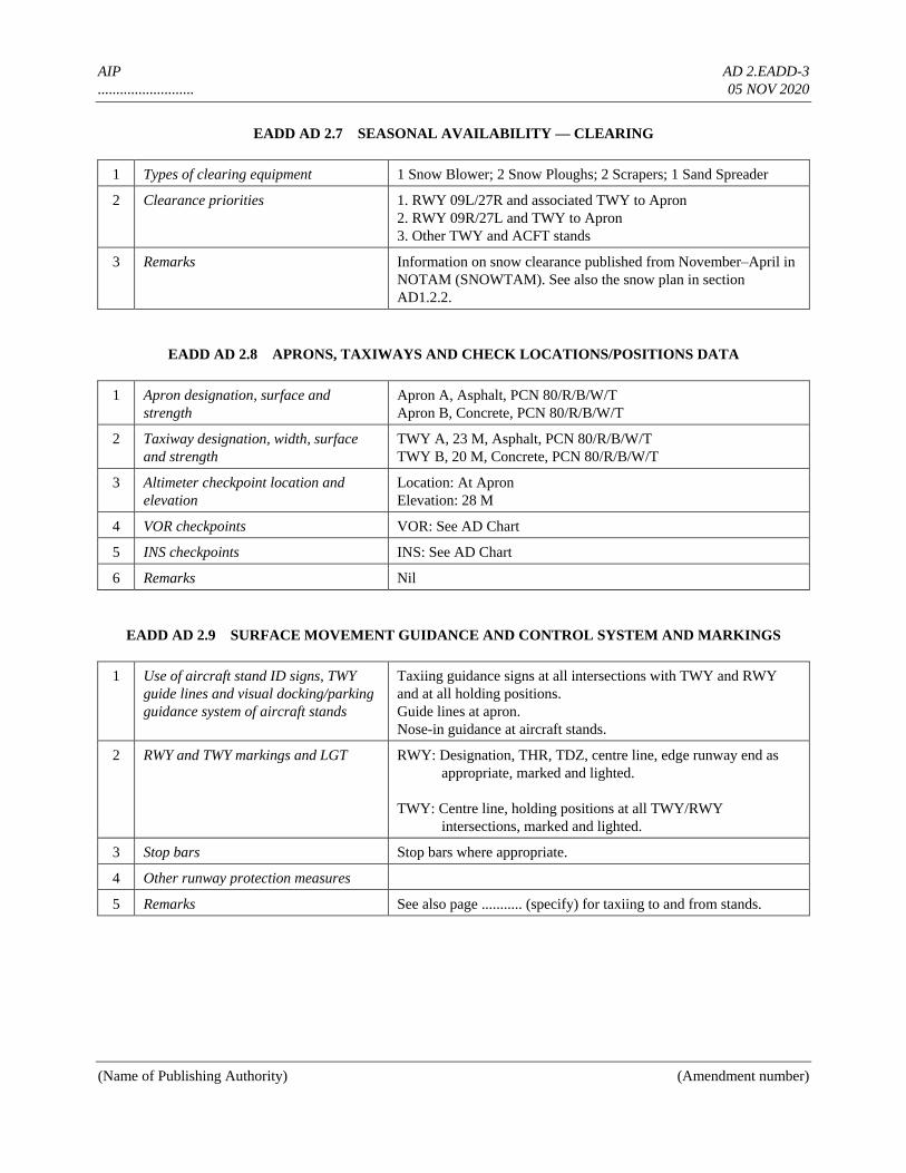
AIP AD 2.EADD-3
.......................... 05 NOV 2020
(Name of Publishing Authority) (Amendment number)
EADD AD 2.7 SEASONAL AVAILABILITY — CLEARING
1 Types of clearing equipment 1 Snow Blower; 2 Snow Ploughs; 2 Scrapers; 1 Sand Spreader
2 Clearance priorities 1. RWY 09L/27R and associated TWY to Apron
2. RWY 09R/27L and TWY to Apron
3. Other TWY and ACFT stands
3 Remarks Information on snow clearance published from November–April in
NOTAM (SNOWTAM). See also the snow plan in section
AD1.2.2.
EADD AD 2.8 APRONS, TAXIWAYS AND CHECK LOCATIONS/POSITIONS DATA
1 Apron designation, surface and
strength
Apron A, Asphalt, PCN 80/R/B/W/T
Apron B, Concrete, PCN 80/R/B/W/T
2 Taxiway designation, width, surface
and strength
TWY A, 23 M, Asphalt, PCN 80/R/B/W/T
TWY B, 20 M, Concrete, PCN 80/R/B/W/T
3 Altimeter checkpoint location and
elevation
Location: At Apron
Elevation: 28 M
4 VOR checkpoints VOR: See AD Chart
5 INS checkpoints INS: See AD Chart
6 Remarks Nil
EADD AD 2.9 SURFACE MOVEMENT GUIDANCE AND CONTROL SYSTEM AND MARKINGS
1 Use of aircraft stand ID signs, TWY
guide lines and visual docking/parking
guidance system of aircraft stands
Taxiing guidance signs at all intersections with TWY and RWY
and at all holding positions.
Guide lines at apron.
Nose-in guidance at aircraft stands.
2 RWY and TWY markings and LGT RWY: Designation, THR, TDZ, centre line, edge runway end as
appropriate, marked and lighted.
TWY: Centre line, holding positions at all TWY/RWY
intersections, marked and lighted.
3 Stop bars Stop bars where appropriate.
4 Other runway protection measures
5 Remarks See also page ........... (specify) for taxiing to and from stands.
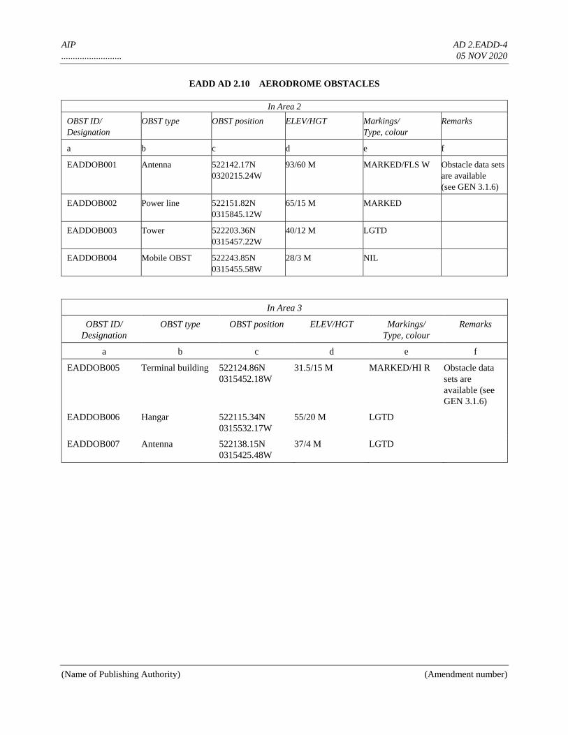
AIP AD 2.EADD-4
.......................... 05 NOV 2020
(Name of Publishing Authority) (Amendment number)
EADD AD 2.10 AERODROME OBSTACLES
In Area 2
OBST ID/
Designation
OBST type OBST position ELEV/HGT Markings/
Type, colour
Remarks
a b c d e f
EADDOB001 Antenna 522142.17N
0320215.24W
93/60 M MARKED/FLS W Obstacle data sets
are available
(see GEN 3.1.6)
EADDOB002 Power line
522151.82N
0315845.12W
65/15 M MARKED
EADDOB003 Tower
522203.36N
0315457.22W
40/12 M LGTD
EADDOB004 Mobile OBST 522243.85N
0315455.58W
28/3 M NIL
In Area 3
OBST ID/
Designation
OBST type OBST position ELEV/HGT Markings/
Type, colour
Remarks
a b c d e f
EADDOB005 Terminal building 522124.86N
0315452.18W
31.5/15 M MARKED/HI R Obstacle data
sets are
available (see
GEN 3.1.6)
EADDOB006 Hangar 522115.34N
0315532.17W
55/20 M LGTD
EADDOB007 Antenna 522138.15N
0315425.48W
37/4 M LGTD
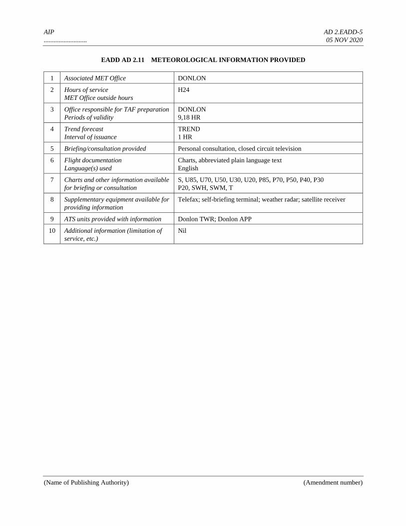
AIP AD 2.EADD-5
.......................... 05 NOV 2020
(Name of Publishing Authority) (Amendment number)
EADD AD 2.11 METEOROLOGICAL INFORMATION PROVIDED
1 Associated MET Office DONLON
2 Hours of service
MET Office outside hours
H24
3 Office responsible for TAF preparation
Periods of validity
DONLON
9,18 HR
4 Trend forecast
Interval of issuance
TREND
1 HR
5 Briefing/consultation provided Personal consultation, closed circuit television
6 Flight documentation
Language(s) used
Charts, abbreviated plain language text
English
7 Charts and other information available
for briefing or consultation
S, U85, U70, U50, U30, U20, P85, P70, P50, P40, P30
P20, SWH, SWM, T
8 Supplementary equipment available for
providing information
Telefax; self-briefing terminal; weather radar; satellite receiver
9 ATS units provided with information Donlon TWR; Donlon APP
10 Additional information (limitation of
service, etc.)
Nil
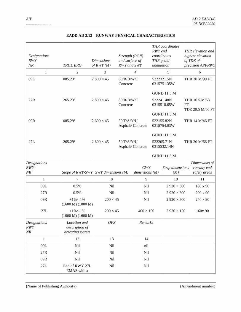
AIP AD 2.EADD-6
.......................... 05 NOV 2020
(Name of Publishing Authority) (Amendment number)
EADD AD 2.12 RUNWAY PHYSICAL CHARACTERISTICS
Designations
RWY
NR TRUE BRG
Dimensions
of RWY (M)
Strength (PCN)
and surface of
RWY and SWY
THR coordinates
RWY end
coordinates
THR geoid
undulation
THR elevation and
highest elevation
of TDZ of
precision APPRWY
1 2 3 4 5 6
09L 085.23° 2 800 × 45 80/R/B/W/T
Concrete
522232.15N
0315751.35W
GUND 11.5 M
THR 30 M/99 FT
27R 265.23° 2 800 × 45 80/R/B/W/T
Concrete
522241.48N
0315518.65W
GUND 11.5 M
THR 16.5 M/53
FT
TDZ 20.5 M/66 FT
09R 085.29° 2 600 × 45 50/F/A/Y/U
Asphalt/ Concrete
522155.82N
0315754.03W
GUND 11.5 M
THR 14 M/46 FT
27L 265.29° 2 600 × 45 50/F/A/Y/U
Asphalt/ Concrete
522205.71N
0315532.14N
GUND 11.5 M
THR 20 M/66 FT
Designations
RWY
NR Slope of RWY-SWY SWY dimensions (M)
CWY
dimensions (M)
Strip dimensions
(M)
Dimensions of
runway end
safety areas
1 7 8 9 10 11
09L 0.5% Nil Nil 2 920 × 300 180 x 90
27R 0.5% Nil Nil 2 920 × 300 200 x 90
09R +1%/–1%
(1600 M) (1000 M)
200 × 45 Nil 2 920 × 300 240 x 90
27L +1%/–1%
(1000 M) (1600 M)
200 × 45 400 × 150 2 920 × 150 160x 90
Designations
RWY
NR
Location and
description of
arresting system
OFZ Remarks
1 12 13 14
09L Nil Nil nil
27R Nil Nil Nil
09R Nil Nil Nil
27L End of RWY 27L
EMAS with a
Nil Nil
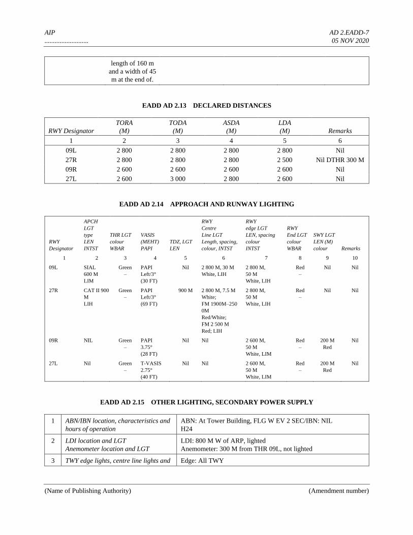
AIP AD 2.EADD-7
.......................... 05 NOV 2020
(Name of Publishing Authority) (Amendment number)
length of 160 m
and a width of 45
m at the end of.
EADD AD 2.13 DECLARED DISTANCES
RWY Designator
TORA
(M)
TODA
(M)
ASDA
(M)
LDA
(M) Remarks
1 2 3 4 5 6
09L 2 800 2 800 2 800 2 800 Nil
27R 2 800 2 800 2 800 2 500 Nil DTHR 300 M
09R 2 600 2 600 2 600 2 600 Nil
27L 2 600 3 000 2 800 2 600 Nil
EADD AD 2.14 APPROACH AND RUNWAY LIGHTING
RWY
Designator
APCH
LGT
type
LEN
INTST
THR LGT
colour
WBAR
VASIS
(MEHT)
PAPI
TDZ, LGT
LEN
RWY
Centre
Line LGT
Length, spacing,
colour, INTST
RWY
edge LGT
LEN, spacing
colour
INTST
RWY
End LGT
colour
WBAR
SWY LGT
LEN (M)
colour Remarks
1 2 3 4 5 6 7 8 9 10
09L SIAL
600 M
LIM
Green
–
PAPI
Left/3°
(30 FT)
Nil 2 800 M, 30 M
White, LIH
2 800 M,
50 M
White, LIH
Red
–
Nil Nil
27R CAT II 900
M
LIH
Green
–
PAPI
Left/3°
(69 FT)
900 M 2 800 M, 7.5 M
White;
FM 1900M–250
0M
Red/White;
FM 2 500 M
Red; LIH
2 800 M,
50 M
White, LIH
Red
–
Nil Nil
09R NIL Green
–
PAPI
3.75°
(28 FT)
Nil Nil 2 600 M,
50 M
White, LIM
Red
–
200 M
Red
Nil
27L Nil Green
–
T-VASIS
2.75°
(40 FT)
Nil Nil 2 600 M,
50 M
White, LIM
Red
–
200 M
Red
Nil
EADD AD 2.15 OTHER LIGHTING, SECONDARY POWER SUPPLY
1 ABN/IBN location, characteristics and
hours of operation
ABN: At Tower Building, FLG W EV 2 SEC/IBN: NIL
H24
2 LDI location and LGT
Anemometer location and LGT
LDI: 800 M W of ARP, lighted
Anemometer: 300 M from THR 09L, not lighted
3 TWY edge lights, centre line lights and Edge: All TWY
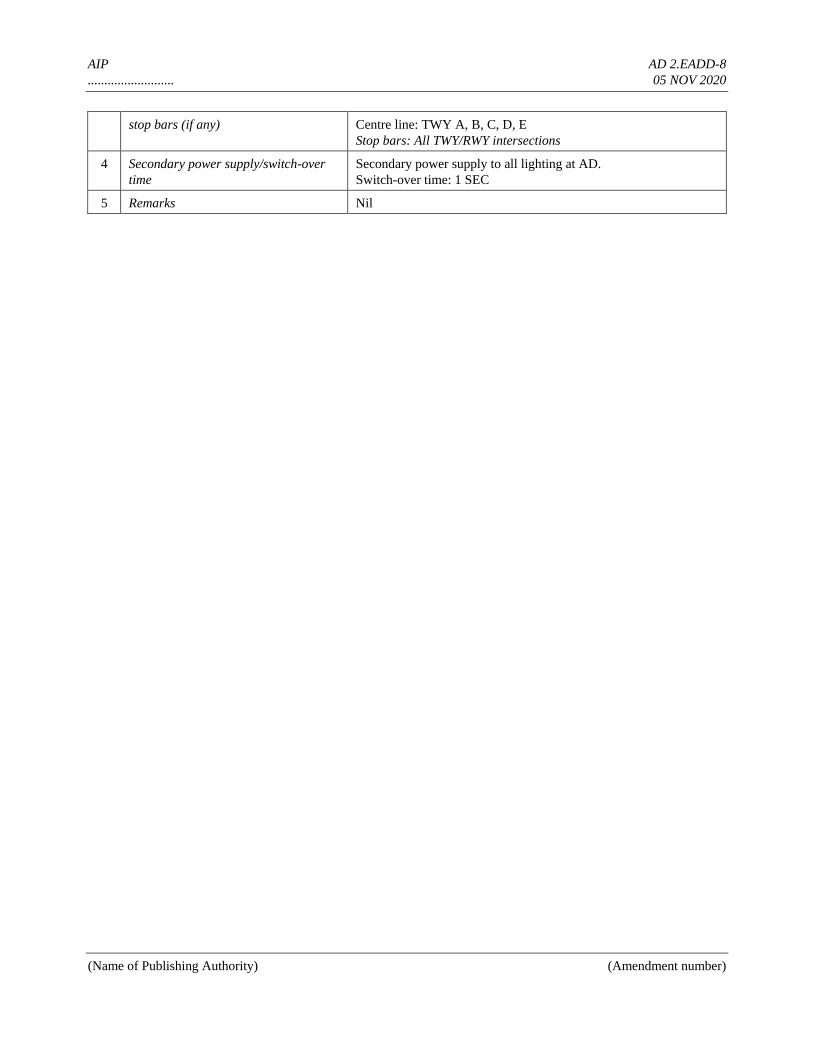
AIP AD 2.EADD-8
.......................... 05 NOV 2020
(Name of Publishing Authority) (Amendment number)
stop bars (if any) Centre line: TWY A, B, C, D, E
Stop bars: All TWY/RWY intersections
4 Secondary power supply/switch-over
time
Secondary power supply to all lighting at AD.
Switch-over time: 1 SEC
5 Remarks Nil
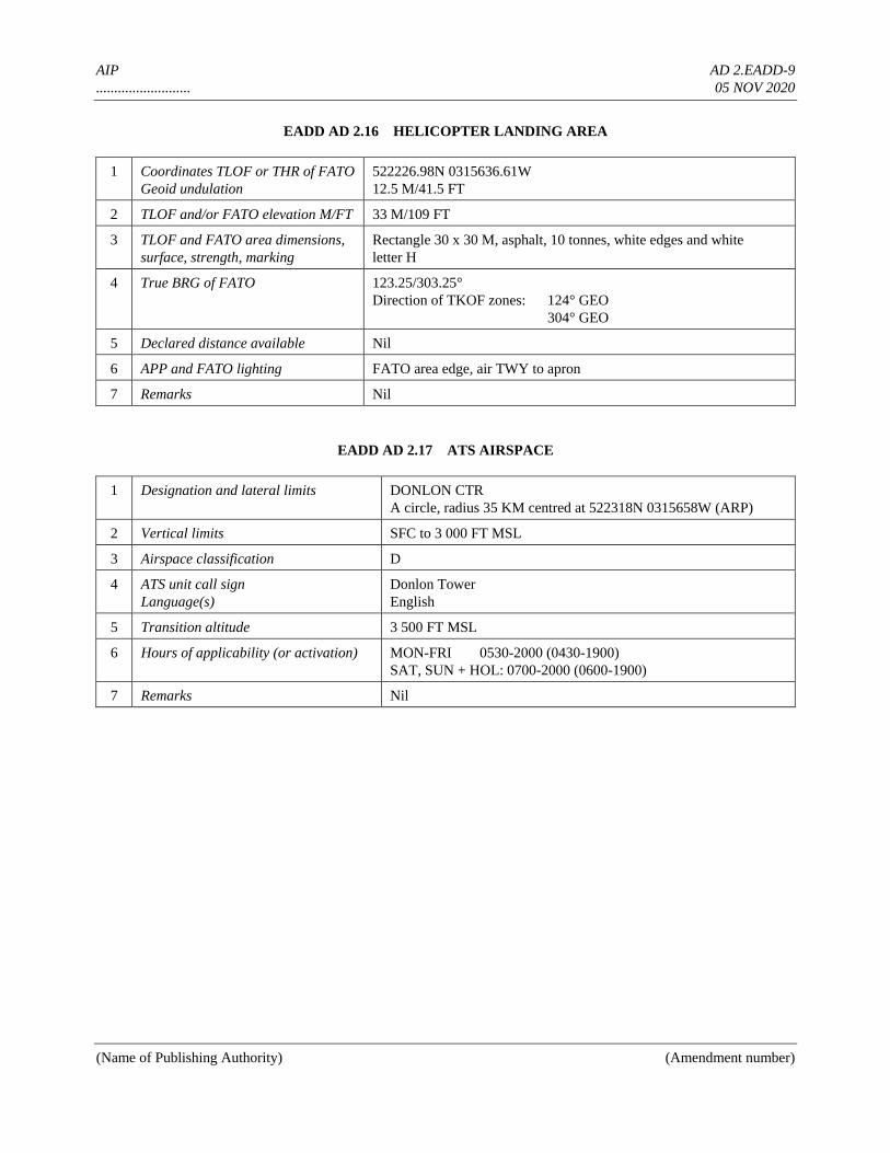
AIP AD 2.EADD-9
.......................... 05 NOV 2020
(Name of Publishing Authority) (Amendment number)
EADD AD 2.16 HELICOPTER LANDING AREA
1 Coordinates TLOF or THR of FATO
Geoid undulation
522226.98N 0315636.61W
12.5 M/41.5 FT
2 TLOF and/or FATO elevation M/FT 33 M/109 FT
3 TLOF and FATO area dimensions,
surface, strength, marking
Rectangle 30 x 30 M, asphalt, 10 tonnes, white edges and white
letter H
4 True BRG of FATO 123.25/303.25°
Direction of TKOF zones: 124° GEO
304° GEO
5 Declared distance available Nil
6 APP and FATO lighting FATO area edge, air TWY to apron
7 Remarks Nil
EADD AD 2.17 ATS AIRSPACE
1 Designation and lateral limits DONLON CTR
A circle, radius 35 KM centred at 522318N 0315658W (ARP)
2 Vertical limits SFC to 3 000 FT MSL
3 Airspace classification D
4 ATS unit call sign
Language(s)
Donlon Tower
English
5 Transition altitude 3 500 FT MSL
6 Hours of applicability (or activation) MON-FRI 0530-2000 (0430-1900)
SAT, SUN + HOL: 0700-2000 (0600-1900)
7 Remarks Nil
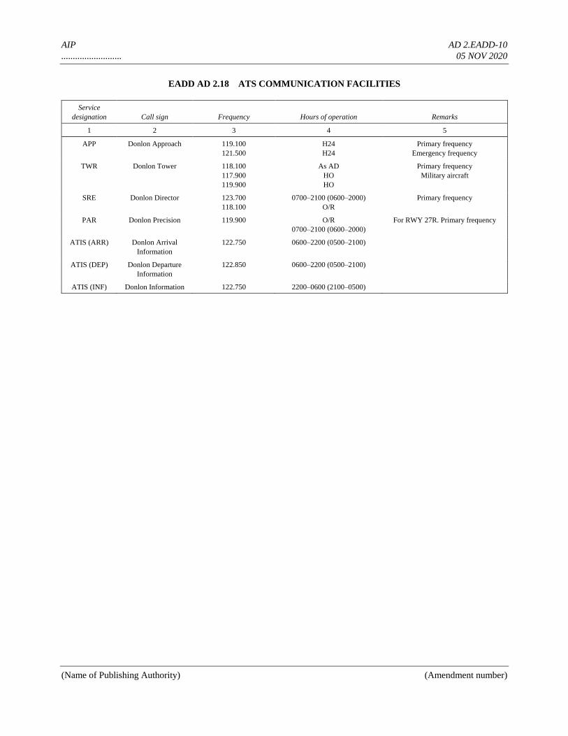
AIP AD 2.EADD-10
.......................... 05 NOV 2020
(Name of Publishing Authority) (Amendment number)
EADD AD 2.18 ATS COMMUNICATION FACILITIES
Service
designation Call sign Frequency Hours of operation Remarks
1 2 3 4 5
APP Donlon Approach 119.100
121.500
H24
H24
Primary frequency
Emergency frequency
TWR Donlon Tower 118.100
117.900
119.900
As AD
HO
HO
Primary frequency
Military aircraft
SRE Donlon Director 123.700
118.100
0700–2100 (0600–2000)
O/R
Primary frequency
PAR Donlon Precision 119.900 O/R
0700–2100 (0600–2000)
For RWY 27R. Primary frequency
ATIS (ARR) Donlon Arrival
Information
122.750 0600–2200 (0500–2100)
ATIS (DEP) Donlon Departure
Information
122.850 0600–2200 (0500–2100)
ATIS (INF) Donlon Information 122.750 2200–0600 (2100–0500)
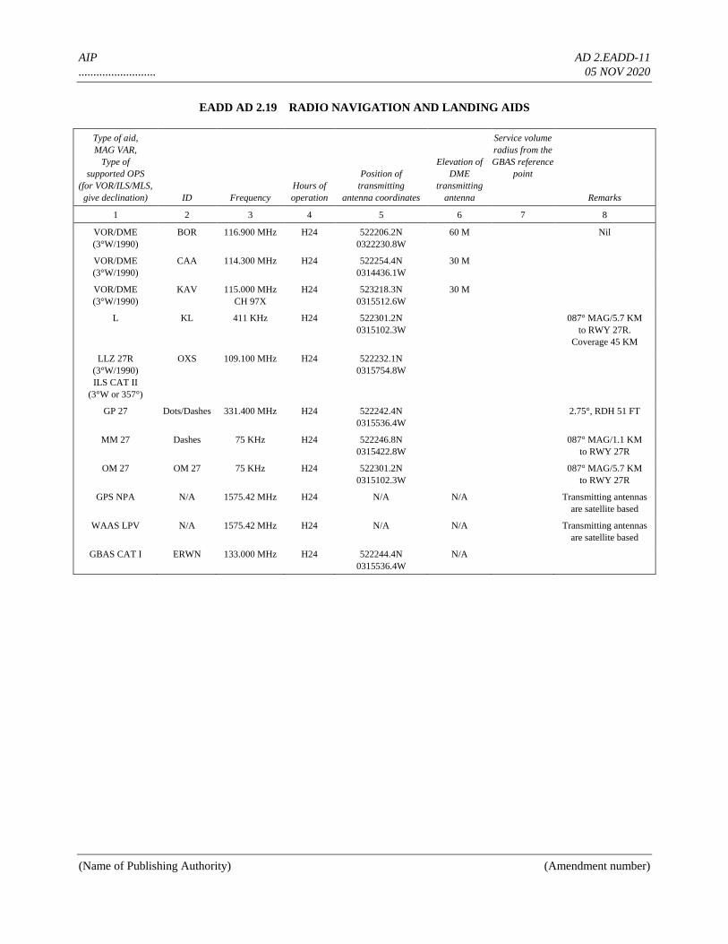
AIP AD 2.EADD-11
.......................... 05 NOV 2020
(Name of Publishing Authority) (Amendment number)
EADD AD 2.19 RADIO NAVIGATION AND LANDING AIDS
Type of aid,
MAG VAR,
Type of
supported OPS
(for VOR/ILS/MLS,
give declination) ID Frequency
Hours of
operation
Position of
transmitting
antenna coordinates
Elevation of
DME
transmitting
antenna
Service volume
radius from the
GBAS reference
point
Remarks
1 2 3 4 5 6 7 8
VOR/DME
(3°W/1990)
BOR 116.900 MHz H24 522206.2N
0322230.8W
60 M Nil
VOR/DME
(3°W/1990)
CAA 114.300 MHz H24 522254.4N
0314436.1W
30 M
VOR/DME
(3°W/1990)
KAV 115.000 MHz
CH 97X
H24 523218.3N
0315512.6W
30 M
L KL 411 KHz H24 522301.2N
0315102.3W
087° MAG/5.7 KM
to RWY 27R.
Coverage 45 KM
LLZ 27R
(3°W/1990)
ILS CAT II
(3°W or 357°)
OXS 109.100 MHz H24 522232.1N
0315754.8W
GP 27 Dots/Dashes 331.400 MHz H24 522242.4N
0315536.4W
2.75°, RDH 51 FT
MM 27 Dashes 75 KHz H24 522246.8N
0315422.8W
087° MAG/1.1 KM
to RWY 27R
OM 27 OM 27 75 KHz H24 522301.2N
0315102.3W
087° MAG/5.7 KM
to RWY 27R
GPS NPA N/A 1575.42 MHz H24 N/A N/A Transmitting antennas
are satellite based
WAAS LPV N/A 1575.42 MHz H24 N/A N/A Transmitting antennas
are satellite based
GBAS CAT I ERWN 133.000 MHz H24 522244.4N
0315536.4W
N/A
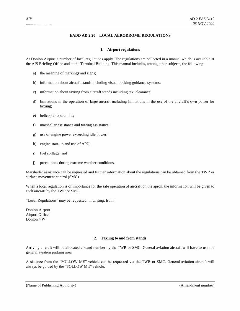
AIP AD 2.EADD-12
.......................... 05 NOV 2020
(Name of Publishing Authority) (Amendment number)
EADD AD 2.20 LOCAL AERODROME REGULATIONS
1. Airport regulations
At Donlon Airport a number of local regulations apply. The regulations are collected in a manual which is available at
the AIS Briefing Office and at the Terminal Building. This manual includes, among other subjects, the following:
a) the meaning of markings and signs;
b) information about aircraft stands including visual docking guidance systems;
c) information about taxiing from aircraft stands including taxi clearance;
d) limitations in the operation of large aircraft including limitations in the use of the aircraft’s own power for
taxiing;
e) helicopter operations;
f) marshaller assistance and towing assistance;
g) use of engine power exceeding idle power;
h) engine start-up and use of APU;
i) fuel spillage; and
j) precautions during extreme weather conditions.
Marshaller assistance can be requested and further information about the regulations can be obtained from the TWR or
surface movement control (SMC).
When a local regulation is of importance for the safe operation of aircraft on the apron, the information will be given to
each aircraft by the TWR or SMC.
“Local Regulations” may be requested, in writing, from:
Donlon Airport
Airport Office
Donlon 4 W
2. Taxiing to and from stands
Arriving aircraft will be allocated a stand number by the TWR or SMC. General aviation aircraft will have to use the
general aviation parking area.
Assistance from the “FOLLOW ME” vehicle can be requested via the TWR or SMC. General aviation aircraft will
always be guided by the “FOLLOW ME” vehicle.
AIP AD 2.EADD-13
.......................... 05 NOV 2020
(Name of Publishing Authority) (Amendment number)
Departing IFR flights shall contact the TWR to obtain ATC clearance before commencing taxiing. Request for ATC
clearance may take place at the earliest 10 minutes prior to engine start-up. Frequency 119.90 MHz is to be used in the
period 0600–2200 (0500–2100) and 118.10 MHz in the period 2200–0600 (2100–0500). Departing aircraft shall obtain
push-back clearance and taxi instruction from DONLON APRON on 121.900 MHz.
3. Parking area for small aircraft
(General aviation)
General aviation aircraft shall be guided by marshallers to the parking area for small aircraft.
4. Parking area for helicopters
The parking area for helicopters consists of two marked stands (H-80 and H-81). Helicopters will always be guided by
a marshaller on the stand.
5. Apron — taxiing during winter conditions
Certain taxiways in the apron area are not equipped with centre line lights. The taxi guide lines may not be visible due
to snow. Assistance from the “FOLLOW ME” vehicle can be requested via the TWR or SMC.
6. Taxiing — limitations
Insufficient safety distances restrict large aircraft’s use of certain taxiways when using their own power. Further
information will be given to each aircraft from the TWR or SMC.
7. School and training flights — technical test flights — use of runways
School and training flights must only be made after permission has been obtained from ATS. Permission will not be
granted for such flights within the following periods:
1800–0600 (1700–0500) and on Sundays and legal holidays.
For school and training flights and such technical test flights necessary for the purpose of ascertaining the airworthiness
of an aircraft during flight, use of the runway system at the aerodrome is restricted as follows:
RWY 09L and 27L may be used for take-off and landing;
RWY 09R may be used for take-off only;1
RWY 27R may be used for landing only.
See also AD 2.21 — Noise Abatement Procedures.
AIP AD 2.EADD-14
.......................... 05 NOV 2020
(Name of Publishing Authority) (Amendment number)
8. Helicopter traffic — limitation
Non-scheduled public air traffic with helicopters is permitted only after prior approval from the Donlon Aerodrome
Administration. Any contact concerning the above shall be made via the handling company or directly to the Airport
Office during the hours of service and, if possible, not later than the day before the flight is to be carried out.
Any request for approval of traffic shall contain the following information:
a) Owner/operator
b) Type of helicopter, registration/call sign
c) Date, arrival time/departure time, destination(s).
Furthermore, other details relevant to the evaluation of the request shall be given as required.
9. Removal of disabled aircraft from runways
When an aircraft is wrecked on a runway, it is the duty of the owner or user of such aircraft to have it removed as soon
as possible. If a wrecked aircraft is not removed from the runway as quickly as possible by the owner or user, the
aircraft will be removed by the aerodrome authority at the owner’s or user’s expense.
1. For technical test flights, runway 09R may be used for landing, if necessary, provided the test flight has proved the aircraft to be airworthy.
AIP AD 2.EADD-15
.......................... 05 NOV 2020
(Name of Publishing Authority) (Amendment number)
EADD AD 2.21 NOISE ABATEMENT PROCEDURES
The provisions are divided into three parts:
I. Noise abatement procedures for jet aeroplanes irrespective of weight, and for propeller and turbo-prop
aeroplanes with MTOM of or above 11 000 kg.
II. Noise abatement procedures for propeller and turboprop aeroplanes with MTOM below 11 000 kg.
III. Noise abatement procedures for helicopters.
As regards engine run-ups and the use of APU, see Local Regulations for Donlon Airport.
Part I
Noise abatement procedures for jet aeroplanes irrespective of weight, and for propeller
and turboprop aeroplanes with MTOM of or above 11 000 kg
1. General provisions
1.1 In connection with approach to landing, the following minimum heights over Greater Donlon shall be
observed:
a) Propeller and turboprop aeroplanes: 1 500 ft
b) Jet aeroplanes: 2 500 ft
As regards altitude restrictions for approach to RWY 09L, 4.2.1 refers.
1.2 RWY 09L and 27R are preferential runways.
1.3 In case of special meteorological conditions such as CBs, significant wind variations, etc. in the approach and
take-off sectors, the ATC can, at its discretion or on request from the pilot-in-command, deviate from the provisions in
sections 2 and 4 below, if deemed necessary for safety reasons.
2. Use of the runway system during the day period [0600ZZ2200 (0500ZZ2100)]
2.1 The preferential runways shall be used to the greatest extent possible.
2.2 When, in the periods 2200ZZ2300 and 0600ZZ0700 local time, the runway in use is RWY 27L/R, RWY
27L shall be used for take-off.
2.2.1 RWY 27R may, however, be used for take-off in the period 2200ZZ2300 and 0600ZZ0700 local time
when:
AIP AD 2.EADD-16
.......................... 05 NOV 2020
(Name of Publishing Authority) (Amendment number)
a) RWY 27L cannot be used for take-off due to snow clearance, disabled aircraft on the runway, work on the
runway or bad runway conditions.
b) an extraordinary traffic situation causes delays of more than one hour.
2.3 If a preferential runway is not the runway in use due to the crosswind component exceeding 15 kt, a request
to use a preferential runway will be complied with if the handling of the other traffic so permits.
2.4 A request for permission to deviate from a clearance will be complied with if the pilot-in-command claims
safety reasons.
3. Use of the runway system during the night period [2200ZZ0600 (2100ZZ0500)]
3.1 When the runway in use is RWY 27R, RWY 27L shall be used for take-off.
3.1.1 RWY 27R may, however, be used for take-off when:
a) RWY 27L cannot be used for take-off due to snow clearance, disabled aircraft, work on the runway or adverse
runway conditions.
b) an extraordinary traffic situation causes delays of more than one hour.
3.2 Limitations in the maximum A-weighted sound pressure level
3.2.1 Take-off and landing shall be so arranged that the maximum A-weighted sound pressure level does not
exceed 85 dB in six measuring positions in the surrounding residential areas.
3.2.2 Take-off may take place only if an advance approval has been issued by the Donlon Airport Authority.
a) Advance approval may be obtained for periods of approximately 6 months, provided that the aeroplane used is
noise certificated according to Annex 16, Chapter 2, 3 or 5, or provided the applicant has demonstrated that
take-off can be carried out in such a way that the provisions in 3.2.1 can be observed.
b) If no advance approval exists, take-off may exceptionally take place if the operator obtains a permit from the
Aerodrome Office based either on documentation stating that the aeroplane is noise certificated or on the fact
that the Donlon Airport Authority is aware that corresponding aeroplanes have the ability to comply with the
provisions in 3.2.1.
c) In the period 2300ZZ0100 (2200ZZ0000) no advance approval is required if the take-off takes place in the
said interval as a result of delay.
3.2.3 No advance approval is required for landing.
4. Restrictions
AIP AD 2.EADD-17
.......................... 05 NOV 2020
(Name of Publishing Authority) (Amendment number)
4.1 Take-off restrictions
4.1.1 RWY 27L:
a) Take-off shall be commenced from position A.
b) Turn must not be commenced until having passed 2 NM southwest of .... (specify) VOR/DME.
4.1.2 RWY 27R:
Turn must not be commenced until having passed 2 NM southwest of .... (specify) VOR/DME.
4.1.3 RWY 09L:
a) Take-off shall be commenced:
— for jet aeroplanes from position B.
— for propeller and turboprop aeroplanes from positions A and B.
b) Turn must not be commenced until ..... (specify) VOR has been passed.
4.1.4 RWY 09R:
a) Take-off shall be commenced from positions A and B.
b) Take-off with jet aeroplanes shall be so arranged that the maximum sound pressure level does not exceed
110 PNdB approximately 3 500 m from the beginning of RWY 09R.
c) If a take-off planned on RWY 09L/R, RWY 27L/R from position B cannot be carried out due to changes in
weather conditions or runway conditions occurring no more than one hour prior to the planned take-off time,
take-off in the period 0700–2200 (0600–2100) irrespective that the maximum sound pressure level exceeds
110 PNdB is acceptable.
d) Turn must not be commenced until ..... (specify) VOR has been passed.
4.2 Landing restrictions
4.2.1 RWY 09L:
During instrument as well as visual approach, flying below the ILS glide path angle is not allowed.
4.2.2 Reverse thrust:
Use of reverse thrust (idle reverse excepted) must take place only for safety reasons.
5. Reporting
AIP AD 2.EADD-18
.......................... 05 NOV 2020
(Name of Publishing Authority) (Amendment number)
5.1 The reporting of Air Traffic Control Donlon to the Civil Aviation Administration,
5.1 Aviation Inspection Department
5.1.1 The ATC Donlon shall notify the Aviation Inspection Department of every operation deviating from the
above-mentioned provisions.
5.1.2 The ATC Donlon shall notify the Aviation Inspection Department of every clearance according to the
provisions in 1.3, 2.2.1, 2.4, 3.1.1 and 3.2.1.
5.1.3 The Aviation Inspection Department will make further investigations based on reports from the ATC.
5.2 The reporting of the Donlon Airport Authority to the Civil Aviation Administration,
5.2 Aviation Inspection Department
5.2.1 The Donlon Airport Authority shall notify the Aviation Inspection Department if an aeroplane causes a
noise level above that allowed, cf. 3.2.1 or 4.1.4.
5.2.2 The Donlon Airport Authority shall notify the Aviation Inspection Department if an aeroplane takes off
within the night period without having the necessary advance approval, cf. 3.2.2.
5.2.3 The Donlon Airport Authority shall notify the Aviation Inspection Department if an aeroplane has been
observed using reverse thrust that exceeds idle reverse, cf. 4.2.2.
5.2.4 The Aviation Inspection Department will make further investigations based on reports from the Donlon
Airport Authority.
Part II
Noise abatement procedures for propeller and
turboprop aeroplanes with MTOM below 11 000 kg
1. Use of the runway system during the
day period [0600–2300 (0500–2200)]
No restrictions.
2. Use of the runway system during the
night period [2300–0600 (2200–0500)]
2.1 Limitations in the maximum A-weighted sound pressure level
2.1.1 Take-off and landing shall be so arranged that the maximum A-weighted sound pressure level does not
exceed 85 dB in six measuring positions in the surrounding residential areas.
2.1.2 Take-off may take place only if an advance approval has been issued by the Donlon Airport Authority.
AIP AD 2.EADD-19
.......................... 05 NOV 2020
(Name of Publishing Authority) (Amendment number)
a) Advance approval may be obtained for periods of approximately 6 months, provided that the aeroplane used is
noise certificated according to Annex 16, Chapter 5 or 6, or provided the applicant has demonstrated that take-
off can be carried out in such a way that the provisions in 2.2.1 can be observed.
b) If no advance approval exists, take-off may take place if the operator obtains a permit from the Airport
Authority based either on documentation stating that the aeroplane is noise certificated or on the fact that the
Donlon Airport Authority is aware that corresponding aeroplanes have the ability to comply with the
provisions in 2.2.1.
c) In the period 2300–0100 (2200–0000) no advance approval is required if the take-off takes place in the said
interval as a result of delay.
2.1.3 No advance approval is required for landing.
3. Reporting
3.1 The reporting of Air Traffic Control Donlon to the
3.1 Civil Aviation Administration, Aviation Inspection Department
3.1.1 The ATC Donlon shall notify the Aviation Inspection Department of every operation deviating from the
above-mentioned provisions.
3.1.2 The ATC Donlon shall notify the Aviation Inspection Department of every clearance according to the
provisions in 2.1 and 2.1.1.
3.1.3 The Aviation Inspection Department will make further investigations based on reports from the ATC.
3.2 The reporting of the Donlon Airport Authority to the
3.2 Civil Aviation Administration, Aviation Inspection Department
3.2.1 The Donlon Airport Authority shall notify the Aviation Inspection Department if an aeroplane causes a
noise level above that allowed, cf. 2.2.1.
3.2.2 The Donlon Airport Authority shall notify the Aviation Inspection Department if an aeroplane takes off
within the night period without having the necessary advance approval, cf. 3.2.2.
3.2.3 The Aviation Inspection Department will make further investigations based on reports from the Donlon
Airport Authority.
Part III
Noise abatement procedures for helicopters
AIP AD 2.EADD-20
.......................... 05 NOV 2020
(Name of Publishing Authority) (Amendment number)
1. General provisions
1.1 In case of special meteorological conditions such as CBs, significant wind variations, etc. in the approach and
take-off sectors, the ATS can, at its discretion or on request from the pilot-in-command, deviate from the provisions in
section 2 below, if deemed necessary for safety reasons.
1.2 Deviations from the provisions in sections 2 and 3 below are permitted in connection with:
a) take-off and landing for vital flights, such as ambulance and transplantation flights, and the like.
b) take-off and landing in connection with rescue operations.
c) take-off and landing in connection with security control of the airport area.
d) landing in such cases where the aircraft during flight has experienced reduced airworthiness, and the pilot-in-
command judges it necessary to land.
e) landing where the pilot-in-command declares an emergency situation.
1.3 Approach and departure respectively, carried out using VFR, will normally be cleared via HOLDING ......,
VFR-route ..... or VFR-route ..... with the limitations stated in 2.3.
1.4 Departure, carried out using IFR, will be cleared in the direction of RWY 04 or RWY 12 with the limitations
stated in 2.3.
2. Use of the runway system during the day period [0600–2300 (0500–2200)]
2.1 In the periods 0600–0700 (0500–0600) and 2200–2300 (2100–2200), the airport is closed for helicopter
traffic.
2.2 Take-off and landing shall take place from/at THR 27L or 27R.
2.3 From the threshold used:
a) departure shall take place on tracks between 030° and 130°;
b) arrival shall take place on tracks between 210° and 310°.
2.4 Hover-taxiing is not permitted with helicopters equipped with wheels.
2.5 Taxiing to and from 27R shall be executed via TWY ..... (specify).
2.5.1 When 27R is the runway in use and there is traffic on TWY ..... (specify), taxiing from THR ..... (specify)
will be permitted via RWY 27R and TWY ..... (specify).
3. Use of the runway system during the night period (2300–0600 local time)
3.1 In the period 2300–0600 local time, the airport is closed for helicopter traffic.
AIP AD 2.EADD-21
.......................... 05 NOV 2020
(Name of Publishing Authority) (Amendment number)
4. Reporting
4.1 The reporting of Air Traffic Control Donlon to the
4.1 Civil Aviation Administration, Aviation Inspection Department
4.1.1 The ATC Donlon shall notify the Aviation Inspection Department of every operation deviating from the
above-mentioned provisions.
4.1.2 The ATC Donlon shall notify the Aviation Inspection Department of every clearance according to the
provisions in 1.1 and 1.2.
4.1.3 The Aviation Inspection Department will make further investigations based on reports from the ATS.
EADD AD 2.22 FLIGHT PROCEDURES
General
Unless special permission has been obtained from Donlon Approach or Donlon Tower as appropriate, flight within
Donlon TMA and Donlon CTR shall be in accordance with the Instrument Flight Rules.
Procedures for IFR flights within Donlon TMA
The inbound, transit and outbound routes shown on the charts may be varied at the discretion of ATS. If necessary, in
case of congestion, inbound aircraft may also be instructed to hold at one of the designated airways, reporting points.
ATC surveillance procedures within Donlon TMA
Radar vectoring and sequencing
Normally, aircraft will be vectored and sequenced from DONNORD and DONNEST NDBs and JUSTIN, ROBIN and
OSTO reporting points to the appropriate final approach track (ILS, PAR, VOR/DME), so as to ensure an expeditious
flow of traffic. Radar vectors and flight levels/altitudes will be issued, as required, for spacing and separating the
aircraft so that correct landing intervals are maintained, taking into account aircraft characteristics.
Radar vectoring charts are not published since the instrument approach procedures and altitudes ensure that adequate
terrain clearance exists at all times until the point where the pilot will resume navigation on final approach or in the
circuit.
Surveillance radar approaches
Surveillance radar approaches will be carried out for runways 27L, 09L and 09R, as step down commencing descent
AIP AD 2.EADD-22
.......................... 05 NOV 2020
(Name of Publishing Authority) (Amendment number)
from 10 km at an altitude of 600 m. Surveillance radar final approaches will be terminated at 3.5 km from touchdown.
At each nautical mile and until 3 NM from touchdown, the pilot will be given the precomputed check altitude so that
the nominal glide path can be maintained.
Missed approach procedures to be followed in the absence of other ATS instructions are as detailed on the Instrument
Approach Chart.
Precision radar approach
Precision radar approach is available for RWY 27R only. It will be terminated at approximately 1 km from touchdown
on RWY 27R. In the event of a pilot requesting radar assistance to carry out an emergency precision radar approach
and landing, the PAR controller will continue the approach to the point of touchdown or until the aircraft is known to
have the runway in sight. A pilot may request a practice emergency radar approach in weather conditions equal to or
better than a visibility of 1.8 km and a cloud ceiling of 150 m. In addition, ATC may request a pilot to carry out this
procedure for ATC training purposes.
Communication failure
In the event of communication failure, the pilot shall act in accordance with the communication failure procedures in
Annex 2. For the Donlon TMA, information concerning the associated navigation aids and the routing is given on
page ...... (specify).
Low visibility procedures
RWY 27R, equipped with ILS approved for CAT II, will be used under RVR below 800 m to 350 m. In order to
provide adequate protection of the ILS system, no vehicle or aircraft shall infringe the ILS sensitive areas when an
arriving aircraft is within 2 NM of touchdown and has not completed its landing run. When RVR at TDZ falls below
400 m, a follow-me car is available on standby to assist pilots during taxi upon request. Pilots will be informed by
ATIS or ATC when LVP are in progress. The ATIS message will contain the phrase “LOW VISIBILITY
PROCEDURES IN PROGRESS” and will also provide details of any unavailability of equipment relevant to LVP.
Pilots will be informed by ATC when LVP are terminated.
The preparation phase will start when visibility falls below 1 500 m and/or the ceiling is at or below 300 ft, and CAT II
operations are expected. The operations phase will start when RVR falls below 800 m or ceiling is at or below 200 ft.
LVP will be terminated when RVR is greater than 800 m and the ceiling is higher than 200 ft, and a continuing
improvement in these conditions is expected. CAT II approach during normal operations is allowed, but due to high
traffic intensity, the protection of the ILS sensitive area cannot be guaranteed and fluctuations in the ILS signal may
occur in periods outside of the low visibility procedures.
Procedures for VFR flights within Donlon TMA
Provided traffic conditions so permit, ATC clearance for VFR flights will be given under the conditions described
below:
a) A flight plan requesting ATC clearance, containing items 7 to 18 and indicating the purpose of the flight, shall
be submitted.
b) ATC clearance shall be obtained immediately before the aircraft enters the area concerned.
AIP AD 2.EADD-23
.......................... 05 NOV 2020
(Name of Publishing Authority) (Amendment number)
c) Position reports shall be submitted in accordance with 3.6.3 of Annex 2.
d) Deviation from the ATC clearance may only be made when prior permission has been obtained.
e) The flight shall be conducted with vertical visual reference to the ground unless the flight can be conducted in
accordance with the Instrument Flight Rules.
f) Two-way radio communication shall be maintained on the frequency prescribed. Information about the
appropriate frequency can be obtained from Donlon Information.
g) The pilot-in-command shall be the holder of an International VHF Licence.
h) The aircraft shall be equipped with SSR transponder with 4 096 Codes in Mode A/3. Flights performed in
connection with parachute jumps shall, in addition, be equipped with Mode C with automatic transmission of
pressure altitude information (cf. Annex 10, Volume I). Exemption from this requirement may be granted by
Donlon Control.
Note.— ATC clearance is intended only to provide separation between IFR and VFR flights.
Procedures for VFR flights within Donlon CTR
a) Flight plan shall be filed for the flight concerned.
b) ATC clearance shall be obtained from the Control Tower.
c) Deviation from ATC clearance may only be made when prior permission has been obtained.
d) The flight shall be conducted with vertical visual reference to the ground.
e) Two-way radio communication shall be established on the frequency prescribed before flight takes place in
the Control Zone.
VFR routes within Donlon CTR
Arrival and departure routes for VFR traffic are established as depicted on the Visual Approach Chart.
EADD AD 2.23 ADDITIONAL INFORMATION
Bird concentrations in the vicinity of the airport
Intense activity of flocks of .............. (type of bird) takes place daily from one to two hours after sunrise when birds fly
from resting area (1 300 m, QDR 090° from threshold of RWY 27L) across approach of runway 27R to their feeding
area near the river NE of the airport. Height varies from 0–2 000 ft (0–600 m) AGL. From one to two hours before
sunset the same activity as described above takes place in reverse when the birds return to their area.

AIP AD 2.EADD-24
.......................... 05 NOV 2020
(Name of Publishing Authority) (Amendment number)
As far as practicable, Aerodrome Control will inform pilots of this bird activity and the estimated heights AGL.
During the above periods pilots of aircraft are advised, where the design limitations of aircraft installations permit, to
operate landing lights in flight, within the terminal area and during take-off, approach-to-land and climb and descent
procedures.
Dispersal activities include occasional playing back of distress calls from tape together with the firing of shell crackers,
supplemented by the use of live ammunition and trapping. Modifications of the environment are under way to reduce, if
not eliminate, the hazard. They comprise better methods of garbage disposal and drainage, elimination of hedge and
ground cover and cessation of farming activity.
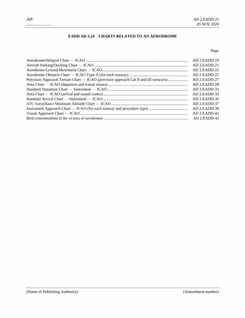
AIP AD 2.EADD-25
.......................... 05 NOV 2020
(Name of Publishing Authority) (Amendment number)
EADD AD 2.24 CHARTS RELATED TO AN AERODROME
Page
Aerodrome/Heliport Chart — ICAO ..................................................................................................... AD 2.EADD-19
Aircraft Parking/Docking Chart — ICAO ............................................................................................. AD 2.EADD-21
Aerodrome Ground Movement Chart — ICAO..................................................................................... AD 2.EADD-23
Aerodrome Obstacle Chart — ICAO Type A (for each runway) .......................................................... AD 2.EADD-25
Precision Approach Terrain Chart — ICAO (precision approach Cat II and III runways) .................... AD 2.EADD-27
Area Chart — ICAO (departure and transit routes) ............................................................................... AD 2.EADD-29
Standard Departure Chart — Instrument — ICAO ................................................................................ AD 2.EADD-31
Area Chart — ICAO (arrival and transit routes) .................................................................................... AD 2.EADD-33
Standard Arrival Chart — Instrument — ICAO .................................................................................... AD 2.EADD-35
ATC Surveillance Minimum Altitude Chart — ICAO ............................................................................ AD 2.EADD-37
Instrument Approach Chart — ICAO (for each runway and procedure type) ....................................... AD 2.EADD-39
Visual Approach Chart — ICAO ........................................................................................................... AD 2.EADD-41
Bird concentrations in the vicinity of aerodromes ....................................................................................... AD 2.EADD-43
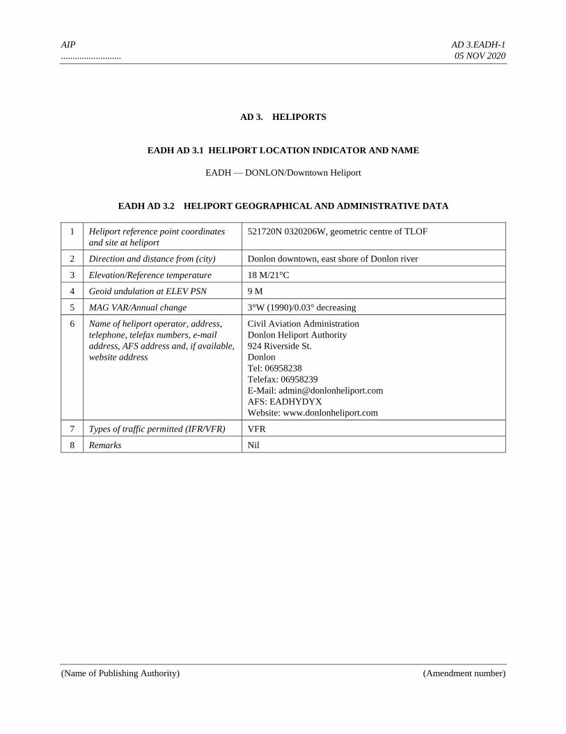
AIP AD 3.EADH-1
.......................... 05 NOV 2020
(Name of Publishing Authority) (Amendment number)
AD 3. HELIPORTS
EADH AD 3.1 HELIPORT LOCATION INDICATOR AND NAME
EADH — DONLON/Downtown Heliport
EADH AD 3.2 HELIPORT GEOGRAPHICAL AND ADMINISTRATIVE DATA
1 Heliport reference point coordinates
and site at heliport
521720N 0320206W, geometric centre of TLOF
2 Direction and distance from (city) Donlon downtown, east shore of Donlon river
3 Elevation/Reference temperature 18 M/21°C
4 Geoid undulation at ELEV PSN 9 M
5 MAG VAR/Annual change 3°W (1990)/0.03° decreasing
6 Name of heliport operator, address,
telephone, telefax numbers, e-mail
address, AFS address and, if available,
website address
Civil Aviation Administration
Donlon Heliport Authority
924 Riverside St.
Donlon
Tel: 06958238
Telefax: 06958239
E-Mail: [email protected]
AFS: EADHYDYX
Website: www.donlonheliport.com
7 Types of traffic permitted (IFR/VFR) VFR
8 Remarks Nil
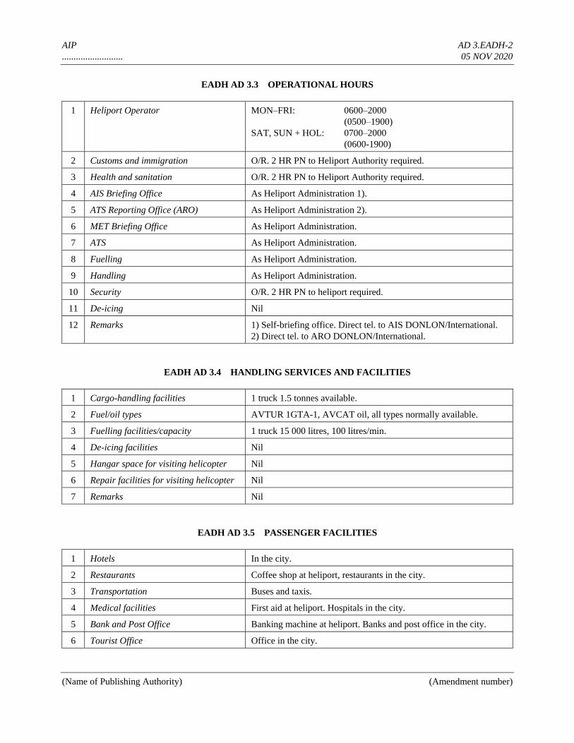
AIP AD 3.EADH-2
.......................... 05 NOV 2020
(Name of Publishing Authority) (Amendment number)
EADH AD 3.3 OPERATIONAL HOURS
1 Heliport Operator MON–FRI: 0600–2000
(0500–1900)
SAT, SUN + HOL: 0700–2000
(0600-1900)
2 Customs and immigration O/R. 2 HR PN to Heliport Authority required.
3 Health and sanitation O/R. 2 HR PN to Heliport Authority required.
4 AIS Briefing Office As Heliport Administration 1).
5 ATS Reporting Office (ARO) As Heliport Administration 2).
6 MET Briefing Office As Heliport Administration.
7 ATS As Heliport Administration.
8 Fuelling As Heliport Administration.
9 Handling As Heliport Administration.
10 Security O/R. 2 HR PN to heliport required.
11 De-icing Nil
12 Remarks 1) Self-briefing office. Direct tel. to AIS DONLON/International.
2) Direct tel. to ARO DONLON/International.
EADH AD 3.4 HANDLING SERVICES AND FACILITIES
1 Cargo-handling facilities 1 truck 1.5 tonnes available.
2 Fuel/oil types AVTUR 1GTA-1, AVCAT oil, all types normally available.
3 Fuelling facilities/capacity 1 truck 15 000 litres, 100 litres/min.
4 De-icing facilities Nil
5 Hangar space for visiting helicopter Nil
6 Repair facilities for visiting helicopter Nil
7 Remarks Nil
EADH AD 3.5 PASSENGER FACILITIES
1 Hotels In the city.
2 Restaurants Coffee shop at heliport, restaurants in the city.
3 Transportation Buses and taxis.
4 Medical facilities First aid at heliport. Hospitals in the city.
5 Bank and Post Office Banking machine at heliport. Banks and post office in the city.
6 Tourist Office Office in the city.
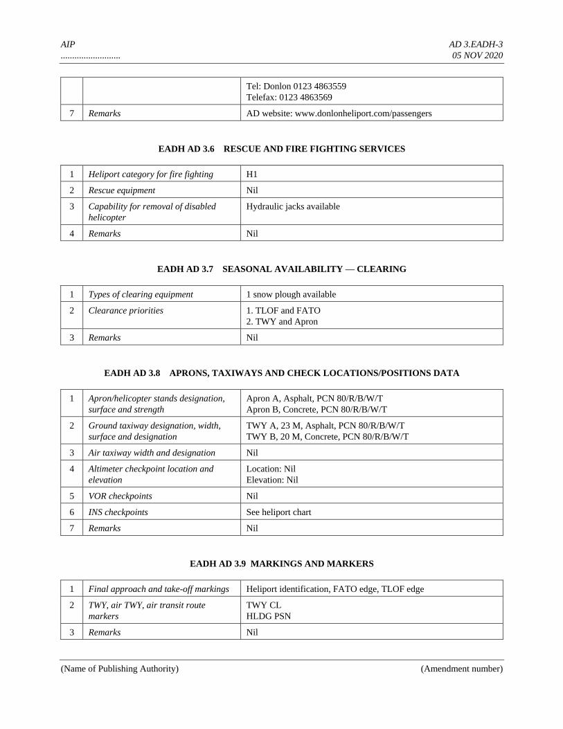
AIP AD 3.EADH-3
.......................... 05 NOV 2020
(Name of Publishing Authority) (Amendment number)
Tel: Donlon 0123 4863559
Telefax: 0123 4863569
7 Remarks AD website: www.donlonheliport.com/passengers
EADH AD 3.6 RESCUE AND FIRE FIGHTING SERVICES
1 Heliport category for fire fighting H1
2 Rescue equipment Nil
3 Capability for removal of disabled
helicopter
Hydraulic jacks available
4 Remarks Nil
EADH AD 3.7 SEASONAL AVAILABILITY — CLEARING
1 Types of clearing equipment 1 snow plough available
2 Clearance priorities 1. TLOF and FATO
2. TWY and Apron
3 Remarks Nil
EADH AD 3.8 APRONS, TAXIWAYS AND CHECK LOCATIONS/POSITIONS DATA
1 Apron/helicopter stands designation,
surface and strength
Apron A, Asphalt, PCN 80/R/B/W/T
Apron B, Concrete, PCN 80/R/B/W/T
2 Ground taxiway designation, width,
surface and designation
TWY A, 23 M, Asphalt, PCN 80/R/B/W/T
TWY B, 20 M, Concrete, PCN 80/R/B/W/T
3 Air taxiway width and designation Nil
4 Altimeter checkpoint location and
elevation
Location: Nil
Elevation: Nil
5 VOR checkpoints Nil
6 INS checkpoints See heliport chart
7 Remarks Nil
EADH AD 3.9 MARKINGS AND MARKERS
1 Final approach and take-off markings Heliport identification, FATO edge, TLOF edge
2 TWY, air TWY, air transit route
markers
TWY CL
HLDG PSN
3 Remarks Nil
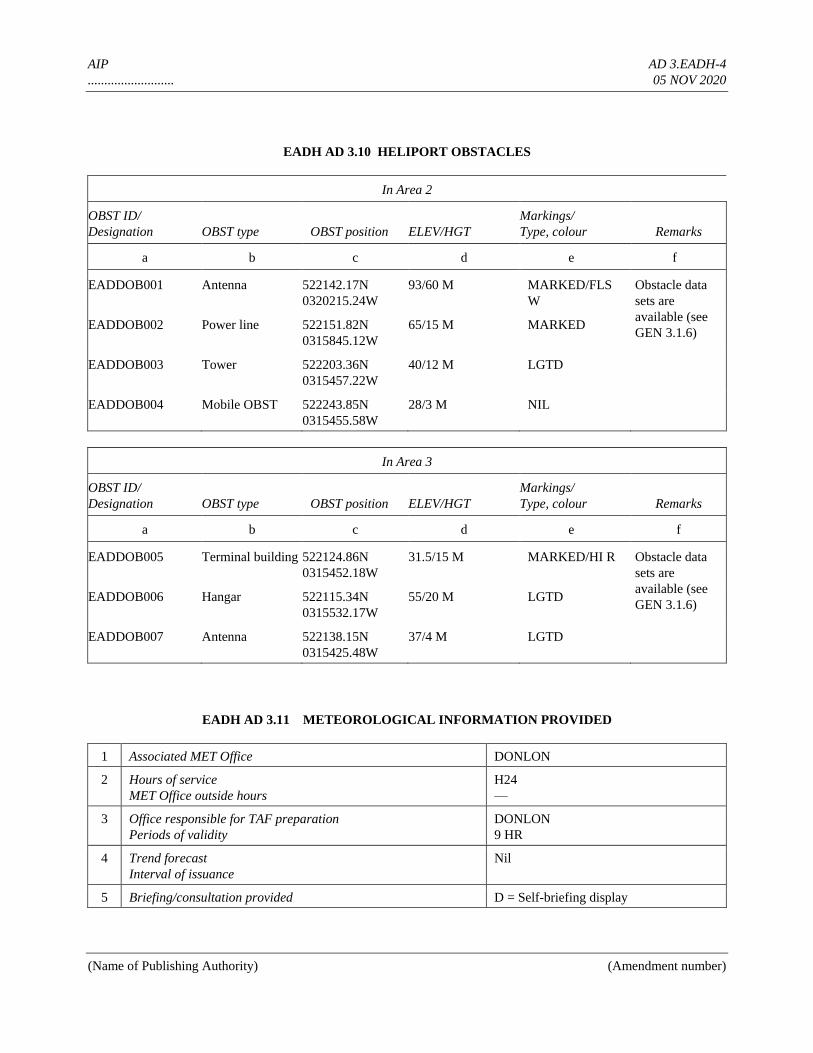
AIP AD 3.EADH-4
.......................... 05 NOV 2020
(Name of Publishing Authority) (Amendment number)
EADH AD 3.10 HELIPORT OBSTACLES
In Area 2
OBST ID/
Designation OBST type OBST position ELEV/HGT
Markings/
Type, colour Remarks
a b c d e f
EADDOB001 Antenna 522142.17N
0320215.24W
93/60 M MARKED/FLS
W
Obstacle data
sets are
available (see
GEN 3.1.6) EADDOB002 Power line
522151.82N
0315845.12W
65/15 M MARKED
EADDOB003 Tower
522203.36N
0315457.22W
40/12 M LGTD
EADDOB004 Mobile OBST 522243.85N
0315455.58W
28/3 M NIL
In Area 3
OBST ID/
Designation OBST type OBST position ELEV/HGT
Markings/
Type, colour Remarks
a b c d e f
EADDOB005 Terminal building 522124.86N
0315452.18W
31.5/15 M MARKED/HI R Obstacle data
sets are
available (see
GEN 3.1.6) EADDOB006 Hangar 522115.34N
0315532.17W
55/20 M LGTD
EADDOB007 Antenna 522138.15N
0315425.48W
37/4 M LGTD
EADH AD 3.11 METEOROLOGICAL INFORMATION PROVIDED
1 Associated MET Office DONLON
2 Hours of service
MET Office outside hours
H24
—
3 Office responsible for TAF preparation
Periods of validity
DONLON
9 HR
4 Trend forecast
Interval of issuance
Nil
5 Briefing/consultation provided D = Self-briefing display
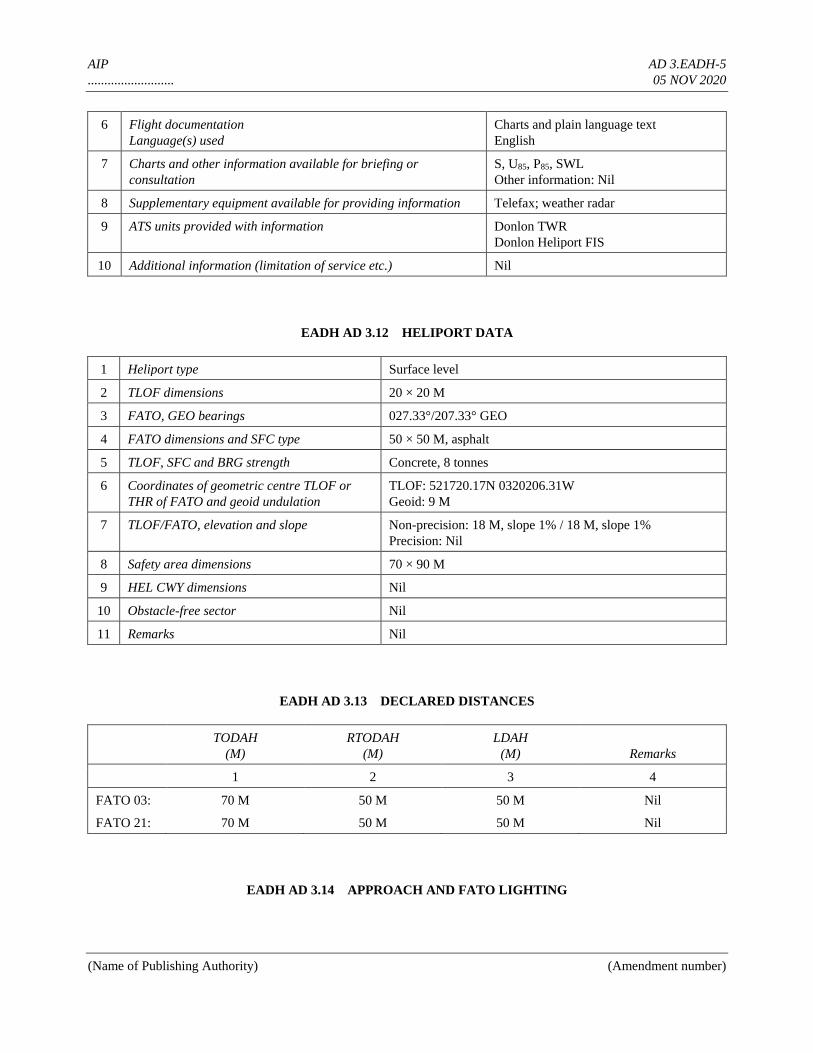
AIP AD 3.EADH-5
.......................... 05 NOV 2020
(Name of Publishing Authority) (Amendment number)
6 Flight documentation
Language(s) used
Charts and plain language text
English
7 Charts and other information available for briefing or
consultation
S, U85, P85, SWL
Other information: Nil
8 Supplementary equipment available for providing information Telefax; weather radar
9 ATS units provided with information Donlon TWR
Donlon Heliport FIS
10 Additional information (limitation of service etc.) Nil
EADH AD 3.12 HELIPORT DATA
1 Heliport type Surface level
2 TLOF dimensions 20 × 20 M
3 FATO, GEO bearings 027.33°/207.33° GEO
4 FATO dimensions and SFC type 50 × 50 M, asphalt
5 TLOF, SFC and BRG strength Concrete, 8 tonnes
6 Coordinates of geometric centre TLOF or
THR of FATO and geoid undulation
TLOF: 521720.17N 0320206.31W
Geoid: 9 M
7 TLOF/FATO, elevation and slope Non-precision: 18 M, slope 1% / 18 M, slope 1%
Precision: Nil
8 Safety area dimensions 70 × 90 M
9 HEL CWY dimensions Nil
10 Obstacle-free sector Nil
11 Remarks Nil
EADH AD 3.13 DECLARED DISTANCES
TODAH
(M)
RTODAH
(M)
LDAH
(M) Remarks
1 2 3 4
FATO 03: 70 M 50 M 50 M Nil
FATO 21: 70 M 50 M 50 M Nil
EADH AD 3.14 APPROACH AND FATO LIGHTING
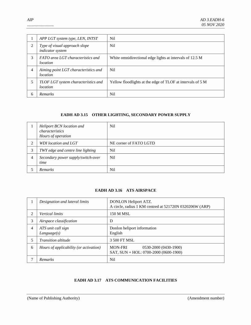
AIP AD 3.EADH-6
.......................... 05 NOV 2020
(Name of Publishing Authority) (Amendment number)
1 APP LGT system type, LEN, INTST Nil
2 Type of visual approach slope
indicator system
Nil
3 FATO area LGT characteristics and
location
White omnidirectional edge lights at intervals of 12.5 M
4 Aiming point LGT characteristics and
location
Nil
5 TLOF LGT system characteristics and
location
Yellow floodlights at the edge of TLOF at intervals of 5 M
6 Remarks Nil
EADH AD 3.15 OTHER LIGHTING, SECONDARY POWER SUPPLY
1 Heliport BCN location and
characteristics
Hours of operation
Nil
2 WDI location and LGT NE corner of FATO LGTD
3 TWY edge and centre line lighting Nil
4 Secondary power supply/switch-over
time
Nil
5 Remarks Nil
EADH AD 3.16 ATS AIRSPACE
1 Designation and lateral limits DONLON Heliport ATZ.
A circle, radius 1 KM centred at 521720N 0320206W (ARP)
2 Vertical limits 150 M MSL
3 Airspace classification D
4 ATS unit call sign
Language(s)
Donlon heliport information
English
5 Transition altitude 3 500 FT MSL
6 Hours of applicability (or activation) MON-FRI 0530-2000 (0430-1900)
SAT, SUN + HOL: 0700-2000 (0600-1900)
7 Remarks Nil
EADH AD 3.17 ATS COMMUNICATION FACILITIES
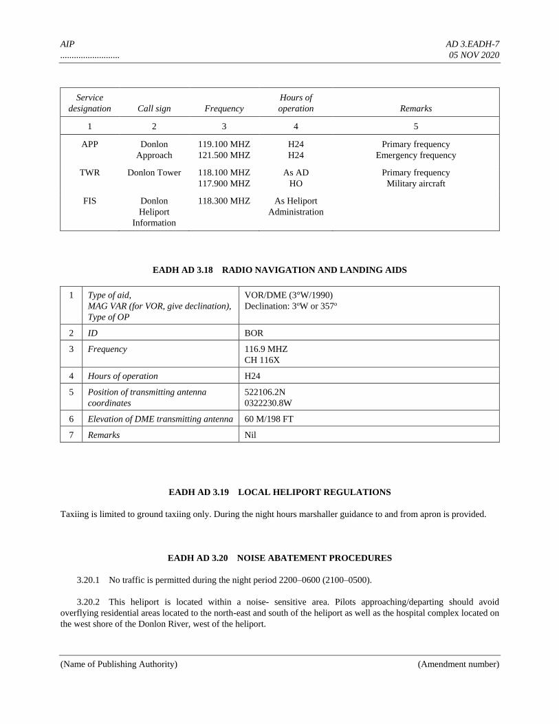
AIP AD 3.EADH-7
.......................... 05 NOV 2020
(Name of Publishing Authority) (Amendment number)
Service
designation Call sign Frequency
Hours of
operation Remarks
1 2 3 4 5
APP Donlon
Approach
119.100 MHZ
121.500 MHZ
H24
H24
Primary frequency
Emergency frequency
TWR Donlon Tower 118.100 MHZ
117.900 MHZ
As AD
HO
Primary frequency
Military aircraft
FIS Donlon
Heliport
Information
118.300 MHZ As Heliport
Administration
EADH AD 3.18 RADIO NAVIGATION AND LANDING AIDS
1 Type of aid,
MAG VAR (for VOR, give declination),
Type of OP
VOR/DME (3°W/1990)
Declination: 3oW or 357o
2 ID BOR
3 Frequency 116.9 MHZ
CH 116X
4 Hours of operation H24
5 Position of transmitting antenna
coordinates
522106.2N
0322230.8W
6 Elevation of DME transmitting antenna 60 M/198 FT
7 Remarks Nil
EADH AD 3.19 LOCAL HELIPORT REGULATIONS
Taxiing is limited to ground taxiing only. During the night hours marshaller guidance to and from apron is provided.
EADH AD 3.20 NOISE ABATEMENT PROCEDURES
3.20.1 No traffic is permitted during the night period 2200–0600 (2100–0500).
3.20.2 This heliport is located within a noise- sensitive area. Pilots approaching/departing should avoid
overflying residential areas located to the north-east and south of the heliport as well as the hospital complex located on
the west shore of the Donlon River, west of the heliport.
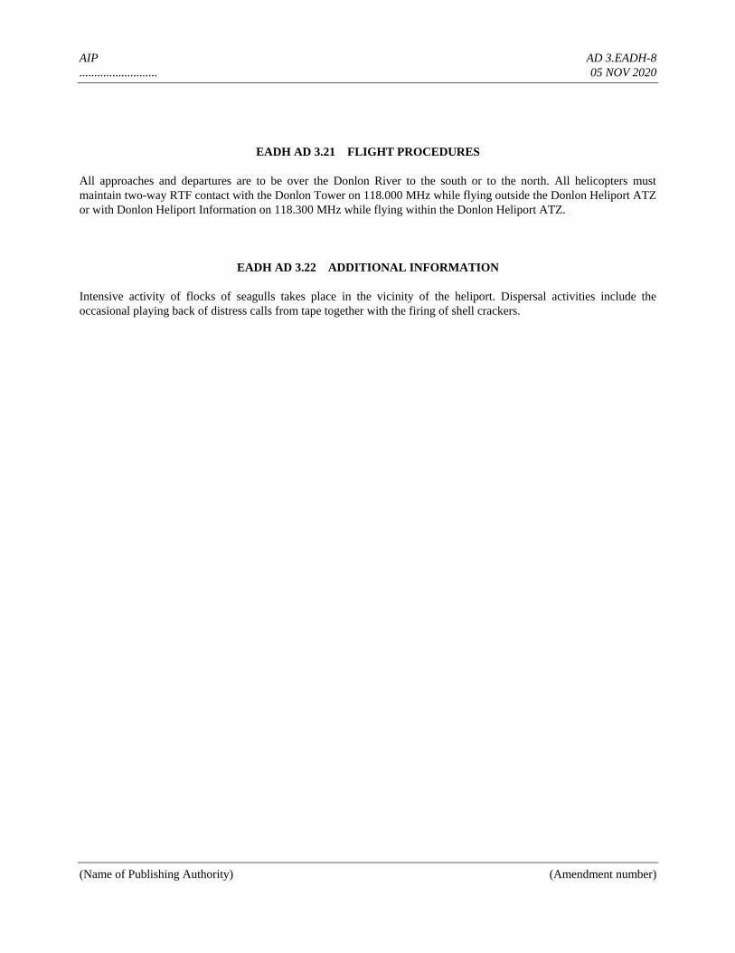
AIP AD 3.EADH-8
.......................... 05 NOV 2020
(Name of Publishing Authority) (Amendment number)
EADH AD 3.21 FLIGHT PROCEDURES
All approaches and departures are to be over the Donlon River to the south or to the north. All helicopters must
maintain two-way RTF contact with the Donlon Tower on 118.000 MHz while flying outside the Donlon Heliport ATZ
or with Donlon Heliport Information on 118.300 MHz while flying within the Donlon Heliport ATZ.
EADH AD 3.22 ADDITIONAL INFORMATION
Intensive activity of flocks of seagulls takes place in the vicinity of the heliport. Dispersal activities include the
occasional playing back of distress calls from tape together with the firing of shell crackers.
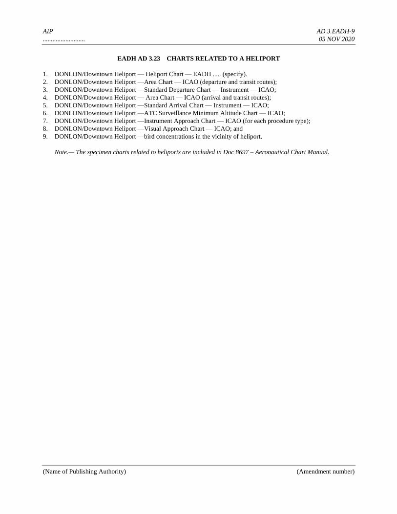
AIP AD 3.EADH-9
.......................... 05 NOV 2020
(Name of Publishing Authority) (Amendment number)
EADH AD 3.23 CHARTS RELATED TO A HELIPORT
1. DONLON/Downtown Heliport — Heliport Chart — EADH ..... (specify).
2. DONLON/Downtown Heliport —Area Chart — ICAO (departure and transit routes);
3. DONLON/Downtown Heliport —Standard Departure Chart — Instrument — ICAO;
4. DONLON/Downtown Heliport — Area Chart — ICAO (arrival and transit routes);
5. DONLON/Downtown Heliport —Standard Arrival Chart — Instrument — ICAO;
6. DONLON/Downtown Heliport —ATC Surveillance Minimum Altitude Chart — ICAO;
7. DONLON/Downtown Heliport —Instrument Approach Chart — ICAO (for each procedure type);
8. DONLON/Downtown Heliport —Visual Approach Chart — ICAO; and
9. DONLON/Downtown Heliport —bird concentrations in the vicinity of heliport.
Note.— The specimen charts related to heliports are included in Doc 8697 – Aeronautical Chart Manual.

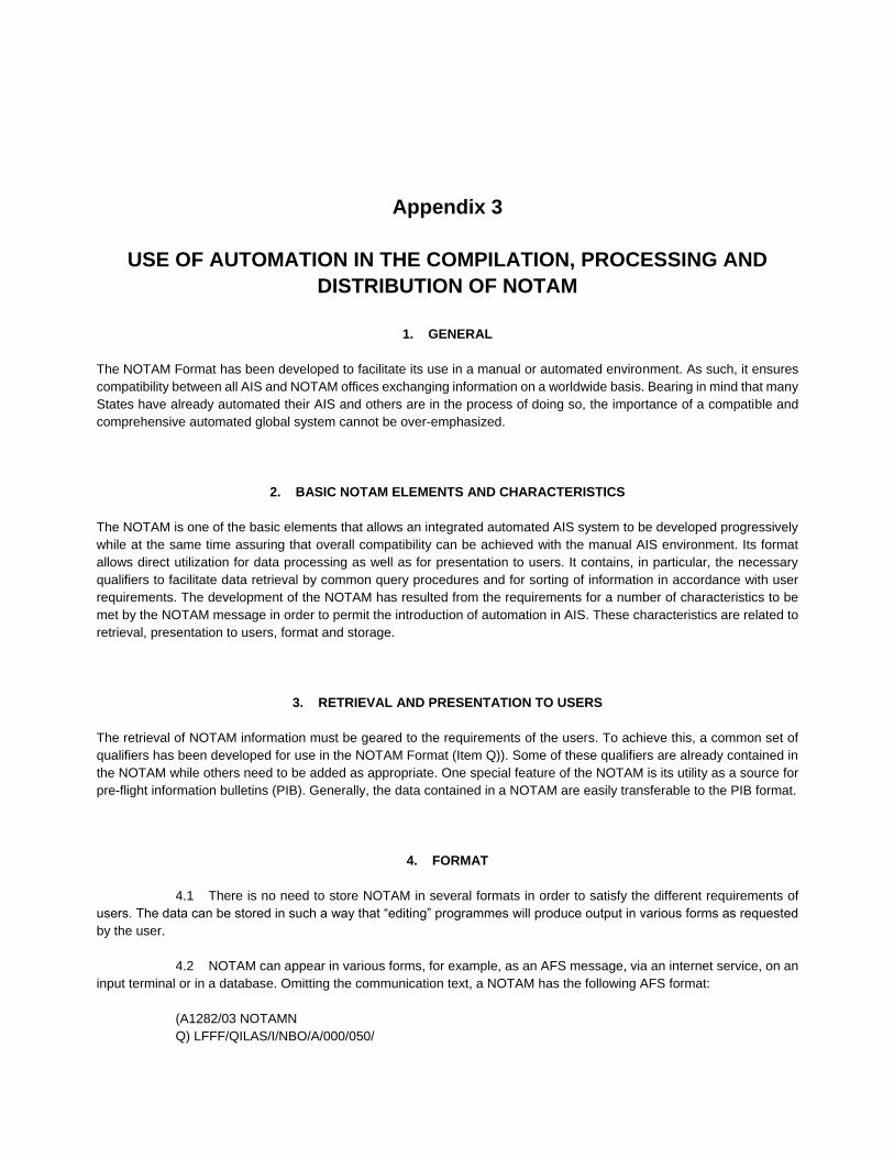
Appendix 3
USE OF AUTOMATION IN THE COMPILATION, PROCESSING AND
DISTRIBUTION OF NOTAM
1. GENERAL
The NOTAM Format has been developed to facilitate its use in a manual or automated environment. As such, it ensures
compatibility between all AIS and NOTAM offices exchanging information on a worldwide basis. Bearing in mind that many
States have already automated their AIS and others are in the process of doing so, the importance of a compatible and
comprehensive automated global system cannot be over-emphasized.
2. BASIC NOTAM ELEMENTS AND CHARACTERISTICS
The NOTAM is one of the basic elements that allows an integrated automated AIS system to be developed progressively
while at the same time assuring that overall compatibility can be achieved with the manual AIS environment. Its format
allows direct utilization for data processing as well as for presentation to users. It contains, in particular, the necessary
qualifiers to facilitate data retrieval by common query procedures and for sorting of information in accordance with user
requirements. The development of the NOTAM has resulted from the requirements for a number of characteristics to be
met by the NOTAM message in order to permit the introduction of automation in AIS. These characteristics are related to
retrieval, presentation to users, format and storage.
3. RETRIEVAL AND PRESENTATION TO USERS
The retrieval of NOTAM information must be geared to the requirements of the users. To achieve this, a common set of
qualifiers has been developed for use in the NOTAM Format (Item Q)). Some of these qualifiers are already contained in
the NOTAM while others need to be added as appropriate. One special feature of the NOTAM is its utility as a source for
pre-flight information bulletins (PIB). Generally, the data contained in a NOTAM are easily transferable to the PIB format.
4. FORMAT
4.1 There is no need to store NOTAM in several formats in order to satisfy the different requirements of
users. The data can be stored in such a way that “editing” programmes will produce output in various forms as requested
by the user.
4.2 NOTAM can appear in various forms, for example, as an AFS message, via an internet service, on an
input terminal or in a database. Omitting the communication text, a NOTAM has the following AFS format:
(A1282/03 NOTAMN
Q) LFFF/QILAS/I/NBO/A/000/050/
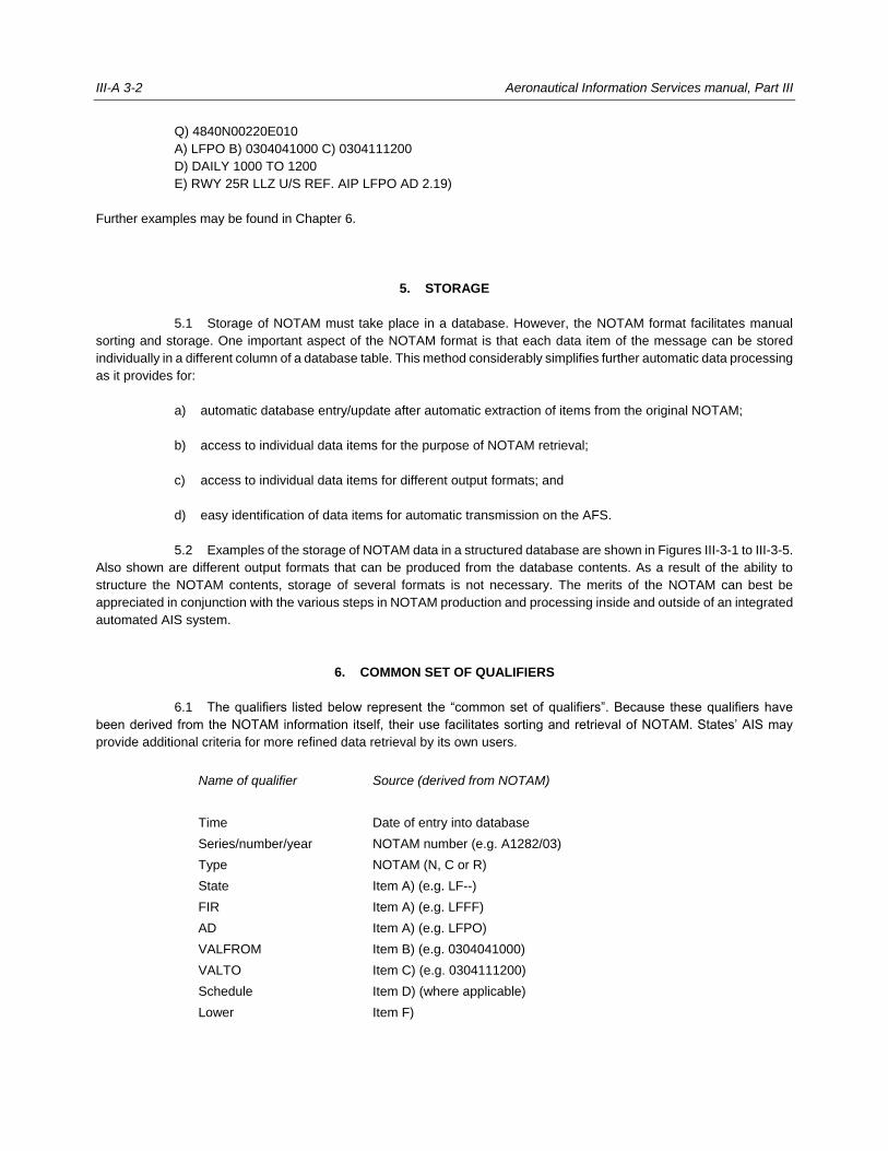
III-A 3-2 Aeronautical Information Services manual, Part III
Q) 4840N00220E010
A) LFPO B) 0304041000 C) 0304111200
D) DAILY 1000 TO 1200
E) RWY 25R LLZ U/S REF. AIP LFPO AD 2.19)
Further examples may be found in Chapter 6.
5. STORAGE
5.1 Storage of NOTAM must take place in a database. However, the NOTAM format facilitates manual
sorting and storage. One important aspect of the NOTAM format is that each data item of the message can be stored
individually in a different column of a database table. This method considerably simplifies further automatic data processing
as it provides for:
a) automatic database entry/update after automatic extraction of items from the original NOTAM;
b) access to individual data items for the purpose of NOTAM retrieval;
c) access to individual data items for different output formats; and
d) easy identification of data items for automatic transmission on the AFS.
5.2 Examples of the storage of NOTAM data in a structured database are shown in Figures III-3-1 to III-3-5.
Also shown are different output formats that can be produced from the database contents. As a result of the ability to
structure the NOTAM contents, storage of several formats is not necessary. The merits of the NOTAM can best be
appreciated in conjunction with the various steps in NOTAM production and processing inside and outside of an integrated
automated AIS system.
6. COMMON SET OF QUALIFIERS
6.1 The qualifiers listed below represent the “common set of qualifiers”. Because these qualifiers have
been derived from the NOTAM information itself, their use facilitates sorting and retrieval of NOTAM. States’ AIS may
provide additional criteria for more refined data retrieval by its own users.
Name of qualifier Source (derived from NOTAM)
Time Date of entry into database
Series/number/year NOTAM number (e.g. A1282/03)
Type NOTAM (N, C or R)
State Item A) (e.g. LF--)
FIR Item A) (e.g. LFFF)
AD Item A) (e.g. LFPO)
VALFROM Item B) (e.g. 0304041000)
VALTO Item C) (e.g. 0304111200)
Schedule Item D) (where applicable)
Lower Item F)
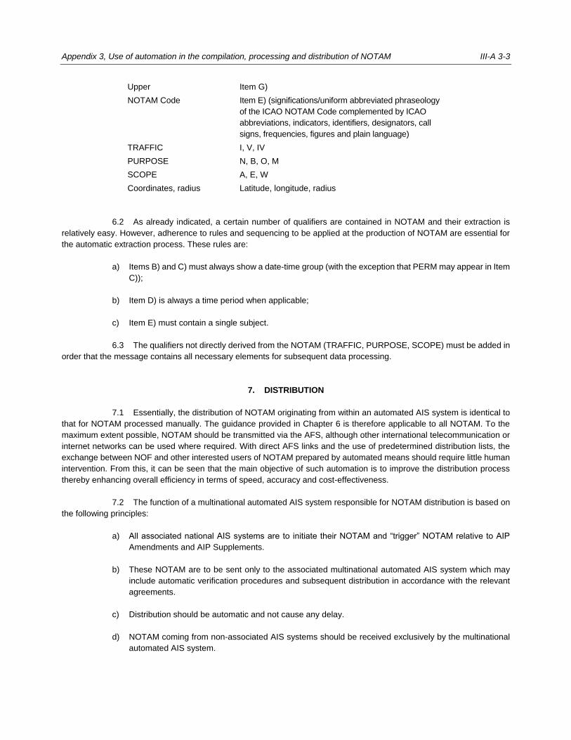
Appendix 3, Use of automation in the compilation, processing and distribution of NOTAM III-A 3-3
Upper Item G)
NOTAM Code Item E) (significations/uniform abbreviated phraseology
of the ICAO NOTAM Code complemented by ICAO
abbreviations, indicators, identifiers, designators, call
signs, frequencies, figures and plain language)
TRAFFIC I, V, IV
PURPOSE N, B, O, M
SCOPE A, E, W
Coordinates, radius Latitude, longitude, radius
6.2 As already indicated, a certain number of qualifiers are contained in NOTAM and their extraction is
relatively easy. However, adherence to rules and sequencing to be applied at the production of NOTAM are essential for
the automatic extraction process. These rules are:
a) Items B) and C) must always show a date-time group (with the exception that PERM may appear in Item
C));
b) Item D) is always a time period when applicable;
c) Item E) must contain a single subject.
6.3 The qualifiers not directly derived from the NOTAM (TRAFFIC, PURPOSE, SCOPE) must be added in
order that the message contains all necessary elements for subsequent data processing.
7. DISTRIBUTION
7.1 Essentially, the distribution of NOTAM originating from within an automated AIS system is identical to
that for NOTAM processed manually. The guidance provided in Chapter 6 is therefore applicable to all NOTAM. To the
maximum extent possible, NOTAM should be transmitted via the AFS, although other international telecommunication or
internet networks can be used where required. With direct AFS links and the use of predetermined distribution lists, the
exchange between NOF and other interested users of NOTAM prepared by automated means should require little human
intervention. From this, it can be seen that the main objective of such automation is to improve the distribution process
thereby enhancing overall efficiency in terms of speed, accuracy and cost-effectiveness.
7.2 The function of a multinational automated AIS system responsible for NOTAM distribution is based on
the following principles:
a) All associated national AIS systems are to initiate their NOTAM and “trigger” NOTAM relative to AIP
Amendments and AIP Supplements.
b) These NOTAM are to be sent only to the associated multinational automated AIS system which may
include automatic verification procedures and subsequent distribution in accordance with the relevant
agreements.
c) Distribution should be automatic and not cause any delay.
d) NOTAM coming from non-associated AIS systems should be received exclusively by the multinational
automated AIS system.
III-A 3-4 Aeronautical Information Services manual, Part III
e) For any AIP Supplements containing information that should be included in PIB, the multinational
automated AIS system concerned must produce and distribute a “trigger” NOTAM.
f) NOTAM received that are not of particular interest to its own State should nevertheless be stored in its
database. Thus, each multinational automated AIS system would have worldwide NOTAM and “trigger”
NOTAM relative to AIP Amendments and AIP Supplements available in its database for preparation of
PIB.
g) Any NOTAM processed is to be sent as a new message with the multinational automated AIS system
concerned being the originator.
h) All NOTAM are to be sent via AFS taking into account the AFS distribution procedures currently in use.
i) Each associated national system is to be responsible for the provision of NOTAM to users in its own
territory.
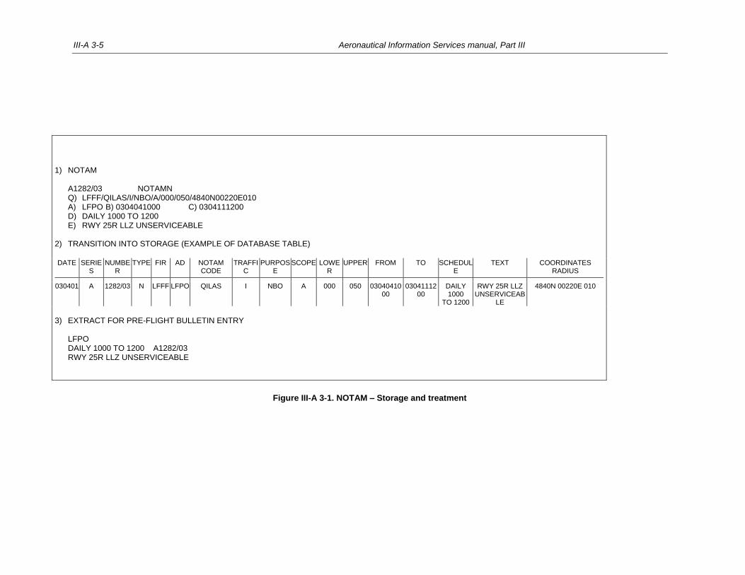
III-A 3-5 Aeronautical Information Services manual, Part III
1) NOTAM A1282/03 NOTAMN Q) LFFF/QILAS/I/NBO/A/000/050/4840N00220E010 A) LFPO B) 0304041000 C) 0304111200 D) DAILY 1000 TO 1200 E) RWY 25R LLZ UNSERVICEABLE 2) TRANSITION INTO STORAGE (EXAMPLE OF DATABASE TABLE)
DATE SERIES
NUMBER
TYPE FIR AD NOTAM CODE
TRAFFIC
PURPOSE
SCOPE LOWER
UPPER FROM TO SCHEDULE
TEXT COORDINATES RADIUS
030401 A 1282/03 N LFFF LFPO QILAS I NBO A 000 050 0304041000
0304111200
DAILY 1000
TO 1200
RWY 25R LLZ UNSERVICEAB
LE
4840N 00220E 010
3) EXTRACT FOR PRE-FLIGHT BULLETIN ENTRY LFPO DAILY 1000 TO 1200 A1282/03 RWY 25R LLZ UNSERVICEABLE
Figure III-A 3-1. NOTAM – Storage and treatment

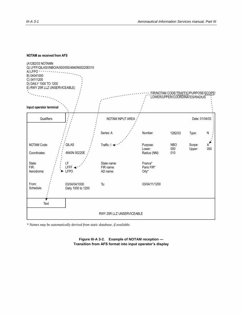
III-A 3-1 Aeronautical Information Services manual, Part III
Figure III-A 3-2. Example of NOTAM reception —
Transition from AFS format into input operator’s display
NOTAM as received from AFS
(A1282/03 NOTAMNQ) LFFF/QILAS/I/NBO/A/000/050/4840N00220E010A) LFPOB) 04041000C) 04111200D) DAILY 1000 TO 1200E) RWY 25R LLZ UNSERVICEABLE)
FIR/NOTAM CODE/TRAFFIC/PURPOSE/SCOPE/LOWER/UPPER/COORDINATES/RADIUS
Input operator terminal
NOTAM INPUT AREA
Series: A 1282/03 Type:
NOTAM Code:
Coordinates:
QILAS
4840N 00220E
Purpose:Lower:Radius (NM):
Traffic: I NBO000010
NNumber:
Qualifiers Date: 01/04/03
Scope:Upper:
A050
* Names may be automatically derived from static database, if available.
State:FIR:Aerodrome:
LFLFFFLFPO
State name:FIR name:AD name:
France*Paris FIR*Orly*
From:Schedule:
03/04/04/1000Daily 1000 to 1200
To:
Text
RWY 25R LLZ UNSERVICEABLE
03/04/11/1200
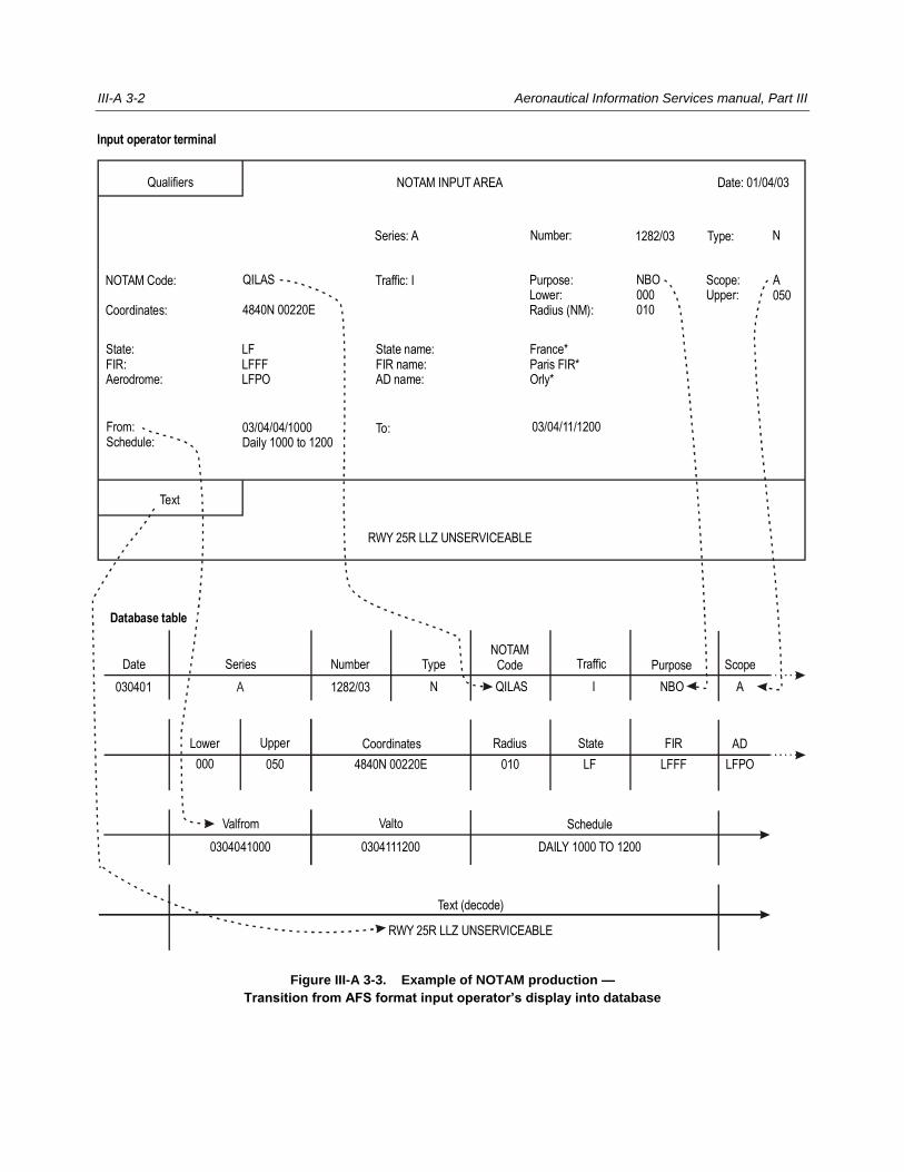
III-A 3-2 Aeronautical Information Services manual, Part III
Figure III-A 3-3. Example of NOTAM production —
Transition from AFS format input operator’s display into database
Input operator terminal
NOTAM INPUT AREA
Series: A 1282/03 Type:
NOTAM Code:
Coordinates:
QILAS
4840N 00220E
Purpose:Lower:Radius (NM):
Traffic: I NBO000010
NNumber:
Qualifiers Date: 01/04/03
Scope:Upper:
A050
State:FIR:Aerodrome:
LFLFFFLFPO
State name:FIR name:AD name:
France*Paris FIR*Orly*
From:Schedule:
03/04/04/1000Daily 1000 to 1200
To:
Text
RWY 25R LLZ UNSERVICEABLE
Database table
Date Series Number TypeNOTAM
Code Traffic Purpose Scope
030401
Lower Upper Coordinates Radius State FIR AD
A 1282/03
000 050 4840N 00220E 010 LF LFFF LFPO
Valfrom Valto Schedule
0304041000 0304111200 DAILY 1000 TO 1200
Text (decode)
RWY 25R LLZ UNSERVICEABLE
N QILAS I NBO A
03/04/11/1200

Appendix 3, Use of automation in the compilation, processing and distribution of NOTAM III-A 3-3
Figure III-A 3-4. Example of AFS NOTAM Format reconstruction from database contents
Database table
Date Series Number TypeNOTAM
Code Traffic Purpose Scope
030401
Lower Upper Coordinates Radius State FIR AD
A 1282/03
000 050 4840N 00220E 010 LF LFFF LFPO
Valfrom Valto Schedule
0304041000 0304111200 DAILY 1000 TO 1200
Text (decode)
RWY 25R LLZ UNSERVICEABLE
N QILAS I NBO A
Reconstructed NOTAM
(A1282/03 NOTAMN
Q) LFFF/QILAS/I/NBO/A/000/050/4840N00220E010
A) LFPO B) 0304041000 C) 0304111200
D) DAILY 1000 TO 1200
E) RWY 25R LLZ UNSERVICEABLE)
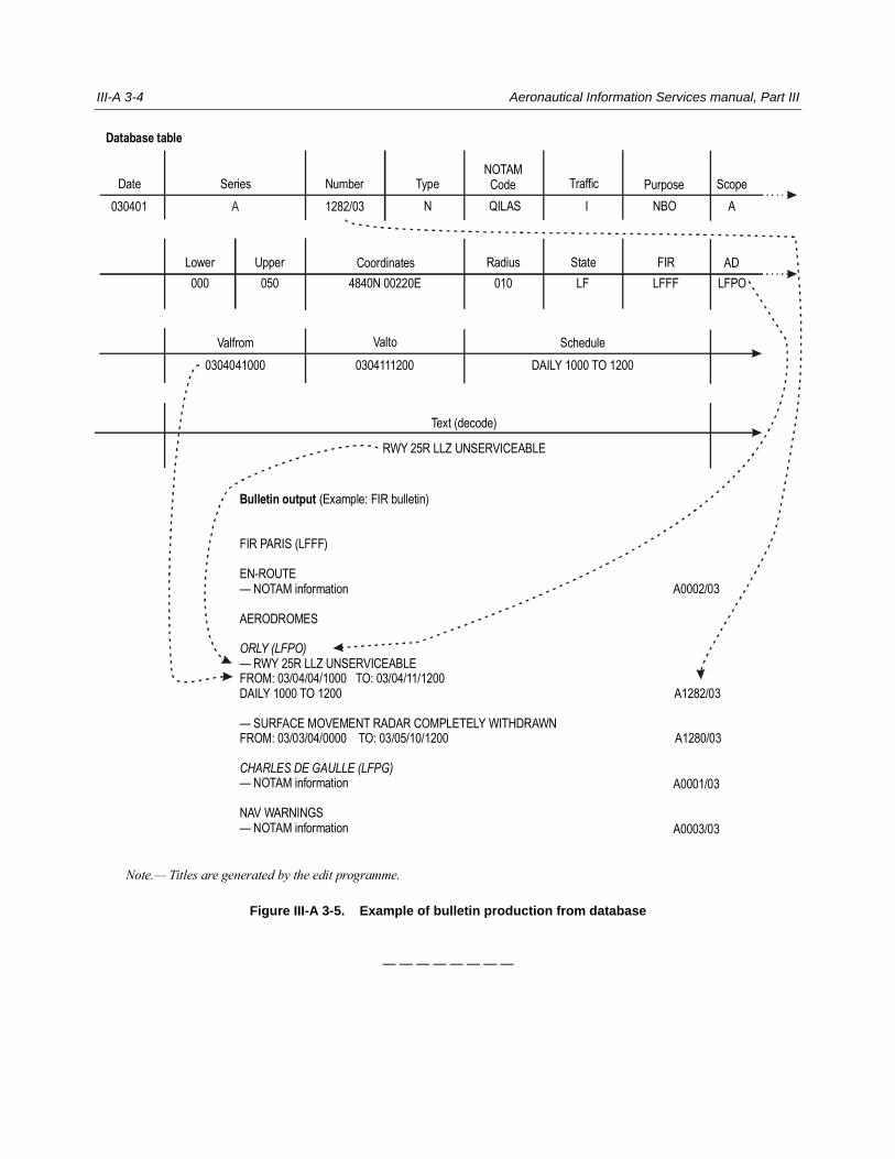
III-A 3-4 Aeronautical Information Services manual, Part III
Figure III-A 3-5. Example of bulletin production from database
— — — — — — — —
Database table
Date Series Number TypeNOTAMCode Traffic Purpose Scope
030401
Lower Upper Coordinates Radius State FIR AD
A 1282/03
000 050 4840N 00220E 010 LF LFFF LFPO
Valfrom Valto Schedule
0304041000 0304111200 DAILY 1000 TO 1200
Text (decode)
RWY 25R LLZ UNSERVICEABLE
N QILAS I NBO A
Bulletin output (Example: FIR bulletin)
FIR PARIS (LFFF)
EN-ROUTE— NOTAM information
AERODROMES
— RWY 25R LLZ UNSERVICEABLEFROM: 03/04/04/1000 TO: 03/04/11/1200DAILY 1000 TO 1200
— SURFACE MOVEMENT RADAR COMPLETELY WITHDRAWNFROM: 03/03/04/0000 TO: 03/05/10/1200
— NOTAM information
NAV WARNINGS— NOTAM information
ORLY (LFPO)
CHARLES DE GAULLE (LFPG)
Note.— Titles are generated by the edit programme.
A0002/03
A1282/03
A1280/03
A0001/03
A0003/03
Appendix 4
COMMON AIS QUERY PROCEDURES FOR SELF-BRIEFING BY END-
USERS
1. The examples that follow contain suggested common AIS query procedures for use in a self-briefing
environment. Implementation of these procedures would enable end-users (pilots and flight operations personnel) to
directly obtain required information from any aerodrome/heliport AIS unit participating in an integrated regional automated
AIS system.
2. Because of local hardware and software requirements, the commonality is limited to the sequence and
the contents of the frames presented. The keying used for interacting with the system may change depending on the
hardware or software configuration. It is important, however, that all inputs be kept as simple as possible, preferably single
key inputs, while ensuring that appropriate help menus are always available.
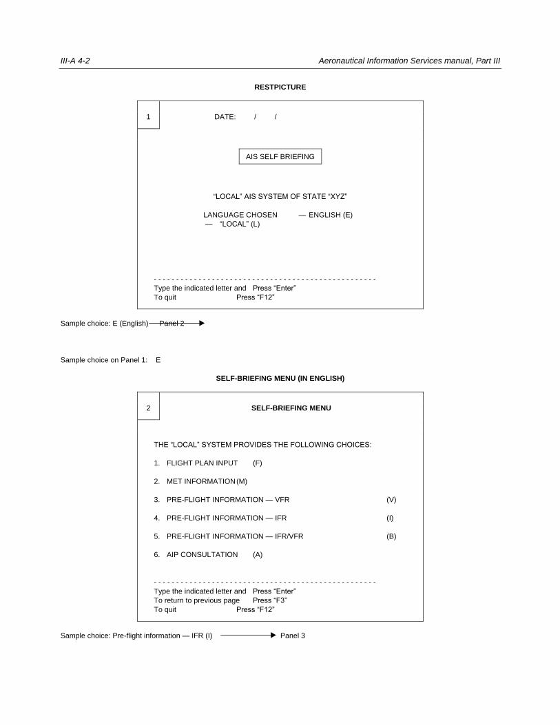
III-A 4-2 Aeronautical Information Services manual, Part III
RESTPICTURE
1 DATE: / /
AIS SELF BRIEFING
“LOCAL” AIS SYSTEM OF STATE “XYZ”
LANGUAGE CHOSEN — ENGLISH (E)
— “LOCAL” (L)
- - - - - - - - - - - - - - - - - - - - - - - - - - - - - - - - - - - - - - - - - - - - - - - - - -
Type the indicated letter and Press “Enter”
To quit Press “F12”
Sample choice: E (English) Panel 2
Sample choice on Panel 1: E
SELF-BRIEFING MENU (IN ENGLISH)
2 SELF-BRIEFING MENU
THE “LOCAL” SYSTEM PROVIDES THE FOLLOWING CHOICES:
1. FLIGHT PLAN INPUT (F)
2. MET INFORMATION (M)
3. PRE-FLIGHT INFORMATION — VFR (V)
4. PRE-FLIGHT INFORMATION — IFR (I)
5. PRE-FLIGHT INFORMATION — IFR/VFR (B)
6. AIP CONSULTATION (A)
- - - - - - - - - - - - - - - - - - - - - - - - - - - - - - - - - - - - - - - - - - - - - - - - - -
Type the indicated letter and Press “Enter”
To return to previous page Press “F3”
To quit Press “F12”
Sample choice: Pre-flight information — IFR (I) Panel 3
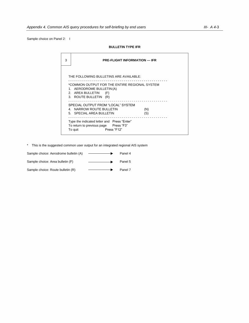
Appendix 4. Common AIS query procedures for self-briefing by end users III- A 4-3
Sample choice on Panel 2: I
BULLETIN TYPE IFR
3 PRE-FLIGHT INFORMATION — IFR
THE FOLLOWING BULLETINS ARE AVAILABLE:
- - - - - - - - - - - - - - - - - - - - - - - - - - - - - - - - - - - - - - - - - - - - - - - - - -
*COMMON OUTPUT FOR THE ENTIRE REGIONAL SYSTEM
1. AERODROME BULLETIN (A)
2. AREA BULLETIN (F)
3. ROUTE BULLETIN (R)
- - - - - - - - - - - - - - - - - - - - - - - - - - - - - - - - - - - - - - - - - - - - - - - - - -
SPECIAL OUTPUT FROM “LOCAL” SYSTEM
4. NARROW ROUTE BULLETIN (N)
5. SPECIAL AREA BULLETIN (S)
- - - - - - - - - - - - - - - - - - - - - - - - - - - - - - - - - - - - - - - - - - - - - - - - - -
Type the indicated letter and Press “Enter”
To return to previous page Press “F3”
To quit Press “F12”
* This is the suggested common user output for an integrated regional AIS system
Sample choice: Aerodrome bulletin (A) Panel 4
Sample choice: Area bulletin (F) Panel 5
Sample choice: Route bulletin (R) Panel 7
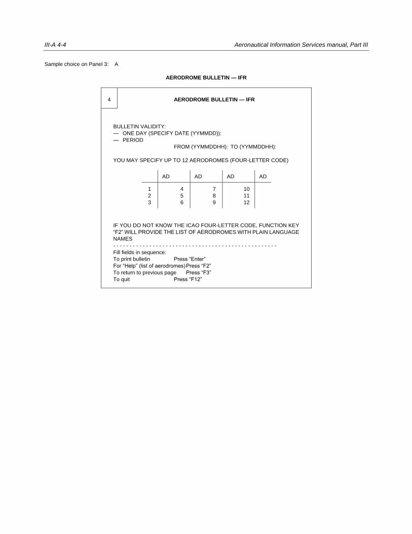
III-A 4-4 Aeronautical Information Services manual, Part III
Sample choice on Panel 3: A
AERODROME BULLETIN — IFR
4 AERODROME BULLETIN — IFR
BULLETIN VALIDITY:
— ONE DAY (SPECIFY DATE (YYMMDD)):
— PERIOD
FROM (YYMMDDHH): TO (YYMMDDHH):
YOU MAY SPECIFY UP TO 12 AERODROMES (FOUR-LETTER CODE)
AD AD AD AD
1
2
3
4
5
6
7
8
9
10
11
12
IF YOU DO NOT KNOW THE ICAO FOUR-LETTER CODE, FUNCTION KEY
“F2” WILL PROVIDE THE LIST OF AERODROMES WITH PLAIN LANGUAGE
NAMES
- - - - - - - - - - - - - - - - - - - - - - - - - - - - - - - - - - - - - - - - - - - - - - - - - -
Fill fields in sequence:
To print bulletin Press “Enter”
For “Help” (list of aerodromes) Press “F2”
To return to previous page Press “F3”
To quit Press “F12”
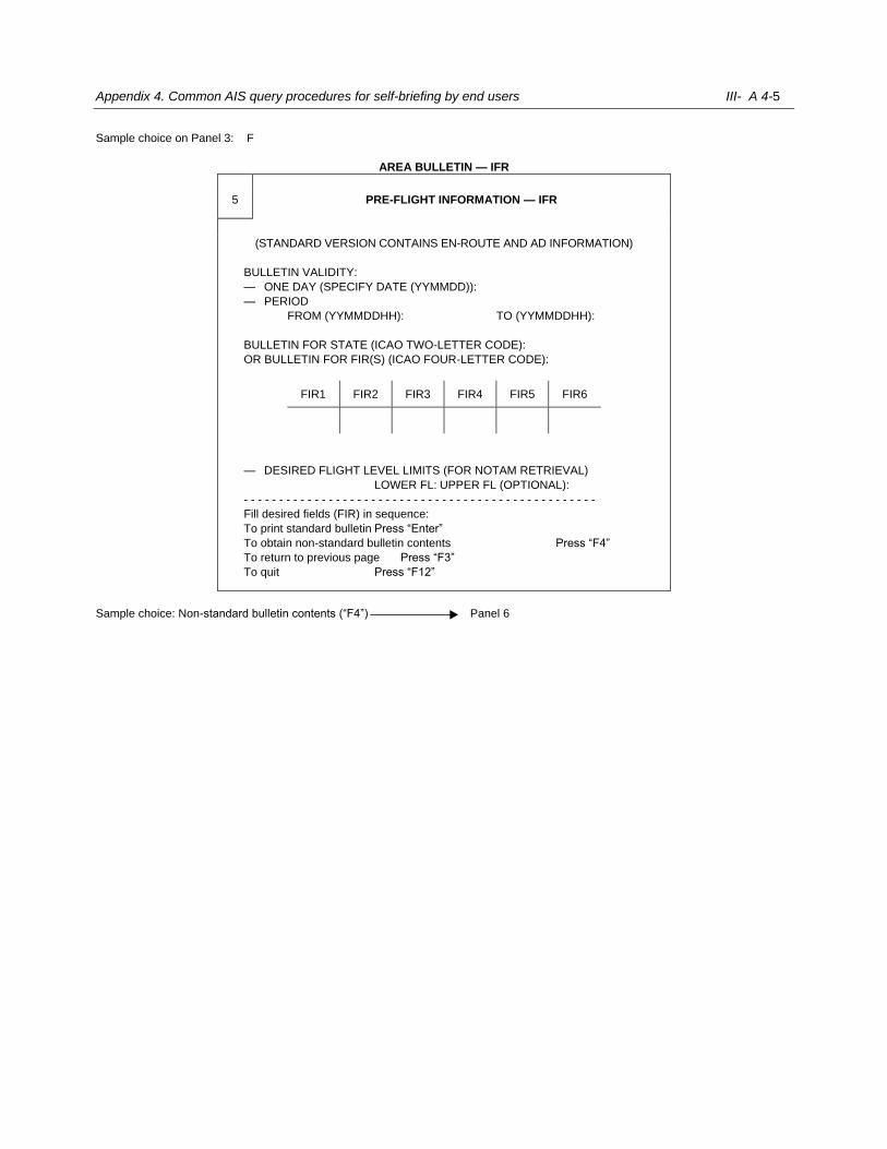
Appendix 4. Common AIS query procedures for self-briefing by end users III- A 4-5
Sample choice on Panel 3: F
AREA BULLETIN — IFR
5 PRE-FLIGHT INFORMATION — IFR
(STANDARD VERSION CONTAINS EN-ROUTE AND AD INFORMATION)
BULLETIN VALIDITY:
— ONE DAY (SPECIFY DATE (YYMMDD)):
— PERIOD
FROM (YYMMDDHH): TO (YYMMDDHH):
BULLETIN FOR STATE (ICAO TWO-LETTER CODE):
OR BULLETIN FOR FIR(S) (ICAO FOUR-LETTER CODE):
FIR1 FIR2 FIR3 FIR4 FIR5 FIR6
— DESIRED FLIGHT LEVEL LIMITS (FOR NOTAM RETRIEVAL)
LOWER FL: UPPER FL (OPTIONAL):
- - - - - - - - - - - - - - - - - - - - - - - - - - - - - - - - - - - - - - - - - - - - - - - - - -
Fill desired fields (FIR) in sequence:
To print standard bulletin Press “Enter”
To obtain non-standard bulletin contents Press “F4”
To return to previous page Press “F3”
To quit Press “F12”
Sample choice: Non-standard bulletin contents (“F4”) Panel 6
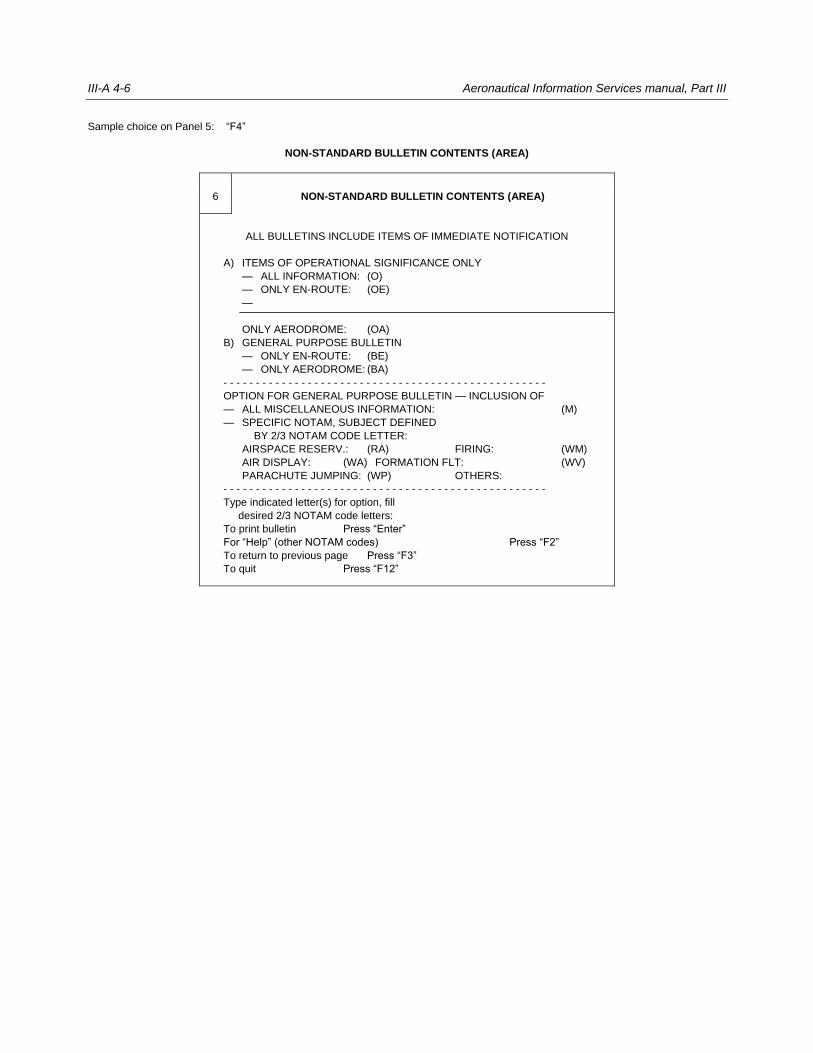
III-A 4-6 Aeronautical Information Services manual, Part III
Sample choice on Panel 5: “F4”
NON-STANDARD BULLETIN CONTENTS (AREA)
6 NON-STANDARD BULLETIN CONTENTS (AREA)
ALL BULLETINS INCLUDE ITEMS OF IMMEDIATE NOTIFICATION
A) ITEMS OF OPERATIONAL SIGNIFICANCE ONLY
— ALL INFORMATION: (O)
— ONLY EN-ROUTE: (OE)
—
ONLY AERODROME: (OA)
B) GENERAL PURPOSE BULLETIN
— ONLY EN-ROUTE: (BE)
— ONLY AERODROME: (BA)
- - - - - - - - - - - - - - - - - - - - - - - - - - - - - - - - - - - - - - - - - - - - - - - - - -
OPTION FOR GENERAL PURPOSE BULLETIN — INCLUSION OF
— ALL MISCELLANEOUS INFORMATION: (M)
— SPECIFIC NOTAM, SUBJECT DEFINED
BY 2/3 NOTAM CODE LETTER:
AIRSPACE RESERV.: (RA) FIRING: (WM)
AIR DISPLAY: (WA) FORMATION FLT: (WV)
PARACHUTE JUMPING: (WP) OTHERS:
- - - - - - - - - - - - - - - - - - - - - - - - - - - - - - - - - - - - - - - - - - - - - - - - - -
Type indicated letter(s) for option, fill
desired 2/3 NOTAM code letters:
To print bulletin Press “Enter”
For “Help” (other NOTAM codes) Press “F2”
To return to previous page Press “F3”
To quit Press “F12”
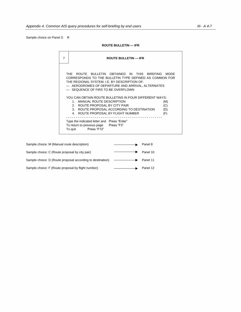
Appendix 4. Common AIS query procedures for self-briefing by end users III- A 4-7
Sample choice on Panel 3: R
ROUTE BULLETIN — IFR
7 ROUTE BULLETIN — IFR
THE ROUTE BULLETIN OBTAINED IN THIS BIREFING MODE
CORRESPONDS TO THE BULLETIN TYPE DEFINED AS COMMON FOR
THE REGIONAL SYSTEM, I.E. BY DESCRIPTION OF:
— AERODROMES OF DEPARTURE AND ARRIVAL, ALTERNATES
— SEQUENCE OF FIRS TO BE OVERFLOWN
YOU CAN OBTAIN ROUTE BULLETINS IN FOUR DIFFERENT WAYS:
1. MANUAL ROUTE DESCRIPTION (M)
2. ROUTE PROPOSAL BY CITY PAIR (C)
3. ROUTE PROPOSAL ACCORDING TO DESTINATION (D)
4. ROUTE PROPOSAL BY FLIGHT NUMBER (F)
- - - - - - - - - - - - - - - - - - - - - - - - - - - - - - - - - - - - - - - - - - - - - - - - - -
Type the indicated letter and Press “Enter”
To return to previous page Press “F3”
To quit Press “F12”
Sample choice: M (Manual route description) Panel 8
Sample choice: C (Route proposal by city pair) Panel 10
Sample choice: D (Route proposal according to destination) Panel 11
Sample choice: F (Route proposal by flight number) Panel 12
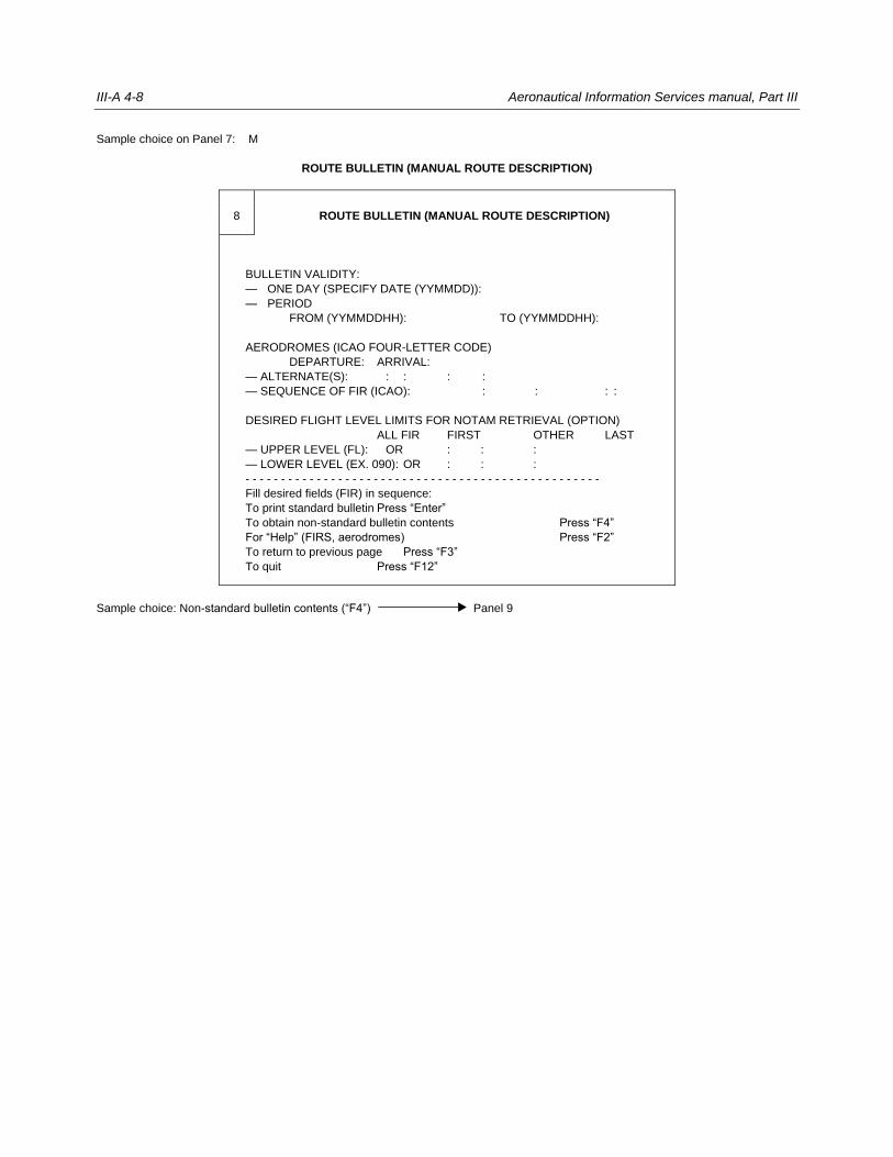
III-A 4-8 Aeronautical Information Services manual, Part III
Sample choice on Panel 7: M
ROUTE BULLETIN (MANUAL ROUTE DESCRIPTION)
8 ROUTE BULLETIN (MANUAL ROUTE DESCRIPTION)
BULLETIN VALIDITY:
— ONE DAY (SPECIFY DATE (YYMMDD)):
— PERIOD
FROM (YYMMDDHH): TO (YYMMDDHH):
AERODROMES (ICAO FOUR-LETTER CODE)
DEPARTURE: ARRIVAL:
— ALTERNATE(S): : : : :
— SEQUENCE OF FIR (ICAO): : : : :
DESIRED FLIGHT LEVEL LIMITS FOR NOTAM RETRIEVAL (OPTION)
ALL FIR FIRST OTHER LAST
— UPPER LEVEL (FL): OR : : :
— LOWER LEVEL (EX. 090): OR : : :
- - - - - - - - - - - - - - - - - - - - - - - - - - - - - - - - - - - - - - - - - - - - - - - - - -
Fill desired fields (FIR) in sequence:
To print standard bulletin Press “Enter”
To obtain non-standard bulletin contents Press “F4”
For “Help” (FIRS, aerodromes) Press “F2”
To return to previous page Press “F3”
To quit Press “F12”
Sample choice: Non-standard bulletin contents (“F4”) Panel 9
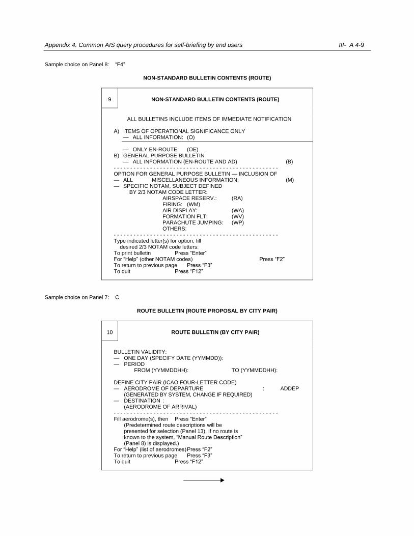
Appendix 4. Common AIS query procedures for self-briefing by end users III- A 4-9
Sample choice on Panel 8: “F4”
NON-STANDARD BULLETIN CONTENTS (ROUTE)
9 NON-STANDARD BULLETIN CONTENTS (ROUTE)
ALL BULLETINS INCLUDE ITEMS OF IMMEDIATE NOTIFICATION
A) ITEMS OF OPERATIONAL SIGNIFICANCE ONLY — ALL INFORMATION: (O)
— ONLY EN-ROUTE: (OE) B) GENERAL PURPOSE BULLETIN — ALL INFORMATION (EN-ROUTE AND AD) (B) - - - - - - - - - - - - - - - - - - - - - - - - - - - - - - - - - - - - - - - - - - - - - - - - - - OPTION FOR GENERAL PURPOSE BULLETIN — INCLUSION OF — ALL MISCELLANEOUS INFORMATION: (M) — SPECIFIC NOTAM, SUBJECT DEFINED BY 2/3 NOTAM CODE LETTER: AIRSPACE RESERV.: (RA) FIRING: (WM) AIR DISPLAY: (WA) FORMATION FLT: (WV) PARACHUTE JUMPING: (WP) OTHERS: - - - - - - - - - - - - - - - - - - - - - - - - - - - - - - - - - - - - - - - - - - - - - - - - - - Type indicated letter(s) for option, fill desired 2/3 NOTAM code letters: To print bulletin Press “Enter” For “Help” (other NOTAM codes) Press “F2” To return to previous page Press “F3” To quit Press “F12”
Sample choice on Panel 7: C
ROUTE BULLETIN (ROUTE PROPOSAL BY CITY PAIR)
10 ROUTE BULLETIN (BY CITY PAIR)
BULLETIN VALIDITY: — ONE DAY (SPECIFY DATE (YYMMDD)): — PERIOD FROM (YYMMDDHH): TO (YYMMDDHH): DEFINE CITY PAIR (ICAO FOUR-LETTER CODE) — AERODROME OF DEPARTURE : ADDEP (GENERATED BY SYSTEM, CHANGE IF REQUIRED) — DESTINATION : (AERODROME OF ARRIVAL) - - - - - - - - - - - - - - - - - - - - - - - - - - - - - - - - - - - - - - - - - - - - - - - - - - Fill aerodrome(s), then Press “Enter” (Predetermined route descriptions will be
presented for selection (Panel 13). If no route is known to the system, “Manual Route Description” (Panel 8) is displayed.)
For “Help” (list of aerodromes) Press “F2” To return to previous page Press “F3” To quit Press “F12”

III-A 4-10 Aeronautical Information Services manual, Part III
Sample choice: Display of predetermined routes (“Enter”) Panel 13
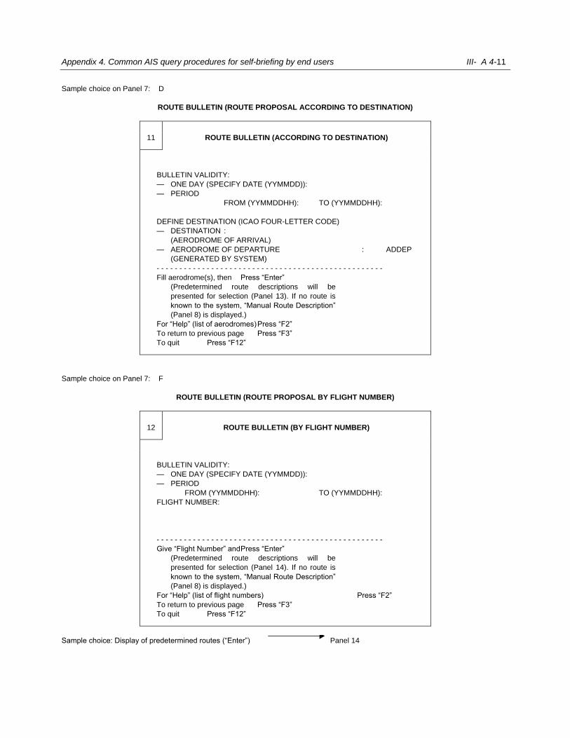
Appendix 4. Common AIS query procedures for self-briefing by end users III- A 4-11
Sample choice on Panel 7: D
ROUTE BULLETIN (ROUTE PROPOSAL ACCORDING TO DESTINATION)
11 ROUTE BULLETIN (ACCORDING TO DESTINATION)
BULLETIN VALIDITY:
— ONE DAY (SPECIFY DATE (YYMMDD)):
— PERIOD
FROM (YYMMDDHH): TO (YYMMDDHH):
DEFINE DESTINATION (ICAO FOUR-LETTER CODE)
— DESTINATION :
(AERODROME OF ARRIVAL)
— AERODROME OF DEPARTURE : ADDEP
(GENERATED BY SYSTEM)
- - - - - - - - - - - - - - - - - - - - - - - - - - - - - - - - - - - - - - - - - - - - - - - - - -
Fill aerodrome(s), then Press “Enter”
(Predetermined route descriptions will be
presented for selection (Panel 13). If no route is
known to the system, “Manual Route Description”
(Panel 8) is displayed.)
For “Help” (list of aerodromes) Press “F2”
To return to previous page Press “F3”
To quit Press “F12”
Sample choice on Panel 7: F
ROUTE BULLETIN (ROUTE PROPOSAL BY FLIGHT NUMBER)
12 ROUTE BULLETIN (BY FLIGHT NUMBER)
BULLETIN VALIDITY:
— ONE DAY (SPECIFY DATE (YYMMDD)):
— PERIOD
FROM (YYMMDDHH): TO (YYMMDDHH):
FLIGHT NUMBER:
- - - - - - - - - - - - - - - - - - - - - - - - - - - - - - - - - - - - - - - - - - - - - - - - - -
Give “Flight Number” and Press “Enter”
(Predetermined route descriptions will be
presented for selection (Panel 14). If no route is
known to the system, “Manual Route Description”
(Panel 8) is displayed.)
For “Help” (list of flight numbers) Press “F2”
To return to previous page Press “F3”
To quit Press “F12”
Sample choice: Display of predetermined routes (“Enter”) Panel 14
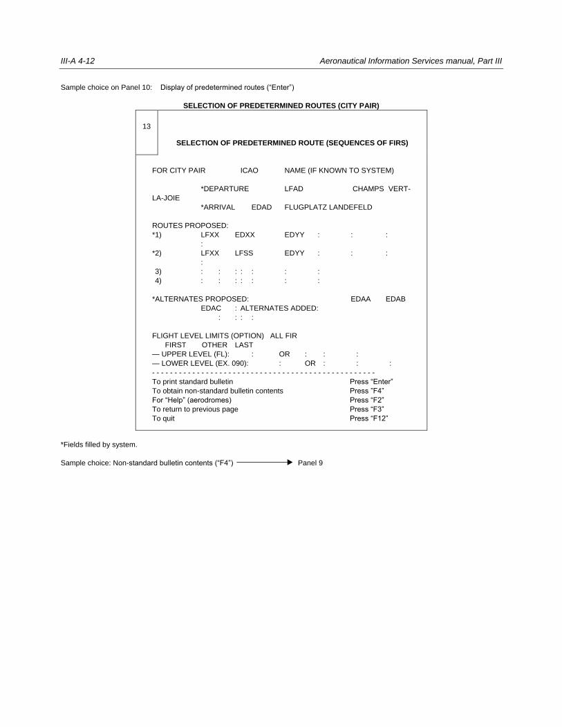
III-A 4-12 Aeronautical Information Services manual, Part III
Sample choice on Panel 10: Display of predetermined routes (“Enter”)
SELECTION OF PREDETERMINED ROUTES (CITY PAIR)
13
SELECTION OF PREDETERMINED ROUTE (SEQUENCES OF FIRS)
FOR CITY PAIR ICAO NAME (IF KNOWN TO SYSTEM)
*DEPARTURE LFAD CHAMPS VERT-
LA-JOIE
*ARRIVAL EDAD FLUGPLATZ LANDEFELD
ROUTES PROPOSED:
*1) LFXX EDXX EDYY : : :
:
*2) LFXX LFSS EDYY : : :
:
*3) : : : : : : :
*4) : : : : : : :
*ALTERNATES PROPOSED: EDAA EDAB
EDAC : ALTERNATES ADDED:
: : : :
FLIGHT LEVEL LIMITS (OPTION) ALL FIR
FIRST OTHER LAST
— UPPER LEVEL (FL): : OR : : :
— LOWER LEVEL (EX. 090): : OR : : :
- - - - - - - - - - - - - - - - - - - - - - - - - - - - - - - - - - - - - - - - - - - - - - - - - -
To print standard bulletin Press “Enter”
To obtain non-standard bulletin contents Press ”F4”
For “Help” (aerodromes) Press “F2”
To return to previous page Press “F3”
To quit Press “F12”
*Fields filled by system.
Sample choice: Non-standard bulletin contents (“F4”) Panel 9
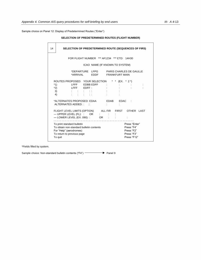
Appendix 4. Common AIS query procedures for self-briefing by end users III- A 4-13
Sample choice on Panel 12: Display of Predetermined Routes (“Enter”)
SELECTION OF PREDETERMINED ROUTES (FLIGHT NUMBER)
14 SELECTION OF PREDETERMINED ROUTE (SEQUENCES OF FIRS)
FOR FLIGHT NUMBER *** AF1234 *** ETD: 14H30
ICAO NAME (IF KNOWN TO SYSTEM)
*DEPARTURE LFPG PARIS CHARLES DE GAULLE
*ARRIVAL EDDF FRANKFURT MAIN
ROUTES PROPOSED: YOUR SELECTION * * (EX. * 2 *)
*1) LFFF EDBB EDFF : : : :
*2) LFFF EDFF : : : : :
*3) : : : : : : :
*4) : : : : : : :
*ALTERNATES PROPOSED: EDAA EDAB EDAC :
ALTERNATES ADDED: : : : : :
FLIGHT LEVEL LIMITS (OPTION) ALL FIR FIRST OTHER LAST
— UPPER LEVEL (FL): : OR : : :
— LOWER LEVEL (EX. 090): : OR : : :
- - - - - - - - - - - - - - - - - - - - - - - - - - - - - - - - - - - - - - - - - - - - - - - - - -
To print standard bulletin Press “Enter”
To obtain non-standard bulletin contents Press ”F4”
For “Help” (aerodromes) Press “F2”
To return to previous page Press “F3”
To quit Press “F12”
*Fields filled by system.
Sample choice: Non-standard bulletin contents (“F4”) Panel 9
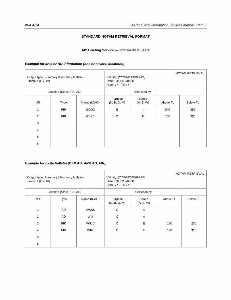
III-A 4-14 Aeronautical Information Services manual, Part III
STANDARD NOTAM RETRIEVAL FORMAT
AIS Briefing Service — Intermediate users
Example for area or AD information (one or several locations)
Output type: Summary (Summary bulletin)
Traffic: I (I, V, IV)
NOTAM RETRIEVAL
Validity: (YY/MM/DD/HHMM)
Date: 03/05/12/0800
From: / / / To: / / /
Location (State, FIR, AD) Selection by:
NR Type Name (ICAO)
Purpose
(N, B, O, M)
Scope
(A, E, W) Above FL Below FL
1 FIR GOOO B – 000 250
2 FIR GVSC O E 100 250
3
4
5
6
Example for route bulletin (DEP AD, ARR AD, FIR)
Output type: Summary (Summary bulletin)
Traffic: I (I, V, IV)
NOTAM RETRIEVAL
Validity: (YY/MM/DD/HHMM)
Date: 03/05/12/0800
From: / / / To: / / /
Location (State, FIR, AD) Selection by:
NR Type Name (ICAO) Purpose
(N, B, O, M)
Scope
(A, E, W)
Above FL Below FL
1 AD WSSS O A
2 AD WIII O A
3 FIR WSJC O E 120 250
4 FIR WIIZ O E 120 310
5
6
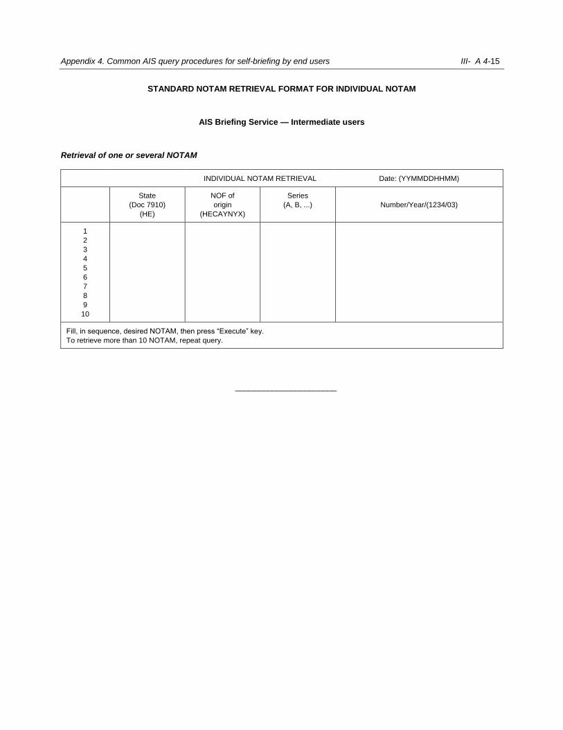
Appendix 4. Common AIS query procedures for self-briefing by end users III- A 4-15
STANDARD NOTAM RETRIEVAL FORMAT FOR INDIVIDUAL NOTAM
AIS Briefing Service — Intermediate users
Retrieval of one or several NOTAM
INDIVIDUAL NOTAM RETRIEVAL Date: (YYMMDDHHMM)
State
(Doc 7910)
(HE)
NOF of
origin
(HECAYNYX)
Series
(A, B, ...)
Number/Year/(1234/03)
1
2
3
4
5
6
7
8
9
10
Fill, in sequence, desired NOTAM, then press “Execute” key.
To retrieve more than 10 NOTAM, repeat query.
______________________

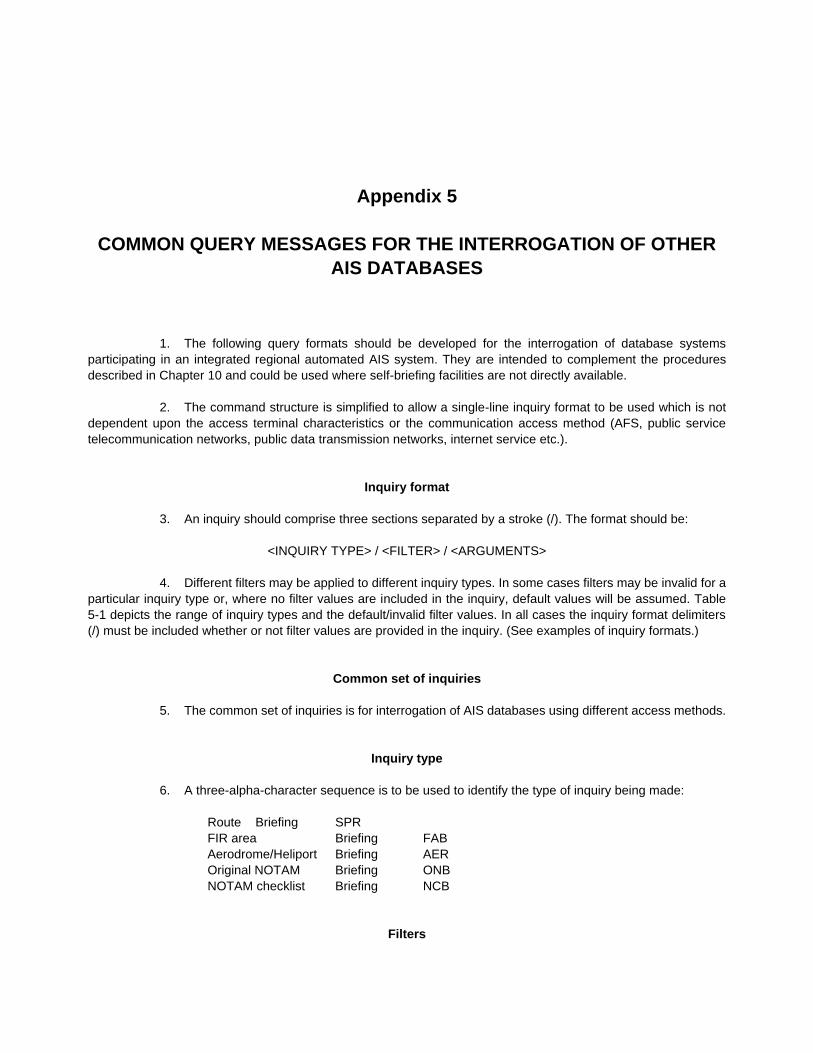
Appendix 5
COMMON QUERY MESSAGES FOR THE INTERROGATION OF OTHER
AIS DATABASES
1. The following query formats should be developed for the interrogation of database systems
participating in an integrated regional automated AIS system. They are intended to complement the procedures
described in Chapter 10 and could be used where self-briefing facilities are not directly available.
2. The command structure is simplified to allow a single-line inquiry format to be used which is not
dependent upon the access terminal characteristics or the communication access method (AFS, public service
telecommunication networks, public data transmission networks, internet service etc.).
Inquiry format
3. An inquiry should comprise three sections separated by a stroke (/). The format should be:
<INQUIRY TYPE> / <FILTER> / <ARGUMENTS>
4. Different filters may be applied to different inquiry types. In some cases filters may be invalid for a
particular inquiry type or, where no filter values are included in the inquiry, default values will be assumed. Table
5-1 depicts the range of inquiry types and the default/invalid filter values. In all cases the inquiry format delimiters
(/) must be included whether or not filter values are provided in the inquiry. (See examples of inquiry formats.)
Common set of inquiries
5. The common set of inquiries is for interrogation of AIS databases using different access methods.
Inquiry type
6. A three-alpha-character sequence is to be used to identify the type of inquiry being made:
Route Briefing SPR
FIR area Briefing FAB
Aerodrome/Heliport Briefing AER
Original NOTAM Briefing ONB
NOTAM checklist Briefing NCB
Filters
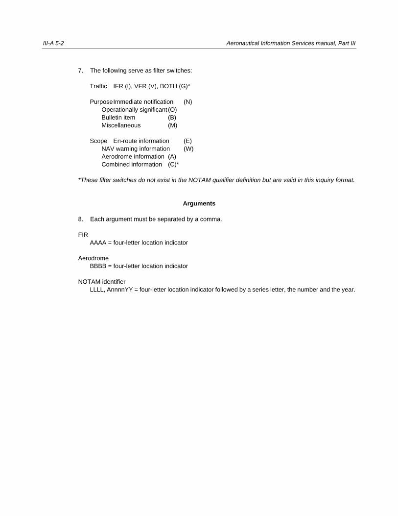
III-A 5-2 Aeronautical Information Services manual, Part III
7. The following serve as filter switches:
Traffic IFR (I), VFR (V), BOTH (G)*
Purpose Immediate notification (N)
Operationally significant (O)
Bulletin item (B)
Miscellaneous (M)
Scope En-route information (E)
NAV warning information (W)
Aerodrome information (A)
Combined information (C)*
*These filter switches do not exist in the NOTAM qualifier definition but are valid in this inquiry format.
Arguments
8. Each argument must be separated by a comma.
FIR
AAAA = four-letter location indicator
Aerodrome
BBBB = four-letter location indicator
NOTAM identifier
LLLL, AnnnnYY = four-letter location indicator followed by a series letter, the number and the year.
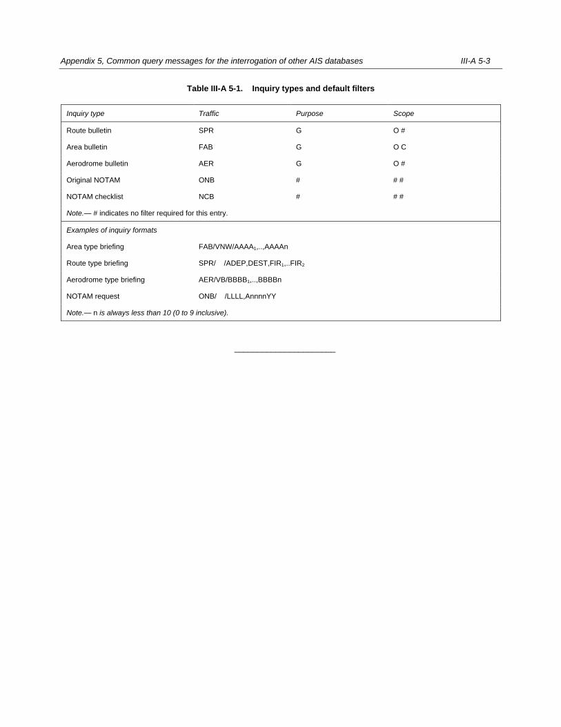
Appendix 5, Common query messages for the interrogation of other AIS databases III-A 5-3
Table III-A 5-1. Inquiry types and default filters
Inquiry type Traffic Purpose Scope
Route bulletin SPR G O #
Area bulletin FAB G O C
Aerodrome bulletin AER G O #
Original NOTAM ONB # # #
NOTAM checklist NCB # # #
Note.— # indicates no filter required for this entry.
Examples of inquiry formats
Area type briefing FAB/VNW/AAAA1,..,AAAAn
Route type briefing SPR/ /ADEP,DEST,FIR1,..FIR2
Aerodrome type briefing AER/VB/BBBB1,..,BBBBn
NOTAM request ONB/ /LLLL,AnnnnYY
Note.— n is always less than 10 (0 to 9 inclusive).
______________________

Appendix 6
USE OF NOTAM CODE AND ABBREVIATIONS
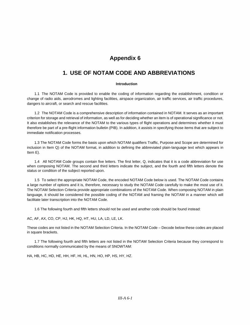
III-A 6-1
Appendix 6
1. USE OF NOTAM CODE AND ABBREVIATIONS
Introduction
1.1 The NOTAM Code is provided to enable the coding of information regarding the establishment, condition or
change of radio aids, aerodromes and lighting facilities, airspace organization, air traffic services, air traffic procedures,
dangers to aircraft, or search and rescue facilities.
1.2 The NOTAM Code is a comprehensive description of information contained in NOTAM. It serves as an important
criterion for storage and retrieval of information, as well as for deciding whether an item is of operational significance or not.
It also establishes the relevance of the NOTAM to the various types of flight operations and determines whether it must
therefore be part of a pre-flight information bulletin (PIB). In addition, it assists in specifying those items that are subject to
immediate notification processes.
1.3 The NOTAM Code forms the basis upon which NOTAM qualifiers Traffic, Purpose and Scope are determined for
inclusion in Item Q) of the NOTAM format, in addition to defining the abbreviated plain-language text which appears in
Item E).
1.4 All NOTAM Code groups contain five letters. The first letter, Q, indicates that it is a code abbreviation for use
when composing NOTAM. The second and third letters indicate the subject, and the fourth and fifth letters denote the
status or condition of the subject reported upon.
1.5 To select the appropriate NOTAM Code, the encoded NOTAM Code below is used. The NOTAM Code contains
a large number of options and it is, therefore, necessary to study the NOTAM Code carefully to make the most use of it.
The NOTAM Selection Criteria provide appropriate combinations of the NOTAM Code. When composing NOTAM in plain
language, it should be considered the possible coding of the NOTAM and framing the NOTAM in a manner which will
facilitate later transcription into the NOTAM Code.
1.6 The following fourth and fifth letters should not be used and another code should be found instead:
AC, AF, AX, CO, CP, HJ, HK, HQ, HT, HU, LA, LD, LE, LK.
These codes are not listed in the NOTAM Selection Criteria. In the NOTAM Code – Decode below these codes are placed
in square brackets.
1.7 The following fourth and fifth letters are not listed in the NOTAM Selection Criteria because they correspond to
conditions normally communicated by the means of SNOWTAM:
HA, HB, HC, HD, HE, HH, HF, HI, HL, HN, HO, HP, HS, HY, HZ.
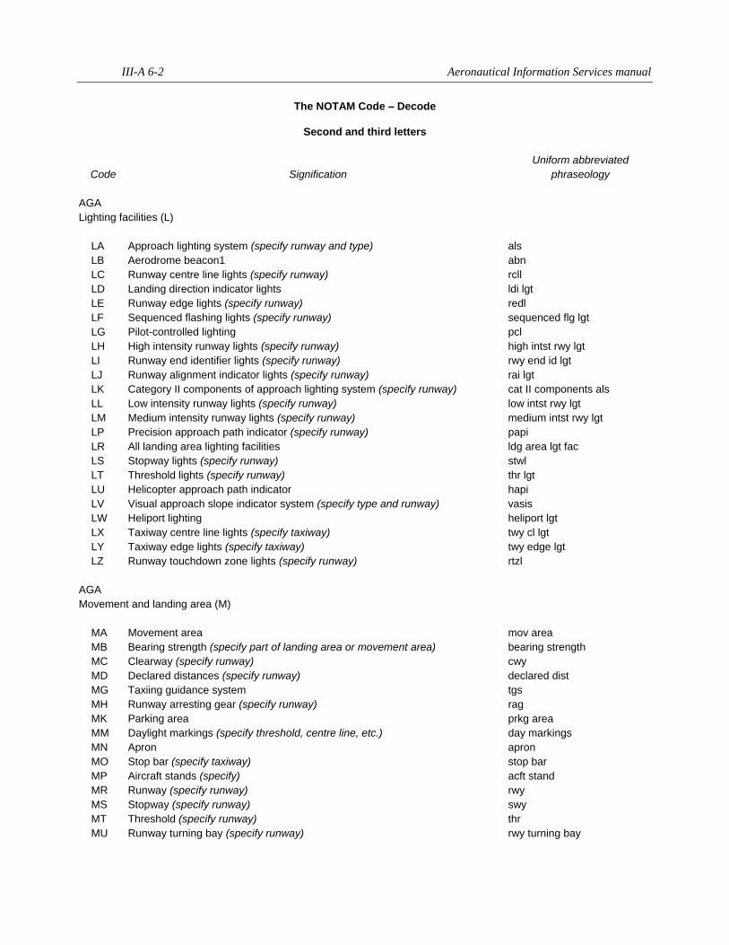
III-A 6-2 Aeronautical Information Services manual
The NOTAM Code – Decode
Second and third letters
Code Signification
Uniform abbreviated
phraseology
AGA
Lighting facilities (L)
LA Approach lighting system (specify runway and type) als
LB Aerodrome beacon1 abn
LC Runway centre line lights (specify runway) rcll
LD Landing direction indicator lights ldi lgt
LE Runway edge lights (specify runway) redl
LF Sequenced flashing lights (specify runway) sequenced flg lgt
LG Pilot-controlled lighting pcl
LH High intensity runway lights (specify runway) high intst rwy lgt
LI Runway end identifier lights (specify runway) rwy end id lgt
LJ Runway alignment indicator lights (specify runway) rai lgt
LK Category II components of approach lighting system (specify runway) cat II components als
LL Low intensity runway lights (specify runway) low intst rwy lgt
LM Medium intensity runway lights (specify runway) medium intst rwy lgt
LP Precision approach path indicator (specify runway) papi
LR All landing area lighting facilities ldg area lgt fac
LS Stopway lights (specify runway) stwl
LT Threshold lights (specify runway) thr lgt
LU Helicopter approach path indicator hapi
LV Visual approach slope indicator system (specify type and runway) vasis
LW Heliport lighting heliport lgt
LX Taxiway centre line lights (specify taxiway) twy cl lgt
LY Taxiway edge lights (specify taxiway) twy edge lgt
LZ Runway touchdown zone lights (specify runway) rtzl
AGA
Movement and landing area (M)
MA Movement area mov area
MB Bearing strength (specify part of landing area or movement area) bearing strength
MC Clearway (specify runway) cwy
MD Declared distances (specify runway) declared dist
MG Taxiing guidance system tgs
MH Runway arresting gear (specify runway) rag
MK Parking area prkg area
MM Daylight markings (specify threshold, centre line, etc.) day markings
MN Apron apron
MO Stop bar (specify taxiway) stop bar
MP Aircraft stands (specify) acft stand
MR Runway (specify runway) rwy
MS Stopway (specify runway) swy
MT Threshold (specify runway) thr
MU Runway turning bay (specify runway) rwy turning bay
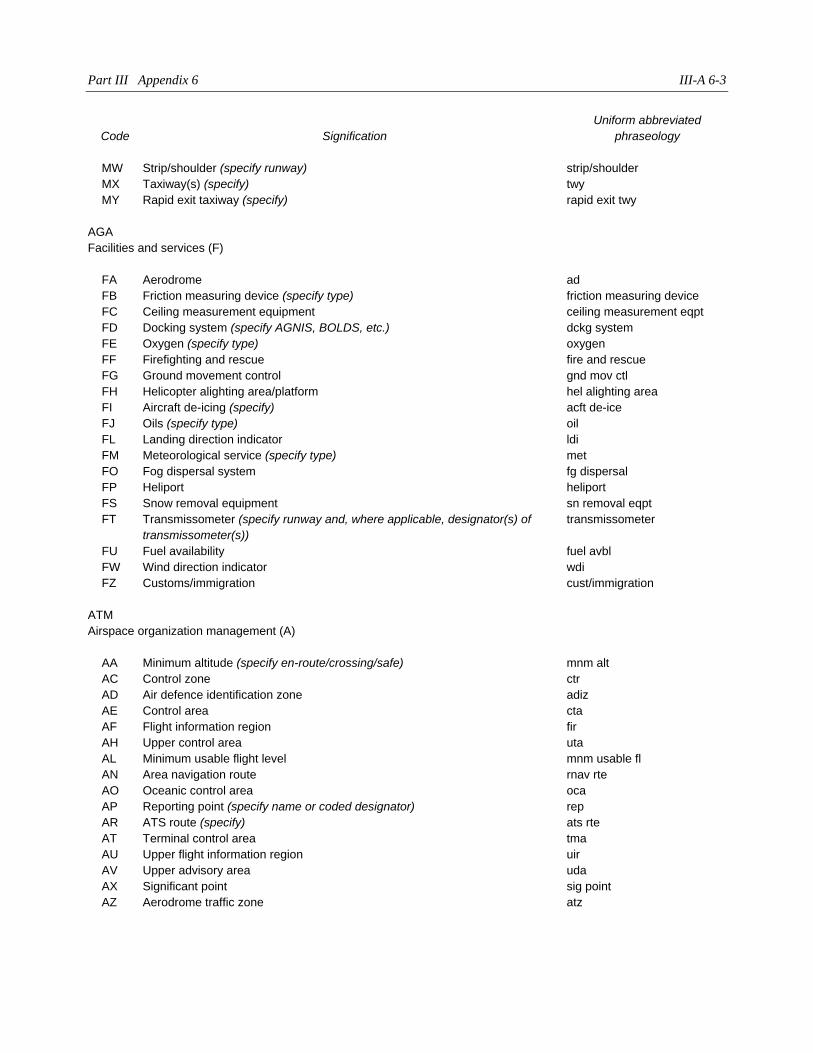
Part III Appendix 6 III-A 6-3
Code Signification
Uniform abbreviated
phraseology
MW Strip/shoulder (specify runway) strip/shoulder
MX Taxiway(s) (specify) twy
MY Rapid exit taxiway (specify) rapid exit twy
AGA
Facilities and services (F)
FA Aerodrome ad
FB Friction measuring device (specify type) friction measuring device
FC Ceiling measurement equipment ceiling measurement eqpt
FD Docking system (specify AGNIS, BOLDS, etc.) dckg system
FE Oxygen (specify type) oxygen
FF Firefighting and rescue fire and rescue
FG Ground movement control gnd mov ctl
FH Helicopter alighting area/platform hel alighting area
FI Aircraft de-icing (specify) acft de-ice
FJ Oils (specify type) oil
FL Landing direction indicator ldi
FM Meteorological service (specify type) met
FO Fog dispersal system fg dispersal
FP Heliport heliport
FS Snow removal equipment sn removal eqpt
FT Transmissometer (specify runway and, where applicable, designator(s) of
transmissometer(s))
transmissometer
FU Fuel availability fuel avbl
FW Wind direction indicator wdi
FZ Customs/immigration cust/immigration
ATM
Airspace organization management (A)
AA Minimum altitude (specify en-route/crossing/safe) mnm alt
AC Control zone ctr
AD Air defence identification zone adiz
AE Control area cta
AF Flight information region fir
AH Upper control area uta
AL Minimum usable flight level mnm usable fl
AN Area navigation route rnav rte
AO Oceanic control area oca
AP Reporting point (specify name or coded designator) rep
AR ATS route (specify) ats rte
AT Terminal control area tma
AU Upper flight information region uir
AV Upper advisory area uda
AX Significant point sig point
AZ Aerodrome traffic zone atz
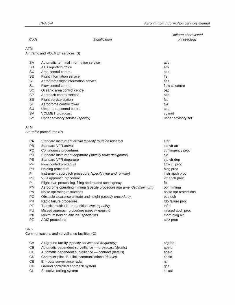
III-A 6-4 Aeronautical Information Services manual
Code Signification
Uniform abbreviated
phraseology
ATM
Air traffic and VOLMET services (S)
SA Automatic terminal information service atis
SB ATS reporting office aro
SC Area control centre acc
SE Flight information service fis
SF Aerodrome flight information service afis
SL Flow control centre flow ctl centre
SO Oceanic area control centre oac
SP Approach control service app
SS Flight service station fss
ST Aerodrome control tower twr
SU Upper area control centre uac
SV VOLMET broadcast volmet
SY Upper advisory service (specify) upper advisory ser
ATM
Air traffic procedures (P)
PA Standard instrument arrival (specify route designator) star
PB Standard VFR arrival std vfr arr
PC Contingency procedures contingency proc
PD Standard instrument departure (specify route designator) sid
PE Standard VFR departure std vfr dep
PF Flow control procedure flow ctl proc
PH Holding procedure hldg proc
PI Instrument approach procedure (specify type and runway) instr apch proc
PK VFR approach procedure vfr apch proc
PL Flight plan processing, filing and related contingency fpl
PM Aerodrome operating minima (specify procedure and amended minimum) opr minima
PN Noise operating restrictions noise opr restrictions
PO Obstacle clearance altitude and height (specify procedure) oca och
PR Radio failure procedure rdo failure proc
PT Transition altitude or transition level (specify) ta/trl
PU Missed approach procedure (specify runway) missed apch proc
PX Minimum holding altitude (specify fix) mnm hldg alt
PZ ADIZ procedure adiz proc
CNS
Communications and surveillance facilities (C)
CA Air/ground facility (specify service and frequency) a/g fac
CB Automatic dependent surveillance — broadcast (details) ads-b
CC Automatic dependent surveillance — contract (details) ads-c
CD Controller-pilot data link communications (details) cpdlc
CE En-route surveillance radar rsr
CG Ground controlled approach system gca
CL Selective calling system selcal
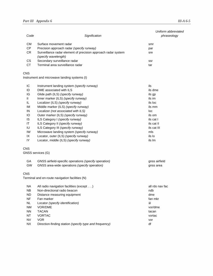
Part III Appendix 6 III-A 6-5
Code Signification
Uniform abbreviated
phraseology
CM Surface movement radar smr
CP Precision approach radar (specify runway) par
CR Surveillance radar element of precision approach radar system
(specify wavelength)
sre
CS Secondary surveillance radar ssr
CT Terminal area surveillance radar tar
CNS
Instrument and microwave landing systems (I)
IC Instrument landing system (specify runway) ils
ID DME associated with ILS ils dme
IG Glide path (ILS) (specify runway) ils gp
II Inner marker (ILS) (specify runway) ils im
IL Localizer (ILS) (specify runway) ils loc
IM Middle marker (ILS) (specify runway) ils mm
IN Localizer (not associated with ILS) loc
IO Outer marker (ILS) (specify runway) ils om
IS ILS Category I (specify runway) ils cat I
IT ILS Category II (specify runway) ils cat II
IU ILS Category III (specify runway) ils cat III
IW Microwave landing system (specify runway) mls
IX Locator, outer (ILS) (specify runway) ils lo
IY Locator, middle (ILS) (specify runway) ils lm
CNS
GNSS services (G)
GA GNSS airfield-specific operations (specify operation) gnss airfield
GW GNSS area-wide operations (specify operation) gnss area
CNS
Terminal and en-route navigation facilities (N)
NA All radio navigation facilities (except . . .) all rdo nav fac
NB Non-directional radio beacon ndb
ND Distance measuring equipment dme
NF Fan marker fan mkr
NL Locator (specify identification) 1l
NM VOR/DME vor/dme
NN TACAN tacan
NT VORTAC vortac
NV VOR vor
NX Direction-finding station (specify type and frequency) df
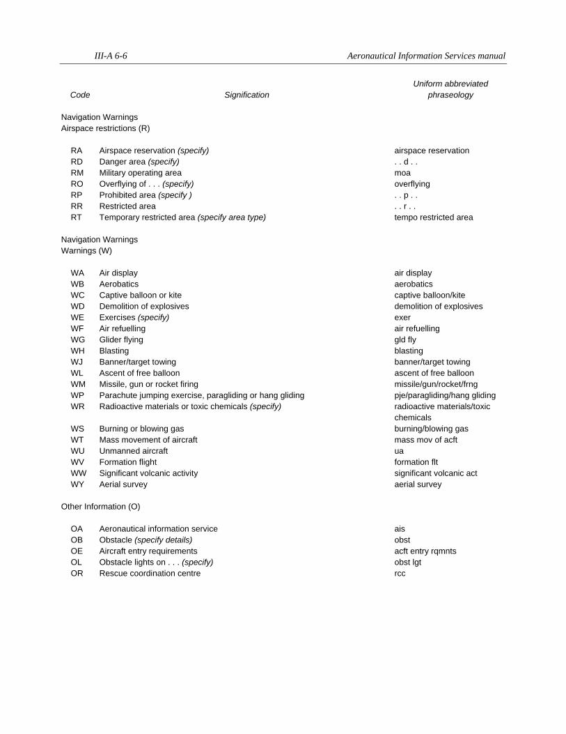
III-A 6-6 Aeronautical Information Services manual
Code Signification
Uniform abbreviated
phraseology
Navigation Warnings
Airspace restrictions (R)
RA Airspace reservation (specify) airspace reservation
RD Danger area (specify) . . d . .
RM Military operating area moa
RO Overflying of . . . (specify) overflying
RP Prohibited area (specify ) . . p . .
RR Restricted area . . r . .
RT Temporary restricted area (specify area type) tempo restricted area
Navigation Warnings
Warnings (W)
WA Air display air display
WB Aerobatics aerobatics
WC Captive balloon or kite captive balloon/kite
WD Demolition of explosives demolition of explosives
WE Exercises (specify) exer
WF Air refuelling air refuelling
WG Glider flying gld fly
WH Blasting blasting
WJ Banner/target towing banner/target towing
WL Ascent of free balloon ascent of free balloon
WM Missile, gun or rocket firing missile/gun/rocket/frng
WP Parachute jumping exercise, paragliding or hang gliding pje/paragliding/hang gliding
WR Radioactive materials or toxic chemicals (specify) radioactive materials/toxic
chemicals
WS Burning or blowing gas burning/blowing gas
WT Mass movement of aircraft mass mov of acft
WU Unmanned aircraft ua
WV Formation flight formation flt
WW Significant volcanic activity significant volcanic act
WY Aerial survey aerial survey
Other Information (O)
OA Aeronautical information service ais
OB Obstacle (specify details) obst
OE Aircraft entry requirements acft entry rqmnts
OL Obstacle lights on . . . (specify) obst lgt
OR Rescue coordination centre rcc
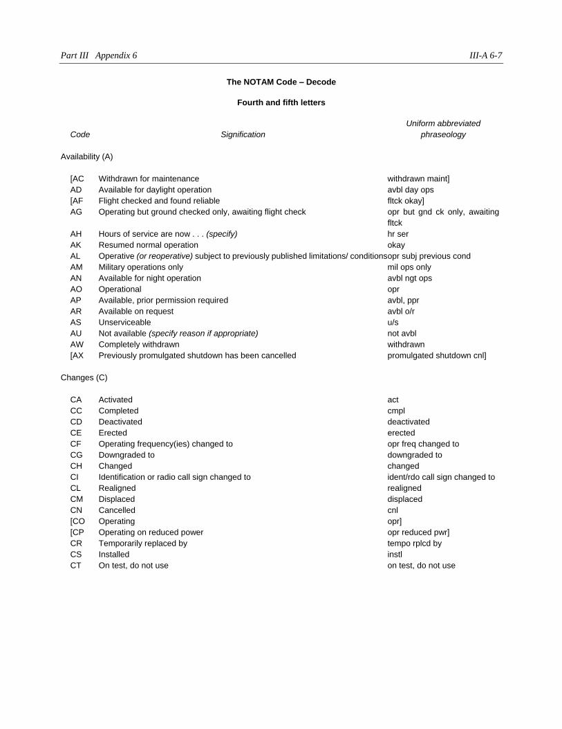
Part III Appendix 6 III-A 6-7
The NOTAM Code – Decode
Fourth and fifth letters
Code Signification
Uniform abbreviated
phraseology
Availability (A)
[AC Withdrawn for maintenance withdrawn maint]
AD Available for daylight operation avbl day ops
[AF Flight checked and found reliable fltck okay]
AG Operating but ground checked only, awaiting flight check opr but gnd ck only, awaiting
fltck
AH Hours of service are now . . . (specify) hr ser
AK Resumed normal operation okay
AL Operative (or reoperative) subject to previously published limitations/ conditions opr subj previous cond
AM Military operations only mil ops only
AN Available for night operation avbl ngt ops
AO Operational opr
AP Available, prior permission required avbl, ppr
AR Available on request avbl o/r
AS Unserviceable u/s
AU Not available (specify reason if appropriate) not avbl
AW Completely withdrawn withdrawn
[AX Previously promulgated shutdown has been cancelled promulgated shutdown cnl]
Changes (C)
CA Activated act
CC Completed cmpl
CD Deactivated deactivated
CE Erected erected
CF Operating frequency(ies) changed to opr freq changed to
CG Downgraded to downgraded to
CH Changed changed
CI Identification or radio call sign changed to ident/rdo call sign changed to
CL Realigned realigned
CM Displaced displaced
CN Cancelled cnl
[CO Operating opr]
[CP Operating on reduced power opr reduced pwr]
CR Temporarily replaced by tempo rplcd by
CS Installed instl
CT On test, do not use on test, do not use
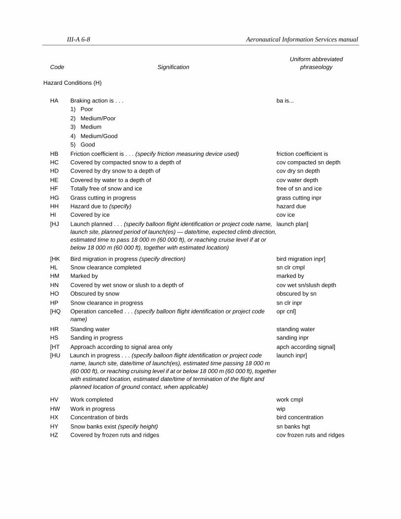
III-A 6-8 Aeronautical Information Services manual
Code Signification
Uniform abbreviated
phraseology
Hazard Conditions (H)
HA Braking action is . . . ba is...
1) Poor
2) Medium/Poor
3) Medium
4) Medium/Good
5) Good
HB Friction coefficient is . . . (specify friction measuring device used) friction coefficient is
HC Covered by compacted snow to a depth of cov compacted sn depth
HD Covered by dry snow to a depth of cov dry sn depth
HE Covered by water to a depth of cov water depth
HF Totally free of snow and ice free of sn and ice
HG Grass cutting in progress grass cutting inpr
HH Hazard due to (specify) hazard due
HI Covered by ice cov ice
[HJ Launch planned . . . (specify balloon flight identification or project code name,
launch site, planned period of launch(es) — date/time, expected climb direction,
estimated time to pass 18 000 m (60 000 ft), or reaching cruise level if at or
below 18 000 m (60 000 ft), together with estimated location)
launch plan]
[HK Bird migration in progress (specify direction) bird migration inpr]
HL Snow clearance completed sn clr cmpl
HM Marked by marked by
HN Covered by wet snow or slush to a depth of cov wet sn/slush depth
HO Obscured by snow obscured by sn
HP Snow clearance in progress sn clr inpr
[HQ Operation cancelled . . . (specify balloon flight identification or project code
name)
opr cnl]
HR Standing water standing water
HS Sanding in progress sanding inpr
[HT Approach according to signal area only apch according signal]
[HU Launch in progress . . . (specify balloon flight identification or project code
name, launch site, date/time of launch(es), estimated time passing 18 000 m
(60 000 ft), or reaching cruising level if at or below 18 000 m (60 000 ft), together
with estimated location, estimated date/time of termination of the flight and
planned location of ground contact, when applicable)
launch inpr]
HV Work completed work cmpl
HW Work in progress wip
HX Concentration of birds bird concentration
HY Snow banks exist (specify height) sn banks hgt
HZ Covered by frozen ruts and ridges cov frozen ruts and ridges
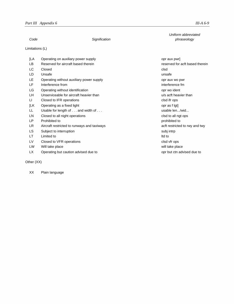
Part III Appendix 6 III-A 6-9
Code Signification
Uniform abbreviated
phraseology
Limitations (L)
[LA Operating on auxiliary power supply opr aux pwr]
LB Reserved for aircraft based therein reserved for acft based therein
LC Closed clsd
LD Unsafe unsafe
LE Operating without auxiliary power supply opr aux wo pwr
LF Interference from interference fm
LG Operating without identification opr wo ident
LH Unserviceable for aircraft heavier than u/s acft heavier than
LI Closed to IFR operations clsd ifr ops
[LK Operating as a fixed light opr as f lgt]
LL Usable for length of . . . and width of . . . usable len.../wid...
LN Closed to all night operations clsd to all ngt ops
LP Prohibited to prohibited to
LR Aircraft restricted to runways and taxiways acft restricted to rwy and twy
LS Subject to interruption subj intrp
LT Limited to ltd to
LV Closed to VFR operations clsd vfr ops
LW Will take place will take place
LX Operating but caution advised due to opr but ctn advised due to
Other (XX)
XX Plain language
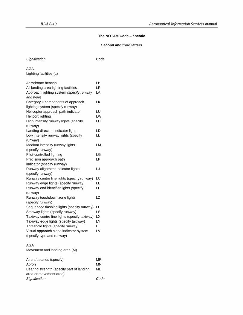
III-A 6-10 Aeronautical Information Services manual
The NOTAM Code – encode
Second and third letters
Signification Code
AGA
Lighting facilities (L)
Aerodrome beacon LB
All landing area lighting facilities LR
Approach lighting system (specify runway
and type)
LA
Category II components of approach
lighting system (specify runway)
LK
Helicopter approach path indicator LU
Heliport lighting LW
High intensity runway lights (specify
runway)
LH
Landing direction indicator lights LD
Low intensity runway lights (specify
runway)
LL
Medium intensity runway lights
(specify runway)
LM
Pilot-controlled lighting LG
Precision approach path
indicator (specify runway)
LP
Runway alignment indicator lights
(specify runway)
LJ
Runway centre line lights (specify runway) LC
Runway edge lights (specify runway) LE
Runway end identifier lights (specify
runway)
LI
Runway touchdown zone lights
(specify runway)
LZ
Sequenced flashing lights (specify runway) LF
Stopway lights (specify runway) LS
Taxiway centre line lights (specify taxiway) LX
Taxiway edge lights (specify taxiway) LY
Threshold lights (specify runway) LT
Visual approach slope indicator system
(specify type and runway)
LV
AGA
Movement and landing area (M)
Aircraft stands (specify) MP
Apron MN
Bearing strength (specify part of landing
area or movement area)
MB
Signification Code
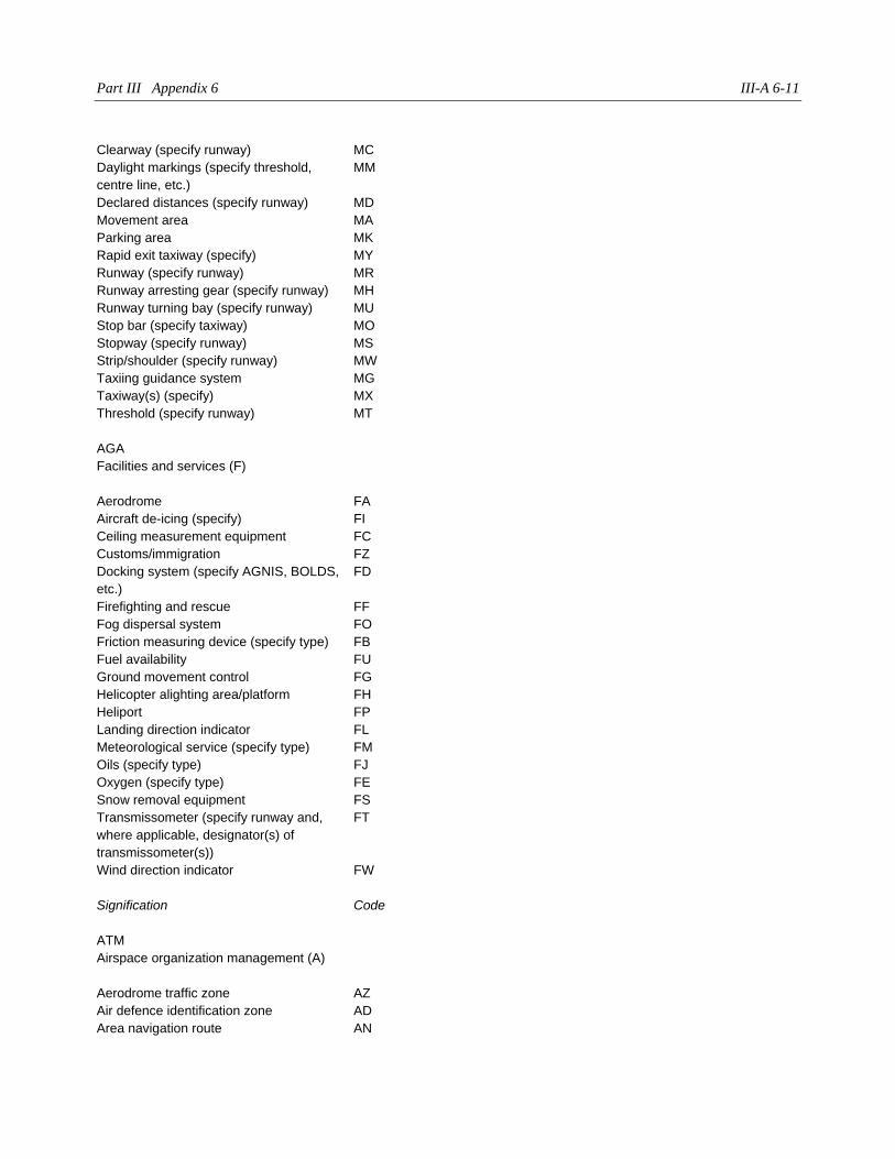
Part III Appendix 6 III-A 6-11
Clearway (specify runway) MC
Daylight markings (specify threshold,
centre line, etc.)
MM
Declared distances (specify runway) MD
Movement area MA
Parking area MK
Rapid exit taxiway (specify) MY
Runway (specify runway) MR
Runway arresting gear (specify runway) MH
Runway turning bay (specify runway) MU
Stop bar (specify taxiway) MO
Stopway (specify runway) MS
Strip/shoulder (specify runway) MW
Taxiing guidance system MG
Taxiway(s) (specify) MX
Threshold (specify runway) MT
AGA
Facilities and services (F)
Aerodrome FA
Aircraft de-icing (specify) FI
Ceiling measurement equipment FC
Customs/immigration FZ
Docking system (specify AGNIS, BOLDS,
etc.)
FD
Firefighting and rescue FF
Fog dispersal system FO
Friction measuring device (specify type) FB
Fuel availability FU
Ground movement control FG
Helicopter alighting area/platform FH
Heliport FP
Landing direction indicator FL
Meteorological service (specify type) FM
Oils (specify type) FJ
Oxygen (specify type) FE
Snow removal equipment FS
Transmissometer (specify runway and,
where applicable, designator(s) of
transmissometer(s))
FT
Wind direction indicator FW
Signification Code
ATM
Airspace organization management (A)
Aerodrome traffic zone AZ
Air defence identification zone AD
Area navigation route AN

III-A 6-12 Aeronautical Information Services manual
ATS route (specify) AR
Control area AE
Control zone AC
Flight information region AF
Minimum altitude (specify
en-route/crossing/safe)
AA
Minimum usable flight level AL
Oceanic control area AO
Reporting point (specify name or coded
designator)
AP
Significant point AX
Terminal control area AT
Upper advisory area AV
Upper control area AH
Upper flight information region AU
ATM
Air traffic and VOLMET services (S)
Aerodrome control tower ST
Aerodrome flight information service SF
Approach control service SP
Area control centre SC
ATS reporting office SB
Automatic terminal information service SA
Flight information service SE
Flight service station SS
Flow control centre SL
Oceanic area control centre SO
Upper advisory service (specify) SY
Upper area control centre SU
VOLMET broadcast SV
ATM
Air traffic procedures (P)
ADIZ procedure PZ
Aerodrome operating minima (specify
procedure and amended minimum)
PM
Contingency procedures PC
Flight plan processing, filing and related
contingency
PL
Flow control procedure PF
Holding procedure PH
Signification Code
Instrument approach procedure (specify
type and runway)
PI
Minimum holding altitude (specify fix) PX
Missed approach procedure (specify
runway)
PU
Noise operating restrictions PN
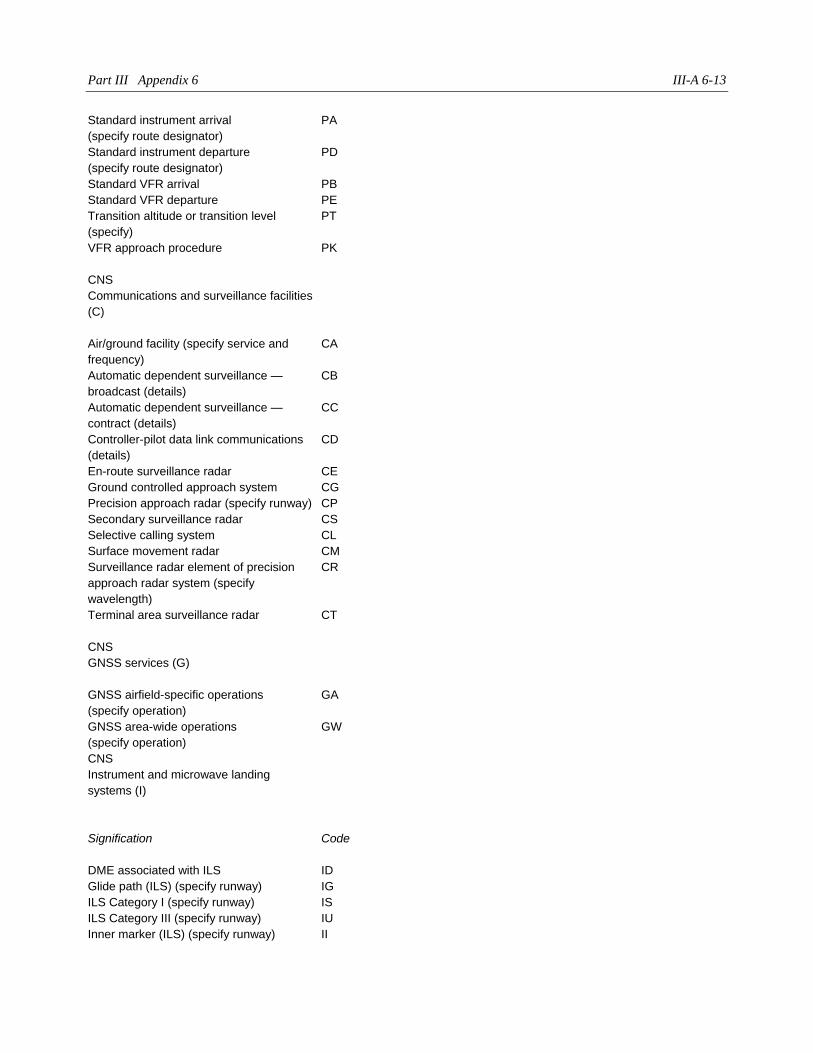
Part III Appendix 6 III-A 6-13
Standard instrument arrival
(specify route designator)
PA
Standard instrument departure
(specify route designator)
PD
Standard VFR arrival PB
Standard VFR departure PE
Transition altitude or transition level
(specify)
PT
VFR approach procedure PK
CNS
Communications and surveillance facilities
(C)
Air/ground facility (specify service and
frequency)
CA
Automatic dependent surveillance —
broadcast (details)
CB
Automatic dependent surveillance —
contract (details)
CC
Controller-pilot data link communications
(details)
CD
En-route surveillance radar CE
Ground controlled approach system CG
Precision approach radar (specify runway) CP
Secondary surveillance radar CS
Selective calling system CL
Surface movement radar CM
Surveillance radar element of precision
approach radar system (specify
wavelength)
CR
Terminal area surveillance radar CT
CNS
GNSS services (G)
GNSS airfield-specific operations
(specify operation)
GA
GNSS area-wide operations
(specify operation)
GW
CNS
Instrument and microwave landing
systems (I)
Signification Code
DME associated with ILS ID
Glide path (ILS) (specify runway) IG
ILS Category I (specify runway) IS
ILS Category III (specify runway) IU
Inner marker (ILS) (specify runway) II
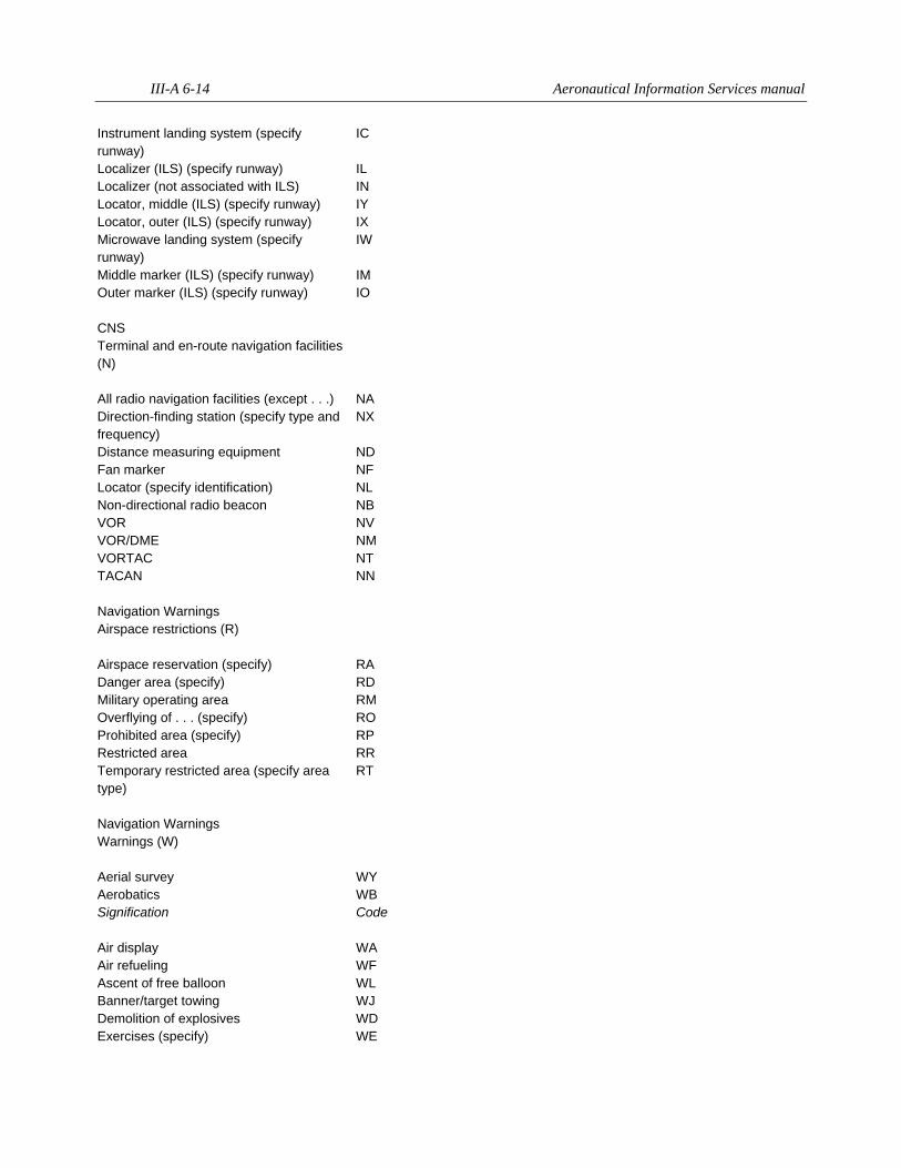
III-A 6-14 Aeronautical Information Services manual
Instrument landing system (specify
runway)
IC
Localizer (ILS) (specify runway) IL
Localizer (not associated with ILS) IN
Locator, middle (ILS) (specify runway) IY
Locator, outer (ILS) (specify runway) IX
Microwave landing system (specify
runway)
IW
Middle marker (ILS) (specify runway) IM
Outer marker (ILS) (specify runway) IO
CNS
Terminal and en-route navigation facilities
(N)
All radio navigation facilities (except . . .) NA
Direction-finding station (specify type and
frequency)
NX
Distance measuring equipment ND
Fan marker NF
Locator (specify identification) NL
Non-directional radio beacon NB
VOR NV
VOR/DME NM
VORTAC NT
TACAN NN
Navigation Warnings
Airspace restrictions (R)
Airspace reservation (specify) RA
Danger area (specify) RD
Military operating area RM
Overflying of . . . (specify) RO
Prohibited area (specify) RP
Restricted area RR
Temporary restricted area (specify area
type)
RT
Navigation Warnings
Warnings (W)
Aerial survey WY
Aerobatics WB
Signification Code
Air display WA
Air refueling WF
Ascent of free balloon WL
Banner/target towing WJ
Demolition of explosives WD
Exercises (specify) WE
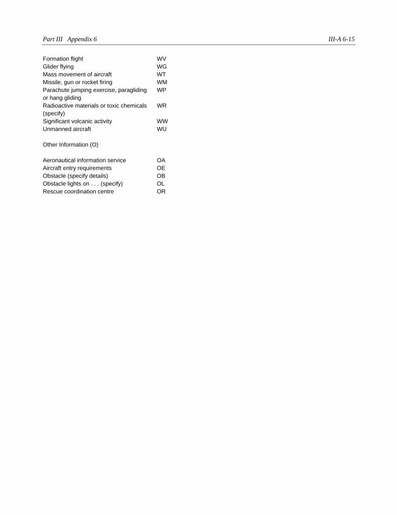
Part III Appendix 6 III-A 6-15
Formation flight WV
Glider flying WG
Mass movement of aircraft WT
Missile, gun or rocket firing WM
Parachute jumping exercise, paragliding
or hang gliding
WP
Radioactive materials or toxic chemicals
(specify)
WR
Significant volcanic activity WW
Unmanned aircraft WU
Other Information (O)
Aeronautical information service OA
Aircraft entry requirements OE
Obstacle (specify details) OB
Obstacle lights on . . . (specify) OL
Rescue coordination centre OR
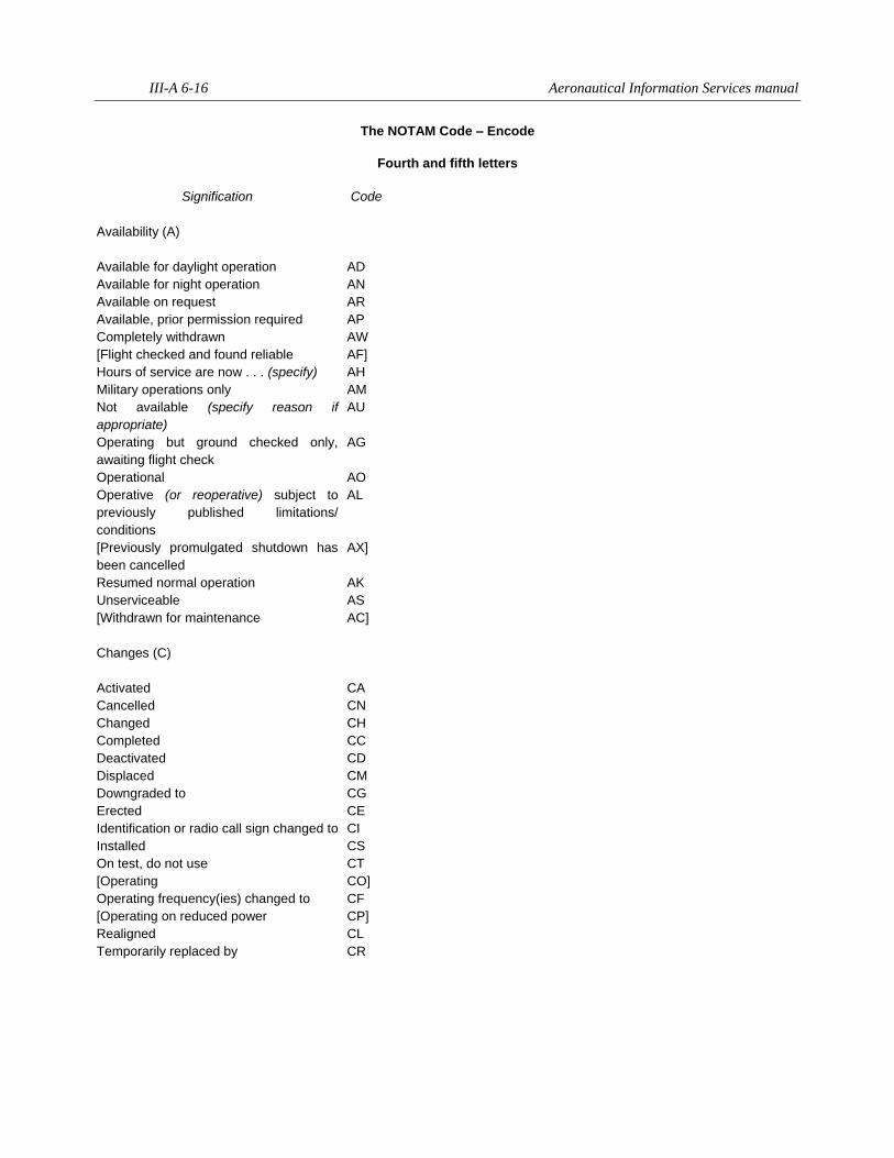
III-A 6-16 Aeronautical Information Services manual
The NOTAM Code – Encode
Fourth and fifth letters
Signification Code
Availability (A)
Available for daylight operation AD
Available for night operation AN
Available on request AR
Available, prior permission required AP
Completely withdrawn AW
[Flight checked and found reliable AF]
Hours of service are now . . . (specify) AH
Military operations only AM
Not available (specify reason if
appropriate)
AU
Operating but ground checked only,
awaiting flight check
AG
Operational AO
Operative (or reoperative) subject to
previously published limitations/
conditions
AL
[Previously promulgated shutdown has
been cancelled
AX]
Resumed normal operation AK
Unserviceable AS
[Withdrawn for maintenance AC]
Changes (C)
Activated CA
Cancelled CN
Changed CH
Completed CC
Deactivated CD
Displaced CM
Downgraded to CG
Erected CE
Identification or radio call sign changed to CI
Installed CS
On test, do not use CT
[Operating CO]
Operating frequency(ies) changed to CF
[Operating on reduced power CP]
Realigned CL
Temporarily replaced by CR
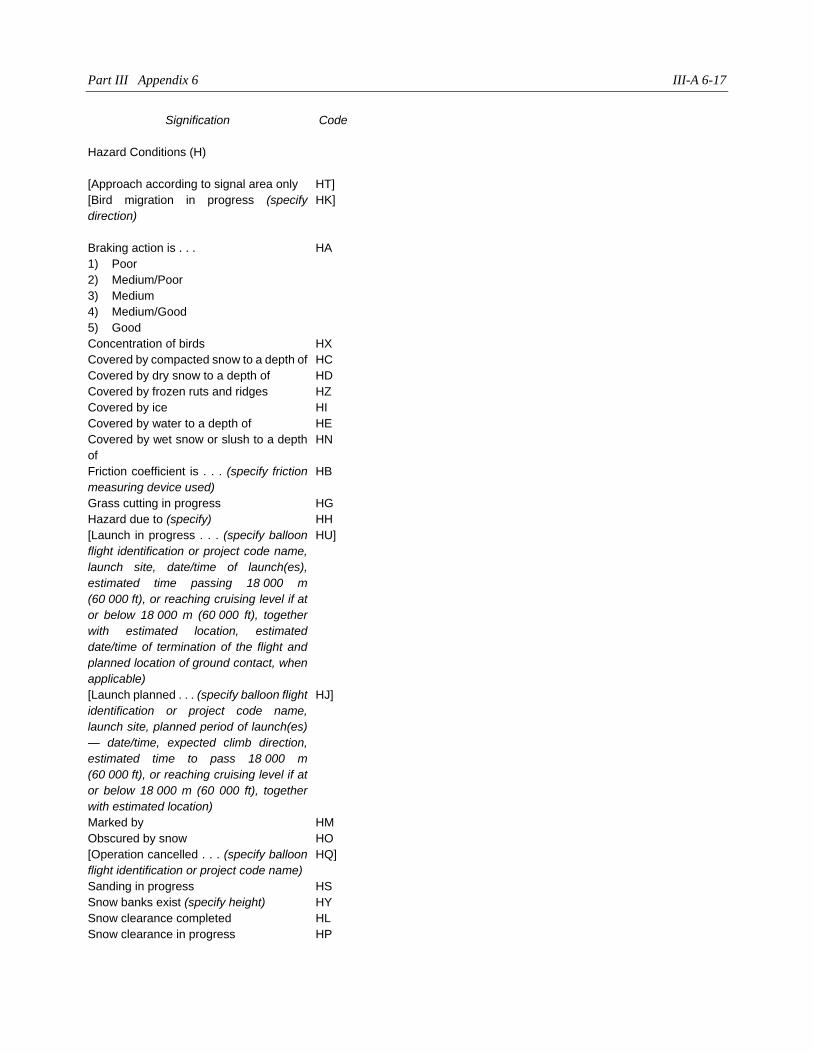
Part III Appendix 6 III-A 6-17
Signification Code
Hazard Conditions (H)
[Approach according to signal area only HT]
[Bird migration in progress (specify
direction)
HK]
Braking action is . . . HA
1) Poor
2) Medium/Poor
3) Medium
4) Medium/Good
5) Good
Concentration of birds HX
Covered by compacted snow to a depth of HC
Covered by dry snow to a depth of HD
Covered by frozen ruts and ridges HZ
Covered by ice HI
Covered by water to a depth of HE
Covered by wet snow or slush to a depth
of
HN
Friction coefficient is . . . (specify friction
measuring device used)
HB
Grass cutting in progress HG
Hazard due to (specify) HH
[Launch in progress . . . (specify balloon
flight identification or project code name,
launch site, date/time of launch(es),
estimated time passing 18 000 m
(60 000 ft), or reaching cruising level if at
or below 18 000 m (60 000 ft), together
with estimated location, estimated
date/time of termination of the flight and
planned location of ground contact, when
applicable)
HU]
[Launch planned . . . (specify balloon flight
identification or project code name,
launch site, planned period of launch(es)
— date/time, expected climb direction,
estimated time to pass 18 000 m
(60 000 ft), or reaching cruising level if at
or below 18 000 m (60 000 ft), together
with estimated location)
HJ]
Marked by HM
Obscured by snow HO
[Operation cancelled . . . (specify balloon
flight identification or project code name)
HQ]
Sanding in progress HS
Snow banks exist (specify height) HY
Snow clearance completed HL
Snow clearance in progress HP
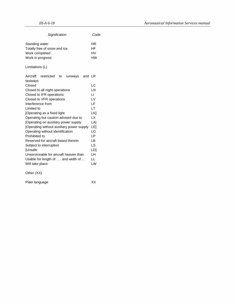
III-A 6-18 Aeronautical Information Services manual
Signification Code
Standing water HR
Totally free of snow and ice HF
Work completed HV
Work in progress HW
Limitations (L)
Aircraft restricted to runways and
taxiways
LR
Closed LC
Closed to all night operations LN
Closed to IFR operations LI
Closed to VFR operations LV
Interference from LF
Limited to LT
[Operating as a fixed light LK]
Operating but caution advised due to LX
[Operating on auxiliary power supply LA]
[Operating without auxiliary power supply LE]
Operating without identification LG
Prohibited to LP
Reserved for aircraft based therein LB
Subject to interruption LS
[Unsafe LD]
Unserviceable for aircraft heavier than LH
Usable for length of . . . and width of . . LL
Will take place LW
Other (XX)
Plain language XX
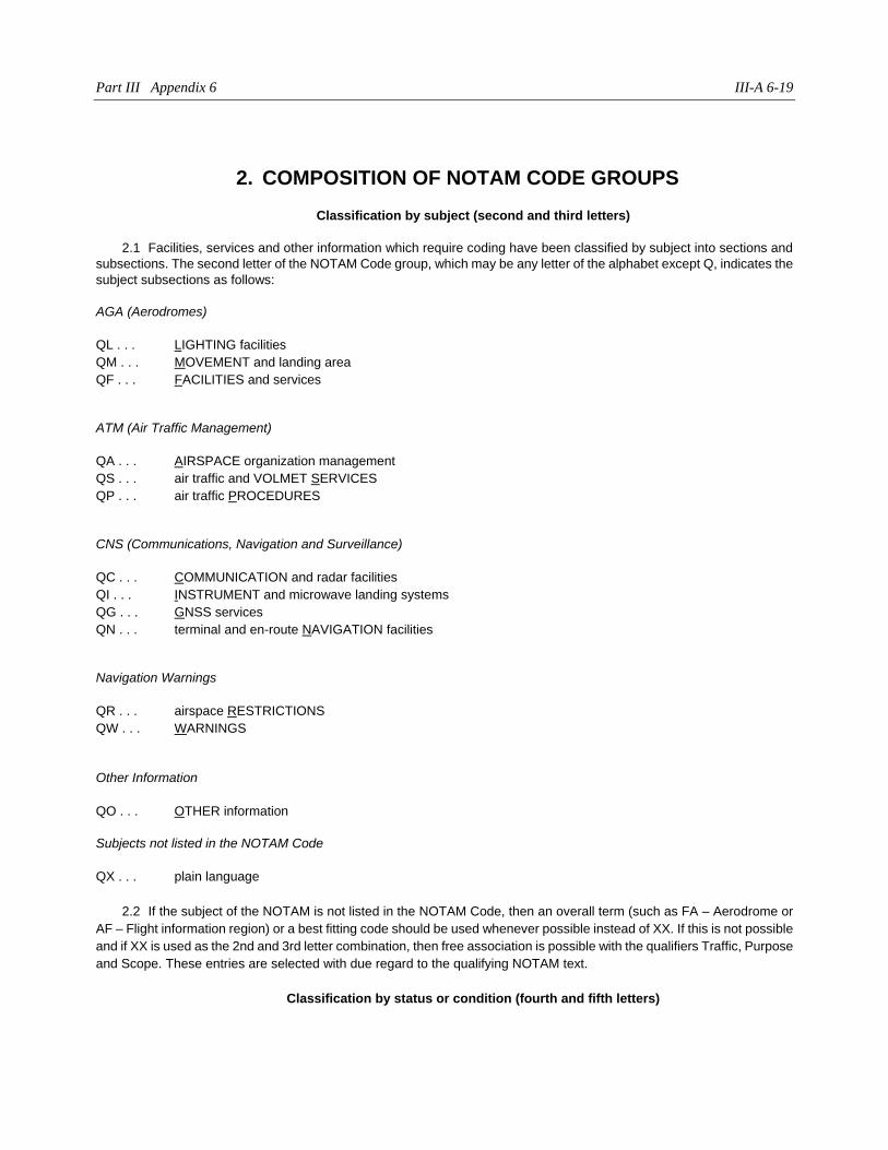
Part III Appendix 6 III-A 6-19
2. COMPOSITION OF NOTAM CODE GROUPS
Classification by subject (second and third letters)
2.1 Facilities, services and other information which require coding have been classified by subject into sections and
subsections. The second letter of the NOTAM Code group, which may be any letter of the alphabet except Q, indicates the
subject subsections as follows:
AGA (Aerodromes)
QL . . . LIGHTING facilities
QM . . . MOVEMENT and landing area
QF . . . FACILITIES and services
ATM (Air Traffic Management)
QA . . . AIRSPACE organization management
QS . . . air traffic and VOLMET SERVICES
QP . . . air traffic PROCEDURES
CNS (Communications, Navigation and Surveillance)
QC . . . COMMUNICATION and radar facilities
QI . . . INSTRUMENT and microwave landing systems
QG . . . GNSS services
QN . . . terminal and en-route NAVIGATION facilities
Navigation Warnings
QR . . . airspace RESTRICTIONS
QW . . . WARNINGS
Other Information
QO . . . OTHER information
Subjects not listed in the NOTAM Code
QX . . . plain language
2.2 If the subject of the NOTAM is not listed in the NOTAM Code, then an overall term (such as FA – Aerodrome or
AF – Flight information region) or a best fitting code should be used whenever possible instead of XX. If this is not possible
and if XX is used as the 2nd and 3rd letter combination, then free association is possible with the qualifiers Traffic, Purpose
and Scope. These entries are selected with due regard to the qualifying NOTAM text.
Classification by status or condition (fourth and fifth letters)
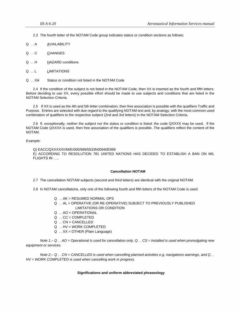
III-A 6-20 Aeronautical Information Services manual
2.3 The fourth letter of the NOTAM Code group indicates status or condition sections as follows:
Q . . A AVAILABILITY
Q . . C CHANGES
Q . . H HAZARD conditions
Q . . L LIMITATIONS
Q . . XX Status or condition not listed in the NOTAM Code
2.4 If the condition of the subject is not listed in the NOTAM Code, then XX is inserted as the fourth and fifth letters.
Before deciding to use XX, every possible effort should be made to use subjects and conditions that are listed in the
NOTAM Selection Criteria.
2.5 If XX is used as the 4th and 5th letter combination, then free association is possible with the qualifiers Traffic and
Purpose. Entries are selected with due regard to the qualifying NOTAM text and, by analogy, with the most common used
combination of qualifiers to the respective subject (2nd and 3rd letters) in the NOTAM Selection Criteria.
2.6 If, exceptionally, neither the subject nor the status or condition is listed: the code QXXXX may be used. If the
NOTAM Code QXXXX is used, then free association of the qualifiers is possible. The qualifiers reflect the content of the
NOTAM.
Example:
Q) EACC/QXXXX/IV/M/E/000/999/5533N00940E999
E) ACCORDING TO RESOLUTION 781 UNITED NATIONS HAS DECIDED TO ESTABLISH A BAN ON MIL
FLIGHTS IN …..
Cancellation NOTAM
2.7 The cancellation NOTAM subjects (second and third letters) are identical with the original NOTAM.
2.8 In NOTAM cancellations, only one of the following fourth and fifth letters of the NOTAM Code is used:
Q . . AK = RESUMED NORMAL OPS
Q . . AL = OPERATIVE (OR RE-OPERATIVE) SUBJECT TO PREVIOUSLY PUBLISHED
LIMITATIONS OR CONDITION
Q . . AO = OPERATIONAL
Q . . CC = COMPLETED
Q . . CN = CANCELLED
Q . . HV = WORK COMPLETED
Q . . XX = OTHER (Plain Language)
Note 1.– Q . . AO = Operational is used for cancellation only, Q . . CS = Installed is used when promulgating new
equipment or services.
Note 2.– Q . . CN = CANCELLED is used when cancelling planned activities e.g. navigations warnings, and Q . .
HV = WORK COMPLETED is used when cancelling work in progress.
Significations and uniform abbreviated phraseology
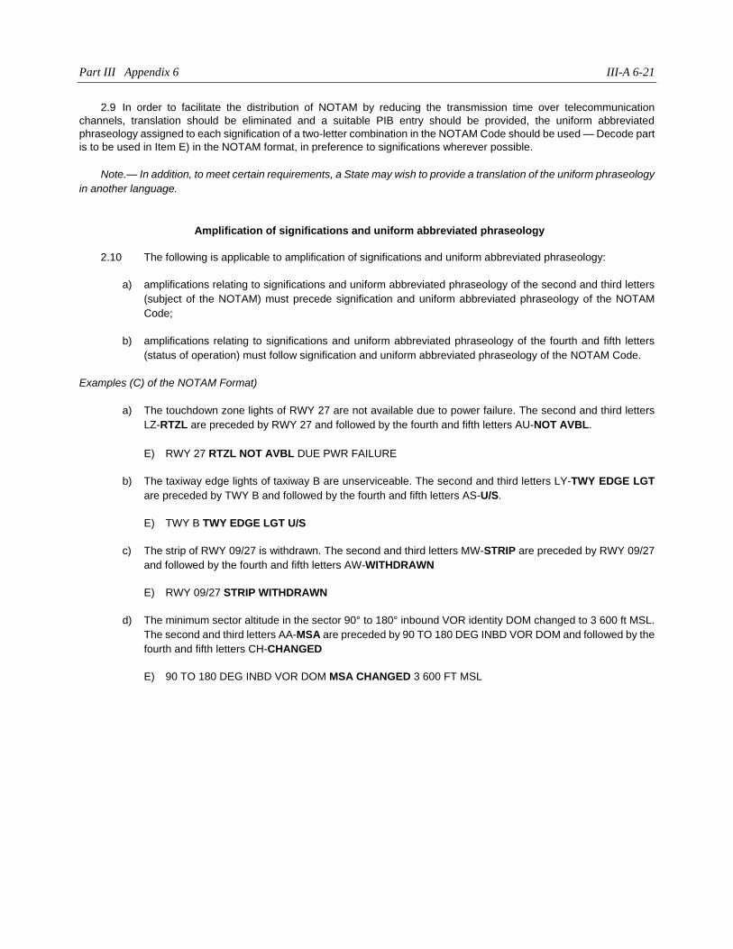
Part III Appendix 6 III-A 6-21
2.9 In order to facilitate the distribution of NOTAM by reducing the transmission time over telecommunication
channels, translation should be eliminated and a suitable PIB entry should be provided, the uniform abbreviated
phraseology assigned to each signification of a two-letter combination in the NOTAM Code should be used — Decode part
is to be used in Item E) in the NOTAM format, in preference to significations wherever possible.
Note.— In addition, to meet certain requirements, a State may wish to provide a translation of the uniform phraseology
in another language.
Amplification of significations and uniform abbreviated phraseology
2.10 The following is applicable to amplification of significations and uniform abbreviated phraseology:
a) amplifications relating to significations and uniform abbreviated phraseology of the second and third letters
(subject of the NOTAM) must precede signification and uniform abbreviated phraseology of the NOTAM
Code;
b) amplifications relating to significations and uniform abbreviated phraseology of the fourth and fifth letters
(status of operation) must follow signification and uniform abbreviated phraseology of the NOTAM Code.
Examples (C) of the NOTAM Format)
a) The touchdown zone lights of RWY 27 are not available due to power failure. The second and third letters
LZ-RTZL are preceded by RWY 27 and followed by the fourth and fifth letters AU-NOT AVBL.
E) RWY 27 RTZL NOT AVBL DUE PWR FAILURE
b) The taxiway edge lights of taxiway B are unserviceable. The second and third letters LY-TWY EDGE LGT
are preceded by TWY B and followed by the fourth and fifth letters AS-U/S.
E) TWY B TWY EDGE LGT U/S
c) The strip of RWY 09/27 is withdrawn. The second and third letters MW-STRIP are preceded by RWY 09/27
and followed by the fourth and fifth letters AW-WITHDRAWN
E) RWY 09/27 STRIP WITHDRAWN
d) The minimum sector altitude in the sector 90° to 180° inbound VOR identity DOM changed to 3 600 ft MSL.
The second and third letters AA-MSA are preceded by 90 TO 180 DEG INBD VOR DOM and followed by the
fourth and fifth letters CH-CHANGED
E) 90 TO 180 DEG INBD VOR DOM MSA CHANGED 3 600 FT MSL

Appendix 7
NOTAM SELECTION CRITERIA
1. THE NOTAM CODE
1.1 The NOTAM code is a comprehensive description of information contained in NOTAM. NOTAM code
groups contain a total of five letters, the first letter of which is always Q. The second and third letters identify the subject,
and the fourth and fifth letters denote the status of the subject reported on. These codes and their significations are found
in the Procedures for Air Navigation Services — Abbreviations and Codes (PANS-ABC, Doc 8400). The most commonly
used NOTAM code groups and their respective relation to the qualifiers Traffic, Purpose and Scope are presented in the
NOTAM Selection Criteria (NSC) tables below.
1.2 The following fourth and fifth letters should not be used and another code should be found instead:
AC, AF, AX, CO, CP, HH, HJ, HK, HQ, HT, HU, LA, LD, LE, LK.
1.3 The following fourth and fifth letters are not listed in the NSC because they correspond to conditions
normally communicated by means of SNOWTAM:
HA, HB, HC, HD, HE, HF, HI, HL, HN, HO, HP, HS, HY, HZ.
2. QUALIFIERS TRAFFIC, PURPOSE AND SCOPE
2.1 Traffic
I = IFR
V = VFR
K = NOTAM is a checklist.
Depending on the NOTAM subject and content, the field for the qualifier Traffic may contain the qualifiers K, I, V or IV. An
indication of IV in the NSC means that either I or V or IV may be used depending on NOTAM content.
2.2 Purpose
N = NOTAM selected for immediate attention of aircraft operators
B = NOTAM selected for PIB entry
O = NOTAM concerning flight operations
M = Miscellaneous NOTAM; not subject for a briefing, but available on request
K = NOTAM is a checklist.
III-A 7-2 Aeronautical Information Services manual
Depending on the NOTAM subject and content, the field for the qualifier Purpose may contain the qualifiers K, M, B, BO or
NBO.
2.3 Scope
A = Aerodrome
E = En-route
W = Nav Warning
K = NOTAM is a checklist.
Depending on the NOTAM subject and content, the field for the qualifier Scope may contain combined qualifiers.
AE = Aerodrome and En-route
Scope AE relates the NOTAM to both scopes of aerodrome and en-route. Scope AE is used whenever
an aerodrome-related NOTAM (e.g. certain navigation facilities) affects both aerodrome and en-route
operations.
AW = Aerodrome and Nav Warning
Scope AW relates the NOTAM to both scopes of A and W. Scope AW is used whenever aerodrome and
en-route traffic is affected by a navigation warning taking place on or in the near vicinity of an aerodrome.
Item A) must contain the aerodrome location indicator, and Item Q) must contain the geographical
coordinates of the location where the activity takes place, followed by the radius.
3. TRIGGER NOTAM
The fourth and fifth letters of the NOTAM code of a trigger NOTAM must always be TT. The second and third letters are
selected from Doc 8400 and must never be XX. The qualifier Purpose is always BO since it relates to AIRAC publication.
4. COMBINATION OF NOTAM CODES AND NOTAM QUALIFIERS
4.1 The NOTAM Selection Criteria is the basis for NOTAM code allocation and selection of qualifiers.
Combinations of the NOTAM codes subject and status or condition with the NOTAM qualifiers Traffic, Purpose and Scope
are presented in the NOTAM Selection Criteria tables. In the tables appropriate combinations are marked with an X.
4.2 If the subject (2nd and 3rd letters) is not listed in plain language code, then XX is used. If the subject demands
a different selection of qualifiers, then Traffic and Purpose entries are selected with due regard to the NOTAM content and
the most common used combination of qualifiers in the tables.
4.3 If the condition (4th and 5th letters) is not listed, then entries are selected with due regard to the qualifying
NOTAM content and, by analogy, with the prevailing association to qualifiers to the respective subject (2nd and 3rd letters).
4.4 To facilitate updates of PIB and flight information service, NOTAM is issued which cancels a previous
NOTAM (NOTAMC) with identical qualifiers: Traffic, Purpose and Scope as the original NOTAM.
4.5 Appropriate combinations of NOTAM cancellations codes are in the bottom under the bold line of each
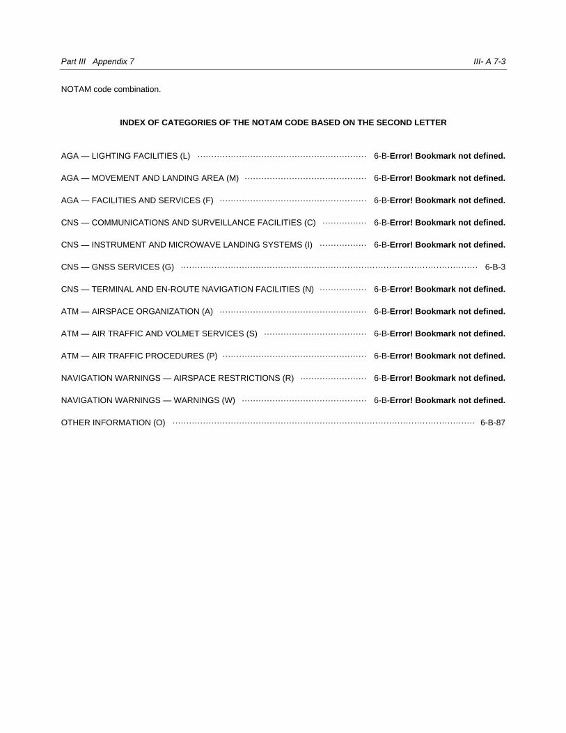
Part III Appendix 7 III- A 7-3
NOTAM code combination.
INDEX OF CATEGORIES OF THE NOTAM CODE BASED ON THE SECOND LETTER
AGA — LIGHTING FACILITIES (L) ····························································· 6-B-Error! Bookmark not defined.
AGA — MOVEMENT AND LANDING AREA (M) ············································ 6-B-Error! Bookmark not defined.
AGA — FACILITIES AND SERVICES (F) ····················································· 6-B-Error! Bookmark not defined.
CNS — COMMUNICATIONS AND SURVEILLANCE FACILITIES (C) ················ 6-B-Error! Bookmark not defined.
CNS — INSTRUMENT AND MICROWAVE LANDING SYSTEMS (I) ················· 6-B-Error! Bookmark not defined.
CNS — GNSS SERVICES (G) ··········································································································· 6-B-3
CNS — TERMINAL AND EN-ROUTE NAVIGATION FACILITIES (N) ················· 6-B-Error! Bookmark not defined.
ATM — AIRSPACE ORGANIZATION (A) ····················································· 6-B-Error! Bookmark not defined.
ATM — AIR TRAFFIC AND VOLMET SERVICES (S) ····································· 6-B-Error! Bookmark not defined.
ATM — AIR TRAFFIC PROCEDURES (P) ···················································· 6-B-Error! Bookmark not defined.
NAVIGATION WARNINGS — AIRSPACE RESTRICTIONS (R) ························ 6-B-Error! Bookmark not defined.
NAVIGATION WARNINGS — WARNINGS (W) ············································· 6-B-Error! Bookmark not defined.
OTHER INFORMATION (O) ············································································································· 6-B-87
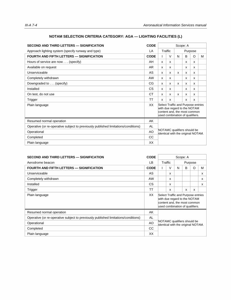
III-A 7-4 Aeronautical Information Services manual
NOTAM SELECTION CRITERIA CATEGORY: AGA — LIGHTING FACILITIES (L)
SECOND AND THIRD LETTERS — SIGNIFICATION CODE Scope: A
Approach lighting system (specify runway and type) LA Traffic Purpose
FOURTH AND FIFTH LETTERS — SIGNIFICATION CODE I V N B O M
Hours of service are now . . . (specify) AH x x x x
Available on request AR x x x x
Unserviceable AS x x x x x
Completely withdrawn AW x x x x
Downgraded to . . . (specify) CG x x x x x
Installed CS x x x x
On test, do not use CT x x x x x
Trigger TT x x x x
Plain language XX Select Traffic and Purpose entries with due regard to the NOTAM content and, the most common used combination of qualifiers.
Resumed normal operation AK
NOTAMC qualifiers should be identical with the original NOTAM.
Operative (or re-operative subject to previously published limitations/conditions) AL
Operational AO
Completed CC
Plain language XX
SECOND AND THIRD LETTERS — SIGNIFICATION CODE Scope: A
Aerodrome beacon LB Traffic Purpose
FOURTH AND FIFTH LETTERS — SIGNIFICATION CODE I V N B O M
Unserviceable AS x x
Completely withdrawn AW x x
Installed CS x x
Trigger TT x x x
Plain language XX Select Traffic and Purpose entries
with due regard to the NOTAM
content and, the most common
used combination of qualifiers.
Resumed normal operation AK
NOTAMC qualifiers should be identical with the original NOTAM.
Operative (or re-operative subject to previously published limitations/conditions) AL
Operational AO
Completed CC
Plain language XX
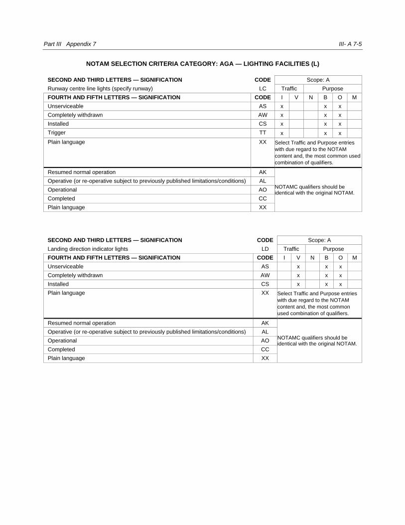
Part III Appendix 7 III- A 7-5
NOTAM SELECTION CRITERIA CATEGORY: AGA — LIGHTING FACILITIES (L)
SECOND AND THIRD LETTERS — SIGNIFICATION CODE Scope: A
Runway centre line lights (specify runway) LC Traffic Purpose
FOURTH AND FIFTH LETTERS — SIGNIFICATION CODE I V N B O M
Unserviceable AS x x x
Completely withdrawn AW x x x
Installed CS x x x
Trigger TT x x x
Plain language XX Select Traffic and Purpose entries
with due regard to the NOTAM
content and, the most common used
combination of qualifiers.
Resumed normal operation AK
NOTAMC qualifiers should be identical with the original NOTAM.
Operative (or re-operative subject to previously published limitations/conditions) AL
Operational AO
Completed CC
Plain language XX
SECOND AND THIRD LETTERS — SIGNIFICATION CODE Scope: A
Landing direction indicator lights LD Traffic Purpose
FOURTH AND FIFTH LETTERS — SIGNIFICATION CODE I V N B O M
Unserviceable AS x x x
Completely withdrawn AW x x x
Installed CS x x x
Plain language XX Select Traffic and Purpose entries
with due regard to the NOTAM
content and, the most common
used combination of qualifiers.
Resumed normal operation AK
NOTAMC qualifiers should be identical with the original NOTAM.
Operative (or re-operative subject to previously published limitations/conditions) AL
Operational AO
Completed CC
Plain language XX
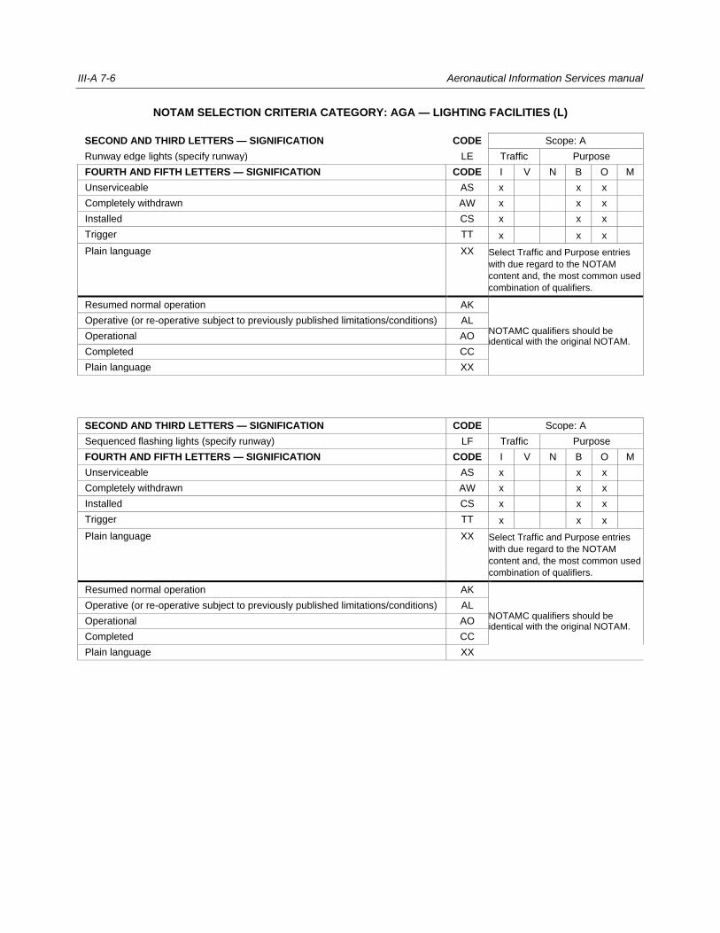
III-A 7-6 Aeronautical Information Services manual
NOTAM SELECTION CRITERIA CATEGORY: AGA — LIGHTING FACILITIES (L)
SECOND AND THIRD LETTERS — SIGNIFICATION CODE Scope: A
Runway edge lights (specify runway) LE Traffic Purpose
FOURTH AND FIFTH LETTERS — SIGNIFICATION CODE I V N B O M
Unserviceable AS x x x
Completely withdrawn AW x x x
Installed CS x x x
Trigger TT x x x
Plain language XX Select Traffic and Purpose entries
with due regard to the NOTAM
content and, the most common used
combination of qualifiers.
Resumed normal operation AK
NOTAMC qualifiers should be identical with the original NOTAM.
Operative (or re-operative subject to previously published limitations/conditions) AL
Operational AO
Completed CC
Plain language XX
SECOND AND THIRD LETTERS — SIGNIFICATION CODE Scope: A
Sequenced flashing lights (specify runway) LF Traffic Purpose
FOURTH AND FIFTH LETTERS — SIGNIFICATION CODE I V N B O M
Unserviceable AS x x x
Completely withdrawn AW x x x
Installed CS x x x
Trigger TT x x x
Plain language XX Select Traffic and Purpose entries
with due regard to the NOTAM
content and, the most common used
combination of qualifiers.
Resumed normal operation AK
NOTAMC qualifiers should be identical with the original NOTAM.
Operative (or re-operative subject to previously published limitations/conditions) AL
Operational AO
Completed CC
Plain language XX
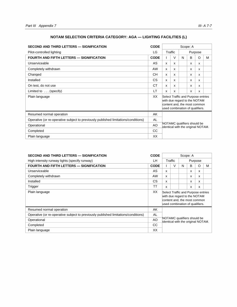
Part III Appendix 7 III- A 7-7
NOTAM SELECTION CRITERIA CATEGORY: AGA — LIGHTING FACILITIES (L)
SECOND AND THIRD LETTERS — SIGNIFICATION CODE Scope: A
Pilot-controlled lighting LG Traffic Purpose
FOURTH AND FIFTH LETTERS — SIGNIFICATION CODE I V N B O M
Unserviceable AS x x x x
Completely withdrawn AW x x x x
Changed CH x x x x
Installed CS x x x x
On test, do not use CT x x x x
Limited to . . . (specify) LT x x x x
Plain language XX Select Traffic and Purpose entries
with due regard to the NOTAM
content and, the most common
used combination of qualifiers.
Resumed normal operation AK
NOTAMC qualifiers should be identical with the original NOTAM.
Operative (or re-operative subject to previously published limitations/conditions) AL
Operational AO
Completed CC
Plain language XX
SECOND AND THIRD LETTERS — SIGNIFICATION CODE Scope: A
High intensity runway lights (specify runway) LH Traffic Purpose
FOURTH AND FIFTH LETTERS — SIGNIFICATION CODE I V N B O M
Unserviceable AS x x x
Completely withdrawn AW x x x
Installed CS x x x
Trigger TT x x x
Plain language XX Select Traffic and Purpose entries
with due regard to the NOTAM
content and, the most common
used combination of qualifiers.
Resumed normal operation AK
NOTAMC qualifiers should be identical with the original NOTAM.
Operative (or re-operative subject to previously published limitations/conditions) AL
Operational AO
Completed CC
Plain language XX
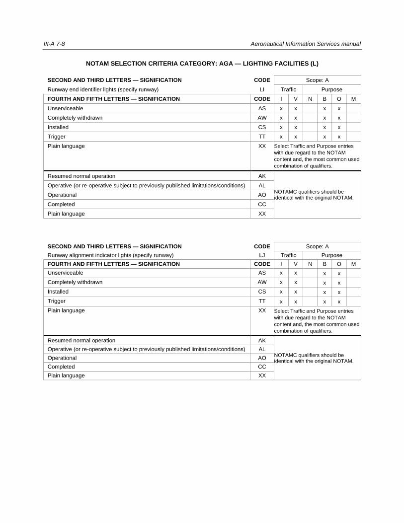
III-A 7-8 Aeronautical Information Services manual
NOTAM SELECTION CRITERIA CATEGORY: AGA — LIGHTING FACILITIES (L)
SECOND AND THIRD LETTERS — SIGNIFICATION CODE Scope: A
Runway end identifier lights (specify runway) LI Traffic Purpose
FOURTH AND FIFTH LETTERS — SIGNIFICATION CODE I V N B O M
Unserviceable AS x x x x
Completely withdrawn AW x x x x
Installed CS x x x x
Trigger TT x x x x
Plain language XX Select Traffic and Purpose entries
with due regard to the NOTAM
content and, the most common used
combination of qualifiers.
Resumed normal operation AK
NOTAMC qualifiers should be identical with the original NOTAM.
Operative (or re-operative subject to previously published limitations/conditions) AL
Operational AO
Completed CC
Plain language XX
SECOND AND THIRD LETTERS — SIGNIFICATION CODE Scope: A
Runway alignment indicator lights (specify runway) LJ Traffic Purpose
FOURTH AND FIFTH LETTERS — SIGNIFICATION CODE I V N B O M
Unserviceable AS x x x x
Completely withdrawn AW x x x x
Installed CS x x x x
Trigger TT x x x x
Plain language XX Select Traffic and Purpose entries
with due regard to the NOTAM
content and, the most common used
combination of qualifiers.
Resumed normal operation AK
NOTAMC qualifiers should be identical with the original NOTAM.
Operative (or re-operative subject to previously published limitations/conditions) AL
Operational AO
Completed CC
Plain language XX
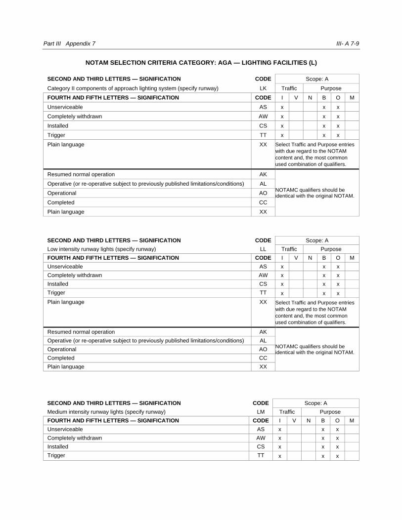
Part III Appendix 7 III- A 7-9
NOTAM SELECTION CRITERIA CATEGORY: AGA — LIGHTING FACILITIES (L)
SECOND AND THIRD LETTERS — SIGNIFICATION CODE Scope: A
Category II components of approach lighting system (specify runway) LK Traffic Purpose
FOURTH AND FIFTH LETTERS — SIGNIFICATION CODE I V N B O M
Unserviceable AS x x x
Completely withdrawn AW x x x
Installed CS x x x
Trigger TT x x x
Plain language XX Select Traffic and Purpose entries
with due regard to the NOTAM
content and, the most common
used combination of qualifiers.
Resumed normal operation AK
NOTAMC qualifiers should be identical with the original NOTAM.
Operative (or re-operative subject to previously published limitations/conditions) AL
Operational AO
Completed CC
Plain language XX
SECOND AND THIRD LETTERS — SIGNIFICATION CODE Scope: A
Low intensity runway lights (specify runway) LL Traffic Purpose
FOURTH AND FIFTH LETTERS — SIGNIFICATION CODE I V N B O M
Unserviceable AS x x x
Completely withdrawn AW x x x
Installed CS x x x
Trigger TT x x x
Plain language XX Select Traffic and Purpose entries
with due regard to the NOTAM
content and, the most common
used combination of qualifiers.
Resumed normal operation AK
NOTAMC qualifiers should be identical with the original NOTAM.
Operative (or re-operative subject to previously published limitations/conditions) AL
Operational AO
Completed CC
Plain language XX
SECOND AND THIRD LETTERS — SIGNIFICATION CODE Scope: A
Medium intensity runway lights (specify runway) LM Traffic Purpose
FOURTH AND FIFTH LETTERS — SIGNIFICATION CODE I V N B O M
Unserviceable AS x x x
Completely withdrawn AW x x x
Installed CS x x x
Trigger TT x x x
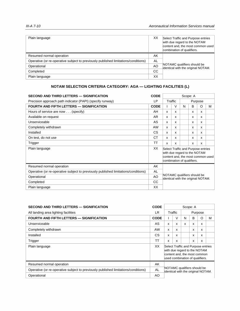
III-A 7-10 Aeronautical Information Services manual
Plain language XX Select Traffic and Purpose entries
with due regard to the NOTAM
content and, the most common used
combination of qualifiers.
Resumed normal operation AK
NOTAMC qualifiers should be identical with the original NOTAM.
Operative (or re-operative subject to previously published limitations/conditions) AL
Operational AO
Completed CC
Plain language XX
NOTAM SELECTION CRITERIA CATEGORY: AGA — LIGHTING FACILITIES (L)
SECOND AND THIRD LETTERS — SIGNIFICATION CODE Scope: A
Precision approach path indicator (PAPI) (specify runway) LP Traffic Purpose
FOURTH AND FIFTH LETTERS — SIGNIFICATION CODE I V N B O M
Hours of service are now . . . (specify) AH x x x x
Available on request AR x x x x
Unserviceable AS x x x x
Completely withdrawn AW x x x x
Installed CS x x x x
On test, do not use CT x x x x
Trigger TT x x x x
Plain language XX Select Traffic and Purpose entries
with due regard to the NOTAM
content and, the most common used
combination of qualifiers.
Resumed normal operation AK
NOTAMC qualifiers should be identical with the original NOTAM.
Operative (or re-operative subject to previously published limitations/conditions) AL
Operational AO
Completed CC
Plain language XX
SECOND AND THIRD LETTERS — SIGNIFICATION CODE Scope: A
All landing area lighting facilities LR Traffic Purpose
FOURTH AND FIFTH LETTERS — SIGNIFICATION CODE I V N B O M
Unserviceable AS x x x x x
Completely withdrawn AW x x x x
Installed CS x x x x
Trigger TT x x x x
Plain language XX Select Traffic and Purpose entries
with due regard to the NOTAM
content and, the most common
used combination of qualifiers.
Resumed normal operation AK NOTAMC qualifiers should be identical with the original NOTAM.
Operative (or re-operative subject to previously published limitations/conditions) AL
Operational AO

Part III Appendix 7 III- A 7-11
Completed CC
Plain language XX
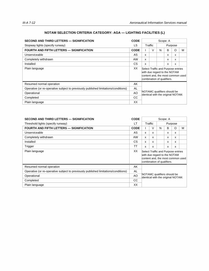
III-A 7-12 Aeronautical Information Services manual
NOTAM SELECTION CRITERIA CATEGORY: AGA — LIGHTING FACILITIES (L)
SECOND AND THIRD LETTERS — SIGNIFICATION CODE Scope: A
Stopway lights (specify runway) LS Traffic Purpose
FOURTH AND FIFTH LETTERS — SIGNIFICATION CODE I V N B O M
Unserviceable AS x x x
Completely withdrawn AW x x x
Installed CS x x x
Plain language XX Select Traffic and Purpose entries
with due regard to the NOTAM
content and, the most common used
combination of qualifiers.
Resumed normal operation AK
NOTAMC qualifiers should be identical with the original NOTAM.
Operative (or re-operative subject to previously published limitations/conditions) AL
Operational AO
Completed CC
Plain language XX
SECOND AND THIRD LETTERS — SIGNIFICATION CODE Scope: A
Threshold lights (specify runway) LT Traffic Purpose
FOURTH AND FIFTH LETTERS — SIGNIFICATION CODE I V N B O M
Unserviceable AS x x x x
Completely withdrawn AW x x x x
Installed CS x x x x
Trigger TT x x x x
Plain language XX Select Traffic and Purpose entries
with due regard to the NOTAM
content and, the most common used
combination of qualifiers.
Resumed normal operation AK
NOTAMC qualifiers should be identical with the original NOTAM.
Operative (or re-operative subject to previously published limitations/conditions) AL
Operational AO
Completed CC
Plain language XX
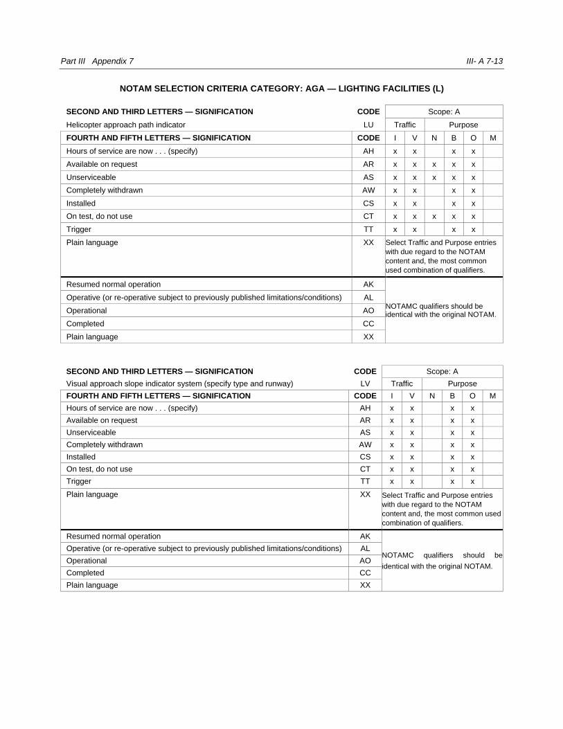
Part III Appendix 7 III- A 7-13
NOTAM SELECTION CRITERIA CATEGORY: AGA — LIGHTING FACILITIES (L)
SECOND AND THIRD LETTERS — SIGNIFICATION CODE Scope: A
Helicopter approach path indicator LU Traffic Purpose
FOURTH AND FIFTH LETTERS — SIGNIFICATION CODE I V N B O M
Hours of service are now . . . (specify) AH x x x x
Available on request AR x x x x x
Unserviceable AS x x x x x
Completely withdrawn AW x x x x
Installed CS x x x x
On test, do not use CT x x x x x
Trigger TT x x x x
Plain language XX Select Traffic and Purpose entries
with due regard to the NOTAM
content and, the most common
used combination of qualifiers.
Resumed normal operation AK
NOTAMC qualifiers should be identical with the original NOTAM.
Operative (or re-operative subject to previously published limitations/conditions) AL
Operational AO
Completed CC
Plain language XX
SECOND AND THIRD LETTERS — SIGNIFICATION CODE Scope: A
Visual approach slope indicator system (specify type and runway) LV Traffic Purpose
FOURTH AND FIFTH LETTERS — SIGNIFICATION CODE I V N B O M
Hours of service are now . . . (specify) AH x x x x
Available on request AR x x x x
Unserviceable AS x x x x
Completely withdrawn AW x x x x
Installed CS x x x x
On test, do not use CT x x x x
Trigger TT x x x x
Plain language XX Select Traffic and Purpose entries
with due regard to the NOTAM
content and, the most common used
combination of qualifiers.
Resumed normal operation AK
NOTAMC qualifiers should be
identical with the original NOTAM.
Operative (or re-operative subject to previously published limitations/conditions) AL
Operational AO
Completed CC
Plain language XX
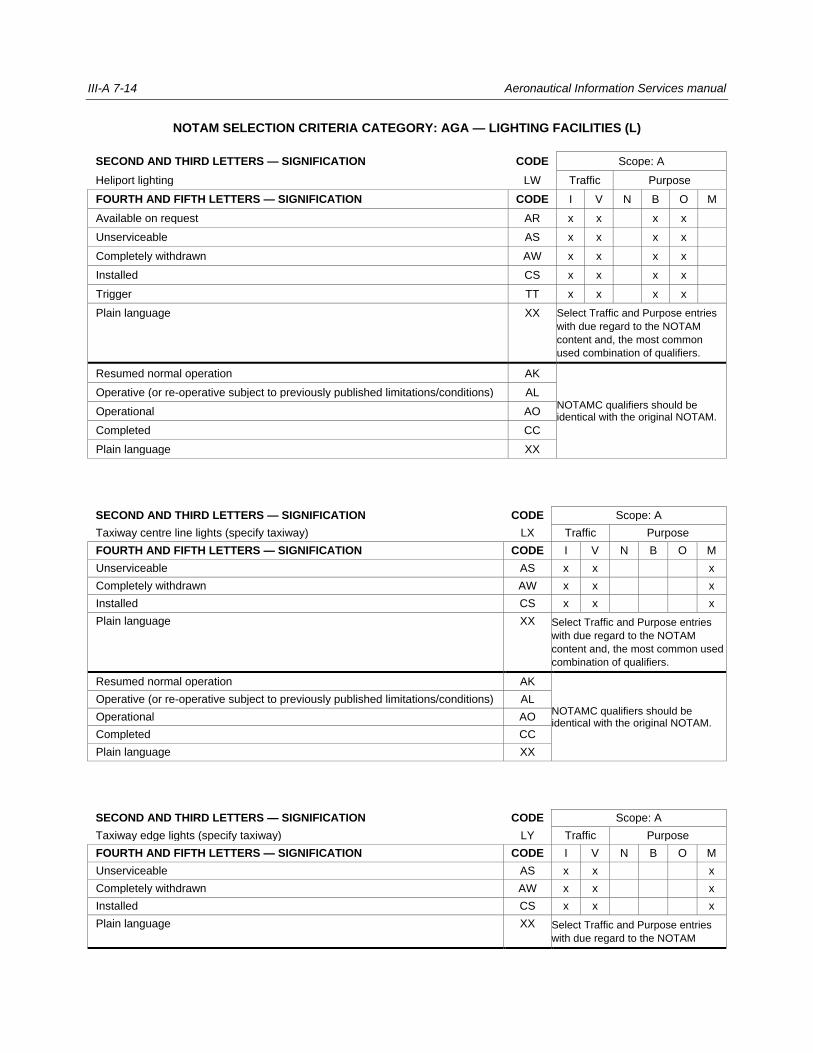
III-A 7-14 Aeronautical Information Services manual
NOTAM SELECTION CRITERIA CATEGORY: AGA — LIGHTING FACILITIES (L)
SECOND AND THIRD LETTERS — SIGNIFICATION CODE Scope: A
Heliport lighting LW Traffic Purpose
FOURTH AND FIFTH LETTERS — SIGNIFICATION CODE I V N B O M
Available on request AR x x x x
Unserviceable AS x x x x
Completely withdrawn AW x x x x
Installed CS x x x x
Trigger TT x x x x
Plain language XX Select Traffic and Purpose entries
with due regard to the NOTAM
content and, the most common
used combination of qualifiers.
Resumed normal operation AK
NOTAMC qualifiers should be identical with the original NOTAM.
Operative (or re-operative subject to previously published limitations/conditions) AL
Operational AO
Completed CC
Plain language XX
SECOND AND THIRD LETTERS — SIGNIFICATION CODE Scope: A
Taxiway centre line lights (specify taxiway) LX Traffic Purpose
FOURTH AND FIFTH LETTERS — SIGNIFICATION CODE I V N B O M
Unserviceable AS x x x
Completely withdrawn AW x x x
Installed CS x x x
Plain language XX Select Traffic and Purpose entries
with due regard to the NOTAM
content and, the most common used
combination of qualifiers.
Resumed normal operation AK
NOTAMC qualifiers should be identical with the original NOTAM.
Operative (or re-operative subject to previously published limitations/conditions) AL
Operational AO
Completed CC
Plain language XX
SECOND AND THIRD LETTERS — SIGNIFICATION CODE Scope: A
Taxiway edge lights (specify taxiway) LY Traffic Purpose
FOURTH AND FIFTH LETTERS — SIGNIFICATION CODE I V N B O M
Unserviceable AS x x x
Completely withdrawn AW x x x
Installed CS x x x
Plain language XX Select Traffic and Purpose entries
with due regard to the NOTAM

Part III Appendix 7 III- A 7-15
content and, the most common used
combination of qualifiers.
Resumed normal operation AK
NOTAMC qualifiers should be identical with the original NOTAM.
Operative (or re-operative subject to previously published limitations/conditions) AL
Operational AO
Completed CC
Plain language XX
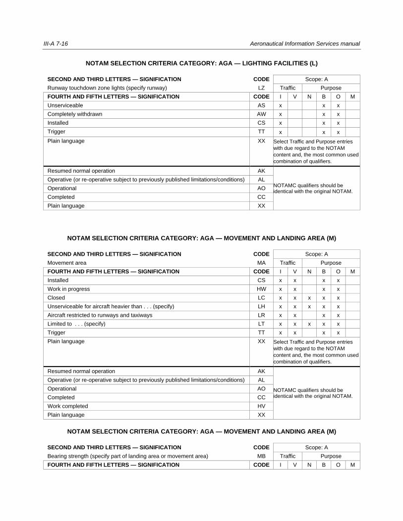
III-A 7-16 Aeronautical Information Services manual
NOTAM SELECTION CRITERIA CATEGORY: AGA — LIGHTING FACILITIES (L)
SECOND AND THIRD LETTERS — SIGNIFICATION CODE Scope: A
Runway touchdown zone lights (specify runway) LZ Traffic Purpose
FOURTH AND FIFTH LETTERS — SIGNIFICATION CODE I V N B O M
Unserviceable AS x x x
Completely withdrawn AW x x x
Installed CS x x x
Trigger TT x x x
Plain language XX Select Traffic and Purpose entries
with due regard to the NOTAM
content and, the most common used
combination of qualifiers.
Resumed normal operation AK
NOTAMC qualifiers should be identical with the original NOTAM.
Operative (or re-operative subject to previously published limitations/conditions) AL
Operational AO
Completed CC
Plain language XX
NOTAM SELECTION CRITERIA CATEGORY: AGA — MOVEMENT AND LANDING AREA (M)
SECOND AND THIRD LETTERS — SIGNIFICATION CODE Scope: A
Movement area MA Traffic Purpose
FOURTH AND FIFTH LETTERS — SIGNIFICATION CODE I V N B O M
Installed CS x x x x
Work in progress HW x x x x
Closed LC x x x x x
Unserviceable for aircraft heavier than . . . (specify) LH x x x x x
Aircraft restricted to runways and taxiways LR x x x x
Limited to . . . (specify) LT x x x x x
Trigger TT x x x x
Plain language XX Select Traffic and Purpose entries
with due regard to the NOTAM
content and, the most common used
combination of qualifiers.
Resumed normal operation AK
NOTAMC qualifiers should be identical with the original NOTAM.
Operative (or re-operative subject to previously published limitations/conditions) AL
Operational AO
Completed CC
Work completed HV
Plain language XX
NOTAM SELECTION CRITERIA CATEGORY: AGA — MOVEMENT AND LANDING AREA (M)
SECOND AND THIRD LETTERS — SIGNIFICATION CODE Scope: A
Bearing strength (specify part of landing area or movement area) MB Traffic Purpose
FOURTH AND FIFTH LETTERS — SIGNIFICATION CODE I V N B O M
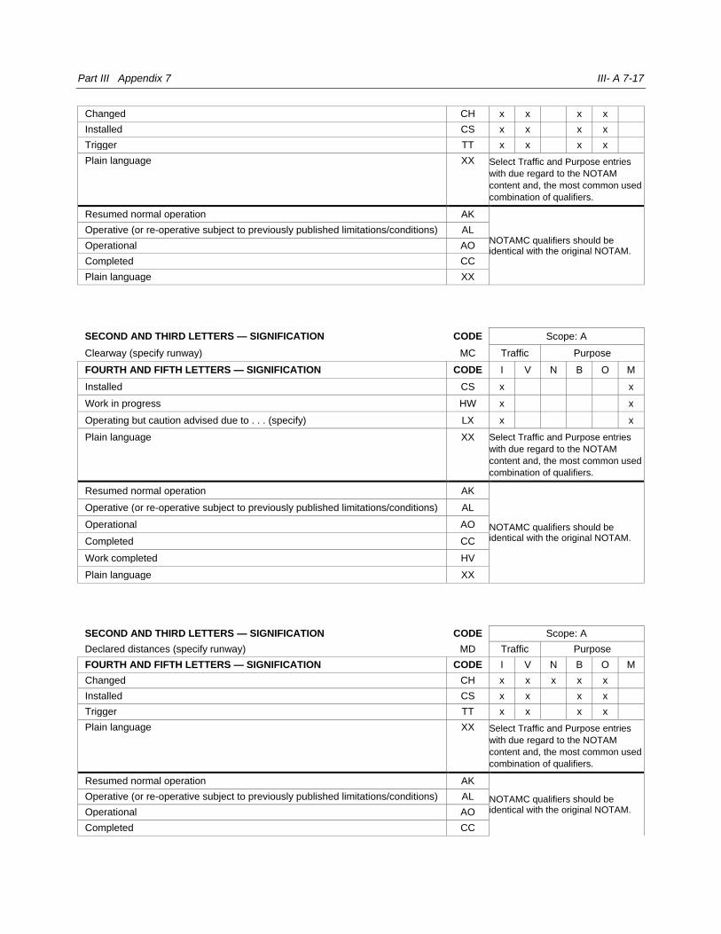
Part III Appendix 7 III- A 7-17
Changed CH x x x x
Installed CS x x x x
Trigger TT x x x x
Plain language XX Select Traffic and Purpose entries
with due regard to the NOTAM
content and, the most common used
combination of qualifiers.
Resumed normal operation AK
NOTAMC qualifiers should be identical with the original NOTAM.
Operative (or re-operative subject to previously published limitations/conditions) AL
Operational AO
Completed CC
Plain language XX
SECOND AND THIRD LETTERS — SIGNIFICATION CODE Scope: A
Clearway (specify runway) MC Traffic Purpose
FOURTH AND FIFTH LETTERS — SIGNIFICATION CODE I V N B O M
Installed CS x x
Work in progress HW x x
Operating but caution advised due to . . . (specify) LX x x
Plain language XX Select Traffic and Purpose entries
with due regard to the NOTAM
content and, the most common used
combination of qualifiers.
Resumed normal operation AK
NOTAMC qualifiers should be identical with the original NOTAM.
Operative (or re-operative subject to previously published limitations/conditions) AL
Operational AO
Completed CC
Work completed HV
Plain language XX
SECOND AND THIRD LETTERS — SIGNIFICATION CODE Scope: A
Declared distances (specify runway) MD Traffic Purpose
FOURTH AND FIFTH LETTERS — SIGNIFICATION CODE I V N B O M
Changed CH x x x x x
Installed CS x x x x
Trigger TT x x x x
Plain language XX Select Traffic and Purpose entries
with due regard to the NOTAM
content and, the most common used
combination of qualifiers.
Resumed normal operation AK
NOTAMC qualifiers should be identical with the original NOTAM.
Operative (or re-operative subject to previously published limitations/conditions) AL
Operational AO
Completed CC

III-A 7-18 Aeronautical Information Services manual
Plain language XX
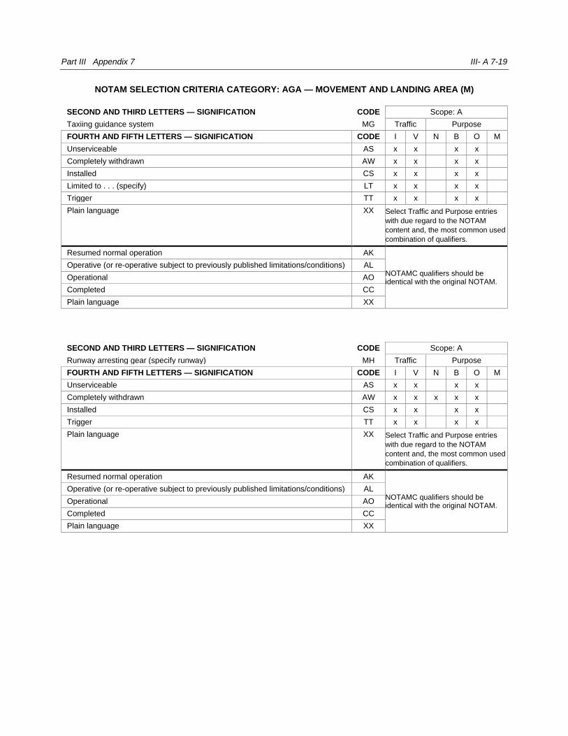
Part III Appendix 7 III- A 7-19
NOTAM SELECTION CRITERIA CATEGORY: AGA — MOVEMENT AND LANDING AREA (M)
SECOND AND THIRD LETTERS — SIGNIFICATION CODE Scope: A
Taxiing guidance system MG Traffic Purpose
FOURTH AND FIFTH LETTERS — SIGNIFICATION CODE I V N B O M
Unserviceable AS x x x x
Completely withdrawn AW x x x x
Installed CS x x x x
Limited to . . . (specify) LT x x x x
Trigger TT x x x x
Plain language XX Select Traffic and Purpose entries
with due regard to the NOTAM
content and, the most common used
combination of qualifiers.
Resumed normal operation AK
NOTAMC qualifiers should be identical with the original NOTAM.
Operative (or re-operative subject to previously published limitations/conditions) AL
Operational AO
Completed CC
Plain language XX
SECOND AND THIRD LETTERS — SIGNIFICATION CODE Scope: A
Runway arresting gear (specify runway) MH Traffic Purpose
FOURTH AND FIFTH LETTERS — SIGNIFICATION CODE I V N B O M
Unserviceable AS x x x x
Completely withdrawn AW x x x x x
Installed CS x x x x
Trigger TT x x x x
Plain language XX Select Traffic and Purpose entries
with due regard to the NOTAM
content and, the most common used
combination of qualifiers.
Resumed normal operation AK
NOTAMC qualifiers should be identical with the original NOTAM.
Operative (or re-operative subject to previously published limitations/conditions) AL
Operational AO
Completed CC
Plain language XX
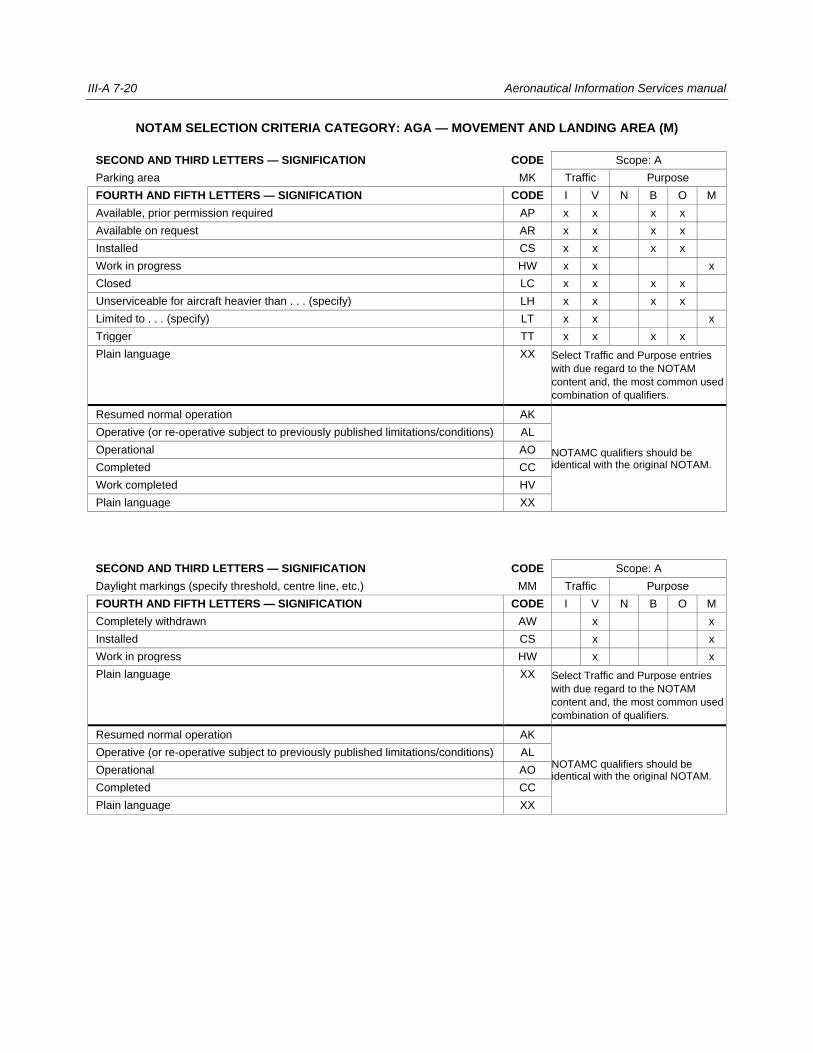
III-A 7-20 Aeronautical Information Services manual
NOTAM SELECTION CRITERIA CATEGORY: AGA — MOVEMENT AND LANDING AREA (M)
SECOND AND THIRD LETTERS — SIGNIFICATION CODE Scope: A
Parking area MK Traffic Purpose
FOURTH AND FIFTH LETTERS — SIGNIFICATION CODE I V N B O M
Available, prior permission required AP x x x x
Available on request AR x x x x
Installed CS x x x x
Work in progress HW x x x
Closed LC x x x x
Unserviceable for aircraft heavier than . . . (specify) LH x x x x
Limited to . . . (specify) LT x x x
Trigger TT x x x x
Plain language XX Select Traffic and Purpose entries
with due regard to the NOTAM
content and, the most common used
combination of qualifiers.
Resumed normal operation AK
NOTAMC qualifiers should be identical with the original NOTAM.
Operative (or re-operative subject to previously published limitations/conditions) AL
Operational AO
Completed CC
Work completed HV
Plain language XX
SECOND AND THIRD LETTERS — SIGNIFICATION CODE Scope: A
Daylight markings (specify threshold, centre line, etc.) MM Traffic Purpose
FOURTH AND FIFTH LETTERS — SIGNIFICATION CODE I V N B O M
Completely withdrawn AW x x
Installed CS x x
Work in progress HW x x
Plain language XX Select Traffic and Purpose entries
with due regard to the NOTAM
content and, the most common used
combination of qualifiers.
Resumed normal operation AK
NOTAMC qualifiers should be identical with the original NOTAM.
Operative (or re-operative subject to previously published limitations/conditions) AL
Operational AO
Completed CC
Plain language XX
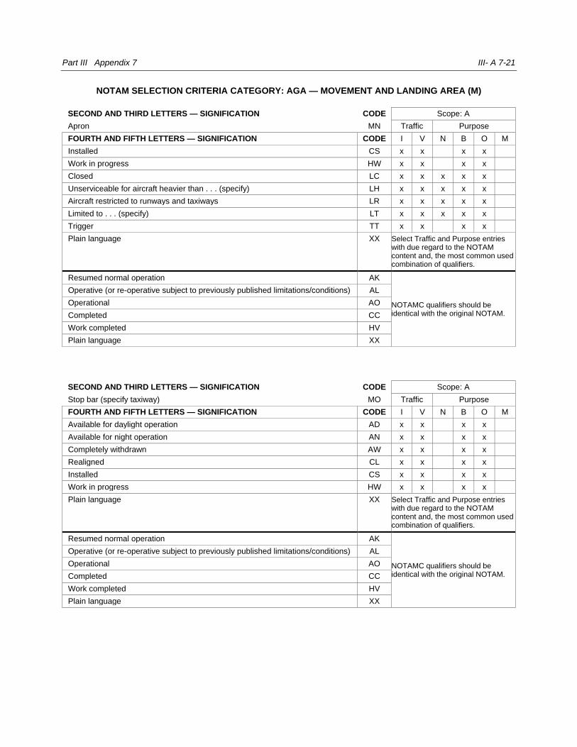
Part III Appendix 7 III- A 7-21
NOTAM SELECTION CRITERIA CATEGORY: AGA — MOVEMENT AND LANDING AREA (M)
SECOND AND THIRD LETTERS — SIGNIFICATION CODE Scope: A
Apron MN Traffic Purpose
FOURTH AND FIFTH LETTERS — SIGNIFICATION CODE I V N B O M
Installed CS x x x x
Work in progress HW x x x x
Closed LC x x x x x
Unserviceable for aircraft heavier than . . . (specify) LH x x x x x
Aircraft restricted to runways and taxiways LR x x x x x
Limited to . . . (specify) LT x x x x x
Trigger TT x x x x
Plain language XX Select Traffic and Purpose entries with due regard to the NOTAM content and, the most common used combination of qualifiers.
Resumed normal operation AK
NOTAMC qualifiers should be identical with the original NOTAM.
Operative (or re-operative subject to previously published limitations/conditions) AL
Operational AO
Completed CC
Work completed HV
Plain language XX
SECOND AND THIRD LETTERS — SIGNIFICATION CODE Scope: A
Stop bar (specify taxiway) MO Traffic Purpose
FOURTH AND FIFTH LETTERS — SIGNIFICATION CODE I V N B O M
Available for daylight operation AD x x x x
Available for night operation AN x x x x
Completely withdrawn AW x x x x
Realigned CL x x x x
Installed CS x x x x
Work in progress HW x x x x
Plain language XX Select Traffic and Purpose entries with due regard to the NOTAM content and, the most common used combination of qualifiers.
Resumed normal operation AK
NOTAMC qualifiers should be identical with the original NOTAM.
Operative (or re-operative subject to previously published limitations/conditions) AL
Operational AO
Completed CC
Work completed HV
Plain language XX
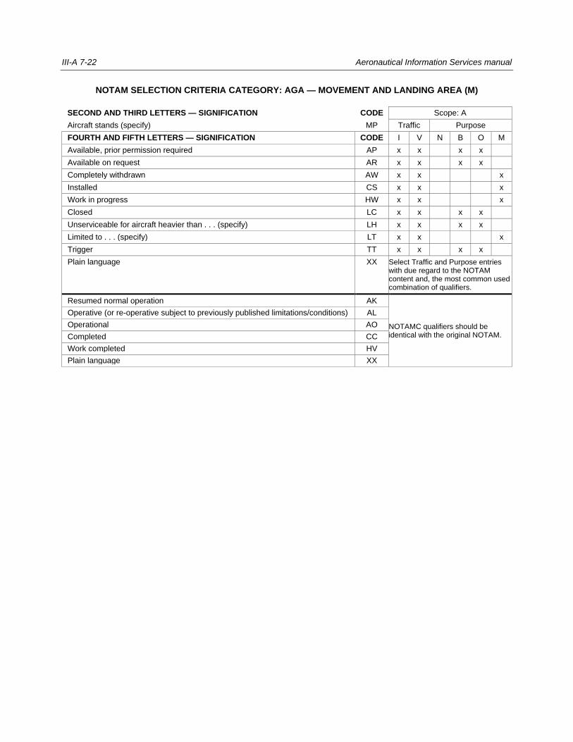
III-A 7-22 Aeronautical Information Services manual
NOTAM SELECTION CRITERIA CATEGORY: AGA — MOVEMENT AND LANDING AREA (M)
SECOND AND THIRD LETTERS — SIGNIFICATION CODE Scope: A
Aircraft stands (specify) MP Traffic Purpose
FOURTH AND FIFTH LETTERS — SIGNIFICATION CODE I V N B O M
Available, prior permission required AP x x x x
Available on request AR x x x x
Completely withdrawn AW x x x
Installed CS x x x
Work in progress HW x x x
Closed LC x x x x
Unserviceable for aircraft heavier than . . . (specify) LH x x x x
Limited to . . . (specify) LT x x x
Trigger TT x x x x
Plain language XX Select Traffic and Purpose entries with due regard to the NOTAM content and, the most common used combination of qualifiers.
Resumed normal operation AK
NOTAMC qualifiers should be identical with the original NOTAM.
Operative (or re-operative subject to previously published limitations/conditions) AL
Operational AO
Completed CC
Work completed HV
Plain language XX
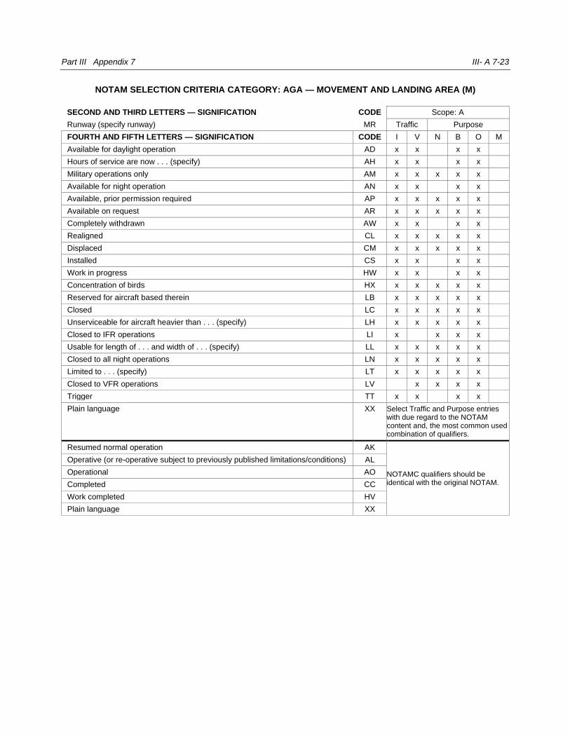
Part III Appendix 7 III- A 7-23
NOTAM SELECTION CRITERIA CATEGORY: AGA — MOVEMENT AND LANDING AREA (M)
SECOND AND THIRD LETTERS — SIGNIFICATION CODE Scope: A
Runway (specify runway) MR Traffic Purpose
FOURTH AND FIFTH LETTERS — SIGNIFICATION CODE I V N B O M
Available for daylight operation AD x x x x
Hours of service are now . . . (specify) AH x x x x
Military operations only AM x x x x x
Available for night operation AN x x x x
Available, prior permission required AP x x x x x
Available on request AR x x x x x
Completely withdrawn AW x x x x
Realigned CL x x x x x
Displaced CM x x x x x
Installed CS x x x x
Work in progress HW x x x x
Concentration of birds HX x x x x x
Reserved for aircraft based therein LB x x x x x
Closed LC x x x x x
Unserviceable for aircraft heavier than . . . (specify) LH x x x x x
Closed to IFR operations LI x x x x
Usable for length of . . . and width of . . . (specify) LL x x x x x
Closed to all night operations LN x x x x x
Limited to . . . (specify) LT x x x x x
Closed to VFR operations LV x x x x
Trigger TT x x x x
Plain language XX Select Traffic and Purpose entries with due regard to the NOTAM content and, the most common used combination of qualifiers.
Resumed normal operation AK
NOTAMC qualifiers should be identical with the original NOTAM.
Operative (or re-operative subject to previously published limitations/conditions) AL
Operational AO
Completed CC
Work completed HV
Plain language XX
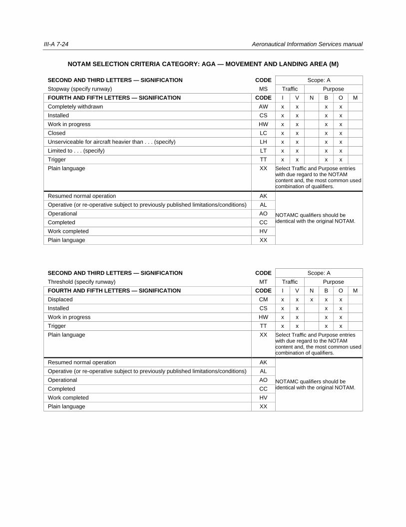
III-A 7-24 Aeronautical Information Services manual
NOTAM SELECTION CRITERIA CATEGORY: AGA — MOVEMENT AND LANDING AREA (M)
SECOND AND THIRD LETTERS — SIGNIFICATION CODE Scope: A
Stopway (specify runway) MS Traffic Purpose
FOURTH AND FIFTH LETTERS — SIGNIFICATION CODE I V N B O M
Completely withdrawn AW x x x x
Installed CS x x x x
Work in progress HW x x x x
Closed LC x x x x
Unserviceable for aircraft heavier than . . . (specify) LH x x x x
Limited to . . . (specify) LT x x x x
Trigger TT x x x x
Plain language XX Select Traffic and Purpose entries with due regard to the NOTAM content and, the most common used combination of qualifiers.
Resumed normal operation AK
NOTAMC qualifiers should be identical with the original NOTAM.
Operative (or re-operative subject to previously published limitations/conditions) AL
Operational AO
Completed CC
Work completed HV
Plain language XX
SECOND AND THIRD LETTERS — SIGNIFICATION CODE Scope: A
Threshold (specify runway) MT Traffic Purpose
FOURTH AND FIFTH LETTERS — SIGNIFICATION CODE I V N B O M
Displaced CM x x x x x
Installed CS x x x x
Work in progress HW x x x x
Trigger TT x x x x
Plain language XX Select Traffic and Purpose entries with due regard to the NOTAM content and, the most common used combination of qualifiers.
Resumed normal operation AK
NOTAMC qualifiers should be identical with the original NOTAM.
Operative (or re-operative subject to previously published limitations/conditions) AL
Operational AO
Completed CC
Work completed HV
Plain language XX
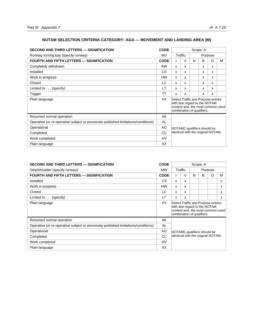
Part III Appendix 7 III- A 7-25
NOTAM SELECTION CRITERIA CATEGORY: AGA — MOVEMENT AND LANDING AREA (M)
SECOND AND THIRD LETTERS — SIGNIFICATION CODE Scope: A
Runway turning bay (specify runway) MU Traffic Purpose
FOURTH AND FIFTH LETTERS — SIGNIFICATION CODE I V N B O M
Completely withdrawn AW x x x x
Installed CS x x x x
Work in progress HW x x x x
Closed LC x x x x
Limited to . . . (specify) LT x x x x
Trigger TT x x x x
Plain language XX Select Traffic and Purpose entries with due regard to the NOTAM content and, the most common used combination of qualifiers.
Resumed normal operation AK
NOTAMC qualifiers should be identical with the original NOTAM.
Operative (or re-operative subject to previously published limitations/conditions) AL
Operational AO
Completed CC
Work completed HV
Plain language XX
SECOND AND THIRD LETTERS — SIGNIFICATION CODE Scope: A
Strip/shoulder (specify runway) MW Traffic Purpose
FOURTH AND FIFTH LETTERS — SIGNIFICATION CODE I V N B O M
Installed CS x x x
Work in progress HW x x x
Closed LC x x x
Limited to . . . (specify) LT x x x
Plain language XX Select Traffic and Purpose entries with due regard to the NOTAM content and, the most common used combination of qualifiers.
Resumed normal operation AK
NOTAMC qualifiers should be identical with the original NOTAM.
Operative (or re-operative subject to previously published limitations/conditions) AL
Operational AO
Completed CC
Work completed HV
Plain language XX
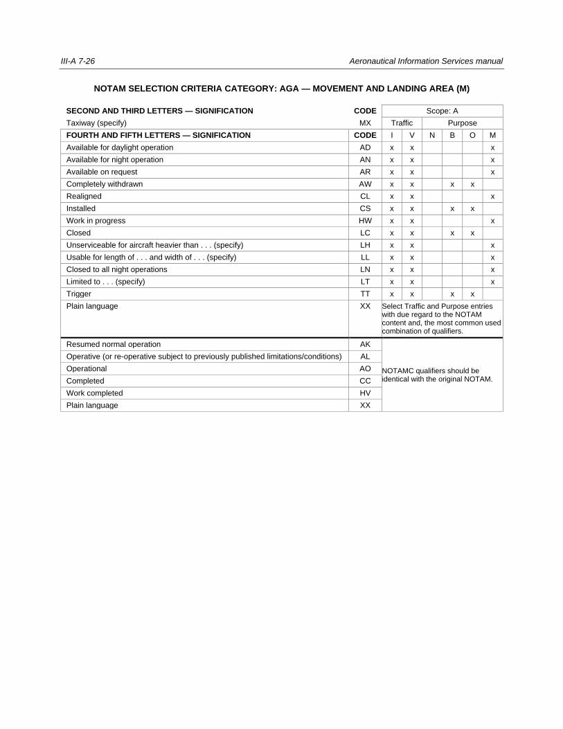
III-A 7-26 Aeronautical Information Services manual
NOTAM SELECTION CRITERIA CATEGORY: AGA — MOVEMENT AND LANDING AREA (M)
SECOND AND THIRD LETTERS — SIGNIFICATION CODE Scope: A
Taxiway (specify) MX Traffic Purpose
FOURTH AND FIFTH LETTERS — SIGNIFICATION CODE I V N B O M
Available for daylight operation AD x x x
Available for night operation AN x x x
Available on request AR x x x
Completely withdrawn AW x x x x
Realigned CL x x x
Installed CS x x x x
Work in progress HW x x x
Closed LC x x x x
Unserviceable for aircraft heavier than . . . (specify) LH x x x
Usable for length of . . . and width of . . . (specify) LL x x x
Closed to all night operations LN x x x
Limited to . . . (specify) LT x x x
Trigger TT x x x x
Plain language XX Select Traffic and Purpose entries with due regard to the NOTAM content and, the most common used combination of qualifiers.
Resumed normal operation AK
NOTAMC qualifiers should be identical with the original NOTAM.
Operative (or re-operative subject to previously published limitations/conditions) AL
Operational AO
Completed CC
Work completed HV
Plain language XX

Part III Appendix 7 III- A 7-27
NOTAM SELECTION CRITERIA CATEGORY: AGA — MOVEMENT AND LANDING AREA (M)
SECOND AND THIRD LETTERS — SIGNIFICATION CODE Scope: A
Rapid exit taxiway (specify) MY Traffic Purpose
FOURTH AND FIFTH LETTERS — SIGNIFICATION CODE I V N B O M
Available for daylight operation AD x x x x
Hours of service are now . . . (specify) AH x x x x
Military operations only AM x x x x x
Available for night operation AN x x x x
Available, prior permission required AP x x x x
Available on request AR x x x x
Completely withdrawn AW x x x x
Realigned CL x x x x x
Displaced CM x x x x x
Installed CS x x x x
Work in progress HW x x x x
Concentration of birds HX x x x x
Reserved for aircraft based therein LB x x x x
Closed LC x x x x x
Unserviceable for aircraft heavier than . . . (specify) LH x x x x x
Closed to IFR operations LI x x x x
Usable for length of . . . and width of . . . (specify) LL x x x x x
Closed to all night operations LN x x x x x
Limited to . . . (specify) LT x x x x
Closed to VFR operations LV x x x
Trigger TT x x x x
Plain language XX Select Traffic and Purpose entries with due regard to the NOTAM content and, the most common used combination of qualifiers.
Resumed normal operation AK
NOTAMC qualifiers should be identical with the original NOTAM.
Operative (or re-operative subject to previously published limitations/conditions) AL
Operational AO
Completed CC
Work completed HV
Plain language XX

III-A 7-28 Aeronautical Information Services manual
NOTAM SELECTION CRITERIA CATEGORY: AGA — FACILITIES AND SERVICES (F)
SECOND AND THIRD LETTERS — SIGNIFICATION CODE Scope: A
Aerodrome FA Traffic Purpose
FOURTH AND FIFTH LETTERS — SIGNIFICATION CODE I V N B O M
Available for daylight operation AD x x x x x
Hours of service are now . . . (specify) AH x x x x
Military operations only AM x x x x x
Available for night operation AN x x x x x
Available, prior permission required AP x x x x x
Available on request AR x x x x x
Completely withdrawn AW x x x x
Identification or radio call sign changed to . . . (specify) CI x x x x
Installed CS x x x x
Grass cutting HG x x x
Work in progress HW x x x x
Concentration of birds HX x x x x x
Reserved for aircraft based therein LB x x x x x
Closed LC x x x x x
Unserviceable for aircraft heavier than . . . (specify) LH x x x x x
Closed to IFR operations LI x x x x
Closed to all night operations LN x x x x x
Aircraft restricted to runways and taxiways LR x x x x
Limited to . . . (specify) LT x x x x x
Closed to VFR operations LV x x x x
Trigger TT x x x x
Plain language XX Select Traffic and Purpose entries with due regard to the NOTAM content and, the most common used combination of qualifiers.
Resumed normal operation AK
NOTAMC qualifiers should be identical with the original NOTAM.
Operative (or re-operative subject to previously published limitations/conditions) AL
Operational AO
Completed CC
Work completed HV
Plain language XX
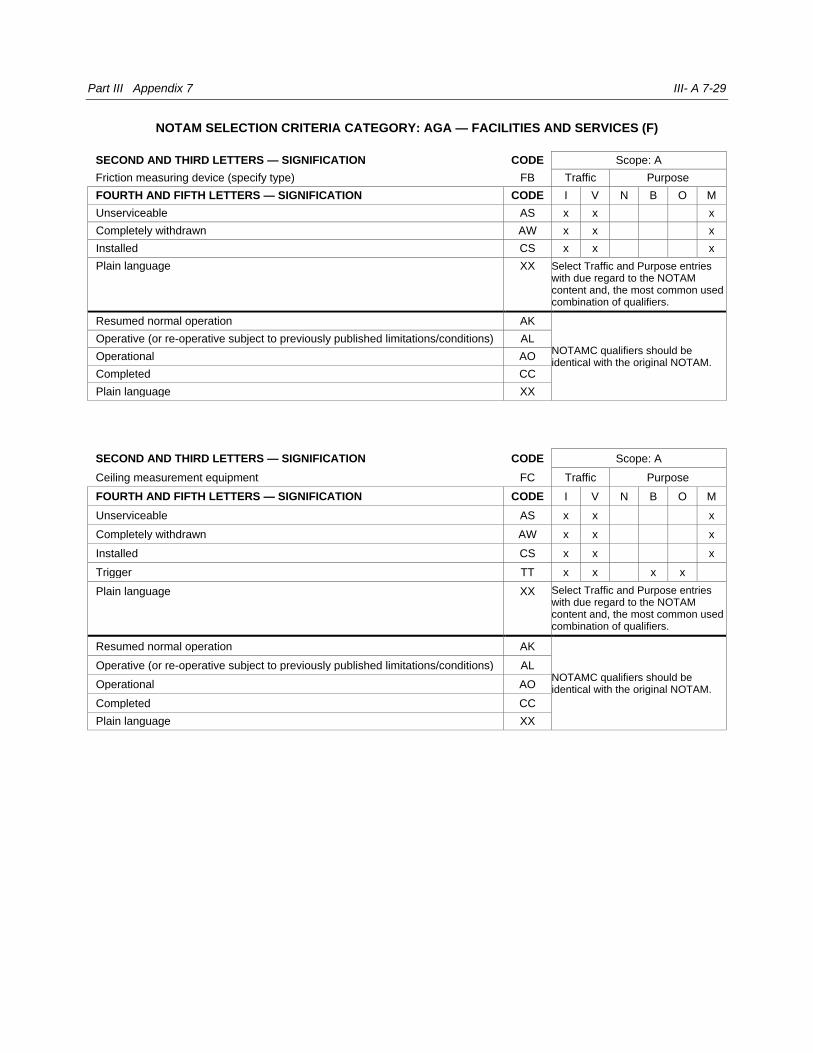
Part III Appendix 7 III- A 7-29
NOTAM SELECTION CRITERIA CATEGORY: AGA — FACILITIES AND SERVICES (F)
SECOND AND THIRD LETTERS — SIGNIFICATION CODE Scope: A
Friction measuring device (specify type) FB Traffic Purpose
FOURTH AND FIFTH LETTERS — SIGNIFICATION CODE I V N B O M
Unserviceable AS x x x
Completely withdrawn AW x x x
Installed CS x x x
Plain language XX Select Traffic and Purpose entries with due regard to the NOTAM content and, the most common used combination of qualifiers.
Resumed normal operation AK
NOTAMC qualifiers should be identical with the original NOTAM.
Operative (or re-operative subject to previously published limitations/conditions) AL
Operational AO
Completed CC
Plain language XX
SECOND AND THIRD LETTERS — SIGNIFICATION CODE Scope: A
Ceiling measurement equipment FC Traffic Purpose
FOURTH AND FIFTH LETTERS — SIGNIFICATION CODE I V N B O M
Unserviceable AS x x x
Completely withdrawn AW x x x
Installed CS x x x
Trigger TT x x x x
Plain language XX Select Traffic and Purpose entries with due regard to the NOTAM content and, the most common used combination of qualifiers.
Resumed normal operation AK
NOTAMC qualifiers should be identical with the original NOTAM.
Operative (or re-operative subject to previously published limitations/conditions) AL
Operational AO
Completed CC
Plain language XX
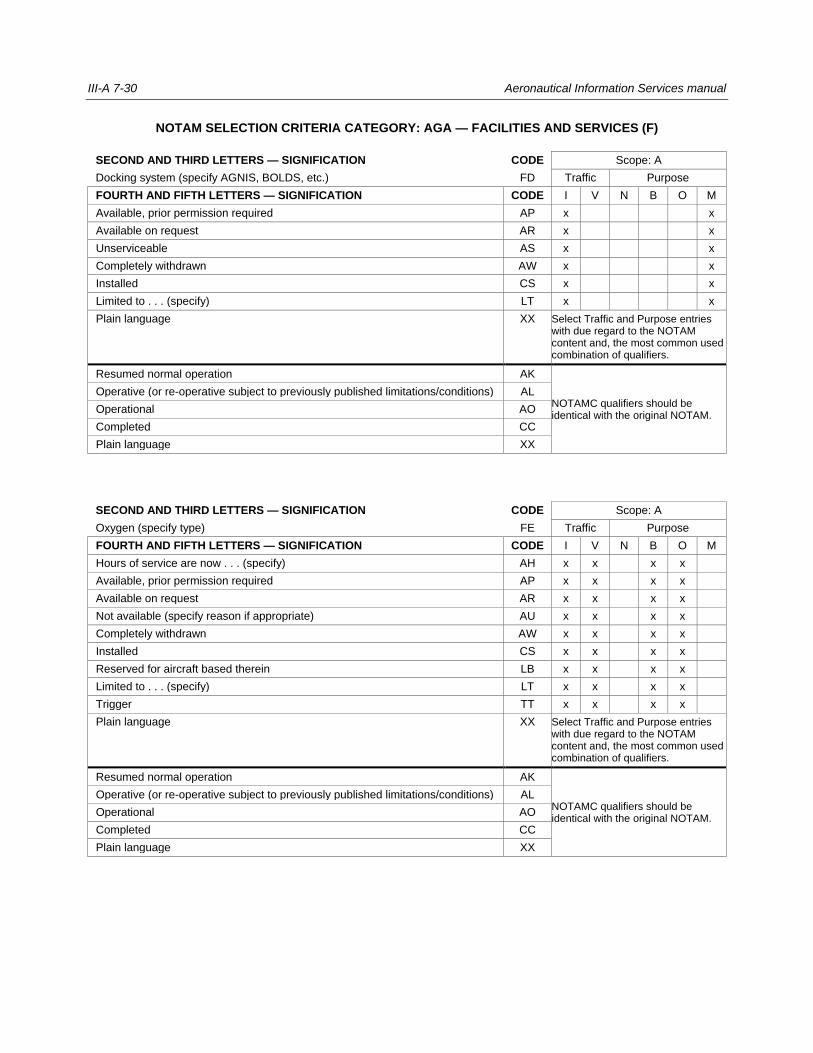
III-A 7-30 Aeronautical Information Services manual
NOTAM SELECTION CRITERIA CATEGORY: AGA — FACILITIES AND SERVICES (F)
SECOND AND THIRD LETTERS — SIGNIFICATION CODE Scope: A
Docking system (specify AGNIS, BOLDS, etc.) FD Traffic Purpose
FOURTH AND FIFTH LETTERS — SIGNIFICATION CODE I V N B O M
Available, prior permission required AP x x
Available on request AR x x
Unserviceable AS x x
Completely withdrawn AW x x
Installed CS x x
Limited to . . . (specify) LT x x
Plain language XX Select Traffic and Purpose entries with due regard to the NOTAM content and, the most common used combination of qualifiers.
Resumed normal operation AK
NOTAMC qualifiers should be identical with the original NOTAM.
Operative (or re-operative subject to previously published limitations/conditions) AL
Operational AO
Completed CC
Plain language XX
SECOND AND THIRD LETTERS — SIGNIFICATION CODE Scope: A
Oxygen (specify type) FE Traffic Purpose
FOURTH AND FIFTH LETTERS — SIGNIFICATION CODE I V N B O M
Hours of service are now . . . (specify) AH x x x x
Available, prior permission required AP x x x x
Available on request AR x x x x
Not available (specify reason if appropriate) AU x x x x
Completely withdrawn AW x x x x
Installed CS x x x x
Reserved for aircraft based therein LB x x x x
Limited to . . . (specify) LT x x x x
Trigger TT x x x x
Plain language XX Select Traffic and Purpose entries with due regard to the NOTAM content and, the most common used combination of qualifiers.
Resumed normal operation AK
NOTAMC qualifiers should be identical with the original NOTAM.
Operative (or re-operative subject to previously published limitations/conditions) AL
Operational AO
Completed CC
Plain language XX
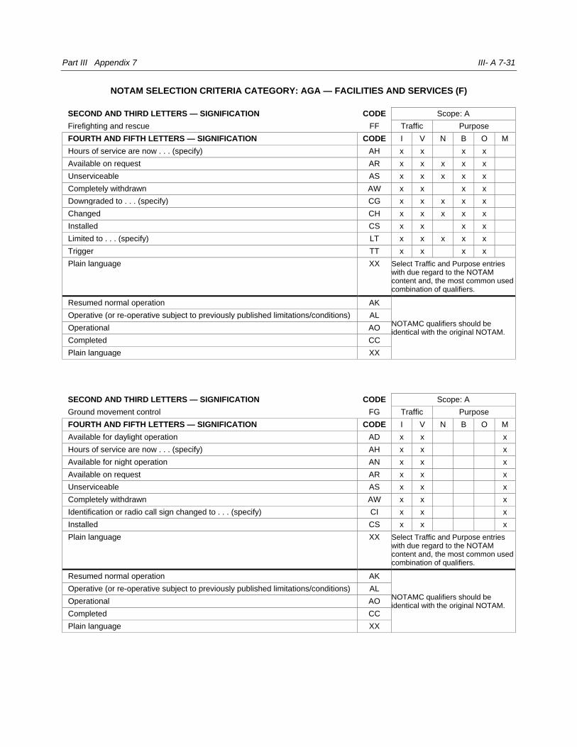
Part III Appendix 7 III- A 7-31
NOTAM SELECTION CRITERIA CATEGORY: AGA — FACILITIES AND SERVICES (F)
SECOND AND THIRD LETTERS — SIGNIFICATION CODE Scope: A
Firefighting and rescue FF Traffic Purpose
FOURTH AND FIFTH LETTERS — SIGNIFICATION CODE I V N B O M
Hours of service are now . . . (specify) AH x x x x
Available on request AR x x x x x
Unserviceable AS x x x x x
Completely withdrawn AW x x x x
Downgraded to . . . (specify) CG x x x x x
Changed CH x x x x x
Installed CS x x x x
Limited to . . . (specify) LT x x x x x
Trigger TT x x x x
Plain language XX Select Traffic and Purpose entries with due regard to the NOTAM content and, the most common used combination of qualifiers.
Resumed normal operation AK
NOTAMC qualifiers should be identical with the original NOTAM.
Operative (or re-operative subject to previously published limitations/conditions) AL
Operational AO
Completed CC
Plain language XX
SECOND AND THIRD LETTERS — SIGNIFICATION CODE Scope: A
Ground movement control FG Traffic Purpose
FOURTH AND FIFTH LETTERS — SIGNIFICATION CODE I V N B O M
Available for daylight operation AD x x x
Hours of service are now . . . (specify) AH x x x
Available for night operation AN x x x
Available on request AR x x x
Unserviceable AS x x x
Completely withdrawn AW x x x
Identification or radio call sign changed to . . . (specify) CI x x x
Installed CS x x x
Plain language XX Select Traffic and Purpose entries with due regard to the NOTAM content and, the most common used combination of qualifiers.
Resumed normal operation AK
NOTAMC qualifiers should be identical with the original NOTAM.
Operative (or re-operative subject to previously published limitations/conditions) AL
Operational AO
Completed CC
Plain language XX
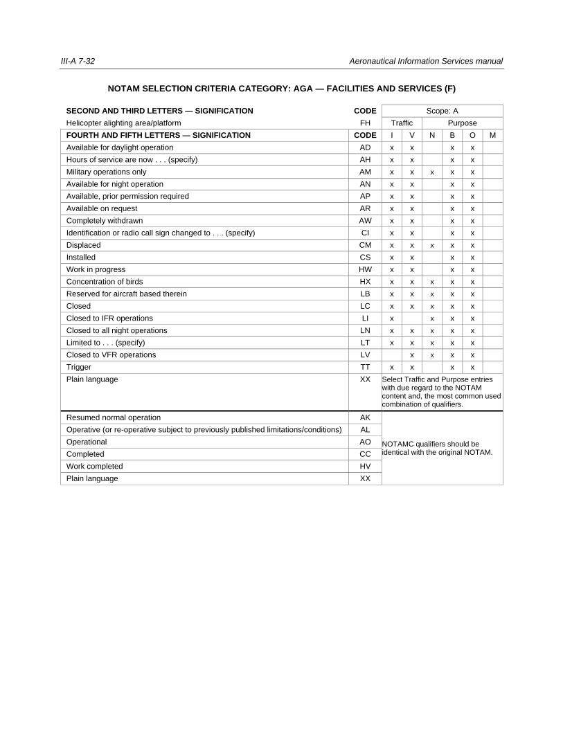
III-A 7-32 Aeronautical Information Services manual
NOTAM SELECTION CRITERIA CATEGORY: AGA — FACILITIES AND SERVICES (F)
SECOND AND THIRD LETTERS — SIGNIFICATION CODE Scope: A
Helicopter alighting area/platform FH Traffic Purpose
FOURTH AND FIFTH LETTERS — SIGNIFICATION CODE I V N B O M
Available for daylight operation AD x x x x
Hours of service are now . . . (specify) AH x x x x
Military operations only AM x x x x x
Available for night operation AN x x x x
Available, prior permission required AP x x x x
Available on request AR x x x x
Completely withdrawn AW x x x x
Identification or radio call sign changed to . . . (specify) CI x x x x
Displaced CM x x x x x
Installed CS x x x x
Work in progress HW x x x x
Concentration of birds HX x x x x x
Reserved for aircraft based therein LB x x x x x
Closed LC x x x x x
Closed to IFR operations LI x x x x
Closed to all night operations LN x x x x x
Limited to . . . (specify) LT x x x x x
Closed to VFR operations LV x x x x
Trigger TT x x x x
Plain language XX Select Traffic and Purpose entries with due regard to the NOTAM content and, the most common used combination of qualifiers.
Resumed normal operation AK
NOTAMC qualifiers should be identical with the original NOTAM.
Operative (or re-operative subject to previously published limitations/conditions) AL
Operational AO
Completed CC
Work completed HV
Plain language XX
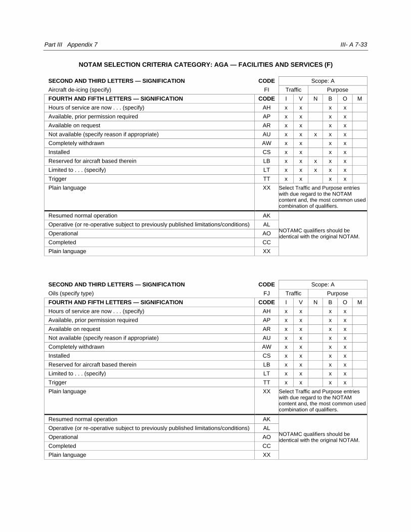
Part III Appendix 7 III- A 7-33
NOTAM SELECTION CRITERIA CATEGORY: AGA — FACILITIES AND SERVICES (F)
SECOND AND THIRD LETTERS — SIGNIFICATION CODE Scope: A
Aircraft de-icing (specify) FI Traffic Purpose
FOURTH AND FIFTH LETTERS — SIGNIFICATION CODE I V N B O M
Hours of service are now . . . (specify) AH x x x x
Available, prior permission required AP x x x x
Available on request AR x x x x
Not available (specify reason if appropriate) AU x x x x x
Completely withdrawn AW x x x x
Installed CS x x x x
Reserved for aircraft based therein LB x x x x x
Limited to . . . (specify) LT x x x x x
Trigger TT x x x x
Plain language XX Select Traffic and Purpose entries with due regard to the NOTAM content and, the most common used combination of qualifiers.
Resumed normal operation AK
NOTAMC qualifiers should be identical with the original NOTAM.
Operative (or re-operative subject to previously published limitations/conditions) AL
Operational AO
Completed CC
Plain language XX
SECOND AND THIRD LETTERS — SIGNIFICATION CODE Scope: A
Oils (specify type) FJ Traffic Purpose
FOURTH AND FIFTH LETTERS — SIGNIFICATION CODE I V N B O M
Hours of service are now . . . (specify) AH x x x x
Available, prior permission required AP x x x x
Available on request AR x x x x
Not available (specify reason if appropriate) AU x x x x
Completely withdrawn AW x x x x
Installed CS x x x x
Reserved for aircraft based therein LB x x x x
Limited to . . . (specify) LT x x x x
Trigger TT x x x x
Plain language XX Select Traffic and Purpose entries with due regard to the NOTAM content and, the most common used combination of qualifiers.
Resumed normal operation AK
NOTAMC qualifiers should be identical with the original NOTAM.
Operative (or re-operative subject to previously published limitations/conditions) AL
Operational AO
Completed CC
Plain language XX
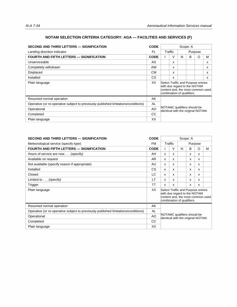
III-A 7-34 Aeronautical Information Services manual
NOTAM SELECTION CRITERIA CATEGORY: AGA — FACILITIES AND SERVICES (F)
SECOND AND THIRD LETTERS — SIGNIFICATION CODE Scope: A
Landing direction indicator FL Traffic Purpose
FOURTH AND FIFTH LETTERS — SIGNIFICATION CODE I V N B O M
Unserviceable AS x x
Completely withdrawn AW x x
Displaced CM x x
Installed CS x x
Plain language XX Select Traffic and Purpose entries with due regard to the NOTAM content and, the most common used combination of qualifiers.
Resumed normal operation AK
NOTAMC qualifiers should be identical with the original NOTAM.
Operative (or re-operative subject to previously published limitations/conditions) AL
Operational AO
Completed CC
Plain language XX
SECOND AND THIRD LETTERS — SIGNIFICATION CODE Scope: A
Meteorological service (specify type) FM Traffic Purpose
FOURTH AND FIFTH LETTERS — SIGNIFICATION CODE I V N B O M
Hours of service are now . . . (specify) AH x x x x
Available on request AR x x x x
Not available (specify reason if appropriate) AU x x x x
Installed CS x x x x
Closed LC x x x x
Limited to . . . (specify) LT x x x x
Trigger TT x x x x
Plain language XX Select Traffic and Purpose entries with due regard to the NOTAM content and, the most common used combination of qualifiers.
Resumed normal operation AK
NOTAMC qualifiers should be identical with the original NOTAM.
Operative (or re-operative subject to previously published limitations/conditions) AL
Operational AO
Completed CC
Plain language XX
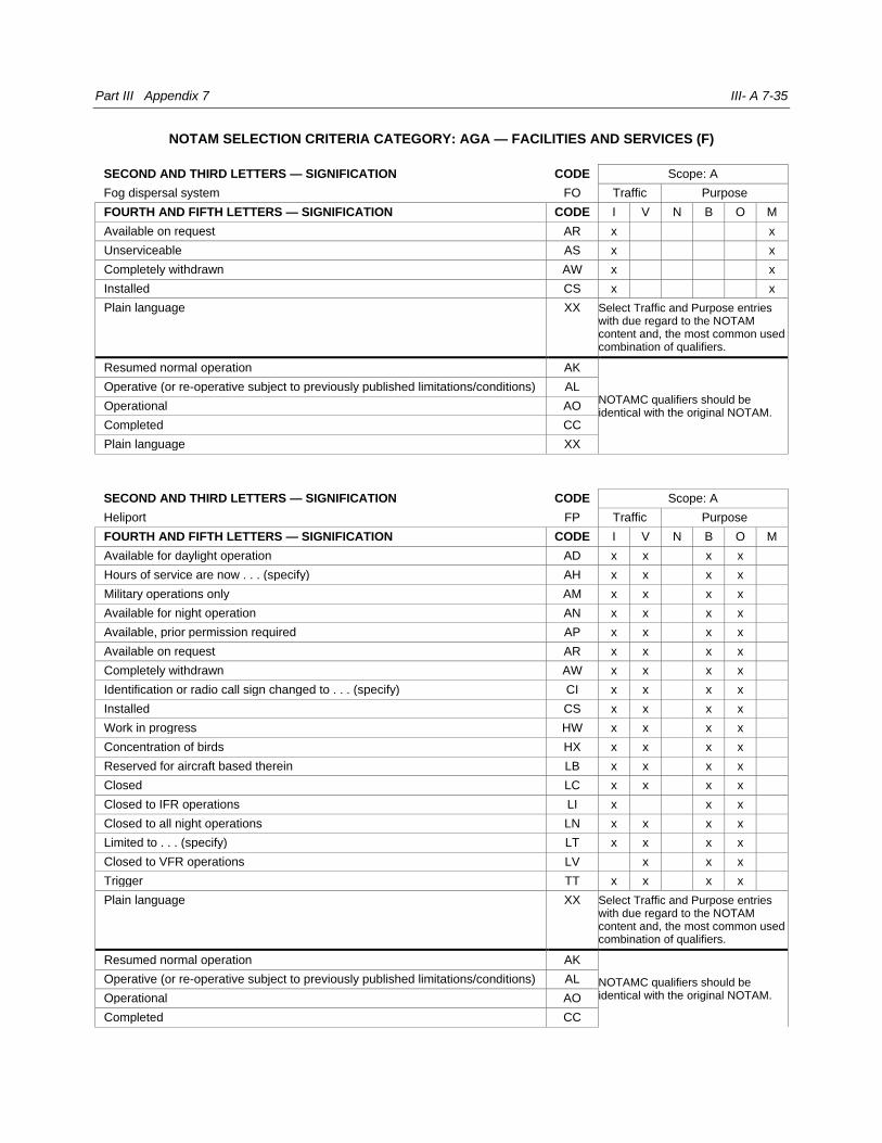
Part III Appendix 7 III- A 7-35
NOTAM SELECTION CRITERIA CATEGORY: AGA — FACILITIES AND SERVICES (F)
SECOND AND THIRD LETTERS — SIGNIFICATION CODE Scope: A
Fog dispersal system FO Traffic Purpose
FOURTH AND FIFTH LETTERS — SIGNIFICATION CODE I V N B O M
Available on request AR x x
Unserviceable AS x x
Completely withdrawn AW x x
Installed CS x x
Plain language XX Select Traffic and Purpose entries with due regard to the NOTAM content and, the most common used combination of qualifiers.
Resumed normal operation AK
NOTAMC qualifiers should be identical with the original NOTAM.
Operative (or re-operative subject to previously published limitations/conditions) AL
Operational AO
Completed CC
Plain language XX
SECOND AND THIRD LETTERS — SIGNIFICATION CODE Scope: A
Heliport FP Traffic Purpose
FOURTH AND FIFTH LETTERS — SIGNIFICATION CODE I V N B O M
Available for daylight operation AD x x x x
Hours of service are now . . . (specify) AH x x x x
Military operations only AM x x x x
Available for night operation AN x x x x
Available, prior permission required AP x x x x
Available on request AR x x x x
Completely withdrawn AW x x x x
Identification or radio call sign changed to . . . (specify) CI x x x x
Installed CS x x x x
Work in progress HW x x x x
Concentration of birds HX x x x x
Reserved for aircraft based therein LB x x x x
Closed LC x x x x
Closed to IFR operations LI x x x
Closed to all night operations LN x x x x
Limited to . . . (specify) LT x x x x
Closed to VFR operations LV x x x
Trigger TT x x x x
Plain language XX Select Traffic and Purpose entries with due regard to the NOTAM content and, the most common used combination of qualifiers.
Resumed normal operation AK
NOTAMC qualifiers should be identical with the original NOTAM.
Operative (or re-operative subject to previously published limitations/conditions) AL
Operational AO
Completed CC

III-A 7-36 Aeronautical Information Services manual
Work completed HV
Plain language XX
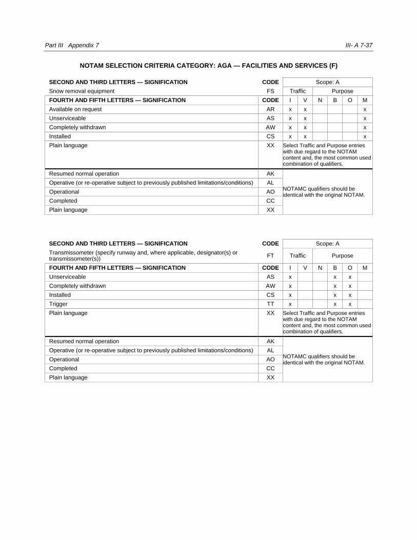
Part III Appendix 7 III- A 7-37
NOTAM SELECTION CRITERIA CATEGORY: AGA — FACILITIES AND SERVICES (F)
SECOND AND THIRD LETTERS — SIGNIFICATION CODE Scope: A
Snow removal equipment FS Traffic Purpose
FOURTH AND FIFTH LETTERS — SIGNIFICATION CODE I V N B O M
Available on request AR x x x
Unserviceable AS x x x
Completely withdrawn AW x x x
Installed CS x x x
Plain language XX Select Traffic and Purpose entries with due regard to the NOTAM content and, the most common used combination of qualifiers.
Resumed normal operation AK
NOTAMC qualifiers should be identical with the original NOTAM.
Operative (or re-operative subject to previously published limitations/conditions) AL
Operational AO
Completed CC
Plain language XX
SECOND AND THIRD LETTERS — SIGNIFICATION CODE Scope: A
Transmissometer (specify runway and, where applicable, designator(s) or transmissometer(s))
FT Traffic Purpose
FOURTH AND FIFTH LETTERS — SIGNIFICATION CODE I V N B O M
Unserviceable AS x x x
Completely withdrawn AW x x x
Installed CS x x x
Trigger TT x x x
Plain language XX Select Traffic and Purpose entries with due regard to the NOTAM content and, the most common used combination of qualifiers.
Resumed normal operation AK
NOTAMC qualifiers should be identical with the original NOTAM.
Operative (or re-operative subject to previously published limitations/conditions) AL
Operational AO
Completed CC
Plain language XX
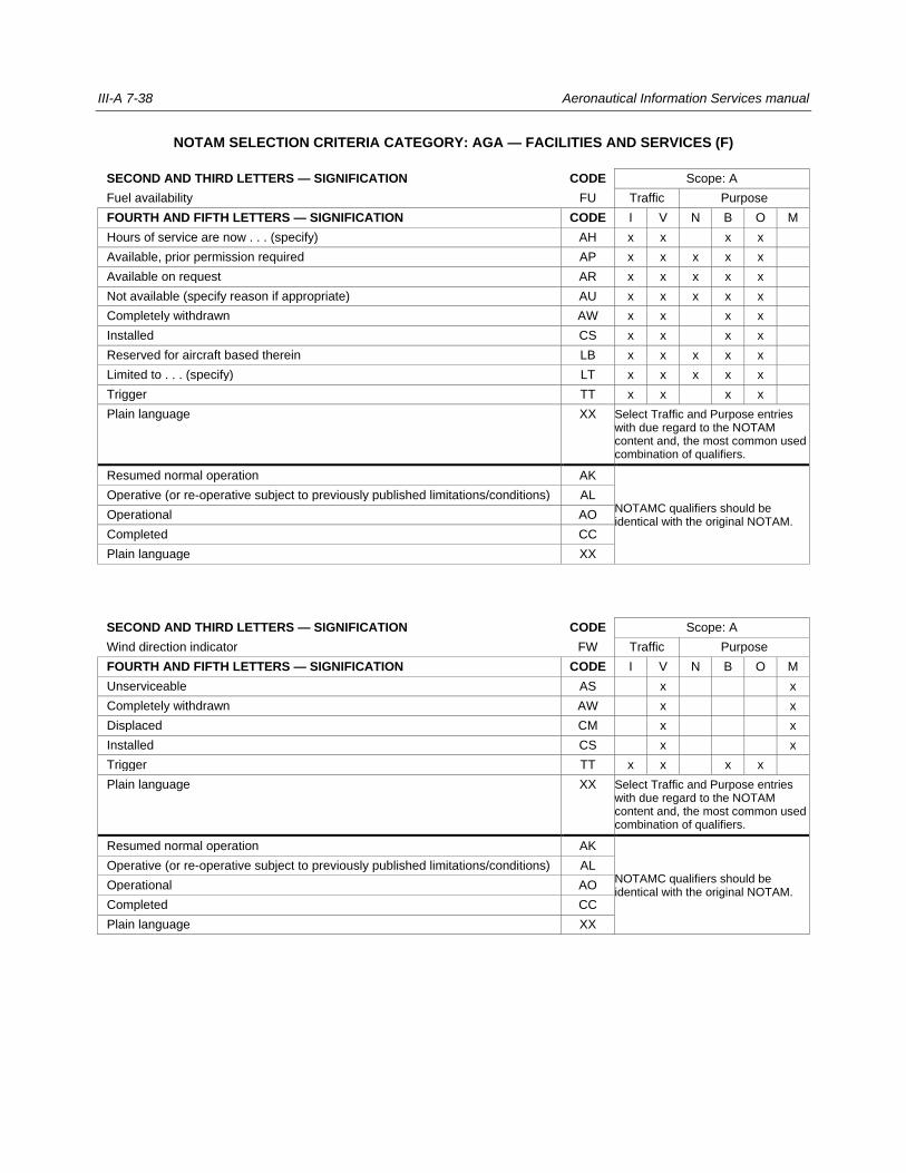
III-A 7-38 Aeronautical Information Services manual
NOTAM SELECTION CRITERIA CATEGORY: AGA — FACILITIES AND SERVICES (F)
SECOND AND THIRD LETTERS — SIGNIFICATION CODE Scope: A
Fuel availability FU Traffic Purpose
FOURTH AND FIFTH LETTERS — SIGNIFICATION CODE I V N B O M
Hours of service are now . . . (specify) AH x x x x
Available, prior permission required AP x x x x x
Available on request AR x x x x x
Not available (specify reason if appropriate) AU x x x x x
Completely withdrawn AW x x x x
Installed CS x x x x
Reserved for aircraft based therein LB x x x x x
Limited to . . . (specify) LT x x x x x
Trigger TT x x x x
Plain language XX Select Traffic and Purpose entries with due regard to the NOTAM content and, the most common used combination of qualifiers.
Resumed normal operation AK
NOTAMC qualifiers should be identical with the original NOTAM.
Operative (or re-operative subject to previously published limitations/conditions) AL
Operational AO
Completed CC
Plain language XX
SECOND AND THIRD LETTERS — SIGNIFICATION CODE Scope: A
Wind direction indicator FW Traffic Purpose
FOURTH AND FIFTH LETTERS — SIGNIFICATION CODE I V N B O M
Unserviceable AS x x
Completely withdrawn AW x x
Displaced CM x x
Installed CS x x
Trigger TT x x x x
Plain language XX Select Traffic and Purpose entries with due regard to the NOTAM content and, the most common used combination of qualifiers.
Resumed normal operation AK
NOTAMC qualifiers should be identical with the original NOTAM.
Operative (or re-operative subject to previously published limitations/conditions) AL
Operational AO
Completed CC
Plain language XX
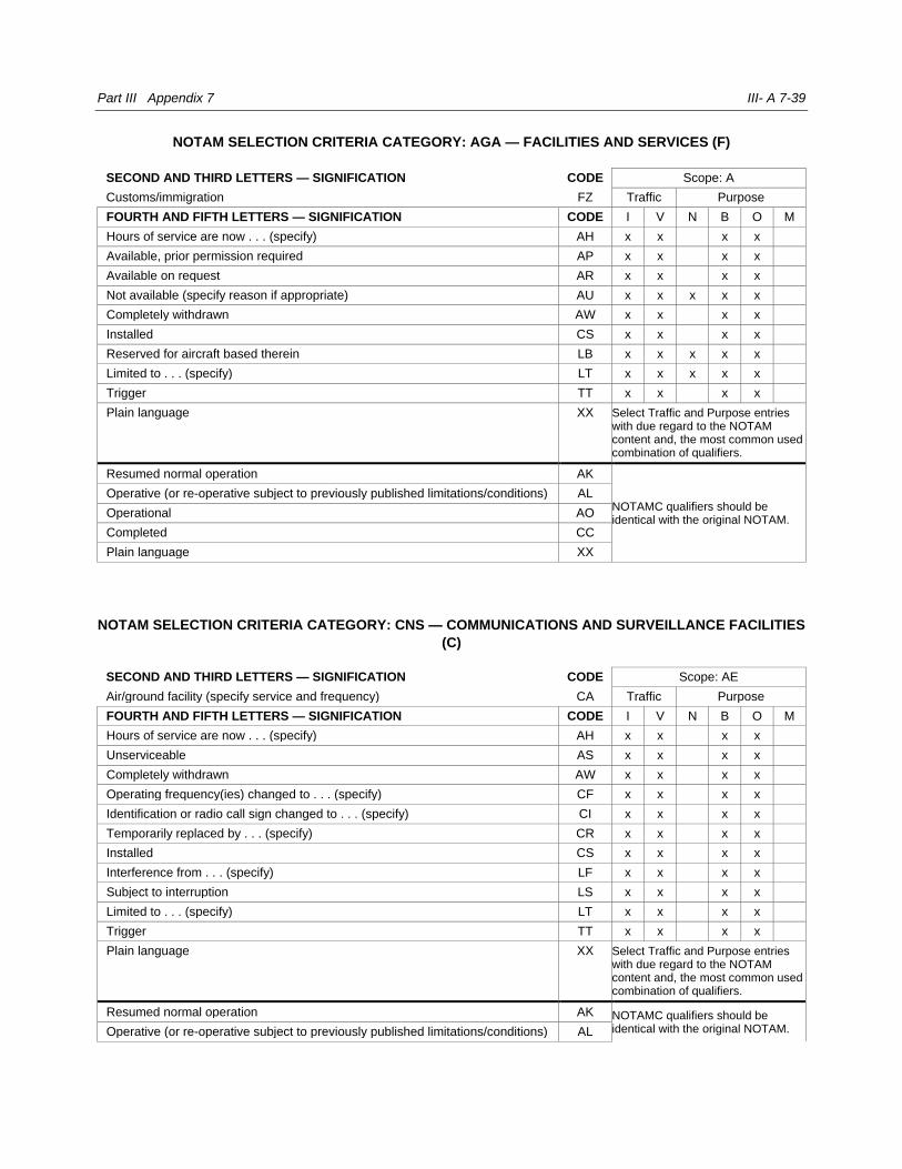
Part III Appendix 7 III- A 7-39
NOTAM SELECTION CRITERIA CATEGORY: AGA — FACILITIES AND SERVICES (F)
SECOND AND THIRD LETTERS — SIGNIFICATION CODE Scope: A
Customs/immigration FZ Traffic Purpose
FOURTH AND FIFTH LETTERS — SIGNIFICATION CODE I V N B O M
Hours of service are now . . . (specify) AH x x x x
Available, prior permission required AP x x x x
Available on request AR x x x x
Not available (specify reason if appropriate) AU x x x x x
Completely withdrawn AW x x x x
Installed CS x x x x
Reserved for aircraft based therein LB x x x x x
Limited to . . . (specify) LT x x x x x
Trigger TT x x x x
Plain language XX Select Traffic and Purpose entries with due regard to the NOTAM content and, the most common used combination of qualifiers.
Resumed normal operation AK
NOTAMC qualifiers should be identical with the original NOTAM.
Operative (or re-operative subject to previously published limitations/conditions) AL
Operational AO
Completed CC
Plain language XX
NOTAM SELECTION CRITERIA CATEGORY: CNS — COMMUNICATIONS AND SURVEILLANCE FACILITIES
(C)
SECOND AND THIRD LETTERS — SIGNIFICATION CODE Scope: AE
Air/ground facility (specify service and frequency) CA Traffic Purpose
FOURTH AND FIFTH LETTERS — SIGNIFICATION CODE I V N B O M
Hours of service are now . . . (specify) AH x x x x
Unserviceable AS x x x x
Completely withdrawn AW x x x x
Operating frequency(ies) changed to . . . (specify) CF x x x x
Identification or radio call sign changed to . . . (specify) CI x x x x
Temporarily replaced by . . . (specify) CR x x x x
Installed CS x x x x
Interference from . . . (specify) LF x x x x
Subject to interruption LS x x x x
Limited to . . . (specify) LT x x x x
Trigger TT x x x x
Plain language XX Select Traffic and Purpose entries with due regard to the NOTAM content and, the most common used combination of qualifiers.
Resumed normal operation AK NOTAMC qualifiers should be identical with the original NOTAM. Operative (or re-operative subject to previously published limitations/conditions) AL
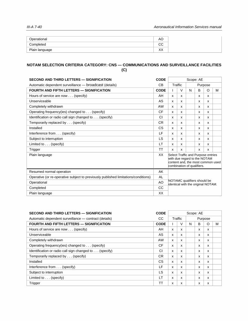
III-A 7-40 Aeronautical Information Services manual
Operational AO
Completed CC
Plain language XX
NOTAM SELECTION CRITERIA CATEGORY: CNS — COMMUNICATIONS AND SURVEILLANCE FACILITIES
(C)
SECOND AND THIRD LETTERS — SIGNIFICATION CODE Scope: AE
Automatic dependent surveillance — broadcast (details) CB Traffic Purpose
FOURTH AND FIFTH LETTERS — SIGNIFICATION CODE I V N B O M
Hours of service are now . . . (specify) AH x x x x
Unserviceable AS x x x x
Completely withdrawn AW x x x x
Operating frequency(ies) changed to . . . (specify) CF x x x x
Identification or radio call sign changed to . . . (specify) CI x x x x
Temporarily replaced by . . . (specify) CR x x x x
Installed CS x x x x
Interference from . . . (specify) LF x x x x
Subject to interruption LS x x x x
Limited to . . . (specify) LT x x x x
Trigger TT x x x x
Plain language XX Select Traffic and Purpose entries with due regard to the NOTAM content and, the most common used combination of qualifiers.
Resumed normal operation AK
NOTAMC qualifiers should be identical with the original NOTAM.
Operative (or re-operative subject to previously published limitations/conditions) AL
Operational AO
Completed CC
Plain language XX
SECOND AND THIRD LETTERS — SIGNIFICATION CODE Scope: AE
Automatic dependent surveillance — contract (details) CC Traffic Purpose
FOURTH AND FIFTH LETTERS — SIGNIFICATION CODE I V N B O M
Hours of service are now . . . (specify) AH x x x x
Unserviceable AS x x x x
Completely withdrawn AW x x x x
Operating frequency(ies) changed to . . . (specify) CF x x x x
Identification or radio call sign changed to . . . (specify) CI x x x x
Temporarily replaced by . . . (specify) CR x x x x
Installed CS x x x x
Interference from . . . (specify) LF x x x x
Subject to interruption LS x x x x
Limited to . . . (specify) LT x x x x
Trigger TT x x x x
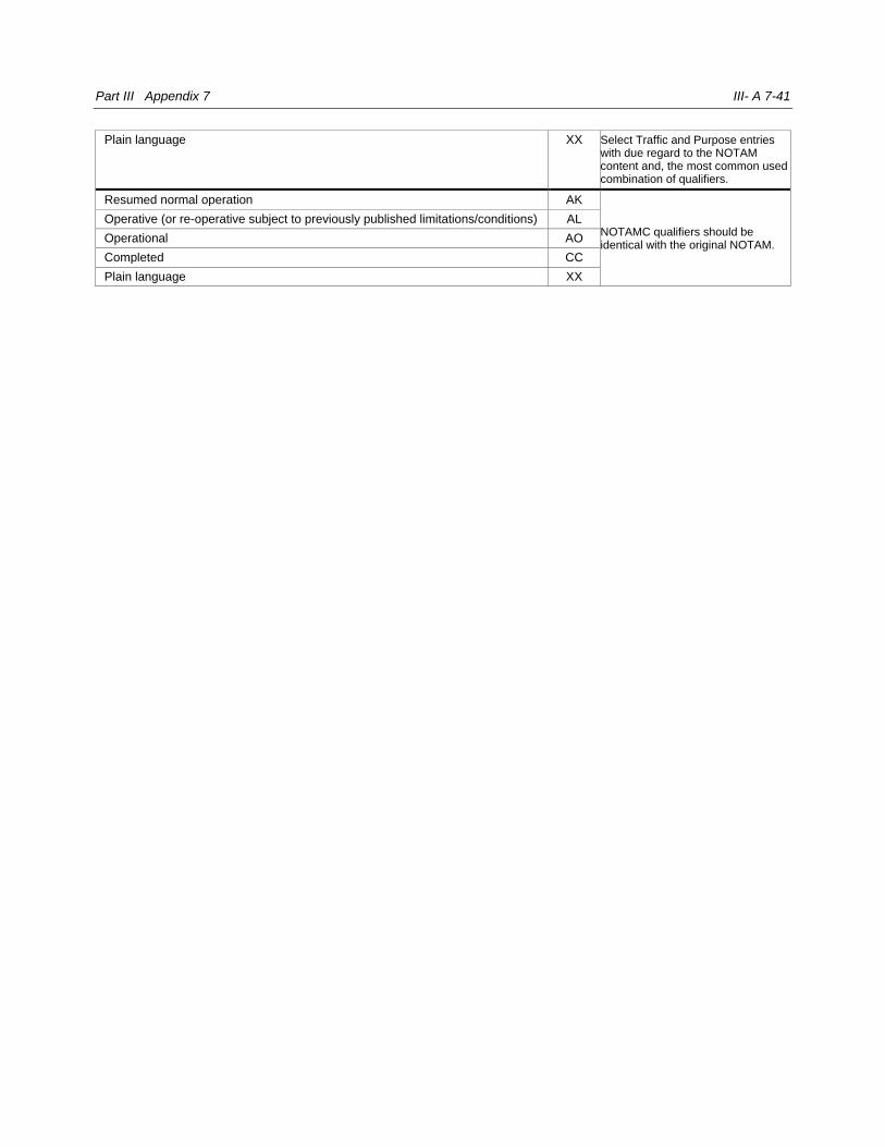
Part III Appendix 7 III- A 7-41
Plain language XX Select Traffic and Purpose entries with due regard to the NOTAM content and, the most common used combination of qualifiers.
Resumed normal operation AK
NOTAMC qualifiers should be identical with the original NOTAM.
Operative (or re-operative subject to previously published limitations/conditions) AL
Operational AO
Completed CC
Plain language XX
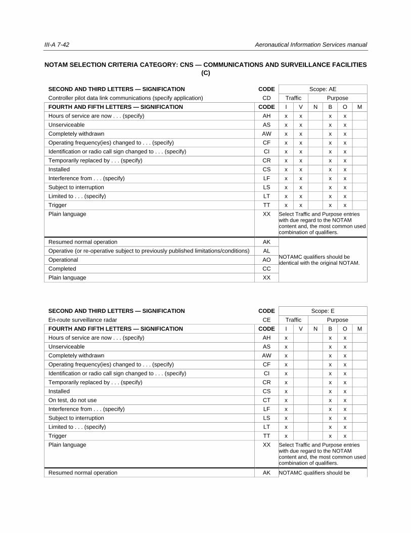
III-A 7-42 Aeronautical Information Services manual
NOTAM SELECTION CRITERIA CATEGORY: CNS — COMMUNICATIONS AND SURVEILLANCE FACILITIES
(C)
SECOND AND THIRD LETTERS — SIGNIFICATION CODE Scope: AE
Controller pilot data link communications (specify application) CD Traffic Purpose
FOURTH AND FIFTH LETTERS — SIGNIFICATION CODE I V N B O M
Hours of service are now . . . (specify) AH x x x x
Unserviceable AS x x x x
Completely withdrawn AW x x x x
Operating frequency(ies) changed to . . . (specify) CF x x x x
Identification or radio call sign changed to . . . (specify) CI x x x x
Temporarily replaced by . . . (specify) CR x x x x
Installed CS x x x x
Interference from . . . (specify) LF x x x x
Subject to interruption LS x x x x
Limited to . . . (specify) LT x x x x
Trigger TT x x x x
Plain language XX Select Traffic and Purpose entries with due regard to the NOTAM content and, the most common used combination of qualifiers.
Resumed normal operation AK
NOTAMC qualifiers should be identical with the original NOTAM.
Operative (or re-operative subject to previously published limitations/conditions) AL
Operational AO
Completed CC
Plain language XX
SECOND AND THIRD LETTERS — SIGNIFICATION CODE Scope: E
En-route surveillance radar CE Traffic Purpose
FOURTH AND FIFTH LETTERS — SIGNIFICATION CODE I V N B O M
Hours of service are now . . . (specify) AH x x x
Unserviceable AS x x x
Completely withdrawn AW x x x
Operating frequency(ies) changed to . . . (specify) CF x x x
Identification or radio call sign changed to . . . (specify) CI x x x
Temporarily replaced by . . . (specify) CR x x x
Installed CS x x x
On test, do not use CT x x x
Interference from . . . (specify) LF x x x
Subject to interruption LS x x x
Limited to . . . (specify) LT x x x
Trigger TT x x x
Plain language XX Select Traffic and Purpose entries with due regard to the NOTAM content and, the most common used combination of qualifiers.
Resumed normal operation AK NOTAMC qualifiers should be

Part III Appendix 7 III- A 7-43
Operative (or re-operative subject to previously published limitations/conditions) AL identical with the original NOTAM.
Operational AO
Completed CC
Plain language XX
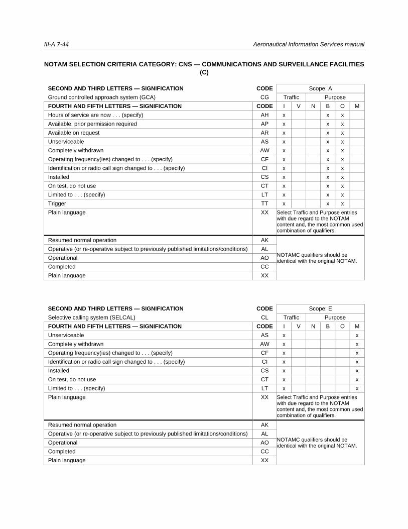
III-A 7-44 Aeronautical Information Services manual
NOTAM SELECTION CRITERIA CATEGORY: CNS — COMMUNICATIONS AND SURVEILLANCE FACILITIES
(C)
SECOND AND THIRD LETTERS — SIGNIFICATION CODE Scope: A
Ground controlled approach system (GCA) CG Traffic Purpose
FOURTH AND FIFTH LETTERS — SIGNIFICATION CODE I V N B O M
Hours of service are now . . . (specify) AH x x x
Available, prior permission required AP x x x
Available on request AR x x x
Unserviceable AS x x x
Completely withdrawn AW x x x
Operating frequency(ies) changed to . . . (specify) CF x x x
Identification or radio call sign changed to . . . (specify) CI x x x
Installed CS x x x
On test, do not use CT x x x
Limited to . . . (specify) LT x x x
Trigger TT x x x
Plain language XX Select Traffic and Purpose entries with due regard to the NOTAM content and, the most common used combination of qualifiers.
Resumed normal operation AK
NOTAMC qualifiers should be identical with the original NOTAM.
Operative (or re-operative subject to previously published limitations/conditions) AL
Operational AO
Completed CC
Plain language XX
SECOND AND THIRD LETTERS — SIGNIFICATION CODE Scope: E
Selective calling system (SELCAL) CL Traffic Purpose
FOURTH AND FIFTH LETTERS — SIGNIFICATION CODE I V N B O M
Unserviceable AS x x
Completely withdrawn AW x x
Operating frequency(ies) changed to . . . (specify) CF x x
Identification or radio call sign changed to . . . (specify) CI x x
Installed CS x x
On test, do not use CT x x
Limited to . . . (specify) LT x x
Plain language XX Select Traffic and Purpose entries with due regard to the NOTAM content and, the most common used combination of qualifiers.
Resumed normal operation AK
NOTAMC qualifiers should be identical with the original NOTAM.
Operative (or re-operative subject to previously published limitations/conditions) AL
Operational AO
Completed CC
Plain language XX
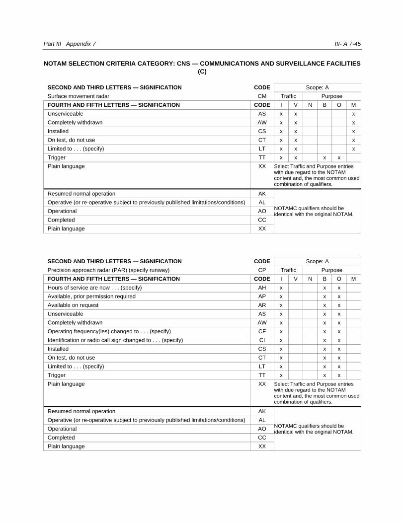
Part III Appendix 7 III- A 7-45
NOTAM SELECTION CRITERIA CATEGORY: CNS — COMMUNICATIONS AND SURVEILLANCE FACILITIES
(C)
SECOND AND THIRD LETTERS — SIGNIFICATION CODE Scope: A
Surface movement radar CM Traffic Purpose
FOURTH AND FIFTH LETTERS — SIGNIFICATION CODE I V N B O M
Unserviceable AS x x x
Completely withdrawn AW x x x
Installed CS x x x
On test, do not use CT x x x
Limited to . . . (specify) LT x x x
Trigger TT x x x x
Plain language XX Select Traffic and Purpose entries with due regard to the NOTAM content and, the most common used combination of qualifiers.
Resumed normal operation AK
NOTAMC qualifiers should be identical with the original NOTAM.
Operative (or re-operative subject to previously published limitations/conditions) AL
Operational AO
Completed CC
Plain language XX
SECOND AND THIRD LETTERS — SIGNIFICATION CODE Scope: A
Precision approach radar (PAR) (specify runway) CP Traffic Purpose
FOURTH AND FIFTH LETTERS — SIGNIFICATION CODE I V N B O M
Hours of service are now . . . (specify) AH x x x
Available, prior permission required AP x x x
Available on request AR x x x
Unserviceable AS x x x
Completely withdrawn AW x x x
Operating frequency(ies) changed to . . . (specify) CF x x x
Identification or radio call sign changed to . . . (specify) CI x x x
Installed CS x x x
On test, do not use CT x x x
Limited to . . . (specify) LT x x x
Trigger TT x x x
Plain language XX Select Traffic and Purpose entries with due regard to the NOTAM content and, the most common used combination of qualifiers.
Resumed normal operation AK
NOTAMC qualifiers should be identical with the original NOTAM.
Operative (or re-operative subject to previously published limitations/conditions) AL
Operational AO
Completed CC
Plain language XX
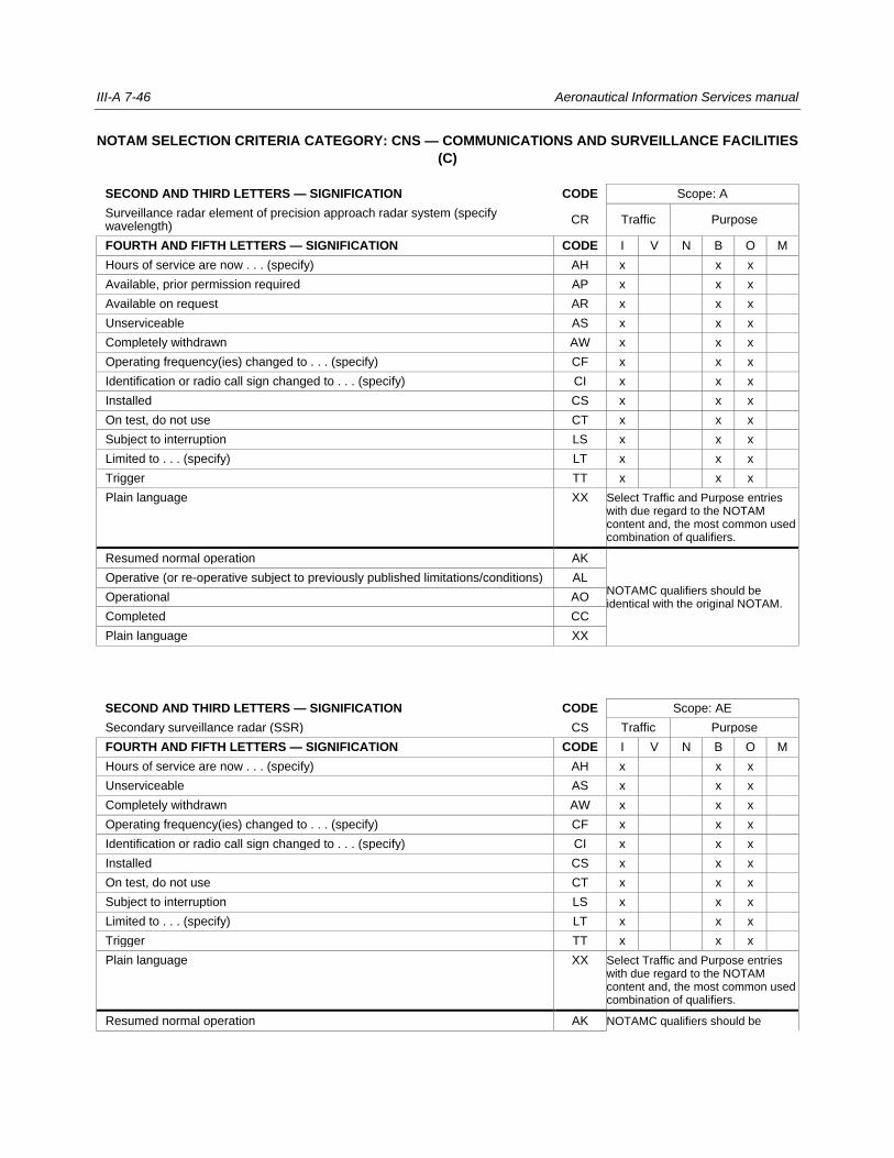
III-A 7-46 Aeronautical Information Services manual
NOTAM SELECTION CRITERIA CATEGORY: CNS — COMMUNICATIONS AND SURVEILLANCE FACILITIES
(C)
SECOND AND THIRD LETTERS — SIGNIFICATION CODE Scope: A
Surveillance radar element of precision approach radar system (specify wavelength)
CR Traffic Purpose
FOURTH AND FIFTH LETTERS — SIGNIFICATION CODE I V N B O M
Hours of service are now . . . (specify) AH x x x
Available, prior permission required AP x x x
Available on request AR x x x
Unserviceable AS x x x
Completely withdrawn AW x x x
Operating frequency(ies) changed to . . . (specify) CF x x x
Identification or radio call sign changed to . . . (specify) CI x x x
Installed CS x x x
On test, do not use CT x x x
Subject to interruption LS x x x
Limited to . . . (specify) LT x x x
Trigger TT x x x
Plain language XX Select Traffic and Purpose entries with due regard to the NOTAM content and, the most common used combination of qualifiers.
Resumed normal operation AK
NOTAMC qualifiers should be identical with the original NOTAM.
Operative (or re-operative subject to previously published limitations/conditions) AL
Operational AO
Completed CC
Plain language XX
SECOND AND THIRD LETTERS — SIGNIFICATION CODE Scope: AE
Secondary surveillance radar (SSR) CS Traffic Purpose
FOURTH AND FIFTH LETTERS — SIGNIFICATION CODE I V N B O M
Hours of service are now . . . (specify) AH x x x
Unserviceable AS x x x
Completely withdrawn AW x x x
Operating frequency(ies) changed to . . . (specify) CF x x x
Identification or radio call sign changed to . . . (specify) CI x x x
Installed CS x x x
On test, do not use CT x x x
Subject to interruption LS x x x
Limited to . . . (specify) LT x x x
Trigger TT x x x
Plain language XX Select Traffic and Purpose entries with due regard to the NOTAM content and, the most common used combination of qualifiers.
Resumed normal operation AK NOTAMC qualifiers should be

Part III Appendix 7 III- A 7-47
Operative (or re-operative subject to previously published limitations/conditions) AL identical with the original NOTAM.
Operational AO
Completed CC
Plain language XX
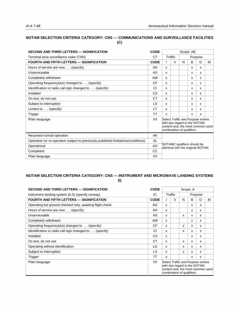
III-A 7-48 Aeronautical Information Services manual
NOTAM SELECTION CRITERIA CATEGORY: CNS — COMMUNICATIONS AND SURVEILLANCE FACILITIES
(C)
SECOND AND THIRD LETTERS — SIGNIFICATION CODE Scope: AE
Terminal area surveillance radar (TAR) CT Traffic Purpose
FOURTH AND FIFTH LETTERS — SIGNIFICATION CODE I V N B O M
Hours of service are now . . . (specify) AH x x x
Unserviceable AS x x x
Completely withdrawn AW x x x
Operating frequency(ies) changed to . . . (specify) CF x x x
Identification or radio call sign changed to . . . (specify) CI x x x
Installed CS x x x
On test, do not use CT x x x
Subject to interruption LS x x x
Limited to . . . (specify) LT x x x
Trigger TT x x x
Plain language XX Select Traffic and Purpose entries with due regard to the NOTAM content and, the most common used combination of qualifiers.
Resumed normal operation AK
NOTAMC qualifiers should be identical with the original NOTAM.
Operative (or re-operative subject to previously published limitations/conditions) AL
Operational AO
Completed CC
Plain language XX
NOTAM SELECTION CRITERIA CATEGORY: CNS — INSTRUMENT AND MICROWAVE LANDING SYSTEMS
(I)
SECOND AND THIRD LETTERS — SIGNIFICATION CODE Scope: A
Instrument landing system (ILS) (specify runway) IC Traffic Purpose
FOURTH AND FIFTH LETTERS — SIGNIFICATION CODE I V N B O M
Operating but ground checked only, awaiting flight check AG x x x
Hours of service are now . . . (specify) AH x x x
Unserviceable AS x x x x
Completely withdrawn AW x x x
Operating frequency(ies) changed to . . . (specify) CF x x x x
Identification or radio call sign changed to . . . (specify) CI x x x x
Installed CS x x x
On test, do not use CT x x x x
Operating without identification LG x x x x
Subject to interruption LS x x x x
Trigger TT x x x
Plain language XX Select Traffic and Purpose entries with due regard to the NOTAM content and, the most common used combination of qualifiers.
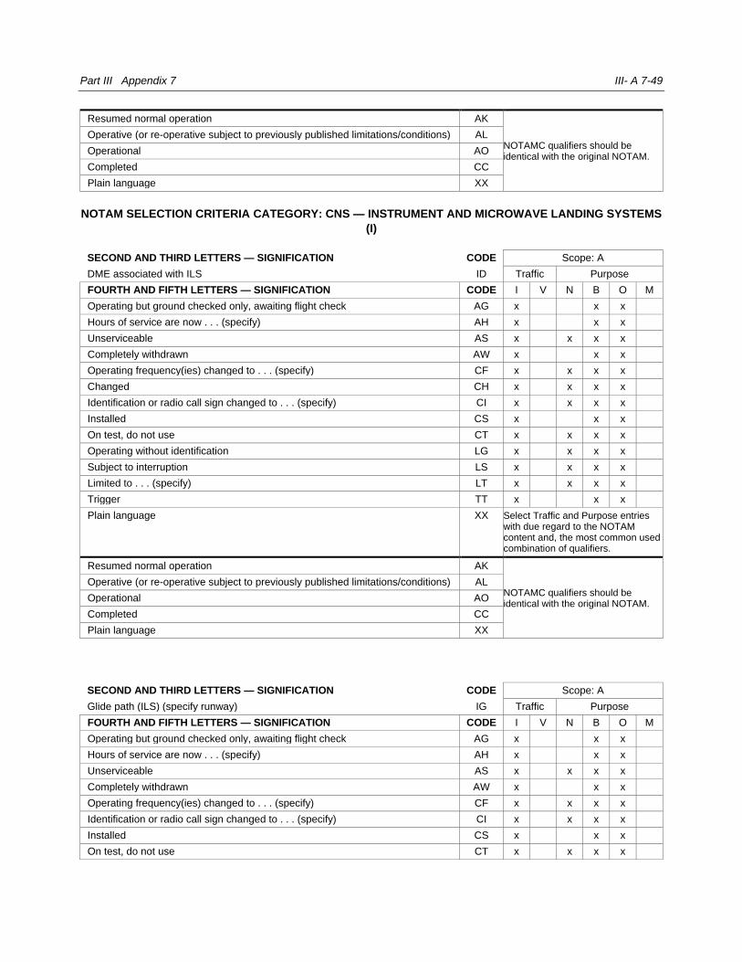
Part III Appendix 7 III- A 7-49
Resumed normal operation AK
NOTAMC qualifiers should be identical with the original NOTAM.
Operative (or re-operative subject to previously published limitations/conditions) AL
Operational AO
Completed CC
Plain language XX
NOTAM SELECTION CRITERIA CATEGORY: CNS — INSTRUMENT AND MICROWAVE LANDING SYSTEMS
(I)
SECOND AND THIRD LETTERS — SIGNIFICATION CODE Scope: A
DME associated with ILS ID Traffic Purpose
FOURTH AND FIFTH LETTERS — SIGNIFICATION CODE I V N B O M
Operating but ground checked only, awaiting flight check AG x x x
Hours of service are now . . . (specify) AH x x x
Unserviceable AS x x x x
Completely withdrawn AW x x x
Operating frequency(ies) changed to . . . (specify) CF x x x x
Changed CH x x x x
Identification or radio call sign changed to . . . (specify) CI x x x x
Installed CS x x x
On test, do not use CT x x x x
Operating without identification LG x x x x
Subject to interruption LS x x x x
Limited to . . . (specify) LT x x x x
Trigger TT x x x
Plain language XX Select Traffic and Purpose entries with due regard to the NOTAM content and, the most common used combination of qualifiers.
Resumed normal operation AK
NOTAMC qualifiers should be identical with the original NOTAM.
Operative (or re-operative subject to previously published limitations/conditions) AL
Operational AO
Completed CC
Plain language XX
SECOND AND THIRD LETTERS — SIGNIFICATION CODE Scope: A
Glide path (ILS) (specify runway) IG Traffic Purpose
FOURTH AND FIFTH LETTERS — SIGNIFICATION CODE I V N B O M
Operating but ground checked only, awaiting flight check AG x x x
Hours of service are now . . . (specify) AH x x x
Unserviceable AS x x x x
Completely withdrawn AW x x x
Operating frequency(ies) changed to . . . (specify) CF x x x x
Identification or radio call sign changed to . . . (specify) CI x x x x
Installed CS x x x
On test, do not use CT x x x x
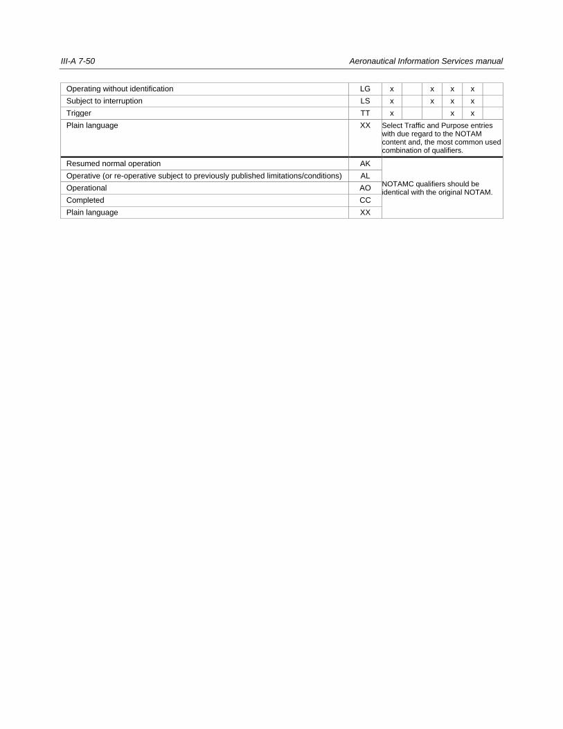
III-A 7-50 Aeronautical Information Services manual
Operating without identification LG x x x x
Subject to interruption LS x x x x
Trigger TT x x x
Plain language XX Select Traffic and Purpose entries with due regard to the NOTAM content and, the most common used combination of qualifiers.
Resumed normal operation AK
NOTAMC qualifiers should be identical with the original NOTAM.
Operative (or re-operative subject to previously published limitations/conditions) AL
Operational AO
Completed CC
Plain language XX
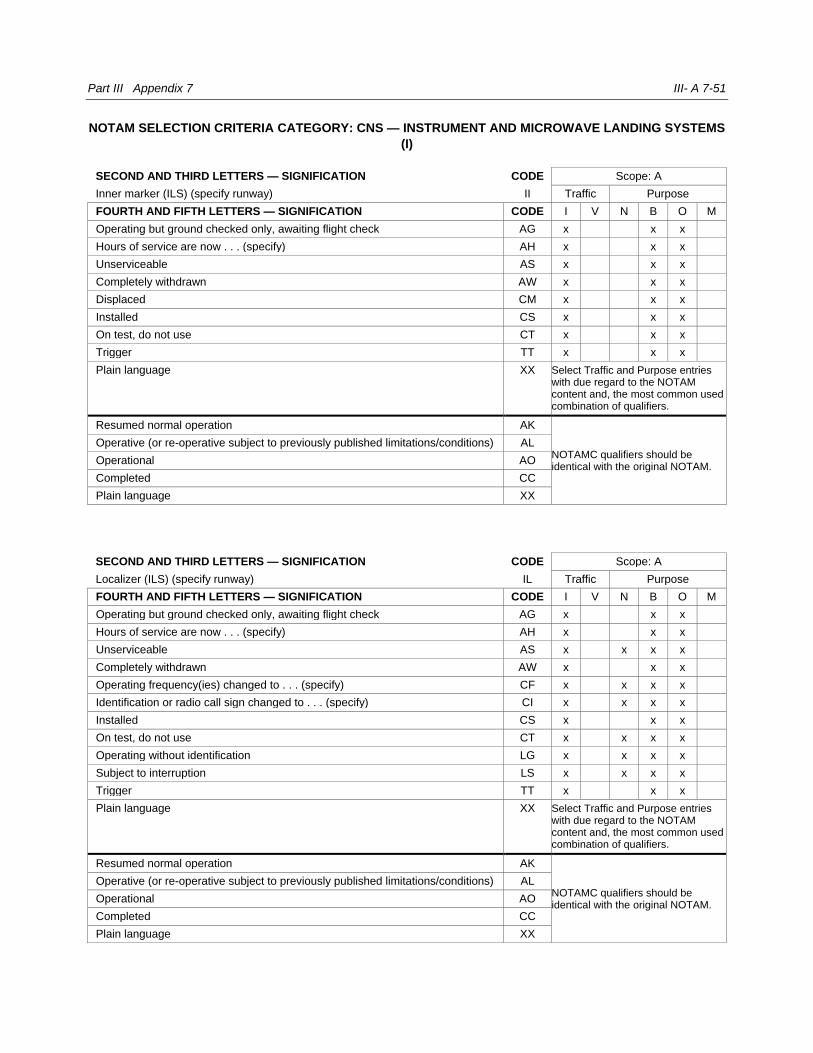
Part III Appendix 7 III- A 7-51
NOTAM SELECTION CRITERIA CATEGORY: CNS — INSTRUMENT AND MICROWAVE LANDING SYSTEMS
(I)
SECOND AND THIRD LETTERS — SIGNIFICATION CODE Scope: A
Inner marker (ILS) (specify runway) II Traffic Purpose
FOURTH AND FIFTH LETTERS — SIGNIFICATION CODE I V N B O M
Operating but ground checked only, awaiting flight check AG x x x
Hours of service are now . . . (specify) AH x x x
Unserviceable AS x x x
Completely withdrawn AW x x x
Displaced CM x x x
Installed CS x x x
On test, do not use CT x x x
Trigger TT x x x
Plain language XX Select Traffic and Purpose entries with due regard to the NOTAM content and, the most common used combination of qualifiers.
Resumed normal operation AK
NOTAMC qualifiers should be identical with the original NOTAM.
Operative (or re-operative subject to previously published limitations/conditions) AL
Operational AO
Completed CC
Plain language XX
SECOND AND THIRD LETTERS — SIGNIFICATION CODE Scope: A
Localizer (ILS) (specify runway) IL Traffic Purpose
FOURTH AND FIFTH LETTERS — SIGNIFICATION CODE I V N B O M
Operating but ground checked only, awaiting flight check AG x x x
Hours of service are now . . . (specify) AH x x x
Unserviceable AS x x x x
Completely withdrawn AW x x x
Operating frequency(ies) changed to . . . (specify) CF x x x x
Identification or radio call sign changed to . . . (specify) CI x x x x
Installed CS x x x
On test, do not use CT x x x x
Operating without identification LG x x x x
Subject to interruption LS x x x x
Trigger TT x x x
Plain language XX Select Traffic and Purpose entries with due regard to the NOTAM content and, the most common used combination of qualifiers.
Resumed normal operation AK
NOTAMC qualifiers should be identical with the original NOTAM.
Operative (or re-operative subject to previously published limitations/conditions) AL
Operational AO
Completed CC
Plain language XX

III-A 7-52 Aeronautical Information Services manual
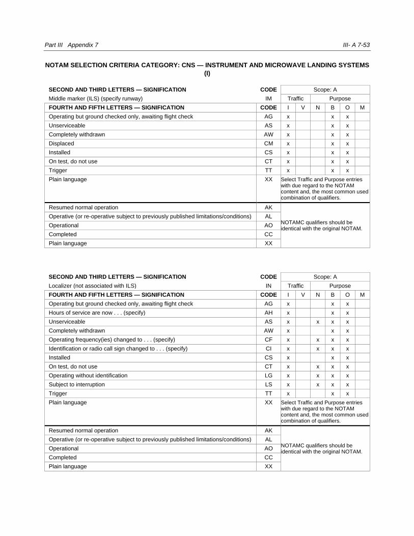
Part III Appendix 7 III- A 7-53
NOTAM SELECTION CRITERIA CATEGORY: CNS — INSTRUMENT AND MICROWAVE LANDING SYSTEMS
(I)
SECOND AND THIRD LETTERS — SIGNIFICATION CODE Scope: A
Middle marker (ILS) (specify runway) IM Traffic Purpose
FOURTH AND FIFTH LETTERS — SIGNIFICATION CODE I V N B O M
Operating but ground checked only, awaiting flight check AG x x x
Unserviceable AS x x x
Completely withdrawn AW x x x
Displaced CM x x x
Installed CS x x x
On test, do not use CT x x x
Trigger TT x x x
Plain language XX Select Traffic and Purpose entries with due regard to the NOTAM content and, the most common used combination of qualifiers.
Resumed normal operation AK
NOTAMC qualifiers should be identical with the original NOTAM.
Operative (or re-operative subject to previously published limitations/conditions) AL
Operational AO
Completed CC
Plain language XX
SECOND AND THIRD LETTERS — SIGNIFICATION CODE Scope: A
Localizer (not associated with ILS) IN Traffic Purpose
FOURTH AND FIFTH LETTERS — SIGNIFICATION CODE I V N B O M
Operating but ground checked only, awaiting flight check AG x x x
Hours of service are now . . . (specify) AH x x x
Unserviceable AS x x x x
Completely withdrawn AW x x x
Operating frequency(ies) changed to . . . (specify) CF x x x x
Identification or radio call sign changed to . . . (specify) CI x x x x
Installed CS x x x
On test, do not use CT x x x x
Operating without identification LG x x x x
Subject to interruption LS x x x x
Trigger TT x x x
Plain language XX Select Traffic and Purpose entries with due regard to the NOTAM content and, the most common used combination of qualifiers.
Resumed normal operation AK
NOTAMC qualifiers should be identical with the original NOTAM.
Operative (or re-operative subject to previously published limitations/conditions) AL
Operational AO
Completed CC
Plain language XX
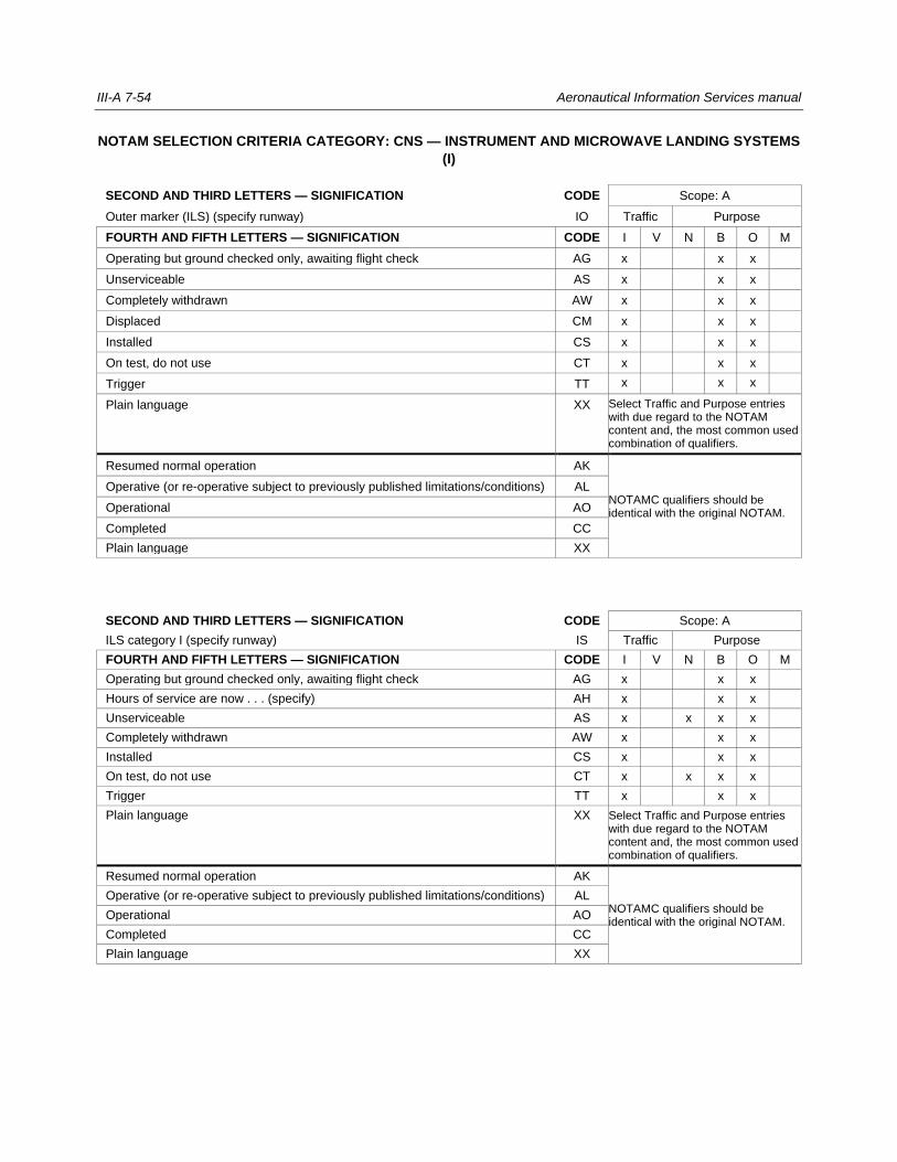
III-A 7-54 Aeronautical Information Services manual
NOTAM SELECTION CRITERIA CATEGORY: CNS — INSTRUMENT AND MICROWAVE LANDING SYSTEMS
(I)
SECOND AND THIRD LETTERS — SIGNIFICATION CODE Scope: A
Outer marker (ILS) (specify runway) IO Traffic Purpose
FOURTH AND FIFTH LETTERS — SIGNIFICATION CODE I V N B O M
Operating but ground checked only, awaiting flight check AG x x x
Unserviceable AS x x x
Completely withdrawn AW x x x
Displaced CM x x x
Installed CS x x x
On test, do not use CT x x x
Trigger TT x x x
Plain language XX Select Traffic and Purpose entries with due regard to the NOTAM content and, the most common used combination of qualifiers.
Resumed normal operation AK
NOTAMC qualifiers should be identical with the original NOTAM.
Operative (or re-operative subject to previously published limitations/conditions) AL
Operational AO
Completed CC
Plain language XX
SECOND AND THIRD LETTERS — SIGNIFICATION CODE Scope: A
ILS category I (specify runway) IS Traffic Purpose
FOURTH AND FIFTH LETTERS — SIGNIFICATION CODE I V N B O M
Operating but ground checked only, awaiting flight check AG x x x
Hours of service are now . . . (specify) AH x x x
Unserviceable AS x x x x
Completely withdrawn AW x x x
Installed CS x x x
On test, do not use CT x x x x
Trigger TT x x x
Plain language XX Select Traffic and Purpose entries with due regard to the NOTAM content and, the most common used combination of qualifiers.
Resumed normal operation AK
NOTAMC qualifiers should be identical with the original NOTAM.
Operative (or re-operative subject to previously published limitations/conditions) AL
Operational AO
Completed CC
Plain language XX
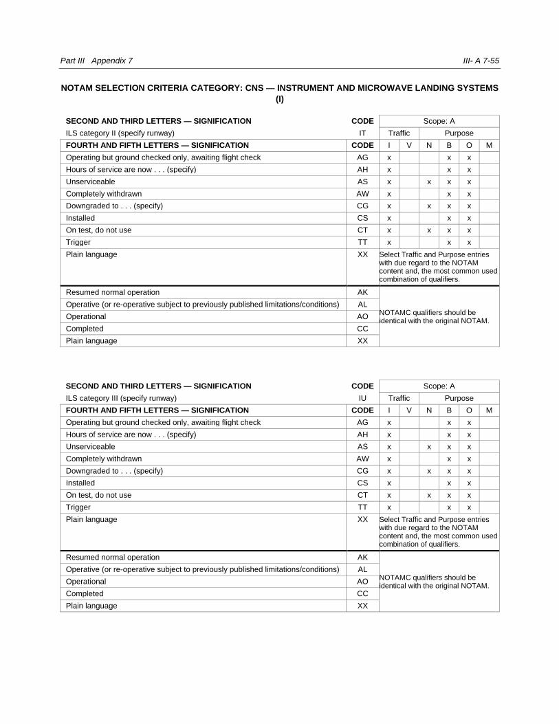
Part III Appendix 7 III- A 7-55
NOTAM SELECTION CRITERIA CATEGORY: CNS — INSTRUMENT AND MICROWAVE LANDING SYSTEMS
(I)
SECOND AND THIRD LETTERS — SIGNIFICATION CODE Scope: A
ILS category II (specify runway) IT Traffic Purpose
FOURTH AND FIFTH LETTERS — SIGNIFICATION CODE I V N B O M
Operating but ground checked only, awaiting flight check AG x x x
Hours of service are now . . . (specify) AH x x x
Unserviceable AS x x x x
Completely withdrawn AW x x x
Downgraded to . . . (specify) CG x x x x
Installed CS x x x
On test, do not use CT x x x x
Trigger TT x x x
Plain language XX Select Traffic and Purpose entries with due regard to the NOTAM content and, the most common used combination of qualifiers.
Resumed normal operation AK
NOTAMC qualifiers should be identical with the original NOTAM.
Operative (or re-operative subject to previously published limitations/conditions) AL
Operational AO
Completed CC
Plain language XX
SECOND AND THIRD LETTERS — SIGNIFICATION CODE Scope: A
ILS category III (specify runway) IU Traffic Purpose
FOURTH AND FIFTH LETTERS — SIGNIFICATION CODE I V N B O M
Operating but ground checked only, awaiting flight check AG x x x
Hours of service are now . . . (specify) AH x x x
Unserviceable AS x x x x
Completely withdrawn AW x x x
Downgraded to . . . (specify) CG x x x x
Installed CS x x x
On test, do not use CT x x x x
Trigger TT x x x
Plain language XX Select Traffic and Purpose entries with due regard to the NOTAM content and, the most common used combination of qualifiers.
Resumed normal operation AK
NOTAMC qualifiers should be identical with the original NOTAM.
Operative (or re-operative subject to previously published limitations/conditions) AL
Operational AO
Completed CC
Plain language XX
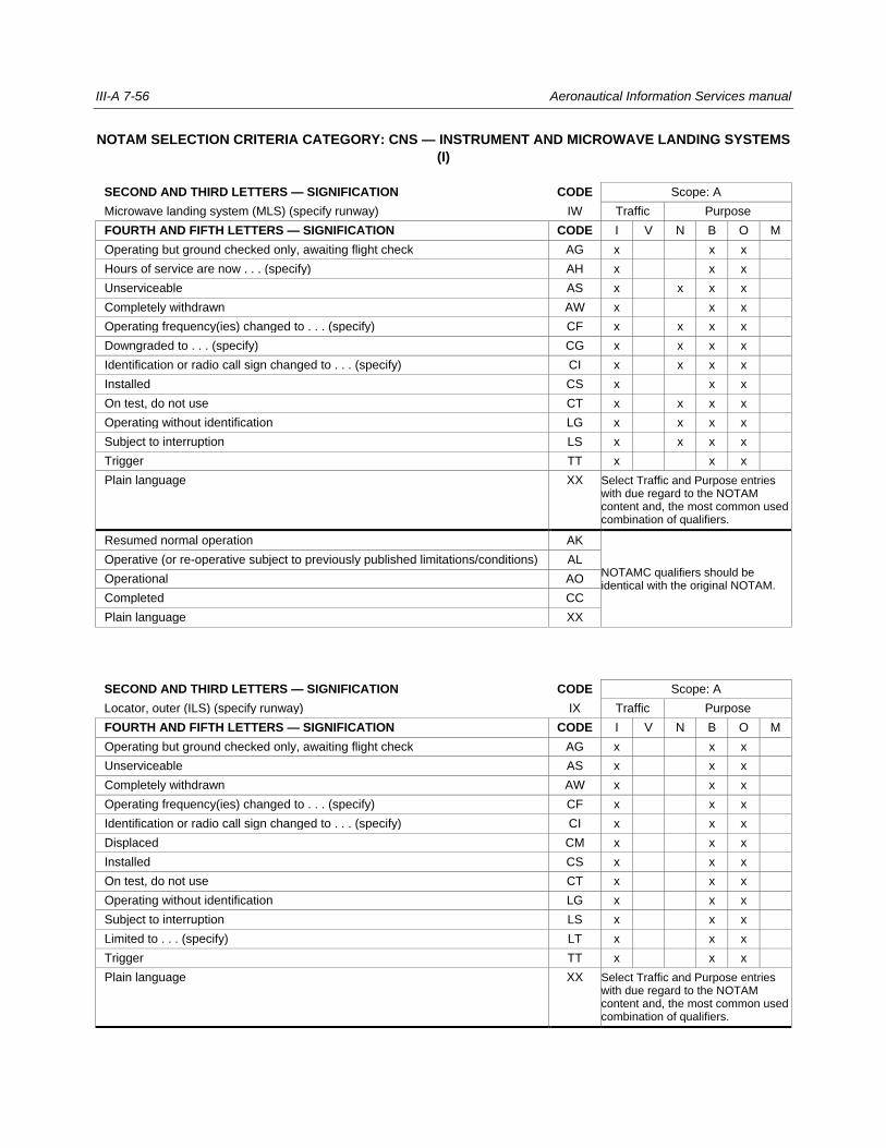
III-A 7-56 Aeronautical Information Services manual
NOTAM SELECTION CRITERIA CATEGORY: CNS — INSTRUMENT AND MICROWAVE LANDING SYSTEMS
(I)
SECOND AND THIRD LETTERS — SIGNIFICATION CODE Scope: A
Microwave landing system (MLS) (specify runway) IW Traffic Purpose
FOURTH AND FIFTH LETTERS — SIGNIFICATION CODE I V N B O M
Operating but ground checked only, awaiting flight check AG x x x
Hours of service are now . . . (specify) AH x x x
Unserviceable AS x x x x
Completely withdrawn AW x x x
Operating frequency(ies) changed to . . . (specify) CF x x x x
Downgraded to . . . (specify) CG x x x x
Identification or radio call sign changed to . . . (specify) CI x x x x
Installed CS x x x
On test, do not use CT x x x x
Operating without identification LG x x x x
Subject to interruption LS x x x x
Trigger TT x x x
Plain language XX Select Traffic and Purpose entries with due regard to the NOTAM content and, the most common used combination of qualifiers.
Resumed normal operation AK
NOTAMC qualifiers should be identical with the original NOTAM.
Operative (or re-operative subject to previously published limitations/conditions) AL
Operational AO
Completed CC
Plain language XX
SECOND AND THIRD LETTERS — SIGNIFICATION CODE Scope: A
Locator, outer (ILS) (specify runway) IX Traffic Purpose
FOURTH AND FIFTH LETTERS — SIGNIFICATION CODE I V N B O M
Operating but ground checked only, awaiting flight check AG x x x
Unserviceable AS x x x
Completely withdrawn AW x x x
Operating frequency(ies) changed to . . . (specify) CF x x x
Identification or radio call sign changed to . . . (specify) CI x x x
Displaced CM x x x
Installed CS x x x
On test, do not use CT x x x
Operating without identification LG x x x
Subject to interruption LS x x x
Limited to . . . (specify) LT x x x
Trigger TT x x x
Plain language XX Select Traffic and Purpose entries with due regard to the NOTAM content and, the most common used combination of qualifiers.

Part III Appendix 7 III- A 7-57
Resumed normal operation AK
NOTAMC qualifiers should be identical with the original NOTAM.
Operative (or re-operative subject to previously published limitations/conditions) AL
Operational AO
Completed CC
Plain language XX
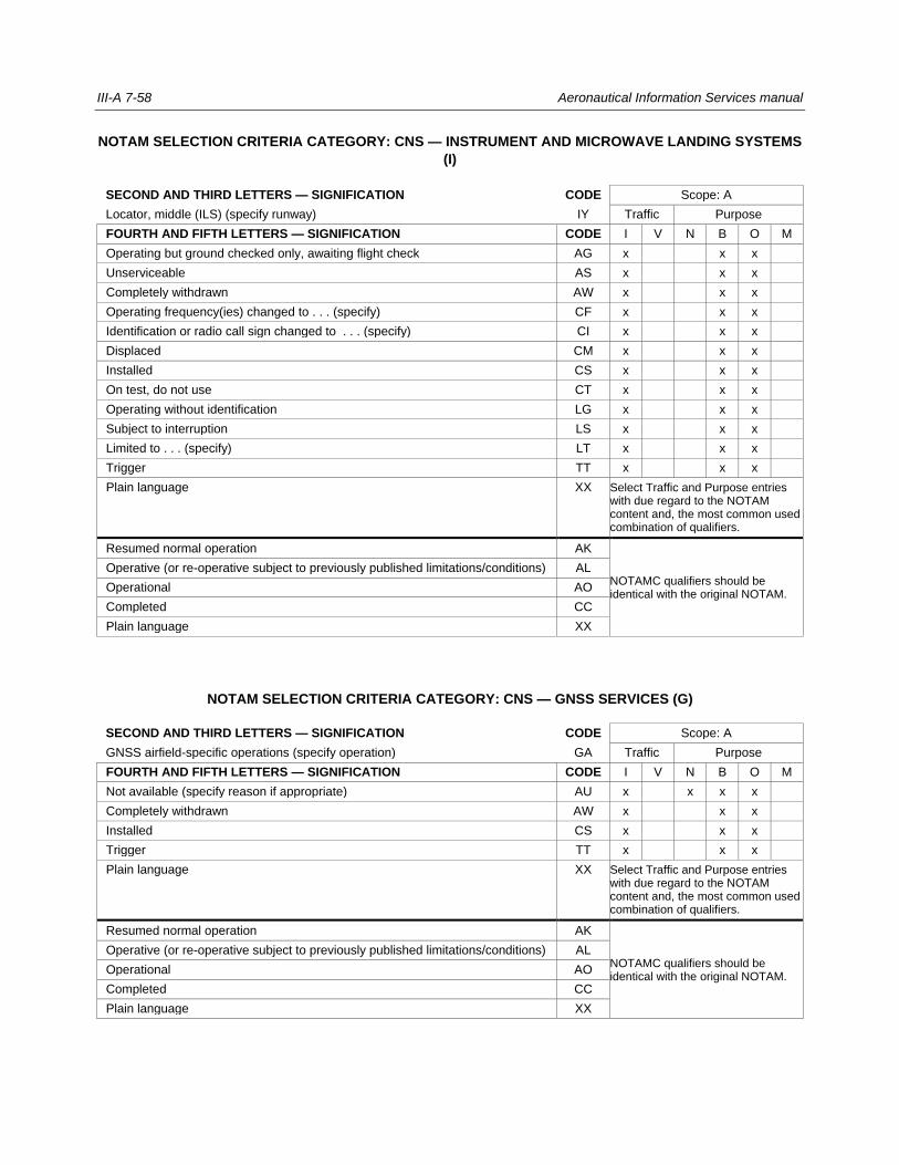
III-A 7-58 Aeronautical Information Services manual
NOTAM SELECTION CRITERIA CATEGORY: CNS — INSTRUMENT AND MICROWAVE LANDING SYSTEMS
(I)
SECOND AND THIRD LETTERS — SIGNIFICATION CODE Scope: A
Locator, middle (ILS) (specify runway) IY Traffic Purpose
FOURTH AND FIFTH LETTERS — SIGNIFICATION CODE I V N B O M
Operating but ground checked only, awaiting flight check AG x x x
Unserviceable AS x x x
Completely withdrawn AW x x x
Operating frequency(ies) changed to . . . (specify) CF x x x
Identification or radio call sign changed to . . . (specify) CI x x x
Displaced CM x x x
Installed CS x x x
On test, do not use CT x x x
Operating without identification LG x x x
Subject to interruption LS x x x
Limited to . . . (specify) LT x x x
Trigger TT x x x
Plain language XX Select Traffic and Purpose entries with due regard to the NOTAM content and, the most common used combination of qualifiers.
Resumed normal operation AK
NOTAMC qualifiers should be identical with the original NOTAM.
Operative (or re-operative subject to previously published limitations/conditions) AL
Operational AO
Completed CC
Plain language XX
NOTAM SELECTION CRITERIA CATEGORY: CNS — GNSS SERVICES (G)
SECOND AND THIRD LETTERS — SIGNIFICATION CODE Scope: A
GNSS airfield-specific operations (specify operation) GA Traffic Purpose
FOURTH AND FIFTH LETTERS — SIGNIFICATION CODE I V N B O M
Not available (specify reason if appropriate) AU x x x x
Completely withdrawn AW x x x
Installed CS x x x
Trigger TT x x x
Plain language XX Select Traffic and Purpose entries with due regard to the NOTAM content and, the most common used combination of qualifiers.
Resumed normal operation AK
NOTAMC qualifiers should be identical with the original NOTAM.
Operative (or re-operative subject to previously published limitations/conditions) AL
Operational AO
Completed CC
Plain language XX
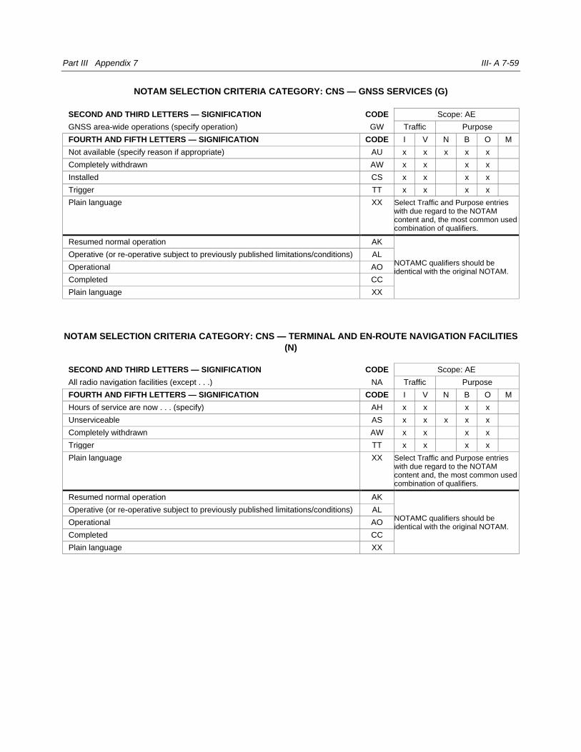
Part III Appendix 7 III- A 7-59
NOTAM SELECTION CRITERIA CATEGORY: CNS — GNSS SERVICES (G)
SECOND AND THIRD LETTERS — SIGNIFICATION CODE Scope: AE
GNSS area-wide operations (specify operation) GW Traffic Purpose
FOURTH AND FIFTH LETTERS — SIGNIFICATION CODE I V N B O M
Not available (specify reason if appropriate) AU x x x x x
Completely withdrawn AW x x x x
Installed CS x x x x
Trigger TT x x x x
Plain language XX Select Traffic and Purpose entries with due regard to the NOTAM content and, the most common used combination of qualifiers.
Resumed normal operation AK
NOTAMC qualifiers should be identical with the original NOTAM.
Operative (or re-operative subject to previously published limitations/conditions) AL
Operational AO
Completed CC
Plain language XX
NOTAM SELECTION CRITERIA CATEGORY: CNS — TERMINAL AND EN-ROUTE NAVIGATION FACILITIES
(N)
SECOND AND THIRD LETTERS — SIGNIFICATION CODE Scope: AE
All radio navigation facilities (except . . .) NA Traffic Purpose
FOURTH AND FIFTH LETTERS — SIGNIFICATION CODE I V N B O M
Hours of service are now . . . (specify) AH x x x x
Unserviceable AS x x x x x
Completely withdrawn AW x x x x
Trigger TT x x x x
Plain language XX Select Traffic and Purpose entries with due regard to the NOTAM content and, the most common used combination of qualifiers.
Resumed normal operation AK
NOTAMC qualifiers should be identical with the original NOTAM.
Operative (or re-operative subject to previously published limitations/conditions) AL
Operational AO
Completed CC
Plain language XX
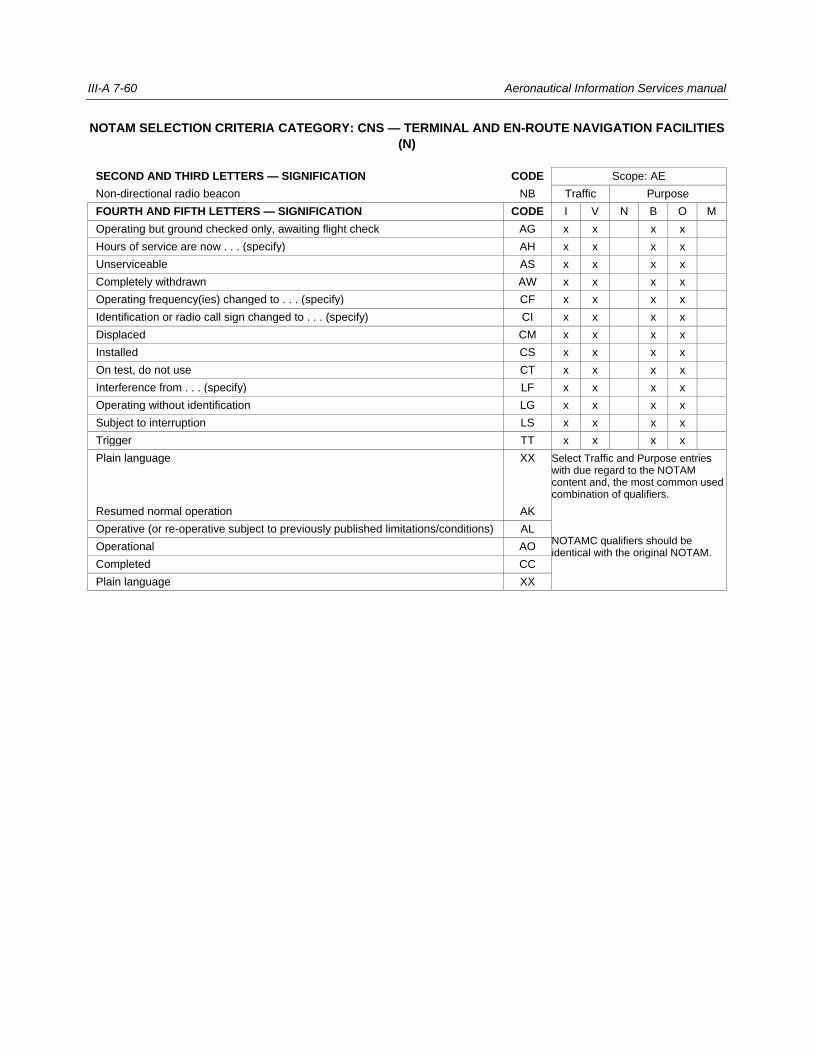
III-A 7-60 Aeronautical Information Services manual
NOTAM SELECTION CRITERIA CATEGORY: CNS — TERMINAL AND EN-ROUTE NAVIGATION FACILITIES
(N)
SECOND AND THIRD LETTERS — SIGNIFICATION CODE Scope: AE
Non-directional radio beacon NB Traffic Purpose
FOURTH AND FIFTH LETTERS — SIGNIFICATION CODE I V N B O M
Operating but ground checked only, awaiting flight check AG x x x x
Hours of service are now . . . (specify) AH x x x x
Unserviceable AS x x x x
Completely withdrawn AW x x x x
Operating frequency(ies) changed to . . . (specify) CF x x x x
Identification or radio call sign changed to . . . (specify) CI x x x x
Displaced CM x x x x
Installed CS x x x x
On test, do not use CT x x x x
Interference from . . . (specify) LF x x x x
Operating without identification LG x x x x
Subject to interruption LS x x x x
Trigger TT x x x x
Plain language XX Select Traffic and Purpose entries with due regard to the NOTAM content and, the most common used combination of qualifiers.
Resumed normal operation AK
NOTAMC qualifiers should be identical with the original NOTAM.
Operative (or re-operative subject to previously published limitations/conditions) AL
Operational AO
Completed CC
Plain language XX
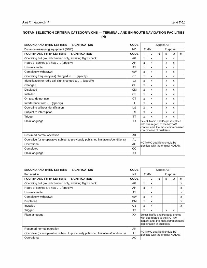
Part III Appendix 7 III- A 7-61
NOTAM SELECTION CRITERIA CATEGORY: CNS — TERMINAL AND EN-ROUTE NAVIGATION FACILITIES
(N)
SECOND AND THIRD LETTERS — SIGNIFICATION CODE Scope: AE
Distance measuring equipment (DME) ND Traffic Purpose
FOURTH AND FIFTH LETTERS — SIGNIFICATION CODE I V N B O M
Operating but ground checked only, awaiting flight check AG x x x x
Hours of service are now . . . (specify) AH x x x x
Unserviceable AS x x x x
Completely withdrawn AW x x x x
Operating frequency(ies) changed to . . . (specify) CF x x x x
Identification or radio call sign changed to . . . (specify) CI x x x x
Changed CH x x x x
Displaced CM x x x x
Installed CS x x x x
On test, do not use CT x x x x
Interference from . . . (specify) LF x x x x
Operating without identification LG x x x x
Subject to interruption LS x x x x
Trigger TT x x x x
Plain language XX Select Traffic and Purpose entries with due regard to the NOTAM content and, the most common used combination of qualifiers.
Resumed normal operation AK
NOTAMC qualifiers should be identical with the original NOTAM.
Operative (or re-operative subject to previously published limitations/conditions) AL
Operational AO
Completed CC
Plain language XX
SECOND AND THIRD LETTERS — SIGNIFICATION CODE Scope: AE
Fan marker NF Traffic Purpose
FOURTH AND FIFTH LETTERS — SIGNIFICATION CODE I V N B O M
Operating but ground checked only, awaiting flight check AG x x x
Hours of service are now . . . (specify) AH x x x
Unserviceable AS x x x
Completely withdrawn AW x x x
Displaced CM x x x
Installed CS x x x
Trigger TT x x x x
Plain language XX Select Traffic and Purpose entries with due regard to the NOTAM content and, the most common used combination of qualifiers.
Resumed normal operation AK NOTAMC qualifiers should be identical with the original NOTAM.
Operative (or re-operative subject to previously published limitations/conditions) AL
Operational AO

III-A 7-62 Aeronautical Information Services manual
Completed CC
Plain language XX
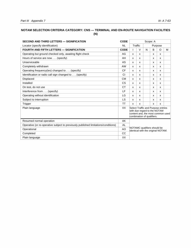
Part III Appendix 7 III- A 7-63
NOTAM SELECTION CRITERIA CATEGORY: CNS — TERMINAL AND EN-ROUTE NAVIGATION FACILITIES
(N)
SECOND AND THIRD LETTERS — SIGNIFICATION CODE Scope: A
Locator (specify identification) NL Traffic Purpose
FOURTH AND FIFTH LETTERS — SIGNIFICATION CODE I V N B O M
Operating but ground checked only, awaiting flight check AG x x x x
Hours of service are now . . . (specify) AH x x x x
Unserviceable AS x x x x
Completely withdrawn AW x x x x
Operating frequency(ies) changed to . . . (specify) CF x x x x
Identification or radio call sign changed to . . . (specify) CI x x x x
Displaced CM x x x x
Installed CS x x x x
On test, do not use CT x x x x
Interference from . . . (specify) LF x x x x
Operating without identification LG x x x x
Subject to interruption LS x x x x
Trigger TT x x x x
Plain language XX Select Traffic and Purpose entries with due regard to the NOTAM content and, the most common used combination of qualifiers.
Resumed normal operation AK
NOTAMC qualifiers should be identical with the original NOTAM.
Operative (or re-operative subject to previously published limitations/conditions) AL
Operational AO
Completed CC
Plain language XX
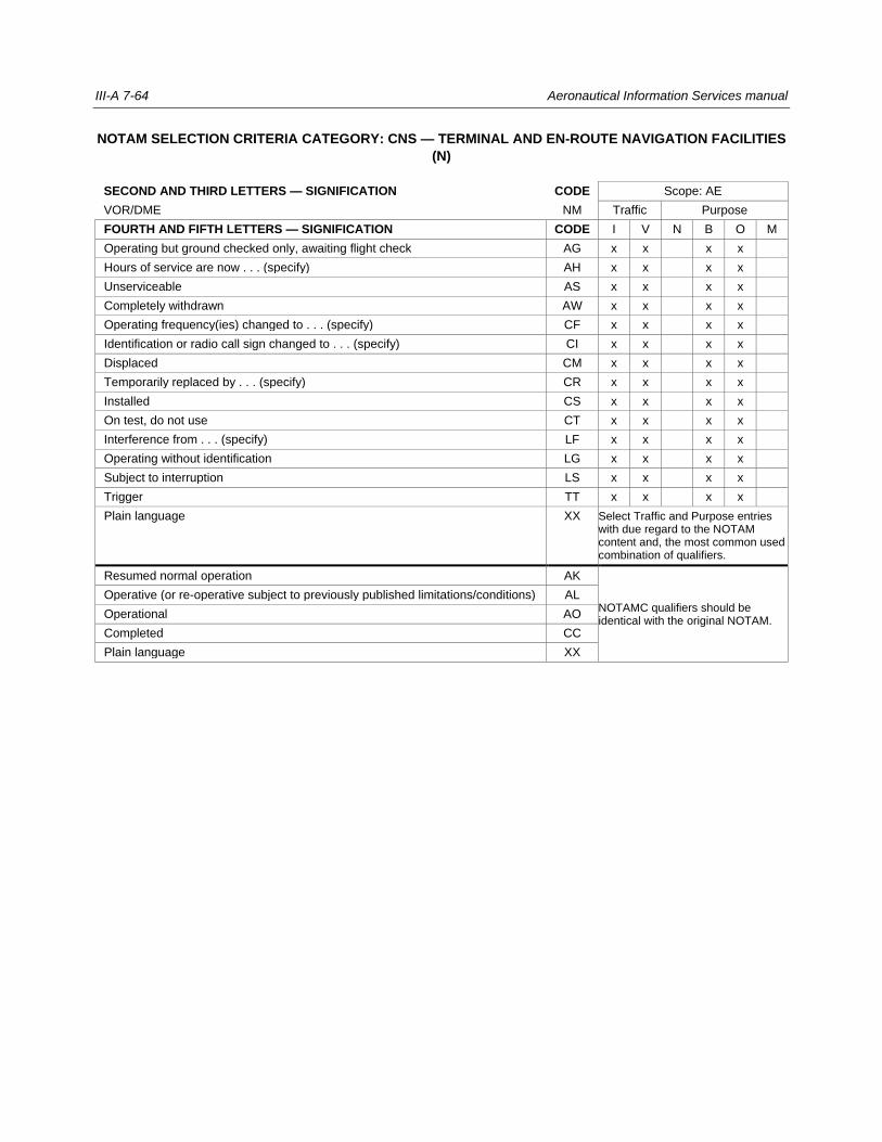
III-A 7-64 Aeronautical Information Services manual
NOTAM SELECTION CRITERIA CATEGORY: CNS — TERMINAL AND EN-ROUTE NAVIGATION FACILITIES
(N)
SECOND AND THIRD LETTERS — SIGNIFICATION CODE Scope: AE
VOR/DME NM Traffic Purpose
FOURTH AND FIFTH LETTERS — SIGNIFICATION CODE I V N B O M
Operating but ground checked only, awaiting flight check AG x x x x
Hours of service are now . . . (specify) AH x x x x
Unserviceable AS x x x x
Completely withdrawn AW x x x x
Operating frequency(ies) changed to . . . (specify) CF x x x x
Identification or radio call sign changed to . . . (specify) CI x x x x
Displaced CM x x x x
Temporarily replaced by . . . (specify) CR x x x x
Installed CS x x x x
On test, do not use CT x x x x
Interference from . . . (specify) LF x x x x
Operating without identification LG x x x x
Subject to interruption LS x x x x
Trigger TT x x x x
Plain language XX Select Traffic and Purpose entries with due regard to the NOTAM content and, the most common used combination of qualifiers.
Resumed normal operation AK
NOTAMC qualifiers should be identical with the original NOTAM.
Operative (or re-operative subject to previously published limitations/conditions) AL
Operational AO
Completed CC
Plain language XX
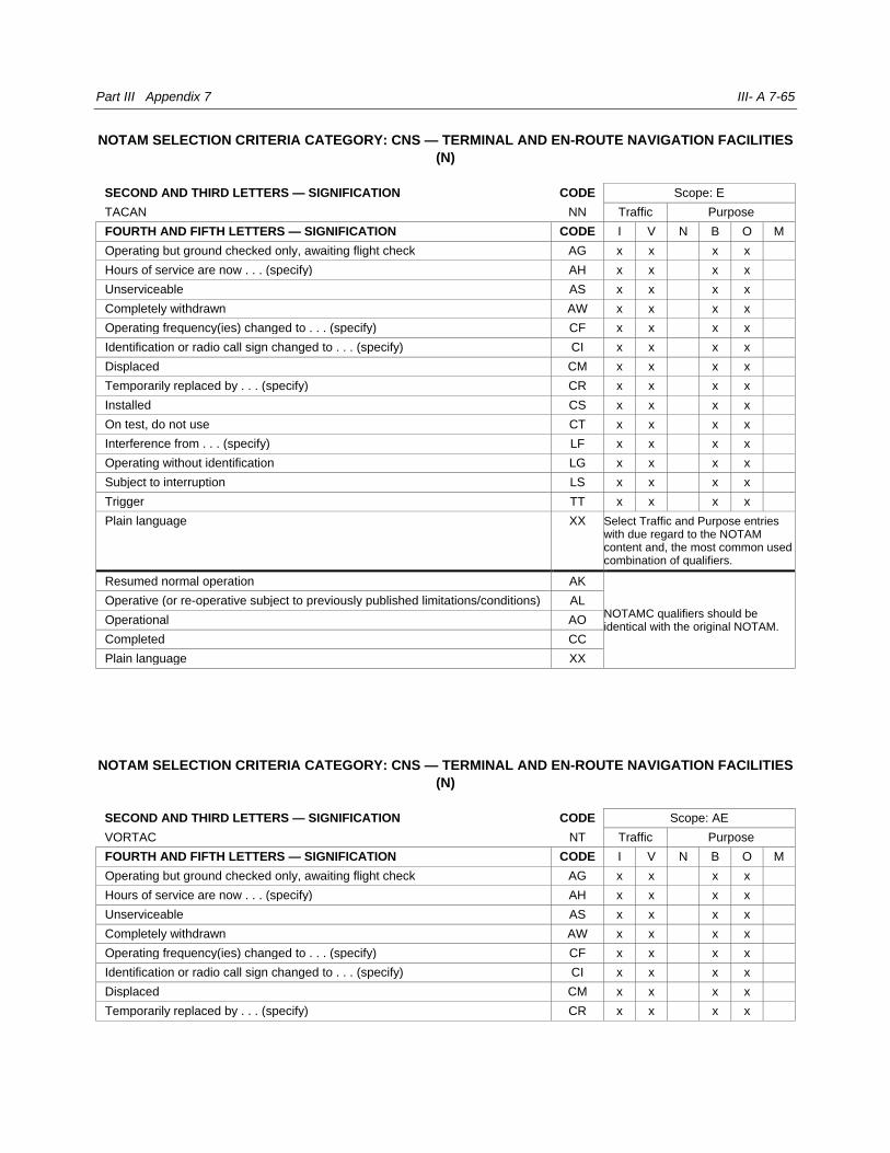
Part III Appendix 7 III- A 7-65
NOTAM SELECTION CRITERIA CATEGORY: CNS — TERMINAL AND EN-ROUTE NAVIGATION FACILITIES
(N)
SECOND AND THIRD LETTERS — SIGNIFICATION CODE Scope: E
TACAN NN Traffic Purpose
FOURTH AND FIFTH LETTERS — SIGNIFICATION CODE I V N B O M
Operating but ground checked only, awaiting flight check AG x x x x
Hours of service are now . . . (specify) AH x x x x
Unserviceable AS x x x x
Completely withdrawn AW x x x x
Operating frequency(ies) changed to . . . (specify) CF x x x x
Identification or radio call sign changed to . . . (specify) CI x x x x
Displaced CM x x x x
Temporarily replaced by . . . (specify) CR x x x x
Installed CS x x x x
On test, do not use CT x x x x
Interference from . . . (specify) LF x x x x
Operating without identification LG x x x x
Subject to interruption LS x x x x
Trigger TT x x x x
Plain language XX Select Traffic and Purpose entries with due regard to the NOTAM content and, the most common used combination of qualifiers.
Resumed normal operation AK
NOTAMC qualifiers should be identical with the original NOTAM.
Operative (or re-operative subject to previously published limitations/conditions) AL
Operational AO
Completed CC
Plain language XX
NOTAM SELECTION CRITERIA CATEGORY: CNS — TERMINAL AND EN-ROUTE NAVIGATION FACILITIES
(N)
SECOND AND THIRD LETTERS — SIGNIFICATION CODE Scope: AE
VORTAC NT Traffic Purpose
FOURTH AND FIFTH LETTERS — SIGNIFICATION CODE I V N B O M
Operating but ground checked only, awaiting flight check AG x x x x
Hours of service are now . . . (specify) AH x x x x
Unserviceable AS x x x x
Completely withdrawn AW x x x x
Operating frequency(ies) changed to . . . (specify) CF x x x x
Identification or radio call sign changed to . . . (specify) CI x x x x
Displaced CM x x x x
Temporarily replaced by . . . (specify) CR x x x x
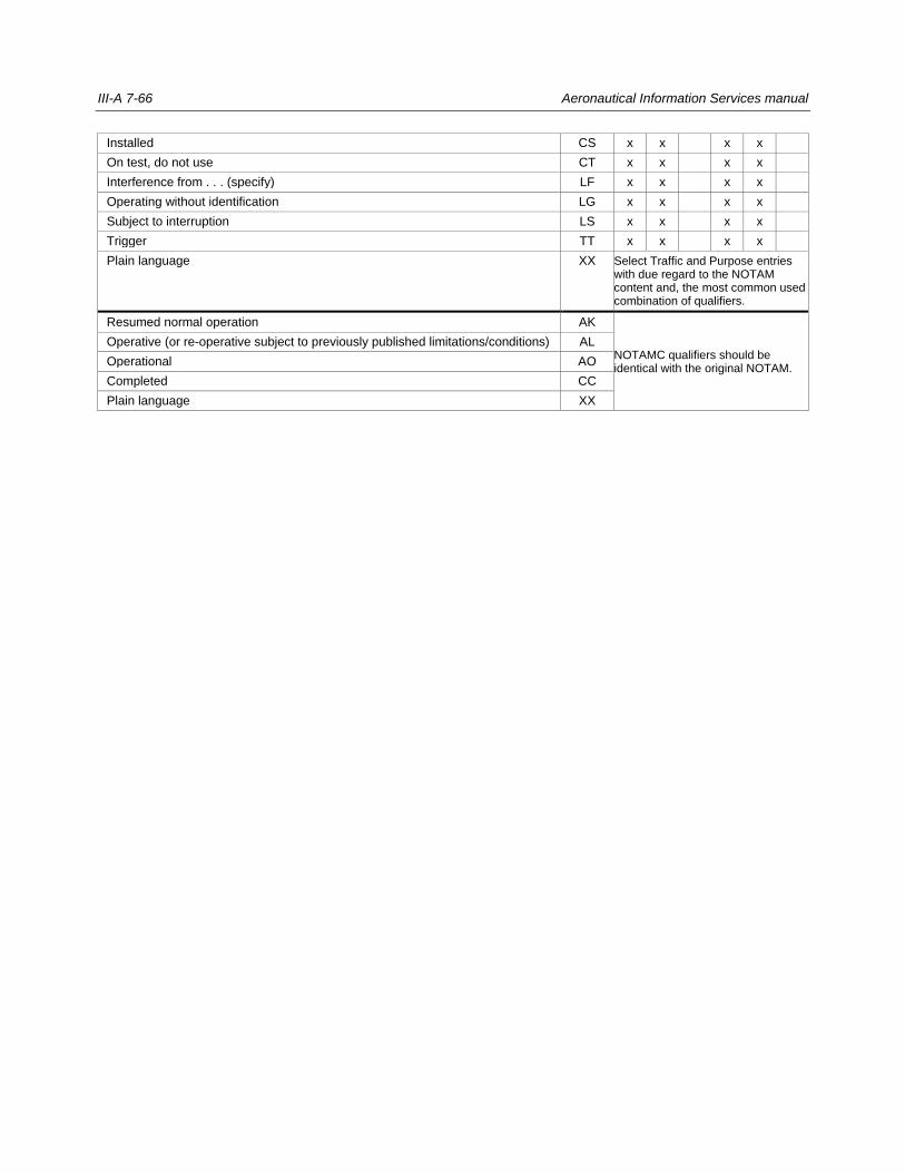
III-A 7-66 Aeronautical Information Services manual
Installed CS x x x x
On test, do not use CT x x x x
Interference from . . . (specify) LF x x x x
Operating without identification LG x x x x
Subject to interruption LS x x x x
Trigger TT x x x x
Plain language XX Select Traffic and Purpose entries with due regard to the NOTAM content and, the most common used combination of qualifiers.
Resumed normal operation AK
NOTAMC qualifiers should be identical with the original NOTAM.
Operative (or re-operative subject to previously published limitations/conditions) AL
Operational AO
Completed CC
Plain language XX

Part III Appendix 7 III- A 7-67
NOTAM SELECTION CRITERIA CATEGORY: CNS — TERMINAL AND EN-ROUTE NAVIGATION FACILITIES
(N)
SECOND AND THIRD LETTERS — SIGNIFICATION CODE Scope: AE
VOR NV Traffic Purpose
FOURTH AND FIFTH LETTERS — SIGNIFICATION CODE I V N B O M
Operating but ground checked only, awaiting flight check AG x x x x
Hours of service are now . . . (specify) AH x x x x
Unserviceable AS x x x x
Completely withdrawn AW x x x x
Operating frequency(ies) changed to . . . (specify) CF x x x x
Identification or radio call sign changed to . . . (specify) CI x x x x
Displaced CM x x x x
Temporarily replaced by . . . (specify) CR x x x x
Installed CS x x x x
On test, do not use CT x x x x
Interference from . . . (specify) LF x x x x
Operating without identification LG x x x x
Subject to interruption LS x x x x
Trigger TT x x x x
Plain language XX Select Traffic and Purpose entries with due regard to the NOTAM content and, the most common used combination of qualifiers.
Resumed normal operation AK
NOTAMC qualifiers should be identical with the original NOTAM.
Operative (or re-operative subject to previously published limitations/conditions) AL
Operational AO
Completed CC
Plain language XX
SECOND AND THIRD LETTERS — SIGNIFICATION CODE Scope: AE
Direction finding station (specify type and frequency) NX Traffic Purpose
FOURTH AND FIFTH LETTERS — SIGNIFICATION CODE I V N B O M
Hours of service are now . . . (specify) AH x x x
Unserviceable AS x x x
Completely withdrawn AW x x x
Operating frequency(ies) changed to . . . (specify) CF x x x
Identification or radio call sign changed to . . . (specify) CI x x x
Installed CS x x x
On test, do not use CT x x x
Limited to . . . (specify) LT x x x
Trigger TT x x x
Plain language XX Select Traffic and Purpose entries with due regard to the NOTAM content and, the most common used combination of qualifiers.
Resumed normal operation AK NOTAMC qualifiers should be

III-A 7-68 Aeronautical Information Services manual
Operative (or re-operative subject to previously published limitations/conditions) AL identical with the original NOTAM.
Operational AO
Completed CC
Plain language XX
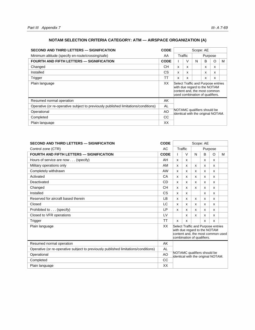
Part III Appendix 7 III- A 7-69
NOTAM SELECTION CRITERIA CATEGORY: ATM — AIRSPACE ORGANIZATION (A)
SECOND AND THIRD LETTERS — SIGNIFICATION CODE Scope: AE
Minimum altitude (specify en-route/crossing/safe) AA Traffic Purpose
FOURTH AND FIFTH LETTERS — SIGNIFICATION CODE I V N B O M
Changed CH x x x x
Installed CS x x x x
Trigger TT x x x x
Plain language XX Select Traffic and Purpose entries with due regard to the NOTAM content and, the most common used combination of qualifiers.
Resumed normal operation AK
NOTAMC qualifiers should be identical with the original NOTAM.
Operative (or re-operative subject to previously published limitations/conditions) AL
Operational AO
Completed CC
Plain language XX
SECOND AND THIRD LETTERS — SIGNIFICATION CODE Scope: AE
Control zone (CTR) AC Traffic Purpose
FOURTH AND FIFTH LETTERS — SIGNIFICATION CODE I V N B O M
Hours of service are now . . . (specify) AH x x x x
Military operations only AM x x x x x
Completely withdrawn AW x x x x x
Activated CA x x x x x
Deactivated CD x x x x x
Changed CH x x x x x
Installed CS x x x x
Reserved for aircraft based therein LB x x x x x
Closed LC x x x x x
Prohibited to . . . (specify) LP x x x x x
Closed to VFR operations LV x x x x
Trigger TT x x x x
Plain language XX Select Traffic and Purpose entries with due regard to the NOTAM content and, the most common used combination of qualifiers.
Resumed normal operation AK
NOTAMC qualifiers should be identical with the original NOTAM.
Operative (or re-operative subject to previously published limitations/conditions) AL
Operational AO
Completed CC
Plain language XX
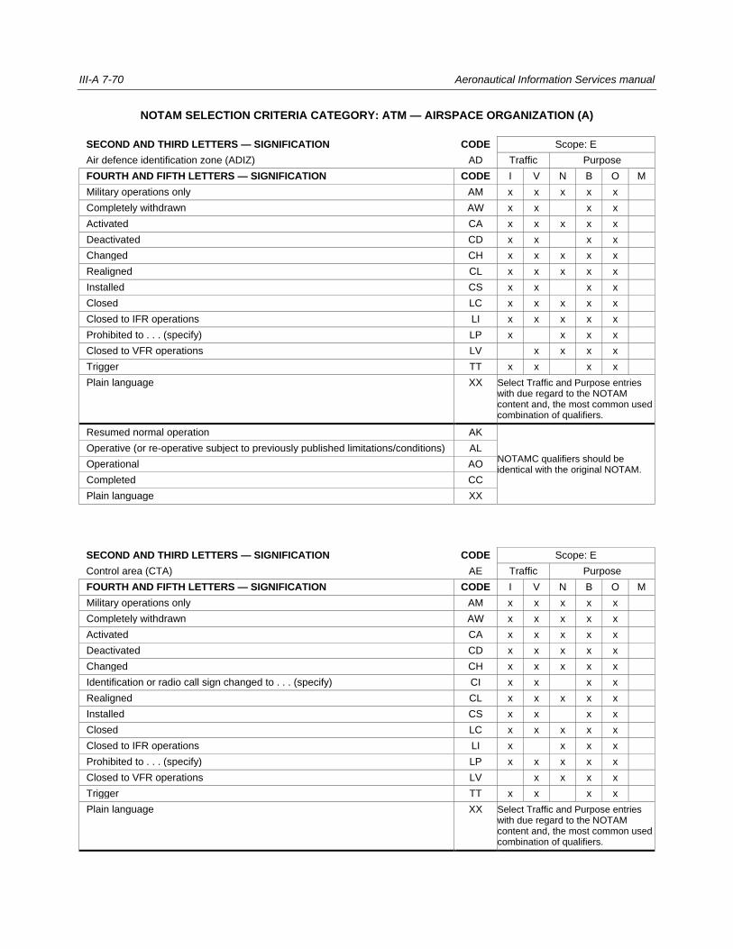
III-A 7-70 Aeronautical Information Services manual
NOTAM SELECTION CRITERIA CATEGORY: ATM — AIRSPACE ORGANIZATION (A)
SECOND AND THIRD LETTERS — SIGNIFICATION CODE Scope: E
Air defence identification zone (ADIZ) AD Traffic Purpose
FOURTH AND FIFTH LETTERS — SIGNIFICATION CODE I V N B O M
Military operations only AM x x x x x
Completely withdrawn AW x x x x
Activated CA x x x x x
Deactivated CD x x x x
Changed CH x x x x x
Realigned CL x x x x x
Installed CS x x x x
Closed LC x x x x x
Closed to IFR operations LI x x x x x
Prohibited to . . . (specify) LP x x x x
Closed to VFR operations LV x x x x
Trigger TT x x x x
Plain language XX Select Traffic and Purpose entries with due regard to the NOTAM content and, the most common used combination of qualifiers.
Resumed normal operation AK
NOTAMC qualifiers should be identical with the original NOTAM.
Operative (or re-operative subject to previously published limitations/conditions) AL
Operational AO
Completed CC
Plain language XX
SECOND AND THIRD LETTERS — SIGNIFICATION CODE Scope: E
Control area (CTA) AE Traffic Purpose
FOURTH AND FIFTH LETTERS — SIGNIFICATION CODE I V N B O M
Military operations only AM x x x x x
Completely withdrawn AW x x x x x
Activated CA x x x x x
Deactivated CD x x x x x
Changed CH x x x x x
Identification or radio call sign changed to . . . (specify) CI x x x x
Realigned CL x x x x x
Installed CS x x x x
Closed LC x x x x x
Closed to IFR operations LI x x x x
Prohibited to . . . (specify) LP x x x x x
Closed to VFR operations LV x x x x
Trigger TT x x x x
Plain language XX Select Traffic and Purpose entries with due regard to the NOTAM content and, the most common used combination of qualifiers.

Part III Appendix 7 III- A 7-71
Resumed normal operation AK
NOTAMC qualifiers should be identical with the original NOTAM.
Operative (or re-operative subject to previously published limitations/conditions) AL
Operational AO
Completed CC
Plain language XX
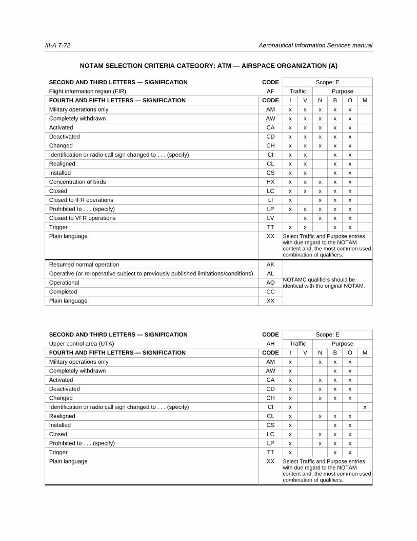
III-A 7-72 Aeronautical Information Services manual
NOTAM SELECTION CRITERIA CATEGORY: ATM — AIRSPACE ORGANIZATION (A)
SECOND AND THIRD LETTERS — SIGNIFICATION CODE Scope: E
Flight information region (FIR) AF Traffic Purpose
FOURTH AND FIFTH LETTERS — SIGNIFICATION CODE I V N B O M
Military operations only AM x x x x x
Completely withdrawn AW x x x x x
Activated CA x x x x x
Deactivated CD x x x x x
Changed CH x x x x x
Identification or radio call sign changed to . . . (specify) CI x x x x
Realigned CL x x x x
Installed CS x x x x
Concentration of birds HX x x x x x
Closed LC x x x x x
Closed to IFR operations LI x x x x
Prohibited to . . . (specify) LP x x x x x
Closed to VFR operations LV x x x x
Trigger TT x x x x
Plain language XX Select Traffic and Purpose entries with due regard to the NOTAM content and, the most common used combination of qualifiers.
Resumed normal operation AK
NOTAMC qualifiers should be identical with the original NOTAM.
Operative (or re-operative subject to previously published limitations/conditions) AL
Operational AO
Completed CC
Plain language XX
SECOND AND THIRD LETTERS — SIGNIFICATION CODE Scope: E
Upper control area (UTA) AH Traffic Purpose
FOURTH AND FIFTH LETTERS — SIGNIFICATION CODE I V N B O M
Military operations only AM x x x x
Completely withdrawn AW x x x
Activated CA x x x x
Deactivated CD x x x x
Changed CH x x x x
Identification or radio call sign changed to . . . (specify) CI x x
Realigned CL x x x x
Installed CS x x x
Closed LC x x x x
Prohibited to . . . (specify) LP x x x x
Trigger TT x x x
Plain language XX Select Traffic and Purpose entries with due regard to the NOTAM content and, the most common used combination of qualifiers.

Part III Appendix 7 III- A 7-73
Resumed normal operation AK
NOTAMC qualifiers should be identical with the original NOTAM.
Operative (or re-operative subject to previously published limitations/conditions) AL
Operational AO
Completed CC
Plain language XX
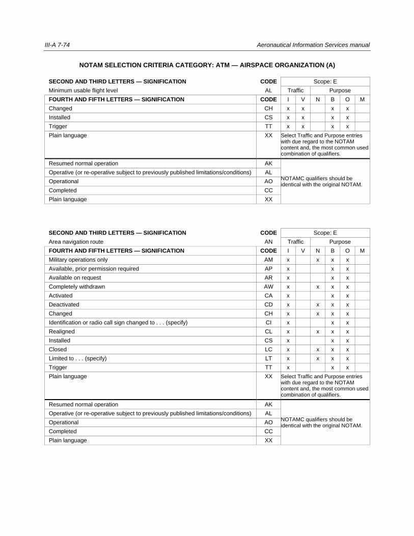
III-A 7-74 Aeronautical Information Services manual
NOTAM SELECTION CRITERIA CATEGORY: ATM — AIRSPACE ORGANIZATION (A)
SECOND AND THIRD LETTERS — SIGNIFICATION CODE Scope: E
Minimum usable flight level AL Traffic Purpose
FOURTH AND FIFTH LETTERS — SIGNIFICATION CODE I V N B O M
Changed CH x x x x
Installed CS x x x x
Trigger TT x x x x
Plain language XX Select Traffic and Purpose entries with due regard to the NOTAM content and, the most common used combination of qualifiers.
Resumed normal operation AK
NOTAMC qualifiers should be identical with the original NOTAM.
Operative (or re-operative subject to previously published limitations/conditions) AL
Operational AO
Completed CC
Plain language XX
SECOND AND THIRD LETTERS — SIGNIFICATION CODE Scope: E
Area navigation route AN Traffic Purpose
FOURTH AND FIFTH LETTERS — SIGNIFICATION CODE I V N B O M
Military operations only AM x x x x
Available, prior permission required AP x x x
Available on request AR x x x
Completely withdrawn AW x x x x
Activated CA x x x
Deactivated CD x x x x
Changed CH x x x x
Identification or radio call sign changed to . . . (specify) CI x x x
Realigned CL x x x x
Installed CS x x x
Closed LC x x x x
Limited to . . . (specify) LT x x x x
Trigger TT x x x
Plain language XX Select Traffic and Purpose entries with due regard to the NOTAM content and, the most common used combination of qualifiers.
Resumed normal operation AK
NOTAMC qualifiers should be identical with the original NOTAM.
Operative (or re-operative subject to previously published limitations/conditions) AL
Operational AO
Completed CC
Plain language XX
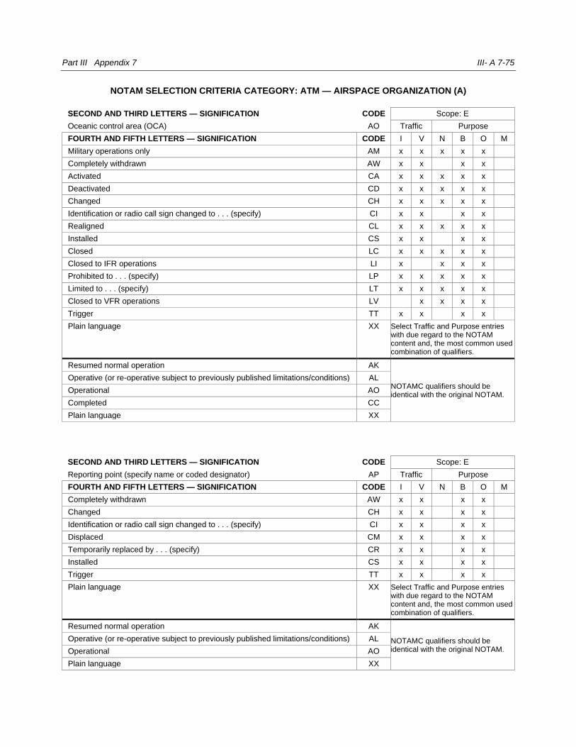
Part III Appendix 7 III- A 7-75
NOTAM SELECTION CRITERIA CATEGORY: ATM — AIRSPACE ORGANIZATION (A)
SECOND AND THIRD LETTERS — SIGNIFICATION CODE Scope: E
Oceanic control area (OCA) AO Traffic Purpose
FOURTH AND FIFTH LETTERS — SIGNIFICATION CODE I V N B O M
Military operations only AM x x x x x
Completely withdrawn AW x x x x
Activated CA x x x x x
Deactivated CD x x x x x
Changed CH x x x x x
Identification or radio call sign changed to . . . (specify) CI x x x x
Realigned CL x x x x x
Installed CS x x x x
Closed LC x x x x x
Closed to IFR operations LI x x x x
Prohibited to . . . (specify) LP x x x x x
Limited to . . . (specify) LT x x x x x
Closed to VFR operations LV x x x x
Trigger TT x x x x
Plain language XX Select Traffic and Purpose entries with due regard to the NOTAM content and, the most common used combination of qualifiers.
Resumed normal operation AK
NOTAMC qualifiers should be identical with the original NOTAM.
Operative (or re-operative subject to previously published limitations/conditions) AL
Operational AO
Completed CC
Plain language XX
SECOND AND THIRD LETTERS — SIGNIFICATION CODE Scope: E
Reporting point (specify name or coded designator) AP Traffic Purpose
FOURTH AND FIFTH LETTERS — SIGNIFICATION CODE I V N B O M
Completely withdrawn AW x x x x
Changed CH x x x x
Identification or radio call sign changed to . . . (specify) CI x x x x
Displaced CM x x x x
Temporarily replaced by . . . (specify) CR x x x x
Installed CS x x x x
Trigger TT x x x x
Plain language XX Select Traffic and Purpose entries with due regard to the NOTAM content and, the most common used combination of qualifiers.
Resumed normal operation AK
NOTAMC qualifiers should be identical with the original NOTAM.
Operative (or re-operative subject to previously published limitations/conditions) AL
Operational AO
Plain language XX

III-A 7-76 Aeronautical Information Services manual
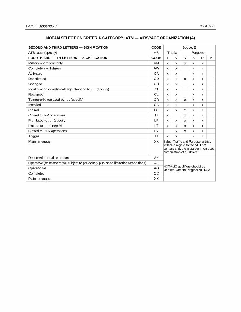
Part III Appendix 7 III- A 7-77
NOTAM SELECTION CRITERIA CATEGORY: ATM — AIRSPACE ORGANIZATION (A)
SECOND AND THIRD LETTERS — SIGNIFICATION CODE Scope: E
ATS route (specify) AR Traffic Purpose
FOURTH AND FIFTH LETTERS — SIGNIFICATION CODE I V N B O M
Military operations only AM x x x x x
Completely withdrawn AW x x x x
Activated CA x x x x
Deactivated CD x x x x x
Changed CH x x x x
Identification or radio call sign changed to . . . (specify) CI x x x x
Realigned CL x x x x
Temporarily replaced by . . . (specify) CR x x x x x
Installed CS x x x x
Closed LC x x x x x
Closed to IFR operations LI x x x x
Prohibited to . . . (specify) LP x x x x x
Limited to . . . (specify) LT x x x x x
Closed to VFR operations LV x x x x
Trigger TT x x x x
Plain language XX Select Traffic and Purpose entries with due regard to the NOTAM content and, the most common used combination of qualifiers.
Resumed normal operation AK
NOTAMC qualifiers should be identical with the original NOTAM.
Operative (or re-operative subject to previously published limitations/conditions) AL
Operational AO
Completed CC
Plain language XX
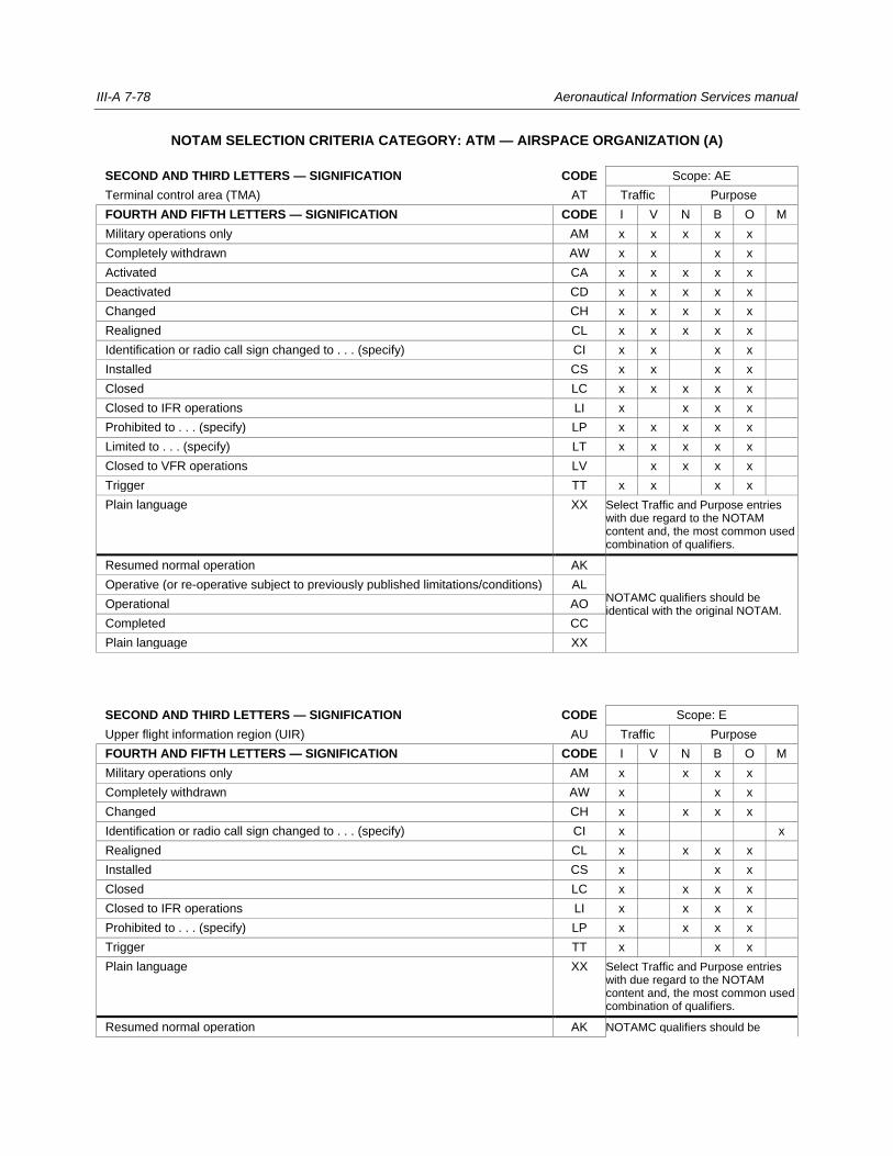
III-A 7-78 Aeronautical Information Services manual
NOTAM SELECTION CRITERIA CATEGORY: ATM — AIRSPACE ORGANIZATION (A)
SECOND AND THIRD LETTERS — SIGNIFICATION CODE Scope: AE
Terminal control area (TMA) AT Traffic Purpose
FOURTH AND FIFTH LETTERS — SIGNIFICATION CODE I V N B O M
Military operations only AM x x x x x
Completely withdrawn AW x x x x
Activated CA x x x x x
Deactivated CD x x x x x
Changed CH x x x x x
Realigned CL x x x x x
Identification or radio call sign changed to . . . (specify) CI x x x x
Installed CS x x x x
Closed LC x x x x x
Closed to IFR operations LI x x x x
Prohibited to . . . (specify) LP x x x x x
Limited to . . . (specify) LT x x x x x
Closed to VFR operations LV x x x x
Trigger TT x x x x
Plain language XX Select Traffic and Purpose entries with due regard to the NOTAM content and, the most common used combination of qualifiers.
Resumed normal operation AK
NOTAMC qualifiers should be identical with the original NOTAM.
Operative (or re-operative subject to previously published limitations/conditions) AL
Operational AO
Completed CC
Plain language XX
SECOND AND THIRD LETTERS — SIGNIFICATION CODE Scope: E
Upper flight information region (UIR) AU Traffic Purpose
FOURTH AND FIFTH LETTERS — SIGNIFICATION CODE I V N B O M
Military operations only AM x x x x
Completely withdrawn AW x x x
Changed CH x x x x
Identification or radio call sign changed to . . . (specify) CI x x
Realigned CL x x x x
Installed CS x x x
Closed LC x x x x
Closed to IFR operations LI x x x x
Prohibited to . . . (specify) LP x x x x
Trigger TT x x x
Plain language XX Select Traffic and Purpose entries with due regard to the NOTAM content and, the most common used combination of qualifiers.
Resumed normal operation AK NOTAMC qualifiers should be

Part III Appendix 7 III- A 7-79
Operative (or re-operative subject to previously published limitations/conditions) AL identical with the original NOTAM.
Operational AO
Completed CC
Plain language XX
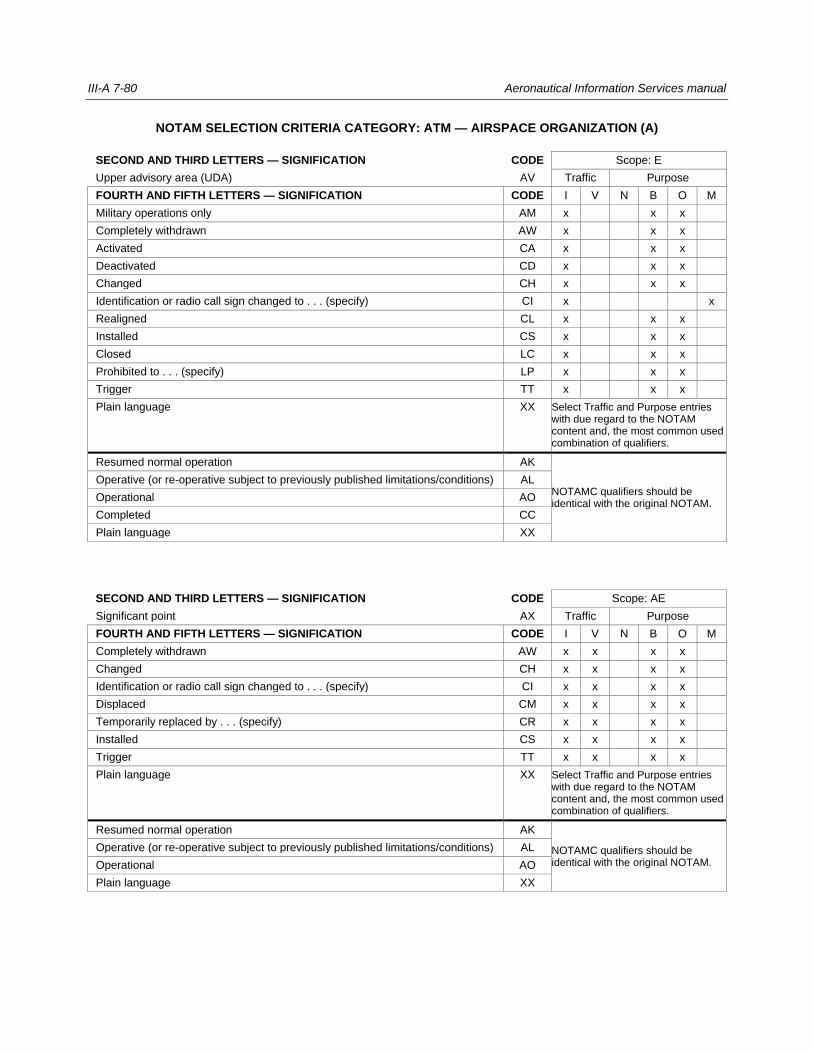
III-A 7-80 Aeronautical Information Services manual
NOTAM SELECTION CRITERIA CATEGORY: ATM — AIRSPACE ORGANIZATION (A)
SECOND AND THIRD LETTERS — SIGNIFICATION CODE Scope: E
Upper advisory area (UDA) AV Traffic Purpose
FOURTH AND FIFTH LETTERS — SIGNIFICATION CODE I V N B O M
Military operations only AM x x x
Completely withdrawn AW x x x
Activated CA x x x
Deactivated CD x x x
Changed CH x x x
Identification or radio call sign changed to . . . (specify) CI x x
Realigned CL x x x
Installed CS x x x
Closed LC x x x
Prohibited to . . . (specify) LP x x x
Trigger TT x x x
Plain language XX Select Traffic and Purpose entries with due regard to the NOTAM content and, the most common used combination of qualifiers.
Resumed normal operation AK
NOTAMC qualifiers should be identical with the original NOTAM.
Operative (or re-operative subject to previously published limitations/conditions) AL
Operational AO
Completed CC
Plain language XX
SECOND AND THIRD LETTERS — SIGNIFICATION CODE Scope: AE
Significant point AX Traffic Purpose
FOURTH AND FIFTH LETTERS — SIGNIFICATION CODE I V N B O M
Completely withdrawn AW x x x x
Changed CH x x x x
Identification or radio call sign changed to . . . (specify) CI x x x x
Displaced CM x x x x
Temporarily replaced by . . . (specify) CR x x x x
Installed CS x x x x
Trigger TT x x x x
Plain language XX Select Traffic and Purpose entries with due regard to the NOTAM content and, the most common used combination of qualifiers.
Resumed normal operation AK
NOTAMC qualifiers should be identical with the original NOTAM.
Operative (or re-operative subject to previously published limitations/conditions) AL
Operational AO
Plain language XX
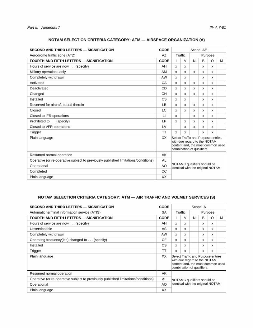
Part III Appendix 7 III- A 7-81
NOTAM SELECTION CRITERIA CATEGORY: ATM — AIRSPACE ORGANIZATION (A)
SECOND AND THIRD LETTERS — SIGNIFICATION CODE Scope: AE
Aerodrome traffic zone (ATZ) AZ Traffic Purpose
FOURTH AND FIFTH LETTERS — SIGNIFICATION CODE I V N B O M
Hours of service are now . . . (specify) AH x x x x
Military operations only AM x x x x x
Completely withdrawn AW x x x x
Activated CA x x x x x
Deactivated CD x x x x x
Changed CH x x x x x
Installed CS x x x x
Reserved for aircraft based therein LB x x x x x
Closed LC x x x x x
Closed to IFR operations LI x x x x
Prohibited to . . . (specify) LP x x x x x
Closed to VFR operations LV x x x x
Trigger TT x x x x
Plain language XX Select Traffic and Purpose entries with due regard to the NOTAM content and, the most common used combination of qualifiers.
Resumed normal operation AK
NOTAMC qualifiers should be identical with the original NOTAM.
Operative (or re-operative subject to previously published limitations/conditions) AL
Operational AO
Completed CC
Plain language XX
NOTAM SELECTION CRITERIA CATEGORY: ATM — AIR TRAFFIC AND VOLMET SERVICES (S)
SECOND AND THIRD LETTERS — SIGNIFICATION CODE Scope: A
Automatic terminal information service (ATIS) SA Traffic Purpose
FOURTH AND FIFTH LETTERS — SIGNIFICATION CODE I V N B O M
Hours of service are now . . . (specify) AH x x x x
Unserviceable AS x x x x
Completely withdrawn AW x x x x
Operating frequency(ies) changed to . . . (specify) CF x x x x
Installed CS x x x x
Trigger TT x x x x
Plain language XX Select Traffic and Purpose entries with due regard to the NOTAM content and, the most common used combination of qualifiers.
Resumed normal operation AK
NOTAMC qualifiers should be identical with the original NOTAM.
Operative (or re-operative subject to previously published limitations/conditions) AL
Operational AO
Plain language XX

III-A 7-82 Aeronautical Information Services manual
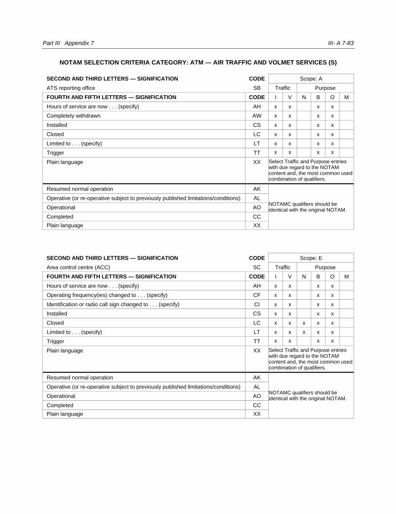
Part III Appendix 7 III- A 7-83
NOTAM SELECTION CRITERIA CATEGORY: ATM — AIR TRAFFIC AND VOLMET SERVICES (S)
SECOND AND THIRD LETTERS — SIGNIFICATION CODE Scope: A
ATS reporting office SB Traffic Purpose
FOURTH AND FIFTH LETTERS — SIGNIFICATION CODE I V N B O M
Hours of service are now . . . (specify) AH x x x x
Completely withdrawn AW x x x x
Installed CS x x x x
Closed LC x x x x
Limited to . . . (specify) LT x x x x
Trigger TT x x x x
Plain language XX Select Traffic and Purpose entries with due regard to the NOTAM content and, the most common used combination of qualifiers.
Resumed normal operation AK
NOTAMC qualifiers should be identical with the original NOTAM.
Operative (or re-operative subject to previously published limitations/conditions) AL
Operational AO
Completed CC
Plain language XX
SECOND AND THIRD LETTERS — SIGNIFICATION CODE Scope: E
Area control centre (ACC) SC Traffic Purpose
FOURTH AND FIFTH LETTERS — SIGNIFICATION CODE I V N B O M
Hours of service are now . . . (specify) AH x x x x
Operating frequency(ies) changed to . . . (specify) CF x x x x
Identification or radio call sign changed to . . . (specify) CI x x x x
Installed CS x x x x
Closed LC x x x x x
Limited to . . . (specify) LT x x x x x
Trigger TT x x x x
Plain language XX Select Traffic and Purpose entries with due regard to the NOTAM content and, the most common used combination of qualifiers.
Resumed normal operation AK
NOTAMC qualifiers should be identical with the original NOTAM.
Operative (or re-operative subject to previously published limitations/conditions) AL
Operational AO
Completed CC
Plain language XX
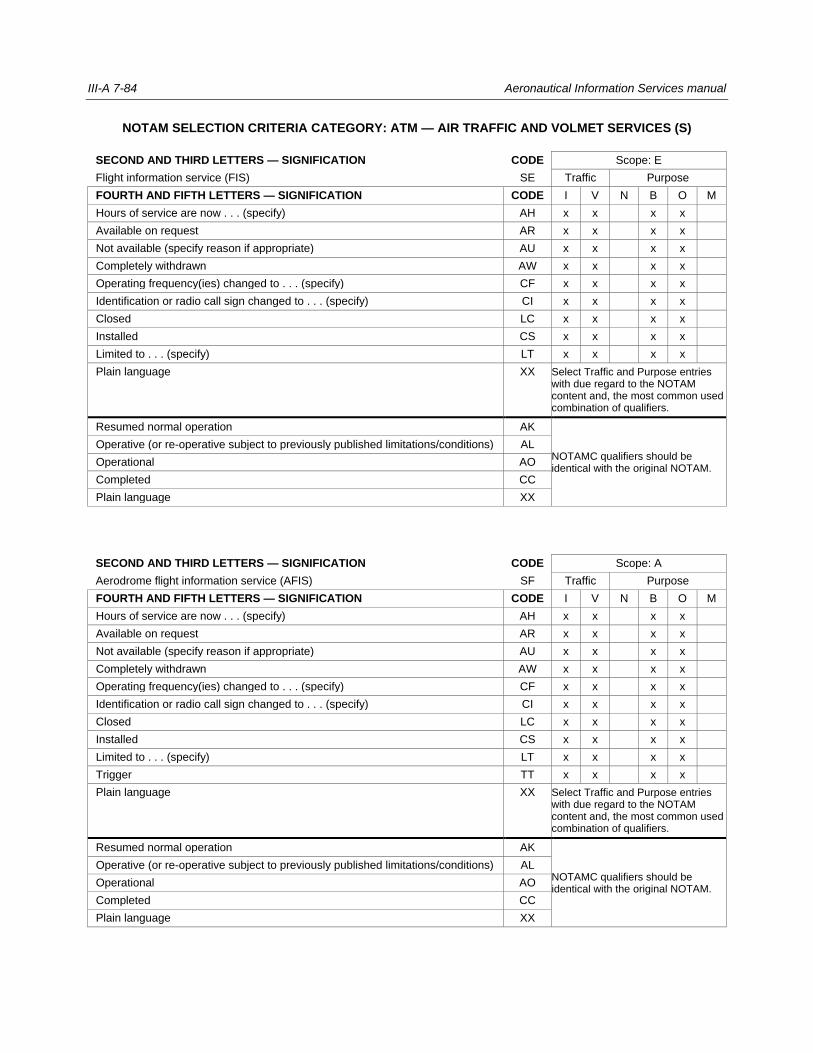
III-A 7-84 Aeronautical Information Services manual
NOTAM SELECTION CRITERIA CATEGORY: ATM — AIR TRAFFIC AND VOLMET SERVICES (S)
SECOND AND THIRD LETTERS — SIGNIFICATION CODE Scope: E
Flight information service (FIS) SE Traffic Purpose
FOURTH AND FIFTH LETTERS — SIGNIFICATION CODE I V N B O M
Hours of service are now . . . (specify) AH x x x x
Available on request AR x x x x
Not available (specify reason if appropriate) AU x x x x
Completely withdrawn AW x x x x
Operating frequency(ies) changed to . . . (specify) CF x x x x
Identification or radio call sign changed to . . . (specify) CI x x x x
Closed LC x x x x
Installed CS x x x x
Limited to . . . (specify) LT x x x x
Plain language XX Select Traffic and Purpose entries with due regard to the NOTAM content and, the most common used combination of qualifiers.
Resumed normal operation AK
NOTAMC qualifiers should be identical with the original NOTAM.
Operative (or re-operative subject to previously published limitations/conditions) AL
Operational AO
Completed CC
Plain language XX
SECOND AND THIRD LETTERS — SIGNIFICATION CODE Scope: A
Aerodrome flight information service (AFIS) SF Traffic Purpose
FOURTH AND FIFTH LETTERS — SIGNIFICATION CODE I V N B O M
Hours of service are now . . . (specify) AH x x x x
Available on request AR x x x x
Not available (specify reason if appropriate) AU x x x x
Completely withdrawn AW x x x x
Operating frequency(ies) changed to . . . (specify) CF x x x x
Identification or radio call sign changed to . . . (specify) CI x x x x
Closed LC x x x x
Installed CS x x x x
Limited to . . . (specify) LT x x x x
Trigger TT x x x x
Plain language XX Select Traffic and Purpose entries with due regard to the NOTAM content and, the most common used combination of qualifiers.
Resumed normal operation AK
NOTAMC qualifiers should be identical with the original NOTAM.
Operative (or re-operative subject to previously published limitations/conditions) AL
Operational AO
Completed CC
Plain language XX
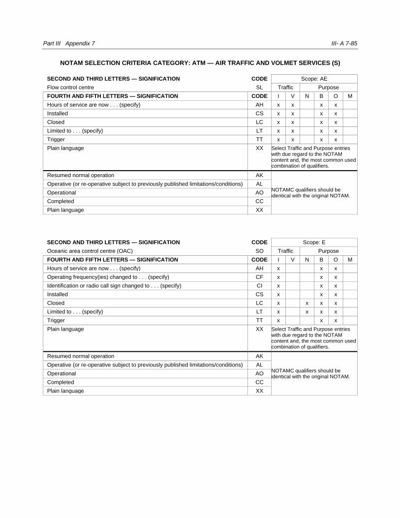
Part III Appendix 7 III- A 7-85
NOTAM SELECTION CRITERIA CATEGORY: ATM — AIR TRAFFIC AND VOLMET SERVICES (S)
SECOND AND THIRD LETTERS — SIGNIFICATION CODE Scope: AE
Flow control centre SL Traffic Purpose
FOURTH AND FIFTH LETTERS — SIGNIFICATION CODE I V N B O M
Hours of service are now . . . (specify) AH x x x x
Installed CS x x x x
Closed LC x x x x
Limited to . . . (specify) LT x x x x
Trigger TT x x x x
Plain language XX Select Traffic and Purpose entries with due regard to the NOTAM content and, the most common used combination of qualifiers.
Resumed normal operation AK
NOTAMC qualifiers should be identical with the original NOTAM.
Operative (or re-operative subject to previously published limitations/conditions) AL
Operational AO
Completed CC
Plain language XX
SECOND AND THIRD LETTERS — SIGNIFICATION CODE Scope: E
Oceanic area control centre (OAC) SO Traffic Purpose
FOURTH AND FIFTH LETTERS — SIGNIFICATION CODE I V N B O M
Hours of service are now . . . (specify) AH x x x
Operating frequency(ies) changed to . . . (specify) CF x x x
Identification or radio call sign changed to . . . (specify) CI x x x
Installed CS x x x
Closed LC x x x x
Limited to . . . (specify) LT x x x x
Trigger TT x x x
Plain language XX Select Traffic and Purpose entries with due regard to the NOTAM content and, the most common used combination of qualifiers.
Resumed normal operation AK
NOTAMC qualifiers should be identical with the original NOTAM.
Operative (or re-operative subject to previously published limitations/conditions) AL
Operational AO
Completed CC
Plain language XX
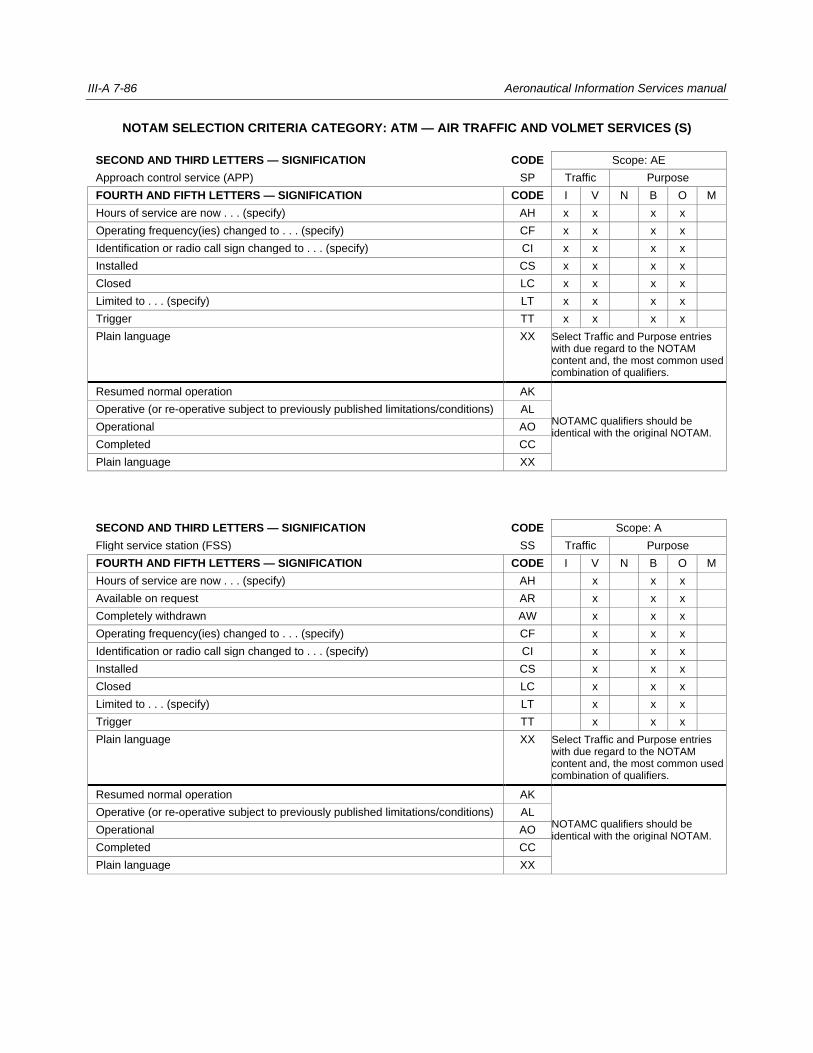
III-A 7-86 Aeronautical Information Services manual
NOTAM SELECTION CRITERIA CATEGORY: ATM — AIR TRAFFIC AND VOLMET SERVICES (S)
SECOND AND THIRD LETTERS — SIGNIFICATION CODE Scope: AE
Approach control service (APP) SP Traffic Purpose
FOURTH AND FIFTH LETTERS — SIGNIFICATION CODE I V N B O M
Hours of service are now . . . (specify) AH x x x x
Operating frequency(ies) changed to . . . (specify) CF x x x x
Identification or radio call sign changed to . . . (specify) CI x x x x
Installed CS x x x x
Closed LC x x x x
Limited to . . . (specify) LT x x x x
Trigger TT x x x x
Plain language XX Select Traffic and Purpose entries with due regard to the NOTAM content and, the most common used combination of qualifiers.
Resumed normal operation AK
NOTAMC qualifiers should be identical with the original NOTAM.
Operative (or re-operative subject to previously published limitations/conditions) AL
Operational AO
Completed CC
Plain language XX
SECOND AND THIRD LETTERS — SIGNIFICATION CODE Scope: A
Flight service station (FSS) SS Traffic Purpose
FOURTH AND FIFTH LETTERS — SIGNIFICATION CODE I V N B O M
Hours of service are now . . . (specify) AH x x x
Available on request AR x x x
Completely withdrawn AW x x x
Operating frequency(ies) changed to . . . (specify) CF x x x
Identification or radio call sign changed to . . . (specify) CI x x x
Installed CS x x x
Closed LC x x x
Limited to . . . (specify) LT x x x
Trigger TT x x x
Plain language XX Select Traffic and Purpose entries with due regard to the NOTAM content and, the most common used combination of qualifiers.
Resumed normal operation AK
NOTAMC qualifiers should be identical with the original NOTAM.
Operative (or re-operative subject to previously published limitations/conditions) AL
Operational AO
Completed CC
Plain language XX
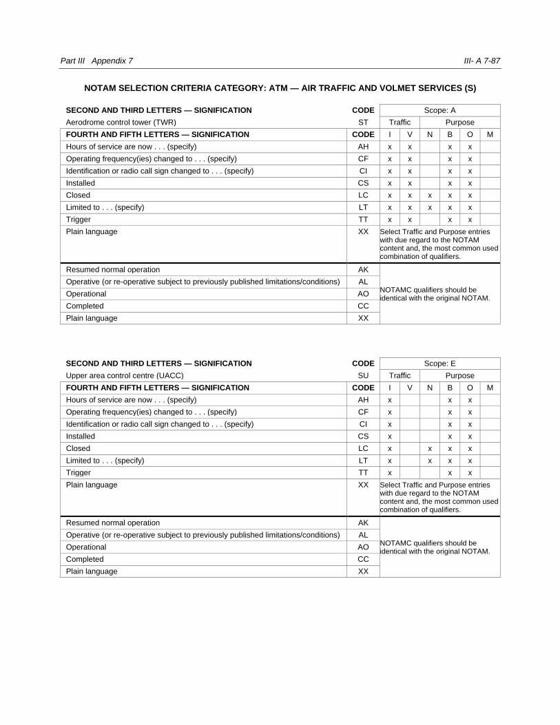
Part III Appendix 7 III- A 7-87
NOTAM SELECTION CRITERIA CATEGORY: ATM — AIR TRAFFIC AND VOLMET SERVICES (S)
SECOND AND THIRD LETTERS — SIGNIFICATION CODE Scope: A
Aerodrome control tower (TWR) ST Traffic Purpose
FOURTH AND FIFTH LETTERS — SIGNIFICATION CODE I V N B O M
Hours of service are now . . . (specify) AH x x x x
Operating frequency(ies) changed to . . . (specify) CF x x x x
Identification or radio call sign changed to . . . (specify) CI x x x x
Installed CS x x x x
Closed LC x x x x x
Limited to . . . (specify) LT x x x x x
Trigger TT x x x x
Plain language XX Select Traffic and Purpose entries with due regard to the NOTAM content and, the most common used combination of qualifiers.
Resumed normal operation AK
NOTAMC qualifiers should be identical with the original NOTAM.
Operative (or re-operative subject to previously published limitations/conditions) AL
Operational AO
Completed CC
Plain language XX
SECOND AND THIRD LETTERS — SIGNIFICATION CODE Scope: E
Upper area control centre (UACC) SU Traffic Purpose
FOURTH AND FIFTH LETTERS — SIGNIFICATION CODE I V N B O M
Hours of service are now . . . (specify) AH x x x
Operating frequency(ies) changed to . . . (specify) CF x x x
Identification or radio call sign changed to . . . (specify) CI x x x
Installed CS x x x
Closed LC x x x x
Limited to . . . (specify) LT x x x x
Trigger TT x x x
Plain language XX Select Traffic and Purpose entries with due regard to the NOTAM content and, the most common used combination of qualifiers.
Resumed normal operation AK
NOTAMC qualifiers should be identical with the original NOTAM.
Operative (or re-operative subject to previously published limitations/conditions) AL
Operational AO
Completed CC
Plain language XX
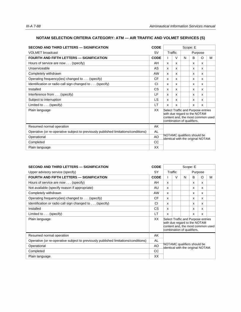
III-A 7-88 Aeronautical Information Services manual
NOTAM SELECTION CRITERIA CATEGORY: ATM — AIR TRAFFIC AND VOLMET SERVICES (S)
SECOND AND THIRD LETTERS — SIGNIFICATION CODE Scope: E
VOLMET broadcast SV Traffic Purpose
FOURTH AND FIFTH LETTERS — SIGNIFICATION CODE I V N B O M
Hours of service are now . . . (specify) AH x x x x
Unserviceable AS x x x x
Completely withdrawn AW x x x x
Operating frequency(ies) changed to . . . (specify) CF x x x x
Identification or radio call sign changed to . . . (specify) CI x x x x
Installed CS x x x x
Interference from . . . (specify) LF x x x x
Subject to interruption LS x x x x
Limited to . . . (specify) LT x x x x
Plain language XX Select Traffic and Purpose entries with due regard to the NOTAM content and, the most common used combination of qualifiers.
Resumed normal operation AK
NOTAMC qualifiers should be identical with the original NOTAM.
Operative (or re-operative subject to previously published limitations/conditions) AL
Operational AO
Completed CC
Plain language XX
SECOND AND THIRD LETTERS — SIGNIFICATION CODE Scope: E
Upper advisory service (specify) SY Traffic Purpose
FOURTH AND FIFTH LETTERS — SIGNIFICATION CODE I V N B O M
Hours of service are now . . . (specify) AH x x x
Not available (specify reason if appropriate) AU x x x
Completely withdrawn AW x x x
Operating frequency(ies) changed to . . . (specify) CF x x x
Identification or radio call sign changed to . . . (specify) CI x x x
Installed CS x x x
Limited to . . . (specify) LT x x x
Plain language XX Select Traffic and Purpose entries with due regard to the NOTAM content and, the most common used combination of qualifiers.
Resumed normal operation AK
NOTAMC qualifiers should be identical with the original NOTAM.
Operative (or re-operative subject to previously published limitations/conditions) AL
Operational AO
Completed CC
Plain language XX
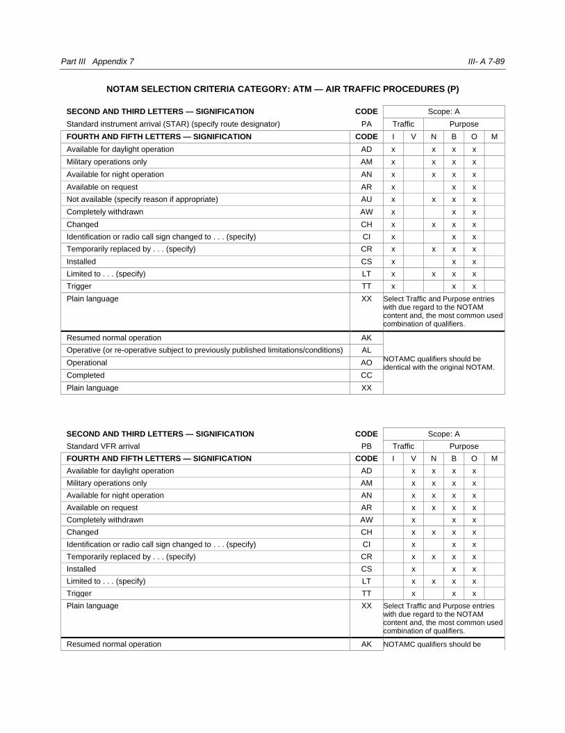
Part III Appendix 7 III- A 7-89
NOTAM SELECTION CRITERIA CATEGORY: ATM — AIR TRAFFIC PROCEDURES (P)
SECOND AND THIRD LETTERS — SIGNIFICATION CODE Scope: A
Standard instrument arrival (STAR) (specify route designator) PA Traffic Purpose
FOURTH AND FIFTH LETTERS — SIGNIFICATION CODE I V N B O M
Available for daylight operation AD x x x x
Military operations only AM x x x x
Available for night operation AN x x x x
Available on request AR x x x
Not available (specify reason if appropriate) AU x x x x
Completely withdrawn AW x x x
Changed CH x x x x
Identification or radio call sign changed to . . . (specify) CI x x x
Temporarily replaced by . . . (specify) CR x x x x
Installed CS x x x
Limited to . . . (specify) LT x x x x
Trigger TT x x x
Plain language XX Select Traffic and Purpose entries with due regard to the NOTAM content and, the most common used combination of qualifiers.
Resumed normal operation AK
NOTAMC qualifiers should be identical with the original NOTAM.
Operative (or re-operative subject to previously published limitations/conditions) AL
Operational AO
Completed CC
Plain language XX
SECOND AND THIRD LETTERS — SIGNIFICATION CODE Scope: A
Standard VFR arrival PB Traffic Purpose
FOURTH AND FIFTH LETTERS — SIGNIFICATION CODE I V N B O M
Available for daylight operation AD x x x x
Military operations only AM x x x x
Available for night operation AN x x x x
Available on request AR x x x x
Completely withdrawn AW x x x
Changed CH x x x x
Identification or radio call sign changed to . . . (specify) CI x x x
Temporarily replaced by . . . (specify) CR x x x x
Installed CS x x x
Limited to . . . (specify) LT x x x x
Trigger TT x x x
Plain language XX Select Traffic and Purpose entries with due regard to the NOTAM content and, the most common used combination of qualifiers.
Resumed normal operation AK NOTAMC qualifiers should be

III-A 7-90 Aeronautical Information Services manual
Operative (or re-operative subject to previously published limitations/conditions) AL identical with the original NOTAM.
Operational AO
Completed CC
Plain language XX
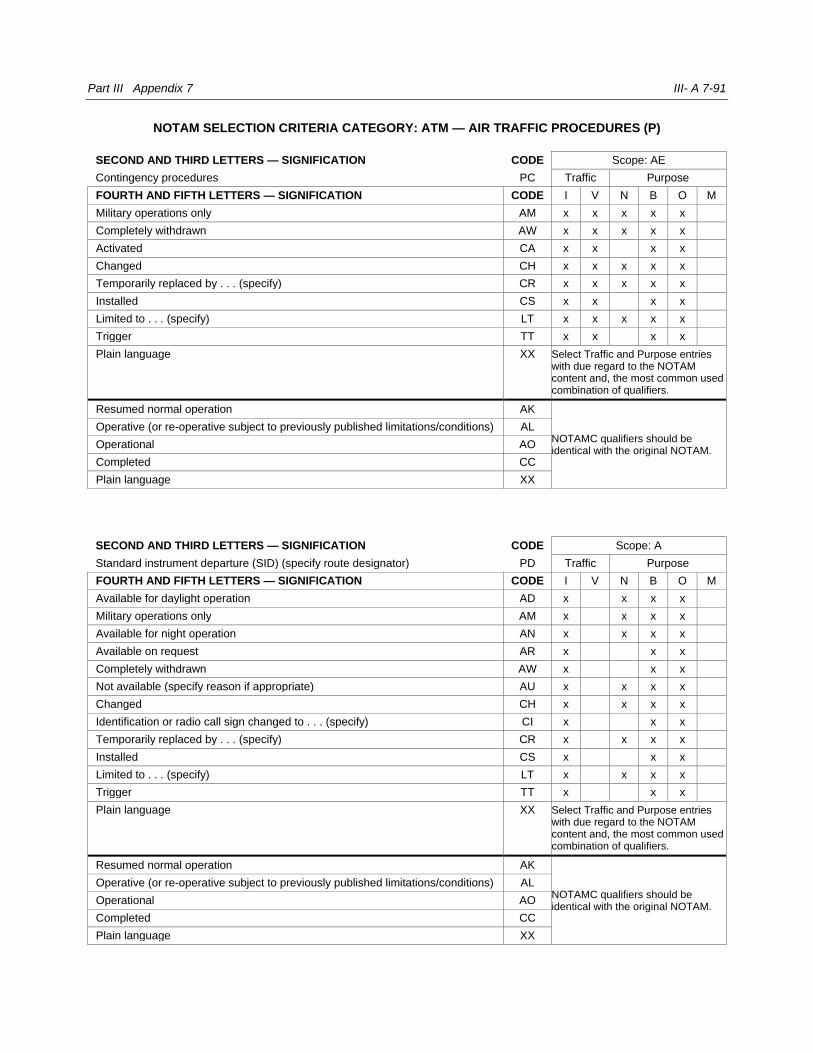
Part III Appendix 7 III- A 7-91
NOTAM SELECTION CRITERIA CATEGORY: ATM — AIR TRAFFIC PROCEDURES (P)
SECOND AND THIRD LETTERS — SIGNIFICATION CODE Scope: AE
Contingency procedures PC Traffic Purpose
FOURTH AND FIFTH LETTERS — SIGNIFICATION CODE I V N B O M
Military operations only AM x x x x x
Completely withdrawn AW x x x x x
Activated CA x x x x
Changed CH x x x x x
Temporarily replaced by . . . (specify) CR x x x x x
Installed CS x x x x
Limited to . . . (specify) LT x x x x x
Trigger TT x x x x
Plain language XX Select Traffic and Purpose entries with due regard to the NOTAM content and, the most common used combination of qualifiers.
Resumed normal operation AK
NOTAMC qualifiers should be identical with the original NOTAM.
Operative (or re-operative subject to previously published limitations/conditions) AL
Operational AO
Completed CC
Plain language XX
SECOND AND THIRD LETTERS — SIGNIFICATION CODE Scope: A
Standard instrument departure (SID) (specify route designator) PD Traffic Purpose
FOURTH AND FIFTH LETTERS — SIGNIFICATION CODE I V N B O M
Available for daylight operation AD x x x x
Military operations only AM x x x x
Available for night operation AN x x x x
Available on request AR x x x
Completely withdrawn AW x x x
Not available (specify reason if appropriate) AU x x x x
Changed CH x x x x
Identification or radio call sign changed to . . . (specify) CI x x x
Temporarily replaced by . . . (specify) CR x x x x
Installed CS x x x
Limited to . . . (specify) LT x x x x
Trigger TT x x x
Plain language XX Select Traffic and Purpose entries with due regard to the NOTAM content and, the most common used combination of qualifiers.
Resumed normal operation AK
NOTAMC qualifiers should be identical with the original NOTAM.
Operative (or re-operative subject to previously published limitations/conditions) AL
Operational AO
Completed CC
Plain language XX

III-A 7-92 Aeronautical Information Services manual
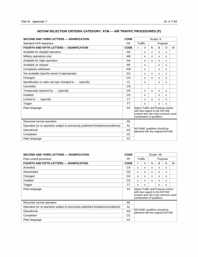
Part III Appendix 7 III- A 7-93
NOTAM SELECTION CRITERIA CATEGORY: ATM — AIR TRAFFIC PROCEDURES (P)
SECOND AND THIRD LETTERS — SIGNIFICATION CODE Scope: A
Standard VFR departure PE Traffic Purpose
FOURTH AND FIFTH LETTERS — SIGNIFICATION CODE I V N B O M
Available for daylight operation AD x x x x
Military operations only AM x x x x
Available for night operation AN x x x x
Available on request AR x x x
Completely withdrawn AW x x x
Not available (specify reason if appropriate) AU x x x x
Changed CH x x x x
Identification or radio call sign changed to . . . (specify) CI x x x
Cancelled CN
Temporarily replaced by . . . (specify) CR x x x x
Installed CS x x x
Limited to . . . (specify) LT x x x x
Trigger TT x x x
Plain language XX Select Traffic and Purpose entries with due regard to the NOTAM content and, the most common used combination of qualifiers.
Resumed normal operation AK
NOTAMC qualifiers should be identical with the original NOTAM.
Operative (or re-operative subject to previously published limitations/conditions) AL
Operational AO
Completed CC
Plain language XX
SECOND AND THIRD LETTERS — SIGNIFICATION CODE Scope: AE
Flow control procedure PF Traffic Purpose
FOURTH AND FIFTH LETTERS — SIGNIFICATION CODE I V N B O M
Activated CA x x x x x
Deactivated CD x x x x x
Changed CH x x x x x
Installed CS x x x x x
Trigger TT x x x x
Plain language XX Select Traffic and Purpose entries with due regard to the NOTAM content and, the most common used combination of qualifiers.
Resumed normal operation AK
NOTAMC qualifiers should be identical with the original NOTAM.
Operative (or re-operative subject to previously published limitations/conditions) AL
Operational AO
Completed CC
Plain language XX
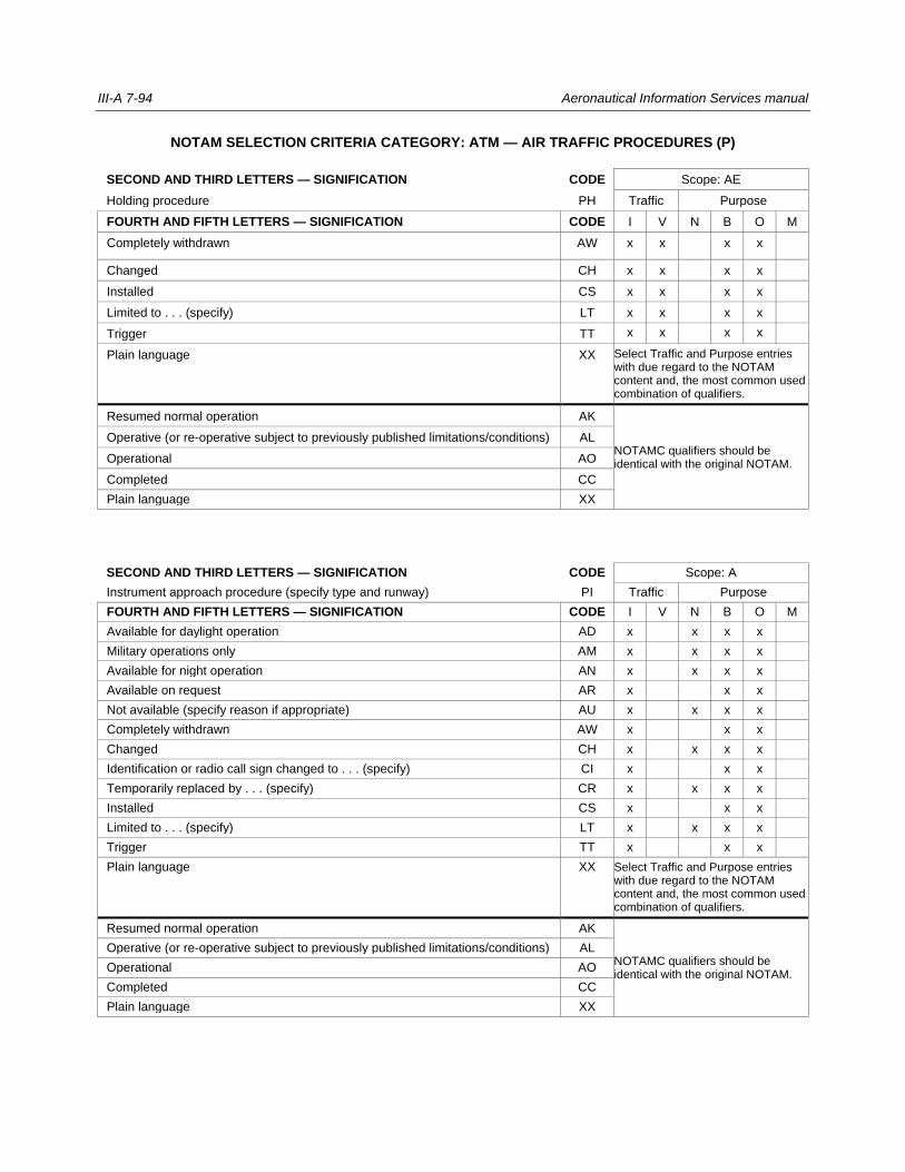
III-A 7-94 Aeronautical Information Services manual
NOTAM SELECTION CRITERIA CATEGORY: ATM — AIR TRAFFIC PROCEDURES (P)
SECOND AND THIRD LETTERS — SIGNIFICATION CODE Scope: AE
Holding procedure PH Traffic Purpose
FOURTH AND FIFTH LETTERS — SIGNIFICATION CODE I V N B O M
Completely withdrawn AW x x x x
Changed CH x x x x
Installed CS x x x x
Limited to . . . (specify) LT x x x x
Trigger TT x x x x
Plain language XX Select Traffic and Purpose entries with due regard to the NOTAM content and, the most common used combination of qualifiers.
Resumed normal operation AK
NOTAMC qualifiers should be identical with the original NOTAM.
Operative (or re-operative subject to previously published limitations/conditions) AL
Operational AO
Completed CC
Plain language XX
SECOND AND THIRD LETTERS — SIGNIFICATION CODE Scope: A
Instrument approach procedure (specify type and runway) PI Traffic Purpose
FOURTH AND FIFTH LETTERS — SIGNIFICATION CODE I V N B O M
Available for daylight operation AD x x x x
Military operations only AM x x x x
Available for night operation AN x x x x
Available on request AR x x x
Not available (specify reason if appropriate) AU x x x x
Completely withdrawn AW x x x
Changed CH x x x x
Identification or radio call sign changed to . . . (specify) CI x x x
Temporarily replaced by . . . (specify) CR x x x x
Installed CS x x x
Limited to . . . (specify) LT x x x x
Trigger TT x x x
Plain language XX Select Traffic and Purpose entries with due regard to the NOTAM content and, the most common used combination of qualifiers.
Resumed normal operation AK
NOTAMC qualifiers should be identical with the original NOTAM.
Operative (or re-operative subject to previously published limitations/conditions) AL
Operational AO
Completed CC
Plain language XX
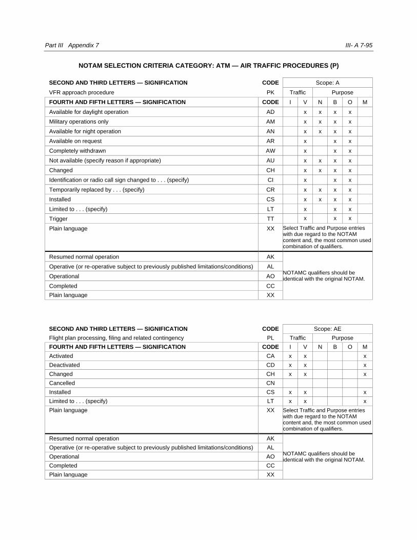
Part III Appendix 7 III- A 7-95
NOTAM SELECTION CRITERIA CATEGORY: ATM — AIR TRAFFIC PROCEDURES (P)
SECOND AND THIRD LETTERS — SIGNIFICATION CODE Scope: A
VFR approach procedure PK Traffic Purpose
FOURTH AND FIFTH LETTERS — SIGNIFICATION CODE I V N B O M
Available for daylight operation AD x x x x
Military operations only AM x x x x
Available for night operation AN x x x x
Available on request AR x x x
Completely withdrawn AW x x x
Not available (specify reason if appropriate) AU x x x x
Changed CH x x x x
Identification or radio call sign changed to . . . (specify) CI x x x
Temporarily replaced by . . . (specify) CR x x x x
Installed CS x x x x
Limited to . . . (specify) LT x x x
Trigger TT x x x
Plain language XX Select Traffic and Purpose entries with due regard to the NOTAM content and, the most common used combination of qualifiers.
Resumed normal operation AK
NOTAMC qualifiers should be identical with the original NOTAM.
Operative (or re-operative subject to previously published limitations/conditions) AL
Operational AO
Completed CC
Plain language XX
SECOND AND THIRD LETTERS — SIGNIFICATION CODE Scope: AE
Flight plan processing, filing and related contingency PL Traffic Purpose
FOURTH AND FIFTH LETTERS — SIGNIFICATION CODE I V N B O M
Activated CA x x x
Deactivated CD x x x
Changed CH x x x
Cancelled CN
Installed CS x x x
Limited to . . . (specify) LT x x x
Plain language XX Select Traffic and Purpose entries with due regard to the NOTAM content and, the most common used combination of qualifiers.
Resumed normal operation AK
NOTAMC qualifiers should be identical with the original NOTAM.
Operative (or re-operative subject to previously published limitations/conditions) AL
Operational AO
Completed CC
Plain language XX

III-A 7-96 Aeronautical Information Services manual
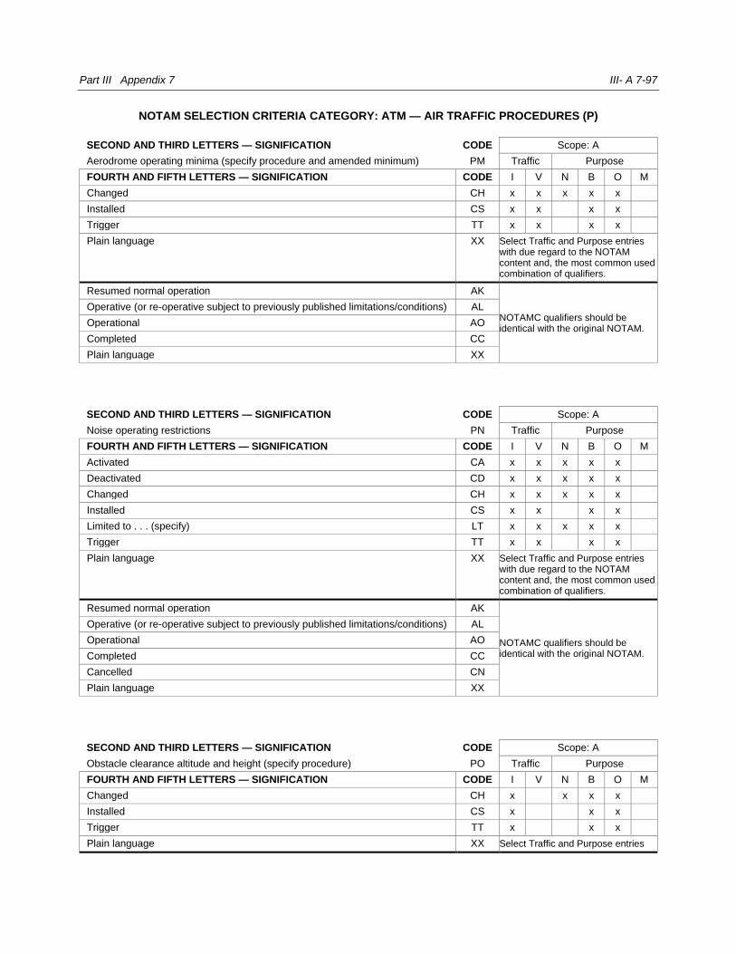
Part III Appendix 7 III- A 7-97
NOTAM SELECTION CRITERIA CATEGORY: ATM — AIR TRAFFIC PROCEDURES (P)
SECOND AND THIRD LETTERS — SIGNIFICATION CODE Scope: A
Aerodrome operating minima (specify procedure and amended minimum) PM Traffic Purpose
FOURTH AND FIFTH LETTERS — SIGNIFICATION CODE I V N B O M
Changed CH x x x x x
Installed CS x x x x
Trigger TT x x x x
Plain language XX Select Traffic and Purpose entries with due regard to the NOTAM content and, the most common used combination of qualifiers.
Resumed normal operation AK
NOTAMC qualifiers should be identical with the original NOTAM.
Operative (or re-operative subject to previously published limitations/conditions) AL
Operational AO
Completed CC
Plain language XX
SECOND AND THIRD LETTERS — SIGNIFICATION CODE Scope: A
Noise operating restrictions PN Traffic Purpose
FOURTH AND FIFTH LETTERS — SIGNIFICATION CODE I V N B O M
Activated CA x x x x x
Deactivated CD x x x x x
Changed CH x x x x x
Installed CS x x x x
Limited to . . . (specify) LT x x x x x
Trigger TT x x x x
Plain language XX Select Traffic and Purpose entries with due regard to the NOTAM content and, the most common used combination of qualifiers.
Resumed normal operation AK
NOTAMC qualifiers should be identical with the original NOTAM.
Operative (or re-operative subject to previously published limitations/conditions) AL
Operational AO
Completed CC
Cancelled CN
Plain language XX
SECOND AND THIRD LETTERS — SIGNIFICATION CODE Scope: A
Obstacle clearance altitude and height (specify procedure) PO Traffic Purpose
FOURTH AND FIFTH LETTERS — SIGNIFICATION CODE I V N B O M
Changed CH x x x x
Installed CS x x x
Trigger TT x x x
Plain language XX Select Traffic and Purpose entries
III-A 7-98 Aeronautical Information Services manual
with due regard to the NOTAM content and, the most common used combination of qualifiers.
Resumed normal operation AK
NOTAMC qualifiers should be identical with the original NOTAM.
Operative (or re-operative subject to previously published limitations/conditions) AL
Operational AO
Completed CC
Plain language XX

Part III Appendix 7 III- A 7-99
NOTAM SELECTION CRITERIA CATEGORY: ATM — AIR TRAFFIC PROCEDURES (P)
SECOND AND THIRD LETTERS — SIGNIFICATION CODE Scope: AE
Radio failure procedure PR Traffic Purpose
FOURTH AND FIFTH LETTERS — SIGNIFICATION CODE I V N B O M
Changed CH x x x x
Installed CS x x x x
Trigger TT x x x x
Plain language XX Select Traffic and Purpose entries with due regard to the NOTAM content and, the most common used combination of qualifiers.
Resumed normal operation AK
NOTAMC qualifiers should be identical with the original NOTAM.
Operative (or re-operative subject to previously published limitations/conditions) AL
Operational AO
Completed CC
Plain language XX
SECOND AND THIRD LETTERS — SIGNIFICATION CODE Scope: A
Transition altitude or transition level (specify) PT Traffic Purpose
FOURTH AND FIFTH LETTERS — SIGNIFICATION CODE I V N B O M
Changed CH x x x x
Installed CS x x x x
Trigger TT x x x x
Plain language XX Select Traffic and Purpose entries with due regard to the NOTAM content and, the most common used combination of qualifiers.
Resumed normal operation AK
NOTAMC qualifiers should be identical with the original NOTAM.
Operative (or re-operative subject to previously published limitations/conditions) AL
Operational AO
Completed CC
Plain language XX
SECOND AND THIRD LETTERS — SIGNIFICATION CODE Scope: A
Missed approach procedure (specify runway) PU Traffic Purpose
FOURTH AND FIFTH LETTERS — SIGNIFICATION CODE I V N B O M
Changed CH x x x
Installed CS x x x
Trigger TT x x x
Plain language XX Select Traffic and Purpose entries with due regard to the NOTAM content and, the most common used combination of qualifiers.
Resumed normal operation AK NOTAMC qualifiers should be identical with the original NOTAM. Operative (or re-operative subject to previously published limitations/conditions) AL

III-A 7-100 Aeronautical Information Services manual
Operational AO
Completed CC
Plain language XX
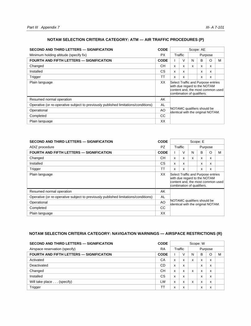
Part III Appendix 7 III- A 7-101
NOTAM SELECTION CRITERIA CATEGORY: ATM — AIR TRAFFIC PROCEDURES (P)
SECOND AND THIRD LETTERS — SIGNIFICATION CODE Scope: AE
Minimum holding altitude (specify fix) PX Traffic Purpose
FOURTH AND FIFTH LETTERS — SIGNIFICATION CODE I V N B O M
Changed CH x x x x x
Installed CS x x x x
Trigger TT x x x x
Plain language XX Select Traffic and Purpose entries with due regard to the NOTAM content and, the most common used combination of qualifiers.
Resumed normal operation AK
NOTAMC qualifiers should be identical with the original NOTAM.
Operative (or re-operative subject to previously published limitations/conditions) AL
Operational AO
Completed CC
Plain language XX
SECOND AND THIRD LETTERS — SIGNIFICATION CODE Scope: E
ADIZ procedure PZ Traffic Purpose
FOURTH AND FIFTH LETTERS — SIGNIFICATION CODE I V N B O M
Changed CH x x x x x
Installed CS x x x x
Trigger TT x x x x
Plain language XX Select Traffic and Purpose entries with due regard to the NOTAM content and, the most common used combination of qualifiers.
Resumed normal operation AK
NOTAMC qualifiers should be identical with the original NOTAM.
Operative (or re-operative subject to previously published limitations/conditions) AL
Operational AO
Completed CC
Plain language XX
NOTAM SELECTION CRITERIA CATEGORY: NAVIGATION WARNINGS — AIRSPACE RESTRICTIONS (R)
SECOND AND THIRD LETTERS — SIGNIFICATION CODE Scope: W
Airspace reservation (specify) RA Traffic Purpose
FOURTH AND FIFTH LETTERS — SIGNIFICATION CODE I V N B O M
Activated CA x x x x x
Deactivated CD x x x x
Changed CH x x x x x
Installed CS x x x x
Will take place . . . (specify) LW x x x x x
Trigger TT x x x x
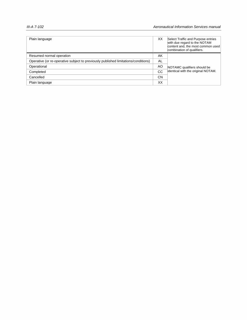
III-A 7-102 Aeronautical Information Services manual
Plain language XX Select Traffic and Purpose entries with due regard to the NOTAM content and, the most common used combination of qualifiers.
Resumed normal operation AK
NOTAMC qualifiers should be identical with the original NOTAM.
Operative (or re-operative subject to previously published limitations/conditions) AL
Operational AO
Completed CC
Cancelled CN
Plain language XX
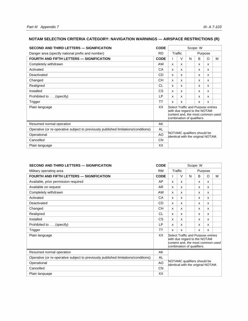
Part III Appendix 7 III- A 7-103
NOTAM SELECTION CRITERIA CATEGORY: NAVIGATION WARNINGS — AIRSPACE RESTRICTIONS (R)
SECOND AND THIRD LETTERS — SIGNIFICATION CODE Scope: W
Danger area (specify national prefix and number) RD Traffic Purpose
FOURTH AND FIFTH LETTERS — SIGNIFICATION CODE I V N B O M
Completely withdrawn AW x x x x
Activated CA x x x x
Deactivated CD x x x x
Changed CH x x x x
Realigned CL x x x x
Installed CS x x x x
Prohibited to . . . (specify) LP x x x x
Trigger TT x x x x
Plain language XX Select Traffic and Purpose entries with due regard to the NOTAM content and, the most common used combination of qualifiers.
Resumed normal operation AK
NOTAMC qualifiers should be identical with the original NOTAM.
Operative (or re-operative subject to previously published limitations/conditions) AL
Operational AO
Cancelled CN
Plain language XX
SECOND AND THIRD LETTERS — SIGNIFICATION CODE Scope: W
Military operating area RM Traffic Purpose
FOURTH AND FIFTH LETTERS — SIGNIFICATION CODE I V N B O M
Available, prior permission required AP x x x x
Available on request AR x x x x
Completely withdrawn AW x x x x
Activated CA x x x x
Deactivated CD x x x x
Changed CH x x x x
Realigned CL x x x x
Installed CS x x x x
Prohibited to . . . (specify) LP x x x x
Trigger TT x x x x
Plain language XX Select Traffic and Purpose entries with due regard to the NOTAM content and, the most common used combination of qualifiers.
Resumed normal operation AK
NOTAMC qualifiers should be identical with the original NOTAM.
Operative (or re-operative subject to previously published limitations/conditions) AL
Operational AO
Cancelled CN
Plain language XX
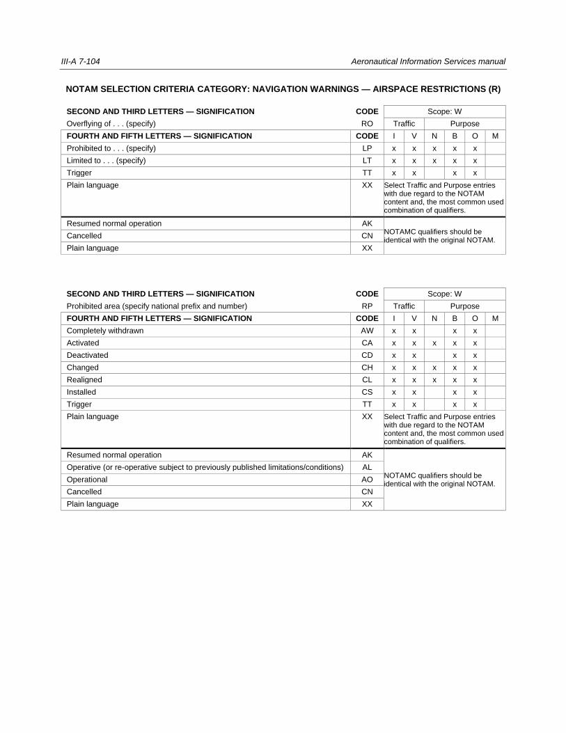
III-A 7-104 Aeronautical Information Services manual
NOTAM SELECTION CRITERIA CATEGORY: NAVIGATION WARNINGS — AIRSPACE RESTRICTIONS (R)
SECOND AND THIRD LETTERS — SIGNIFICATION CODE Scope: W
Overflying of . . . (specify) RO Traffic Purpose
FOURTH AND FIFTH LETTERS — SIGNIFICATION CODE I V N B O M
Prohibited to . . . (specify) LP x x x x x
Limited to . . . (specify) LT x x x x x
Trigger TT x x x x
Plain language XX Select Traffic and Purpose entries with due regard to the NOTAM content and, the most common used combination of qualifiers.
Resumed normal operation AK NOTAMC qualifiers should be identical with the original NOTAM.
Cancelled CN
Plain language XX
SECOND AND THIRD LETTERS — SIGNIFICATION CODE Scope: W
Prohibited area (specify national prefix and number) RP Traffic Purpose
FOURTH AND FIFTH LETTERS — SIGNIFICATION CODE I V N B O M
Completely withdrawn AW x x x x
Activated CA x x x x x
Deactivated CD x x x x
Changed CH x x x x x
Realigned CL x x x x x
Installed CS x x x x
Trigger TT x x x x
Plain language XX Select Traffic and Purpose entries with due regard to the NOTAM content and, the most common used combination of qualifiers.
Resumed normal operation AK
NOTAMC qualifiers should be identical with the original NOTAM.
Operative (or re-operative subject to previously published limitations/conditions) AL
Operational AO
Cancelled CN
Plain language XX
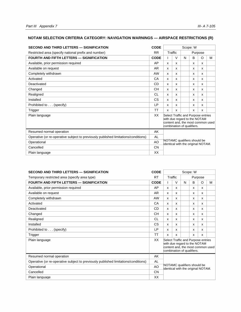
Part III Appendix 7 III- A 7-105
NOTAM SELECTION CRITERIA CATEGORY: NAVIGATION WARNINGS — AIRSPACE RESTRICTIONS (R)
SECOND AND THIRD LETTERS — SIGNIFICATION CODE Scope: W
Restricted area (specify national prefix and number) RR Traffic Purpose
FOURTH AND FIFTH LETTERS — SIGNIFICATION CODE I V N B O M
Available, prior permission required AP x x x x
Available on request AR x x x x
Completely withdrawn AW x x x x
Activated CA x x x x
Deactivated CD x x x x
Changed CH x x x x
Realigned CL x x x x
Installed CS x x x x
Prohibited to . . . (specify) LP x x x x
Trigger TT x x x x
Plain language XX Select Traffic and Purpose entries with due regard to the NOTAM content and, the most common used combination of qualifiers.
Resumed normal operation AK
NOTAMC qualifiers should be identical with the original NOTAM.
Operative (or re-operative subject to previously published limitations/conditions) AL
Operational AO
Cancelled CN
Plain language XX
SECOND AND THIRD LETTERS — SIGNIFICATION CODE Scope: W
Temporary restricted area (specify area type) RT Traffic Purpose
FOURTH AND FIFTH LETTERS — SIGNIFICATION CODE I V N B O M
Available, prior permission required AP x x x x
Available on request AR x x x x
Completely withdrawn AW x x x x
Activated CA x x x x
Deactivated CD x x x x
Changed CH x x x x
Realigned CL x x x x
Installed CS x x x x
Prohibited to . . . (specify) LP x x x x
Trigger TT x x x x
Plain language XX Select Traffic and Purpose entries with due regard to the NOTAM content and, the most common used combination of qualifiers.
Resumed normal operation AK
NOTAMC qualifiers should be identical with the original NOTAM.
Operative (or re-operative subject to previously published limitations/conditions) AL
Operational AO
Cancelled CN
Plain language XX

III-A 7-106 Aeronautical Information Services manual
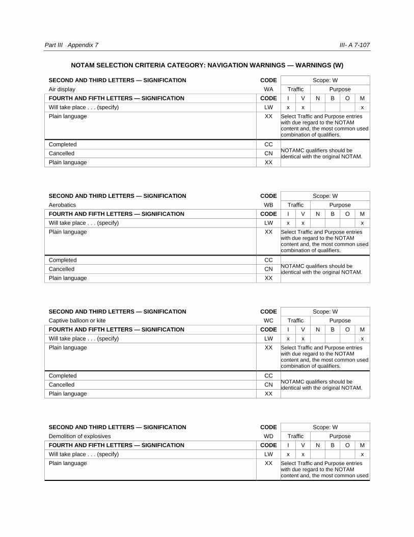
Part III Appendix 7 III- A 7-107
NOTAM SELECTION CRITERIA CATEGORY: NAVIGATION WARNINGS — WARNINGS (W)
SECOND AND THIRD LETTERS — SIGNIFICATION CODE Scope: W
Air display WA Traffic Purpose
FOURTH AND FIFTH LETTERS — SIGNIFICATION CODE I V N B O M
Will take place . . . (specify) LW x x x
Plain language XX Select Traffic and Purpose entries with due regard to the NOTAM content and, the most common used combination of qualifiers.
Completed CC NOTAMC qualifiers should be identical with the original NOTAM.
Cancelled CN
Plain language XX
SECOND AND THIRD LETTERS — SIGNIFICATION CODE Scope: W
Aerobatics WB Traffic Purpose
FOURTH AND FIFTH LETTERS — SIGNIFICATION CODE I V N B O M
Will take place . . . (specify) LW x x x
Plain language XX Select Traffic and Purpose entries with due regard to the NOTAM content and, the most common used combination of qualifiers.
Completed CC NOTAMC qualifiers should be identical with the original NOTAM.
Cancelled CN
Plain language XX
SECOND AND THIRD LETTERS — SIGNIFICATION CODE Scope: W
Captive balloon or kite WC Traffic Purpose
FOURTH AND FIFTH LETTERS — SIGNIFICATION CODE I V N B O M
Will take place . . . (specify) LW x x x
Plain language XX Select Traffic and Purpose entries with due regard to the NOTAM content and, the most common used combination of qualifiers.
Completed CC NOTAMC qualifiers should be identical with the original NOTAM.
Cancelled CN
Plain language XX
SECOND AND THIRD LETTERS — SIGNIFICATION CODE Scope: W
Demolition of explosives WD Traffic Purpose
FOURTH AND FIFTH LETTERS — SIGNIFICATION CODE I V N B O M
Will take place . . . (specify) LW x x x
Plain language XX Select Traffic and Purpose entries with due regard to the NOTAM content and, the most common used

III-A 7-108 Aeronautical Information Services manual
combination of qualifiers.
Completed CC NOTAMC qualifiers should be identical with the original NOTAM.
Cancelled CN
Plain language XX

Part III Appendix 7 III- A 7-109
NOTAM SELECTION CRITERIA CATEGORY: NAVIGATION WARNINGS — WARNINGS (W)
SECOND AND THIRD LETTERS — SIGNIFICATION CODE Scope: W
Exercises (specify) WE Traffic Purpose
FOURTH AND FIFTH LETTERS — SIGNIFICATION CODE I V N B O M
Will take place . . . (specify) LW x x x x
Trigger TT x x x x
Plain language XX Select Traffic and Purpose entries with due regard to the NOTAM content and, the most common used combination of qualifiers.
Completed CC NOTAMC qualifiers should be identical with the original NOTAM.
Cancelled CN
Plain language XX
SECOND AND THIRD LETTERS — SIGNIFICATION CODE Scope: W
Air refueling WF Traffic Purpose
FOURTH AND FIFTH LETTERS — SIGNIFICATION CODE I V N B O M
Will take place . . . (specify) LW x x x
Plain language XX Select Traffic and Purpose entries with due regard to the NOTAM content and, the most common used combination of qualifiers.
Completed CC NOTAMC qualifiers should be identical with the original NOTAM.
Cancelled CN
Plain language XX
SECOND AND THIRD LETTERS — SIGNIFICATION CODE Scope: W
Glider flying WG Traffic Purpose
FOURTH AND FIFTH LETTERS — SIGNIFICATION CODE I V N B O M
Will take place . . . (specify) LW x x x
Plain language XX Select Traffic and Purpose entries with due regard to the NOTAM content and, the most common used combination of qualifiers.
Completed CC NOTAMC qualifiers should be identical with the original NOTAM.
Cancelled CN
Plain language XX
SECOND AND THIRD LETTERS — SIGNIFICATION CODE Scope: W
Blasting WH Traffic Purpose
FOURTH AND FIFTH LETTERS — SIGNIFICATION CODE I V N B O M
Will take place . . . (specify) LW x x x
Plain language XX Select Traffic and Purpose entries with due regard to the NOTAM

III-A 7-110 Aeronautical Information Services manual
content and, the most common used combination of qualifiers.
Operational AO
NOTAMC qualifiers should be identical with the original NOTAM.
Completed CC
Cancelled CN
Plain language XX
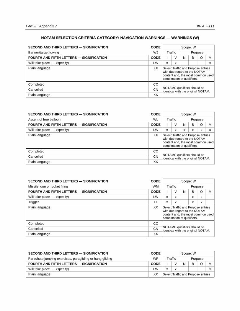
Part III Appendix 7 III- A 7-111
NOTAM SELECTION CRITERIA CATEGORY: NAVIGATION WARNINGS — WARNINGS (W)
SECOND AND THIRD LETTERS — SIGNIFICATION CODE Scope: W
Banner/target towing WJ Traffic Purpose
FOURTH AND FIFTH LETTERS — SIGNIFICATION CODE I V N B O M
Will take place . . . (specify) LW x x x
Plain language XX Select Traffic and Purpose entries with due regard to the NOTAM content and, the most common used combination of qualifiers.
Completed CC NOTAMC qualifiers should be identical with the original NOTAM.
Cancelled CN
Plain language XX
SECOND AND THIRD LETTERS — SIGNIFICATION CODE Scope: W
Ascent of free balloon WL Traffic Purpose
FOURTH AND FIFTH LETTERS — SIGNIFICATION CODE I V N B O M
Will take place . . . (specify) LW x x x x x x
Plain language XX Select Traffic and Purpose entries with due regard to the NOTAM content and, the most common used combination of qualifiers.
Completed CC NOTAMC qualifiers should be identical with the original NOTAM.
Cancelled CN
Plain language XX
SECOND AND THIRD LETTERS — SIGNIFICATION CODE Scope: W
Missile, gun or rocket firing WM Traffic Purpose
FOURTH AND FIFTH LETTERS — SIGNIFICATION CODE I V N B O M
Will take place . . . (specify) LW x x x x
Trigger TT x x x x
Plain language XX Select Traffic and Purpose entries with due regard to the NOTAM content and, the most common used combination of qualifiers.
Completed CC NOTAMC qualifiers should be identical with the original NOTAM.
Cancelled CN
Plain language XX
SECOND AND THIRD LETTERS — SIGNIFICATION CODE Scope: W
Parachute jumping exercises, paragliding or hang gliding WP Traffic Purpose
FOURTH AND FIFTH LETTERS — SIGNIFICATION CODE I V N B O M
Will take place . . . (specify) LW x x x
Plain language XX Select Traffic and Purpose entries

III-A 7-112 Aeronautical Information Services manual
with due regard to the NOTAM content and, the most common used combination of qualifiers.
Completed CC NOTAMC qualifiers should be identical with the original NOTAM.
Cancelled CN
Plain language XX
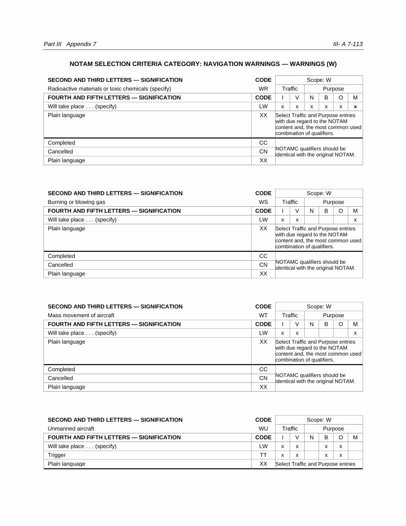
Part III Appendix 7 III- A 7-113
NOTAM SELECTION CRITERIA CATEGORY: NAVIGATION WARNINGS — WARNINGS (W)
SECOND AND THIRD LETTERS — SIGNIFICATION CODE Scope: W
Radioactive materials or toxic chemicals (specify) WR Traffic Purpose
FOURTH AND FIFTH LETTERS — SIGNIFICATION CODE I V N B O M
Will take place . . . (specify) LW x x x x x x
Plain language XX Select Traffic and Purpose entries with due regard to the NOTAM content and, the most common used combination of qualifiers.
Completed CC NOTAMC qualifiers should be identical with the original NOTAM.
Cancelled CN
Plain language XX
SECOND AND THIRD LETTERS — SIGNIFICATION CODE Scope: W
Burning or blowing gas WS Traffic Purpose
FOURTH AND FIFTH LETTERS — SIGNIFICATION CODE I V N B O M
Will take place . . . (specify) LW x x x
Plain language XX Select Traffic and Purpose entries with due regard to the NOTAM content and, the most common used combination of qualifiers.
Completed CC NOTAMC qualifiers should be identical with the original NOTAM.
Cancelled CN
Plain language XX
SECOND AND THIRD LETTERS — SIGNIFICATION CODE Scope: W
Mass movement of aircraft WT Traffic Purpose
FOURTH AND FIFTH LETTERS — SIGNIFICATION CODE I V N B O M
Will take place . . . (specify) LW x x x
Plain language XX Select Traffic and Purpose entries with due regard to the NOTAM content and, the most common used combination of qualifiers.
Completed CC NOTAMC qualifiers should be identical with the original NOTAM.
Cancelled CN
Plain language XX
SECOND AND THIRD LETTERS — SIGNIFICATION CODE Scope: W
Unmanned aircraft WU Traffic Purpose
FOURTH AND FIFTH LETTERS — SIGNIFICATION CODE I V N B O M
Will take place . . . (specify) LW x x x x
Trigger TT x x x x
Plain language XX Select Traffic and Purpose entries

III-A 7-114 Aeronautical Information Services manual
with due regard to the NOTAM content and, the most common used combination of qualifiers.
Completed CC NOTAMC qualifiers should be identical with the original NOTAM.
Cancelled CN
Plain language XX
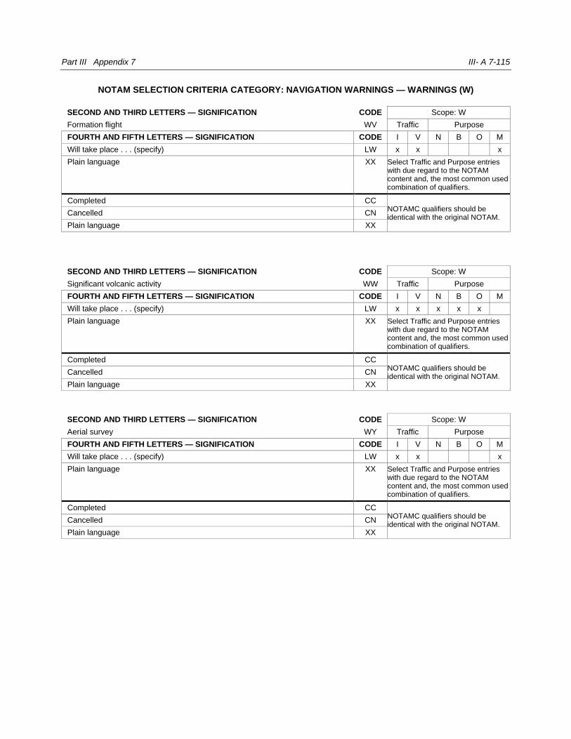
Part III Appendix 7 III- A 7-115
NOTAM SELECTION CRITERIA CATEGORY: NAVIGATION WARNINGS — WARNINGS (W)
SECOND AND THIRD LETTERS — SIGNIFICATION CODE Scope: W
Formation flight WV Traffic Purpose
FOURTH AND FIFTH LETTERS — SIGNIFICATION CODE I V N B O M
Will take place . . . (specify) LW x x x
Plain language XX Select Traffic and Purpose entries with due regard to the NOTAM content and, the most common used combination of qualifiers.
Completed CC NOTAMC qualifiers should be identical with the original NOTAM.
Cancelled CN
Plain language XX
SECOND AND THIRD LETTERS — SIGNIFICATION CODE Scope: W
Significant volcanic activity WW Traffic Purpose
FOURTH AND FIFTH LETTERS — SIGNIFICATION CODE I V N B O M
Will take place . . . (specify) LW x x x x x
Plain language XX Select Traffic and Purpose entries with due regard to the NOTAM content and, the most common used combination of qualifiers.
Completed CC NOTAMC qualifiers should be identical with the original NOTAM.
Cancelled CN
Plain language XX
SECOND AND THIRD LETTERS — SIGNIFICATION CODE Scope: W
Aerial survey WY Traffic Purpose
FOURTH AND FIFTH LETTERS — SIGNIFICATION CODE I V N B O M
Will take place . . . (specify) LW x x x
Plain language XX Select Traffic and Purpose entries with due regard to the NOTAM content and, the most common used combination of qualifiers.
Completed CC NOTAMC qualifiers should be identical with the original NOTAM.
Cancelled CN
Plain language XX
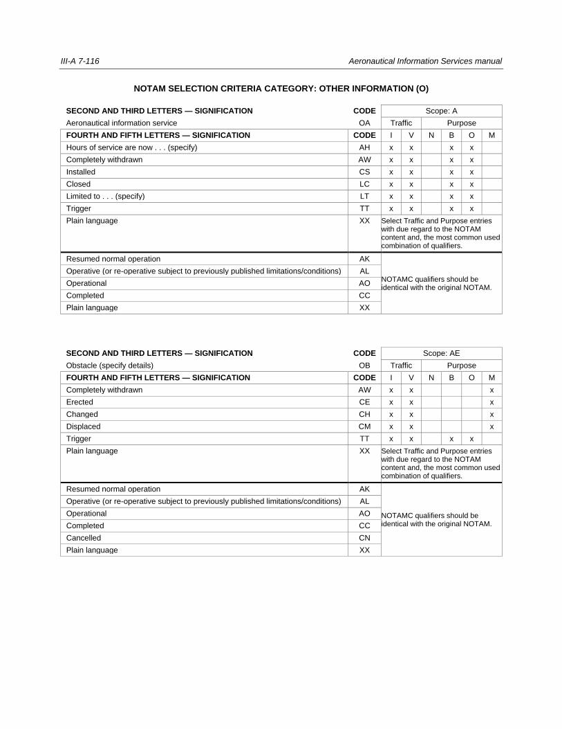
III-A 7-116 Aeronautical Information Services manual
NOTAM SELECTION CRITERIA CATEGORY: OTHER INFORMATION (O)
SECOND AND THIRD LETTERS — SIGNIFICATION CODE Scope: A
Aeronautical information service OA Traffic Purpose
FOURTH AND FIFTH LETTERS — SIGNIFICATION CODE I V N B O M
Hours of service are now . . . (specify) AH x x x x
Completely withdrawn AW x x x x
Installed CS x x x x
Closed LC x x x x
Limited to . . . (specify) LT x x x x
Trigger TT x x x x
Plain language XX Select Traffic and Purpose entries with due regard to the NOTAM content and, the most common used combination of qualifiers.
Resumed normal operation AK
NOTAMC qualifiers should be identical with the original NOTAM.
Operative (or re-operative subject to previously published limitations/conditions) AL
Operational AO
Completed CC
Plain language XX
SECOND AND THIRD LETTERS — SIGNIFICATION CODE Scope: AE
Obstacle (specify details) OB Traffic Purpose
FOURTH AND FIFTH LETTERS — SIGNIFICATION CODE I V N B O M
Completely withdrawn AW x x x
Erected CE x x x
Changed CH x x x
Displaced CM x x x
Trigger TT x x x x
Plain language XX Select Traffic and Purpose entries with due regard to the NOTAM content and, the most common used combination of qualifiers.
Resumed normal operation AK
NOTAMC qualifiers should be identical with the original NOTAM.
Operative (or re-operative subject to previously published limitations/conditions) AL
Operational AO
Completed CC
Cancelled CN
Plain language XX
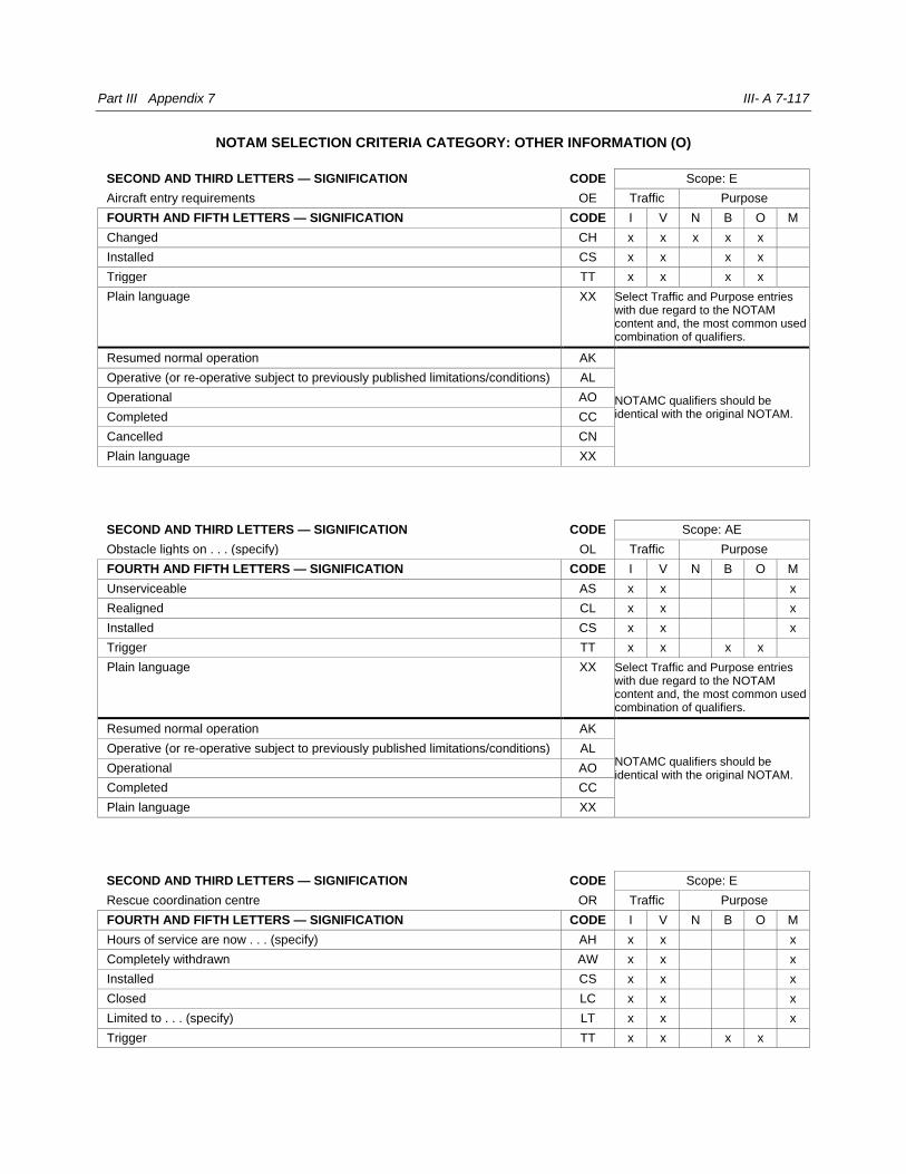
Part III Appendix 7 III- A 7-117
NOTAM SELECTION CRITERIA CATEGORY: OTHER INFORMATION (O)
SECOND AND THIRD LETTERS — SIGNIFICATION CODE Scope: E
Aircraft entry requirements OE Traffic Purpose
FOURTH AND FIFTH LETTERS — SIGNIFICATION CODE I V N B O M
Changed CH x x x x x
Installed CS x x x x
Trigger TT x x x x
Plain language XX Select Traffic and Purpose entries with due regard to the NOTAM content and, the most common used combination of qualifiers.
Resumed normal operation AK
NOTAMC qualifiers should be identical with the original NOTAM.
Operative (or re-operative subject to previously published limitations/conditions) AL
Operational AO
Completed CC
Cancelled CN
Plain language XX
SECOND AND THIRD LETTERS — SIGNIFICATION CODE Scope: AE
Obstacle lights on . . . (specify) OL Traffic Purpose
FOURTH AND FIFTH LETTERS — SIGNIFICATION CODE I V N B O M
Unserviceable AS x x x
Realigned CL x x x
Installed CS x x x
Trigger TT x x x x
Plain language XX Select Traffic and Purpose entries with due regard to the NOTAM content and, the most common used combination of qualifiers.
Resumed normal operation AK
NOTAMC qualifiers should be identical with the original NOTAM.
Operative (or re-operative subject to previously published limitations/conditions) AL
Operational AO
Completed CC
Plain language XX
SECOND AND THIRD LETTERS — SIGNIFICATION CODE Scope: E
Rescue coordination centre OR Traffic Purpose
FOURTH AND FIFTH LETTERS — SIGNIFICATION CODE I V N B O M
Hours of service are now . . . (specify) AH x x x
Completely withdrawn AW x x x
Installed CS x x x
Closed LC x x x
Limited to . . . (specify) LT x x x
Trigger TT x x x x
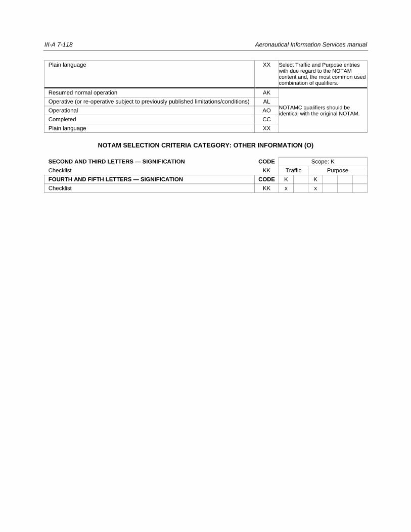
III-A 7-118 Aeronautical Information Services manual
Plain language XX Select Traffic and Purpose entries with due regard to the NOTAM content and, the most common used combination of qualifiers.
Resumed normal operation AK
NOTAMC qualifiers should be identical with the original NOTAM.
Operative (or re-operative subject to previously published limitations/conditions) AL
Operational AO
Completed CC
Plain language XX
NOTAM SELECTION CRITERIA CATEGORY: OTHER INFORMATION (O)
SECOND AND THIRD LETTERS — SIGNIFICATION CODE Scope: K
Checklist KK Traffic Purpose
FOURTH AND FIFTH LETTERS — SIGNIFICATION CODE K K
Checklist KK x x
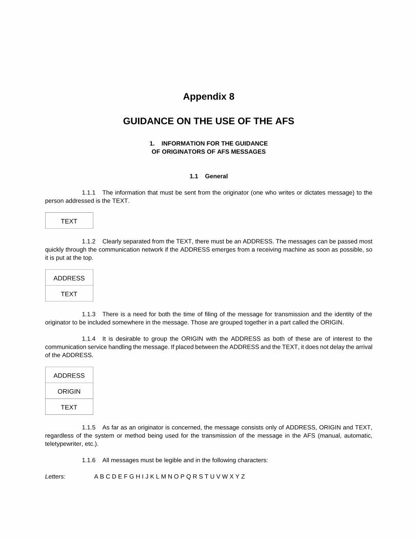
Appendix 8
GUIDANCE ON THE USE OF THE AFS
1. INFORMATION FOR THE GUIDANCE
OF ORIGINATORS OF AFS MESSAGES
1.1 General
1.1.1 The information that must be sent from the originator (one who writes or dictates message) to the
person addressed is the TEXT.
TEXT
1.1.2 Clearly separated from the TEXT, there must be an ADDRESS. The messages can be passed most
quickly through the communication network if the ADDRESS emerges from a receiving machine as soon as possible, so
it is put at the top.
ADDRESS
TEXT
1.1.3 There is a need for both the time of filing of the message for transmission and the identity of the
originator to be included somewhere in the message. Those are grouped together in a part called the ORIGIN.
1.1.4 It is desirable to group the ORIGIN with the ADDRESS as both of these are of interest to the
communication service handling the message. If placed between the ADDRESS and the TEXT, it does not delay the arrival
of the ADDRESS.
ADDRESS
ORIGIN
TEXT
1.1.5 As far as an originator is concerned, the message consists only of ADDRESS, ORIGIN and TEXT,
regardless of the system or method being used for the transmission of the message in the AFS (manual, automatic,
teletypewriter, etc.).
1.1.6 All messages must be legible and in the following characters:
Letters: A B C D E F G H I J K L M N O P Q R S T U V W X Y Z
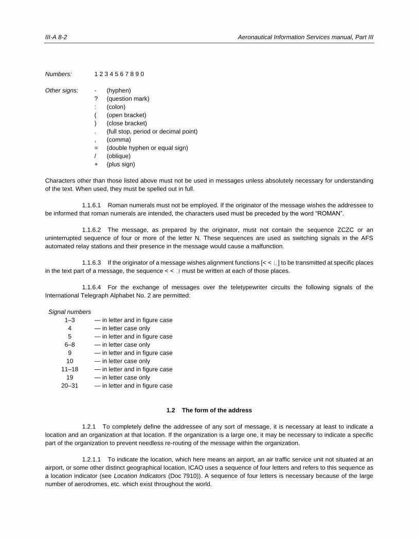
III-A 8-2 Aeronautical Information Services manual, Part III
Numbers: 1 2 3 4 5 6 7 8 9 0
Other signs: - (hyphen)
? (question mark)
: (colon)
( (open bracket)
) (close bracket)
. (full stop, period or decimal point)
, (comma)
= (double hyphen or equal sign)
/ (oblique)
+ (plus sign)
Characters other than those listed above must not be used in messages unless absolutely necessary for understanding
of the text. When used, they must be spelled out in full.
1.1.6.1 Roman numerals must not be employed. If the originator of the message wishes the addressee to
be informed that roman numerals are intended, the characters used must be preceded by the word “ROMAN”.
1.1.6.2 The message, as prepared by the originator, must not contain the sequence ZCZC or an
uninterrupted sequence of four or more of the letter N. These sequences are used as switching signals in the AFS
automated relay stations and their presence in the message would cause a malfunction.
1.1.6.3 If the originator of a message wishes alignment functions [< < ] to be transmitted at specific places
in the text part of a message, the sequence < < must be written at each of those places.
1.1.6.4 For the exchange of messages over the teletypewriter circuits the following signals of the
International Telegraph Alphabet No. 2 are permitted:
Signal numbers
1–3 — in letter and in figure case
4 — in letter case only
5 — in letter and in figure case
6–8 — in letter case only
9 — in letter and in figure case
10 — in letter case only
11–18 — in letter and in figure case
19 — in letter case only
20–31 — in letter and in figure case
1.2 The form of the address
1.2.1 To completely define the addressee of any sort of message, it is necessary at least to indicate a
location and an organization at that location. If the organization is a large one, it may be necessary to indicate a specific
part of the organization to prevent needless re-routing of the message within the organization.
1.2.1.1 To indicate the location, which here means an airport, an air traffic service unit not situated at an
airport, or some other distinct geographical location, ICAO uses a sequence of four letters and refers to this sequence as
a location indicator (see Location Indicators (Doc 7910)). A sequence of four letters is necessary because of the large
number of aerodromes, etc. which exist throughout the world.
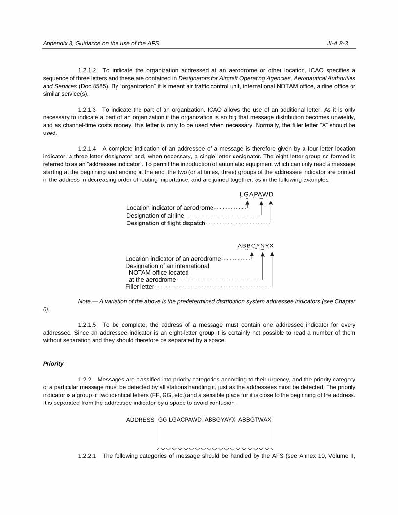
Appendix 8, Guidance on the use of the AFS III-A 8-3
1.2.1.2 To indicate the organization addressed at an aerodrome or other location, ICAO specifies a
sequence of three letters and these are contained in Designators for Aircraft Operating Agencies, Aeronautical Authorities
and Services (Doc 8585). By “organization” it is meant air traffic control unit, international NOTAM office, airline office or
similar service(s).
1.2.1.3 To indicate the part of an organization, ICAO allows the use of an additional letter. As it is only
necessary to indicate a part of an organization if the organization is so big that message distribution becomes unwieldy,
and as channel-time costs money, this letter is only to be used when necessary. Normally, the filler letter “X” should be
used.
1.2.1.4 A complete indication of an addressee of a message is therefore given by a four-letter location
indicator, a three-letter designator and, when necessary, a single letter designator. The eight-letter group so formed is
referred to as an “addressee indicator”. To permit the introduction of automatic equipment which can only read a message
starting at the beginning and ending at the end, the two (or at times, three) groups of the addressee indicator are printed
in the address in decreasing order of routing importance, and are joined together, as in the following examples:
Note.— A variation of the above is the predetermined distribution system addressee indicators (see Chapter
6).
1.2.1.5 To be complete, the address of a message must contain one addressee indicator for every
addressee. Since an addressee indicator is an eight-letter group it is certainly not possible to read a number of them
without separation and they should therefore be separated by a space.
Priority
1.2.2 Messages are classified into priority categories according to their urgency, and the priority category
of a particular message must be detected by all stations handling it, just as the addressees must be detected. The priority
indicator is a group of two identical letters (FF, GG, etc.) and a sensible place for it is close to the beginning of the address.
It is separated from the addressee indicator by a space to avoid confusion.
1.2.2.1 The following categories of message should be handled by the AFS (see Annex 10, Volume II,
h
Location indicator of aerodrome
Designation of airline
Designation of flight dispatc
LGAPAWD
Location indicator of an aerodromeDesignation of an international NOTAM office located at the aerodromeFiller letter
ABBGYNYX
ADDRESS GG LGACPAWD ABBGYAYX ABBGTWAX
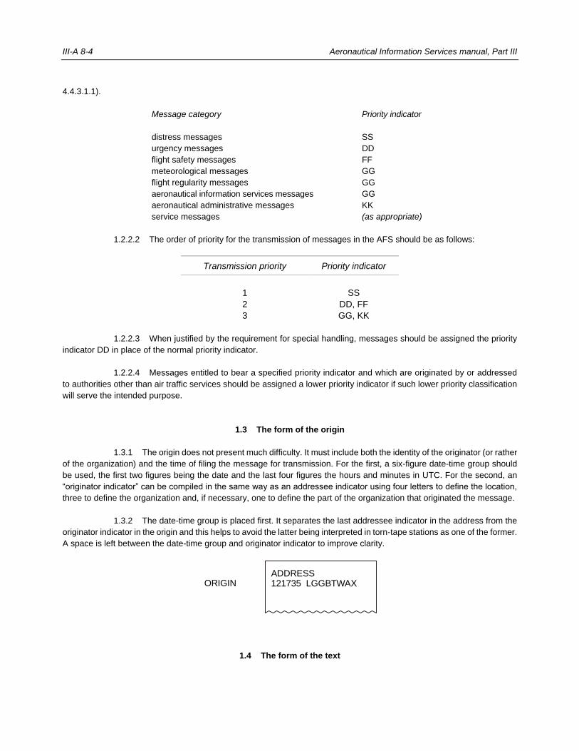
III-A 8-4 Aeronautical Information Services manual, Part III
4.4.3.1.1).
Message category
Priority indicator
distress messages SS
urgency messages DD
flight safety messages FF
meteorological messages GG
flight regularity messages GG
aeronautical information services messages GG
aeronautical administrative messages KK
service messages (as appropriate)
1.2.2.2 The order of priority for the transmission of messages in the AFS should be as follows:
Transmission priority Priority indicator
1 SS
2 DD, FF
3 GG, KK
1.2.2.3 When justified by the requirement for special handling, messages should be assigned the priority
indicator DD in place of the normal priority indicator.
1.2.2.4 Messages entitled to bear a specified priority indicator and which are originated by or addressed
to authorities other than air traffic services should be assigned a lower priority indicator if such lower priority classification
will serve the intended purpose.
1.3 The form of the origin
1.3.1 The origin does not present much difficulty. It must include both the identity of the originator (or rather
of the organization) and the time of filing the message for transmission. For the first, a six-figure date-time group should
be used, the first two figures being the date and the last four figures the hours and minutes in UTC. For the second, an
“originator indicator” can be compiled in the same way as an addressee indicator using four letters to define the location,
three to define the organization and, if necessary, one to define the part of the organization that originated the message.
1.3.2 The date-time group is placed first. It separates the last addressee indicator in the address from the
originator indicator in the origin and this helps to avoid the latter being interpreted in torn-tape stations as one of the former.
A space is left between the date-time group and originator indicator to improve clarity.
1.4 The form of the text
ADDRESS121735 LGGBTWAXORIGIN
Appendix 8, Guidance on the use of the AFS III-A 8-5
1.4.1 In 1.2.1.2, it was noted that a three-letter designator is to be used to indicate an organization
addressed at a location. A three-letter designator gives enough combinations to cover most cases but cannot cover every
small organization, individual aircraft (in the case where a message is being sent to an air/ground station for an aircraft in
flight), or military organization.
1.4.2 For this reason, the following three-letter designators have been given the meanings shown:
YYY: An organization not given a specific two-letter designator but identified in the text.
YXY: A military (navy, army, air force, etc.) service or organization identified in the text.
ZZZ: An aircraft in flight identified in the text.
The same designators are used, with the same meaning, in the originator indicator.
1.4.3 When, and only when, “YYY” or “ZZZ” are used:
a) the name of the organization or the identity of the aircraft concerned is to appear at the beginning of the
text;
b) the order of such insertions is to be the same as the order of the addressee indicators and/or the
originator indicator;
c) where there is more than one such insertion, the last should be followed by the word “STOP”;
d) where there is one or more insertions in respect of addressee indicators plus an insertion in respect of
the originator indicator, the word “FROM” is to appear before that relating to the originator indicator.
1.4.4 If originators of messages wish to include a reference in the text for their own purposes, it must go
immediately after the material described above — or right at the beginning of the text if there is no such material.
ADDRESS
ORIGIN
Designation of organization(s), service(s) and/or
aircraft if necessary, followed by word “STOP”, if
required, followed by originator’s reference if
necessary, followed by the rest of the TEXT.
1.4.5 What goes in the rest of the text is mainly for the originator to decide, but three rules are necessary
to enable the communication service to do its job properly. These are:
Rule 1
The text must be drafted in plain language or in code. The originator shall ensure that the abbreviations and codes used
are familiar to the aeronautical telecommunication agency accepting the message for transmission and to the intended
recipient, or that a proper decode for the abbreviations and codes used is available.
Rule 2
The text must be as abbreviated as possible. The originator must avoid the use of plain language when abbreviation by
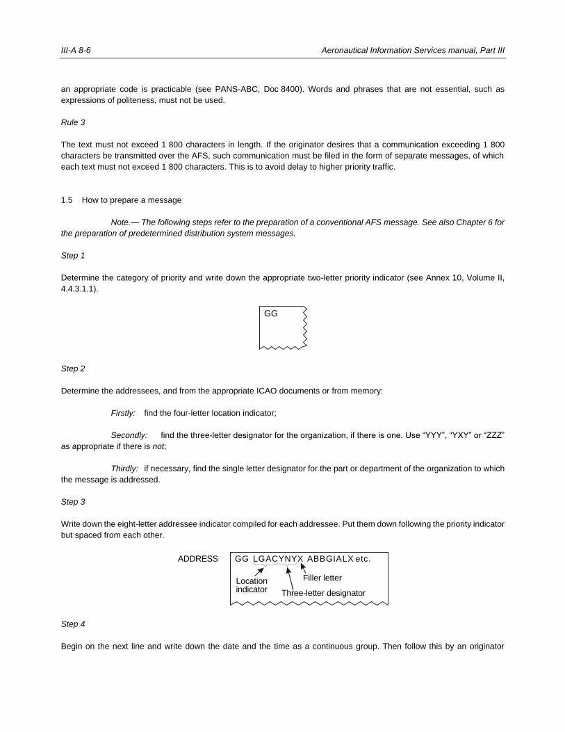
III-A 8-6 Aeronautical Information Services manual, Part III
an appropriate code is practicable (see PANS-ABC, Doc 8400). Words and phrases that are not essential, such as
expressions of politeness, must not be used.
Rule 3
The text must not exceed 1 800 characters in length. If the originator desires that a communication exceeding 1 800
characters be transmitted over the AFS, such communication must be filed in the form of separate messages, of which
each text must not exceed 1 800 characters. This is to avoid delay to higher priority traffic.
1.5 How to prepare a message
Note.— The following steps refer to the preparation of a conventional AFS message. See also Chapter 6 for
the preparation of predetermined distribution system messages.
Step 1
Determine the category of priority and write down the appropriate two-letter priority indicator (see Annex 10, Volume II,
4.4.3.1.1).
Step 2
Determine the addressees, and from the appropriate ICAO documents or from memory:
Firstly: find the four-letter location indicator;
Secondly: find the three-letter designator for the organization, if there is one. Use “YYY”, “YXY” or “ZZZ”
as appropriate if there is not;
Thirdly: if necessary, find the single letter designator for the part or department of the organization to which
the message is addressed.
Step 3
Write down the eight-letter addressee indicator compiled for each addressee. Put them down following the priority indicator
but spaced from each other.
Step 4
Begin on the next line and write down the date and the time as a continuous group. Then follow this by an originator
GG
ADDRESS GG LGACYNYX ABBGIALX etc.
Locationindicator
Filler letter
Three-letter designator
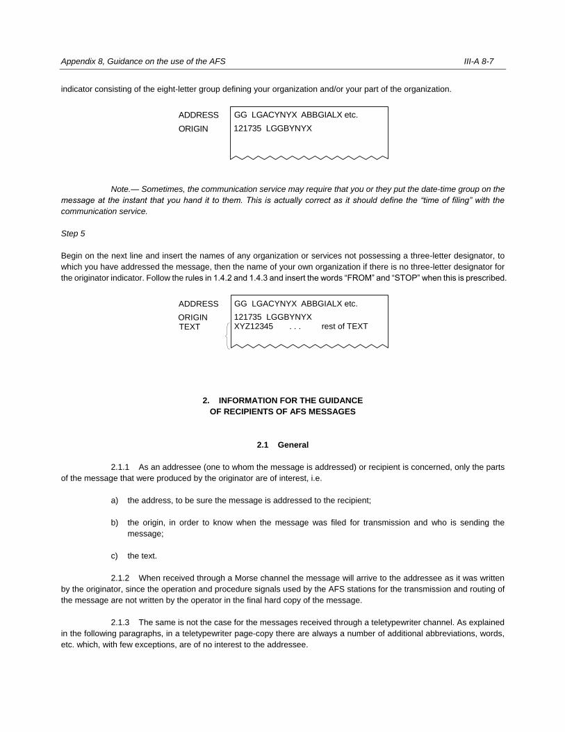
Appendix 8, Guidance on the use of the AFS III-A 8-7
indicator consisting of the eight-letter group defining your organization and/or your part of the organization.
Note.— Sometimes, the communication service may require that you or they put the date-time group on the
message at the instant that you hand it to them. This is actually correct as it should define the “time of filing” with the
communication service.
Step 5
Begin on the next line and insert the names of any organization or services not possessing a three-letter designator, to
which you have addressed the message, then the name of your own organization if there is no three-letter designator for
the originator indicator. Follow the rules in 1.4.2 and 1.4.3 and insert the words “FROM” and “STOP” when this is prescribed.
2. INFORMATION FOR THE GUIDANCE
OF RECIPIENTS OF AFS MESSAGES
2.1 General
2.1.1 As an addressee (one to whom the message is addressed) or recipient is concerned, only the parts
of the message that were produced by the originator are of interest, i.e.
a) the address, to be sure the message is addressed to the recipient;
b) the origin, in order to know when the message was filed for transmission and who is sending the
message;
c) the text.
2.1.2 When received through a Morse channel the message will arrive to the addressee as it was written
by the originator, since the operation and procedure signals used by the AFS stations for the transmission and routing of
the message are not written by the operator in the final hard copy of the message.
2.1.3 The same is not the case for the messages received through a teletypewriter channel. As explained
in the following paragraphs, in a teletypewriter page-copy there are always a number of additional abbreviations, words,
etc. which, with few exceptions, are of no interest to the addressee.
ADDRESS GG LGACYNYX ABBGIALX etc.
121735 LGGBYNYXORIGIN
ADDRESS GG LGACYNYX ABBGIALX etc.
121735 LGGBYNYXXYZ12345 . . . rest of TEXTTEXT
ORIGIN
III-A 8-8 Aeronautical Information Services manual, Part III
2.2 How received page-copy appears
2.2.1 Apart from some non-typing or switching signals, which are of no interest to the addressee because
they do not normally appear in page-copy, there are the following extra parts which appear in page-copy but are also of
no interest to the addressee due to the fact that they are added by the communication service for its own purposes (see
Figure III-A 8-2).
2.2.2 A teletypewriter message, when received, should still look like the example in 1.5, Step 5 but, as
explained above, there will be some extra parts that were added by the communication service for its own purposes, and
for example it could appear as in Figure III-A 8-2
2.2.3 In Figure III-A 8-2, the NNNN shown in the line of the heading is the end-of-message signal of the
previous message and was left in the machine when that message was torn off. The heading of the NRA062 message was
then printed on the same line. The end-of-message signal of NRA062 is similarly left in the machine and the heading of the
next message will ultimately be printed on the same line.
2.2.4 The communication service will sometimes insert material at the beginning of the text to draw
attention to something that has occurred during transmission. If, after a message has been transmitted in toto a station
detects that the text or the origin of the message was mutilated or incomplete, a service message will be transmitted to all
addressees concerned with the following text, if an unmutilated copy of the message is available in the station:
SVC CORRECTION (the origin of the incorrect message)
STOP (followed by the correct text).
2.2.5 The communication service will sometimes insert material, immediately after the end of the text, to
draw attention to something that has occurred during transmission. There are three types of insertions, as follows:
a) The groups “QTA QTA”. This means that the message has been spoiled in some way and should be
ignored. A correct copy will follow.
b) The group “DUPE”. This means that the communication service has found it necessary to transmit a
duplicate copy of the message, either because the first copy was not transmitted perfectly or because
there is some doubt that it was delivered. The addressee should check whether the message has
already been received and a previous copy acted upon, or whether a copy that was incomplete or
otherwise imperfect was acted upon.
c) The expression “CHECK TEXT NEW ENDING ADDED”, appearing in upper case to attract attention.
This means that an automatic relay station had received the message without a proper end-of-message
signal and that one was added. The addressee should look for a remnant of the original end-of-message
signal (NNNN) immediately above the word “CHECK”. If it is not there, it is possible that it has been
completely lost and that a part of the text has been lost with it. The addressee should then check the
text and, if it seems to be incomplete, should ask the communication service for a repetition.
2.2.6 Errors made during the preparation of the text for transmission are corrected in teletypewriter
operation in most cases on the tape, so they do not appear in the received page-copy. When this is not possible, the
correction is done by following the error with the error sign, retyping the last correct word (or group), then continuing with
the message. For example:
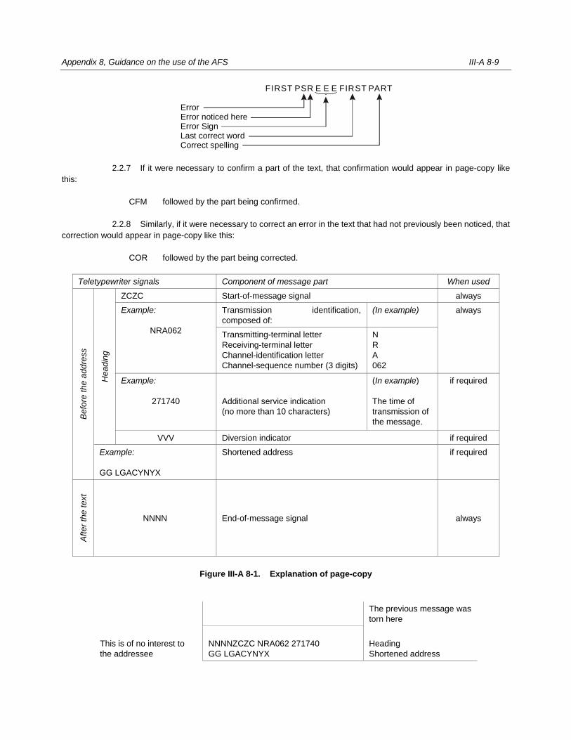
Appendix 8, Guidance on the use of the AFS III-A 8-9
2.2.7 If it were necessary to confirm a part of the text, that confirmation would appear in page-copy like
this:
CFM followed by the part being confirmed.
2.2.8 Similarly, if it were necessary to correct an error in the text that had not previously been noticed, that
correction would appear in page-copy like this:
COR followed by the part being corrected.
Teletypewriter signals Component of message part When used
Befo
re t
he a
ddre
ss
Hea
din
g
ZCZC Start-of-message signal always
Example:
NRA062
Transmission identification,
composed of:
(In example) always
Transmitting-terminal letter
Receiving-terminal letter
Channel-identification letter
Channel-sequence number (3 digits)
N
R
A
062
Example:
271740
Additional service indication
(no more than 10 characters)
(In example)
The time of
transmission of
the message.
if required
VVV Diversion indicator if required
Example:
GG LGACYNYX
Shortened address if required
Aft
er
the t
ext
NNNN End-of-message signal always
Figure III-A 8-1. Explanation of page-copy
This is of no interest to
the addressee
The previous message was
torn here
NNNNZCZC NRA062 271740
GG LGACYNYX
Heading
Shortened address
ErrorError noticed hereError SignLast correct wordCorrect spelling
FIRST PSR E E E FIRST PART
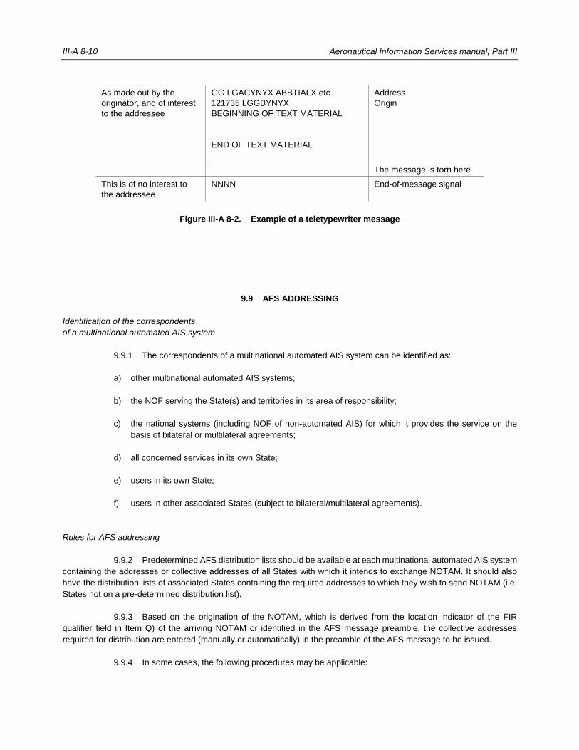
III-A 8-10 Aeronautical Information Services manual, Part III
As made out by the
originator, and of interest
to the addressee
GG LGACYNYX ABBTIALX etc.
121735 LGGBYNYX
BEGINNING OF TEXT MATERIAL
END OF TEXT MATERIAL
Address
Origin
The message is torn here
This is of no interest to
the addressee
NNNN End-of-message signal
Figure III-A 8-2. Example of a teletypewriter message
9.9 AFS ADDRESSING
Identification of the correspondents
of a multinational automated AIS system
9.9.1 The correspondents of a multinational automated AIS system can be identified as:
a) other multinational automated AIS systems;
b) the NOF serving the State(s) and territories in its area of responsibility;
c) the national systems (including NOF of non-automated AIS) for which it provides the service on the
basis of bilateral or multilateral agreements;
d) all concerned services in its own State;
e) users in its own State;
f) users in other associated States (subject to bilateral/multilateral agreements).
Rules for AFS addressing
9.9.2 Predetermined AFS distribution lists should be available at each multinational automated AIS system
containing the addresses or collective addresses of all States with which it intends to exchange NOTAM. It should also
have the distribution lists of associated States containing the required addresses to which they wish to send NOTAM (i.e.
States not on a pre-determined distribution list).
9.9.3 Based on the origination of the NOTAM, which is derived from the location indicator of the FIR
qualifier field in Item Q) of the arriving NOTAM or identified in the AFS message preamble, the collective addresses
required for distribution are entered (manually or automatically) in the preamble of the AFS message to be issued.
9.9.4 In some cases, the following procedures may be applicable:
Appendix 8, Guidance on the use of the AFS III-A 8-11
a) Distribution of NOTAM produced by a multi-national automated AIS system
A multinational automated AIS system should use the distribution list prepared for promulgation of its
own NOTAM. The list should normally contain the addresses (or collective addresses) of:
— the relevant State(s) (NOF) in its area of responsibility;
— the relevant State(s) (NOF) and users in the associated States;
— other multinational automated AIS systems which will each use their own list of addresses for
further distribution.
b) Distribution of NOTAM received from other national automated AIS system centres
The multinational automated AIS system identifies the originator abbreviation in the preamble of the
arriving NOTAM or by the FIR qualifier in Item Q) and selects and applies the relevant distribution list
accordingly. The list should contain the addresses (or collective addresses) of:
— the States (NOF) in its area of responsibility;
— the AIS systems and users in the associated States;
— other multinational automated AIS system centres which will each use their own list of addresses
for further distribution.
______________________

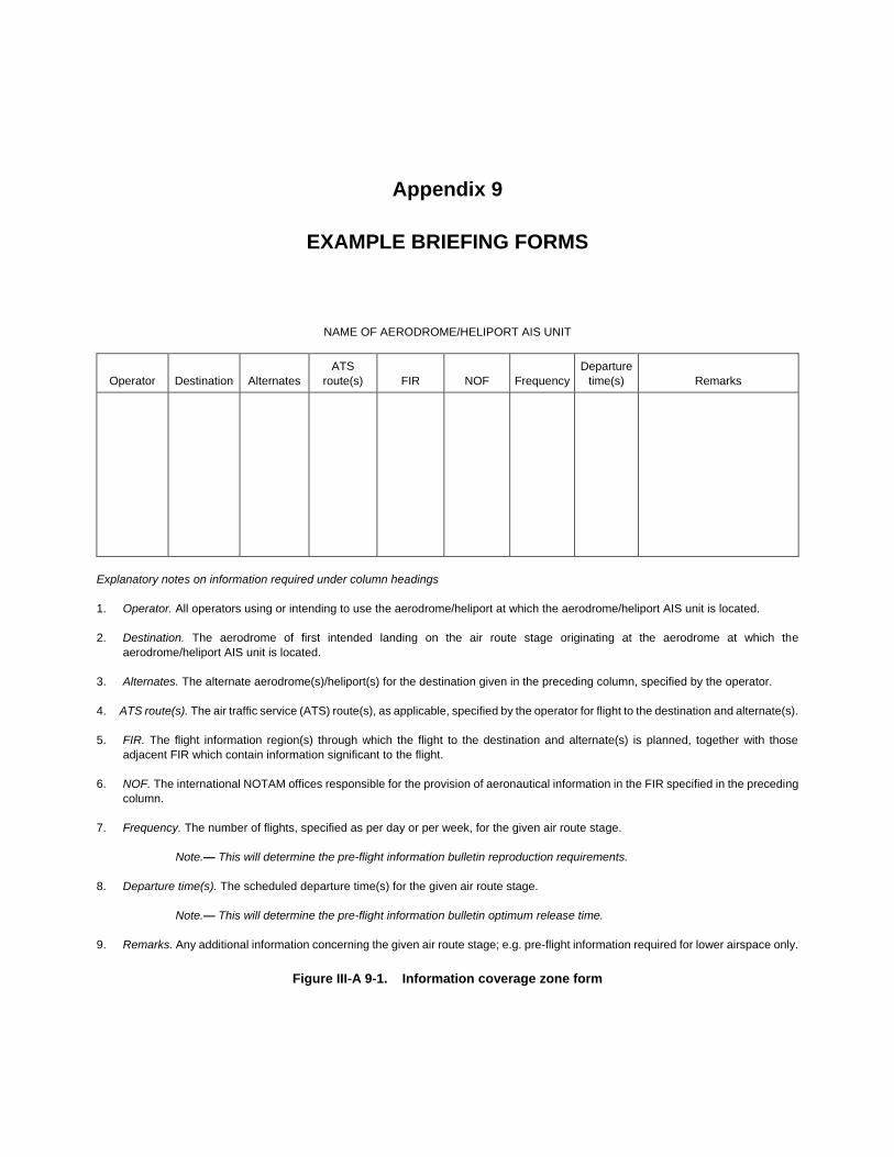
Appendix 9
EXAMPLE BRIEFING FORMS
NAME OF AERODROME/HELIPORT AIS UNIT
Operator Destination Alternates
ATS
route(s) FIR NOF Frequency
Departure
time(s) Remarks
Explanatory notes on information required under column headings
1. Operator. All operators using or intending to use the aerodrome/heliport at which the aerodrome/heliport AIS unit is located.
2. Destination. The aerodrome of first intended landing on the air route stage originating at the aerodrome at which the
aerodrome/heliport AIS unit is located.
3. Alternates. The alternate aerodrome(s)/heliport(s) for the destination given in the preceding column, specified by the operator.
4. ATS route(s). The air traffic service (ATS) route(s), as applicable, specified by the operator for flight to the destination and alternate(s).
5. FIR. The flight information region(s) through which the flight to the destination and alternate(s) is planned, together with those
adjacent FIR which contain information significant to the flight.
6. NOF. The international NOTAM offices responsible for the provision of aeronautical information in the FIR specified in the preceding
column.
7. Frequency. The number of flights, specified as per day or per week, for the given air route stage.
Note.— This will determine the pre-flight information bulletin reproduction requirements.
8. Departure time(s). The scheduled departure time(s) for the given air route stage.
Note.— This will determine the pre-flight information bulletin optimum release time.
9. Remarks. Any additional information concerning the given air route stage; e.g. pre-flight information required for lower airspace only.
Figure III-A 9-1. Information coverage zone form
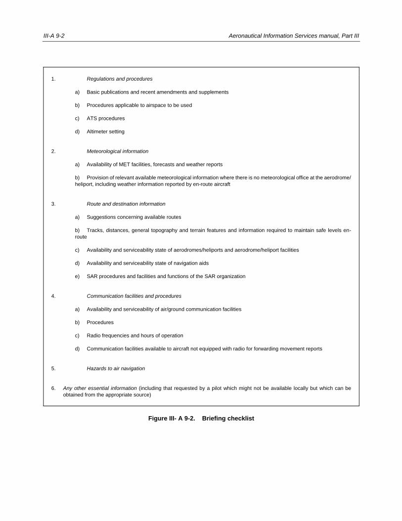
III-A 9-2 Aeronautical Information Services manual, Part III
1. Regulations and procedures
a) Basic publications and recent amendments and supplements
b) Procedures applicable to airspace to be used
c) ATS procedures
d) Altimeter setting
2. Meteorological information
a) Availability of MET facilities, forecasts and weather reports
b) Provision of relevant available meteorological information where there is no meteorological office at the aerodrome/
heliport, including weather information reported by en-route aircraft
3. Route and destination information
a) Suggestions concerning available routes
b) Tracks, distances, general topography and terrain features and information required to maintain safe levels en-
route
c) Availability and serviceability state of aerodromes/heliports and aerodrome/heliport facilities
d) Availability and serviceability state of navigation aids
e) SAR procedures and facilities and functions of the SAR organization
4. Communication facilities and procedures
a) Availability and serviceability of air/ground communication facilities
b) Procedures
c) Radio frequencies and hours of operation
d) Communication facilities available to aircraft not equipped with radio for forwarding movement reports
5. Hazards to air navigation
6. Any other essential information (including that requested by a pilot which might not be available locally but which can be
obtained from the appropriate source)
Figure III- A 9-2. Briefing checklist
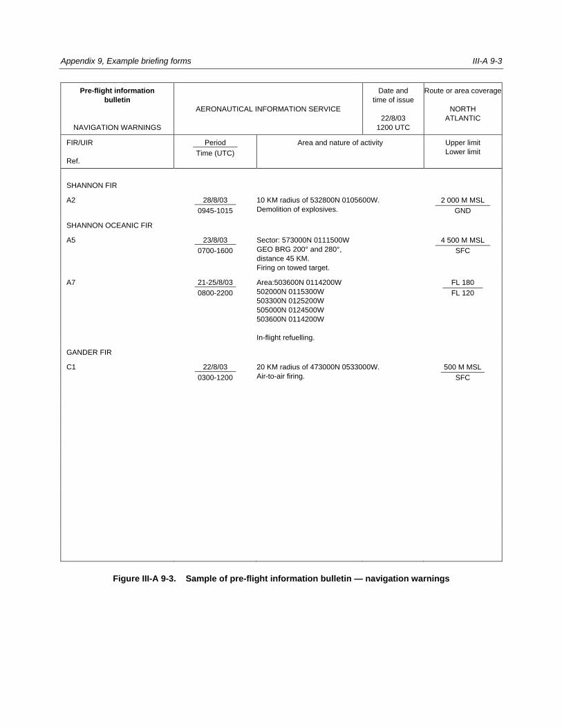
Appendix 9, Example briefing forms III-A 9-3
Pre-flight information
bulletin
NAVIGATION WARNINGS
AERONAUTICAL INFORMATION SERVICE
Date and
time of issue
22/8/03
1200 UTC
Route or area coverage
NORTH
ATLANTIC
FIR/UIR
Ref.
Period
Time (UTC)
Area and nature of activity Upper limit
Lower limit
SHANNON FIR
A2 28/8/03
0945-1015
10 KM radius of 532800N 0105600W.
Demolition of explosives.
2 000 M MSL
GND
SHANNON OCEANIC FIR
A5 23/8/03
0700-1600
Sector: 573000N 0111500W
GEO BRG 200° and 280°,
distance 45 KM.
Firing on towed target.
4 500 M MSL
SFC
A7 21-25/8/03
0800-2200
Area:503600N 0114200W
502000N 0115300W
503300N 0125200W
505000N 0124500W
503600N 0114200W
In-flight refuelling.
FL 180
FL 120
GANDER FIR
C1 22/8/03
0300-1200
20 KM radius of 473000N 0533000W.
Air-to-air firing.
500 M MSL
SFC
Figure III-A 9-3. Sample of pre-flight information bulletin — navigation warnings

III-A 9-4 Aeronautical Information Services manual, Part III
Pre-flight information
bulletin
AERONAUTICAL INFORMATION SERVICE
Date and
time of issue
4/11/03
1200 UTC
Route or area
coverage
NORTH
ATLANTIC
Location Facility Information
LONDON FIR
LONDON/Heathrow
EGLL
RWY 05/23 Closed for maintenance 2100 0500 on nights of 7, 8 and 9 Nov.
REYKJAVIK FIR
KEFLAVIK/Keflavik
BIFK
ILS AVBL for RWY 12 only.
SONDRESTROM FIR
PRINS CHRISTIANS SUND
BGPC
HF/RTF FREQ. 2868, 2945 and 2987 KHZ unserviceable.
GANDER FIR
GANDER
CYQX
VOR 112.7 MHZ Voice unserviceable.
Figure III- A 9-4. Sample of pre-flight information bulletin — information other than navigation warnings

Appendix 9, Example briefing forms III-A 9-5
Figure III– A 9-5. Sample navigation warning display
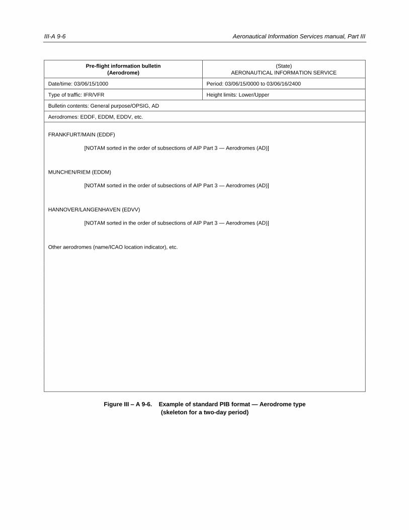
III-A 9-6 Aeronautical Information Services manual, Part III
Pre-flight information bulletin
(Aerodrome)
(State)
AERONAUTICAL INFORMATION SERVICE
Date/time: 03/06/15/1000 Period: 03/06/15/0000 to 03/06/16/2400
Type of traffic: IFR/VFR Height limits: Lower/Upper
Bulletin contents: General purpose/OPSIG, AD
Aerodromes: EDDF, EDDM, EDDV, etc.
FRANKFURT/MAIN (EDDF)
[NOTAM sorted in the order of subsections of AIP Part 3 — Aerodromes (AD)]
MUNCHEN/RIEM (EDDM)
[NOTAM sorted in the order of subsections of AIP Part 3 — Aerodromes (AD)]
HANNOVER/LANGENHAVEN (EDVV)
[NOTAM sorted in the order of subsections of AIP Part 3 — Aerodromes (AD)]
Other aerodromes (name/ICAO location indicator), etc.
Figure III – A 9-6. Example of standard PIB format — Aerodrome type
(skeleton for a two-day period)
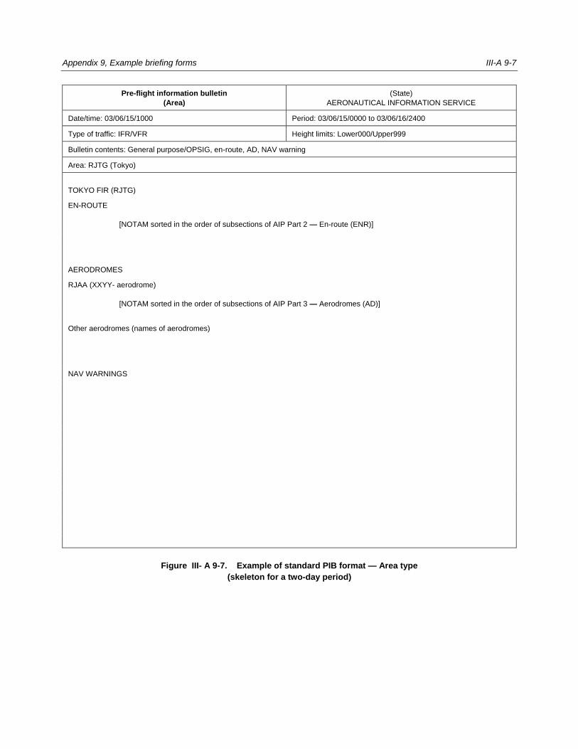
Appendix 9, Example briefing forms III-A 9-7
Pre-flight information bulletin
(Area)
(State)
AERONAUTICAL INFORMATION SERVICE
Date/time: 03/06/15/1000 Period: 03/06/15/0000 to 03/06/16/2400
Type of traffic: IFR/VFR Height limits: Lower000/Upper999
Bulletin contents: General purpose/OPSIG, en-route, AD, NAV warning
Area: RJTG (Tokyo)
TOKYO FIR (RJTG)
EN-ROUTE
[NOTAM sorted in the order of subsections of AIP Part 2 — En-route (ENR)]
AERODROMES
RJAA (XXYY- aerodrome)
[NOTAM sorted in the order of subsections of AIP Part 3 — Aerodromes (AD)]
Other aerodromes (names of aerodromes)
NAV WARNINGS
Figure III- A 9-7. Example of standard PIB format — Area type
(skeleton for a two-day period)
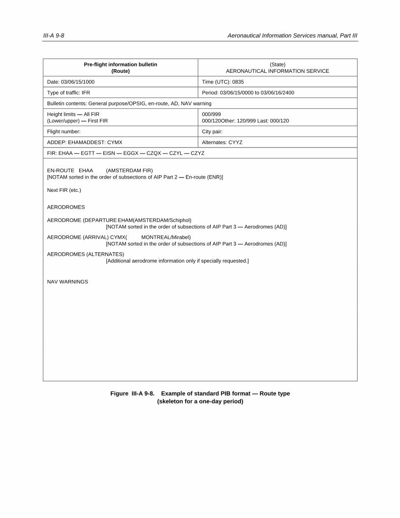
III-A 9-8 Aeronautical Information Services manual, Part III
Pre-flight information bulletin
(Route)
(State)
AERONAUTICAL INFORMATION SERVICE
Date: 03/06/15/1000 Time (UTC): 0835
Type of traffic: IFR Period: 03/06/15/0000 to 03/06/16/2400
Bulletin contents: General purpose/OPSIG, en-route, AD, NAV warning
Height limits — All FIR
(Lower/upper) — First FIR
000/999
000/120Other: 120/999 Last: 000/120
Flight number: City pair:
ADDEP: EHAMADDEST: CYMX Alternates: CYYZ
FIR: EHAA — EGTT — EISN — EGGX — CZQX — CZYL — CZYZ
EN-ROUTE EHAA (AMSTERDAM FIR)
[NOTAM sorted in the order of subsections of AIP Part 2 — En-route (ENR)]
Next FIR (etc.)
AERODROMES
AERODROME (DEPARTURE EHAM(AMSTERDAM/Schiphol)
[NOTAM sorted in the order of subsections of AIP Part 3 — Aerodromes (AD)]
AERODROME (ARRIVAL) CYMX( MONTREAL/Mirabel)
[NOTAM sorted in the order of subsections of AIP Part 3 — Aerodromes (AD)]
AERODROMES (ALTERNATES)
[Additional aerodrome information only if specially requested.]
NAV WARNINGS
Figure III-A 9-8. Example of standard PIB format — Route type
(skeleton for a one-day period)
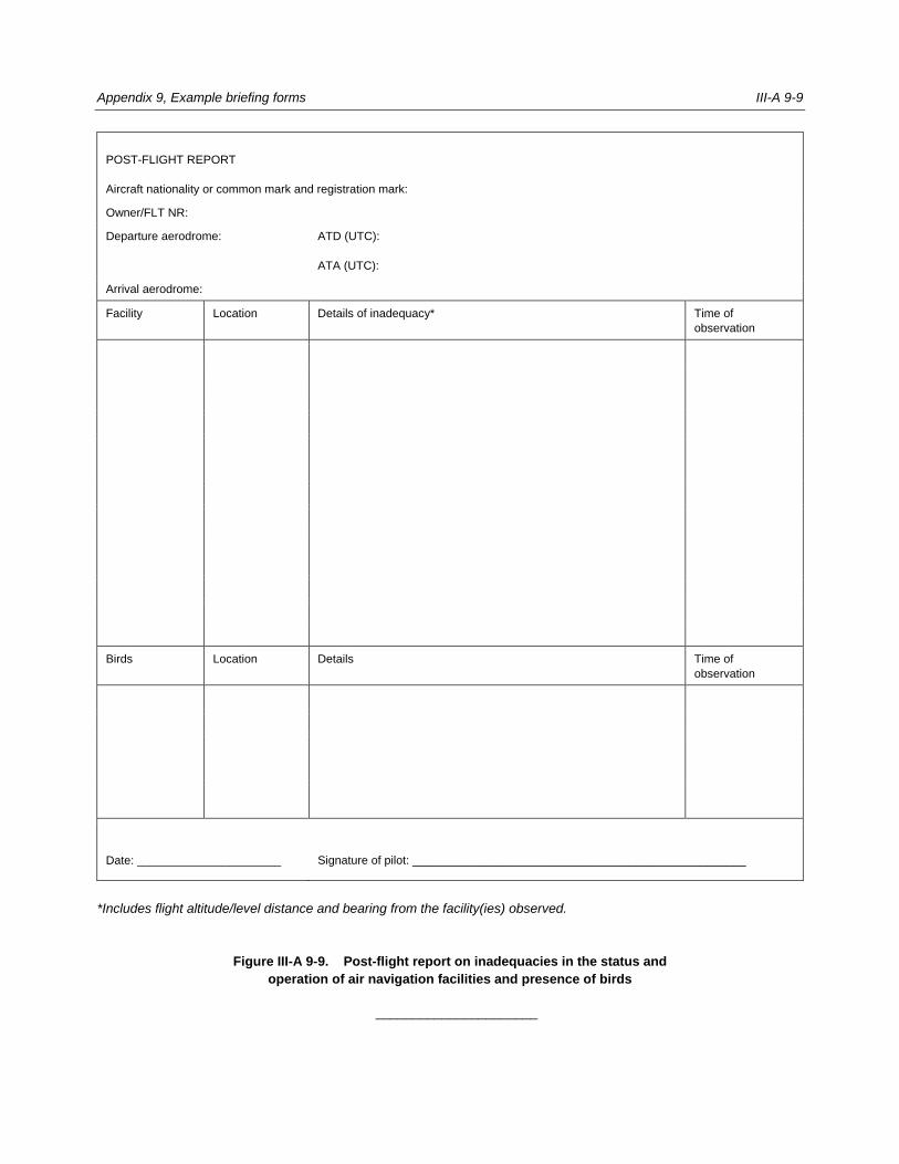
Appendix 9, Example briefing forms III-A 9-9
POST-FLIGHT REPORT
Aircraft nationality or common mark and registration mark:
Owner/FLT NR:
Departure aerodrome: ATD (UTC):
ATA (UTC):
Arrival aerodrome:
Facility Location Details of inadequacy* Time of
observation
Birds Location Details Time of
observation
Date: ______________________
Signature of pilot: ___________________________________________________
*Includes flight altitude/level distance and bearing from the facility(ies) observed.
Figure III-A 9-9. Post-flight report on inadequacies in the status and
operation of air navigation facilities and presence of birds
______________________


PART IV
Digital Aeronautical Information Products and Related Services
(under development)