Embed Size (px)
Citation preview
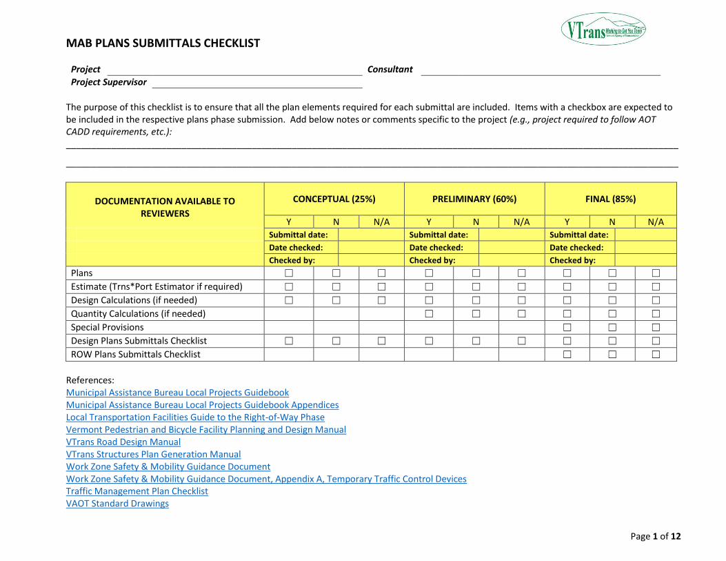
MAB PLANS SUBMITTALS CHECKLIST
Page 1 of 12
Project Consultant
Project Supervisor
The purpose of this checklist is to ensure that all the plan elements required for each submittal are included. Items with a checkbox are expected to be included in the respective plans phase submission. Add below notes or comments specific to the project (e.g., project required to follow AOT CADD requirements, etc.): __________________________________________________________________________________________________________________________
__________________________________________________________________________________________________________________________
DOCUMENTATION AVAILABLE TO REVIEWERS
CONCEPTUAL (25%) PRELIMINARY (60%) FINAL (85%)
Y N N/A Y N N/A Y N N/A Submittal date: Submittal date: Submittal date:
Date checked: Date checked: Date checked:
Checked by: Checked by: Checked by:
Plans ☐ ☐ ☐ ☐ ☐ ☐ ☐ ☐ ☐
Estimate (Trns*Port Estimator if required) ☐ ☐ ☐ ☐ ☐ ☐ ☐ ☐ ☐
Design Calculations (if needed) ☐ ☐ ☐ ☐ ☐ ☐ ☐ ☐ ☐
Quantity Calculations (if needed) ☐ ☐ ☐ ☐ ☐ ☐
Special Provisions ☐ ☐ ☐
Design Plans Submittals Checklist ☐ ☐ ☐ ☐ ☐ ☐ ☐ ☐ ☐
ROW Plans Submittals Checklist ☐ ☐ ☐
References: Municipal Assistance Bureau Local Projects Guidebook Municipal Assistance Bureau Local Projects Guidebook Appendices Local Transportation Facilities Guide to the Right-of-Way Phase Vermont Pedestrian and Bicycle Facility Planning and Design Manual VTrans Road Design Manual VTrans Structures Plan Generation Manual Work Zone Safety & Mobility Guidance Document Work Zone Safety & Mobility Guidance Document, Appendix A, Temporary Traffic Control Devices Traffic Management Plan Checklist VAOT Standard Drawings
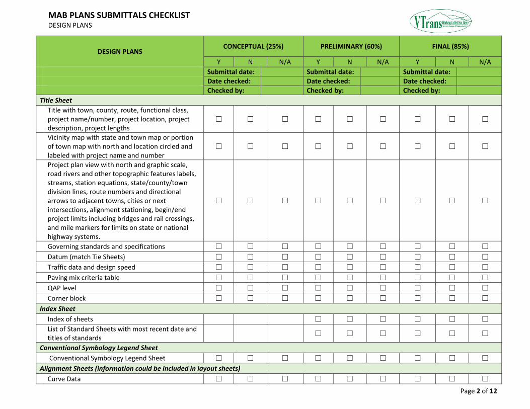
MAB PLANS SUBMITTALS CHECKLIST DESIGN PLANS
Page 2 of 12
DESIGN PLANS CONCEPTUAL (25%) PRELIMINARY (60%) FINAL (85%)
Y N N/A Y N N/A Y N N/A
Submittal date: Submittal date: Submittal date:
Date checked: Date checked: Date checked:
Checked by: Checked by: Checked by:
Title Sheet
Title with town, county, route, functional class, project name/number, project location, project description, project lengths
☐ ☐ ☐ ☐ ☐ ☐ ☐ ☐ ☐
Vicinity map with state and town map or portion of town map with north and location circled and labeled with project name and number
☐ ☐ ☐ ☐ ☐ ☐ ☐ ☐ ☐
Project plan view with north and graphic scale, road rivers and other topographic features labels, streams, station equations, state/county/town division lines, route numbers and directional arrows to adjacent towns, cities or next intersections, alignment stationing, begin/end project limits including bridges and rail crossings, and mile markers for limits on state or national highway systems.
☐ ☐ ☐ ☐ ☐ ☐ ☐ ☐ ☐
Governing standards and specifications ☐ ☐ ☐ ☐ ☐ ☐ ☐ ☐ ☐
Datum (match Tie Sheets) ☐ ☐ ☐ ☐ ☐ ☐ ☐ ☐ ☐
Traffic data and design speed ☐ ☐ ☐ ☐ ☐ ☐ ☐ ☐ ☐
Paving mix criteria table ☐ ☐ ☐ ☐ ☐ ☐ ☐ ☐ ☐
QAP level ☐ ☐ ☐ ☐ ☐ ☐ ☐ ☐ ☐
Corner block ☐ ☐ ☐ ☐ ☐ ☐ ☐ ☐ ☐
Index Sheet
Index of sheets ☐ ☐ ☐ ☐ ☐ ☐
List of Standard Sheets with most recent date and titles of standards
☐ ☐ ☐ ☐ ☐ ☐
Conventional Symbology Legend Sheet
Conventional Symbology Legend Sheet ☐ ☐ ☐ ☐ ☐ ☐ ☐ ☐ ☐
Alignment Sheets (information could be included in layout sheets)
Curve Data ☐ ☐ ☐ ☐ ☐ ☐ ☐ ☐ ☐
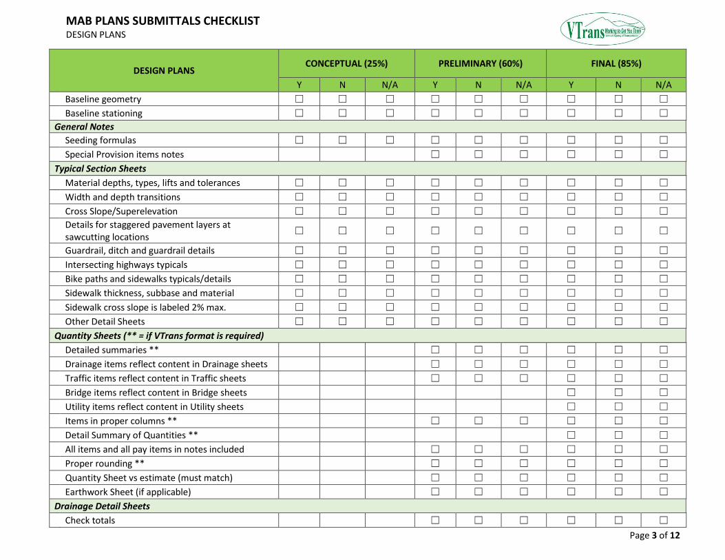
MAB PLANS SUBMITTALS CHECKLIST DESIGN PLANS
Page 3 of 12
DESIGN PLANS CONCEPTUAL (25%) PRELIMINARY (60%) FINAL (85%)
Y N N/A Y N N/A Y N N/A
Baseline geometry ☐ ☐ ☐ ☐ ☐ ☐ ☐ ☐ ☐
Baseline stationing ☐ ☐ ☐ ☐ ☐ ☐ ☐ ☐ ☐
General Notes
Seeding formulas ☐ ☐ ☐ ☐ ☐ ☐ ☐ ☐ ☐
Special Provision items notes ☐ ☐ ☐ ☐ ☐ ☐
Typical Section Sheets
Material depths, types, lifts and tolerances ☐ ☐ ☐ ☐ ☐ ☐ ☐ ☐ ☐
Width and depth transitions ☐ ☐ ☐ ☐ ☐ ☐ ☐ ☐ ☐
Cross Slope/Superelevation ☐ ☐ ☐ ☐ ☐ ☐ ☐ ☐ ☐
Details for staggered pavement layers at sawcutting locations
☐ ☐ ☐ ☐ ☐ ☐ ☐ ☐ ☐
Guardrail, ditch and guardrail details ☐ ☐ ☐ ☐ ☐ ☐ ☐ ☐ ☐
Intersecting highways typicals ☐ ☐ ☐ ☐ ☐ ☐ ☐ ☐ ☐
Bike paths and sidewalks typicals/details ☐ ☐ ☐ ☐ ☐ ☐ ☐ ☐ ☐
Sidewalk thickness, subbase and material ☐ ☐ ☐ ☐ ☐ ☐ ☐ ☐ ☐
Sidewalk cross slope is labeled 2% max. ☐ ☐ ☐ ☐ ☐ ☐ ☐ ☐ ☐
Other Detail Sheets ☐ ☐ ☐ ☐ ☐ ☐ ☐ ☐ ☐
Quantity Sheets (** = if VTrans format is required)
Detailed summaries ** ☐ ☐ ☐ ☐ ☐ ☐
Drainage items reflect content in Drainage sheets ☐ ☐ ☐ ☐ ☐ ☐
Traffic items reflect content in Traffic sheets ☐ ☐ ☐ ☐ ☐ ☐
Bridge items reflect content in Bridge sheets ☐ ☐ ☐
Utility items reflect content in Utility sheets ☐ ☐ ☐
Items in proper columns ** ☐ ☐ ☐ ☐ ☐ ☐
Detail Summary of Quantities ** ☐ ☐ ☐
All items and all pay items in notes included ☐ ☐ ☐ ☐ ☐ ☐
Proper rounding ** ☐ ☐ ☐ ☐ ☐ ☐
Quantity Sheet vs estimate (must match) ☐ ☐ ☐ ☐ ☐ ☐
Earthwork Sheet (if applicable) ☐ ☐ ☐ ☐ ☐ ☐
Drainage Detail Sheets
Check totals ☐ ☐ ☐ ☐ ☐ ☐
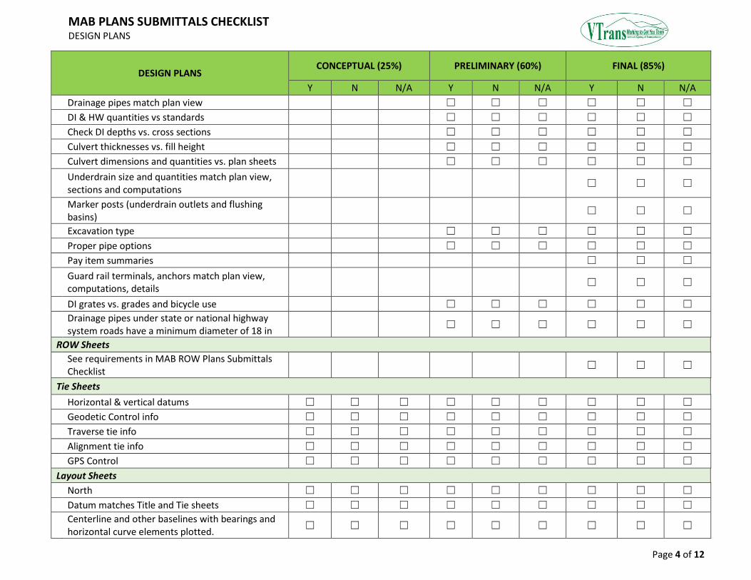
MAB PLANS SUBMITTALS CHECKLIST DESIGN PLANS
Page 4 of 12
DESIGN PLANS CONCEPTUAL (25%) PRELIMINARY (60%) FINAL (85%)
Y N N/A Y N N/A Y N N/A
Drainage pipes match plan view ☐ ☐ ☐ ☐ ☐ ☐
DI & HW quantities vs standards ☐ ☐ ☐ ☐ ☐ ☐
Check DI depths vs. cross sections ☐ ☐ ☐ ☐ ☐ ☐
Culvert thicknesses vs. fill height ☐ ☐ ☐ ☐ ☐ ☐
Culvert dimensions and quantities vs. plan sheets ☐ ☐ ☐ ☐ ☐ ☐
Underdrain size and quantities match plan view, sections and computations
☐ ☐ ☐
Marker posts (underdrain outlets and flushing basins)
☐ ☐ ☐
Excavation type ☐ ☐ ☐ ☐ ☐ ☐
Proper pipe options ☐ ☐ ☐ ☐ ☐ ☐
Pay item summaries ☐ ☐ ☐
Guard rail terminals, anchors match plan view, computations, details
☐ ☐ ☐
DI grates vs. grades and bicycle use ☐ ☐ ☐ ☐ ☐ ☐
Drainage pipes under state or national highway system roads have a minimum diameter of 18 in
☐ ☐ ☐ ☐ ☐ ☐
ROW Sheets
See requirements in MAB ROW Plans Submittals Checklist
☐ ☐ ☐
Tie Sheets
Horizontal & vertical datums ☐ ☐ ☐ ☐ ☐ ☐ ☐ ☐ ☐
Geodetic Control info ☐ ☐ ☐ ☐ ☐ ☐ ☐ ☐ ☐
Traverse tie info ☐ ☐ ☐ ☐ ☐ ☐ ☐ ☐ ☐
Alignment tie info ☐ ☐ ☐ ☐ ☐ ☐ ☐ ☐ ☐
GPS Control ☐ ☐ ☐ ☐ ☐ ☐ ☐ ☐ ☐
Layout Sheets
North ☐ ☐ ☐ ☐ ☐ ☐ ☐ ☐ ☐
Datum matches Title and Tie sheets ☐ ☐ ☐ ☐ ☐ ☐ ☐ ☐ ☐
Centerline and other baselines with bearings and horizontal curve elements plotted.
☐ ☐ ☐ ☐ ☐ ☐ ☐ ☐ ☐
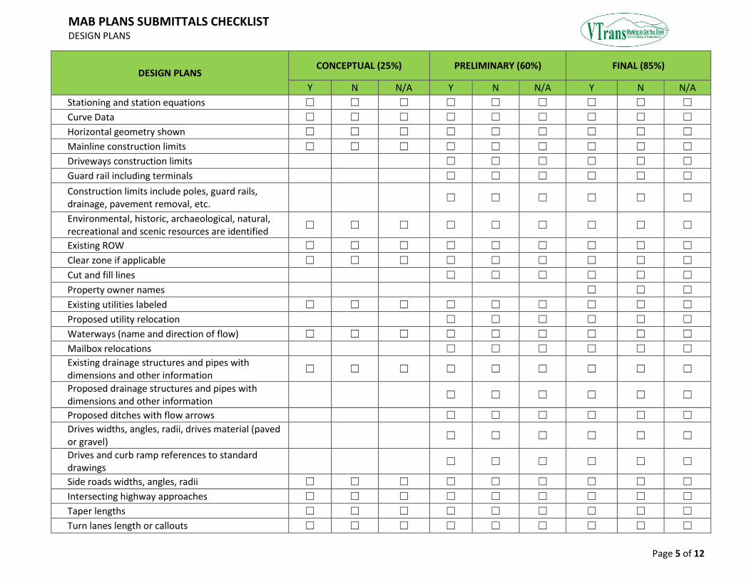
MAB PLANS SUBMITTALS CHECKLIST DESIGN PLANS
Page 5 of 12
DESIGN PLANS CONCEPTUAL (25%) PRELIMINARY (60%) FINAL (85%)
Y N N/A Y N N/A Y N N/A
Stationing and station equations ☐ ☐ ☐ ☐ ☐ ☐ ☐ ☐ ☐
Curve Data ☐ ☐ ☐ ☐ ☐ ☐ ☐ ☐ ☐
Horizontal geometry shown ☐ ☐ ☐ ☐ ☐ ☐ ☐ ☐ ☐
Mainline construction limits ☐ ☐ ☐ ☐ ☐ ☐ ☐ ☐ ☐
Driveways construction limits ☐ ☐ ☐ ☐ ☐ ☐
Guard rail including terminals ☐ ☐ ☐ ☐ ☐ ☐
Construction limits include poles, guard rails, drainage, pavement removal, etc.
☐ ☐ ☐ ☐ ☐ ☐
Environmental, historic, archaeological, natural, recreational and scenic resources are identified
☐ ☐ ☐ ☐ ☐ ☐ ☐ ☐ ☐
Existing ROW ☐ ☐ ☐ ☐ ☐ ☐ ☐ ☐ ☐
Clear zone if applicable ☐ ☐ ☐ ☐ ☐ ☐ ☐ ☐ ☐
Cut and fill lines ☐ ☐ ☐ ☐ ☐ ☐
Property owner names ☐ ☐ ☐
Existing utilities labeled ☐ ☐ ☐ ☐ ☐ ☐ ☐ ☐ ☐
Proposed utility relocation ☐ ☐ ☐ ☐ ☐ ☐
Waterways (name and direction of flow) ☐ ☐ ☐ ☐ ☐ ☐ ☐ ☐ ☐
Mailbox relocations ☐ ☐ ☐ ☐ ☐ ☐
Existing drainage structures and pipes with dimensions and other information
☐ ☐ ☐ ☐ ☐ ☐ ☐ ☐ ☐
Proposed drainage structures and pipes with dimensions and other information
☐ ☐ ☐ ☐ ☐ ☐
Proposed ditches with flow arrows ☐ ☐ ☐ ☐ ☐ ☐
Drives widths, angles, radii, drives material (paved or gravel)
☐ ☐ ☐ ☐ ☐ ☐
Drives and curb ramp references to standard drawings
☐ ☐ ☐ ☐ ☐ ☐
Side roads widths, angles, radii ☐ ☐ ☐ ☐ ☐ ☐ ☐ ☐ ☐
Intersecting highway approaches ☐ ☐ ☐ ☐ ☐ ☐ ☐ ☐ ☐
Taper lengths ☐ ☐ ☐ ☐ ☐ ☐ ☐ ☐ ☐
Turn lanes length or callouts ☐ ☐ ☐ ☐ ☐ ☐ ☐ ☐ ☐

MAB PLANS SUBMITTALS CHECKLIST DESIGN PLANS
Page 6 of 12
DESIGN PLANS CONCEPTUAL (25%) PRELIMINARY (60%) FINAL (85%)
Y N N/A Y N N/A Y N N/A
State/County/Town lines ☐ ☐ ☐ ☐ ☐ ☐ ☐ ☐ ☐
Construction notes match graphics and specifications
☐ ☐ ☐ ☐ ☐ ☐
Existing trees and landscaping within construction limits is labeled as saved or removed
☐ ☐ ☐ ☐ ☐ ☐
Topography shown within ROW ☐ ☐ ☐ ☐ ☐ ☐ ☐ ☐ ☐
Curb types, limits, new, existing, reset ☐ ☐ ☐ ☐ ☐ ☐
Sidewalk (type, thickness, width) ☐ ☐ ☐ ☐ ☐ ☐ ☐ ☐ ☐
Fences, geotextile, landscaping, stone fill ☐ ☐ ☐ ☐ ☐ ☐
Demolition or removal items ☐ ☐ ☐ ☐ ☐ ☐
Bridge and bridge limits properly drawn ☐ ☐ ☐ ☐ ☐ ☐
Plan changes due to permitting ☐ ☐ ☐ ☐ ☐ ☐
Match lines have matching sheets and stations ☐ ☐ ☐ ☐ ☐ ☐ ☐ ☐ ☐
Bench Marks ☐ ☐ ☐ ☐ ☐ ☐ ☐ ☐ ☐
Graphic scale and scale units ☐ ☐ ☐ ☐ ☐ ☐ ☐ ☐ ☐
Profile Sheets
Percent of grades shown to a minimum of 4 decimal places
☐ ☐ ☐ ☐ ☐ ☐ ☐ ☐ ☐
VPOTs match grades and elevations plotted ☐ ☐ ☐ ☐ ☐ ☐ ☐ ☐ ☐
VC Data and Equations ☐ ☐ ☐ ☐ ☐ ☐ ☐ ☐ ☐
Superelevation transitions ☐ ☐ ☐ ☐ ☐ ☐
Intersecting sidelines ☐ ☐ ☐ ☐ ☐ ☐ ☐ ☐ ☐
Ks and SSDs shown ☐ ☐ ☐ ☐ ☐ ☐ ☐ ☐ ☐
VC data vs Design grades shown ☐ ☐ ☐ ☐ ☐ ☐ ☐ ☐ ☐
Proposed and existing elevations shown at every 25 feet
☐ ☐ ☐ ☐ ☐ ☐ ☐ ☐ ☐
Note for accuracy of existing and proposed elevations
☐ ☐ ☐ ☐ ☐ ☐ ☐ ☐ ☐
Datum, graphic Scales and scale units ☐ ☐ ☐ ☐ ☐ ☐ ☐ ☐ ☐
Special Profiles
Back of sidewalk ☐ ☐ ☐ ☐ ☐ ☐
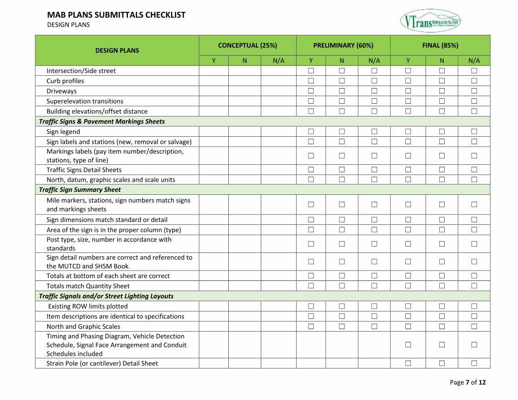
MAB PLANS SUBMITTALS CHECKLIST DESIGN PLANS
Page 7 of 12
DESIGN PLANS CONCEPTUAL (25%) PRELIMINARY (60%) FINAL (85%)
Y N N/A Y N N/A Y N N/A
Intersection/Side street ☐ ☐ ☐ ☐ ☐ ☐
Curb profiles ☐ ☐ ☐ ☐ ☐ ☐
Driveways ☐ ☐ ☐ ☐ ☐ ☐
Superelevation transitions ☐ ☐ ☐ ☐ ☐ ☐
Building elevations/offset distance ☐ ☐ ☐ ☐ ☐ ☐
Traffic Signs & Pavement Markings Sheets
Sign legend ☐ ☐ ☐ ☐ ☐ ☐
Sign labels and stations (new, removal or salvage) ☐ ☐ ☐ ☐ ☐ ☐
Markings labels (pay item number/description, stations, type of line)
☐ ☐ ☐ ☐ ☐ ☐
Traffic Signs Detail Sheets ☐ ☐ ☐ ☐ ☐ ☐
North, datum, graphic scales and scale units ☐ ☐ ☐ ☐ ☐ ☐
Traffic Sign Summary Sheet
Mile markers, stations, sign numbers match signs and markings sheets
☐ ☐ ☐ ☐ ☐ ☐
Sign dimensions match standard or detail ☐ ☐ ☐ ☐ ☐ ☐
Area of the sign is in the proper column (type) ☐ ☐ ☐ ☐ ☐ ☐
Post type, size, number in accordance with standards
☐ ☐ ☐ ☐ ☐ ☐
Sign detail numbers are correct and referenced to the MUTCD and SHSM Book.
☐ ☐ ☐ ☐ ☐ ☐
Totals at bottom of each sheet are correct ☐ ☐ ☐ ☐ ☐ ☐
Totals match Quantity Sheet ☐ ☐ ☐ ☐ ☐ ☐
Traffic Signals and/or Street Lighting Layouts
Existing ROW limits plotted ☐ ☐ ☐ ☐ ☐ ☐
Item descriptions are identical to specifications ☐ ☐ ☐ ☐ ☐ ☐
North and Graphic Scales ☐ ☐ ☐ ☐ ☐ ☐
Timing and Phasing Diagram, Vehicle Detection Schedule, Signal Face Arrangement and Conduit Schedules included
☐ ☐ ☐
Strain Pole (or cantilever) Detail Sheet ☐ ☐ ☐
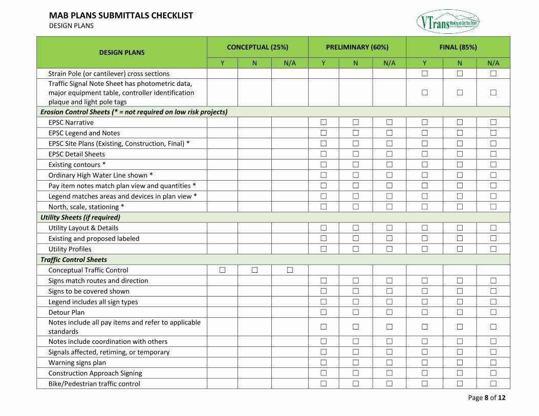
MAB PLANS SUBMITTALS CHECKLIST DESIGN PLANS
Page 8 of 12
DESIGN PLANS CONCEPTUAL (25%) PRELIMINARY (60%) FINAL (85%)
Y N N/A Y N N/A Y N N/A
Strain Pole (or cantilever) cross sections ☐ ☐ ☐
Traffic Signal Note Sheet has photometric data, major equipment table, controller identification plaque and light pole tags
☐ ☐ ☐
Erosion Control Sheets (* = not required on low risk projects)
EPSC Narrative ☐ ☐ ☐ ☐ ☐ ☐
EPSC Legend and Notes ☐ ☐ ☐ ☐ ☐ ☐
EPSC Site Plans (Existing, Construction, Final) * ☐ ☐ ☐ ☐ ☐ ☐
EPSC Detail Sheets ☐ ☐ ☐ ☐ ☐ ☐
Existing contours * ☐ ☐ ☐ ☐ ☐ ☐
Ordinary High Water Line shown * ☐ ☐ ☐ ☐ ☐ ☐
Pay item notes match plan view and quantities * ☐ ☐ ☐ ☐ ☐ ☐
Legend matches areas and devices in plan view * ☐ ☐ ☐ ☐ ☐ ☐
North, scale, stationing * ☐ ☐ ☐ ☐ ☐ ☐
Utility Sheets (if required)
Utility Layout & Details ☐ ☐ ☐ ☐ ☐ ☐
Existing and proposed labeled ☐ ☐ ☐ ☐ ☐ ☐
Utility Profiles ☐ ☐ ☐ ☐ ☐ ☐
Traffic Control Sheets
Conceptual Traffic Control ☐ ☐ ☐
Signs match routes and direction ☐ ☐ ☐ ☐ ☐ ☐
Signs to be covered shown ☐ ☐ ☐ ☐ ☐ ☐
Legend includes all sign types ☐ ☐ ☐ ☐ ☐ ☐
Detour Plan ☐ ☐ ☐ ☐ ☐ ☐
Notes include all pay items and refer to applicable standards
☐ ☐ ☐ ☐ ☐ ☐
Notes include coordination with others ☐ ☐ ☐ ☐ ☐ ☐
Signals affected, retiming, or temporary ☐ ☐ ☐ ☐ ☐ ☐
Warning signs plan ☐ ☐ ☐ ☐ ☐ ☐
Construction Approach Signing ☐ ☐ ☐ ☐ ☐ ☐
Bike/Pedestrian traffic control ☐ ☐ ☐ ☐ ☐ ☐
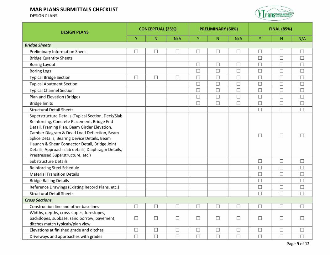
MAB PLANS SUBMITTALS CHECKLIST DESIGN PLANS
Page 9 of 12
DESIGN PLANS CONCEPTUAL (25%) PRELIMINARY (60%) FINAL (85%)
Y N N/A Y N N/A Y N N/A
Bridge Sheets
Preliminary Information Sheet ☐ ☐ ☐ ☐ ☐ ☐ ☐ ☐ ☐
Bridge Quantity Sheets ☐ ☐ ☐
Boring Layout ☐ ☐ ☐ ☐ ☐ ☐
Boring Logs ☐ ☐ ☐ ☐ ☐ ☐
Typical Bridge Section ☐ ☐ ☐ ☐ ☐ ☐ ☐ ☐ ☐
Typical Abutment Section ☐ ☐ ☐ ☐ ☐ ☐
Typical Channel Section ☐ ☐ ☐ ☐ ☐ ☐
Plan and Elevation (Bridge) ☐ ☐ ☐ ☐ ☐ ☐
Bridge limits ☐ ☐ ☐ ☐ ☐ ☐
Structural Detail Sheets ☐ ☐ ☐
Superstructure Details (Typical Section, Deck/Slab Reinforcing, Concrete Placement, Bridge End Detail, Framing Plan, Beam Girder Elevation, Camber Diagram & Dead Load Deflection, Beam Splice Details, Bearing Device Details, Beam Haunch & Shear Connector Detail, Bridge Joint Details, Approach slab details, Diaphragm Details, Prestressed Superstructure, etc.)
☐ ☐ ☐
Substructure Details ☐ ☐ ☐
Reinforcing Steel Schedule ☐ ☐ ☐
Material Transition Details ☐ ☐ ☐
Bridge Railing Details ☐ ☐ ☐
Reference Drawings (Existing Record Plans, etc.) ☐ ☐ ☐
Structural Detail Sheets ☐ ☐ ☐
Cross Sections
Construction line and other baselines ☐ ☐ ☐ ☐ ☐ ☐ ☐ ☐ ☐
Widths, depths, cross slopes, foreslopes, backslopes, subbase, sand borrow, pavement, ditches match typicals/plan view
☐ ☐ ☐ ☐ ☐ ☐ ☐ ☐ ☐
Elevations at finished grade and ditches ☐ ☐ ☐ ☐ ☐ ☐ ☐ ☐ ☐
Driveways and approaches with grades ☐ ☐ ☐ ☐ ☐ ☐ ☐ ☐ ☐
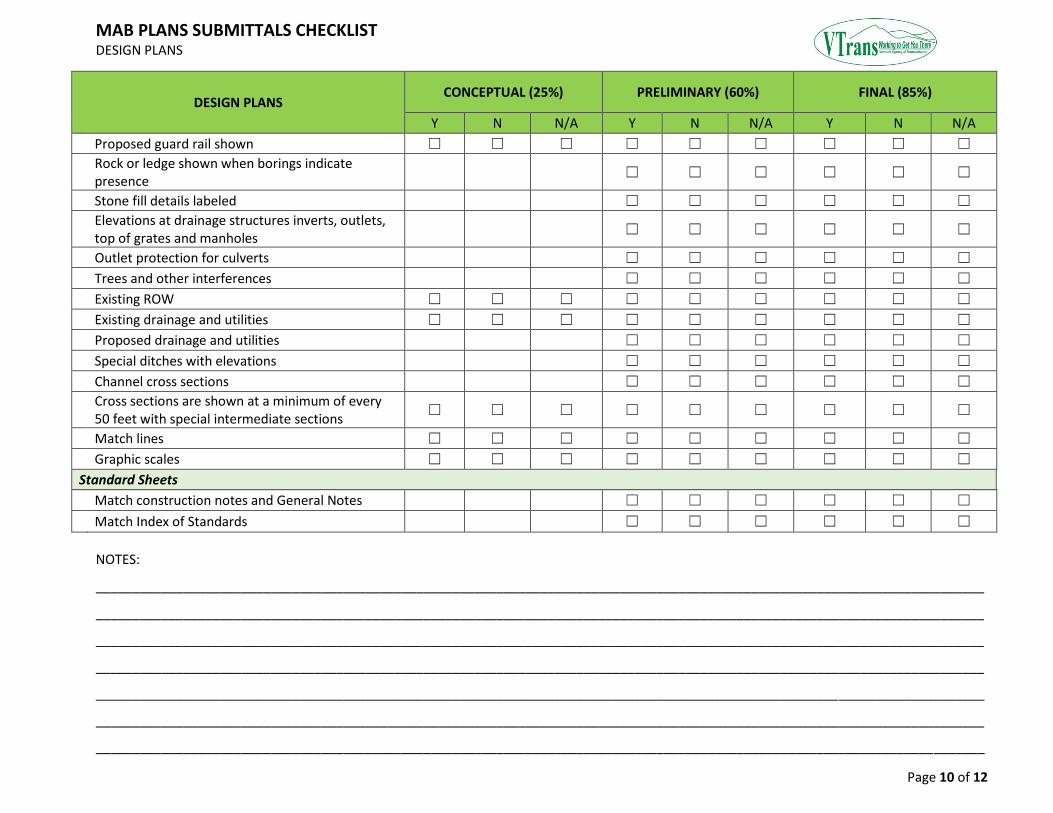
MAB PLANS SUBMITTALS CHECKLIST DESIGN PLANS
Page 10 of 12
DESIGN PLANS CONCEPTUAL (25%) PRELIMINARY (60%) FINAL (85%)
Y N N/A Y N N/A Y N N/A
Proposed guard rail shown ☐ ☐ ☐ ☐ ☐ ☐ ☐ ☐ ☐
Rock or ledge shown when borings indicate presence
☐ ☐ ☐ ☐ ☐ ☐
Stone fill details labeled ☐ ☐ ☐ ☐ ☐ ☐
Elevations at drainage structures inverts, outlets, top of grates and manholes
☐ ☐ ☐ ☐ ☐ ☐
Outlet protection for culverts ☐ ☐ ☐ ☐ ☐ ☐
Trees and other interferences ☐ ☐ ☐ ☐ ☐ ☐
Existing ROW ☐ ☐ ☐ ☐ ☐ ☐ ☐ ☐ ☐
Existing drainage and utilities ☐ ☐ ☐ ☐ ☐ ☐ ☐ ☐ ☐
Proposed drainage and utilities ☐ ☐ ☐ ☐ ☐ ☐
Special ditches with elevations ☐ ☐ ☐ ☐ ☐ ☐
Channel cross sections ☐ ☐ ☐ ☐ ☐ ☐
Cross sections are shown at a minimum of every 50 feet with special intermediate sections
☐ ☐ ☐ ☐ ☐ ☐ ☐ ☐ ☐
Match lines ☐ ☐ ☐ ☐ ☐ ☐ ☐ ☐ ☐
Graphic scales ☐ ☐ ☐ ☐ ☐ ☐ ☐ ☐ ☐
Standard Sheets
Match construction notes and General Notes ☐ ☐ ☐ ☐ ☐ ☐
Match Index of Standards ☐ ☐ ☐ ☐ ☐ ☐
NOTES:
__________________________________________________________________________________________________________________________
__________________________________________________________________________________________________________________________
__________________________________________________________________________________________________________________________
__________________________________________________________________________________________________________________________
__________________________________________________________________________________________________________________________
__________________________________________________________________________________________________________________________
__________________________________________________________________________________________________________________________
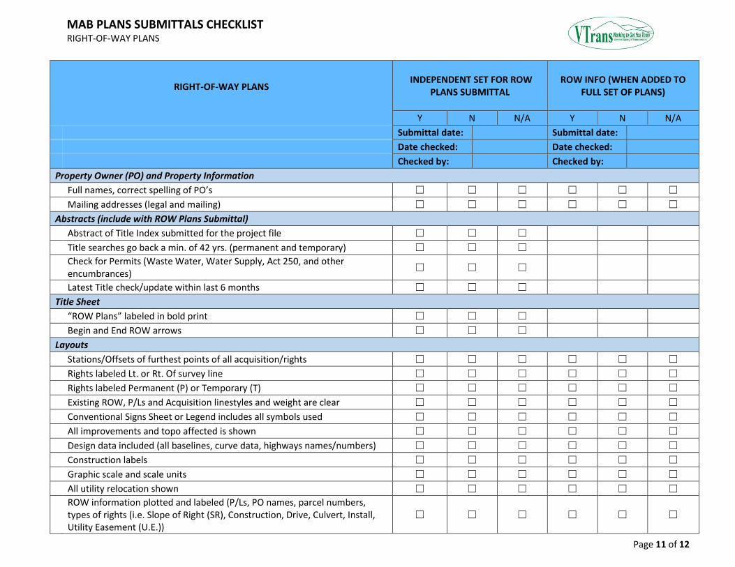
MAB PLANS SUBMITTALS CHECKLIST RIGHT-OF-WAY PLANS
Page 11 of 12
RIGHT-OF-WAY PLANS INDEPENDENT SET FOR ROW
PLANS SUBMITTAL ROW INFO (WHEN ADDED TO
FULL SET OF PLANS)
Y N N/A Y N N/A
Submittal date: Submittal date:
Date checked: Date checked:
Checked by: Checked by:
Property Owner (PO) and Property Information
Full names, correct spelling of PO’s ☐ ☐ ☐ ☐ ☐ ☐
Mailing addresses (legal and mailing) ☐ ☐ ☐ ☐ ☐ ☐
Abstracts (include with ROW Plans Submittal)
Abstract of Title Index submitted for the project file ☐ ☐ ☐
Title searches go back a min. of 42 yrs. (permanent and temporary) ☐ ☐ ☐
Check for Permits (Waste Water, Water Supply, Act 250, and other encumbrances)
☐ ☐ ☐
Latest Title check/update within last 6 months ☐ ☐ ☐
Title Sheet
“ROW Plans” labeled in bold print ☐ ☐ ☐
Begin and End ROW arrows ☐ ☐ ☐
Layouts
Stations/Offsets of furthest points of all acquisition/rights ☐ ☐ ☐ ☐ ☐ ☐
Rights labeled Lt. or Rt. Of survey line ☐ ☐ ☐ ☐ ☐ ☐
Rights labeled Permanent (P) or Temporary (T) ☐ ☐ ☐ ☐ ☐ ☐
Existing ROW, P/Ls and Acquisition linestyles and weight are clear ☐ ☐ ☐ ☐ ☐ ☐
Conventional Signs Sheet or Legend includes all symbols used ☐ ☐ ☐ ☐ ☐ ☐
All improvements and topo affected is shown ☐ ☐ ☐ ☐ ☐ ☐
Design data included (all baselines, curve data, highways names/numbers) ☐ ☐ ☐ ☐ ☐ ☐
Construction labels ☐ ☐ ☐ ☐ ☐ ☐
Graphic scale and scale units ☐ ☐ ☐ ☐ ☐ ☐
All utility relocation shown ☐ ☐ ☐ ☐ ☐ ☐
ROW information plotted and labeled (P/Ls, PO names, parcel numbers, types of rights (i.e. Slope of Right (SR), Construction, Drive, Culvert, Install, Utility Easement (U.E.))
☐ ☐ ☐ ☐ ☐ ☐
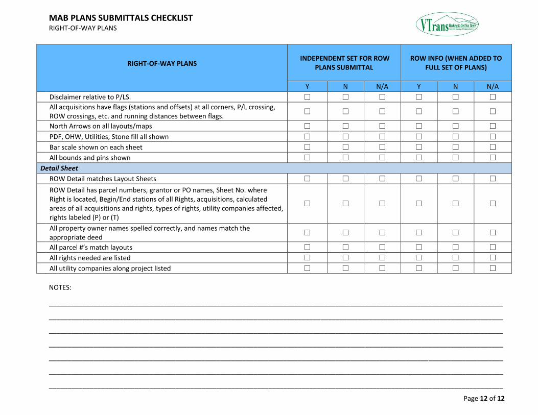
MAB PLANS SUBMITTALS CHECKLIST RIGHT-OF-WAY PLANS
Page 12 of 12
RIGHT-OF-WAY PLANS INDEPENDENT SET FOR ROW
PLANS SUBMITTAL ROW INFO (WHEN ADDED TO
FULL SET OF PLANS)
Y N N/A Y N N/A
Disclaimer relative to P/LS. ☐ ☐ ☐ ☐ ☐ ☐
All acquisitions have flags (stations and offsets) at all corners, P/L crossing, ROW crossings, etc. and running distances between flags.
☐ ☐ ☐ ☐ ☐ ☐
North Arrows on all layouts/maps ☐ ☐ ☐ ☐ ☐ ☐
PDF, OHW, Utilities, Stone fill all shown ☐ ☐ ☐ ☐ ☐ ☐
Bar scale shown on each sheet ☐ ☐ ☐ ☐ ☐ ☐
All bounds and pins shown ☐ ☐ ☐ ☐ ☐ ☐
Detail Sheet
ROW Detail matches Layout Sheets ☐ ☐ ☐ ☐ ☐ ☐
ROW Detail has parcel numbers, grantor or PO names, Sheet No. where Right is located, Begin/End stations of all Rights, acquisitions, calculated areas of all acquisitions and rights, types of rights, utility companies affected, rights labeled (P) or (T)
☐ ☐ ☐ ☐ ☐ ☐
All property owner names spelled correctly, and names match the appropriate deed
☐ ☐ ☐ ☐ ☐ ☐
All parcel #’s match layouts ☐ ☐ ☐ ☐ ☐ ☐
All rights needed are listed ☐ ☐ ☐ ☐ ☐ ☐
All utility companies along project listed ☐ ☐ ☐ ☐ ☐ ☐
NOTES:
__________________________________________________________________________________________________________________________
__________________________________________________________________________________________________________________________
__________________________________________________________________________________________________________________________
__________________________________________________________________________________________________________________________
__________________________________________________________________________________________________________________________
__________________________________________________________________________________________________________________________
__________________________________________________________________________________________________________________________