Embed Size (px)
Citation preview

The San Andreas and Walker Lane fault systems, western North America:
transpression, transtension, cumulative slip and the structural evolution of
a major transform plate boundary
Steven G. Wesnousky
Center for Neotectonic Studies, University of Nevada, Reno, NV 89557, USA
Received 5 April 2004; received in revised form 4 January 2005; accepted 17 January 2005
Available online 9 June 2005
Abstract
Relative right-lateral Pacific–North American transform motion across the western US is largely taken up by the San Andreas and Walker
Lane fault systems. Cumulative lateral displacement on active strands of the San Andreas system is 3–4 or more times greater than across
faults of the Walker Lane. The San Andreas system is transpressional while the Walker Lane system is transtensional. The relatively more
complex, discontinuous and broader system of faults composing the Walker Lane system is attributed to lower cumulative slip and an
attendant extensional component of motion. Greater slip accompanied by a small component of contraction has yielded the simpler, more
continuous and generally throughgoing set of faults that comprise the San Andreas system. With respect to the contrasting amounts of
cumulative slip, the San Andreas is at a more mature stage of structural development than the Walker Lane. Despite differences in gross
patterns of faulting, the systems also share similarities in deformation style. Slip along each is locally accommodated by clockwise rotation of
crustal blocks that has produced structural basins and oblique components of slip are commonly partitioned into subparallel strike-slip and
dip-slip faults.
q 2005 Elsevier Ltd. All rights reserved.
Keywords: San Andreas; Walker Lane; Neotectonics; Plate tectonics
1. Introduction
Pacific–North American relative plate motion is dis-
tributed on faults across the western United States (Fig. 1)
(e.g. Minster and Jordan, 1987; Bennett et al., 2003). Fault
displacement along the northwest-striking San Andreas
system takes up the major portion of motion. Most of the
remaining transform motion occurs on a similarly trending
zone of faults that strikes through the Mojave Desert and
bounds the east flank of the Sierra Nevada (Sauber et al.,
1986; Dokka and Travis, 1990b; Dixon et al., 1995;
Thatcher et al., 1999; Bennett et al., 2003). The zone of
faults, all or in part, has been previously referred to as the
Walker Lane (Locke et al., 1940), the Walker Line
(Billingsley and Locke, 1941), the Walker Belt (Stewart,
1980), the Walker Lane Belt (Carr, 1984) and the Eastern
0191-8141/$ - see front matter q 2005 Elsevier Ltd. All rights reserved.
doi:10.1016/j.jsg.2005.01.015
E-mail address: [email protected].
California Shear Zone (Dokka and Travis, 1990b). The
earliest accounts of strike-slip faulting east of the Sierra
Nevada includes Gianella and Callaghan’s (1934) descrip-
tion of the 1932 Cedar Mountain earthquake and the
mapping of Ferguson andMuller (1949) and Nielsen (1965).
I use the terms Walker Lane and Eastern California Shear
Zone as shown in Fig. 2 to group and label faults for the
following discussion. The San Andreas and Walker Lane
fault systems accommodate primarily right-lateral strike-
slip parallel to the plate boundary but display distinctly
different patterns of faulting. The San Andreas system is
composed of relatively smooth, curvilinear and anastomos-
ing fault traces. The Walker Lane is marked by a generally
broader and discontinuous set of strike-slip faults. I first
consider observations bearing on both the history of slip and
geodetic constraints on the relative motion across each of
the fault systems. The observations are then the basis to
suggest that marked differences in the style of deformation
observed along the two fault systems provides a picture of
two major strike-slip systems at different stages of structural
evolution and that the Walker Lane is a zone of transtension
Journal of Structural Geology 27 (2005) 1505–1512
www.elsevier.com/locate/jsg

Fig. 1. Generalized fault map of western United States. Pacific–North
American relative plate motion vector (50 mm/year at N508W) from
DeMets and Dixon (1999). The majority of transform motion is taken up
within the Walker Lane, Eastern California Shear Zone (ECSZ) and along
the San Andreas fault system. Areas outlined by boxes are shown in greater
detail in Fig. 2. Mount Shasta (MS) and Lassen Peak (LP) denoted by stars.
S.G. Wesnousky / Journal of Structural Geology 27 (2005) 1505–15121506
while the San Andreas is one of transpression. I also point to
deformation characteristics that are shared or universal to
both fault systems.
2. History of slip
2.1. Overview
Deformation across the western United States is
attributed primarily to right-lateral transform motion that
links plate boundary triple junctions near Cape Mendocino
and the Gulf of California (e.g. Atwater, 1970, 1989;
Bennett et al., 2003). Interpretation of seafloor magnetic
lineations indicates approximately 1100–1500 km of trans-
form motion since inception of the transform w28–30 Ma
(e.g. Stock and Molnar, 1988). A major portion of the plate
motion has been taken up along faults of the San Andreas
system. The remainder has been taken up by a broad zone of
shear east of the San Andreas system which encompasses
the Walker Lane and also transform faulting offshore of
California (Garfunkel, 1973; Howell, 1976; Beck, 1986;
Atwater, 1989). Only about one-half to one-third of the
estimated total transform motion is attributed to displace-
ment on currently active strands of the San Andreas and
Walker Lane fault systems (Powell et al., 1993).
2.2. San Andreas
Measures of cumulative right-slip of basement terranes
range from about 300 to 450 km along the southern and
northern reaches of the San Andreas fault system,
respectively (e.g. Dillon and Ehlig, 1993; James et al.,
1993). Most of that displacement has occurred along the San
Andreas fault proper. Lesser, albeit significant, amounts are
reported for a few of the subsidiary strands as well. Right-
slip offset across the San Jacinto fault is w25 km (Sharp,
1967). Estimates of total right-slip along the Whittier–
Elsinore fault vary from about 10 to 40 km (Lamar, 1961;
Sage, 1973; Weber, 1977; Mueller, 1984; Lamar and
Rockwell, 1986). Total right-lateral displacement estimates
along the Newport–Inglewood fault range from!1 km to a
maximum of 10 km (Barrows, 1974). Estimates of cumu-
lative offset along secondary strands of the northern San
Andreas fault system are apparently limited to a single
estimate of 24 km right-slip along the Calaveras fault zone
(Kintzer et al., 1977).
2.3. Walker Lane
The Eastern California Shear Zone in the Mojave Desert
is composed of a set of subparallel, northwest-striking fault
strands (Figs. 1 and 2). Each shows high-angle dip, right slip
and anastomosing and en echelon segments. Dokka (1983)
and Dokka and Travis (1990a) report right lateral offset of
Miocene terrane across the zone of 65–80 km.
The southern Walker Lane extends northward from the
Garlock fault and includes the northwest-striking Owens
Valley fault, the Panamint Valley–Hunter Mountain–Saline
Valley fault system, and the Death Valley–Furnace Creek–
Fish Lake Valley fault system. Estimates of total right-slip
on the Furnace Creek–Fish Lake Valley fault zone range
from about 40 to 100 km based on offsets of various
stratigraphic and geochemical markers and isopach trends
(Stewart, 1988). Reheis and Sawyer (1997) favor a value of
40–50 km arising from McKee’s (1968) observation of an
offset Jurassic quartz monzonite in northern Death Valley.
Paleozoic rocks are right-laterally offset 16–19 km along the
State Line fault to the east (Stewart, 1988). Right-lateral
displacement on the Hunter Mountain fault is on the order of
8–10 km (Burchfiel et al., 1987). Net right slip on the Owens
Valley fault system has been considered to be no more than
a few kilometers (Moore and Hopson, 1961; Ross, 1962)
though Beanland and Clark (1994) argue that 10–20 km of
right slip is permissive. The more recent work of Kylander-
Clark et al. (in press) and Bartley et al. (submitted) favors
65G5 km of right slip across Owens Valley since 83.5 Ma,
but points to regional relationships to interpret that most of
the displacement took place in latest Cretaceous–early
Tertiary, prior to development of the San Andreas transform
fault system. Thus, cumulative net right-slip across the
southern Walker Lane since inception of the San Andreas
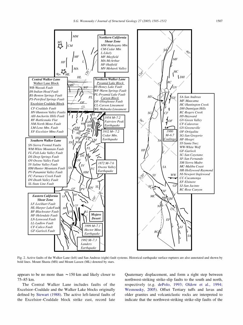
Fig. 2. Active faults of the Walker Lane (left) and San Andreas (right) fault systems. Historical earthquake surface ruptures are also annotated and shown by
bold lines. Mount Shasta (MS) and Mount Lassen (ML) denoted by stars.
S.G. Wesnousky / Journal of Structural Geology 27 (2005) 1505–1512 1507
appears to be no more than w150 km and likely closer to
75–85 km.
The Central Walker Lane includes faults of the
Excelsior–Coaldale and the Walker Lake blocks originally
defined by Stewart (1988). The active left-lateral faults of
the Excelsior–Coaldale block strike east, record late
Quaternary displacement, and form a right step between
northwest-striking strike-slip faults to the south and north,
respectively (e.g. dePolo, 1993; Oldow et al., 1994;
Wesnousky, 2005). Offset Tertiary tuffs and lavas and
older granites and volcaniclastic rocks are interpreted to
indicate that the northwest-striking strike-slip faults of the

S.G. Wesnousky / Journal of Structural Geology 27 (2005) 1505–15121508
Walker Lane block have taken up 48–60 km of right-lateral
strike-slip (Ekren et al., 1980; Ekren and Byers, 1984).
Evidence bearing on the history of slip to the north within
the northern Walker Lane and northern California shear
zone is minimal to absent. The northern Walker Lane
includes the Carson and Pyramid Lake blocks of Stewart
(1988). Similar to the region of the Excelsior–Coaldale
Block, the Carson Block is characterized by zones of east-
trending left-lateral faults and lineaments (Rogers, 1975;
Stewart, 1988). The Pyramid Lake Block is distinguished by
a left-stepping set of northwest-trending active right-lateral
strike-slip faults. Cumulative offset measurement is limited
to the conjecture of Bonham (1969) and recent work of
Faulds et al. (2003) that paleovalleys and Cenozoic tuffs are
displaced right-laterally about 25–32 km across the zone
(Stewart, 1988). I am aware of no estimates of cumulative
slip across the northern California shear zone.
Fig. 3. Decomposition of plate motion vectors into components parallel to
the average strike of the Walker Lane and Central San Andreas faults
predicts fault perpendicular components of extension and contraction along
the Walker Lane and San Andreas, respectively. Figure modified from
Bennett et al. (2003). See text for discussion.
3. Plate tectonic and geodetic considerations
Analysis of GPS and plate kinematic data by DeMets and
Dixon (1999) places the pole of Pacific–North American
plate motion at 50.58N, 248.28E with angular velocity of
0.776 MyK1. The Pacific–North American plate vector
derived from the pole is 50 mm/year at 3238 evaluated 378N
latitude and 121.758W longitude along the central San
Andreas fault (Fig. 3, upper). Bennett et al.’s (2003) recent
study provides the most complete picture of how the
displacement field is distributed across the western United
States. They and Dixon et al. (2000) conclude that the
interior region of the Sierra Nevada is acceptably described
as a rigid microblock that translates w12 mm/year oriented
3138 with respect to the Colorado Plateau and stable North
America. Bennett et al. (2003) further conclude that the
12 mm/year Sierra–Nevada vector may be divided into two
components. The first of these, primarily reflecting exten-
sion across the eastern Great Basin, is 2.8 mm/year at 2768
(Fig. 3, lower). The second includes deformation localized
within the Walker Lane and western Great Basin and is
9.3 mm/year at 3238. When decomposing this latter vector
into components parallel and perpendicular to the average
308 trend of the Walker Lane, the result shows a small
component of extension, oriented perpendicular to the main
trend of the Walker Lane (Fig. 3, lower), a result also
inherent in the recent discussion of Unruh et al. (2003). The
difference vector between the Pacific–North American and
Sierra–Nevada vectors may be similarly decomposed into
the San Andreas fault–parallel and perpendicular com-
ponents. The decomposition shows that the fault-parallel
motion of 37 mm/year is accompanied by a small
component of fault perpendicular shortening (Fig. 3,
upper). In sum, observations indicate the primarily strike-
slip fault systems of the Walker Lane and San Andreas are
transtensional and transpressional in character, respectively.
4. Discussion
The general pattern of faulting along the San Andreas
fault system is dominated by the relatively smooth and
continuous trace of the San Andreas fault. Other subsidiary
strike-slip strands such as the San Jacinto and Hayward–
Maacama fault systems are essentially interconnected,
branching-off at small angles to the San Andreas fault. In
contrast, there exists no single throughgoing strand along
the Walker Lane. Northwest-trending right-lateral strike-
slip faults that define the shear zone are discontinuous and
interrupted by zones of east-trending left-lateral faults.
Faults comprising the Walker Lane define a broader and
more diffuse pattern than the San Andreas system.
Laboratory studies show that strike-slip fault systems are
characterized by a zone of separate and distinct fault
segments during initial stages of development that ulti-
mately coalesce to take up displacement along a principal
and throughgoing fault (e.g. Wilcox et al., 1973). Prior field
observations have also shown that individual strike-slip

S.G. Wesnousky / Journal of Structural Geology 27 (2005) 1505–1512 1509
faults show a simplification of fault trace with the
accumulation of slip (Stirling et al., 1996; Wesnousky,
1988). The preceding review indicates the Walker Lane and
Eastern California Shear Zone have taken up significantly
less of the Pacific–North American plate motion than has
the San Andreas system. I suggest here that the more
complex, diffuse, and discontinuous nature of the fault
systems defining Walker Lane and Eastern California Shear
Zone is in large part due to differences in cumulative slip
registered across the zones. Another factor likely playing a
role in the greater complexity of the Walker Lane fault
system is the attendant component of extension. The pattern
of faulting observed to the west in the Basin and Range
suggests a tendency for continental extension to diffuse over
broad areas. The component of extension transverse to the
Walker Lane may thus work against the coalescence and
simplification of strike-slip deformation with continued
offset.
The small component of motion perpendicular to the
main strike-slip faults of the San Andreas and Walker Lane
is taken up on subparallel dip-slip faults. The phenomenon
was first recognized by Fitch (1972) along major subduction
zones and has been discussed in detail along the San
Andreas and western Basin and Range (Wesnousky and
Jones, 1994). In this case, the components of slip transverse
to the main trend of strike-slip structures is taken up by
thrust faulting along the San Andreas and normal faulting
within the Walker Lane (Fig. 4). An example of this
behavior along the San Andreas system is the occurrence of
the 1983 M6.5 Coalinga thrust and associated folds that
strike parallel to the adjacent central San Andreas fault
(Jones andWesnousky, 1992). In like manner, the strike-slip
trace of the 1872 M7.6 Owens Valley earthquake runs
parallel to the adjacent Sierra Nevada rangefront normal
fault (Wesnousky and Jones, 1994). Hence, the partitioning
of slip in this manner is shared by both fault systems.
The San Andreas fault along the Mojave desert in
southern California strikes more westerly than sections to
the north and south that more closely parallel the Pacific–
North America plate motion vector (Figs. 1 and 5). A large
right-step in the traces of major strike-slip faults of the
Walker Lane occurs between the Gabbs Valley Range and
Fig. 4. The oblique component of displacement along the transtensional and t
respectively, is commonly taken up locally on normal and oblique dip-slip faults
White Mountains (Fig. 5). The northwest-trending strike-
slip faults strike subparallel to the relative motion vector
between the Sierra Nevada and Central Basin and Range.
Though the sense of slip or bend differs in each area, the
geometries require that the northwest-directed shear in each
region be taken up by structures oblique to the main trend of
each fault system. Prominent to both regions are east-
trending left-lateral strike-slip faults. Crustal blocks within
southern California bounded by east-trending left-lateral
faults have undergone 35 to O608 of clockwise rotation
since the Miocene inception of the San Andreas fault system
(Luyendyk et al., 1980), and the rotation remains active
today (Jackson and Molnar, 1990; Luyendyk, 1991).
Structural and physiographic observation indicates that the
blocks bounded by east-striking left-lateral faults within the
Walker Lane step are similarly undergoing clockwise
rotation (Fig. 5); (Wesnousky, 2005). The accommodation
of right-lateral shear by clockwise vertical axis rotation
of crustal blocks where faults step or bend is a shared
feature of these zones of transtensional and transpres-
sional strike-slip, as is the development of structural
basins resulting from those rotations (e.g. see Luyendyk,
1991; Cashman and Fontaine, 2000; Wesnousky, 2005).
A large amount of the block rotation and basin
development along the San Andreas occurred in early
to middle Miocene when the San Andreas is considered
to have been a transtensional fault system (Luyendyk,
1991), like the Walker Lane is today. The Walker Lane
fault pattern within the area of Fig. 5 may be analogous
to an earlier stage in the structural development of the
San Andreas when the system was transtensional and
before sufficient slip accumulated to yield the now
throughgoing San Andreas fault.
5. Conclusion
Right-lateral transform motion due to Pacific–North
America relative plate motion is taken up in majority along
the San Andreas and Walker Lane fault systems. Cumulat-
ive lateral displacement on active strands of the San
Andreas system is 3–4 or more times greater than recorded
ranspressional strike-slip systems of the Walker Lane and San Andreas,
which trend parallel to the main zones of shear.

Fig. 5. Distribution of fault traces along sections of the central Walker Lane (upper) and southern San Andreas (lower) fault systems. Each region displays east-
striking left-slip faults and clockwise crustal rotations. The pattern of faulting within the Central Walker Lane may be analogous to an earlier stage of
development of the San Andreas system prior to accumulation of sufficient slip to produce a throughgoing San Andreas fault. Half-arrows show sense of lateral
slip and curled arrows sense of vertical crustal rotations.
S.G. Wesnousky / Journal of Structural Geology 27 (2005) 1505–15121510

S.G. Wesnousky / Journal of Structural Geology 27 (2005) 1505–1512 1511
on faults of the Walker Lane system. Additionally, the
Walker Lane fault system is transtensional and the San
Andreas fault system is transpressional. The lower cumu-
lative slip and component of extension across the Walker
Lane is manifested in a fault system that is more complex
and discontinuous than defined by the San Andreas system.
With respect to the contrasting amounts of cumulative slip,
the San Andreas may be viewed as a more structurally
mature strike-slip fault system. Despite the difference in
fault patterns, the systems also share similar behaviors.
Regions of fault bends and steps are characterized by east-
striking left-slip faults bounding crustal blocks that have
undergone clockwise rotation to produce structural basins.
The oblique component of slip along each is also locally
partitioned between subparallel strike-slip and dip-slip
faults.
Acknowledgements
I thank Jim Dolan, David Ferrill, and Bruce Luyendyk
for constructive comments. Thanks also to Kelvin
Berryman, Mark Stirling, and Terry Webb for hosting me
at IGNS in New Zealand during the final stages of
manuscript preparation. This material is based upon work
supported by the National Science Foundation under Grant
EAR-0001006. Center for Neotectonic Studies Contribution
No. 44.
References
Atwater, T., 1970. Implications of plate tectonics for the Cenozoic tectonic
evolution of western North America. Geological Society of America
Bulletin 81, 3513–3535.
Atwater, T., 1989. Plate tectonic history of the northeast Pacific and western
North America. In: Winterer, E.L., Husson, D.M., Decker, R.W. (Eds.),
The Eastern Pacific Ocean and Hawaii Geological Society of America.
The Geology of North America, Boulder, CO, pp. 21–72.
Barrows, A.G., 1974. A review of the geology and earthquake history of the
Newport–Inglewood structural zone, southern California. California
Division of Mines and Geology Special Report 114, 1–115.
Bartley, J.M., Glazner, A.F., Coleman, D.S., Kylander-Clark, R.C.,
Friederich, A.M. Large dextral offset across Owens Valley, California,
and its possible relation to tectonic uproofing of the southern Sierra
Nevada. Geological Society of America Special Paper, submitted for
publication.
Beanland, S., Clark, M., 1994. The Owens Valley fault zone, eastern
California, and surface rupture associated with the 1872 earthquake.
United States Geological Survey Bulletin 1982 1872, 1–29.
Beck Jr., M.E., 1986. Model for late Mesozoic–early Tertiary tectonics of
coastal California and western Mexico and speculations on the origin of
the San Andreas fault. Tectonics 5, 49–64.
Bennett, R.A., Wernicke, B.P., Niemi, N.A., Friederich, A.M., Davis, J.L.,
2003. Contemporary strain rates in the northern Basin and Range
province from GPS data. Tectonics 22 (0278-7407/03/C001355),
3-1–3-31.
Billingsley, P., Locke, A., 1941. Structure of ore districts in the continental
framework. Transactions of American Institute of Mining and
Metallurgical Engineers 144, 9–59.
Bonham, H.F., 1969. Geology and Mineral Depostis of Washoe and Storey
Counties, Nevada. Nevada Bureau of Mines and Geology Bulletin 70,
1–140.
Burchfiel, B.C., Hodges, K.V., Royden, L.H., 1987. Geology of the
Panamint Valley–Saline Valley pull apart system, California: palin-
spastic evidence for low angle geometry of a Neogene range-bounding
fault. Journal of Geophysical Research 92, 10422–10426.
Carr, W.J., 1984. Regional structural setting of Yucca Mountain, south-
western Nevada, and Late Cenozoic rates of tectonic activity in part of
the southwestern Great Basin, Nevada and California. US Geological
Survey Open File Report, 84-854, 109pp.
Cashman, P.H., Fontaine, S.A., 2000. Strain partitioning in the northern
Walker Lane, western Nevada and northeastern California. Tectono-
physics 326, 111–130.
DeMets, C., Dixon, T.H., 1999. New kinematic models for Pacific-North
America motion from 3 Ma to present, I: evidence for steady motion
and biases in the NUVEL-1A model. Geophysical Research Letters 26,
1921–1924.
dePolo, C.M., 1993. Contemporary tectonics, seismicity, and potential
earthquake sources in the White Mountains seismic gap, west-central
Nevada and east-central California, USA. Tectonophysics 225,
271–299.
Dillon, J.T., Ehlig, P.L., 1993. Displacement on the southern San Andreas
fault. In: Powell, R.E., Weldon, R.J.I., Matti, J.C. (Eds.), The San
Andreas Fault System: Displacement, Palinspastic Reconstruction, and
Geologic Evolution Memoir, 178. Geological Society of America,
Boulder, CO, pp. 199–216.
Dixon, T.H., Robaudo, S., Lee, J., Reheis, M.C., 1995. Constraints on
present-day Basin and Range deformation from space geodesy.
Tectonics 14 (4), 755–772.
Dixon, T.H., Miller, M., Farina, F., Wang, H., Johnson, D., 2000. Present-
day motion of the Sierra Nevada block and some tectonic implications
for the Basin and Range Province, North America Cordillera. Tectonics
1, 19–24.
Dokka, R.K., 1983. Displacements on late Cenozoic strike-slip faults of the
central Mojave Desert, California. Geology 11, 305–308.
Dokka, R.K., Travis, C.J., 1990a. Late Cenozoic strike-slip faulting in the
Mojave Desert, California. Tectonics 9, 311–340.
Dokka, R.K., Travis, C.J., 1990b. Role of the eastern California shear zone
in accommodating Pacific–North American plate motion. Geophysical
Research Letters 17 (9), 1323–1326.
Ekren, E.B., Byers Jr., F.M., 1984. The Gabbs Valley Range—a well-
exposed segment of the Walker Lane in west-central Nevada. In:
Lintz, J. (Ed.), Geological Society of America, Guidebook, Annual
Meeting Western Geologic Excursions, Reno, Nevada, 4, pp. 203–215.
Ekren, E.B., Byers Jr., F.M., Hardyman, R.F., Marvin, R.F.,
Silberman, M.L., 1980. Stratigraphy, preliminary petrology, and some
structural features of Tertiary volcanic rocks in the Gabbs Valley and
Gillis Ranges. US Geological Survey Bulletin 1464, 1–54.
Faulds, J.E., Henry, C.D., Hinz, N.H., 2003. Kinematics and cumulative
displacement across the northern Walker Lane, an incipient transform
fault, northwest Nevada and northeast California. Geological Society of
America Abstracts with Programs 35 (6), 305.
Ferguson, H.G., Muller, S.W., 1949. Structural Geology of the Hawthorne
and Tonopah quadrangles, Nevada. US Geological Survey Professional
Paper 216, 55pp.
Fitch, T.J., 1972. Plate convergence, transcurrent faults and internal
deformation adjacent to southeast Asia and the western Pacific. Journal
of Geophysical Research 77, 4432–4460.
Garfunkel, Z., 1973. History of the San Andreas fault as a plate boundary.
Geological Society of America Bulletin 84, 2035–2042.
Gianella, V.P., Callaghan, E., 1934. The earthquake of December 20, 1932,
at Cedar Mountain, Nevada and its bearing on the genesis of Basin and
Range structure. Journal of Geology 47, 1–22.
Howell, D.G., 1976. A model to accommodate 1000 kilometres of right-
slip, Neogene displacement in the southern California area. In:

S.G. Wesnousky / Journal of Structural Geology 27 (2005) 1505–15121512
Howell, D.G. (Ed.), Aspects of the Geologic History of the California
Continental Borderland Pacific Section, vol. 24. American Association
of Petroleum Geologists Miscellaneous Publication, pp. 530–540.
Jackson, J., Molnar, P., 1990. Active faulting and block rotations in the
western Transverse Ranges, California. Journal of Geophysical
Research 95, 22073–22087.
James, E.W., Kimbrough, D.L., Mattinson, J.M., 1993. Evaluation of
displacements of pre-Tertiary rocks on the northern San Andreas fault
using U–Pb zircon dating, initial SR, and common Pb isotopic ratios. In:
Powell, R.E., Weldon, R.J.I., Matti, J.C. (Eds.), The San Andreas Fault
System: Displacement, Palinspastic Reconstruction, and Geologic
Evolution Geological Society of America Memoir, Boulder, CO, vol.
178, pp. 257–271.
Jones, C.H., Wesnousky, S.G., 1992. Variation in strength and slip rate
along the San Andreas fault system. Science 256, 83–86.
Kintzer, F.C., Brooks, J.C., Cummings, J.C., 1977. An offset Miocene
shoreline: implications fo Calaveras fault movement. Geological
Society of America Abstracts with Programs 9, 65.
Kylander-Clark, R.C., Coleman, D.S., Glazner, A.F. Bartley, J.M. Evidence
for 65 km of dextral slip across Owens Valley, California. Geological
Society of American Bulletin, in press.
Lamar, D.L., 1961. Structural evolution of the Northern Margin of the Los
Angeles Basin. Unpublished PhD thesis, University of California.
Lamar, D.L., Rockwell, T.K., 1986. An overview of the tectonics of the
Elsinore fault zone. In: Ehlig, P. (Ed.), Neotectonics and Faulting in
Southern California. Cordilleran Section Field Guide. Geological
Society of America, Los Angeles, pp. 149–158.
Locke, A., Billingsley, P., Mayo, E.B., 1940. Sierra Nevada tectonic
patterns. Geological Society of America Bulletin 51, 513–540.
Luyendyk, B.P., 1991. A model for Neogene crustal rotations, transtension,
and transpression in southern California. Geological Society of
American Bulletin 103, 1528–1536.
Luyendyk, B.P., Kamerling, M.J., Terres, R., 1980. Geometric model for
Neogene crustal rotations in southern California. Geological Society of
America Bulletin 91, 211–217.
McKee, E.H., 1968. Age and rate of movement of the northern part of the
Death Valley–Furnace Creek fault zone, California. Geological Society
of America Bulletin 79, 509–512.
Minster, J.B., Jordan, T.H., 1987. Vector constraints on Western US
deformation from space geodesy, neotectonics, and plate motions.
Journal of Geophysical Research 92, 4798–4804.
Moore, J.G., Hopson, C.A., 1961. The Independence Dike swarm in Eastern
California. American Journal of Science 259, 241–259.
Mueller, K.J., 1984. Neotectonics, alluvial history, and soil chronology of
the southwestern margin of the Sierra de los Cucapas, Baja California
Norte. Unpublished MS thesis, San Diego State University.
Nielsen, R.L., 1965. Right-lateral strike-slip faulting in the Walker Lane,
west-central Nevada. Geological Society of America Bulletin 76,
1301–1308.
Oldow, J.S., Kohler, G., Donelick, R.A., 1994. Late Cenozoic extensional
transfer in the Walker Lane strike-slip belt, Nevada. Geology 22,
637–640.
Powell, R.E., Weldon, R.J.I., Matti, J.C., 1993. The San Andreas Fault
System: Displacement, Palinspastic Reconstruction, and Geologic
Evolution Memoir, vol. 178. Geological Society of America, Boulder,
CO, pp. 1–332.
Reheis, M.C., Sawyer, T.L., 1997. Late Cenozoic history and slip rates of
the Fish Lake Valley, Emigrant Peak, and Deep Springs fault zone,
Nevada and California. Geological Society of America Bulletin 109,
280–299.
Rogers, D.K., 1975. The Carson Lineament-Its influence on recent left-
lateral faulting near Carson City, Nevada. Geological Society of
America Abstracts with Programs 7, 1250.
Ross, D.C., 1962. Correlation of granitic plutons across faulted Owens
Valley, California. US Geological Survey Professional Paper 450, D86–
D88.
Sage, O.G., 1973. Paleocene geography of the Los Angeles region
Proceedings of conference on tectonic problems of San Andreas fault
system XIII. Stanford University Press, Palo Alto, pp. 348–357.
Sauber, J., Thatcher, W., Solomon, S.C., 1986. Geodetic measurements of
deformation in the central Mojave Desert, California. Journal of
Geophysical Research 91, 12661–12674.
Sharp, R.V., 1967. San Jacinto fault in the peninsular ranges of southern
California. Geological Society of America Bulletin 78, 705–730.
Stewart, J.H., 1980. Geology of Nevada. Nevada Bureau of Mines and
Geology Special Publication 4, 1–136.
Stewart, J.H., 1988. Tectonics of the Walker Lane Belt, western Great
Basin Mesozoic and Cenozoic deformation in a zone of shear. In:
Ernst, W.G. (Ed.), Metamorphism and Crustal Evolution of the
Western US, Ruby Volume VII. Prentice Hall, Englewood Cliffs, NJ,
pp. 685–713.
Stirling, M.W., Wesnousky, S.G., Shimazaki, K., 1996. Fault trace
complexity, cumulative slip, and the shape of the magnitude-frequency
distribution for strike-slip faults: a global survey. Geophysical Journal
International 124, 833–868.
Stock, J., Molnar, P., 1988. Uncertainties and implications of the Late
Cretaceous and Tertiary position of North America relative to the
Farallon, Kuyla, and Pacific plates. Tectonics 7, 1339–1384.
Thatcher, W., Foulger, G.R., Julian, B.R., Svarc, J.L., Quilty, E.,
Bawden, G.W., 1999. Present-day deformation across the Basin and
Range province, western United States. Science 283, 1714–1717.
Unruh, J., Humphrey, J., Barron, A., 2003. Transtensional model for the
Sierra Nevada frontal fault system, eastern California. Geology 31,
327–330.
Weber Jr., F.H., 1977. Seismic hazards related to geologic factors, Elsinore
and Chino fault zones, northwestern Riverside county, California.
California Division of Mines and Geology Open File Report 77-4, 1–96.
Wesnousky, S.G., 1988. Seismological and structural evolution of strike-
slip faults. Nature 335, 340–343.
Wesnousky, S.G., 2005. Active Faulting in the Walker Lane. Tectonics, 24,
doi:10.1029/2004TC001645, in press.
Wesnousky, S.G., Jones, C.H., 1994. Oblique slip, slip partitioning, spatial
and temporal changes in the regional stress field, and the relative
strength of active faults in the Basin and Range, western United States.
Geology 22, 1031–1034.
Wilcox, R.E., Harding, T.P., Seely, D.R., 1973. Basic wrench tectonics.
American Association of Petroleum Geologists Bulletin 57 (1), 74–96.