Embed Size (px)
Citation preview
Survey of Roadside Conservation Values in the Shire of Dowerin 1
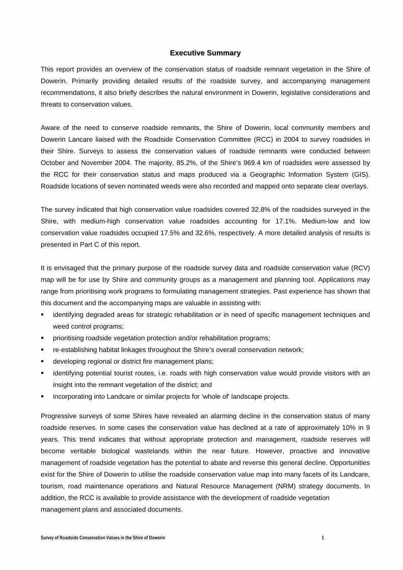
EExxeeccuuttiivvee SSuummmmaarryy
This report provides an overview of the conservation status of roadside remnant vegetation in the Shire of
Dowerin. Primarily providing detailed results of the roadside survey, and accompanying management
recommendations, it also briefly describes the natural environment in Dowerin, legislative considerations and
threats to conservation values.
Aware of the need to conserve roadside remnants, the Shire of Dowerin, local community members and
Dowerin Lancare liaised with the Roadside Conservation Committee (RCC) in 2004 to survey roadsides in
their Shire. Surveys to assess the conservation values of roadside remnants were conducted between
October and November 2004. The majority, 85.2%, of the Shire’s 969.4 km of roadsides were assessed by
the RCC for their conservation status and maps produced via a Geographic Information System (GIS).
Roadside locations of seven nominated weeds were also recorded and mapped onto separate clear overlays.
The survey indicated that high conservation value roadsides covered 32.8% of the roadsides surveyed in the
Shire, with medium-high conservation value roadsides accounting for 17.1%. Medium-low and low
conservation value roadsides occupied 17.5% and 32.6%, respectively. A more detailed analysis of results is
presented in Part C of this report.
It is envisaged that the primary purpose of the roadside survey data and roadside conservation value (RCV)
map will be for use by Shire and community groups as a management and planning tool. Applications may
range from prioritising work programs to formulating management strategies. Past experience has shown that
this document and the accompanying maps are valuable in assisting with:
identifying degraded areas for strategic rehabilitation or in need of specific management techniques and
weed control programs;
prioritising roadside vegetation protection and/or rehabilitation programs;
re-establishing habitat linkages throughout the Shire’s overall conservation network;
developing regional or district fire management plans;
identifying potential tourist routes, i.e. roads with high conservation value would provide visitors with an
insight into the remnant vegetation of the district; and
incorporating into Landcare or similar projects for 'whole of' landscape projects.
Progressive surveys of some Shires have revealed an alarming decline in the conservation status of many
roadside reserves. In some cases the conservation value has declined at a rate of approximately 10% in 9
years. This trend indicates that without appropriate protection and management, roadside reserves will
become veritable biological wastelands within the near future. However, proactive and innovative
management of roadside vegetation has the potential to abate and reverse this general decline. Opportunities
exist for the Shire of Dowerin to utilise the roadside conservation value map into many facets of its Landcare,
tourism, road maintenance operations and Natural Resource Management (NRM) strategy documents. In
addition, the RCC is available to provide assistance with the development of roadside vegetation
management plans and associated documents.

Survey of Roadside Conservation Values in the Shire of Dowerin 2
PPAARRTT AA
OOVVEERRVVIIEEWW OOFF
RROOAADDSSIIDDEE
CCOONNSSEERRVVAATTIIOONN
Survey of Roadside Conservation Values in the Shire of Dowerin 3
11..00 WWhhyy iiss RRooaaddssiiddee VVeeggeettaattiioonn IImmppoorrttaanntt??
Since the settlement of Western Australia by Europeans, large areas of native vegetation in the south west of
the state have been cleared for agriculture, roads, settlements, and other development. The fragmentation of
the more or less continuous expanse of native vegetation communities by clearing has resulted in the
isolation of plant and animal populations. This results in a mosaic of man-made biogeographical islands of
small native vegetation remnants.
The flora and fauna in these areas are severely
disadvantaged and these habitats are typically unreliable
for sustaining wildlife due to limited and scarce food
resources, increased disease risk and the reduced genetic
diversity caused by a diminishing gene pool. Some habitat
fragments may be too small to provide the requirements
for even a small population; therefore, it is essential to
their survival that they have a means of dispersing
throughout the landscape. The presence of native
vegetation along roadsides often fulfils an important role in
alleviating this isolation effect by providing connectivity
between bush remnants. While many roadside reserves
are inadequate in size to support many plant and animal
communities, they are integral in providing connections
between larger areas of potentially more suitable remnant patches. It is therefore important that all native
vegetation is protected regardless of the apparent conservation value it contains. It is important to
acknowledge that even degraded roadsides have the ability to act as
corridors for the dispersal of a variety of fauna.
Other important values of transport corridor remnants are that they:
are often the only remaining example of original vegetation within
extensively cleared areas;
often contain rare and endangered plants and animals. Currently,
roadside plants represent more than 80 per cent of the known
populations of DRF and three species are known only to exist in
roadside populations;
provide the basis for our important wildflower tourism industry. The
aesthetic appeal of well-maintained roadsides should not be
overlooked, and they have the potential to improve local tourism and
provide a sense of place;
often contain sites of Aboriginal/European historic or cultural
significance;
provide windbreaks and stock shelter areas for adjoining farmland by
helping to stabilise temperature and reduce evaporation; Flora Roads are high conservation value
roadside remnants.Photo D. Lamont.
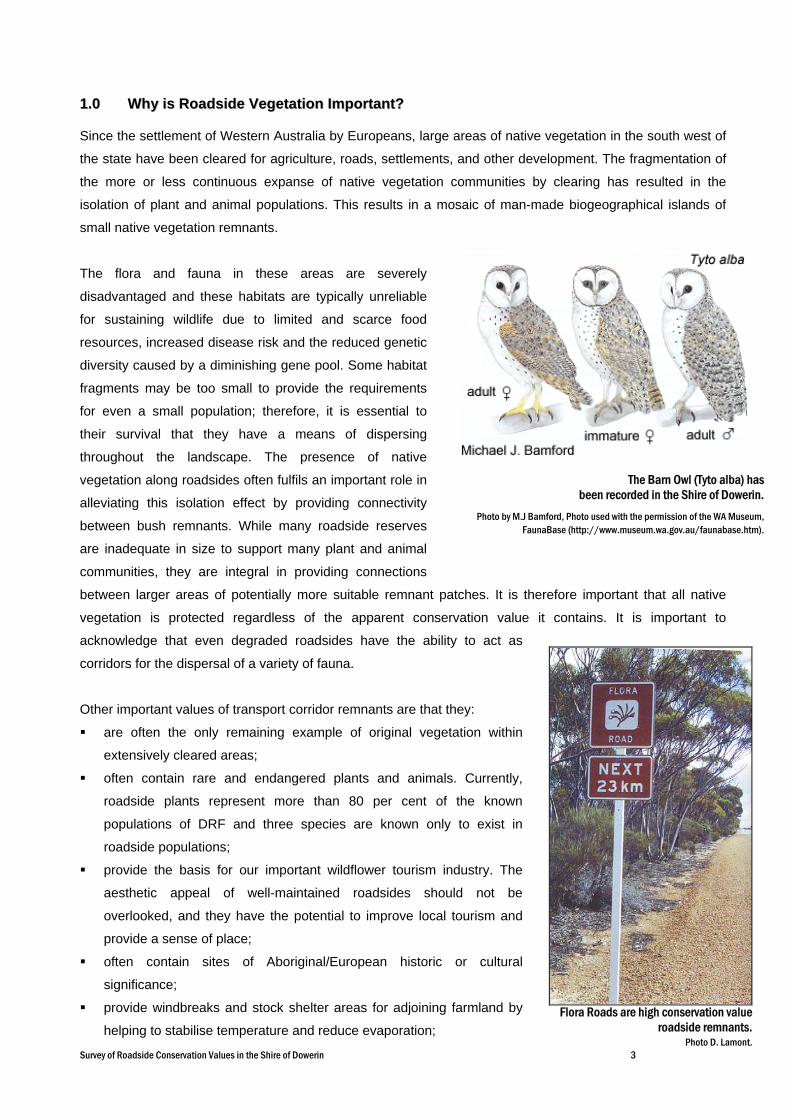
The Barn Owl (Tyto alba) has been recorded in the Shire of Dowerin.
Photo by M.J Bamford, Photo used with the permission of the WA Museum,FaunaBase (http://www.museum.wa.gov.au/faunabase.htm).

Survey of Roadside Conservation Values in the Shire of Dowerin 4
assist with erosion and salinity control, and not only in the land adjoining the road reserve; and
provide a valuable source of seed for regeneration projects. This is especially pertinent to shrub species,
as clearing and grazing beneath farm trees often removes this layer. Approval of the local Shire and a
CALM permit are required prior to collection. Guidelines for seed and timber harvesting can be found in
Appendix 6.
22..00 WWhhaatt aarree tthhee TThhrreeaattss??
2.1 Lack of Awareness
The general decline of the roadside environment can, in many instances, be attributed to the lack of
awareness of the functional and conservation value of the roadside remnants, both by the general community
and those who work in the road reserve environment. As a consequence, there is a lack of knowledge of
threatening processes (such as road maintenance and inappropriate use of fire) on the sustainability of the
roadside reserve as a fauna corridor and habitat area. This situation can therefore act as a catalyst for decline
in environmental quality.
2.2 Roadside Clearing
Western Australia’s agricultural region, also known as the Intensive Land-use Zone (ILZ), covers an area of
approximately 25,091,622 ha, of which only 29.8% is covered by the original native vegetation. Of the 87 rural
Local Government Authorities in this zone, 21 carry less than 10% of the original remnant vegetation, and a
further 30 have less than 30% (Shepherd, D.P., Beeston, G.R., and Hopkins, A.J.M. 2001).
Inappropriate road management practices, particularly the systematic and indiscriminate clearing of roadside
vegetation in some areas has caused irreversible damage and impacted enormously upon the conservation
value of roadsides in Western Australia. Clearing roadside vegetation reduces the viability of the roadside to
act as a biological corridor, the diminished habitat width impeding the movement of wildlife throughout the
surrounding landscape matrix. Roadside clearing activities have the potential to introduce and spread weeds,
due to the movement and disturbance of soil, thus competing with native vegetation residing in the roadside.
When coupled with poor site planning and preparation, road construction and maintenance projects can often
introduce and spread weeds into previously undisturbed, weed-free roadsides. Roadsides are, in many cases,
the only remaining example of remnant vegetation in agricultural areas, yet they are also at great risk due to
ongoing inappropriate clearing.
Amendments to the Environmental Protection Act 1986 have put in place a permit application process
designed to assess vegetation clearing based upon a number of clearing principles which ensure ecological,
conservation and land degradation issues are considered. Under the Act clearing native vegetation requires a
permit unless it is for exempt purposes. These amendments are design to provide improved protection for
native vegetation, maintain biodiversity and allow for some incidental clearing activities to continue, such as
day-to-day farming practices, without the need for a permit.
Survey of Roadside Conservation Values in the Shire of Dowerin 5
2.3 Fire
Although Western Australia’s flora and fauna have evolved with a tolerance to pre-European fire regimes,
these are generally not present today. Fire in transport corridors will inevitably alter the native vegetation, but
the extent of changes is dependent on a number of factors such as:
species present;
intensity of fire;
frequency of fire; and
seasonality of the fire.
The RCC’s policies on fire management are:
1. Roadside Burning should not take place without the consent of the managing authority;
2. Local Government Authorities should adopt by-laws to control roadside burning;
3. Roadside burning should be planned as part of a total Shire/area Fire Management Plan;
4. Only one side of a road should be burnt in any one year;
5. When designing a Fire Management Plan, the two principles which must be kept in mind are the
ecological management of vegetation and the abatement of fire hazard;
6. No firebreaks should be permitted within the road reserve unless the width of the roadside vegetation
strip is greater than 20m;
7. A firebreak on any road reserve should be permitted only when, in the opinion of the road manager, one
is necessary for the protection of the roadside vegetation. The road manager shall specify the maximum
width to which the break may be constructed; and
8. In the case of any dispute concerning roadside fire
management, the Bush Fires Board should be called in
to arbitrate.
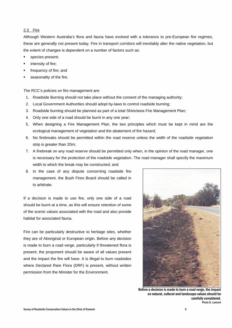
If a decision is made to use fire, only one side of a road
should be burnt at a time, as this will ensure retention of some
of the scenic values associated with the road and also provide
habitat for associated fauna.
Fire can be particularly destructive to heritage sites, whether
they are of Aboriginal or European origin. Before any decision
is made to burn a road verge, particularly if threatened flora is
present, the proponent should be aware of all values present
and the impact the fire will have. It is illegal to burn roadsides
where Declared Rare Flora (DRF) is present, without written
permission from the Minister for the Environment.
Before a decision is made to burn a road verge, the impacton natural, cultural and landscape values should be
carefully considered.Photo D. Lamont
Survey of Roadside Conservation Values in the Shire of Dowerin 6
Paterson’s curse is a widespread pasture weed that is spread by seed, making roadside populations a priority for control. Photography by R. Knox and J.Dodds. Photo used with the permission of the WA Herbarium, CALM http://florabase.calm.wa.gov.au/help/photos#reuse).
2.4 Weeds
Weeds are generally disturbance opportunists and as such
the road verge often provides a vacant niche easily colonised.
Their establishment can impinge on the survival of existing
native plants, increase flammability of the vegetation and
interfere with the engineering structure of the road. The effect
of weed infestations on native plant populations can be
severe, often with flow on effects for native fauna such as
diminished habitat or food resources.
Once weeds become established in an area, they become a
long-term management issue, costing considerable resources
to control or eradicate. The WA Herbarium records 19 weed
species in the Shire of Dowerin, see Appendix 4. The roadside
survey recorded populations of seven significant weeds, and
their locations were mapped by the RCC onto clear overlays.
The seven nominated weed groups were:
Paterson’s Curse (Echium plantagineum);
Tagasaste (Chamaecytisus palmensis);
Couch (Cynodon dactylon);
Soursob (Oxalis pes-caprae);
Sharp/Spiny rush (Juncus acutus);
Perennial Veldt Grass (Ehrharta calycina); and
African Lovegrass (Eragrostis curvula).
Roadside populations of these weeds can be observed on the
weed overlays provided with the Dowerin Roadside
Conservation Value map (2005) (Note: Soursob was not
recorded for any of the roadside surveys, and as a result no
overlay has been printed for this weed species). The
Roadside Conservation Value map and weed overlays will
assist the Shire and community in planning, budgeting and
coordinating strategic weed control projects. Further information
on the presence of these nominated weeds is presented in Part
C of this report.
African Lovegrass is an invasive weed found along roadsides and degraded land, causing major problems for road maintenance. It has been located in the Shire of Dowerin in large quantities. Photography by R. Randall. Photo used with the permission of the WA Herbarium, CALM http://florabase.calm.wa.gov.au/help/photos#reuse).
Tagasaste can be a common weed in degraded roadsides and disturbed areas, and is found throughout Dowerin. Photography by S.M. Armstrong. Photo used with the permission of the WA Herbarium, CALM http://florabase.calm.wa.gov.au/help/photos#reuse).

Survey of Roadside Conservation Values in the Shire of Dowerin 7
2.5 Salinity
Salinity is one of the greatest environmental threats facing Western Australia’s agricultural areas, with
approximately 1.8 million hectares in the south west agricultural region already affected to some degree.
Dryland salinity has occurred as a consequence of the heavy clearing undertaken in the past, namely, the
removal of perennial deep-rooted native vegetation and replacement by shallow rooted annual crop
vegetation, and the subsequent rising of the water table. The large amount of salt stored within the soil
column in these areas of Western Australia is dissolved by the rising water and carried to the surface. Once
at the surface, the water evaporates, leaving a white film of salt over the landscape, making it unproductive
for current agricultural practices, and severely impacting upon the remaining native vegetation. Without
significant changes to the current land use, it has been estimated that approximately 3 million hectares will be
affected by salinity by 2010-2015, and 6 million hectares, or 30% of the region, affected by the time a new
groundwater equilibrium is reached (Department of Agriculture WA, 2004).
The effect of salinity has not only been restricted to agriculture, but is also having a serious effect on rural
townsites and the road network. The National Land and Resources Audit (2002) warned that, across
Australia, some 19,800km of roads, 1,600km of railways and 306 towns are all at a high risk from dryland
salinity (Department of Environment and Heritage and the Department of Agriculture, Fisheries and Forestry
Australia, 2003). It has also been estimated that more than 4,000km (or 5%) of roads in the South West land
division of Western Australia are at threat of being degraded by the effects of rising water tables and salinity.
Based on figures supplied by the Department of Agriculture WA for the Salinity Investment Framework Interim
Report (2003), Table 1 shows that approximately 6.8%, or 56.9km of roads in the Shire of Dowerin are
potentially under threat from salinity.
Roads potentially affected by salinity - length in km Shire
Total road length
assessed (km)
Highways Local roads Main roads Other roads Total affected
% of total potentially
affected
Dowerin 831.41 39.83 1.75 15.33 56.90 6.84% Wongan-Ballidu 1,396.91 127.10 5.78 42.85 175.73 12.58 Koorda 908.40 53.30 14.90 68.20 7.51 Wyalkatchem 784.11 24.43 0.23 11.98 36.63 4.67 Cunderdin 797.55 4.63 38.28 15.65 58.55 7.34 Northam 23.97 0.38 0.55 0.93 3.86
Table 1. Road lengths potentially affected by salinity in the Shires of Dowerin, Wongan-Ballidu, Koorda, Wyalkatchem, Cunderdin and Northam. Adapted from material produced by the Department of Agriculture WA for Department of Environment 2003, Salinity Investment Framework Interim Report - Phase 1, 2003, Department of Environment, Salinity and Land Use Impacts Series No. SLUI 32

Survey of Roadside Conservation Values in the Shire of Dowerin 8
33..00 LLeeggiissllaattiivvee RReeqquuiirreemmeennttss Uncertainty often exists in the minds of many with regard to the ‘ownership’, control and management of 'the
roadside'. This problem is also exacerbated by the multitude of legislative reference to activities within a
transport corridor.
The Department of Conservation and Land Management (CALM) has the legislative responsibility to manage
and protect all native flora and fauna in Western Australia. It is important to note that all native flora and
fauna is protected under provisions of the Wildlife Conservation Act 1950, and cannot be taken unless it is
taken in a lawful manner. In addition to the general provisions relating to protected flora under the Wildlife
Conservation Act, special protection is afforded to flora that is declared as rare or threatened under section
23F of the Wildlife Conservation Act.
The legislation pertaining to the management of road reserves is complex and includes those listed below.
State legislation: - Aboriginal Heritage Act 1972
- Agriculture and Related Resources Protection Act 1976
- Bush Fires Act 1954
- Conservation and Land Management Act 1984
- Environmental Protection Act 1986
- Heritage of WA Act 1990
- Land Act 1933
- Local Government Act 1995
- Main Roads Act 1930
- Mining Act 1978
- Soil and Land Conservation Act 1945
- State Energy Commission Supply Act 1979
- Water Authority Act 1987
- Wildlife Conservation Act 1950-1979
Commonwealth legislation: - Environment Protection and Biodiversity Conservation Act 1999
New legalisation has been introduced under the Environmental Protection Act 1986 which specify that all
clearing of native vegetation require a permit, unless it is for an exempt purpose. The Environmental
Protection (Clearing of Native Vegetation) Regulations 2004 provide an outline of these exemptions. Clearing
applications are assessed against twelve clearing principles, which look at values such as:
biological value of the remnant vegetation;
potential impact on wetlands and drainage;
existence of rare flora and threatened ecological communities; and
likely land degradation impacts.
Survey of Roadside Conservation Values in the Shire of Dowerin 9
This assessment process is designed to provide a more comprehensive and stringent land clearing control
system. There are two land clearing permits available, an area permit and a purpose permit. Where clearing
is for a once-off clearing event such as pasture clearing or an agricultural development for example, an area
permit is required. Where ongoing clearing is necessary as part of a maintenance program for road or railway
reserves for example, a purpose permit is needed. In the case of Shire road construction and maintenance
activities, clearing is allowed to occur if it is to the width and height previously cleared for that purpose. The
exceptions for maintenance work will expire on 7th July 2006. Contact the Department of Environment’s
Native Vegetation Protection Team for advice on the situation following this date.
It is recommended that a cautionary approach be taken when working within roadsides, and that the relevant
authority be contacted if there is any doubt about the management or protection of heritage or conservation
values present in the roadsides.
44..00 EEnnvviirroonnmmeennttaallllyy SSeennssiittiivvee AArreeaass
An Environmentally Sensitive Area (ESA) is a section of roadside that requires special protection for the
following reasons:
protection of rare or threatened species of native plants;
protection of sites that have other high conservation, scientific or aesthetic values; and
protection of Aboriginal or European cultural sites.
Environmentally Sensitive Areas can be delineated by the use of site markers. See the RCC publication
Guidelines for Managing Special Environmental Areas in Transport Corridors for design and placement of
ESA markers. Workers who come across an ‘Environmentally Sensitive Area’ marker in the field should not
disturb the area between the markers unless specifically instructed. If in doubt, the Works Supervisor, Shire
Engineer or CEO should be contacted. Western Power and West Net rail also have systems for marking sites
near power or rail lines.
To ensure that knowledge of rare flora and other sites
does not get lost due, perhaps, to staff changes, the
Local Authority should establish an Environmentally
Sensitive Area Register. This should outline any
special treatment, which the site should receive. The
Environmentally Sensitive Area Register should be
consulted by the appropriate person prior to work
commencing on any particular road. This will ensure
that inadvertent damage does not occur.
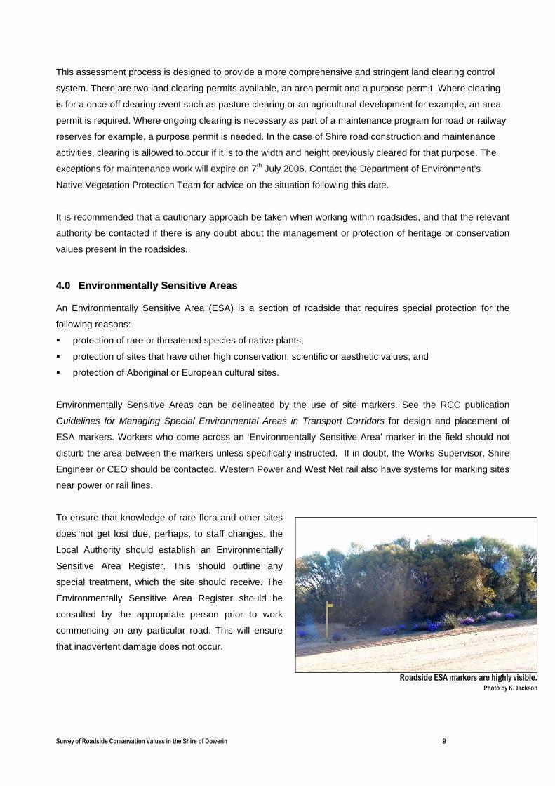
Roadside ESA markers are highly visible.Photo by K. Jackson
Survey of Roadside Conservation Values in the Shire of Dowerin 10
Right: The RCC has assisted local communities toproduce wildflower drive pamphlets.
Local Government is encouraged to permanently mark Environmentally Sensitive Areas to prevent
inadvertent or inappropriate damage to the rare flora or other values being protected. Markers of a uniform
shape and colour will make recognition easier for other authorities using road reserves. Information about
markers is available from the Roadside Conservation Committee.
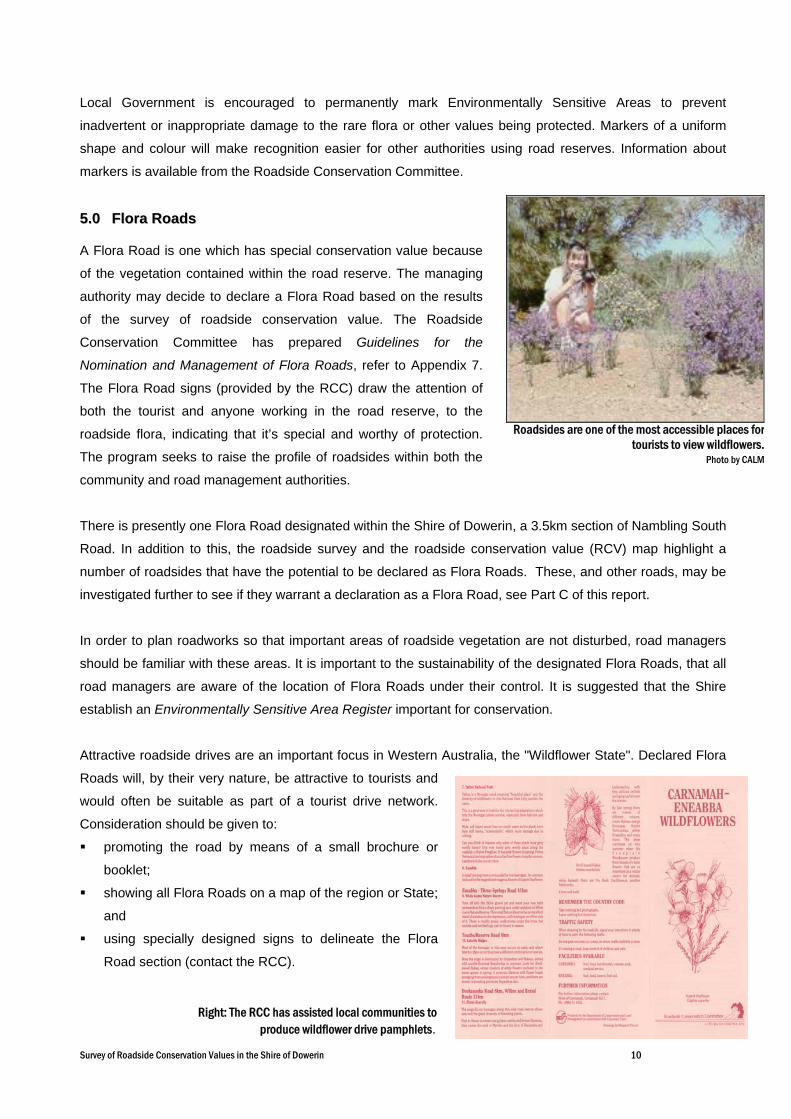
55..00 FFlloorraa RRooaaddss
A Flora Road is one which has special conservation value because
of the vegetation contained within the road reserve. The managing
authority may decide to declare a Flora Road based on the results
of the survey of roadside conservation value. The Roadside
Conservation Committee has prepared Guidelines for the
Nomination and Management of Flora Roads, refer to Appendix 7.
The Flora Road signs (provided by the RCC) draw the attention of
both the tourist and anyone working in the road reserve, to the
roadside flora, indicating that it’s special and worthy of protection.
The program seeks to raise the profile of roadsides within both the
community and road management authorities.
There is presently one Flora Road designated within the Shire of Dowerin, a 3.5km section of Nambling South
Road. In addition to this, the roadside survey and the roadside conservation value (RCV) map highlight a
number of roadsides that have the potential to be declared as Flora Roads. These, and other roads, may be
investigated further to see if they warrant a declaration as a Flora Road, see Part C of this report.
In order to plan roadworks so that important areas of roadside vegetation are not disturbed, road managers
should be familiar with these areas. It is important to the sustainability of the designated Flora Roads, that all
road managers are aware of the location of Flora Roads under their control. It is suggested that the Shire
establish an Environmentally Sensitive Area Register important for conservation.
Attractive roadside drives are an important focus in Western Australia, the "Wildflower State". Declared Flora
Roads will, by their very nature, be attractive to tourists and
would often be suitable as part of a tourist drive network.
Consideration should be given to:
promoting the road by means of a small brochure or
booklet;
showing all Flora Roads on a map of the region or State;
and
using specially designed signs to delineate the Flora
Road section (contact the RCC).
Roadsides are one of the most accessible places fortourists to view wildflowers.
Photo by CALM
Survey of Roadside Conservation Values in the Shire of Dowerin 11
PPAARRTT BB
TThhee NNaattuurraall
EEnnvviirroonnmmeenntt iinn
DDoowweerriinn

Survey of Roadside Conservation Values in the Shire of Dowerin 12
11..00 FFlloorraa
On a global scale, Western Australia has almost ten times the amount of vascular plant varieties than
countries such as Great Britain. In fact Western Australia has some 4.8% of the 250,000 known vascular flora
present on Earth. The Western Australian flora is also unique, with the majority of species being endemic, that
is, found nowhere else in the world. Up to 75% of the 6,000 species in the South West are endemic.
The WA Herbarium lists over 457 species
of plants present in the Shire of Dowerin.
The most prolific genus are Acacia 43 spp,
Eucalyptus 38 spp, Verticordia 18 spp,
Grevillea 17 spp, Melaleuca 16 spp,
Caladenia 13 spp and Daviesia 10 spp. The
complete list of recorded flora can bee seen
in Appendix 4 of this report.
22..00 DDeeccllaarreedd RRaarree FFlloorraa ((DDRRFF))
Declared Rare Flora (DRF) species, or
populations, are of great conservation
significance and should therefore be treated
with special care when road and utility
service, construction or maintenance is
undertaken. Populations of DRF along roadsides are designated Environmentally Sensitive Areas (ESA's)
and are usually delineated by yellow stakes with an identification plate welded on. It is suggested that the
RCC publication Guidelines for Managing Special Environmental Areas in Transport Corridors is used as a
guideline for managing these sites. It is the responsibility of the road manager to ensure these markers are
installed, and guides for this are available from the Roadside Conservation Committee. For information
regarding DRF, contact the CALM Flora Officer for the Merredin District. If roadworks are to be carried out
near DRF sites, it is advisable to contact CALM at least six weeks in advance.
Currently (as at August 2005), 9 locations of declared rare and
priority flora are known to occur within roadsides in the Shire of
Dowerin. All 9 of these sites are road verges vested in the Shire.
In total, there are five species of declared rare and priority flora on
roadsides in the Shire, these include:
Hughan's Featherflower is a declared rare native plant endemic to the Shires of Dowerin and Goomaling. Photography by M. Hancock,and S.F. Patrick. Photo used with the permission of the WA Herbarium, CALM http://florabase.calm.wa.gov.au/help/photos#reuse
Declared Rare Flora (DRF) sites should be clearlymarked with these yellow posts.
Photo K. Jackson.
Survey of Roadside Conservation Values in the Shire of Dowerin 13
Eucalyptus recta
Eucalyptus subangusta subsp. virescens
Daviesia euphorbioides
Grevillea rosieri
Leucopogon sp. Bungulla (R.D. Royce 3435)
Note: this information may have changed since the time of this report’s release; therefore it is important to
contact the relevant CALM District office or Wildlife Branch in Kensington for the most recent information.
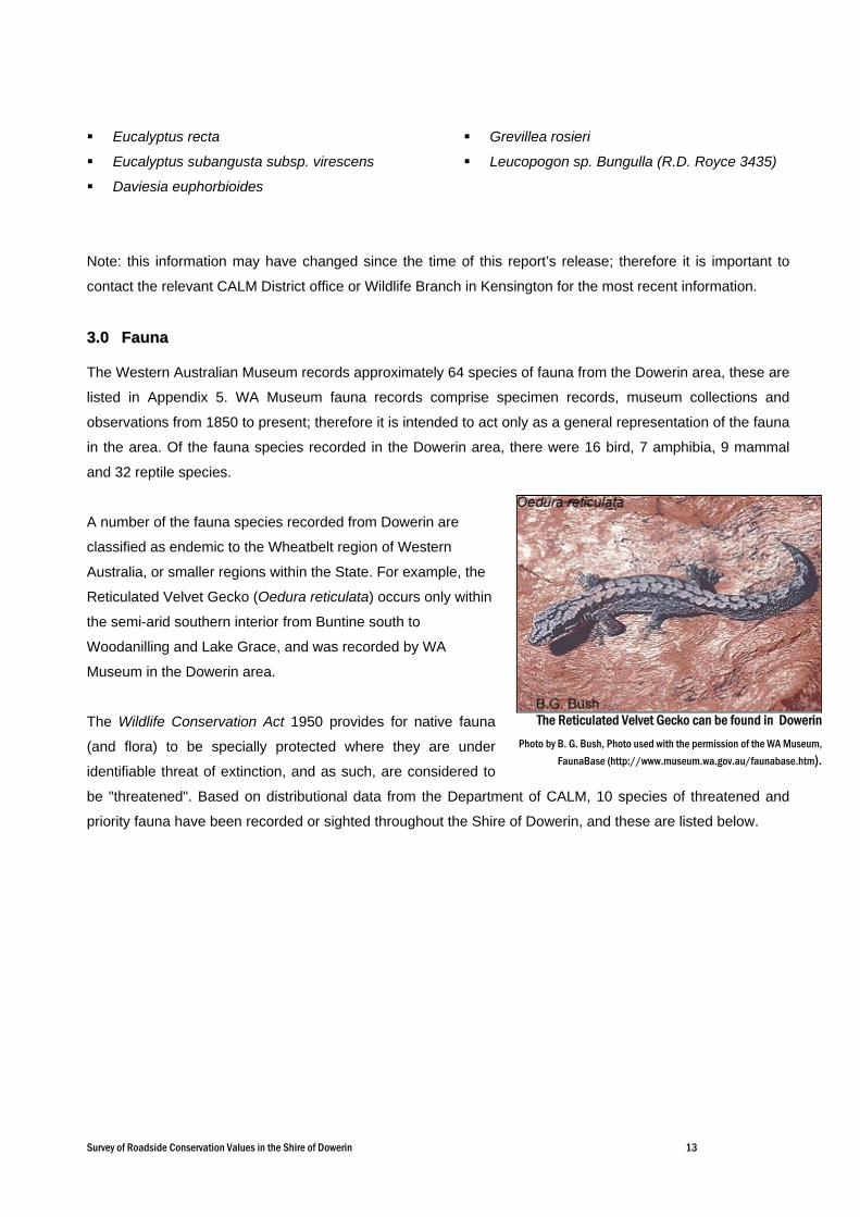
33..00 FFaauunnaa
The Western Australian Museum records approximately 64 species of fauna from the Dowerin area, these are
listed in Appendix 5. WA Museum fauna records comprise specimen records, museum collections and
observations from 1850 to present; therefore it is intended to act only as a general representation of the fauna
in the area. Of the fauna species recorded in the Dowerin area, there were 16 bird, 7 amphibia, 9 mammal
and 32 reptile species.
A number of the fauna species recorded from Dowerin are
classified as endemic to the Wheatbelt region of Western
Australia, or smaller regions within the State. For example, the
Reticulated Velvet Gecko (Oedura reticulata) occurs only within
the semi-arid southern interior from Buntine south to
Woodanilling and Lake Grace, and was recorded by WA
Museum in the Dowerin area.
The Wildlife Conservation Act 1950 provides for native fauna
(and flora) to be specially protected where they are under
identifiable threat of extinction, and as such, are considered to
be "threatened". Based on distributional data from the Department of CALM, 10 species of threatened and
priority fauna have been recorded or sighted throughout the Shire of Dowerin, and these are listed below.
The Reticulated Velvet Gecko can be found in DowerinPhoto by B. G. Bush, Photo used with the permission of the WA Museum,
FaunaBase (http://www.museum.wa.gov.au/faunabase.htm).

Survey of Roadside Conservation Values in the Shire of Dowerin 14
Chuditch (Dasyurus geoffroii) This carnivorous marsupial occupies large home ranges, is highly mobile and appears able to utilise bush
remnants and corridors.
Carnaby's Black-Cockatoo (Calyptorhynchus latirostris) This species moves around seasonally in flocks to feeding areas in proteaceous scrubs and heaths and
eucalypt woodlands as well as pine plantations. Breeding occurs in winter/spring, mainly in the eastern forests
and Wheatbelt where they can find mature hollow-bearing trees to nest in.
Western Spiny-tailed Skink (Egernia stokesii badia) This species occurs in semi-arid scrubs and woodlands of Shark Bay and the northern Wheatbelt, sheltering
in hollow logs and behind bark of fallen trees.
Shield-backed Trapdoor Spider (Idiosoma nigrum) This species is in decline in its patchy distribution through the
northern and central Wheatbelt and coastal plain. It is a long-lived
species that is very sensitive to disturbance.
Minnivale Trapdoor Spider (Teyl sp) This species is only known from a few locations.
Peregrine Falcon (Falco peregrinus) This species is uncommon and prefers areas with rocky ledges,
cliffs, watercourses, open woodland or margins with cleared land.
Shy Heathwren (western spp) (Hylacola cauta whitlocki) This species is an uncommon resident in mallee undergrowth.
Crested Bellbird (southern) (Oreoica gutturalis gutturalis) This sedentary and solitary species inhabits the drier mallee
woodlands and heaths of the southern parts of the State.
White-browed Babbler (Pomatostomus superciliosus
ashbyi) This species of bird lives in eucalypt forests and woodlands, and forages on or near the ground for insects
and seeds.
Quenda (Isoodon obesulus fusciventer) This species prefers areas with dense understorey vegetation, particularly around swamps and along
watercourses, that provides ample protection from predators.
Many fauna species, particularly small birds need continuous corridors of dense vegetation to move
throughout the landscape. Roadsides therefore are of particular importance to this avifauna because they
usually contain the only continuous linear vegetation connection in some areas.
The quenda has been found in the Shire of
Dowerin.Information from Mammals of the South-West by Brent
Johnson Brown and Carolyn Thomson. Available at;www.margaret-river-online.com.au

Survey of Roadside Conservation Values in the Shire of Dowerin 15
44..00 RReemmnnaanntt VVeeggeettaattiioonn CCoovveerr
Only 4.3% of the original native vegetation remains in the Shire of Dowerin, and this is located in a variety of
tenures from nature reserves to privately owned land. National Objectives and Targets for Biodiversity
Conservation 2001-2005 (Environment Australia, 2001) stated that vegetation types represented by less than
30% are considered ecologically endangered and in need of protection and restoration wherever they are
located. With less than 5% vegetation cover remaining in Dowerin, this is extremely low, and this problem is
magnified when considering the surrounding Shires, which also show similar low percentages of remaining
vegetation cover. What is left of these remnants can, and will easily be depleted if proactive measures are not
taken to manage this priceless resource for future generations.
Table 2. Remnant vegetation remaining in agricultural areas of Dowerin and surrounding Shires (Shepherd, Beeston and Hopkins, 2001).
The continued presence of the flora and fauna living in these fragmented
remnants is dependant on the connectivity throughout the landscape.
This enables access to habitat and food resources essential for the
survival of species and the overall biodiversity of the region. In many
situations remnant native vegetation in transport corridors is of vital
importance as it provides the only continuous link throughout the
landscape.
Vegetation Cover Remaining (inside clearing line)
Shire Total Area (ha)
Area inside Clearing Line (ha) (ha) (%)
Dowerin 188,786 188,786 8,055 4.3
Wongan-Ballidu 333,908 333,908 17,454 5.2
Koorda 283,746 266,057 21,537 8.1
Wyalkatchem 158,004 158,004 7,814 4.9
Cunderdin 188,696 188,696 3,312 1.8
Northam 141,410 141,410 31,229 22.1
Goomalling 185,768 185,768 8,559 4.6
Tree hollows are of vital importance tobreeding birds.
Photo by L. McMahon, Birds Australia
Survey of Roadside Conservation Values in the Shire of Dowerin 16
PPAARRTT CC
RROOAADDSSIIDDEE
SSUURRVVEEYYSS IINN TTHHEE
SSHHIIRREE OOFF DDOOWWEERRIINN

Survey of Roadside Conservation Values in the Shire of Dowerin 17
11..00 IInnttrroodduuccttiioonn
The roadside survey and mapping program was developed to provide a method of readily determining the
conservation status of roadsides. Using this method, community volunteers are able to participate in a ‘snap-
shot’ survey of roadside vegetation to identify a range of attributes that, when combined, give an overall
indication of the conservation status of the vegetation.
The majority (826.0km, or 85.2%) of the Shire of Dowerin’s 969.4km of roads were surveyed and then
assessed to determine the conservation status of the road reserves. Fieldwork was carried out throughout the
months of October and November 2004. The enthusiastic efforts of the volunteer roadside surveyors and the
support provided by Council and Shire staff ensured that this project was successfully completed. The
roadside surveyors were:
Vanessa Malcolm Beth Boase Robert Boase Ron Larkin Debbie Larkin
Janelle Robinson Kerry Robinson Elaine Podmore Anne Robson Erin Slater
11..11 MMeetthhooddss
Roadside surveys were undertaken in a vehicle, with two or three people per vehicle. The passenger
recorded all the roadside survey data using the RCC’s iPAQ personal computers and, when these were not
available, used the standard paper survey sheets shown in Appendix 1. At the end of the survey, the iPAQs
and survey sheets were sent back to the RCC for analysis and mapping.
The methods to assess and calculate the conservation value of the roadside reserves are described in
Assessing Roadsides: A guide for Rating Conservation Value (Jackson, 2002). The process involves scoring
a set of pre-selected attributes, which, when combined, represent a roadside's conservation status. A list of
these attributes is presented on a standard survey sheet in Appendix 1. This provides both a convenient and
uniform method of scoring.
The following 6 attributes were used to produce a quantitative measure of conservation value:
structure of native vegetation on roadside;
extent of native vegetation along roadside;
number of native species;
level of weed infestation;
value as a biological corridor; and
predominant adjoining land use.
Each of these 6 attributes was given a score ranging from 0 to 2 points. Their combined scores provided a
conservation value score ranging from 0 to 12. The conservation values, in the form of conservation status
categories, are represented on the roadside conservation value map by the following colour codes.
Conservation Value Conservation Status Colour Code 9 – 12 High Dark Green
7 – 8 Medium High Light Green
5 – 6 Medium Low Dark Yellow
0 – 4 Low Light Yellow
Survey of Roadside Conservation Values in the Shire of Dowerin 18
The following attributes were also noted but did not contribute to the conservation value score:
• width of road reserve;
• width of vegetated roadside;
• presence of utilities/disturbances;
• general comments; and
• presence of 7 nominated weeds.
It is felt that the recording of these attributes will provide a dataset capable of being used by a broad range of
community land management interests.
11..22 MMaappppiinngg RRooaaddssiiddee CCoonnsseerrvvaattiioonn VVaalluueess
The RCC produced a computer-generated map (using a Geographic Information System, or GIS), at a scale
of 1:100,000 for the Shire of Dowerin. Known as the Roadside Conservation Value (RCV) map, it depicts the
conservation status of the roadside vegetation and the width of the road reserves within the Shire of Dowerin.
The data used to produce both the map and the following figures and tables are presented in Appendix 2.
Road names and lengths information can be found in Appendix 3.
Digital information was obtained from the Department of CALM, Main Roads WA and the Department of
Agriculture WA and used in the map, depicting the location of remnant vegetation on both the Crown estate
and privately owned land. Watercourses are also depicted on the RCV map.
11..33 RRooaaddssiiddee CCoonnsseerrvvaattiioonn VVaalluuee CCaatteeggoorriieess
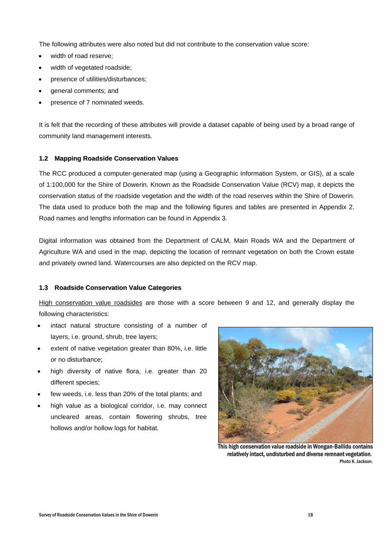
High conservation value roadsides are those with a score between 9 and 12, and generally display the
following characteristics:
• intact natural structure consisting of a number of
layers, i.e. ground, shrub, tree layers;
• extent of native vegetation greater than 80%, i.e. little
or no disturbance;
• high diversity of native flora, i.e. greater than 20
different species;
• few weeds, i.e. less than 20% of the total plants; and
• high value as a biological corridor, i.e. may connect
uncleared areas, contain flowering shrubs, tree
hollows and/or hollow logs for habitat.
This high conservation value roadside in Wongan-Ballidu containsrelatively intact, undisturbed and diverse remnant vegetation.
Photo K. Jackson.
Survey of Roadside Conservation Values in the Shire of Dowerin 19
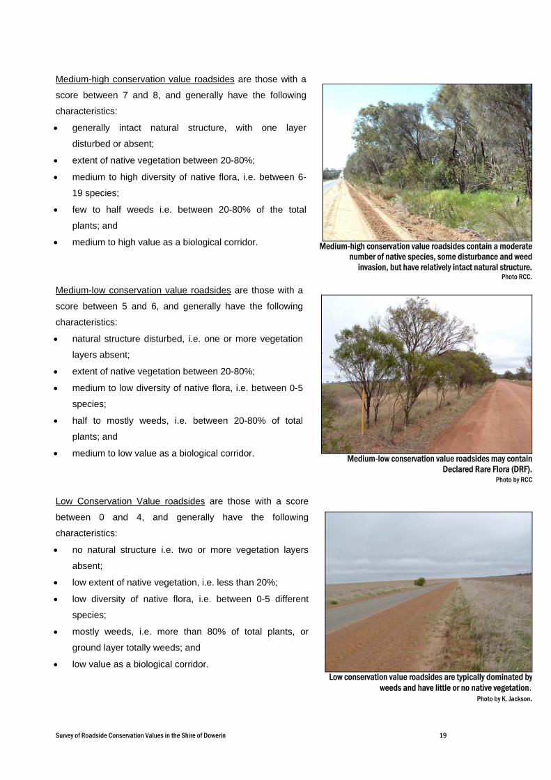
Medium-high conservation value roadsides contain a moderatenumber of native species, some disturbance and weed
invasion, but have relatively intact natural structure.Photo RCC.
Medium-high conservation value roadsides are those with a
score between 7 and 8, and generally have the following
characteristics:
• generally intact natural structure, with one layer
disturbed or absent;
• extent of native vegetation between 20-80%;
• medium to high diversity of native flora, i.e. between 6-
19 species;
• few to half weeds i.e. between 20-80% of the total
plants; and
• medium to high value as a biological corridor.
Medium-low conservation value roadsides are those with a
score between 5 and 6, and generally have the following
characteristics:
• natural structure disturbed, i.e. one or more vegetation
layers absent;
• extent of native vegetation between 20-80%;
• medium to low diversity of native flora, i.e. between 0-5
species;
• half to mostly weeds, i.e. between 20-80% of total
plants; and
• medium to low value as a biological corridor.
Low Conservation Value roadsides are those with a score
between 0 and 4, and generally have the following
characteristics:
• no natural structure i.e. two or more vegetation layers
absent;
• low extent of native vegetation, i.e. less than 20%;
• low diversity of native flora, i.e. between 0-5 different
species;
• mostly weeds, i.e. more than 80% of total plants, or
ground layer totally weeds; and
• low value as a biological corridor.
Low conservation value roadsides are typically dominated byweeds and have little or no native vegetation.
Photo by K. Jackson.
Medium-low conservation value roadsides may containDeclared Rare Flora (DRF).
Photo by RCC

Survey of Roadside Conservation Values in the Shire of Dowerin 20
22..00 UUSSIINNGG TTHHEE RRCCVV MMAAPP
The RCV map initially provides an inventory of the condition of the roadside vegetation. This is important as
the quality of roadside vegetation has far reaching implications for sustaining biodiversity, tourism and
Landcare values.
Moreover, the data and map can be incorporated as a management and planning tool for managing the
roadsides, as it enables the condition of roadside vegetation to be easily assessed. This information can then
be used to identify environmentally sensitive areas, high conservation roadsides or strategically important
areas, and thus ensure their conservation. Conversely, it enables degraded areas to be identified as areas
important for strategic rehabilitation or in need of specific management techniques and weed control
programs.
The map can also be used as a
reference to overlay
transparencies of other
information relevant to roadside
conservation. This enables the
roadside vegetation to be
assessed in the context of its
importance to the Shire’s overall
conservation network. Other
overlays, such as the degree of
weed infestation, or the location of
Environmentally Sensitive Areas
or future planned developments,
could also be produced as an aid
to roadside management.
The RCV map depicts roadside conservation values in the Shire of Dowerin.
Survey of Roadside Conservation Values in the Shire of Dowerin 21
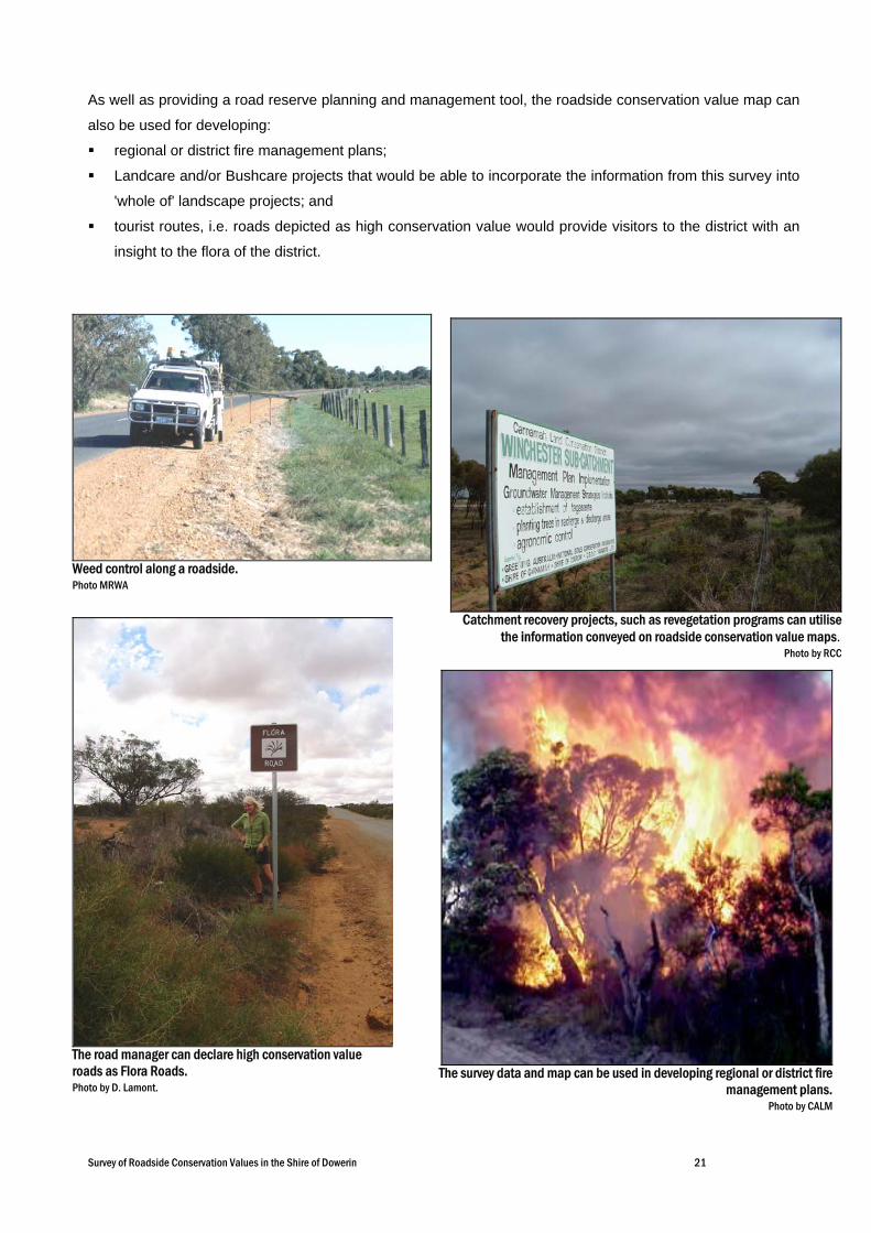
As well as providing a road reserve planning and management tool, the roadside conservation value map can
also be used for developing:
regional or district fire management plans;
Landcare and/or Bushcare projects that would be able to incorporate the information from this survey into
'whole of' landscape projects; and
tourist routes, i.e. roads depicted as high conservation value would provide visitors to the district with an
insight to the flora of the district.
Weed control along a roadside. Photo MRWA
Catchment recovery projects, such as revegetation programs can utilisethe information conveyed on roadside conservation value maps.
Photo by RCC
The survey data and map can be used in developing regional or district firemanagement plans.
Photo by CALM
The road manager can declare high conservation value roads as Flora Roads. Photo by D. Lamont.
Survey of Roadside Conservation Values in the Shire of Dowerin 22
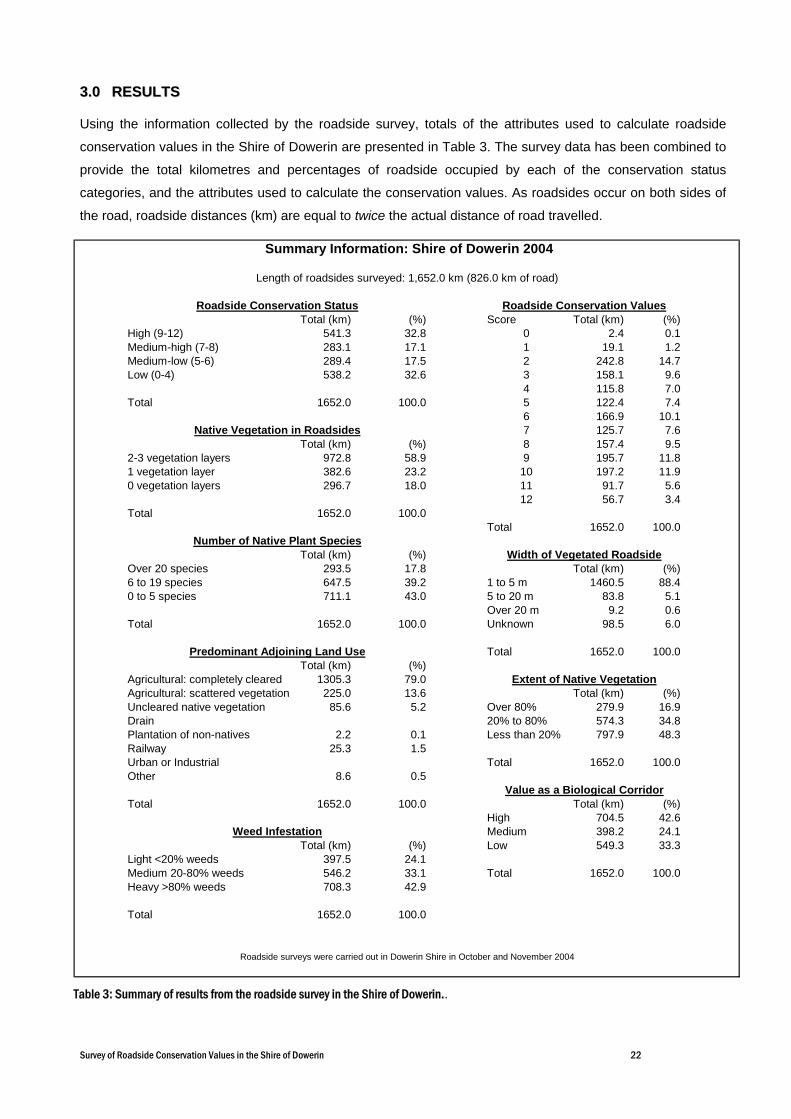
33..00 RREESSUULLTTSS
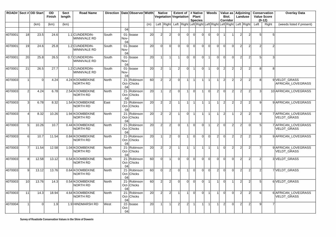
Using the information collected by the roadside survey, totals of the attributes used to calculate roadside
conservation values in the Shire of Dowerin are presented in Table 3. The survey data has been combined to
provide the total kilometres and percentages of roadside occupied by each of the conservation status
categories, and the attributes used to calculate the conservation values. As roadsides occur on both sides of
the road, roadside distances (km) are equal to twice the actual distance of road travelled.
Total (km) (%) Score Total (km) (%)High (9-12) 541.3 32.8 0 2.4 0.1Medium-high (7-8) 283.1 17.1 1 19.1 1.2Medium-low (5-6) 289.4 17.5 2 242.8 14.7Low (0-4) 538.2 32.6 3 158.1 9.6
4 115.8 7.0Total 1652.0 100.0 5 122.4 7.4
6 166.9 10.17 125.7 7.6
Total (km) (%) 8 157.4 9.52-3 vegetation layers 972.8 58.9 9 195.7 11.81 vegetation layer 382.6 23.2 10 197.2 11.90 vegetation layers 296.7 18.0 11 91.7 5.6
12 56.7 3.4Total 1652.0 100.0
Total 1652.0 100.0
Total (km) (%)Over 20 species 293.5 17.8 Total (km) (%)6 to 19 species 647.5 39.2 1 to 5 m 1460.5 88.40 to 5 species 711.1 43.0 5 to 20 m 83.8 5.1
Over 20 m 9.2 0.6Total 1652.0 100.0 Unknown 98.5 6.0
Total 1652.0 100.0Total (km) (%)
Agricultural: completely cleared 1305.3 79.0Agricultural: scattered vegetation 225.0 13.6 Total (km) (%)Uncleared native vegetation 85.6 5.2 Over 80% 279.9 16.9Drain 20% to 80% 574.3 34.8Plantation of non-natives 2.2 0.1 Less than 20% 797.9 48.3Railway 25.3 1.5Urban or Industrial Total 1652.0 100.0Other 8.6 0.5
Total 1652.0 100.0 Total (km) (%)High 704.5 42.6Medium 398.2 24.1
Total (km) (%) Low 549.3 33.3Light <20% weeds 397.5 24.1Medium 20-80% weeds 546.2 33.1 Total 1652.0 100.0Heavy >80% weeds 708.3 42.9
Total 1652.0 100.0
Summary Information: Shire of Dowerin 2004
Length of roadsides surveyed: 1,652.0 km (826.0 km of road)
Roadside Conservation Status Roadside Conservation Values
Weed Infestation
Roadside surveys were carried out in Dowerin Shire in October and November 2004
Native Vegetation in Roadsides
Number of Native Plant SpeciesWidth of Vegetated Roadside
Predominant Adjoining Land Use
Extent of Native Vegetation
Value as a Biological Corridor
Table 3: Summary of results from the roadside survey in the Shire of Dowerin..
Survey of Roadside Conservation Values in the Shire of Dowerin 23
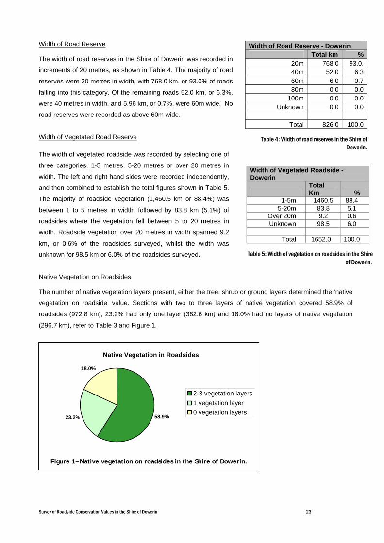
Width of Road Reserve
The width of road reserves in the Shire of Dowerin was recorded in
increments of 20 metres, as shown in Table 4. The majority of road
reserves were 20 metres in width, with 768.0 km, or 93.0% of roads
falling into this category. Of the remaining roads 52.0 km, or 6.3%,
were 40 metres in width, and 5.96 km, or 0.7%, were 60m wide. No
road reserves were recorded as above 60m wide.
Width of Vegetated Road Reserve
The width of vegetated roadside was recorded by selecting one of
three categories, 1-5 metres, 5-20 metres or over 20 metres in
width. The left and right hand sides were recorded independently,
and then combined to establish the total figures shown in Table 5.
The majority of roadside vegetation (1,460.5 km or 88.4%) was
between 1 to 5 metres in width, followed by 83.8 km (5.1%) of
roadsides where the vegetation fell between 5 to 20 metres in
width. Roadside vegetation over 20 metres in width spanned 9.2
km, or 0.6% of the roadsides surveyed, whilst the width was
unknown for 98.5 km or 6.0% of the roadsides surveyed.
Native Vegetation on Roadsides
The number of native vegetation layers present, either the tree, shrub or ground layers determined the ‘native
vegetation on roadside’ value. Sections with two to three layers of native vegetation covered 58.9% of
roadsides (972.8 km), 23.2% had only one layer (382.6 km) and 18.0% had no layers of native vegetation
(296.7 km), refer to Table 3 and Figure 1.
Native Vegetation in Roadsides
58.9%23.2%
18.0%
2-3 vegetation layers1 vegetation layer0 vegetation layers
Figure 1– Native vegetation on roadsides in the Shire of Dowerin.
Width of Road Reserve - Dowerin Total km %
20m 768.0 93.0.40m 52.0 6.360m 6.0 0.780m 0.0 0.0
100m 0.0 0.0Unknown 0.0 0.0
Total 826.0 100.0
Table 4: Width of road reserves in the Shire of
Dowerin.
Width of Vegetated Roadside - Dowerin
Total Km %
1-5m 1460.5 88.4 5-20m 83.8 5.1
Over 20m 9.2 0.6 Unknown 98.5 6.0
Total 1652.0 100.0
Table 5: Width of vegetation on roadsides in the Shire
of Dowerin.

Survey of Roadside Conservation Values in the Shire of Dowerin 24
Number of Native Plant Species
The ‘number of native plant species’ score provided a measure of the diversity of the roadside vegetation.
Survey sections with more than 20 plant species spanned 17.8% (293.5 km) of the roadsides surveyed.
Roadside sections with 6 to 19 plant species accounted for 39.2% (647.5 km) of the roadside. The remaining
43.0% (711.1 km) contained less than 5 plant species, refer to Table 3 and Figure 2.
Extent of Native Vegetation
The ‘extent of native vegetation’ cover refers to the continuity of the roadside vegetation and takes into
account the presence of disturbances such as weeds. Roadsides with extensive vegetation cover, i.e. greater
than 80%, occurred along 16.9% of the roadsides surveyed (279.9 km). Survey sections with medium, i.e.
20% to 80%, vegetation cover accounted for 34.8% of the roadsides (574.3 km). The remaining 48.3% had
less than 20% native vegetation (797.9 km), and therefore, a low ‘extent of native vegetation’ value, refer to
Table 3 and Figure 3.
Number of Native Plant Species
17.8%
39.2%
43.0% Over 20 species6 to 19 species0 to 5 species
Figure 2 – Number of Native Plant Species in roadsides in the Shire of Dowerin.
Extent of Native Vegetation16.9%
34.8%
48.3%Over 80%20% to 80%Less than 20%
Figure 3 – Extent of Native Vegetation in roadsides in the Shire of Dowerin.

Survey of Roadside Conservation Values in the Shire of Dowerin 25
Value as a Biological Corridor
This characteristic considered the presence of four attributes - connection to uncleared areas; presence of
flowering shrubs; large trees with hollows; and hollow logs. Roadsides determined to have high value as a
biological corridor were present along 42.6% (704.5 km) of the roadsides surveyed. Roadsides with medium
value as biological corridors made up 24.1% (398.2 km), and roadsides with low value as a biological corridor
occurred along 33.3% (549.3 km) of the roadsides surveyed, refer to Table 3 and Figure 4.
Weed Infestation
Light levels of weed infestation (weeds less than 20% of total plants), were recorded on 24.1% (397.5 km) of
the roadsides surveyed, medium level weed infestation (weeds 20-80% of the total plants) occurred on 33.1%
(546.2 km) of the roadsides and 42.9% of roadsides (708.3 km) were heavily infested with weeds (weeds
more than 80% of the total plants), refer to Table 3 and Figure 5.
Value as a Biological Corridor
42.6%
24.1%
33.3%
HighMediumLow
Figure 4 – Roadside vegetation value as a biological corridor in the Shire of Dowerin.
Weed Infestation
24.1%
33.1%
42.9%
Light <20% weeds
Medium 20-80%weedsHeavy >80%weeds
Figure 5 – Weed infestation along roadsides in the Shire of Dowerin.

Survey of Roadside Conservation Values in the Shire of Dowerin 26
Predominant Adjoining Land Use
Uncleared native vegetation was present on 5.2% (85.6 km) of the land adjoining roadsides, whilst 79.0%
(1,305.3 km) of roadsides adjoined land that had been completely cleared for agriculture. 13.6% (225.0 km) of
the roadsides bordered land cleared for agriculture, but contained a scattered distribution of native vegetation.
Railway reserves were the predominant adjoining landuse for 1.5% (25.3 km) of the roadsides surveyed,
plantation of non-natives covered 0.1% (2.2 km) of the roadsides surveyed, and ‘other’ landuses adjoined
0.5% (8.6 km) of the roadsides surveyed, see Table 3 and Figure 6.
Nominated Weeds
The following weeds are depicted on clear overlays accompanying the 2005 Roadside Conservation Value
map:
Paterson’s Curse (Echium plantagineum);
Tagasaste (Chamaecytisus palmensis);
Couch (Cynodon dactylon);
Soursob (Oxalis pes-caprae);
Sharp/Spiny rush (Juncus acutus);
Perennial Veldt Grass (Ehrharta calycina); and
African Lovegrass (Eragrostis curvula).
Roadside populations of nominated weeds were recorded as
being present in the road reserve, i.e. not recorded specifically
for presence on the left and/or right hand sides. Therefore, the
occurrence of each weed (in kilometres) indicates the
presence of the weed within the road, and may need to be
doubled where present on both sides of the road.
Predominant Adjoining Land Use
79.0%
13.6%
1.5%
5.2%0.5%0.1%
Agricultural: completely clearedAgricultural: scattered vegetationUncleared native vegetationPlantation of non-nativesRailwayOther
Figure 6 – Predominant adjoining land use in the Shire of Dowerin.
Tagasaste can be a common weed in degraded roadsides and disturbed areas, and is found throughout Dowerin. Photography by S.M. Armstrong. Photo used with the permission of the WA Herbarium, CALM http://florabase.calm.wa.gov.au/help/photos#reuse).
Survey of Roadside Conservation Values in the Shire of Dowerin 27
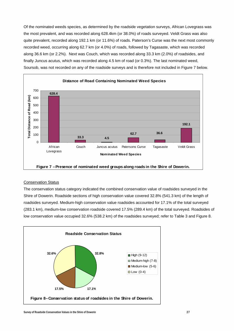
Of the nominated weeds species, as determined by the roadside vegetation surveys, African Lovegrass was
the most prevalent, and was recorded along 628.4km (or 38.0%) of roads surveyed. Veldt Grass was also
quite prevalent, recorded along 192.1 km (or 11.6%) of roads. Paterson’s Curse was the next most commonly
recorded weed, occurring along 62.7 km (or 4.0%) of roads, followed by Tagasaste, which was recorded
along 36.6 km (or 2.2%). Next was Couch, which was recorded along 33.3 km (2.0%) of roadsides, and
finally Juncus acutus, which was recorded along 4.5 km of road (or 0.3%). The last nominated weed,
Soursob, was not recorded on any of the roadside surveys and is therefore not included in Figure 7 below.
Conservation Status
The conservation status category indicated the combined conservation value of roadsides surveyed in the
Shire of Dowerin. Roadside sections of high conservation value covered 32.8% (541.3 km) of the length of
roadsides surveyed. Medium-high conservation value roadsides accounted for 17.1% of the total surveyed
(283.1 km), medium-low conservation roadside covered 17.5% (289.4 km) of the total surveyed. Roadsides of
low conservation value occupied 32.6% (538.2 km) of the roadsides surveyed; refer to Table 3 and Figure 8.
Distance of Road Containing Nominated Weed Species
4.562.7
192.1
36.633.3
628.4
0
100
200
300
400
500
600
700
AfricanLovegrass
Couch Juncus acutus Patersons Curse Tagasaste Veldt Grass
Nominated Weed Species
Tota
l Dis
tanc
e of
Roa
d (k
m)
Figure 7 – Presence of nominated weed groups along roads in the Shire of Dowerin.
Roadside Conservation Status
32.8%
17.1%17.5%
32.6% High (9-12)
Medium-high (7-8)
Medium-low (5-6)
Low (0-4)
Figure 8– Conservation status of roadsides in the Shire of Dowerin.
Survey of Roadside Conservation Values in the Shire of Dowerin 28
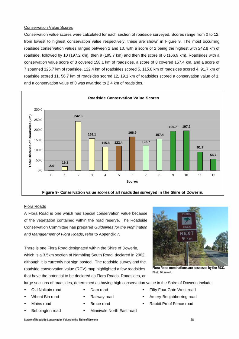
Conservation Value Scores Conservation value scores were calculated for each section of roadside surveyed. Scores range from 0 to 12,
from lowest to highest conservation value respectively, these are shown in Figure 9. The most occurring
roadside conservation values ranged between 2 and 10, with a score of 2 being the highest with 242.8 km of
roadside, followed by 10 (197.2 km), then 9 (195.7 km) and then the score of 6 (166.9 km). Roadsides with a
conservation value score of 3 covered 158.1 km of roadsides, a score of 8 covered 157.4 km, and a score of
7 spanned 125.7 km of roadside. 122.4 km of roadsides scored 5, 115.8 km of roadsides scored 4, 91.7 km of
roadside scored 11, 56.7 km of roadsides scored 12, 19.1 km of roadsides scored a conservation value of 1,
and a conservation value of 0 was awarded to 2.4 km of roadsides.
Flora Roads
A Flora Road is one which has special conservation value because
of the vegetation contained within the road reserve. The Roadside
Conservation Committee has prepared Guidelines for the Nomination
and Management of Flora Roads, refer to Appendix 7.
There is one Flora Road designated within the Shire of Dowerin,
which is a 3.5km section of Nambling South Road, declared in 2002,
although it is currently not sign posted. The roadside survey and the
roadside conservation value (RCV) map highlighted a few roadsides
that have the potential to be declared as Flora Roads. Roadsides, or
large sections of roadsides, determined as having high conservation value in the Shire of Dowerin include:
Old Nalkain road
Wheat Bin road
Mains road
Bebbington road
Dam road
Railway road
Bruce road
Minnivale North East road
Fifty Four Gate West road
Amery-Benjabberring road
Rabbit Proof Fence road
Flora Road nominations are assessed by the RCC. Photo D Lamont.
Roadside Conservation Value Scores
2.419.1
158.1
115.8
166.9 157.4
195.7 197.2
56.7
125.7122.491.7
242.8
0.0
50.0
100.0
150.0
200.0
250.0
300.0
0 1 2 3 4 5 6 7 8 9 10 11 12
Scores
Tota
l Dis
tanc
e of
Roa
dsid
es (k
m)
Figure 9- Conservation value scores of all roadsides surveyed in the Shire of Dowerin.

Survey of Roadside Conservation Values in the Shire of Dowerin 29
PPAARRTT DD
RROOAADDSSIIDDEE
MMAANNAAGGEEMMEENNTT
RREECCOOMMMMEENNDDAATTIIOONNSS
Survey of Roadside Conservation Values in the Shire of Dowerin 30
11..00 MMaannaaggeemmeenntt RReeccoommmmeennddaattiioonnss
The primary aim of road management is the creation and maintenance of a safe, efficient road system.
However, the following management procedures are recommended. The following section provides
general management recommendations that will assist in retaining and enhancing roadside conservation
values.
The Executive Officer of the Roadside Conservation Committee is also available to provide assistance on
all roadside conservation matters, and can be contacted on (08) 9334 0423. The following RCC
publications provide guidelines and management recommendations that will assist Local Government
Authorities:
RCC Roadside Manual;
The Roadside Handbook;
Guidelines for Managing Special Environmental Areas in Transport Corridors; and
Handbook of Environmental Practice for Road Construction and Maintenance Works.
11..11 PPrrootteecctt hhiigghh ccoonnsseerrvvaattiioonn vvaalluuee rrooaaddssiiddeess bbyy mmaaiinnttaaiinniinngg aanndd eennhhaanncciinngg tthhee nnaattiivvee ppllaanntt
ccoommmmuunniittiieess.. This can be achieved by:
retaining remnant vegetation;
minimising disturbance to existing roadside vegetation;
minimising disturbance to soil; and
preventing or controlling the introduction of weeds.
11..22.. PPrroommoottee aanndd rraaiissee aawwaarreenneessss ooff tthhee ccoonnsseerrvvaattiioonn vvaalluuee aassssoocciiaatteedd wwiitthh rrooaaddssiiddee vveeggeettaattiioonn
bbyy:: establishing a register of Shire roads important for conservation;
declaring suitable roadsides as Flora Roads; and
incorporating into tourist, wildflower and/or scenic drives.
11..33 IImmpprroovvee rrooaaddssiiddee sseeccttiioonnss ooff mmeeddiiuumm ttoo llooww ccoonnsseerrvvaattiioonn vvaalluuee bbyy:: minimising disturbance caused by machinery, adjoining land practices and incidences of fire;
carrying out a targeted weed control program;
retaining remnant trees and shrubs;
allowing natural regeneration;
spreading local native seed to encourage regeneration; and
encourage revegetation projects by adjacent landholders.
Survey of Roadside Conservation Values in the Shire of Dowerin 31
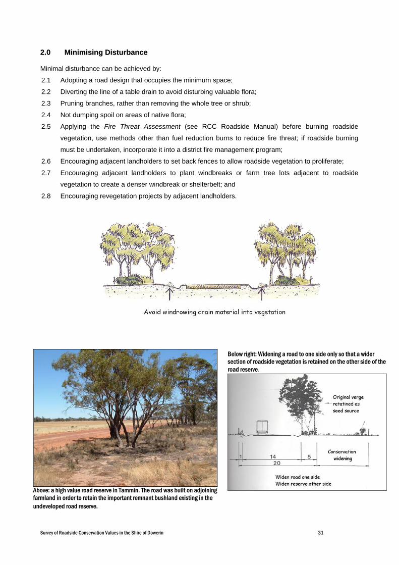
22..00 MMiinniimmiissiinngg DDiissttuurrbbaannccee
Minimal disturbance can be achieved by:
2.1 Adopting a road design that occupies the minimum space;
2.2 Diverting the line of a table drain to avoid disturbing valuable flora;
2.3 Pruning branches, rather than removing the whole tree or shrub;
2.4 Not dumping spoil on areas of native flora;
2.5 Applying the Fire Threat Assessment (see RCC Roadside Manual) before burning roadside
vegetation, use methods other than fuel reduction burns to reduce fire threat; if roadside burning
must be undertaken, incorporate it into a district fire management program;
2.6 Encouraging adjacent landholders to set back fences to allow roadside vegetation to proliferate;
2.7 Encouraging adjacent landholders to plant windbreaks or farm tree lots adjacent to roadside
vegetation to create a denser windbreak or shelterbelt; and
2.8 Encouraging revegetation projects by adjacent landholders.
Above: a high value road reserve in Tammin. The road was built on adjoining farmland in order to retain the important remnant bushland existing in the undeveloped road reserve.
Below right: Widening a road to one side only so that a wider section of roadside vegetation is retained on the other side of the road reserve.

Survey of Roadside Conservation Values in the Shire of Dowerin 32
33..00 PPllaannnniinngg ffoorr RRooaaddssiiddeess
The RCC is able to provide comprehensive models of Roadside Management Plans and encourages all
Shires to adopt this practice of planning for roadside conservation.
The following actions greatly enhance likelihood of a plan that changes behaviour and results in on-ground
actions:
Community support - encourage ongoing community involvement and commitment by establishing a
local Roadside Advisory Committee or working group within the Shire Environmental Committee;
Contract specifications - maintain roadside values by developing environmental specifications for
inclusion in all tender documents or work practices;
Community education - use of innovative and pertinent material can increase community
understanding of roadside values;
Training - promote local roadside planning initiatives and gain acceptance and understanding by
involving Shire staff, contractors, utility provider staff and the community in workshops, seminars or
training days. The Roadside Conservation Committee can provide this training.
Training develops recognition and understanding of roadside values and highlights best work practices.
Workshops are developed to ensure that local issues and environments are dealt with and they include site
visits to high conservation remnants, current projects and works.
44..00 SSeettttiinngg OObbjjeeccttiivveess
The objective of all roadside management should be to:
Protect - native vegetation
- rare or threatened flora or fauna
- cultural and heritage values
- community assets from fire
Maintain - safe function of the road
- native vegetation communities
- fauna habitats and corridors
- visual amenity and landscape qualities
- water quality
Minimise - land degradation
- spread of weeds and vermin
- spread of soil borne pathogens
- risk and impact of fire
- disturbance during installation and
maintenance of service assets
Enhance - indigenous vegetation communities
- fauna habitats and corridors
Survey of Roadside Conservation Values in the Shire of Dowerin 33
RReeffeerreenncceess Beeston G, Mlodawski G, Saunders A and True D (1993, unpub.), Remnant Vegetation Inventory in the Southern Agricultural Areas of Western Australia. Western Australian Department of Agriculture, South Perth. Department of Agriculture WA for Department of Environment (2003), Salinity Investment Framework Department Interim Report – Phase 1, 2003, Department of Environment, Salinity and Land Use Impacts Series No. SLUI 32 Department of Agriculture WA (2005), Salinity in Western Australia, http://agspsrv34.agric.wa.gov.au/environment/salinity/ Department of Environment and Heritage and the Department of Agriculture, Fisheries and Forestry Australia (2003), Natural Heritage Trust- The Journal of the Natural Heritage Trust Summer 2003, No 14. Department of Environment and Heritage and the Department of Agriculture, Fisheries and Forestry Australia, Canberra, Australia. Environment Australia (2001), National Objectives and Targets for Biodiversity Conservation 2001-2005. Environment Australia, Canberra, Australia. Jackson KA (2002), Assessing Roadsides A Guide to Rating Conservation Value, Roadside Conservation Committee, Kensington, Western Australia Lamont DA and Blyth JD (1995), Roadside corridors and community networks, pp 425-35. In Nature Conservation 4: The Role of Networks, ed by Saunders, D.A., Craig J.L., and Mattiske E.M. Surrey Beatty & Sons, 1995. Lamont DA (1998), Western Australian Roadside Handbook: Environmental guidelines for road construction and maintenance workers. Roadside Conservation Committee, Kensington, Western Australia. Lamont DA and Atkins K (2000), Guidelines for Managing Special Environmental Areas in Transport Corridors. Roadside Conservation Committee, Kensington, Western Australia. Platt SJ and Lowe KW (2002), Biodiversity Action Planning: Action planning for native biodiversity at multiple scales – catchment, bioregional, landscape, local. Department of Natural Resources and Environment, Melbourne. Roadside Conservation Committee (1990), Roadside Manual, Roadside Conservation Committee, Como WA Shepherd DP, Beeston GR and Hopkins AJM (2001), Native Vegetation in Western Australia. Technical Report 249, Department of Agriculture, Western Australia, South Perth Western Australian Museum (2005), Fauna Base, www.museum.wa.gov.au/faunabase/prod/index.htm
Survey of Roadside Conservation Values in the Shire of Dowerin
Appendix
1

Survey of Roadside Conservation Values in the Shire of Dowerin
Survey of Roadside Conservation Values in the Shire of Dowerin
Appendix
2

Survey of Roadside Conservation Values in the Shire of Dowerin
ROAD# Sect # OD Start OD Finish
Sect length
Road Name Direction Date Observer Width Native Vegetation
Extent of Vegetation
# Native Plant
Species
Weeds Value as Biol.
Corridor
Adjoining Landuse
Conservation Value Score
(0-12)
Overlay Data
(km) (km) (km) (m) Left Right Left Right Left Right Left Right Left Right Left Right Left Right (weeds listed if present) 4070001 1 0 1.3 1.3 CUNDERDIN-
MINNIVALE RD South 26-
Oct-04
vanessa 20 2 2 2 2 2 2 2 2 2 2 0 0 10 10 AFRICAN_LOVEGRASS
4070001 2 1.3 4.3 3 CUNDERDIN-MINNIVALE RD
South 26-Oct-
04
vanessa 20 2 2 2 2 2 2 2 2 2 2 2 2 12 12 VELDT_GRASS AFRICAN_LOVEGRASS
4070001 3 4.3 6 1.7 CUNDERDIN-MINNIVALE RD
South 26-Oct-
04
vanessa 20 2 2 2 2 2 2 2 2 2 2 0 0 10 10 AFRICAN_LOVEGRASS
4070001 4 6 8.1 2.1 CUNDERDIN-MINNIVALE RD
South 26-Oct-
04
vanessa 20 2 2 1 1 1 1 1 1 2 2 2 2 9 9 AFRICAN_LOVEGRASS
4070001 5 8.1 8.9 0.8 CUNDERDIN-MINNIVALE RD
South 26-Oct-
04
vanessa 20 1 2 0 0 0 0 0 0 0 1 2 2 3 5 AFRICAN_LOVEGRASS
4070001 6 8.9 10.3 1.4 CUNDERDIN-MINNIVALE RD
South 26-Oct-
04
vanessa 20 2 2 0 0 0 0 0 0 1 1 2 2 5 5 AFRICAN_LOVEGRASS
4070001 7 10.3 11.5 1.2 CUNDERDIN-MINNIVALE RD
South 26-Oct-
04
vanessa 20 2 1 0 0 0 0 0 0 1 1 2 2 5 4 AFRICAN_LOVEGRASS
4070001 8 11.5 13.5 2 CUNDERDIN-MINNIVALE RD
South 26-Oct-
04
vanessa 20 2 2 1 1 1 1 1 1 2 2 2 2 9 9 AFRICAN_LOVEGRASS VELDT_GRASS
4070001 9 13.5 14.4 0.9 CUNDERDIN-MINNIVALE RD
South 26-Oct-
04
vanessa 20 2 2 1 1 1 1 1 1 2 2 2 2 9 9 AFRICAN_LOVEGRASS VELDT_GRASS
4070001 10 14.4 15.7 1.3 CUNDERDIN-MINNIVALE RD
South 01-Nov-
04
boase 20 1 2 0 0 0 1 0 1 1 2 2 2 4 8
4070001 11 15.7 16.2 0.5 CUNDERDIN-MINNIVALE RD
South 01-Nov-
04
boase 20 2 0 1 0 1 0 1 0 2 1 2 2 7 1
4070001 12 16.2 17.7 1.5 CUNDERDIN-MINNIVALE RD
South 01-Nov-
04
boase 20 1 1 0 0 0 0 0 0 1 1 2 2 4 4 AFRICAN_LOVEGRASS
4070001 13 17.7 18.9 1.2 CUNDERDIN-MINNIVALE RD
South 01-Nov-
04
boase 20 0 0 0 0 0 0 0 0 0 0 2 2 2 2 AFRICAN_LOVEGRASS
4070001 14 18.9 19.9 1 CUNDERDIN-MINNIVALE RD
South 01-Nov-
04
boase 20 1 2 0 0 1 1 1 1 0 1 2 2 5 7 AFRICAN_LOVEGRASS
4070001 15 19.9 20.6 0.7 CUNDERDIN-MINNIVALE RD
South 01-Nov-
04
boase 20 2 2 0 0 0 0 1 1 0 0 2 2 5 5
4070001 16 20.6 22 1.4 CUNDERDIN-MINNIVALE RD
South 01-Nov-
04
boase 20 0 0 0 0 0 0 0 0 0 0 2 2 2 2
4070001 17 22 23.5 1.5 CUNDERDIN-MINNIVALE RD
South 01-Nov-
boase 20 2 2 0 0 0 0 1 1 0 0 2 2 3 3
Survey of Roadside Conservation Values in the Shire of Dowerin
ROAD# Sect # OD Start OD Finish
Sect length
Road Name Direction Date Observer Width Native Vegetation
Extent of Vegetation
# Native Plant
Species
Weeds Value as Biol.
Corridor
Adjoining Landuse
Conservation Value Score
(0-12)
Overlay Data
(km) (km) (km) (m) Left Right Left Right Left Right Left Right Left Right Left Right Left Right (weeds listed if present) 04
4070001 18 23.5 24.6 1.1 CUNDERDIN-MINNIVALE RD
South 01-Nov-
04
boase 20 2 2 0 0 0 0 0 0 1 1 2 2 5 5
4070001 19 24.6 25.8 1.2 CUNDERDIN-MINNIVALE RD
South 01-Nov-
04
boase 20 0 0 0 0 0 0 0 0 0 0 2 2 2 2
4070001 20 25.8 26.5 0.7 CUNDERDIN-MINNIVALE RD
South 01-Nov-
04
boase 20 1 1 1 0 0 0 1 0 0 0 2 2 5 3
4070001 21 26.5 27.7 1.2 CUNDERDIN-MINNIVALE RD
South 01-Nov-
04
boase 20 2 1 2 0 1 0 1 0 2 2 2 2 8 8
4070003 1 0 4.24 4.24 KOOMBEKINE NORTH RD
North 21-Oct-
04
Robinson Chicks
60 2 2 0 1 1 1 1 1 2 2 2 2 8 9 VELDT_GRASS AFRICAN_LOVEGRASS
4070003 2 4.24 6.78 2.54 KOOMBEKINE NORTH RD
North 21-Oct-
04
Robinson Chicks
20 1 2 0 1 0 1 0 2 0 2 2 2 3 10 AFRICAN_LOVEGRASS
4070003 3 6.78 8.32 1.54 KOOMBEKINE NORTH RD
East 21-Oct-
04
Robinson Chicks
20 2 2 1 1 1 1 1 1 2 2 2 2 9 9 AFRICAN_LOVEGRASS
4070003 4 8.32 10.26 1.94 KOOMBEKINE NORTH RD
North 21-Oct-
04
Robinson Chicks
20 2 2 1 0 1 1 1 1 2 1 2 2 9 7 AFRICAN_LOVEGRASS VELDT_GRASS
4070003 5 10.26 10.7 0.44 KOOMBEKINE NORTH RD
North 21-Oct-
04
Robinson Chicks
20 2 2 0 1 0 0 1 2 0 2 2 0 5 7 AFRICAN_LOVEGRASS VELDT_GRASS
4070003 6 10.7 11.54 0.84 KOOMBEKINE NORTH RD
North 21-Oct-
04
Robinson Chicks
20 1 2 0 1 0 0 0 2 0 2 2 2 3 9 AFRICAN_LOVEGRASS
4070003 7 11.54 12.58 1.04 KOOMBEKINE NORTH RD
North 21-Oct-
04
Robinson Chicks
20 2 2 1 1 1 1 1 1 0 2 2 2 7 9 AFRICAN_LOVEGRASS VELDT_GRASS
4070003 8 12.58 13.12 0.54 KOOMBEKINE NORTH RD
North 21-Oct-
04
Robinson Chicks
60 0 1 0 0 0 0 0 0 0 0 2 2 2 3 VELDT_GRASS
4070003 9 13.12 13.76 0.64 KOOMBEKINE NORTH RD
North 21-Oct-
04
Robinson Chicks
60 0 2 0 1 0 0 0 2 0 0 2 2 2 7 VELDT_GRASS
4070003 10 13.76 14.3 0.54 KOOMBEKINE NORTH RD
North 21-Oct-
04
Robinson Chicks
60 2 2 0 0 0 0 1 1 0 1 2 2 5 6 VELDT_GRASS
4070003 11 14.3 18.94 4.64 KOOMBEKINE NORTH RD
North 21-Oct-
04
Robinson Chicks
20 2 2 1 1 0 0 1 1 0 0 2 2 6 6 AFRICAN_LOVEGRASS VELDT_GRASS
4070004 1 0 1.9 1.9 HINDMARSH RD West 22-Oct-
04
boase 20 1 1 2 2 1 1 1 1 2 0 2 2 9 7

Survey of Roadside Conservation Values in the Shire of Dowerin
ROAD# Sect # OD Start OD Finish
Sect length
Road Name Direction Date Observer Width Native Vegetation
Extent of Vegetation
# Native Plant
Species
Weeds Value as Biol.
Corridor
Adjoining Landuse
Conservation Value Score
(0-12)
Overlay Data
(km) (km) (km) (m) Left Right Left Right Left Right Left Right Left Right Left Right Left Right (weeds listed if present) 4070004 2 1.9 5.2 3.3 HINDMARSH RD West 22-
Oct-04
boase 20 2 2 0 0 1 1 0 0 1 1 2 2 6 6
4070004 3 5.2 6.2 1 HINDMARSH RD West 22-Oct-
04
boase 20 0 0 0 0 0 0 0 0 0 0 2 2 2 2
4070004 4 6.2 6.7 0.5 HINDMARSH RD West 22-Oct-
04
boase 20 1 1 1 1 0 0 1 1 0 0 2 2 5 5
4070004 5 6.7 7.4 0.7 HINDMARSH RD West 22-Oct-
04
boase 20 0 0 0 0 0 0 0 0 0 0 2 2 2 2 PATERSONS_CURSE
4070004 6 7.4 13.3 5.9 HINDMARSH RD West 22-Oct-
04
boase 20 2 2 1 1 1 1 1 1 2 2 2 2 8 8 AFRICAN_LOVEGRASS PATERSONS_CURSE
4070005 1 0 3.95 3.95 RABBIT PROOF FENCE RD
South 23-Oct-
04
larkin 20 2 2 2 2 2 2 2 2 1 2 2 2 10 11 AFRICAN_LOVEGRASS PATERSONS_CURSE
4070005 2 3.95 7.7 3.75 RABBIT PROOF FENCE RD
South 23-Oct-
04
larkin 20 2 2 1 2 2 2 2 2 1 2 2 2 10 12 AFRICAN_LOVEGRASS
4070005 3 7.7 8.25 0.55 RABBIT PROOF FENCE RD
South 23-Oct-
04
larkin 20 2 2 1 1 1 1 2 2 1 1 2 2 9 9 AFRICAN_LOVEGRASS
4070005 4 8.25 10.9 2.65 RABBIT PROOF FENCE RD
South 23-Oct-
04
larkin 20 2 2 1 1 1 1 1 1 2 2 1 1 8 8 AFRICAN_LOVEGRASS
4070005 5 10.9 11.75 0.85 RABBIT PROOF FENCE RD
South 23-Oct-
04
larkin 20 1 2 0 1 0 1 1 1 0 2 0 2 2 9 AFRICAN_LOVEGRASS
4070005 6 11.75 16.9 5.15 RABBIT PROOF FENCE RD
South 23-Oct-
04
larkin 20 2 2 1 1 1 1 2 2 2 2 2 2 10 10 AFRICAN_LOVEGRASS
4070005 7 16.9 18.55 1.65 RABBIT PROOF FENCE RD
South 23-Oct-
04
larkin 20 1 2 0 1 0 1 1 1 0 2 2 2 4 9 AFRICAN_LOVEGRASS
4070005 8 18.55 19.6 1.05 RABBIT PROOF FENCE RD
South 23-Oct-
04
larkin 20 2 2 1 2 1 2 1 1 2 2 2 2 9 11 AFRICAN_LOVEGRASS
4070005 9 19.6 22.4 2.8 RABBIT PROOF FENCE RD
South 23-Oct-
04
larkin 20 1 2 1 1 1 1 1 1 1 2 2 2 7 9 AFRICAN_LOVEGRASS
4070005 10 22.4 25 2.6 RABBIT PROOF FENCE RD
South 23-Oct-
04
larkin 20 2 2 1 1 1 2 1 2 1 2 2 2 8 11 AFRICAN_LOVEGRASS
4070005 11 25 25.7 0.7 RABBIT PROOF FENCE RD
South 23-Oct-
04
larkin 20 2 2 1 1 1 1 1 1 1 2 2 2 8 9 AFRICAN_LOVEGRASS
4070005 12 25.7 27.2 1.5 RABBIT PROOF FENCE RD
South 23-Oct-
larkin 20 2 2 1 2 1 2 1 2 2 2 2 1 9 11 AFRICAN_LOVEGRASS VELDT_GRASS

Survey of Roadside Conservation Values in the Shire of Dowerin
ROAD# Sect # OD Start OD Finish
Sect length
Road Name Direction Date Observer Width Native Vegetation
Extent of Vegetation
# Native Plant
Species
Weeds Value as Biol.
Corridor
Adjoining Landuse
Conservation Value Score
(0-12)
Overlay Data
(km) (km) (km) (m) Left Right Left Right Left Right Left Right Left Right Left Right Left Right (weeds listed if present) 04
4070005 13 27.2 27.8 0.6 RABBIT PROOF FENCE RD
South 23-Oct-
04
larkin 20 2 2 1 2 1 2 1 2 0 2 2 1 7 11 AFRICAN_LOVEGRASS VELDT_GRASS
4070005 14 27.8 28.1 0.3 RABBIT PROOF FENCE RD
South 23-Oct-
04
larkin 20 1 2 0 2 1 2 1 2 0 2 2 1 5 11 AFRICAN_LOVEGRASS VELDT_GRASS
4070005 15 28.1 30 1.9 RABBIT PROOF FENCE RD
South 23-Oct-
04
larkin 20 1 2 0 1 1 2 1 2 1 2 2 1 6 10 AFRICAN_LOVEGRASS
4070006 1 0 1.6 1.6 NAMBLING RD North 27-Oct-
04
vanessa 20 2 2 0 0 0 0 0 0 1 1 2 2 5 5 AFRICAN_LOVEGRASS VELDT_GRASS
4070006 2 1.6 2.2 0.6 NAMBLING RD North 27-Oct-
04
vanessa 20 2 2 1 1 1 1 1 1 2 2 1 1 8 8 AFRICAN_LOVEGRASS VELDT_GRASS
4070007 1 0 1.75 1.75 UCARTY SOUTH RD
South 21-Oct-
04
boase 20 1 2 1 2 1 2 1 2 0 2 2 0 6 10
4070007 2 1.75 2.55 0.8 UCARTY SOUTH RD
South 21-Oct-
04
boase 20 1 0 0 0 0 0 0 0 0 0 2 2 3 2 AFRICAN_LOVEGRASS
4070007 3 2.55 2.75 0.2 UCARTY SOUTH RD
South 21-Oct-
04
boase 20 2 2 1 1 2 2 1 1 1 1 2 2 7 9 AFRICAN_LOVEGRASS
4070007 4 2.75 4.15 1.4 UCARTY SOUTH RD
South 21-Oct-
04
boase 20 0 0 0 0 0 0 0 0 0 0 2 2 2 2 AFRICAN_LOVEGRASS VELDT_GRASS
4070007 5 4.15 5.25 1.1 UCARTY SOUTH RD
South 21-Oct-
04
boase 20 1 1 0 0 0 0 1 1 1 1 2 2 5 5 AFRICAN_LOVEGRASS
4070007 6 5.25 7.65 2.4 UCARTY SOUTH RD
South 21-Oct-
04
boase 20 0 0 0 0 0 0 0 0 0 0 2 2 2 2 AFRICAN_LOVEGRASS
4070007 7 7.65 8.75 1.1 UCARTY SOUTH RD
South 21-Oct-
04
boase 20 2 2 1 1 1 1 1 1 1 2 2 2 8 9 AFRICAN_LOVEGRASS
4070007 8 8.75 9.85 1.1 UCARTY SOUTH RD
South 21-Oct-
04
boase 20 0 0 0 0 0 0 0 0 0 0 2 2 2 2 AFRICAN_LOVEGRASS
4070007 9 9.85 12.65 2.8 UCARTY SOUTH RD
South 21-Oct-
04
boase 20 2 2 0 0 1 1 0 0 1 1 2 2 5 5 AFRICAN_LOVEGRASS
4070007 10 12.65 16.25 3.6 UCARTY SOUTH RD
South 21-Oct-
04
boase 20 0 0 0 0 0 0 0 0 0 0 2 2 2 2 PATERSONS_CURSE AFRICAN_LOVEGRASS
4070007 11 16.25 16.85 0.6 UCARTY SOUTH RD
South 21-Oct-
04
boase 20 2 1 1 1 0 0 1 1 2 2 2 2 6 6 VELDT_GRASS
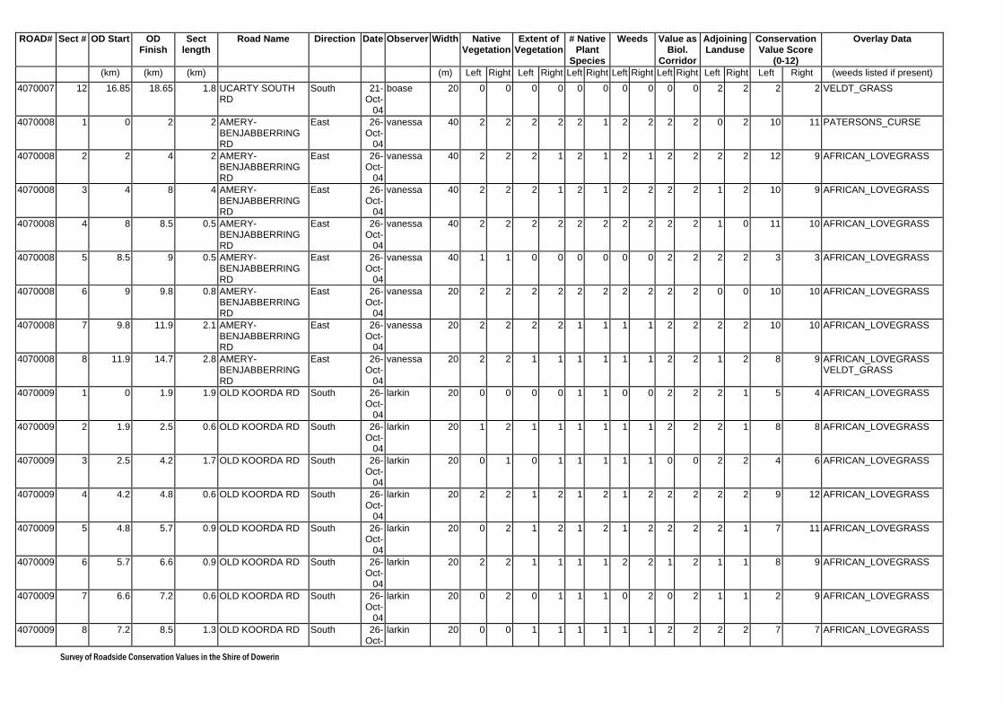
Survey of Roadside Conservation Values in the Shire of Dowerin
ROAD# Sect # OD Start OD Finish
Sect length
Road Name Direction Date Observer Width Native Vegetation
Extent of Vegetation
# Native Plant
Species
Weeds Value as Biol.
Corridor
Adjoining Landuse
Conservation Value Score
(0-12)
Overlay Data
(km) (km) (km) (m) Left Right Left Right Left Right Left Right Left Right Left Right Left Right (weeds listed if present) 4070007 12 16.85 18.65 1.8 UCARTY SOUTH
RD South 21-
Oct-04
boase 20 0 0 0 0 0 0 0 0 0 0 2 2 2 2 VELDT_GRASS
4070008 1 0 2 2 AMERY-BENJABBERRING RD
East 26-Oct-
04
vanessa 40 2 2 2 2 2 1 2 2 2 2 0 2 10 11 PATERSONS_CURSE
4070008 2 2 4 2 AMERY-BENJABBERRING RD
East 26-Oct-
04
vanessa 40 2 2 2 1 2 1 2 1 2 2 2 2 12 9 AFRICAN_LOVEGRASS
4070008 3 4 8 4 AMERY-BENJABBERRING RD
East 26-Oct-
04
vanessa 40 2 2 2 1 2 1 2 2 2 2 1 2 10 9 AFRICAN_LOVEGRASS
4070008 4 8 8.5 0.5 AMERY-BENJABBERRING RD
East 26-Oct-
04
vanessa 40 2 2 2 2 2 2 2 2 2 2 1 0 11 10 AFRICAN_LOVEGRASS
4070008 5 8.5 9 0.5 AMERY-BENJABBERRING RD
East 26-Oct-
04
vanessa 40 1 1 0 0 0 0 0 0 2 2 2 2 3 3 AFRICAN_LOVEGRASS
4070008 6 9 9.8 0.8 AMERY-BENJABBERRING RD
East 26-Oct-
04
vanessa 20 2 2 2 2 2 2 2 2 2 2 0 0 10 10 AFRICAN_LOVEGRASS
4070008 7 9.8 11.9 2.1 AMERY-BENJABBERRING RD
East 26-Oct-
04
vanessa 20 2 2 2 2 1 1 1 1 2 2 2 2 10 10 AFRICAN_LOVEGRASS
4070008 8 11.9 14.7 2.8 AMERY-BENJABBERRING RD
East 26-Oct-
04
vanessa 20 2 2 1 1 1 1 1 1 2 2 1 2 8 9 AFRICAN_LOVEGRASS VELDT_GRASS
4070009 1 0 1.9 1.9 OLD KOORDA RD South 26-Oct-
04
larkin 20 0 0 0 0 1 1 0 0 2 2 2 1 5 4 AFRICAN_LOVEGRASS
4070009 2 1.9 2.5 0.6 OLD KOORDA RD South 26-Oct-
04
larkin 20 1 2 1 1 1 1 1 1 2 2 2 1 8 8 AFRICAN_LOVEGRASS
4070009 3 2.5 4.2 1.7 OLD KOORDA RD South 26-Oct-
04
larkin 20 0 1 0 1 1 1 1 1 0 0 2 2 4 6 AFRICAN_LOVEGRASS
4070009 4 4.2 4.8 0.6 OLD KOORDA RD South 26-Oct-
04
larkin 20 2 2 1 2 1 2 1 2 2 2 2 2 9 12 AFRICAN_LOVEGRASS
4070009 5 4.8 5.7 0.9 OLD KOORDA RD South 26-Oct-
04
larkin 20 0 2 1 2 1 2 1 2 2 2 2 1 7 11 AFRICAN_LOVEGRASS
4070009 6 5.7 6.6 0.9 OLD KOORDA RD South 26-Oct-
04
larkin 20 2 2 1 1 1 1 2 2 1 2 1 1 8 9 AFRICAN_LOVEGRASS
4070009 7 6.6 7.2 0.6 OLD KOORDA RD South 26-Oct-
04
larkin 20 0 2 0 1 1 1 0 2 0 2 1 1 2 9 AFRICAN_LOVEGRASS
4070009 8 7.2 8.5 1.3 OLD KOORDA RD South 26-Oct-
larkin 20 0 0 1 1 1 1 1 1 2 2 2 2 7 7 AFRICAN_LOVEGRASS
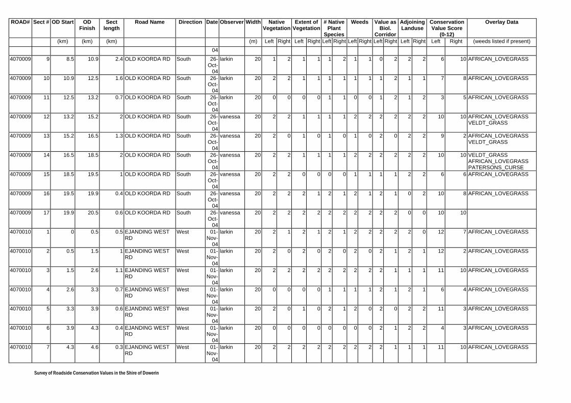
Survey of Roadside Conservation Values in the Shire of Dowerin
ROAD# Sect # OD Start OD Finish
Sect length
Road Name Direction Date Observer Width Native Vegetation
Extent of Vegetation
# Native Plant
Species
Weeds Value as Biol.
Corridor
Adjoining Landuse
Conservation Value Score
(0-12)
Overlay Data
(km) (km) (km) (m) Left Right Left Right Left Right Left Right Left Right Left Right Left Right (weeds listed if present) 04
4070009 9 8.5 10.9 2.4 OLD KOORDA RD South 26-Oct-
04
larkin 20 1 2 1 1 1 2 1 1 0 2 2 2 6 10 AFRICAN_LOVEGRASS
4070009 10 10.9 12.5 1.6 OLD KOORDA RD South 26-Oct-
04
larkin 20 2 2 1 1 1 1 1 1 1 2 1 1 7 8 AFRICAN_LOVEGRASS
4070009 11 12.5 13.2 0.7 OLD KOORDA RD South 26-Oct-
04
larkin 20 0 0 0 0 1 1 0 0 1 2 1 2 3 5 AFRICAN_LOVEGRASS
4070009 12 13.2 15.2 2 OLD KOORDA RD South 26-Oct-
04
vanessa 20 2 2 1 1 1 1 2 2 2 2 2 2 10 10 AFRICAN_LOVEGRASS VELDT_GRASS
4070009 13 15.2 16.5 1.3 OLD KOORDA RD South 26-Oct-
04
vanessa 20 2 0 1 0 1 0 1 0 2 0 2 2 9 2 AFRICAN_LOVEGRASS VELDT_GRASS
4070009 14 16.5 18.5 2 OLD KOORDA RD South 26-Oct-
04
vanessa 20 2 2 1 1 1 1 2 2 2 2 2 2 10 10 VELDT_GRASS AFRICAN_LOVEGRASS PATERSONS_CURSE
4070009 15 18.5 19.5 1 OLD KOORDA RD South 26-Oct-
04
vanessa 20 2 2 0 0 0 0 1 1 1 1 2 2 6 6 AFRICAN_LOVEGRASS
4070009 16 19.5 19.9 0.4 OLD KOORDA RD South 26-Oct-
04
vanessa 20 2 2 2 1 2 1 2 1 2 1 0 2 10 8 AFRICAN_LOVEGRASS
4070009 17 19.9 20.5 0.6 OLD KOORDA RD South 26-Oct-
04
vanessa 20 2 2 2 2 2 2 2 2 2 2 0 0 10 10
4070010 1 0 0.5 0.5 EJANDING WEST RD
West 01-Nov-
04
larkin 20 2 1 2 1 2 1 2 2 2 2 2 0 12 7 AFRICAN_LOVEGRASS
4070010 2 0.5 1.5 1 EJANDING WEST RD
West 01-Nov-
04
larkin 20 2 0 2 0 2 0 2 0 2 1 2 1 12 2 AFRICAN_LOVEGRASS
4070010 3 1.5 2.6 1.1 EJANDING WEST RD
West 01-Nov-
04
larkin 20 2 2 2 2 2 2 2 2 2 1 1 1 11 10 AFRICAN_LOVEGRASS
4070010 4 2.6 3.3 0.7 EJANDING WEST RD
West 01-Nov-
04
larkin 20 0 0 0 0 1 1 1 1 2 1 2 1 6 4 AFRICAN_LOVEGRASS
4070010 5 3.3 3.9 0.6 EJANDING WEST RD
West 01-Nov-
04
larkin 20 2 0 1 0 2 1 2 0 2 0 2 2 11 3 AFRICAN_LOVEGRASS
4070010 6 3.9 4.3 0.4 EJANDING WEST RD
West 01-Nov-
04
larkin 20 0 0 0 0 0 0 0 0 2 1 2 2 4 3 AFRICAN_LOVEGRASS
4070010 7 4.3 4.6 0.3 EJANDING WEST RD
West 01-Nov-
04
larkin 20 2 2 2 2 2 2 2 2 2 1 1 1 11 10 AFRICAN_LOVEGRASS
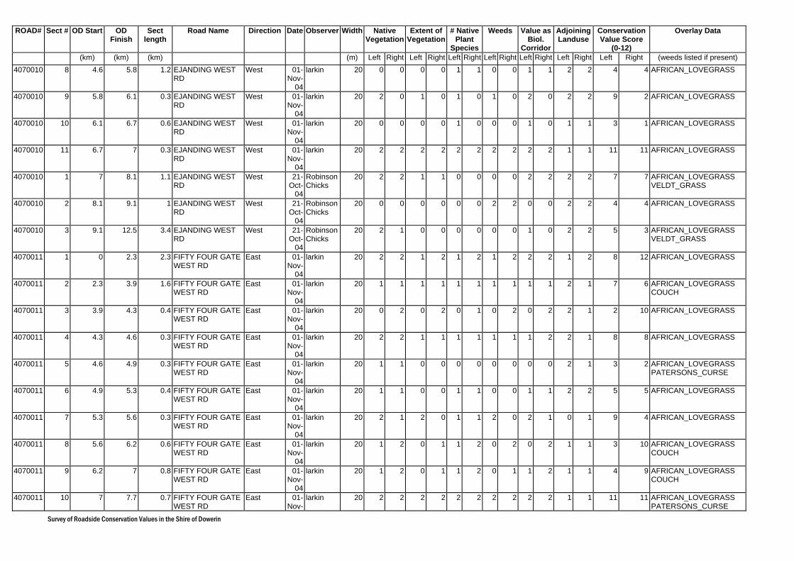
Survey of Roadside Conservation Values in the Shire of Dowerin
ROAD# Sect # OD Start OD Finish
Sect length
Road Name Direction Date Observer Width Native Vegetation
Extent of Vegetation
# Native Plant
Species
Weeds Value as Biol.
Corridor
Adjoining Landuse
Conservation Value Score
(0-12)
Overlay Data
(km) (km) (km) (m) Left Right Left Right Left Right Left Right Left Right Left Right Left Right (weeds listed if present) 4070010 8 4.6 5.8 1.2 EJANDING WEST
RD West 01-
Nov-04
larkin 20 0 0 0 0 1 1 0 0 1 1 2 2 4 4 AFRICAN_LOVEGRASS
4070010 9 5.8 6.1 0.3 EJANDING WEST RD
West 01-Nov-
04
larkin 20 2 0 1 0 1 0 1 0 2 0 2 2 9 2 AFRICAN_LOVEGRASS
4070010 10 6.1 6.7 0.6 EJANDING WEST RD
West 01-Nov-
04
larkin 20 0 0 0 0 1 0 0 0 1 0 1 1 3 1 AFRICAN_LOVEGRASS
4070010 11 6.7 7 0.3 EJANDING WEST RD
West 01-Nov-
04
larkin 20 2 2 2 2 2 2 2 2 2 2 1 1 11 11 AFRICAN_LOVEGRASS
4070010 1 7 8.1 1.1 EJANDING WEST RD
West 21-Oct-
04
Robinson Chicks
20 2 2 1 1 0 0 0 0 2 2 2 2 7 7 AFRICAN_LOVEGRASS VELDT_GRASS
4070010 2 8.1 9.1 1 EJANDING WEST RD
West 21-Oct-
04
Robinson Chicks
20 0 0 0 0 0 0 2 2 0 0 2 2 4 4 AFRICAN_LOVEGRASS
4070010 3 9.1 12.5 3.4 EJANDING WEST RD
West 21-Oct-
04
Robinson Chicks
20 2 1 0 0 0 0 0 0 1 0 2 2 5 3 AFRICAN_LOVEGRASS VELDT_GRASS
4070011 1 0 2.3 2.3 FIFTY FOUR GATE WEST RD
East 01-Nov-
04
larkin 20 2 2 1 2 1 2 1 2 2 2 1 2 8 12 AFRICAN_LOVEGRASS
4070011 2 2.3 3.9 1.6 FIFTY FOUR GATE WEST RD
East 01-Nov-
04
larkin 20 1 1 1 1 1 1 1 1 1 1 2 1 7 6 AFRICAN_LOVEGRASS COUCH
4070011 3 3.9 4.3 0.4 FIFTY FOUR GATE WEST RD
East 01-Nov-
04
larkin 20 0 2 0 2 0 1 0 2 0 2 2 1 2 10 AFRICAN_LOVEGRASS
4070011 4 4.3 4.6 0.3 FIFTY FOUR GATE WEST RD
East 01-Nov-
04
larkin 20 2 2 1 1 1 1 1 1 1 2 2 1 8 8 AFRICAN_LOVEGRASS
4070011 5 4.6 4.9 0.3 FIFTY FOUR GATE WEST RD
East 01-Nov-
04
larkin 20 1 1 0 0 0 0 0 0 0 0 2 1 3 2 AFRICAN_LOVEGRASS PATERSONS_CURSE
4070011 6 4.9 5.3 0.4 FIFTY FOUR GATE WEST RD
East 01-Nov-
04
larkin 20 1 1 0 0 1 1 0 0 1 1 2 2 5 5 AFRICAN_LOVEGRASS
4070011 7 5.3 5.6 0.3 FIFTY FOUR GATE WEST RD
East 01-Nov-
04
larkin 20 2 1 2 0 1 1 2 0 2 1 0 1 9 4 AFRICAN_LOVEGRASS
4070011 8 5.6 6.2 0.6 FIFTY FOUR GATE WEST RD
East 01-Nov-
04
larkin 20 1 2 0 1 1 2 0 2 0 2 1 1 3 10 AFRICAN_LOVEGRASS COUCH
4070011 9 6.2 7 0.8 FIFTY FOUR GATE WEST RD
East 01-Nov-
04
larkin 20 1 2 0 1 1 2 0 1 1 2 1 1 4 9 AFRICAN_LOVEGRASS COUCH
4070011 10 7 7.7 0.7 FIFTY FOUR GATE WEST RD
East 01-Nov-
larkin 20 2 2 2 2 2 2 2 2 2 2 1 1 11 11 AFRICAN_LOVEGRASS PATERSONS_CURSE
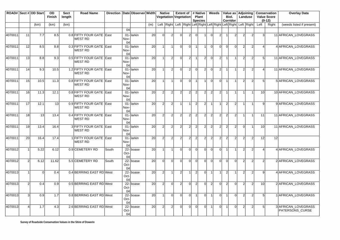
Survey of Roadside Conservation Values in the Shire of Dowerin
ROAD# Sect # OD Start OD Finish
Sect length
Road Name Direction Date Observer Width Native Vegetation
Extent of Vegetation
# Native Plant
Species
Weeds Value as Biol.
Corridor
Adjoining Landuse
Conservation Value Score
(0-12)
Overlay Data
(km) (km) (km) (m) Left Right Left Right Left Right Left Right Left Right Left Right Left Right (weeds listed if present) 04
4070011 11 7.7 8.5 0.8 FIFTY FOUR GATE WEST RD
East 01-Nov-
04
larkin 20 0 2 0 2 0 1 0 2 1 2 2 2 3 11 AFRICAN_LOVEGRASS
4070011 12 8.5 8.8 0.3 FIFTY FOUR GATE WEST RD
East 01-Nov-
04
larkin 20 1 1 0 0 1 1 0 0 0 0 2 2 4 4 AFRICAN_LOVEGRASS
4070011 13 8.8 9.3 0.5 FIFTY FOUR GATE WEST RD
East 01-Nov-
04
larkin 20 1 2 0 2 1 2 0 2 1 1 2 2 5 11 AFRICAN_LOVEGRASS
4070011 14 9.3 10.5 1.2 FIFTY FOUR GATE WEST RD
East 01-Nov-
04
larkin 20 1 2 0 2 0 2 0 2 1 1 2 2 4 11 AFRICAN_LOVEGRASS
4070011 15 10.5 11.3 0.8 FIFTY FOUR GATE WEST RD
East 01-Nov-
04
larkin 20 1 1 0 0 1 1 0 0 1 1 2 2 5 5 AFRICAN_LOVEGRASS
4070011 16 11.3 12.1 0.8 FIFTY FOUR GATE WEST RD
East 01-Nov-
04
larkin 20 2 2 2 2 2 2 2 2 1 1 1 1 10 10 AFRICAN_LOVEGRASS
4070011 17 12.1 13 0.9 FIFTY FOUR GATE WEST RD
East 01-Nov-
04
larkin 20 2 2 1 1 2 2 1 1 2 2 1 1 9 9 AFRICAN_LOVEGRASS
4070011 18 13 13.4 0.4 FIFTY FOUR GATE WEST RD
East 01-Nov-
04
larkin 20 2 2 2 2 2 2 2 2 2 2 1 1 11 11 AFRICAN_LOVEGRASS
4070011 19 13.4 16.4 3 FIFTY FOUR GATE WEST RD
East 01-Nov-
04
larkin 20 2 2 2 2 2 2 2 2 2 2 0 1 10 11 AFRICAN_LOVEGRASS
4070011 20 16.4 17.4 1 FIFTY FOUR GATE WEST RD
East 01-Nov-
04
larkin 20 2 2 2 2 2 2 2 2 2 2 2 2 12 12
4070012 1 5.22 6.12 0.9 CEMETERY RD South 22-Oct-
04
boase 20 1 1 0 0 0 0 0 0 1 1 2 2 4 4 AFRICAN_LOVEGRASS
4070012 2 6.12 11.62 5.5 CEMETERY RD South 22-Oct-
04
boase 20 0 0 0 0 0 0 0 0 0 0 2 2 2 2 AFRICAN_LOVEGRASS
4070013 1 0 0.4 0.4 BERRING EAST RD West 22-Oct-
04
boase 20 2 1 2 1 2 0 1 1 2 1 2 2 9 4 AFRICAN_LOVEGRASS
4070013 2 0.4 0.9 0.5 BERRING EAST RD West 22-Oct-
04
boase 20 2 0 2 0 2 0 2 0 2 0 2 2 10 2 AFRICAN_LOVEGRASS
4070013 3 0.9 1.7 0.8 BERRING EAST RD West 22-Oct-
04
boase 20 1 0 0 0 1 0 1 0 1 0 2 2 5 1 AFRICAN_LOVEGRASS
4070013 4 1.7 4.3 2.6 BERRING EAST RD West 22-Oct-
04
boase 20 2 2 0 0 0 0 1 0 1 0 2 2 5 3 AFRICAN_LOVEGRASS PATERSONS_CURSE
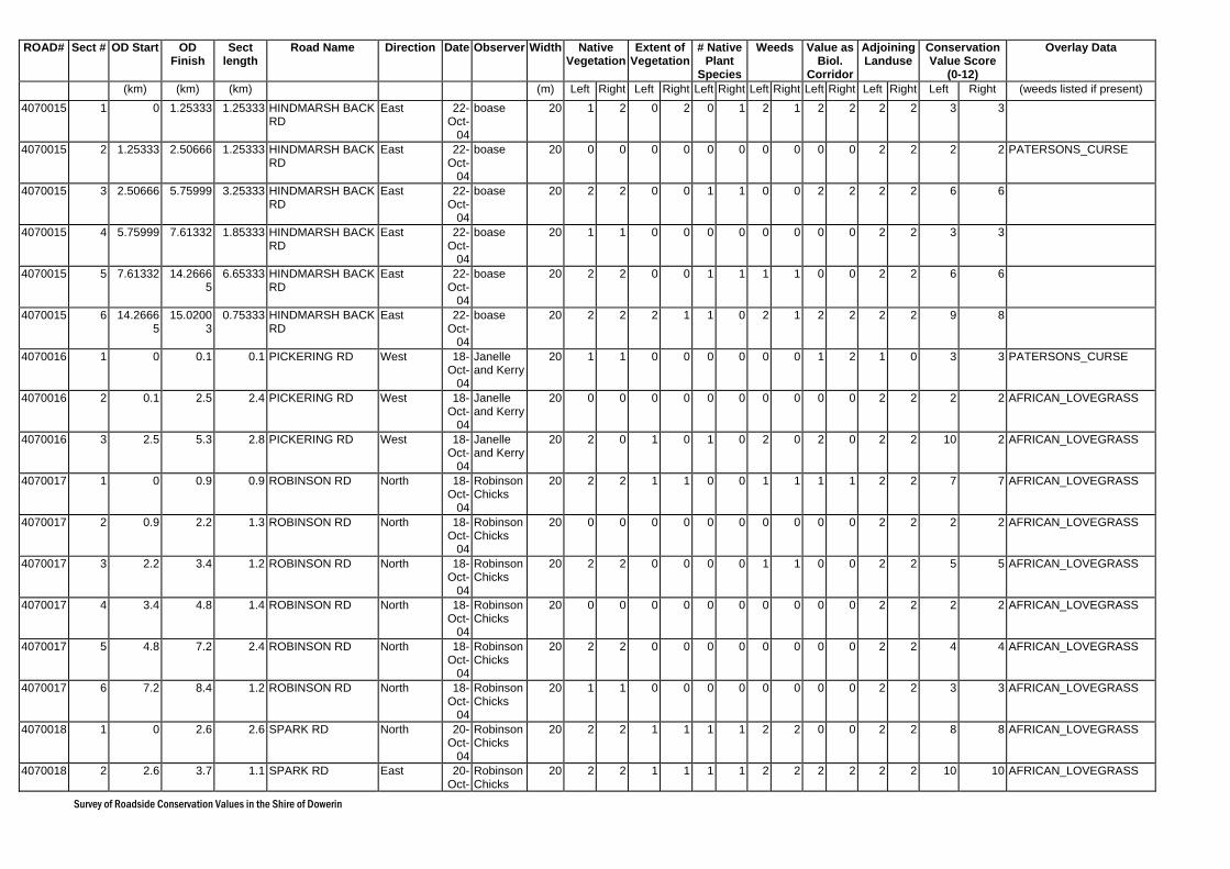
Survey of Roadside Conservation Values in the Shire of Dowerin
ROAD# Sect # OD Start OD Finish
Sect length
Road Name Direction Date Observer Width Native Vegetation
Extent of Vegetation
# Native Plant
Species
Weeds Value as Biol.
Corridor
Adjoining Landuse
Conservation Value Score
(0-12)
Overlay Data
(km) (km) (km) (m) Left Right Left Right Left Right Left Right Left Right Left Right Left Right (weeds listed if present) 4070015 1 0 1.25333 1.25333 HINDMARSH BACK
RD East 22-
Oct-04
boase 20 1 2 0 2 0 1 2 1 2 2 2 2 3 3
4070015 2 1.25333 2.50666 1.25333 HINDMARSH BACK RD
East 22-Oct-
04
boase 20 0 0 0 0 0 0 0 0 0 0 2 2 2 2 PATERSONS_CURSE
4070015 3 2.50666 5.75999 3.25333 HINDMARSH BACK RD
East 22-Oct-
04
boase 20 2 2 0 0 1 1 0 0 2 2 2 2 6 6
4070015 4 5.75999 7.61332 1.85333 HINDMARSH BACK RD
East 22-Oct-
04
boase 20 1 1 0 0 0 0 0 0 0 0 2 2 3 3
4070015 5 7.61332 14.26665
6.65333 HINDMARSH BACK RD
East 22-Oct-
04
boase 20 2 2 0 0 1 1 1 1 0 0 2 2 6 6
4070015 6 14.26665
15.02003
0.75333 HINDMARSH BACK RD
East 22-Oct-
04
boase 20 2 2 2 1 1 0 2 1 2 2 2 2 9 8
4070016 1 0 0.1 0.1 PICKERING RD West 18-Oct-
04
Janelle and Kerry
20 1 1 0 0 0 0 0 0 1 2 1 0 3 3 PATERSONS_CURSE
4070016 2 0.1 2.5 2.4 PICKERING RD West 18-Oct-
04
Janelle and Kerry
20 0 0 0 0 0 0 0 0 0 0 2 2 2 2 AFRICAN_LOVEGRASS
4070016 3 2.5 5.3 2.8 PICKERING RD West 18-Oct-
04
Janelle and Kerry
20 2 0 1 0 1 0 2 0 2 0 2 2 10 2 AFRICAN_LOVEGRASS
4070017 1 0 0.9 0.9 ROBINSON RD North 18-Oct-
04
Robinson Chicks
20 2 2 1 1 0 0 1 1 1 1 2 2 7 7 AFRICAN_LOVEGRASS
4070017 2 0.9 2.2 1.3 ROBINSON RD North 18-Oct-
04
Robinson Chicks
20 0 0 0 0 0 0 0 0 0 0 2 2 2 2 AFRICAN_LOVEGRASS
4070017 3 2.2 3.4 1.2 ROBINSON RD North 18-Oct-
04
Robinson Chicks
20 2 2 0 0 0 0 1 1 0 0 2 2 5 5 AFRICAN_LOVEGRASS
4070017 4 3.4 4.8 1.4 ROBINSON RD North 18-Oct-
04
Robinson Chicks
20 0 0 0 0 0 0 0 0 0 0 2 2 2 2 AFRICAN_LOVEGRASS
4070017 5 4.8 7.2 2.4 ROBINSON RD North 18-Oct-
04
Robinson Chicks
20 2 2 0 0 0 0 0 0 0 0 2 2 4 4 AFRICAN_LOVEGRASS
4070017 6 7.2 8.4 1.2 ROBINSON RD North 18-Oct-
04
Robinson Chicks
20 1 1 0 0 0 0 0 0 0 0 2 2 3 3 AFRICAN_LOVEGRASS
4070018 1 0 2.6 2.6 SPARK RD North 20-Oct-
04
Robinson Chicks
20 2 2 1 1 1 1 2 2 0 0 2 2 8 8 AFRICAN_LOVEGRASS
4070018 2 2.6 3.7 1.1 SPARK RD East 20-Oct-
Robinson Chicks
20 2 2 1 1 1 1 2 2 2 2 2 2 10 10 AFRICAN_LOVEGRASS
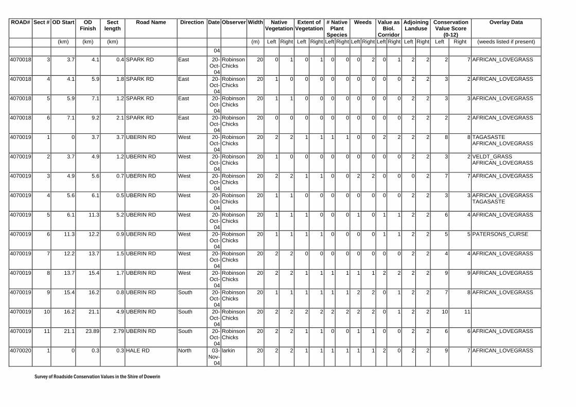
Survey of Roadside Conservation Values in the Shire of Dowerin
ROAD# Sect # OD Start OD Finish
Sect length
Road Name Direction Date Observer Width Native Vegetation
Extent of Vegetation
# Native Plant
Species
Weeds Value as Biol.
Corridor
Adjoining Landuse
Conservation Value Score
(0-12)
Overlay Data
(km) (km) (km) (m) Left Right Left Right Left Right Left Right Left Right Left Right Left Right (weeds listed if present) 04
4070018 3 3.7 4.1 0.4 SPARK RD East 20-Oct-
04
Robinson Chicks
20 0 1 0 1 0 0 0 2 0 1 2 2 2 7 AFRICAN_LOVEGRASS
4070018 4 4.1 5.9 1.8 SPARK RD East 20-Oct-
04
Robinson Chicks
20 1 0 0 0 0 0 0 0 0 0 2 2 3 2 AFRICAN_LOVEGRASS
4070018 5 5.9 7.1 1.2 SPARK RD East 20-Oct-
04
Robinson Chicks
20 1 1 0 0 0 0 0 0 0 0 2 2 3 3 AFRICAN_LOVEGRASS
4070018 6 7.1 9.2 2.1 SPARK RD East 20-Oct-
04
Robinson Chicks
20 0 0 0 0 0 0 0 0 0 0 2 2 2 2 AFRICAN_LOVEGRASS
4070019 1 0 3.7 3.7 UBERIN RD West 20-Oct-
04
Robinson Chicks
20 2 2 1 1 1 1 0 0 2 2 2 2 8 8 TAGASASTE AFRICAN_LOVEGRASS
4070019 2 3.7 4.9 1.2 UBERIN RD West 20-Oct-
04
Robinson Chicks
20 1 0 0 0 0 0 0 0 0 0 2 2 3 2 VELDT_GRASS AFRICAN_LOVEGRASS
4070019 3 4.9 5.6 0.7 UBERIN RD West 20-Oct-
04
Robinson Chicks
20 2 2 1 1 0 0 2 2 0 0 0 2 7 7 AFRICAN_LOVEGRASS
4070019 4 5.6 6.1 0.5 UBERIN RD West 20-Oct-
04
Robinson Chicks
20 1 1 0 0 0 0 0 0 0 0 2 2 3 3 AFRICAN_LOVEGRASS TAGASASTE
4070019 5 6.1 11.3 5.2 UBERIN RD West 20-Oct-
04
Robinson Chicks
20 1 1 1 0 0 0 1 0 1 1 2 2 6 4 AFRICAN_LOVEGRASS
4070019 6 11.3 12.2 0.9 UBERIN RD West 20-Oct-
04
Robinson Chicks
20 1 1 1 1 0 0 0 0 1 1 2 2 5 5 PATERSONS_CURSE
4070019 7 12.2 13.7 1.5 UBERIN RD West 20-Oct-
04
Robinson Chicks
20 2 2 0 0 0 0 0 0 0 0 2 2 4 4 AFRICAN_LOVEGRASS
4070019 8 13.7 15.4 1.7 UBERIN RD West 20-Oct-
04
Robinson Chicks
20 2 2 1 1 1 1 1 1 2 2 2 2 9 9 AFRICAN_LOVEGRASS
4070019 9 15.4 16.2 0.8 UBERIN RD South 20-Oct-
04
Robinson Chicks
20 1 1 1 1 1 1 2 2 0 1 2 2 7 8 AFRICAN_LOVEGRASS
4070019 10 16.2 21.1 4.9 UBERIN RD South 20-Oct-
04
Robinson Chicks
20 2 2 2 2 2 2 2 2 0 1 2 2 10 11
4070019 11 21.1 23.89 2.79 UBERIN RD South 20-Oct-
04
Robinson Chicks
20 2 2 1 1 0 0 1 1 0 0 2 2 6 6 AFRICAN_LOVEGRASS
4070020 1 0 0.3 0.3 HALE RD North 03-Nov-
04
larkin 20 2 2 1 1 1 1 1 1 2 0 2 2 9 7 AFRICAN_LOVEGRASS
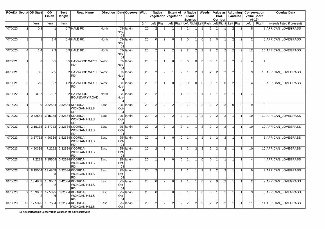
Survey of Roadside Conservation Values in the Shire of Dowerin
ROAD# Sect # OD Start OD Finish
Sect length
Road Name Direction Date Observer Width Native Vegetation
Extent of Vegetation
# Native Plant
Species
Weeds Value as Biol.
Corridor
Adjoining Landuse
Conservation Value Score
(0-12)
Overlay Data
(km) (km) (km) (m) Left Right Left Right Left Right Left Right Left Right Left Right Left Right (weeds listed if present) 4070020 2 0.3 1 0.7 HALE RD North 03-
Nov-04
larkin 20 2 2 1 1 1 1 1 1 1 1 2 2 8 8 AFRICAN_LOVEGRASS
4070020 3 1 1.4 0.4 HALE RD North 03-Nov-
04
larkin 20 0 2 0 1 0 1 0 1 0 1 2 2 2 8 AFRICAN_LOVEGRASS
4070020 4 1.4 2.3 0.9 HALE RD North 03-Nov-
04
larkin 20 2 2 2 2 2 2 2 2 2 2 2 2 12 10 AFRICAN_LOVEGRASS
4070021 1 0 0.5 0.5 HAYWOOD WEST RD
West 03-Nov-
04
larkin 20 1 1 0 0 0 0 0 0 1 1 2 2 4 4
4070021 2 0.5 2.5 2 HAYWOOD WEST RD
West 03-Nov-
04
larkin 20 2 2 1 2 1 2 1 2 2 2 2 0 9 10 AFRICAN_LOVEGRASS
4070021 3 2.5 6.7 4.2 HAYWOOD WEST RD
West 03-Nov-
04
larkin 20 1 1 0 0 0 0 0 0 1 0 2 2 4 3 AFRICAN_LOVEGRASS
4070022 1 3.87 7.07 3.2 HAYWOOD BOUNDARY ROAD
North 03-Nov-
04
larkin 20 2 2 1 1 1 1 1 1 1 2 1 1 7 8
4070023 1 0 0.32584 0.32584 KOORDA-WONGAN HILLS RD
East 25-Oct-
04
larkin 20 2 2 2 2 1 1 2 2 2 2 0 0 9 9
4070023 2 0.32584 3.15168 2.82584 KOORDA-WONGAN HILLS RD
East 25-Oct-
04
larkin 20 2 2 2 2 1 1 2 2 2 2 1 1 10 10 AFRICAN_LOVEGRASS
4070023 3 3.15168 3.37752 0.22584 KOORDA-WONGAN HILLS RD
East 25-Oct-
04
larkin 20 2 2 2 2 1 1 2 2 2 2 1 1 10 10 AFRICAN_LOVEGRASS
4070023 4 3.37752 4.90336 1.52584 KOORDA-WONGAN HILLS RD
East 25-Oct-
04
larkin 20 1 1 0 0 1 1 1 1 2 2 1 1 6 6 AFRICAN_LOVEGRASS
4070023 5 4.90336 7.2292 2.32584 KOORDA-WONGAN HILLS RD
East 25-Oct-
04
larkin 20 2 2 1 1 2 2 2 2 2 2 1 1 10 10 AFRICAN_LOVEGRASS
4070023 6 7.2292 8.15504 0.92584 KOORDA-WONGAN HILLS RD
East 25-Oct-
04
larkin 20 1 1 0 0 1 1 0 0 1 1 1 1 4 4 AFRICAN_LOVEGRASS
4070023 7 8.15504 13.48088
5.32584 KOORDA-WONGAN HILLS RD
East 25-Oct-
04
larkin 20 2 2 1 1 1 1 2 2 2 2 1 1 9 9 AFRICAN_LOVEGRASS
4070023 8 13.48088
16.90672
3.42584 KOORDA-WONGAN HILLS RD
East 25-Oct-
04
larkin 20 0 2 0 1 1 1 0 2 0 2 1 1 2 9 AFRICAN_LOVEGRASS
4070023 9 16.90672
17.53256
0.62584 KOORDA-WONGAN HILLS RD
East 25-Oct-
04
larkin 20 0 0 0 0 1 1 0 0 1 1 1 1 3 3 AFRICAN_LOVEGRASS
4070023 10 17.53256
18.7584 1.22584 KOORDA-WONGAN HILLS
East 25-Oct-
larkin 20 2 2 2 2 2 2 2 2 2 2 1 1 11 11 AFRICAN_LOVEGRASS

Survey of Roadside Conservation Values in the Shire of Dowerin
ROAD# Sect # OD Start OD Finish
Sect length
Road Name Direction Date Observer Width Native Vegetation
Extent of Vegetation
# Native Plant
Species
Weeds Value as Biol.
Corridor
Adjoining Landuse
Conservation Value Score
(0-12)
Overlay Data
(km) (km) (km) (m) Left Right Left Right Left Right Left Right Left Right Left Right Left Right (weeds listed if present) RD 04
4070023 11 18.7584 20.38424
1.62584 KOORDA-WONGAN HILLS RD
East 25-Oct-
04
larkin 20 0 0 0 0 0 0 0 0 0 0 1 1 1 1 AFRICAN_LOVEGRASS
4070023 12 20.38424
22.81008
2.42584 KOORDA-WONGAN HILLS RD
East 25-Oct-
04
larkin 20 2 2 1 1 1 1 2 2 1 1 1 1 8 8 AFRICAN_LOVEGRASS
4070025 1 4.7 5.6 0.9 DOWERIN KOORDA RD
South 26-Oct-
04
larkin 20 2 2 2 2 2 2 2 2 2 2 2 2 12 12 AFRICAN_LOVEGRASS
4070025 2 5.6 6 0.4 DOWERIN KOORDA RD
South 26-Oct-
04
larkin 20 0 0 1 1 1 1 1 1 2 1 2 2 7 6 AFRICAN_LOVEGRASS
4070025 3 6 13.3 7.3 DOWERIN KOORDA RD
South 26-Oct-
04
larkin 20 2 2 1 1 2 2 1 1 2 2 2 2 10 10 AFRICAN_LOVEGRASS
4070025 4 13.3 16.6 3.3 DOWERIN KOORDA RD
South 26-Oct-
04
larkin 20 0 0 1 1 2 2 1 1 2 2 2 2 8 8 AFRICAN_LOVEGRASS
4070025 5 16.6 17.9 1.3 DOWERIN KOORDA RD
West 26-Oct-
04
larkin 20 2 2 1 1 2 1 1 1 2 1 2 2 10 8 AFRICAN_LOVEGRASS
4070025 6 17.9 20.1 2.2 DOWERIN KOORDA RD
West 26-Oct-
04
larkin 20 2 2 2 2 2 2 2 2 2 2 2 1 12 11 AFRICAN_LOVEGRASS
4070025 7 20.1 21 0.9 DOWERIN KOORDA RD
West 26-Oct-
04
larkin 20 0 0 0 0 1 1 1 1 1 2 1 1 4 5 AFRICAN_LOVEGRASS
4070025 8 21 22 1 DOWERIN KOORDA RD
West 26-Oct-
04
larkin 20 1 2 1 1 1 1 1 1 1 1 1 1 6 7 AFRICAN_LOVEGRASS
4070026 1 0 1.4 1.4 MINNIVALE NORTH EAST RD
North 26-Oct-
04
vanessa 20 2 2 2 2 2 2 2 2 2 2 0 0 10 10
4070026 2 1.4 3 1.6 MINNIVALE NORTH EAST RD
North 26-Oct-
04
vanessa 20 1 2 0 1 0 1 0 1 0 2 2 2 3 9 VELDT_GRASS
4070026 3 3 6.2 3.2 MINNIVALE NORTH EAST RD
North 26-Oct-
04
vanessa 20 2 2 1 1 1 1 1 1 2 2 2 2 9 9 VELDT_GRASS
4070028 1 0 0.6 0.6 EJANDING EAST RD
East 01-Nov-
04
larkin 20 0 2 0 2 0 2 0 2 0 2 1 1 1 11 AFRICAN_LOVEGRASS
4070028 2 0.6 1.8 1.2 EJANDING EAST RD
East 01-Nov-
04
larkin 20 2 2 2 2 2 2 2 2 2 2 1 1 11 11 AFRICAN_LOVEGRASS
4070028 3 1.8 2 0.2 EJANDING EAST RD
East 01-Nov-
04
larkin 20 1 2 1 2 1 2 1 2 1 2 1 1 6 11 AFRICAN_LOVEGRASS
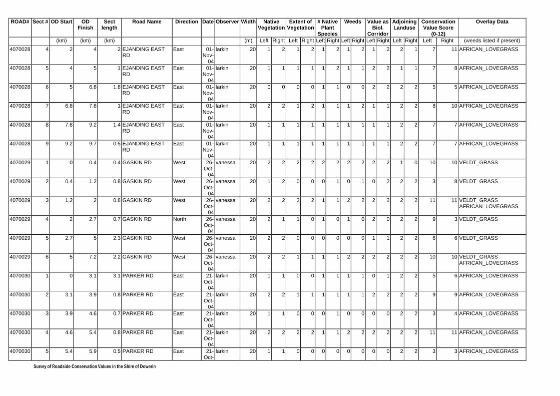
Survey of Roadside Conservation Values in the Shire of Dowerin
ROAD# Sect # OD Start OD Finish
Sect length
Road Name Direction Date Observer Width Native Vegetation
Extent of Vegetation
# Native Plant
Species
Weeds Value as Biol.
Corridor
Adjoining Landuse
Conservation Value Score
(0-12)
Overlay Data
(km) (km) (km) (m) Left Right Left Right Left Right Left Right Left Right Left Right Left Right (weeds listed if present) 4070028 4 2 4 2 EJANDING EAST
RD East 01-
Nov-04
larkin 20 1 2 1 2 1 2 1 2 1 2 2 1 7 11 AFRICAN_LOVEGRASS
4070028 5 4 5 1 EJANDING EAST RD
East 01-Nov-
04
larkin 20 1 1 1 1 1 2 1 1 2 2 1 1 7 8 AFRICAN_LOVEGRASS
4070028 6 5 6.8 1.8 EJANDING EAST RD
East 01-Nov-
04
larkin 20 0 0 0 0 1 1 0 0 2 2 2 2 5 5 AFRICAN_LOVEGRASS
4070028 7 6.8 7.8 1 EJANDING EAST RD
East 01-Nov-
04
larkin 20 2 2 1 2 1 1 1 2 1 1 2 2 8 10 AFRICAN_LOVEGRASS
4070028 8 7.8 9.2 1.4 EJANDING EAST RD
East 01-Nov-
04
larkin 20 1 1 1 1 1 1 1 1 1 1 2 2 7 7 AFRICAN_LOVEGRASS
4070028 9 9.2 9.7 0.5 EJANDING EAST RD
East 01-Nov-
04
larkin 20 1 1 1 1 1 1 1 1 1 1 2 2 7 7 AFRICAN_LOVEGRASS
4070029 1 0 0.4 0.4 GASKIN RD West 26-Oct-
04
vanessa 20 2 2 2 2 2 2 2 2 2 2 1 0 10 10 VELDT_GRASS
4070029 2 0.4 1.2 0.8 GASKIN RD West 26-Oct-
04
vanessa 20 1 2 0 0 0 1 0 1 0 2 2 2 3 8 VELDT_GRASS
4070029 3 1.2 2 0.8 GASKIN RD West 26-Oct-
04
vanessa 20 2 2 2 2 1 1 2 2 2 2 2 2 11 11 VELDT_GRASS AFRICAN_LOVEGRASS
4070029 4 2 2.7 0.7 GASKIN RD North 26-Oct-
04
vanessa 20 2 1 1 0 1 0 1 0 2 0 2 2 9 3 VELDT_GRASS
4070029 5 2.7 5 2.3 GASKIN RD West 26-Oct-
04
vanessa 20 2 2 0 0 0 0 0 0 1 1 2 2 6 6 VELDT_GRASS
4070029 6 5 7.2 2.2 GASKIN RD West 26-Oct-
04
vanessa 20 2 2 1 1 1 1 2 2 2 2 2 2 10 10 VELDT_GRASS AFRICAN_LOVEGRASS
4070030 1 0 3.1 3.1 PARKER RD East 21-Oct-
04
larkin 20 1 1 0 0 1 1 1 1 0 1 2 2 5 6 AFRICAN_LOVEGRASS
4070030 2 3.1 3.9 0.8 PARKER RD East 21-Oct-
04
larkin 20 2 2 1 1 1 1 1 1 2 2 2 2 9 9 AFRICAN_LOVEGRASS
4070030 3 3.9 4.6 0.7 PARKER RD East 21-Oct-
04
larkin 20 1 1 0 0 0 1 0 0 0 0 2 2 3 4 AFRICAN_LOVEGRASS
4070030 4 4.6 5.4 0.8 PARKER RD East 21-Oct-
04
larkin 20 2 2 2 2 1 1 2 2 2 2 2 2 11 11 AFRICAN_LOVEGRASS
4070030 5 5.4 5.9 0.5 PARKER RD East 21-Oct-
larkin 20 1 1 0 0 0 0 0 0 0 0 2 2 3 3 AFRICAN_LOVEGRASS

Survey of Roadside Conservation Values in the Shire of Dowerin
ROAD# Sect # OD Start OD Finish
Sect length
Road Name Direction Date Observer Width Native Vegetation
Extent of Vegetation
# Native Plant
Species
Weeds Value as Biol.
Corridor
Adjoining Landuse
Conservation Value Score
(0-12)
Overlay Data
(km) (km) (km) (m) Left Right Left Right Left Right Left Right Left Right Left Right Left Right (weeds listed if present) 04
4070030 6 5.9 6.9 1 PARKER RD East 21-Oct-
04
larkin 20 2 1 1 0 1 1 1 0 2 0 2 2 9 4 AFRICAN_LOVEGRASS
4070030 7 6.9 7.1 0.2 PARKER RD East 21-Oct-
04
larkin 20 2 2 1 1 1 1 1 1 1 1 2 0 8 6 AFRICAN_LOVEGRASS
4070030 8 7.1 7.7 0.6 PARKER RD East 21-Oct-
04
larkin 20 2 1 0 0 1 0 0 0 0 0 2 2 5 3 AFRICAN_LOVEGRASS
4070031 1 0 1.3 1.3 KING RD South 26-Oct-
04
vanessa 20 2 2 0 0 0 0 0 0 2 2 2 2 6 6 VELDT_GRASS AFRICAN_LOVEGRASS
4070031 2 1.3 3.4 2.1 KING RD South 26-Oct-
04
vanessa 20 2 2 1 1 1 1 2 2 1 1 2 2 9 9 VELDT_GRASS AFRICAN_LOVEGRASS
4070031 3 3.4 4.8 1.4 KING RD South 26-Oct-
04
vanessa 20 1 2 0 0 0 0 1 1 2 2 2 2 6 7 VELDT_GRASS
4070031 4 4.8 6 1.2 KING RD South 26-Oct-
04
vanessa 20 2 2 1 1 1 1 1 1 2 2 2 2 9 9 VELDT_GRASS
4070031 5 6 6.7 0.7 KING RD South 26-Oct-
04
vanessa 20 2 2 2 2 2 2 2 2 2 2 0 0 10 10
4070032 1 0 2.3 2.3 WINDSOR RD South 29-Oct-
04
vanessa 40 1 2 0 0 0 0 0 0 0 1 1 2 2 5 VELDT_GRASS AFRICAN_LOVEGRASS
4070032 2 2.3 4.3 2 WINDSOR RD South 29-Oct-
04
vanessa 40 2 2 0 0 0 1 0 0 1 2 2 2 5 7 VELDT_GRASS COUCH AFRICAN_LOVEGRASS
4070032 3 4.3 7.1 2.8 WINDSOR RD South 29-Oct-
04
vanessa 40 2 2 1 1 1 1 1 1 2 2 2 2 9 9 VELDT_GRASS
4070033 1 0 0.6 0.6 COOK RD East 29-Oct-
04
vanessa 20 2 2 0 1 1 1 1 1 1 1 2 2 7 8 VELDT_GRASS TAGASASTE JUNCUS_ACUTUS
4070033 2 0.6 2.2 1.6 COOK RD East 29-Oct-
04
vanessa 20 1 2 0 0 0 0 0 0 0 1 2 2 3 5 VELDT_GRASS JUNCUS_ACUTUS
4070033 3 2.2 3.2 1 COOK RD East 29-Oct-
04
vanessa 20 2 2 0 0 0 0 0 0 1 2 2 2 5 6 VELDT_GRASS COUCH AFRICAN_LOVEGRASS JUNCUS_ACUTUS
4070033 4 3.2 5.2 2 COOK RD East 29-Oct-
04
vanessa 20 2 2 1 1 1 1 1 1 2 2 2 2 9 9 VELDT_GRASS COUCH AFRICAN_LOVEGRASS JUNCUS_ACUTUS
4070033 5 5.2 5.5 0.3 COOK RD East 29-Oct-
04
vanessa 20 2 2 0 0 0 0 0 0 2 2 2 2 6 6 AFRICAN_LOVEGRASS JUNCUS_ACUTUS
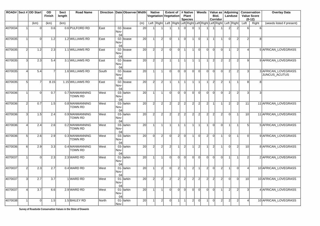
Survey of Roadside Conservation Values in the Shire of Dowerin
ROAD# Sect # OD Start OD Finish
Sect length
Road Name Direction Date Observer Width Native Vegetation
Extent of Vegetation
# Native Plant
Species
Weeds Value as Biol.
Corridor
Adjoining Landuse
Conservation Value Score
(0-12)
Overlay Data
(km) (km) (km) (m) Left Right Left Right Left Right Left Right Left Right Left Right Left Right (weeds listed if present) 4070034 1 0 0.6 0.6 PULFORD RD East 02-
Nov-04
boase 20 1 1 1 1 0 0 1 1 1 1 2 2 6 6
4070035 1 0 1.2 1.2 WILLIAMS RD East 02-Nov-
04
boase 20 1 2 0 1 0 1 0 1 1 1 0 2 2 8
4070035 2 1.2 2.3 1.1 WILLIAMS RD East 02-Nov-
04
boase 20 2 2 0 0 1 1 0 0 0 0 1 2 4 5 AFRICAN_LOVEGRASS
4070035 3 2.3 5.4 3.1 WILLIAMS RD East 02-Nov-
04
boase 20 2 2 1 1 1 1 1 1 2 2 2 2 9 9 AFRICAN_LOVEGRASS
4070035 4 5.4 7 1.6 WILLIAMS RD South 02-Nov-
04
boase 20 1 1 0 0 0 0 0 0 0 0 2 2 3 3 AFRICAN_LOVEGRASS JUNCUS_ACUTUS
4070035 5 7 8.15 1.15 WILLIAMS RD East 02-Nov-
04
boase 20 2 2 1 1 1 1 1 1 2 2 1 1 8 8
4070036 1 0 0.7 0.7 MANMANNING TOWN RD
West 03-Nov-
04
larkin 20 1 1 0 0 0 0 0 0 0 0 2 2 3 3
4070036 2 0.7 1.5 0.8 MANMANNING TOWN RD
West 03-Nov-
04
larkin 20 2 2 2 2 2 2 2 2 1 1 2 2 11 11 AFRICAN_LOVEGRASS
4070036 3 1.5 2.4 0.9 MANMANNING TOWN RD
West 03-Nov-
04
larkin 20 2 2 2 2 2 2 2 2 2 2 0 1 10 11 AFRICAN_LOVEGRASS
4070036 4 2.4 2.6 0.2 MANMANNING TOWN RD
West 03-Nov-
04
larkin 20 1 1 1 1 1 1 1 1 0 0 1 1 5 5 AFRICAN_LOVEGRASS
4070036 5 2.6 2.9 0.3 MANMANNING TOWN RD
West 03-Nov-
04
larkin 20 0 2 0 2 0 1 0 2 0 1 0 1 0 9 AFRICAN_LOVEGRASS
4070036 6 2.9 3.3 0.4 MANMANNING TOWN RD
West 03-Nov-
04
larkin 20 2 2 2 1 2 1 2 1 2 1 0 2 10 8 AFRICAN_LOVEGRASS
4070037 1 0 2.3 2.3 WARD RD West 01-Nov-
04
larkin 20 1 1 0 0 0 0 0 0 0 0 1 1 2 2 AFRICAN_LOVEGRASS
4070037 2 2.3 2.7 0.4 WARD RD West 01-Nov-
04
larkin 20 1 2 0 2 1 2 1 2 0 2 1 0 4 10 AFRICAN_LOVEGRASS
4070037 3 2.7 3.7 1 WARD RD West 01-Nov-
04
larkin 20 2 2 2 2 2 2 2 2 2 2 0 0 10 10 AFRICAN_LOVEGRASS
4070037 4 3.7 6.6 2.9 WARD RD West 01-Nov-
04
larkin 20 1 1 0 0 0 0 0 0 0 1 2 2 3 4 AFRICAN_LOVEGRASS
4070038 1 0 1.5 1.5 BAILEY RD North 01-Nov-
larkin 20 1 2 0 1 1 2 0 1 0 2 2 2 4 10 AFRICAN_LOVEGRASS

Survey of Roadside Conservation Values in the Shire of Dowerin
ROAD# Sect # OD Start OD Finish
Sect length
Road Name Direction Date Observer Width Native Vegetation
Extent of Vegetation
# Native Plant
Species
Weeds Value as Biol.
Corridor
Adjoining Landuse
Conservation Value Score
(0-12)
Overlay Data
(km) (km) (km) (m) Left Right Left Right Left Right Left Right Left Right Left Right Left Right (weeds listed if present) 04
4070038 2 1.5 1.9 0.4 BAILEY RD North 01-Nov-
04
larkin 20 2 2 1 1 1 1 1 1 2 2 1 2 8 9 AFRICAN_LOVEGRASS
4070038 3 1.9 2.2 0.3 BAILEY RD North 01-Nov-
04
larkin 20 0 2 0 1 0 2 0 1 0 2 2 1 2 9 AFRICAN_LOVEGRASS
4070038 4 2.2 2.4 0.2 BAILEY RD North 01-Nov-
04
larkin 20 2 2 1 1 1 1 1 1 1 1 2 2 8 8
4070038 5 2.4 3 0.6 BAILEY RD North 01-Nov-
04
larkin 20 0 0 0 0 0 0 0 0 0 0 2 2 2 2
4070038 6 3 6.5 3.5 BAILEY RD North 01-Nov-
04
larkin 20 2 2 2 2 2 2 2 2 2 2 2 2 12 12 AFRICAN_LOVEGRASS
4070038 7 6.5 7.1 0.6 BAILEY RD North 01-Nov-
04
larkin 20 2 2 2 2 2 2 2 2 1 1 2 2 11 11 AFRICAN_LOVEGRASS
4070038 8 7.1 7.6 0.5 BAILEY RD North 01-Nov-
04
larkin 20 2 2 1 1 1 1 1 1 1 1 2 2 8 8 AFRICAN_LOVEGRASS
4070038 9 7.6 8.1 0.5 BAILEY RD North 01-Nov-
04
larkin 20 2 2 2 2 2 2 2 2 2 2 0 0 10 10 AFRICAN_LOVEGRASS
4070039 1 0 1.5 1.5 HARRIS RD East 27-Oct-
04
larkin 20 2 2 2 2 2 2 2 2 1 2 2 2 11 12 AFRICAN_LOVEGRASS
4070039 2 1.5 2.3 0.8 HARRIS RD East 27-Oct-
04
larkin 20 2 2 2 2 2 2 2 2 2 2 2 1 12 11 AFRICAN_LOVEGRASS
4070039 3 2.3 3.4 1.1 HARRIS RD East 27-Oct-
04
larkin 20 0 0 0 0 0 0 0 0 0 0 2 2 2 2 AFRICAN_LOVEGRASS
4070039 4 3.4 3.8 0.4 HARRIS RD East 27-Oct-
04
larkin 20 0 0 0 0 0 0 0 0 0 0 2 2 2 2 AFRICAN_LOVEGRASS COUCH
4070039 5 3.8 4.9 1.1 HARRIS RD East 27-Oct-
04
larkin 20 0 0 0 0 0 0 0 0 0 0 2 2 2 2 AFRICAN_LOVEGRASS
4070040 1 0 0.78 0.78 BOORALAMING WEST RD
West 01-Nov-
04
larkin 20 2 2 2 2 2 2 2 2 2 2 1 0 11 10 AFRICAN_LOVEGRASS
4070040 2 0.78 1.06 0.28 BOORALAMING WEST RD
West 01-Nov-
04
larkin 20 2 2 2 2 2 2 2 2 2 2 2 2 12 12 AFRICAN_LOVEGRASS
4070040 3 1.06 1.64 0.58 BOORALAMING WEST RD
West 01-Nov-
04
larkin 20 1 2 0 1 0 1 0 2 0 2 2 2 3 10 AFRICAN_LOVEGRASS

Survey of Roadside Conservation Values in the Shire of Dowerin
ROAD# Sect # OD Start OD Finish
Sect length
Road Name Direction Date Observer Width Native Vegetation
Extent of Vegetation
# Native Plant
Species
Weeds Value as Biol.
Corridor
Adjoining Landuse
Conservation Value Score
(0-12)
Overlay Data
(km) (km) (km) (m) Left Right Left Right Left Right Left Right Left Right Left Right Left Right (weeds listed if present) 4070040 4 1.64 2.72 1.08 BOORALAMING
WEST RD West 01-
Nov-04
larkin 20 1 1 0 0 0 0 0 0 0 1 2 2 3 4 AFRICAN_LOVEGRASS
4070040 5 2.72 4.6 1.88 BOORALAMING WEST RD
West 01-Nov-
04
larkin 20 2 2 2 2 2 2 2 2 2 2 2 1 12 11 AFRICAN_LOVEGRASS
4070040 6 4.6 5.28 0.68 BOORALAMING WEST RD
West 01-Nov-
04
larkin 20 1 1 0 0 0 0 2 2 1 1 1 1 5 5
4070040 7 5.28 6.26 0.98 BOORALAMING WEST RD
West 01-Nov-
04
larkin 20 2 2 2 2 2 2 2 2 2 2 1 1 11 11 AFRICAN_LOVEGRASS
4070040 8 6.26 9.44 3.18 BOORALAMING WEST RD
West 01-Nov-
04
larkin 20 2 1 1 0 1 0 1 0 2 1 1 1 8 3 AFRICAN_LOVEGRASS
4070040 9 9.44 10.72 1.28 BOORALAMING WEST RD
West 01-Nov-
04
larkin 20 2 2 2 2 2 2 2 2 2 2 1 2 11 12 AFRICAN_LOVEGRASS
4070040 10 10.72 12.1 1.38 BOORALAMING WEST RD
West 01-Nov-
04
larkin 20 2 2 2 2 2 2 2 2 2 2 0 0 10 10 AFRICAN_LOVEGRASS
4070040 11 12.1 12.48 0.38 BOORALAMING WEST RD
West 01-Nov-
04
larkin 20 1 1 0 0 1 1 1 1 1 1 1 1 5 5 AFRICAN_LOVEGRASS
4070040 12 12.48 13.06 0.58 BOORALAMING WEST RD
West 01-Nov-
04
larkin 20 2 2 1 1 1 1 1 1 1 2 1 2 7 9 AFRICAN_LOVEGRASS
4070040 13 13.06 13.74 0.68 BOORALAMING WEST RD
West 01-Nov-
04
larkin 20 2 1 1 0 1 1 1 1 2 1 1 2 8 6 AFRICAN_LOVEGRASS
4070040 14 13.74 14.72 0.98 BOORALAMING WEST RD
West 01-Nov-
04
larkin 20 1 1 1 1 1 1 1 1 2 1 1 2 7 7
4070041 1 0 2.3 2.3 MOONIJIN EAST RD
West 27-Oct-
04
larkin 20 0 0 0 0 1 1 0 0 0 0 2 2 3 3 AFRICAN_LOVEGRASS
4070041 2 2.3 2.7 0.4 MOONIJIN EAST RD
West 27-Oct-
04
larkin 20 2 2 2 2 2 2 2 2 2 2 0 0 10 10 AFRICAN_LOVEGRASS
4070041 3 2.7 2.84 0.14 MOONIJIN EAST RD
West 27-Oct-
04
larkin 20 0 0 0 0 0 0 0 0 0 0 1 1 1 1 AFRICAN_LOVEGRASS
4070042 1 0 0.2 0.2 MCHUGH RD East 21-Oct-
04
larkin 20 1 1 0 0 0 0 0 0 0 0 2 2 3 3 AFRICAN_LOVEGRASS
4070042 2 0.2 0.5 0.3 MCHUGH RD East 21-Oct-
04
larkin 20 2 2 1 1 1 1 2 2 2 2 2 2 10 10 AFRICAN_LOVEGRASS
4070042 3 0.5 0.9 0.4 MCHUGH RD East 21-Oct-
larkin 20 1 2 0 0 0 0 0 0 0 0 2 2 3 4 AFRICAN_LOVEGRASS

Survey of Roadside Conservation Values in the Shire of Dowerin
ROAD# Sect # OD Start OD Finish
Sect length
Road Name Direction Date Observer Width Native Vegetation
Extent of Vegetation
# Native Plant
Species
Weeds Value as Biol.
Corridor
Adjoining Landuse
Conservation Value Score
(0-12)
Overlay Data
(km) (km) (km) (m) Left Right Left Right Left Right Left Right Left Right Left Right Left Right (weeds listed if present) 04
4070042 4 0.9 3.6 2.7 MCHUGH RD East 21-Oct-
04
larkin 20 2 2 1 1 1 1 1 1 2 2 2 2 9 9
4070042 5 3.6 4.5 0.9 MCHUGH RD East 21-Oct-
04
larkin 20 1 1 0 0 0 0 0 0 0 0 1 2 2 3 AFRICAN_LOVEGRASS
4070042 6 4.5 4.8 0.3 MCHUGH RD East 21-Oct-
04
larkin 20 2 2 1 1 1 1 1 1 2 2 2 2 9 9 AFRICAN_LOVEGRASS
4070042 7 4.8 5.4 0.6 MCHUGH RD East 21-Oct-
04
larkin 20 0 2 0 1 0 1 0 2 0 2 2 0 2 8 AFRICAN_LOVEGRASS
4070042 8 5.4 6.3 0.9 MCHUGH RD East 21-Oct-
04
larkin 20 2 1 0 0 1 1 0 0 0 0 2 2 5 4 AFRICAN_LOVEGRASS
4070042 9 6.3 8.7 2.4 MCHUGH RD East 21-Oct-
04
larkin 20 1 1 0 0 1 1 0 0 0 0 2 2 4 4 AFRICAN_LOVEGRASS
4070044 1 0 1 1 MORRELL NORTH RD
South 21-Oct-
04
Robinson Chicks
20 0 0 0 0 0 0 0 0 0 0 2 2 2 2 AFRICAN_LOVEGRASS
4070044 2 1 3.2 2.2 MORRELL NORTH RD
South 21-Oct-
04
Robinson Chicks
20 1 1 1 1 0 0 0 0 1 1 2 2 5 5 AFRICAN_LOVEGRASS
4070044 3 3.2 3.8 0.6 MORRELL NORTH RD
South 21-Oct-
04
Robinson Chicks
20 2 2 1 2 1 2 2 0 2 2 2 2 10 10
4070046 1 0 4.5 4.5 SANDERS RD East 22-Oct-
04
boase 20 2 2 0 0 0 0 0 0 2 2 2 2 6 6 PATERSONS_CURSE AFRICAN_LOVEGRASS
4070046 2 4.5 4.9 0.4 SANDERS RD East 22-Oct-
04
boase 20 2 2 2 2 0 0 1 1 1 1 2 2 6 6
4070046 3 4.9 7.1 2.2 SANDERS RD East 22-Oct-
04
boase 20 0 0 0 0 0 0 0 0 0 0 2 2 1 1
4070047 1 0 1.4 1.4 TWENTY SIX GATE RD
East 22-Oct-
04
boase 20 1 1 0 0 0 0 1 1 2 2 2 2 6 6
4070047 2 1.4 2.3 0.9 TWENTY SIX GATE RD
East 22-Oct-
04
boase 20 2 2 2 2 2 2 2 2 2 2 2 2 10 10
4070047 3 2.3 7 4.7 TWENTY SIX GATE RD
East 22-Oct-
04
boase 20 2 2 1 1 0 0 1 1 2 2 2 2 8 8
4070048 1 0 1.3 1.3 HAGBOOM RD East 22-Oct-
04
boase 20 0 0 0 0 0 0 0 0 0 0 2 2 2 2 AFRICAN_LOVEGRASS
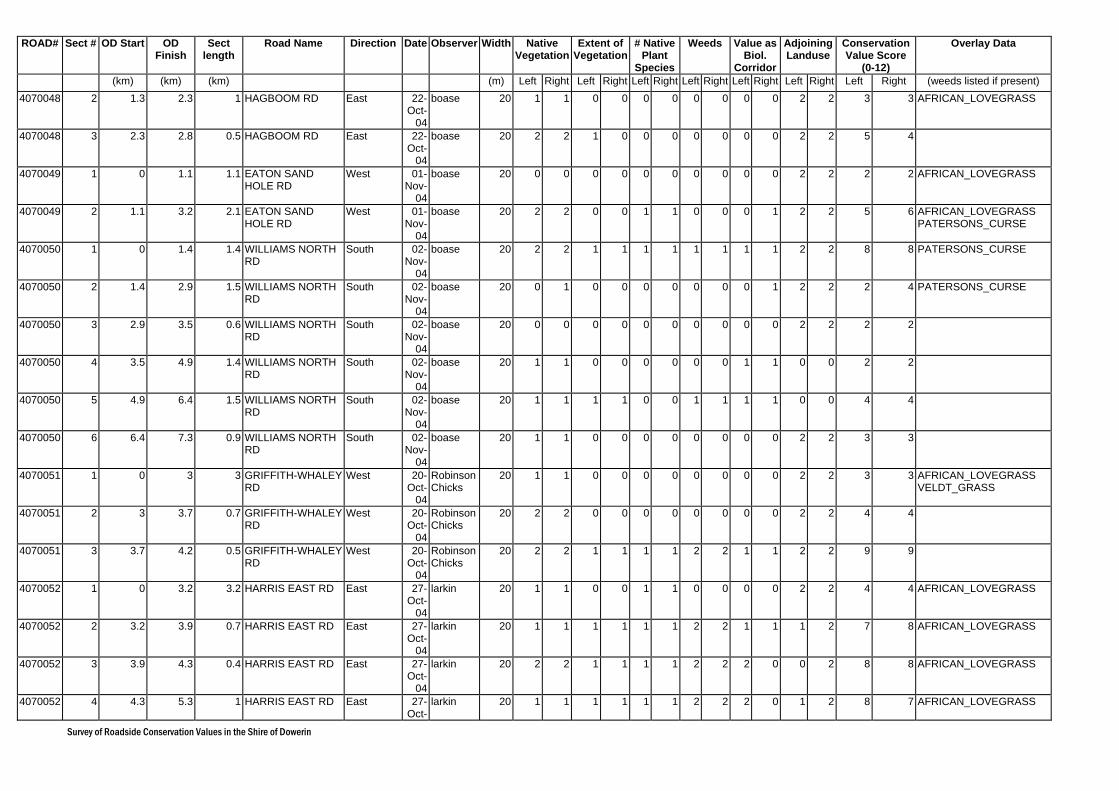
Survey of Roadside Conservation Values in the Shire of Dowerin
ROAD# Sect # OD Start OD Finish
Sect length
Road Name Direction Date Observer Width Native Vegetation
Extent of Vegetation
# Native Plant
Species
Weeds Value as Biol.
Corridor
Adjoining Landuse
Conservation Value Score
(0-12)
Overlay Data
(km) (km) (km) (m) Left Right Left Right Left Right Left Right Left Right Left Right Left Right (weeds listed if present) 4070048 2 1.3 2.3 1 HAGBOOM RD East 22-
Oct-04
boase 20 1 1 0 0 0 0 0 0 0 0 2 2 3 3 AFRICAN_LOVEGRASS
4070048 3 2.3 2.8 0.5 HAGBOOM RD East 22-Oct-
04
boase 20 2 2 1 0 0 0 0 0 0 0 2 2 5 4
4070049 1 0 1.1 1.1 EATON SAND HOLE RD
West 01-Nov-
04
boase 20 0 0 0 0 0 0 0 0 0 0 2 2 2 2 AFRICAN_LOVEGRASS
4070049 2 1.1 3.2 2.1 EATON SAND HOLE RD
West 01-Nov-
04
boase 20 2 2 0 0 1 1 0 0 0 1 2 2 5 6 AFRICAN_LOVEGRASS PATERSONS_CURSE
4070050 1 0 1.4 1.4 WILLIAMS NORTH RD
South 02-Nov-
04
boase 20 2 2 1 1 1 1 1 1 1 1 2 2 8 8 PATERSONS_CURSE
4070050 2 1.4 2.9 1.5 WILLIAMS NORTH RD
South 02-Nov-
04
boase 20 0 1 0 0 0 0 0 0 0 1 2 2 2 4 PATERSONS_CURSE
4070050 3 2.9 3.5 0.6 WILLIAMS NORTH RD
South 02-Nov-
04
boase 20 0 0 0 0 0 0 0 0 0 0 2 2 2 2
4070050 4 3.5 4.9 1.4 WILLIAMS NORTH RD
South 02-Nov-
04
boase 20 1 1 0 0 0 0 0 0 1 1 0 0 2 2
4070050 5 4.9 6.4 1.5 WILLIAMS NORTH RD
South 02-Nov-
04
boase 20 1 1 1 1 0 0 1 1 1 1 0 0 4 4
4070050 6 6.4 7.3 0.9 WILLIAMS NORTH RD
South 02-Nov-
04
boase 20 1 1 0 0 0 0 0 0 0 0 2 2 3 3
4070051 1 0 3 3 GRIFFITH-WHALEY RD
West 20-Oct-
04
Robinson Chicks
20 1 1 0 0 0 0 0 0 0 0 2 2 3 3 AFRICAN_LOVEGRASS VELDT_GRASS
4070051 2 3 3.7 0.7 GRIFFITH-WHALEY RD
West 20-Oct-
04
Robinson Chicks
20 2 2 0 0 0 0 0 0 0 0 2 2 4 4
4070051 3 3.7 4.2 0.5 GRIFFITH-WHALEY RD
West 20-Oct-
04
Robinson Chicks
20 2 2 1 1 1 1 2 2 1 1 2 2 9 9
4070052 1 0 3.2 3.2 HARRIS EAST RD East 27-Oct-
04
larkin 20 1 1 0 0 1 1 0 0 0 0 2 2 4 4 AFRICAN_LOVEGRASS
4070052 2 3.2 3.9 0.7 HARRIS EAST RD East 27-Oct-
04
larkin 20 1 1 1 1 1 1 2 2 1 1 1 2 7 8 AFRICAN_LOVEGRASS
4070052 3 3.9 4.3 0.4 HARRIS EAST RD East 27-Oct-
04
larkin 20 2 2 1 1 1 1 2 2 2 0 0 2 8 8 AFRICAN_LOVEGRASS
4070052 4 4.3 5.3 1 HARRIS EAST RD East 27-Oct-
larkin 20 1 1 1 1 1 1 2 2 2 0 1 2 8 7 AFRICAN_LOVEGRASS
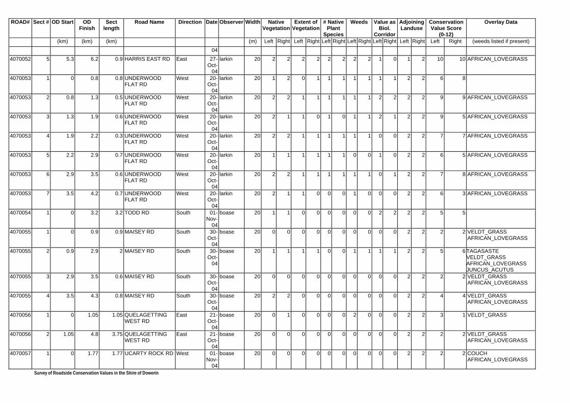
Survey of Roadside Conservation Values in the Shire of Dowerin
ROAD# Sect # OD Start OD Finish
Sect length
Road Name Direction Date Observer Width Native Vegetation
Extent of Vegetation
# Native Plant
Species
Weeds Value as Biol.
Corridor
Adjoining Landuse
Conservation Value Score
(0-12)
Overlay Data
(km) (km) (km) (m) Left Right Left Right Left Right Left Right Left Right Left Right Left Right (weeds listed if present) 04
4070052 5 5.3 6.2 0.9 HARRIS EAST RD East 27-Oct-
04
larkin 20 2 2 2 2 2 2 2 2 1 0 1 2 10 10 AFRICAN_LOVEGRASS
4070053 1 0 0.8 0.8 UNDERWOOD FLAT RD
West 20-Oct-
04
larkin 20 1 2 0 1 1 1 1 1 1 1 2 2 6 8
4070053 2 0.8 1.3 0.5 UNDERWOOD FLAT RD
West 20-Oct-
04
larkin 20 2 2 1 1 1 1 1 1 2 2 2 2 9 9 AFRICAN_LOVEGRASS
4070053 3 1.3 1.9 0.6 UNDERWOOD FLAT RD
West 20-Oct-
04
larkin 20 2 1 1 0 1 0 1 1 2 1 2 2 9 5 AFRICAN_LOVEGRASS
4070053 4 1.9 2.2 0.3 UNDERWOOD FLAT RD
West 20-Oct-
04
larkin 20 2 2 1 1 1 1 1 1 0 0 2 2 7 7 AFRICAN_LOVEGRASS
4070053 5 2.2 2.9 0.7 UNDERWOOD FLAT RD
West 20-Oct-
04
larkin 20 1 1 1 1 1 1 0 0 1 0 2 2 6 5 AFRICAN_LOVEGRASS
4070053 6 2.9 3.5 0.6 UNDERWOOD FLAT RD
West 20-Oct-
04
larkin 20 2 2 1 1 1 1 1 1 0 1 2 2 7 8 AFRICAN_LOVEGRASS
4070053 7 3.5 4.2 0.7 UNDERWOOD FLAT RD
West 20-Oct-
04
larkin 20 2 1 1 0 0 0 1 0 0 0 2 2 6 3 AFRICAN_LOVEGRASS
4070054 1 0 3.2 3.2 TODD RD South 01-Nov-
04
boase 20 1 1 0 0 0 0 0 0 2 2 2 2 5 5
4070055 1 0 0.9 0.9 MAISEY RD South 30-Oct-
04
boase 20 0 0 0 0 0 0 0 0 0 0 2 2 2 2 VELDT_GRASS AFRICAN_LOVEGRASS
4070055 2 0.9 2.9 2 MAISEY RD South 30-Oct-
04
boase 20 1 1 1 1 0 0 1 1 1 1 2 2 5 6 TAGASASTE VELDT_GRASS AFRICAN_LOVEGRASS JUNCUS_ACUTUS
4070055 3 2.9 3.5 0.6 MAISEY RD South 30-Oct-
04
boase 20 0 0 0 0 0 0 0 0 0 0 2 2 2 2 VELDT_GRASS AFRICAN_LOVEGRASS
4070055 4 3.5 4.3 0.8 MAISEY RD South 30-Oct-
04
boase 20 2 2 0 0 0 0 0 0 0 0 2 2 4 4 VELDT_GRASS AFRICAN_LOVEGRASS
4070056 1 0 1.05 1.05 QUELAGETTING WEST RD
East 21-Oct-
04
boase 20 0 1 0 0 0 0 2 0 0 0 2 2 3 1 VELDT_GRASS
4070056 2 1.05 4.8 3.75 QUELAGETTING WEST RD
East 21-Oct-
04
boase 20 0 0 0 0 0 0 0 0 0 0 2 2 2 2 VELDT_GRASS AFRICAN_LOVEGRASS
4070057 1 0 1.77 1.77 UCARTY ROCK RD West 01-Nov-
04
boase 20 0 0 0 0 0 0 0 0 0 0 2 2 2 2 COUCH AFRICAN_LOVEGRASS
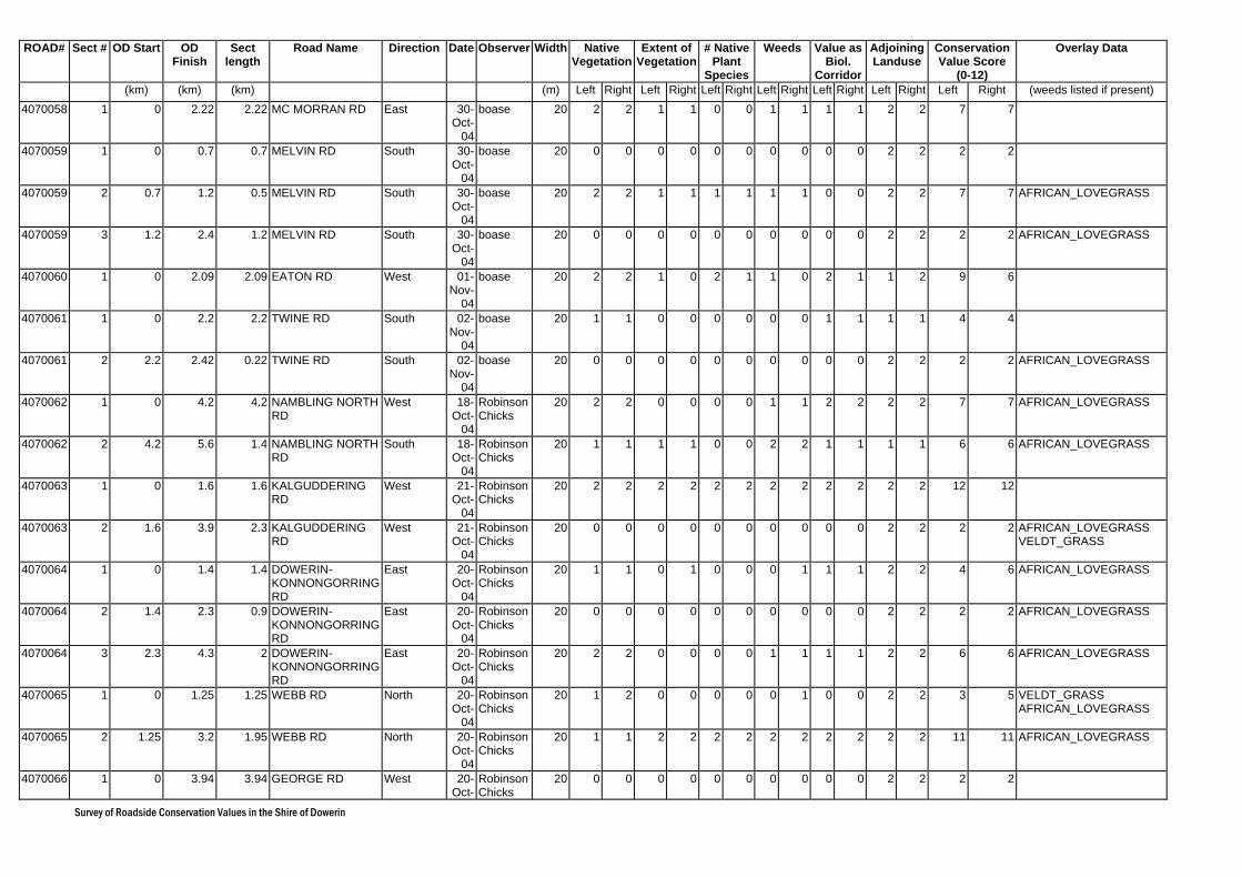
Survey of Roadside Conservation Values in the Shire of Dowerin
ROAD# Sect # OD Start OD Finish
Sect length
Road Name Direction Date Observer Width Native Vegetation
Extent of Vegetation
# Native Plant
Species
Weeds Value as Biol.
Corridor
Adjoining Landuse
Conservation Value Score
(0-12)
Overlay Data
(km) (km) (km) (m) Left Right Left Right Left Right Left Right Left Right Left Right Left Right (weeds listed if present) 4070058 1 0 2.22 2.22 MC MORRAN RD East 30-
Oct-04
boase 20 2 2 1 1 0 0 1 1 1 1 2 2 7 7
4070059 1 0 0.7 0.7 MELVIN RD South 30-Oct-
04
boase 20 0 0 0 0 0 0 0 0 0 0 2 2 2 2
4070059 2 0.7 1.2 0.5 MELVIN RD South 30-Oct-
04
boase 20 2 2 1 1 1 1 1 1 0 0 2 2 7 7 AFRICAN_LOVEGRASS
4070059 3 1.2 2.4 1.2 MELVIN RD South 30-Oct-
04
boase 20 0 0 0 0 0 0 0 0 0 0 2 2 2 2 AFRICAN_LOVEGRASS
4070060 1 0 2.09 2.09 EATON RD West 01-Nov-
04
boase 20 2 2 1 0 2 1 1 0 2 1 1 2 9 6
4070061 1 0 2.2 2.2 TWINE RD South 02-Nov-
04
boase 20 1 1 0 0 0 0 0 0 1 1 1 1 4 4
4070061 2 2.2 2.42 0.22 TWINE RD South 02-Nov-
04
boase 20 0 0 0 0 0 0 0 0 0 0 2 2 2 2 AFRICAN_LOVEGRASS
4070062 1 0 4.2 4.2 NAMBLING NORTH RD
West 18-Oct-
04
Robinson Chicks
20 2 2 0 0 0 0 1 1 2 2 2 2 7 7 AFRICAN_LOVEGRASS
4070062 2 4.2 5.6 1.4 NAMBLING NORTH RD
South 18-Oct-
04
Robinson Chicks
20 1 1 1 1 0 0 2 2 1 1 1 1 6 6 AFRICAN_LOVEGRASS
4070063 1 0 1.6 1.6 KALGUDDERING RD
West 21-Oct-
04
Robinson Chicks
20 2 2 2 2 2 2 2 2 2 2 2 2 12 12
4070063 2 1.6 3.9 2.3 KALGUDDERING RD
West 21-Oct-
04
Robinson Chicks
20 0 0 0 0 0 0 0 0 0 0 2 2 2 2 AFRICAN_LOVEGRASS VELDT_GRASS
4070064 1 0 1.4 1.4 DOWERIN-KONNONGORRING RD
East 20-Oct-
04
Robinson Chicks
20 1 1 0 1 0 0 0 1 1 1 2 2 4 6 AFRICAN_LOVEGRASS
4070064 2 1.4 2.3 0.9 DOWERIN-KONNONGORRING RD
East 20-Oct-
04
Robinson Chicks
20 0 0 0 0 0 0 0 0 0 0 2 2 2 2 AFRICAN_LOVEGRASS
4070064 3 2.3 4.3 2 DOWERIN-KONNONGORRING RD
East 20-Oct-
04
Robinson Chicks
20 2 2 0 0 0 0 1 1 1 1 2 2 6 6 AFRICAN_LOVEGRASS
4070065 1 0 1.25 1.25 WEBB RD North 20-Oct-
04
Robinson Chicks
20 1 2 0 0 0 0 0 1 0 0 2 2 3 5 VELDT_GRASS AFRICAN_LOVEGRASS
4070065 2 1.25 3.2 1.95 WEBB RD North 20-Oct-
04
Robinson Chicks
20 1 1 2 2 2 2 2 2 2 2 2 2 11 11 AFRICAN_LOVEGRASS
4070066 1 0 3.94 3.94 GEORGE RD West 20-Oct-
Robinson Chicks
20 0 0 0 0 0 0 0 0 0 0 2 2 2 2

Survey of Roadside Conservation Values in the Shire of Dowerin
ROAD# Sect # OD Start OD Finish
Sect length
Road Name Direction Date Observer Width Native Vegetation
Extent of Vegetation
# Native Plant
Species
Weeds Value as Biol.
Corridor
Adjoining Landuse
Conservation Value Score
(0-12)
Overlay Data
(km) (km) (km) (m) Left Right Left Right Left Right Left Right Left Right Left Right Left Right (weeds listed if present) 04
4070067 1 0 1 1 IRVINE RD West 27-Oct-
04
erin 20 0 2 0 0 0 0 0 0 0 1 2 1 2 4 PATERSONS_CURSE AFRICAN_LOVEGRASS VELDT_GRASS
4070067 2 1 1.6 0.6 IRVINE RD West 27-Oct-
04
erin 20 2 2 0 1 0 0 0 0 1 2 2 1 5 6 AFRICAN_LOVEGRASS
4070067 3 1.6 2.6 1 IRVINE RD West 27-Oct-
04
erin 20 2 2 0 1 1 2 1 2 1 1 2 1 7 9 AFRICAN_LOVEGRASS
4070068 1 0 1.77 1.77 AVERY RD South 01-Nov-
04
larkin 20 0 0 0 0 0 0 0 0 0 0 2 2 2 2
4070070 1 0 0.58 0.58 BRUCE RD South 01-Nov-
04
larkin 20 2 2 2 2 2 2 2 2 2 2 2 2 12 12 AFRICAN_LOVEGRASS
4070070 2 0.58 2.16 1.58 BRUCE RD South 01-Nov-
04
larkin 20 2 2 2 2 1 1 2 1 2 2 1 1 10 9 AFRICAN_LOVEGRASS
4070070 3 2.16 2.64 0.48 BRUCE RD South 01-Nov-
04
larkin 20 1 1 2 2 1 1 2 2 0 0 1 1 7 7 AFRICAN_LOVEGRASS
4070070 4 2.64 3.62 0.98 BRUCE RD South 01-Nov-
04
larkin 20 2 2 1 1 2 2 1 1 2 2 2 2 10 10 AFRICAN_LOVEGRASS
4070070 5 3.62 5.4 1.78 BRUCE RD South 01-Nov-
04
larkin 20 2 2 2 2 2 2 2 2 1 2 2 1 11 11 AFRICAN_LOVEGRASS
4070072 1 2.85 3.76 0.91 JONES RD South 21-Oct-
04
Robinson Chicks
20 1 1 1 1 0 0 0 0 1 1 0 0 3 3 VELDT_GRASS
4070072 2 3.76 4.96 1.2 JONES RD South 21-Oct-
04
Robinson Chicks
20 0 0 0 0 0 0 0 0 0 0 0 0 2 2 VELDT_GRASS
4070072 3 4.96 5.56 0.6 JONES RD South 21-Oct-
04
Robinson Chicks
20 0 0 0 0 0 0 0 0 0 0 2 2 2 2 AFRICAN_LOVEGRASS VELDT_GRASS
4070073 1 0 0.6 0.6 HENNING RD South 21-Oct-
04
Robinson Chicks
20 2 0 1 0 0 0 0 0 0 0 2 2 5 2
4070073 2 0.3 0.8 0.5 HENNING RD South 21-Oct-
04
Robinson Chicks
20 0 0 0 0 0 0 0 0 0 0 2 2 2 2
4070073 3 0.8 1.8 1 HENNING RD South 21-Oct-
04
Robinson Chicks
20 2 0 1 0 0 0 1 0 0 0 2 2 6 2 AFRICAN_LOVEGRASS
4070073 4 1.8 3.5 1.7 HENNING RD South 21-Oct-
04
Robinson Chicks
20 0 0 0 0 0 0 0 0 0 0 2 2 2 2 AFRICAN_LOVEGRASS VELDT_GRASS
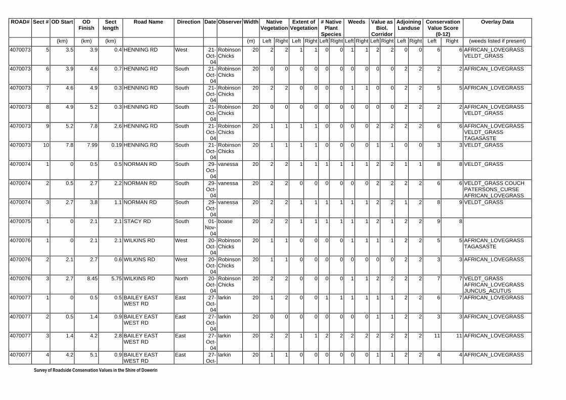
Survey of Roadside Conservation Values in the Shire of Dowerin
ROAD# Sect # OD Start OD Finish
Sect length
Road Name Direction Date Observer Width Native Vegetation
Extent of Vegetation
# Native Plant
Species
Weeds Value as Biol.
Corridor
Adjoining Landuse
Conservation Value Score
(0-12)
Overlay Data
(km) (km) (km) (m) Left Right Left Right Left Right Left Right Left Right Left Right Left Right (weeds listed if present) 4070073 5 3.5 3.9 0.4 HENNING RD West 21-
Oct-04
Robinson Chicks
20 2 2 1 1 0 0 1 1 2 2 0 0 6 6 AFRICAN_LOVEGRASS VELDT_GRASS
4070073 6 3.9 4.6 0.7 HENNING RD South 21-Oct-
04
Robinson Chicks
20 0 0 0 0 0 0 0 0 0 0 2 2 2 2 AFRICAN_LOVEGRASS
4070073 7 4.6 4.9 0.3 HENNING RD South 21-Oct-
04
Robinson Chicks
20 2 2 0 0 0 0 1 1 0 0 2 2 5 5 AFRICAN_LOVEGRASS
4070073 8 4.9 5.2 0.3 HENNING RD South 21-Oct-
04
Robinson Chicks
20 0 0 0 0 0 0 0 0 0 0 2 2 2 2 AFRICAN_LOVEGRASS VELDT_GRASS
4070073 9 5.2 7.8 2.6 HENNING RD South 21-Oct-
04
Robinson Chicks
20 1 1 1 1 0 0 0 0 2 2 2 2 6 6 AFRICAN_LOVEGRASS VELDT_GRASS TAGASASTE
4070073 10 7.8 7.99 0.19 HENNING RD South 21-Oct-
04
Robinson Chicks
20 1 1 1 1 0 0 0 0 1 1 0 0 3 3 VELDT_GRASS
4070074 1 0 0.5 0.5 NORMAN RD South 29-Oct-
04
vanessa 20 2 2 1 1 1 1 1 1 2 2 1 1 8 8 VELDT_GRASS
4070074 2 0.5 2.7 2.2 NORMAN RD South 29-Oct-
04
vanessa 20 2 2 0 0 0 0 0 0 2 2 2 2 6 6 VELDT_GRASS COUCH PATERSONS_CURSE AFRICAN_LOVEGRASS
4070074 3 2.7 3.8 1.1 NORMAN RD South 29-Oct-
04
vanessa 20 2 2 1 1 1 1 1 1 2 2 1 2 8 9 VELDT_GRASS
4070075 1 0 2.1 2.1 STACY RD South 01-Nov-
04
boase 20 2 2 1 1 1 1 1 1 2 1 2 2 9 8
4070076 1 0 2.1 2.1 WILKINS RD West 20-Oct-
04
Robinson Chicks
20 1 1 0 0 0 0 1 1 1 1 2 2 5 5 AFRICAN_LOVEGRASS TAGASASTE
4070076 2 2.1 2.7 0.6 WILKINS RD West 20-Oct-
04
Robinson Chicks
20 1 1 0 0 0 0 0 0 0 0 2 2 3 3 AFRICAN_LOVEGRASS
4070076 3 2.7 8.45 5.75 WILKINS RD North 20-Oct-
04
Robinson Chicks
20 2 2 0 0 0 0 1 1 2 2 2 2 7 7 VELDT_GRASS AFRICAN_LOVEGRASS JUNCUS_ACUTUS
4070077 1 0 0.5 0.5 BAILEY EAST WEST RD
East 27-Oct-
04
larkin 20 1 2 0 0 1 1 1 1 1 1 2 2 6 7 AFRICAN_LOVEGRASS
4070077 2 0.5 1.4 0.9 BAILEY EAST WEST RD
East 27-Oct-
04
larkin 20 0 0 0 0 0 0 0 0 1 1 2 2 3 3 AFRICAN_LOVEGRASS
4070077 3 1.4 4.2 2.8 BAILEY EAST WEST RD
East 27-Oct-
04
larkin 20 2 2 1 1 2 2 2 2 2 2 2 2 11 11 AFRICAN_LOVEGRASS
4070077 4 4.2 5.1 0.9 BAILEY EAST WEST RD
East 27-Oct-
larkin 20 1 1 0 0 0 0 0 0 1 1 2 2 4 4 AFRICAN_LOVEGRASS
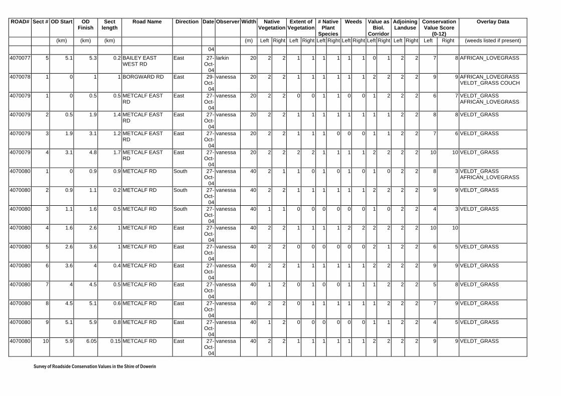
Survey of Roadside Conservation Values in the Shire of Dowerin
ROAD# Sect # OD Start OD Finish
Sect length
Road Name Direction Date Observer Width Native Vegetation
Extent of Vegetation
# Native Plant
Species
Weeds Value as Biol.
Corridor
Adjoining Landuse
Conservation Value Score
(0-12)
Overlay Data
(km) (km) (km) (m) Left Right Left Right Left Right Left Right Left Right Left Right Left Right (weeds listed if present) 04
4070077 5 5.1 5.3 0.2 BAILEY EAST WEST RD
East 27-Oct-
04
larkin 20 2 2 1 1 1 1 1 1 0 1 2 2 7 8 AFRICAN_LOVEGRASS
4070078 1 0 1 1 BORGWARD RD East 29-Oct-
04
vanessa 20 2 2 1 1 1 1 1 1 2 2 2 2 9 9 AFRICAN_LOVEGRASS VELDT_GRASS COUCH
4070079 1 0 0.5 0.5 METCALF EAST RD
East 27-Oct-
04
vanessa 20 2 2 0 0 1 1 0 0 1 2 2 2 6 7 VELDT_GRASS AFRICAN_LOVEGRASS
4070079 2 0.5 1.9 1.4 METCALF EAST RD
East 27-Oct-
04
vanessa 20 2 2 1 1 1 1 1 1 1 1 2 2 8 8 VELDT_GRASS
4070079 3 1.9 3.1 1.2 METCALF EAST RD
East 27-Oct-
04
vanessa 20 2 2 1 1 1 0 0 0 1 1 2 2 7 6 VELDT_GRASS
4070079 4 3.1 4.8 1.7 METCALF EAST RD
East 27-Oct-
04
vanessa 20 2 2 2 2 1 1 1 1 2 2 2 2 10 10 VELDT_GRASS
4070080 1 0 0.9 0.9 METCALF RD South 27-Oct-
04
vanessa 40 2 1 1 0 1 0 1 0 1 0 2 2 8 3 VELDT_GRASS AFRICAN_LOVEGRASS
4070080 2 0.9 1.1 0.2 METCALF RD South 27-Oct-
04
vanessa 40 2 2 1 1 1 1 1 1 2 2 2 2 9 9 VELDT_GRASS
4070080 3 1.1 1.6 0.5 METCALF RD South 27-Oct-
04
vanessa 40 1 1 0 0 0 0 0 0 1 0 2 2 4 3 VELDT_GRASS
4070080 4 1.6 2.6 1 METCALF RD East 27-Oct-
04
vanessa 40 2 2 1 1 1 1 2 2 2 2 2 2 10 10
4070080 5 2.6 3.6 1 METCALF RD East 27-Oct-
04
vanessa 40 2 2 0 0 0 0 0 0 2 1 2 2 6 5 VELDT_GRASS
4070080 6 3.6 4 0.4 METCALF RD East 27-Oct-
04
vanessa 40 2 2 1 1 1 1 1 1 2 2 2 2 9 9 VELDT_GRASS
4070080 7 4 4.5 0.5 METCALF RD East 27-Oct-
04
vanessa 40 1 2 0 1 0 0 1 1 1 2 2 2 5 8 VELDT_GRASS
4070080 8 4.5 5.1 0.6 METCALF RD East 27-Oct-
04
vanessa 40 2 2 0 1 1 1 1 1 1 2 2 2 7 9 VELDT_GRASS
4070080 9 5.1 5.9 0.8 METCALF RD East 27-Oct-
04
vanessa 40 1 2 0 0 0 0 0 0 1 1 2 2 4 5 VELDT_GRASS
4070080 10 5.9 6.05 0.15 METCALF RD East 27-Oct-
04
vanessa 40 2 2 1 1 1 1 1 1 2 2 2 2 9 9 VELDT_GRASS

Survey of Roadside Conservation Values in the Shire of Dowerin
ROAD# Sect # OD Start OD Finish
Sect length
Road Name Direction Date Observer Width Native Vegetation
Extent of Vegetation
# Native Plant
Species
Weeds Value as Biol.
Corridor
Adjoining Landuse
Conservation Value Score
(0-12)
Overlay Data
(km) (km) (km) (m) Left Right Left Right Left Right Left Right Left Right Left Right Left Right (weeds listed if present) 4070081 1 0 0.2 0.2 LAWRENCE RD East 26-
Oct-04
larkin 20 2 2 1 1 1 1 1 0 1 0 2 2 8 6 AFRICAN_LOVEGRASS
4070081 2 0.2 1.8 1.6 LAWRENCE RD East 26-Oct-
04
larkin 20 0 0 0 0 1 1 0 0 0 2 2 2 3 5 AFRICAN_LOVEGRASS
4070081 3 1.8 2.2 0.4 LAWRENCE RD East 26-Oct-
04
larkin 20 0 2 0 2 1 1 0 2 0 2 1 1 2 10 AFRICAN_LOVEGRASS
4070081 4 2.2 2.7 0.5 LAWRENCE RD East 26-Oct-
04
larkin 20 2 2 2 2 2 2 2 2 2 2 0 0 10 10 AFRICAN_LOVEGRASS
4070081 5 2.7 3.6 0.9 LAWRENCE RD East 26-Oct-
04
larkin 20 0 0 1 1 1 1 1 1 2 2 2 2 7 7 AFRICAN_LOVEGRASS
4070081 6 3.6 4.1 0.5 LAWRENCE RD East 26-Oct-
04
larkin 20 2 2 2 2 2 2 2 2 1 1 2 1 11 10 AFRICAN_LOVEGRASS
4070082 1 0 0.69 0.69 CLINIC RD North 21-Oct-
04
Robinson Chicks
20 1 1 1 0 0 0 0 0 2 2 2 2 6 5
4070082 2 0.69 1.18 0.49 CLINIC RD North 21-Oct-
04
Robinson Chicks
20 0 0 0 0 0 0 0 0 0 0 2 2 2 2 AFRICAN_LOVEGRASS
4070082 3 1.18 1.97 0.79 CLINIC RD North 21-Oct-
04
Robinson Chicks
20 2 2 1 1 0 1 0 0 1 2 2 0 6 6 AFRICAN_LOVEGRASS
4070082 4 1.97 3.06 1.09 CLINIC RD North 21-Oct-
04
Robinson Chicks
20 0 0 0 0 0 0 0 0 0 0 2 2 2 2 AFRICAN_LOVEGRASS VELDT_GRASS
4070082 5 3.06 5.35 2.29 CLINIC RD North 21-Oct-
04
Robinson Chicks
20 2 2 0 0 0 0 0 0 0 0 2 2 4 4 AFRICAN_LOVEGRASS VELDT_GRASS
4070082 6 5.35 5.64 0.29 CLINIC RD North 21-Oct-
04
Robinson Chicks
20 2 2 1 1 0 0 0 0 1 1 2 2 6 6 AFRICAN_LOVEGRASS VELDT_GRASS
4070082 7 5.64 8.53 2.89 CLINIC RD North 21-Oct-
04
Robinson Chicks
20 0 0 0 0 0 0 0 0 0 0 2 2 2 2 AFRICAN_LOVEGRASS VELDT_GRASS
4070082 8 8.53 10.12 1.59 CLINIC RD North 21-Oct-
04
Robinson Chicks
20 2 2 1 1 1 1 1 1 0 2 2 0 7 9 AFRICAN_LOVEGRASS VELDT_GRASS
4070082 9 10.12 12.21 2.09 CLINIC RD North 21-Oct-
04
Robinson Chicks
20 0 0 0 0 0 0 0 0 0 0 0 2 0 2 AFRICAN_LOVEGRASS VELDT_GRASS
4070082 10 12.21 13.5 1.29 CLINIC RD North 21-Oct-
04
Robinson Chicks
20 2 2 1 1 0 0 1 1 2 2 2 2 8 8 AFRICAN_LOVEGRASS VELDT_GRASS
4070082 11 13.5 14.69 1.19 CLINIC RD North 21-Oct-
Robinson Chicks
20 0 0 0 0 0 0 0 0 0 0 2 2 2 2 AFRICAN_LOVEGRASS

Survey of Roadside Conservation Values in the Shire of Dowerin
ROAD# Sect # OD Start OD Finish
Sect length
Road Name Direction Date Observer Width Native Vegetation
Extent of Vegetation
# Native Plant
Species
Weeds Value as Biol.
Corridor
Adjoining Landuse
Conservation Value Score
(0-12)
Overlay Data
(km) (km) (km) (m) Left Right Left Right Left Right Left Right Left Right Left Right Left Right (weeds listed if present) 04
4070082 12 14.69 15.38 0.69 CLINIC RD North 21-Oct-
04
Robinson Chicks
20 2 2 1 1 0 0 2 2 2 2 2 2 9 9 AFRICAN_LOVEGRASS
4070082 13 15.38 16.07 0.69 CLINIC RD North 21-Oct-
04
Robinson Chicks
20 0 2 0 0 0 0 0 0 0 0 2 2 2 4
4070082 14 16.07 17.26 1.19 CLINIC RD North 21-Oct-
04
Robinson Chicks
20 0 0 0 0 0 0 0 0 0 0 2 2 2 2 AFRICAN_LOVEGRASS
4070083 1 0 2.82 2.82 MONTAGUE RD South 29-Oct-
04
vanessa 20 2 2 1 1 1 1 1 1 2 2 1 1 8 8 VELDT_GRASS
4070084 1 0 1 1 PETERS RD East 20-Oct-
04
larkin 20 2 2 1 1 1 1 2 2 1 0 2 2 9 8 AFRICAN_LOVEGRASS
4070084 2 1 1.6 0.6 PETERS RD East 20-Oct-
04
larkin 20 1 1 0 0 0 1 0 0 1 0 2 2 4 4 AFRICAN_LOVEGRASS
4070101 1 0 0.5 0.5 COUPER RD East 01-Nov-
04
boase 20 0 2 0 1 0 2 0 1 0 2 1 0 1 8
4070101 2 0.5 1.8 1.3 COUPER RD South 01-Nov-
04
boase 20 2 2 1 1 0 1 1 1 2 2 1 0 7 7
4070103 1 0 0.9 0.9 SCHELL RD West 20-Oct-
04
Robinson Chicks
20 0 0 0 0 0 0 0 0 0 0 2 2 2 2 AFRICAN_LOVEGRASS
4070103 2 0.9 2.2 1.3 SCHELL RD West 20-Oct-
04
Robinson Chicks
20 2 2 1 1 0 0 2 2 2 2 2 2 9 9
4070104 1 0 0.6 0.6 MC KAY RD West 03-Nov-
04
larkin 20 2 2 2 2 2 2 2 2 2 2 1 1 11 11 AFRICAN_LOVEGRASS PATERSONS_CURSE
4070104 2 0.6 1.6 1 MC KAY RD West 03-Nov-
04
larkin 20 1 2 0 2 0 2 1 2 0 2 2 0 4 10 AFRICAN_LOVEGRASS
4070104 3 1.6 2.3 0.7 MC KAY RD West 03-Nov-
04
larkin 20 1 1 0 0 0 0 0 0 0 1 2 0 3 2 AFRICAN_LOVEGRASS PATERSONS_CURSE
4070104 4 2.3 2.7 0.4 MC KAY RD West 03-Nov-
04
larkin 20 2 2 2 2 2 2 2 2 0 2 2 0 10 10 AFRICAN_LOVEGRASS PATERSONS_CURSE
4070104 5 2.7 3.7 1 MC KAY RD West 03-Nov-
04
larkin 20 2 2 2 2 2 2 2 2 1 2 2 0 11 10 AFRICAN_LOVEGRASS
4070104 6 3.7 4.3 0.6 MC KAY RD West 03-Nov-
04
larkin 20 1 2 0 1 0 1 0 2 0 2 2 1 3 9 AFRICAN_LOVEGRASS
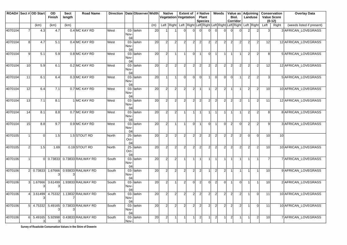
Survey of Roadside Conservation Values in the Shire of Dowerin
ROAD# Sect # OD Start OD Finish
Sect length
Road Name Direction Date Observer Width Native Vegetation
Extent of Vegetation
# Native Plant
Species
Weeds Value as Biol.
Corridor
Adjoining Landuse
Conservation Value Score
(0-12)
Overlay Data
(km) (km) (km) (m) Left Right Left Right Left Right Left Right Left Right Left Right Left Right (weeds listed if present) 4070104 7 4.3 4.7 0.4 MC KAY RD West 03-
Nov-04
larkin 20 1 1 0 0 0 0 0 0 0 0 2 2 3 3 AFRICAN_LOVEGRASS
4070104 8 4.7 5.1 0.4 MC KAY RD West 03-Nov-
04
larkin 20 2 2 2 2 2 2 2 2 2 2 2 2 12 12 AFRICAN_LOVEGRASS
4070104 9 5.1 5.9 0.8 MC KAY RD West 03-Nov-
04
larkin 20 2 1 1 0 1 0 1 1 1 1 2 2 8 5 AFRICAN_LOVEGRASS
4070104 10 5.9 6.1 0.2 MC KAY RD West 03-Nov-
04
larkin 20 2 2 2 2 2 2 2 2 2 2 2 2 12 12 AFRICAN_LOVEGRASS
4070104 11 6.1 6.4 0.3 MC KAY RD West 03-Nov-
04
larkin 20 1 1 0 0 0 1 0 0 0 1 2 2 3 5 AFRICAN_LOVEGRASS
4070104 12 6.4 7.1 0.7 MC KAY RD West 03-Nov-
04
larkin 20 2 2 2 2 1 1 2 2 1 1 2 2 10 10 AFRICAN_LOVEGRASS
4070104 13 7.1 8.1 1 MC KAY RD West 03-Nov-
04
larkin 20 2 2 2 2 2 2 2 2 2 2 1 2 11 12 AFRICAN_LOVEGRASS
4070104 14 8.1 8.8 0.7 MC KAY RD West 03-Nov-
04
larkin 20 2 2 1 1 1 1 1 1 1 1 2 2 8 8 AFRICAN_LOVEGRASS
4070104 15 8.8 9.7 0.9 MC KAY RD West 03-Nov-
04
larkin 20 2 1 1 0 1 0 1 0 2 0 2 2 9 3 AFRICAN_LOVEGRASS
4070105 1 0 1.5 1.5 STOUT RD North 25-Oct-
04
larkin 20 2 2 2 2 2 2 2 2 2 2 0 0 10 10
4070105 2 1.5 1.69 0.19 STOUT RD North 25-Oct-
04
larkin 20 2 2 2 2 2 2 2 2 2 2 2 2 10 10 AFRICAN_LOVEGRASS
4070106 1 0 0.73833 0.73833 RAILWAY RD South 03-Nov-
04
larkin 20 2 2 1 1 1 1 1 1 1 1 1 1 7 7 AFRICAN_LOVEGRASS
4070106 2 0.73833 1.676663
0.938333
RAILWAY RD South 03-Nov-
04
larkin 20 2 2 2 2 2 1 2 2 1 1 1 1 10 9 AFRICAN_LOVEGRASS
4070106 3 1.676663
3.614993
1.93833 RAILWAY RD South 03-Nov-
04
larkin 20 2 1 2 0 2 0 2 0 1 0 1 1 10 2 AFRICAN_LOVEGRASS
4070106 4 3.614993
4.75332 1.138327
RAILWAY RD South 03-Nov-
04
larkin 20 2 2 2 2 2 2 2 2 2 2 1 0 11 10 AFRICAN_LOVEGRASS
4070106 5 4.75332 5.491653
0.738333
RAILWAY RD South 03-Nov-
04
larkin 20 2 2 2 2 2 2 2 2 2 2 1 0 11 10 AFRICAN_LOVEGRASS
4070106 6 5.491653
5.929983
0.43833 RAILWAY RD South 03-Nov-
larkin 20 2 1 1 1 2 1 2 1 2 1 1 2 10 7 AFRICAN_LOVEGRASS
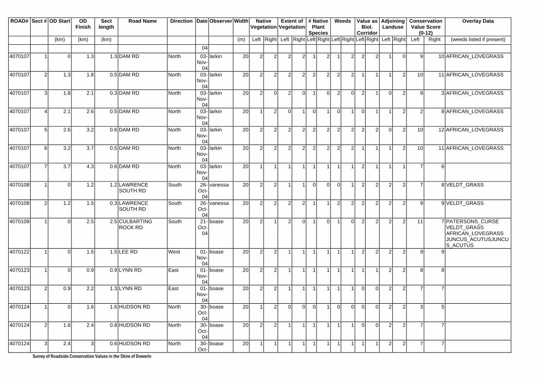
Survey of Roadside Conservation Values in the Shire of Dowerin
ROAD# Sect # OD Start OD Finish
Sect length
Road Name Direction Date Observer Width Native Vegetation
Extent of Vegetation
# Native Plant
Species
Weeds Value as Biol.
Corridor
Adjoining Landuse
Conservation Value Score
(0-12)
Overlay Data
(km) (km) (km) (m) Left Right Left Right Left Right Left Right Left Right Left Right Left Right (weeds listed if present) 04
4070107 1 0 1.3 1.3 DAM RD North 03-Nov-
04
larkin 20 2 2 2 2 1 2 1 2 2 2 1 0 9 10 AFRICAN_LOVEGRASS
4070107 2 1.3 1.8 0.5 DAM RD North 03-Nov-
04
larkin 20 2 2 2 2 2 2 2 2 1 1 1 2 10 11 AFRICAN_LOVEGRASS
4070107 3 1.8 2.1 0.3 DAM RD North 03-Nov-
04
larkin 20 2 0 2 0 1 0 2 0 2 1 0 2 9 3 AFRICAN_LOVEGRASS
4070107 4 2.1 2.6 0.5 DAM RD North 03-Nov-
04
larkin 20 1 2 0 1 0 1 0 1 0 1 1 2 2 8 AFRICAN_LOVEGRASS
4070107 5 2.6 3.2 0.6 DAM RD North 03-Nov-
04
larkin 20 2 2 2 2 2 2 2 2 2 2 0 2 10 12 AFRICAN_LOVEGRASS
4070107 6 3.2 3.7 0.5 DAM RD North 03-Nov-
04
larkin 20 2 2 2 2 2 2 2 2 1 1 1 2 10 11 AFRICAN_LOVEGRASS
4070107 7 3.7 4.3 0.6 DAM RD North 03-Nov-
04
larkin 20 1 1 1 1 1 1 1 1 2 1 1 1 7 6
4070108 1 0 1.2 1.2 LAWRENCE SOUTH RD
South 26-Oct-
04
vanessa 20 2 2 1 1 0 0 0 1 2 2 2 2 7 8 VELDT_GRASS
4070108 2 1.2 1.5 0.3 LAWRENCE SOUTH RD
South 26-Oct-
04
vanessa 20 2 2 2 2 1 1 2 2 2 2 2 2 9 9 VELDT_GRASS
4070109 1 0 2.5 2.5 CULBARTING ROCK RD
South 21-Oct-
04
boase 20 2 1 2 0 1 0 1 0 2 2 2 2 11 7 PATERSONS_CURSE VELDT_GRASS AFRICAN_LOVEGRASS JUNCUS_ACUTUSJUNCUS_ACUTUS
4070122 1 0 1.5 1.5 LEE RD West 01-Nov-
04
boase 20 2 2 1 1 1 1 1 1 2 2 2 2 9 9
4070123 1 0 0.9 0.9 LYNN RD East 01-Nov-
04
boase 20 2 2 1 1 1 1 1 1 1 1 2 2 8 8
4070123 2 0.9 2.2 1.3 LYNN RD East 01-Nov-
04
boase 20 2 2 1 1 1 1 1 1 0 0 2 2 7 7
4070124 1 0 1.6 1.6 HUDSON RD North 30-Oct-
04
boase 20 1 2 0 0 0 1 0 0 0 0 2 2 3 5
4070124 2 1.6 2.4 0.8 HUDSON RD North 30-Oct-
04
boase 20 2 2 1 1 1 1 1 1 0 0 2 2 7 7
4070124 3 2.4 3 0.6 HUDSON RD North 30-Oct-
boase 20 1 1 1 1 1 1 1 1 1 1 2 2 7 7

Survey of Roadside Conservation Values in the Shire of Dowerin
ROAD# Sect # OD Start OD Finish
Sect length
Road Name Direction Date Observer Width Native Vegetation
Extent of Vegetation
# Native Plant
Species
Weeds Value as Biol.
Corridor
Adjoining Landuse
Conservation Value Score
(0-12)
Overlay Data
(km) (km) (km) (m) Left Right Left Right Left Right Left Right Left Right Left Right Left Right (weeds listed if present) 04
4070124 4 3 5.6 2.6 HUDSON RD North 30-Oct-
04
boase 20 0 0 0 0 0 0 0 0 0 0 2 2 2 2 AFRICAN_LOVEGRASS
4070125 1 0 0.8 0.8 HENNESSEY RD South 27-Oct-
04
vanessa 20 1 2 0 2 0 1 0 2 0 2 1 2 2 11 VELDT_GRASS
4070125 2 0.8 1.8 1 HENNESSEY RD South 27-Oct-
04
vanessa 20 2 2 2 2 1 1 2 2 2 2 2 2 11 11 VELDT_GRASS
4070126 1 0 1.3 1.3 UCARTY RD West 01-Nov-
04
boase 20 2 2 1 1 1 1 1 1 0 0 2 2 7 7 AFRICAN_LOVEGRASS
4070126 2 1.3 2.7 1.4 UCARTY RD West 01-Nov-
04
boase 20 0 0 0 0 0 0 0 0 0 0 2 2 2 2 AFRICAN_LOVEGRASS VELDT_GRASS
4070126 3 2.7 2.9 0.2 UCARTY RD West 01-Nov-
04
boase 20 2 2 1 1 1 1 1 1 1 1 0 0 6 6
4070127 1 0 2.1 2.1 HAGBOOM SOUTH RD
South 21-Oct-
04
boase 20 1 1 0 0 0 0 0 0 1 1 2 2 4 4 AFRICAN_LOVEGRASS
4070128 1 0 0.7 0.7 BERRING-NAMBLING RD
North 22-Oct-
04
boase 20 0 0 0 0 0 0 0 0 0 0 2 2 2 2 AFRICAN_LOVEGRASS
4070128 2 0.7 1.3 0.6 BERRING-NAMBLING RD
North 22-Oct-
04
boase 20 1 2 2 1 0 1 0 0 1 1 2 2 6 7 AFRICAN_LOVEGRASS
4070128 3 1.3 2.2 0.9 BERRING-NAMBLING RD
North 22-Oct-
04
boase 20 2 2 2 2 1 1 1 1 2 1 2 2 8 9 AFRICAN_LOVEGRASS
4070128 4 2.2 3.3 1.1 BERRING-NAMBLING RD
East 22-Oct-
04
boase 20 2 2 1 1 1 1 1 1 1 2 1 1 7 8 AFRICAN_LOVEGRASS
4070129 1 0 2.5 2.5 THOMAS RD South 20-Oct-
04
Robinson Chicks
20 1 1 0 0 0 0 0 0 0 0 2 2 3 3 AFRICAN_LOVEGRASS
4070129 2 2.5 3.5 1 THOMAS RD South 20-Oct-
04
Robinson Chicks
20 1 0 0 0 0 0 0 0 1 0 2 2 4 2 AFRICAN_LOVEGRASS
4070129 3 3.5 4.9 1.4 THOMAS RD South 20-Oct-
04
Robinson Chicks
20 2 2 1 1 1 1 2 2 2 2 2 2 10 10 AFRICAN_LOVEGRASS
4070129 4 4.9 5.8 0.9 THOMAS RD South 20-Oct-
04
Robinson Chicks
20 0 0 0 0 0 0 0 0 0 0 2 2 2 2 AFRICAN_LOVEGRASS
4070130 1 0 0.7 0.7 BOTHERLING EAST RD
West 20-Oct-
04
Robinson Chicks
20 1 1 1 1 0 0 1 1 0 0 2 2 5 5 TAGASASTE
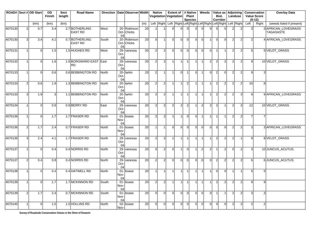
Survey of Roadside Conservation Values in the Shire of Dowerin
ROAD# Sect # OD Start OD Finish
Sect length
Road Name Direction Date Observer Width Native Vegetation
Extent of Vegetation
# Native Plant
Species
Weeds Value as Biol.
Corridor
Adjoining Landuse
Conservation Value Score
(0-12)
Overlay Data
(km) (km) (km) (m) Left Right Left Right Left Right Left Right Left Right Left Right Left Right (weeds listed if present) 4070130 2 0.7 3.4 2.7 BOTHERLING
EAST RD West 20-
Oct-04
Robinson Chicks
20 1 1 0 0 0 0 0 0 0 0 2 2 3 3 AFRICAN_LOVEGRASS TAGASASTE
4070130 3 3.4 4.1 0.7 BOTHERLING EAST RD
South 20-Oct-
04
Robinson Chicks
20 0 1 0 0 0 0 0 1 0 0 2 2 2 4 AFRICAN_LOVEGRASS
4070131 1 0 1.5 1.5 HUGHES RD West 29-Oct-
04
vanessa 20 2 2 0 0 0 0 0 0 1 1 2 2 5 5 VELDT_GRASS
4070132 1 0 1.6 1.6 BORGWARD EAST RD
East 29-Oct-
04
vanessa 20 2 2 1 1 1 1 1 2 2 2 2 2 9 10 VELDT_GRASS
4070133 1 0 0.6 0.6 BEBBINGTON RD North 20-Oct-
04
larkin 20 2 1 1 0 1 0 1 0 2 0 2 2 9 3
4070133 2 0.6 1.9 1.3 BEBBINGTON RD North 20-Oct-
04
larkin 20 2 2 1 1 2 1 1 1 2 2 2 2 10 9
4070133 3 1.9 3 1.1 BEBBINGTON RD North 20-Oct-
04
larkin 20 2 2 1 1 1 1 1 1 2 2 2 2 9 9 AFRICAN_LOVEGRASS
4070134 1 0 0.9 0.9 BERRY RD East 29-Oct-
04
vanessa 20 2 2 2 2 2 1 2 2 2 1 2 2 12 10 VELDT_GRASS
4070136 1 0 1.7 1.7 FRASER RD North 01-Nov-
04
boase 20 2 2 1 1 0 0 1 1 1 1 2 2 7 7
4070136 2 1.7 2.4 0.7 FRASER RD North 01-Nov-
04
boase 20 1 1 0 0 0 0 0 0 0 0 2 2 3 3 AFRICAN_LOVEGRASS
4070136 3 2.4 4.1 1.7 FRASER RD North 29-Oct-
04
vanessa 20 2 2 1 1 1 1 1 1 2 2 2 1 9 8 VELDT_GRASS
4070137 1 0 0.4 0.4 NORRIS RD North 29-Oct-
04
vanessa 20 0 2 0 1 0 1 2 2 1 2 0 2 3 10 JUNCUS_ACUTUS
4070137 2 0.4 0.8 0.4 NORRIS RD North 29-Oct-
04
vanessa 20 2 2 0 0 0 0 0 0 2 2 2 2 6 6 JUNCUS_ACUTUS
4070138 1 0 0.4 0.4 HATWELL RD North 01-Nov-
04
boase 20 1 1 1 1 1 1 1 1 0 0 1 1 5 5
4070139 1 0 1.7 1.7 MCKINNON RD South 01-Nov-
04
boase 20 2 2 1 1 1 1 1 1 2 2 2 2 9 9
4070139 2 1.7 2.4 0.7 MCKINNON RD South 01-Nov-
04
boase 20 0 0 0 0 0 0 0 0 1 1 2 2 3 3
4070140 1 0 1.5 1.5 HOLLINS RD North 02-Nov-
boase 20 0 0 0 0 0 0 0 0 0 0 2 2 2 2

Survey of Roadside Conservation Values in the Shire of Dowerin
ROAD# Sect # OD Start OD Finish
Sect length
Road Name Direction Date Observer Width Native Vegetation
Extent of Vegetation
# Native Plant
Species
Weeds Value as Biol.
Corridor
Adjoining Landuse
Conservation Value Score
(0-12)
Overlay Data
(km) (km) (km) (m) Left Right Left Right Left Right Left Right Left Right Left Right Left Right (weeds listed if present) 04
4070140 2 1.5 2.2 0.7 HOLLINS RD North 02-Nov-
04
boase 20 1 2 0 0 0 0 0 0 1 1 2 2 4 5 AFRICAN_LOVEGRASS JUNCUS_ACUTUS
4070140 3 2.2 3.38 1.18 HOLLINS RD North 02-Nov-
04
boase 20 0 0 0 0 0 0 0 0 0 0 2 2 2 2 AFRICAN_LOVEGRASS
4070142 1 0 0.5 0.5 AMERY SOUTH RD East 26-Oct-
04
vanessa 20 2 2 2 2 2 2 2 2 2 2 0 0 12 12
4070142 2 0.5 1 0.5 AMERY SOUTH RD South 26-Oct-
04
vanessa 20 2 2 1 2 0 2 1 2 1 1 2 0 7 9
4070142 3 1 1.7 0.7 AMERY SOUTH RD South 26-Oct-
04
vanessa 20 1 1 0 0 0 0 0 0 0 0 2 1 3 2 AFRICAN_LOVEGRASS
4070142 4 1.7 3.2 1.5 AMERY SOUTH RD South 26-Oct-
04
vanessa 20 2 2 1 1 1 1 1 1 1 1 2 2 8 8 AFRICAN_LOVEGRASS VELDT_GRASS
4070142 5 3.2 3.9 0.7 AMERY SOUTH RD South 26-Oct-
04
vanessa 20 1 1 0 0 0 0 0 0 1 1 2 2 4 4 AFRICAN_LOVEGRASS VELDT_GRASS
4070142 6 3.9 4.3 0.4 AMERY SOUTH RD South 26-Oct-
04
vanessa 20 2 2 1 1 1 1 1 1 1 1 2 1 8 7 VELDT_GRASS
4070144 1 0.48 1.08 0.6 GODDARD SIDING RD
North 20-Oct-
04
larkin 20 1 2 0 1 1 1 1 1 1 1 2 2 6 8 AFRICAN_LOVEGRASS
4070147 1 0 0.5 0.5 EJANDING SCHOOL RD
South 27-Oct-
04
larkin 20 2 2 2 2 2 2 2 2 2 2 0 1 10 11
4070150 1 0 2.12 2.12 TURRIFF RD East 23-Oct-
04
larkin 20 1 1 0 0 0 0 0 0 0 1 2 2 3 4 AFRICAN_LOVEGRASS
4070151 1 0 1.1 1.1 BYWATER RD East 23-Oct-
04
larkin 20 1 1 0 0 0 0 0 0 0 0 2 2 3 3 AFRICAN_LOVEGRASS
4070152 1 0 0.9 0.9 CADOUX PUMP RD West 23-Oct-
04
larkin 20 2 2 2 2 2 2 2 2 1 2 2 2 11 12 AFRICAN_LOVEGRASS
4070153 1 0 1.7 1.7 BEAR RD West 01-Nov-
04
larkin 20 2 2 1 1 2 2 2 2 2 2 1 1 10 10 AFRICAN_LOVEGRASS
4070154 1 0 2.8 2.8 HENNING NORTH RD
West 03-Nov-
04
larkin 20 0 0 0 0 0 0 0 0 0 0 2 2 2 2
4070156 1 0 0.4 0.4 MAINS RD North 23-Oct-
04
larkin 20 2 2 1 1 1 1 2 2 2 1 1 1 9 8 AFRICAN_LOVEGRASS
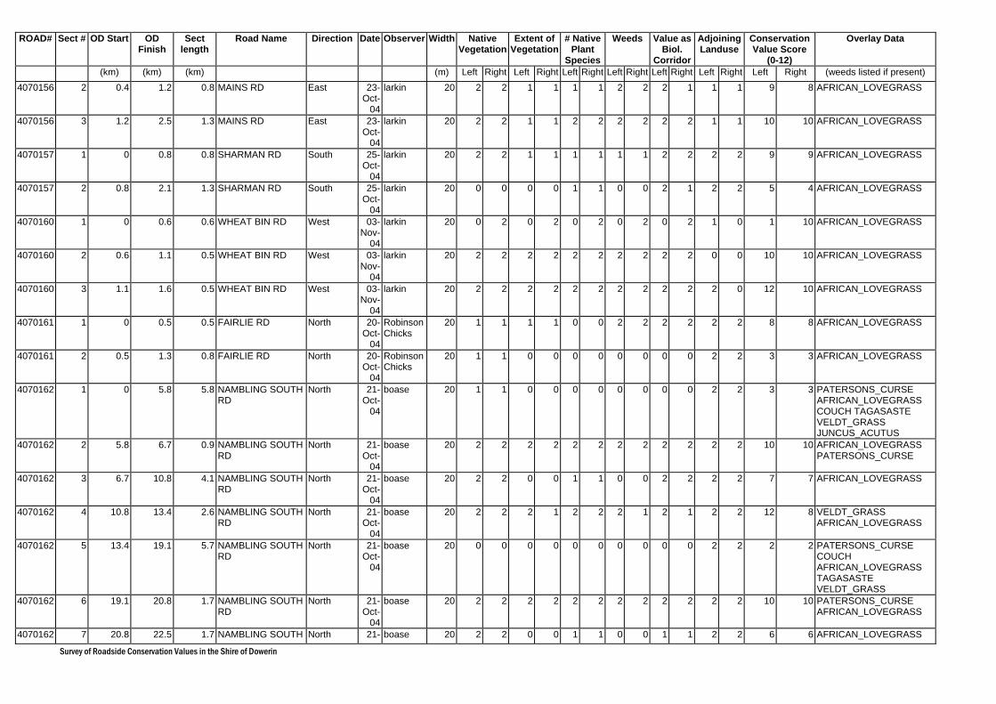
Survey of Roadside Conservation Values in the Shire of Dowerin
ROAD# Sect # OD Start OD Finish
Sect length
Road Name Direction Date Observer Width Native Vegetation
Extent of Vegetation
# Native Plant
Species
Weeds Value as Biol.
Corridor
Adjoining Landuse
Conservation Value Score
(0-12)
Overlay Data
(km) (km) (km) (m) Left Right Left Right Left Right Left Right Left Right Left Right Left Right (weeds listed if present) 4070156 2 0.4 1.2 0.8 MAINS RD East 23-
Oct-04
larkin 20 2 2 1 1 1 1 2 2 2 1 1 1 9 8 AFRICAN_LOVEGRASS
4070156 3 1.2 2.5 1.3 MAINS RD East 23-Oct-
04
larkin 20 2 2 1 1 2 2 2 2 2 2 1 1 10 10 AFRICAN_LOVEGRASS
4070157 1 0 0.8 0.8 SHARMAN RD South 25-Oct-
04
larkin 20 2 2 1 1 1 1 1 1 2 2 2 2 9 9 AFRICAN_LOVEGRASS
4070157 2 0.8 2.1 1.3 SHARMAN RD South 25-Oct-
04
larkin 20 0 0 0 0 1 1 0 0 2 1 2 2 5 4 AFRICAN_LOVEGRASS
4070160 1 0 0.6 0.6 WHEAT BIN RD West 03-Nov-
04
larkin 20 0 2 0 2 0 2 0 2 0 2 1 0 1 10 AFRICAN_LOVEGRASS
4070160 2 0.6 1.1 0.5 WHEAT BIN RD West 03-Nov-
04
larkin 20 2 2 2 2 2 2 2 2 2 2 0 0 10 10 AFRICAN_LOVEGRASS
4070160 3 1.1 1.6 0.5 WHEAT BIN RD West 03-Nov-
04
larkin 20 2 2 2 2 2 2 2 2 2 2 2 0 12 10 AFRICAN_LOVEGRASS
4070161 1 0 0.5 0.5 FAIRLIE RD North 20-Oct-
04
Robinson Chicks
20 1 1 1 1 0 0 2 2 2 2 2 2 8 8 AFRICAN_LOVEGRASS
4070161 2 0.5 1.3 0.8 FAIRLIE RD North 20-Oct-
04
Robinson Chicks
20 1 1 0 0 0 0 0 0 0 0 2 2 3 3 AFRICAN_LOVEGRASS
4070162 1 0 5.8 5.8 NAMBLING SOUTH RD
North 21-Oct-
04
boase 20 1 1 0 0 0 0 0 0 0 0 2 2 3 3 PATERSONS_CURSE AFRICAN_LOVEGRASS COUCH TAGASASTE VELDT_GRASS JUNCUS_ACUTUS
4070162 2 5.8 6.7 0.9 NAMBLING SOUTH RD
North 21-Oct-
04
boase 20 2 2 2 2 2 2 2 2 2 2 2 2 10 10 AFRICAN_LOVEGRASS PATERSONS_CURSE
4070162 3 6.7 10.8 4.1 NAMBLING SOUTH RD
North 21-Oct-
04
boase 20 2 2 0 0 1 1 0 0 2 2 2 2 7 7 AFRICAN_LOVEGRASS
4070162 4 10.8 13.4 2.6 NAMBLING SOUTH RD
North 21-Oct-
04
boase 20 2 2 2 1 2 2 2 1 2 1 2 2 12 8 VELDT_GRASS AFRICAN_LOVEGRASS
4070162 5 13.4 19.1 5.7 NAMBLING SOUTH RD
North 21-Oct-
04
boase 20 0 0 0 0 0 0 0 0 0 0 2 2 2 2 PATERSONS_CURSE COUCH AFRICAN_LOVEGRASS TAGASASTE VELDT_GRASS
4070162 6 19.1 20.8 1.7 NAMBLING SOUTH RD
North 21-Oct-
04
boase 20 2 2 2 2 2 2 2 2 2 2 2 2 10 10 PATERSONS_CURSE AFRICAN_LOVEGRASS
4070162 7 20.8 22.5 1.7 NAMBLING SOUTH North 21- boase 20 2 2 0 0 1 1 0 0 1 1 2 2 6 6 AFRICAN_LOVEGRASS
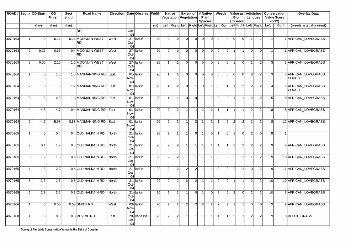
Survey of Roadside Conservation Values in the Shire of Dowerin
ROAD# Sect # OD Start OD Finish
Sect length
Road Name Direction Date Observer Width Native Vegetation
Extent of Vegetation
# Native Plant
Species
Weeds Value as Biol.
Corridor
Adjoining Landuse
Conservation Value Score
(0-12)
Overlay Data
(km) (km) (km) (m) Left Right Left Right Left Right Left Right Left Right Left Right Left Right (weeds listed if present) RD Oct-
044070163 1 0 0.16 0.16 MOONIJIN WEST
RD West 27-
Oct-04
larkin 20 0 0 0 0 0 0 0 0 0 0 1 1 1 1 AFRICAN_LOVEGRASS
4070163 2 0.16 0.56 0.4 MOONIJIN WEST RD
West 27-Oct-
04
larkin 20 0 0 0 0 0 0 0 0 1 1 0 0 1 1 AFRICAN_LOVEGRASS
4070163 3 0.56 2.16 1.6 MOONIJIN WEST RD
West 27-Oct-
04
larkin 20 1 1 0 0 0 0 0 0 1 0 1 2 3 3 AFRICAN_LOVEGRASS
4070164 1 0 1.8 1.8 MANMANNING RD East 01-Nov-
04
larkin 20 1 1 0 0 0 0 0 0 0 0 2 2 3 3 AFRICAN_LOVEGRASS COUCH
4070164 2 1.8 3 1.2 MANMANNING RD East 01-Nov-
04
larkin 20 1 2 0 1 0 1 0 1 1 2 2 2 4 9 AFRICAN_LOVEGRASS COUCH
4070164 3 3 4.3 1.3 MANMANNING RD East 01-Nov-
04
larkin 20 1 1 0 0 1 1 0 0 1 1 2 2 5 5 AFRICAN_LOVEGRASS
4070164 4 4.3 4.7 0.4 MANMANNING RD East 01-Nov-
04
larkin 20 2 2 1 1 1 1 1 1 1 1 2 2 8 8 AFRICAN_LOVEGRASS
4070164 5 4.7 5.58 0.88 MANMANNING RD East 01-Nov-
04
larkin 20 2 2 1 2 1 2 1 2 2 2 1 2 8 12 AFRICAN_LOVEGRASS
4070165 1 0 0.4 0.4 OLD NALKAIN RD North 21-Oct-
04
larkin 20 2 1 1 0 1 0 1 0 1 0 2 0 8 1
4070165 2 0.4 1.2 0.8 OLD NALKAIN RD North 21-Oct-
04
larkin 20 2 2 1 1 1 1 1 1 2 2 2 2 9 9 AFRICAN_LOVEGRASS
4070165 3 1.2 1.8 0.6 OLD NALKAIN RD North 21-Oct-
04
larkin 20 2 2 1 1 1 1 2 2 2 2 1 2 9 10 AFRICAN_LOVEGRASS
4070165 4 1.8 2.3 0.5 OLD NALKAIN RD North 21-Oct-
04
larkin 20 2 2 2 2 1 1 2 2 2 2 0 2 9 11 AFRICAN_LOVEGRASS
4070165 5 2.3 2.8 0.5 OLD NALKAIN RD North 21-Oct-
04
larkin 20 2 2 2 2 1 1 2 2 1 1 2 2 10 10 AFRICAN_LOVEGRASS
4070165 6 2.8 3.6 0.8 OLD NALKAIN RD North 21-Oct-
04
larkin 20 2 1 1 0 1 0 2 0 2 0 2 2 10 3 AFRICAN_LOVEGRASS
4070166 1 0 0.55 0.55 SMITH RD West 03-Nov-
04
larkin 20 2 2 2 2 2 2 2 2 1 1 0 0 9 9 AFRICAN_LOVEGRASS
4070168 1 0 0.8 0.8 DEVINE RD East 28-Oct-
04
vanessa 20 2 2 1 1 1 1 1 1 2 1 2 2 9 8 VELDT_GRASS
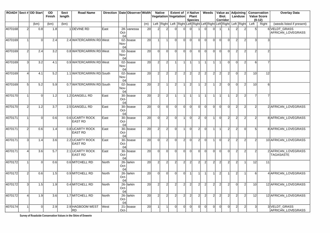
Survey of Roadside Conservation Values in the Shire of Dowerin
ROAD# Sect # OD Start OD Finish
Sect length
Road Name Direction Date Observer Width Native Vegetation
Extent of Vegetation
# Native Plant
Species
Weeds Value as Biol.
Corridor
Adjoining Landuse
Conservation Value Score
(0-12)
Overlay Data
(km) (km) (km) (m) Left Right Left Right Left Right Left Right Left Right Left Right Left Right (weeds listed if present) 4070168 2 0.8 1.8 1 DEVINE RD East 28-
Oct-04
vanessa 20 2 2 0 0 0 1 0 0 1 1 2 2 5 6 VELDT_GRASS AFRICAN_LOVEGRASS
4070169 1 0 2.4 2.4 WATERCARRIN RD West 02-Nov-
04
boase 20 1 1 0 0 0 0 0 0 0 0 2 2 3 3
4070169 2 2.4 3.2 0.8 WATERCARRIN RD West 02-Nov-
04
boase 20 0 0 0 0 0 0 0 0 0 0 2 2 2 2
4070169 3 3.2 4.1 0.9 WATERCARRIN RD West 02-Nov-
04
boase 20 2 2 1 1 1 1 1 1 1 0 0 2 6 7
4070169 4 4.1 5.2 1.1 WATERCARRIN RD South 02-Nov-
04
boase 20 2 2 2 2 2 2 2 2 2 2 0 2 10 12
4070169 5 5.2 5.9 0.7 WATERCARRIN RD South 02-Nov-
04
boase 20 2 1 2 1 2 1 2 1 2 0 0 2 10 6
4070170 1 0 1.2 1.2 GANGELL RD East 30-Oct-
04
boase 20 2 2 1 1 1 1 1 1 1 1 2 2 7 7
4070170 2 1.2 3.7 2.5 GANGELL RD East 30-Oct-
04
boase 20 0 0 0 0 0 0 0 0 0 0 2 2 2 2 AFRICAN_LOVEGRASS
4070171 1 0 0.6 0.6 UCARTY ROCK EAST RD
East 30-Oct-
04
boase 20 0 2 0 1 0 2 0 1 0 2 2 2 2 8 AFRICAN_LOVEGRASS
4070171 2 0.6 1.4 0.8 UCARTY ROCK EAST RD
East 30-Oct-
04
boase 20 2 2 0 1 0 2 0 1 1 2 2 0 5 8 AFRICAN_LOVEGRASS
4070171 3 1.4 3.6 2.2 UCARTY ROCK EAST RD
East 30-Oct-
04
boase 20 0 2 0 2 0 2 0 1 0 2 2 2 2 10 AFRICAN_LOVEGRASS
4070171 4 3.6 5.7 2.1 UCARTY ROCK EAST RD
East 30-Oct-
04
boase 20 0 0 0 0 0 0 0 0 0 0 2 2 2 2 AFRICAN_LOVEGRASS TAGASASTE
4070172 1 0 0.6 0.6 MITCHELL RD North 26-Oct-
04
larkin 20 2 2 2 2 2 2 2 2 2 2 2 1 12 11
4070172 2 0.6 1.5 0.9 MITCHELL RD North 26-Oct-
04
larkin 20 0 0 0 0 1 1 1 1 2 1 2 1 6 4 AFRICAN_LOVEGRASS
4070172 3 1.5 1.9 0.4 MITCHELL RD North 26-Oct-
04
larkin 20 2 2 2 2 2 2 2 2 2 2 0 2 10 12 AFRICAN_LOVEGRASS
4070172 4 1.9 3.6 1.7 MITCHELL RD North 26-Oct-
04
larkin 20 2 2 2 2 2 2 2 2 2 2 2 2 12 12 AFRICAN_LOVEGRASS
4070174 1 0 2.9 2.9 HAGBOOM WEST RD
West 21-Oct-
boase 20 1 1 0 0 0 0 0 0 0 0 2 2 3 3 VELDT_GRASS AFRICAN_LOVEGRASS

Survey of Roadside Conservation Values in the Shire of Dowerin
ROAD# Sect # OD Start OD Finish
Sect length
Road Name Direction Date Observer Width Native Vegetation
Extent of Vegetation
# Native Plant
Species
Weeds Value as Biol.
Corridor
Adjoining Landuse
Conservation Value Score
(0-12)
Overlay Data
(km) (km) (km) (m) Left Right Left Right Left Right Left Right Left Right Left Right Left Right (weeds listed if present) 04
4070180 1 0 2.1 2.1 WOODS RD South 22-Oct-
04
boase 20 1 2 0 1 0 1 1 1 2 2 2 2 6 9
4070182 1 14.04 15.24 1.2 DOWERIN-KALANNIE RD
North 25-Oct-
04
larkin 20 0 0 0 0 0 0 0 0 0 0 2 2 2 2
4070182 2 15.24 15.84 0.6 DOWERIN-KALANNIE RD
North 25-Oct-
04
larkin 20 0 0 0 0 1 0 0 0 0 0 2 1 3 1
4070182 3 15.84 19.74 3.9 DOWERIN-KALANNIE RD
North 25-Oct-
04
larkin 20 1 1 1 1 1 1 2 2 1 1 1 1 7 7 AFRICAN_LOVEGRASS
4070182 4 19.74 20.24 0.5 DOWERIN-KALANNIE RD
North 25-Oct-
04
larkin 20 2 2 2 1 1 1 2 1 2 1 1 1 10 7 AFRICAN_LOVEGRASS
4070182 5 20.24 21.24 1 DOWERIN-KALANNIE RD
North 25-Oct-
04
larkin 20 0 0 0 0 1 1 0 0 0 0 1 1 2 2 AFRICAN_LOVEGRASS
4070182 6 21.24 22.84 1.6 DOWERIN-KALANNIE RD
North 25-Oct-
04
larkin 20 1 1 0 0 0 0 0 0 0 0 2 2 3 3 AFRICAN_LOVEGRASS
4070182 7 22.84 23.04 0.2 DOWERIN-KALANNIE RD
North 25-Oct-
04
larkin 20 2 1 1 0 1 0 2 0 1 0 2 2 9 3 AFRICAN_LOVEGRASS
4070182 8 23.04 23.74 0.7 DOWERIN-KALANNIE RD
North 25-Oct-
04
larkin 20 2 2 2 2 2 1 2 1 2 1 2 1 12 8 AFRICAN_LOVEGRASS
4070182 9 23.74 27.14 3.4 DOWERIN-KALANNIE RD
North 25-Oct-
04
larkin 20 1 1 0 0 2 1 0 0 1 0 1 1 5 3 AFRICAN_LOVEGRASS
4070182 10 27.14 27.94 0.8 DOWERIN-KALANNIE RD
North 25-Oct-
04
larkin 20 2 2 1 1 2 1 1 1 2 1 1 1 9 7 AFRICAN_LOVEGRASS PATERSONS_CURSE
4070182 11 27.94 28.64 0.7 DOWERIN-KALANNIE RD
North 25-Oct-
04
larkin 20 2 2 2 2 2 1 2 2 2 2 1 1 11 10 AFRICAN_LOVEGRASS
4070182 12 28.64 29.84 1.2 DOWERIN-KALANNIE RD
North 25-Oct-
04
larkin 20 2 2 0 0 1 1 0 0 1 1 2 2 6 6 AFRICAN_LOVEGRASS PATERSONS_CURSE
4070182 13 29.84 30.74 0.9 DOWERIN-KALANNIE RD
North 25-Oct-
04
larkin 20 1 2 0 1 0 1 0 1 0 1 2 2 3 8 AFRICAN_LOVEGRASS PATERSONS_CURSE
4070182 14 30.74 31.04 0.3 DOWERIN-KALANNIE RD
North 25-Oct-
04
larkin 20 2 2 1 1 1 1 1 1 2 1 1 1 8 7 AFRICAN_LOVEGRASS
4070182 15 31.04 33.84 2.8 DOWERIN-KALANNIE RD
North 25-Oct-
04
larkin 20 1 1 0 0 1 1 0 1 0 1 2 2 4 6 AFRICAN_LOVEGRASS
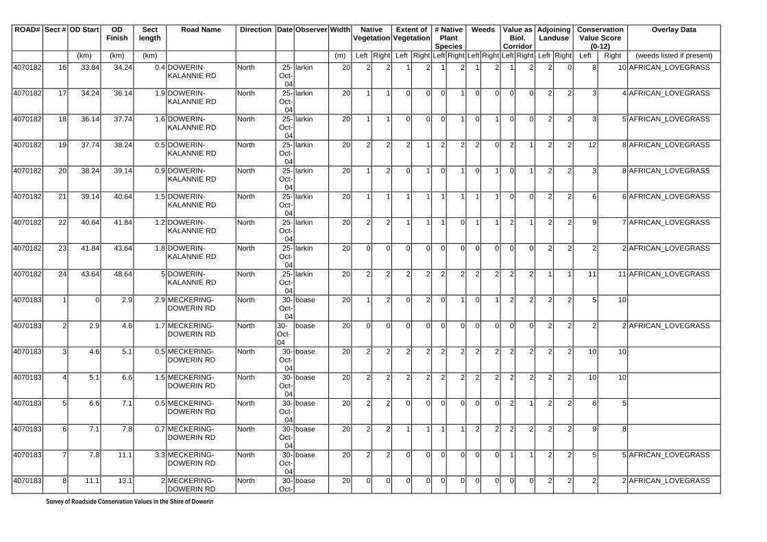
Survey of Roadside Conservation Values in the Shire of Dowerin
ROAD# Sect # OD Start OD Finish
Sect length
Road Name Direction Date Observer Width Native Vegetation
Extent of Vegetation
# Native Plant
Species
Weeds Value as Biol.
Corridor
Adjoining Landuse
Conservation Value Score
(0-12)
Overlay Data
(km) (km) (km) (m) Left Right Left Right Left Right Left Right Left Right Left Right Left Right (weeds listed if present) 4070182 16 33.84 34.24 0.4 DOWERIN-
KALANNIE RD North 25-
Oct-04
larkin 20 2 2 1 2 1 2 1 2 1 2 2 0 8 10 AFRICAN_LOVEGRASS
4070182 17 34.24 36.14 1.9 DOWERIN-KALANNIE RD
North 25-Oct-
04
larkin 20 1 1 0 0 0 1 0 0 0 0 2 2 3 4 AFRICAN_LOVEGRASS
4070182 18 36.14 37.74 1.6 DOWERIN-KALANNIE RD
North 25-Oct-
04
larkin 20 1 1 0 0 0 1 0 1 0 0 2 2 3 5 AFRICAN_LOVEGRASS
4070182 19 37.74 38.24 0.5 DOWERIN-KALANNIE RD
North 25-Oct-
04
larkin 20 2 2 2 1 2 2 2 0 2 1 2 2 12 8 AFRICAN_LOVEGRASS
4070182 20 38.24 39.14 0.9 DOWERIN-KALANNIE RD
North 25-Oct-
04
larkin 20 1 2 0 1 0 1 0 1 0 1 2 2 3 8 AFRICAN_LOVEGRASS
4070182 21 39.14 40.64 1.5 DOWERIN-KALANNIE RD
North 25-Oct-
04
larkin 20 1 1 1 1 1 1 1 1 0 0 2 2 6 6 AFRICAN_LOVEGRASS
4070182 22 40.64 41.84 1.2 DOWERIN-KALANNIE RD
North 25-Oct-
04
larkin 20 2 2 1 1 1 0 1 1 2 1 2 2 9 7 AFRICAN_LOVEGRASS
4070182 23 41.84 43.64 1.8 DOWERIN-KALANNIE RD
North 25-Oct-
04
larkin 20 0 0 0 0 0 0 0 0 0 0 2 2 2 2 AFRICAN_LOVEGRASS
4070182 24 43.64 48.64 5 DOWERIN-KALANNIE RD
North 25-Oct-
04
larkin 20 2 2 2 2 2 2 2 2 2 2 1 1 11 11 AFRICAN_LOVEGRASS
4070183 1 0 2.9 2.9 MECKERING-DOWERIN RD
North 30-Oct-
04
boase 20 1 2 0 2 0 1 0 1 2 2 2 2 5 10
4070183 2 2.9 4.6 1.7 MECKERING-DOWERIN RD
North 30-Oct-04
boase 20 0 0 0 0 0 0 0 0 0 0 2 2 2 2 AFRICAN_LOVEGRASS
4070183 3 4.6 5.1 0.5 MECKERING-DOWERIN RD
North 30-Oct-
04
boase 20 2 2 2 2 2 2 2 2 2 2 2 2 10 10
4070183 4 5.1 6.6 1.5 MECKERING-DOWERIN RD
North 30-Oct-
04
boase 20 2 2 2 2 2 2 2 2 2 2 2 2 10 10
4070183 5 6.6 7.1 0.5 MECKERING-DOWERIN RD
North 30-Oct-
04
boase 20 2 2 0 0 0 0 0 0 2 1 2 2 6 5
4070183 6 7.1 7.8 0.7 MECKERING-DOWERIN RD
North 30-Oct-
04
boase 20 2 2 1 1 1 1 2 2 2 2 2 2 9 8
4070183 7 7.8 11.1 3.3 MECKERING-DOWERIN RD
North 30-Oct-
04
boase 20 2 2 0 0 0 0 0 0 1 1 2 2 5 5 AFRICAN_LOVEGRASS
4070183 8 11.1 13.1 2 MECKERING-DOWERIN RD
North 30-Oct-
boase 20 0 0 0 0 0 0 0 0 0 0 2 2 2 2 AFRICAN_LOVEGRASS

Survey of Roadside Conservation Values in the Shire of Dowerin
ROAD# Sect # OD Start OD Finish
Sect length
Road Name Direction Date Observer Width Native Vegetation
Extent of Vegetation
# Native Plant
Species
Weeds Value as Biol.
Corridor
Adjoining Landuse
Conservation Value Score
(0-12)
Overlay Data
(km) (km) (km) (m) Left Right Left Right Left Right Left Right Left Right Left Right Left Right (weeds listed if present) 04
4070183 9 13.1 18 4.9 MECKERING-DOWERIN RD
North 30-Oct-
04
boase 20 2 2 0 0 1 1 0 0 1 1 2 2 6 6 TAGASASTE AFRICAN_LOVEGRASS
4070183 10 18 20.2 2.2 MECKERING-DOWERIN RD
North 30-Oct-
04
boase 20 0 0 0 0 0 0 0 0 0 0 2 2 1 1 JUNCUS_ACUTUS
4070183 11 20.2 20.7 0.5 MECKERING-DOWERIN RD
North 30-Oct-
04
boase 20 2 2 1 1 1 1 1 1 0 0 2 2 6 6 AFRICAN_LOVEGRASS
4070183 12 20.7 22.9 2.2 MECKERING-DOWERIN RD
North 27-Oct-
04
erin 20 2 2 1 0 1 1 1 1 2 2 2 2 9 8 AFRICAN_LOVEGRASS VELDT_GRASS COUCH
4070183 13 22.9 24.1 1.2 MECKERING-DOWERIN RD
North 27-Oct-
04
erin 20 2 2 0 0 0 0 0 0 1 1 2 2 5 5 AFRICAN_LOVEGRASS VELDT_GRASS COUCH
4070183 14 24.1 24.9 0.8 MECKERING-DOWERIN RD
North 27-Oct-
04
erin 20 2 2 1 1 1 1 2 2 1 2 2 2 9 10 AFRICAN_LOVEGRASS VELDT_GRASS COUCH
4070183 15 24.9 26.2 1.3 MECKERING-DOWERIN RD
North 27-Oct-
04
erin 20 2 2 0 0 0 0 0 0 2 2 2 2 6 6 AFRICAN_LOVEGRASS VELDT_GRASS
M016 1 10.14 10.54 0.4 GOOMALLING-MERREDIN HWY
East 27-Oct-
04
vanessa 40 2 2 1 1 1 1 1 1 1 2 2 1 8 8 AFRICAN_LOVEGRASS VELDT_GRASS
M016 2 10.54 11.04 0.5 GOOMALLING-MERREDIN HWY
East 27-Oct-
04
vanessa 40 2 2 0 0 0 1 0 0 2 1 1 1 5 5 AFRICAN_LOVEGRASS VELDT_GRASS
M016 3 11.04 12.14 1.1 GOOMALLING-MERREDIN HWY
East 27-Oct-
04
vanessa 40 2 2 0 1 0 1 0 1 1 2 2 1 5 8 AFRICAN_LOVEGRASS VELDT_GRASS
M016 4 12.14 14.24 2.1 GOOMALLING-MERREDIN HWY
East 27-Oct-
04
vanessa 40 2 2 2 2 1 1 1 1 1 2 2 1 9 9 AFRICAN_LOVEGRASS VELDT_GRASS
M016 5 14.24 14.94 0.7 GOOMALLING-MERREDIN HWY
East 27-Oct-
04
vanessa 40 2 2 0 0 0 0 2 0 2 1 2 1 8 4 AFRICAN_LOVEGRASS VELDT_GRASS
M016 6 14.94 15.54 0.6 GOOMALLING-MERREDIN HWY
East 27-Oct-
04
vanessa 40 1 1 0 0 0 0 2 2 0 0 1 1 4 4 AFRICAN_LOVEGRASS VELDT_GRASS
M016 7 15.54 16.74 1.2 GOOMALLING-MERREDIN HWY
East 27-Oct-
04
vanessa 40 1 1 0 0 0 0 1 0 0 0 2 1 4 2 AFRICAN_LOVEGRASS
M016 8 16.74 16.94 0.2 GOOMALLING-MERREDIN HWY
East 27-Oct-
04
vanessa 40 2 2 2 1 2 1 2 1 2 1 0 1 10 7 AFRICAN_LOVEGRASS
M016 9 16.94 19.14 2.2 GOOMALLING-MERREDIN HWY
East 27-Oct-
04
vanessa 40 1 2 0 1 0 1 0 2 1 2 2 1 4 9 AFRICAN_LOVEGRASS

Survey of Roadside Conservation Values in the Shire of Dowerin
ROAD# Sect # OD Start OD Finish
Sect length
Road Name Direction Date Observer Width Native Vegetation
Extent of Vegetation
# Native Plant
Species
Weeds Value as Biol.
Corridor
Adjoining Landuse
Conservation Value Score
(0-12)
Overlay Data
(km) (km) (km) (m) Left Right Left Right Left Right Left Right Left Right Left Right Left Right (weeds listed if present) M016 10 19.14 20.34 1.2 GOOMALLING-
MERREDIN HWY East 27-
Oct-04
vanessa 40 2 2 2 0 2 0 1 1 2 1 1 2 10 6 COUCH VELDT_GRASS
M016 11 21.86 22.76 0.9 GOOMALLING-MERREDIN HWY
East 27-Oct-
04
vanessa 40 2 2 1 1 0 1 2 2 0 1 2 2 7 9 PATERSONS_CURSE AFRICAN_LOVEGRASS
M016 12 22.76 24.86 2.1 GOOMALLING-MERREDIN HWY
East 27-Oct-
04
vanessa 40 1 2 0 1 0 1 0 2 0 1 2 2 3 9 AFRICAN_LOVEGRASS VELDT_GRASS
M016 13 24.86 25.46 0.6 GOOMALLING-MERREDIN HWY
East 27-Oct-
04
vanessa 40 2 2 1 0 0 1 1 0 2 2 2 0 8 5 AFRICAN_LOVEGRASS
M016 14 25.46 28.86 3.4 GOOMALLING-MERREDIN HWY
East 27-Oct-
04
vanessa 40 2 2 1 1 1 1 1 1 2 2 2 2 9 9 VELDT_GRASS AFRICAN_LOVEGRASS
M016 15 28.86 29.86 1 GOOMALLING-MERREDIN HWY
East 27-Oct-
04
vanessa 40 2 2 1 0 1 0 1 0 1 0 2 2 8 4 AFRICAN_LOVEGRASS
M016 16 29.86 32.76 2.9 GOOMALLING-MERREDIN HWY
East 27-Oct-
04
vanessa 40 2 2 1 1 1 1 1 1 2 2 2 2 9 9 AFRICAN_LOVEGRASS VELDT_GRASS
M016 17 32.76 34.46 1.7 GOOMALLING-MERREDIN HWY
East 27-Oct-
04
vanessa 40 2 2 1 1 1 1 1 1 1 1 2 2 8 8 VELDT_GRASS
M016 18 34.46 35.66 1.2 GOOMALLING-MERREDIN HWY
East 27-Oct-
04
vanessa 40 2 2 0 0 0 0 0 0 0 0 2 2 4 4 AFRICAN_LOVEGRASS TAGASASTE
M016 19 35.66 37.66 2 GOOMALLING-MERREDIN HWY
East 27-Oct-
04
vanessa 40 2 2 2 2 2 2 2 2 2 2 0 0 10 10 AFRICAN_LOVEGRASS TAGASASTE
M016 20 37.66 41.56 3.9 GOOMALLING-MERREDIN HWY
East 27-Oct-
04
vanessa 40 2 2 1 0 1 1 1 0 2 1 2 2 9 6 AFRICAN_LOVEGRASS VELDT_GRASS PATERSONS_CURSE
Survey of Roadside Conservation Values in the Shire of Dowerin
Appendix
3

Survey of Roadside Conservation Values in the Shire of Dowerin
APPENDIX 3 Road names and lengths: Shire of Dowerin
(Source- Main Roads WA 2004)
Road # Road Name Road length (km)
4070167 AIR ST 0.11 4070143 AMERY NORTH RD 8.34 4070142 AMERY SOUTH RD 4.18 4070008 AMERY-BENJABBERRING RD 14.74 4070085 ANDERSON ST 0.48 4070068 AVERY RD 1.77 4070077 BAILEY EAST WEST RD 5.21 4070038 BAILEY RD 7.97 4070153 BEAR RD 1.77 4070133 BEBBINGTON RD 2.98 4070118 BEL ST 0.40 4070013 BERRING EAST RD 5.15 4070128 BERRING-NAMBLING RD 3.22 4070134 BERRY RD 0.89 4070040 BOORALAMING WEST RD 14.60 4070132 BORGWARD EAST RD 1.53 4070078 BORGWARD RD 0.97 4070099 BORGWARD ST 0.32 4070130 BOTHERLING EAST RD 4.19 4070135 BRADLEY RD 0.40 4070070 BRUCE RD 5.40 4070151 BYWATER RD 1.93 4070152 CADOUX PUMP RD 0.97 4070120 CAMPBELL RD 0.32 4070012 CEMETERY RD 11.62 4070082 CLINIC RD 17.27 4070173 CLINIC WEST RD 0.70 4070033 COOK RD 5.65 4070094 COTTRELL ST 1.03 4070101 COUPER RD 1.85 4070116 COUPER ST 0.16 4070109 CULBARTING ROCK RD 2.49 4070001 CUNDERDIN-MINNIVALE RD 27.70 4070107 DAM RD 4.18 4070168 DEVINE RD 1.80 4070098 DOWALL ST 0.72 4070025 DOWERIN KOORDA RD 22.00 4070182 DOWERIN-KALANNIE RD 48.64 4070064 DOWERIN-KONNONGORRING RD 4.35 4070087 DUDLEY ST 0.34 4070086 EAST ST 0.64 4070060 EATON RD 2.09 4070049 EATON SAND HOLE RD 3.20 4070097 EDDY ST 0.80 4070179 EJANDING BIN RD 0.80 4070028 EJANDING EAST RD 9.70 4070147 EJANDING SCHOOL RD 0.48 4070148 EJANDING SIDING RD 0.90 4070149 EJANDING SOUTH RD 1.80 4070010 EJANDING WEST RD 12.45 4070114 ERHARDT ST 0.13 4070161 FAIRLIE RD 1.30 4070011 FIFTY FOUR GATE WEST RD 17.40
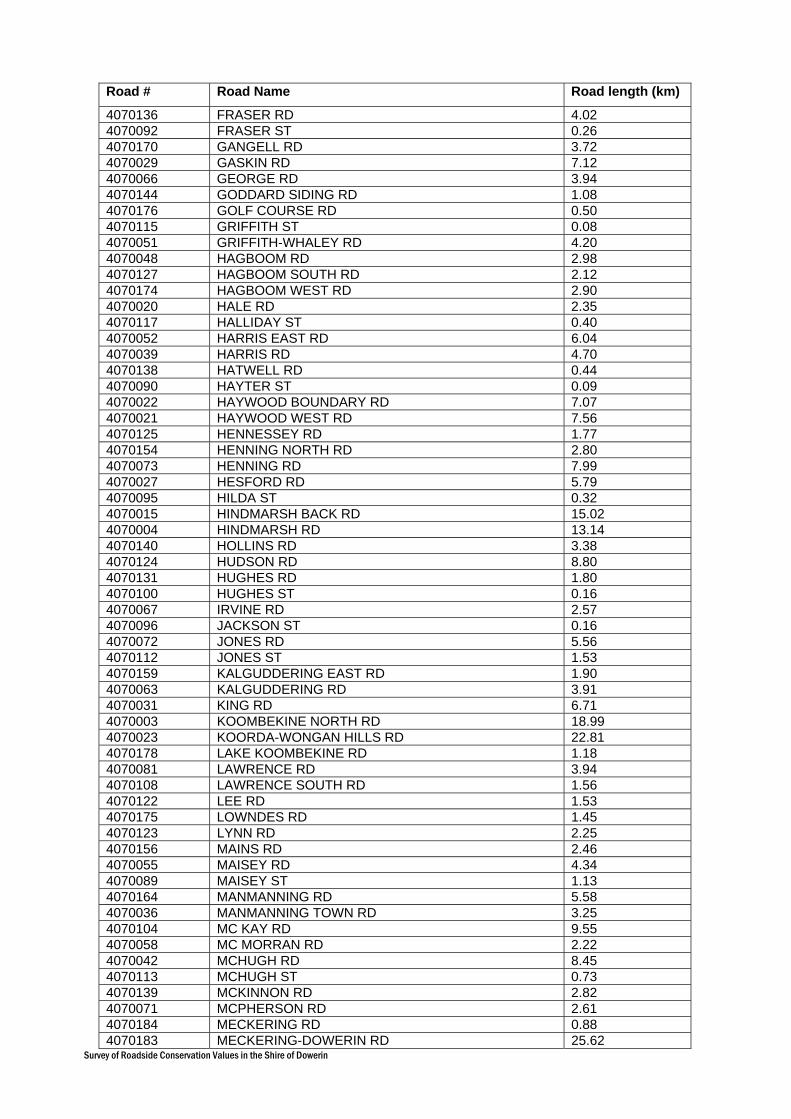
Survey of Roadside Conservation Values in the Shire of Dowerin
Road # Road Name Road length (km)
4070136 FRASER RD 4.02 4070092 FRASER ST 0.26 4070170 GANGELL RD 3.72 4070029 GASKIN RD 7.12 4070066 GEORGE RD 3.94 4070144 GODDARD SIDING RD 1.08 4070176 GOLF COURSE RD 0.50 4070115 GRIFFITH ST 0.08 4070051 GRIFFITH-WHALEY RD 4.20 4070048 HAGBOOM RD 2.98 4070127 HAGBOOM SOUTH RD 2.12 4070174 HAGBOOM WEST RD 2.90 4070020 HALE RD 2.35 4070117 HALLIDAY ST 0.40 4070052 HARRIS EAST RD 6.04 4070039 HARRIS RD 4.70 4070138 HATWELL RD 0.44 4070090 HAYTER ST 0.09 4070022 HAYWOOD BOUNDARY RD 7.07 4070021 HAYWOOD WEST RD 7.56 4070125 HENNESSEY RD 1.77 4070154 HENNING NORTH RD 2.80 4070073 HENNING RD 7.99 4070027 HESFORD RD 5.79 4070095 HILDA ST 0.32 4070015 HINDMARSH BACK RD 15.02 4070004 HINDMARSH RD 13.14 4070140 HOLLINS RD 3.38 4070124 HUDSON RD 8.80 4070131 HUGHES RD 1.80 4070100 HUGHES ST 0.16 4070067 IRVINE RD 2.57 4070096 JACKSON ST 0.16 4070072 JONES RD 5.56 4070112 JONES ST 1.53 4070159 KALGUDDERING EAST RD 1.90 4070063 KALGUDDERING RD 3.91 4070031 KING RD 6.71 4070003 KOOMBEKINE NORTH RD 18.99 4070023 KOORDA-WONGAN HILLS RD 22.81 4070178 LAKE KOOMBEKINE RD 1.18 4070081 LAWRENCE RD 3.94 4070108 LAWRENCE SOUTH RD 1.56 4070122 LEE RD 1.53 4070175 LOWNDES RD 1.45 4070123 LYNN RD 2.25 4070156 MAINS RD 2.46 4070055 MAISEY RD 4.34 4070089 MAISEY ST 1.13 4070164 MANMANNING RD 5.58 4070036 MANMANNING TOWN RD 3.25 4070104 MC KAY RD 9.55 4070058 MC MORRAN RD 2.22 4070042 MCHUGH RD 8.45 4070113 MCHUGH ST 0.73 4070139 MCKINNON RD 2.82 4070071 MCPHERSON RD 2.61 4070184 MECKERING RD 0.88 4070183 MECKERING-DOWERIN RD 25.62

Survey of Roadside Conservation Values in the Shire of Dowerin
Road # Road Name Road length (km)
4070059 MELVIN RD 2.41 4070088 MEMORIAL AVE 0.80 4070079 METCALF EAST RD 4.67 4070146 METCALF NORTH RD 2.66 4070080 METCALF RD 6.05 4070091 METCALF ST 1.29 4070145 MILES RD 0.48 4070026 MINNIVALE NORTH EAST RD 6.45 4070172 MITCHELL RD 3.60 4070083 MONTAGUE RD 2.82 4070041 MOONIJIN EAST RD 2.84 4070163 MOONIJIN WEST RD 11.08 4070044 MORRELL NORTH RD 3.70 4070062 NAMBLING NORTH RD 5.64 4070006 NAMBLING RD 2.23 4070162 NAMBLING SOUTH RD 22.58 4070074 NORMAN RD 3.78 4070137 NORRIS RD 0.97 4070110 NORRIS ST 0.40 4070141 OLD KALANNIE RD 1.29 4070009 OLD KOORDA RD 20.27 4070165 OLD NALKAIN RD 3.70 4070177 O'LOGHLEN ST 0.28 4070030 PARKER RD 7.70 4070084 PETERS RD 1.61 4070158 PHILLIPS NORTH RD 0.38 4070043 PHILLIPS RD 5.95 4070016 PICKERING RD 5.30 4070111 PLACE ST 0.92 4070034 PULFORD RD 0.60 4070056 QUELAGETTING WEST RD 4.80 4070005 RABBIT PROOF FENCE RD 52.91 4070106 RAILWAY RD 5.93 4070002 REDDING RD 0.90 4070102 RICHARDS RD 1.85 4070045 RIFLE RANGE RD 3.10 4070017 ROBINSON RD 8.39 4070046 SANDERS RD 7.00 4070103 SCHELL RD 2.25 4070155 SHANKLAND RD 5.54 4070157 SHARMAN RD 2.17 4070166 SMITH RD 0.55 4070018 SPARK RD 9.24 4070075 STACY RD 2.11 4070093 STACY ST 0.97 4070181 STEWART ST 1.44 4070105 STOUT RD 1.69 4070129 THOMAS RD 5.88 4070121 THOMAS ST 0.24 4070014 THORNETT RD 9.40 4070054 TODD RD 3.22 4070150 TURRIFF RD 2.12 4070047 TWENTY SIX GATE RD 7.00 4070061 TWINE RD 3.44 4070019 UBERIN RD 23.89 4070126 UCARTY RD 2.85 4070171 UCARTY ROCK EAST RD 5.60 4070057 UCARTY ROCK RD 1.77 4070007 UCARTY SOUTH RD 18.65
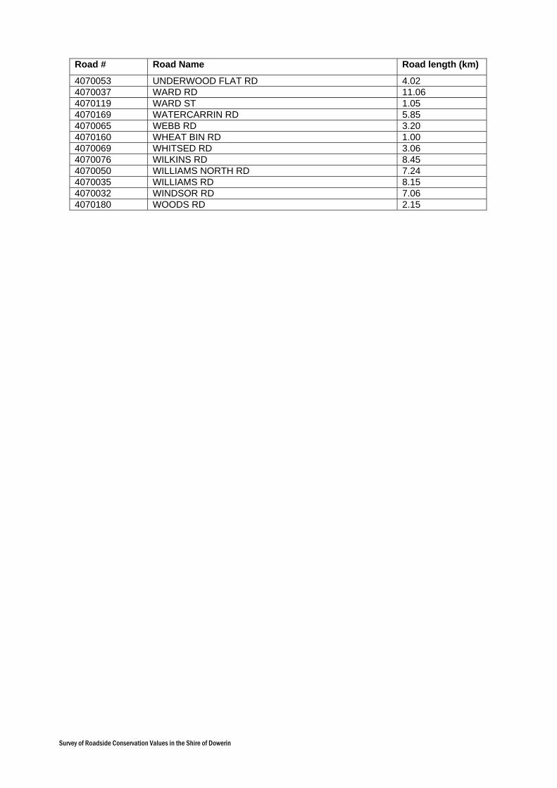
Survey of Roadside Conservation Values in the Shire of Dowerin
Road # Road Name Road length (km)
4070053 UNDERWOOD FLAT RD 4.02 4070037 WARD RD 11.06 4070119 WARD ST 1.05 4070169 WATERCARRIN RD 5.85 4070065 WEBB RD 3.20 4070160 WHEAT BIN RD 1.00 4070069 WHITSED RD 3.06 4070076 WILKINS RD 8.45 4070050 WILLIAMS NORTH RD 7.24 4070035 WILLIAMS RD 8.15 4070032 WINDSOR RD 7.06 4070180 WOODS RD 2.15

Survey of Roadside Conservation Values in the Shire of Dowerin
Appendix
4
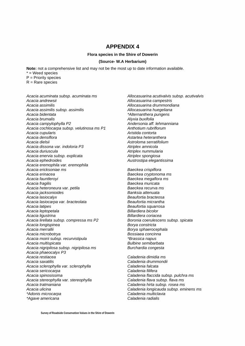
Survey of Roadside Conservation Values in the Shire of Dowerin
APPENDIX 4 Flora species in the Shire of Dowerin
(Source- W.A Herbarium)
Note: not a comprehensive list and may not be the most up to date information available. * = Weed species P = Priority species R = Rare species Acacia acuminata subsp. acuminata ms Acacia andrewsii Acacia assimilis Acacia assimilis subsp. assimilis Acacia bidentata Acacia brumalis Acacia campylophylla P2 Acacia cochlocarpa subsp. velutinosa ms P1 Acacia cupularis Acacia densiflora Acacia dielsii Acacia dissona var. indoloria P3 Acacia duriuscula Acacia enervia subsp. explicata Acacia ephedroides Acacia eremophila var. eremophila Acacia ericksoniae ms Acacia erinacea Acacia fauntleroyi Acacia fragilis Acacia heteroneura var. petila Acacia jacksonioides Acacia lasiocalyx Acacia lasiocarpa var. bracteolata Acacia latipes Acacia leptopetala Acacia ligustrina Acacia lirellata subsp. compressa ms P2 Acacia longispinea Acacia merrallii Acacia microbotrya Acacia moirii subsp. recurvistipula Acacia multispicata Acacia nigripilosa subsp. nigripilosa ms Acacia phaeocalyx P3 Acacia restiacea Acacia saxatilis Acacia sclerophylla var. sclerophylla Acacia sericocarpa Acacia spinosissima Acacia stereophylla var. stereophylla Acacia tratmaniana Acacia ulicina *Adonis microcarpa *Agave americana
Allocasuarina acutivalvis subsp. acutivalvis Allocasuarina campestris Allocasuarina drummondiana Allocasuarina huegeliana *Alternanthera pungens Alyxia buxifolia Andersonia aff. lehmanniana Anthotium rubriflorum Aristida contorta Astartea heteranthera Astroloma serratifolium Atriplex amnicola Atriplex nummularia Atriplex spongiosa Austrostipa elegantissima Baeckea crispiflora Baeckea cryptonoma ms Baeckea megaflora ms Baeckea muricata Baeckea recurva ms Banksia attenuata Beaufortia bracteosa Beaufortia micrantha Beaufortia squarrosa Billardiera bicolor Billardiera coriacea Boronia coerulescens subsp. spicata Borya constricta Borya sphaerocephala Bossiaea concinna *Brassica napus Bulbine semibarbata Burchardia congesta Caladenia dimidia ms Caladenia drummondii Caladenia falcata Caladenia filifera Caladenia flaccida subsp. pulchra ms Caladenia flava subsp. flava ms Caladenia hirta subsp. rosea ms Caladenia longicauda subsp. eminens ms Caladenia multiclavia Caladenia radialis
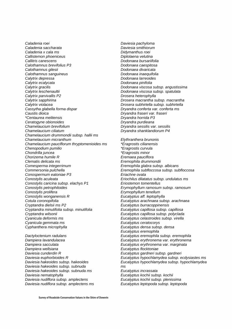
Survey of Roadside Conservation Values in the Shire of Dowerin
Caladenia roei Caladenia saccharata Caladenia x cala ms Callistemon phoeniceus Callitris canescens Calothamnus brevifolius P3 Calothamnus gilesii Calothamnus sanguineus Calytrix depressa Calytrix ecalycata Calytrix gracilis Calytrix leschenaultii Calytrix parvivallis P2 Calytrix sapphirina Calytrix violacea Cassytha glabella forma dispar Caustis dioica *Centaurea melitensis Ceratogyne obionoides Chamelaucium brevifolium Chamelaucium ciliatum Chamelaucium drummondii subsp. hallii ms Chamelaucium micranthum Chamelaucium pauciflorum thryptomenioides ms Chenopodium pumilio Chondrilla juncea Chorizema humile R Clematis delicata ms Comesperma integerrimum Commersonia pulchella Conospermum eatoniae P3 Conostylis aculeata Conostylis caricina subsp. elachys P1 Conostylis petrophiloides Conostylis prolifera Conostylis wonganensis R Cotula coronopifolia Cryptandra dielsii ms P2 Cryptandra minutifolia subsp. minutifolia Cryptandra wilsonii Cyanicula deformis ms Cyanicula gemmata ms Cyphanthera microphylla Dactyloctenium radulans Dampiera lavandulacea Dampiera sacculata Dampiera wellsiana Daviesia cunderdin R Daviesia euphorbioides R Daviesia hakeoides subsp. hakeoides Daviesia hakeoides subsp. subnuda Daviesia hakeoides subsp. subnuda ms Daviesia nematophylla Daviesia nudiflora subsp. amplectens Daviesia nudiflora subsp. amplectens ms
Daviesia pachyloma Daviesia smithiorum Didymanthus roei Diplolaena velutina Dodonaea bursariifolia Dodonaea caespitosa Dodonaea divaricata Dodonaea inaequifolia Dodonaea larreoides Dodonaea pinifolia Dodonaea viscosa subsp. angustissima Dodonaea viscosa subsp. spatulata Drosera heterophylla Drosera macrantha subsp. macrantha Drosera subhirtella subsp. subhirtella Dryandra conferta var. conferta ms Dryandra fraseri var. fraseri Dryandra horrida P3 Dryandra purdieana Dryandra sessilis var. sessilis Dryandra shanklandiorum P4 Elythranthera brunonis *Eragrostis cilianensis *Eragrostis curvula *Eragrostis minor Eremaea pauciflora Eremophila drummondii Eremophila glabra subsp. albicans Eremophila subfloccosa subsp. subfloccosa Eriachne ovata Eriochilus dilatatus subsp. undulatus ms Eriostemon tomentellus Erymophyllum ramosum subsp. ramosum Erymophyllum tenellum Eucalyptus aff. leptophylla Eucalyptus arachnaea subsp. arachnaea Eucalyptus burracoppinensis Eucalyptus capillosa subsp. capillosa Eucalyptus capillosa subsp. polyclada Eucalyptus celastroides subsp. virella Eucalyptus ceratocorys Eucalyptus densa subsp. densa Eucalyptus eremophila Eucalyptus eremophila subsp. eremophila Eucalyptus erythronema var. erythronema Eucalyptus erythronema var. marginata Eucalyptus flocktoniae Eucalyptus gardneri subsp. gardneri Eucalyptus hypochlamydea subsp. ecdysiastes ms Eucalyptus hypochlamydea subsp. hypochlamydea ms Eucalyptus incrassata Eucalyptus kochii subsp. kochii Eucalyptus kochii subsp. plenissima Eucalyptus leptopoda subsp. leptopoda

Survey of Roadside Conservation Values in the Shire of Dowerin
Eucalyptus livida Eucalyptus loxophleba subsp. loxophleba Eucalyptus obtusiflora Eucalyptus oldfieldii Eucalyptus olivina Eucalyptus pyriformis Eucalyptus rigidula Eucalyptus salmonophloia Eucalyptus salubris Eucalyptus semivestita ms Eucalyptus sheathiana Eucalyptus stowardii Eucalyptus stricklandii Eucalyptus subangusta subsp. subangusta Eucalyptus subangusta subsp. virescens P1 Eucalyptus transcontinentalis Eucalyptus vegrandis Eucalyptus yilgarnensis Exocarpos aphyllus Gastrolobium bennettsianum Gastrolobium callistachys P4 Gastrolobium calycinum Gastrolobium parviflorum Gastrolobium spinosum var. triangulare *Gazania linearis Gilberta tenuifolia Glischrocaryon aureum Glischrocaryon aureum var. angustifolium Goodenia caerulea Goodenia helmsii Grevillea dryandroides Grevillea dryandroides subsp. hirsuta R Grevillea eremophila Grevillea excelsior Grevillea haplantha subsp. recedens Grevillea hookeriana Grevillea nana subsp. nana Grevillea paniculata Grevillea paradoxa Grevillea petrophiloides Grevillea pterosperma Grevillea rosieri P2 Grevillea roycei P2 Grevillea shuttleworthiana subsp. shuttleworthiana Grevillea spinosissima P3 Grevillea umbellulata subsp. umbellulata Grevillea uncinulata subsp. uncinulata Guichenotia macrantha Guichenotia micrantha Gunniopsis intermedia Gunniopsis quadrifida *Gynandriris setifolia Gyrostemon subnudus Hakea francisiana
Hakea lissocarpha Hakea meisneriana Hakea multilineata Hakea petiolaris subsp. trichophylla ms Hakea scoparia Hakea trifurcata Halosarcia pergranulata subsp. pergranulata Halosarcia syncarpa Helichrysum leucopsideum Heliotropium curassavicum Hemiandra incana Hemigenia dielsii Hibbertia aff. commutata Hibbertia eatoniae Hibbertia exasperata Hibbertia glomerosa Hibbertia polystachya *Hordeum vulgare Hyalosperma glutinosum Hyalosperma glutinosum subsp. glutinosum Hybanthus floribundus subsp. curvifolius Hybanthus floribundus subsp. floribundus Hydrocotyle pilifera var. glabrata Hydrocotyle rugulosa Hypocalymma angustifolium Hypocalymma puniceum Isoetes caroli Isopogon scabriusculus subsp. scabriusculus ms Isotropis juncea Jacksonia densiflora Jacksonia fasciculata Jacksonia racemosa Juncus radula Kennedia prostrata Keraudrenia integrifolia Kunzea pulchella *Lamarckia aurea Laxmannia grandiflora subsp. grandiflora Laxmannia paleacea Lechenaultia floribunda Lepidium phlebopetalum Lepidosperma costale Leptosema aphyllum ms Leptosema daviesioides Leptospermum erubescens Leucopogon conostephioides Leucopogon woodsii Lobelia alata Logania flaviflora Lomandra collina *Lupinus angustifolius Lysiana casuarinae
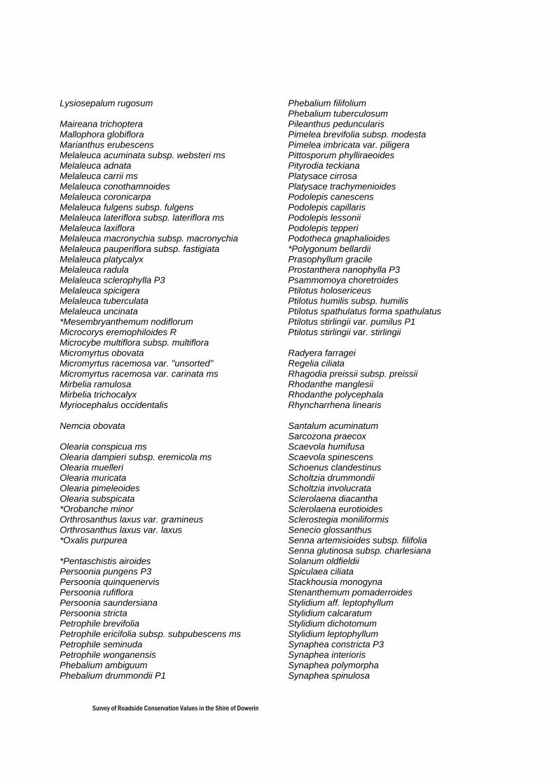
Survey of Roadside Conservation Values in the Shire of Dowerin
Lysiosepalum rugosum Maireana trichoptera Mallophora globiflora Marianthus erubescens Melaleuca acuminata subsp. websteri ms Melaleuca adnata Melaleuca carrii ms Melaleuca conothamnoides Melaleuca coronicarpa Melaleuca fulgens subsp. fulgens Melaleuca lateriflora subsp. lateriflora ms Melaleuca laxiflora Melaleuca macronychia subsp. macronychia Melaleuca pauperiflora subsp. fastigiata Melaleuca platycalyx Melaleuca radula Melaleuca sclerophylla P3 Melaleuca spicigera Melaleuca tuberculata Melaleuca uncinata *Mesembryanthemum nodiflorum Microcorys eremophiloides R Microcybe multiflora subsp. multiflora Micromyrtus obovata Micromyrtus racemosa var. "unsorted" Micromyrtus racemosa var. carinata ms Mirbelia ramulosa Mirbelia trichocalyx Myriocephalus occidentalis Nemcia obovata Olearia conspicua ms Olearia dampieri subsp. eremicola ms Olearia muelleri Olearia muricata Olearia pimeleoides Olearia subspicata *Orobanche minor Orthrosanthus laxus var. gramineus Orthrosanthus laxus var. laxus *Oxalis purpurea *Pentaschistis airoides Persoonia pungens P3 Persoonia quinquenervis Persoonia rufiflora Persoonia saundersiana Persoonia stricta Petrophile brevifolia Petrophile ericifolia subsp. subpubescens ms Petrophile seminuda Petrophile wonganensis Phebalium ambiguum Phebalium drummondii P1
Phebalium filifolium Phebalium tuberculosum Pileanthus peduncularis Pimelea brevifolia subsp. modesta Pimelea imbricata var. piligera Pittosporum phylliraeoides Pityrodia teckiana Platysace cirrosa Platysace trachymenioides Podolepis canescens Podolepis capillaris Podolepis lessonii Podolepis tepperi Podotheca gnaphalioides *Polygonum bellardii Prasophyllum gracile Prostanthera nanophylla P3 Psammomoya choretroides Ptilotus holosericeus Ptilotus humilis subsp. humilis Ptilotus spathulatus forma spathulatus Ptilotus stirlingii var. pumilus P1 Ptilotus stirlingii var. stirlingii Radyera farragei Regelia ciliata Rhagodia preissii subsp. preissii Rhodanthe manglesii Rhodanthe polycephala Rhyncharrhena linearis Santalum acuminatum Sarcozona praecox Scaevola humifusa Scaevola spinescens Schoenus clandestinus Scholtzia drummondii Scholtzia involucrata Sclerolaena diacantha Sclerolaena eurotioides Sclerostegia moniliformis Senecio glossanthus Senna artemisioides subsp. filifolia Senna glutinosa subsp. charlesiana Solanum oldfieldii Spiculaea ciliata Stackhousia monogyna Stenanthemum pomaderroides Stylidium aff. leptophyllum Stylidium calcaratum Stylidium dichotomum Stylidium leptophyllum Synaphea constricta P3 Synaphea interioris Synaphea polymorpha Synaphea spinulosa
Survey of Roadside Conservation Values in the Shire of Dowerin
Tecticornia verrucosa Templetonia aculeata Templetonia egena Templetonia smithiana Templetonia sulcata Thelymitra antennifera Thomasia tenuivestita P1 Thryptomene australis Thryptomene kochii Thryptomene mucronulata Thryptomene racemulosa Thysanotus patersonii Thysanotus rectantherus Thysanotus sparteus Thysanotus speckii Trachymene cyanopetala Trachymene ornata Tribonanthes longipetala Triglochin sp.A Perth Flora(A.S.George 4100) Triodia longipalea *Triticum aestivum Trymalium daphnifolium Urodon capitatus Verticordia acerosa var. preissii Verticordia auriculata Verticordia brachypoda Verticordia chrysantha Verticordia chrysanthella Verticordia densiflora var. cespitosa Verticordia densiflora var. densiflora Verticordia eriocephala Verticordia hughanii R Verticordia insignis subsp. compta Verticordia mitchelliana Verticordia monadelpha var. monadelpha Verticordia pennigera Verticordia picta Verticordia pritzelii Verticordia serrata var. ciliata Verticordia tumida subsp. tumida Verticordia venusta P3 Wahlenbergia tumidifructa Waitzia acuminata var. acuminata Westringia cephalantha Westringia rigida Wurmbea dioica subsp. alba Wurmbea graniticola Xylomelum angustifolium
Survey of Roadside Conservation Values in the Shire of Dowerin
Appendix
5
Survey of Roadside Conservation Values in the Shire of Dowerin
APPENDIX 5 Fauna species in the Shire of Dowerin (Source- W.A Museum, 2005)
Information provided by Western Australian Museum, Fauna Base, latitude/longitude coordinates -30.80, 116.9333 and –31.4333, 117.2833.
Note: not a comprehensive list.
* represents an introduced species.
BIRD SPECIES Accipitridae Hamirostra isura Square-tailed Kite Aegothelidae Aegotheles cristatus cristatus Australian Owlet-nightjar Cracticidae Cracticus tibicen Australian Magpie Falconidae Falco peregrinus Peregrine Falcon (Protected) Meliphagidae Epthianura albifrons White-fronted Chat Manorina flavigula Yellow-throated Miner Pachycephalidae Oreoica gutturalis gutturalis Southern Crested Bellbird (Near Threatened) Pachycephala rufiventris rufiventris Rufous Whistler Pardalotidae Hylacola cauta whitlocki Shy Heathwren (Near Threatened) Pardalotus striatus Striated Pardalote Pomatostomidae Pomatostomus superciliosus ashbyi White-browed Babbler (Near Threatened) Psittacidae Calyptohynchus latirostris Carnaby’s Black Cockatoo (Endangered) Neophema elegans Elegant Parrot Platycercus zonarius Ringneck “28” Parrot Polytelis anthopeplus anthopeplus Regent Parrot Tytonidae Tyto alba Barn Owl MAMMAL SPECIES Bovidae *Bos Taurus Hereford Cattle *Ovis aries Sheep Dasyuridae Dasyurus geoffroii Chuditch (Threatened/Vulnerable) Sminthopsis crassicaudata Fat-tailed Dunnart Peramelidae Isoodon obesulus fusciventer Quenda (Near Threatened)

Survey of Roadside Conservation Values in the Shire of Dowerin
Sminthopsis dolichura Little Long-tailed Dunnart Muridae Sminthopsis murina Common Dunnart Vespertilionidae *Mus musculus House Mouse REPTILE SPECIES Agamidae Chalinolobus gouldii Gould’s Wattled Bat Ctenophorus maculatus griseus Spotted Sand Dragon Ctenophorus ornatus Ornate Crevice Dragon Moloch horridus Thorny Devil Pogona minor Dwarf Bearded Dragon Pogona minor minor Western Bearded Dragon Boidae Aspidites ramsayi Woma Python (Endangered) Elapidae Brachyurophis semifasciata Southern Shovel-nosed Snake Demansia psammophis reticulata Yellow-faced Whipsnake Parasuta gouldii Gould’s Hooded Snake Pseudechis australis King Brown Snake Pseudonaja modesta Ringed Brown Snake Pseudonaja nuchalis Western Brown Snake Gekkonidae Diplodactylus granariensis Wheatbelt Stone Gecko Diplodactylus pulcher Granite Gecko Gehyra variegata Tree Dtella Heteronotia binoei Bynoe’s Prickly Gecko Oedura reticulata Reticulated Velvet Gecko Pygopodidae Delma australis Marble-faced Delma (Endangered) Delma grayii Gray’s Legless Lizard Lialis burtonis Burton’s Snake-lizard Pygopus lepidopodus Common Scaly Foot Scincidae Cryptoblepharus plagiocephalus Speckled Skink Ctenotus schomburgkii Barred Wedgesnout Ctenotus Egernia stokesii badia Western Spiny-tailed Skink (Endangered) Lerista macropisthopus macropisthopus Lerista muelleri Wood Mulch Slider (Endangered) Menetia greyii Common Dwarf Skink Morethia obscura Woodland Flecked Skink Tiliqua occipitalis Western Blue-tongue Lizard Tiliqua rugosa rugosa Bobtail Typhlopidae Ramphotyphlops australis Southern Blind Snake Ramphotyphlops waitii Beaked Blind Snake
Survey of Roadside Conservation Values in the Shire of Dowerin
AMPHIBIA SPECIES Myobatrachidae Heleioporus albopunctatus Western Spotted Frog Myobatrachus gouldii Turtle Frog Neobatrachus kunapalari Kunapalari Frog Neobatrachus pelobatoides Humming Frog Neobatrachus sp Neobatrachus sutor Shoemaker Frog Pseudophryne guentheri Gunther’s Toadlet / Crawling Frog

Survey of Roadside Conservation Values in the Shire of Dowerin
Appendix
6
Survey of Roadside Conservation Values in the Shire of Dowerin
ROADSIDE CONSERVATION COMMITTEE GUIDELINES FOR MANAGING THE HARVESTING OF NATIVE FLOWERS, SEED
AND TIMBER FROM ROADSIDES Preamble
The diversity of values associated with roadside vegetation is well documented and acknowledged. In landscapes that have been extensively cleared, roadside vegetation provides essential wildlife corridors and habitat for local flora and fauna, including a number of threatened species. Hence it is highly desirable that this asset is managed in such a way as to ensure its conservation and sustainability. The control and management of roadside vegetation is the responsibility of the road manager. Local government authorities, as road managers, are often approached for ‘permission’ to take various flora products from the roadside. These requests are mainly for wildflowers, native seed and firewood. Other products which may be sought include material for making didgeridoos, other types of craftwood, and stakes or poles for various purposes. Although road managers are primarily concerned about the maintenance of the running surface itself, through the implementation of these simple guidelines for the removal of flora and timber material from the roadsides, the vegetated roadside reserve should be maintained for its biodiversity values, and the benefit of the community and road users. In some instances the Roadside Conservation Committee (RCC) is supportive of the sustainable harvesting of flora, such as salvage (removal of dead material that is not significant wildlife habitat or is material to be destroyed by road works), or the selective collection of seed for revegetation. However, each case should be viewed on its merits and any decision to facilitate harvesting from roadsides should be referred to the Department of Conservation and Land Management (CALM) and/or the RCC for advice. Licences allowing the taking of roadside flora may be issued by CALM when supported by the road managing authority. Legislation
All Western Australian native flora is protected under the Wildlife Conservation Act 1950. Native flora includes all parts of a native plant, including its flowers, seed, and timber. Protection of native flora under the Act has the effect of requiring a person to only take (cut or remove) native flora from Crown land under a licence. Road and rail reserves are Crown land, and hence a licence is required to cut or remove any native flora from a roadside or rail line. There is, however, a legal provision by which the road manager or their agent (contractor) does not require a licence whilst undertaking legitimate road management activities. This provision does not extend to other persons who wish to take protected flora from roadsides. There are two types of licences that apply to the taking of protected flora from Crown land –Commercial Purposes Licences where the flora is being taken for any commercial purpose, and

Survey of Roadside Conservation Values in the Shire of Dowerin
Scientific or Other Prescribed Purposes Licences where the protected flora is being taken for specific non-commercial purposes. These licences are issued by CALM. In issuing a licence, CALM is required to be assured that the activity will not compromise the conservation of the flora. In determining this, CALM will seek advice from the land manager for which the application relates to determine the potential impact of the activity, and how the activity relates to the management objectives being applied to that land. A licence application may be refused if the activity is either a conservation concern, or does not fit in with the management objectives of the road manager. Once issued with a licence, a licensee must comply with the conditions of the licence that are designed to ensure the activity does not adversely impact on the conservation of the flora or the natural environment in which it occurs. Commercial Wildflower Harvesting
Western Australia is referred to as the ‘Wildflower State’, and its wildflowers attract a significant number of tourists each year. Roadside vegetation provides the most accessible, and hence the most commonly viewed, array of wildflowers, and as such are an important feature of regional tourism and can provide a significant financial boost to local economies. The RCC considers that the flora on roadsides is reserved and maintained for public benefit. It is therefore seen as a contradiction of purpose to allow wildflowers on roadsides to be harvested, particularly for private gain, and this activity should not be permitted. Wildflower harvesting in many instances detracts from the biodiversity and tourism values of the roadside. It is often the case that flora is harvested from roadsides because of the convenience of access, and harvesters should be directed to find alternative locations. There are situations where some harvesting may be considered, such as in very wide road reserves where the activity can be screened from road users, but mostly road managers have been discouraged from supporting or allowing such harvesting to occur. If harvesting is to be approved, then the points provided at the end of these guidelines should be considered. Seed Collection Throughout much of the South West, revegetation of the native flora is being undertaken to redress the problems that historic clearing has created. Increasingly, this revegetation is aimed at using local native flora so as to recreate the native vegetation to support biodiversity objectives. The paradox is that in many areas the native vegetation has been cleared to such an extent that adequate sources of native seed cannot be found for undertaking this work. Roadside vegetation may be a source of such seed. Native seed is an important component of remnant vegetation. It is critical for the regeneration of certain species, called re-seeder species, when plants are either killed by an event, such as fire, storm damage, or die as part of their natural cycle. The maintenance of adequate seed of these species is necessary as a precaution to ensure the sustainability of the flora biodiversity. Native seed is also an important food source for native fauna living in roadside vegetation, from ants to birds and mammals. The maintenance of this fauna is important for the continuing survival of the vegetation, especially where the fauna is required to pollinate the flora.

Survey of Roadside Conservation Values in the Shire of Dowerin
When seed is needed for bona fide revegetation projects within the local community, and no other source of local seed is available, then the controlling authority may consider giving permission for collection of seed from roadsides. Such collection must be under the appropriate licence issued by CALM and the harvesting should be done in a way that does not endanger the long-term survival of the roadside vegetation. Where seed collection is to be authorised on roadsides, the road manager should consider the points listed at the end of these guidelines. Specific consideration should be given to the methods that are approved for harvesting the seed, the quantity of seed that may be taken, and the species from which the seed is to be sourced. Timber Harvesting from Roadsides. Timber is harvested for a range of reasons, including saw logs, firewood and craftwood. Due to the ease of access, timber harvesters may wish to source timber from roadside vegetation for these purposes. The RCC seeks to encourage roadside managers to retain timber on roadsides as an important component of the natural habitat, which fulfils ecological, aesthetic and land management functions. The value of fallen logs and branches within the roadside is often not realised, but this material forms an important habitat for many species of insects, reptiles, mammals and birds, thus enhancing the roadside biodiversity. Insects and reptiles that live in fallen timber are also important elements of the food chain, and are very important to the functioning of natural systems, and the survival of many other native animals. The RCC believes that harvesting of timber from roadsides should not be permitted except in defined road safety, fence line or service clearance zones, or where a tree has fallen, or appears likely to fall into clearance zones. Where timber removal is to be allowed, consideration should be given to the points raised at the end of these guidelines, especially in relation to safety issues related to timber cutting. Permission to remove timber should be specific to certain sections of roadsides where the removal is necessary for other planned road management purposes. Guidelines For Harvesting On Roadsides
In all cases the permission of the managing authority, i.e. Main Roads WA, Local Government or CALM, must be sought before native flora is removed from a roadside.
Flora removal should be from only designated roads, which have wider vegetated road verges i.e. vegetation width > 3metres
The number of operators authorised to remove flora from a roadside should be strictly limited to that which can be sustained and managed. The determination of this is at the judgement of the managing authority, but consideration should be taken of the type of flora being harvested and an evaluation of monitoring of the impact of the harvest activity. Advice may be sought from CALM.
Approval for flora harvesting should be for a set period, with a review of the impact and operation before renewal.
Approval should also stipulate approved methods of harvesting, the species which may be harvested, and the quantity of material to be taken. Advice on harvest conditions may be obtained from CALM.
Survey of Roadside Conservation Values in the Shire of Dowerin
Any flora removed should not affect the viability of the residual seed bank. It is recommended that no more than 20% of the flowers or seed on a plant should be taken, unless it is in an area that is scheduled to be cleared as part of road management.
Methods of harvesting flora should not jeopardise the survival of the plant/tree, unless it is in an area that is scheduled to be cleared as part of road management.
The removal of whole plants should be restricted to areas that are scheduled to be cleared as part of road management. Note: some species of flora such as zamia palms and grass trees cannot be removed for commercial purposes without a special endorsement on the Commercial Purposes Licence issued by CALM.
No flora of special conservation concern (Declared Rare Flora or Priority Flora) should be removed without special authorisation through CALM.
No commercial harvesting of any plant product should be allowed for any reason between the markers that delineate an Environmentally Sensitive Area.
Flora harvesting should be prohibited from designated Flora Roads.
Care should be taken that access to Dieback infected areas is limited to the drier months of the year, and vehicular access disallowed.
Safety should always be of prime concern and every effort should be made to ensure that personal safety is a key consideration in any harvesting operation.
Flora harvesters should not operate from the roadside in areas where the vegetation is close to the road, where vehicles cannot be safely parked off the road, or where there is poor driver visibility.
Survey of Roadside Conservation Values in the Shire of Dowerin
Appendix
7

Survey of Roadside Conservation Values in the Shire of Dowerin
ROADSIDE CONSERVATION COMMITTEE
Guidelines for the Nomination and Management of Flora
Roads Introduction The Flora Roads program began as an initiative of the Roadside Conservation Committee (RCC), as a means of encouraging road managers to protect and conserve roadside vegetation of high conservation value. Flora Roads also highlight areas of high conservation flora as a tourist asset to local communities and are easily identified to passing travellers as areas worthy of an inspection to view the local flora. The Roadside Conservation Committee has defined Flora Roads as "those roads which have conservation value owing to the vegetation growing within the reserve". Principle Conservation Values of Flora Roads: The roadside must contain a significant population of native vegetation. Introduced trees and grasses
are not important for conservation. The native vegetation must be in as near to its natural condition as possible. In undisturbed
vegetation, several layers of plants occur – trees, shrubs and herbs are present in woodlands, for example. If one or more of the expected layers are missing, the conservation value is reduced.
The roadside may be the only remaining example of original vegetation within a cleared area. It thus: - Assists in vegetation mapping and distribution studies - Provides a benchmark for study of soil change during agricultural development - Provides a source of local seed for revegetation projects - Acts as a wildlife habitat for the protection of fauna. - Rare or endangered plants may occur on the roadside. - May provide nest sites and refuges for native animals. - May act as a biological corridor.
Identification and Nomination of Flora Roads The RCC has been coordinating a volunteer roadside survey program since 1989, which provides a list of high conservation value roads within many Shires in the agricultural areas of this state. These roadsides can be investigated further to see of they warrant declaration as a Flora Road. Nevertheless, roadsides that have not been surveyed may still be nominated. Any person may suggest to the managing authority or to the RCC that a road, or a section of road, fits the criteria of a Flora Road. However, only the managing authority in whom care, control and management of the road is vested can officially declare it a Flora Road. A road may be nominated as a Flora Road by submitting a written request to the RCC. The RCC requires the following information: Endorsement from the managing authority; Name of the road, LGA, and the road manager (MRWA, Local Government or DCLM); Distance of the proposed Flora Road; and Width of the road reserve.
The following information would also be useful: Photograph(s) of the road; A list of the dominant plant species; Threats (weeds, disturbances, etc).
This information will be stored in the RCC Flora Roads Register, a database which is maintained by the RCC Technical Officer (Mapping).
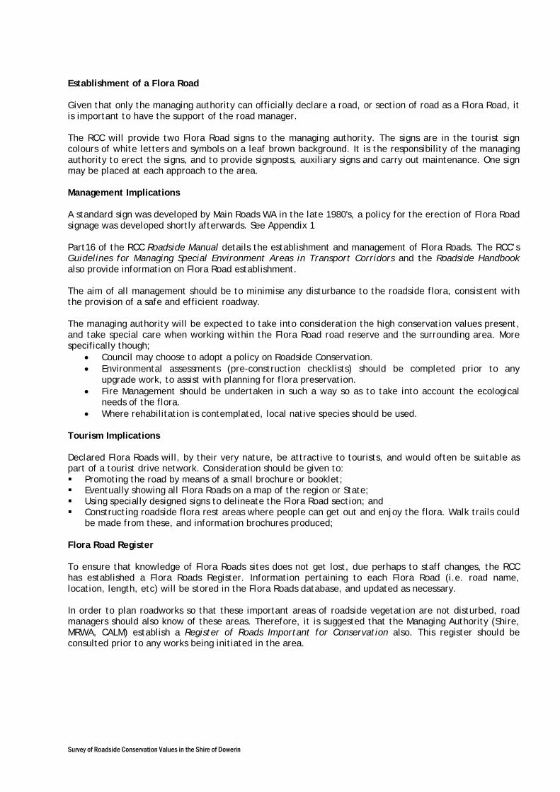
Survey of Roadside Conservation Values in the Shire of Dowerin
Establishment of a Flora Road Given that only the managing authority can officially declare a road, or section of road as a Flora Road, it is important to have the support of the road manager. The RCC will provide two Flora Road signs to the managing authority. The signs are in the tourist sign colours of white letters and symbols on a leaf brown background. It is the responsibility of the managing authority to erect the signs, and to provide signposts, auxiliary signs and carry out maintenance. One sign may be placed at each approach to the area. Management Implications A standard sign was developed by Main Roads WA in the late 1980's, a policy for the erection of Flora Road signage was developed shortly afterwards. See Appendix 1 Part16 of the RCC Roadside Manual details the establishment and management of Flora Roads. The RCC’s Guidelines for Managing Special Environment Areas in Transport Corridors and the Roadside Handbook also provide information on Flora Road establishment. The aim of all management should be to minimise any disturbance to the roadside flora, consistent with the provision of a safe and efficient roadway. The managing authority will be expected to take into consideration the high conservation values present, and take special care when working within the Flora Road road reserve and the surrounding area. More specifically though;
• Council may choose to adopt a policy on Roadside Conservation. • Environmental assessments (pre-construction checklists) should be completed prior to any
upgrade work, to assist with planning for flora preservation. • Fire Management should be undertaken in such a way so as to take into account the ecological
needs of the flora. • Where rehabilitation is contemplated, local native species should be used.
Tourism Implications Declared Flora Roads will, by their very nature, be attractive to tourists, and would often be suitable as part of a tourist drive network. Consideration should be given to: Promoting the road by means of a small brochure or booklet; Eventually showing all Flora Roads on a map of the region or State; Using specially designed signs to delineate the Flora Road section; and Constructing roadside flora rest areas where people can get out and enjoy the flora. Walk trails could
be made from these, and information brochures produced; Flora Road Register To ensure that knowledge of Flora Roads sites does not get lost, due perhaps to staff changes, the RCC has established a Flora Roads Register. Information pertaining to each Flora Road (i.e. road name, location, length, etc) will be stored in the Flora Roads database, and updated as necessary. In order to plan roadworks so that these important areas of roadside vegetation are not disturbed, road managers should also know of these areas. Therefore, it is suggested that the Managing Authority (Shire, MRWA, CALM) establish a Register of Roads Important for Conservation also. This register should be consulted prior to any works being initiated in the area.


![[DRAFT, PRE-FINAL OR FINAL] REPORT - OECD](https://img.pdfslide.net/doc/110x75/5ec770f8c7c9f9670a3f7375/-draft-pre-final-or-final-report-.jpg)