Embed Size (px)
Citation preview
Alternatives to Conventional Zoning
Prepared for:
State of Georgia Small Towns and Communities
Prepared by:
Office of Coordinated Planning Planning and Environmental Management Division
GEORGIA DEPARTMENT OF COMMUNITY AFFAIRS 60 Executive Park South, N.E. Atlanta, Georgia 30329-2231
April, 2002
PHASE 2 – December 2003
Table of Contents Georgia Department of Community Affairs December 2003 Model Code: Alternatives to Conventional Zoning
i
Acknowledgements
Prepared under contract by Jerry Weitz, Jerry Weitz and Associates, Inc., Planning and Development Consultants, Alpharetta, Georgia and Lisa Hollingsworth, Community and Environmental, Inc., Calhoun, Georgia.
Legal Counsel provided by Jenkins & Olson, P.C., Cartersville, Georgia. Phase 2 Legal Counsel provided by Julian Conrad Juergensmeyer, Professor of Law and Planning, Georgia State University.
The Georgia Department of Community Affairs, Office of Coordinated Planning would like to thank and acknowledge the following task force members for their commitment and hard work in guiding and developing this important project. Larry Vanden Bosch, Planning Director, North Georgia RDC David Sutton, Planning Director, South Georgia RDC Larry Sparks, Planning Director, Georgia Mountains RDC Rob LeBeau, Principal Planner, Atlanta Regional Commission Deborah Miness, Project Manager, DCA Office of Coordinated Planning Adriane Wood, DCA Regional Representative, Region 6 Annaka Woodruff, DCA Regional Representative, Region 12 Brenda Hayes, Office Director, DCA Office of Downtown Development Stuart Dorfman, DCA Office of Coordinated Planning Jim Frederick, Office Director, DCA Office of Community Redevelopment Martha Reimann, DCA Office of Downtown Development
Table of Contents Georgia Department of Community Affairs December 2003 Model Code: Alternatives to Conventional Zoning
ii
Credits
The illustrations that appear in Section 2-1, page 78 and Section 5-3, page 243 were reprinted from Saving America’s Countryside: A Guide to Rural Conservation.
By Samuel L. Stokes;
Copyright 1989, with the permission of The John Hopkins University Press
2715 North Charles Street Baltimore, Maryland 21218-4363
The illustrations that appear in Section 2-1, page 79 and Section 5-3, page 255 were
reprinted from Time Saver Standards for Site Planning.
By Joseph DeChiara and Lee E. Koppelman;
Copyright 1984, with the permission of The McGraw-Hill Companies Permission Department
Two Penn Plaza, 9th Floor New York, New York 10121-2298
The illustrations that appear in Section 4-7, page 241 and Section 5-3, page 245 were
reprinted from Rural by Design: Maintaining Small Town Character. By
Randall Arendt; Copyright 1994, with permission of
American Planning Association 122 S. Michigan Avenue, Suite 1600
Chicago, Illinois 60603
The illustrations that appear in Section 4-7, pages 243 and 244 were reprinted from “Land Use Law and Zoning Digest” Vol. 42, 9:3-9.
By Gary Pivo, Robert Small, and Charles R. Wolfe
Copyright 1990, with permission of American Planning Association
122 S. Michigan Avenue, Suite 1600 Chicago, Illinois 60603
Table of Contents Georgia Department of Community Affairs December 2003 Model Code: Alternatives to Conventional Zoning
iii
The illustrations that appear in Section 5-3, pages 240 and 241 were reprinted from Landscape Ecology Principles in Landscape Architecture and Land-Use Planning.
By Wenche E. Dramstad, James D. Olson and Richard T.T. Forman
Copyright 1996, with permission of Copyright Clearance Center, Inc. Academic Permissions Service
222 Rosewood Drive Denvers, Massachusetts 01923
The illustrations that appear in Section 5-3, page 244 were reprinted from the Hidden Design in Land Use Ordinances: Accessing the Visual Impact of Dimensions Use for
Town Planning in Maine Landscapes. By
Paula M. Craighead Copyright 1991, with permission of
University of Southern Maine Post Office Box 9300
Portland, Maine 04104-9300
Table of Contents Georgia Department of Community Affairs December 2003 Model Code: Alternatives to Conventional Zoning
iv
Credits for Phase 2
The illustrations that appear in Section 2-5A on page 6, Section 2-5B on pages 5 through 9, and Section 2-6 on page 2 were reprinted from Street Design Guidelines
for Healthy Neighborhoods By
Dan Burden with Michael Wallwork, Ken Sides, Ramon Trias and Harrison Bright Rue;
Copyright 2002, Local Government Commission, Center for Livable Communities. Sacramento, CA.
The illustrations that appear in Section 2-5A on page 13 and Section 2-5B on page
11 were reprinted from Model Development Code and User's Guide for Small Cities By
OTAK. Copyright 1999. Oregon Transportation and Growth Management Program.
Salem, OR The illustrations that appear in Section 2-5B on pages 2 and 10 are reprinted from
Residential Streets, 3rd Edition By
Walter M. Kulash Copyright 2001, Urban Land Institute, Washington DC (www.uli.org)
The illustrations that appear in Section 2-5B on page 3 and Section 2-6 on page 2
are reprinted from
Main Street…When a Highway Runs Through It: A Handbook for Oregon Communities
By Oregon Transportation and Growth Management Program. 1998.Salem, OR The illustration that appears in Section 2-6 on page 5 is reprinted from Bicycle Facility Planning
By Suzan Anderson Pinsof and Terri Musser
Copyright 1995; Planning Advisory Service Report No. 468, American Planning Association, Chicago, IL
The illustration that appears in Section 2-7 on page 18 is reprinted from Developing Difficult Sites: Solutions for Developers and Builders
By Donald Brandes and Michael Luzier
Copyright 1991, BuilderBooks, National Association of Home Builders, Wash DC
Table of Contents Georgia Department of Community Affairs December 2003 Model Code: Alternatives to Conventional Zoning
v
The illustrations that appear in Section 3-9 on pages 7 through 13 are reprinted from Preparing a Landscape Ordinance
By Wendelyn A. Martz and Marya Morris
Copyright 1990; Planning Advisory Service Report No. 431, American Planning Association, Chicago, IL
The illustration that appears in Section 4-9 on page 11 is reprinted from Design Guidelines for the Garrision Hill District
By Talka & Connor and Hughes Good O’Leary and Ryan
Copyright 2000, Department of Community Development, Roswell, GA
The illustrations that appear in Section 4-9 on pages 15 and 16 are reprinted from a presentation by the City of Atlanta (GA) – Quality of Life Development Codes
Copyright 2003, City of Atlanta (GA)
Additionally, the illustrations/charts depicted in Phase 2 of the Model Code: Alternatives to Conventional Zoning are used with copyright permission, where necessary. Specific credit is given to individual source contributors as shown beneath the illustration/chart provided. Additional references are shown at the end of each section, when considered appropriate.
Table of Contents Georgia Department of Community Affairs December 2003 Model Code: Alternatives to Conventional Zoning
vi
Legal Review
Table of Contents Georgia Department of Community Affairs December 2003 Model Code: Alternatives to Conventional Zoning
vii
LEGAL REVIEW FOR PHASE II
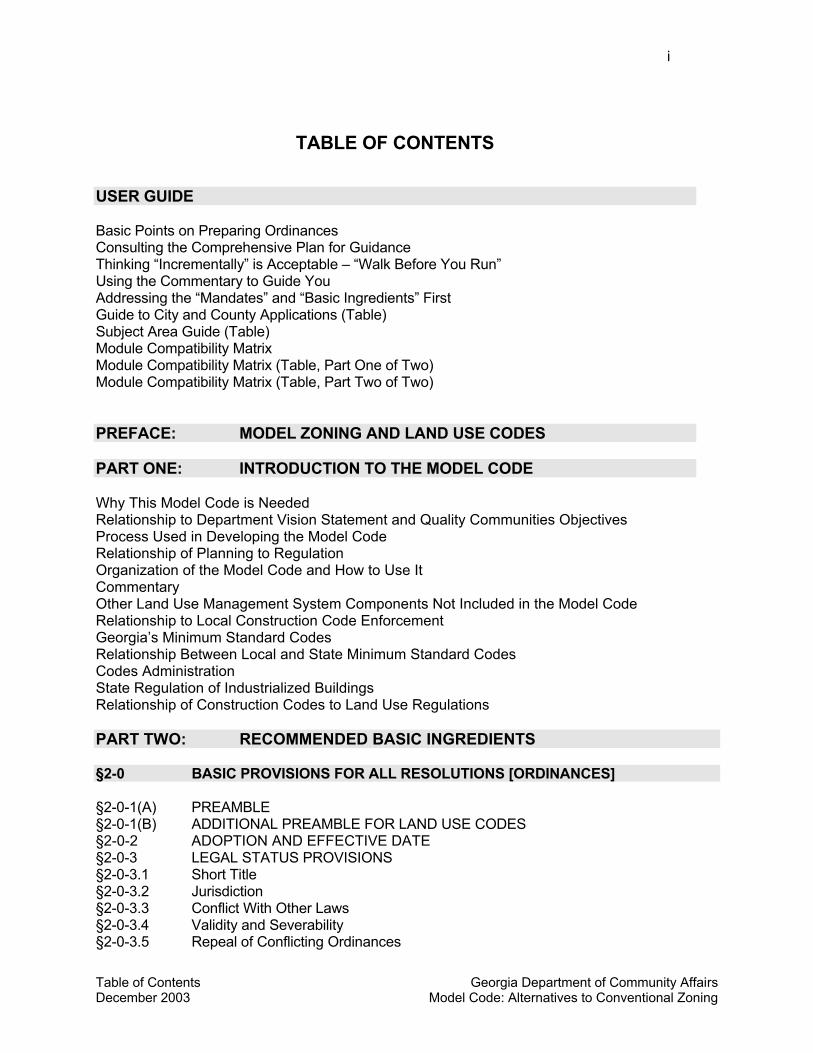
Table of Contents Georgia Department of Community Affairs December 2003 Model Code: Alternatives to Conventional Zoning
i
TABLE OF CONTENTS
USER GUIDE Basic Points on Preparing Ordinances Consulting the Comprehensive Plan for Guidance Thinking “Incrementally” is Acceptable – “Walk Before You Run” Using the Commentary to Guide You Addressing the “Mandates” and “Basic Ingredients” First Guide to City and County Applications (Table) Subject Area Guide (Table) Module Compatibility Matrix Module Compatibility Matrix (Table, Part One of Two) Module Compatibility Matrix (Table, Part Two of Two) PREFACE: MODEL ZONING AND LAND USE CODES PART ONE: INTRODUCTION TO THE MODEL CODE Why This Model Code is Needed Relationship to Department Vision Statement and Quality Communities Objectives Process Used in Developing the Model Code Relationship of Planning to Regulation Organization of the Model Code and How to Use It Commentary Other Land Use Management System Components Not Included in the Model Code Relationship to Local Construction Code Enforcement Georgia’s Minimum Standard Codes Relationship Between Local and State Minimum Standard Codes Codes Administration State Regulation of Industrialized Buildings Relationship of Construction Codes to Land Use Regulations PART TWO: RECOMMENDED BASIC INGREDIENTS §2-0 BASIC PROVISIONS FOR ALL RESOLUTIONS [ORDINANCES] §2-0-1(A) PREAMBLE §2-0-1(B) ADDITIONAL PREAMBLE FOR LAND USE CODES §2-0-2 ADOPTION AND EFFECTIVE DATE §2-0-3 LEGAL STATUS PROVISIONS §2-0-3.1 Short Title §2-0-3.2 Jurisdiction §2-0-3.3 Conflict With Other Laws §2-0-3.4 Validity and Severability §2-0-3.5 Repeal of Conflicting Ordinances
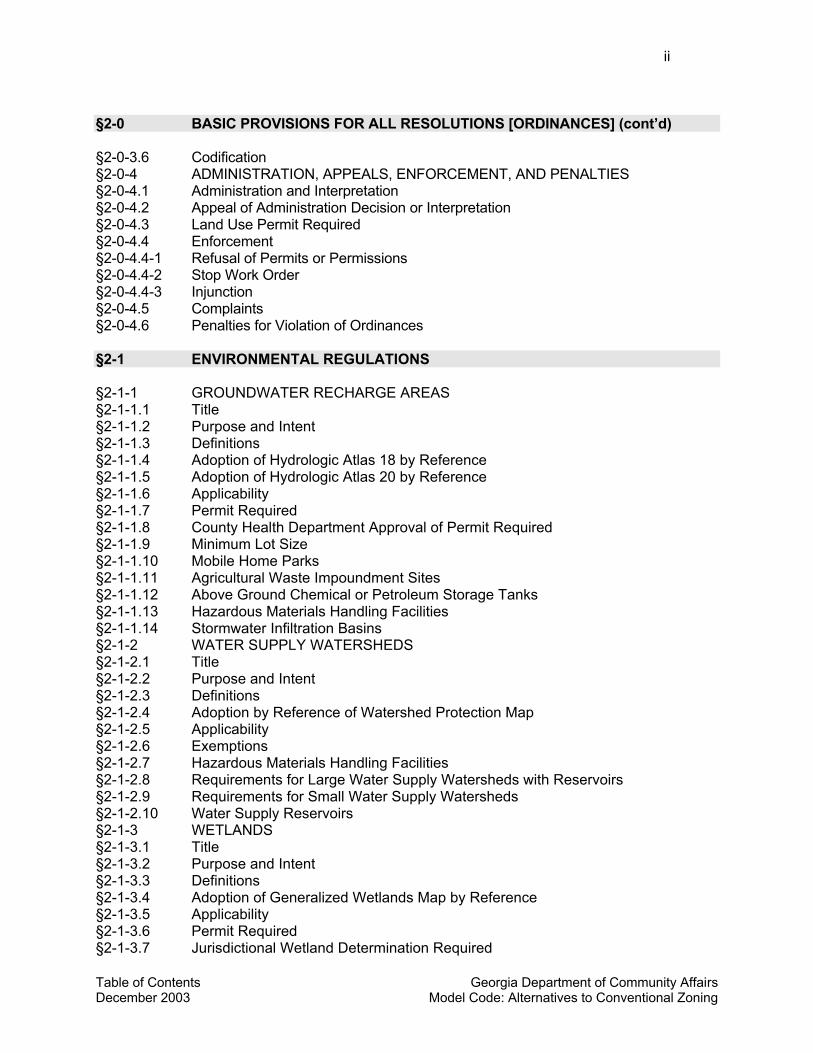
Table of Contents Georgia Department of Community Affairs December 2003 Model Code: Alternatives to Conventional Zoning
ii §2-0 BASIC PROVISIONS FOR ALL RESOLUTIONS [ORDINANCES] (cont’d) §2-0-3.6 Codification §2-0-4 ADMINISTRATION, APPEALS, ENFORCEMENT, AND PENALTIES §2-0-4.1 Administration and Interpretation §2-0-4.2 Appeal of Administration Decision or Interpretation §2-0-4.3 Land Use Permit Required §2-0-4.4 Enforcement §2-0-4.4-1 Refusal of Permits or Permissions §2-0-4.4-2 Stop Work Order §2-0-4.4-3 Injunction §2-0-4.5 Complaints §2-0-4.6 Penalties for Violation of Ordinances §2-1 ENVIRONMENTAL REGULATIONS §2-1-1 GROUNDWATER RECHARGE AREAS §2-1-1.1 Title §2-1-1.2 Purpose and Intent §2-1-1.3 Definitions §2-1-1.4 Adoption of Hydrologic Atlas 18 by Reference §2-1-1.5 Adoption of Hydrologic Atlas 20 by Reference §2-1-1.6 Applicability §2-1-1.7 Permit Required §2-1-1.8 County Health Department Approval of Permit Required §2-1-1.9 Minimum Lot Size §2-1-1.10 Mobile Home Parks §2-1-1.11 Agricultural Waste Impoundment Sites §2-1-1.12 Above Ground Chemical or Petroleum Storage Tanks §2-1-1.13 Hazardous Materials Handling Facilities §2-1-1.14 Stormwater Infiltration Basins §2-1-2 WATER SUPPLY WATERSHEDS §2-1-2.1 Title §2-1-2.2 Purpose and Intent §2-1-2.3 Definitions §2-1-2.4 Adoption by Reference of Watershed Protection Map §2-1-2.5 Applicability §2-1-2.6 Exemptions §2-1-2.7 Hazardous Materials Handling Facilities §2-1-2.8 Requirements for Large Water Supply Watersheds with Reservoirs §2-1-2.9 Requirements for Small Water Supply Watersheds §2-1-2.10 Water Supply Reservoirs §2-1-3 WETLANDS §2-1-3.1 Title §2-1-3.2 Purpose and Intent §2-1-3.3 Definitions §2-1-3.4 Adoption of Generalized Wetlands Map by Reference §2-1-3.5 Applicability §2-1-3.6 Permit Required §2-1-3.7 Jurisdictional Wetland Determination Required
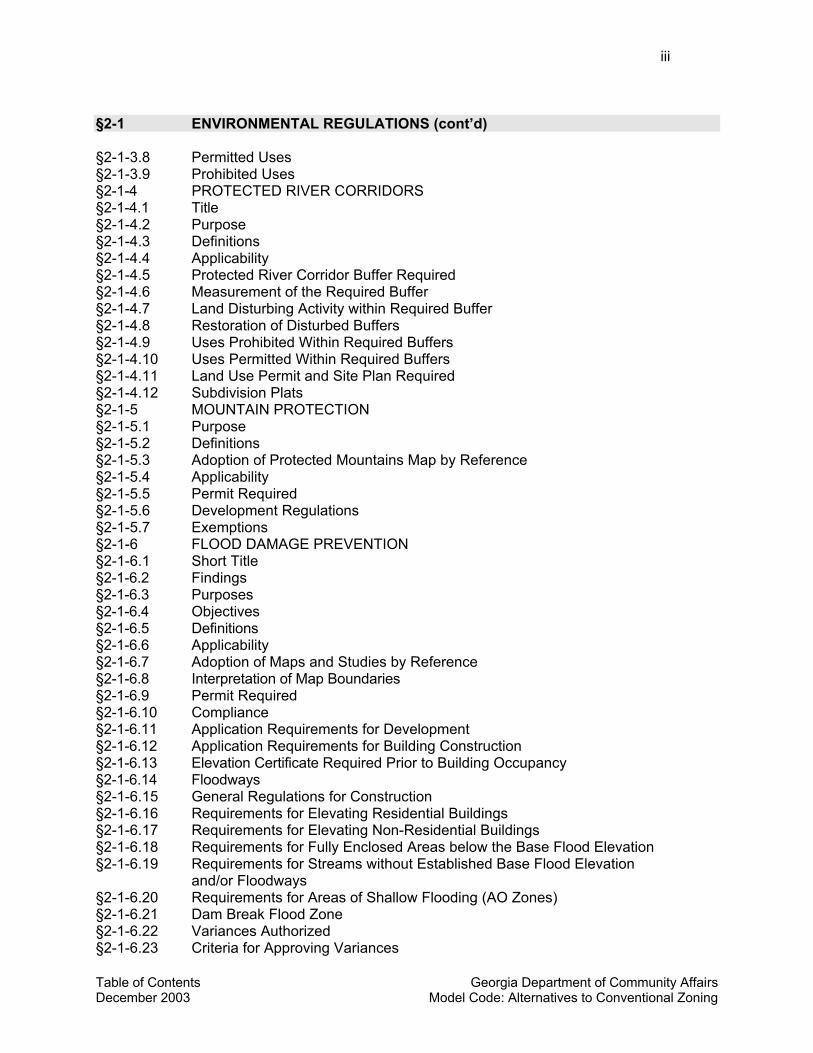
Table of Contents Georgia Department of Community Affairs December 2003 Model Code: Alternatives to Conventional Zoning
iii §2-1 ENVIRONMENTAL REGULATIONS (cont’d) §2-1-3.8 Permitted Uses §2-1-3.9 Prohibited Uses §2-1-4 PROTECTED RIVER CORRIDORS §2-1-4.1 Title §2-1-4.2 Purpose §2-1-4.3 Definitions §2-1-4.4 Applicability §2-1-4.5 Protected River Corridor Buffer Required §2-1-4.6 Measurement of the Required Buffer §2-1-4.7 Land Disturbing Activity within Required Buffer §2-1-4.8 Restoration of Disturbed Buffers §2-1-4.9 Uses Prohibited Within Required Buffers §2-1-4.10 Uses Permitted Within Required Buffers §2-1-4.11 Land Use Permit and Site Plan Required §2-1-4.12 Subdivision Plats §2-1-5 MOUNTAIN PROTECTION §2-1-5.1 Purpose §2-1-5.2 Definitions §2-1-5.3 Adoption of Protected Mountains Map by Reference §2-1-5.4 Applicability §2-1-5.5 Permit Required §2-1-5.6 Development Regulations §2-1-5.7 Exemptions §2-1-6 FLOOD DAMAGE PREVENTION §2-1-6.1 Short Title §2-1-6.2 Findings §2-1-6.3 Purposes §2-1-6.4 Objectives §2-1-6.5 Definitions §2-1-6.6 Applicability §2-1-6.7 Adoption of Maps and Studies by Reference §2-1-6.8 Interpretation of Map Boundaries §2-1-6.9 Permit Required §2-1-6.10 Compliance §2-1-6.11 Application Requirements for Development §2-1-6.12 Application Requirements for Building Construction §2-1-6.13 Elevation Certificate Required Prior to Building Occupancy §2-1-6.14 Floodways §2-1-6.15 General Regulations for Construction §2-1-6.16 Requirements for Elevating Residential Buildings §2-1-6.17 Requirements for Elevating Non-Residential Buildings §2-1-6.18 Requirements for Fully Enclosed Areas below the Base Flood Elevation §2-1-6.19 Requirements for Streams without Established Base Flood Elevation
and/or Floodways §2-1-6.20 Requirements for Areas of Shallow Flooding (AO Zones) §2-1-6.21 Dam Break Flood Zone §2-1-6.22 Variances Authorized §2-1-6.23 Criteria for Approving Variances
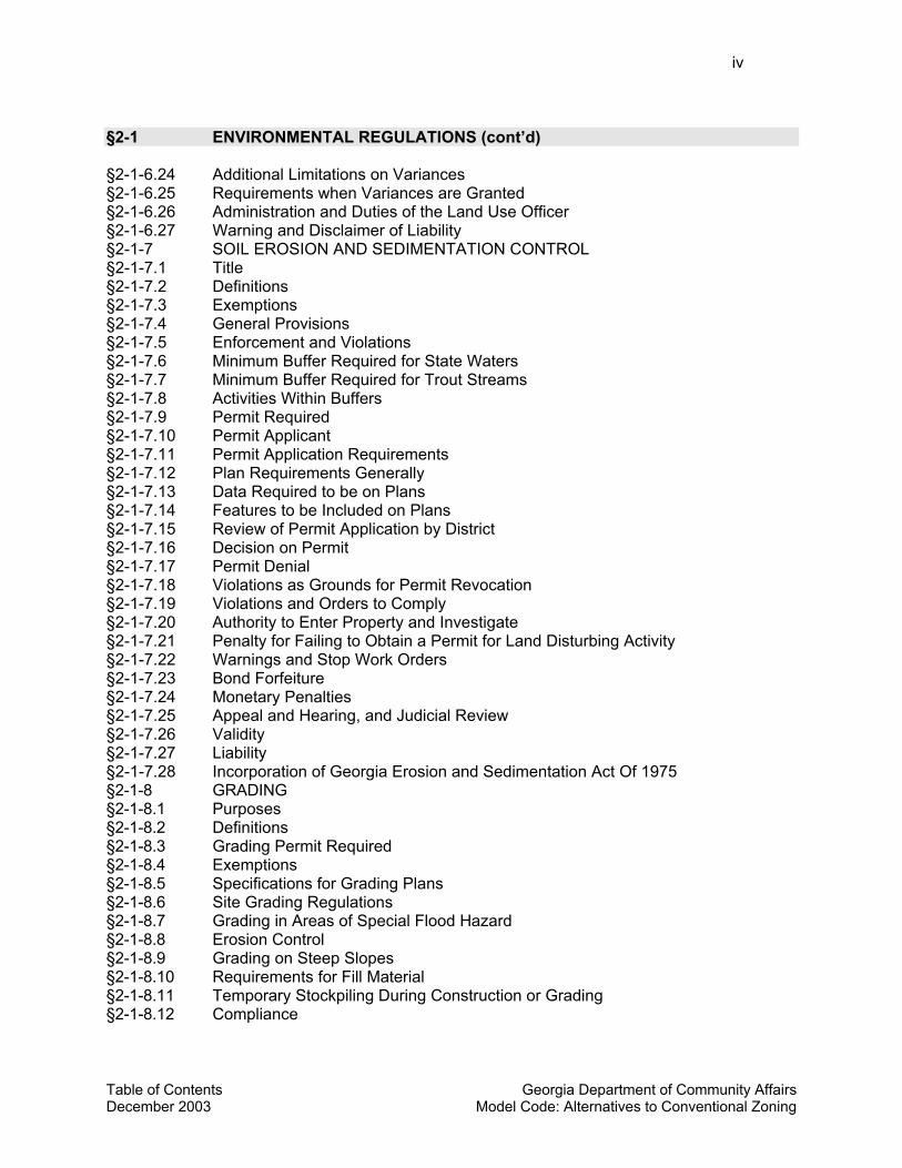
Table of Contents Georgia Department of Community Affairs December 2003 Model Code: Alternatives to Conventional Zoning
iv §2-1 ENVIRONMENTAL REGULATIONS (cont’d) §2-1-6.24 Additional Limitations on Variances §2-1-6.25 Requirements when Variances are Granted §2-1-6.26 Administration and Duties of the Land Use Officer §2-1-6.27 Warning and Disclaimer of Liability §2-1-7 SOIL EROSION AND SEDIMENTATION CONTROL §2-1-7.1 Title §2-1-7.2 Definitions §2-1-7.3 Exemptions §2-1-7.4 General Provisions §2-1-7.5 Enforcement and Violations §2-1-7.6 Minimum Buffer Required for State Waters §2-1-7.7 Minimum Buffer Required for Trout Streams §2-1-7.8 Activities Within Buffers §2-1-7.9 Permit Required §2-1-7.10 Permit Applicant §2-1-7.11 Permit Application Requirements §2-1-7.12 Plan Requirements Generally §2-1-7.13 Data Required to be on Plans §2-1-7.14 Features to be Included on Plans §2-1-7.15 Review of Permit Application by District §2-1-7.16 Decision on Permit §2-1-7.17 Permit Denial §2-1-7.18 Violations as Grounds for Permit Revocation §2-1-7.19 Violations and Orders to Comply §2-1-7.20 Authority to Enter Property and Investigate §2-1-7.21 Penalty for Failing to Obtain a Permit for Land Disturbing Activity §2-1-7.22 Warnings and Stop Work Orders §2-1-7.23 Bond Forfeiture §2-1-7.24 Monetary Penalties §2-1-7.25 Appeal and Hearing, and Judicial Review §2-1-7.26 Validity §2-1-7.27 Liability §2-1-7.28 Incorporation of Georgia Erosion and Sedimentation Act Of 1975 §2-1-8 GRADING §2-1-8.1 Purposes §2-1-8.2 Definitions §2-1-8.3 Grading Permit Required §2-1-8.4 Exemptions §2-1-8.5 Specifications for Grading Plans §2-1-8.6 Site Grading Regulations §2-1-8.7 Grading in Areas of Special Flood Hazard §2-1-8.8 Erosion Control §2-1-8.9 Grading on Steep Slopes §2-1-8.10 Requirements for Fill Material §2-1-8.11 Temporary Stockpiling During Construction or Grading §2-1-8.12 Compliance
Table of Contents Georgia Department of Community Affairs December 2003 Model Code: Alternatives to Conventional Zoning
v §2-2 SUBDIVISIONS AND LAND DEVELOPMENT §2-2-1 TITLE §2-2-2 PURPOSES §2-2-3 DEFINITIONS §2-2-4 AUTHORITY AND DELEGATION §2-2-4.1 Authority §2-2-4.2 Delegation of Powers to Planning Commission §2-2-4.3 Delegation of Powers to Director §2-2-4.4 Delegation of Powers to County [City] Engineer §2-2-5 APPLICABILITY AND GENERAL PROVISIONS §2-2-5.1 Applicability §2-2-5.2 Land is One Tract Until Subdivided §2-2-5.3 All Land Subdivisions to Comply §2-2-5.4 Preliminary Plat or Site Plan and Plans Required Prior to Construction §2-2-5.5 Building and Other Permits §2-2-5.6 Public Streets and Lands §2-2-5.7 Appeals §2-2-6 EXEMPTIONS FROM PLAT APPROVAL §2-2-7 LOT COMBINATIONS §2-2-8 BOUNDARY LINE ADJUSTMENTS §2-2-9 DESIGN REQUIREMENTS FOR BLOCKS §2-2-9.1 Block Length §2-2-9.2 Block Width §2-2-10 DESIGN REQUIREMENTS FOR LOTS §2-2-10.1 Natural Features and Assets §2-2-10.2 Access and Minimum Lot Frontage §2-2-10.3 Adequate Buildable Area Required §2-2-10.4 Lot Remnants Not Permitted §2-2-10.5 Service Areas §2-2-10.6 Lot Area §2-2-10.7 Lot Width §2-2-10.8 Lot Depth §2-2-10.9 Flag Lots §2-2-10.10 Side Lot Lines §2-2-10.11 Corner Lots §2-2-10.12 Double Frontage Lots §2-2-11 EASEMENTS §2-2-12 SURVEY MONUMENTS FOR ALL LOTS REQUIRED §2-2-13 PRELIMINARY PLAT §2-2-13.1 Purpose §2-2-13.2 When Required §2-2-13.3 Preliminary Plat Application and Specifications §2-2-13.4 Procedures §2-2-13.5 Disposition §2-2-13.6 Appeal §2-2-13.7 Amendments to Approved Preliminary Plats
Table of Contents Georgia Department of Community Affairs December 2003 Model Code: Alternatives to Conventional Zoning
vi §2-2 SUBDIVISIONS AND LAND DEVELOPMENT (cont’d) §2-2-14 CONSTRUCTION PLANS §2-2-14.1 Application §2-2-14.2 Director’s Decision Criteria §2-2-14.3 Certificate of Approval §2-2-15 FINAL PLAT §2-2-15.1 When Required §2-2-15.2 Criteria for Approval §2-2-15.3 Approval Certificate §2-2-15.4 Additional plat certificates §2-2-16 DEDICATIONS OF STREETS AND PUBLIC LANDS §2-2-17 SUBDIVISION IMPROVEMENT GUARANTEES §2-2-18 LIMITATIONS ON MINOR SUBDIVISIONS §2-2-18.1 Purpose §2-2-18.2 Common Contiguous Parcels Shown on Minor Subdivision Plats §2-2-18.3 Limitations §2-2-19 PRIVATE STREETS §2-2-19.1 Private Streets Permitted §2-2-19.2 Engineering Plans Required §2-2-19.3 Standards §2-2-19.4 Street Names and Signs §2-2-19.5 Easements §2-2-19.6 Maintenance §2-2-19.7 Specifications for Final Plats Involving Private Streets §2-2-19.8 Requirement for Purchaser’s Acknowledgement of Private Responsibilities §2-3 IMPROVEMENTS REQUIRED FOR SUBDIVISIONS AND
LAND DEVELOPMENT §2-3-1 PURPOSE §2-3-2 DEFINITIONS §2-3-3 AUTHORITY OF COUNTY [CITY] ENGINEER §2-3-4 APPLICABILITY AND EXEMPTION §2-3-5 ENGINEERED DRAWINGS §2-3-6 PERMITS FOR CONSTRUCTION IN PUBLIC RIGHT-OF-WAY §2-3-7 IMPROVEMENTS TO ABUTTING LAND §2-3-8 STANDARDS FOR CONFIGURING NEW STREETS §2-3-8.1 Street Alignment, Intersections and Jogs §2-3-8.2 Continuation of Existing Streets and Connections §2-3-8.3 Street Plans for Future Phases of the Tract §2-3-8.4 Dead-End Streets and Cul-De-Sacs §2-3-8.5 Marginal Access Streets §2-3-8.6 Alleys and Service Access §2-3-9 REQUIREMENTS FOR STREETS §2-3-9.1 Bridges §2-3-9.2 Grading and Stabilization of Street Rights-Of-Ways §2-3-9.3 Radius at Street Intersections §2-3-9.4 Street Grades §2-3-9.5 Minimum Street Right-Of-Ways and Pavement Widths
Table of Contents Georgia Department of Community Affairs December 2003 Model Code: Alternatives to Conventional Zoning
vii §2-3 IMPROVEMENTS REQUIRED FOR SUBDIVISIONS AND
LAND DEVELOPMENT (cont’d) §2-3-9.6 Street Horizontal Alignment and Reverse Curves §2-3-10 CURB CUTS AND ACCESS SPECIFICATIONS §2-3-10.1 Entrance Improvement Specifications §2-3-10.2 Curb Cut Specifications §2-3-10.3 Access Along and Near Divided Highways §2-3-10.4 Interparcel Connections §2-3-11 STREET LIGHTING §2-3-12 STREET SIGNS §2-3-13 CURBS AND GUTTERS §2-3-14 SIDEWALKS §2-3-14.1 When Required §2-3-14.2 Location §2-3-14.3 Specifications §2-3-15 DRAINAGE AND STORMWATER MANAGEMENT §2-3-15.1 General Requirements §2-3-15.2 Method of Design and Capacity §2-3-15.3 Location §2-3-15.4 Discharge §2-3-15.5 Grading and Site Drainage §2-3-15.6 Cross-Drain Pipes §2-3-15.7 Drop Inlets §2-3-15.8 Easements §2-3-16 WATER §2-3-16.1 Generally §2-3-16.2 Water Main Requirements §2-3-16.3 Wells §2-3-16.4 Community Water System §2-3-16.5 Fire Hydrants §2-3-17 SEWER §2-3-17.1 Generally §2-3-17.2 Connection to Public Sewerage System §2-3-17.3 Alternative Provision §2-3-17.4 Septic Tanks §2-3-18 UTILITIES §2-3-19 OVERSIZING OF IMPROVEMENTS AND UTILITIES §2-3-20 PROCEDURE FOR ADMINISTRATIVE INSPECTION AND ACCEPTANCE OF
PUBLIC IMPROVEMENTS §2-4 REFERENCE TO STATE PERMITS §2-4-1 GEORGIA AIR QUALITY ACT OF 1978 §2-4-2 GROUND WATER USE ACT OF 1972 §2-4-3 GEORGIA WATER QUALITY CONTROL ACT §2-4-4 GEORGIA HAZARDOUS WASTE MANAGEMENT ACT §2-4-5 GEORGIA COMPREHENSIVE SOLID WASTE MANAGEMENT ACT OF 1990 §2-4-6 COASTAL MARSHLANDS PROTECTION ACT OF 1970;
SHORE ASSISTANCE ACT OF 1979
Table of Contents Georgia Department of Community Affairs December 2003 Model Code: Alternatives to Conventional Zoning
viii §2-4 REFERENCE TO STATE PERMITS (cont’d) §2-4-7 GEORGIA SURFACE MINING ACT OF 1968 §2-4-8 ENDANGERED WILDLIFE ACT OF 1973;
WILDFLOWER PRESERVATION ACT OF 1973 §2-4-9 BURIAL GROUNDS AND CEMETERIES §2-4-10 GEORGIA SAFE DAMS ACT OF 1978 § 2-5 (PHASE 2) ALTERNATIVE STREET AND PEDESTRIAN SYSTEM
STANDARDS § 2-5-1 PURPOSE § 2-5-2 DEFINITIONS § 2-5-3 STREET STANDARDS § 2-5-3.1 Alleys. § 2-5-3.2 Lanes. § 2-5-3.3 Local Streets. § 2-5-3.4 Avenues and Main Streets. § 2-5-3.5 Boulevards. § 2-5-3 .6 Parkways. § 2-5-3 .7 Turnarounds. § 2-5-3.8 Curb radii. § 2-5-4 PEDESTRIAN SYSTEM STANDARDS § 2-5-4.1 Pedestrian Connections from Development to Street. § 2-6 (PHASE 2) BICYCLE FACILITY SPECIFICATIONS § 2-6-1 PURPOSE § 2-6-2 DEFINITIONS § 2-6-3 PROVISION OF BICYCLE FACILITIES § 2-6-4 DESIGN REQUIREMENTS FOR ALL BICYCLE FACILITIES § 2-6-4.1 Intersection Crossings. § 2-6-4.2 Markers and Signage. § 2-6-4.3 Drainage Grates. § 2-6-5 DESIGN REQUIREMENTS FOR BICYCLE PATHS § 2-6-5.1 When Appropriate. § 2-6-5.2 Minimum Bicycle Path Width. § 2-6-5.3 Clearances and Shoulders. § 2-6-5.4 Grade. § 2-6-5.5 Grade Separation. § 2-6-5.6 Barriers to Unauthorized Motor Vehicle Traffic. § 2-6-6 DESIGN REQUIREMENTS FOR BICYCLE LANES § 2-6-6 .1 Bicycle Lane Minimum Lane Width, Use, and Location. § 2-6-6 .2 Pavement Markings. § 2-6-7 DESIGN REQUIREMENTS FOR BICYCLING ON SHARED ROADWAYS § 2-6-7 .1 When Appropriate. § 2-6-7.2 Minimum Width.
Table of Contents Georgia Department of Community Affairs December 2003 Model Code: Alternatives to Conventional Zoning
ix § 2-6 (PHASE 2) BICYCLE FACILITY SPECIFICATIONS (cont’d) § 2-6-8 BICYCLE FACILITIES ON RURAL ROAD SHOULDERS § 2-6-9 AUTHORITY OF COUNTY [CITY] ENGINEER § 2-7 (PHASE 2) HILLSIDE DEVELOPMENT § 2-7-1 FINDINGS § 2-7-2 PURPOSE AND INTENT § 2-7-3 DEFINITIONS § 2-7-4 APPLICABILITY § 2-7-5 GENERAL PROVISIONS § 2-7-5 .1 Compliance. § 2-7-5 .2 Regulations versus guidelines. § 2-7-5.3 Topographic data. § 2-7-5.4 Subdivision of steep slopes. § 2-7-6 SOILS AND HYDROLOGY REPORTS § 2-7-6.1 Soils report. § 2-7-6.2 Hydrology report. § 2-7-6.3 Action. § 2-7-7 ENGINEERING GEOLOGY REPORT § 2-7-7.1 Engineering geology report required § 2-7-7.2 Contents of the report. § 2-7-7.3 Action. § 2-7-8 GENERAL DEVELOPMENT GUIDELINES § 2-7-9 GRADING AND LAND DISTURBANCE § 2-7-9.1 General grading requirements. § 2-7-9.2 Cut slopes. § 2-7-9.3 Fill slopes. § 2-7-10 CLEARING AND IMPROVEMENT LIMITS § 2-7-11 TREES AND VEGETATION § 2-7-11.1 Removal. § 2-7-11.2 Tree protection areas. § 2-7-11.3 Tree replacement. § 2-7-11.4 Tree survey required. § 2-7-12 REVEGETATION § 2-7-12.1 Plan required. § 2-7-12.2 Species selection. § 2-7-12.3 Slope stability. § 2-7-12.4 Installation. § 2-7-13 DRAINAGE § 2-7-14 EROSION CONTROL § 2-7-15 ROADS, DRIVEWAYS, AND PARKING AREAS § 2-7-16 UTILITIES § 2-7-17 BUILDABLE AREA REQUIREMENTS AND GUIDELINES § 2-7-17.1 Buildable area required. § 2-7-17.2 Ridgeline restrictions. § 2-7-17.3 Building pads. § 2-7-18 REQUIREMENTS AND GUIDELINES FOR BUILDINGS AND STRUCTURES § 2-7-18. Foundations.
Table of Contents Georgia Department of Community Affairs December 2003 Model Code: Alternatives to Conventional Zoning
x § 2-7 (PHASE 2) HILLSIDE DEVELOPMENT (cont’d) § 2-7-18.2 Roofs. § 2-7-18.3 Height. § 2-7-18.4 Setbacks. § 2-7-18.5 Mass. § 2-7-18.6 Location. § 2-7-18.7 Colors. § 2-7-18.8 Designs that reduce clearing and impervious surfaces. § 2-7-19 FIRE PROTECTION § 2-7-20 VARIANCES § 2-7-21 APPEALS PART THREE: PROVISIONS FOR DEVELOPING AND BUILT-UP AREAS §3-1 PERFORMANCE STANDARDS FOR OFF-SITE IMPACTS §3-1-1 OUTDOOR LIGHTING §3-1-1.1 Purpose and Intent §3-1-1.2 Definitions §3-1-1.3 Applicability §3-1-1.4 Exemptions §3-1-1.5 Prohibitions §3-1-1.6 Newly Installed Luminaires to Comply §3-1-1.7 Luminaires Creating Glare to be Redirected §3-1-1.8 Illuminance Levels §3-1-1.9 Lighting Plan Required §3-1-2 NOISE §3-1-2.1 Definitions §3-1-2.2 Noise Disturbance Prohibited §3-1-2.3 Measurement §3-1-2.4 Performance Standards §3-1-2.5 Exemptions §3-1-3 VIBRATION §3-1-4 ODOR §3-1-5 SMOKE OR PARTICULATE MATTER §3-1-6 ELECTOMAGNETIC INTERFERENCE §3-2 DEVELOPMENT PERFORMANCE STANDARDS §3-2-1 TITLE §3-2-2 PURPOSE §3-2-3 DEFINITIONS §3-2-4 APPLICABILITY §3-2-5 BUILDING HEIGHT §3-2-5.1 Generally §3-2-5.2 Maximum Height Limitations §3-2-5.3 Variances to Maximum Height Limitations
Table of Contents Georgia Department of Community Affairs December 2003 Model Code: Alternatives to Conventional Zoning
xi §3-2 DEVELOPMENT PERFORMANCE STANDARDS (cont’d) 3-2-5.4 Height Performance Standard §3-2-6 YARDS §3-2-7 LANDSCAPE STRIPS AND BUFFERS §3-2-7.1 Required Landscape Strips §3-2-7.2 Waiver of Landscape Strip Requirements §3-2-7.3 Required Buffers §3-2-7.4 Buffer Specifications §3-2-7.5 Reduction of Buffer §3-2-8 LAND USE INTENSITY RATIOS §3-3 HOME BUSINESS USES §3-3-1 TITLE §3-3-2 PURPOSE AND INTENT §3-3-3 APPLICABILITY §3-3-4 DEFINITIONS §3-3-5 GENERAL PROVISIONS §3-3-6 LAND USE PERMIT REQUIRED §3-3-7 BUSINESS REGISTRATION REQUIRED §3-3-8 USES AND ACTIVITIES PROHIBITED §3-3-9 USE OF DWELLING AND PHYSICAL LIMITATIONS §3-3-10 VEHICLES AND PARKING §3-3-11 EQUIPMENT; NUISANCES §3-3-12 VISITATIONS §3-3-13 DISPLAY AND STOCK-IN-TRADE §3-3-14 EMPLOYEES §3-3-15 SIGNS §3-4 TREE PROTECTION §3-4-1 PURPOSE §3-4-2 DEFINITIONS §3-4-3 TREE PROTECTION DURING DEVELOPMENT §3-4-3.1 Applicability §3-4-3.2 Tree Save Areas §3-4-3.3 Canopy Cover Requirements §3-4-3.4 Replacement Trees §3-4-3.5 Protection of Trees During Construction §3-4-4 STREET TREES REQUIRED §3-4-5 PROTECTION OF PUBLIC TREES §3-4-5.1 Right to Plant §3-4-5.2 Permit Required §3-4-5.3 Liability §3-4-6 PRUNING §3-4-6.1 Pruning Standards
Table of Contents Georgia Department of Community Affairs December 2003 Model Code: Alternatives to Conventional Zoning
xii §3-4 TREE PROTECTION (cont’d) §3-4-6.2 Tree Topping §3-5 REGULATIONS FOR SPECIFIC USES §3-5-1 ACCESSORY STRUCTURES AND USES §3-5-2 AGRICULTURAL, FARM, AND ANIMAL STRUCTURES AND USES §3-5-3 AMPHITHEATERS §3-5-4 AUTOMOBILE SALES ESTABLISHMENTS §3-5-5 AUTOMOBILE WRECKING YARDS AND JUNKYARDS §3-5-6 CHURCHES, TEMPLES, SYNOGOGUES, AND PLACES OF WORSHIP §3-5-7 COMMUNICATION TOWERS §3-5-8 DAY CARE CENTERS §3-5-9 DRIVE-THROUGH FACILITIES §3-5-10 DWELLINGS, SINGLE-FAMILY ATTACHED (TOWNHOUSES) §3-5-11 EXTRACTIVE INDUSTRIES §3-5-12 GOLF DRIVING RANGES §3-5-13 HELICOPTER LANDING FACILITIES §3-5-14 KENNELS §3-5-15 LANDFILLS §3-5 REGULATIONS FOR SPECIFIC USES (cont’d) §3-5-16 MINI-WAREHOUSES §3-5-17 SHOOTING RANGES §3-5-18 STORAGE OF PETROLEUM PRODUCTS AND EXPLOSIVES §3-5-19 RACE TRACKS §3-5-20 SERVICE AND FUEL FILLING STATIONS §3-5-21 USES GENERATING TRUCK TRAFFIC § 3-6 PUBLIC NUISANCE §3-6-1 PURPOSES §3-6-2 DEFINITIONS §3-6-3 ILLUSTRATIVE EXAMPLES OF NUISANCES §3-6-4 NUISANCE PROHIBITED §3-6-5 NOTICE TO ABATE §3-6-6 CONTENTS OF NOTICE §3-6-7 PROVISIONS FOR SPECIFIC NUISANCES §3-6-7.1 Animals §3-6-7.2 Abandoned Vehicles §3-6-7.3 Trees and Other Vegetation §3-6-7.4 Noise §3-7 SIGNS §3-7-1 TITLE §3-7-2 PURPOSE §3-7-3 INTENT
Table of Contents Georgia Department of Community Affairs December 2003 Model Code: Alternatives to Conventional Zoning
xiii §3-7 SIGNS (cont’d) §3-7-4 DEFINITIONS §3-7-5 APPLICABILITY §3-7-6 DEFINITIONS AND INERPRETATIONS §3-7-6.1 Master Signage Plan §3-7-6.2 Common Signage Plan §3-7-6.3 Provision of Common Signage Plan §3-7-6.4 Limit on Freestanding Signs Under Common Signage Plan §3-7-6.5 Other Provisions of Master or Common Signage Plans §3-7-6.6 Consent §3-7-6.7 Joint Processing §3-7-6.8 Amendment §3-7-6.9 Existing Signs Not Conforming to Master or Common Signage Plan §3-7-6.10 Binding Effect §3-7-7 PERMITTING PROCEDURES §3-7-7.1 Permits Required §3-7-7.2 Application and Review Procedures §3-7-7.2.1 Application §3-7-7.2.2 Fees §3-7-7.2.3 Completeness §3-7-7.2.4 Action or Plan §3-7-7.2.5 Failure to Act or Plan §3-7-7.3 Permits to Construct §3-7-7.3.1 Permit for New Sign or for Sign Modification §3-7-7.3.2 Inspection §3-7-7.4 Permits to Remain Current and in Force §3-7-7.4.1 Initial Sign Permit §3-7-7.4.2 Assignment of Sign Permits §3-7-8 TEMPORARY PERMITS §3-7-8 TEMPORARY PERMITS §3-7-8.1 Temporary Sign Permits §3-7-8.2 Banners §3-7-8.3 Pennants and Streamers §3-7-8.4 Inflatable Signs and Tethered Balloons §3-7-9 SIGNS EXEMPT FROM REGULATION UNDER THIS RESOLUTION [ORDINANCE] §3-7-10 MAXIMUM HEIGHT OF SIGNS §3-7-11 MINIMUM SETBACK FROM RIGHT-OF-WAY §3-7-12 FREESTANDING SIGNS §3-7-12.1 Residential and Office Subdivision §3-7-12.2 Other Freestanding Signs §3-7-12.3 Spacing Limitations of Freestanding Signs §3-7-13 COMPUTATIONS §3-7-13.1 Computation of Area of Individual Signs §3-7-13.2 Computation of Area of Multi-faced Signs §3-7-13.3 Computation of Height §3-7-13.4 Computation of Maximum Total Permitted Sign Area §3-7-14 DESIGN, CONSTRUCTION, AND MAINTENANCE §3-7-15 SIGNS IN THE PUBLIC RIGHT-OF-WAY §3-7-15.1 Permanent Signs
Table of Contents Georgia Department of Community Affairs December 2003 Model Code: Alternatives to Conventional Zoning
xiv §3-7 SIGNS (cont’d) §3-7-16 SIGNS PROHIBITED UNDER THIS RESOLUTION [ORDINANCE] §3-7-17 NONCONFORMING SIGNS WITHOUT PERMITS §3-7-17.1 Signs Existing on Effective Date §3-7-18 CRITERIA FOR APPROVAL OF SIGN VARIANCES §3-7-19 SIGNS PERMITTED AND MAXIMUM SIZES § 3-8 (PHASE 2) PLANNED UNIT DEVELOPMENT § 3-8-1 PURPOSE AND INTENT § 3-8-2 DEFINITIONS § 3-8-3 PERMITTED LOCATIONS AND USES § 3-8-4 DIMENSIONAL REQUIREMENTS § 3-8-4 .1 Minimum Open Space. § 3-8-4 .2 Density. § 3-8-5 GENERAL GUIDELINES FOR LAND USE MIX AND DESIGN § 3-8-5.1 Comprehensive Plan. § 3-8-5.2 Housing Unit Diversity. § 3-8-5.3 Civic and Institutional Uses. § 3-8-5.4 Retail Component. § 3-8-5.5 Industrial Uses. § 3-8-5.6 Interconnectivity. § 3-8-6 APPLICATION REQUIREMENTS § 3-8-6.1 Development Plan. § 3-8-6.2 Architectural Elevations. § 3-8-6 .3 Land Uses and Development Summary. § 3-8-6 .4 Performance Standards Comparison. § 3-8-6 .5 Improvement Requirements Comparison. § 3-8-6 .6 Private Restrictions. § 3-8-6.7 Community Benefit Statement. § 3-8-7 PROCEDURES § 3-8-7 .1 Pre-application Conference. § 3-8-7 .2 Recommendation and Approval Authority. § 3-8-7 .3 Criteria for Approval. § 3-8-7 .4 Revisions. § 3-8-7 .5 Construction Plans. § 3-8-7 .6 Permits and Certificates. § 3-8-7.7 Appeals. § 3-9 (PHASE 2) LANDSCAPING AND BUFFERS
§ 3-9-1 PURPOSE § 3-9-2 DEFINITIONS § 3-9-3 APPLICABILITY § 3-9-4 LANDSCAPE ADJACENT TO STREET RIGHT OF WAY § 3-9-5 PARKING LOT LANDSCAPE ALONG OTHER PROPERTY LINES § 3-9-6 LANDSCAPE BETWEEN BUILDINGS AND STREET RIGHT-OF-WAY § 3-9-7 BUFFERS REQUIRED § 3-9-8 SCREENING AND BUFFER SPECIFICATIONS
Table of Contents Georgia Department of Community Affairs December 2003 Model Code: Alternatives to Conventional Zoning
xv § 3-9 (PHASE 2) LANDSCAPING AND BUFFERS (cont’d) § 3-9-9 GENERAL PROVISIONS § 3-9-9.1 Visibility. § 3-9-9.2 Clearance. § 3-9-9.3 Curb Stops. § 3-9-10 LANDSCAPE PLAN § 3-9-11 APPROVAL OF LANDSCAPING AND OTHER MATERIALS § 3-9-12 TREE PLANTING GUIDELINES § 3-9-13 LANDSCAPE MAINTENANCE AND LANDSCAPE BOND § 3-9-14 LISTS OF APPROVED LANDSCAPING MATERIALS § 3-9-14.1 Vines. § 3-9-14.2 Ground Covers. § 3-9-14.3 Shrubs 1-4 Feet. § 3-9-14.4 Shrubs 4-6 Feet. § 3-9-14.5 Shrubs 6-12 Feet. § 3-9-14.6 Small Trees 15-40 Feet. § 3-9-14.7 Large Trees 40+ Feet. § 3-10 (PHASE 2) RESIDENTIAL INFILL DEVELOPMENT
§ 3-10-1 PURPOSE AND INTENT § 3-10-2 DEFINITIONS § 3-10-3 RESIDENTIAL INFILL OVERLAY DISTRICT § 3-10-4 APPLICABILITY AND GENERAL PROVISIONS § 3-10-5 PERMITTED USES § 3-10-6 LOT REQUIREMENTS § 3-10-6.1 Intent. § 3-10-6.2 Maximum Density (Minimum Lot Size). § 3-10-6.3 Density Bonus for Open Space. § 3-10-6.4 Lot Size Averaging. § 3-10-7. FLAG LOTS § 3-10-7.1 Intent. § 3-10-7.2 Flag Lots Permitted. § 3-10-7.3 Shared Driveways for Flag Lots. § 3-10-7.4 Administrative Approval. § 3-10-8 DWELLING HEIGHT AND WIDTH § 3-10-8.1 Intent. § 3-10-8.2 Height to Width Ratio. § 3-10-8.3 Height Transition Area. § 3-10-9 BUILD-TO LINE AND SETBACKS § 3-10-9.1 Intent. § 3-10-9.2 Requirement. § 3-10-9.3 Setback Averaging. § 3-10-9.4 Setback Variance. § 3-10-9.5 Exemption. § 3-10-10 DESIGN REQUIREMENTS § 3-10-11 APPEAL
Table of Contents Georgia Department of Community Affairs December 2003 Model Code: Alternatives to Conventional Zoning
xvi PART FOUR: PROVISIONS FOR AGRICULTURAL/RURAL AREAS §4-1 AGRICULTURAL LANDS §4-1-1 PURPOSE AND INTENT §4-1-2 DEFINITIONS §4-1-3 OFFICIAL DESIGNATION OF AGRICULTURAL LANDS §4-2 AGRICULTURAL USE NOTICE AND WAIVER §4-2-1 REQUIRED §4-2-2 CONTENT §4-3 AGRICULTURAL BUFFERS §4-3-1 PURPOSE §4-3-2 AGRICULTURAL BUFFERS REQUIRED §4-3-2.1 Buffer Abutting Agricultural Land §4-3-2.2 Setback and Buffer Required for New Poultry Houses and Hog Pens §4-3-3 BUFFER SPECIFICATIONS §4-3-4 BUFFER SITE PLAN REQUIRED §4-3-5 BUFFER A CONDITION OF PERMITS §4-3-6 DESIGNATION OF BUFFER ON SUBDIVISION PLAT §4-4 MANUFACTURED HOME COMPATIBILITY STANDARDS §4-4-1 PURPOSE §4-4-2(A) BASIC DEFINITIONS §4-4-2(B) DEFINITIONS REGARDING ARCHITECTURAL COMPATIBILITY §4-4-3 LAND USE PERMIT REQUIRED §4-4-4 BASIC INSTALLATION REQUIREMENTS §4-4-4.1 Foundation §4-4-4.2 Hauling Mechanisms Removed §4-4-4.3 Installation Requirements §4-4-4.4 Approved Septic System §4-4-5 TYPE 1 COMPATIBILITY STANDARDS §4-4-5.1 Applicability §4-4-5.2 Foundation §4-4-5.3 Skirting §4-4-5.4 Exterior Finish §4-4-5.5 Roof Pitch and Materials §4-4-6 TYPE 2 COMPATIBILITY STANDARDS §4-4-6.1 Applicability §4-4-6.2 Foundation §4-4-6.3 Masonry Skirting §4-4-6.4 Exterior Finish §4-4-6.5 Roof Pitch and Materials §4-4-6 Covered Porch or Deck §4-4-7 TYPE 3 COMPATIBILITY STANDARDS
Table of Contents Georgia Department of Community Affairs December 2003 Model Code: Alternatives to Conventional Zoning
xvii §4-4 MANUFACTURED HOME COMPATIBILITY STANDARDS (cont’d) §4-4-7.1 Applicability §4-4-7.2 Width §4-4-7.3 Covered Porch §4-4-7.4 Additional Architectural Features §4-5 MANUFACTURED HOME PARKS §4-5-1 PURPOSE §4-5-2 DEFINITIONS §4-5-3 SITE PLAN REVIEW AND LAND USE PERMIT REQUIRED §4-5-4 SITE CONDITIONS AND SITE PLANNING §4-5-4.1 Site Conditions §4-5-4.2 Site Planning §4-5-5 GENERAL DEVELOPMENT REQUIREMENTS §4-5-5.1 Site Frontage, Access, and Minimum Width §4-5-5.2 Perimeter Buffer or Landscape Screen §4-5-5.3 Open Space and Recreational Areas §4-5-5.4 Community Services §4-5-5.5 Interior Access Roads, Addresses, and Signing §4-5-5.6 Guest Parking §4-5-5.7 Utilities §4-5-5.8 Drainage §4-5-5.9 Refuse Collection §4-5-5.10 Walkways §4-5-5.11 Park Rules §4-5-6 REQUIREMENTS FOR MANUFACTURED HOME SPACES §4-5-6.1 Design §4-5-6.2 Width, Depth, and Size of Spaces and Markings §4-5-6.3 Stands §4-5-6.4 Use of Spaces §4-5-6.5 Space Identification Numbers §4-5-6.6 Parking §4-5-6.7 Walkways §4-5-6.8 Setbacks §4-5-6.9 Additions and Accessory Structures §4-5-6.10 Maximum Density §4-6 ANIMAL FEEDING OPERATIONS §4-6-1 TITLE §4-6-2 PURPOSE §4-6-3 DEFINITIONS
Table of Contents Georgia Department of Community Affairs December 2003 Model Code: Alternatives to Conventional Zoning
xviii §4-6 ANIMAL FEEDING OPERATIONS (cont’d) §4-6-4 EQUIVALENT ANIMAL NUMBERS §4-6-5 ENVIRONMENTAL PROTECTION §4-6-6 WATER RESOURCE SETBACKS §4-6-7 ODOR SETBACKS §4-6-8 PERMIT REQUIRED §4-6-9 APPLICATION REQUIREMENTS §4-6-10 ACTION ON PERMIT §4-6-11 ENFORCEMENT §4-6-12 APPEAL §4-7 RURAL CLUSTERING §4-7-1 TITLE §4-7-2 PURPOSE AND INTENT §4-7-3 DEFINITIONS §4-7-4 APPLICABILITY §4-7-5 RURAL CLUSTER MANDATE §4-7-5.1 Planning Commission Authority §4-7-5.2 Requirements for Denying a Preliminary Plat §4-7-5.3 Appeal §4-7-6 RELATIONSHIP TO LAND SUBDIVISION REGULATIONS §4-7-7 DESIGN REQUIREMENTS RURAL CLUSTERS AND CLUSTER LOTS §4-7-7.1 Density Clustering §4-7-7.2 Area of Lots §4-7-7.3 Locations of Clusters §4-7-8 DESIGN REQUIREMENTS FOR REMAINDER PARCELS §4-7-9 OTHER DESIGN REQUIREMENTS §4-7-10 RESOURCE LAND AND OPEN SPACE RETENTION §4-7-11 RESOURCE USE MANAGEMENT PLAN §4-7-12 OWNERSHIP AND MANAGEMENT OF RESOURCE LAND OR OPEN SPACE § 4-8 (PHASE 2) SCENIC CORRIDOR OVERLAY DISTRICT § 4-8-1 PURPOSE AND INTENT § 4-8-2 DEFINITIONS § 4-8-3 SCENIC CORRIDOR DESIGNATION § 4-8-4 APPLICATION AND EXCEPTIONS § 4-8-5 EXISTING CONDITIONS ANALYSIS AND SITE PLAN REQUIRED § 4-8-6 ADOPTION AND INCORPORATION BY REFERENCE § 4-8-7 SETBACK, BUFFERS, TREES, AND LANDSCAPING § 4-8-7.1 Development Setback. § 4-8-7.2 Roadway Buffer. § 4-8-7.3 Uses Within Roadway Buffer. § 4-8-7.4 Exceptions to Roadway Buffer for Scenic Viewshed Protection. § 4-8-7.5 Exceptions for Product Viewing. § 4-8-7.6 Landscaping Plan. § 4-8-7.7 Tree Requirement. § 4-8-8 PROVISIONS REGARDING BUILDINGS AND STRUCTURES
Table of Contents Georgia Department of Community Affairs December 2003 Model Code: Alternatives to Conventional Zoning
xix § 4-8 (PHASE 2) SCENIC CORRIDOR OVERLAY DISTRICT (cont’d) § 4-8-8.1 Screening. § 4-8-8.2 Height. § 4-8-8.3 Utilities. § 4-8-8.4 Signage. § 4-8-8.5 Roads, Driveways, and Paths. § 4-8-8.6 Walls and Fences. § 4-8-9 DESIGN REVIEW § 4-8-10 VARIANCES § 4-8-11 APPEALS § 4-9 (PHASE 2) RURAL/SUBURBAN ARTERIAL CORRIDOR OVERLAY § 4-9-1 PURPOSE AND INTENT § 4-9-2 DEFINITIONS § 4-9-3 APPLICABILITY § 4-9-4 PERMITTED USES IN FOCUS AREAS § 4-9-5 PERMITTED USES OUTSIDE FOCUS AREAS WITHIN THE CORRIDOR § 4-9-6 ACCESS § 4-9-6.1 Medians. § 4-9-6.2 Vehicular Access to Site. § 4-9-6.3 Pedestrian Access. § 4-9-6.4 Interparcel Access. § 4-9-7 BUILDING PLACEMENT, HEIGHT, AND INTENSITY § 4-9-7.1 Placement Generally. § 4-9-7.2 Placement in Relation To Other Quadrants in the Focus Area. § 4-9-7.3 Building Height. § 4-9-7.4 Building Mass, Intensity, and Density. § 4-9-7.5 Floor-Area Ratio. § 4-9-8 PARKING LOCATION AND DESIGN § 4-9-8.1 Location of Parking Areas. § 4-9-8.2 Screening of Parking Areas. § 4-9-8.3 Shared Parking. § 4-9-10 AMENITY ZONE § 4-9-10.1 Established. § 4-9-10.2 Uses and Improvements. § 4-9-11 LANDSCAPING § 4-9-11.1 Amenity Zones. § 4-9-11.2 Medians. § 4-9-11.3 Street Trees. § 4-9-11.4 Perimeter Buffers. § 4-9-12 PROVISIONS FOR SPECIFIC USES § 4-9-12.1 Big Box Retail Development. § 4-9-12.2 Communication Towers. § 4-9-12.3 Fences and Walls. § 4-9-12.4 Drive-Through Facilities. § 4-9-12.5 Gas Station Pump Islands. § 4-9-12.6 Outside Display and Storage and Service Areas. § 4-9-12.7 Stormwater Detention Facilities.
Table of Contents Georgia Department of Community Affairs December 2003 Model Code: Alternatives to Conventional Zoning
xx § 4-9 (PHASE 2) RURAL/SUBURBAN ARTERIAL CORRIDOR OVERLAY (cont’d) § 4-9-13 ARCHITECTURE § 4-9-13.1 Building Walls. § 4-9-13.2 Awnings. § 4-9-13.3 Building Materials. § 4-9-13.4 Windows. § 4-9-13.5 Rooftop Mechanical Equipment. § 4-9-13.6 Gutters and Downspouts. § 4-9-14 Signage § 4-9-14.1 Off-Premise Signs. § 4-9-14.2 On-Premise Signs. § 4-9-14.2 Sign Programs. § 4-9-15 LAND USE OFFICER’S RESPONSIBILITIES § 4-9-16 VARIANCES § 4-9-17 APPEALS PART FIVE: PROVISIONS FOR SMALL DOWNTOWNS § 5-1 DOWNTOWN SPECIFIC PLANS §5-1-1 PURPOSE AND INTENT §5-1-2 DEFINITIONS §5-1-3 ADOPTION OF DOWNTOWN SPECIFIC PLAN BY REFERENCE §5-1-4 PLAN AS REGULATION §5-1-5 USE LIMITATIONS §5-1-5.1 Permitted Uses §5-1-5.2 Determination of Similar Land Uses §5-1-6 BUILDING SETBACKS §5-1-6.1 Minimum Front Setbacks §5-1-6.2 Maximum Front Setbacks §5-1-6.3 Minimum Rear Yard Setbacks §5-1-6.4 Through Lots §5-1-6.5 Side Yard Setbacks §5-1-6.6 Setback Exceptions §5-1-7 BUILDING HEIGHT §5-1-7.1 Maximum Height §5-1-7.2 Height Increase for Buildings Containing Residences §5-1-7.3 Exceptions to Height Regulations §5-1-7.4 Method of Measurement §5-1-8 DESIGN GUIDELINES AND STANDARDS §5-1-8.1 Building Size, Bulk, Scale and Mass §5-1-8.2 Building Orientation §5-1-8.3 Storefront Design §5-1-8.4 Building Materials §5-1-8.5 Building Color §5-1-8.6 Pedestrian Amenities §5-1-9 SPECIAL STANDARDS FOR RESIDENTIAL USES
Table of Contents Georgia Department of Community Affairs December 2003 Model Code: Alternatives to Conventional Zoning
xxi § 5-1 DOWNTOWN SPECIFIC PLANS (cont’d) §5-1-9.1 Residential Uses Generally §5-1-9.2 Mixed-Use Development Required §5-1-9.3 Limitation on Street-Level Housing §5-1-9.4 Allowable Density §5-1-10 SPECIAL STANDARDS FOR PARKING AREAS §5-1-10.1 Parking, Garages and Driveways §5-1-10.2 Relationship of Buildings to Streets and Parking §5-1-11 SPECIAL STANDARDS FOR OTHER USES §5-1-11.1 Light Manufacturing §5-1-11.2 Accessory Uses §5-1-11.3 Trash and Loading Areas §5-1-12 SIGNS §5-1-12.1 Ground Mounted Pole Signs §5-1-12.2 Projecting Signs §5-1-12.3 Historic Wall Signs §5-1-12.4 Pedestrian Orientation §5-1-12.5 Illumination §5-1-12.6 Materials and Color §5-1-12.7 Size Limitations § 5-2 DESIGN REVIEW §5-2-1 TITLE §5-2-2 PURPOSE AND INTENT §5-2-3 APPLICABILITY §5-2-4 ESTABLISHMENT OF DESIGN REVIEW BOARD §5-2-5 AUTHORITY OF THE DESIGN REVIEW BOARD §5-2-6 MEETINGS OF THE BOARD §5-2-7 DEFINITIONS §5-2-8 DESIGN REVIEW AND APPROVAL REQUIRED §5-2-9 EXEMPTION FOR MINOR CHANGES §5-2-10 PRE-APPLICATION CONFERENCE §5-2-11 APPLICATION REQUIREMENTS §5-2-11.1 Elevation Drawings, Color and Material Samples §5-2-11.2 Photographs §5-2-11.3 Site Plan and Landscaping Plan §5-2-11.4 Fee §5-2-11.5 Additional Information §5-2-12 CRITERIA FOR ACTING ON DESIGN REVIEW APPLICATIONS §5-2-13 ACTION BY DESIGN REVIEW BOARD §5-2-14 CHANGES AFTER BOARD APPROVAL §5-2-15 APPEALS §5-2-16 ENFORCEMENT
Table of Contents Georgia Department of Community Affairs December 2003 Model Code: Alternatives to Conventional Zoning
xxii §5-3 DESIGN GUIDELINES §5-3-1 PURPOSE AND INTENT §5-3-2 SITE PLANNING §5-3-3 PROTECTING THE NATURAL ENVIRONMENT §5-3-4 SITE GRADING §5-3-5 DRAINAGE §5-3-6 RETAINING RURAL RESIDENTIAL CHARACTER §5-3-7 ARCHITECTURAL DESIGN §5-3-8 BUILDING MATERIALS, FINISHES, AND COLORS §5-3-9 AUTOMOBILE-RELATED ESTABLISHMENTS §5-3-10 INDUSTRIAL DISTRICTS §5-3-11 ACCESS §5-3-12 EXTERIOR LIGHTING §5-3-13 PARKING LOT LANDSCAPING §5-4 HISTORIC PRESERVATION §5-4-1 TITLE §5-4-2 PURPOSE §5-4-3 DEFINITIONS §5-4-4 CREATION OF HISTORIC PRESERVATION COMMISSION §5-4-5 COMPOSITION OF THE COMMISSION §5-4-6 POWERS OF THE COMMISSION §5-4-7 RULES OF PROCEDURE §5-4-8 DESIGNATION OF HISTORIC DISTRICTS AND PROPERTIES §5-4-9 CRITERIA FOR SELECTION OF HISTORIC DISTRICTS §5-4-10 CRITERIA FOR DESIGNATION OF PROPERTIES §5-4-11 PUBLIC HEARING AND NOTICE REQUIREMENTS §5-4-12 RECOMMENDATION BY COMMISSION §5-4-13 REVIEW BY STATE OFFICE OF HISTORIC PRESERVATION §5-4-14 ACTION BY LOCAL GOVERNING BODY §5-4-15 NOTIFICATION FOLLOWING ORDINANCE ADOPTION §5-4-16 AMENDMENT TO DISTRICT AND PROPERTY DESIGNATIONS §5-4-17 CERTIFICATE OF APPROPRIATENESS REQUIRED §5-4-18 PRE-APPLICATION CONFERENCE §5-4-19 APPLICATION REQUIREMENTS §5-4-19.1 Elevation Drawings, Color and Material Samples §5-4-19.2 Photographs §5-4-19.3 Site Plan and Landscaping Plan §5-4-19.4 Fee §5-4-19.5 Additional Information §5-4-20 NOTICE TO ABUTTING PROPERTY OWNERS §5-4-21 PUBLIC HEARING AND NOTICE §5-4-22 CRITERIA FOR ACTING ON CERTIFICATES OF APPROPRIATENESS §5-4-23 ACTION BY THE COMMISSION §5-4-24 CHANGES AFTER COMMISSION APPROVAL §5-4-25 APPEALS §5-4-26 EXCLUSION §5-4-27 VARIATIONS
Table of Contents Georgia Department of Community Affairs December 2003 Model Code: Alternatives to Conventional Zoning
xxiii §5-4 HISTORIC PRESERVATION (cont’d) §5-4-28 ENFORCEMENT §5-4-29 PENALTIES §5-4-30 INCORPORATION CLAUSE § 5-5 (PHASE 2) URBAN REDEVELOPMENT/ DOWNTOWN DEVELOPMENT § 5-5-1 AUTHORITY § 5-5-2 CREATION OF AGENCY [AUTHORITY] § 5-5-3 JURISDICTION § 5-5-4 PURPOSES § 5-5-5 DEFINITIONS § 5-5-6 COMPOSITION OF DOWNTON DEVELOPMENT AUTHORITY § 5-5-7 AUTHORITY MEMBER REQUIREMENTS; OFFICERS § 5-5-8 URBAN REDEVELOPMENT PLAN § 5-5-9 POWERS OF URBAN REDEVELOPMENT AGENCY LIMITED § 5-5-10(a) AGENCY EXERCISE OF EMINENT DOMAIN § 5-5-10(b) EXERCISE OF EMINENT DOMAIN BY AN AUTHORITY § 5-5-11 LEVYING OF TAXES, FEES OR ASSESSMENTS
PART SIX: ALTERNATIVE APPROACHES §6-1 LAND USE INTENSITY DISTRICTS AND MAP §6-1-1 TITLE §6-1-2 DEFINITIONS §6-1-3 ESTABLISHMENT OF LAND USE INTENSITY DISTRICTS §6-1-4 OFFICIAL LAND USE INTENSITY DISTRICTS MAP §6-1-4.1 Map §6-1-4.2 Map Amendment §6-1-4.3 Use District of Vacated Right-of-Ways §6-1-5 RULES GOVERNING BOUNDARIES §6-1-6 LAND USE INTENSITY DISTRICTS §6-1-6.1 Agricultural District (AG) §6-1-6.2 Rural Residential District (RR) §6-1-6.3 Suburban Residential District (SR) §6-1-6.4 Urban Residential District (UR) §6-1-6.5 Office Residential District (OR) §6-1-6.6 Neighborhood Commercial District (NC) §6-1-6.7 Highway Business District (HB) §6-1-6.8 Central Business District (CBD) §6-1-6.9 Light Industrial District (LI) §6-1-7 GENERAL PROVISIONS §6-1-7.1 Use §6-1-7.2 Height §6-1-7.3 Maximum Density, Minimum Lot Size, and Minimum Lot Width §6-1-7.4 Minimum Required Yards and Building Setbacks
Table of Contents Georgia Department of Community Affairs December 2003 Model Code: Alternatives to Conventional Zoning
xxiv §6-1 LAND USE INTENSITY DISTRICTS AND MAP (cont’d) §6-1-7.5 One Principal Building on a Lot §6-1-7.6 Coverage Requirements §6-1-7.7 Buffer and Landscape Strip Requirements §6-1-7.8 Visibility at Intersections and Driveway Entrances §6-1-8 NONCONFORMING SITUATIONS §6-1-8.1 Nonconforming Lots §6-1-8.2 Expansion of Nonconforming Buildings and Structures §6-1-8.3 Nonconforming Uses §6-1-9 PARKING §6-1-9.1 Off-Street Parking Required §6-1-9.2 Location of Off-Street Parking Areas §6-1-9.3 Parking Plan Required §6-1-9.4 Minimum Number of Parking Spaces Required §6-1-9.5 Interpretations of Parking Requirements §6-1-9.6 Reduction of Required Parking for Mixed or Joint Use of Parking Spaces §6-1-10 LOADING §6-1-10.1 Off-Street Loading Areas Required for Specified Uses §6-1-10.2 Loading Area Specifications §6-1-10.3 Minimum Number of Off-Street Loading Spaces Required §6-2 INTERCHANGE AREA DEVELOPMENT §6-2-1 TITLE §6-2-2 FINDINGS §6-2-3 PURPOSE AND INTENT §6-2-4 DEFINITIONS §6-2-5 APPLICABILITY §6-2-6 SITE PLAN APPROVAL REQUIRED §6-2-7 HIGHWAY ACCESS AND SAFETY §6-2-7.1 Purpose §6-2-7.2 Access from Highways §6-2-8 BUFFER AND SETBACKS §6-2-8.1 Buffer Along Interstate Highway §6-2-8.2 Setback Along Interchange Access Road §6-2-9 LANDSCAPING AND TREE REQUIREMENTS §6-2-9.1 Landscape Plan §6-2-9.2 Tree Requirement §6-2-9.3 Parking Lot Landscaping §6-2-9.4 Screening §6-2-10 ARCHITECTURE AND UTILITIES §6-2-10.1 Purpose §6-2-10.2 Building Materials §6-2-10.3 Accessory Uses §6-2-10.4 Utilities §6-2-11 SIGNS §6-2-11.1 Purpose §6-2-11.2 Regulations
Table of Contents Georgia Department of Community Affairs December 2003 Model Code: Alternatives to Conventional Zoning
xxv §6-2 INTERCHANGE AREA DEVELOPMENT (cont’d) §6-2-12 EXTERIOR LIGHTING §6-2-12.1 Purpose §6-2-12.2 Cut-Off Fixtures §6-2-12.3 Height §6-2-13 STREAM AND WETLAND BUFFERS §6-2-14 ADMINISTRATION AND VARIANCES §6-3 DEVELOPMENT AGREEMENT §6-3-1 TITLE §6-3-2 FINDINGS §6-3-3 PURPOSE §6-3-4 AUTHORITY TO ENTER INTO DEVELOPMENT AGREEMENTS §6-3-5 APPLICATION §6-3-6 REQUIRED CONTENTS OF A DEVELOPMENT AGREEMENT §6-3-6.1 Definitions §6-3-6.2 Parties §6-3-6.3 Relationship of the Parties §6-3-6.4 Property §6-3-6.5 Intent of the Parties §6-3-6.6 Recitation of Benefits and Burdens §6-3-6.7 Notice and Hearings §6-3-6.8 Applicable Land Use Regulations §6-3-6.9 Approval and Permit Requirements §6-3-6.10 Uses Permitted Under the Agreement §6-3-6.11 Uses Prohibited by the Agreement §6-3-6.12 Dedications and Reservations §6-3-6.13 Utility Connections §6-3-6.14 Duration of the Agreement §6-3-6.15 Amendments and Termination §6-3-6.16 Periodic Review §6-3-6.17 Remedies and Enforcement §6-3-6.18 Approval and Signature Block §6-3-7 ADOPTION BY ORDINANCE AFTER PUBLIC HEARING §6-3-8 ADMINISTRATION §6-4 MAJOR PERMIT REQUIREMENT §6-4-1 TITLE §6-4-2 PURPOSE AND INTENT §6-4-3 TYPES OF USES SUBJECT TO MAJOR PERMIT §6-4-4 APPLICATION REQUIREMENTS §6-4-4.1 Site Plan §6-4-4.2 Fee §6-4-5 APPLICATION PROCESS §6-4-6 CRITERIA FOR MAKING DECISIONS ON MAJOR PERMITS §6-4-7 APPEALS
Table of Contents Georgia Department of Community Affairs December 2003 Model Code: Alternatives to Conventional Zoning
xxvi §6-5 ENVIRONMENTAL IMPACT REVIEW §6-5-1 TITLE §6-5-2 PURPOSE AND INTENT §6-5-3 DEFINITIONS §6-5-4 THRESHOLDS OF APPLICABILITY AND EXEMPTION §6-5-5 GENERAL PROVISIONS §6-5-6 ENVIRONMENTAL CHECKLIST ADOPTED BY REFERENCE §6-5-7 APPLICATION REQUIREMENTS §6-5-7.1 Environmental Checklist §6-5-7.2 Site Plan §6-5-7.3 Fee §6-5-8 REVIEW BY LAND USE OFFICER AND OTHER AGENCIES §6-5-9 DETERMINATION BY LAND USE OFFICER §6-5-10 PROCEDURES FOLLOWING COMPLETION OF AN ENVIRONMENTAL
IMPACT STATEMENT §6-5-11 ACTION ON ENVIRONMENTAL IMPACT STATEMENT AND DEVELOPMENT
APPLICATION §6-6 LAND USE GUIDANCE (POINT) SYSTEM §6-6-1 TITLE §6-6-2 PURPOSE §6-6-3 APPLICABILITY AND PROCEDURES §6-6-4 EXEMPTIONS §6-6-5 POINT RATING SYSTEM OF DEVELOPMENT CRITERIA §6-6-6 APPEAL §6-7 CORRIDOR MAP
§6-7-1 TITLE §6-7-2 PURPOSE AND INTENT §6-7-3 DEFINITIONS §6-7-4 FINDINGS AND CORRIDOR MAP ADOPTION §6-7-5 GENERAL PROVISIONS §6-7-6 LAND USE PERMIT REQUIRED TO DEVELOP RESERVED LAND §6-7-7 PUBLIC HEARING AND NOTICE ON LAND USE PERMIT §6-7-8 ACTION §6-7-9 AUTHORITY TO ACQUIRE FOR RESERVED LAND FOR PUBLIC USE §6-7-10 FINAL ACTION ON THE LAND USE PERMIT § 6-8 (PHASE 2) INTERIM DEVELOPMENT REGULATIONS § 6-8-1 PURPOSE AND INTENT § 6-8-2 DEFINITIONS § 6-8-3 FUTURE URBAN RESIDENTIAL GROWTH AREA(S) ESTABLISHED § 6-8-4 GENERAL PROVISION § 6-8-5 URBAN DENSITY SUBDIVISION REQUIRED § 6-8-6 EXISTING LOTS OF RECORD § 6-8-6.1 Development.
Table of Contents Georgia Department of Community Affairs December 2003 Model Code: Alternatives to Conventional Zoning
xxvii § 6-8 (PHASE 2) INTERIM DEVELOPMENT REGULATIONS (cont’d) § 6-8-6.2 Subdivision. § 6-8-7 SHADOW PLAT FOR INTERIM DEVELOPMENT § 6-8-8 PUBLIC FACILITIES POLICIES § 6-8-9 ACKNOWLEDGMENT OF URBAN DENSITIES PART SEVEN: PROCEDURES, BOARDS, AND COMMISSIONS §7-1 PROCEDURES §7-1-1 AUTHORITY TO AMEND §7-1-2 INITIATION OF AMENDMENT §7-1-3 PREAPPLICATION CONFERENCE §7-1-4 MAP AMENDMENT APPLICATION REQUIREMENTS §7-1-5 COMPLETE APPLICATION §7-1-6 PUBLIC HEARING §7-1-7 PUBLIC HEARING NOTICE §7-1-8 PUBLIC NOTICE SIGN ON SUBJECT PROPERTY §7-1-9 CRITERIA TO CONSIDER FOR MAP AMENDMENTS §7-1-9.1 Compatibility with Adjacent Uses and Districts §7-1-9.2 Property Value §7-1-9.3 Suitability §7-1-9.4 Vacancy and Marketing §7-1-9.5 Evidence of Need §7-1-9.6 Public Facilities Impacts §7-1-9.7 Consistency with Comprehensive Plan §7-1-9.8 Other Conditions §7-1-10 CRITERIA TO CONSIDER FOR CONDITIONAL USES §7-1-11 STAFF INVESTIGATION AND REPORT §7-1-12 PLANNING COMMISSION REVIEW AND RECOMMENDATION §7-1-13 PROCEDURES FOR CONDUCTING PUBLIC HEARINGS §7-1-13.1 Call of Hearing §7-1-13.2 Report by Land Use Officer §7-1-13.3 Presentation by Applicant §7-1-13.4 Determination of Interested Parties §7-1-13.5 Public Testimony §7-1-13.6 Applicant’s Rebuttal §7-1-13.7 Close of Public Hearing §7-1-13.8 Recess of Hearing §7-1-13.9 Vote §7-1-14 WITHDRAWAL OF APPLICATION §7-1-15 LIMITATION ON NEW APPLICATIONS §7-2 BOARD OF APPEALS AND VARIANCES §7-2-1 PURPOSE §7-2-2 BOARD OF APPEALS
Table of Contents Georgia Department of Community Affairs December 2003 Model Code: Alternatives to Conventional Zoning
xxviii §7-2 BOARD OF APPEALS AND VARIANCES (cont’d) §7-2-3 MEETINGS OF THE BOARD OF APPEALS §7-2-4 AUTHORITY TO GRANT VARIANCES §7-2-5 VARIANCE APPLICATIONS §7-2-6 CONDITIONS AND CRITERIA FOR GRANTING A VARIANCE §7-2-7 STAFF INVESTIGATION AND REPORT §7-2-8 APPEALS OF ADMINISTRATIVE DECISIONS §7-2-9 NOTICE AND HEARING §7-2-10 ACTION ON APPEALS AND VARIANCES §7-3 PLANNING COMMISSION §7-3-1 CREATION AND APPOINTMENT §7-3-2 ORGANIZATION, RULES, STAFF, AND OFFICERS §7-3-3 MEETINGS §7-3-4 RECORDS §7-3-5 FUNCTIONS AND DUTIES §7-4 HEARING EXAMINER §7-4-1 CREATION AND APPOINTMENT §7-4-2 SECRETARY §7-4-3 MEETINGS §7-4-4 RECORDS §7-4-5 FUNCTIONS AND DUTIES §7-5 INTERGOVERNMENTAL AGREEMENT FOR SERVICES §7-5-1 SCOPE OF SERVICES §7-5-1.1 Building and Construction Code Administration §7-5-1.2 Code Enforcement Services §7-5-1.3 Land Use Regulation Services §7-5-2 DESCRIPTION OF SPECIFIC SERVICES §7-5-3 AUTHORIZATIONS §7-5-4 OBLIGATIONS OF SERVICE RECIPIENT §7-5-5 OBLIGATIONS OF SERVICE PROVIDER §7-5-6 INDEPENDENT STATUS §7-5-7 RENEGOTIATIONS §7-5-8 EFFECTIVE DATE §7-5-9 TERMINATION § 7-6 (PHASE 2) TRAFFIC IMPACT STUDIES § 7-6-1 PURPOSE AND INTENT § 7-6-2 OBJECTIVES § 7-6-3 SHORT TITLE § 7-6-4 DEFINITIONS § 7-6-5 THRESHOLDS OF APPLICABILITY § 7-6-6 EXEMPTIONS
Table of Contents Georgia Department of Community Affairs December 2003 Model Code: Alternatives to Conventional Zoning
xxix § 7-6 (PHASE 2) TRAFFIC IMPACT STUDIES (cont’d) § 7-6-7 TRIP GENERATION DATA § 7-6-8 DETERMINATION OF APPLICABILITY § 7-6-9 CASES WHERE DATA ARE NOT AVAILABLE § 7-6-10 SPECIFICATIONS FOR PEAK-HOUR TRIP GENERATION STUDIES § 7-6-11 SCOPING MEETING § 7-6-12 REQUIRED CONTENTS OF A TRAFFIC IMPACT STUDY § 7-6-13 ADDITIONAL TECHNICAL SPECIFICATIONS § 7-6-14 COSTS AND FEES § 7-6-15 SUBMITTAL AND REVIEW OF STUDY § 7-6-16 RECOMMENDATIONS FOR MITIGATION OF IMPACTS § 7-6-17 DETERMINATION OF PROJECT AND SYSTEM IMPROVEMENTS § 7-6-18 CONDITIONS OF DEVELOPMENT APPROVAL FOR PROJECT IMPROVEMENTS § 7-6-19 SYSTEM IMPROVEMENTS § 7-6-20 APPEAL
List of Figures Georgia Department of Community Affairs December 2003 Model Code: Alternatives to Conventional Zoning
i
LIST OF FIGURES
FIGURE TITLE 2-1-1.2.1 Recharge of Groundwater from Surface Water During Normal
and Drought Conditions 2-1-1.3.1 Excerpt from Hydrologic Atlas 18 2-1-2.8.1 Water Supply Reservoir, Perennial Streams, and Seven-Mile Radius 2-1-2.2 Buffer and Setback Adjacent to Stream 2-1-3.1 Wildlife Values of Wetlands 2-1-3.2 Contaminant Removal Processes in a Constructed Wetland 2-1-3.3.1 Types of Wetlands 2-1-4.3.1 Riverbank 2-1-4.5.1 Buffer Along Protected River Corridor 2-1-5.6.1 Protected Mountain Residential Density Regulations 2-1-5.6.2 Protected Mountain Height Limits and Exemptions from Height Limits 2-1-5.6.3 Landscaping Plan and Topographic Survey 2-1-5.6.4 Tree Protection Plan 2-1-6.1 Flood Plain 2-1-6.5.2 Floodway 2-2-3.1 Block, Block Length, and Block Width 2-2-3.2 Cul-de-Sac 2-2-3.3 Easements 2-2-3.4 Types of Lots 2-2-3.5 Lot Definitions 2-2-7.1 Lot Combination 2-2-7.2 Boundary Line Adjustment 2-2-9.2.1 Block Length, Block Width, and Pedestrian Way 2-2-10.3.1 Adequate Building Area Required 2-3-8.1.1 Intersection Angles and Street Jogs 2-3-8.5.1 Marginal Access Street 2-3-9.5.1 Residential Street with Curb and Gutter 2-3-9.5.2 Cul-de-Sac Detail 2-3-10.3.1 Curb Cuts and Access Specifications 2-3-10.4.1 Minimum Access Spacing Along and Near Divided Highway 2-3-13.1 Vertical Curb Detail 2-5.2 Curb Radius 2-5 p. 3 Raised Median 2-5-3.2 Lane 2-5-3.3 Street 2-5-3.4 Avenue 2-5-3.5 Boulevard 2-5-3.6 Parkway 2-5-3.7 Turnarounds (Cul de Sac with Center Island and Hammerheads) 2-5-4.1 Pedestrian Connections from Development to Street 2-6-2.2 Multi-Use Trail 2-6-2.3 Shared Roadway Facilities 2-6-5.6 Trail Entrance Cross Section View 2-6 p. 11 Pathway Connections to Arterial
List of Figures Georgia Department of Community Affairs December 2003 Model Code: Alternatives to Conventional Zoning
ii FIGURE TITLE (cont’d) 2-7-3.6 U.S.G.S. Quadrangle Map 2-7-3.6.1 Slope 2-7-9.2/.3 Cut and Fill Slopes 2-7-17.3 Building Pads 2-7-18.1 Residence that “Steps Down” the Hillside 2-7-18.2 Roofs 3-2-5.4.1 Performance Standard for Building Height: Slope/Setback 3-4-2.1 Example of a Critical Root Zone 3-4-3.3.1 Examples of Canopy Cover (%) 3-4-3.5.1 Tree Protection Device Detail 3-9-1 Option 1, Landscape Adjacent to Street Right-of-Way 3-9-2 Option 2, Landscape Adjacent to Street Right-of-Way 3-9-3 Option 3, Landscape Adjacent to Street Right-of-Way 3-9-4 Option 4, Landscape Adjacent to Street Right-of-Way 3-9-5 Option 5, Landscape Adjacent to Street Right-of-Way 3-9-6 Perimeter Landscape Strip 3-9-7 Illustrative Interior Parking Lot Landscaping Island 3-9-8 Option 1, Landscape between Nonresidential Building and Street Right-of-Way 3-9-9 Option 2, Landscape between Nonresidential Building and Street Right-of-Way 3-9-10 Option 3, Landscape between Nonresidential Building and Street Right-of-Way 3-9-14 Plant Hardiness Zones for Georgia 3-10-2.1 Accessory Apartment, Detached 3-10-2.2 Building Frontage and Build-to Line 3-10-2.3 Dwelling, Two Family Duplex 3-10-2.4 Infill Site and Established Residential Area 3-10-2.5 Zero Lot Line 3-10-6.3 Density Bonus (Reduced Lot Size) For Open Space Dedication 3-10-6.4 Subdivision of Irregularly Shaped Parcel for Infill Development Using Flag Lot Design and Lot Size Averaging 3-10-8.2 Illustrative Height-to-Width Calculation 3-10-8.3 Illustrative Application of Height Transition Area 4-3-2.2.1 Buffer Abutting Agricultural Land/Setback and Buffer for Poultry Houses and Hog
Pens 4-4-5.0 Type 1 Unrestricted Manufactured Home Installation/Manufactured Home Compatibility
Standards 4-4-6.0 Types 2&3 Manufactured Home Compatibility Standards 4-5-5.1.1 Manufactured Home Park Minimum Requirements/Manufactured Home Space
Minimum Requirements/Interior Access Road Detail 4-5-5.1.2 Illustrative Manufactured Home Park/Manufactured Home Park Space Detail 4-6-4 Equivalent Animal Numbers 4-6-7 Setback Distances for Animal Feeding Operations 4-7-7.1.1 Rural Cluster 4-7-7.1.2 Rural Cluster (Plotted) 4-7-7.2.1 Common Drainfield 4-7-7.3.1 Rural Cluster Locations 4-7-7.3.2 Rural Cluster Preserves Stream 4-7-7.3.4 Cluster Lot 4-9-2 Focus Areas
List of Figures Georgia Department of Community Affairs December 2003 Model Code: Alternatives to Conventional Zoning
iii FIGURE TITLE (cont’d) 4-9-5.1 Corridor Development Concept 4-9-5.2 Illustrative Focus Area Development Concept 4-9-9.3 Pedestrian Access 4-9-7.1 Encouraged: Shops Facing Street 4-9-7.3 Decrease Height and Mass in Focus Area 4-9-11.3 Street Trees 4-9-12.4 Drive through Facilities 4-9-12.5 Gas Station Pump Islands 4-9-13.1 Building Walls 5-1-5.0 Residential Uses Mixed with Commercial Shops 5-2-7.1 Selected Architectural Details 5-3-3.1 Retention of Vegetated Stream Corridor 5-3-3.2 Habitat Patch Preservation and Connection 5-3-3.3 Stepping Stones 5-3-5.1 Drainage Feature as an Amenity 5-3-6.1 Retention of Agricultural Structures 5-3-6.2 Site Dwellings at Edges of Fields 5-3-6.3 Clearcutting Discouraged 5-3-6.4 Dwellings Buffered 5-3-6.5 Siting Dwellings in Rural Areas 5-3-7.1 Recesses and Projections 5-3-8.1 Monotonous Blank Building Walls 5-3-8.2 Awnings and Storefront Windows 5-3-11.1 Access Considerations 5-3-11.2 Connectivity 5-3-11.3 Interparcel Connections 5-3-11.4 Common Access Easement and Shared Driveway 5-3-12.1 Lighting Recommendations 5-3-13.1 Parking Lot Landscaped Island 6-2-4.1 Interchange Area Boundary 6-7-6.1 Illustrative Partial Corridor Map Showing Land Reservations for New Local Street
and State Highway Improvement 6-8-2 Illustrative Shadow Plat
List of Tables Georgia Department of Community Affairs December 2003 Model Code: Alternatives to Conventional Zoning
i
LIST OF TABLES
TABLE TITLE 2-1-7.14 Features to be Included on Plans 2-2-15.1.1 Application Requirements 2-2-15.2.1 Plat and Plan Requirements 2-3-9.5 Minimum Street Right-of-Way and Pavement Widths 2-3-9.6 Street Horizontal Alignment and Reverse Curves 2-3-10.3 Access Standards Along and Near Divided Highways 2-4-1 Emission Standards for Specific Sources of Air Pollution 2-5-3.1 Specifications for Alleys 2-5-3.2 Specifications for Lanes 2-5-3.3 Specifications for Street 2-5-3.4 Specifications for Avenue 2-5-3.5 Specifications for Boulevard 2-5-3.6 Specifications for Parkway 2-5-3.7 Specifications for Turnarounds 2-5-3.8 Curb Radii 2-5.6 A Healthy Street Typology 2-7-10 Clearing and Improvement Limits 3-1-1.8 Illuminance Levels 3-1-2.4 Performance Standards 3-2-5.2 Maximum Height Limitations 3-2-5.4.1 Performance Standard for Building Height: Slope/Setback 3-2-6.1 Minimum Required Side and Rear Yards 3-2-7.3.1 Required Landscape Strips and Buffers 3-2-8.1 Land Use Intensity Ratios 3-4.1 Guidelines to Avoid Conflicts with Infrastructure 3-7-19.1 Signs Permitted by Type of Land Use 3-7-19.2 Maximum Total Sign Area 3-7-19.3 Number, Dimensions and Location of Individual Signs 3-7-19.4 Number and Dimensions of Certain Individual Signs by Sign Type 3-7-19.5 Types of Attached Signs 3-7-19.6 Types of Ground Signs 3-9.1&2 How this Module Fits with Other Model Code Provisions 3-9.3 Minimum Required Buffer Width 3-9-8 Screening and Buffer Specifications 3-9-14.1 Vines 3-9-14.2 Ground Covers 3-9-14.3 Shrubs: 1 – 4 Feet 3-9-14.4 Shrubs: 4 – 6 Feet 3-9-14.5 Shrubs: 6 – 12 Feet 3-9-14.6 Small Trees 15 - 40 Feet 3-9-14.7 Large Trees 40+ Feet 4-6-4 Equivalent Animal Numbers 4-6-7 Setback Distances for Animal Feeding Operations 4-8-8.2 Building and Structure Height 5-1-5.1.1 Uses Permitted in the Specific Downtown Plan Area 6-1.13 Land Use Intensity Districts Applicable to Small Cities/Rural Counties
List of Tables Georgia Department of Community Affairs December 2003 Model Code: Alternatives to Conventional Zoning
ii TABLE TITLE (cont’d) 6-1-6.1.1 Permitted and Conditional Uses by Land Use Intensity District 6-1-6.1.2 Dimensional Requirements by Land Use Intensity District 6-1-9.4.1 Minimum Number of Off-Street Parking Spaces Required 6-6-5.1 Point Rating System of Development Criteria 6-8-1 Non-Urban Subdivision Permitted 7-6-1 Developments Meeting Thresholds of 100 Peak Hour Trips or 750 Daily Trips 7-6-2 Study Area Size Requirements

Appendices Georgia Department of Community Affairs December 2003 Model Code: Alternatives to Conventional Zoning
LIST OF APPENDICES
Task 1 Report Task 2 Report Appendix A Basic Template for Conducting Quality Growth Audits
User Guide Georgia Department of Community Affairs April 2002 Model Code: Alternatives to Conventional Zoning
i
USER GUIDE
The User Guide was prepared to assist you or your government in determining which “modules”
of the model code might be most appropriate for individual local situations. To that end, it
provides a Guide to City and County Applications, a Subject Area Guide, and a Module
Compatibility Matrix. All users of the model code should review each of these three sections
carefully in considering local adoption of any portion of the model code. In addition, an attorney
(such as your community's city or county attorney) should carefully review any portion of the
model code prior to its adoption by a local government.
The model code was prepared to serve both as a comprehensive code and also as a “menu” of
choices and approaches to land use management that provide viable alternatives to
conventional zoning. It is very unlikely that a local government would need to consider adopting
the entire code. Although the model code was drafted so that most of the individual modules
can and do fit together in a coherent and consistent whole, not every module is likely to apply in
a given jurisdiction because of overlap and duplication. Such potential conflict is inherent
whenever alternatives are provided. In some cases, different modules are intentionally
duplicative and therefore would be in conflict with one another if adopted together. These
points are discussed further under the Module Compatibility Matrix of this guide.
BASIC POINTS ON PREPARING ORDINANCES
For the most part, the individual modules (such as Section 2.5, 4.3, 6.7, etc.) cannot stand alone
as legal ordinances without additional material from Section 2.0, Basic Provisions for All
Ordinances. For almost any application, a local land use management ordinance should
include relevant portions of the model preambles and legal status provisions provided in Section
2.0, Basic Provisions. It is important to include a “preamble” in each ordinance because it helps
to provide the legal rationale for the adoption of the ordinance. The jurisdiction or “geographic
scope” of each ordinance must also be clear. The geographic jurisdictions of different
ordinances may differ and need to be reconciled in order to fit together. Finally, the government
must decide how each ordinance will be administered and enforced, and whether any variances
and appeals should be provided for in the ordinance. If so, then provisions of Part Seven:
Procedures, Boards and Commissions, may be needed. There are many opportunities for the
modules in Part Seven to fit with other code sections, but such a connection may or may not
need to be made, depending on the local situation.
User Guide Georgia Department of Community Affairs April 2002 Model Code: Alternatives to Conventional Zoning
ii
CONSULTING THE COMPREHENSIVE PLAN FOR GUIDANCE
Your local government’s comprehensive plan should provide guidance as to which types of land
use problems have been identified in your city or county and therefore, which types of
regulations are needed. In most instances, the types of local regulations that are needed to
implement the comprehensive plan will be identified in the Short-Term Work Program (STWP)
portion of the comprehensive plan. It is also fruitful to consult the Land Use Element of the
comprehensive plan and the Natural and Historic Resources Element(s), because they are likely
to provide descriptions of land use problems and environmental issues and the rationales for
adopting various land use and environmental regulations. It should be noted, however, that few
comprehensive plans in Georgia are likely to refer in exact language to the module titles of the
model code, because the model code provides innovations and modified codes that are not
likely to be found in Georgia to date.
THINKING “INCREMENTALLY” IS ACCEPTABLE - “WALK BEFORE YOU RUN”
It was also necessary to design the model code as a set of modules because different sections
of the code address unique geographic areas (e.g., developing and built-up areas, small
downtowns, and agricultural/rural areas) that may not be found within a single local jurisdiction.
In addition, most rural counties and small cities and towns are not likely to adopt multiple land
use management ordinances. Local governments that in the past have been unable for various
reasons to adopt land use regulations should take small steps—consider one, or only a few,
land use issues and ordinance modules at a time. (The model code should probably never be
presented in its entirety to a citizens advisory group, planning commission, or elected council or
commission, because the very size and scope of the document could be intimidating - and
perhaps counterproductive.)
USING THE COMMENTARY TO GUIDE YOU
The model code contains numerous “commentary” sections, which provide background
information and alert you to factors that might lead to you to consider changes from the model
code language. Consult these commentary sections for useful information on modifying the
model code provisions and connecting them to other parts of the model code. In some cases,
commentaries provide specific references as to how the code provision relates to another
module or code provision in the same module.
User Guide Georgia Department of Community Affairs April 2002 Model Code: Alternatives to Conventional Zoning
iii
ADDRESSING THE “MANDATES” AND “BASIC INGREDIENTS” FIRST
Part Two of the model code consolidates those types of environmental regulations that are most
likely to be called for (and/or mandated) in local comprehensive plans. For instance, local
governments in Georgia must implement the relevant “Part V” Environmental Planning Criteria
in order to maintain their Qualified Local Government status under the Georgia Planning Act.
These regulations provide minimum criteria for the protection of groundwater recharge areas,
water supply watersheds, wetlands, protected river corridors, and protected mountains, to the
extent that they may apply in a given jurisdiction. In addition, most local governments with flood
hazard areas need to adopt flood plain management regulations, because access to federal
flood insurance for local residents is contingent on local government adoption of flood
prevention measures. Also, local governments need to adopt soil erosion and sedimentation
control ordinances unless they are content to allow the state Department of Natural Resources
to enforce this state law within their local jurisdictions. Finally, most local governments should
adopt the most basic of land development regulations - land subdivision regulations and land
development improvement requirements - as provided in Part Two of the model code.
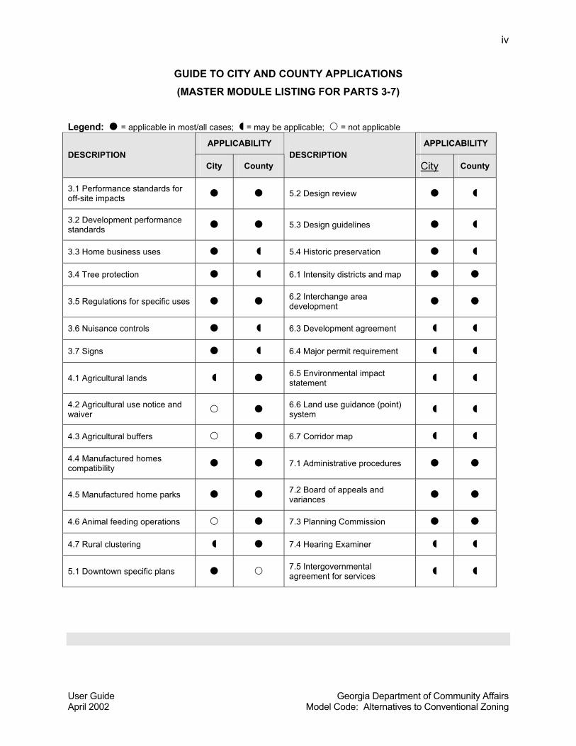
A GUIDE TO CITY AND COUNTY APPLICATIONS
The model code has been written to provide land use management techniques that can be
applied in a variety of areas, including municipal and unincorporated, built-up and rural, areas.
As would be expected, the conditions in a small town can differ remarkably from the conditions
found in an unincorporated area some ten miles out of town. Indeed, cities and counties may
have remarkably different needs with regard to land use regulations. This section of the user
guide provides additional guidance on selecting modules, depending on whether you are
applying regulations to a city or a rural, unincorporated area of the county. However, one
should also note that the types of municipalities that are most likely to consult this model code
are those that are experiencing slow growth or no growth and may have vacant and even
agricultural land inside the city limits. Therefore, one should not take the oversimplifications in
the table below to be definitive or representative in every case. Note that the table below only
includes additional “optional” tools that are over and above the modules in Part Two, which
contains recommended basic ingredients for all local land use management codes.
User Guide Georgia Department of Community Affairs April 2002 Model Code: Alternatives to Conventional Zoning
iv
GUIDE TO CITY AND COUNTY APPLICATIONS (MASTER MODULE LISTING FOR PARTS 3-7)
Legend: = applicable in most/all cases; = may be applicable; = not applicable
APPLICABILITY APPLICABILITY DESCRIPTION
City County DESCRIPTION
City County
3.1 Performance standards for off-site impacts 5.2 Design review
3.2 Development performance standards 5.3 Design guidelines
3.3 Home business uses 5.4 Historic preservation
3.4 Tree protection 6.1 Intensity districts and map
3.5 Regulations for specific uses 6.2 Interchange area development
3.6 Nuisance controls 6.3 Development agreement
3.7 Signs 6.4 Major permit requirement
4.1 Agricultural lands 6.5 Environmental impact statement
4.2 Agricultural use notice and waiver 6.6 Land use guidance (point)
system
4.3 Agricultural buffers 6.7 Corridor map
4.4 Manufactured homes compatibility 7.1 Administrative procedures
4.5 Manufactured home parks 7.2 Board of appeals and variances
4.6 Animal feeding operations 7.3 Planning Commission
4.7 Rural clustering 7.4 Hearing Examiner
5.1 Downtown specific plans 7.5 Intergovernmental agreement for services
User Guide Georgia Department of Community Affairs April 2002 Model Code: Alternatives to Conventional Zoning
v
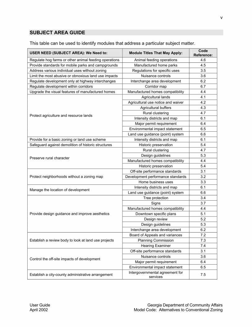
SUBJECT AREA GUIDE This table can be used to identify modules that address a particular subject matter.
USER NEED (SUBJECT AREA): We Need to: Module Titles That May Apply: Code Reference:
Regulate hog farms or other animal feeding operations Animal feeding operations 4.6 Provide standards for mobile parks and campgrounds Manufactured home parks 4.5 Address various individual uses without zoning Regulations for specific uses 3.5 Limit the most abusive or obnoxious land use impacts Nuisance controls 3.6 Regulate development only at highway interchanges Interchange area development 6.2 Regulate development within corridors Corridor map 6.7 Upgrade the visual features of manufactured homes Manufactured homes compatibility 4.4
Agricultural lands 4.1 Agricultural use notice and waiver 4.2
Agricultural buffers 4.3 Rural clustering 4.7
Intensity districts and map 6.1 Major permit requirement 6.4
Environmental impact statement 6.5
Protect agriculture and resource lands
Land use guidance (point) system 6.6 Provide for a basic zoning or land use scheme Intensity districts and map 6.1 Safeguard against demolition of historic structures Historic preservation 5.4
Rural clustering 4.7 Design guidelines 5.3
Manufactured homes compatibility 4.4 Preserve rural character
Historic preservation 5.4 Off-site performance standards 3.1
Development performance standards 3.2 Protect neighborhoods without a zoning map Home business uses 3.3
Intensity districts and map 6.1 Manage the location of development
Land use guidance (point) system 6.6 Tree protection 3.4
Signs 3.7 Manufactured homes compatibility 4.4
Downtown specific plans 5.1 Design review 5.2
Design guidelines 5.3
Provide design guidance and improve aesthetics
Interchange area development 6.2 Board of Appeals and variances 7.2
Planning Commission 7.3 Establish a review body to look at land use projects Hearing Examiner 7.4
Off-site performance standards 3.1 Nuisance controls 3.6
Major permit requirement 6.4 Control the off-site impacts of development
Environmental impact statement 6.5
Establish a city-county administrative arrangement Intergovernmental agreement for services 7.5
User Guide Georgia Department of Community Affairs April 2002 Model Code: Alternatives to Conventional Zoning
vi
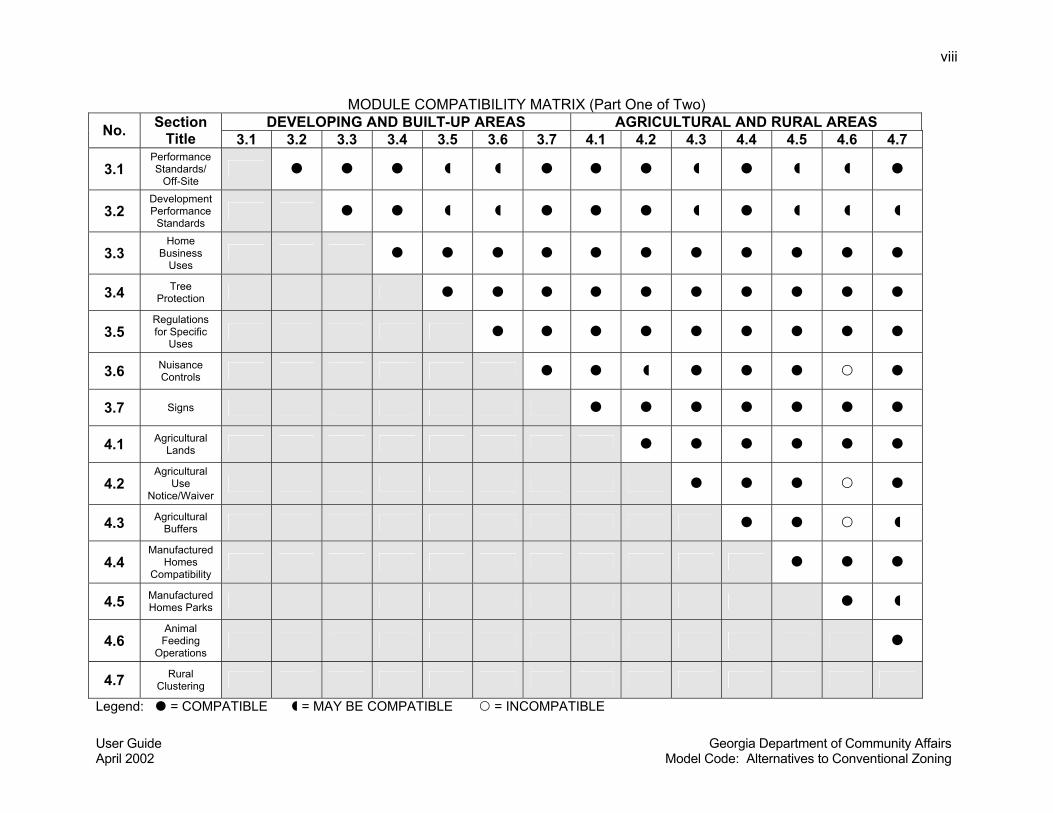
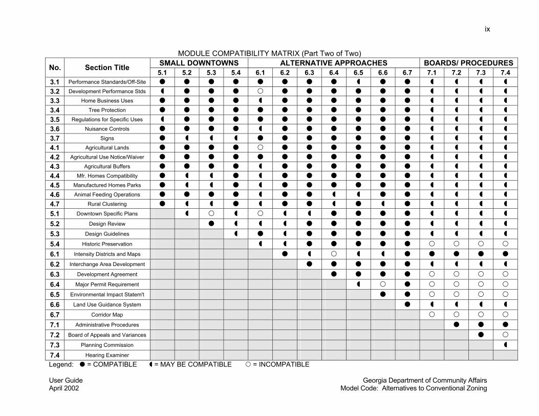
MODULE COMPATIBILITY MATRIX As noted above, many modules are mutually compatible and will work well in combination, while
others may not. The following Module Compatibility Matrix provides a guide to the compatibility
of each module (code section) with each other module. The matrix shows code sections both
horizontally and vertically. One can determine whether a module is compatible ( ), may be
compatible ( ), or incompatible ( ) by consulting the module compatibility matrix.
However, this guidance is not intended to serve as a substitute for the judgement of the model
code user, a local community, or its planning and legal consultants.
Because the modules in Part Two, Basic Ingredients for All Ordinances, are compatible with all
other land use regulations provided in the model code, they are not included in the compatibility
matrix. Therefore only code sections from Parts Three through Seven are included in the
compatibility matrix (it is presented in two parts only because of space constraints). To use the
compatibility matrix, choose a particular module you want to compare with others, then locate
the section number and name in the first column of the table. Find the section number to be
compared with in the first row of the table (the names of sections are listed only in the first
column, due to space considerations). At the intersection of the selected row and column you
will find a " ”," “,” or “ ,” which can be interpreted as follows:
• The symbol “ ” means that the two code sections would not present any inherent conflicts if
combined in the same code. However, the lack of inherent conflicts does not imply a
recommendation that they should be adopted together. For instance, there would be no
need for a small city to adopt the Downtown Specific Plans module (5.1) along with the
Animal Feeding Operations module (4.6), yet the two modules could exist without conflict in
the same land use code if they were both needed. The large number of “ ” designations in
the module compatibility matrix should not be surprising, as the code was designed to avoid
creating major conflicts between modules presented as a unified model code. However,
avoiding conflicts had to be balanced with the desire to provide alternatives. Because
different alternatives are provided in parts of the code, there is by necessity some overlap
and hence, possibilities for conflict.
User Guide Georgia Department of Community Affairs April 2002 Model Code: Alternatives to Conventional Zoning
vii
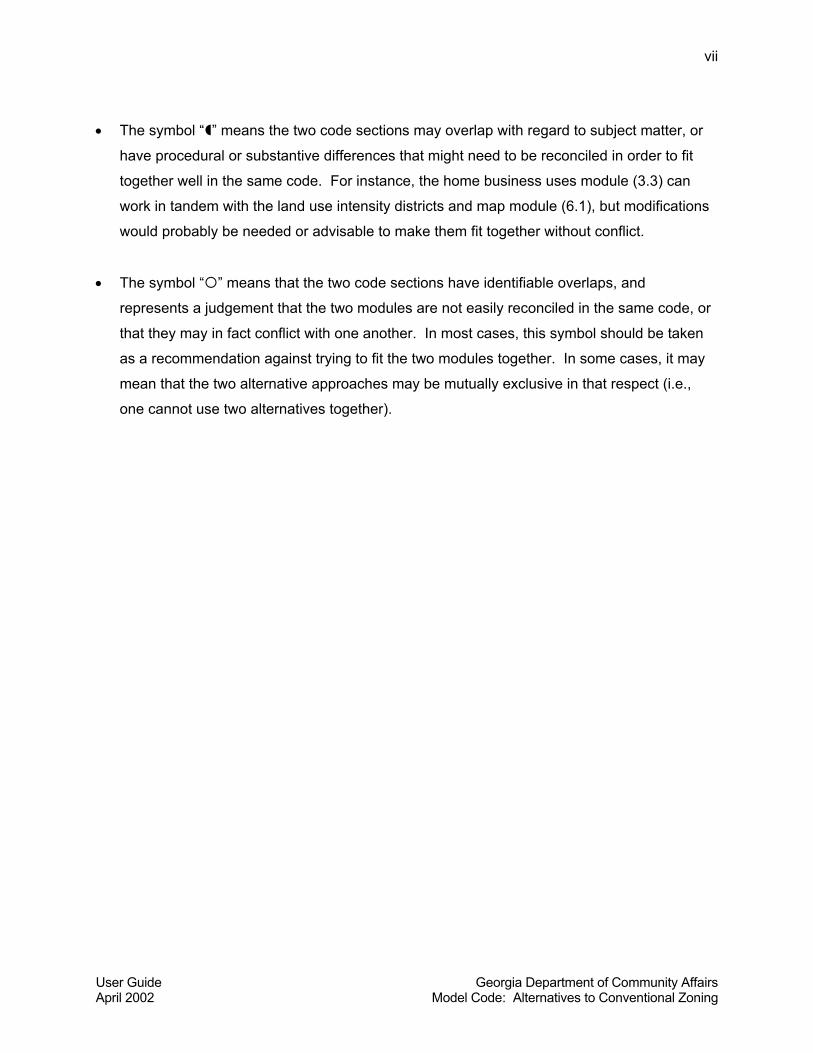
• The symbol “ ” means the two code sections may overlap with regard to subject matter, or
have procedural or substantive differences that might need to be reconciled in order to fit
together well in the same code. For instance, the home business uses module (3.3) can
work in tandem with the land use intensity districts and map module (6.1), but modifications
would probably be needed or advisable to make them fit together without conflict.
• The symbol “ ” means that the two code sections have identifiable overlaps, and
represents a judgement that the two modules are not easily reconciled in the same code, or
that they may in fact conflict with one another. In most cases, this symbol should be taken
as a recommendation against trying to fit the two modules together. In some cases, it may
mean that the two alternative approaches may be mutually exclusive in that respect (i.e.,
one cannot use two alternatives together).
User Guide Georgia Department of Community Affairs April 2002 Model Code: Alternatives to Conventional Zoning
viii
MODULE COMPATIBILITY MATRIX (Part One of Two) DEVELOPING AND BUILT-UP AREAS AGRICULTURAL AND RURAL AREAS No. Section
Title 3.1 3.2 3.3 3.4 3.5 3.6 3.7 4.1 4.2 4.3 4.4 4.5 4.6 4.7
3.1 Performance Standards/
Off-Site
3.2 Development Performance
Standards
3.3 Home
Business Uses
3.4 Tree Protection
3.5 Regulations for Specific
Uses
3.6 Nuisance Controls
3.7 Signs
4.1 Agricultural Lands
4.2 Agricultural
Use Notice/Waiver
4.3 Agricultural Buffers
4.4 Manufactured
Homes Compatibility
4.5 Manufactured Homes Parks
4.6 Animal Feeding
Operations
4.7 Rural Clustering
Legend: = COMPATIBLE = MAY BE COMPATIBLE = INCOMPATIBLE
User Guide Georgia Department of Community Affairs April 2002 Model Code: Alternatives to Conventional Zoning
ix
MODULE COMPATIBILITY MATRIX (Part Two of Two) SMALL DOWNTOWNS ALTERNATIVE APPROACHES BOARDS/ PROCEDURES No. Section Title 5.1 5.2 5.3 5.4 6.1 6.2 6.3 6.4 6.5 6.6 6.7 7.1 7.2 7.3 7.4
3.1 Performance Standards/Off-Site 3.2 Development Performance Stds 3.3 Home Business Uses 3.4 Tree Protection 3.5 Regulations for Specific Uses 3.6 Nuisance Controls 3.7 Signs 4.1 Agricultural Lands 4.2 Agricultural Use Notice/Waiver 4.3 Agricultural Buffers 4.4 Mfr. Homes Compatibility 4.5 Manufactured Homes Parks 4.6 Animal Feeding Operations 4.7 Rural Clustering 5.1 Downtown Specific Plans 5.2 Design Review 5.3 Design Guidelines 5.4 Historic Preservation 6.1 Intensity Districts and Maps 6.2 Interchange Area Development 6.3 Development Agreement 6.4 Major Permit Requirement 6.5 Environmental Impact Statem't 6.6 Land Use Guidance System 6.7 Corridor Map 7.1 Administrative Procedures 7.2 Board of Appeals and Variances 7.3 Planning Commission 7.4 Hearing Examiner Legend: = COMPATIBLE = MAY BE COMPATIBLE = INCOMPATIBLE
Preface: Model Zoning and Land Use Codes Georgia Department of Community Affairs April 2002 Model Code: Alternatives to Conventional Zoning
1
PREFACE: MODEL ZONING AND LAND USE CODES
This Model Land Use Management Code for Small Cities and Rural Counties in Georgia
(hereafter, the model code) was prepared by Jerry Weitz & Associates, Inc. under contract with
the Atlanta Regional Commission as managed by the Georgia Department of Community
Affairs, Office of Coordinated Planning. Community & Environment, Inc. was a subcontractor on
this project and prepared initial drafts of portions of the model code relating to environmental
regulation. Frank Jenkins, Esq., provided legal review of the model code and also reviewed and
supplemented the legal commentary provided by Jerry Weitz & Associates, Inc.
A number of model zoning and land use codes have been developed since the advent of the
planning profession. This section summarizes in chronological order many of the existing model
codes that are available and which were consulted or used to prepare this model code.
While no longer law, the General Planning Enabling Act of 1957 (Atlanta: Bureau of State
Planning and Community Affairs, 1970) provides language that has been incorporated into
many, if not most, of the local zoning ordinances in effect in Georgia’s communities today. It
has served as a model for local zoning ordinances and still has merit today at least with regard
to its legal precedent in Georgia. Its language regarding zoning ordinances, subdivision
regulations, and official maps was consulted in preparing this model code. Bair (1965) prepared
Local Regulation of Mobile Home Parks, Travel Trailer Parks and Related Facilities (Chicago:
Mobile Homes Research Foundation, 1965), which contains a model ordinance with
commentary for the regulation of mobile home parks. While Bair’s work is woefully outdated
due to extensive changes in the manufactured home industry, it was still consulted with regard
to historical precedent because manufactured home parks and recreational vehicle parks still
cause land use issues in rural Georgia today.
In 1974, Howard Schretter wrote and the Institute of Community and Area Development (ICAD)
published Opportunities for Local Building Codes Enforcement (Athens, GA: Institute of
Community and Area Development, 1974). This publication contains among other materials a
model contract for multi-jurisdictional codes services, and it was consulted for its value in
preparing a model intergovernmental agreement for services.
Preface: Model Zoning and Land Use Codes Georgia Department of Community Affairs April 2002 Model Code: Alternatives to Conventional Zoning
2
In 1979, Charles Aguar wrote and ICAD published Social Circle Zoning Ordinance Proposal: A
Model Zoning Format for Georgia Communities (Athens, GA: University of Georgia, Institute of
Community and Area Development, 1979). The Social Circle proposal is now quite dated, but it
provides commentary and code contents that have been considered in preparing this model
code.
In 1983, John Waters wrote and ICAD published Maintaining a Sense of Place: A Community
Guide to Preservation (Athens, GA: Institute of Community and Area Development, 1983).
Waters’ work (1983) includes a model historic preservation ordinance based on Georgia’s 1980
state preservation law, which formed the basis for the model preservation ordinance included
here.
Michael Brough wrote a Unified Development Ordinance (Chicago: Planners Press, 1985) which
combines zoning, subdivision, utility and street specifications, signs, and landscaping
regulations into a single development ordinance. Brough’s work, which includes commentary,
has its roots in North Carolina law. Due to its comprehen-siveness, Brough’s work is relevant to
this effort and was consulted as appropriate. In 1986, the International City Management
Association distributed Nuisance Abatement Program and Ordinances, Erwin, North Carolina
(Washington, DC: ICMA, 1986) as a clearinghouse report; this report provided the foundation for
the public nuisance module contained in this model code.
In 1989, Jerry Weitz prepared a model zoning ordinance with commentary. That work was
written as a model for a suburban community in Georgia and based largely on the City of
Roswell, Georgia’s zoning ordinance. Although not published, Weitz’s model zoning ordinance
with commentary was one of many sources that Jean McRae, Esq., of the Association County
Commissioners of Georgia (ACCG) consulted in preparing a Model Rural County Zoning
Ordinance (Atlanta, GA: Association County Commissioners of Georgia, 1993) under the
context of Georgia law at that time. ACCG’s effort to publish a model rural zoning ordinance is
noteworthy not only for its content (which is to some extent relevant here) but because it marks
a recognition (which is even more valid today) that rural counties in Georgia need simplified
models of land use regulations to consider, adopt, and implement.
A book written by Mantell, Harper and Propst titled Resource Guide for Creating Successful
Communities (Washington, DC: Island Press, 1990), provides sample ordinances with regard to
Preface: Model Zoning and Land Use Codes Georgia Department of Community Affairs April 2002 Model Code: Alternatives to Conventional Zoning
3
stream corridor protection, wetlands and drainage, historic preservation districts, signage, and
hillside development, among others. In the early 1990s, the Georgia Department of Community
Affairs prepared and distributed a Model Water Supply Watershed Protection Ordinance and a
Model Groundwater Recharge Area Protection Ordinance (Atlanta, Office of Coordinated
Planning, not dated). This model code draws heavily on more recent versions of model
groundwater recharge, water supply watershed, and wetland ordinances and guidebooks
published by DCA.
With regard to subdivision regulations, there are two significant model codes available that were
consulted in preparing this model code. Listoken and Walker wrote a model subdivision and
site plan ordinance for the State of New Jersey which was subsequently published as The
Subdivision and Site Plan Handbook (New Brunswick, NJ: Center for Urban Policy Research,
1989). That work includes a handbook containing a model ordinance and commentary in a
side-by-side format; its provisions have been considered in this model code, as appropriate.
Freilich and Schultz wrote the second edition of Model Subdivision Regulations: Planning and
Law (Chicago: Planners Press, 1995) which provides helpful ordinance language (some of
which is incorporated here) and generous commentary on subdivision regulations and public
facility impact fees. Arendt (1996) provides model ordinance provisions for conservation
subdivisions in Conservation Design for Subdivisions: A Practical Guide to Creating Open
Space Networks (Washington, DC: Island Press, 1996). That work and Arendt’s earlier work
(1994) were helpful in producing this code.
In 1998, the American Planning Association published Growing Smart Legislative Guidebook:
Model Statutes for Planning and the Management of Change (Chicago: American Planning
Association, 1998). Although this work is intended to provide guidance to the reform of state
statutes, it is still quite useful in the context of local land use regulations. This model code
incorporates selected provisions from the Legislative Guidebook, particularly its provisions on
“corridor maps” as an alternative to “official maps.” A book on performance zoning approaches
by Porter, Phillips, and Lasser titled Flexible Zoning: How It Works (Washington, DC: Urban
Land Institute, 1988) provides detailed performance zoning provisions, and that work was the
primary reference source used in preparing the simplified land use guidance (point) system
module included in this model code.
Preface: Model Zoning and Land Use Codes Georgia Department of Community Affairs April 2002 Model Code: Alternatives to Conventional Zoning
4
A book by Tom Daniels, When City and Country Collide: Managing Growth in the Metropolitan
Fringe (Washington, DC: Island Press, 1999) provides, among other useful information, a model
ordinance for telecommunications towers and antennas and a model intergovernmental
agreement between a county and a city or village. In 1999, OTAK, Inc. prepared and Oregon’s
Transportation and Growth Management Program published a Model Development Code and
User’s Guide for Small Cities (Salem: Oregon Transportation and Growth Management
Program, 1999). This model development code is well illustrated with code provisions and
design standards, and it provides an example model code written for small cities without full-
time professional planning staffs. Because it contains a “user’s guide,” it was also consulted for
ideas in that regard.
The scope of services for this model code called for the illustration of regulations where
possible. Most of the aforementioned model code sources are not heavily illustrated. In fact,
there is no known illustrated model land use code available. However, the following sources
were consulted in preparing illustrations for this model code: Moskowitz and Lindbloom’s The
Illustrated Book of Zoning Definitions (Piscataway, NJ: Center for Urban Policy Research,
1981), the second edition of the Residential Development Handbook (Washington, DC: Urban
Land Institute, 1990), Kone’s (eighth edition) Land Development (Washington, DC: Home
Builder Press), DeChiara, Panero and Zelnick’s Time-Saver Standards for Housing and
Residential Development (New York: McGraw-Hill, 1995) and DeChiara and Koppelman’s Time
Saver Standards for Site Planning (New York: McGraw-Hill, 1984). A limited number of
illustrations are available and were consulted from Davidson and Dolnick’s A Glossary of
Zoning, Development, and Planning Terms (Chicago: American Planning Association, 1999).
Original drawings prepared by Jerry Weitz & Associates, Inc. in prior work, including the Forsyth
County, Georgia, Unified Development Code (2000) and Development and Design Guidelines
for the Georgia 400 Corridor, Dawson County, Georgia (2001), were also incorporated into this
model code.
Numerous other sources were consulted which cannot be reiterated here. For more information
on sources, see the master bibliography.
Part One: Introduction to the Model Code Georgia Department of Community Affairs April 2002 Model Code: Alternatives to Conventional Zoning
1
PART ONE: INTRODUCTION TO THE MODEL CODE
WHY THIS MODEL CODE IS NEEDED
Small cities and rural counties in Georgia need simplified land use management techniques that
minimize administrative requirements. The intent of the Alternatives to Zoning (ALT Z) project is
to provide viable alternatives to conventional zoning that can be implemented by smaller local
governments with limited technical and administrative capacity.
Rather than proceed directly to writing model code provisions, the ALT Z project scope included
an initial study of rural land use problems and issues and prevailing responses to them. A task
1 report titled Land Use in Rural Georgia: Problems, Issues, and Prospects (Jerry Weitz &
Associates, Inc. and Community & Environment, Inc. 2001) documented a wide variety of
regional and local land use problems and issues in rural Georgia. It confirmed the need to
develop and promote new, simpler models of land use management that fit the needs of rural
local governments better than conventional zoning. The Task 1 report helped in many ways to
guide the direction and content of the model code.
Some of the cities reviewed and discussed in the Task 1 report are still mostly agricultural with
little to no development pressure. Because conventional zoning was not originally designed to
address agricultural land uses, some cities may view zoning as an inappropriate tool for solving
their land use problems. Conventional zoning could be used to address agricultural land use
issues, but the perception of some people in rural Georgia is that conventional zoning may be
an inappropriate tool. Conventional zoning may not be the best answer to rural land use
problems and issues in small, agriculturally based cities. Something less rigid than conventional
zoning is needed for rural counties and small agriculturally based communities.
Political considerations are paramount when it comes to objections and obstacles to the
adoption of local land use regulations. Research in the Task 1 report indicates that Georgia’s
rural counties have had an especially difficult time, politically, with attempts to pass countywide
zoning regulations. Clearly, less rigid alternatives to conventional zoning are needed before
some of the rural counties will try to adopt additional land use regulations.
Part One: Introduction to the Model Code Georgia Department of Community Affairs April 2002 Model Code: Alternatives to Conventional Zoning
2
The Model Land Use Management Code for Small Cities and Rural Counties in Georgia
(hereafter, the “model code”) is written with these local governments in mind—small
agriculturally based cities that are not experiencing much development but still need some sort
of protection from land use problems, and counties that are experiencing growth but cannot
muster the support from the citizenry (or the political will on the Board) to adopt conventional
zoning. It is highly unlikely that any single land use management system will be applicable to
all, or even the vast majority, of local governments in rural Georgia that have not adopted
zoning ordinances. However, by basing the model code contents on research of land use
problems and issues in rural Georgia (i.e., the Task 1 report), this model code contains several
modules that will surely be useful to local governments that want less restrictive land use tools
that do not have to be implemented with a zoning map.
Most of Georgia’s regional development centers (RDCs) have conventional zoning ordinances
that can be used as models, and they have helped many cities and counties to adopt
conventional zoning. A key feature of this model code is the alternatives to conventional zoning.
These alternatives include stand alone ordinances that serve some of the same purposes as
conventional zoning and a basic land use intensity district system (i.e., “zoning light”), among
others. For instance, a system of building setbacks and buffers between incompatible uses can
be adopted independently of zoning districts and a zoning map. Local governments that cannot
politically accept the rigidity and restrictiveness of conventional zoning may more readily adopt
such “mapless” or “light” zoning alternatives.
The Task 1 report also revealed particular concerns with strip commercial development impacts,
and to a lesser extent, nuisances from industrial uses. It revealed a need to include aesthetic
and functional controls on strip commercial development and techniques to resolve
incompatibilities between commercial and residential uses.
Most RDCs also have reasonably good land subdivision ordinances and have helped numerous
local governments control land subdivisions in their communities. However, basic subdivision
approval procedures often lack important development standards, such as access controls and
construction specifications. The model code provides a model land subdivision ordinance and
land development regulations designed to ensure proper infrastructure improvements in the
local government’s jurisdiction.
Part One: Introduction to the Model Code Georgia Department of Community Affairs April 2002 Model Code: Alternatives to Conventional Zoning
3
The Task 1 report did not include original research on the status of local staff available for the
administration and enforcement of codes and land use regulations. However, the Task 1 Report
provides some strong evidence of a lack of available city staff to administer building codes,
enforce codes, and manage land use programs. Regional and local planners have
recommended interlocal agreements and the pooling of local resources to hire code
enforcement officers and zoning officers in areas that cannot afford their own staff. While local
and regional plans point out the need for city-county and even multi-county cooperation with
regard to land use regulations, there appears to be a lack of suitable models from which to
begin implementing interlocal agreements and programs for land use regulation. This model
code helps to fill that void with a model interlocal agreement. However, the Task 1 report also
cautions that intergovernmental arrangements for land use management will not work in all
regions and localities.
RELATIONSHIP TO DEPARTMENT VISION STATEMENT AND QUALITY COMMUNITIES OBJECTIVES The Georgia Department of Community Affairs has adopted a vision statement and quality
communities objectives. In summary, the Department’s vision is (among other principles) to
structure its programs to: preserve quality of life, revitalize downtowns, reverse the decline of
older neighborhoods, conserve natural and historic resources, facilitate sustainable strategies
for growth and development, manage river and transportation corridors, promote more
traditional and less auto-dependent (i.e., traditional neighborhood) development patterns,
mitigate the negative impacts of development, introduce new smart growth concepts, regulate
but do not hinder economic development in rural communities, reduce sprawl by minimizing the
conversion of undeveloped land at the urban periphery, and achieve local participation in
regional initiatives to protect shared natural resources.
One single project, such as this model code, cannot realistically be expected to promote and
implement all objectives. However, the Department’s vision statement and quality communities
objectives suggest, implicitly if not explicitly, much of this project’s content. The model code
provides “modules” that, if adopted by local governments, will bring them closer to attaining
several of the quality communities objectives. However, land use regulation is but one spoke in
the wheel of local programs—including financial abilities and leadership qualities—that are
needed to attain many of the department’s objectives.
Part One: Introduction to the Model Code Georgia Department of Community Affairs April 2002 Model Code: Alternatives to Conventional Zoning
4
PROCESS USED IN DEVELOPING THE MODEL CODE
The Department of Community Affairs appointed a project advisory committee to provide
oversight to the contractor, in addition to management of the project by DCA’s Office of
Coordinated Planning. Aside from the project advisory committee, which consisted of local and
regional planners, the model code was written without substantive input from stakeholder
groups such as developers, homebuilders, environmental groups, neighborhood
representatives, and county and city planning commissioners and elected officials. Some
groups might view the lack of substantial stakeholder input initially as a deficiency. It might be
viewed differently, however, when one considers the need to produce numerous models of
alternative land use regulations that are not intended to fit exactly the needs of any one
particular community. Hence, the model code is free from the local political compromises that
usually result when land use regulations are adopted. In this light, the lack of formal, ongoing
stakeholder involvement is understandable.
RELATIONSHIP OF PLANNING TO REGULATION
Virtually every local government in Georgia has a comprehensive plan that is intended to
provide local policy direction with regard to land use. The model code assumes the city or
county interested in regulating land use has a comprehensive plan and that it supports efforts to
regulate land uses. In some cases, local comprehensive plans may not have sufficient data and
policy statements strong enough to support the regulations contained in this model code.
Comprehensive planning is an essential prerequisite to the implementation of most parts of this
model code. Frequent references to the comprehensive plan are provided in the model code,
and some of the modules of the code will need to be preceded by amendments to the
comprehensive plan.
ORGANIZATION OF THE MODEL CODE
The model code is organized into seven parts, summarized below:
Part One: Introduction
Part Two: Recommended Basic Ingredients
Part Three: Provisions for Developing and Built-up Areas
Part Four: Provisions for Agricultural and Rural Areas
Part Five: Provisions for Small Downtowns
Part Six: Alternative Approaches
Part Seven: Procedures, Boards, and Commissions
Part One: Introduction to the Model Code Georgia Department of Community Affairs April 2002 Model Code: Alternatives to Conventional Zoning
5
The organization into parts deserves some explanation. First, the bulk and scope of the model
code itself works against one of its most important goals, which is to provide simple models that
can be administered relatively easily. All local governments are especially encouraged to adopt
regulations contained in part two, “Recommended Basic Ingredients.” Part two contains
environmental regulations which are either conditionally mandated by the state or are so
important that virtually every local government must eventually adopt them in whole or
significant part. These include floodplain management, water supply watersheds and
groundwater recharge areas, subdivision regulations, and land development regulations. Local
governments that have few if any land use regulations should start by adding these basic
ingredients to their land use regulatory programs.
A key feature of the model code’s organization is its severability into “modules.” Parts three,
four, and five of the model code are modules in their own right. Within each part are modules
that can be severed from the rest of the model code and used as stand-alone ordinances
(sometimes requiring the addition of other parts of the model code). One will note that there is a
geographical distinction between parts three, four, and five of the model code. Part three of the
model code is targeted at areas with developed residential areas that need protection; it
includes regulations for protecting neighborhoods, preserving trees, and regulating home
businesses and nonresidential land uses. The regulations in part three are most likely to apply
to municipalities, although counties certainly may also find them valuable.
Part four is designed primarily to address agricultural and rural issues such as agricultural
buffers and manufactured home park regulation. While the modules in part four are expected to
be more popular with rural counties than cities, there are a number of cities in Georgia that still
have much farmland inside the city limits and that have a substantial number of manufactured
homes. Therefore, while designed for rural counties, modules in part four are clearly applicable
to some of the cities in Georgia.
Part five of the model code provides the “aesthetic” tools that some small cities may need to
protect their overall appearance and/or their historic qualities. In some instances, the provisions
of this part might be considered applicable to parts of rural counties.
Part One: Introduction to the Model Code Georgia Department of Community Affairs April 2002 Model Code: Alternatives to Conventional Zoning
6
Part six provides alternative approaches. With the exception of Section 6.1, which is similar to
conventional zoning, part six contains regulations that are no longer really “innovative” with
regard to the United States, but which are almost entirely absent from use in Georgia. The
modules in part six of the model code were derived from land use programs in other states and
localities outside Georgia, as described in the Task 2 report for ALT Z, titled, Alternative Land
Use Management Techniques with Potential Application In Rural Georgia (Jerry Weitz &
Associates, Inc. 2001).
Local governments that need guidance in establishing procedures, boards, and commissions
should refer to part seven for assistance. Part seven provides modules on procedures
(including amendments to the model code and applications for development approvals) and
establishing a Board of Appeals, Planning Commission, and Hearing Examiner.
COMMENTARY
Like most model codes, this one provides “commentary.” Originally, it was anticipated that the
commentary would be standardized among the various parts and modules of the model code.
The language in the various commentaries throughout the model code is not standardized,
however, since each alternative land use regulation has its own unique set of issues to
consider.
Commentary includes, but is not limited to, the following considerations: general introduction;
example applications; administrative and enforcement considerations; legal issues; alternatives
to the language proposed; and references to other sections of the model code that are needed
to make a particular module stand alone.
“Sources” or “references” follow many of the modules of the model code, so that users are
aware of the original sources of some of the model code provisions and can consult them if
needed. A master bibliography is also provided at the end of the model code text.
OTHER LAND USE MANAGEMENT SYSTEM COMPONENTS NOT INCLUDED IN THE MODEL CODE It is important to emphasize at the outset that this model code focuses exclusively on land use
regulations that can be adopted by small cities and rural counties in Georgia. With this limited
focus, it clearly does not describe or provide more sophisticated tools of growth management,
Part One: Introduction to the Model Code Georgia Department of Community Affairs April 2002 Model Code: Alternatives to Conventional Zoning
7
which are usually preceded by conventional zoning or basic land use controls. Furthermore,
there are a number of fiscal tools such as capital improvement programming and infrastructure
programs such as sewer facility master planning that are not covered in this model code
because of its exclusive focus on regulation.
RELATIONSHIP TO LOCAL CONSTRUCTION CODE ENFORCEMENT
Building and construction codes are prepared and administered in order to ensure that building
practices meet acceptable standards for safety (safety, wind resistance, fire resistance, load
bearing standards, and so forth). Because the state adopts minimum codes, local governments
do not have to (and, in fact, should not) adopt the mandatory codes in order to enforce them
(O.C.G.A. Section 8-2-25(a)) (Georgia Department of Community Affairs web page). Many
cities and counties do not enforce building and construction codes, whether locally adopted or
not. As of September 1999 according to the Georgia Department of Community Affairs, some
four dozen counties and approximately 200 municipalities in Georgia did not enforce any sort of
construction code. State statistics on local code enforcement reveal further that codes most
often enforced by counties are the standard electrical, plumbing, and building codes. For cities,
the codes most commonly enforced are fire prevention, electrical, building, and plumbing codes.
GEORGIA’S MINIMUM STANDARD CODES Construction codes are adopted at the state level to ensure uniformity in their application
throughout the state. Minimum standard codes have been adopted by the state (O.C.G.A. 8-2).
There are fourteen codes that have been adopted by the State of Georgia, eight of which are
“mandatory” and six of which are “permissive.” Mandatory codes are applicable to all
construction, whether or not they are locally enforced. Permissive codes are only applicable if a
local government chooses to adopt and enforce one or more of them. Under Georgia law, any
structure built in Georgia must comply with the mandatory codes, whether or not the local
government chooses to locally enforce these codes. The eight mandatory codes (as amended
by the state) are listed below. Most of these codes are published by the Southern Building
Code Congress International, Inc. (SBCCI).
SBCCI Standard Building Code; 1994.
National Electrical Code; 1999.
SBCCI Standard Gas Code (International Fuel Gas Code); 2000.
SBCCI Standard Mechanical Code (International Mechanical Code); 2000.
Part One: Introduction to the Model Code Georgia Department of Community Affairs April 2002 Model Code: Alternatives to Conventional Zoning
8
CABO One and Two Family Dwelling Code; 1995.
SBCCI Georgia State Energy Code for Buildings (CABO Model Energy Code); 1995.
SBCCI Standard Fire Prevention Code; 1994.
Standard Plumbing Code (International Plumbing Code); 2000.
Permissive codes are listed as follows: Standard Housing Code; Standard Amusement Device
Code; Excavation and Grading Code; Standard Existing Buildings Code; Standard Swimming
Pool Code; and the Standard Unsafe Building Abatement Code (all published by SBCCI).
DCA periodically reviews, amends and/or updates the state minimum standard codes. If a local
government chooses to locally enforce any of these codes, it must enforce the latest editions
and the amendments adopted by DCA. Information about code amendments is available on
DCA’s web page.
RELATIONSHIP BETWEEN LOCAL AND STATE MINIMUM STANDARD CODES Local governments can propose local amendments to state minimum standard codes, but they
cannot be less stringent than the requirements in a state minimum standard code. Local
construction codes can be more stringent than state minimum standard codes, but only if they
are justified on the basis of unique local climatic, geologic, topographic, or public safety factors.
Any local amendment to a state minimum standard code is required to be sent to the Georgia
Department of Community Affairs (DCA) for review and recommendation. Georgia's
Construction Code Program is administered by DCA’s Construction Codes and Industrialized
Buildings Section.
CODES ADMINISTRATION As noted by the Georgia Department of Community Affairs, “in order to properly administer and
enforce the state minimum standard codes, local governments must adopt reasonable
administrative provisions. The power to adopt these administrative procedures is set forth in
O.C.G.A. Section 8-2-26(a)(1). These provisions should include procedural requirements for
the enforcement of the codes, provisions for hearings, provisions for appeals from decisions of
local inspectors, and any other procedures necessary for the proper local administration and
enforcement of the state minimum standard codes.” Because DCA has already prepared a
sample resolution/ordinance that may be used as a guide for local governments in the
development of their administrative procedures, a model code relative to those provisions is not
Part One: Introduction to the Model Code Georgia Department of Community Affairs April 2002 Model Code: Alternatives to Conventional Zoning
9
provided in this code. DCA can provide a copy of the sample resolution/ordinance for
establishing administrative procedures relative to construction codes. It can also provide
technical assistance if needed in the development of a local code enforcement program.
STATE REGULATION OF INDUSTRIALIZED BUILDINGS Georgia's Industrialized Buildings Program was established via the Industrialized Buildings Act
in 1976 with the purpose of establishing building construction standards for factory built housing.
In 1982 the program was expanded by the General Assembly to include, in addition to housing,
all business and commercial buildings that are mass-produced in factories and then transported
to building sites to be installed. State codes for industrialized buildings are needed because
they cannot be inspected at the installation site without disassembly, damage or destruction. All
state-approved industrialized buildings must be manufactured to meet the official Georgia State
Construction Codes. Such buildings have an insignia from the Georgia Department of
Community Affairs indicating their compliance with the state's construction standards. An
approved building is deemed to comply with all local ordinances and laws relating to its
construction.
Manufactured (mobile) homes are excluded from the state program, because they are the
responsibility of the U. S. Department of Housing and Urban Development. Buildings
constructed in a conventional manner are not subject to the state industrialized building
program; they are regulated instead by the state minimum codes described above. The
industrialized buildings codes program does not supersede zoning (or land use) regulations
administered by local governments. Local governments retain control over all matters relating
to a building's installation at a site, including subdivision controls, zoning, grading, foundation
installations, and utility hook-ups.
RELATIONSHIP OF CONSTRUCTION CODES TO LAND USE REGULATIONS Any local land use management system, no matter how simple or sophisticated, relies on other
systems for enforcement, especially a building permit system used to administer standard
building and other state minimum codes. One of the most direct ways to control land
development is through a building permit system. A building permit can be withheld in cases
where a development proposal does not comply with city or county land use regulations. Also,
the building review process provides a means for reviewing development proposals for
compliance with development regulations, in addition to construction codes.
Part One: Introduction to the Model Code Georgia Department of Community Affairs April 2002 Model Code: Alternatives to Conventional Zoning
10
This model land use management code takes into account that many cities and counties still do
not administer construction codes and thus probably do not require building permits.
This model code, if adopted, does not require the local government to adopt minimum building
and other construction codes or administer state minimum codes. However, local governments
need some sort of permit requirement to trigger a review of construction and development. In
lieu of a “building permit” requirement, this model code makes frequent reference to a “land use
permit.” The reference to a land use permit is intentional so as to differentiate the requirements
of this code from building and other construction permit requirements. In cases where a city or
county has adopted a building code (i.e., building permit requirement), it could substitute
“building” permit for “land use” permit for the sake of simplicity, though it should also recognize
that construction codes are administered by building officials while land use codes are
administered by planners, engineers, and zoning administrators.

Appendix, Basic Template for Conducting a Georgia Department of Community Affairs Quality Growth Audit Model Code: Alternatives to Conventional Zoning December 2003
1
§2-0 Basic Provisions for All Ordinances Georgia Department of Community Affairs April 2002 Model Code: Alternatives to Conventional Zoning
1
§2-0 BASIC PROVISIONS FOR ALL RESOLUTIONS [ORDINANCES]
CONTENTS
§2-0-1(A) PREAMBLE §2-0-1(B) ADDITIONAL PREAMBLE FOR LAND USE CODES §2-0-2 ADOPTION AND EFFECTIVE DATE §2-0-3 LEGAL STATUS PROVISIONS §2-0-3.1 Short Title §2-0-3.2 Jurisdiction §2-0-3.3 Conflict With Other Laws §2-0-3.4 Validity and Severability §2-0-3.5 Repeal of Conflicting Ordinances §2-0-3.6 Codification §2-0-4 ADMINISTRATION, APPEALS, ENFORCEMENT, AND PENALTIES §2-0-4.1 Administration and Interpretation §2-0-4.2 Appeal of Administration Decision or Interpretation §2-0-4.3 Land Use Permit Required §2-0-4.4 Enforcement §2-0-4.4.1 Refusal of Permits or Permissions §2-0-4.4.2 Stop Work Order §2-0-4.4.3 Injunction §2-0-4.5 Complaints §2-0-4.6 Penalties for Violation of Ordinances §2-0 BASIC PROVISIONS FOR ALL RESOLUTIONS [ORDINANCES]
§2-0-1(A) PREAMBLE
WHEREAS, the Constitution of the State of Georgia, effective July 1, 1983, provides in
Article IX, Section II, Paragraph IV thereof, that the governing authority of the County [City] may
adopt plans and exercise the power of zoning; and
WHEREAS, the Georgia General Assembly has enacted the Georgia Planning Act of
1989, (Georgia Laws, 1989, pp. 1317-1391, Act 634) which among other things provides for local
governments to adopt plans and regulations to implement plans for the protection and
preservation of natural resources, the environment, vital areas, and land use; and
WHEREAS, the Georgia Department of Community Affairs has promulgated Minimum
Standards and Procedures for Local Comprehensive Planning (Chapter 110-3-2 of Rules of the
Georgia Department of Community Affairs) to implement the Georgia Planning Act of 1989, said
standards and procedures were ratified by the Georgia General Assembly, and said rules require
local governments to describe regulatory measures and land development regulations needed to
implement local Comprehensive Plans; and
§2-0 Basic Provisions for All Ordinances Georgia Department of Community Affairs April 2002 Model Code: Alternatives to Conventional Zoning
2
WHEREAS, the Georgia Department of Natural Resources has promulgated Rules for
Environmental Planning Criteria, commonly known as the “Part V” Standards, said rules were
ratified by the Georgia General Assembly, and said rules require local governments to plan for the
protection of the natural resources, the environment, and vital areas of the State; and
WHEREAS, the Board of Commissioners [Mayor and City Council] has adopted a
Comprehensive Plan in accordance with the requirements of the Georgia Planning Act of 1989,
Rules of the Georgia Department of Community Affairs, and Rules of the Georgia Department of
Natural Resources, and said plan has been revised from time to time; and
WHEREAS, the Comprehensive Plan specifies a number of goals and policies that are not
currently implemented by the County’s [City’s] land use regulations; and
WHEREAS the Board of Commissioners [Mayor and City Council] desires to help assure
the implementation of its Comprehensive Plan; and
WHEREAS, the Board of Commissioners [Mayor and City Council] desires to promote the
health, safety, welfare, morals, convenience, order, and prosperity of the County [City] and its
citizens;
NOW THEREFORE BE IT RESOLVED [ORDAINED] by the Board of Commissioners [Mayor and
City Council], and it is hereby resolved [ordained] by the authority of the same, that the following
articles [or chapters] and sections known collectively as the [insert title of resolution or ordinance]
is hereby enacted into law.
Commentary: Resolutions and ordinances typically contain a “preamble” that provides a legal
justification for its provisions. Sometimes, the “whereas” parts of the preamble are not codified.
The preamble provided in this model code cites major sources of authority for the adoption of
zoning and land use regulations. Authority is derived from the state constitution, statutes (the
Georgia Planning Act), and administrative rules of the state Departments of Community Affairs
and Department of Natural Resources. All of these citations may or may not be included in the
ordinance, depending on its contents. For instance, an ordinance that has nothing to do with the
environment should not cite the Georgia’ Department of Natural Resources’ rules for
environmental planning criteria. The reference to the comprehensive plan is probably appropriate
for all land use regulations, but it must be accurate. That is, if the proposed ordinance does not
clearly implement a policy of the comprehensive plan, the local government should consider
amending the comprehensive plan to identify the need and provide support for a particular
ordinance.
§2-0 Basic Provisions for All Ordinances Georgia Department of Community Affairs April 2002 Model Code: Alternatives to Conventional Zoning
3
§2-0-1(A) provides a general preamble and enactment clause. For more comprehensive land use
ordinances, such as those that establish intensity districts, regulate specific uses of lands and
their locations and characteristics, and/or govern the subdivision of land and improvements
thereon, additional preamble provisions are recommended, as provided in §2-0-1(B) below.
§2-0-1(B) ADDITIONAL PREAMBLE FOR LAND USE CODES
WHEREAS, the Board of Commissioners [Mayor and City Council] desires to promote
responsible growth, lessen congestion in the public thoroughfares, secure safety from fire and
health dangers, and promote desirable living conditions; and
WHEREAS, the Board of Commissioners [Mayor and City Council] desires to regulate the
height, bulk, and the size of buildings and structures; and
WHEREAS, the Board of Commissioners [Mayor and City Council] desires to classify land
uses, establish procedures and regulations for the subdivision and development of land, and
regulate the distribution and density of uses on the land to avoid both the undue concentration of
population and the inappropriate dispersion of population, prevent the encroachment of
incompatible land uses within residential areas, and preserve property values; and
WHEREAS, the Board of Commissioners [Mayor and City Council] desires to provide for
economically sound and stable land development by assuring the provision in land developments
of adequate streets, utilities, services, traffic access and circulation, public open spaces, and
maintenance continuity; and
WHEREAS, the Board of Commissioners [Mayor and City Council] finds that the
regulations contained in this Resolution [Ordinance] are the minimum necessary to accomplish
the various public purposes; and
WHEREAS, the General Assembly of the State of Georgia enacted Ga. Laws 1985, page
1139, Act. No. 662, providing for an amendment to Title 36 of the Official Code of Georgia
Annotated, codified as O.C.G.A. sections 36-66-1 et seq., so as to provide procedures for the
exercise of zoning powers by cities and counties; and
WHEREAS, appropriate public notice and hearing have been accomplished; and
WHEREAS, the planning commission has considered this matter;
Commentary: This section should be carefully reviewed for its appropriateness. It provides the
rationale for adoption of both an intensity district ordinance (see §6-1) and land subdivision
regulations (see §2-2). If appropriate, it should be added to the preamble language provided in
§2-0 Basic Provisions for All Ordinances Georgia Department of Community Affairs April 2002 Model Code: Alternatives to Conventional Zoning
4
§2-0-1(A) before the “NOW, THEREFORE…”. If a planning commission has not been created or
does not review land use regulations, that reference should be deleted. Land use regulations,
whether or not they constitute “zoning ordinances” should in most cases be adopted only after
following procedures pursuant to and consistent with the Zoning Procedures Law (O.C.G.A. 36-
66).
§2-0-2 ADOPTION AND EFFECTIVE DATE
This Resolution [Ordinance] is hereby adopted this ___ day of ___________, ____, and shall be
effective immediately upon its adoption, the public welfare demanding it.
BOARD OF COMMISSIONERS [MAYOR AND CITY COUNCIL]
_________________, Chairman [Mayor]
ATTEST:
____________________________________
County [City] Clerk
APPROVED AS TO LEGAL FORM AND SUFFICIENCY:
____________________________________
County [City] Attorney
Commentary: Sometimes a local government may want to establish an effective date that is
different from the date of adoption. That is, a local government may not want to make the
ordinance effective immediately. There may be some risks involved in establishing an effective
date that is not immediate, because it provides time for persons to establish uses and engage in
practices that might not be consistent with the new ordinance. In the event the effective date is
different from the date of adoption, the ordinance should specify both dates. An alternative used
in many ordinances is the provision of a section titled “Effective Date” under “Legal Status
Provisions.”
§2-0 Basic Provisions for All Ordinances Georgia Department of Community Affairs April 2002 Model Code: Alternatives to Conventional Zoning
5
§2-0-3 LEGAL STATUS PROVISIONS
§2-0-3.1 Short Title. The Resolution [Ordinance] shall be known and may be cited as
the ________________ [insert title of resolution or ordinance].
§2-0-3.2 Jurisdiction. Unless this Resolution [Ordinance] clearly indicates otherwise,
this Resolution [Ordinance] shall apply within the unincorporated limits of _________________
County, Georgia, and within the limits of any inactive municipality in accordance with O.C.G.A. §
36-70-5 [city limits of the city of ________________, Georgia].
§2-0-3.3 Conflict With Other Laws. Whenever the regulations of this Resolution
[Ordinance] require or impose more restrictive standards than are required in or under any other
Resolution [Ordinance], the requirements of this Resolution [Ordinance] shall govern.
Whenever the provisions of any state or federal statute requires more restrictive standards than
are required by this Resolution [Ordinance], the provisions of such statute shall govern.
§2-0-3.4 Validity and Severability. Should any section or provision of this Resolution
[Ordinance] be declared invalid or unconstitutional by any court of competent jurisdiction, such
declaration shall not affect the validity of the Resolution [Ordinance] as a whole or any part
thereof which is not specifically declared to be invalid or unconstitutional.
§2-0-3.5 Repeal of Conflicting Resolutions [Ordinances]. All Resolutions [Ordinances]
and parts of Resolutions [Ordinances] in conflict herewith are repealed to the extent necessary
to give this Resolution [Ordinance] full force and effect, except that any ordinances or
resolutions repealed by this provision shall not limit or impair the county’s [city’s] authority to
enforce such ordinances or resolutions to the extent that violations thereof occurred prior to
repeal.
§2-0-3.6 Codification. It is the intention of the Board of Commissioners [Mayor and
Council], and it is hereby resolved [ordained] that the provisions of this Resolution [Ordinance]
shall become and be made a part of the official code of the County [City] of ___________, and
the sections of this Resolution [Ordinance] may be renumbered or reorganized to accomplish
such intention.
§2-0 Basic Provisions for All Ordinances Georgia Department of Community Affairs April 2002 Model Code: Alternatives to Conventional Zoning
6
Commentary: Except for the “short title,” these are standard legal status provisions that should be
included in any resolution or ordinance or any amendment thereto. The “codification” provision
allows the local government to bring the new ordinance into its code, in a different format, without
the need for readopting it. Note the section on “jurisdiction and applicability” cites “inactive
municipalities” where a county’s jurisdiction might apply—this provision should be deleted if it is
not applicable.
§2-0-4 ADMINISTRATION, APPEALS, ENFORCEMENT, AND PENALTIES
§2-0-4.1 Administration and Interpretation. It shall be the duty of the duly appointed
Land Use Officer to administer and interpret this Resolution [Ordinance]. To this end, the Land
Use Officer is authorized to prepare administrative procedures, guidelines, application forms, to
tend to other administrative details not inconsistent with the provisions of this Resolution
[Ordinance], and to implement the provisions of this Resolution [Ordinance]. The Land Use
Officer may delegate administrative functions, powers and duties assigned by this Resolution
[Ordinance] to other staff as may be appropriate, without the need to reflect such delegation by
formal action.
Commentary: The administrative officer or enforcement officer could have other titles, such as
“city clerk,” “planner,” “building official,” “building inspector,” “code enforcement officer,” and the
like. For purposes of convenience, this model code uses the term “Land Use Officer.” The
code should specifically define who the Land Use Officer is, or alternatively, use a different term
such as “building official.” Note the language “duly appointed.” Even though the definition of
the term “Land Use Officer” should suffice, this term might become legally problematic. To err
on the side of caution, the local government might consider specifically designating, by
resolution or formal vote reflected in the minutes of a public meeting, the appropriate staff
person as the Land Use Officer. Such action will help to avoid a claim that a given staff person
is not acting pursuant to specific authority provided by the local government. This section also
provides authority of the administrative official to prepare administrative forms and the like, an
authorization that is often overlooked in other ordinances.
§2-0-4.2 Appeal of an Administrative Decision or Interpretation. Any person who alleges
that there has been an error by the Land Use Officer in administration or interpretation of this
§2-0 Basic Provisions for All Ordinances Georgia Department of Community Affairs April 2002 Model Code: Alternatives to Conventional Zoning
7
ordinance shall have the right to appeal the decision of the Land Use Officer to the Board of
Appeals, as more specifically provided in Section 7.2 of this code.
Commentary: A Board of Appeals needs to be established to hear appeals of administrative
decisions and interpretations. Alternatively, the Local Governing Body could serve as the body
with jurisdictions for appeals. If the local government does not want a board of appeals or
wants to further simplify the ordinance, it may appoint itself, i.e., the Board of Commissioners or
Mayor and City Council, to decide appeals of decisions by the Land Use Officer. However,
because legislative decisions of the governing body and quasi-judicial proceedings appeals
board are usually separate, and since governing bodies do not typically have experience
making decisions under quasi-judicial proceedings, it is recommended that appeals go to a
separate Board of Appeals (Section 7.2) or a Hearing Examiner (Section 7.4). Also note that
this “appeal” provision is often included within an article or section on the Board of Appeals
itself.
§2-0-4.3 Land Use Permit Required. Unless specifically exempted or otherwise
provided by this Resolution [Ordinance], no building, sign, or other structure shall be erected,
moved, added to, or structurally altered without a Land Use Permit issued by the Land Use
Officer. It shall be unlawful to use or occupy or permit the use or occupancy of any building,
structure, land, water, or premises, without a Land Use Permit for such use or occupancy.
Unless specifically exempted or otherwise provided by this Resolution [Ordinance], no land use
activity including land disturbance shall be initiated without a Land Use Permit issued by the
Land Use Officer, and except in conformity with said Land Use Permit. It shall be unlawful to
erect, move, add to, structurally alter any building or structure, use or occupy or permit the use
of any occupancy of any building, structure, land, water, or premises, or initiate any land use
activity that is in violation of an approved Land Use Permit.
Commentary: This provision establishes a generic “Land Use Permit” in place of a building
permit, development permit or land disturbance permit, and certificate of occupancy. Local
governments that have adopted building codes could substitute the terms “building permit” and
“certificate of occupancy” for “land use permit.” Local governments that have established
separate “land disturbance” or “land development” permits could also rewrite this section to
reflect existing permitting requirements. Even with such building, certificate of occupancy, and
land disturbance or development permits in place, a local government could consider requiring a
land use permit anyway, to ensure that all activities are covered under a permitting process, and
§2-0 Basic Provisions for All Ordinances Georgia Department of Community Affairs April 2002 Model Code: Alternatives to Conventional Zoning
8
to otherwise ensure enforcement of the ordinance lies with the Land Use Officer. Also, as noted
by Aguar (1979), a requirement for a land use permit helps to separate land use from the permit
used in enforcing the building code or other construction codes. However, these advantages
should be weighed against the need to “streamline” permitting processes.
Commentary: Local governments should also carefully consider how the “land use permit”
required by this section relates to a land disturbance permit required to be issued for purposes
of soil erosion and sedimentation control (see Code Section 2-1-7). If the land use permit is the
same as the land disturbance permit as described in Code Section 2-1-7, it should be noted that
land disturbance permits are issued by the Georgia Department of Natural Resources (DNR)
rather than the local government, unless the local government has been certified by the DNR to
issue those permits.
§2-0-4.4 Enforcement. It shall be the duty of the duly appointed Land Use Officer to
enforce this Resolution [Ordinance] and to bring to the attention of the County [City] attorney
any violations or lack of compliance therewith. The Land Use Officer may delegate enforcement
functions, powers, and duties assigned by this Resolution [Ordinance] to other staff as may be
appropriate, without the need to reflect such delegation by formal action.
§2-0-4.4.1 Refusal ofPermits or Permissions. The Land Use Officer is hereby authorized
and directed to deny and withhold permits or permissions on any new project or application
pursuant to this Resolution [Ordinance] or other Resolutions [Ordinances] of the County [City]
where the applicant, applicant's business, or agent has failed or refused to comply with this
Resolution [Ordinance].
§2-0-4.4.2 Stop Work Order. The Land Use Officer is hereby authorized to issue written
"stop work" and "cease and desist" orders for any activity that fails to comply with the provisions of
this Resolution [Ordinance]. Such “stop work” or “cease and desist” orders may be lifted at such
time as the Land Use Officer is satisfied that a good faith effort is being made to comply with
applicable provisions of this Resolution [Ordinance]. Nothing shall prevent the Land Use Officer
from reissuing “stop work” and “cease and desist” orders where warranted.
§2-0-4.4.3 Injunction. If any land is used, or building, structure, or other activity is
established or maintained in violation of this Resolution [Ordinance], the Land Use Officer is
§2-0 Basic Provisions for All Ordinances Georgia Department of Community Affairs April 2002 Model Code: Alternatives to Conventional Zoning
9
authorized to and may institute, in addition to other remedies, an injunction or undertake other
appropriate action to cause the violation to cease or to be corrected.
§2-0-4.5 Complaints. Whenever a violation of this Resolution [Ordinance] occurs or is
alleged to have occurred, any person may file a written complaint. Such complaint shall state
clearly and fully the causes and bases of the complaint and shall be filed with the Land Use
Officer. The Land Use Officer shall record properly such complaint, investigate, and take action
thereon as may be appropriate to enforce this Resolution [Ordinance].
§2-0-4.6 Penalties for Violation of Ordinances. Any person violating any of the provisions
of the Resolutions [Ordinances] of _________ County [City of ___________] shall be punished by
a fine or imprisonment, or both. In no case shall the maximum punishment for violation of any of
these Resolutions [Ordinances] exceed a fine of $1,000.00 or imprisonment for 60 days, or both.
Violations of Resolutions [Ordinances] in the County [City] may be tried upon citation with or
without a prosecuting attorney as well as upon accusations.
Commentary: The above provision applies to county ordinance violations tried in the magistrate
court. The statutory provisions relating to use of citations by counties are found at O.C.G.A. §15-
10-62.
§2-1 Environmental Regulations Georgia Department of Community Affairs April 2002 Model Code: Alternatives to Conventional Zoning
10
§2-1 ENVIRONMENTAL REGULATIONS
CONTENTS §2-1-1 GROUNDWATER RECHARGE AREAS §2-1-1.1 Title §2-1-1.2 Purpose and Intent §2-1-1.3 Definitions §2-1-1.4 Adoption of Hydrologic Atlas 18 by Reference §2-1-1.5 Adoption of Hydrologic Atlas 20 by Reference §2-1-1.6 Applicability §2-1-1.7 Permit Required §2-1-1.8 County Health Department Approval of Permit Required §2-1-1.9 Minimum Lot Size §2-1-1.10 Mobile Home Parks §2-1-1.11 Agricultural Waste Impoundment Sites §2-1-1.12 Above Ground Chemical or Petroleum Storage Tanks §2-1-1.13 Hazardous Materials Handling Facilities §2-1-1.14 Stormwater Infiltration Basins §2-1-2 WATER SUPPLY WATERSHEDS §2-1-2.1 Title §2-1-2.2 Purpose and Intent §2-1-2.3 Definitions §2-1-2.4 Adoption by Reference of Watershed Protection Map §2-1-2.5 Applicability §2-1-2.6 Exemptions §2-1-2.7 Hazardous Materials Handling Facilities §2-1-2.8 Requirements for Large Water Supply Watersheds with Reservoirs §2-1-2.9 Requirements for Small Water Supply Watersheds §2-1-2.10 Water Supply Reservoirs §2-1-3 WETLANDS §2-1-3.1 Title §2-1-3.2 Purpose and Intent §2-1-3.3 Definitions §2-1-3.4 Adoption of Generalized Wetlands Map by Reference §2-1-3.5 Applicability §2-1-3.6 Permit Required §2-1-3.7 Jurisdictional Wetland Determination Required §2-1-3.8 Permitted Uses §2-1-3.9 Prohibited Uses §2-1-4 PROTECTED RIVER CORRIDORS §2-1-4.1 Title §2-1-4.2 Purpose §2-1-4.3 Definitions §2-1-4.4 Applicability §2-1-4.5 Protected River Corridor Buffer Required §2-1-4.6 Measurement of the Required Buffer §2-1-4.7 Land Disturbing Activity within Required Buffer §2-1-4.8 Restoration of Disturbed Buffers §2-1-4.9 Uses Prohibited Within Required Buffers §2-1-4.10 Uses Permitted Within Required Buffers
§2-1 Environmental Regulations Georgia Department of Community Affairs April 2002 Model Code: Alternatives to Conventional Zoning
11
§2-1-4.11 Land Use Permit and Site Plan Required §2-1-4.12 Subdivision Plats §2-1-5 MOUNTAIN PROTECTION §2-1-5.1 Purpose §2-1-5.2 Definitions §2-1-5.3 Adoption of Protected Mountains Map by Reference §2-1-5.4 Applicability §2-1-5.5 Permit Required §2-1-5.6 Development Regulations §2-1-5.7 Exemptions §2-1-6 FLOOD DAMAGE PREVENTION §2-1-6.1 Short Title §2-1-6.2 Findings §2-1-6.3 Purposes §2-1-6.4 Objectives §2-1-6.5 Definitions §2-1-6.6 Applicability §2-1-6.7 Adoption of Maps and Studies by Reference §2-1-6.8 Interpretation of Map Boundaries §2-1-6.9 Permit Required §2-1-6.10 Compliance §2-1-6.11 Application Requirements for Development §2-1-6.12 Application Requirements for New Construction §2-1-6.13 Elevation Certificate Required Prior to Building Occupancy §2-1-6.14 Floodways §2-1-6.15 General Regulations for Construction §2-1-6.16 Requirements for Elevating Residential Buildings §2-1-6.17 Requirements for Elevating Non-Residential Buildings §2-1-6.18 Requirements for Fully Enclosed Areas below the Base Flood Elevation §2-1-6.19 Requirements for Streams without Established Base Flood Elevation
and/or Floodways §2-1-6.20 Requirements for Areas of Shallow Flooding (AO Zones) §2-1-6.21 Dam Break Flood Zone §2-1-6.22 Variances Authorized §2-1-6.23 Criteria for Approving Variances §2-1-6.24 Additional Limitations on Variances §2-1-6.25 Requirements when Variances are Granted §2-1-6.26 Administration and Duties of the Land Use Officer §2-1-6.27 Warning and Disclaimer of Liability §2-1-7.1 Title §2-1-7.2 Definitions §2-1-7.3 Exemptions §2-1-7.4 General Provisions §2-1-7.5 Enforcement and Violations §2-1-7.6 Minimum Buffer Required for State Waters §2-1-7.7 Minimum Buffer Required for Trout Streams §2-1-7.8 Activities within Buffers §2-1-7.9 Permit Required §2-1-7.10 Permit Applicant §2-1-7.11 Permit Application Requirements §2-1-7.12 Plan Requirements Generally
§2-1 Environmental Regulations Georgia Department of Community Affairs April 2002 Model Code: Alternatives to Conventional Zoning
12
§2-1-7.13 Data Required to be on Plans §2-1-7.14 Features to be Included on Plans §2-1-7.15 Review of Permit Application by District §2-1-7.16 Decision on Permit §2-1-7.17 Permit Denial §2-1-7.18 Violations as Grounds for Permit Revocation §2-1-7.19 Violations and Orders to Comply §2-1-7.20 Authority to Enter Property and Investigate §2-1-7.21 Penalty for Failing to Obtain a Permit for Land Disturbing Activity §2-1-7.22 Warnings and Stop Work Orders §2-1-7.23 Bond Forfeiture §2-1-7.24 Monetary Penalties §2-1-7.25 Appeal and Hearing, and Judicial Review §2-1-7.26 Validity §2-1-7.27 Liability §2-1-7.28 Incorporation of Georgia Erosion and Sedimentation Act of 1975 §2-1-8 GRADING §2-1-8.1 Purposes §2-1-8.2 Definitions §2-1-8.3 Grading Permit Required §2-1-8.4 Exemptions §2-1-8.5 Specifications for Grading Plans §2-1-8.6 Site Grading Regulations §2-1-8.7 Grading in Areas of Special Flood Hazard §2-1-8.8 Erosion Control §2-1-8.9 Grading on Steep Slopes §2-1-8.10 Requirements for Fill Material §2-1-8.11 Temporary Stockpiling during Construction or Grading §2-1-8.12 Compliance §2-1 ENVIRONMENTAL REGULATIONS §2-1-1 GROUNDWATER RECHARGE AREAS
Commentary on Applicability: This ordinance is specifically designed to implement the state
Department of Natural Resources’ Environmental Planning Criteria (Rule 391-3-16-.02) (also
known as “Part V” standards) relative to groundwater recharge areas. If the local government
does not have any significant recharge areas as shown on Hydrologic Atlas 18 (Georgia
Geologic Survey 1989), it does not need to adopt this ordinance. However, local jurisdictions
that rely on groundwater supplies for domestic and public water supplies should consider the
merits of applying the standards established in this ordinance.
Commentary: The State of Georgia has established criteria for the protection of groundwater
recharge areas. Groundwater recharge areas provide the mechanism for rainfall runoff to enter
the water table, providing water supply resource for not only domestic water supplies, but also
§2-1 Environmental Regulations Georgia Department of Community Affairs April 2002 Model Code: Alternatives to Conventional Zoning
13
public well systems. While some rainfall runoff flows into creeks, streams, rivers and lakes, a
large portion of the water seeps downward through the soil into the saturated zone, or water
table. Any materials or chemicals contacting the water as it travels downward through the soil
can be carried into the water table.
§2-1-1.1 Title. This Resolution [Ordinance] shall be known and may be cited as a
“Resolution [Ordinance] to Protect Groundwater Recharge Areas.” §2-1-1.2 Purpose and Intent. Groundwater is among the Nation's most important
natural resources. It provides drinking water to urban and rural communities, supports irrigation
and industry, sustains the flow of streams and rivers, and maintains riparian and wetland
ecosystems. In many areas of the Nation, the future sustainability of ground-water resources is
at risk from over use and contamination. Because groundwater systems typically respond
slowly to human actions, a long-term perspective is needed to manage this valuable resource.
This Resolution [Ordinance] is intended to implement rules of the Georgia Department of
Natural Resources’ Environmental Protection Division known as the “Rules for Environmental
Planning Criteria” as they specifically relate to groundwater recharge areas (Rule 391-3-16-.02).
It is essential to the health, safety, and welfare of the public that the quality of subsurface public
drinking water be maintained. Groundwater resources exist in underground reservoirs known
as aquifers. These aquifers are zones of rock beneath the earth’s surface that are capable of
providing water for a well. They occupy vast regions of the subsurface and are replenished by
infiltration of surface water runoff in zones of the surface, known as groundwater recharge
areas. Groundwater is susceptible to contamination when unrestricted development occurs
within significant groundwater recharge areas. Certain land use activities, such as septic tanks,
underground tanks, and chemical spills, pose a threat to the quality of groundwater supplies.
Therefore, it is necessary to manage land uses within groundwater recharge areas in order to
ensure that pollution threats are minimized. To this end, this Resolution [Ordinance] establishes
minimum lot sizes to provide for the orderly and safe development of property utilizing on-site
sewage management systems. (See Figure 2-1-1.2.1).
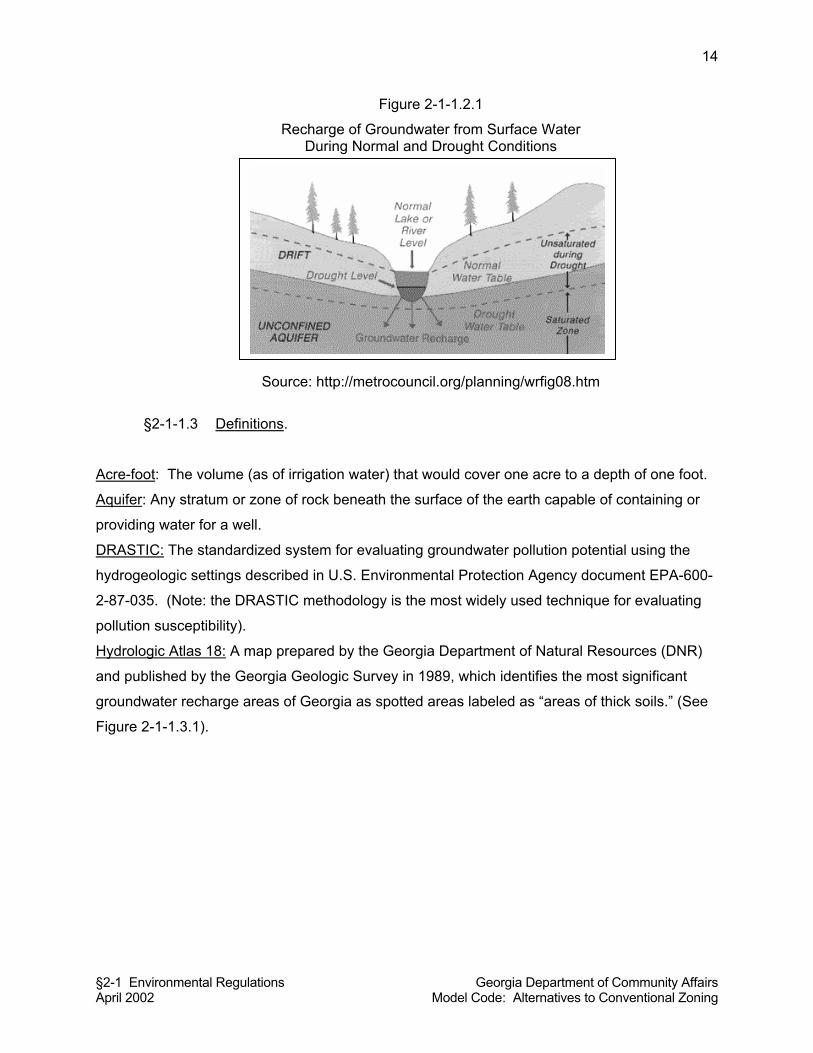
§2-1 Environmental Regulations Georgia Department of Community Affairs April 2002 Model Code: Alternatives to Conventional Zoning
14
Figure 2-1-1.2.1
Recharge of Groundwater from Surface Water During Normal and Drought Conditions
Source: http://metrocouncil.org/planning/wrfig08.htm
§2-1-1.3 Definitions.
Acre-foot: The volume (as of irrigation water) that would cover one acre to a depth of one foot.
Aquifer: Any stratum or zone of rock beneath the surface of the earth capable of containing or
providing water for a well.
DRASTIC: The standardized system for evaluating groundwater pollution potential using the
hydrogeologic settings described in U.S. Environmental Protection Agency document EPA-600-
2-87-035. (Note: the DRASTIC methodology is the most widely used technique for evaluating
pollution susceptibility).
Hydrologic Atlas 18: A map prepared by the Georgia Department of Natural Resources (DNR)
and published by the Georgia Geologic Survey in 1989, which identifies the most significant
groundwater recharge areas of Georgia as spotted areas labeled as “areas of thick soils.” (See
Figure 2-1-1.3.1).
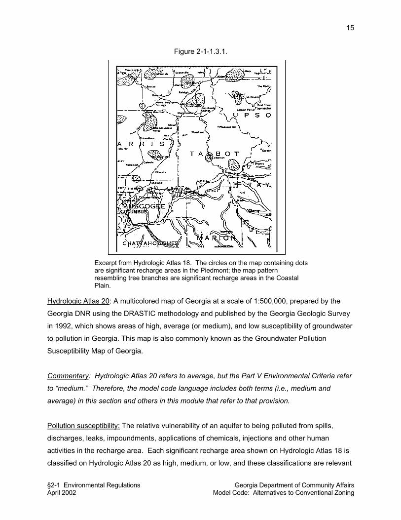
§2-1 Environmental Regulations Georgia Department of Community Affairs April 2002 Model Code: Alternatives to Conventional Zoning
15
Figure 2-1-1.3.1.
Excerpt from Hydrologic Atlas 18. The circles on the map containing dots are significant recharge areas in the Piedmont; the map pattern resembling tree branches are significant recharge areas in the Coastal Plain.
Hydrologic Atlas 20: A multicolored map of Georgia at a scale of 1:500,000, prepared by the
Georgia DNR using the DRASTIC methodology and published by the Georgia Geologic Survey
in 1992, which shows areas of high, average (or medium), and low susceptibility of groundwater
to pollution in Georgia. This map is also commonly known as the Groundwater Pollution
Susceptibility Map of Georgia.
Commentary: Hydrologic Atlas 20 refers to average, but the Part V Environmental Criteria refer
to “medium.” Therefore, the model code language includes both terms (i.e., medium and
average) in this section and others in this module that refer to that provision.
Pollution susceptibility: The relative vulnerability of an aquifer to being polluted from spills,
discharges, leaks, impoundments, applications of chemicals, injections and other human
activities in the recharge area. Each significant recharge area shown on Hydrologic Atlas 18 is
classified on Hydrologic Atlas 20 as high, medium, or low, and these classifications are relevant
§2-1 Environmental Regulations Georgia Department of Community Affairs April 2002 Model Code: Alternatives to Conventional Zoning
16
in this Resolution [Ordinance].
Recharge Area: Any portion of the earth’s surface where water infiltrates into the ground to
replenish an aquifer.
Significant Recharge Areas: Those areas mapped by the Georgia DNR in Hydrologic Atlas 18
(1989 edition) within the County [City] of __________. Each significant recharge area shall be
determined to have a pollution susceptibility of high, medium, or low based on Hydrologic Atlas
20.
§2-1-1.4 Adoption of Hydrologic Atlas 18 by reference. Hydrologic Atlas 18, as
defined by this Resolution [Ordinance] is hereby adopted and made a part of this Resolution
[Ordinance] as if fully set forth herein.
§2-1-1.5 Adoption of Hydrologic Atlas 20 by reference. Hydrologic Atlas 20, as
defined by this Resolution [Ordinance] is hereby adopted and made a part of this Resolution
[Ordinance] as if fully set forth herein.
Commentary: To obtain these hydrologic atlases, contact the Georgia Geologic Survey Room
400, 19 Martin Luther King Jr. Dr. Atlanta, Georgia 30334. Phone: 404.656.3214. While local
governments should probably adopt Hydrologic Atlas 18 and Hydrologic Atlas 20 by reference in
their ordinance, it must be noted that the scales of the atlases make it difficult to apply to site-
specific conditions. The city or county comprehensive plan should provide a map of significant
recharge areas and pollution susceptibility that can be more readily applied in the development
review process. It is advisable to transfer information on Hydrologic Atlas 18 and Hydrologic
Atlas 20 to a single map that has a scale of no smaller than 1 inch = 2000 feet, so that their
applicability can be determined by the Land Use Officer. Digital manipulation of Hydrologic
Atlas 18 is now possible; it is available as an Arcinfo database from the Georgia Environmental
Protection Division’s web page (www.georgianet.org/dnr/environ). If the city or county
comprehensive plan has transferred the information from Hydrologic Atlas 18 and Hydrologic
Atlas 20 onto a base map of the city or county, or if the city or county uses the ArcInfo database
to construct its own map, then such map should be adopted by reference in addition to the
adoption by reference of Hydrologic Atlas 18 and Hydrologic Atlas 20. The locally produced
map may be sufficient for implementation, but adoption of the official state maps would
strengthen the legal standing of the ordinance.
§2-1 Environmental Regulations Georgia Department of Community Affairs April 2002 Model Code: Alternatives to Conventional Zoning
17
§2-1-1.6 Applicability. This Resolution [Ordinance] shall apply to all lands within the
County [City] of __________ that are mapped as significant recharge areas as defined by this
Resolution [Ordinance].
§2-1-1.7 Permit Required. No land use permit or building permit shall be issued by the
Land Use Officer for a building, structure, or manufactured home to be served by a septic tank,
unless the land use or building conforms to the requirements of this Resolution [Ordinance].
Prior to a land use permit or building permit being issued, the Land Use Officer shall require a
site plan or subdivision plat in sufficient detail to review the proposed development for
compliance with the provisions of this Resolution [Ordinance].
§2-1-1.8 County Health Department Approval of Permit Required. No land use permit
or building permit shall be issued by the Land Use Officer for a building, structure, or
manufactured home to be served by a septic tank, unless the __________ County Health
Department first approves the proposed septic tank installation as meeting the requirements of
the Georgia Department of Human Resources Manual for On-Site Sewage Management
Systems (hereinafter DHR Manual) and this Resolution [Ordinance].
§2-1-1.9 Minimum Lot Size. Within an area governed by this Resolution [Ordinance],
new homes or land uses served by a septic tank/drain field system shall be on lots having
minimum lot sizes as follows, based on application of Table MT-1 of the DHR Manual
(hereinafter DHR Table MT-1). The minimums set forth in DHR Table MT-1 may be increased
further based on consideration of other factors set forth in Sections A-F of the DHR Manual, as
determined by the _______County Health Department.
(a) 150% of the subdivision minimum lot size calculated based on application of
DHR Table MT-1 if they are within a high pollution susceptibility area.
(b) 125% of the subdivision minimum lot size calculated based on application of
DHR Table MT-1 if they are within an average or medium pollution susceptibility
area.
(c) 110% of the subdivision minimum lot size calculated based on application of
DHR Table MT-1 if they are within a low pollution susceptibility area.
Any lot of record approved prior to the adoption of this Resolution [Ordinance] shall be exempt
from the minimum lot size requirements of this section. Within an area governed by this
§2-1 Environmental Regulations Georgia Department of Community Affairs April 2002 Model Code: Alternatives to Conventional Zoning
18
Resolution [Ordinance], no subdivision plat shall be recorded until and unless said plat has been
reviewed and approved by the Land Use Officer as being in compliance with the minimum lot
sizes established by this section.
Commentary: The Environmental Planning Criteria only specify these requirements for
“homes.” The first sentence in this section of the model code also extends the provisions to
“land uses,” thus giving the provision broader applicability. Local governments that only want to
comply with the minimum requirements may delete “or land uses” from the first sentence of this
section.
Commentary on vested rights: This code section recognizes vested rights of prior approved lots.
But keep in mind, in Georgia, although approval may not yet be obtained, a vested right accrues
where the property owner has applied for lot approval, such as a subdivision, where the
requested lots are allowed at the time of the application.
§2-1-1.10 Mobile Home Parks. Within an area governed by this Resolution [Ordinance],
new mobile home parks served by septic tank/drainfield systems shall have lots or spaces
having minimum areas in square feet as follows, based on application of Table MT-2 of the DHR
Manual (hereinafter DHR Table MT-2). The minimums set forth in Table MT-2 may be
increased further based on consideration of other factors set forth in Sections A-F of the DHR
Manual, as determined by the _______County Health Department.
(a) 150% of the subdivision minimum lot or space size calculated based on
application of DHR Table MT-2 if they are within a high pollution susceptibility
area;
(b) 125% of the subdivision minimum lot or space size calculated based on
application of DHR Table MT-2 if they are within an average or medium pollution
susceptibility area;
(c) 110% of the subdivision minimum lot or space size calculated based on
application of DHR Table MT-2 if they are within a low pollution susceptibility
area.
Within an area governed by this Resolution [Ordinance], no site plan for a mobile home park or
manufactured home park shall be considered valid until and unless said site plan has been
§2-1 Environmental Regulations Georgia Department of Community Affairs April 2002 Model Code: Alternatives to Conventional Zoning
19
reviewed and approved by the Land Use Officer as being in compliance with the minimum
space sizes established by this section.
§2-1-1.11 Agricultural Waste Impoundment Sites. New agricultural waste impoundment
sites in a significant recharge area, as specified below, shall contain a liner consisting of
compacted clay having a thickness of one-foot and a vertical hydraulic conductivity of less than
5 x 10⁻⁷cm/sec or other criteria established by the Natural Resource and Conservation Service:
(a) Any agricultural waste impoundment site located in a high pollution
susceptibility area;
(b) Any agricultural waste impoundment site within an average or medium
pollution susceptibility area which exceeds 15 acre-feet; or,
(c) Any agricultural waste impoundment site within a low pollution
susceptibility area that exceeds 50 acre-feet.
§2-1-1.12 Above Ground Chemical or Petroleum Storage Tanks. Within an area
governed by this Resolution [Ordinance], new above-ground chemical or petroleum storage
tanks having a minimum volume of 660 gallons shall have secondary containment for 110% of
the volume of such tanks or 110% of the volume of the largest tank in a cluster of tanks. Such
tanks used for agricultural purposes are exempt, provided they comply with all federal
requirements.
§2-1-1.13 Hazardous Materials Handling Facilities. Within an area governed by this
Resolution [Ordinance], new facilities that handle hazardous materials of the types listed in
section 312 of the Resource Conservation and Recovery Act of 1976 (excluding underground
storage tanks) and in amounts of 10,000 pounds or more on any one day, shall perform their
operations on impervious surfaces and in conformance with any applicable federal spill
prevention requirements and any adopted County [City] fire code requirements.
§2-1-1.14 Stormwater Infiltration Basins. Permanent storm water infiltration basins shall
not be constructed in significant recharge areas having high pollution susceptibility.
Commentary on How to Make this Resolution [Ordinance] Stand Alone: This module has been
written to fit into the land use management code. As such, it relies on certain other sections of
§2-1 Environmental Regulations Georgia Department of Community Affairs April 2002 Model Code: Alternatives to Conventional Zoning
20
the model code, which have not been reiterated in this module. To make this Resolution
[Ordinance] “stand alone,” the following provisions should be added in their entirety:
§2-0-1(A) PREAMBLE
§2-0-2 ADOPTION AND EFFECTIVE DATE
§2-0-3 LEGAL STATUS PROVISIONS
§2-0-4 ADMINISTRATION, APPEALS, ENFORCEMENT, AND PENALTIES
References:
For a more detailed version of a groundwater recharge area ordinance, see the City of
Montezuma, Georgia, Ordinance #311:
http://www.montezuma-ga.org/ordinances/ORD311.HTM.
For more detailed information on groundwater resources in Georgia, see “Ground-Water
Conditions In Georgia,” 1999,By Alan M. Cressler (U.S. Geological Survey Open-File Report
00-151): http://ga.water.usgs.gov/publications/ofr00-151/index.html. Additional information can
be obtained from the U.S. Geological Survey, Ground-Water Resources Program, 2001, U.S.
Geological Survey Fact Sheet 056-01, June 2001: http://water.usgs.gov/ogw/pubs/fs01056/.
§2-1-2 WATER SUPPLY WATERSHEDS
Commentary on Applicability: The State of Georgia has promulgated standards for the
protection of water supply watersheds and water supply reservoirs. This ordinance is
specifically designed to implement the state Department of Natural Resources’ Environmental
Planning Criteria (Rule 391-3-16-01) (also known as “Part V” standards) relative to water supply
watersheds and water supply reservoirs. If the local government does not have any water
supply watersheds or water supply reservoirs within its jurisdiction, then it does not need to
adopt this ordinance.
§2-1-2.1 Title. This Resolution [Ordinance] shall be known and may be cited as a
“Water Supply Watersheds Protection Resolution [Ordinance].”
§2-1 Environmental Regulations Georgia Department of Community Affairs April 2002 Model Code: Alternatives to Conventional Zoning
21
§2-1-2.2 Purpose and Intent. The quality of public drinking water supplies must be
assured. Land-disturbing activities associated with development can increase erosion and
sedimentation, which threaten the storage capacity of reservoirs and impair the quality of public
drinking water supplies. Stormwater runoff, particularly from impervious surfaces, can introduce
toxins, nutrients, and sediments into drinking water supplies, making water treatment more
complicated and expensive, and rendering water resources unusable for recreation and other
uses. Industrial land uses that involve the manufacture, use, transport, and storage of
hazardous or toxic waste materials result in potential risks of contamination of nearby public
drinking water supplies. Therefore, land use activities within water supply watersheds must be
regulated to ensure that public water supplies remain clean. This Resolution [Ordinance]
establishes standards, consistent with the Georgia Department of Natural Resources’ Rules for
Environmental Planning Criteria for Water Supply Watersheds (Rule 391-3-16-01) to ensure
water quality in the watershed system is not compromised by land activities such as grading,
septic systems, and accidental release of contaminants. The intent of this ordinance is to
minimize the transport of pollutants and sediment to the water supply, to maintain the yield of
water supply watersheds, and to ensure water can be treated to meet federal and state drinking
water standards.
§2-1-2.3 Definitions.
Buffer: A natural or enhanced vegetated area with no or limited minor land disturbances, such
as trails and picnic areas, located adjacent to water supply reservoirs or perennial streams
within water supply watersheds.
Corridor: All land within the buffer areas established adjacent to water supply reservoirs or
perennial streams within water supply watersheds and within other setback areas specified in
this Resolution [Ordinance].
Impervious surface: A man-made structure or surface that prevents the infiltration of stormwater
into the ground below the structure or surface. Examples are buildings, roads, driveways,
parking lots, decks, swimming pools, and patios.
Large water supply watershed: A watershed containing 100 square miles or more of land within
the drainage basin upstream of a governmentally owned public drinking water supply intake.
Perennial stream: A stream that flows throughout the whole year as indicated by a solid blue
line on a United States Geological Survey Quadrangle map.
Reservoir boundary: The edge of a water supply reservoir defined by its normal pool level.
§2-1 Environmental Regulations Georgia Department of Community Affairs April 2002 Model Code: Alternatives to Conventional Zoning
22
Small water supply watershed: A watershed that contains less than 100 square miles of land
within the drainage basin upstream of a governmentally owned public drinking water supply
intake.
Utility: Public or private water or sewer piping systems, water or sewer pumping stations,
electric power lines, fuel pipelines, telephone lines, roads, driveways, bridges, river/lake access
facilities, stormwater systems and railroads or other utilities identified by a local government.
Watershed protection map: A map prepared for the local jurisdiction which identifies water
supply watersheds and water supply reservoirs, which are the subject of this Resolution
[Ordinance]. The watershed protection map also identifies public water supply intake points and
perennial streams within the watershed that are upstream of water supply intake points or water
supply reservoirs, and the seven-mile radius line from each water intake or water supply
reservoir boundary.
Commentary: Local Governments that have prepared a Comprehensive Plan are required to
delineate existing and future water supply watersheds, therefore, the information needed to
prepare a watershed protection map should already be available. This information should be
compared to data supplied by the State’s Regional Development Centers. This data includes
water supply intake points mapped in Geographic Information Systems (GIS) and delineated
water supply watersheds.
Water supply reservoir: A governmentally owned impoundment of water for the primary purpose
of providing water to one or more governmentally owned public drinking water systems. This
excludes the multipurpose reservoirs owned by the U.S. Army Corps of Engineers.
Water supply watershed: The area of land upstream of a governmentally owned public drinking
water intake.
§2-1-2.4 Adoption by Reference of Watershed Protection Map. The watershed
protection map, as defined by this Resolution [Ordinance], is hereby adopted and made a part
of this Resolution [Ordinance] as if fully set forth herein.
§2-1-2.5 Applicability. This Resolution [Ordinance] shall apply to all lands within
existing and future small water supply watersheds, large water supply watersheds, and to water
supply reservoirs and their immediate surroundings, as shown on the Watershed Protection
§2-1 Environmental Regulations Georgia Department of Community Affairs April 2002 Model Code: Alternatives to Conventional Zoning
23
Map. This Resolution [Ordinance] does not apply to watersheds not used for public drinking
water supply.
Commentary: If the local jurisdiction does not have a large water supply watershed, a small
watershed, or a water supply reservoir within its jurisdiction, then this section needs to be
modified to delete references to those provisions not applicable in the local jurisdiction.
However, it must be noted that the water supply watershed protection requirements apply even
if the local government does not own a water intake or reservoir, or not located in the subject
local jurisdiction. For instance, a water supply reservoir requiring protection may be owned by
someone other than the local government, but it still requires protection under the state
environmental planning criteria. Also, a water intake may be located outside of the city or
county but the watershed extends into the subject local jurisdiction. In these cases, protection
by the subject local government is required. All local governments with jurisdiction must protect
those watersheds and reservoirs, regardless of ownership or location of the water intake point
or reservoir.
§2-1-2.6 Exemptions. The following land uses and activities are exempted from
compliance with this Resolution [Ordinance].
(a) Land uses existing prior to the adoption of this Resolution [Ordinance].
(b) Mining activities permitted by the Department of Natural Resources under the
Surface Mining Act.
(c) If utilities cannot feasibly be located outside the buffer or setback areas required
by this Resolution [Ordinance], such utility locations can be exempted from the
stream corridor buffer and setback area provisions subject to the following
conditions:
(1) The utilities shall be located as far from the stream bank as reasonably
possible;
(2) The installation and maintenance of the utilities shall be such to protect
the integrity of the buffer and setback areas as best as reasonably
possible; and,
(3) The utilities shall not impair the quality of the drinking water stream.
(d) Specific forestry and agricultural activities in the stream corridor buffer and
setback areas in accordance with the following conditions.
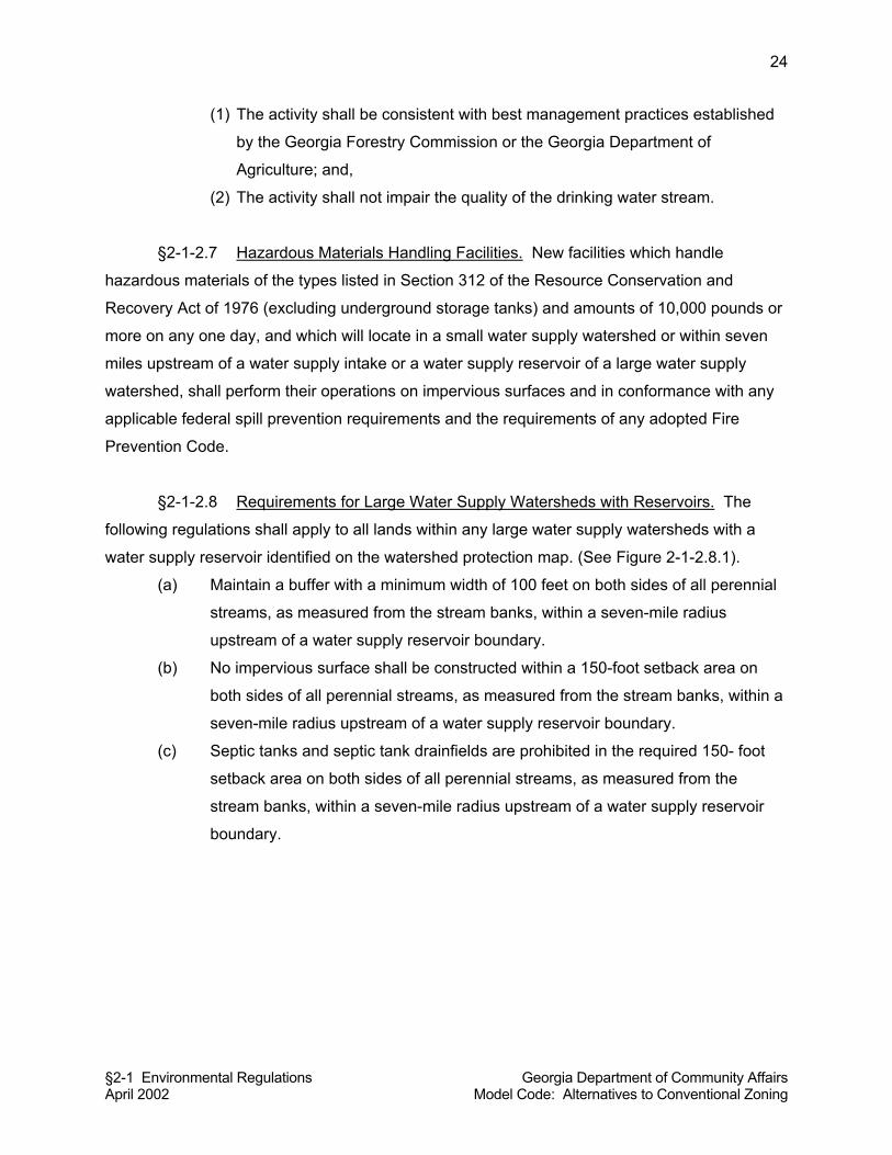
§2-1 Environmental Regulations Georgia Department of Community Affairs April 2002 Model Code: Alternatives to Conventional Zoning
24
(1) The activity shall be consistent with best management practices established
by the Georgia Forestry Commission or the Georgia Department of
Agriculture; and,
(2) The activity shall not impair the quality of the drinking water stream.
§2-1-2.7 Hazardous Materials Handling Facilities. New facilities which handle
hazardous materials of the types listed in Section 312 of the Resource Conservation and
Recovery Act of 1976 (excluding underground storage tanks) and amounts of 10,000 pounds or
more on any one day, and which will locate in a small water supply watershed or within seven
miles upstream of a water supply intake or a water supply reservoir of a large water supply
watershed, shall perform their operations on impervious surfaces and in conformance with any
applicable federal spill prevention requirements and the requirements of any adopted Fire
Prevention Code.
§2-1-2.8 Requirements for Large Water Supply Watersheds with Reservoirs. The
following regulations shall apply to all lands within any large water supply watersheds with a
water supply reservoir identified on the watershed protection map. (See Figure 2-1-2.8.1).
(a) Maintain a buffer with a minimum width of 100 feet on both sides of all perennial
streams, as measured from the stream banks, within a seven-mile radius
upstream of a water supply reservoir boundary.
(b) No impervious surface shall be constructed within a 150-foot setback area on
both sides of all perennial streams, as measured from the stream banks, within a
seven-mile radius upstream of a water supply reservoir boundary.
(c) Septic tanks and septic tank drainfields are prohibited in the required 150- foot
setback area on both sides of all perennial streams, as measured from the
stream banks, within a seven-mile radius upstream of a water supply reservoir
boundary.
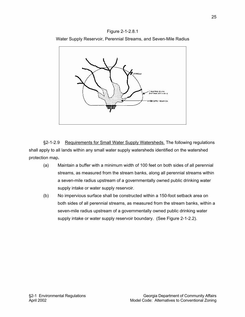
§2-1 Environmental Regulations Georgia Department of Community Affairs April 2002 Model Code: Alternatives to Conventional Zoning
25
Figure 2-1-2.8.1
Water Supply Reservoir, Perennial Streams, and Seven-Mile Radius
§2-1-2.9 Requirements for Small Water Supply Watersheds. The following regulations
shall apply to all lands within any small water supply watersheds identified on the watershed
protection map.
(a) Maintain a buffer with a minimum width of 100 feet on both sides of all perennial
streams, as measured from the stream banks, along all perennial streams within
a seven-mile radius upstream of a governmentally owned public drinking water
supply intake or water supply reservoir.
(b) No impervious surface shall be constructed within a 150-foot setback area on
both sides of all perennial streams, as measured from the stream banks, within a
seven-mile radius upstream of a governmentally owned public drinking water
supply intake or water supply reservoir boundary. (See Figure 2-1-2.2).
§2-1 Environmental Regulations Georgia Department of Community Affairs April 2002 Model Code: Alternatives to Conventional Zoning
26
Figure 2-1-2.2
Buffer and Setback Adjacent to Stream
(c) Septic tanks and septic tank drainfields are prohibited in the required 150- foot
setback area on both sides of all perennial streams, as measured from the
stream banks, within a seven-mile radius upstream of a governmentally owned
public drinking water supply intake or a water supply reservoir boundary.
(d) Maintain a buffer with a minimum width of 50 feet on both sides of all perennial
streams, as measured from the stream banks outside a seven-mile radius
upstream of a governmentally owned public drinking water supply intake or water
supply reservoir.
(e) No impervious surface shall be constructed within a 75-foot setback area on both
sides of all perennial streams, as measured from the stream banks, outside a
seven-mile radius upstream of a governmentally owned public drinking water
supply intake or water supply reservoir boundary.
Commentary: The environmental planning criteria apply to the entire length of a perennial
stream that is in a local government’s jurisdiction, for buffers and setbacks, with other
regulations governing the entire water supply watershed. A local government is only responsible
for implementing these regulations for areas within its jurisdiction.
(f) Septic tanks and septic tank drainfields are prohibited in the required 75- foot
setback area on both sides of all perennial streams, as measured from the
stream banks, outside a seven-mile radius upstream of a governmentally owned
public drinking water supply intake or a water supply reservoir boundary.
STREAM BANKS
BUFFER ZONE
BUFFER ZONE
BUILDING
MINIMUM SETBACK DISTANCE
STREAM
§2-1 Environmental Regulations Georgia Department of Community Affairs April 2002 Model Code: Alternatives to Conventional Zoning
27
(g) New sanitary landfills are allowed only if they have synthetic liners and leachate
collection systems. New hazardous waste treatment or disposal facilities are
prohibited.
(h) The impervious surface area, including all public and private structures, utilities,
or facilities, of the entire small water supply watershed shall be limited to 25
percent, or existing use, whichever is greater.
Commentary: If a small water supply watershed lies within more than one jurisdiction, all of the
local governments within the boundaries of the watershed may agree among themselves on an
allocation program for impervious surfaces that yields a net 25 percent limitation throughout the
watershed. This approach would require all of the local governments within the watershed to
reach a formal impervious surface allocation agreement, and such an agreement would have to
be reflected in the comprehensive plan of each participating local government. As another
alternative, when more than one local government has jurisdiction over a small water supply
watershed, each local government may agree to limit development within their portion of the
watershed to 25 percent impervious surfaces. A third alternative is for the local government to
limit its portion of the small water supply watershed to 25 percent impervious surfaces but then
establish impervious surface ratios for individual land uses (e.g., 15 percent for single family
residential, 35 percent for commercial, etc.) which collectively will achieve the 25% impervious
limitation in their jurisdiction.
§2-1-2.10 Water Supply Reservoirs. A buffer shall be maintained for a
distance of 150 feet from any water supply reservoir boundary as measured from the normal
pool elevation. All development within the 150-foot buffer from any water supply reservoir
boundary, and any uses of the reservoir itself including docks, shall comply with the reservoir
management plan adopted by the County [City] and approved by the Georgia DNR, which is
adopted by reference as if fully set forth herein.
Commentary: The owner of a water supply reservoir is required by the Rules for
Environmental Planning Criteria to develop a reservoir management plan for approval of the
DNR. A reservoir management plan may have been prepared as a part of the local jurisdiction’s
Comprehensive Plan, or may have been prepared in order for the local government to obtain a
DNR water withdrawal permit. Local governments can adopt the reservoir management plan by
reference (as in the provision above), incorporate the specific regulatory provisions of the
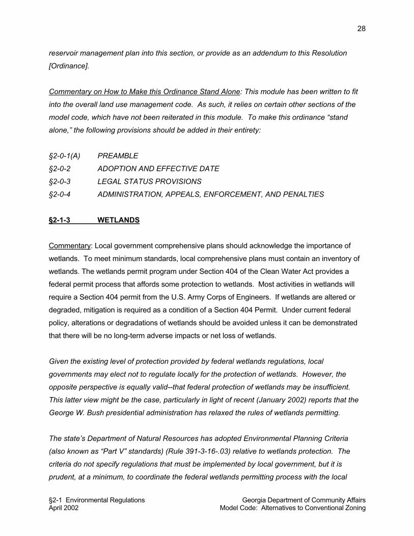
§2-1 Environmental Regulations Georgia Department of Community Affairs April 2002 Model Code: Alternatives to Conventional Zoning
28
reservoir management plan into this section, or provide as an addendum to this Resolution
[Ordinance].
Commentary on How to Make this Ordinance Stand Alone: This module has been written to fit
into the overall land use management code. As such, it relies on certain other sections of the
model code, which have not been reiterated in this module. To make this ordinance “stand
alone,” the following provisions should be added in their entirety:
§2-0-1(A) PREAMBLE
§2-0-2 ADOPTION AND EFFECTIVE DATE
§2-0-3 LEGAL STATUS PROVISIONS
§2-0-4 ADMINISTRATION, APPEALS, ENFORCEMENT, AND PENALTIES
§2-1-3 WETLANDS
Commentary: Local government comprehensive plans should acknowledge the importance of
wetlands. To meet minimum standards, local comprehensive plans must contain an inventory of
wetlands. The wetlands permit program under Section 404 of the Clean Water Act provides a
federal permit process that affords some protection to wetlands. Most activities in wetlands will
require a Section 404 permit from the U.S. Army Corps of Engineers. If wetlands are altered or
degraded, mitigation is required as a condition of a Section 404 Permit. Under current federal
policy, alterations or degradations of wetlands should be avoided unless it can be demonstrated
that there will be no long-term adverse impacts or net loss of wetlands.
Given the existing level of protection provided by federal wetlands regulations, local
governments may elect not to regulate locally for the protection of wetlands. However, the
opposite perspective is equally valid--that federal protection of wetlands may be insufficient.
This latter view might be the case, particularly in light of recent (January 2002) reports that the
George W. Bush presidential administration has relaxed the rules of wetlands permitting.
The state’s Department of Natural Resources has adopted Environmental Planning Criteria
(also known as “Part V” standards) (Rule 391-3-16-.03) relative to wetlands protection. The
criteria do not specify regulations that must be implemented by local government, but it is
prudent, at a minimum, to coordinate the federal wetlands permitting process with the local
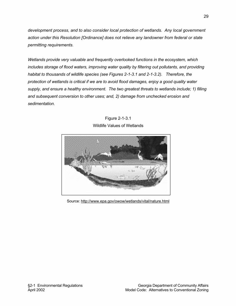
§2-1 Environmental Regulations Georgia Department of Community Affairs April 2002 Model Code: Alternatives to Conventional Zoning
29
development process, and to also consider local protection of wetlands. Any local government
action under this Resolution [Ordinance] does not relieve any landowner from federal or state
permitting requirements.
Wetlands provide very valuable and frequently overlooked functions in the ecosystem, which
includes storage of flood waters, improving water quality by filtering out pollutants, and providing
habitat to thousands of wildlife species (see Figures 2-1-3.1 and 2-1-3.2). Therefore, the
protection of wetlands is critical if we are to avoid flood damages, enjoy a good quality water
supply, and ensure a healthy environment. The two greatest threats to wetlands include; 1) filling
and subsequent conversion to other uses; and, 2) damage from unchecked erosion and
sedimentation.
Figure 2-1-3.1
Wildlife Values of Wetlands
Source: http://www.epa.gov/owow/wetlands/vital/nature.html
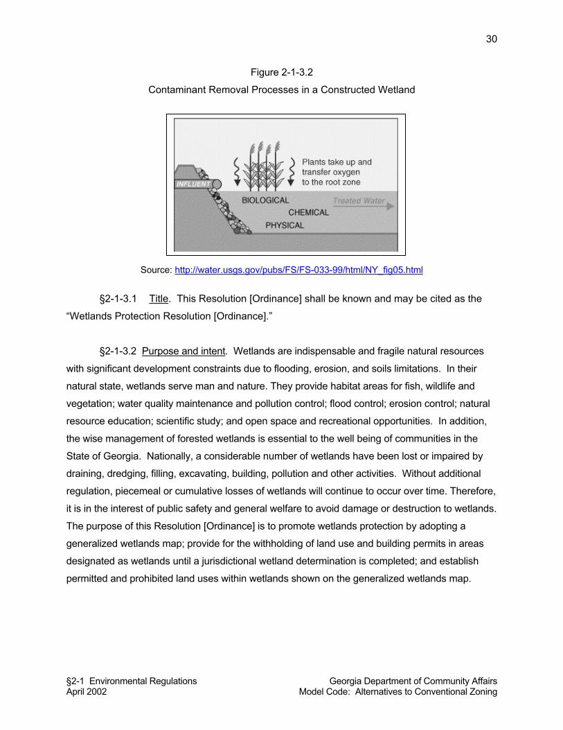
§2-1 Environmental Regulations Georgia Department of Community Affairs April 2002 Model Code: Alternatives to Conventional Zoning
30
Figure 2-1-3.2
Contaminant Removal Processes in a Constructed Wetland
Source: http://water.usgs.gov/pubs/FS/FS-033-99/html/NY_fig05.html
§2-1-3.1 Title. This Resolution [Ordinance] shall be known and may be cited as the
“Wetlands Protection Resolution [Ordinance].”
§2-1-3.2 Purpose and intent. Wetlands are indispensable and fragile natural resources
with significant development constraints due to flooding, erosion, and soils limitations. In their
natural state, wetlands serve man and nature. They provide habitat areas for fish, wildlife and
vegetation; water quality maintenance and pollution control; flood control; erosion control; natural
resource education; scientific study; and open space and recreational opportunities. In addition,
the wise management of forested wetlands is essential to the well being of communities in the
State of Georgia. Nationally, a considerable number of wetlands have been lost or impaired by
draining, dredging, filling, excavating, building, pollution and other activities. Without additional
regulation, piecemeal or cumulative losses of wetlands will continue to occur over time. Therefore,
it is in the interest of public safety and general welfare to avoid damage or destruction to wetlands.
The purpose of this Resolution [Ordinance] is to promote wetlands protection by adopting a
generalized wetlands map; provide for the withholding of land use and building permits in areas
designated as wetlands until a jurisdictional wetland determination is completed; and establish
permitted and prohibited land uses within wetlands shown on the generalized wetlands map.
§2-1 Environmental Regulations Georgia Department of Community Affairs April 2002 Model Code: Alternatives to Conventional Zoning
31
§2-1-3.3 Definitions.
Generalized wetlands map: A map of wetlands provided in the County’s [City’s] comprehensive
plan [and/or: any U.S. Fish and Wildlife Service National Wetlands Inventory (NWI) map
showing wetlands within the local jurisdiction].
Commentary: If the local government’s wetlands map, as found in the Comprehensive Plan, is
sufficiently detailed (e.g., based on special studies or a mapping of hydric soils), it might be used
as the Generalized Wetlands Map. The NWI maps referenced in the definition above are
sufficiently detailed and can be used in the development review process. Note that the
generalized wetland map does not necessarily represent the boundaries of jurisdictional wetlands
within [name of local government] and cannot serve as a substitute for a delineation of wetland
boundaries by the U.S. Army Corps of Engineers, as required by Section 404 of the Clean Water
Act, as amended.
National Wetlands Inventory (NWI) maps are available in both digital (computer) and paper
format. The digital maps are available on the World Wide Web at www.nwi.fws.gov. Some
areas of the state have been digitally mapped and are available for downloading. To obtain
paper copies of NWI maps, contact either: (1) Division of Natural Resources, Georgia Natural
Heritage Program, 2117 U.S. Highway 278 SE, Social Circle, Georgia 30025, Phone:
770.918.6411; or (2) Georgia Geologic Survey Room 4063 19 Martin Luther King Jr. Dr. SW,
Atlanta, GA 30334-9004, Phone (404) 657-6127. Local governments can also contact their
Regional Development Center for assistance.
Jurisdictional wetland: An area that meets the definitional requirements for wetlands as
determined by the U.S. Army Corps of Engineers.
Commentary: The U.S. Army Corps of Engineers’ definition is quite restrictive; in order for an
area to qualify as a “wetland” it requires that all three wetland parameters be present. Although
the Corps’ definition is the most common definition used, it may result in the City or County
losing some valuable wetlands. As an alternative to deferring to the Corps’ definition, a local
government might require an environmental impact review (see Module 6.5 of this model code)
for proposed developments including areas shown on the NWI maps as wetlands. The U.S.
§2-1 Environmental Regulations Georgia Department of Community Affairs April 2002 Model Code: Alternatives to Conventional Zoning
32
Fish and Wildlife Service’s definition of wetland requires just one of the three wetland
parameters to be present and would afford a higher degree of wetlands protection.
Jurisdictional wetland determination: A delineation of jurisdictional wetland boundaries by the
U.S. Army Corps of Engineers, as required by Section 404 of the Clean Water Act, 33 U.S.C.
§1344, as amended.
Regulated activity: Any activity which will, or which may reasonably be expected to, result in the
discharge of dredged or fill material into waters of the U.S. excepting those activities exempted
in Section 404 of the Federal Clean Water Act.
Wetlands: Those areas that are inundated or saturated by surface or groundwater at a
frequency and duration sufficient to support, and that under normal circumstances do support, a
prevalence of vegetation typically adapted for life in saturated soil conditions. Wetlands
generally include swamps, marshes, bogs, and similar areas (see Figure 2-1-3.3.1). The
ecological parameters for designating wetlands include hydric soils, hydrophytic vegetation, and
hydrological conditions that involve a temporary or permanent source of water to cause soil
saturation.
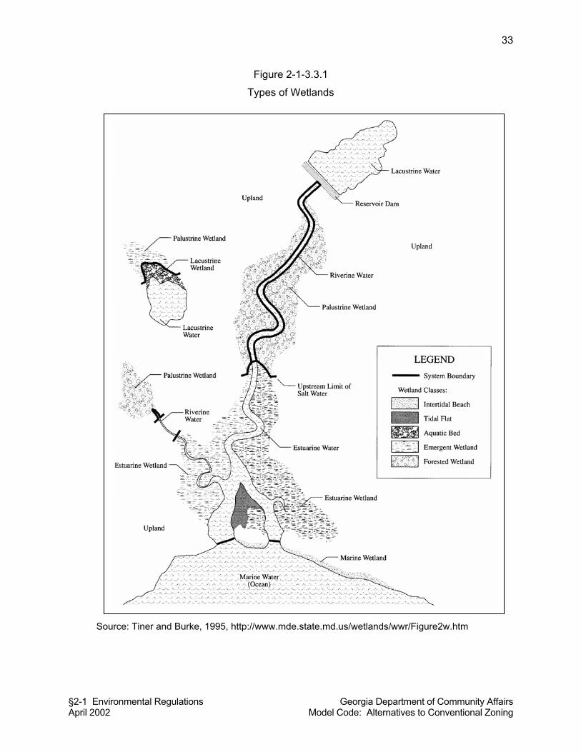
§2-1 Environmental Regulations Georgia Department of Community Affairs April 2002 Model Code: Alternatives to Conventional Zoning
33
Figure 2-1-3.3.1
Types of Wetlands
Source: Tiner and Burke, 1995, http://www.mde.state.md.us/wetlands/wwr/Figure2w.htm
§2-1 Environmental Regulations Georgia Department of Community Affairs April 2002 Model Code: Alternatives to Conventional Zoning
34
§2-1-3.4 Adoption of Generalized Wetlands Map by Reference. The Generalized
Wetlands Map, as defined by this Resolution [Ordinance], together with all explanatory matter
thereon, is hereby adopted by reference, and hereby made a part of this Resolution [Ordinance]
as if fully set forth herein.
§2-1-3.5 Applicability. This Resolution [Ordinance] shall apply to all lands within the
County [City] of __________ that are shown on the Generalized Wetlands map, as defined by
this Resolution [Ordinance], as wetlands.
§2-1-3.6 Permit Required. No land use permit or building permit shall be issued by the
Land Use Officer for a land use, building, structure, or manufactured home, nor shall any
regulated activity as defined by this Resolution [Ordinance] commence, unless the land use,
building, structure, manufactured home or regulated activity conforms to the requirements of this
Resolution [Ordinance]. Prior to a land use permit or building permit being issued, the Land Use
Officer shall require a site plan or subdivision plat in sufficient detail to review the proposed
development for compliance with the provisions of this Resolution [Ordinance].
§2-1-3.7 Jurisdictional Wetland Determination Required. If an area proposed for
development is located within 50 feet of a wetland as shown on the Generalized Wetlands Map,
as determined by the Land Use Officer, no local land use permit or building permit on said
wetland shall be issued until a jurisdictional wetland determination has been completed and
either of the following occur:
(a) The U.S. Army Corps of Engineers determines that there are jurisdictional
wetlands present on the proposed development site, a Section 404 permit is
required, and either a Section 404 Permit or a letter of permission is issued by
the Corps for the proposed development; or,
(b) The U.S. Army Corps of Engineers determines that jurisdictional wetlands are not
present on the proposed development site, and no Section 404 permit or letter of
permission is required.
Commentary: Local governments must compare projects to their generalized wetlands maps to
see if particular projects appear to be near or within a wetland. If they are, then the developer
needs to consult with the U.S. Army Corps of Engineers before issuance of any local permit. If
there are no jurisdictional wetlands on site, the local government permitting process can proceed.
§2-1 Environmental Regulations Georgia Department of Community Affairs April 2002 Model Code: Alternatives to Conventional Zoning
35
If there are jurisdictional wetlands on the site that will be disturbed by the proposed development,
the code section above requires that the applicant first obtain a wetlands permit or permission
from the U.S. Army Corps of Engineers. The 50 feet, referenced in the above section, is
considered an absolute minimum. Some local governments use 100-200 feet as a measurement
to err on the safe side.
§2-1-3.8 Permitted uses. The following uses shall be allowed as of right within an area
shown as a wetland on the Generalized Wetlands Map, to the extent that they are not prohibited
by any other ordinance or law, including laws of trespass, and provided they do not require
structures, grading, fill, draining, or dredging except as provided herein.
(a) Conservation or preservation of soil, water, vegetation, fish and other wildlife,
provided it does not affect waters of Georgia or of the Unites States in such a
way that would require an individual 404 Permit.
(b) Outdoor passive recreational activities, including fishing, bird watching, hiking,
boating, horseback riding, and canoeing.
(c) Forestry practices applied in accordance with best management practices
approved by the Georgia Forestry Commission and as specified in Section 404 of
the Clean Water Act.
(d) The cultivation of agricultural crops. Agricultural activities shall be subject to best
management practices approved by the Georgia Department of Agriculture.
(e) The pasturing of livestock, provided that riparian wetlands are protected, that soil
profiles are not disturbed and that approved agricultural Best Management
Practices are followed.
(f) Education, scientific research, and nature trails.
Commentary: The activities listed in this section are exempted from Section 404 regulations
provided they do not have impacts on a navigable waterway that would necessitate acquisition of
an individual 404 permit. However, under Section 10 of the Rivers and Harbors Act, a permit may
be required in some circumstances. Some activities that destroy or degrade wetlands, but are not
regulated by Section 404, including timber harvesting and certain agricultural activities, are listed
as possible permitted uses in the Environmental Planning Criteria for Wetlands Protection.
§2-1-3.9 Prohibited Uses. The following uses are prohibited within wetlands shown on
the Generalized Wetlands Map:
§2-1 Environmental Regulations Georgia Department of Community Affairs April 2002 Model Code: Alternatives to Conventional Zoning
36
(a) Receiving areas for toxic or hazardous waste or other contaminants.
(b) Hazardous or sanitary waste landfills.
(c) [List any other uses the local government wants to prohibit].
Commentary on How to Make this Ordinance Stand Alone: This module has been written to fit into
a land use management code. As such, it relies on certain other sections of the model code,
which have not been reiterated in this module. To make this ordinance “stand alone,” the
following provisions should be added in their entirety:
§2-0-1(A) PREAMBLE
§2-0-2 ADOPTION AND EFFECTIVE DATE
§2-0-3 LEGAL STATUS PROVISIONS
§2-0-4 ADMINISTRATION, APPEALS, ENFORCEMENT, AND PENALTIES
Resources:
For a more detailed freshwater wetlands ordinance, see Yorktown, New York’s ordinance as
published in Michael A. Mantell, Stephen F. Harper, and Luther Propst, Resource Guide for
Creating Successful Communities (Washington, DC: Island Press, 1990).
§2-1-4 PROTECTED RIVER CORRIDORS
Commentary on Applicability: The State of Georgia has promulgated standards for the
protection of river corridors meeting a minimum threshold for water flow (400 cubic feet per
second or more). This ordinance is specifically designed to implement the state Department of
Natural Resources’ Environmental Planning Criteria for Protected River Corridors. If the local
government does not have any protected river corridors within its jurisdiction, then it does not
need to adopt this ordinance. §2-1-4.1 Title. This Resolution [Ordinance] shall be known and may be cited as a
“Protected River Corridors Resolution [Ordinance].”
§2-1-4.2 Purpose. River corridors are the strips of land that flank major rivers in
Georgia. These corridors are of vital importance to Georgia in that they help preserve those
§2-1 Environmental Regulations Georgia Department of Community Affairs April 2002 Model Code: Alternatives to Conventional Zoning
37
qualities that make a river suitable as a habitat for wildlife, a site for recreation, and a source for
clean drinking water. River corridors also allow the free movement of wildlife from area to area
within the state, help control erosion and river sedimentation, and help absorb floodwaters. The
[River Name] has been designated as a protected river by the State of Georgia. The purpose of
this Resolution [Ordinance] is to establish measures to guide future growth and development in
the areas adjacent to the protected river as defined herein. The river corridor regulations
established in this Resolution [Ordinance] require the maintenance of buffers where natural
vegetation is left intact along the banks of protected rivers. Preservation of the soil and plants
within the corridor reduces non-point source pollution entering the river and minimizes riverbank
erosion. The vegetation acts to slow down water flow and trap sediment and other
contaminants carried in runoff before they reach downstream water supplies. This Resolution
[Ordinance] also minimizes disturbance of the natural terrain and vegetation and protects water
quality through various use limitations.
§2-1-4.3 Definitions.
Hazardous waste: Any solid waste which has been defined as a hazardous waste in regulations
promulgated by the administrator of the United States Environmental Protection Agency
pursuant to the federal act, which are in force and effect on February 1, 1988, codified as 40
C.F.R. Section 261.3. (Note: This is same definition as used in the Georgia Hazardous Waste
Management Act.)
Land disturbing activity: Any grading, scraping, excavating, or filling of land; clearing of
vegetation; and any construction, rebuilding, or alteration of a structure. Land-disturbing activity
shall not include activities such as ordinary maintenance and landscaping operations, individual
home gardens, yard and grounds upkeep, repairs, additions or minor modifications to a single-
family dwelling, and the cutting of firewood for personal use.
Natural vegetative buffer or buffer area: A river corridor containing the flora native to that area.
The natural floras for specific areas are described in Georgia Geologic Survey Bulletin 114,
“The Natural Environments of Georgia.” Habitats for endangered and threatened species may
require human management of the river corridor in order to maintain those species.
Perennial river: A river or section of a river that flows continuously throughout the year.
Port facility: Any facility for the docking, loading, and unloading of ships.
Protected river: Any perennial river or watercourse with an average annual flow of at least 400
cubic feet per second as determined by the appropriate U.S. Geological Survey quadrangle
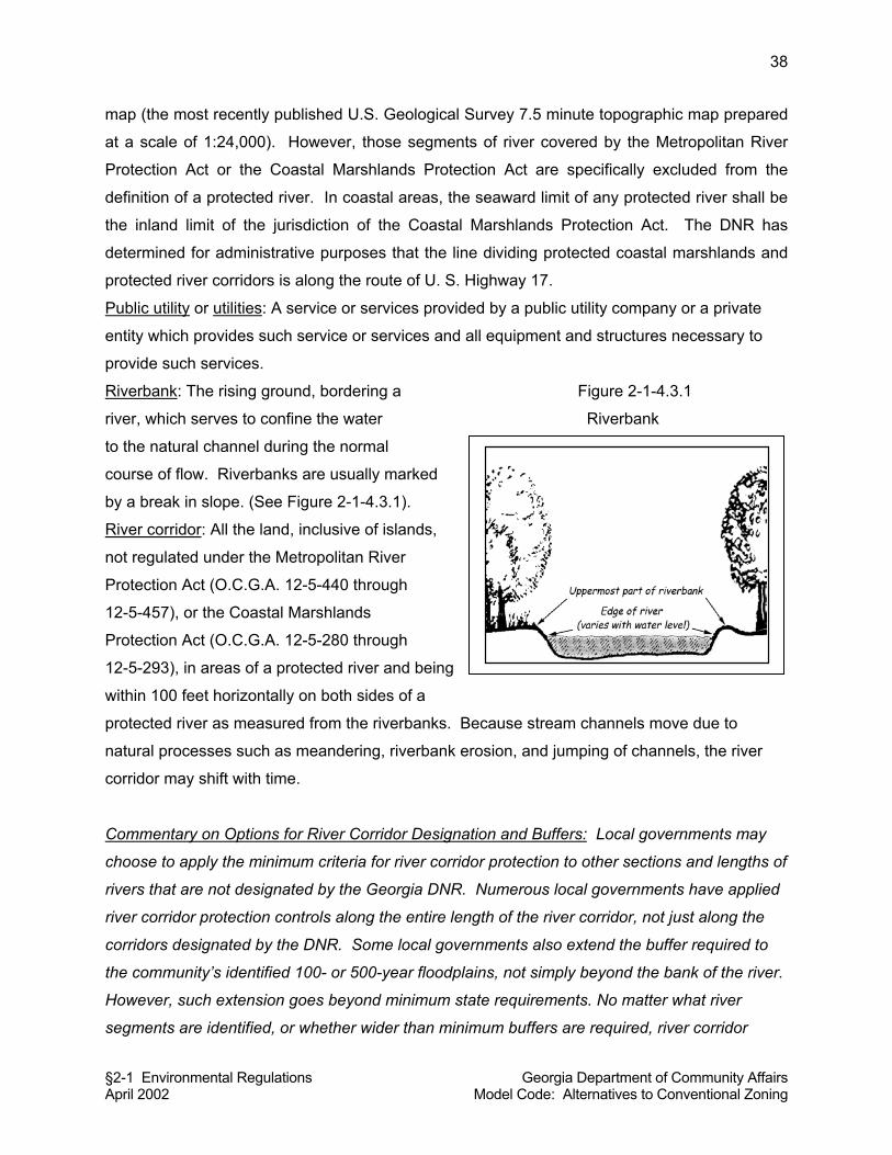
§2-1 Environmental Regulations Georgia Department of Community Affairs April 2002 Model Code: Alternatives to Conventional Zoning
38
map (the most recently published U.S. Geological Survey 7.5 minute topographic map prepared
at a scale of 1:24,000). However, those segments of river covered by the Metropolitan River
Protection Act or the Coastal Marshlands Protection Act are specifically excluded from the
definition of a protected river. In coastal areas, the seaward limit of any protected river shall be
the inland limit of the jurisdiction of the Coastal Marshlands Protection Act. The DNR has
determined for administrative purposes that the line dividing protected coastal marshlands and
protected river corridors is along the route of U. S. Highway 17.
Public utility or utilities: A service or services provided by a public utility company or a private
entity which provides such service or services and all equipment and structures necessary to
provide such services.
Riverbank: The rising ground, bordering a Figure 2-1-4.3.1
river, which serves to confine the water Riverbank
to the natural channel during the normal
course of flow. Riverbanks are usually marked
by a break in slope. (See Figure 2-1-4.3.1).
River corridor: All the land, inclusive of islands,
not regulated under the Metropolitan River
Protection Act (O.C.G.A. 12-5-440 through
12-5-457), or the Coastal Marshlands
Protection Act (O.C.G.A. 12-5-280 through
12-5-293), in areas of a protected river and being
within 100 feet horizontally on both sides of a
protected river as measured from the riverbanks. Because stream channels move due to
natural processes such as meandering, riverbank erosion, and jumping of channels, the river
corridor may shift with time.
Commentary on Options for River Corridor Designation and Buffers: Local governments may
choose to apply the minimum criteria for river corridor protection to other sections and lengths of
rivers that are not designated by the Georgia DNR. Numerous local governments have applied
river corridor protection controls along the entire length of the river corridor, not just along the
corridors designated by the DNR. Some local governments also extend the buffer required to
the community’s identified 100- or 500-year floodplains, not simply beyond the bank of the river.
However, such extension goes beyond minimum state requirements. No matter what river
segments are identified, or whether wider than minimum buffers are required, river corridor
§2-1 Environmental Regulations Georgia Department of Community Affairs April 2002 Model Code: Alternatives to Conventional Zoning
39
policy should be fully described in the comprehensive plan in order to provide additional legal
rationale for any regulatory efforts.
Sensitive natural area: Any area, as identified now or hereafter by the DNR, which contain one
or more of the following: habitat, including nesting sites, occupied by rare or endangered
species; rare or exemplary natural communities; significant landforms, hydroforms, or geological
features; or other areas so designated by the DNR; and which are sensitive or vulnerable to
physical or biological alteration.
Single-family dwelling: A dwelling structure that is designed for the use of one family or
household.
§2-1-4.4 Applicability. This Resolution [Ordinance] shall apply to all protected rivers,
as defined by this Resolution [Ordinance], and to all river corridors, as defined by this
Resolution [Ordinance]. The regulations in this Resolution [Ordinance] shall not supercede
those contained in the Metropolitan River Protection Act, the Coastal Marshlands Protection Act,
and the Erosion and Sedimentation Act.
Commentary: In the spirit of simplifying implementation by local governments, the model code
module does not require a map of protected rivers and the Rules for Environmental Planning
Criteria do not require adoption of a map. However, local governments may at their discretion
adopt a protected rivers map that illustrate river corridors on a map. This model code module
does not require a map of protected rivers in the spirit of simplifying implementation by local
government.
§2-1-4.5 Protected River Corridor Buffer Required. Along any protected river, as
defined by this Resolution [Ordinance], the river corridor, as defined by this Resolution
[Ordinance] shall be maintained as a natural vegetative buffer or buffer area as defined by this
Resolution [Ordinance], except as specifically otherwise exempted or provided for in this
Resolution [Ordinance]. (See Figure 2-1-4.5.1).
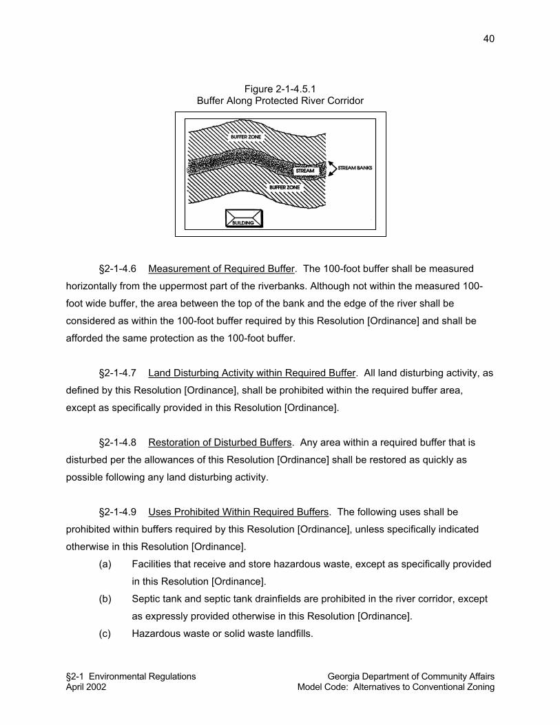
§2-1 Environmental Regulations Georgia Department of Community Affairs April 2002 Model Code: Alternatives to Conventional Zoning
40
Figure 2-1-4.5.1 Buffer Along Protected River Corridor
§2-1-4.6 Measurement of Required Buffer. The 100-foot buffer shall be measured
horizontally from the uppermost part of the riverbanks. Although not within the measured 100-
foot wide buffer, the area between the top of the bank and the edge of the river shall be
considered as within the 100-foot buffer required by this Resolution [Ordinance] and shall be
afforded the same protection as the 100-foot buffer.
§2-1-4.7 Land Disturbing Activity within Required Buffer. All land disturbing activity, as
defined by this Resolution [Ordinance], shall be prohibited within the required buffer area,
except as specifically provided in this Resolution [Ordinance].
§2-1-4.8 Restoration of Disturbed Buffers. Any area within a required buffer that is
disturbed per the allowances of this Resolution [Ordinance] shall be restored as quickly as
possible following any land disturbing activity.
§2-1-4.9 Uses Prohibited Within Required Buffers. The following uses shall be
prohibited within buffers required by this Resolution [Ordinance], unless specifically indicated
otherwise in this Resolution [Ordinance].
(a) Facilities that receive and store hazardous waste, except as specifically provided
in this Resolution [Ordinance].
(b) Septic tank and septic tank drainfields are prohibited in the river corridor, except
as expressly provided otherwise in this Resolution [Ordinance].
(c) Hazardous waste or solid waste landfills.
§2-1 Environmental Regulations Georgia Department of Community Affairs April 2002 Model Code: Alternatives to Conventional Zoning
41
(d) Local governments may exclude other unacceptable uses, as it deems
appropriate.
§2-1-4.10 Uses Permitted Within Required Buffers.
(a) Agricultural production and management, provided that all such activities shall be
consistent with best management practices established by the Georgia Soil and
Water Conservation Commission and provided that such activities shall not
impair the drinking quality of the river water as defined by the Federal Clean
Water Act, as amended; and provided that such activities shall be consistent with
all state and federal laws, and all regulations promulgated by the Georgia
Department of Agriculture.
(b) Any use permitted by the Georgia DNR or under Section 404 of the Clean Water
Act.
(c) Any use not prohibited by this Resolution [Ordinance] and not otherwise specified
and regulated under the terms of this Resolution [Ordinance], that lawfully
existed on the effective date of this Resolution [Ordinance] and falls within one of
the following categories:
(1) Completed;
(2) Under construction;
(3) Fully approved by the governing authority;
(4) All materials have been submitted for approval by the governing authority;
or,
(5) Zoned for such use and expenditures in excess of $2,500 have been
made in preparation for construction in accordance with such zoning.
Commentary: The Rules state, “c) Land uses existing prior to the promulgation of a River
Corridor Protection Plan means any land use or land-disturbing activity, including all human
endeavors directly associated with such use or activity, which, prior to the promulgation of the
River Corridor Protection Plan falls within one of the following categories:
(a) Is complete;
(b) Is under construction;
(c) Is fully approved by the governing authority;
§2-1 Environmental Regulations Georgia Department of Community Affairs April 2002 Model Code: Alternatives to Conventional Zoning
42
(d) All materials have been submitted for approval by the governing authority; or
(e) Is zoned for such use and expenditures in excess of $2,500.00 have been made
in preparation for construction in accordance with such zoning.”
(d) Dwellings, including single-family detached and manufactured homes, including
the usual appurtenances or accessory uses, subject to the following conditions:
(1) The dwelling shall be in compliance with all local land use regulations.
(2) The dwelling shall be located on a tract of land containing at least two
acres. For the purposes of these standards, the size of the tract of the
land shall not include any area that lies within the protected river. That is,
for tracts of land that include portions of a protected river, the area
between the riverbanks can not be counted towards the two-acre
minimum size.
(3) There shall be only one such dwelling on each two-acre or larger tract of
land.
(4) A septic tank or tanks serving such a dwelling may be located within the
buffer area, but septic tank drainfields shall not be located within the
buffer area.
Commentary: The state environmental planning criteria for river corridors specify a minimum lot
size (two acres), but no minimum lot width. Local governments might want to set a minimum lot
width (e.g., 200 feet) to supplement the state standards. Otherwise, very narrow two-acre lots
could be created within river corridors.
(e) Industrial and commercial land uses existing in the river corridor on the effective
date of this Resolution [Ordinance] provided that such existing land uses do not
impair the drinking quality of the river water and meet all state and federal
environmental rules and regulations.
(f) Mining activities, if permitted by the DNR pursuant to the Georgia Surface Mining
Act of 1968, as amended.
(g) Port facilities that handle, receive and store hazardous waste, provided that they
meet all federal and state laws and regulations for the handling and transport of
hazardous waste and those facilities handling hazardous waste perform their
operations on impermeable surfaces having spill and leak protection systems in
§2-1 Environmental Regulations Georgia Department of Community Affairs April 2002 Model Code: Alternatives to Conventional Zoning
43
conformance with any applicable Environmental Protection Agency (EPA) spill
prevention requirements and any local fire code requirements.
(h) Recreational uses consistent either with the maintenance of a natural vegetative
buffer or with river-dependent recreation, specifically including paths, walkways,
and boat ramps but excluding hard-surface tennis courts and parking lots.
(i) Road crossings and utility crossings, provided such construction meets all
requirements of the Erosion and Sedimentation Control Act of 1975, and all
applicable local ordinances on soil erosion and sedimentation control; provided
further, that utilities shall only be allowed if they cannot feasibly be located
outside the buffer, as decided conservatively by the Land Use Officer, and further
provided that:
(1) The utilities shall be located as far from the riverbank as reasonably
possible;
(2) Installation and maintenance of the utilities shall be such as to protect the
integrity of the buffer area as well as is reasonably possible; and,
(3) Utilities shall not impair the drinking quality of the river water.
(j) Timber production and harvesting, provided that such uses do not impair the
long-term functions of the protected river or the river corridor, provided that such
forestry activity shall be consistent with best management practices established
by the Georgia Forestry Commission, and such activity shall not impair the
drinking quality of the river water as defined by the federal Clean Water Act, as
amended.
(k) Wildlife and fisheries management activities consistent with the purposes of
O.C.G.A. 12-2-8.
(l) Waste-water treatment.
(m) Water quality treatment or purification.
§2-1-4.11 Land Use Permit and Site Plan Required. No land use permit or building
permit shall be issued by the land use officer for a building, structure, or activity, unless the land
use, building, or activity conforms to the requirements of this Resolution [Ordinance]. Prior to a
land use permit or building permit being issued, the Land Use Officer shall require a site plan in
sufficient detail to review the proposed development for compliance with the provisions of this
Resolution [Ordinance].
§2-1 Environmental Regulations Georgia Department of Community Affairs April 2002 Model Code: Alternatives to Conventional Zoning
44
§2-1-4.12 Subdivision Plats. Within an area governed by this Resolution [Ordinance],
no subdivision plat shall be recorded until and unless said plat has been reviewed and approved
by the Land Use Officer as being in compliance with any minimum lot size established by this
Resolution [Ordinance].
Commentary on making this ordinance stand-alone: This module has been written so that it will
fit into the land use management code. As such, it relies on certain other sections of the model
code, which have not been reiterated in this module. To make this ordinance “stand alone,” the
following provisions should be added in their entirety:
§2-0-1(A) PREAMBLE
§2-0-2 ADOPTION AND EFFECTIVE DATE
§2-0-3 LEGAL STATUS PROVISIONS
§2-0-4 ADMINISTRATION, APPEALS, ENFORCEMENT, AND PENALTIES
§2-1-5 MOUNTAIN PROTECTION
Commentary on Applicability: This ordinance is specifically designed to implement the state
Department of Natural Resources’ criteria relative to mountain protection pursuant to the
Mountain and River Corridor Protection Act. A protected mountain includes all land area 2,200
feet or more above mean sea level, that has a percentage slope of 25 percent or greater for at
least 500 feet, horizontally. It includes the crests, summits, and ridge tops that lie at elevations
higher than any such area. This module is written for cities and counties in north Georgia with
protected mountains within their jurisdiction. If your jurisdiction has no protected mountains as
defined by state law and state administrative rules, then it is not necessary to adopt this code
section.
§2-1-5.1 Purpose. Steep slopes and thin soils characterize the mountains of Georgia.
Because of the natural stresses placed on such environments, they require special protection.
Land-disturbing activity on the high-elevation, steep-slope mountains of Georgia potentially
threatens the public health, safety, welfare, and economic progress of the state. Unregulated
land-disturbing activity may endanger the quality of surface water by increasing erosion and
stream sedimentation; has the potential to induce landslides; has the potential to adversely
affect ground water due to the difficulty in providing proper sewage disposal in areas of steep
§2-1 Environmental Regulations Georgia Department of Community Affairs April 2002 Model Code: Alternatives to Conventional Zoning
45
slope and high elevation; may damage the habitat for some species of wildlife (both plants and
animals); and may detract from the mountains' scenic and natural beauty, which is vital to the
recreation and tourism industry of North Georgia.
§2-1-5.2 Definitions.
Hazardous waste: Any solid waste which has been defined as a hazardous waste in regulations
promulgated by the administrator of the United States Environmental Protection Agency
pursuant to the federal act, which are in force and effect on February 1, 1988, codified as 40
C.F.R. Section 261.3.
Commentary: This is the same definition as used in the Georgia Hazardous Waste Management
Act.
Land-disturbing activity: Any grading, scraping, excavating, or filling of land; clearing of
vegetation; and any construction, rebuilding, or alteration of a structure. Land-disturbing activity
shall not include activities such as ordinary maintenance and landscaping operations, individual
home gardens, yard and grounds upkeep, repairs, additions or minor modifications to a single-
family dwelling, and the cutting of firewood for personal use.
Multi-family dwelling: A structure that contains multiple dwelling units.
Protected mountain: All land area 2,200 feet or more above mean sea level that has a
percentage slope of 25 percent or greater for at least 500 feet, horizontally, including the crests,
summits, and ridge tops which lie at elevations higher than any such area.
Quadrangle map: The most recently published U.S. Geological Survey 7.5-minute topographic
map prepared at a scale of 1:24,000.
Protected mountains map: A map, based on quadrangle maps for the local jurisdiction, prepared
by or for the local jurisdiction showing all land areas meeting the definition of protected
mountain.
Reforestation plan: A plan, prepared by a registered forester, for replacing harvested timber by
replanting or by natural regenerative processes (such as coppicing, seed trees, etc.), consistent
with the Recommended Best Management Practices for Forestry in Georgia, as published by
the Georgia Forestry Commission.
Sensitive natural area: Any area, as identified now or hereafter by the Department of Natural
Resources (DNR), which contains one or more of the following: habitat, including nesting sites,
§2-1 Environmental Regulations Georgia Department of Community Affairs April 2002 Model Code: Alternatives to Conventional Zoning
46
occupied by rare or endangered species; rare or exemplary natural communities; significant
landforms, hydroforms, or geological features; or other areas so designated by the Department
of Natural Resources; and which is sensitive or vulnerable to physical or biological alteration.
Single-family dwelling means a dwelling structure that is designed for the use of one family.
§2-1-5.3 Adoption of protected mountains map by reference. The protected mountains
map, as defined by this Resolution [Ordinance], is hereby adopted and made a part of this
Resolution [Ordinance] as if fully set forth herein.
Commentary: The city or county comprehensive plan should, per state administrative rules,
provide a map of protected mountains. Such map might be detailed enough to be applied in the
development review process. If not, local governments will need to create a protected
mountains map. To create a protected mountains map, it is required that either U.S.G.S. 7.5
quadrangle maps or a plat map be used as a base. These quadrangle maps can be obtained
from the Georgia Geologic Survey, Room 400, 19 Martin Luther King Jr. Drive, Atlanta, Georgia
30334. Phone: (404) 656-3214. Local governments should refer to their RDC for technical
assistance with regard to preparing protected mountains maps.
§2-1-5.4 Applicability. This Resolution [Ordinance] shall apply to all lands within the
County [City] of __________ that are protected mountains as defined by this Resolution
[Ordinance] and as shown on the protected mountains map as defined by and made a part of
this Resolution [Ordinance].
§2-1-5.5 Permit Required. No land use permit or building permit shall be issued by the
Land Use Officer for any activity, land use, building, or structure within a protected mountain
area, unless the activity, land use, building, or structure conforms to the requirements of this
Resolution [Ordinance]. Prior to a land use permit or building permit being issued, the Land Use
Officer shall require a site plan or subdivision plat in sufficient detail to review the proposed
development for compliance with the provisions of this Resolution [Ordinance]. All development
activities or site work conducted after approval of the site plan shall conform to the
specifications of said site plan.
§2-1-5.6 Development Regulations. Except as more specifically provided herein, the
following regulations shall apply.
§2-1 Environmental Regulations Georgia Department of Community Affairs April 2002 Model Code: Alternatives to Conventional Zoning
47
(a) Proposed land-disturbing activity shall meet all applicable requirements of the
"Erosion and Sedimentation Act of 1975” as amended, and all applicable local
ordinances on soil erosion and sedimentation control.
(b) Where one or more septic tanks are to be used for individual sewage disposal,
the proposed land-disturbing activity shall meet all applicable requirements
imposed by the Local Governing Authority.
(c) Where one or more wells are to be used for an individual’s water supply, the
proposed land-disturbing activity shall meet all applicable requirements of the
"Water Well Standards Act of 1985"; the requirements of the rules and
regulations of the Department of Human Resources regarding individual or
nonpublic wells; [and, any more stringent requirements imposed by the local
governing authority].
(d) If sewage treatment is to be provided by any means other than one or more
individual septic tanks, the sewage treatment shall meet all applicable
requirements of the "Georgia Water Quality Control Act."
(e) If a public water supply system is to be provided, the water supply system shall
meet all applicable requirements of the "Georgia Safe Drinking Water Act of
1977."
(f) Single-family dwellings shall not be constructed at a density of more than one per
acre and no such acre shall be less than 100-feet wide at the building site. This
density restriction shall not apply to:
(1) Any lot of less than one acre, if such a lot was, as of the date of the
adoption of this Resolution [Ordinance], owned and described as a
discrete parcel of real property according to the instrument of title of the
person or persons owning the lot on said date;
(2) Any lot of less than one acre, if such a lot was, as of the date of the
adoption of this Resolution [Ordinance], shown as a discrete parcel of real
property on a plat of survey properly recorded in the real property records
of the clerk of superior court by the person or persons owning the lot on
said date; or,
(3) Any land, or part of any land, which was contained in or subject to any
master plan, planned unit development plan, special approved
development plan, or any other development plan if such plan was filed
with and approved by the Local Governing Authority prior to the date of
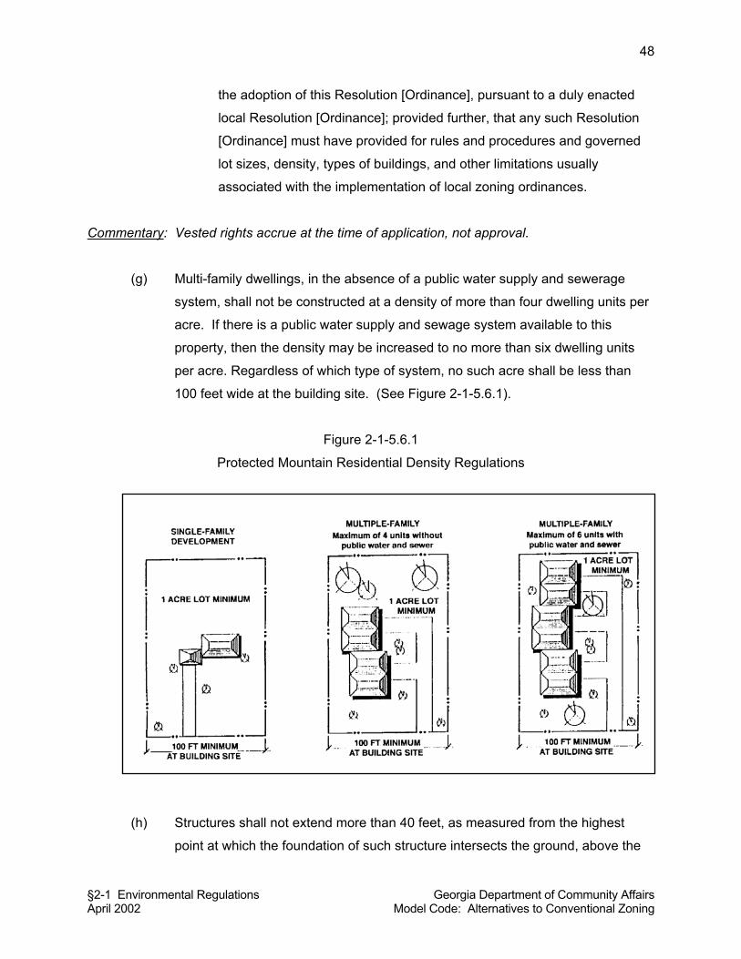
§2-1 Environmental Regulations Georgia Department of Community Affairs April 2002 Model Code: Alternatives to Conventional Zoning
48
the adoption of this Resolution [Ordinance], pursuant to a duly enacted
local Resolution [Ordinance]; provided further, that any such Resolution
[Ordinance] must have provided for rules and procedures and governed
lot sizes, density, types of buildings, and other limitations usually
associated with the implementation of local zoning ordinances.
Commentary: Vested rights accrue at the time of application, not approval.
(g) Multi-family dwellings, in the absence of a public water supply and sewerage
system, shall not be constructed at a density of more than four dwelling units per
acre. If there is a public water supply and sewage system available to this
property, then the density may be increased to no more than six dwelling units
per acre. Regardless of which type of system, no such acre shall be less than
100 feet wide at the building site. (See Figure 2-1-5.6.1).
Figure 2-1-5.6.1
Protected Mountain Residential Density Regulations
(h) Structures shall not extend more than 40 feet, as measured from the highest
point at which the foundation of such structure intersects the ground, above the
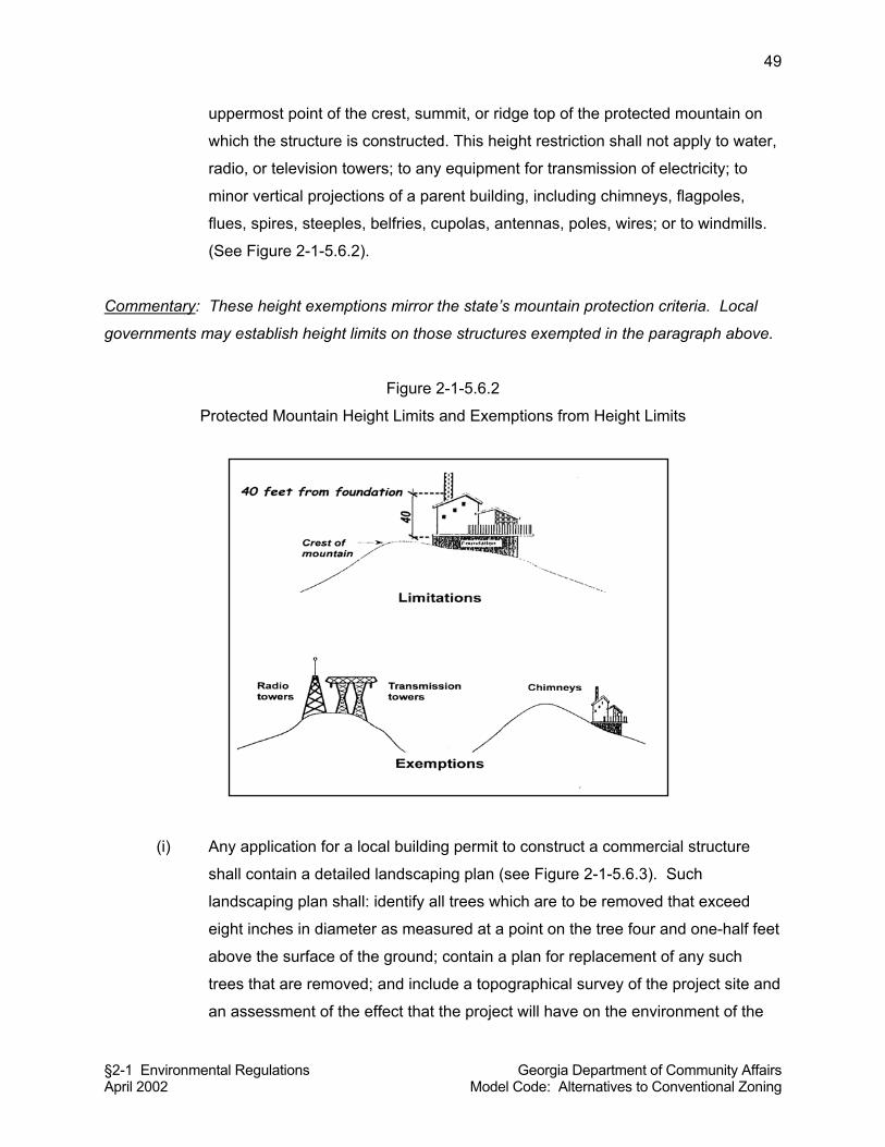
§2-1 Environmental Regulations Georgia Department of Community Affairs April 2002 Model Code: Alternatives to Conventional Zoning
49
uppermost point of the crest, summit, or ridge top of the protected mountain on
which the structure is constructed. This height restriction shall not apply to water,
radio, or television towers; to any equipment for transmission of electricity; to
minor vertical projections of a parent building, including chimneys, flagpoles,
flues, spires, steeples, belfries, cupolas, antennas, poles, wires; or to windmills.
(See Figure 2-1-5.6.2).
Commentary: These height exemptions mirror the state’s mountain protection criteria. Local
governments may establish height limits on those structures exempted in the paragraph above.
Figure 2-1-5.6.2
Protected Mountain Height Limits and Exemptions from Height Limits
(i) Any application for a local building permit to construct a commercial structure
shall contain a detailed landscaping plan (see Figure 2-1-5.6.3). Such
landscaping plan shall: identify all trees which are to be removed that exceed
eight inches in diameter as measured at a point on the tree four and one-half feet
above the surface of the ground; contain a plan for replacement of any such
trees that are removed; and include a topographical survey of the project site and
an assessment of the effect that the project will have on the environment of the
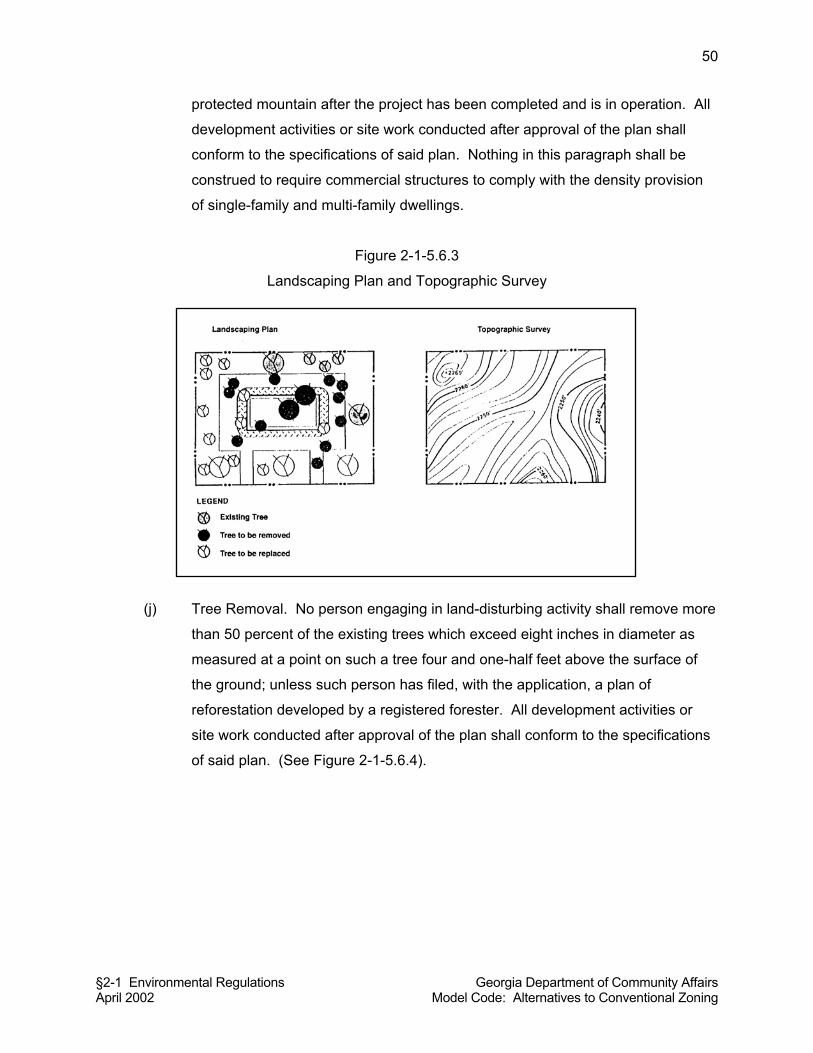
§2-1 Environmental Regulations Georgia Department of Community Affairs April 2002 Model Code: Alternatives to Conventional Zoning
50
protected mountain after the project has been completed and is in operation. All
development activities or site work conducted after approval of the plan shall
conform to the specifications of said plan. Nothing in this paragraph shall be
construed to require commercial structures to comply with the density provision
of single-family and multi-family dwellings.
Figure 2-1-5.6.3
Landscaping Plan and Topographic Survey
(j) Tree Removal. No person engaging in land-disturbing activity shall remove more
than 50 percent of the existing trees which exceed eight inches in diameter as
measured at a point on such a tree four and one-half feet above the surface of
the ground; unless such person has filed, with the application, a plan of
reforestation developed by a registered forester. All development activities or
site work conducted after approval of the plan shall conform to the specifications
of said plan. (See Figure 2-1-5.6.4).
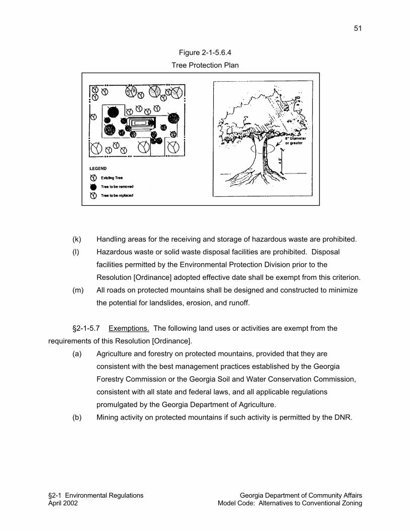
§2-1 Environmental Regulations Georgia Department of Community Affairs April 2002 Model Code: Alternatives to Conventional Zoning
51
Figure 2-1-5.6.4
Tree Protection Plan
(k) Handling areas for the receiving and storage of hazardous waste are prohibited.
(l) Hazardous waste or solid waste disposal facilities are prohibited. Disposal
facilities permitted by the Environmental Protection Division prior to the
Resolution [Ordinance] adopted effective date shall be exempt from this criterion.
(m) All roads on protected mountains shall be designed and constructed to minimize
the potential for landslides, erosion, and runoff.
§2-1-5.7 Exemptions. The following land uses or activities are exempt from the
requirements of this Resolution [Ordinance].
(a) Agriculture and forestry on protected mountains, provided that they are
consistent with the best management practices established by the Georgia
Forestry Commission or the Georgia Soil and Water Conservation Commission,
consistent with all state and federal laws, and all applicable regulations
promulgated by the Georgia Department of Agriculture.
(b) Mining activity on protected mountains if such activity is permitted by the DNR.
§2-1 Environmental Regulations Georgia Department of Community Affairs April 2002 Model Code: Alternatives to Conventional Zoning
52
§2-1-6 FLOOD DAMAGE PREVENTION
Commentary on Applicability: This module is based on the model ordinance for flood damage
prevention as authored by the Federal Emergency Management Agency (FEMA). Flood hazard
areas are those areas identified on floodplain maps prepared and published by FEMA. If your
community has flood-prone areas, these will be identified on FEMA floodplain maps, and your
jurisdiction should adopt the following ordinance. Once this code section is adopted, property
owners will have access to flood insurance through the National Flood Insurance Program.
Because the standards contained in this ordinance are designed to ensure protection from flood
hazard as required by FEMA, the requirements should not be altered except as may be needed
to make its provisions match local permitting procedures. If there are no flood-prone areas
mapped in your jurisdiction, then it is not necessary to adopt this code section.
Commentary: Flood-prone areas are those areas that are subject to periodic inundation by
floodwaters. Development in flood-prone areas should be avoided, since the potential for the
loss of property due to flooding is very high. A one hundred-year floodplain means that flooding
has a one-percent statistical probability of occurring in any given year. However, if the drainage
basin has been extensively developed and more than five to ten percent of the basin or
watershed consists of impervious surface, then the one hundred year flood will occur much
more frequently than once in each century. This flood damage prevention ordinance is intended
to provide development standards to help avoid loss of property due to flooding.
Commentary on Availability of Mapping. Flood hazard maps are not available in many parts of
rural Georgia. Naturally, this hinders a local government’s ability to adopt and enforce flood
hazard areas when data are not available. More extensive efforts are needed by federal and
state emergency management agencies before all rural local governments have the data
needed to identify, regulate, and enforce flood hazard area regulations.
§2-1-6.1 Short Title. This Resolution [Ordinance] shall be known and may be cited
as the flood damage prevention resolution [ordinance] of the County [City] of
_________________.
§2-1-6.2 Findings. The flood hazard areas in the local jurisdiction are subject to
periodic inundation which potentially results in loss of life and property, health and safety
§2-1 Environmental Regulations Georgia Department of Community Affairs April 2002 Model Code: Alternatives to Conventional Zoning
53
hazards, disruption of commerce and governmental services, extraordinary public expenditures
for flood protection and relief, and impairment of the tax base, all of which adversely affect the
public health, safety and general welfare. These flood losses are caused by the cumulative
effect of obstructions in floodplains causing increases in flood heights and velocities, and by the
occupancy in flood hazard areas by uses vulnerable to floods or hazardous to other lands which
are inadequately elevated, floodproofed, or otherwise unprotected from flood damages.
§2-1-6.3 Purposes. It is the purpose of this Resolution [Ordinance] to promote the
public health, safety and general welfare and to minimize public and private losses due to flood
conditions in specific areas by provisions designed to:
(a) Restrict or prohibit uses which are dangerous to health, safety and property due
to water or erosion hazards, or which result in damaging increases in erosions or
in flood heights or velocities;
(b) Require that uses vulnerable to floods, including facilities which serve such uses,
be protected against flood damage at the time of initial construction;
(c) Control the alteration of natural floodplains, stream channels, and natural
protective barriers that are involved in the accommodation of floodwaters;
(d) Control filling, grading, dredging and other development which may increase
erosion or flood damage; and
(e) Prevent or regulate the construction of flood barriers which will unnaturally divert
floodwaters or which may increase flood hazards to other lands.
§2-1-6.4 Objectives. The objectives of this Resolution [Ordinance] are:
(a) To protect human life and health;
(b) To minimize expenditure of public money for costly flood control projects;
(c) To minimize the need for rescue and relief efforts associated with flooding and
generally undertaken at the expense of the general public;
(d) To minimize prolonged business interruptions;
(e) To minimize damage to public facilities and utilities such as water and gas mains,
electric, telephone and sewer lines, streets and bridges located in floodplains;
(f) To help maintain a stable tax base by providing for the sound use and
development of flood prone areas in such a manner as to minimize flood blight
areas; and
§2-1 Environmental Regulations Georgia Department of Community Affairs April 2002 Model Code: Alternatives to Conventional Zoning
54
(g) To ensure that potential homebuyers are notified that property is in a flood
area.
§2-1-6.5 Definitions. Unless specifically defined below or otherwise in this Resolution
[Ordinance], words or phrases used herein shall be interpreted so as to give them the meaning
they have in common usage and to give this Resolution [Ordinance] its most reasonable
application.
Addition to an existing building: Any walled and roofed expansion to the perimeter of a building
in which the addition is connected by a common load-bearing wall other than a firewall. Any
walled and roofed addition that is connected by a firewall or is separated by independent
perimeter load-bearing walls is new construction.
Appeal: A request for a review of the Land Use Officer’s interpretation of any provision of this
Resolution [Ordinance].
Area of shallow flooding: A designated AO or VO Zone on a community's Flood Insurance Rate
Map (FIRM) with base flood depths from one to three feet where a clearly defined channel does
not exist, where the path of flooding is unpredictable and indeterminate, and where velocity flow
may be evident.
Area of special flood hazard: The land in the floodplain within a community subject to a one
percent or greater chance of flooding in any given year.
Base flood: The flood having a one percent chance of being equaled or exceeded in any given
year.
Basement: That portion of a building having its lowest floor subgrade (below ground level) on all
sides.
Breakaway wall: A wall that is not part of the structural support of the building and is intended
through its design and construction to collapse under specific lateral loading forces without
causing damage to the elevated portion of the building or the supporting foundation system.
Building: Any structure built for support, shelter, or enclosure for any occupancy or storage.
Dam break flood zone: That area within the flood contour elevations subject to flooding as
based upon information obtained from the U.S. Corps of Engineers or other federal, state, or
county agencies, or local hydraulic studies which occur from any seepage or failure of any dam.
Development: Any man-made change to improved or unimproved real estate, including, but not
limited to, buildings or other structures, mining, dredging, filling, grading, paving, excavating,
drilling operations, or permanent storage of materials.
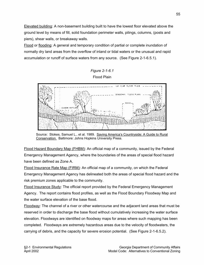
§2-1 Environmental Regulations Georgia Department of Community Affairs April 2002 Model Code: Alternatives to Conventional Zoning
55
Elevated building: A non-basement building built to have the lowest floor elevated above the
ground level by means of fill, solid foundation perimeter walls, pilings, columns, (posts and
piers), shear walls, or breakaway walls.
Flood or flooding: A general and temporary condition of partial or complete inundation of
normally dry land areas from the overflow of inland or tidal waters or the unusual and rapid
accumulation or runoff of surface waters from any source. (See Figure 2-1-6.5.1).
Figure 2-1-6.1
Flood Plain
Source: Stokes, Samuel L., et al. 1989. Saving America’s Countryside: A Guide to Rural Conservation. Baltimore: Johns Hopkins University Press.
Flood Hazard Boundary Map (FHBM): An official map of a community, issued by the Federal
Emergency Management Agency, where the boundaries of the areas of special flood hazard
have been defined as Zone A.
Flood Insurance Rate Map (FIRM): An official map of a community, on which the Federal
Emergency Management Agency has delineated both the areas of special flood hazard and the
risk premium zones applicable to the community.
Flood Insurance Study: The official report provided by the Federal Emergency Management
Agency. The report contains flood profiles, as well as the Flood Boundary Floodway Map and
the water surface elevation of the base flood.
Floodway: The channel of a river or other watercourse and the adjacent land areas that must be
reserved in order to discharge the base flood without cumulatively increasing the water surface
elevation. Floodways are identified on floodway maps for areas where such mapping has been
completed. Floodways are extremely hazardous areas due to the velocity of floodwaters, the
carrying of debris, and the capacity for severe erosion potential. (See Figure 2-1-6.5.2).
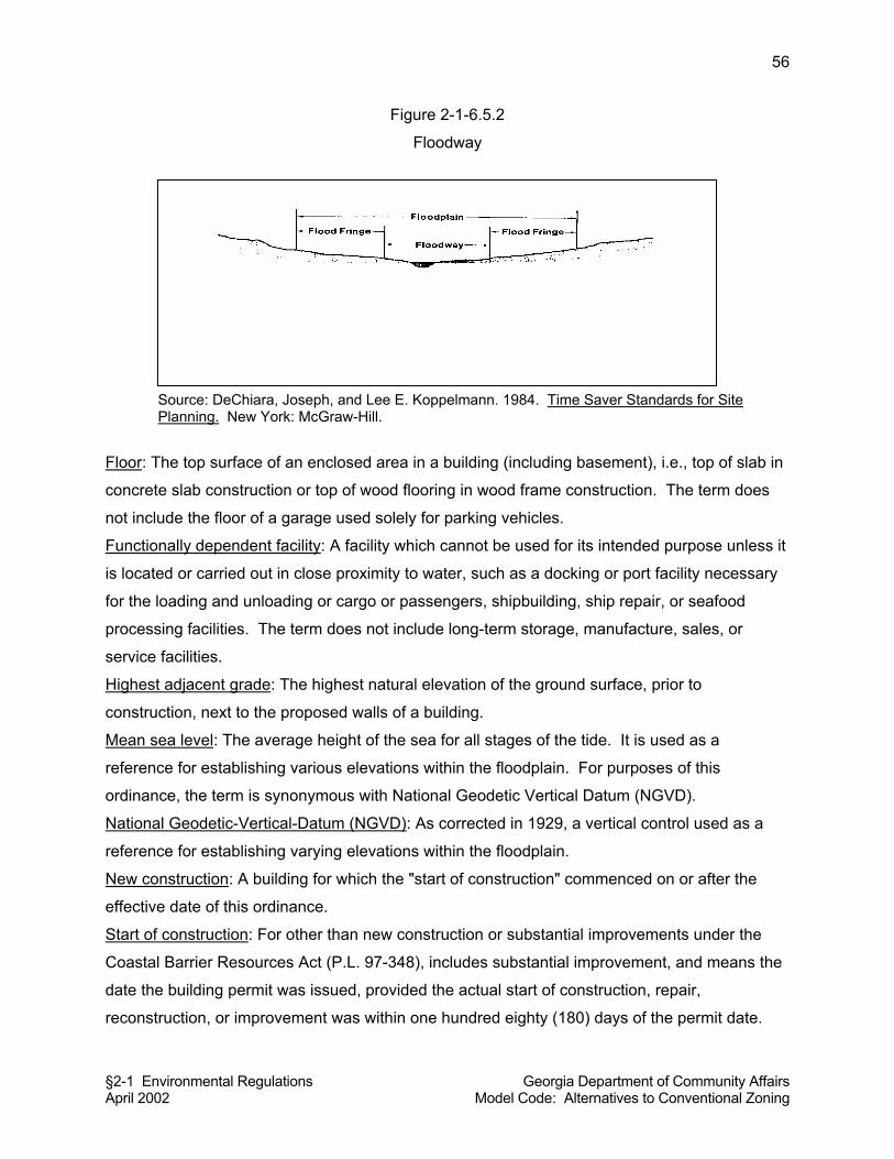
§2-1 Environmental Regulations Georgia Department of Community Affairs April 2002 Model Code: Alternatives to Conventional Zoning
56
Figure 2-1-6.5.2
Floodway
Source: DeChiara, Joseph, and Lee E. Koppelmann. 1984. Time Saver Standards for Site Planning. New York: McGraw-Hill.
Floor: The top surface of an enclosed area in a building (including basement), i.e., top of slab in
concrete slab construction or top of wood flooring in wood frame construction. The term does
not include the floor of a garage used solely for parking vehicles.
Functionally dependent facility: A facility which cannot be used for its intended purpose unless it
is located or carried out in close proximity to water, such as a docking or port facility necessary
for the loading and unloading or cargo or passengers, shipbuilding, ship repair, or seafood
processing facilities. The term does not include long-term storage, manufacture, sales, or
service facilities.
Highest adjacent grade: The highest natural elevation of the ground surface, prior to
construction, next to the proposed walls of a building.
Mean sea level: The average height of the sea for all stages of the tide. It is used as a
reference for establishing various elevations within the floodplain. For purposes of this
ordinance, the term is synonymous with National Geodetic Vertical Datum (NGVD).
National Geodetic-Vertical-Datum (NGVD): As corrected in 1929, a vertical control used as a
reference for establishing varying elevations within the floodplain.
New construction: A building for which the "start of construction" commenced on or after the
effective date of this ordinance.
Start of construction: For other than new construction or substantial improvements under the
Coastal Barrier Resources Act (P.L. 97-348), includes substantial improvement, and means the
date the building permit was issued, provided the actual start of construction, repair,
reconstruction, or improvement was within one hundred eighty (180) days of the permit date.
§2-1 Environmental Regulations Georgia Department of Community Affairs April 2002 Model Code: Alternatives to Conventional Zoning
57
The actual start means the first placement of permanent construction of a building on a site,
such as the pouring of slabs or footings, installation of piles, construction of columns, or any
work beyond the stage of excavation or the placement of a manufactured home on a foundation.
Permanent construction does not include land preparation, such as clearing, grading and filling;
nor does it include the installation of streets and/or walkways; nor does it include excavation for
a basement, footings, piers or foundations or the erection of temporary forms; nor does it
include the installation on the property of accessory buildings, such as garages or sheds not
occupied as dwelling units or not part of the main building.
Structure: A walled and roofed building that is principally above ground, a manufactured home,
a gas or liquid storage tank, or other man-made facilities or infrastructure.
Substantial improvement: Any combination of repairs, reconstruction, alteration, or
improvements to a building in which the cumulative cost equals or exceeds fifty percent (50%)
of the market value of the building. The market value of the building should be the appraised
value of the building prior to the start of the initial repair or improvement, or in the case of
damage, the value of the building prior to the damage occurring. The term does not, however,
include any project for improvement of a building required to comply with existing health,
sanitary or safety code specifications which are solely necessary to assure safe living
conditions.
Variance: A grant of relief from the requirements of this Resolution [Ordinance] that permits
construction in a matter otherwise prohibited by this Resolution [Ordinance] where specific
enforcement would result in unnecessary hardship.
§2-1-6.6 Applicability. This Resolution [Ordinance] shall apply to all areas of special
flood hazard as defined by this Resolution [Ordinance], as may be identified on the Flood
Hazard Boundary Map, Flood Insurance Rate Map, or in the Flood Insurance Study as
appropriate within the local jurisdiction.
Commentary: There may be ambiguity in this provision because of the reference to two different
sets of maps and a study. Flood insurance studies specify flood elevations and therefore need
to be referenced because they are likely to be consulted in specific instances. Flood-prone
areas are usually shown on both flood hazard boundary maps and flood insurance rate maps, to
the extent they exist for a given local jurisdiction. Local governments with both maps should
consider whether reference to only one of the maps would suffice, rather than both, to lesson
the potential for ambiguity.
§2-1 Environmental Regulations Georgia Department of Community Affairs April 2002 Model Code: Alternatives to Conventional Zoning
58
§2-1-6.7 Adoption of Maps and Studies by Reference. The areas of special flood
hazards identified by the Federal Emergency Management Agency in its Flood Hazard
Boundary Map, Flood Insurance Rate Map, or in the Flood Insurance Study, as appropriate,
dated (month and year), with accompanying maps and other supporting data, and any revision
thereto, are hereby adopted by reference and declared to be a part of this Resolution
[ordinance]. When base flood elevation data or floodway data are not available, then the Land
Use Officer shall obtain, review and reasonably utilize any base flood elevation and floodway
data available from a federal, state, or other source, in order to administer the provisions of this
Resolution [Ordinance].
§2-1-6.8 Interpretation of Map Boundaries. Where interpretation is needed as to the
exact location of boundaries of the areas of special flood hazard (for example, where there
appears to be a conflict between a mapped boundary and actual field conditions) the Land Use
Officer shall make the necessary interpretation. Any person who desires to contest the
interpretation by the Land Use Officer of the location of any such boundary may appeal the
interpretation of the Land Use Officer as provided in this Resolution [Ordinance].
§2-1-6.9 Permit Required. No development activity shall commence within an area
regulated by this Resolution [ordinance] until and unless a land use permit shall have been
approved and issued by the Land Use Officer. No development activity shall be approved
unless it is in conformance with the provisions of this Resolution [Ordinance] prior to the
commencement of any development activities. No building or structure shall be constructed
within an area regulated by this Resolution [ordinance] until and unless a land use permit shall
have been approved and issued by the Land Use Officer. No building or structure shall be
approved unless it is in conformance with the provisions of this Resolution [Ordinance] prior to
the construction of said building or structure.
Commentary: For local jurisdictions with building permit requirements, “building permit” can and
should be substituted for “land use permit” with regard to buildings and structures.
§2-1-6.10 Compliance. No structure shall hereafter be located, extended, converted, or
structurally altered, and no land shall be developed or occupied, unless it complies fully with the
terms of this Resolution [Ordinance] and other applicable regulations.
§2-1 Environmental Regulations Georgia Department of Community Affairs April 2002 Model Code: Alternatives to Conventional Zoning
59
§2-1-6.11 Application Requirements for Development. Applications for approval of any
development within an area regulated by this Resolution [Ordinance] shall be made to the Land
Use Officer on forms furnished by him or her. At a minimum, the application shall include the
following:
(a) Plans. Plans drawn to scale showing the nature, location, dimensions, and
elevations of the land, existing or proposed buildings or structures if any,
proposed fill, and storage of materials, and drainage facilities.
(b) Watercourse modifications. A description of the extent to which any watercourse will
be altered or relocated as a result of the proposed development.
§2-1-6.12 Application Requirements for Building Construction. Applications for approval
of any building or structure within an area regulated by this Resolution [Ordinance] shall be
made to the Land Use Officer on forms furnished by him or her. At a minimum, the application
shall include the following:
(a) Elevations. The elevation in relation to mean sea level of the proposed lowest
floor (including basement) of all buildings.
(b) Flood-proofing certificate. In the case of a building that is required to be
flood-proofed by this Resolution [ordinance], a certificate from a registered
professional engineer or architect that the building to be flood-proofed will meet
the flood-proofing requirements of this Resolution [ordinance].
§2-1-6.13 Elevation Certificate Required Prior to Building Occupancy. No building shall
be occupied until the requirements of this subsection are met. After the lowest floor of a
building is completed, after placement of the horizontal structural members of the lowest floor,
or upon placement of the lowest floor to be flood-proofed, whichever is applicable, it shall be the
duty of the permit holder to submit to the Land Use Officer a certification of the as-built elevation
in relation to mean sea level of the lowest floor, the elevation of the lowest portion of the
horizontal structural members of the lowest floor, or a flood-proofed elevation, whichever is
applicable. Said certificate shall be prepared by, or under the direct supervision of, a registered
land surveyor or professional engineer and certified by same. Upon submittal of any required
elevation certificate, the Land Use Officer shall review the floor elevation certificate for
compliance with this Resolution [Ordinance]. The permit holder immediately and prior to
authorization to proceed with further work shall correct any deficiencies detected by such
§2-1 Environmental Regulations Georgia Department of Community Affairs April 2002 Model Code: Alternatives to Conventional Zoning
60
review. Failure to submit the elevation certificate or failure to make any corrections required by
the Land Use Officer shall be cause for issuing a stop-work order on the project.
§2-1-6.14 Floodways. Encroachments, including fill, new construction, substantial
improvements, or any other development shall be prohibited unless certification, with supporting
technical data, by a registered professional engineer is provided which demonstrates that
encroachments shall not result in an increase in flood levels of more than one foot in elevation
during the occurrence of the base flood discharge.
Commentary: This provision allows for encroachments if flood studies prepared by a registered
professional engineer are completed showing a one foot or less increase in the flood elevation.
The cumulative impact of floodway encroachments and the resulting increases in the height of
flood levels, however, could cause severe damage. Accordingly, communities should seriously
consider prohibiting all development within floodways. Furthermore, some communities prohibit
the construction of buildings and structures and severely limit land uses within the flood plains
as well, due to the displacement of floodwaters and the increased need for downstream flood
storage capacity when upstream flood plain storage capacity is eliminated.
§2-1-6.15 General Regulations for Construction. New buildings or structures, or
substantial improvements, and related development or facilities in all areas of special flood
hazard shall conform to the following regulations. Any alteration, repair, reconstruction or
improvements to a building that is in compliance with the provisions of this Resolution
[Ordinance] shall meet the requirements of this subsection.
(a) They shall be anchored to prevent floatation, collapse or lateral movement of the
structure.
(b) They shall be constructed with materials and utility equipment resistant to flood
damage, and by methods and practices that minimize flood damage.
(c) Electrical, heating, ventilation, plumbing, air conditioning equipment and other
service facilities shall be designed and/or located so as to prevent water from
entering or accumulating within the components during conditions of flooding.
§2-1 Environmental Regulations Georgia Department of Community Affairs April 2002 Model Code: Alternatives to Conventional Zoning
61
(d) New and replacement water supply systems shall be designed to minimize or
eliminate infiltration of floodwaters into the system.
(e) New and replacement sanitary sewage systems shall be designed to minimize or
eliminate infiltration of floodwaters into the systems and discharges from the
systems into flood waters.
(f) On-site waste disposal systems shall be located and constructed to avoid
impairment to them or contamination from them during flooding.
§2-1-6.16 Requirements for Elevating Residential Buildings. In all areas of special flood
hazard where base flood elevation data have been provided, new construction or substantial
improvements of any residential building shall have the lowest floor, including basement,
elevated no lower than one foot above the base flood elevation. If solid foundation perimeter
walls are used to elevate a residential building, openings sufficient to facilitate the unimpeded
movements of floodwater shall be provided as required by this Resolution [Ordinance].
§2-1-6.17 Requirements for Elevating Nonresidential Buildings. In all areas of special
flood hazard where base flood elevation data have been provided, new construction or
substantial improvements of any institutional, commercial, industrial, or other non-residential
building shall have the lowest floor, including basement, elevated no lower than two feet above
the level of the base flood elevation. Buildings located in all A-zones (see definition of “areas of
shallow flooding”) may be flood-proofed in lieu of being elevated as required by this subsection,
provided that all areas of the building below the required elevation are water tight with walls
substantially impermeable to the passage of water, and use structural components having the
capability of resisting hydrostatic and hydrodynamic loads and the effect of buoyancy. A
registered professional engineer or architect shall certify that the standards of this subsection
are satisfied. Such certification shall be provided to the Land Use officer as required in this
section.
Commentary: The two subsections above establish what is commonly referred to as a
“freeboard” requirement. At minimum, new buildings and substantial improvements must be at
least one foot above the base flood elevation. Some communities may wish to (and many
communities do) provide higher elevation requirements (freeboards) to allow for some additional
protection in the event flood waters exceed the base flood elevation. Given the possibility of
§2-1 Environmental Regulations Georgia Department of Community Affairs April 2002 Model Code: Alternatives to Conventional Zoning
62
flood data being inaccurate, a higher freeboard requirement should be strongly considered,
perhaps up to four feet above the base flood elevation.
§2-1-6.18 Requirements for Fully Enclosed Areas below the Base Flood Elevation.
New construction or substantial improvements of elevated buildings that include fully enclosed
areas formed by foundation and other exterior walls below the base flood elevation shall not be
designed or used as finished space. In addition, said fully enclosed areas shall be designed to
allow for the entry and exit of floodwaters to automatically equalize hydrostatic flood forces on
exterior walls, in accordance with the following requirements:
(a) A minimum of two openings having a total net area of not less than one square
inch for every square foot of enclosed area subject to flooding shall be provided.
(b) The bottom of all openings shall be no higher than one foot above grade.
(c) Openings may be equipped with screens, louvers, valves or other coverings or
devices provided they permit the automatic flow of floodwaters in both directions.
(d) Access to the enclosed area shall be the minimum necessary to allow for parking
of vehicles (garage door) or limited storage of maintenance equipment used in
connection with the premises (standard exterior door) or entry to the living area
(stairway or elevator).
(e) The interior portion of such enclosed area shall not be partitioned or finished into
separate rooms.
A professional engineer or architect shall certify that the designs of new construction or
substantial improvement, which includes fully enclosed area formed by foundation and other
exterior walls below the base flood elevation, complies with the requirements of this subsection,
prior to occupancy of the building.
§2-1-6.19 Requirements for Streams without Established Base Flood Elevation and/or
Floodways. Located within the areas of special flood hazard where small streams exist but
where no base flood data have been provided or where no floodways have been provided. In
such areas, no encroachments shall be allowed unless certification by a registered professional
engineer is provided and approved by the Land Use Officer, demonstrating that such
encroachments shall not result in any increase in flood levels during the occurrence of the base
flood discharge. New construction or substantial improvements of buildings within such areas
shall be elevated or flood-proofed to elevations established by this Resolution [Ordinance].
§2-1 Environmental Regulations Georgia Department of Community Affairs April 2002 Model Code: Alternatives to Conventional Zoning
63
§2-1-6.20 Requirements for Areas of Shallow Flooding (AO Zones). Areas designated
as shallow flooding areas are located within special flood hazard areas. These areas have
special flood hazards associated with base flood depths of one to three feet where a clearly
defined channel does not exist and where the path of flooding is unpredictable and
indeterminate. In such areas the following regulations shall apply:
(a) Residential buildings. All new construction and substantial improvements of
residential buildings shall have the lowest floor, including basement, elevated to
a height specified by the Land Use Officer based on available information as may
be supplied by the County [City] Engineer.
Commentary: This provision appears arbitrary because it does not set a specific minimum
required height for a residential dwelling to be elevated above a shallow flooding area. This is
because such elevation cannot be precisely established in all cases. However, to avoid
vagueness, the local government should establish a specific height elevation (e.g., one foot
above the shallow flood elevation) based on its local knowledge of shallow flooding zones in the
section above (for residential dwellings) and below (for nonresidential buildings).
(b) Nonresidential buildings. All new construction and substantial improvements of
non-residential buildings shall have the lowest floor, including basement,
elevated to a height specified by the Land Use Officer based on available
information as may be supplied by the County [City] Engineer. In addition, any
attendant utility and sanitary facilities shall be completely flood-proofed to or
above that level so that any space below that level is watertight with walls
substantially impermeable to the passage of water and with structural
components having the capability of resisting hydrostatic and hydrodynamic
loads and effects of buoyancy.
§2-1-6.21 Dam Break Flood Zone. No residential building shall be allowed to be
constructed within the dam break flood zone.
§2-1-6.22 Variances Authorized. The Board of Appeals, as established in section 7.2 of
this code, shall hear and decide any requests for variances from the requirements of this
Resolution [Ordinance]. Upon consideration of the criteria for approving variances as provided
§2-1 Environmental Regulations Georgia Department of Community Affairs April 2002 Model Code: Alternatives to Conventional Zoning
64
by this Resolution [Ordinance], the Board of Appeals may approve or deny applications for
variances. The Board of Appeals may attach such conditions to the granting of variances, as it
deems necessary to further the purpose of this Resolution [Ordinance].
Commentary: If the local government does not create a Board of Appeals to hear variances as
specified this subsection, it may substitute the governing body or another body such as the
planning commission (or appoint a hearing examiner) to hear and decide variances.
§2-1-6.23 Criteria for Approving Variances. In ruling on applications for variances, the
board of appeals shall consider all technical evaluations, all relevant factors, all regulations
specified in this Resolution [ordinance], and the following criteria:
(a) The danger of materials being swept onto other lands to the injury of others;
(b) The danger to life and property due to flooding or erosion damage;
(c) The susceptibility of the proposed facility and its contents to flood damage and
the effect of such damage on the individual owner;
(d) The importance of the services provided by the proposed facility to the
community;
(e) The necessity of the facility to a waterfront location, in the case of a functionally
dependent facility;
(f) The availability of alternative locations, not subject to flooding or erosion
damage, for the proposed use;
(g) The compatibility of the proposed use with existing and anticipated development;
(h) The relationship of the proposed use to the comprehensive plan and floodplain
management program for that area;
(i) The safety of access to the property in times of flood for ordinary and emergency
vehicles;
(j) The expected heights, velocity, duration, rate of rise and sediment transport of
the flood waters and the effects of wave action, if applicable, expected at the site,
and;
(k) The costs of providing governmental services during and after flood conditions
including maintenance and repair of public utilities and facilities such as sewer,
gas, electrical and water systems, and streets and bridges.
§2-1 Environmental Regulations Georgia Department of Community Affairs April 2002 Model Code: Alternatives to Conventional Zoning
65
§2-1-6.24 Additional Limitations on Variances.
(a) Variances shall not be issued within any designated floodway if any increase in
flood levels during the base flood discharge would result.
(b) Variances shall only be issued upon a determination that the variance is the
minimum necessary, considering the flood hazard, to afford relief; and in the
instance of a historical building, a determination that the variance is the minimum
necessary so as not to destroy the historic character and design of the building.
(c) Variances shall only be issued upon a showing of good and sufficient cause, a
determination that failure to grant the variance would result in exceptional
hardship, and a determination that the granting of a variance will not result in
increased flood heights, additional threats to public safety, extraordinary public
expense, create a nuisance, cause fraud on or victimization of the public, or
conflict with existing local laws or ordinances.
Commentary: The two sections above establish numerous criteria for granting a variance. As
this ordinance is based on prior models prepared by the Federal Emergency Management
Agency, such a rigorous description of grounds for variances is not surprising. Local
governments should keep in mind that the multiple criteria established in this code section for
variances should be trimmed down if possible, because the multiple criteria demand too much
attention. Approval of a variance could be challenged on grounds that the approval authority
failed to consider all relevant criteria.
§2-1-6.25 Requirements when Variances are Granted. Any applicant to whom a
variance is granted shall be given written notice by the Land Use Officer specifying the
difference between the base flood elevation and the elevation to which the building is to be built,
and stating that the cost of flood insurance will be commensurate with the increased risk
resulting from the reduced lowest floor elevation. The Land Use Officer shall maintain the
records of all variances and submit them to the Federal Emergency Management Agency upon
request.
§2-1-6.26 Administration and Duties of the Land Use Officer. This Resolution
[Ordinance] shall be administered by the Land Use Officer. The Land Use Officer shall have the
following duties in connection with the administration of this Resolution [Ordinance]:
§2-1 Environmental Regulations Georgia Department of Community Affairs April 2002 Model Code: Alternatives to Conventional Zoning
66
(a) Review all permit applications to assure that the permit requirements of this
Resolution [ordinance] have been satisfied.
(b) Advise applicants that additional federal or state permits may be required, and if
specific federal or state permit requirements are known, require that copies of
such permits be provided and maintained on file with the locally approved permit.
(c) Notify adjacent affected communities and the Georgia Department of Natural
Resources prior to any alteration or relocation of a watercourse, and submit
evidence of such notification to the Federal Emergency Management Agency.
(d) Assure that maintenance is provided within the altered or relocated portion of
said watercourse so that the flood-carrying capacity is not diminished.
(e) Receive and review elevation certificates and floodproofing certificates for all new
or substantially improved buildings, for compliance with this Resolution
[Ordinance]. (f) Interpret the provisions of this Resolution [Ordinance]. In the interpretation and
application of this ordinance all provisions shall be considered as minimum
requirements. They shall be liberally construed in favor of the governing body,
and the provisions of this Resolution [Ordinance) shall not be deemed to limit or
repeal any other powers granted under state statutes.
(f) Maintain all records pertaining to the provisions of this Resolution [Ordinance],
which shall be open for public inspection.
§2-1-6.27 Warning and Disclaimer of Liability. The degree of flood protection required
by this ordinance is considered reasonable for regulatory purposes and is based on scientific
and engineering consideration. Larger floods can and will occur on rare occasions. Flood
heights may be increased by man-made or natural causes. This ordinance does not imply that
land outside the areas of special flood hazard or uses permitted within such areas will be free
from flooding or flood damages. This ordinance shall not create liability on the part of the (local
government) or by any officer or employee thereof for any flood damages that result from
reliance on this ordinance or any administrative decision lawfully made thereunder.
Commentary: This module is written as a part of an overall land use management system.
However, it can be easily adopted as a stand-alone resolution or ordinance, if the following
other provisions are included in the adopted ordinance:
§2-1 Environmental Regulations Georgia Department of Community Affairs April 2002 Model Code: Alternatives to Conventional Zoning
67
§ 2-0-1(A) PREAMBLE (although some of it may not be considered necessary)
§ 2-0-2 EFFECTIVE DATE
§ 2-0-3 LEGAL STATUS PROVISIONS
§ 2-0-4 APPEALS, ENFORCEMENT, AND PENALTIES
§2-1-7 SOIL EROSION AND SEDIMENTATION CONTROL
Commentary: Soil erosion results in contamination of Georgia’s waterways. Soil chokes
streams, rivers, and lakes, blocking light and reducing the amount of dissolved oxygen to levels
below what is required to support aquatic life. The single most important action local
governments can take to improve local and regional water quality is to enforce erosion and
sedimentation control standards to reduce the amount of soil that leaves land disturbance sites
during rainfall events.
Commentary: This Resolution [Ordinance] has been prepared based on a model provided by
the Georgia Department of Natural Resources. Because the DNR has specific requirements for
recognizing “Issuing Authorities,” the model has been retained substantially in its recommended
form, although some elements of the regulations have been reorganized.
§2-1-7.1 Title. This Resolution [Ordinance] will be known as Soil Erosion and
Sedimentation Control Ordinance.
§2-1-7.2 Definitions. The following definitions shall apply in the application,
interpretation, and enforcement of this Resolution [Ordinance], unless otherwise specifically
stated.
Best Management Practices (BMPs): A collection of structural practices and vegetative
measures which, when properly designed, installed, and maintained, will provide effective
erosion and sedimentation control for all rainfall events up to and including a 25-year rainfall
event. Any land-disturbing activity governed by these Resolution [Ordinance] provisions
require, as a minimum, best management practices, including sound conservation and
engineering practices to prevent and minimize erosion and resultant sedimentation, which are
consistent with, and no less stringent than, those practices contained in the "Manual for Erosion
and Sediment Control In Georgia" published by the State Soil and Water Conservation
§2-1 Environmental Regulations Georgia Department of Community Affairs April 2002 Model Code: Alternatives to Conventional Zoning
68
Commission as of January 1 of the year in which the land-disturbing activity was permitted, as
well as the following:
(a) Stripping of vegetation, regrading, and other development activities shall be
conducted in such a manner so as to minimize erosion.
(b) Cut and fill operations must be kept to a minimum.
(c) Development plans must conform to topography and soil type, so as to create the
lowest practicable erosion potential.
(d) Whenever feasible, natural vegetation shall be retained, protected, and
supplemented.
(e) The disturbed area and the duration of exposure to erosive elements shall be
kept to a practicable minimum.
(f) Disturbed soil shall be stabilized as quickly as practicable.
(g) Temporary vegetation or mulching shall be employed to protect exposed critical
areas during development.
(h) Permanent vegetation and structural erosion control measures must be installed
as soon as practicable.
(i) To the extent necessary, sediment in run-off water must be trapped by the use of
debris basins, sediment basins, silt traps, or similar measures until the disturbed area is
stabilized. As used in this paragraph, a disturbed area is stabilized when it is brought to
a condition of continuous compliance with the requirements of this chapter.
(j) Adequate provisions must be provided to minimize damage from surface water to
the cut face of excavations or the sloping surfaces of fills.
(k) Cuts and fills may not endanger adjoining property.
(l) Fills may not encroach upon natural watercourses or constructed channels in a
manner adversely affecting other property owners.
(m) Grading equipment that must go across flowing streams by means of bridges or
culverts, except when such methods are not feasible, provided, in any case, that such
crossings must be kept to a minimum.
(n) Land-disturbing activity plans for erosion and sedimentation control shall include
provisions for treatment or control of any source of sediments and adequate
sedimentation control facilities to retain sediments on site or preclude sedimentation of
adjacent waters beyond the levels specified in O.C.G.A. §12-7-6(a).
Board: The Board of Natural Resources of the State of Georgia.
§2-1 Environmental Regulations Georgia Department of Community Affairs April 2002 Model Code: Alternatives to Conventional Zoning
69
Buffer: The area of land immediately adjacent to the banks of state waters in its natural state of
vegetation, which facilitates the protection of water quality and aquatic habitat.
Commission: The state Soil and Water Conservation Commission.
Cut: A portion of land surface or area from which earth has been removed or will be removed
by excavation; the depth below original ground surface to excavated. Also known as
excavation.
Department: The Department of Natural Resources of the State of Georgia.
District: The (name of appropriate) Soil and Water Conservation District.
Division: The Environmental Protection Division of the Department of Natural Resources of the
State of Georgia.
Drainage structure: A device composed of a virtually nonerodible material such as concrete,
steel, plastic, or other such material that conveys water from one place to another by
intercepting the flow and carrying it to a release point for stormwater management, drainage
control, or flood control purposes.
Erosion: The process by which land surface is worn away by the action of wind, water, ice, or
gravity.
Erosion and sedimentation control plan: A plan for the control of soil erosion and sedimentation
resulting from a land disturbing activity. Also known as the plan.
Ground elevation: The original elevation of the ground surface prior to cutting or filling.
Fill: A portion of land surface to which soil or other solid material has been added; the depth
above the original ground.
Finished grade: The final elevation and contouring of the ground after cutting or filling and
conforming to the proposed design.
Grading: Altering the shape of ground surfaces to a predetermined condition; this includes
stripping, cutting, filling, stockpiling, and shaping or any combination thereof and shall include
the land in its cut or filled condition.
Issuing Authority: The governing body of __________ County [or the City of __________]
[whichever adopts the Resolution [Ordinance]].
Land-disturbing activity: Any activity which may result in soil erosion from water or wind and the
movement of sediments into state waters or onto lands within the state, including, but not limited
to clearing, dredging, grading, excavating, transporting, and filling of land but not including
agricultural practices as described in this Resolution [Ordinance].
§2-1 Environmental Regulations Georgia Department of Community Affairs April 2002 Model Code: Alternatives to Conventional Zoning
70
Metropolitan River Protection Act (MRPA): A state law referenced as O.C.G.A. 12-5-440 et.
seq., which addresses environmental and developmental matters in certain metropolitan river
corridors and their drainage basins.
Commentary: Only certain local governments in the Atlanta metropolitan region are subject to
the requirements of MRPA. If it does not apply, provisions related to MRPA can be deleted from
the Resolution [Ordinance].
Natural ground surface: The ground surface in its original state before any grading, excavation
or filling.
Nephelometric turbidity units (NTU): Numerical units of measure based upon photometric
analytical techniques for measuring the light scattered by finely divided particles of a substance
in suspension. This technique is used to estimate the extent of turbidity in water in which
colloidally dispersed particles are present.
Permit: The authorization necessary to conduct a land disturbing activity under the provisions of
this Resolution [Ordinance].
Person: Any individual, partnership, firm, association, joint venture, public or private
corporation, trust estate, commission, board, public or private institution, utility, cooperative,
state agency, municipality or other political subdivision of this State; any interstate body or any
other legal entity.
Project: The entire proposed development project regardless of the size of the area and land to
be disturbed.
Proper design or properly designed: Best management practices that are designed to control
soil erosion and sedimentation for all rainfall events up to and including a 25 year, 24 hour
rainfall event.
Roadway drainage structure: A device such as a bridge, culvert, or ditch, composed of a
virtually nonerodible material such as concrete, steel, plastic, or other such material that
conveys water under a roadway by intercepting the flow on one side of a traveled way
consisting of one or more defined lanes, with or without shoulder areas, and carrying water to a
release point on the other side.
Sediment: Solid material, both organic and inorganic, that is in suspension, is being
transported, or has been moved from its site of origin by air, water, ice, or gravity as a product of
erosion.
Sedimentation: The process by which eroded material is transported and deposited by the
action of water, wind, ice or gravity.
§2-1 Environmental Regulations Georgia Department of Community Affairs April 2002 Model Code: Alternatives to Conventional Zoning
71
Soil and Water Conservation District approval plan: An erosion and sedimentation control plan
approved in writing by the (name of applicable) soil and water conservation district.
Stabilization: An activity that secures soil cover or vegetation by installing temporary or
permanent structures to reduce or minimize the erosion process and the resulting transport of
sediment by wind, water, ice or gravity.
State waters: Any and all rivers, streams, creeks, branches, lakes, reservoirs, ponds, drainage
systems, springs, wells, and other bodies of surface or subsurface water, natural or artificial,
lying within or forming a part of the boundaries of the State which are not entirely confined and
retained completely upon the property of a single individual, partnership, or corporation.
Structural erosion and sedimentation control practices: Practices for the stabilization of erodible
or sediment producing areas by utilizing the mechanical properties of matter for the purpose of
either changing the surface or the land or storing, regulating, or disposing of runoff to prevent
excessive sediment loss. Examples of structural erosion and sediment control practices are
riprap, sediment basins, dikes, level spreaders, waterways or outlets, diversions, grade
stabilization structures, sediment traps, and land grading, etc. Such practices can be found in
the publication, “Manual for Erosion and Sediment Control in Georgia.”
Trout streams: All streams or portions of streams within the watershed as designated by the
Game and Fish Division of the Georgia Department of Natural Resources under the provisions
of the Georgia Water Quality Control Act, O.C.G.A. 12-5-20 et. seq. Streams designated as
primary trout waters are defined as water supporting a self-sustaining population of rainbow,
brown, or brook trout. Streams designated as secondary trout waters are those in which there
is no evidence of natural trout reproduction, but are capable of supporting trout throughout the
year. First order trout waters are streams into which no other streams flow except springs.
Commentary: Much of the state does not contain trout streams. Most ordinances, particularly
those below the “fall line,” can delete provisions pertaining to trout streams from their
ordinances.
Vegetative erosion and sedimentation control measures: Measures for the stabilization of
erodible or sediment-producing areas by covering the soil with permanent seeding, sprigging, or
planting, producing long term vegetative cover; temporary seeding, producing short term
vegetative cover; or sodding, covering areas with a turf or perennial sod farming grass. Such
measures can be found in the publication, “Manual for Erosion and Sediment Control in
Georgia.”
§2-1 Environmental Regulations Georgia Department of Community Affairs April 2002 Model Code: Alternatives to Conventional Zoning
72
Watercourse: Any natural or artificial watercourse, stream, river, creek, channel, ditch, canal,
conduit, culvert, drain, waterway, gully, ravine, or wash in which water flows either continuously
or intermittently and which has a definite channel, bed and banks, including any area adjacent
thereto subject to inundation by reason of overflow of floodwater.
Wetlands: Those areas that are inundated or saturated by surface or groundwater at a
frequency and duration sufficient to support, and that under normal circumstances do support a
prevalence of vegetation typically adapted for life in saturated soil conditions. Wetlands
generally include swamps, marshes, bogs, and similar areas.
§2-1-7.3 Exemptions. This Resolution [Ordinance] shall apply to any land disturbing
activity undertaken by any person on any land except for the following:
(a) Surface mining, as the same is defined in O.C.G.A. 12-4-72, “Mineral Resources
and Caves Act.”
(b) Granite quarrying and land clearing for such quarrying.
(c) Such minor land disturbing activities as home gardens, and individual home
landscaping, repairs, maintenance work, and other related activities which result
in minor soil erosion.
(d) The construction of single-family residences, when such are constructed by or
under contract with the owner for his or her own occupancy, or the construction
of single-family residences not a part of a platted subdivision, a planned
community, or an association of other residential lots consisting of more than two
lots and not otherwise exempted under this paragraph; provided, however, that
construction of any such residence shall conform to the minimum requirements
as set forth in this Resolution [Ordinance]. For single-family residence
construction covered by the provisions of this paragraph, there shall be a buffer
zone between the residence and any state waters classified as trout streams
pursuant to Article 2 of Chapter 5 of the Georgia Water Quality Control Act. In
any such buffer zone, no land disturbing activity shall be constructed between the
residence and the point where vegetation has been wrested by normal stream
flow or wave action from the banks of the trout waters. For primary trout waters,
the buffer zone shall be at least 50 horizontal feel, and no variance to a smaller
buffer shall be granted. For secondary trout waters, the buffer zone shall be at
least 50 horizontal feet, but the Issuing Authority may grant variances to no less
than 25 feet. Regardless of whether a trout stream is primary or secondary, for
§2-1 Environmental Regulations Georgia Department of Community Affairs April 2002 Model Code: Alternatives to Conventional Zoning
73
first order trout waters, which are streams into which no other streams flow
except for springs, the buffer shall be at least 25 horizontal feet, and no variance
to a smaller buffer shall be granted.
(e) Agricultural operations as defined in O.C.G.A. 1-3-3, “Definitions,” to include
raising, harvesting, or storing of products of the field or orchard; feeding,
breeding, or managing livestock or poultry; producing or storing feed for use in
the production of livestock, including but not limited to cattle, calves, swine, hogs,
goats, sheep, and rabbits or for use in the production of poultry, including, but not
limited to chickens, hens and turkeys; producing plants, trees, fowl, or animals;
the production of aquaculture, horticultural, dairy, livestock, poultry, eggs and
apiarian products; farm buildings and farm ponds.
(f) Forestry land management practices including harvesting; provided, however,
that when such exempt forestry practices cause or result in land disturbing or
other activities otherwise prohibited in a buffer, as established in this Resolution
[Ordinance], no other land disturbing activities, except for normal forest
management practices, shall be allowed on the entire property upon which the
forestry practices were conducted for a period of three years after completion of
such forestry practices.
(g) Any project carried out under the technical supervision of the Natural Resources
Conservation Service of the United States Department of Agriculture.
(h) Any project involving one and one tenth acres or less; provided, however, that
this exemption shall not apply to any land disturbing activity within 200 feet of the
bank of any state waters, and for purposes of this paragraph, “State Waters”
excludes channels and drainageways which have water in them only during and
immediately after rainfall events and intermittent streams which do not have
water in them year-round; provided, however, that any person responsible for a
project which involves one and one-tenth acres or less, which involves land
disturbing activity, and which is within 200 feet of any such excluded channel or
drainageway, must prevent sediment from moving beyond the boundaries of the
property on which such property is located and provided, further, that nothing
contained herein shall prevent the issuing authority from regulating any such
project which is not specifically exempted by other provisions of this Resolution
[Ordinance].
§2-1 Environmental Regulations Georgia Department of Community Affairs April 2002 Model Code: Alternatives to Conventional Zoning
74
(i) Construction or maintenance projects, or both, undertaken or financed in whole
or in part, or both, by the Department of Transportation, the Georgia Highway
Authority, or the State Tollway Authority; or any road construction or
maintenance project, or both, undertaken by any county or municipality;
provided, however, that such projects shall conform to the minimum
requirements set forth in this Resolution [Ordinance]; provided further that
construction or maintenance projects of Department of Transportation or State
Tollway Authority which disturb five or more contiguous acres of land shall be
subject to provisions of O.C.G.A.12-7-7.1.
(j) Any land disturbing activities conducted by any electric membership corporation
or municipal electrical system or any public utility under the regulatory jurisdiction
of the Public Service Commission, provided that any such land disturbing activity
shall conform to the minimum requirements set forth in this Resolution
[Ordinance].
§2-1-7.4 General Provisions. Excessive soil erosion and resulting sedimentation can
take place during land disturbing activities. Therefore, plans for those land-disturbing activities
that are not exempted by this Resolution [Ordinance] shall contain provisions for application of
soil erosion and sedimentation control measures and practices. The provisions shall be
incorporated into the erosion and sedimentation control plans. Soil erosion and sedimentation
control measures and practices shall conform to the minimum requirements of this Resolution
[Ordinance]. The application of measures and practices shall apply to all features of the site,
including street and utility installations, drainage facilities and other temporary and permanent
improvements. Measures shall be installed to prevent or control erosion and sedimentation
pollution during all stages of any land disturbing activity.
§2-1-7.5 Enforcement and Violations.
(a) Where this Resolution [Ordinance] requires compliance with the minimum
requirements set forth in this Resolution [Ordinance], Issuing Authorities shall
enforce compliance with the minimum requirements as if a permit had been
issued and violations shall be subject to the same penalties as violations by
permit holders.
(b) Proper design, installation, and maintenance of BMPs shall constitute a complete
defense to any action by the Issuing Authority or to any other allegation of
§2-1 Environmental Regulations Georgia Department of Community Affairs April 2002 Model Code: Alternatives to Conventional Zoning
75
noncompliance with this section or any substantially similar terms contained in a
permit for the discharge of stormwater issued pursuant to subsection (f) of Code
Section 12-5-30, the “Georgia Water Quality Control Act”. A discharge of
stormwater runoff from disturbed areas where BMPs have not been properly
designed, installed, and maintained shall constitute a separate violation of any
land disturbing permit issued by a local Issuing Authority or by the Division or of
any general permit for construction activities issued by the Division pursuant to
subsection (f) of Code Section 12-5-30, the “Georgia Water Quality Control Act”,
for each day on which such discharge results in the turbidity of receiving waters
being increased by more than 25 nephelometric turbidity units for waters
supporting warm water fisheries or by more than ten nephelometric turbidity units
for waters classified as trout waters. The turbidity of the receiving waters shall be
measured in accordance with guidelines to be issued by the Issuing Authority.
(c) Failure to properly design, install, or maintain best management practices shall
constitute a violation of any land disturbing permit issued by a local Issuing
Authority, or any general permit for construction activities issued by the Division
pursuant to subsection (f) of Code Section 12-5-30, the Georgia Water Quality
Control Act, for each day on which such failure occurs.
(d) The Issuing Authority may require, in accordance with regulations adopted by the
Board, reasonable and prudent monitoring of the turbidity level of receiving
waters into which discharges from land disturbing activities occur.
(e) The fact that land disturbing activity for which a permit has been issued results in
injury to the property of another shall neither constitute proof of nor create a
presumption of a violation of the standards provided for in this Resolution
[Ordinance] or the terms of the permit.
Best management practices as defined by this Resolution [Ordinance] shall be required
for all land disturbing activities.
§2-1-7.6 Minimum Buffer Required for State Waters. There shall be a 25-foot wide
buffer along the banks of all state waters as measured horizontally from the point where
vegetation has been wrested by normal stream flow or wave action, except where the Issuing
Authority pursuant to O.C.G.A. 12-2-8 allows a variance that is at least as protective of natural
resources and the environment, or where a drainage structure or a roadway drainage structure
§2-1 Environmental Regulations Georgia Department of Community Affairs April 2002 Model Code: Alternatives to Conventional Zoning
76
must be constructed, provided that adequate erosion control measures are incorporated in the
project plans and specifications, and are implemented; provided, however, the buffers of at least
25 feet established pursuant to part 6 of Article 5, Chapter 5 of Title 12, the “Georgia Water
Quality Control Act”, shall remain in force unless a variance is granted by the Issuing Authority
as provided in this paragraph.
Commentary: The 25-foot buffer is minimal but complies with state law. A 50-foot buffer is
much better in terms of protecting riparian resources.
§2-1-7.7 Minimum Buffer Required for Trout Streams. There shall be a 50-foot wide
buffer as measured horizontally from the point where vegetation has been wrested by normal
stream flow or wave action, along the banks of any state waters classified as trout streams
pursuant to Article 2 of Chapter 5 of Title 12, the Georgia Water Quality Control Act, except
where a roadway drainage structure must be constructed; provided, however, that small springs
and streams classified as trout streams which discharge an average annual flow of 25 gallons
per minute or less shall have a 25-foot buffer or they may be piped, at the discretion of the
landowner, pursuant to the terms of a rule providing for a general variance promulgated by the
Board, so long as any such pipe stops short of the downstream landowner’s property and the
landowner complies with the buffer requirement for any adjacent trout streams. The Issuing
Authority may grant a variance from such buffer to allow land disturbing activity, provided that
adequate erosion control measures are incorporated in the project plans and specifications and
are implemented.
Commentary: As noted previously, most local governments in Georgia do not have trout
streams and thus can omit this section.
§2-1-7.8 Activities Within Buffers. The following requirements shall apply to any buffer
required along the banks of all state waters and trout streams. No land disturbing activities shall
be conducted within a buffer. The buffer shall remain in its natural, undisturbed state of
vegetation until all land-disturbing activities on the construction site are completed. Once the
final stabilization of the site is achieved, vegetation in the buffer may be thinned or trimmed as
long as a protective vegetative cover remains to protect water quality and aquatic habitat and a
natural canopy is left in sufficient quantity to keep shade on the stream bed.
§2-1 Environmental Regulations Georgia Department of Community Affairs April 2002 Model Code: Alternatives to Conventional Zoning
77
§2-1-7.9 Permit Required. No person shall conduct any land-disturbing activity within
the jurisdictional boundaries of (name of local government) without first obtaining a permit from
the (office of local government) to perform such activity. A complete application for a permit as
required by this Resolution [Ordinance] shall be submitted to the (designated local government
official).
§2-1-7.10 Permit Applicant. The property owner is the only party who may obtain a
permit under this Resolution [Ordinance].
§2-1-7.11 Permit Application Requirements. All applications for a permit pursuant to the
provisions of this Resolution [Ordinance], in order to be complete, shall include the following:
(a) ___(number) copies of an erosion and sedimentation control plan with supporting
data, as necessary, including as a minimum, the data specified in this Resolution
[Ordinance] and conforming to the provisions of this Resolution [Ordinance].
(b) A fee in the amount of $ _____ (amount) shall be charged for each acre or
fraction thereof in the project area.
(c) A statement by the (appropriate local government office) certifying that all ad
valorem taxes levied against the property and due and owing have been paid.
(d) Bond. The Issuing Authority may require the permit applicant to post a bond in
the form of government security, cash, irrevocable letter of credit, or any combination thereof,
up to but not exceeding $3,000 per acre or fraction thereof off the proposed land disturbing
activity, prior to issuing the permit. If the applicant does not comply with this Resolution
[Ordinance] or with the conditions of the permit after issuance, the Issuing Authority may call the
bond or any part thereof to be forfeited and may use the proceeds to hire a contractor to
stabilize the site of the land disturbing activity and bring it into compliance.
Commentary: A more specific standard governing when the local government will require a
bond should be established. For example, the Resolution [Ordinance] could specify a certain
area threshold (acres) above which bonds may be required.
§2-1-7.12 Plan Requirements Generally. Erosion and sedimentation control plans must
be prepared to meet the minimum requirements of this Resolution [Ordinance]. Conformance
with the minimum requirements may be attained through the use of the design criteria in the
current issue of the “Manual for Erosion and Sedimentation Control in Georgia,” published by
§2-1 Environmental Regulations Georgia Department of Community Affairs April 2002 Model Code: Alternatives to Conventional Zoning
78
the State Soil and Water Conservation Commission as a guide; or through the use or more
stringent, alternate design criteria which conform to sound conservation and engineering
practices. The plan for the land disturbing activity shall consider the interrelationship of the soil
types, geological and hydrological characteristics, topography, watershed, vegetation, proposed
permanent structures including roadways, constructed waterways, sediment control and
stormwater management facilities, local ordinances, and State laws. If the tract is to be
developed in phases, then a separate permit shall be required for each phase.
§2-1-7.13 Data Required to be on Plans. Data required for erosion and sedimentation
control plans submitted with permit applications would be as follows.
(a) Narrative or notes, and other information. Notes or narrative to be located on the
site plan in general notes or in erosion and sediment control notes.
(b) Description of existing land use at project site and description of proposed
project.
(c) Name, address, and phone number of the property owner.
(d) Name and phone number of a 24-hour local contact who is responsible for
erosion and sedimentation controls.
(e) Size of project, or phase under construction, in acres.
(f) Activity schedule showing anticipated starting and completion dates for the
project. Include the statement in bold letters, that “the installation of erosion and
sedimentation control measures and practices shall occur prior to or concurrent
with land-disturbing activities.”
(g) Stormwater and sedimentation management systems-storage capacity,
hydrologic study and calculations, including offsite drainage areas.
(h) Vegetative plan for all temporary and permanent vegetative measures, including
species, planting dates, and seeding, fertilizer, lime, and mulching rates. The
vegetative plan should show options for year-round seeding.
(i) Detail drawings for all structural practices. Specifications may follow guidelines
set forth in the “Manual for Erosion and Sedimentation Control in Georgia.”
(j) Maintenance statement – “Erosion and sedimentation control measures will be
maintained at all times. Additional erosion and sedimentation control measures
and practices will be installed if deemed necessary by onsite inspection.”
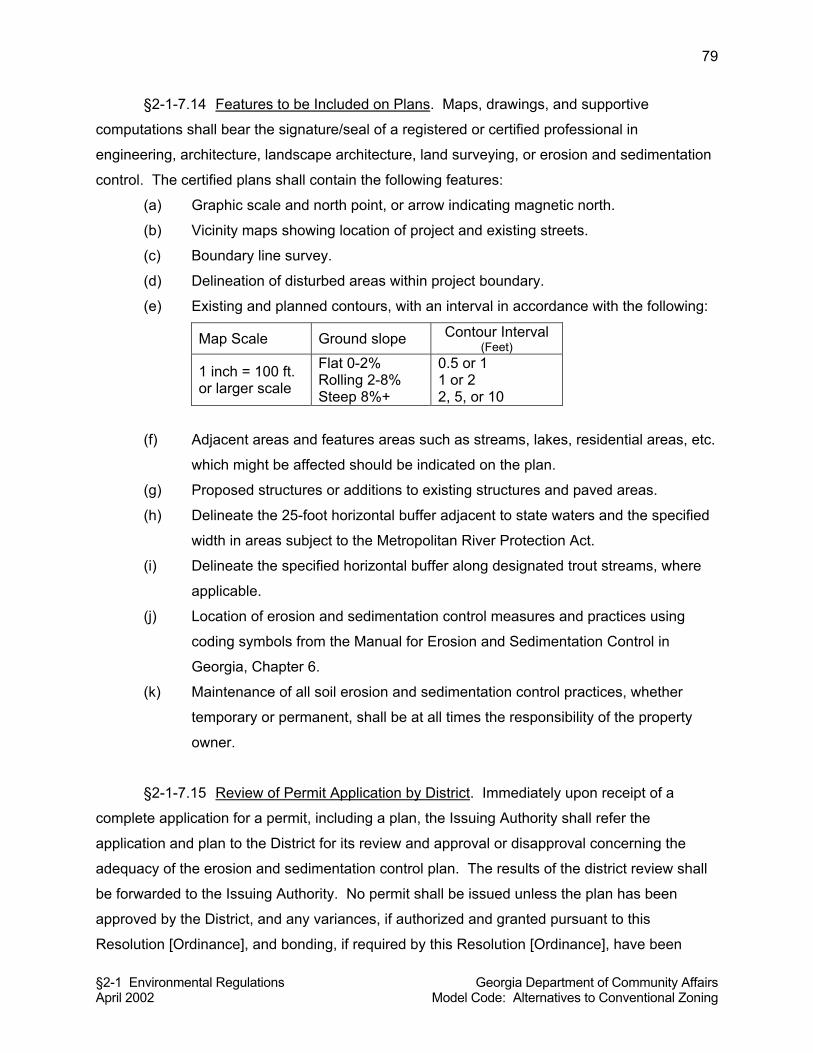
§2-1 Environmental Regulations Georgia Department of Community Affairs April 2002 Model Code: Alternatives to Conventional Zoning
79
§2-1-7.14 Features to be Included on Plans. Maps, drawings, and supportive
computations shall bear the signature/seal of a registered or certified professional in
engineering, architecture, landscape architecture, land surveying, or erosion and sedimentation
control. The certified plans shall contain the following features:
(a) Graphic scale and north point, or arrow indicating magnetic north.
(b) Vicinity maps showing location of project and existing streets.
(c) Boundary line survey.
(d) Delineation of disturbed areas within project boundary.
(e) Existing and planned contours, with an interval in accordance with the following:
Map Scale Ground slope Contour Interval (Feet)
1 inch = 100 ft. or larger scale
Flat 0-2% Rolling 2-8% Steep 8%+
0.5 or 1 1 or 2 2, 5, or 10
(f) Adjacent areas and features areas such as streams, lakes, residential areas, etc.
which might be affected should be indicated on the plan.
(g) Proposed structures or additions to existing structures and paved areas.
(h) Delineate the 25-foot horizontal buffer adjacent to state waters and the specified
width in areas subject to the Metropolitan River Protection Act.
(i) Delineate the specified horizontal buffer along designated trout streams, where
applicable.
(j) Location of erosion and sedimentation control measures and practices using
coding symbols from the Manual for Erosion and Sedimentation Control in
Georgia, Chapter 6.
(k) Maintenance of all soil erosion and sedimentation control practices, whether
temporary or permanent, shall be at all times the responsibility of the property
owner.
§2-1-7.15 Review of Permit Application by District. Immediately upon receipt of a
complete application for a permit, including a plan, the Issuing Authority shall refer the
application and plan to the District for its review and approval or disapproval concerning the
adequacy of the erosion and sedimentation control plan. The results of the district review shall
be forwarded to the Issuing Authority. No permit shall be issued unless the plan has been
approved by the District, and any variances, if authorized and granted pursuant to this
Resolution [Ordinance], and bonding, if required by this Resolution [Ordinance], have been
§2-1 Environmental Regulations Georgia Department of Community Affairs April 2002 Model Code: Alternatives to Conventional Zoning
80
obtained. Such review will not be required if the Issuing Authority and the District have entered
into an agreement that allows the Issuing Authority to conduct such review and approval of the
plan without referring the application and plan to the District.
§2-1-7.16 Decision on Permit. Permits shall be issued or denied as soon as practicable
but in any event not later than 45 days after receipt by the Issuing Authority of a completed
application, providing variances and bonding are obtained, where necessary. No permit shall
be issued by the Issuing Authority unless the Issuing Authority has affirmatively determined that
the erosion and sedimentation control plan is in compliance with this Resolution [Ordinance],
and that the land use activity is in compliance with all rules and regulations in effect within the
jurisdictional boundaries of the Issuing Authority.
§2-1-7.17 Permit Denial. If the permit is denied, the reason for denial shall be furnished
to the applicant. If a permit applicant has had two or more violations of previous permits, this
Resolution [Ordinance], or the Erosion and Sedimentation Act, as amended, within three years
prior to the date of filing of the application under consideration, the Issuing Authority may deny
the permit application without further consideration.
§2-1-7.18 Violations as Grounds for Permit Revocation. The permit may be suspended,
revoked, or modified by the Issuing Authority, as to all or any portion of the land affected by the
plan, upon finding that the holder or his successor in the title is not in compliance with the
approved erosion and sedimentation control plan or that the holder or his successor in title is in
violation of this Resolution [Ordinance]. A holder of a permit shall notify any successor in title to
him as to all or any portion of the land affected by the approved plan of the conditions contained
in the permit.
§2-1-7.19 Violations and Orders to Comply. The [designated local government official]
will periodically inspect the sites of land disturbing activities for which permits have been issued
to determine if the activities are being conducted in accordance with the plan and if the
measures required in the plan are effective in controlling erosion and sedimentation. If, through
inspection, it is deemed that a person in engaged in land-disturbing activities as defined herein
has failed to comply with the approved plan, with permit conditions, or with the provisions of this
Resolution [Ordinance], a written notice to comply shall be served upon that person. The notice
shall set forth the measures necessary to achieve compliance and shall state the time within

§2-1 Environmental Regulations Georgia Department of Community Affairs April 2002 Model Code: Alternatives to Conventional Zoning
81
which such measures must be completed. If the person engaged in the land disturbing activity
fails to comply within the time specified, s/he shall be deemed in violation of this Resolution
[Ordinance].
§2-1-7.20 Authority to Enter Property and Investigate. The [designated local
government official] shall have the power to conduct such investigations as he or she may
reasonably deem necessary to carry out duties as prescribed in this Resolution [Ordinance],
and for this purpose to enter at reasonable times upon any property, public or private, for the
purpose of investigation and inspecting the site of land disturbing activities. No person shall
refuse entry or access to any authorized representative or agent of the Issuing Authority, the
Commission, the District, or Division who requests entry for the purpose of inspection, and who
presents appropriate credentials, nor shall any person obstruct, hamper, or interfere with any
such representative while in the process of carrying out his official duties.
§2-1-7.21 Penalty for Failing to Obtain a Permit for Land Disturbing Activity. If any
person commences any land disturbing activity requiring a land disturbing permit as specified in
this Resolution [Ordinance] without first obtaining said permit, the person shall be subject to
revocation of his business license, work permit or other authorization for the conduct of a
business and associated work activities within the jurisdictional boundaries of the Issuing
Authority.
§2-1-7.22 Warnings and Stop Work Orders. For the first and second violations of the
provisions of this Resolution [Ordinance] by any violator, the Issuing Authority shall issue a
written warning to the violator. The violator shall have five days to correct the violation. If the
violation is not corrected within five days, the Issuing Authority shall issue a stop work order
requiring that land disturbing activities be stopped until necessary corrective action or mitigation
has occurred. However, if the violation presents an imminent threat to public health or waters of
the state or if the land disturbing activities are conducted without obtaining the necessary
permit, the Issuing Authority shall issue an immediate stop work order in lieu of a warning. For
a third and each subsequent violation, the Issuing Authority shall issue an immediate stop work
order. All stop work orders shall be effective immediately upon issuance and shall be in effect
until the necessary corrective action or mitigation has occurred.
§2-1 Environmental Regulations Georgia Department of Community Affairs April 2002 Model Code: Alternatives to Conventional Zoning
82
§2-1-7.23 Bond Forfeiture. If, through inspection, it is determined that a person
engaged in a land disturbing activity has failed to comply with the approved plan, a written
notice to comply shall be served upon that person. The notice shall set forth the measures
necessary to achieve compliance with the plan and shall state the time within which such
measures must be completed. If the person engaged in the land disturbing activity fails to
comply within the time specified, he shall be deemed in violation of this Resolution [Ordinance]
and, in addition to other penalties, shall be deemed to have forfeited his performance bond, if
required to post one under the provisions of this Resolution [Ordinance]. The Issuing Authority
may call the bond or any part thereof to be forfeited and may use the proceeds to hire a
contractor to stabilize the site of the land disturbing activity and bring it into compliance.
§2-1-7.24 Monetary Penalties. Except as otherwise specifically provided in this section,
any person who violates any provisions of this Resolution [Ordinance] or any permit condition,
or who negligently or intentionally fails or refuses to comply with any final or emergency order of
the Issuing Authority issued as provided in this Resolution [Ordinance] shall be liable for a civil
penalty not to exceed $2,500 per day. Each day during which violation or failure or refusal to
comply continues shall be a separate violation.
The following specific penalties shall apply to land disturbing activities performed in violation of
any provision of this Resolution [Ordinance], or any permit condition. There shall be a minimum
penalty of $250 per day for each violation involving construction of a single-family dwelling by or
under contract with the owner for his or her own occupancy.
There shall be a minimum penalty of $1,000 per day for each violation involving land disturbing
activities other than those involving construction of a single-family dwelling by or under contract
with the owner for his or her own occupancy.
§2-1-7.25 Appeal and Hearing, and Judicial review. The suspension, revocation,
modification or grant with condition of a permit by the Issuing Authority upon finding that the
holder is not in compliance with the approved erosion and sediment control plan, or that the
holder is in violation of any Resolution [Ordinance], shall entitle the person submitting the plan
or holding the permit to a hearing before the [board or body] within [number] days after receipt
by the Issuing Authority of written notice of appeal. Any person aggrieved by a decision or order
of the Issuing Authority, after exhausting his or her administrative remedies via this section,
shall have the right to appeal de novo to the Superior Court of _________ County.
§2-1 Environmental Regulations Georgia Department of Community Affairs April 2002 Model Code: Alternatives to Conventional Zoning
83
§2-1-7.26 Validity. If any section, paragraph, clause, phrase, or provision of this
Resolution [Ordinance] shall be adjudged invalid or held unconstitutional, such decisions shall
not effect the remaining portions of this Resolution [Ordinance].
§2-1-7.27 Liability. Neither the approval of a plan under the provisions of this
Resolution [Ordinance], nor the compliance with provisions of this Resolution [Ordinance], shall
relieve any person from the responsibility for damage to any person or property otherwise
imposed by law, nor impose any liability upon the Issuing Authority or District for damage to any
person or property. The fact that a land disturbing activity for which a permit has been issued
results in injury to the property of another shall neither constitute proof of nor create a
presumption of a violation of the standards provided for in this Resolution [Ordinance] or the
terms of the permit. No provision of this Resolution [Ordinance] shall permit any persons to
violate the Georgia Erosion and Sedimentation Act of 1975, the Georgia Water Quality Control
Act, or the rules and regulations promulgated and approved thereunder or pollute any waters of
the State as defined thereby.
§2-1-7.28 Incorporation of Georgia Erosion and Sedimentation Act of 1975. It is the
intent of the county [city] to apply and enforce the Georgia Erosion and Sedimentation Act of
1975 (O.C.G.A. Chapter 12-7) within the boundaries of its jurisdiction. To that end, the said Act
is incorporated herein by reference and shall be enforced under the provisions of this section,
except where any provision of this section is in conflict with the said Act, in which case the more
restrictive provision will apply.
§2-1-8 GRADING
Commentary: All grading (land-disturbing activity) is governed by the Erosion and
Sedimentation Act made applicable locally by adopting the previous module (2-1-7). This
module may not be needed by most local governments since the best management practices
required under Section 2-1-7 address virtually all major aspects of grading. However, this
module provides greater specificity and additional regulations that may be appropriate in some
jurisdictions. Local governments should weigh whether these additional provisions are needed,
or whether a “minimalist” approach to the regulation of land-disturbing activities is desired. If a
minimal approach is desired, the combination of modules 2-1-6 and 2-1-7 may be sufficient.
§2-1 Environmental Regulations Georgia Department of Community Affairs April 2002 Model Code: Alternatives to Conventional Zoning
84
§2-1-8.1 Purposes. The purposes of this Resolution [Ordinance] are to limit grading to
the minimum amount necessary; establish minimum requirements for grading work; guard
against land instability; prevent the unnecessary removal of vegetation; protect the quality of
wetlands and water courses from increased sedimentation; and, to preserve the aesthetic
quality of the natural terrain.
§2-1-8.2 Definitions.
Cut: The removal of naturally occurring earth materials by mechanical means.
Development: Any activity which alters the elevation of the land, removes or destroys plant life,
or causes structures of any kind to be erected or removed.
Elevation: The vertical height or heights above a datum plane which for purposes of this
Resolution [Ordinance] shall be the Mean Sea Level datum of the United States Coast and
Geodetic Survey of 1929 or other customarily accepted source.
Existing grade: The elevation of the ground surface at any given point prior to cutting or filling.
Fill: The deposit of soil, rock or other material by man.
Finished grade: The elevation of the ground surface at any given point after cutting or filling.
Grading: Any cutting, or filling or combination thereof and includes the land in its cut or filled
condition.
Natural drainage: Channels formed by the existing surface topography of the earth prior to
changes made by unnatural causes.
Slope: An inclined ground surface, the inclination of which is expressed as a ratio of horizontal
distance to vertical distance.
§2-1-8.3 Grading Permit Required. A grading permit shall be required for all grading
activities for any site if the combined volume of excavation, fill, dredging, or other movement of
earth materials is more than 50 cubic yards unless specifically exempted by this Resolution
[Ordinance]. No grading as specified in this section shall take place until grading plans have
been submitted to, approved by, and a grading permit issued by the land use officer. At the
applicant’s option, where there will be construction or placement of a building following grading
activities, the grading approval and permit may be a component of any required land use permit
or building permit.
§2-1 Environmental Regulations Georgia Department of Community Affairs April 2002 Model Code: Alternatives to Conventional Zoning
85
Commentary: This module specifies a “grading” permit as separate and distinct from a “land-
disturbance” permit required by Section 2-1-7 of this model code. Some local governments do
have both a grading permit requirement and a land-disturbance permit requirement, so as to
distinguish between the two required permitting requirements. However, if this module is
adopted, consideration should be given to merging the grading and land-disturbance permit
processes.
Commentary: Local governments may wish to set the threshold of 50 cubic yards of grading to
trigger the requirement for a grading permit. Review of grading plans is primarily the purview of
the civil engineer, as it involves predominantly engineering considerations. However, planners
usually review grading plans for non-engineering considerations, such as the aesthetics of the
landscape, consistency with Comprehensive Plan policies, and protection of environmentally
sensitive areas. This ordinance provides the land use officer with final authority over the
approval of grading activities, even though the applicant for a grading permit would work much
closer with the local government engineer in the review process. This is done to keep all
permits regarding land use activities under the authority of one person. However, depending on
local staffing arrangements, the responsibility for final approval of grading plans might rest with
the local government engineer rather than the land use officer. If so, approval by the engineer
needs to, at minimum, be “signed off on” by the land use officer. However, most small rural
local governments do not have an engineer on staff. It must be emphasized here that local
governments need to have an engineer on staff or an arrangement with a consulting engineer to
adequately administer and enforce grading and land-disturbance regulations.
§2-1-8.4 Exemptions. The following grading activities shall be exempt from the
requirement to file grading plans and received a grading permit.
(a) Excavations and filling of cemetery graves.
(b) Excavations for exploratory investigations by soil scientists, engineering
geologists, and the like.
(c) Grading or filling performed exclusively for agricultural activities in fields such as
the planting of crops or the raising of livestock, but not including the construction
of any building or structure.
(d) Operation of surface mines and other activities involving the extraction of mineral
and earth materials subject to the regulations and under a permit of the Georgia
Department of Natural Resources.
§2-1 Environmental Regulations Georgia Department of Community Affairs April 2002 Model Code: Alternatives to Conventional Zoning
86
(e) Sanitary landfills or other landfills subject to the regulations and under a permit of
the Georgia Department of Natural Resources.
(f) Stockpiling and handling of earth material when the earth material is consumed
or produced in a process which is the principal use of the site.
(g) On-site work required for construction, repair, repaving, replacement or
reconstruction of an existing road, street or utility installation in a public right-of-
way.
(h) Trenching and backfilling for the installation, reconstruction or repair of utilities on
property other than a public right-of-way.
(i) Underground storage tank removal and replacement that is subject to regulation
by a state or federal agency.
§2-1-8.5 Specifications for Grading Plans. An application for a grading permit or
approval shall be made to the Land Use Officer. The grading plans shall be prepared by, or
under the direction of, a registered civil engineer for all applications where the total amount of
materials graded is more than 2,500 cubic yards. Grading plans shall show existing and
proposed contour lines at an interval of no more than five feet. Grading plans shall outline the
areas which are required to remain undisturbed (i.e., tree protection areas, buffers, etc.) and
shall indicate all protective measures such as fencing or staking to be placed surrounding such
areas. The Land Use Officer may require additional information pertaining to the specific site
and any other relevant information needed in order to assess potential hazards associated with
the proposed grading activities and to determine whether a grading permit or approval should
be issued. Grading plans shall be processed in accordance with procedures for building permits
or, when not submitted simultaneously with a building permit application, shall be processed
and a final decision made by the Land Use Officer within thirty (30) days of receiving a
completed application.
§2-1-8.6 Site Grading Regulations.
(a) Final graded slopes shall be no steeper than is safe for the intended use. The
maximum slopes for cut or fill shall be 2:1 (two feet of horizontal run for each foot
of rise or fall), except as approved by the County [City] Engineer.
(b) When a cut is made in rock that requires blasting, the slope may be steeper if
presplitting is employed and upon submission of a geotechnical report which
substantiates the integrity of the rock in the steeper condition, subject to the
§2-1 Environmental Regulations Georgia Department of Community Affairs April 2002 Model Code: Alternatives to Conventional Zoning
87
review and approval of the County [City] Engineer. No blasting shall occur
without a valid permit issued by the Fire Marshal.
(c) Grading shall not create or contribute to flooding, erosion, or increased turbidity,
siltation or other forms of pollution in a watercourse.
(d) All grading shall occur entirely within the site, unless encroachment on adjoining
property is shown on grading plans and the applicant provides; proof of
ownership, an easement authorizing the encroachment, or a letter signed by the
owner of the adjoining property which authorizes such temporary encroachments
during construction on the adjoining property.
(e) Any grading shall be performed in such a manner that final contours appear to be
consistent with the existing terrain, both on and adjacent to the site.
(f) Construction and development plans calling for excessive cutting and filling may
be refused a grading permit by the Land Use Officer if it is determined that the
proposed land use can be supported with less alteration of the natural terrain.
§2-1-8.7 Grading in Areas of Special Flood Hazard. In addition to requirements for
grading approval or permit set forth in this Resolution [Ordinance], any grading in areas of
special flood hazard is subject to the requirements of Section 2-1-6 of this code, “Flood Damage
Prevention.”
§2-1-8.8 Erosion Control. Erosion and sedimentation control measures, as required
by Section 2-1-7 of this code, shall be coordinated with the sequence of grading, development,
and construction operations.
Commentary. If local governments choose not to adopt Sections 2-1-6 and 2-1-7, then the two
paragraphs above would be deleted. However, since flood hazard regulations are required to
be eligible for the flood insurance program, and because erosion control regulations are
enforced by the state if not by local government, most local governments will need to adopt
regulations for flood plains and soil erosion and sedimentation.
§2-1-8.9 Grading on Steep Slopes. In areas where the slope of a given parcel to be
developed exceeds 35 percent, at least 85 percent of the ground surface of the parcel shall
remain in an undistributed state (i.e., not cut or fill).
§2-1 Environmental Regulations Georgia Department of Community Affairs April 2002 Model Code: Alternatives to Conventional Zoning
88
Commentary: Some communities will not have steep slopes as defined here, and thus could
delete this provision. It is intended to apply to communities that have hillside or mountain
topography and that wish to avoid clearcutting of steep slopes, which can damage the natural
environment and destroy scenic views. The 15 percent allowance for cut and fill on steep
slopes should normally be adequate to allow a single-family residence and perhaps other types
of development to occur on steep slopes.
§2-1-8.10 Requirements for Fill Material. Materials used in fills shall comply with the
following requirements:
(a) Material used in filling shall be appropriate to the site and the intended use of that
portion of the site.
(b) Fill shall be composed of earth materials. Any rock or other similar irreducible
material used in a fill shall be of a maximum diameter of 12 inches and shall
compose not more than 20 percent of the total fill material.
(c) Topsoil shall not be used as a fill material except that the upper 12 inches of a fill
site may be covered with topsoil.
(d) No frozen or thawing material shall be used in a fill.
(e) No solid waste, hazardous waste or hazardous material may be used in a fill.
(f) No organic material shall be used in a fill unless approved by the Land Use
Officer.
(g) Fill must be compacted to 95 percent unless the County [City] Engineer specifies
another standard.
§2-1-8.11 Temporary Stockpiling during Construction or Grading. Temporary stockpiles
of earth materials during construction or grading shall not exceed ten feet in height. Stockpiles
shall have slopes no greater than one horizontal to one vertical. Stockpiles shall not be placed
in locations that would cause suffocation of root systems of trees to be preserved.
§2-1-8.12 Compliance. Grading shall be done in accordance with the lines and grades
shown on the approved grading plan.
Commentary on making this module a stand-alone ordinance: This module is written as if it will
be adopted as part of a more comprehensive land use management code. To make this
§2-1 Environmental Regulations Georgia Department of Community Affairs April 2002 Model Code: Alternatives to Conventional Zoning
89
module stand-alone will require several other provisions, such as a preamble, enforcement,
appeals, and more detailed provisions on procedures.
References:
Gwinnett County, Georgia, Development Regulations.
For a straightforward, general discussion of earthwork considerations, see: Lynch, Kevin, and
Gary Hack. 1984. Site Planning. Cambridge: MIT Press.
For formulas, calculations, and other technical, engineering-related aspects of grading and
earthwork, see: Brewer, William E., and Charles P. Alter. 1988. The Complete Manual of Land
Planning and Development. Englewood Cliffs, NJ: Prentice-Hall; and Colley, B.C. 1986.
Practical Manual of Site Development. New York: McGraw-Hill.
§2-2 Subdivisions and Land Development Georgia Department of Community Affairs April 2002 Model Code: Alternatives to Conventional Zoning
1
§2-2 SUBDIVISIONS AND LAND DEVELOPMENT
CONTENTS §2-2-1 TITLE §2-2-2 PURPOSES §2-2-3 DEFINITIONS §2-2-4 AUTHORITY AND DELEGATION §2-2-4.1 Authority §2-2-4.2 Delegation of Powers to Planning Commission §2-2-4.3 Delegation of Powers to Director §2-2-4.4 Delegation of Powers to County [City] Engineer §2-2-5 APPLICABILITY AND GENERAL PROVISIONS §2-2-5.1 Applicability §2-2-5.2 Land is One Tract Until Subdivided §2-2-5.3 All Land Subdivisions to Comply §2-2-5.4 Preliminary Plat or Site Plan and Plans Required Prior to Construction §2-2-5.5 Building and Other Permits §2-2-5.6 Public Streets and Lands §2-2-5.7 Appeals §2-2-6 EXEMPTIONS FROM PLAT APPROVAL §2-2-7 LOT COMBINATIONS §2-2-8 BOUNDARY LINE ADJUSTMENTS §2-2-9 DESIGN REQUIREMENTS FOR BLOCKS §2-2-9.1 Block Length §2-2-9.2 Block Width §2-2-10 DESIGN REQUIREMENTS FOR LOTS §2-2-10.1 Natural Features and Assets §2-2-10.2 Access and Minimum Lot Frontage §2-2-10.3 Adequate Buildable Area Required §2-2-10.4 Lot Remnants Not Permitted §2-2-10.5 Service Areas §2-2-10.6 Lot Area §2-2-10.7 Lot Width §2-2-10.8 Lot Depth §2-2-10.9 Flag Lots §2-2-10.10 Side Lot Lines §2-2-10.11 Corner Lots §2-2-10.12 Double Frontage Lots §2-2-11 EASEMENTS §2-2-12 SURVEY MONUMENTS FOR ALL LOTS REQUIRED §2-2-13 PRELIMINARY PLAT §2-2-13.1 Purpose §2-2-13.2 When Required §2-2-13.3 Preliminary Plat Application and Specifications §2-2-13.4 Procedures §2-2-13.5 Disposition §2-2-13.6 Appeal §2-2-13.7 Amendments to Approved Preliminary Plats
§2-2 Subdivisions and Land Development Georgia Department of Community Affairs April 2002 Model Code: Alternatives to Conventional Zoning
2
§2-2-14 CONSTRUCTION PLANS §2-2-14.1 Application §2-2-14.2 Director’s Decision Criteria §2-2-14.3 Certificate of Approval §2-2-15 FINAL PLAT §2-2-15.1 When Required §2-2-15.2 Criteria for Approval §2-2-15.3 Approval Certificate §2-2-15.4 Additional Plat Certificates §2-2-16 DEDICATIONS OF STREETS AND PUBLIC LANDS §2-2-17 SUBDIVISION IMPROVEMENT GUARANTEES §2-2-18 LIMITATIONS ON MINOR SUBDIVISIONS §2-2-18.1 Purpose §2-2-18.2 Common Contiguous Parcels Shown on Minor Subdivision Plats §2-2-18.3 Limitations §2-2-19 PRIVATE STREETS §2-2-19.1 Private Streets Permitted §2-2-19.2 Engineering Plans Required §2-2-19.3 Standards §2-2-19.4 Street Names and Signs §2-2-19.5 Easements §2-2-19.6 Maintenance §2-2-19.7 Specifications for Final Plats Involving Private Streets §2-2-19.8 Requirement for Purchaser’s Acknowledgement of Private Responsibilities §2-2 SUBDIVISIONS AND LAND DEVELOPMENT
Commentary on Purpose of Subdivision Regulations: Without subdivision regulations, a
community may have tracts of land sold without provision for water, sewage disposal, or even
access. It may without such regulations have lots that cannot be developed. Without land
subdivision regulations, land records are likely to be inadequate. There is probably no other
regulation more important than subdivision regulations, because the resulting designs and
patterns of land subdivision establish the geography and geometry of the community and in turn
influence the entire character of the city or county. Once land has been cut up into streets,
blocks, and lots, the pattern is very difficult to alter. The subdivision and development of land
affects the welfare of the entire community in so many ways that it cannot be entrusted to
haphazard subdivision design.
Commentary: This ordinance provides for the regulation of subdivision plats and land
developments. Subdivisions are classified as minor (four lots or less) which can be approved
administratively by the Director (land use officer) and major subdivisions (more than four lots)
which require approval by the Planning Commission. Section 2-3 is an integral companion
§2-2 Subdivisions and Land Development Georgia Department of Community Affairs April 2002 Model Code: Alternatives to Conventional Zoning
3
module to this module, as it contains improvement requirements for all land subdivisions and
land developments.
§2-2-1 TITLE
These regulations shall be known and may be referred to as the land subdivision regulations of
__________ County [City of _____________].
§2-2-2 PURPOSES
This Resolution [Ordinance] is adopted for the following purposes.
(a) Promote the orderly, planned, efficient, and economic development of the County [City]
and to guide future growth in accordance with the Comprehensive Plan.
(b) Ensure that lands subdivided are of such character that they can be used for building purposes without danger to the health or safety of residents, and to secure safety from fire, flood, or other menace. (c) Prevent the pollution of air, land, streams, and ponds, as well as encourage the wise use
and management of natural resources throughout the County [City], and preserve the
topography and beauty of the community and the value of land.
(d) Ensure the proper provision of improvements such as drainage, water, sewerage, and
capital improvements such as schools, parks, playgrounds, recreational facilities, and
transportation facilities.
(e) Provide for open spaces through the most efficient design and layout of the land.
(f) Establish procedures for the subdivision and re-subdivision of land in order to further the
orderly development of land.
(g) Provide for the proper monumenting of subdivided land and proper legal descriptions.
(h) Help eliminate the costly maintenance problems that develop when streets and lots are
established without proper consideration given to various public purposes.
(i) Facilitate and inform lot purchasers who generally lack the specialized knowledge
needed to evaluate subdivision improvements and design.
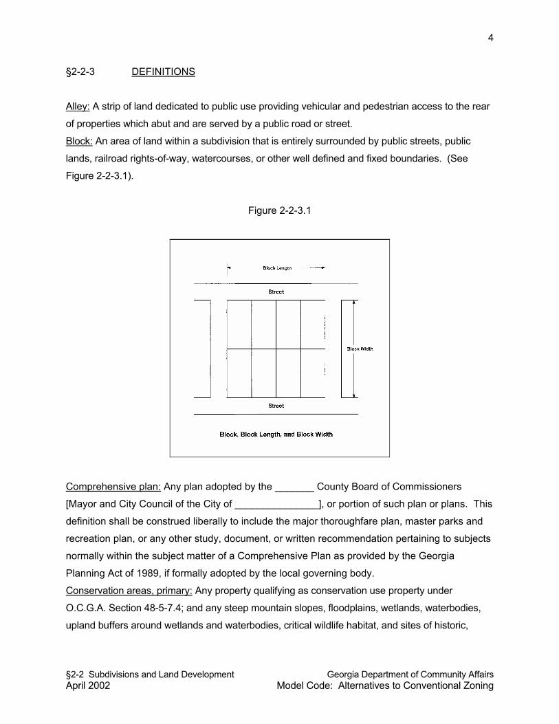
§2-2 Subdivisions and Land Development Georgia Department of Community Affairs April 2002 Model Code: Alternatives to Conventional Zoning
4
§2-2-3 DEFINITIONS
Alley: A strip of land dedicated to public use providing vehicular and pedestrian access to the rear
of properties which abut and are served by a public road or street.
Block: An area of land within a subdivision that is entirely surrounded by public streets, public
lands, railroad rights-of-way, watercourses, or other well defined and fixed boundaries. (See
Figure 2-2-3.1).
Figure 2-2-3.1
Comprehensive plan: Any plan adopted by the _______ County Board of Commissioners
[Mayor and City Council of the City of _______________], or portion of such plan or plans. This
definition shall be construed liberally to include the major thoroughfare plan, master parks and
recreation plan, or any other study, document, or written recommendation pertaining to subjects
normally within the subject matter of a Comprehensive Plan as provided by the Georgia
Planning Act of 1989, if formally adopted by the local governing body.
Conservation areas, primary: Any property qualifying as conservation use property under
O.C.G.A. Section 48-5-7.4; and any steep mountain slopes, floodplains, wetlands, waterbodies,
upland buffers around wetlands and waterbodies, critical wildlife habitat, and sites of historic,
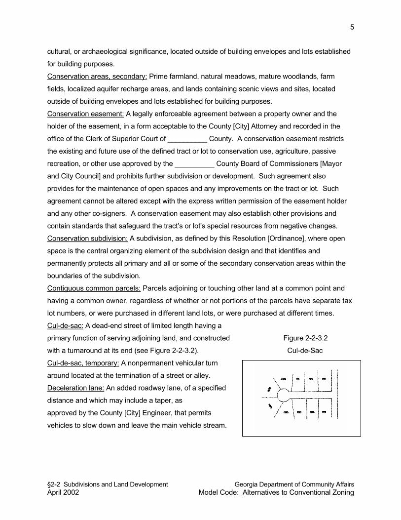
§2-2 Subdivisions and Land Development Georgia Department of Community Affairs April 2002 Model Code: Alternatives to Conventional Zoning
5
cultural, or archaeological significance, located outside of building envelopes and lots established
for building purposes.
Conservation areas, secondary: Prime farmland, natural meadows, mature woodlands, farm
fields, localized aquifer recharge areas, and lands containing scenic views and sites, located
outside of building envelopes and lots established for building purposes.
Conservation easement: A legally enforceable agreement between a property owner and the
holder of the easement, in a form acceptable to the County [City] Attorney and recorded in the
office of the Clerk of Superior Court of __________ County. A conservation easement restricts
the existing and future use of the defined tract or lot to conservation use, agriculture, passive
recreation, or other use approved by the __________ County Board of Commissioners [Mayor
and City Council] and prohibits further subdivision or development. Such agreement also
provides for the maintenance of open spaces and any improvements on the tract or lot. Such
agreement cannot be altered except with the express written permission of the easement holder
and any other co-signers. A conservation easement may also establish other provisions and
contain standards that safeguard the tract’s or lot's special resources from negative changes.
Conservation subdivision: A subdivision, as defined by this Resolution [Ordinance], where open
space is the central organizing element of the subdivision design and that identifies and
permanently protects all primary and all or some of the secondary conservation areas within the
boundaries of the subdivision.
Contiguous common parcels: Parcels adjoining or touching other land at a common point and
having a common owner, regardless of whether or not portions of the parcels have separate tax
lot numbers, or were purchased in different land lots, or were purchased at different times.
Cul-de-sac: A dead-end street of limited length having a
primary function of serving adjoining land, and constructed Figure 2-2-3.2
with a turnaround at its end (see Figure 2-2-3.2). Cul-de-Sac
Cul-de-sac, temporary: A nonpermanent vehicular turn
around located at the termination of a street or alley.
Deceleration lane: An added roadway lane, of a specified
distance and which may include a taper, as
approved by the County [City] Engineer, that permits
vehicles to slow down and leave the main vehicle stream.
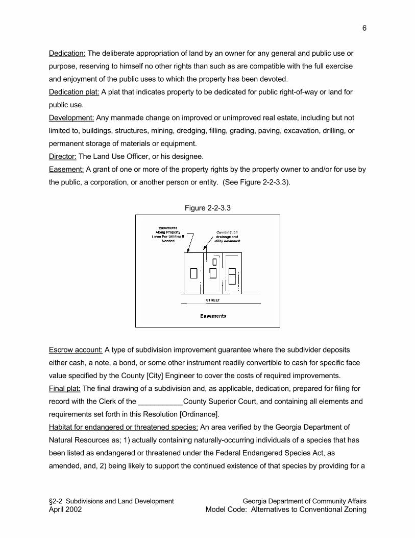
§2-2 Subdivisions and Land Development Georgia Department of Community Affairs April 2002 Model Code: Alternatives to Conventional Zoning
6
Dedication: The deliberate appropriation of land by an owner for any general and public use or
purpose, reserving to himself no other rights than such as are compatible with the full exercise
and enjoyment of the public uses to which the property has been devoted.
Dedication plat: A plat that indicates property to be dedicated for public right-of-way or land for
public use.
Development: Any manmade change on improved or unimproved real estate, including but not
limited to, buildings, structures, mining, dredging, filling, grading, paving, excavation, drilling, or
permanent storage of materials or equipment.
Director: The Land Use Officer, or his designee.
Easement: A grant of one or more of the property rights by the property owner to and/or for use by
the public, a corporation, or another person or entity. (See Figure 2-2-3.3).
Figure 2-2-3.3
Escrow account: A type of subdivision improvement guarantee where the subdivider deposits
either cash, a note, a bond, or some other instrument readily convertible to cash for specific face
value specified by the County [City] Engineer to cover the costs of required improvements.
Final plat: The final drawing of a subdivision and, as applicable, dedication, prepared for filing for
record with the Clerk of the ___________County Superior Court, and containing all elements and
requirements set forth in this Resolution [Ordinance].
Habitat for endangered or threatened species: An area verified by the Georgia Department of
Natural Resources as; 1) actually containing naturally-occurring individuals of a species that has
been listed as endangered or threatened under the Federal Endangered Species Act, as
amended, and, 2) being likely to support the continued existence of that species by providing for a
§2-2 Subdivisions and Land Development Georgia Department of Community Affairs April 2002 Model Code: Alternatives to Conventional Zoning
7
significant portion of that species' biological requirements, and that meets the definition of "natural
conditions" as defined by this Resolution [Ordinance].
Half street: A portion of the ultimate width of a road or street where the remaining portion of the
road or street shall be provided at a future date.
Home owners association: An organization formed for the maintenance and operation of the
common areas of a development, where membership in the association is automatic with the
purchase of a dwelling unit or lot within the development, with the ability to legally assess each
owner of a dwelling unit or lot and which has authority to place a lien against all dwelling units and
lots within the development.
Land suitability analysis: A method used by land planners, in preparing land use plans at a
community- wide scale or land plans at a site development scale, to evaluate the fitness of land
for various uses based at least partially on environmental criteria. The end product of land
suitability analysis is typically a map or set of maps depicting the appropriateness of land areas
for various land uses.
Letter of credit: A type of subdivision improvement guarantee whereby a subdivider secures an
instrument from a bank or other institution or from a person with resources sufficient to cover the
cost of improvements required by the County [City]. The instrument pledges the creditor to pay
the cost of improvements in case of default by the subdivider.
Lot: A portion or parcel of land separated from other portions or parcels by description (such as on
a subdivision plat of record or a survey map or plat) or described by metes and bounds, and
intended for use, transfer of ownership, or for building development. The word "lot" shall not
include any portion of a dedicated right-of-way. Types of lots are illustrated in Figure 2-2-3.4.
Lot, corner: A lot abutting upon two or more streets at their intersection.
Lot, depth: The average horizontal distance between the front and rear lot lines.
Lot, double frontage: A lot other than a corner lot that has frontage upon two or more streets that
do not intersect at a point abutting the property.
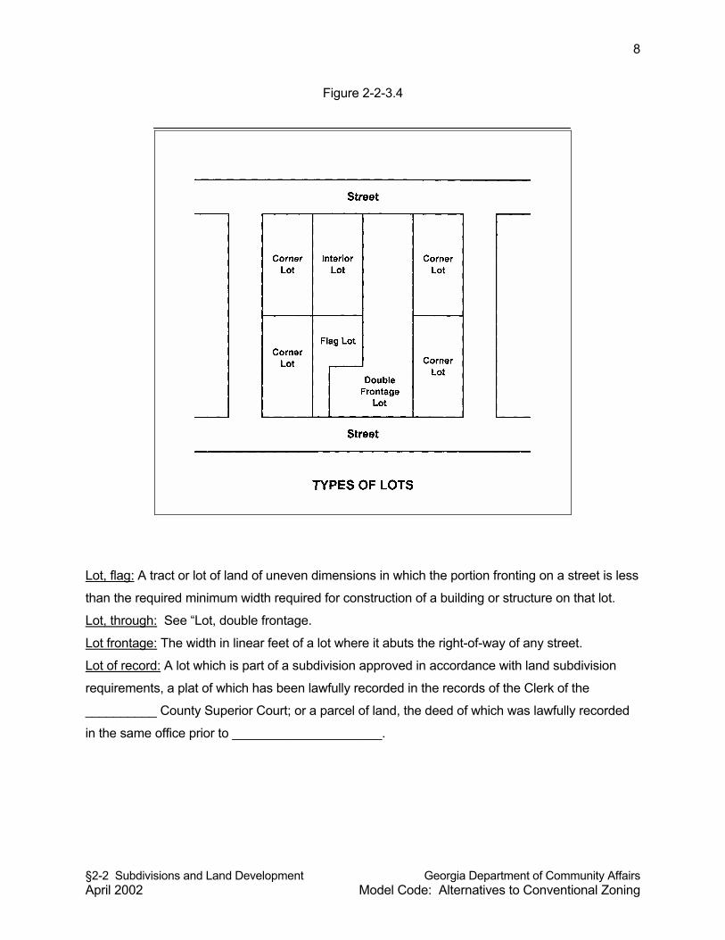
§2-2 Subdivisions and Land Development Georgia Department of Community Affairs April 2002 Model Code: Alternatives to Conventional Zoning
8
Figure 2-2-3.4
Lot, flag: A tract or lot of land of uneven dimensions in which the portion fronting on a street is less
than the required minimum width required for construction of a building or structure on that lot.
Lot, through: See “Lot, double frontage.
Lot frontage: The width in linear feet of a lot where it abuts the right-of-way of any street.
Lot of record: A lot which is part of a subdivision approved in accordance with land subdivision
requirements, a plat of which has been lawfully recorded in the records of the Clerk of the
__________ County Superior Court; or a parcel of land, the deed of which was lawfully recorded
in the same office prior to _____________________.
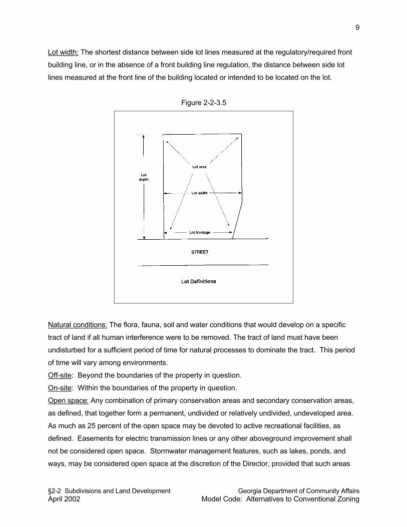
§2-2 Subdivisions and Land Development Georgia Department of Community Affairs April 2002 Model Code: Alternatives to Conventional Zoning
9
Lot width: The shortest distance between side lot lines measured at the regulatory/required front
building line, or in the absence of a front building line regulation, the distance between side lot
lines measured at the front line of the building located or intended to be located on the lot.
Figure 2-2-3.5
Natural conditions: The flora, fauna, soil and water conditions that would develop on a specific
tract of land if all human interference were to be removed. The tract of land must have been
undisturbed for a sufficient period of time for natural processes to dominate the tract. This period
of time will vary among environments.
Off-site: Beyond the boundaries of the property in question.
On-site: Within the boundaries of the property in question.
Open space: Any combination of primary conservation areas and secondary conservation areas,
as defined, that together form a permanent, undivided or relatively undivided, undeveloped area.
As much as 25 percent of the open space may be devoted to active recreational facilities, as
defined. Easements for electric transmission lines or any other aboveground improvement shall
not be considered open space. Stormwater management features, such as lakes, ponds, and
ways, may be considered open space at the discretion of the Director, provided that such areas
§2-2 Subdivisions and Land Development Georgia Department of Community Affairs April 2002 Model Code: Alternatives to Conventional Zoning
10
are designed and maintained in a manner that contributes to open space and the aesthetics of the
subdivision.
Open space, public: An area within a development or subdivision designed and intended for the
use and enjoyment of all residents or for the use and enjoyment of the public in general.
Original tract: A unit of land which the owner holds under single or unified ownership, or which
the owner holds controlling interest on the effective date of this Resolution [Ordinance], where
all land abutting said tract is separately owned by others, not related to or associated by
business partnership with the owner.
Package treatment plant: A sewage treatment facility, usually privately operated, typically
having a treatment capacity of less than one million gallons per day. In most cases, a package
treatment plant is considered a temporary means of wastewater treatment until connection to a
public sanitary sewerage system is available.
Pedestrian way: A public right-of-way or private easement across a block or within a block to
provide access for pedestrians and which may, in addition to providing pedestrian access, be
used for the installation of utility lines.
Performance bond: A type of subdivision improvement guarantee in the form of a bond, secured
by the subdivider from a bonding company, in an amount specified by the County [City] Engineer
to cover the costs of required improvements, and payable to the County [City]. The County [City]
may call in the performance bond in the event the subdivider defaults on required improvements.
Person: A natural human being, estate, association, firm, partnership, corporation, or other legal
entity.
Preliminary plat: A tentative drawing or map of a proposed subdivision. A preliminary plat is the
basis for the approval or disapproval of the general layout of a land subdivision.
Planned unit development: A form of development usually characterized by a unified site design
for a number of housing units, clustered buildings, common open space, and a mix of building
types and land uses in a slightly more dense setting than allowable on separate zoned lots.
Professional engineer: An engineer duly registered or otherwise authorized by the State of
Georgia to practice in the field of civil engineering.
Professional surveyor: A surveyor duly registered or otherwise authorized by the State of Georgia
to practice in the field of land surveying.
Protective covenants: Contracts made between private parties as to the manner in which land
may be used, with the view toward protecting and preserving the physical and economic integrity
of any given area.
§2-2 Subdivisions and Land Development Georgia Department of Community Affairs April 2002 Model Code: Alternatives to Conventional Zoning
11
Recreation, active: Leisure activities that are facility oriented, such as swimming pools, tennis
courts, and ball fields.
Recreation, passive: Leisure activities that are natural resource oriented, such as hiking trails,
conservation areas, and nature preserves.
Reservation: A method of holding land for future public use by showing proposed public areas on
a subdivision plat.
Reserve strip: A strip of land across the end of, or along the edge of, a street, alley, or lot for the
purpose of controlling access which is reserved or held until future street extension or widening.
Right-of-way:
(a) A strip of land acquired by reservation, dedication, forced dedication, prescription,
or condemnation and intended to be occupied by a road, crosswalk, railroad,
electric transmission line, oil or gas pipeline, water line, sanitary storm sewer, or
other similar use.
(b) Generally, the right of one to pass over the property of another.
Scenic views and sites: Those geographic areas containing visually significant or unique natural
features, as identified in the Comprehensive Plan, or by other reasonable means.
Sensitive natural areas: Any area, as identified now or hereafter by the Department of Natural
Resources, which contains one or more of the following:
(a) Habitat, including nesting sites, occupied by rare or endangered species;
(b) Rare or exemplary natural communities;
(c) Significant landforms, hydroforms, or geological features; and/or
(d) Other areas so designated by the Department of Natural Resources that are
sensitive or vulnerable to physical or biological alteration.
Septic tank: An approved watertight tank designed or used to receive sewage from a building
sewer and to affect separation and organic decomposition of sewerage solids, and discharging
sewage effluent to an absorption field or other management system.
Shade tree: A tree in a public place, street right-of-way, or special easement, planted to provide
canopy that will obscure the sun and heat from the ground.
Sidewalk: A hard-surfaced pedestrian access area adjacent to or within the right-of-way of a
public road.
Site plan: A neat and approximate drawing of a multi-family residential, institutional, office,
commercial, or industrial development, showing the general layout of a proposed development
including among other features the location of buildings, parking areas, and buffers and
landscaping. The site plan is the basis for the approval or disapproval of the general layout of a
§2-2 Subdivisions and Land Development Georgia Department of Community Affairs April 2002 Model Code: Alternatives to Conventional Zoning
12
development in the case of a multiple-family residential, institutional, office, commercial, or
industrial development.
Slope: Degree of deviation of a surface from the horizontal, usually expressed in percent or
degree; the ratio of the difference in elevation between two points on the ground, and the
horizontal distance between these two points. For purposes of determining steep slopes, slopes
shall be measured between two points on the ground separated by 500 feet or more.
Steep slopes: Lands with slopes of at least 35 percent, as indicated in the Comprehensive Plan of
the County [City], or which can be calculated with aid of a United States Geological Survey
1:24,000, 7.5 minute quadrangle topographic map or other available topographic information.
Street: Any vehicular way, other than an alley, that:
(a) is an existing federal, state, county or municipal roadway;
(b) is constructed as shown upon a plat approved pursuant to law and is open to
vehicle travel;
(c) is constructed and open to vehicle travel as approved by other official action of the
Board of Commissioners [Mayor and City Council]; or
(d) is constructed and open to vehicle travel and shown on a plat duly filed and
recorded in the Clerk's Office, __________ County Superior Court prior to the
effective date of this Resolution [Ordinance]. Land between the street lines,
whether improved or unimproved, shall be considered part of the street.
Street, collector: Unless otherwise defined by the Major Transportation Plan or Comprehensive
Plan, a collector street is a public street whose function is to collect traffic from neighborhoods and
local streets and which connects to another public street of equal of greater classification. A
collector also may provide direct access to adjacent properties.
Street, local: Unless otherwise defined in the Major Transportation Plan or Comprehensive Plan,
any public street, except an alley, collector, or arterial, and which has a primary function to provide
direct access to adjoining properties and which serves a limited area only, usually a single land
subdivision.
Street, major arterial: Unless otherwise defined by the Major Transportation Plan or
Comprehensive Plan, a major arterial street is a street connecting two or more towns or
communities, connecting two highways of equal or greater capacity, or serving as the primary
access to a large land area. A major arterial may also serve a large traffic generator (e.g., an
industrial area) and perform a secondary function of providing local access.
Street, marginal access: A residential street parallel and adjacent to a major thoroughfare and
which provides access to abutting properties with protection from through-traffic.
§2-2 Subdivisions and Land Development Georgia Department of Community Affairs April 2002 Model Code: Alternatives to Conventional Zoning
13
Street, private: A road or street that has not been accepted for maintenance by the County [City]
and that is not owned and maintained by a state, county, city, or another public entity.
Subdivider: Any person, as defined by this Resolution [Ordinance], who undertakes the
subdivision of land, and any person having such a proprietary interest in land to be subdivided as
will authorize the maintenance of proceedings to subdivide such land under this Resolution
[Ordinance], or the authorized agent of such person.
Subdivision: A division of a tract or parcel of land into two or more lots, building sites, or other
divisions for the purpose of sale or building development, whether immediate or future, including
all division of land involving the dedication of a new street or a change in existing streets. The
word “subdivision” includes re-subdivision and, when appropriate to the context, relates either to
the process of subdividing or to the actual land or area which is subdivided.
Subdivision, minor: A subdivision of four or fewer lots, which does not involve the construction of
a new public or private street. Because minor subdivisions do not involve the construction of a
new public or private street, they are processed administratively by the Director as final plat
applications that do not require preliminary plat approval. Any improvements to an existing
public street abutting the tract proposed for minor subdivision, or the installation of utilities along
said existing public road, as may be required to comply with this Resolution [Ordinance], shall
be done according to plans and permit requirements of this Resolution [Ordinance], but said
requirements shall not subject the minor subdivision to the requirements for a major subdivision
as specified in this Resolution [Ordinance].
Subdivision, major: The division of a tract or parcel of land into four or more lots which may or
may not involve the construction of a new public or private street; or any subdivision that
involves the construction of a new public or private street. Because major subdivisions involve
construction of a new public or private street or the upgrade of an existing private access way to
County [City] standards, construction plans and land disturbance permits are required, and
major subdivisions are therefore processed in multiple steps including preliminary plat approval
(unless specifically exempted), approval of construction plans and issuance of land disturbance
permits, and final plat approval.
Utility: Public or private water or sewer piping systems, water or sewer pumping stations,
electric power lines, fuel or gas pipelines, telephone lines, roads, cable telephone line, fiber optic
cable, driveways, bridges, river/lake access facilities, storm water systems and drainage ways,
and railroads or other utilities identified by the County [City]. As appropriate to the context, the
term “utility” may also include all persons, companies, or governmental agencies supplying the
same.
§2-2 Subdivisions and Land Development Georgia Department of Community Affairs April 2002 Model Code: Alternatives to Conventional Zoning
14
Variance: A grant of relief from the strict requirements of this Resolution [Ordinance] which
permits construction in a manner that would otherwise be prohibited by this Code; a minimal
relaxation or modification of the strict terms of this Resolution [Ordinance] as applied to specific
property when, because of particular physical surroundings, shape, or topographical condition of
the property, compliance would result in practical difficulty; or a grant of relief from the strict
requirements of this Resolution [Ordinance] due to a proposed project not being able to meet
policies and objectives specifically identified in the Comprehensive Plan.
§2-2-4 AUTHORITY AND DELEGATION
§2-2-4.1 Authority. These regulations are adopted pursuant to powers vested in
counties [cities] by the State of Georgia Constitution, home rule powers, state administrative
rules for the adoption and implementation of Comprehensive Plans, and the protection of vital
areas of the State.
§2-2-4.2 Delegation of Powers to Planning Commission. The Planning Commission is
vested with the authority to review, approve, conditionally approve, and disapprove preliminary
plats of major subdivisions, and to grant variances from the requirements of this Resolution
[Ordinance].
Commentary: Some cities and counties require the governing body (County Board of
Commissioners or Mayor and City Council) to approve preliminary plats and final plats of
subdivisions. That is a local choice. This model ordinance provides for the planning
commission to approve final plats. Final platting is an administrative procedure approved by the
Director (Land Use Officer).
§2-2-4.3 Delegation of Powers to Director. The Director is vested with the authority to
review, approve, conditionally approve or disapprove final plats of minor subdivisions and minor
re-subdivisions, lot combination plats, lot line adjustments, dedication plats, construction plans
and final plats of major subdivisions when preliminary plat approval has been obtained from the
Planning Commission. The Director shall also be authorized to review major subdivisions and
major re-subdivisions for conformity to the requirements of this Resolution [Ordinance], and to
make reports and recommendations to the Planning Commission on major subdivisions and
§2-2 Subdivisions and Land Development Georgia Department of Community Affairs April 2002 Model Code: Alternatives to Conventional Zoning
15
major re-subdivisions, and to administer, interpret, and enforce the provisions of this Resolution
[Ordinance].
Commentary: This ordinance uses the word “director” rather than “land use officer” as found in
other modules, because sometimes the authority to approve subdivisions is vested in a Director
of Public Works, Director of Community Development, or some other administrative official.
§2-2-4.4 Delegation of Powers to County [City] Engineer. The County [City] Engineer
is vested with the authority to require and approve land development improvements and to
require improvement guarantees for public improvements as specified in this Resolution
[Ordinance].
§2-2-5 APPLICABILITY AND GENERAL PROVISIONS
§2-2-5.1 Applicability. These regulations shall apply to all real property within
unincorporated ________ County [corporate limits of the City of _______________].
§2-2-5.2 Land is One Tract Until Subdivided. Until property proposed for subdivision
has received final plat approval and been properly recorded, the land involving the subdivision
shall be considered as one tract, or as otherwise legally recorded.
§2-2-5.3 All Land Subdivisions to Comply. No person shall sell, advertise, or offer to
sell, by deed, map, plat or other instrument, any parcel of land not subdivided under the
requirements of this Resolution [Ordinance]. It shall be unlawful for any person to transfer or sell
land by reference to, or by exhibition of, or by other use of, a plat of a land subdivision that has
not been approved and recorded in accordance with the requirements of this Resolution
[Ordinance]. The description of such land by metes and bounds in the instrument of transfer
shall not exempt the transaction. No plat of land subdivision shall be entitled to be recorded in
the Office of the Clerk of the Superior Court of __________ County, and it shall be unlawful to
record such a plat of land subdivision, unless and until it shall have been approved in
accordance with the requirements of this Resolution [Ordinance].
Commentary: It is not uncommon for persons unfamiliar with the subdivision process to divide
land by virtue of a metes and bounds legal description, with or without survey, and without going
§2-2 Subdivisions and Land Development Georgia Department of Community Affairs April 2002 Model Code: Alternatives to Conventional Zoning
16
through the land subdivision process which requires public review and approval of a plat. This
provision specifically makes such a practice unlawful.
§2-2-5.4 Preliminary Plat and Plans Required Prior to Construction. No person shall
commence construction of any improvements on any lot, prior to the approval of a preliminary
plat if required by this Resolution [Ordinance], nor prior to approval of construction plans and
engineering plans for said improvements are approved as required by this Resolution
[Ordinance] and Section 2-3 of this code.
Commentary: This ordinance applies to more than just land subdivisions. Any development
involving the improvement of land comes under the terms of this ordinance, even if most of its
provisions apply only to the subdivision platting procedure.
§2-2-5.5 Building and Other Permits. No building permit or certificate of occupancy
shall be issued for a building, structure, or use, nor shall any excavation, grading, or land
disturbance applications be approved, on any parcel of land regulated by this Resolution
[Ordinance] that has not been approved in accordance with the provisions of this Resolution
[Ordinance].
§2-2-5.6 Public Streets and Lands. No land dedicated as a public street or for other
public purpose shall be opened, extended, or accepted as a public street or for other public land
unless such improvements are constructed in accordance with the specifications of this
Resolution [Ordinance] and said land and/or improvements are formally approved and accepted
as public improvements by the Board of Commissioners [Mayor and City Council] in accordance
with procedures established in this Resolution [Ordinance].
§2-2-5.7 Appeals. Any person aggrieved by an interpretation or decision of the
Director, County [City] Engineer, or other official responsible for the administration of this
Resolution [Ordinance] may file an appeal to the Board of Appeals in accordance with Section
7.2 of this code.
Commentary: An appeal procedure is strongly advised. Local governments adopting this
ordinance also need to adopt Section 7.2 of this model code. For local governments that do not
§2-2 Subdivisions and Land Development Georgia Department of Community Affairs April 2002 Model Code: Alternatives to Conventional Zoning
17
wish to establish a Board of Appeals, the ordinance could be modified so that any appeals go to
the local governing body rather than the Board of Appeals.
§2-2-6 EXEMPTIONS FROM PLAT APPROVAL
The following types of land subdivisions, transfers, and sales are specifically exempted from the
plat approval requirements of this Resolution [Ordinance]; provided, however, that such
exemptions shall not apply to land development requirements and improvement requirements of
Section 2-3 of this code.
(a) The creation and sale of cemetery plots.
(b) The sale of lots consistent with previously approved and recorded plats or deeds.
(c) The creation of leaseholds for space within a multiple-occupancy building or the division
of property into leaseholds for commercial, industrial, or institutional use.
(d) The creation of leaseholds for the agricultural use of property where the use does not
involve the construction of a building to be used as a residence or for other purposes not
directly related to agricultural use of the land or crops or livestock raised thereon.
(e) Any division of land to heirs through a judicial estate proceeding, or any
division of land pursuant to a judicial partition, or any division of land occurring
from the foreclosure of a deed of trust; provided, however, that such exemption
shall not require the County [City] to issue permits if the resulting lots or parcels
fail to meet any applicable regulations of the local jurisdiction concerning lot
size, lot width, and other dimensional requirements.
Commentary: The above exemptions do not have to file a subdivision plat for approval. However,
such exemptions from plat approval do not relieve them from land development requirements
established in this module and the next section (2-3).
§2-2-7 LOT COMBINATIONS
An existing lot line forming the boundary between two conforming platted lots located within the
same subdivision or a lot line between lots or parcels that have merged to form one building lot
may be removed or eliminated through a final plat revision process which conforms to the
requirements of this Resolution [Ordinance]. In the case no final plat applies to the subject lots
or parcels, a boundary survey and plat depicting all lots involved in the lot combination shall be
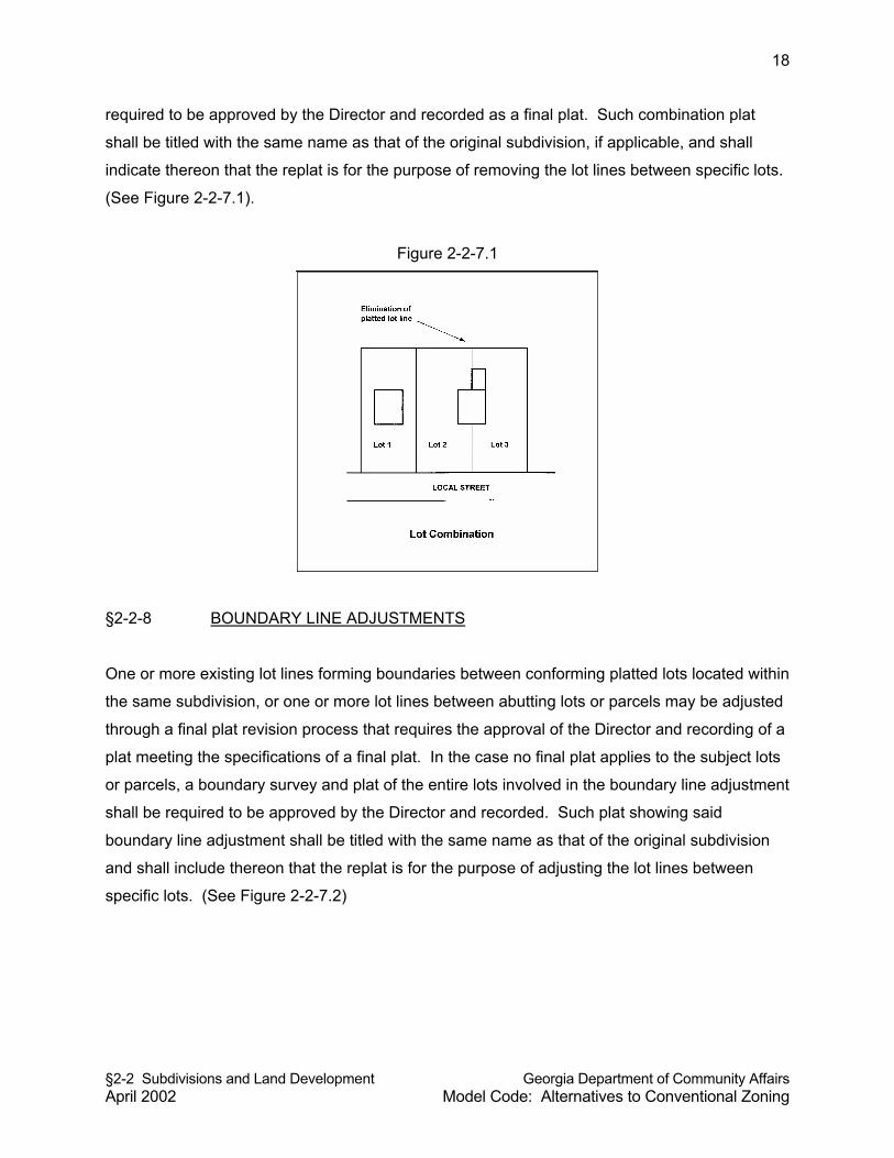
§2-2 Subdivisions and Land Development Georgia Department of Community Affairs April 2002 Model Code: Alternatives to Conventional Zoning
18
required to be approved by the Director and recorded as a final plat. Such combination plat
shall be titled with the same name as that of the original subdivision, if applicable, and shall
indicate thereon that the replat is for the purpose of removing the lot lines between specific lots.
(See Figure 2-2-7.1).
Figure 2-2-7.1
§2-2-8 BOUNDARY LINE ADJUSTMENTS
One or more existing lot lines forming boundaries between conforming platted lots located within
the same subdivision, or one or more lot lines between abutting lots or parcels may be adjusted
through a final plat revision process that requires the approval of the Director and recording of a
plat meeting the specifications of a final plat. In the case no final plat applies to the subject lots
or parcels, a boundary survey and plat of the entire lots involved in the boundary line adjustment
shall be required to be approved by the Director and recorded. Such plat showing said
boundary line adjustment shall be titled with the same name as that of the original subdivision
and shall include thereon that the replat is for the purpose of adjusting the lot lines between
specific lots. (See Figure 2-2-7.2)
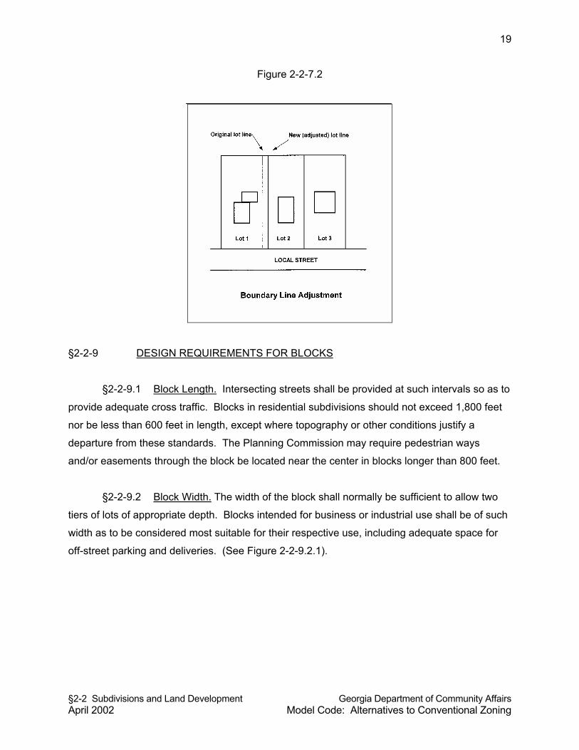
§2-2 Subdivisions and Land Development Georgia Department of Community Affairs April 2002 Model Code: Alternatives to Conventional Zoning
19
Figure 2-2-7.2
§2-2-9 DESIGN REQUIREMENTS FOR BLOCKS
§2-2-9.1 Block Length. Intersecting streets shall be provided at such intervals so as to
provide adequate cross traffic. Blocks in residential subdivisions should not exceed 1,800 feet
nor be less than 600 feet in length, except where topography or other conditions justify a
departure from these standards. The Planning Commission may require pedestrian ways
and/or easements through the block be located near the center in blocks longer than 800 feet.
§2-2-9.2 Block Width. The width of the block shall normally be sufficient to allow two
tiers of lots of appropriate depth. Blocks intended for business or industrial use shall be of such
width as to be considered most suitable for their respective use, including adequate space for
off-street parking and deliveries. (See Figure 2-2-9.2.1).
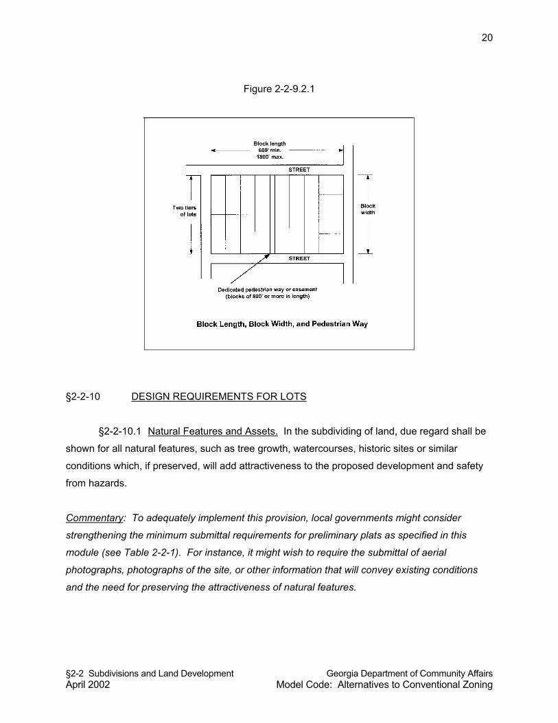
§2-2 Subdivisions and Land Development Georgia Department of Community Affairs April 2002 Model Code: Alternatives to Conventional Zoning
20
Figure 2-2-9.2.1
§2-2-10 DESIGN REQUIREMENTS FOR LOTS
§2-2-10.1 Natural Features and Assets. In the subdividing of land, due regard shall be
shown for all natural features, such as tree growth, watercourses, historic sites or similar
conditions which, if preserved, will add attractiveness to the proposed development and safety
from hazards.
Commentary: To adequately implement this provision, local governments might consider
strengthening the minimum submittal requirements for preliminary plats as specified in this
module (see Table 2-2-1). For instance, it might wish to require the submittal of aerial
photographs, photographs of the site, or other information that will convey existing conditions
and the need for preserving the attractiveness of natural features.
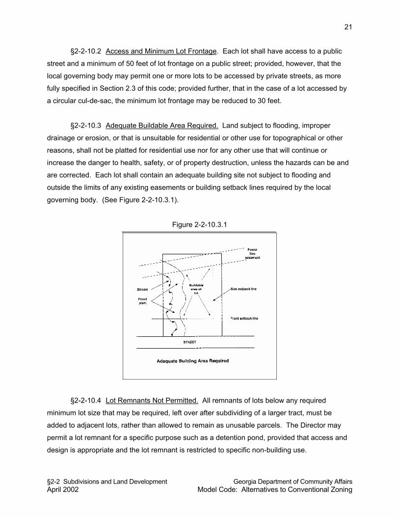
§2-2 Subdivisions and Land Development Georgia Department of Community Affairs April 2002 Model Code: Alternatives to Conventional Zoning
21
§2-2-10.2 Access and Minimum Lot Frontage. Each lot shall have access to a public
street and a minimum of 50 feet of lot frontage on a public street; provided, however, that the
local governing body may permit one or more lots to be accessed by private streets, as more
fully specified in Section 2.3 of this code; provided further, that in the case of a lot accessed by
a circular cul-de-sac, the minimum lot frontage may be reduced to 30 feet.
§2-2-10.3 Adequate Buildable Area Required. Land subject to flooding, improper
drainage or erosion, or that is unsuitable for residential or other use for topographical or other
reasons, shall not be platted for residential use nor for any other use that will continue or
increase the danger to health, safety, or of property destruction, unless the hazards can be and
are corrected. Each lot shall contain an adequate building site not subject to flooding and
outside the limits of any existing easements or building setback lines required by the local
governing body. (See Figure 2-2-10.3.1).
Figure 2-2-10.3.1
§2-2-10.4 Lot Remnants Not Permitted. All remnants of lots below any required
minimum lot size that may be required, left over after subdividing of a larger tract, must be
added to adjacent lots, rather than allowed to remain as unusable parcels. The Director may
permit a lot remnant for a specific purpose such as a detention pond, provided that access and
design is appropriate and the lot remnant is restricted to specific non-building use.
§2-2 Subdivisions and Land Development Georgia Department of Community Affairs April 2002 Model Code: Alternatives to Conventional Zoning
22
§2-2-10.5 Service Areas. Commercial and industrial lots shall be adequate to provide
service areas and off-street parking suitable to the use intended.
§2-2-10.6 Lot Area. The minimum lot area shall not be less than that established by the
land use intensity district in which the subdivision is located, if applicable.
§2-2-10.7 Lot Width. No portion of a lot shall be narrower than 60 feet, with the
exception of cul-de-sac lots, nor shall any lot have a lot width less than that established by the
land use intensity district in which the subdivision is located, if applicable.
§2-2-10.8 Lot Depth. Lots shall have a depth of not less than 100 feet, unless
circumstances make these limitations impracticable.
§2-2-10.9 Flag lots. No lot shall be approved which constitutes a flag lot except with
special approval from the Planning Commission due to extreme topographic circumstances.
§2-2-10.10 Side Lot Lines. Insofar as practical, side lot lines shall be at right angles to
straight street lines or radial to curved street lines.
§2-2-10.11 Corner Lots. Corner lots shall have adequate width to meet the front
building setback requirements, if applicable, from all rights-of-way.
§2-2-10.12 Double Frontage Lots. Double frontage or “through” lots should be avoided
except where essential to provide separation of residential development from arterials or
overcome specific disadvantages of topography or orientation. Double frontage lots with
frontage on a major arterial street shall have additional depth in order to allow space for screen
planting along the lot line abutting a major arterial street.
§2-2-11 EASEMENTS
Where a watercourse, drainage way, channel or stream traverses a subdivision, there shall be
provided a stormwater or drainage easement of adequate width. Easements shall be provided
for all drainage facilities as approved by the County [City] Engineer. Where easements are
needed for utility locations, the subdivider shall provide them to the appropriate utility provider.
§2-2 Subdivisions and Land Development Georgia Department of Community Affairs April 2002 Model Code: Alternatives to Conventional Zoning
23
Where easements are needed for public water and/or sanitary sewer lines, they shall be
provided as determined appropriate by the County [City] Engineer. All easements required
pursuant to this section shall be shown on the preliminary plat, if required, and final plat.
§2-2-12 SURVEY MONUMENTS FOR ALL LOTS REQUIRED
For all subdivisions, a Georgia registered land surveyor shall install permanent survey
monuments at all property corners and land lot lines, prior to final plat approval. Lot corners
shall be marked with metal rods not less than 1/2" in diameter and 18" in length and driven so
as to be stabilized in the ground. Permanent survey monuments shall also be installed in
accordance with the most recent edition of Section 180-7-.05 Monument of the Rules of State
Board of Registration for Professional Engineers & Land Surveyors and the Georgia Plat Act
(O.C.G.A. 15-6-67).
§2-2-13 PRELIMINARY PLAT
§2-2-13.1 Purpose. The purpose of this section is to ensure compliance with the basic
design concepts and improvement requirements of subdivisions and land developments through
the submittal of a tentative map of all major subdivisions for review and approval by the
Planning Commission.
§2-2-13.2 When Required. All major subdivisions, and any subdivision involving the
dedication of a public street, shall require the submission of a preliminary plat to the Director for
review and approval by the Planning Commission. Prior to the issuance of any permit for land
disturbance, or the installation of any improvements, the Planning Commission must approve
the preliminary plat, if required.
§2-2-13.3 Preliminary Plat Application and Specifications. Preliminary plat applications
shall be made in accordance with requirements shown in Table 2-2-15.1.1, and preliminary plats
shall meet the minimum plat specifications shown in Table 2-2-15.2.2.
Commentary: Subdivision regulations typically contain provisions for land dedications and
reservations. An earlier version of this model code contained a section regarding public use
reservations and dedications, but it was omitted on the recommendation of legal counsel. There
§2-2 Subdivisions and Land Development Georgia Department of Community Affairs April 2002 Model Code: Alternatives to Conventional Zoning
24
was concern about the possibility of such a provision resulting in a taking of private property
without just compensation.
§2-2-13.4 Procedures. Upon receipt of a completed preliminary plat application, the
Director shall schedule the application for the next public meeting before the Planning
Commission and forward all pertinent materials in the application to the Planning Commission
for review. An application for preliminary plat approval must be submitted as least 14 days
before the regular meeting date of the Planning Commission to be considered on that agenda.
The Planning Commission shall have 32 days from the date the public meeting is held to
approve, conditionally approve, or deny the preliminary plat application. The basis of the
Planning Commission’s review of and action on a preliminary plat shall be whether the
preliminary plat meets the purposes and requirements of this Resolution [Ordinance], and all
other Resolutions [Ordinances] that relate to the proposed development.
§2-2-13.5 Disposition. Approval of a preliminary plat shall be valid for a period of one
year, after which time a complete construction plans application must be submitted. If a
completed application for construction plans is not submitted during that time, preliminary plat
approval shall expire and be null and void.
§2-2-13.6 Appeal. Denial of preliminary plat approval may be appealed to the Board of
Commissioners of __________County [Mayor and City Council of the City of ____________].
§2-2-13.7 Amendments to Approved Preliminary Plats. The Director is authorized to
approve minor amendments to preliminary plats. Any proposed amendment to a sketch plat
that is determined by the Director to constitute a public interest shall be deemed a major
amendment. For all amendments to preliminary plats determined to be major amendments,
Planning Commission approval shall be required. The Planning Commission shall approve,
conditionally approve, or deny the proposed major amendment to a preliminary plat.
Procedures for considering a major amendment to a preliminary plat shall be the same as
required for an initial application for preliminary plat approval.
§2-2 Subdivisions and Land Development Georgia Department of Community Affairs April 2002 Model Code: Alternatives to Conventional Zoning
25
§2-2-14 CONSTRUCTION PLANS
§2-2-14.1 Application. Upon approval of a preliminary plat, the subdivider or land
developer may apply for construction plan approval. In the case of a minor subdivision, or in
cases where a preliminary plat is not required by this article, the subdivider or land developer
may apply for approval of construction plans; provided, however, that in the case of a minor
subdivision or land development the applicant for construction plan approval should hold a pre-
application conference with the Director to ensure that plans meet the intent and specific
provisions of this Resolution [Ordinance] and other applicable regulations. The construction
plan approval process is administrative. Applications for construction plan approval shall be
made in accordance with requirements shown in Table 2-2-15.1.1 and Table 2-2-15.2.1. No
application for construction plans shall be accepted for processing nor approved by the Director
until a preliminary plat, if required, has been approved by the Planning Commission and the
proposed construction plans are found by the Director to be in substantial conformity with said
approval and any conditions of such approval.
§2-2-14.2 Director’s Decision Criteria. The only basis upon which the Director may
deny a construction plan is the failure of the application to meet the requirements of this
Resolution [Ordinance] or any other applicable local regulations or the failure of the construction
plans and application to meet the requirements of preliminary plat approval specified by the
Planning Commission.
§2-2-14.3 Certificate of Approval. All copies of the construction plans shall be noted by
inscription on the plat noting such approval by the Director and the County [City] Engineer.
Construction plan approval shall expire and be null and void after a period of one year, unless
activity toward improvements on the land has been initiated, or unless the Director approves an
extension of time.
§2-2-15 FINAL PLAT
§2-2-15.1 When Required. All major subdivisions, minor subdivisions, and dedications
shall require final plat approval. The final plat approval process is administrative. Applications
shall be made in accordance with requirements shown in Table 2-2-15.1.1.
§2-2 Subdivisions and Land Development Georgia Department of Community Affairs April 2002 Model Code: Alternatives to Conventional Zoning
26
Table 2-2-15.1.1
Application Requirements
MAJOR SUBDIVISION REQUIREMENT MINOR
SUBDIVISION Preliminary Plat
Construction Plans
Final Plat
Pre-application review with staff Recommended
Application form completed Required Required Required Letter requesting approval with name, address, and phone of applicant
Required
Number of copies of plat 4 8 8 10 Filing fee per Resolution/ schedule Required Required Required Required
Description of type of water supply and sewerage system and utilities to be provided
Required Required Required Required
Soil test for each lot proposed for on-site septic tank and drainfield
Required Required Required Required
Data on existing conditions Required Hydrological or other engineering study
Per County [City] Engineer Required
Subdivision entrance monument and landscaping elevation/plan (prepared by landscape architect)
Required
Warranty deed for the dedication of streets and other public places
Required
Written approval from electric utility company regarding installation of service points and street lights
Required
As-built drawings of public improvements Required
Subdivision improvement guarantee Required
Certificate of title Required Required Plat Certificates Required Required
§2-2 Subdivisions and Land Development Georgia Department of Community Affairs April 2002 Model Code: Alternatives to Conventional Zoning
27
§2-2-15.2 Criteria for Approval. The Director may grant final plat approval if the
following conditions, as applicable, are met. (See Figure 2-2-15.2.1).
(a) The Planning Commission has previously approved a preliminary plat of the
proposed subdivision, if required (not required for minor subdivision).
(b) Where new improvements are involved in the subdivision, construction plans
have been approved by the Director, and all improvements have been installed
and inspected by the County [City] Engineer, and subdivision improvement
guarantees as required by this Resolution [Ordinance] have been submitted.
(c) The final plat meets all applicable requirements of this Resolution [Ordinance].
(d) A complete final plat application has been submitted, including all supporting
materials required by this chapter for final plats.
The Director shall consider final plats and applications that meet the above-referenced
conditions a ministerial action of approval. Denial of a final plat shall be permitted only upon
specific findings that one or more of the above-referenced conditions have not been met. (See
Figure 2-2-15.2.1).
Table 2-2-15.2.1
Plat and Plan Requirements
REQUIRED INFORMATION (Required to be on the plat
or construction plans)
Preliminary Plat
Construction Plans
Final Plat
Scale (minimum) 1"=100 feet 1"=100 feet 1"=100 feet Sheet size (maximum) 24" x 36" 24" x 36" 18" x 22" North arrow and graphic engineering scale Required Required Required
Reference to north point (magnetic, true north, or grid north) Required
Proposed name of subdivision or project and phases, if any Required Required Required
Vicinity map Required Required Required Total acreage of the property being subdivided Required Required Required
Name, address, and telephone of owner of record Required Required Required
Name, address and telephone of subdivider Required Required Required
Name, address and telephone of preparer of plat Required Required Required
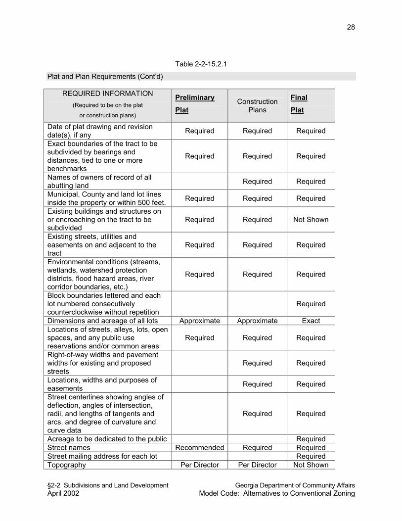
§2-2 Subdivisions and Land Development Georgia Department of Community Affairs April 2002 Model Code: Alternatives to Conventional Zoning
28
Table 2-2-15.2.1
Plat and Plan Requirements (Cont’d)
REQUIRED INFORMATION (Required to be on the plat
or construction plans)
Preliminary Plat
Construction Plans
Final Plat
Date of plat drawing and revision date(s), if any Required Required Required
Exact boundaries of the tract to be subdivided by bearings and distances, tied to one or more benchmarks
Required Required Required
Names of owners of record of all abutting land Required Required
Municipal, County and land lot lines inside the property or within 500 feet. Required Required Required
Existing buildings and structures on or encroaching on the tract to be subdivided
Required Required Not Shown
Existing streets, utilities and easements on and adjacent to the tract
Required Required Required
Environmental conditions (streams, wetlands, watershed protection districts, flood hazard areas, river corridor boundaries, etc.)
Required Required Required
Block boundaries lettered and each lot numbered consecutively counterclockwise without repetition
Required
Dimensions and acreage of all lots Approximate Approximate Exact Locations of streets, alleys, lots, open spaces, and any public use reservations and/or common areas
Required Required Required
Right-of-way widths and pavement widths for existing and proposed streets
Required Required
Locations, widths and purposes of easements Required Required
Street centerlines showing angles of deflection, angles of intersection, radii, and lengths of tangents and arcs, and degree of curvature and curve data
Required Required
Acreage to be dedicated to the public Required Street names Recommended Required Required Street mailing address for each lot Required Topography Per Director Per Director Not Shown
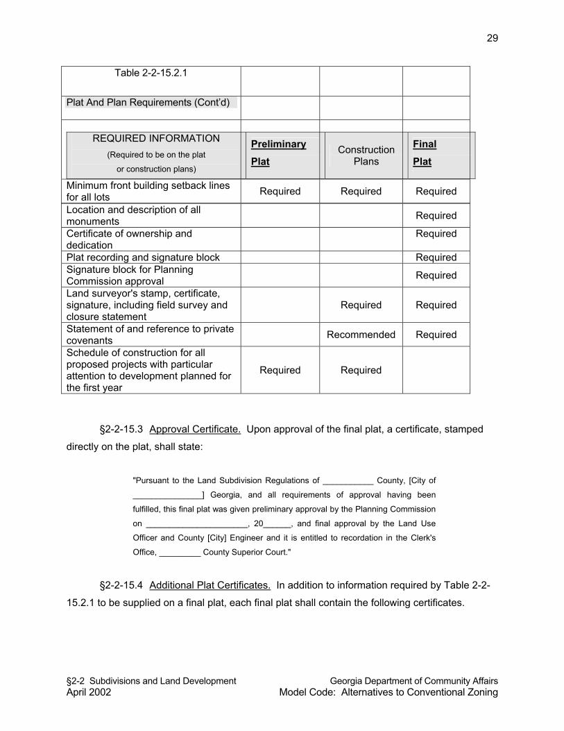
§2-2 Subdivisions and Land Development Georgia Department of Community Affairs April 2002 Model Code: Alternatives to Conventional Zoning
29
Table 2-2-15.2.1
Plat And Plan Requirements (Cont’d)
REQUIRED INFORMATION
(Required to be on the plat
or construction plans)
Preliminary Plat
Construction Plans
Final Plat
Minimum front building setback lines for all lots Required Required Required
Location and description of all monuments Required
Certificate of ownership and dedication
Required
Plat recording and signature block Required Signature block for Planning Commission approval Required
Land surveyor's stamp, certificate, signature, including field survey and closure statement
Required Required
Statement of and reference to private covenants Recommended Required
Schedule of construction for all proposed projects with particular attention to development planned for the first year
Required Required
§2-2-15.3 Approval Certificate. Upon approval of the final plat, a certificate, stamped
directly on the plat, shall state:
"Pursuant to the Land Subdivision Regulations of ___________ County, [City of
_______________] Georgia, and all requirements of approval having been
fulfilled, this final plat was given preliminary approval by the Planning Commission
on ______________________, 20______, and final approval by the Land Use
Officer and County [City] Engineer and it is entitled to recordation in the Clerk's
Office, _________ County Superior Court."
§2-2-15.4 Additional Plat Certificates. In addition to information required by Table 2-2-
15.2.1 to be supplied on a final plat, each final plat shall contain the following certificates.
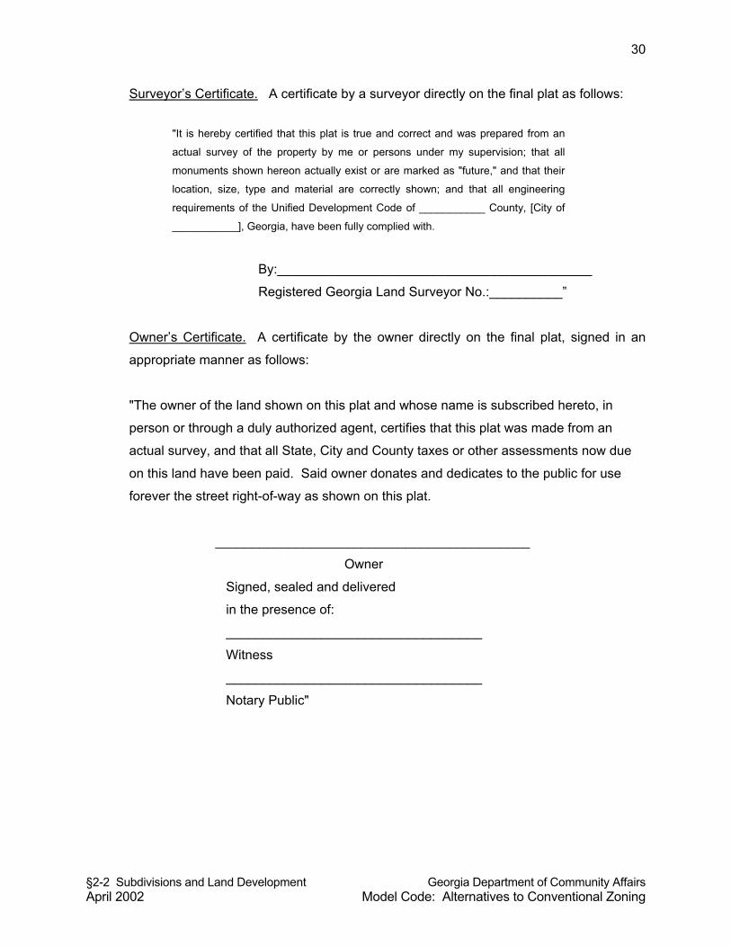
§2-2 Subdivisions and Land Development Georgia Department of Community Affairs April 2002 Model Code: Alternatives to Conventional Zoning
30
Surveyor’s Certificate. A certificate by a surveyor directly on the final plat as follows:
"It is hereby certified that this plat is true and correct and was prepared from an
actual survey of the property by me or persons under my supervision; that all
monuments shown hereon actually exist or are marked as "future," and that their
location, size, type and material are correctly shown; and that all engineering
requirements of the Unified Development Code of ___________ County, [City of
___________], Georgia, have been fully complied with.
By:___________________________________________
Registered Georgia Land Surveyor No.:__________”
Owner’s Certificate. A certificate by the owner directly on the final plat, signed in an
appropriate manner as follows:
"The owner of the land shown on this plat and whose name is subscribed hereto, in
person or through a duly authorized agent, certifies that this plat was made from an
actual survey, and that all State, City and County taxes or other assessments now due
on this land have been paid. Said owner donates and dedicates to the public for use
forever the street right-of-way as shown on this plat.
___________________________________________
Owner
Signed, sealed and delivered
in the presence of:
___________________________________
Witness
___________________________________
Notary Public"
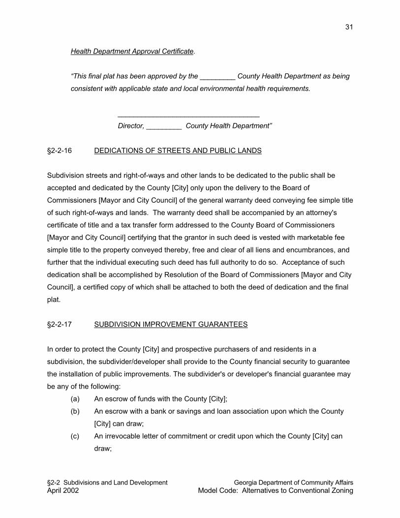
§2-2 Subdivisions and Land Development Georgia Department of Community Affairs April 2002 Model Code: Alternatives to Conventional Zoning
31
Health Department Approval Certificate.
“This final plat has been approved by the _________ County Health Department as being
consistent with applicable state and local environmental health requirements.
____________________________________
Director, _________ County Health Department”
§2-2-16 DEDICATIONS OF STREETS AND PUBLIC LANDS
Subdivision streets and right-of-ways and other lands to be dedicated to the public shall be
accepted and dedicated by the County [City] only upon the delivery to the Board of
Commissioners [Mayor and City Council] of the general warranty deed conveying fee simple title
of such right-of-ways and lands. The warranty deed shall be accompanied by an attorney's
certificate of title and a tax transfer form addressed to the County Board of Commissioners
[Mayor and City Council] certifying that the grantor in such deed is vested with marketable fee
simple title to the property conveyed thereby, free and clear of all liens and encumbrances, and
further that the individual executing such deed has full authority to do so. Acceptance of such
dedication shall be accomplished by Resolution of the Board of Commissioners [Mayor and City
Council], a certified copy of which shall be attached to both the deed of dedication and the final
plat.
§2-2-17 SUBDIVISION IMPROVEMENT GUARANTEES
In order to protect the County [City] and prospective purchasers of and residents in a
subdivision, the subdivider/developer shall provide to the County financial security to guarantee
the installation of public improvements. The subdivider's or developer's financial guarantee may
be any of the following:
(a) An escrow of funds with the County [City];
(b) An escrow with a bank or savings and loan association upon which the County
[City] can draw;
(c) An irrevocable letter of commitment or credit upon which the County [City] can
draw;
§2-2 Subdivisions and Land Development Georgia Department of Community Affairs April 2002 Model Code: Alternatives to Conventional Zoning
32
(d) A performance bond for the benefit of the County [City] upon which the County
[City] can collect, or a certificate of deposit with assignment letter; and
(e) Any other form of guarantee approved by the Board of Commissioners [Mayor
and City Council] that will satisfy the objectives of this section. The guarantee
shall be in an amount to secure the full costs, as determined by the County [City],
of constructing or installing the improvements and utilities required.
§2-2-18 LIMITATIONS ON MINOR SUBDIVISIONS
§2-2-18.1 Purpose. Minor subdivisions provide certain advantages, such as a shorter
application process and less public scrutiny, that tend to favor their use over the filing of major
subdivision applications. Given these advantages, the prospect exists that subdividers may
seek to divide a parcel via consecutive and/or contiguous minor subdivisions instead of filing for
a major subdivision. It is the intent of the Board of Commissioners [Mayor and City Council] to
prohibit the practice of “chain” subdivisions where the same land owner subdivides land and
then files minor subdivision applications on common contiguous parcels, which collectively total
more than four lots. It is also the intent of the Board of Commissioners [Mayor and City Council]
to prohibit minor subdivisions adjacent to each other within a three-year time period, in cases
where part of an original tract of land is now owned by another person or entity and was
transferred or sold to another owner with the apparent intent to circumvent the major subdivision
process.
§2-2-18.2 Common Contiguous Parcels Shown on Minor Subdivision Plats. Contiguous
common parcels, as defined by this Resolution [Ordinance], shall be referenced on all
applications for minor subdivisions, and contiguous common parcels shall be considered part of
any application for minor subdivision, for purposes of determining whether or not the division of
land proposed is a major subdivision or a minor subdivision. Common contiguous parcels shall
not be counted as lots in the case of a minor subdivision.
§2-2-18.3 Limitations. Land within a minor subdivision, including all contiguous parcels
owned by the subdivider, shall not be further divided for a period of three years unless a
preliminary plat application is filed and approved as a major subdivision pursuant to the
requirements of this Resolution [Ordinance]. If property proposed to be subdivided was part of
an original tract, and if the property proposed to be subdivided abuts land that has been divided
§2-2 Subdivisions and Land Development Georgia Department of Community Affairs April 2002 Model Code: Alternatives to Conventional Zoning
33
as a minor subdivision in the last three years, then minor subdivision of said property shall be
prohibited. This provision shall not be construed to prohibit the approval of two contiguous
minor subdivisions under separate ownership; however, this provision is intended to be
construed liberally so that one property owner does not develop a minor subdivision on part of
an original tract and transfer or sell another part of the original tract for the purposes of minor
subdivision within a three year period. It is the intent that land abutting a minor subdivision that
was owned by the subdivider of the abutting minor subdivision shall not be subdivided as a
minor subdivision for a period of three years, regardless of ownership.
§2-2-19 PRIVATE STREETS
Commentary: Many communities do not specifically address private streets in their land use
management codes. This section addresses private streets in major subdivisions. Private
streets, when they provide access to multiple lots, raise many questions about the adequacy of
public access and the provision of future public utilities along said private streets. Because of
potential problems with private streets, such as determining an equitable distribution of
maintenance costs among property owners served by private roads, this section provides that
the local governing body must approve private streets in major subdivisions. Private streets
should at minimum meet the standards for public streets---otherwise, land developers have an
incentive to provide private rather than public streets.
§2-2-19.1 Private Streets Permitted. Private streets may, upon application, be permitted
by the Board of Commissioners [Mayor and City Council] within major subdivisions, subject to
the requirements of this section. Applications for approval of private streets shall be considered
by the Board of Commissioners [Mayor and City Council] at the time of preliminary plat approval
by the Planning Commission. Following a recommendation by the Planning Commission to
authorize private streets in a major subdivision, the Board of Commissioners [Mayor and City
Council] shall consider the application and may impose conditions on the approval of private
streets to ensure various public purposes and to mitigate potential problems with private streets.
No final plat involving a private street shall be approved unless said final plat conforms to the
requirements of this section.
§2-2-19.2 Engineering Plans Required. It shall be unlawful for any person, firm, or
corporation to construct a new private street or alter an existing private street or to cause the
§2-2 Subdivisions and Land Development Georgia Department of Community Affairs April 2002 Model Code: Alternatives to Conventional Zoning
34
same to be done without first obtaining approval of engineering and construction plans from the
Director and the County [City] Engineer in accordance with the requirements of this Resolution
[Ordinance] and Section 2.3 of this code.
§2-2-19.3 Standards. All private streets shall be constructed to all standards for public
streets as required by Section 2.3 of this code, applicable construction specifications of the
County [City] Engineer, and as approved by the County [City] Engineer.
§2-2-19.4 Street Names And Signs. Private streets shall be named, subject to the
approval of the Director. The subdivider of land involving a private street shall install street
signs with content containing the street name and the designation “private,” as approved by the
County [City] Engineer. The sign signifying the private street may be required by the County
[City] Engineer to be a different color than that of street signs provided for public streets, in
order to distinguish maintenance responsibilities in the field.
§2-2-19.5 Easements. Easements for private streets shall be designated on final plats
as general-purpose public access and utility easements, along with the name of said private
street. Said easement shall at minimum be of the same width as that required for the right-of-
way of a public street by the major thoroughfare plan and the County [City] Engineer for the type
of public street (local, collector, etc.) most closely resembling the proposed private street.
Easements for private streets shall not be included in any calculation of minimum lot size or
density limitations established by local land use regulations. In the cases of private streets, the
general-purpose public access and utility easement for the private street shall either;
(a) Be shown in a manner on the final plat such that each lot fronting the private
street extends to the centerline of the private street. No lot shall be permitted to
be divided by the general purpose public access and utility easement required
and established for a private street; or
(b) Shall be drawn as its own discrete parcel to be dedicated to a private
homeowners association (i.e., not shown to be a part of any lot).
§2-2-19.6 Maintenance. The County [City] shall not maintain, repair, resurface, rebuild,
or otherwise improve streets, signs, drainage improvements or any other appurtenances within
general purpose public access and utility easements established for private streets. A private
maintenance covenant recorded with the County Clerk of the Superior Court shall be required
§2-2 Subdivisions and Land Development Georgia Department of Community Affairs April 2002 Model Code: Alternatives to Conventional Zoning
35
for any private street and other improvements within general-purpose public access and utility
easements established for private streets. The covenant shall set out the distribution of
expenses, remedies for non-compliance with the terms of the agreement, rights to the use of
easements, and other pertinent considerations. The Covenant shall specifically include the
following terms.
(a) The Covenant shall establish minimum annual assessments in an amount
adequate to defray costs of ordinary maintenance and procedures for approval of
additional needed assessments. The Covenant shall also specify that the funds
from such assessments will be held by a homeowners or property owners
association in cases of a subdivision of seven or more lots fronting on a private
street.
(b) The Covenant shall include a periodic maintenance schedule.
(c) The Covenant for maintenance shall be enforceable by any property owner
served by the private street.
(d) The Covenant shall establish a formula for assessing maintenance and repair
costs equitably to property owners served by the private street.
(e) The Covenant shall run with the land.
(f) The Board of Commissioners [Mayor and City Council] may, at its discretion, as a
condition of approving private streets, require a performance bond and/or
maintenance bond be submitted by the subdivider and held by a homeowners or
property owners association, or the Board [Council] may require that the
subdivider pay an amount of money as recommended by the County [City]
Engineer into an escrow account or other suitable account for the maintenance
and repair of private streets and stormwater management improvements, to be
drawn from by the homeowners or property owners association as maintenance
and repair needs may arise.
§2-2-19.7 Specifications For Final Plats Involving Private Streets. The Director shall not
approve for recording any final plat involving a private street unless and until it shall contain the
following on the face of the plat:
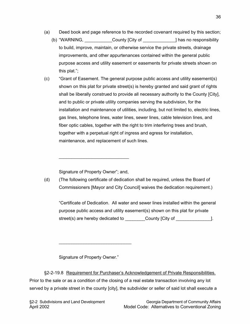
§2-2 Subdivisions and Land Development Georgia Department of Community Affairs April 2002 Model Code: Alternatives to Conventional Zoning
36
(a) Deed book and page reference to the recorded covenant required by this section;
(b) “WARNING, ___________County [City of _____________] has no responsibility
to build, improve, maintain, or otherwise service the private streets, drainage
improvements, and other appurtenances contained within the general public
purpose access and utility easement or easements for private streets shown on
this plat.”;
(c) “Grant of Easement. The general purpose public access and utility easement(s)
shown on this plat for private street(s) is hereby granted and said grant of rights
shall be liberally construed to provide all necessary authority to the County [City],
and to public or private utility companies serving the subdivision, for the
installation and maintenance of utilities, including, but not limited to, electric lines,
gas lines, telephone lines, water lines, sewer lines, cable television lines, and
fiber optic cables, together with the right to trim interfering trees and brush,
together with a perpetual right of ingress and egress for installation,
maintenance, and replacement of such lines.
____________________________
Signature of Property Owner”; and,
(d) (The following certificate of dedication shall be required, unless the Board of
Commissioners [Mayor and City Council] waives the dedication requirement.)
“Certificate of Dedication. All water and sewer lines installed within the general
purpose public access and utility easement(s) shown on this plat for private
street(s) are hereby dedicated to ________County [City of ______________].
_____________________________
Signature of Property Owner.”
§2-2-19.8 Requirement for Purchaser’s Acknowledgement of Private Responsibilities.
Prior to the sale or as a condition of the closing of a real estate transaction involving any lot
served by a private street in the county [city], the subdivider or seller of said lot shall execute a
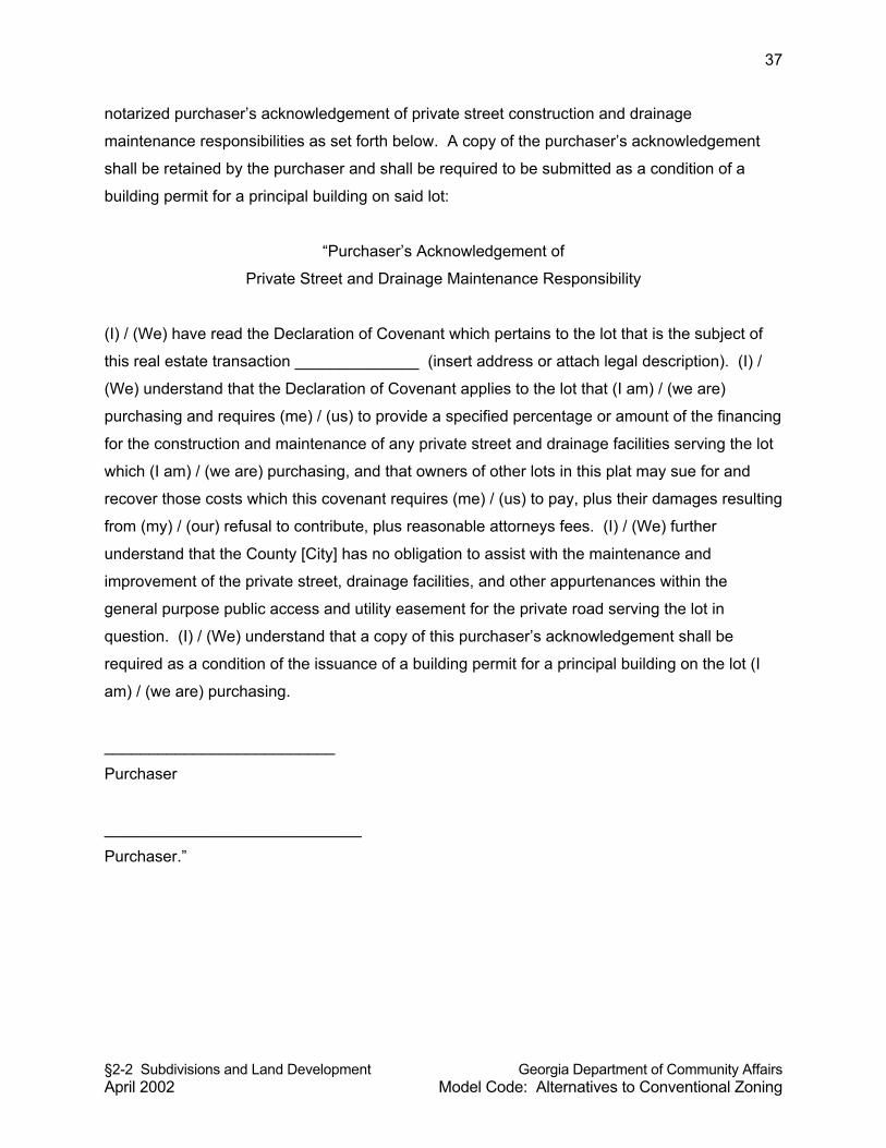
§2-2 Subdivisions and Land Development Georgia Department of Community Affairs April 2002 Model Code: Alternatives to Conventional Zoning
37
notarized purchaser’s acknowledgement of private street construction and drainage
maintenance responsibilities as set forth below. A copy of the purchaser’s acknowledgement
shall be retained by the purchaser and shall be required to be submitted as a condition of a
building permit for a principal building on said lot:
“Purchaser’s Acknowledgement of
Private Street and Drainage Maintenance Responsibility
(I) / (We) have read the Declaration of Covenant which pertains to the lot that is the subject of
this real estate transaction ______________ (insert address or attach legal description). (I) /
(We) understand that the Declaration of Covenant applies to the lot that (I am) / (we are)
purchasing and requires (me) / (us) to provide a specified percentage or amount of the financing
for the construction and maintenance of any private street and drainage facilities serving the lot
which (I am) / (we are) purchasing, and that owners of other lots in this plat may sue for and
recover those costs which this covenant requires (me) / (us) to pay, plus their damages resulting
from (my) / (our) refusal to contribute, plus reasonable attorneys fees. (I) / (We) further
understand that the County [City] has no obligation to assist with the maintenance and
improvement of the private street, drainage facilities, and other appurtenances within the
general purpose public access and utility easement for the private road serving the lot in
question. (I) / (We) understand that a copy of this purchaser’s acknowledgement shall be
required as a condition of the issuance of a building permit for a principal building on the lot (I
am) / (we are) purchasing.
__________________________
Purchaser
_____________________________
Purchaser.”
§2-3 Improvements Required for Subdivisions Georgia Department of Community Affairs and Land Development Model Code: Alternatives to Conventional Zoning April 2002
1
§2-3 IMPROVEMENTS REQUIRED FOR SUBDIVISIONS AND LAND DEVELOPMENT
CONTENTS
§2-3-1 PURPOSE §2-3-2 DEFINITIONS §2-3-3 AUTHORITY OF COUNTY [CITY] ENGINEER §2-3-4 APPLICABILITY AND EXEMPTION §2-3-5 ENGINEERED DRAWINGS §2-3-6 PERMITS FOR CONSTRUCTION IN PUBLIC RIGHT-OF-WAY §2-3-7 IMPROVEMENTS TO ABUTTING LAND §2-3-8 STANDARDS FOR CONFIGURING NEW STREETS §2-3-8.1 Street Alignment, Intersections and Jogs §2-3-8.2 Continuation of Existing Streets and Connections §2-3-8.3 Street Plans for Future Phases of the Tract §2-3-8.4 Dead-End Streets and Cul-De-Sacs §2-3-8.5 Marginal Access Streets §2-3-8.6 Alleys and Service Access §2-3-9 REQUIREMENTS FOR STREETS §2-3-9.1 Bridges §2-3-9.2 Grading and Stabilization of Street Rights-Of-Ways §2-3-9.3 Radius at Street Intersections §2-3-9.4 Street Grades §2-3-9.5 Minimum Street Right-Of-Way and Pavement Widths §2-3-9.6 Street Horizontal Alignment and Reverse Curves §2-3-10 CURB CUTS AND ACCESS SPECIFICATIONS §2-3-10.1 Entrance Improvement Specifications §2-3-10.2 Curb Cut Specifications §2-3-10.3 Access Along and Near Divided Highways §2-3-10.4 Interparcel Connections §2-3-11 STREET LIGHTING §2-3-12 STREET SIGNS §2-3-13 CURBS AND GUTTERS §2-3-14 SIDEWALKS §2-3-14.1 When Required §2-3-14.2 Location §2-3-14.3 Specifications §2-3-15 DRAINAGE AND STORMWATER MANAGEMENT §2-3-15.1 General requirements §2-3-15.2 Method of Design and Capacity §2-3-15.3 Location §2-3-15.4 Discharge §2-3-15.5 Grading and Site Drainage §2-3-15.6 Cross-Drain Pipes §2-3-15.7 Drop Inlets §2-3-15.8 Easements
§2-3 Improvements Required for Subdivisions Georgia Department of Community Affairs and Land Development Model Code: Alternatives to Conventional Zoning April 2002
2
§2-3 IMPROVEMENTS REQUIRED FOR SUBDIVISIONS AND LAND DEVELOPMENT (cont’d)
§2-3-16 WATER §2-3-16.1 Generally §2-3-16.2 Water Main Requirements §2-3-16.3 Wells §2-3-16.4 Community Water System §2-3-16.5 Fire Hydrants §2-3-17 SEWER §2-3-17.1 Generally §2-3-17.2 Connection to Public Sewerage System §2-3-17.3 Alternative Provision §2-3-17.4 Septic Tanks §2-3-18 UTILITIES §2-3-19 OVERSIZING OF IMPROVEMENTS AND UTILITIES §2-3-20 PROCEDURE FOR ADMINISTRATIVE INSPECTION AND ACCEPTANCE OF
PUBLIC IMPROVEMENTS §2-3 IMPROVEMENTS REQUIRED FOR SUBDIVISIONS AND
LAND DEVELOPMENT
Commentary: The review and approval of subdivision and land development improvements is
primarily the purview of the local government engineer. The land use officer also has a
significant role in the review of plans and plats and the application of various standards. The
construction specifications of public improvements go far beyond the specifics identified in this
module. For this reason, local governments should authorize (as this module does) the local
government engineer to adopt standard drawings and specifications which can be published in
a technical document. The improvement requirements specified here should be sufficient to
identify the more important construction specifications, although local governments are strongly
encouraged to have the local engineering department adopt more specific and more
comprehensive standards for public and private improvements. If the rural local government
does not have a civil engineer on staff, it is strongly advised that engineering standards be
prepared and implemented by a professional engineer under a consulting arrangement.
§2-3-1 PURPOSE
The purpose of this Resolution [Ordinance] is to establish minimum design requirements,
standards, and specifications for improvements within subdivisions and land developments.
§2-3 Improvements Required for Subdivisions Georgia Department of Community Affairs and Land Development Model Code: Alternatives to Conventional Zoning April 2002
3
§2-3-2 DEFINITIONS
Definitions pertaining to this Resolution [Ordinance] shall be as provided in Section 2-2 of this
code.
§2-3-3 AUTHORITY OF COUNTY [CITY] ENGINEER
The County [City] Engineer is hereby authorized to review and approve plans for subdivisions
and land developments to ensure compliance with the requirements of this code. The County
[City] Engineer is further authorized to prepare and promulgate standards, standard drawings,
and specifications to more specifically implement the intent of the improvement requirements of
this code.
§2-3-4 APPLICABILITY AND EXEMPTION
The improvement requirements specified in this code section (2-3) shall apply to all non-single-
family residential developments. The improvement requirements specified in this code section
shall not apply to individual lots proposed for development as a detached, single-family dwelling
or manufactured home, although such lots may be a part of a land subdivision that has initially
met the requirements of this code section. All improvements required to be constructed as part
of a major subdivision, minor subdivision or land development process shall be constructed and
improved, in accordance with the standards and specifications for construction as required by
this code section and as specified by the County [City] Engineer.
No person to which this code section applies shall commence construction of any improvements
on any land, prior to the approval of construction plans and engineering plans for said
improvements, as required by Section 2-2 of this code, according to the improvement standards
specified in this code section and as adopted by the County [City] Engineer. No building permit
or certificate of occupancy shall be issued for a building, structure, or use, nor shall any
excavation, grading, or land disturbance applications be approved, on any parcel of land that
does not meet the improvement requirements specified in this section and as adopted by the
County [City] Engineer pursuant to this section.
§2-3 Improvements Required for Subdivisions Georgia Department of Community Affairs and Land Development Model Code: Alternatives to Conventional Zoning April 2002
4
§2-3-5 ENGINEERED DRAWINGS
Engineering drawings for public streets, including cross sections and centerline profiles, and
public and private water, sewer, drainage, and utility systems, certified by a professional
engineer registered in the State of Georgia, or if authorized under state law, a registered land
surveyor, or professional landscape architect, shall be required to be submitted for review and
approval, and such plans must meet the requirements of this code section (2-3) and the
specifications of the County [City] Engineer. Prior to approval and recording of a final plat, or
prior to the approval of any certificate of occupancy, a registered engineer for the
subdivider/developer shall submit one copy of all finished, as-built plans of improvements,
demonstrating that said improvements, as installed, meet the requirements of this code section
and certifying that the plans accurately reflect actual construction and installation. The County
[City] Engineer shall maintain all as-built street and utility plans for future use by the County
[City].
§2-3-6 PERMITS FOR CONSTRUCTION IN PUBLIC RIGHT-OF-WAY
Permits from the County [City] Engineer shall be required for construction in any public right-of-
way. Permits will not be issued until such time that plans have been submitted and approved by
the County [City] Engineer. Permit fees shall be approved by resolution of the Board of County
Commissioners [Mayor and City Council].
§2-3-7 IMPROVEMENTS TO ABUTTING LAND
For subdivisions and land developments that abut and access an abutting public street, the
subdivider or land developer shall install curb and gutter, sidewalk, other road improvements,
and, if required, a deceleration lane, according to standards and specifications of the County
[City] Engineer, along all abutting public streets. When a subdivision or land development uses
an unpaved public right-of-way for access, the sudivider or land developer shall improve that
right-of-way to a pavement width consistent with County [City] road design standards. Said
improvements shall be from the subdivision or land development entrance to the paved County
[City] road which the County [City] Engineer determines will be the primary direction of travel for
residents of the subdivision or occupants of the land development.
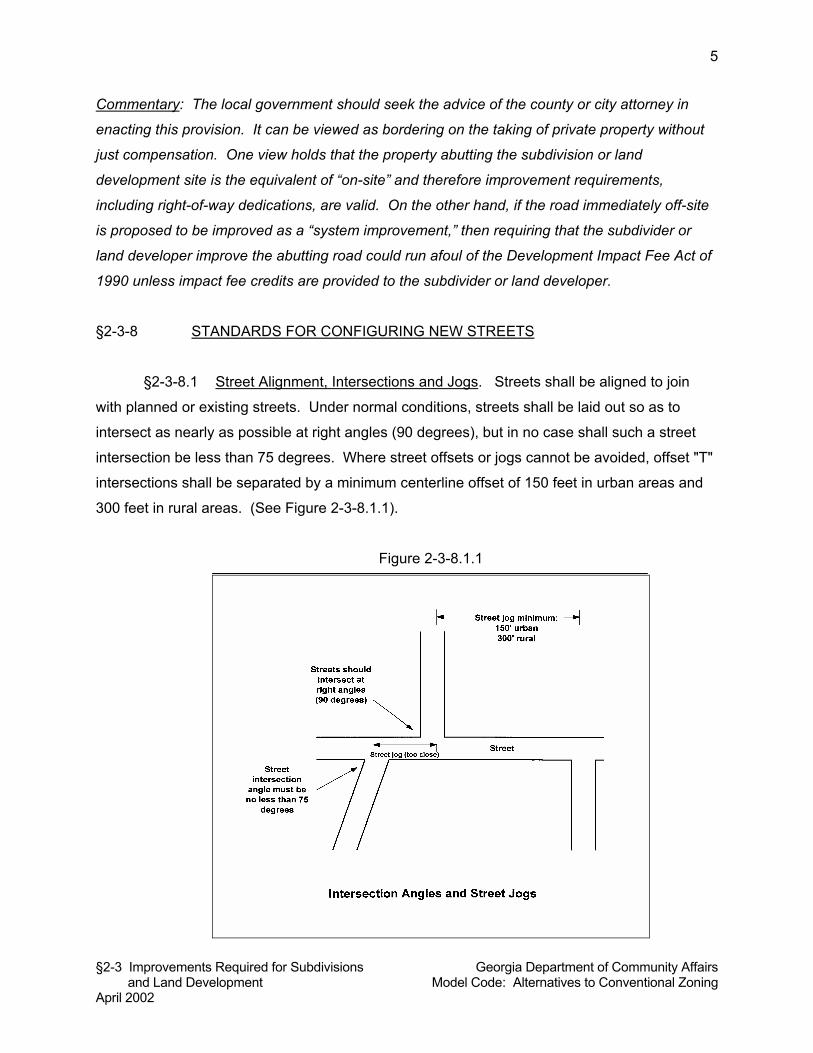
§2-3 Improvements Required for Subdivisions Georgia Department of Community Affairs and Land Development Model Code: Alternatives to Conventional Zoning April 2002
5
Commentary: The local government should seek the advice of the county or city attorney in
enacting this provision. It can be viewed as bordering on the taking of private property without
just compensation. One view holds that the property abutting the subdivision or land
development site is the equivalent of “on-site” and therefore improvement requirements,
including right-of-way dedications, are valid. On the other hand, if the road immediately off-site
is proposed to be improved as a “system improvement,” then requiring that the subdivider or
land developer improve the abutting road could run afoul of the Development Impact Fee Act of
1990 unless impact fee credits are provided to the subdivider or land developer.
§2-3-8 STANDARDS FOR CONFIGURING NEW STREETS
§2-3-8.1 Street Alignment, Intersections and Jogs. Streets shall be aligned to join
with planned or existing streets. Under normal conditions, streets shall be laid out so as to
intersect as nearly as possible at right angles (90 degrees), but in no case shall such a street
intersection be less than 75 degrees. Where street offsets or jogs cannot be avoided, offset "T"
intersections shall be separated by a minimum centerline offset of 150 feet in urban areas and
300 feet in rural areas. (See Figure 2-3-8.1.1).
Figure 2-3-8.1.1
§2-3 Improvements Required for Subdivisions Georgia Department of Community Affairs and Land Development Model Code: Alternatives to Conventional Zoning April 2002
6
§2-3-8.2 Continuation of Existing Streets and Connections. Existing streets, and their
rights-of-way, shall be continued at the same or greater width, but in no case less than the
required width. The Planning Commission may require that a major subdivision provide one or
more future connections to adjoining subdivisions or unsubdivided tracts.
§2-3-8.3 Street Plans for Future Phases of the Tract. Where the plat or site plan
proposed to be subdivided or developed includes only part of the tract owned or intended for
subdivision or development by the subdivider or land developer, a tentative plan of a future
street system for the portion not slated for immediate subdivision consideration may be required
by the Director and if required shall be prepared and submitted by the subdivider or land
developer.
§2-3-8.4 Dead-End Streets and Cul-De-Sacs. Streets that dead-end shall terminate in
a cul-de-sac. The maximum length of such streets shall be 600 feet in urban areas and 1,200
feet in rural areas. Streets that are planned to continue at some future date shall provide a
temporary cul-de-sac as required by the County [City] Engineer.
§2-3-8.5 Marginal Access Streets. Whenever a major subdivision is proposed abutting
the right-of-way of a U.S. or State highway, a marginal access street approximately parallel and
adjacent to such right-of-way may be required by the Planning Commission at a distance
suitable for the appropriate use of land between such marginal access street and highway right-
of-way. The Planning Commission may also require a 20-foot no-access easement and
planting strip along the major arterial street to ensure that lots fronting on said street do not
have access thereto. (See Figure 2-3-8.5.1).
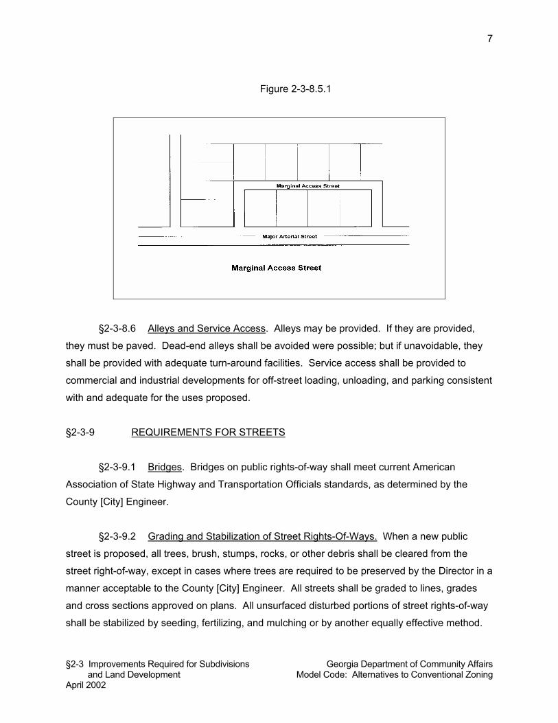
§2-3 Improvements Required for Subdivisions Georgia Department of Community Affairs and Land Development Model Code: Alternatives to Conventional Zoning April 2002
7
Figure 2-3-8.5.1
§2-3-8.6 Alleys and Service Access. Alleys may be provided. If they are provided,
they must be paved. Dead-end alleys shall be avoided were possible; but if unavoidable, they
shall be provided with adequate turn-around facilities. Service access shall be provided to
commercial and industrial developments for off-street loading, unloading, and parking consistent
with and adequate for the uses proposed.
§2-3-9 REQUIREMENTS FOR STREETS
§2-3-9.1 Bridges. Bridges on public rights-of-way shall meet current American
Association of State Highway and Transportation Officials standards, as determined by the
County [City] Engineer.
§2-3-9.2 Grading and Stabilization of Street Rights-Of-Ways. When a new public
street is proposed, all trees, brush, stumps, rocks, or other debris shall be cleared from the
street right-of-way, except in cases where trees are required to be preserved by the Director in a
manner acceptable to the County [City] Engineer. All streets shall be graded to lines, grades
and cross sections approved on plans. All unsurfaced disturbed portions of street rights-of-way
shall be stabilized by seeding, fertilizing, and mulching or by another equally effective method.
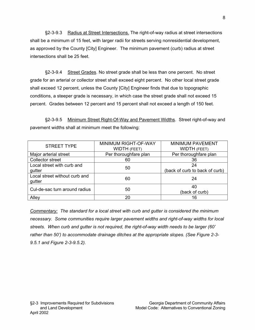
§2-3 Improvements Required for Subdivisions Georgia Department of Community Affairs and Land Development Model Code: Alternatives to Conventional Zoning April 2002
8
§2-3-9.3 Radius at Street Intersections. The right-of-way radius at street intersections
shall be a minimum of 15 feet, with larger radii for streets serving nonresidential development,
as approved by the County [City] Engineer. The minimum pavement (curb) radius at street
intersections shall be 25 feet.
§2-3-9.4 Street Grades. No street grade shall be less than one percent. No street
grade for an arterial or collector street shall exceed eight percent. No other local street grade
shall exceed 12 percent, unless the County [City] Engineer finds that due to topographic
conditions, a steeper grade is necessary, in which case the street grade shall not exceed 15
percent. Grades between 12 percent and 15 percent shall not exceed a length of 150 feet.
§2-3-9.5 Minimum Street Right-Of-Way and Pavement Widths. Street right-of-way and
pavement widths shall at minimum meet the following:
STREET TYPE MINIMUM RIGHT-OF-WAY WIDTH (FEET)
MINIMUM PAVEMENT WIDTH (FEET)
Major arterial street Per thoroughfare plan Per thoroughfare plan Collector street 60 36 Local street with curb and gutter 50 24
(back of curb to back of curb) Local street without curb and gutter 60 24
Cul-de-sac turn around radius 50 40 (back of curb)
Alley 20 16
Commentary: The standard for a local street with curb and gutter is considered the minimum
necessary. Some communities require larger pavement widths and right-of-way widths for local
streets. When curb and gutter is not required, the right-of-way width needs to be larger (60’
rather than 50’) to accommodate drainage ditches at the appropriate slopes. (See Figure 2-3-
9.5.1 and Figure 2-3-9.5.2).
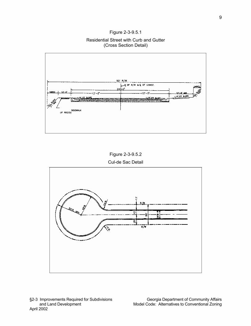
§2-3 Improvements Required for Subdivisions Georgia Department of Community Affairs and Land Development Model Code: Alternatives to Conventional Zoning April 2002
9
Figure 2-3-9.5.1
Residential Street with Curb and Gutter (Cross Section Detail)
Figure 2-3-9.5.2
Cul-de Sac Detail
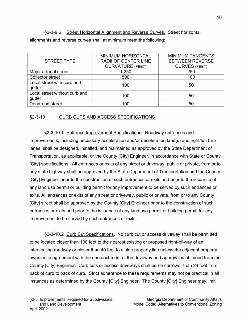
§2-3 Improvements Required for Subdivisions Georgia Department of Community Affairs and Land Development Model Code: Alternatives to Conventional Zoning April 2002
10
§2-3-9.6 Street Horizontal Alignment and Reverse Curves. Street horizontal
alignments and reverse curves shall at minimum meet the following:
STREET TYPE MINIMUM HORIZONTAL RADII OF CENTER LINE
CURVATURE (FEET)
MINIMUM TANGENTS BETWEEN REVERSE
CURVES (FEET) Major arterial street 1,250 250 Collector street 500 100 Local street with curb and gutter 100 50
Local street without curb and gutter 100 50
Dead-end street 100 50
§2-3-10 CURB CUTS AND ACCESS SPECIFICATIONS
§2-3-10.1 Entrance Improvement Specifications. Roadway entrances and
improvements, including necessary acceleration and/or deceleration lane(s) and right/left turn
lanes, shall be designed, installed, and maintained as approved by the State Department of
Transportation, as applicable, or the County [City] Engineer, in accordance with State or County
[City] specifications. All entrances or exits of any street or driveway, public or private, from or to
any state highway shall be approved by the State Department of Transportation and the County
[City] Engineer prior to the construction of such entrances or exits and prior to the issuance of
any land use permit or building permit for any improvement to be served by such entrances or
exits. All entrances or exits of any street or driveway, public or private, from or to any County
[City] street shall be approved by the County [City] Engineer prior to the construction of such
entrances or exits and prior to the issuance of any land use permit or building permit for any
improvement to be served by such entrances or exits.
§2-3-10.2 Curb Cut Specifications. No curb cut or access driveway shall be permitted
to be located closer than 100 feet to the nearest existing or proposed right-of-way of an
intersecting roadway or closer than 40 feet to a side property line unless the adjacent property
owner is in agreement with the encroachment of the driveway and approval is obtained from the
County [City] Engineer. Curb cuts or access driveways shall be no narrower than 24 feet from
back of curb to back of curb. Strict adherence to these requirements may not be practical in all
instances as determined by the County [City] Engineer. The County [City] Engineer may limit
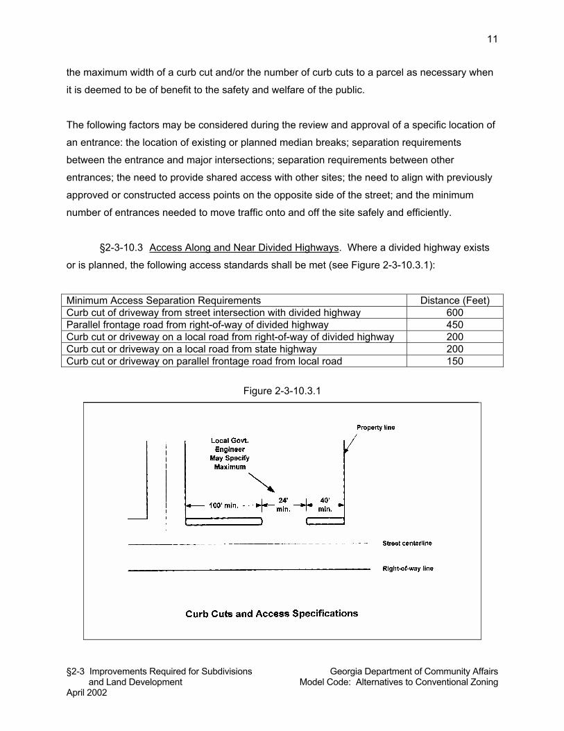
§2-3 Improvements Required for Subdivisions Georgia Department of Community Affairs and Land Development Model Code: Alternatives to Conventional Zoning April 2002
11
the maximum width of a curb cut and/or the number of curb cuts to a parcel as necessary when
it is deemed to be of benefit to the safety and welfare of the public.
The following factors may be considered during the review and approval of a specific location of
an entrance: the location of existing or planned median breaks; separation requirements
between the entrance and major intersections; separation requirements between other
entrances; the need to provide shared access with other sites; the need to align with previously
approved or constructed access points on the opposite side of the street; and the minimum
number of entrances needed to move traffic onto and off the site safely and efficiently.
§2-3-10.3 Access Along and Near Divided Highways. Where a divided highway exists
or is planned, the following access standards shall be met (see Figure 2-3-10.3.1):
Minimum Access Separation Requirements Distance (Feet) Curb cut of driveway from street intersection with divided highway 600 Parallel frontage road from right-of-way of divided highway 450 Curb cut or driveway on a local road from right-of-way of divided highway 200 Curb cut or driveway on a local road from state highway 200 Curb cut or driveway on parallel frontage road from local road 150
Figure 2-3-10.3.1
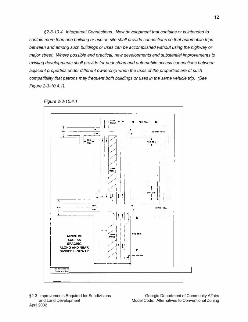
§2-3 Improvements Required for Subdivisions Georgia Department of Community Affairs and Land Development Model Code: Alternatives to Conventional Zoning April 2002
12
§2-3-10.4 Interparcel Connections. New development that contains or is intended to
contain more than one building or use on site shall provide connections so that automobile trips
between and among such buildings or uses can be accomplished without using the highway or
major street. Where possible and practical, new developments and substantial improvements to
existing developments shall provide for pedestrian and automobile access connections between
adjacent properties under different ownership when the uses of the properties are of such
compatibility that patrons may frequent both buildings or uses in the same vehicle trip. (See
Figure 2-3-10.4.1).
Figure 2-3-10.4.1
§2-3 Improvements Required for Subdivisions Georgia Department of Community Affairs and Land Development Model Code: Alternatives to Conventional Zoning April 2002
13
§2-3-11 STREET LIGHTING
The County [City] Engineer may require that subdivisions and land developments in urban and
suburban areas provide street lighting along all public streets and along existing streets abutting
the subdivision or land development. Such street lighting if required shall meet specifications of
the County [City] Engineer.
Commentary: Local governments are encouraged to consider a more specific standard under
which street lighting would be required. This provision may be too subjective.
§2-3-12 STREET SIGNS
Signs for street names, directions of travel, traffic control, and hazards shall be provided as
directed by the County [City] Engineer. Street signs on exterior/boundary streets shall be
installed by the County [City] with the developer paying a proportionate share determined by the
County [City]. Street signs for interior streets of a subdivision or land development shall be
installed at the subdivider or developer’s expense by the subdivider or developer, subject to the
approval of the County [City] Engineer.
Unless otherwise provided in standards and specifications adopted by the County [City]
Engineer, street signs shall meet the following specifications. Signs shall be constructed of
aluminum sheets with reflective backgrounds. Information on the street name signs shall be
readable from both sides of the sign. Signs shall be installed on a steel post. The vertical
distance from the road elevation to the bottom of the sign face shall be seven feet with a
minimum burial depth of three feet.
§2-3-13 CURBS AND GUTTERS
Curbs and gutters shall be installed if required by the County [City] Engineer in accordance with
standards and specifications of the County [City] Engineer. Subdivisions consisting totally of lots
intended for single-family residential use containing a minimum of two acres shall not require
curbs and gutters, provided, however, that curbs are required for all roads when sidewalks are
required by these regulations. All commercial and industrial subdivisions and land
developments must have curbs and gutters, regardless of the size of the lots. When property
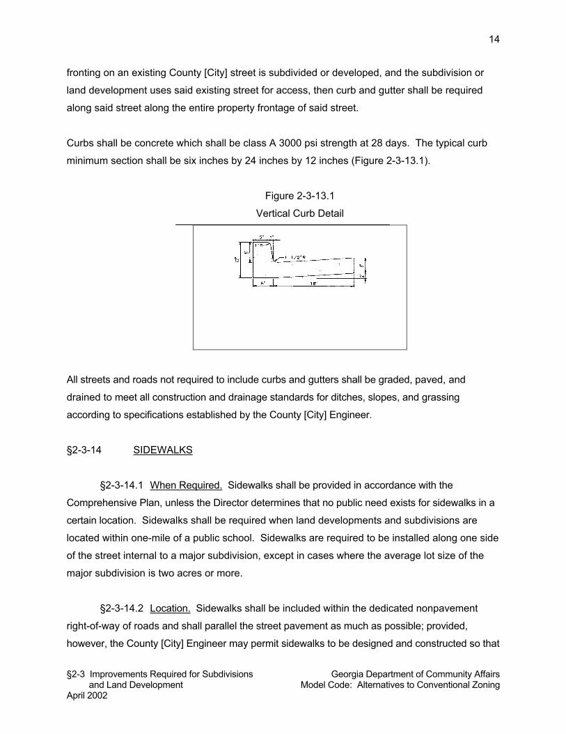
§2-3 Improvements Required for Subdivisions Georgia Department of Community Affairs and Land Development Model Code: Alternatives to Conventional Zoning April 2002
14
fronting on an existing County [City] street is subdivided or developed, and the subdivision or
land development uses said existing street for access, then curb and gutter shall be required
along said street along the entire property frontage of said street.
Curbs shall be concrete which shall be class A 3000 psi strength at 28 days. The typical curb
minimum section shall be six inches by 24 inches by 12 inches (Figure 2-3-13.1).
Figure 2-3-13.1
Vertical Curb Detail
All streets and roads not required to include curbs and gutters shall be graded, paved, and
drained to meet all construction and drainage standards for ditches, slopes, and grassing
according to specifications established by the County [City] Engineer.
§2-3-14 SIDEWALKS
§2-3-14.1 When Required. Sidewalks shall be provided in accordance with the
Comprehensive Plan, unless the Director determines that no public need exists for sidewalks in a
certain location. Sidewalks shall be required when land developments and subdivisions are
located within one-mile of a public school. Sidewalks are required to be installed along one side
of the street internal to a major subdivision, except in cases where the average lot size of the
major subdivision is two acres or more.
§2-3-14.2 Location. Sidewalks shall be included within the dedicated nonpavement
right-of-way of roads and shall parallel the street pavement as much as possible; provided,
however, the County [City] Engineer may permit sidewalks to be designed and constructed so that
§2-3 Improvements Required for Subdivisions Georgia Department of Community Affairs and Land Development Model Code: Alternatives to Conventional Zoning April 2002
15
they meander around permanent obstructions or deviate from a linear pattern for design
purposes.
§2-3-14.3 Specifications. Sidewalks shall be a minimum of four feet wide. A median
strip of grassed or landscaped areas at least two feet wide shall separate all sidewalks from
adjacent curbs in residential areas.
Commentary: If the local Comprehensive Plan is construed to mean that sidewalks are required
off-site, then the local government should consult its attorney about this provision.
§2-3-15 DRAINAGE AND STORMWATER MANAGEMENT
§2-3-15.1 General Requirements. An adequate drainage system, separate and
independent of any sanitary sewer system and including any necessary ditches, pipes, culverts,
intersectional drains, drop inlets, bridges, etc., shall be provided for the proper drainage of all
surface water for all subdivisions and land developments. Sizing and location of all drainage
structures shall be the responsibility of a registered professional engineer or land surveyor. The
County [City] Engineer may require the use of on-site control methods such as retention or
detention to mitigate the stormwater and drainage impacts of the proposed subdivisions and
land developments. The Planning Commission shall not approve any preliminary plat of
subdivision that does not make adequate provision for storm and flood water runoff channels or
basins as determined by the County [City] Engineer. No building permit shall be issued for any
building within a subdivision or for the development of land, if there is not present throughout the
subdivision or to the land development an adequate system of drainage and stormwater
management.
§2-3-15.2 Method of Design and Capacity. Storm sewers, where required, shall be
designed by the Rational Method, or other methods as approved by the County [City] Engineer,
and a copy of design computations shall be submitted along with required plans. Drainage
improvements shall accommodate potential runoff from the entire upstream drainage area within
the site and shall be designed to prevent increases in downstream flooding. Capacity for a 10-
year storm or rain shall be provided for all street drainage structures such as catch basin, inlets
cross drains, etc. Capacity for a 100-year frequency storm event shall be provided for all main
§2-3 Improvements Required for Subdivisions Georgia Department of Community Affairs and Land Development Model Code: Alternatives to Conventional Zoning April 2002
16
drainage structures such as retention basins, principal storm sewers, and all types of flood
protection works.
§2-3-15.3 Location. Drainage facilities shall be located in the road right-of-way where
feasible, and shall be constructed in accordance with standards and specifications of the County
[City Engineer]. Catch basins shall be located at low points of streets. Where topography or
other conditions are such as to make impractical the inclusion of drainage facilities within road
rights-of-way, perpetual, unobstructed easements at least fifteen (15) feet in width for drainage
facilities shall be provided across property outside the road right-of-way and with satisfactory
access to the road.
§2-3-15.4 Discharge. Drainage shall be designed so as to avoid concentration of storm
drainage water from each lot or land development site to adjacent lots, land development sites,
or vacant properties. Storm water shall not be discharged directly to perennial streams. It shall
be directed toward natural drainages. If water must be discharged to a stream, the water quality
flowing into the stream must meet or exceed the water quality in the receiving waters. The
water quantity flowing into the stream must be evaluated to ensure the stream channel can
accommodate the increased flows and not disrupt or degrade the ecology of the water body.
§2-3-15.5 Grading and Site Drainage. Lots or land development sites shall be laid out
so as to provide positive drainage away from all buildings, and drainage for individual lots or
land development sites shall be coordinated with the general storm drainage pattern for the
area. Buildings and parking lots shall be appropriately drained so as to prevent damage to
abutting properties or public streets. All disturbed or graded ground areas of a building site not
used for buildings or open storage areas shall be appropriately stabilized and grassed or
covered with plants or landscaping materials.
§2-3-15.6 Cross-Drainpipes. Where a watercourse separates the buildable area of a lot
from the street by which it has access, provisions shall be made for installation of a culvert or
other structure, the design of which shall be approved by the County [City] Engineer. Cross-
drains shall be provided to accommodate all natural waterflow, and shall be of sufficient length
to permit full-width roadways and the required slopes. Cross drainpipes shall have head walls
of an approved type on inlet and outlet ends of the pipe. Pipe installed within the right-of-way
§2-3 Improvements Required for Subdivisions Georgia Department of Community Affairs and Land Development Model Code: Alternatives to Conventional Zoning April 2002
17
shall be reinforced concrete pipe. All storm drainpipes shall be minimum 18 inches in diameter.
Storm sewer slopes shall be equal to or greater than one percent.
§2-3-15.7 Drop Inlets. Drop inlets shall be generally three-foot by three-foot boxes with
two-foot by three-foot grates unless otherwise specified by the County [City] Engineer.
§2-3-15.8 Easements. Where an irrigation ditch or channel, natural creek, stream or
other drainage way crosses a subdivision or land development, the subdivider or developer
shall provide an easement sufficient for drainage and maintenance. Easements shall be
provided for all drainage facilities as approved by the County [City] Engineer. When a
subdivision or land development is traversed by a watercourse, drainage way, channel, or
intermittent stream, a stormwater or drainage easement of at least twenty (20) feet shall be
provided.
§2-3-16 WATER
§2-3-16.1 Generally. All habitable buildings and buildable lots shall be connected to a
water system capable of providing water for health and emergency purposes, including
adequate fire protection. No building permit shall be issued for any building within a subdivision
or for the development of land, if there is not present throughout the subdivision or to the land
development an adequate water supply.
§2-3-16.2 Water Main Requirements. When a public water main is accessible, the
developer shall install adequate water facilities, including fire hydrants, according to
specifications of the County [City] Engineer. All water mains shall normally be at least six
inches in diameter except that pipe of lesser size may be used if properly looped and adequate
water pressure is maintained in accordance with standards established by the Southeastern
Fire Underwriters Association. Pipe of less than four inches shall not be used except in unusual
cases. Water lines shall be installed at least 30 inches below grade. Water mains within
subdivisions and land developments must be provided with connections to each lot in the
subdivision and each land development, except as otherwise specifically provided.
§2-3-16.3 Wells. If a County and/or municipal water supply is not available to the
subdivision or land development at the time of constructing improvements for a subdivision or
§2-3 Improvements Required for Subdivisions Georgia Department of Community Affairs and Land Development Model Code: Alternatives to Conventional Zoning April 2002
18
land development, then the subdivider or developer shall provide an adequate alternative water
source and an adequate water storage facility. In subdivisions or land developments with a
residential density of one unit per acre or less and when a public water system is not available
as determined by the County [City] Engineer, individual wells may be used in a manner so that
an adequate supply of potable water will be available to every lot in the subdivision or to the
land development. When individual wells are proposed to be used for water supply, water
samples shall be submitted to the County Health Department for its approval, and individual
wells shall be approved by the County Health Department. Approvals shall be submitted to the
Director prior to final subdivision plat approval.
§2-3-16.4 Community Water System. If a County and/or municipal water supply is not
available to the subdivision or land development at the time of constructing improvements for a
subdivision or land development, then the subdivider or developer shall provide an adequate
alternative water source and an adequate water storage facility. Any community water system, if
permitted, shall provide a minimum flow of 400 gallons per day per each lot platted, whether or not
each lot is to be immediately developed; shall be sanitary; and shall have a minimum pressure of
30 pounds per square inch at each lot in the subdivision or each land development to be served.
For all common non-public water supply systems, acceptable management, maintenance, and
distribution policies and procedures shall be established. These policies and procedures shall
be required to guarantee the provision of adequate supplies to each perspective lot owner on a
continuing, ongoing basis, and to provide acceptable means for repairs and unforeseen events.
The community water system plan shall be approved by the __________ County Health
Department and a letter of approval from the Georgia Department of Natural Resources shall
accompany the final plat or land development application.
§2-3-16.5 Fire Hydrants. Fire hydrants shall be required for all nonresidential land
developments and all subdivisions except those permitted to be served by individual on-site
wells. Fire hydrants with appropriate water pressure at appropriate intervals throughout the
subdivision or land development shall be provided by the subdivider or land developer as required
by the County [City] Fire Department. Fire hydrants shall be located no more than 1,000 feet
apart and within 500 feet of any principal dwelling. Hydrants, fittings, valves and fire department
connections shall be approved by the Fire Department. Fire department connections shall be
not less than 18 inches or more than 36 inches above the level of the adjoining ground or
paving. The thread of such connections shall be uniform with that used by the Fire Department.
§2-3 Improvements Required for Subdivisions Georgia Department of Community Affairs and Land Development Model Code: Alternatives to Conventional Zoning April 2002
19
To eliminate future street openings, all underground utilities for fire hydrants, together with the
fire hydrants themselves, and all other supply improvements shall be installed before any final
paving of a street within the right-of-way shared by such underground utilities.
§2-3-17 SEWER
§2-3-17.1 Generally. All habitable buildings and buildable lots shall be served by an
approved means of wastewater collection and treatment. Each subdivision and land
development shall be served by adequate sewage disposal facilities. No building permit shall be
issued for any building within a subdivision or for the development of land, if there is not present
throughout the subdivision or to the land development an adequate system of wastewater
collection and treatment.
§2-3-17.2 Connection to Public Sewerage System. When a public sanitary sewerage
system is reasonably accessible, as determined by the County [City] Engineer, the subdivider or
land developer shall connect with same and provide sewers accessible to each lot in the
subdivision or to each land development. If a public sanitary sewer is reasonably accessible, it
shall be unlawful for any to maintain upon any such property an individual sewage disposal
system. When a public sanitary sewerage system is not immediately accessible but is
anticipated by the County [City] to be available within a period of three years, the applicant shall
install sanitary sewer lines, laterals, and mains from the street curb to a point in the subdivision
or land development boundary so that a future connection with the public sewer main can be
made. The County [City] Engineer may condition the approval of a subdivision or land
development on the agreement to connect to the public sewerage system upon its availability.
Sanitary sewers shall be located within street or alley rights-of-way unless topography dictates
otherwise. No public sewer shall be less than eight inches in diameter. Manholes shall be
installed in sanitary sewers with a maximum distance between two manholes of 400 feet, unless
otherwise specified by standards of the County [City] Engineer. Sanitary sewer slopes shall be
equal to or greater than 0.7 percent for eight inch lines. All sewer lines shall be designed with
slopes to obtain a minimum velocity of two feet per second. Minimum 20-foot wide easements
shall be provided for all sanitary sewer lines.
§2-3-17.3 Alternative Provision. If sanitary sewer is not available at the time of the
development of the subdivision or land development, and if sanitary sewer is not anticipated to be
§2-3 Improvements Required for Subdivisions Georgia Department of Community Affairs and Land Development Model Code: Alternatives to Conventional Zoning April 2002
20
available within a period of three years to serve the subdivision or land development in question,
then on-site septic tanks, an oxidation pond, or another approved method of treatment of sanitary
sewerage shall be installed by and at the expense of the subdivider, land developer, or lot
purchaser, in conformity with the requirements of the County Health Department and according to
specifications adopted by the County [City] Engineer.
§2-3-17.4 Septic Tanks. Where individual onsite wastewater disposal systems are
allowed and proposed, individual lot sizes and shapes must exhibit appropriate regard for the
peculiar health, drainage, and maintenance characteristics on the site. Additionally, detailed soil
tests may be required in order to verify the ability of the lots to safely contain and dispose of
septic system effluent. All septic tanks and onsite wastewater disposal systems are subject to
the approval of the _________ County Health Department.
§2-3-18 UTILITIES
All utility facilities, including but not limited to gas, electric power, telephone, and cable
television, shall be located underground throughout the subdivision or land development.
Whenever existing utility facilities are located above ground, except when existing on public
roads and rights-of-way, they shall be removed and placed underground. Easements centered
on rear lot lines shall be provided for utilities, private and public, and such easements shall be at
least 10 feet wide. When topographical or other conditions are such as to make impractical the
inclusion of utilities along the rear lot lines of a subdivision, lot, or land development site,
perpetual unobstructed easements at least 10 feet in width shall be provided along side lot lines
with satisfactory access.
§2-3-19 OVERSIZING OF IMPROVEMENTS AND UTILITIES
The subdivider or land developer shall construct such oversized improvements and utilities that
the County [City] Engineer determines are necessary, provided that the subdivider or land
developer shall not be obligated for the additional cost of improvements and utilities that are not
uniquely required for that development, and provided the subdivider agrees to a proposal by the
County [City] Engineer to share in the cost arrangements for over-sizing improvements and
utilities. A formula may be developed by the County [City] to provide for a sharing of the cost of
§2-3 Improvements Required for Subdivisions Georgia Department of Community Affairs and Land Development Model Code: Alternatives to Conventional Zoning April 2002
21
other improvements needed to serve the subdivision or land development when certain of the
improvements are necessary to serve future subdivisions or developments in the vicinity.
§2-3-20 PROCEDURE FOR ADMINISTRATIVE INSPECTION AND ACCEPTANCE OF
PUBLIC IMPROVEMENTS
Upon completion of public improvement construction, the subdivider or land developer shall
notify the Director of Engineering and request an inspection. The County [City] Engineer shall
inspect all public improvements and shall notify the subdivider or land developer by mail of
nonacceptance or preliminary acceptance. If the public improvements are not acceptable, the
reason for non-acceptance shall be stated and corrective measures shall be outlined in a letter
of notification. Upon notification, the subdivider or land developer shall correct all deficiencies
identified in the non-acceptance letter within the time limit established by the County [City]
Engineer. Once deficiencies are corrected, the subdivider or land developer shall again request
inspection in writing. Acceptance of public improvements required by Section 2-2 of this code to
be approved by the local governing body shall be forwarded to the governing body by the
Director following receipt of written approval of the County [City] Engineer.
References:
Forsyth County Department of Public Works. 1995. Construction Standards and Specifications.
Cumming, GA: Forsyth County Department of Public Works.
Jerry Weitz & Associates, Inc. 2001. Development and Design Guidelines for the Georgia 400
Corridor, Dawson County, Georgia. Dawsonville, GA: Dawson County Department of Planning
.
§2-4 Reference to State Permits Georgia Department of Community Affairs December 2003 Model Code: Alternatives to Conventional Zoning
1
§2-4 REFERENCE TO STATE PERMITS
CONTENTS §2-4-1 GEORGIA AIR QUALITY ACT OF 1978 §2-4-2 GROUND WATER USE ACT OF 1972 §2-4-3 GEORGIA WATER QUALITY CONTROL ACT §2-4-4 GEORGIA HAZARDOUS WASTE MANAGEMENT ACT §2-4-5 GEORGIA COMPREHENSIVE SOLID WASTE MANAGEMENT
ACT OF 1990 §2-4-6 COASTAL MARSHLANDS PROTECTION ACT OF 1970;
SHORE ASSISTANCE ACT OF 1979 §2-4-7 GEORGIA SURFACE MINING ACT OF 1968 §2-4-8 ENDANGERED WILDLIFE ACT OF 1973;
WILDFLOWER PRESERVATION ACT OF 1973 §2-4-9 BURIAL GROUNDS AND CEMETERIES §2-4-10 GEORGIA SAFE DAMS ACT OF 1978 §2-4 REFERENCE TO STATE PERMITS
Commentary: This module provides references to major state land use and environmental laws
as they relate to the permitting of specific land uses and categories of uses. While it is not the
intent to incorporate state laws into this code or have local governments adopt state
requirements, local Land Use Officers should be generally aware of the types of land uses that
require compliance with state laws. This module provides that when a permit is required to be
issued by the state, that a copy of said state permit be submitted to the Land Use Officer. This
should not imply a responsibility of the local Land Use Officer to enforce state law; rather, it is
intended simply to ensure that the local government has a record of the state permit which
provides information to local constituencies who may be concerned about compliance with a
particular development.
Commentary: It is not uncommon for a city or county without zoning to find out a certain major
polluting facility is proposed to be located in its jurisdiction, only to further ascertain that it has
no control over the location of such facility. It is important to note that the state environmental
laws described in this module do not regulate the location of such facilities. Rather, they are
intended only to review such uses for compliance with federal/state pollution and environmental
laws. Cities and counties without land use regulations have been known to try and lobby the
Department of Natural Resources to deny one or more required permits. However, the state
must make permitting decisions in compliance with applicable laws and administrative rules,
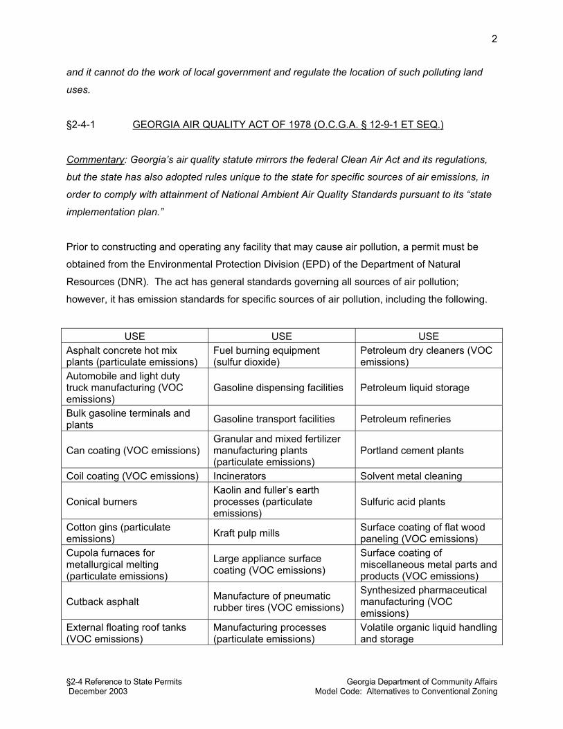
§2-4 Reference to State Permits Georgia Department of Community Affairs December 2003 Model Code: Alternatives to Conventional Zoning
2
and it cannot do the work of local government and regulate the location of such polluting land
uses.
§2-4-1 GEORGIA AIR QUALITY ACT OF 1978 (O.C.G.A. § 12-9-1 ET SEQ.)
Commentary: Georgia’s air quality statute mirrors the federal Clean Air Act and its regulations,
but the state has also adopted rules unique to the state for specific sources of air emissions, in
order to comply with attainment of National Ambient Air Quality Standards pursuant to its “state
implementation plan.”
Prior to constructing and operating any facility that may cause air pollution, a permit must be
obtained from the Environmental Protection Division (EPD) of the Department of Natural
Resources (DNR). The act has general standards governing all sources of air pollution;
however, it has emission standards for specific sources of air pollution, including the following.
USE USE USE Asphalt concrete hot mix plants (particulate emissions)
Fuel burning equipment (sulfur dioxide)
Petroleum dry cleaners (VOC emissions)
Automobile and light duty truck manufacturing (VOC emissions)
Gasoline dispensing facilities Petroleum liquid storage
Bulk gasoline terminals and plants Gasoline transport facilities Petroleum refineries
Can coating (VOC emissions) Granular and mixed fertilizer manufacturing plants (particulate emissions)
Portland cement plants
Coil coating (VOC emissions) Incinerators Solvent metal cleaning
Conical burners Kaolin and fuller’s earth processes (particulate emissions)
Sulfuric acid plants
Cotton gins (particulate emissions) Kraft pulp mills Surface coating of flat wood
paneling (VOC emissions) Cupola furnaces for metallurgical melting (particulate emissions)
Large appliance surface coating (VOC emissions)
Surface coating of miscellaneous metal parts and products (VOC emissions)
Cutback asphalt Manufacture of pneumatic rubber tires (VOC emissions)
Synthesized pharmaceutical manufacturing (VOC emissions)
External floating roof tanks (VOC emissions)
Manufacturing processes (particulate emissions)
Volatile organic liquid handling and storage
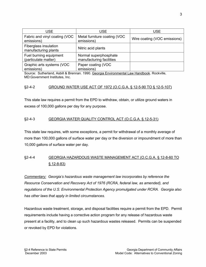
§2-4 Reference to State Permits Georgia Department of Community Affairs December 2003 Model Code: Alternatives to Conventional Zoning
3
USE USE USE
Fabric and vinyl coating (VOC emissions)
Metal furniture coating (VOC emissions) Wire coating (VOC emissions)
Fiberglass insulation manufacturing plants Nitric acid plants
Fuel burning equipment (particulate matter)
Normal superphosphate manufacturing facilities
Graphic arts systems (VOC emissions)
Paper coating (VOC emissions)
Source: Sutherland, Asbill & Brennan. 1990. Georgia Environmental Law Handbook. Rockville, MD:Government Institutes, Inc.
§2-4-2 GROUND WATER USE ACT OF 1972 (O.C.G.A. § 12-5-90 TO § 12-5-107)
This state law requires a permit from the EPD to withdraw, obtain, or utilize ground waters in
excess of 100,000 gallons per day for any purpose.
§2-4-3 GEORGIA WATER QUALITY CONTROL ACT (O.C.G.A. § 12-5-31)
This state law requires, with some exceptions, a permit for withdrawal of a monthly average of
more than 100,000 gallons of surface water per day or the diversion or impoundment of more than
10,000 gallons of surface water per day.
§2-4-4 GEORGIA HAZARDOUS WASTE MANAGEMENT ACT (O.C.G.A. § 12-8-60 TO
§ 12-8-83)
Commentary: Georgia’s hazardous waste management law incorporates by reference the
Resource Conservation and Recovery Act of 1976 (RCRA, federal law, as amended), and
regulations of the U.S. Environmental Protection Agency promulgated under RCRA. Georgia also
has other laws that apply in limited circumstances.
Hazardous waste treatment, storage, and disposal facilities require a permit from the EPD. Permit
requirements include having a corrective action program for any release of hazardous waste
present at a facility, and to clean up such hazardous wastes released. Permits can be suspended
or revoked by EPD for violations.
§2-4 Reference to State Permits Georgia Department of Community Affairs December 2003 Model Code: Alternatives to Conventional Zoning
4
§2-4-5 GEORGIA COMPREHENSIVE SOLID WASTE MANAGEMENT ACT OF 1990
(O.C.G.A. § 12-8-20 TO § 12-8-40).
Commentary: All permits for solid waste handling facilities require written verification from the
applicant that the proposed facility complies with local zoning and land use ordinances. For this
reason, local governments should not make the prior receipt of state approval of solid waste
management facilities a condition of local approval.
This act repealed the Georgia Solid Waste Management Act. Any person engaging in solid
waste or special waste handling in Georgia, or operating or constructing a solid waste handling
facility, must first obtain a permit from EPD. The term “solid waste handling” is broadly defined.
Existing regulations for solid waste management and permitting of solid waste disposal facilities
are codified in Chapter 391-3-4 of Georgia EPD. Such facilities cannot be located near National
Historic Sites or within two miles of areas designated by EPD as significant groundwater
recharge areas unless a liner and leachate collection system is installed (see Section 2-1-1 of
this model code, groundwater recharge areas).
§2-4-6 COASTAL MARSHLANDS PROTECTION ACT OF 1970 (O.C.G.A. § 12-5-280
TO § 12-5-293). SHORE ASSISTANCE ACT OF 1979 (O.C.G.A. § 12-5-230 TO
§ 12-5-246)
Commentary: The state withdrew from the Federal Coastal Zone Management Program in 1979
and instead adopted its own program via the Shore Assistance Act of 1979. There are more than
400,000 acres of salt and brackish water marshlands along the coast of Georgia (Kundell et al.
1989).
These two laws establish specific permit programs for protecting coastal areas. The 1970 law
requires a permit for the alteration of marshes, which requires proof of compliance with any local
zoning restrictions. The 1979 law is aimed at protecting the state’s coastal sand dunes, beaches,
sandbars and shoals. Permit approval requires certification of a local governing authority that the
proposal is in compliance with any zoning law, ordinance, or other local land use restrictions
(Kundell et al. 1989). Local governing authorities can become permit-issuing agencies if they
enact ordinances meeting or exceeding the requirements of the Shore Assistance Act and can
enforce such regulations (Kundell et al. 1989).
§2-4 Reference to State Permits Georgia Department of Community Affairs December 2003 Model Code: Alternatives to Conventional Zoning
5
§2-4-7 GEORGIA SURFACE MINING ACT OF 1968 (O.C.G.A. § 12-4-70 ET SEQ.)
Commentary: Virtually all mining in the state is surface mining for stone, clays, and other
industrial minerals including barite, marble, bauxite, kaolin, mica, talc, and limestone.
Surface mine operators are required to obtain a mining permit from EPD before commencing
operation of a mine. Applications for permits must be accompanied by a mined land use plan,
which includes reclamation activities.
§2-4-8 ENDANGERED WILDLIFE ACT OF 1973 (O.C.G.A. § 27-3-130 TO § 27-3-133).
WILDFLOWER PRESERVATION ACT OF 1973 (O.C.G.A. § 12-6-170 TO § 12-6-
176)
Rules adopted by EPD make it unlawful to engage in an act that causes the death of a
protected animal, and the destruction of the habitat of a protected animal on public land is
prohibited. It is also unlawful to remove protected plant species from public land without a
permit.
§2-4-9 BURIAL GROUNDS AND CEMETERIES (O.C.G.A. § 27-3-133; § 12-6-176)
Georgia law prohibits disturbance of any known burial place for human remains for the purpose
of developing or changing the use of land unless a permit is obtained from the governing
authority of the city or county (the jurisdiction in which the burial site is located) or from the
superior court of the county in which the burial place is located. Reinternment is required for a
permit to be issued.
§2-4-10 GEORGIA SAFE DAMS ACT OF 1978 (O.C.G.A. § 12-4-143 TO § 12-4-146)
This law provides for the inspection and permitting of dams to protect the health, safety, and
welfare of citizens by reducing the risk of failure of such dams. DNR has promulgated rules and
regulations enforcing the act.
§2-4 Reference to State Permits Georgia Department of Community Affairs December 2003 Model Code: Alternatives to Conventional Zoning
6
References:
Kundell, James E., et al. 1989. Land-use Policy and Protection of Georgia’s Environment.
Athens, GA: University of Georgia, Carl Vinson Institute of Government.
Sutherland, Asbill & Brennan. 1990. Georgia Environmental Law Handbook. Rockville, MD:
Government Institutes, Inc

§2-4 Reference to State Permits Georgia Department of Community Affairs December 2003 Model Code: Alternatives to Conventional Zoning
1
§2-5 ALTERNATIVE STREET AND PEDESTRIAN SYSTEM STANDARDS § 2-5-1 PURPOSE § 2-5-2 DEFINITIONS § 2-5-3 STREET STANDARDS § 2-5-3.1 Alleys. § 2-5-3.2 Lanes. § 2-5-3.3 Local Streets. § 2-5-3.4 Avenues and Main Streets. § 2-5-3.5 Boulevards. § 2-5-3 .6 Parkways. § 2-5-3 .7 Turnarounds. § 2-5-3.8 Curb radii. § 2-5-4 PEDESTRIAN SYSTEM STANDARDS § 2-5-4.1 Pedestrian Connections from Development to Street. Commentary: For an extended commentary on street and pedestrian standards, see the extended
commentary following this module of the Model Code: Alternatives to Conventional Zoning.
§ 2-5-1 PURPOSE
The purpose of this Code section is to provide for alternative street specifications that will reduce
construction costs to developers, provide flexibility to developers and minimize right-of-way
widths, pavement widths, turnaround dimensions and intersection curb radii. It is also the intent of
this Code section to maintain safety standards, provide for more pedestrian-friendly street
environments, afford appropriate access for bicyclists, facilitate implementation of the county’s
[city’s] multi-modal transportation element of its comprehensive plan and in general provide for
more healthy neighborhoods and commercial areas.
§ 2-5-2 DEFINITIONS
Americans with Disabilities Act (ADA): Federal civil rights legislation passed in 1990, which
requires accessibility for disabled persons.
Alley: A slow-speed service road running behind and sometimes between rows of houses, which
provides public service and utility access and secondary or primary access to off-street parking for
residences or businesses.
Arterial street: Unless otherwise specifically defined in the transportation element of the
comprehensive plan, arterial streets are roads designed to carry traffic through an area rather
than to local destinations.
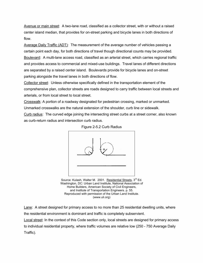
Avenue or main street: A two-lane road, classified as a collector street, with or without a raised
center island median, that provides for on-street parking and bicycle lanes in both directions of
flow.
Average Daily Traffic (ADT): The measurement of the average number of vehicles passing a
certain point each day, for both directions of travel though directional counts may be provided.
Boulevard: A multi-lane access road, classified as an arterial street, which carries regional traffic
and provides access to commercial and mixed-use buildings. Travel lanes of different directions
are separated by a raised center island. Boulevards provide for bicycle lanes and on-street
parking alongside the travel lanes in both directions of flow.
Collector street: Unless otherwise specifically defined in the transportation element of the
comprehensive plan, collector streets are roads designed to carry traffic between local streets and
arterials, or from local street to local street.
Crosswalk: A portion of a roadway designated for pedestrian crossing, marked or unmarked.
Unmarked crosswalks are the natural extension of the shoulder, curb line or sidewalk.
Curb radius: The curved edge joining the intersecting street curbs at a street corner, also known
as curb-return radius and intersection curb radius.
Figure 2-5.2 Curb Radius
Source: Kulash, Walter M. 2001. Residential Streets, 3rd Ed. Washington, DC: Urban Land Institute, National Association of
Home Builders, American Society of Civil Engineers, and Institute of Transportation Engineers. p. 55.
Reproduced with permission of the Urban Land Institute. (www.uli.org)
Lane: A street designed for primary access to no more than 25 residential dwelling units, where
the residential environment is dominant and traffic is completely subservient.
Local street: In the context of this Code section only, local streets are designed for primary access
to individual residential property, where traffic volumes are relative low (250 - 750 Average Daily
Traffic).
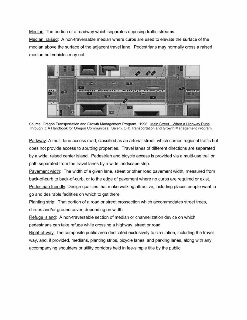
Median: The portion of a roadway which separates opposing traffic streams.
Median, raised: A non-traversable median where curbs are used to elevate the surface of the
median above the surface of the adjacent travel lane. Pedestrians may normally cross a raised
median but vehicles may not.
Source: Oregon Transportation and Growth Management Program. 1998. Main Street…When a Highway Runs Through It: A Handbook for Oregon Communities. Salem, OR: Transportation and Growth Management Program.
Parkway: A multi-lane access road, classified as an arterial street, which carries regional traffic but
does not provide access to abutting properties. Travel lanes of different directions are separated
by a wide, raised center island. Pedestrian and bicycle access is provided via a multi-use trail or
path separated from the travel lanes by a wide landscape strip.
Pavement width: The width of a given lane, street or other road pavement width, measured from
back-of-curb to back-of-curb, or to the edge of pavement where no curbs are required or exist.
Pedestrian friendly: Design qualities that make walking attractive, including places people want to
go and desirable facilities on which to get there.
Planting strip: That portion of a road or street crossection which accommodates street trees,
shrubs and/or ground cover, depending on width.
Refuge island: A non-traversable section of median or channelization device on which
pedestrians can take refuge while crossing a highway, street or road.
Right-of-way: The composite public area dedicated exclusively to circulation, including the travel
way, and, if provided, medians, planting strips, bicycle lanes, and parking lanes, along with any
accompanying shoulders or utility corridors held in fee-simple title by the public.
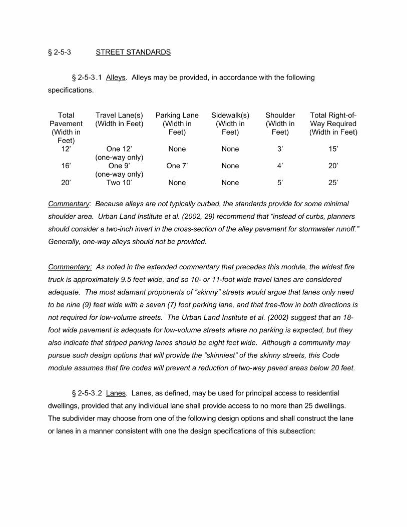
§ 2-5-3 STREET STANDARDS
§ 2-5-3 .1 Alleys. Alleys may be provided, in accordance with the following
specifications.
Total Pavement (Width in
Feet)
Travel Lane(s) (Width in Feet)
Parking Lane (Width in
Feet)
Sidewalk(s) (Width in
Feet)
Shoulder (Width in
Feet)
Total Right-of-Way Required (Width in Feet)
12’ One 12’ (one-way only)
None None 3’ 15’
16’ One 9’ (one-way only)
One 7’ None 4’ 20’
20’ Two 10’ None None 5’ 25’
Commentary: Because alleys are not typically curbed, the standards provide for some minimal
shoulder area. Urban Land Institute et al. (2002, 29) recommend that “instead of curbs, planners
should consider a two-inch invert in the cross-section of the alley pavement for stormwater runoff.”
Generally, one-way alleys should not be provided.
Commentary: As noted in the extended commentary that precedes this module, the widest fire
truck is approximately 9.5 feet wide, and so 10- or 11-foot wide travel lanes are considered
adequate. The most adamant proponents of “skinny” streets would argue that lanes only need
to be nine (9) feet wide with a seven (7) foot parking lane, and that free-flow in both directions is
not required for low-volume streets. The Urban Land Institute et al. (2002) suggest that an 18-
foot wide pavement is adequate for low-volume streets where no parking is expected, but they
also indicate that striped parking lanes should be eight feet wide. Although a community may
pursue such design options that will provide the “skinniest” of the skinny streets, this Code
module assumes that fire codes will prevent a reduction of two-way paved areas below 20 feet.
§ 2-5-3 .2 Lanes. Lanes, as defined, may be used for principal access to residential
dwellings, provided that any individual lane shall provide access to no more than 25 dwellings.
The subdivider may choose from one of the following design options and shall construct the lane
or lanes in a manner consistent with one the design specifications of this subsection:
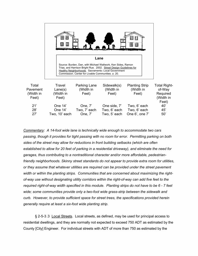
Total Pavement (Width in
Feet)
Travel Lane(s)
(Width in Feet)
Parking Lane (Width in
Feet)
Sidewalk(s) (Width in
Feet)
Planting Strip (Width in
Feet)
Total Right-of-Way
Required (Width in
Feet) 21’ One 14’ One, 7’ One side, 7’ Two, 6’ each 40’ 28’ One 14’ Two, 7’ each Two, 6’ each Two, 6’ each 45’ 27’ Two, 10’ each One, 7’ Two, 5’ each One 6’, one 7’ 50’
Commentary: A 14-foot wide lane is technically wide enough to accommodate two cars
passing, though it provides for tight passing with no room for error. Permitting parking on both
sides of the street may allow for reductions in front building setbacks (which are often
established to allow for 20 feet of parking in a residential driveway), and eliminate the need for
garages, thus contributing to a nontraditional character and/or more affordable, pedestrian-
friendly neighborhoods. Skinny street standards do not appear to provide extra room for utilities,
or they assume that whatever utilities are required can be provided under the street pavement
width or within the planting strips. Communities that are concerned about maximizing the right-
of-way use without designating utility corridors within the right-of-way can add five feet to the
required right-of-way width specified in this module. Planting strips do not have to be 6 - 7 feet
wide; some communities provide only a two-foot wide grass-strip between the sidewalk and
curb. However, to provide sufficient space for street trees, the specifications provided herein
generally require at least a six-foot wide planting strip.
§ 2-5-3 .3 Local Streets. Local streets, as defined, may be used for principal access to
residential dwellings, and they are normally not expected to exceed 750 ADT as estimated by the
County [City] Engineer. For individual streets with ADT of more than 750 as estimated by the
Lane Source: Burden, Dan, with Michael Wallwork, Ken Sides, Ramon Trias, and Harrison Bright Rue. 2002. Street Design Guidelines for Healthy Neighborhoods. Sacramento: Local Government Commission, Center for Livable Communities. p. 20.
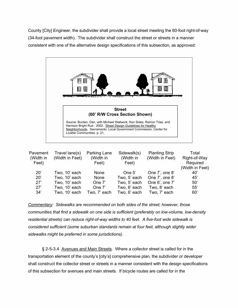
County [City] Engineer, the subdivider shall provide a local street meeting the 60-foot right-of-way
(34-foot pavement width). The subdivider shall construct the street or streets in a manner
consistent with one of the alternative design specifications of this subsection, as approved:
Pavement (Width in
Feet)
Travel lane(s) (Width in Feet)
Parking Lane (Width in
Feet)
Sidewalk(s) (Width in
Feet)
Planting Strip (Width in Feet)
Total Right-of-Way
Required (Width in Feet)
20’ Two, 10’ each None One 5’ One 7’, one 8’ 40’ 20’ Two, 10’ each None Two, 5’ each One 7’, one 8’ 45’ 27’ Two, 10’ each One 7’ Two, 5’ each One 6’, one 7’ 50’ 27’ Two, 10’ each One 7’ Two, 6’ each Two, 8’ each 55’ 34’ Two, 10’ each Two, 7’ each Two, 6’ each Two, 7’ each 60’
Commentary: Sidewalks are recommended on both sides of the street; however, those
communities that find a sidewalk on one side is sufficient (preferably on low-volume, low-density
residential streets) can reduce right-of-way widths to 40 feet. A five-foot wide sidewalk is
considered sufficient (some suburban standards remain at four feet, although slightly wider
sidewalks might be preferred in some jurisdictions).
§ 2-5-3.4 Avenues and Main Streets. Where a collector street is called for in the
transportation element of the county’s [city’s] comprehensive plan, the subdivider or developer
shall construct the collector street or streets in a manner consistent with the design specifications
of this subsection for avenues and main streets. If bicycle routes are called for in the
Street (60’ R/W Cross Section Shown)
Source: Burden, Dan, with Michael Wallwork, Ken Sides, Ramon Trias, and Harrison Bright Rue. 2002. Street Design Guidelines for Healthy Neighborhoods. Sacramento: Local Government Commission, Center for Livable Communities. p. 21.
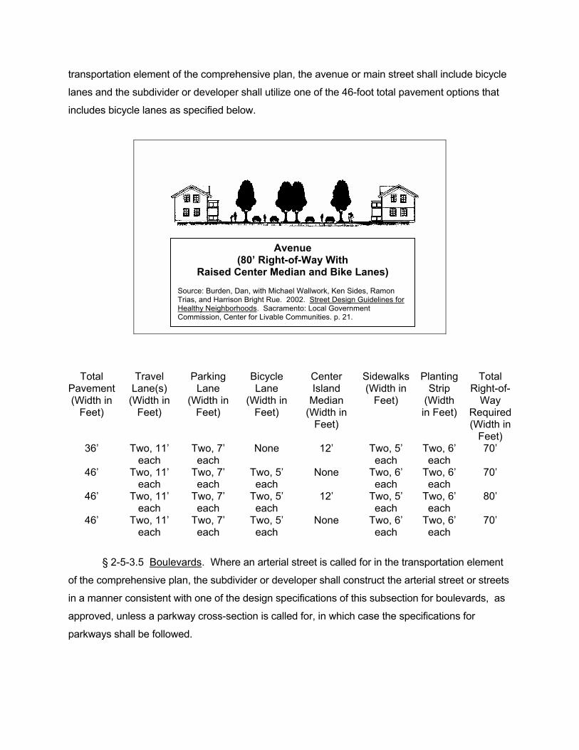
transportation element of the comprehensive plan, the avenue or main street shall include bicycle
lanes and the subdivider or developer shall utilize one of the 46-foot total pavement options that
includes bicycle lanes as specified below.
Total Pavement (Width in
Feet)
Travel Lane(s)
(Width in Feet)
Parking Lane
(Width in Feet)
Bicycle Lane
(Width in Feet)
Center Island
Median (Width in
Feet)
Sidewalks (Width in
Feet)
Planting Strip
(Width in Feet)
Total Right-of-
Way Required (Width in
Feet) 36’ Two, 11’
each Two, 7’ each
None 12’ Two, 5’ each
Two, 6’ each
70’
46’ Two, 11’ each
Two, 7’ each
Two, 5’ each
None Two, 6’ each
Two, 6’ each
70’
46’ Two, 11’ each
Two, 7’ each
Two, 5’ each
12’ Two, 5’ each
Two, 6’ each
80’
46’ Two, 11’ each
Two, 7’ each
Two, 5’ each
None Two, 6’ each
Two, 6’ each
70’
§ 2-5-3.5 Boulevards. Where an arterial street is called for in the transportation element
of the comprehensive plan, the subdivider or developer shall construct the arterial street or streets
in a manner consistent with one of the design specifications of this subsection for boulevards, as
approved, unless a parkway cross-section is called for, in which case the specifications for
parkways shall be followed.
Avenue (80’ Right-of-Way With
Raised Center Median and Bike Lanes) Source: Burden, Dan, with Michael Wallwork, Ken Sides, Ramon Trias, and Harrison Bright Rue. 2002. Street Design Guidelines for Healthy Neighborhoods. Sacramento: Local Government Commission, Center for Livable Communities. p. 21.
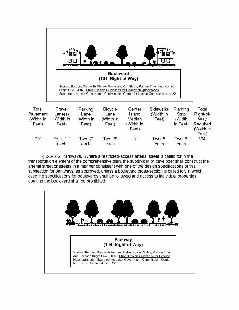
Total Pavement (Width in
Feet)
Travel Lane(s)
(Width in Feet)
Parking Lane
(Width in Feet)
Bicycle Lane
(Width in Feet)
Center Island
Median (Width in
Feet)
Sidewalks (Width in
Feet)
Planting Strip
(Width in Feet)
Total Right-of-
Way Required (Width in
Feet) 70’ Four, 11’
each Two, 7’ each
Two, 6’ each
12’ Two, 5’ each
Two, 6’ each
104’
§ 2-5-3 .6 Parkways. Where a restricted-access arterial street is called for in the transportation element of the comprehensive plan, the subdivider or developer shall construct the arterial street or streets in a manner consistent with one of the design specifications of this subsection for parkways, as approved, unless a boulevard cross-section is called for, in which case the specifications for boulevards shall be followed and access to individual properties abutting the boulevard shall be prohibited.
Parkway (104’ Right-of-Way)
Source: Burden, Dan, with Michael Wallwork, Ken Sides, Ramon Trias, and Harrison Bright Rue. 2002. Street Design Guidelines for Healthy Neighborhoods. Sacramento: Local Government Commission, Center for Livable Communities. p. 22.
Boulevard (104’ Right-of-Way)
Source: Burden, Dan, with Michael Wallwork, Ken Sides, Ramon Trias, and Harrison Bright Rue. 2002. Street Design Guidelines for Healthy Neighborhoods. Sacramento: Local Government Commission, Center for Livable Communities. p. 22.
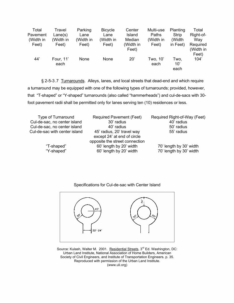
Total Pavement (Width in
Feet)
Travel Lane(s)
(Width in Feet)
Parking Lane
(Width in Feet)
Bicycle Lane
(Width in Feet)
Center Island
Median (Width in
Feet)
Multi-use Paths
(Width in Feet)
Planting Strip
(Width in Feet)
Total Right-of-
Way Required (Width in
Feet) 44’ Four, 11’
each None None 20’ Two, 10’
each Two, 10’
each
104’
§ 2-5-3 .7 Turnarounds. Alleys, lanes, and local streets that dead-end and which require
a turnaround may be equipped with one of the following types of turnarounds; provided, however,
that “T-shaped” or “Y-shaped” turnarounds (also called “hammerheads”) and cul-de-sacs with 30-
foot pavement radii shall be permitted only for lanes serving ten (10) residences or less.
Type of Turnaround Required Pavement (Feet) Required Right-of-Way (Feet) Cul-de-sac, no center island 30’ radius 40’ radius Cul-de-sac, no center island 40’ radius 50’ radius Cul-de-sac with center island 45’ radius, 20’ travel way
except 24’ at end of circle opposite the street connection
55’ radius
“T-shaped” 60’ length by 20’ width 70’ length by 30’ width “Y-shaped” 60’ length by 20’ width 70’ length by 30’ width
Specifications for Cul-de-sac with Center Island
Source: Kulash, Walter M. 2001. Residential Streets, 3rd Ed. Washington, DC: Urban Land Institute, National Association of Home Builders, American
Society of Civil Engineers, and Institute of Transportation Engineers. p. 35. Reproduced with permission of the Urban Land Institute.
(www.uli.org)
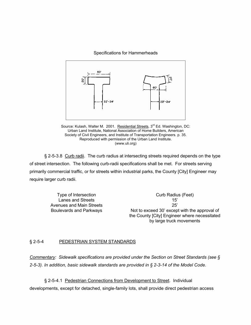
Specifications for Hammerheads
Source: Kulash, Walter M. 2001. Residential Streets, 3rd Ed. Washington, DC: Urban Land Institute, National Association of Home Builders, American
Society of Civil Engineers, and Institute of Transportation Engineers. p. 35. Reproduced with permission of the Urban Land Institute.
(www.uli.org)
§ 2-5-3.8 Curb radii. The curb radius at intersecting streets required depends on the type
of street intersection. The following curb-radii specifications shall be met. For streets serving
primarily commercial traffic, or for streets within industrial parks, the County [City] Engineer may
require larger curb radii.
Type of Intersection Curb Radius (Feet) Lanes and Streets 15’
Avenues and Main Streets 25’ Boulevards and Parkways Not to exceed 30’ except with the approval of
the County [City] Engineer where necessitated by large truck movements
§ 2-5-4 PEDESTRIAN SYSTEM STANDARDS
Commentary: Sidewalk specifications are provided under the Section on Street Standards (see §
2-5-3). In addition, basic sidewalk standards are provided in § 2-3-14 of the Model Code.
§ 2-5-4.1 Pedestrian Connections from Development to Street. Individual
developments, except for detached, single-family lots, shall provide direct pedestrian access
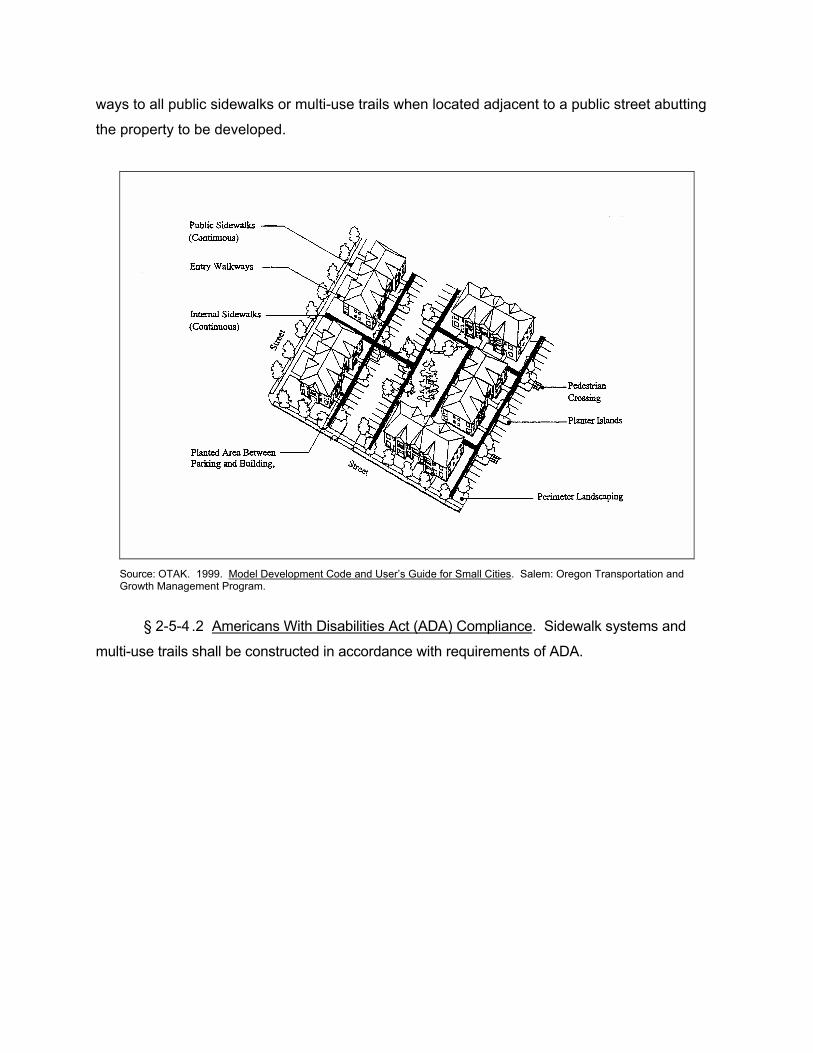
ways to all public sidewalks or multi-use trails when located adjacent to a public street abutting
the property to be developed.
Source: OTAK. 1999. Model Development Code and User’s Guide for Small Cities. Salem: Oregon Transportation and Growth Management Program.
§ 2-5-4 .2 Americans With Disabilities Act (ADA) Compliance. Sidewalk systems and
multi-use trails shall be constructed in accordance with requirements of ADA.
COMMENTARY ON ALTERNATIVE STREET AND PEDESTRIAN STANDARDS
OVERVIEW Why Alternative Street Standards are Needed Overcoming Obstacles to Reducing Street Standards Relationship to the Model Land Use Management Code Relationship to Existing Quality Growth Tool Descriptions STREET DESIGN PRINCIPLES AND STANDARDS Principles for Smart Street Design A Healthy Street Typology Alleys Lanes Local Streets Avenues and Main Streets Boulevards Parkways Turnarounds Curb Radii SIDEWALK AND PEDESTRIAN NETWORK PRINCIPLES AND STANDARDS Principles for Sidewalks and Pedestrian Networks When Sidewalks Should be Required Sidewalk and Pedestrian Network Standards BICYCLE FACILITY STANDARDS Principles for Bicycle Facilities Cycling Behavior Types of Bicycle Facilities: Which is Appropriate? RETROFITTING CONVENTIONAL SUBURBAN SUBDIVISIONS Pedestrian Connections Between Cul-De-Sacs Local Street Network Planning Retrofitting Existing Rights-Of-Way and Local Streets
OVERVIEW
Streets are the most prevalent of public spaces, touching virtually every parcel of private
land (Oregon Transportation and Growth Management Program 1998). Streets must be
places rather than simply channels of movement (Ewing 1997, 65).
This extended commentary is intended to accompany Model Code provisions § 2-5 and
§ 2-6.
Why Alternative Street Standards Are Needed
It is increasingly accepted that street design standards have historically overemphasized
automobiles, but that they need to introduce human-scale design. Many suburban
communities have minimum street width requirements that are much greater than
necessary, resulting in the wasteful use of land and encouraging motorists to speed
through subdivisions. Many existing street standards have borrowed provisions of state
highway manuals and applied them to neighborhoods (Burden et al. 2002).
Communities have historically borrowed subdivision street standards from state highway
manuals and other communities without judging for themselves the local context in
which they have chosen to apply them. Many of the street standards that govern land
subdivisions are now out of character with the neighborhood and produce inappropriate
behavior (e.g., speeding) by motorists (Burden et al. 2002). Some communities insist on
“gold-plated” standards because it is the developer who is paying for the subdivision
improvements. Wide subdivision street standards have been criticized as unnecessarily
contributing to the costs of housing (Advisory Commission on Regulatory Barriers to
Affordable Housing 1991).
Furthermore, some street standards no longer meet the need for which they were
intended, or never served a valid public purpose in the first place. For instance, the
Advisory Commission on Regulatory Barriers (1991) finds that communities establish
cul-de-sac radius requirements that can accommodate the largest firefighting apparatus
— usually a ladder truck — even though a ladder track is never dispatched to single-
family residential neighborhoods.
Overcoming Obstacles to Reducing Street Standards
Efforts to reform current street standards often must confront opposition from traffic
engineers, who might insist that the existing street standards (which require wide
pavement widths and generous turning radii) are required to ensure public safety. Street
width standards can be reduced, however, without compromising safety, function, and
performance. Space needed for emergency vehicles, for instance, is less than most
local governments previously thought (Transportation and Growth Management Program
1998).
Furthermore, the width of vehicles is often less than expected. The average car or
pickup truck is only about 5 ½ to 6 ½ feet wide, and even dump trucks and school buses
are rarely more than 7 feet wide (Arendt 1994).
Traffic engineers cite the well-known “A Policy on Geometric Design of Highways and
Streets” (1994) (a.k.a., the “Green Book”) of the American Association of State Highway
and Transportation Officials (AASHTO) in support of maintaining wide streets and
generous geometric requirements for streets. As proponents of more human-scaled
streets have noted (Marriott 1998; Burden 2002), however, AASHTO’s Green Book
supports in many ways the design of streets for pedestrians and bicyclists. When
opposition to smaller street widths is encountered, proponents can cite the Green Book
(excerpted by Burden et al. 2002) which indicates that, for certain single-family
residential neighborhoods, it is acceptable and safe to have streets so narrow that there
is only one unobstructed lane:
“On residential streets in areas where the primary function is to provide land
service and foster a safe and pleasant environment, at least one unobstructed
moving lane must be ensured even where parking occurs on both sides. The
level of user inconvenience occasioned by the lack of two moving lanes is
remarkably low in areas where single-family units prevail” (AASHTO Green Book,
“Number of Lanes,” p. 431, cited in Burden et al. 2002).
“On these [narrow residential] streets, with intermittent on-street parking, the
street’s width may occasionally require one driver to slow down or pull over to let
an oncoming vehicle pass before proceeding, particularly if one of the vehicles is a
truck or other large vehicle. The keys here are the words “occasionally” requiring
drivers to pull over or stop and “intermittent” on-street parking that allows such pulling
over….From the designer’s perspective, where volumes are low and large vehicles are
few, one may actually only need a single, relative clear or through lane” (Institute of
Transportation Engineers 1999, 5).
Furthermore, when local fire chiefs argue that street standards cannot be reduced
because skinnier streets will hinder access by fire trucks, proponents of skinny streets
can reply by citing the following evidence:
A study of fire trucks and suitability of access of residential streets in Winter Park,
Florida, revealed the following: Winter Park Fire Department trucks are 9.5 feet
wide (from mirror to mirror). Fire fighters chose 20 of Winter Park’s narrowest
streets, which included streets as narrow as 16 feet wide with parking on one
side. Other streets with parking on both sides had street widths of 22-24 feet.
The Winter Park Fire Department officials assured the study sponsors that they
could navigate any street in the city (Burden et al. 2002).
The most confining street situation for emergency vehicles is the local street with
cars parked on both sides. The parked cars occupy 13 to 14 feet of the roadway,
leaving ten to 13 feet for the passage of emergency vehicles, even on a minimal 24-
to 26-foot-wide street. The maximum width of a standard pumper is eight feet,
excluding mirrors. Thus, even with parked vehicles present on both sides of a local
street, a standard pumper can freely negotiate the street (Urban Land Institute et al.
2001).
Relationship to the Model Land Use Management Code
Section 2-3 of the Model Code (Alternatives to Conventional Zoning) provides basic
improvement requirements for streets and sidewalks (see § 2-3-9, “Requirements for
Streets,” and § 2-3-14, “Sidewalks”). The minimum pavement width requirement for local
streets in § 2-3-9 is not excessive at 24 feet; in fact, that requirement is less than many
suburban subdivision street standards. However, the street standards of § 2-3-9 of the
Model Code imply the conventional street hierarchy of arterial, collector, and local
streets and wide radii for cul-de-sac rights-of-way and pavement widths. With regard to
sidewalks, the requirements of § 2-3-14 of the Model Code only require a sidewalk be
constructed on one side of the road.
Communities are encouraged to be more flexible in establishing street standards that will
encourage pedestrian use, reduce cost requirements and promote quality of place. The
standard specifications in § 2-3-9 and § 2-3-14 do not necessarily serve those objectives.
For these reasons, and to provide additional flexibility, a set of flexible street standards is
provided as an additional module of the Model Code (see § 2-5). In addition, because
bicycle facilities are not addressed in § 2-3-9, an additional module with bicycle facility
standards is provided (see § 2-6).
STREET DESIGN PRINCIPLES AND STANDARDS
Principles for Smart Street Design
• Streets should be “skinny,” or no wider than the minimum width needed to
accommodate the typical and usual vehicular mix that the street will serve.
• Residential streets should be built at a variety of widths, depending on their
function and hierarchy in the street system.
• Smart development encourages people to take alternative modes: riding transit,
biking, or walking. Streets should be designed with different users in mind,
including bicyclists and pedestrians (nonmotorized travel).
• If streets are more than two lanes, they should be divided by wide, planted
medians to appear more like two one-way streets.
• Cul-de-sacs and other dead-end streets hinder connectivity and should be
avoided wherever possible. Short loops and cul-de-sacs are acceptable as long
as higher-order streets (arterials, collectors) offer many interconnections and
direct routing.
• Higher-order streets (arterials, collectors) should be spaced one-half mile or less
apart, or the equivalent route density in an irregular road network.
• All streets, except for alleys and roads in rural areas or adjacent to natural
settings such as parks, should have vertical curbs. A vertical curb clearly
distinguishes the space allocated for the automobile from the space provided for
pedestrians and people in wheelchairs. Rollover curbs encourage drivers to park
their cars up on the sidewalks and therefore create a hostile environment for
pedestrians.
A HEALTHY STREET TYPOLOGY
TYPE PURPOSE RIGHT-OF-WAY
WIDTH
ROAD PAVEMENT
WIDTH
OTHER FEATURES
Alleys Service access 20 feet 10 -12 feet Lanes Access to homes 38 feet 16 -18 feet Landscaping and
sidewalks Streets Access to single
and multi-family housing
48 - 50 feet 24 - 26 feet Landscaping and sidewalks; on-street parking on both sides
Avenues Connect neighborhoods to
town centers
80 feet 48 feet Raised center median; landscaping, sidewalks, bike lanes and on-street parking on both sides
Main Streets
Neighborhood and commercial
access
60 feet 36 feet Landscaping, sidewalks and on-street parking on both sides
Boulevards Multi-lane access to commercial buildings; carry regional traffic
104 feet 70 feet Raised center median; landscaping, sidewalks, bike lanes and on-street parking on both sides
Parkways Carry traffic through natural
areas; not designed to
accommodate adjoining
development
120 feet 44 feet Four travel lanes; raised center median; landscaping and trails (separate bike and pedestrian access) on both sides
Source: Burden, Dan, with Michael Wallwork, Ken Sides, Ramon Trias and Harrison Bright Rue. 2002. Street Design Guidelines for Healthy Neighborhoods. Sacramento Local Government Commission.
The paragraphs below summarize the typology of street types that are specified in the
accompanying model code provisions. Generally, options are provided which give the
community flexibility in terms of whether on-street parking is permitted. Traffic engineers
refer to two conditions, yield-flow and slow-flow operations as described below:
• Yield-flow operation: two parking lanes and one traffic lane.
• Slow-flow operation: one parking lane and two traffic lanes.
The number of lanes required can, of course, vary based on whether the street is one-
way or two-way.
Alleys
Alleys are sometimes prohibited in conventional suburban subdivision codes. In others,
they are permitted but perhaps discouraged with excessive pavement width
requirements. In neotraditional developments (TNDs), alleys are encouraged. Many
TNDs have alleys, with garages and carports fronting the alley rather than the street.
“Locating garages and driveways at the rear of properties [and accessed by alleys]
improves the streetscape by eliminating the sight of cars parked in driveways and
avoiding house designs that present the garage as the dominant feature seen from the
street.” (Urban Land Institute et al. 2002)
Typically, alleys have 20-foot rights-of-way. In cases where two-way travel is desired, or
parking is permitted, alleys are typically constructed to a width of 16 feet. Burden et al.
(2002) suggest that alleys can be as skinny as 10 -12 feet wide, implying that one-travel
lane is considered sufficient for alleys. If subdivision blocks are kept short, the lengths of
any given alley segment is also kept short, and thus the inconvenience of a garbage
truck or other obstruction occupying the travel lane (and delaying access by others) is
mitigated. Parking should be prohibited on skinnier alleys. Curbs are rarely provided (or
needed) for alleys.
Lanes
Burden et al. (2002) suggest that lanes can be as skinny as 16 -18 feet of pavement
width and rights-of-way as narrow as 38 feet. The local street network plan for Eugene,
Oregon, provides specifications for access lanes with pavement widths of 21 feet to 28
feet depending on use and flow options. Most local governments will not reduce their
pavement width for a lane below 20 feet due to fire code requirements for access.
Local Streets
The Model Code street specifications (see § 2-5 which follows this commentary) provide alternatives for local streets ranging from pavement widths of 20 - 34 feet (right-of-way widths of 40 - 60 feet). Avenues and Main Streets Avenues are designed to connect residential neighborhoods to town centers. They are
also sometimes referred to as residential collectors in the conventional hierarchical
system of roads. They accommodate bicycle and transit use, and they can be equipped
with a raised center island median. On-street parking is optional.
Main streets provide access to neighborhoods and commercial and mixed-use buildings.
Typically, on-street parking is provided. Bike lanes are optional but preferred. Center
island medians are usually not provided, but “bulbouts” (curbed intrusions into the line of
traffic to slow vehicles) are often provided to calm traffic and extend sidewalks into the
roadway (thereby shortening walking distance while maintaining safety).
Boulevards
Boulevards are multi-lane access ways for commercial and mixed-use buildings and
regional traffic. Boulevards are typically designed with bike lanes, sidewalks and
sections of on-street parking.
Parkways
Parkways carry regional traffic and are not designed to provide access to abutting
properties. Typically, parkways adjoin natural areas. Bike paths are often found on the
edges of parkways, separated from traffic lanes by distances of at least ten (10) feet,
sometimes 100 feet or more.
Turnarounds
Suburban subdivision street standards often limit the options for turnarounds to a cul-de-
sac and specify excessive radii for cul-de-sacs (i.e., the distance from the center of the
circular turnaround to the edge of the circular turnaround). For instance, some
communities still require 60-foot right-of-way radii and 50-foot pavement radii for cul-de-
sacs. Section 2-3 of this Model Land Use Management Code establishes a 50-foot
right-of-way radius and a 40-foot pavement radius (from back-of-curb) for cul-de-sacs.
Even that standard may be considered excessive in some cases, however, as noted in
the excerpt below:
“The recommended radius for the paved area of a circular turnaround without a
center island serving passenger vehicles is 30 feet. If frequent use of the turnaround by
single unit vehicles (municipal services equipment, school buses) is likely, a 42-foot
radius may be required. Single unit vehicles can use a turnaround with a 30-foot
radius, but backing would be required. A 42-foot radius can accommodate SUVs and
other large passenger vehicles as well as all commercial and service vehicles
with a regular need to visit residential streets, including school buses, all types of
delivery trucks, emergency vehicles, solid waste collection trucks and repair services
vehicles.” (Urban Land Institute et al. 2002, 33-34)
Circular turnarounds (i.e., cul-de-sacs) are usually preferred, because they do not
normally require backing-up movements. Cul-de-sacs do not necessary have to be
completely paved over; alternative standards allow for center islands within cul-de-sacs.
There are other alternatives as well, such as “T-shaped” or “Y-shaped” turnarounds
which can be used for short streets and alleys serving up to ten houses. These
alternative turnaround designs require all vehicles to make a backing-up movement, but
that inconvenience can be justified on streets with low traffic volumes. One justification
is that such alternative turnarounds yield a paved area only 43 percent as large as the
smallest (30-foot radius) turnaround. They also have lower construction and
maintenance costs and provide greater flexibility in land planning. (Urban Land Institute
et al. 2002)
Curb Radii
Curb radii are important because they allow vehicles to make turning movements. If they
are insufficient, a vehicle may not be able to make the turn without scrubbing or bumping
into the curb. Curb radii need to accommodate the expected amount and type of traffic
and allow for safe turning speeds. As the curb radius increases, the paving cost
increases, as does the distance that a pedestrian must cross. As curb radii increase, the
speed of turning movement increases. When curb radii are excessive, drivers can make
turns at excessive speeds. These reasons suggest that curb radii standards should be
reviewed to ensure they meet safety requirements but are not excessive (Urban Land
Institute et al. 2002). When curb radii are 30 feet or more, the likelihood that a vehicle
will stop to make a right-hand turn decreases, because
the larger curb radii creates a “free-right” or continuous turning movement (Institute of
Transportation Engineers 1999). The AASHTO Greenbook recommends 25-foot or
more curb radii at minor cross streets, 30 feet or more at major cross streets and 40 feet
or more where large truck combinations and buses turn frequently (Oregon
Transportation and Growth Management Program 1999). Curb radii exceeding 30 feet,
however, should only be required where absolutely necessary for large truck turning
movements.
SIDEWALK AND PEDESTRIAN NETWORK PRINCIPLES AND STANDARDS
Principles for Sidewalks and Pedestrian Networks
• Smart street design requires an emphasis on the role of pedestrians in addition
to vehicular traffic.
• “Emphasis has been placed on the joint use of transportation corridors by
pedestrians, cyclists and public transit vehicles. Designers should recognize the
implications of this sharing of the transportation corridors” (AASHTO Green
Book).
• “Pedestrians are a part of everyday roadway environment and attention must be
paid to their presence in rural as well as urban areas” (AASHTO Green Book).
• “Sidewalks are integral parts of city streets, but few are provided in rural areas.
Yet, a need exists in many rural areas because the high speed and general
absence of adequate lighting increase the accident potential to those walking on
or adjacent to the traveled way” (AASHTO Green Book).
• As a general practice, sidewalks should be constructed along any street or
highway not provided with shoulders, even though pedestrian traffic may be light”
(AASHTO Green Book).
• “Sidewalks used for pedestrian access to schools, parks, shopping areas and
transit stops and placed along all streets in commercial areas should be provided
along both sides of the street” (AASHTO Green Book).
• “In residential areas, sidewalks are desirable on both sides of the street but need
to be provided on at least one side of all local streets” (AASHTO Green Book).
• A comfortable, convenient, and safe street environment is necessary to
encourage non-motorized travel. Sidewalks should be required along all
potential pedestrian routes to make walking safer and more convenient.
• New subdivisions must have direct pedestrian and bicycle connections to
adjacent schools, community centers and commercial areas.
• Developments should be required to provide pedestrian connections on private
properties to public sidewalks.
• Trips can be shortened through good site planning. Pedestrians like to follow the
“path of least resistance” and thus will cut corners to keep their routes as direct
as possible. Short, straight streets and sidewalks help minimize distance
traveled and increase pedestrian use.
Providing isolated refuge islands or intermittent accommodations is not sufficient;
pedestrians and bicyclists need a continuous network.
REFERENCES
Advisory Commission on Regulatory Barriers to Affordable Housing. 1991. “Not In My
Backyard”: Removing Regulatory Barriers to Affordable Housing. Report to President
Bush and Secretary Kemp. Washington, DC: U.S. Department of Housing and Urban
Development.
American Association of State Highway and Transportation Officials. 1994. A Policy on
Geometric Design of Highways and Streets. Washington, DC: AASHTO.

Arendt, Randall. 1999. Crossroads, Hamlet, Village, Town: Design Characteristics of
Traditional Neighborhoods, Old and New. Planning Advisory Service Report No.
487/488. Chicago: American Planning Association.
Arendt, Randall. 1996. Conservation Design for Subdivisions: A Practical Guide to
Creating Open Space Networks. Washington, DC: Island Press.
Arendt, Randall, with Elizabeth Brabec, Harry Dodson, Christine Reid, and Robert Yaro.
1994. Rural By Design: Maintaining Small Town Character. Chicago: Planners Press.
Bucks County (PA) Planning Commission. 1980. Performance Streets. The Author.
Burden, Dan, with Michael Wallwork, Ken Sides, Ramon Trias, and Harrison Bright Rue.
2002. Street Design Guidelines for Healthy Neighborhoods. Sacramento: Local
Government Commission, Center for Livable Communities.
DeChiara, Joseph,and Lee E. Koppelman. 1984. Time-Saver Standards for Site
Planning. New York: McGraw-Hill.
DeChiara, Joseph, Julius Panero, and Martin Zelnik. 1995. Time-Saver Standards for
Housing and Residential Development. 2nd Ed. New York: McGraw-Hill.
Ewing, Reid. 1997. Transportation & Land Use Innovations: When You Can’t Pave
Your Way Out of Congestion. Chicago: Planners Press.
Ewing, Reid. 1996. Best Development Practices: Doing the Right Thing and Making
Money at the Same Time. Chicago: Planners Press.
Florida Department of Transportation. Bicycle Planning & Design Manual.
Florida Department of Transportation. 1992. Developing Pedestrian Plans: Pedestrian
Coordinators Manual.
Florida Department of Transportation. 1989. Florida Pedestrian System Plan.
Freilich, Robert H., and Michael A. Schultz. 1995. Model Subdivision Regulations:
Planning and Law. Chicago: Planners Press.
Georgia Quality Growth Toolkit. Flexible Street Design Standards.
Heyer, Fred. 1990. Preserving Rural Character. Planning Advisory Service Report No.
429. Chicago: American Planning Association.
Institute of Transportation Engineers. 1999. Traditional Neighborhood Development
Street Design Guidelines. Washington, DC: Institute of Transportation Engineers.
Kulash, Walter M. 2001. Residential Streets, 3rd Ed. Washington, DC: Urban Land
Institute, National Association of Home Builders, American Society of Civil Engineers,
and Institute of Transportation Engineers.
Listoken, David, and Carole Walker. 1989. The Subdivision and Site Plan Handbook.
New Brunswick, NJ: Rutgers, the State University of New Jersey, Center for Urban
Policy Research.
Mantell, Michael A., Stephen F. Harper, and Luther Propst. 1990. Resource Guide for
Creating Successful Communities. Washington, DC: Island Press.
Marriott, Paul Daniel. 1998. Saving Historic Roads: Design and Policy Guidelines. New
York: John Wiley & Sons, Inc.
Morris, Marya. 1996. Creating Transit-Supportive Land-Use Regulations. Planning
Advisory Service Report No. 468. Chicago: American Planning Association.
Oregon Administrative Rules, OAR 66-12, Transportation Planning Rule.
Oregon Transportation and Growth Management Program. 1998. Main Street…When a
Highway Runs Through It: A Handbook for Oregon Communities. Salem, OR:
Transportation and Growth Management Program.
Oregon Transportation and Growth Management Program. 1998. The Principles of
Smart Development. Panning Advisory Service Report No. 479. Chicago: American
Planning Association.
OTAK. 1999. Model Development Code and User’s Guide for Small Cities. Salem:
Oregon Transportation and Growth Management Program.
Parsons, Brinckerhoff Quade and Douglas, Inc. with Cambridge Systematics, Inc. and
Calthorpe Associates. December 1993. Making the Land Use, Transportation, Air
Quality Connection: The Pedestrian Environment, Volume 4A. Portland: 1000 Friends of
Oregon.
Pinsof, Suzan Anderson, and Terri Musser. 1995. Bicycle Facility Planning. Planning
Advisory Service Report No. 468. Chicago: American Planning Association.
Stover, Vergil G., and Frank J. Koepke. 1988. Transportation and Land Development.
Washington, DC: Institute of Transportation Engineers.
Town of Huntersville Zoning Ordinance. 1999. Huntersville, NC: Planning Dept.
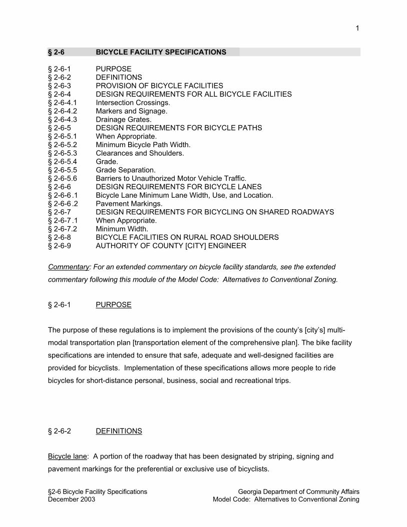
§2-6 Bicycle Facility Specifications Georgia Department of Community Affairs December 2003 Model Code: Alternatives to Conventional Zoning
1
§ 2-6 BICYCLE FACILITY SPECIFICATIONS § 2-6-1 PURPOSE § 2-6-2 DEFINITIONS § 2-6-3 PROVISION OF BICYCLE FACILITIES § 2-6-4 DESIGN REQUIREMENTS FOR ALL BICYCLE FACILITIES § 2-6-4.1 Intersection Crossings. § 2-6-4.2 Markers and Signage. § 2-6-4.3 Drainage Grates. § 2-6-5 DESIGN REQUIREMENTS FOR BICYCLE PATHS § 2-6-5.1 When Appropriate. § 2-6-5.2 Minimum Bicycle Path Width. § 2-6-5.3 Clearances and Shoulders. § 2-6-5.4 Grade. § 2-6-5.5 Grade Separation. § 2-6-5.6 Barriers to Unauthorized Motor Vehicle Traffic. § 2-6-6 DESIGN REQUIREMENTS FOR BICYCLE LANES § 2-6-6 .1 Bicycle Lane Minimum Lane Width, Use, and Location. § 2-6-6 .2 Pavement Markings. § 2-6-7 DESIGN REQUIREMENTS FOR BICYCLING ON SHARED ROADWAYS § 2-6-7 .1 When Appropriate. § 2-6-7.2 Minimum Width. § 2-6-8 BICYCLE FACILITIES ON RURAL ROAD SHOULDERS § 2-6-9 AUTHORITY OF COUNTY [CITY] ENGINEER
Commentary: For an extended commentary on bicycle facility standards, see the extended
commentary following this module of the Model Code: Alternatives to Conventional Zoning.
§ 2-6-1 PURPOSE
The purpose of these regulations is to implement the provisions of the county’s [city’s] multi-
modal transportation plan [transportation element of the comprehensive plan]. The bike facility
specifications are intended to ensure that safe, adequate and well-designed facilities are
provided for bicyclists. Implementation of these specifications allows more people to ride
bicycles for short-distance personal, business, social and recreational trips.
§ 2-6-2 DEFINITIONS
Bicycle lane: A portion of the roadway that has been designated by striping, signing and
pavement markings for the preferential or exclusive use of bicyclists.
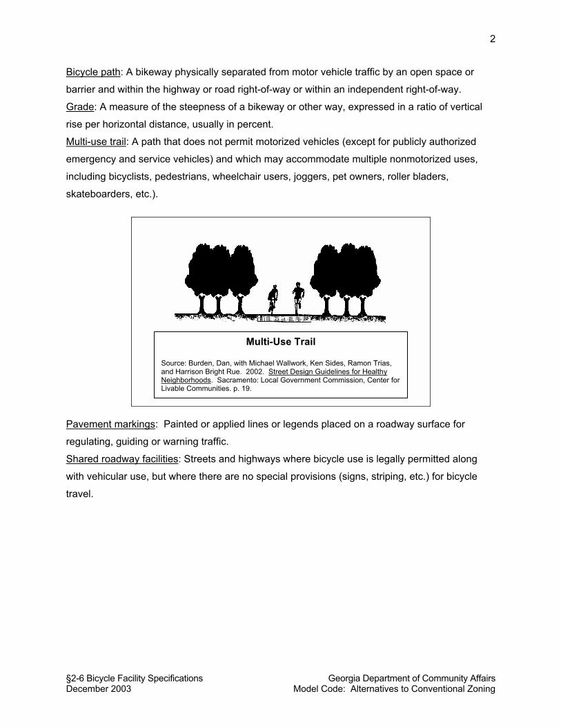
§2-6 Bicycle Facility Specifications Georgia Department of Community Affairs December 2003 Model Code: Alternatives to Conventional Zoning
2
Bicycle path: A bikeway physically separated from motor vehicle traffic by an open space or
barrier and within the highway or road right-of-way or within an independent right-of-way.
Grade: A measure of the steepness of a bikeway or other way, expressed in a ratio of vertical
rise per horizontal distance, usually in percent.
Multi-use trail: A path that does not permit motorized vehicles (except for publicly authorized
emergency and service vehicles) and which may accommodate multiple nonmotorized uses,
including bicyclists, pedestrians, wheelchair users, joggers, pet owners, roller bladers,
skateboarders, etc.).
Pavement markings: Painted or applied lines or legends placed on a roadway surface for
regulating, guiding or warning traffic.
Shared roadway facilities: Streets and highways where bicycle use is legally permitted along
with vehicular use, but where there are no special provisions (signs, striping, etc.) for bicycle
travel.
Multi-Use Trail Source: Burden, Dan, with Michael Wallwork, Ken Sides, Ramon Trias, and Harrison Bright Rue. 2002. Street Design Guidelines for Healthy Neighborhoods. Sacramento: Local Government Commission, Center for Livable Communities. p. 19.
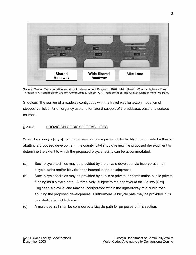
§2-6 Bicycle Facility Specifications Georgia Department of Community Affairs December 2003 Model Code: Alternatives to Conventional Zoning
3
Source: Oregon Transportation and Growth Management Program. 1998. Main Street…When a Highway Runs Through It: A Handbook for Oregon Communities. Salem, OR: Transportation and Growth Management Program.
Shoulder: The portion of a roadway contiguous with the travel way for accommodation of
stopped vehicles, for emergency use and for lateral support of the subbase, base and surface
courses.
§ 2-6-3 PROVISION OF BICYCLE FACILITIES
When the county’s [city’s] comprehensive plan designates a bike facility to be provided within or
abutting a proposed development, the county [city] should review the proposed development to
determine the extent to which the proposed bicycle facility can be accommodated.
(a) Such bicycle facilities may be provided by the private developer via incorporation of
bicycle paths and/or bicycle lanes internal to the development.
(b) Such bicycle facilities may be provided by public or private, or combination public-private
funding as a bicycle path. Alternatively, subject to the approval of the County [City]
Engineer, a bicycle lane may be incorporated within the right-of-way of a public road
abutting the proposed development. Furthermore, a bicycle path may be provided in its
own dedicated right-of-way.
(c) A multi-use trail shall be considered a bicycle path for purposes of this section.
Shared Roadway
Wide Shared Roadway
Bike Lane
§2-6 Bicycle Facility Specifications Georgia Department of Community Affairs December 2003 Model Code: Alternatives to Conventional Zoning
4
§ 2-6-4 DESIGN REQUIREMENTS FOR ALL BICYCLE FACILITIES
The provisions of this section shall apply to all types of bicycle facilities:
§ 2-6-4.1 Intersection Crossings. When a bicycle lane, bicycle path, or multi-use trail
crosses a road intersection or a railroad, ramps and adequate warning and safety signing and
striping must be provided, subject to the approval of the County [City] Engineer.
§ 2-6-4.2 Markers and Signage. Designated bicycle routes shall be equipped with
bicycle route markers, mile markers (for routes more than two miles) and other appropriate
signs and markers as determined by the County [City] Engineer and consistent with the Manual
on Uniform Traffic Control Devices or other specifications accepted by the County [City]
Engineer.
§ 2-6-4.3 Drainage Grates. Grates comprised of bars running parallel to the direction of
travel shall not be used.
§ 2-6-5 DESIGN REQUIREMENTS FOR BICYCLE PATHS
The provisions of this section shall apply to bicycle paths, as defined.
§ 2-6-5.1 When Appropriate. Along major and minor arterial streets, bicycle paths are
the appropriate type of bicycle facility. If adequate right-of-way is not present or cannot be
acquired, the County [City] Engineer may approve another bicycle facility type be installed along
said arterial street.
§ 2-6-5.2 Minimum Bicycle Path Width. The minimum width for a bicycle path shall be
ten (10) feet; provided, however, that the County [City] Engineer may reduce this required width
to eight (8) feet, in instances where he or she finds bicycle traffic and pedestrian use will be
light, and where the path presents a satisfactory and safe alignment vertically and horizontally.
The County [City] Engineer may also authorize a reduction of the ten-foot minimum width for
short sections of the bicycle path where necessary to preserve trees, move the bicycle path
alignment to avoid hazards, at narrow bridge crossings, or other places as may be appropriate.
When a bicycle path is incorporated into a multi-use trail, the multi-use trail shall be
wider than ten (10) feet (e.g., either constructed to a width of twelve feet, or provided with pull-
§2-6 Bicycle Facility Specifications Georgia Department of Community Affairs December 2003 Model Code: Alternatives to Conventional Zoning
5
outs or passing areas in frequent places along the length of the multi-use trail) to accommodate
passing situations for different users traveling at different speeds.
§ 2-6-5.3 Clearances and Shoulders. Bicycle paths shall have a minimum two-foot wide
graded shoulder area on at least one side of the bicycle path. Bicycle paths shall have a
minimum three-foot clearance from trees, poles, and other obstructions unless this requirement
presents practical difficulty, in which case the County [City] Engineer may approve a deviation if
adequate warning signage is provided. Vertical clearance shall be eight (8)-foot minimum with
ten (10) feet desirable.
§ 2-6-5.4 Grade. The maximum grade of a bicycle path, except for those paths
designated for mountain biking or otherwise provided with notice of difficult grade, shall be five
(5) percent. The County [City] Engineer may permit a bicycle path to exceed the maximum five
(5) percent grade for short sections of the path, in cases where topographic conditions present
practical difficulties in achieving that grade. If difficult grade problems cannot be overcome,
measures should include the provision of rest stops or lower grade “switchbacks.”
§ 2-6-5.5 Grade Separation. Where possible, bicycle paths should be constructed or
provided at a grade that is separate from the grade of motorized travel (i.e., “grade separated”).
A grade separation may be required where a bicycle path crosses a railroad track.
§ 2-6-5.6 Barriers to Unauthorized Motor Vehicle Traffic. Entrances to bicycle paths
shall provide a physical barrier as approved by the County [City] Engineer to prevent
unauthorized motor vehicles from using the facility. A removable post or other removable
barrier may be provided to allow entrance by authorized emergency and maintenance vehicles.
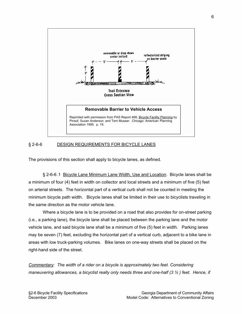
§2-6 Bicycle Facility Specifications Georgia Department of Community Affairs December 2003 Model Code: Alternatives to Conventional Zoning
6
§ 2-6-6 DESIGN REQUIREMENTS FOR BICYCLE LANES
The provisions of this section shall apply to bicycle lanes, as defined.
§ 2-6-6 .1 Bicycle Lane Minimum Lane Width, Use and Location. Bicycle lanes shall be
a minimum of four (4) feet in width on collector and local streets and a minimum of five (5) feet
on arterial streets. The horizontal part of a vertical curb shall not be counted in meeting the
minimum bicycle path width. Bicycle lanes shall be limited in their use to bicyclists traveling in
the same direction as the motor vehicle lane.
Where a bicycle lane is to be provided on a road that also provides for on-street parking
(i.e., a parking lane), the bicycle lane shall be placed between the parking lane and the motor
vehicle lane, and said bicycle lane shall be a minimum of five (5) feet in width. Parking lanes
may be seven (7) feet, excluding the horizontal part of a vertical curb, adjacent to a bike lane in
areas with low truck-parking volumes. Bike lanes on one-way streets shall be placed on the
right-hand side of the street.
Commentary: The width of a rider on a bicycle is approximately two feet. Considering
maneuvering allowances, a bicyclist really only needs three and one-half (3 ½ ) feet. Hence, if
Removable Barrier to Vehicle Access Reprinted with permission from PAS Report 468, Bicycle Facility Planning by Pinsof, Suzan Anderson, and Terri Musser. Chicago: American Planning Association 1995. p. 19.

§2-6 Bicycle Facility Specifications Georgia Department of Community Affairs December 2003 Model Code: Alternatives to Conventional Zoning
7
five-foot or six-foot wide bike paths are a problem and need to be narrowed, they might be
reduced to four feet (DeChiara and Koppelman 1984).
§ 2-6-6 .2 Pavement Markings. Pavement markings shall be provided for all bicycle
lanes, and said pavement markings shall contain word symbols and messages as appropriate
and consistent with the Manual on Uniform Traffic Control Devices for Streets and Highways
(Federal Highway Administration 1988).
§ 2-6-7 DESIGN REQUIREMENTS FOR BICYCLING ON SHARED ROADWAYS
§ 2-6-7 .1 When Appropriate. Bicycling shall not be accommodated on roadways with
on-street parking, except on local residential subdivision streets with low traffic volumes as
determined by the County [City] Engineer. Where on-street parking is allowed and traffic
volumes are moderate or heavy, a bicycle path (i.e., a striped facility) is the appropriate facility
type.
§ 2-6-7.2 Minimum width. Bicycle use may be authorized on any roadway without
striping and markings, provided that the following standards are met:
(a) Where bicycles are to be accommodated on arterial, collector or local streets with one
motor vehicle lane only per direction, and no on-street parking, each travel lane
accommodating bicycle use shall be a minimum of sixteen (16) feet in width, excluding
the horizontal part of the vertical curb if present.
(b) Where bicycles are to be accommodated on arterial, collector or local streets with two
motor vehicle lanes per direction, and no on-street parking, the minimum pavement
width for each direction of travel to accommodate bicycle use shall be twenty-eight (28)
feet, excluding the horizontal part of the vertical curb if present.
§ 2-6-8 BICYCLE FACILITIES ON RURAL ROAD SHOULDERS
On rural state highways or rural arterial roads (i.e., without curbs and gutters), the shoulders of
roads may be paved, designated and maintained for bicycle travel. In such cases, the portion of
the shoulder for use as a bicycle path shall be no less than four (4) feet wide. A minimum two-
foot shoulder shall be provided in addition to the paved shoulder on all state highways. No
§2-6 Bicycle Facility Specifications Georgia Department of Community Affairs December 2003 Model Code: Alternatives to Conventional Zoning
8
additional shoulder is required when a minimum four-foot paved shoulder is designated for
bicycle travel on a rural county roadway.
§ 2-6-9 AUTHORITY OF COUNTY [CITY] ENGINEER
The County [City] Engineer is hereby authorized to review and approve plans for subdivisions
and land developments involving bicycle facilities to ensure compliance with the requirements of
this Code. The County [City] Engineer is further authorized to prepare and promulgate
standards, standard drawings and specifications to more specifically implement the intent of this
code.
Commentary: The review and approval of bicycle facilities is primarily the purview of the local
government engineer.
§2-6 Bicycle Facility Specifications Georgia Department of Community Affairs December 2003 Model Code: Alternatives to Conventional Zoning
9
COMMENTARY ON BICYCLE FACILITY STANDARDS
Principles for Bicycle Facilities
• Communities can better provide for the needs of bicyclists at reasonable cost by
maximizing the usefulness of existing roads through improving the safety of
shared roadway space. For instance, paved or landscaped islands and medians
not essential for traffic control can be removed and replaced with marked
pavement to add several feet of usable width for bicyclists (Pinsof and Musser
1995).
• Studies show that people engaged in long, regional routes will ride a bicycle a
couple of miles to a transit stop, or eight times the typical walking distance. If
bicycle parking facilities and bike carriers on transit vehicles are provided, good
bicycle access to transit can result in a significant increase in transit ridership
(Ewing 1997, 46).
• “The local roadway is generally sufficient to accommodate bicycle traffic;
however, when special facilities are desired they should be in accordance with
AASHTO’s Guide for Development of Bicycle Facilities” (1991) (AASHTO Green
Book).
• Wide curb lanes (i.e., through-lanes with a width of 14 feet or more)
accommodate bicycle use, but striped and signed bike lanes may encourage
increased use (Pinsof and Musser 1995).
• Careful attention must be paid to providing safety when bike lanes are
established contiguous to on-street parking (i.e., parking lanes). Parking lanes
may be narrowed to seven (7) feet adjacent to a bike lane in areas with low truck-
parking volumes (Pinsof and Musser 1995).
Cycling Behavior
Bike trips for work, shopping and other utilitarian purposes are usually less than two
miles. Bicyclists and pedestrians are much more sensitive than motorists to the length of
trips and the environment in which they travel. Pedestrian and bicyclists travel for the
experience as well as the trip purpose (Ewing 1997)
§2-6 Bicycle Facility Specifications Georgia Department of Community Affairs December 2003 Model Code: Alternatives to Conventional Zoning
10
Bicyclists should never be directed to use sidewalks. Bicyclists should not be permitted
to ride in a direction against the flow of motor vehicle traffic. Cyclists often prefer
collector streets over local access streets, since they offer a more continuous and direct
route of travel. Many cyclists will still want to use the roadway, even when a separate
bicycle path is provided, despite the fact that state law may require that they ride on the
bicycle path (Pinsof and Musser 1995).
Types of Bicycle Facilities: Which is Appropriate?
Standards for bicycle networks depend on the primary user. Skilled bicyclists prefer to
travel on the street system along with automobiles, but they are a small percentage of all
bike riders. Children and casual adult cyclists must be separated from high-speed, high-
volume traffic or they will not ride; they outnumber skilled riders 20 - 1 (Ewing 1997, 63-
64). These findings suggest that, if resources for bikeway improvements are limited,
then planning bicycle paths that will accommodate children and unskilled bicyclists will
be more responsive to demands.
Generally, there are four types of bicycle facilities: bicycle paths, bicycle lanes, shared-
road facilities and paved shoulders. Bicycle paths are the most accommodating and
safest for all bicyclists. Bicycle lanes also tend to encourage increased use. Shared-
road facilities may be acceptable and safe in certain circumstances but will probably not
encourage bicycle use. Paved shoulders should not be selected as an alternative unless
the other facility types cannot be accommodated due to cost considerations or safety
concerns. As noted by Pinsof and Musser (1995):
“For experienced cyclists, wide curb lanes or paved shoulders may be all that is
necessary to encourage riding on major arterials. For those cyclists less
experienced at riding in traffic, designated bicycle lanes or an alternative on-
street route may be the facility of choice.”