Embed Size (px)
Citation preview
Sean Peasgood, President & CEO
Marcel Valentin, Vice President
www.SophicCapital.com
FROM AIR TO WATER The Next Investment Frontier for Drones
September 14, 2015
ABSTRACT: THE AERIAL DRONE MARKET COULD BE
CUMULATIVELY WORTH $91 B ILLION OVER THE NEXT
DECADE . AS ATTRACTIVE AS THIS M ARKET IS , SOPHIC
CAP ITAL BELIEVES THAT THERE IS A NAS CENT DRONE
MARKET WHICH COULD P ROVE MORE LUCRATIVE TO
INVESTORS – SEA DRONES , OR UNMANNED
UNDERWATER VEHICLES .
WATER COVERS OVER 70% OF THE EARTH , YET
WE’VE EXP LORED LESS THAN 5% OF SEABEDS DUE TO
THE SEA’S HOSTILE ENVIRONMENT , AN
ENVIRONMENT BETTER SUITED FOR MACHINES THAN
HUMANS . WE BELIEVE THE UNM ANNED UNDERWATER
VEHICLE INDUSTRY , WHICH MARKETS ANDMARKETS
ESTIM ATES WILL BE WORTH $4.8 B ILLION BY 2019,
WILL RAMP IN A S IM ILAR MANNER TO ITS AER IAL
DRONE COUS IN .
From Air to Water
Sean Peasgood, www.SophicCapital.com September 14, 2015 - 2
Reasons to Read this Report
1. The aerial drones market continues to expand; the unmanned underwater vehicle, or sea
drone, market is a nascent industry at an inflection point;
2. Water covers 70% of the Earth’s surface, yet we’ve mapped only 5% of the seabed (never
mind everything between the surface and the seabed), creating a big opportunity;
3. You’ll learn about the different types of unmanned underwater vehicles (UUV); page 4,
4. An industry insider tells us how he sees UUVs evolving in the oil and gas sector; page 7,
5. You’ll read about the diverse industries set to adopt UUVs, en masse; page 7,
6. You’ll understand the types of technology used in UUVs; page 16 and,
7. You’ll learn about investable companies, including Kraken Sonar Systems (TSXV:PNG),
a Sophic Capital client; page 19.
Introduction
On September 8, 2015, Sophic Capital published our aerial drone report, Drones: A Rising
Market. In that report, we stated that:
1. The aerial drone market could cumulatively generate $91 billion over the next decadei;
2. The military sector has been the biggest adopter of aerial drones;
3. Aerial drones are starting to penetrate the consumer and industrial spaces (possibly a $1
billion to $2 billion market by 2023);
4. Large industrial companies compete in this space including: Lockheed Martin
(NYSE:LMT). Northrop Grumman (NYSE:NOC), and L-3 (NYSE:LLL); and,
5. Funding for aerial drone startups is accelerating in 2015.
Although we see healthy growth continuing in the aerial drone market across the military,
consumer, and industrial verticals, we believe investors could find even larger returns in the
drone market focused on the Earth’s final unexplored frontier – the sea. We are before the
inflection point, and this drone report, our second, focuses on the underwater drone market, or the
“unmanned underwater vehicle” market as it is known in the industry.
Water: The Next Big Drone Frontier
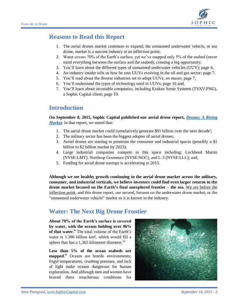
About 70% of the Earth’s surface is covered
by water, with the oceans holding over 96%
of that water.ii The total volume of the Earth’s
water is 1.386 billion km³, which would fill a
sphere that has a 1,365 kilometer diameter.iii
Less than 5% of the ocean seabeds are
mapped.iv Oceans are hostile environments;
frigid temperatures, crushing pressure, and lack
of light make oceans dangerous for human
exploration. And although men and women have
braved these treacherous conditions for
From Air to Water
Sean Peasgood, www.SophicCapital.com September 14, 2015 - 3
centuries, technology has advanced to minimize human exposure to these dangerous aquatic
environments.
Unmanned underwater vehicles are becoming responsible for the most dull, dirty, and
dangerous sea jobs. These vehicles undertake mapping, water-sampling, harbour patrolling, and
sea mine detection duties, making the seas safer for everyone.
The nascent UUV industry is where the unmanned aerial industry (UAV) was in the 1990s –
heavily used by the military. Militaries are increasingly adopting UUVs, a market forecasted to
be worth $4.8 billion by 2019.v Given this, we believe that the underwater drone market could ramp
like the aerial drone market did years ago. Our reasoning is that navies have already adopted UUVs
for numerous applications ranging from harbour patrol to naval mine detection. Several non-
military verticals, which we detail later in this report, are also utilizing UUVs. And although we
believe the commercial seabed survey market is the largest, long-term UUV opportunity, the
military industry appears to be the closest market to monetize.
Sizing the Underwater
Drone Market Opportunity
We like to think of the UUV market as
the underwater drone market.
Furthermore, we believe that the UUV
market is about to ramp as the aerial drone
market did during the 1990s. There are
several market drivers to accelerate this
ramp. These include seabed mining, oil and
gas, and telecommunications.
Research firm MarketsandMarkets forecasts the UUV market will grow from $1.2 billion in
2014 to $4.8 billion in 2019.vi MarketsandMarkets also estimates that the global AUV market will
expand from $457 million in 2014 at almost 32% CAGR through 2019. vii Douglas-Westwood
estimates that from 2015 through 2019, global subsea vessel operating expenditures will generate
$122 billion.viii The firm also anticipates that by 2018, 825 AUVs will be deployed across the globe,
led by the military sector.ix
Early Stages of the Underwater Drone
Market
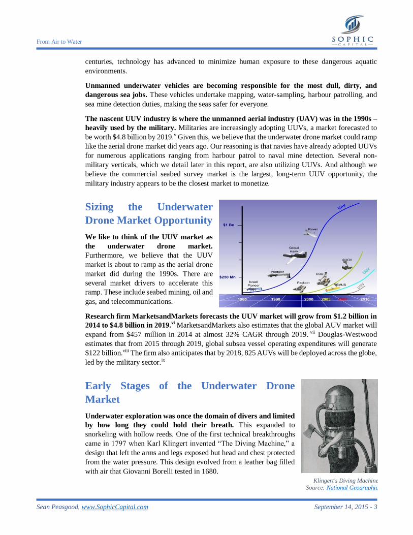
Underwater exploration was once the domain of divers and limited
by how long they could hold their breath. This expanded to
snorkeling with hollow reeds. One of the first technical breakthroughs
came in 1797 when Karl Klingert invented “The Diving Machine,” a
design that left the arms and legs exposed but head and chest protected
from the water pressure. This design evolved from a leather bag filled
with air that Giovanni Borelli tested in 1680.
Klingert's Diving Machine Source: National Geographic

From Air to Water
Sean Peasgood, www.SophicCapital.com September 14, 2015 - 4
In the 1620s, Cornelius Drebbel created the first
working submarine.x By 1800, France had built a
human powered submarine called the Nautilus.
During the 1860s, the U.S. Navy contracted a
submarine design, the Alligator, which was built
but never deployed into battle – the Alligator was
cut adrift to prevent the USS Sumpter (its tow ship)
from sinking. The Titanic tragedy brought calls to
develop systems for detecting underwater objects
and threats. Canadian Reginald Fessenden
developed an underwater echo system (circa 1912)
to detect underwater threats and objects.xi By 1918,
the French and British Navies developed ASDIC
(Anti-Submarine Detection Investigation
Committee) to conduct submarine detection
research. ASDIC was deployed during World War
I and transferred to the United States for further
development during World War II. The Americans
adopted the SONAR acronym - SOund NAvigation
and Ranging - to describe the technology.
Post war sonar applications expanded rapidly.
Some non-military sonar uses include: fish
detection for the fisheries, echo sounding
(determining water depth), net location, crashed
aircraft location, wave measurement, bathymetric
mapping, and water velocity measurement.
Types of UUV
An unmanned underwater vehicle (UUV) is a vehicle that operates underwater without
people onboard. There are two types of UUVs: autonomous underwater vehicles (AUV), which
are untethered and operate without the input from a surface-based operator, and remotely operated
underwater vehicles (ROV), which are tethered and operate with the input of a surface-based
operator. Some UUVs operate on the water’s surface and are known as unmanned surface vehicles
(USV). The desire to take operators out of harm’s way has driven the growth of USVs, and these
USVs often carry and deploy AUVs to achieve this vision.
Autonomous Underwater Vehicles (AUVs)
AUVs operate independently in the sea without the need for a human controller or tether.
These robots carry all power (lithium ion batteries, fuel cells, or diesel fuel) onboard and are self-
guiding. Since they are untethered, they eliminate the risk that the tether could become entangled
in a tightly navigated area. Plus, they eliminate the tons of cabling required to tether a UUV to a
ship.
ASDIC Operators
Source: National Archives of Canada
Source: Undersea Warfare
From Air to Water
Sean Peasgood, www.SophicCapital.com September 14, 2015 - 5
The military currently uses the most AUVs,
and market research firm Douglas-
Westwood forecasts that by 2018,
commercial applications will represent 9%
of the AUV market.xii
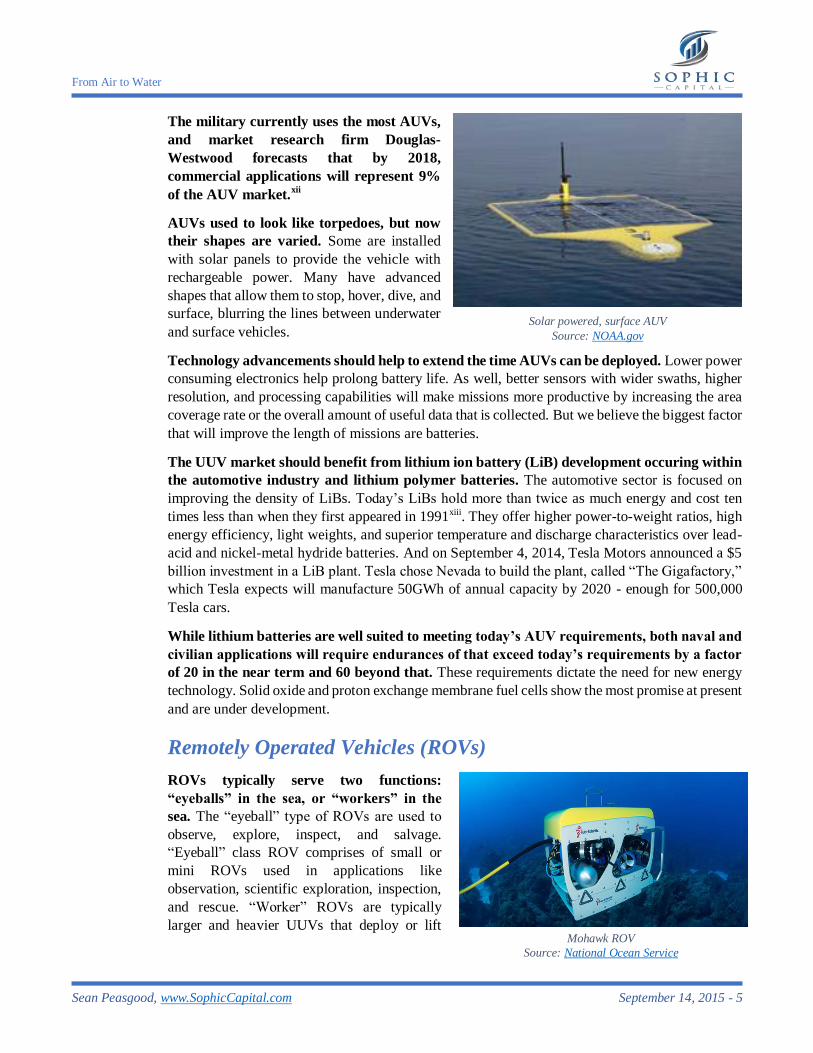
AUVs used to look like torpedoes, but now
their shapes are varied. Some are installed
with solar panels to provide the vehicle with
rechargeable power. Many have advanced
shapes that allow them to stop, hover, dive, and
surface, blurring the lines between underwater
and surface vehicles.
Technology advancements should help to extend the time AUVs can be deployed. Lower power
consuming electronics help prolong battery life. As well, better sensors with wider swaths, higher
resolution, and processing capabilities will make missions more productive by increasing the area
coverage rate or the overall amount of useful data that is collected. But we believe the biggest factor
that will improve the length of missions are batteries.
The UUV market should benefit from lithium ion battery (LiB) development occuring within
the automotive industry and lithium polymer batteries. The automotive sector is focused on
improving the density of LiBs. Today’s LiBs hold more than twice as much energy and cost ten
times less than when they first appeared in 1991xiii. They offer higher power-to-weight ratios, high
energy efficiency, light weights, and superior temperature and discharge characteristics over lead-
acid and nickel-metal hydride batteries. And on September 4, 2014, Tesla Motors announced a $5
billion investment in a LiB plant. Tesla chose Nevada to build the plant, called “The Gigafactory,”
which Tesla expects will manufacture 50GWh of annual capacity by 2020 - enough for 500,000
Tesla cars.
While lithium batteries are well suited to meeting today’s AUV requirements, both naval and
civilian applications will require endurances of that exceed today’s requirements by a factor
of 20 in the near term and 60 beyond that. These requirements dictate the need for new energy
technology. Solid oxide and proton exchange membrane fuel cells show the most promise at present
and are under development.
Remotely Operated Vehicles (ROVs)
ROVs typically serve two functions:
“eyeballs” in the sea, or “workers” in the
sea. The “eyeball” type of ROVs are used to
observe, explore, inspect, and salvage.
“Eyeball” class ROV comprises of small or
mini ROVs used in applications like
observation, scientific exploration, inspection,
and rescue. “Worker” ROVs are typically
larger and heavier UUVs that deploy or lift
Solar powered, surface AUV
Source: NOAA.gov
Mohawk ROV
Source: National Ocean Service
From Air to Water
Sean Peasgood, www.SophicCapital.com September 14, 2015 - 6
underwater equipment. Some crawl on the seabed and can bury cables or dig trenches.
Smaller ROVs are typically preferred, due to their better manueverability, operating costs
(fewer personnel are required for deployment and operation), and maintenance costs. As a
result, the industry is reliant upon technological advances to reduce ROV form and power
consumption. This has led to smaller scientific instruments, cameras, sensors, and robotic arms.
Reducing weight and power consumption in the ROV translates to thinner umbilicals or tethers,
reducing the size and cost of the surface handling equipment. However, there are exceptions to the
smaller ROV preference; some construction ROVs need larger form factors to haul big payloads.
Towed Vehicle
A towed vehicle is an UUV that is towed by another vessel. The main advantage of a towed
vehicle is that they provide real-time data to ship crews whereas AUVs need to surface for crews
to collect the data. Data turnaround time for an AUV can be on the order of 24 hours or longer.
Another benefit of a towed vehicle is that explorers can get the sensors closer to the underwater
structure or sea floor for better resolution compared to a sensor mounted on the hull of a ship. As
well, towed vehicles can operate at high speeds (8 to 10 knots) and are more stable in rough water
when compared to a shipborne sensor.
Towed vehicles also have limitations. As depths increase beyond 500 meters, the drag on the
cable becomes prohibitive. This drag results in slower survey speeds (less than 1 meter per second)
thereby slowing surveys to the point where they become unproductive in terms of area coverage.
This is why AUVs have largely replaced towed vehicles in deep ocean surveys. Towed vehicles
also rely upon a ship to steer their course. And due to the distance between the ship and the towed
vehicle, determining the towed vehicle’s position lacks precision. This makes towed vehicles
challenging to position for some underwater tasks such as pipeline and cable route survey.
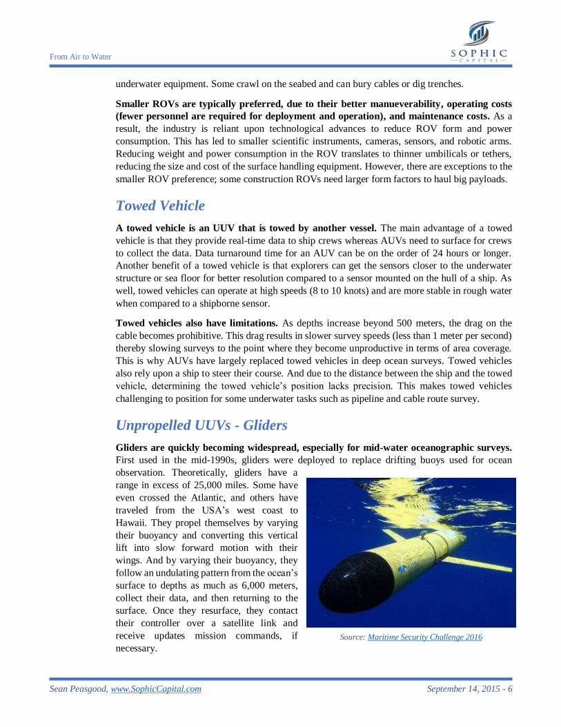
Unpropelled UUVs - Gliders
Gliders are quickly becoming widespread, especially for mid-water oceanographic surveys.
First used in the mid-1990s, gliders were deployed to replace drifting buoys used for ocean
observation. Theoretically, gliders have a
range in excess of 25,000 miles. Some have
even crossed the Atlantic, and others have
traveled from the USA’s west coast to
Hawaii. They propel themselves by varying
their buoyancy and converting this vertical
lift into slow forward motion with their
wings. And by varying their buoyancy, they
follow an undulating pattern from the ocean’s
surface to depths as much as 6,000 meters,
collect their data, and then returning to the
surface. Once they resurface, they contact
their controller over a satellite link and
receive updates mission commands, if
necessary.
Source: Maritime Security Challenge 2016
From Air to Water
Sean Peasgood, www.SophicCapital.com September 14, 2015 - 7
Gliders are entering mainstream marine surveys at the expense drifting oceanographic
buoys. This is because gliders collect 2D survey data whereas the buoys only gather unidimensional
data. Gliders also have a cost advantage over small diameter (<20cm) propelled AUVs – gliders
are about 10% of the cost of an AUV. However, glider cost benefits can be diminished by the fact
that they are more likely to be lost at sea compared to AUVs. In fact, many surveyors purchase two
gliders with the expectation that they will only have one after five years.
An Industry Consultant sees Changes in the Oil & Gas Industry
We spoke with an industry veteran who was previously employed at large UUV
manufacturers. He didn’t want his name or past employers quoted, and in exchange for
maintaining his confidentiality, he shared his thoughts about how he foresees the UUV industry
evolving within the oil and gas sector.
Over the next five to 10 years, AUVs used for inspections will largely replace ROVs used
offshore and for pipeline surveys. The reason for this is AUVs are far less expensive to operate
than ROVs. ROVs require dynamic positioning1 ships that can cost upwards of $250,000 per day
(and this doesn’t include the ROV). Deploying AUVs is less expensive - around $30,000 per day,
and they can survey a pipeline two to three times faster than a ROV. AUVs also don’t cost as much
as ROVs. All these factors make the business case to deploy AUVs rather than ROVs.
Hybrid AUVs, AUVs that carry ROVs, will replace the maintenance and repair ROVs,
particularly in satellite fields. A few hybrid AUVs have been built, and many offshore oil and
gas companies are factoring their development and acquisition into their near term plans. The
reason for this transition mirrors that for why AUVs will replace inspection ROVs – cost.
A drawback of a hybrid AUV is that the vehicle has to be “plugged in” to power in order to
operate the ROV. In the next five to 10 years with the quantum leap forecast in processing power,
the first artificially intelligent AUVs will start replacing the hybrid vehicles. Prototype development
leading to this capability is now ongoing.
UUV Use Cases
Military
Militaries are the largest consumer of UUVs, using AUVs and Towed Systems to search for
underwater mines. They also use AUVs for intelligence collection, surveillance, and
reconnaissance. AUVs also hold the potential to scour the seas for hostile submarines and warships.
We spoke with a retired submarine commander who noted that this is probably one of the missions
for the U.S. Large Diameter UUV. He believed that such a “scouring” mission could take the form
of pre-positioning or locating a number of AUVs at a land-base close to a strategic maritime
1 “Dynamic positioning” refers to computers that use a ship’s propellers and thrusters to maintain the ship’s
position and heading.
From Air to Water
Sean Peasgood, www.SophicCapital.com September 14, 2015 - 8
chokepoint2. AUVs would be stationed across the chokepoint listening for and reporting
submarines and other shipping as they pass.
The U.S. Navy is investing 22% of its science and technology dollars on the underwater
domain.xiv
And the U.S. Navy recently announced that it would invest up to $1.43 billion to support
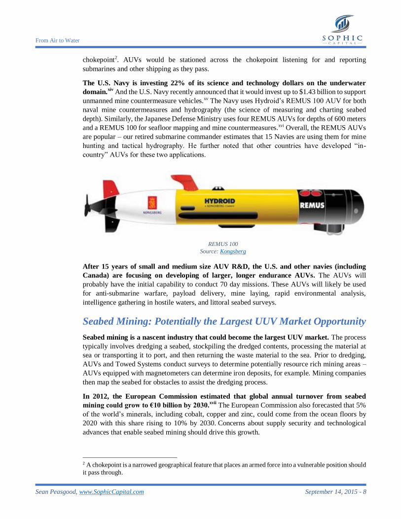
unmanned mine countermeasure vehicles.xv The Navy uses Hydroid’s REMUS 100 AUV for both
naval mine countermeasures and hydrography (the science of measuring and charting seabed
depth). Similarly, the Japanese Defense Ministry uses four REMUS AUVs for depths of 600 meters
and a REMUS 100 for seafloor mapping and mine countermeasures.xvi Overall, the REMUS AUVs
are popular – our retired submarine commander estimates that 15 Navies are using them for mine
hunting and tactical hydrography. He further noted that other countries have developed “in-
country” AUVs for these two applications.
After 15 years of small and medium size AUV R&D, the U.S. and other navies (including
Canada) are focusing on developing of larger, longer endurance AUVs. The AUVs will
probably have the initial capability to conduct 70 day missions. These AUVs will likely be used
for anti-submarine warfare, payload delivery, mine laying, rapid environmental analysis,
intelligence gathering in hostile waters, and littoral seabed surveys.
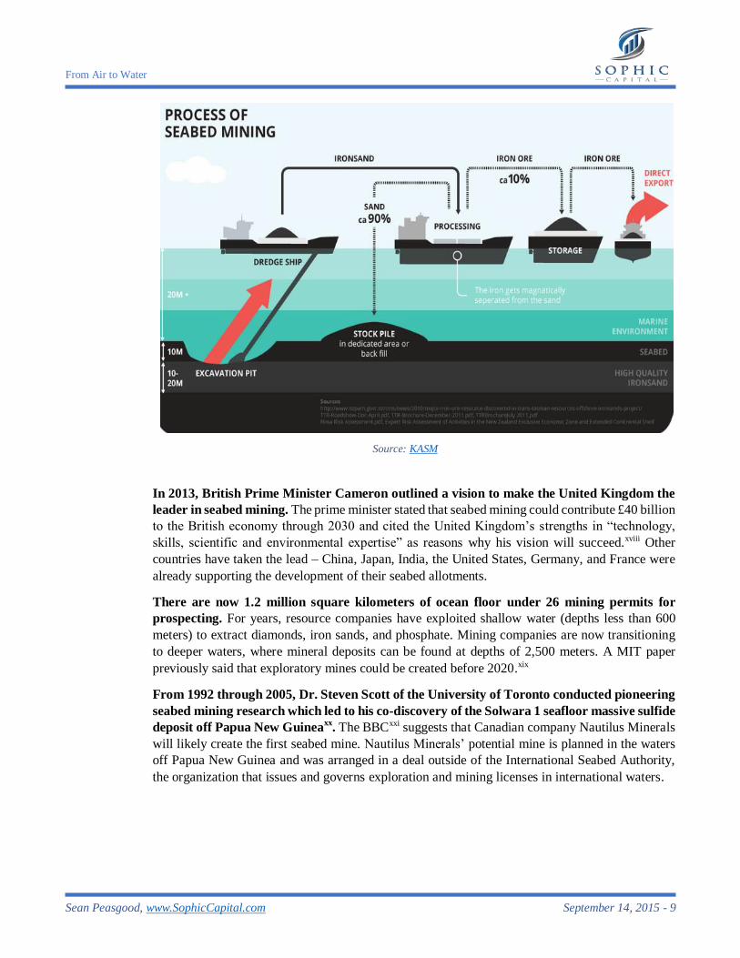
Seabed Mining: Potentially the Largest UUV Market Opportunity
Seabed mining is a nascent industry that could become the largest UUV market. The process
typically involves dredging a seabed, stockpiling the dredged contents, processing the material at
sea or transporting it to port, and then returning the waste material to the sea. Prior to dredging,
AUVs and Towed Systems conduct surveys to determine potentially resource rich mining areas –
AUVs equipped with magnetometers can determine iron deposits, for example. Mining companies
then map the seabed for obstacles to assist the dredging process.
In 2012, the European Commission estimated that global annual turnover from seabed
mining could grow to €10 billion by 2030.xvii
The European Commission also forecasted that 5%
of the world’s minerals, including cobalt, copper and zinc, could come from the ocean floors by
2020 with this share rising to 10% by 2030. Concerns about supply security and technological
advances that enable seabed mining should drive this growth.
2 A chokepoint is a narrowed geographical feature that places an armed force into a vulnerable position should
it pass through.
REMUS 100
Source: Kongsberg
From Air to Water
Sean Peasgood, www.SophicCapital.com September 14, 2015 - 9
In 2013, British Prime Minister Cameron outlined a vision to make the United Kingdom the
leader in seabed mining. The prime minister stated that seabed mining could contribute £40 billion
to the British economy through 2030 and cited the United Kingdom’s strengths in “technology,
skills, scientific and environmental expertise” as reasons why his vision will succeed.xviii Other
countries have taken the lead – China, Japan, India, the United States, Germany, and France were
already supporting the development of their seabed allotments.
There are now 1.2 million square kilometers of ocean floor under 26 mining permits for
prospecting. For years, resource companies have exploited shallow water (depths less than 600
meters) to extract diamonds, iron sands, and phosphate. Mining companies are now transitioning
to deeper waters, where mineral deposits can be found at depths of 2,500 meters. A MIT paper
previously said that exploratory mines could be created before 2020.xix
From 1992 through 2005, Dr. Steven Scott of the University of Toronto conducted pioneering
seabed mining research which led to his co-discovery of the Solwara 1 seafloor massive sulfide
deposit off Papua New Guineaxx
. The BBCxxi suggests that Canadian company Nautilus Minerals
will likely create the first seabed mine. Nautilus Minerals’ potential mine is planned in the waters
off Papua New Guinea and was arranged in a deal outside of the International Seabed Authority,
the organization that issues and governs exploration and mining licenses in international waters.
Source: KASM
From Air to Water
Sean Peasgood, www.SophicCapital.com September 14, 2015 - 10
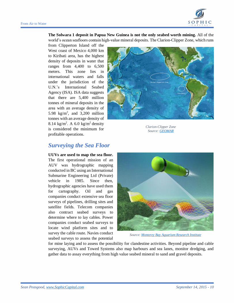
The Solwara 1 deposit in Papua New Guinea is not the only seabed worth mining. All of the
world’s ocean seafloors contain high-value mineral deposits. The Clarion-Clipper Zone, which runs
from Clipperton Island off the
West coast of Mexico 4,000 km
to Kiribati area, has the highest
density of deposits in water that
ranges from 4,400 to 6,500
meters. This zone lies in
international waters and falls
under the jurisdiction of the
U.N.’s International Seabed
Agency (ISA). ISA data suggests
that there are 5,400 million
tonnes of mineral deposits in the
area with an average density of
5.98 kg/m2, and 3,200 million
tonnes with an average density of
8.14 kg/m2. A 6.0 kg/m2 density
is considered the minimum for
profitable operations.
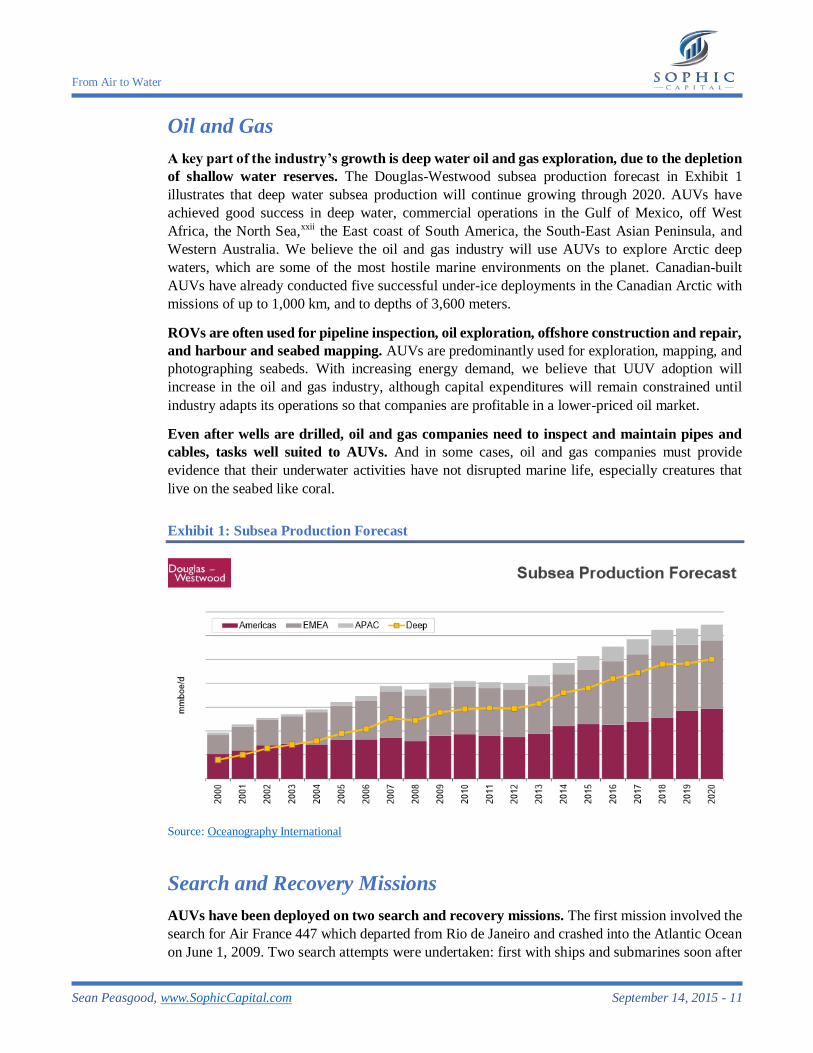
Surveying the Sea Floor
UUVs are used to map the sea floor.
The first operational mission of an
AUV was hydrographic mapping
conducted in BC using an International
Submarine Engineering Ltd (Private)
vehicle in 1985. Since then,
hydrographic agencies have used them
for cartography. Oil and gas
companies conduct extensive sea floor
surveys of pipelines, drilling sites and
satellite fields. Telecom companies
also contract seabed surveys to
determine where to lay cables. Power
companies conduct seabed surveys to
locate wind platform sites and to
survey the cable route. Navies conduct
seabed surveys to assess the potential
for mine laying and to assess the possibility for clandestine activities. Beyond pipeline and cable
surveying, AUVs and Towed Systems also map harbours and sea lanes, monitor dredging, and
gather data to assay everything from high value seabed mineral to sand and gravel deposits.
Clarion-Clipper Zone
Source: GEOMAR
Source: Monterey Bay Aquarium Research Institute
From Air to Water
Sean Peasgood, www.SophicCapital.com September 14, 2015 - 11
Oil and Gas
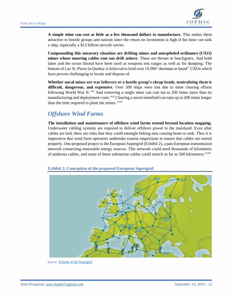
A key part of the industry’s growth is deep water oil and gas exploration, due to the depletion
of shallow water reserves. The Douglas-Westwood subsea production forecast in Exhibit 1
illustrates that deep water subsea production will continue growing through 2020. AUVs have
achieved good success in deep water, commercial operations in the Gulf of Mexico, off West
Africa, the North Sea,xxii the East coast of South America, the South-East Asian Peninsula, and
Western Australia. We believe the oil and gas industry will use AUVs to explore Arctic deep
waters, which are some of the most hostile marine environments on the planet. Canadian-built
AUVs have already conducted five successful under-ice deployments in the Canadian Arctic with
missions of up to 1,000 km, and to depths of 3,600 meters.
ROVs are often used for pipeline inspection, oil exploration, offshore construction and repair,
and harbour and seabed mapping. AUVs are predominantly used for exploration, mapping, and
photographing seabeds. With increasing energy demand, we believe that UUV adoption will
increase in the oil and gas industry, although capital expenditures will remain constrained until
industry adapts its operations so that companies are profitable in a lower-priced oil market.
Even after wells are drilled, oil and gas companies need to inspect and maintain pipes and
cables, tasks well suited to AUVs. And in some cases, oil and gas companies must provide
evidence that their underwater activities have not disrupted marine life, especially creatures that
live on the seabed like coral.
Exhibit 1: Subsea Production Forecast
Source: Oceanography International
Search and Recovery Missions
AUVs have been deployed on two search and recovery missions. The first mission involved the
search for Air France 447 which departed from Rio de Janeiro and crashed into the Atlantic Ocean
on June 1, 2009. Two search attempts were undertaken: first with ships and submarines soon after
From Air to Water
Sean Peasgood, www.SophicCapital.com September 14, 2015 - 12
the crash, and then a second search in 2011 that used Hydroid REMUS 6000 AUV. The REMUS
succeeded in locating the aircraft wreckage.
Search efforts continue for Malaysian Airlines flight 370, which disappeared March 8, 2014.
To assist the search, the U.S. Navy used an AUV built by Bluefin Robotics (private) and operated
by Phoenix International Holdings (private) over the course of several weeks. And although the
AUV didn’t locate the wreckage, it
demonstrated the versatility of the
technology. The AUV undertook 25
missions in 21 days, operated for a total
of 370 hours, covered 250 square miles,
and dove to depths of 5,000 meters.xxiii
What this demonstrates is that newer
AUVs can cover wide seabed areas at a
higher resolution over shorter periods of
time compared to conventional sonar
systems. A second search conducted by
Fugro (AMS:FUR) is ongoing. Fugro is
using a slower deep tow system, likely
because (according to our sources) no
6,000 meter AUV is available for the
duration of the survey.
ROVs have a recovery mission history. In July 1985, an ROV recovered Air India 182’s voice
recorder.xxiv And a Canadian Forces ROV took part in the search and recovery of Swissair 111 that
crashed off the coast of Nova Scotia in 1998.xxv
Naval Mine Detection
During the Korean War, over three thousand naval mines deployed over a few weeks
prevented a 250-ship United Nations amphibious assault on Wonsan.xxvi
This caused Rear
Admiral Allen E. Smith to lament, “We have lost control of the seas to a nation without a navy,
using pre–World War I weapons, laid by vessels that were utilized at the time of the birth of Christ.”
xxvii Such is the effectiveness that naval mines have at deterring navies from advancing.
Over 400,000 naval mines are in
the hands of U.S. competitors and
enemies.xxviii
Many of them are
legacy mines, left over from prior
wars. And similar to landmines,
naval mines stay active for years
after a conflict has ended. This poses
danger to commercial and military
vessels. Over 90% of the world’s
goods are transported by sea.xxix
Mines that block access to harbours
can damage economies. Source: Warfare Sims
Workers deploy a Bluefin-2 in the Indian Ocean
Source: National Defense Industrial Association
From Air to Water
Sean Peasgood, www.SophicCapital.com September 14, 2015 - 13
A simple mine can cost as little as a few thousand dollars to manufacture. This makes them
attractive to hostile groups and nations since the return on investment is high if the mine can sink
a ship, especially a $13 billion aircraft carrier.
Compounding this unsavory situation are drifting mines and unexploded ordinance (UXO)
mines whose mooring cables rust out drift ashore. These are threats to beachgoers. And both
lakes and the ocean littoral have been used as weapons test ranges as well as for dumping. The
bottom of Lac St. Pierre in Quebec is believed to hold over 10,000 “dormant or latent” UXOs which
have proven challenging to locate and dispose of.
Whether naval mines are war leftovers or a hostile group’s cheap bomb, neutralizing them is
difficult, dangerous, and expensive. Over 500 ships were lost due to mine clearing efforts
following World War II. xxx And removing a single mine can cost ten to 200 times more than its
manufacturing and deployment costs.xxxi Clearing a naval minefield can take up to 200 times longer
than the time required to plant the mines. xxxii
Offshore Wind Farms
The installation and maintenance of offshore wind farms extend beyond location mapping.
Underwater cabling systems are required to deliver offshore power to the mainland. Even after
cables are laid, there are risks that they could entangle fishing nets causing boats to sink. Thus it is
imperative that wind farm operators undertake routine inspections to ensure that cables are seated
properly. One proposed project is the European Supergrid (Exhibit 2), a pan-European transmission
network connecting renewable energy sources. This network could need thousands of kilometers
of undersea cables, and some of these submarine cables could stretch as far as 500 kilometers.xxxiii
Exhibit 2: Conception of the proposed European Supergrid
Source: Friends of the Supergrid
From Air to Water
Sean Peasgood, www.SophicCapital.com September 14, 2015 - 14
Laying a submarine cable involves several steps, many of which an UUV could handle. These
steps include: the selection of a provisional route, a survey of the route, cable burial locations (if
applicable), and post-cable installation inspection. However, these would all be preceded by a
desktop study to determine the best route for the cable.
Telecom Companies
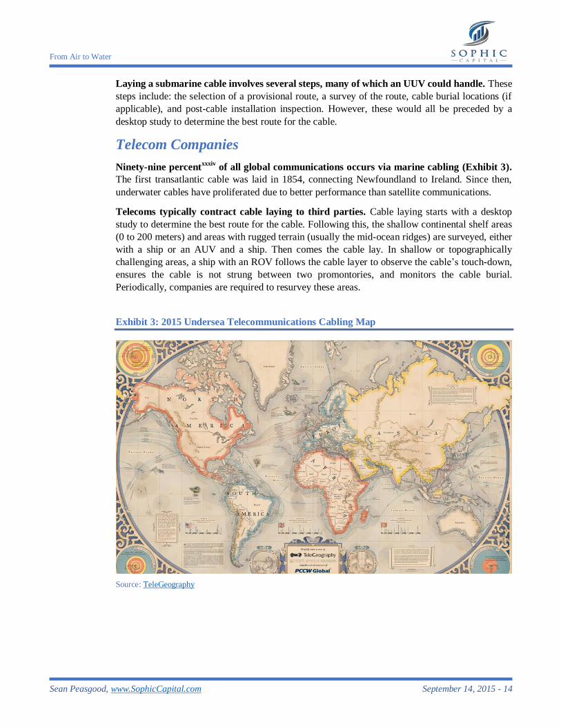
Ninety-nine percentxxxiv
of all global communications occurs via marine cabling (Exhibit 3).
The first transatlantic cable was laid in 1854, connecting Newfoundland to Ireland. Since then,
underwater cables have proliferated due to better performance than satellite communications.
Telecoms typically contract cable laying to third parties. Cable laying starts with a desktop
study to determine the best route for the cable. Following this, the shallow continental shelf areas
(0 to 200 meters) and areas with rugged terrain (usually the mid-ocean ridges) are surveyed, either
with a ship or an AUV and a ship. Then comes the cable lay. In shallow or topographically
challenging areas, a ship with an ROV follows the cable layer to observe the cable’s touch-down,
ensures the cable is not strung between two promontories, and monitors the cable burial.
Periodically, companies are required to resurvey these areas.
Exhibit 3: 2015 Undersea Telecommunications Cabling Map
Source: TeleGeography
From Air to Water
Sean Peasgood, www.SophicCapital.com September 14, 2015 - 15
Treasure Hunting
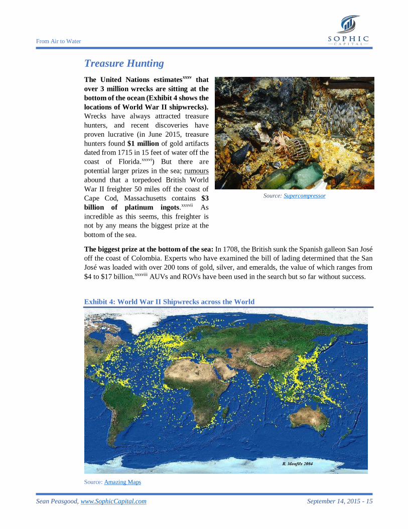
The United Nations estimatesxxxv
that
over 3 million wrecks are sitting at the
bottom of the ocean (Exhibit 4 shows the
locations of World War II shipwrecks).
Wrecks have always attracted treasure
hunters, and recent discoveries have
proven lucrative (in June 2015, treasure
hunters found $1 million of gold artifacts
dated from 1715 in 15 feet of water off the
coast of Florida.xxxvi) But there are
potential larger prizes in the sea; rumours
abound that a torpedoed British World
War II freighter 50 miles off the coast of
Cape Cod, Massachusetts contains $3
billion of platinum ingots.xxxvii As
incredible as this seems, this freighter is
not by any means the biggest prize at the
bottom of the sea.
The biggest prize at the bottom of the sea: In 1708, the British sunk the Spanish galleon San José
off the coast of Colombia. Experts who have examined the bill of lading determined that the San
José was loaded with over 200 tons of gold, silver, and emeralds, the value of which ranges from
$4 to $17 billion.xxxviii AUVs and ROVs have been used in the search but so far without success.
Exhibit 4: World War II Shipwrecks across the World
Source: Amazing Maps
Source: Supercompressor
From Air to Water
Sean Peasgood, www.SophicCapital.com September 14, 2015 - 16
Many in the salvaging community are attracted to remote sensing applications embedded in
UUVs to increase the probability of locating shipwrecks. Before the technology evolved,
searches were random and often relied upon luck to locate and map wrecks. Now, sensing
technology facilitates broader coverage of the sea. More important, it allows for accurate
positioning so that salvagers can easily find a shipwreck again.
The Franklin Expedition search was an example of a UUV locating a shipwreck. In 1845, Sir
John Franklin set sail from England in search of a Northwest Passage in Canada’s arctic. Franklin’s
ships became icebound and the entire crew was lost. In September 2014, Parks Canada discovered
one of Franklin’s ships, the HMS Erebus, using Synthetic Aperture sonar (SAS) technology
developed by Kraken Sonar (TSXV:PNG), a company which we detail more extensively later in
this report.
As attractive as treasure hunting is, we don’t foresee this becoming a large market for UUVs.
There are three reasons for this. First, there is a threat of piracy. Once the treasure is brought to the
surface, it must be transported to port, and then transported by land to a secure site. This opens the
possibility to robbery. Second, countries and agencies that own the shipwrecks may not have the
funds to recover the treasure. Thus, the treasure may remain sunk for decades. Third, once treasure
is found, it is placed in escrow until all the countries and agencies have their chance to claim
ownership in the courts. These can take decades to resolve and leave the treasure seekers with a
pittance. Combined, these factors make it unlikely that treasure hunting will expand beyond the
realm of well-funded companies. This means that not many UUVs will be required for treasure
hunting.
The Technology to See Underwater
3D Geospatial Mapping Tools
Nearly all of the industries using UUVs that we detailed need to survey and manage their field
assets across large geographies. 3D geospatial software allows the surveying of assets in
combination with GPS (global positioning system) data to create three-dimensional maps.
Evolving from technology in the 1960s, CARIS (private) is a leading 3D geospatial mapping
provider. CARIS (Computer Aided Resource Information System) has numerous vertical markets
that include: military agencies, survey contractors, ports and harbours, municipalities, land
administrators, and academia in more than 85 countries.
Geospatial Corporation (OTCMKTS:GSPH) creates 3D maps and models of shallow water,
in-shore pipelines at depths of up to 55 meters. The Company manages infrastructure data on
GeoUnderground, its Cloud-Based GIS Portal designed around the Google Maps API.
Conventional Sonar
Sonar is used to find and identify objects in water. There are two types of SONAR: active and
passive. Active sonar transmits a sound wave, called a “ping”, and measures the time it takes for
the ping to reflect back. The distance to an underwater object or seabed can then be extracted from
the time it takes the ping reflection to return to the sensor. Passive SONAR, on the other hand, does
From Air to Water
Sean Peasgood, www.SophicCapital.com September 14, 2015 - 17
not transmit pings; these systems listen to sounds occurring in the sea, such as those from sea
animals and ships.
Active sonar was first used during World War I to detect German submarines. Then, in the
1920s, the U.S. Coast Guard used sonar to map deep water locations. And in World War II, sonar
was again deployed for military applications. The 1960s introduced computers to sonar systems,
allowing for data plotting. It wasn’t until the 1970s when the military declassified SONAR,
allowing commercial exploitation of the technology.
Multibeam SONAR
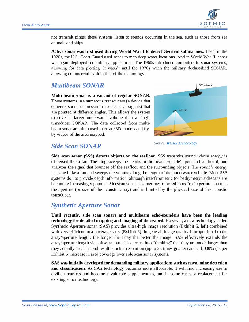
Multi-beam sonar is a variant of regular SONAR.
These systems use numerous transducers (a device that
converts sound or pressure into electrical signals) that
are pointed at different angles. This allows the system
to cover a larger underwater volume than a single
transducer SONAR. The data collected from multi-
beam sonar are often used to create 3D models and fly-
by videos of the area mapped.
Side Scan SONAR
Side scan sonar (SSS) detects objects on the seafloor. SSS transmits sound whose energy is
dispersed like a fan. The ping sweeps the depths to the towed vehicle’s port and starboard, and
analyzes the signal that bounces off the seafloor and the surrounding objects. The sound’s energy
is shaped like a fan and sweeps the volume along the length of the underwater vehicle. Most SSS
systems do not provide depth information, although interferometric (or bathymetry) sidescans are
becoming increasingly popular. Sidescan sonar is sometimes referred to as “real aperture sonar as
the aperture (or size of the acoustic array) and is limited by the physical size of the acoustic
transducer.
Synthetic Aperture Sonar
Until recently, side scan sonars and multibeam echo-sounders have been the leading
technology for detailed mapping and imaging of the seabed. However, a new technology called
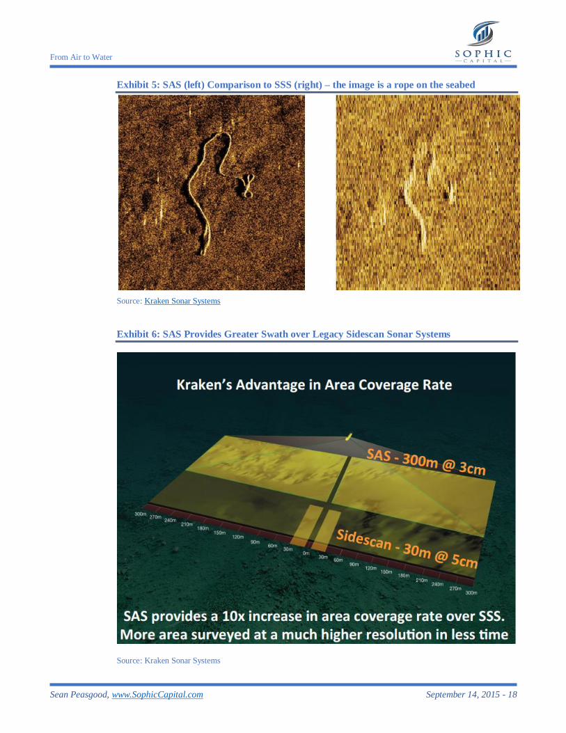
Synthetic Aperture sonar (SAS) provides ultra-high image resolution (Exhibit 5, left) combined
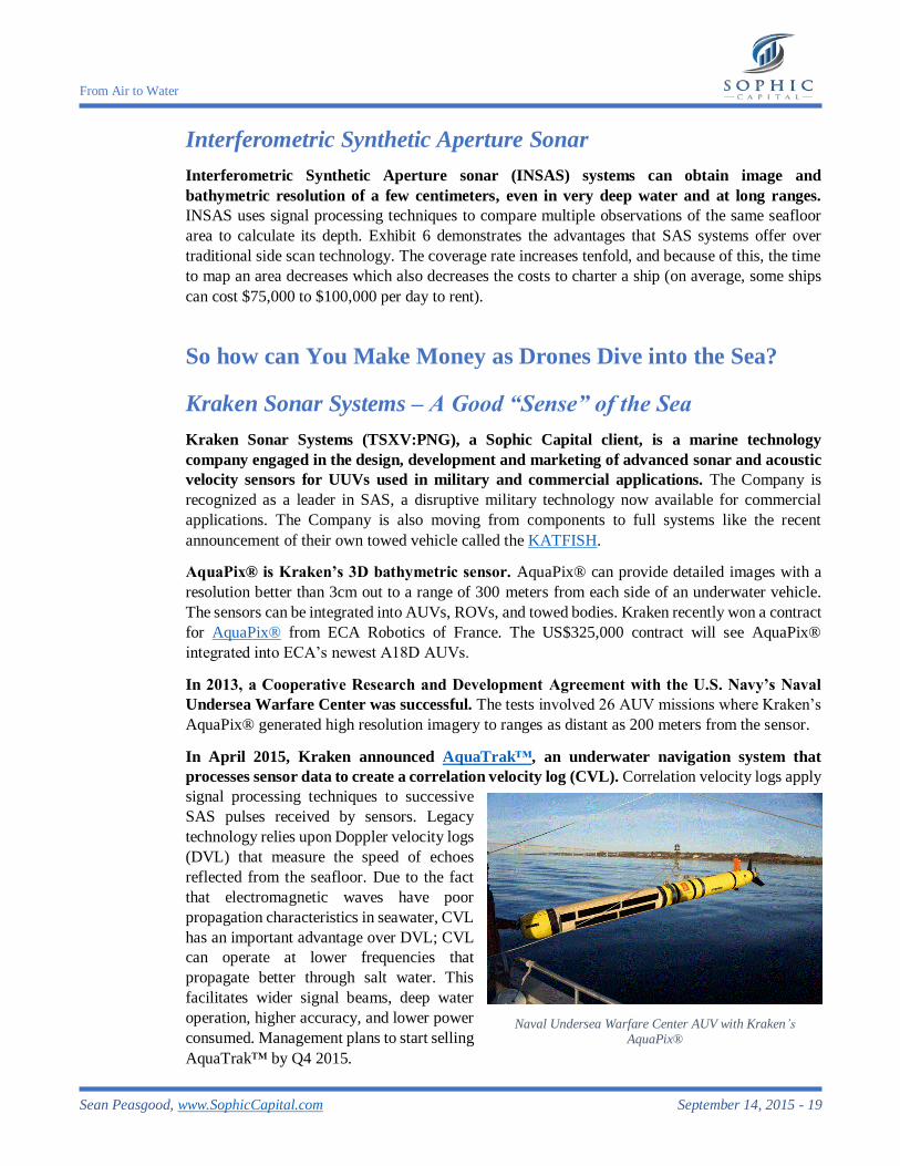
with very efficient area coverage rates (Exhibit 6). In general, image quality is proportional to the
array/aperture length: the longer the array the better the image. SAS effectively extends the
array/aperture length via software that tricks arrays into “thinking” that they are much larger than
they actually are. The end result is better resolution (up to 25 times greater) and a 1,000% (as per
Exhibit 6) increase in area coverage over side scan sonar systems.
SAS was initially developed for demanding military applications such as naval mine detection
and classification. As SAS technology becomes more affordable, it will find increasing use in
civilian markets and become a valuable supplement to, and in some cases, a replacement for
existing sonar technology.
Source: Wessex Archaeology
From Air to Water
Sean Peasgood, www.SophicCapital.com September 14, 2015 - 18
Exhibit 5: SAS (left) Comparison to SSS (right) – the image is a rope on the seabed
Source: Kraken Sonar Systems
Exhibit 6: SAS Provides Greater Swath over Legacy Sidescan Sonar Systems
Source: Kraken Sonar Systems
From Air to Water
Sean Peasgood, www.SophicCapital.com September 14, 2015 - 19
Interferometric Synthetic Aperture Sonar
Interferometric Synthetic Aperture sonar (INSAS) systems can obtain image and
bathymetric resolution of a few centimeters, even in very deep water and at long ranges.
INSAS uses signal processing techniques to compare multiple observations of the same seafloor
area to calculate its depth. Exhibit 6 demonstrates the advantages that SAS systems offer over
traditional side scan technology. The coverage rate increases tenfold, and because of this, the time
to map an area decreases which also decreases the costs to charter a ship (on average, some ships
can cost $75,000 to $100,000 per day to rent).
So how can You Make Money as Drones Dive into the Sea?
Kraken Sonar Systems – A Good “Sense” of the Sea
Kraken Sonar Systems (TSXV:PNG), a Sophic Capital client, is a marine technology
company engaged in the design, development and marketing of advanced sonar and acoustic
velocity sensors for UUVs used in military and commercial applications. The Company is
recognized as a leader in SAS, a disruptive military technology now available for commercial
applications. The Company is also moving from components to full systems like the recent
announcement of their own towed vehicle called the KATFISH.
AquaPix® is Kraken’s 3D bathymetric sensor. AquaPix® can provide detailed images with a
resolution better than 3cm out to a range of 300 meters from each side of an underwater vehicle.
The sensors can be integrated into AUVs, ROVs, and towed bodies. Kraken recently won a contract
for AquaPix® from ECA Robotics of France. The US$325,000 contract will see AquaPix®
integrated into ECA’s newest A18D AUVs.
In 2013, a Cooperative Research and Development Agreement with the U.S. Navy’s Naval
Undersea Warfare Center was successful. The tests involved 26 AUV missions where Kraken’s
AquaPix® generated high resolution imagery to ranges as distant as 200 meters from the sensor.
In April 2015, Kraken announced AquaTrak™, an underwater navigation system that
processes sensor data to create a correlation velocity log (CVL). Correlation velocity logs apply
signal processing techniques to successive
SAS pulses received by sensors. Legacy
technology relies upon Doppler velocity logs
(DVL) that measure the speed of echoes
reflected from the seafloor. Due to the fact
that electromagnetic waves have poor
propagation characteristics in seawater, CVL
has an important advantage over DVL; CVL
can operate at lower frequencies that
propagate better through salt water. This
facilitates wider signal beams, deep water
operation, higher accuracy, and lower power
consumed. Management plans to start selling
AquaTrak™ by Q4 2015.
Naval Undersea Warfare Center AUV with Kraken’s AquaPix®
Source: NavalDrones
From Air to Water
Sean Peasgood, www.SophicCapital.com September 14, 2015 - 20
On August 4, 2015, Tritech International, a Moog (NYSE:MOG.A) company, signed a multi-
year agreement to sell Kraken’s CVL. Under the agreement, Tritech will manufacture, sell, and
support Kraken’s AquaTrak™ CVL across its extensive international network, with the first
AquaTrak™ shipments expected in Q4/2015.
On July 21, 2015, Kraken announced plans to develop KATFISH, a proprietary towed
vehicle. The KATFISH is the evolution of the Company's sensors to systems strategy, based on
Kraken's Miniature Interferometric Synthetic Aperture Sonar technology and real-time SAS
processing algorithms. KATFISH uses an actively controlled, smart towed vehicle as a platform
for real-time ultra-high resolution seabed mapping system and comes with a winch and handling
subsystems for easy launch, tow, recovery, and stowage. Kraken has scheduled KATFISH’s
commercial availability for Q1 2016 with a price expected in the range of US$1.5 million. We view
the Company’s strategy to develop a complete turn-key system as a key growth driver.
Kraken stands apart from all of its competitors by the simple fact that it is not a
defense/aerospace company. Unencumbered by a bureaucracy, it is able to recognize potential,
move smartly to capitalize on the opportunity, and develop products which are disruptive from both
the perspective of cost and performance.
Tritech International – Piecing UUVs Together
Tritech International Limited, a Moog Inc. company, is a high-technology business that
provides imaging and ancillary equipment for use in underwater applications. The Company
offers an extensive family of imaging sonar, surveying sensors, video cameras, and control units –
essentially everything the defense, energy, engineering, survey, and UUV markets require to design
and manufacture UUVs.
Tritech is an industry leader in the provision of sensors and tools for the ROV and AUV
markets. The Company earned this reputation over 21 years of delivering expertise through key
industry-standard products such as the Super SeaKing mechanically scanning sonar (renowned for
obstacle avoidance) and the Gemini 720i sonar for real-time multibeam imaging. Tritech has sales
and customer support locations in Scotland, U.K. and Texas. Tritech also has a support office in
Brazil. The Company’s design and production locations are in Cumbria, England and Edinburgh,
Scotland. Tritech has further global representation through a broad agent network.
In August, 2012, Moog Inc. announced that it had acquired Tritech International Limited.
The purchase price was approximately £21 million in cash. At the time, Tritech had trailing 12-
month revenues of $19 million pegging its valuation at 1.1 times trailing 12-month revenues.
Kongsberg Gruppen ASA – Operating under Extreme Conditions
Kongsberg Gruppen ASA (OTCMKTS:NSKFF) supplies technological solutions that
improve the reliability, safety and efficiency of complex operations under extreme conditions.
The Oslo-based company has a division called Kongsberg Maritime that provides maritime
solutions including: dynamic positioning and navigation, marine automation, safety management,
cargo handling, subsea survey and construction, maritime simulation and training, and satellite
positioning. The Company’s main markets are countries with large offshore, shipyard and energy
exploration and production industries. Kongsberg Maritime provides sophisticated underwater and
From Air to Water
Sean Peasgood, www.SophicCapital.com September 14, 2015 - 21
positioning technology and systems for survey vessel operation for the exploration vertical. For
field development, the Division supports construction and offshore vessels with solutions for
operation and specialist applications. In the production field, Kongsberg Maritime’s hardware and
software solutions enhance output and minimize downtime. For maritime transport and offshore
vessels, the Division provides a broad ecosystem of solutions that cover navigation, automation,
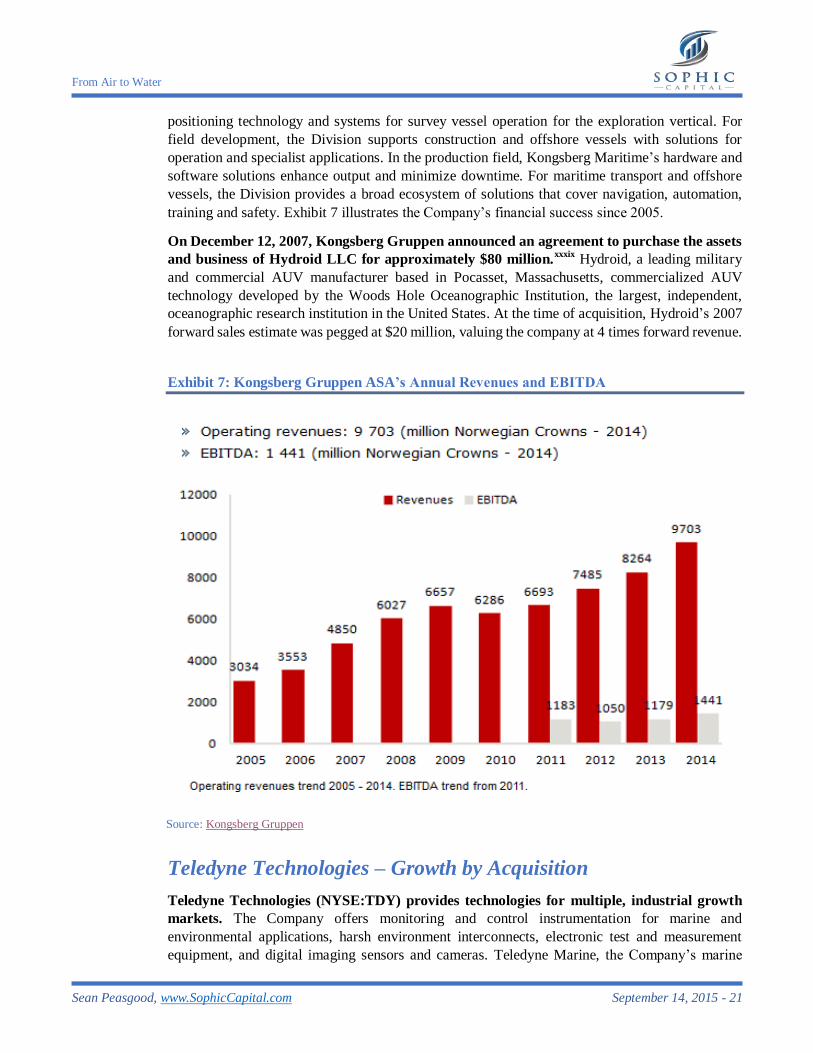
training and safety. Exhibit 7 illustrates the Company’s financial success since 2005.
On December 12, 2007, Kongsberg Gruppen announced an agreement to purchase the assets
and business of Hydroid LLC for approximately $80 million.xxxix
Hydroid, a leading military
and commercial AUV manufacturer based in Pocasset, Massachusetts, commercialized AUV
technology developed by the Woods Hole Oceanographic Institution, the largest, independent,
oceanographic research institution in the United States. At the time of acquisition, Hydroid’s 2007
forward sales estimate was pegged at $20 million, valuing the company at 4 times forward revenue.
Exhibit 7: Kongsberg Gruppen ASA’s Annual Revenues and EBITDA
Source: Kongsberg Gruppen
Teledyne Technologies – Growth by Acquisition
Teledyne Technologies (NYSE:TDY) provides technologies for multiple, industrial growth
markets. The Company offers monitoring and control instrumentation for marine and
environmental applications, harsh environment interconnects, electronic test and measurement
equipment, and digital imaging sensors and cameras. Teledyne Marine, the Company’s marine
From Air to Water
Sean Peasgood, www.SophicCapital.com September 14, 2015 - 22
division, has made several recent acquisitions. On February 2, 2015, Teledyne Marine acquired
Bowtech Products, which makes harsh underwater vision systems. On November 2014, the
Division completed its purchase of Bolt Technology, a leading supplier of marine seismic energy
sources and replacement parts for offshore energy exploration, for $171 million.xl The Division
also purchased The Oceanscience Group, a designer and manufacturer of marine sensor platforms
and unmanned surface vehicles. Back in July 2014, Teledyne Marine also invested in Ocean Aero,
a company designing an unmanned surface vehicle that will have the ability to descend.
On August 29, 2005, Teledyne acquired RD Instruments for approximate $37 million.xli
RD
Instruments, based in San Diego, California, manufactures acoustic Doppler instruments and had
2004 sales of $29 million, pegging the acquisition at 1.3 times trailing revenue.
Ultra Electronics Holdings – Combatting Enemy Mines
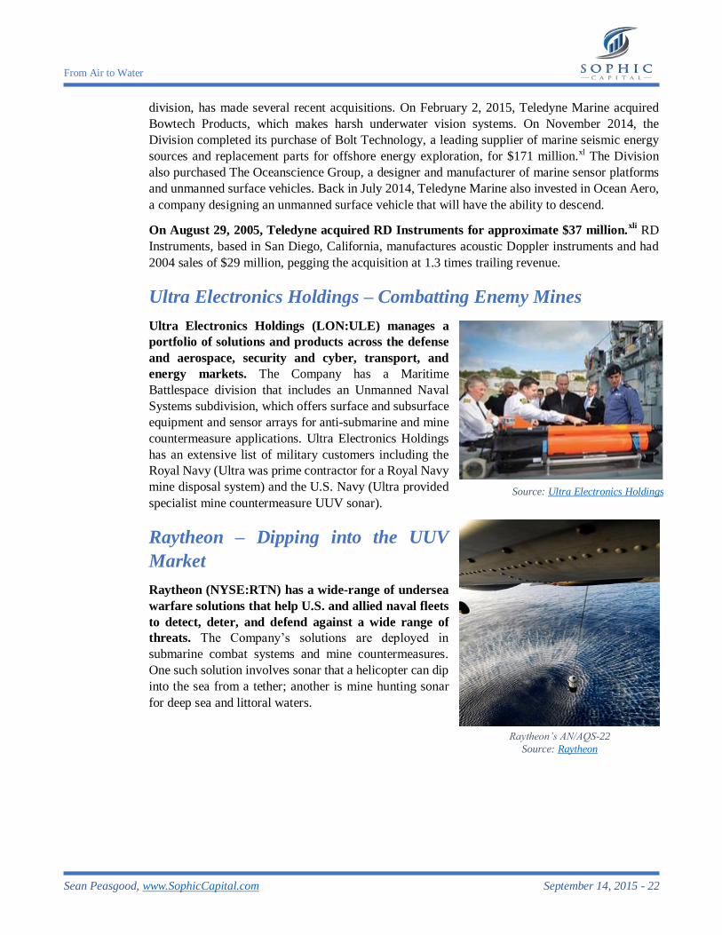
Ultra Electronics Holdings (LON:ULE) manages a
portfolio of solutions and products across the defense
and aerospace, security and cyber, transport, and
energy markets. The Company has a Maritime
Battlespace division that includes an Unmanned Naval
Systems subdivision, which offers surface and subsurface
equipment and sensor arrays for anti-submarine and mine
countermeasure applications. Ultra Electronics Holdings
has an extensive list of military customers including the
Royal Navy (Ultra was prime contractor for a Royal Navy
mine disposal system) and the U.S. Navy (Ultra provided
specialist mine countermeasure UUV sonar).
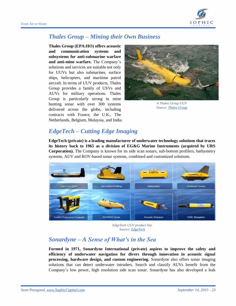
Raytheon – Dipping into the UUV
Market
Raytheon (NYSE:RTN) has a wide-range of undersea
warfare solutions that help U.S. and allied naval fleets
to detect, deter, and defend against a wide range of
threats. The Company’s solutions are deployed in
submarine combat systems and mine countermeasures.
One such solution involves sonar that a helicopter can dip
into the sea from a tether; another is mine hunting sonar
for deep sea and littoral waters.
Source: Ultra Electronics Holdings
Raytheon’s AN/AQS-22
Source: Raytheon
From Air to Water
Sean Peasgood, www.SophicCapital.com September 14, 2015 - 23
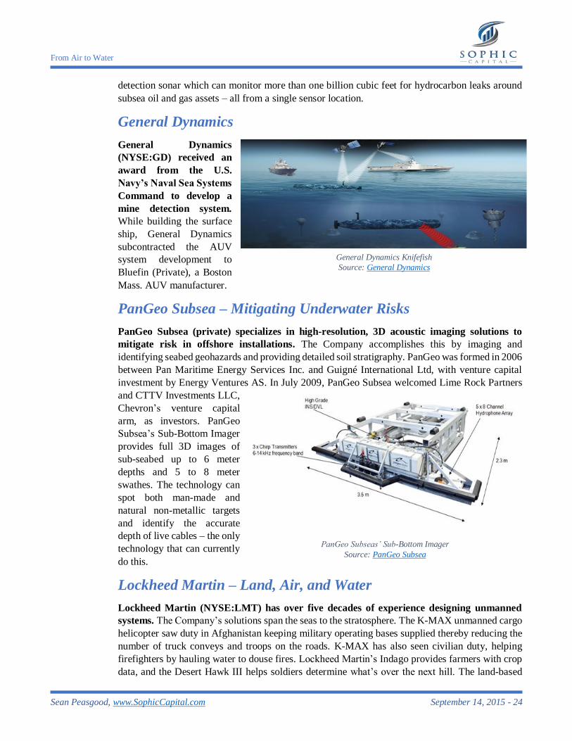
Thales Group – Mining their Own Business
Thales Group (EPA:HO) offers acoustic
and communication systems and
subsystems for anti-submarine warfare
and anti-mine warfare. The Company’s
solutions and services are suitable not only
for UUVs but also submarines, surface
ships, helicopters, and maritime patrol
aircraft. In terms of UUV products, Thales
Group provides a family of USVs and
AUVs for military operations. Thales
Group is particularly strong in mine
hunting sonar with over 300 systems
delivered across the globe, including
contracts with France, the U.K., The
Netherlands, Belgium, Malaysia, and India.
EdgeTech – Cutting Edge Imaging
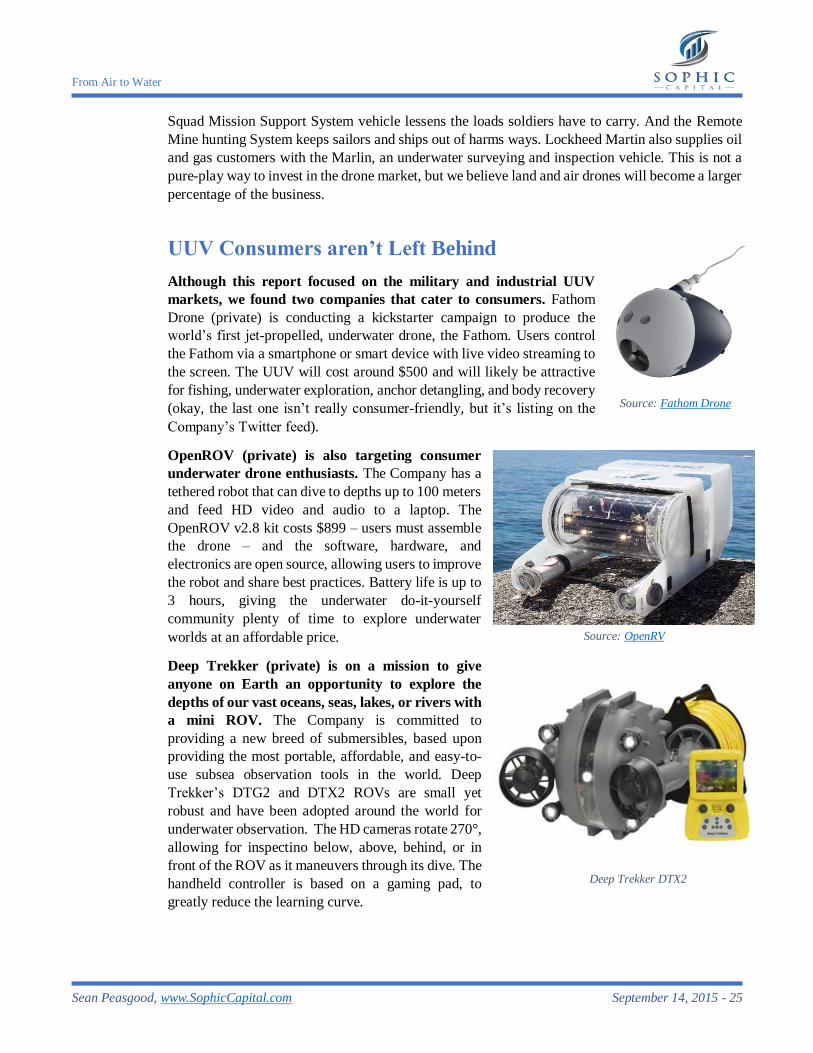
EdgeTech (private) is a leading manufacturer of underwater technology solutions that traces
its history back to 1965 as a division of EG&G Marine Instruments (acquired by URS
Corporation). The Company is known for its side scan sonars, sub-bottom profilers, bathymetry
systems, AUV and ROV-based sonar systems, combined and customized solutions.
Sonardyne – A Sense of What’s in the Sea
Formed in 1971, Sonardyne International (private) aspires to improve the safety and
efficiency of underwater navigation for divers through innovation in acoustic signal
processing, hardware design, and custom engineering. Sonardyne also offers sonar imaging
solutions that can detect underwater intruders. Search and classify AUVs benefit from the
Company’s low power, high resolution side scan sonar. Sonardyne has also developed a leak
A Thales Group UUV
Source: Thales Group
EdgeTech UUV product line
Source: EdgeTech
From Air to Water
Sean Peasgood, www.SophicCapital.com September 14, 2015 - 24
detection sonar which can monitor more than one billion cubic feet for hydrocarbon leaks around
subsea oil and gas assets – all from a single sensor location.
General Dynamics
General Dynamics
(NYSE:GD) received an
award from the U.S.
Navy’s Naval Sea Systems
Command to develop a
mine detection system.
While building the surface
ship, General Dynamics
subcontracted the AUV
system development to
Bluefin (Private), a Boston
Mass. AUV manufacturer.
PanGeo Subsea – Mitigating Underwater Risks
PanGeo Subsea (private) specializes in high-resolution, 3D acoustic imaging solutions to
mitigate risk in offshore installations. The Company accomplishes this by imaging and
identifying seabed geohazards and providing detailed soil stratigraphy. PanGeo was formed in 2006
between Pan Maritime Energy Services Inc. and Guigné International Ltd, with venture capital
investment by Energy Ventures AS. In July 2009, PanGeo Subsea welcomed Lime Rock Partners
and CTTV Investments LLC,
Chevron’s venture capital
arm, as investors. PanGeo
Subsea’s Sub-Bottom Imager
provides full 3D images of
sub-seabed up to 6 meter
depths and 5 to 8 meter
swathes. The technology can
spot both man-made and
natural non-metallic targets
and identify the accurate
depth of live cables – the only
technology that can currently
do this.
Lockheed Martin – Land, Air, and Water
Lockheed Martin (NYSE:LMT) has over five decades of experience designing unmanned
systems. The Company’s solutions span the seas to the stratosphere. The K-MAX unmanned cargo
helicopter saw duty in Afghanistan keeping military operating bases supplied thereby reducing the
number of truck conveys and troops on the roads. K-MAX has also seen civilian duty, helping
firefighters by hauling water to douse fires. Lockheed Martin’s Indago provides farmers with crop
data, and the Desert Hawk III helps soldiers determine what’s over the next hill. The land-based
General Dynamics Knifefish
Source: General Dynamics
PanGeo Subseas’ Sub-Bottom Imager
Source: PanGeo Subsea
From Air to Water
Sean Peasgood, www.SophicCapital.com September 14, 2015 - 25
Squad Mission Support System vehicle lessens the loads soldiers have to carry. And the Remote
Mine hunting System keeps sailors and ships out of harms ways. Lockheed Martin also supplies oil
and gas customers with the Marlin, an underwater surveying and inspection vehicle. This is not a
pure-play way to invest in the drone market, but we believe land and air drones will become a larger
percentage of the business.
UUV Consumers aren’t Left Behind
Although this report focused on the military and industrial UUV
markets, we found two companies that cater to consumers. Fathom
Drone (private) is conducting a kickstarter campaign to produce the
world’s first jet-propelled, underwater drone, the Fathom. Users control
the Fathom via a smartphone or smart device with live video streaming to
the screen. The UUV will cost around $500 and will likely be attractive
for fishing, underwater exploration, anchor detangling, and body recovery
(okay, the last one isn’t really consumer-friendly, but it’s listing on the
Company’s Twitter feed).
OpenROV (private) is also targeting consumer
underwater drone enthusiasts. The Company has a
tethered robot that can dive to depths up to 100 meters
and feed HD video and audio to a laptop. The
OpenROV v2.8 kit costs $899 – users must assemble
the drone – and the software, hardware, and
electronics are open source, allowing users to improve
the robot and share best practices. Battery life is up to
3 hours, giving the underwater do-it-yourself
community plenty of time to explore underwater
worlds at an affordable price.
Deep Trekker (private) is on a mission to give
anyone on Earth an opportunity to explore the
depths of our vast oceans, seas, lakes, or rivers with
a mini ROV. The Company is committed to
providing a new breed of submersibles, based upon
providing the most portable, affordable, and easy-to-
use subsea observation tools in the world. Deep
Trekker’s DTG2 and DTX2 ROVs are small yet
robust and have been adopted around the world for
underwater observation. The HD cameras rotate 270°,
allowing for inspectino below, above, behind, or in
front of the ROV as it maneuvers through its dive. The
handheld controller is based on a gaming pad, to
greatly reduce the learning curve.
Source: Fathom Drone
Source: OpenRV
Deep Trekker DTX2
From Air to Water
Sean Peasgood, www.SophicCapital.com September 14, 2015 - 26
Conclusion – Underwater is the next Big Market for Drones
Although we have traversed the seas for centuries, we know little of what lurks beneath the
water’s surface. The military has aggressively adopted underwater drones, and it appears as though
the industrial and consumer sectors are on the cusp of embracing the technology. We recommend
that investors considering investing in this emerging tech space examine the public UUV
companies that we have profiled. Many are large conglomerates (Raytheon, General Dynamics,
Moog) which we believe won’t afford significant upside should the UUV market ramp as we
expect. We suggest that investors look at Kraken Sonar, a Sophic Capital client, and Kongsberg
Gruppen since these are publicly listed maritime companies.
From Air to Water
Sean Peasgood, www.SophicCapital.com September 14, 2015 - 27
Acronyms Used in this Report
AUSVI Association for Unmanned Vehicle Systems International
AUV autonomous underwater vehicle
CVL correlation velocity log
DVL Doppler velocity log
GPS global positioning system
INSAS interferometric synthetic aperture SONAR
ISA International Seabed Agency
LiB lithium-ion battery
NOAA National Oceanic and Atmospheric Administration
ROV remotely operated underwater vehicle
SAS synthetic aperture sonar
SSS side scan SONAR
SONAR SOund NAvigation and Ranging
UAV unmanned aerial vehicle
USV unmanned surface vehicle
UUV unmanned underwater vehicle
Glossary
bathymetry Measuring the depth and floor of water bodies.
hydrography The science of measuring and charting seabed depth.
interferometry Any of several optical, acoustic, or radio-frequency instruments that use
interference phenomena between a reference wave and an experimental
wave or between two parts of an experimental wave to determine
wavelengths and wave velocities, measure very small distances and
thicknesses, and calculate indices of refraction.
stratigraphy The order and relative position of strata and their relationship to the
geological time scale.
From Air to Water
Sean Peasgood, www.SophicCapital.com September 14, 2015 - 28
References
i Teal Group Predicts Worldwide UAV Market Will Total $91 Billion in Its 2014 UAV Market Profile and
Forecast, Teal Group Corporation, July 14, 2015 ii How much water is there on, in, and above the Earth?, U.S. Geological Survey, 1984 iii Ibid iv How much of the ocean have we explored?, National Oceanic and Atmospheric Administration, June 24,
2014, pg. 30 v Unmanned Underwater Vehicles Market worth $4.84 Billion by 2019, MarketsandMarkets, March 2014 vi Ibid vii Ibid viii World Subsea Vessel Operations Market Forecast 2015-2019, Douglas-Westwood ix Global AUV Fleet to increase 42% by 2018, Douglas-Westwood x Cornelius Drebbel (1572 - 1633), BBC, 2015 xi Angela D’Amico and Richard Pittenger, A Brief History of Active Sonar, Aquatic Mammals, 2009 xii Murray Dormer, AUVs – Global Market Prospects, Douglas-Westwood, March 13, 2014, pg. 18 xiii Ibid. xiv Clay Dillow, The Drone Revolution Hits the High Seas, Fortune, April 17, 2015 xv Megan Eckstein, Navy to Invest Up to $1.43 Billion to Support Unmanned Mine Countermeasures
Vehicles, USNI News, July 22, 2015 xvi Remote Environmental Monitoring Unit System (REMUS), Naval Drones, 205 xvii Blue Growth opportunities for marine and maritime sustainable growth, COM(2012) 494 final, pg. 10,
European Commission, September 13, 2012 xviii Terry Macalister, David Cameron says seabed mining could be worth £40bn to Britain, The Guardian,
March 14, 2013 xix Matt Burgess, Deep sea mining: AUV to help unlock hidden resources, Factor, January 13, 2015 xx Steve Scott (Emeritus), University of Toronto, 2014 xxi David Shukman, Deep sea mining licences issued, BBC News, July 23, 2014 xxii Marine industries global market analysis, Dougless-Westwood, March 2005, pg. 79 xxiii Yasmin Tadjdeh, As Technology Matures, New Roles Emerge for Underwater Drones, National
DEFENSE, September 2014 xxiv Edith M. Lederer, Second flight recorder recovered from wreckage, Associated Press, July 11, 1985 xxv Geoffrey Ho, Nada J. Pavlovi, Robert Arrabito, Rifaat Abdalla, Human Factors Issues When Operating
Unmanned Underwater Vehicles, Defence R&D Canada, March 2011, page 25 xxvi Scott C. Truver, Taking Mines Seriously, Naval War College Review, Spring 2012, Vol. 65, No. 2, pg.
30 xxvii Scott C. Truver, Taking Mines Seriously, Naval War College Review, Spring 2012, Vol. 65, No. 2, pg.
31 xxviii Sydney J. Freedberg Jr., Sowing The Sea With Fire: The Threat Of Sea Mines, Breaking Defense, March
30, 2015 xxix Natasha Geiling, How the Shipping Industry is the Secret Force Driving the World Economy,
Smithsonian, October 15, 2013 xxx Ryan Faith, The US Navy May Battle Deadly Naval Mines With Quadcopter Drones, Vice News,
September 26, 2014 xxxi Ibid xxxii Ibid xxxiii Brieuc Hamon, Survey of Offshore Wind Farm Project in EU and Their Connecting Grid Systems, Global
Energy Network Institute, July 2012, pg. 17 xxxiv Secrets of Submarine Cables - Transmitting 99 percent of all international data!, NEC xxxv Wrecks, United Nations Educational, Scientific and Cultural Organization, 2015 xxxvi Kaylee Heck, 300 Years After Shipwreck, Treasure Hunters Find $1M in Gold, ABCNews, July 28, 2015 xxxviiAlan Farnham, $3B Sunken Treasure? Questions Over Whether Hunt For WWII Bullion Is Fishy or Legit, ABCNews, April 16, 2014

From Air to Water
Sean Peasgood, www.SophicCapital.com September 14, 2015 - 29
xxxviii US Court Rules in Favor of Colombia in Holy Grail of Shipwrecks Case, Fox News Latino, October
25, 2011 xxxix KONGSBERG acquires Hydroid LLC, Kongsberg Gruppen ASA, December 12, 2007 xl Teledyne Completes Acquisition of Bolt Technology Corporation, Teledyne Technologies, November 18,
2014 xli Teledyne Acquires RD Instruments, Inc., Teledyne Technologies, August 29, 2005
From Air to Water
Sean Peasgood, www.SophicCapital.com September 14, 2015 - 30
Disclaimers
The particulars contained herein were obtained from sources that we believe to be reliable, but are
not guaranteed by us and may be incomplete or inaccurate. The opinions expressed are based upon
our analysis and interpretation of these particulars and are not to be construed as a solicitation of
offer to buy or sell the securities mentioned herein. Sophic Capital Inc. (“Sophic Capital”) may act
as financial advisor, for certain of the companies mentioned herein, and may receive remuneration
for its services. Sophic Capital and/or its principals, officers, directors, representatives, and
associates may have a position in the securities mentioned herein and may make purchases and/or
sales of these securities from time to time in the open market or otherwise.