Embed Size (px)
Citation preview

6
2. BACKGROUND
2.1 The West Branch Susquehanna River watershed
While the WBSR watershed includes several developed areas, forests cover about 83% of the land, and agricultural land makes up about 10%. Most abandoned mine lands (AMLs) are found on the remaining 7% of the land, which includes developed and disturbed land (SRBC, 2008). Public lands are significant. Of the roughly 4.5 million acres in the watershed, more than 1.4 million are in state forests, more than 250,000 are in state game lands, and more than 29,000 are in state parks (SRBC, 2008). The watershed also overlaps considerably with the Pennsylvania Wilds region, the focus of a major push toward ecotourism and outdoor recreation–related economic opportunities in central and north-central Pennsylvania.. AMD impacts the watershed’s fisheries. As shown in Figure 2, brook trout populations in some subwatersheds have been depressed or even extirpated. But despite these impacts, trout streams are abundant. Most AMD-impacted streams in the watershed that have been assessed have the potential to support stocked or naturally reproducing trout. In fact, above AMD impacts, most headwaters streams are classified as Class A wild trout fisheries (WBSR Task Force, 2005).
Picture 2: Fishing on Kettle Creek above abandoned mine drainage
Photo credit: Rebecca Dunlap. Across the watershed, 1,249 miles of Exceptional Value streams receive the highest level of protection from future degradation. High Quality streams include 5,229 miles of Cold Water

7
Fisheries and 73 miles of Trout-Stocked Fisheries. An additional 3,971 miles of Cold Water Fisheries, 359 miles of Trout-Stocked Fisheries, and 1,208 miles of Warm Water Fisheries are located within the watershed (WBSR Task Force, 2005). About 2,400 stream miles in the WBSR watershed have been documented to have wild trout reproduction, and the watershed also includes approximately 660 miles of Class A trout streams (SRBC, 2008). According to the Pennsylvania Fish and Boat Commission (PAFBC), these streams support populations of naturally reproducing trout of sufficient size and abundance to support a long-term and rewarding sport fishery. About 250 miles of Wilderness Trout streams are also found in the watershed (SRBC, 2008). Many more undocumented, reproducing wild trout streams may exist, but have not yet been documented (SRBC, 2008).
2.2 Abandoned mine drainage pollution
AMD is the number one source of pollution to Pennsylvania’s waterways. According to the Pennsylvania Department of Environmental Protection (PADEP), 5,584 stream miles are polluted by AMD across the Commonwealth (PADEP, 2008). More than 20% of Pennsylvania’s AMD-polluted streams—1,205 stream miles—lie within the WBSR watershed (SRBC, 2008).According to the WBSR Task Force (2005), physical stream habitat across the watershed is in relatively good condition, and AMD pollution is the most significant cause of water quality impairments. These impairments are caused by AMLs. The 42,062 acres of un-reclaimed AMLs in the WBSR watershed represent almost 23% of those within the entire Commonwealth (SRBC, 2008). Funds for remediating AMD from AMLs may come from a variety of sources, including Title IV Abandoned Mine Land Fund allocations to Pennsylvania, the Growing Greener program, and Clean Water Act Section 319 Nonpoint Source grants. Other government programs can also allocate funds toward remediation. Dedicated federal, state, or local government funds may ultimately be needed as well. Across the WBSR watershed, many AMD remediation projects have been installed, and additional AMD-focused remediation plans have been completed or are in progress, as shown in Table 2. In addition, more than 50 total maximum daily loads (TMDLs) have been approved for AMD-impaired streams in the WBSR watershed, and additional TMDLs are under development (SRBC, 2008).

8 Figu
re 2
: Bro
ok tr
out c
lass
ifica
tions
in th
e W
est B
ranc
h Su
sque
hann
a R
iver
wat
ersh
ed
So
urce
: Eas
tern B
rook
Tro
ut Jo
int V
entur
e (Un
dated
).
9
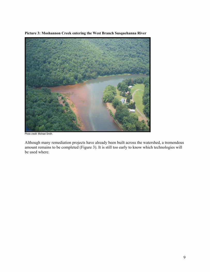
Picture 3: Moshannon Creek entering the West Branch Susquehanna River
Photo credit: Michael Smith. Although many remediation projects have already been built across the watershed, a tremendous amount remains to be completed (Figure 3). It is still too early to know which technologies will be used where.

10 Figu
re 3
: Aba
ndon
ed m
ine
drai
nage
–im
pair
ed st
ream
s in
the
Wes
t Bra
nch
Susq
ueha
nna
Riv
er w
ater
shed
So
urce
: AMD
-impa
ired s
tream
s fro
m PA
DEP
(200
8) as
prov
ided b
y Pen
nsylv
ania
Spati
al Da
ta Ac
cess
(200
8). A
ccor
ding t
o PAD
EP (2
008)
, the W
BSR
from
Mosh
anno
n Cre
ek do
wnstr
eam
has n
ot be
en as
sess
ed; h
owev
er,
data
sugg
est th
is re
ach i
s imp
aired
by pH
and m
etals
from
AMD.

11
Table 2: Abandoned mine drainage–focused remediation plans in the West Branch Susquehanna River watershed
Plan Watershed County Year
completed Completed by Completed for WBSR Headwaters AMD Assessment and Restoration Plan
WBSR Cambria 2002 Vapco Engineering West Branch Susquehanna Rescue
WBSR Headwaters AMD Assessment WBSR Cambria 2006 Hedin Environmental West Branch
Susquehanna Rescue Chest Creek Assessment and Restoration Plan Chest Creek Cambria,
Clearfield In progress Cambria County Cons. Dist.
Chest Creek Watershed Alliance
Bear Run Restoration Plan WBSR Indiana, Clearfield 2006 Indiana County Cons.
Dist. Indiana County Cons. Dist.
Clearfield Creek Watershed Assessment Phase I and II Clearfield Creek Cambria,
Clearfield 2004
Melius and Hockenberry Environmental Services Inc.
Clearfield Creek Watershed Assoc.
Morgan Run Assessment and Restoration Plan Clearfield Creek Clearfield 2006 New Miles of Blue
Stream
Clearfield Cons. Dist., Morgan Run Watershed Group
Restoration Plan for Little Laurel Run, Cambria County, PA Clearfield Creek Cambria 2005 Arthur W. Rose Clearfield Creek
Watershed Assoc. Anderson Creek Watershed Assessment, Restoration, and Implementation Plan
Anderson Creek Clearfield 2006 Western Pennsylvania Conservancy
Anderson Creek Watershed Assoc.
Hartshorn Run Assessment WBSR Clearfield In progress Clearfield County Cons. Dist.
Clearfield County Cons. Dist.
Montgomery Creek 319 Watershed Implementation Plan WBSR Clearfield In progress
Clearfield County Cons. Dist., Montgomery Run
Clearfield County Cons. Dist., Watershed Assoc.
Lick Run Cold Water Assessment and Restoration Plan
WBSR Clearfield 2005 Allegheny Mountain Chapter of TU
Allegheny Mountain Chapter of TU
Deer Creek Assessment WBSR Clearfield In progress Clearfield County Cons. Dist.
Clearfield County Cons. Dist., Deer Creek Watershed Assoc.
Moravian Run Assessment WBSR Clearfield In progress Clearfield County Cons. Dist.
Clearfield County Cons. Dist.
Upper Alder Run Assessment WBSR Clearfield In progress Alder Run Engineering Inc.
West Branch Sportsman's Association
Hubler Run Implementation Plan WBSR Clearfield 2007 Alder Run Engineering Inc.
West Branch Sportsman's Association
Emigh Run Assessment and Restoration Plan Moshannon Creek Clearfield 2004 New Miles of Blue
Stream Emigh Run Lakeside Watershed Assoc.
Trout Run Assessment and Restoration Plan Moshannon Creek Centre 2006 New Miles of Blue
Stream Moshannon Creek Watershed Coalition
Headwaters of Moshannon Creek Assessment Moshannon Creek Clearfield,
Centre In progress New Miles of Blue Stream
Moshannon Creek Watershed Coalition
Shimel Run Restoration Plan Moshannon Creek Centre In progress New Miles of Blue Stream
Moshannon Creek Watershed Coalition
Moshannon Creek Water Quality Data Clearinghouse Moshannon Creek Clearfield,
Centre 2006 New Miles of Blue Stream
Moshannon Creek Watershed Coalition
Moshannon Creek Cold Water Assessment and Restoration Plan
Moshannon Creek Clearfield, Centre In progress Clearfield County
Cons. Dist. Clearfield County Cons. Dist.
Bennett Branch Watershed Assessment and Restoration Plan
Bennett Branch, Sinnemahoning Creek
Clearfield, Elk,
Cameron 2003 Gannett Fleming Inc. Bennett Branch
Watershed Assoc.

12
Table 2: Abandoned mine drainage–focused remediation plans in the West Branch Susquehanna River watershed (continued)
Plan Watershed County Year
completed Completed by Completed for
Dents Run Watershed Ecosystem Restoration
Bennett Branch, Sinnemahoning Creek
Elk 2001 US Army Corps of Engineers
Bennett Branch Watershed Assoc.
Sterling Run Assessment and Restoration Plan
Driftwood Branch, Sinnemahoning Creek
Cameron 2004 Gannet Fleming Inc. Cameron County Cons. Dist.
Lower Kettle Creek Restoration Plan Kettle Creek Clinton 2000 Hedin Environmental TU, Kettle Creek
Watershed Assoc.
West Side of Lower Kettle Creek AMD Remediation Master Plan Kettle Creek Clinton 2007 Hedin Environmental
Kettle Creek Watershed Assoc. & TU
Huling Branch Mine Complex: Investigation of AMD and Recommendations for Remediation
Kettle Creek Clinton 2004 Hedin Environmental TU, Kettle Creek Watershed Assoc.
Twomile Run Watershed AMD Remediation Master Plan Kettle Creek Clinton 2007 Hedin Environmental
Kettle Creek Watershed Assoc. & TU
Rapid Watershed AMD Assessment for Sandy Run, Woodley Draft, and Stony Run
Drury Run Clinton 2006 Hedin Environmental Western PA Coalition for Abandoned Mine Reclamation
Loop Run Restoration Plan WBSR Clinton 2004 New Miles of Blue Stream
Rocky Mountain Elk Foundation
Tangascootack Creek Watershed Assessment WBSR Clinton 1998 PADEP Moshannon
District Mining Office Clinton County Cons. Dist.
Acid Mine Drainage Restoration Plan for the Beech Creek Watershed
Beech Creek Clinton, Centre 2006 Hedin Environmental Beech Creek
Watershed Assoc.
Jonathon Run Restoration Plan Beech Creek Centre 2003 Hedin Environmental Beech Creek Watershed Assoc.
Jonathon Run Site Evaluation Beech Creek Centre 2006 GAI Consultants Penn DOT Contrary Run and Butts Run Assessment Beech Creek Centre 2004 Bucek & Associates Beech Creek
Watershed Assoc. Lycoming Acidification Assessment Lycoming Creek Lycoming 2007 Hedin Environmental Lycoming Creek
Watershed Assoc. Source: Copied from SRBC (2008), Table 2. Plans are listed from upstream to downstream.