Embed Size (px)
Citation preview
Action PlanDowntown Lafayette
June 10, 2014Prepared by Wallace Roberts & Todd and Zyscovich Architects, with Lambert Advisory

This Page Intentionally Blank.
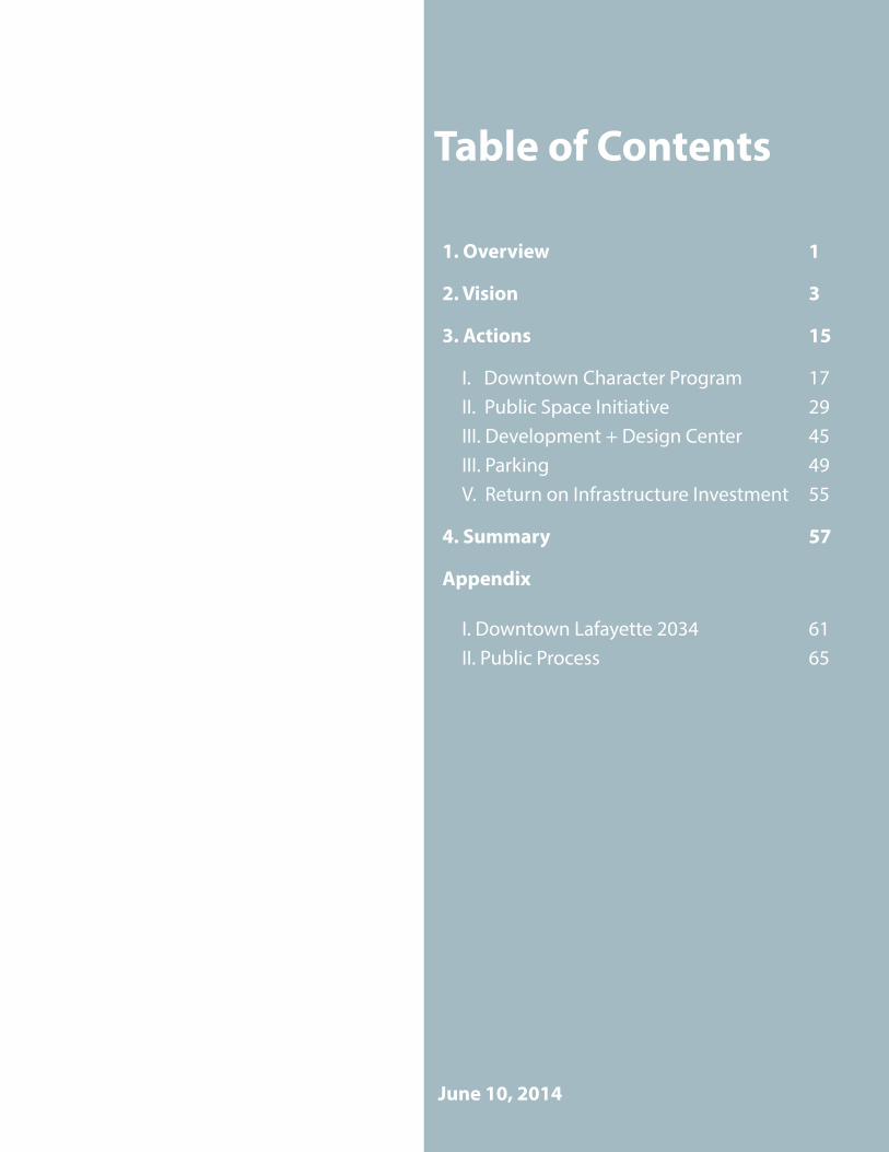
Table of Contents
1. Overview 1
2. Vision 3
3. Actions 15
I. Downtown Character Program 17II. Public Space Initiative 29III. Development + Design Center 45III. Parking 49V. Return on Infrastructure Investment 55
4. Summary 57
Appendix
I. Downtown Lafayette 2034 61II. Public Process 65
June 10, 2014

Page 1
1. Overview
Downtown Lafayette is the heart of the Acadiana region. This Downtown Action Plan (“Plan”) provides a vision for how we can leverage this important asset for the benefit of the entire region.
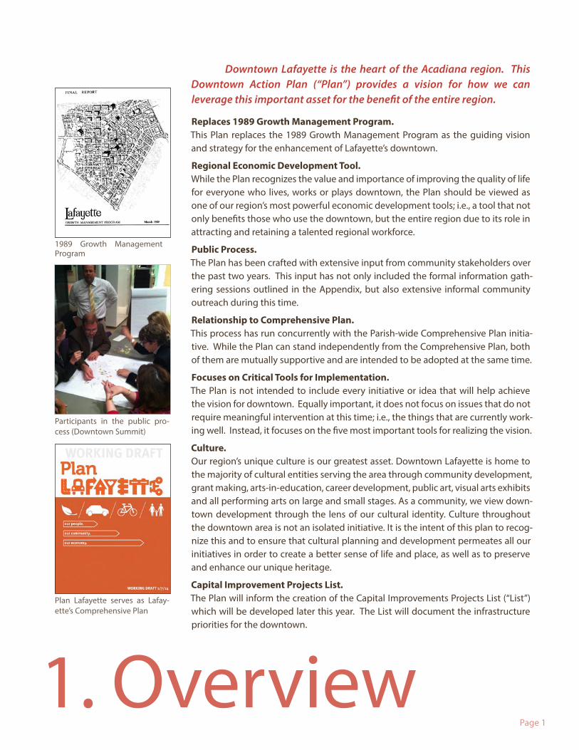
Replaces 1989 Growth Management Program. This Plan replaces the 1989 Growth Management Program as the guiding vision and strategy for the enhancement of Lafayette’s downtown.
Regional Economic Development Tool.While the Plan recognizes the value and importance of improving the quality of life for everyone who lives, works or plays downtown, the Plan should be viewed as one of our region’s most powerful economic development tools; i.e., a tool that not only benefits those who use the downtown, but the entire region due to its role in attracting and retaining a talented regional workforce.
Public Process. The Plan has been crafted with extensive input from community stakeholders over the past two years. This input has not only included the formal information gath-ering sessions outlined in the Appendix, but also extensive informal community outreach during this time.
Relationship to Comprehensive Plan. This process has run concurrently with the Parish-wide Comprehensive Plan initia-tive. While the Plan can stand independently from the Comprehensive Plan, both of them are mutually supportive and are intended to be adopted at the same time.
Focuses on Critical Tools for Implementation. The Plan is not intended to include every initiative or idea that will help achieve the vision for downtown. Equally important, it does not focus on issues that do not require meaningful intervention at this time; i.e., the things that are currently work-ing well. Instead, it focuses on the five most important tools for realizing the vision.
Culture. Our region’s unique culture is our greatest asset. Downtown Lafayette is home to the majority of cultural entities serving the area through community development, grant making, arts-in-education, career development, public art, visual arts exhibits and all performing arts on large and small stages. As a community, we view down-town development through the lens of our cultural identity. Culture throughout the downtown area is not an isolated initiative. It is the intent of this plan to recog-nize this and to ensure that cultural planning and development permeates all our initiatives in order to create a better sense of life and place, as well as to preserve and enhance our unique heritage.
Capital Improvement Projects List. The Plan will inform the creation of the Capital Improvements Projects List (“List”) which will be developed later this year. The List will document the infrastructure priorities for the downtown.
1989 Growth Management Program
Participants in the public pro-cess (Downtown Summit)
Plan Lafayette serves as Lafay-ette’s Comprehensive Plan


Page 3
2. Vision
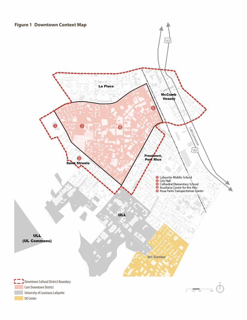
Freetown, Port Rico
Sterling Grove
La Place
Saint Streets
McCombVeazey
Spring Hill
I-49 Connector
LafayetteMiddleSchool
CathedralElementarySchool
AcadianaCenter forthe Arts
CityHall
Rosa ParksTransportationCenter
N
0 312.5 625 1,250’
W Vermilion St
W Congress St
Oliver St
W Simcoe St
Cameron St
W Main St
W Convent St
John
ston
St
Lee A
ve
W Gar�eld St
tS nhoJ tnia
S
tS etteyafaL
Buch
anan
St
Central S
tJe
�ers
on S
t
University Ave
Evangeline Thruway
W Simcoe St
Mudd Ave
Saint Landry
StDunre
ath St
Gord
on S
t
E Ta
ft St
E Pin
hook
Rd
S Chestnut St
Louisiana Ave
12th StS Magnolia St
Co H
wy
728
Saint Mary Blvd
Saint Patrick St
Myrtle Pl
Agnes St
Azalea St
Coliseum Rd
Saint Mary Blvd
E Lewis St
182
90
90
182167
167
Parks/Open Space
Commercial Core
CityPark
Youth Park
University ofLouisiana at Lafayette
Oil centerGirardPark
Downtown Cultural District BoundaryCore Downtown DistrictUniversity of Louisiana LafayetteOil Center
Figure 1 Downtown Context Map
Page 5
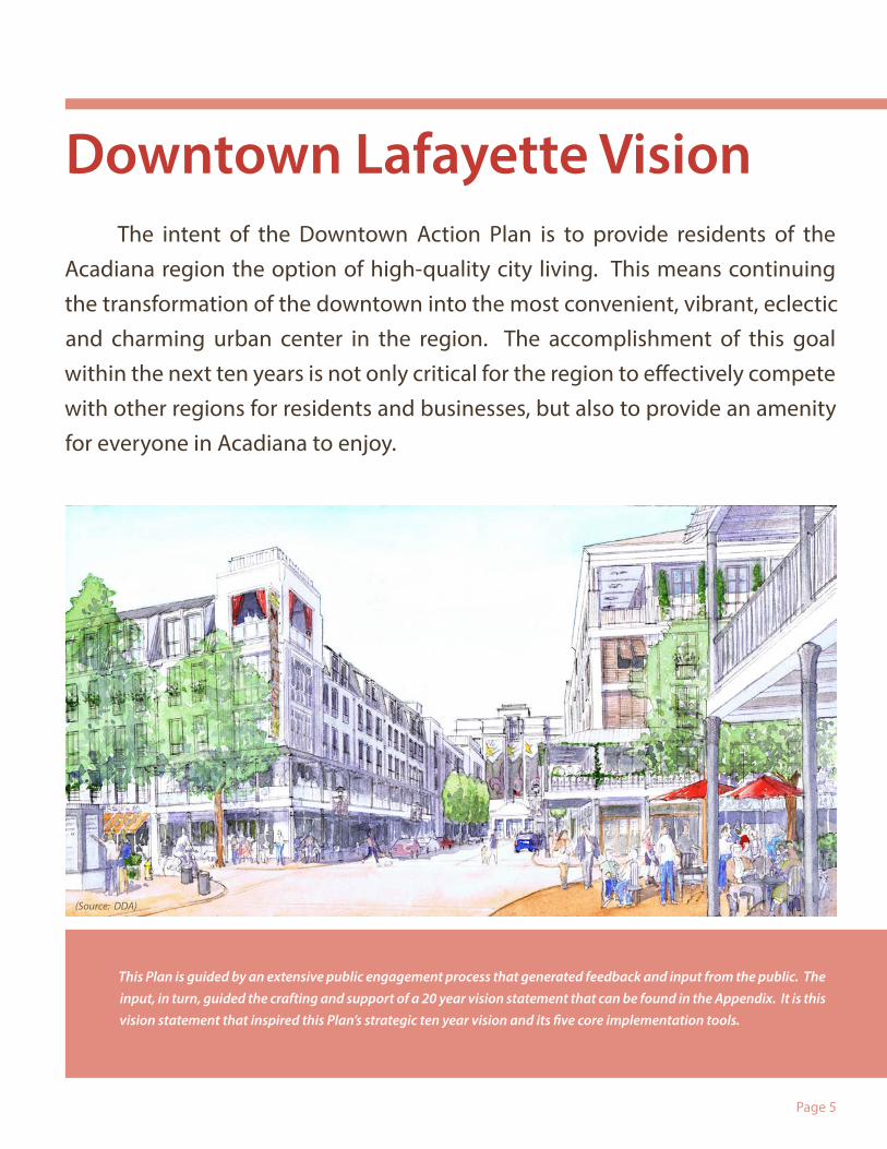
Downtown Lafayette Vision The intent of the Downtown Action Plan is to provide residents of the Acadiana region the option of high-quality city living. This means continuing the transformation of the downtown into the most convenient, vibrant, eclectic and charming urban center in the region. The accomplishment of this goal within the next ten years is not only critical for the region to effectively compete with other regions for residents and businesses, but also to provide an amenity for everyone in Acadiana to enjoy.
(Source: DDA)
This Plan is guided by an extensive public engagement process that generated feedback and input from the public. The input, in turn, guided the crafting and support of a 20 year vision statement that can be found in the Appendix. It is this vision statement that inspired this Plan’s strategic ten year vision and its five core implementation tools.
Page 6
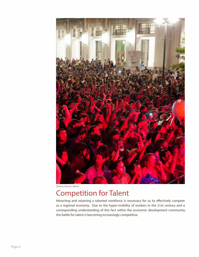
Competition for TalentAttracting and retaining a talented workforce is necessary for us to effectively compete as a regional economy. Due to the hyper-mobility of workers in the 21st century and a corresponding understanding of this fact within the economic development community, the battle for talent is becoming increasingly competitive.
(Source: Denny Culbert)
Page 7
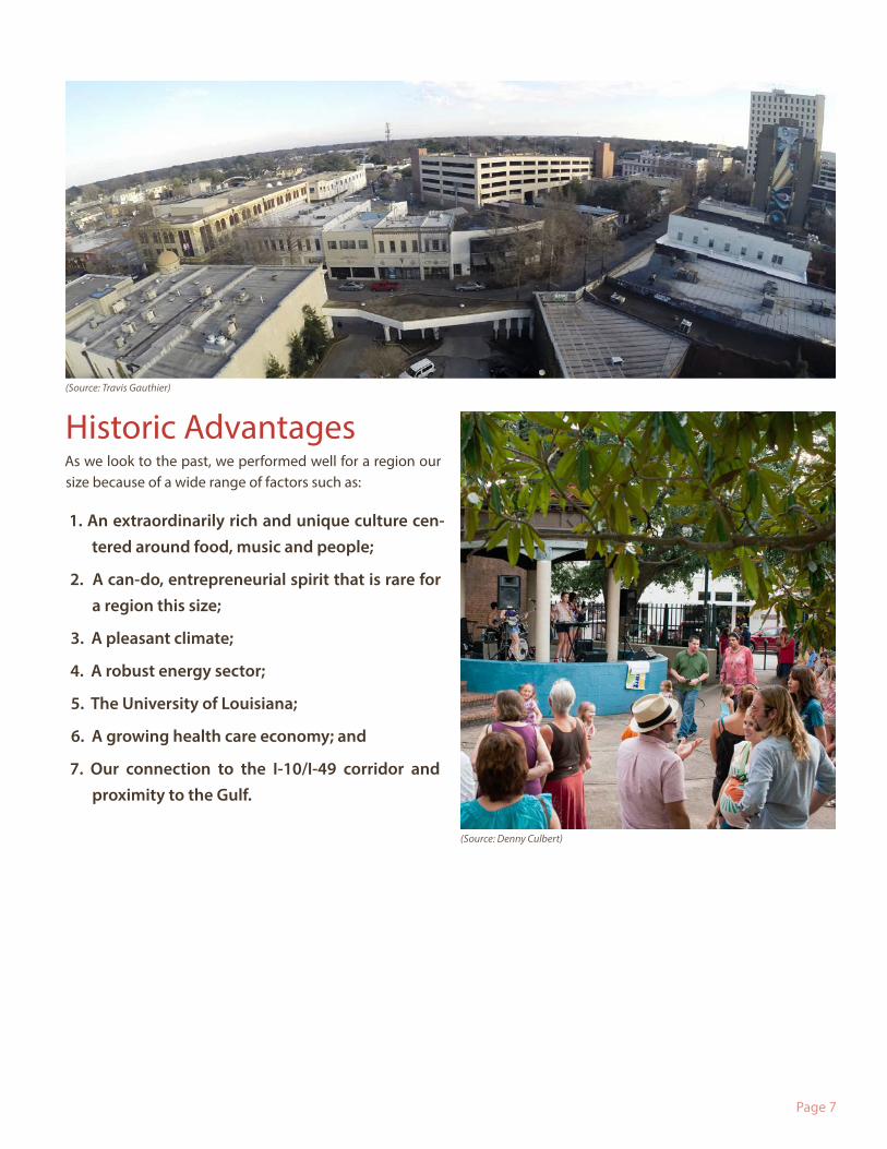
Historic Advantages As we look to the past, we performed well for a region our size because of a wide range of factors such as:
1. An extraordinarily rich and unique culture cen-tered around food, music and people;
2. A can-do, entrepreneurial spirit that is rare for a region this size;
3. A pleasant climate;
4. A robust energy sector;
5. The University of Louisiana;
6. A growing health care economy; and
7. Our connection to the I-10/I-49 corridor and proximity to the Gulf.
(Source: Denny Culbert)
(Source: Travis Gauthier)
Page 8
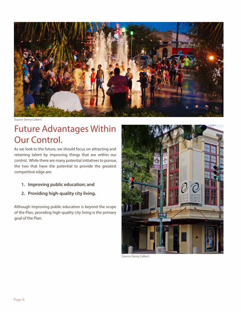
Future Advantages Within Our Control. As we look to the future, we should focus on attracting and retaining talent by improving things that are within our control. While there are many potential initiatives to pursue, the two that have the potential to provide the greatest competitive edge are:
1. Improving public education; and
2. Providing high-quality city living.
Although Improving public education is beyond the scope of the Plan, providing high-quality city living is the primary goal of the Plan.
(Source: Denny Culbert)
(Source: Denny Culbert)
Page 9
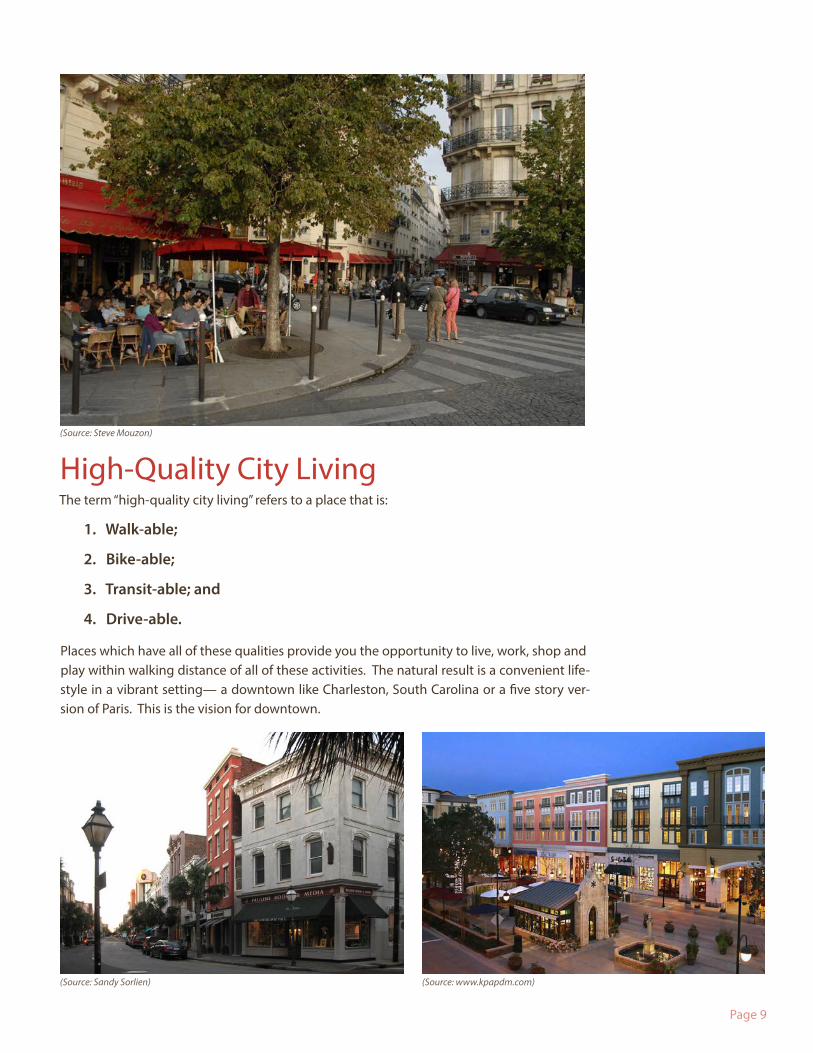
High-Quality City Living The term “high-quality city living” refers to a place that is:
1. Walk-able;
2. Bike-able;
3. Transit-able; and
4. Drive-able.
Places which have all of these qualities provide you the opportunity to live, work, shop and play within walking distance of all of these activities. The natural result is a convenient life-style in a vibrant setting— a downtown like Charleston, South Carolina or a five story ver-sion of Paris. This is the vision for downtown.
(Source: www.kpapdm.com)(Source: Sandy Sorlien)
(Source: Steve Mouzon)
Page 10
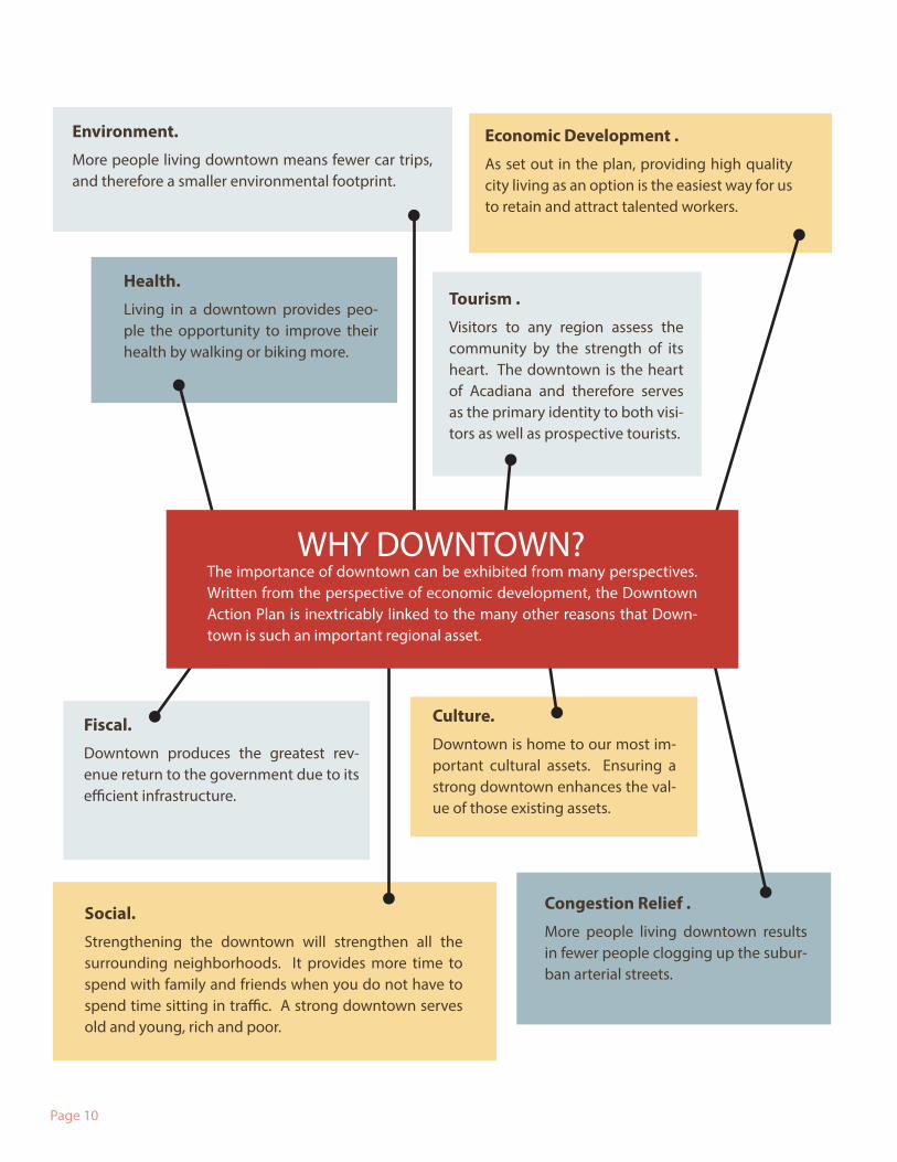
Environment.
More people living downtown means fewer car trips, and therefore a smaller environmental footprint.
Health.
Living in a downtown provides peo-ple the opportunity to improve their health by walking or biking more.
The importance of downtown can be exhibited from many perspectives. Written from the perspective of economic development, the Downtown Action Plan is inextricably linked to the many other reasons that Down-town is such an important regional asset.
Social.
Strengthening the downtown will strengthen all the surrounding neighborhoods. It provides more time to spend with family and friends when you do not have to spend time sitting in traffic. A strong downtown serves old and young, rich and poor.
Fiscal.
Downtown produces the greatest rev-enue return to the government due to its efficient infrastructure.
Economic Development .
As set out in the plan, providing high quality city living as an option is the easiest way for us to retain and attract talented workers.
Tourism .
Visitors to any region assess the community by the strength of its heart. The downtown is the heart of Acadiana and therefore serves as the primary identity to both visi-tors as well as prospective tourists.
Culture.
Downtown is home to our most im-portant cultural assets. Ensuring a strong downtown enhances the val-ue of those existing assets.
Congestion Relief .
More people living downtown results in fewer people clogging up the subur-ban arterial streets.
WHY DOWNTOWN?
Page 11
Lack of Residential OptionsIn our region, we provide high-quality rural living options as well as high-quality suburban options, but we do not pro-vide high-quality city living because of the lack of residen-tial options in the downtown’s core.
This is surprising given the downtown’s current advantages such as:
1. Region’s largest employment center;
2. Immediately adjacent to the University of Louisiana with over 17,000 students;
3. Region’s center for cultural events and assets such as the Acadiana Center for the Arts, Festival International, Lafayette Science Museum, Children’s Museum of Acadiana, Lafayette’s Main Library, Downtown Alive!, ArtWalk, Movies in the Parc, Cite des Arts, and other theaters, museums, and art galleries;
4. Region’s center for nightlife with over 30 restaurants and bars;
5. Largest concentration of parks in Lafayette;
6. Cathedral-Carmel School (pre-K to 8), First Baptist Christian School (pre-K through 8), and Ascension Episcopal School (1 thru 7);
7. Seven places of worship;
8. A wide range of businesses that cater to your retail and service support needs;
9. Region’s center for banking and legal services; and
10. The center of city and parish government and civic operations recognizing Downtown as the true heart of Lafayette.
In other words, we have a downtown that has everything someone wants from a city except a place to live!
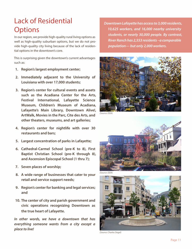
Downtown Lafayette has access to 3,000 residents, 10,625 workers, and 16,000 nearby university students, or nearly 30,000 people. By contrast, River Ranch has 2,553 residents –a comparable population— but only 2,000 workers.
(Source: DDA)
(Source: DDA)
(Source: Charles Siegel)
Page 12
The Urgency of Fixing the Imbalance
The good news is that we can fix this imbalance by implementing this Downtown Action Plan. The bad news is that without the option of high quality city living in this region, we will suffer three disadvantages that seriously undermine our regional competitiveness in the following ways:
1. Losing Talent.
Even though most folks do not desire to live in a vibrant downtown, many do. In fact, while market studies have consistently shown that a minimum of 10% of the population prefers to live in a vibrant downtown, that percentage is growing thanks to the dramatically higher interest in downtown living by the Millennial generation.
More importantly, many talented workers are unwilling to live in a place without the option of high-quality city living now that many cities offer it (unlike the 70’s 80’s and 90’s). As author Jeff Speck recently stated, “the question isn’t whether people will be moving to the city, the question is whose city they will be moving to.”
Right now our downtown can accommodate less than 1% of 1% of the region. It should come as no surprise that certain types of companies and very large companies are having an unnecessarily hard time recruiting a certain percentage of their workforce due to the lack of high-quality city living.
2. Weaker Identity.
Visitors, prospective companies and residents tend to judge a community based upon its downtown. We can see the importance of this symbolic role if we simply Google the name of any city and look up the images that the search produces. Invariably, the most common generic image is a photo of the heart of the community; i.e., the downtown. It should also come as no surprise that local television stations usually use a downtown skyline as the backdrop to the news.
Improving the downtown toward the look and feel of a five story Paris will dramatically improve our image, and therefore our ability to attract and retain talent.
3. Lower Quality of Life.
The quality of the downtown impacts all of the citizens in our region, not just those who live down-town.
First, there are many citizens who take advantage of the cultural and recreational opportunities downtown. Providing an even more compelling visiting environment will improve the experience of living in Acadiana.
Second, there are many citizens who never come downtown but remain indirectly impacted. For ex-ample, he or she might have a relative such as a son, daughter, niece, nephew or grandson or grand-daughter that will move away so long as they cannot experience high-quality city living. Similarly, he or she will be impacted if his or her employer decides to move to another region in order to secure the full range of workers they need; i.e., not only workers who choose a suburban or rural lifestyle, but also workers who will only choose a region that offers the choice of high-quality city living.
Page 13
The Five Tools To fulfill our vision for high quality city living, we must harness the power of the following five tools that are detailed in this Downtown Action Plan.
I. Downtown Character Program;
II. Public Space Initiative;
III. Development & Design Center;
IV. Parking Infrastructure & Management; and
V. Return on Infrastructure Investment Analysis Tool.
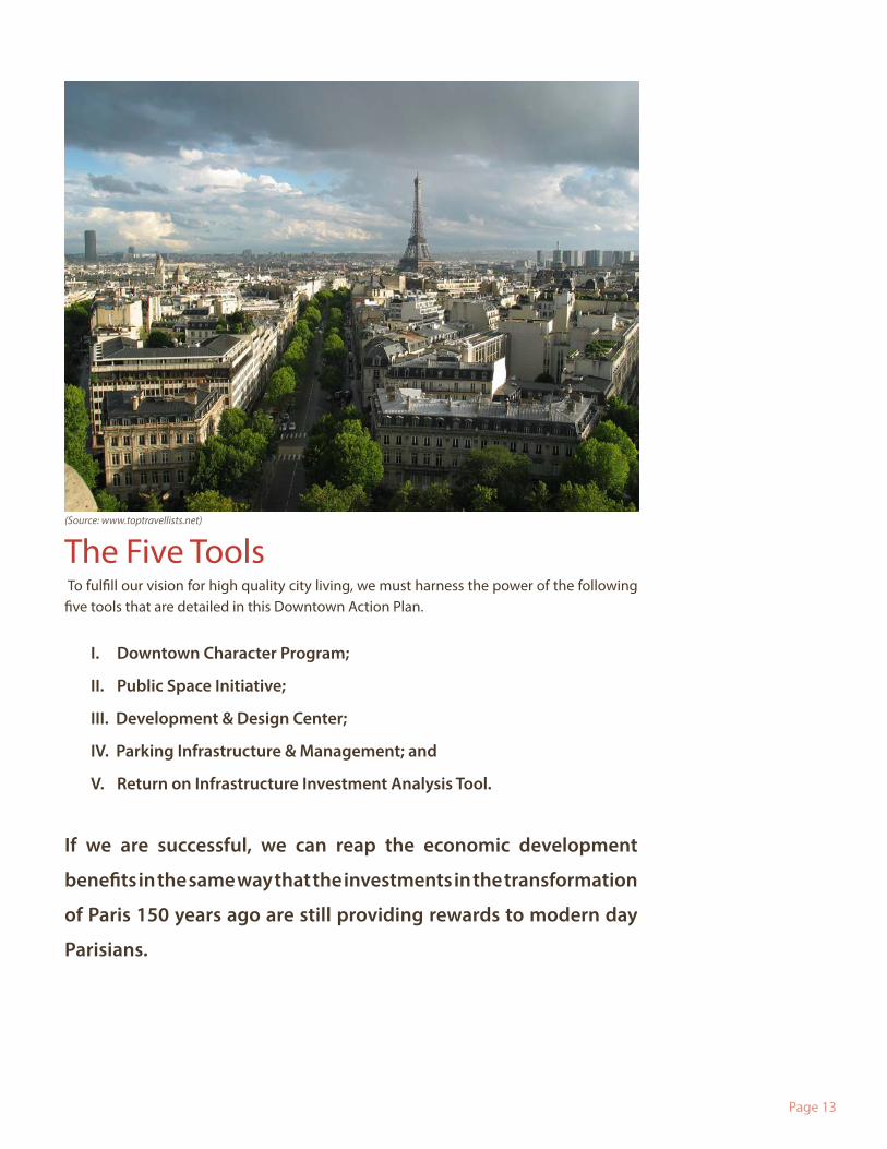
If we are successful, we can reap the economic development
benefits in the same way that the investments in the transformation
of Paris 150 years ago are still providing rewards to modern day
Parisians.
(Source: www.toptravellists.net)


Page 15
3. Actions

Page 16
Page 17
The focus of the Downtown Action Plan is to deliver high-quality city living. The primary strategy for delivering high-quality city living is to implement a Downtown Character Program that safeguards the downtown from development that undermines the three advantages our downtown has over its suburban or rural counterparts. Those three advantages are:
1. Convenience;
2. Vibrancy; and
3. Outdoor Rooms.
Set out below is a detailed description of these advantages along with the physical attri-butes of development that can enhance each of these characteristics.
I. Downtown Character Program
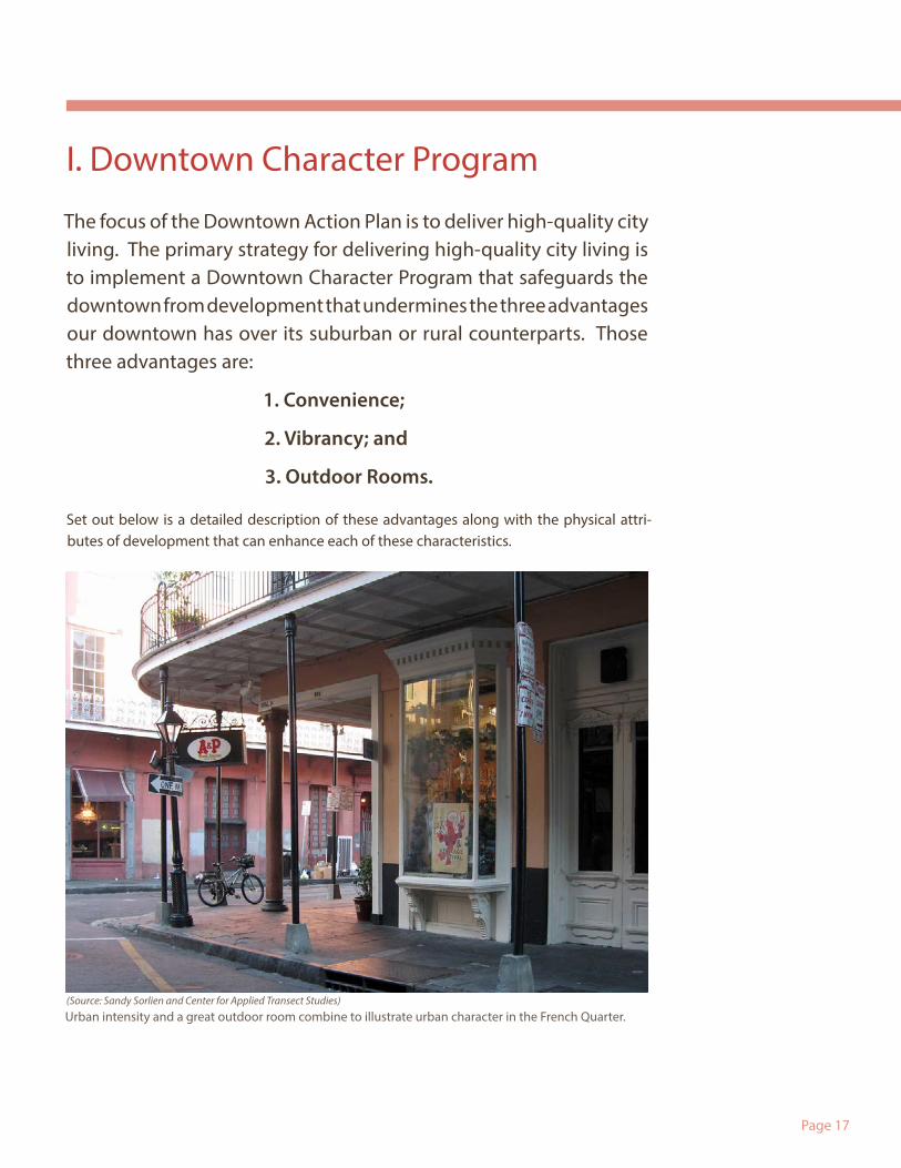
Urban intensity and a great outdoor room combine to illustrate urban character in the French Quarter. (Source: Sandy Sorlien and Center for Applied Transect Studies)
Page 18
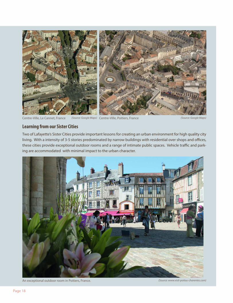
Learning from our Sister CitiesTwo of Lafayette’s Sister Cities provide important lessons for creating an urban environment for high quality city living. With a intensity of 3-5 stories predominated by narrow buildings with residential over shops and offices, these cities provide exceptional outdoor rooms and a range of intimate public spaces. Vehicle traffic and park-ing are accommodated with minimal impact to the urban character.
Centre-Ville, Le Cannet, France
An exceptional outdoor room in Poitiers, France.
Centre-Ville, Poitiers, France(Source: Google Maps) (Source: Google Maps)
(Source: www.visit-poitou-charentes.com)
Page 19
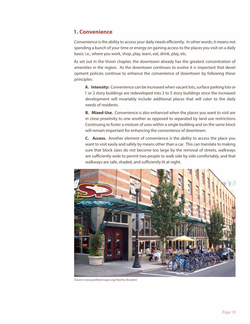
1. Convenience
Convenience is the ability to access your daily needs efficiently. In other words, it means not spending a bunch of your time or energy on gaining access to the places you visit on a daily basis; i.e., where you work, shop, play, learn, eat, drink, play, etc.
As set out in the Vision chapter, the downtown already has the greatest concentration of amenities in the region. As the downtown continues to evolve it is important that devel-opment policies continue to enhance the convenience of downtown by following these principles:
A. Intensity: Convenience can be increased when vacant lots, surface parking lots or 1 or 2 story buildings are redeveloped into 3 to 5 story buildings since the increased development will invariably include additional places that will cater to the daily needs of residents.
B. Mixed-Use. Convenience is also enhanced when the places you want to visit are in close proximity to one another as opposed to separated by land use restrictions. Continuing to foster a mixture of uses within a single building and on the same block will remain important for enhancing the convenience of downtown.
C. Access. Another element of convenience is the ability to access the place you want to visit easily and safely by means other than a car. This can translate to making sure that block sizes do not become too large by the removal of streets, walkways are sufficiently wide to permit two people to walk side by side comfortably, and that walkways are safe, shaded, and sufficiently lit at night.
(Source: www.pedbikeimages.org/Heather Bowden)
Page 20
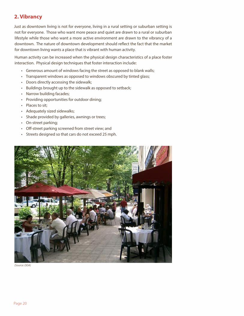
2. Vibrancy
Just as downtown living is not for everyone, living in a rural setting or suburban setting is not for everyone. Those who want more peace and quiet are drawn to a rural or suburban lifestyle while those who want a more active environment are drawn to the vibrancy of a downtown. The nature of downtown development should reflect the fact that the market for downtown living wants a place that is vibrant with human activity.
Human activity can be increased when the physical design characteristics of a place foster interaction. Physical design techniques that foster interaction include:
• Generous amount of windows facing the street as opposed to blank walls;• Transparent windows as opposed to windows obscured by tinted glass;• Doors directly accessing the sidewalk;• Buildings brought up to the sidewalk as opposed to setback;• Narrow building facades;• Providing opportunities for outdoor dining;• Places to sit;• Adequately sized sidewalks;• Shade provided by galleries, awnings or trees;• On-street parking;• Off-street parking screened from street view; and• Streets designed so that cars do not exceed 25 mph.
(Source: DDA)
Page 21(Source: DDA)
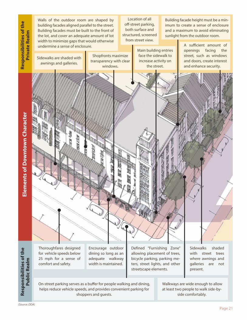
Building facade height must be a min-imum to create a sense of enclosure and a maximum to avoid eliminating sunlight from the outdoor room.
Sidewalks are shaded with awnings and galleries.
Sidewalks shaded with street trees where awnings and galleries are not present.
Main building entries face the sidewalk to increase activity on
the street.
Elem
ents
of D
ownt
own
Char
acte
r
Walkways are wide enough to allow at least two people to walk side-by-
side comfortably.
Defined “Furnishing Zone” allowing placement of trees, bicycle parking, parking me-ters, street lights, and other streetscape elements.
Location of all off-street parking, both surface and
structured, screened from street view.
Thoroughfares designed for vehicle speeds below 25 mph for a sense of comfort and safety.
Encourage outdoor dining so long as an adequate walkway width is maintained.
On-street parking serves as a buffer for people walking and dining, helps reduce vehicle speeds, and provides convenient parking for
shoppers and guests.
Shopfronts maximize transparency with clear
windows.
Walls of the outdoor room are shaped by building facades aligned parallel to the street. Building facades must be built to the front of the lot, and cover an adequate amount of lot width to minimize gaps that would otherwise undermine a sense of enclosure. A sufficient amount of
openings facing the street, such as windows and doors, create interest and enhance security.Re
spon
sibi
litie
s of
the
Priv
ate
Real
mRe
spon
sibi
litie
s of
the
Publ
ic R
ealm
Page 22(Source: DDA)
Ana
tom
y o
f an
Out
door
Roo
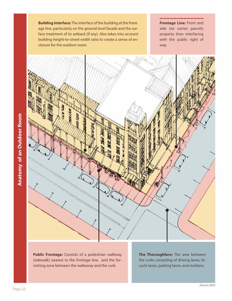
mFrontage Line: Front and side (on corner parcels) property lines interfacing with the public right of way.
Public Frontage: Consists of a pedestrian walkway (sidewalk) nearest to the frontage line, and the fur-nishing zone between the walkaway and the curb.
The Thoroughfare: The area between the curbs consisting of driving lanes, bi-cycle lanes, parking lanes, and medians.
Building Interface: The interface of the building at the front-age line, particularly on the ground level facade and the sur-face treatment of its setback (if any). Also takes into account building height-to-street width ratio to create a sense of en-closure for the outdoor room.
Page 23
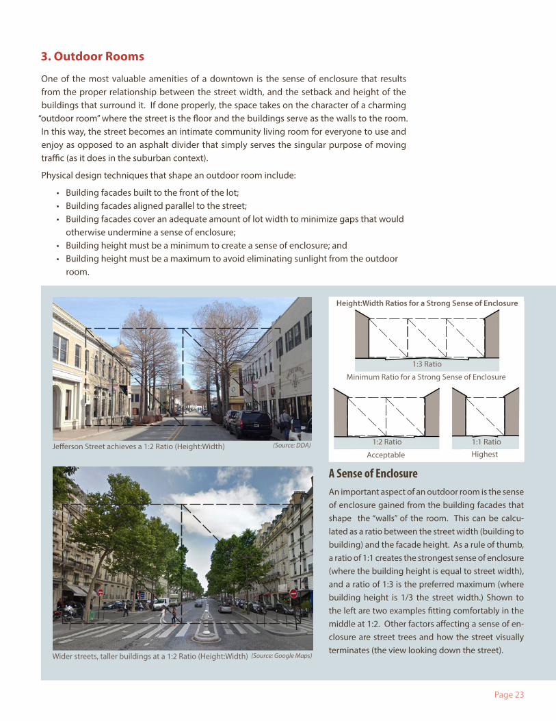
3. Outdoor Rooms
One of the most valuable amenities of a downtown is the sense of enclosure that results from the proper relationship between the street width, and the setback and height of the buildings that surround it. If done properly, the space takes on the character of a charming
“outdoor room” where the street is the floor and the buildings serve as the walls to the room. In this way, the street becomes an intimate community living room for everyone to use and enjoy as opposed to an asphalt divider that simply serves the singular purpose of moving traffic (as it does in the suburban context).
Physical design techniques that shape an outdoor room include:
• Building facades built to the front of the lot;• Building facades aligned parallel to the street;• Building facades cover an adequate amount of lot width to minimize gaps that would
otherwise undermine a sense of enclosure;• Building height must be a minimum to create a sense of enclosure; and• Building height must be a maximum to avoid eliminating sunlight from the outdoor
room.
(Source: Google Maps)
(Source: DDA)
A Sense of EnclosureAn important aspect of an outdoor room is the sense of enclosure gained from the building facades that shape the “walls” of the room. This can be calcu-lated as a ratio between the street width (building to building) and the facade height. As a rule of thumb, a ratio of 1:1 creates the strongest sense of enclosure (where the building height is equal to street width), and a ratio of 1:3 is the preferred maximum (where building height is 1/3 the street width.) Shown to the left are two examples fitting comfortably in the middle at 1:2. Other factors affecting a sense of en-closure are street trees and how the street visually terminates (the view looking down the street).
Jefferson Street achieves a 1:2 Ratio (Height:Width)
Minimum Ratio for a Strong Sense of Enclosure
Height:Width Ratios for a Strong Sense of Enclosure
Acceptable Highest
1:2 Ratio 1:1 Ratio
1:3 Ratio
Wider streets, taller buildings at a 1:2 Ratio (Height:Width)
Page 24
Downtown Character Program Implementation
In order to implement the policies required to generate convenience, vibrancy and outdoor rooms, the Downtown Character Program consists of two specific action items:
1. Creation and Adoption of Updated Zoning Code.The primary implementation strategy is to update the downtown zoning code so that it provides greater certainty and predictability on the character of what is built downtown. The code should clearly illustrate requirements through easy to understand graphics that are focused on the physical design techniques that are referenced above. The update will be conducted in conjunction with the citywide Unified Development Code (UDC) update process, although it should be crafted so that it can immediately replace the Central Busi-ness District (CBD) zoning requirements (while still ensuring compatibility for integration into the future UDC).
2. Rail Line Quiet ZoneThe character of the downtown is not only limited to things that you see, but also things that you hear. There are five railroad crossings within the downtown district, and several others in the immediate vicinity of the downtown district. The horns of the train are so loud that they reduce the marketability of living close to the railroad tracks.
In order to mitigate the negative impact of the noise, the downtown should seek to estab-lish a New Quiet Zone or Partial Quiet Zone wherein supplemental safety measures and/or wayside horns replace the train horns during specified times or altogether.
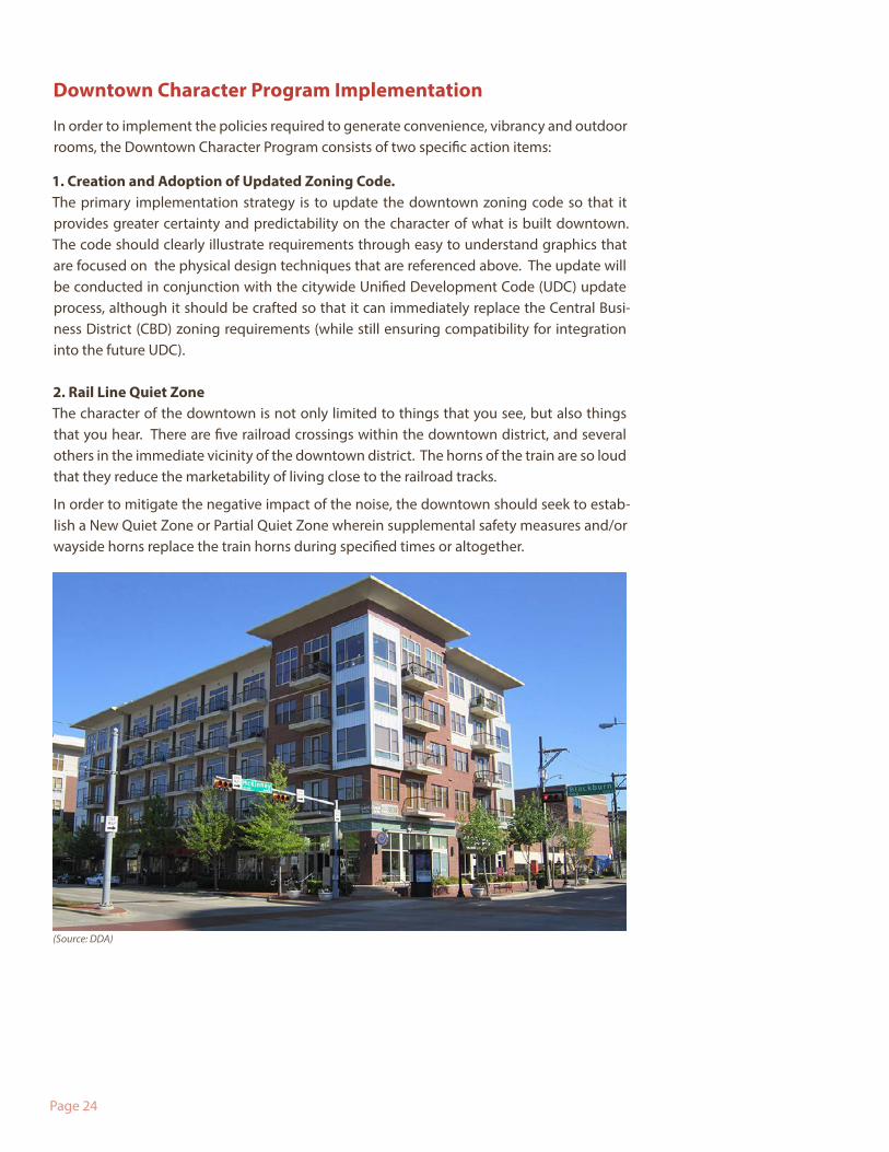
(Source: DDA)
Page 25
I. Downtown Character Program: Actions & Investments1. Continue to work toward adopting an updated downtown zoning code in conjunction with the citywide Unified Development Code update process.
2. Establish a process to coordinate and adopt a Rail Line Quiet Zone.
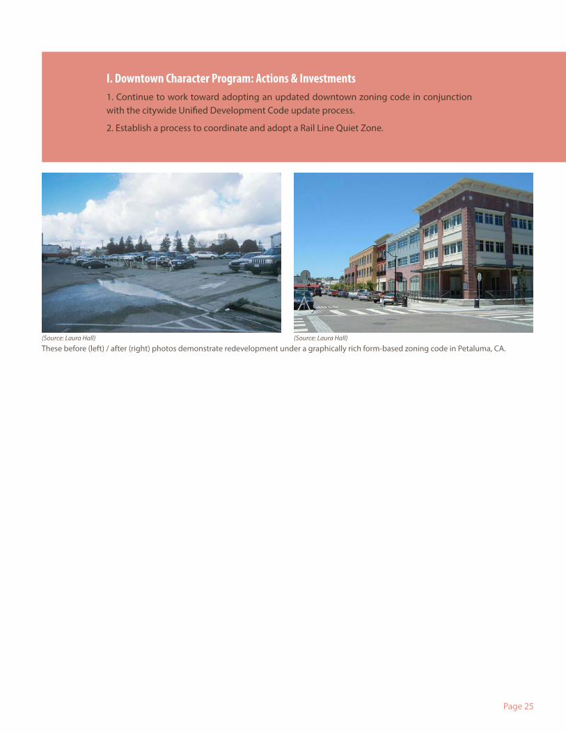
(Source: Laura Hall) (Source: Laura Hall)
These before (left) / after (right) photos demonstrate redevelopment under a graphically rich form-based zoning code in Petaluma, CA.

Page 26
Figure 2 Aligning with Plan Lafayette: Future Land Uses
Page 27
Aligning with Plan Lafayette
The Lafayette Downtown Action Plan is a key piece of Lafayette’s new comprehensive plan. It pro-vides the guide to improve and build on the success of downtown, the largest of the future growth centers designated for new population and jobs over the next 20-25 years. Plan Lafayette guides the character of development intensity through a Future Land Use Map. The Future Land Use Map is intended to set the direction for specific changes to the zoning map and ongoing decisions about neighborhood and land use planning and infrastructure. Focusing on the downtown, Fig-ure 2 demonstrates the application of Plan Lafayette’s future land use categories. Plan Lafayette defines these land use categories as follows:
Downtown Core (Mixed Use Center): Core mixed-use areas of the parish, including downtown. Uses include retail, office, services, restaurants, and residential. The mixed-use centers are envisioned as walkable districts served by transit. The mixed-use centers are anticipated to range in scale and density. The highest density uses and activity would take place downtown, with more moderate density and uses in the outlying centers.
Transitional Mixed Use: Includes both commercial and residential mixed-uses. The tran-sitional mixed-use category is anticipated to serve as a transition between higher density mixed use (from the mixed-use center) to residential or other lower density uses. It is envisioned to include residential, retail, and office in a walkable neighborhood along a transportation corridor or as a ring surrounding a mixed-use center in a walkable, pedes-trian friendly pattern.
Residential/Related: Predominantly detached, single family neighborhoods that also include appropriately located semi-attached and attached multifamily dwelling units. Neighborhood retail, services, offices, and institutions are also included in appropriate locations (e.g., along transportation corridors or at intersections).
Commercial/Office (Commercial Corridor): Includes general commercial and employ-ment uses, such as neighborhood retail, services, office, and limited residential. The scale of uses will vary based on the context surrounding each area. Newly developed and rede-veloped areas are encouraged to accommodate all types of users – including pedestrians, bicyclists, transit users, and motorists.
The public engagement process for the downtown also identified some downtown-specific cat-egories:
University Residential: Provides a mixed use district connecting Downtown with the University and to protect the character of Freetown with building intensity that matches the existing character of the neighborhood. Also facilitates a vital mixed use corridor to connect the downtown to UL Lafayette via McKinley and Jefferson Streets.
Light Industrial & Supportive Uses: Provides opportunities for light manufacturing (non-noxious industrial uses that do not require buffering) and adaptive reuse of indus-trial buildings along the rail corridor. Adaptive reuse could support industrial arts ware-houses, technology incubators, and other creative-class initiatives. This area could also be considered for future Mixed Use Center and Transitional Mixed Use categories.
Page 28
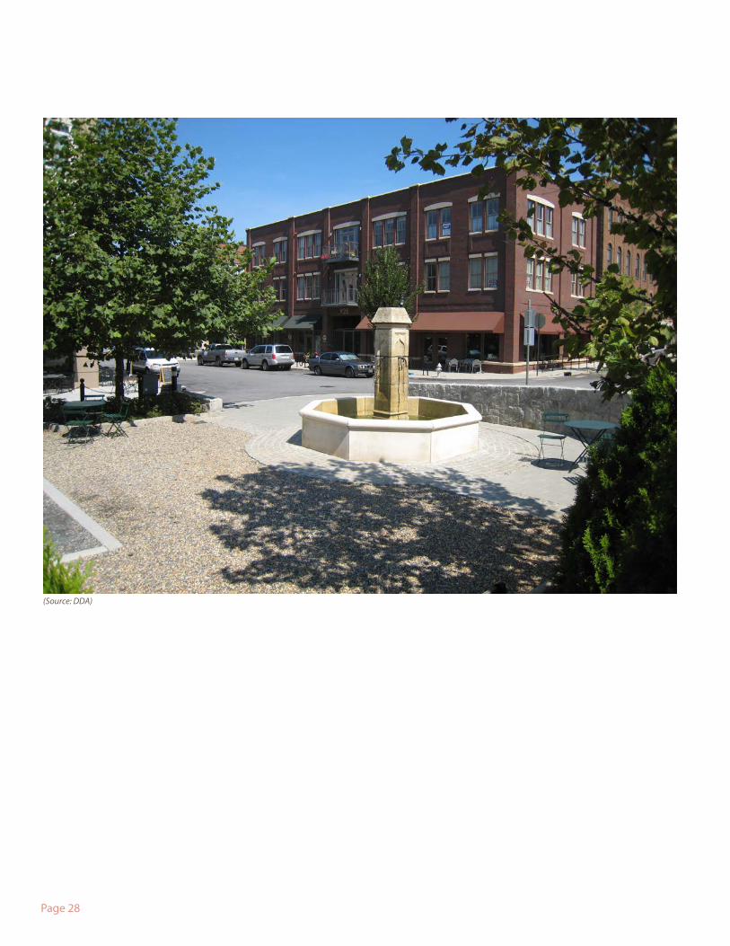
(Source: DDA)
Page 29
Public spaces are those parts of the downtown we own and use collectively as citizens. These places are what brings together everyone in our community regardless of their age, wage or stage of life. In short, these are “the commons” of our community. They include not only parks, plazas, and squares, but also our streets: the largest and most significant of our public spaces. A trade-off for living in more compact, mixed use places is the availability of high quality public spaces within walkable proximity. Further, as the downtown serves as a cultural hub to the entire region, our public spaces also play host to a wide range of cultural activities and events. To provide high quality city living, we must dramatically improve the quality of our streets and maintain, improve, and expand upon our parks, squares, and plazas.
The following are priorities for public space in the downtown:
1. Streetscape Renovations for Internal Streets
2. Public Space Expansion and Improvements
3. New Public Spaces
4. Creativity Everywhere, Public Art & the Community Culture Plan
5. Outdoor Dining
6. Conversion of Suburban Arterials
7. Gateways and Signage
8. Connections
9. Cycling Mobility
10. I-49 Interface
11. Transit Mobility
II. Public Space Initiative
Page 30
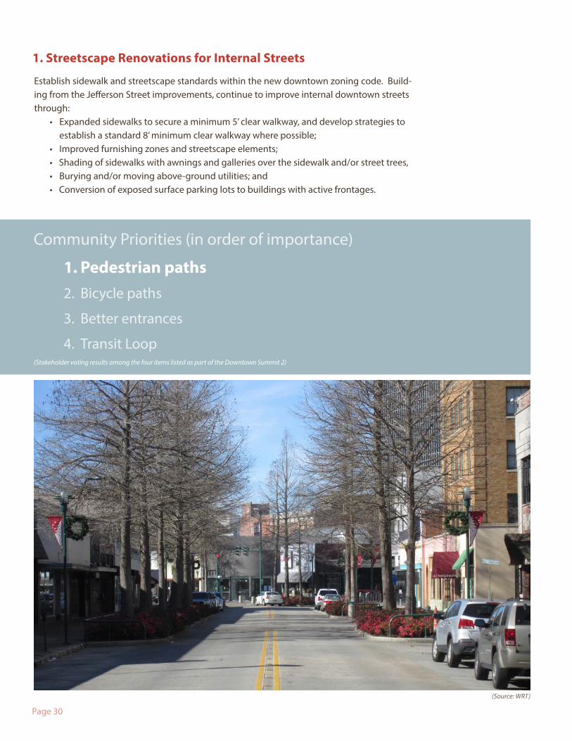
1. Streetscape Renovations for Internal Streets
Establish sidewalk and streetscape standards within the new downtown zoning code. Build-ing from the Jefferson Street improvements, continue to improve internal downtown streets through:
• Expanded sidewalks to secure a minimum 5’ clear walkway, and develop strategies to establish a standard 8’ minimum clear walkway where possible;
• Improved furnishing zones and streetscape elements;• Shading of sidewalks with awnings and galleries over the sidewalk and/or street trees, • Burying and/or moving above-ground utilities; and• Conversion of exposed surface parking lots to buildings with active frontages.
Community Priorities (in order of importance)
1. Pedestrian paths2. Bicycle paths
3. Better entrances
4. Transit Loop
(Source: WRT)
(Stakeholder voting results among the four items listed as part of the Downtown Summit 2)
Page 31
Community Priorities (in order of importance)
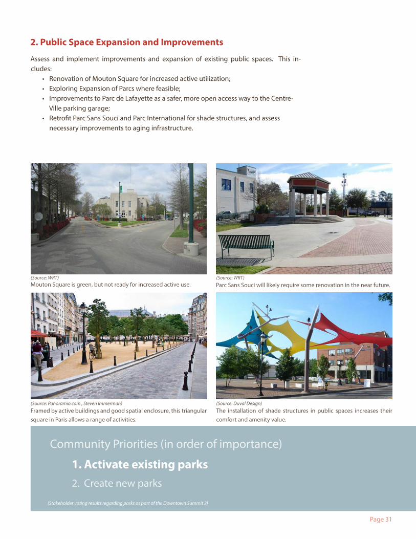
1. Activate existing parks2. Create new parks
Mouton Square is green, but not ready for increased active use.
Framed by active buildings and good spatial enclosure, this triangular square in Paris allows a range of activities.
The installation of shade structures in public spaces increases their comfort and amenity value.
Parc Sans Souci will likely require some renovation in the near future.
2. Public Space Expansion and Improvements
Assess and implement improvements and expansion of existing public spaces. This in-cludes:
• Renovation of Mouton Square for increased active utilization;• Exploring Expansion of Parcs where feasible;• Improvements to Parc de Lafayette as a safer, more open access way to the Centre-
Ville parking garage;• Retrofit Parc Sans Souci and Parc International for shade structures, and assess
necessary improvements to aging infrastructure.
(Source: WRT) (Source: WRT)
(Source: Duval Design)(Source: Panoramio.com , Steven Immerman)
(Stakeholder voting results regarding parks as part of the Downtown Summit 2)
Page 32
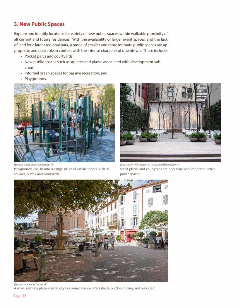
3. New Public Spaces
Explore and identify locations for variety of new public spaces within walkable proximity of all current and future residences. With the availability of larger event spaces, and the lack of land for a larger regional park, a range of smaller and more intimate public spaces are ap-propriate and desirable in context with the intense character of downtown. These include:
• Pocket parcs and courtyards;• New public spaces such as squares and plazas associated with development sub-
areas;• Informal green spaces for passive recreation; and• Playgrounds.
Small plazas and courtyards are necessary and important urban public spaces.
Playgrounds can fit into a range of small urban spaces such as squares, plazas, and courtyards.
A small, intimate plaza in sister city Le Cannet, France offers shade, outdoor dining, and public art.
(Source: www.glenwoodnyc.com)
(Source: www.kiechle.com)
(Source: Jim Henderson at www.en.wikipedia.com)
Page 33
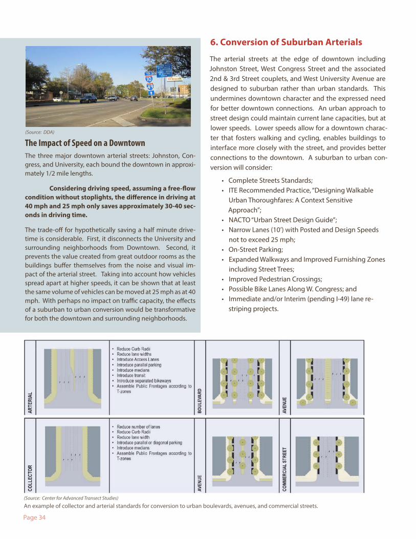
5. Outdoor Dining
Identify and implement outdoor dining opportunities including paving selected planting areas along Jefferson Street and/or selectively occupying on-street parking spaces for dining.
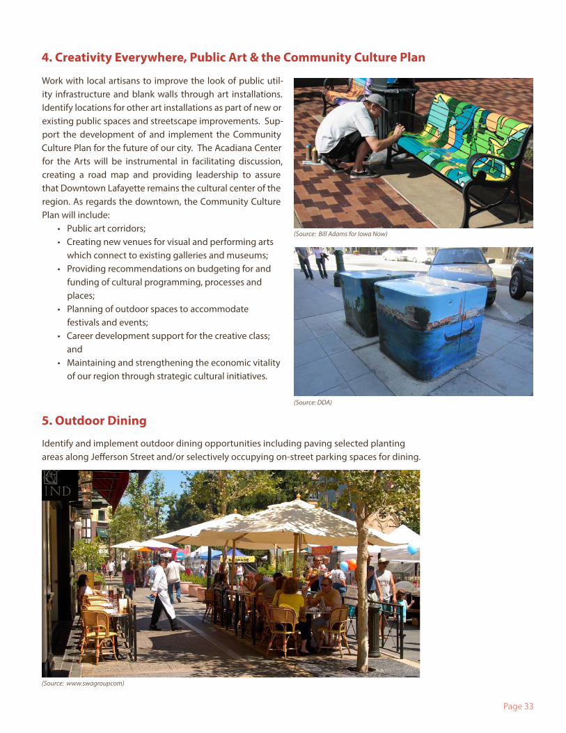
Work with local artisans to improve the look of public util-ity infrastructure and blank walls through art installations. Identify locations for other art installations as part of new or existing public spaces and streetscape improvements. Sup-port the development of and implement the Community Culture Plan for the future of our city. The Acadiana Center for the Arts will be instrumental in facilitating discussion, creating a road map and providing leadership to assure that Downtown Lafayette remains the cultural center of the region. As regards the downtown, the Community Culture Plan will include:
• Public art corridors; • Creating new venues for visual and performing arts
which connect to existing galleries and museums; • Providing recommendations on budgeting for and
funding of cultural programming, processes and places;
• Planning of outdoor spaces to accommodate festivals and events;
• Career development support for the creative class; and
• Maintaining and strengthening the economic vitality of our region through strategic cultural initiatives.
4. Creativity Everywhere, Public Art & the Community Culture Plan
(Source: www.swagroupcom)
(Source: DDA)
(Source: Bill Adams for Iowa Now)
Page 34
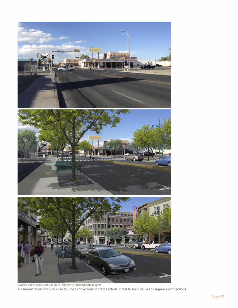
6. Conversion of Suburban Arterials
The arterial streets at the edge of downtown including Johnston Street, West Congress Street and the associated 2nd & 3rd Street couplets, and West University Avenue are designed to suburban rather than urban standards. This undermines downtown character and the expressed need for better downtown connections. An urban approach to street design could maintain current lane capacities, but at lower speeds. Lower speeds allow for a downtown charac-ter that fosters walking and cycling, enables buildings to interface more closely with the street, and provides better connections to the downtown. A suburban to urban con-version will consider:
• Complete Streets Standards;• ITE Recommended Practice, “Designing Walkable
Urban Thoroughfares: A Context Sensitive Approach”;
• NACTO “Urban Street Design Guide”;• Narrow Lanes (10’) with Posted and Design Speeds
not to exceed 25 mph;• On-Street Parking;• Expanded Walkways and Improved Furnishing Zones
including Street Trees;• Improved Pedestrian Crossings;• Possible Bike Lanes Along W. Congress; and• Immediate and/or Interim (pending I-49) lane re-
striping projects.
An example of collector and arterial standards for conversion to urban boulevards, avenues, and commercial streets.
The Impact of Speed on a DowntownThe three major downtown arterial streets: Johnston, Con-gress, and University, each bound the downtown in approxi-mately 1/2 mile lengths.
Considering driving speed, assuming a free-flow condition without stoplights, the difference in driving at 40 mph and 25 mph only saves approximately 30-40 sec-onds in driving time.
The trade-off for hypothetically saving a half minute drive-time is considerable. First, it disconnects the University and surrounding neighborhoods from Downtown. Second, it prevents the value created from great outdoor rooms as the buildings buffer themselves from the noise and visual im-pact of the arterial street. Taking into account how vehicles spread apart at higher speeds, it can be shown that at least the same volume of vehicles can be moved at 25 mph as at 40 mph. With perhaps no impact on traffic capacity, the effects of a suburban to urban conversion would be transformative for both the downtown and surrounding neighborhoods.
(Source: Center for Advanced Transect Studies)
(Source: DDA)
Page 35
A demonstration of a suburban to urban conversion of a large arterial street to build value and improve connections.(Source: City of Las Cruces,NM; Steve Price, www. urbanadvantage.com)
Page 36
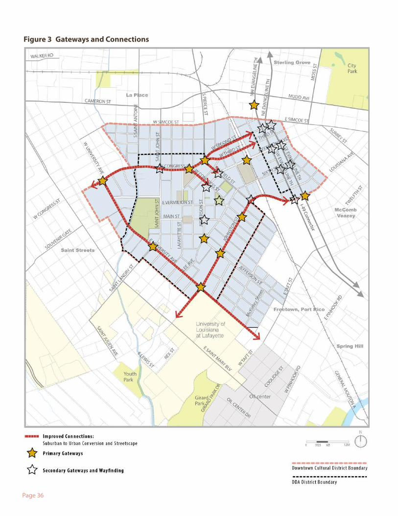
Figure 3 Gateways and Connections
Page 37
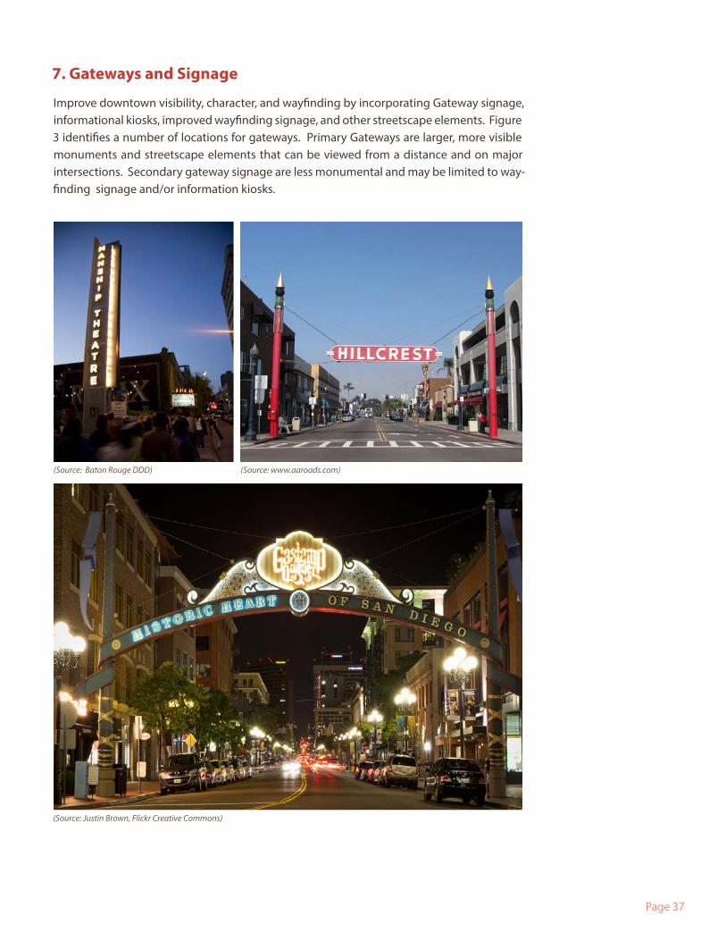
7. Gateways and Signage
Improve downtown visibility, character, and wayfinding by incorporating Gateway signage, informational kiosks, improved wayfinding signage, and other streetscape elements. Figure 3 identifies a number of locations for gateways. Primary Gateways are larger, more visible monuments and streetscape elements that can be viewed from a distance and on major intersections. Secondary gateway signage are less monumental and may be limited to way-finding signage and/or information kiosks.
(Source: Baton Rouge DDD)
(Source: Justin Brown, Flickr Creative Commons)
(Source: www.aaroads.com)
Page 38
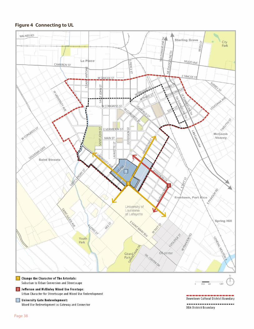
Figure 4 Connecting to UL
Page 39
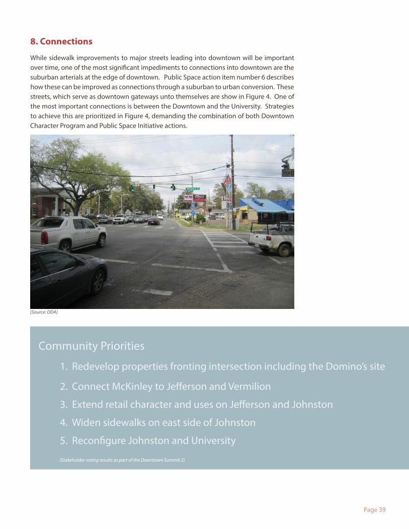
8. Connections
While sidewalk improvements to major streets leading into downtown will be important over time, one of the most significant impediments to connections into downtown are the suburban arterials at the edge of downtown. Public Space action item number 6 describes how these can be improved as connections through a suburban to urban conversion. These streets, which serve as downtown gateways unto themselves are show in Figure 4. One of the most important connections is between the Downtown and the University. Strategies to achieve this are prioritized in Figure 4, demanding the combination of both Downtown Character Program and Public Space Initiative actions.
Community Priorities
1. Redevelop properties fronting intersection including the Domino’s site
2. Connect McKinley to Jefferson and Vermilion
3. Extend retail character and uses on Jefferson and Johnston
4. Widen sidewalks on east side of Johnston
5. Reconfigure Johnston and University
(Stakeholder voting results as part of the Downtown Summit 2)
(Source: DDA)
Page 40
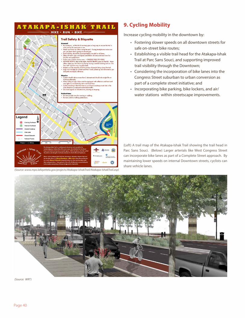
9. Cycling Mobility
Increase cycling mobility in the downtown by:
• Fostering slower speeds on all downtown streets for safe on-street bike routes;
• Establishing a visible trail head for the Atakapa-Ishak Trail at Parc Sans Souci, and supporting improved trail visibility through the Downtown;
• Considering the incorporation of bike lanes into the Congress Street suburban to urban conversion as part of a complete street initiative; and
• Incorporating bike parking, bike lockers, and air/ water stations within streetscape improvements.
(Left) A trail map of the Atakapa-Ishak Trail showing the trail head in Parc Sans Souci. (Below) Larger arterials like West Congress Street can incorporate bike lanes as part of a Complete Street approach. By maintaining lower speeds on internal Downtown streets, cyclists can share vehicle lanes.
(Source: WRT)
(Source: www.mpo.lafayettela.gov/projects/Atakapa-IshakTrail/Atakapa-IshakTrail.asp)
Page 41
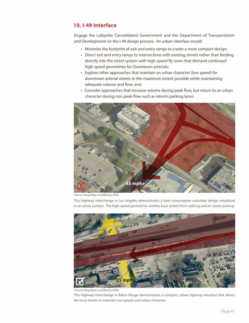
10. I-49 Interface
Engage the Lafayette Consolidated Government and the Department of Transportation and Development on the I-49 design process. An urban interface would:
• Minimize the footprint of exit and entry ramps to create a more compact design;• Direct exit and entry ramps to intersections with existing streets rather than feeding
directly into the street system with high-speed fly overs that demand continued high speed geometries for Downtown arterials;
• Explore other approaches that maintain an urban character (low speed) for downtown arterial streets to the maximum extent possible while maintaining adequate volume and flow; and
• Consider approaches that increase volume during peak flow, but return to an urban character during non peak-flow such as interim parking lanes.
This highway interchange in Baton Rouge demonstrates a compact, urban highway interface that allows the local streets to maintain low speeds and urban character.
This highway interchange in Los Angeles demonstrates a land consumptive suburban design misplaced in an urban context. The high-speed geometries sterilize local streets from walking and on-street parking.
(Source: Bing Maps modified by DDA)
(Source: Bing Maps modified by DDA)
45 mph+
25 mph
X
✓
Page 42
11.Transit Mobility
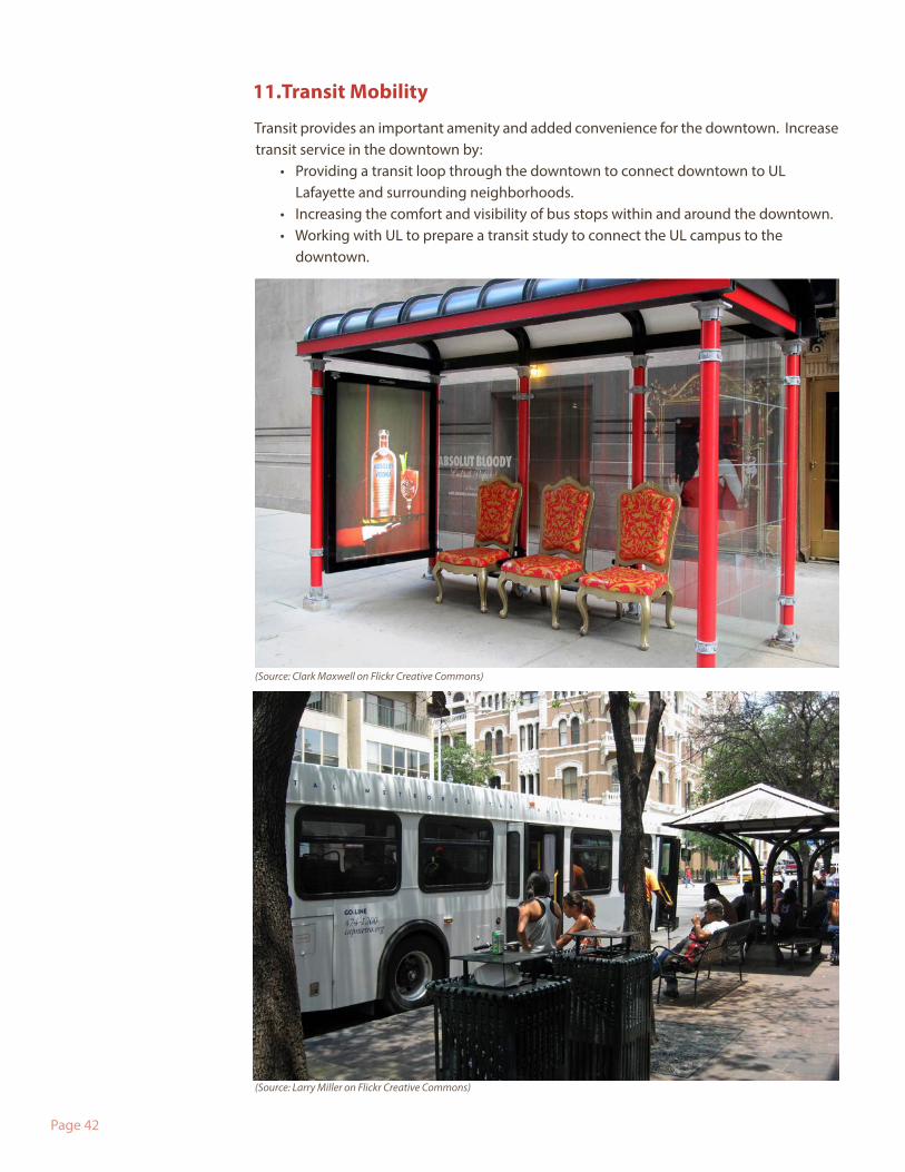
Transit provides an important amenity and added convenience for the downtown. Increase transit service in the downtown by:
• Providing a transit loop through the downtown to connect downtown to UL Lafayette and surrounding neighborhoods.
• Increasing the comfort and visibility of bus stops within and around the downtown. • Working with UL to prepare a transit study to connect the UL campus to the
downtown.
(Source: Clark Maxwell on Flickr Creative Commons)
(Source: Larry Miller on Flickr Creative Commons)
Page 43
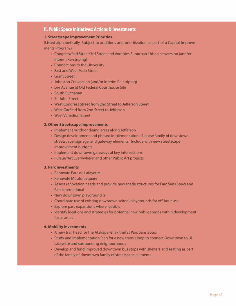
II. Public Space Initiatives: Actions & Investments1. Streetscape Improvement Priorities (Listed alphabetically. Subject to additions and prioritization as part of a Capital Improve-ments Program.)
• Congress/2nd Street/3rd Street and Voorhies Suburban-Urban conversion (and/or Interim Re-striping)
• Connections to the University• East and West Main Street • Grant Street• Johnston Conversion (and/or Interim Re-striping)• Lee Avenue at Old Federal Courthouse Site• South Buchanan • St. John Street• West Congress Street from 2nd Street to Jefferson Street• West Garfield from 2nd Street to Jefferson• West Vermilion Street
2. Other Streetscape Improvements• Implement outdoor dining areas along Jefferson• Design development and phased implementation of a new family of downtown
streetscape, signage, and gateway elements. Include with new streetscape improvement budgets
• Implement downtown gateways at key intersections• Pursue “Art Everywhere” and other Public Art projects
3. Parc Investments• Renovate Parc de Lafayette• Renovate Mouton Square• Assess renovation needs and provide new shade structures for Parc Sans Souci and
Parc International• New downtown playground (s)• Coordinate use of existing downtown school playgrounds for off-hour use • Explore parc expansions where feasible • Identify locations and strategies for potential new public spaces within development
focus areas
4. Mobility Investments• A new trail head for the Atakapa-Ishak trail at Parc Sans Souci• Study and Implementation Plan for a new transit loop to connect Downtown to UL
Lafayette and surrounding neighborhoods• Develop and fund improved downtown bus stops with shelters and seating as part
of the family of downtown family of streetscape elements
Page 44
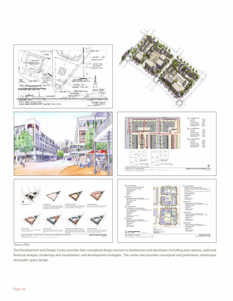
The Development and Design Center provides free conceptual design services to landowners and developers including plan options, yield and financial analysis, renderings and visualization, and development strategies. The center also provides conceptual and preliminary streetscape and public space design.
(Source: DDA)
Page 45
To help mitigate these challenges as well as speed redevelopment and improve the qual-ity of development, the Development & Design Center (DDC) was established as an entity within the Downtown Development Authority in August of 2013 with the creation of the Director of Design position.
The DDC has five primary responsibilities:
1. Implement the Downtown Action Plan. The DDC is the primary entity tasked with facilitating the day to day implementation of this Downtown Action Plan. This also in-cludes ongoing efforts to provide information to various stakeholders about the vision for the downtown and the basis for the vision.
2. Facilitate Promotion & Coordination of Downtown Development. The down-town competes with large-scale developments in the suburbs that have centralized sales and coordinated development operations. The DDC serves as informal sales of-fice by actively promoting the downtown to prospective residents, businesses, visitors and developers in collaboration with Downtown Lafayette Unlimited. The DDC also helps facilitate coordination between property owners.
3. Concierge. The DDC serves as a concierge for development that supports the vision of the downtown.
4. Mediator. The DDC may act as a mediator when a conflict arises between a devel-oper and an entity involved in the development process such as the local government, utility service provider or neighbor.
5. Research & Development Conceptual Design Services. The DDC provides con-ceptual schematic design services to owners and developers of property in the down-town upon request. This includes the creation of conceptual master plans, illustrations, regulatory documents and other planning documents that will increase the speed of redevelopment in the downtown.
Development in the downtown is complex because there are a multitude of landowners (both public and private), a wide variety of infrastructure conditions, and no master developer coordinating its overall development like a large-scale suburban greenfield project.
III. Development + Design Center
Page 46
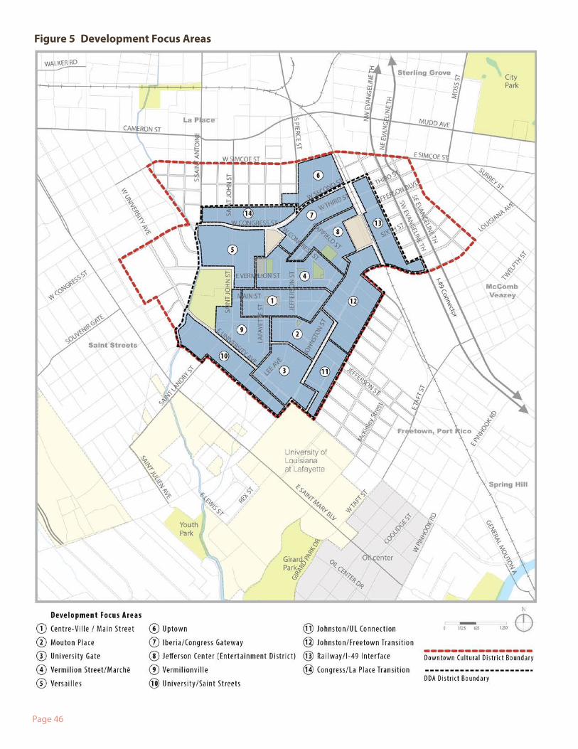
Figure 5 Development Focus Areas
Page 47
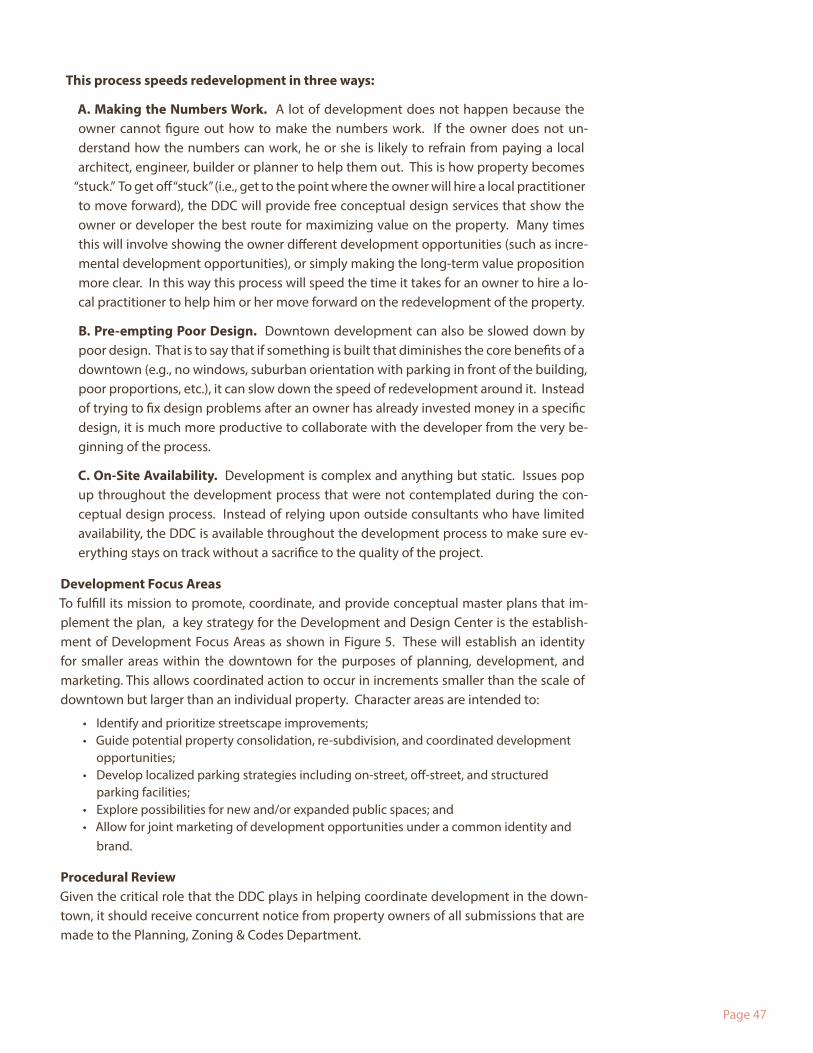
This process speeds redevelopment in three ways:
A. Making the Numbers Work. A lot of development does not happen because the owner cannot figure out how to make the numbers work. If the owner does not un-derstand how the numbers can work, he or she is likely to refrain from paying a local architect, engineer, builder or planner to help them out. This is how property becomes
“stuck.” To get off “stuck” (i.e., get to the point where the owner will hire a local practitioner to move forward), the DDC will provide free conceptual design services that show the owner or developer the best route for maximizing value on the property. Many times this will involve showing the owner different development opportunities (such as incre-mental development opportunities), or simply making the long-term value proposition more clear. In this way this process will speed the time it takes for an owner to hire a lo-cal practitioner to help him or her move forward on the redevelopment of the property.
B. Pre-empting Poor Design. Downtown development can also be slowed down by poor design. That is to say that if something is built that diminishes the core benefits of a downtown (e.g., no windows, suburban orientation with parking in front of the building, poor proportions, etc.), it can slow down the speed of redevelopment around it. Instead of trying to fix design problems after an owner has already invested money in a specific design, it is much more productive to collaborate with the developer from the very be-ginning of the process.
C. On-Site Availability. Development is complex and anything but static. Issues pop up throughout the development process that were not contemplated during the con-ceptual design process. Instead of relying upon outside consultants who have limited availability, the DDC is available throughout the development process to make sure ev-erything stays on track without a sacrifice to the quality of the project.
Development Focus AreasTo fulfill its mission to promote, coordinate, and provide conceptual master plans that im-plement the plan, a key strategy for the Development and Design Center is the establish-ment of Development Focus Areas as shown in Figure 5. These will establish an identity for smaller areas within the downtown for the purposes of planning, development, and marketing. This allows coordinated action to occur in increments smaller than the scale of downtown but larger than an individual property. Character areas are intended to:
• Identify and prioritize streetscape improvements;• Guide potential property consolidation, re-subdivision, and coordinated development
opportunities;• Develop localized parking strategies including on-street, off-street, and structured
parking facilities;• Explore possibilities for new and/or expanded public spaces; and• Allow for joint marketing of development opportunities under a common identity and
brand.
Procedural ReviewGiven the critical role that the DDC plays in helping coordinate development in the down-town, it should receive concurrent notice from property owners of all submissions that are made to the Planning, Zoning & Codes Department.
Page 48
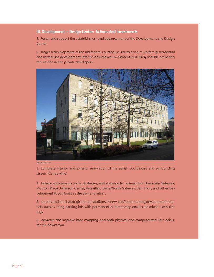
III. Development + Design Center: Actions And Investments1. Foster and support the establishment and advancement of the Development and Design Center.
2. Target redevelopment of the old federal courthouse site to bring multi-family residential and mixed-use development into the downtown. Investments will likely include preparing the site for sale to private developers.
3. Complete interior and exterior renovation of the parish courthouse and surrounding streets (Centre-Ville)
4. Initiate and develop plans, strategies, and stakeholder outreach for University Gateway, Mouton Place, Jefferson Center, Versailles, Iberia/North Gateway, Vermilion, and other De-velopment Focus Areas as the demand arises.
5. Identify and fund strategic demonstrations of new and/or pioneering development proj-ects such as lining parking lots with permanent or temporary small-scale mixed use build-ings.
6. Advance and improve base mapping, and both physical and computerized 3d models, for the downtown.
(Source: DDA)
Page 49
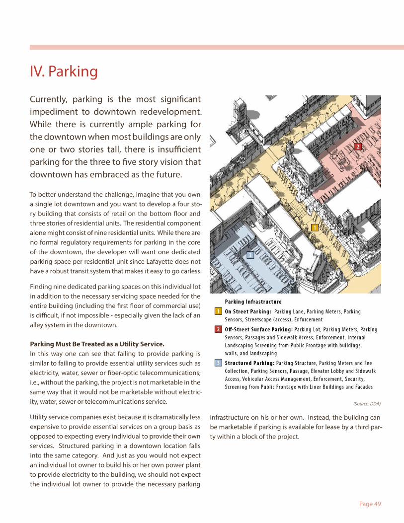
To better understand the challenge, imagine that you own a single lot downtown and you want to develop a four sto-ry building that consists of retail on the bottom floor and three stories of residential units. The residential component alone might consist of nine residential units. While there are no formal regulatory requirements for parking in the core of the downtown, the developer will want one dedicated parking space per residential unit since Lafayette does not have a robust transit system that makes it easy to go carless.
Finding nine dedicated parking spaces on this individual lot in addition to the necessary servicing space needed for the entire building (including the first floor of commercial use) is difficult, if not impossible - especially given the lack of an alley system in the downtown.
Parking Must Be Treated as a Utility Service. In this way one can see that failing to provide parking is similar to failing to provide essential utility services such as electricity, water, sewer or fiber-optic telecommunications; i.e., without the parking, the project is not marketable in the same way that it would not be marketable without electric-ity, water, sewer or telecommunications service.
Utility service companies exist because it is dramatically less expensive to provide essential services on a group basis as opposed to expecting every individual to provide their own services. Structured parking in a downtown location falls into the same category. And just as you would not expect an individual lot owner to build his or her own power plant to provide electricity to the building, we should not expect the individual lot owner to provide the necessary parking
infrastructure on his or her own. Instead, the building can be marketable if parking is available for lease by a third par-ty within a block of the project.
(Source: DDA)
Currently, parking is the most significant impediment to downtown redevelopment. While there is currently ample parking for the downtown when most buildings are only one or two stories tall, there is insufficient parking for the three to five story vision that downtown has embraced as the future.
IV. Parking
Page 50
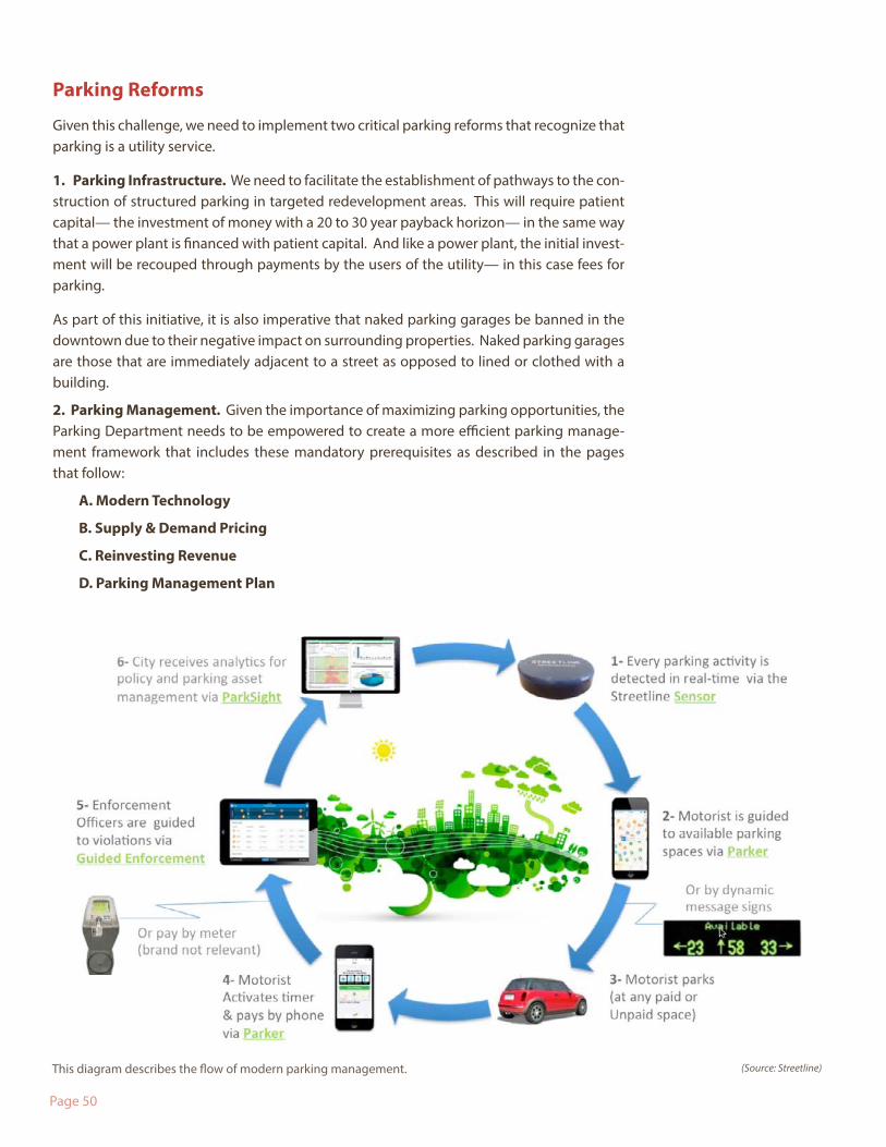
This diagram describes the flow of modern parking management.
Parking Reforms
Given this challenge, we need to implement two critical parking reforms that recognize that parking is a utility service.
1. Parking Infrastructure. We need to facilitate the establishment of pathways to the con-struction of structured parking in targeted redevelopment areas. This will require patient capital— the investment of money with a 20 to 30 year payback horizon— in the same way that a power plant is financed with patient capital. And like a power plant, the initial invest-ment will be recouped through payments by the users of the utility— in this case fees for parking.
As part of this initiative, it is also imperative that naked parking garages be banned in the downtown due to their negative impact on surrounding properties. Naked parking garages are those that are immediately adjacent to a street as opposed to lined or clothed with a building.
2. Parking Management. Given the importance of maximizing parking opportunities, the Parking Department needs to be empowered to create a more efficient parking manage-ment framework that includes these mandatory prerequisites as described in the pages that follow:
A. Modern Technology
B. Supply & Demand Pricing
C. Reinvesting Revenue
D. Parking Management Plan
(Source: Streetline)
Page 51
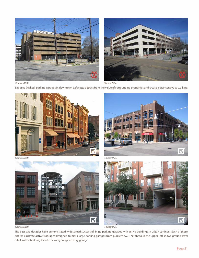
Exposed (Naked) parking garages in downtown Lafayette detract from the value of surrounding properties and create a disincentive to walking.
The past two decades have demonstrated widespread success of lining parking garages with active buildings in urban settings. Each of these photos illustrate active frontages designed to mask large parking garages from public view. The photo in the upper left shows ground level retail, with a building facade masking an upper story garage.
(Source: DDA)
(Source: DDA)
(Source: DDA)
(Source: DDA)
(Source: DDA)
(Source: DDA)
X X
✓
✓
✓
✓
Page 52
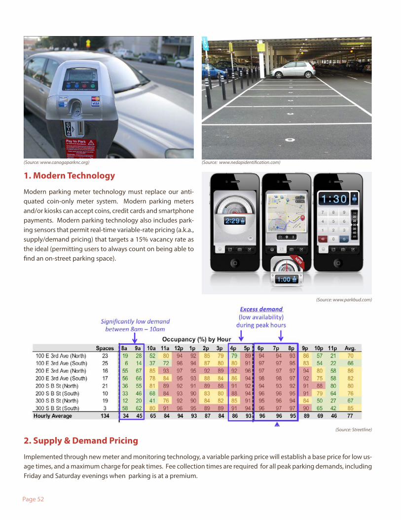
1. Modern Technology
Modern parking meter technology must replace our anti-quated coin-only meter system. Modern parking meters and/or kiosks can accept coins, credit cards and smartphone payments. Modern parking technology also includes park-ing sensors that permit real-time variable-rate pricing (a.k.a., supply/demand pricing) that targets a 15% vacancy rate as the ideal (permitting users to always count on being able to find an on-street parking space).
2. Supply & Demand Pricing
Implemented through new meter and monitoring technology, a variable parking price will establish a base price for low us-age times, and a maximum charge for peak times. Fee collection times are required for all peak parking demands, including Friday and Saturday evenings when parking is at a premium.
(Source: www.nedapidentification.com)(Source: www.canogaparknc.org)
(Source: Streetline)
(Source: www.parkbud.com)
Page 53
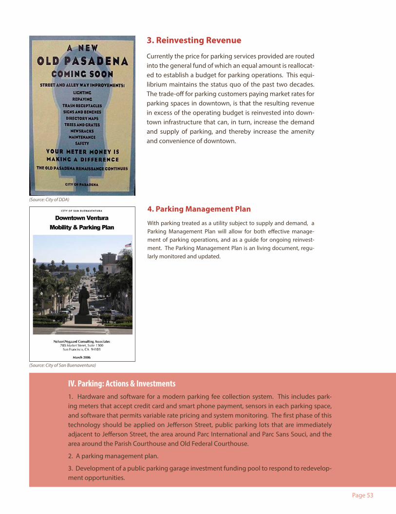
3. Reinvesting Revenue
Currently the price for parking services provided are routed into the general fund of which an equal amount is reallocat-ed to establish a budget for parking operations. This equi-librium maintains the status quo of the past two decades. The trade-off for parking customers paying market rates for parking spaces in downtown, is that the resulting revenue in excess of the operating budget is reinvested into down-town infrastructure that can, in turn, increase the demand and supply of parking, and thereby increase the amenity and convenience of downtown.
4. Parking Management Plan
With parking treated as a utility subject to supply and demand, a Parking Management Plan will allow for both effective manage-ment of parking operations, and as a guide for ongoing reinvest-ment. The Parking Management Plan is an living document, regu-larly monitored and updated.
IV. Parking: Actions & Investments1. Hardware and software for a modern parking fee collection system. This includes park-ing meters that accept credit card and smart phone payment, sensors in each parking space, and software that permits variable rate pricing and system monitoring. The first phase of this technology should be applied on Jefferson Street, public parking lots that are immediately adjacent to Jefferson Street, the area around Parc International and Parc Sans Souci, and the area around the Parish Courthouse and Old Federal Courthouse.
2. A parking management plan.
3. Development of a public parking garage investment funding pool to respond to redevelop-ment opportunities.
(Source: City of San Buenaventura)
(Source: City of DDA)
Page 54
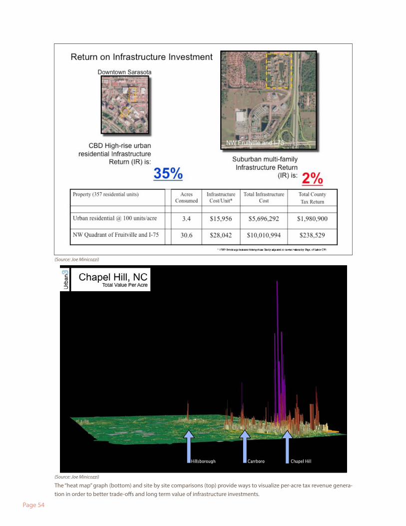
The “heat map” graph (bottom) and site by site comparisons (top) provide ways to visualize per-acre tax revenue genera-tion in order to better trade-offs and long term value of infrastructure investments.
(Source: Joe Minicozzi)
(Source: Joe Minicozzi)
Page 55
Infrastructure Investments Shape Our Community.
The biggest tool that Lafayette has to shape its future is its infrastructure budget; i.e., where it decides to invest in roads, drainage, utilities, parks, parking garages, etc. Currently those investments are analyzed from the perspective of their costs and impact upon prospective users. Rarely are those investments analyzed from the perspective of how much revenue those investments will generate for the community.
V. Return on Infrastructure Investment
This failure to consider revenue impacts unnecessarily penalizes hyper-efficient mixed-use centers like the downtown by hiding their financial resilience. At the same time, the failure to analyze these issues on inefficient suburban infrastructure investments conceals the fact that those projects will require ongoing infrastructure subsidies.
Return on Infrastructure Investment ToolThis problem can be remedied by the creation of a tool that can measure the cost of services/infrastructure investments as well as the expected revenue generated by those investments. This tool would be known as a Return on Infrastructure Investment Tool.
Advantages of Measuring Costs Plus Revenue By accurately tracking the cost of services/infrastructure investments in relation to the revenue they generate, the Lafayette Consolidated Government would be able to achieve:
1. Better Decisions. Make better informed spending decisions since the value of invest-ments, not just their costs or impact upon prospective users, will be capable of analysis;
2. Increased Transparency. Increase the transparency of decision-making;
3. Subsidy Reduction. Support corrections in taxation policies so that taxpayer subsidies are reduced; and
4. Restructure Government as Necessary. Help manage the allocation of human and budgetary resources with the Lafayette Consolidated Government.
It is important to note that this analysis tool should look at both short and long term cost and revenue projections. For example, long term costs not only consider the maintenance costs of the “first life cycle” of infrastructure, but also the “second life cycle” when the infrastructure must be replaced.
V. Return on Infrastructure Investment: Actions & InvestmentsCoordinate, develop, and implement a comprehensive Return on the Infrastructure Investment Tool.

Page 56
Page 57
4. Summary
I. Downtown Character Program: Actions & Investments1. Continue to work toward adopting an updated downtown zoning code in conjunction with the citywide Unified Development Code update process.
2. Establish a process to coordinate and adopt a Rail Line Quiet Zone.
II. Public Space Initiatives: Actions & Investments1. Streetscape Improvement Priorities (Listed alphabetically. Subject to additions and prioritization as part of a Capital Improve-ments Program.)
• Congress/2nd Street/3rd Street and Voorhies Suburban-Urban conversion (and/or Interim Re-striping)
• Connections to the University• East and West Main Street • Grant Street• Johnston Conversion (and/or Interim Re-striping)• Lee Avenue at Old Federal Courthouse Site• South Buchanan • St. John Street• West Congress Street from 2nd Street to Jefferson Street• West Garfield from 2nd Street to Jefferson• West Vermilion Street
2. Other Streetscape Improvements• Implement outdoor dining areas along Jefferson• Design development and phased implementation of a new family of downtown
streetscape, signage, and gateway elements. Include with new streetscape improvement budgets
• Implement downtown gateways at key intersections• Pursue “Art Everywhere” and other Public Art projects
3. Parc Investments• Renovate Parc de Lafayette• Renovate Mouton Square• Assess renovation needs and provide new shade structures for Parc Sans Souci and
Parc International• New downtown playground (s)• Coordinate use of existing downtown school playgrounds for off-hour use • Explore parc expansions where feasible • Identify locations and strategies for potential new public spaces within development
focus areas
Page 58
4. Mobility Investments• A new trail head for the Atakapa-Ishak trail at Parc Sans Souci• Study and Implementation Plan for a new transit loop to connect Downtown to UL
Lafayette and surrounding neighborhoods• Develop and fund improved downtown bus stops with shelters and seating as part
of the family of downtown family of streetscape elements
III. Development + Design Center: Actions And Investments1. Foster and support the establishment and advancement of the Development and Design Center.
2. Target redevelopment of the old federal courthouse site to bring multi-family residential and mixed-use development into the downtown. Investments will likely include preparing the site for sale to private developers.
3. Complete interior and exterior renovation of the parish courthouse and surrounding streets (Centre-Ville)
4. Initiate and develop plans, strategies, and stakeholder outreach for University Gateway, Mouton Place, Jefferson Center, Versailles, Iberia/North Gateway, Vermilion, and other De-velopment Focus Areas as the demand arises.
5. Identify and fund strategic demonstrations of new and/or pioneering development proj-ects such as lining parking lots with permanent or temporary small-scale mixed use build-ings.
6. Advance and improve base mapping, and both physical and computerized 3d models, for the downtown.
IV. Parking: Actions & Investments1. Hardware and software for a modern parking fee collection system. This includes parking meters that accept credit card and smart phone payment, sensors in each parking space, and software that permits variable rate pricing and system monitoring. The first phase of this technology should be applied on Jefferson Street, public parking lots that are immedi-ately adjacent to Jefferson Street, the area around Parc International and Parc Sans Souci, and the area around the Parish Courthouse and Old Federal Courthouse.
2. A parking management plan.
3. Development of a public parking garage investment funding pool to respond to redevel-opment opportunities.
V. Return on Infrastructure Investment: Actions & InvestmentsCoordinate, develop, and implement a comprehensive Return on the Infrastructure Invest-ment Tool.

Page 59Appendix

Page 61
The intent of the Downtown Action Plan (“Plan”) is to set in motion the transformation of downtown Lafayette into one of the most engaging, colorful and eclectic urban settings in the nation. This Plan is guided by an extensive public engagement process (described and illustrated in Appendix II.) that included the development of a vision that imagined how the downtown might be in twenty years as a result of the Plan. This exercise inspired the stakeholder feed-back and input that would in turn serve as a foundation for the Plan’s strategic vision and five core tools. Below is the vision and story developed as part of this exercise.
Twenty years from now, the implementation of this Plan will have redefined downtown Lafayette in four fundamental ways:
1. As the Heartbeat of Acadiana2. As a Vibrant Urban Place3. As a Thriving “Urban Neighborhood”4. As a Dynamic, Connected Center
Appendix I: Downtown Lafayette 2034 A Community Vision
1. Heartbeat of AcadianaIn many ways and more than ever, downtown is the heartbeat of our city, parish and region, pulsing to the rich vibe and distinct flavor of Acadiana —a vivid sensory experience that resonates with the unique rhythms, sounds, flavors and colors of our community.
We have become a destination of choice for cultural tourism. Our visitors are attracted from all over the region and beyond for the strength of our museums and the originality of our art galleries, as well as for the scope of performances, special events and festivals that fill our playhouses, our parcs, the Acadiana Center for the Arts, and new outdoor and indoor cultural venues throughout downtown all year long.
An abundance of eclectic downtown hotels accommodates leisure and business travelers alike. First-rate conference facilities located within easy walking distance of dining, retail and entertainment (coupled with increased ease of transportation access in and out of La-fayette) support our position as the cultural heart of our region.
The presence of these facilities also reinforces our role as the region’s major center of busi-ness, attractive to large employers but also welcoming to local entrepreneurs and small business owners. In our downtown, these entrepreneurs find a fertile environment for in-novation as well as strong support from a business friendly Lafayette Consolidated Govern-ment.
Page 62
2. Vibrant Urban Place
We have succeeded in re-knitting our urban fabric, filling the former gaps of surface parking and other underutilized or vacant sites with compelling, exciting mixed use developments that complement and enhance the historic foundation of our downtown.
Our central business district has become the region’s destination for specialty retail, dining and entertainment, with unique shops, boutiques, restaurants and services thriving along key corridors, including but not limited to Jefferson Street, Buchanan Street, and Lee Av-enue.
Our civic realm reflects our status as a cultural destination, with wide sidewalks and lush streetscapes of native trees, lighting and seating, punctuated by new green spaces, formal plazas and fountains designed to highlight and celebrate our distinct character and ambi-ance. This civic realm is also activated by well-designed private spaces that accommodate outdoor dining and open air cafes and galleries, and by a high level of pedestrian and bi-cycle activity.
3. Thriving “Urban Neighborhood”
A wide array of new housing developed throughout downtown appeals to our growing and diverse population. Detached, semi-detached and attached houses, multiplexes, apart-ments, lofts, live/work units, secondary units and other innovative housing types accom-modate the diversity of families and households of all generations and incomes who want to live, work and play in downtown.
With the influx of additional population, the neighborhood infrastructure of our downtown has expanded incrementally, to the point where today we can sustain, and be sustained by, the kinds of businesses that serve the needs of downtown residents: grocers and farm-ers markets, a great variety of restaurants, convenience retail, services and entertainment; schools, parks and recreational activities for people of all ages.
A high level of daytime and nighttime activity, combined with the eyes-on-the-street care and close-knit fabric of our residents, have made downtown one of Lafayette’s safest and friendliest neighborhoods.
Page 63
4. Dynamic, Connected Center
Once barriers closing off downtown, University Avenue, Johnston Street and Congress Street have become scenic, pedestrian and bicycle friendly “seams” –shaded avenues link-ing downtown to the University of Louisiana at Lafayette (ULL) campus, Freetown-Port Rico, Saints Streets, La Place, McComb-Veazey and other nearby neighborhoods.
Major intersections have become vibrantly landscaped gateways, announcing to visitors that they are entering a special location. Colorful new way-finding signage and information kiosks throughout downtown enable visitors to easily navigate our many attractions and landmarks.
Many coulees that crisscross the downtown and city have been adapted to accommodate trails and greenways that provide a safe, enjoyable means to walk or bicycle to and from the surrounding neighborhoods, while buses and trolleys circulate around downtown reducing the need to depend on the automobile for those who live in or visit downtown.
Our status as a major employment center is also supported by a variety of transportation modes that makes downtown easily accessible from the rest of the parish and the region, and which in turn connect us to the Oil Center, the ULL campus, the Lafayette Regional Air-port, Lafayette Central Park, and other city and parish destinations.

Page 64
Page 65
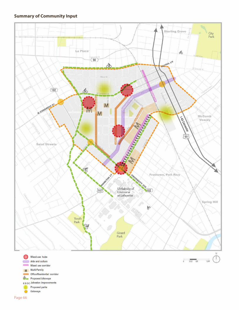
This plan was developed in response to a comprehensive public engagement process to col-lect community and stakeholder input, ideas, and concerns. Ideas generated for downtown include more housing and infill development, more retail and mixing of uses, more parks and open space and better designed streetscapes, enhanced pedestrian connections, bet-ter bikeways and connections, and transit loop around downtown and connecting through the university. Building from the foundation of these ideas and other community input, this document represents a bold, forward-looking vision enacted through an action plan to fulfill our mission to achieve high quality city living in Downtown Lafayette.
Originally described as the “Downtown Strategic Framework,”, the public Downtown Action Plan engagement process included stakeholder interviews, an open house and follow up survey, Downtown Summit 1 and 2, and review and comment by the Downtown Advisory Committee. The main public events - Downtown Summit 1 and 2 served as a basis to de-velop the vision and actions for downtown.
Stakeholder Interviews As part of the public engagement kickoff activities, Zyscovich Architects and WRT conduct-ed interviews with groups of individuals involved closely in downtown Lafayette. Held over a two day period, the stakeholder groups included those involved in financing, downtown businesses (e.g., technology, creative industries), arts and culture, retail and services, com-munity development, schools, as well as residents, entrepreneurs, and property owners. These initial focus group interviews provided key insights into the issues and opportunities facing the downtown study area.
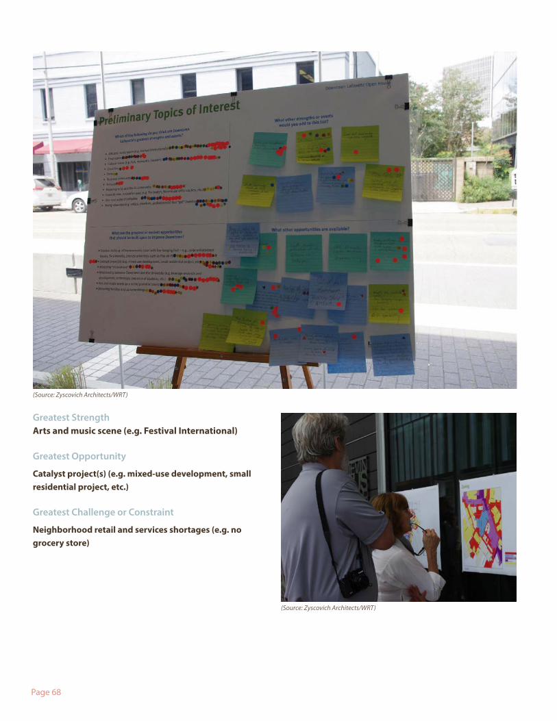
Open House and Follow Up SurveyMore than 150 people attended the downtown open house in August 2012. The open house gave participants a chance to review a draft of existing conditions data and maps, respond to a list of preliminary strengths, opportunities, and challenges defined with input from the stakeholder interviews, and discuss issues with the planning team. To engage a larger audience after the open house, LCG encouraged residents to fill out an online survey to provide ideas in the same format as the open house. Over 100 people filled out the on-line survey providing additional ideas about downtown. The results are described on the following pages.
Appendix II: Public Engagement
Page 66
Summary of Community Input
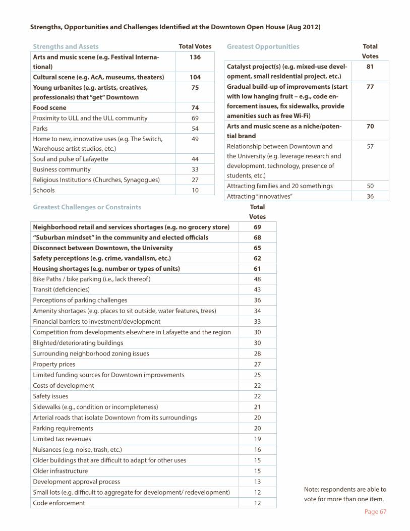
Page 67
Strengths and Assets Total Votes
Arts and music scene (e.g. Festival Interna-tional)
136
Cultural scene (e.g. AcA, museums, theaters) 104
Young urbanites (e.g. artists, creatives, professionals) that “get” Downtown
75
Food scene 74
Proximity to ULL and the ULL community 69
Parks 54
Home to new, innovative uses (e.g. The Switch, Warehouse artist studios, etc.)
49
Soul and pulse of Lafayette 44
Business community 33
Religious Institutions (Churches, Synagogues) 27
Schools 10
Greatest Opportunities Total Votes
Catalyst project(s) (e.g. mixed-use devel-opment, small residential project, etc.)
81
Gradual build-up of improvements (start with low hanging fruit – e.g., code en-forcement issues, fix sidewalks, provide amenities such as free Wi-Fi)
77
Arts and music scene as a niche/poten-tial brand
70
Relationship between Downtown and the University (e.g. leverage research and development, technology, presence of students, etc.)
57
Attracting families and 20 somethings 50
Attracting “innovatives” 36
Greatest Challenges or Constraints Total Votes
Neighborhood retail and services shortages (e.g. no grocery store) 69
“Suburban mindset” in the community and elected officials 68
Disconnect between Downtown, the University 65
Safety perceptions (e.g. crime, vandalism, etc.) 62
Housing shortages (e.g. number or types of units) 61
Bike Paths / bike parking (i.e., lack thereof ) 48
Transit (deficiencies) 43
Perceptions of parking challenges 36
Amenity shortages (e.g. places to sit outside, water features, trees) 34
Financial barriers to investment/development 33
Competition from developments elsewhere in Lafayette and the region 30
Blighted/deteriorating buildings 30
Surrounding neighborhood zoning issues 28
Property prices 27
Limited funding sources for Downtown improvements 25
Costs of development 22
Safety issues 22
Sidewalks (e.g., condition or incompleteness) 21
Arterial roads that isolate Downtown from its surroundings 20
Parking requirements 20
Limited tax revenues 19
Nuisances (e.g. noise, trash, etc.) 16
Older buildings that are difficult to adapt for other uses 15
Older infrastructure 15
Development approval process 13
Small lots (e.g. difficult to aggregate for development/ redevelopment) 12
Code enforcement 12
Strengths, Opportunities and Challenges Identified at the Downtown Open House (Aug 2012)
Note: respondents are able to vote for more than one item.
Page 68
Greatest StrengthArts and music scene (e.g. Festival International)
Greatest Opportunity
Catalyst project(s) (e.g. mixed-use development, small residential project, etc.)
Greatest Challenge or Constraint
Neighborhood retail and services shortages (e.g. no grocery store)
(Source: Zyscovich Architects/WRT)
(Source: Zyscovich Architects/WRT)
Page 69
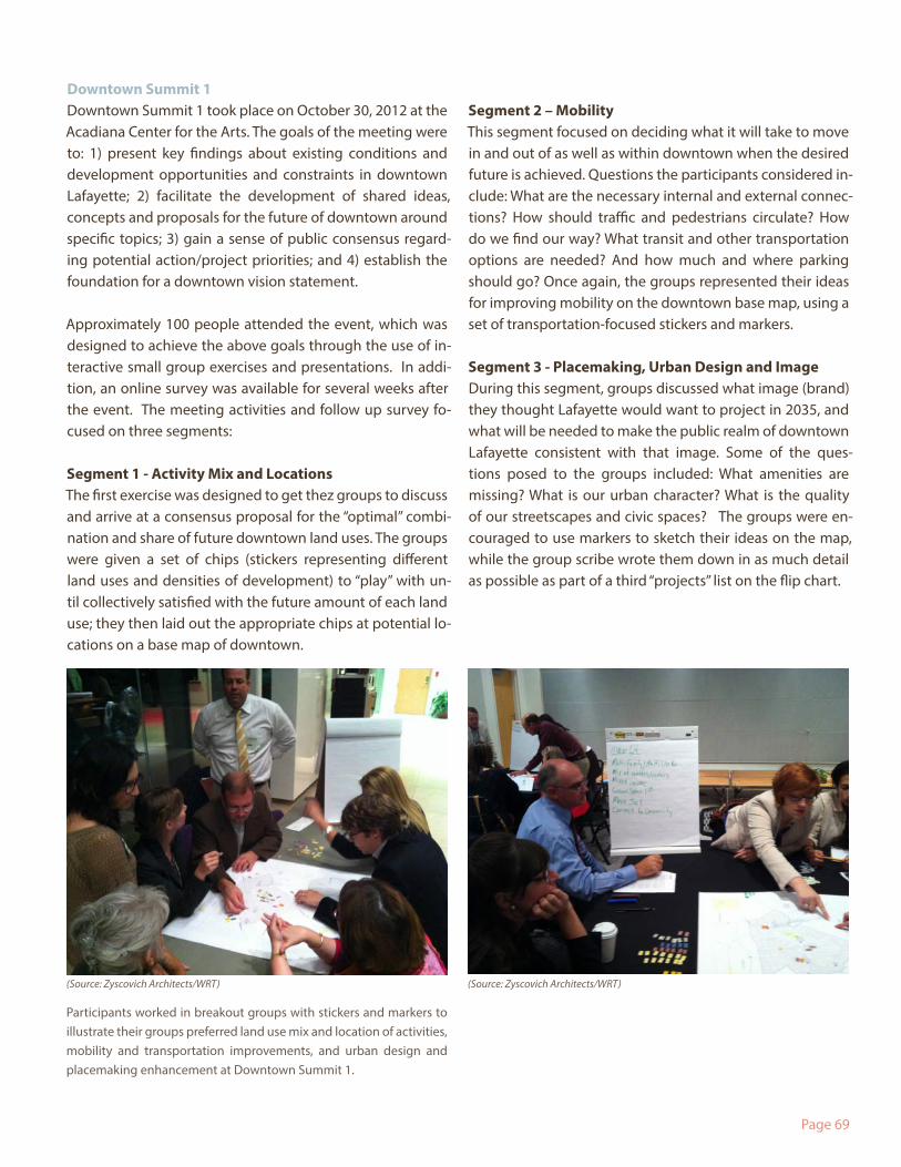
Downtown Summit 1Downtown Summit 1 took place on October 30, 2012 at the Acadiana Center for the Arts. The goals of the meeting were to: 1) present key findings about existing conditions and development opportunities and constraints in downtown Lafayette; 2) facilitate the development of shared ideas, concepts and proposals for the future of downtown around specific topics; 3) gain a sense of public consensus regard-ing potential action/project priorities; and 4) establish the foundation for a downtown vision statement.
Approximately 100 people attended the event, which was designed to achieve the above goals through the use of in-teractive small group exercises and presentations. In addi-tion, an online survey was available for several weeks after the event. The meeting activities and follow up survey fo-cused on three segments:
Segment 1 - Activity Mix and Locations The first exercise was designed to get thez groups to discuss and arrive at a consensus proposal for the “optimal” combi-nation and share of future downtown land uses. The groups were given a set of chips (stickers representing different land uses and densities of development) to “play” with un-til collectively satisfied with the future amount of each land use; they then laid out the appropriate chips at potential lo-cations on a base map of downtown.
Segment 2 – MobilityThis segment focused on deciding what it will take to move in and out of as well as within downtown when the desired future is achieved. Questions the participants considered in-clude: What are the necessary internal and external connec-tions? How should traffic and pedestrians circulate? How do we find our way? What transit and other transportation options are needed? And how much and where parking should go? Once again, the groups represented their ideas for improving mobility on the downtown base map, using a set of transportation-focused stickers and markers.
Segment 3 - Placemaking, Urban Design and ImageDuring this segment, groups discussed what image (brand) they thought Lafayette would want to project in 2035, and what will be needed to make the public realm of downtown Lafayette consistent with that image. Some of the ques-tions posed to the groups included: What amenities are missing? What is our urban character? What is the quality of our streetscapes and civic spaces? The groups were en-couraged to use markers to sketch their ideas on the map, while the group scribe wrote them down in as much detail as possible as part of a third “projects” list on the flip chart.
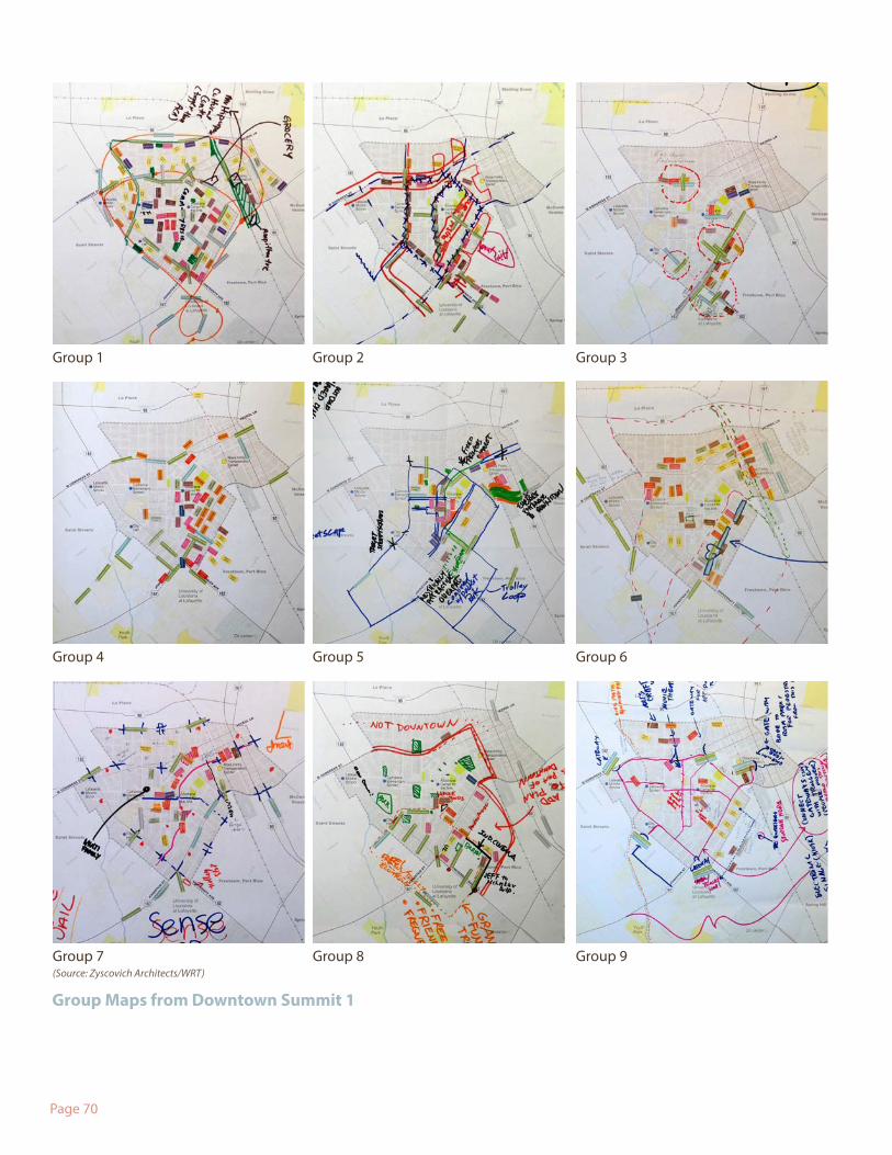
Participants worked in breakout groups with stickers and markers to illustrate their groups preferred land use mix and location of activities, mobility and transportation improvements, and urban design and placemaking enhancement at Downtown Summit 1.
(Source: Zyscovich Architects/WRT) (Source: Zyscovich Architects/WRT)
Page 70
Group 1 Group 2 Group 3
Group 4 Group 5 Group 6
Group 7 Group 8 Group 9
Group Maps from Downtown Summit 1
(Source: Zyscovich Architects/WRT)
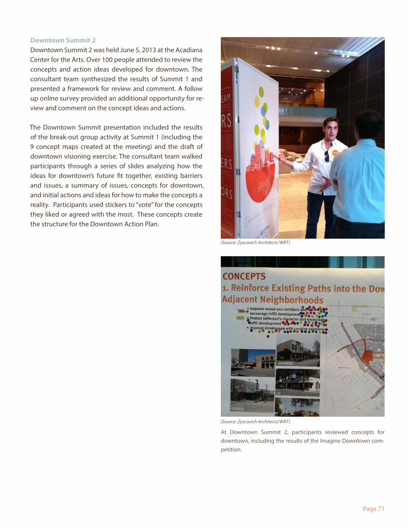
Page 71
Downtown Summit 2Downtown Summit 2 was held June 5, 2013 at the Acadiana Center for the Arts. Over 100 people attended to review the concepts and action ideas developed for downtown. The consultant team synthesized the results of Summit 1 and presented a framework for review and comment. A follow up online survey provided an additional opportunity for re-view and comment on the concept ideas and actions.
The Downtown Summit presentation included the results of the break-out group activity at Summit 1 (including the 9 concept maps created at the meeting) and the draft of downtown visioning exercise. The consultant team walked participants through a series of slides analyzing how the ideas for downtown’s future fit together, existing barriers and issues, a summary of issues, concepts for downtown, and initial actions and ideas for how to make the concepts a reality. Participants used stickers to “vote” for the concepts they liked or agreed with the most. These concepts create the structure for the Downtown Action Plan.
At Downtown Summit 2, participants reviewed concepts for downtown, including the results of the Imagine Downtown com-petition.
(Source: Zyscovich Architects/WRT)
(Source: Zyscovich Architects/WRT)