Embed Size (px)
Citation preview

Dr Nigel TroddCoventry University
Sourcing Geodata

giservices require
peoplesoftware
data
method
hardware

geospatial data consist of
geographical entitiesattributesmetadata
geospatial data are useful only if
available & accessiblefit for purpose
referenced to a common spatial referencing system

Aim & objectives
To identify & understand the process of building a geospatial database
We willidentify sources of geographically referenced data exemplify techniques to acquire geospatial data

importance of data acquisition
constrains data analysisinfluences output quality
determines economic viability50% of the total cost & 70% - 80% of the time of a GIS project
revolve around data acquisition

…the cost of data
10 seats 100 seats
$ % $ %
Hardware 30 3.4 250 8.6
Software 25 2.8 200 6.9
Data 400 44.7 450 15.5
Staff 440 49.1 2000 69.9
Total 895 100 2900 100Source: Longley et al. 2001

a system to
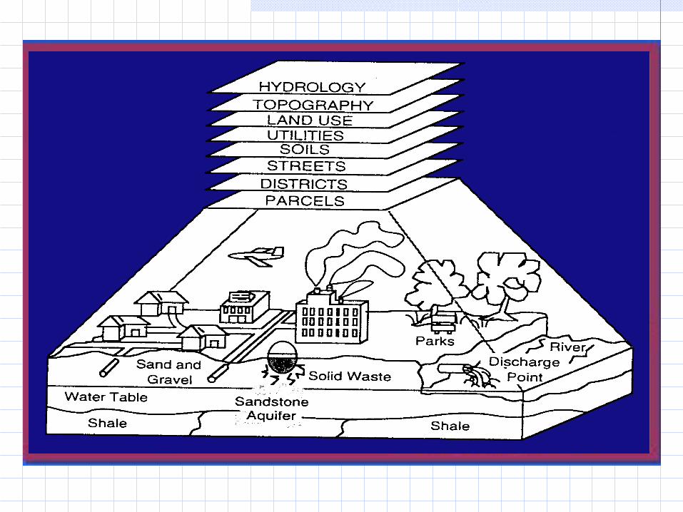
the data stream in GIS
capturestorecheckintegratemanipulate analysedisplay spatial data
capturestorecheckintegratemanipulate analysedisplay spatial data


sourcing data
Determine location Georeferencing system
Determine extent of phenomena from reality to spatial data
structures
Characterise properties of phenomena

data sourcesPrimary data sources
Field survey Questionnaires Aerial photos & satellite images
Secondary data sources Maps & other published documents Government databases e.g. health, crime,
social security, land registry Private sector databases e.g. credit rating,
lifestyle (EPOS)

primary data sourcesField survey
Satellite Navigation System

GPS & GLONASS principles

Limitations
Working environment
Selective availability
Range uncertaintyData quality
SA on SA off DGPS
Horizontal
100m 10-20m <1-5m
Vertical 160m

GPS applications

remote sensing …the acquisition of physical data of an object without touch or
contact (Lintz & Simonett 1976)

Earth observation by remote sensing

IKONOS 1m-sharpened multispectral image
Poppy fields in Kandahar, Afghanistan
Image courtesy of United Nations Office on Drugs Crime
… to local
Global…

Change detection: deforestation & fragmentation in the Amazon
1975 1986 1992

secondary data sources
digitising
& scanning

butCartographic licence and Data Currency
Map-1978 Imagery-1997

Government organisations with GB geodata holdings
Ordnance Survey GB & Ordnance Survey Northern Ireland Topographical & grid references
HM Land Registry Land ownership & house prices
Highways Agency Traffic flow
Post Office Postcode
Environment Agency Flood
British Geological Survey Geological & geomagnetic
UK Met Office & European Centre fir Medium-Range Weather Forecasting
Weather & climate
Natural Environment Research Council Environmental
Forestry Commission Vegetation
National Park Authorities Biodiversity & visitors
Office for National Statistics Demographic
National Health Service Patient & estates
Higher Education Statistics Authority Student
UK Passport Service Travellers
English & Scottish Heritage Historical
The National Archives Genealogical
The Countryside Agency Rural
Police Authorities Crime
Central Office of Information Government
Local Government Address & demographic
Home Office Identity card

Geocoded socio-economic survey

uk census
Population census
• every 10 years since 1801 except 1941
• target resources & plan service provision

uk census 2001
2001 census held on Sunday 29 April 2001
• £255 million operation organised by Office for National Statistics, General Register Office for Scotland and Northern Ireland Statistics & Research Agency
• Population, Health, Housing, Employment, Transport, Ethnic Group
• Legal obligation to complete a census form but identification of individuals protected for 100 years by Census Confidentiality Act 1991

butOrdnance Survey +
British Geological Survey +
ONS Census +
National LANDMAP satellite imagery
= 1% of total UK digital data volume
… and the rest?
… and what about 'soft' data?

soft data
Communities – assets, land useIndividuals e.g. farmers, preferences & fearPrivate companies e.g. Rail Track, ExperianMultimedia e.g. photos, video, text, oral testimony