Embed Size (px)
Citation preview
Tashman Johnson LLC
Consultants in Policy, Planning & Project Management
Jeff Tashman 503.407.7443 [email protected]@comcast.net
Nina Johnson 503.407.5983 [email protected] www.tashmanjohnson.com
DRAFT
Ashland Urban Renewal Feasibility Study
JULY 18, 2011

Urban Renewal Feasibility Study: Draft Report
Tashman Johnson LLC July 18, 2011 2
Table of Contents
I. INTRODUCTION AND SCOPE OF STUDY ........................................................................ 3 II. SCOPE OF FEASIBILITY STUDY ....................................................................................... 5 III. STUDY AREAS .................................................................................................................... 7 IV EXISTING CONDITIONS IN STUDY AREAS .................................................................... 10 V. REAL ESTATE MARKET ASSESSMENT ......................................................................... 11 VI. TAX INCREMENT REVENUE PROJECTIONS ................................................................. 13 VII. INFRASTRUCTURE AND PUBLIC FACILITY NEEDS AND ESTIMATED COSTS.......... 20 VIII. FINANCING ALTERNATIVES ........................................................................................... 24 IX. PRELIMINARY FINANCING PLAN ................................................................................... 26 X. CONCLUSIONS ................................................................................................................. 29 XI. DECISION ISSUES ........................................................................................................... 31
Urban Renewal Feasibility Study: Draft Report
Tashman Johnson LLC July 18, 2011 3
I. INTRODUCTION
The Ashland City Council has identified important areas of the city – Downtown, the “Railroad” property and the East Ashland Study Area that will likely require public improvements to allow development that meets the City’s land use, livability and economic development objectives. These improvements include:
access (vehicular, pedestrian and bike);
utilities (sanitary sewer, water, storm water management); and
public facilities such as parks and public parking. As the City’s Capital Improvement Plan shows, some of these improvements do not have an identified funding source. Further, existing funding mechanisms (e.g. revenue bonds, systems development charges, gas tax funds) do not appear to be sufficient for these future needs. In this context, the Council directed staff to study the feasibility of an additional funding source – tax increment financing (see Section V), undertaken as part of an urban renewal plan. Generally, tax increment financing consists of using the property tax revenues on growth in assessed value within an urban renewal area to fund public investments to overcome obstacles to the proper development of the urban renewal area. See Section VI for more detailed information on tax increment financing. Urban renewal is a locally controlled program, authorized under state law, to improve specific areas of a city or county that are not achieving local land use and development objectives. These areas can have old deteriorated buildings and bad streets and utilities or they can lack buildings, streets, utilities altogether. Public facilities in these areas (e.g. parks, parking facilities) may be inadequate. The statutes refer to these areas as “blighted areas,” a term that originated in the initial focus of urban renewal on inner city neighborhoods that contained unsafe buildings.
The underlying rationale for urban renewal is that these areas do not generate property tax revenues and do not contribute to the economy as much as they could if more fully developed. By making needed public investments, conditions in the area can be improved and made more productive. Tax increment financing is being used in conjunction with 106 urban renewal plans in 71 Oregon cities and counties. It has been used successfully many times to fund infrastructure improvements for employment uses. Examples include:
Tualatin’s Leveton Tax Increment District (completed in FY 20009/2010) which used a combination of tax increment financing and state infrastructure grants and loans to fund streets and utilities for a high tech business park.
Hillsboro’s Ronler Acres, which use tax increment financing to assemble sites for industrial and mixed residential/commercial development and supported the development of several Intel fabrication facilities and the Orenco Station community.
Urban renewal has also been used successfully to promote and enhance downtown development. Examples include:
Urban Renewal Feasibility Study: Draft Report
Tashman Johnson LLC July 18, 2011 4
Downtown Portland, where three urban renewal plans have promoted intense commercial and residential development, served with nationally recognized urban parks and open spaces.
Downtown Lake Oswego, which is now the site of Lake View Village, a high end mixed use retail and office development supported by a public parking structure.
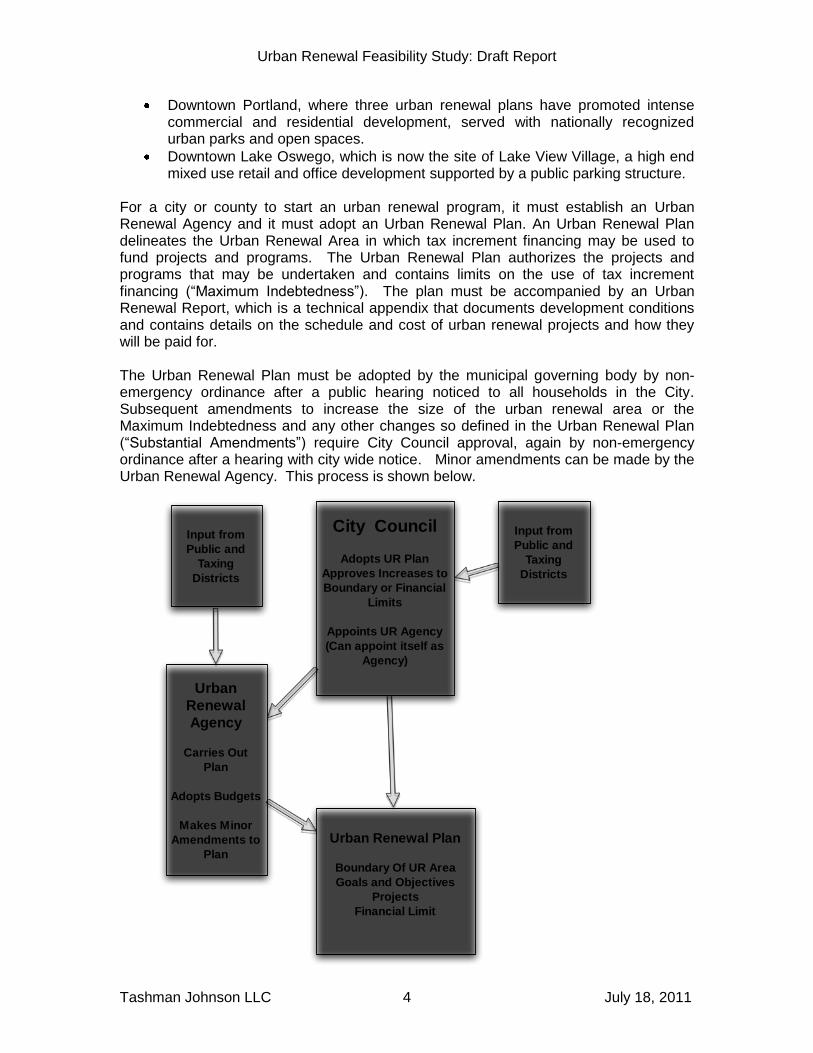
For a city or county to start an urban renewal program, it must establish an Urban Renewal Agency and it must adopt an Urban Renewal Plan. An Urban Renewal Plan delineates the Urban Renewal Area in which tax increment financing may be used to fund projects and programs. The Urban Renewal Plan authorizes the projects and programs that may be undertaken and contains limits on the use of tax increment financing (“Maximum Indebtedness”). The plan must be accompanied by an Urban Renewal Report, which is a technical appendix that documents development conditions and contains details on the schedule and cost of urban renewal projects and how they will be paid for. The Urban Renewal Plan must be adopted by the municipal governing body by non-emergency ordinance after a public hearing noticed to all households in the City. Subsequent amendments to increase the size of the urban renewal area or the Maximum Indebtedness and any other changes so defined in the Urban Renewal Plan (“Substantial Amendments”) require City Council approval, again by non-emergency ordinance after a hearing with city wide notice. Minor amendments can be made by the Urban Renewal Agency. This process is shown below.
City Council
Adopts UR Plan
Approves Increases to
Boundary or Financial
Limits
Appoints UR Agency
(Can appoint itself as
Agency)
Urban Renewal Plan
Boundary Of UR Area
Goals and Objectives
Projects
Financial Limit
Urban
Renewal
Agency
Carries Out
Plan
Adopts Budgets
Makes Minor
Amendments to
Plan
Input from
Public and
Taxing
Districts
Input from
Public and
Taxing
Districts

Urban Renewal Feasibility Study: Draft Report
Tashman Johnson LLC July 18, 2011 5
To begin its consideration of urban renewal and tax increment financing, the City retained consultants to work with the Council, staff and a stakeholder group to analyze the feasibility of this funding source and its impacts on tax payers and taxing districts. This draft report summarizes the Feasibility Study. The Feasibility Study is primarily technical in nature and its purpose is provide information to Council that will help the Council decide whether and/or how to proceed. As it has been a technical task, the public has not been directly involved. Council direction has been provided at Council work sessions. The stakeholders committee has provided additional feedback and information, but its meetings have not been publicized. If the Council decides to proceed with development of an urban renewal plan or plans, public involvement will be a key part of the process. Typically, preparing an urban renewal plan involves the public by means of public informational meetings as well as the public meetings of the Planning Commission and City Council that are required as part of the adoption process. Many communities also appoint an urban renewal planning advisory committee to provide feedback and direction for the plan. The Feasibility Study is also not intended to evaluate the development objectives that the City has already adopted in its Comprehensive Plan and implementing ordinances. The study takes as “givens” the adopted land use designations, policies and regulations and then focuses on if and how urban renewal and tax increment financing can help promote development in conformance with those designations, policies and regulations. II. SCOPE OF FEASIBILITY STUDY
The Feasibility Study addresses these key questions and issues regarding urban renewal and tax increment financing:
Are the Study Areas (discussed below) eligible for inclusion in an Urban Renewal Plan by virtue of their being “blighted areas” as defined in statute? Blighted areas may lack public infrastructure and/or they may be underdeveloped in relationship to their Comprehensive Plan designations.
What scale, type and value of development (within the limits of the Comprehensive Plan designations) is reasonable to expect in the Study Areas over the typical twenty-year life of an urban renewal plan?
What public improvements and other investments may be needed to allow development of the areas to their Comprehensive Plan potential?
What tax increment revenues would be generated by such development and how much public investment would be supported by these projected revenues.
What other funding sources can be used, with or instead of tax increment financing, to pay for the needed improvements and investments?
What impact would tax increment financing have on property tax payers and the taxing districts that levy taxes within the Study Areas (“Overlapping Taxing Districts”)?
Urban Renewal Feasibility Study: Draft Report
Tashman Johnson LLC July 18, 2011 6
What information is helpful to make a decision on proceeding with urban renewal?
To answer these questions, the Feasibility Study:
Inventoried and analyzed the existing conditions of the Study Areas.
Analyzed the public improvement needs of the Study Areas including scope and cost.
Assessed regional and local real estate market demand and the supply of vacant and/or redevelopable land in the Study Areas and projected growth in the real market value of new development over a twenty year period.
Based on the projected development, analyzed the assessed value of future growth and applicable total property tax rates in order to project annual tax increment revenues.
Analyzed the funding capacity for projects and programs represented by the projected annual revenues.
Analyzed the impact on Overlapping Taxing Districts and property tax payers of the tax increment financing.
Analyzed other funding sources that could be used to meet the public investment needs.
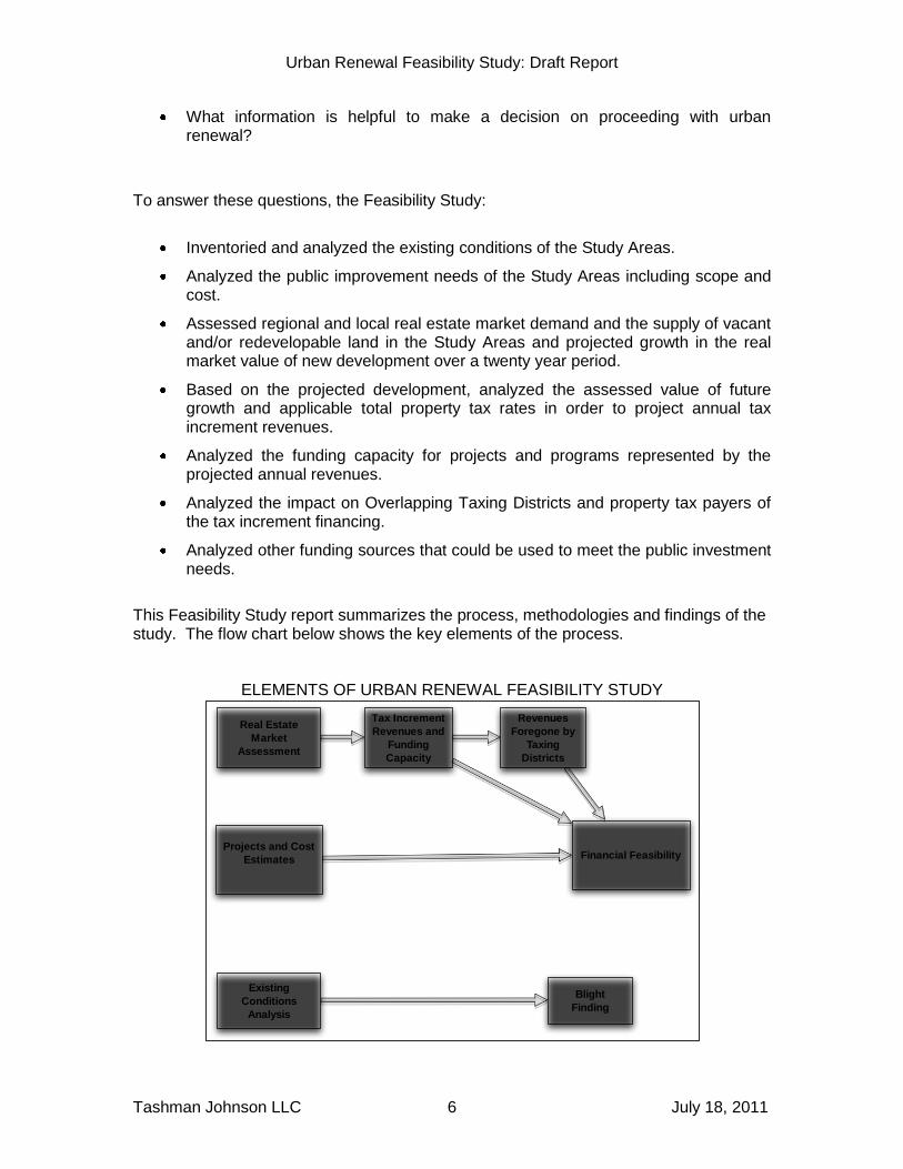
This Feasibility Study report summarizes the process, methodologies and findings of the study. The flow chart below shows the key elements of the process.
ELEMENTS OF URBAN RENEWAL FEASIBILITY STUDY
Real Estate
Market
Assessment
Projects and Cost
Estimates
Tax Increment
Revenues and
Funding
Capacity
Financial Feasibility
Revenues
Foregone by
Taxing
Districts
Existing
Conditions
Analysis
Blight
Finding

Urban Renewal Feasibility Study: Draft Report
Tashman Johnson LLC July 18, 2011 7
III. STUDY AREAS
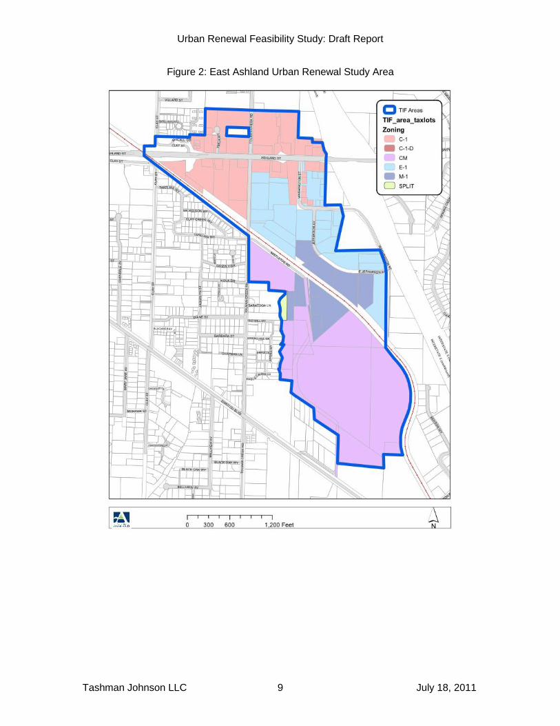
Study Area boundaries were developed with the help of staff only for the purpose of the Feasibility Study. They are not intended to be urban renewal area boundaries. If the Council decides to prepare an urban renewal plan or plans, the delineation of the boundaries will be a collaborative process with public input. The two Study Areas are shown in Figures 1 and 2 below. The Downtown/Railroad Property Study Area combines two “subdistricts,” the Downtown proper (primarily identified as the Retail Commercial – Downtown District [C1-D]) and the area including vacant property owned by the Union Pacific Railroad that is primarily zoned Employment 1 with a Residential Overlay [E-1]. These subdistricts were combined because of the close geographic and functional relationships between them. The Railroad Property itself benefits greatly from its proximity to Downtown and Downtown will continue to draw people who work and/or live north and south of the RR tracks. In addition, by combining the subdistricts, the corridors connecting the two sub districts on the west (Oak, Water and Helman Streets) can be included in one Study Area. The East Ashland Study Area includes the former Croman Mill district itself, the primarily light industrial property north of the railroad and east of Tolman Creek Road and the primarily commercial property north and south of Ashland Street.

Urban Renewal Feasibility Study: Draft Report
Tashman Johnson LLC July 18, 2011 8
Figure 1: Downtown/Railroad Property Urban Renewal Study Area
Urban Renewal Feasibility Study: Draft Report
Tashman Johnson LLC July 18, 2011 9
Figure 2: East Ashland Urban Renewal Study Area
Urban Renewal Feasibility Study: Draft Report
Tashman Johnson LLC July 18, 2011 10
IV. EXISTING CONDITIONS IN STUDY AREAS
Urban renewal and tax increment financing are authorized under State Law (Oregon Revised Statutes Chapter 457) for use in “blighted areas.” While the concept of blight originated in the context of deteriorated inner city neighborhoods, the law describes a number of conditions, any of which can be taken as a sign of blight. The finding of blight is made by the City Council in the ordinance adopting an Urban Renewal Plan, and this finding establishes the eligibility of the area for urban renewal. Blighted areas can be underdeveloped, have old, deteriorated buildings and bad streets and utilities or they can lack buildings, streets, and utilities altogether. The lack of public facilities, such as parks and/or parking, is another condition that would make an area eligible for urban renewal. Existing conditions in the two Study Areas were analyzed and described in detail in Technical Memorandum 1, “Existing Conditions Analysis”. Generally the Downtown/Railroad Property Study Area” is characterized by underdevelopment of the Railroad Property, lack of direct access to Downtown and lack of local access and utilities. Downtown’s conditions of blight include inadequate intersections, lack of street furniture and other pedestrian amenities and possibly lack of parking. The East Ashland Study Area is characterized by underdevelopment and lack of access and utilities. The East Ashland Study Area was delineated within the city limits. Property within the Urban Growth Boundary but outside the city limits can be included in an Urban Renewal Area, and in several cases cities have found that including such land is essential to achieving the objectives of the urban renewal plan. Procedurally, including property outside the city limits requires that the County approve the Urban Renewal Plan (with less stringent notice and findings requirements) and any subsequent substantial amendment of the Plan. While meeting the legal requirements for eligibility for urban renewal is not generally difficult to do, the policy decisions to adopt an Urban Renewal Plan for an area are not always easy. Sometimes these decisions are viewed skeptically by citizens thinking of blight in its historic, inner city context. However many urban renewal areas in Oregon have been found eligible because of lack of infrastructure and underdevelopment of property in relationship to the Comprehensive Plan designations.
Urban Renewal Feasibility Study: Draft Report
Tashman Johnson LLC July 18, 2011 11
V. REAL ESTATE MARKET ASSESSMENT
Tax increment financing of urban renewal projects is based on the expectation that assessed value growth from new development and rehabilitation of existing buildings, along with the appreciation of existing properties within the 3% limit, will produce tax increment revenues that will cover a share of the costs of the needed public investments. As a basis for our projections of tax increment revenues, we assessed real estate market conditions for Southern Oregon and the city of Ashland as they pertain to the Downtown/Railroad Property and East Ashland Study Areas (See Technical Memorandum 2, “Real Estate Market Assessment.”) With a goal of forecasting long-term real estate development, the analysis examines:
Historic measures of growth and development Forecasts of employment and population Current real estate market conditions, particularly in light of the extended
recession Opportunities and obstacles for new development Existing expansion plans for local businesses
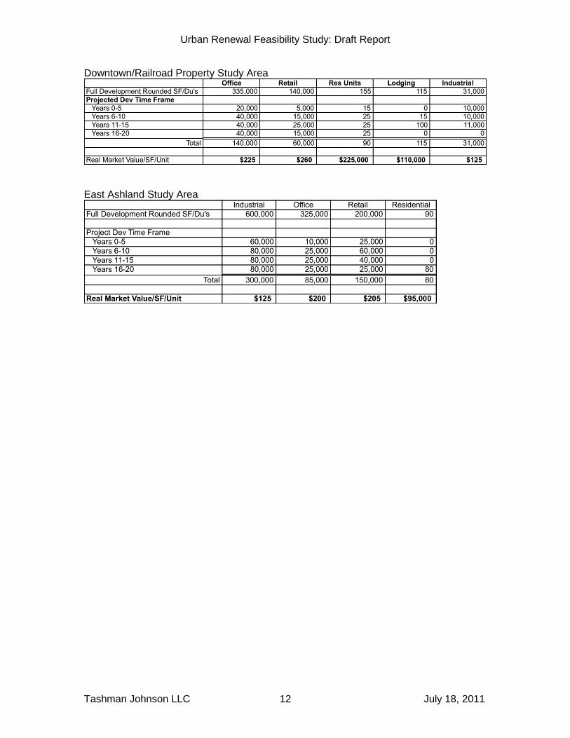
The Economic Opportunity Analysis (EOA) updated in 2009 and adopted in 2010 provides a solid background of supply and demand of buildable lands, as well as a review of Ashland’s overall economic and employment base. However, projections of real estate development presented in this analysis are “closer to the ground,” i.e. specific sites and parcels are identified as candidates for development or redevelopment. The localization of projected new development within the Study Areas focused on “opportunity parcels.” Opportunity parcels are those parcels that could be candidates for development within the 20-year projection time horizon. For vacant parcels, this likelihood is based on a combination of factors including: active development activity; active planning activity, proximity to recent successful development, location within a fully developed area, strong commercial location with high traffic counts, and many other factors. For parcels with some improvements, the factors include: low improvement-to-land (I:L) ratios (the ratio of the real market value of the improvements (I) to the real market value of the land (L), proximity to high value development, economic age of improvements, low intensity uses in an area with higher density commercial development, etc. As the real estate bubble and subsequent implosion demonstrated, predictions of growth can be overoptimistic when based on price trends rather than underlying economic reality. In view of this, these projections use conservative estimates of employment growth as a baseline. In addition, projections are not specific to exact locations and timing, but are presented within 5-year increments. The projections of full development in each Study Area are shown below, in terms of square feet (SF) of industrial, retail and office space and numbers of dwelling units (DU’s) for housing. Shown is full development of the opportunity parcels, followed by the projected development over twenty years in five year periods. Finally the table shows the estimated current real market value per square foot or DU.
Urban Renewal Feasibility Study: Draft Report
Tashman Johnson LLC July 18, 2011 12
Downtown/Railroad Property Study Area
East Ashland Study Area
Urban Renewal Feasibility Study: Draft Report
Tashman Johnson LLC July 18, 2011 13
VI. TAX INCREMENT REVENUE PROJECTIONS
This section starts with an explanation of key concepts in tax increment financing and how the amount of revenues are calculated and collected. It then describes the projections of annual tax increment revenues and the resulting funding capacity. Technical Memorandum 3, “Tax Increment Revenue Projections” provides more detail. Tax increment financing is only available as part of an Urban Renewal Plan, which, among other things, defines the Urban Renewal Area, authorizes specific investments and contains financial limits. Urban renewal plans are adopted by the municipality (City Council or County Commission) after and are administered by an Urban Renewal Agency that is appointed by the municipality. (The Agency can consist of the members of the Council/Commission itself and/or can be composed of other members appointed by the Council/Commission.
A. Key Concepts in Tax Increment Financing
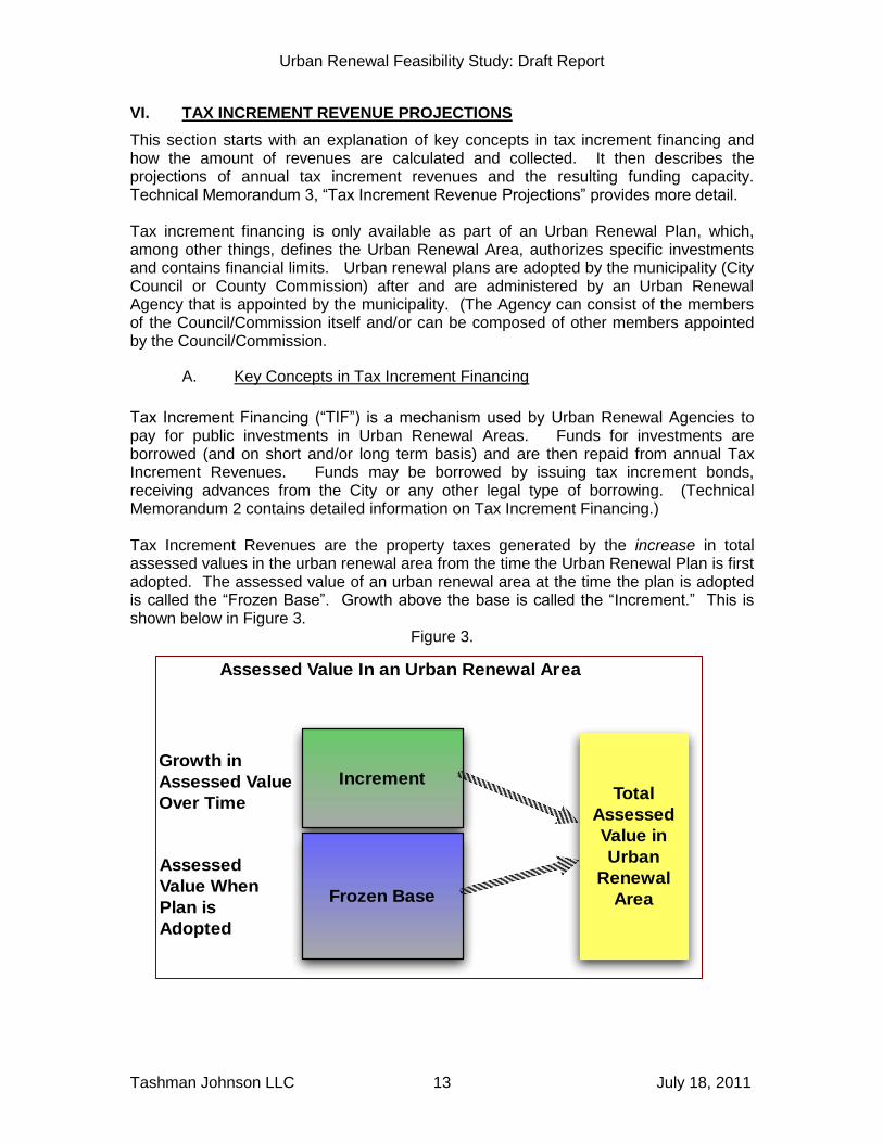
Tax Increment Financing (“TIF”) is a mechanism used by Urban Renewal Agencies to pay for public investments in Urban Renewal Areas. Funds for investments are borrowed (and on short and/or long term basis) and are then repaid from annual Tax Increment Revenues. Funds may be borrowed by issuing tax increment bonds, receiving advances from the City or any other legal type of borrowing. (Technical Memorandum 2 contains detailed information on Tax Increment Financing.) Tax Increment Revenues are the property taxes generated by the increase in total assessed values in the urban renewal area from the time the Urban Renewal Plan is first adopted. The assessed value of an urban renewal area at the time the plan is adopted is called the “Frozen Base”. Growth above the base is called the “Increment.” This is shown below in Figure 3.
Figure 3.
Increment
Frozen Base
Assessed Value In an Urban Renewal Area
Growth in
Assessed Value
Over Time
Assessed
Value When
Plan is
Adopted
Total
Assessed
Value in
Urban
Renewal
Area

Urban Renewal Feasibility Study: Draft Report
Tashman Johnson LLC July 18, 2011 14
The process by which the County Assessor allocates funds to the Urban Renewal Agency is called “Dividing The Taxes”. The Assessor divides taxes so that the Agency receives the property tax revenues on the Increment and taxing districts (e.g. the City, the County, the School District) receive property taxes on the Frozen Base. The diagram below in Figure 4 shows how this works. The “adjusted total tax rate” excludes the Local Option Levies and GO Bond Levies shown in the bottom row.
Figure 4: Dividing The Taxes
Though the amount of tax increment revenue is determined by the growth in assessed value inside the Urban Renewal Area, the taxes are actually allocated from all property taxes paid within the city. An “Ashland Urban Renewal” line would appear on property tax bills, but it won’t represent additional property taxes1. This was the case in Ashland during the years that Jackson County financed its White City Urban Renewal Plan with tax increment financing. A “Jackson County Urban Renewal” line appeared on tax bills in the entire County. The financial limits on tax increment financing take the form of a “Maximum Indebtedness” that be issued or taken on under an urban renewal plan. This is
1 A minor exception to the “no additional taxes” rule is that the rates calculated by the Assessor for GO Bonds approved prior to October 5, 2001 will not include increment in an urban renewal area and may be slightly higher as a result.
Urban Renewal Feasibility Study: Draft Report
Tashman Johnson LLC July 18, 2011 15
effectively a dollar limit on expenditures of annual tax increment revenues for any use other payment of interest on debt. The Maximum Indebtedness must be stated in the Urban Renewal Plan and included on the city-wide notice of the Council’s public hearing on the ordinance approving the Urban Renewal Plan. After the Urban Renewal Plan is adopted, any increase in the Maximum Indebtedness must be considered a Substantial Amendment and approved by the same process used to approve the initial Urban Renewal Plan.
B. How Tax Increment Revenues Are Calculated
Tax increment revenues are calculated by multiplying the projected Increment by the projected Adjusted Total Property Tax Rate. The Increment includes all growth in assessed value over the Frozen Base, including the increase in assessed value from the maximum increase of 3% in the assessed value of existing property and the added assessed value from property that is developed, subdivided or used in a way that is permitted by a change in zoning, referred to here as “New Development”. This is shown in the diagram below (Figure 5).

Urban Renewal Feasibility Study: Draft Report
Tashman Johnson LLC July 18, 2011 16
Figure 3: Determining Amount of Tax Increment Revenues
Growth from
New
Development
Growth from
Existing
Property (Max
3%)
Development
Total
Assessed
Value in
Urban
Renewal Area
Total
Assessed
Value in
Urban
Renewal Area
Less
Frozen
Base
Increment
Increment X
Adjusted
Total
Property
Tax Rate
=Tax
Increment
Revenues
Urban Renewal Feasibility Study: Draft Report
Tashman Johnson LLC July 18, 2011 17
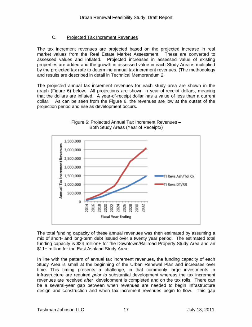
C. Projected Tax Increment Revenues
The tax increment revenues are projected based on the projected increase in real market values from the Real Estate Market Assessment. These are converted to assessed values and inflated. Projected increases in assessed value of existing properties are added and the growth in assessed value in each Study Area is multiplied by the projected tax rate to determine annual tax increment revenues. (The methodology and results are described in detail in Technical Memorandum 2. The projected annual tax increment revenues for each study area are shown in the graph (Figure 6) below. All projections are shown in year-of-receipt dollars, meaning that the dollars are inflated. A year-of-receipt dollar has a value of less than a current dollar. As can be seen from the Figure 6, the revenues are low at the outset of the projection period and rise as development occurs.
Figure 6: Projected Annual Tax Increment Revenues – Both Study Areas (Year of Receipt$)
The total funding capacity of these annual revenues was then estimated by assuming a mix of short- and long-term debt issued over a twenty year period. The estimated total funding capacity is $24 million+ for the Downtown/Railroad Property Study Area and an $11+ million for the East Ashland Study Area. In line with the pattern of annual tax increment revenues, the funding capacity of each Study Area is small at the beginning of the Urban Renewal Plan and increases over time. This timing presents a challenge, in that commonly large investments in infrastructure are required prior to substantial development whereas the tax increment revenues are received after development is completed and on the tax rolls. There can be a several-year gap between when revenues are needed to begin infrastructure design and construction and when tax increment revenues begin to flow. This gap
Urban Renewal Feasibility Study: Draft Report
Tashman Johnson LLC July 18, 2011 18
makes it critical that other, front end, sources of revenue be available. These other revenues, and when and where they may be appropriate, are discussed in Section VIII.
D. Impacts of Tax Increment Revenues on Overlapping Taxing Districts
The taxing districts that levy permanent rate taxes in an urban renewal area are referred to as “Overlapping Taxing Districts” (“OTD”). While tax increment financing is in use, the OTD do not receive – they forego – the permanent rate taxes on the Increment (growth in assessed value over the Frozen Base). The OTD’s are affected to the extent that they do not receive the tax revenues produced by applying their permanent rate to that growth in assessed value in the urban renewal area that would have occurred without urban renewal investments. This growth would include the appreciation in the value of existing properties subject to the 3% limit and such new development that is not dependent on urban renewal investments. The property taxes on growth in assessed value that occurs only because of urban renewal investments should not be considered as revenues not received by the OTD, because this part of the growth in assessed value in the urban renewal area would not have been there but for urban renewal. The two Study Areas are different in character, and our judgment as to what part of the projected increment is due to urban renewal investments takes into account these differences. In our view, the Downtown/Railroad Property Study Area is likely to grow in assessed value with or without urban renewal investments. Needed projects could be funded from other revenue sources, although the timing of these projects might be later. The East Ashland Study Area, on the other hand, lacks essential infrastructure and public facilities. In our view, without urban renewal investments the development would occur on a much slower pace and the public facilities (e.g. the Central Park and parking structure) might be similarly delayed. The analysis of permanent rate revenues foregone by the OTD therefore, uses different assumptions about what part of the projected Increment would occur without urban renewal investments. For the Downtown/Railroad Property Study Area we assume that the initial growth directly resulting from urban renewal investments is 0%, rising gradually to 30% at the end of the twenty year period. For the East Ashland Study Area we assume that the initial growth resulting from urban renewal investments is 50%, rising to 90% by the end of the twenty year period. Using these assumptions, we calculated the annual permanent rate revenues foregone by the OTD’s and converted the total into FYE 2014 dollars. We then calculated the average annual figure and then compared this average annual figure to the FYE 2011 permanent rate levy of the OTD. The results are shown in the tables below. Note that there are no figures for the Ashland School District or the ESD. This is because there is no direct impact on these districts, which receive most of their funds from the State. The State, in effect, makes up for local property taxes foregone. Tax increment financing anywhere in Oregon can reduce the total of all local permanent rate property taxes statewide, and there may be an indirect effect on all school districts and ESD’s from the use of tax increment financing anywhere in the State.
Urban Renewal Feasibility Study: Draft Report
Tashman Johnson LLC July 18, 2011 19
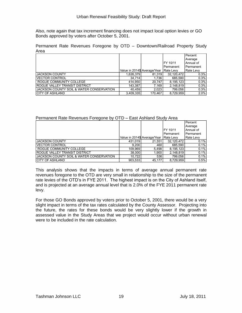
Also, note again that tax increment financing does not impact local option levies or GO Bonds approved by voters after October 5, 2001. Permanent Rate Revenues Foregone by OTD – Downtown/Railroad Property Study Area
Permanent Rate Revenues Foregone by OTD – East Ashland Study Area
This analysis shows that the impacts in terms of average annual permanent rate revenues foregone to the OTD are very small in relationship to the size of the permanent rate levies of the OTD’s in FYE 2011. The highest impact is on the City of Ashland itself, and is projected at an average annual level that is 2.0% of the FYE 2011 permanent rate levy. For those GO Bonds approved by voters prior to October 5, 2001, there would be a very slight impact in terms of the tax rates calculated by the County Assessor. Projecting into the future, the rates for these bonds would be very slightly lower if the growth in assessed value in the Study Areas that we project would occur without urban renewal were to be included in the rate calculation.
Urban Renewal Feasibility Study: Draft Report
Tashman Johnson LLC July 18, 2011 20
VII. INFRASTRUCTURE AND PUBLIC FACILITY NEEDS AND ESTIMATED
COSTS
While previous elements of our analysis focused on the revenue capacity of tax increment financing, in this section we begin to focus on the infrastructure and public facility needs of the two Urban Renewal Study Areas. For the most part, this analysis of needs is based on existing City plans and studies including the Croman Mill Site Design And Use Standards and the Downtown Plan Phase II. These sources have been supplemented by information from the ongoing updates of the Transportation System plan and other Master Plan updates as well as our analysis and recommendations. The project needs that are discussed in this section have been compiled only for the purpose of the feasibility study, i.e. to allow for some comparison of potential revenues to potential costs. If the City chooses to proceed with an Urban Renewal Plan, that process will include a much more substantive consideration of what projects will be authorized and what part of the project costs will be allocated to the Urban Renewal Plan. The listing of the projects below should not be taken as constituting a specific recommendation from staff or the consultants as to what projects should be included in an urban renewal plan. The Study Areas are clearly very different in character. The Downtown/Railroad Property Study Area has extensive existing infrastructure and its future needs are in the nature of upgrades and enhancements. Within the East Ashland Study Area, the Croman Mill property itself requires entirely new systems of access and some utilities. Lists of infrastructure needs and estimated costs in current dollars for the two Study Areas were developed by staff and reviewed by the consultant team. Tables 1 and 2 show the lists. The costs are based on unit costs of similar projects and not on specific designs for the projects. The costs include design and administration. Downtown/Railroad Property Study Area The table below shows the infrastructure needs identified by staff and our consultant team. The RR Property, being previously undeveloped, requires extension of access via Clear Creek Drive and extension of sewer and water lines. Downtown is well served by access and utilities and the identified needs are intersection improvements along Main Street and Lithia Way and planter and street furniture improvements.
Urban Renewal Feasibility Study: Draft Report
Tashman Johnson LLC July 18, 2011 21
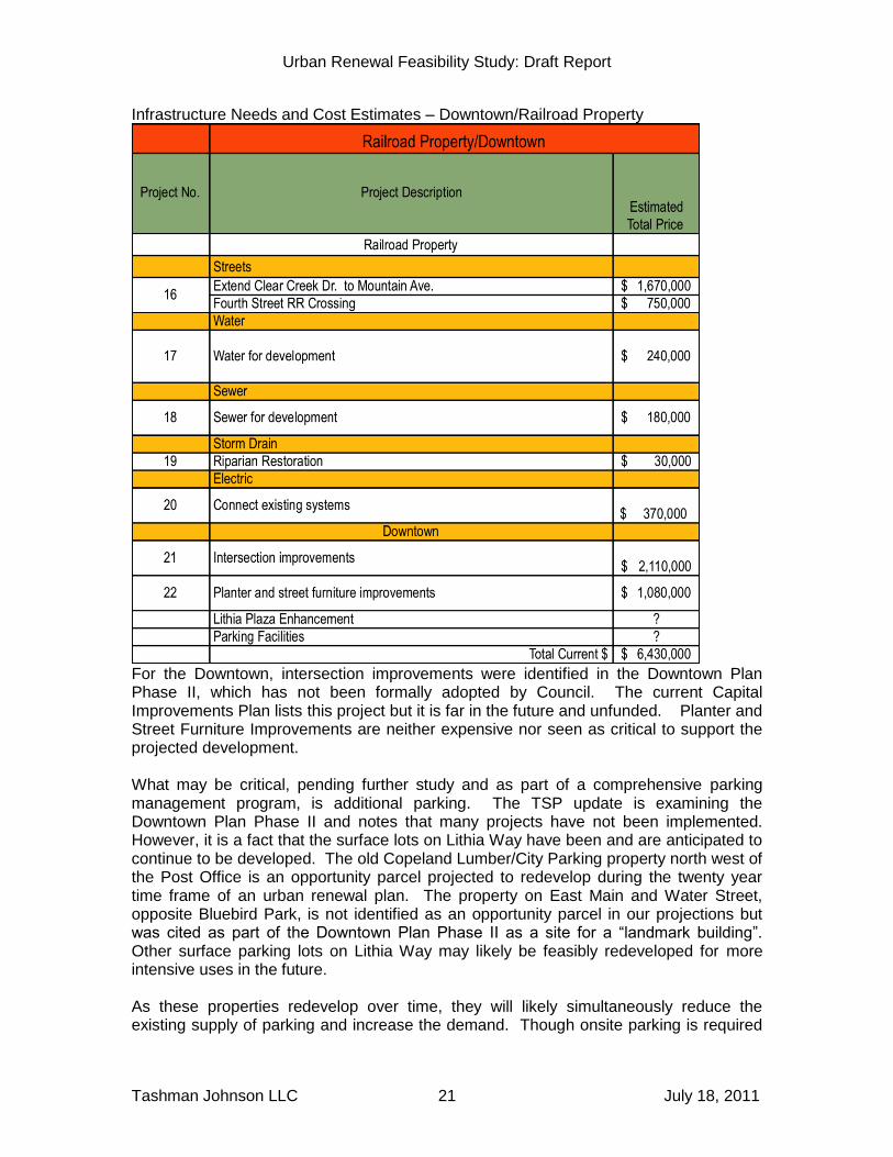
Infrastructure Needs and Cost Estimates – Downtown/Railroad Property
For the Downtown, intersection improvements were identified in the Downtown Plan Phase II, which has not been formally adopted by Council. The current Capital Improvements Plan lists this project but it is far in the future and unfunded. Planter and Street Furniture Improvements are neither expensive nor seen as critical to support the projected development. What may be critical, pending further study and as part of a comprehensive parking management program, is additional parking. The TSP update is examining the Downtown Plan Phase II and notes that many projects have not been implemented. However, it is a fact that the surface lots on Lithia Way have been and are anticipated to continue to be developed. The old Copeland Lumber/City Parking property north west of the Post Office is an opportunity parcel projected to redevelop during the twenty year time frame of an urban renewal plan. The property on East Main and Water Street, opposite Bluebird Park, is not identified as an opportunity parcel in our projections but was cited as part of the Downtown Plan Phase II as a site for a “landmark building”. Other surface parking lots on Lithia Way may likely be feasibly redeveloped for more intensive uses in the future. As these properties redevelop over time, they will likely simultaneously reduce the existing supply of parking and increase the demand. Though onsite parking is required
Urban Renewal Feasibility Study: Draft Report
Tashman Johnson LLC July 18, 2011 22
under terms of the C-1 zone that pertains to the Copeland Lumber/City Parking site, other sites in the C-1D zone do not require onsite parking. While we have not included any specific parking projects in the project list above, it is our recommendation that the Council would consider, in connection with a future urban renewal plan or otherwise, to proceed with evaluating parking needs and management strategies for downtown. Also not included in the project list but cited by staff as a possible project is the enhancement of Lithia Plaza. This project does not appear in the Downtown Plan Phase II and there is no basis for scoping or estimating the cost of the project. Regarding the Railroad Property the Fourth Street railroad crossing is a critically needed improvement for the future development of this area. The project would also benefit the general public by increasing circulation and access for cars, bikes and pedestrians and as such would be appropriate as a key urban renewal investment. The extension of Clear Creek Drive and sewer and water lines would normally be a direct cost of development of the vacant property. East Ashland Study Area The table below shows the shows the infrastructure needs identified by staff and our consultant team. Several of the projects shown - the Phase II Mistletoe Upgrade, the Tolman/Siskiyou signal, the connection from Tolman to Washington and the Washington St. extension over the railroad tracks were either identified in the existing TSP 2009-2018, or subsequent traffic analysis report when the Croman mill site was previously zoned M-1 Industrial. Note that there are three sub phases of the Central Boulevard shown below the overall project, and that the cost of the project when done at once is lower than the sum of the costs of the phases (and not accounting for inflation.) While the projects included for this area were taken from the Croman Mill Area Redevelopment Plan, additional projects are likely needed in the areas north of the railroad tracks. Gateway improvements to Ashland Street and intersection improvements at the Ashland St./Tolman Creek Road intersection have been discussed in the Pedestrian Places Project and the Transportation System Plan Update. Additionally, the extension and upgrade of Washington Street will be necessary for the Washington/Jefferson vicinity to fully develop. Again, it is not assumed that all the costs of these public facilities would be public costs to be funded through urban renewal but rather that the Feasibility Study should account for some level of participation in the development of these facilities as they are required for the area to develop as called for in the Land Use Code.
Urban Renewal Feasibility Study: Draft Report
Tashman Johnson LLC July 18, 2011 23
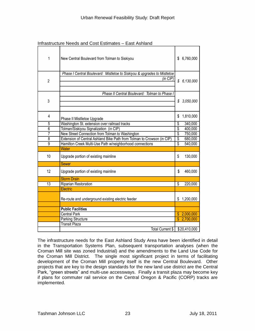
Infrastructure Needs and Cost Estimates – East Ashland
The infrastructure needs for the East Ashland Study Area have been identified in detail in the Transportation Systems Plan, subsequent transportation analyses (when the Croman Mill site was zoned Industrial) and the amendments to the Land Use Code for the Croman Mill District. The single most significant project in terms of facilitating development of the Croman Mill property itself is the new Central Boulevard. Other projects that are key to the design standards for the new land use district are the Central Park, “green streets” and multi-use accessways. Finally a transit plaza may become key if plans for commuter rail service on the Central Oregon & Pacific (CORP) tracks are implemented.
Urban Renewal Feasibility Study: Draft Report
Tashman Johnson LLC July 18, 2011 24
Though the Croman Mill District Standards refer to the initial phase of Central Boulevard as “developer constructed,” it is likely that additional funding will be needed for the full project. An Immediate Opportunity Fund application is under consideration at this time for up to one million dollars but this funding would not cover the costs of construction, as shown in the table above. We would therefore recommend it be considered as a potential urban renewal project for the purposes of the Feasibility Study. The Central Park and parking structure are public facilities that would appropriately be considered as urban renewal investments. VIII. FINANCING ALTERNATIVES
For both the Study Areas, Tax Increment Financing (TIF) is likely to provide one revenue stream among others to meet the funding needs for infrastructure, public facilities and other programs and projects necessary to overcome development obstacles. This is commonly the case in urban renewal areas, as the costs of public improvements has increased (although not in the immediate past) and the revenues from TIF have been constrained, primarily by Ballot Measure 50 in 1998. Another very common reason that a combination of funding sources is needed is that Tax Increment Revenues from any one development project begin to flow to the Urban Renewal Agency only after a project is complete and on the tax rolls and property tax revenues are collected. While Tax Increment Revenues flow after completion of a project, commonly the infrastructure and public facility investments precede the beginning of a project. A very important consideration for the use of any funding source is that the funding should come from those who are benefitted by the project. The funding sources discussed below are described in terms of their use for projects where the people paying and the people benefitting are to a large degree the same. There are important policy issues related to the following funding sources that would have to be discussed and resolved prior to implementation. For the two Ashland Study Areas, we would see a combination of funding sources, in addition to TIF. For both areas:
Street and utility funds, receiving moneys from SDC’s and other sources for the relevant transportation and utility needs, could participate in the cost of system- wide improvements that benefit the whole city.
Improvements made by the property owner and/or developer as a condition of a building permit would contribute to the cost of streets and utilities that primarily serve adjacent development, as opposed to system wide improvements.
Grants and other contributions from government and non government organizations could add funding under very specific conditions, e.g. infrastructure with a direct link to job creation or innovative green design efforts.
General obligation bonds could provide a part of the funding for public facilities that benefit the whole city, in those cases where it is likely the citizens would see a substantial and tangible benefit from the public facilities.
Following is a discussion of how these funding sources and others could be used in the two Study Areas.
Urban Renewal Feasibility Study: Draft Report
Tashman Johnson LLC July 18, 2011 25
Downtown/Railroad Property Study Area The Fourth Street RR crossing is project with City wide circulation benefits and important land use benefits. Commercial, residential and employment activities in the Railroad Property Area and the retail, restaurants, services and offices and Downtown would be linked in a manner that would benefit both areas and the city as a whole. Given these considerations, TIF could be combined with Street Fund revenues and property owner contributions to cover project costs. In particular some property owner contributions could be in the form of an advance or loan which then would get repaid with TIF revenues. The Clear Creek Road project would have primarily local benefits, providing access to adjacent properties, but to some degree it provides an alternative circulation option to Hersey Street for east-west travel. The quieter nature of the street would be especially attractive to bicyclists and pedestrians. This project could be funded by property owner contributions to the extent of the costs of a local street, and supplemented by TIF as necessary to complete the project. Improvements in excess of local street improvements could be financed by a property owner contribution to be repaid with Tax Increment Revenues. Downtown, the identified needed street and intersection improvements could be funded in part by the Street fund and TIF, but would this project could perhaps be financed in part by a Local Improvement District (LID). This combination would reflect the mix of local and city wide benefits for this project. The same approach could be taken for the improvements needed to planters and street furniture. Parking improvements, if found to be needed and feasible as part of a parking management plan, could be financed by TIF and an LID. While parking revenues are another source of funding, typically these revenues are used for operation and maintenance as opposed to capital costs. East Ashland Study Area The Land Use Code for the new Croman Mill District refers to funding of the critical Central Boulevard by the developer. It is likely that additional sources of revenue will be needed, with or without an Immediate Opportunity Fund grant. There are aspects of the Central Boulevard as a Boulevard that provide benefits beyond local access, by connecting Croman Mill to the existing boulevard system and to downtown. These wider benefits indicate a participation role for TIF in the development of this project. Again, from a financing basis, part of the initial investments by the property owner can be repaid at a later date with Tax Increment Revenues. The Central Park and the Multi-use Pathway are projects that could be considered for funding in part from a General Obligation Bond. They are designed to have city-wide benefits which makes GO Bond financing potentially acceptable. Possibly part of the costs of green streets could be included in such a bond issue. A Croman Parking Structure will primarily serve commercial and industrial users of space in Croman Mill District buildings. The capital cost of the structure should primarily fall on the developers and or property owner. However, participation in the cost of the
Urban Renewal Feasibility Study: Draft Report
Tashman Johnson LLC July 18, 2011 26
structure with TIF proceeds can be justified on the basis of the facility needing to be developed in advance of the real estate market supporting sufficient rents. Again, a repayment of some initial developer contributions by tax increment revenues could be an appropriate arrangement. IX. PRELIMINARY FINANCING PLAN
As noted in the summary of the tax increment revenue projections in Section VI, annual revenues and funding capacity tend to be low at the beginning of an urban renewal plan whereas infrastructure investment needs tend to be high at this same time. Therefore the common challenge is to find other sources of revenues that can be used for the “up front” investment. The previous Section, Financing Alternatives, described several overall financing alternatives. Other specific financing alternatives were noted for the Downtown/Railroad Property Study Area and the East Ashland Study Area. All of these alternatives could provide funds in advance of the receipt of substantial tax increment revenues. The tables below show how these revenue sources might be combined for each of the Study Areas. The tables list both “Developer Paid” and “Developer Financed”. Developer Financed means that the costs of the project are initially paid by the developer but later they are reimbursed from tax increment revenues. “Area Property Owners” means funds from an assessment of property owners that benefit from the project. A local improvement district is an example of this kind of funding. Project costs are allocated to the various revenue sources using the following guidelines.
Street and utility projects that are primarily serving adjacent properties are shown as Developer Paid.
Street projects that serve a broader area than adjacent properties are shown as ultimately paid from TIF, Street Fund and/or Area Property Owners. Some street projects that are required before development can occur are shown as Developer Financed.
“Green” projects such as riparian restoration, bike paths and multi use paths are shown as funded through a GO bond, on the basis of potential support among Ashland voters for green projects.

Urban Renewal Feasibility Study: Draft Report
Tashman Johnson LLC July 18, 2011 27
A. Downtown/Railroad Property Study Area
The table above suggests that the key projects that could appropriately be funded at least in part from urban renewal are the needed intersection improvements, planters and street furniture and riparian restoration. The Lithia Plaza enhancement project and Parking Facility projects could also be appropriately funded from urban renewal. The projected funding capacity for a twenty year period of tax increment financing has been projected at more than $24 million. Though the total project costs shown above are in current dollars, and though the Lithia Plaza and parking facility projects have no cost estimates, it is safe to assume that the projected funding capacity would exceed urban renewal project costs. In this case, the time frame of the tax increment financing should be reduced to match the determined urban renewal share of total project costs.
Urban Renewal Feasibility Study: Draft Report
Tashman Johnson LLC July 18, 2011 28
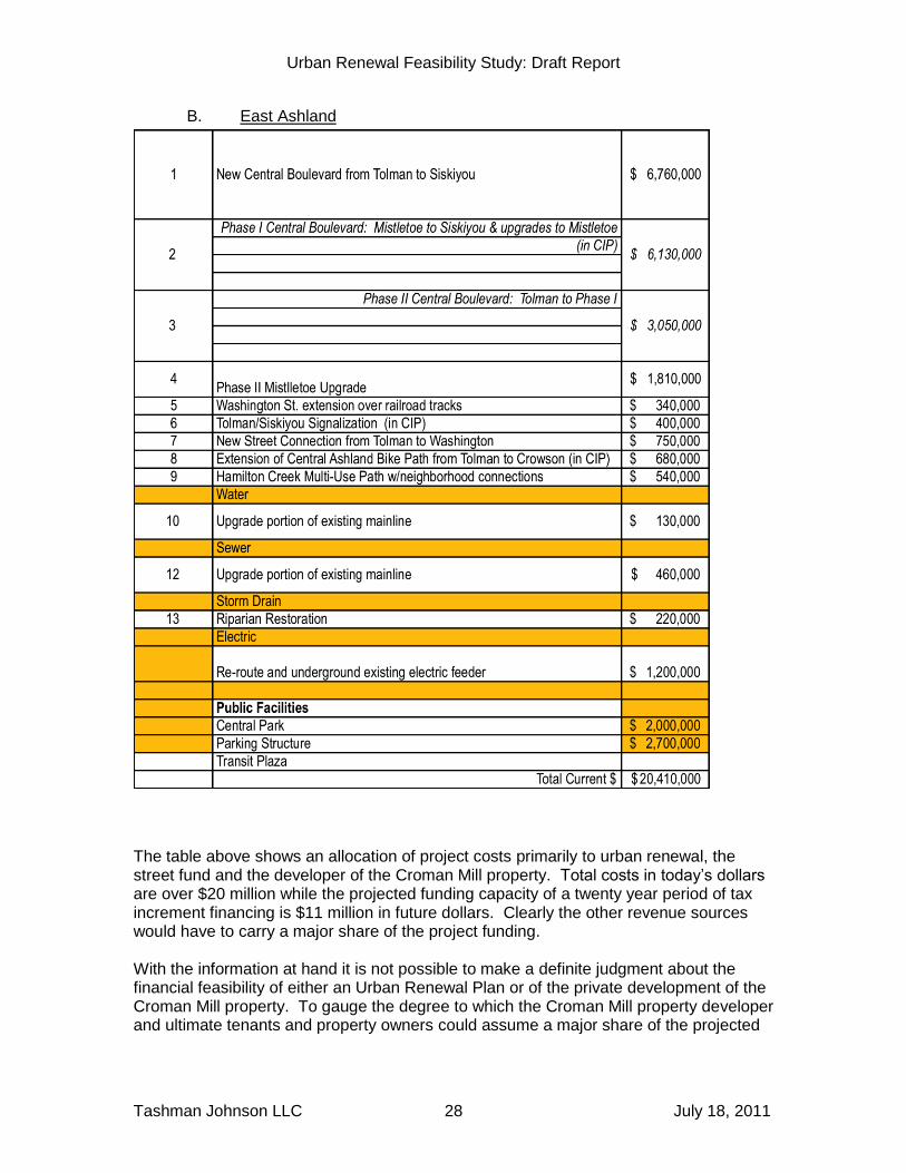
B. East Ashland
The table above shows an allocation of project costs primarily to urban renewal, the street fund and the developer of the Croman Mill property. Total costs in today’s dollars are over $20 million while the projected funding capacity of a twenty year period of tax increment financing is $11 million in future dollars. Clearly the other revenue sources would have to carry a major share of the project funding. With the information at hand it is not possible to make a definite judgment about the financial feasibility of either an Urban Renewal Plan or of the private development of the Croman Mill property. To gauge the degree to which the Croman Mill property developer and ultimate tenants and property owners could assume a major share of the projected
Urban Renewal Feasibility Study: Draft Report
Tashman Johnson LLC July 18, 2011 29
costs would require a development feasibility analysis, which is outside the scope of this study. It is possible to conclude that tax increment financing in this Study Area would provide a significant but not sufficient source of funding. This is not an unusual situation, in that commonly multiple funding sources must be combined to cover major public facility costs. X. CONCLUSIONS
A. Are the Study Areas (discussed below) eligible for inclusion in an Urban Renewal Plan by virtue of their being “blighted areas” as defined in statute?
Yes, the Study Areas have conditions that would support a finding by the Council that they are blighted areas. The Downtown/Railroad Property Study Area has areas that are underdeveloped and that have inadequate access and infrastructure. The East Ashland Study Area lacks access and infrastructure and contains underdeveloped commercial properties. (see Section IV and Technical Memorandum 1.
B. What scale, type and value of development (within the limits of the Comprehensive Plan designations) is reasonable to expect in the Study Areas over the typical twenty-year life of an urban renewal plan?
Regional and local real estate market demand will support a substantial amount of development and there are sufficient sites (“opportunity parcels”) to accommodate such development. This development does not represent full build out of the Study Areas. See Section V and Technical Memorandum 2.
1. Downtown/Railroad Property Study Area
This Study Area is projected to add 140,000 square feet of office space, 60,000 square feet of retail, 90 residential units and 115 hotel rooms.
2. East Ashland Study Area
This Study Area is projected to add 300,000 square feet of light industrial (employment) space, 85,000 square feet of office space 150,000 square feet of retail and 90 residential units.
C. What public improvements and other investments may be needed to allow development of the areas to their Comprehensive Plan potential? See Section VII
1. Downtown/Railroad Property Study Area
Downtown will require intersection improvements, street furniture and planters, and possibly enhancement of Lithia Plaza and development of public parking facilities.
Urban Renewal Feasibility Study: Draft Report
Tashman Johnson LLC July 18, 2011 30
The Railroad Property area will require a railroad crossing at 4th Street and extension of Clear Creek Road and utilities.
2. East Ashland Study Area
The Croman Mill District will require access, utilities and public facilities including a public park and parking structure. The Ashland Street commercial area will require a secondary connection between Tolman Creek Road and Washington Street.
D. What tax increment revenues would be generated by such development and how much public investment would be supported by these projected revenues. See Section VI and Technical Memorandum 3.
The Downtown/Railroad Property Study Area is projected to generate tax increment revenues that would support $24 million in funding capacity. This funding capacity is likelty to be sufficient for the Downtown/Railroad Property Study Area, even with the addition of projects for which costs are not yet known. The East Ashland Study Area is projected to generate tax increment revenues that would support $11 million (future dollars) in funding capacity. For the East Ashland Study Area, tax increment financing would have to supplemented to a large extent with other revenue sources. Again, it is commonly the case that tax increment financing does not cover 100% of the costs of even the most key projects. In and of itself, the insufficiency of tax increment financing to completely fund major public facility investments does not necessarily lead to a conclusion that an urban renewal program is not justified.
E. What other funding sources can be used, with or instead of tax increment financing, to pay for the needed improvements and investments?
Other funding sources include developer payment of local improvements, Street Fund revenues, grants and GO Bonds. See Section VII.
F. What impact would tax increment financing have on property tax payers and the taxing districts that levy taxes within the Study Areas (“Overlapping Taxing Districts”?
1. Downtown/Railroad Property Study Area
The projected annual permanent rate property tax revenues foregone by the Overlapping Taxing Districts other than the City of Ashland are projected to be, on the average less than 0.3% of their FYE 2011 permanent rate levy. The City is projected to forego revenues equal to 2% of its FYE 2011 permanent rate levy.
2. East Ashland Study Area
The projected annual permanent rate property tax revenues foregone by the Overlapping Taxing Districts other than the City of Ashland are projected to be, on the average less than 0.1% of their FYE 2011 permanent rate levy. The City is projected to forego revenues equal to 0.5% of its FYE 2011 permanent rate levy.

Urban Renewal Feasibility Study: Draft Report
Tashman Johnson LLC July 18, 2011 31
XI. DECISION ISSUES
Deciding how or whether to proceed with an urban renewal program involves a host of policy issues. Perhaps the most basic is what role should the City play in promoting development. The City is both a planner/regulator of development and an investor, through the CIP, in infrastructure to support development. Urban renewal, as a program to promote certain types of development in areas that need investment, goes beyond these roles. The City’s willingness and desire to play a more aggressive role in development are not necessarily at the same level for the Downtown/Railroad Property Study Area and the East Ashland Study Area. This is an issue for Council consideration, with input from the community. The Feasibility Study does not make any recommendations in this area. As for overall issue of community support for urban renewal, in some cases a community solidly supports the objectives of an Urban Renewal Plan; in other cases there is a wide variety of opinion about whether and how the local government should support development in certain areas. It is therefore very important, that early in the process of preparing an Urban Renewal Plan, the local governing body provides opportunities for the public to learn about urban renewal and to provide feedback. Local public ownership and support of an Urban Renewal Plan is vital to the success of the program. The governance of urban renewal programs is another policy decision. A local government must “activate” an Urban Renewal Agency and appoint the members of the Agency board. The governing body can designate itself as the Urban Renewal Agency although the Agency will still be a separate legal entity. Most city councils and county commissions appoint themselves as the Agency board because they judge urban renewal too important to delegate. On the other hand, some governing bodies feel that urban renewal will be given more attention and be less influenced by day-to-day policy issues if the Agency board is composed of appointed officials. A local government also commonly considers the level of staff support that will be required to administer an Urban Renewal Plan. Actively carryout out a plan can take substantial staff resources. Urban renewal staffing can be provided from the City Administrator’s office, from Community Development or from a newly established department. The function of urban renewal staff is most closely related to economic development and in many communities, a staff person will preform both urban renewal and economic development functions. XII. POSSIBLE NEXT STEPS
The Feasibility Study has explored the key technical issues pertaining to urban renewal for the two Study Areas. The conclusions of the study support a decision to proceed with further consideration of urban renewal. However, it may well be the case that the Council would want to devote more time to digesting the conclusions of the study and to solicit community input and OTD feedback on the issue before making a decision to begin developing an urban renewal plan. It is important to keep in mind that preparing urban renewal plan in itself includes substantial Council policy direction, public input and OTD feedback.
Urban Renewal Feasibility Study: Draft Report
Tashman Johnson LLC July 18, 2011 32
In particular the direction from Council and input from the public and OTD during the urban renewal plan preparation relate to:
Boundaries of the urban renewal area
Goals and objectives
Urban renewal projects
Financial limits (Maximum Indebtedness)
Revenue impacts on OTD
Procedures for future amendments.
City of Ashland Urban Renewal Feasibility Study
Existing Conditions Analysis
Prepared for the City of Ashland July 2011
Tashman Johnson LLC
Elaine Howard Consulting, LLC
Table of Contents I. Introduction ......................................................................................................................... 3
II. Existing Conditions Analysis ............................................................................................... 3
A. Review Existing Plans and Studies .................................................................................. 3
1. The City of Ashland Comprehensive Plan .................................................................... 3
2. The City of Ashland Land Use Ordinance ................................................................... 8
3. The Transportation Systems Plan (TSP) ...................................................................... 8
B. Analyze Existing Conditions in Downtown/Railroad Urban Renewal Study Area .............. 9
1. Street and Sidewalk Conditions ..................................................................................10
2. Storm Water ................................................................................................................10
3. Sanitary Sewer ...........................................................................................................10
4. Water ..........................................................................................................................11
5. Electric ........................................................................................................................11
6. Parking .......................................................................................................................11
7. Railroad Crossing .......................................................................................................11
8. Land Use ....................................................................................................................11
9. Zoning and Comprehensive Plan Designations ...........................................................12
10. Improvement to Land Ratios (I:L) ............................................................................13
C. Analyze Existing Conditions in East Ashland Urban Renewal Study Area ......................14
1. Street and Sidewalk Conditions ..................................................................................16
2. Storm Water ................................................................................................................17
3. Sanitary Sewer ...........................................................................................................17
4. Water ..........................................................................................................................17
5. Electric ........................................................................................................................17
6. Railroad Crossing .......................................................................................................17
7. Parks ..........................................................................................................................17
8. Parking .......................................................................................................................17
9. Transit .........................................................................................................................17
10. Land Use .................................................................................................................18
11. Zoning and Comprehensive Plan Designations .......................................................18
12. Improvement to Land Ratios (I:L) ............................................................................20
III. Conformance with Acreage and Assessed Value Limitations .............................................21
IV. Blight Findings ...................................................................................................................21

Ashland Urban Renewal Feasibility Study –Existing Conditions Feasibility Analysis Page 2
Ashland Urban Renewal Feasibility Study –Existing Conditions Feasibility Analysis Page 3
I. INTRODUCTION
The City of Ashland is reviewing the possibility of implementing urban renewal in two areas in Ashland: the Downtown/Railroad Study Area and the East Ashland Study Area. The Downtown/Railroad Study Area is the combination of the downtown retail core and the developing area to the north along the railroad right-of-way. The two areas are linked because of their proximity to downtown and the close geographic and functional relationship of the two areas. The Railroad Property itself benefits greatly from its proximity to downtown and downtown will continue to draw people who work and/or live to the north and south of the railroad tracks. The corridors connecting the two sub districts on the west (Oak, Water, and Helman Streets) are also included in the Downtown/Railroad Study Area (Figure 1).
The East Ashland Study Area is located in the southeast portion of the city approximately two and a half miles from downtown and three quarters of a mile from I-5. The East Ashland Study Area includes the former Croman Lumber Mill district, the primarily light industrial property north of the railroad and east of Tolman Creek Road, and the primarily commercial property north and south of Ashland Street (Figure 2).
The two areas will be described together in the Review Existing Plans and Studies section and then separately in the Existing Conditions portion of this feasibility study. II. EXISTING CONDITIONS ANALYSIS
One of the main questions when looking at the feasibility of an urban renewal plan for an area is whether or not the area has a lack of public investment, resulting in conditions of “blight,” that make it eligible for urban renewal. These conditions can include underdevelopment in relationship to the comprehensive plan and zoning, inadequate streets and/or utilities, and/or inadequate sidewalks and streetscape. The requirement to find that an area is blighted is found in ORS 457. Generally to establish an Urban Renewal Agency the City Council/County Commission must state that blighted areas exist that require urban renewal, but this finding is not generally accompanied by findings of fact. However the ordinance which approves an Urban Renewal Plan must include findings that the urban renewal area is blighted and these findings must be supported by facts contained in the Urban Renewal Report.
A. Review Existing Plans and Studies
A number of documents were reviewed in preparation for this study, including the Ashland Comprehensive Plan, Ashland Railroad Property Master Plan, Ashland Downtown Plan, Ashland Downtown Plan Phase II, City of Ashland Economic Opportunity Analysis, Croman Mill Site Redevelopment Plan, Ashland Land Use Ordinance of the City, and the Transportation Systems Plan. A more detailed review of these documents will be completed if an urban renewal plan is prepared. Information on the Comprehensive Plan, the Land Use Ordinance, and the Transportation Systems Plan is included in this analysis. Information taken directly from the documents is shown in italics.
1. The City of Ashland Comprehensive Plan
The City of Ashland Comprehensive Plan is the general guide for the City for all activities that relate to land use. It identifies existing assets, problems, and needs in the community, and sets forth City policies and implementation strategies for dealing with these issues. The proposed urban renewal area
Ashland Urban Renewal Feasibility Study –Existing Conditions Feasibility Analysis Page 4
relates to several of these stated goals, policies, and implementation strategies. Of particular relevance are the following sections: Citizen Participation and Involvement, The Economy, Parks, Open Space, and Aesthetics, Public Services, Transportation Element, Energy, Air, and Water Conservation, and Urbanization.
Ashland Urban Renewal Feasibility Study –Existing Conditions Feasibility Analysis Page 5
Goal 1: Citizen Participation and Involvement
To maintain a citizen involvement program that ensures the opportunity for citizens to be involved in all phases of the planning process. The Ashland Feasibility Study team has worked directly with the Ashland City Council and Stakeholders group on this study. The study involves four public meetings to gather input and provide information.
Goal 7: The Economy
To ensure that the local economy increases in its health, and diversifies in the number, type, and size of businesses consistent with the local social needs,
public service capabilities, and the retention of a high quality environment. Downtown/Railroad Study Area: An Urban Renewal Plan (Plan) could upgrade the major utility systems, provide intersection improvements, install planters, and make improvements to street furniture. In addition,parking improvements could also be made and a redevelopment loan fund could be created. These improvements would allow for additional development and redevelopment in the Downtown/Railroad Area, stimulating the economy in the area and generating additional tax revenue for the municipality when the urban renewal area expires. East Ashland Study Area: An Urban Renewal Plan would help install the infrastructure necessary to support development of the Croman Mill Site and the Washington/Jefferson area, as well as address gateway and intersection upgrades in the Ashland St./Tolman Creek Rd. area. It would help encourage the development of prime commercial and industrial land that will both provide expansion opportunities for existing local businesses and attract new ones. Growth in the East Ashland Area would create new jobs for the community and would generate additional tax revenue for the municipality when the urban renewal area expires.
Goal 8: Parks, Open Space, and Aesthetics
To provide the people of Ashland with a variety, quantity and quality of parks, park facilities, open spaces, trails, and visual resources sufficient for their needs.
Downtown/Railroad Study Area: A Plan could provide funding for planter and street furniture improvements, enhancing the pedestrian experience in the area The proposed development of a new park at the east edge of the railroad property and the riparian restoration along the creek and to the north of the proposed park provide both more park facilities and visual resources for the people of Ashland.
East Ashland Study Area: A Plan would encourage the development of the underdeveloped East Ashland Study Area. The Croman Mill Site Redevelopment Plan includes new park facilities, including a new Central Park as an amenity for employment uses and serving as a gathering space for the adjacent neighborhood and community and open space preservation and enhancements such as a pathway along Hamilton Creek and around an existing pond that provide visual buffers between residential and industrial uses and public amenities within the area.
Ashland Urban Renewal Feasibility Study –Existing Conditions Feasibility Analysis Page 6
Goal 9: Public Services
To provide public utilities, services and facilities in an orderly, efficient and environmentally sensitive way and in sufficient quantity to meet city needs now and in the future. To provide sanitary sewers that meet environmental standards for all areas within the city limits. To provide sufficient water supply for Ashland residents.
To provide an adequate storm water drainage system throughout the entire City of Ashland. To provide systematic control of the solid waste process from collection to storage, emphasizing efficiency, resource recovery and environmental protection. To make maximum effort toward utilization of present and future educational and recreational facilities and resources through public, private and city cooperation.
Downtown/Railroad Study Area: A Plan could assist in the financing of improvements to the public infrastructure in the area.
East Ashland Study Area: A Plan could assist in the financing for the development of basic infrastructure in the area.
Goal 10: Transportation Element
To provide all citizens with safe and convenient transportation while reinforcing the recognition of public rights-of-way as critical public spaces.
To raise the priority of convenient, safe, accessible, and attractive walking and bicycling networks. To support and encourage increased levels of walking and bicycling. Emphasize environments which enhance pedestrian and bicycle usage. To dedicate funding and staff support to implement the goals and policies of this section.
To create a public transportation system that is linked to pedestrian, bicycle and motor vehicle travel modes, and is as easy and efficient to use as driving a motor vehicle.
To provide efficient and effective movement of goods, services and passengers by air, rail, water, pipeline, and highway freight transportation while maintaining the high quality of life of Ashland. Downtown/Railroad Study Area: The potential redevelopment of the area would enable the City to consider a project that would improve intersections and allow for planter and furniture improvements in the area. This would encourage more pedestrian and bicycle activity, and in turn, support business activity. Redevelopment of the area would also improve the function of the business

Ashland Urban Renewal Feasibility Study –Existing Conditions Feasibility Analysis Page 7
district to strengthen existing businesses, provide additional employment opportunities, and provide services to residents that will help to reduce trips outside of the area. The 4th Street Railroad Crossing will allow occupants of the newer railroad district easy access to the Historic Railroad District and to downtown Ashland. This feature is also an important component to successful pedestrian and bicycle connections in the area. Reinforcing the strength of the business district would also support the strength of the adjacent neighborhoods. East Ashland Study Area: The transportation system in the area does not allow for the full development of the area. An effective transportation system in the area will meet the goals of the Transportation Element and will allow for the efficient and effective movement of goods. It will be applicable to all modes of travel and will also help create a public transportation system. Goal 11: Energy, Air and Water Conservation
The city shall strive, in every appropriate way, to reduce energy consumption within the community. Water conservation and air quality enhancement should also be promoted programs should emphasize greater efficiency in end use, rather than sacrifices in living standards.
Downtown/Railroad Study Area: This area is located near existing residential neighborhoods and can provide necessary services within walking and cycling distances, thereby reducing trips in the area. Assisting in the redevelopment of the area will help it retain its vitality and provide local jobs for Ashland residents, reducing their need to go outside of the area for employment.
East Ashland Study Area: The development of the area would help ensure the development of land that is already in the urban growth boundary. By providing opportunities for businesses to expand or relocate to the area, the number of trips outside of the area to find employment will also decrease.
Goal 12: Urbanization
It is the City of Ashland’s goal to maintain a compact urban form and to include an adequate supply of vacant land in the City so as not to hinder natural market forces within the City, and to ensure an orderly and sequential development of land in the City limits.
Downtown/Railroad Study Area: This area already has a compact urban form, and providing tools to assist in the redevelopment of the area will ensure that the area flourishes through the orderly and sequential development of land in the city limits.
East Ashland Study Area: By providing opportunities for businesses to expand or relocate to the East Ashland Study Area, the area will develop into a compact urban form allowing for the City to grow, supporting the natural market forces within the City and helping to ensure the orderly and sequential development of land in the City limits.
Ashland Urban Renewal Feasibility Study –Existing Conditions Feasibility Analysis Page 8
2. The City of Ashland Land Use Ordinance
Zoning designations are established by The City of Ashland Municipal Code, Chapter 18: Land Use Ordinance. The purpose of the Land Use Ordinance is to encourage the most appropriate and efficient use of land, to accommodate orderly growth, to provide adequate open space for light and air; to conserve and stabilize the value of property; to protect and improve the aesthetic and visual qualities of the living environment; to aid in securing safety from fire and other dangers; to facilitate adequate provisions for maintaining sanitary conditions; to provide for adequate access to and through property; and in general to promote the public health, safety and the general welfare, all of which is in accordance with and in implementation of the Comprehensive Plan of the City of Ashland, Race, color, religion, sex, sexual orientation, national origin or disability shall not be an adverse consideration in making any decision under the Land Use Ordinance.
The specific zoning designations are identified for each study area.
3. The Transportation Systems Plan (TSP)
The TSP is presently being updated, with an estimated completion date in the winter of 2011. Some of the initial information from “white papers” is being included in this document.

Ashland Urban Renewal Feasibility Study –Existing Conditions Feasibility Analysis Page 9
B. Analyze Existing Conditions in Downtown/Railroad Study Area
To determine the extent to which conditions of blight might exist in the area, the consultants:
conducted a visual survey of the area;
reviewed existing planning documents, as described in Section A above;
solicited input from City of Ashland Planning and Engineering staff; and
analyzed FY 2010-2011 Jackson County tax assessor’s data for parcels within the area.
The Downtown/Railroad Study Area and the zoning and comprehensive plan designations are shown in Figure 1.
Figure 1 - Downtown/Railroad Study Area
Ashland Urban Renewal Feasibility Study –Existing Conditions Feasibility Analysis Page 10
The conclusions of the existing conditions analysis are summarized below.
1. Street and Sidewalk Conditions
The Ashland TSP is presently being updated. A Downtown Plan White Paper dated March 2, 2011 states that many of the improvements in the Downtown Plan Phase II have yet to be implemented and are therefore still relevant, and the white paper proposes updates to the Downtown Plan Phase II. The white paper proposals, yet to be adopted by the City Council, are:
Look for the opportunity to widen sidewalks to 15 feet.
Incorporate addition treatments to facilitate pedestrian travel including pedestrian countdown signals, landscape buffers between sidewalk and roadway, filling existing sidewalk gaps, pedestrian refuge islands and benches at transit stops.
Integrate bioswales and/or similar treatments into the planning, design and construction of new roadway medians and/or reconstruction of existing medians;
Incorporate bioretention planters and basins into the planning, design, construction of new, and/or reconstruction of existing landscape buffers, curb extensions and other similar aesthetic vegetation treatments within downtown; and
Integrate permeable paving into new paving, repaving and/or reconstruction projects of sidewalks, alleys and lower volume streets in downtown.
Establish a citizens task force to recommend locations where bicycle parking is needed based on local input and first‐hand knowledge; and
Integrate bicycle parking into currently planned projects that overlap with the locations identified by the task force.
Add a striped buffer space to the bicycle lane on Lithia Way to create additional separation between automobiles and bicyclists;
Add a bicycle lane to East Main Street with a striped buffer space to create additional separation between automobiles and bicyclists;
Identify 1st Street as a potential bicycle boulevard; and
Identify B Street as a potential bicycle boulevard.
Intersection Improvements were identified in the Downtown Plan Phase II, which has not been formally adopted by Council. The current Capital Improvements Plan lists the intersection improvement project, but it is far off in the future and unfunded.
2. Storm Water
The storm water system upgrade needed in the Downtown/Railroad Area is riparian restoration along Mountain Creek, with an estimated total price of $30,000.
3. Sanitary Sewer
The sanity sewer system upgrades needed in the Downtown/Railroad Area are sewer line upgrades to support new development. All sewer lines serving development shall connect to the existing system off of Clerk Creek Drive, which is an eight-inch line, and N. Mountain Avenue, also an eight-inch line.
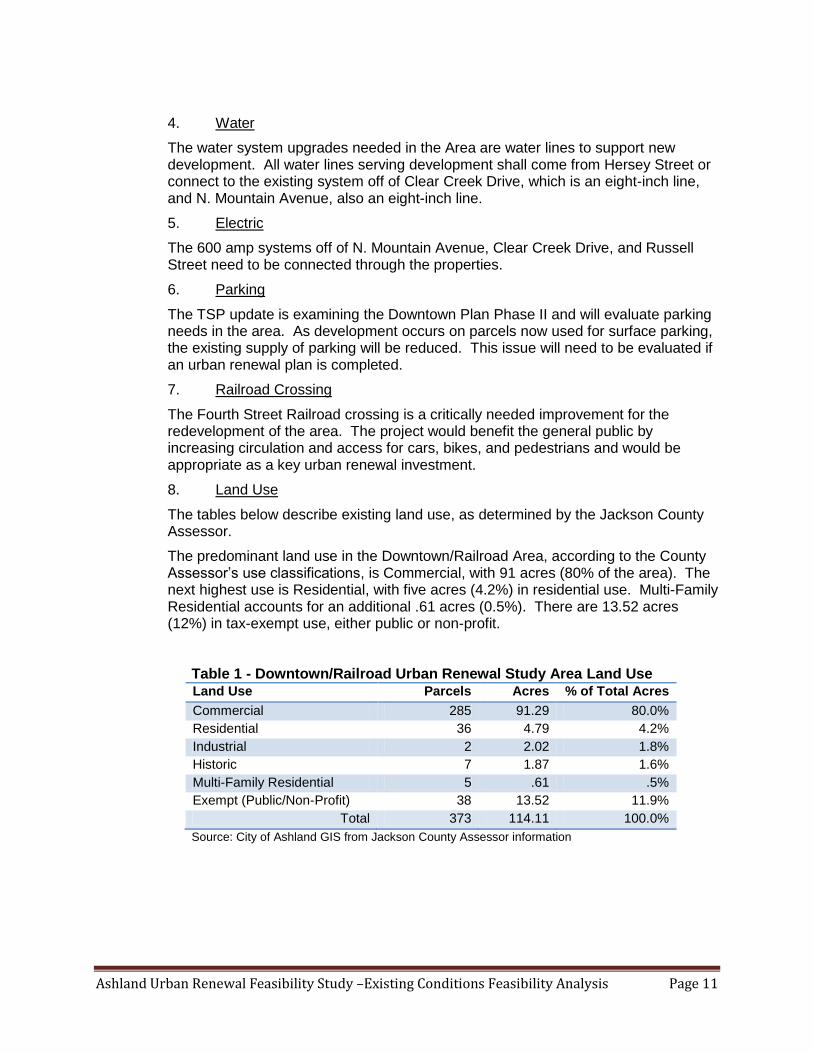
Ashland Urban Renewal Feasibility Study –Existing Conditions Feasibility Analysis Page 11
4. Water
The water system upgrades needed in the Area are water lines to support new development. All water lines serving development shall come from Hersey Street or connect to the existing system off of Clear Creek Drive, which is an eight-inch line, and N. Mountain Avenue, also an eight-inch line.
5. Electric
The 600 amp systems off of N. Mountain Avenue, Clear Creek Drive, and Russell Street need to be connected through the properties.
6. Parking
The TSP update is examining the Downtown Plan Phase II and will evaluate parking needs in the area. As development occurs on parcels now used for surface parking, the existing supply of parking will be reduced. This issue will need to be evaluated if an urban renewal plan is completed.
7. Railroad Crossing
The Fourth Street Railroad crossing is a critically needed improvement for the redevelopment of the area. The project would benefit the general public by increasing circulation and access for cars, bikes, and pedestrians and would be appropriate as a key urban renewal investment.
8. Land Use
The tables below describe existing land use, as determined by the Jackson County Assessor.
The predominant land use in the Downtown/Railroad Area, according to the County Assessor’s use classifications, is Commercial, with 91 acres (80% of the area). The next highest use is Residential, with five acres (4.2%) in residential use. Multi-Family Residential accounts for an additional .61 acres (0.5%). There are 13.52 acres (12%) in tax-exempt use, either public or non-profit.
Table 1 - Downtown/Railroad Urban Renewal Study Area Land Use Land Use Parcels Acres % of Total Acres
Commercial 285 91.29 80.0%
Residential 36 4.79 4.2%
Industrial 2 2.02 1.8%
Historic 7 1.87 1.6%
Multi-Family Residential 5 .61 .5%
Exempt (Public/Non-Profit) 38 13.52 11.9%
Total 373 114.11 100.0%
Source: City of Ashland GIS from Jackson County Assessor information
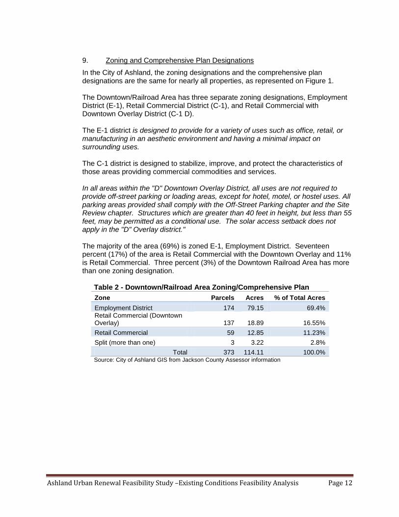
Ashland Urban Renewal Feasibility Study –Existing Conditions Feasibility Analysis Page 12
9. Zoning and Comprehensive Plan Designations
In the City of Ashland, the zoning designations and the comprehensive plan designations are the same for nearly all properties, as represented on Figure 1. The Downtown/Railroad Area has three separate zoning designations, Employment District (E-1), Retail Commercial District (C-1), and Retail Commercial with Downtown Overlay District (C-1 D). The E-1 district is designed to provide for a variety of uses such as office, retail, or manufacturing in an aesthetic environment and having a minimal impact on surrounding uses. The C-1 district is designed to stabilize, improve, and protect the characteristics of those areas providing commercial commodities and services. In all areas within the "D" Downtown Overlay District, all uses are not required to provide off-street parking or loading areas, except for hotel, motel, or hostel uses. All parking areas provided shall comply with the Off-Street Parking chapter and the Site Review chapter. Structures which are greater than 40 feet in height, but less than 55 feet, may be permitted as a conditional use. The solar access setback does not apply in the "D" Overlay district." The majority of the area (69%) is zoned E-1, Employment District. Seventeen percent (17%) of the area is Retail Commercial with the Downtown Overlay and 11% is Retail Commercial. Three percent (3%) of the Downtown Railroad Area has more than one zoning designation.
Table 2 - Downtown/Railroad Area Zoning/Comprehensive Plan
Zone Parcels Acres % of Total Acres
Employment District 174 79.15 69.4% Retail Commercial (Downtown Overlay) 137 18.89 16.55%
Retail Commercial 59 12.85 11.23%
Split (more than one) 3 3.22 2.8%
Total 373 114.11 100.0% Source: City of Ashland GIS from Jackson County Assessor information

Ashland Urban Renewal Feasibility Study –Existing Conditions Feasibility Analysis Page 13
10. Improvement to Land Ratios (I:L)
The degree, or intensity, of development is typically measured in terms of an improvement value to land value ratio (I:L). The values used are real market values. For example, a property with a building value of $200,000 and a land value of $100,000 would have a I:L of 2.0. Where the value of improvements is less than the value of land, the ratio is less than 1.0. I:L ratios for healthy properties in this part of Ashland would be 4.0 or more, based on the real estate market assessment prepared for this Feasibility Study. Five percent (5%) of the properties have no land value, meaning they are non-taxable. Twenty-eight percent (28%) have no improvements. Over 50% of the properties have an I:L of less than 4:1. The I:L ratios in the Downtown/Railroad Area are low, and reflect the fact that the area is underdeveloped.
Table 3 - Downtown/Railroad Area I:L ratios
I:L Ratio Parcels Acres % of Total Acres
No Land Value 62 6.21 5.44%
No Improvement Value 54 32.41 28.40%
0.00 - 0.49 61 17.53 15.36%
0.50 - 0.99 29 10.66 9.34%
1.00 - 1.49 26 4.52 3.96%
1.50 - 1.99 21 4.59 4.02%
2.00 - 2.49 18 6.85 6.00%
2.50 - 2.99 12 2.51 2.20%
3.01 - 3.49 16 2.46 2.16%
3.50 - 3.99 16 8.19 7.18%
4.00 - 4.99 18 5.73 5.02%
5.00 - 5.99 11 2.51 2.20%
6.00 - 6.99 5 1.83 1.60%
I:L > 7.0 24 8.11 7.11%
Total 373 114.11 100.00% Source: Ashland GIS from Jackson County Assessor information
Ashland Urban Renewal Feasibility Study –Existing Conditions Feasibility Analysis Page 14
C. Analyze Existing Conditions in East Ashland Study Area
To determine the extent to which conditions of blight might exist in the Area, the consultants:
conducted a visual survey of the area;
reviewed existing planning documents, as described in Section A above;
solicited input from City of Ashland Planning and Engineering staff; and
analyzed FY 2010-2011 Jackson County tax assessor’s data for parcels within the area.
A map of the area is shown in Figure 2.

Ashland Urban Renewal Feasibility Study –Existing Conditions Feasibility Analysis Page 15
Figure 2 - East Ashland Study Area

Ashland Urban Renewal Feasibility Study –Existing Conditions Feasibility Analysis Page 16
The conclusions of the Existing Conditions Analysis for the East Ashland Study Area are summarized below.
1. Street and Sidewalk Conditions
There are street, sidewalk, and streetscape improvements required throughout the East Ashland Study Area. The infrastructure needs for the Croman Mill Site have been identified in detail in the amendments to the Land Use Ordinance for the Croman Mill District (Ordinance 3030). The single most significant project, in terms of facilitating development of the Croman Mill property itself, is the new Central Boulevard. Other projects that are key to the design standards for the new land use district are “green streets” and multi-use accessways. Finally, a transit plaza may become essential if plans for commuter rail service on the Central Oregon & Pacific (CORP) tracks are implemented. The street projects and their estimated costs are shown in the table below. While the projects included for this area were taken from the Croman Mill Area Redevelopment Plan, additional projects are likely needed north of the railroad tracks in the study area. Gateway improvements to Ashland Street and intersection improvements at the Ashland St./Tolman Creek Rd. intersection have been discussed in the Pedestrian Places Project and the Transportation System Plan Update. Additionally, the extension and upgrade of Washington St. will be necessary for the Washington/Jefferson vicinity to fully develop. Table 4 - Street Projects for the East Ashland Study Area
Project Description Type/Size Estimated Price
Streets
New Central Boulevard from Tolman to Siskiyou 3-lane boulevard (arterial)
On-street parking both sides
Upgrade existing section of remaining 10" steel mainline from
Siskiyou Blvd to Adroit office at 185 Mistletoe Rd.
Green Street
$6,760,000
Phase I Central Boulevard: Mistletoe to
Siskiyou & upgrades to Mistletoe (in CIP)
Mistletoe to Siskiyou
Upgrades/widening Mistletoe from Tolman to northern boundary of
CM-OE zone
Add turn lanes to Tolman/Mistletoe at 50% development
Signalization at 75% development
$6,130,000
Phase II Central Boulevard: Tolman to Phase I ODOT yard relocation and property acquisition
Relocate Central Boulevard
Intersection realignment
Signalization
$3,050,000
Phase II Mistletoe Upgrade Upgrades to Mistletoe from northern boundary of CM-OE zone to
Siskiyou
Repave and add city standard sidewalks$1,810,000
Washington St. extension over railroad tracks At grade crossing identified in Croman District standards $340,000
Tolman/Siskiyou signalization (in CIP) $400,000
New street connection from Tolman to
Washington
2-lane neighborhood commercial collector$750,000
Extension of Central Ashland Bike Path from
Tolman to Crowson (in CIP)
16' wide multi-use path/20' ROW$680,000
Hamilton Creek Multi-Use Path w/neighborhood
connections
10' wide multi-use path/14' ROW$540,000
Total Streets $20,460,000

Ashland Urban Renewal Feasibility Study –Existing Conditions Feasibility Analysis Page 17
2. Storm Water
Riparian restoration along Hamilton and Golf Course Creeks, with an estimated total price of $220,000, is recommended in the East Ashland Study Area.
3. Sanitary Sewer
The sewer lines in the East Ashland Study Area will need to be upsized from existing mainlines from six and eight inches to twelve inches so they can handle the additional flow which will be added as a result of development of the site. The estimated cost is $460,000.
4. Water
An upgrade of the existing section of remaining 10-inch steel mainline from Siskiyou Boulevard to Adroit office at 185 Mistletoe Road is needed in the East Ashland Study Area. The estimated cost is $130,000.
5. Electric
The main electrical feeder that currently runs through the center of the property needs to be rerouted from the Interstate-5 over-crossing on Crowson Road to Tolman Creek Road. The estimated cost is $1,200,000.
6. Railroad Crossing
The Washington Street right-of-way is preserved in the Croman Mill District Plan for a future crossing with redevelopment of the site. This potential crossing is also identified in the Railroad Crossing White Paper as part of TSP update. In the future, if the City decides that an additional rail crossing at Washington Street is required for the Croman Mill site, another at-grade crossing will need to be closed or a grade-separated solution would need to be pursued at that time.
7. Parks
A Central Park and Transit Plaza are recommended in the Croman Mill Site Redevelopment Plan. The estimated cost is $2,000,000 based on the cost of various urban parks recently constructed in Oregon. Open spaces within private development parcels are also designated in the Croman Mill Site Redevelopment Plan, as is the daylighting of Hamilton Creek and the preservation and enhancement of the Hamilton Greenway.
8. Parking
As identified in the Croman Mill Site Redevelopment Plan, a parking structure is recommended to serve commercial and industrial users of space in Croman Mill buildings.
9. Transit
As identified in the Croman Mill Site Redevelopment Plan, a park and ride lot is recommended for the area.
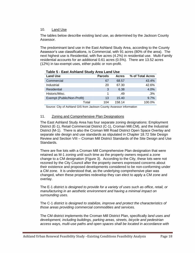
Ashland Urban Renewal Feasibility Study –Existing Conditions Feasibility Analysis Page 18
10. Land Use
The tables below describe existing land use, as determined by the Jackson County Assessor. The predominant land use in the East Ashland Study Area, according to the County Assessor’s use classifications, is Commercial, with 91 acres (80% of the area). The next highest use is Residential, with five acres (4.2%) in residential use. Multi-Family residential accounts for an additional 0.61 acres (0.5%). There are 13.52 acres (12%) in tax-exempt uses, either public or non-profit.
Table 5 - East Ashland Study Area Land Use Land Use Parcels Acres % of Total Acres
Commercial 67 68.57 43.4%
Industrial 20 67.30 42.6%
Residential 3 6.38 4.0%
Historic/Misc. 1 .49 .3%
Exempt (Public/Non-Profit) 13 15.40 9.7%
Total 104 158.14 100.0%
Source: City of Ashland GIS from Jackson County Assessor information
11. Zoning and Comprehensive Plan Designations
The East Ashland Study Area has four separate zoning designations: Employment District (E-1), Retail Commercial District (C-1), Croman Mill.CM), and the Industrial District (M-1). There is also the Croman Mill Road District Open Space Overlay and separate site design and use standards as stipulated in Chapter 18.72 Site Design Review and Section VIII – Croman Mill District Standards of the Site Design and Use Standards. There are five lots with a Croman Mill Comprehensive Plan designation that were retained as M-1 zoning until such time as the property owners request a zone change to a CM designation (Figure 3). According to the City, these lots were not rezoned by the City Council after the property owners expressed concerns about their existence and proposed developments considered to be non-conforming under a CM zone. It is understood that, as the underlying comprehensive plan was changed, when these properties redevelop they can elect to apply a CM zone and overlay. The E-1 district is designed to provide for a variety of uses such as office, retail, or manufacturing in an aesthetic environment and having a minimal impact on surrounding uses. The C-1 district is designed to stabilize, improve and protect the characteristics of those areas providing commercial commodities and services.
The CM district implements the Croman Mill District Plan, specifically land uses and development, including buildings, parking areas, streets, bicycle and pedestrian access ways, multi-use paths and open spaces shall be located in accordance with
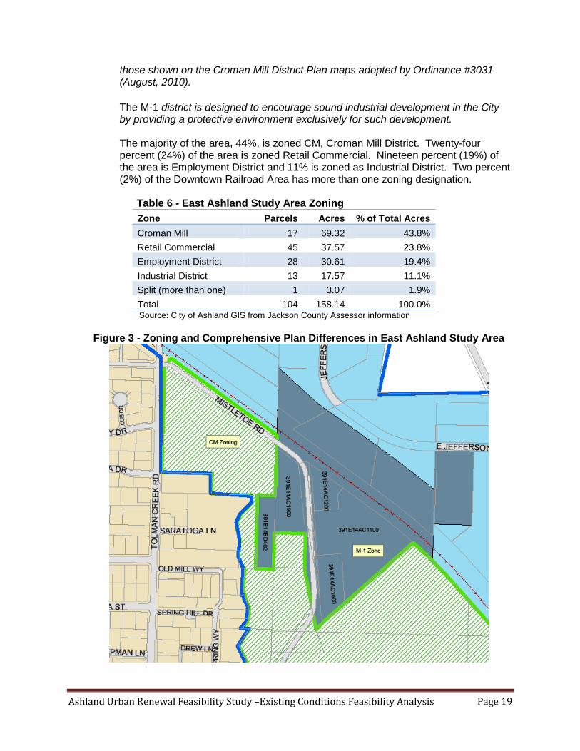
Ashland Urban Renewal Feasibility Study –Existing Conditions Feasibility Analysis Page 19
those shown on the Croman Mill District Plan maps adopted by Ordinance #3031 (August, 2010).
The M-1 district is designed to encourage sound industrial development in the City by providing a protective environment exclusively for such development. The majority of the area, 44%, is zoned CM, Croman Mill District. Twenty-four percent (24%) of the area is zoned Retail Commercial. Nineteen percent (19%) of the area is Employment District and 11% is zoned as Industrial District. Two percent (2%) of the Downtown Railroad Area has more than one zoning designation.
Table 6 - East Ashland Study Area Zoning
Zone Parcels Acres % of Total Acres
Croman Mill 17 69.32 43.8%
Retail Commercial 45 37.57 23.8%
Employment District 28 30.61 19.4%
Industrial District 13 17.57 11.1%
Split (more than one) 1 3.07 1.9%
Total 104 158.14 100.0% Source: City of Ashland GIS from Jackson County Assessor information
Figure 3 - Zoning and Comprehensive Plan Differences in East Ashland Study Area

Ashland Urban Renewal Feasibility Study –Existing Conditions Feasibility Analysis Page 20
12. Improvement to Land Ratios (I:L)
The degree, or intensity, of development is typically measured in terms of an improvement value to land value ratio (I:L). The values used are real market values. For example, a property with a building value of $200,000 and a land value of $100,000 would have a I:L of 2.0. Where the value of improvements is less than the value of land, the ratio is less than 1.0. I:L ratios for healthy properties in this part of Ashland would be 4.0 or more. The I:L ratios in the East Ashland Study Area are low, reflecting the fact that the area is underdeveloped.
Over 49% percent of the properties in the East Ashland Study Area have an improvement to land ratio of below 2:1, while 55% of the properties have an I:L below 3:1, and 60% of the properties have an I:L below 4.0:1. This does not include the 2% with no land value and 32% with no improvement value.
Table 7 - I:L in East Ashland Study Area
I:L Ratio Parcels Acres % of Total Acres
No Land Value 10 3.33 2.11%
No Improvement Value 38 51.34 32.46%
0.00 - 0.49 12 46.78 29.58%
0.50 - 0.99 8 10.02 6.34%
1.00 - 1.49 7 14.43 9.12%
1.50 - 1.99 7 6.78 4.29%
2.00 - 2.49 7 4.98 3.15%
2.50 - 2.99 6 4.55 2.88%
3.01 - 3.49 3 7.92 5.01%
3.50 - 3.99 0 0.00 0.00%
4.00 - 4.99 1 2.23 1.41%
5.00 - 5.99 0 0.00 0.00%
6.00 - 6.99 4 4.82 3.05%
I:L > 7.0 1 0.96 0.61%
Total 104 158.14 100.00% Source: City of Ashland GIS from Jackson County Assessor information
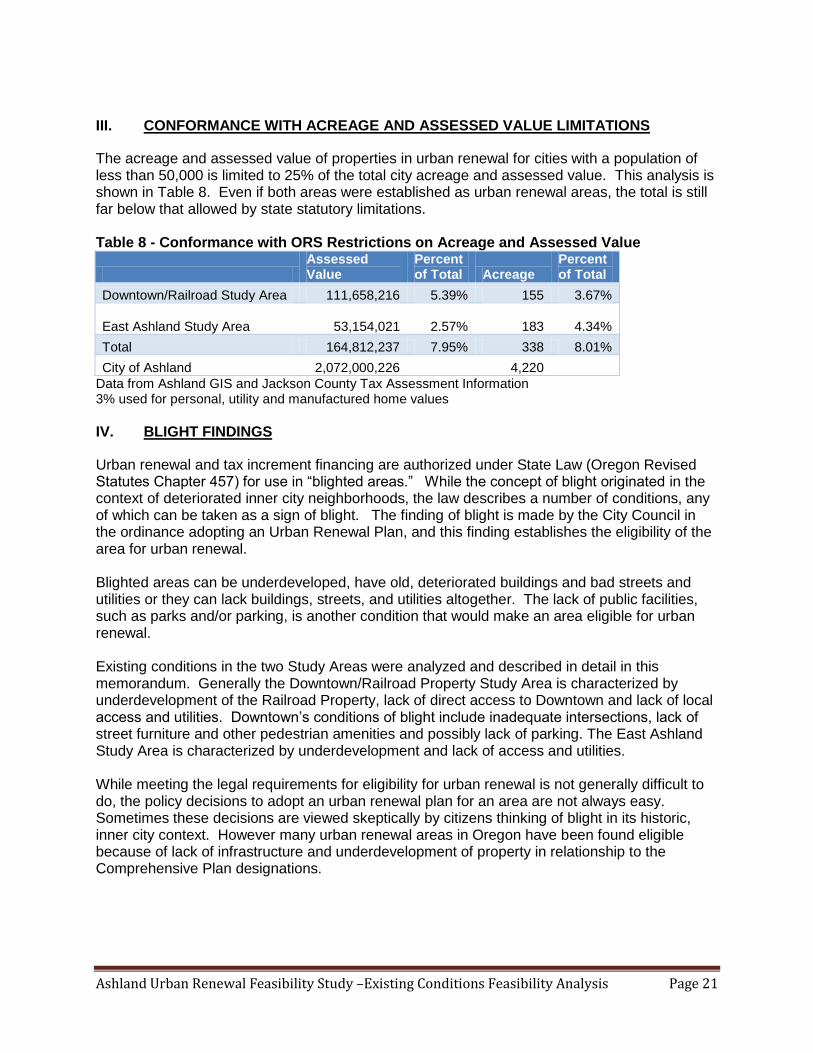
Ashland Urban Renewal Feasibility Study –Existing Conditions Feasibility Analysis Page 21
III. CONFORMANCE WITH ACREAGE AND ASSESSED VALUE LIMITATIONS
The acreage and assessed value of properties in urban renewal for cities with a population of less than 50,000 is limited to 25% of the total city acreage and assessed value. This analysis is shown in Table 8. Even if both areas were established as urban renewal areas, the total is still far below that allowed by state statutory limitations. Table 8 - Conformance with ORS Restrictions on Acreage and Assessed Value
Assessed Value
Percent of Total Acreage
Percent of Total
Downtown/Railroad Study Area 111,658,216 5.39% 155 3.67%
East Ashland Study Area
53,154,021 2.57% 183 4.34%
Total 164,812,237 7.95% 338 8.01%
City of Ashland 2,072,000,226 4,220
Data from Ashland GIS and Jackson County Tax Assessment Information 3% used for personal, utility and manufactured home values
IV. BLIGHT FINDINGS
Urban renewal and tax increment financing are authorized under State Law (Oregon Revised Statutes Chapter 457) for use in “blighted areas.” While the concept of blight originated in the context of deteriorated inner city neighborhoods, the law describes a number of conditions, any of which can be taken as a sign of blight. The finding of blight is made by the City Council in the ordinance adopting an Urban Renewal Plan, and this finding establishes the eligibility of the area for urban renewal. Blighted areas can be underdeveloped, have old, deteriorated buildings and bad streets and utilities or they can lack buildings, streets, and utilities altogether. The lack of public facilities, such as parks and/or parking, is another condition that would make an area eligible for urban renewal. Existing conditions in the two Study Areas were analyzed and described in detail in this memorandum. Generally the Downtown/Railroad Property Study Area is characterized by underdevelopment of the Railroad Property, lack of direct access to Downtown and lack of local access and utilities. Downtown’s conditions of blight include inadequate intersections, lack of street furniture and other pedestrian amenities and possibly lack of parking. The East Ashland Study Area is characterized by underdevelopment and lack of access and utilities. While meeting the legal requirements for eligibility for urban renewal is not generally difficult to do, the policy decisions to adopt an urban renewal plan for an area are not always easy. Sometimes these decisions are viewed skeptically by citizens thinking of blight in its historic, inner city context. However many urban renewal areas in Oregon have been found eligible because of lack of infrastructure and underdevelopment of property in relationship to the Comprehensive Plan designations.

Ashland Urban Renewal Feasibility Study –Existing Conditions Feasibility Analysis Page 22