Embed Size (px)
Citation preview
Draft Corrective Measure Implementation Report for
SWMU 11 Dighole
Prepared for:
Department of the Navy Naval Facilities Engineering Command Southwest 1220 Pacific Highway San Diego, CA 92123
Marine Corps Air Station Yuma Yuma, Arizona
Contract Number: N68711-03-D-SI06 Task Order: 023
DCN: BAI-SI06-023-0084
25 July 2007
Prepared by:
CONI Federal Programs Corporation 9444 Farnham Street, Suite 210 San Diego, CA 92123
Under Subcontract with:
B ~ I Barajas & AssoclaJp.s,lnc .. ' ~- .- . .
Barajas & Associates, Inc. 839 W. Harbor Drive, Suite 1 San Diego, CA 92101
Draft
Corrective Measure Implementation Report for SWMU 11 Dighole
Marine Corps Air Station Yuma
Yuma, Arizona
Prepared for:
DEPARTMENT OF THE NAVY Naval Facilities Engineering Command Southwest 1220 Pacific Highway San Diego, California 92132
Prepared by:
CDIVI Federal Programs Corporation 9444 Farnham Street, Suite 210-San Diego, California 92123
Under Subcontract with:
Barajas & Associates, Inc. 839 W. Harbor Drive, Suite 1 San Diego, California 92101
Prepared under:
Naval Facilities Engineering Command Southwest Contract Number: N68711-03-D-5106 Task Order: 023 DCN: BAI-5106-023-0084
25 July 2007
ARIZONA DEPARTMENT OF ENVIRONMENTAL QUALITY
SEP 11 2007
CONI
MCAS Yuma CMI for SWMU 11
Draft
Corrective Measure Implementation Report SWMU 11 Dighole
Marine Corps Air Station Yuma
Yuma, Arizona
Contract Number: N68711-03-D-SI06 Task Order: 023 DCN: BAI-SI06-023-0084
Prepared by: _______________ _ Jacob Dunk Environmental Scientist, CDM
Approved by: _______________ _ Randa Chichakli, P.E. Project Manager, CDM
Approved by: _______________ _ Larry Davidson, P.E. Program Manager, CDM
Approved by: _______________ _ Frederick E. Daniel Jr. Director Environmental Quality, MCAS Yuma
Date
Date
Date
Date
Signature Page
This page intentionally left blank.
ii CONI
MCAS Yuma eMI for SWMU 11
CONI
MCAS Yuma CMI for SWMU 11
Owner Certification
I certify under penalty of law that this document and all attachments [or identified portions thereof] have been read and understood by persons working under my direction or supervision and that the information submitted is, to the best of my knowledge and belief, true, accurate and complete. I am aware that there are significant penalties for knowingly submitting false information, including the possibility of fines and imprisonment for knowing violations.
B.D. HANCOCK, Colonel, USMC Commanding Officer Marine Corps Air Station Yuma
Date
iii

Owner Certification
This page intentionally left blank.
iv CONI MCAS Yuma eMI for SWMU 11
..,---- -~" , \
I
Executive Summary
CONI
MCAS Yuma eM1 for SWMU 11
Executive Summary
This report presents the results of a Resource Conservation and Recovery Act (RCRA) Corrective Measure Implementation (CMI) at the Solid Waste Management Unit (SWMU) 11 Dighole located at Marine Corps Air Station (MCAS) Yuma in Yuma, Arizona. This CMI Report has been prepared by CDM Federal Programs Corporation (CDM) under subcontract with Barajas & Associates, Inc. (Barajas) for Naval Facilities Engineering Command (NAVFAC) Southwest under Contract Number N68711-03-D-5106, Task Order 023.
SWMU 11 (Former Explosive Ordnance Disposal [EOD] Range) was identified in the 2002 RCRA Facility Assessment (RF A) for the Barry M. Goldwater Range (BMGR) (Booz Allen Hamilton [Booz Allen] 2002 and Arizona Department of Environmental Quality [ADEQ] 2003). The RFA recommended further investigation under a RCRA Facility Investigation (RFI) to determine whether a release of hazardous substances had occurred. The RFI for SWMU 11 was conducted in 2004 and investigation activities discovered that open burning and burying of munitions had occurred at one portion of the site: the SWMU 11 Dighole. The RFI concluded that past activities conducted at the SWMU 11 Dighole could result in the release of contaminants to site soils and further action under RCRA was recommended (CDM 2005).
The following corrective action objectives (CAOs) were developed for the SWMU 11 Dighole in the Corrective Measure Study (CMS) Report (CDM 2006):
• Minimize future potential exposure of human and ecological receptors to contaminated materials; and
• Prevent off-site transport of contaminated materials.
To meet the CAOs and achieve a "Corrective Action Complete without Controls" status for the SWMU 11 Dighole, the CMS Report recommended excavating all impacted soil to a depth exceeding visual and geophysical evidence of buried/burned munitions and collecting soil samples from the excavation limits to confirm removal of all contaminants (CDM 2006).
Sampling results from the CMI collected after the soil excavation indicated no contamination exists at concentrations above cleanup objectives in the SWMU 11 Dighole. Confirmation samples collected from the excavation limits also did not show any contaminant concentrations of concern.
The CMI findings demonstrate that the CAOs for the SWMU 11 Dighole have been met:
• Future potential exposure of human and ecological receptors with contaminated materials has been minimized due to the lack of contaminated materials; and
v
Executive Summary
vi
• Off-site transport of contaminated materials has been prevented due to the lack of contaminated materials.
No further action is necessary for the SWMU 11 Dighole and a "Corrective Action Complete without Controls" status is recommended for the site.
CONI
MCAS Yuma CMI for SWMU 11
Contents
CONI
MCAS Yuma eMI for SWMU 11
Table of Contents
Executive Summary
Acronyms and Abbreviations
Owner Certification
Section 1
1.1 1.2 1.3
Section 2
2.1 2.2
2.3
Section 3
Section 4
4.1 4.2 4.3 4.4
4.5 4.6
Section 5
5.1 5.2
Section 6
6.1
6.2
Introduction
Background .................................................................................................. 1-1 CMI Objectives ............................................................................................ 1-1 Report Organization ................................................................................... 1-1
Site Description and History
Site Location ................................................................................................. 2-1 Physical Setting ........................................................................................... 2-1 2.2.1 Topography .................................................................................... 2-1 2.2.2 Surface Waters ................................................................................ 2-1 2.2.3 Groundwater .................................................................................. 2-1 2.2.4 Climate ............................................................................................ 2-2 2.2.5 Land Use ......................................................................................... 2-2 Site History ................................................................................................... 2-2 2.3.1 BMGR History ................................................................................ 2-2 2.3.2 SWMU 11 Dighole History ........................................................... 2-3
Scope of eMI
CMI Activities
UXO Screening ............................................................................................ 4-1 Geophysical Survey .................................................................................... 4-1 Excavation .................................................................................................... 4-2 Soil Sampling ............................................................................................... 4-2 4.4.1 Confirmation Sampling ................................................................. 4-2 4.4.2 Characterization Sampling ........................................................... 4-3 4.4.3 Laboratory Analyses ...................................................................... 4-3 4.4.4 Sample Handling and Documentation ....................................... 4-3 Management and Disposal of lOW .......................................................... 4-4 Deviations from CMI Plan ......................................................................... 4-5
Results
Confirmation Samples ................................................................................ 5-1 Characterization Samples .......................................................................... 5-1
Quality Assurance
Quality Control Procedures ....................................................................... 6-1 6.1.1 Data Verification ............................................................................ 6-1 6.1.2 Laboratory QC Samples ................................................................ 6-1 6.1.3 Field QC Samples ........................................................................... 6-2 Data Quality Assessment ........................................................................... 6-3 6.2.1 General Data Review ..................................................................... 6-3
vii
Table of Contents
viii
6.2.2 Laboratory Data Validation .......................................................... 6-3 6.3 QC Evaluation of the Analytical Data ...................................................... 6-3
6.3.1 Field QC Samples ........................................................................... 6-3 6.3.2 Precision and Accuracy ................................................................. 6-4 6.3.3 Representativeness ........................................................................ 6-4 6.3.4 Completeness .................................................................................. 6-5 6.3.5 Comparability ................................................................................. 6-5
Section 7
Section 8
Conclusions
References
List of Tables
3-1 Soil Cleanup Objectives ....................................... : ................................................ 3-3 5-1 SWMU 11 Dighole Sampling Results .................................................................. 5-3
List of Figures
2-1 Area Location Map ................................................................................................ 2-5 2-2 Site Location Map .................................................................................................. 2-7 4-1 SWMU 11 Dighole Corrective Measure Implementation ................................ 4-6
A B C
List of Appendices
Photographs Geophysical Survey Report (ULS 2007) Analytical Laboratory Results (PDF), Validated Data (MS Excel), and Data Validation Report (PDF) (on compact disk)
CONI
MCAS Yuma eMI for SWMU 11
CONI
MCAS Yuma eMt for SWMU 11
Acronyms and Abbreviations
ADEQ arnsl
Barajas bgs BMGR Booz Allen
°C \
CAO CDM CFR CMI CMS COC
DOD DPEMIMD
EMAX EMIMD EOD EPA EWI
GPR
ID IDW
LCS LCSD LDC
MCAS mg/kg MLWA mm MS MSD MTR
NAVFAC Navy NFESC
PPE PRG
QA QC
Arizona Department of Environmental Quality above mean sea level
Barajas & Associates, Inc. below ground surface Barry M. Goldwater Range Booz Allen Hamilton
degrees Celsius corrective action objective CDM Federal Programs Corporation Code of Federal Regulations corrective measure implementation corrective measure study chain of custody
United States Department of Defense delay pulse electromagnetic induction metal detection
EM AX Laboratories Inc. electromagnetic induction metal detection explosive ordnance disposal United States Environmental Protection Agency Environmental Work Instruction
ground penetrating radar
identification investigation-derived waste
laboratory control sample laboratory control sample duplicate Laboratory Data Consultants
Marine Corps Air Station milligram per kilogram Military Lands Withdrawal Act millimeter matrix spike matrix spike duplicate munitions treatment range
Naval Facilities Engineering Command United States Department of the Navy Naval Facilities Engineering Service Center
personal protective equipment preliminary remediation goal
quality assurance quality control
ix
Acronyms and Abbreviations
x
RCRA RFA RFI RPD
SAP SDG SOP SRL SVOC SWMU
TPH
ULS UXO
VOC
Resource Conservation and Recovery Act RCRA Facility Assessment RCRA Facility Investigation relative percent difference
sampling and analysis plan sample delivery group standard operating procedure soil remediation level semivolatile organic compound solid waste management unit
total petroleum hydrocarbon
ULS Services Corporation unexploded ordnance
volatile organic compound
CONI
MCAS Yuma CMI for SWMU 11
Section One
COM
MCAS Yuma eMl for SWMU 11
Section 1 Introduction
This report presents the results of a Resource Conservation and Recovery Act (RCRA) Corrective Measure Implementation (CMI) at the Solid Waste Management Unit (SWMU) 11 Dighole located at Marine Corps Air Station (MCAS) Yuma in Yuma, Arizona. This CMI Report has been prepared by CDM Federal Programs Corporation (CDM) under subcontract with Barajas & Associates, Inc. (Barajas) for Naval Facilities Engineering Command (NAVFAC) Southwest under Contract Number N68711-03-D-5106, Task Order 023.
1.1 Background SWMU 11 (Former Explosive Ordnance Disposal [EOD] Range) was identified in the 2002 RCRA Facility Assessment (RF A) for the Barry M. Goldwater Range (BMGR) (Booz Allen Hamilton [Booz Allen] 2002 and Arizona Department of Environmental Quality [ADEQ] 2003). The RFA recommended further investigation under a RCRA Facility Investigation (RFI) to determine whether a release of hazardous substances had occurred. The RFI for SWMU 11 was conducted in 2004 and investigation activities discovered that open burning and burying of munitions had occurred at one portion of the site: the SWMU 11 Dighole. The RFI concluded that past activities conducted at the SWMU 11 Dighole could result in the release of contaminants to site soils and further action under RCRA was recommended (CDM 2005).
1.2 eMIObjectives The following corrective action objectives (CAOs) were developed for the SWMU 11 Dighole in the Corrective Measure Study (CMS) Report (CDM 2006):
• Minimize future potential exposure of human and ecological receptors to contaminated materials; and
• Prevent off-site transport of contaminated materials.
The goal of the CMI was meet the CAOs by implementing the corrective measure recommended in the CMS Report (in accordance with the CMI Plan [CDM 2006]) by removing all burned and buried munitions and associated contamination from the SWMU 11 Dighole and returning the site to a natural state. Upon completion of the CMI, the SWMU 11 Dighole should achieve "Corrective Action Complete without Controls" status and eliminate the need for further remedial actions, monitoring, and/ or operation and maintenance activities (CDM 2006).
1.3 Report Organization This CMI Report is organized as follows:
• Section 1 provides a brief background of the site and the eMI objectives.
1-1
Section 1 Introduction
1-2
• Section 2 describes the location, physical setting, and history of the site.
• Section 3 presents the scope of the CM!.
• Section 4 presents a summary of the activities conducted for the CM!.
• Section 5 presents the results of the CM!.
• Section 6 presents the quality assurance (QA)/ quality control (QC) summary.
• Section 7 presents the conclusions.
• Section 8 presents references used in this report.
• Appendix A presents photographs from CMI field activities.
• Appendix B is the geophysical survey report.
• Appendix C is an electronic version of the analytical laboratory results (PDF), complete validated data (MS Excel), and data validation report (PDF).
CONI
MCAS Yuma eM] for SWMU 11
Section Two

COM MCAS Yuma eMI ror SWMU 11
Section 2 Site Description and History
This section provides a description of the SWMU 11 Dighole including its location and physical setting. A summary of previous investigations and other activities at the SWMU 11 Dighole is also provided below.
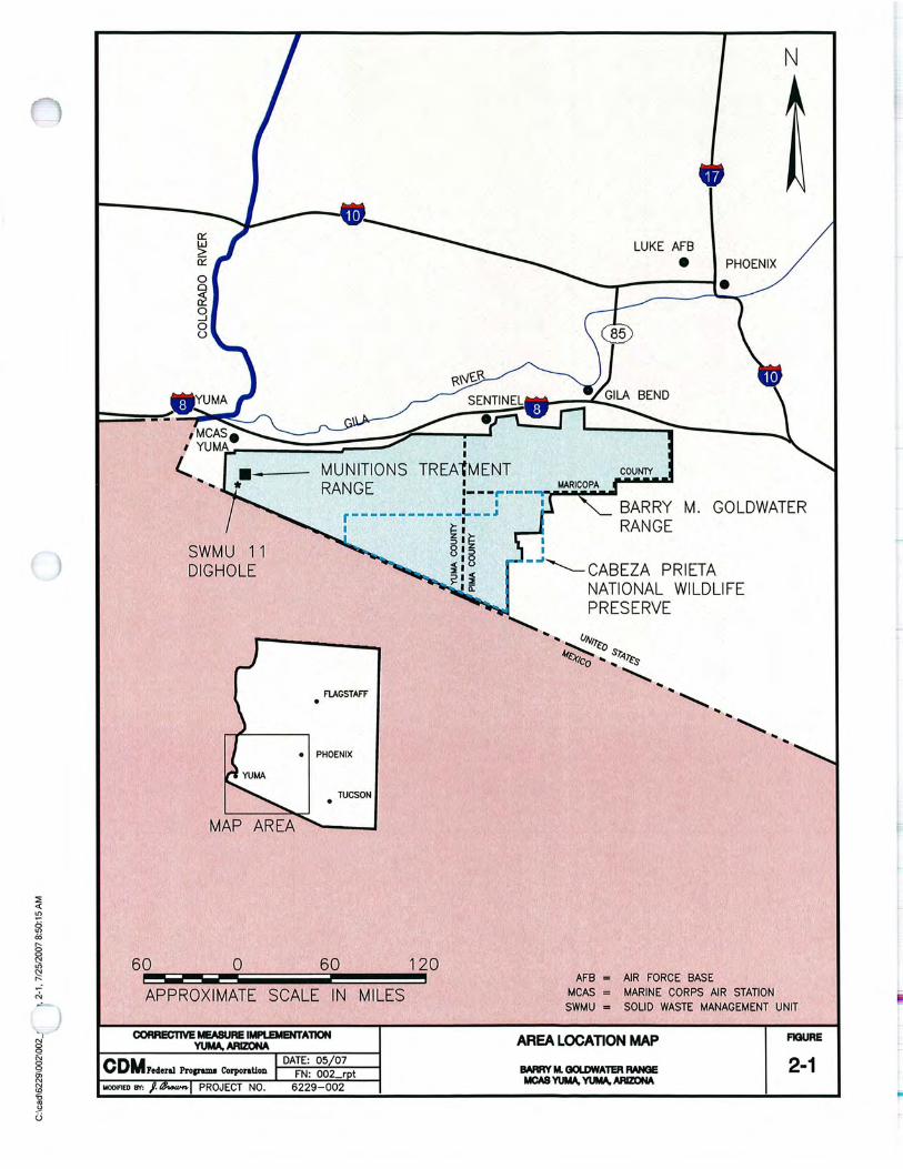
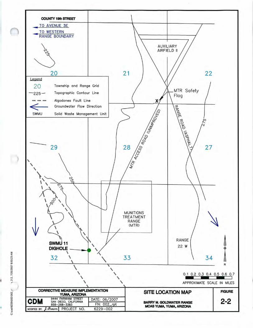
2.1 Site Location MCAS Yuma is located in the City of Yuma in the southwestern comer of Arizona. MCAS Yuma operates four sub ranges in the BMGR: two manned ranges, an air-to-air gunnery range, and an air combat maneuvering range. An area location map showing MCAS Yuma and the BMGR is provided as Figure 2-1. The SWMU 11 Dighole is located on the western edge of the BMGR (Figure 2-1), approximately 0.35 miles from the southwest corner of MCAS Yuma's Munitions Treatment Range (MTR) (Figures 2-1 and 2-2).
2.2 Physical Setting The following subsections provide a description of the topography, surface waters, groundwater, climate, and land use in the vicinity of the SWMU 11 Oighole.
2.2.1 Topography Topography across the BMGR varies from an elevation of 200 feet above mean sea level (amsl) on the western boundary to over 4,000 feet amsl on the eastern boundary. Approximately ten mountain ranges cross the BMGR, including the Gila, Cabeza Prieta, Sierra Pinta, Copper, Granite, Mohawk, Grant, Growler, Sauceda, and Sand Tank Mountains (west to east). Regional topography slopes north and west; however, localized topography is controlled by the numerous mountain ranges that cross the BMGR in a northwest-southeast orientation (COM 2003).
The elevation of the SWMU 11 Dighole is approximately 275 feet amsl (Figure 2-2). The site is sparsely vegetated with native desert shrubs and grasses.
2.2.2 Surface Waters There are several small lakes and playas on the southern portion of the BMGR within the Cabeza Prieta National Wildlife Refuge. The closest surface waters to the SWMU 11 Oighole are the Colorado River to the west (15 miles) and the Gila River to the north (12 miles), both of which are beyond the west and north boundaries of the BMGR.
2.2.3 Groundwater Numerous groundwater studies have been conducted on surrounding perimeter areas of the BMGR. The three largest and deepest basins are Lechuguilla, MohawkTule, and San Cristobal. The major water-bearing units in the perimeter areas are found above and below thick lacustrine clay layers. Studies done of the Lechuguilla
2-1
Section 2 Site Description and History
2-2
Desert (location of the SWMU 11 Dighole) and Mohawk-Tule Valley indicate a shallow unconfined aquifer at depths ranging from 125 feet below ground surface (bgs) in the east-central portion area to 366 feet bgs in the west-central area. A sand and gravel aquifer is suspected to exist beneath the lacustrine clay deposit that is found at depths ranging from 600 to 1,500 feet bgs (CDM 2003).
The United States Bureau of Reclamation collects groundwater elevation data from several piezometers in the BMGR (several in the vicinity of the SWMU 11 Dighole). East of the Algodones Fault, groundwater flows to the southeast and ranges in depth between 130 and 140 feet bgs. West of the Algodones Fault (location of the SWMU 11 Dighole), groundwater flows to the south at a depth of approximately 80 feet bgs (Figure 2-2) (CDM 2003).
2.2.4 Climate Climatic data can be inferred from weather stations located in communities around the northern and eastern borders of the range. In general, the BMGR has a climate that is characterized by: (1) low precipitation that is distributed between summer and winter rainy seasons, (2) hot summers and mild winters, (3) limited cloudiness, (4) moderate winds, and (5) relative low humidity. Average annual precipitation is 3.2 inches per year (CDM 2003).
2.2.5 Land Use Land use within the BMGR has been significantly restricted because of the withdrawal of land through the 1986 Military Lands Withdrawal Act (MLWA). Livestock grazing and mining have not been allowed since 1941. Right-of-ways are limited to utilities and a railroad, both of which parallel Highway 85 on the eastern side of the BMGR. No special use or temporary use permits have been issued on the BMGR. Future issuances of these types of permits are unlikely (CDM 2003).
There are no formal recreation areas in proximity to the SWMU 11 Dighole. However, the various subranges of the BMGR may be open for recreational activity (e.g., hunting) and visitors must gain access to the BMGR from MCAS Yuma Range Management.
2.3 Site History The following subsections provide a brief history of the BMGR and a history of the SWMU 11 Dighole site.
2.3.1 BMGR History The BMGR is, and has been, an important facility for training pilots in aerial and airto-ground combat since 1941. It is highly valued for its year-round flying weather and expansive, unencumbered air and land space that can accommodate a variety of military training needs. This combination of features is unequaled elsewhere in the continental United States. As urban and other development pressures force
CONI
MCAS Yuma eM! ror SWMU 11
MCAS Yuma CM1 for SWMU 11
Section 2 Site Description and History
restrictions on the operation of military aircraft at other range locations, the BMGR will become increasingly vital to the nation's defense.
Acquisition of the BMGR for military aviation training purposes began in 1941, shortly before the United States entered World War II. Congress officially set aside 2.6 million acres of the BMGR with the 1986 MLWA and designated it the Barry M. Goldwater Air Force Range under management of the United States Air Force. Congress extended authorization of the BMGR once more and re-designated BMGR management responsibilities with the 1999 MLW A. The BMGR is authorized for use by the Secretaries of the Air Force and Navy for 25 years unti12024 and provides that the United States Department of Defense may apply for an extension to that authorization should there be a continuing military need for the BMGR beyond 2024. The 1999 MLWA designates the western portion as BMGR-West (Yuma Segment), consisting of 1,017,990 acres with about 186 miles of exterior perimeter, and the eastern portion of the range as BMGR-East (Gila Bend Segment), consisting of a 1,651,235 acre parcel with approximately 280 miles of exterior perimeter. The airspace over the Gila Bend Segment belongs to, and is controlled by, the United States Air Force, while the Yuma Segment belongs to and is controlled by the United States Department of the Navy (Navy). Ground access to these segments is also controlled by the agency controlling the overlying airspace. Control by the Navy is administered through MCAS Yuma; Luke Air Force Base administers United States Air Force control.
2.3.2 SWMU 11 Dighole History SWMU 11 (Former EOD Range) was identified in the 2002 RFA for the BMGR (Booz Allen 2002 and ADEQ 2003). Upon visual investigation, SWMU 11 was found to consist of a man-made trench (approximately 2 feet deep, 14 feet wide, and 50 feet long) and a dighole (approximately 2 feet deep and 21 feet in diameter). The site was used in the past for on-range munitions treatment by open burning and open detonation. Previous reports alleged that munitions were treated by detonation (in shotholes), burned in pits to remove any remaining active explosive residue, and then, after burning, the material was reportedly covered with native soil (i.e., buried) (Booz Allen 2002 and ADEQ 2003). On-range destruction of munitions is consistent with "use for intended purpose" and is therefore, not considered a solid waste (40 Code of Federal Regulations [CFR] 266.202). However, "use for intended purpose" does not include burial of munitions. The RFA concluded that past activities conducted at SWMU 11 may have resulted in the release of hazardous substances to site soils and recommended a RFI (Booz Allen 2002 and ADEQ 2003).
The RFI for SWMU 11 was conducted in 2004 to determine if burned or buried munitions existed at the site by excavating the area. The trench portion of SWMU 11 was excavated and backfilled and no evidence of burned or buried munitions was found. At the start of excavation of the dighole portion of SWMU 11, nonexplosive "range trash" (empty shipping container canisters) was immediately uncovered. The "range trash" was screened by an on-site MCAS Yuma EOD speCialist who confirmed that it was nonexplosive. At approximately 3 feet bgs, a thin layer of black ash and
2-3
Section 2 Site Description and History
2-4
burned munitions (20 millimeter [mm] rounds, 25 mm shell casings) was encountered. This provided evidence that open burning and burying of munitions occurred at the site; therefore, all excavation activities ceased. The material already excavated was left in stockpiles on top of plastic sheeting adjacent to the SWMU 11 Dighole. Further action under RCRA was recommended for the SWMU 11 Dighole (CDM2005).
A CMS Report was prepared in 2006 that screened two corrective measure alternatives (Soil Removal and No Action), provided a detailed analysis of the Soil Removal alternative (recommended alternative), and included a CMI Plan for the implementation of the Soil Removal. The purpose of the corrective measure was to achieve a "Corrective Action Complete without Controls" status for the SWMU 11 Dighole (i.e., eliminate the need for further remedial actions, monitoring, and! or operation and maintenance activities at the site) (CDM 2006).
CONI
MCAS Yuma eMI for SWMU 11
I I
MUNITIONS TREAtMENT
60
SWMU 11 DIGHOLE
o
RANGE
FlAGSTAFF
TUCSON •
60 --- 120 --- ~
APPROXIMATE SCALE IN MILES
I I
N
LUKE AFB • PHOENIX
""--_----1.
COUNTY
BARRY M. GOLDWATER RANGE
--'''--CABEZA PRIETA NATIONAL WILDLIFE PRESERVE
AFB = AIR FORCE BASE MCAS = MARINE CORPS AIR STATION
SWMU = SOLID WASTE MANAGEMENT UNIT
AREA LOCATION MAP FlQURE
2-1 •
COUNTY 19th STREET
.. TO AVENUE 3E
TO WESTERN .. RANGE BOUNDARY
~
20 -225-
< SWMU
--, ,
20
Township and Range Grid
Topographic Contour Line
Algodones Fault Line
Groundwater Flow Direction
Solid Waste Management Unit
29
\ \
\ \
\ \
CORRECTIVE MEASURE IMPLEMENTATION YUMA, ARIZONA
,
21
MUNITIONS TREATMENT
RANGE (MTR)
, , ,
33
AUXILIARY AIRFIELD II
22
Safety
27
34 N
0.1 0.2 0.3 0.4 0.5 0.6 0.7
APPROXIMATE SCALE IN MILES
SITE LOCATION MAP FIGURE
COM 9444 FARNHAM STREET SAN DIEGO. CALIFORNIA 858-268-3383
DATE: 06/2007 BARRY M. GOLDWATER RANGE MOAS YUMA. YUMA. ARIZONA
2-2 MODIFIED BY: . t3~ PROJECT NO. 6229-002
(
Section Three
MCAS Yuma eMI for SWMU 11
Section 3 Scope of eMI
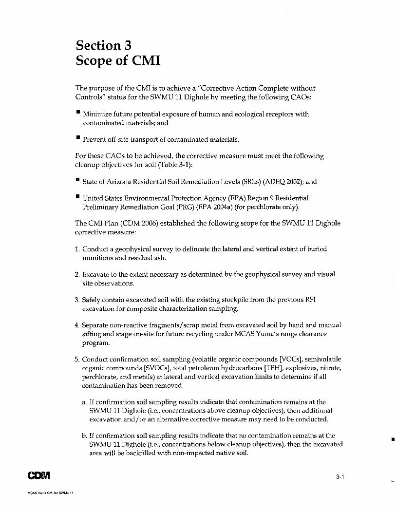
The purpose of the CMI is to achieve a "Corrective Action Complete without Controls" status for the SWMU 11 Dighole by meeting the following CAOs:
• Minimize future potential exposure of human and ecological receptors with contaminated materials; and
• Prevent off-site transport of contaminated materials.
For these CAOs to be achieved, the corrective measure must meet the following cleanup objectives for soil (Table 3-1):
• State of Arizona Residential Soil Remediation Levels (SRLs) (ADEQ 2002); and
• United States Environmental Protection Agency (EPA) Region 9 Residential Preliminary Remediation Goal (PRG) (EPA 2004a) (for perchlorate only).
The CMI Plan (CDM 2006) established the following scope for the SWMU 11 Dighole corrective measure:
1. Conduct a geophysical survey to delineate the lateral and vertical extent of buried munitions and residual ash.
2. Excavate to the extent necessary as determined by the geophysical survey and visual site observations.
3. Safely contain excavated soil with the existing stockpile from the previous RFI excavation for composite characterization sampling.
4. Separate non-reactive fragments/scrap metal from excavated soil by hand and manual sifting and stage on-site for future recycling under MCAS Yuma's range clearance program.
5. Conduct confirmation soil sampling (volatile organic compounds [VOCs], semivolatile organic compounds [SVOCs], total petroleum hydrocarbons [TPH], explosives, nitrate, perchlorate, and metals) at lateral and vertical excavation limits to determine if all contamination has been removed.
a. If confirmation soil sampling results indicate that contamination remains at the SWMU 11 Dighole (i.e., concentrations above cleanup objectives), then additional excavation and/ or an alternative corrective measure may need to be conducted.
b. If confirmation soil sampling results indicate that no contamination remains at the SWMU 11 Dighole (i.e., concentrations below cleanup objectives), then the excavated area will be backfilled with non-impacted native soil.
3-1

Section 3 Scope ofCMI
3-2
6. Conduct characterization soil sampling (VOCs, SVOCs, TPH, explosives, nitrate, perchlorate, and metals) of excavated materials to determine appropriate method of disposal.
a. If characterization soil sampling results indicate that contamination exists in the excavated soils (i.e., concentrations above cleanup objectives), then the necessity and appropriateness for treatment and off-site disposal will be evaluated.
b. If characterization soil sampling results indicate that no contamination exists in the excavated soils (i.e., concentrations below cleanup objectives), then the excavated soil will be disposed of on-site (i.e., backfilled into the SWMU 11 Dighole).
7. Properly dispose of any investigation-derived waste (IDW).
CDNI
MCAS Yuma eMI for SWMU 11
Ii

Table 3·1 Soil Cleanup Objectives
Analyte
Unit of Measure
Metals - EPA Methods 60108 and 7470
Arsenic
Barium
Cadmium
Chromium
Lead
Mercury
Selenium
Silver
Nitrate - EPA Method 300
Nitrate
VOCs - EPA Method 82608
1,1,1,2-Tetrachloroethane
1,1,1-Trichloroethane
1,1,2,2-Tetrachloroethane
1,1,2-Trichloroethane
1,1-Dichloroethane
1,1-Dichloroethene
1,1-Dichloropropene
1,2,3-Trichlorobenzene
1,2,3-T richloropropane
1,2A-Trichlorobenzene
1,2A-Trimethylbenzene
1 ,2-Dibromo-3-Ch loropropane
1,2-Dibromoethane
1,2-Dichlorobenzene
1,2-Dichloroethane
1,2-Dichloropropane
1,3,5-Trimethylbenzene
1 ,3-Dichlorobenzene
1,3-Dichloropropane
1 A-Dichlorobenzene
2-Butanone (Methyl Ethyl Ketone)
2-Chlorotoluene
2-Hexanone
4-Chlorotoluene
4-Methyl-2-Pentanone
Acetone
MCAS YUMA CMf for SWMU 11
Soil Cleanup Objective
mg/kg
10
5,300
38
2,100
400
6.7
380
380
100,000
23
1,200
4.4
6.5
500
0.36
NA
NA
0.014
570
NA
3.2
0.049
1,100
2.5
3.1
NA
500
NA
190
7,100
160
NA
NA
NA
2,100
Section 3 Scope ofCMI
Soil Cleanup Objective Source
Residential SRLa
Residential SRLa
Residential SRLa
Residential SRLa
Residential SRLa
Residential SRLa
Residential SRLa
Residential SRLa
Residential SRL a
Residential SRL a
Residential SRL a
Residential SRL a
Residential SRLa
Residential SRLa
Residential SRLa
NA
NA
Residential SRLa
Residential SRLa
NA
Residential SRLa
Residential SRLa
Residential SRLa
Residential SRLa
Residential SRLa
NA
Residential SRLa
NA
Residential SRLa
Residential SRLa
Residential SRLa
NA
NA
NA
Residential SRLa
3-3
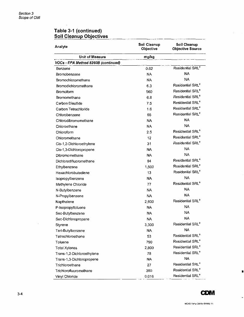
Section 3 Scope ofCMI
Table 3-1 (continued) Soil Cleanup Objectives
Analyte Soil Cleanup Soil Cleanup Objective Objective Source
Unit of Measure mg/kg
VOCs - EPA Method 8260B (continued)
Benzene 0.62 Residential SRLa
Bromobenzene NA NA
Bromochloromethane NA NA
Bromodichloromethane 6.3 Residential SRLa
Bromoform 560 Residential SRL a
Bromomethane 6.8 Residential SRLa
Carbon Disulfide 7.5 Residential SRLa
Carbon Tetrachloride 1.6 Residential SRLa
Chlorobenzene 65 Residential SRLa
Chlorodibromomethane NA NA
Chloroethane NA NA
Chloroform 2.5 Residential SRLa
Chloromethane 12 Residential SRLa
Cis-1,2-Dichloroethylene 31 Residential SRLa
Cis-1,3-Dichloropropene NA NA
Dibromomethane NA NA
Dichlorodifluoromethane 94 Residential SRLa
Ethylbenzene 1,500 Residential SRLa
Hexachlorobutadiene 13 Residential SRLa
Isopropylbenzene NA NA
Methylene Chloride 77 Residential SRLa
N-Butylbenzene NA NA
N-Propylbenzene NA NA
Napthalene 2,600 Residential SRLa
P-Isopropyltoluene NA NA
Sec-Butyl benzene NA NA
Sec-Dichloropropane NA NA
Styrene 3,300 Residential SRLa
Tert-Butylbenzene NA NA
Tetrachloroethene 53 Residential SRLa
Toluene 790 Residential SRLa
Total Xylenes 2,800 Residential SRLa
Trans-1,2-Dichloroethylene 78 Residential SRL a
Trans-1,3-Dichloropropene NA NA
Trichloroethene 27 Residential SRLa
Trichlorofluoromethane 380 Residential SRLa
Vinyl Chloride 0.016 Residential SRLa
3-4 CDM
MCAS Yuma eMI for SWMU 11
Section 3 Scope ofCMI
Table 3-1 (continued) Soil Cleanu~ Objectives
Analyte Soil Cleanup Soil Cleanup
Objective Objective Source
Unit of Measure mg/kg
SVOCs - EPA Method 8270C
1,2,4-Trichlorobenzene 570 Residential SRL8
1 ,2-Dichlorobenzene 1,100 Residential SRL8
1,3-Dichlorobenzene 500 Residential SRL8
1,4-Dichlorobenzene 190 Residential SRL8
2,4,5-Trichlorophenol 6,500 Residential SRL8
2,4,6-Trichlorophenol 400 Residential SRL8
2,4-Dichlorophenol 200 Residential SRL8
2,4-Dimethylphenol 1,300 Residential SRL8
2,4-Dinitrophenol 130 Residential SRL 8
2,4-Dinitrotoluene 130 Residential SRL8
2,6-Dinitrotoluene 65 Residential SRL8
2-Chloronaphthalene 5,200 Residential SRL8
2-Chlorophenol 91 Residential SRL8
2-Methylnaphthalene NA NA
2-Methylphenol 3,300 Residential SRL8
2-Nitroaniline 3.9 Residential SRL8
2-Nitrophenol NA NA
3,3-Dichlorobenzidine 9.9 Residential SRL8
3-Nitroaniline NA NA
4,6-Dinitro-2-Methylphenol NA NA
4-Bromophenyl Phenyl Ether NA NA
4-Chloro-3-Methylphenol NA NA
4-Chloroaniline 260 Residential SRL8
4-Chlorophenyl Phenyl Ether NA NA
4-Methylphenol 330 Residential SRL 8
4-Nitroaniline NA NA
4-Nitrophenol NA NA
Acenaphthene 3,900 Residential SRL8
Aniline 19 Residential SRL 8
Anthracene 20,000 Residential SRL8
Benz(a)anthracene 6.1 Residential SRL8
Benzo(a)pyrene 0.61 Residential SRL8
Benzo(b )fluoranthene 6.1 Residential SRL8
Benzo(g,h ,i)perylene NA NA
Benzo(k)fluoranthene 61 Residential SRL8
Benzoic Acid 260,000 Residential SRL8
Benzyl Alcohol 20,000 Residential SRL8
Bis(2-Chloro-1-Methylethyl)ether 63 Residential SRL8
CDIVI 3-5
MCAS Yuma eM! for SWMU 11
Section 3 Scope ofCMI
Table 3-1 (continued) Soil Cleanu~ Objectives
Analyte Soil Cleanup Soil Cleanup Objective Objective Source
Unit of Measure mg/kg
SVOCs - EPA Method 8270C (continued)
Bis(2-Chloroethoxy)methane NA NA
Bis(2-Chloroethyl)ether 0.43 Residential SRLa
Bis(2-Ethylhexyl)phthalate 320 Residential SRLa
Butyl Benzyl Phthalate 13,000 Residential SRLa
Chrysene 610 Residential SRLa
Dibenzo(a,h)anthracene 0.61 Residential SRLa
Dibenzofuran 260 Residential SRLa
Diethyl Phthalate 52,000 Residential SRLa
Dimethyl Phthalate 650,000 Residential SRLa
Di-n-Butyl Phthalate NA NA
Di-n-Octyl Phthalate 1,300 Residential SRLa
Fluoranthene 2,600 Residential SRLa
Fluorene 2,600 Residential SRLa
Hexachlorobenzene 2.8 Residential SRLa
Hexachlorobutadiene 13 Residential SRLa
Hexachlorocyclopentadiene 450 Residential SRLa
Hexachloroethane 65 Residential SRLa
Indeno(1,2,3-cd)pyrene 6.1 Residential SRLa
Isophorone 4,700 Residential SRLa
Naphthalene 2,600 Residential SRLa
Nitrobenzene 18 Residential SRLa
N-Nitroso-di-n-Propylamine 0.63 Residential SRLa
N-Nitrosodimethylamine 0.087 Residential SRLa
Pentachlorophenol 25 Residential SRLa
Phenanthrene NA NA
Phenol 39,000 Residential SRLa
Pyrene 2,000 Residential SRLa
Explosives - EPA Method 8330
1,3,5-Trinitrobenzene (TNB) 3.3 Residential SRLa
1,3-Dinitrobenzene (DNB) 6.5 Residential SRLa
2,4,6-Trinitrotoluene (TNT) 33 Residential SRLa
2,4-Dinitrotoluene (DNT) 130 Residential SRL a
2,6-DNT 65 Residential SRLa
2-Amino-4,6-DNT NA NA
2-Nitrotoluene NA NA
3-Nitrotoluene 650 Residential SRLa
4-Amino-2,6-DNT NA NA
4-Nitrotoluene 650 Residential SRLa
3-6 CONI
MCAS Yuma eMI for SWMU 11
CONI MCAS Yuma CMI for SWMU 11
Table 3-1 (continued) Soil Cleanup Objectives
Analyte
Unit of Measure
Explosives - EPA Method 8330 (continued)
Cyclotetramethylene Tetranitramine (HMX)
Nitrobenzene
Cyclotrimethylene Trinitramine (RDX)
2,4,6-Trinitrophenylnitramine (Tetryl)
Perchlorate· EPA Method 6850
Perchlorate
TPH - EPA Method 8015(AZ) Modified
Gasoline (Carbon Range 6-10)
Diesel (Carbon Range 10-22)
Motor Oil (Carbon Range 22-32)
Notes:
Soil Cleanup Objective
mg/kg
NA
18
40
650
7.8
NA
NA
NA
Section 3 Scope ofCMI
Soil Cleanup Objective Source
NA
Residential SRLa
Residential SRLa
Residential SRL a
Residential PRG b
NA
NA
NA
a Residential Soil Remediation Levels (SRLs) will be used as cleanup objectives for VOCs, TPH, nitrate, SVOCs, metals, and explosives. SRL values are taken from Appendix A Soil Screening Criteria (Arizona Administrative Code) of Title 18 Environmental Quality Chapter 7 Department of Environmental Quality Remedial Action, September 2002.
b Residential Preliminary Remediation Gqal (PRG) will be used as a cleanup objective for perchlorate. PRG value is taken from EPA Region 9 PRG values.
Acronyms! Abbreviations:
AZ = EPA = mg!kg = NA = SVOC = TPH = VOC =
Arizona United States Environmental Protection Agency milligrams per kilogram no cleanup objective available semivolatile organic compounds total petroleum hydrocarbons volatile organic compounds
3-7
Section 3 Scope ofCMI
3-8
This page intentionally left blank.
CONI
MCAS Yuma CMI for SWMU 11

o
u
..
CDIVI
MCAS Yuma eMI for SWMU 11
Section 4 eMI Activities
CMI field activities were conducted by CDM and MCAS Yuma personnel on 10 and 11 April 2007 and 20 June 2007. Field activities included screening for unexploded ordnance (UXO), conducting a geophysical survey, conducting soil excavation with a backhoe, manually segregating non-reactive fragments/ scrap metal from excavated soils, collecting discrete confirmation and composite characterization soil samples, collecting QC samples, sample handling and documentation, management and disposal of IDW, and backfilling excavated soils.
All fieldwork was performed in accordance with the CMI Plan (CDM 2006). Photographs of the field activities are presented in Appendix A.
4.1 UXO Screening All CMI field activities at the SWMU 11 Dighole were conducted under the direct supervision of an MCAS Yuma Military Munitions Emergency Response Technician (Frederick E. Daniel Jr.) trained in the identification of munitions and potential UXO. Visual UXO screenings were conducted prior to and during all excavation and soil handling (e.g., segregation of fragments from soil and soil sampling) activities. Potential II live" munitions were identified, transported away from the excavation area, and tagged for future examination and clearance by an MCAS Yuma EOD specialist.
4.2 Geophysical Survey On 10 April 2007, prior to beginning excavation of the SWMU 11 Dighole, a geophysical survey was conducted by ULS Services Corporation (ULS). Visual inspection, standard electromagnetic induction metal detection (EMIMD), delay pulse electromagnetic induction metal detection (DPEMIMD), and analog magnetic gradiometer methods were used for the survey to detect metal mass anomalies such as metallic soils and metallic fragments. The use of ground penetrating radar (GPR) was not feasible due the rough surface and the depression of the SWMU 11 Dighole (ULS 2007).
A two-way grid pattern was walked in the SWMU 11 Dighole area approximately 40 feet out from the site in each direction. EMIMD was used first to locate areas of high electromagnetic response. DPEMIMD with an electromagnetic noise filter was used after the EMIMD to verify and specifically locate areas of high response. The analog magnetic gradiometer was used to detect ferrous metal. Observed electromagnetic anomalies were marked on the ground surface with paint before excavation began (ULS 2007).
Two distinct areas of EMIMD/DPEMIMD response (i.e., electromagnetic anomalies) were observed along the east and south edges of the SWMU 11 Dighole. Excavation confirmed the anomalies by revealing various metal fragments and discolored burned
4-1
Section 4 eMI Activities
4-2
soil. After the soil and metal fragments were removed from the SWMU 11 Dighole, a final electromagnetic survey was conducted on the bottom and sides of the excavated dighole to verify the absence of metallic material; no further conductive anomalies were observed (ULS 2007).
The complete geophysical survey report is presented in Appendix B.
4.3 Excavation Excavation of the SWMU 11 Dighole was conducted on 10 April 2007. A backhoe, operated by MCAS Yuma personnel, was used to excavate soil from the SWMU 11 Dighole based on the marked limits from the geophysical survey. CDM and MCAS Yuma staff visually observed the excavated soils and the excavation limits to further direct the backhoe operations. All excavated material (soil and metal fragments) was placed by the backhoe onto plastic sheeting adjacent to the site.
When no further evidence of metal fragments or discolored soil was visible at the limits of the SWMU 11 Dighole, and it appeared that native soil had been reached, excavation ceased. The geophysical survey confirmed the absence of additional metallic material at the excavation limits. At the completion of the excavation, the SWMU 11 Dighole was elliptical in shape (approximately 21 and 15.5 feet along the major and minor axes) with an average depth of 5 feet.
On 10 and 11 April 2007, CDM and MCAS Yuma personnel manually separated nonreactive fragments/ scrap metal from the excavated soil using shovels, sifters, and rakes. Metal fragments were placed in piles for future recycling under MCAS Yuma's range clearance program. Soil was left on the plastic sheeting for characterization sampling.
4.4 Soil Sampling Confirmation and characterization sampling was conducted by CDM on 11 April 2007 as described in the subsections below. Disposable sampling equipment (plastic scoops) dedicated to each sample location was used for collecting the soil samples.
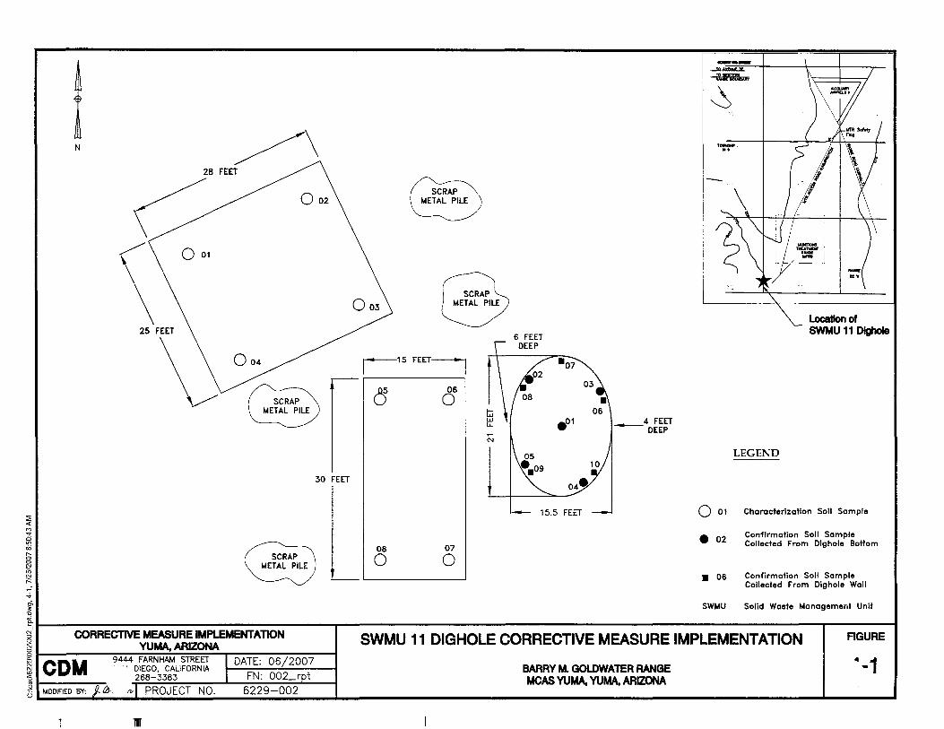
4.4.1 Confirmation Sampling Ten discrete confirmation surface soil (0 to 0.5 feet bgs) samples were collected from the excavation limits of the SWMU 11 Dighole as follows (Figure 4-1):
• CONFOl through CONF05 were collected from the bottom of the excavated dighole.
• CONF06 through CONF10 were collected from the walls of the excavated dighole.
All confirmation samples were submitted for VOC, SVOC, TPH, explosive, nitrate, perchlorate, and metal analyses. VOC and volatile TPH samples were collected from the bottom/walls first using EnCore™ samplers. Glass jars were then filled directly from the bottom/walls using a dedicated plastic scoop for SVOC, extractable TPH, explosives, nitrate, perchlorate, and metals analyses.
CONI
MCAS Yuma eMI for SWMU 11
COM
MCAS Yuma CMI for SWMU 11
Section 4 eMI Activities
4.4.2 Characterization Sampling Eight characterization soil samples were collected from the excavated soil piles as follows (Figure 4-1):
• CHAROl through CHAR04 were discrete samples collected from the northwestern most stockpile.
• CHAROS through CHAR08 were discrete samples collected from the stockpile immediately adjacent (west) to the excavated dighole.
• CHAR09 was composited from CHAROl through CHAR08.
All discrete characterization samples (CHAR01 through CHAR08) were collected first using EnCore™ samplers and submitted for VOC and volatile TPH analyses. Soil from CHAR01 through CHAR08 locations was homogenized using a plastic scoop and new stainless steel bowl and scooped into glass jars for SVOC, extractable TPH, explosives, nitrate, perchlorate, and metals analyses.
4.4.3 Laboratory Analyses A total of 19 primary soil samples, 3 field duplicates, and 2 temperature blanks (one per cooler) were collected for the CM!. All samples were submitted to EMAX Laboratories, Inc. (EMAX) of Torrance, California, a Naval Facilities Engineering Service Center (NFESC)-approved and State of Arizona-certified laboratory. Analytical results from EM AX were sent to Laboratory Data Consultants (LDC) for independent data validation (see Section 6.2.2). The analytical laboratory results (PDF format), complete validated data (MS Excel format), and the data validation report (PDF format) are presented in Appendix C.
4.4.4 Sample Handling and Documentation All samples were labeled and handled as described in the CMI Plan (CDM 2006). Sample identification (ID) numbers consisted of a unique code to indicate the sampling location. The following protocol was used to identify each sample:
The first portion of the sample number represents the year the sample was collected and the investigation abbreviation (07CMI). The second portion of the sample number represents the site abbreviation (SWMU11). The third portion of the sample number represents the sample location (CONFOl through CONF10 for confirmation samples and CHAROl through CHAR09 for characterization samples). The fourth portion of the sample identification number is a sample code, either 1/11/ for a primary sample or 1/31/ for a field duplicate sample.
The following is an example of the sample identification:
07CMI-SWMUll-CONF02-1
4-3
Section 4 eMf Activities
4-4
This example identifies that the sample was collected in the year 2007, for the CMI, at SWMU 11, was confirmation sample number 2, and was a primary sample.
Preprinted labels were completed and affixed to the appropriate sample containers with waterproof tape. All labels included the following information: sample ID, analyses required, sample matrix, preservative, date and time sampled, and initials of the CDM employee that collected the sample.
Samples were packaged and shipped in accordance with the applicable CDM Standard Operating Procedures (SOPs) presented in the CMI Plan (CDM 2006). Sample IDs and analytical requests were recorded on the appropriate chain-ofcustody (COC) form, and after all labeling and custody information was verified, the samples and signed COC forms were placed in an insulated cooler for shipment to EMAX. Adequate ice was used to maintain cooler temperature at 4±2 degrees Celsius (0C) during shipment. The cooler was sealed with strapping tape and a signed custody seal was applied to the cooler lid. The CDM employees who collected the samples maintained custody of the samples at the appropriate cooler temperature until delivery to Federal Express. The samples were sent via Federal Express to EMAX.
4.5 Management and Disposal of IDW IDW generated during this project consisted of the following:
• Excavated soil from the SWMU 11 Digholei
• Non-reactive fragments/ scrap metal segregated from the excavated soili and
• Personal protective equipment (PPE), such as nitrile gloves.
Excavated soil was placed on plastic sheeting next to the dighole, and left onsite pending analytical results. Soil sampling results indicated that no contamination exists in the excavated soil (see Section 5.2) and the excavated soil was backfilled into the SWMU 11 Dighole on 20 June 2007. After backfilling, the majority of the plastic sheeting placed under the excavated soil was collected and disposed of as nonhazardous solid waste. Some plastic sheeting was unrecoverable and was left on-site to be collected as possible during future range clearance activities.
Non-reactive fragments/ scrap metal segregated from the excavated soil was left onsite in piles and will be collected and recycled by MCAS Yuma as part of the range clearance program.
PPE and sampling supplies (tape, bags, etc.) were placed in trash bags and disposed of as non-hazardous solid waste.
CONI
MCAS Yuma eMI ror SWMU 11
CDM MCAS Yuma eMI for SWMU 11
Section 4 GMf Activities
4.6 Deviations from eMI Plan The CMI Plan (CDM 2006) prescribed for decontamination of sampling equipment and the subsequent collection of rinsate and source blank samples. Due to the nature and simplicity of collecting soil grab samples from the excavation limits and the stockpiled soils and the cost effectiveness of disposable equipment, all samples were collected using disposable equipment (i.e., decontamination was not necessary). The disposable equipment reduced the risk of cross contamination between samples and reduced the quantity of QC samples.
The geophysical investigation methods used to conduct the geophysical survey differed from the procedures outlined in the CMI Plan due to field conditions. The CMI Plan (CDM 2006) called for using GPR to determine the vertical extent of metallic materials prior to conducting the excavation. Due to the rough surfaces and the depression of the dighole, using GPR was not feasible. To determine the vertical extent of metallic materials, an additional round of geophysical investigation using electromagnetic methods was conducted at the completion of excavation to confirm the absence of metallic materials at the bottom and sides of the dighole.
The CMI Plan (CDM 2006) listed EPA Method 314 as the laboratory method to be used for perchlorate analysis. Due to recent United States Department of Defense (DOD) requirements (DOD Perchlorate Handbook [DOD 2006]) EPA Method 6850, which employs liquid chromatography/mass spectrometry methods, was used to analyze the soil samples.
The Site Health and Safety Plan (CDM 2006) required that all field work at the SWMU 11 Dighole be conducted under the direct supervision of an MCAS Yuma EOD specialist present during all field activities. Due to limited availability of MCAS Yuma EOD personnel, their fulltime oversight was not possible for the CMI; however, an MCAS Yuma Military Munitions Emergency Response Technician was present during all field activities. The MCAS Yuma Military Munitions Emergency Response Technician was trained in the identification of munitions and potential UXO. If the technician identified potential UXO/"live" munitions during fieldwork activities, he stopped all activities, transported the suspect item away from the excavation area, and tagged it for future examination and clearance by an MCAS Yuma EOD specialist.
4-5
::;; <{ M ..,. a '" cici
" o o
Sl ~ .;.
~ "0
N
28 FEET
o 001
25 FEET
\J 004
002
SCRAP METAL PILE
30 FEET
SCRAP METAL PILE
,15FEETj
, ,
8 06
o
08 07
o o
---~
~
'~
-
LEGEND
location of SWMU 11 DIghoIe
o 01 Characterization Soll Sample
• 02
• 06
Confirmation Soll Sample Collected From DI9hoie Bottom
Confirmation Soil Sample Collected From Di9hole Wall
SWMU Solid Waste Management Unit
15. I
i' CORRECTIVE y~~~~~~MENTATlON I I I AGURE SWMU 11 DIGHOLE CORRECTIVE MEASURE IMPLEMENTATION 1); CDM 9444 FARNHAM STREET I DATE: 06/2007 ~ , DIEGO, CALIFORNIA ~ .. 1 '6268-3383 I FN: 002_rpt
B MODIFIED BY: j. 0, "'I PROJECT NO. 6229-002 I I I
BARRY M. GOLDWATER RANGE MOAS YUMA, YUMA, ARIZONA
I
Section· Five
CONI
MCAS Yuma CMI for SWMU 11
Section 5 Results
A lotal of 22 soil samples (19 primary samples and 3 field duplicates) were collected and analyzed during the CMI at the SWMU 11 Dighole. Table 5-1 provides a summary of the analytical results and Appendix C provides the analytical laboratory results (PDF format), complete validated data (MS Excel format), and data validation report (PDF format). The following subsections describe the results.
5.1 Confirmation Samples Ten discrete confirmation soil samples were collected from the excavation limits of the SWMU 11 Dighole: five from the side walls and five from the bottom. The samples were analyzed for VOCs, SVOCs, TPH, explosives, nitrate, perchlorate, and metals. The following bullets summarize the results:
• No VOCs were detected in any confirmation samples.
• One SVOC (diethyl phthalate) was detected in one sample at 8.8 milligrams per kilogram (mg/kg), significantly below the cleanup objective of 52,000 mg/kg.
• No TPHs were detected in any confirmation samples.
• No explosives were detected in any confirmation samples.
• Nitrate concentrations ranged from 1.31 mg/kg to 19.5 mg/kg, significantly below the cleanup objective of 100,000 mg/kg.
• Perchlorate concentrations ranged from 0.00307 mg/kg to 0.229 mg/kg, significantly below the cleanup objective of 7.8 mg/kg.
• Maximum concentrations of arsenic (5.7 mg/kg), barium (275 mg/kg), cadmium (0.777 mg/kg), chromium (7.6 mg/kg), and lead (117 mg/kg) were all below their respective cleanup objectives.
• Mercury, selenium, and silver were not detected in any confirmation samples.
5.2 Characterization Samples Eight discrete characterization soil samples were collected from the excavated soils and analyzed for VOCs and volatile TPHs. Soil from the same eight locations was homogenized and submitted as a composite characterization sample for SVOCs, extractable TPHs, explosives, nitrate, perchlorate, and metals. The following bullets summarize the results:
• One VOC (toluene) was detected in three discrete characterization samples at estimated concentrations ranging from 0.0043 mg/kg to 0.031 mg/kg, significantly below the cleanup objective of 790 mg/kg.
5-1
Ii!
Section 5 Results
5-2
• No SVOCs were detected in the composite characterization sample.
• TPH as motor oil was detected in the field duplicate composite characterization sample at an estimated concentration of 8.1 mg/kg; TPH as motor oil was not detected in the primary composite characterization sample.
• No explosives were detected in the composite characterization sample.
• Nitrate concentration in the composite characterization sample was 3.95 mg/kg, significantly below the cleanup objective of 100,000 mg/kg.
• Perchlorate concentration in the composite characterization sample was 0.0618 mg/kg, significantly below the cleanup objective of 7.8 mg/kg.
• Arsenic (2.53 mg/kg), barium (68.9 mg/kg), cadmium (0.335 mg/kg), chromium (5.36 mg/kg), and lead (16.2 mg/kg) concentrations were all below their respective cleanup objectives in the composite characterization sample.
• Mercury, selenium, and silver were not detected in the composite characterization sample.
CONI
MCAS Yuma eMI for SWMU 11
and the top of the 12- to 16-foot DPT sleeve, coinciding with the depth at which gravel began to occur. Beginning at 8 feet bgs, the light gray powder was also found on the inside of the DPT sleeve "coating" the soil core (see Appendix A photos). Borings 23 and 24 had similar findings with powder coating the inside of the DPT sleeves and powder on top of the sleeves when gravel was first encountered (varying depths between 4 and 14 feet bgs) (see Appendix A for photos and Appendix B for boring logs). According to the DPT driller, the powder is a result of pulverized rock commonly encountered when advancing the DPT probes through gravel.
A total of six primary samples were collected in July 2007 from the three borings that encountered the light gray powder (see Figure 4-2); sample depths were selected to ensure that the sample consisted of both native soil and the light gray powder of interest. Samples were submitted for explosives, metals, SVOC, and nitrate analyses. Three QC samples (one soil and two aqueous) were also collected and submitted for the same analyses.
No explosives or SVOCs were detected above laboratory reporting limits in any of the soil/ powder samples. Nitrate was detected in three samples at concentrations ranging between 2.57 mg/kg and 8.73 mg/kg (screening level is 100,000 mg/kg). Barium, chromium, and lead were detected in all soil/ powder samples at maximum concentrations of 147 mg/kg (estimated), 43.9 mg/kg, and 8.83 mg/kg, respectively, which are significantly below their screening levels (5300 mg/kg, 2100 mg/kg, and 400 mg/kg, respectively). Cadmium was detected in three samples ranging from estimated values of 0.140 mg/kg to 0.211 mg/kg (screening level is 38 mg/kg). Silver was detected in one sample at an estimated value of 0.810 mg/kg (screening level is 380 mg/kg). Arsenic was detected in all soil/ powder samples at concentrations between 2.66 mg/kg and 11.7 mg/kg, with two samples meeting or exceeding the screening level of 10 mg/kg (see Table 5-3).
5.1.2.3 Human Health Risk Evaluation (2007 Results)
Of the chemicals detected in the soil/ powder samples, only arsenic is considered to potentially cause cancer and has an associated State of Arizona Residential cancer SRL (AAC 2007). The SRL is a risk based value for protection of residential receptors contacting chemicals in soils through ingestion, dermal exposure, and inhalation of particulates. Results from the 2007 sampling at SWMU 5 were used to perform a screening human health risk evaluation as shown in Table 5-4. Arsenic was the only carcinogenic chemical detected above reporting limits in SWMU 5 soils. Total cancer risk calculated based on the maximum concentrations detected in the soil/ powder samples are 1 x 10⁻⁶ at SWMU 5 Borings 22 and 23. A risk estimate of 1 x 10⁻⁶ is generally recognized as a point of departure for risk management decisions. Values of 1 x 10⁻⁶ or less indicate that risks are negligible because the SRLs are risk-based criteria designed to be protective of residential exposure scenarios.
CONI MCAS Yuma RFI Report
5-3 Revised Final
December 2007
Noncancer hazards were also considered for chemicals detected in the soil/ powder samples at SWMU 5. Detected soil concentrations were compared to State of Arizona Residential SRLs. Ratios of maximum soil concentration to the SRL are summed and reported as the hazard index (HI) for each location. Arsenic was the primary driver; however, the HI was 1.0 with arsenic accounting for 93 and 96 percent of the hazards at Boring 22 and 23, respectively (see Table 5-4). HI values greater than 1 indicate the potential for noncarcinogenic effects to receptors. An HI of 1 is within the range of acceptable hazards since SRLs are risk-based criteria designed to be protective of residential exposures.
5.1.3 SWMU 9 (Former Accumulation Area for Burn Residue)
Four DPT borings were installed at SWMU 9. Three primary soil samples were collected from two borings, one each at surface,S feet bgs, and at DPT refusal (9 to 10 feet bgs). Four primary soil samples were collected from the remaining two borings, one each at surface,S feet bgs, 10 feet bgs, and at DPT refusal (15 feet bgs). A total of 14 primary soil samples and four QC samples (one soil and three aqueous) were collected and submitted for VOc, SVOC, metals, explosives, perchlorate, and white phosphorus analyses (see Figure 4-3).
Lead, arsenic, barium, and chromium were detected in all soil samples well below the screening levels. Cadmium was detected in one soil sample at an estimated concentration of 0.028 mg/kg (screening level is 38 mg/kg). Acetone was detected in seven soil samples at concentrations ranging from 11 Jlg/kg to 14 Jlg/kg (screening level is 2,100,000 Jlg/kg). Benzene and toluene were each detected in one soil sample at 2.1 Jlg/kg (screening level 620 Jlg/kg) and 3.5 Jlg/kg (screening level 400,000 Jlg/kg), respectively. Methylene chloride was detected in two soil samples at 1.7 and 1.8 Jlg/kg (screening level is 77,000 Jlg/kg).
All contaminant concentrations were below the screening levels (see Table 5-5).
5.2 SWMU 11 (Former EOD Range)
5.2.1 Trench
Once the trench was cleared of all debris by the EOD specialist, the boundaries of the former trench (approximately 50 feet by 14 feet) and the excavation boundaries (58 feet by 22 feet) were marked and the UTM coordinates were recorded. Backhoe excavation began at the northeast corner of the trench. Debris was encountered at the center of the trench at depths ranging from 3 to 6 feet bgs. Upon discovery of debris, excavation would cease until the EOD specialist identified and cleared the debris. Only nonexplosive scrap metal and "range trash" was identified by the EOD specialist (i.e., no UXO was identified) and excavation continued to the planned dimensions of 58 feet by 22 feet. The trench was excavated to an approximate depth of 10 feet bgs where an
CONI MCAS Yuma RFI Report
5-4 Revised Final
December 2007
undisturbed consolidated silty, sandstone and gravel layer was encountered (determined to be native soil). Excavation unearthed non-explosive "range trash" consisting of various articles of debris, including empty rocket motor casings, an empty napalm bomb, barrels, practice bombs, an expended tube from a TOW missile, and practice warheads. No evidence that the "range trash" had been treated by burning or open detonation was found; it appeared to be merely landfilled in the trench. All recovered contents of the trench were left outside the excavation boundaries and the trench was filled in with the excavated soil. Photographs of the trench excavation and the recovered "range trash" are provided in Appendix A.
5.2.2 Dighole
An MCAS Yuma EOD specialist screened and cleared the dighole of debris prior to beginning excavation. The boundaries of the dighole (21 feet diameter) and the excavation boundaries (28 feet diameter) were then marked and the UTM coordinates recorded. Nonexplosive "range trash" was immediately uncovered at the start of excavation and was screened by the EOD specialist who determined it was nonexplosive. At approximately 3 feet bgs, a thin layer of black ash and burned munitions (20 mm rounds, 25 mm shell casings) was encountered. This indicated evidence that open burning and burying of munitions occurred at the site and all excavation activities ceased (per the Final RFI Work Plan). No UXO was identified in the ash layer; however the UXO assessment ceased when the buried munitions were encountered so the assessment was not completed. The excavated hole was not backfilled, and the excavated soils (placed on plastic sheeting adjacent to the dighole) were covered with plastic liner and left onsite. During excavation of the dighole, scattered pockets of gray ash (consistent with the appearance of residual ash left at the bottom of open detonation pits) were encountered providing evidence that the dighole was also used for open detonation. In addition, several empty shipping container canisters were buried in the dighole indicating that it was also used for landfilling. Photographs of the dighole excavation, the ash and burned munitions are provided in Appendix A.
5-5 MCAS Yuma RFI Report
Revised Final
December 2007
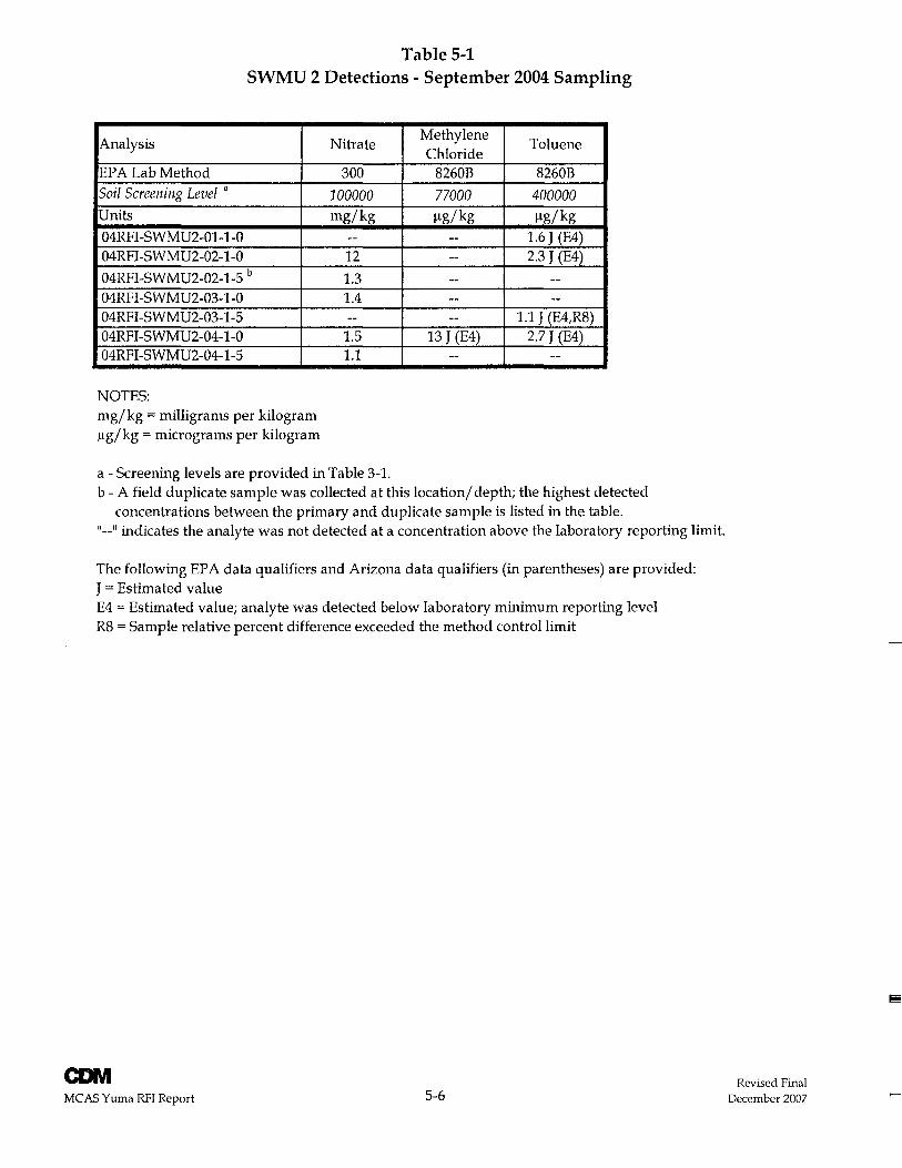
Table 5-1 SWMU 2 Detections - September 2004 Sampling
Analysis
EPA Lab Method Soil Screening Level a
Units
04RFI-SWMU2-01-1-0 04RFI-SWMU2-02-1-0
04RFI-SWMU2-02-1-S b
04RFI-SWMU2-03-1-0 04RFI-SWMU2-03-1-S 04RFI-SWMU2-04-1-0 04RFI -SWMU2-04-1-S
NOTES: mg/kg = milligrams per kilogram I-tg/kg = micrograms per kilogram
Nitrate
300
100000 mg/kg
--12
1.3 1.4 --
1.S 1.1
a - Screening levels are provided in Table 3-1.
Methylene Toluene
Chloride 8260B 8260B
77000 400000 I-tg/kg Ilg/ kg
-- 1.6 J (E4) -- 2.3 J (E4)
-- ---- ---- 1.1 J (E4,R8)
13 J (E4) 2.7 J (E4) -- --
b - A field duplicate sample was collected at this location/ depth; the highest detected concentrations between the primary and duplicate sample is listed in the table.
"--" indicates the analyte was not detected at a concentration above the laboratory reporting limit.
The following EPA data qualifiers and Arizona data qualifiers (in parentheses) are provided: J = Estimated value E4 = Estimated value; analyte was detected below laboratory minimum reporting level R8 = Sample relative percent difference exceeded the method control limit
CONI MCAS Yuma RFI Report S-6
Revised Final December 2007
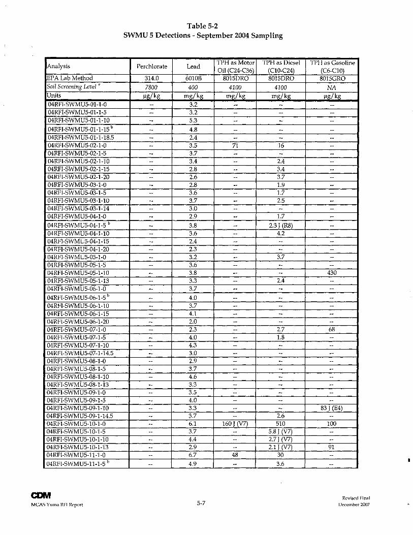
Analysis
EPA Lab Method
Soil Screening Level a
Units
04RFI-SWMUS-01-1-0 04RFI-SWMUS-01-1-S 04RFI-SWMUS-0l-1-10
04RFI-SWMUS-01-1-1S b
04RFI-SWMUS-01-1-1B.5 04RFI-SWMUS-02-1-0 04RFI-SWMUS-02-1-S 04RFI-SWMUS-02-1-10 04RFI-SWMUS-02-1-1S 04RFI-SWMUS-02-1-20 04RFI-SWMUS-03-1-0 04RFI-SWMUS-03-1-S 04RFI-SWMUS-03-1-10 04RFI -SWMUS-03-1-14 04RFI-SWMUS-04-1-0
04RFI-SWMUS-04-1-S b
04RFI-SWMUS-04-1-10 04RFI -SWMUS-04-1-1S 04RFI-SWMUS-04-1-20 04RFI-SWMUS-OS-I-0 04RFI-SWMUS-OS-1-S 04RFI-SWMUS-OS-I-10 04RFI-SWMUS-OS-1-13 04RFI-SWMUS-06-1-0
04RFI-SWMUS-06-1-S b
04RFI-SWMUS-06-1-10 04RFI -SWMUS-06-1-1S 04RFI-SWMUS-06-1-20 04RFI-SWMUS-07 -1-0 04RFI-SWMUS-07-1-S 04RFI-SWMUS-07-1-10 04RFI-SWMUS-07-1-14.S 04RFI-SWMUS-OB-I-0 04RFI-SWMUS-OB-l-S 04RFI-SWMUS-OB-1-10 04RFI-SWMUS-08-1-13 04RFI-SWMUS-09-1-0 04RFI-SWMUS-09-1-S 04RFI -SWMUS-09-1-1 0 04RFI-SWMUS-09-1-14.5 04RFI-SWMUS-I0-1-0 04RFI-SWMUS-10-1-S 04RFI-SWMUS-10-1-10 04RFI-SWMUS-10-1-13 04RFI-SWMUS-ll-1-0
04RFI-SWMUS-ll-1-S b
MCAS Yuma RFI Report
Table 5-2 SWMU 5 Detections - September 2004 Sampling
Perchlorate Lead TPHas Motor TPH as Diesel Oil (C24-C36) (C10-C24)
314.0 6010B B01SDRO B01SDRO
7800 400 4100 4100 J.1g/kg rng/kg rng/kg rng/kg
-- 3.2 -- ---- 3.2 -- ---- S.3 -- ---- 4.B -- ---- 2.4 -- ---- 3.5 71 16 -- 3.7 -- ---- 3.4 -- 2.4 -- 2.B -- 3.4 -- 2.6 -- 3.7 -- 2.B -- 1.9 -- 3.6 -- 1.7 -- 3.7 -- 2.5 -- 3.0 -- ---- 2.9 -- 1.7
-- 3.B -- 2.3 J (RB) -- 3.6 -- 4.2 -- 2.4 -- ---- 2.3 -- ---- 3.2 -- 3.7 -- 3.6 -- ---- 3.B -- ---- 3.3 -- 2.4 -- 3.7 -- ---- 4.0 -- ---- 3.7 -- ---- 4.1 -- ---- 2.0 -- ---- 2.3 -- 2.7 -- 4.0 -- 1.B -- 4.3 -- ---- 3.0 -- ---- 2.9 -- ---- 3.7 -- ---- 4.6 -- ---- 3.3 -- ---- 3.S -- ---- 4.0 -- ---- 3.3 -- ---- 3.7 -- 2.6
-- 6.1 160 J (V7) S10 -- 3.7 -- S.B J (V7)
-- 4.4 -- 2.7J (V7)
-- 2.9 -- 2.1 J (V7) -- 6.7 4B 30
-- 4.9 -- 3.6
S-7
TPH as Gasoline (C6-ClO) B01SGRO
NA J.1g/kg
------------------------------------------
430 ------------6B ------------------
B3 J (E4) --
100 ----91 ----
Revised Final December 2007
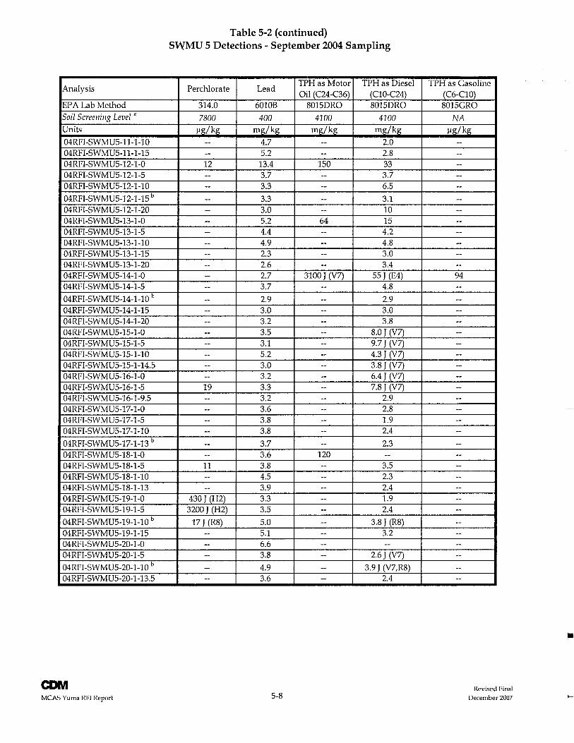
Analysis
EPA Lab Method Soil Screening Level n
Units
04RFI -SWMUS-ll-l-1 0 04RFI-SWMUS-ll-1-1S 04RFI-SWMUS-12-1-0 04RFI-SWMU5-12-1-5 04RFI-SWMU5-12-1-10
04RFI-SWMUS-12-1-15 b
04RFI-SWMU5-12-1-20 04RFI-SWMU5-13-1-0 04RFI-SWMU5-13-1-S 04RFI-SWMU5-13-1-10 04RFI-SWMU5-13-1-1S 04RFI-SWMU5-13-1-20 04RFI-SWMUS-14-1-0 04RFI -SWMU5-14-1-5
04RFI-SWMU5-14-1-10 b
04RFI-SWMU5-14-1-15 04RFI-SWMU5-14-1-20 04RFI-SWMU5-15-1-0 04RFI-SWMU5-15-1-S 04RFI -SWMU 5-15-1-1 0 04RFI-SWMU5-15-1-14.5 04RFI-SWMUS-16-1-0 04RFI -SWMU 5-16-1-5 04RFI -SWM U5-16-1-9.5 04RFI -SWMUS-17 -1-0 04RFI-SWMUS-17-1-5 04RFI-SWMU5-17-1-10
04RFI-SWMU5-17-1-13 b
04RFI -SWMU5-1S-1-0 04RFI -SWMU5-18-1-S 04RFI-SWMU5-1S-1-10 04RFI-SWMU5-18-1-13 04RFI-SWMU5-19-1-0 04RFI -SWM U S-19-1-S
04RFI-SWMUS-19-1-10 b
04RFI -SWMU5-19-1-15 04RFI -SWMU5-20-1-0 04RFI-SWMU5-20-1-5
04RFI-SWMUS-20-1-10 b
04RFI-SWMU5-20-1-13.5
CDIVI MCAS Yuma RFI Report
Table 5-2 (continued) SWMU 5 Detections - September 2004 Sampling
Perchlorate Lead TPH as Motor TPH as Diesel Oil (C24-C36) (C10-C24)
314.0 6010B SOlSDRO SOlSDRO
7800 400 4100 4100 ~g/kg mg/kg mg/kg mg/kg
-- 4.7 -- 2.0 -- S.2 -- 2.S 12 13.4 150 33 -- 3.7 -- 3.7 -- 3.3 -- 6.5
-- 3.3 -- 3.1 -- 3.0 -- 10 -- S.2 64 15 -- 4.4 -- 4.2 -- 4.9 -- 4.S -- 2.3 -- 3.0 -- 2.6 -- 3.4 -- 2.7 3100 J (V7) S5 J (E4) -- 3.7 -- 4.S
-- 2.9 -- 2.9 -- 3.0 -- 3.0 -- 3.2 -- 3.S -- 3.5 -- S.O J (V7) -- 3.1 -- 9.7 J (V7)
-- S.2 -- 4.3 J (V7) -- 3.0 -- 3.S J (V7) -- 3.2 -- 6.4 J (V7) 19 3.3 -- 7.S J (V7) -- 3.2 -- 2.9 -- 3.6 -- 2.S -- 3.S -- 1.9 -- 3.S -- 2.4
-- 3.7 -- 2.3 -- 3.6 120 --11 3.S -- 3.S -- 4.5 -- 2.3
-- 3.9 -- 2.4 430 J (H2) 3.3 -- 1.9
3200 J (H2) 3.5 -- 2.4
17 J (RS) S.O -- 3.8 J (RS) -- 5.1 -- 3.2 -- 6.6 -- ---- 3.S -- 2.6 J (V7)
-- 4.9 -- 3.9 J (V7,RS) -- 3.6 -- 2.4
5-S
TPH as Gasoline (C6-ClO) SOlSGRO
NA ~g/kg
------------------------94 ----------
--
----
--
----
------
------
------
------
----
--
--
Revised Final December 2007
Table 5-2 (continued) SWMU 5 Detections - September 2004 Sampling
NOTES: mg/kg = milligrams per kilogram Ilg/kg = micrograms per kilogram
a - Screening levels are provided in Table 3-1. b - A field duplicate sample was collected at this location/ depth; the highest detected concentrations
between the primary and duplicate sample is listed in the table. " __ " indicates the analyte was not detected at a concentration above the laboratory reporting limit.
The following EPA data qualifiers and Arizona data qualifiers (in parentheses) are provided: J = Estimated value E4 = Estimated value; analyte was detected below laboratory minimum reporting level H2 = Initial analysis within holding time; reanalysis for the required dilution was past holding time R8 = Sample relative percent difference exceeded the method control limit V7 = Calibration verification recovery was above the method control limit for this analyte, however
the average percent difference or percent drift for all the anlytes met method criteria
CDM MCAS Yuma RFI Report 5-9
Revised Final December 2007
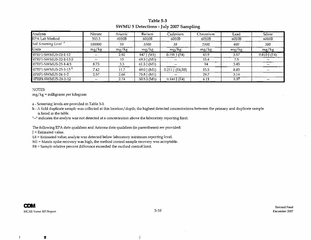
Table 5-3 SWMU 5 Detections - July 2007 Sampling
Analysis Nitrate Arsenic Barium Cadmium Chromium Lead Silver EPA Lab Method 353.3 6010B 6010B 6010B 6010B 6010B 6010B Soil Screening Level " 100000 10 5300 38 2100 400 380 Units mg/kg mg/kg mg/kg mg/kg mg/kg mg/kg mg/kg 07RFl-SWMU5-22-1-12 -- 2.92 147 J (Ml) 0.191 J (E4) 43.9 3.57 0.810 J (E4) 07RFl-SWMU5-22-1-13.5 -- 10 69.3 J (Ml) -- 15.4 7.5 --07RFl-SWMU5-23-1-4.5 8.73 3.3 61.5 J (Ml) -- 14 3.45 --07RFl-SWMU5-23-1-13 b 7.42 11.7 49.0 J (Ml) 0.211 J (E4,R8) 15.5 8.83 --07RFl-SWMU5-24-1-2 2.57 2.66 75.8 J (Ml) -- 29.7 3.14 07RFl-SWMU5-24-1-12 -- 2.74 50.5 J (Ml) 0.140 J (E4) 6.11 3.37 --
NOTES: mg/kg = milligrams per kilogram
a - Screening levels are provided in Table 3-1. b - A field duplicate sample was collected at this location/ depth; the highest detected concentrations between the primary and duplicate sample
is listed in the table. " __ " indicates the analyte was not detected at a concentration above the laboratory reporting limit.
The following EPA data qualifiers and Arizona data qualifiers (in parentheses) are provided: J = Estimated value. E4 = Estimated value; analyte was detected below laboratory minimum reporting level. Ml = Matrix spike recovery was high, the method control sample recovery was acceptable. R8 = Sample relative percent difference exceeded the method control limit.
CDM MCAS Yuma RFI Report 5-10
I
Revised Final December 2007
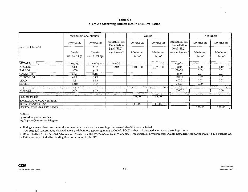
Detected Chemical
METALS ARSENIC BARIUM CADMIUM CHROMIUM LEAD SILVER
NITRATE
SUM OF RATIOS BACKGROUND CANCER RISK TOTAL CANCER RISK NONCANCER HAZARD INDEX
NOTES: bgs = below ground surface mg/kg = milligrams per kilogram
Table 5-4 SWMU 5 Screening Human Health Risk Evaluation
Maximum Concentration a Cancer
SWMU5-22 SWMU5-23 Residential Soil SWMU5-22 SWMU5-23 Remediation Level (SRL) -
Depth: Depth: carcinogen b Maximum Maximum 12-13.5 ft bgs 4.5-13 feet bgs Ratio C Ratio C
mg/kg mg/kg mg/kg 10.0 11.7 10.0 1.00E+00 1.17E+00 147.0 61.5 0.191 0.211 43.9 15.5 7.5 8.83
0.810 ND
ND 8.73 .
1.E+OO 1.E+OO
l.E-06 l.E-06
a - Borings where at least one chemical was detected at or above the screening criteria (see Table 3-1) were included.
Residential Soil Remediation Level (SRL) -
noncarcinogen b
mg/kg 10.0
5300.0 38.0
2100.0 400.0 380.0
100000.0
Any chemical concentration detected above the laboratory reporting limit is included. BOLD = chemical detected at or above screening criteria.
Noncancer
SWMU5-22 SWMU5-23
Maximum Maximum
Ratio c Ratio C
1.00 1.17 0.03 0.01 0.01 0.01 0.02 0.01 0.02 0.02 0.00 --
-- 0.00
l.E+OO 1.E+OO
b - Residential SRLs from Arizona Administrative Code Title 18 Environmental Quality, Chapter 7 Department of Environmental Quality Remedial Action, Appendix A Soil Screening Cri c - Ratios are determinded by dividing the concentration by the SRL.
COM MCAS Yuma RFI Report
III
5-11 Revised Final
December 2007
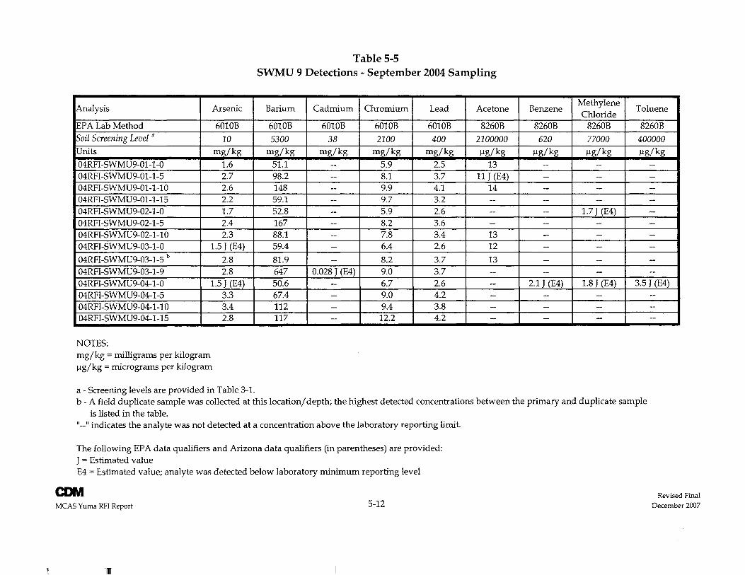
Analysis Arsenic
EPA Lab Method 6010B Soil Screening Level a 10 Units mg/kg
04RFI-SWMU9-01-1-0 1.6 04RFI-SWMU9-01-1-5 2.7 04RFI-SWMU9-01-1-10 2.6 04RFI-SWMU9-01-1-15 2.2 04RFI-SWMU9-02-1-0 1.7 04RFI-SWMU9-02-1-5 2.4 04RFI-SWMU9-02-1-10 2.3 04RFI-SWMU9-03-1-0 1.5 J (E4)
04RFI-SWMU9-03-1-5 b 2.8 04RFI-SWMU9-03-1-9 2.8 04RFI-SWMU9-04-1-0 1.5 J (E4) 04RFI-SWMU9-04-1-5 3.3 04RFI-SWMU9-04-1-10 3.4 04RFI-SWMU9-04-1-15 2.8
NOTES: mg/kg = milligrams per kilogram Ilg/kg = micrograms per kilogram
a - Screening levels are provided in Table 3-1.
Table 5-5 SWMU 9 Detections - September 2004 Sampling
Barium Cadmium Chromium Lead Acetone
6010B 6010B 6010B 6010B 8260B
5300 38 2100 400 2100000 mg/kg mg/kg mg/kg mg/kg Ilg/kg
51.1 -- 5.9 2.5 13 98.2 -- 8.1 3.7 11 J (E4) 148 -- 9.9 4.1 14 59.1 -- 9.7 3.2 --52.8 -- 5.9 2.6 --167 -- 8.2 3.6 -88.1 -- 7.8 3.4 13 59.4 -- 6.4 2.6 12
81.9 -- 8.2 3.7 13 647 0.028 J (E4) 9.0 3.7 --50.6 -- 6.7 2.6 -67.4 -- 9.0 4.2 --112 -- 9.4 3.8 --117 -- 12.2 4.2 -
Benzene Methylene
Toluene Chloride
8260B 8260B 8260B
620 77000 400000 Ilg/kg Ilg/kg Ilg/kg
-- - --- -- -- !
-- -- --i
-- -- -- I
- 1.7 J (E4) -- i
-- - ---- -- -- i
-- -- --
- -- --- -- --
2.1 J (E4) 1.8 J (E4) 3.5 J (E4) -- -- ---- -- --- -- --
b - A field duplicate sample was collected at this location/depth; the highest detected concentrations between the primary and duplicate sample is listed in the table.
" __ " indicates the analyte was not detected at a concentration above the laboratory reporting limit.
The following EPA data qualifiers and Arizona data qualifiers (in parentheses) are provided: J = Estimated value E4 = Estimated value; analyte was detected below laboratory minimum reporting level
CONI MCAS Yuma RFI Report 5-12
III
Revised Final December 2007
Section Six
CONI
MCAS Yuma eMI for SWMU 11
Section 6 Quality Assurance
The collection of field data and sampling and analysis activities for the SWMU 11 Dighole CMI were performed according to guidance and QAj QC procedures described in the Sampling and Analysis Plan (SAP) and SOPs, Appendices A and B, respectively, of the CMI Plan (CDM 2006). With one exception (see Section 4.6 regarding change in perchlorate analysis) the laboratory analyses were also performed according to proper analytical methods, detection limits, and QAj QC procedures described in the CMI Plan.
In addition to laboratory QC samples, three field duplicate QC samples were collected.
The quality control procedures and data quality assessment are described below in Sections 6.1 and 6.2, respectively. The complete QC evaluation of the analytical data, including results of laboratory and field QC samples, is summarized below in Section 6.3. Appendix C includes the analytical laboratory results (PDF), complete validated data (MS Excel), and data validation report (PDF).
6.1 Quality Control Procedures Data verification, laboratory QC, and field QC samples used for this project are identified below.
6.1.1 Data Verification Data collected were subjected to the data verification process that includes proofreading and editing hard-copy data reports to assure that data correctly represent the analytical measurement. In general, verification identifies non-technical errors in the data package that can be corrected (e.g., typographical errors). Data verification also includes verifying that the sample identifiers on laboratory reports (hard copy) match those on the COC record.
6.1.2 Laboratory QC Samples Laboratory QC samples are used to:
• Verify that procedures, such as sample handling, storage, and preparation, are not introducing variables into the process that could render the validity of samples questionable; and
• Assess data quality in terms of precision and accuracy.
QC samples are regularly prepared in the laboratory so that all phases of the sampling process are monitored. The types of laboratory QC samples prepared during the analysis of samples from the field activities are discussed below.
6-1
Section 6 Quality Assurance
6-2
6.1.2.1 Method Blanks One method blank was analyzed per batch of samples (not greater than 20 samples). The method blank is processed following the same preparatory and analytical procedures as the field-collected samples and is used to detect the presence and magnitude of contaminants or other anomalies resulting from the sample preparation and analytical procedures.
6.1.2.2 Matrix Spikes/Matrix Spike Duplicates At a minimum, one matrix spike (MS)/matrix spike duplicate (MSD) pair was prepared and analyzed for every 20 samples for organic analyses. The MS/MSD samples are prepared by spiking a known amount of certain analytes of interest for each method into a sample of the matrix. The spiked samples are then carried through the same procedures as the unspiked field-collected samples. The percent recoveries of the spiked compounds are used as an indication of the accuracy and appropriateness of the methods for the matrix. The precision of the methods is also assessed by calculating and evaluating the relative percent difference (RPD) between the results of the MS and MSD.
6.1.2.3 Surrogates Surrogate compounds (artificial compounds with similar chemical properties and behavior as the compounds of interest) are added to each sample analyzed for applicable organic analytical methods. The percent recoveries of these spiked surrogate compounds are used to assess the accuracy of sample preparation and analytical procedures.
6.1.3 Field QC Samples Field QC samples were collected in accordance with the CMI Plan (CDM 2006) to evaluate the reproducibility of the field sampling techniques.
6.1.3.1 Field Duplicate Samples The CMI Plan prescribed the collection of field duplicate samples at a rate of ten percent (or greater) from the same source and at the same time as the primary sample. Field duplicate results are used to evaluate the precision of the overall sampling and analytical system by comparing the RPD with the established RPD limit of 50 percent for the soil samples. Three field duplicates were submitted to the laboratory and analyzed for the target contaminants, exceeding the requirements prescribed in the CMIPlan.
6.1.3.2 Equipment Rinsate Blanks and Source Blanks The CMI Plan prescribed the collection of one equipment rinsate blank per day of sampling and one source blank per decontamination water source. The equipment rinsate blank serves as a check on residual environmental contamination remaining after equipment decontamination. The source blank serves as a check on the water used for decontamination. As described in Section 4.6, disposable equipment was
CONI
MCAS Yuma eMI for SWMU 11
CDIVI
MCAS Yuma eM! for SWMU 11
Section 6 Quality Assurance
used for all sample collection; therefore, decontamination was not necessary and the above-mentioned QC samples were not collected.
6.2 Data Quality Assessment 6.2.1 General Data Review The field and laboratory data collected during the CMI at the SWMU 11 Dighole have been reviewed according to the criteria described in the CMI Plan (CDM 2006). The laboratory hard-copy analytical reports and case narratives were reviewed to verify correct sample designation, identification, and cac records and to assure that analytical method, holding time, and detection limit requirements were met. All affected data were qualified accordingly during the data validation process.
6.2.2 Laboratory Data Validation EMAX prepared Level IV analytical data packages for all sample analyses performed (Appendix C). LDC performed Level IV independent data validation for 10 percent of the data and Level III validation on the remaining data; the complete data validation report is provided in Appendix C. Data validation was conducted in accordance with NAVFAC's Environmental Work Instruction (EWI) #1 (NAVFAC 2001) and updates from EPA Contract Laboratory Program National Functional Guidelines for Inorganic Data Review (EPA 2004b). EWI No.1 is compiled from EPA Contract Laboratory Program National Functional Guidelines for Inorganic Data Review (EPA 1994) and EPA Contract LaboratonJ Program National Functional Guidelines for Organic Data Review (EPA 1999).
The project goals for precision, accuracy, representativeness, completeness, and comparability, as defined in the CMI Plan (CDM 2006), were evaluated. Except as noted in the data validation reports, the data validation indicates that the analytical data obtained during this sampling event are considered to be usable for the intended purposes. LDC's data validation report is included in Appendix C.
6.3 QC Evaluation of the Analytical Data This section presents the results of the evaluation of both field and laboratory QC checks. The data quality objectives as described in the CMI Plan (CDM 2006) were met for the CMI at the SWMU 11 Dighole. The evaluation of the validated data sets compared the objective versus the actual data results through the use of the precision, accuracy, representativeness, completeness, and comparability parameters. Precision, accuracy, and completeness goals for the major chemical analyses that were performed on samples collected from the sites were those specified in the EPA Contract Laboratory Program Statement of Work.
6.3.1 Field QC Samples All field duplicate sample results were reviewed as part of the data validation activity performed during this sampling event. For additional information on the duplicate samples, see the data validation report in Appendix C.
6-3
Section 6 Quality Assurance
6-4
Field duplicate sample results were within 50 percent RPD for the soil samples as specified in the CMI Plan except for perchlorate, toluene, and TPH as motor oil. All affected data were qualified accordingly during the data validation process.
6.3.2 Precision and Accuracy The procedures in this section are designed to assess QC data for blanks, duplicates, controls, spikes, and surrogates. The review of these data provides information concerning the precision and accuracy measurements conducted by the laboratories and field procedures.
6.3.2.1 Laboratory Method Blanks No chemicals were reported in laboratory method blanks.
6.3.2.2 Initial and Continuing Calibration Controls All compounds were within the method and validation criteria except for 2,2-dichloropropane, naphthalene, bromomethane, 1,1,1-trichloroethane, cis-l,3-dichloropropene, 1,2-dibromoethane, and hexachlorocydopentadiene. These chemicals were not reported in any of the primary soil samples. All affected data points were qualified with "VI" during the data validation process indicating that the compound was analyzed for but not detected and the detection limit is an estimated value.
6.3.2.3 Matrix Spikes/Matrix Spike Duplicates MS/MSD results that were prepared and analyzed by the laboratory were within control limits.
6.3.2.4 Surrogates Surrogate percent recoveries were within required control limits.
6.3.2.5 Laboratory Control Samples Laboratory control sample (LCS) and laboratory control sample duplicate (LCSD) results prepared and analyzed by the laboratory were within control limits.
6.3.3 Representativeness Representativeness is the reliability with which a measurement or measurement system reflects the true conditions under investigation (EPA 1993). Representativeness is influenced by the number and location of the sampling points, sampling timing and frequency of monitoring efforts, and the field and laboratory sampling procedures (EPA 1993).
The representativeness of data was enhanced by the use of established field and laboratory procedures and their consistent application. Samples that were collected are considered to be representative of the location of sample collection.
CONI
MCAS Yuma eMI for SWMU 11
CONI MCAS Yuma eMI for SWMU 11
6.3.4 Completeness
Section 6 Quality Assurance
The completeness of the data is described as a ratio of the amount of data expected from the field program versus the amount of valid data actually received. Valid data are considered to be those data that have not been rejected (were not R-qualified either from data validation or internal data review). Completeness can be expressed by the following equation:
(number of valid results) C = --------------------------------------------------------- X 100
(total number of requested results)
Based on the data validation and internal review no results were rejected. The completeness of the sample set submitted for analysis is 100 percent, which is within the completeness goal (90 percent) set for this project.
6.3.5 Comparability Comparability evaluates whether the reported data is comparable with similar data reported by other organizations. The comparability of the laboratory results was found to be acceptable. All samples have been analyzed by the same laboratory, using the complete list of published methods specified in the field sampling plan. All units were consistent and appropriate for the matrix sampled.
6-5

Section 6 Quality Assurance
This page intentionally left blank.
6-6 CONI
MCAS Yuma CMI for SWMU 11
Section Seven
COM
MCAS Yuma eMt for SWMU 11
Section 7 Conclusions
Sampling results from the CMI indicate that no contamination exists in the SWMU 11 Dighole. Results of characterization samples taken from the excavated soils showed no contaminant concentrations above cleanup objectives. Confirmation samples collected from the excavation limits also did not show any contaminant concentrations of concern.
The CMI findings demonstrate that the CAOs for the SWMU 11 Dighole have been met:
• Future potential exposure of human and ecological receptors to contaminated materials has been minimized due to the lack of contaminated materials; and
• Off-site transport of contaminated materials has been prevented due to the lack of contaminated materials.
No further action is necessary for the SWMU 11 Dighole and a "Corrective Action Complete without Controls" status is recommended for the site.
7-1

Section 7 Conclusions
7-2
This page intentionally left blank.
CONI MCAS Yuma eMI for SWMU 11
• Ion Eight
COM MCAS Yuma eM1 for SWMU 11
Section 8 References
Arizona Department of Environmental Quality (ADEQ) Waste Programs Division Hazardous Waste Permits Unit. 2003. RCRA Facilihj Assessment Report Final Addendum, Barry Goldwater Range Yuma Segment. September.
------. 2002. Arizona Administrative Code, Title 18, Chapter 7, Appendix A. Arizona Soil Remediation Levels. September.
Booz Allen Hamilton (Booz Allen). 2002. RCRA Facilihj Assessment Report, Barnj Goldwater Range Yuma Segment. July.
CDM Federal Programs Corporation (CDM). 2006. Corrective Measure Study Report for SWMU 11 Dighole, Marine Corps Air Station Yuma, Yuma, Arizona. July.
------. 2005. RCRA Facilihj Investigation Report for SWMU 2, SWMU 5, SWMU 9, and SWMU 11, Final. August.
------.2003. Final Resource Conservation and Recovery Act Part B Permit Application, 2003 Update for Marine Corps Air Station Yuma Munitions Treatment Range, Barry M. Goldwater Range, Arizona. October.
ULS Services Corporation (ULS). 2007. Field Documentation Report for Electromagnetic Survey - Burn Pit. April.
United States Department of Defense (DOD). 2006. DOD Perchlorate Handbook. March.
United States Department of the Navy, Naval Facilities Engineering Command Southwest (NAVFAC). 2001. Environmental Work Instruction #1 (3EN2.1), Chemical Data Validation. November.
United States Environmental Protection Agency (EPA). 2004a. Region 9 Residential Preliminanj Remediation Goals. October.
------. 2004b. EPA Contract Laboratory Program National Functional Guidelines for Inorganic Data Review. EPA 540jR-99/008. October.
------.1999. EPA Contract Laboratonj Program National Functional Guidelines for Organic Data Review. EPA 540j R-99j 008. October.
------. 1994. National Functional Guidelines for Inorganic Data Review. Office of Emergency and Remedial Response. Washington, DC. EPA-540jR-94/013. February.
------.1993. EPA National Guidelines for Data Validation.
8-1
Section 8 References
8-2
This page intentionally left blank.
CDM
MCAS YlMTla CMI for SWMU 11