Embed Size (px)
Citation preview
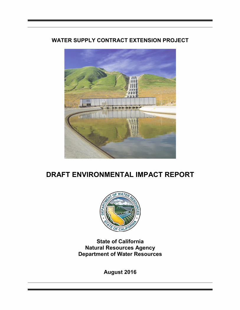
WATER SUPPLY CONTRACT EXTENSION PROJECT
DRAFT ENVIRONMENTAL IMPACT REPORT
State of California Natural Resources Agency
Department of Water Resources
August 2016

State of California The Resources Agency
Department of Water Resources
WATER SUPPLY CONTRACT EXTENSION PROJECT
DRAFT ENVIRONMENTAL IMPACT REPORT
AUGUST 2016
EDMUND G. BROWN Jr Governor
State of California
JOHN LAIRD Secretary for Resources The Resources Agency
MARK W. COWIN Director
Department of Water Resources

WATER SUPPLY CONTRACT EXTENSION PROJECT Draft Environmental Impact Report
Prepared for August 2016 State of California Natural Resources Agency Department of Water Resources
2600 Capitol Avenue Suite 200 Sacramento, CA 95816 916.564.4500 www.esassoc.com
Irvine
Los Angeles
Oakland
Orlando
Palm Springs
Petaluma
Portland
San Diego
San Francisco
Seattle
Tampa
Woodland Hills

OUR COMMITMENT TO SUSTAINABILITY | ESA helps a variety of public and private sector clients plan and prepare for climate change and emerging regulations that limit GHG emissions. ESA is a registered assessor with the California Climate Action Registry, a Climate Leader, and founding reporter for the Climate Registry. ESA is also a corporate member of the U.S. Green Building Council and the Business Council on Climate Change (BC3). Internally, ESA has adopted a Sustainability Vision and Policy Statement and a plan to reduce waste and energy within our operations. This document was produced using recycled paper.
Table of Contents

Water Supply Contract Extension Project i ESA / 120002 Draft Environmental Impact Report August 2016
TABLE OF CONTENTS
Chapter Page
ACRONYMS AND ABBREVIATIONS ........................................................................................ v
EXECUTIVE SUMMARY ...................................................................................................... ES-1 Introduction .................................................................................................................. ES-1 Potential Areas of Controversy and Concern ................................................................ ES-3 Proposed Project .......................................................................................................... ES-3 Environmental Impacts ................................................................................................. ES-4 Alternatives to the Proposed Project............................................................................. ES-5
1 INTRODUCTION .............................................................................................................1-1 1.1 Introduction .............................................................................................................1-1 1.2 Purpose of the DEIR ...............................................................................................1-2 1.3 Environmental Review and Approval Process .........................................................1-3
1.3.1 Notice of Preparation ..................................................................................1-3 1.3.2 DEIR ...........................................................................................................1-4 1.3.3 Final EIR .....................................................................................................1-4 1.3.4 Approval Process ........................................................................................1-5
1.4 Scope of this EIR ....................................................................................................1-5 1.5 Organization of the DEIR ........................................................................................1-6
2. STATE WATER PROJECT .............................................................................................2-1 2.1 History and Background..........................................................................................2-1 2.2 Components of the SWP ........................................................................................2-2
2.2.1 Cross Drainage Facilities ............................................................................2-8 2.3 Water Service Provisions ...................................................................................... 2-10
2.3.1 Annual Table A Amounts ........................................................................... 2-12 2.3.2 Water Management Practices ................................................................... 2-15
2.4 SWP Operations ................................................................................................... 2-15 2.4.1 SWP Deliveries ......................................................................................... 2-17
2.5 Background on Previous Contract Amendments and Settlement Agreements ...... 2-19 2.5.1 Monterey Amendment and Settlement Agreement .................................... 2-19 2.5.2 Recent SWP Supply Allocation Amendments ............................................ 2-20
2.6 References ........................................................................................................... 2-21
3. STATE WATER PROJECT FINANCING AND WATER SUPPLY CONTRACT FINANCIAL PROVISIONS ..............................................................................................3-1 3.1 Introduction .............................................................................................................3-1 3.2 Capital Financing and Operations and Maintenance Expenditures .........................3-1
3.2.1 The Burns-Porter Act ..................................................................................3-1 3.2.2 Central Valley Project Improvement Act ......................................................3-2 3.2.3 Capital Resources Financing.......................................................................3-2
3.3 Annual Revenues ...................................................................................................3-3 3.3.1 Water Supply Contract Cost Recovery ........................................................3-3 3.3.2 Timing and Method of Payment ...................................................................3-6 3.3.3 The Davis-Dolwig Act ..................................................................................3-7
3.4 Monterey Amendment Financial Provisions ............................................................3-7 3.4.1 General Operating Account .........................................................................3-8
Table of Contents
Chapter Page
Water Supply Contract Extension Project ii ESA / 120002 Draft Environmental Impact Report August 2016
3.4.2 State Water Facilities Capital Account .........................................................3-8 3.4.3 Rate Restructuring Provisions .....................................................................3-8
4. PROJECT DESCRIPTION ..............................................................................................4-1 4.1 Introduction .............................................................................................................4-1 4.2 Project Location ......................................................................................................4-1 4.3 Project Objectives ...................................................................................................4-2 4.4 Project Description ..................................................................................................4-2
4.4.1 Extended Contract Term .............................................................................4-3 4.4.2 Increased Operating Reserves ....................................................................4-3 4.4.3 New Billing Provisions .................................................................................4-4 4.4.4 Enhanced Funding Mechanisms and New Accounts ...................................4-5 4.4.5 Enhanced Coordination Regarding SWP Finances .....................................4-6 4.4.6 Proposed Contract Amendments ................................................................4-6
4.5 Required Permits and Approvals ............................................................................4-7
5. ENVIRONMENTAL ANALYSIS ......................................................................................5-1 5.1 Introduction to the Analysis .....................................................................................5-1
5.1.1 Method of Analysis ......................................................................................5-3 5.2 Environmental Analysis ..........................................................................................5-9
5.2.1 Aesthetics ...................................................................................................5-9 5.2.2 Agricultural and Forest Resources ............................................................ 5-13 5.2.3 Air Quality ................................................................................................. 5-19 5.2.4 Biological Resources ................................................................................. 5-26 5.2.5 Cultural Resources .................................................................................... 5-34 5.2.6 Energy ...................................................................................................... 5-49 5.2.7 Geology, Soils, and Mineral Resources ..................................................... 5-54 5.2.8 Greenhouse Gas Emissions ...................................................................... 5-62 5.2.9 Groundwater Hydrology and Water Quality ............................................... 5-73 5.2.10 Hazards and Hazardous Materials ............................................................ 5-89 5.2.11 Land Use and Planning ............................................................................. 5-94 5.2.12 Noise ......................................................................................................... 5-98 5.2.13 Population and Housing .......................................................................... 5-106 5.2.14 Public Services and Recreation ............................................................... 5-109 5.2.15 Surface Water Hydrology and Water Quality ........................................... 5-114 5.2.16 Transportation ......................................................................................... 5-132 5.2.17 Utilities and Service Systems .................................................................. 5-136 5.2.18 Water Supply .......................................................................................... 5-140
6. OTHER CEQA CONSIDERATIONS ...............................................................................6-1 6.1 Cumulative Impacts ................................................................................................6-1
6.1.1 Cumulative Projects ....................................................................................6-2 6.1.2 Cumulative Impact Analysis ........................................................................6-4
6.2 Significant Unavoidable Impacts .............................................................................6-5 6.3 Significant Irreversible Environmental Changes ......................................................6-5 6.4 Growth-Inducing Impacts ........................................................................................6-6
6.4.1 Growth Inducement Potential ......................................................................6-7 6.5 References .............................................................................................................6-7
Table of Contents
Chapter Page
Water Supply Contract Extension Project iii ESA / 120002 Draft Environmental Impact Report August 2016
7 ALTERNATIVES .............................................................................................................7-1 7.1 Introduction .............................................................................................................7-1 7.2 Project Objectives ...................................................................................................7-2 7.3 Alternatives Considered but Rejected .....................................................................7-2
7.3.1 Reduce Table A Deliveries ..........................................................................7-3 7.3.2 Implement New Water Conservation Provisions in the Extended
Contracts.....................................................................................................7-4 7.3.3 Implement California WaterFix ....................................................................7-5
7.4 Project Alternatives .................................................................................................7-6 7.4.1 Alternative 1: No Project ..............................................................................7-6 7.4.2 Alternative 2: Different Contract Term (2065) with Financial Provisions of
the Proposed Project ................................................................................. 7-13 7.4.3 Alternative 3: Different Contract Term (2110) with Financial Provisions of
the Proposed Project ................................................................................. 7-15 7.4.4 Alternative 4: Extend Contract Term to 2085 without Financial Provisions
of the Proposed Project ............................................................................. 7-17 7.4.5 Alternative 5: Extend Contract Term to 2085 and do not Implement
Financial Provisions of the Proposed Project until 2035 ............................ 7-19 7.4.6 Alternative 6: Extend Contract Term Through the Sale of Bonds ............... 7-21 7.4.7 Alternative 7: Not All Contractors Sign ...................................................... 7-24
7.5 Environmentally Superior Alternative .................................................................... 7-26 7.6 References ........................................................................................................... 7-28
8. CONTRIBUTORS AND REVIEWERS .............................................................................8-1
APPENDICES Appendix A - Agreement in Principal Appendix B - Notice of Preparation and Comment Letters Received Appendix C - Example of Water Supply Contract Appendix D - SWP Financial Model
FIGURES 2-1. State Water Project Contractor’s Service Areas .......................................................2-3 2-2. Primary State Water Project Water Delivery Facilities ..............................................2-4 5.1-1. Comparison of Transportation and Conservation Capital Charges 2016 to 2038 ......5-4 5.1-2. Comparison of Conservation Minimum Charges .......................................................5-5
TABLES ES-1. Comparison of Alternatives to Proposed Project .................................................... ES-9 2-1. Physical Characteristics of Primary Storage Facilities ..............................................2-9 2-2. Total Miles of Aqueducts ........................................................................................ 2-10 2-3. Water Supply Contract Execution and Current Expiration Dates ............................. 2-11 2-4. Maximum Table A Amounts .................................................................................... 2-13 2-5. Table A Amounts 1970–2016 ................................................................................. 2-14
Table of Contents
Chapter Page
Water Supply Contract Extension Project iv ESA / 120002 Draft Environmental Impact Report August 2016
2-6. Historical Table A Requests & Deliveries to SWP Contractors ................................ 2-17 5.2.3-1. State and National Criteria Air Pollutant Standards, Effects, and Sources .............. 5-21 5.2.8-1. Global, National, State, and Local GHG Emissions Inventories .............................. 5-65 5.2.9-1. Groundwater Management Plans and Groundwater Sustainability Agencies
within the Study Area .............................................................................................. 5-85 5.2.12-1. Representative Environmental Noise Levels ........................................................... 5-99 5.2.12-2. Human Response to Different Levels of Groundborne Vibration ........................... 5-101 5.2.12-3. Typical Ambient Noise Levels in a Suburban and Urban Environment .................. 5-102 5.2.12-4. Land Use Compatibility for Community Noise Environment .................................. 5-103 7-1. Summary of Alternatives Considered ........................................................................7-7 7-2. Comparison of Alternatives to Proposed Project ..................................................... 7-27
Water Supply Contract Extension Project v ESA / 120002 Draft Environmental Impact Report August 2016
ACRONYMS AND ABBREVIATIONS
°C Celsius °F Fahrenheit µg/L micrograms per liter AB Assembly Bill af acre-feet AIP Agreement in Principle Concerning Extension of the State Water Project
Water Supply Contracts APCD Air Pollution Control District AQMD Air Quality Management District Banks Harvey O. Banks Delta Bay-Delta Sacramento-San Joaquin Estuary B.C.E. Before Common Era BDCP Bay Delta Conservation Plan BiOp Biological Opinion CAA Federal Clean Air Act CAL FIRE California Department of Forestry and Fire Protection CalRecycle California Department of Resources Recycling and Recovery Caltrans California Department of Transportation CARB California Air Resources Board CAISO California Independent System Operator CBC California Building Standards Code CCAA California Clean Air Act CCR California Code of Regulations CCWA Central Coast Water Authority CDFW California Department of Fish and Wildlife CDPH California Department of Public Health CDWA Central Delta Water Agency C.E. Common Era CEC California Energy Commission CEPA California Environmental Protection Agency CEQA California Environmental Quality Act CESA California Endangered Species Act CFCP California Farmland Conservancy Program CFR Code of Federal Regulations cfs cubic feet per second CH4 methane CNEL Community Noise Equivalent Level CO carbon monoxide CO2 carbon dioxide
Acronyms and Abbreviations
Water Supply Contract Extension Project vi ESA / 120002 Draft Environmental Impact Report August 2016
CO2e CO2 equivalents COA Coordinated Operating Agreement COGs Council of Governments Contractors State Water Contractors Contracts Water Supply Contracts CPUC California Public Utilities Commission CRHR California Register of Historical Places CTC California Transportation Commission CVP Reclamation’s Central Valley Project CVPIA Central Valley Project Improvement Act CWA Clean Water Act dB decibel dBA A-weighted decibel scale DEIR Draft Environmental Impact Report DOC California Department of Conservation DSC Delta Stewardship Council DWR California Department of Water Resources E-Clay Corcoran Clay EFH Essential Fish Habitat EIR Environmental Impact Report EIS Environmental Impact Statement ESA Endangered Species Act FC&WCD Flood Control and Water Conservation District FCAA federal Clean Air Act FCAAA Federal Clean Air Act Amendments FCD Flood Control District FERC Federal Energy Regulatory Commission FHWA Federal Highway Administration FIFRA Federal Insecticide, Fungicide, and Rodenticide Act FIP Federal Implementation Plan FMMP Farmland Mapping and Monitoring Program FSZ Farmland Security Zone GAMA Groundwater Ambient Monitoring and Assessment GGERP Greenhouse Gas Emissions Reduction Plan GHG greenhouse gas GMP Groundwater Management Plan GOA General Operating Account GSA Groundwater Sustainability Agency GSP Groundwater Sustainability Plan GWh gigawatt hours HAP Hazardous Air Pollutant
Acronyms and Abbreviations
Water Supply Contract Extension Project vii ESA / 120002 Draft Environmental Impact Report August 2016
HCP Habitat Conservation Plan HFC hydrofluorocarbons HHWE household hazardous waste element ID Irrigation District IPCC Intergovernmental Panel on Climate Change IRWMP integrated regional water management plan ITP incidental take permit JPOD Joint Point of Diversion KFE Kern Fan Element kV kilovolts KWBA Kern Water Bank Authority L50 a statistical noise level, is the noise level which is exceeded 50 percent of
the time during which the noise is measured LADWP Los Angeles Department of Water and Power Ldn day-night average noise level Leq equivalent energy noise level M&I municipal and industrial MAF million acre feet MCL maximum contaminant level mm/yr millimeters per year MOU Memorandum of Understanding MRZ mineral resource zone MW megawatt MWD Municipal Water District mt metric tons MWh/yr megawatt-hours per year N2O nitrous oxide NAAQS National Ambient Air Quality Standards NBA North Bay Aqueduct NBA AIP North Bay Aqueduct Alternate Intake Project NCCP Natural Community Conservation Planning NEHRPA National Earthquake Hazards Reduction Program Act NEPA National Environmental Policy Act NERC North American Electric Reliability Corporation NGO non-government organization NHPA National Historic Preservation Act NMFS National Marine Fisheries Service NO2 nitrogen dioxide NOP Notice of Preparation NPDES National Pollutant Discharge Elimination System NRCS U.S. Natural Resources Conservation Service
Acronyms and Abbreviations
Water Supply Contract Extension Project viii ESA / 120002 Draft Environmental Impact Report August 2016
NRDC Natural Resources Defense Council NRHP National Register of Historic Places O&M Operation and Maintenance OPR Office of Planning and Research PCB polychlorinated biphenyl PCE tetrachloroethylene PFC perfluorocarbons PFMC Pacific Fishery Management Council PG&E Pacific Gas and Electric PM particulate matter PRC California Public Resources Code RAS replacement accounting system RDEIR Recirculated Draft Environmental Impact Report Reclamation U.S. Bureau of Reclamation Reporting Rule Greenhouse Gas Reporting Rule Resources Agency California Natural Resources Agency RPS Renewables Portfolio Standard Regional Water Board Regional Water Quality Control Board SB Senate Bill SBVMWD San Bernardino Valley Municipal Water District SCWA Solano County Water Agency SDEIS Supplemental Draft Environmental Impact Statement SDWA Safe Drinking Water Act SF6 sulfur hexafluoride SFPUC San Francisco Public Utility Commission SGMA Sustainable Groundwater Management Act SHPO State Historic Preservation Office SIP State Implementation Plan SMARA Surface Mining and Reclamation Act SO2 sulfur dioxide SR State Route SRA State Water Resources Development System Reinvestment Account SRRE source reduction and recycling element SSA State Water Resources Development System Support Account State Water Board State Water Resources Control Board SVP Society of Vertebrate Paleontology SWP State Water Project SWPAO State Water Project Analysis Office SWRDS State Water Resources Development System TAC toxic air contaminant
Acronyms and Abbreviations
Water Supply Contract Extension Project ix ESA / 120002 Draft Environmental Impact Report August 2016
taf thousand acre-feet TCE trichloroethylene TDS total dissolved solids TMDL total maximum daily load TPZ Timber Production Zones US 101 U.S. Highway 101 USACE U.S. Army Corps of Engineers USEPA U.S. Environmental Protection Agency USFWS U.S. Fish and Wildlife Service USGS U.S. Geological Survey UWMP urban water management plan VdB vibration decibels WA Water Agency WD Water District WDSC Water District of Southern California WECC Western Electricity Coordinating Council WQCP Water Quality Control Plan WSD Water Storage District WSRA Wild and Scenic Rivers Act

Acronyms and Abbreviations
Water Supply Contract Extension Project x ESA / 120002 Draft Environmental Impact Report August 2016
This page intentionally left blank
Executive Summary

Water Supply Contract Extension Project ES-1 ESA / 120002 Draft Environmental Impact Report August 2016
EXECUTIVE SUMMARY
INTRODUCTION
The Department of Water Resources (DWR) is proposing to implement the Water Supply Contract Extension Project (proposed project). The proposed project includes amending certain provisions of the State Water Resources Development System (SWRDS) Water Supply Contracts (Contracts). SWRDS (defined in Water Code Section 12931), or more commonly referred to as the State Water Project (SWP), was enacted into law in the Burns-Porter Act, passed by the Legislature in 1959 and approved by the voters in 1960. DWR constructed and currently operates and maintains the SWP, a system of storage and conveyance facilities that provide water to 29 State Water Contractors (Contractors).
The SWP is a complex system of reservoirs, dams, power plants, pumping plants, pipelines, and aqueducts. Precipitation and watershed runoff are stored in Lake Oroville, a reservoir behind Oroville Dam in Butte County, and delivered via natural stream channels to the Delta and pumped into the California Aqueduct system to water agencies and districts in Southern California, the Central Coast, the San Joaquin Valley, and portions of the San Francisco Bay Area.
The Contractors receive water service from the SWP in exchange for paying all costs that are associated with constructing, operating, and maintaining the SWP facilities and are attributable to water supply. DWR and each of the Contractors entered into Contracts in the 1960s with 75-year terms. The Contracts are substantially uniform. The Contracts begin to expire in 2035, unless the expiration dates are otherwise extended pursuant to the option for continued service in Article 4 of the Contracts.1 All Contracts will expire by 2042 if not extended.
The major sources of capital financing for construction of the SWP have been and are: the Burns-Porter Act, which authorized General Obligation Bond sales; the Central Valley Project Act, which authorizes the issuance of revenue bonds; and other capital resources revenues. Of the three types of capital financing, revenue bonds are currently the predominate form of capital financing. In the past, DWR has typically sold revenue
1 Article 4 states that, by written notice to DWR at least 6 months prior to the expiration date of a Contract, the
Contractor can elect to receive continued service after the expiration of the term under the following conditions unless otherwise agreed to: (1) service of water in annual amounts up to and including the Contractor’s maximum annual Table A amount; (2) service of water at no greater cost to the Contractor than would have been the case had the Contract continued in effect; (3) service of water under the same physical conditions of service, including time, place, amount, and rate of delivery; (4) retention of the same chemical quality objective provision; and (5) retention of the same options to use the SWP transportation facilities as provided for in Articles 18(c) and 55, as applicable.
Executive Summary
Water Supply Contract Extension Project ES-2 ESA / 120002 Draft Environmental Impact Report August 2016
bonds with terms up to 30 years or more. However, it has become more challenging in recent years to affordably finance capital expenditures for the SWP because as a practical matter, it would be difficult to sell revenue bonds used to finance these expenditures with maturity dates that extend beyond the year 2035, the year the first of the Contracts would expire. Although DWR has the contractual authority to issue bonds with maturities after 2035 (and in so doing, extend the Contract expiration date under Article 2 of the Contracts2), such bonds likely could not be issued without a Contract amendment or other arrangement with the Contractors to provide for the orderly financial management of the SWP for the entire period over which such bonds would be outstanding, including after 2035. Today, DWR sells only bonds that extend for fewer than 30 years because of the 2035 limitation; for example, in 2017, DWR will sell bonds with a maturity date no longer than 18 years (i.e., up to 2035). In order for DWR to sell bonds for 30 years or more, which would provide more affordable financing to the Contractors for the SWP costs associated with constructing and repairing the SWP facilities that are allocated to water supply, it is necessary to extend the expiration dates of the Contracts.
In May 2013, DWR and the Contractors entered into public negotiations to extend the term and make other financial improvements to the Contracts. The outcome of these negotiations resulted in the “Agreement in Principle Concerning Extension of the State Water Project Water Supply Contracts” (AIP). The AIP is included as Appendix A of this Draft Environmental Impact Report (DEIR). The proposed project, which is evaluated in this DEIR, would amend certain financial provisions of the Contracts and extend the term of the Contracts to 2085 based on the AIP. The proposed project would not create new water management measures, alter the existing authority to build new or modify existing facilities, or change water allocation provisions of the Contracts. DWR determined that an EIR was the appropriate California Environmental Quality Act (CEQA) document due to the statewide importance of any proposed amendments to the Contracts, such as the proposed project. Further, as an informational document, this DEIR discloses for public and lead agency consideration potential environmental effects attributed to the outcome of the public negotiations to extend the term and make other financial improvements to the Contracts. It also is intended to provide sufficient information to foster informed decision-making by DWR.
2 Article 2 provides separately for each Contract that the specific Contract shall remain in effect for the longest of
(1) the “project repayment period” (i.e., December 31, 2035); (2) “75 years”; or (3) “the period ending with the latest maturity date of any bond issue used to finance the construction costs of project facilities.” No bonds have been sold with a maturity date later than December 1, 2035. The project repayment period and the 75-year term provisions result in the individual Contracts having varying expiration dates that range between December 31, 2035 and 2042.
Executive Summary
Water Supply Contract Extension Project ES-3 ESA / 120002 Draft Environmental Impact Report August 2016
POTENTIAL AREAS OF CONTROVERSY AND CONCERN
DWR issued a Notice of Preparation (NOP) for this EIR September 12, 2014 (see Appendix B of this DEIR). DWR provided the NOP to: (1) local, State, and federal agencies; (2) local libraries; (3) city and county clerk offices; and (4) other interested parties. The NOP was circulated for comment for 30 days, ending on October 13, 2014. Responses to the NOP identified potential areas of controversy and concern to a range of local, state, and non-governmental interests.
During two scoping meetings held on September 23, 2014, no participants commented on the proposed project. Six written comment letters were submitted during the NOP comment period. Letters were received from the Central Delta Water Agency (CDWA), County of Santa Barbara, Delta Stewardship Council (DSC), Natural Resources Defense Council (NRDC), Stanislaus County Environmental Review Committee, and a coalition of non-government organizations (NGOs). DWR reviewed all scoping comments received and the letters are included in Appendix B of this DEIR. General topics raised included: requirements of a NOP; description of the project background; description of the project evaluated in the DEIR; range of alternatives to be evaluated in the DEIR; definition of environmental and regulatory setting and baseline for the DEIR analysis; technical resource areas that should be considered; context for the cumulative impact analysis; need to conduct a growth inducement analysis; National Environmental Policy Act (NEPA) nexus; and potential project segmentation issues. Issues raised in response to the NOP are addressed in this EIR, as appropriate, for compliance with CEQA.
PROPOSED PROJECT
DWR and the Contractors agreed to the following proposed project objectives:
1. Ensure DWR can finance SWP expenditures beyond 2035 for a sufficiently extended period to provide for a reliable stream of revenue from the Contractors and to facilitate ongoing financial planning for the SWP.
2. Maintain an appropriate level of reserves and funds to meet ongoing financial SWP needs and purposes.
3. Simplify the SWP billing process.
4. Increase coordination between DWR and the Contractors regarding SWP financial matters.
The proposed project would amend and add financial provisions to the Contracts based on the negotiated AIP between DWR and the Contractors. The proposed project would not create new water management measures, alter the existing authority to build new or

Executive Summary
Water Supply Contract Extension Project ES-4 ESA / 120002 Draft Environmental Impact Report August 2016
modify existing facilities, require or otherwise change SWP operations, or change water allocation provisions of the Contracts. The changes to the SWP contracts by the proposed project are composed of the following five project elements that meet the proposed project objectives identified above. The proposed project is described in more detail in Chapter 4, Project Description, of the DEIR.
1. Extended Contract Term. Revise Article 2 to extend the term of the 29 Contracts to December 31, 2085 (subject to the provisions of Article 4).3
2. Increased Operating Reserves. Provide for increased SWP financial operating reserves.
3. New Billing Provisions. Implement a comprehensive pay-as-you-go repayment methodology with a corresponding billing system that more closely matches the timing of future SWP revenues to future expenditures. The pay-as-you-go repayment methodology generally means to recover capital, operation, and maintenance costs within the year incurred and/or expended.
4. Enhanced Funding Mechanisms and New Accounts. Provide enhanced funding mechanisms and create additional accounts to address SWP financial needs and purposes.
5. Enhanced Coordination Regarding SWP Finances. Provide for a finance committee and provide other means to increase coordination between DWR and the Contractors regarding SWP financial matters.
ENVIRONMENTAL IMPACTS
The impact of the proposed project on the following resource topics was analyzed in Chapter 5, Environmental Analysis, of the DEIR: aesthetics; agricultural and forest resources; air quality; biological resources; cultural resources; energy; geology, soils, and mineral resources; greenhouse gas emissions; groundwater hydrology and water quality; hazards and hazardous materials; land use and planning; noise; population and housing; public services and recreation; surface water hydrology and water quality; transportation; utilities and service systems; and water supply.
The results of the analyses in Chapter 5 found that the proposed project would result in no impact on any of these resource topics because it would amend and add financial provisions to the Contracts and would not create new water management measures, alter the existing authority to build new or modify existing SWP facilities, or change water allocation provisions of the Contracts. Further, the cumulative impact analyses (see Chapter 6, Other CEQA Considerations) found that implementation of the proposed project would not result in physical environmental impacts; therefore, it would 3 Article 4 provides each Contractor an option for continued service after the date determined in accordance with
Article 2. Article 2 is described in footnote 2 on page ES-2 and Article 4 is described in footnote 1 on page ES-1.

Executive Summary
Water Supply Contract Extension Project ES-5 ESA / 120002 Draft Environmental Impact Report August 2016
not contribute to any cumulative effect. As a result, the proposed project would have no cumulative impacts.
Growth Inducement
As described in Chapter 6, because the proposed project would not construct new or modified SWP facilities or change water supply allocations in Contractors’ service areas there would be no new housing and no substantial new permanent employment opportunities. Furthermore, it would not directly or indirectly remove obstacles to growth because the proposed project would not provide for additional and/or more reliable water supplies. There would be no change in land uses associated with SWP deliveries including, conversion of agricultural land uses to urban uses or increased developed uses in urban areas because water deliveries would continue consistent with the current contract. Therefore, the proposed project would not result in direct or indirect growth inducement.
ALTERNATIVES TO THE PROPOSED PROJECT
As described in Chapter 7, Alternatives, the focus and definition of the alternatives evaluated in the DEIR were governed by the “rule of reason” in accordance with Section 15126.6(f) of the CEQA Guidelines requiring evaluation of only those alternatives “necessary to permit a reasoned choice.” As described in Chapter 5, there are no impacts associated with the proposed project. Therefore, there are no alternatives that would reduce or eliminate significant project impacts as compared to the proposed project and development of specific alternatives to reduce or eliminate significant environmental impacts is not required by CEQA. However, as an informational document, this DEIR discloses for public and agency consideration a reasonable range of alternatives to the proposed project in order to provide DWR with sufficient information to foster informed decision-making. Alternatives to the proposed project were developed and analyzed for their ability to meet the project objectives. Where alternatives were found to attain most of the basic objectives, they were included as part of the detailed analysis presented in Chapter 7. Where alternatives were not found to attain most of the basic project objectives or not to be feasible means to achieve basic project objectives, they were eliminated from further detailed consideration. The alternatives that were considered but rejected include:
1. Reduce Table A deliveries (see discussion of current Table A Contract provisionsin Chapter 2, State Water Project)
2. Implement new water conservation management provisions in the extendedContracts
3. Implement California WaterFix
Executive Summary
Water Supply Contract Extension Project ES-6 ESA / 120002 Draft Environmental Impact Report August 2016
The following provides a summary of the alternatives evaluated in the DEIR along with an analysis of impacts, as compared to the proposed project, and the alternative’s ability to achieve the proposed project’s objectives. See Chapter 7 for the detailed evaluation.
Alternative 1 - No Project
Under the No Project Alternative, DWR takes no action, and DWR and the Contractors would continue to operate and finance the SWP under the Contracts to December 31, 2035. Upon receipt of Article 4 letters from the Contractors (at least 6 months prior to the existing expiration date for each Contract) the term of the Contracts would be extended beyond their current expiration dates. Under this alternative, the Contracts would not expire beginning in 2035. Water service would continue beyond 2035 to all the Contractors, consistent with the Contracts including the existing financial provisions. Annual revenue and water supply cost recovery would continue consistent with the current Contracts. Until the Contractors submit their Article 4 letters to extend their Contract expiration dates and the extended Contract expiration date is determined, DWR would not sell bonds with maturity dates past 2035 to finance SWP capital expenditures and therefore the current compression in the recovery of capital costs and bond financing costs would be exacerbated.
Alternative 2 - Different Contract Term (2065) with Financial Provisions of the Proposed Project
Under Alternative 2, DWR and the Contractors would agree to implement the proposed financial provision changes and extend the term of the Contract beyond December 31, 2035, to 2065 compared to the proposed project (2085). Repayment of existing bonds covering past expenditures would continue to 2035 consistent with the current Contracts as modified by the proposed financial provision changes. Bond sales to fund future expenditures would continue past 2035, but no bonds would be sold with a maturity date beyond 2065. Water service would continue beyond 2035 consistent with the current Contracts. The proposed project’s revised financial provisions would begin to be implemented upon Contract amendment execution. All other Contract provisions would remain unchanged.
Alternative 3: Different Contract Term (2110) with Financial Provisions of the Proposed Project
Under Alternative 3, DWR and the Contractors would agree to implement the proposed financial provision changes and extend the term of the Contract beyond December 31, 2035, to 2110 compared to the proposed project (2085). Repayment of existing bonds covering past expenditures would continue to 2035 consistent with the current Contract
Executive Summary
Water Supply Contract Extension Project ES-7 ESA / 120002 Draft Environmental Impact Report August 2016
as modified by the proposed financial provision changes. Bond sales to fund future expenditures would continue past 2035, but no bonds would be sold with a maturity date beyond 2110. Water service would continue beyond 2035 consistent with the current Contract. Annual revenue and water supply cost recovery would continue consistent with the current Contract except for the revised financial provision changes.
Alternative 4: Extend Contract Term to 2085 without Financial Provisions of the Proposed Project
Under this alternative DWR and the Contractors would agree to extend the Contract term to 2085 and would not implement proposed financial provision changes. Repayment of existing bonds covering past expenditures would continue to 2035 consistent with the current Contracts. Bond sales could start after Contract extension amendment approval and the bonds would have maturity dates beyond 2035, but no bonds would be sold with a maturity date beyond 2085. Water service to all Contractors would continue beyond 2035 consistent with the current Contract. Annual revenue and water supply cost recovery would continue consistent with the current Contract.
Alternative 5: Extend Contract Term to 2085 and do not Implement Financial Provisions of the Proposed Project until 2035
Under this alternative, DWR and the Contractors would agree to extend the term of the Contract to 2085 but would not implement financial provision changes until 2035. Water service to all Contractors would continue beyond 2035 consistent with the current Contract. Annual revenue and water supply cost recovery would continue consistent with the current Contract through 2035, with the exception that the method for charging the Contractors for debt service on bonds sold prior to 2035, but with maturities extending beyond 2035, would need to be addressed. After 2035 the proposed financial provision changes would be implemented.
Alternative 6: Extend Contract Term Through the Sale of Bonds
Under this alternative DWR would sell bonds with maturity dates extending beyond the current Contract expiration dates which, pursuant to Article 2 of the Contract, would have the effect of extending the Contract term to the latest maturity date of the bonds sold. The proposed financial provision changes would not be implemented. Repayment of existing bonds covering past expenditures would continue to 2035 consistent with the current Contract. Bond sales to fund future expenditures would continue past 2035 with the Contract term extended to the latest maturity date of any bond sold. Water service to all Contractors would continue beyond 2035 consistent with the current Contract. Annual revenue and water supply cost recovery would continue consistent with the
Executive Summary
Water Supply Contract Extension Project ES-8 ESA / 120002 Draft Environmental Impact Report August 2016
current Contract through to the extended Contract expiration date, although some cost recovery and billing issues would need to be addressed.
Also, without a Contract amendment, there would be uncertainty, among other things, about DWR’s ability to continue to market long-term revenue bonds in a cost effective manner, DWR’s ability to engage in reliable long-term financial planning and the effect this would have on the financial integrity of the SWP.
Alternative 7: Not All Contractors Sign
Under this alternative, DWR and most Contractors would choose to sign the Contract amendment. Some Contractors, however, could choose not to sign the Contract amendment and have their water service cease on their Contract expiration dates. For those Contractors who choose not to sign the Contract amendment, annual revenue and water supply cost recovery would continue consistent with the current Contract through to their Contract expiration dates, without the implementation of the financial provision changes. For those Contractors who sign the Contract amendment, their Contracts would be extended to 2085 and their water service would continue under the existing Contract provisions through to 2085. Annual revenue and water supply cost recovery would continue consistent with current Contract except for the proposed financial provision changes. Repayment of existing bonds covering past expenditures would continue to 2035 consistent with the current Contract provisions. Bond sales to fund future expenditures would continue past 2035 using the new modified financial provisions, but no bonds would be sold with a maturity date beyond 2085.
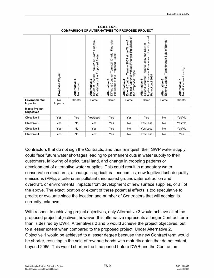
Environmentally Superior Alternative
Table ES-1 presents a summary of how each alternative compares to the proposed project with respect to the impacts and the ability to meet project objectives. As presented in Chapter 5, implementation of the proposed project would not result in any physical environmental impacts. As discussed in Chapter 7 section 7.4, identical to the proposed project, Alternatives 2 through 6 would also not result in any impacts. Alternatives 1 and 7 could result in indirect impacts not identified for the proposed project. Under Alternative 1 there would likely be delays in the ability of DWR to sell revenue bonds beyond 2035 to fund needed repairs and improvements to existing facilities or the construction and acquisition of new facilities. Furthermore, Contractors could also delay expenditures on their own operations and/or local capital projects. This could indirectly affect the reliability of SWP water service and/or the reliability of some Contractors’ water service. Alternative 7 could result in indirect impacts due to changes in project operations as some Contractors no longer receive SWP water service.
Executive Summary
Water Supply Contract Extension Project ES-9 ESA / 120002 Draft Environmental Impact Report August 2016
TABLE ES-1. COMPARISON OF ALTERNATIVES TO PROPOSED PROJECT
Prop
osed
Pro
ject
Alte
rnat
ive
1
No
Pro
ject
Alte
rnat
ive
2 D
iffer
ent C
ontra
ct T
erm
(206
5) w
ith F
inan
cial
P
rovi
sion
s of
the
Pro
pose
d P
roje
ct
Alte
rnat
ive
3
Diff
eren
t Con
tract
Ter
m (2
110)
with
Fin
anci
al
Pro
visi
ons
of th
e P
ropo
sed
Pro
ject
Alte
rnat
ive
4
Ext
end
Con
tract
Ter
m to
208
5 at
the
Tim
e of
P
roje
ct A
ppro
val w
ithou
t Fin
anci
al P
rovi
sion
s of
th
e P
ropo
sed
Pro
ject
Alte
rnat
ive
5 E
xten
d C
ontra
ct T
erm
to 2
085
and
Do
Not
Im
plem
ent F
inan
cial
Pro
visi
ons
of th
e P
ropo
sed
Pro
ject
unt
il 20
35
Alte
rnat
ive
6 E
xten
d C
ontra
ct T
erm
thro
ugh
Sal
e of
Bon
ds
Alte
rnat
ive
7 N
ot A
ll C
ontra
ctor
s S
ign
Environmental Impacts
No Impacts
Greater Same Same Same Same Same Greater
Meets Project Objectives
Objective 1 Yes Yes Yes/Less Yes Yes Yes No Yes/No
Objective 2 Yes No Yes Yes No Yes/Less No Yes/No
Objective 3 Yes No Yes Yes No Yes/Less No Yes/No
Objective 4 Yes No Yes Yes No Yes/Less No Yes
Contractors that do not sign the Contracts, and thus relinquish their SWP water supply, could face future water shortages leading to permanent cuts in water supply to their customers, fallowing of agricultural land, and change in cropping patterns or development of alternative water supplies. This could result in mandatory water conservation measures, a change in agricultural economics, new fugitive dust air quality emissions (PM10, a criteria air pollutant), increased groundwater extraction and overdraft, or environmental impacts from development of new surface supplies, or all of the above. The exact location or extent of these potential effects is too speculative to predict or evaluate since the location and number of Contractors that will not sign is currently unknown.
With respect to achieving project objectives, only Alternative 3 would achieve all of the proposed project objectives; however, this alternative represents a longer Contract term than is desired by DWR. Alternatives 2 and 5 would achieve the project objectives, but to a lesser extent when compared to the proposed project. Under Alternative 2, Objective 1 would be achieved to a lesser degree because the new Contract term would be shorter, resulting in the sale of revenue bonds with maturity dates that do not extent beyond 2065. This would shorten the time period before DWR and the Contractors
Executive Summary
Water Supply Contract Extension Project ES-10 ESA / 120002 Draft Environmental Impact Report August 2016
would face a revenue bond debt service compression problem. Under Alternative 5, Objectives 2 through 4 would not be achieved until after 2035 when the financial provision modifications would take effect. Alternative 7 would also achieve the proposed project objectives; however, all of the objectives would be achieved only for DWR and the Contractors that sign the amendment.
Therefore, because the proposed project and Alternatives 2 through 6 would result in no impact, they would be the environmentally superior alternatives. However, only the proposed project and Alternative 3 would achieve the project objectives.
Chapter 1 Introduction

Water Supply Contract Extension Project 1-1 ESA / 120002 Draft Environmental Impact Report August 2016
1 INTRODUCTION
1.1 INTRODUCTION
The Department of Water Resources (DWR) is proposing to implement the Water Supply Contract Extension Project (proposed project). As more fully discussed in Chapter 4, Project Description, the proposed project includes amending certain provisions of the State Water Resources Development System (SWRDS) Water Supply Contracts (Contracts). SWRDS (defined in Water Code Section 12931), or more commonly referred to as the State Water Project (SWP), was enacted into law in the Burns-Porter Act, passed by the Legislature in 1959 and approved by the voters in 1960. DWR constructed and currently operates and maintains the SWP, a system of storage and conveyance facilities that provide water to 29 State Water Contractors (Contractors). The Contractors receive water service from the SWP in exchange for paying all costs that are associated with constructing, operating, and maintaining the SWP facilities and are attributable to water supply. DWR and each of the Contractors entered into Contracts in the 1960s with 75-year terms. The Contracts are substantially uniform. The Contracts begin to expire in 2035, unless the expiration dates are otherwise extended pursuant to the option for continued service in Article 4 of the Contracts.1 All Contracts will expire by 2042 if not extended.
The major sources of capital financing for construction of the SWP have been and are: the Burns-Porter Act, which authorized General Obligation Bond sales; the Central Valley Project Act, which authorizes the issuance of revenue bonds; and other capital resources revenues. Of the three types of capital financing, revenue bonds are currently the predominate form of capital financing. In the past, DWR has typically sold revenue bonds with terms up to 30 years or more. However, it has become more challenging in recent years to affordably finance capital expenditures for the SWP because as a practical matter, it would be difficult to sell revenue bonds used to finance these expenditures with maturity dates that extend beyond the year 2035, the year the first of the Contracts would expire. Although DWR has the contractual authority to issue bonds with maturities after 2035 (and in so doing, extend the Contract expiration date under
1 Article 4 states that, by written notice to DWR at least 6 months prior to the expiration date of a Contract, the Contractor can elect to receive continued service after the expiration of the term under the following conditions unless otherwise agreed to: (1) service of water in annual amounts up to and including the Contractor’s maximum annual Table A amount; (2) service of water at no greater cost to the Contractor than would have been the case had the Contract continued in effect; (3) service of water under the same physical conditions of service, including time, place, amount, and rate of delivery; (4) retention of the same chemical quality objective provision; and (5) retention of the same options to use the SWP transportation facilities as provided for in Articles 18(c) and 55,as applicable.
1. Introduction
Water Supply Contract Extension Project 1-2 ESA / 120002 Draft Environmental Impact Report August 2016
Article 2 of the Contracts2), bonds likely could not, as a practical matter, be issued without a Contract amendment or other arrangement with the Contractors to provide for the orderly financial management of the SWP for the entire period over which such bonds would be outstanding, including after 2035. Today, DWR sells only bonds that extend for fewer than 30 years because of the 2035 limitation; for example, in 2017, DWR will sell bonds with a maturity date no longer than 18 years (i.e., up to 2035). In order for DWR to sell bonds for 30 years or more, which would provide more affordable financing to the Contractors for the SWP costs associated with constructing and repairing the SWP facilities that are allocated to water supply, it is necessary to extend the expiration dates of the Contracts.
In May 2013, DWR and the Contractors entered into public negotiations to extend the term and make other financial improvements to the Contracts. The outcome of these negotiations resulted in the “Agreement in Principle Concerning Extension of the State Water Project Water Supply Contracts” (AIP). The AIP is included as Appendix A of this Draft Environmental Impact Report (DEIR). The proposed project, which is evaluated in this DEIR, would amend certain financial provisions of the Contracts and extend the term of the Contracts to 2085 based on the AIP. The proposed project would not create new water management measures, alter the existing authority to build new or modify existing facilities, or change water allocation provisions of the Contracts. DWR determined that an Environmental Impact Report (EIR) was the appropriate California Environmental Quality Act (CEQA) document due to the statewide importance of any proposed amendments to the Contracts, such as the proposed project. Further, as an informational document, this DEIR discloses for public and lead agency consideration potential environmental effects attributed to the outcome of the public negotiations to extend the term and make other financial improvements to the Contracts. It is also is intended to provide sufficient information to foster informed decision-making by DWR.
1.2 PURPOSE OF THE DEIR
This DEIR has been prepared in conformance with CEQA (Public Resources Code, Sections 21000, et seq.) and the CEQA Guidelines for Implementing the California Environmental Quality Act (CEQA Guidelines) (California Code of Regulations, Title 14, Sections 15000, et seq.). As described in CEQA Guidelines Section 15121(a), an EIR is
2 Article 2 provides separately for each Contract that the specific Contract shall remain in effect for the longest of (1) the “project repayment period” (i.e., December 31, 2035); (2) “75 years”; or (3) “the period ending with thelatest maturity date of any bond issue used to finance the construction costs of project facilities.” No bonds havebeen sold with a maturity date later than December 1, 2035. The project repayment period and the 75-year termprovisions result in the individual Contracts having varying expiration dates that range between December 31, 2035and 2042.
1. Introduction
Water Supply Contract Extension Project 1-3 ESA / 120002 Draft Environmental Impact Report August 2016
a public information document that objectively assesses and discloses potential environmental effects of the proposed project, and identifies mitigation measures and alternatives to the proposed project that would reduce or avoid adverse environmental impacts. CEQA requires that lead, responsible, or trustee agencies consider the environmental consequences of projects over which they have discretionary authority. As the lead agency for the proposed project, DWR will use the information in this EIR to: evaluate the proposed project’s potential environmental impacts; determine whether any feasible mitigation measures and alternatives are necessary and available to reduce potentially significant environmental impacts; and approve, modify, or deny approval of the proposed project. This EIR may also be used by the Contractors, as responsible agencies under CEQA, in their discretionary approval processes within their jurisdictions to meet their CEQA requirements.
1.3 ENVIRONMENTAL REVIEW AND APPROVAL PROCESS
The preparation of an EIR involves multiple steps in which the public is provided the opportunity to review and comment on the scope of the analysis, content of the EIR, results and conclusions presented, and overall adequacy of the document to meet the substantive requirements of CEQA. The following describes the steps in the environmental review process for the proposed project.
1.3.1 Notice of Preparation
In accordance with Section 15082 of the CEQA Guidelines, DWR prepared a Notice of Preparation (NOP) of an EIR and published it on September 12, 2014. DWR provided the NOP to: (1) local, State, and federal agencies; (2) local libraries; (3) city and county clerk offices; and (4) other interested parties. The NOP was circulated for comment for 30 days, ending on October 13, 2014. The NOP included the project background, project objectives, description of the proposed project, and a summary of potential significant environmental impacts to be evaluated in the DEIR. The NOP and list of agencies and persons that received the NOP is included in Appendix B.
Comment letters received in response to the NOP were considered during preparation of this DEIR and are also included in Appendix B. Two public scoping meetings were held in Sacramento on September 23, 2014. The purpose of the public scoping meetings was to provide a forum for the public to learn about the proposed project and to provide comments on the proposed scope of the EIR analysis. The NOP and comments received on the NOP were posted at http://www.water.ca.gov/swpao/watercontractextension/.
1. Introduction
Water Supply Contract Extension Project 1-4 ESA / 120002 Draft Environmental Impact Report August 2016
1.3.2 DEIR
This DEIR will be published and made available to local, State, and federal agencies and to interested organizations and individuals who may want to review and comment on the adequacy of the analysis included in this DEIR. Notice of this DEIR will be sent directly to persons and agencies that commented on the NOP. The 60-day public review period for this DEIR is August 17, 2016 through October 17, 2016. During the public review period, written comments should be mailed or emailed to:
Ted Alvarez State Water Project Analysis Office Department of Water Resources P.O. Box 942836 Sacramento, CA 94236-0001 Email: [email protected]
The DEIR is available for review at DWR’s State Water Project Analysis Office during normal business hours located at 1416 Ninth Street Room 1620, Sacramento, California, 95814. The DEIR is also available at the locations included in Appendix B, as well as on the DWR project website at: http://www.water.ca.gov/swpao/watercontractextension/.
During the 60-day review period a public meeting will be held on September 12, 2016 from 4:00 p.m. to 8:00 p.m. in the Sacramento Central Library Tsakopoulos Galleria, 821 I Street, Sacramento, CA 95814.
Comments are due no later than 5:00 p.m. Pacific Daylight Time on October 17, 2016, which is 60 days after publication of the DEIR.
Before including your name, address, telephone number, email or other personal identifying information in your comment, be advised that your entire comment – including your personal identifying information – is a matter of public record and may be made publically available at any time. You can request in your comment to withhold this information from public review; however, there is no guarantee it will be possible.
1.3.3 Final EIR
Written and oral comments received on the DEIR during the public review period will be addressed in a Response to Comments document which, together with the DEIR and any changes to the DEIR made in response to comments received, will constitute the Final EIR. The DEIR and Final EIR together will comprise the EIR for the proposed project.
1. Introduction
Water Supply Contract Extension Project 1-5 ESA / 120002 Draft Environmental Impact Report August 2016
1.3.4 Approval Process
Before DWR makes a decision with regard to the proposed project, CEQA Guidelines Section 15090(a) requires that DWR first certify that the EIR has been completed in compliance with CEQA, that DWR has reviewed and considered the information in the EIR, and that the EIR reflects the independent judgment and analysis of DWR.
In the event DWR approves the proposed project, CEQA requires that it file a Notice of Determination and adopt appropriate findings as set forth in CEQA Guidelines Section 15091. Under CEQA Guidelines Section 15092, a lead agency may only approve or carry out a project subject to an EIR if it determines that: (1) that project will not have a significant effect, or (2) that the agency has eliminated or substantially lessened all significant effects on the environment where feasible and any remaining significant effects on the environment that are found to be unavoidable are acceptable due to overriding considerations. As described above, this EIR may also be used by the Contractors, as responsible agencies under CEQA, in their discretionary approval processes within their jurisdictions to meet their CEQA requirements.
1.4 SCOPE OF THIS EIR
DWR identified in the NOP for this EIR impacts that could result from implementation of the proposed project. Based on the NOP (provided in Appendix B), DWR determined that this EIR will address the following technical issue areas:
• Aesthetics
• Agricultural and Forest Resources
• Air Quality
• Biological Resources
• Cultural Resources
• Energy
• Geology and Soils
• Greenhouse Gas Emissions
• Hazardous Materials and Public Safety
• Hydrology and Water Quality (including surface water and groundwater resources)
• Land Use and Planning
• Mineral Resources
• Noise
• Population and Housing
1. Introduction
Water Supply Contract Extension Project 1-6 ESA / 120002 Draft Environmental Impact Report August 2016
• Public Services
• Recreation
• Transportation and Traffic
• Utilities and Service Systems (including water supply)
1.5 ORGANIZATION OF THE DEIR
This DEIR is organized with references provided in each of the chapters listed below:
Executive Summary. The Executive Summary presents a summary of the project description, a description of issues to be resolved, and a summary table listing the level of significance of effects of the proposed project on resource areas to be addressed.
Chapter 1, Introduction. Chapter 1 describes the intended uses of this EIR, the environmental review and approval process, and document organization.
Chapter 2, State Water Project. Chapter 2 provides the history and background of the SWP, the regulatory and policy framework for operating the SWP, and a summary of certain non-financial Contract provisions.
Chapter 3, State Water Project Financing and Water Supply Contract Financial Provisions. Chapter 3 presents an overview of the current status of SWP financing and the description of the financial provisions of the Contract.
Chapter 4, Project Description. Chapter 4 presents an overview of the proposed project, outlines the project objectives, and describes the elements of the proposed project.
Chapter 5, Environmental Analysis. Chapter 5 presents an introduction to how resource topics were evaluated and the analysis of the potential environmental impacts of the proposed project.
Chapter 6, Other CEQA Considerations. Chapter 6 discusses other CEQA issues, including growth-inducing impacts, cumulative impacts, significant unavoidable impacts on the environment, and significant irreversible environmental changes.
Chapter 7, Alternatives. Chapter 7 describes potential alternatives to the proposed project, including the No Project Alternative, along with an analysis of
1. Introduction
Water Supply Contract Extension Project 1-7 ESA / 120002 Draft Environmental Impact Report August 2016
ability to meet proposed project objectives and differences in level of environmental impact.
Chapter 8, Contributors and Reviewers. Chapter 8 provides the names of the DEIR authors and consultants.
Appendices. The appendices include materials that support the findings and conclusions presented in the text of the DEIR.

1. Introduction
Water Supply Contract Extension Project 1-8 ESA / 120002 Draft Environmental Impact Report August 2016
This page intentionally left blank

Chapter 2 State Water Project

Water Supply Contract Extension Project 2-1 ESA / 120002 Draft Environmental Impact Report August 2016
2 STATE WATER PROJECT
DWR’s mission includes managing the water resources of California in cooperation with other agencies to benefit the citizens of the State of California and to protect, restore, and enhance the natural and human environments. DWR plans, designs, constructs, and operates the SWP to deliver water, control floods, generate power, and provide recreational opportunities. DWR also provides enhancements for fish and wildlife. To fulfill its mission, DWR has eight goals:1 (1) developing and assessing strategies for managing the State’s water resources, including development of the California Water Plan Update; (2) planning, constructing, operating, and maintaining the SWP to achieve maximum flexibility, safety, and reliability; (3) protecting and improving the water resources and dependent ecosystems of statewide significance, including the Sacramento-San Joaquin Bay-Delta Estuary (Bay-Delta); (4) protecting lives and infrastructure as they relate to dams, floods, droughts, and watersheds impacted by fire and disasters, as well as assisting in other emergencies; (5) providing policy direction and legislative guidance on water and energy issues and educating the public on the importance, hazards, and efficient use of water; (6) supporting local planning and integrated regional water management through technical and financial assistance; (7) performing efficiently all statutory, legal, and fiduciary responsibilities regardingmanagement of State long-term power contracts and servicing of power revenue bonds;and (8) providing professional, cost-effective, and timely services in support of DWR’sprograms, consistent with governmental regulatory and policy requirements.
This chapter summarizes the history and background of the SWP and presents the regulatory and policy framework for operating the SWP. A summary of current SWRDS Contracts water service provisions is also provided (Appendix C contains an example of a current Contract for reference). The primary source of information used in writing this chapter comes from DWR’s Bulletin 132 series, Management of the State Water Project, with supplemental up-to-date information provided by DWR’s State Water Project Analysis Office (SWPAO).
2.1 HISTORY AND BACKGROUND
Authorization and initial financing for SWRDS, commonly referred to as the SWP, was enacted into law in the Burns-Porter Act (Water Code Section 12930 et seq.), which was passed by the California Legislature in 1959 and approved by the voters in 1960. The Burns-Porter Act expressly authorized the State of California to issue up to
1 California Department of Water Resources. 2005. Mission and Goals. Available: http://www.water.ca.gov/about/mission.cfm. Accessed May 2016.
2. State Water Project
Water Supply Contract Extension Project 2-2 ESA / 120002 Draft Environmental Impact Report August 2016
$1.75 billion in bonds for the construction of the SWP and enter into Contracts for the sale, delivery, or use of water or power made available by the SWP. In return for the State financing, constructing, operating, and maintaining facilities needed to provide water service, 29 public water agencies (Contractors) contractually agreed to repay all SWP capital and operating costs allocable to water supply, including the portion allocable to water supply of the Burns-Porter bonds used to construct the SWP facilities. Construction of the SWP commenced in the 1960s and water was first delivered in 1962 through a portion of the South Bay Aqueduct to Alameda and Santa Clara Counties. Large-scale water deliveries began in the late 1960s.
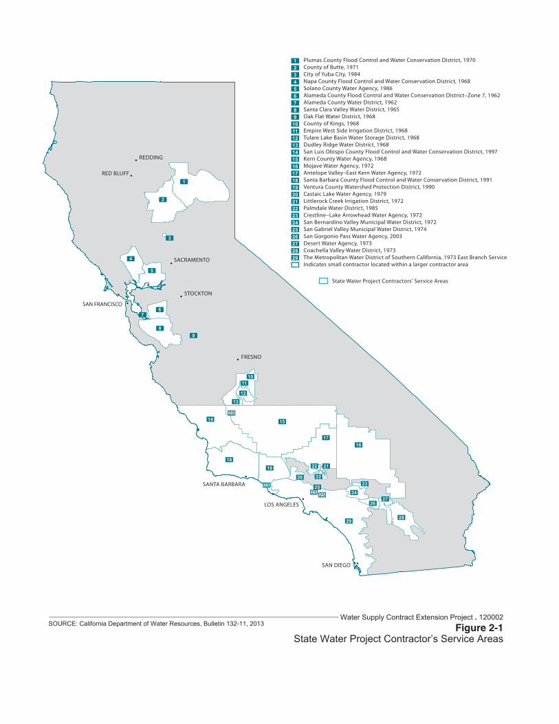
Managed by DWR, the SWP is the largest state-owned, multi-purpose, user-financed water storage and delivery system in the United States. The multi-purpose SWP facilities deliver water through contracts between DWR and 29 Contractors throughout California. The Contractors receive water service from the SWP in exchange for paying all costs that are associated with constructing, operating, and maintaining the SWP facilities and are attributable to water supply. Contractors include local water agencies and districts legislatively enabled to serve irrigation, municipal, and industrial water supply customers or retail water supply agencies throughout Northern California, San Joaquin Valley, San Francisco Bay Area, Central Coast Area, and Southern California. Figure 2-1 depicts the SWP service area, including the name, location, and first year of service for each Contractor. Approximately 25 million Californians receive a portion of their drinking water supply from the SWP, and about 750,000 acres of agricultural land, primarily in the San Joaquin Valley, are irrigated with SWP water. For all the Contractors, SWP water supplements supplies from other sources within their service areas, including groundwater, local surface water, other imported water supplies, recycled water, and desalinated water.
2.2 COMPONENTS OF THE SWP
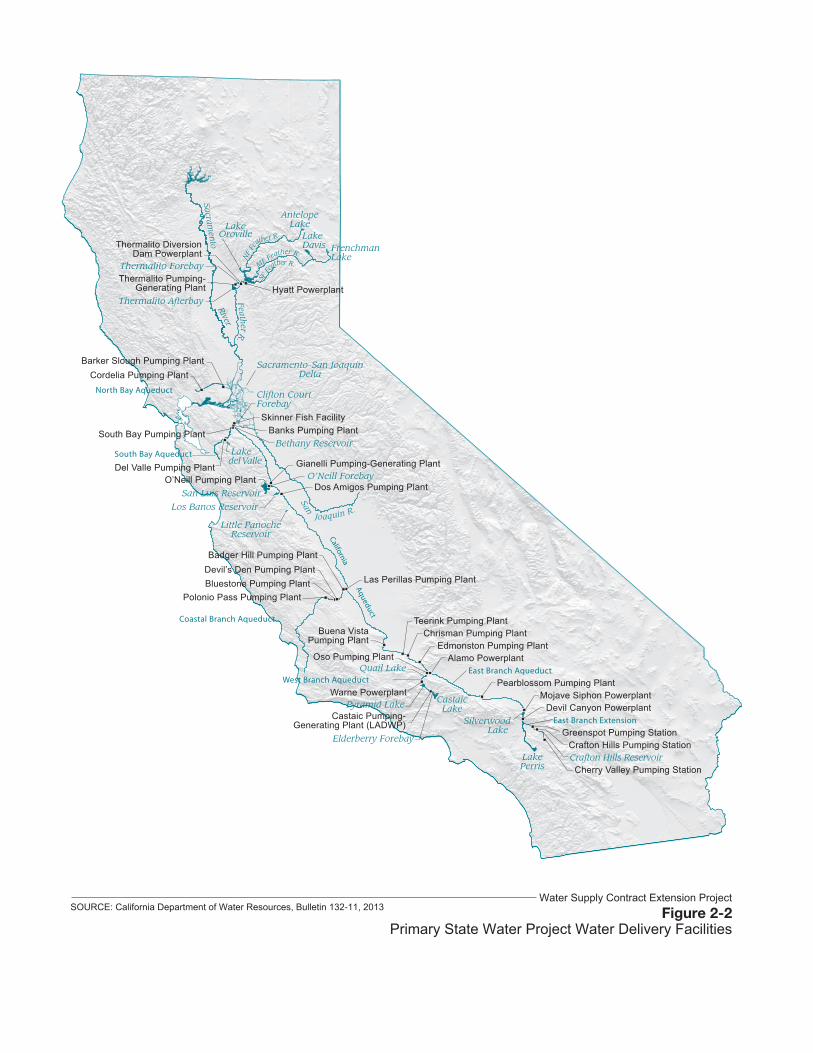
The SWP is a complex system of reservoirs, dams, power plants, pumping plants, pipelines, and aqueducts. Precipitation and watershed runoff are stored in Lake Oroville, a reservoir behind Oroville Dam in Butte County, and is delivered via natural stream channels to the Bay-Delta and pumped into the California Aqueduct system to water agencies and districts in Southern California, the Central Coast, the San Joaquin Valley, and portions of the San Francisco Bay Area. The principal components of the SWP are shown in Figure 2-2.
Three small reservoirs—Lake Davis, Frenchman Lake, and Antelope Lake—are the northernmost SWP facilities. Situated on Feather River tributaries in Plumas County, these lakes are used primarily for recreation. Lake Davis also provides water to Plumas
B U L L E T I N 1 3 2 - 1 1 1 1
TH
E S
TA
TE
WA
TE
R P
RO
JEC
T
Figure 1-2 Names, Locations, and First Year of Service of Long-term Contracting Agencies, December 31, 2010
1
2
3
4
5
67
89
1011
12
13
14 15
1617
18
19
20
2122
23
2425
2627
2829
22
252925
20
123456789
1011121314151617181920212223242526272829
SANTA BARBARA
REDDING
STOCKTON
SACRAMENTO
LOS ANGELES
FRESNO
SAN FRANCISCO
SAN DIEGO
RED BLUFF
Plumas County Flood Control and Water Conservation District, 1970County of Butte, 1971City of Yuba City, 1984Napa County Flood Control and Water Conservation District, 1968Solano County Water Agency, 1986Alameda County Flood Control and Water Conservation District–Zone 7, 1962Alameda County Water District, 1962Santa Clara Valley Water District, 1965Oak Flat Water District, 1968County of Kings, 1968Empire West Side Irrigation District, 1968Tulare Lake Basin Water Storage District, 1968Dudley Ridge Water District, 1968San Luis Obispo County Flood Control and Water Conservation District, 1997Kern County Water Agency, 1968Mojave Water Agency, 1972Antelope Valley–East Kern Water Agency, 1972Santa Barbara County Flood Control and Water Conservation District, 1991Ventura County Watershed Protection District, 1990Castaic Lake Water Agency, 1979Littlerock Creek Irrigation District, 1972Palmdale Water District, 1985Crestline–Lake Arrowhead Water Agency, 1972San Bernardino Valley Municipal Water District, 1972San Gabriel Valley Municipal Water District, 1974San Gorgonio Pass Water Agency, 2003Desert Water Agency, 1973Coachella Valley Water District, 1973The Metropolitan Water District of Southern California, 1973 East Branch ServiceIndicates small contractor located within a larger contractor area
State Water Project Contractors' Service Areas
Figure 2-1State Water Project Contractor’s Service Areas
SOURCE: California Department of Water Resources, Bulletin 132-11, 2013Water Supply Contract Extension Project . 120002
B U L L E T I N 1 3 2 - 1 1 5
TH
E S
TA
TE
WA
TE
R P
RO
JEC
T
Figure 1-1 Names and Locations of Primary Water Delivery Facilities, December 31, 2010
River
Sacramen
to
San Joaquin R.
NF
Feather R.
MF Feather R.SF
Fea
ther R.
Feather R.
North Bay Aqueduct
Quail Lake
Pyramid Lake
Elderberry Forebay
LakeDavis Frenchman
Lake
AntelopeLake
Clifton CourtForebay
Aqueduct
LakePerris
East Branch Extension
East Branch AqueductWest Branch Aqueduct
SilverwoodLake
Coastal Branch Aqueduct
San Luis Reservoir
Little PanocheReservoir
Los Banos Reservoir
O’Neill Forebay
Lakedel Valle
Thermalito Afterbay
Thermalito Forebay
LakeOroville
CastaicLake
South Bay AqueductBethany Reservoir
California
Hyatt PowerplantThermalito Pumping-
Generating Plant
Thermalito DiversionDam Powerplant
Barker Slough Pumping PlantCordelia Pumping Plant
Banks Pumping PlantSouth Bay Pumping Plant
Skinner Fish Facility
Del Valle Pumping Plant Gianelli Pumping-Generating Plant
Dos Amigos Pumping PlantO’Neill Pumping Plant
Badger Hill Pumping Plant
Bluestone Pumping PlantDevil’s Den Pumping Plant
Polonio Pass Pumping Plant
Las Perillas Pumping Plant
Buena VistaPumping Plant
Teerink Pumping PlantChrisman Pumping Plant
Edmonston Pumping PlantAlamo Powerplant
Warne Powerplant
Castaic Pumping-Generating Plant (LADWP)
Pearblossom Pumping Plant
Devil Canyon PowerplantMojave Siphon Powerplant
Greenspot Pumping Station
Cherry Valley Pumping StationCrafton Hills ReservoirCrafton Hills Pumping Station
Oso Pumping Plant
Sacramento-San JoaquinDelta
Primary State Water Project Water Delivery FacilitiesSOURCE: California Department of Water Resources, Bulletin 132-11, 2013
Water Supply Contract Extension Project
2. State Water Project
Water Supply Contract Extension Project 2-5 ESA / 120002 Draft Environmental Impact Report August 2016
County Flood Control and Water Conservation District (FC&WCD), a Contractor, and local agencies that have water rights agreements with DWR.
Downstream from these three lakes is the SWP’s primary storage facility; the Oroville-Thermalito Complex. The Oroville-Thermalito Complex includes: Lake Oroville and Oroville Dam; Hyatt Powerplant; Thermalito Diversion Dam and Powerplant; the Feather River Fish Hatchery; Thermalito Power Canal; Thermalito Forebay; Ronald B. Robie Thermalito Pumping-Generating Plant; and Thermalito Afterbay. Water service to Butte County, a Contractor, is provided directly from the Oroville-Thermalito Complex.
The Oroville-Thermalito Complex was designed as an efficient water and power system. Lake Oroville has a storage capacity of approximately 3.5 million acre-feet (af) and it stores winter runoff and spring snowmelt from the Feather River watershed for later downstream release. Power is generated from releases made through the Hyatt Powerplant, the Thermalito Dam Powerplant, and Ronald B. Robie Thermalito Pumping-Generating Plant (currently out of operation for cleanup and repairs after a fire on November 22, 2012). Water stored in the Thermalito Forebay and Afterbay can also be pumped back into Lake Oroville during off-peak power periods when feasible for subsequent power generation during on-peak power periods. A special fish barrier dam was built to lead salmon and steelhead, returning to spawn, into the Feather River Fish Hatchery. Salmon and steelhead raised at the hatchery are transported and released in the Feather and Sacramento Rivers, or in the Bay-Delta near the San Francisco Bay Area.
Releases from Lake Oroville flow down the Feather River, then merge with the Sacramento River. The Sacramento River flows into the Bay-Delta, which comprises 738,000 acres of land interlaced with many channels that receive runoff from approximately 40 percent of the State’s land area. DWR’s Delta Facilities Program consists of projects that are designed to increase the efficiency of water transfers through the Bay-Delta to increase water supply, improve Bay-Delta water quality, and reduce or mitigate for fish losses caused by pumping. The projects proposed as part of this program include dredging, channel improvements, flow control structures, seismic studies, and environmental mitigation measures.
DWR completed the Barker Slough Pumping Plant in 1988 to divert water for delivery from the northern Bay-Delta through the North Bay Aqueduct (NBA) to the North Bay Contractors (Solano County Water Agency [SCWA] and Napa County FC&WCD) service areas. Because of physical and water quality limitations, the diversion at Barker Slough cannot deliver the maximum Table A water requested. In order to address these facility limitations and meet projected future water delivery needs of the North Bay
2. State Water Project
Water Supply Contract Extension Project 2-6 ESA / 120002 Draft Environmental Impact Report August 2016
Contractors, DWR is considering constructing a new intake and pumping plant facility in the Sacramento River and a new segment of NBA Conveyance pipeline that would be operated in conjunction with the existing Barker Slough Pumping Plant. If approved for construction, the NBA Alternate Intake Project (NBA AIP) would enable the NBA to deliver the total water supply allocation (Table A amounts) to the North Bay Contractors. See Section 2.3.1 for a description of annual Table A amounts.
In the southern Bay-Delta, the SWP diverts water into Clifton Court Forebay for delivery south of the Bay-Delta. From Clifton Court Forebay, the Skinner Fish Facility diverts an average of 15 million fish each year away from the Bay-Delta pumps. Two miles downstream from Skinner Fish Facility, the Harvey O. Banks Delta (Banks) Pumping Plant lifts water into the California Aqueduct, which then flows to Bethany Reservoir.
From Bethany Reservoir, the South Bay Pumping Plant lifts water into the South Bay Aqueduct to supply portions of Alameda and Santa Clara Counties. The South Bay Aqueduct provided initial deliveries in 1962 and has been fully operational since 1965. South Bay Aqueduct facilities include Lake Del Valle, a regulatory, flood control, and water supply reservoir for the aqueduct. Recent improvements include enlarging the aqueduct for increased capacity and other associated modifications to the aqueduct and other facilities. These improvements were completed in 2014. The remaining water delivered to Bethany Reservoir continues south in the California Aqueduct. This 444-mile-long main aqueduct, in addition to the 180 miles of California Aqueduct branches, conveys water to the primarily agricultural lands of the San Joaquin Valley and the main urban regions of Southern California. The first SWP deliveries to San Joaquin Valley Contractors began in 1968. The first SWP deliveries to Southern California began in 1972.
The California Aqueduct winds along the west side of the San Joaquin Valley. It transports water to O’Neill Forebay. Water in the forebay can be released to the San Luis Canal or pumped into San Luis Reservoir by the Gianelli Pumping-Generating Plant. San Luis Reservoir has a storage capacity of more than 2 million af and is jointly owned and operated by DWR and the U.S. Bureau of Reclamation (Reclamation). The SWP’s share of the reservoir’s gross storage is about 1,062,180 af. DWR generally pumps water through the Gianelli Pumping-Generating Plant into San Luis Reservoir during late fall through early spring for temporary storage until DWR releases the water back into the O’Neill Forebay and the California Aqueduct to meet the late spring and summer peak demands of the Contractors.
SWP water pumped directly from the Bay-Delta and water eventually released from San Luis Reservoir continues to flow south in the San Luis Canal, a portion of the California
2. State Water Project
Water Supply Contract Extension Project 2-7 ESA / 120002 Draft Environmental Impact Report August 2016
Aqueduct jointly owned by DWR and Reclamation. Reclamation’s Central Valley Project (CVP) joint ownership ends near Kettleman City, and the SWP portion of the California Aqueduct continues. As the water flows through the San Joaquin Valley, numerous turnouts convey water to farmlands and municipal and industrial water customers within the service areas of the SWP and CVP. Along its journey, four pumping plants—Dos Amigos, Buena Vista, Teerink, and Chrisman—lift the water more than 1,000 feet before it reaches the foot of the Tehachapi Mountains. Tehachapi East Afterbay provides additional storage to these pumping plants to reduce power costs by shifting on-peak power consumption to off-peak, increasing ancillary services capability and providing other benefits of increased operational flexibility.
In the San Joaquin Valley near Kettleman City, Phase I of the Coastal Branch Aqueduct serves agricultural areas west of the California Aqueduct. Phase II of the Coastal Branch extended the conveyance facility to serve municipal and industrial water users in San Luis Obispo and Santa Barbara Counties. Phase II became operational in 1997.
The remaining water conveyed by the California Aqueduct is delivered to Southern California. Pumps at Edmonston Pumping Plant, situated at the foot of the Tehachapi Mountains, raise the water 1,926 feet; the highest single lift of any pumping plant in the world. From there, the water enters about 8 miles of tunnels and siphons as it flows into Antelope Valley, where the California Aqueduct divides into two branches, the East Branch and the West Branch.
The East Branch carries water through the Tehachapi East Afterbay, Alamo Powerplant, Pearblossom Pumping Plant, and Mojave Siphon Powerplant into Silverwood Lake in the San Bernardino Mountains. From Silverwood Lake, water flows through the San Bernardino Tunnel into the Devil Canyon Powerplant. Water continues down the East Branch to Lake Perris, the terminus of the East Branch. Lake Perris lies just east of Riverside, has a capacity of 131,500 af, and serves as a regulatory and emergency water supply facility for the East Branch. The Lake Perris Dam Remediation Program was initiated after investigations discovered seismic deficiencies in the dam’s structure. Lake Perris Reservoir levels have been restricted to about half the storage capacity since 2006. The Dam Remediation Program is expected to be completed in 2019, allowing for the restriction to be lifted.
Phase I of the East Branch Extension of the California Aqueduct was completed in 2003 and provides conveyance facilities to deliver SWP water to San Gorgonio Pass Water Agency and to the eastern portion of the San Bernardino Valley Municipal Water District (WD), both of which deliver water to areas such as Yucaipa, Calimesa, Beaumont, Banning, and other communities. The East Branch Extension comprises a combination
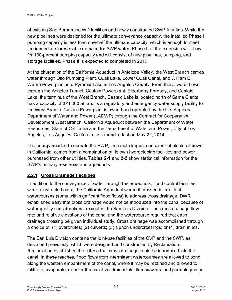
2. State Water Project
Water Supply Contract Extension Project 2-8 ESA / 120002 Draft Environmental Impact Report August 2016
of existing San Bernardino WD facilities and newly constructed SWP facilities. While the new pipelines were designed for the ultimate conveyance capacity, the installed Phase I pumping capacity is less than one-half the ultimate capacity, which is enough to meet the immediate foreseeable demand for SWP water. Phase II of the extension will allow for 100-percent pumping capacity and will consist of new pipelines, pumping, and storage facilities. Phase II is expected to completed in 2017.
At the bifurcation of the California Aqueduct in Antelope Valley, the West Branch carries water through Oso Pumping Plant, Quail Lake, Lower Quail Canal, and William E. Warne Powerplant into Pyramid Lake in Los Angeles County. From there, water flows through the Angeles Tunnel, Castaic Powerplant, Elderberry Forebay, and Castaic Lake, the terminus of the West Branch. Castaic Lake is located north of Santa Clarita, has a capacity of 324,000 af, and is a regulatory and emergency water supply facility for the West Branch. Castaic Powerplant is owned and operated by the Los Angeles Department of Water and Power (LADWP) through the Contract for Cooperative Development West Branch, California Aqueduct between the Department of Water Resources, State of California and the Department of Water and Power, City of Los Angeles, Los Angeles, California, as amended last on May 22, 2014.
The energy needed to operate the SWP, the single largest consumer of electrical power in California, comes from a combination of its own hydroelectric facilities and power purchased from other utilities. Tables 2-1 and 2-2 show statistical information for the SWP’s primary reservoirs and aqueducts.
2.2.1 Cross Drainage Facilities
In addition to the conveyance of water through the aqueducts, flood control facilities were constructed along the California Aqueduct where it crossed intermittent watercourses (some with significant flood flows) to address cross drainage. DWR established early that cross drainage would not be introduced into the canal because of water quality considerations, except in the San Luis Division. The cross drainage flow rate and relative elevations of the canal and the watercourse required that each drainage crossing be given individual study. Cross drainage was accomplished through a choice of: (1) overchutes; (2) culverts; (3) siphon undercrossings; or (4) drain inlets.
The San Luis Division contains the joint-use facilities of the CVP and the SWP, as described previously, which were designed and constructed by Reclamation. Reclamation established the criteria that cross drainage could be introduced into the canal. In these reaches, flood flows from intermittent watercourses are allowed to pond along the western embankment of the canal, where it may be retained and allowed to infiltrate, evaporate, or enter the canal via drain inlets, flumes/weirs, and portable pumps.
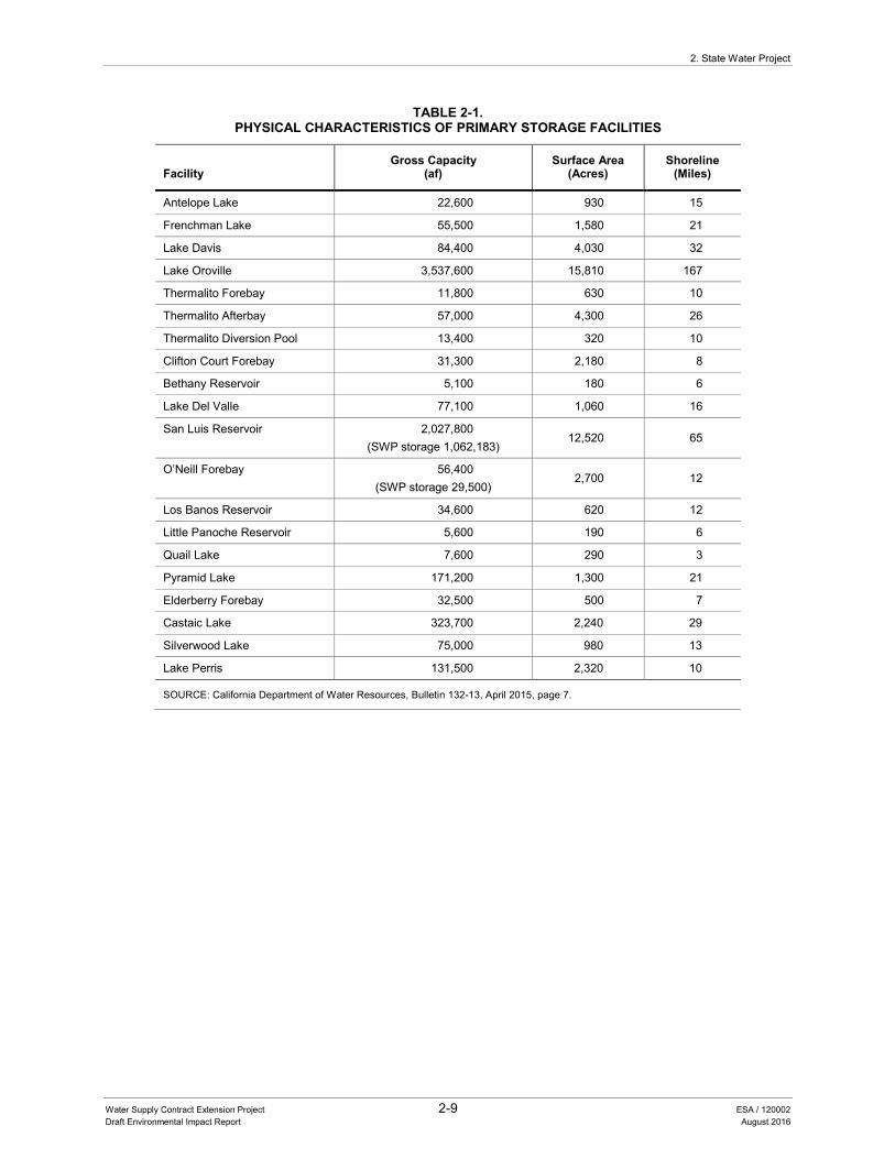
2. State Water Project
Water Supply Contract Extension Project 2-9 ESA / 120002 Draft Environmental Impact Report August 2016
TABLE 2-1. PHYSICAL CHARACTERISTICS OF PRIMARY STORAGE FACILITIES
Facility Gross Capacity
(af) Surface Area
(Acres) Shoreline
(Miles)
Antelope Lake 22,600 930 15
Frenchman Lake 55,500 1,580 21
Lake Davis 84,400 4,030 32
Lake Oroville 3,537,600 15,810 167
Thermalito Forebay 11,800 630 10
Thermalito Afterbay 57,000 4,300 26
Thermalito Diversion Pool 13,400 320 10
Clifton Court Forebay 31,300 2,180 8
Bethany Reservoir 5,100 180 6
Lake Del Valle 77,100 1,060 16
San Luis Reservoir 2,027,800 (SWP storage 1,062,183)
12,520 65
O’Neill Forebay 56,400 (SWP storage 29,500)
2,700 12
Los Banos Reservoir 34,600 620 12
Little Panoche Reservoir 5,600 190 6
Quail Lake 7,600 290 3
Pyramid Lake 171,200 1,300 21
Elderberry Forebay 32,500 500 7
Castaic Lake 323,700 2,240 29
Silverwood Lake 75,000 980 13
Lake Perris 131,500 2,320 10
SOURCE: California Department of Water Resources, Bulletin 132-13, April 2015, page 7.
2. State Water Project
Water Supply Contract Extension Project 2-10 ESA / 120002 Draft Environmental Impact Report August 2016
TABLE 2-2. TOTAL MILES OF AQUEDUCTS
Facility Channel and
Reservoir Canal Pipeline Tunnel Total
North Bay Aqueduct 0.0 0.0 27.6 0.0 27.6
South Bay Aqueduct (including Del Valle Branch) 0.3 10.7 31.9 1.7 44.6
Grizzly Valley Pipeline 0.0 0.0 6.0 0.0 6.0
California Aqueduct
Clifton Court Forebay to O’Neill Forebay 4.5 61.9 0.3 0.0 66.7
O’Neill Forebay to Kettleman City 4.1 101.4 0.2 0.0 105.7
Kettleman City to Edmonston Pumping Plant 0.0 120.1 0.9 0.0 121.0
Edmonston Pumping Plant to Tehachapi Afterbay 0.0 0.2 1.9 7.9 10.0
Tehachapi Afterbay to Lake Perris 4.0 97.8 34.3 3.9 140.0
Subtotal 12.6 381.4 37.6 11.8 443.4
California Aqueduct Branches
West Branch 9.7 9.3 5.8 7.1 31.9
Coastal Branch 0.0 14.1 98.7 2.7 115.5
East Branch Extension 0.0 0.0 32.6 0.0 32.6
Total 24.1 417.4 240.2 23.3 705.0
SOURCE: California Department of Water Resources, Bulletin 132-13, April 2015, page 9.
2.3 WATER SERVICE PROVISIONS
DWR and each of the 29 Contractors entered into Contracts in the 1960s with 75-year terms. The Contracts are substantially uniform. The first Contract, executed by DWR and the Metropolitan Water District of Southern California (WDSC) has an expiration date in 2035. See Table 2-3 for a list of the Contractors and their respective Contract execution and expiration dates.
Contract provisions reflected DWR’s expectations at that time with respect to future water demand and the construction schedule of SWP components. The Contracts also outline how the Contractors will repay all SWP capital and operating costs allocable to water supply in return for the State’s financing, constructing, operating, and maintaining the SWP and providing water service. The Contracts are complex legal documents with multiple provisions, primarily covering water delivery, payments, and general provisions. An example of a current Contract for one of the Contractors is contained in Appendix C for reference, including definitions of Contract terms.
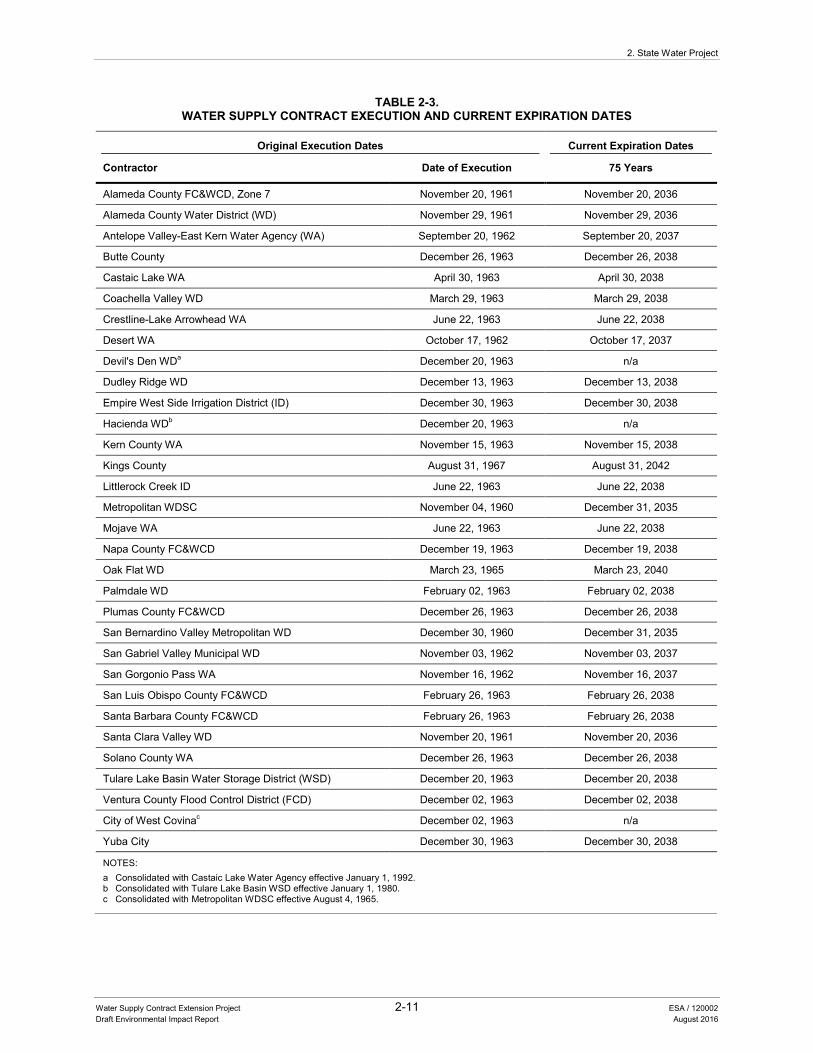
2. State Water Project
Water Supply Contract Extension Project 2-11 ESA / 120002 Draft Environmental Impact Report August 2016
TABLE 2-3. WATER SUPPLY CONTRACT EXECUTION AND CURRENT EXPIRATION DATES
Original Execution Dates Current Expiration Dates
Contractor Date of Execution 75 Years
Alameda County FC&WCD, Zone 7 November 20, 1961 November 20, 2036
Alameda County Water District (WD) November 29, 1961 November 29, 2036
Antelope Valley-East Kern Water Agency (WA) September 20, 1962 September 20, 2037
Butte County December 26, 1963 December 26, 2038
Castaic Lake WA April 30, 1963 April 30, 2038
Coachella Valley WD March 29, 1963 March 29, 2038
Crestline-Lake Arrowhead WA June 22, 1963 June 22, 2038
Desert WA October 17, 1962 October 17, 2037
Devil's Den WDa December 20, 1963 n/a
Dudley Ridge WD December 13, 1963 December 13, 2038
Empire West Side Irrigation District (ID) December 30, 1963 December 30, 2038
Hacienda WDb December 20, 1963 n/a
Kern County WA November 15, 1963 November 15, 2038
Kings County August 31, 1967 August 31, 2042
Littlerock Creek ID June 22, 1963 June 22, 2038
Metropolitan WDSC November 04, 1960 December 31, 2035
Mojave WA June 22, 1963 June 22, 2038
Napa County FC&WCD December 19, 1963 December 19, 2038
Oak Flat WD March 23, 1965 March 23, 2040
Palmdale WD February 02, 1963 February 02, 2038
Plumas County FC&WCD December 26, 1963 December 26, 2038
San Bernardino Valley Metropolitan WD December 30, 1960 December 31, 2035
San Gabriel Valley Municipal WD November 03, 1962 November 03, 2037
San Gorgonio Pass WA November 16, 1962 November 16, 2037
San Luis Obispo County FC&WCD February 26, 1963 February 26, 2038
Santa Barbara County FC&WCD February 26, 1963 February 26, 2038
Santa Clara Valley WD November 20, 1961 November 20, 2036
Solano County WA December 26, 1963 December 26, 2038
Tulare Lake Basin Water Storage District (WSD) December 20, 1963 December 20, 2038
Ventura County Flood Control District (FCD) December 02, 1963 December 02, 2038
City of West Covinac December 02, 1963 n/a
Yuba City December 30, 1963 December 30, 2038
NOTES: a Consolidated with Castaic Lake Water Agency effective January 1, 1992. b Consolidated with Tulare Lake Basin WSD effective January 1, 1980. c Consolidated with Metropolitan WDSC effective August 4, 1965.
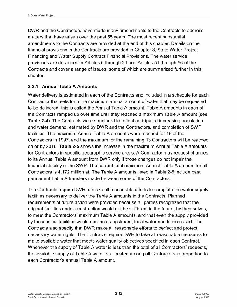
2. State Water Project
Water Supply Contract Extension Project 2-12 ESA / 120002 Draft Environmental Impact Report August 2016
DWR and the Contractors have made many amendments to the Contracts to address matters that have arisen over the past 55 years. The most recent substantial amendments to the Contracts are provided at the end of this chapter. Details on the financial provisions in the Contracts are provided in Chapter 3, State Water Project Financing and Water Supply Contract Financial Provisions. The water service provisions are described in Articles 6 through 21 and Articles 51 through 56 of the Contracts and cover a range of issues, some of which are summarized further in this chapter.
2.3.1 Annual Table A Amounts
Water delivery is estimated in each of the Contracts and included in a schedule for each Contractor that sets forth the maximum annual amount of water that may be requested to be delivered; this is called the Annual Table A amount. Table A amounts in each of the Contracts ramped up over time until they reached a maximum Table A amount (see Table 2-4). The Contracts were structured to reflect anticipated increasing population and water demand, estimated by DWR and the Contractors, and completion of SWP facilities. The maximum Annual Table A amounts were reached for 16 of the Contractors in 1997, and the maximum for the remaining 13 Contractors will be reached on or by 2016. Table 2-5 shows the increase in the maximum Annual Table A amounts for Contractors in specific geographic service areas. A Contractor may request changes to its Annual Table A amount from DWR only if those changes do not impair the financial stability of the SWP. The current total maximum Annual Table A amount for all Contractors is 4.172 million af. The Table A amounts listed in Table 2-5 include past permanent Table A transfers made between some of the Contractors.
The Contracts require DWR to make all reasonable efforts to complete the water supply facilities necessary to deliver the Table A amounts in the Contracts. Planned requirements of future action were provided because all parties recognized that the original facilities under construction would not be sufficient in the future, by themselves, to meet the Contractors’ maximum Table A amounts, and that even the supply provided by those initial facilities would decline as upstream, local water needs increased. The Contracts also specify that DWR make all reasonable efforts to perfect and protect necessary water rights. The Contracts require DWR to take all reasonable measures to make available water that meets water quality objectives specified in each Contract. Whenever the supply of Table A water is less than the total of all Contractors’ requests, the available supply of Table A water is allocated among all Contractors in proportion to each Contractor’s annual Table A amount.
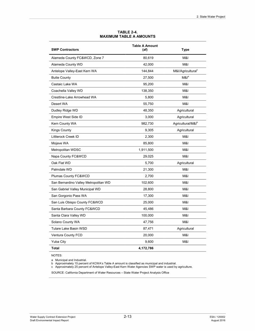
2. State Water Project
Water Supply Contract Extension Project 2-13 ESA / 120002 Draft Environmental Impact Report August 2016
TABLE 2-4. MAXIMUM TABLE A AMOUNTS
SWP Contractors Table A Amount
(af) Type
Alameda County FC&WCD, Zone 7 80,619 M&I
Alameda County WD 42,000 M&I
Antelope Valley-East Kern WA 144,844 M&I/Agriculturalc
Butte County 27,500 M&Ia
Castaic Lake WA 95,200 M&I
Coachella Valley WD 138,350 M&I
Crestline-Lake Arrowhead WA 5,800 M&I
Desert WA 55,750 M&I
Dudley Ridge WD 48,350 Agricultural
Empire West Side ID 3,000 Agricultural
Kern County WA 982,730 Agricultural/M&Ib
Kings County 9,305 Agricultural
Littlerock Creek ID 2,300 M&I
Mojave WA 85,800 M&I
Metropolitan WDSC 1,911,500 M&I
Napa County FC&WCD 29,025 M&I
Oak Flat WD 5,700 Agricultural
Palmdale WD 21,300 M&I
Plumas County FC&WCD 2,700 M&I
San Bernardino Valley Metropolitan WD 102,600 M&I
San Gabriel Valley Municipal WD 28,800 M&I
San Gorgonio Pass WA 17,300 M&I
San Luis Obispo County FC&WCD 25,000 M&I
Santa Barbara County FC&WCD 45,486 M&I
Santa Clara Valley WD 100,000 M&I
Solano County WA 47,756 M&I
Tulare Lake Basin WSD 87,471 Agricultural
Ventura County FCD 20,000 M&I
Yuba City 9,600 M&I
Total 4,172,786
NOTES: a Municipal and Industrial. b Approximately 15 percent of KCWA’s Table A amount is classified as municipal and industrial. c Approximately 25 percent of Antelope Valley-East Kern Water Agencies SWP water is used by agriculture.
SOURCE: California Department of Water Resources – State Water Project Analysis Office
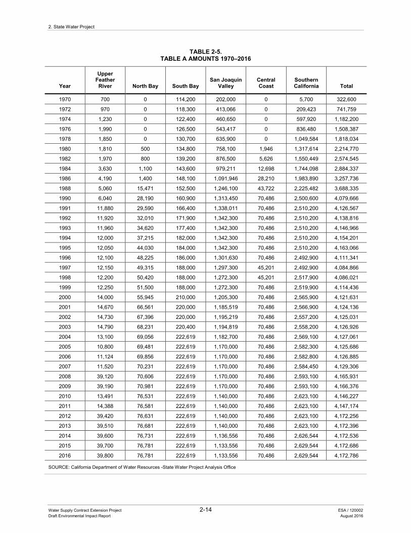
2. State Water Project
Water Supply Contract Extension Project 2-14 ESA / 120002 Draft Environmental Impact Report August 2016
TABLE 2-5. TABLE A AMOUNTS 1970–2016
Year
Upper Feather River North Bay South Bay
San Joaquin Valley
Central Coast
Southern California Total
1970 700 0 114,200 202,000 0 5,700 322,600
1972 970 0 118,300 413,066 0 209,423 741,759
1974 1,230 0 122,400 460,650 0 597,920 1,182,200
1976 1,990 0 126,500 543,417 0 836,480 1,508,387
1978 1,850 0 130,700 635,900 0 1,049,584 1,818,034
1980 1,810 500 134,800 758,100 1,946 1,317,614 2,214,770
1982 1,970 800 139,200 876,500 5,626 1,550,449 2,574,545
1984 3,630 1,100 143,600 979,211 12,698 1,744,098 2,884,337
1986 4,190 1,400 148,100 1,091,946 28,210 1,983,890 3,257,736
1988 5,060 15,471 152,500 1,246,100 43,722 2,225,482 3,688,335
1990 6,040 28,190 160,900 1,313,450 70,486 2,500,600 4,079,666
1991 11,880 29,590 166,400 1,338,011 70,486 2,510,200 4,126,567
1992 11,920 32,010 171,900 1,342,300 70,486 2,510,200 4,138,816
1993 11,960 34,620 177,400 1,342,300 70,486 2,510,200 4,146,966
1994 12,000 37,215 182,000 1,342,300 70,486 2,510,200 4,154,201
1995 12,050 44,030 184,000 1,342,300 70,486 2,510,200 4,163,066
1996 12,100 48,225 186,000 1,301,630 70,486 2,492,900 4,111,341
1997 12,150 49,315 188,000 1,297,300 45,201 2,492,900 4,084,866
1998 12,200 50,420 188,000 1,272,300 45,201 2,517,900 4,086,021
1999 12,250 51,500 188,000 1,272,300 70,486 2,519,900 4,114,436
2000 14,000 55,945 210,000 1,205,300 70,486 2,565,900 4,121,631
2001 14,670 66,561 220,000 1,185,519 70,486 2,566,900 4,124,136
2002 14,730 67,396 220,000 1,195,219 70,486 2,557,200 4,125,031
2003 14,790 68,231 220,400 1,194,819 70,486 2,558,200 4,126,926
2004 13,100 69,056 222,619 1,182,700 70,486 2,569,100 4,127,061
2005 10,800 69,481 222,619 1,170,000 70,486 2,582,300 4,125,686
2006 11,124 69,856 222,619 1,170,000 70,486 2,582,800 4,126,885
2007 11,520 70,231 222,619 1,170,000 70,486 2,584,450 4,129,306
2008 39,120 70,606 222,619 1,170,000 70,486 2,593,100 4,165,931
2009 39,190 70,981 222,619 1,170,000 70,486 2,593,100 4,166,376
2010 13,491 76,531 222,619 1,140,000 70,486 2,623,100 4,146,227
2011 14,388 76,581 222,619 1,140,000 70,486 2,623,100 4,147,174
2012 39,420 76,631 222,619 1,140,000 70,486 2,623,100 4,172,256
2013 39,510 76,681 222,619 1,140,000 70,486 2,623,100 4,172,396
2014 39,600 76,731 222,619 1,136,556 70,486 2,626,544 4,172,536
2015 39,700 76,781 222,619 1,133,556 70,486 2,629,544 4,172,686
2016 39,800 76,781 222,619 1,133,556 70,486 2,629,544 4,172,786
SOURCE: California Department of Water Resources -State Water Project Analysis Office
2. State Water Project
Water Supply Contract Extension Project 2-15 ESA / 120002 Draft Environmental Impact Report August 2016
2.3.2 Water Management Practices
To enhance flexibility and reliability of SWP water supplies to Contractors, the Contracts include water management practices. Article 21 water is water available to the SWP that the Contractors may receive on a short-term basis in addition to their Table A water if requested. Article 21 water becomes available after the Contractors have received their scheduled Table A deliveries and DWR has met the operational requirements of the SWP. Water management practices available to Contractors include transfers and exchanges of water among the Contractors to provide flexibility (e.g., changing the location and timing of delivery), especially during dry years. In addition to transfers and exchanges, the Contracts provide water management flexibility by allowing some Contractors to store water in San Luis Reservoir and to withdraw and replace water from Castaic Lake and Lake Perris, and to use capacity within the SWP system for the conveyance of non-SWP water for transfers to all Contractors.
Other water management practices that provide flexibility allow Contractors to carry-over water scheduled for delivery in the last 3 months of a year to be delivered in the first 3 months of the next year, to the extent such deliveries do not adversely affect current or future project operations, including filling of SWP reservoirs, flood control releases, and water quality restrictions (Article 12(e)). Article 56(c) of the Contracts allows a Contractor to store its allocated water of the current year in facilities outside of the Contractor’s service area, in a groundwater program or in project or non-project surface facilities, for later delivery to the Contractor’s service area. Carry-over water under Article 12(e) and storage of water under Article 56(c) both allow the Contractors to make the most beneficial use of allocated water by not losing such supply at the end of the year and having water available for contingency planning, subject to certain conditions. In addition, Article 14 of the Contracts provides that allocated Table A amounts not delivered at any time during a year because of a DWR interruption or reduction of deliveries for the purposes of repair, maintenance, and replacement of any of the SWP facilities may be delivered at other times during the year. The delayed delivery is conditioned upon the ability of DWR to deliver that water, considering the Table A delivery schedules of all Contractors. Article 14(b) provides for delivery in only one succeeding year, rather than in multiple succeeding years.
2.4 SWP OPERATIONS
Operations at the Oroville-Thermalito Complex alter seasonal flows in the Feather River by retaining a portion of the winter and spring runoff for release during the summer and fall. Flood control operations begin in mid-September and end in June and help lessen extreme flood peaks down the Feather River.
2. State Water Project
Water Supply Contract Extension Project 2-16 ESA / 120002 Draft Environmental Impact Report August 2016
Water operations at Lake Oroville are regulated by a number of orders, regulations, decisions, and opinions of State and federal regulatory agencies. Only a portion of the water released and other uncontrolled flows in the Bay-Delta can be diverted into the North Bay and California Aqueduct through the Barker Slough Pumping Plant and Banks Pumping Plant, respectively.
The CVP and SWP have historically shared their Bay-Delta export pumping facilities when it is advantageous to do so. Sharing of the pumping facilities can help both projects deliver water to their contractors when demand is high or some facilities are out of service in emergencies or during maintenance. The sharing of facilities is referred to as the Joint Point of Diversion (JPOD). In 1978, DWR agreed to, and the State Water Resources Control Board (State Water Board) permitted, the CVP to use the SWP’s Banks Pumping Plant capacity to divert and export up to 195,000 af annually from the Bay-Delta to replace pumping capacity lost at the CVP’s Jones Pumping Plant. Pumping capacity was lost as a result of restrictions contained in the State Water Board’s Decision 1485. In 1986, DWR and Reclamation formally agreed that “either party may make use of its facilities available to the other party for pumping and conveyance of water by written agreement.”
State and federal laws protect water rights, water quality, wetlands, anadromous and other native fish, migratory birds, and threatened and endangered species in the Feather River, Sacramento River, and the Bay-Delta, the latter of which is both an estuary and a navigable waterway. Because the SWP and CVP both divert large volumes of water from the Bay-Delta, they must be operated to comply with applicable environmental regulations, including Bay-Delta water quality standards. Coordinated operations help the two water projects meet consumptive and environmental water needs more efficiently. Coordinated operations in the 1970s and early 1980s were accomplished by annual agreements between DWR and Reclamation. In 1986, the two agencies executed the Coordinated Operating Agreement (COA), which specifies how the two parties would operate their facilities to meet their customers’ water demands and Bay-Delta water quality standards and other environmental regulations without adversely affecting each other.
Once SWP water is pumped from the Bay-Delta, it flows down the California Aqueduct, which is divided into a series of interconnected pools of water separated by gated check structures. This system of pools allows for control of water levels and flow in the aqueduct.
Each year by the first of October, Contractors submit monthly water requests to DWR for the subsequent calendar year. DWR then estimates the amount of water available to
2. State Water Project
Water Supply Contract Extension Project 2-17 ESA / 120002 Draft Environmental Impact Report August 2016
the Contractors based on reservoir storages and hydrologic conditions and forecast, and incorporates these monthly delivery requests in order to determine how much supply is available to be allocated for delivery to the Contractors. Beginning in late December or January, Contractors may submit updated weekly or monthly requests. DWR uses these requests to make water deliveries and adjust SWP operational plans. As winter progresses, DWR relies on updated rainfall and snowpack values to refine its total water supply availability projections, and allocations to Contractors are adjusted accordingly.
2.4.1 SWP Deliveries
Hydrologic conditions vary widely within California—from region to region, from season to season, and from year to year. The amount of water available to the SWP fluctuates because of this variability, and because of flood management needs, capacity of SWP storage and conveyance facilities, changing weather-temperature conditions, and water quality and environmental requirements. These are all factors that affect the amount of water that can be delivered annually to Contractors.
Table 2-6 shows SWP water deliveries and other water delivered to Contractors annually from 1970 to 2014. Other water includes water conveyed with excess capacity in the SWP to those Contractors that purchase water from sources other than the SWP.
TABLE 2-6. HISTORICAL TABLE A REQUESTS & DELIVERIES TO SWP CONTRACTORS
Year
Initial Table A Requests
(af)
Final Allocation Percentage
(M&I/Ag)
SWP Water Deliveriesa
(af) Other Water Deliveries b
(af) Total Deliveriesc
(af)
1970 322,600 100 365,841 24,225 390,066
1971 375,590 100 651,921 17,972 669,893
1972 594,094 100 1,034,123 7,414 1,041,537
1973 923,954 100 987,804 19,237 1,007,041
1974 1,146,650 100 1,286,528 20,763 1,307,291
1975 1,311,260 100 1,844,675 27,834 1,872,509
1976 1,488,470 100 1,924,687 8,534 1,933,221
1977 1,660,538 90 / 40 926,126 18,614 944,740
1978 1,828,624 100 1,501,844 49,214 1,551,058
1979 1,855,003 100 2,356,726 17,777 2,374,503
1980 1,880,386 100 1,931,166 30,973 1,962,139
1981 1,876,707 100 2,838,590 26,158 2,864,748
1982 2,342,576 100 1,990,695 29,225 2,019,920
1983 2,365,818 100 1,198,493 85,114 1,283,607
1984 1,563,620 100 1,859,636 27,549 1,887,185
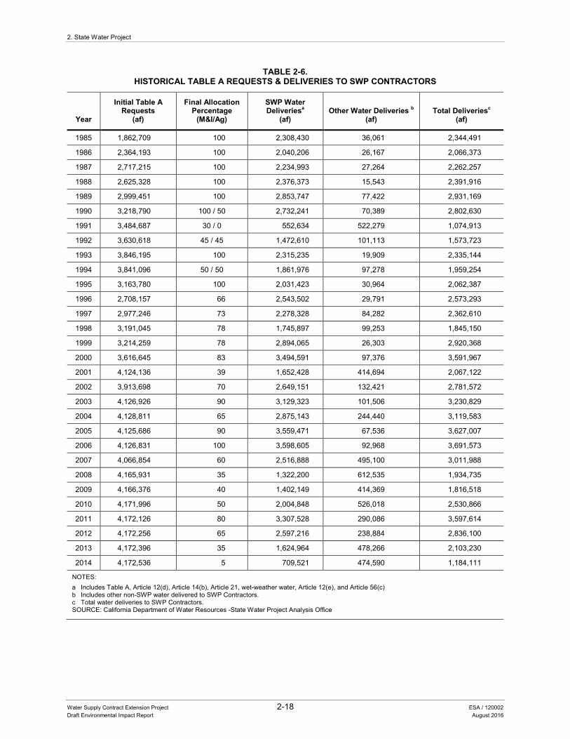
2. State Water Project
Water Supply Contract Extension Project 2-18 ESA / 120002 Draft Environmental Impact Report August 2016
TABLE 2-6. HISTORICAL TABLE A REQUESTS & DELIVERIES TO SWP CONTRACTORS
Year
Initial Table A Requests
(af)
Final Allocation Percentage
(M&I/Ag)
SWP Water Deliveriesa
(af) Other Water Deliveries b
(af) Total Deliveriesc
(af)
1985 1,862,709 100 2,308,430 36,061 2,344,491
1986 2,364,193 100 2,040,206 26,167 2,066,373
1987 2,717,215 100 2,234,993 27,264 2,262,257
1988 2,625,328 100 2,376,373 15,543 2,391,916
1989 2,999,451 100 2,853,747 77,422 2,931,169
1990 3,218,790 100 / 50 2,732,241 70,389 2,802,630
1991 3,484,687 30 / 0 552,634 522,279 1,074,913
1992 3,630,618 45 / 45 1,472,610 101,113 1,573,723
1993 3,846,195 100 2,315,235 19,909 2,335,144
1994 3,841,096 50 / 50 1,861,976 97,278 1,959,254
1995 3,163,780 100 2,031,423 30,964 2,062,387
1996 2,708,157 66 2,543,502 29,791 2,573,293
1997 2,977,246 73 2,278,328 84,282 2,362,610
1998 3,191,045 78 1,745,897 99,253 1,845,150
1999 3,214,259 78 2,894,065 26,303 2,920,368
2000 3,616,645 83 3,494,591 97,376 3,591,967
2001 4,124,136 39 1,652,428 414,694 2,067,122
2002 3,913,698 70 2,649,151 132,421 2,781,572
2003 4,126,926 90 3,129,323 101,506 3,230,829
2004 4,128,811 65 2,875,143 244,440 3,119,583
2005 4,125,686 90 3,559,471 67,536 3,627,007
2006 4,126,831 100 3,598,605 92,968 3,691,573
2007 4,066,854 60 2,516,888 495,100 3,011,988
2008 4,165,931 35 1,322,200 612,535 1,934,735
2009 4,166,376 40 1,402,149 414,369 1,816,518
2010 4,171,996 50 2,004,848 526,018 2,530,866
2011 4,172,126 80 3,307,528 290,086 3,597,614
2012 4,172,256 65 2,597,216 238,884 2,836,100
2013 4,172,396 35 1,624,964 478,266 2,103,230
2014 4,172,536 5 709,521 474,590 1,184,111
NOTES: a Includes Table A, Article 12(d), Article 14(b), Article 21, wet-weather water, Article 12(e), and Article 56(c) b Includes other non-SWP water delivered to SWP Contractors. c Total water deliveries to SWP Contractors. SOURCE: California Department of Water Resources -State Water Project Analysis Office
2. State Water Project
Water Supply Contract Extension Project 2-19 ESA / 120002 Draft Environmental Impact Report August 2016
2.5 BACKGROUND ON PREVIOUS CONTRACT AMENDMENTS AND SETTLEMENT AGREEMENTS
2.5.1 Monterey Amendment and Settlement Agreement
In 1994, DWR and Contractor representatives agreed to a set of principles to modify the Contracts to address issues related to various articles in the Contracts, and subsequently developed the Monterey Amendment based on those principles. All Contractors except Plumas County FC&WCD and the Empire West Side ID signed the Monterey Amendment. These two Contractors continue to receive SWP water from DWR in accordance with the Contracts in effect before the Monterey Amendment.
In 1995, the EIR for the Monterey Agreement was subject to judicial challenge. In 2000, the Third District Court of Appeal ordered that the EIR be decertified on the grounds that DWR should have been the lead agency and that the EIR was, in part, inadequate. In May 2003, the parties to the litigation negotiated a settlement agreement that was confirmed by the Superior Court order on June 6, 2003. The settlement agreement included a commitment by DWR to a process that included the plaintiffs and Contractors in the development of a new EIR on the Monterey Amendment and other additional elements (Settlement Agreement). The Monterey Amendment and the Settlement Agreement together comprised the project referred to as Monterey Plus. DWR prepared a new EIR on the Monterey Plus and certified the Final Environmental Impact Report for the Monterey Amendment to the State Water Project Contracts (Including Kern Water Bank Transfer) and Associated Actions as Part of a Settlement Agreement (Monterey Plus) on February 1, 2010.
In general, the Monterey Amendment modified the Contracts by providing as follows:
• Changes in the procedures for allocation of Table A water and surplus water among the Contractors
• Approval to permanent transfers of 130,000 af and retirement of 45,000 af of Table A amounts
• Transfer of property known as the “Kern Fan Element (KFE) property” in Kern County
• Changes to water supply management practices
• Restructured rates
In addition to establishing a process for involving plaintiffs and Contractors in the development of the new EIR on the Monterey Amendment, the Settlement Agreement provided the following:
2. State Water Project
Water Supply Contract Extension Project 2-20 ESA / 120002 Draft Environmental Impact Report August 2016
• DWR will communicate SWP water reliability information by substituting the term “Table A amount” for “entitlement” in the Contracts and by implementing new procedures for disclosure of SWP delivery reliability.
• DWR will provide for better public review of major SWP actions by issuing guidelines on DWR’s review of permanent Table A transfers and issuing principles for the public to observe and comment on the negotiations for certain Contract amendments, including Table A transfers.
• Certain Table A transfers under the Monterey Amendment are recognized as final.
• Assurances regarding the KFE property transfer are provided including confirmation that title to the KFE property was retained by the Kern Water Bank Authority (KWBA). Restrictions on the use of the KFE property were included and DWR was required to analyze some operations of the KWBA-developed Kern Water Bank in an independent study.
• Certain measures are implemented pertaining to Plumas County, including provisions relating to the Plumas Watershed Forum, funding for watershed restoration and other purposes and amendment of Plumas County FC&WCD’s Contract with respect to access to SWP water.
• DWR will provide funding to the plaintiffs for multiple purposes including watershed restoration.
In 2010, the Monterey Plus EIR was subject to two separate legal challenges. The trial court ruled that most of the EIR is adequate under CEQA, but that the EIR’s discussion of the Kern Water Bank’s future impacts is insufficient. In 2014, the Sacramento County Superior Court ruled in both actions that DWR must decertify and revise its EIR to include a description and analysis of the development, use and operation of the Kern Water Bank lands as a water banking and recovery project particularly to groundwater hydrology and water quality. DWR published the Monterey Plus Draft Revised EIR on April 28, 2016 (State Clearinghouse Number 2003011118).
2.5.2 Recent SWP Supply Allocation Amendments
As a result of a settlement of a lawsuit about SWP allocations for Contractors in Northern California, DWR entered into four settlement agreements and amendments to the Contracts with four Contractors: SCWA, the Napa County FC&WCD, Yuba City, and Butte County. The amendments modified the four Contractors’ SWP allocations to improve SWP water delivery reliability for these Contractors.
These amendments resulted in a modification of the water delivery allocations under the Contracts for these four Contractors. The new allocation to SCWA, Napa County FC&WCD, and Yuba City is established by a method referred to as the “North of Delta
2. State Water Project
Water Supply Contract Extension Project 2-21 ESA / 120002 Draft Environmental Impact Report August 2016
Allocation.” In addition, the settlement agreements authorize the SCWA, Napa County FC&WCD, and Yuba City to borrow water from the SWP in certain years to supplement the existing Table A water delivery schedule to SCWA, Napa County FC&WCD, and Yuba City during periods when demand exceeds other SWP water supplies (referred to as an “Advanced Table A Program”). The contract amendments included conditions to ensure that potential impacts on supply for the other SWP Contractors would be less than significant.
The new allocation to Butte County is described in a new Butte County Table that is part of the amendment to its Contract and is distinct from the other three Contractors’ water delivery allocations under their settlement agreements. As part of the implementation of the amendment to Butte County’s Contract, DWR approved separate agreements for the transfer of a portion of Butte County’s annual Table A amounts between Butte County and several water districts for 2012, 2013, and the years 2014–2021.
2.6 REFERENCES
DWR (California Department of Water Resources). 2005. Mission and Goals. Available: http://www.water.ca.gov/about/mission.cfm. Accessed May 2016.

2. State Water Project
Water Supply Contract Extension Project 2-22 ESA / 120002 Draft Environmental Impact Report August 2016
This page intentionally left blank
Chapter 3 State Water Project Financing and Water Supply Contract Financial Provisions

Water Supply Contract Extension Project 3-1 ESA / 120002 Draft Environmental Impact Report August 2016
3 STATE WATER PROJECT FINANCING AND WATER SUPPLY CONTRACT FINANCIAL PROVISIONS
3.1 INTRODUCTION
The purpose of this chapter is to provide the reader with a more detailed background on the financial management of the SWP under the Contracts. The financial terminology and principles presented in this chapter will help with the understanding of the proposed project and the analysis presented in this EIR.
3.2 CAPITAL FINANCING AND OPERATIONS AND MAINTENANCE EXPENDITURES
The major sources of capital financing for construction of the SWP have been and are: the Burns-Porter Act, which authorized General Obligation Bond sales; the Central Valley Project Act, which authorizes the issuance of revenue bonds; State appropriations (e.g., certain tidelands oil revenues); and SWP revenues. The Burns-Porter Act and the Central Valley Project Act also authorize the expenditure of funds for the operation and maintenance (O&M) of the SWP. These financing authorizations and mechanisms are discussed below and in the following pages.
3.2.1 The Burns-Porter Act
As described in Chapter 2, State Water Project, a large portion of the initial SWP facilities were financed by the sale of general obligation bonds of the State pursuant to the provisions of the Burns-Porter Act (Water Code Section 12930 et seq.), which authorized the issuance of $1,750,000,000 in bonds for the construction of the SWP and certain other facilities. Of that authorization, approximately $1,582,400,000 (including the entire amount available for construction of the initial components of the SWP) has been issued, of which $154,775,000 was outstanding as of December, 2015. The unissued $167,600,000 of the authorization is available only to provide funds for the construction of certain additional SWP facilities.
The Burns-Porter Act also created the California Water Resources Development Bond Fund into which are deposited all revenues received by DWR from the sale, use, and delivery of water and power from the SWP (other than those revenues attributable to the CVP revenue bond financed facilities). Revenues deposited in the California Water Resources Development Bond Fund are used to make payments in the following order of priority to the extent funds are available, as specified in the Burns-Porter Act. The first use of such revenues is to pay the reasonable costs of the annual maintenance, operation and replacement of the SWP. The second use is to reimburse the General Fund of the State for the payment of the debt service on the general obligation bonds
3. State Water Project Financing and Water Supply Contract Financial Provisions
Water Supply Contract Extension Project 3-2 ESA / 120002 Draft Environmental Impact Report August 2016
used to finance a portion of the capital costs of the SWP. The third use is to repay the California Water Fund for moneys made available for the construction of the SWP; that repayment has been completed (see Subsection 3.2.3). The last use of revenues available in the California Water Resources Development Bond Fund is to pay the costs of the acquisition and construction of additional SWP facilities.
3.2.2 Central Valley Project Act
Additional major funding for portions of the SWP has been obtained through the sale of DWR’s long-term CVP revenue bonds (CVP Revenue Bonds) and, pending long-term financing, DWR’s short-term CVP commercial paper notes (CVP Commercial Paper). DWR has issued $4,087,000,000 of CVP Revenue Bonds (exclusive of refunding bonds) to finance specified SWP facilities and projects, and of the total amount of CVP Revenue Bonds issued, approximately $2,400,000,000 remained outstanding as of December, 2015. The CVP Revenue Bond financing program is a continuing program and is the primary source for the funding of the construction of new SWP facilities and the major repair and reconstruction of existing SWP facilities. The moneys used to pay the debt service on the CVP Revenue Bonds and to pay the maintenance and operation costs of the revenue-bond-financed facilities are the revenues attributable to the revenue-bond-financed facilities. In addition, DWR has authorized the issuance of CVP Commercial Paper, the proceeds from the sale of which are used to finance SWP facilities prior to permanent financing from the sale of revenue bonds.
SWP revenues from facilities financed by CVP Revenue Bonds are deposited into an account in the CVP Revenue Fund and pledged to the repayment of the CVP Revenue Bonds and thereafter allocated to the payment of the maintenance and operation expenses of the facilities financed by such revenue bonds. SWP revenues from the facilities financed by CVP Commercial Paper are also deposited into accounts in the CVP Revenue Fund and pledged to the payment of the commercial paper.
3.2.3 Capital Resources Financing
In addition to the funds obtained through the sale of Burns-Porter Act general obligation bonds, CVP Revenue Bonds, and CVP Commercial Paper, certain other moneys have been made available to DWR to pay the cost for construction of the SWP, including a portion of the moneys from State tidelands oil royalties, other State appropriations, a Pooled Money Investment Account loan, and federal reimbursements for project costs allocated to flood control. The tidelands oil royalties appropriated by the Legislature for construction of the SWP were deposited in a fund designated as the California Water Fund. Under the Burns-Porter Act, DWR was required to reimburse the California Water Fund for such appropriations made after November 8, 1960. In April 1998, DWR made
3. State Water Project Financing and Water Supply Contract Financial Provisions
Water Supply Contract Extension Project 3-3 ESA / 120002 Draft Environmental Impact Report August 2016
the final reimbursement installment to the California Water Fund, reducing the unreimbursed balance to zero. No moneys currently remain in the California Water Fund.
3.3 ANNUAL REVENUES
SWP revenues are used to pay for the SWP purposes of water supply, flood control, and recreation and fish and wildlife enhancement. The predominant source of revenues collected for the SWP comes from Contractor payments required under their individual Contracts with DWR. Other annual revenues received by DWR include payments from Reclamation for its proportionate share of the joint use facilities, contributions from the United States Army Corps of Engineers for SWP flood control costs, revenues from the sale of electric power produced by SWP power plants, payments from the LADWP relating to the Castaic Power Plant, Legislative appropriations and general obligation bond funding for recreation and fish and wildlife enhancement purposes. The Davis-Dolwig Act, which provides appropriations for recreation and fish and wildlife enhancement purposes, is discussed in Section 3.3.3. The following sections contain a description of the financial and payment provisions of the Contracts pursuant to which the Contractors are charged for costs allocated to the water supply purpose.
3.3.1 Water Supply Contract Cost Recovery
Annual Contractor charges represent each Contractor’s proportionate share of the capital costs, operating costs, and variable costs of the SWP facilities that are allocable to the water supply purpose (referred to as “reimbursable” in the Contracts). The original Contracts provided for two charges to the Contractor: (1) a Delta Water Charge relating to the costs of SWP facilities that conserve water (project conservation facilities); and (2) a Transportation Charge relating to the costs of SWP facilities necessary to deliver water to the Contractors (project transportation facilities). Subsequent amendments have provided for several additional charges to recover the financing costs of CVP Revenue Bonds and CVP Commercial Paper relating to specified facilities. Each of these is further described in the following sections.
3.3.1.1 Delta Water Charge The Delta Water Charge provisions of the Contracts consist of three components: (1) a capital cost component; (2) a minimum operation cost component (operation costs that do not vary with water deliveries); and (3) a variable operation cost component (operation costs that vary with water deliveries). However, DWR has not categorized costs as falling under the variable operation cost component of the Delta Water Charge, and has therefore not billed Contractors under that component.
3. State Water Project Financing and Water Supply Contract Financial Provisions
Water Supply Contract Extension Project 3-4 ESA / 120002 Draft Environmental Impact Report August 2016
The Delta Water Charge is a charge for each acre-foot of annual Table A amount, the maximum amount of water a Contractor may request to be delivered. It is computed to return to DWR, during the project repayment period as defined in the Contracts, all reimbursable costs of the project conservation facilities, together with interest at the project interest rate. The project conservation facilities now include the Oroville facilities, the Bay-Delta facilities, the San Luis facilities, and a portion of the aqueduct leading to the San Luis facilities from the Bay-Delta. Reimbursable costs are those costs determined by DWR to be allocable to the purpose of water supply. Under the Contracts, the project repayment period ends December 31, 2035, unless bonds are issued with a later maturity date, in which case the project repayment period for the facilities financed by such bonds would be extended to the latest maturity of such bonds. The project interest rate, at 4.610 percent, is a weighted average interest rate that takes into account the interest rates on the Burns-Porter Act general obligation bonds and certain CVP Revenue Bonds.
The Delta Water Charge capital cost component consists of costs such as planning, designing, and construction costs of project conservation facilities. The Delta Water Charge minimum cost component consists of costs such as operation, maintenance, and administrative costs of project conservation facilities.
3.3.1.2 Transportation Charge The Transportation Charge also consists of three components: (1) a capital cost component; (2) a minimum operation cost component (operation costs that do not vary with water deliveries); and (3) a variable operation cost component (operation costs that vary with water deliveries). The Transportation Charge is computed to return to DWR, during the term of the Contract, the reimbursable costs of certain of the facilities necessary to deliver water to a Contractor, together with interest. Such facilities include aqueducts, pumping plants, and on-aqueduct power facilities, except for certain facilities covered in specific amendments to the Contracts. The costs of the facilities relating to each reach of aqueduct are allocated among all Contractors receiving water through that reach. Certain transportation facilities are the subject of specific amendments that provide for the recovery of the financing costs of CVP Revenue Bonds and CVP Commercial Paper issued to finance those facilities.
The Transportation Charge capital cost component consists primarily of costs for planning, designing, and constructing project transportation facilities. Each year’s capital expenditures are allocated among the Contractors, and the allocated amount is required to be paid by each Contractor, together with interest at the project interest rate, in not more than 50 equal annual installments under the capital cost component of the
3. State Water Project Financing and Water Supply Contract Financial Provisions
Water Supply Contract Extension Project 3-5 ESA / 120002 Draft Environmental Impact Report August 2016
Transportation Charge. For agricultural Contractors, these capital costs are repaid by a uniform charge per af of the maximum annual amount of agricultural water that may be requested; the charge is computed so as to return to DWR during the project repayment period such costs with interest at the project interest rate. The effect has been that agricultural Contractors’ (County of Kings, Dudley Ridge WD, Empire West Side ID, Kern County WA [for most of its Table A amount], Oak Flat WD, and Tulare Lake Basin WD) repayment of transportation capital costs has been spread out over a longer period than the repayment period of such costs for M&I Contractors.
The Transportation Charge minimum cost component consists of costs such as operation, maintenance, and administrative costs of project transportation facilities.
The Transportation Charge variable cost component primarily consists of energy-related expenditures required to transport water to Contractors. The annual net value of power produced by power plants located on the California Aqueduct is credited to all Contractors receiving water flowing through that power plant in proportion to each Contractor’s portion of the total water flowing through the plant during the year. That is because the Contractors receiving water flowing through that powerplant have paid for the cost of that powerplant. The credit is given in the form of a reduction in the variable operation cost component of each such Contractor’s Transportation Charge. The minimum and variable cost components of the Transportation Charge are paid on a “pay-as-you-go” basis in the year they are incurred.
3.3.1.3 CVP Revenue Bond Charges The Contract amendments that have been executed to provide for charges to the Contractors to recover the financing costs of CVP Revenue Bonds and CVP Commercial Paper relate to both certain project conservation facilities and certain project transportation facilities. Two of these amendments have been added to all 29 Contracts; the Water System Revenue Bond Amendment and the Off-Aqueduct Power Amendment, which are discussed below.
In addition, certain facilities that have been or will be financed with revenue bonds will only benefit a limited number of Contractors. In those cases, amendments have been entered into with only those Contractors that will benefit from, and be responsible for repaying the costs of, such facilities. Examples of these amendments include the East Branch Enlargement Amendment (with 7 Contractors in Southern California), Coastal Branch Extension Amendment (with the Santa Barbara County FC&WCD and San Luis Obispo FC&WCD), East Branch Extension Amendment (with the San Bernardino Valley Municipal WD and San Gorgonio WA), and the South Bay Aqueduct Enlargement Amendment (with the Alameda County FC&WCD, Zone 7).
3. State Water Project Financing and Water Supply Contract Financial Provisions
Water Supply Contract Extension Project 3-6 ESA / 120002 Draft Environmental Impact Report August 2016
The Water System Revenue Bond Amendment with all Contractors provides for the recovery of the financing costs of the construction of certain specified SWP facilities as well as the costs of repairs, additions, and betterments of those facilities and all other SWP facilities existing as of January 1, 1987 (with the exception of facilities covered by other specific revenue bond amendments). It provides for the recovery of the annual financing costs under two elements:
1. A first element consists of the original annual Delta Water Charge and Transportation Charge for such facilities financed with water system revenue bonds.
2. To the extent that those charges are not sufficient to recover all of the related annual financing costs, the second element consists of a surcharge to be paid in such year by all Contractors in proportion to their respective annual interest payments that are charged at the project interest rate.
The Off-Aqueduct Power Facilities Amendment with all Contractors also establishes a separate subcategory of Transportation Charge for Off-Aqueduct Power Facilities such as the Reid Gardner Project, and changes the method of allocation and payment of costs of such power facilities. Under the Off-Aqueduct Power Facilities Amendment, the annual costs of such facilities are allocated among the Contractors based on power consumed in such year delivering SWP water to each Contractor. As of July 1, 2015, the SWP is not receiving any power from any Off-Aqueduct Power Facilities (including the Reid Gardner Project).
3.3.2 Timing and Method of Payment
DWR furnishes each Contractor with a statement of estimated charges for the capital cost components (including charges under the Revenue Bond Amendments) and the minimum operation cost components of the Delta Water Charge and Transportation Charge by July 1 for the following calendar year. DWR also furnishes each Contractor with a statement that shows the difference between the estimated water charges paid and the actual costs incurred for all prior calendar years. The difference is paid by or credited to each Contractor, as applicable, in equal monthly installments commencing on January 1 of the year following the “true-up” calculation. This process results in an approximately 2-year delay in the reconciliation of estimated charges paid and actual costs reimbursed to DWR.
DWR determines the rate (per acre-foot) to be charged each Contractor in the following calendar year for the variable operation cost component of the Transportation Charge. The variable operation cost component is calculated and billed monthly based on water deliveries for the preceding month and an updated rate determined at the beginning the
3. State Water Project Financing and Water Supply Contract Financial Provisions
Water Supply Contract Extension Project 3-7 ESA / 120002 Draft Environmental Impact Report August 2016
calendar year. Payment of the variable operation cost components is due each month following receipt of the monthly statement of charges.
3.3.3 The Davis-Dolwig Act
DWR is required under the Davis-Dolwig Act, enacted by the Legislature in 1961, to incorporate recreation and fish and wildlife preservation and enhancement features in the planning and construction of the SWP. The Davis-Dolwig Act provides, in California Water Code Section 11913, that it is the intent of the Legislature that there shall be included in the budget for DWR for each fiscal year, and in the State’s budget act for each fiscal year, an appropriation from the General Fund of the funds necessary for enhancement of fish and wildlife and for recreation in connection with State water projects (including the SWP). Between 1998 and 2011, no appropriation from the General Fund was made to DWR for these purposes. In 2012, the Legislature enacted legislation that created the Davis-Dolwig Account in the California Water Resources Development Bond Fund and provides a continuous annual appropriation of $7,500,000 into that account to DWR for the costs of SWP operations, maintenance, and capital costs attributable to recreation and fish and wildlife enhancement (Water Code Section 11913.1). The legislation also provides a continuous annual appropriation of $2,500,000 to DWR for the payment of SWP recreation and fish and wildlife enhancement costs DWR incurred before 2012 and further provides that this $2,500,000 annual continuous appropriation shall be in effect until all such prior costs have been repaid.
3.4 MONTEREY AMENDMENT FINANCIAL PROVISIONS
In the mid-1990s, DWR and a number of Contractors entered into settlement discussions to resolve contractual issues that had arisen in the first 35 years of the Contracts. These discussions culminated in the Monterey Amendment, signed by DWR and 27 Contractors. The Monterey Amendment included provisions addressing, among other things, water allocations (including during times of shortage), water transfers, transfers of the KFE property, water supply practices, and financial provisions. It is the Monterey Amendment financial provisions that are relevant to the proposed project. Those financial provisions were added as Article 51 to the Contracts of the 27 Contractors which signed the Monterey Amendment. Empire West Side ID and the Plumas County FC&WCD did not sign; therefore, these two Contractors continue to receive SWP water from DWR in accordance with the Contracts without the changes made in the Monterey Amendment. See Chapter 2, State Water Project, for a more detailed discussion of the Monterey Amendment.
3. State Water Project Financing and Water Supply Contract Financial Provisions
Water Supply Contract Extension Project 3-8 ESA / 120002 Draft Environmental Impact Report August 2016
3.4.1 General Operating Account
Article 51 established the General Operating Account (GOA). The GOA’s purpose is to provide funds needed to pay for operations and maintenance costs and to repay the State’s General Fund for Burns-Porter General Obligation Bond debt service in the event of an emergency or a cash flow shortage. The initial funding of the GOA came from reserves for revenue bonds that had been retired. The maximum amount to be held in the GOA was initially set at $32 million, and is subject to limited adjustments based on a formula set out in the Contracts. Any additional deposits to the GOA are also dependent upon certain conditions occurring. The GOA has never contained more than $28 million.
3.4.2 State Water Facilities Capital Account
Article 51 established the State Water Facilities Capital Account. Its purpose is to pay capital costs of the State Water Facilities for which neither general obligation bond proceeds nor revenue bond proceeds are available. Up to $4.5 million is annually deposited into the account, and such deposits are made prior to making any rate reductions under the rate restructuring provisions of Article 51 (discussed below). This account has been used to fund a portion of the San Joaquin Valley Drainage Program, among other projects.
3.4.3 Rate Restructuring Provisions
The following describes the rate restructuring provisions included in Article 51.
1. Each year DWR calculates the annual statement of charges for the following year for each Contractor as if Article 51 had not been added to the Contract by the Monterey Amendment, and separately determines the revenue needs of the SWP for the following year. Charges to the Contractors for the year are to be reduced—subject to specified limitations—if and to the extent that the projected revenues from the statement of charges will exceed DWR’s revenue needs for payments for general obligation bonds; revenue bonds; maintenance, operation, and replacement costs; reimbursement of the California Water Fund; deposits into the State Water Facilities Capital Account; and, in some circumstances if certain targets are met, additional SWP purposes.
2. Article 51 requires DWR, in consultation with the Contractors, to review the financial requirements of the SWP every 5 years starting in 2001.
3. Article 51 projected that $40,500,000 would be available for rate reductions each year from 2001 through 2035. Between 2001 and 2015, rate reductions ranged between $3,000,000 and $40,500,000 per year. For years 1997 through 2000, rate reductions were less than $40,500,000 per year.
3. State Water Project Financing and Water Supply Contract Financial Provisions
Water Supply Contract Extension Project 3-9 ESA / 120002 Draft Environmental Impact Report August 2016
4. Article 51 also established an Agricultural Rate Management Trust Fund. The amounts of any reductions in charges for agricultural Contractors were to be deposited by them into this trust fund. Each Contractor’s deposits were then to be available to the Contractor to meet its SWP financial obligations in years in which it receives less than it’s requested annual Table A amount for that year.
5. Article 51 provides for supplemental bills to the Contractors for a year in an amount not to exceed the amounts of the current year’s rate restructuring reductions, if necessary to meet unanticipated costs for operations and maintenance and repayments to the General Fund for Burns-Porter General Obligation Bond debt service, which are chargeable to the Contractors. DWR may also submit supplemental bills to the Contractors if necessary to meet unanticipated costs for revenue bond debt service and coverage, which are chargeable to the Contractors.

3. State Water Project Financing and Water Supply Contract Financial Provisions
Water Supply Contract Extension Project 3-10 ESA / 120002 Draft Environmental Impact Report August 2016
This page intentionally left blank
Chapter 4 Project Description

Water Supply Contract Extension Project 4-1 ESA / 120002 Draft Environmental Impact Report August 2016
4 PROJECT DESCRIPTION
4.1 INTRODUCTION
The proposed project includes amending certain provisions of the SWP Contracts. As described in Chapter 2, State Water Project, the SWP was constructed by DWR, which operates and maintains the storage and conveyance facilities that provide water to the 29 Contractors. As described in Chapter 3, State Water Project Financing and Water Supply Contract Financial Provisions, the majority of the capital costs associated with the development and maintenance of the SWP is financed by DWR using revenue bonds that have typically been sold with terms up to 30 years or more, and those terms have been roughly commensurate with the expected economic life of the facilities being financed. It has become more challenging in recent years to affordably finance capital expenditures for the SWP because as a practical matter, it would be difficult to sell revenue bonds used to finance these expenditures with maturity dates that extend beyond the year 2035, the year the first Contracts would expire. Although DWR has the contractual authority to issue bonds with maturities after 2035 (and in so doing, extend the Contract expiration date under Article 2 of the Contracts), such bonds likely could not as a practical matter be issued without a Contract amendment or other arrangement with the contractors to provide for the orderly financial management of the SWP for the entire period over which such bonds would be outstanding, including after 2035.
The proposed project consists of amendments to the financial provisions of the Contracts, including extending the contract expiration dates addressed in Article 2. The financial provisions generally provide for reimbursement by the Contractors of costs incurred by DWR that are allocated to water supply. The proposed project would not create new water management measures, alter the existing authority of DWR to build new or modify existing facilities, or change water allocation provisions of the Contracts.
4.2 PROJECT LOCATION
The proposed project amends the financial provisions of the Contracts; as such, the project does not have a specific physical location. However, the environmental analysis prepared as part of this DEIR will address whether implementation of the proposed amendments would affect areas within the State connected with operation and management of the SWP. Therefore, the proposed project study area consists of the areas encompassing SWP operations and facilities, as well as Contractor service areas (see Chapter 2, Figures 2-1 and 2-2).
4. Project Description
Water Supply Contract Extension Project 4-2 ESA / 120002 Draft Environmental Impact Report August 2016
4.3 PROJECT OBJECTIVES
DWR and the Contractors have a common interest to maintain the financial integrity of the SWP. To address financial challenges and make needed improvements to the Contract provisions (see Chapter 3 for a description of financial issues addressed by this project), DWR and the Contractors agreed to the following proposed project objectives:
1. Ensure DWR can finance SWP expenditures beyond 2035 for a sufficiently extended period to provide for a reliable stream of revenue from the Contractors and to facilitate ongoing financial planning for the SWP.
2. Maintain an appropriate level of reserves and funds to meet ongoing financial SWP needs and purposes.
3. Simplify the SWP billing process.
4. Increase coordination between DWR and the Contractors regarding SWP financial matters.
4.4 PROJECT DESCRIPTION
The proposed project would amend and add financial provisions to the Contracts based on the negotiated AIP between DWR and the Contractors (see Appendix A). The proposed project would not create new water management measures, alter the existing authority to build new or modify existing facilities, or change water allocation provisions of the Contracts. The changes to the SWP contracts by the proposed project are composed of the following five project elements that meet the proposed project objectives identified above.
1. Extended Contract Term. Revise Article 2 to extend the term of the 29 Contracts to December 31, 2085 (subject to the provisions of Article 4).
1
2. Increased Operating Reserves. Provide for increased SWP financial operating reserves.
3. New Billing Provisions. Implement a comprehensive pay-as-you-go repayment methodology with a corresponding billing system that more closely matches the timing of future SWP revenues to future expenditures. The pay-as-you-go repayment methodology generally means to recover capital, operation, and maintenance costs within the year incurred and/or expended.
1 Article 4 provides each Contractor an option for continued service after the date determined in accordance with
Article 2. Article 2 is described in footnote 2 on page 1-2 and Article 4 is described in footnote 1 on page 1-1.
4. Project Description
Water Supply Contract Extension Project 4-3 ESA / 120002 Draft Environmental Impact Report August 2016
4. Enhanced Funding Mechanisms and New Accounts. Provide enhanced funding mechanisms and create additional accounts to address SWP financial needs and purposes.
5. Enhanced Coordination Regarding SWP Finances. Provide for a finance committee and provide other means to increase coordination between DWR and the Contractors regarding SWP financial matters.
Each of these elements is described further in this chapter. Subsection 4.4.6 presents the articles of the Contracts that are anticipated to be amended under the proposed project.
4.4.1 Extended Contract Term
To ensure DWR can finance SWP expenditures beyond 2035 and continue to receive a reliable stream of revenues from the Contractors for the construction, operation, and maintenance of the SWP until at least 2085, the proposed project would extend the date determined in accordance with Article 2 of the Contracts to 2085. Extension of the date to 2085 would allow for the sale of revenue bonds with longer and more favorable financial terms (including lower annual payments), locking in for a longer term favorable interest rates as and when available in the market, and amortizing facility costs over a period more commensurate with the economic useful life of each facility.
4.4.2 Increased Operating Reserves
The proposed project would increase SWP operating reserves to strengthen the financial integrity of the SWP as follows:
1. Establish increased levels of reserves, with an initial cap of no less than $150,000,000, within the existing GOA and provide that such reserves may be used for cash flow deficiencies resulting from water supply purposes chargeable to the Contractors and/or during an SWP emergency for any SWP purpose. Funding of the GOA up to the maximum level would be made at DWR’s discretion from certain available revenues. Replenishment of amounts expended from the GOA would be charged to the purpose for which the funds were spent. For example, amounts spent on water supply would be recovered from the Contractors. Article 51 of the current Contracts initially sets the maximum amount to be held in the GOA at only $32,000,000, with a formula in the Contracts for further but limited adjustments of that cap amount.
2. Continue DWR’s authorization to issue a supplemental bill to the Contractors, subject to certain limitations, if needed, to pay unanticipated costs for O&M or to repay the General Fund for Burns-Porter General Obligation Bond debt service. This authorization would remain in effect through December 31, 2035, unless the Director eliminates such supplemental billing authorization prior to that date. The maximum amount of the supplemental bill is limited to the recovery of the
4. Project Description
Water Supply Contract Extension Project 4-4 ESA / 120002 Draft Environmental Impact Report August 2016
amounts that the Contractor’s bill was reduced in the current year under the rate restructuring provisions of the Contract.
4.4.3 New Billing Provisions
The proposed project would amend articles in the Contracts and add new articles to enhance the current billing provisions by implementing a comprehensive pay-as-you-go repayment methodology for future expenditures. Amendments for the new billing provisions would accomplish the following:
1. Implement a comprehensive pay-as-you-go repayment methodology to recover SWP water supply costs incurred on and after the Billing Transition Date,2 until the end of the proposed extended term (2085). The existing repayment methodology would be concurrently maintained through 2035 for costs incurred prior to the Billing Transition Date to ensure the full recovery of all past expenditures. All future expenditures after the Billing Transition Date would be recovered under the new comprehensive pay-as-you-go repayment methodology.
2. Define the comprehensive pay-as-you-go repayment methodology as the recovery of reimbursable costs and obligations, within the calendar year they are incurred and/or expended or, in the case of certain capital costs not financed with revenue bonds, over an amortization period determined in accordance with the Contract. Charges to the Contractors to recover such costs would be made each year as follows:
a. Operation, maintenance, and power costs for SWP water supply and certain capital costs for SWP assets with an insubstantial cost or short useful life (e.g., vehicles) would be recovered in the year the costs are incurred and/or expended,
b. The annual debt obligations on revenue bonds issued to finance reimbursable SWP capital costs would be recovered in the year DWR is required to make such debt service and other payments, and
c. Reimbursable capital costs not financed with revenue bonds, but instead paid with available funds in a new SWRDS Reinvestment Account (see subsection 4.4.4), would be recovered through annual charges to the Contractors of an amortized amount of such costs plus interest at a market rate as defined in the new financial provisions.
2 Billing Transition Date means January 1 of the first calendar year starting after approval of the proposed project,
but not earlier than January 1, 2017.
4. Project Description
Water Supply Contract Extension Project 4-5 ESA / 120002 Draft Environmental Impact Report August 2016
4.4.4 Enhanced Funding Mechanisms and New Accounts
To maintain sufficient reserves and to obtain funds needed for operation, maintenance, construction, and repair of the SWP facilities, the proposed project would do the following:
1. Create a new account, the SWRDS Reinvestment Account (SRA), to provide funds to finance all or a portion of the capital costs of individual SWP projects that are chargeable to the Contractors and for which neither general obligation bonds nor revenue bonds are issued. This funding could be used for any SWP capital projects, similar to categories of capital projects that would be financed with revenue bonds, to the extent of funds in the account. The SRA would be funded initially at the discretion of the Director from revenues that are available after meeting certain SWP needs specified and determined in accordance with Article 51. The primary source of funding and replenishment of the account thereafter would be from reimbursements from the Contractors. The costs of the capital facility investments funded from the SRA would be recovered from the Contractors on an amortized basis using the market interest rates on municipal bonds with the SWP’s bond rating prevailing at the time DWR pays such capital costs from the SRA.
2. Create a new account, the SWRDS Support Account (SSA), to provide funds for costs that are not reimbursable by the Contractors such as the costs of the San Joaquin Valley Drainage Program.
3. Eliminate the funding of a reserve for the replacement of certain major equipment and the related replacement accounting system (RAS), return to the Contractors the amounts they advanced in the RAS, and, in the future, recover reimbursable SWP equipment replacement costs as either minimum or capital costs under the Contracts.
4. Allow SWP revenue bonds to be issued to: (1) finance repairs, additions, and betterments to most facilities of the SWP without regard to whether the facilities were in existence prior to January 1, 1987, which is the current Contract requirement in Article 1(hh)(8); and (2) finance other capital projects (not already in the list in Article 1(hh) for which revenue bonds could be sold) when mutually agreed to by DWR and at least 80 percent of the affected Contractors, provided the approving affected Contractors’ Table A amounts also exceed 80 percent of all affected Contractors’ Table A amounts.
5. Adjust the rate restructuring provision in Article 51, which provides for the reduction of rates on an annual basis after revenues are determined to be available to meet then-current SWP needs and requirements. If revenues from the Contractors are determined in any year to exceed payments for general obligation bonds; revenue bonds; maintenance, operation, and replacement costs; reimbursement of the California Water Fund; and deposits into the State Water Facilities Capital Account, DWR would reduce Contractor charges by up to
4. Project Description
Water Supply Contract Extension Project 4-6 ESA / 120002 Draft Environmental Impact Report August 2016
$48,000,000. The current Contract rate restructuring provision projects that $40,500,000 would be available each year for rate reductions; in addition to any amounts above $40,500,000 the Director determines would not be needed for other SWP purposes. Under the proposed project, the amount of projected rate reductions would be set at $48,000,000. The Contractors would agree to forgo any additional rate management reductions, including additional rate reductions to make up for past deficiencies or to provide any additional rate reductions above $48,000,000. The Article 51 rate restructuring provision would expire as of December 31, 2035.
6. Continue DWR’s Contract administration regarding the development of public recreation as including both capital and O&M costs in accordance with the Davis-Dolwig Act (Water Code Section 11910 et seq.) requirement that the costs of the development of public recreation not be included in the prices, rates, and charges for water and power. In addition, certain language from the Davis-Dolwig Act would be set out in the Contracts.
4.4.5 Enhanced Coordination Regarding SWP Finances
1. Provide for a SWRDS Finance Committee comprised of DWR and Contractors to provide recommendations to the Director concerning financial policies of the SWP and certain other specified matters.
2. Provide for DWR’s preparation of specific reports regarding SWP finances, to be provided to the SWRDS Finance Committee.
4.4.6 Proposed Contract Amendments
DWR anticipates that, in addition to adding new articles to the Contracts, the following existing articles would be the primary articles required to be amended to implement the principles in the AIP, although other existing articles may also be amended.
Article 1 --------------- Definitions
Article 2 --------------- Term of Contract
Articles 22–29 ------ Billing Provisions
Article 50 -------------- Water System Revenue Bond Financing
Article 51 -------------- Financial Adjustments
In addition to amending existing articles, DWR expects that under the proposed project, new articles would be required to address, among other things, the following:
1. Implementing a comprehensive pay-as-you-go repayment methodology, the corresponding billing system and other billing changes.
4. Project Description
Water Supply Contract Extension Project 4-7 ESA / 120002 Draft Environmental Impact Report August 2016
2. Establishing new funding mechanisms and accounts.
3. Increasing the reserves in the GOA and specifying the uses of those reserves.
4. Enhancing coordination between DWR and the Contractors regarding SWP financial matters.
4.5 REQUIRED PERMITS AND APPROVALS
The proposed project would not change SWP operations; therefore, no permits or approvals are required for the proposed project, except for approvals by the Contractors and DWR to execute the Contract amendments. See the discussion in Chapter 1, Introduction, on the uses of this DEIR. Operation of the SWP is subject to ongoing environmental regulations, including water rights, water quality, and endangered species protection, among other State and federal laws and regulations.

4. Project Description
Water Supply Contract Extension Project 4-8 ESA / 120002 Draft Environmental Impact Report August 2016
This page intentionally left blank
Chapter 5 Environmental Analysis

Water Supply Contract Extension Project 5-1 ESA / 120002 Draft Environmental Impact Report August 2016
5 ENVIRONMENTAL ANALYSIS
5.1 INTRODUCTION TO THE ANALYSIS
The Environmental Analysis chapter of this DEIR presents analysis of the following resource topics. Each resource topic section contains: (1) a description of the environmental and regulatory setting; (2) methods of analysis; (3) standards of significance used to evaluate the significance of project impacts; and (4) impacts and mitigation measures.
5.2.1 Aesthetics
5.2.2 Agricultural and Forestry Resources
5.2.3 Air Quality
5.2.4 Biological Resources
5.2.5 Cultural Resources
5.2.6 Energy
5.2.7 Geology, Soils, and Mineral Resources
5.2.8 Greenhouse Gas Emissions
5.2.9 Groundwater Hydrology and Water Quality
5.2.10 Hazards and Hazardous Materials
5.2.11 Land Use and Planning
5.2.12 Noise
5.2.13 Population and Housing
5.2.14 Public Services and Recreation
5.2.15 Surface Water Hydrology and Water Quality
5.2.16 Transportation
5.2.17 Utilities and Service Systems
5.2.18 Water Supply
5. Environmental Analysis
Water Supply Contract Extension Project 5-2 ESA / 120002 Draft Environmental Impact Report August 2016
The resource topic sections in this chapter provide an explanation of the relationship between the proposed project and the resulting changes in the Contract provisions (as described in Chapter 4, Project Description), and how the changes might affect the physical environment within the SWP study area. The SWP study area used for the analysis in this DEIR is defined as the areas encompassing SWP operations and facilities as well as Contractor service areas (see Chapter 2, State Water Project, Figures 2-1 and 2-2). The study area includes facilities and service areas within the following counties:
• Plumas County
• Butte County
• Yuba County
• Solano County
• Napa County
• Alameda County
• Santa Clara County
• San Joaquin County
• Stanislaus County
• Merced County
• Fresno County
• Kings County
• Kern County
• San Luis Obispo County
• Santa Barbara County
• Ventura County
• Los Angeles County
• San Bernardino County
• Riverside County
• Orange County
• San Diego County
As described in the Project Description, the proposed project would not create new water management measures, alter the existing authority of DWR to build new or modify existing facilities, or change water allocation provisions of the Contracts. The proposed project would amend certain financial provisions. CEQA and the CEQA Guidelines do
5.1 Introduction to the Analysis
Water Supply Contract Extension Project 5-3 ESA / 120002 Draft Environmental Impact Report August 2016
not require an economic analysis, and do not recognize financial changes as physical changes to the environment requiring an impact analysis under CEQA. But, economic and social changes can be used to determine if there are physical changes to the environment (CEQA Guidelines Section 15131). Therefore, to fully evaluate and disclose the potential effects to the physical environment, this chapter evaluates the proposed financial provisions and any potential physical change in the environment resulting from these for each resource topic. The following presents the overall method of analysis used to evaluate impacts in each of the resource topic sections, including results of a financial spreadsheet model used to determine possible financial impacts of proposed financial provisions.
5.1.1 Method of Analysis
5.1.1.1 CEQA Standards of Significance The physical and regulatory setting provides a point of reference for assessing the environmental impacts of the proposed project. Standards of Significance used in this DEIR include the questions presented in Appendix G of the CEQA Guidelines; criteria based on factual or scientific information; criteria based on regulatory standards of local, State, and federal agencies; and criteria adopted by DWR. The Standards of Significance were the criteria used to determine at what level or “threshold” an impact would be considered significant. In determining the level of significance, the analysis assumes that the proposed project would comply with relevant federal, State, and local regulations and ordinances.
5.1.1.2 Financial Implications to the Contractors with Project Implementation The proposed project consists of amendments to the financial provisions of the current Contracts. Current Contract financial provisions generally provide for reimbursement by the Contractors of costs incurred by DWR that are allocated to water supply. The proposed project would allow DWR to finance capital improvements with up to 30-year or longer revenue bonds, matching the repayment for capital costs more closely with the anticipated life of the financed improvement or capital project. The proposed project would also allow for repaying the costs of operating the SWP in the year the expenditure was incurred. These proposed changes in financing and repayment of the SWP can be “modeled” by comparing future billings with the current Contract provisions to future billings with the proposed project. Other financial provisions included in the proposed project are not significant in terms of costs to affect the overall conclusions of the modeled comparison, and are not included in the modeled financial analysis.
A financial spreadsheet model was developed by the Metropolitan WDSC for its own financial planning purposes. DWR has reviewed the model, and has determined that it would be helpful to use the results of the model to assist with the environmental
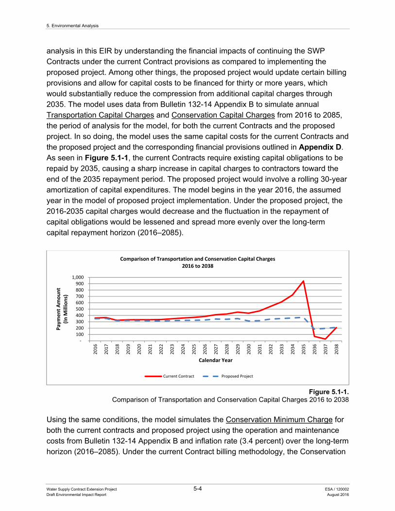
5. Environmental Analysis
Water Supply Contract Extension Project 5-4 ESA / 120002 Draft Environmental Impact Report August 2016
analysis in this EIR by understanding the financial impacts of continuing the SWP Contracts under the current Contract provisions as compared to implementing the proposed project. Among other things, the proposed project would update certain billing provisions and allow for capital costs to be financed for thirty or more years, which would substantially reduce the compression from additional capital charges through 2035. The model uses data from Bulletin 132-14 Appendix B to simulate annual Transportation Capital Charges and Conservation Capital Charges from 2016 to 2085, the period of analysis for the model, for both the current Contracts and the proposed project. In so doing, the model uses the same capital costs for the current Contracts and the proposed project and the corresponding financial provisions outlined in Appendix D. As seen in Figure 5.1-1, the current Contracts require existing capital obligations to be repaid by 2035, causing a sharp increase in capital charges to contractors toward the end of the 2035 repayment period. The proposed project would involve a rolling 30-year amortization of capital expenditures. The model begins in the year 2016, the assumed year in the model of proposed project implementation. Under the proposed project, the 2016-2035 capital charges would decrease and the fluctuation in the repayment of capital obligations would be lessened and spread more evenly over the long-term capital repayment horizon (2016–2085).
Figure 5.1-1. Comparison of Transportation and Conservation Capital Charges 2016 to 2038
Using the same conditions, the model simulates the Conservation Minimum Charge for both the current contracts and proposed project using the operation and maintenance costs from Bulletin 132-14 Appendix B and inflation rate (3.4 percent) over the long-term horizon (2016–2085). Under the current Contract billing methodology, the Conservation
‐ 100 200 300 400 500 600 700 800 900
1,000
2016
2017
2018
2019
2020
2021
2022
2023
2024
2025
2026
2027
2028
2029
2030
2031
2032
2033
2034
2035
2036
2037
2038
Payment Amount
(In M
illions)
Calendar Year
Comparison of Transportation and Conservation Capital Charges2016 to 2038
Current Contract Proposed Project
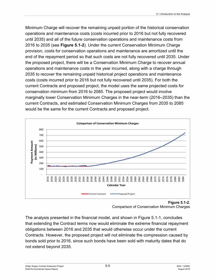
5.1 Introduction to the Analysis
Water Supply Contract Extension Project 5-5 ESA / 120002 Draft Environmental Impact Report August 2016
Minimum Charge will recover the remaining unpaid portion of the historical conservation operations and maintenance costs (costs incurred prior to 2016 but not fully recovered until 2035) and all of the future conservation operations and maintenance costs from 2016 to 2035 (see Figure 5.1-2). Under the current Conservation Minimum Charge provision, costs for conservation operations and maintenance are amortized until the end of the repayment period so that such costs are not fully recovered until 2035. Under the proposed project, there will be a Conservation Minimum Charge to recover annual operations and maintenance costs in the year incurred, along with a charge through 2035 to recover the remaining unpaid historical project operations and maintenance costs (costs incurred prior to 2016 but not fully recovered until 2035). For both the current Contracts and proposed project, the model uses the same projected costs for conservation minimum from 2016 to 2085. The proposed project would involve marginally lower Conservation Minimum Charges in the near-term (2016–2035) than the current Contracts, and estimated Conservation Minimum Charges from 2035 to 2085 would be the same for the current Contracts and proposed project.
Figure 5.1-2.
Comparison of Conservation Minimum Charges
The analysis presented in the financial model, and shown in Figure 5.1-1, concludes that extending the Contract terms now would eliminate the extreme financial repayment obligations between 2016 and 2035 that would otherwise occur under the current Contracts. However, the proposed project will not eliminate the compression caused by bonds sold prior to 2016, since such bonds have been sold with maturity dates that do not extend beyond 2035.
-
100
200
300
400
500
600
700
800
2016
2018
2020
2022
2024
2026
2028
2030
2032
2034
2036
2038
2040
2042
2044
2046
2048
2050
2052
2054
2056
2058
2060
2062
2064
2066
2068
2070
2072
2074
2076
2078
2080
2082
2084
Paym
ent A
mou
nt
(In M
illio
ns)
Calendar Year
Comparison of Conservation Minimum Charges
Current Contract Proposed Project
5. Environmental Analysis
Water Supply Contract Extension Project 5-6 ESA / 120002 Draft Environmental Impact Report August 2016
Overall, the proposed project would substantially reduce the annual capital charges that otherwise would continue to increase as the contracts approach 2035. This would allow Contractors to better assess their future rate structures, and thereby facilitate their planning process. It is expected that with the proposed project, the Contractors would continue their current practice of paying their SWP bills, since there is no anticipated change to the overall costs that the Contractors will be responsible for under the Contracts. Rather, the proposed project would result in a leveling out of future capital payments for such costs that would be due from the Contractors. Accordingly, based on this financial model, no direct or indirect environmental effects are expected as a result of projected costs from the effective date of the project to 2085.
As stated previously, other changes to the Contracts, including increasing SWP financial operating reserves and creating additional accounts to address SWP financial needs and purposes, do not have a measurable effect on the Contractor billings and are not analyzed in the financial model.
5.1.1.3 Assumptions for the Analysis The resource topics presented in the sections of this chapter include an evaluation of the proposed project’s potential to result in a substantial or potentially substantial adverse change in any of the physical conditions within the proposed project study area (CEQA Guidelines Section 15382). The analysis assesses potential effects (or impacts) of a physical change (consistent with CEQA Guidelines Section 15358(b)) attributed to implementation of the proposed project compared to the baseline conditions that existed at the time of release of the NOP in 2014 (CEQA Guidelines Section 15162.2). The determination of significance is based on whether or not an impact exceeds the standards (or thresholds) of significance identified in each section. As required under CEQA Guidelines Section 15126.4, an EIR shall describe feasible measures which would minimize any identified significant adverse impacts. However, after careful evaluation, and as presented in this Chapter, the proposed project was determined to not cause a change in physical conditions; and therefore, no impacts would occur and no mitigation measures are proposed. The conclusions are based on the following common assumptions.
SWP water supply would not change under the proposed project and would continue to be delivered to the Contractors consistent with current Contracts. The proposed project does not change hydrology, regulations, or climate change, all factors that could affect water supply delivery by the SWP. DWR would continue to maintain and operate the SWP and deliver available supplies to the Contractors consistent with the Contract terms, including Table A deliveries, Article 21 deliveries, and all regulatory

5.1 Introduction to the Analysis
Water Supply Contract Extension Project 5-7 ESA / 120002 Draft Environmental Impact Report August 2016
requirements. Therefore, no changes in the conditions of resources associated with the SWP would be expected.
Current bonds would be repaid consistent with their maturity schedules, which do not exceed 2035. The proposed project does not affect the repayment terms of bonds that are outstanding at the time of project approval. Those bonds would continue to be repaid at the current rates and repayment periods. Repayment of existing bonds would not have an adverse effect on the environment because there would be no change in physical conditions.
After project approval, bonds could be issued with terms of 30 years or longer. The extension of the Contract term to 2085 would allow for project bonds to be issued for 30-year terms up through 2055, when bond repayment compression may begin again. This time period for bond repayment would be consistent with the expected life of most project facilities that would be financed with bonds.
SWP financial planning would be enhanced by the development of new and amended financial provisions to the Contracts. The proposed project would establish increased levels of SWP financial reserves, create new accounts, restructure other accounts, and implement a comprehensive billing system to better match revenues with anticipated SWP capital and operations and maintenance costs. None of these new or amended financial provisions would have an adverse effect on the environment because there would be no change in physical conditions.
The proposed project would provide long-term benefits to the SWP by continuing to provide a stable revenue source, better matching revenues with anticipated costs, and providing for the maintenance of reserves and funds for all SWP purposes. These benefits include the ability to continue to finance projects such as repairs to the California Aqueduct, replacement of aging pumps, generators, and other equipment and implementing low- greenhouse gas (GHG) emission energy projects. Capital projects that could be financed in whole or in part by the sale of longer term bonds (if available as the result of contract extension) include: (1) reinforcing Perris Dam at Lake Perris against seismic failure and maintaining other SWP facilities to current seismic safety standards; (2) reconstructing the Ronald B Robie Thermalito pump-generating plant in the aftermath of a damaging fire to the facility; (3) implementing the Oroville hydroelectric license project; and (4) obtaining a renewed Federal Energy Regulatory Commission (FERC) license for the SWP’s southern hydroelectric plants. An EIR or other environmental documentation for each of these projects has been or will be prepared. For future projects, DWR will continue its practice of providing separate CEQA compliance at the time that each such project is proposed. For example, the
5. Environmental Analysis
Water Supply Contract Extension Project 5-8 ESA / 120002 Draft Environmental Impact Report August 2016
California WaterFix project, for which a separate EIR/Environmental Impact Statement (EIS) is being prepared, is discussed in Chapter 6, Other CEQA Considerations, Section 6.1.1.1 and Chapter 7, Alternatives, Section 7.3.3.
The following sections describe the environmental setting, regulatory setting, thresholds of significance, and analysis of proposed project effects on 18 resource topics, included in Appendix G, Environmental Checklist Form, and Appendix F, Energy Conservation, of the CEQA Guidelines. Cumulative impacts and other CEQA considerations, and alternatives analysis discussions are in Chapters 6 and 7, respectively.
5.2.1 Aesthetics
Water Supply Contract Extension Project 5-9 ESA / 120002 Draft Environmental Impact Report August 2016
5.2 ENVIRONMENTAL ANALYSIS
5.2.1 Aesthetics
5.2.1.1 Introduction This section describes the environmental and regulatory settings and analysis of the proposed project effects on aesthetics. No comments were received in response to the NOP addressing aesthetics.
5.2.1.2 Environmental Setting Visual or aesthetic resources are comprised of both the natural and built features of the landscape that contribute to the public’s experience and appreciation of the environment. As described in Chapter 2, State Water Project, the SWP is a complex system of reservoirs, dams, power plants, pumping plants, pipelines, and aqueducts that delivers water to Contractors throughout Northern California, the San Joaquin Valley, San Francisco Bay Area, Central Coast Area, and Southern California. SWP facilities include small reservoirs in the northern part of the State, which are primarily used for recreation (Lake Davis, Frenchman Lake, and Antelope Lake), and downstream reservoirs that are primarily used for storage but are also accessed for recreation, including but not limited to Lake Oroville, San Luis Reservoir, Lake Perris, and Castaic Lake. Public use of these reservoirs includes picnic areas, camping, fishing, and boating.
Surface elevation of reservoir water affects the aesthetic (visual) character of SWP reservoirs. When a reservoir is at or near its maximum operating storage level, the water surface generally meets fully vegetated shorelines. As drawdown occurs during the summer and fall, an increasingly broad ring of unvegetated shoreline appears. In narrow or steep-sided branches of the reservoirs, large drawdowns can create conditions in which it appears a reservoir is set within a deep, red-sided canyon. In places where slopes are gradual, areas that appear to be mudflats are created.
SWP conveyance facilities include the use of natural stream channels in Northern California (Sacramento River and Feather River) that deliver water to the Bay-Delta, where it is pumped to the California Aqueduct system for delivery to the Contractors located south of the Bay-Delta. Surrounding land uses include agricultural, residential, commercial, industrial, and open space uses. Large portions of the California Aqueduct are visible to vehicle travelers on Interstate 5 (I-5) as it winds along the west side of the San Joaquin Valley.
5. Environmental Analysis
Water Supply Contract Extension Project 5-10 ESA / 120002 Draft Environmental Impact Report August 2016
Wild and Scenic Rivers A designated wild and scenic river is one that has remarkable scenic, recreational, geologic, fish and wildlife, historic, cultural, or other similar values (see the Regulatory Setting subsection for further description). There are several federally designated wild and scenic rivers within the SWP study area, including Feather River, Cosumnes River, and Kern River (National Wild and Scenic Rivers System 2015).
Scenic Highways A scenic highway designation is based on the scenic quality of the landscape, the amount of a natural landscape that can be seen by travelers, and the extent to which development intrudes upon the landscape (see the Regulatory Setting subsection for further description). There are several scenic highways within the vicinity of the SWP study area, including portions of State Route (SR) 1 and I-5.
5.2.1.3 Regulatory Setting The following text summarizes federal, State, and local laws and regulations pertinent to evaluation of the proposed project’s impacts on aesthetics and visual resources.
Federal Wild and Scenic Rivers Act The Wild and Scenic Rivers Act (WSRA) of 1968, as amended (Public Law 90-542; 16 U.S. Code 12371–1287), established the National Wild and Scenic Rivers System, which identifies distinguished rivers of the nation that possess remarkable scenic, recreational, geologic, fish and wildlife, historic, cultural, or other similar values. The WSRA preserves the free-flowing condition of rivers that are designated and protects their local environments. Section 5(d)(1) of the WSRA requires that all federal agencies, when planning for the use and development of water and related land resources, consider potential national wild, scenic, and recreational river areas, which are defined as follows (National Wild and Scenic Rivers System 2015):
• “Wild” river areas – Those rivers or sections of rivers that are free of impoundments and are generally inaccessible except by trail, with watersheds or shorelines essentially primitive and waters unpolluted. These represent vestiges of primitive America.
• “Scenic” river areas – Those rivers or sections of rivers that are free of impoundments, with shorelines or watersheds still largely primitive and shorelines largely undeveloped, but accessible in places by roads.
• “Recreational” river areas – Those rivers or sections of rivers that are readily accessible by road or railroad, that may have some development along their shorelines, and that may have undergone some impoundment or diversion in the
5.2.1 Aesthetics
Water Supply Contract Extension Project 5-11 ESA / 120002 Draft Environmental Impact Report August 2016
past. Scenic qualities are a major consideration in the designation of rivers as wild (pristine), scenic (largely undeveloped), or recreational (mostly developed), although river segments in any of the three categories typically maintain high scenic qualities.
State California Scenic Highway Program The California Scenic Highway Program, which began in 1963, was created to enhance and protect scenic highways and adjacent corridors. A scenic highway designation is based on the scenic quality of the landscape, the amount of natural landscape that can be seen by travelers, and the extent to which development intrudes upon the landscape. Official designation requires a local jurisdiction to enact a scenic corridor protection program that protects and enhances scenic resources (California Department of Transportation [Caltrans] 2015).
Local Generally, State agencies involved with the location or construction of facilities for the production, generation, storage, treatment, or transmission of water are not subject to local regulations. Inconsistency with local land use regulations is not in and of itself considered an adverse effect on the environment. The SWP study area covers multiple counties with multiple cities throughout California. Each of these counties and cities has local regulations and General Plans with unique goals and policies that address visual resources. Although scenic elements are not a required element of General Plans, many cities and counties incorporate goals and policies related to protecting scenic resources into other elements of the General Plan or include a scenic element as an optional element. These General Plan goals, policies, and elements typically identify important scenic resources, scenic highways, and scenic vistas within the local jurisdiction and propose goals and policies for protection of scenic resources.
5.2.1.4 Impact Analysis Methods of Analysis Methods used to analyze the potential impacts to aesthetics associated with implementation of the proposed project included review of project documentation, regulations, and policies.
Standards of Significance Based on Appendix G of the CEQA Guidelines, an impact is considered significant if implementation of the proposed project would:
• Have a substantial adverse effect on a scenic vista.
5. Environmental Analysis
Water Supply Contract Extension Project 5-12 ESA / 120002 Draft Environmental Impact Report August 2016
• Substantially damage scenic resources, including, but not limited to, trees, rock outcroppings, and historic buildings within a State scenic highway.
• Substantially degrade the existing visual character or quality of the site and its surroundings.
• Create a new source of substantial light or glare that would adversely affect day or nighttime views in the area.
Impacts and Mitigation Measures The proposed project would amend and add financial provisions to the current Contracts based on the negotiated AIP between DWR and the Contractors. The proposed project would not create new water management measures, alter the existing authority to build new or modify existing facilities, or change water allocation provisions of the current Contracts. Because the proposed project would not result in construction or modification of reservoirs or a change in operations, there would be no changes in the visual character of any SWP reservoirs or scenic resources when compared to existing conditions. In addition, because no SWP conveyance facilities would be constructed or modified, the proposed project would not result in any change of the surrounding visual character of the conveyance facilities or create new sources of light and glare and no change in daytime or nighttime views in the SWP study area. Therefore, the proposed project would not have a substantial adverse effect on a scenic vista or a wild or scenic river, and would not substantially damage scenic resources such as trees, rock outcroppings, or historic buildings within a State scenic highway. Also, the proposed project would not substantially degrade the existing visual character or quality of the SWP facilities and surroundings or create a new source of substantial light or glare.
Therefore, no impacts would occur to visual resources and no mitigation measures are required.
5.2.1.5 References Caltrans (California Department of Transportation). 2015. The California Scenic
Highway Program.
National Wild and Scenic Rivers System. 2015. California. Available: www.rivers.gov/california.php. Accessed July 22, 2015.
5.2.2 Agricultural and Forest Resources
Water Supply Contract Extension Project 5-13 ESA / 120002 Draft Environmental Impact Report August 2016
5.2.2 Agricultural and Forest Resources
5.2.2.1 Introduction This section describes the environmental and regulatory settings and analyzes potential impacts on agriculture and forest resources. No comments addressing agriculture and forest resources were received in response to the NOP.
5.2.2.2 Environmental Setting Agricultural Resources The California Department of Conservation (DOC) administers the Farmland Mapping and Monitoring Program (FMMP), California’s statewide agricultural land inventory. Through this mapping effort, the DOC classifies farmland into four categories: Prime Farmland, Farmland of Statewide Importance, Unique Farmland, and Farmland of Local Importance. Prime Farmland are those lands with the best combination of physical and chemical features able to sustain long-term agricultural production; Farmland of Statewide Importance is similar to Prime Farmland but with minor shortcomings, including greater slopes or less ability to store soil moisture; Unique Farmland has lesser quality soils and is used for the production of the State’s leading agricultural crops; and Farmland of Local Importance and lands important to the local agricultural economy is determined by the county board of supervisors for each county in which such farmland exists and by local advisory committees (DOC 2015).
The California Land Conservation Act of 1965, commonly referred to as the Williamson Act, enables local governments to enter into contracts with private landowners for the purpose of restricting specific parcels of land to agricultural or related open-space use. In return, landowners receive property tax assessments that are much lower than normal because they are based upon farming and open-space uses as opposed to full market value. Local governments receive an annual subvention of forgone property tax revenues from the State via the Open Space Subvention Act of 1971. By State law, only land located in an agricultural preserve is eligible for a Williamson Act contract.
Approximately 750,000 acres of agricultural land, primarily in the San Joaquin Valley, is irrigated with water delivered by the SWP. Agricultural lands in the SWP study area include those designated as Prime Farmland, Farmland of Statewide Importance, or Unique Farmland. There are also lands under Williamson Act contract.
According to the DOC 2008–2010 California Farmland Conversion Report, irrigated farmland in California decreased by approximately 168,039 acres between 2008 and 2010 with loss of Prime Farmland comprising 61 percent of the total loss (DOC 2014). Conversion to urban development was approximately 44,000 acres of the total reduction
5. Environmental Analysis
Water Supply Contract Extension Project 5-14 ESA / 120002 Draft Environmental Impact Report August 2016
in irrigated farmland acreage, with land idling accounting for the majority of the total reduction during this period. The southern San Joaquin Valley and counties in the Bay-Delta were most impacted by land idling. Losses of irrigated farmland have resulted in part from drought-related reductions in water supply and from reclassification of lands. During this same 2008–2010 period, there was a net increase in irrigated farmland that mostly occurred in the eastern foothills of the northern San Joaquin Valley. These increases were primarily due to planting of orchards and vineyards.
Forest Land Forest land is defined as native tree cover greater than 10 percent that allows for management of timber, aesthetics, fish and wildlife, recreation, and other public benefits (California Public Resources Code [PRC] Section 12220(g)). Natural forest and woodland vegetation types in the SWP study area typically have greater than 10 percent cover by native trees. Timberland, a subset of forest land, is defined by State law as land that is available for, and capable of, growing a crop of trees of any commercial species used to produce lumber and other forest products (PRC Section 4526), and can produce an average annual volume of wood fiber of at least 20 cubic feet per acre per year at its maximum production (PRC Section 51104(g)).
Forests can serve as high-quality habitat for fish and wildlife species, sequester carbon to mitigate climate change effects, capture vital runoff for agricultural and domestic water supply, and provide a variety of outdoor recreation and education opportunities. Many rural communities depend on income and employment opportunities resulting from working timber industries, or on amenity values that support a tourist industry and attract new residents seeking a better lifestyle. In metropolitan areas, urban forests contribute to improved air quality, cooling of heat islands for energy conservation, and local employment (CAL FIRE 2010). Portions of the SWP study area are located within forest land, including the Los Padres and Angeles National Forests.
5.2.2.3 Regulatory Setting The following text summarizes federal, State, and local laws and regulations pertinent to evaluation of the proposed project’s impacts on agriculture and forest resources.
Federal Federal Farmland Protection Act Policy The U.S. Natural Resources Conservation Service (NRCS), within the U.S. Department of Agriculture, is primarily responsible for implementing and administering the Federal Farmland Protection Policy Act. This law is intended to minimize federal contributions to the conversion of farmland to nonagricultural uses by ensuring that federal programs
5.2.2 Agricultural and Forest Resources
Water Supply Contract Extension Project 5-15 ESA / 120002 Draft Environmental Impact Report August 2016
are administered in a manner compatible with state government, local government, and private programs designed to protect farmland. For the purposes of the law, federal programs include construction projects—such as highways, airports, dams, flood protection projects, and federal buildings—sponsored or financed in whole or part by the federal government, and the management of federal lands.
State California Farmland Conservancy Program The DOC’s California Farmland Conservancy Program (CFCP) was established in 1996 to encourage the permanent conservation of productive agricultural lands in collaboration with local entities. In creating the CFCP, the California Legislature recognized the important contribution that farmland makes to the State’s food supply and the additional benefits that farmland provides—conserving wildlife habitat, protecting wetlands, and preserving scenic open space. The CFCP supports local efforts to conserve farmland by providing grant funds for the purchase of agricultural conservation easements. Agricultural conservation easements are deed restrictions to ensure that a given piece of agricultural land can never be used for purposes that would interfere with farming, leaving farmers free to make all ongoing agricultural management decisions on their land. Grant funds are made available through a competitive process to qualified entities, including nonprofit land trusts and local governments, to purchase conservation easements from landowners. The CFCP also provides planning and technical assistance grants to these same qualified local entities to facilitate development of local and regional farmland conservation strategies.
Important Farmland The DOC, in conjunction with NRCS, has adopted categorical definitions of Important Farmland for purposes of land use inventories. These definitions recognize the land’s suitability for agricultural production, rather than only reflecting the physical and chemical characteristics of the soil. To this end, the FMMP was established, and the Important Farmland Map Series was developed based on NRCS soil surveys. These maps classify land into categories (DOC 2016):
• Prime Farmland is land that has the best combination of physical and chemical characteristics for crop production, as well as high soil quality, appropriate growing season, and adequate moisture supply to sustained high crop yields.
• Farmland of Statewide Importance is land other than Prime Farmland that has a good combination of physical and chemical characteristics for crop production. The definition is similar to that for Prime Farmland except that crop production characteristics are considered good; not the best.
5. Environmental Analysis
Water Supply Contract Extension Project 5-16 ESA / 120002 Draft Environmental Impact Report August 2016
• Unique Farmland does not meet the definition of either Prime Farmland or Farmland of Statewide Importance, but it is land that is being used for specific crops of high economic value. This farmland type has a special combination of soil quality, location, growing season, and moisture supply needed to produce sustained high-quality or high yields of specific crops.
Important Farmland is defined in Appendix G of the CEQA Guidelines as Prime Farmland, Farmland of Statewide Importance, and Unique Farmland. These farmland types are defined together under the term “Agricultural Land” in CEQA (PRC Sections 21060.1 and 21095; CEQA Guidelines, Appendix G).
Williamson Act The Williamson Act is one of the State’s primary agricultural conservation tools. Under this law, local governments can enter into contracts with private property owners to protect land (within agricultural preserves) for agricultural and open space purposes. Williamson Act contracts are required to be a minimum initial term of 10 years, and are automatically extended each year for an additional year, unless either party (landowner or the contracting city or county) notifies the other of the intent not to renew the contract. Of California’s 58 counties, 53 have adopted the Williamson Act program. Farmland Security Zone (FSZ) lands were authorized by a 1998 amendment to the Williamson Act with the same general intent as Williamson Act contracts. Under FSZ provisions, the landowner agrees to keep land that is threatened by development in agricultural use for at least 20 years; in return, the landowner receives the benefits of lower property tax bills, parcel tax exemptions, annexation exemptions, and exemptions from school use. Accordingly, FSZs increase both the duration and the protection of Williamson Act status. An FSZ must be located in an agricultural preserve (an area designated as eligible for a Williamson Act contract). Agricultural landowners in FSZs must enter into contracts with counties for a minimum term of 20 years that are also renewed automatically each year, and these landowners are ensured an additional 35 percent tax benefit over and above the standard Williamson Act contract. The FSZ program has been adopted by 25 counties, although not all of those counties have executed contracts.
Forest Land, Timberland, and the Forest Taxation Reform Act As stated previously, forest land is defined as native tree cover greater than 10 percent that allows for management of timber, aesthetics, fish and wildlife, recreation, and other public benefits (PRC Section 12220(g)). A subset of forest land, timberland is land that is available for, and capable of, growing a crop of trees of any commercial species used to produce lumber and other forest products (PRC Section 4526), and that can produce an average annual volume of wood fiber of at least 20 cubic feet per acre per year at its
5.2.2 Agricultural and Forest Resources
Water Supply Contract Extension Project 5-17 ESA / 120002 Draft Environmental Impact Report August 2016
maximum production (PRC Section 51104(g)). The Forest Taxation Reform Act, enacted in 1976, provides guidelines that allow cities and counties with qualifying timberland to adopt Timber Production Zones (TPZs) that protect timberlands from incompatible uses. TPZs are privately owned land or land acquired for State forest purposes. When a TPZ is established, a private landowner agrees to commit the land to forest production for 10 years. In return, the approving jurisdiction grants the landowner a 35 percent reduction in property taxes. The California Department of Forestry and Fire Protection has jurisdiction over timber harvest and timberland conversion decisions in TPZs, which it passes down to county agriculture departments.
Local Generally, State agencies involved with the location or construction of facilities for the production, generation, storage, treatment, or transmission of water are not subject to local regulations. Inconsistency with local land use regulation is not in and of itself considered an adverse effect on the environment. The SWP study area covers multiple counties with multiple cities throughout California. Each of these counties and cities has local regulations and General Plans with unique goals and policies that preserve and guide development of agricultural lands within their local jurisdictions and may identify mitigation ratios for conversion of agricultural lands to nonagricultural uses. Cities and counties often adopt urban limit lines, establish buffers between agriculture and other approved uses, adopt right-to-farm ordinances, support the Williamson Act program, control subdivisions of land, define land use types allowed within agricultural areas, and establish minimum agricultural parcel sizes.
5.2.2.4 Impact Analysis Methods of Analysis Methods used to analyze the proposed project’s effect on agriculture and forest resources included review of project documentation, regulations, and policies.
Standards of Significance Based on Appendix G of the CEQA Guidelines, an impact is considered significant if implementation of the proposed project would:
• Convert Prime Farmland, Unique Farmland, or Farmland of Statewide Importance (Farmland) as shown on the maps prepared pursuant to the Farmland Mapping and Monitoring Program of the California Resources Agency, to nonagricultural use.
• Conflict with existing zoning for agricultural use, or a Williamson Act contract.
5. Environmental Analysis
Water Supply Contract Extension Project 5-18 ESA / 120002 Draft Environmental Impact Report August 2016
• Conflict with existing zoning for, or cause rezoning of, forest land (as defined in PRC section 12220(g)), timberland (as defined by PRC section 4526), or Timberland zoned Timberland production (as defined by Government Code section 51104(g)).
• Result in the loss of forest land or conversion of forest land to non-forest use.
• Involve other changes in the existing environment which, due to their location or nature, could result in conversion of Farmland, to non-agricultural use or conversion of forest land to non-forest use.
Impacts and Mitigation Measures The proposed project would amend and add financial provisions of the current Contracts based on the negotiated AIP between DWR and the Contractors. The proposed project would not create new water management measures, alter the existing authority to build new or modify existing facilities, or change water allocation provisions of the current Contracts. Because the proposed project would not result in construction or modification of SWP facilities, it would not affect surrounding land uses or result in development that could conflict with zoning for agricultural or forestry uses or result in the loss or conversion of these resources. Further, because water allocation would not change, there would be no change in land uses associated with SWP deliveries including, conversion of agricultural land uses to urban uses or to nonagricultural use. Contractors would continue to provide water in their service areas in the same manner as they do currently.
Therefore, no impacts would occur related to agricultural or forestry resources and no mitigation measures are required.
5.2.2.5 References CAL FIRE (California Department of Forestry and Fire Protection). 2010. Fire and
Resource Assessment Program. California’s Forests and Rangelands: 2010 Assessment. June 2010.
DOC (California Department of Conservation). 2014. California Farmland Conversion Report 2008-2010. Available: www.conservation.ca.gov/dlrp/fmmp/Pages/FMMP_2008-2010_FCR.aspx. Accessed July 16, 2015.
———. 2015. Important Farmland Mapping Categories and Soil Taxonomy Terms. Available: www.conservation.ca.gov/dlrp/fmmp/Documents/soil_criteria.pdf. Accessed March 18, 2015.
———. 2016. Important Farmland Categories. Available: www.conservation.ca.gov/dlrp/fmmp/mccu/Pages/map_categories.aspx. Accessed May 21, 2016.
5.2.3 Air Quality
Water Supply Contract Extension Project 5-19 ESA / 120002 Draft Environmental Impact Report August 2016
5.2.3 Air Quality
5.2.3.1 Introduction This section describes background air quality information and the associated regulatory framework, and presents an analysis of potential air quality impacts that could result from implementing the proposed project. No comments related to the generation of air pollutants were received in response to the NOP.
5.2.3.2 Environmental Setting California Climate and Meteorology Air quality is affected by the rate, amount, and location of pollutant emissions and the associated meteorological conditions that influence pollutant movement and dispersal. Atmospheric conditions (e.g., wind speed, wind direction, and air temperature) in combination with local surface topography (e.g., geographic features such as mountains and valleys) determine how air pollutant emissions affect local air quality.
Because of the strong influence of the Pacific Ocean and mountains, variations in climate in California run in a general east-to-west direction. California’s climate varies from Mediterranean (most of the State) to steppe (scattered foothill areas), to alpine (high Sierra), to desert (Colorado and Mojave Deserts).
The Sierra Nevada, Northern Coast, Southern Coast, Cascade, Transverse, and Peninsular mountain ranges act as barriers to the passage of air masses. During summer, California is protected from much of the hot, dry air masses that develop over the central United States. Because of these barriers, and California’s western border of the Pacific Ocean, summer weather in portions of the State is generally milder than that in the rest of the country and is characterized by dry, sunny conditions with infrequent rain. In winter, the same mountain ranges prevent cold, dry air masses from moving into California from the central areas of the United States. Consequently, winters in California are also milder than would be expected at these latitudes.
Criteria Air Pollutants As required by the federal Clean Air Act (FCAA) passed in 1970, the U.S. Environmental Protection Agency (USEPA) has identified six criteria air pollutants for which state and national health-based ambient air quality standards have been established. The USEPA calls these pollutants “criteria air pollutants” because the agency has regulated them by developing specific public health- and welfare-based criteria as the basis for setting permissible levels. Ozone, carbon monoxide (CO), nitrogen dioxide (NO2), sulfur dioxide (SO2), particulate matter, and lead are the six criteria air pollutants. Notably, particulate matter is measured in two size ranges: PM10
5. Environmental Analysis
Water Supply Contract Extension Project 5-20 ESA / 120002 Draft Environmental Impact Report August 2016
for particles less than 10 microns in diameter, and PM2.5 for particles less than 2.5 microns in diameter.
Toxic Air Contaminants Toxic air contaminants (TACs) are airborne substances that are capable of causing short-term (acute) and/or long-term (chronic and/or carcinogenic) adverse human health effects (i.e., injury or illness). TACs are substances for which federal or State criteria air pollutant standards have not been adopted. Thus, for TACs, there is no federal or State ambient air quality standard against which to measure a project’s air quality impacts. For this reason, TACs are analyzed by performing a health risk assessment. TACs include both organic and inorganic chemical substances. They may be emitted from a variety of common sources, including diesel-fueled engines, gasoline stations, automobiles, dry cleaners, industrial operations, and painting operations.
Odorous Emissions Although odors rarely cause any physical harm, they still remain unpleasant and can lead to public distress, generating complaints. The occurrence and severity of odor impacts depend on the nature, frequency, and intensity of the source; wind speed and direction; and the sensitivity of receptors.
5.2.3.3 Regulatory Setting The following text summarizes federal, State, and local laws and regulations pertinent to evaluation of the proposed project’s impacts on air quality.
Federal Criteria Pollutants The 1970 FCAA (last amended in 1990) required that regional planning and air pollution control agencies prepare a regional air quality plan to outline the measures by which both stationary and mobile sources of pollutants will be controlled in order to achieve all national ambient standards by the deadlines specified in the FCAA. These ambient air quality standards are intended to protect public health and welfare, and they specify the concentration of pollutants (with an adequate margin of safety) to which the public can be exposed without adverse health effects. They are designed to protect those segments of the public most susceptible to respiratory distress, including asthmatics, the very young, the elderly, people weak from other illness or disease, or persons engaged in strenuous work or exercise. Healthy adults can tolerate occasional exposure to air pollution levels that are somewhat above ambient air quality standards before adverse health effects are observed. Table 5.2.3-1 presents current national and state ambient air quality standards and provides a brief discussion of the related health

5.2.3 Air Quality
Water Supply Contract Extension Project 5-21 ESA / 120002 Draft Environmental Impact Report August 2016
TABLE 5.2.3-1. STATE AND NATIONAL CRITERIA AIR POLLUTANT STANDARDS, EFFECTS, AND SOURCES
Pollutant Averaging
Time State Standard National Standard Pollutant Health and Atmospheric Effects Major Pollutant Sources
Ozone 1 hour 0.09 ppm --- High concentrations can directly affect lungs, causing irritation. Long-term exposure may cause damage to lung tissue.
Formed when reactive organic gases (ROG) and nitrogen oxides (NOx) react in the presence of sunlight. Major sources include on-road motor vehicles, solvent evaporation, and commercial/industrial mobile equipment.
8 hours 0.07 ppm 0.075 ppm
Carbon Monoxide
1 hour 20 ppm 35 ppm Classified as a chemical asphyxiant, carbon monoxide interferes with the transfer of fresh oxygen to the blood and deprives sensitive tissues of oxygen.
Internal combustion engines, primarily gasoline-powered motor vehicles. 8 hours 9.0 ppm 9 ppm
Nitrogen Dioxide
1 hour 0.18 ppm 100 ppb Irritating to eyes and respiratory tract. Colors atmosphere reddish-brown.
Motor vehicles, petroleum refining operations, industrial sources, aircraft, ships, and railroads. Annual Avg. 0.030 ppm 0.053 ppm
Sulfur Dioxide 1 hour 0.25 ppm 75 ppb Irritates upper respiratory tract; injurious to lung tissue. Can yellow the leaves of plants, destructive to marble, iron, and steel. Limits visibility and reduces sunlight.
Fuel combustion, chemical plants, sulfur recovery plants, and metal processing. 3 hours --- 0.5 ppm
24 hours 0.04 ppm 0.14 ppm Annual Avg. --- 0.030 ppm
Respirable Particulate Matter (PM10)
24 hours 50 ug/m3 150 ug/m3 May irritate eyes and respiratory tract, decreases in lung capacity, cancer and increased mortality. Produces haze and limits visibility.
Dust and fume-producing industrial and agricultural operations, combustion, atmospheric photochemical reactions, and natural activities (e.g., wind-raised dust and ocean sprays).
Annual Avg. 20 ug/m3 ---
Fine Particulate Matter (PM2.5)
24 hours --- 35 ug/m3 Increases respiratory disease, lung damage, cancer, and premature death. Reduces visibility and results in surface soiling.
Fuel combustion in motor vehicles, equipment, and industrial sources; residential and agricultural burning; Also, formed from photochemical reactions of other pollutants, including NOx, sulfur oxides, and organics.
Annual Avg. 12 ug/m3 12 ug/m3
Lead Monthly Avg. 1.5 ug/m3 --- Disturbs gastrointestinal system and causes anemia, kidney disease, and neuromuscular and neurological dysfunction.
Present sources: lead smelters, battery manufacturing & recycling facilities. Past source: combustion of leaded gasoline.
Quarterly --- 1.5 ug/m3
Hydrogen Sulfide
1 hour 0.03 ppm No National Standard
Nuisance odor (rotten egg smell),headache and breathing difficulties (higher concentrations)
Geothermal power plants, petroleum production, and refining.
Sulfates 24 hour 25 ug/m3 No National Standard
Breathing difficulties, aggravates asthma, reduced visibility
Produced by the reaction in the air of SO2.
Visibility Reducing Particles
8 hour Extinction of 0.23/km;
visibility of 10 miles or more
No National Standard
Reduces visibility, reduced airport safety, lower real estate value, discourages tourism.
See PM2.5.
NOTES: ppm = parts per million; ug/m3 = micrograms per cubic meter.
SOURCES: California Air Resources Board, 2013. Ambient Air Quality Standards. Available: www.arb.ca.gov/research/aaqs/aaqs2.pdf. Standards last updated June 4, 2013; California Air Resources Board, 2009. ARB Fact Sheet: Air Pollution Sources, Effects and Control. Available: www.arb.ca.gov/research/health/fs/fs2/fs2.htm. Page last reviewed by CARB December 2009.
5. Environmental Analysis
Water Supply Contract Extension Project 5-22 ESA / 120002 Draft Environmental Impact Report August 2016
effects and principal sources for each pollutant. Pursuant to the 1990 Federal Clean Air Act Amendments (FCAAA), the USEPA classifies air basins (or portions thereof) as “attainment” or “nonattainment” for each criteria air pollutant, based on whether or not the National Ambient Air Quality Standards (NAAQS) has been achieved. “Unclassified” is defined by the FCAAA as any area that cannot be classified, on the basis of available information, as meeting or not meeting the national primary or secondary ambient air quality standard for the pollutant.
The FCAA required each state to prepare an air quality control plan referred to as the State Implementation Plan (SIP). The FCAAA added requirements for states containing areas that violate the NAAQS to revise their SIPs to incorporate additional control measures to reduce air pollution. The SIP is a living document that is periodically modified to reflect the latest emissions inventories, planning documents, and rules and regulations of air basins as reported by the agencies with jurisdiction over them. The USEPA has the responsibility to review all states’ SIPs to determine if they conform to the mandates of the FCAAA and will achieve air quality goals when implemented. If the USEPA determines a SIP to be inadequate, it may prepare a Federal Implementation Plan (FIP) for the nonattainment area and may impose additional control measures. Failure to submit an approvable SIP or to implement the plan within mandated timeframes can result in sanctions being applied to transportation funding and stationary air pollution sources in the air basin.
Toxic Air Contaminants TACs are regulated under both state and federal laws. Federal laws use the term “Hazardous Air Pollutants” (HAPs) to refer to the same types of compounds that are referred to as TACs under state law. Both terms encompass essentially the same compounds. The 1977 FCAAA required USEPA to identify National Emission Standards for Hazardous Air Pollutants to protect public health and welfare. These substances include certain volatile organic chemicals, pesticides, herbicides, and radionuclides that present a tangible hazard, based on scientific studies of exposure to humans and other mammals. Under the 1990 FCAAA, 189 substances are regulated as HAPs.
State Criteria Pollutants Although the FCAA established the NAAQS, individual states retained the option to adopt more stringent standards and to include other pollution sources. California had already adopted its own air quality standards when federal standards were established, and because of the unique meteorology in California, there is considerable diversity between the State standards and NAAQS, as shown in Table 5.2.3-1. California
5.2.3 Air Quality
Water Supply Contract Extension Project 5-23 ESA / 120002 Draft Environmental Impact Report August 2016
ambient standards tend to be at least as protective as NAAQS and are often more stringent.
In 1988, California passed the California Clean Air Act (CCAA) (California Health and Safety Code Sections 39600 et seq.), which, like its federal counterpart, called for the designation of areas as attainment or nonattainment, but based on state ambient air quality standards rather than the federal standards. The CCAA requires each air district in which State air quality standards are exceeded to prepare a plan that documents reasonable progress toward attainment.
Toxic Air Contaminants The California Health and Safety Code defines TACs as air pollutants that may cause or contribute to an increase in mortality or in serious illness, or that may pose a present or potential hazard to human health. The State Air Toxics Program was established in 1983 under Assembly Bill (AB) 1807 (Tanner). A total of 243 substances have been designated TACs under California law; they include the 189 (federal) HAPs adopted in accordance with AB 2728. The Air Toxics “Hot Spots” Information and Assessment Act of 1987 (AB 2588) seeks to identify and evaluate risk from air toxics sources; however, AB 2588 does not regulate air toxics emissions. TAC emissions from individual facilities are quantified and prioritized. “High-priority” facilities are required to perform a health risk assessment, and if specific thresholds are violated, are required to communicate the results to the public in the form of notices and public meetings.
In 2000, the California Air Resources Board (CARB) approved a comprehensive Diesel Risk Reduction Plan to reduce diesel emissions from both new and existing diesel-fueled vehicles and engines. The regulation is anticipated to result in an 80 percent decrease in statewide diesel health risk by 2020 as compared with the diesel risk in 2000. Additional regulations apply to new trucks and diesel fuel. Subsequent CARB regulations and programs regarding diesel emissions include the On-Road Heavy-Duty Diesel Vehicle (In-Use) Regulation, the On-Road Heavy Duty (New) Vehicle Program, the In-Use Off-Road Diesel Vehicle Regulation, and the New Off-Road Compression-Ignition (Diesel) Engines and Equipment Program. All of these regulations and programs have timetables by which manufacturers must comply and existing operators must upgrade their diesel-powered equipment.
Local Enforcement of the FCAA through permitting of all air pollution and emissions from stationary sources (non-vehicular sources), rests primarily with the local and regional air pollution control authorities known as Air Pollution Control Districts (APCDs) or Air Quality Management Districts (AQMDs). These local air districts issue permits for
5. Environmental Analysis
Water Supply Contract Extension Project 5-24 ESA / 120002 Draft Environmental Impact Report August 2016
construction and operation of facilities. SWP facilities are located within the jurisdictions of multiple local air districts.
Individual air districts or groups of air districts prepare air quality management plans designed to bring an air basin into compliance for nonattainment criteria pollutants. Those plans are submitted to the CARB for approval and usually contain an emissions inventory and a list of rules proposed for adoption.
Generally, State agencies involved with the location or construction of facilities for the production, generation, storage, treatment, or transmission of water are not subject to local regulations. Inconsistency with local land use regulations is not in and of itself considered an adverse effect on the environment. The SWP study area covers multiple counties with multiple cities throughout California. Each of these counties and cities has local regulations and General Plans with unique goals and policies that address air emissions.
5.2.3.4 Impact Analysis Methods of Analysis Methods used to analyze the potential impacts to air quality associated with implementation of the proposed project included review of project documentation, technical documents, and regulations and policies.
Standards of Significance Based on Appendix G of the CEQA Guidelines, an impact is considered significant if implementation of the proposed project would:
• Conflict with or obstruct implementation of the applicable air quality plan.
• Violate any air quality standard or contribute substantially to an existing or projected air quality violation.
• Result in a cumulatively considerable net increase of any non-attainment pollutant for which the project region is non-attainment under an applicable federal or state ambient air quality standard (including releasing emissions that exceed quantitative thresholds for ozone precursors).
• Expose sensitive receptors to substantial pollutant concentrations.
• Create objectionable odors affecting a substantial number of people.
Impacts and Mitigation Measures The proposed project would amend and add financial provisions of the current Contracts based on the negotiated AIP between DWR and the Contractors. The proposed project would not create new water management measures, alter the existing
5.2.3 Air Quality
Water Supply Contract Extension Project 5-25 ESA / 120002 Draft Environmental Impact Report August 2016
authority to build new or modify existing facilities, or change water allocation provisions of the current Contracts. Because no SWP facilities would be built or expanded there would be no criteria pollutant emissions or dust associated with construction activities. Further, the proposed project would not change current SWP O&M. As such, the proposed project would not result in increases to air quality emissions associated with changes in O&M activities when compared to existing conditions. The proposed project would not conflict with implementation of an applicable air quality plan, violate any air quality standard or contribute substantially to an existing or projected air quality violation, result in a cumulatively considerable increase of a non-attainment pollutant, expose sensitive receptors to substantial pollutant concentrations, or create objectionable odors. Further, the proposed project would not result in a cumulatively considerable net increase of any nonattainment pollutant for which the project region is non-attainment.
Therefore, no impacts would occur associated with air emissions and no mitigation measures are required.
5.2.3.5 References California Air Resources Board. 2009. ARB Fact Sheet: Air Pollution Sources, Effects
and Control. Available: www.arb.ca.gov/research/health/fs/fs2/fs2.htm. Page last reviewed by CARB December 2009.
———. 2013. Ambient Air Quality Standards. Available: www.arb.ca.gov/research/aaqs/aaqs2.pdf. Standards last updated June 4, 2013.
5. Environmental Analysis
Water Supply Contract Extension Project 5-26 ESA / 120002 Draft Environmental Impact Report August 2016
5.2.4 Biological Resources
5.2.4.1 Introduction This section describes the environmental and regulatory settings and analyzes effects of the proposed project associated with biological resources. Comments were received in response to the NOP on the topic of biological resources. Specifically, comments stated that the Bay-Delta ecosystem is in decline and needs increased flows (and reduced diversions) to recover. This issue is addressed in section 5.4.2.4 below. The major source of information used to prepare this section was the Bay Delta Conservation Plan (BDCP)/California WaterFix Recirculated DEIR/EIS (Reclamation et al. 2013)
5.2.4.2 Environmental Setting This section provides a description of the sensitive biological resources that are present within the SWP study area. The descriptions are organized by aquatic and terrestrial habitat types in the service areas, including the riverine, lacustrine, estuarine and terrestrial habitats.
Riverine Habitat Riverine habitat within the SWP study area primarily occurs within the Sacramento River, the Feather River, the American River, the San Joaquin River, and the Stanislaus River. Riverine habitat is aquatic habitat characterized by moving water. The nature and characteristics of riverine habitat can vary considerably and depending on the size of the drainage basin and topography, riverine habitats can consist of large, slow-moving water to small, fast-moving water found in higher elevation drainages. Historically in the Central Valley, smaller streams and rivers typically were dry in the late summer. Only the larger rivers or spring-fed streams were consistently perennial. With construction of reservoirs on most of the larger streams and rivers in the Central Valley, most flows have been regulated resulting in less variable flows supporting aquatic habitat within and among years. Aquatic and emergent vegetation is typically sparse in riverine habitats and limited to slower moving shallow areas of the channel. Emergent vegetation is restricted to the margins and backwaters of rivers in areas of shallow, slow-moving water.
Fish assemblages in the riverine habitats of the study area include native and non-native species. More than 30 species of fish are known to use riverine habitats in the study area (Moyle 2002). Primary species of management concern (e.g., special status and recreationally important species) include four runs of Chinook salmon (Oncorhynchus tshawytscha), steelhead (Oncorhynchus mykiss), green sturgeon (Acipenser medirostris), and striped bass (Morone saxatilis). The distribution and
5.2.4 Biological Resources
Water Supply Contract Extension Project 5-27 ESA / 120002 Draft Environmental Impact Report August 2016
abundance of these species in riverine habitat within the study area varies depending on the location and specific conditions of the riverine habitat such as water temperature, gradient, turbidity and substrate composition, among others.
Lacustrine Habitat Lacustrine habitats in the study area are represented by artificial impoundments. Lacustrine habitat includes the lake bed and shoreline areas (benthic) and also the open water (pelagic) habitat. Large reservoirs like Shasta and Folsom lakes and Lake Oroville typically maintain both a cold and warm water fishery. Management of the cold water pool is an important consideration to successfully manage for cold water fishes downstream of these large dams. Permanent, shallow waters can support emergent and aquatic plants in shallow areas and along the margins of the water body. Most reservoirs, because of their seasonally fluctuating water levels, do not support emergent or submerged aquatic vegetation.
Fish associated with lacustrine habitat vary substantially depending on the size and characteristics of the habitat and whether species have been intentionally or unintentionally introduced. Larger reservoirs in the study area thermally stratify in the summer and can support warm and cold water fish assemblages.
Estuarine Habitat Estuarine habitat occurs in tidally influence areas of the Bay-Delta where fresh and saltwater meet. The Bay-Delta is comprised of tidal river channels and sloughs and many constructed features. The constructed features include the Sacramento and Stockton deepwater ship channels, the Delta Cross Channel and Clifton Court Forebay. The Bay-Delta contains the diversion intakes and fish screens for the CVP and SWP located in the southwest side of the Bay-Delta. Suisun Bay provides shallow water, estuarine habitat that is important for many fish species. More than 120 fish species rely on the Bay-Delta as important areas to complete one or more life stages. Channels and sloughs of the Bay-Delta and Suisun Bay provide important migration and rearing habitats for anadromous salmonids (i.e., Chinook salmon and steelhead), green sturgeon, delta smelt (Hypomesus transpacificus), and longfin smelt (Spirinchus thaleichthys) (Moyle 2002). Numerous programs have been, and continue to be, implemented to monitor the status of fish species in the Bay-Delta.
Terrestrial Habitat Historically, the Central Valley, Bay-Delta, and the surrounding foothills contained a mosaic of riverine, wetland, and riparian habitat along rivers and streams with surrounding terrestrial habitats consisting of perennial grassland and oak and conifer
5. Environmental Analysis
Water Supply Contract Extension Project 5-28 ESA / 120002 Draft Environmental Impact Report August 2016
woodland. With settlement of the Central Valley, agricultural and urban development converted land from native habitats to cultivated fields, pastures, residences, water impoundments, flood control structures, and other developments. As a result, native habitats generally are restricted in their distribution and size and are highly fragmented. Agricultural land comprises most of the study area and includes row and field crops, rice, pasture, and orchards. A large number of special-status animal and plant species occur within terrestrial habitats in the SWP study area.
The Central Valley, including the Sacramento River and San Joaquin River watersheds, contains approximately one-fifth the land area (27,000 square miles) of the state, and once supported a variety of grassland, savannah, riparian, and wetland habitats. Today the Central Valley is predominantly agricultural, with rice, orchards, and vineyards in the northern part of the valley and cotton and citrus orchards in the southern part. Undeveloped land in the Central Valley is mostly non-native annual grasslands. However, the Central Valley still includes remnants of native perennial grassland, vernal pool wetlands, riparian, and oak woodland habitats providing the Central Valley with a diversity of habitats.
The Bay-Delta region also contains about 641,000 acres of agricultural land that dominate its lowland areas. Other dominant habitats in the region include valley foothill riparian and fresh and saline emergent wetlands. Although less prominent, other important habitats include seasonal freshwater wetlands and non-tidal freshwater, tidal, freshwater and brackish water emergent marsh. Hundreds of miles of waterways divide the Bay-Delta into islands, some of which are below sea level. The Bay-Delta Region relies on more than 1,000 miles of levees to protect these islands.
5.2.4.3 Regulatory Setting The following text summarizes federal, State, and local laws and regulations pertinent to evaluation of the proposed project’s impacts on biological resources.
Federal Endangered Species Act The Endangered Species Act (ESA) grants protection over species that are formally listed as threatened, endangered, or proposed for listing. The primary protective requirement in the case of projects requiring federal permits, authorizations, or funding, is Section 7 of the ESA, which requires federal lead agencies to consult (or “confer” in the case of proposed species or proposed critical habitat) with the US Fish and Wildlife Service (USFWS) and National Oceanic and Atmospheric Administration National Marine Fisheries Service (NMFS) to ensure that their actions do not jeopardize the continued existence of federally-listed species. In addition to Section 7 requirements,
5.2.4 Biological Resources
Water Supply Contract Extension Project 5-29 ESA / 120002 Draft Environmental Impact Report August 2016
Section 9 of the ESA protects listed wildlife species from “take”. Take is broadly defined as those activities that “harass, harm, pursue, hunt, shoot, wound, kill, trap, capture, or collect [a protected species], or attempt to engage in any such conduct.” Reclamation is the lead federal agency responsible for consultation for CVP activities with the USFWS and NMFS under Section 7 of the ESA. If an activity would result in the take of a federally-listed species, one of the following is required: an incidental take permit (ITP) under Section 10(a) of ESA, or an incidental take statement issued pursuant to federal interagency consultation under Section 7 of ESA. Such authorization typically requires various measures to avoid and minimize species take, and to protect the species and avoid jeopardy to the species’ continued existence.
Authorization may involve a letter of concurrence that the project will not result in the potential take of a listed species, or may result in the issuance of a Biological Opinion (BiOp) that describes measures that must be undertaken to minimize the likelihood of an incidental take of a listed species.
Biological Opinions In 2008 and 2009, both USFWS and NMFS issued new BiOps following formal consultation with Reclamation for the long-term coordinated operation of the CVP and SWP. These BiOps were subject to separate legal challenges. In 2014, the Ninth Circuit Court of Appeals upheld the 2008 USFWS BiOp and 2009 NMFS BiOp except for National Environmental Policy Act (NEPA). The court ordered the preparation of an EIS for these BiOps. In the interim, the 2008 USFWS BiOp and the 2009 NMFS BiOp are in full effect.
Magnuson-Stevens Fishery Conservation and Management Act – Essential Fish Habitat The Pacific Fishery Management Council (PFMC) has designated the Bay-Delta, San Francisco Bay, and Suisun Bay as Essential Fish Habitat (EFH) to protect and enhance habitat for coastal marine fish and macroinvertebrate species that support commercial fisheries such as Pacific salmon. The amended Magnuson-Stevens Fishery Conservation and Management Act, also known as the Sustainable Fisheries Act (Public Law 104-297), requires that all federal agencies consult with NMFS on activities or proposed activities authorized, funded, or undertaken by that agency that may adversely affect EFH of commercially managed marine and anadromous fish species.
As part of the Biological Assessment on the Coordinated Long-Term Operations of the CVP and SWP, Reclamation and DWR have addressed anticipated effects of SWP and CVP operations on EFH within the Bay-Delta estuary for use in the re-consultation for compliance with the Act. The EFH provisions of the Sustainable Fisheries Act are designed to protect fishery habitat from being lost due to disturbance and degradation.
5. Environmental Analysis
Water Supply Contract Extension Project 5-30 ESA / 120002 Draft Environmental Impact Report August 2016
Real-Time Decision-Making to Assist Fishery Management DWR and Reclamation work closely with USFWS, NMFS, California Department of Fish and Wildlife (CDFW), and other agencies to coordinate the operation of the SWP and CVP with fishery needs. This coordination is facilitated through several forums, including the Water Operations Management Team, the Operations Group (composed of the Operations and Fishery Forum, Data Assessment Team, and B2 Interagency Team), and the Fisheries Technical Teams (composed of the Sacramento River Temperature Task Group, Delta Operations for Salmonids and Sturgeon Group, Delta Smelt Working Group, and American River Operations Work Group)
Clean Water Act Section 404 Section 404 of the Clean Water Act (CWA) requires that a permit be obtained from the U.S. Army Corps of Engineers (USACE) for the discharge of dredged or fill material into “waters of the United States, including wetlands.” Waters of the United States include wetlands and lakes, rivers, streams, and their tributaries. Wetlands are defined for regulatory purposes, at 33 Code of Federal Regulations (CFR) 328.3 and 40 CFR 230.3, as areas inundated or saturated by surface water or groundwater at a frequency and duration sufficient to support, and that under normal circumstances do support, a prevalence of vegetation typically adapted for life in saturated soil conditions.
State California Endangered Species Act Pursuant to the California Endangered Species Act (CESA) and Section 2081 of the California Fish and Game Code, a permit from CDFW is required for a project that could result in the take of a state-listed threatened or endangered species (i.e., species listed under CESA). Under CESA, the definition of “take” includes an activity that would directly or indirectly kill an individual of a species, but the state definition does not include “harm” or “harass,” as the federal definition does. As a result, the threshold for take under the CESA is typically higher than that under the ESA. Under CESA, CDFW maintains a list of threatened and endangered species (California Fish and Game Code 2070). The CDFW also maintains two additional lists: (1) a list of candidate species that are species CDFW has formally noticed as being under review for addition to either the list of endangered species or the list of threatened species; and (2) a list of “species of special concern;” these lists serve as “watch lists.”
California Fish and Game Code Fully Protected Species The California Fish and Game Code includes several sections that protect a variety of sensitive biological resources. Certain species are considered fully protected, meaning that the code explicitly prohibits all take of individuals of these species except for take
5.2.4 Biological Resources
Water Supply Contract Extension Project 5-31 ESA / 120002 Draft Environmental Impact Report August 2016
permitted for scientific research. It also is possible for a species to be protected under the California Fish and Game Code, but not fully protected.
Habitat Conservation Plan (HCP)/Natural Community Conservation Planning (NCCP) Across the State, as of 2015, there are a total of 16 HCPs and 23 NCCPs (CDFW 2015) that have been developed. Under the authority of the USFWS, HCPs generally provide a regional approach to managing urban development vis-à-vis habitat conservation and in coordination with NCCPs, where there is overlap, and, in some cases, also involves agricultural protection. Typically an HCP identifies species that are listed as State or federally threatened or endangered, and determines the limits of development for jurisdictions to ensure that these habitats and species are appropriately protected. In addition, per Fish and Game Code Sections 2800–2835, the Natural Community Conservation Planning Act sets the standards for developing NCCPs. Section 2805 defines a NCCP as a plan prepared pursuant to a planning agreement entered into in accordance with Section 2810 of the Fish and Game Code. The plan is required to identify and provide for those measures necessary to conserve and manage natural biological diversity within the plan area while allowing compatible and appropriate economic development, growth, and other human uses.
Local Generally, State agencies involved with the location or construction of facilities for the production, generation, storage, treatment, or transmission of water are not subject to local regulations. Inconsistency with local land use regulation is not in and of itself considered an adverse effect on the environment. The SWP study area covers multiple counties with multiple cities throughout California. Each of these counties and cities has local regulations and General Plans with unique goals and policies that address sensitive biological resources.
5.2.4.4 Impact Analysis Methods of Analysis Methods used to analyze potential impacts to biological resources associated with implementation of the proposed project included review of project documentation, regulations, and policies.
5. Environmental Analysis
Water Supply Contract Extension Project 5-32 ESA / 120002 Draft Environmental Impact Report August 2016
Standards of Significance Based on Appendix G of the CEQA Guidelines, an impact is considered significant if implementation of the proposed project would:
• Have a substantial adverse effect, either directly or through habitat modifications, on any species identified as a candidate, sensitive, or special-status species in local or regional plans, policies, or regulations, or by the CDFW or USFWS.
• Have a substantial adverse effect on any riparian habitat or other sensitive natural community identified in local or regional plans, policies, regulations or by the CDFW or USFWS.
• Have a substantial adverse effect on federally protected wetlands as defined by Section 404 of the Clean Water Act (including, but not limited to, marsh, vernal pool, coastal, etc.) through direct removal, filling, hydrological interruption, or other means.
• Interfere substantially with the movement of any native resident or migratory fish or wildlife species or with established native resident or migratory wildlife corridors, or impede the use of native wildlife nursery sites.
• Conflict with any local policies or ordinances protecting biological resources, such as a tree preservation policy or ordinance.
• Conflict with the provisions of an adopted Habitat Conservation Plan, Natural Community Conservation Plan, or other approved local, regional, or state habitat conservation plan.
Impacts and Mitigation Measures The proposed project would amend and add financial provisions to the Contracts based on the negotiated AIP between DWR and the Contractors. The proposed project would not change or create new water management measures, alter the existing authority to build new or modify existing facilities, or change water allocation provisions of the current Contracts. Further, the proposed project would not change the amount or timing of SWP deliveries, or change SWP and O&M activities. DWR would continue to work closely with USFWS, NMFS, CDFW, and other agencies to coordinate the operation of the SWP and CVP with fishery needs and in compliance with BOs from NMFS and USWFS.
Because the proposed amendments to financial provisions would not change Contractors’ water operations and no structures would be constructed as part of the proposed project, no substantial adverse effect, either directly or through habitat modifications, on any species identified as a candidate, sensitive, or special-status species would occur. Furthermore, the proposed project would not have a substantial adverse effect on any wildlife corridors, riparian habitat, other sensitive natural
5.2.4 Biological Resources
Water Supply Contract Extension Project 5-33 ESA / 120002 Draft Environmental Impact Report August 2016
community, or federally protected wetlands as defined by Section 404 of the CWA, and would not conflict with HCP/NCCPs.
Therefore, no impacts would occur to biological resources and no mitigation measures are required.
5.2.4.5 References CDFW (California Department of Fish and Wildlife). 2015. California Regional
Conservation Plans. Moyle, P. 2002. Inland Fishes of California, Revised and Expanded. University of
California Press. Berkeley, California. Reclamation et al. (U.S. Bureau of Reclamation, California Department of Water
Resources, U.S. Fish and Wildlife Service, and National Marine Fisheries Service). 2013. Bay Delta Conservation Plan Draft Environmental Impact Report/Environmental Impact Statement. Prepared by ICF International, Sacramento, CA. November 2013.
5. Environmental Analysis
Water Supply Contract Extension Project 5-34 ESA / 120002 Draft Environmental Impact Report August 2016
5.2.5 Cultural Resources
5.2.5.1 Introduction This section describes the prehistoric and historic setting of the SWP operations area, along with description of typical cultural resource types identified within the SWP area, and discusses potential impacts to significant impacts to cultural resources resulting from project implementation. Cultural resources include, but are not limited to, any object, building, structure, site, area, place, record, or manuscript that is historically or archaeologically significant, or is significant in the architectural, engineering, scientific, economic, agricultural, educational, social, political, military, or cultural annals of California. The proposed project includes amendments affecting financial provisions of existing SWP contracts. The proposed project does not include any new facilities or changes in water operations to existing, no project conditions. No comments related to cultural resources were received in response to the NOP.
5.2.5.2 Environmental Setting Prehistoric Setting Current archaeological evidence indicates that human occupation in California began at least 15,000 years ago. Perceptions of human colonization of the Americas have shifted in the past 20 years. Terrestrial migration, where big-game hunters crossed over the ice bridge from northeastern Asia and traveled down the ice-free corridor into the central plains, has recently been remodeled. Archaeologists now understand that coastal migrations as well as multiple periods of migration should be included in a viable discussion about California’s first human settlement (Erlandson et al. 2007).
Categorizing prehistoric human occupation into broad environmental regions and cultural stages allows researchers to describe a wide number of archaeological sites with similar cultural patterns and components in a particular location, during a given period of time, thereby creating a regional chronology. Numerous and varying cultural chronologies have been developed for California’s regions; however interregional diversity cannot be simplified. The variation of environments in California has created differences in both the cultural behavior of the prehistoric inhabitants as well as in the approach of archaeological methods and research, thereby creating a complex and ever expanding understanding of California prehistory (Moratto and Chartkoff 2007).
While the names and dates of California’s prehistoric periods vary by region, time has generally been divided into broad periods that reflect major changes in material culture and settlement patterns (i.e., the Paleoindian Period, the Early Period, the Middle Period, and the Late Period). Economic and technological types, socio-politics, trade
5.2.5 Cultural Resources
Water Supply Contract Extension Project 5-35 ESA / 120002 Draft Environmental Impact Report August 2016
networks, population density, and variations of artifact types further delineate cultural periods.
The Paleoindian Period (ca. 15,000 to 8000 Before Common Era or B.C.E.) was characterized by big-game hunters occupying broad geographic areas. During the Early Period (ca. 8000 to 500 B.C.E.) geographic mobility continued and is characterized by the milling slab and handstone as well as large wide-stemmed and leaf-shaped projectile points. Cut shell beads and the mortar and pestle are first documented in burials during this period, indicating the beginnings of a shift to more sedentary ways. During the Middle Period (ca. 500 B.C.E. to Common Era or C.E. 1200) geographic mobility may have continued, although groups began to establish longer-term base camps in localities from which a more diverse range of resources could be exploited. The occurrence of sites in a wider range of environments suggests that the economic base was more diverse and mobility was slowly replaced by the development of small villages. During the Late Period (ca. C.E. 1200 to 1550), social complexity developed toward lifeways of large, central villages with resident political leaders and specialized activity sites. Artifacts associated with the Late Period include the bow and arrow, small corner-notched points, and a diversity of beads and ornaments.
Native American Tribes The project corridor extends through a number of traditional Native American territories. Prior to appearance of European American explorers and settlers, the SWP study area was populated by the Wintu, Yana, Patwin, Maidu, Nisenan, Yokuts, Luiseno, Serrano, Chemehuevi, Tataviam, and Kitanemuk among others. Synthesized narratives, such as the Handbook of North American Indians, California: Volume 8 (Heizer 1978), categorize California Native traditions and practices; however, the complexity of regional diversity should not be overlooked.
The Upper Sacramento Valley was populated by the Wintu, Yana, and Patwin. The Wintu occupied the Sacramento River corridor and many of its most productive tributaries, and the Yana lived in the eastern foothills and stream corridors of the southern Cascade. The Patwin occupied areas adjacent to the river in Southern Colusa and northern Yolo counties. The Northwestern Maidu occupied a portion of the river in northern Colusa and southern Glenn counties. The material culture and lifestyles of the groups were quite similar, with semi-permanent or permanent villages on the terraces above main stream corridors and emphasized the use of fish (especially salmon), shellfish, acorns, small mammals, birds, and native plant foods. Housing was comprised of conical, semi-subterranean family residences, approximately 10 feet in diameter,
5. Environmental Analysis
Water Supply Contract Extension Project 5-36 ESA / 120002 Draft Environmental Impact Report August 2016
often located near a larger communal structure used as a residence and for ceremonies.
The Valley Nisenan lived along the Sacramento River from downstream of the confluence with the American River, upstream to beyond Yuba City/Marysville, and eastward along the American River. Nisenan villages may have had 500 to 1,000 occupants, with houses and granaries for storage of acorns and other supplies. The ethnographic territory of the Plains Miwok consists of the area along the Sacramento River between Freeport and the confluence of the Cosumnes River. Plains Miwok lived in large, semi-sedentary villages along the major river courses of the delta system, focusing on plant collecting with some fishing and hunting activities.
The Bay-Delta area includes lands claimed by the Penutian-speaking Yokuts. These peoples occupied an area extending from the crest of the Coast Diablo and Temblor Ranges east into the foothills of the Sierra Nevada, north to the American River (for the Northern Valley Yokuts), and south to Buena Vista and Kern Lakes at the southernmost end of the Great Central Valley (for the Southern Valley Yokuts). North Valley Yokuts life centered along the San Joaquin River and its many tributaries, which is flanked by dry, treeless grasslands along its length. Round, single-family dwellings built of reeds were the primary structure in North Valley Yokuts villages. Basketry and other fiber weaving work constituted the primary craft, along with a lithics industry manufacturing tools from locally obtainable chert, jasper, and chalcedony. Trade with neighboring peoples such as the Costanoans and Miwok was common. Villages typically consisted of a scattering of small structures, each containing a single family of three to seven people, although larger villages that were maintainable seasonally might also contain an earth lodge. The Yokuts used a wide variety of wooden, bone, and stone artifacts to collect and process their food.
The Luiseño territory was bordered by Agua Hedionda Creek on the south and Aliso Creek on the northwest, encompassed most of the drainage of the San Luis Rey River and the Santa Margarita River, and extended east as far as the San Jacinto Mountains. Today, this area is located within northern San Diego, southern Orange, and Riverside Counties, and would have encompassed a diverse environment including lagoons and marshes, coastal areas, inland river valleys, foothills, and mountains. The Cahuilla are generally divided into three groups based on their geographic setting: the Pass Cahuilla of the Beaumont/Banning area; the Mountain Cahuilla of the San Jacinto and Santa Rosa Mountains; and the Desert Cahuilla from the Coachella Valley, as far south as the Salton Sea. The Cahuilla occupied territories that ranged from low or moderately low desert to the mountain regions of the Transverse and Peninsular ranges.
5.2.5 Cultural Resources
Water Supply Contract Extension Project 5-37 ESA / 120002 Draft Environmental Impact Report August 2016
The Serrano occupied territories that ranged from low or moderately low desert to the mountain regions of the Transverse and Peninsular ranges. The Serrano were organized into clans, with the clan being the largest autonomous political entity. They lived in small villages where extended families lived in circular, dome-shaped structures made of willow frames covered with tule thatching. The Chemehuevi, a branch of the Southern Paiute, had a territory that stretched from the Colorado River to the San Bernardino Mountains. Chemehuevi material culture and subsistence was similar to the Serrano. Tataviam territory was concentrated along the upper reaches of the Santa Clara River drainage, east Piru Creek, and along the southern slopes of Sawmill and Liebre Moutains; and extending north into the southern end of the Antelope Valley. Tataviam villages varied in size from larger centers with as many as 200 people, to smaller villages with only a few families. The Kitanemuk were the northern neighbors of the Tataviam, and occupied a territory that extended from the Tehachapi Mountains into the western end of the Antelope Valley.
While traditional anthropological literature portrays Native peoples as having static cultures, today it is better understood that many variations of culture and ideology existed within and between villages. While these “static” descriptions of separations between native cultures of California make it an easier task for ethnographers to describe past behaviors, this masks Native adaptability and self-identity. California’s Native Americans never saw themselves as solely members of larger “cultural groups,” as described by anthropologists. Instead, they see themselves as members of specific villages, perhaps related to others by marriage or kinship ties, but viewing the village as the primary identifier of their origins.
The 2000 U.S. Census recorded 220,657 American Indians in California, for those designating only one race, excluding Alaska Natives and Native Hawaiians. Of that number, some come from tribes outside the modern boundaries of California. Currently there are 107 federally recognized Tribes in California and approximately 40 groups seeking to gain recognition. While the devastation brought about by the introduction of disease and displacement following European contact was overwhelming, Native American individuals and communities have continued to protect their cultural heritage and identity and maintain their languages and traditions.
Historic Setting The earliest European presence in California came with the Spanish discovery and exploration of the California coast in the mid-sixteenth century. Alta California had been claimed for Spain in 1542 by the Portuguese Juan Cabrillo, who sailed up the Pacific Coast as far as Fort Ross. Due to the prosperity of its more southern colonies and the
5. Environmental Analysis
Water Supply Contract Extension Project 5-38 ESA / 120002 Draft Environmental Impact Report August 2016
great distances required to travel so far north, Spain largely ceased overland and maritime exploration of Alta California until the eighteenth century. Spain had originally focused its energy and attention on its southern colonies in New Spain, however, in the eighteenth century the increased presence of Russian settlements along the northwest coast and the British acquisition of Canada in 1763 encouraged Spain to explore and occupy Alta California in order to prevent Russian and British encroachment from the north.
European expansion into Alta California began when Spanish Mexico instigated the establishment of a string of Franciscan missions throughout the region. The California mission system had two goals: to Christianize and civilize the native population of California and to gain political and social control of the area for the Spanish government in Mexico. Mission San Diego de Alcalá, the first of 21 California missions, was founded in July 1769. Over the next 50 years the mission system was extended further north. Alongside the missions came a network of military establishments or presidios and civilian settlements or pueblos. Exploration of the California hinterland focused predominantly on the identification of rancho sites to support the mission network as well as the recapture of runaway Natives.
Although the original Spanish plan for the mission system included secularization, the process did not begin until Mexican independence from Spain. Fueled by reports of Franciscans padres degrading the Native peoples and failing to provide food and services to the military, the Mexican government began secularization in mid-1834. During the process, the mission lands were to be divided among the Native American neophytes, although rarely did this actually happen. More often the mission lands were granted to high-ranking Mexican Californian soldiers, politicians, and socialites.
Mexican Californians, or Californios, were well known for their hospitality and easygoing lifeways. Early accounts describe ranchos with large households, operated by a large Native American labor force. Most ranchos were intensively involved in the hide-and-tallow trade, supporting huge herds of cattle on their vast landholdings. The cattle were driven to matanzas, or slaughter sites, that were usually as near to water transportation as possible for easy transport onto foreign trade vessels. The relationship between the Californios and the foreign ships had been active since the early 1820s. The ships imported all manner of trade goods, since little refined manufacturing occurred in Mexican California.
Beginning in the 1830s, Americans began to migrate to California. Ewing Young was the first American known to actually enter the Sacramento Valley in 1832. The first Anglo-American to travel to what is now Sacramento County was Jedediah Strong
5.2.5 Cultural Resources
Water Supply Contract Extension Project 5-39 ESA / 120002 Draft Environmental Impact Report August 2016
Smith. Later, Captain John A. Sutter established New Helvetia, the first non-Indian settlement in the Central Valley, in 1839. He established Sutter's Fort in the City of Sacramento as a trading post. In response to hinterland explorations, the Mexican government provided land grants to Mexican citizens within the Sacramento Valley to fortify their sovereignty. Many Americans became Mexican citizens, married into prominent Californio families, and were granted lands from the governor. These first immigrants became acculturated into Mexican society and politics, while many were prominent businessmen and landowners.
The discovery of gold in California in 1848 instigated one of the largest migrations in history. Thousands came by land and sea in search of their fortunes. Most came to dig for the gold, but many came with the foresight that miners needed supplies. Earlier residents of California, including many Californios and previous Euroamerican immigrants, capitalized on the new immigrant population. Many Californios also struggled to hold on to their vast landholdings. Although the Treaty of Guadalupe Hidalgo promised that property belonging to the Mexicans be “inviolably respected,” the new Americans generally believed that the lands in California should be public property as a privilege of military victory. The vague land-grant maps, or diseños, that marked the boundaries of each rancho territory were protested and ignored by the land-hungry immigrants. “Squatters” settled on land officially owned by Mexicans and violence often erupted. Many Californios lost substantial amounts of land, despite legal efforts to hold on to it. Although many claims were confirmed, the Mexican landowners were often bankrupt by the end of the long and costly proceedings.
Mining camps and towns were established almost immediately throughout California’s gold-bearing regions, which are generally located along the western foothills of the Sierra Nevada mountain range and along the Klamath and Trinity river basins. At the outset, the mining population was made up almost exclusively of single men. But miners needed food and supplies, and people who could provide those goods followed. Ultimately women and children also relocated to mining communities. The influx also brought an extreme diversity of cultures and nationalities. California gold mining was very successful; in 1852 California produced more than $81,000,000 worth of gold—60 percent of the world production for that year (Clark 1957; Caltrans, 2008).
The agricultural potential of California was recognized in the second half of the 19th century. The Central Valley was settled in the 1850s by hay and barley growers, although the primary agricultural industry was stock raising. In addition, fruits and wine grapes were grown and timber mills developed along the rivers. Unreliable precipitation and the need for protection from periodic flooding limited further growth of agriculture in the region until irrigation facilities started to be constructed in the 1890s. Almost
5. Environmental Analysis
Water Supply Contract Extension Project 5-40 ESA / 120002 Draft Environmental Impact Report August 2016
immediately after the discovery of gold, investors began talking about the construction of a transcontinental railroad that would connect eastern goods, money, and services to the new western enterprises. The first Transcontinental Railroad from Sacramento to Omaha was completed May 1869. The Central Pacific Railroad, the Pacific end of the railroad, largely took over nearly all freight across the Sierra Nevada in Northern California.
In 1862, the Homestead Act passed, allowing settlement of public lands and requiring only residence, improvement, and cultivation of the land. Although settlement was encouraged by the Homestead Act of 1862 and the Desert Land Act of 1877, which permitted disposal of 640-acre tracts of arid public lands at $1.25 per acre to homesteaders if they proved reclamation of the land by irrigation, the hinterlands of Southern California did not see much growth until after the coming of the railroad. In 1876, the Southern Pacific Railroad line that ran south from the San Joaquin Valley was connected to the line from Los Angeles, encouraging development of the region. In 1884, this line joined the Atchison, Topeka, and Santa Fe line that ran east through Needles.
Water Conveyance and Flood Control Water in California and all aspects of its use and management have been of paramount concern since California’s inception as a state within the United States. Surveyor-General John A. Brewster recognized a need for a coordinated state water policy as early as 1856. In 1874, Colonel Barton S. Alexander, Chief Engineer to the Military Division of the Pacific, concluded that large-scale irrigation was possible and much land could be reclaimed from swamps in the Bay-Delta for use in agriculture. Shortly after the report by the Alexander Commission, the California legislature established an Office of State Engineer in 1878 with the responsibility for water planning in California.
In 1919, Robert S. Marshall, Chief Hydrographer of the U.S. Geological Survey (USGS) presented a statewide plan, sometimes referred to as the Marshall Plan. The plan included a huge dam and reservoir on the Sacramento River, two major canals and lesser canals, aqueducts, tunnels, and storage reservoirs all supplying water from Northern California to the Central Valley and even Southern California. Few people took Marshall’s plan seriously and it would be over a decade before a large-scale water conveyance project would be undertaken at the state level (JRP and Caltrans 2000).
The California Legislature created a Department of Public Works in 1921. This new entity consisted of five divisions, including a Division of Water Rights, Division of Water Resources (predecessor of DWR), and a Division of Engineering and Irrigation. The Legislature requested a plan to irrigate the maximum amount of land and provide
5.2.5 Cultural Resources
Water Supply Contract Extension Project 5-41 ESA / 120002 Draft Environmental Impact Report August 2016
maximum protection from floods. This was to be a comprehensive water plan for the state which would address conservation, flood control, storage, distribution, and uses. In 1931, a “State Water Plan” report was submitted by the Division of Water Resources to the legislature; this plan would later be known as the “Central Valley Project.”
Passed in 1933, the California Central Valley Project Act authorized the sale of $170 million in revenue bonds to build the CVP. The Act provided for dams, reservoirs, canals, pumping plants, and power plants in an extensive system to improve utilization of the Sacramento, San Joaquin, and other rivers. The Act authorized several facilities including: Kennett Dam (now Shasta Dam), Contra Costa Conduit, San Joaquin Pumping System, Friant Dam, Madera Canal, and the Friant-Kern Canal. The CVP was designed to provide irrigation and flood control, improve river navigability, and control saltwater intrusion into freshwater areas. During the Depression era, the State could not afford to initiate the CVP, so the Federal government passed the Central Valley Project Improvement Act (CVPIA) in 1935 and took over the development of the CVP. Initial construction was conducted by the USACE with Reclamation completing the majority of the work. Construction of the initial units began in October 1937 with the Contra Costa Canal, which workers completed in its entirety in 1948, although the first delivery of water was made in 1940. Work began on Shasta Dam, a keystone of the CVP, in 1938 and was completed in 1945. Storage of water at the reservoir began in January 1944, and the first power from the power plant was delivered in June 1944 (JRP and Caltrans 2000).
During and after World War II, growth in population, industry, and military installations created new demands for water in Southern California (Meyerson 2009). The California Legislature responded to the growing number of water consumers by passing the State Water Resources Act of 1945. The Act gave the state the authority to organize water development by creating the Water Resources Board to survey the state’s water resources and produce plans for solving its water problems. In 1947, the State Legislature gave the initial authorization for a statewide water project, and a plan was developed under the direction of State Engineers Edward Hyatt and Arthur Edmonston.
Throughout the late 1940s and 1950s, the government authorized new divisions of the CVP. The USACE built several dams in California under the Flood Control Act of 1944, including several of which they integrated into CVP. In 1951, Edmonston presented the Feather River Project (later renamed the SWP) to the State Legislature. The project included a multipurpose dam and reservoir near Oroville complete with a power plant, an afterbay dam, a peripheral canal, an electric power transmission system, an aqueduct to transport water from the Bay-Delta to Santa Clara and Alameda counties, and a second aqueduct to carry water from the Bay-Delta to the San Joaquin Valley and
5. Environmental Analysis
Water Supply Contract Extension Project 5-42 ESA / 120002 Draft Environmental Impact Report August 2016
Southern California. In that same year, the State Legislature authorized construction of a water storage and supply system to capture and store runoff in Northern California and distribute it to Northern and Southern California, the San Francisco Bay area, and the San Joaquin Valley. Edmonston later augmented the project, adding plans for the San Luis Reservoir, South Bay Aqueduct, and NBA.
After devastating floods in the Sacramento Valley in 1955–1956, the State Legislature created DWR to oversee all State agencies involved in water development. The Governor appointed Harvey O. Banks director of the new department and tasked him with developing a plan for the proposed SWP. An emergency appropriation of approximately $25 million was passed by the Legislature in 1957 for flood control facilities on the Feather River and construction began at the Oroville site that same year. Appropriations were continued to fund the construction of the South Bay and California aqueducts in 1959 (JRP and Caltrans 2000).
As described in Chapter 2, State Water Project, authorization and initial financing for the SWP, was enacted into law in the Burns-Porter Act (Water Code Section 12930 et seq.), which was passed by the California Legislature in 1959 and approved by the voters in 1960. Construction of the SWP commenced in the 1960s and water was first delivered in 1962 through a portion of the South Bay Aqueduct to Alameda and Santa Clara counties. Large-scale water deliveries began in the late 1960s. The SWP has been delivering water for over 50 years and is the largest state-owned, multi-purpose, user financed water storage and delivery system in the United States.
5.2.5.3 Regulatory Setting The following text summarizes federal, State, and local laws and regulations pertinent to evaluation of the proposed project’s impacts on cultural resources.
Federal Section 106 of the National Historic Preservation Act Archaeological resources are protected through the National Historic Preservation Act (NHPA) of 1966, as amended (16 USC 470f), and it’s implementing regulations, Protection of Historic Properties (36 CFR Part 800), the Archaeological and Historic Preservation Act of 1974, and the Archaeological Resources Protection Act of 1979. Prior to implementing an “undertaking” (e.g., issuing a federal permit), Section 106 of the NHPA requires federal agencies to consider the effects of the undertaking on historic properties and to afford the Advisory Council on Historic Preservation and the State Historic Preservation Officer (SHPO) a reasonable opportunity to comment on any undertaking that would adversely affect properties eligible for listing in the National Register of Historic Places (NRHP). As indicated in Section 101(d)(6)(A) of the NHPA,
5.2.5 Cultural Resources
Water Supply Contract Extension Project 5-43 ESA / 120002 Draft Environmental Impact Report August 2016
properties of traditional religious and cultural importance to a tribe are eligible for inclusion in the NRHP. Under the NHPA, a resource is considered significant if it meets the NRHP listing criteria at 36 CFR 60.4. This project is not subject to Section 106 of the NHPA because it does not involve a federal undertaking.
National Register of Historic Places The NRHP was established by the NHPA of 1966, as “an authoritative guide to be used by federal, state, and local governments, private groups and citizens to identify the Nation’s historic resources and to indicate what properties should be considered for protection from destruction or impairment” (CFR 36 Section 60.2). The NRHP recognizes both historic-period and prehistoric archaeological properties that are significant at the national, state, and local levels.
To be eligible for listing in the NRHP, a resource must be significant in American history, architecture, archaeology, engineering, or culture. Districts, sites, buildings, structures, and objects of potential significance must meet one or more established criteria (National Parks Service 1995). Unless the property possesses exceptional significance, it must be at least 50 years old to be eligible for NRHP listing (National Parks Service 1995).
In addition to meeting the criteria of significance, a property must have integrity. Integrity is defined as “the ability of a property to convey its significance” (National Parks Service 1995). The NRHP recognizes seven qualities that, in various combinations, define integrity. To retain historic integrity a property must possess several, and usually most, of these seven aspects. Thus, the retention of the specific aspects of integrity is paramount for a property to convey its significance. The seven factors that define integrity are location, design, setting, materials, workmanship, feeling, and association.
State California Environmental Quality Act CEQA, as codified in PRC Sections 21000 et seq., is the principal statute governing the environmental review of projects in the state. See also the CEQA Guidelines for Implementing the California Environmental Quality Act (California Code of Regulations, Title 14, Section 15000, et seq.) CEQA requires lead agencies to determine if a proposed project would have a significant effect on historical resources, including archaeological resources.
CEQA Guidelines Section 15064.5 subd. (a)(3) allows a lead agency to treat a resource that is associated with events that have made a significant contribution to the broad patterns of California’s history and cultural heritage as potentially historically significant.
5. Environmental Analysis
Water Supply Contract Extension Project 5-44 ESA / 120002 Draft Environmental Impact Report August 2016
CEQA Guidelines Section 15064.5 subd.(c)(4) also provides that if a resource is neither a unique archaeological resource nor a historical resource, the effects of the project on that resource shall not be considered a significant effect on the environment.
California Public Resources Code Several sections of the California PRC protect paleontological resources. PRC Section 5097.5 prohibits “knowing and willful” excavation, removal, destruction, injury, and defacement of any paleontological feature on public lands (lands under State, county, city, district, or public authority jurisdiction, or the jurisdiction of a public corporation), except where the agency with jurisdiction has granted permission. Section 7050.5 of the Health and Safety Code protects human remains by prohibiting the disinterring, disturbing, or removing human remains from any location other than a dedicated cemetery. Section 5097.98 of the PRC (and reiterated in CEQA Guidelines Section 15064.5 subd.(e)) also states that in the event of the accidental discovery or recognition of any human remains in any location other than a dedicated cemetery, there are specific steps to undertake.
Public Resources Code, Section 21080.3.1, et seq., also requires, for projects in which a NOP was issued on or after July 1, 2015, formal notification to California Native American Tribes upon written request to start formal consolation between the California Native American Tribe and the CEQA Lead Agency. The NOP for the proposed project was issued on September 12, 2014. No comments were received on the NOP from California Native American tribes.
California Register of Historical Resources The California Register of Historic Resources (CRHR) is “an authoritative listing and guide to be used by state and local agencies, private groups, and citizens in identifying the existing historical resources of the state and to indicate which resources deserve to be protected, to the extent prudent and feasible, from substantial adverse change” (PRC Section 5024.1[a], Title 14 California Code of Regulations [CCR], Section 4850 et seq.). The criteria for eligibility to the CRHR are based on NRHP criteria (PRC Section 5024.1[b], Title 14 CCR, Section 4850 et seq.). Certain resources are determined by the statute to be automatically included in the CRHR, including California properties listed in or formally determined eligible for listing in the NRHP. For a resource to be eligible for the CRHR, it must also retain enough integrity to be recognizable as a historical resource and to convey its significance. A resource that does not retain sufficient integrity to meet the NRHP criteria may still be eligible for listing in the CRHR.
5.2.5 Cultural Resources
Water Supply Contract Extension Project 5-45 ESA / 120002 Draft Environmental Impact Report August 2016
Paleontological Resources Paleontological resources are explicitly afforded protection by CEQA Section V(c) of Appendix G, the “Environmental Checklist Form,” which addresses the potential for adverse impacts to “unique paleontological resource[s] or site[s] or … unique geological feature[s].” This provision discusses significant fossils—remains of species or genera new to science, for example, or fossils exhibiting features not previously recognized for a given animal group—as well as localities that yield fossils significant in their abundance, diversity, preservation, and so forth. Mitigation of adverse impacts to paleontological resources is therefore required under CEQA. Appendix G (Part V) of the CEQA Guidelines provides guidance relative to significant impacts on paleontological resources, stating that a project will normally result in a significant impact on the environment if it will “…disrupt or adversely affect a paleontological resource or site or unique geologic feature, except as part of a scientific study.”
The Society of Vertebrate Paleontology (SVP) has established standard guidelines that outline acceptable professional practices in the conduct of paleontological resource assessments and surveys, monitoring and mitigation, data and fossil recovery, sampling procedures, and specimen preparation, identification, analysis, and curation. Most California State regulatory agencies accept the SVP standard guidelines as a measure of professional practice.
California Natural Resources Agency’s (Resources Agency) Final Tribal Consultation Policy Pursuant to Executive Order B-10-11, the Resources agency adopted the Final Tribal Consultation Policy. The purpose of the Final Tribal Consultation Policy is to ensure effective government-to-government consultation between the Resources Agency, its departments, including, but not limited to DWR, and California Native American Tribes and tribal communities to further this mission and to provide meaningful input into projects and activities that may affect tribal communities through consultation, communication, and collaboration.
Local Local cultural resource issues are addressed through implementation of General Plan policies, including inventory and identification, protection of sensitive archaeological resources, and tribal consultation. Cultural resource policies are intended to identify and protect significant cultural resources within local jurisdictions.
Generally, State agencies involved with the location or construction of facilities for the production, generation, storage, treatment, or transmission of water are not subject to local regulations. Inconsistency with local land use regulation is not in and of itself
5. Environmental Analysis
Water Supply Contract Extension Project 5-46 ESA / 120002 Draft Environmental Impact Report August 2016
considered an adverse effect on the environment. The SWP study area covers multiple counties with multiple cities throughout California. Each of these counties and cities has local regulations and General Plans with unique goals and policies that address sensitive historic, archeological and Tribal resources. These include policies guiding action following accidental discovery, consultation with Tribes prior to project construction, and protection of character defining features of significant historic structures and buildings.
5.2.5.4 Impact Analysis Methods of Analysis For the purposes of this analysis, effects on cultural resources included a review of project documentation, a compilation of research previously conducted within the SWP study area by DWR, and regulations and policies.
Standards of Significance Based on the Appendix G of the CEQA Guidelines, an impact is considered significant if implementation of the proposed project would:
• Cause a substantial adverse change in the significance of a historical resource as defined in Section 15064.5.
• A substantial adverse change in the significance of a unique archaeological resource.
• Disturbance or destruction of a unique paleontological resource or site or unique geologic feature.
• Disturbance of any human remains, including those interred outside or formal cemeteries.
Historical Resources CEQA Guidelines Section 15064.5 requires the lead agency to consider the effects of a project on historical resources. A historical resource is defined as any building, structure, site, or object listed in or determined to be eligible for listing in the CRHR, or determined by a lead agency to be significant in the architectural, engineering, scientific, economic, agricultural, educational, social, political, or cultural annals of California. Types of historical resources potentially located in areas where suction dredge mining is conducted includes submerged vessels, historic-era mining sites and features, prehistoric sites, and sites or features important to Native American groups. Archaeological resources that are potentially historical resources according to CEQA Guidelines Section 15064.5 are addressed in Unique Archaeological Resources below.
5.2.5 Cultural Resources
Water Supply Contract Extension Project 5-47 ESA / 120002 Draft Environmental Impact Report August 2016
Archaeological Resources The effects of a project on archaeological resources, both as historical resources according to CEQA Guidelines Section 15064.5, as well as unique archaeological resources as defined in CEQA Guidelines Section 21083.2 (g) must also be considered.
Human Remains Human remains, including those buried outside formal cemeteries, are protected under a number of state laws including PRC Section 5097.98 and Health and Safety Code Section 7050.5.
Impacts and Mitigation Measures The proposed project would amend and add financial provisions of the current Contracts based on the negotiated AIP between DWR and the Contractors. The proposed project would not create new water management measures, alter the existing authority to build new or modify existing facilities, or change water allocation provisions of the current Contracts. Further, the proposed project would not result in changes to the O&M of the SWP.
DWR is treating the SWP as potentially historically significant because it is over 50 years of age and is associated with events that have made a significant contribution to the broad patterns of California’s history and cultural heritage. The SWP provided the necessary infrastructure to deliver water from Northern California throughout regions in California, including the San Francisco Bay Area and Central and Southern California, which has supported the needs of California communities and agricultural sectors, thereby contributing to California’s development, land use, and agricultural history.
In general, a significant effect would occur if the proposed project results in a substantial adverse change in the significance of a historical resource. The significance of a historical resource is materially impaired when a proposed project demolishes or materially alters in an adverse manner those physical characteristics that convey its historical significance. The Contracts, although signed over 50 years ago, are not a physical feature of the SWP, and are not central to the historical significance of the SWP.
The proposed project would not result in physical changes (no demolition or alteration) to the SWP. The facilities for delivering water from Northern California to various regions of California would remain unchanged; therefore, implementation of the proposed project would not result in any effects to the SWP, including character-defining features of the SWP. As a result, the proposed project would not result in a substantial adverse change to the physical characteristics of the SWP that convey its
5. Environmental Analysis
Water Supply Contract Extension Project 5-48 ESA / 120002 Draft Environmental Impact Report August 2016
historical significance and the proposed project would have no impact to historical resources.
As previously discussed, in regard to archeological and paleontological resources and human remains, implementation of the proposed project would not result in physical changes to the SWP. Because no SWP facilities would be built or expanded, there would be no ground disturbance activities that could impact subsurface archaeological or paleontological resources, or human remains. Therefore, the proposed project would not result in a substantial adverse change to the significance of historical resources or to the integrity of cultural resources, known or unknown. No impacts would occur to cultural resources and no mitigation measures are required.
5.2.5.5 References Caltrans (California Department of Transportation). 2008. A Historical Context and
Archaeological Research Design for Mining Properties in California. Division of Environmental Analysis, Caltrans, Sacramento, CA.
Clark, William B. 1957. Gold. Mineral Commodities of California. California Division of Mines, Bulletin 176:215–226.
Erlandson, J.M., M.H. Graham, B.J. Bourque, D. Corbett, J.A. Estes, and R.S. Steneck. 2007. The kelp highway hypothesis: Marine ecology, the coastal migration theory, and the peopling of the Americas. Journal of Island and Coastal Archaeology 2:161–174.
Heizer, Robert F. 1978. Trade and Trails in California, edited by Robert F. Heizer, pp. 485–495. Handbook of North American Indians, Volume 8, William C. Sturtevant, general editor. Smithsonian Institution, Washington, DC.
JRP and Caltrans (JRP Historical Consulting Services and California Department of Transportation), 2000. Water Conveyance Systems in California: Historic Context, Development, and Evaluation Procedures. Sacramento, CA.
Meyerson, H. 2009, “California: A Dream Decimated”. The Washington Post, July 1, 2009.
Moratto, Michael J., and Joseph L. Chartkoff. 2007. Archaeological Progress since 1984, In Prehistoric California: Colonization, Culture, and Complexity. Edited by T.L. Jones and K.A. Klar, pp. 1–10, AltaMira Press.
National Parks Service. 1995. How to Apply the National Register Criteria for Evaluation. Available: www.nps.gov/nr/publications/bulletins/nrb15/.
5.2.6 Energy
Water Supply Contract Extension Project 5-49 ESA / 120002 Draft Environmental Impact Report August 2016
5.2.6 Energy
5.2.6.1 Introduction This section describes the environmental and regulatory settings and potential impacts associated with energy, including energy use for SWP operations. No comments related to energy were received in response to the NOP.
5.2.6.2 Environmental Setting State Water Project Energy Sources and Use The SWP is one of the largest water and power systems in the world. The multipurpose nature of the SWP affects how its facilities are operated. Under normal operations, the priority is to maximize water deliveries to SWP Contractors within regulatory constraints. SWP operations are closely coordinated with those of the CVP through the COA. (See Section 5.2.18 Water Supply for a description of the COA.) Energy is generated at various SWP facilities in Northern, Central, and Southern California for use in operation of SWP pumps and other facilities. However, the SWP is a net energy consumer because it uses more energy than it generates as a result of the extensive nature of delivering water supplies from Northern California to the San Francisco Bay area, the San Joaquin Valley, the Central Coast, and Southern California. To meet its annual demand, the SWP has a diversified portfolio of energy sources.
A substantial portion of the SWP demand is met by SWP hydropower sources, and long-term hydropower purchases. The SWP operates several hydroelectric power plants with a combined capacity of over 1,000 megawatts (MW) (DWR 2012a). The Hyatt-Thermalito Complex at Lake Oroville includes Edward Hyatt Pumping-Generating Plant, Thermalito Diversion Dam Powerplant, and Thermalito Pumping-Generating Plant, with a combined generation capacity of 762 MW. In total, these generate over 2.2 million megawatt-hours per year (MWh/yr) of energy in a median year. South of the Bay-Delta, SWP facilities include Alamo Powerplant with 17 MW of capacity, Devil Canyon Powerplant with 276 MW of capacity, Mojave Siphon Powerplant with 30 MW of capacity, and Warne Powerplant with 74 MW of capacity. Generation at these facilities varies with the amount of water being conveyed. Gianelli and O’Neill pumping-generating plants at San Luis Reservoir are jointly owned and operated by the SWP and the CVP and have 424 MW and 14.4 MW of generation capacity, respectively. Generation at these facilities also varies with the amount of water being conveyed. Additionally, the SWP has long-term and short-term agreements for purchases of power with the Metropolitan WDSC (30 MW), Kings River Conservation District (165 MW), and the Western Systems Power Pool (variable depending on participating suppliers). DWR also has a cooperative agreement with LADWP for the operation of the Castaic Powerplant pursuant to which DWR may receive up to 214 MW.
5. Environmental Analysis
Water Supply Contract Extension Project 5-50 ESA / 120002 Draft Environmental Impact Report August 2016
Because hydropower availability is variable according to precipitation and water availability, and subject to periodic outages, such as the current multiyear outage at the Hyatt-Thermalito facility to repair damage from fire, SWP demand is also served by non-hydropower sources. The Lodi Energy Center and Camelot Solar Photovoltaic Project (a solar power generation facility) are recent additions to the SWP’s energy portfolio. The Lodi Energy Center is a natural gas power plant with a capacity of 280 MW, of which DWR has a 33.5 percent partial interest (DWR 2012b). The Camelot Solar Photovoltaic Project is a solar power generation facility with a capacity of 45 MW (DWR 2015). The remaining balance of energy demand is met with short- and mid-term contract power purchases and real-time purchases from the California Independent System Operator’s (CAISO) energy market.
Energy generated and purchased from the above-mentioned sources is used to power the SWP 20 pumping plants and 4 pumping-generating plants that contribute to SWP energy consumption. SWP pumping plants that have historically consumed most of the energy are Gianelli Pumping-Generating Plant, Banks Pumping Plant, Dos Amigos Pumping Plant, Ira J. Chrisman Pumping Plant, and A. D. Edmonston Pumping Plant. Pumping water through the SWP system annually consumes 3.4 to 9.9 million MWh of electricity (DWR 2012c) (see Chapter 2, State Water Project, Figure 2-2 Primary State Water Project Water Delivery Facilities).
5.2.6.3 Regulatory Setting The following text summarizes federal, State, and local laws and regulations pertinent to evaluation of the proposed project’s impacts on energy resources. Power production and energy efficiencies are regulated by the federal and state governments. Local ordinances, General Plans, and Climate Action Plans govern energy efficiency measures at the local level.
Federal Federal Energy Regulatory Commission FERC regulates the transmission of oil, natural gas, and electricity for both Federal and non-Federal power projects. FERC licenses state, local and privately-owned hydroelectric projects and oversees hydroelectricity, electrical transmission, and large-scale electricity policy initiatives. FERC ensures the reliability of interstate electricity transmission systems.
North American Electric Reliability Corporation The North American Electric Reliability Corporation (NERC) is an international regulatory authority that develops and enforces power system reliability standards, and assesses seasonal and long-term energy reliability. NERC is subject to FERC oversight.
5.2.6 Energy
Water Supply Contract Extension Project 5-51 ESA / 120002 Draft Environmental Impact Report August 2016
Western Electricity Coordinating Council With delegated authority from NERC and FERC, the Western Electricity Coordinating Council (WECC) is a regional entity that coordinates and promotes bulk electric system reliability in the western United States. WECC participates in development of the reliability standards, and enforces them.
State In addition to the State regulations described below, laws pertaining to the emission of GHGs associated with energy generation and consumption are described in Section 5.2.8, Greenhouse Gas Emissions.
California Energy Commission The California Energy Commission (CEC) is the state’s primary energy policy and planning agency. Amongst its responsibilities, CEC forecasts future energy needs, licenses thermal power plants over 50 MW, including large solar thermal generation facilities, develops renewable energy resources, and plans for and directs state response to energy emergencies.
California Public Utilities Commission The California Public Utilities Commission (CPUC) regulates privately owned electricity and natural gas companies. CPUC requires hydroelectric power companies to certify compliance with operations and maintenance standards for each generating unit. Regulated utilities must obtain a CPUC certificate of Public Convenience and Necessity to construct transmission lines 200 kilovolts (kV) and above or a Permit to Construct, for facilities between 50 kV and 200 kV. DWR facilities are not subject to CPUC oversight.
California Independent System Operator Corporation CAISO is an independent operator of approximately 80 percent of the statewide wholesale power grid, and is responsible for system reliability and scheduling of available transmission capacity.
California Renewable Energy Resources Act, adding and amending various sections of the Fish and Game Code, Public Resources Code, and Public Utilities Code. As described in greater detail in Section 5.2.8, Greenhouse Gas Emissions, this Act codified California’s commitment to expanding the State’s Renewables Portfolio Standard (RPS) to include 33 percent renewable power by 2020. In 2013, PG&E served 23.8 percent of its retail customers with renewable energy, while Southern California Edison served its customers with 21.6 percent, and San Diego Gas & Electric with 23.6 percent (CPUC 2015).
5. Environmental Analysis
Water Supply Contract Extension Project 5-52 ESA / 120002 Draft Environmental Impact Report August 2016
Senate Bill 350 Effective on January 1, 2016, Senate Bill (SB) 350 raised the RPS for both investor and publicly owned utilities for the amount of electricity generated and sold to retail customers per year from eligible renewable energy resources from 33 percent to 50 percent by 2030.
Local Generally, State agencies involved with the location or construction of facilities for the production, generation, storage, treatment, or transmission of water are not subject to local regulations. Inconsistency with local land use regulation is not in and of itself considered an adverse effect on the environment. The SWP study area covers multiple counties with multiple cities throughout California. Each of these counties and cities has local regulations and General Plans with unique goals and policies that address reduction in combustion of fossil fuels to produce electricity, reduction in electricity use, and management of peak energy loads.
5.2.6.4 Impact Analysis Methods of Analysis Project impacts on energy fall into three categories: (1) impacts to consumption of power due to changes in SWP operations; (2) impacts to hydropower generation and pumping associated with changes in water levels and conveyance; and, (3) potential conflict with local General Plans that have been adopted for the purpose of improving energy efficiency.
Standards of Significance As described in Appendix F of the CEQA Guidelines, an EIR must include a discussion of a proposed project’s impacts on energy, with particular emphasis on avoiding or reducing inefficient, wasteful and unnecessary consumption of energy (PRC section 21100(b)(3)). Appendix F lists possible energy impacts and suggested mitigation measures designed to assist in preparing an EIR. Consistent with Appendix F, an impact to energy resources is considered significant if implementation of the proposed project would:
• Result in a substantial inefficient, wasteful, or unnecessary long-term consumption of energy for construction or operation.
• Result in a significant increase in average annual energy consumption related to project operation.
• Result in a significant decrease in average annual energy generation or reliability by SWP hydropower systems.
5.2.6 Energy
Water Supply Contract Extension Project 5-53 ESA / 120002 Draft Environmental Impact Report August 2016
• Result in a significant increase in average annual energy consumption by SWP pumping plants.
• Conflict with applicable plans, policies, or regulations of local counties that have been adopted for the purpose of improving energy efficiency or reducing consumption of fossil fuels.
Impacts and Mitigation Measures The proposed project would amend and add financial provisions of the current Contracts based on the negotiated AIP between DWR and the Contractors. The proposed project would not create new water management measures, alter the existing authority to build new or modify existing facilities, or change water allocation provisions of the current Contracts. Because the quantities and timing of water conveyed by the SWP would not be changed, there would be no change in SWP-associated energy consumption, generation of energy by the SWP, or reliability of energy produced by SWP attributable to the proposed project. In addition, there would be no increase in energy use compared to existing conditions because no new or modified SWP facilities would be constructed as part of this project. Furthermore, because there would be no anticipated change in energy use, the proposed project would not conflict with local county goals, policies, and actions to improve energy efficiency.
Therefore, no impacts would occur related to energy use and no mitigation measures are required.
5.2.6.5 References CPUC (California Public Utilities Commission). 2015. California Renewables Portfolio
Standard. April 6, 2015. Available: www.cpuc.ca.gov/PUC/energy/Renewables. Accessed April 10, 2015.
DWR (California Department of Water Resources). 2012a. Management of the California State Water Project, Bulletin 132-08. Sacramento, CA. June 2012.
———. 2012b. The Department of Water Resources Report on Reducing Dependency on Fossil Fuels and Changes to the Power Contracts Portfolio. Sacramento, CA. June 2012. Available: www.water.ca.gov/legislation/docs/2012-FossilFuelReport.pdf. Accessed April 10, 2015.
———. 2012c. Final Climate Action Plan Phase I: Greenhouse Gas Emissions Reduction Plan. Sacramento, CA. May 2012.
———. 2015. “DWR Adds ‘Green Power’ to Energize State Water Project.” News for Immediate Release. Sacramento, CA. January 2015. Available: www.water.ca.gov/news/newsreleases/2015/010815.pdf. Accessed April 10, 2015.
5. Environmental Analysis
Water Supply Contract Extension Project 5-54 ESA / 120002 Draft Environmental Impact Report August 2016
5.2.7 Geology, Soils, and Mineral Resources
5.2.7.1 Introduction This section describes the environmental and regulatory settings and potential impacts associated with geologic conditions, soil characteristics, and mineral resources. Comments were received in response to the NOP on the topic of subsidence. Specifically, comments stated that subsidence has led to reduced conveyance capacity in the Delta-Mendota Canal, California Aqueduct, and other canals that deliver agricultural water. One commenter suggested that SWP allocations below full contract amounts leads contractors to increase groundwater extraction in order to meet demands, and thereby induces land subsidence. Subsidence is referenced in this section. Groundwater resources and subsidence are also discussed in Section 5.3.9 Groundwater Hydrology and Water Quality, and 5.2.18 Water Supply.
5.2.7.2 Environmental Setting This section describes the geology and geomorphology, seismicity and neotectonics (current tectonic activity occurring within the past 1.6 million years, called the Quaternary Period), soils, and mineral resources located within the SWP study area.
Geology and Geomorphology The geological setting in regions which the project traverses is varied and complex. The geological setting for the SWP is essentially the geological setting for most of the state of California. The SWP traverses 6 of the 12 geomorphic provinces in California: the Sierra Nevada, the Great Valley, the Coast Ranges, the Transverse Ranges, the Peninsular Ranges, and the Colorado Desert. These geomorphic provinces are based on landforms and late Cenozoic structural and erosional history (Norris and Webb 1990), and are summarized below (CGS 2002):
• Sierra Nevada Province: Deep river canyons are cut into the western slope of the Sierra Nevada Province. Their upper courses, especially in massive granites of the higher Sierra, are modified by glacial sculpturing, forming such scenic features as Yosemite Valley. Metamorphic bedrock contains gold-bearing veins in the northwest trending Mother Lode.
• Great Valley Province: The Great Valley is an alluvial plain in central California in which sediments have been deposited almost continuously over the last 160 million years. Its northern part is the Sacramento Valley and its southern part is the San Joaquin Valley.
• Coast Ranges Province: Between the Pacific Ocean and the Great Valley Province lay the Coast Ranges. The sedimentary Coast Ranges south of San Francisco Bay are subparallel to the San Andreas Fault.

5.2.7 Geology, Soils, and Mineral Resources
Water Supply Contract Extension Project 5-55 ESA / 120002 Draft Environmental Impact Report August 2016
• Transverse Ranges Province: The Transverse Ranges are an east-west trending series of steep mountain ranges and valleys in Southern California. The Transverse Ranges is one of the most rapidly rising regions on earth.
• Peninsular Ranges Province: The Peninsular Ranges are between the Pacific Ocean and the Colorado Desert, and include a series of valleys which lay subparallel to faults branching from the San Andreas Fault. The Peninsular Ranges Province encompasses the Los Angeles Basin. Geology of the Peninsular Ranges includes granitic rock intruding older metamorphic rocks.
• Colorado Desert Province: The Colorado Desert Province is a depressed block between active branches of the San Andreas Fault; it lies well below sea level. The province is characterized by alluvium. The Salton Sea is located in the Colorado Desert Province.
Seismicity and Neotectonics Much of California is subject to neotectonics. This activity is responsible for continued uplift of the Transverse Ranges. The 600-mile-long San Andreas Fault and numerous associated smaller faults are also active. Both the Sierra Nevada and Central Valley provinces are part of the Sierra Nevada microplate, which is one component of a broad tectonically active belt that accommodates motion between the North American plate to the east and the Pacific plate to the west (CGS 2002; Wakabayashi and Sawyer 2001).
Although a fault rupture can cause significant damage along its narrow surface trace, earthquake damage is mainly caused by strong, sustained groundshaking (WG02 2003). Seismic groundshaking can also cause soils and unconsolidated sediments to compact and settle. If compacted soils or sediments are saturated, pore water is forced upward to the ground surface, forming sand boils or mud spouts. This soil deformation, called liquefaction, may cause minor to major damage to infrastructure. Earthquake groundshaking hazard potential is low in most of the Sacramento and San Joaquin valleys and Sierra Nevada foothills. The potential increases along the western side of the valley, and into the Coast Ranges. The Bay-Delta, San Francisco Bay area, and much of Southern California are located near major, active faults and have a higher potential for groundshaking (CSSC 2003).
Soils The development of individual soils is based largely on parent material, climate, associated biology, topography, and age. These factors combine to create the more than 2,000 unique soils in the State. Soil characteristics and issues are generally similar within each of the various physiographic regions in the state. In most of the SWP service area, the dominant soil type is loam, while sandier soils are commonly found in the alluvium of Southern California (University of California 1980).
5. Environmental Analysis
Water Supply Contract Extension Project 5-56 ESA / 120002 Draft Environmental Impact Report August 2016
The accumulation of salts in the soils of the San Joaquin Valley is due to a combination of the regional geology, high water table, intensive irrigation and fertilization practices, and the importation of water from the Bay-Delta that is high in salinity. Excess salinity is harmful to plants including crops. The dominant form of salinity in the San Joaquin Valley, sodium sulfate, adversely affects soil structure, reducing permeability and hydraulic connectivity, and further impacting plant growth (San Joaquin Valley Drainage Implementation Program Salt Utilization Technical Committee 1999).
Soils in the Bay-Delta remained saturated with water over thousands of years, allowing organic matter to accumulate faster than it could decay. These soils are typically dark and acidic because of their high organic matter content, and are usually referred to as peat. Drainage of Bay-Delta peat soils for agricultural production has allowed the decomposition process to accelerate, and in many areas the oxidation of peat soils has led to subsidence. In areas that remain saturated, peat soils can emit flammable gases such as methane.
Mineral Resources The SWP study area includes large area of the State with diverse geological formation and regions that contain many different kinds of valuable mineral resources, including gold, silver, iron, clays, bentonite clay, aggregate, feldspar, gemstones, gypsum, iron ore (used in cement manufacturing), lime, magnesium compounds, perlite, pumice, salt, soda ash, and zeolites (DOC 2014).
5.2.7.3 Regulatory Setting The following text summarizes federal, State, and local laws and regulations pertinent to evaluation of the proposed project’s impacts on geology, soils and minerals resources.
Federal Earthquake Hazards Reduction Act In October 1977, the U.S. Congress passed the Earthquake Hazards Reduction Act, amended 2004, (42 U.S. Code 7701 et. seq.) to “reduce the risks to life and property from future earthquakes in the United States through the establishment and maintenance of an effective earthquake hazards and reduction program.” To accomplish this, the act established the National Earthquake Hazards Reduction Program. The National Earthquake Hazards Reduction Program Act (NEHRPA) significantly amended this program in November 1990 by refining the description of agency responsibilities, program goals, and objectives. The NEHRPA designates the Federal Emergency Management Agency as the lead agency of the program and assigns it several planning, coordinating, and reporting responsibilities.
5.2.7 Geology, Soils, and Mineral Resources
Water Supply Contract Extension Project 5-57 ESA / 120002 Draft Environmental Impact Report August 2016
State Geologic/Seismic Regulations 1990 Seismic Hazards Mapping Act The 1990 Seismic Hazards Mapping Act (PRC Sections 2690 through 2699.6) addresses strong ground shaking, liquefaction, landslides, or other ground failures as a result of earthquakes. This act requires statewide identification and mapping of seismic hazard zones, which would be used by cities and counties to adequately prepare the safety element of their General Plans and protect public health and safety. Local agencies are also required to regulate development in any seismic hazard zones, primarily through permitting. Permits for development projects are not issued until geologic investigations have been completed and mitigation measures have been developed to address identified issues.
Alquist-Priolo Earthquake Fault Zoning Act The Alquist-Priolo Act (PRC Section 2621) was passed by the California Legislature to mitigate the hazard of surface faulting to structures. The act’s main purpose is to prevent the construction of buildings used for human occupancy on the surface trace of active faults. The act addresses only the hazard of surface fault rupture and is not directed toward other earthquake hazards. Local agencies must regulate most development in fault zones established by the State Geologist. Before a project can be permitted in a designated Alquist-Priolo Earthquake Fault Zone, cities and counties must require a geologic investigation to demonstrate that proposed buildings would not be constructed across active faults.
California Building Standards Code The State of California provides minimum standards for building design through the California Building Standards Code (CBC) (see Title 24, Part 2, Table 18-1-B). Where no other building codes apply, Chapter 29 regulates excavation, foundations, and retaining walls. The CBC also applies to building design and construction in the State and is based on the Federal Uniform Building Code used widely throughout the country (generally adopted on a state-by-state or district-by-district basis). The CBC has been modified for California conditions with numerous more detailed and/or more stringent regulations.
The State’s earthquake protection law (California Health and Safety Code, Section 19100 et seq.) requires that structures be designed to resist stresses produced by lateral forces caused by wind and earthquakes. Specific minimum seismic safety and structural design requirements are set forth in Chapter 16 of the CBC. The CBC identifies seismic factors that must be considered in structural design.
5. Environmental Analysis
Water Supply Contract Extension Project 5-58 ESA / 120002 Draft Environmental Impact Report August 2016
Chapter 18 of the CBC regulates the excavation of foundations and retaining walls, and Appendix Chapter A33 regulates grading activities, including drainage and erosion control, and construction on unstable soils such as expansive soils and liquefaction areas.
Mineral Resources The Surface Mining and Reclamation Act (SMARA), Chapter 9, Division 2 of the Public Resources Code, requires the State Mining and Geology Board to adopt State policy for the reclamation of mined lands and the conservation of mineral resources. These policies are prepared in accordance with the Administrative Procedures Act, (Government Code) and are found in California Code of Regulations, Title 14, Division 2, Chapter 8, Subchapter 1. The California Mining and Geology Board is responsible for classifying mineral resources and designates specific areas as containing significant mineral resources based on a four zone mineral resource ranking system (with two zones broken into an a and b configuration). The four mineral resource zones (MRZs) are listed below:
• MRZ-1: Areas where adequate information is available to indicate that no significant mineral deposits exists or are likely to exist.
• MRZ-2a: Areas where mineral deposits are underlain where geologic data indicate the presence of measured or indicated resources.
• MRZ-2b: Areas where mineral deposits are underlain where geologic data indicate the inferred presence of resources.
• MRZ-3a: Areas holding known mineral deposits that may qualify as mineral resources.
• MRZ-3b: Areas holding inferred mineral deposits that may qualify as mineral resources.
• MRZ-4: Areas where, based on geologic information, neither the presence or absence of mineral resources can be determined (DOC 2000).
Local Generally, State agencies involved with the location or construction of facilities for the production, generation, storage, treatment, or transmission of water are not subject to local regulations. Inconsistency with local land use regulation is not in and of itself considered an adverse effect on the environment. The SWP study area covers multiple counties with multiple cities throughout California. Each of these counties and cities has local regulations and General Plans with unique goals and policies that address seismic safety, soil constraints, and mineral resources.
5.2.7 Geology, Soils, and Mineral Resources
Water Supply Contract Extension Project 5-59 ESA / 120002 Draft Environmental Impact Report August 2016
Typically, General Plans incorporate provisions of the Surface Mining and Reclamation Act that protect significant mineral resources from incompatible land uses and regulate mining operations and reclamation. General Plans typically include mechanisms for controlling pollutant discharges in construction site runoff, including requiring grading plans and engineered erosion, sediment, and runoff control plans. Local permits are generally required for construction activities, and construction projects must conform to local drainage and erosion control policies and ordinances. Some General Plans also contain policies to conserve soil as a resource, without regard to its agricultural suitability or prime farmland status (Reclamation et al. 2013).
5.2.7.4 Impact Analysis Methods of Analysis Methods used to analyze potential impacts to geology and soils associated with implementation of the proposed project included review of project documentation, regulations, and policies.
Standards of Significance Based on Appendix G of the CEQA Guidelines, an impact is considered significant if implementation of the proposed project would:
• Expose people or structures to potential substantial adverse effects, including the risk of loss, injury, or death involving: o Rupture of a known earthquake fault, as delineated on the most recent
Alquist-Priolo Earthquake Fault Zoning Map issued by the State Geologist for the area or based on other substantial evidence of a known fault
o Strong seismic ground shaking o Seismic-related ground failure, including liquefaction o Landslides
• Result in substantial soil erosion or the loss of topsoil.
• Be located on a geologic unit or soil that is unstable, or that would become unstable as a result of the project, and potentially result in on- or off-site landslides, lateral spreading, subsidence, liquefaction or collapse.
• Be located on expansive soil, as defined in Table 18-1-B of the Uniform Building Code (1994), creating substantial risks to life or property.
• Have soils incapable of adequately supporting the use of septic tanks or alternative waste water disposal systems where sewers are not available for the disposal of waste water.
• Result in the loss of availability of a known mineral resource that would be of value to the region and the residents of the State.
5. Environmental Analysis
Water Supply Contract Extension Project 5-60 ESA / 120002 Draft Environmental Impact Report August 2016
• Result in the loss of availability of a locally-important mineral resource recovery site delineated on a local General Plan, Specific Plan, or other land use plan.
Impacts and Mitigation Measures The proposed project would amend and add financial provisions of the current Contracts based on the negotiated AIP between DWR and the Contractors. The proposed project would not create new water management measures, alter the existing authority to build new or modify existing facilities, or change water allocation provisions of the current Contracts. No structures would be constructed as part of the proposed project; therefore, no people or structures would be exposed to risk of loss, injury, or death associated with fault rupture, ground shaking, seismic-related ground failure, landslides, lateral spreading, subsidence, liquefaction, collapse, or expansive soils. Furthermore, because no new or modified SWP facilities would be constructed, the proposed project would not result in a loss of availability of mineral resources compared to existing conditions.
Because no SWP facilities would be built or expanded and there would be no change in SWP O&M activities, there would be no change in earth disturbance and no change in the rate or amount of soil erosion. In addition there would be no new facilities that could be exposed to risks associated with unstable soils, such as loss of structural integrity.
Therefore, no impacts would occur to geology, soils or mineral resources and no mitigation measures are required.
5.2.7.5 References CGS (California Geological Survey). 2002. California Geomorphic Provinces, Note 36. CSSC (California Seismic Safety Commission). 2003. Earthquake shaking potential for
California. Publication No. 03-02. Available: www.seismic.ca.gov/pub/shaking_18x23.pdf. Accessed March 11, 2008.
DOC (California Department of Conservation). 2014. State Mining and Geology Board—Annual Report 2013-2014. p. 20. December 2014.
———. 2000. Guidelines for Classification and Designation of Mineral Land. pp. 4-6. January 2000.
Norris, Robert M. and Robert W. Webb. 1990. Geology of California. Second Edition. Reclamation et al. (U.S. Bureau of Reclamation, California Department of Water
Resources, U.S. Fish and Wildlife Service, and National Marine Fisheries Service). 2013. Bay Delta Conservation Plan Draft Environmental Impact Report/Environmental Impact Statement. Prepared by ICF International, Sacramento, CA. November 2013.
5.2.7 Geology, Soils, and Mineral Resources
Water Supply Contract Extension Project 5-61 ESA / 120002 Draft Environmental Impact Report August 2016
San Joaquin Valley Drainage Implementation Program Salt Utilization Technical Committee. 1999. Salt Utilization. Final Report. February 1999.
University of California (University of California, Division of Agricultural Sciences). 1980. Publication 4028, Generalized Soil Map of California, 51 p. May 1980.
Wakabayashi, J., and T. L. Sawyer. 2001. Stream Incision, Tectonics, Uplift and Evolution of Topography of the Sierra Nevada, California. The Journal of Geology, Vol. 109, pp. 539–562.
WG02 (Working Group on California Earthquake Probabilities). 2003. Earthquake probabilities in the San Francisco Bay region: 2002 – 2031. U.S. Geological Survey Open-File Report 03-214.
5. Environmental Analysis
Water Supply Contract Extension Project 5-62 ESA / 120002 Draft Environmental Impact Report August 2016
5.2.8 Greenhouse Gas Emissions
5.2.8.1 Introduction This section provides background information on GHG emissions and associated regulatory framework, and presents an analysis of effects of the proposed project related to GHGs. No comments related to the production of GHGs were received in response to the NOP.
5.2.8.2 Environmental Setting Local GHG emissions contribute in a cumulative manner to influence global GHG concentrations in the atmosphere, which in turn contribute to changes in global climatic patterns and other natural phenomena. This section describes the current knowledge of GHG and its relationship to climate change, globally and in California.
Greenhouse Gases and Climate Change Global climate change refers to the increase in the average temperature of the Earth’s near-surface air and oceans since the mid-20th century and its projected continuing rise. The IPCC reported that the globally averaged combined land and ocean surface temperature data show a warming of 1.53 degrees Fahrenheit (°F) (0.85 degrees Celsius (°C)) over the period 1880 to 2012 (Intergovernmental Panel on Climate Change [IPCC] 2014a).
The causes of this warming have been identified as both natural processes and human actions. IPCC concludes that variations in natural phenomena such as solar radiation and volcanic eruptions produced most of the warming from pre-industrial times to 1950. However, after 1950, increasing GHG concentrations resulting from human activities, such as the use of fossil fuels and deforestation, have been responsible for most of the observed temperature increase. More than half of the observed increase in global average surface temperatures from 1951 to 2010 was likely caused by the anthropogenic increase in GHG emissions (IPCC 2014a).
Some GHGs occur naturally and are necessary for keeping the Earth’s surface habitable. GHGs naturally trap heat by impeding the exit of solar radiation that has entered the Earth’s atmosphere that would otherwise reflect back into space. Because increases in the concentrations of these gases in the atmosphere during the last hundred years have decreased the amount of solar radiation that is reflected back into space, there has been an increase of global average temperatures.
The principal GHGs of concern are carbon dioxide (CO2), methane (CH4), nitrous oxide (N2O), sulfur hexafluoride (SF6), perfluorocarbons (PFC), and hydrofluorocarbons (HFC). Each of the principal GHGs has a long atmospheric lifetime (one year to several
5.2.8 Greenhouse Gas Emissions
Water Supply Contract Extension Project 5-63 ESA / 120002 Draft Environmental Impact Report August 2016
thousand years). The potential heat trapping ability of each of these gases vary significantly from one another. For example, CH4 is 23 times as potent as CO2, while SF6 is 22,200 times more potent than CO2. GHGs are typically reported in CO2 equivalents (CO2e). CO2e takes into account the relative potency of non-CO2 GHGs and converts their quantities to an equivalent amount of CO2 so that all GHG emissions can be reported as a single quantity.
The primary man-made processes that release GHGs include, but are not limited to: burning of fossil fuels for transportation, heating, and electricity generation; agricultural practices that release CH4 such as livestock grazing and crop residue decomposition; and industrial processes that release smaller amounts of gases with high global warming potential, such as SF6, PFC, and HFC. Deforestation and land cover conversion have also been identified as contributing to global warming by reducing the Earth’s capacity to remove CO2 from the air and altering the Earth’s albedo or surface reflectance, allowing more solar radiation to be absorbed.
Global Climate Trends and Associated Effects Global mean surface temperature has increased since the late 19th century. Each of the past three decades has been successively warmer at the Earth’s surface than any of the previous decades in the instrumental record, and the decade of the 2000’s has been the warmest. The globally averaged combined land and ocean surface temperature data, show a warming of 1.53°F (0.85 degree °C) over the period from 1880–2012. The increase of average temperatures between the period from 1850–1900 and the period from 2003–2012 was 1.4°F (0.78°C). If current trends continue, an increase of 1.40°F (0.3°C) to 9.64°F (4.8°C) over the next hundred years is likely. The Arctic region is expected to warm more rapidly than the global mean, and mean warming over land is expected be larger than over the ocean (IPCC 2014a and 2014b).
Climate change also impacts other natural systems related to water management. The mean rate of global average sea level rise was approximately 1.7 millimeters per year (mm/yr) between 1901 and 2010, 2.0 mm/yr between 1971 and 2010, and 3.2 mm/yr between 1993 and 2010. In addition, precipitation patterns throughout the world have shifted, with some areas becoming wetter and others drier; tropical cyclone activity in the North Atlantic has increased; and peak runoff timing of many glacial and snow-fed rivers has shifted earlier. Changes in many extreme weather and climate events have been observed since about 1950 (IPCC 2014a).
California Climate Trends and Associated Effects Since 1895, annual average air temperatures in California have increased by about 1.5°F, with minimum temperatures increasing at a rate almost twice as fast as the increase in maximum temperatures (approximately 2°F and 1°F per century,
5. Environmental Analysis
Water Supply Contract Extension Project 5-64 ESA / 120002 Draft Environmental Impact Report August 2016
respectively). In most regions of the state, warming accelerated over the past three decades (California Environmental Protection Agency [CEPA] 2013). The annual minimum temperature averaged over the entire state of California has increased 0.33°F per decade during the period 1920–2003, while the average annual maximum temperature has increased 0.1°F per decade (Moser et al. 2009).
With respect to California’s water resources, the most significant effects of climate change have been changes to hydrology and sea level rise. Spring snowmelt from the Sierra Nevada to the Sacramento River has declined over the past century. Lower water volumes of snowmelt runoff indicate warmer winter temperatures. More precipitation falls as rain instead of snow, reducing winter water storage in the form of snow pack. Instead, winter precipitation flows directly into the watersheds before spring, and as a result, spring snow melt runoff that occurs between April and June has declined by about nine percent. While no overall trend in statewide snow-water content (the amount of water stored in snowpack) is discernible, a decreasing trend has been observed in the northern Sierra Nevada, and an increasing trend in the southern Sierra Nevada (CEPA 2013). The average early spring snowpack in the Sierra Nevada has decreased by about 10 percent during the last century, a loss of approximately 1.5 million acre-feet (maf) of snowpack storage. These changes have important implications for water supply, flooding, aquatic ecosystems, energy generation, and recreation throughout the State (DWR 2008).
During the last century, sea level along California’s coast rose 7 inches (DWR 2008). Sea levels measured at stations in San Francisco and La Jolla have risen at a rate of 8 and 6 inches over the past century, respectively (CEPA 2013). Sea level rise in California could lead to flooding of low-lying areas, ecological impacts along the coastline, erosion of cliffs and beaches, saltwater contamination of drinking water sources, impacts on roads and bridges, and loss of coastal wetlands, such as portions of the San Francisco Bay and the Sacramento River and San Joaquin River Delta system.
Greenhouse Gas Emissions Inventories A GHG inventory involves quantification of all GHG emissions within a selected physical and/or economic boundary. GHG inventories can be performed on a large scale (i.e., for global or national entities) or on a small scale (i.e., for a particular building or person). While quantification of GHGs can be complex, several agencies have developed tools to streamline quantification of emissions from certain sources. Table 5.2.8-1 outlines the most recent global, national and statewide GHG inventories to help contextualize the magnitude of potential project-related emissions.
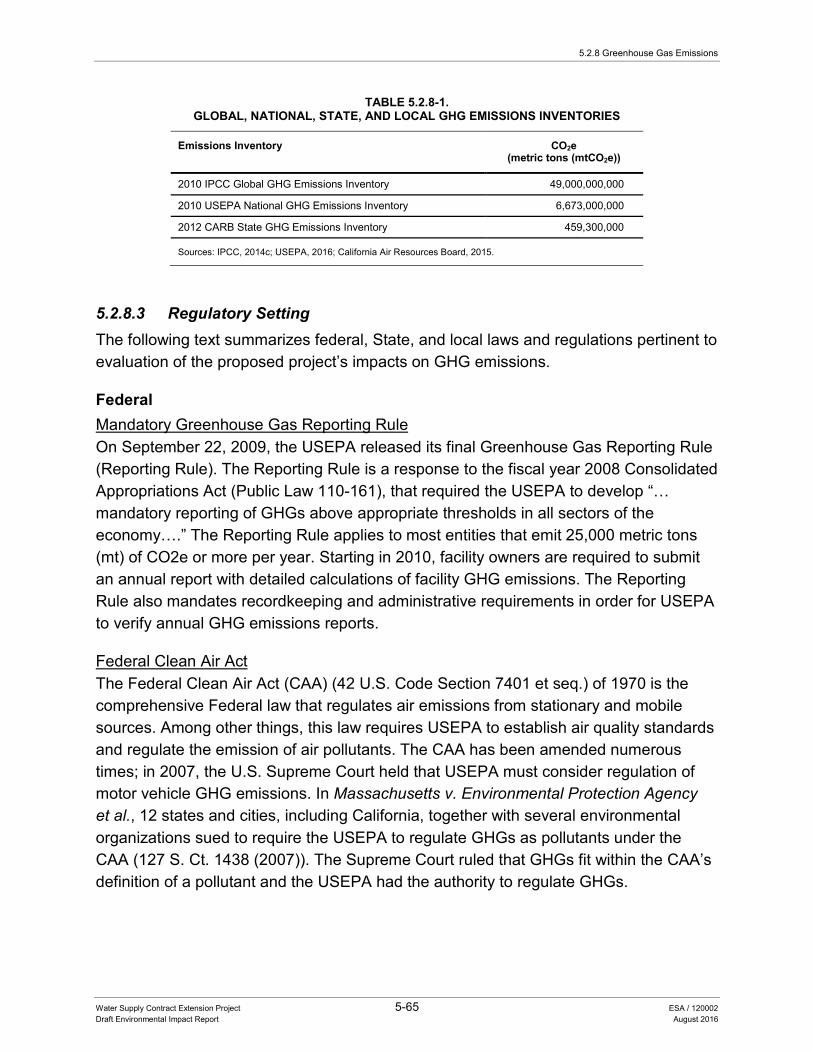
5.2.8 Greenhouse Gas Emissions
Water Supply Contract Extension Project 5-65 ESA / 120002 Draft Environmental Impact Report August 2016
TABLE 5.2.8-1. GLOBAL, NATIONAL, STATE, AND LOCAL GHG EMISSIONS INVENTORIES
Emissions Inventory CO2e (metric tons (mtCO2e))
2010 IPCC Global GHG Emissions Inventory 49,000,000,000
2010 USEPA National GHG Emissions Inventory 6,673,000,000
2012 CARB State GHG Emissions Inventory 459,300,000
Sources: IPCC, 2014c; USEPA, 2016; California Air Resources Board, 2015.
5.2.8.3 Regulatory Setting The following text summarizes federal, State, and local laws and regulations pertinent to evaluation of the proposed project’s impacts on GHG emissions.
Federal Mandatory Greenhouse Gas Reporting Rule On September 22, 2009, the USEPA released its final Greenhouse Gas Reporting Rule (Reporting Rule). The Reporting Rule is a response to the fiscal year 2008 Consolidated Appropriations Act (Public Law 110-161), that required the USEPA to develop “… mandatory reporting of GHGs above appropriate thresholds in all sectors of the economy….” The Reporting Rule applies to most entities that emit 25,000 metric tons (mt) of CO2e or more per year. Starting in 2010, facility owners are required to submit an annual report with detailed calculations of facility GHG emissions. The Reporting Rule also mandates recordkeeping and administrative requirements in order for USEPA to verify annual GHG emissions reports.
Federal Clean Air Act The Federal Clean Air Act (CAA) (42 U.S. Code Section 7401 et seq.) of 1970 is the comprehensive Federal law that regulates air emissions from stationary and mobile sources. Among other things, this law requires USEPA to establish air quality standards and regulate the emission of air pollutants. The CAA has been amended numerous times; in 2007, the U.S. Supreme Court held that USEPA must consider regulation of motor vehicle GHG emissions. In Massachusetts v. Environmental Protection Agency et al., 12 states and cities, including California, together with several environmental organizations sued to require the USEPA to regulate GHGs as pollutants under the CAA (127 S. Ct. 1438 (2007)). The Supreme Court ruled that GHGs fit within the CAA’s definition of a pollutant and the USEPA had the authority to regulate GHGs.
5. Environmental Analysis
Water Supply Contract Extension Project 5-66 ESA / 120002 Draft Environmental Impact Report August 2016
On December 7, 2009, the USEPA Administrator signed two distinct findings regarding GHGs under Section 202(a) of the CAA:
• Endangerment Finding: The current and projected concentrations of the six key GHGs—CO2, CH4, N2O, HFCs, PFCs, and SF6—in the atmosphere threaten the public health and welfare of current and future generations.
• Cause or Contribute Finding: The combined emissions of these GHGs from new motor vehicles and new motor vehicle engines contribute to the GHG pollution that threatens public health and welfare.
State The legal framework for GHG emission reduction has come about through Governors’ Executive Orders, legislation, and regulation. The major components of California’s climate change initiative are described below.
California Environmental Quality Act and Climate Change CEQA Guidelines Section 15064.4 specifically addresses the significance of GHG emissions, requiring a lead agency to make a “good-faith effort” to “describe, calculate or estimate” GHG emissions in CEQA environmental documents. Section 15064.4 further states that the analysis of GHG impacts should include consideration of: (1) the extent to which the project may increase or reduce GHG emissions; (2) whether the project emissions would exceed a locally applicable threshold of significance; and (3) the extent to which the project would comply with “regulations or requirements adopted to implement a statewide, regional, or local plan for the reduction or mitigation of GHG emissions.” The CEQA Guidelines also state that a project’s incremental contribution to a cumulative effect is not cumulatively considerable if the project will comply with the requirements in a previously approved plan or mitigation program (including plans or regulations for the reduction of GHG emissions) that provides specific requirements that will avoid or substantially lessen the cumulative problem within the geographic area in which the project is located (CEQA Guidelines Section 15064(h)(3)). The CEQA Guidelines do not, however, set a numerical threshold of significance for GHG emissions.
The CEQA Guidelines also include the direction on measures to mitigate GHG emissions, when such emissions are found to be significant (CEQA Guidelines Section 15126.4(a).)
California Clean Air Act Air quality planning programs have generally been developed in response to requirements established by the CAA of 1972 and subsequent amendments to the act; however, the enactment of the CCAA of 1988 produced additional changes in the
5.2.8 Greenhouse Gas Emissions
Water Supply Contract Extension Project 5-67 ESA / 120002 Draft Environmental Impact Report August 2016
structure and administration of air quality management programs in California. The CARB is responsible for coordinating and overseeing State and local air pollution control programs in California and for implementing the CCAA.
California Health and Safety Code Sections 42823 and 43018.5 (Assembly Bill 1493) In 2002, then-Governor Gray Davis signed AB 1493, which required CARB to develop and adopt regulations to reduce vehicle emissions in the state. To meet the requirements of AB 1493, CARB approved amendments to their regulations adding GHG emissions standards to California’s existing standards for motor vehicle emissions. This law resulted in amending Section 42823 of, and adding Section 43018.5 to, the California Health and Safety Code. The USEPA granted California a waiver under the CAA in 2009 in light of these higher state standards.
Executive Order S-3-05 In 2005, then-Governor Schwarzenegger established Executive Order S-3-05, recognizing California’s vulnerability to climate change. The Executive Order S-3-05 sets forth a series of target dates by when statewide GHG emissions would be progressively reduced: GHG emissions should be reduced to 2000 levels by 2010; 1990 levels by 2020; and 80 percent below 1990 levels by 2050. Executive Orders apply to State agencies but not to local, regional, or private entities.
Executive Order S-13-08, Adaptation to Climate Change Executive Order S-13-08, issued November 14, 2008 directs the California Natural Resources Agency (Resources Agency), Office of Planning and Research, Energy Commission, State Water Board, State Parks Department, and California’s coastal management agencies to participate in a number of planning and research activities to advance California’s ability to adapt to the impacts of climate change. The order specifically directs agencies to work with the National Academy of Sciences to initiate the first California Sea Level Rise Assessment and to review and update the assessment every 2 years after completion; immediately assess the vulnerability of California’s transportation system to sea level rise; and to develop a California Climate Change Adaptation Strategy.
Executive Order B-30-15 (Safeguarding California Plan) In 2015, Governor Brown established Executive Order B-30-15, setting forth a new interim statewide GHG emission reduction target to reduce GHG emissions to 40 percent below 1990 levels by 2030 is established in order to ensure California meets its target of reducing GHG emissions to 80 percent below 1990 levels by 2050.
5. Environmental Analysis
Water Supply Contract Extension Project 5-68 ESA / 120002 Draft Environmental Impact Report August 2016
Global Warming Solutions Act and California Public Utilities Code Chapter 3, Section 8340 (Assembly Bill 32 and Senate Bill 1368) In 2006, the California legislature passed AB 32 (California Health and Safety Code Division 25.5, Sections 38500, et seq., or AB 32), also known as the Global Warming Solutions Act. AB 32 requires CARB to design and implement feasible limits, regulations, and other measures to reduce statewide GHG emissions to 1990 levels by 2020 (representing a 25-percent reduction in emissions). AB 32 anticipates that the GHG reduction goals will be met, in part, through local government actions. The CARB has identified a GHG reduction target of 15 percent from current levels for local governments.
Pursuant to AB 32, the CARB adopted a Climate Change Scoping Plan in December 2008 (reapproved by the CARB on August 24, 2011) outlining measures to meet the 2020 GHG reduction goals.
The CARB manages a Cap-and-Trade Program, which is an integral element of meeting the goals of AB 32. The Cap-and-Trade Program is a key element of California’s climate plan and sets a statewide limit on sources responsible for 85 percent of California’s GHG emissions, and establishes a price signal needed to drive long-term investment in cleaner fuels and more efficient use of energy. The program is designed to provide covered entities the flexibility to seek out and implement the lowest-cost options to reduce emissions. The Cap-and-Trade Program began in 2013 for electricity generators and large industrial facilities emitting 25,000 mtCO2e or more annually, and in 2015 for distributors of natural gas and other fuels. DWR does not operate facilities that emit 25,000 mtCO2e or more, and is not involved with the Cap-and-Trade program.
SB 1368, which added Section 8340 to the California Public Utilities Code, is the companion bill of AB 32. SB 1368, codified in Section 8340 of Division 4.1 of the California Public Utility Code, required the CPUC to establish a GHG emission performance standard for baseload generation from investor-owned utilities. The CEC was also required to establish a similar standard for local publicly owned utilities by June 30, 2007. These standards cannot exceed the GHG emission rate from a baseload combined-cycle natural gas-fired plant. The legislation further requires that all electricity provided to California, including imported electricity, must be generated from plants that meet the standards set by the CPUC and CEC.
California Renewable Energy Resources Act, adding and amending various sections of the Fish and Game Code, PRC, and Public Utilities Code. This Act codified California’s commitment to expanding the State’s RPS to include 33 percent renewable power by
5.2.8 Greenhouse Gas Emissions
Water Supply Contract Extension Project 5-69 ESA / 120002 Draft Environmental Impact Report August 2016
2020. This RPS goal applies to all electricity retailers in the state, including publicly owned utilities, investor-owned utilities, electricity service providers, and community choice aggregators. All of these entities must adopt the goals of 20 percent of retail sales from renewables by the end of 2013 and 25 percent by the end of 2016, with the 33 percent requirement being met by the end of 2020. In 2013, Pacific Gas and Electricity (PG&E) served 23.8 percent of its retail customers with renewable energy, while Southern California Edison served its customers with 21.6 percent, and San Diego Gas & Electric with 23.6 percent (CPUC 2015).
DWR Climate Action Plan, Phase 1: Greenhouse Gas Emissions Reduction Plan DWR’s Greenhouse Gas Emissions Reduction Plan (GGERP) details DWR’s progress and future plans for reducing GHG emissions consistent with the GHG emissions reduction targets established in AB 32, Executive Order S-3-05, and department-specific policies. The GGERP also outlines DWR’s plan to monitor its progress and to reduce its emissions by over 80 percent below 1990 levels (DWR 2012).
The GGERP provides estimates of historical (going back to 1990), current, and future GHG emissions related to operations (e.g., energy use), construction (e.g., bulldozers), maintenance (e.g., flood protection facility upkeep), and business practices (e.g., DWR building-related emissions). The GGERP specifies aggressive 2020 and 2050 emission reduction goals and identifies a list of GHG emissions reduction measures that DWR will undertake to achieve these goals.
GHG emissions related to SWP operations account for 98 percent of emissions from DWR activities. The overwhelming majority of DWR GHG emissions are emitted by non-hydroelectric-generation facilities which are needed to supply energy to move water through the SWP. These facilities emit between 1.2 million and 4.1 million mtCO2e per year, with an average production of 2.4 mtCO2e per year from 2007 to 2010. Emissions related to construction represent the second largest source of GHG emissions from DWR’s activities, but are less than 2 percent of DWR’s total GHG emissions.
Chapter 12 of DWR’s GGERP outlines how individual projects can demonstrate consistency with the GGERP so that they may rely on the analysis it provides for the purposes of a CEQA cumulative GHG impacts analysis.
In addition, if implementation of the proposed project would result in additional energy demands on the SWP system of 15 gigawatt hour (GWh) per year or greater, the project must perform additional analyses with the DWR SWP Power and Risk Office. From these analyses, DWR will determine any additional necessary steps beyond those identified in the GGERP to achieve its emissions reduction goals.
5. Environmental Analysis
Water Supply Contract Extension Project 5-70 ESA / 120002 Draft Environmental Impact Report August 2016
Local Enforcement of the CAA through permitting of all air pollution and emissions from stationary sources (non-vehicular sources) rests primarily with the local and regional APCDs or AQMDs. These local air districts issue permits for construction and operations of facilities.
Generally, State agencies involved with the location or construction of facilities for the production, generation, storage, treatment, or transmission of water are not subject to local regulations. Inconsistency with local land use regulation is not in and of itself considered an adverse effect on the environment. The SWP study area covers multiple counties with multiple cities throughout California. Each of these counties and cities has General Plans with unique goals and policies that address GHG emissions, including Climate Action Plans.
5.2.8.4 Impacts Analysis Methods of Analysis The geographic scope of potential cumulative GHG impacts encompasses the numerous local air districts and county jurisdictional areas and statewide, national, and international boundaries. However, for purposes of practicality and reasonableness (see CEQA Guidelines Section 15130(b)), this analysis focuses on the State as a reasonable geographic boundary, including considerations related to effects on the attainment of State global climate change policies.
The temporal scope of the proposed project includes long-term SWP contract extension (to 2085). GHG emission-related impacts are cumulative impacts by nature; therefore, a project-specific evaluation cannot determine the level of potential impact (CAPCOA 2008). Thus, the analysis and conclusions provided below consider the cumulative effects of GHG emissions. Overall, the approach to evaluate project-level cumulative GHG emissions should be consistent with the GGERP.
Standards of Significance Based on Appendix G of the CEQA Guidelines, an impact is considered significant if implementation of the proposed project would:
• Generate GHG emissions, either directly or indirectly, that may have a significant impact on the environment.
• Conflict with an applicable plan, policy, or regulation adopted for the purpose of reducing the emissions of GHG.
5.2.8 Greenhouse Gas Emissions
Water Supply Contract Extension Project 5-71 ESA / 120002 Draft Environmental Impact Report August 2016
Impacts and Mitigation Measures The proposed project would amend and add financial provisions of the current Contracts based on the negotiated AIP between DWR and the Contractors. The proposed project would not create new water management measures, alter the existing authority to build new or modify existing facilities, or change water allocation provisions of the current Contracts. Further, the proposed project would not result in changes to the O&M of SWP. Under the GGERP, DWR has established department-wide GHG emissions goals and identified activities to meet those goals, which are consistent with AB 32 and subsequent related state laws and regulations. DWR has also developed procedures to determine a proposed project’s consistency with the GGERP. The proposed project would be considered not likely to create significant impacts or conflicts to the goals and objectives established through AB 32 and subsequent related state law and regulations, if all potential impacts can be managed and mitigated through procedures and protocols established in the GGERP.
Based on the above rationale, the proposed project would be considered to have a significant impact if it would conflict with state’s goals for reducing GHG emissions through AB 32 and associated law and regulations. It is anticipated that AB 32 would be successful in reducing GHG emissions and reducing the cumulative GHG emissions statewide by 2020. It is important that the state has taken these measures, including DWR’s GGERP and applicable local plans, because no individual project could have a major impact (either positively or negatively) on the global concentration of GHGs.
Because the quantities and timing of water conveyed by the SWP would not be changed, there would be no change in associated energy consumption or generation attributable to the proposed project. In addition, there would be no increase in energy use compared to existing conditions because no new or modified SWP facilities would be constructed. Therefore, the associated GHG emissions would not change compared to existing conditions and would be covered by the GGERP, including the plan and actions to reduce the current GHG emission level to the established target. Importantly, the proposed project would result in greater financial certainty for future investments, such as investments in GHG reduction technologies and projects. In addition, because there would be no change in GHG emissions implementation of the proposed project would not result in a significant impact on the environment and/or conflict with applicable plans, policies or regulations adopted to reduce GHG emissions.
Therefore, no impacts would occur related to GHG emissions and no mitigation measures are required.

5. Environmental Analysis
Water Supply Contract Extension Project 5-72 ESA / 120002 Draft Environmental Impact Report August 2016
5.2.8.5 References California Air Resources Board. 2015. California Greenhouse Gas Emission Inventory –
2015 Edition. Accessed: May 22, 2016. Available: www.arb.ca.gov/cc/inventory/data/data.htm.
CAPCOA (California Air Pollution Control Officers Association). 2008. CEQA and Climate Change: Evaluating and Addressing Greenhouse Gas Emissions from Projects Subject to the California Environmental Quality Act. January 2008.
CEPA (California Environmental Protection Agency). 2013. Indicators of Climate Change in California. Office of Environmental Health Hazard Assessment. August 2013.
CPUC (California Public Utilities Commission). 2015. California Renewables Portfolio Standard. April 6, 2015. Available: www.cpuc.ca.gov/PUC/energy/Renewables/. Accessed April 10, 2015.
DWR (California Department of Water Resources). 2008. Managing an Uncertain Future: Climate Change Adaptation Strategies for California’s Water. Accessed April 14, 2015. Available: www.water.ca.gov/climatechange/docs/ClimateChangeWhitePaper.pdf.
———. 2012. Final Climate Action Plan Phase I: Greenhouse Gas Emissions Reduction Plan. Sacramento, CA. May 2012.
IPCC (Intergovernmental Panel on Climate Change). 2014a. Climate Change 2013: Physical Science Basis, Summary for Policy Makers. Working Group I Contribution to the Fifth Assessment Report of the Intergovernmental Panel on Climate Change. January 2014.
———. 2014b. Climate Change 2013: Physical Science Basis, Technical Summary. Working Group I Contribution to the Fifth Assessment Report of the Intergovernmental Panel on Climate Change. January 2013.
———. 2014c. Climate Change 2014: Mitigation of Climate Change, Summary for Policy Makers. Working Group III Contribution to the Fifth Assessment Report of the Intergovernmental Panel on Climate Change. April 2014.
Moser, S.; Franco, G.; Pittiglio, S.; Chou, W.; Cayan, D. (Moser et al.). 2009. The Future is Now: An Update on Climate Change Science Impacts and Response Option for California. California Energy Commission Public Interest Energy Research Program, California Climate Change Center. CEC-500-2008-071.
USEPA (U.S. Environmental Protection Agency). 2016. Inventory of U.S. Greenhouse Gas Emissions and Sinks: 1990-2014. Available: www3.epa.gov/climatechange/Downloads/ghgemissions/US-GHG-Inventory-2016-Main-Text.pdf. Accessed December 24, 2015.
5.2.9 Groundwater Hydrology and Water Quality
Water Supply Contract Extension Project 5-73 ESA / 120002 Draft Environmental Impact Report August 2016
5.2.9 Groundwater Hydrology and Water Quality
5.2.9.1 Introduction This section describes the environmental and regulatory settings and potential impacts associated with groundwater, including supply and quality. Comments were received in response to the NOP on the groundwater-related topic of subsidence. Specifically, comments stated that subsidence has led to reduced conveyance capacity in the Delta-Mendota Canal, California Aqueduct, and other canals that deliver agricultural water. One commenter suggested that SWP allocations below full contract amounts lead contractors to increase groundwater extraction in order to meet demands, resulting in subsidence. Subsidence is addressed in this section and Sections. 5.2.7, Geology, Soils, and Mineral Resources, and 5.2.18 Water Supply.
5.2.9.2 Environmental Setting The proposed project geographic setting encompasses the SWP facilities and Contractor service areas. Groundwater basins within these areas are located within portions of the Sacramento River, San Joaquin River, Tulare Lake, San Francisco Bay Area, Central Coast, Colorado River, and Lahontan hydrologic regions. More than 70 percent of California’s groundwater extraction occurs in the Central Valley from Tulare Lake, San Joaquin River, and Sacramento River hydrologic regions combined; therefore, these hydrologic regions are described in greater detail than the other regions in the following sections. Information specific to groundwater resources includes groundwater levels and budget and groundwater quality (DWR 2003).
Sacramento River Hydrologic Region Regional Hydrogeology Groundwater resources in the Sacramento River Hydrologic Region are supplied by both alluvial and fractured rock aquifers. Groundwater resources within the Sacramento River Hydrologic Region are primarily associated with alluvial aquifers within the Great Valley Geomorphic Province in California. Alluvial aquifers are composed of sand and gravel or finer grained sediments, with groundwater stored within the voids, or pore space, between the alluvial sediments.
The majority of the groundwater within the Sacramento River Hydrologic Region is stored in alluvial aquifers within 88 alluvial groundwater basins and subbasins recognized in Bulletin 118: California’s Groundwater (DWR 2003). The largest and most heavily used basins are within the Sacramento Valley Groundwater Basin. Within this basin, the North American, Colusa, Solano, Yolo and East Butte subbasins account for 52 percent of the average 2.7 million acre-feet (maf) of groundwater pumped annually during the 2005–2010 period.
5. Environmental Analysis
Water Supply Contract Extension Project 5-74 ESA / 120002 Draft Environmental Impact Report August 2016
Fractured-rock aquifers consist of impermeable granitic, metamorphic, volcanic, and hard sedimentary rocks, with groundwater being stored within cracks, fractures, or other void spaces. Fractured-rock aquifers supply a small portion of the groundwater within the Sacramento River Hydrologic Region, which is generally found in the mountainous area of the hydrologic region between the edge of the alluvial groundwater basin and the foothill areas, and into the surrounding mountains.
Groundwater-Surface Water Interaction Groundwater resources in the Sacramento River Hydrologic Region are influenced by surface waters in this hydrologic region as sources of recharge or as bodies receiving groundwater inflow. Rivers that bring water from the upland mountainous areas in the form of snowpack spring melt provide a source for recharge to groundwater basins in the alluvial basins of the Central Valley. Groundwater modeling studies of the Sacramento Valley suggest that, on average, the flux of groundwater discharging to the rivers is approximately equal to the quantity of water that leaks from streams to recharge the aquifer system (Glenn Colusa Irrigation District and the Natural Heritage Institute 2010).
In areas with a shallow groundwater table, rivers can receive groundwater inflow, which may contribute to providing a cooling effect to local river water. The Sacramento and Feather rivers on the valley floor are gaining (water from groundwater enters the rivers) throughout most of the year, except in areas of depressed groundwater levels, where the water table has been artificially lowered through groundwater pumping. In these areas, the rivers are losing (water leaves the rivers and recharges the groundwater system) (Reclamation et al. 2013).
Rivers drain the Coast Ranges and the Sierra Nevada, bringing water into the Central Valley and converging at the confluence of the Sacramento and San Joaquin Rivers; the Bay-Delta. These rivers are almost exclusively losing streams in their upper reaches, but transition to gaining streams farther downstream near their confluences with the Sacramento River. In addition to the Sacramento River, the Sacramento Valley has several major creeks that drain the valley including Stony, Cache, Putah, and numerous other west side tributary creeks that flow to the Sacramento River (Reclamation et al. 2013).
Regional Groundwater Production Between 2005 and 2010 the average annual extraction volume within the Sacramento River Hydrologic Region was approximately 2.7 maf. This accounts for approximately 17 percent of all the groundwater extraction in California (DWR 2013). Groundwater contributes about 31 percent of the total water supply within this region; with extraction
5.2.9 Groundwater Hydrology and Water Quality
Water Supply Contract Extension Project 5-75 ESA / 120002 Draft Environmental Impact Report August 2016
of 2.4 maf to meet approximately one-third of agricultural demands and extraction of approximately 465 thousand acre-feet (taf) to meet half of the urban water demand (DWR 2013).
Groundwater Quality Regional and statewide groundwater quality monitoring information and data are available on the State Water Board Groundwater Ambient Monitoring and Assessment (GAMA) web site and the GeoTracker GAMA groundwater information system developed as part of the Groundwater Quality Monitoring Act of 2001. Primary constituents of concern in the hydrologic region include arsenic, boron, localized contamination by organic compounds and nitrates, and chromium 6 (DWR 2013).
High concentrations of arsenic are found in wells along the Sacramento and Feather rivers. Boron has been detected at concentrations greater than the non-regulatory human-health notification levels of 1,000 micrograms per liter (µg/L) in several aquifers located within southern and middle parts of the Sacramento Valley from wells located along Cache and Putah creeks. The solvent tetrachloroethylene (PCE) has been detected in some public supply wells in Butte and Sacramento counties at concentrations that exceed the maximum contaminant level (MCL) or drinking water standards. Nitrate levels in most public water supply wells in the region are below drinking water standards, but some wells in the Sacramento River Hydrologic Region have occasionally exceeded the nitrate MCL. Additional areas in the Sacramento River Hydrologic Region that have high nitrate levels include Chico and the Antelope area of Red Bluff. Chromium-6 has been detected at concentrations above the detection limit (above 1 µg/L) in many active and standby public wells along the west or valley portion of the Sacramento Valley (DWR 2013).
Land Subsidence Subsidence in California is occurring because of: (1) aquifer compaction caused by pumping-related reduction of groundwater levels; (2) compaction and disappearance of soils with high organic content due to development (Reclamation 1997); (3) recent (Quaternary) tectonic activity; and (4) subsidence due to collapsible near-surface soils. This discussion focuses on subsidence due to aquifer compaction.
In the Sacramento River Hydrologic Region, land subsidence associated with groundwater withdrawal was observed in the early part of the twentieth century in Yolo County (Ikehara 1995), and has since been documented in the North American subbasin as well. Between 1925 and 1977, land in the area of Zamora and Knights Landing in Yolo County sank by as much as 6 feet. Subsidence slowed until the drought
5. Environmental Analysis
Water Supply Contract Extension Project 5-76 ESA / 120002 Draft Environmental Impact Report August 2016
of 1978-1993, which led to increased groundwater pumping and associated subsidence (Water Education Foundation 2015).
DWR has established a Sacramento Valley subsidence monitoring network that has shown land subsidence in some areas. Land subsidence had exceeded 1 foot by 1973 in two areas in the southwestern part of the valley near Davis and Zamora (DWR 2003). The Zamora site has been monitored since 1992 and shows a total land displacement of over 1 foot with an average subsidence of 0.05 feet per year (DWR 2013).
San Joaquin River Hydrologic Region Regional Hydrogeology Groundwater resources in the San Joaquin River Hydrologic Region are primarily associated with alluvial aquifers within the Great Valley Geomorphic Province in California. Other geomorphic provinces in the region primarily associated with fractured rock aquifers include the Sierra Nevada to the east and the Coast Ranges to the west.
The majority of the groundwater within the San Joaquin River Hydrologic Region is stored in alluvial aquifers within 11 groundwater basins and subbasins recognized in Bulletin 118 (DWR 2003). The most heavily used subbasins within the San Joaquin Valley Groundwater Basin include Eastern San Joaquin, Modesto, Turlock, Merced, Chowchilla, Madera, and Delta-Mendota, which account for more than 90 percent of the average 3.2 maf of groundwater pumped annually during the 2005 through 2010 period.
Fractured-rock aquifers in the San Joaquin River Hydrologic Region typically supply individual domestic and stock wells, or small community water systems. These fractured-rock aquifers are typically found in the mountain and foothill areas adjacent to the Cosumnes, Eastern San Joaquin, Modesto, Turlock, Merced, and Madera groundwater basins (DWR 2013).
Groundwater-Surface Water Interaction In the San Joaquin Valley groundwater basin, long-term groundwater production throughout this basin has lowered groundwater levels beyond what natural recharge can replenish. Groundwater pumping and recharge from imported irrigation water have resulted in a change in regional groundwater flow patterns. Flow largely occurs from areas of recharge toward areas of lower groundwater levels caused by groundwater pumping (Bertoldi et al. 1991). As previously mentioned, most rivers draining the Coast Ranges and the Sierra Nevada into the Central Valley are losing streams that recharge groundwater; this is the case in most of the San Joaquin River. In downstream portions of the San Joaquin River as it enters the Bay-Delta, groundwater levels are shallower and groundwater discharges into the river (Reclamation et al. 2013).
5.2.9 Groundwater Hydrology and Water Quality
Water Supply Contract Extension Project 5-77 ESA / 120002 Draft Environmental Impact Report August 2016
Regional Groundwater Production Groundwater within the San Joaquin River Hydrologic Region is used for agricultural, urban and for managed wetlands. Approximately 81 percent of the region’s groundwater extraction supports agricultural needs and 13 percent supports urban needs. The remaining 6 percent of the groundwater use in the region is used to support managed wetlands in the region. Groundwater use in the San Joaquin River Hydrologic Region increased during the 2007 through 2009 drought as a result of reduced surface water supplies in the region. Agricultural groundwater use was estimated to be approximately 1.6 maf in 2005 and increased to more than 3.2 maf by 2009. Groundwater accounted for approximately 38 percent of the estimated average annual total water supply for the region from 2005 through 2010 (DWR 2013).
Groundwater Quality Regional and statewide groundwater quality monitoring information and data are available on the State Water Board GAMA web site and the GeoTracker GAMA groundwater information system developed as part of the Groundwater Quality Monitoring Act of 2001. Groundwater quality in the San Joaquin River Hydrologic Region varies considerably. Within the San Joaquin Valley Groundwater Basin, groundwater quality is generally suitable for most urban and agricultural uses (DWR 2003). Primary constituents of concern in the hydrologic region include salinity, nitrate, arsenic, gross alpha particle activity and uranium, chromium 6, and localized contamination by PCE and trichloroethylene (TCE) (DWR 2013).
Salinity management has been a long-term water quality issue in the San Joaquin River Hydrologic Region. Water applied in the western part of the San Joaquin Groundwater Basin for crop irrigation and wetland management via federal, State, and local water projects causes salts in the soil to be leached out of the soil (DWR 2013). Salt is purposefully leached below the root zone to maintain salt balance in the root zone, such that most leached salt ends up in the groundwater (Reclamation et al. 2013). Nitrate concentrations in 24 percent (21 of 88) of the domestic wells sampled from 1993 through 1995 in the regional aquifer survey and land-use studies of the eastern San Joaquin Valley exceeded the drinking-water standard of 10 µg/L established by the USEPA (DWR 2013). Concentrations of nitrate and pesticides in the shallow part of the aquifer system at depths of domestic wells in the study area have increased over time due to continued contributions of recharge water containing these constituents. Concentrations of nitrates and pesticides in the shallow part of the aquifer are likely to move to deeper parts of the groundwater flow system (Burow et al. 2004). Arsenic is generally considered naturally occurring and has been detected in raw and untreated

5. Environmental Analysis
Water Supply Contract Extension Project 5-78 ESA / 120002 Draft Environmental Impact Report August 2016
water from public supply wells in the eastern portion of the valley floor and in the foothills of Madera County with levels that exceed the MCL (DWR 2013).
Land Subsidence Land subsidence in the San Joaquin River Hydrologic Region was first noted near the Delano area in 1935 (Galloway et al. 1999). Since that time, the San Joaquin Valley has undergone several periods of regional aquifer compaction as a result of groundwater extraction, largely for agricultural uses. In the late 1960s and early 1970s, surface water was imported via canals, and the California Aqueduct began importing supplies to the subsiding areas, reducing groundwater pumping and reducing new land subsidence in the western and southern portions of the San Joaquin Valley Groundwater Basin (Ireland 1986). By 1981, subsidence reached nearly 30 feet by 1981, the greatest subsidence recorded in the United States (Bertoldi et al. 1991). Drought conditions during 1976 and 1977 and from 1987 to 1992, and drought conditions combined with regulatory restrictions from 2007 to 2010, resulted in high groundwater pumping rates, inducing land subsidence. Significant land subsidence was detected again in the San Joaquin Valley Groundwater Basin due to increased groundwater pumping, affecting capacity of the Mendota Dam and Sack Dam, California Aqueduct, and even the San Joaquin River (Sneed et al. 2013).
Various programs are under way in the San Joaquin River Hydrologic Region to monitor land subsidence, including California Aqueduct elevation surveys, seven active monitoring sites, Caltrans Highway 152 elevation monitoring and groundwater level monitoring and subsidence (DWR 2013). A USGS study published in 2013 examined data for the period from 2003 to 2010 and found a large area of subsidence centered south of the town of El Nido (Sneed et al. 2013). The feature, defined by the area experiencing 0.06 feet (20 millimeters) or more of subsidence, extended 50 miles east to west (from Check 17 on the Delta-Mendota Canal to the town of Madera) and 25 miles north to south (from near Merced to near Mendota). According to the study, a maximum 1.77 feet of subsidence was observed during 2008 to 2010.
Tulare Lake Hydrologic Region Regional Hydrogeology Groundwater resources in the Tulare Lake Hydrologic Region are primarily associated with alluvial aquifers within the Great Valley Geomorphic Province in California. Other geomorphic provinces in the region primarily associated with fractured rock aquifers include the Sierra Nevada to the east and the Coast Ranges to the west.
The majority of the groundwater within the Tulare Lake Hydrologic Region is stored in alluvial aquifers within seven subbasins in the San Joaquin Valley Groundwater Basin
5.2.9 Groundwater Hydrology and Water Quality
Water Supply Contract Extension Project 5-79 ESA / 120002 Draft Environmental Impact Report August 2016
and 12 subbasins outside the San Joaquin Valley Groundwater Basin recognized in Bulletin 118 (DWR 2003). The aquifer system of the San Joaquin Valley Groundwater Basin consists of younger and older alluvium, flood-basin deposits, lacustrine and marsh deposits and unconsolidated continental deposits. These deposits form an unconfined to semi-confined upper aquifer and a confined lower aquifer in most parts of the Basin. The aquifers are separated by the Corcoran Clay (E-Clay) member of the Tulare Formation, which occurs at depths between 200 and 850 feet along the central and western portion of the basin. Fine-grained lacustrine deposits can be up to 3,600 feet thick in the Tulare Lake region. The most heavily used subbasins within the San Joaquin River Hydrologic Region include Kings, Westside, Kaweah, Tulare Lake, Tule, and Kern County, which account for approximately 98 percent of the average 6.8 maf of groundwater pumped annually during the 2005–2010 period (DWR 2013).
Fractured-rock aquifers in the Tulare Lake Hydrologic Region are typically found in the mountain and foothill areas adjacent to the alluvial groundwater basins. Information related to fractured-rock aquifers in the Tulare Lake Hydrologic Region was not developed as part of DWR’s California Water Plan Update (DWR 2013).
Groundwater-Surface Water Interaction For much of the Tulare Lake Hydrologic Region, due to extensive groundwater pumping over the years the groundwater table has been disconnected from the surface water system for decades and provides no contribution to surface flow (DWR 2013).
Regional Groundwater Production The Tulare Lake Hydrologic Region meets about 50 percent of its local uses with groundwater extraction, with almost 90 percent used to meet agricultural demand and over 9 percent to meet urban demand. Approximately one-half percent of the groundwater supply is used to meet managed wetland demand. Groundwater is used conjunctively with surface water when those supplies are not sufficient to meet the region’s demand for agricultural, municipal, and industrial uses (DWR 2003). During critically dry periods such as 2009, groundwater supplies account for almost 69 percent of the applied water demand for agricultural use (DWR 2013). The estimated average annual total water supply for the region from 2005 to 2010 was 11.7 maf, with 6.2 maf made up from groundwater supplies (DWR 2013).
Groundwater Quality Similar to the San Joaquin River Hydrologic Region, groundwater quality in the Tulare Lake Hydrologic Region varies considerably throughout the area, but in general, is suitable for most urban and agricultural uses (DWR 2003). Primary constituents of concern on a regional level include: total dissolved solids (TDS), boron, nitrates,
5. Environmental Analysis
Water Supply Contract Extension Project 5-80 ESA / 120002 Draft Environmental Impact Report August 2016
arsenic, selenium, 1,2-dibromo-3-chloropropane, radon, and uranium. The GAMA program data are currently available for the Southeast San Joaquin Valley and the Kern County Subbasin study areas in the Tulare Lake Hydrologic Region (Burton and Belitz 2008, Shelton et al. 2008).
Land Subsidence The relationship between groundwater extraction and subsidence is not as strong in the Tulare Lake Hydrologic Region as it is in the San Joaquin River Hydrologic Region, likely due to differences in aquifer sediments and applied stresses in the regions. However despite these differences, subsidence trends in the Tulare Lake Hydrologic Region mirror those of the San Joaquin River Hydrologic Region, with increased subsidence during drought periods. The area of subsidence within this region can be described as two separate areas, the Arvin-Maricopa and the Tulare-Wasco areas. The Arvin-Maricopa area is 700 square miles, and is located 20 miles south of Bakersfield, mostly in Kern County. Two confining beds, the A-clay and the C-clay, underlie the area; the C-clay is the more extensive of the two beds. Maximum land subsidence in the Arvin-Maricopa area exceeds nine feet, parts of which were influenced by oil and gas withdrawal and near-surface hydrocompaction. In the Tulare-Wasco area between Fresno and Bakersfield, land subsidence exceeded 12 feet between 1926 and 1970 (Williamson et al. 1989).
San Francisco Bay Area Hydrologic Region The San Francisco Bay Area Hydrologic Region includes 33 groundwater basins, as defined by DWR (DWR 2003). The most heavily used basins which receive imported water from the Bay-Delta include the Santa Clara Valley, Napa Valley, and Livermore Valley groundwater basins. Santa Clara Water District water supplies include SWP water via the South Bay Aqueduct, CVP water via the San Felipe Division of the CVP, and water from San Francisco Public Utility Commission’s (SFPUC) Hetch Hetchy System (Reclamation et al. 2013).
While the water demand within the San Francisco Bay Area Hydrologic Region is served with imported water from Sierra Nevada and the Bay-Delta sources through various State, federal, and local projects, groundwater remains an important component of the overall water supply portfolio for agencies in the region to offset the variability of imported water. The estimated average annual total water supply from 2005 through 2010 was 1.285 maf. Groundwater accounts for only 21 percent of the region’s total water supply (approximately 260 taf), with 71 percent of groundwater supplies used to meet urban demand and 29 percent used to meet for agricultural demand (DWR 2013). The South Bay planning area is a large user of groundwater in the region, with an
5.2.9 Groundwater Hydrology and Water Quality
Water Supply Contract Extension Project 5-81 ESA / 120002 Draft Environmental Impact Report August 2016
annual average demand of 181 taf or 70 percent of the total groundwater supply in the region (DWR 2013).
Central Coast Hydrologic Region The Central Coast Hydrologic Region contains 60 alluvial groundwater basins and subbasins as recognized by DWR (DWR 2003). The most heavily used groundwater basins in the region are the Salinas Valley, Pajaro Valley, Gilroy-Hollister Valley, Santa Maria Valley, and the Santa Barbara groundwater basins.
The Central Coast Hydrologic Region has the most reliance of all hydrologic regions in the State on groundwater to meet its local uses, with more than 80 percent of its water use supplied by groundwater in an average year (Reclamation et al. 2013). The estimated average annual total water supply for the Central Coast Hydrologic Region from 2005 through 2010 was 1.3 maf, of which 1.1 maf was met with groundwater supplies (DWR 2013).
Southern California Region (South Coast, Colorado River, and South Lahontan Hydrologic Regions) The South Coast Hydrologic Region contains 73 alluvial groundwater basins and subbasins as recognized by DWR (DWR 2003). The most heavily used groundwater basins in the region are the Coastal Plain of Los Angeles, Coastal Plain of Orange County, the Upper Santa Ana Valley, and the Santa Clara River Valley groundwater basins.
The South Lahontan Hydrologic Region contains 77 alluvial groundwater basins and 2 subbasins. The most heavily used groundwater basin in the region is the Antelope Valley Groundwater Basin, which is bordered by the Garlock Fault Zone and the Tehachapi Mountains to the northwest and the San Andreas Fault Zone and the San Gabriel Mountains to the southwest (DWR 2013).
The Colorado River Hydrologic Region contains 64 alluvial groundwater basins and subbasins. The most heavily used groundwater basins in the region include Borrego Valley, Warren Valley, Lucerne Valley, and Coachella Valley groundwater basins (DWR 2013).
Groundwater makes up approximately 34 percent of total water supply in the South Coast Hydrologic Region. Approximately 76 percent of the groundwater supplies in the South Coast Hydrologic Region are used to meet urban demand while the rest is used to meet agricultural demand (DWR 2013). The estimated average annual total water supply for the South Coast Hydrologic Region from 2005 through 2010 was 4.7 maf, of
5. Environmental Analysis
Water Supply Contract Extension Project 5-82 ESA / 120002 Draft Environmental Impact Report August 2016
which 1.6 maf was met with groundwater supplies. Metropolitan Los Angeles and Santa Ana planning areas account for approximately 40 percent of the South Coast Hydrologic Region’s total groundwater supply for the region, with an average annual groundwater use of 637 and 623 taf, respectively (DWR 2013).
Groundwater makes up approximately two-thirds of the South Lahontan Hydrologic Region’s total water supply, with approximately 61 percent used to meet agricultural demand and 39 percent used to meet urban demand. The estimated average annual total water supply for the South Lahontan Hydrologic Region from 2005 through 2010 was 668 taf, of which 441 taf was met with groundwater supplies.
Groundwater supplies less than 10 percent of the Colorado River Hydrologic Region’s total water supply, with approximately 87 percent used to meet urban use and 13 percent to meet agricultural use. The estimated average annual 2005–2010 total water supply for the region was about 4.27 maf, of which 380 taf was met with groundwater supplies (DWR 2013).
5.2.9.3 Regulatory Setting The following text summarizes federal, State, and local laws and regulations pertinent to evaluation of the proposed project’s impacts on groundwater resources.
Federal Clean Water Act The CWA is the major Federal legislation governing the water quality for surface water, which in turn can affect groundwater quality. The CWA is described further in Section 5.2.3, Biological Resources.
Safe Drinking Water Act The Safe Drinking Water Act (SDWA) was passed by Congress in 1974, and amended in 1986 and 1996, to protect public health by regulating the nation’s public drinking-water supply. The SDWA requires many actions to protect drinking water and its sources: rivers, lakes, reservoirs, springs, and groundwater wells. The law authorizes the USEPA to set national health-based standards for drinking water to protect against both naturally occurring and human-made contaminants that may be found in drinking water. Drinking water standards that include MCL and treatment requirements are set for approximately 90 contaminants in drinking water. Water suppliers may not provide water that does not meet these standards. Every state must assess its sources of drinking water to identify important potential sources of contamination and determine the susceptibility of the sources to these threats.
5.2.9 Groundwater Hydrology and Water Quality
Water Supply Contract Extension Project 5-83 ESA / 120002 Draft Environmental Impact Report August 2016
State Water Rights The State Watermaster Program’s main purpose is to ensure that water is allocated according to established water rights (riparian or appropriative), or as determined by court adjudications or agreements by an unbiased, qualified person, thereby reducing court litigation, civil lawsuits, and enforcement workload. Some groundwater rights in California have been settled by the courts after landowners or other parties have appealed to the courts to settle disputes over how much groundwater can rightfully be extracted. In these “adjudicated groundwater basins,” the courts have determined an equitable distribution of water that will be available for extraction each year. In adjudicated groundwater basins, the courts typically appoint a watermaster to administer the court judgment. Counties have also enacted laws to prevent wells developed on one property from interfering with the use of adjacent wells.
Area-of-Origin Statute Limitations Section 1220 of the California Water Code prohibits pumping groundwater for export from within the combined Sacramento and Delta–Central Sierra basins, as defined in DWR Bulletin 160-74, unless the pumping complies with a groundwater management plan that is adopted by ordinance.
Groundwater Quality and Supply The State requires counties to enact regulations covering well design to protect groundwater quality from surface contamination, and to properly construct and develop wells for domestic use. The Groundwater Management Act provides a systematic procedure for groundwater management planning at the county and city levels.
Sustainable Groundwater Management Act The 2014 Sustainable Groundwater Management Act (SGMA) builds upon the historical and non-regulatory groundwater management framework of legislative bills AB 3030 (1992), SB 1938 (2002), and AB 359 (2011). Under the SGMA, DWR is responsible for (1) developing regulations related to local agency requests to modify groundwater basin boundaries; (2) adopting regulations for evaluating and implementing Groundwater Sustainability Plans (GSPs) and coordination agreements; (3) identifying basins subject to critical conditions of overdraft; (4) identifying water available for groundwater replenishment; and (5) publishing best management practices for the sustainable management of groundwater.
The Act gives the local agency the authority to develop a Groundwater Management Plan (GMP) in groundwater basins defined in DWR Bulletin 118, and to raise revenue to pay for facilities to manage the basin (extraction, recharge, conveyance, quality [DWR

5. Environmental Analysis
Water Supply Contract Extension Project 5-84 ESA / 120002 Draft Environmental Impact Report August 2016
1975]). The intent of the Act is to encourage local agencies to work cooperatively to manage groundwater resources within their jurisdictions and to provide a methodology for developing a GMP. GSPs developed in compliance with SGMA will consist of similar technical components.
The SGMA requires the formation of Groundwater Sustainability Agencies (GSAs) which must develop GSPs in the groundwater basins (or subbasins) that were designated by DWR as medium or high priority. Final Basin Prioritization findings indicate that 127 of California's 515 groundwater basins and subbasins are High and Medium priority. These basins account for 96 percent of California's annual groundwater pumping and supply 88 percent of the population which resides over groundwater basins. There are 117 groundwater basins designated as high or medium priority in the SWP study area, with 35 in the South Coast Hydrologic Region (DWR 2015).
Assembly Bills 91 and 92 In March 2015, in response to the fourth consecutive year of extreme drought in California, the California Legislature adopted two appropriations bills (AB 91 and SB 75) and two policy trailer bills (AB 92 and SB 76). As described in more detail in Section 5.2.18, Water Supply, this legislation includes monitoring and mitigation for drought conditions and continued evaluation of groundwater conditions by DWR.
Local Generally, State agencies involved with the location or construction of facilities for the production, generation, storage, treatment, or transmission of water are not subject to local regulations. Inconsistency with local land use regulation is not in and of itself considered an adverse effect on the environment. The SWP study area covers multiple counties with multiple cities throughout California. Each of these counties and cities has local regulations and General Plans with unique goals and policies that address groundwater quantity and quality.
In addition, more than 100 GMPs have been developed, implemented, and updated under the Groundwater Management Acts, described above within the study area. GMPs and the GSA developed by Contractors are shown in Table 5.2.9-1. Projects implemented in areas covered by GMPs, or within areas to be addressed by GSPs, should be consistent with those plans. The GMPs were developed under SB 1938 (Groundwater Management Act of 2002). Under SB 1938, local agencies developing GMPs under certain provisions of law or seeking state funds for groundwater projects or groundwater quality projects were required to include in those plans certain basin management objectives, adopt certain monitoring protocols, and use sound geologic and hydrogeologic practices to effectively manage groundwater in the relevant

5.2.9 Groundwater Hydrology and Water Quality
Water Supply Contract Extension Project 5-85 ESA / 120002 Draft Environmental Impact Report August 2016
management area. In addition to the GMPs, GSAs will be formed to address all of the groundwater basins and subbasins.
TABLE 5.2.9-1. GROUNDWATER MANAGEMENT PLANS AND GROUNDWATER SUSTAINABILITY AGENCIES WITHIN THE
STUDY AREA
GMP or
GSP Agency Name
Hydrologic Region in Which Agency is
Located Web Site Where GMP or GSA Notification may be Accessed
GMP
Castaic Lake Water Agency South Coast www.water.ca.gov/groundwater/docs/GWMP/SC-1_CastaicLakeWA_GWMP_2003.pdf
Coachella Valley Water District Colorado River www.water.ca.gov/groundwater/docs/GWMP/CR-
3_CoachellaValley_WMPUpdateDRAFT_2010.pdf
County of Butte Sacramento River www.water.ca.gov/groundwater/docs/GWMP/SR-3_ButteCounty_GWMP_2004.pdf
County of Kings Tulare Lake www.water.ca.gov/groundwater/docs/GWMP/TL-13_KingsCountyWD_GWMP_2011.pdf
Mojave Water Agency South Lahontan www.water.ca.gov/groundwater/docs/GWMP/SL-4_MojaveWARegionalWMP_2004.pdf
Santa Clara Valley Water District San Francisco Bay www.water.ca.gov/groundwater/docs/GWMP/SF-
1_SantaClaraValleyWD_GWMP_2012.pdf
Tulare Lake Basin Water Storage District Tulare Lake www.water.ca.gov/groundwater/docs/GWMP/TL-
23_TulareLakeBedCoordinated_GWMP_2012.pdf
Zone 7 Water Agency San Francisco Bay www.water.ca.gov/groundwater/docs/GWMP/SF-3_Zone7_Livermore-AmadorValleyGWBasin_GWMP_2005.pdf
GSA County of Ventura South Coast www.water.ca.gov/groundwater/sgm/gsa_notification/010-County_of_Ventura_GSA_2015-05-11.pdf
NOTES: GMP = Groundwater Management Plan; GSA = Groundwater Sustainability Agency
5.2.9.4 Impact Analysis Methods of Analysis Methods used to analyze the potential impacts to groundwater resources associated with implementation of the proposed project included review of project documentation, technical documents, and regulations and policies.
Standards of Significance Based on Appendix G of the CEQA Guidelines, an impact is considered significant if implementation of the proposed project would:
• Substantially deplete groundwater supplies or interfere substantially with groundwater recharge such that there would be a net deficit in aquifer volume or a lowering of the local groundwater table level (e.g., the production rate of pre-existing nearby wells would drop to a level which would not support existing land uses or planned uses for which permits have been granted).
5. Environmental Analysis
Water Supply Contract Extension Project 5-86 ESA / 120002 Draft Environmental Impact Report August 2016
• Otherwise substantially degrade water quality.
Impacts and Mitigation Measures The proposed project would amend and add financial provisions of the current Contracts based on the negotiated AIP between DWR and the Contractors. The proposed project would not create new water management measures, alter the existing authority to build new or modify existing facilities, or change water allocation provisions of the current Contracts. Further, the proposed project would not result in changes to O&M of SWP. Because the proposed project would not change water allocations there would be no change in groundwater withdrawals compared to existing conditions, and no changes in groundwater levels, subsidence due to aquifer compaction, or groundwater quality compared to existing conditions. Furthermore, because no new facilities would be constructed or expanded, there would be no increase in impervious surface cover; and therefore, no change in groundwater recharge potential or effect to water quality.
Recent changes to groundwater management in California, with implementation of the SGMA, will likely result in changes to how groundwater is managed in the SWP study area in order to meet future groundwater sustainability goals. However, the proposed project would not include actions that would change water management by DWR or the Contractors and groundwater in the Contractors service areas would be managed consistent with the requirements of SGMA, independent of the proposed project.
Therefore, no impacts would occur to the quantity or quality of groundwater resources and no mitigation measures are required.
5.2.9.5 References Bertoldi, G. L., R. H. Johnston, and K. D. Evenson. 1991. Ground Water in the Central
Valley, California—A Summary Report. U.S. Geological Survey Professional Paper 1401-A.
Burow, K.A., B. Jurgens., N.M. Dubrovsky, and K. Belitz. 2004. Regional Assessment of Arsenic Concentrations in Groundwater In the San Joaquin Valley, California. Abstracts of Groundwater Resources Association of California Symposium, Arsenic in Groundwater; Impacts on a Critical Resource, October 18–19, Fresno. California.
Burton, C.A., and K. Belitz. 2008. Ground-water quality data in the southeast San Joaquin Valley, 2005 – 2006. Results from the California GAMA Program: U.S. Geological Survey Data Series 351, 103 p. Available: http://pubs.usgs.gov/ds/351/. Accessed June 24, 2015.
5.2.9 Groundwater Hydrology and Water Quality
Water Supply Contract Extension Project 5-87 ESA / 120002 Draft Environmental Impact Report August 2016
Castaic Lake Water Agency. 2003. Castaic Lake Water Agency Groundwater Management Plan. Available: www.water.ca.gov/groundwater/docs/GWMP/SC-1_CastaicLakeWA_GWMP_2003.pdf. Accessed June 27, 2015.
Coachella Valley Water District. 2010. Coachella Valley Water Management Plan Update. Draft. Available: www.water.ca.gov/groundwater/docs/GWMP/CR-3_CoachellaValley_WMPUpdateDRAFT_2010.pdf. Accessed June 27, 2015.
County of Butte. 2004. Butte County Groundwater Management Plan. Available: www.water.ca.gov/groundwater/docs/GWMP/SR-3_ButteCounty_GWMP_2004.pdf. Accessed June 27, 2015.
County of Kings. 2011. Kings County Water District Groundwater Management Plan. Available: www.water.ca.gov/groundwater/docs/GWMP/TL-13_KingsCountyWD_GWMP_2011.pdf. Accessed June 27. 2015.
County of Ventura. 2015. Notice of Intent to Become a Groundwater Sustainability Agency. Available: www.water.ca.gov/groundwater/sgm/gsa_notification/010-County_of_Ventura_GSA_2015-05-11.pdf.
DWR (California Department of Water Resources). 2003. California’s Groundwater. Bulletin 118: Update 2003.
———. 2013. California Water Plan Update 2013. Bulletin 160-13. ———. 2015. CASGEM Groundwater Basin Prioritization Results. Available:
www.water.ca.gov/groundwater/casgem/pdfs/lists/StatewidePriority_Abridged_05262014.pdf. Accessed June 27, 2015.
Galloway D, Jones D.R., and Ingebritsen S.E. 1999. Land Subsidence in the United States. Denver (CO): U.S. Geological Survey. 177 pp. Available: http://pubs.usgs.gov/circ/circ1182/#pdf. Accessed June 24, 2015.
Glenn Colusa Irrigation District and the Natural Heritage Institute. 2010. Water Management Technical Investigation Modeling Report. February 2010.
Ikehara, Marti E. 1995. Data from the Woodland Land-Subsidence Monitoring Station, Yolo County, California, Water Years 1988-92.
Ireland, R.L. 1986. Land Subsidence in the San Joaquin Valley, California as of 1983, U.S. Geological Survey Water Resources Investigations Report 85-4196.
Mojave Water Agency. 2004. Mojave Water Agency 2004 Regional Water Management Plan. Adopted February 24, 2005. Available: www.water.ca.gov/groundwater/docs/GWMP/SL-4_MojaveWARegionalWMP_2004.pdf. Accessed June 27, 2015.
Santa Clara Valley Water District. 2012. 2012 Groundwater Management Plan. Available: www.water.ca.gov/groundwater/docs/GWMP/SF-1_SantaClaraValleyWD_GWMP_2012.pdf. Accessed June 27, 2015.
Shelton, J.L., I. Pimentel, M.S. Fram, and K. Belitz. 2008. Ground-water quality data in the Kern County subbasin study unit, 2006. Results from the California GAMA Program: U.S. Geological Survey Data Series 337, 75 p. Available: http://pubs.usgs.gov/ds/337/. Accessed June 24, 2015.
5. Environmental Analysis
Water Supply Contract Extension Project 5-88 ESA / 120002 Draft Environmental Impact Report August 2016
Sneed, Michelle, Justin Brandt, and Mike Solt. 2013. Land Subsidence along the Delta-Mendota Canal in the Northern Part of the San Joaquin Valley, California, 2003–10. U.S. Geological Survey Scientific Investigations Report 2013–5142.
Reclamation (U.S. Bureau of Reclamation). 1997. Central Valley Project Improvement Act Draft Programmatic Environmental Impact Statement. September 1997.
Reclamation et al. (U.S. Bureau of Reclamation, California Department of Water Resources, U.S. Fish and Wildlife Service, and National Marine Fisheries Service). 2013. Bay Delta Conservation Plan Draft Environmental Impact Report/Environmental Impact Statement. Prepared by ICF International, Sacramento, CA. November 2013.
Water Education Foundation. 2015. Land Subsidence - Water Education Foundation. Available: www.watereducation.org/aquapedia/land-subsidence. Accessed July 16, 2015.
Williamson, A.K., D.E. Prudic, and L.A. Swain. 1989. Groundwater Flow in the Central Valley, California, U.S. Geological Survey Professional Paper 1401-D, 127 p. Available: http://pubs.usgs.gov/pp/1401d/report.pdf. Accessed June 24, 2015.
Zone 7 Water Agency. 2005. Groundwater Management Plan for Livermore-Amador Valley Groundwater Basin. Available: www.water.ca.gov/groundwater/docs/GWMP/SF-3_Zone7_Livermore-AmadorValleyGWBasin_GWMP_2005.pdf. Accessed June 27, 2015.
5.2.10 Hazards and Hazardous Materials
Water Supply Contract Extension Project 5-89 ESA / 120002 Draft Environmental Impact Report August 2016
5.2.10 Hazards and Hazardous Materials
5.2.10.1 Introduction This section describes the environmental and regulatory settings and potential impacts associated with both natural- and human-caused hazards and hazardous substances. No comments addressing hazards and hazardous substances were received in response to the NOP. For a discussion of hazards related to flooding, please see Section 5.2.15, Surface Water Hydrology and Quality. For a discussion of geologic hazards such as earthquakes and liquefaction see Section 5.2.7, Geology, Soils, and Mineral Resources. For discussion of hazards associated with subsidence see also Section 5.2.7 and Sections 5.2.9, Groundwater Hydrology and Water Quality, and 5.2.18 Water Supply.
5.2.10.2 Environmental Setting Hazards and hazardous materials within the study area include natural-caused hazards, such as wildland fires, and human-caused hazards, such as traffic patterns. Hazardous materials include substances and waste that by their nature and reactivity, have the capacity of causing harm or a health hazard during normal exposure or an accidental release or mishap, and are characterized as being toxic, corrosive, flammable, reactive, an irritant or strong sensitizer. Activities and operations that use or manage hazardous or potentially hazardous materials can create a hazardous situation if released into the environment. The following discussion summarizes the characteristics of potential hazards associated with land uses in the SWP study area. DWR has hazardous materials management plans at each of the five SWP Field Division Offices.
Agricultural Land Uses Much of the SWP study area is and has historically been used mainly for agricultural purposes. Hazards associated with agricultural land use are associated with the use of pesticides and herbicides and the use of fuels, lubricants, and other fluids associated with the operation and maintenance of agricultural equipment. Pesticides that are no longer used due to the hazards they pose may remain in soils throughout the study area. In addition, agricultural land uses often include underground piping and other infrastructure that may contain hazardous substances. Ground disturbance of contaminated soil, surface water, or groundwater in these areas can lead to human exposure to hazardous substances.
Irrigation and flooding practices for agricultural production may influence the level of mosquito production associated with standing water. Mosquitoes can transmit diseases such as West Nile virus, encephalitis, endemic malaria, parasitic worms, and dengue, chikungunya, and yellow fevers. Typically, greater numbers of mosquitoes are produced
5. Environmental Analysis
Water Supply Contract Extension Project 5-90 ESA / 120002 Draft Environmental Impact Report August 2016
in water bodies with water levels that slowly increase or recede than in water bodies with water levels that are stable or that fluctuate rapidly (California Department of Public Health [CDPH] 2015).
Urban Land Uses Urban land uses, including municipal, industrial, and commercial land uses, are found throughout the study area, and are most heavily concentrated in the San Francisco Bay Area and Southern California. Urban hazards can vary widely depending on the population density, materials in use by various industries and business, traffic patterns, and other factors. Additionally, aboveground and underground utility infrastructure located in urban areas, such as pipelines (e.g., water, gas, and fuels), transmission lines, and gas and oil wells, may contain hazardous materials and/or could result in hazardous conditions. Hazards associated with wastewater and stormwater runoff are also associated with urban land use.
Some hazards, such as mosquito-transmitted diseases and exposure to contaminated soils and surface or groundwater, transcend land use, but can be magnified with increased development and population density, such as occurs in urban areas. As with agricultural land use, ground disturbance of contaminated soil, surface water, or groundwater in urban areas can lead to human exposure to hazardous substances. Increased populations found in urban areas also increase the risk of human exposure to the same mosquito-borne illnesses listed above.
Wildland Fire Hazards Wildland fires pose a hazard to both persons and property in much of the SWP study area. The severity of wildland fires is influenced primarily by vegetation, topography, and weather (temperature, humidity, and wind). California Department of Forestry and Fire Protection (CAL FIRE) developed a fire hazard severity scale that considers vegetation, climate, and slope to evaluate the level of wildfire hazard, and identifies three levels of fire hazard severity (moderate, high, and very high) to indicate the severity of fire hazard in a particular geographic area. Areas of high and very high risk are located within the water service areas of some SWP contractors where wildlands are within or near service area boundaries; these include the foothills of the Sierra Nevada, Coast, Transverse and Peninsular ranges. Contractors whose water service areas are located entirely on the floor of the Central Valley (such as County of Kings, Empire West Side Irrigation District, and Tulare Lake Basin Water Storage District) are typically not impacted by wildland fire hazards (CAL FIRE 2007a and 2007b).
5.2.10 Hazards and Hazardous Materials
Water Supply Contract Extension Project 5-91 ESA / 120002 Draft Environmental Impact Report August 2016
5.2.10.3 Regulatory Setting The following text summarizes federal, State, and local laws and regulations pertinent to evaluation of the proposed project’s impacts on hazards and hazardous materials.
Federal Federal Insecticide, Fungicide, and Rodenticide Act The Federal Insecticide, Fungicide, and Rodenticide Act (FIFRA) (7 USC 136 et seq. 1996) provides for Federal regulation of pesticide distribution, sale, and use. All pesticides distributed or sold in the United States must be registered (licensed) by USEPA. Registration is intended to restrict the use of pesticides that, if used in accordance with specifications, will not cause unreasonable harm to the environment (USEPA 2012).
State Control of Pesticides Food and Agricultural Code sections of the CCR are implemented by CEPA, Department of Pesticide Regulation. The mission of the Department of Pesticide Regulation (DPR) is “to protect human health and the environment by regulating pesticide sales and use, and by fostering reduced-risk pesticide management” (DPR 2011).
Fire Hazard Severity Zones CAL FIRE maps areas of significant fire hazards based on fuels, terrain, weather, and other relevant factors, in accordance with PRC Sections 4201 to 4204 and Government Code sections 51175 to 51189. The zones, referred to as Fire Hazard Severity Zones, are based on the likelihood that an area will burn over a 30 to 50-year period (without considering modifications such as fuel reduction efforts). Fire Hazard Severity Zone maps are intended to be used for implementing wildland-urban interface building standards for new construction, natural hazard real estate disclosure at time of sale, 100-foot defensible space clearance requirements around buildings, consideration in city and county General Plans, and property development standards such as road widths, water supply, and signage (CAL FIRE 2007c).
Local Generally, State agencies involved with the location or construction of facilities for the production, generation, storage, treatment, or transmission of water are not subject to local regulations. Inconsistency with local land use regulation is not in and of itself considered an adverse effect on the environment. The SWP study area covers multiple counties with multiple cities throughout California. Each of these counties and cities has
5. Environmental Analysis
Water Supply Contract Extension Project 5-92 ESA / 120002 Draft Environmental Impact Report August 2016
local regulations and General Plans that include safety elements addressing a variety of natural and human-caused hazards. At a minimum, the safety element must adopt policies related to fire safety, flooding, and geologic and seismic hazards (California Government Code, Section 65302(g)).
5.2.10.4 Impact Analysis Methods of Analysis Methods used to analyze the potential impacts to hazards associated with implementation of the proposed projects included review of project documentation, technical documents, and regulations and policies.
Standards of Significance Based on Appendix G of the CEQA Guidelines, an impact is considered significant if implementation of the proposed project would:
• Create a significant hazard to the public or the environment through the routine transport, use, or disposal of hazardous materials.
• Create a significant hazard to the public or the environment through reasonably foreseeable upset and accident conditions involving the release of hazardous materials into the environment.
• Emit hazardous emissions or handle hazardous or acutely hazardous materials, substances, or waste within one-quarter mile of an existing or proposed school.
• Be located on a site which is included on a list of hazardous materials sites compiled pursuant to Government Code Section 65962.5 and, as a result, would it create a significant hazard to the public or the environment.
• For a project located within an airport land use plan or, where such a plan has not been adopted, within 2 miles of a public airport or public use airport, would the project result in a safety hazard for people residing or working in the SWP study area.
• For a project within the vicinity of a private airstrip, would the project result in a safety hazard for people residing or working in the SWP study area.
• Impair implementation of or physically interfere with an adopted emergency response plan or emergency evacuation plan.
• Expose people or structures to a significant risk of loss, injury or death involving wildland fires, including where wildlands are adjacent to urbanized areas or where residences are intermixed with wildlands.
Impacts and Mitigation Measures The proposed project would amend and add financial provisions of the current Contracts based on the negotiated AIP between DWR and the Contractors. The
5.2.10 Hazards and Hazardous Materials
Water Supply Contract Extension Project 5-93 ESA / 120002 Draft Environmental Impact Report August 2016
proposed project would not create new water management measures, alter the existing authority to build new or modify existing facilities, or change water allocation provisions of the current Contracts. Further, the proposed project would not change the O&M of SWP. Because no SWP facilities would be constructed or modified there would be no increase in the use of hazardous materials associated with construction activities. There would also not be an increase in risk of exposure due to encountering previously unidentified contaminated soil and/or groundwater conditions. In addition, because no new facilities would be developed, the proposed project would not expose new uses or persons to hazards associated with wildfires, airport operations or interfere with emergency response. The proposed project would not interfere with the implementation of any DWR hazardous materials management plan.
Because the proposed project would not change operation of the SWP, it would not involve a change in the transport, use, or disposal of hazardous materials compared to existing conditions. Therefore, implementation of the proposed project would not result in activities that could expose people to more or different kinds of hazards and hazardous materials.
Therefore, no impact associated with hazards or hazardous materials would occur and no mitigation measures are required.
5.2.10.5 References CAL FIRE (California Department of Forestry and Fire Protection). 2007a. Guidelines
for Fire Hazard Zoning Review and Validation. Available: http://frap.cdf.ca.gov/projects/hazard/FHSZ_review_instructionsv1_3b.pdf. Accessed June 25, 2015.
———. 2007b. Draft Fire Hazard Severity Zones in Local Responsibility Area. Available: http://frap.fire.ca.gov/webdata/maps/statewide/fhszl06_1_map.pdf. Accessed June 25, 2015.
———. 2007c. Fact Sheet: California’s Fire Hazard Severity Zones. May 2007. Available: http://osfm.fire.ca.gov/codedevelopment/pdf/Wildfire Protection/FHSZ 2007 fact sheet.pdf. Accessed June 25, 2015.
DPR (California Department of Pesticide Regulation). 2011. A Guide to Pesticide Regulation in California. December 2011.
CDPH (California Department of Public Health). 2015. Mosquitos and Mosquito-Borne Diseases. Available: www.cdph.ca.gov/HealthInfo/discond/Pages/MosquitoBorneDiseases.aspx. Accessed June 25, 2015.
USEPA (U.S. Environmental Protection Agency). 2012. Federal Insecticide, Fungicide, and Rodenticide Act (FIFRA). June 27. Available: www.epa.gov/agriculture/lfra.html. Accessed June 25, 2015.
5. Environmental Analysis
Water Supply Contract Extension Project 5-94 ESA / 120002 Draft Environmental Impact Report August 2016
5.2.11 Land Use and Planning
5.2.11.1 Introduction This section describes the impacts associated with the proposed project to land use and planning. As the proposed project encompasses as vast portion of the State of California, the following sections include information and analysis of counties within the study area of the SWP. No comments addressing land use and planning were received in response to the NOP.
5.2.11.2 Environmental Setting As described in Chapter 2, State Water Project, the SWP is a complex system of reservoirs, dams, power plants, pumping plants, pipelines, and aqueducts that delivers water to Contractors throughout Northern California, the San Joaquin Valley, the San Francisco Bay Area, the Central Coast Area, and Southern California. SWP facilities include small reservoirs in northern part of the State which are primarily used for recreation (Lake Davis, Frenchman Lake and Antelope Lake) and downstream reservoirs that are primarily used for storage but are also accessed for recreation including, but not limited to, Lake Oroville, San Luis Reservoir, Lake Perris and Castaic Lake. Public use of these reservoirs includes picnic areas, camping, fishing, and boating.
SWP conveyance facilities include the use of natural stream channels in Northern California (Sacramento River and Feather River) which deliver water to the Bay-Delta, where it is pumped to the California Aqueduct system for delivery to the Contractors located south of the Bay-Delta. Surrounding land uses include agricultural, residential, commercial, industrial, and open space uses.
5.2.11.3 Regulatory Setting The following text summarizes federal, State, and local laws and regulations pertinent to evaluation of the proposed project’s impacts on land use and planning.
Federal There are no applicable federal regulations pertaining to land use.
State State General Plan Guidelines The California Governor’s Office of Planning and Research provides a statewide regulatory document, State of California General Plan Guidelines, for preparing long-term General Plan documents, per State law Government Code 65040.2). All cities and counties within the State of California are required to have a comprehensive General
5.2.11 Land Use and Planning
Water Supply Contract Extension Project 5-95 ESA / 120002 Draft Environmental Impact Report August 2016
Plan that guides planning and development decisions, and must consider a long-term perspective (Government Code 65300). Generally, the General Plan must also cover all territory within the boundaries of the affected jurisdiction; for cities, all public and private land within the city limits must be covered, while all counties must include all unincorporated areas (Office of Planning and Research [OPR] 2003). The General Plan Guidelines document also explains the components that are necessary for a General Plan across a range of categories. Text in General Plans consists of goals that set the direction of a General Plan concept and express values held within the community. These goals are shaped by objectives, principles, standards, and, in some cases, plan proposals, which in turn prepare specific policies to develop the changes that a jurisdiction seeks to achieve (OPR 2003).
Habitat Conservation Plan/Natural Community Conservation Planning Across the State, as of 2014, there are a total of 44 HCPs, of which 24 are also NCCPs (CDFW 2014) that have been developed in accordance with CDFW. HCPs generally provide a regional approach to managing urban development vis-à-vis habitat conservation and, in some cases, also involves agricultural protection. Typically an HCP identifies species that are listed as State or federally threatened or endangered, and determines the limits of development for jurisdictions to ensure that these habitats and species are appropriately protected. In addition, per Fish and Game Code Sections 2800-2835, the Natural Community Conservation Planning Act sets the standards for developing NCCPs. Section 2805 defines a NCCP as a plan prepared pursuant to a planning agreement entered into in accordance with Section 2810 of the Fish and Game Code. The plan is required to identify and provide for those measures necessary to conserve and manage natural biological diversity within the plan area while allowing compatible and appropriate economic development, growth, and other human uses.
Local Generally, State agencies that are involved with the location or construction of facilities for the production, generation, storage, treatment, or transmission of water are not subject to local regulations. Inconsistency with local land use regulation is not in and of itself considered an adverse effect on the environment. The SWP study area covers multiple counties with multiple cities throughout California. Each of these counties and cities have General Plans with unique goals and policies that address land use.
5.2.11.4 Impact Analysis Methods of Analysis Methods used to analyze the proposed project effects on land use and planning included review of project documentation, regulations, and policies. Issues related to

5. Environmental Analysis
Water Supply Contract Extension Project 5-96 ESA / 120002 Draft Environmental Impact Report August 2016
growth inducement are addressed in a Section 6.4 in Chapter 6, Other CEQA Considerations.
Standards of Significance Based on Appendix G of the CEQA Guidelines, an impact is considered significant if implementation of the proposed project would:
• Physically divide an established community.
• Conflict with any applicable land use plan, policy, or regulation of an agency with jurisdiction over the project (including, but not limited to the General Plan, Specific Plan, local coastal program, or zoning ordinance) adopted for the purpose of avoiding or mitigating an environmental effect.
• Conflict with any applicable habitat conservation plan or natural community conservation plan.
Impacts and Mitigation Measures The proposed project would amend and add financial provisions of the current Contracts based on the negotiated AIP between DWR and the Contractors. The proposed project would not create new water management measures, alter the existing authority to build new or modify existing facilities, or change water allocation provisions of the current Contracts. Because the proposed project would not result in construction or modification of SWP facilities it would not affect surrounding land uses or result in development that would physically divide a community, conflict with applicable land use plans, policies or regulations adopted to avoid or mitigate environmental effects, and would not affect HCP/NCCPs. Further, because water allocation would not change, DWR would continue to deliver water in the same manner to Contractors. The Contractors would make decisions, based on their overall water supplies and demands from their customers as they currently do. In addition, DWR does not have authority over local land use decisions, and, as such, there would be no change in land uses associated with SWP deliveries including, conversion of agricultural land uses to urban uses or increased developed uses in urban areas. Contractors would continue to provide water in their service areas in the same manner as they do currently. Therefore, implementation of the proposed project would not be expected to result in a change in applicable land use plans, policies or regulations.
Therefore, impacts would occur related to land use or planning and no mitigation measures are required.
5.2.11 Land Use and Planning
Water Supply Contract Extension Project 5-97 ESA / 120002 Draft Environmental Impact Report August 2016
5.2.11.5 References OPR (California Governor’s Office of Planning and Research). 2003. State of California
General Plan Guidelines. October 2003. pp. 10 and 14. CDFW (California Department of Fish and Wildlife). 2014. California Regional
Conservation Plans. March 2014.
5. Environmental Analysis
Water Supply Contract Extension Project 5-98 ESA / 120002 Draft Environmental Impact Report August 2016
5.2.12 Noise
5.2.12.1 Introduction This section describes the environmental and regulatory settings, and the potential noise impacts associated with the proposed project. No comments related to noise were received in response to the NOP.
5.2.12.2 Environmental Setting Fundamentals of Sound and Environmental Noise Sound is technically described in terms of amplitude (loudness) and frequency (pitch). The standard unit of sound amplitude measurement is the decibel (dB). The decibel scale is a logarithmic scale that describes the physical intensity of the pressure vibrations that make up any sound. The pitch of the sound is related to the frequency of the pressure vibration. Since the human ear is not equally sensitive to a given sound level at all frequencies, a special frequency-dependent rating scale has been devised to relate noise to human sensitivity. The A-weighted decibel scale (dBA) provides this compensation by discriminating against frequencies in a manner approximating the sensitivity of the human ear.
Noise, on the other hand, is typically defined as unwanted sound. A typical noise environment consists of a base of steady “background” noise that is the sum of many distant and indistinguishable noise sources. Superimposed on this background noise is the sound from individual local sources. These can vary from an occasional aircraft or train passing by to virtually continuous noise from, for example, traffic on a major highway. Table 5.2.12-1 lists representative noise levels for the environment.
Several rating scales have been developed to analyze the adverse effect of community noise on people. Since environmental noise fluctuates over time, these scales consider that the effect of noise upon people is largely dependent upon the total acoustical energy content of the noise, as well as the time of day when the noise occurs. Those that are applicable to this analysis are as follows:
Leq—The equivalent energy noise level, is the average acoustic energy content of noise for a stated period of time. Thus, the Leq of a time-varying noise and that of a steady noise are the same if they deliver the same acoustic energy to the ear during exposure. For evaluating community impacts, this rating scale does not vary, regardless of whether the noise occurs during the day or the night.
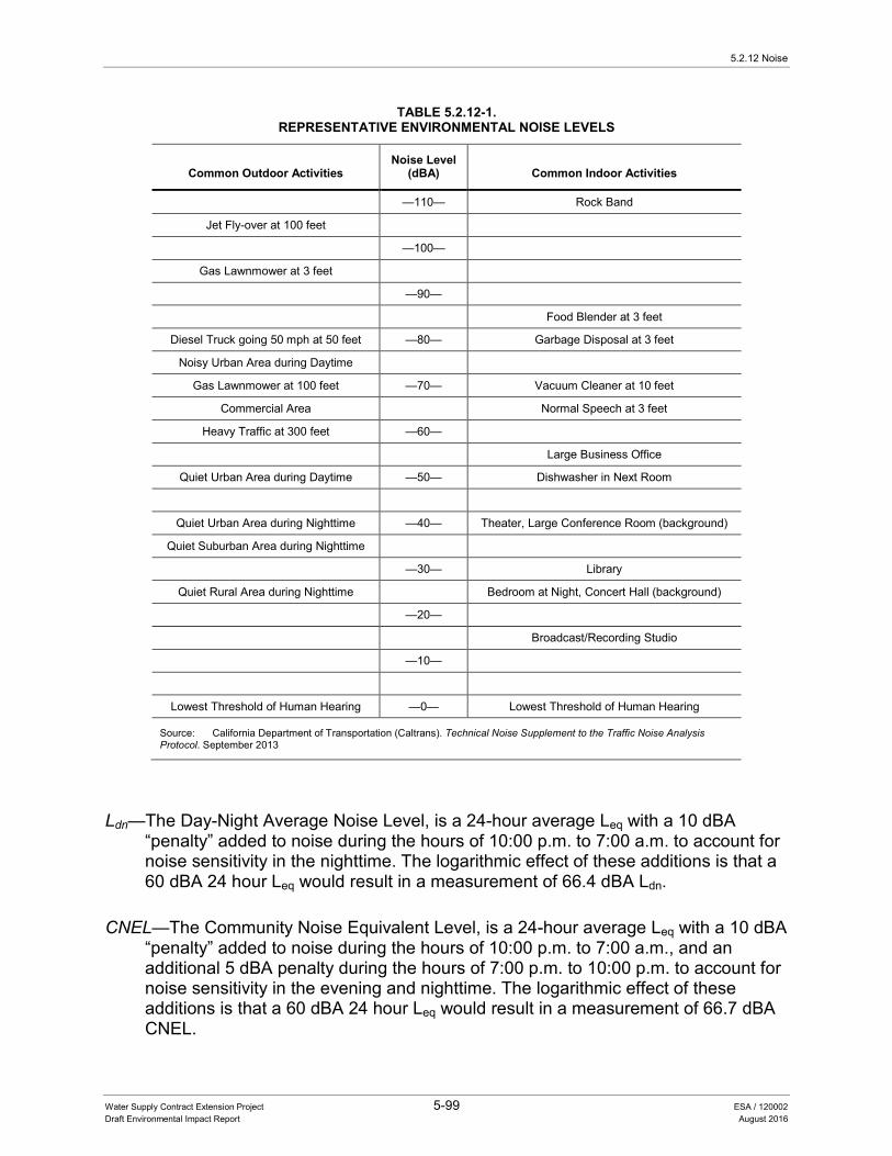
5.2.12 Noise
Water Supply Contract Extension Project 5-99 ESA / 120002 Draft Environmental Impact Report August 2016
TABLE 5.2.12-1. REPRESENTATIVE ENVIRONMENTAL NOISE LEVELS
Common Outdoor Activities Noise Level
(dBA) Common Indoor Activities
—110— Rock Band
Jet Fly-over at 100 feet
—100—
Gas Lawnmower at 3 feet
—90—
Food Blender at 3 feet
Diesel Truck going 50 mph at 50 feet —80— Garbage Disposal at 3 feet
Noisy Urban Area during Daytime
Gas Lawnmower at 100 feet —70— Vacuum Cleaner at 10 feet
Commercial Area Normal Speech at 3 feet
Heavy Traffic at 300 feet —60—
Large Business Office
Quiet Urban Area during Daytime —50— Dishwasher in Next Room
Quiet Urban Area during Nighttime —40— Theater, Large Conference Room (background)
Quiet Suburban Area during Nighttime
—30— Library
Quiet Rural Area during Nighttime Bedroom at Night, Concert Hall (background)
—20—
Broadcast/Recording Studio
—10—
Lowest Threshold of Human Hearing —0— Lowest Threshold of Human Hearing
Source: California Department of Transportation (Caltrans). Technical Noise Supplement to the Traffic Noise Analysis Protocol. September 2013
Ldn—The Day-Night Average Noise Level, is a 24-hour average Leq with a 10 dBA “penalty” added to noise during the hours of 10:00 p.m. to 7:00 a.m. to account for noise sensitivity in the nighttime. The logarithmic effect of these additions is that a 60 dBA 24 hour Leq would result in a measurement of 66.4 dBA Ldn.
CNEL—The Community Noise Equivalent Level, is a 24-hour average Leq with a 10 dBA “penalty” added to noise during the hours of 10:00 p.m. to 7:00 a.m., and an additional 5 dBA penalty during the hours of 7:00 p.m. to 10:00 p.m. to account for noise sensitivity in the evening and nighttime. The logarithmic effect of these additions is that a 60 dBA 24 hour Leq would result in a measurement of 66.7 dBA CNEL.
5. Environmental Analysis
Water Supply Contract Extension Project 5-100 ESA / 120002 Draft Environmental Impact Report August 2016
L50—A statistical noise level, is the noise level which is exceeded 50 percent of the time during which the noise is measured.
When evaluating changes in 24-hour community noise levels, a difference of 3 dBA is a barely-perceptible increase to most people. A 5 dBA increase is readily noticeable, while a difference of 10 dBA would be perceived as a doubling of loudness. Except in a carefully controlled laboratory condition, a change of 1 dBA is very difficult to perceive.
Noise levels from a particular source generally decline as distance to the receptor increases. Other factors such as the weather and reflecting or shielding also help intensify or reduce the noise level at any given location. A commonly used rule of thumb for roadway noise is that for every doubling of distance from the source, the noise level is reduced by about 3 dBA at acoustically “hard” locations (i.e., the area between the noise source and the receptor is nearly complete asphalt, concrete, hard-packed soil, or other solid materials) and 4.5 dBA at acoustically “soft” locations (i.e., the area between the source and receptor is normal earth or has vegetation, including grass). Noise from stationary or point sources is reduced by about 6 to 7.5 dBA for every doubling of distance at acoustically hard and soft locations, respectively. Noise levels are also generally reduced by 1 dBA for each 1,000 feet of distance due to air absorption. Noise levels may also be reduced by intervening structures—generally, a single row of buildings between the receptor and the noise source reduces the noise level by about 5 dBA, while a solid wall or berm reduces noise levels by 5 to 10 dBA. The manner in which older homes in California were constructed generally provides a reduction of exterior-to-interior noise levels of about 20 dBA with closed windows. The exterior-to-interior reduction of newer homes is generally 30 dBA or more.
Fundamentals of Environmental Groundborne Vibration Vibration is sound radiated through the ground. The rumbling sound caused by the vibration of room surfaces is called groundborne noise. The ground motion caused by vibration is measured as particle velocity in inches per second and in the United States is referenced as vibration decibels (VdB).
The background vibration velocity level in residential and educational areas is usually around 50 VdB. The vibration velocity level threshold of perception for humans is approximately 65 VdB. A vibration velocity level of 75 VdB is the approximate dividing line between barely perceptible and distinctly perceptible levels for many people. Most perceptible indoor vibration is caused by sources within buildings such as operation of mechanical equipment, movement of people, or the slamming of doors. Typical outdoor sources of perceptible groundborne vibration are construction equipment, steel-wheeled trains, and traffic on rough roads. If a roadway is smooth, the groundborne vibration

5.2.12 Noise
Water Supply Contract Extension Project 5-101 ESA / 120002 Draft Environmental Impact Report August 2016
from traffic is rarely perceptible. The range of interest is from approximately 50 VdB, which is the typical background vibration velocity level, and 100 VdB, which is the general threshold where minor damage can occur in fragile buildings. The general human response to different levels of groundborne vibration velocity levels is described in Table 5.2.12-2.
TABLE 5.2.12-2. HUMAN RESPONSE TO DIFFERENT LEVELS OF GROUNDBORNE VIBRATION
Vibration Velocity Level Human Reaction
65 VdB Approximate threshold of perception for many people.
75 VdB Approximate dividing line between barely perceptible and distinctly perceptible. Many people find that transportation-related vibration at this level is unacceptable.
85 VdB Vibration acceptable only if there are an infrequent number of events per day.
Source: Federal Transit Administration, Transit Noise and Vibration Impact Assessment. May 2006.
Existing Noise Environment Some land uses are considered more sensitive to ambient noise levels than others, due to the amount of noise exposure (in terms of both exposure duration and insulation from noise) and the types of activities typically involved. Residences, motels and hotels, schools, libraries, churches, hospitals, nursing homes, auditoriums, and parks and other outdoor recreation areas generally are more sensitive to noise than are commercial (other than lodging facilities) and industrial land uses.
The SWP study area is characterized by a wide range of noise profiles, including urban and rural roadways, rural agricultural noise, residential traffic, airports. These include low-volume traffic noise from tractors, large trucks, and other farm equipment, both on and off-road passenger vehicles, and high-volume traffic noise in the more urban parts of the SWP study area. For this analysis, the noise sensitive receptors are assumed to be those as close as 100 feet from SWP facilities.
The ambient noise environments in the cities within the proposed SWP study area were estimated using a relationship determined during a research program by the USEPA (USEPA 1974). USEPA determined that ambient noise can be related to population density in locations away from transportation corridors, such as airports, major roads and rail road tracks. Table 5.2.12-3 provides typical ambient noise levels from environs ranging from a “Quiet Suburban” to “Very Noisy Urban.”
5.2.12.3 Regulatory Setting The following text summarizes federal, State, and local laws and regulations pertinent to evaluation of the proposed project’s impacts on noise.
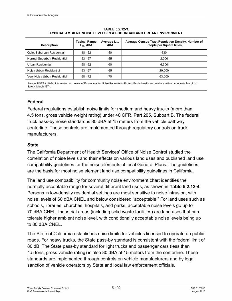
5. Environmental Analysis
Water Supply Contract Extension Project 5-102 ESA / 120002 Draft Environmental Impact Report August 2016
TABLE 5.2.12-3. TYPICAL AMBIENT NOISE LEVELS IN A SUBURBAN AND URBAN ENVIRONMENT
Description Typical Range
Ldn, dBA Average Ldn,
dBA Average Census Tract Population Density, Number of
People per Square Miles
Quiet Suburban Residential 48 - 52 50 630
Normal Suburban Residential 53 - 57 55 2,000
Urban Residential 58 - 62 60 6,300
Noisy Urban Residential 63 - 67 65 20,000
Very Noisy Urban Residential 68 - 72 70 63,000
Source: USEPA. 1974. Information on Levels of Environmental Noise Requisite to Protect Public Health and Welfare with an Adequate Margin of Safety. March 1974.
Federal Federal regulations establish noise limits for medium and heavy trucks (more than 4.5 tons, gross vehicle weight rating) under 40 CFR, Part 205, Subpart B. The federal truck pass-by noise standard is 80 dBA at 15 meters from the vehicle pathway centerline. These controls are implemented through regulatory controls on truck manufacturers.
State The California Department of Health Services’ Office of Noise Control studied the correlation of noise levels and their effects on various land uses and published land use compatibility guidelines for the noise elements of local General Plans. The guidelines are the basis for most noise element land use compatibility guidelines in California.
The land use compatibility for community noise environment chart identifies the normally acceptable range for several different land uses, as shown in Table 5.2.12-4. Persons in low-density residential settings are most sensitive to noise intrusion, with noise levels of 60 dBA CNEL and below considered “acceptable.” For land uses such as schools, libraries, churches, hospitals, and parks, acceptable noise levels go up to 70 dBA CNEL. Industrial areas (including solid waste facilities) are land uses that can tolerate higher ambient noise level, with conditionally acceptable noise levels being up to 80 dBA CNEL.
The State of California establishes noise limits for vehicles licensed to operate on public roads. For heavy trucks, the State pass-by standard is consistent with the federal limit of 80 dB. The State pass-by standard for light trucks and passenger cars (less than 4.5 tons, gross vehicle rating) is also 80 dBA at 15 meters from the centerline. These standards are implemented through controls on vehicle manufacturers and by legal sanction of vehicle operators by State and local law enforcement officials.
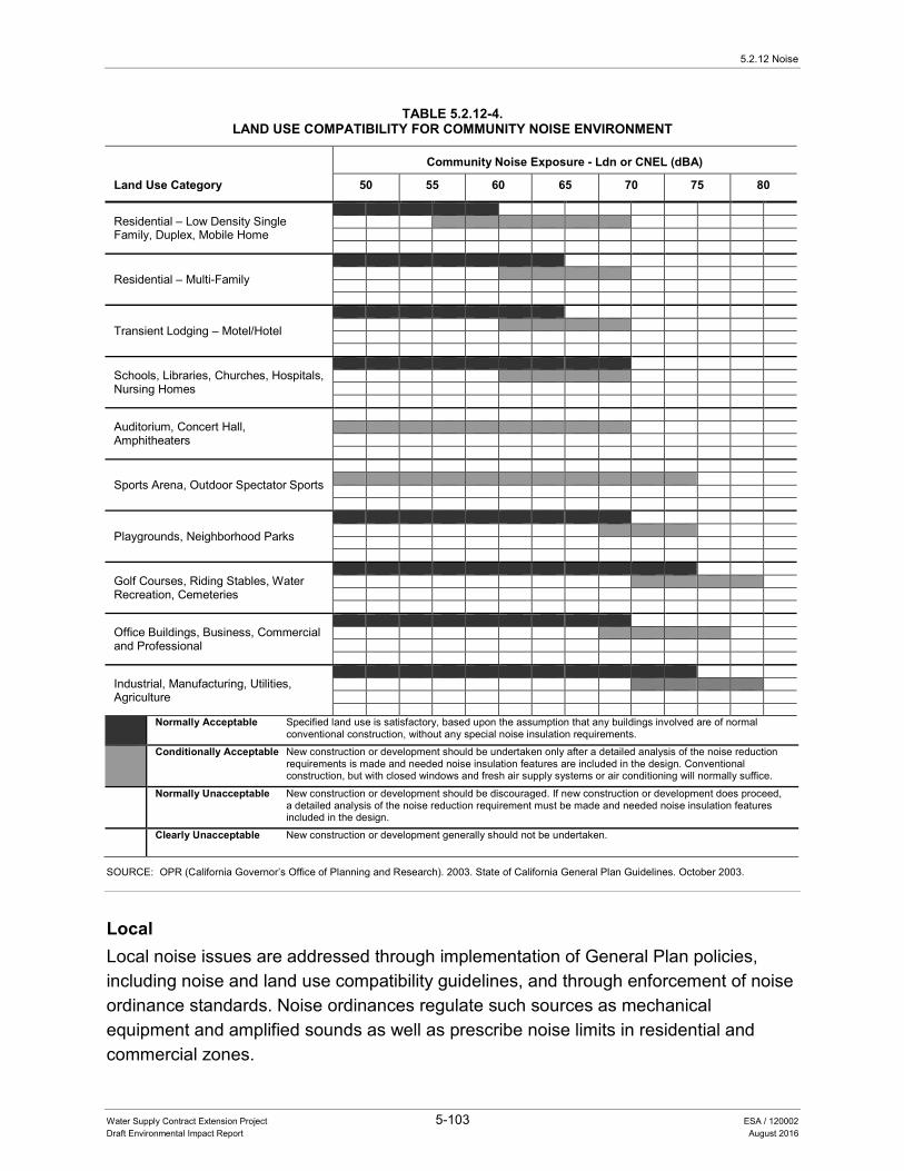
5.2.12 Noise
Water Supply Contract Extension Project 5-103 ESA / 120002 Draft Environmental Impact Report August 2016
TABLE 5.2.12-4. LAND USE COMPATIBILITY FOR COMMUNITY NOISE ENVIRONMENT
Land Use Category
Community Noise Exposure - Ldn or CNEL (dBA)
50 55 60 65 70 75 80
Residential – Low Density Single Family, Duplex, Mobile Home
Residential – Multi-Family
Transient Lodging – Motel/Hotel
Schools, Libraries, Churches, Hospitals, Nursing Homes
Auditorium, Concert Hall, Amphitheaters
Sports Arena, Outdoor Spectator Sports
Playgrounds, Neighborhood Parks
Golf Courses, Riding Stables, Water Recreation, Cemeteries
Office Buildings, Business, Commercial and Professional
Industrial, Manufacturing, Utilities, Agriculture
Normally Acceptable Specified land use is satisfactory, based upon the assumption that any buildings involved are of normal conventional construction, without any special noise insulation requirements.
Conditionally Acceptable New construction or development should be undertaken only after a detailed analysis of the noise reduction requirements is made and needed noise insulation features are included in the design. Conventional construction, but with closed windows and fresh air supply systems or air conditioning will normally suffice.
Normally Unacceptable New construction or development should be discouraged. If new construction or development does proceed, a detailed analysis of the noise reduction requirement must be made and needed noise insulation features included in the design.
Clearly Unacceptable New construction or development generally should not be undertaken.
SOURCE: OPR (California Governor’s Office of Planning and Research). 2003. State of California General Plan Guidelines. October 2003.
Local Local noise issues are addressed through implementation of General Plan policies, including noise and land use compatibility guidelines, and through enforcement of noise ordinance standards. Noise ordinances regulate such sources as mechanical equipment and amplified sounds as well as prescribe noise limits in residential and commercial zones.
5. Environmental Analysis
Water Supply Contract Extension Project 5-104 ESA / 120002 Draft Environmental Impact Report August 2016
The SWP study area extends into multiple counties within the State. Each of these counties has their own General Plan policies and ordinances that address noise within each respective jurisdiction. Most of these noise policies and ordinances address issues related to exempting noise generated by construction activities during daytime hours (e.g., 7:00 a.m. to 7:00 p.m.) and/or establishes maximum noise levels allowable during curtain times of the day (e.g., 65 dBA Ldn during daytime, 55 dBA Ldn during evening, 45 dBA Ldn during nighttime).
Many of the local county and city noise ordinances within the SWP area either have exemptions or include special provisions for construction-related noise, which would be similar to O&M activities because of the short-duration of the activity and the type of equipment used. These exemptions or special provisions consider construction noise to be in compliance with the ordinance even if the noise generated exceeds the standards applied to other activities. Some jurisdictions also make special provisions to allow nighttime construction or O&M activities to occur without considering noise generated by the activity a violation of applicable noise regulations.
Generally, State agencies involved with the location or construction of facilities for the production, generation, storage, treatment, or transmission of water are not subject to local regulations. Inconsistency with local land use regulation is not in and of itself considered an adverse effect on the environment. The SWP study area covers multiple counties with multiple cities throughout California. Each of these counties and cities has local regulations and General Plans with unique goals and policies that address noise.
5.2.12.4 Impact Analysis Methods of Analysis Methods used to analyze the potential impacts to air quality associated with implementation of the proposed project included review of project documentation, technical documents, and regulations and policies.
Standards of Significance Based on Appendix G of the CEQA Guidelines, an impact is considered significant if implementation of the proposed project would:
• Expose persons to or generate noise levels in excess of standards established in the General Plan or noise ordinance or applicable standards of other agencies.
• Expose persons to or generate excessive groundborne vibration or groundborne noise levels.
• Result in a substantial permanent increase in ambient noise levels in the project vicinity above levels existing without the project.
5.2.12 Noise
Water Supply Contract Extension Project 5-105 ESA / 120002 Draft Environmental Impact Report August 2016
• Result in a substantial temporary or periodic increase in ambient noise levels in the project vicinity above levels existing without the project.
• For a project located within an airport land uses plan or, where such a plan has not been adopted within 2 miles of a public airport or public-use airport, expose people residing or working in the SWP study area to excessive noise levels.
• For a project within the vicinity of a private airstrip, expose people residing or working in the SWP study area to excessive noise levels.
Impacts and Mitigation Measures The proposed project would amend and add financial provisions of the current Contracts based on the negotiated AIP between DWR and the Contractors. The proposed project would not create new water management measures, alter the existing authority to build new or modify existing facilities, or change water allocation provisions of the current Contracts. Further, the proposed project would not change O&M of the SWP. Because there would be no development of new or modification of existing SWP facilities or an increase in operations, the proposed project would not result in any substantial or temporary increase in noise and vibration. As a result, the proposed project would not expose persons to or generate excessive groundborne vibration or noise levels or result in a substantial temporary or periodic increase in ambient noise levels in the project vicinity above levels existing without the project. Therefore, the proposed project would not increase existing levels of noise and would not expose persons to or generate noise levels in excess of standards established in the General Plan or noise ordinance or applicable standards of other agencies. No impact related to noise and vibration would occur and no mitigation measures are required.
5.2.12.5 References Caltrans (California Department of Transportation). 2013. Technical Noise Supplement
to the Traffic Noise Analysis Protocol. September 2013. OPR (California Governor’s Office of Planning and Research). 2003. State of California
General Plan Guidelines. October 2003. Federal Transit Administration. 2006. Transit Noise and Vibration Impact Assessment.
May 2006. USEPA (U.S. Environmental Protection Agency). 1974. Information on Levels of
Environmental Noise Requisite to Protect Public Health and Welfare with an Adequate Margin of Safety. March 1974.

5. Environmental Analysis
Water Supply Contract Extension Project 5-106 ESA / 120002 Draft Environmental Impact Report August 2016
5.2.13 Population and Housing
5.2.13.1 Introduction This section describes the environmental and regulatory settings and potential impacts associated with population and housing that may occur as a result of the proposed. No comments related to population and housing were received in response to the NOP.
5.2.13.2 Environmental Setting Population and housing conditions frequently involve economic and social issues, which are not considered to have significant effects on the environment. However, CEQA requires analyses of environmental impacts that may result from a project’s population and housing impacts. Consistent with CEQA Guidelines, the analysis of population and housing impacts in this DEIR addresses the precursors of physical changes that could result from implementation of the proposed project.
As of 2014, there were 38.8 million people in the State of California (Census 2015). Approximately 25 million people receive a portion of their drinking water from the SWP throughout Northern California, the San Joaquin Valley, the San Francisco Bay Area, the Central Coast Area, and Southern California (DWR 2015).
5.2.13.3 Regulatory Setting The following text summarizes State, and local laws and regulations pertinent to evaluation of the proposed project’s impacts on population and housing.
State State of California Housing Element Requirements California Housing Element Law (Government Code 65580) requires cities and counties to include, as part of their General Plans, a housing element to address housing conditions and needs in the community. The housing element law requires the California Department of Housing and Community Development, in consultation with each regional council of governments, to determine each region’s existing and projected housing need. The regional council of governments in turn develops a regional housing allocation plan that includes the actual allocation of housing need to the cities and counties within the region. Allocations are based on factors that consider existing employment, employment growth, household growth, and the availability of transit; need is determined for households in all income categories from very-low to above-moderate. The jurisdictions are required to plan for their allocated number of housing units within the housing elements of their General Plans. Housing elements are required to be updated every 7 to 8 years, following timetables adopted by the State. The housing element must identify and analyze existing and projected housing needs and “make
5.2.13 Population and Housing
Water Supply Contract Extension Project 5-107 ESA / 120002 Draft Environmental Impact Report August 2016
adequate provision for the existing and projected needs of all economic segments of the community,” among other requirements.
Local Generally, State agencies involved with the location or construction of facilities for the production, generation, storage, treatment, or transmission of water are not subject to local regulations. Inconsistency with local land use regulation is not in and of itself considered an adverse effect on the environment. The SWP study area covers multiple counties with multiple cities throughout California. Each of these counties and cities has local regulations and General Plans with unique goals and policies that address population and housing.
5.2.13.4 Impact Analysis Methods of Analysis Methods used to analyze the potential impacts to population and housing associated with implementation of the proposed project included review of project documentation, regulations, and policies.
Standards of Significance Based on Appendix G of the CEQA Guidelines, an impact is considered significant if implementation of the proposed project would:
• Induce substantial population growth in an area directly (for example, by proposing new homes and businesses).
• Displace substantial numbers of existing housing units, necessitating the construction of replacement housing elsewhere.
• Displace substantial numbers of people, necessitating the construction of replacement housing elsewhere.
Impacts and Mitigation Measures The proposed project would amend and add financial provisions of the current Contracts based on the negotiated AIP between DWR and the Contractors. The proposed project would not create new water management measures, alter the existing authority to build new or modify existing facilities, or change water allocation provisions of the current Contracts. Because the proposed project would not change existing SWP operations, there would be no changes to water supply allocations and water supply management measures in the Contractors’ service areas. Therefore, there would be no increase in water supplies that would support and increase in population and housing.
5. Environmental Analysis
Water Supply Contract Extension Project 5-108 ESA / 120002 Draft Environmental Impact Report August 2016
No elements of the proposed project would directly induce substantial population growth in an area because it would not construct new homes or businesses. Further, because the proposed project would not result in construction of new facilities, it would not displace existing housing or people, necessitating the construction of replacement housing elsewhere.
Therefore, no impacts would occur associated with population and housing and no mitigation measures are required.
5.2.13.5 References DWR (California Department of Water Resources). 2010. California State Water Project
Overview. August 2010. ———. 2015. Bulletin 132-13: Management of the California State Water Project, p. 3. Census (U.S. Census Bureau). 2015. State and County QuickFacts: California. May
2015.
5.2.14 Public Services and Recreation
Water Supply Contract Extension Project 5-109 ESA / 120002 Draft Environmental Impact Report August 2016
5.2.14 Public Services and Recreation
5.2.14.1 Introduction This section describes the environmental and regulatory settings and analyzes the effects of the proposed project on public services, which include police and fire protection, schools, and parks and recreational facilities. This section specifically addresses recreation within the SWP study area. Comments received on the NOP included concerns over the responsibility of Contractors to fund certain fish and wildlife and recreation requirements of the SWP with proposed project implementation.
5.2.14.2 Environmental Setting Public services are those physical assets and community services that are important to maintaining a community’s welfare and livability. Public services include police and fire protection, schools, and the provision of parks and recreation facilities. In incorporated communities police protection is provided by local police departments. In rural unincorporated areas police protection is provided by County Sheriff departments or through Memorandums of Understanding (MOUs) between law enforcement agencies in the area. Similarly, fire protection in incorporated communities is provided by local fire departments. In rural unincorporated areas fire response is often handled by local fire departments or through MOUs between departments and/or by CAL FIRE. Public and private schools are located throughout the SWP study area. There are also numerous local and regional park and recreational facilities in the study area.
SWP Recreational Areas and Use As described in Chapter 2, State Water Project, the SWP is a complex system of reservoirs, dams, power plants, pumping plants, pipelines, and aqueducts that delivers water to Contractors throughout Northern California, the San Joaquin Valley, the San Francisco Bay Area, the Central Coast Area, and Southern California. The SWP is a multipurpose project that provides recreational benefits including sightseeing, fishing, hunting, picnicking, camping, boating, water skiing, bicycling, hiking, and swimming. The SWP has 37 developed recreation areas, or sites, throughout the State. Since the SWP began delivering water in 1962, approximately 231 million recreation days1 have been recorded at SWP recreation facilities. Most SWP recreation use is concentrated at the lakes and major reservoirs (DWR 2015).
1 A recreation day is defined as one individual user visiting a recreation site along the SWP within all or part of a
one-day period.
5. Environmental Analysis
Water Supply Contract Extension Project 5-110 ESA / 120002 Draft Environmental Impact Report August 2016
5.2.14.3 Regulatory Setting The following text summarizes federal, State, and local laws and regulations pertinent to evaluation of the proposed project’s impacts on public services. While there are no federal regulations that specifically pertain to public services, State and local regulations do exist to regulate development decisions.
Federal There are no applicable federal regulations pertaining to public services.
State Davis-Dolwig Act The Davis-Dolwig Act, found in Water Code Section, 11900 et seq. is a State statute that requires that features for recreation and fish and wildlife preservation and enhancement be incorporated in the planning and construction of State water projects, including the SWP. This Act further sets forth the Legislature’s intent to provide funds to DWR for the enhancement of fish and wildlife and for recreation in connection with such projects. In 2012, the State Legislature enacted an additional statute to create the Davis-Dolwig Account in the California Water Resources Development Bond Fund and to provide a continuous annual appropriation of $7.5 million to DWR for the payment of SWP recreation and fish and wildlife enhancement costs (Water Code Section 11913.1). In addition, this same 2012 legislative action provides another $2.5 million annual continuous appropriation to pay for recreation and fish and wildlife enhancement costs incurred prior to December 31, 2011.
California Code of Regulations The CCR, Title 5 Education Code, regulates all aspects related to the provision of education within the State of California.
Department of Education Standards The California Department of Education published the Guide to School Site Analysis and Development to establish a valid technique for determining acreage for new school development. Rather than assigning a strict student/acreage ratio, this guide provides flexible formulas that permit each district to tailor its ratios as necessary to accommodate its individual conditions. The Department of Education also recommends that a site utilization study be prepared for the site, based on these formulas.
California Department of Forestry and Fire Protection CAL FIRE provides fire protection services for areas within the State Responsibility Areas as well as some local jurisdictions with which CAL FIRE maintains contracts to provide services, which are largely unincorporated portions of the State. In addition,
5.2.14 Public Services and Recreation
Water Supply Contract Extension Project 5-111 ESA / 120002 Draft Environmental Impact Report August 2016
CAL FIRE also provides assistance to local fire departments through mutual and automatic aid agreements, providing wildfire protection services for incidents occurring within incorporated jurisdictions. CAL FIRE is responsible for the implementation of state-legislated fire safety standards and conducts fuel management activities and also performs annual inspections. By law, CAL FIRE policy requires that CAL FIRE will respond to and abate any uncontrolled fire that threatens to destroy life, property, or natural resources.
California Fire Code The California Fire Code provides specialized regulations related to the construction, maintenance, and use of buildings as they relate to fire and safety. The extent of the code coverage encompasses fire department access, fire hydrants, automatic sprinkler systems, fire alarm systems, fire and explosion hazards safety, hazardous materials storage and use, provisions to aid fire responders, industrial processes, and other fire-safety requirements for existing and new buildings.
Quimby Act California Government Code 66477, Subdivision Map Act, referred to as the Quimby Act, permits local jurisdictions to require the dedication of land and/or the payment of in-lieu fees solely for parks and recreation purposes. The required dedication and/or fee is/are based on factors such as residential density and parkland cost, among others. Land dedicated and fees collected pursuant to the Quimby Act may only be used for developing new, or rehabilitating existing, park or recreational facilities
Local Generally, State agencies that are involved with the location or construction of facilities for the production, generation, storage, treatment, or transmission of water are not subject to local regulations. Inconsistency with local public service provision and regulation is not in and of itself considered an adverse effect on the environment. The SWP study area covers multiple counties with multiple cities throughout California. Each of these counties and cities has a General Plan with unique goals and policies that address public services.
5.2.14.4 Impact Analysis Methods of Analysis Methods used to analyze the proposed project effects on public services included review of project documentation, regulations, and policies.
5. Environmental Analysis
Water Supply Contract Extension Project 5-112 ESA / 120002 Draft Environmental Impact Report August 2016
Standards of Significance Based on Appendix G of the CEQA Guidelines, an impact is considered significant if implementation of the proposed project would:
• Result in substantial adverse physical impacts associated with the provision of new or physically altered governmental facilities, or the need for new or physically altered governmental facilities, the construction of which could cause significant environmental impacts, in order to maintain acceptable service ratios, response times, or other performance objectives for police protection, fire protection, schools, and/or parks and recreational facilities.
• Increase the use of existing neighborhood and regional parks or other recreational facilities such that substantial physical deterioration of the facilities would occur or be accelerated.
• Include recreational facilities or require the construction or expansion of recreational facilities that might have an adverse physical effect on the environment.
Impacts and Mitigation Measures The proposed project would amend and add financial provisions of the current Contracts based on the negotiated AIP between DWR and the Contractors. The proposed project would not create new water management measures, alter the existing authority to build new or modify existing facilities, or change water allocation provisions of the current Contracts. Because the proposed project would not result in construction or modification of SWP facilities it would not affect surrounding land uses, including recreational facilities or uses. Because water allocation would not change, there would be no change in land uses associated with SWP deliveries including, conversion of agricultural land uses to urban uses or increased developed uses in urban areas. Therefore, there would be no associated increase in population and no increase in the need for public services when compared to existing conditions. Contractors would continue to provide water in their service areas in the same manner as they do currently.
The Davis-Dolwig Act declares the Legislature’s intent that annual appropriations be made to DWR for fish and wildlife enhancement and recreation. The Act further states that costs incurred for the enhancement of fish and wildlife and the development of public recreation not be included in the prices, rates and charges for water and power. Implementation of the proposed project would continue DWR’s contract administration, consistent with the Act, that the development of public recreation includes both capital and O&M costs. Further, operation of the SWP would not change from existing operations to maintain water levels provided for recreational use. Therefore,
5.2.14 Public Services and Recreation
Water Supply Contract Extension Project 5-113 ESA / 120002 Draft Environmental Impact Report August 2016
implementation of the proposed project would not change the manner in which SWP recreational uses are funded when compared to existing contract administration. There would be no change to the recreation, and fish and wildlife enhancement portion of the SWP projects and facilities as a result of the proposed project.
There would be no impact related to the provision of public services, including recreation and no mitigation measures are required.
5.2.14.5 References DWR (California Department of Water Resources). 2015. Bulletin 132-13: Management
of the California State Water Project, p. 245.
5. Environmental Analysis
Water Supply Contract Extension Project 5-114 ESA / 120002 Draft Environmental Impact Report August 2016
5.2.15 Surface Water Hydrology and Water Quality
5.2.15.1 Introduction This section describes the existing environmental and regulatory setting as it pertains to surface water hydrology (including drainage and flooding) and quality, followed by a discussion of potential impacts to surface water hydrology and quality. The environmental and regulatory setting and impacts related to groundwater hydrology and quality are described in Section 5.2.9, Groundwater Hydrology and Water Quality. No comments related to surface water hydrology or quality were received in response to the NOP. Major sources of information used in preparing this resource section and analysis include:
• California Water Plan Update 2013 (DWR 2013)
• California 303(d) List of Water Quality Limited Segments (State Water Board 2010)
5.2.15.2 Environmental Setting This section includes discussion of existing surface water hydrology and quality conditions. The discussion is organized by region, including the Sacramento River Hydrologic Region, San Joaquin River Hydrologic Region, the Tulare Lake Hydrologic Region, the Delta Region (including the San Francisco Bay area watersheds), Central Coast Hydrologic Region, and Southern California region (including the Colorado River, Lahontan, and South Coast hydrologic regions). The complex system of reservoirs, dams, power plants, pumping plants, pipelines, and aqueducts of the SWP is described in Chapter 2, State Water Project. Also discussed in Chapter 2 is the role that SWP facilities perform in flood management in California, including operating SWP facilities to manage flood flows. Section 303 of the CWA requires states to adopt water quality standards for all surface waters of the United States. Water body and pollutants that exceed protective water quality standards are placed on the State’s 303(d) List. For waters on this list, the states develop total maximum daily loads (TMDLs) to account for all sources of the pollutants that caused the water to be listed. The nine regional water quality control boards (Regional Water Boards) prepare and periodically update basin plans (also known as water quality control plans), which set forth water quality standards for surface water and groundwater within their regions, and actions (including TMDLs) to control nonpoint and point sources of pollution to achieve and maintain these standards (DWR 2015a). Relevant basin plans include those developed for the Central Valley, San Francisco Bay, Central Coast, Lahontan, Colorado River, Santa Ana, and San Diego regions. The CWA Section 303(d) listings informed the following discussion.
In addition to the challenges addressed by the CWA, ongoing drought conditions pose unique challenges to water quality and to water management throughout the study area.
5.2.15 Surface Water Hydrology and Water Quality
Water Supply Contract Extension Project 5-115 ESA / 120002 Draft Environmental Impact Report August 2016
On January 29, 2014, the Governor of the State of California issued an emergency drought proclamation, which remains in place over a year later. In particular, drought-related water quality challenges include elevated water temperatures due to decreased flows and decreased volumes of water in storage in reservoirs, and saltwater intrusion in the Bay-Delta due to decreased freshwater inflows. Under the SWP and CVP Drought Contingency Plan issued by Reclamation and DWR in January of 2015, the SWP and CVP are being operated in part to preserve enough cold water deep in Shasta Lake and other reservoirs to: maintain cool river temperatures for various runs of Chinook salmon, control saltwater intrusion in the Bay-Delta by providing enough fresh water flow out of the Bay-Delta throughout dry months to repel saltwater that pushes inland on ocean-driven tides from San Francisco Bay, and maintain protections for State and federally endangered and threatened species and other fish and wildlife resources that are suffering from unavoidable impacts due to drought and necessary drought-related actions.
Sacramento River Hydrologic Region Surface Water Hydrology The Sacramento River flows generally north to south from its source near Mount Shasta to the Bay-Delta near Freeport. Upstream from Shasta Dam and Lake, the Sacramento River receives flows from the Pit River, McCloud River, Squaw Creek, and the headwaters of the Sacramento River, as well as many minor tributary creeks and streams. Flows in the Sacramento River in the 65-mile reach between Shasta Dam and Red Bluff are regulated by Shasta Dam and are reregulated downstream at Keswick Dam. In this reach, flows are influenced by tributary inflow. Major west-side tributaries to the Sacramento River in this reach of the river include Clear and Cottonwood creeks. Major east side tributaries to the Sacramento River in this reach of the river include Battle, Bear, Churn, Cow, and Paynes creeks (Reclamation 2013).
The Sacramento River enters the Sacramento Valley about 5 miles north of Red Bluff. The Sacramento Valley contains the Sacramento, Feather, and American river basins; and major and minor streams and rivers that drain the east and west sides of the valley, covering an area of more than 24,000 square miles. On average, more than 22 maf of water, approximately one-third of the total runoff in California, flows through the Sacramento Valley (Water Years 1922–2003). The operation and capacity of reservoirs in the Sacramento Valley are affected by precipitation, agricultural diversions, water supply releases, hydroelectric power generation, and flood management (Reclamation 2013, DWR 2012).
5. Environmental Analysis
Water Supply Contract Extension Project 5-116 ESA / 120002 Draft Environmental Impact Report August 2016
From Red Bluff to Chico Landing (52 miles), the river receives flows from Antelope, Mill, Deer, Big Chico, Rock, and Pine creeks on the east side and Thomes, Elder, Reeds, and Red Bank creeks on the west side. From Chico Landing to Colusa (50 miles), the only major tributary is Stony Creek. No tributaries enter the Sacramento River between Stony Creek and its confluence with the Feather River (Reclamation 2013). The Colusa Basin to the west receives flow of several minor tributaries. The natural overflow basin to the east, Butte Basin, receives flow from several minor tributaries and the Sacramento River, and overflow from the Moulton and Colusa weirs (DWR 2012). Outflow from Butte Basin discharges through the Sutter Bypass; reentering the Sacramento River directly across and downstream from Fremont Weir.
The Feather River is the largest tributary to the Sacramento River below Shasta Dam. The Feather River flows from the east into the Sacramento River immediately upstream of Verona. Major tributaries to the Feather River include the Yuba and Bear rivers. Flows in the lower Feather River are regulated by operations of the Oroville-Thermalito Complex and diversions by Western Canal, Richvale Canal, the PG&E Lateral, and the Sutter-Butte Canal (DWR 2013). Flow from the Yuba and Bear rivers combines with Feather River flow and enters the Sacramento River near the Fremont Weir.
The Sacramento River is joined by the American River at the city of Sacramento, and continues downstream to the Bay-Delta. During high-flow events, the bulk of Sacramento River flows pass over the Fremont Weir to continue through the Yolo Bypass for approximately 72 miles south then ultimately discharge in the north Bay-Delta. Flow from the Coast Ranges to the west is captured by the Colusa Basin Drain, which discharges directly to the Sacramento River, and into the Knights Landing Ridge Cut which empties into the Yolo Bypass, and by Cache, Willow Slough Bypass and Putah creeks, which discharge into the Yolo Bypass (DWR 2012).
Surface Water Quality Surface water in the Sacramento River Hydrologic Region is of generally high quality, and most water bodies in the region are suitable for most designated beneficial uses. Water quality issues in the region are largely associated with mercury and other metals, PCBs, pesticides, and toxicity from unknown origin included in the CWA 303(d) listings on the Sacramento River and its immediate tributaries.
Metals in the Sacramento River watershed, including mercury, cadmium, zinc, and copper, are generally associated with historic mining activities in the watershed. Copper, cadmium, zinc, and lead are metals that are naturally found in high concentrations in the “Copper Crescent” in Shasta County. Copper mining in the Upper Feather River watershed has also caused copper, cadmium, and zinc impairments in
5.2.15 Surface Water Hydrology and Water Quality
Water Supply Contract Extension Project 5-117 ESA / 120002 Draft Environmental Impact Report August 2016
several of the Upper Feather River tributaries. These metals are toxic to aquatic life at elevated concentrations, and at higher concentrations may cause human health impacts (DWR 2013).
Cinnabar ore (mercury sulfide) was mined in the Inner Coast Ranges for elemental mercury (quicksilver), and used for gold recovery in the Sierra Nevada during California’s gold rush. Several million pounds of mercury entered the environment during this period. Inorganic mercury also enters waterways when soils erode, atmospheric dust falls to the ground, and mineral springs discharge (DWR 2013). In aquatic environments, inorganic mercury can be converted to methylmercury which is a potent neurotoxin (Wentz, et al. 2014). The Sacramento River and many of its tributaries are impaired by mercury. Cache Creek alone accounts for 60 percent of the mercury discharged within the Central Valley, as it transports mercury from abandoned mercury mines in the Coast Ranges to the Cache Creek Settling Basin and eastward to the Yolo Bypass (DWR 2013). SWP facilities impaired by mercury include Davis Creek Reservoir in the upper Feather River watershed, Lake Oroville, and the Thermalito Afterbay (part of the Oroville-Thermalito complex) (State Water Board 2010).
Pesticides, including legacy compounds such as DDT and chlordane, are present in the Sacramento River watershed due to both urban and agricultural applications. The Sacramento River below Red Bluff, as well as the Feather and Bear rivers and Stony Creek are listed as impaired by pesticides.
Polychorinated biphenyls (PCB) are legacy compounds of industrial origin. Although no longer manufactured in the United States, PCBs persist in the environment, where they can bioaccumulate. The Sacramento, Feather, and American rivers; Lake Oroville; and the Thermalito Afterbay and Forebay are listed as impaired by PCBs (State Water Board 2010).
San Joaquin River Hydrologic Region Surface Water Hydrology Originating high in the Sierra Nevada, the San Joaquin River carries snowmelt and rainfall runoff from mountain meadows south of Yosemite National Park to the valley floor near Fresno, then northwest through the valley to the Bay-Delta.
The SWP does not deliver SWP water to the San Joaquin River hydrologic region, and this region will not be discussed further. However, local flood flows are taken into the California Aqueduct at specified locations through drain inlets in the San Joaquin Valley in order to maintain the integrity of the Aqueduct (see Chapter 2, State Water Project for more information on this topic).
5. Environmental Analysis
Water Supply Contract Extension Project 5-118 ESA / 120002 Draft Environmental Impact Report August 2016
Tulare Lake Hydrologic Region Surface Water Hydrology The Tulare Lake region is divided into several main hydrologic subareas: the alluvial fans from the Sierra foothills and the basin subarea (in the vicinity of the Kings, Kaweah, and Tule rivers and their distributaries); the Tulare Lake bed; and the southwestern uplands. The alluvial fan/ basin subarea is characterized by southwest to south flowing rivers, creeks, and irrigation canal systems that convey surface water originating from the Sierra Nevada. The dominant hydrologic features in the alluvial fan/basin subarea are the Kings, Kaweah, Tule, and Kern rivers and their major distributaries from the western flanks of the Sierra. Los Gatos Creek is the one substantial creek entering from the Coast Ranges, flowing southeast. The largest river in terms of runoff is the Kings River, which originates high in Kings Canyon National Park and generally trends southwest into Pine Flat Lake. Downstream of Pine Flat Dam, the river flows south and west toward Tulare Lake. During flood release events from Pine Flat Reservoir, the majority of the Kings River flow is diverted northwest into the Fresno Slough/James Bypass system (along the historically high-water outlet of Tulare Lake), emptying first into the Mendota Pool, and from there, into the San Joaquin River. The Kaweah River begins in Sequoia National Park, flows west and southwest, and is impounded by Terminus Dam. It subsequently spreads into many distributaries around Visalia and Tulare trending toward Tulare Lake. The Tule River begins in Sequoia National Forest and flows southwest through Lake Success toward Tulare Lake (DWR 2013).
The Kern River has the largest drainage basin area and produces the second highest runoff. It originates in Inyo and Sequoia National Forests and Sequoia National Park, flowing southward into Lake Isabella. The river downstream of Isabella Dam flows southwest. In high-discharge years, water will spill into the ancient Buena Vista/Kern Lake bed. In very-high-discharge years, Buena Vista Lake historically spilled into Tulare Lake via sloughs and floodwater channels. In addition, some Kern River water may be allowed to flow into the SWP via the Kern River Intertie. There are many smaller creeks that feed into the main rivers, which can present a localized flooding threat during specific storm conditions (DWR 2013).
Surface Water Quality Due to the essentially closed nature of the Tulare Lake Basin, the impact of contaminants on water quality will be a continuing threat to beneficial uses of surface water and groundwater. Generally, flows from the east side of the basin are considered to be excellent quality, fed by Sierra snowmelt and springs from granitic bedrock. Flows from the west side are considered to be poor quality due to naturally occurring constituents such as selenium and salinity from the marine sediments (DWR 2013).
5.2.15 Surface Water Hydrology and Water Quality
Water Supply Contract Extension Project 5-119 ESA / 120002 Draft Environmental Impact Report August 2016
Water quality issues for the Tulare Lake Hydrologic Region include: salinity, pesticides (chlorpyrifos, dimethoate, and toxaphene) from agriculture, metals (mercury, selenium, and molybdenum), and erosion and sediment (State Water Board 2010).
Salinity is the primary contaminant affecting water quality and habitat in the Tulare Lake region. When water is used, salts are left behind. Sometimes this salt is intentionally added (e.g., home water softeners, plant fertilizers), but even when no salts are added to the system, evaporation and consumptive use act to concentrate unused salts. Additionally, salts move with water so salts originating in one basin will turn up in another. This is a significant problem when the receiving basin has no reliable way of disposing the salt, as is the case in the Tulare Lake region. Salinity increases can affect municipal, agricultural, and industrial beneficial uses of water and the ability to recycle and reuse municipal wastewater.
In the Tulare Lake region, pesticide impairments due to chlorpyrifos, dimethoate, and toxaphene (a legacy pesticide) have been identified in areas of agricultural production (State Water Board 2010). A fraction of the applied pesticides can enter surface waters during rainfall or irrigation events when residual pesticides migrate in stormwater runoff or irrigation return water or migrate with sediment carried in stormwater runoff or irrigation return water and cause unintended toxicity to aquatic life. In this region, mercury impairments are found downstream of New Idria Mine, which was the second most productive mercury mine in North America, and in Pine Flat Reservoir and Kaweah Lake (State Water Board 2010; USEPA 2012). Inorganic mercury enters reservoirs and other water bodies through a variety of sources including atmospheric deposition; through tributary streams carrying runoff from mercury and gold mining sites; from urban and industrial discharges; and from erosion of soils naturally enriched with mercury. Methylmercury is a concern because it bioaccumulates through the aquatic food web to potentially harmful amounts found in larger fish that can be consumed by humans and wildlife (State Water Board 2012).
Molybdenum was found in the Kings River at levels high enough to cause concern for agricultural use. Selenium is a highly bioaccumulative trace element, which, under certain conditions, can be mobilized through the food chain and cause both acute and chronic toxicity to waterfowl (Central Valley RWQCB 2001).
Erosion is one of the greatest problems in the foothills and mountain areas of this region. Erosion is a natural occurrence, but most human activities accelerate the process. Erosion causes discoloration of streams, and the suspended matter settles to form a smothering blanket on the streambed. Sedimentation impairs fisheries; and, by virtue of the characteristics of many organic and inorganic compounds to bind to soil
5. Environmental Analysis
Water Supply Contract Extension Project 5-120 ESA / 120002 Draft Environmental Impact Report August 2016
particles, it serves to distribute and circulate toxic substances through the riparian, estuarine, and marine systems. Erosion is accelerated by poor drainage and soil stabilization associated with road building, clearing land, leveling land, construction, logging, brush clearing, off-road vehicle use, agriculture, overgrazing, and fires (Central Valley RWQCB 2004).
Delta Region, Including San Francisco Bay Area Watersheds Surface Water Hydrology The hydraulics of the Bay-Delta are complicated by tidal influences, a multitude of agricultural and M&I diversions for use within the Bay-Delta itself, and by CVP and SWP operations and exports. Principal factors affecting Bay-Delta hydrodynamics are (1) river inflow from the Sacramento River system including the Yolo Bypass, San Joaquin River, Mokelumne, Cosumnes, and Calaveras rivers and other smaller eastside tributaries; (2) daily tidal inflow and outflow through San Francisco Bay; and (3) export pumping including from the south Bay-Delta, primarily through the SWP Banks and CVP Jones pumping plants, and in-Delta water diversions for agriculture (DWR 2012; Reclamation et al. 2013).
Average winter outflow from the Bay-Delta is about 32,000 cfs, while the average summer outflow is 6,000 cubic feet per second (cfs) (Water Years 1956–2012). Because of tidal factors and changing channel geometry, Bay-Delta outflow is typically calculated rather than a directly measured (Reclamation 2014). The Sacramento and San Joaquin rivers are the main tributaries to the Bay-Delta. The streams in the northern portion of the San Joaquin River Basin, generally between the American and Stanislaus rivers, are commonly referred to as the eastside tributaries to the Bay-Delta. These rivers flow into the San Joaquin River within the boundaries of the Bay-Delta. The three main eastside tributaries to the Bay-Delta are the Cosumnes, Mokelumne, and Calaveras rivers.
On average, tidal inflows to the Bay-Delta are approximately equal to tidal outflows. However, tidal flows vary with the gravitational effects of the moon. The spring tide, where the maximum tidal range occurs, coincides with full and new moon. The neap tide, where the minimum tidal range occurs, coincides with the quarter phases of the moon. At Martinez, the tidal range can vary by about 30 percent between the spring and neap conditions. Tidal flows at Martinez can be as high as 600,000 cfs. Pacific Ocean tides move into and out of the Bay-Delta, ranging from less than 1 foot in the eastern Bay-Delta to more than 5 feet in the western Bay-Delta. At inland locations, such as near Freeport and Vernalis, riverine conditions dominate the tidal effects (Reclamation et al. 2013, DWR 2013).
5.2.15 Surface Water Hydrology and Water Quality
Water Supply Contract Extension Project 5-121 ESA / 120002 Draft Environmental Impact Report August 2016
The San Joaquin River enters the Bay-Delta downstream from Vernalis and splits into several channels including the main river channel, Middle River, and Old River. In the southern Bay-Delta, CVP and SWP export pumping in Middle and Old Rivers can reduce the minimum water levels such that sufficient pump draft for in-Delta diversions for agriculture cannot be maintained. During the summer of most years, DWR installs barriers in the Old and Middle Rivers and in the Grant Line Canal to maintain water levels for agricultural diversions (DWR 2015b).
The San Francisco Bay area receives outflow from the Bay-Delta, as well as runoff from numerous small tributaries, and includes the watersheds of Suisun Marsh, Suisun Bay, San Pablo Bay, and San Francisco Bay. Bay-Delta outflow enters Suisun Marsh and Bay (including Grizzly Bay). Flows exit Suisun Bay via the Carquinez Strait, entering San Pablo Bay at the confluence with the Napa River. Other major tributaries to San Pablo Bay include Petaluma River, San Rafael Creek, and, indirectly, Sonoma Creek. As in the Bay-Delta, water levels in the San Francisco Bay area are influenced by the tides.
Surface Water Quality The San Francisco Bay Estuary lies within the jurisdictions of two regional water boards: the Central Valley Water Quality Control Board and the San Francisco Bay Water Quality Control Board. Both water boards have adopted water quality control plans that establish water quality objectives for the Bay-Delta and Suisun Marsh based on the identified beneficial uses of Bay-Delta waters, while the State Water Board adopted the Water Quality Control Plan for the San Francisco Bay/Sacramento-San Joaquin Delta Estuary (2006 Bay-Delta Plan). The 2006 Bay-Delta Plan supersedes the water board basin plans to the extent of any conflict (State Water Board 2006).
CWA Section 303(d) listings and concerns are similar throughout the various regions of the Bay-Delta. The following discussion broadly covers water quality issues of concern throughout the Bay-Delta, including those constituents and parameters identified on the CWA Section 303(d) list. Bay-Delta waterways are impaired due to pesticides, mercury and other metals, PCBs, salinity, pathogens, nutrients, invasive species, organic enrichment/low dissolved oxygen, sediment, water temperature, and unknown toxicity. Surface water in the Carquinez Strait, Suisun Marsh and Suisun Bay, San Pablo Bay, San Francisco Bay, and Del Valle Reservoir are impaired by some or all of the following: pesticides, mercury and other metals, PCBs, salinity, selenium, nutrients, invasive species, and trash (State Water Board 2010).
Water quality in the Bay-Delta is highly variable temporally and spatially. It is a function of complex circulation patterns affected by inflows, pumping for agricultural operations
5. Environmental Analysis
Water Supply Contract Extension Project 5-122 ESA / 120002 Draft Environmental Impact Report August 2016
and exports, operation of flow management structures, and tidal action. Water quality is generally better in the northern Bay-Delta, where inflows from the Sacramento River dominate water quality conditions. In the southern Bay-Delta, poor quality water entering from the San Joaquin River and the ocean contribute to degraded conditions. Actions within the Bay-Delta including agricultural and urban land use, dredging, and diversions further contribute to water quality challenges.
The northern Bay-Delta tends to have better water quality primarily because of inflow from the Sacramento River, though some water quality parameters, such as mercury, may be more impaired than in other portions. The quality of water in the western Bay-Delta is strongly influenced by tidal exchange with San Francisco Bay; during low-flow periods, seawater intrusion results in increased salinity. In the southern Bay-Delta, water quality tends to be poorer because of the combination of inflows of poorer water quality from the San Joaquin River, discharges from Bay-Delta islands, and effects of diversions that can sometimes increase seawater intrusion from San Francisco Bay.
The Sacramento River and San Joaquin River contribute approximately 61 percent and 33 percent, respectively, to tributary inflow TDS concentrations within the Bay-Delta. TDS concentrations are relatively low in the Sacramento River, but because of its large volumetric contribution, the river provides the majority of the TDS load supplied by tributary inflow to the Bay-Delta (DWR 2001). Although actual flow from the San Joaquin River is lower than from the Sacramento River, TDS concentrations in San Joaquin River water average approximately 7 times those in the Sacramento River. The influence of this relatively poor San Joaquin River water quality is greatest in the southern Bay-Delta channels and in CVP and SWP exports. Water temperature in the Bay-Delta is only slightly influenced by water management activities (e.g., dam releases) (Reclamation and DWR 2005).
Bay-Delta exports contain elevated concentrations of disinfection byproduct precursors (e.g., dissolved organic carbon), and the presence of bromide increases the potential for formation of brominated compounds in treated drinking water. Organic carbon in the Bay-Delta originates from runoff from agricultural and urban land, drainage water pumped from Bay-Delta islands that have soils with high organic matter, runoff and drainage from wetlands, wastewater discharges, and primary organic carbon production in Bay-Delta waters. Bay-Delta agricultural drainage can also contain high levels of nutrients, suspended solids, organic carbon, minerals (salinity), and trace chemicals such as organophosphate, carbamate, and organochlorine pesticides (Reclamation 2014).
5.2.15 Surface Water Hydrology and Water Quality
Water Supply Contract Extension Project 5-123 ESA / 120002 Draft Environmental Impact Report August 2016
Water quality issues in the San Francisco Bay area watersheds are similar to those in the Bay-Delta, though urban and industrial runoff and tidal influences play a larger role. Emerging pollutants in the region include flame retardants, perfluorinated compounds, nonylphenol fipronil, and pharmaceuticals. The San Francisco Water Board monitors these pollutants through its Regional Monitoring Program; develops management strategies; and implements actions, including pollution prevention, to reduce them. Sanitary sewer spills can occur because of aging collection systems and treatment plants. Non-native invasive species are a growing water quality threat. Erosion is a water quality issue on streams in the San Francisco Bay area watersheds. Stream erosion is accelerated by urbanization and additional impervious surfaces, land use conversion, rural development, and grazing (DWR 2013).
Central Coast Hydrologic Region Surface Water Hydrology South of the San Francisco Bay area from southern San Mateo County to Santa Barbara County, are the watersheds of the Central Coast. Among all of California’s hydrologic regions, the Central Coast Hydrologic Region is the most reliant on groundwater for its water supply. The main watersheds in the region are the San Lorenzo River, Pajaro River, Elkhorn Slough, Salinas River, Carmel River, Chorro Creek, Santa Maria River, San Antonio Creek, San Luis Obispo Creek, Santa Ynez River, and Carrizo Plain watersheds. Coastal watersheds west of the northern Santa Lucia Range include the Little Sur and Big Sur rivers and numerous coastal streams, many of which are ephemeral (DWR 2013).
Surface Water Quality The Central Coast Hydrologic Region is under jurisdiction of the Central Coast Regional Water Board. Screening conducted by the Central Coast Regional Water Board indicated that the most severely impacted areas of the Central Coast are those watersheds affected by intensive agricultural activity, including watersheds of the Moso Cojo, Tembladero Slough-Salinas Reclamation Canal, Salinas River, Oso Flaco Creek, and Santa Maria River (DWR 2013).
Water quality issues in the Central Coast Hydrologic Region are largely associated with sediment, pathogens, nutrients, pesticides, salinity, and metals. Agriculture is the main source of pollutants, although CWA 303(d) listings also note urban runoff, natural sources, habitat modification, and hydromodification as important sources, with unknown sources and unspecified nonpoint source pollution also contributing many listings (State Water Board 2010). A total of 3,302 water bodies in the Central Coast Hydrologic Region are listed as impaired on the CWA 303(d) list.
5. Environmental Analysis
Water Supply Contract Extension Project 5-124 ESA / 120002 Draft Environmental Impact Report August 2016
Southern California Region Surface Water Hydrology The hydrologic regions in Southern California include the South Coast, Colorado River, and South Lahontan hydrologic regions.
The South Coast Hydrologic Region is the most urbanized and populous region in the State. There are 19 major rivers and watersheds in the South Coast Hydrologic Region. Many of these watersheds have densely urbanized lowlands, with concrete-lined channels and dams controlling flood flows. The headwaters for many rivers, however, are within coastal mountain ranges and have remained largely undeveloped. The watersheds include the Ventura River, Santa Clara River, Calleguas Creek, Santa Monica Bay, Los Angeles River, Malibu Creek, Ballona Creek, Dominguez Channel, San Gabriel River, Santa Ana River, San Diego Creek, San Jacinto River, San Juan Creek, San Margarita River, San Luis Rey, Carlsbad, San Dieguito River, San Diego River, Sweetwater River, Otay River, and the Tijuana River watersheds (DWR 2013).
Many of the prominent watersheds in the Colorado River Hydrologic Region offer combinations of native vegetation and human-made environmental, urban, and agricultural land and water uses. Included are the Salton Sea, Whitewater River, Alamo River, New River, San Felipe Creek, Fish Creek, Vallecito Creek, Carrizo Creek, Havasu-Mohave Lakes, Piute Wash, Imperial Reservoir, Lower Colorado River, and Southern Mojave watersheds (DWR 2013).
The South Lahontan Hydrologic Region is characterized by closed basins, deserts, and ephemeral streams and rivers. Major watersheds in the South Lahontan Hydrologic Region include the Antelope Valley, Mojave, Mono Basin, Owens River, Amargosa River, and Mojave River watersheds. The perennial flows in the Owens River and streams draining to Mono Lake reflect the wetter conditions and runoff from snowmelt found in the northern part of the region (DWR 2013).
Surface Water Quality Five regional water boards have jurisdiction over the Southern California hydrologic regions, including the Los Angeles, Santa Ana, and San Diego regional water boards in the South Coast Hydrologic Region; the Lahontan Regional Water Board in the South Lahontan Hydrologic Region; and the Colorado River Basin Regional Water Board in the Colorado River Hydrologic Region. The water quality issues of concern are distinct between the three regions.
Specific water quality issues within the densely populated and heavily urbanized South Coast Hydrologic Region include beach closures, contaminated sediments, agricultural
5.2.15 Surface Water Hydrology and Water Quality
Water Supply Contract Extension Project 5-125 ESA / 120002 Draft Environmental Impact Report August 2016
discharges, salinity management, and port and harbor discharges (DWR 2013). Water quality issues in the South Coast watersheds are largely associated with nutrients and pathogens. Agriculture is the main source of pollutants, although CWA 303(d) listings also note urban runoff, natural sources, habitat modification, and hydromodification as important sources, with unknown sources and unspecified nonpoint and point source pollution also contributing many listings. Some SWP facilities in this region (Pyramid Lake and Castaic Lake) are impaired by mercury. A total of 7,240 impaired water bodies are identified in the CWA 303(d) list for South Coast watersheds (State Water Board 2010).
In contrast to the South Coast Hydrologic Region, the Colorado River Hydrologic Region is largely agricultural, with less than 1,000,000 residents. It is landlocked, but has water bodies of statewide, national, and international significance such as the Salton Sea and the Colorado River. Water quality issues include the quality of imported water supplies, on-site wastewater treatment systems, nitrates, leaking underground storage tanks, and animal feeding and dairy operations (DWR 2013). Water quality issues in the Colorado River Hydrologic Region include sedimentation/siltation on the Alamo River and in Imperial Valley drains, selenium in Imperial Valley drains, nutrients and salinity in the Salton Sea, and nutrients and pathogens in the New River. All identified water quality impairments are due to agriculture (State Water Board 2010).
Water quality in SWP water service areas in the South Lahontan Hydrologic Region are influenced by geothermal activity, agricultural activities, and municipal and industrial waste disposal. Natural geothermal springs contribute fluoride and sulfates to the Mojave River, while the sources of water body impairments in this region by manganese and total dissolved solids are unknown (State Water Board 2010).
5.2.15.3 Regulatory Setting The following text summarizes federal, State, and local laws and regulations pertinent to evaluation of the proposed project’s impacts on surface water hydrology and water quality.
Federal Federal Clean Water Act The CWA is the primary Federal legislation governing the water quality aspects of the study area. The objective of the act is “to restore and maintain the chemical, physical, and biological integrity of the nation’s waters.” The CWA establishes the basic structure for regulating discharge of pollutants into the waters of the United States and gives USEPA the authority to implement pollution control programs such as setting wastewater standards for industries. In certain states such as California, USEPA has
5. Environmental Analysis
Water Supply Contract Extension Project 5-126 ESA / 120002 Draft Environmental Impact Report August 2016
delegated authority to state agencies. Relevant sections of the CWA include the following:
• Section 303 – Section 303 of the CWA requires states to adopt water quality standards for all surface waters of the United States. The three major components of water quality standards are designated users, water quality criteria, and antidegradation policy. Under Section 303(d) of the CWA, State and Regional Water Boards assess water quality monitoring data for California’s surface waters every 2 years to determine if they contain pollutants at levels that exceed protective water quality standards for designated beneficial uses. Water body and pollutants that exceed protective water quality standards are placed on the State’s 303(d) List. For waters on this list, the states develop TMDLs to account for all sources of the pollutants that caused the water to be listed. A TMDL is a plan to restore the beneficial uses of a stream or to otherwise correct impairment (USEPA 2002). See the Environmental Setting for a discussion of 303(d) listings for the relevant basins in the proposed SWP study area.
• Section 402 – Section 402 of the CWA creates the National Pollutant Discharge Elimination System (NPDES) permit program. This program covers point sources of pollution discharging into a surface water body.
Federal Antidegradation Policy The federal antidegradation policy is designed to provide the level of water quality necessary to protect existing uses and provide protection for higher quality and national water resources.
State Water Right Decision 1641 Decision (D)-1641 and Water Right Order 2001-05 contain the current water right requirements to implement the 1995 Water Quality Control Plan (WQCP). D-1641 incorporates water right settlement agreements between DWR, Reclamation and certain water users in the Bay-Delta and upstream watersheds regarding contributions of flows to meet water quality objectives. D-1641 assigns DWR and/or Reclamation the responsibility to meet certain water quality objectives in the Bay-Delta and also authorizes the CVP and SWP to use JPOD in the south Bay-Delta.
Porter-Cologne Water Quality Control Act Under the Porter-Cologne Water Quality Control Act, “waters of the State” fall under the jurisdiction of the appropriate Regional Water Board. Under the act, the Regional Water Board must prepare and periodically update basin plans. Each basin plan sets forth water quality standards for surface water and groundwater, and actions to control nonpoint and point sources of pollution to achieve and maintain these standards. Projects that affect wetlands or waters must meet the Regional Water Board’s waste
5.2.15 Surface Water Hydrology and Water Quality
Water Supply Contract Extension Project 5-127 ESA / 120002 Draft Environmental Impact Report August 2016
discharge requirements, which may be issued in addition to a water quality certification under Section 401 of the CWA.
Water Quality Control Plans The CWA requires each state to institute a continuing planning process approved by the USEPA. The State and Regional water boards’ planning process includes adoption, review, and amendment of state-wide and basin water quality control plans and policies. The Regional Water Boards throughout the State adopt WQCPs, also known as basin plans, which include development and adoption of TMDLs and implementation plans to protect water quality in its region. The WQCPs designate the beneficial uses and establish an implementation program to achieve the water quality objectives and protect the beneficial uses (DWR 2015a). Relevant WQCPs include:
The WQCP for the Sacramento and San Joaquin River Basins (Central Valley RWQCB 2011) outlines several agricultural water quality control programs which aim to establish water quality objectives for specific pollutants and to develop strategies to meet those objectives by implementing monitoring programs and limiting pollutant discharges. The WQCP for the Bay-Delta Estuary (State Water Board 2006) commits the CVP and SWP to Bay-Delta habitat objectives, with positive implications for Bay-Delta drinking water intakes.
The WQCP for the Central Coastal Basin (Central Coast RWQCB 2011), the Basin Plan for the Coastal Watersheds of Los Angeles and Ventura Counties (Los Angeles RWQCB 1994), the WQCP for the Santa Ana River Basin (Santa Ana RWQCB 2008), and the WQCP for the San Diego Basin (San Diego RWQCB 2011) include protections for coastal components of these watersheds, including bays and estuaries. Agricultural considerations are a main focus in the WQCP for the Colorado River Basin (Colorado River RWQCB 2014).
Sacramento-San Joaquin Delta Reform Act In November 2009 the Sacramento-San Joaquin Delta Reform Act was passed. It established State policy of coequal goals for the Bay-Delta and created the Delta Stewardship Council as a new, independent State agency that will delineate how to meet these goals through development and implementation of the Delta Plan. The “coequal goals” are providing a more reliable water supply for California and protecting, restoring, and enhancing the Bay-Delta ecosystem. Under the act, the Delta Stewardship Council adopted a Delta Plan and implementing regulations in May 2013.
5. Environmental Analysis
Water Supply Contract Extension Project 5-128 ESA / 120002 Draft Environmental Impact Report August 2016
Integrated Regional Water Management Planning Act of 2002 In 2002, the State of California passed SB 1672, the Integrated Regional Water Management Planning Act, to provide bond funds to regional water management work groups statewide. Integrated regional water management plans (IRWMPs) are statewide voluntary initiatives to foster regional water management and are intended to “ensure sustainable water uses, reliable water supplies, better water quality, environmental stewardship, efficient urban development, protection of agriculture, and a strong economy” (DWR 2015c). The purpose of IRWM is to comprehensively address water supply, quality, flood, and ecosystem challenges through a collaborative planning and implementation framework of regional partners. The IRWM Planning Act of 2002 requires that regional water management groups be formed to administer the development of IRWMPs. Regional water management groups across the State are responsible for developing their own organizational structure, size, and means of governance (DWR 2015c).
Local Generally, State agencies involved with the location or construction of facilities for the production, generation, storage, treatment, or transmission of water are not subject to local regulations. Inconsistency with local land use regulation is not in and of itself considered an adverse effect on the environment. The SWP study area covers multiple counties with multiple cities throughout California. Each of these counties and cities has General Plans with unique goals and policies that address surface water hydrology and water quality.
Local surface water regulations include IRWMPs, urban water management plans (UWMPs), General Plans, and land-use ordinances. Many of these regulations pertain to the study area. These plans and their relationship to water supply are discussed in Section 5.2.18, Water Supply.
5.2.15.4 Impact Analysis Methods of Analysis Methods used to analyze the potential impacts to water quality and surface water hydrology associated with implementation of the proposed projects included review of project documentation, technical documents, and regulations and policies.
Standards of Significance Based on Appendix G of the CEQA Guidelines, an impact is considered significant if implementation of the proposed project would:
5.2.15 Surface Water Hydrology and Water Quality
Water Supply Contract Extension Project 5-129 ESA / 120002 Draft Environmental Impact Report August 2016
• Substantially alter the existing drainage pattern of the site or area, including through the alteration of the course of a stream or river, in a manner which would result in substantial erosion or siltation on- or off-site.
• Substantially alter the existing drainage pattern of the site or area, including through the alteration of the course of a stream or river, or substantially increase the rate or amount of surface runoff in a manner which would result in flooding on- or off-site.
• Create or contribute runoff water which would exceed the capacity of existing or planned stormwater drainage systems or provide substantial additional sources of polluted runoff.
• Place housing within a 100-year flood hazard area as mapped on a federal Flood Hazard Boundary or Flood Insurance Rate Map or other flood hazard delineation map.
• Place within a 100-year flood hazard area structures which would impede or redirect flood flows.
• Expose people or structures to a significant risk of loss, injury or death involving flooding, including flooding as a result of the failure of a levee or dam.
• Cause inundation by seiche, tsunami, or mudflow.
• Violate any water quality standards or waste discharge requirements.
• Otherwise substantially degrade water quality.
Impacts and Mitigation Measures The proposed project would amend and add financial provisions of the current Contracts based on the negotiated AIP between DWR and the Contractors. The proposed project would not create new water management measures, alter the existing authority to build new or modify existing facilities, or change water allocation provisions of the current Contracts. Further, the proposed project would not change O&M of the SWP. Since no housing or structures would be constructed as part of the proposed project impacts associated with impeding or redirecting flood flows or placing housing within a 100-year flood hazard area would not occur. Because the proposed project would not construct, modify, or otherwise affect levees or dams, or modify the way flood flows are routed into, below or above the California Aqueduct, the project would not expose people or structures to a significant risk of loss, injury or death involving flooding, including flooding as a result of the failure of a levee or dam, seiche, tsunami, or mudflow.
Because no new SWP facilities would be constructed or expanded, there would be no increase in impervious surface cover, and no change in runoff that could adversely affect drainage capacity or discharge pollutants into surface waters which could
5. Environmental Analysis
Water Supply Contract Extension Project 5-130 ESA / 120002 Draft Environmental Impact Report August 2016
adversely affect receiving water quality over existing conditions. Therefore, the proposed project would not violate any water quality standards or waste discharge requirements, or otherwise substantially degrade water quality.
Therefore, no impacts would occur to surface water hydrology and water quality and no mitigation measures are required.
5.2.15.5 References Central Coast RWQCB (Central Coast Regional Water Quality Control Board). 2011.
Water Quality Control Plan for the Central Coastal Basin. June 2011. Central Valley RWQCB (Central Valley Regional Water Quality Control Board). 2001.
Total Maximum Daily Load for Selenium in the Lower San Joaquin River. Available: www.waterboards.ca.gov/centralvalley/water_issues/tmdl/central_valley_projects/san_joaquin_se/index.shtml.
———. 2004. Amendments to the Water Quality Control Plan for the Sacramento River and San Joaquin River Basins for the Control of Salt and Boron Discharges into the Lower San Joaquin River Draft Final Staff Report: Appendix 1: Technical TMDL Report. July 2004. Available: www.waterboards.ca.gov/rwqcb5/water_issues/tmdl/central_valley_projects/vernalis_salt_boron/appendix1.pdf. Accessed June 17, 2015.
———. 2011. The Water Quality Control Plan for the Sacramento River and San Joaquin River Basins (Basin Plan). Fourth edition. Originally published 1998. Rancho Cordova, California. Available: www.waterboards.ca.gov/centralvalley/water_issues/basin_plans/. Accessed April 2, 2014.
Colorado River RWQCB (Colorado River Regional Water Quality Control Board). 2014. Water Quality Control Plan: Colorado River Basin – Region 7. March 2014.
DWR (California Department of Water Resources). 2001. Division of Planning and Local Assistance, and Municipal Water Quality Investigations Program. Sanitary Survey Update Report. December 2001.
———. 2012. Central Valley Flood Protection Plan Consolidated Final Program Environmental Impact Report. July 2012.
———. 2013. California Water Plan Update 2013. Bulletin 160-13. ———. 2015a. Total Maximum Daily Load Program. Available:
www.waterboards.ca.gov/water_issues/programs/tmdl/background.shtml. Accessed June 17, 2015.
———. 2015b. Temporary Barriers Project Information. Available: http://baydeltaoffice.water.ca.gov/sdb/tbp/web_pg/tempbar.cfm. Accessed June 24, 2015.
———. 2015c. Review of Integrated Regional Water Management Planning and Implementation in California. February 2015.
5.2.15 Surface Water Hydrology and Water Quality
Water Supply Contract Extension Project 5-131 ESA / 120002 Draft Environmental Impact Report August 2016
Los Angeles RWQCB (Los Angeles Regional Water Quality Control Board). 1994. Basin Plan for the Coastal Watersheds of Los Angeles and Ventura Counties. June 1994.
Reclamation (U.S. Bureau of Reclamation). 2013. Shasta Lake Water Resources Investigation Draft Environmental Impact Statement. June 2013.
———. 2014. Upper San Joaquin River Basin Storage Investigation Draft Environmental Impact Statement. Mid-Pacific Region. August 2014.
Reclamation and DWR (U.S. Bureau of Reclamation, and California Department of Water Resources). 2005. South Delta Improvements Program Draft Environmental Impact Statement/Environmental Impact Report. State Clearinghouse No. 2002092065. Mid-Pacific Region. Sacramento, CA. October 2005.
Reclamation et al. (U.S. Bureau of Reclamation, California Department of Water Resources, U.S. Fish and Wildlife Service, and National Marine Fisheries Service). 2013. Bay Delta Conservation Plan Draft Environmental Impact Report/Environmental Impact Statement. Prepared by ICF International, Sacramento, CA. November 2013.
San Diego RWQCB (San Diego Regional Water Quality Control Board). 2011. Water Quality Control Plan for the San Diego Basin.
Santa Ana RWQCB (Santa Ana Regional Water Quality Control Board). 2008. Water Quality Control Plan for the Santa Ana River Basin. February 2008.
State Water Board (State Water Resources Control Board). 1995. Water Quality Control Plan for the San Francisco Bay/Sacramento-San Joaquin Delta Estuary. May 1995.
———. 2005. Water Quality Response Plan. July 1, 2005. ———. 2006. Water Quality Control Plan for the San Francisco Bay/Sacramento-San
Joaquin Delta Estuary. December 2006. ———. 2010. 2010 California 303(d) List of Water Quality Limited Segments. ———. 2016. Fact Sheet: Statewide Mercury Control Program for Reservoirs. May
2016. Available: www.waterboards.ca.gov/water_issues/programs/mercury/docs/mercury_reservoir_program_factsheet_may_2016.pdf. Accessed May 25, 2016.
USEPA (U.S. Environmental Protection Agency). 2002. Major Environmental Laws—Clean Water Act: Introduction to the Clean Water Act.
———. 2012. “New Idria Mercury Mine.” Available: http://yosemite.epa.gov/R9/SFUND/R9SFDOCW.NSF/3dec8ba3252368428825742600743733/4d99072d0c3ba0ce8825784f00067c90!OpenDocument.
Wentz, D.A., Brigham, M.E., Chasar, L.C., Lutz, M.A., and Krabbenhoft, D.P., 2014, Mercury in the Nation’s streams—Levels, trends, and implications: U.S. Geological Survey Circular 1395, 90 p., Accessed December 25, 2105. http://pubs.usgs.gov/circ/1395/pdf/circ1395.pdf.
5. Environmental Analysis
Water Supply Contract Extension Project 5-132 ESA / 120002 Draft Environmental Impact Report August 2016
5.2.16 Transportation
5.2.16.1 Introduction This section describes the environmental and regulatory setting, and analyzes the proposed project effects on transportation and circulation. No comments addressing transportation were received in response to the NOP.
5.2.16.2 Environmental Setting As described in Chapter 2, State Water Project, the SWP is a complex system of reservoirs, dams, power plants, pumping plants, pipelines, and aqueducts that delivers water to Contractors throughout Northern California, the San Joaquin Valley, the San Francisco Bay Area, the Central Coast Area, and Southern California. SWP facilities include small reservoirs in northern part of the State which are primarily used for recreation (Lake Davis, Frenchman Lake and Antelope Lake) and downstream reservoirs that are primarily used for storage but are also accessed for recreation including, but not limited to, Lake Oroville, San Luis Reservoir, Lake Perris and Castaic Lake. SWP conveyance facilities include the use of natural stream channels in Northern California (Sacramento River and Feather River) which deliver; water to the Bay-Delta where it is pumped to the California Aqueduct system for delivery to the Contractors located south of the Bay-Delta.
The roadway system in the SWP study area contains numerous local streets and State and federal highways and freeways, all of varying capacities and service levels. In particular, U.S. Highway 101 (US 101), I-5, I-15, I-80, and I-215 are the major freeways that either cross or are closely located near the SWP conveyance facilities, and SR 70, SR 99, SR 138, SR 152, and SR 299 are the major highways that either cross or are closely located near the SWP. In addition, there are numerous local and county roadways, which are generally two- to four-lane county and local roads providing access to local and regional areas. Collectors (both major and minor) provide a linkage between local streets and minor roads and higher volume arterial streets and State and regional highways. Collector streets serve a variety of functions ranging from providing access to individual properties to conveying higher volumes of traffic to and between higher volume arterial and highway travel routes.
5.2.16.3 Regulatory Setting The following text summarizes federal, State, and local laws and regulations pertinent to evaluation of the proposed project’s impacts on transportation and circulation. While there are no federal or State regulations specifically pertaining to transportation and circulation, local laws and regulations do exist to regulate transportation development.
5.2.16 Transportation
Water Supply Contract Extension Project 5-133 ESA / 120002 Draft Environmental Impact Report August 2016
Federal Federal Highway Administration The Federal Highway Administration (FHWA) coordinates highway transportation programs in cooperation with states and other partners to enhance the country’s safety, economic vitality, quality of life and the environment. FHWA has programs that provide federal financial assistance to states for construction and improvement of the National Highway System, urban and rural roads and bridges. This program provides funds for general improvements and development of safe highways and roads.
State California Department of Transportation Caltrans is responsible for operating and maintaining the State highway system. In the vicinity of SWP, several of the major highways and freeways, exit and entrance ramps, and intersections fall under Caltrans jurisdiction.
California Transportation Commission The California Transportation Commission (CTC) is responsible for the programming and allocating of funds for the construction of highway, passenger rail and transit improvements throughout California. The CTC also advises and assists the Secretary of the California State Transportation Agency and the Legislature in formulating and evaluating State policies and plans for California’s transportation programs. The CTC is also an active participant in the initiation and development of State and Federal legislation that seeks to secure financial stability for the State’s transportation needs.
Local Numerous regional agencies work with local jurisdictions to address regional transportation issues, including Council of Governments (COGs), Association of Governments, and regional transportation commissions and authorities. These regional agencies are often responsible for developing policies, planning and securing funding for transportation and transit facilities.
Generally, State agencies that are involved with the location or construction of facilities for the production, generation, storage, treatment, or transmission of water are not subject to local regulations. Inconsistency with local transportation regulation is not in and of itself considered an adverse effect on the environment. The SWP study area covers multiple counties with multiple cities throughout California. Each of these counties and cities have General Plans that contain transportation and circulation elements that include policies to facilitate their respective Congestion Management Plans as well as local and regional transportation planning.

5. Environmental Analysis
Water Supply Contract Extension Project 5-134 ESA / 120002 Draft Environmental Impact Report August 2016
5.2.16.4 Impact Analysis Methods of Analysis Methods used to analyze the proposed project effects on transportation and circulation associated included review of project documentation, regulations, and policies.
Standards of Significance Based on Appendix G of the CEQA Guidelines, an impact is considered significant if implementation of the proposed project would:
• Conflict with an applicable plan, ordinance or policy establishing measures of effectiveness for the performance of the circulation system, taking into account all modes of transportation including mass transit and non-motorized travel and relevant components of the circulation system, including, but not limited to intersections, streets, highways and freeways, pedestrian and bicycle paths, and mass transit.
• Conflict with an applicable congestion management program, including, but not limited to level of service standards and travel demand measures, or other standards established by the county congestion management agency for designated roads or highways.
• Result in a change in air traffic patterns, including either an increase in traffic levels or a change in location that results in substantial safety risks.
• Substantially increase hazards due to a design feature (e.g., sharp curves or dangerous intersections) or incompatible uses (e.g., farm equipment).
• Result in inadequate emergency access.
• Conflict with adopted policies, plans, or programs regarding public transit, bicycle, or pedestrian facilities, or otherwise decrease the performance or safety of such facilities.
Impacts and Mitigation Measures The proposed project would amend and add financial provisions of the current Contracts based on the negotiated AIP between DWR and the Contractors. The proposed project would not create new water management measures, alter the existing authority to build new or modify existing facilities, or change water allocation provisions of the current Contracts. Further, the proposed project would not change O&M of the SWP. Because the proposed project would not result in construction or modification of SWP facilities it would not affect surrounding land uses; and therefore, would not increase vehicle trips or conflict with applicable plans, policies, or ordinances or congestion management plans. Further, because water allocation would not change, there would be no change in land uses associated with SWP deliveries including, conversion of agricultural land uses to urban uses or increased developed uses in urban

5.2.16 Transportation
Water Supply Contract Extension Project 5-135 ESA / 120002 Draft Environmental Impact Report August 2016
areas. Therefore, there would be no change in vehicle trips. The proposed project would also not result in a change in air traffic patterns or include the design and construction of features that could create a traffic hazard or result in inadequate emergency access.
Therefore, no impacts would occur to transportation and circulation and no mitigation measures are required.
5. Environmental Analysis
Water Supply Contract Extension Project 5-136 ESA / 120002 Draft Environmental Impact Report August 2016
5.2.17 Utilities and Service Systems
5.2.17.1 Introduction This section provides a description of the environmental and regulatory setting used to analyze the proposed project effects on public utilities and associated service systems, including electricity, natural gas, wastewater collection and treatment, and solid waste services. Water supply is addressed in Section 5.2.18 Water Supply and stormwater drainage is addressed in Section 5.2.15 Surface Water Hydrology and Water Quality. No comments related to public utilities or service systems were received in response to the NOP.
5.2.17.2 Environmental Setting As described in Chapter 2, the SWP study area consists of the areas encompassing the physical facilities (e.g., dams, reservoirs, canals) and Contractor service areas (see Figures 2-1 and 2-2); these areas are predominantly located in Northern California, the San Joaquin Valley, the San Francisco Bay Area, the Central Coast Area, and Southern California. Because the SWP study area encompasses a large area of the State, it is located within many different rural and urban jurisdictions that provide a wide range of utilities and service systems, including electricity, natural gas, wastewater collection and treatment, and solid waste services.
5.2.17.3 Regulatory Setting The following text summarizes federal, State, and local laws and regulations pertinent to evaluation of the proposed project’s impacts on utilities and service systems.
Federal Clean Water Act Title 40 CFR Part 503, Title 23 CCR, and standards established by the Regional Water Board’s all regulate the disposal of biosolids. The main purpose for these regulatory measures is to ensure appropriate limits for effluent discharge to surface waters. These limits affect the sizing and treatment capacities of wastewater utilities that serve communities in California.
National Pollutant Discharge Elimination System Permits The NPDES permit system was made to regulate industrial and municipal discharges to surface waters within the United States. Each NPDES permit contains allowable concentrations limits for pollutants found in discharges. Sections 401 and 402 of the CWA provide general requirements regarding NPDES permits. Section 307 of the CWA specifies the factors that the USEPA is required to recognize when preparing effluent
5.2.17 Utilities and Service Systems
Water Supply Contract Extension Project 5-137 ESA / 120002 Draft Environmental Impact Report August 2016
limits for pollutants designated as priority. See more a detailed description of these regulations in Section 5.2.16, Surface Water Hydrology and Quality.
State California Integrated Waste Management Act The California Integrated Waste Management Act, also known as AB 939 (PRC, Section 41780), enacted in 1989, contains regulations affecting solid waste disposal in California. AB 939 is designed to increase landfill life and conserve other resources through increased source reduction and recycling. AB 939 requires cities and counties to prepare solid waste management plans and adopt source reduction and recycling elements (SRREs) to implement AB 939’s goals. These goals include diverting approximately 50 percent of solid waste from landfills and identifying programs to stimulate local recycling in manufacturing and the purchase of recycled products.
The legislature amended the California Integrated Waste Management Act in 2007 through SB 1016. Previously, AB 939 had required the California Department of Resources Recycling and Recovery (CalRecycle) to review a jurisdiction’s SRRE and household hazardous waste element (HHWE) at least once every 2 years. Under SB 1016, which repealed that requirement, CalRecycle instead was required to make a finding as to whether each jurisdiction was in compliance with AB 939’s diversion requirements for calendar year 2006 and to determine compliance for the 2007 calendar year and later years based on the jurisdiction’s change in its per capita disposal rate. CalRecycle is also required to review a jurisdiction’s compliance with those diversion requirements in accordance with a specified schedule, which would be based on the finding that the jurisdiction is in compliance with those requirements or has implemented its SRRE and HHWE. SB 1016 repeals this review schedule on January 1, 2018, and, after that date, requires CalRecycle to review each jurisdiction’s SRRE and HHWE at least once every 2 years.
SB 1016 also requires CalRecycle to issue an order of compliance if it finds that the jurisdiction has failed to make a good faith effort to implement its SRRE or its HHWE pursuant to a specified procedure. CalRecycle is required to comply with certain requirements in making this determination, including considering the extent to which the jurisdiction has maintained its per capita disposal rate.
Assembly Bill 341 AB 341, which was enacted in 2011, states that it is the policy goal of the State that not less than 75 percent of solid waste generated be reduced, recycled, or composted by the year 2020. The bill also requires that a business, defined to include a commercial or public entity that generates more than 4 cubic yards of commercial solid waste per week
5. Environmental Analysis
Water Supply Contract Extension Project 5-138 ESA / 120002 Draft Environmental Impact Report August 2016
arrange for recycling services, on and after July 1, 2012. Jurisdictions, on and after July 1, 2012, are required to implement a commercial solid waste recycling program or revise their SRRE to meet this requirement.
California Department of Resources Recycling and Recovery CalRecycle is the home of California’s recycling and waste reduction efforts. Officially known as the Department of Resources Recycling and Recovery, CalRecycle is a department within the California Environmental Protection Agency and administers programs formerly managed by the California Integrated Waste Management Board and Division of Recycling. CalRecycle is the State department charged with the primary responsibility for permitting of solid waste facilities. CalRecycle operates through its designated local enforcement agencies, which typically are county health departments. Air pollution from solid waste facilities is regulated by local APCDs or AQMDs, while water pollution is regulated by Regional Water Boards.
Universal Waste Regulations Universal wastes are hazardous wastes that are widely produced by households and many different types of businesses. Universal wastes include televisions, computers, and other electronic devices as well as batteries, fluorescent lamps, and mercury thermostats and other mercury-containing equipment, among others. The hazardous waste regulations identify seven categories of hazardous wastes that can be managed as universal wastes. Any unwanted item that falls within one of these waste streams can be handled, transported, and recycled following the simple requirements set forth in the universal waste regulations (22 CCR Division 4.5, Chapter 23).
Local Generally, State agencies that are involved with the location or construction of facilities for the production, generation, storage, treatment, or transmission of water are not subject to local regulations. Inconsistency with local utilities provision and regulation is not in and of itself considered an adverse effect on the environment. The SWP study area covers multiple counties with multiple cities throughout California. Each of these counties and cities have General Plans with unique goals and policies that address utilities and service systems.
5.2.17.4 Impact Analysis Methods of Analysis Methods used to analyze the proposed project’s effects on utilities and service systems included review of project documentation, regulations, and policies.
5.2.17 Utilities and Service Systems
Water Supply Contract Extension Project 5-139 ESA / 120002 Draft Environmental Impact Report August 2016
Standards of Significance Based on Appendix G of the CEQA Guidelines, an impact is considered significant if implementation of the proposed project would:
• Exceed wastewater treatment requirements of the applicable RWQCB.
• Require or result in the construction of new water or wastewater treatment facilities or expansion of existing facilities, the construction of which could cause significant environmental effects.
• Require or result in the construction of new storm water drainage facilities or expansion of existing facilities, the construction of which could cause significant environmental effects.
• Result in a determination by the wastewater treatment provider which serves or may serve the project that it has adequate capacity to serve the project’s projected demand in addition to the provider’s existing commitments.
• Be served by a landfill with sufficient permitted capacity to accommodate the project’s solid waste disposal needs.
• Comply with federal, State, and local statutes and regulations related to solid waste.
Impacts and Mitigation Measures The proposed project would amend and add financial provisions of the current Contracts based on the negotiated AIP between DWR and the Contractors. The proposed project would not create new water management measures, alter the existing authority to build new or modify existing facilities, or change water allocation provisions of the current Contracts. Therefore, there would be no increase in water supplies that would support an increase in population that in turn would result in additional demand in utility service systems.
As the proposed project does not involve any physical changes or contractual changes that could affect utilities providers, no change in the provision of these utilities would occur resulting from the proposed project. Therefore, the proposed project does not conflict with any plans related to existing utilities or service providers.
Therefore, no impacts to utilities or service systems would occur and no mitigation measures are required.
5. Environmental Analysis
Water Supply Contract Extension Project 5-140 ESA / 120002 Draft Environmental Impact Report August 2016
5.2.18 Water Supply
5.2.18.1 Introduction This section describes the environmental and regulatory settings and analyzes effects of the proposed project associated with water supply.
Comments addressing water supply were received in response to the NOP. Many of the comments received recommended measures to be included in the alternatives, including water conservation measures and/or reductions or changes in the maximum Table A deliveries (based on DWR reliability reports, climate change reports and the Delta Reform Act, other reports on future water supplies, and the BDCP alternatives); these comments are addressed in Chapter 7, Alternatives.
Other comments stated that subsidence has led to reduced conveyance capacity in the Delta-Mendota Canal, California Aqueduct, and other canals that deliver agricultural water. In addition to this section, subsidence is addressed in Section 5.2.9, Groundwater Hydrology and Quality and Section 5.2.7, Geology, Soils and Mineral Resources.
One comment requested that this EIR address “...impacts from ongoing water deliveries, including... beneficial uses of water.” It is unclear what impacts the commenter is referring to; however, the State Water Board allocates surface water rights and permits use of water throughout the State, and attaches conditions to these permits to ensure that the water user puts the State’s water resources to the most beneficial use in the best interest of the public. This project would not change the terms of permits issued by the State Water Board, including identified beneficial uses.
Major sources of information used to prepare this section include the following:
• California Water Plan Update 2013 (DWR 2013)
• Interviews conducted with Contractors’ representatives in 2015
5.2.18.2 Environmental Setting Water supplies and use vary by region and by SWP contractor, as described below.
Regional Water Supply and Use Large reservoirs throughout the Sacramento River and San Joaquin River hydrologic regions provide storage for flood control, power production, diversions and conservation storage for urban and agricultural purposes, fish and habitat, recreation, and salinity control. This storage is often operated by or in conjunction with valley irrigation districts that hold water rights and distribute the surface water to their users. Water use in the
5.2.18 Water Supply
Water Supply Contract Extension Project 5-141 ESA / 120002 Draft Environmental Impact Report August 2016
Sacramento River and San Joaquin River hydrologic regions is mostly for agricultural production, including a variety of crops as well as livestock management, followed by environmental and urban use. Irrigation using both groundwater and surface water dominates water use volume, but municipal water use has grown along with the rising population. Many of the cities in the San Joaquin River Hydrologic Region experienced groundwater depressions, resulting in increased use of treated surface water for municipal supplies (DWR 2013).
Water use in the Bay-Delta is mostly agricultural, and is used under appropriative or riparian rights. Irrigation water is diverted directly from Bay-Delta waterways and transported to farmlands; the surface water levels and quality are determined in part by Bay-Delta inflows, tides, local diversions, and CVP/SWP water export operations and deliveries. Other water sources include groundwater and recycled water. Groundwater use is primarily for residential use, and little is known about the quantity of groundwater used for this purpose. Recycled water use is primarily for agricultural irrigation or for wetlands and natural systems (DWR 2013).
In the Central Coast Hydrologic Region, agricultural uses account for approximately half of water use in the region, while urban water use accounts for 15 to 20 percent. The remainder is applied to environmental purposes, such as maintaining instream flows to sustain fish populations. Groundwater accounts for approximately 83 percent of the water supply used for agricultural and urban purposes and nearly 100 percent for rural domestic purposes. Groundwater accounts for nearly 100 percent of the potable supply in the Salinas Valley (DWR 2013).
Applied water demands in the South Coast Hydrologic Region are reflective of the populous and urban setting. Urban water users require more than 80 percent of the total water use in the region. Almost 75 percent of the urban water uses occurred in the Metropolitan Los Angeles and Santa Ana areas, with slightly more than 40 percent occurring in Metropolitan Los Angeles.
In the Colorado River Hydrologic Region, agriculture accounts for approximately 75 percent of demand, primarily within the Imperial Valley. More than half of the urban demand in this region occurs in the Coachella Valley (DWR 2013).
The South Lahontan Hydrologic Region is arid and is a closed basin, such that all rivers and streams flow to internal basins. Two of the fastest-growing urban areas are located within the region: Antelope and Victor valleys. Agriculture, although small in acreage, has remained steady over the years. Groundwater is used to meet approximately 62 percent of demand (2005–2010), while SWP supplies, other surface water, and
5. Environmental Analysis
Water Supply Contract Extension Project 5-142 ESA / 120002 Draft Environmental Impact Report August 2016
recycled water meet the remaining demand. Recycled water is used mainly in Antelope Valley for recreation and landscape irrigation purposes.
SWP Use by Contractor The following discussion summarizes the sources and uses of water supplies within each contractor’s water service area, including the role of SWP supplies. The volumes and relative proportions of various water sources vary depending on precipitation, regulatory restrictions, legislative restrictions and operational conditions. The proportions below are generally for long-term averages (if available) or the most recent year reported; the year(s) used to derive proportions vary by contractor. For specific information on the year(s) used to derive proportions, please refer to the document(s) cited in the relevant discussion.
Every 2 years, DWR prepares a State Water Project Delivery Capability Report (DWR 2015c. This report informs the Contractors and the public about key factors important to the operation of the SWP and provides an estimate of the current SWP water supply delivery capability, taking into account regulatory requirements, the variability of hydrology and potential impacts of climate change. The report states that the average annual Table A delivery capability under existing conditions is 2,550 taf/year, slightly less than the average annual estimated in 2013.
• Alameda County FC&WCD, Zone 7 – Alameda County FC&WCD, Zone 7 or Alameda County Zone 7 WA relies on the SWP for approximately 80 percent of its water supply; they also receive other water from Byron Bethany ID and from local water rights. The agency is a water wholesaler to M&I retailers and retailer to agricultural water users. Alameda County Zone 7 WA water uses in 2009 included residential (54 percent), commercial/institutional (16 percent), landscape (13 percent), agriculture (10 percent) unaccounted-for water (7 percent) and industrial (1 percent) (Zone 7 Water Agency 2010; pers. comm., Rank and Florez 2015).
• Alameda County WD – Alameda County WD received approximately 27 percent of its supply from the SWP during the district’s fiscal years 1999/2000 through 2009/2010; the remainder comes from the San Francisco Regional Water System (19 percent) and local water supplies (54 percent). Water use during this period was predominantly residential (70 percent) while the remainder (30 percent) was provided to commercial, industrial, dedicated landscape and institutional customers (Alameda County Water District 2010).
• Antelope Valley-East Kern WA – Currently, SWP supplies are 100 percent of Antelope Valley-East Kern WA’s water supplies. Groundwater banking allows the agency to store supplies when demands are low, and deliver them when demands are high but supplies are constrained (by conveyance capacity and/or availability).
5.2.18 Water Supply
Water Supply Contract Extension Project 5-143 ESA / 120002 Draft Environmental Impact Report August 2016
Antelope Valley East-Kern WA is a wholesaler to M&I (87 percent of deliveries in 2010) and retailer to agricultural water users (13 percent of deliveries in 2010) (Antelope Valley East-Kern Water Agency et al. 2013; pers. comm., Barnes 2015).
• Butte County –Butte County is a wholesaler of SWP supplies. SWP supplies are a small portion of their overall water supply portfolio; other sources include the CVP, local surface water supplies, groundwater, and recycled water. According to the Butte County Water Inventory and Analysis (Butte County Department of Water and Resource Conservation 2001), in a normal year, water use includes agriculture (71 percent), conveyance losses (15 percent), environmental demands (10 percent), and urban demands (4 percent). Water use allocations are similar in drought years.
• Castaic Lake WA – In addition to SWP supplies, Castaic Lake WA receives supplies from two other water districts in Kern County, and has access to groundwater and recycled water. The agency is a wholesaler to four retail purveyors, who deliver supplies to primarily M&I users (Castaic Lake Water Agency 2011).
• Coachella Valley WD – Coachella Valley WD supplies in 2010 included Colorado River water (54 percent), groundwater (19 percent), SWP supplies (13 percent), and local water supplies (10 percent). Water uses include agriculture (45 percent), M&I (33 percent), golf courses (17 percent), and fish farms and duck clubs (4 percent) (Coachella Valley Water District 2011).
• Crestline-Lake Arrowhead WA – SWP supplies made up approximately 80 percent of Crestline-Lake Arrowhead WA’s water supplies in 2010, while the remainder of their supplies came from local surface water sources. The agency is primarily a wholesaler; information on water use within the purveyors’ water service areas is not available; however, Crestline-Lake Arrowhead WA estimates that 93 percent of the retail service connections in the service area are classified as general or residential, 57 as commercial connections, 8 as agricultural/irrigation connections, and 17 as other water systems and camps (none as industrial) (Crestline-Lake Arrowhead Water Agency 2011).
• Desert WA – Desert WA’s water sources in 2010 included groundwater (28 percent), local surface water (10 percent), SWP supplies (45 percent), and recycled water (7 percent). In 2010, water uses included residential (66 percent), commercial (30 percent), and industrial/government (4 percent) (Desert Water Agency 2011).
• Dudley Ridge WD – Dudley Ridge WD uses surface water supplies exclusively, including supplies from the SWP and other sources outside of the district. All deliveries are agricultural (Kern County Water Agency 2011).
5. Environmental Analysis
Water Supply Contract Extension Project 5-144 ESA / 120002 Draft Environmental Impact Report August 2016
• Empire West Side ID – Empire West Side ID uses surface water supplies exclusively, including supplies from the SWP and local river runoff. All deliveries are agricultural (State Water Contractors [SWC] 2015).
• Kern County WA – Kern County WA is a wholesaler to various agricultural and M&I member districts. For three of the member districts, SWP water is the sole water supply; for others, it is a supplemental supply. SWP supplies make up approximately 30 percent of Kern County WA supplies; CVP supplies and Kern River surface water make up the remainder (pers. comm., Creel and Minaberrigarai 2015).
• County of Kings – Kings County WD has a variety of water sources, including local surface water supplies and SWP supplies, and makes agricultural deliveries (SWC 2015).
• Littlerock Creek ID – Littlerock Creek ID provides surface water, including SWP and local supplies, and groundwater to agricultural and residential customers (Littlerock Creek Irrigation District 2002).
• Metropolitan WDSC – Metropolitan WDSC is a wholesaler of SWP and Colorado River water supplies; deliveries are made to other wholesalers and retailers. Within the water service area, local surface water and groundwater supplies meet approximately half of the demand. On a long-term basis, approximately 35 percent of retail demand is met with SWP supplies. Approximately 93 percent of Metropolitan WDSC’s deliveries to water retailers are used for M&I, and 7 percent for agricultural purposes (pers. comm., Upadhyay and Napoli 2015; Metropolitan Water District of Southern California 2010).
• Mojave WA – SWP supplies are approximately 20 percent of Mojave WA’s water supply portfolio, and it is primarily used to recharge groundwater. Other water sources include local surface water, treated wastewater imports from outside of the service area, and return flows from pumped groundwater (pers. comm., Cortner et al. 2015; Mojave Water Agency 2011).
• Napa County FC&WCD – Napa County FC&WCD provides SWP water to three cities in Napa County (pers. comm., Miller and Martin 2015; Napa County 2011).
• Oak Flat WD – Oak Flat WD provides SWP supplies to agricultural users (pers. comm., Hansen 2015).
• Palmdale WD – SWP supplies make up approximately half of Palmdale WD’s supplies; the remainder comes from groundwater (40 percent) and local surface water (10 percent) (pers. comm., Lamoreaux 2015; Palmdale Water District 2005).
• Plumas County FC&WCD – SWP supplies are the sole water supply to Plumas County FC&WCD; they currently provide supplies to the City of Portola and a
5.2.18 Water Supply
Water Supply Contract Extension Project 5-145 ESA / 120002 Draft Environmental Impact Report August 2016
private golf course (Grizzly Lake Conservation Storage District is also anticipated to take deliveries in the future) (pers. comm., Perrault 2015).
• San Bernardino Valley Metropolitan WD – San Bernardino Valley Metropolitan WD wholesales SWP supplies to retail purveyors (San Bernardino Valley Metropolitan Water District et al. 2012).
• San Gabriel Valley Municipal WD – San Gabriel Valley Municipal WD is a wholesaler of SWP supplies to primarily M&I customers; they have no other water supply sources (pers. comm., Kasamoto and Lemieux 2015).
• San Gorgonio Pass WA – In addition to SWP supplies, San Gorgonio Pass WA purchases a small amount of local water supplies (pers. comm., Davis 2015; San Gorgonio Pass Water Agency 2010).
• San Luis Obispo County FC&WCD – San Luis Obispo County FC&WCD is an urban wholesaler, providing SWP supplies to 11 subcontractors in San Luis Obispo County (Central Coast Water Authority (CCWA) 2010).
• Santa Barbara County FC&WCD – Santa Barbara County FC&WCD serves SWP water to customers through the Central Coast Water Authority (CCWA) facilities. The CCWA serves water to 13 public and private entities (CCWA 2010).
• Santa Clara Valley WD – Santa Clara Valley WD’s water supplies include local surface water, groundwater, SWP supplies, and CVP supplies. Approximately 15 percent of the district’s water supply is SWP supplies; nearly all of the SWP water is used for M&I needs (Santa Clara Valley Water District 2010; pers. comm., Jacobson and Caldon 2015).
• Solano County Water Agency – The water sources for the SSCWD are the SWP (13 percent in 2010) and the Federal Solano Project (87 percent in 2010). SWP supplies are sold wholesale to cities in Solano County (Solano County Water Agency 2010).
• Tulare Lake Basin WSD – Tulare Lake Basin WSD has a variety of water sources, including local surface water supplies and SWP supplies, and makes agricultural deliveries (SWC 2015).
• Ventura County FCD (Ventura County Watershed Protection District) – Ventura County Watershed Protection District primarily relies on local surface water supplies; it does not regularly rely on SWP supplies (pers. comm., Wickstrum 2015).
• Yuba City – In addition to SWP supplies, which comprise the majority of the city’s supplies, Yuba City has local water supplies and a surface water supply contract with North Yuba Water District (City of Yuba City 2013; pers. comm., Cook and Langley 2015).
5. Environmental Analysis
Water Supply Contract Extension Project 5-146 ESA / 120002 Draft Environmental Impact Report August 2016
5.2.18.3 Regulatory Setting The following text summarizes federal, State, and local laws and regulations pertinent to evaluation of the proposed project’s impacts on water supply.
Federal Central Valley Project Improvement Act Implementation of the CVPIA changed management of the CVP by making fish and wildlife protection a project purpose, equal to water supply for agricultural and urban uses. The CVPIA affects water exports from the Bay-Delta to San Luis Reservoir and increases operational pressures on the reservoir to meet south of Bay-Delta water demands. CVPIA Section 3406 (b)(2) authorized and directed the Secretary of the Interior, among other actions, to dedicate and manage 800 taf of CVP yield annually for the primary purpose of implementing the fish, wildlife, and habitat restoration purposes and measures authorized in the CVPIA, to assist the State of California in its efforts to protect the waters of the San Francisco Bay-Delta estuary, and to help meet obligations legally imposed on the CVP under federal or State law following the date of enactment of the CVPIA.
CVPIA Sections 3406(d)(1) and 3406(d)(2) dedicate two water supplies to refuges: Level 2 water and Level 4 water. The CVPIA requires delivery of Level 2 water in all year types except critically dry water year conditions, when Level 2 water can be reduced by 25 percent. Level 4 water amounts to about 163 taf and are in addition to Level 2 water supplies. The availability of Level 4 water is influenced by the availability of water for transfer from willing sellers, which varies from year to year.
Coordinated Operation Agreement The COA between Reclamation and DWR governs the coordinated operations of the CVP and SWP (Reclamation and DWR 1986) in the Sacramento River watershed and the Bay-Delta. With the goal of using coordinated management of reservoir releases and surplus flows in the Bay-Delta to improve Bay-Delta export and conveyance capability, the COA received congressional approval in 1986 and became Public Law 99-546. As modified by interim agreements, the COA coordinates operations between the CVP and SWP, and provides for equitable sharing of surplus water entering the Bay-Delta.
State California Water Rights A water right is a legally granted and protected right to take possession of water and put it to beneficial use. As authorized by the California Water Code, the State Water Board
5.2.18 Water Supply
Water Supply Contract Extension Project 5-147 ESA / 120002 Draft Environmental Impact Report August 2016
allocates surface water rights and permits the diversion and use of water throughout the State. Through its Division of Water Rights, the State Water Board issues permits to divert water for new appropriations, change existing water rights, or store water for a certain length of time. The State Water Board attaches conditions to these permits to ensure that the water user prevents waste, conserves water, does not infringe on the rights of others, and puts the State’s water resources to the beneficial use in the best interest of the public.
Sacramento-San Joaquin Delta Reform Act In November 2009 the Sacramento-San Joaquin Delta Reform Act was passed. It established State policy of coequal goals for the Bay-Delta and created the Delta Stewardship Council as a new, independent State agency that will delineate how to meet these goals through development and implementation of the Delta Plan. The 'coequal goals' are providing a more reliable water supply for California and protecting, restoring, and enhancing the Bay-Delta ecosystem. Under the act, the Delta Stewardship Council adopted the Delta Plan and implementing regulations in May 2013. The Delta Plan and implementing regulations address water supply in the Bay-Delta directly and indirectly (Delta Stewardship Council 2014 and 2015).
Integrated Regional Water Management Planning Act of 2002, California Water Code, Division 6, Part 2.2 In 2002, the State of California passed SB 1672, the Integrated Regional Water Management Planning Act, California Water Code, Division 6, Part 2.2 to provide bond funds to regional water management work groups statewide. IRWMPs are statewide voluntary initiatives to foster regional water management and are intended to “ensure sustainable water uses, reliable water supplies, better water quality, environmental stewardship, efficient urban development, protection of agriculture, and a strong economy” (DWR 2015a). The purpose of IRWM is to comprehensively address water supply, quality, flood, and ecosystem challenges through a collaborative planning and implementation framework of regional partners. The IRWM Planning Act of 2002 requires that regional water management groups be formed to administer the development of IRWMPs. Regional water management groups across the state are responsible for developing their own organizational structure, size, and means of governance (DWR 2015b).
Water Conservation Act, California Water Code, Division 6, Part 2.55 and Part 2.8 This law sets an overall goal of reducing per capita urban water use by 20 percent by December 31, 2020, with interim targets in 2016. The act requires all wholesale and retail urban water suppliers—whether publicly or privately owned—that provide water directly or indirectly for municipal purposes to more than 3,000 customers, or more than
5. Environmental Analysis
Water Supply Contract Extension Project 5-148 ESA / 120002 Draft Environmental Impact Report August 2016
3,000 af per year, to prepare a urban water management plan (UWMP) at least once every 5 years. The act requires urban retail water suppliers to provide a narrative description that addresses the nature and extent of each water demand management measure implemented over the previous 5 years, and describes the water demand management measures that the supplier plans to implement to achieve its water use targets. Effective 2016, urban retail water suppliers who do not meet the water conservation requirements are not eligible for State water grants or loans.
California Legislative Session 2015/2016, Assembly Bills 91 and 92 In March 2015, in response to the fourth consecutive year of extreme drought in California, the California Legislature adopted two appropriations bills (AB 91 and SB 75) and two policy trailer bills (AB 92 and SB 76) allocating approximately $1 billion for drought-related activities in the State. This legislation includes making funds available for emergency relief (drinking water projects, drought disaster recovery support, and food assistance to people affected by the drought); water recycling demonstration projects, and clean drinking water and wastewater treatment infrastructure; monitoring and mitigation for drought conditions and continued evaluation of surface and groundwater conditions by DWR; species and environmental preservation; and regulatory oversight of State Water Board for enforcement of water rights and water curtailment actions.
Local Integrated Regional Water Management Plans Integrated regional water management implements integrated water management – an approach to achieve social, environmental, and economic objectives in water management – on a regional scale. Forty-eight regional water management groups now cover almost 90 percent of the State’s geographic area, and 99 percent of the population. IRWM regions in the study area include Upper Feather River Watershed, North Sacramento Valley, North Coast Resource Partnership, San Francisco Bay Area, Westside (Yolo, Solano, Napa, Lake, Colusa), Pajaro River Watershed, San Luis Obispo, Kern County, Poso Creek, Kings Basin Water Authority, Westside-San Joaquin, Tule, Fremont Basin, Watersheds Coalition of Ventura County, Mojave, Antelope Valley, Santa Barbara County, Upper Santa Clara River, Greater Los Angeles County, Gateway Region, Santa Ana Watershed Project Authority, South Orange County Water Management Area, Upper Santa Margarita, Coachella Valley, and San Diego. Each of these regions (except Tule and Fremont Basin) has adopted an IRWMP pursuant to the 2002 IRWM Planning Act. The IRWMPs for the Tule and Fremont Basin regions are under development (DWR 2015b).
5.2.18 Water Supply
Water Supply Contract Extension Project 5-149 ESA / 120002 Draft Environmental Impact Report August 2016
Urban Water Management Plans UWMPs developed in response to the Water Conservation Act of 2009 address water use in urban areas, including how water management tools are used to maximize resources and minimize waste, quantifications of past water use and projections of future water use, and discussions of past and future water demand management measures. The plans include measures to achieve the legislated goal of a 20 percent per capita reduction in water use by 2020. Many of the plans to date look to achieve this goal through a combination of measures to increase water conservation, improve water use efficiency, and increase use of recycled water to offset potable demand, among others.
SWP water use within each contractor’s water service area was previously described in Section 5.2.18.2, Environmental Setting. The following list presents relevant local UWMPs, and notes any projected changes in reliance on or use of SWP supplies:
• Alameda County Zone 7 WA 2015 UWMP (2016) – The UWMP does not project a change in the use of SWP supplies. The 2015 UWMP does plan for additional sources of water such as reuse, to fill in projected gaps in future water supply due to reduced SWP supplies as projected by DWR in the 2015 SWP Delivery Capability Report.
• Alameda County WD UWMP 2015–2020 (2016) – The UWMP does not project a change in the use of SWP supplies but it does reflect a reduced level of supplies from the SWP after 2020.
• Antelope Valley-East Kern WA 2010 UWMP (2011) – Antelope Valley-East Kern WA is currently implementing a groundwater banking project to store excess water available from the SWP during wet periods and recover it during dry and high demand periods or during a disruption in deliveries from the SWP. The UWMP does not project any other changes in reliance on or use of SWP supplies.
• Castaic Lake WA 2015 UWMP for Santa Clarita Valley (2016) – The UWMP does not project a change in the use of SWP supplies.
• CCWA 2015 UWMP (2016) – The UWMP does not project a change in the use of SWP supplies but it does reflect a reduced level of supplies after 2020 (covers SWP supplies for Santa Barbara County and parts of San Luis Obispo County).
• Coachella Valley WD 2015 UWMP (2016) – The UWMP calls for reduced SWP supplies after 2020 as projected by DWR in the 2015 SWP Delivery Capability Report.
• Crestline-Lake Arrowhead WA 2010 UWMP (2011) – The UWMP projects increasing demands for SWP supplies, though it does not anticipate reaching
5. Environmental Analysis
Water Supply Contract Extension Project 5-150 ESA / 120002 Draft Environmental Impact Report August 2016
demand for Crestline-Lake Arrowhead WA’s full Table A contract amount before 2035, if ever. The UWMP does not project a change in use of SWP supplies.
• Desert WA 2015 UWMP (2015) – The UWMP does not project a change in the use of SWP supplies.
• Kern County WA Kern County IRWMP (2011) – The IRWMP does not project a change in reliance on or use of SWP supplies.
• Kings Basin IRWMP (2012) – The UWMP does not project a change in reliance on or use of SWP supplies.
• Metropolitan WDSC 2015 IWRMP (2016) – The IRWMP does not project a change in the use of SWP supplies. The IRWMP does forecast reduced SWP supplies after 2020 as projected by DWR in the SWP Delivery Capability Report.
• Mojave WA 2015 UWMP (2016) – The UWMP does not project a change in the use of SWP supplies.
• Palmdale WD 2015 UWMP (2016) – Palmdale WD is investigating ways to diversify their water portfolio, including groundwater banking, desalination and water reuse. The UWMP does not project a change in use of SWP supplies but does project a slight decrease in availability of SWP supplies as projected by DWR in the SWP Delivery Capability Report.
• 2015 San Bernardino Valley Regional UWMP (2016) – The UWMP does not project a change in reliance on or use of SWP supplies.
• 2010 UWMP for the San Gorgonio Pass WA (2010) – The UWMP does not project a significant change in the use of SWP supplies.
• Santa Clara Valley WD 2010 UWMP (2010) – The UWMP does not project a change in the use of SWP supplies. The UWMP does forecast a need to augment supplies during extended drought with conservation, water recycling, stormwater capture and reuse, and use of banked groundwater partially due to lower SEP supplies as projected by DWR in the 2015 SWP Delivery Capability Report.
• Solano County Water Agency 2010 UWMP (2010) – The UWMP does not project a change in reliance on or use of SWP supplies.
• Tulare Lake Basin WSD Water Management Plan (2013) – The water management plan does not project a change in reliance on or use of SWP supplies.
• Yuba City 2015 UWMP Update (2016) – According to the UWMP, the City will need to reduce demand and increase supplies during extended dry periods due to
5.2.18 Water Supply
Water Supply Contract Extension Project 5-151 ESA / 120002 Draft Environmental Impact Report August 2016
the lower availability of SWP supplies during those times as projected by DWR in the 2015 SWP Delivery Capability Report.
General Plans Generally, State agencies involved with the location or construction of facilities for the production, generation, storage, treatment, or transmission of water are not subject to local regulations. Inconsistency with local land use regulation is not in and of itself considered an adverse effect on the environment. The SWP study area covers multiple counties with multiple cities throughout California. Many of the county and city General Plans within the study area have goals, objectives, and policies oriented toward the conservation, protection, and enhancement of streams, rivers, wetlands, and riparian areas. Development and land-use ordinance decisions within these counties and cities are considered in view of their consequences to the General Plan goals. General plans also have policies toward water supply protection and enhancement, and coordinate closely with their local water supply master plans. General plans are typically administered by local planning commissions.
5.2.18.4 Impacts and Mitigation Measures Methods of Analysis Methods used to analyze the potential impacts to water supply resources associated with implementation of the proposed projects included review of project documentation, technical documents, and regulations and policies.
Standards of Significance Based on Appendix G of the CEQA Guidelines, an impact is considered significant if implementation of the proposed project would:
• Adversely affect surface water supply facilities operations.
• Have sufficient water supplies available to serve the project from existing entitlements and resources, requiring new or expanded water supplies.
Impacts and Mitigation Measures The proposed project would amend and add financial provisions of the current Contracts based on the negotiated AIP between DWR and the Contractors. The proposed project would not create new water management measures, alter the existing authority to build new or modify existing facilities, or change water allocation provisions of the current Contracts. Further, the proposed project would not change O&M of the SWP. Because water allocation would not change, there would be no change in land uses associated with SWP deliveries including conversion of agricultural land uses to urban uses or increased developed uses in urban areas. The proposed project would

5. Environmental Analysis
Water Supply Contract Extension Project 5-152 ESA / 120002 Draft Environmental Impact Report August 2016
not alter DWR’s estimates under the SWP Delivery Capability Report to delivery SWP supplies to the Contractors.
Local General Plans include goals, policies, and actions to ensure sustainable growth and development across diverse environments, communities, and jurisdictions within California. The proposed project does not change any goals or policies relating to the provision of water supply in any of the jurisdictions where the SWP is located, as no physical changes would occur as a result of the proposed project. Furthermore, because the proposed project would not amend water supply provisions of the Contracts, the Contractors would provide water supply in their respective services areas in the same manner as they do today, providing local jurisdictions with projected water supplies for planning purposes.
Therefore, no impact to surface water supplies, water supply facilities or operations would occur and no mitigation measures are required.
5.2.18.5 References Alameda County Water District. 2010. Urban Water Management Plan 2010–2015.
Available: www.acwd.org/index.aspx?NID=365. Accessed June 16, 2015. ———. 2016. Urban Water Management Plan. March 2016. Available:
www.water.ca.gov/urbanwatermanagement/2010uwmps/Alameda%20County%20Water%20District/Alameda%20County%20WD%202010%20UWMP.pdf. Accessed August 12, 2016.
Alameda County Zone 7 Water Agency. 2016. 2015 Urban Water Management Plan. June 2016. Available: www.zone7water.com/images/pdf_docs/water_supply/uwmp_2015.pdf. Accessed August 12, 2016.
Antelope Valley-East Kern Water Agency. 2011. 2010 Urban Water Management Plan. Available: www.avek.org/files/mnu_menu_1.pdf. Accessed June 16, 2015.
Antelope Valley East-Kern Water Agency et al. (Antelope Valley-East Kern Water Agency, Antelope Valley Contractors Association, City of Lancaster, City of Palmdale, Littlerock Creek Irrigation District, Los Angeles County Sanitation District Nos. 14 and 20, Los Angeles County Waterworks District No. 40, Palmdale Water District, Quartz Hill Water District, and Rosamond Community Services District). 2013. Antelope Valley Integrated Regional Water Management Plan, 2013 Update.
Barnes, Tom, personal communication with Scott Jercich, Terri Ely, and Ted Alvarez of the California Department of Water Resources, Erick Cooke of Environmental Science Associates, and Barbara McDonnell of MWH, April 3, 2015.
Butte County Department of Water and Resource Conservation. 2001. Butte County Water Inventory and Analysis.
5.2.18 Water Supply
Water Supply Contract Extension Project 5-153 ESA / 120002 Draft Environmental Impact Report August 2016
Castaic Lake Water Agency. 2011. 2010 Santa Clarita Valley Urban Water Management Plan. June. Available: www.water.ca.gov/urbanwatermanagement/2010uwmps/Castaic Lake Water Agency Santa Clarita Water Division/Castaic Lake WA- Santa Clarita RUWMP.pdf. Accessed June 16, 2015.
Castaic Lake Water Agency, Santa Clarita Water Division, Newhall County Water District, and Valencia Water Company. 2016. 2015 Urban Water Management Plan for Santa Clarita Valley. June 2016. Available: https://clwa.org/docs/wp-content/uploads/2016/04/2015-FINAL-Urban-Water-Management-Plan-for-Santa-Clarita-Valley.pdf. Accessed August 12, 2016.
CCWA (Central Coast Water Authority). 2010. Central Coast Water Authority Urban Water Management Plan. June. Available: www.water.ca.gov/urbanwatermanagement/2010uwmps/Central Coast%20Water Authority/CCWA 2010 Urban Water Management Plan.pdf. Accessed June 16, 2015.
———. 2016. 2015 Urban Water Management Plan. June 2016. Available: www.ccwa.com/Archives/UWMPs/2015-CCWA-UWMP.pdf. Accessed August 12, 2016.
City of Yuba City. 2013. City of Yuba 2010 Urban Water Management Plan Amendment. March 2013. Available: www.yubacity.net/UserFiles/Servers/Server_239174/File/2010-urban-water-management-plan-amendment.pdf. Accessed June 16, 2015.
Coachella Valley Water District. 2011. 2010 Urban Water Management Plan. July 2011. Available: www.cvwd.org/DocumentCenter/Home/View/1321. Accessed June 22, 2015.
———. 2016. 2015 Urban Water Management Plan. July 2015. Available: www.cvwd.org/ArchiveCenter/ViewFile/Item/516. Accessed August 12, 2016.
Cook, Denis, and Diane Langley; personal communication with Scott Jercich, Terri Ely, and Ted Alvarez of the California Department of Water Resources; Cathy McEfee of Environmental Science Associates, and Barbara McDonnell of MWH; March 16, 2015.
Cortner, Kathy, Norm Caouete, Bill Brunick, and Kirby Brill; personal communication with Scott Jercich, Terri Ely, and Ted Alvarez of the California Department of Water Resources, Erick Cooke and Cathy McEfee of Environmental Science Associates, and Barbara McDonnell of MWH; April 3, 2015.
Creel, Curtis, and Amelia Minaberrigarai; personal communication with Scott Jercich, Terri Ely, and Ted Alvarez of the California Department of Water Resources; Erick Cooke of Environmental Science Associates; and Barbara McDonnell of MWH; April 3, 2015.
Crestline-Lake Arrowhead Water Agency. 2011. 2010 Urban Water Management Plan. August. Available: www.water.ca.gov/urbanwatermanagement/2010uwmps/Crestline-Lake Arrowhead Water Agency/CLAWA Final 2010 UWMP.pdf. Accessed June 16, 2015.
5. Environmental Analysis
Water Supply Contract Extension Project 5-154 ESA / 120002 Draft Environmental Impact Report August 2016
Davis, Jeff; personal communication with Scott Jercich and Terri Ely of the California Department of Water Resources, Erick Cooke of Environmental Science Associates, and Barbara McDonnell of MWH; March 27, 2015.
Delta Stewardship Council. 2014. Delta Stewardship Council Regulations. Available: deltacouncil.ca.gov/sites/default/files/2015/05/DSC REGS.pdf. Accessed July 15, 2015. November 2014.
———. 2015. Delta Stewardship Council – Delta Plan Regulations. Available: www.deltacouncil.ca.gov/delta-plan-regulations. Accessed June 16, 2015.
Desert Water Agency. 2011. 2010 Urban Water Management Plan. March 2011. Available: www.water.ca.gov/urbanwatermanagement/2010uwmps/Desert Water Agnecy/101-26.6-DWA UWMP 2010.pdf. Accessed June 16, 2015.
———. 2016. 2015 Urban Water Management Plan. June 2016. Available: www.dwa.org/getdoc.cfm?id=580. Accessed August 12, 2016.
DWR (California Department of Water Resources). 2013. California Water Plan Update 2013. Bulletin 160-13.
———. 2015a. Integrated Regional Water Management Grant Program. Available: www.waterboards.ca.gov/water_issues/programs/grants_loans/irwmgp. Accessed June 16, 2015.
———. 2015b. Review of Integrated Regional Water Management Planning and Implementation in California. February 2015.
———. 2015c State Water Project Delivery Capability Report. Available: http://baydeltaoffice.water.ca.gov/swpreliability.
Hansen, Anthea; personal communication with Scott Jercich, Terri Ely, and Ted Alvarez of the California Department of Water Resources, Cathy McEfee of Environmental Science Associates, and Barbara McDonnell of MWH; March 9, 2015.
Jacobson, Dana, and Deborah Caldon; personal communication with Scott Jercich, Terri Ely, and Ted Alvarez of the California Department of Water Resources, Cathy McEfee of Environmental Science Associates, and Barbara McDonnell of MWH; April 6, 2015.
Johnson, Mark, Steve Bigley, and Robert Cheng; personal communication with Scott Jercich, Terri Ely, and Ted Alvarez of the California Department of Water Resources, Cathy McEfee of Environmental Science Associates, and Barbara McDonnell of MWH; February 27, 2015.
Kasamoto, Darin, and Keith Lemieux; personal communication with Scott Jercich, Terri Ely, and Ted Alvarez of the California Department of Water Resources, Cathy McEfee of Environmental Science Associates, and Barbara McDonnell of MWH; April 2, 2015.
Kern County Water Agency. 2011. Tulare Lake Basin Portion of Kern County Integrated Regional Water Management Plan. October. http://kernirwmp.com/documents/KCWA_DraftIRWMP_111004_PrintNC.DOC. Accessed June 16, 2015.
5.2.18 Water Supply
Water Supply Contract Extension Project 5-155 ESA / 120002 Draft Environmental Impact Report August 2016
Kings Basin Water Authority. 2012. Kings Basin Integrated Region Water Management Plant. October 2012. Available: http://krcd.org/_pdf_ukbirwma/20121017_KB_IRWMP.pdf. Accessed June 16, 2015.
Lamoreaux, Dennis; personal communication with Scott Jercich, Terri Ely, and Ted Alvarez of the California Department of Water Resources, Cathy McEfee of Environmental Science Associates, and Barbara McDonnell of MWH; March 19, 2015.
Littlerock Creek Irrigation District. 2002. Littlerock Creek Irrigation District. Available: www.littlerock-ca.us/littlerock_creek_irrigation_dist.htm. Accessed June 23, 2015.
Metropolitan Water District of Southern California. 2010. Metropolitan Water District of Southern California’s Regional Urban Water Management Plan. November 2010.
———. 2016. 2015 Integrated Water Resources Plan Draft 2015 Update. January 2016. Available: mwdh2o.com/Reports/2.4.1_Integrated_Resources_Plan.pdf. Accessed August 12, 2016.
Miller, Phillip, and Rob Martin; personal communication with Scott Jercich, Terri Ely, and Ted Alvarez of the California Department of Water Resources, Cathy McEfee of Environmental Science Associates, and Barbara McDonnell of MWH; March 9, 2015.
Mojave Water Agency. 2011. Final 2010 Urban Water Management Plan. June 2011. Available: www.mojavewater.org/files/mwa_2010_uwmp_final.pdf. Accessed June 16, 2015.
———. 2016. 2015 Urban Water Management Plan. June 2016. Available: www.mojavewater.org/files/UWMP_Final_20160609.pdf. Accessed August 12, 2016.
Napa County. 2011. Napa County Integrated Water Resource Management Planning Framework. April 2011.
Palmdale Water District. 2005. 2005 Urban Water Management Plan. December 2005. Available: www.ladpw.org/wwd/avirwmp/docs/2005_UWMP.pdf. Accessed June 16, 2015.
———. 2016. 2015 Urban Water Management Plan. May 2016. Available: www.palmdalewater.org/wp-content/uploads/2016/07/PWD_2015UWMPUpdate_Final_Draft.pdf. Accessed August 12, 2016.
Perrault, Bob; personal communication with Scott Jercich, Terri Ely, and Ted Alvarez of the California Department of Water Resources, Cathy McEfee and Erick Cooke of Environmental Science Associates, and Barbara McDonnell of MWH; June 17, 2015.
Rank, Elke and Amparo Florez; personal communication with Scott Jercich, Terri Ely, and Ted Alvarez of the California Department of Water Resources, Cathy McEfee of Environmental Science Associates, and Barbara McDonnell of MWH; April 2, 2015.
5. Environmental Analysis
Water Supply Contract Extension Project 5-156 ESA / 120002 Draft Environmental Impact Report August 2016
Reclamation and DWR (U.S. Bureau of Reclamation and California Department of Water Resources). 1986. Agreement Between the United States of America and the State of California for the Coordinated Operation of the Central Valley Project and the State Water Project.
San Bernardino Valley Municipal Water District et al. (San Bernardino Valley Metropolitan Water District, East Valley Water District, City of Loma Linda, City of Redlands, City of San Bernardino Municipal Water Department, West Valley Water District, Yucaipa Valley Water District, and City of Colton). 2012. 2010 San Bernardino Valley Regional Urban Water Management Plan. Amended Draft. September 2012. Available: www.ci.san-bernardino.ca.us/civicax/filebank/blobdload.aspx?blobid=14232. Accessed June 23, 2015.
San Bernardino Valley Municipal Water District, East Valley Water District, City of Loma Linda, City of Redlands, City of San Bernardino Municipal Water Department, West Valley Water District, Yucaipa Valley Water District, City of Colton, City of Rialto, and Riverside Highland Water Company. 2016. 2015 San Bernardino Valley Regional Urban Water Management Plan. June 2016. Available: www.sbvmwd.com/Home/ShowDocument?id=4228. Accessed August 12, 2016.
San Gorgonio Pass Water Agency. 2010. 2010 Urban Water Management Plan for the San Gorgonio Pass Water Agency. December 2010. Available: www.sgpwa.com/pdfs/2010 urban water management plan for the sgpwa-b-w.pdf. Accessed June 16, 2015.
Santa Clara Valley Water District. 2010. 2010 Urban Water Management Plan. Available: www.valleywater.org/services/uwmp2010.aspx. Accessed June 16, 2015.
Santa Clara Valley Water District. 2016. 2015 Urban Water Management Plan. May 2016. Available: http://valleywater.org/uploadedFiles/Services/CleanReliableWater/WaterSupplyPlanning/Urban_Water_Managment_Plan/SCVWD%202015%20UWMP-Report%20Only.pdf. Accessed August 12, 2016.
Solano County Water Agency. 2010. 2010 Solano County Water Agency Urban Water Management Plan. Available: www.water.ca.gov/urbanwatermanagement/2010uwmps/Solano County Water Agency/2010%2520UWMP%2520final%2520draft.pdf. Accessed June 16, 2015.
State Water Contractors (SWC). 2015. Contractors – Member Agencies. Available: www.swc.org/about-us/member-agencies-list/41-empire-west-side-irrigation-district. Accessed June 23, 2015.
Tulare Lake Basin Water Storage District. 2013. Tulare Lake Basin Water Storage District Water Management Plan. April 2013. Available: www.water.ca.gov/wateruseefficiency/sb7/docs/2014/plans/Tulare Lake Basin WSD AWMP with attachments.pdf. Accessed June 16, 2015.
Upadhyay, Devon, and Tom Napoli; personal communication with Scott Jercich, Terri Ely, and Ted Alvarez of the California Department of Water Resources, Cathy McEfee of Environmental Science Associates, and Barbara McDonnell of MWH; April 17, 2015.
5.2.18 Water Supply
Water Supply Contract Extension Project 5-157 ESA / 120002 Draft Environmental Impact Report August 2016
Wickstrum, Steve; personal communication with Scott Jercich, Terri Ely, and Ted Alvarez of the California Department of Water Resources, Cathy McEfee of Environmental Science Associates, and Barbara McDonnell of MWH; March 9, 2015.
Yuba City. 2015 Urban Water Management Plan Update. July 2016. Available: www.yubacity.net/UserFiles/Servers/Server_239174/File/Public%20Works/Utilities/Water/Treatment/Final%202015%20Urban%20Water%20Management%20Plan.pdf. Accessed August 12, 2016.
Zone 7 Water Agency. 2010. 2010 Urban Water Management Plan. December 2010. Available: www.water.ca.gov/urbanwatermanagement/2010uwmps/Alameda%20County Flood Control District- Zone 7/Zone 7 UWMP 2010.pdf. Accessed June 16, 2015.

5. Environmental Analysis
Water Supply Contract Extension Project 5-158 ESA / 120002 Draft Environmental Impact Report August 2016
This page intentionally left blank
Chapter 6 Other CEQA Considerations

Water Supply Contract Extension Project 6-1 ESA / 120002 Draft Environmental Impact Report August 2016
6 OTHER CEQA CONSIDERATIONS
CEQA Guidelines Section 15126 requires that all phases of a project must be considered when evaluating its impact on the environment, including planning, acquisition, development and operation. As part of this analysis, the EIR must also identify: (1) significant environmental effects of the proposed project; (2) significant environmental effects that cannot be avoided if the proposed project is implemented; (3) significant irreversible environmental changes that would result from implementationof the proposed project; and (4) growth-inducing impacts of the proposed project.
Section 15130(a) of the CEQA Guidelines requires that an EIR contain an assessment of the cumulative impacts that could be associated with project implementation. This assessment is included in Section 6.1 of this EIR.
Section 15126.2(b) of the CEQA Guidelines requires that an EIR describe any significant impacts that cannot be avoided, even with the implementation of feasible mitigation measures. The effects of the proposed project on various aspects of the environment are presented in Chapter 5 of this EIR. Section 6.2 summarizes that analysis.
Section 15126.2(c) of the CEQA Guidelines requires a discussion of any significant and irreversible environmental changes that would be caused by the proposed project. This analysis is included in Section 6.3 of this EIR.
Section 15126.2(d) of the CEQA Guidelines requires that an EIR evaluate the growth-inducing impacts of a project. This analysis is presented in Section 6.4 of this EIR.
6.1 CUMULATIVE IMPACTS
This section provides a discussion of CEQA analysis requirements for assessment of cumulative impacts and explains the cumulative impacts assessment developed from the analysis of proposed project impacts provided in the technical sections of Chapter 5, Environmental Analysis. The CEQA Guidelines require that an EIR assess the cumulative impacts of a project when its incremental effect is “cumulatively considerable” (CEQA Guidelines Section 15130). CEQA requires that an EIR assess the cumulative impacts of a project by either discussing the significant cumulative impacts with respect to past, current, and probable future projects within the context of the cumulative setting or by proving a summary of projects contained in an adopted local, regional, or statewide plan, or related planning document, that deserves or evaluates conditions contributing to the cumulative effect. Section 15355 of the CEQA Guidelines defines cumulative effects as “two or more individual effects that, when
6. Other CEQA Considerations
Water Supply Contract Extension Project 6-2 ESA / 120002 Draft Environmental Impact Report August 2016
considered together, are considerable or which compound or increase other environmental impacts.” According to CEQA Guidelines Section 15130(b), the cumulative impacts discussion shall reflect “the severity of the impacts and their likelihood of occurrence” and shall “be guided by the standards of practicality and reasonableness.” The CEQA Guidelines further indicate that the discussion of cumulative impacts should include:
• Either: (A) a list of past, present, and probable future projects producing related cumulative impacts; or (B) a summary of projections contained in an adopted General Plan or similar document, or in an adopted or certified environmental document, which describes or evaluates conditions contributing to a cumulative impact.
• A discussion of the geographic scope of the area affected by the cumulative effect.
• A summary of expected environmental effects to be produced by these projects.
• Reasonable, feasible options for mitigating or avoiding the project’s contribution to any significant cumulative effects.
6.1.1 Cumulative Projects
In light of the fact that the proposed project would extend the expiration dates and make changes to the financial provisions of the Contracts, the discussion of cumulative impacts took into consideration past, present, and probable future projects that would or did result in similar changes to Contract provisions. Additional criteria used to identify projects for consideration includes: (1) whether the project is under active consideration; (2) whether the project would be operational or contemplated within the timeframe of the proposed project; and (3) whether the project in combination with the proposed project would have the potential to affect the same resources. If a project met all of these criteria then it was considered reasonably foreseeable and was selected for inclusion in the cumulative impact analysis. Projects that were already past the consideration process and met criteria 2 and 3 were also included in the cumulative impact analysis. Based on these criteria it was determined that the following projects were considered in this cumulative analysis:
1. California WaterFix
2. Monterey Agreement/Amendment
Each of these projects is further described below and in the following pages, followed by an assessment of if each of these projects in combination with the proposed project would contribute to a cumulative impact.
6. Other CEQA Considerations
Water Supply Contract Extension Project 6-3 ESA / 120002 Draft Environmental Impact Report August 2016
6.1.1.1 California WaterFix On April 30, 2015, Governor Brown and federal officials announced that they are proposing a new BDCP sub-alternative—Alternative 4A—which would replace BDCP Alternative 4 (the proposed BDCP) as the State’s proposed project. Alternative 4A reflects the State’s proposal to separate the conveyance facility and habitat restoration measures into two separate efforts: California WaterFix and California EcoRestore. California EcoRestore, the primary habitat restoration program, would be overseen by the California Natural Resources Agency and implemented under the California Water Action Plan (DWR 2015). These two efforts are a direct reflection of public comments and fulfill the requirement of the 2009 Delta Reform Act to meet the co-equal goals. DWR and Reclamation prepared a partially Recirculated Draft Environmental Impact Report/Supplemental Draft Environmental Impact Statement (RDEIR/SDEIS) in 2015 that addresses the impacts of Alternative 4A. The RDEIR/SDEIS includes those portions of the DEIR/DEIS (for the BDCP) that have been amended or supplemented based on comments received and changes in impact analysis warranting another public review prior to publication of final documents (Natural Resources Agency 2015).
The proposed project is separate and independent from the California WaterFix project. The proposed project would need to occur regardless of the outcome of California WaterFix. As discussed in Chapter 4 Project Description, one of the primary reasons the Contracts are being amended is to extend the Contracts’ expiration dates to 2085. It has become more challenging in recent years to affordably finance capital expenditures for the SWP since revenue bonds used to finance these expenditures are not sold with maturity dates that extend beyond the year 2035, the year the first Contract would expire. Not extending the Contracts would continue to exacerbate the revenue bond compression problem that DWR and the Contractors are currently facing. Extending the Contracts’ expiration dates to 2085 will enable DWR to finance SWP expenditures beyond 2035 and continue to receive a reliable stream of revenues from Contractors for the construction, operation, and maintenance of the SWP.
The California WaterFix is subject to a separate CEQA review.
6.1.1.2 The Monterey Amendment and Settlement Agreement As described in Chapter 2, State Water Project, Section 2.5.1, in 1994, 27 of the 29 Contractors negotiated with DWR to amend the Contracts with a set of 14 principles developed by the Contractors to modify water allocations and the development of measures to facilitate more effective management of the more limited SWP water supplies anticipated to be available to them in the future. Later in 1994, DWR and the 27 Contractors executed the Monterey Agreement. The EIR that was prepared for the
6. Other CEQA Considerations
Water Supply Contract Extension Project 6-4 ESA / 120002 Draft Environmental Impact Report August 2016
agreement was challenged and mediation commenced. The Parties executed a settlement agreement in May 2003. The Monterey Settlement Agreement allowed the SWP to continue to operate pursuant to the Monterey Agreement while a new EIR was being prepared.
The Monterey Settlement Agreement provided a way for the Contractors and the plaintiffs to advise DWR in the preparation of the new EIR, and it commits DWR to several actions, including: deleting references to the term “entitlement” in the long-term water supply contract, developing a water supply reliability report (now referred to as the capability report) to be published every 2 years, and conducting certain contract amendment negotiations in public. The Monterey Settlement Agreement also required that DWR and the Contractors not rely on the Monterey Agreement EIR to approve any new project or activity that was not approved, initiated, or implemented before March 26, 2011, and that could require separate environmental documentation.
In 2010, the Monterey Plus EIR was completed and challenged in two separate legal challenges. The trial court ruled that most of the EIR is adequate under CEQA, but that the EIR’s discussion of the Kern Water Bank’s future impacts is insufficient. The Sacramento County Superior Court ruled in both actions that DWR must decertify and revise its EIR to include a description and analysis of the development, use, and operation of the Kern Water Bank lands as a water banking and recovery project particularly to groundwater hydrology and water quality. Plaintiffs in one of the actions have appealed certain trial court findings that were in favor of DWR.
6.1.2 Cumulative Impact Analysis
The proposed project would amend and add financial provisions to the Contracts based on the negotiated AIP between DWR and the Contractors. The proposed project would not create new water management measures, alter the existing authority to build new or modify existing facilities, or change water allocation provisions of the Contracts. The proposed project would not affect the provisions of the Monterey Amendment specific to water allocations and water management measures or amendments that may be added to allocate costs for the California WaterFix should it be approved. As identified in Chapter 5, Environmental Analysis, implementation of the proposed project would not result in physical environmental impacts; therefore, it would not contribute to any cumulative effect and would not compound or increase an environmental impact of these other projects. As a result, the proposed project would have no cumulative impacts.
6. Other CEQA Considerations
Water Supply Contract Extension Project 6-5 ESA / 120002 Draft Environmental Impact Report August 2016
6.2 SIGNIFICANT UNAVOIDABLE IMPACTS
CEQA Guidelines Section 15126.2(b) states that an EIR must include a description of impacts identified as potentially significant and unavoidable should the proposed project be implemented. Impacts that have been deemed by a lead agency as significant and unavoidable are those impacts that the lead agency has determined either no mitigation, or only partial mitigation, is feasible. As identified in Chapter 5, Environmental Analysis, implementation of the proposed project would not result in any physical environmental impacts and no significant and unavoidable impacts would occur.
6.3 SIGNIFICANT IRREVERSIBLE ENVIRONMENTAL CHANGES
CEQA Guidelines Section 15126.2(c) requires an evaluation of the significant irreversible environmental changes that would be caused by a project if implemented, as described below:
Uses of nonrenewable resources during the initial and continued phases of the project may be irreversible since a large commitment of such resources makes removal or nonuse there after unlikely. Primary impacts, and, particularly, secondary impacts (such as highway improvement which provides access to a previously inaccessible area) generally commit future generations to similar uses. Also, irreversible damage can result from environmental accidents associated with the project. Irretrievable commitments of resources should be evaluated to assure that such current consumption is justified.
In general, the CEQA Guidelines refer to the need to evaluate and justify the consumption of nonrenewable resources and the extent to which the project commits future generations to similar uses of nonrenewable resources. In addition, CEQA requires that irreversible damage resulting from an environmental accident associated with the project be evaluated.
The proposed project would amend and add financial provisions to the Contracts based on the negotiated Agreements in Principle between DWR and the Contractors. The proposed project would not create new water management measures, alter the existing authority to build new or modify existing facilities, or change water allocation provisions of the Contracts. The proposed project would not construct new or modified SWP facilities or change water supply allocations in Contractors’ service areas. Therefore, the proposed project would not result in the commitment of nonrenewable natural resources such as gravel, petroleum products, steel, and slowly renewable resources such as wood products any differently than under existing conditions, and there would be no significant irreversible environmental changes.
6. Other CEQA Considerations
Water Supply Contract Extension Project 6-6 ESA / 120002 Draft Environmental Impact Report August 2016
6.4 GROWTH-INDUCING IMPACTS
The CEQA Guidelines Section 15126.2(d) requires that an EIR evaluate the growth-inducing impacts of a project. The EIR must:
Discuss the ways in which the proposed project could foster economic or population growth, or the construction of additional housing, either directly or indirectly, in the surrounding environment. Included in this are projects which would remove obstacles to population growth (a major expansion of a wastewater treatment plant might, for example, allow for more construction in service areas). Increases in the population may tax existing community service facilities, requiring construction of new facilities that could cause significant environmental effects. Also discuss the characteristics of some projects which may encourage and facilitate other activities that could significantly affect the environment, either individually or cumulatively. It must not be assumed that growth in any area is necessarily beneficial, detrimental, or of little significance to the environment.
A project can have direct or indirect growth inducement potential. Direct growth inducement would result if a project involved construction of substantial new housing or commercial development. A project would have an indirect growth-inducement effect if it removed an obstacle to additional growth and development, such as removing a constraint on a required public service. For example, an increase in the capacity of utility or road infrastructure could allow either new or additional development in the surrounding area.
As identified in CEQA Section 15126.2(d), growth inducement is not in and of itself an “environmental impact”; however, growth can result in adverse environmental consequences. Growth inducement may constitute an adverse impact if the growth is not consistent with or accommodated by the land use plans and policies for the affected area. Local land use plans, typically General Plans, provide for land use development patterns and growth policies that allow for the “orderly” expansion of urban development supported by adequate urban public services, such as water supply, sewer service, and new roadway infrastructure. A project that would induce “disorderly” growth (i.e., a project in conflict with local land use plans) could indirectly cause adverse environmental impacts, for example, loss of agricultural land that has not been addressed in the planning process. To assess whether a project with the potential to induce growth is expected to result in significant impacts, it is important to assess the degree to which the growth associated with a project would or would not be consistent with applicable land use plans.
6. Other CEQA Considerations
Water Supply Contract Extension Project 6-7 ESA / 120002 Draft Environmental Impact Report August 2016
In California, cities and counties have primary authority1 over land use decisions, while water suppliers, through laws and agreements, are expected and usually required to provide water service if water supply is available. Approval or denial of development proposals is the responsibility of the cities and counties in the Contractor service areas. Numerous laws are intended to ensure that water supply planning, including planning for water supply infrastructure, and land use planning (such as the approval of, or establishment of constraints to, development) proceed in an orderly fashion.
6.4.1 Growth Inducement Potential
As previously stated, the proposed project would not create new water management measures, alter the existing authority to build new or modify existing facilities, or change water allocation provisions of the Contracts. The proposed project would not construct new or modified SWP facilities or change water supply allocations in Contractors’ service areas. No housing is proposed as part of the project or required as a result of it, nor would the project provide substantial new permanent employment opportunities. Furthermore, because it would not involve development of new water conveyance facilities or change water supply allocations, it would not directly or indirectly remove obstacles to growth. For instance, the proposed project does not provide for additional and/or more reliable water supplies. There would be no change in land uses associated with SWP deliveries including, conversion of agricultural land uses to urban uses or increased developed uses in urban areas because water deliveries would continue consistent with the current contract. Therefore, the proposed project would not result in direct or indirect growth inducement.
6.5 REFERENCES
DWR (California Department of Water Resources). 2015. California Water Action Plan. DWR and Reclamation (California Department of Water Resources and U.S. Bureau of
Reclamation). 2015. Bay Delta Conservation Plan/California WaterFix Partially Recirculated Draft Environmental Impact Report/Supplemental Draft Environmental Impact Statement (RDEIR/SDEIS). Available: http://baydeltaconservationplan.com/2015PublicReview.aspx.
Natural Resources Agency (California Natural Resources Agency). 2015. Bay-Delta Conservation Plan. Available: http://baydeltaconservationplan.com/Home.aspx. Accessed June 29, 2015.
1 Although cities and counties have primary authority over land use planning, there are exceptions to this such as
the CEC (with permit authority and CEQA lead agency status for some thermal power plant projects) and the CPUC (with regulatory authority and CEQA lead agency status for certain utility projects).

6. Other CEQA Considerations
Water Supply Contract Extension Project 6-8 ESA / 120002 Draft Environmental Impact Report August 2016
This page intentionally left blank

Chapter 7 Alternatives

Water Supply Contract Extension Project 7-1 ESA / 120002 Draft Environmental Impact Report August 2016
7 ALTERNATIVES
7.1 INTRODUCTION
CEQA requires that an EIR describe and evaluate a range of reasonable alternatives to a project or to the location of a project that would feasibly attain most of the basic project objectives and avoid or substantially lessen significant project impacts. The purpose of the alternatives analysis is to determine whether or not a variation of the proposed project would reduce or eliminate significant project impacts within the framework of the project’s basic objectives.
The focus and definition of the alternatives evaluated in this DEIR is governed by the “rule of reason” in accordance with Section 15126.6(f) of the CEQA Guidelines requiring evaluation of only those alternatives “necessary to permit a reasoned choice.” Further, an EIR “need not consider an alternative whose effect cannot be reasonably ascertained and whose implementation is remote and speculative” (CEQA Guidelines Section 15126.6(f)(3). As described in Chapter 5, Environmental Analysis, there are no impacts associated with the proposed project. Therefore, there are no alternatives that would reduce or eliminate significant project impacts as compared to the proposed project and development of specific alternatives to reduce or eliminate significant environmental impacts is not required by CEQA. However, as an informational document, this DEIR discloses for public and agency consideration a reasonable range of alternatives to the proposed project in order to provide DWR with sufficient information to foster informed decision-making. Alternatives to the proposed project were developed and analyzed for their ability to meet the basic objectives of the project (see Section 7.2). Where alternatives were found to attain most of the basic objectives, they were included as part of the detailed analysis presented in this chapter. Where alternatives were not found to attain most of the basic project objectives or not to be feasible means to achieve basic project objectives, they were eliminated from further detailed consideration. The selection and discussion of alternatives is intended to foster meaningful public participation and informed decision making. The scoping process (as described in Chapter 1, Introduction) and the Contracts negotiation process (see Chapter 1, Introduction) were some of the methods used to identify a range of potential alternatives that were then evaluated in this chapter.
The alternatives considered but rejected are discussed in Section 7.3. The alternatives carried forward for analysis are discussed in Section 7.4. The CEQA Guidelines also requires that the environmentally superior alternative be identified in the EIR. Section 7.5 identifies the environmentally superior alternative and summarizes the
7. Alternatives
Water Supply Contract Extension Project 7-2 ESA / 120002 Draft Environmental Impact Report August 2016
impacts and the ability to meet project objectives for each alternative as compared to the proposed project.
7.2 PROJECT OBJECTIVES
As presented in Chapter 4, Project Description, DWR and the Contractors have a common interest to maintain the financial integrity of the SWP. To address financial challenges and make needed improvements to the current SWRDS (commonly referred to as the SWP) Water Supply Contract financial provisions (see Chapter 3, State Water Project Financing and Water Supply Contract Financial Provisions for a description of financial issues addressed by the proposed project), DWR and the Contractors agreed to the following proposed project objectives.
1. Ensure DWR can finance SWP expenditures beyond 2035 for a sufficiently extended period to provide for a reliable stream of revenue from the Contractors and to facilitate ongoing financial planning for the SWP.
2. Maintain an appropriate level of reserves and funds to meet ongoing financial SWP needs and purposes.
3. Simplify the SWP billing process.
4. Increase coordination of financial matters between DWR and the Contractors.
7.3 ALTERNATIVES CONSIDERED BUT REJECTED
The CEQA Guidelines require an EIR to identify any alternatives that were considered by the lead agency but were rejected as infeasible and briefly explain the reasons underlying the lead agency’s determination. Section 15126.6(c) of the CEQA Guidelines states the following:
The EIR should identify any alternatives that were considered by the lead agency but were rejected as infeasible during the scoping process and briefly explain the reasons underlying the lead agency’s determination…Among the factors that may be used to eliminate alternatives from detailed consideration in an EIR are: (i) failure to meet most of the basic project objectives, (ii) infeasibility, or (iii) inability to avoid significant environmental impacts.
The alternatives that were considered but rejected are:
1. Reduce Table A deliveries (see discussion of current Table A Contract provisions in Chapter 2, State Water Project)
2. Implement new water conservation management provisions in the extended Contracts
3. Implement California WaterFix

7. Alternatives
Water Supply Contract Extension Project 7-3 ESA / 120002 Draft Environmental Impact Report August 2016
7.3.1 Reduce Table A Deliveries
Comments during the scoping process recommended that the DEIR include an alternative with a reduction in the maximum Table A deliveries to Contractors based on DWR reliability reports, climate change reports and the Sacramento-San Joaquin Delta Reform Act (Delta Reform Act), and other associated reports on future water supplies. This alternative would alter the basic Table A allocations that the Contractors receive or allow further water management measures to be included in the Contracts’ amendments, such as reduction in Table A amounts or water auctioning.
As described in detail in Chapter 2, State Water Project (Section 2.3.1), annual Table A amounts are included in a schedule for each Contractor that sets forth the maximum annual amount of water that may be requested to be delivered. The Contracts specify that DWR make all reasonable efforts to perfect and protect necessary water rights. Annual Table A amounts are not a contractual guarantee for water service. Water service depends on water availability in the system, which in turn depends on hydrology and water year type (average, dry, etc.), prior rights to water, and environmental requirements, among other considerations.
Also stated in Chapter 2 (Section 2.3.2), the Contracts include water management practices that address allocation of water surpluses and deficiencies. These water management practices include transfers and exchanges of water among the Contractors, Contractors storing water outside their service area, and the ability of Contractors to carry-over, or retain, a portion of the allocated Table A water in SWP conservation reservoirs from one year into the following years, subject to limitations. Consistent with current and projected hydrological conditions, available water in storage, and environmental restrictions, DWR initially approves Table A allocations. These Table A allocations can be reduced if drier hydrologic conditions subsequently develop. In addition, under extreme drought conditions, DWR may re-allocate based on human health and safety needs. Whenever the supply of Table A water is less than the total of all Contractors’ requests, the available supply of Table A water is allocated among all Contractors in proportion to each Contractor’s annual Table A amount.
As described earlier, the project objectives were developed to address financial challenges and make needed improvements to the Contract provisions. Table A amounts set out in the Contracts represent the maximum annual water delivery that each Contractor can request in a year. Reducing Table A amounts proportionately for all the Contractors by amendment would not change the amount of water being delivered to the Contractors nor would it change the financial health of the SWP as it would not affect any of the other Contract financial provisions that address SWP billing provisions
7. Alternatives
Water Supply Contract Extension Project 7-4 ESA / 120002 Draft Environmental Impact Report August 2016
and reimbursements. Therefore, reducing Table A deliveries was rejected because it does not address the project objectives.
7.3.2 Implement New Water Conservation Provisions in the Extended Contracts
Comments during the scoping process recommended that the EIR include an alternative that requires new agriculture and urban water conservation measures in the Contract amendments.
As described in Section 5.2.18, Water Supply, federal, State, and local regulatory requirements are in place that require water efficiency, conservation, and management measures for water users in California. In addition, the Contractors’ (both agricultural and M&I) water uses are governed by the Reasonable and Beneficial Use Doctrine (Reasonable Use Doctrine) within California’s water right laws. Under the Reasonable Use Doctrine, all water use must be reasonable and beneficial regardless of the type of underlying water right. This can affect all water uses, including urban, hydropower, recreation, environment, and agriculture (Wilson 2012).
On April 1, 2015, Governor Brown issued Executive Order B-29-15 requiring statewide mandatory water reductions. The mandatory water reductions included a 25 percent reduction in potable urban water use through February 2016, as compared to the amount used in 2013. The Executive Order states that the State Water Board shall require frequent reporting of water diversion and use by water right holders, conduct inspections to determine whether illegal diversions or wasteful and unreasonable use of water are occurring, and bring enforcement actions against illegal diverters and those engaging in the wasteful and unreasonable use of water. The Contractors, their members, or contracted retail agencies, and, ultimately, water users in their service area are required to meet the reduction in potable urban water usage, as determined applicable by the State Water Board and put into effect by the water suppliers.
As described above, agriculture and urban water efficiency, conservation, and management measures are governed by the existing regulatory and legal requirements independent from the proposed project. Additional water conservation measures would not address the financial challenges, nor do they make needed improvements to the current Contract financial provisions. Therefore, amending the Contracts to require implementation of agriculture and urban water conservation measures was rejected, as these actions are independent from the proposed project and do not meet the basic project objectives.
7. Alternatives
Water Supply Contract Extension Project 7-5 ESA / 120002 Draft Environmental Impact Report August 2016
7.3.3 Implement California WaterFix
Comments during the scoping process recommended that the DEIR include an alternative for each of the water supply delivery amounts that would result from the implementation of the BDCP, which was undergoing environmental review under CEQA at that time. Since the date that the scoping period closed on the proposed project, major changes have been made in the formulation of the BDCP alternatives and the proposed methods of implementation.
On April 30, 2015, Governor Brown and federal officials announced that they are proposing a new BDCP sub-alternative—Alternative 4A—which would replace BDCP Alternative 4 (the proposed BDCP) as the State’s proposed project. Alternative 4A reflects the State’s proposal to separate the conveyance facility and habitat restoration measures into two separate efforts: California WaterFix and California EcoRestore. California EcoRestore, the primary habitat restoration program, would be overseen by the California Natural Resources Agency and implemented under the California Water Action Plan (DWR 2015). These two efforts are a direct reflection of public comments and fulfill the requirement of the 2009 Delta Reform Act to meet the co-equal goals. DWR and Reclamation prepared a RDEIR/SDEIS (2015) that addresses the impacts of Alternative 4A. The RDEIR/SDEIS includes those portions of the DEIR/DEIS (for the BDCP) that have been amended or supplemented based on comments received and changes in impact analysis warranting another public review prior to publication of final documents (Natural Resources Agency 2015).
The proposed project is separate and independent from the California WaterFix project. The proposed project would need to occur regardless of the outcome of California WaterFix. As discussed in Chapter 2, SWP, one of the primary reasons the Contracts are being amended is to extend the Contracts’ expiration dates to 2085. It has become more challenging in recent years to affordably finance capital expenditures for the SWP since revenue bonds used to finance these expenditures are not sold with maturity dates that extend beyond the year 2035, the year the first Contract would expire. Not extending the Contracts would continue to exacerbate the revenue bond compression problem that DWR and the Contractors are currently facing. Extending the Contracts’ expiration date to 2085 will enable DWR to finance SWP expenditures beyond 2035 and continue to receive a reliable stream of revenues from Contractors for the construction, operation, and maintenance of the SWP.
The California WaterFix is subject to a separate CEQA review. While the proposed project and California WaterFix are related, the proposed project is a separate, independent project that would occur with or without implementation of California
7. Alternatives
Water Supply Contract Extension Project 7-6 ESA / 120002 Draft Environmental Impact Report August 2016
WaterFix. Therefore, the California WaterFix alternative was rejected as an alternative to the proposed project.
7.4 PROJECT ALTERNATIVES
The following alternatives were identified for analysis in this DEIR:
• Alternative 1: No Project
• Alternative 2: Different Contract Term (2065) with Financial Provisions of the Proposed Project
• Alternative 3: Different Contract Term (2110) with Financial Provisions of the Proposed Project
• Alternative 4: Extend Contract Term to 2085 without Financial Provisions of the Proposed Project
• Alternative 5: Extend Contract Term to 2085 and Do Not Implement Financial Provisions of the Proposed Project Until 2035
• Alternative 6: Extend Contract Term through the Sale of Bonds
• Alternative 7: Not All Contractors Sign
Table 7-1 presents a summary of the alternatives. The following subsections include a more detailed description of each alternative along with an analysis of impacts, as compared to the proposed project, and the alternative’s ability to achieve the proposed project’s objectives.
7.4.1 Alternative 1: No Project
CEQA Guidelines Section 15126.6(e) requires consideration of a No Project Alternative. The purpose of this alternative is to allow the decision makers to compare impacts of approving a project with impacts of not approving a project. Under the No Project Alternative, DWR takes no action, and DWR and the Contractors would continue to operate and finance the SWP under the Contracts to December 31, 2035. Upon receipt of Article 4 letters from the Contractors (at least 6 months prior to the existing expiration date for each Contract) the term of the Contracts would be extended beyond their current expiration dates. Under this alternative, the Contracts would not expire beginning in 2035. Water service would continue beyond 2035 to all the Contractors, consistent with the Contracts including the existing financial provisions. Annual revenue and water supply cost recovery would continue consistent with the current Contracts. Until the Contractors submit their Article 4 letters to extend their Contract expiration dates and the extended Contract expiration date is determined, DWR would not sell bonds with maturity dates past 2035 to finance SWP capital expenditures and therefore
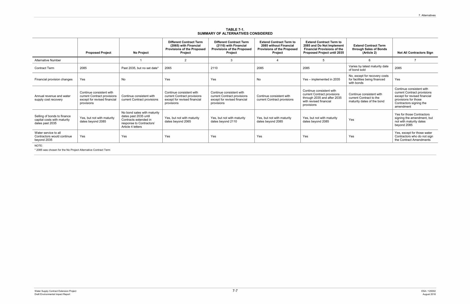
7. Alternatives
Water Supply Contract Extension Project 7-7 ESA / 120002 Draft Environmental Impact Report August 2016
TABLE 7-1. SUMMARY OF ALTERNATIVES CONSIDERED
Proposed Project No Project
Different Contract Term (2065) with Financial
Provisions of the Proposed Project
Different Contract Term (2110) with Financial
Provisions of the Proposed Project
Extend Contract Term to 2085 without Financial
Provisions of the Proposed Project
Extend Contract Term to 2085 and Do Not Implement Financial Provisions of the Proposed Project until 2035
Extend Contract Term through Sales of Bonds
(Article 2) Not All Contractors Sign
Alternative Number 1 2 3 4 5 6 7
Contract Term 2085 Past 2035, but no set date* 2065 2110 2085 2085 Varies by latest maturity date of bond sold 2085
Financial provision changes Yes No Yes Yes No Yes – implemented in 2035 No, except for recovery costs for facilities being financed with bonds
Yes
Annual revenue and water supply cost recovery
Continue consistent with current Contract provisions except for revised financial provisions
Continue consistent with current Contract provisions
Continue consistent with current Contract provisions except for revised financial provisions
Continue consistent with current Contract provisions except for revised financial provisions
Continue consistent with current Contract provisions
Continue consistent with current Contract provisions through 2035 and after 2035 with revised financial provisions
Continue consistent with current Contract to the maturity dates of the bond
Continue consistent with current Contract provisions except for revised financial provisions for those Contractors signing the amendment
Selling of bonds to finance capital costs with maturity dates past 2035
Yes, but not with maturity dates beyond 2085
No bond sales with maturity dates past 2035 until Contracts extended in response to Contractors’ Article 4 letters
Yes, but not with maturity dates beyond 2065
Yes, but not with maturity dates beyond 2110
Yes, but not with maturity dates beyond 2085
Yes, but not with maturity dates beyond 2085 Yes
Yes for those Contractors signing the amendment, but not with maturity dates beyond 2085
Water service to all Contractors would continue beyond 2035
Yes Yes Yes Yes Yes Yes Yes Yes, except for those water Contractors who do not sign the Contract Amendments
NOTE: * 2085 was chosen for the No Project Alternative Contract Term
7. Alternatives
Water Supply Contract Extension Project 7-8 ESA / 120002 Draft Environmental Impact Report August 2016
This page intentionally left blank
7. Alternatives
Water Supply Contract Extension Project 7-9 ESA / 120002 Draft Environmental Impact Report August 2016
the current compression in the recovery of capital costs and bond financing costs would be exacerbated.
7.4.1.1 Impact Analysis Similar to the proposed project, Alternative 1 would not result in any direct physical environmental impacts because it would not would not create new water management measures, alter the existing authority to build new or modify existing facilities, or change water allocation provisions of the Contracts. Operation of the SWP under this alternative would be subject to ongoing environmental regulations including for water rights, water quality and endangered species protection, among other State and federal laws. Also similar to the proposed project, Alternative 1 would not require permits or approvals to extend the Contracts as the Contractors would send in their Article 4 letters to extend the term of the Contracts beyond 2035. Article 4 provides as follows:
“4. OPTION FOR CONTINUED SERVICE
By written notice to the State at least six (6) months prior to the expiration of the term of this contract, the District may elect to receive continued service after expiration of said term under the following conditions unless otherwise agreed to:
(1) Service of water in annual amounts up to and including the District’s maximum annual entitlement hereunder.
(2) Service of water at no greater cost to the District than would have been the case had this contract continued in effect.
(3) Service of water under the same physical conditions of service including time, place, amount and rate of delivery, as are provided for hereunder.
(4) Retention of the same chemical quality objective provision as is set forth herein.
(5) Retention of the same options to utilize the project transportation facilities as are provided for in Articles 18(c) and 55, to the extent such options are then applicable.
Other terms and conditions of the continued service shall be reasonable and equitable and shall be mutually agreed upon. In the event that said terms and conditions provide for continued service for a limited number of years only, the District shall have the same option to receive
7. Alternatives
Water Supply Contract Extension Project 7-10 ESA / 120002 Draft Environmental Impact Report August 2016
continued service here provided for upon the expiration of that and each succeeding period of continued service.”
The no project alternative will likely result in a further delay in the ability of DWR to sell revenue bonds beyond 2035 to fund needed repairs and improvements to existing facilities and to fund the construction and acquisition of new facilities. Article 4 letters would be expected to be submitted over time between now and 2035 under the no project alternative. A determination of the length of the extension would be required. The Article 4 requirement that the service of water be at no greater cost than would have been the case had this Contract continued in effect, presents issues as to whether and how to establish a new project repayment period and payment methodology similar to that used in the existing Contract (or whether a new payment methodology should be established). So even under Article 4, there would be issues that would need to be addressed before the Contracts could be extended and this would take additional time.
This expected delay under the no project alternative would continue to exacerbate the revenue bond compression problem that DWR and the Contractors are currently facing. DWR is not issuing revenue bonds beyond the date of the first-expiring Contract term (December 31, 2035) because a secure revenue source is required for the successful marketing of DWR’s revenue bonds. The compressed revenue bond maturities would in turn require the Contractors to pay DWR the revenue bond debt service over a much shorter period of years and in much higher annual amounts than would otherwise be the case if the Contracts were extended and DWR were able to issue longer-term revenue bonds (historically, 30 years or more) commensurate with the expected economic life of the repairs, improvements and facilities being financed. Alternatively, DWR might decide to defer some SWP repairs, improvements, or construction projects to hold down the costs to be passed on to the Contractors. At the same time, some Contractors might opt to conserve funds for the purpose of paying DWR these higher annual charges under the Water Supply Contracts, by delaying expenditures for their own operations and/or local capital projects. This could indirectly affect the reliability of SWP water service and/or the reliability of some Contractors’ water service to their customers.
CEQA does not require lead agencies to speculate as to future environmental consequences, where future development is unspecified and uncertain. Impacts associated with deferred operation and maintenance and major construction are speculative at this time as it is unknown how deferred maintenance and repair would affect SWP facilities and, in turn, affect SWP water service, and it is unknown if the Contractors would have difficulty financing local system improvements and how this would affect their local water service. Nevertheless, it is reasonable to assume that the indirect impacts of this alternative would likely be greater than the impacts of the
7. Alternatives
Water Supply Contract Extension Project 7-11 ESA / 120002 Draft Environmental Impact Report August 2016
proposed project. But the extent and nature of such indirect impacts are speculative and not analyzed further in this EIR.
7.4.1.2 Ability to Meet Project Objectives Objective 1. Under Alternative 1, upon receipt of Article 4 letters from each Contractor (at least six months prior to the existing expiration date for such Contractor’s Contract) the term of each Contract would be extended so the Contracts would not begin to expire in 2035. While it is uncertain how far beyond 2035 the Contracts would be extended under this alternative, the year 2085 was chosen for the Contract term (which is the same as the proposed project). Furthermore, regardless of the extended Contract term established in response to the Article 4 letters submitted prior to their current expiration date, each Contractor will have a continuing right under Article 4 to request an extension of each extended Contract term under similar Contract provisions. Accordingly, although the length of the Contract term extension would not be determined until the Contractors submit their Article 4 letters and discussions between DWR and the Contractors as to the extended term take place, this alternative could meet the objectives of extending the current Contract expiration date through to at least 2085.
Therefore, Alternative 1 would meet this objective.
Objective 2. Unlike the proposed project, which would increase the GOA reserves (with an initial cap of no less than $150 million), Alternative 1 would keep the maximum amount held in the GOA at $32 million (with a formula in the Contract for further but limited adjustments of that cap amount). This would result in less reserves for cash flow deficiencies resulting from water supply purposes chargeable to the Contractors or for any SWP emergency. Unlike the proposed project, Alternative 1 does not include a new SRA to fund the capital costs of individual SWP projects that are chargeable to the Contractors and for which neither general obligation bonds nor revenue bonds are issued. In addition, it does not include an SSA to provide for payment of costs that are not reimbursable by the Contractors. This could result in some funds not being available when needed for operation, maintenance, construction, and repair of the SWP facilities.
As with the proposed project, Alternative 1 would allow SWP revenue bonds to be issued beyond 2035, but there likely would be a substantial delay in extending the Contracts through the use of Article 4 and therefore a delay in being able to issue bonds with maturities beyond 2035. Also, revenue bonds could only be issued for those projects and activities currently in the list for which revenue bonds could be sold. Unlike the proposed project, bonds to fund repairs, additions and betterments to existing SWP facilities could only be issued if those facilities were in existence prior to January 1,
7. Alternatives
Water Supply Contract Extension Project 7-12 ESA / 120002 Draft Environmental Impact Report August 2016
1987. In addition, also unlike the proposed project, new projects could not be added with the agreement of only 80 percent of the affected Contractors to the list of projects for which revenue bonds could be sold.
Therefore, Alternative 1 would not meet this objective.
Objective 3. Unlike the proposed project, the Contract articles would not be amended or added to enhance the current billing provisions and the billing process would not be simplified. Unlike the proposed project, Alternative 1 would not implement a comprehensive pay-as-you-go repayment methodology to recover SWP water supply costs incurred after the proposed Contract extension amendments are signed. Alternative 1 would continue to use the existing repayment methodology (unless another methodology were agreed upon) as explained in Chapter 3, State Water Project Financing and Water Supply Contract Financial Provisions (Section 3.3.1).This would result in the continuing mismatch of certain revenues and expenditures. This mismatch of certain revenues and expenditures was a billing issue sought to be alleviated by the proposed project’s change to a comprehensive pay-as-you-go methodology.
Therefore, Alternative 1 would not meet this objective.
Objective 4. Unlike the proposed project, Alternative 1 would not provide for a SWRDS Finance Committee nor the preparation of DWR specific reports regarding SWP finances, to be provided to the SWRDS Finance Committee. The Contractors would not have this contractually established process to interact with DWR on the financial matters of the SWP.
Therefore, Alternative 1 would not meet this objective.
Summary Alternative 1 would not meet the basic objectives of the project. It would likely result in substantial delay in extending the Contract, and in so doing exacerbate the revenue bond debt service compression problem that DWR and the Contractors are currently facing and are seeking to alleviate. Although Article 4 provides a contractual right to the Contractors to obtain extensions of their water supply Contracts with the same water delivery service, water quality and cost of service, there are additional provisions that still would need to be addressed, such as the new “repayment period” (unless another payment methodology is agreed to) and the length of the extended term, before the Contracts could be extended. In addition, the limit on the amount of the reserves in the GOA and the lack of the additional accounts to provide the necessary funds for SWP purposes, could have an adverse impact on DWR’s ability to address both anticipated
7. Alternatives
Water Supply Contract Extension Project 7-13 ESA / 120002 Draft Environmental Impact Report August 2016
and unexpected funding needs. Also, the failure to update the billing system methodology used for the first term of the project to a comprehensive pay-as-you-go methodology for all Contractor charges would be disadvantageous to DWR and the Contractors. Therefore, while Alternative 1 would meet Objective 1 it would not meet Objectives 2 through 4.
7.4.2 Alternative 2: Different Contract Term (2065) with Financial Provisions of the Proposed Project
Under Alternative 2, DWR and the Contractors would agree to implement the proposed financial provision changes and extend the term of the Contract beyond December 31, 2035, to 2065 compared to the proposed project (2085). Repayment of existing bonds covering past expenditures would continue to 2035 consistent with the current Contracts as modified by the proposed financial provision changes. Bond sales to fund future expenditures would continue past 2035, but no bonds would be sold with a maturity date beyond 2065. Water service would continue beyond 2035 consistent with the current Contracts. The proposed project’s revised financial provisions would begin to be implemented upon Contract amendment execution. All other Contract provisions would remain unchanged.
7.4.2.1 Impact Analysis Similar to the proposed project, through 2065, Alternative 2 would not result in any direct physical environmental impacts because it would not create new water management measures, alter the existing authority to build new or modify existing facilities, or change water allocation provisions of the current Contracts. Operation of the SWP under this alternative would be subject to ongoing environmental regulations including for water rights, water quality and endangered species protection, among other State and federal laws. Also similar to the proposed project, Alternative 2 would not require permits or approvals to extend the Contract, except approvals by DWR and the Contractors to execute the Contract amendments.
7.4.2.2 Ability to Meet Project Objectives Objective 1. Under Alternative 2, DWR and the Contractors would agree to implement the proposed financial provision changes and extend the term of the Contracts beyond December 31, 2035, to 2065 compared to the proposed project (2085).
As with the proposed project, the major sources of funding of capital financing for construction and repair of the SWP would continue to be the Central Valley Project Act which authorizes the issuance of revenue bonds, State appropriations and SWP water and power revenues. The Burns-Porter Act and the Central Valley Project Act would
7. Alternatives
Water Supply Contract Extension Project 7-14 ESA / 120002 Draft Environmental Impact Report August 2016
continue to authorize the expenditure of funds for the operation and maintenance of the SWP facilities. Also, similar to the proposed project, water service would continue beyond 2035 to all the Contractors.
Unlike the proposed project which extends the Contract date to 2085, Alternative 2 would extend the date to only 2065. This alternative would allow for the sale of revenue bonds beyond 2035, but unlike the proposed project, revenue bonds would not be sold with maturities beyond 2065. This would shorten the time period before DWR and the Contractors would next face a revenue bond debt service compression problem and again need to discuss a new extension. It would also have an impact on long-term financial planning, as compared to the proposed project. Many of the facilities financed with revenue bonds have expected useful lives of at least 30 years and as much as 50 years or more, thus supporting a longer contractual term for financial planning purposes. In addition, any extension beyond 2065 would require either a new Contract extension amendment, with provisions to be negotiated for inclusion in the new amendment or Contractors’ submission of Article 4 notices to DWR, which would entitle the Contractors to receive water service in accordance with the major provisions in effect as of the date of the submission of such notices. However, the manner of such extension and the provisions that would govern any Contract beyond 2065 are speculative at this time.
Therefore, Alternative 2 would meet this objective; however, to a lesser degree than the proposed project because the new Contract term would be shorter.
Objective 2. As with the proposed project, Alternative 2 would increase the reserves, with an initial cap of no less than $150 million within the existing GOA (see Section 4.4.2).
As with the proposed project, Alternative 2 would include a new SRA for capital costs of individual SWP projects that are chargeable to the Contractors and for which neither general obligation bonds nor revenue bonds are issued (see Section 4.4.4, item 1). This alternative would also include an SSA to provide for payment of costs that are not reimbursable by the Contractors (see Section 4.4.4, item 2). Further, under Alternative 2, identical to the proposed project, SWP revenue bonds could be issued for repairs, additions, and betterments to existing facilities (including facilities constructed or acquired after 1986) and for projects approved by 80 percent of the affected Contractors (see Section 4.4.4, item 4).
Therefore, Alternative 2 would meet this objective.

7. Alternatives
Water Supply Contract Extension Project 7-15 ESA / 120002 Draft Environmental Impact Report August 2016
Objective 3. Similar to the proposed project, under Alternative 2 the Contract articles would be amended or added to enhance the current billing provisions (see Section 4.4.3).
Therefore, Alternative 2 would meet this objective.
Objective 4. Similar to the proposed project, Alternative 2 would provide for a SWRDS Finance Committee and the preparation of DWR specific reports regarding SWP finances, to be provided to the SWRDS Finance Committee (see Section 4.4.5).
Therefore, Alternative 2 would meet this objective.
Summary Alternative 2 would meet the objectives of the project, but to a lesser degree because it represents a shorter Contract term than is desired by DWR and the SWP Contractors.
7.4.3 Alternative 3: Different Contract Term (2110) with Financial Provisions of the Proposed Project
Under Alternative 3, DWR and the Contractors would agree to implement the proposed financial provision changes and extend the term of the Contract beyond December 31, 2035, to 2110 compared to the proposed project (2085). Repayment of existing bonds covering past expenditures would continue to 2035 consistent with the current Contract as modified by the proposed financial provision changes. Bond sales to fund future expenditures would continue past 2035, but no bonds would be sold with a maturity date beyond 2110. Water service would continue beyond 2035 consistent with the current Contract. Annual revenue and water supply cost recovery would continue consistent with the current Contract except for the revised financial provision changes.
7.4.3.1 Impact Analysis Alternative 3 would not result in any direct physical environmental impacts because it would not create new water management measures, alter the existing authority to build new or modify existing facilities, or change water allocation provisions of the current Contracts. Operation of the SWP under this alternative would be subject to ongoing environmental regulations including for water rights, water quality and endangered species protection, among other State and federal laws. Also similar to the proposed project, Alternative 3 would not require permits or approvals to extend the Contract, except approvals by DWR and the Contractors to execute the Contract amendments.
7. Alternatives
Water Supply Contract Extension Project 7-16 ESA / 120002 Draft Environmental Impact Report August 2016
7.4.3.2 Ability to Meet Project Objectives Objective 1. Under Alternative 3, DWR and the Contractors would agree to implement the proposed financial provision changes and extend the term of the contract beyond December 31, 2035, to 2110 compared to the proposed project (2085).
As with the proposed project, the major sources of funding of capital financing for construction and repair of the SWP would continue to be the Central Valley Project Act which authorizes the issuance of revenue bonds, State appropriations and SWP water and power revenues. The Burns-Porter Act and the Central Valley Project Act would continue to authorize the expenditure of funds for the operation and maintenance of the SWP facilities. Also, identical to the proposed project, water service would continue beyond 2035 to all the Contractors.
Therefore, Alternative 3 would meet this objective.
Objective 2. As with the proposed project, Alternative 3 would increase the reserves, with an initial cap of no less than $150M within the existing GOA (see Section 4.4.2).
As with the proposed project, Alternative 3 would include a new SRA for capital costs of individual SWP projects that are chargeable to the Contractors and for which neither general obligation bonds nor revenue bonds are issued (see Section 4.4.4, item 1). This alternative would also include an SSA to provide for payment of costs that are not reimbursable by the Contractors (see Section 4.4.4, item 2). Further, under Alternative 3, identical to the proposed project, SWP revenue bonds could be issued for repairs, additions and betterments to existing facilities (including facilities constructed or acquired after 1986) and for projects approved by 80 percent of the affected Contractors (see Section 4.4.4, item 4).
Therefore, Alternative 3 would meet this objective.
Objective 3. Similar to the proposed project, under Alternative 3 the Contract articles would be amended or added to enhance the current billing provisions (see Section 4.4.3).
Therefore, Alternative 3 would meet this objective.
Objective 4. Similar to the proposed project, Alternative 3 would provide for a SWRDS Finance Committee and the preparation of DWR specific reports regarding SWP finances, to be provided to the SWRDS Finance Committee (see Section 4.4.5).
Therefore, Alternative 3 would meet this objective.
7. Alternatives
Water Supply Contract Extension Project 7-17 ESA / 120002 Draft Environmental Impact Report August 2016
Summary Alternative 3 would meet the objectives of the proposed project, but it represents a longer Contract term than is desired by DWR. DWR believes that an expiration date of 2085 rather than an expiration date further into the future will provide a sufficiently extended period for DWR to sell its long term bonds and to evaluate the benefits and effectiveness of the proposed project. In addition, an expiration date of 2085 allows DWR and the Contractors sufficient time in advance of 2085 to discuss changes that may be needed or desirable post 2085.
7.4.4 Alternative 4: Extend Contract Term to 2085 without Financial Provisions of the Proposed Project
Under this alternative DWR and the Contractors would agree to extend the Contract term to 2085 and would not implement proposed financial provision changes. Repayment of existing bonds covering past expenditures would continue to 2035 consistent with the current Contracts. Bond sales could start after Contract extension amendment approval and the bonds would have maturity dates beyond 2035, but no bonds would be sold with a maturity date beyond 2085. Water service to all Contractors would continue beyond 2035 consistent with the current Contract. Annual revenue and water supply cost recovery would continue consistent with the current Contract.
7.4.4.1 Impact Analysis Similar to the proposed project, Alternative 4 would not result in any direct physical environmental impacts because it would not would not create new water management measures, alter the existing authority to build new or modify existing facilities, or change water allocation provisions of the current Contracts. Operation of the SWP under this alternative would be subject to ongoing environmental regulations, including for water rights, water quality, and endangered species protection, among other State and federal laws. Also similar to the proposed project, Alternative 4 would not require permits or approvals to extend the Contract, except approvals by DWR and the Contractors to execute the Contract amendments.
7.4.4.2 Ability to Meet Project Objectives Objective 1. Under Alternative 4, DWR and the Contractors would agree to extend the term of the Contracts beyond December 31, 2035, to 2085, consistent with the proposed project’s extended term.
As with the proposed project, the major sources of funding of capital financing for construction and repair of the SWP would continue to be the Central Valley Project Act which authorizes the issuance of revenue bonds, State appropriations and SWP water
7. Alternatives
Water Supply Contract Extension Project 7-18 ESA / 120002 Draft Environmental Impact Report August 2016
and power revenues. The Burns-Porter Act and the Central Valley Project Act would continue to authorize the expenditure of funds for the operation and maintenance of the SWP facilities. Also, identical to the proposed project, water service would continue beyond 2035 to all the Contractors.
Therefore, Alternative 4 would meet this objective.
Objective 2. Unlike the proposed project, which would increase the GOA reserves (with an initial cap of no less than $150 million), Alternative 4 would keep the maximum amount held in the GOA at $32 million (with a formula in the Contract for further but limited adjustments of that cap amount). This would result in less reserves for cash flow deficiencies resulting from water supply purposes chargeable to the Contractors or for any SWP emergency.
Unlike the proposed project, Alternative 4 does not include a new SRA to fund the capital costs of individual SWP projects that are chargeable to the Contractors and for which neither general obligation bonds nor revenue bonds are issued. In addition, it does not include an SSA to provide for payment of costs that are not reimbursable by the Contractors. This could result in some funds not being available when needed for operation, maintenance, construction, and repair of the SWP facilities.
As with the proposed project, Alternative 4 would allow SWP revenue bonds to be issued beyond 2035. However, revenue bonds could only be issued for those projects and activities currently in the list for which revenue bonds could be sold. Unlike the proposed project, bonds to fund repairs, additions and betterments to existing SWP facilities could only be issued if those facilities were in existence prior to January 1, 1987. In addition, also unlike the proposed project, new projects could not be added with the agreement of 80 percent of the affected Contractors to the list of projects for which revenue bonds could be sold.
Therefore, Alternative 4 would not meet this objective.
Objective 3. Unlike the proposed project, the Contract articles would not be amended or added to enhance the current billing provisions and the billing process would not be simplified. Unlike the proposed project, Alternative 4 would not implement a comprehensive pay-as-you-go repayment methodology to recover SWP water supply costs incurred after the proposed Contract extension amendments are signed. Alternative 4 would continue to use the existing repayment methodology (unless another methodology were agreed upon) as explained in Chapter 3, State Water Project Financing and Water Supply Contract Financial Provisions (Section 3.3.1).This would
7. Alternatives
Water Supply Contract Extension Project 7-19 ESA / 120002 Draft Environmental Impact Report August 2016
result in the continuing mismatch of certain revenues and expenditures. This mismatch of certain revenues and expenditures was a billing issue sought to be alleviated by the proposed project’s change to a comprehensive pay-as-you-go methodology.
Therefore, Alternative 4 would not meet this objective.
Objective 4. Unlike the proposed project, Alternative 4 would not provide for a SWRDS Finance Committee nor the preparation of DWR specific reports regarding SWP finances, to be provided to the SWRDS Finance Committee. The Contractors would not have this contractually established process to interact with DWR on the financial matters of the SWP.
Therefore, Alternative 4 would not meet this objective.
Summary Alternative 4 would meet Objective 1, but it would not meet Objectives 2 through 4. Therefore, Alternative 4 would meet some but not all of the project objectives.
7.4.5 Alternative 5: Extend Contract Term to 2085 and do not Implement Financial Provisions of the Proposed Project until 2035
Under this alternative, DWR and the Contractors would agree to extend the term of the Contract to 2085 but would not implement financial provision changes until 2035. Water service to all Contractors would continue beyond 2035 consistent with the current Contract. Annual revenue and water supply cost recovery would continue consistent with the current Contract through 2035, with the exception that the method for charging the Contractors for debt service on bonds sold prior to 2035, but with maturities extending beyond 2035, would need to be addressed. After 2035 the proposed financial provision changes would be implemented.
7.4.5.1 Impact Analysis Similar to the proposed project, Alternative 5 would not result in any direct physical environmental impacts because it would not would not create new water management measures, alter the existing authority to build new or modify existing facilities, or change water allocation provisions of the current Contracts. Operation of the SWP under this alternative would be subject to ongoing environmental regulations including for water rights, water quality and endangered species protection, among other State and federal laws. Also similar to the proposed project, Alternative 5 would not require permits or approvals to extend the Contract, except approvals by DWR and the Contractors to execute the Contract amendments.
7. Alternatives
Water Supply Contract Extension Project 7-20 ESA / 120002 Draft Environmental Impact Report August 2016
7.4.5.2 Ability to Meet Project Objectives Objective 1. Under Alternative 5, DWR and the Contractors would agree to extend the term of the Contract beyond December 31, 2035, to 2085, consistent with the proposed project’s extended term.
As with the proposed project, the major sources of funding of capital financing for construction and repair of the SWP would continue to be the Central Valley Project Act which authorizes the issuance of revenue bonds, State appropriations and SWP water and power revenues. The Burns-Porter Act and the Central Valley Project Act would continue to authorize the expenditure of funds for the operation and maintenance of the SWP facilities. Also, identical to the proposed project, water service would continue beyond 2035 to all the Contractors.
Therefore, Alternative 5 would meet this objective.
Objective 2. As with the proposed project, Alternative 5 would implement the new financial provisions, but not until 2035, with no changes in financial provisions prior to 2035. In 2035, Alternative 5 would increase the reserves, with an initial cap of no less than $150M within the existing GOA.
As with the proposed project, Alternative 5 would include a new SRA for capital costs of individual SWP projects that are chargeable to the Contractors and for which neither general obligation bonds nor revenue bonds are issued. This alternative would also include an SSA to provide for payment of costs that are not reimbursable by the Contractors. However, under Alternative 5, none of these accounts would be in place until after 2035. Under Alternative 5, revenue bonds could be issued for repairs, additions and betterments to existing facilities (including facilities constructed or acquired after 1986) and issued for projects approved by 80 percent of the affected Contractors as stated in Chapter 4, Section 4.4.4, item 4, but these changes would not take effect until after 2035.
Therefore, Alternative 5 would meet this project objective, but to a lesser degree than the proposed project as the modified financial provisions would not take effect until after 2035.
Objective 3. Similar to the proposed project, under Alternative 5 the Contract articles would be amended or added to enhance the current billing provisions, but unlike the proposed project, the new billing provisions would not be implemented until 2035.
Identical to the proposed project, Alternative 5 would implement a comprehensive pay-as-you-go repayment methodology to recover SWP water supply costs. However, the
7. Alternatives
Water Supply Contract Extension Project 7-21 ESA / 120002 Draft Environmental Impact Report August 2016
comprehensive pay-as-you-go billing methodology would only apply to costs incurred after 2035. Alternative 5 would continue to use the existing repayment methodology as explained in Chapter 3, State Water Project Financing and Water Supply Contract Financial Provisions (Section 3.3.1) for costs incurred through 2035, with the exception that the method for charging the Contractors for debt service on bonds sold prior to 2035, but with maturities extending beyond 2035, would need to be addressed.
Therefore, Alternative 5 would meet this project objective, but to a lesser degree than the proposed project, as the financial provision changes would not take effect until after 2035.
Objective 4. Identical to the proposed project, Alternative 5 would provide for a SWRDS Finance Committee and the preparation of DWR specific reports regarding SWP finances, to be provided to the SWRDS Finance Committee. However, the Finance Committee and other related provisions would not take effect until after 2035.
Therefore, Alternative 5 meets this objective, but not until after 2035.
Summary Alternative 5 would meet Objective 1. Alternative 5 would also meet Objectives 2 through 4, but to a lesser degree than the proposed project because implementation of the financial provision changes would be delayed until after 2035.
7.4.6 Alternative 6: Extend Contract Term Through the Sale of Bonds
Under this alternative DWR would sell bonds with maturity dates extending beyond the current Contract expiration dates which, pursuant to Article 2 of the Contract, would have the effect of extending the Contract term to the latest maturity date of the bonds sold. The proposed financial provision changes would not be implemented. Repayment of existing bonds covering past expenditures would continue to 2035 consistent with the current Contract. Bond sales to fund future expenditures would continue past 2035 with the Contract term extended to the latest maturity date of any bond sold. Water service to all Contractors would continue beyond 2035 consistent with the current Contract. Annual revenue and water supply cost recovery would continue consistent with the current Contract through to the extended Contract expiration date, although some cost recovery and billing issues would need to be addressed.
Also, without a Contract amendment, there would be uncertainty, among other things, about DWR’s ability to continue to market long-term revenue bonds in a cost effective manner, DWR’s ability to engage in reliable long-term financial planning and the effect this would have on the financial integrity of the SWP.
7. Alternatives
Water Supply Contract Extension Project 7-22 ESA / 120002 Draft Environmental Impact Report August 2016
7.4.6.1 Impact Analysis Similar to the proposed project, Alternative 6 would not result in any direct physical environmental impacts because it would not create new water management measures, alter the existing authority to build new or modify existing facilities, or change water allocation provisions of the current Contracts. Operation of the SWP under this alternative would be subject to ongoing environmental regulations including for water rights, water quality and endangered species protection, among other State and federal laws. Also similar to the proposed project, Alternative 6 would not require permits or approvals to extend the Contract, except approvals by DWR and the Contractors to execute the Contract amendments.
7.4.6.2 Ability to Meet Project Objectives Objective 1. Under Alternative 6, DWR would sell bonds with maturity dates extending beyond the current Contract expiration dates, which would have the effect of extending the Contract term to the latest maturity date of the bonds sold. Therefore, the term of the Contract would be extended beyond December 31, 2035. However, the length of any Contract term extension would continue to change with each subsequent bond sale with a maturity extending beyond the maturity dates of all earlier bond issuances. With a fluctuating Contract term, there would be uncertainty, among other things, about DWR’s ability to continue to market long-term revenue bonds in a cost effective manner, DWR’s ability to engage in reliable long-term financial planning and the effect this would have on the financial integrity of the SWP.
As with the proposed project, the major the sources of funding of capital financing for construction and repair of the SWP would continue to be the Central Valley Project Act which authorizes the issuance of revenue bonds, State appropriations and SWP water and power revenues. The Burns-Porter Act and the Central Valley Project Act would continue to authorize the expenditure of funds for the operation and maintenance of the SWP facilities. Also identical to the proposed project, water service would continue beyond 2035 to all the Contractors.
Therefore, Alternative 6 would not meet this objective.
Objective 2. Unlike the proposed project, which would increase the GOA reserves (with an initial cap of no less than $150 million), Alternative 6 would keep the maximum amount held in the GOA at $32 million (with a formula in the Contract for further but limited adjustments of that cap amount). This would result in less reserves for cash flow deficiencies resulting from water supply purposes chargeable to the Contractors or for any SWP emergency.

7. Alternatives
Water Supply Contract Extension Project 7-23 ESA / 120002 Draft Environmental Impact Report August 2016
Unlike the proposed project, Alternative 6 does not include a new SRA to fund the capital costs of individual SWP projects that are chargeable to the Contractors and for which neither general obligation bonds nor revenue bonds are issued. In addition, it does not include an SSA to provide for payment of costs that are not reimbursable by the Contractors. This could result in some funds not being available when needed for operation, maintenance, construction, and repair of the SWP facilities.
As with the proposed project, Alternative 6 would allow SWP revenue bonds to be issued beyond 2035. However, revenue bonds could only be issued for those projects and activities currently in the list for which revenue bonds could be sold. Unlike the proposed project, bonds to fund repairs, additions and betterments to existing SWP facilities could only be issued if those facilities were in existence prior to January 1, 1987. In addition, also unlike the proposed project, new projects could not be added with the agreement of only 80 percent of the affected Contractors to the list of projects for which revenue bonds could be sold.
Therefore, Alternative 6 would not meet this objective.
Objective 3. Unlike the proposed project, the Contract articles would not be amended or added to enhance the current billing provisions and the billing process would not be simplified. Unlike the proposed project, Alternative 6 would not implement a comprehensive pay-as-you-go repayment methodology to recover SWP water supply costs incurred after the proposed Contract extension amendments are signed. Alternative 1 would continue to use the existing repayment methodology (unless another methodology were agreed upon) as explained in Chapter 3, State Water Project Financing and Water Supply Contract Financial Provisions (Section 3.3.1).This would result in the continuing mismatch of certain revenues and expenditures. This mismatch of certain revenues and expenditures was a billing issue sought to be alleviated by the proposed project’s change to a comprehensive pay-as-you-go methodology.
Therefore, Alternative 6 would not meet this objective.
Objective 4. Unlike the proposed project, Alternative 6 would not provide for a SWRDS Finance Committee nor the preparation of DWR specific reports regarding SWP finances, to be provided to the SWRDS Finance Committee. The Contractors would not have this contractually established process to interact with DWR on the financial matters of the SWP.
Therefore, Alternative 6 would not meet this objective.
7. Alternatives
Water Supply Contract Extension Project 7-24 ESA / 120002 Draft Environmental Impact Report August 2016
Summary Alternative 6 would not meet the objectives of the proposed project.
7.4.7 Alternative 7: Not All Contractors Sign
Under this alternative, DWR and most Contractors would choose to sign the Contract amendment. Some Contractors, however, could choose not to sign the Contract amendment and have their water service cease on their Contract expiration dates. For those Contractors who choose not to sign the Contract amendment, annual revenue and water supply cost recovery would continue consistent with the current Contract through to their Contract expiration dates, without the implementation of the financial provision changes. For those Contractors who sign the Contract amendment, their Contracts would be extended to 2085 and their water service would continue under the existing Contract provisions through to 2085. Annual revenue and water supply cost recovery would continue consistent with current Contract except for the proposed financial provision changes. Repayment of existing bonds covering past expenditures would continue to 2035 consistent with the current Contract provisions. Bond sales to fund future expenditures would continue past 2035 using the new modified financial provisions, but no bonds would be sold with a maturity date beyond 2085.
7.4.7.1 Impact Analysis Similar to the proposed project, Alternative 7 would not result in any direct physical environmental impacts because it would not would not create new water management measures or alter the existing authority to build new or modify existing facilities, or change water allocation provisions of the current Contracts. However, it may lead to indirect impacts due to changes in project operation as some Contractors discontinue receiving SWP water service.
For those Contractors that do not sign the Contract amendments, they would be required to pay all of their allocated charges prior to the expiration of their Contracts, resulting in compression of capital charges reimbursements (identical to Alternative 1- No Project Alternative). Compression of capital charges to finance SWP expenditures could make it more costly for those Contractors to finance SWP expenditures, compared to the proposed project. Therefore, as the annual bills increase due to repayment compaction, Contractors that do not sign may have difficulty financing local system improvements and local water service could be adversely impacted.
Contractors that do not sign the Contracts, and relinquish their SWP water supply could face future water shortages leading to permanent cuts in water supply to their customers, fallowing of agricultural land, and change in cropping patterns or

7. Alternatives
Water Supply Contract Extension Project 7-25 ESA / 120002 Draft Environmental Impact Report August 2016
development of alternative water supplies. This could result in mandatory water conservation measures, a change in agricultural economics, new fugitive dust air quality emissions (PM10, a criteria air pollutant), increased groundwater extraction and overdraft, or environmental impacts from development of new surface supplies, or all of the above. The exact location or extent of these potential effects is too speculative to predict or evaluate since the location and number of Contractors who do not sign is currently unknown.
7.4.7.2 Ability to Meet Project Objectives Objective 1. The Not All Contractors Sign Alternative would be the same as the proposed project for those Contractors signing the Contract amendments. Unlike the proposed project, for those Contractors not signing the Contract amendments, their Contracts would expire on the dates stated in their Contract and water service for these Contractors would not continue beyond expiration of their Contracts.
Alternative 7 would meet this objective for DWR and those Contractors signing the Contract amendment, but it would not meet it for those Contractors not signing the Contract amendments.
Objective 2. Alternative 7 would be the same as the proposed project for those Contractors signing the Contract amendments. Unlike the proposed project, for those Contractors not signing the Contract amendments, their Contracts would keep their same financial provisions until their expiration dates stated in their Contracts.
Alternative 7 would meet this objective for DWR and those Contractors signing the Contract amendment, but it would not meet it for those Contractors not signing the Contract amendments.
Objective 3. Alternative 7 would be the same as the proposed project for those Contractors signing the Contract amendments. Unlike the proposed project, for those Contractors not signing the Contract amendments, the Contract articles would not be amended or added to enhance the current billing provisions and the billing process would not be simplified. These Contractors would continue to be billed using the existing repayment methodology as explained in Chapter 3 (Section 3.3.1).
Alternative 7 would meet this objective for DWR and those Contractors signing the Contract amendments, but it would not meet it for those Contractors not signing the Contract amendments.
Objective 4. Alternative 7 would be the same as the proposed project for those Contractors signing the Contract amendments. For those Contractors not signing the
7. Alternatives
Water Supply Contract Extension Project 7-26 ESA / 120002 Draft Environmental Impact Report August 2016
Contract amendments, they would not be members of the SWRDS Finance Committee, but would otherwise be able to benefit from the enhanced coordination, including receiving copies of the reports that DWR would be required to prepare.
Therefore, Alternative 7 meets this objective.
Summary All objectives are met for DWR and those Contractors signing the Contract amendment, but Objectives 1 through 3 would not be met for those Contractors not signing the Contract amendments.
7.5 ENVIRONMENTALLY SUPERIOR ALTERNATIVE
CEQA requires identification of an environmental superior alternative; that is, the alternative that has the least significant impacts on the environment. Table 7-2 presents a summary of how each alternative compares to the proposed project with respect to the impacts and the ability to meet project objectives. As presented in Chapter 5, implementation of the proposed project would not result in any physical environmental impacts. As discussed in Section 7.4, identical to the proposed project, Alternatives 2 through 6 would also not result in any impacts. Alternatives 1 and 7 could result in indirect impacts not identified for the proposed project. Under Alternative 1 there would likely be delays in the ability of DWR to sell revenue bonds beyond 2035 to fund needed repairs and improvements to existing facilities or the construction and acquisition of new facilities. Furthermore, Contractors could also delay expenditures on their own operations and/or local capital projects. This could indirectly affect the reliability of SWP water service and/or the reliability of some Contractors’ water service. Alternative 7 could result in indirect impacts due to changes in project operations as some Contractors no longer receive SWP water service. Contractors that do not sign the Contracts, and thus relinquish their SWP water supply, could face future water shortages leading to permanent cuts in water supply to their customers, fallowing of agricultural land, and change in cropping patterns or development of alternative water supplies. This could result in mandatory water conservation measures, a change in agricultural economics, new fugitive dust air quality emissions (PM10, a criteria air pollutant), increased groundwater extraction and overdraft, or environmental impacts from development of new surface supplies, or all of the above. The exact location or extent of these potential effects is too speculative to predict or evaluate since the location and number of Contractors that will not sign is currently unknown.

7. Alternatives
Water Supply Contract Extension Project 7-27 ESA / 120002 Draft Environmental Impact Report August 2016
TABLE 7-2. COMPARISON OF ALTERNATIVES TO PROPOSED PROJECT
Prop
osed
Pro
ject
Alte
rnat
ive
1
No
Pro
ject
Alte
rnat
ive
2 D
iffer
ent C
ontra
ct T
erm
(206
5) w
ith F
inan
cial
P
rovi
sion
s of
the
Pro
pose
d P
roje
ct
Alte
rnat
ive
3
Diff
eren
t Con
tract
Ter
m (2
110)
with
Fin
anci
al
Pro
visi
ons
of th
e P
ropo
sed
Pro
ject
Alte
rnat
ive
4
Ext
end
Con
tract
Ter
m to
208
5 at
the
Tim
e of
P
roje
ct A
ppro
val w
ithou
t Fin
anci
al P
rovi
sion
s of
th
e P
ropo
sed
Pro
ject
Alte
rnat
ive
5 E
xten
d C
ontra
ct T
erm
to 2
085
and
Do
Not
Im
plem
ent F
inan
cial
Pro
visi
ons
of th
e P
ropo
sed
Pro
ject
unt
il 20
35
Alte
rnat
ive
6 E
xten
d C
ontra
ct T
erm
thro
ugh
Sal
e of
Bon
ds
Alte
rnat
ive
7 N
ot A
ll C
ontra
ctor
s S
ign
Environmental Impacts No Impacts Greater Same Same Same Same Same Greater
Meets Project Objectives
Objective 1 Yes Yes Yes/Less Yes Yes Yes No Yes/No
Objective 2 Yes No Yes Yes No Yes/Less No Yes/No
Objective 3 Yes No Yes Yes No Yes/Less No Yes/No
Objective 4 Yes No Yes Yes No Yes/Less No Yes
7. Alternatives
Water Supply Contract Extension Project 7-28 ESA / 120002 Draft Environmental Impact Report August 2016
With respect to achieving project objectives, only Alternative 3 would achieve all of the proposed project objectives; however, this alternative represents a longer Contract term than is desired by DWR. Alternatives 2 and 5 would achieve the project objectives, but to a lesser extent when compared to the proposed project. Under Alternative 2, Objective 1 would be achieved to a lesser degree because the new Contract term would be shorter, resulting in the sale of revenue bonds with maturity dates that do not extend beyond 2065. This would shorten the time period before DWR and the Contractors would face a revenue bond debt service compression problem. Under Alternative 5, Objectives 2 through 4 would not be achieved until after 2035 when the financial provision modifications would take effect. Alternative 7 would also achieve the proposed project objectives; however, all of the objectives would be achieved only for DWR and the Contractors that sign the amendment.
Therefore, because the proposed project and Alternatives 2 through 6 would result in no impact, they would be the environmentally superior alternatives. However, only the proposed project and Alternative 3 would achieve the project objectives.
7.6 REFERENCES
DWR (California Department of Water Resources). 2015. California Water Action Plan. DWR and Reclamation (California Department of Water Resources and U.S. Bureau of
Reclamation). 2015. Bay Delta Conservation Plan/California WaterFix Partially Recirculated Draft Environmental Impact Report/Supplemental Draft Environmental Impact Statement (RDEIR/SDEIS). Available: http://baydeltaconservationplan.com/2015PublicReview.aspx.
Natural Resources Agency (California Natural Resources Agency). 2015. Bay-Delta Conservation Plan. http://baydeltaconservationplan.com/Home.aspx. Accessed June 29, 2015.
Wilson, Craig M. 2012. The Reasonable Use Doctrine and Agricultural Water Use Efficiency. A report to the State Water Resources Control Board and the Delta Stewardship Council.

Chapter 8 Contributors and Reviewers

Water Supply Contract Extension Project 8-1 ESA / 120002 Draft Environmental Impact Report August 2016
8 CONTRIBUTORS AND REVIEWERS
8.1 CALIFORNIA DWR
Department of Water Resources 1416 9th Street Sacramento, CA 95814
8.1.1 DWR STAFF
Teodoro Alvarez, Supervising Engineer, Water Resources Steve Cohen, Staff Counsel, Office of the Chief Counsel Robert Cooke, Chief, State Water Project Analysis Office Terri Ely, Senior Environmental Scientist Scott Jercich, Principal Engineer, Water Resources Perla Netto-Brown, Chief, Division of Fiscal Services Dave Paulson, Supervising Engineer, Water Resources Nancy Quan, Supervising Engineer, Water Resources Vera Sandronsky, Attorney IV, Office of the Chief Counsel Lisa Toms, Accounting Administrator III Raphael Torres, Chief of Utility Operations, Water Resources (Retired Annuitant) Pedro Villalobos, Principal HEP Utility Engineer
8.2 EIR CONSULTANTS
Environmental Science Associates (ESA) 2600 Capitol Avenue, Suite 200 Sacramento, CA 95816
MWH 3301 C Street, Suite 1900 Sacramento, CA 95816
8.2.1 Project Management
Project Manager - Cathy McEfee (ESA) Deputy Project Manager - Erick Cooke
8. Contributors and Reviewers
Water Supply Contract Extension Project 8-2 ESA / 120002 Draft Environmental Impact Report August 2016
8.2.2 Technical Support
8.2.2.1 ESA Cathy McEfee, Vice President Project Description, Alternatives Erick Cooke, Senior Managing Associate Project Description, Alternatives Kathy Anderson, Managing Associate Cultural Resources Stan Armstrong, Associate Air Quality, Noise, Greenhouse Gas Emissions Chris Fitzer, Program Manager Biological Resources Todd Gordon, Associate Public Services and Recreation, Utilities and Service Systems Samhita Saquib, Associate Aesthetics, Agricultural and Forestry Resources,
Land Use and Planning, Population and Housing, Transportation
Emma Gill, Administrative Manager Administrative Record, Document Production Kristine Olsen, Senior Word Processor Document Production Megan Rhode, Technical Editor Technical Editing James Songco, Senior Graphic Designer Graphics and Figures
8.2.2.2 MWH Barbara McDonnell, Principal Scientist, CEQA strategy, CEQA compliance review, and Project Description
Meredith Parkin, Supervising Scientist, CEQA compliance review and Alternatives
Jill Chomycia, Supervising Scientist, Energy; Geology, Soils, and Mineral Resources; Surface Water Hydrology and Water Quality; Water Supply; Hazards and Hazardous Materials
Heather Shannon, Supervising Scientist, Groundwater Hydrology and Water Quality
Yung-Hsin Sun, Principal Engineer, QA/QC of Greenhouse Gas Emissions and economics support
Vincent Barbara, Senior Scientist Economics support
Steve Irving, Senior GIS Analyst, GIS