Embed Size (px)
Citation preview

The proposed Agricultural Nonpoint Source Implementation Handbook for Adaptive Management and Water Quality Trading WPDES Permit Compliance Options was developed to provide guidance to potential nonpoint source implementation entities when being approached to partner with WPDES permittees on the evaluation, development and implementation of Adaptive Management and Water Quality Trading plans. This handbook was developed to address questions from nonpoint source implementation entities as well as complement existing program guidance for WPDES permittees. The Department is soliciting comments from the public on this draft handbook. Once the 21-day notice period is complete, all comments will be considered by the Department. After considering all public comments, revisions may be made to the document and a final version will be made available to internal and external stakeholders. Comments related to this draft document should be sent to: [email protected].

DRAFT for PUBLIC COMMENT April, 2015
Page | 2
BUREAU OF WATERSHED MANAGEMENT PROGRAM GUIDANCE
Nonpoint Source Program
Agricultural Nonpoint Source Implementation Handbook for Adaptive Management and Water Quality Trading WPDES
Permit Compliance Options
Effective Date: Date Guidance #: 3800-2015-07
Notice: This document is intended solely as guidance, and does not contain any mandatory requirements except where requirements found in statute or administrative rule are referenced. This guidance does not establish or affect legal rights or obligations, and is not finally determinative of any of the issues addressed. This guidance does not create any rights enforceable by any party in litigation with the State of Wisconsin or the Department of Natural Resources. Any regulatory decisions made by the Department of Natural Resources in any matter addressed by this guidance will be made by applying the governing statutes and administrative rules to the relevant facts.
________________________________________________________________________
APPROVED: ________________________ ________________ Pam Biersach, Director Date Bureau of Watershed Management

DRAFT for PUBLIC COMMENT April, 2015
Page | 3

DRAFT for PUBLIC COMMENT April, 2015
Page | 4
Contents Introduction .................................................................................................................................................. 5
Comparison of Adaptive Management and Water Quality Trading ............................................................. 6
Role of Nonpoint Source Implementers in AM & WQT ................................................................................ 7
Evaluating WPDES Permit Compliance Options ........................................................................................ 7
Assisting with Plan Development.............................................................................................................. 8
Implementing an AM or WQT Plan ......................................................................................................... 11
Post-Implementation Activities .............................................................................................................. 19
Summary ..................................................................................................................................................... 22
References & Resources ............................................................................................................................. 23
APPENDIX A: Using SNAP-Plus to Quantify Phosphorus Trading Credits ................................................... 24
APPENDIX B: Financial Aid Programs Available for AM & WQT ................................................................. 31
APPENDIX C: Financial Aid Programs Not Available for AM & WQT .......................................................... 37
APPENDIX D: Implementation Strategy for NR 151 – Agricultural Nonpoint Performance Standards and Prohibitions ................................................................................................................................................. 39
Appendix E: Example of Social Marketing and Civic Engagement Implementation .................................. 45

DRAFT for PUBLIC COMMENT April, 2015
Page | 5
Introduction Water Quality Trading (WQT) and Adaptive Management (AM) may be used by municipal and industrial Wisconsin Pollutant Discharge Elimination System (WPDES) permit holders (“permittees”) to demonstrate compliance with water quality-based effluent limits (WQBELs). Both of these compliance options provide a watershed-based opportunity to reduce pollutant loading to streams, rivers, and lakes through point and nonpoint source collaboration. AM and WQT may also provide a new source of funding for local assistance and implementation of management measures to address nonpoint source pollution and improve water quality. The Adaptive Management Technical Handbook and the Water Quality Trading How-To Manual were developed largely to advise WPDES permittees and their consultants on when to consider these compliance options and to guide them through the processes and requirements for planning and implementation. The purpose of this document is to:
Supplement the existing AM/WQT guidance with information for the agricultural “nonpoint source (NPS) implementers” that may be assisting WPDES permittees to meet the requirements of the AM/WQT compliance options,
Define and clarify roles related to NPS implementation of watershed-based pollutant reduction,
Reduce uncertainties related to NPS pollutant reduction’s role in meeting WPDES permit requirements, and
Outline what “NPS implementers” can do to make WQT and AM successful. It should be noted that this document is focusing on agricultural NPS implementation and does not cover “urban NPS implementation” (non-WPDES permitted municipalities and urban storm water runoff) at this time. Also note that for WPDES permitted concentrated animal feeding operations (CAFOs), the discharge requirements for the production site are classified as point sources while the land application sites are considered to be nonpoint sources. In addition, this guidance does not discuss trades between point source discharges. See the How-To Manual for additional information regarding point-to-point trading. It is critical to the success of local AM or WQT programs that WPDES permittees coordinate with or hire people that have agricultural NPS implementation skills. While AM and WQT are compliance options for
Additional Information and Guidance on AM and WQT: For additional information on Adaptive Management, visit: http://dnr.wi.gov/topic/SurfaceWater/AdaptiveManagement.html. The Adaptive Management Technical Handbook is available at: http://dnr.wi.gov/topic/SurfaceWater/documents/AdaptiveManagementHandbooksigned.pdf For additional information on Water Quality Trading, visit: http://dnr.wi.gov/topic/surfacewater/waterqualitytrading.html. The Water Quality Trading How-To Manual is available at: http://dnr.wi.gov/topic/surfacewater/documents/WQT_howto_9_9_2013signed.pdf

DRAFT for PUBLIC COMMENT April, 2015
Page | 6
WPDES permittees, a NPS implementer’s participation in AM and WQT projects is voluntary. A skilled NPS implementer should have the experience and relationships with agricultural producers and landowners necessary to implement nonpoint source control measures. In addition, a good understanding of best management practices (BMPs) and engineering design would also be among the skills necessary for implementation. County land conservation department (LCD) staff are well positioned to serve this role in AM/WQT programs. Other entities, such as non-governmental organizations and private consultants, can also serve this role. Throughout the document, these potential implementation entities will be referred to as “NPS implementers”. This guidance outlines the roles that NPS implementers should play in the AM/WQT programs and the skills necessary for AM/WQT programs to be effective and successful in agricultural areas. Entities or parties, who are considering serving this role, are encouraged to read through this guidance to carefully evaluate their skills against the skills necessary to do the agricultural NPS implementation work in local AM/WQT programs. The potential workload for NPS implementers participating in AM/WQT programs includes the following, which are detailed more fully in subsequent sections of this guidance:
Assisting the WPDES permit holder in evaluating compliance options – AM vs. WQT
Developing AM or WQT plans,
Working with landowners to implement management measures,
Tracking where management measures are implemented, and
Reporting on progress in the AM/WQT areas.
Comparison of Adaptive Management and Water Quality Trading Guidance documents are available to point sources and their consultants to help them with the development of a successful AM/WQT program. Figure 1 helps clarify the differences between WQT and AM programs.
Figure 1: Adaptive Management or Water Quality Trading1
1 A more complete comparison of AM versus WQT is available in the guidance documents previously mentioned.
Adaptive Management
•Permittee improves water quality in a watershed by reducing in-stream phosphorus concentrations.
•Permit compliance is demonstrated by reducing in-stream phosphorus concentrations and eventually achieving the phosphorus water quality criteria (monitoring).
Water Quality Trading
•Permittee purchases "credits" in the watershed to achieve permit compliance.
•Permit compliance is demonstrated by comparing permittee discharge data and "credits" available to the applicable WQBEL (modeling).
DRAFT for PUBLIC COMMENT April, 2015
Page | 7
Role of Nonpoint Source Implementers in AM & WQT Both, the AM and WQT guidance documents, recommend that permittees evaluate their compliance options before the WPDES permit is up for renewal.2 Permittees are encouraged to contact NPS implementers about potential AM and WQT projects because they generally have the necessary expertise and information to understand the NPS pollution control needs in a watershed. Thus, NPS implementers may be asked by permittees to assist in the evaluation and feasibility of AM and WQT in a particular watershed or action area.
Evaluating WPDES Permit Compliance Options Evaluating a watershed to determine if there are eligible nonpoint source pollutants for AM or WQT is the first step a permittee will need to do in order to select a WPDES permit compliance option. In many cases, permittees may approach NPS implementers to assist in this evaluation step. Table 1 outlines some of the information that a NPS implementer may be approached to provide. Table 1: Investigating AM and WQT Information
Activity AM WQT
Assist in determining sources of NPS pollutant loading in a watershed
X X
Gather and provide inventory of historic and current BMP project data to establish if there is landowner participation and willingness to work collaboratively and manage NPS pollution in a watershed.
X X
Provide existing inventory data or gather additional data to confirm the potential for pursuing additional management measures and quantify the potential reduction
X X
Provide guidance in identifying and selecting critical areas to target for NPS reductions.
X
Provide guidance in identifying and selecting potential credit generators.
X
Given these factors, NPS implementers should consider the following:
Does the NPS implementer have the technical capacity and infrastructure – appropriate technical expertise, data systems, screening tools, modeling expertise, etc. – to meet the data and information needs of the permittee?
o If no, is the NPS implementer willing to review related materials prepared by another entity regarding project feasibility?
Does the NPS implementer have sufficient staff resources to devote time to the investigatory phase of an AM or WQT project?
o If yes, will the NPS implementer participate as a partner, free-of-charge, or will a fee for
2 Specifically, “Section 3. Evaluating Adaptive Management” of the Adaptive Management Technical Handbook and
“Section 3. Selecting Trading as a Compliance Option” of the Water Quality Trading How-To Manual advise permittees to allow enough time to make informed compliance decisions.

DRAFT for PUBLIC COMMENT April, 2015
Page | 8
services be necessary? o If no, will it be necessary to require a fee for services to provide adequate staff
resources for the AM or WQT project?
Is there a need to develop a memorandum of understanding (MOU) or contract between the NPS implementer(s) and WPDES permittee to provide information and/or services during the investigatory phase of an AM or WQT project?
Regardless of the funding and contractual issues, NPS implementers, again, serve as a bridge between the WPDES permittees and the critical information they need about the agricultural land use in a watershed. However, there is no requirement on the NPS implementer’s part to participate in an AM or WQT plan. Priorities, resources, and goals should be considered when approached by a permittee to assist in implementation of these programs. Keep in mind that participating in the implementation process may assist in accomplishing other local programmatic goals and priorities.
Assisting with Plan Development An AM or WQT plan is developed in much the same way as a County Land and Water Resource Management Plan, a Priority Watershed Plan, a Lake Management Plan, a TMDL Implementation Plan, or other watershed-based plans. Figure 2 outlines the major tasks that need to be addressed when developing an AM or WQT plan. The permittee may seek assistance with some or all of these tasks, which can be categorized in two phases: data collection and assessment.
Figure 2: Tasks for Developing AM or WQT Plans
Adaptive Management
Identify the action area
Describe the receiving water
Set a load reduction goal
Water Quality Trading
Identify the necessary reduction
Find pollutant sources in the watershed
Identify credit generators

DRAFT for PUBLIC COMMENT April, 2015
Page | 9
The data collection phase includes tasks related to identifying a project area, calculating potential load reductions, and identifying critical source areas. Table 2 outlines the steps included in this phase. Table 2: Data Collection Phase3
Data Collection Phase Step 1 Step 2
Goal Conduct an Inventory (Identify sources of pollution)
Identify Potential Loading (Locate critical areas or credit generators)
Tasks Identify 12-digit HUCs Identify existing agricultural practices
Collect information on physical features in watershed
Rank areas by pollutant generating capability from high to low
Collect current and historic BMP information
Rank areas by delivery potential from high to low
Project potential future BMP information
Identify critical areas or potential credit generators as high in load and delivery (see Figure 3)
The level of detail needed in the data collection phase will depend on the level of interest from the permittee and whether a cursory feasibility analysis is requested or a more sophisticated analysis to lay out the final groundwork for AM or WQT plan development. In some cases, NPS implementers may want to run typical cropping practices and soil conditions through available models to help identify critical source areas. In other cases, approximating pollutant source and delivery factors may be sufficient to help identify critical source areas. Source factors represent the amount of phosphorus available on the land, while transport factors represent the mechanisms by which phosphorus is moved across the landscape and delivered to receiving waters as shown in Figure 3.
Figure 3: Source & Delivery Factors
3 Not all elements identified in this table will need to be completed for WQT in cases where supply greatly exceeds the demand
for credits.
• Soil test P or soil loss rate
• Application rate of P fertilizer and manure
• Application method of P fertilizer and manure
Pollutant Load Factors
• Erosion potential
• Runoff volume
• Connectivity to receiving waters
Delivery Factors

DRAFT for PUBLIC COMMENT April, 2015
Page | 10
With the completion of the data collection phase, the assessment phase is to identify practices that are cost-effective and feasible in reducing pollutant loads. Table 3 outlines the steps involved in the assessment phase. Table 3: Assessment Phase
Assessment Phase
Step 3 Step 4
Goal Propose Corrective Measures Estimate Pollutant Reductions
Tasks Utilize available technical standards Utilize existing models, such as SNAP-Plus, EVAAL, etc.
Utilize performance standards as initial benchmarks
Use quantifiable methods to estimate reductions when models are not available
Consider location and feasibility Identify practices for which no quantifiable method is available; consider whether these are a good fit for project
Consider relative cost of practices Factor in trade ratios for WQT
Once the data collection and assessment phases are complete, the information should be provided to the permittee to be used to determine whether AM or WQT is more suited for the targeted watershed. The existing guidance for AM and WQT provide the permittee with resources on selecting the appropriate compliance option. The final phases for AM and WQT plan development vary slightly. For AM, there is the requirement to conduct in-stream water quality monitoring. In-stream monitoring is collected at the point of standards application. Other in-stream sampling points may be advantageous for the project, such as in an upstream tributary stream. Edge of field or BMP monitoring is not required. The AM plan will need to include a monitoring strategy. A NPS implementer may be interested in participating in this phase if they currently conduct or plan to conduct monitoring in the area. Table 4 highlights the tasks associated with developing a monitoring plan for AM. Table 4: Monitoring Plan Phase for AM
Monitoring Phase Step 5
Goal Establish long-term monitoring station
Tasks Decide where and when to monitor Set water quality assurance protocols Identify who will take and analyze samples
In addition to the data provided in the five steps above, the AM plan will also need to identify potential implementation partners, where necessary, and develop an implementation schedule with clearly identified milestones. The information collected in steps one through five is critical to fulfill the requirements for the AM plan. It is also important to note that NPS implementers have discretion to select their level of involvement for each of these steps.

DRAFT for PUBLIC COMMENT April, 2015
Page | 11
For WQT, modeling of proposed practices is used in order to calculate available credits. The WQT plan will identify the amount of credits necessary for the permittee to comply with the WPDES permit conditions. These credits are used to off-set the WQBELs established in the WPDES permit to meet the discharge requirements for the receiving water at the point of standards application. A NPS implementer may assist in conducting the models for proposed practices to assist in calculating available credits. Appendix A provides information regarding how to utilize SNAP-Plus to quantify phosphorus credits.
Implementing an AM or WQT Plan There are a numbers of factors a NPS implementer should consider when partnering with a permittee to implement an AM or WQT plan. The factors discussed in this section include: contracts, responsibility, funding, regulatory authority, marketing, implementing BMPs, water quality monitoring, and TMDLs. Over time, these factors may need to be revisited as more AM and WQT programs are implemented in Wisconsin and more experience is gained by permittees, NPS implementers and regulatory agencies.
Contracts Between NPS Implementers and Permittees It is not required for NPS implementers to enter into a contract with permittees. However, there may be benefits for NPS implementers to enter into these contracts to clearly define the scope of work and resources that will be provided to achieve this scope of work. When a NPS implementer is approached by a permittee to assist in implementing an AM or WQT plan, a number of considerations should be discussed prior to agreeing to the contract:
• What BMPs are being proposed to comply with the goals of the plan or strategy? • What watershed(s) is/are being targeted? • What role will the NPS implementer play in:
• Conduct pre- and post-inventory work, • Contact landowners, • Identify appropriate BMPs, • Model pollutant load reductions, • Assist in the development of agreements, • Design of BMPs, • Conduct construction oversight of practices, • Verify BMP installation and maintenance, • Track and report to the permittee, and • Monitor pre/post-water quality?
• Does the NPS implementer have the appropriate staff and skills to conduct the work and still meet the other goals and priorities of the organization?
• What is the timeline for compliance under the WPDES permit compliance schedule for the current permit term, as well as future permit terms?
• Are there enough potential pollutant loading sources to meet the goals of an AM plan or WQT strategy?
• What risks, liability and responsibilities is the NPS implementer willing to accept as part of implementing a WPDES permit compliance option for a point source?
Once the terms of a contract are agreed upon by both parties, contracts should be reviewed by legal

DRAFT for PUBLIC COMMENT April, 2015
Page | 12
staff that represent or serve both parties, as well as committees and boards necessary to approve such contracts. Education and outreach may be necessary to bring persons ultimately approving such contracts up to speed on the advantages and disadvantages of partnering with a point source implementing AM and WQT.
Responsibility The WPDES permit specifies dates and deadlines for compliance to meet certain components of an AM or WQT plan. NPS implementers will need to be aware of these compliance dates when planning projects; however, the permittee retains the responsibility of meeting the permit conditions as the permit holder. Many factors can delay or prevent a practice from being installed in a timely manner; availability of equipment and supplies, soil conditions, weather, design delays, permit approvals, etc. Thus, it is recommended that NPS implementers work with permittees in advance of applicable permit deadlines to avoid these timing conflicts. In WQT, the responsibility associated with permit conditions rests solely with the permittee. The shift of permit requirements from the permittee to another entity is not allowed under the legal framework of the Clean Water Act or US EPA’s Water Quality Trading Policy. This means permit violations resulting from failure to generate adequate nonpoint credits cannot be shifted from the credit user to the credit generator. Both DNR and EPA enforcement resides solely with the credit user or permittee. Contractual remedies such as financial penalties for failure to generate credits are allowed; however, such remedies need to reside in contracts between the credit buyer and credit generator and are not subject to DNR or EPA review, nor factored into enforcement remedies for failure to comply with permit requirements. DNR has attempted to mitigate the risk associated with WQT by establishing procedures for what occurs if a practice fails, by using applicable NRCS technical standards for design, using accepted modeling techniques to quantify credits, and recommending that practices be fully paid for only after being installed. Uncertainty associated with WQT is also addressed through trade ratios. For AM, minimum P reductions and applicable NRCS technical standards help mitigate risk. Results from in-stream monitoring are the primary compliance mechanism for determining whether applicable water quality standards are being achieved. Similar to WQT, the responsibility associated with the permit conditions rests solely with the permittee. However, the installation and maintenance of practices beyond the minimum requirement will help offset these risks.
Funding As a party to implementation of an AM/WQT plan, a NPS implementer may be asked to assist the permittee with locating supplemental funding options. With the selection of AM or WQT as their compliance option, the primary responsibility lies with permittees to fund the associated watershed projects. NPS implementers assisting permittees should be aware of other watershed and NPS funding options and any restrictions that may apply with regards to funding WPDES permit compliance. Various elements of an AM or WQT project could be funded including staff, equipment, BMPs, maintenance costs for BMPs, and performance incentives. Figure 4 provides considerations associated with different funding sources.

DRAFT for PUBLIC COMMENT April, 2015
Page | 13
Figure 4: Funding Considerations
Regulatory Authority In many cases, there are local, state, or federal authorities that impact the development and implementation of any NPS pollution control project. These authorities need to be considered when implementing an AM/WQT plan. It is important for agricultural producers and landowners to understand the difference between participating in a voluntary effort, such as these point source compliance options, versus complying with local, state, and federal NPS regulatory requirements. Non-governmental organizations and private consultants acting as NPS implementers may need to work with local or state authorities to ensure the landowners are operating in compliance with applicable local and state regulations and programs. This may require these groups to work closely with a local or state governmental agency to address regulatory requirements as part of implementing the plans.
Local Authority: Local authorities may include town, village, city or county ordinances, involving zoning, livestock siting, animal waste, manure storage, shoreland zoning, storm water construction, building codes, etc. These ordinances are administered at the local level. When
•A permittee may use some of its own funding to develop and implement an AM or WQT plan.
•A permittee may use its funding to support implementation staff and/or consultants, construct and implement BMPs, provide incentive payments, and cover long-term maintenance agreements with landowners.
Permittee Funds
•A county or township may have funding programs that are authorized through local programs and budgets for conservation projects, which could be used to assist in the development and implementation of an AM or WQT program.
Local Funds
•There are a variety of state funds in Wisconsin allocated for NPS pollution control and other associated water quality improvement activities.
•Many of these funds have code and statutory requirements limiting, and sometimes restricting, their use for WPDES permit compliance.
•Applicable state funding programs and the associated eligibility limitations are identified in Appendix B.
State Funds
•The federal government has a variety of funding options available to address NPS pollution control.
•Some of these funds may be able to assist with the implementation of AM or WQT programs.
•See Appendix B and C for specific federal funding options.
Federal Funds
•Private funds or nonprofit groups may also have funds to partner with a point source to implement AM and WQT programs.
•These funds may assist with the installation of conservation practices, post-implementation monitoring, compliance, incentive payments, BMP maintenance, etc.
Private/Nonprofit Funds

DRAFT for PUBLIC COMMENT April, 2015
Page | 14
implementing an AM or WQT plan, any projects conducted within a local jurisdiction are expected to comply with local ordinances and applicable permitting requirements. For example, if a proposed project involves the construction of manure storage, all applicable building setbacks and permitting requirements would be required to be met as part of the project. If there are questions related to local authority and implementation of AM and WQT plans, permittees should consult with legal counsel and review local authorities, authorizations, and jurisdictions to determine appropriate courses of action. As a NPS implementer, permittees may ask for assistance in identifying what local authorities apply to proposed projects.
Agricultural Performance Standards & Prohibitions (ch. NR 151, Wis. Adm. Code): When
working with nonpoint sources, it is expected that management measures implemented through a WQT or AM plan will ultimately result in compliance with applicable ch. NR 151 performance standards. The DNR realizes that in some cases, it may take multiple years to implement management measures to meet applicable performance standards. If management measures installed do not ultimately result in compliance with applicable performance standards, higher trade ratios may be required as outlined in Table 4 of Guidance for Implementing Water Quality Trading in WPDES Permits. During the development of the WQT or AM plan, contact the DNR if management measures will not result in compliance with applicable performance standards. For WQT, credits cannot be generated from compliance with the manure management prohibitions contained in NR 151.08(2), NR 151.08(3), and NR 151.08(5). Credits can be generated from management measures implemented to address NR 151.08(4); runoff from a feedlot into the waters of the state (refer to Figure 5 for manure management prohibitions). For cropland or a livestock facility meeting a performance standard through the implementation of WQT or AM, the requirements of NR 151.09(3)(b) and NR 151.095(4)(b) apply respectively. The landowner or operator will be notified of the compliance determination by the DNR or County LCD in accordance with the requirements stipulated in NR 151.09(5) and (6) or NR 151.095(6) and (7) respectively. Table 5 provides an overview of the agricultural performance standards and Appendix D highlights the current implementation process utilized by the DNR and County LCDs in Wisconsin.
Figure 5: Manure Management Prohibitions
Manure Management Prohibitions
NR 151.08(2): No overflow of manure storage facilities.
NR 151.08(3): No unconfined manure piles in water quality management areas.
NR 151.08(4): No direct runoff from feedlots or stored manure from waters of the state.
NR 151.08(5): Limit access or otherwise manage livestock from waters of the state to maintain vegetative cover and prevent erosion.

DRAFT for PUBLIC COMMENT April, 2015
Page | 15
Table 5: Agricultural Performance Standards
Sheet, Rill and Wind Erosion Performance Standard, NR 151.02 Meet tolerable soil loss (“T”) on all cropped fields and pastures
Tillage Setback Performance Standard, NR 151.03
Avoid tilling within 5 feet of the edge of the bank of surface waters. This setback may be extended up to 20 feet to ensure bank integrity and prevent soil deposition
Phosphorus Index Performance Standard, NR 151.04 Use the phosphorus index (PI) standard to ensure that a nutrient management plan adequately
controls phosphorus runoff over the accounting period. Manure Storage Facilities Performance Standard, NR 151.05
Maintain structures to prevent overflow and maintain contents at or below the specified margin of safety.
Repair or upgrade any failing or leaking structures to prevent negative impacts to public health, aquatic life and groundwater.
Close idle structures according to accepted standards. Meet technical standards for newly constructed or significantly altered structures.
Process Wastewater Handling Performance Standard, NR 151.055 Prevent significant discharges of process wastewater (i.e. milkhouse waste, feed leachate, etc.)
into waters of the state. Clean Water Diversion Performance Standard, NR 151.06
Divert clean water away from feedlots, manure storage areas and barnyards located within water quality management areas.
Nutrient Management, NR 151.07 Annually develop and follow a nutrient management plan designed to keep nutrient and
sediment from entering waters of the state.
Animal Feeding Operations (ch. NR 243, Wis. Adm. Code): Some livestock operations in
Wisconsin are required to obtain a WPDES permit for discharges to waters of the state under either state or federal regulations. These operations have permit conditions requiring “zero discharge” from the production sites as point source discharges. In these cases, there will be no opportunities to implement practices for AM or WQT plan as the WPDES permit conditions require limits that do not allow for discharges of pollutants. However, the cropland associated with a permitted livestock operation is generally classified as a nonpoint source. In these cases, there may be limited opportunities for these operations to participate in AM or WQT programs. In order to participate, the permitted livestock operation would need to maintain compliance with their WPDES permit conditions for land application sites. Then, the proposed measures should go beyond the existing WPDES permit requirements or could be related to something not regulated by the WPDES permit. If the AM or WQT plan proposes to work with WPDES permitted livestock operations, it is recommended the permittee or NPS implementer work with the DNR specialist covering the livestock operation’s permit to determine any overlap in permit compliance requirements. In addition, some livestock operations are identified as posing an imminent threat to public health or fish and aquatic life by having direct discharges to waters of the state without coverage under a WPDES permit. This program is typically called the Notice of Discharge (NOD)

DRAFT for PUBLIC COMMENT April, 2015
Page | 16
Program. These sites typically require immediate actions to be taken which may not fit into the timelines identified in an AM or WQT plan. If a site is selected to participate in an AM or WQT program and is posing an imminent threat, it is recommended the permittee or NPS implementer work with the appropriate DNR NPS staff to address the issues. While these sites are not prohibited from participating in an AM or WQT program, the timelines for corrective measures may not be conducive for participation; however, they will be evaluated on a case-by-case basis.
Other State Programs: Other state regulations and programs may also add a level of complexity to implementing agricultural practices in an AM or WQT plan. DATCP has a series of administrative codes which may overlap with implementation such as: Farmland Preservation Program, Agriculture Enterprise Areas, Livestock Siting regulations, Soil and Water Resource Management programs (i.e. land and water resource management plans, offers of cost-share funding from alternative sources of funding, manure storage ordinances, etc.). These programs are typically implemented by county LCDs. It is important for NPS implementers to work with DATCP and local county LCDs to ensure adherence to DATCP program guidelines and policies.
Federal Regulations & Programs: Federal programs may also have limitations or considerations
to be aware of when implementing a watershed-based point source compliance program. A producer may be involved in federal programs that may have eligibility requirements that could limit their participation in an adaptive management or water quality trading program. In addition, many producers participating in federal programs are covered under the Privacy Act (1974) and need to provide special releases to have their involvement with federal programs released to other entities.
Marketing AM and WQT Marketing AM and WQT is very similar to marketing existing conservation programs. The BMPs, pollutant load reduction expectations, and longevity of compliance are similar under AM and WQT as they are under existing, established programs. The primary difference is the source of funding for the proposed practices. Obtaining buy-in from stakeholders including landowners, producers, agronomists, consultants, co-op staff, local agricultural coalitions, environmental groups, tax payers, elected officials and staff can be daunting. However, targeting the appropriate audience is key to successfully marketing conservation programs. NPS implementers should understand the audiences necessary to successfully implement NPS pollution control activities. The tools to reach these audiences may vary. Examples of these tools are identified in Figure 6. Social marketing and civic engagement are other methods to explore when working toward changing social behaviors. Appendix E provides an example of how social marketing and civic engagement are being incorporated into TMDL implementation efforts for Lake St. Croix. These methods would translate well to other NPS implementation efforts such as AM and WQT. In addition, DNR adaptive management and trading coordinators may be useful resources to aid in the development of materials and outreach to these targeted audiences.

DRAFT for PUBLIC COMMENT April, 2015
Page | 17
Figure 6: Example Outreach Tools
Implementing BMPs Currently, County LCDs play a major role in identifying, contracting, designing and implementing practices as part of implementing existing local and state conservation programs and cost-share programs. Figure 7 describes the general steps involved in implementing BMPs. Since inventory work was completed during plan development, critical source areas should have already been identified in the AM or WQT plan for the targeted watershed.
Water Quality Monitoring For AM, in-stream monitoring is necessary to show improvements in water quality for compliance with the permit. Permittees may contract for services to implement water quality monitoring plans. As part of the approved AM plan, a monitoring plan should have been included, discussing which parameters will be measured, sampling locations, and timing of sample collection. If the NPS implementer does not have the skills and resources to conduct a full-scale stream monitoring program, it may be beneficial to contract this work with a different entity more experienced in water quality monitoring, obtain specific training for water quality monitoring, or some combination of both. Again, this monitoring data will need to be collected, analyzed, tracked, and reported in order for the DNR to determine the permittee’s compliance under the permit conditions.
Websites
Fact Sheets
Social Media
Brochures
Townhall Meetings
Stakeholder/advisory groups
Press Releases

DRAFT for PUBLIC COMMENT April, 2015
Page | 18
Figure 7: Steps for Implementing BMPs
•Involves one-on-one conversations and farm walk-overs with landowners, producers, or renters along with their consultants (i.e. agronomists, co-op representatives, etc.) discussing practices needed on the farm to address water quality standards and conservation goals.
Meet with willing participants
•Once a landowner opts to participate in the program, practices need to be identified specific to the farm that are also eligible under the approved AM or WQT plan.
•Only practices approved under the plan can be addressed under the program.
•Practices not identified in the plan, but are still necessary for compliance with other state or local programs ,would remain eligible for implementation under more traditional conservation programs.
•Ensure the appropriate entities are available to conduct design work within the necessary time constraints.
Identify eligible BMPs
•An agreement may be developed specific to the needs and goals of the AM or WQT plan.
•Both DATCP and DNR have example cost-share agreements available which are associated with existing state cost-sharing programs [see References & Resources].
•These agreements can be modified to address the conditions necessary for an agreement under the AM or WQT programs.
•NPS implementers can work with the permittee to develop new agreements that meet the needs of the AM or WQT plan. It is recommended to have legal review of draft agreements.
•Consider including operation and maintenance language in agreements.
Develop Agreement
•The BMPs will need to be designed by professionals with the appropriate training and design certifications.
•Construction oversite also needs to be completed by appropriately trained individuals.
•As part of the design phase, modeling will need to be conducted to quantify the existing conditions in order to either estimate load reductions under an AM plan or calculate credits for WQT.
Design & Install BMP
•Once the BMP is installed, the modeling will need to be updated in order to quantify the load reduction and trading credits based on post-installation conditions.
•NPS implementers need to verify the practice was installed in accordance with the plans and specifications.
Post-Implementation Verification
•Once practices are installed and the modeling is completed, this information needs to be tracked in a database and tied to a common tracking denominator.
•The most common database used for tracking NPS efforts are geographic information systems (GIS).
•The most common tracking component used to tie practices to the landscape is the parcel IDs.
•All of this information will need to be summarized and provided to the permittee at some regular interval as identified in the contract in order for the point source to take credit for the work completed and reductions in pollutant loading.
Tracking & Reporting

DRAFT for PUBLIC COMMENT April, 2015
Page | 19
Total Maximum Daily Loads (TMDLs) When implementing an AM or WQT plan in a TMDL area, the goals and conditions of the TMDL, which included associated load reduction recommendations for nonpoint sources, should be considered. In many of the state’s TMDLs, the load allocations for nonpoint sources were set assuming that, at a minimum, all agricultural nonpoint sources were meeting the statewide agricultural performance standards and prohibitions in NR 151. In some TMDLs, complying with the statewide standards may be enough to meet the goals of the TMDL. Other TMDLs may require load reductions that go beyond what is needed to meet the statewide NR 151 standards. In these cases, creative solutions and funding options may be explored to go above and beyond the statewide performance standards.
Post-Implementation Activities Once an AM or WQT plan has been developed and implementation has occurred, projects move into a post-implementation phase. During this phase of the project, NPS implementers may be asked to assist the permittee in verifying that practices are being maintained as designed, tracking long-term implementation needs and compiling information for reporting purposes.
Verification Regardless of the program, the permittee may ask a NPS implementer to conduct long-term verification of practices installed as part of compliance with WPDES permit conditions. Verification may involve regular compliance checks to ensure the installed practice is being operated, maintained, and functioning as designed, in accordance with the operation/maintenance program. Depending on the practice, there is the potential the permittee may provide funding for long-term maintenance costs. In these situations, the NPS implementer may need to manage funding and work associated with BMP maintenance or on-going incentive payments. In addition, modeling of pollutant loads may need to be recalculated depending on the compliance status of the site and BMP life expectancy. The verification process is similar to existing programs NPS implementers are already familiar with, such as local ordinances, agricultural performance standards and manure prohibitions, or Working Lands Initiative. Verification may be completed through onsite inspections, windshield or drive-by inspections, meetings with landowners, or file reviews. These verification steps should be documented in a tracking system including: compliance determination documentation, compliance schedule information for implementation issues, photographic or other documentation where appropriate, payments, satisfaction of compliance determinations, and any other information necessary for tracking purposes. Permittees and NPS implementers should discuss what steps need to be taken regarding landowner compliance with contracts issued under an AM or WQT plan and include those procedures in BMP verification procedures. In addition, the frequency and timing of verification work should be discussed; will verification procedures need to be completed on an annual basis, life of the BMP, permit term, etc.? An example of a BMP verification process is included in Figure 8.

DRAFT for PUBLIC COMMENT April, 2015
Page | 20
Figure 8: Example BMP Verification Process
Tracking In order to adequately track and report on implementation of AM or WQT programs, NPS implementers should ensure staff have the appropriate tools, resources, training, and knowledge to accurately report implementation progress. Existing tracking systems utilized by the NPS implementer may work well for AM and WQT programs. Spatially-based databases, such as GIS, will likely be the most popular tool used to track implementation. Parcel ID numbers or codes are recommended as the common unit for tracking practices, regardless of implementation program (i.e. adaptive management, water quality trading, NR 151 implementation, FPP, county ordinances, TMDL implementation, etc.) Apart from the tracking system used, BMPs may need to be tracked on a regular basis from installation through a BMP’s lifespan in order to report progress for compliance under a WPDES permit. Figure 9 displays some example categories that may be included in a tracking system.
Conduct compliance check
Determine BMP status
Issue compliance determination to
landowner and/or permittee
Take corrective measures, as needed
Document corrective measures are completed,
as needed
Update tracking system

DRAFT for PUBLIC COMMENT April, 2015
Page | 21
Figure 9: Elements for Tracking Systems
Reporting Under AM or WQT programs, point sources will be required to submit regular status and verification reports to the DNR as part of the permit compliance schedule, ensuring compliance with permit conditions. The main report would be an annual report, likely due in January of each year, which will include a variety of information related to the implementation of the approved plan. The compilation work associated with developing this report may be contracted by the point source to a NPS implementer. However, the submittal responsibility and compliance liability of the report still lies with the permit holder. Figure 10 briefly outlines the major elements that should be included in an annual report for AM and WQT programs.
Figure 10: Annual Reporting for AM and WQT4
4 Complete reporting requirements for permittees is discussed in other guidance documents as referenced in the
Introduction as well as the WPDES permit.
Pollutant load modelling
Compliance determinations
BMPs & technical standards
Operation and maintenance programs
Locational information
Cross-compliance information, if applicable
BMP repairs or modifications
• Water quality monitoring data
• BMP installation
• Pollutant load calculations
• Verification of installed BMPs
Adaptive Management
• BMP installation
• Verification of installed BMPs
• Pollutant load calculations
• Trade ratio calculations
Water Quality Trading

DRAFT for PUBLIC COMMENT April, 2015
Page | 22
Summary AM and WQT programs are voluntary compliance options for WPDES permitted dischargers in Wisconsin that provide opportunities to work in an identified watershed to reduce pollutant loads and improve water quality. These programs present an opportunity to bring point source and nonpoint source entities together to address local water quality issues holistically. NPS implementers should be aware of their skills, knowledge and abilities and how they can be beneficial for implementation of successful AM and WQT programs. However, NPS implementers should also be aware of their limitations and not over promise outcomes which they cannot deliver. Considering all of the elements that go into implementing a successful AM or WQT plan are key to making these programs work for Wisconsin and improve water quality.

DRAFT for PUBLIC COMMENT April, 2015
Page | 23
References & Resources The following is a list of references and resources available to NPS implementers. Adaptive Management Technical Handbook: A Guidance Document for Stakeholders (2013) http://dnr.wi.gov/topic/SurfaceWater/documents/AdaptiveManagementHandbooksigned.pdf Watershed Adaptive Management Request, Form 3200-139 http://dnr.wi.gov/topic/surfacewater/documents/AM_Request_Form.pdf Guidance for Implementing Water Quality Trading in WPDES Permits (2013) http://dnr.wi.gov/topic/surfacewater/documents/WQT_guidance_Aug_21_2013signed.pdf A Water Quality Trading How To Manual (2013) http://dnr.wi.gov/topic/surfacewater/documents/WQT_howto_9_9_2013signed.pdf Notice of Intent to Conduct Water Quality Trading, Form 3400-206 http://dnr.wi.gov/topic/surfacewater/documents/NOI_WQT.pdf Water Quality Trading Checklist, Form 3400-208 http://dnr.wi.gov/topic/surfacewater/documents/Checklist_WQT.pdf Water Quality Trading Management Practice Registration, Form 3400-207 http://dnr.wi.gov/topic/surfacewater/documents/PracticeReg_WQT.pdf Pollutant Load Ratio Estimation Tool (PRESTO) http://dnr.wi.gov/topic/surfacewater/PRESTO.html Water Quality Trading Tools Table (2014) http://dnr.wi.gov/topic/surfacewater/documents/wqtradingtoolstable_2014.pdf Erosion Vulnerability Assessment for Agricultural Lands (EVAAL) http://dnr.wi.gov/topic/nonpoint/evaal.html Wisconsin’s Runoff Rules: What farmers need to know (2013) http://dnr.wi.gov/topic/Nonpoint/documents/farmersneed.pdf Cost-Share Agreement, Form 3400-069 http://dnr.wi.gov/files/PDF/forms/3400/3400-069.pdf

DRAFT for PUBLIC COMMENT April, 2015
Page | 24
APPENDIX A: Using SNAP-Plus to Quantify Phosphorus Trading Credits
Purpose The purpose of this document is to provide general guidance about “P Trade” report in SNAP-Plus, and
how to quantify credits using this report. This guidance does not describe data needs for SNAP-Plus or
how to use the SNAP-Plus tool. It is recommended that individuals interested in using the SNAP-Plus tool
review the SNAP-Plus user manual, available at http://snapplus.wisc.edu/users-manual , and attend a
SNAP-Plus training session to gain additional information about data needs and using this tool. This
document also refers to DNR’s WQ Trading Program - http://dnr.wisconsin.gov. DNR also has a “Water
Quality Trading How-To Manual”, or “How-To Manual”, which provides more comprehensive guidance
regarding trading. This resource is available for download at
http://dnr.wi.gov/topic/SurfaceWater/WaterQualityTrading.html.
Background SNAP-Plus (Soil Nutrient Application Planner) is a widely used software program to prepare NRCS 590
standard compliant nutrient management plans. The program helps farmers make the best use of their
on-farm nutrients; make informed and justified commercial fertilizer purchases. Two critical features of
this program related to water quality is the ability to generate, by field, a phosphorus index (PI) value
and capability to calculate soil erosion, based on a conservative version of the revised universal soil loss
equation (RUSLE2). By calculating potential soil and phosphorus runoff losses on a field-by-field basis
while assisting in the economic planning of manure and fertilizer applications, Snap-Plus provides
Wisconsin farmers with a tool for protecting soil and water quality. SNAP-Plus is supported by UW-
Madison Department of Soil Science, DATCP, NRCS, UW-Extension, and DNR, and is available for
download at http://snapplus.wisc.edu/.
The SNAP-Plus tool was recently revised to quantify phosphorus reductions for trading or adaptive
management projects. SNAP-Plus is a preferred tool for trading and adaptive management because it
can quantify the amount of phosphorus delivered from a farm field to the nearest surface water before
and after management practices are installed. Additionally, this tool has been calibrated using edge of
field and in-stream monitoring. Management practices that can be quantified in SNAP-Plus include
whole field management, companion crops, conservation easements, and nutrient management and
supporting practices, among other things.
The P Trade Report
Data Inputs The P Trade Report is designed to aggregate data in SNAP-Plus to quantify the amount of phosphorus
that is delivered to the nearest receiving water from a specific farm. Keeping in mind that the surface
water responds to its net phosphorus load from field runoff and not the phosphorus load from specific
fields, it is necessary to account for the phosphorus loss from a whole-farm perspective. This avoids over
application of phosphorus on specific fields and ensures that a net reduction of phosphorus loading is
occurring on that farm. When using the P Trade Report, all fields owned and operated by the farm

DRAFT for PUBLIC COMMENT April, 2015
Page | 25
should be included in the farm SNAP-plus database for the purposes of quantifying phosphorus
reductions in water quality trading.
Once the farm database has been created, it is important to verify that all field information is included in
the “Fields” tab, particularly the predominant soil type information. Predominant soil type information
is available on the soil web survey along with critical soil type information-
http://websoilsurvey.sc.egov.usda.gov/App/HomePage.htm. The P Trade Report will use the
predominant soil type (i.e., the largest soil unit within the field) to quantify the phosphorus loss in lieu of
the critical soil type used for calculation of the P-Index.
The other tabs in SNAP-Plus, including “Soil Tests” and “Nutrients” should be filled out the same as they
would be when using SNAP-Plus for the purposes of calculating the PI value. A minimum of two years of
historical data are needed in order to use the P Trade Report. Ideally, historic nutrient management
plans and soil test values can be used to create a two-year historic record. Here are a few
recommendations if these resources are not available:
Conduct a farmer interview to gather cropping, tillage, and fertilizer application information
Interview County LCD staff to gather additional information and help determine what
reasonable assumptions for fields included in the P Trade report.
Use county average cropping yield information
Gather soil test P data and apply the current data to the historic record
Running the P Trade Report Once the historic record has been built, run the P Trade report, absent the practices that will be installed
to reduce phosphorus under the trading program. The report provides average annual phosphorus
losses from the farm and will serve as the “baseline” for future comparisons. The following pdf provides
an example “baseline” report using the P Trade Report:
Above Average farm P trade report baseline.pdf
TIP: Include all fields that are owned or operated by the farmer in the farm database. If the farm is located in multiple watersheds, create a farm database for all fields in each watershed in question.
TIP: Two P Trade reports must be created- a baseline and a reduction report. The difference between these reports is the net phosphorus reduction from the farm.

DRAFT for PUBLIC COMMENT April, 2015
Page | 26
Next, make a copy of the database, and open the copied database in SNAP+. Modify the data inputs tabs
to reflect phosphorus-reducing practices installed as part of the water quality trade. Run the P Trade
report again, creating a “reduction” report. The following pdf provides an example “reduction” report
using the P Trade Report:
Above Average Farm P trade report with changes.pdf
In order to determine the total phosphorus reduction, subtract the total phosphorus load calculated in
the “reduction” report from the total phosphorus load calculated in the “baseline” report. SNAP-plus
allows users to create reports using Adobe pdf, MS excel spreadsheet or other applications. Using MS
excel to create P Trade Reports can help make a comparison between baseline and reduction loads to
calculate the resulting P reduction.
Example:
Farm Field Acres PTP
2010
PTP
2011
PTP
2012
PTP
2013
PTP
2014
PTP
2015
AboveAverage 80 1 21.0 12 26 99 61 48 18
AboveAverage 80 2 10.0 78 85 63 21 14 11
AboveAverage 80 3 12.0 7 15 10 6 4 4
AboveAverage 80 4 20.0 40 23 14 8 49 135
AboveAverage 80 6 12.0 111 121 89 22 15 11
AboveAverage HOME 1 22.0 7 60 51 130 126 81
AboveAverage HOME 2 12.0 12 11 9 7 14 43
AboveAverage HOME 3 10.0 2 4 41 13 45 3
AboveAverage HOME 4 9.0 251 37 22 15 10 30
AboveAverage HOME 5 7.0 14 13 10 8 16 47
AboveAverage MART 1 2.0 1 1 3 7
AboveAverage MART 2 23.0 11 24 34 19
AboveAverage MART 3 4.0 1 1 1 1
AboveAverage PASTURE East 3.0 62 51 72
AboveAverage PASTURE West 13.0 19 17 17 18 18 18
AboveAverage TILLIES 1 13.0 4 5 23 114 173 39
AboveAverage TILLIES 2 11.0 22 10 10 7 5 14
AboveAverage TILLIES 3 10.0 2 1 8 40 64 13
AboveAverage TILLIES 4 16.0 95 134 136 35 18 17
AboveAverage TILLIES 5 11.0 11 51 79 16 13 71
AboveAverage TILLIES 6 10.0 30 7 4 4 3 2
AboveAverage TILLIES 6 S01 0.0 0 0 0 0 0 0
Total BASELINE 251 789 698 795 551 634 557
Total REDUCTION 251.0 789 698 795 551 520 319
Total NET P reduced 251.0 0 0 0 0 114 238

DRAFT for PUBLIC COMMENT April, 2015
Page | 27
Converting to Credit Apply trade ratios to the total P reduction calculated above to convert the calculated phosphorus
reductions into phosphorus credits. As described in the Water Quality Trading Manual
(http://dnr.wi.gov/topic/SurfaceWater/WaterQualityTrading.html), trade ratios are designed to account
for the uncertainties associated with trading (see Table 1).
Table 1. Types of uncertainty associated with trading and credit generation.
1- Equivalency is not applicable for phosphorus or TSS trades. It is included in Table 2 for
completeness, but is not relevant to the reductions quantified using the P Trade Report.
Each component of the trade ratio can be determined if you:
A. Know the practices that are generating the phosphorus reductions (i.e. the ones you added in
the “reduction” report), and
B. Know the location of the farm, or credit generator, in relation to the credit user.
Know the practice
There are two components of the trade ratio that directly relate to the phosphorus-reducing practices
themselves: uncertainty and habitat adjustment. The uncertainty factor is a practice-specific value that
can be looked-up in the How-To Manual, or at
http://dnr.wi.gov/topic/surfacewater/documents/wqtradingtoolstable_2014.pdf. Contact your regional
water quality trading coordinator to determine the appropriate uncertainty factor for practices not
currently listed in this table. The habitat adjustment factor only applies to a handful of practices
including wetland creation, wetland restoration, and stream habitat and improvement and
•Accounts for the distance between the credit generator and the credit user, and the impact that this distance can have on fate and transport of the pollutant.
Delivery
•Adjusts for local water quality impacts if the credit user is upstream of the credit generator. Downstream
•Accounts for situations where trading partners discharge different forms of the traded pollutant. Example: Total Nitrogen vs. Nitrate-Nitrogen
Equivalency1
•Accounts for modeling inaccuracies used to quantify load reductions, ease of verification of the practice, and the reliability of the practice to reduce loads.
Uncertainty
•Used to capture ancillary benefits from select practices that benefit habitat in addition to capturing the pollutant of concern. Only applies to wetland creation, resoration, and stream improvements.
Habitat Adjustment

DRAFT for PUBLIC COMMENT April, 2015
Page | 28
management. If you select one of these practices, contact your regional water quality trading
coordinator to determine the appropriate adjustment factor for this project.
Know the location
A map may be helpful in evaluating components of the trade ratio. Wisconsin’s surface water data
viewer, among other GIS-based mapping tools- http://dnr.wi.gov/topic/surfacewater/swdv/ (see Figure
1), can be used to generate such maps. These maps do not need to be submitted to DNR in a water
quality trading plan so long as management practice registration forms are completed for the practices
in question. All water quality trading forms are available at
http://dnr.wi.gov/topic/SurfaceWater/WaterQualityTrading.html.
Figure 1. Illustration of simple map that can be created using the surface water data viewer to display the location of credit user and credit generator in a watershed.
Once there is a clear understanding of the location of the credit user and generator, answer the
following questions.

DRAFT for PUBLIC COMMENT April, 2015
Page | 29
Example Calculation using one practice:
Assume that the credit generator highlighted in yellow in Figure 1 is a 240 acre farm, and plans to
generate phosphorus credits for 2104 by installing edge of field filter strips. Edge of field filter strips has
an uncertainty factor of 2:1. The total phosphorus reduction calculated in Snap-Plus is 114 lbs in 2014.
Therefore, the final phosphorus credit for 2014 is:
Final Credit= 114 lbs / 2 = 57 lbs of TP credit in 2014
Example Calculation using multiple practices:
Some trades may utilize a variety of phosphorus-reducing practices to generate phosphorus credits. In
these instances a variety of uncertainty factors may apply. For ease of calculation, it is recommended
that a “farm weighted average” be used to covert practice specific trade ratio values to a whole farm
trade ratio.
𝐹𝑎𝑟𝑚 𝑊𝑒𝑖𝑔ℎ𝑡𝑒𝑑 𝑇𝑟𝑎𝑑𝑒 𝑅𝑎𝑡𝑖𝑜 =∑ (𝑃𝑟𝑎𝑐𝑡𝑖𝑐𝑒 𝑠𝑝𝑒𝑐𝑖𝑓𝑖𝑐 𝑡𝑟𝑎𝑑𝑒 𝑟𝑎𝑡𝑖𝑜 ∗ #𝑜𝑓 𝑎𝑐𝑟𝑒𝑠/𝑝𝑟𝑎𝑐𝑡𝑖𝑐𝑒)
∑ (𝑎𝑐𝑟𝑒𝑠 𝑤𝑖𝑡ℎ 𝑡𝑟𝑎𝑑𝑖𝑛𝑔 𝑝𝑟𝑎𝑐𝑡𝑖𝑐𝑒𝑠 )
For example, let’s assume that the same 240 acre farm illustrated in Figure 1 generates credits by:
• Installing of edge of field filter strips serving 20 acres,
• Implementing conservation tillage practices on a different 40 acres, and
• Planting companion crops on 15 acres.
Is the credit generator and credit user in the same HUC 12?
Is the credit user downstream of the credit generator?
If yes, deliver factor=0;
If no, see How-To Manual to quantify deliver factor
If yes, downstream factor=0;
If no, see How-To Manual to quantify downstream factor
TIP: As stated in the How-To Manual, the minimum trade ratio for point source to nonpoint source trades in 1.2:1.

DRAFT for PUBLIC COMMENT April, 2015
Page | 30
Because the nonpoint source is upstream and within the same watershed as the point source, and
trading for phosphorus, the trade ratio is equal to the uncertainty factor for the specific practices.
According to Appendix A of the Water Quality Trading How-To Manual,
http://dnr.wi.gov/topic/SurfaceWater/WaterQualityTrading.html, the uncertainty factor for filter strips
and conservation tillage is 2:1, and the trade ratio for companion crops is 1:1. Therefore, the farm-
weighted average trade ratio is 1.8:1. Assuming the reductions from these practices equaled 238 lbs in
2015, the total credit generated by this farm would be 132 lbs for that year (238/1.8).

DRAFT for PUBLIC COMMENT April, 2015
Page | 31
APPENDIX B: Financial Aid Programs Available for AM & WQT
Funding Program
Purpose/Description Web Site
Federal Opportunities
USDA NRCS
Environmental Quality Incentives Program (EQIP)
EQIP provides financial and technical assistance to agricultural producers through contracts up to a maximum term of ten years in length. These contracts provide financial assistance to help plan and implement conservation practices that address natural resource concerns and for opportunities to improve soil, water, plant, animal, air and related resources on agricultural land and non-industrial private forestland.
http://www.nrcs.usda.gov/wps/portal/nrcs/main/national/programs/financial/eqip/
Regional Conservation Partnership Program (RCPP)
The RCPP promotes coordination between NRCS and its partners to deliver conservation assistant to producers and landowners. These projects encourage partners to join in efforts with producers to increase the restoration and sustainable use of soil, water, wildlife and related natural resources on regional or watershed scales.
http://www.nrcs.usda.gov/wps/portal/nrcs/main/national/programs/farmbill/rcpp/
Conservation Stewardship Program (CSP)
The CSP is a voluntary program that encourages agricultural and forestry producers to address resource concerns. CSP provides financial and technical assistance to help land stewards conserve and enhance soil, water, air, and related natural resources on their land.
http://www.nrcs.usda.gov/wps/portal/nrcs/main/national/programs/financial/csp/
Grasslands Reserve Program (GRP)
Provides financial support to prevent grazing and pasture land from being converted into cropland, used for urban development, or developed for other non-grazing uses. Participants in the program voluntarily limit future development of their grazing and pasture land, while still being able to use the land for livestock grazing and activities related to forage and seed production.
http://www.fsa.usda.gov/FSA/webapp?area=home&subject=copr&topic=grp

DRAFT for PUBLIC COMMENT April, 2015
Page | 32
Great Lakes Restoration Initiative
The Great Lakes Restoration Initiative provides funding in the Great Lakes Basin, covering five "focus areas": Cleaning up toxics and areas of concern; Combating invasive species; Promoting near shore health by protecting watersheds from polluted runoff; Restoring wetlands and other habitats; and Tracking progress, education and working with strategic partners.
http://glri.us/
Driftless Area Landscape Conservation Initiative
NRCS offers financial assistance to agricultural producers for implementing practices that reduce erosion and improve fish wildlife habitat in the Driftless Area of Wisconsin. Financial assistance comes through the Environmental Quality Incentives Program (EQIP) and focuses on reducing erosion and sediment delivery to surface water as well as activities related to improving fish and wildlife habitats. The program provides payments to help implement designated conservation practices. Socially disadvantaged farmers, limited resource farmers, and beginning farmers may qualify for higher program payments.
http://www.nrcs.usda.gov/wps/portal/nrcs/detail/wi/home/?cid=NRCS142P2_020761
Mississippi River Basin Healthy Watersheds Initiative
Landowners and producers in priority watersheds in the Mississippi River Basin are eligible for additional NRCS program funding through the Environmental Quality Incentives Program (EQIP) and the Conservation Stewardship Program (CSP).
http://www.nrcs.usda.gov/wps/portal/nrcs/detailfull/national/programs/initiatives/?cid=stelprdb1048200
National Water Quality Initiative
Only available in a few, key watersheds: http://www.nrcs.usda.gov/wps/portal/nrcs/detail/national/programs/financial/eqip/?&cid=stelprdb1047761
· Pigeon Lake/River - Waupaca County
· Horse Lake/Creek - Polk County
· Big Green Lake - Green County
North American Wetlands Conservation Act
Competitive grants program to protect and restore the quality wetland and associated upland habitat and require that grant requests be matched by partner contributions at no less than a 1-to-1 ratio.
http://www.fws.gov/birdhabitat/Grants/NAWCA/index.shtm
Farm Service Agency

DRAFT for PUBLIC COMMENT April, 2015
Page | 33
Conservation Reserve Program (CRP)
The Conservation Reserve Program (CRP) is a land conservation program administered by the Farm Service Agency (FSA). In exchange for a yearly rental payment, farmers enrolled in the program agree to remove environmentally sensitive land from agricultural production and plant species that will improve environmental health and quality. Contracts for land enrolled in CRP are 10-15 years in length. The long-term goal of the program is to re-establish valuable land cover to help improve water quality, prevent soil erosion, and reduce loss of wildlife habitat.
http://www.fsa.usda.gov/FSA/webapp?area=home&subject=copr&topic=crp
Great Lakes Commission
Great Lakes Sediment & Nutrient Reduction Program
Goal: Protect and improve water quality in the Great Lakes by reducing sedimentation and nutrient runoff.
http://keepingitontheland.net/
State Opportunities
WDNR Grants
River Protection Management Grant
For purchasing land or conservation easements, installation of nonpoint source pollution control practices and river restoration activities. This is a cost-share program and DNR can reimburse up to 75%.
http://dnr.wi.gov/Aid/SurfaceWater.html
River Planning Grants
River planning grants assist in the formation of a qualified river management organization or in strengthening an existing organization; protection or improvement of rivers and their ecosystems; river improvement education projects; assessments and plan development. This is a cost-share program and DNR can reimburse up to 75%.
http://dnr.wi.gov/Aid/SurfaceWater.html
Lake Protection Grant
For purchasing land or conservation easements, installation of nonpoint source pollution control practices and other lake protection and restoration activities. This is a cost-share program and DNR can reimburse up to 75%.
http://dnr.wi.gov/Aid/SurfaceWater.html

DRAFT for PUBLIC COMMENT April, 2015
Page | 34
Lake Management Planning Grant
The purpose of the lake management grants is to collect and analyze information needed to protect and restore lakes and their watersheds. This is a cost-share program and DNR can reimburse up to 67%.
http://dnr.wi.gov/Aid/SurfaceWater.html
Lake Classification Grant
The purpose of the lake classification grants is to collect and analyze information needed to select appropriate criteria and management goals and begin evaluating the effectiveness of management tools in the lake and watersheds. This is a cost-share program and DNR can reimburse up to 75%.
http://dnr.wi.gov/aid/lakeclassificationprotection.html
Knowles-Nelson Stewardship Program Grants
Part of the Knowles-Nelson Stewardship Fund is available each year in the form of grants to local units of government and nonprofit conservation organizations. These grants help fund land acquisition and recreational development statewide.
http://dnr.wi.gov/topic/stewardship/grants/index.html
Streambank Protection Program
Protect water quality and fish habitat in Wisconsin by establishing buffers along high-priority waterways. Priority is given to projects that will mitigate the impact of agricultural runoff. This is a cost-share program and DNR can reimburse up to 50%.
http://dnr.wi.gov/topic/stewardship/grants/applyNCO.html
County Forest Land Acquisition Grant Program
Expand nature-based recreational opportunities by adding to lands in the county forest system.
http://dnr.wi.gov/topic/stewardship/grants/applycounty.html
Wisconsin Forest Landowner Grant Program
Assist private landowners in protecting and enhancing their forested lands, prairies and waters. This is a cost-share program and DNR can reimburse a landowner for up to 50%.
http://dnr.wi.gov/Aid/ForestLandowner.html
Landowner Incentive Program
Help private landowners create and manage habitat for species that are rare or declining. Cost-share funding to individuals and organizations proposing projects on private lands throughout Wisconsin. DNR can reimburse a landowner for up to 75% of the cost for the on-the-ground practices.
http://dnr.wi.gov/topic/endangeredresources/lip.html

DRAFT for PUBLIC COMMENT April, 2015
Page | 35
Urban Nonpoint Source & Storm Water Management Grants
Reimburse to municipalities costs of construction projects controlling urban nonpoint source and storm water runoff pollution. This is a cost-share program and DNR can reimburse the municipality up to 50%.
http://dnr.wi.gov/Aid/UrbanNonpoint.html
Targeted Runoff Management (TRM) Grants **
Competitive grants for local governments for controlling nonpoint source pollution which provides up to 70% cost share. ** Eligibility is contingent on goals and priorities identified in approved AM or WQT plans and WPDES permit compliance schedules. See Appendix C.
http://dnr.wi.gov/Aid/TargetedRunoff.html
Notice of Discharge (NOD) Grants**
Competitive grants for local units of government for controlling agricultural nonpoint source pollution from NOD sites. ** Eligibility is contingent on goals and priorities identified in approved AM or WQT plans and WPDES permit compliance schedules. See Appendix C.
http://dnr.wi.gov/Aid/NOD.html
WDNR Loans
County Forest Project Loan
Interest free loans to be used for meritorious and economically productive forestry operations including land acquisition. Funds may not be used for construction of recreational facilities or fish and game projects.
http://dnr.wi.gov/aid/forestproject.html
County Forest Variable Acreage Share Loan
Interest-free loans to be used for the purchase, development, preservation and maintenance of County Forest lands.
http://dnr.wi.gov/aid/forestacreage.html
Clean Water Fund Program Pilot Projects
Low interest loans to municipalities for construction of nontraditional projects to meet a wastewater treatment plant’s water quality permit limits. New program currently being defined
http://dnr.wi.gov/Aid/EIF.html
WDATCP

DRAFT for PUBLIC COMMENT April, 2015
Page | 36
Soil and Water Resource Management Grant Program
Supports locally-led conservation efforts; provides landowner cost-sharing to implement LWRM plans. (Will not fund CAFO compliance with an "existing" permit, including those CAFOs that have applied for a permit.)
http://datcp.wi.gov/Environment/Land_and_Water_Conservation/Soil_and_Water_Resource_Management/index.aspx
Conservation Reserve Enhancement Program (CREP)
Financial incentives: cost sharing conservation practice installation, upfront incentive payments, & annual soil rental payments.
http://datcp.wi.gov/Environment/Land_and_Water_Conservation/CREP/
WDOA
Wisconsin Coastal Management Program
Enhance and restore coastal resources within the state's coastal zone - all counties adjacent to Lakes Superior and Michigan. This is a cost share and technical assistance program which pays up to 60 percent cost-share assistance.
http://www.doa.state.wi.us/Divisions/Intergovernmental-Relations/Wisconsin-Coastal-Management/grant-program/
Other Opportunities
Joyce Foundation
The Joyce Foundation will seek and support funding opportunities to protect and restore the Great Lakes by funding projects that focus on reducing polluted, nonpoint source runoff from agricultural lands and cities, and supporting Great Lakes restoration and protection policies.
http://www.joycefdn.org/apply/guidelines/
Natural Resources Foundation of Wisconsin - Besadny Conservation Grants
Grants are awarded annually to projects of programs in Wisconsin that: benefit the public, involve management and restoration of Wisconsin’s natural resources, and/or contribute to knowledge about Wisconsin’s natural resources through education. Recipients are required to match the grant award on a 1:1 basis with funds or in-kind.
http://www.wisconservation.org/how-we-work/c-d-besadny-conservation-grants/

DRAFT for PUBLIC COMMENT April, 2015
Page | 37
APPENDIX C: Financial Aid Programs Not Available for AM & WQT
Funding Program Purpose/Description Why Can't It Be Used For AM/WQT?
Web Site
Federal
U.S. EPA Section 319 (Nonpoint Source Program) Grants
To address nonpoint sources of water pollution such as agriculture, forestry, construction, and urban activities
Cannot be used for WPDES-permitted activities per Section 319 Grant Guidelines.
http://water.epa.gov/polwaste/nps/cwact.cfm
State
Clean Water Fund Program (CWFP) – Traditional Program
Low interest loans to municipalities for construction of infrastructure projects related to water quality improvements (wastewater & stormwater). Some principal forgiveness (i.e. grant funds) available but not expected in the future.
NR 162.03 - Not listed as an eligible project.
http://dnr.wi.gov/Aid/EIF.html
Targeted Runoff Management (TRM) Grants
Competitive grants for local governments for controlling nonpoint source pollution which provides up to 70% cost share.
Cannot be used for a wastewater treatment facility’s (WWTF) contributing P load offset in AM areas because that offset is a WPDES permit requirement. Cannot be used for WQT because any NPS trades would be a WPDES permit requirement. Per s. NR 153.15(2)(f)3., Wis. Adm. Code.
http://dnr.wi.gov/Aid/TargetedRunoff.html

DRAFT for PUBLIC COMMENT April, 2015
Page | 38
Notice of Discharge (NOD) Grants
Competitive grants for local units of government for controlling agricultural nonpoint source pollution from NOD sites.
Cannot be used for WWTF's contributing P load offset in AM areas because that offset is a WPDES permit requirement. Cannot be used for WQT because any NPS trades would be a WPDES permit requirement. Per s. NR 153.15(2)(f)3., Wis. Adm. Code.
http://dnr.wi.gov/Aid/NOD.html

DRAFT for PUBLIC COMMENT April, 2015
Page | 39
APPENDIX D: Implementation Strategy for NR 151 – Agricultural
Nonpoint Performance Standards and Prohibitions 02/05/2003
OVERVIEW This document sets forth a comprehensive strategy for the implementation of Wisconsin’s agricultural performance standards and prohibitions, as defined in NR 151. If implemented consistently on a statewide basis, it will ensure that all landowners and other responsible parties comply with these standards and prohibitions. It will also bring accountability and organization to an otherwise complex and obscure redesigned nonpoint program. This document will evolve as needed as program partners gain more experience with implementing the performance standards and prohibitions. While a successful agricultural nonpoint program will take the cooperative effort of multiple agencies, the framers of the redesign intended that Land Conservation Committees and Departments would play the lead role in the implementation of agricultural standards and prohibitions, using authorities and funding grants under Chapter 92, Wisconsin State Statutes. Thus, consistent with § 92.10(6)(a)5 and ATCP 50.12(2)(i) Wis. Admin. Code, the first component of this framework establishes that in their Land and Water Resource Management Plans, counties identify the strategy they will use locally to implement and ensure compliance with the State’s agricultural performance standards and prohibitions. Preferably, these local strategies will be developed with input from local, state and federal cooperating agencies. Likewise, the resource management and/or work plans of other agencies should be developed with input from the county. This will help ensure everyone’s plans are somewhat consistent and complimentary when it comes to implementing the state nonpoint standards. While resource and work plans communicate the activities of their respective agency, they do not always communicate the roles of other participating agencies or how we’ll all work together, however. Since clearly defined roles and responsibilities are critical for achieving a successful program, the second component of this framework provides that each participating agency clearly communicate and document their level of commitment towards each of the activities required to implement NR 151. Components three through eight of the strategy outline the procedural and logistical steps and activities necessary to administer the program. These components are modeled after existing program protocols, including critical sites, animal waste (NR 243) and the Farmland Preservation Program. Components nine and ten represent the final requirements of a well-organized program, and include ongoing monitoring and reporting. As a precursory step to blanket implementation of this strategy, the DNR will conduct surveys of counties and other partner agencies to determine what each will commit to the NR 151 workload. The survey will list the components of the strategy in a format that allows each agency to indicate which of the activities they will help accomplish by way of staff time and financial resources. The DNR will use information gathered from the surveys to subsequently develop internal workload plans and partnership arrangements. It should be noted that this strategy is not a mandate nor does it mandate any specific county responsibilities. While it is necessary that each component must be accomplished in order for the program to be complete, counties may choose the degree and extent to which it intends to implement some, all or none of them. Consequently, the DNR will assume (to the extent it is able) or assign lead

DRAFT for PUBLIC COMMENT April, 2015
Page | 40
responsibilities in implementing those activities for which a county is unable or unwilling to carry out. Where there are insufficient resources and or willingness by either the county, state or federal agency to carry out one or more activities, the overall program will likely be compromised both at the local as well as the state level.
Component 1: Plan the Implementation Approach
A. Develop and adopt a systematic and comprehensive strategy to implement agricultural nonpoint source pollution control standards and prohibitions under NR 151. To be consistent with this statewide program, the local strategy should describe the methodology to be used for carrying out activities under components three through ten (below) including: Conducting information and education activities; Systematically selecting and evaluating parcels for compliance with standards and
prohibitions; Documenting and reporting compliance status; Providing or arranging for the provision of technical assistance; Making cost sharing available as needed to install or implement BMP’s; Issuing required notices and conducting enforcement activities; Tracking and reporting program activities and progress; and Monitoring compliance
Notes: 1. For counties choosing to implement this component, the strategy must a) be defined in
the county Land and Water Plan per ATCP 50.12(2)(I), Wis. Administrative Code, and b) ensure that compliance with the standards and prohibitions is achieved, per § 92.10(6)(a)5 Wis. Stats. and ATCP 50.12(2)(i) Wis. Admin. Code.
2. The systematic selection of parcels will ensure that a prescribed amount of evaluations
will regularly occur (e.g. annually). This will, in turn, ensure that realistic projections concerning timeframes and needed financial resources can be made and routinely updated on a statewide basis. In order to be systematic, a strategy for selecting and evaluating parcels and subsequently implementing standards does not rely only on voluntary participation.
Component 2: Define Level of Agencies’ Commitment to NR151 Workload
Consider communicate and document the level of agency (county, state and federal) commitment (staff participation, financial resources, etc.) towards NR 151 workload, including but not limited to carrying out the activities under components 3 through 10.
Component 3: Conduct Information and Education Activities A. Develop information and education materials designed to achieve the following objectives:
Educate landowners about Wisconsin’s agricultural performance standards and prohibitions, applicable conservation practices, and cost share grant opportunities;
Promote implementation of conservation practices necessary to meet performance standards and prohibitions;

DRAFT for PUBLIC COMMENT April, 2015
Page | 41
Inform landowners about procedures and agency roles to be used statewide and locally for ensuring compliance with the performance standards and prohibitions; and
Establish expectations for compliance and consequences for non-compliance. Note: The DNR and DATCP have agreed that they will take the “lead” role in developing I&E materials for statewide use, and will look to the counties to take the lead role in providing that information to landowners.
B. Deliver information and education materials (via news media, newsletters, public information
meetings and one-on-one contacts) as outlined in the County LWRM Plan Component 4: Determine Current Compliance
A. Records Inventory (Note: The records inventory is a review of existing records of landowners throughout the county who may already be in compliance based upon past and/or present program participation. This step is intended to take less than 90 days and would be conducted before the onset of systematic onsite evaluations. Onsite evaluations for these operations are optional, except for those where O & M periods may have expired.)
1. Compile records of existing State and/or Federal program participants who have previously
signed contracts to install conservation practices to control soil erosion and nonpoint sources of pollution.
2. From records, evaluate which parcels are subject to which standards and prohibitions. (Note: For the purposes of this document, the term “parcel” may be defined as a cropped field, an agricultural or livestock facility or a group of fields (e.g. tax parcel or FSA tract) and is defined by the county based on how they organize and manage geographic data.)
3. Based on above evaluations, determine which landowners are currently already meeting standards and prohibitions as a result of: a) Having installed or implemented BMP’s under an existing state or federal cost share
agreement; b) Maintaining compliance with Wisconsin Farmland Preservation Program and federal
farm program conservation provisions; and/or c) Maintaining compliance with state animal waste regulations (e.g. NR 243, WPDES, etc.)
B. Onsite Evaluations (Note: Onsite evaluations would occur after the countywide records inventory has been completed, beginning with targeted sites and/or in high-priority areas, as defined in the county’s LWRM Plan. Also, it is not necessary to complete on-site evaluations of the entire before proceeding with the components that follow.)
1. Compile list of parcels for which on-site evaluations will be conducted, according to systematic methodology outlined in the county Land & Water Plan.
2. Contact owners of selected parcels and schedule site evaluations. 3. Conduct onsite evaluations:
a) Determine and document the extent of current compliance with each of the performance standards and prohibitions.
b) Where non-compliant, determine costs and eligibility for cost sharing. Note: Cost share requirements are based upon whether or not the evaluated cropland or livestock facility is new or existing and whether or not corrective measures entail eligible costs. See NR 151.09(4)(b-c) and 151.095(5)(b-c).

DRAFT for PUBLIC COMMENT April, 2015
Page | 42
Component 5: Prepare Report and Notify Landowners of Compliance Status A) Following completion of records review and or on-site evaluation, prepare and Issue NR 151
Status Report to owners of the evaluated parcels. This Report will convey, at a minimum, the following information: Current status of compliance of individual parcels with each of the performance standards and
prohibitions. Identify corrective measure options and rough cost estimates to comply with each of the
performance standards and prohibitions for which a parcel is not in compliance. Status of eligibility for public cost sharing. Grant funding sources and technical assistance available from Federal, State, and local
sources, and third party service providers. An explanation of conditions that apply if public cost share funds are used. (If public funds are
used, applicable technical standards must be met.) Signature lines indicating landowner agreement or disagreement with report findings. Process and procedures to contest evaluation results to county and or state. (Optional) A copy of performance standards and prohibitions and technical design standards.
Note: A cover letter (signed jointly by the DNR and LCD) which describes the ramifications and assumptions related to the Status Report would be attached.
B) Keep and maintain evaluation and compliance information as public record. Note: The primary objective of this step is to ensure subsequent owners are made aware of (and have access to) NR 151 information pertinent to their property. Local authority may determine the method that will work best for maintaining these records and for ensuring relevant information is conveyed to subsequent owners
Component 6: Secure Funding and Technical Assistance / Issue NR 151 Notice
A) Voluntary Component 1. Receive request for cost-share and/or technical assistance from landowner.
(Note: Landowners will be prompted to voluntarily apply for cost sharing based on information provided in a NR 151 Compliance Status Report.)
2. Confirm cost-share grant eligibility and determine availability of cost share & technical assistance.
3. Develop and issue cost-share contract (including BMP’s to be installed or implemented, estimated costs and project schedule and notification requirements under NR 151.09(5-6) and/or 151.095(6-7).
4. The DNR will assist in developing proper notification language…
B) Non-voluntary Component In the event that a landowner chooses not to voluntarily apply for public funding to install or implement corrective measures that entail eligible costs, or to voluntarily install or implement corrective measures that do not entail eligible cost, issue Landowner Notification per NR 151.09(5-6) and/or 151.095(6-7). If eligible costs are involved, this notification shall include an offer of cost sharing. If no eligible costs are involved, or if cost sharing is or was already made available, the
notification will not include an offer of cost sharing.
Note: The Notification referenced above will be designed by the DNR and contain: a) A

DRAFT for PUBLIC COMMENT April, 2015
Page | 43
description of the performance standard or prohibition being addressed; b) The compliance status determination made in accordance with NR 151; c) The determination as to which best management practices or other corrective measures are needed and which, if any, are eligible for cost sharing; d) The determination that cost sharing is or has been made available, including a written offer of cost sharing when appropriate; e) An offer to provide or coordinate the provision of technical assistance; f) A compliance period for meeting the performance standard or prohibition; g) An explanation of the possible consequences if the owner or operator fails to comply with provisions of the notice; and h) An explanation of state or local appeals procedures.
Component 7: Administer Funding and Technical Assistance / Re-evaluate Parcel
A) If cost sharing is involved, finalize and execute cost-share agreement including schedule for installing or implementing BMP(s).
B) Provide technical services and oversight: Provide conservation plan assistance. Review conservation plans prepared by other parties. Provide engineering design assistance. Review engineering designs provided by other parties. Provide construction oversight. Evaluate and certify installation of conservation practices.
C) After corrective measures are applied, conduct evaluation to determine if parcel is now in compliance with relevant performance(s) standard or prohibition(s). If site is compliant, update “NR 151 Status Report ” (see per component 5.A.) and issue “Letter
of NR151 Compliance”. Note: A Letter of NR 151Compliance serves as official notification that the site have been determined to now be in compliance with applicable performance standards and prohibitions. This letter would also include an appeals process if a landowner wishes to contest the findings. When and where counties are not operating under a local ordinance, the issuance of a Letter of NR 151Compliance would likely be a joint effort with the DNR in order to give it the significance and standing that it merits.
If not compliant, seek non-regulatory remedies or initiate enforcement action. Note: Follow-up measures at this stage will differ depending on the circumstances, including whether or not failure to comply is the fault of the landowner. If this is the case, then non-regulatory remedies will likely be sufficient. If not (e.g. there is an intentional breach of contract) then enforcement action may be necessary.
Component 8: Enforcement A. If a landowner refuses to respond appropriately to a Notice under 6.B., or is in breach of a cost
share contract under component 7.A., then prepare and issue “Notice of NR 151 Violation” letter, or other appropriate notice per local ordinance, pursuant to NR 151.09(5) or (6), or 151.095(6) or (7).
Note: Enforcement, which really first begins with this letter, will be pursued in circumstances where: (a) there is a breach of contractual agreement including failing to install, implement or maintain BMP’s according to the provisions of the agreement OR the landowner has failed to comply with a notice issued under component 6.B;, AND (b) non-regulatory attempts to resolve the situation have failed.
B. Schedule enforcement conference.
DRAFT for PUBLIC COMMENT April, 2015
Page | 44
C. Participate in enforcement conference. D. Initiate enforcement action:
Refer cases to DNR for enforcement Enforce through separate county ordinance, which incorporates standards. Enforce through financial sanctions available through State program (e.g. FPP). Enforcement through the local District Attorney
Component 9: Ongoing Compliance Monitoring
Conduct periodic evaluations to verify ongoing compliance (similar to FPP monitoring).
Respond to public complaints alleging noncompliance.
Ensure new owners are made aware of (and have access to) NR 151 compliance information that may pertain to the property they have just acquired.
Component 10: Annual Reporting A) Maintain and convey a record of annual site evaluations which shows their location and
compliance status. B) Report estimated timeframe and staff resources needed to complete remaining site evaluations
in the County C) Maintain a record of estimated costs of corrective measures for each parcel that has been
evaluated and for which corrective measures have been estimated. D) Maintain and convey a record showing parcels where public cost sharing has been applied to
implement standards and prohibitions, the amount and source of those funds, and the landowner share.
E) Maintain and convey a record and location of parcels receiving notifications under component 5.B. and violation letters under Component 8.A.
F) Maintain and convey a record of the annual cost of technical and administrative assistance needed to administer agricultural performance standards and prohibitions, as established in NR151.
G) Other reports as may be required in ATCP50. H) Compile locally-developed reports into regional and statewide NR 151 Progress Reports.
Note: Program partners will jointly develop reporting forms. State agencies will provide reporting forms and guidance to counties on how these forms should be filled out. State agencies will assume responsibility for compiling county reports into statewide reports.
Also available at: http://dnr.wi.gov/topic/nonpoint/documents/strategy151.pdf

DRAFT for PUBLIC COMMENT April, 2015
Page | 45
Appendix E: Example of Social Marketing and Civic Engagement
Implementation From: Implementation Plan for the Lake St. Croix Nutrient Total Maximum Daily Load, 2013
Civic Engagement Planning Guide
Authored by Lynne Kolze and Cindy Hilmoe
Contributor: Barbara Radke, University of Minnesota Extension Service, Leadership and Civic Engagement
MPCA
Implementation Plan for Lake St. Croix Original October 2012, Revised February 2013 Nutrient TMDL Appendix A Civic Engagement Planning Guide
2012
Civic Engagement Planning Guide
PART I: MOVING INTENTIONALLY TOWARD COLLABORATION While significant and measurable progress has been made in improving water quality in many of our lakes and streams over recent decades, the pollution problems that remain require new solution strategies – ones that encourage and support public participation, collaboration, citizenship, transparency, and accountability at all levels of government. In short, civic engagement as this work must strive to create and draw upon a common sense of purpose and obligation to protect this important resource while providing for differing interests and values to be recognized and respected, allowing people to consider self- interests at the same time. For many years, government efforts to address pollution through regulation have focused on the application of technological tools for reducing pollutant loadings. Application of technology and natural resource management expertise has, in fact, resulted in impressive achievements in reducing municipal and industrial pollution. Regulation has also played a central role in achieving water quality improvements. However, nonpoint sources of pollution now pose the greatest remaining challenge to ensuring that waters meet water quality standards. Because nonpoint sources must be addressed through the voluntary actions of average citizens, applying best practices to those problems will require support and buy-in from the public. Support and acceptance are best attained when those impacted by a problem or those needed to implement solutions are able to co-create those solutions. This requires building trust and relationships between the public and governmental/organizational entities to get the work done. Working together to accomplish water quality goals will require changes in how citizens think about their civic obligation to their community as well as changes in how government sets the stage for community problem-solving efforts. The need to come together to address public problems is no longer an option but a right approach given the interconnectedness and complexity of today’s issues creating a shared power world (Crosby, 1992), Using a collaborative approach to governing may require a deeper

DRAFT for PUBLIC COMMENT April, 2015
Page | 46
commitment and a stronger pledge to work for the common good at all levels than current approaches require of us. Most of the responsibility for providing direction, policy, and solutions for ensuring a sustainable supply of clean water has been placed on government agencies even though citizens have a critical role in the success of identified solution. As government organizations have taken on the bulk of the responsibility, civic capacity for solving water quality challenges has diminished (Citizens League, 2009). As a result, government organizations have developed watershed plans and policies on their own, often with minimal involvement from citizens and stakeholders. When a few willing citizens do participate, they are typically given a good deal of information, but often do not have the ability to influence policies or plans in meaningful ways. The interested and willing individuals that do show up at meetings are often tapped over and over again, leading to stakeholder burnout or fatigue. The public involvement that is needed to help resolve water issues is missing because citizens that we need to help us solve complex water problems are less and less willing to participate in traditional public involvement venues (such as public meetings, etc.) and are becoming increasingly skeptical of experts (Yankelovich and Friedman, 2010). It is by recognizing and fostering the critical partnership between the public and government agencies when addressing public issues that effective water management will occur. Basin Team members recognize this reality and are poised to change course and provide meaningful venues for citizen involvement. New approaches to civic engagement as an intentional strategy will need to focus on discussion in the form of dialogue and deliberation as the means to purposeful problem-solving, along with opportunities for collaboration and reflection (U of MN Extension, 2012). Dialogue which is designed to incorporate an opportunity to learn of individual life experiences, values, emotions and aspirations creates an opportunity to develop a shared sense of responsibility for restoring and protecting water quality. Citizens are now more vocal, skeptical, and critical of government, are more highly educated, and have more access to information than in years past (National League of Cities, 2012). As the public’s dissatisfaction with the expert model of governance rises and their expectations of government increase, the argument for a more collaborative model of governance will likely gain traction throughout all levels of government. Continuing to develop policies and regulations in a “business as usual” manner and not paying attention to public sentiment and the growing distrust between technical experts and citizens will not serve us well in the future. Our ability to solve problems and implement solutions will continue to be challenged or stalled. If government organizations continue on as they have in past decades, they will not be tapping the knowledge, talents, energy, creativity and leadership skills of citizens interested in water quality issues across the region. Seeing the Challenge as an Opportunity Watershed management has evolved over many years. During that time, a tension has existed between developing the science and technology needed to assess natural environments and creating the right conditions for collaborative decision-making. This tension has been treated as a paradox, resulting in policy makers and managers feeling the need to choose between the two. This should not be viewed as a paradox, but rather as an opportunity -- one that recognizes the critical role of both policy makers and citizens in accomplishing our goals. Focusing on the biophysical study of a watershed and not placing equal emphasis on the social dimension of watershed management is now recognized as a probable weakness in the existing way we address water issues. Professionals in other disciplines, such as education, social services, and health

DRAFT for PUBLIC COMMENT April, 2015
Page | 47
care are reaching similar conclusions about the need to collaborate with the public – that those impacted by a problem should be involved in defining the problems and in helping to create solutions to correct them. Over many years, federal, state and local organizations have created numerous opportunities for the public to take part in their decision making activities. Over that time period, few agencies have been expected to go beyond customary levels of public involvement such as public meetings, public hearings or open houses. Reacting to changing public expectations and to the need to make additional progress on protecting our waters, federal, state, local governments and others are exploring ways to improve interactions with the public in the policy-making realm. There is an increasing recognition that we must move away from temporary public engagement efforts (public meetings, open houses, etc.) to more stable, durable and sustainable ways of promoting participatory, inclusive, deliberative and collaborative decision making (National League of Cities, 2012). To create a more productive, long-term relationship with the public, government organizations at all levels have an opportunity to do things differently. By creating intentional, well-conceived strategies for collaborating with the public in water planning activities, citizens can have a more meaningful role in the policy-making realm, and can become problem-solvers alongside government staff. By building civic capacity for policy making within organizations and among individual members of a community, a sustainable community infrastructure can then be tapped over and over again as we cycle through multiple watershed planning efforts. Government organizations that support public deliberation, who are effective at mobilizing citizens and who are willing to take their ideas into consideration or even to share authority with them may reap the benefits of those efforts (Fagatto and Fung, 2009). There is a significant body of social science research that supports the notion that civic engagement and the development of social capital (the value of social relations and the role of cooperation and confidence to get collective results in a community) can lead to a number of benefits for members of a community. These include (Mae Davenport, 2009):
1) Increased citizen awareness, understanding and a sense of responsibility for the common good; 2) Engagement in environmentally responsible behaviors and civic action; 3) Building a shared identity and trust between government institutions, citizens; stakeholders,
businesses and non-profits in the river basin; 4) Building local capacity to problem-solve and organize others; 5) Improving program effectiveness through solicitation of local knowledge, improving
transparency, and improving accountability; 6) Citizens coming to understand and appreciate views they do not hold themselves; 7) Improving collaborative decision making skills; 8) Adaptive learning and flexibility; 9) Better communication between collaborators; and 10) Identification of citizens interested in change and who are willing to lead those efforts.
Civic engagement must not be viewed simplistically as a set of activities, but rather a lens through which organizations view their day-to-day work within the community. More than anything, it must begin with a philosophy about water governance that is open and transparent to the public.

DRAFT for PUBLIC COMMENT April, 2015
Page | 48
The Role of Outreach and Education Programs in Collaborative Decision-Making A critical part of encouraging meaningful public engagement in any policymaking setting is ensuring that people have access to good information upon which to make decisions. Over the past several decades, the number of public policy controversies that require some scientific or technical knowledge for effective participation has been increasing (Science Daily, 2007). Many public issues, including addressing water pollution, point to the need for an informed citizenry in the formulation of public policy. Civic engagement not grounded in good scientific information may result in unjust or poor public judgments. Consequently, educators will be important partners in helping to translate scientific research and expert opinion into something that the average citizen can understand and deliberate upon. It is important to note that only 28 percent of American adults currently qualify as scientifically literate (Michigan State, 2007). Our challenge will be to communicate key scientific research to all citizens, regardless of their ability to follow data-rich presentations, or to understand jargon or complex decision making models. Data visualization may become increasingly important in order to provide a good foundation for dialogue and deliberation between scientists and the public that cares about water. Support for Civic Engagement in Civic Problem-Solving is Growing In recent years, there has been an increasing call for greater civic engagement within other public policy fields and disciplines (National League of Cities). Wherever there is an interface between government and average citizens and stakeholders, there are possibilities for better engagement strategies, whether the work is in the field of health care, poverty, education or natural resource planning. Civic engagement is being seen more commonly as a business strategy in private institutions as well. In 2009, The Clean Water Council, appointed by the Governor of Minnesota, aspired to reach the following civic engagement outcomes:
1. More Minnesotans understand their own role in achieving and maintaining healthy lakes, rivers and wetlands, and act accordingly.
2. A greater proportion of individuals become responsible for changing personal behaviors that impact water quality.
3. More residents become active leaders and participants in the democratic process of creating water restoration plans for their watershed.
In recent years, the Minnesota Legislature has been encouraging state agencies and private entities to expand their efforts to engage citizens in watersheds and in the development of TMDLs. The Legislature developed this charge:
In accordance with the federal Clean Water Act, the MN Clean Water Legacy Act states that “Public agencies and private entities...shall encourage participation by the public and stakeholders, including local citizens, landowners and managers, and public and private organizations in the identification of impaired waters, in developing TMDLs and in planning, priority setting and implementing restoration of impaired waters.” (2007 MN Statute Section 114D.35)

DRAFT for PUBLIC COMMENT April, 2015
Page | 49
PART II: GROUNDING COLLABORATIVE DECISION MAKING IN PRINCIPLES Operating Principles Before any work is done to collaborate or engage citizens, it is important for the project team to have a set of principles or beliefs that guide their efforts. A project’s civic governance identity or philosophy can be grounded in something as robust as the following principles:
1. Democracy: Our democracy asks that all citizens assist in governing for the common good. Stakeholders and citizens work to organize a civic infrastructure to govern for the commons and produce justice in the tension between individual self-interest and the common good.
2. Human Capacity to Govern for the Common Good (of Clean Water) – Every citizen is a policy maker with the capacity to know what is important, to grow in that knowledge, to help to govern for the common good and to organize to achieve this outcome.
3. Active Citizenship (Civic Leadership) – Democracy obligates citizens to govern for the good of the whole. An active citizen is a governing member in society, no matter where they live or work. In return, citizens share in the rewards of a fair and just system and protection of common goods, like clean water. Civic leaders are supported in their efforts to organize the infrastructure needed to encourage active citizenship in their own jurisdiction (family, business, places of worship, etc.)
4. Political Competence (The mindset and skills needed to carry out the obligation of active citizenship) – Politics means the “work of the citizen”. Citizens are responsible for developing the political skills needed to help to define problems, produce solutions, and establish policies.
5. Institutional Efficacy (Building the civic infrastructure needed to sustain democracy and develop active citizenship) –Institutions of family, work, community, learning, faith and governance sustain the democracy we live in. Civic leaders and active citizens understand their obligation to produce the civic infrastructure and institutions necessary to sustain our democracy and common resources, like Lake St. Croix.
They can also be as simple as the City of Portland, Oregon’s Civic Engagement Principles: (City of Portland, Oregon, 2012, http://www.thataway.org/files/Expanded_Core_Principles_Public_Engagement.pdf)
Partnership
Early involvement
Building Relationships and Community Capacity
Inclusiveness and Equity
Good Quality Process Design and Implementation
Transparency
Accountability
Once these principles are developed, they can be used in a variety of settings, for example, when recruiting people to be part of a watershed planning process or used in local newsletters or websites to convey that a new direction in governance is being established. Civic Standards Guide Civic Engagement Planning and Actions Civic standards are commonly agreed upon ways of working that guide civic practice (Peg Michaels, 2010). It is likely that leaders of all kinds and at all levels of government will need to develop civic skills

DRAFT for PUBLIC COMMENT April, 2015
Page | 50
to meet these standards. Each project team can consider whether the following standards resonate with them and become part of their process:
Those impacted by the problem will help to define the problem in light of civic principles (above) and the realities of their situation.
Citizens and stakeholders are accountable for contributing resources (leadership/time, knowledge, constituencies and dollars) to solve the problem.
Citizens and Stakeholders are engaged in decision-making and policy-making that contributes to the common good of clean water.
Citizens and stakeholders implement policies or actions grounded in civic principles in the places where they have the authority to act (at home, at work, in organizations). This simply means encouraging citizens to act within their personal sphere of influence.
PART III: SOCIAL SCIENCE SUPPORTS CIVIC ENGAGEMENT WORK The Idea of Building Civic Capacity is Based on a Social Science Model It has become increasingly evident to science and policy experts that healthy ecosystems and healthy social systems are interdependent and mutually supporting. Building a community’s capacity for collaborative decision making is an important step in ensuring that democratic processes (such as developing watershed plans) are successful. Dr. Mae Davenport of the University of Minnesota has adapted a model (Figure 1) which outlines four major areas of community capacity that along with a set of conditions reflecting the perception of fairness and legitimacy in the watershed management processes support a community’s ability to solve complex public problems, such as water pollution, over time. This model is based on extensive literature reviews in the fields of psychology, sociology, natural resource management and public health, as well as through empirical research and ongoing interactions with water resource professionals working on the ground. The model can be used to assess a community’s existing assets and challenges, its core capacities for collective problem-solving and levels of individual awareness and concern, all of which are important to water quality problem.
1. Individual Capacity – Encompasses a community member’s awareness of and knowledge about water issues, as well as their personal commitment to change practices that may be negatively impacting water quality. Altogether, these attributes contribute to individual conservation stewardship and civic action.
2. Relational Capacity –The degree to which interpersonal relationships, trust and social networks exist within communities. These are important attributes that promote information and idea exchange.
3. Organizational Capacity –The effectiveness of non-governmental and public organizations at working together in a collaborative framework. This considers whether organizations are working effectively together for the common good, whether they are communicating effectively among themselves, pooling resources for greater efficiency, providing strong leadership, applying adaptive learning, and coordinating within and across communities.
4. Programmatic Capacity – Relates to conservation, education and civic engagement actions that communities create and maintain to sustainably manage water resources. Programs should address collective needs, have clear goals and objectives, encourage collective action, and include appropriate monitoring and program evaluation.

DRAFT for PUBLIC COMMENT April, 2015
Page | 51
5. Fairness and Legitimacy – Reflects the degree to which trustworthy relationships exist between government programs and the community, government programs are perceived as consistently and equitably applied, and local knowledge and values are incorporated into decisions regarding application of the program locally.
Figure 1: Davenport, Mae, 2010, adapted from Goodman et al., 1998; Chaskin et al., 2001 Foster-Fishman et al., 2001).
This model provides a consistent way to talk and think about community capacity for problem-solving, to encourage a greater understanding of the importance of community capacity in watershed planning, to assess existing levels of capacity within watersheds or communities, and to evaluate improvements in capacity building over time. The ideal situation is to have high capacity within all four areas. Should this situation exist, it will be more likely that there will be a sustainable local network that can be brought to bear on solving water quality problems. Therefore, it will be important to build greater capabilities at all levels of the community over a period of time. Building the Capacity of Civic Leaders and Organizers to Collaborate Will be Important A citizen who sees him/herself as having an investment in the success of a given process (because he/she has invested his time and energy in making it work) will work harder to ensure that the process is not derailed or thwarted by others seeking to force a given outcome. A citizen needs to “own” the process just as much as she/he needs to “own” the outcome. It is important for an organization or agency entrusted to work on public issues to recognize the connection between genuine civic engagement in creating trust and relationships with the public. It is

DRAFT for PUBLIC COMMENT April, 2015
Page | 52
trust that leads to relationships and relationships are responsible for getting work done. Having the capacity to create public settings that foster a sense of partnering and co-creation of solutions is becoming more and more important in our roles as agency staff. Authentic civic engagement can lead to collective action based on decisions that are informed and that has a public purpose, competence, resources, and buy-in and support…a resourceFULL decision (University of MN Extension, 2012). Civic Leaders have primary responsibility for creating and sustaining an open and transparent process while achieving outcomes (Peg Michaels, 2009). They are organizers, educators and policymakers within their own jurisdictions which can influence other jurisdictions (business, neighbors, government, nonprofits, etc.). Harvard University researchers Archon Fung and Elena Fagatto argue in a recent report that the most successful of civic engagement efforts are those that address not only particular public issues such as water quality, poverty, violence, or education, but also improve the quality of local democratic governance at the same time (Fung and Fagatto, 2009). Building civic skills among local government staff and citizens alike will be important if we are to increase local capacity for organizing and advocating for clean water. Civic skills can be developed within the context of businesses, schools, homes, places of worship, government institutions, etc. However, these skills are not traditionally taught in any public or private venues. For this reason, it will be important to provide training opportunities for interested citizens who wish to build their leadership and organizing skills. Having new skills may make citizens more effective at advocating for, participating in, and leading local change initiatives. In the end, by mastering new skills, citizens will likely feel more committed to achieving important civic goals and outcomes. PART IV: BUILDING SUSTAINABLE CIVIC ENGAGEMENT REQUIRES CREATING GOOD PROCESS DESIGN APPLIED THROUGH ADAPTIVE MANAGEMENT PRACTICE There is no mandated predetermined or prescribed way to engage citizens and stakeholders. In Minnesota, MPCA has found the research-informed Civic Engagement model designed by the University of Minnesota Extension helpful to guide local governments in designing their own unique civic engagement strategies. This model provides a “map” for thinking and planning while allowing an individual project team maximum flexibility in designing a strategy that works for their community. The model allows for adaptive management to be practiced within water quality management. By integrating this model to water quality management, the goal is to:
Create an awareness and understanding that meetings involving the public are opportunities to be designed and managed as civic engagement
Encourage planners to create a strategy of interconnected and synergistic civic engagement actions that are enabled and driven by data about the community rather than by hunches.
Emphasize the need for evaluating civic engagement efforts using that data; and
Adapt future actions and practices based on the results of this evaluation. The research of Archon Fung, Barbara Crosby and others has informed the development of this model. Core to effective civic engagement is discussion in the format of dialogue and deliberation, reflection and collaboration. Additionally, there are five civic engagement components in which the dialogue and

DRAFT for PUBLIC COMMENT April, 2015
Page | 53
deliberation occur. This five components are 1) Prepare, 2) Inquire, 3) Analyze, 4) Synthesize and 5) Act Together. Below are explanations developed by the U of MN Extension/Leadership and Civic Engagement program area: In Prepare, conveners and the community come together to dialogue on the context/community environment in which the issue will be addressed. Dialogue may occur on issue perception, social capital, human capital, past and current efforts to address the issue, etc. Deliberation then occurs around the decision to launch an effort to work on the issue. At Inquire, the community and conveners dialogue to better understand the issue content. Here the presenting issue is explored to determine underlying issue(s) and clarify and re-frame the issue. Education may occur on the issue to raise awareness and understanding. Deliberation occurs to frame the issue. In Analyze, the focus of the conveners and community will be to explore options to address the issue. Dialogue will occur to explore and understand various perspectives and viewpoints in relationship to addressing the issue. Deliberation will occur in identifying various options to address the issue.
Radke, B., Hinz, L., Horntvedt, J., Chazdon, S., Hennen, M.A. and Allen, R., Civic Engagement: ResourceFULLTM Decisions and Collective Action on Public Issues, © 2012 Copyright Regents of the University of Minnesota. All rights reserved.
Figure 2: Civic Engagement Process Design and Adaptive Management Model
Research-informed model being piloted in civic engagement cohorts and programming in collaboration with MPCA and other organizations. For more information go to www.extension.umn.edu/community or contact Barbara Radke at [email protected]
At Synthesize stage, community and conveners dialogue on the issue framed in Inquire stage and the options generated in Analyze stage to synthesize a plan of action. Deliberation occurs in reaching a resourceFULL decision and plan. According to Archon Fung, a decision may be deficient in “lack of

DRAFT for PUBLIC COMMENT April, 2015
Page | 54
knowledge, competence, public purpose, resources, or respect necessary to command compliance and cooperation. Authentic citizen engagement can result in knowledge generation and the building of trust and relationships. The building of trust and relationships can create a network of resources including human capital/competence. Overcoming deficient decisions results in a resourceFULL decision. A resourceFULL decision is a decision that has collected the information necessary to make an informed decision along with competence, resources, public purpose, and respect to provide for cooperation and compliance. This is so because those affected by the decision or action will have been provided an opportunity for authentic civic engagement in a role of sharing information and/or decision-making while using processes to foster trust and relationships through respectful dialogue, deliberation and reflection. With a plan developed in Synthesize, the final component is Act Together. Again, because those affected by the decision or action will have been provided an opportunity for authentic engagement, the likelihood for buy-in and support is increased. This model encourages project teams and citizens to plan their civic engagement activities strategically, based on an accurate assessment of a community’s history, values, beliefs, and assets determined in the Prepare stage. The model emphasizes the collection of information about the community as a first step in planning for civic engagement. This data can be used as a baseline against which to evaluate changes in community capacity for civic engagement and the degree to which the strategy mobilized citizens and resources in the community over time. The model also guards against the tendency of individuals or teams to jump to solutions too quickly (a common problem in projects). It invites planners and project managers to develop actions and plans based on contextual data collection important to informing the project. When circumstances prevent ideal completion of each phase of civic engagement planning, projects are encouraged to accomplish what is feasible now and to gradually expand synergistic civic engagement efforts over time through adaptive management.
PART V: DEVELOPING A CIVIC ENGAGEMENT STRATEGY or WORK PLAN To actually build a meaningful and sustainable civic infrastructure, theory and models presented above must be applied to citizen engagement at a number of scales – from basin-level policy making (for example, development of the Total Maximum Daily Load Study (TMDL) and the TMDL Implementation Plan), community-level dialogues, in one-on-one technical assistance or as part of a neighborhood clean-up project to restore water quality. The challenge will be to create public settings that incorporate engagement process which encourage and motivate individuals to be contributors and co-creators of solutions; one that respects the uniqueness of every watershed from a physical and cultural perspective to find common ground upon which to engage diverse sectors in collective action. Applying a “cookie-cutter” selection of civic engagement tools and resources would likely fail. By recognizing the uniqueness of each situation and providing local partners with an array of tools, resources, and technical and moral support to implement engagement activities, our ability to practice adaptive management and conduct authentic and appropriate civic engagement will be increased leading to co-creation through discussion, reflection and collaboration. Local organizations or governments will develop most of the civic engagement strategies to be incorporated into a Watershed Restoration and Protection Strategy or into an individual project work

DRAFT for PUBLIC COMMENT April, 2015
Page | 55
plan developed in support of that strategy. Laying out the work according to the 3 focus areas listed below enables cost tracking and forecasting according to the 3 elements of an adaptive management routine: Plan, Do, Check/Act. The details and emphasis of activities included will change depending on, among other things, the stage of the 10-year watershed management cycle underway, whether or not biophysical and/or human dimension studies (data collection and analysis) already exist, the stage of the civic engagement cycle (Figure 2) and the desired outcomes of the strategy or project (Figure 1). Additional information regarding the components of each focus area are provided below. Focus Area 1 activities ensure evidence-based decisions and a shared vision among project partners:
1. Community assessment to enable integration of human and biophysical information in watershed planning and to provide the foundation for creating a strategic and intentional civic engagement strategy. Depending on project capacity, this may range from a simple but standard and systematic analysis done by a project team to a sophisticated investigation by a consultant.
2. Select operating principles which aim to ground the project team’s civic engagement decisions and set clear expectations for what citizens can expect from public processes.
3. Define civic engagement outcomes and goal that clearly articulate the focus and intention for planning and executing Focus Area 2 activities and conducting adaptive/performance management (Focus Area 3). Utilizing a social science model to guide this task ensures civic engagement actions will be grounded in the embedded research and field standards, thus enabling better performance and adaptive management. Applying a consistent social science model, like the “Multilevel
4. Community Capacity Model” (Davenport, 2011) ensures continuity across watershed projects statewide and through time and enables aggregation of results from multiple projects.
5. Issue framing that reflects community concerns and aspirations for a waterbody. 6. Governance & stakeholder recruitment to ensure accountability and diverse representation. 7. Compiling and reviewing current documentation representing current status and history
regarding biophysical and human dimension of the watershed management work. Focus Area 2 activities entice more citizens to actively participate in the watershed management planning process and make them want to return time and again when designed for the specific project outcomes identified in Focus Area 1 activities. Following process design models like MN Extension’s “Civic Engagement: ResourceFULLTM Decisions and Collective Action on Public Issues” (2012) to plan Focus Area 2 activities sets the stage for successful execution consistent with desired outcomes defined as part of Focus Area 1 activities. Deliverables (products, services, processes) and resource / time allocations are associated with these activities or groups of these activities. Examples of Focus Area 2 activities include:
1. Customary education, outreach and communication strategies. 2. Civic engagement tools and processes like friendship tours, community dialogs, community arts
initiatives, social media strategies, farmer-led watershed projects, civic engagement process design, and networking and partnering strategies that incorporate opportunities for meaningful dialog and informed or collaborative decision-making.
3. Building local civic capacity to assist community members, organizations and programs to find common ground for collective action in support of watershed management goals.
Focus Area 3 activities encourage an adaptive management approach to civic engagement and allow for the aggregation of civic engagement results statewide. A project will use the results of a community

DRAFT for PUBLIC COMMENT April, 2015
Page | 56
assessment in relation to clearly articulated outcome statements (both Focus Area 1 activities) as a baseline for conducting performance management. In this way, project and phase management proceeds according to an adaptive management model. Measureable outcomes defined as part of Focus Area 3 activities refer to changes in knowledge, skill, ability, attitude (values, beliefs, perspectives) [KSAA] and practices (environmental, land use, civic, etc.). Community Assessment A community assessment provides the community context in which the water quality management will occur, It will help to determine community readiness to collaborate on water issues and to understand where community capacities may need to be strengthened over time before moving ahead. Just as gathering and analyzing water quality and geomorphic data is a critical first step to understanding the possibilities for technical remedies, the community assessment process forms the foundation for planning the engagement strategy. While some watershed projects and organizations may have the resources or capacity to conduct full-blown community assessments involving statistically rigorous sampling and analysis plans (for instance, conducting key informant interviews, surveys, focus groups, scenario workshops and corresponding analytical and interpretive services prepared by specialists), many are only positioned to use more rudimentary human data collection and analysis tools. The latter may involve a simple stakeholder analysis exercise or an asset mapping exercise to identify those important stakeholders and citizens that will be essential partners in collaborative watershed projects as well as the community assets that could be built upon to benefit water quality. Or it may involve creating a map of social and professional networks within the community that could be leveraged. However simple or robust the community assessment and analysis is, the project team can use this activity to grow their networks, build trust, and delineate common ground within the community. The data and information can ultimately used for evidence-based civic engagement process design and project evaluation and adaptive management. The MPCA is currently developing workshops to help local partners complete such a suite of exercises. Project Outcomes & Goals Begin by identifying the project team’s desired civic engagement outcomes. The outcomes selected will be based on the local situation and constraints revealed during the community assessment as well as on the water issues which must be addressed. The project goal will be, in part, a statement encompassing the overall intent of these outcomes. Just as biophysical investigations and strategies use hydrologic models to ensure continuity and consistency in outcomes based in sound science, social science models like Davenport’s Community Capacity Model provides this structure and grounding for civic engagement outcomes. The project outcome statements will be used to frame and design community assessment instruments like surveys, key informant questionnaires and focus groups, etc. A simple project performance management or evaluation plan can be developed by selecting a limited number of these outcomes to track over time and to report on in project annual reports. In making these decisions, the project team will have a chance to develop a shared understanding of how important civic engagement is as a strategy to achieve water quality goals and what is feasible within existing constraints. While a watershed assessment may indicate the importance of developing community capacity in all four categories of Davenport’s “Level of Community Capacity Model,” it may

DRAFT for PUBLIC COMMENT April, 2015
Page | 57
be feasible to strengthen or build capacity in only one or two focus areas, leaving the other identified areas to be tackled during a future phase of work. What is important to recognize is that by integrating intentional, synergistic (not piecemeal) and authentic civic engagement tools and processes into water quality management, community capacity can be influenced in a positive way. Operating Principles Developed by the project team, Operating Principles provide a framework or philosophical basis for civic engagement work that occurs at the project or community scale. Principles describe the project team’s beliefs about the role of citizens in public decision making processes and why citizen involvement is considered important to the project. Operating Principles guide everything the team does when engaging citizens in policymaking and they become a key informational piece that can be shared with your community. A definition of civic engagement often accompanies Operating Principles. Use one to provide people with a common language and shared understanding of their overarching focal point. Local project teams may wish to incorporate the Operating Principles presented earlier in this document into project work plans. Some alternates include the International Association for Public Participation core values (http://iap2usa.org/corevalues), The Seven Core Principles for Public Engagement (National Coalition for Dialogue & Deliberation (NCDD), the International Association for Public Participation (IAP2), the Co-Intelligence Institute (http://www.thataway.org/files/Expanded_Core_Principles_Public_Engagement.pdf ) or something very simple, such as the City of Portland, Oregon’s Civic Engagement Principles (http://www.portlandonline.com/oni/index.cfm?c=51069&a=312804). Governance - Identify Convening Organizations The inter-watershed or inter-basin organizations, the local governmental units, non-governmental organizations and the citizens and stakeholders who collaborated in the initial community assessment are likely to serve as the core governing body for the watershed project. The community assessment may have identified additional organizations, outside those typically tapped as part of watershed management initiatives, to cultivate as part of the governing body. Identify members of these organizations who have designed and/or executed successful collaborative processes. Stakeholder Development -Identify Collaborative Networks across Disciplines and Agencies: Networks of individuals and organizations are essential to watershed planning and implementation projects. During the community assessment, look for past and existing initiatives and civic engagement successes in the community and build upon them. Prepare and execute a recruitment plan for a local work group, stakeholder group or advisory group. Understanding the issue content It has been said that if you ask the wrong question, you will get the wrong answer. Similarly, if you don’t dialogue and deliberate to clarify the issue(s), you may find yourself addressing the presenting issue when there are underlying issues that need to be addressed. Framing the watershed management issue and the desired change in condition with help from the community is important. The community holds wisdom and experiences important to the issue. Align the issue and change in condition with respect to civic engagement strategy according to the specific stage of biophysical technical study underway. As part of this process, the project team may want to employ an interest-difference exercise to help hone in on the issue at hand.

DRAFT for PUBLIC COMMENT April, 2015
Page | 58
Compiling Documentation Review partners, contact list and key stakeholders. Review current and past watershed projects. Review local water and comprehensive plans (schedules and priorities. Review monitoring history (site location, period of record, data) with technical team. Work with GIS technician(s) assigned to compile watershed base layers in existing or desired maps. Contact water permitting staff (NPDES facilities, municipal storm water, feedlots) regarding existing documents or permitting schedules. Exploring Options Convene a diverse group of stakeholders to reflect as a community upon the issues of concern. This exercise could be part of a charge to a local work group, stakeholder group or advisory group. Generate ideas for engaging a diverse public from within the larger community and targeted audiences to identify common ground for collective action and to foster local active participation and leadership. This also ensures that efforts to address the issue are respectful of the hopes, concerns and aspirations of that community. For each idea, identify individuals and organizations willing to commit to developing the idea further and someone willing to take responsibility for convening this smaller group to pursue the idea and to help carry it towards fruition. Consider actions that will advance civic engagement as a strategy. The focus may be on closing gaps in human dimension data, capacity building, and/or convening the community to help reflect, analyze or consult regarding watershed management issues, priorities and policy. Think about how the options for encouraging more citizen involvement will help solve water quality issue(s) and achieve the outcomes chosen for this project. Attachment B provides a small example of the many types of tools available for engaging citizens and stakeholders in watershed projects. We encourage an innovative mindset when selecting actions and tools so that citizens see that there is a real difference between civic engagement now and “business as usual” approaches to engagement. Consider addressing these key ideas in local civic engagement strategies:
a. Dialogue and Bridging Events: Most people want to be heard and to contribute in an authentic and meaningful way and will do so when the right conditions have been created. By bringing diverse groups of individuals and perspectives together, greater understanding can be achieved among participants. In well-designed processes, participants can experience personal transformations when confronted by ideas that are different from their own. To achieve a sustained level of productive engagement, civic engagement strategies should incorporate as many opportunities for citizens and stakeholders to dialogue together as possible. These public forums will build trust that will carry citizens through the often difficult times that come with collaborative problem-solving activities. See Attachment A and B.
b. Ongoing Network Development: Once stakeholder or other work groups have been convened and are underway, engagement has only just begun. These groups will require new members and energy over time as well as support and coordination. Consider that a great deal of additional work will occur outside these formal groups. Informal networks are equally as important as those that are more visible to the community and may also require support.
c. Customary Education and Outreach: A critical part of encouraging meaningful public
engagement in any policymaking setting is ensuring that people have access to good information upon which to make decisions. Over the past several decades, the number of public policy controversies that require some scientific or technical knowledge for effective participation has been increasing (Science Daily, 2007). Many public issues, including addressing water pollution,

DRAFT for PUBLIC COMMENT April, 2015
Page | 59
point to the need for an informed citizenry in the formulation of public policy. Chrislip, in Collaborative Leadership, had identified credible data as one of three important elements for effective collaboration. Civic engagement not grounded in good scientific information may result in unjust or poor public judgments. Consequently, educators will be important partners in helping to translate scientific research and expert opinion into something that the average citizen can understand and deliberate upon. It is important to note that only 28 percent of American adults currently qualify as scientifically literate (Michigan State, 2007). Our challenge will be to communicate key scientific research to all citizens, regardless of their ability to follow data-rich presentations, or to understand jargon or complex decision making models. Data visualization may become increasingly important in order to provide a good foundation for dialogue and deliberation between scientists and the public that cares about water. Part of your civic engagement strategy will likely involve development of education and outreach materials related to your overall project and for interested citizens who wish to change land use practices. Be certain to research the most effective tools for reaching your desired audience. In many cases, individual one-on-one interactions are preferable for citizens to reading informational material alone.
d. Communication Strategy: A good communication strategy will require an effective communication network, if a diverse public is to be engaged. Creating a “healthy information environment” allows people to become informed and engaged, and to address issues they care about. However, not just any information will do. A single source of information will seldom work effectively. Rather, it is more effective to create many varied opportunities for people entering public life and becoming involved in community issues (Harwood, 2011)..
e. Capacity Building- During the community assessment, both the readiness of the community to engage and the readiness of the local conveners to bring the public into water planning processes will become clearer. The results of this analysis may find that citizens and conveners alike may need or desire training on how to be most effective at working within a civic setting. Very few people are taught civic skills in existing institutions. Building leadership and organizing skills at multiple levels of the community may be a good investment in improving the quality of local governance, which in turn can support watershed management activities.
Developing a Plan Synthesize the approaches selected by the community representatives into a civic engagement strategy or project work plan. This can be developed in a simple spreadsheet or as a brief document. Collective Action Ensure adequate human and financial resources to sustain civic momentum and project follow-through. Review your civic engagement strategy to determine if the intentionality and synergy in tool and process selection will provide a foundation to create collective action and resourceFULL decisions. Execute Strategy through Performance and Adaptive Management Once your strategy for engaging citizens is completed, the implementation work begins. As you go forward the data/information collected as part of the community assessment may become the benchmarks against which you mark improvements in the capacity of the community to collaboratively

DRAFT for PUBLIC COMMENT April, 2015
Page | 60
address water quality issues. Consider the following concepts as you develop methodologies for tracking progress:
a) Adaptive Management: If performance in implementing civic engagement actions is not as expected over time, the project team may decide to adapt their course of action. People do not always act as expected. Civic engagement actions may not have been as effective as hoped. Civic engagement is an emerging field, requiring project teams to change and adapt as learning occurs. A project team should expect to continually adapt as plans unfold.
b) Tracking Mechanisms: As mentioned above, the rigor used in tracking performance over time may be minimal depending on project resources and capacity. If a project team chooses to document progress in engaging citizens using narrative data (e.g., personal stories or interview quotes), a plan for recording this data against specific outcomes and performance indicators must be implemented from the outset, just as a project team would if they were collecting numeric data. The rationale for selecting one methodology of performance tracking over the other must be transparent to those whom expect progress reports. Government institutions are increasingly facing skeptics and critics who want greater accountability from public institutions regarding the ways they are spending public dollars in general and against specific legislative mandates. This is occurring at all levels of government. Consequently, it is important to create methodologies for evaluating outcomes from civic engagement that can be tracked over time and consistently across states.
c) Reporting: While the actual community assessment may include many lines of data and inquiry, only a few outcomes and indicators are likely to be selected by the project team for purposes of performance management and reporting. Select these parameters according to the different audiences expecting or requiring reports of progress and performance from you.
Resources MPCA St. Paul Watershed Program Civic Engagement staff is in the process of developing and/or compiling a workbook of exercises and exploratory conversations, an interactive Internet site and other programmatic infrastructure and systems to assist projects requiring more strategic civic engagement. For more information about MPCA’s civic engagement activities, contact: MPCA Civic Engagement Program Development and Technical Assistance Lynne Kolze in St. Paul -- 651-757-2501 Cindy Hilmoe in St. Paul -- 651-757-2437 MPCA Regional Civic Engagement Coordinators: Larry Gunderson in St. Paul (Representing Mankato Office) -- 651-757-2400 Mike Kennedy in MPCA’s Duluth Office --218-302-6629 Shaina Keseley in MPCA’s Rochester Office -- 507-206-2622
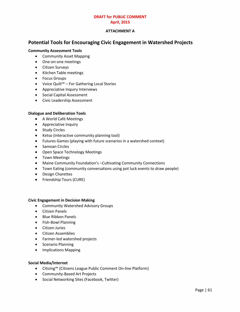
DRAFT for PUBLIC COMMENT April, 2015
Page | 61
ATTACHMENT A
Potential Tools for Encouraging Civic Engagement in Watershed Projects
Community Assessment Tools
Community Asset Mapping
One-on-one meetings
Citizen Surveys
Kitchen Table meetings
Focus Groups
Voice Quilt™ – For Gathering Local Stories
Appreciative Inquiry Interviews
Social Capital Assessment
Civic Leadership Assessment
Dialogue and Deliberation Tools
A World Café Meetings
Appreciative Inquiry
Study Circles
Ketso (interactive community planning tool)
Futures Games (playing with future scenarios in a watershed context)
Samoan Circles
Open Space Technology Meetings
Town Meetings
Maine Community Foundation’s –Cultivating Community Connections
Town Eating (community conversations using pot luck events to draw people)
Design Charettes
Friendship Tours (CURE)
Civic Engagement in Decision Making
Community Watershed Advisory Groups
Citizen Panels
Blue Ribbon Panels
Fish-Bowl Planning
Citizen Juries
Citizen Assemblies
Farmer-led watershed projects
Scenario Planning
Implications Mapping
Social Media/Internet
Citizing™ (Citizens League Public Comment On-line Platform)
Community-Based Art Projects
Social Networking Sites (Facebook, Twitter)

DRAFT for PUBLIC COMMENT April, 2015
Page | 62
Subwatershed web sites Civic Leadership Skills Training
Civic Organizing, Inc. -Citizenship and Community Organizing Training
Citizen Leadership Development (MN Extension)
Civic Engagement Capacity Building (U of MN Extension)
Community and Coalition Building (U of MN Extension)
Work Team Development and Committees That Work (U of MN Extension) Information/Outreach
Public Kiosks
News Conferences/Press Packets
Interviews
Kitchen Table meetings
Focus Groups
Field Tours
Public Meetings
Open Houses
Newsletters
Videos
Radio Call-in Shows
Citizen Monitoring
Canoe/boat Outings
Fishing Contests
River/Lake/Community Clean-up events
Citizen-hosted events

DRAFT for PUBLIC COMMENT April, 2015
Page | 63
ATTACHMENT B
PROMISING APPROACHES FOR ENGAGING THE PUBLIC IN COMMUNITY PROBLEM-SOLVING FOR WATER QUALITY
Over the past year, the Basin Team held a speaker series which brought in civic engagement practitioners from around the State of Minnesota. These innovators shared their most effective civic engagement actions and strategies. Several of these concepts are worthy of additional attention and experimentation. There are other models that seem promising as well. Some of these include:
Social Media: When attempting to engage large numbers of people, it may be necessary to look at how, why and where they want to spend their time interacting with government organizations (Wilson and Casey, 2008). Increasingly, informal social networks are valuable ways to access particular groups of people who do not usually interact with formalized processes or governance. It should not be assumed that citizens are anxiously waiting for an opportunity to engage with a central planning process. Rather is it important to reach out into existing networks and invite participation directly (Wilson and Casey, 2008).
Peer to Peer Learning: An area that deserves more attention and which holds great potential is peer-to-peer learning among citizens. Rather than having government staff serve in an expert capacity educating citizens, citizens teach one another about new practices and BMPs that could improve water quality. Research indicates that peer learning activities typically result in: (a) team-building spirit and more supportive relationships; (b) greater psychological well-being, social competence, communication skills and self-esteem; and (c) higher achievement and greater productivity in terms of enhanced learning outcomes. Although peer-learning strategies are valuable tools for educators to utilize, simply placing citizens in groups and telling them to ‘work together’ will not automatically yield results. The educator/coordinator must consciously orchestrate the learning exercises and choose the appropriate vehicles for it. Only then will participants effectively engage in peer learning and reap the benefits discussed above (Christudason, 2003). This model of information exchange and learning has proven effective within Farmer-Led watershed projects in Iowa and Minnesota. Peer-to-peer learning allows people to develop their talents and supports their desire to be autonomous, achieve personal mastery of an issue, and to work toward a goal that gives purpose and meaning to their lives. These are key ingredients that result in greater satisfaction and motivation among people when working to accomplish complex tasks (Pink, 2011).
Friendship Tours: For many years, there have been conflicts between environmentalists and farmers that have come to a head over issues of water quality. To date, these conflicts have often been addressed through lawsuits, one-upsmanship, and unsatisfying communications in public meetings. Clean Up the River Environment (CURE) worked to bring upstream farmers and downstream environmentalists together to talk about these problems and to seek a common vision and process for addressing them. More than 50 people took part in the tours, spending several days

DRAFT for PUBLIC COMMENT April, 2015
Page | 64
together traveling around the Minnesota River Basin, learning, listening and talking together in an attempt to create understanding among all participants. The tour organizers provided structured and unstructured opportunities for dialogue, which ultimately helped to build bridges between parties that heretofore had engaged in blame-laden exchanges at public hearings and in the media.
Farmer-Led Watershed Projects: Farmers in the Whitewater River Watershed in Minnesota and in several watersheds in Iowa are taking the lead in water quality improvement through Farmer-Led Councils. The Council Chairs lead their neighbors in developing water quality improvement plans and encouraging implementation of land practices that could improve water quality. These Councils address the self-interests of farmers while also encouraging a concern for the common good. Participation in these Councils has been high and participants have largely been satisfied with their experiences. In many cases, participation in these Councils has allowed farmers to save money while at the same time work to improve water quality in their community.
Civic Engagement Capacity Building: Authentic civic engagement can provide for collective action and decisions which are informed, have a public purpose, create buy-in and support, have the resources (including human), and competence...a resourceFULL decision. Building the skill set in individuals, leaders and organizations to design and manage public settings to create and build trust and relationships to address nonpoint sources of water pollution will be important to water quality management.
Community Dialogues: Given that civic skills and dialogue are practiced at the community level less and less, community dialogues provide an opportunity for average citizens of vastly different backgrounds and perspectives to come together to explore ideas. In this case, community dialogues revolve around the topic of water. Meetings allow people to discuss ideas for protecting water quality, their goals, hopes and aspirations for improving their local water resources, etc. These community forums provide safe environments for conversations that have a purpose – asking all who participate to listen empathically, suspend judgment, and consider the ideas of others. Community dialogues that are thoughtfully designed often result in increased levels of good will and an openness to work together on addressing specific water issues within the community.
Interactive Watershed Planning Tools (games and hands-on tools): Traditional meetings often mean sitting and listening to someone else speak and not having an opportunity to fully participate in problem-solving. If a person can relate to an event by experiencing and actively participating in an event they will get a broader understanding than a spectator who is passively watching the event.
Games and other hands- on interactive community planning tools can provide unique opportunities for people to become more intellectually and physically involved in problem-solving. Each require people to move around, to visually and physically interact with the planning tools and provide opportunities for participants to experience team work in a positive way.
Integration of Citizens and Technical Experts in Advisory Committees: Traditionally, Advisory Committees have been separated into Technical and Citizens Advisory Committees. This

DRAFT for PUBLIC COMMENT April, 2015
Page | 65
approach often leaves the Citizens Advisory Committee cut off from real policy-making activities and the ability to influence decisions by experts. By combining citizens and technical experts in the same committee, the technical experts have the ability to learn from citizens and citizens from the experts. By merging the two, we can better tap the talents, ideas and creativity of all, ensuring that government remains accountable and open to citizen inquiries and that citizens are exposed to the real challenges and constraints faced by government as it works to improve water quality. The goal is move away from citizen participation as outside of or separated from real decision-making. The underlying belief must be that citizens deserve a real voice and opportunity to influence government policy.
Community Arts: People learn and experience things in very different ways. Rather than focusing on attracting people to water quality projects by appealing to them from an intellectual perspective alone, the arts can create unique opportunities that appeal to their emotions as well. Using the arts within watershed projects recognizes that people are multi-dimensional and complex. By appealing to the whole person, it seems likely that more will be drawn to this work. Music, community arts projects, theatre, poetry, history and so on can be used to make water quality projects more engaging and fun. Natural resource agencies have not explored this avenue for appealing to the public to the extent they could. There are numerous examples where these projects have been used successfully to move people and activate their interests in water quality.
Civic Skills Training: Many people see their role as a citizen narrowly – as a voter. Civic skills are diminishing as are citizen interactions within the public sphere. Learning civic skills in leadership and organizing can build up the knowledge, skills and abilities of the citizens we wish to convene as well as our own as public servants. Skill development in this emerging field of civic engagement will undoubtedly be needed if we are to

DRAFT for PUBLIC COMMENT April, 2015
Page | 66
NOTES
Boyte, Harry C. The Citizen Solution: How You Can Make a Difference, Minnesota Historical Society Press, 2008, page 15. Citizens League, To the Source: Moving Minnesota’ Water Governance Upstream, November 2009, page 16. Christudason, Alice, The Centre for Development of Teaching and Learning (CDTL), Number 37, © CDTL 2003. Retrieved March12, 2012, from http://www.bing.com/search?q=successful+learning%2Fcdtl%2C+Christudason&src=IE-SearchBox&Form=IE8SRC City of Portland, Oregon, 2012, Retrieved on May 14, 2012 from http://www.portlandonline.com/oni/index.cfm?c=51069&a=312804. Crosby, Barbara, Leadership for the Common Good, 1992 Corporation for National and Community Service (March 12, 2012), Retrieved March 12, 2012, from http://www.volunteeringinamerica.gov/WI and http://www.volunteeringinamerica.gov/MN. Davenport, Mae, 2010. Adapted from Goodman et al, 1998: Chaskin et al., 2001: Foster-Fisherman et al., 2001. Fagotto, Elena and Archon Fung, Sustaining Public Engagement: Embedded Deliberation in Local Communities, 2009, Everyday Democracy and the Kettering Foundation, page 42. Harwood, Richard, 2012. Richard Harwood Blog Post, Retrieved 2/29/2012 from http://theharwoodinstitute.org/ Harwood, Richard C., 2011. Assessing Community Information Needs: A Practical Guide, The Aspen Institute, page vii. Kirlin, Mary, 2003. The Role of Civic Skills in Fostering Civic Engagement, California State University, Sacramento. Layzer, Judith A. Natural Experiments, PRESS?? Page?? MN Statutes (FILL IN ) McCoy, Martha L. and Patrick L. Scully, 2002. National Civic Review, vol. 91, no. 2, Summer 2002 © Wiley Periodicals, Inc. Michaels, Peg, Civic Organizing 101 Curriculum Guide, 2009. Michigan State University (2007, February 18). Scientific Literacy: How Do Americans Stack Up?. ScienceDaily. Retrieved March 5, 2012, from http://www.sciencedaily.com/releases/2007/02/070218134322.htm
DRAFT for PUBLIC COMMENT April, 2015
Page | 67
Pink, Daniel, 2010, Drive: The Surprising Truth About What Motivates Us, PRESS?? ScienceDaily. Retrieved March 5, 2012, from http://www.sciencedaily.com/releases/2007/02/070218134322.htm Radke, Barbara, et. al., 2012. Regents of the University of Minnesota., University of Minnesota/Extension. Skocpol, T. “Advocates Without Members: The Recent Transformation of American Civic Life.” In T. Skocpol and M. P. Fiorina (eds.), Civic Engagement in American Democracy. Washington, D.C.: Brookings Institution Press, 1999, pp. 461–509. Stiglitz, J. (1998), “Towards a New Paradigm for Development: Strategies, Policies, and Processes”, Prebisch Lecture, UNCTAD, October. Wilson, Richard and Alice Casey, “Teleparticiaption: Engaging Millions”, page 5. Yankelovich, Daniel and William Friedman, 2010, Toward Wiser Public Judgment, Vanderbilt University Press, Nashville. pp 1-50.