Embed Size (px)
Citation preview
NDOT Planning and Environmental Linkages Questionnaire and Checklist 1
I ‐ 1 1 N O R T H E R N N E V A D A A L T E R N A T I V E S A N A L Y S I S
Planning and Environmental Linkages Questionnaire and Checklist
February 1, 2019
Prepared for
Nevada Department of Transportation
and
Federal Highway Administration
NDOT Planning and Environmental Linkages Questionnaire and Checklist 1
Planning and Environmental Linkages Questionnaire and Checklist
I-11 Northern Nevada Alternatives Analysis
BACKGROUND
The Nevada Department of Transportation (NDOT) seeks to employ unified and dedicated efforts to deliver transportation solutions that improve the quality of life for those in Nevada. Improvements to the transportation system are typically accomplished through projects. Federal and State transportation improvement funds and NDOT’s construction program and projects are scheduled and delivered through the Statewide Transportation Improvement Program (STIP). For 40 years, Congress directed this sequencing of funding flow, triggered by metropolitan and statewide transportation planning processes that serve as the basis for project decisions and incorporate an emphasis on public involvement, environmental considerations, and other factors.
The National Environmental Policy Act of 1969 (NEPA) established a national environmental policy intentionally focused on federal activities and the desire for a sustainable environment balanced with other, essential, present and future needs of generations of Americans. NEPA mandated that federal agencies consider the potential environmental consequences of their proposed actions, document the analysis, and make this information available to the public for comment prior to implementation. These requirements form the basic framework for federal decision making and the NEPA process. NEPA applies only where there is a federal action. For the Federal Highway Administration (FHWA) and the Federal Transit Administration (FTA), implementation of NEPA is based on the Council on Environmental Quality (CEQ) regulations set down in 40 Code of Federal Regulations [C.F.R.] §§ 1500–08 and 23 C.F.R. § 771.
1978 CEQ regulations call for an integration of “the NEPA process with other planning at the earliest possible time to insure that planning and decisions reflect environmental values, to avoid delays later in the process, and to head off potential conflicts” (40 C.F.R.§ 1501.2). Despite this statutory and regulatory emphasis on the early integration of transportation planning with NEPA, these two activities have, in practice, been carried out in a separate and sequential manner. Environmental analyses prepared to support the project development/NEPA process are typically disconnected from the analyses used to develop long-range transportation plans, statewide and metropolitan Transportation Improvement Programs, and planning-level corridor/subarea/feasibility studies. When transportation planning and NEPA processes are not well coordinated, duplication of work and delays in implementing transportation improvements frequently occur.
A requirement to consider mitigation activities in long-range plans and a requirement to consult with resource and land management agencies and related plans, maps, or inventories during the development of long-range transportation plans provide an opportunity for early identification of environmental and design considerations that could cause project costs to rise and jeopardize schedules. This initiative is referred to as planning and environmental linkages (PEL). The goal of PEL is to create a decision-making process that minimizes duplication of effort, promotes environmental stewardship, and reduces delays, from the visioning and planning stages all the way through project development to project implementation.
The PEL process seeks to develop subarea and corridor studies that have been scoped to more directly inform the NEPA process for those projects that ultimately become part of the STIP. Effective, conceptual-level transportation planning studies that follow the PEL process provide opportunities both to identify important issues of concern early and to build agency, stakeholder, and public understanding of the project. Such early, integrated planning is not driven solely by regulatory requirements and the quest for more efficient and effective processes, although those are desirable results. Transportation and environmental professionals—as
NDOT Planning and Environmental Linkages Questionnaire and Checklist 2
well as those in metropolitan planning organizations, state and federal resource agencies, and nongovernmental organizations—are finding that early collaboration helps achieve broader transportation and environmental stewardship goals through better decisions regarding programs, planning, and projects.
This document has been developed based on the adopted PEL Questionnaire and Checklist by NDOT dated July 2012 to provide guidance, particularly to transportation planners and NEPA specialists, regarding how to most effectively link the transportation planning and NEPA processes. By considering the questions and issues raised in this questionnaire, transportation planners will become more aware of potential gaps in their subarea or corridor studies, better understand the needs of future users of the studies, and be reminded of the benefits of wider and/or deeper collaboration with agencies, the public, and other stakeholders. NEPA specialists who fill out the checklist will assume a new role in the transportation planning process: becoming advocates for early awareness of environmental issues before the NEPA process begins. This questionnaire and checklist is designed to assist in linking planning with potential environmental concerns and should be viewed as a tool, not a mandatory exercise when reviewing potential transportation projects.
The following PEL questionnaire and checklist are intended to be used as tools to guide proper documentation and selection of information gathered during the planning process that can later be made available for input, review, and possible incorporation by reference during the NEPA project development process.
This questionnaire and checklist will be used to effectively influence the scope, content, and process employed for NDOT transportation planning studies that focus on specific transportation corridors or on transportation network subareas (versus statewide transportation studies). Completion of this questionnaire and checklist will support the PEL process and serve dual objectives:1
provide guidance to transportation planners on the level of detail needed to ensure that information collected and decisions made during the transportation planning study can be used during the NEPA process for a proposed transportation project
provide the future NEPA study team with documentation on the outcomes of the transportation planning process, including the history of decisions made and the level of detailed analysis undertaken
Major issues to consider when conducting a transportation planning study that links to the future NEPA process include:2
identifying the appropriate level of environmental analysis for the study
identifying the appropriate level of agency, stakeholder, and public involvement
defining unique study concurrence points for seeking agreement from relevant resource agencies, stakeholders, and members of the public
developing a process to ensure that the study will be recognized as valid within the NEPA process
identifying when to involve resource agencies in the study, and to what extent they influence decision making
identifying how to persuade U.S. Department of Transportation reviewers to accept the use of these studies in the NEPA process
These issues will be considered throughout the Study process. Users of this Planning and Environmental Linkages Questionnaire and Checklist should review the entire document at the beginning of the study to 1 Objectives are based on the Federal Highway Administration’s online document: Case Studies: Colorado: Colorado Department of Transportation: Tools and Techniques to Implement PEL, <www.environment.fhwa.dot.gov/integ/case_colorado2.asp> (accessed October 24, 2011).
2 Further guidance is available in the Federal Highway Administration’s Guidance on Using Corridor and Subarea Planning to Inform NEPA, dated April 5, 2011, available online at <www.environment.fhwa.dot.gov/integ/corridor_nepa_guidance.pdf>.
NDOT Planning and Environmental Linkages Questionnaire and Checklist 3
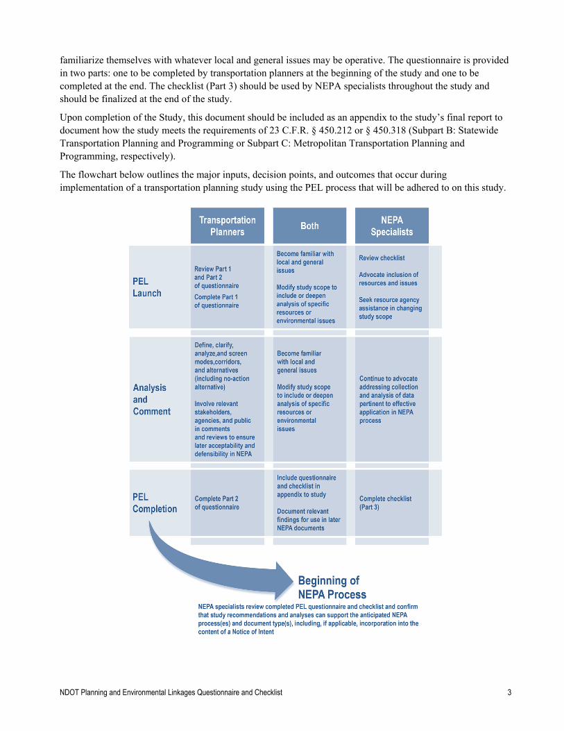
familiarize themselves with whatever local and general issues may be operative. The questionnaire is provided in two parts: one to be completed by transportation planners at the beginning of the study and one to be completed at the end. The checklist (Part 3) should be used by NEPA specialists throughout the study and should be finalized at the end of the study.
Upon completion of the Study, this document should be included as an appendix to the study’s final report to document how the study meets the requirements of 23 C.F.R. § 450.212 or § 450.318 (Subpart B: Statewide Transportation Planning and Programming or Subpart C: Metropolitan Transportation Planning and Programming, respectively).
The flowchart below outlines the major inputs, decision points, and outcomes that occur during implementation of a transportation planning study using the PEL process that will be adhered to on this study.
I-11 Northern Nevada Alternatives Analysis
NDOT Planning and Environmental Linkages Questionnaire and Checklist 4
Questionnaire for Transportation Planners – Part 1
This part of the questionnaire should be completed by transportation planners at the beginning of the transportation planning study. Please note that planners should also review Part 2 of the questionnaire to understand what additional issues will need to be considered and documented as the study progresses.
Project identification
What is the name of the study? What cities and counties does it cover? What major streets or highways are covered? For corridor studies, what are the intended termini?
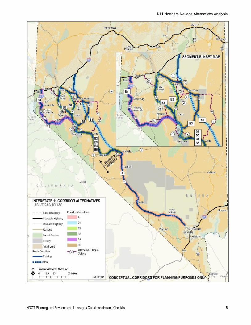
Name of the study: I-11 Northern Nevada Alternatives Analysis Intended termini: This corridor study is a continuation of the effort established in the I-11 and Intermountain West Corridor Study (2014) performed by NDOT and the Arizona Department of Transportation (ADOT). For the Northern Nevada segment, the Intermountain West Corridor Study provided a high level review of potential connections from the Las Vegas metropolitan area to the northern state boundary, looking at options on the east, west, and central portions of the state. The study recommended pursuing a more detailed corridor study on the west side of the state, connecting the Las Vegas and Reno-Sparks metropolitan areas. This recommendation was supported by the Fixing America’s Surface Transportation (FAST) Act, which extended the I-11 designation from Las Vegas to I-80, generally along the US 95 corridor. Thus, this alternatives analysis will review potential corridor options between Las Vegas and I-80, generally connecting to/near Reno.
Based on preliminary feasibility work conducted, and the findings of the initial PEL review, the segment between Las Vegas and Tonopah will primarily assess upgrading the US 95 corridor to I-11, including potential bypass segments. Various options will be reviewed between Tonopah and I-80, including connection points to I-80 at I-580 (Reno), Fernley, and north of Fallon (see map on following page).
Who is the study sponsor?
Nevada Department of Transportation (NDOT)
Briefly describe the study and its purpose.
As established in the I-11 and Intermountain West Corridor Study, the goal of I-11 is to establish a high-capacity, limited-access, transportation corridor connecting Mexican ports and manufacturing areas with Canada, traversing Arizona’s and Nevada’s largest regional, national and international manufacturing and economic activity centers, in support of regional, national, and international trade. Western states compete individually and collectively in national and global markets with Canada, Mexico, the I-5 Corridor, and the Gulf of Mexico states. For Arizona and Nevada, the purpose of I-11 is to assist in diversifying the states’ economies to target industry clusters that rely heavily on interconnected and efficient transportation systems to transport goods and facilitate business attraction/retention.
The I-11 Corridor has the potential to become one of the first north-south, high-capacity routes through the Intermountain West that could greatly improve commerce, tourism, and international trade opportunities. This northern Nevada segment of I-11 would connect Las Vegas and I-80 near Reno, providing an efficient north-south interstate connection between Nevada’s two largest economic centers.
Future projections indicate that the proposed I-11 Corridor will continue to see significant growth, prompting the need for better surface transportation connections to accommodate not only the travel demand between metropolitan areas, but also improved mobility for freight shipments throughout the Intermountain West. This Corridor could provide needed connectivity, offer alternative routes for freight and passenger traffic, and improve reliability for better trade and commerce opportunities. Developing a north-south multimodal corridor through Nevada provides the foundation for a renewed, stronger, diversified economy in the Intermountain West.
This study effort will build upon the connection identified in the Northern Nevada Feasibility Assessment of the I-11 and Intermountain West Corridor Study (Las Vegas to Reno-Sparks) and identify, analyze, and evaluate a series of corridor options, to determine the most reasonable and feasible option(s) to be advanced into further environmental studies.
I-11 Northern Nevada Alternatives Analysis
NDOT Planning and Environmental Linkages Questionnaire and Checklist 5
I-11 Northern Nevada Alternatives Analysis
NDOT Planning and Environmental Linkages Questionnaire and Checklist 6
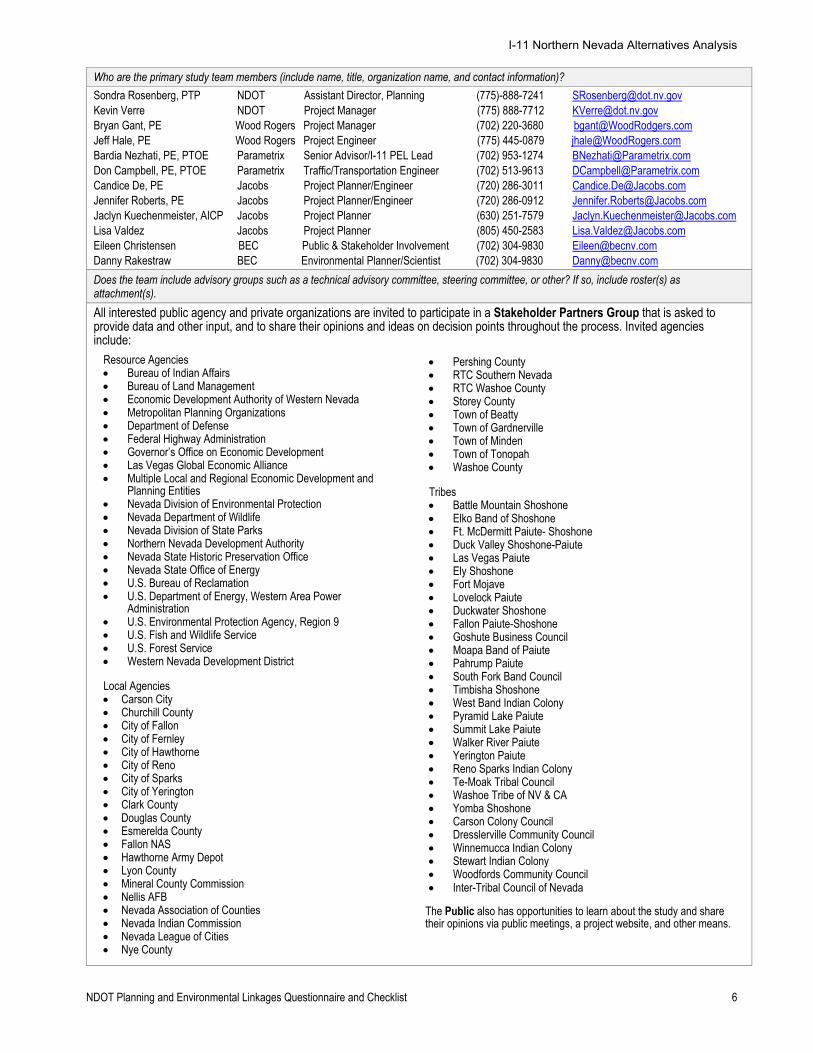
Who are the primary study team members (include name, title, organization name, and contact information)?
Sondra Rosenberg, PTP NDOT Assistant Director, Planning (775)-888-7241 [email protected] Kevin Verre NDOT Project Manager (775) 888-7712 [email protected] Bryan Gant, PE Wood Rogers Project Manager (702) 220-3680 [email protected] Jeff Hale, PE Wood Rogers Project Engineer (775) 445-0879 [email protected] Bardia Nezhati, PE, PTOE Parametrix Senior Advisor/I-11 PEL Lead (702) 953-1274 [email protected] Don Campbell, PE, PTOE Parametrix Traffic/Transportation Engineer (702) 513-9613 [email protected] Candice De, PE Jacobs Project Planner/Engineer (720) 286-3011 [email protected] Jennifer Roberts, PE Jacobs Project Planner/Engineer (720) 286-0912 [email protected] Jaclyn Kuechenmeister, AICP Jacobs Project Planner (630) 251-7579 [email protected] Lisa Valdez Jacobs Project Planner (805) 450-2583 [email protected] Eileen Christensen BEC Public & Stakeholder Involvement (702) 304-9830 [email protected] Danny Rakestraw BEC Environmental Planner/Scientist (702) 304-9830 [email protected]
Does the team include advisory groups such as a technical advisory committee, steering committee, or other? If so, include roster(s) as attachment(s).
All interested public agency and private organizations are invited to participate in a Stakeholder Partners Group that is asked to provide data and other input, and to share their opinions and ideas on decision points throughout the process. Invited agencies include:
The Public also has opportunities to learn about the study and share their opinions via public meetings, a project website, and other means.
Resource Agencies Bureau of Indian Affairs Bureau of Land Management Economic Development Authority of Western Nevada Metropolitan Planning Organizations Department of Defense Federal Highway Administration Governor’s Office on Economic Development Las Vegas Global Economic Alliance Multiple Local and Regional Economic Development and
Planning Entities Nevada Division of Environmental Protection Nevada Department of Wildlife Nevada Division of State Parks Northern Nevada Development Authority Nevada State Historic Preservation Office Nevada State Office of Energy U.S. Bureau of Reclamation U.S. Department of Energy, Western Area Power
Administration U.S. Environmental Protection Agency, Region 9 U.S. Fish and Wildlife Service U.S. Forest Service Western Nevada Development District Local Agencies Carson City Churchill County City of Fallon City of Fernley City of Hawthorne City of Reno City of Sparks City of Yerington Clark County Douglas County Esmerelda County Fallon NAS Hawthorne Army Depot Lyon County Mineral County Commission Nellis AFB Nevada Association of Counties Nevada Indian Commission Nevada League of Cities Nye County
Pershing County RTC Southern Nevada RTC Washoe County Storey County Town of Beatty Town of Gardnerville Town of Minden Town of Tonopah Washoe County Tribes Battle Mountain Shoshone Elko Band of Shoshone Ft. McDermitt Paiute- Shoshone Duck Valley Shoshone-Paiute Las Vegas Paiute Ely Shoshone Fort Mojave Lovelock Paiute Duckwater Shoshone Fallon Paiute-Shoshone Goshute Business Council Moapa Band of Paiute Pahrump Paiute South Fork Band Council Timbisha Shoshone West Band Indian Colony Pyramid Lake Paiute Summit Lake Paiute Walker River Paiute Yerington Paiute Reno Sparks Indian Colony Te-Moak Tribal Council Washoe Tribe of NV & CA Yomba Shoshone Carson Colony Council Dresslerville Community Council Winnemucca Indian Colony Stewart Indian Colony Woodfords Community Council Inter-Tribal Council of Nevada
I-11 Northern Nevada Alternatives Analysis
NDOT Planning and Environmental Linkages Questionnaire and Checklist 7
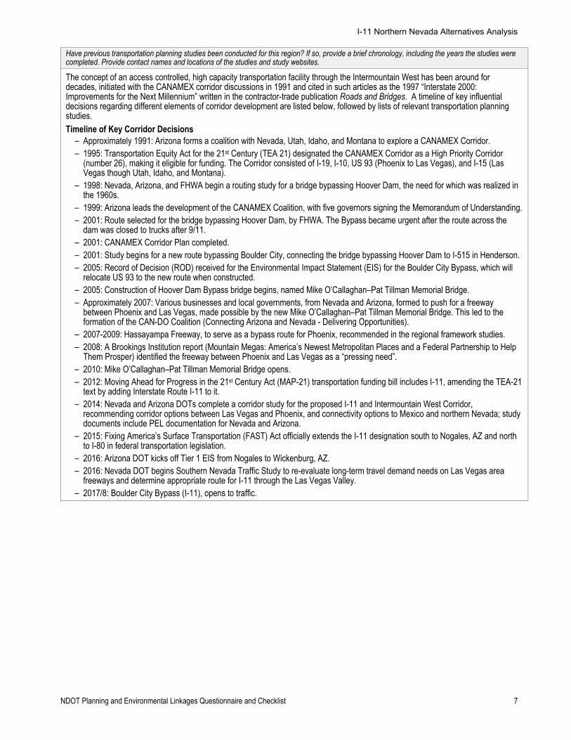
Have previous transportation planning studies been conducted for this region? If so, provide a brief chronology, including the years the studies were completed. Provide contact names and locations of the studies and study websites.
The concept of an access controlled, high capacity transportation facility through the Intermountain West has been around for decades, initiated with the CANAMEX corridor discussions in 1991 and cited in such articles as the 1997 “Interstate 2000: Improvements for the Next Millennium” written in the contractor-trade publication Roads and Bridges. A timeline of key influential decisions regarding different elements of corridor development are listed below, followed by lists of relevant transportation planning studies. Timeline of Key Corridor Decisions ‒ Approximately 1991: Arizona forms a coalition with Nevada, Utah, Idaho, and Montana to explore a CANAMEX Corridor. ‒ 1995: Transportation Equity Act for the 21st Century (TEA 21) designated the CANAMEX Corridor as a High Priority Corridor
(number 26), making it eligible for funding. The Corridor consisted of I-19, I-10, US 93 (Phoenix to Las Vegas), and I-15 (Las Vegas though Utah, Idaho, and Montana).
‒ 1998: Nevada, Arizona, and FHWA begin a routing study for a bridge bypassing Hoover Dam, the need for which was realized in the 1960s.
‒ 1999: Arizona leads the development of the CANAMEX Coalition, with five governors signing the Memorandum of Understanding. ‒ 2001: Route selected for the bridge bypassing Hoover Dam, by FHWA. The Bypass became urgent after the route across the
dam was closed to trucks after 9/11. ‒ 2001: CANAMEX Corridor Plan completed. ‒ 2001: Study begins for a new route bypassing Boulder City, connecting the bridge bypassing Hoover Dam to I-515 in Henderson. ‒ 2005: Record of Decision (ROD) received for the Environmental Impact Statement (EIS) for the Boulder City Bypass, which will
relocate US 93 to the new route when constructed. ‒ 2005: Construction of Hoover Dam Bypass bridge begins, named Mike O’Callaghan–Pat Tillman Memorial Bridge. ‒ Approximately 2007: Various businesses and local governments, from Nevada and Arizona, formed to push for a freeway
between Phoenix and Las Vegas, made possible by the new Mike O’Callaghan–Pat Tillman Memorial Bridge. This led to the formation of the CAN-DO Coalition (Connecting Arizona and Nevada - Delivering Opportunities).
‒ 2007-2009: Hassayampa Freeway, to serve as a bypass route for Phoenix, recommended in the regional framework studies. ‒ 2008: A Brookings Institution report (Mountain Megas: America’s Newest Metropolitan Places and a Federal Partnership to Help
Them Prosper) identified the freeway between Phoenix and Las Vegas as a “pressing need”. ‒ 2010: Mike O’Callaghan–Pat Tillman Memorial Bridge opens. ‒ 2012: Moving Ahead for Progress in the 21st Century Act (MAP-21) transportation funding bill includes I-11, amending the TEA-21
text by adding Interstate Route I-11 to it. ‒ 2014: Nevada and Arizona DOTs complete a corridor study for the proposed I-11 and Intermountain West Corridor,
recommending corridor options between Las Vegas and Phoenix, and connectivity options to Mexico and northern Nevada; study documents include PEL documentation for Nevada and Arizona.
‒ 2015: Fixing America’s Surface Transportation (FAST) Act officially extends the I-11 designation south to Nogales, AZ and north to I-80 in federal transportation legislation.
‒ 2016: Arizona DOT kicks off Tier 1 EIS from Nogales to Wickenburg, AZ. ‒ 2016: Nevada DOT begins Southern Nevada Traffic Study to re-evaluate long-term travel demand needs on Las Vegas area
freeways and determine appropriate route for I-11 through the Las Vegas Valley. ‒ 2017/8: Boulder City Bypass (I-11), opens to traffic.
I-11 Northern Nevada Alternatives Analysis
NDOT Planning and Environmental Linkages Questionnaire and Checklist 8
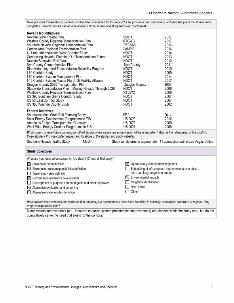
Have previous transportation planning studies been conducted for this region? If so, provide a brief chronology, including the years the studies were completed. Provide contact names and locations of the studies and study websites. (continued)
Nevada led initiatives: Nevada State Freight Plan NDOT 2017 Washoe County Regional Transportation Plan RTCWC 2017 Southern Nevada Regional Transportation Plan RTCSNV 2016 Carson Area Regional Transportation Plan CAMPO 2016 I-11 and Intermountain West Corridor Study NDOT 2014 Connecting Nevada: Planning Our Transportation Future NDOT 2013 Nevada Statewide Rail Plan NDOT 2012 Nye County Comprehensive Plan Nye County 2011 Statewide Integrated Transportation Reliability Program NDOT 2010 I-80 Corridor Study NDOT 2009 I-80 Corridor System Management Plan NDOT 2014 I-15 Corridor System Master Plan/I-15 Mobility Alliance NDOT 2017 Douglas County 2030 Transportation Plan Douglas County 2009 Statewide Transportation Plan – Moving Nevada Through 2028 NDOT 2008 Washoe County Regional Transportation Plan RTCWC 2008 US 395 Southern Sierra Corridor Study NDOT 2007 US 50 East Corridor Study NDOT 2007 US 395 Washoe County Study NDOT 2002
Federal initiatives: Southwest Multi-State Rail Planning Study FRA 2014 Solar Energy Development Programmatic EIS US DOE 2012 America’s Freight Transportation Gateways US DOT 2009 West-Wide Energy Corridor Programmatic EIS US DOE 2008
What current or near-future planning (or other) studies in the vicinity are underway or will be undertaken? What is the relationship of this study to those studies? Provide contact names and locations of the studies and study websites.
Southern Nevada Traffic Study NDOT Study will determine appropriate I-11 connection within Las Vegas Valley
Study objectives
What are your desired outcomes for this study? (Check all that apply.)
Stakeholder identification Stakeholder roles/responsibilities definition Travel study area definition Performance measures development Development of purpose and need goals and other objectives Alternative evaluation and screening Alternative travel modes definition
Operationally independent segments Scheduling of infrastructure improvements over short-, mid-, and long-range time frames
Environmental impacts Mitigation identification Don't know Other ____________________________________
Have system improvements and additions that address your transportation need been identified in a fiscally constrained statewide or regional long-range transportation plan?
Minor system improvements (e.g., localized capacity, system preservation improvements) are planned within the study area, but do not cumulatively serve the need that exists for the corridor.
I-11 Northern Nevada Alternatives Analysis
NDOT Planning and Environmental Linkages Questionnaire and Checklist 9
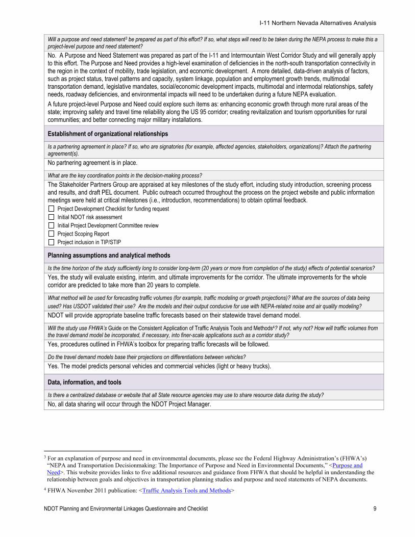
Will a purpose and need statement3 be prepared as part of this effort? If so, what steps will need to be taken during the NEPA process to make this a project-level purpose and need statement?
No. A Purpose and Need Statement was prepared as part of the I-11 and Intermountain West Corridor Study and will generally apply to this effort. The Purpose and Need provides a high-level examination of deficiencies in the north-south transportation connectivity in the region in the context of mobility, trade legislation, and economic development. A more detailed, data-driven analysis of factors, such as project status, travel patterns and capacity, system linkage, population and employment growth trends, multimodal transportation demand, legislative mandates, social/economic development impacts, multimodal and intermodal relationships, safety needs, roadway deficiencies, and environmental impacts will need to be undertaken during a future NEPA evaluation.
A future project-level Purpose and Need could explore such items as: enhancing economic growth through more rural areas of the state; improving safety and travel time reliability along the US 95 corridor; creating revitalization and tourism opportunities for rural communities; and better connecting major military installations.
Establishment of organizational relationships
Is a partnering agreement in place? If so, who are signatories (for example, affected agencies, stakeholders, organizations)? Attach the partnering agreement(s).
No partnering agreement is in place.
What are the key coordination points in the decision-making process?
The Stakeholder Partners Group are appraised at key milestones of the study effort, including study introduction, screening process and results, and draft PEL document. Public outreach occurred throughout the process on the project website and public information meetings were held at critical milestones (i.e., introduction, recommendations) to obtain optimal feedback.
Project Development Checklist for funding request Initial NDOT risk assessment Initial Project Development Committee review Project Scoping Report Project inclusion in TIP/STIP
Planning assumptions and analytical methods
Is the time horizon of the study sufficiently long to consider long-term (20 years or more from completion of the study) effects of potential scenarios?
Yes, the study will evaluate existing, interim, and ultimate improvements for the corridor. The ultimate improvements for the whole corridor are predicted to take more than 20 years to complete.
What method will be used for forecasting traffic volumes (for example, traffic modeling or growth projections)? What are the sources of data being used? Has USDOT validated their use? Are the models and their output conducive for use with NEPA-related noise and air quality modeling?
NDOT will provide appropriate baseline traffic forecasts based on their statewide travel demand model.
Will the study use FHWA’s Guide on the Consistent Application of Traffic Analysis Tools and Methods4? If not, why not? How will traffic volumes from the travel demand model be incorporated, if necessary, into finer-scale applications such as a corridor study?
Yes, procedures outlined in FHWA’s toolbox for preparing traffic forecasts will be followed.
Do the travel demand models base their projections on differentiations between vehicles?
Yes. The model predicts personal vehicles and commercial vehicles (light or heavy trucks).
Data, information, and tools
Is there a centralized database or website that all State resource agencies may use to share resource data during the study?
No, all data sharing will occur through the NDOT Project Manager.
3 For an explanation of purpose and need in environmental documents, please see the Federal Highway Administration’s (FHWA’s)
“NEPA and Transportation Decisionmaking: The Importance of Purpose and Need in Environmental Documents,” <Purpose and Need>. This website provides links to five additional resources and guidance from FHWA that should be helpful in understanding the relationship between goals and objectives in transportation planning studies and purpose and need statements of NEPA documents.
4 FHWA November 2011 publication: <Traffic Analysis Tools and Methods>
I-11 Northern Nevada Alternatives Analysis
NDOT Planning and Environmental Linkages Questionnaire and Checklist 10
Questionnaire for Transportation Planners – Part 2
This part of the questionnaire should be completed by transportation planners at the end of the transportation planning study. This completed document should become an appendix to the study’s final report to document how the study meets the requirements of 23 Code of Federal Regulations § 450.212 or § 450.318.
Purpose and need for this study
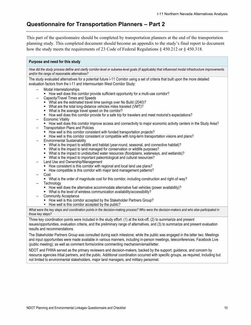
How did the study process define and clarify corridor-level or subarea-level goals (if applicable) that influenced modal infrastructure improvements and/or the range of reasonable alternatives?
The study evaluated alternatives for a potential future I-11 Corridor using a set of criteria that built upon the more detailed evaluation factors from the I-11 and Intermountain West Corridor Study:
‒ Modal Interrelationships How well does this corridor provide sufficient opportunity for a multi-use corridor?
‒ Capacity/Travel Times and Speeds What are the estimated travel time savings over No Build (2040)? What are the total long-distance vehicles miles traveled (VMT)? What is the average travel speed on the corridor? How well does this corridor provide for a safe trip for travelers and meet motorist’s expectations?
‒ Economic Vitality How well does this corridor improve access and connectivity to major economic activity centers in the Study Area?
‒ Transportation Plans and Policies How well is this corridor consistent with funded transportation projects? How well is this corridor consistent or compatible with long-term transportation visions and plans?
‒ Environmental Sustainability What is the impact to wildlife and habitat (year-round, seasonal, and connective habitat)? What is the impact to land managed for conservation or wildlife purposes? What is the impact to undisturbed water resources (floodplains, waterways, and wetlands)? What is the impact to important paleontological and cultural resources?
‒ Land Use and Ownership/Management How consistent is this corridor with regional and local land use plans? How compatible is this corridor with major land management patterns?
‒ Cost What is the order of magnitude cost for this corridor, including construction and right-of-way?
‒ Technology How well does the alternative accommodate alternative fuel vehicles (power availability)? What is the level of wireless communication availability/accessibility?
‒ Community Acceptance How well is this corridor accepted by the Stakeholder Partners Group? How well is this corridor accepted by the public?
What were the key steps and coordination points in the decision-making process? Who were the decision-makers and who else participated in those key steps?
Three key coordination points were included in the study effort: (1) at the kick-off, (2) to summarize and present issues/opportunities, evaluation criteria, and the preliminary range of alternatives, and (3) to summarize and present evaluation results and recommendations.
The Stakeholder Partners Group was consulted during each milestone; while the public was engaged in the latter two. Meetings and input opportunities were made available in various manners, including in-person meetings, teleconferences, Facebook Live (public meeting); as well as comment forms/online commenting mechanism/email/letter.
NDOT and FHWA served as the primary reviewers and decision-makers, backed by the support, guidance, and concern by resource agencies tribal partners, and the public. Additional coordination occurred with specific groups, as required, including but not limited to environmental stakeholders, major land managers, and military personnel.
I-11 Northern Nevada Alternatives Analysis
NDOT Planning and Environmental Linkages Questionnaire and Checklist 11
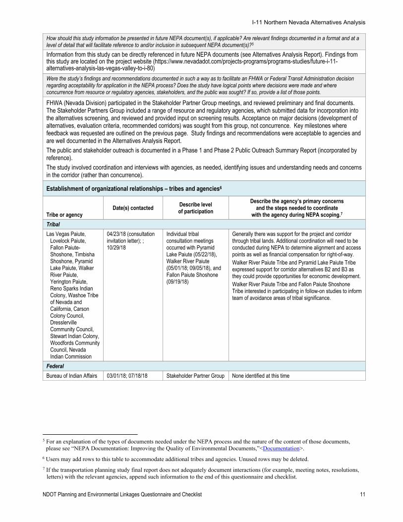
How should this study information be presented in future NEPA document(s), if applicable? Are relevant findings documented in a format and at a level of detail that will facilitate reference to and/or inclusion in subsequent NEPA document(s)?5
Information from this study can be directly referenced in future NEPA documents (see Alternatives Analysis Report). Findings from this study are located on the project website (https://www.nevadadot.com/projects-programs/programs-studies/future-i-11-alternatives-analysis-las-vegas-valley-to-i-80)
Were the study’s findings and recommendations documented in such a way as to facilitate an FHWA or Federal Transit Administration decision regarding acceptability for application in the NEPA process? Does the study have logical points where decisions were made and where concurrence from resource or regulatory agencies, stakeholders, and the public was sought? If so, provide a list of those points.
FHWA (Nevada Division) participated in the Stakeholder Partner Group meetings, and reviewed preliminary and final documents. The Stakeholder Partners Group included a range of resource and regulatory agencies, which submitted data for incorporation into the alternatives screening, and reviewed and provided input on screening results. Acceptance on major decisions (development of alternatives, evaluation criteria, recommended corridors) was sought from this group, not concurrence. Key milestones where feedback was requested are outlined on the previous page. Study findings and recommendations were acceptable to agencies and are well documented in the Alternatives Analysis Report.
The public and stakeholder outreach is documented in a Phase 1 and Phase 2 Public Outreach Summary Report (incorporated by reference).
The study involved coordination and interviews with agencies, as needed, identifying issues and understanding needs and concerns in the corridor (rather than concurrence).
Establishment of organizational relationships – tribes and agencies6
Tribe or agency Date(s) contacted
Describe level of participation
Describe the agency’s primary concerns and the steps needed to coordinate
with the agency during NEPA scoping.7
Tribal
Las Vegas Paiute, Lovelock Paiute, Fallon Paiute-Shoshone, Timbisha Shoshone, Pyramid Lake Paiute, Walker River Paiute, Yerington Paiute, Reno Sparks Indian Colony, Washoe Tribe of Nevada and California, Carson Colony Council, Dresslerville Community Council, Stewart Indian Colony, Woodfords Community Council, Nevada Indian Commission
04/23/18 (consultation invitation letter); ; 10/29/18
Individual tribal consultation meetings occurred with Pyramid Lake Paiute (05/22/18), Walker River Paiute (05/01/18; 09/05/18), and Fallon Paiute Shoshone (09/19/18)
Generally there was support for the project and corridor through tribal lands. Additional coordination will need to be conducted during NEPA to determine alignment and access points as well as financial compensation for right-of-way. Walker River Paiute Tribe and Pyramid Lake Paiute Tribe expressed support for corridor alternatives B2 and B3 as they could provide opportunities for economic development. Walker River Paiute Tribe and Fallon Paiute Shoshone Tribe interested in participating in follow-on studies to inform team of avoidance areas of tribal significance.
Federal
Bureau of Indian Affairs 03/01/18; 07/18/18 Stakeholder Partner Group None identified at this time
5 For an explanation of the types of documents needed under the NEPA process and the nature of the content of those documents,
please see “NEPA Documentation: Improving the Quality of Environmental Documents,”<Documentation>.
6 Users may add rows to this table to accommodate additional tribes and agencies. Unused rows may be deleted.
7 If the transportation planning study final report does not adequately document interactions (for example, meeting notes, resolutions, letters) with the relevant agencies, append such information to the end of this questionnaire and checklist.
I-11 Northern Nevada Alternatives Analysis
NDOT Planning and Environmental Linkages Questionnaire and Checklist 12
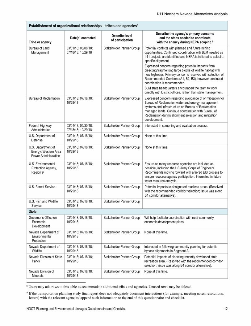
Establishment of organizational relationships – tribes and agencies8
Tribe or agency Date(s) contacted
Describe level of participation
Describe the agency’s primary concerns and the steps needed to coordinate
with the agency during NEPA scoping.9
Bureau of Land Management
03/01/18; 05/08/18; 07/18/18; 10/29/18
Stakeholder Partner Group Potential conflicts with planned and future mining opportunities. Continued coordination with BLM needed as I-11 projects are identified and NEPA is initiated to select a specific alignment. Expressed concern regarding potential impacts from bisecting/fragmenting large blocks of wildlife habitat with new highways. Primary concerns resolved with selection of Recommended Corridors (A1, B2, B3), however continued coordination is recommended. BLM state headquarters encouraged the team to work directly with District offices, rather than state management.
Bureau of Reclamation 03/01/18; 07/18/18; 10/29/18
Stakeholder Partner Group Expressed concern regarding avoidance of or mitigation for Bureau of Reclamation water and energy management systems and infrastructure on Bureau of Reclamation managed lands. Continue coordination with Bureau of Reclamation during alignment selection and mitigation development.
Federal Highway Administration
03/01/18; 05/30/18; 07/18/18; 10/29/18
Stakeholder Partner Group Interested in screening and evaluation process.
U.S. Department of Defense
03/01/18; 07/18/18; 10/29/18
Stakeholder Partner Group None at this time.
U.S. Department of Energy, Western Area Power Administration
03/01/18; 07/18/18; 10/29/18
Stakeholder Partner Group None at this time.
U.S. Environmental Protection Agency, Region 9
03/01/18; 07/18/18; 10/29/18
Stakeholder Partner Group Ensure as many resource agencies are included as possible, including the US Army Corps of Engineers. Recommends moving forward with a tiered EIS process to ensure resource agency participation. Interested in future water resource analysis.
U.S. Forest Service 03/01/18; 07/18/18; 10/29/18
Stakeholder Partner Group Potential impacts to designated roadless areas. (Resolved with the recommended corridor selection; issue was along B4 corridor alternative).
U.S. Fish and Wildlife Service
03/01/18; 07/18/18; 10/29/18
Stakeholder Partner Group
State
Governor’s Office on Economic Development
03/01/18; 07/18/18; 10/29/18
Stakeholder Partner Group Will help facilitate coordination with rural community economic development plans.
Nevada Department of Environmental Protection
03/01/18; 07/18/18; 10/29/18
Stakeholder Partner Group None at this time.
Nevada Department of Wildlife
03/01/18; 07/18/18; 10/29/18
Stakeholder Partner Group Interested in following community planning for potential bypass alignments in Segment A.
Nevada Division of State Parks
03/01/18; 07/18/18; 10/29/18
Stakeholder Partner Group Potential impacts of bisecting recently developed state recreation area. (Resolved with the recommended corridor selection; issue was along B4 corridor alternative).
Nevada Division of Minerals
03/01/18; 07/18/18; 10/29/18
Stakeholder Partner Group None at this time.
8 Users may add rows to this table to accommodate additional tribes and agencies. Unused rows may be deleted.
9 If the transportation planning study final report does not adequately document interactions (for example, meeting notes, resolutions, letters) with the relevant agencies, append such information to the end of this questionnaire and checklist.
I-11 Northern Nevada Alternatives Analysis
NDOT Planning and Environmental Linkages Questionnaire and Checklist 13
Establishment of organizational relationships – tribes and agencies8
Tribe or agency Date(s) contacted
Describe level of participation
Describe the agency’s primary concerns and the steps needed to coordinate
with the agency during NEPA scoping.9
Nevada State Historic Preservation Office
03/01/18; 07/18/18; 10/29/18
Stakeholder Partner Group None at this time.
Nevada State Office of Energy
03/01/18; 07/18/18; 10/29/18
Stakeholder Partner Group None at this time.
County
Carson City County 03/01/18; 07/18/18; 10/29/18
Stakeholder Partner Group None at this time.
Churchill County 03/01/18; 05/16/18; 07/18/18; 10/29/18
Stakeholder Partner Group Interested in corridor around Fallon and concerns about connections north of I-80; preference for B1 corridor. Would like additional evaluation of specific route costs, traffic flow requirements, private property impacts, and environmental impacts, such as wildlife and agriculture.
Clark County 03/01/18; 04/05/18; 07/18/18; 10/29/18
Stakeholder Partner Group None at this time.
Douglas County 03/01/18; 07/18/18; 10/29/18
Stakeholder Partner Group None at this time.
Esmeralda County 03/01/18; 07/18/18; 10/29/18
Stakeholder Partner Group None at this time.
Lyon County 03/01/18; 07/18/18; 10/29/18
Stakeholder Partner Group None at this time.
Mineral County 03/01/18; 07/18/18; 10/29/18
Stakeholder Partner Group Concerned with alignment around Hawthorne; recommended additional coordination with local planning efforts .
Nye County 03/01/18; 07/18/18; 10/29/18
Stakeholder Partner Group Concern and interest in specific alignments and design considerations of potential bypasses.
Pershing County 03/01/18; 07/18/18; 10/29/18
Stakeholder Partner Group None at this time.
Storey County 03/01/18; 07/18/18; 10/29/18
Stakeholder Partner Group None at this time.
Washoe County 03/01/18; 07/18/18; 10/29/18
Stakeholder Partner Group None at this time.
Regional
Regional Transportation Commission of Southern Nevada
03/01/18; 07/18/18; 10/29/18
Stakeholder Partner Group None at this time.
Regional Transportation Commission of Washoe County
03/01/18; 07/18/18; 10/29/18
Stakeholder Partner Group Interested in cost estimation process.
Regional economic development organizations
03/01/18; 07/18/18; 10/29/18
Stakeholder Partner Group Ensure coordination with needs of the rural communities.
I-11 Northern Nevada Alternatives Analysis
NDOT Planning and Environmental Linkages Questionnaire and Checklist 14
Establishment of organizational relationships – tribes and agencies8
Tribe or agency Date(s) contacted
Describe level of participation
Describe the agency’s primary concerns and the steps needed to coordinate
with the agency during NEPA scoping.9
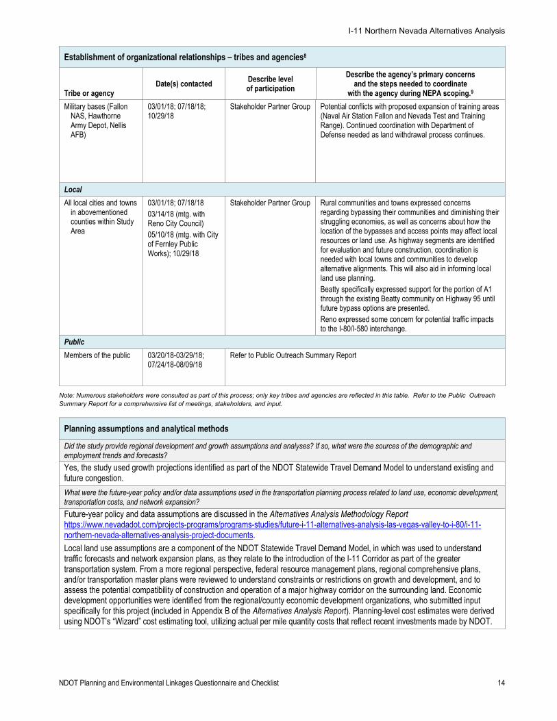
Military bases (Fallon NAS, Hawthorne Army Depot, Nellis AFB)
03/01/18; 07/18/18; 10/29/18
Stakeholder Partner Group Potential conflicts with proposed expansion of training areas (Naval Air Station Fallon and Nevada Test and Training Range). Continued coordination with Department of Defense needed as land withdrawal process continues.
Local
All local cities and towns in abovementioned counties within Study Area
03/01/18; 07/18/18 03/14/18 (mtg. with Reno City Council) 05/10/18 (mtg. with City of Fernley Public Works); 10/29/18
Stakeholder Partner Group Rural communities and towns expressed concerns regarding bypassing their communities and diminishing their struggling economies, as well as concerns about how the location of the bypasses and access points may affect local resources or land use. As highway segments are identified for evaluation and future construction, coordination is needed with local towns and communities to develop alternative alignments. This will also aid in informing local land use planning. Beatty specifically expressed support for the portion of A1 through the existing Beatty community on Highway 95 until future bypass options are presented. Reno expressed some concern for potential traffic impacts to the I-80/I-580 interchange.
Public
Members of the public 03/20/18-03/29/18; 07/24/18-08/09/18
Refer to Public Outreach Summary Report
Note: Numerous stakeholders were consulted as part of this process; only key tribes and agencies are reflected in this table. Refer to the Public Outreach Summary Report for a comprehensive list of meetings, stakeholders, and input.
Planning assumptions and analytical methods
Did the study provide regional development and growth assumptions and analyses? If so, what were the sources of the demographic and employment trends and forecasts?
Yes, the study used growth projections identified as part of the NDOT Statewide Travel Demand Model to understand existing and future congestion.
What were the future-year policy and/or data assumptions used in the transportation planning process related to land use, economic development, transportation costs, and network expansion?
Future-year policy and data assumptions are discussed in the Alternatives Analysis Methodology Report https://www.nevadadot.com/projects-programs/programs-studies/future-i-11-alternatives-analysis-las-vegas-valley-to-i-80/i-11-northern-nevada-alternatives-analysis-project-documents.
Local land use assumptions are a component of the NDOT Statewide Travel Demand Model, in which was used to understand traffic forecasts and network expansion plans, as they relate to the introduction of the I-11 Corridor as part of the greater transportation system. From a more regional perspective, federal resource management plans, regional comprehensive plans, and/or transportation master plans were reviewed to understand constraints or restrictions on growth and development, and to assess the potential compatibility of construction and operation of a major highway corridor on the surrounding land. Economic development opportunities were identified from the regional/county economic development organizations, who submitted input specifically for this project (included in Appendix B of the Alternatives Analysis Report). Planning-level cost estimates were derived using NDOT’s “Wizard” cost estimating tool, utilizing actual per mile quantity costs that reflect recent investments made by NDOT.
I-11 Northern Nevada Alternatives Analysis
NDOT Planning and Environmental Linkages Questionnaire and Checklist 15
Were the planning assumptions and the corridor vision/purpose and need statement consistent with each other and with the long-range transportation plan? Are the assumptions still valid?
Yes. The study compiles recommendations from an exhaustive list of previous statewide and corridor level planning studies, and incorporates assumptions of long-range transportation plans and regional transportation plans.
Data, information, and tools
Are the relevant data used in the study available in a compatible format that is readily usable? Are they available through a centralized web portal?
Most data were shared with or obtained by the Project Team as GIS shapefiles, from NDOT, other state departments, and federal land management and environmental resource agencies. Other information was obtained or provided as reports or web-mapped data. Specific datasets (when not covered under non-disclosure agreements) from the NDOT Project Manager. Relevant information is included in the Alternatives Analysis Report, which is made available to stakeholders and the public via the project website: https://www.nevadadot.com/projects-programs/programs-studies/future-i-11-alternatives-analysis-las-vegas-valley-to-i-80/i-11-northern-nevada-alternatives-analysis-project-documents.
Are the completeness and quality of the data consistent with the quality (not scale or detail) of inputs needed for a NEPA project-level analysis10?
Yes. This study process was structured to facilitate a NEPA project-level analysis for the recommended corridor alternatives. However, due to the long-range nature of the study, updates will be necessary during project development. Site visits, ground-truthing and field surveys were not conducted as part of this study.
Are the data used in the study regularly updated and augmented? If regularly updated, provide schedule and accessibility information.
NDOT updates traffic and socioeconomic data regularly (statewide travel demand model recently updated to reflect the most recent population and employment projections). Environmental data used in this study were obtained from readily available sources managed by a variety of local, state, and federal agencies. Agencies update these sources as existing information changes, as new information is obtained, and/or as available funding allows. All sources of environmental information must be updated prior to initiation of each phase of the NEPA process.
Have the environmental data been mapped at scales that facilitate comparison of effects across different resources and at sufficient resolution to guide initial NEPA issue definition? If not, what data collection and/or manipulation would likely be needed for application to the NEPA scoping process?
No, more detailed data collection and mapping will be required to analyze data at a scale that facilitates a clearer understanding of impacts and effects. Data mapped to date provides a broad-scale understanding of where the corridor may be routed to address major land ownership and management constraints, substantial environmental concerns, and general engineering requirements (e.g., topography).
Did the study incorporate models of, for example, species/habitat locations (predictive range maps), future land use, population dynamics, stormwater runoff, or travel demand? What models were used? Did the study adequately document what models were used, who was responsible for their use, and how they were used (with respect to, for example, calibration, replicability, contingencies, and exogenous factors)?
The study utilized existing environmental and travel demand data obtained from a variety of sources, including the NDOT travel demand model. No modeling of environmental resources (e.g., species distribution or habitat) were developed or otherwise used for this study. Only readily available maps, reports or other data were used, which may have been originally derived from modeling by the reporting federal and state agencies (e.g., US Forest Service, US military, Nevada Department of Wildlife). Data sources are documented in the Alternatives Analysis Methodology Report.
In scoping, conducting, and documenting the planning study, participants have come across documents and leads from agency staff and other sources that NEPA specialists may be able to use in conducting their studies. List any applicable memoranda of understanding, cost-share arrangements, programmatic agreements, or technical studies that are underway but whose findings are not yet published, etc.
The study did not require memoranda of understanding, cost sharing arrangements, or programmatic agreements specific to this study. Existing agreements between NDOT and the Nevada Natural Heritage Program resulted in obtaining sensitive species data. Non-disclosure agreements were necessary between study participants and the U.S. Department of the Navy relative to preliminary planning for the withdrawal of the NAS Fallon, but technical data, studies, or reports were not part of the information transfer.
10 For an explanation of the types of information needed to evaluate impacts in environmental documents, please see FHWA’s “NEPA
and Transportation Decisionmaking: Impacts,”<Analysis of Impacts>. This website provides links to six additional resources and guidance that should be helpful in understanding the types of impacts that need to be assessed, their context, and their intensity.
I-11 Northern Nevada Alternatives Analysis
NDOT Planning and Environmental Linkages Questionnaire and Checklist 16
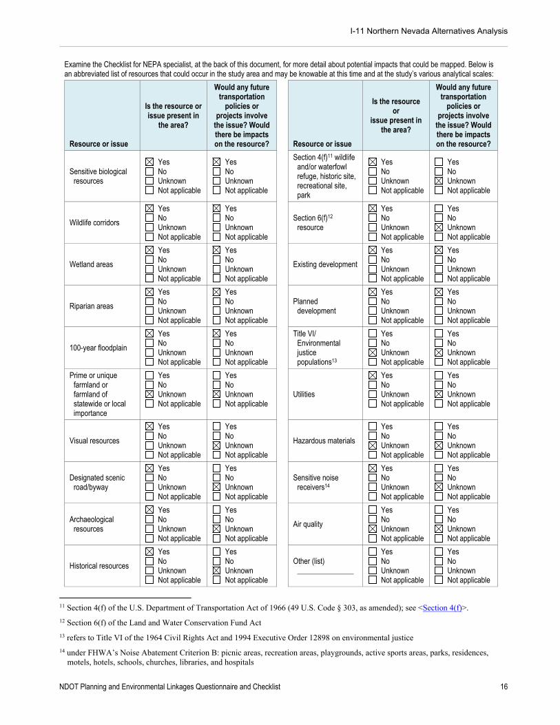
Examine the Checklist for NEPA specialist, at the back of this document, for more detail about potential impacts that could be mapped. Below is an abbreviated list of resources that could occur in the study area and may be knowable at this time and at the study’s various analytical scales:
Resource or issue
Is the resource or issue present in
the area?
Would any future transportation
policies or projects involve
the issue? Would there be impacts on the resource?
Resource or issue
Is the resource or
issue present in the area?
Would any future transportation
policies or projects involve
the issue? Would there be impacts on the resource?
Sensitive biological resources
Yes No Unknown Not applicable
Yes No Unknown Not applicable
Section 4(f)11 wildlife and/or waterfowl refuge, historic site, recreational site, park
Yes No Unknown Not applicable
Yes No Unknown Not applicable
Wildlife corridors
Yes No Unknown Not applicable
Yes No Unknown Not applicable
Section 6(f)12 resource
Yes No Unknown Not applicable
Yes No Unknown Not applicable
Wetland areas
Yes No Unknown Not applicable
Yes No Unknown Not applicable
Existing development
Yes No Unknown Not applicable
Yes No Unknown Not applicable
Riparian areas
Yes No Unknown Not applicable
Yes No Unknown Not applicable
Planned development
Yes No Unknown Not applicable
Yes No Unknown Not applicable
100-year floodplain
Yes No Unknown Not applicable
Yes No Unknown Not applicable
Title VI/ Environmental justice populations13
Yes No Unknown Not applicable
Yes No Unknown Not applicable
Prime or unique farmland or farmland of statewide or local importance
Yes No Unknown Not applicable
Yes No Unknown Not applicable
Utilities
Yes No Unknown Not applicable
Yes No Unknown Not applicable
Visual resources
Yes No Unknown Not applicable
Yes No Unknown Not applicable
Hazardous materials
Yes No Unknown Not applicable
Yes No Unknown Not applicable
Designated scenic road/byway
Yes No Unknown Not applicable
Yes No Unknown Not applicable
Sensitive noise receivers14
Yes No Unknown Not applicable
Yes No Unknown Not applicable
Archaeological resources
Yes No Unknown Not applicable
Yes No Unknown Not applicable
Air quality
Yes No Unknown Not applicable
Yes No Unknown Not applicable
Historical resources
Yes No Unknown Not applicable
Yes No Unknown Not applicable
Other (list) _______________
Yes No Unknown Not applicable
Yes No Unknown Not applicable
11 Section 4(f) of the U.S. Department of Transportation Act of 1966 (49 U.S. Code § 303, as amended); see <Section 4(f)>.
12 Section 6(f) of the Land and Water Conservation Fund Act
13 refers to Title VI of the 1964 Civil Rights Act and 1994 Executive Order 12898 on environmental justice
14 under FHWA’s Noise Abatement Criterion B: picnic areas, recreation areas, playgrounds, active sports areas, parks, residences, motels, hotels, schools, churches, libraries, and hospitals
I-11 Northern Nevada Alternatives Analysis
NDOT Planning and Environmental Linkages Questionnaire and Checklist 17
Development of alternatives
Were resource agencies, stakeholders, and members of the public engaged in the process of identifying, evaluating, and screening out modes, corridors, a range of alternatives,15 or a preferred alternative (if one was identified—the latter two refer to corridor plans)? If so, how? Did these groups review the recommendation of a preferred mode(s), corridor(s), range of alternatives (including the no-build alternative), or an alternative? Were the participation and inputs of these groups at a level acceptable for use in purpose and need statements or alternatives development sections in NEPA documents? If not, why not?
Yes. The project’s Stakeholder Partners Group (29 local/regional agencies, 21 state/federal resource agencies, 30 tribes/organizations) was engaged in the study process at regular milestones. Milestone meetings included presentation and discussion of the following topics: a) project history, data needs, universe of alternatives; b) evaluation criteria; and c) results of screening process and recommendations. Document review and input was solicited after each meeting.
In addition, a series of in-person public meetings were held, supplemented by online web materials and a Facebook Live meeting, for those unable to travel, attend, or participate in another manner (March 2018, August 2018). Documentation of meeting logistics and input is summarized in both the Phase 1 and Phase 2 Public Outreach Summaries.
Input received led to refinements to the alternatives development and evaluation process, including the determination of the recommendation, as “community acceptance” was one of nine major screening criteria categories.
Describe the process of outreach to resource agencies, the public, and other stakeholders. Describe the documentation of this process and of the responses to their comments. Is this documentation adequate in breadth and detail for use in NEPA documents?
The outreach process included a series of Stakeholder Partner Group meetings, public information meetings, tribal and other resource agency coordination, as requested. Depending on the group, these meetings either occurred as a joint meeting of several locations via teleconference/web meeting, or they were conducted in location-specific geographies. The format of the meetings generally included an informative presentation followed by a facilitated discussion or question/answer sessions. Public meetings occurred in an open house format. Stakeholder meetings were held in a physical location, supplemented by a teleconference that allowed input from those unable to attend the meeting in person. Discussion elements were documented in meeting summaries. Meeting participants were provided a window of time for submitting additional comments on the materials presented during the meeting. Input was utilized to refine technical documentation and/or process inputs for the study. Outreach documentation is compiled as part of the Public Outreach Summary Report.
If the study was a corridor study, describe the range of alternatives or modes of transportation (if any) considered, screening process, and screening criteria. Include what types of alternatives were considered (including the no-build alternative) and how the screening criteria were selected. Was a preferred alternative selected as best addressing the identified transportation issue? Are alternatives’ locations and design features specified?
The Alternatives Analysis Methodology Report and Alternatives Analysis Results Report present the details of the alternatives development and evaluation process, as well as the recommendations.
Based on the tenants of the overarching I-11 Corridor’s Purpose and Need, a series of corridor alternatives were developed connecting Las Vegas with I-80. These corridor alternatives were refined based on the planning-level analysis, as well as the initial round of public and stakeholder outreach. They were developed using engineering design parameters (e.g., topography), major known environmental constraints, as well as suggestions from stakeholders. While the alternatives are primarily focused on an interstate connection, the evaluation screens the ability for each alternative to accommodate multiple uses within the corridor footprint and does not preclude the implementation of other modes.
A series of nine evaluation categories were identified for the screening process, with one to four sub-criteria. These categories support the overall I-11 Corridor’s Purpose and Need and are consistent with I-11 Corridor planning throughout Arizona and Nevada.
The purpose of the evaluation was to narrow down the reasonable and feasible range of corridor alternatives for further planning and environmental review (to be completed in future work efforts) as part of the continued I-11 project development process. This effort does not include identification of a preferred alternative. The final recommendation includes moving two corridors alternatives forward (eliminating three) for further evaluation and refinement in NEPA, or subsequent PEL studies. General locations and design features are noted (e.g., level of access management desired), however more specific information on alignment location and design parameters should be specified in the next phase of study.
15 For an explanation of the development of alternatives in environmental documents, please see FHWA’s “NEPA and Transportation
Decisionmaking: Development and Evaluation of Alternatives,”<Alternatives>.
I-11 Northern Nevada Alternatives Analysis
NDOT Planning and Environmental Linkages Questionnaire and Checklist 18
Also regarding whether the study was a corridor study, for alternatives that were screened out, summarize the reasons for their rejection. Are defensible, credible rationale articulated for their being screened out? Did the study team take into account legal standards 15 needed in the NEPA process for such decisions? Did the study team have adequate information for screening out the alternatives?
Are defensible, credible rationale articulated for their being screened out?
Yes, the Alternatives Analysis Results Report explains the screening results process, results, and outcomes. Alternatives were screened out if fatal flaws were discovered, or the alternative did not meet the corridor’s purpose and need.
Did the study team take into account legal standards16 needed in the NEPA process for such decisions?
Yes, coordination with FHWA occurred to ensure integrity of this process to lay the foundation for future NEPA actions, although a formal legal review was not conducted.
Did the study team have adequate information for screening out the alternatives?
Yes.
What issues, if any, remain unresolved with the public, stakeholders, and/or resource agencies?
Continued coordination with project stakeholders and the public is required to determine specific alignment alternatives.
More detailed coordination with environmental resource agencies would be required to better understand potential opportunities and constraints. For example, BLM identifies lands available for disposal in Resource Management Plans (RMPs) through the federal land management planning process. Parcels of land for current and future disposal are identified along each corridor in current RMPs, and additional parcels likely will be identified as RMPs are updated or amended. In addition, Congressional actions may identify parcels for transfer or disposal in the future. As this planning process moves forward, updated information on land use, management and ownership must be obtained from the proper agencies and data sources to support the planning and evaluation process. Detailed coordination with the Bureau of Reclamation would be required to identify current and planned water and energy management structures and facilities to avoid impacts or develop appropriate mitigation. Similarly, coordination with military agencies is critical to remain updated on military expansion plans that might impact alignment decisions.
Coordination with local communities will be important to plan for and understand concerns related to expanding existing highway segments through communities versus constructing nearby bypass corridors.
Identification of potential environmental mitigation activities
Could the transportation planning process be integrated with other planning activities, such as land use or resource management plans? If so, could this integrated planning effort be used to develop a more strategic approach to environmental mitigation measures?
Yes, the compilation of information from numerous sources into one planning document will aid the transportation planning process. Understanding the improvements planned throughout the corridor may aid in developing strategic implementation plans for resource management on federal lands, Department of Defense land withdrawals, mining expansion, and wildlife management.
With respect to potential environmental mitigation opportunities at the PEL level, who should NDOT consult with among federal, State, and local agencies and tribes, and how formally and frequently should such consultation be undertaken?
NDOT should continue to consult with the project’s Stakeholder Partner Group as this project advances into future study phases. The formality and frequency of the coordination is dependent on the nature and timing of implementation of the project.
Formally joining PEL with the NEPA process
Lead federal agencies proposing a project that will undergo the NEPA process will want to most effectively leverage the transportation planning study’s efforts and results. How could a Notice of Intent (for an environmental impact statement17) refer to the study’s findings with respect to preliminary purpose and need and/or the range of alternatives to be studied?
The Alternatives Analysis Results Report will best summarize the overall purpose and need, screening criteria, alternatives development and evaluation process, and recommendations of corridor alternatives identified for further study.
16 23 Code of Federal Regulations (CFR) § 771.123(c), 23 CFR § 771.111(d), 40 CFR § 1502.14(a), 40 CFR § 1502.14(b) and (d),
23 CFR § 771.125(a)(1); see FHWA Technical Advisory T 6640.8A, October 30, 1987, <FHWA Technical Advisory T 6640.8A>.
17 While Notices of Intent are required by some federal agencies for environmental assessments, they are optional for FHWA. Please see “3.3.2 Using the Notice of Intent to Link Planning and NEPA,” in Guidance on Using Corridor and Subarea Planning to Inform NEPA (Federal Highway Administration, April 5, 2011), <Notice of Intent>.
I-11 Northern Nevada Alternatives Analysis
NDOT Planning and Environmental Linkages Questionnaire and Checklist 19
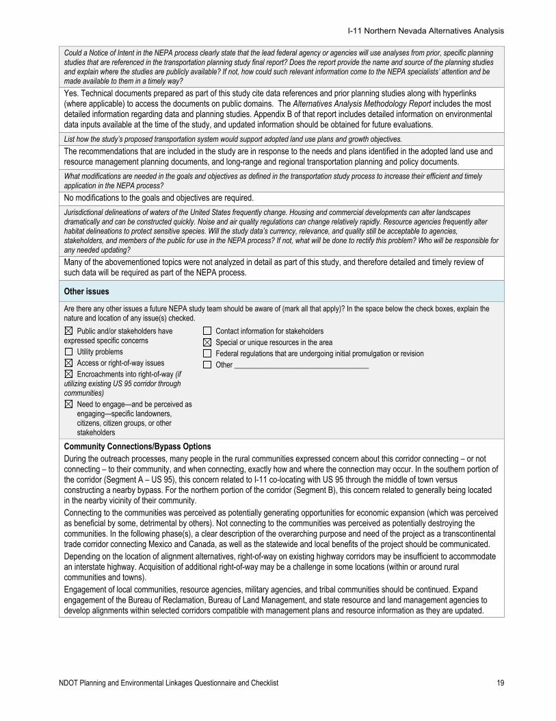
Could a Notice of Intent in the NEPA process clearly state that the lead federal agency or agencies will use analyses from prior, specific planning studies that are referenced in the transportation planning study final report? Does the report provide the name and source of the planning studies and explain where the studies are publicly available? If not, how could such relevant information come to the NEPA specialists’ attention and be made available to them in a timely way?
Yes. Technical documents prepared as part of this study cite data references and prior planning studies along with hyperlinks (where applicable) to access the documents on public domains. The Alternatives Analysis Methodology Report includes the most detailed information regarding data and planning studies. Appendix B of that report includes detailed information on environmental data inputs available at the time of the study, and updated information should be obtained for future evaluations.
List how the study’s proposed transportation system would support adopted land use plans and growth objectives.
The recommendations that are included in the study are in response to the needs and plans identified in the adopted land use and resource management planning documents, and long-range and regional transportation planning and policy documents.
What modifications are needed in the goals and objectives as defined in the transportation study process to increase their efficient and timely application in the NEPA process?
No modifications to the goals and objectives are required.
Jurisdictional delineations of waters of the United States frequently change. Housing and commercial developments can alter landscapes dramatically and can be constructed quickly. Noise and air quality regulations can change relatively rapidly. Resource agencies frequently alter habitat delineations to protect sensitive species. Will the study data’s currency, relevance, and quality still be acceptable to agencies, stakeholders, and members of the public for use in the NEPA process? If not, what will be done to rectify this problem? Who will be responsible for any needed updating?
Many of the abovementioned topics were not analyzed in detail as part of this study, and therefore detailed and timely review of such data will be required as part of the NEPA process.
Other issues
Are there any other issues a future NEPA study team should be aware of (mark all that apply)? In the space below the check boxes, explain the nature and location of any issue(s) checked.
Public and/or stakeholders have expressed specific concerns
Utility problems Access or right-of-way issues Encroachments into right-of-way (if
utilizing existing US 95 corridor through communities)
Need to engage—and be perceived as engaging—specific landowners, citizens, citizen groups, or other stakeholders
Contact information for stakeholders Special or unique resources in the area Federal regulations that are undergoing initial promulgation or revision Other ____________________________________
Community Connections/Bypass Options During the outreach processes, many people in the rural communities expressed concern about this corridor connecting – or not connecting – to their community, and when connecting, exactly how and where the connection may occur. In the southern portion of the corridor (Segment A – US 95), this concern related to I-11 co-locating with US 95 through the middle of town versus constructing a nearby bypass. For the northern portion of the corridor (Segment B), this concern related to generally being located in the nearby vicinity of their community. Connecting to the communities was perceived as potentially generating opportunities for economic expansion (which was perceived as beneficial by some, detrimental by others). Not connecting to the communities was perceived as potentially destroying the communities. In the following phase(s), a clear description of the overarching purpose and need of the project as a transcontinental trade corridor connecting Mexico and Canada, as well as the statewide and local benefits of the project should be communicated. Depending on the location of alignment alternatives, right-of-way on existing highway corridors may be insufficient to accommodate an interstate highway. Acquisition of additional right-of-way may be a challenge in some locations (within or around rural communities and towns). Engagement of local communities, resource agencies, military agencies, and tribal communities should be continued. Expand engagement of the Bureau of Reclamation, Bureau of Land Management, and state resource and land management agencies to develop alignments within selected corridors compatible with management plans and resource information as they are updated.
I-11 Northern Nevada Alternatives Analysis
NDOT Planning and Environmental Linkages Questionnaire and Checklist 20
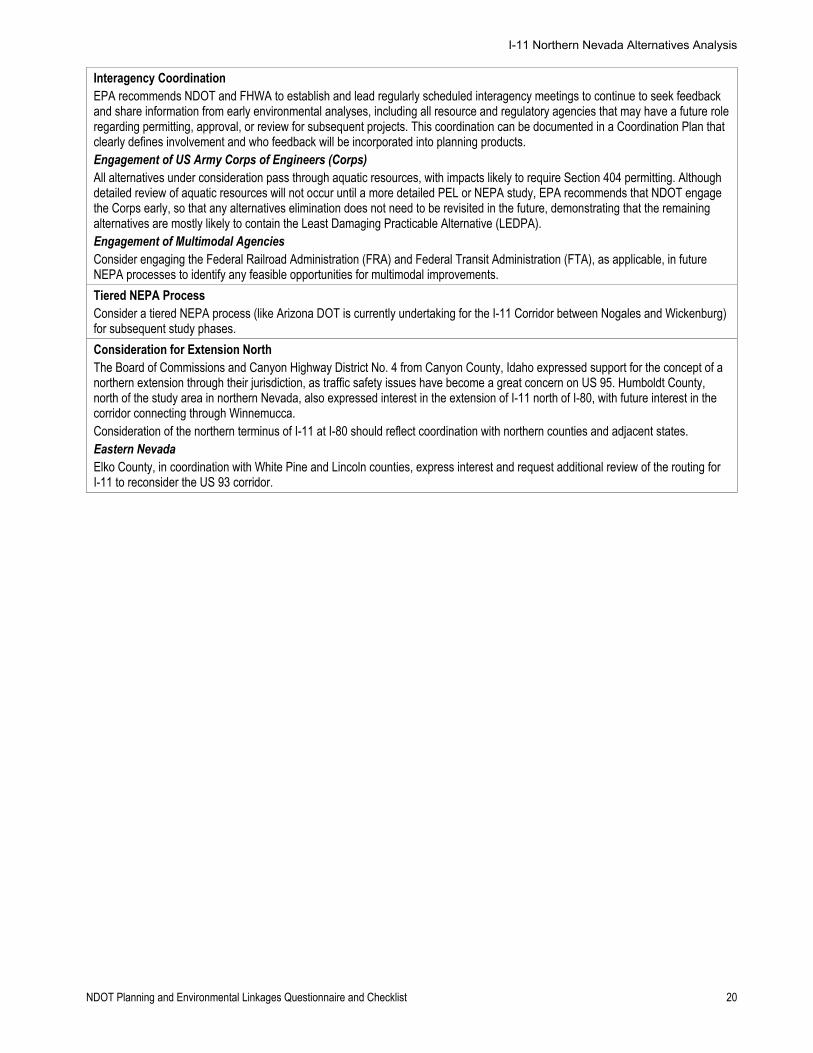
Interagency Coordination EPA recommends NDOT and FHWA to establish and lead regularly scheduled interagency meetings to continue to seek feedback and share information from early environmental analyses, including all resource and regulatory agencies that may have a future role regarding permitting, approval, or review for subsequent projects. This coordination can be documented in a Coordination Plan that clearly defines involvement and who feedback will be incorporated into planning products. Engagement of US Army Corps of Engineers (Corps) All alternatives under consideration pass through aquatic resources, with impacts likely to require Section 404 permitting. Although detailed review of aquatic resources will not occur until a more detailed PEL or NEPA study, EPA recommends that NDOT engage the Corps early, so that any alternatives elimination does not need to be revisited in the future, demonstrating that the remaining alternatives are mostly likely to contain the Least Damaging Practicable Alternative (LEDPA). Engagement of Multimodal Agencies Consider engaging the Federal Railroad Administration (FRA) and Federal Transit Administration (FTA), as applicable, in future NEPA processes to identify any feasible opportunities for multimodal improvements.
Tiered NEPA Process Consider a tiered NEPA process (like Arizona DOT is currently undertaking for the I-11 Corridor between Nogales and Wickenburg) for subsequent study phases.
Consideration for Extension North The Board of Commissions and Canyon Highway District No. 4 from Canyon County, Idaho expressed support for the concept of a northern extension through their jurisdiction, as traffic safety issues have become a great concern on US 95. Humboldt County, north of the study area in northern Nevada, also expressed interest in the extension of I-11 north of I-80, with future interest in the corridor connecting through Winnemucca. Consideration of the northern terminus of I-11 at I-80 should reflect coordination with northern counties and adjacent states. Eastern Nevada Elko County, in coordination with White Pine and Lincoln counties, express interest and request additional review of the routing for I-11 to reconsider the US 93 corridor.
I-11 Northern Nevada Alternatives Analysis
NDOT Planning and Environmental Linkages Questionnaire and Checklist 22
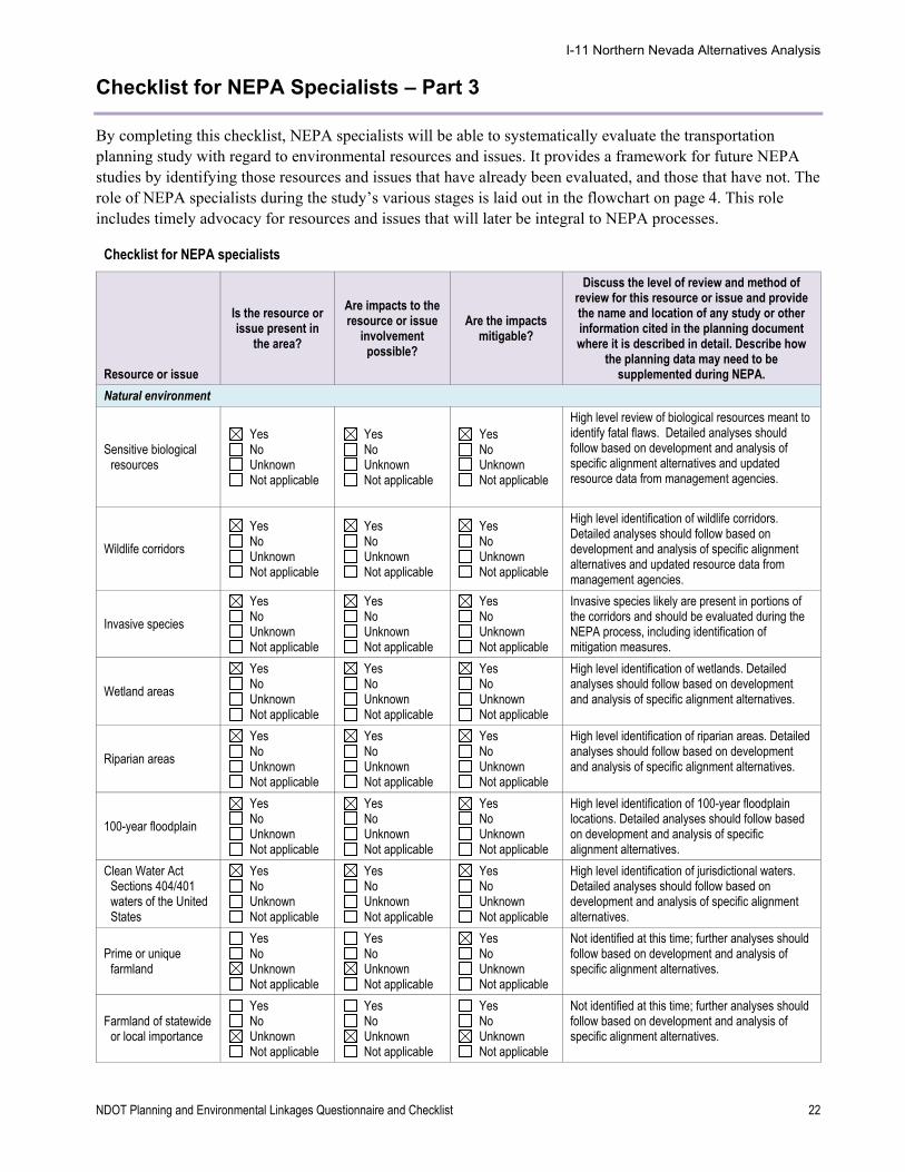
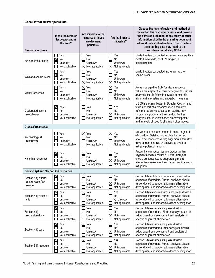
Checklist for NEPA Specialists – Part 3
By completing this checklist, NEPA specialists will be able to systematically evaluate the transportation planning study with regard to environmental resources and issues. It provides a framework for future NEPA studies by identifying those resources and issues that have already been evaluated, and those that have not. The role of NEPA specialists during the study’s various stages is laid out in the flowchart on page 4. This role includes timely advocacy for resources and issues that will later be integral to NEPA processes.
Checklist for NEPA specialists
Resource or issue
Is the resource or issue present in
the area?
Are impacts to the resource or issue
involvement possible?
Are the impacts mitigable?
Discuss the level of review and method of review for this resource or issue and provide the name and location of any study or other information cited in the planning document where it is described in detail. Describe how
the planning data may need to be supplemented during NEPA.
Natural environment
Sensitive biological resources
Yes No Unknown Not applicable
Yes No Unknown Not applicable
Yes No Unknown Not applicable
High level review of biological resources meant to identify fatal flaws. Detailed analyses should follow based on development and analysis of specific alignment alternatives and updated resource data from management agencies.
Wildlife corridors
Yes No Unknown Not applicable
Yes No Unknown Not applicable
Yes No Unknown Not applicable
High level identification of wildlife corridors. Detailed analyses should follow based on development and analysis of specific alignment alternatives and updated resource data from management agencies.
Invasive species
Yes No Unknown Not applicable
Yes No Unknown Not applicable
Yes No Unknown Not applicable
Invasive species likely are present in portions of the corridors and should be evaluated during the NEPA process, including identification of mitigation measures.
Wetland areas
Yes No Unknown Not applicable
Yes No Unknown Not applicable
Yes No Unknown Not applicable
High level identification of wetlands. Detailed analyses should follow based on development and analysis of specific alignment alternatives.
Riparian areas
Yes No Unknown Not applicable
Yes No Unknown Not applicable
Yes No Unknown Not applicable
High level identification of riparian areas. Detailed analyses should follow based on development and analysis of specific alignment alternatives.
100-year floodplain
Yes No Unknown Not applicable
Yes No Unknown Not applicable
Yes No Unknown Not applicable
High level identification of 100-year floodplain locations. Detailed analyses should follow based on development and analysis of specific alignment alternatives.
Clean Water Act Sections 404/401 waters of the United States
Yes No Unknown Not applicable
Yes No Unknown Not applicable
Yes No Unknown Not applicable
High level identification of jurisdictional waters. Detailed analyses should follow based on development and analysis of specific alignment alternatives.
Prime or unique farmland
Yes No Unknown Not applicable
Yes No Unknown Not applicable
Yes No Unknown Not applicable
Not identified at this time; further analyses should follow based on development and analysis of specific alignment alternatives.
Farmland of statewide or local importance
Yes No Unknown Not applicable
Yes No Unknown Not applicable
Yes No Unknown Not applicable
Not identified at this time; further analyses should follow based on development and analysis of specific alignment alternatives.
I-11 Northern Nevada Alternatives Analysis
NDOT Planning and Environmental Linkages Questionnaire and Checklist 23
Checklist for NEPA specialists
Resource or issue
Is the resource or issue present in
the area?
Are impacts to the resource or issue
involvement possible?
Are the impacts mitigable?
Discuss the level of review and method of review for this resource or issue and provide the name and location of any study or other information cited in the planning document where it is described in detail. Describe how
the planning data may need to be supplemented during NEPA.
Sole-source aquifers
Yes No Unknown Not applicable
Yes No Unknown Not applicable
Yes No Unknown Not applicable
Limited review conducted; no sole source aquifers located in Nevada, per EPA Region 9 categorization.
Wild and scenic rivers
Yes No Unknown Not applicable
Yes No Unknown Not applicable
Yes No Unknown Not applicable
Limited review conducted; no known wild or scenic rivers.
Visual resources
Yes No Unknown Not applicable
Yes No Unknown Not applicable
Yes No Unknown Not applicable
Areas managed by BLM for visual resource values are adjacent to corridor segments. Further analyses should follow to develop compatible alignment alternative and mitigation measures.
Designated scenic road/byway
Yes No Unknown Not applicable
Yes No Unknown Not applicable
Yes No Unknown Not applicable
US 50 is a scenic byway in Douglas County; and while not part of a recommended alternative, refinements during subsequent studies may incorporate portions of the corridor. Further analyses should follow based on development and analysis of specific alignment alternatives.
Cultural resources
Archaeological resources
Yes No Unknown Not applicable
Yes No Unknown Not applicable
Yes No Unknown Not applicable
Known resources are present in some segments of corridors. Detailed and updated analyses should be conducted during alignment alternative development and NEPA analysis to avoid or mitigate potential impacts.
Historical resources
Yes No Unknown Not applicable
Yes No Unknown Not applicable
Yes No Unknown Not applicable
Known historic resources are present within segments of each corridor. Further analyses should be conducted to support alignment alternative development and impact avoidance or mitigation.
Section 4(f) and Section 6(f) resources
Section 4(f) wildlife and/or waterfowl refuge
Yes No Unknown Not applicable
Yes No Unknown Not applicable
Yes No Unknown Not applicable
Section 4(f) wildlife resources are present within segments of corridors. Further analyses should be conducted to support alignment alternative development and impact avoidance or mitigation.
Section 4(f) historic site
Yes No Unknown Not applicable
Yes No Unknown Not applicable
Yes No
Unknown Not applicable
Section 4(f) historic resources are present within segments of corridors. Further analyses should be conducted to support alignment alternative development and impact avoidance or mitigation
Section 4(f) recreational site
Yes No Unknown Not applicable
Yes No Unknown Not applicable
Yes No Unknown Not applicable
Section 4(f) resources are present within segments of corridors. Ffurther analyses should follow based on development and analysis of specific alignment alternatives.
Section 4(f) park
Yes No Unknown Not applicable
Yes No Unknown Not applicable
Yes No Unknown Not applicable
Section 4(f) resources are present within segments of corridors Further analyses should follow based on development and analysis of specific alignment alternatives.
Section 6(f) resource
Yes No Unknown Not applicable
Yes No Unknown Not applicable
Yes No Unknown Not applicable
Section 6(f) resources are present within segments of corridors. Further analyses should be conducted to support alignment alternative development and impact avoidance or mitigation
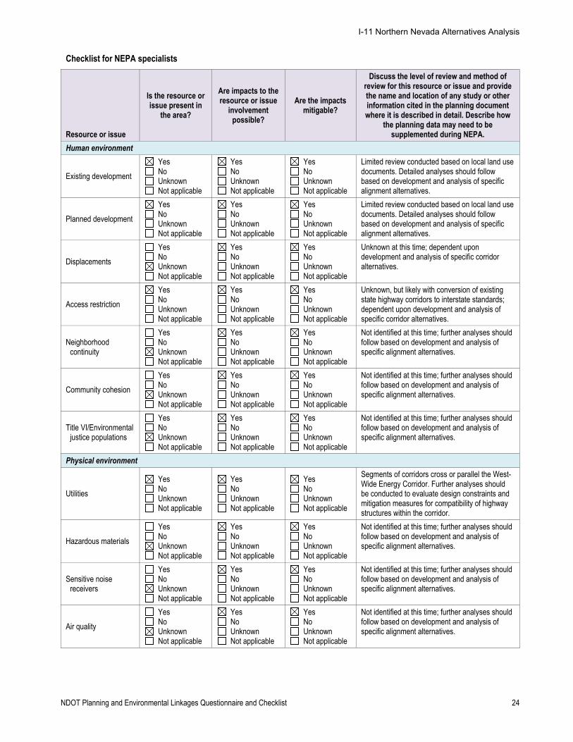
I-11 Northern Nevada Alternatives Analysis
NDOT Planning and Environmental Linkages Questionnaire and Checklist 24
Checklist for NEPA specialists
Resource or issue
Is the resource or issue present in
the area?
Are impacts to the resource or issue
involvement possible?
Are the impacts mitigable?
Discuss the level of review and method of review for this resource or issue and provide the name and location of any study or other information cited in the planning document where it is described in detail. Describe how
the planning data may need to be supplemented during NEPA.
Human environment
Existing development
Yes No Unknown Not applicable
Yes No Unknown Not applicable
Yes No Unknown Not applicable
Limited review conducted based on local land use documents. Detailed analyses should follow based on development and analysis of specific alignment alternatives.
Planned development
Yes No Unknown Not applicable
Yes No Unknown Not applicable
Yes No Unknown Not applicable
Limited review conducted based on local land use documents. Detailed analyses should follow based on development and analysis of specific alignment alternatives.
Displacements
Yes No Unknown Not applicable
Yes No Unknown Not applicable
Yes No Unknown Not applicable
Unknown at this time; dependent upon development and analysis of specific corridor alternatives.
Access restriction
Yes No Unknown Not applicable
Yes No Unknown Not applicable
Yes No Unknown Not applicable
Unknown, but likely with conversion of existing state highway corridors to interstate standards; dependent upon development and analysis of specific corridor alternatives.
Neighborhood continuity
Yes No Unknown Not applicable
Yes No Unknown Not applicable
Yes No Unknown Not applicable
Not identified at this time; further analyses should follow based on development and analysis of specific alignment alternatives.
Community cohesion
Yes No Unknown Not applicable
Yes No Unknown Not applicable
Yes No Unknown Not applicable
Not identified at this time; further analyses should follow based on development and analysis of specific alignment alternatives.
Title VI/Environmental justice populations
Yes No Unknown Not applicable
Yes No Unknown Not applicable
Yes No Unknown Not applicable
Not identified at this time; further analyses should follow based on development and analysis of specific alignment alternatives.
Physical environment
Utilities
Yes No Unknown Not applicable
Yes No Unknown Not applicable
Yes No Unknown Not applicable
Segments of corridors cross or parallel the West-Wide Energy Corridor. Further analyses should be conducted to evaluate design constraints and mitigation measures for compatibility of highway structures within the corridor.
Hazardous materials
Yes No Unknown Not applicable
Yes No Unknown Not applicable
Yes No Unknown Not applicable
Not identified at this time; further analyses should follow based on development and analysis of specific alignment alternatives.
Sensitive noise receivers
Yes No Unknown Not applicable
Yes No Unknown Not applicable
Yes No Unknown Not applicable
Not identified at this time; further analyses should follow based on development and analysis of specific alignment alternatives.
Air quality
Yes No Unknown Not applicable
Yes No Unknown Not applicable
Yes No Unknown Not applicable
Not identified at this time; further analyses should follow based on development and analysis of specific alignment alternatives.
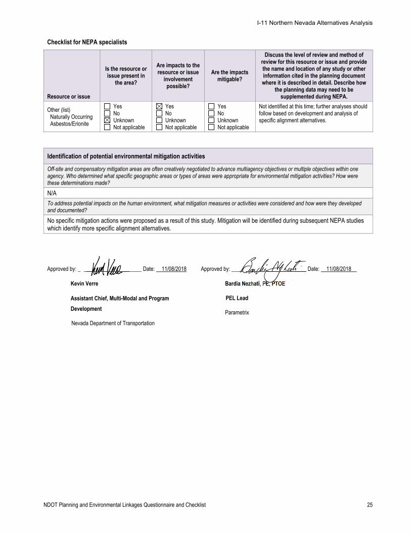
I-11 Northern Nevada Alternatives Analysis
NDOT Planning and Environmental Linkages Questionnaire and Checklist 25
Checklist for NEPA specialists
Resource or issue
Is the resource or issue present in
the area?
Are impacts to the resource or issue
involvement possible?
Are the impacts mitigable?
Discuss the level of review and method of review for this resource or issue and provide the name and location of any study or other information cited in the planning document where it is described in detail. Describe how
the planning data may need to be supplemented during NEPA.
Other (list) Naturally Occurring Asbestos/Erionite
Yes No Unknown Not applicable
Yes No Unknown Not applicable
Yes No Unknown Not applicable
Not identified at this time; further analyses should follow based on development and analysis of specific alignment alternatives.
Identification of potential environmental mitigation activities
Off-site and compensatory mitigation areas are often creatively negotiated to advance multiagency objectives or multiple objectives within one agency. Who determined what specific geographic areas or types of areas were appropriate for environmental mitigation activities? How were these determinations made?
N/A
To address potential impacts on the human environment, what mitigation measures or activities were considered and how were they developed and documented?
No specific mitigation actions were proposed as a result of this study. Mitigation will be identified during subsequent NEPA studies which identify more specific alignment alternatives.
Approved by: _ _____________________ Date: 11/08/2018
Kevin Verre
Assistant Chief, Multi-Modal and Program
Development
Nevada Department of Transportation
Approved by: ____ ______________________ Date: 11/08/2018 1
Bardia Nezhati, PE, PTOE
PEL Lead
Parametrix