Embed Size (px)
Citation preview
DRAFT Roadside Conservation Management Plan 2020 Page 2
This document is an update of the previous Roadside Conservation Management Plans of 1999, 2003, 2011 and 2015.
This Roadside Conservation Management Plan development has been undertaken under the direction of Indigo Shire Council. The scope of this Plan is the conservation management of rural roadsides under the control of Indigo Shire Council, specifically excluding roads controlled by Rural Roads Victoria.
Prepared by consultant Nicki Munro of Notomys Environmental Consulting, on behalf of:
Indigo Shire Council
PO Box 28
Beechworth, Victoria, 3747
Telephone 1300 365 003, (03) 5728 8000
Email: [email protected]
www.indigoshire.vic.gov.au
ABN: 76887 704 310
This publication is intended to be of assistance to all people involved in the management of roadsides, but Indigo Shire Council, its employees and consultants do not guarantee that the publication is without flaw of any kind or that it is wholly appropriate for the particular purposes of individuals, and therefore disclaim any liability for any error, loss or other consequences which may arise from reliance on any information in this publication.
Front Cover
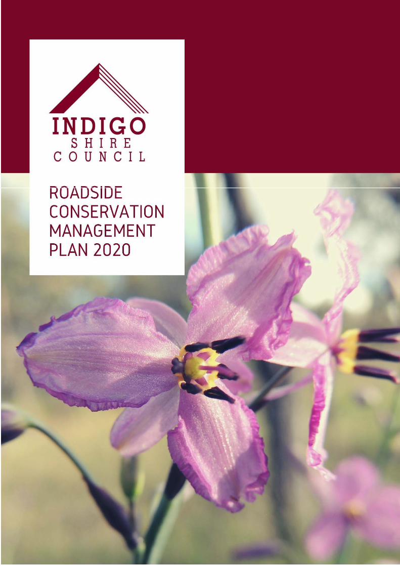
Chocolate Lily (Arthropodium strictum) in flower on a roadside in Wooragee.
DRAFT Roadside Conservation Management Plan 2020 Page 3
Name of document: Indigo Shire Council
Roadside Conservation Management Plan 2020
Version Number Date of Issue Author(s) Brief Description of Change
Version 1 1999 ISC staff and steering committee
Document development
Version 2 2003 Consultant, council staff and steering committee
Adopted.
Version 3
2009 Draft. Included roadside conservation values survey
Version 4 May 2011 ISC staff
Version 5 Nov 2015 ISC staff Adopted. Included fire procedures and conflict resolution
Version 6 2016 ISC staff Draft. Change of formatting to three separate documents for ISC, public and operations
Version 7 2020 Notomys Environmental Consulting (Nicki Munro) and ISC staff
Change of formatting, to single document (public information online), more streamlined, updated (most key state legislation has been updated/superseded in previous 1‐3 years)
DRAFT Roadside Conservation Management Plan 2020 Page 4
Contents Executive Summary....................................................................................................................................................... 6
Glossary ......................................................................................................................................................................... 7
PART A - BACKGROUND .............................................................................................................................................. 9
1 Introduction ........................................................................................................................................................ 9
1.1 The Roadside Conservation Management Plan (RCMP) ...................................................... 9 1.2 Scope of the RCMP .................................................................................................................. 9 1.3 Objectives of the RCMP......................................................................................................... 10 1.4 The approach of the RCMP ................................................................................................... 12 1.5 General Principles for the Protection of Conservation Values .......................................... 12
2 Roadside Importance and Threats .................................................................................................................. 13
2.1 Why it is important to conserve roadside vegetation ......................................................... 13 2.2 The vegetation assets of Indigo Shire ................................................................................. 15 2.3 Roadside Conservation Values Assessment ...................................................................... 19 2.4 Threats to roadside vegetation ............................................................................................. 21
3 Legislative and policy framework..................................................................................................................... 28
3.1 Commonwealth legislation .................................................................................................... 28 3.2 State legislation ..................................................................................................................... 28 3.3 Council plans and policy ....................................................................................................... 30 3.4 How the RCMP links to other operational documents ........................................................ 31
4 Stakeholders ................................................................................................................................................... 31
PART B – REQUIREMENTS ........................................................................................................................................ 33
6 General Operational Controls .......................................................................................................................... 33
6.1 Prevent spread of weeds ....................................................................................................... 33 6.2 Minimise disturbance to native animals .............................................................................. 35 6.3 Minimise disturbance to soil and native plants ................................................................... 35 6.4 Minimise disturbance to cultural heritage sites .................................................................. 35 6.5 Significant Landscapes and Visual Amenity ....................................................................... 36
7 Requirements for specific activities on roadsides ............................................................................................ 36
7.1 Access Points ........................................................................................................................ 43 7.2 Construction of Pathways and Tracks ................................................................................. 43 7.3 Drains and Culverts ............................................................................................................... 43 7.4 Fencing ................................................................................................................................... 44 7.5 Fire Management ................................................................................................................... 45 7.6 Harvesting wildflowers, foliage and seeds .......................................................................... 46 7.7 Installation of services .......................................................................................................... 46 7.8 Maintenance of electrical lines ............................................................................................. 46 7.9 Pest Plants and Animals ....................................................................................................... 47 7.10 Ploughing, slashing, haymaking and cropping ................................................................... 48 7.11 Revegetation and restoration of roadsides ......................................................................... 49 7.12 Road Maintenance, Construction and Widening ................................................................. 50 7.13 Sand, Soil and Gravel Extraction .......................................................................................... 52 7.14 Stock Movement, Grazing and Droving ............................................................................... 52
DRAFT Roadside Conservation Management Plan 2020 Page 5
7.15 Weed Spraying ....................................................................................................................... 53
PART C – IMPLEMENTATION ..................................................................................................................................... 54
8 Implementation of this Plan ............................................................................................................................. 54
8.1 Weed and pest animal management program ..................................................................... 54 8.2 Internal awareness ................................................................................................................. 57 8.3 Community awareness and education ................................................................................. 57 8.4 Compliance and Enforcement .............................................................................................. 59 8.5 Roles and responsibilities ..................................................................................................... 59 8.6 Actions ................................................................................................................................. 61 8.7 Monitoring and Review ................................................................................................. 62
References and Resources ...................................................................................................................................... 64
PART D – APPENDICES .............................................................................................................................................. 67
Appendix 1 Threat matrix ......................................................................................................................................... 68
Appendix 2 Ecological Vegetation Classes in Indigo Shire .................................................................................. 69
Appendix 3 Rare and Threatened Fauna in Indigo Shire ..................................................................................... 72
Appendix 4 Roadside conservation values maps ............................................................................................... 74
Appendix 5 Roadside conservation values list ..................................................................................................... 83
Appendix 6 Legislative Context .......................................................................................................................... 110
Appendix 7 Details of specific legislation ........................................................................................................... 116
Victorian Native Vegetation Regulations ........................................................................................ 116 Exemptions contained in Clause 52.17 (Native Vegetation) .......................................................... 116 Exemptions contained in Clause 52.48 (Bushfire Protection)....................................................... 117 Cultural Heritage regulations ........................................................................................................... 119 FFG Act Threatening processes ...................................................................................................... 120
Appendix 8 Rare and Threatened Flora in Indigo Shire ..................................................................................... 121
Appendix 9 Roadside Weeds of Indigo Shire ..................................................................................................... 124
DRAFT Roadside Conservation Management Plan 2020 Page 6
Executive Summary Management of roadside vegetation is complex, governed by multiple items of legislation. Roads have several functions, and various stakeholders with diverse interests. While the primary function of roads must be to provide safe and effective transit, roadside vegetation aids the conservation of our native plants and animals, and contributes to the visual character of Indigo Shire.
There are many, real and perceived, tensions in managing roadside vegetation. The threat of fire is justifiably paramount. This Plan aims to enable legally compliant fire management activities, and also increase education to the community on how native vegetation can actually reduce fire risk (in comparison to some introduced pasture grasses).
The conservation value of each roadside in Indigo Shire is assessed approximately every 10 years. The most recent survey in 2019-20 showed there has been a significant reduction in the quality and condition of Indigo Shire’s roadside vegetation. This Plan sets out a framework to prevent further decline of the conservation values of our roadsides, largely via legislative and policy compliance, with opportunities for additional strategic actions.
To comply with Federal and State legislation, Indigo Shire Council, as well as third parties, MUST adhere to ALL OF the following requirements in relation to council-managed roadsides:
1. Removal of native vegetation must be avoided, minimised where it can’t be avoided, and offset where it can’t be avoided or minimised.
2. Planning permits are required for removal of native vegetation, unless an exemption applies.
3. Some exemptions require a written agreement with the Department of Environment, Land, Water and Planning (DELWP), with specific requirements to be followed and recorded.
4. ISC has a legal responsibility to control declared weeds and pest animals on council managed roadsides.
5. ISC is the responsible authority to administer (including compliance and enforcement of) the planning scheme, including the native vegetation clauses.
This Roadside Conservation Management Plan summarises all legislative requirements, informing non-negotiable roadside vegetation management practices. This Plan also discusses negotiable or ‘beyond-compliance’ opportunities to improve roadside vegetation.
In addition to adhering to the legislative requirements, Indigo Shire Council has the opportunity to take positive actions in partnership with Landcare and the community to prevent further decline of roadside vegetation.
DRAFT Roadside Conservation Management Plan 2020 Page 7
Glossary
Term Meaning
CFA Country Fire Authority
DJPR Department of Jobs, Precincts and Regions (previously the
Department of Economic Development, Jobs, Transport and
Resources)
DELWP Department of Environment, Land, Water and Planning
EVC Ecological Vegetation Class
MERO Municipal Emergency Resource Officer
MFPC Municipal Fire Prevention Committee
MFPO Municipal Fire Prevention Officer
MFMP Municipal Fire Management Plan
MSS Municipal Strategic Statement
NECMA North East Catchment Management Authority
TfN Trust for Nature
RRV Rural Roads Victoria (Previously VicRoads)
VFF Victorian Farmers Federation
Authorised officer A person authorised by Indigo Shire Council under Section 224 of the Local Government Act 1989 to be authorised ‘for the purposes of the administration of any Act, regulations or local laws which relate to the functions and powers of the Council’.
Biodiversity The range of all living life-forms including plants, animals and micro-organisms, the genes they all contain and the eco-systems of which they form a part.
Declared Road Freeways, State highways, main roads, tourist roads and forest roads that are managed by Rural Roads Victoria (previously VicRoads) in accordance with VicRoads Roadside Management Strategy.
Droving of Stock Driving of livestock, from one location to another for the purpose of changing their grazing area or moving livestock from their grazing areas to a location for purposes of sale or from a sale location to a grazing area but does not include movement of livestock as defined in Local Law 4. lt does not include driving of livestock in or through a municipal district for the purpose of or including supplementing their feeding.
Environmental Weed A plant that colonises natural vegetation and threatens conservation values. It can be an exotic or native plant (e.g. Cootamundra wattle) that is not indigenous to the area. They are so called because their presence is in some way detrimental to the natural environment.
Fen A low and marshy or frequently flooded area of land. Fuel Reduced Corridor As specified in the Municipal Fire Management Plan to assist to
minimise the occurrence of initial spread of fire, enable establishment of control lines and provide a clear traffic route.
DRAFT Roadside Conservation Management Plan 2020 Page 8
Grazing of Stock Causing livestock to enter and remain on a road or roads within the municipal district for purposes of grazing rather than for purposes of droving or movement of livestock as defined in Local Law 4. lt relates to grazing a particular or designated area and not to indiscriminate droving for purposes of or including supplementing feeding.
Indigenous Vegetation Native vegetation that occurs naturally in a particular district including trees, shrubs, herbs, forbs and grasses.
Movement of Stock i. individual or regular movement of livestock; ii. as part of normal farm management operations of one
farming enterprise but not for purposes of grazing; iii. from one property within the municipal district to
another property within the municipal district or from or to one property in the municipal district to or from a property within an adjacent municipal district where the properties concerned are occupied by one farming enterprise;
iv. at the rate of not less than one kilometre per hour in the direction of movement between the two properties where the properties concerned are occupied by the one farming enterprise; and
v. the movement is completed during daylight hours Non Declared or Local Road Roads that are managed by ISC. Noxious Weed A plant listed under the Catchment and Land Protection Act 1994
that requires either eradication or control (dependent on the class).
Priority Access Road As specified in the Municipal Fire Management Plan a road that is critical for an ensured transport route for travellers and provides a link between critical locations to reduce travel time for fire fighters.
Remnant Vegetation Remaining indigenous vegetation. Road Formation The portion of the road reserve along which vehicles travel. It
includes the road pavement, shoulders and the area to the outermost side of the roadside drain, at least to where the drain batter meets the natural surface. This area includes the cut off drain.
Road Reserve The total strip of land reserved for transportation purposes from fence line to fence line or boundary to boundary if unfenced. The road reserve includes the roadside.
Roadside The strip of land between the road formation and the boundary of the road reserve which is usually also the boundary of the adjoining property.
Roadside Biological Corridor Connects isolated blocks of native vegetation and provides a strategic link for wildlife movement and serves as a gene pool for flora.
Tree Protection Zone (TPZ) A tree protection zone is an area around the trunk of the tree which has a radius of 12x the diameter at breast height to a maximum of 15 m but not less than 2 m. Dead trees should be protected with a radius of 15 m from the base.
Unused Road Reserve A road that has been gazetted under the Crown Lands Act 1958 where it is not used for public traffic, and is not on Councils road register.
DRAFT Roadside Conservation Management Plan 2020 Page 9
PART A - BACKGROUND
1 Introduction 1.1 The Roadside Conservation Management Plan (RCMP) The Roadside Conservation Management Plan (RCMP) aims to protect and enhance roadside native vegetation where possible, while recognising the primary role of roads as transit corridors. The plan incorporates relevant legislation pertinent to the management of native vegetation on roadsides.
This RCMP outlines the objectives, general principles and actions necessary to implement this Plan for use by Indigo Shire Council (ISC) management and staff and by the community. Management of roads for their functions outside of native vegetation conservation is covered by ISC’s Road Management Plan.
The first Roadside (Conservation) Management Plan for Indigo Shire was written in 1999, which was then updated in 2003 and again in 2011 and 2015 (the 2015 Plan was formally adopted by lSC). The 2015 review included processes developed from the Road Fire Management Strategy (taken from the Municipal Fire Management Plan). The increased linkage to emergency management plans has been continued during the development of this RCMP, with consideration of, and alignment to, the Road Fire Management Strategy 2019.
This 2020 review of the RCMP updates legislation, aims to provide greater balance and alignment between biodiversity objectives and the other uses of the road and provides a more streamlined document. As such, a large amount of information is in appendices, or refers to the source legislation.
Since the previous review of this Plan there have been updates to some key documents, plans and strategies, including the Indigo Shire Environment Strategy 2019, the Council Plan 2017-2021, Australia’s Biodiversity Conservation Strategy 2010-2030 (Commonwealth of Australia, 2010, revised 2018), Protecting Victoria’s Environment – Biodiversity 2037 (DELWP, 2017). Further information on the influence of these plans and strategies is given in section 3 below.
1.2 Scope of the RCMP The RCMP covers all rural roads within Indigo Shire that are not under the direct control of Rural Roads Victoria (RRV, previously called VicRoads) or the Department of Environment, Land, Water and Planning (DELWP). RRV are responsible for all major arterial roads within the Shire, such as those between towns. DELWP and Parks Victoria (PV) are responsible for managing most roads within declared Crown Land including National Parks, State Parks and State Forest areas, plus ‘unused roads’. ISC manages all remaining roads (approximately 1,300km). Street trees (mainly non-native) within the urban areas have not been included in this plan and are discussed in the Indigo Shire Tree Management Plan.
Road maintenance works conducted by the Shire are done within the ‘maintenance envelope’, which is defined by DELWP as an area encompassing the road surface plus an area to one metre beyond the guide posts at the edge of the road shoulder or one metre past the table drain if there are no posts. The envelope is defined vertically to five metres above the road. This RCMP does not include any areas within this road maintenance envelope.
DRAFT Roadside Conservation Management Plan 2020 Page 10
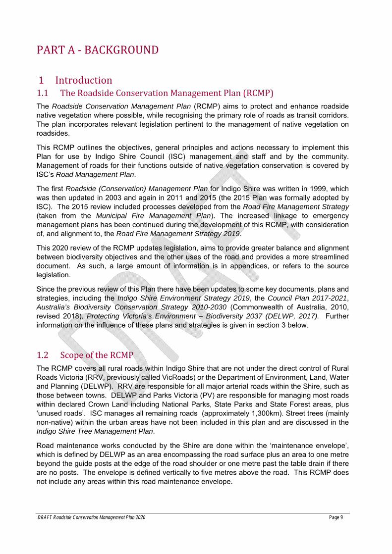
The roadside addressed by this RCMP is usually the area between a property boundary and the road drain as shown in figure 1 below. This Plan focuses on the management of native vegetation located on roadsides and recognises the opportunities to protect and enhance roadside vegetation, while acknowledging that the primary function of roads is to provide safe vehicle transit. Management of roadside vegetation must also be balanced with the need for access to utilities and properties, and must incorporate the needs of fire management.
Figure 1. Diagram indicating what constitutes ‘roadside vegetation’.
This Plan applies to all applicable council staff and contractors planning, supervising or undertaking work on the roadside. Additionally, elements of the Plan apply to community members and third parties seeking to undertake certain activities on the roadside. Information for community members and third parties from this Plan shall be made available in an easy to understand format on Council’s website.
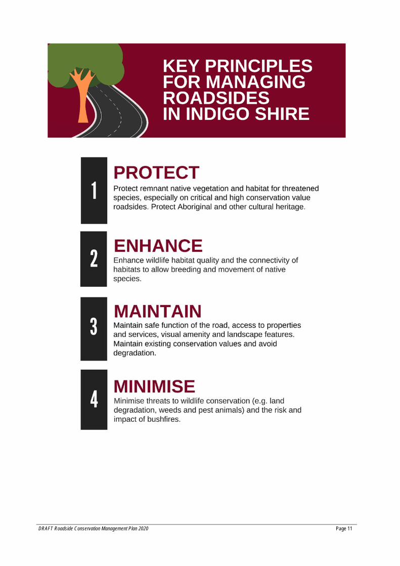
1.3 Objectives of the RCMP Indigo Shire Council aims to manage roadside reserves to ensure:
Provision of safe transportation corridors (including during fires); Protection and enhancement of the quality and viability of our natural biodiversity; Ensure vegetation management also meets the needs of bushfire protection, and Protection of indigenous and non-indigenous cultural heritage.
This will be achieved by applying the following key principles to all planning, priority setting and works on roadsides:
DRAFT Roadside Conservation Management Plan 2020 Page 11
DRAFT Roadside Conservation Management Plan 2020 Page 12
1.4 The approach of the RCMP
The requirements described in this Plan largely reflect legislative requirements that ISC must adhere to. The ISC RCMP follows a similar approach to that used in many other Victorian Shires where roadsides are assessed for their conservation value to inform scalable controls and interventions. This plan does not introduce new permit requirements. This updated plan sets out the existing permissions required for activities based on existing and revised legislation.
To explore the risks to roadside conservation and determine controls for activities, a threat matrix was used (Appendix 1). This outlines the most common roadside management activities, and the damage they are likely to cause. Activities are not permitted where they will cause unnecessary damage to native vegetation.
1.5 General Principles for the Protection of Conservation Values In Indigo Shire, the following general principles will apply when making decisions about activities potentially affecting roadside biodiversity:
1. The road must be safe and effective for transit.
2. Legislative compliance – broadly, native vegetation is protected and cannot be removed without a permit, unless exemptions apply. Higher level native vegetation protection may also apply for threatened or protected species or communities. Other legislation, including the Road Management Act, must also be followed.
3. All native plant types and parts of the ecosystem are included in the term ‘native vegetation’. This includes native grasses, forbs, orchids, fungi, logs, dead trees and shrubs; and their values should be recognised.
4. Protect critical and high conservation value roadsides - particularly those containing threatened species or communities. Critical and high conservation value roadsides should be the focus of protection and restoration.
5. Medium and low conservation roadsides still have conservation value, and should be protected, and improved, where possible. Degraded native vegetation areas should be weeded, where possible, and allowed to regenerate naturally.
6. Critical habitats should be identified, protected, and enhanced where possible (enlarged and improved). Critical habitats include areas containing threatened species or vegetation communities, or habitat for threatened fauna. This requires desktop checks prior to certain works being carried out, and appropriate controls put in place.
7. Habitat features should be recognised and retained where possible. These include hollow-bearing trees, fallen branches, dead trees and shrubs, rocks, logs and leaf litter.
8. Areas of natural regeneration or revegetation should be treated as per ‘native vegetation’. These should also be protected unless it poses an unacceptable risk to road use or fire management.
9. Revegetation should be encouraged to improve the quality, diversity or extent of native vegetation. Revegetation should be suitable to the site and match the original Ecological Vegetation Class (EVC);
DRAFT Roadside Conservation Management Plan 2020 Page 13
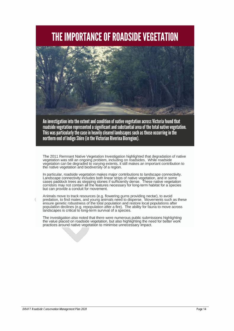
2 Roadside Importance and Threats 2.1 Why it is important to conserve roadside vegetation The primary function of a road is to provide safe vehicle access routes for the transport of people, goods and services. Many roadsides also support important biodiversity values because they retain remnants of native vegetation and wildlife habitats that were once widespread throughout the landscape. Roadsides often provide the only habitat connections to other native vegetation remnants in heavily cleared rural landscapes in the Indigo Shire. Roadsides also complement land protection and habitat restoration efforts (e.g. revegetation) on adjoining land.
The primary goal identified for native vegetation management in Protecting Victoria’s Environment – Biodiversity 2037 (DELWP, 2017) is: ‘No net loss to biodiversity as a result of the removal, destruction or lopping of native vegetation’. The “no net less” goal recognises that at times losses of vegetation might be unavoidable, but it must be avoided and minimised wherever possible, and offset where it cannot be avoided and minimised. Offsetting means protecting similar vegetation elsewhere to compensate for the vegetation cleared.
Roadsides are integral to supporting biodiversity and other state and local policy objectives through providing:
Habitat for wildlife, including endangered and rare plants (flora) and animals (fauna); Vegetated corridors for fauna movement (habitat connectivity); Source of local genetic resources (e.g. native plant seed for habitat restoration /
revegetation); Important historic, cultural and natural landscape values; Aesthetic values for tourism and residents that choose to live in a rural setting; Assistance with controlling land degradation and maintaining road integrity (e.g. erosion,
water overflow management); Ecosystem services – e.g. improving water quality, water table control, carbon
sequestration, and improving air quality; Windbreaks and shelter belts - e.g. for livestock and crops in adjacent paddocks; Movement avenues for livestock, and Access for pedestrians, cyclists and horse riders.
DRAFT Roadside Conservation Management Plan 2020 Page 14
DRAFT Roadside Conservation Management Plan 2020 Page 15
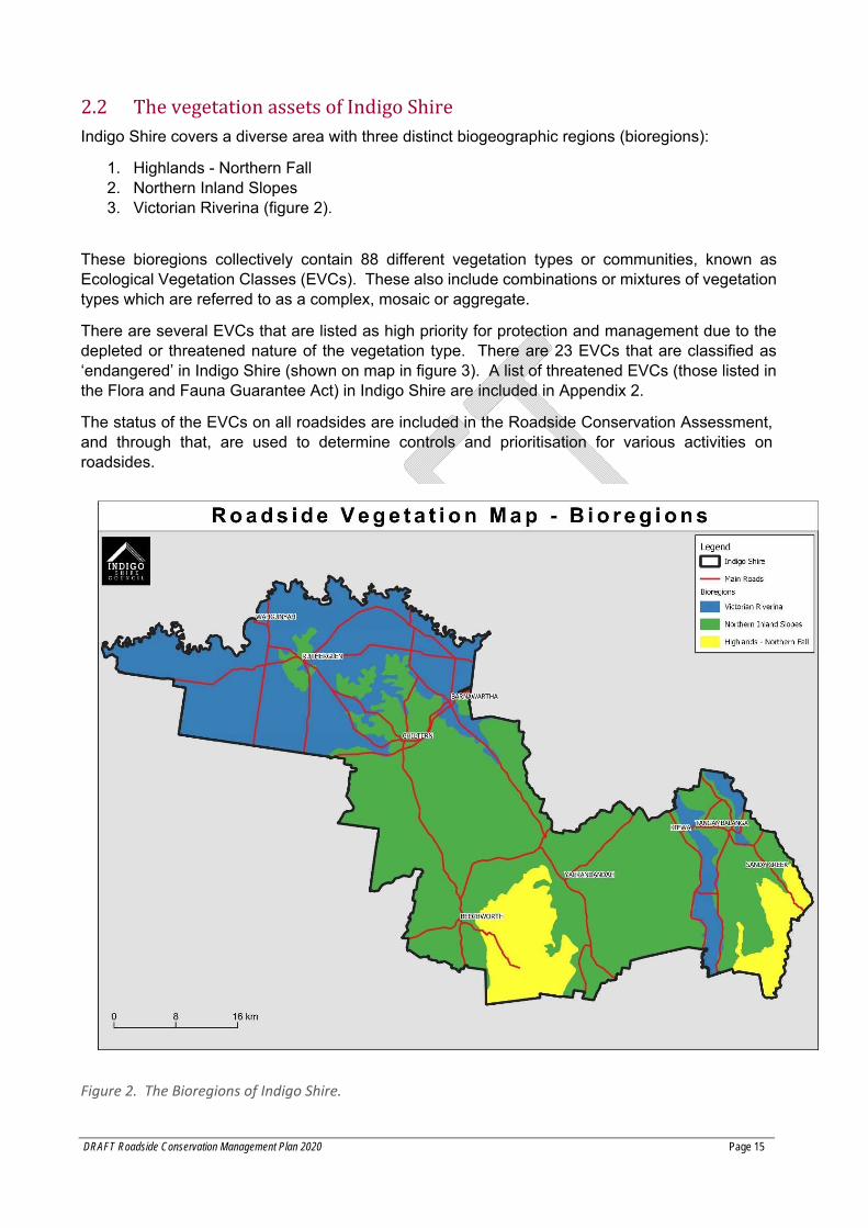
2.2 The vegetation assets of Indigo Shire Indigo Shire covers a diverse area with three distinct biogeographic regions (bioregions):
1. Highlands - Northern Fall 2. Northern Inland Slopes 3. Victorian Riverina (figure 2).
These bioregions collectively contain 88 different vegetation types or communities, known as Ecological Vegetation Classes (EVCs). These also include combinations or mixtures of vegetation types which are referred to as a complex, mosaic or aggregate.
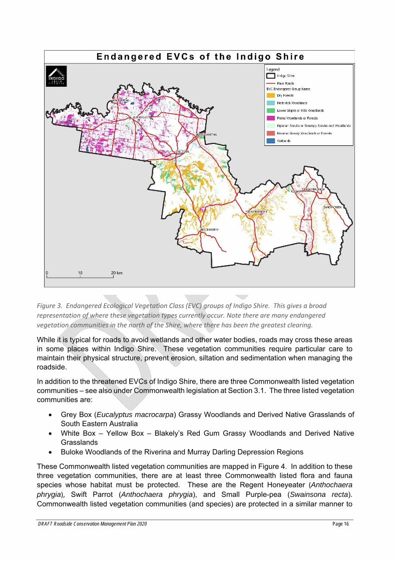
There are several EVCs that are listed as high priority for protection and management due to the depleted or threatened nature of the vegetation type. There are 23 EVCs that are classified as ‘endangered’ in Indigo Shire (shown on map in figure 3). A list of threatened EVCs (those listed in the Flora and Fauna Guarantee Act) in Indigo Shire are included in Appendix 2.
The status of the EVCs on all roadsides are included in the Roadside Conservation Assessment, and through that, are used to determine controls and prioritisation for various activities on roadsides.
Figure 2. The Bioregions of Indigo Shire.
DRAFT Roadside Conservation Management Plan 2020 Page 16
Figure 3. Endangered Ecological Vegetation Class (EVC) groups of Indigo Shire. This gives a broad
representation of where these vegetation types currently occur. Note there are many endangered
vegetation communities in the north of the Shire, where there has been the greatest clearing.
While it is typical for roads to avoid wetlands and other water bodies, roads may cross these areas in some places within Indigo Shire. These vegetation communities require particular care to maintain their physical structure, prevent erosion, siltation and sedimentation when managing the roadside.
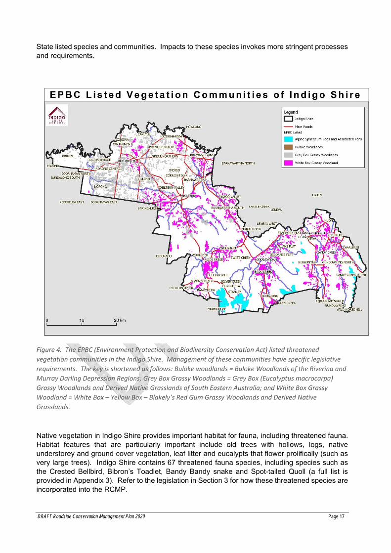
In addition to the threatened EVCs of Indigo Shire, there are three Commonwealth listed vegetation communities – see also under Commonwealth legislation at Section 3.1. The three listed vegetation communities are:
Grey Box (Eucalyptus macrocarpa) Grassy Woodlands and Derived Native Grasslands of South Eastern Australia
White Box – Yellow Box – Blakely’s Red Gum Grassy Woodlands and Derived Native Grasslands
Buloke Woodlands of the Riverina and Murray Darling Depression Regions
These Commonwealth listed vegetation communities are mapped in Figure 4. In addition to these three vegetation communities, there are at least three Commonwealth listed flora and fauna species whose habitat must be protected. These are the Regent Honeyeater (Anthochaera phrygia), Swift Parrot (Anthochaera phrygia), and Small Purple-pea (Swainsona recta). Commonwealth listed vegetation communities (and species) are protected in a similar manner to
DRAFT Roadside Conservation Management Plan 2020 Page 17
State listed species and communities. Impacts to these species invokes more stringent processes and requirements.
Figure 4. The EPBC (Environment Protection and Biodiversity Conservation Act) listed threatened
vegetation communities in the Indigo Shire. Management of these communities have specific legislative
requirements. The key is shortened as follows: Buloke woodlands = Buloke Woodlands of the Riverina and
Murray Darling Depression Regions; Grey Box Grassy Woodlands = Grey Box (Eucalyptus macrocarpa)
Grassy Woodlands and Derived Native Grasslands of South Eastern Australia; and White Box Grassy
Woodland = White Box – Yellow Box – Blakely’s Red Gum Grassy Woodlands and Derived Native
Grasslands.
Native vegetation in Indigo Shire provides important habitat for fauna, including threatened fauna. Habitat features that are particularly important include old trees with hollows, logs, native understorey and ground cover vegetation, leaf litter and eucalypts that flower prolifically (such as very large trees). Indigo Shire contains 67 threatened fauna species, including species such as the Crested Bellbird, Bibron’s Toadlet, Bandy Bandy snake and Spot-tailed Quoll (a full list is provided in Appendix 3). Refer to the legislation in Section 3 for how these threatened species are incorporated into the RCMP.
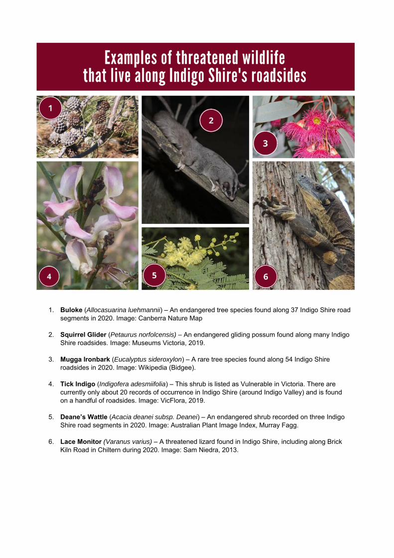
1. Buloke (Allocasuarina luehmannii) – An endangered tree species found along 37 Indigo Shire road segments in 2020. Image: Canberra Nature Map
2. Squirrel Glider (Petaurus norfolcensis) – An endangered gliding possum found along many Indigo Shire roadsides. Image: Museums Victoria, 2019.
3. Mugga Ironbark (Eucalyptus sideroxylon) – A rare tree species found along 54 Indigo Shire roadsides in 2020. Image: Wikipedia (Bidgee).
4. Tick Indigo (Indigofera adesmiifolia) – This shrub is listed as Vulnerable in Victoria. There are currently only about 20 records of occurrence in Indigo Shire (around Indigo Valley) and is found on a handful of roadsides. Image: VicFlora, 2019.
5. Deane’s Wattle (Acacia deanei subsp. Deanei) – An endangered shrub recorded on three Indigo Shire road segments in 2020. Image: Australian Plant Image Index, Murray Fagg.
6. Lace Monitor (Varanus varius) – A threatened lizard found in Indigo Shire, including along Brick Kiln Road in Chiltern during 2020. Image: Sam Niedra, 2013.
2.3 Roadside Conservation Values Assessment ISC manages 1,310km of local roads, or 2,620km of road reserve length. A large proportion of the original native vegetation on the roads has been lost or modified due to agricultural practices, road and drainage works, urban growth and weed invasion.
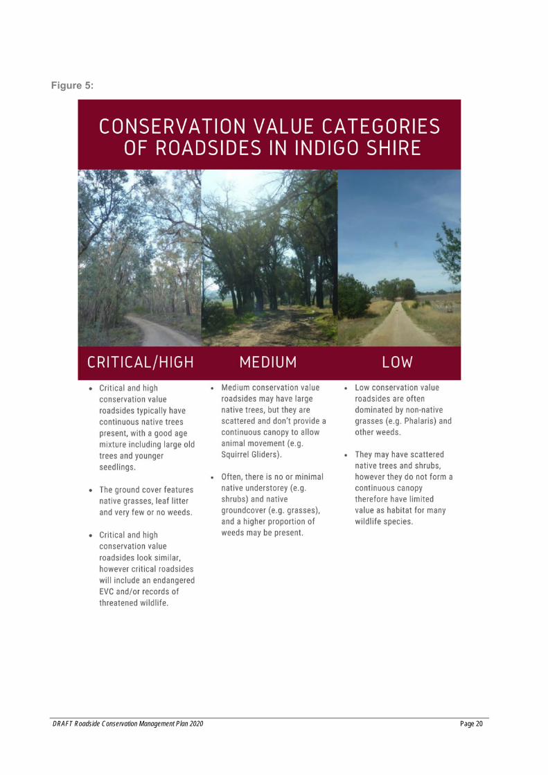
Not all roadsides are in good condition, and not all have native vegetation. Those that are in good condition (healthy, intact native vegetation) are more important to protect than roadsides in poor condition. It is important to understand the current (and trending) condition of roadsides in the Shire, when allowing or conducting activities on roadsides.
To map the condition of roadside vegetation, an assessment of rural roads for which Council is the responsible authority, has been undertaken to determine conservation value.
The roadside conservation value assessment is undertaken by consultants approximately every ten years, with the third and most recent round occurring in 2020. Although a significant budget item, it is important to regularly reassess the roadside conservation values to keep data current to inform operational controls, as well as effective use of the pest and weed program budget.
The assessment considers percentage canopy cover, percentage cover weeds, understorey, recruits, logs, organic litter and landscape connectivity. All roads included in the assessment were assigned a conservation value as per Figure 5. A map of the conservation value of roadsides (critical, high, medium and low conservation value, Appendix 4) is provided on Council’s website, as well as in the Shire’s geographical information system. A list of all roads with their conservation status is included as Appendix 5.
This information is used to determine what activities will be approved on roadsides. Broadly, some activities on critical and high conservation roadsides may require additional controls or consultation. Critical and High conservation roadsides will be prioritised for weed and pest management, and for revegetation works.
DRAFT Roadside Conservation Management Plan 2020 Page 20
Figure 5:
DRAFT Roadside Conservation Management Plan 2020 Page 21
2.4 Threats to roadside vegetation Threats to roadside vegetation are events or occurrences that have an impact on the quality and quantity of the roadside biodiversity. Because roadsides are generally narrow and linear, roadside vegetation is susceptible to many threats including:
Pest plants and animals Encroachment of farming activities and urban development (e.g. driveways) Installation of services Impacts from grading and other road maintenance activities Timber extraction and firewood collection Inappropriate fire prevention activities such as ploughing of native grasses Weed spread by vehicles.
All these activities can threaten the viability of roadside vegetation and as a result, reduce the value of the ecosystem services that roadside vegetation provides.
These management practices if done poorly, ultimately lead to greater management costs in the future, a reduction in vegetation quality, and specific conflicts. Table 1 outlines common roadside activities and their specific threats.
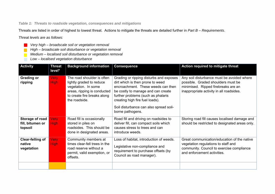
Table 1: Threats to roadside vegetation, consequences and mitigations
Threats are listed in order of highest to lowest threat. Actions to mitigate the threats are detailed further in Part B – Requirements.
Threat levels are as follows:
Very high – broadscale soil or vegetation removal High – broadscale soil disturbance or vegetation removal Medium – localised soil disturbance or vegetation removal Low – localised vegetation disturbance
Activity Threat level*
Background information Consequence Action required to mitigate threat
Grading or ripping
Very High
The road shoulder is often lightly graded to reduce vegetation. In some areas, ripping is conducted to create fire breaks along the roadside.
Grading or ripping disturbs and exposes dirt which is then prone to weed encroachment. These weeds can then be costly to manage and can create further problems (such as phalaris creating high fire fuel loads).
Soil disturbance can also spread soil-borne pathogens.
Any soil disturbance must be avoided where possible. Graded shoulders must be minimised. Ripped firebreaks are an inappropriate activity in all roadsides.
Storage of road fill, bitumen or topsoil
Very High
Road fill is occasionally stored in piles on roadsides. This should be done in designated areas.
Road fill and driving on roadsides to deliver fill, can compact soils which causes stress to trees and can introduce weeds.
Storing road fill causes localised damage and should be restricted to designated areas only.
Clear-felling of native vegetation
Very High
Community members at times clear-fell trees in the road reserve without a permit, valid exemption, or offsets.
Loss of habitat, introduction of weeds.
Legislative non-compliance and requirement to purchase offsets (by Council as road manager).
Great communication/education of the native vegetation regulations to staff and community. Council to exercise compliance and enforcement activities.
DRAFT Roadside Conservation Management Plan 2020 Page 23
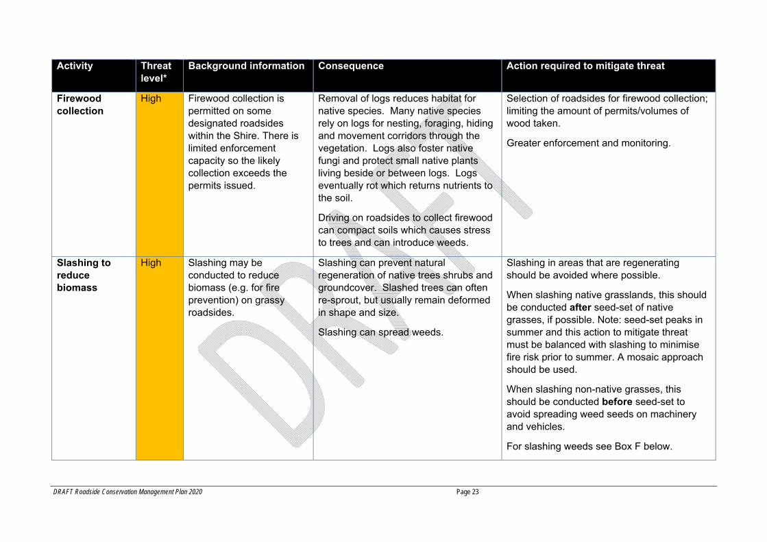
Activity Threat level*
Background information Consequence Action required to mitigate threat
Firewood collection
High Firewood collection is permitted on some designated roadsides within the Shire. There is limited enforcement capacity so the likely collection exceeds the permits issued.
Removal of logs reduces habitat for native species. Many native species rely on logs for nesting, foraging, hiding and movement corridors through the vegetation. Logs also foster native fungi and protect small native plants living beside or between logs. Logs eventually rot which returns nutrients to the soil.
Driving on roadsides to collect firewood can compact soils which causes stress to trees and can introduce weeds.
Selection of roadsides for firewood collection; limiting the amount of permits/volumes of wood taken.
Greater enforcement and monitoring.
Slashing to reduce biomass
High Slashing may be conducted to reduce biomass (e.g. for fire prevention) on grassy roadsides.
Slashing can prevent natural regeneration of native trees shrubs and groundcover. Slashed trees can often re-sprout, but usually remain deformed in shape and size.
Slashing can spread weeds.
Slashing in areas that are regenerating should be avoided where possible.
When slashing native grasslands, this should be conducted after seed-set of native grasses, if possible. Note: seed-set peaks in summer and this action to mitigate threat must be balanced with slashing to minimise fire risk prior to summer. A mosaic approach should be used.
When slashing non-native grasses, this should be conducted before seed-set to avoid spreading weed seeds on machinery and vehicles.
For slashing weeds see Box F below.
DRAFT Roadside Conservation Management Plan 2020 Page 24
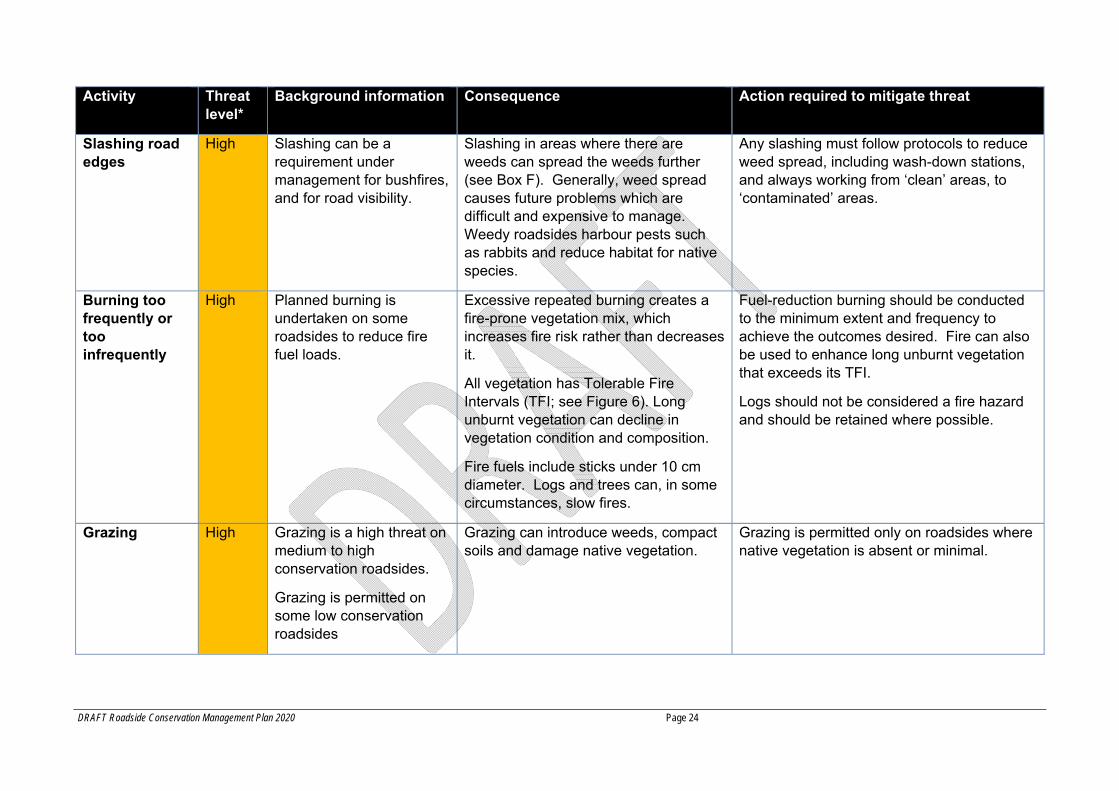
Activity Threat level*
Background information Consequence Action required to mitigate threat
Slashing road edges
High Slashing can be a requirement under management for bushfires, and for road visibility.
Slashing in areas where there are weeds can spread the weeds further (see Box F). Generally, weed spread causes future problems which are difficult and expensive to manage. Weedy roadsides harbour pests such as rabbits and reduce habitat for native species.
Any slashing must follow protocols to reduce weed spread, including wash-down stations, and always working from ‘clean’ areas, to ‘contaminated’ areas.
Burning too frequently or too infrequently
High Planned burning is undertaken on some roadsides to reduce fire fuel loads.
Excessive repeated burning creates a fire-prone vegetation mix, which increases fire risk rather than decreases it.
All vegetation has Tolerable Fire Intervals (TFI; see Figure 6). Long unburnt vegetation can decline in vegetation condition and composition.
Fire fuels include sticks under 10 cm diameter. Logs and trees can, in some circumstances, slow fires.
Fuel-reduction burning should be conducted to the minimum extent and frequency to achieve the outcomes desired. Fire can also be used to enhance long unburnt vegetation that exceeds its TFI.
Logs should not be considered a fire hazard and should be retained where possible.
Grazing High Grazing is a high threat on medium to high conservation roadsides.
Grazing is permitted on some low conservation roadsides
Grazing can introduce weeds, compact soils and damage native vegetation.
Grazing is permitted only on roadsides where native vegetation is absent or minimal.
DRAFT Roadside Conservation Management Plan 2020 Page 25
Activity Threat level*
Background information Consequence Action required to mitigate threat
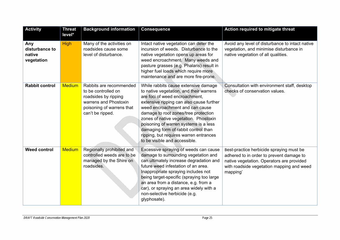
Any disturbance to native vegetation
High Many of the activities on roadsides cause some level of disturbance.
Intact native vegetation can deter the incursion of weeds. Disturbance to the native vegetation opens up areas for weed encroachment. Many weeds and pasture grasses (e.g. Phalaris) result in higher fuel loads which require more maintenance and are more fire-prone.
Avoid any level of disturbance to intact native vegetation, and minimise disturbance in native vegetation of all qualities.
Rabbit control Medium Rabbits are recommended to be controlled on roadsides by ripping warrens and Phostoxin poisoning of warrens that can’t be ripped.
While rabbits cause extensive damage to native vegetation, and their warrens are foci of weed encroachment, extensive ripping can also cause further weed encroachment and can cause damage to root zones/tree protection zones of native vegetation. Phostoxin poisoning of warren systems is a less damaging form of rabbit control than ripping, but requires warren entrances to be visible and accessible.
Consultation with environment staff, desktop checks of conservation values.
Weed control Medium Regionally prohibited and controlled weeds are to be managed by the Shire on roadsides.
Excessive spraying of weeds can cause damage to surrounding vegetation and can ultimately increase degradation and future weed infestation of an area. Inappropriate spraying includes not being target-specific (spraying too large an area from a distance, e.g. from a car), or spraying an area widely with a non-selective herbicide (e.g. glyphosate).
Best-practice herbicide spraying must be adhered to in order to prevent damage to native vegetation. Operators are provided with roadside vegetation mapping and weed mapping’
DRAFT Roadside Conservation Management Plan 2020 Page 26
Activity Threat level*
Background information Consequence Action required to mitigate threat
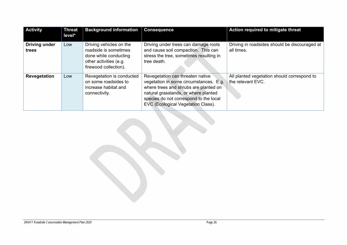
Driving under trees
Low Driving vehicles on the roadside is sometimes done while conducting other activities (e.g. firewood collection).
Driving under trees can damage roots and cause soil compaction. This can stress the tree, sometimes resulting in tree death.
Driving in roadsides should be discouraged at all times.
Revegetation Low Revegetation is conducted on some roadsides to increase habitat and connectivity.
Revegetation can threaten native vegetation in some circumstances. E.g. where trees and shrubs are planted on natural grasslands, or where planted species do not correspond to the local EVC (Ecological Vegetation Class).
All planted vegetation should correspond to the relevant EVC.
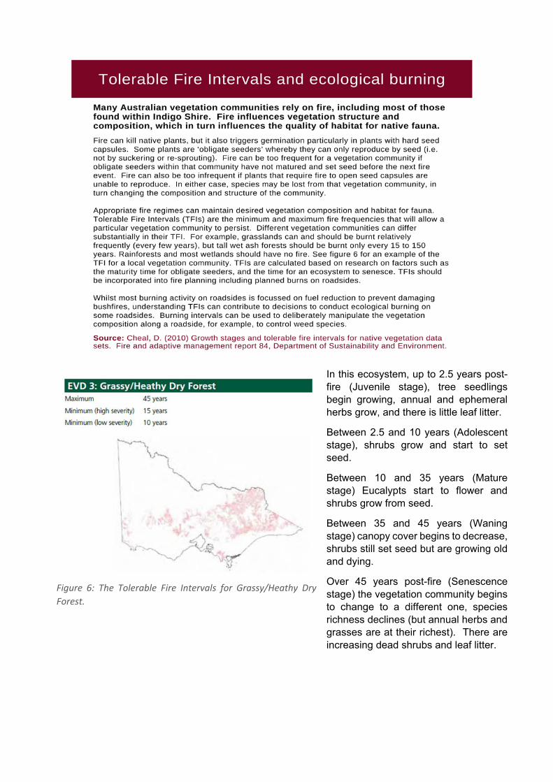
Figure 6: The Tolerable Fire Intervals for Grassy/Heathy Dry
Forest.
In this ecosystem, up to 2.5 years post-fire (Juvenile stage), tree seedlings begin growing, annual and ephemeral herbs grow, and there is little leaf litter.
Between 2.5 and 10 years (Adolescent stage), shrubs grow and start to set seed.
Between 10 and 35 years (Mature stage) Eucalypts start to flower and shrubs grow from seed.
Between 35 and 45 years (Waning stage) canopy cover begins to decrease, shrubs still set seed but are growing old and dying.
Over 45 years post-fire (Senescence stage) the vegetation community begins to change to a different one, species richness declines (but annual herbs and grasses are at their richest). There are increasing dead shrubs and leaf litter.
DRAFT Indigo Shire Council Roadside Conservation Management Plan
Page 28
3 Legislative and policy framework The RCMP falls within a complex legislative and policy framework as shown in Appendix 6 and 7. Work by Council, agencies and adjacent landholders must comply with the relevant legislation. This section includes legislation, policy, plans and strategies at Commonwealth, State and Council levels which apply to roadsides.
Key documents affecting what can and can’t be done on roadsides are summarised below. Further information on each activity is presented in Part B of this Plan.
3.1 Commonwealth legislation 3.1.1 Environment Protection and Biodiversity Conservation Act, 1999
The Environment Protection and Biodiversity Conservation (EPBC) Act (1999) outlines obligations to protect Commonwealth listed threatened flora, fauna and ecological communities. If a project impacts EPBC Act listed species, it may need referral under this Act. The stakeholder information kit provides further guidance: https://www.environment.gov.au/epbc/information‐kit
There are several EPBC listed species of flora and fauna which require particular protection under the EPBC Act. Listed species occurring in Indigo Shire are also listed under the Victorian legislation for threatened species and are shown in Appendix 3 and 8. In addition, there are three threatened vegetation communities under legislative protection within Indigo Shire. Data on the location and status of these species and communities and their specific management requirements are available online from the Federal Government website on EPBC Act List of Threatened Species and Ecological Communities available at: (http://www.environment.gov.au/biodiversity/threatened).
3.2 State legislation 3.2.1 Victorian Planning Provisions
The Victorian Planning Provisions state an objective ‘to ensure that there is no net loss to biodiversity as a result of the removal, destruction, or lopping of native vegetation’ (VPP 12.01-2S and VPP 52.17 native vegetation). Under Clause 52.17 a planning permit is usually required to remove or lop any native vegetation, although there are some exemptions. The guidelines on the removal of native vegetation are outlined below (Section 3.2.2). Relevant documents are listed under Section 3.2.9.
3.2.2 Victorian Native Vegetation Regulations
All native vegetation is protected under the Victorian Planning Provisions Clause 52.17 (see The Guidelines for the removal, destruction or lopping of native vegetation, 2017) unless specific exemptions apply.
A description of this legislation and its exemptions are provided in Appendix 7.
The Shire must keep records of the amount of vegetation that has been lopped, removed or destroyed, for annual reporting to DELWP, and some cases will need to offset these losses.
3.2.3 Flora and Fauna Guarantee Act, 1988
The Victorian Flora and Fauna Guarantee Act (1988) (FFG Act) outlines the obligations to protect threatened flora and fauna species and ecological communities listed as Protected under the FFG Act. Where a species may be impacted by roadside works, this Act may need to be referred to.

DRAFT Indigo Shire Council Roadside Conservation Management Plan Page 29
Removal of any protected flora species from roadsides will require a permit to take protected flora under the FFG Act.
The FFG Act also outlines a number of threatening processes which should be avoided where possible. A list of threatening processes pertinent to the management of roadsides is included in Appendix 7.
Whenever vegetation is to be removed, Habitat Importance Models should be consulted to see if a threatened species’ modelled habitat occurs on the site. This will impact the pathway of vegetation removal applications. Note that previously a threatened species itself needed to be recorded at the site, but now threatened species presence is based on modelled habitat. Habitat importance models are available via DELWP’s NatureKit tool.
3.2.4 Agreement with DELWP – road safety exemption
Indigo Shire has an agreement with DELWP to access the Road Safety Exemption under Clause 52.17 in accordance with the Procedure to rely on the road safety exemption in planning schemes (2018). This agreement:
Outlines that council (as the road manager for municipal roads) can remove, destroy or lop native vegetation along existing roadsides to maintain the safe and efficient function of the road, without a planning permit, within certain thresholds.
States that although exempt from a planning permit, the requirements of the procedure must be met (or the agreement may be revoked).
Requires that vegetation removal must be minimised as much as possible in all cases. Explains there are two categories of road works subject to this procedure: maintenance and
minor construction. Consultation with DELWP and offsets are required for construction projects. Internal reporting only is required for maintenance projects. An internal procedure TRIM
internal 19 681, further details the requirements and processes to comply with this exemption.
Other legislation must still be complied with (e.g. FFG Act or relevant overlays).
3.2.5 Country Fire Authority Act, 1958
Under the Country Fire Authority Act (1958) (Section 43) Council is obliged to undertake all practicable steps to reduce the occurrence of fires on roadsides. Under this Act, Council is required to implement a Municipal Fire Management Plan (MFMP) which outlines works to reduce fire risk along roadsides.
3.2.6 Agreement with DELWP – fire management exemption
The DELWP document Roadside vegetation management for bushfire risk mitigation purposes: Guidelines for road managers states that a permit is not required when native vegetation is to be removed, destroyed or lopped (by the road manager) to reduce fuel loads on roadsides to minimise risk to life and property from bushfire on an existing public road (LPP Clause 52.17). This exemption includes a roadside risk assessment process which is based on the CFA Roadside Fire Management Guidelines.
Consultation with DELWP and the CFA is required as part of this procedure and requires a plan to be prepared for the management of fire risk on council roadsides. The intent is for this plan to be a two to three year plan for all roadsides in the Shire needing risk reduction works.
A description of this exemption is provided in Appendix 7.
DRAFT Indigo Shire Council Roadside Conservation Management Plan Page 30
3.2.7 Aboriginal Heritage Act, 2006
All Victorian Aboriginal archaeological sites (registered and unregistered) are protected by the Aboriginal Heritage Act (2006) which prevents the disturbance of cultural sites or objects.
A description of this legislation is provided in Appendix 7.
3.2.8 Road Management Act, 2004
Under the Road Management Act (2004), Council is responsible for local roads within the Shire. This act outlines the management of the road envelope, which is largely outside the scope of this RCMP.
3.3 Council plans and policy Indigo Shire Council administers the planning scheme including Clause 52.17 and is also under obligation to abide by Federal and State legislation regarding rare and threatened flora, fauna and ecological communities.
The Municipal Strategic Statement (MSS) under the Indigo Shire Planning Scheme deals with state legislation relevant to vegetation on roadsides, and lists as a key issue ‘The protection of the natural resources of soil, waterways and wetlands, remnant vegetation, threatened flora and fauna and landscapes’ (LPP 21.02); lists as a primary objective ‘Conserve and enhance ecosystem functionality’ and ‘Mitigate / minimise loss of vegetation’ (LPP 21.04-2); and includes as a strategy to ‘protect and enhance biodiversity’ (21.04-2) and also to ‘facilitate the development of biodiversity corridors in localities where it would be most advantageous to allow re-vegetation/planting to take place’.
The Council Plan 2017-2021 has a separate theme for Environment and Sustainability. A vision is ‘reducing our impact on the environment’, with an objective ‘to protect native habitat and biodiversity’.
The Council operates a system requiring ‘Consent to Work in Road Reserves’ for all activities on Shire managed roadsides.
The Indigo Shire Environment Strategy 2019 defines Council’s role in relation to the environment and acknowledges the ecological value of roadsides as linear reserves, habitat, corridors for movement by fauna and areas of native vegetation in an otherwise largely cleared landscape. The Biodiversity theme of the strategy has the goal ‘Our habitats are improved to secure the wellbeing of our native plants and animals’.
The ISC Road Fire Management Strategy 2019 is a sub-plan within the Municipal Fire Management Plan which guides the fire treatment suitable for each type of road, and lists the roads and their categories.
Roads management plan 2017 is ISC’s operational document that outlines how work is done on roads up to the road shoulder. From the road shoulder to the fence is roadside and is covered by this plan. In some cases, activities conducted within the scope of the Roads management plan has impact on the roadside.
DRAFT Indigo Shire Council Roadside Conservation Management Plan Page 31
3.4 How the RCMP links to other operational documents This RCMP is primarily driven by the legislative requirements at Federal and State levels (see Legislative and policy framework at section 3 of this plan).
The RCMP aligns with the Municipal Strategic Statement which states as an objective to ‘mitigate and minimise the loss of native vegetation’. The RCMP also aligns with the Council Plan 2017-2021 which has an objective ‘to protect native habitat and biodiversity’. The Environment and Sustainability Strategy 2019 acknowledges the ecological value of roadsides. See section 3.3 above.
The RCMP acknowledges the sometimes competing requirements of native vegetation protection and bushfire mitigation. The legislation around bushfire mitigation also acknowledges native vegetation protection and emphasises actions such as fuel-reduction burning to the minimum extent necessary to achieve outcomes for fire protection. As such, the roads within Indigo Shire, have been classified based on size and importance of each road as a conduit, and different fire management regimes have been assigned accordingly. This RCMP works with the Roadside Fire Management Strategy and Plan to achieve balanced outcomes.
4 Stakeholders There are different managers and stakeholders of different roads in the Indigo Shire. Rural Roads Victoria (formerly VicRoads) is responsible for all major arterial roads including their roadside vegetation, DELWP is responsible for roadsides within Crown Land, State Park or National Park, and the ISC is responsible for all other roads in the Shire (typically all rural roads outside state parks). Service providers also have some access and responsibilities for parts of the roadside relevant to their service. Other significant stakeholders to this RCMP include:
Landcare groups – Indigo Shire is fortunate to have several active Landcare groups that play a part in roadside conservation. This can range from undertaking revegetation projects, community engagement and reporting non-compliances.
Neighbours/landholders – landholders adjacent to roadside vegetation often have a significant role in its protection or threat. Roadside vegetation can be perceived in many different ways by a diverse set of landholders, including sentimental value, perceived fire threat, perceived “messiness” or appreciation of the native habitat. Education and engagement of landholders (particularly abutting critical and high conservation value roadsides) is important to meeting the objectives of this Plan and is further discussed in section C: implementation.
Country Fire Authority (CFA) – the CFA has a critical role in the community in preparing for and responding to bushfire threats. ISC aims to enable this important work, while ensuring that legislative requirements are met where practicable.
Indigo Environment Advisory Committee (IEAC) – the IEAC comprises community and agency representatives that advise council on environmental matters. This Plan has been developed with IEAC input.
Landcare groups within the Shire, as well as the IEAC and state government agencies were consulted on the development of this Plan.
While it is acknowledged that the different stakeholders involved in managing roadsides often have different management objectives, some of which may compete, it is also noted that each management agency must avoid native vegetation removal where possible and only remove native

DRAFT Indigo Shire Council Roadside Conservation Management Plan Page 32
vegetation to the ‘minimum extent necessary’. Native vegetation is protected unless specific exemptions apply.
Previously, landholders were responsible for the management of the road reserve adjacent to their property. This is no longer the case since the Catchment and Land Protection Act was amended in 2004, but many landholders continue to manage their adjacent road reserve. This management can have mixed results, with some unintended consequences, resulting in a reduction in the conservation value of the roadside vegetation. Inappropriate management includes non-targeted spraying, slashing, grazing, ripping fire-breaks, firewood collection, clearing and planting of inappropriate vegetation (e.g. weed species). If adjacent landholders managed the roadside well, their contribution could be an asset. Public education is important to ensure that the roadsides are not further degraded by inappropriate actions.
This RCMP outlines all likely activities on roadsides under ISC control, including their legal framework, need for permits and other issues surrounding each activity. This information is for ISC staff and contractors, service providers working on roadsides and the public seeking to conduct an activity on a roadside.
Roadsides with native vegetation make a very important contribution to the native vegetation of our region and state. This vegetation can be retained and improved, with positive outcomes for weeds on adjacent private land, public amenity, habitat for threatened species and fire management, if all stakeholders adhere to best practice, and this Plan is implemented in full.
DRAFT Indigo Shire Council Roadside Conservation Management Plan Page 33
PART B – REQUIREMENTS This Plan is primarily used by ISC staff and contractors to determine what actions are allowed on roadsides, as determined by Federal and State legislation. ISC staff must conduct their own activities in accordance with the Plan, and must approve the activities of the community and third parties in accordance with the Plan.
This section outlines the necessary actions required for a range of common activities on roadsides. This applies to ISC staff – both for ISC maintenance and project work, as well as when responding to third party requests to conduct activities on roadsides. Information for the community and third parties is presented on the Indigo Shire website.
Consent from Council is required for all works that are to be undertaken within a municipal road reserve by a third party such as an adjoining landowner, community group or contractor. This is to ensure that care is taken in assessing and managing risks associated with working in the road reserve. Contact Council before any works are undertaken to obtain a ‘Works within a Municipal Road Reserves’ consent and to check if a planning permit is required.
6 General Operational Controls
For all activities it is important to minimise soil disturbance, prevent the spread of weeds, minimise disturbance to native animals and plants, and minimise disturbance to cultural heritage sites. The following sections provide information on the general operational controls to minimise impacts to roadside vegetation. For all specific activities refer to Table 2 and the following detailed descriptions of each activity.
6.1 Prevent spread of weeds Noxious and environmental weeds can be spread during road construction, maintenance and other projects on roadsides. Council is obligated under the Catchment and Land Protection Act 1994 to prevent the spread of noxious weeds, which are plants that have been proclaimed under the Act which require management to eradicate. These plants cause environmental or economic harm or have the potential to cause such harm.
Environmental weeds are weeds that threaten natural ecosystems. They are capable of invading native plant communities and out-competing native species – resulting in a reduction of plant diversity and loss of habitat for native fauna. Some weeds, such as Phalaris, pose a much higher fire risk than native grasses or other native vegetation.
Weeds can be spread by inappropriate road maintenance procedures. Movement of machinery is a major cause of the spread of weeds according to Agriculture Victoria (http://agriculture.vic.gov.au/agriculture/pests‐diseases‐and‐weeds/weeds/weedstop‐vehicle‐hygiene‐program/machinery‐hygiene). Good machinery hygiene is vital to preventing weed spread.
For construction projects, an environmental assessment of the project site prior to the commencement of works will identify exact locations of noxious and environmental weeds that need to be identified on a site map with other areas of significance such as ‘no-go’, ‘construction’ and approved vegetation removal zones.
DRAFT Indigo Shire Council Roadside Conservation Management Plan Page 34
The spread of weeds must be controlled by:
Beginning work in areas of high conservation value area then moving to areas of lower conversation value;
Where practicable, plan for works to be undertaken when weeds are not in flower or seed; Where practicable, plan for works to be done in dry weather so ‘mud’ containing weed seed
is not spread; Marking weed infested areas within the road construction area as ‘no go’ zones; Developing and implementing clean down procedures for machinery, vehicles and
clothing/footwear; Brushing/blowing/washing down machinery and vehicles before leaving areas of weed
infestation, at least 500m from creeks and vegetation of high conservation value; Brushing/blowing/washing down machinery and vehicles before entering areas which have
low weed infestation and/or an area of intact native vegetation in the lower, mid and upper storeys;
Treating a weed infestation in a project construction zone with a chemical application before the project commences – only spray herbicide on days of calm, dry weather and avoid native vegetation, especially ground cover.
DRAFT Indigo Shire Council Roadside Conservation Management Plan Page 35
6.2 Minimise disturbance to native animals Roadside native vegetation provides habitat for native wildlife and provides corridors for the movement of animals. Efforts to protect fauna habitat tend to focus on tree retention, however, many species of native fauna live at ground level or utilise understorey shrubs and ground covers. It is important to note that native fauna includes soil organisms, insects, mammals, birds and reptiles.
Minimise disturbance by:
Working from the road pavement; Avoiding and minimising machinery movement in vegetated areas; Making project site staff aware of the potential presence of particular fauna (informed by
desktop checks during the work planning phase); Where possible focus on removing weight / head of the tree instead of the entire tree; Retaining, wherever possible, trees with hollows, including dead trees and fallen logs at
ground level; Engaging qualified fauna spotters when removal of hollow-bearing trees is unavoidable (to
capture and relocate fauna).
6.3 Minimise disturbance to soil and native plants All native plants are protected by legislation, but removal may be exempt from requiring a planning permit in some situations. ‘Native vegetation’ includes trees, shrubs, ground cover, grasses, orchids, mosses and dead plants. Native vegetation should be protected from grading, cutting down, spraying, having soil dumped on top, compaction, erosion, and inappropriate grazing and burning. Native trees must be protected from these negative impacts to the Tree Protection Zone, even if this are does not contain native vegetation. The native vegetation guidelines (Guidelines for the removal, destruction or lopping of native vegetation, DELWP 2017) include a requirement to avoid and minimise loss of native vegetation, meaning that planning permits for vegetation removal need to include a description of what practicable measures to avoid and minimise loss have been considered and incorporated into the project. This principle also applies to vegetation removal that is exempt from a planning permit.
See legislation in Appendix 6 and 7.
6.4 Minimise disturbance to cultural heritage sites Indigo Shire Council is obligated by legislation to protect both indigenous and non-indigenous cultural heritage sites.
Prior to work commencing the project manager must undertake desktop checks, consulting Council’s Planning staff if necessary, to identify if the works site is subject to planning controls in relation to cultural heritage and consult official cultural heritage registers administered by the Heritage Council of Victoria and the Office of Aboriginal Affairs Victoria. Management of cultural heritage sites must be negotiated with these organisations prior to the commencement of work.
Identified sites and objects must be marked on a site map that also identifies other significant areas such as ‘no go’, ‘construction’ and native vegetation removal and weed infestation zones.
Work should cease immediately if a cultural heritage site or artefact is found.
DRAFT Indigo Shire Council Roadside Conservation Management Plan Page 36
6.5 Significant Landscapes and Visual Amenity In addition to protection of vegetation, the Indigo Planning Scheme provisions can also be applied to protect environmental values in areas of landscape significance. A number of Environmental Significance Overlays (ESO) and Significant Landscape Overlays (SLO) occur within Indigo Shire to protect areas of landscape significance.
Give highest priority protection and enhancement to major roads and entrances into towns;
Record and preserve significant landscapes and significant trees. These can be nominated for inclusion in the register of classified and recorded landscapes and significant trees kept by the National Trust of Australia (Victoria);
Record and protect Avenues of Honour or planting or exotic species recognised as significant.
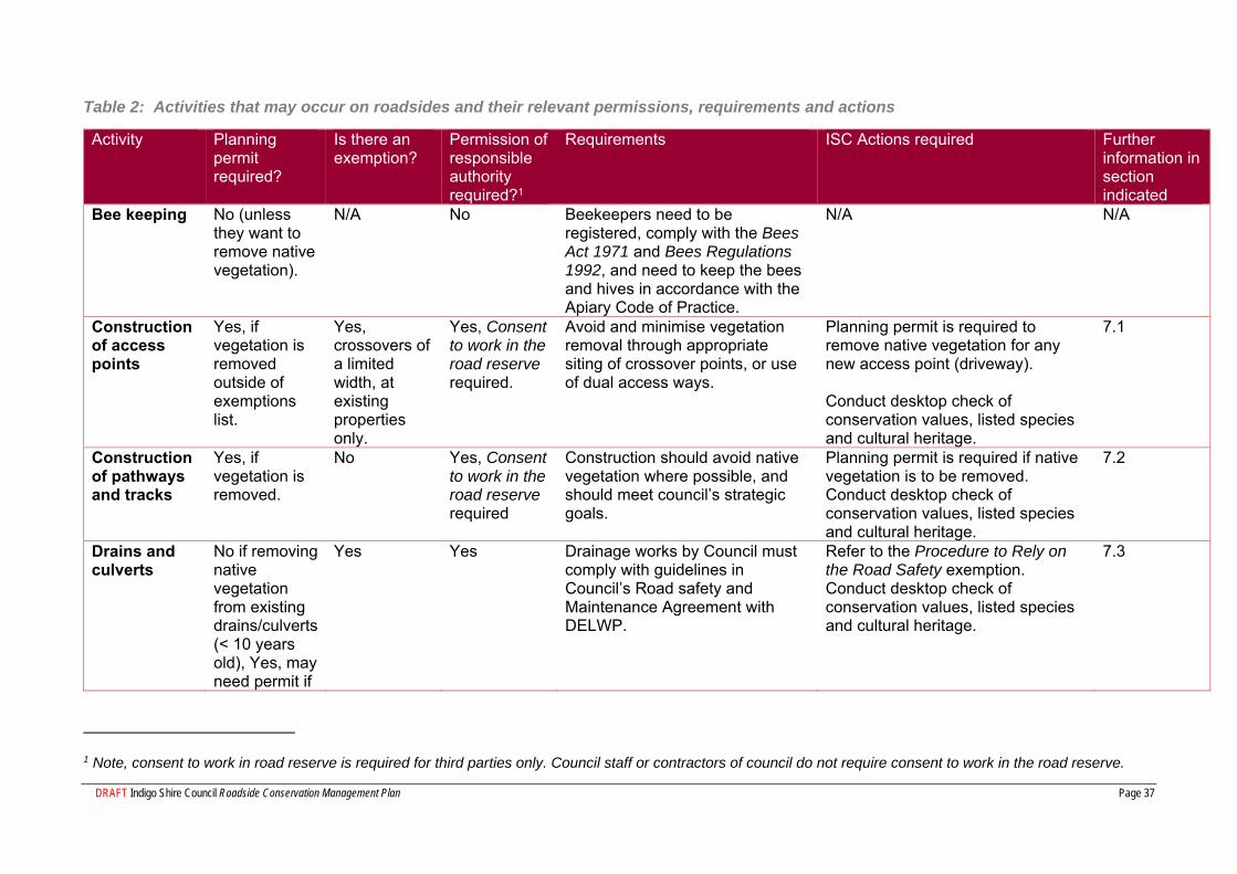
7 Requirements for specific activities on roadsides
Table 2 outlines all the main activities that could occur on roadsides, with basic information on permits and other regulations. The following sections provide further details of some of these activities.
DRAFT Indigo Shire Council Roadside Conservation Management Plan Page 37
Table 2: Activities that may occur on roadsides and their relevant permissions, requirements and actions
Activity Planning permit required?
Is there an exemption?
Permission of responsible authority required?1
Requirements ISC Actions required Further information in section indicated
Bee keeping No (unless they want to remove native vegetation).
N/A No Beekeepers need to be registered, comply with the Bees Act 1971 and Bees Regulations 1992, and need to keep the bees and hives in accordance with the Apiary Code of Practice.
N/A N/A
Construction of access points
Yes, if vegetation is removed outside of exemptions list.
Yes, crossovers of a limited width, at existing properties only.
Yes, Consent to work in the road reserve required.
Avoid and minimise vegetation removal through appropriate siting of crossover points, or use of dual access ways.
Planning permit is required to remove native vegetation for any new access point (driveway). Conduct desktop check of conservation values, listed species and cultural heritage.
7.1
Construction of pathways and tracks
Yes, if vegetation is removed.
No Yes, Consent to work in the road reserve required
Construction should avoid native vegetation where possible, and should meet council’s strategic goals.
Planning permit is required if native vegetation is to be removed. Conduct desktop check of conservation values, listed species and cultural heritage.
7.2
Drains and culverts
No if removing native vegetation from existing drains/culverts (< 10 years old), Yes, may need permit if
Yes Yes Drainage works by Council must comply with guidelines in Council’s Road safety and Maintenance Agreement with DELWP.
Refer to the Procedure to Rely on the Road Safety exemption. Conduct desktop check of conservation values, listed species and cultural heritage.
7.3
1 Note, consent to work in road reserve is required for third parties only. Council staff or contractors of council do not require consent to work in the road reserve.
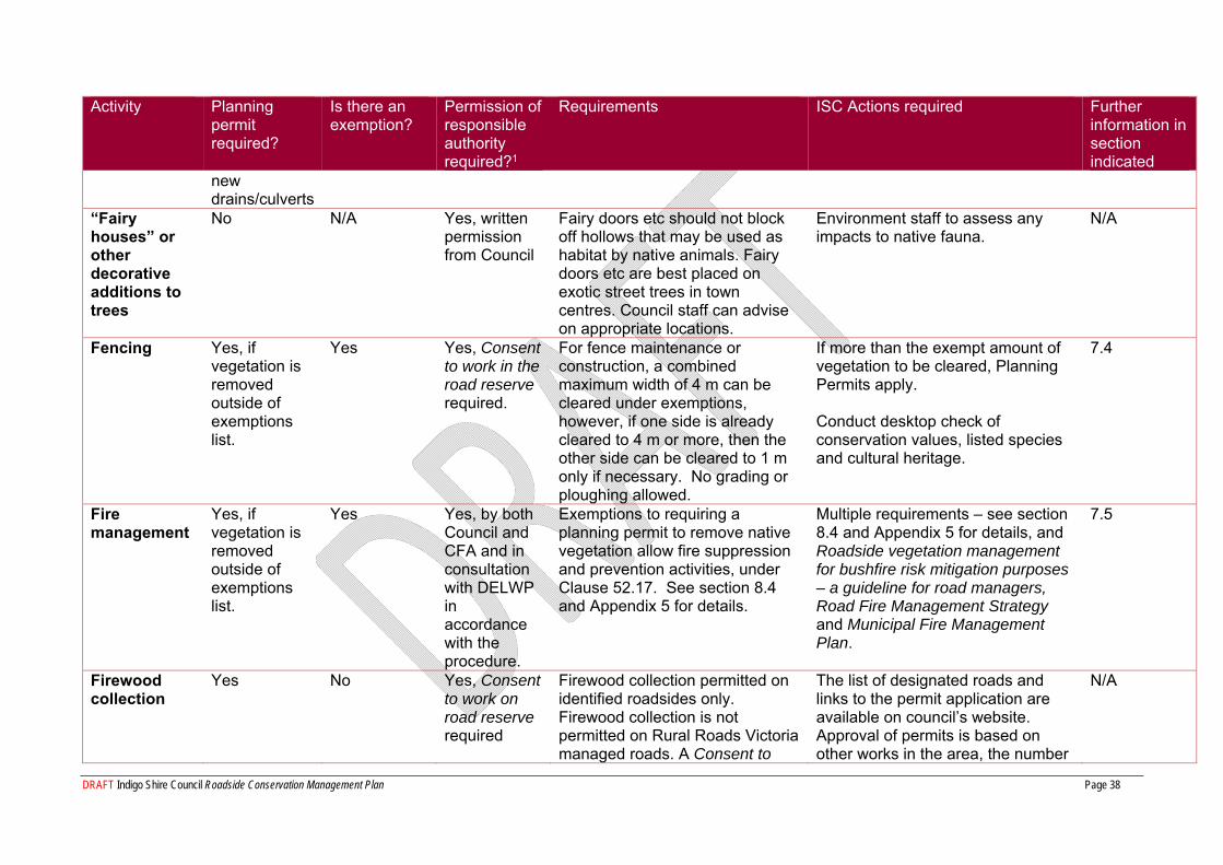
DRAFT Indigo Shire Council Roadside Conservation Management Plan Page 38
Activity Planning permit required?
Is there an exemption?
Permission of responsible authority required?1
Requirements ISC Actions required Further information in section indicated
new drains/culverts
“Fairy houses” or other decorative additions to trees
No N/A Yes, written permission from Council
Fairy doors etc should not block off hollows that may be used as habitat by native animals. Fairy doors etc are best placed on exotic street trees in town centres. Council staff can advise on appropriate locations.
Environment staff to assess any impacts to native fauna.
N/A
Fencing Yes, if vegetation is removed outside of exemptions list.
Yes Yes, Consent to work in the road reserve required.
For fence maintenance or construction, a combined maximum width of 4 m can be cleared under exemptions, however, if one side is already cleared to 4 m or more, then the other side can be cleared to 1 m only if necessary. No grading or ploughing allowed.
If more than the exempt amount of vegetation to be cleared, Planning Permits apply. Conduct desktop check of conservation values, listed species and cultural heritage.
7.4
Fire management
Yes, if vegetation is removed outside of exemptions list.
Yes Yes, by both Council and CFA and in consultation with DELWP in accordance with the procedure.
Exemptions to requiring a planning permit to remove native vegetation allow fire suppression and prevention activities, under Clause 52.17. See section 8.4 and Appendix 5 for details.
Multiple requirements – see section 8.4 and Appendix 5 for details, and Roadside vegetation management for bushfire risk mitigation purposes – a guideline for road managers, Road Fire Management Strategy and Municipal Fire Management Plan.
7.5
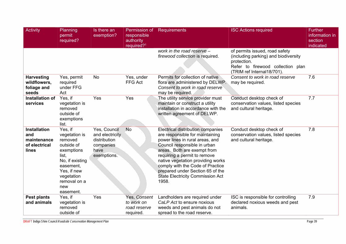
Firewood collection
Yes No Yes, Consent to work on road reserve required
Firewood collection permitted on identified roadsides only. Firewood collection is not permitted on Rural Roads Victoria managed roads. A Consent to
The list of designated roads and links to the permit application are available on council’s website. Approval of permits is based on other works in the area, the number
N/A
DRAFT Indigo Shire Council Roadside Conservation Management Plan Page 39
Activity Planning permit required?
Is there an exemption?
Permission of responsible authority required?1
Requirements ISC Actions required Further information in section indicated
work in the road reserve – firewood collection is required.
of permits issued, road safety (including parking) and biodiversity protection. Refer to firewood collection plan (TRIM ref Internal18/701).
Harvesting wildflowers, foliage and seeds
Yes, permit required under FFG Act
No Yes, under FFG Act
Permits for collection of native flora are administered by DELWP. Consent to work in road reserve may be required.
Consent to work in road reserve may be required.
7.6
Installation of services
Yes, if vegetation is removed outside of exemptions list.
Yes Yes The utility service provider must maintain or construct a utility installation in accordance with the written agreement of DELWP.
Conduct desktop check of conservation values, listed species and cultural heritage.
7.7
Installation and maintenance of electrical lines
Yes, if vegetation is removed outside of exemptions list, No, if existing easement, Yes, if new vegetation removal on a new easement.
Yes, Council and electricity distribution companies have exemptions.
No Electrical distribution companies are responsible for maintaining power lines in rural areas, and Council responsible in urban areas. Both are exempt from requiring a permit to remove native vegetation providing works comply with the Code of Practice prepared under Section 65 of the State Electricity Commission Act 1958.
Conduct desktop check of conservation values, listed species and cultural heritage.
7.8
Pest plants and animals
Yes, if vegetation is removed outside of
Yes Yes, Consent to work on road reserve required.
Landholders are required under CaLP Act to ensure noxious weeds and pest animals do not spread to the road reserve.
ISC is responsible for controlling declared noxious weeds and pest animals.
7.9
DRAFT Indigo Shire Council Roadside Conservation Management Plan Page 40
Activity Planning permit required?
Is there an exemption?
Permission of responsible authority required?1
Requirements ISC Actions required Further information in section indicated
exemptions list.
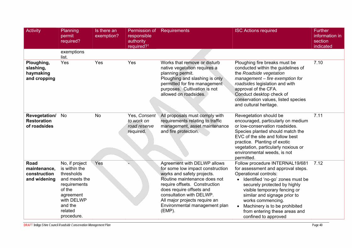
Ploughing, slashing, haymaking and cropping
Yes Yes Yes Works that remove or disturb native vegetation requires a planning permit. Ploughing and slashing is only permitted for fire management purposes. Cultivation is not allowed on roadsides.
Ploughing fire breaks must be conducted within the guidelines of the Roadside vegetation management – fire exemption for roadsides legislation and with approval of the CFA. Conduct desktop check of conservation values, listed species and cultural heritage.
7.10
Revegetation/ Restoration of roadsides
No No Yes, Consent to work on road reserve required.
All proposals must comply with requirements relating to traffic management, asset maintenance and fire protection.
Revegetation should be encouraged, particularly on medium or low-conservation roadsides. Species planted should match the EVC of the site and follow best practice. Planting of exotic vegetation, particularly noxious or environmental weeds, is not permitted.
7.11
Road maintenance, construction and widening
No, if project is within the thresholds and meets the requirements of the agreement with DELWP and the related procedure.
Yes - Agreement with DELWP allows for some low impact construction works and safety projects. Routine maintenance does not require offsets. Construction does require offsets and consultation with DELWP. All major projects require an Environmental management plan (EMP).
Follow procedure INTERNAL19/681 for assessment and approval steps. Operational controls: Identified ‘no-go’ zones must be
securely protected by highly visible temporary fencing or similar and signage prior to works commencing.
Machinery is to be prohibited from entering these areas and confined to approved
7.12
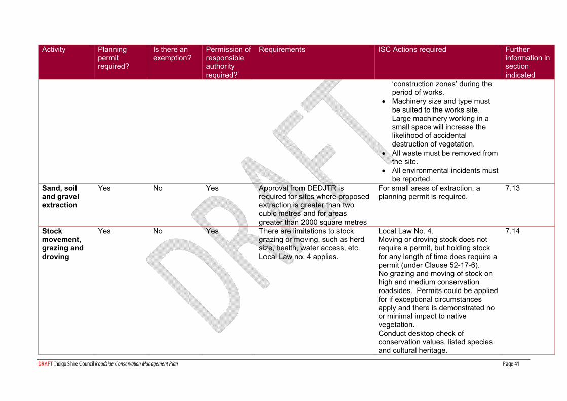
DRAFT Indigo Shire Council Roadside Conservation Management Plan Page 41
Activity Planning permit required?
Is there an exemption?
Permission of responsible authority required?1
Requirements ISC Actions required Further information in section indicated
‘construction zones’ during the period of works.
Machinery size and type must be suited to the works site. Large machinery working in a small space will increase the likelihood of accidental destruction of vegetation.
All waste must be removed from the site.
All environmental incidents must be reported.
Sand, soil and gravel extraction
Yes No Yes Approval from DEDJTR is required for sites where proposed extraction is greater than two cubic metres and for areas greater than 2000 square metres
For small areas of extraction, a planning permit is required.
7.13
Stock movement, grazing and droving
Yes No Yes There are limitations to stock grazing or moving, such as herd size, health, water access, etc. Local Law no. 4 applies.
Local Law No. 4. Moving or droving stock does not require a permit, but holding stock for any length of time does require a permit (under Clause 52-17-6). No grazing and moving of stock on high and medium conservation roadsides. Permits could be applied for if exceptional circumstances apply and there is demonstrated no or minimal impact to native vegetation. Conduct desktop check of conservation values, listed species and cultural heritage.
7.14
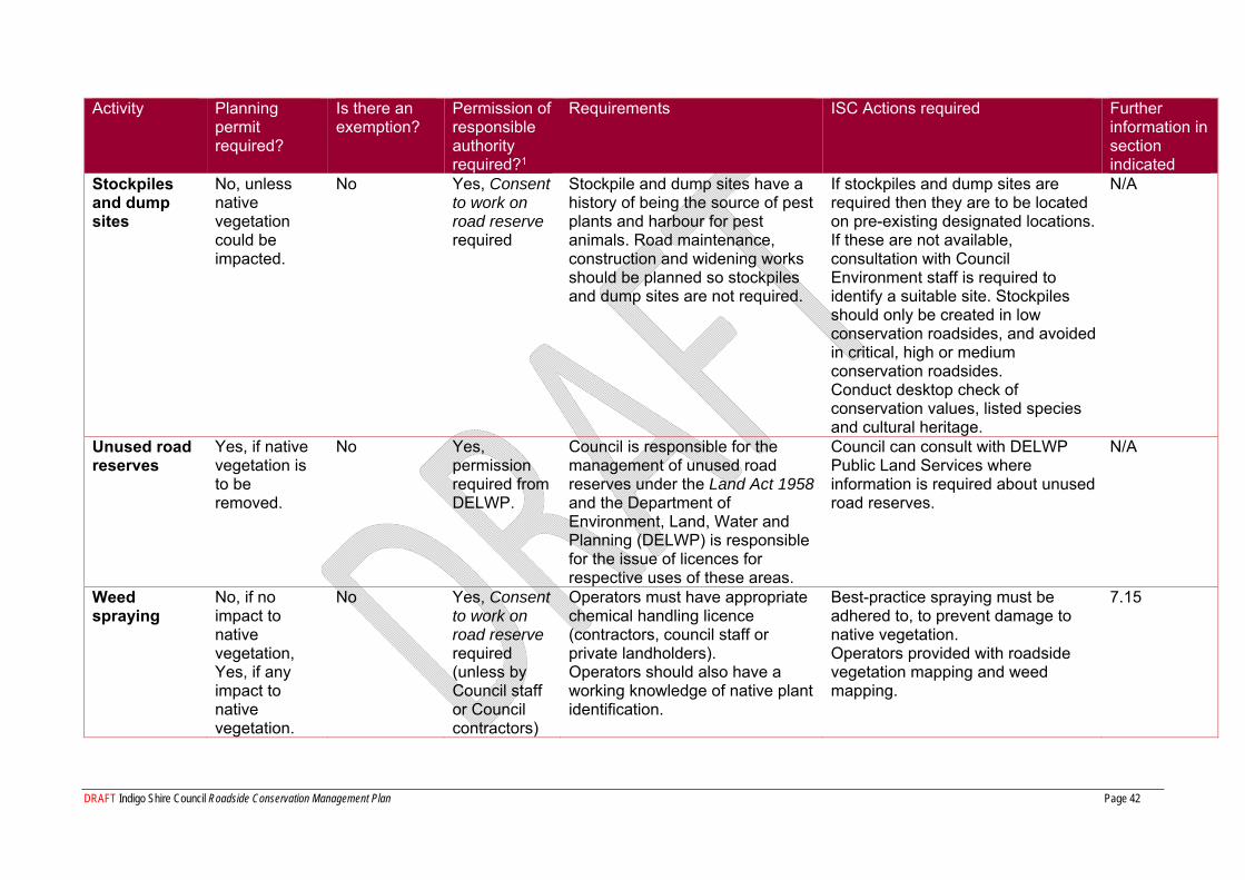
DRAFT Indigo Shire Council Roadside Conservation Management Plan Page 42
Activity Planning permit required?
Is there an exemption?
Permission of responsible authority required?1
Requirements ISC Actions required Further information in section indicated
Stockpiles and dump sites
No, unless native vegetation could be impacted.
No Yes, Consent to work on road reserve required
Stockpile and dump sites have a history of being the source of pest plants and harbour for pest animals. Road maintenance, construction and widening works should be planned so stockpiles and dump sites are not required.
If stockpiles and dump sites are required then they are to be located on pre-existing designated locations. If these are not available, consultation with Council Environment staff is required to identify a suitable site. Stockpiles should only be created in low conservation roadsides, and avoided in critical, high or medium conservation roadsides. Conduct desktop check of conservation values, listed species and cultural heritage.
N/A
Unused road reserves
Yes, if native vegetation is to be removed.
No Yes, permission required from DELWP.
Council is responsible for the management of unused road reserves under the Land Act 1958 and the Department of Environment, Land, Water and Planning (DELWP) is responsible for the issue of licences for respective uses of these areas.
Council can consult with DELWP Public Land Services where information is required about unused road reserves.
N/A
Weed spraying
No, if no impact to native vegetation, Yes, if any impact to native vegetation.
No Yes, Consent to work on road reserve required (unless by Council staff or Council contractors)
Operators must have appropriate chemical handling licence (contractors, council staff or private landholders). Operators should also have a working knowledge of native plant identification.
Best-practice spraying must be adhered to, to prevent damage to native vegetation. Operators provided with roadside vegetation mapping and weed mapping.
7.15
DRAFT Indigo Shire Council Roadside Conservation Management Plan
Page 43
7.1 Access Points An access point refers to a driveway or track across the road reserve, e.g. to access a property. In most cases a Planning Permit is required for native vegetation removal on the road reserve, and the width cannot exceed 6 m. Native vegetation removal is not permitted where the siting of the access could be positioned where no native vegetation needs to be removed (i.e. avoid and minimise).
7.2 Construction of Pathways and Tracks The construction of pathways or tracks by a third party, such as adjoining landholder, community group or contractor on roadsides for the access of walking, cycling or horse riding will require a Consent to work in road reserve.
Where possible, new paths/tracks need to be located/aligned to avoid native vegetation. If vegetation is to be removed (including native grasses, shrubs, herbs and forbs), a Planning Permit will be required. If there is to be no removal of native vegetation, the pathway or track may be permitted if it relates to actions included within relevant Council strategic plans including Council Plan, Bike Strategy or Recreation Plan.
Waste must not be left on the road reserve.
7.3 Drains and Culverts The maintenance of both table drains (running parallel with the road) and cut off drains (drains that take the flow of water away from the road) is required to remove silt build up so that water is not sitting in the drain or on the road – thus providing a safety risk to road users. The pooling of water can also lead to moisture under the road pavement leading to road breakdown including potholes, subsidence and shoulder slumping.
For drains associated with an access point, refer to Access Points.
The maintenance of drains is to be in accordance with the DELWP Agreement Procedure to rely on the road safety exemption in planning schemes, 2018, which is based on the principle of avoiding the removal of native vegetation where possible and minimising any disturbance. Maintenance of existing structures does not require a permit, but construction requires consultation with DELWP and offsets.
The following must be considered:
On critical and high conservation roadsides there must be consultation with ISC Environment and Sustainability staff regarding the maintenance or construction works;
The spread of soil is not to occur on critical, high and medium conservation roadsides;
On critical, high and medium conservation roadsides the drain spoil is to be taken to a disposal site or placed on the lower side of the road – spoil should not be placed on top of the batter;
Material to be pulled along road shoulders or pavement where grader can access, ensuring material is not a safety hazard;
If suitable, reuse material on unsealed roads; and
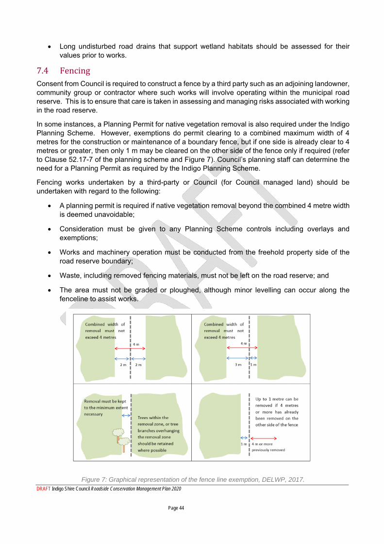
DRAFT Indigo Shire Council Roadside Conservation Management Plan 2020 Page 44
Long undisturbed road drains that support wetland habitats should be assessed for their values prior to works.
7.4 Fencing Consent from Council is required to construct a fence by a third party such as an adjoining landowner, community group or contractor where such works will involve operating within the municipal road reserve. This is to ensure that care is taken in assessing and managing risks associated with working in the road reserve.
In some instances, a Planning Permit for native vegetation removal is also required under the Indigo Planning Scheme. However, exemptions do permit clearing to a combined maximum width of 4 metres for the construction or maintenance of a boundary fence, but if one side is already clear to 4 metres or greater, then only 1 m may be cleared on the other side of the fence only if required (refer to Clause 52.17-7 of the planning scheme and Figure 7). Council’s planning staff can determine the need for a Planning Permit as required by the Indigo Planning Scheme.
Fencing works undertaken by a third-party or Council (for Council managed land) should be undertaken with regard to the following:
A planning permit is required if native vegetation removal beyond the combined 4 metre width is deemed unavoidable;
Consideration must be given to any Planning Scheme controls including overlays and exemptions;
Works and machinery operation must be conducted from the freehold property side of the road reserve boundary;
Waste, including removed fencing materials, must not be left on the road reserve; and
The area must not be graded or ploughed, although minor levelling can occur along the fenceline to assist works.
Figure 7: Graphical representation of the fence line exemption, DELWP, 2017.
DRAFT Indigo Shire Council Roadside Conservation Management Plan 2020 Page 45
7.5 Fire Management The DELWP document Roadside vegetation management for bushfire risk mitigation purposes – a guideline for road managers states that a permit is not required when native vegetation is to be removed, destroyed or lopped to reduce fuel loads on roadsides to minimise risk to life and property from bushfire on an existing public road (LPP Clause 52.17). This process requires consultation with DELWP natural environment program staff and CFA staff and typically requires a two to three year plan be prepared for all relevant roadside risk mitigation works. This exemption includes a roadside risk assessment process which is based on the CFA Roadside Fire Management Guidelines.
The exemptions are outlined in Appendix 6 and 7.
The RCMP supports fire prevention activities, provided all legislative requirements are met.
The Road Fire Management Strategy states that removal of vegetation for the purposes of fire management must be conducted in a manner to minimise the negative impact on native vegetation. This strategy classifies all roads within Indigo Shire based on their size and importance as conduits for transport. Different road classifications have different fire management strategies. ISC staff must identify the classification of a road prior to approval for works.
Consent from Indigo Shire Council is required for all works that are to be undertaken within a municipal road reserve by a third party such as an adjoining landowner, community group or contractor, or CFA. A Consent to work on road reserve is required by all third parties.
All fire prevention works on a municipal road reserve:
Must have approval from the CFA in consultation with the Municipal Fire Prevention Officer (MFPO) and DELWP where it involves impacts on native vegetation, prior to works commencing;
Must comply with Indigo Shire Council’s Municipal Fire Management Plan, Road Fire Management Strategy (2019) and Country Fire Authority Act 1958;
Must comply with CFA Roadside Fire Management Guidelines;
Must comply with the Indigo Planning Scheme;
Must comply with the Flora and Fauna Guarantee Act 1988 and the Commonwealth’s Environment Protection and Biodiversity Conservation Act 1999;
Are advised to comply with advice about Tolerable Fire Intervals (see Figure 6) from ISCs fire database on fuel treatment (available on TRIM), which is reliant on information from Growth stages and tolerable fire intervals for native vegetation data sets. Fire and adaptive management report 84, 2010, DSE.
Fire prevention works should take account of the following:
Native grasses tend to have lower fuel loads than introduced grasses such as Paspalum or Phalaris, so native grasses should be retained where possible;
Branches and logs greater than 25 mm diameter can be retained in roadsides – they do not constitute ‘fine fuels’ and can be slow to burn or even slow a fire;

DRAFT Indigo Shire Council Roadside Conservation Management Plan 2020 Page 46
Grading firebreaks within the road reserve should be avoided where possible, and should not occur in Critical or High conservation roadsides; and
Firebreaks should be placed on neighbouring cleared land where possible.
7.6 Harvesting wildflowers, foliage and seeds Harvesting wildflowers, foliage and seeds requires a permit for protected flora. Protected flora includes plant taxa listed as protected under the FFG Act, plant taxa belonging to communities listed as threatened under FFG Act, and other designated plant taxa requiring protection (e.g. grasstrees and orchids). A full list of protected flora is described in: DELWPs Flora and Fauna Guarantee Act 1988 Protected Flora List June 2017.
To harvest any component of protected flora, a Protected Flora Licence or permit to take protected flora is required from DELWP. A Consent to work on the road reserve is also required from ISC.
7.7 Installation of services Schedule 3 of the Telecommunications Act 1997 outlines procedures and conditions for the installation and maintenance of communications.
Part 7 of the Gas Industry Act 2001 allows for any trees obstructing a pipeline to be felled or removed.
Any new utility easements impacting native veg will require a planning permit. All major projects should be planned in advance to allow consultation with relevant departments, ISC and for preparation for vegetation rehabilitation and offset planning.
7.8 Maintenance of electrical lines Sections 84 and 84A to 84D of the Electricity Safety Act 1998 specify who is responsible for keeping trees clear of electric lines. ISC is responsible for maintaining electric line clearances in town urban areas and electrical distribution companies are responsible in the remaining urban areas and the rural areas.
Councils and electrical distribution companies are exempted from requiring a permit to remove native vegetation providing the Electricity Safety (Electric Line Clearance) Regulations (2015) including the Code of Practice for Electric Line Clearance (made under sections 151, 151A and 157 of the Electricity Safety Act 1998) are complied with.
Any damage to, or removal of, native vegetation outside the clearance space recognised under the Code of Practice for Electric Line Clearance requires a Planning Permit under the Indigo Planning Scheme. If the obligations of the electrical distribution companies under the Code are not met, concerns with non-compliance can be lodged with the Energy Safe Victoria and also with the Energy and Water Ombudsman.
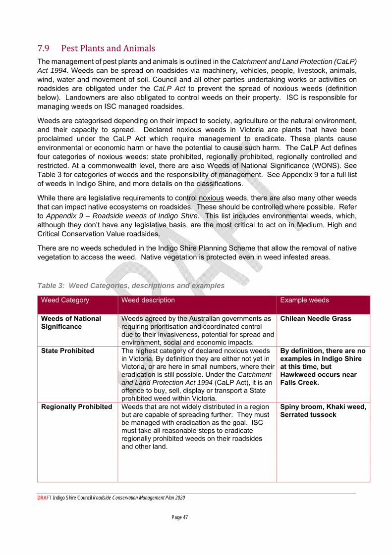
DRAFT Indigo Shire Council Roadside Conservation Management Plan 2020 Page 47
7.9 Pest Plants and Animals The management of pest plants and animals is outlined in the Catchment and Land Protection (CaLP) Act 1994. Weeds can be spread on roadsides via machinery, vehicles, people, livestock, animals, wind, water and movement of soil. Council and all other parties undertaking works or activities on roadsides are obligated under the CaLP Act to prevent the spread of noxious weeds (definition below). Landowners are also obligated to control weeds on their property. ISC is responsible for managing weeds on ISC managed roadsides.
Weeds are categorised depending on their impact to society, agriculture or the natural environment, and their capacity to spread. Declared noxious weeds in Victoria are plants that have been proclaimed under the CaLP Act which require management to eradicate. These plants cause environmental or economic harm or have the potential to cause such harm. The CaLP Act defines four categories of noxious weeds: state prohibited, regionally prohibited, regionally controlled and restricted. At a commonwealth level, there are also Weeds of National Significance (WONS). See Table 3 for categories of weeds and the responsibility of management. See Appendix 9 for a full list of weeds in Indigo Shire, and more details on the classifications.
While there are legislative requirements to control noxious weeds, there are also many other weeds that can impact native ecosystems on roadsides. These should be controlled where possible. Refer to Appendix 9 – Roadside weeds of Indigo Shire. This list includes environmental weeds, which, although they don’t have any legislative basis, are the most critical to act on in Medium, High and Critical Conservation Value roadsides.
There are no weeds scheduled in the Indigo Shire Planning Scheme that allow the removal of native vegetation to access the weed. Native vegetation is protected even in weed infested areas.
Table 3: Weed Categories, descriptions and examples
Weed Category Weed description Example weeds
Weeds of National Significance
Weeds agreed by the Australian governments as requiring prioritisation and coordinated control due to their invasiveness, potential for spread and environment, social and economic impacts.
Chilean Needle Grass
State Prohibited The highest category of declared noxious weeds in Victoria. By definition they are either not yet in Victoria, or are here in small numbers, where their eradication is still possible. Under the Catchment and Land Protection Act 1994 (CaLP Act), it is an offence to buy, sell, display or transport a State prohibited weed within Victoria.
By definition, there are no examples in Indigo Shire at this time, but Hawkweed occurs near Falls Creek.
Regionally Prohibited
Weeds that are not widely distributed in a region but are capable of spreading further. They must be managed with eradication as the goal. ISC must take all reasonable steps to eradicate regionally prohibited weeds on their roadsides and other land.
Spiny broom, Khaki weed, Serrated tussock
DRAFT Indigo Shire Council Roadside Conservation Management Plan 2020 Page 48
Regionally Controlled
Weeds that are usually widespread in a region. Land owners have the responsibility to take all reasonable steps to prevent the growth and spread of Regionally controlled weeds on their land.
Blackberry, Gorse,St. John’s wort, Paterson’s curse, English broom, Hawthorn, Cape broom, Sweet briar, Willows
Restricted weed Includes plants that pose an unacceptable risk of spreading in Victoria and are a serious threat to another State or Territory. Trade in these weeds and their propagules, either as plants, seeds or contaminants in other materials is prohibited.
Bridal creeper
A pest animal is an introduced animal with an established self-supporting population in the wild (also known as feral) that is a threat to human health, primary production and/or the natural environment. Common pest animals in Indigo Shire are rabbits, hares, foxes, feral cats, deer, pigs and goats.
Under the Catchment and Land Protection Act 1994 land owners have a responsibility to take all reasonable steps to prevent the spread of, and as far as possible eradicate, established pest animals from their land. These include rabbits, hares, foxes and wild dogs/dingo-dog hybrids.
7.10 Ploughing, slashing, haymaking and cropping Ploughing or grading for strategic firebreaks should only occur in the road reserve when there is no opportunity to do this on the freehold side of the boundary. It must be recognised that ploughing or grading causes considerable soil disturbance which kills perennial vegetation and can facilitate encroachment of weeds. Ploughing or grading should not occur on medium, high or critical conservation value roadsides. Ploughing or grading could be considered on low conservation roadsides where there is no native vegetation only:
To maintain existing fuel breaks; As an ancillary measure on strategic firebreak roads prior to fuel reduction burning; or As part of installation and maintenance procedures by service providers.
Slashing may be defined as a once-off cutting of grass, typically with a tractor, usually for fire fuel reduction purposes. This may or may not be bailed for hay.
Grass may be cut (slashing) or made into hay (removal of slashed grass) if the grass is exotic (preferably before the grass has set seed), or if native (only after the grass has set seed), and only for fire protection purposes. Slashing, mowing or haymaking should only occur on grasslands. If shrubs are present, the slashing process will permanently distort their physical shape and compromises their capacity to grow or reproduce. Native trees and shrubs should be allowed to recolonise by avoiding slashing, but exotic trees and shrubs could be slashed as a control method.
Mowing typically involves repeat cutting of grass, often with a lawn mower. This method seldom allows grass to seed, so perennial grasslands are converted to annual grasslands over time. Annual grasses in the Shire are typically exotic, while many perennial grasses are native. Therefore, repeat mowing should be avoided in native grasslands, or grassy understorey woodlands. Repeat mowing is typically conducted on the roadside immediately outside a residence. Mowing is not appropriate beyond this location.
DRAFT Indigo Shire Council Roadside Conservation Management Plan 2020 Page 49
Cropping, whereby the land has been cultivated and sown, should not be allowed on any roadside within the Shire.
7.11 Revegetation and restoration of roadsides Revegetation should be encouraged on medium and low-conservation roadsides. High and critical conservation roadsides should not require revegetation. Revegetation is usually conducted by community groups, but could also be conducted by restoration companies. Revegetation can be conducted to improve vegetation quality or connectivity, or for rehabilitation following disturbance. In some situations, revegetation plantings may be part of an offset. Restoration works can include weed control (see section on weed control). Groups undertaking restoration are required to obtain a consent to work in the road reserve from ISC.
The species planted must match the Ecological Vegetation Class (EVC) of the area, unless biophysical changes to the site means that the EVC is no longer appropriate (e.g. where a wetland has been created), or there is a rationale for recreating an endangered EVC at the site. Revegetation should consider all plant forms, such as grasses, herbs and forbs, as well as trees and shrubs, as appropriate to the site. ISC environmental staff and/or local Landcare groups can provide site-specific revegetation advice. Trees should not be planted too thickly – consult the EVC description for tree density and plant no more than double this density. It is important to not plant trees and shrubs into a grassland, or where the understorey could be unduly disturbed (e.g. where there are orchids, mosses, herbs or native grasses). Inappropriate species selection can have detrimental effects on local biodiversity.
Revegetated areas should be treated as native vegetation into the future.
ISC is required to consult with the relevant CFA brigade to ensure that any proposed works will not be in conflict with priorities in the Municipal Road Fire Management Strategy.
Works undertaken must reflect the biodiversity, fire prevention and road safety objectives of ISC policies, strategies and plans and must be referred to relevant ISC staff for approval.
Revegetation works and methods must be planned to minimise disturbance and undertaken in a best practice manner. Proposals for these works must demonstrate how they:
Ensure appropriate planting density including spacing every 100 metres for fire prevention access;
Allow sufficient room from fence-lines to enable future maintenance of such assets; Not impede traffic line of sight or compromise any future road maintenance activities such as
clearing of table drains; Ensure that the movement of roadside users (e.g. walkers) is not impeded; Outline how maintenance will occur (i.e. who, when, what); Check that underground services will not be damaged as a result of the planting; Use indigenous species of the appropriate vegetation type for the site; and, Planting of exotic vegetation, particularly noxious or environmental weeds is not permitted.
Rehabilitation must include removal/treatment of declared noxious and environmental weeds that threaten native vegetation and habitats.
Large-scale revegetation programs are difficult to implement due to costs of site preparation, plants and guards and labour (although volunteer labour may be available). However, recurrent smaller-
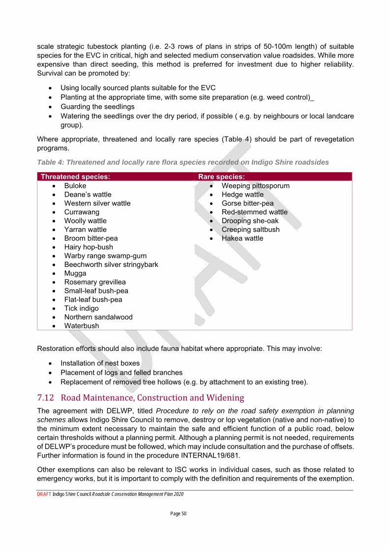
DRAFT Indigo Shire Council Roadside Conservation Management Plan 2020 Page 50
scale strategic tubestock planting (i.e. 2-3 rows of plans in strips of 50-100m length) of suitable species for the EVC in critical, high and selected medium conservation value roadsides. While more expensive than direct seeding, this method is preferred for investment due to higher reliability. Survival can be promoted by:
Using locally sourced plants suitable for the EVC Planting at the appropriate time, with some site preparation (e.g. weed control)_ Guarding the seedlings Watering the seedlings over the dry period, if possible ( e.g. by neighbours or local landcare
group).
Where appropriate, threatened and locally rare species (Table 4) should be part of revegetation programs.
Table 4: Threatened and locally rare flora species recorded on Indigo Shire roadsides
Threatened species: Rare species: Buloke Deane’s wattle Western silver wattle Currawang Woolly wattle Yarran wattle Broom bitter-pea Hairy hop-bush Warby range swamp-gum Beechworth silver stringybark Mugga Rosemary grevillea Small-leaf bush-pea Flat-leaf bush-pea Tick indigo Northern sandalwood Waterbush
Weeping pittosporum Hedge wattle Gorse bitter-pea Red-stemmed wattle Drooping she-oak Creeping saltbush Hakea wattle
Restoration efforts should also include fauna habitat where appropriate. This may involve:
Installation of nest boxes Placement of logs and felled branches Replacement of removed tree hollows (e.g. by attachment to an existing tree).
7.12 Road Maintenance, Construction and Widening The agreement with DELWP, titled Procedure to rely on the road safety exemption in planning schemes allows Indigo Shire Council to remove, destroy or lop vegetation (native and non-native) to the minimum extent necessary to maintain the safe and efficient function of a public road, below certain thresholds without a planning permit. Although a planning permit is not needed, requirements of DELWP’s procedure must be followed, which may include consultation and the purchase of offsets. Further information is found in the procedure INTERNAL19/681.
Other exemptions can also be relevant to ISC works in individual cases, such as those related to emergency works, but it is important to comply with the definition and requirements of the exemption.
DRAFT Indigo Shire Council Roadside Conservation Management Plan 2020 Page 51
To minimise the impact of works on biodiversity the following should be applied:
Desktop checks shall first be undertaken by the project manager to identify: o The conservation value of the road being worked on o Any listed species known or likely to occur in the area o Cultural heritage values
Significant or protected vegetation, or areas containing protected species under the FFG Act, should be excluded from disturbance and classified as ‘no-go’ zones using barrier tape or highly visible temporary fencing and signage prior to works commencing;
Trees to be retained should be protected within the Tree Protection Zone (TPZ) according to AS 4970-2009). These TPZ should also be defined on-site as a ‘no-go’ zone using barrier tape or equivalent;
The ‘construction’ zone should be identified and machinery must be confined to this area during the period of works. These should preferably be sited on previously disturbed land, for stockpiles, turning circles, parking areas and areas for operation of machinery;
Vegetation approved for removal must be identified by highly visible paint or tape. All approved vegetation removal or lopping must only be the minimum extent necessary;
The ‘no-go’, ‘construction’ and approved vegetation removal zones must be identified on a site plan that all staff working on the project are familiar with and are confident to use;
Machinery size and type must be suited to the works site. Large machinery working in a small space will increase the likelihood of accidental destruction of vegetation;
Fill or windrow spoil should not be placed over ground flora or tree roots (it will suffocate them). Spoil should be removed and disposed of off-site away from native vegetation;
Appropriate actions should be taken to prevent erosion and weed spread;
The removal of limbs and branches occurs as part of road maintenance and safety works. The need for these works is sometimes identified from reports by the CFA and the public, as well as during staff inspections. Any reports of dead or overhanging limbs posing a risk to road safety need to be assessed by appropriately qualified Council staff or may require an arborist assessment. Refer to the tree query process flow charts (TRIM INTERNAL19 686).
Timber and debris created as a result of tree management activities needs to be appropriately managed. A balance is needed between retaining logs and branches (especially hollow ones) for habitat and the need to remove or chip this material to reduce fuel load. Where possible, hollow logs and branches should be retained onsite and any excess debris or head material should either be chipped or removed offsite. Stockpiling timber on a road reserve must be avoided as this harbours pest plants and animals.
All parties involved with road construction and maintenance works should aim to avoid and minimise litter and waste. Inappropriate storage, transport, use and disposal of waste, including hazardous material, which can lead to soil and water contamination. This can cause serious detriment to the environment, the need for future remediation (and associated costs) and prosecution by the Environment Protection Authority (EPA).
These measures must be implemented for waste management:
Wherever possible do not take material packaging on site; Remove waste from site and dispose of at a waste transfer station appropriately; Storage, transport, use and disposal of hazardous materials must be in accordance with the
manufacturer’s guidelines, material safety data sheet and applicable legislation; and Reuse material such as topsoil, mulch, large logs (for wildlife habitat) on site where possible.
DRAFT Indigo Shire Council Roadside Conservation Management Plan 2020 Page 52
All construction waste such as sump oil, packaging, empty chemical containers, metal off cuts and tyres must be removed from the site immediately following the completion of the works and disposed of according to manufacturer’s guidelines, material safety data sheets and applicable legislation.
If an environmental incident occurs as a direct result of road construction or maintenance works, it shall be immediately reported to the works supervisor/project manager, who will then notify the Coordinator Environment and Austainability. Works shall cease until approval to recommence is provided. The incident shall be recorded and actions tracked via the OHS incident reporting system. If regulatory notification is required, this shall be actioned by the Coordinator of Environment and Sustainability, the Director of Infrastructure Services or delegate.
The project manager of an external contractor or the supervisor of works undertaken by ISC must submit a report outlining what the environment incident was, how it occurred, proposed remediation works and measures that have been put in place to minimise reoccurrence of the incident within five working days of the incident.
Environmental incidents include but are not limited to:
Pollution of waterways Soil contamination Unauthorised native vegetation removal Death or injury of native wildlife (as a result of the works undertaken) Destruction of cultural heritage
7.13 Sand, Soil and Gravel Extraction A Planning Permit is required for stone or soil extraction, including on a roadside, under the Indigo Planning Scheme. Approval from the Department of Jobs, Precincts and Regions (DJPR) is required for sites where proposed extraction is greater than two cubic metres and for areas greater than 2000 square metres.
As outlined in the Extractive Industries Development Act 1995, Council must obtain a Work Authority from the DJPR for any proposed sand, soil or gravel extraction on a roadside.
7.14 Stock Movement, Grazing and Droving A Local Law Permit is required for livestock movement, grazing and droving on a roadside. Grazing or droving is only permitted on low-conservation roadsides where there is no threat to native vegetation, and conditions may apply. Applications for stock movement, grazing and droving on medium, high or critical conservation value roadsides shall be assessed in consultation with ISC environmental staff and possibly DELWP.
Proposals for livestock movement, droving and grazing on roads must be referred to Council Local Laws staff for compliance with Indigo Shire Council Local Law No 4 and to Council’s Environment staff for environmental assessment and recommendations.
Ecological objectives should be considered when allowing grazing or movement of livestock on roads with native vegetation and habitats, for example, timely reduction of introduced grasses. Grazing of native vegetation and disturbance of habitats should not be undertaken if it is likely to contribute to a loss of vegetation and habitat quality.
A Local Law Permit for livestock grazing on roadsides must include as a minimum:
Appropriate precautions to ensure no damage occurs to native vegetation in the road reserve including planted revegetation works;
DRAFT Indigo Shire Council Roadside Conservation Management Plan 2020 Page 53
Grazing should be avoided when ground conditions are wet or extremely dry to avoid compaction and erosion of soil;
In the event that livestock are causing damage, including where overgrazing occurs, they must be removed from the road reserve without delay;
No supplementary feeding of stock in road reserves is to occur; Driving vehicles on roadsides must be avoided; Livestock should not remain in road reserves overnight.
A Local Law Permit for livestock movement/droving on roadsides must include as a minimum:
The use of roads for movement of livestock is minimised so far as is practicable (roads should not be used as an alternative to providing internal property access);
Livestock should be supervised by a person/s competent in the management of livestock; Livestock movement is avoided when ground conditions are wet or extremely dry to avoid
compaction and erosion of soil; Livestock must be moved promptly and not allowed to wander aimlessly; No supplementary feeding of stock in road reserves; Driving vehicles on roadsides must be avoided; Livestock should not remain in road reserves overnight.
7.15 Weed Spraying Herbicide spraying is undertaken on roadsides for a number of reasons including weed control, maintenance of guideposts, signs and drains, as well as for fuel reduction.
Spraying on roadsides has a high risk of removing or destroying native vegetation, incurring loss or damage to habitats. Only people with a relevant qualification such as an ACUP (Agricultural Chemical Users Permit, or equivalent) are permitted to undertake roadside weed spraying. Local landholders are not permitted to conduct spraying on roadsides without relevant qualifications/certifications, Consent to work on road reserve permission, evidence of competency in vegetation identification, and after discussion with the Coordinator Environment and Sustainability of ISC.
Damaging plants other than weeds can cause greater weed problems due to larger areas of disturbance. This risk should be reduced by:
accurately identifying the difference between weeds and native species (training of Shire staff and contractors may be required),
Not spraying grass lined drains,
Only spraying up to 2 m either side of culverts,
Only spraying up to 1 m around guideposts and guard rails, and only if exotic vegetation and it is required,
Cutting and poisoning suckers in table drains,
Only spraying in calm and dry weather conditions,
Spraying weeds from a close distance to prevent non-target impacts,
Using low pressure air induction nozzles and large droplet size to minimise drift,
In instances where weeds sit among native vegetation, making sure weed control techniques are specific, such as:
DRAFT Indigo Shire Council Roadside Conservation Management Plan 2020 Page 54
o drilling and filling, or cutting and painting
o using selective herbicides
o using spray hoods where possible
o hand pulling (where weed occurrence is minimal).
While conducting weed control works, consideration must be given to managing spread of weeds. This can be controlled by:
o brushing/blowing/washing down machinery, vehicles, equipment and clothing/footwear before leaving weed infested areas, or entering areas with no/low weed infestation;
o beginning work in areas of low infestation then moving to areas of high infestation
Dead vegetation created by spraying works can be left to undergo decomposition rather than being ‘cleaned up’. This material could be also burnt with involvement of the relevant CFA brigade and permission from Council to minimise any addition to fuel loads.
At times, spraying is not a suitable method for weed control, e.g. if there is a risk of impacting native vegetation, the weed species is currently dormant, or the size of the weed makes spraying ineffective. Larger woody weeds should instead be controlled by cut and paint, drill and fill and mechanical means combined with spraying/painting. In these case, the cleared woody material may be left in situ on the roadside to contribute to habitat. At times there may be a concern about increased fuel load when cleared woody weeds are left in situ. This shall be assessed on a case by case basis.
PART C – IMPLEMENTATION 8 Implementation of this Plan
Part B discussed specific actions and operational controls required by ISC staff when undertaking works on roadsides, or advising third parties on roadside work requirements. This section discusses implementation of the overall Plan.
8.1 Weed and pest animal management program
Weeds and pest animals are some of the most significant threats to the roadside environment, so it is critical to have an effective roadside pest and weed management program. This section outlines ISC’s roadside pest and weed management program (whereas specific controls to limit impacts on native vegetation as a result of weed spraying are detailed in section 7.15).
Townships zones are treated by the ISC operations team, while rural roads are treated for weeds by contractors overseen by the environment and sustainability team. The operations team also conducts spraying on rural roads, but this is not targeted for noxious or environmental weeds and is aimed at maintaining a cleared road verge.
The approach in recent years has been to engage one or more contractors to complete the roadside pest and weed program, with priorities directed from:
the roadside conservation assessment layer in the GIS program; mapped records of weeds treated in the previous years; contractor knowledge/experience; and community complaints/requests.
DRAFT Indigo Shire Council Roadside Conservation Management Plan 2020 Page 55
The program has also included a minor amount of rabbit control. Pest animals are difficult to control on roadsides due to the linear, narrow environment being easily re-colonised by pest animals from the surrounding landscape. Control efforts on roadsides can only be effective if there is a broad-scale, coordinated effort of multiple stakeholders in the area where the roadside occurs.
ISC’s roadside pest and weed management program has been funded approximately two-thirds by council rates, and one-third contribution by DELWP. The program has focused on State-listed noxious weeds (a condition of the DELWP funding), and less focus has been given to environmental weeds. Feedback from Landcare groups has consistently requested increased focus on environmental weeds.
The DELWP contribution is reviewed annually and is not guaranteed to continue. Even with the combined budget, not all roads and weeds can be treated. Prioritisation needs to occur to ensure effective use of the funding. The prioritisation is not as simple as solely considering the roadside conservation values, or the classifications of the weed species present (e.g. restricted, regionally controlled). Value for money also has to be considered, i.e. not expending large amounts of funds and effort on weeds that have become naturalised in that area and are unlikely to ever be eradicated. For example, several weed species (i.e. African boxthorn, sweet briar, horehound, European olive, peppercorn trees, Prunus sp., and desert ash) are found in dense populations around the northern sections of the Shire and are not feasible to control with existing budgets or programs, and attempts to treat them each year are not having any effect. However, the same species are present in smaller numbers in other areas of the Shire and could be prevented from becoming established in those areas.
The potential damage to native vegetation as a result of weed treatment must also be considered. Herbaceous weeds such as Spear Thistle and St. John’s Wort are now widespread in the Shire, and impossible to control without having a deleterious impact on the native species they grow intermingled with. Therefore, treating these weeds may be a poor investment of a limited weed treatment budget, and also cause a decline in adjacent native species.
The strategic approach to ISC’s roadside weed and pest animal management program going forward (2020 – 2025) is based on:
1. A weed mapping survey conducted in 2020, and consultant recommendations – focusing on noxious and environmental weeds that occurring in areas in small populations that can practicably be controlled.
2. A review of weed control at town entrances 2019, and consultant recommendations. 3. The updated roadside conservation values mapping. 4. Feedback from Landcare groups – which will be gathered annually before work instructions
are issued to contractors. The draft programs of works shall be circulated to Landcare groups who may provide additional “eyes on the ground” and report other emerging weeds or locations for treatment.
5. Community expectations - Community requests and reports are a valued component of the roadside weed and pest control program. However, expectations made may exceed the available budget at the time the request is made. Community requests are often submitted at a time that is not suitable to control the weed in question, e.g. requests to treat blackberries in winter. Community requests will be considered according to the treatment priority criteria outlined below. Community members with weed concerns are encouraged to liaise with their local Landcare group – both for ongoing advice, and also to feed into the annual weed treatment consultation described above.
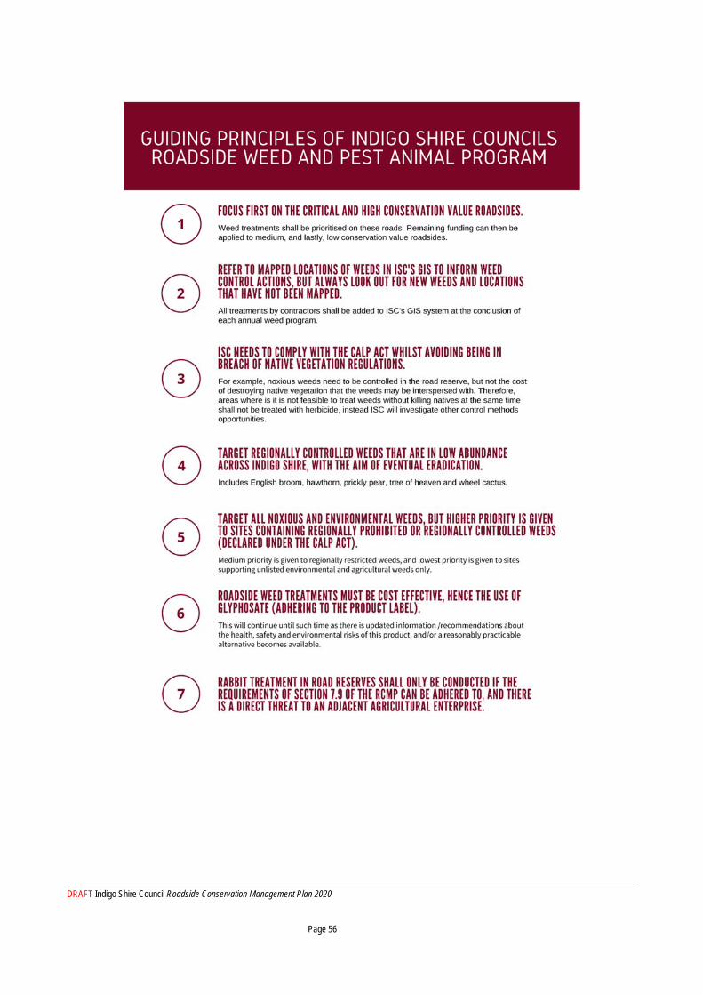
DRAFT Indigo Shire Council Roadside Conservation Management Plan 2020 Page 56
DRAFT Indigo Shire Council Roadside Conservation Management Plan 2020 Page 57
8.2 Internal awareness
All staff working on roadsides, or advising the community or third parties about working in roadsides, must be aware of this Plan.
ISC staff compliance to applicable legislative requirements and to the controls detailed in this plan will be promoted and monitored via:
Staff inductions Workplace inspections Operations toolbox meetings Operations pocket guide/toolkit – summarising the key points of this Plan Roadside conservation training Inclusion of applicable requirements in project/site specific environmental management
plans, project management checklists, safe work method statements and other operational procedures.
Regular update of roadside conservation values assessment and inclusion of roadside conservation values in the GIS program.
For many activities in the roadside, desktop checks to access information associated with this Plan are required at the project planning phase. This is the responsibility of the Project Manager, with assistance from the Coordinator Environment and Sustainability as required.
Information available for staff to access via desktop checks includes:
Roadside Conservation Value for the segment of road work is to be undertaken on. This information is available in the GIS and must be consulted before finalising design plans for roadworks or other activity that is likely to impact on roadside vegetation. If the conservation rating is critical or high, Council’s Environment staff should be consulted to determine the attributes of the road section that contribute to the critical or high status – this may include the presence of threatened flora and fauna species or vegetation community.
State or federally listed threatened or protected species which may require protection under the FFG or EPBC Acts.
Planning controls- including any zones, overlays or local provisions.
Victorian Cultural Heritage Register - to be consulted to ascertain if there is a cultural site at the location of the potential works, in accordance to Section 6.4. If no, workers need to be observant for any un-registered cultural sites. If yes, further action may be required (see section 8.1 Cultural Heritage);
8.3 Community awareness and education
Roadsides are an obvious feature of the public domain, with the community as well as tourists driving past roadsides often daily. The community will see different values in roadside vegetation and will have different opinions on its management. The general public may engage with roadside management issues such as firewood collection, fuel reduction burning or reporting inappropriate
DRAFT Indigo Shire Council Roadside Conservation Management Plan 2020 Page 58
clearing. Differing views will likely persist within the community, particularly on the balance between native vegetation protection and bushfire protection. Indigo Shire Council should be abreast of the latest research and strategies to assist public education and debate.
Previous laws held local landholders responsible for the roadsides adjacent to their properties. While this law was changed many years ago, adjacent landholders often continue to maintain a sense of ownership over the adjacent roadside. This can have positive or negative impacts, depending on the needs of the roadside, and the management actions taken by the landholder. Connecting with landholders and encouraging them to undertake beneficial actions on their roadsides will be important.
Any actions on roadsides (including leaving them alone) will need to be embraced by the local community for these actions to succeed. Relevant sections of this plan will be developed for the public as web content on ISC’s website. The community handbook that accompanied previous versions of the RCMP is discontinued, and replaced with digital information on Indigo Shire’s website. This will be supplemented with Indigo Informer articles, Facebook campaigns and engagement events.
Future community education could include events that encourage engagement about roadside issues. Consideration should be given to letters or pamphlets to landholders adjacent to critical and high conservation value roadsides explaining the features of the roadside, the threats and protective actions on that roadside. In particular, new property owners could be provided with appropriate information on roadside management in their area. Signage on the roadsides can indicate important conservation information to both staff and the community.
Community groups, such as Landcare, can play and important role in managing roadsides. For example, in Strathbogie Shire, local Landcare groups identify problem areas, oversee weed control efforts by contractors and they co-ordinate revegetation events on roadsides. While Landcare groups in Indigo Shire do not have this level of participation, there is still an exceptional level of expertise within these groups which can be consulted for projects such as revegetation. ISC should partner with Landcare groups where possible. Landcare groups hold considerable expertise and local knowledge which can be used to mutual benefit. Also, Landcare networks conduct activities such as releasing bio-controls for pest plants and animals, which would ideally be delivered in a synchronised manner across the district.
DRAFT Indigo Shire Council Roadside Conservation Management Plan 2020 Page 59
8.4 Compliance and Enforcement Compliance activities are actions and programs designed to ensure laws are followed. Compliance can be proactively encouraged through education, providing information and support and incentives.
ISC authorised officers may undertake surveillance and compliance enforcement activities relating to members of the community or third parties undertaking activities on the roadside. This may be random or in response to complaints.
Compliance and enforcement activities shall be risk based and undertaken in accordance with the DELWP compliance and enforcement strategy – native vegetation removal and regulations and the DELWP roadside vegetation compliance and enforcement toolkit.
Enforcement activities are actions undertaken when the law is not followed. Much of the content of this RCMP is state legislation, which, via the Planning Scheme, is regulated and enforced by local governments. Any observed/reported un-permitted removal of native vegetation is to be referred to ISC’s Planning Department, as authorised officers. ISC’s authorised officers have a range of scalable, risk-based responses that may be undertaken in response to non-compliance, including:
Informal negotiation; Warning letter; Notice to comply; Infringement notice; Remedial plans and revegetation or offsets; and Enforcement orders.
Further guidance on appropriate, risk-based responses to native vegetation non-compliances can be found in the DELWP compliance and enforcement strategy – native vegetation removal and regulations and the DELWP roadside vegetation compliance and enforcement toolkit.
ISC must ensure there are sufficient resources to adequately manage compliance with this plan and associated legislation.
8.5 Roles and responsibilities See Table 5 below on the roles and responsibilities pertinent to this plan.
Table 5: The roles and responsibilities for roadside conservation management within ISC
Role Responsibilities Manager municipal operations Champion operations team compliance to applicable
procedures and requirements for roadside conservation Consult Coordinator Environment and Sustainability for any
projects that require vegetation removal and offsets Works supervisors – East and West
Consult Coordinator Environment and Sustainability for road safety works and minor construction projects in accordance with INTERNAL 19 681 Vegetation removal under the Road Safety Exemption Procedure.
Supervise work crews to ensure requirements of the environmental specification; code of practice for road works
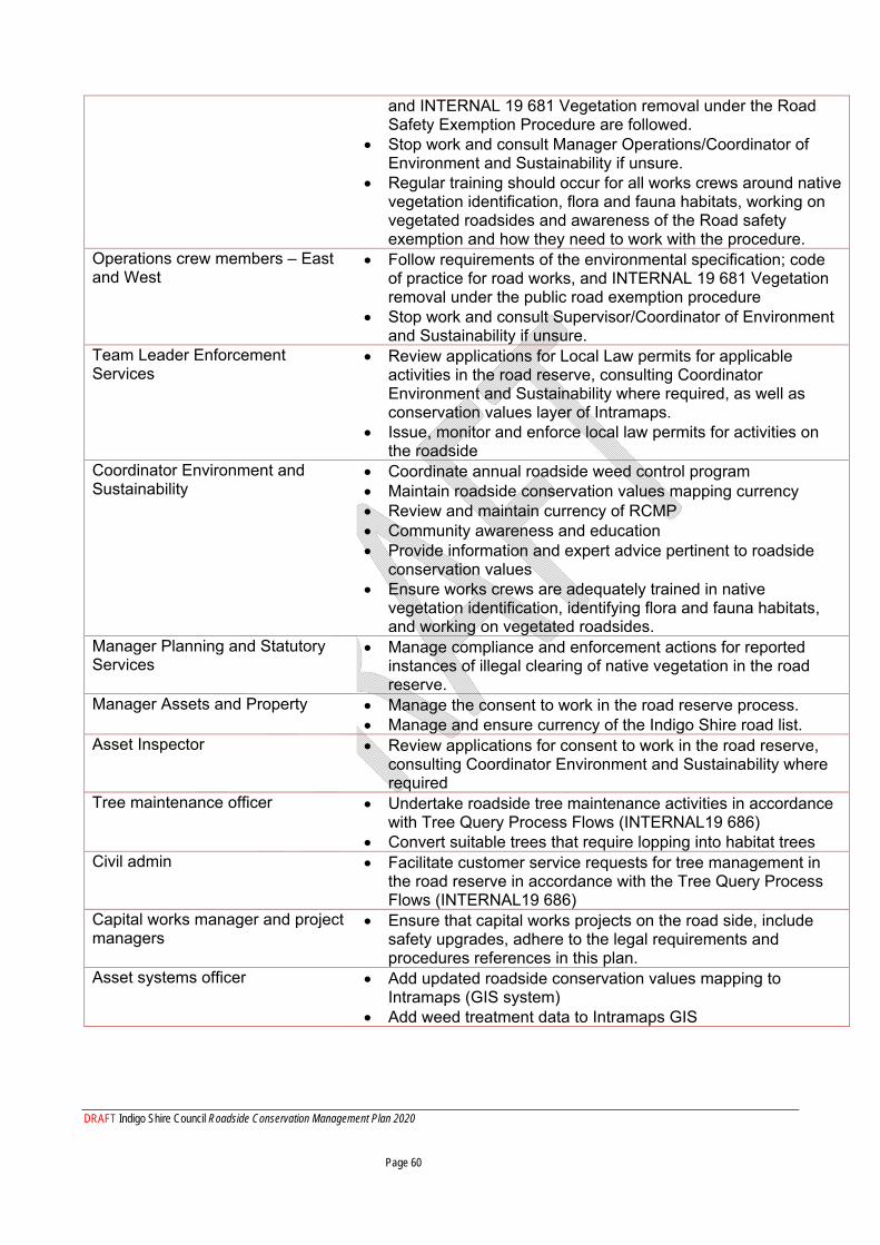
DRAFT Indigo Shire Council Roadside Conservation Management Plan 2020 Page 60
and INTERNAL 19 681 Vegetation removal under the Road Safety Exemption Procedure are followed.
Stop work and consult Manager Operations/Coordinator of Environment and Sustainability if unsure.
Regular training should occur for all works crews around native vegetation identification, flora and fauna habitats, working on vegetated roadsides and awareness of the Road safety exemption and how they need to work with the procedure.
Operations crew members – East and West
Follow requirements of the environmental specification; code of practice for road works, and INTERNAL 19 681 Vegetation removal under the public road exemption procedure
Stop work and consult Supervisor/Coordinator of Environment and Sustainability if unsure.
Team Leader Enforcement Services
Review applications for Local Law permits for applicable activities in the road reserve, consulting Coordinator Environment and Sustainability where required, as well as conservation values layer of Intramaps.
Issue, monitor and enforce local law permits for activities on the roadside
Coordinator Environment and Sustainability
Coordinate annual roadside weed control program Maintain roadside conservation values mapping currency Review and maintain currency of RCMP Community awareness and education Provide information and expert advice pertinent to roadside
conservation values Ensure works crews are adequately trained in native
vegetation identification, identifying flora and fauna habitats, and working on vegetated roadsides.
Manager Planning and Statutory Services
Manage compliance and enforcement actions for reported instances of illegal clearing of native vegetation in the road reserve.
Manager Assets and Property Manage the consent to work in the road reserve process. Manage and ensure currency of the Indigo Shire road list.
Asset Inspector Review applications for consent to work in the road reserve, consulting Coordinator Environment and Sustainability where required
Tree maintenance officer Undertake roadside tree maintenance activities in accordance with Tree Query Process Flows (INTERNAL19 686)
Convert suitable trees that require lopping into habitat trees Civil admin Facilitate customer service requests for tree management in
the road reserve in accordance with the Tree Query Process Flows (INTERNAL19 686)
Capital works manager and project managers
Ensure that capital works projects on the road side, include safety upgrades, adhere to the legal requirements and procedures references in this plan.
Asset systems officer Add updated roadside conservation values mapping to Intramaps (GIS system)
Add weed treatment data to Intramaps GIS
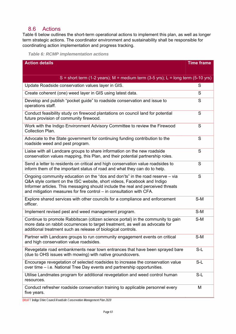
DRAFT Indigo Shire Council Roadside Conservation Management Plan 2020 Page 61
8.6 Actions Table 6 below outlines the short-term operational actions to implement this plan, as well as longer term strategic actions. The coordinator environment and sustainability shall be responsible for coordinating action implementation and progress tracking.
Table 6: RCMP implementation actions
Action details
Time frame
S = short term (1-2 years); M = medium term (3-5 yrs); L = long term (5-10 yrs)
Update Roadside conservation values layer in GIS. S
Create coherent (one) weed layer in GIS using latest data. S
Develop and publish “pocket guide” to roadside conservation and issue to operations staff.
S
Conduct feasibility study on firewood plantations on council land for potential future provision of community firewood.
S
Work with the Indigo Environment Advisory Committee to review the Firewood Collection Plan.
S
Advocate to the State government for continuing funding contribution to the roadside weed and pest program.
S
Liaise with all Landcare groups to share information on the new roadside conservation values mapping, this Plan, and their potential partnership roles.
S
Send a letter to residents on critical and high conservation value roadsides to inform them of the important status of road and what they can do to help.
S
Ongoing community education on the “dos and don’ts” in the road reserve – via Q&A style content on the ISC website, short videos, Facebook and Indigo Informer articles. This messaging should include the real and perceived threats and mitigation measures for fire control – in consultation with CFA.
S
Explore shared services with other councils for a compliance and enforcement officer.
S-M
Implement revised pest and weed management program. S-M
Continue to promote Rabbitscan (citizen science portal) in the community to gain more data on rabbit occurrences to target treatment, as well as advocate for additional treatment such as release of biological controls.
S-M
Partner with Landcare groups to run community engagement events on critical and high conservation value roadsides.
S-M
Revegetate road embankments near town entrances that have been sprayed bare (due to OHS issues with mowing) with native groundcovers.
S-L
Encourage revegetation of selected roadsides to increase the conservation value over time – i.e. National Tree Day events and partnership opportunities.
S-L
Utilise Landmates program for additional revegetation and weed control human resources.
S-L
Conduct refresher roadside conservation training to applicable personnel every five years.
M
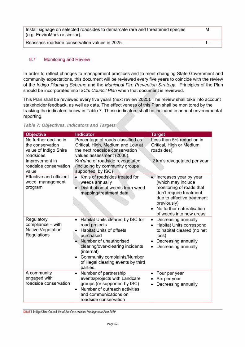
DRAFT Indigo Shire Council Roadside Conservation Management Plan 2020 Page 62
Install signage on selected roadsides to demarcate rare and threatened species (e.g. EnviroMark or similar).
M
Reassess roadside conservation values in 2025. L
8.7 Monitoring and Review
In order to reflect changes to management practices and to meet changing State Government and community expectations, this document will be reviewed every five years to coincide with the review of the Indigo Planning Scheme and the Municipal Fire Prevention Strategy. Principles of the Plan should be incorporated into ISC’s Council Plan when that document is reviewed.
This Plan shall be reviewed every five years (next review 2025). The review shall take into account stakeholder feedback, as well as data. The effectiveness of this Plan shall be monitored by the tracking the indicators below in Table 7. These indicators shall be included in annual environmental reporting.
Table 7: Objectives, Indicators and Targets
Objective Indicator Target No further decline in the conservation value of Indigo Shire roadsides
Percentage of roads classified as Critical, High, Medium and Low at the next roadside conservation values assessment (2030).
Less than 5% reduction in Critical, High or Medium roadsides).
Improvement in roadside conservation value
Km’s/ha of roadside revegetated (including by community groups supported by ISC)
2 km’s revegetated per year
Effective and efficient weed management program
Km’s of roadsides treated for weeds annually
Distribution of weeds from weed mapping/treatment data
Increases year by year (which may include monitoring of roads that don’t require treatment due to effective treatment previously)
No further naturalisation of weeds into new areas
Regulatory compliance – with Native Vegetation Regulations
Habitat Units cleared by ISC for road projects
Habitat Units of offsets purchased
Number of unauthorised clearing/over-clearing incidents (internal)
Community complaints/Number of illegal clearing events by third parties.
Decreasing annually Habitat Units correspond
to habitat cleared (no net loss)
Decreasing annually Decreasing annually
A community engaged with roadside conservation
Number of partnership events/projects with Landcare groups (or supported by ISC)
Number of outreach activities and communications on roadside conservation
Four per year Six per year Decreasing annually

DRAFT Indigo Shire Council Roadside Conservation Management Plan 2020 Page 63
Number of illegal clearing events by third parties.
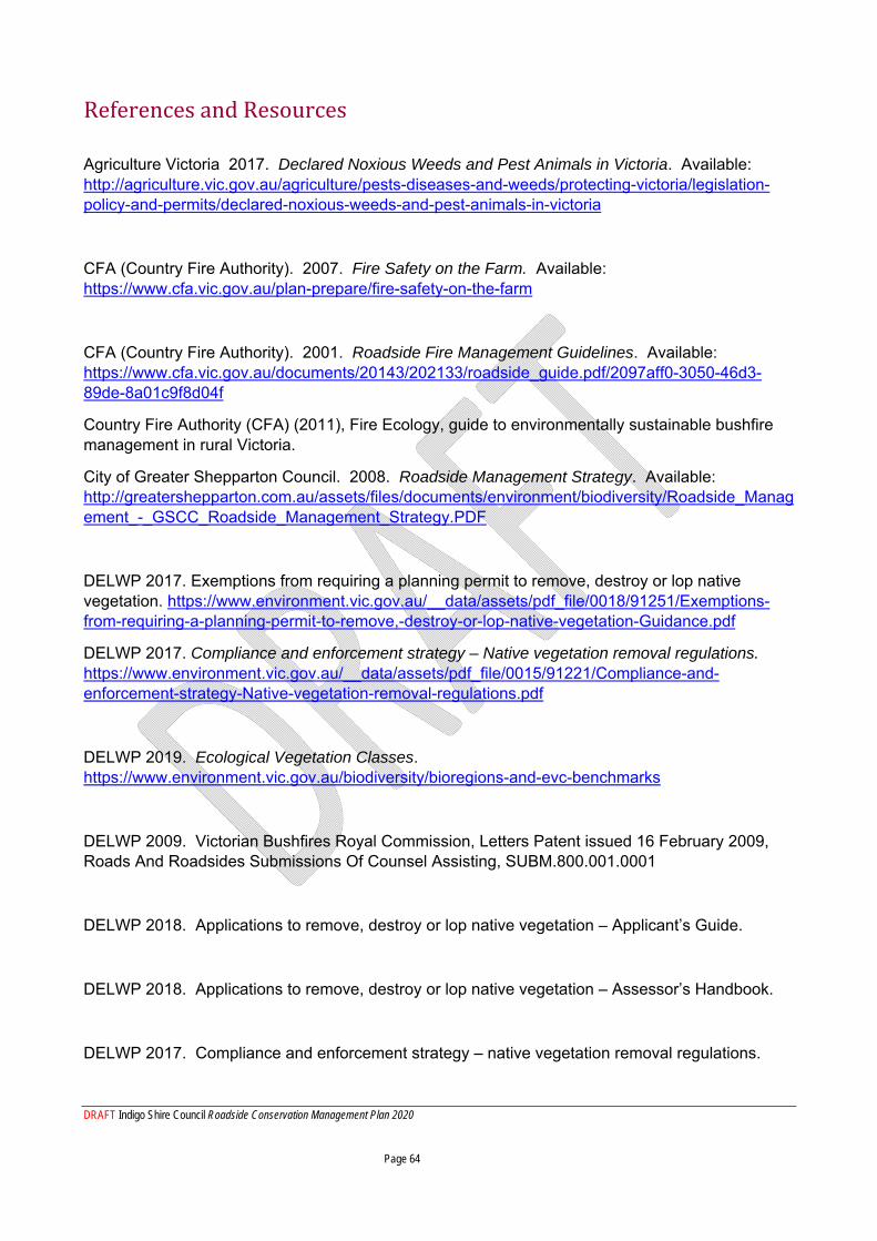
DRAFT Indigo Shire Council Roadside Conservation Management Plan 2020 Page 64
References and Resources
Agriculture Victoria 2017. Declared Noxious Weeds and Pest Animals in Victoria. Available: http://agriculture.vic.gov.au/agriculture/pests-diseases-and-weeds/protecting-victoria/legislation-policy-and-permits/declared-noxious-weeds-and-pest-animals-in-victoria
CFA (Country Fire Authority). 2007. Fire Safety on the Farm. Available: https://www.cfa.vic.gov.au/plan-prepare/fire-safety-on-the-farm
CFA (Country Fire Authority). 2001. Roadside Fire Management Guidelines. Available: https://www.cfa.vic.gov.au/documents/20143/202133/roadside_guide.pdf/2097aff0-3050-46d3-89de-8a01c9f8d04f
Country Fire Authority (CFA) (2011), Fire Ecology, guide to environmentally sustainable bushfire management in rural Victoria.
City of Greater Shepparton Council. 2008. Roadside Management Strategy. Available: http://greatershepparton.com.au/assets/files/documents/environment/biodiversity/Roadside_Management_-_GSCC_Roadside_Management_Strategy.PDF
DELWP 2017. Exemptions from requiring a planning permit to remove, destroy or lop native vegetation. https://www.environment.vic.gov.au/__data/assets/pdf_file/0018/91251/Exemptions-from-requiring-a-planning-permit-to-remove,-destroy-or-lop-native-vegetation-Guidance.pdf
DELWP 2017. Compliance and enforcement strategy – Native vegetation removal regulations. https://www.environment.vic.gov.au/__data/assets/pdf_file/0015/91221/Compliance-and-enforcement-strategy-Native-vegetation-removal-regulations.pdf
DELWP 2019. Ecological Vegetation Classes. https://www.environment.vic.gov.au/biodiversity/bioregions-and-evc-benchmarks
DELWP 2009. Victorian Bushfires Royal Commission, Letters Patent issued 16 February 2009, Roads And Roadsides Submissions Of Counsel Assisting, SUBM.800.001.0001
DELWP 2018. Applications to remove, destroy or lop native vegetation – Applicant’s Guide.
DELWP 2018. Applications to remove, destroy or lop native vegetation – Assessor’s Handbook.
DELWP 2017. Compliance and enforcement strategy – native vegetation removal regulations.
DRAFT Indigo Shire Council Roadside Conservation Management Plan 2020 Page 65
DELWP 2017. Exemptions from requiring a planning permit to remove, destroy or lop native vegetation – Guidance.
DELWP 2017. Native vegetation gain scoring manual.
DELWP 2018. Procedure to rely on the road safety exemption in planning schemes.
DELWP 2012. Roadside vegetation management for bushfire risk mitigation purposes – a guideline for road managers.
DELWP 2017. Guidelines for the removal, destruction or lopping of native vegetation.
DSE (Department of Sustainability and Environment). 2009. Restoration & Revegetation Guide for the North East Catchment.
DELWP 2014. Advisory List of Rare or Threatened Plants in Victoria – 2014 https://www.environment.vic.gov.au/conserving-threatened-species/threatened-species-advisory-lists
EPA (Environment Protection Authority) Victoria. 1996. Best Practice Environmental Management – Environmental Guidelines for Major Construction Sites. Publication Number 480. https://www.epa.vic.gov.au/~/media/Publications/480.pdf
GBCMA (Goulburn-Broken Catchment Management Authority). 2007. Goulburn-Broken Catchment Roadside Biodiversity Risk Assessment Report. Available: https://www.gbcma.vic.gov.au/downloads/Biodiversity/RBRM_Protocols_Report.pdf
Indigo Shire Council. Local Law #1 and #4. Available: https://www.indigoshire.vic.gov.au/About-your-Council/Council-documents/Local-Laws
Indigo Shire Council. 2019. Municipal Fire Management Plan. Available: https://www.indigoshire.vic.gov.au/Emergencies/Fire-safety
Indigo Shire Council 2019 Environment Strategy. Available: https://www.indigoshire.vic.gov.au/Living-in-Indigo/Environment/Environment-and-Sustainability
Museums Victoria, 2019. https://collections.museumvictoria.com.au/species/8446
DRAFT Indigo Shire Council Roadside Conservation Management Plan 2020 Page 66
NECMA (North East Catchment Management Authority). 2005. North East Native Vegetation Management Plan. Available: https://www.necma.vic.gov.au/Solutions/Plants-Animals/Native-Plants-Animals/Vegetation-communities-revegetation
NECMA (North East Catchment Management Authority). 2003. North East Regional Catchment Strategy. Available: https://www.necma.vic.gov.au/About-Us/Publications/Strategies/Regional-Catchment-Strategy
RCAC (Roadsides Conservation Advisory Committee). 1995. Roadside Assessment Handbook.
VicRoads. 2010. VicRoads’ Roadside Management Strategy. Available: https://www.vicroads.vic.gov.au/about-vicroads/our-strategy/vicroads-roadside-management-strategy
VicFlora, 2019. https://vicflora.rbg.vic.gov.au/flora/taxon/25a9cf41-5d5c-45bc-88bf-c260dd796410
Victorian Government 2004. Road Management Act

DRAFT Indigo Shire Council Roadside Conservation Management Plan 2020 Page 67
PART D – APPENDICES
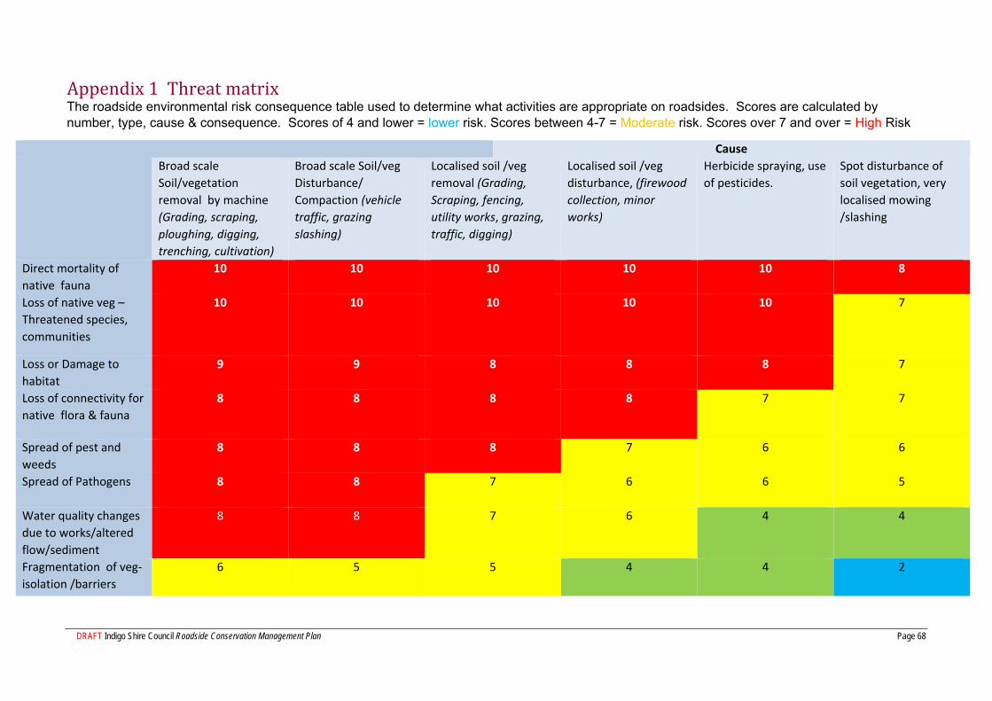
DRAFT Indigo Shire Council Roadside Conservation Management Plan Page 68
Appendix 1 Threat matrix The roadside environmental risk consequence table used to determine what activities are appropriate on roadsides. Scores are calculated by number, type, cause & consequence. Scores of 4 and lower = lower risk. Scores between 4-7 = Moderate risk. Scores over 7 and over = High Risk
Cause Broad scale
Soil/vegetation
removal by machine
(Grading, scraping,
ploughing, digging,
trenching, cultivation)
Broad scale Soil/veg
Disturbance/
Compaction (vehicle
traffic, grazing
slashing)
Localised soil /veg
removal (Grading,
Scraping, fencing,
utility works, grazing,
traffic, digging)
Localised soil /veg
disturbance, (firewood
collection, minor
works)
Herbicide spraying, use
of pesticides.
Spot disturbance of
soil vegetation, very
localised mowing
/slashing
Direct mortality of
native fauna
10
10 10
10 10 8
Loss of native veg –
Threatened species,
communities
10
10 10
10 10 7
Loss or Damage to
habitat
9
9 8
8 8 7
Loss of connectivity for
native flora & fauna
8
8 8
8 7 7
Spread of pest and
weeds
8
8 8
7 6 6
Spread of Pathogens 8
8 7
6 6 5
Water quality changes
due to works/altered
flow/sediment
8
8 7
6 4 4
Fragmentation of veg‐
isolation /barriers
6
5 5
4 4 2
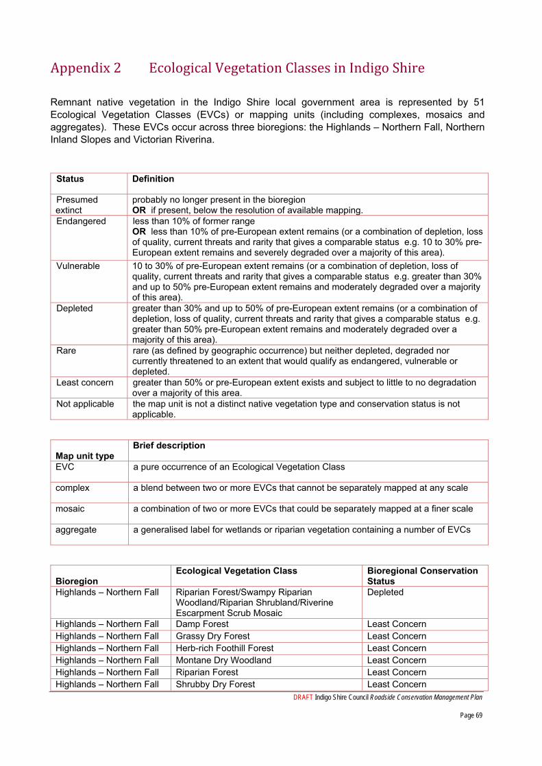
DRAFT Indigo Shire Council Roadside Conservation Management Plan
Page 69
Appendix 2 Ecological Vegetation Classes in Indigo Shire
Remnant native vegetation in the Indigo Shire local government area is represented by 51 Ecological Vegetation Classes (EVCs) or mapping units (including complexes, mosaics and aggregates). These EVCs occur across three bioregions: the Highlands – Northern Fall, Northern Inland Slopes and Victorian Riverina.
Status Definition
Presumed extinct
probably no longer present in the bioregion OR if present, below the resolution of available mapping.
Endangered less than 10% of former range OR less than 10% of pre-European extent remains (or a combination of depletion, loss of quality, current threats and rarity that gives a comparable status e.g. 10 to 30% pre-European extent remains and severely degraded over a majority of this area).
Vulnerable 10 to 30% of pre-European extent remains (or a combination of depletion, loss of quality, current threats and rarity that gives a comparable status e.g. greater than 30% and up to 50% pre-European extent remains and moderately degraded over a majority of this area).
Depleted greater than 30% and up to 50% of pre-European extent remains (or a combination of depletion, loss of quality, current threats and rarity that gives a comparable status e.g. greater than 50% pre-European extent remains and moderately degraded over a majority of this area).
Rare rare (as defined by geographic occurrence) but neither depleted, degraded nor currently threatened to an extent that would qualify as endangered, vulnerable or depleted.
Least concern greater than 50% or pre-European extent exists and subject to little to no degradation over a majority of this area.
Not applicable the map unit is not a distinct native vegetation type and conservation status is not applicable.
Map unit type
Brief description
EVC a pure occurrence of an Ecological Vegetation Class
complex a blend between two or more EVCs that cannot be separately mapped at any scale
mosaic a combination of two or more EVCs that could be separately mapped at a finer scale
aggregate a generalised label for wetlands or riparian vegetation containing a number of EVCs
Bioregion
Ecological Vegetation Class Bioregional Conservation Status
Highlands – Northern Fall Riparian Forest/Swampy Riparian Woodland/Riparian Shrubland/Riverine Escarpment Scrub Mosaic
Depleted
Highlands – Northern Fall Damp Forest Least Concern Highlands – Northern Fall Grassy Dry Forest Least Concern Highlands – Northern Fall Herb-rich Foothill Forest Least Concern Highlands – Northern Fall Montane Dry Woodland Least Concern Highlands – Northern Fall Riparian Forest Least Concern Highlands – Northern Fall Shrubby Dry Forest Least Concern
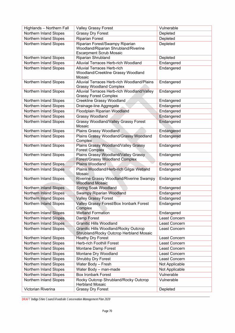
DRAFT Indigo Shire Council Roadside Conservation Management Plan 2020 Page 70
Highlands – Northern Fall Valley Grassy Forest Vulnerable Northern Inland Slopes Grassy Dry Forest Depleted Northern Inland Slopes Riparian Forest Depleted Northern Inland Slopes Riparian Forest/Swampy Riparian
Woodland/Riparian Shrubland/Riverine Escarpment Scrub Mosaic
Depleted
Northern Inland Slopes Riparian Shrubland Depleted Northern Inland Slopes Alluvial Terraces Herb-rich Woodland Endangered Northern Inland Slopes Alluvial Terraces Herb-rich
Woodland/Creekline Grassy Woodland Mosaic
Endangered
Northern Inland Slopes Alluvial Terraces Herb-rich Woodland/Plains Grassy Woodland Complex
Endangered
Northern Inland Slopes Alluvial Terraces Herb-rich Woodland/Valley Grassy Forest Complex
Endangered
Northern Inland Slopes Creekline Grassy Woodland Endangered Northern Inland Slopes Drainage-line Aggregate Endangered Northern Inland Slopes Floodplain Riparian Woodland Endangered Northern Inland Slopes Grassy Woodland Endangered Northern Inland Slopes Grassy Woodland/Valley Grassy Forest
Mosaic Endangered
Northern Inland Slopes Plains Grassy Woodland Endangered Northern Inland Slopes Plains Grassy Woodland/Grassy Woodland
Complex Endangered
Northern Inland Slopes Plains Grassy Woodland/Valley Grassy Forest Complex
Endangered
Northern Inland Slopes Plains Grassy Woodland/Valley Grassy Forest/Grassy Woodland Complex
Endangered
Northern Inland Slopes Plains Woodland Endangered Northern Inland Slopes Plains Woodland/Herb-rich Gilgai Wetland
Mosaic Endangered
Northern Inland Slopes Riverine Grassy Woodland/Riverine Swampy Woodland Mosaic
Endangered
Northern Inland Slopes Spring Soak Woodland Endangered Northern Inland Slopes Swampy Riparian Woodland Endangered Northern Inland Slopes Valley Grassy Forest Endangered Northern Inland Slopes Valley Grassy Forest/Box Ironbark Forest
Complex Endangered
Northern Inland Slopes Wetland Formation Endangered Northern Inland Slopes Damp Forest Least Concern Northern Inland Slopes Granitic Hills Woodland Least Concern Northern Inland Slopes Granitic Hills Woodland/Rocky Outcrop
Shrubland/Rocky Outcrop Herbland Mosaic Least Concern
Northern Inland Slopes Heathy Dry Forest Least Concern Northern Inland Slopes Herb-rich Foothill Forest Least Concern Northern Inland Slopes Montane Damp Forest Least Concern Northern Inland Slopes Montane Dry Woodland Least Concern Northern Inland Slopes Shrubby Dry Forest Least Concern Northern Inland Slopes Water Body – Fresh Not Applicable Northern Inland Slopes Water Body – man-made Not Applicable Northern Inland Slopes Box Ironbark Forest Vulnerable Northern Inland Slopes Rocky Outcrop Shrubland/Rocky Outcrop
Herbland Mosaic Vulnerable
Victorian Riverina Grassy Dry Forest Depleted
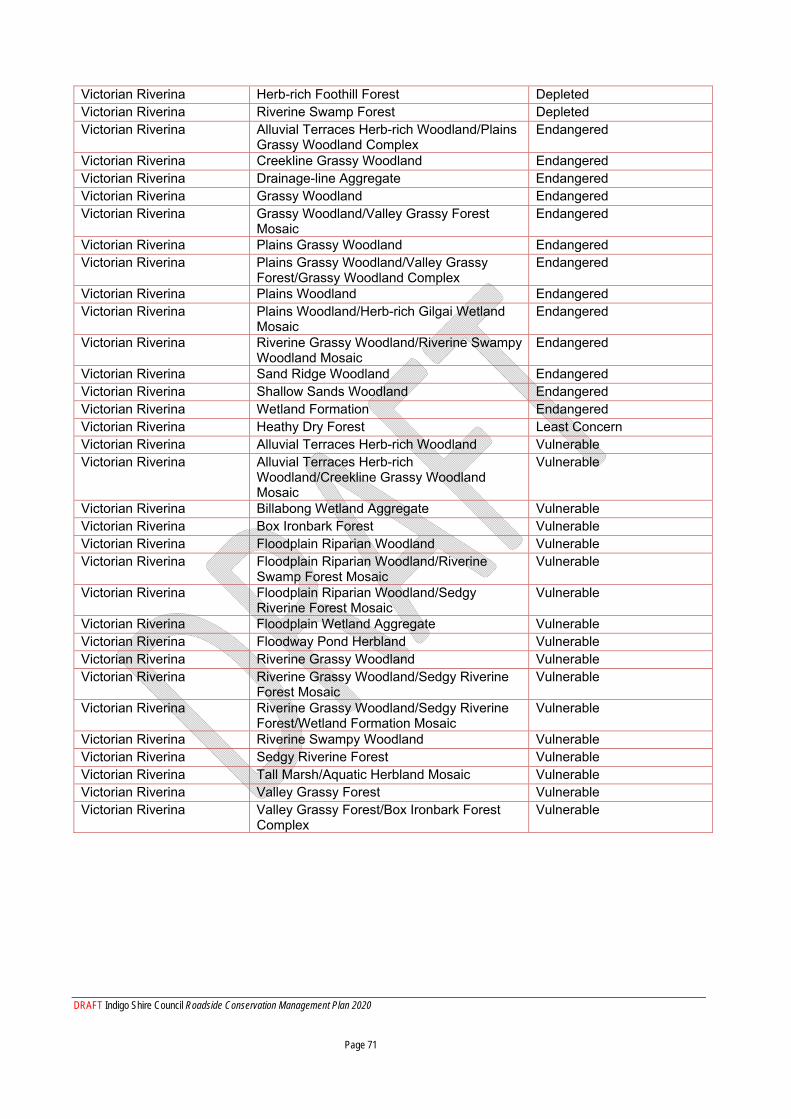
DRAFT Indigo Shire Council Roadside Conservation Management Plan 2020 Page 71
Victorian Riverina Herb-rich Foothill Forest Depleted Victorian Riverina Riverine Swamp Forest Depleted Victorian Riverina Alluvial Terraces Herb-rich Woodland/Plains
Grassy Woodland Complex Endangered
Victorian Riverina Creekline Grassy Woodland Endangered Victorian Riverina Drainage-line Aggregate Endangered Victorian Riverina Grassy Woodland Endangered Victorian Riverina Grassy Woodland/Valley Grassy Forest
Mosaic Endangered
Victorian Riverina Plains Grassy Woodland Endangered Victorian Riverina Plains Grassy Woodland/Valley Grassy
Forest/Grassy Woodland Complex Endangered
Victorian Riverina Plains Woodland Endangered Victorian Riverina Plains Woodland/Herb-rich Gilgai Wetland
Mosaic Endangered
Victorian Riverina Riverine Grassy Woodland/Riverine Swampy Woodland Mosaic
Endangered
Victorian Riverina Sand Ridge Woodland Endangered Victorian Riverina Shallow Sands Woodland Endangered Victorian Riverina Wetland Formation Endangered Victorian Riverina Heathy Dry Forest Least Concern Victorian Riverina Alluvial Terraces Herb-rich Woodland Vulnerable Victorian Riverina Alluvial Terraces Herb-rich
Woodland/Creekline Grassy Woodland Mosaic
Vulnerable
Victorian Riverina Billabong Wetland Aggregate Vulnerable Victorian Riverina Box Ironbark Forest Vulnerable Victorian Riverina Floodplain Riparian Woodland Vulnerable Victorian Riverina Floodplain Riparian Woodland/Riverine
Swamp Forest Mosaic Vulnerable
Victorian Riverina Floodplain Riparian Woodland/Sedgy Riverine Forest Mosaic
Vulnerable
Victorian Riverina Floodplain Wetland Aggregate Vulnerable Victorian Riverina Floodway Pond Herbland Vulnerable Victorian Riverina Riverine Grassy Woodland Vulnerable Victorian Riverina Riverine Grassy Woodland/Sedgy Riverine
Forest Mosaic Vulnerable
Victorian Riverina Riverine Grassy Woodland/Sedgy Riverine Forest/Wetland Formation Mosaic
Vulnerable
Victorian Riverina Riverine Swampy Woodland Vulnerable Victorian Riverina Sedgy Riverine Forest Vulnerable Victorian Riverina Tall Marsh/Aquatic Herbland Mosaic Vulnerable Victorian Riverina Valley Grassy Forest Vulnerable Victorian Riverina Valley Grassy Forest/Box Ironbark Forest
Complex Vulnerable
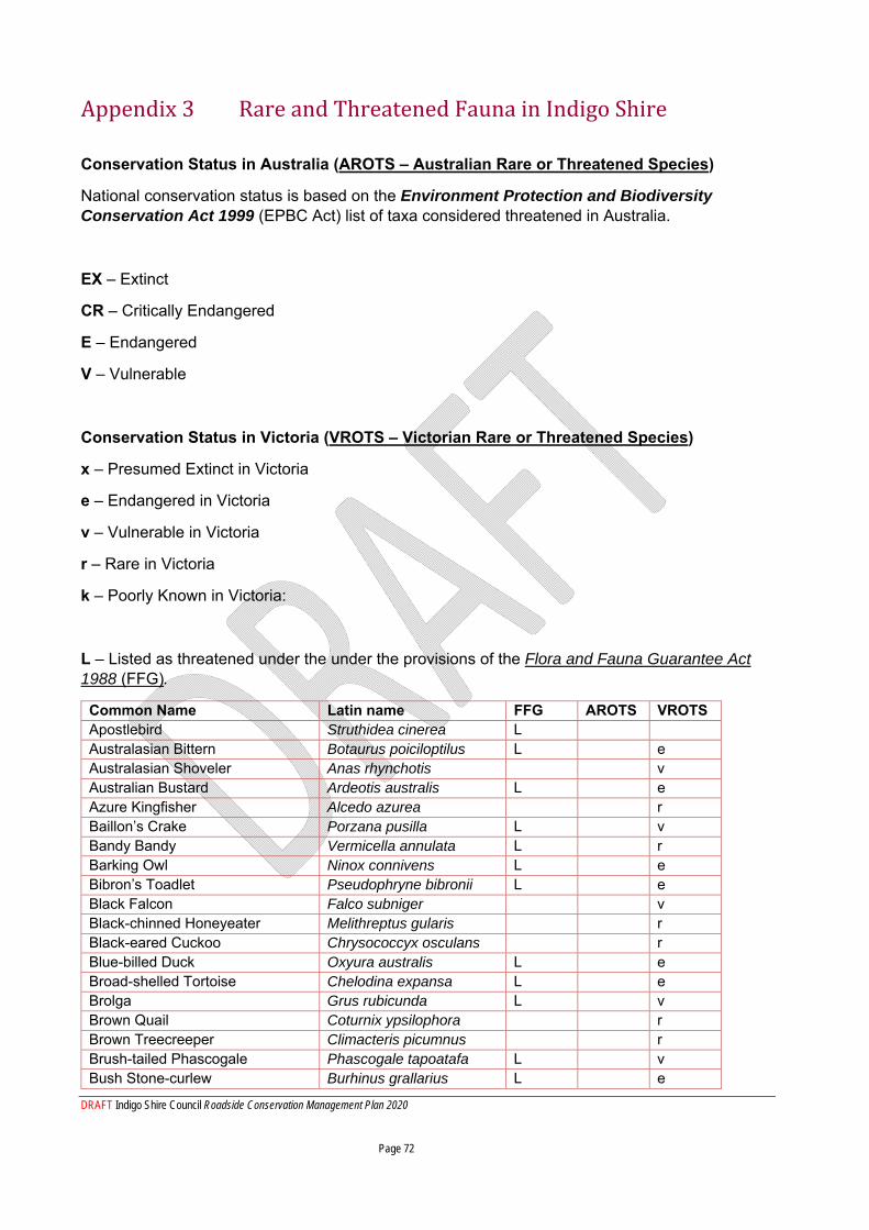
DRAFT Indigo Shire Council Roadside Conservation Management Plan 2020 Page 72
Appendix 3 Rare and Threatened Fauna in Indigo Shire
Conservation Status in Australia (AROTS – Australian Rare or Threatened Species)
National conservation status is based on the Environment Protection and Biodiversity Conservation Act 1999 (EPBC Act) list of taxa considered threatened in Australia.
EX – Extinct
CR – Critically Endangered
E – Endangered
V – Vulnerable
Conservation Status in Victoria (VROTS – Victorian Rare or Threatened Species)
x – Presumed Extinct in Victoria
e – Endangered in Victoria
v – Vulnerable in Victoria
r – Rare in Victoria
k – Poorly Known in Victoria:
L – Listed as threatened under the under the provisions of the Flora and Fauna Guarantee Act 1988 (FFG).
Common Name Latin name FFG AROTS VROTS Apostlebird Struthidea cinerea L Australasian Bittern Botaurus poiciloptilus L e Australasian Shoveler Anas rhynchotis v Australian Bustard Ardeotis australis L e Azure Kingfisher Alcedo azurea r Baillon’s Crake Porzana pusilla L v Bandy Bandy Vermicella annulata L r Barking Owl Ninox connivens L e Bibron’s Toadlet Pseudophryne bibronii L e Black Falcon Falco subniger v Black-chinned Honeyeater Melithreptus gularis r Black-eared Cuckoo Chrysococcyx osculans r Blue-billed Duck Oxyura australis L e Broad-shelled Tortoise Chelodina expansa L e Brolga Grus rubicunda L v Brown Quail Coturnix ypsilophora r Brown Treecreeper Climacteris picumnus r Brush-tailed Phascogale Phascogale tapoatafa L v Bush Stone-curlew Burhinus grallarius L e
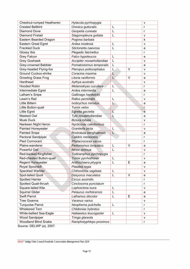
DRAFT Indigo Shire Council Roadside Conservation Management Plan 2020 Page 73
Chestnut-rumped Heathwren Hylacola pyrrhopygia v Crested Bellbird Oreoica gutturalis L r Diamond Dove Geopelia cuneata L r Diamond Firetail Stagonopleura guttata L v Eastern Bearded Dragon Pogona barbata k Eastern Great Egret Ardea modesta L v Freckled Duck Stictonetta naevosa L e Glossy Ibis Plegadis falcinellus r Grey Falcon Falco hypoleucos L e Grey Goshawk Accipiter novaehollandiae L v Grey-crowned Babbler Pomatostomus temporalis L e Grey-headed Flying-fox Pteropus poliocephalus L V v Ground Cuckoo-shrike Coracina maxima L v Growling Grass Frog Litoria raniformis L V e Hardhead Aythya australis v Hooded Robin Melanodryas cucullata L r Intermediate Egret Ardea intermedia L e Latham’s Snipe Gallinago hardwickii r Lewin’s Rail Rallus pectoralis L v Little Bittern Ixobrychus minutus L e Little Button-quail Turnix velox r Little Egret Egretta garzetta L e Masked Owl Tyto novaehollandiae L e Musk Duck Biziura lobata v Nankeen Night Heron Nycticorax caledonicus r Painted Honeyeater Grantiella picta L v Painted Snipe Rostratula benghalensis L e Pectoral Sandpiper Calidris melanotos r Pied Cormorant Phalacrocorax varius r Plains-wanderer Pedionomus torquatus L V e Powerful Owl Ninox strenua L v Red-backed Kingfisher Todiramphus pyrrhopygia r Red-chested Button-quail Turnix pyrrhothorax L v Regent Honeyeater Anthochaera phygria L E e Royal Spoonbill Platalea regia v Speckled Warbler Chthonicola sagittata L v Spot-tailed Quoll Dasyurus maculatus L V e Spotted Harrier Circus assimilis r Spotted Quail-thrush Cinclosoma punctatum r Square-tailed Kite Lophoictinia isura L v Squirrel Glider Petaurus norfolcensis L e Swift Parrot Lathamus discolor L E e Tree Goanna Varanus varius v Turquoise Parrot Neophema pulchella L r Whiskered Tern Chlidonias hybridus r White-bellied Sea-Eagle Haliaeetus leucogaster L v Wood Sandpiper Tringa glareola v Woodland Blind Snake Ramphotyphlops proximus r
Source: DELWP (a), 2007.
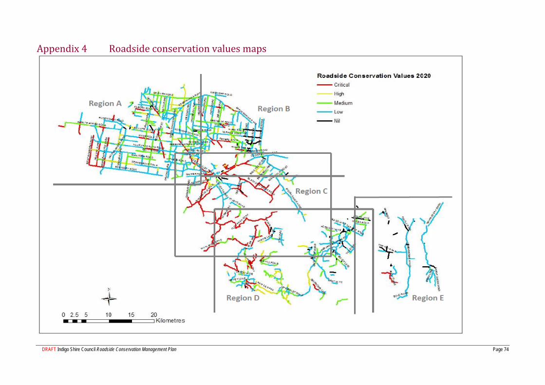
DRAFT Indigo Shire Council Roadside Conservation Management Plan Page 74
Appendix 4 Roadside conservation values maps
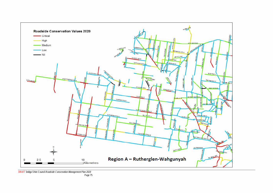
DRAFT Indigo Shire Council Roadside Conservation Management Plan 2020 Page 75

DRAFT Indigo Shire Council Roadside Conservation Management Plan 2020 Page 76
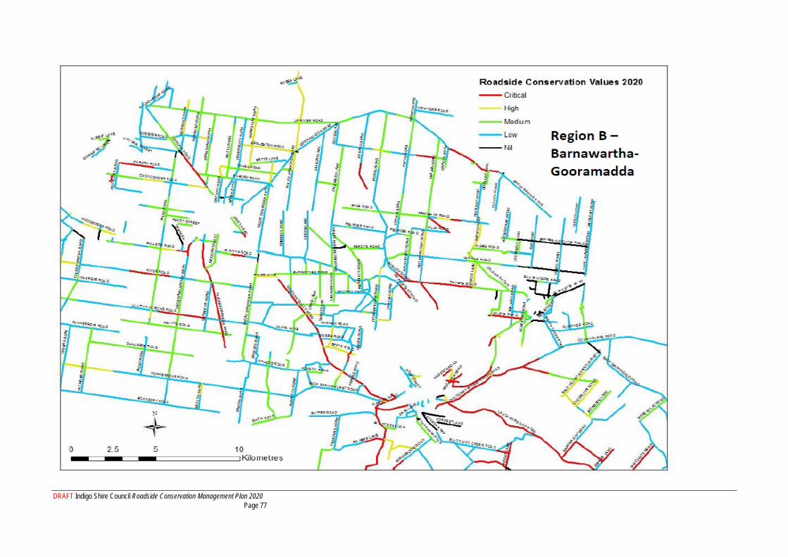
DRAFT Indigo Shire Council Roadside Conservation Management Plan 2020 Page 77

DRAFT Indigo Shire Council Roadside Conservation Management Plan 2020 Page 78
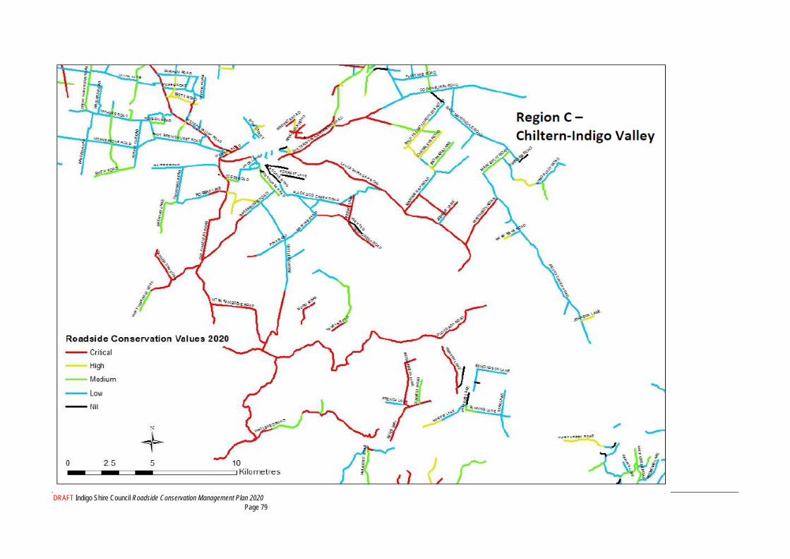
DRAFT Indigo Shire Council Roadside Conservation Management Plan 2020 Page 79
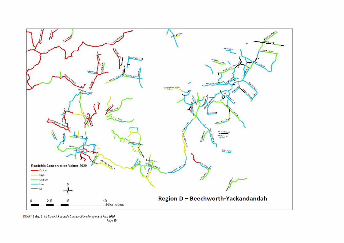
DRAFT Indigo Shire Council Roadside Conservation Management Plan 2020 Page 80
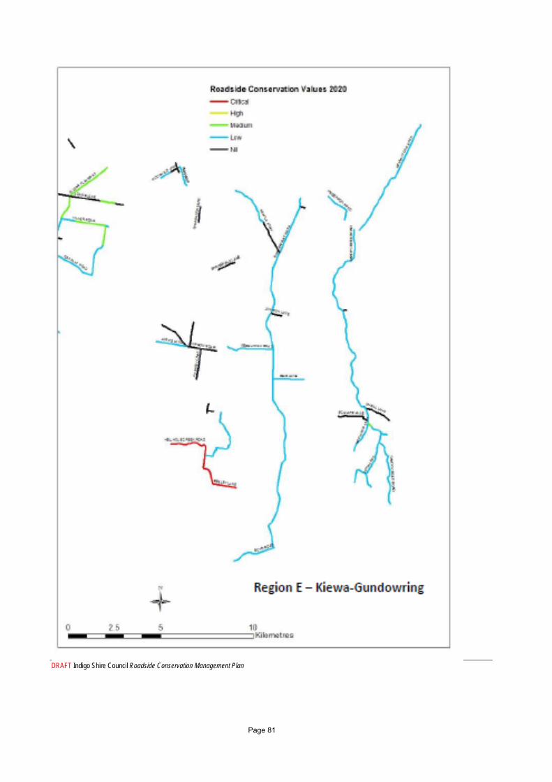
DRAFT Indigo Shire Council Roadside Conservation Management Plan Page 81

DRAFT Indigo Shire Council Roadside Conservation Management Plan Page 82
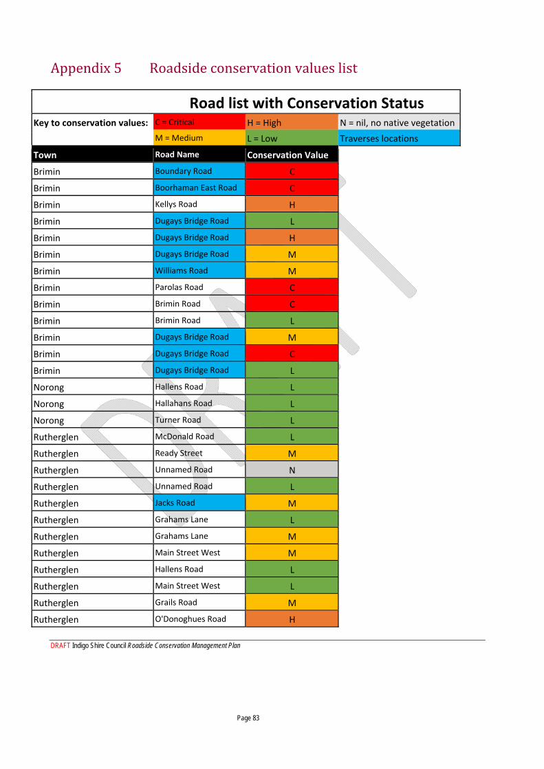
DRAFT Indigo Shire Council Roadside Conservation Management Plan Page 83
Appendix 5 Roadside conservation values list
Road list with Conservation Status Key to conservation values: C = Critical H = High N = nil, no native vegetation
M = Medium L = Low Traverses locations
Town Road Name Conservation Value
Brimin Boundary Road C
Brimin Boorhaman East Road C
Brimin Kellys Road H
Brimin Dugays Bridge Road L
Brimin Dugays Bridge Road H
Brimin Dugays Bridge Road M
Brimin Williams Road M
Brimin Parolas Road C
Brimin Brimin Road C
Brimin Brimin Road L
Brimin Dugays Bridge Road M
Brimin Dugays Bridge Road C
Brimin Dugays Bridge Road L
Norong Hallens Road L
Norong Hallahans Road L
Norong Turner Road L
Rutherglen McDonald Road L
Rutherglen Ready Street M
Rutherglen Unnamed Road N
Rutherglen Unnamed Road L
Rutherglen Jacks Road M
Rutherglen Grahams Lane L
Rutherglen Grahams Lane M
Rutherglen Main Street West M
Rutherglen Hallens Road L
Rutherglen Main Street West L
Rutherglen Grails Road M
Rutherglen O'Donoghues Road H
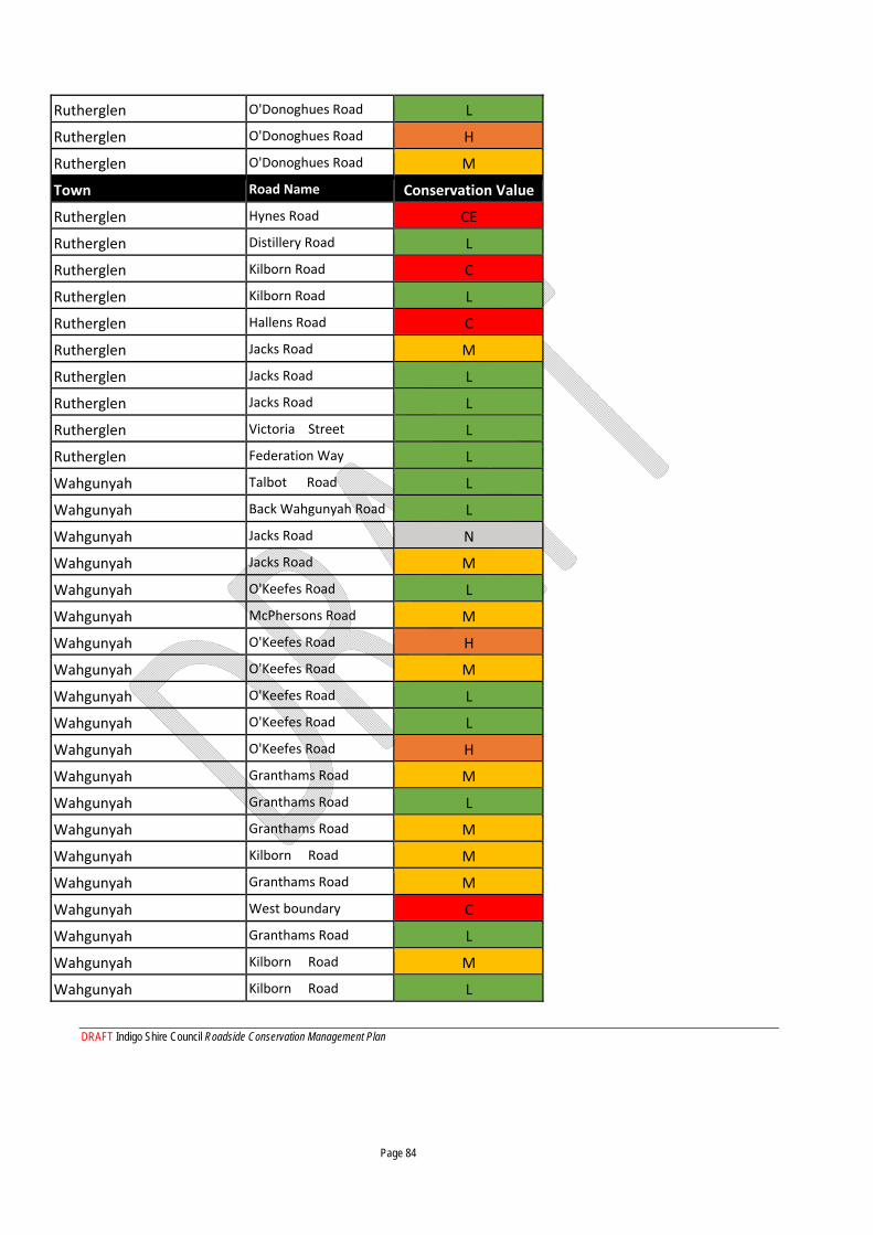
DRAFT Indigo Shire Council Roadside Conservation Management Plan Page 84
Rutherglen O'Donoghues Road L
Rutherglen O'Donoghues Road H
Rutherglen O'Donoghues Road M
Town Road Name Conservation Value
Rutherglen Hynes Road CE
Rutherglen Distillery Road L
Rutherglen Kilborn Road C
Rutherglen Kilborn Road L
Rutherglen Hallens Road C
Rutherglen Jacks Road M
Rutherglen Jacks Road L
Rutherglen Jacks Road L
Rutherglen Victoria Street L
Rutherglen Federation Way L
Wahgunyah Talbot Road L
Wahgunyah Back Wahgunyah Road L
Wahgunyah Jacks Road N
Wahgunyah Jacks Road M
Wahgunyah O'Keefes Road L
Wahgunyah McPhersons Road M
Wahgunyah O'Keefes Road H
Wahgunyah O'Keefes Road M
Wahgunyah O'Keefes Road L
Wahgunyah O'Keefes Road L
Wahgunyah O'Keefes Road H
Wahgunyah Granthams Road M
Wahgunyah Granthams Road L
Wahgunyah Granthams Road M
Wahgunyah Kilborn Road M
Wahgunyah Granthams Road M
Wahgunyah West boundary C
Wahgunyah Granthams Road L
Wahgunyah Kilborn Road M
Wahgunyah Kilborn Road L
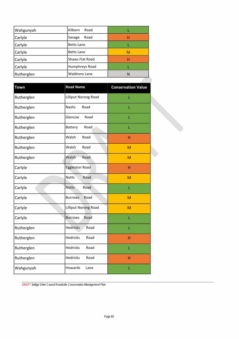
DRAFT Indigo Shire Council Roadside Conservation Management Plan Page 85
Wahgunyah Kilborn Road L
Carlyle Savage Road H
Carlyle Betts Lane L
Carlyle Betts Lane M
Carlyle Shaws Flat Road H
Carlyle Humphreys Road L
Rutherglen Waldrons Lane N
Town Road Name Conservation Value
Rutherglen Lilliput Norong Road L
Rutherglen Nashs Road L
Rutherglen Glencoe Road L
Rutherglen Battery Road L
Rutherglen Walsh Road H
Rutherglen Walsh Road M
Rutherglen Walsh Road M
Carlyle Eggleston Road H
Carlyle Notts Road M
Carlyle Notts Road L
Carlyle Burrows Road M
Carlyle Lilliput Norong Road M
Carlyle Burrows Road L
Rutherglen Hedricks Road L
Rutherglen Hedricks Road H
Rutherglen Hedricks Road L
Rutherglen Hedricks Road H
Wahgunyah Howards Lane L
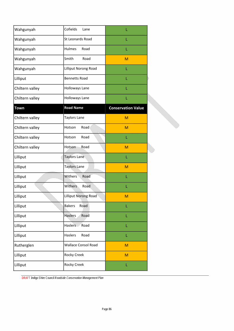
DRAFT Indigo Shire Council Roadside Conservation Management Plan Page 86
Wahgunyah Cofields Lane L
Wahgunyah St Leonards Road L
Wahgunyah Hulmes Road L
Wahgunyah Smith Road M
Wahgunyah Lilliput Norong Road L
Lilliput Bennetts Road L
Chiltern valley Holloways Lane L
Chiltern valley Holloways Lane L
Town Road Name Conservation Value
Chiltern valley Taylors Lane M
Chiltern valley Hotson Road M
Chiltern valley Hotson Road L
Chiltern valley Hotson Road M
Lilliput Taylors Lane L
Lilliput Taylors Lane M
Lilliput Withers Road L
Lilliput Withers Road L
Lilliput Lilliput Norong Road M
Lilliput Bakers Road L
Lilliput Haslers Road L
Lilliput Haslers Road L
Lilliput Haslers Road L
Rutherglen Wallace Consol Road M
Lilliput Rocky Creek M
Lilliput Rocky Creek L
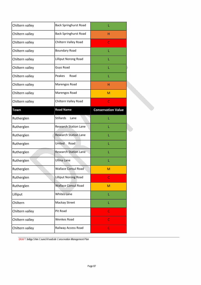
DRAFT Indigo Shire Council Roadside Conservation Management Plan Page 87
Chiltern valley Back Springhurst Road L
Chiltern valley Back Springhurst Road H
Chiltern valley Chiltern Valley Road C
Chiltern valley Boundary Road L
Chiltern valley Lilliput Norong Road L
Chiltern valley Guys Road L
Chiltern valley Peakes Road L
Chiltern valley Marengos Road H
Chiltern valley Marengos Road M
Chiltern valley Chiltern Valley Road C
Town Road Name Conservation Value
Rutherglen Stillards Lane L
Rutherglen Research Station Lane L
Rutherglen Research Station Lane L
Rutherglen United Road L
Rutherglen Research Station Lane L
Rutherglen Ullina Lane L
Rutherglen Wallace Consul Road M
Rutherglen Lilliput Norong Road C
Rutherglen Wallace Consul Road M
Lilliput Whites Lane L
Chiltern Mackay Street L
Chiltern valley Pit Road C
Chiltern valley Wenkes Road C
Chiltern valley Railway Access Road C
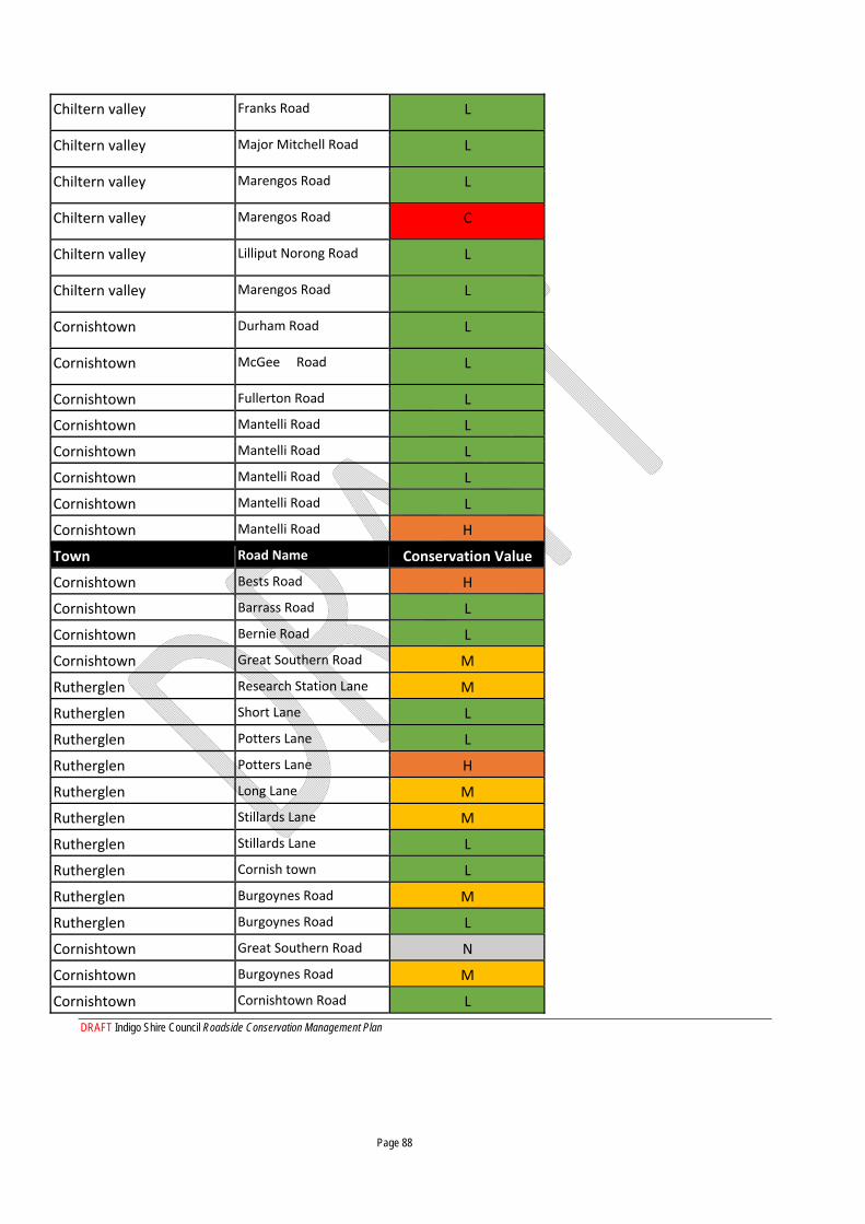
DRAFT Indigo Shire Council Roadside Conservation Management Plan Page 88
Chiltern valley Franks Road L
Chiltern valley Major Mitchell Road L
Chiltern valley Marengos Road L
Chiltern valley Marengos Road C
Chiltern valley Lilliput Norong Road L
Chiltern valley Marengos Road L
Cornishtown Durham Road L
Cornishtown McGee Road L
Cornishtown Fullerton Road L
Cornishtown Mantelli Road L
Cornishtown Mantelli Road L
Cornishtown Mantelli Road L
Cornishtown Mantelli Road L
Cornishtown Mantelli Road H
Town Road Name Conservation Value
Cornishtown Bests Road H
Cornishtown Barrass Road L
Cornishtown Bernie Road L
Cornishtown Great Southern Road M
Rutherglen Research Station Lane M
Rutherglen Short Lane L
Rutherglen Potters Lane L
Rutherglen Potters Lane H
Rutherglen Long Lane M
Rutherglen Stillards Lane M
Rutherglen Stillards Lane L
Rutherglen Cornish town L
Rutherglen Burgoynes Road M
Rutherglen Burgoynes Road L
Cornishtown Great Southern Road N
Cornishtown Burgoynes Road M
Cornishtown Cornishtown Road L
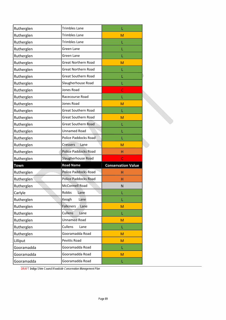
DRAFT Indigo Shire Council Roadside Conservation Management Plan Page 89
Rutherglen Trimbles Lane L
Rutherglen Trimbles Lane M
Rutherglen Trimbles Lane L
Rutherglen Green Lane L
Rutherglen Green Lane L
Rutherglen Great Northern Road M
Rutherglen Great Northern Road L
Rutherglen Great Southern Road L
Rutherglen Slaugherhouse Road L
Rutherglen Jones Road C
Rutherglen Racecourse Road L
Rutherglen Jones Road M
Rutherglen Great Southern Road L
Rutherglen Great Southern Road M
Rutherglen Great Southern Road L
Rutherglen Unnamed Road L
Rutherglen Police Paddocks Road L
Rutherglen Cressers Lane M
Rutherglen Police Paddocks Road H
Rutherglen Slaugherhouse Road C
Town Road Name Conservation Value
Rutherglen Police Paddocks Road H
Rutherglen Police Paddocks Road H
Rutherglen McConnell Road N
Carlyle Robbs Lane L
Rutherglen Keogh Lane L
Rutherglen Falkiners Lane M
Rutherglen Cullens Lane L
Rutherglen Unnamed Road M
Rutherglen Cullens Lane L
Rutherglen Gooramadda Road M
Lilliput Pevitts Road M
Gooramadda Gooramadda Road L
Gooramadda Gooramadda Road M
Gooramadda Gooramadda Road L
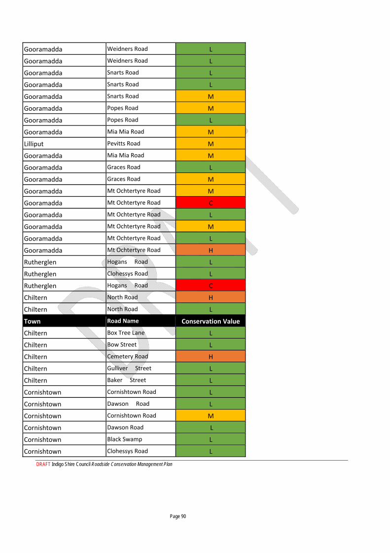
DRAFT Indigo Shire Council Roadside Conservation Management Plan Page 90
Gooramadda Weidners Road L
Gooramadda Weidners Road L
Gooramadda Snarts Road L
Gooramadda Snarts Road L
Gooramadda Snarts Road M
Gooramadda Popes Road M
Gooramadda Popes Road L
Gooramadda Mia Mia Road M
Lilliput Pevitts Road M
Gooramadda Mia Mia Road M
Gooramadda Graces Road L
Gooramadda Graces Road M
Gooramadda Mt Ochtertyre Road M
Gooramadda Mt Ochtertyre Road C
Gooramadda Mt Ochtertyre Road L
Gooramadda Mt Ochtertyre Road M
Gooramadda Mt Ochtertyre Road L
Gooramadda Mt Ochtertyre Road H
Rutherglen Hogans Road L
Rutherglen Clohessys Road L
Rutherglen Hogans Road C
Chiltern North Road H
Chiltern North Road L
Town Road Name Conservation Value
Chiltern Box Tree Lane L
Chiltern Bow Street L
Chiltern Cemetery Road H
Chiltern Gulliver Street L
Chiltern Baker Street L
Cornishtown Cornishtown Road L
Cornishtown Dawson Road L
Cornishtown Cornishtown Road M
Cornishtown Dawson Road L
Cornishtown Black Swamp L
Cornishtown Clohessys Road L
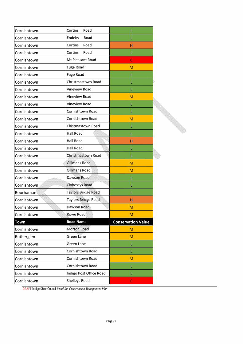
DRAFT Indigo Shire Council Roadside Conservation Management Plan Page 91
Cornishtown Curtins Road L
Cornishtown Endeby Road L
Cornishtown Curtins Road H
Cornishtown Curtins Road L
Cornishtown Mt Pleasant Road C
Cornishtown Fuge Road M
Cornishtown Fuge Road L
Cornishtown Christmastown Road L
Cornishtown Vineview Road L
Cornishtown Vineview Road M
Cornishtown Vineview Road L
Cornishtown Cornishtown Road L
Cornishtown Cornishtown Road M
Cornishtown Chistmastown Road L
Cornishtown Hall Road L
Cornishtown Hall Road H
Cornishtown Hall Road L
Cornishtown Christmastown Road L
Cornishtown Gillmans Road M
Cornishtown Gillmans Road M
Cornishtown Dawson Road L
Cornishtown Clohessys Road L
Boorhaman Taylors Bridge Road L
Cornishtown Taylors Bridge Road H
Cornishtown Dawson Road M
Cornishtown Rowe Road M
Town Road Name Conservation Value
Cornishtown Morton Road M
Rutherglen Green Lane M
Cornishtown Green Lane L
Cornishtown Cornishtown Road L
Cornishtown Cornishtown Road M
Cornishtown Cornishtown Road L
Cornishtown Indigo Post Office Road L
Cornishtown Shelleys Road C
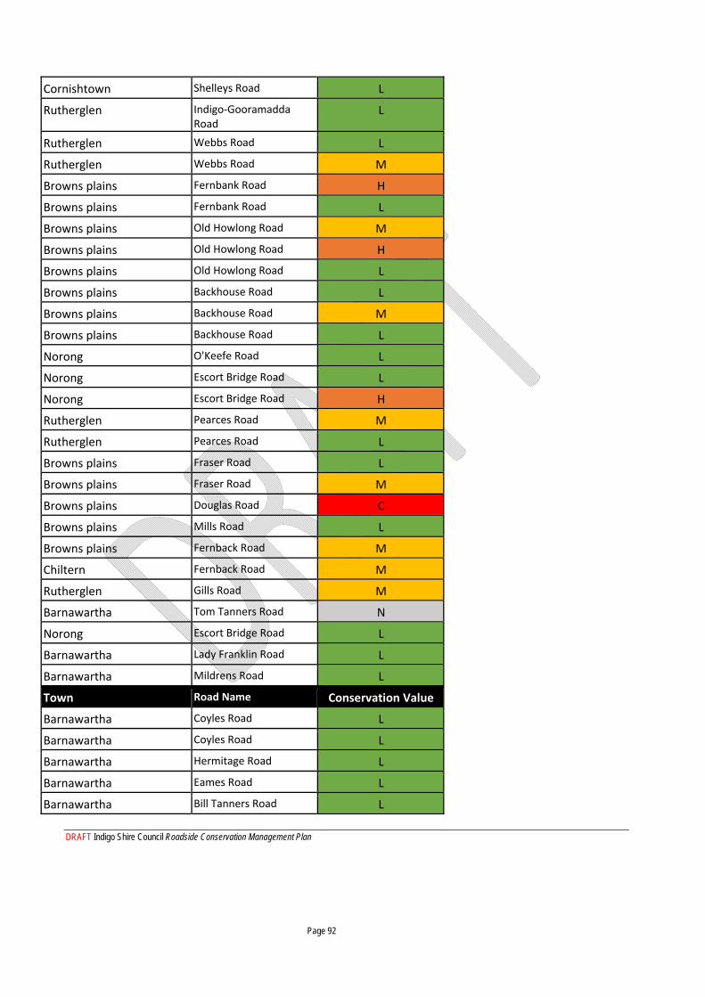
DRAFT Indigo Shire Council Roadside Conservation Management Plan Page 92
Cornishtown Shelleys Road L
Rutherglen Indigo‐Gooramadda Road
L
Rutherglen Webbs Road L
Rutherglen Webbs Road M
Browns plains Fernbank Road H
Browns plains Fernbank Road L
Browns plains Old Howlong Road M
Browns plains Old Howlong Road H
Browns plains Old Howlong Road L
Browns plains Backhouse Road L
Browns plains Backhouse Road M
Browns plains Backhouse Road L
Norong O'Keefe Road L
Norong Escort Bridge Road L
Norong Escort Bridge Road H
Rutherglen Pearces Road M
Rutherglen Pearces Road L
Browns plains Fraser Road L
Browns plains Fraser Road M
Browns plains Douglas Road C
Browns plains Mills Road L
Browns plains Fernback Road M
Chiltern Fernback Road M
Rutherglen Gills Road M
Barnawartha Tom Tanners Road N
Norong Escort Bridge Road L
Barnawartha Lady Franklin Road L
Barnawartha Mildrens Road L
Town Road Name Conservation Value
Barnawartha Coyles Road L
Barnawartha Coyles Road L
Barnawartha Hermitage Road L
Barnawartha Eames Road L
Barnawartha Bill Tanners Road L
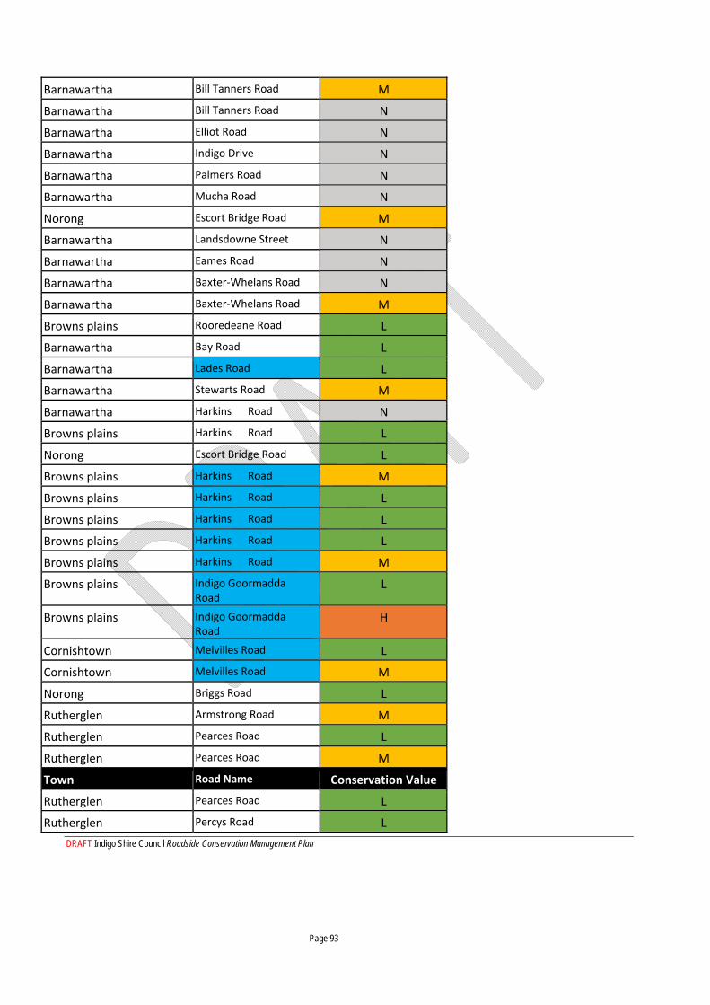
DRAFT Indigo Shire Council Roadside Conservation Management Plan Page 93
Barnawartha Bill Tanners Road M
Barnawartha Bill Tanners Road N
Barnawartha Elliot Road N
Barnawartha Indigo Drive N
Barnawartha Palmers Road N
Barnawartha Mucha Road N
Norong Escort Bridge Road M
Barnawartha Landsdowne Street N
Barnawartha Eames Road N
Barnawartha Baxter‐Whelans Road N
Barnawartha Baxter‐Whelans Road M
Browns plains Rooredeane Road L
Barnawartha Bay Road L
Barnawartha Lades Road L
Barnawartha Stewarts Road M
Barnawartha Harkins Road N
Browns plains Harkins Road L
Norong Escort Bridge Road L
Browns plains Harkins Road M
Browns plains Harkins Road L
Browns plains Harkins Road L
Browns plains Harkins Road L
Browns plains Harkins Road M
Browns plains Indigo Goormadda Road
L
Browns plains Indigo Goormadda Road
H
Cornishtown Melvilles Road L
Cornishtown Melvilles Road M
Norong Briggs Road L
Rutherglen Armstrong Road M
Rutherglen Pearces Road L
Rutherglen Pearces Road M
Town Road Name Conservation Value
Rutherglen Pearces Road L
Rutherglen Percys Road L
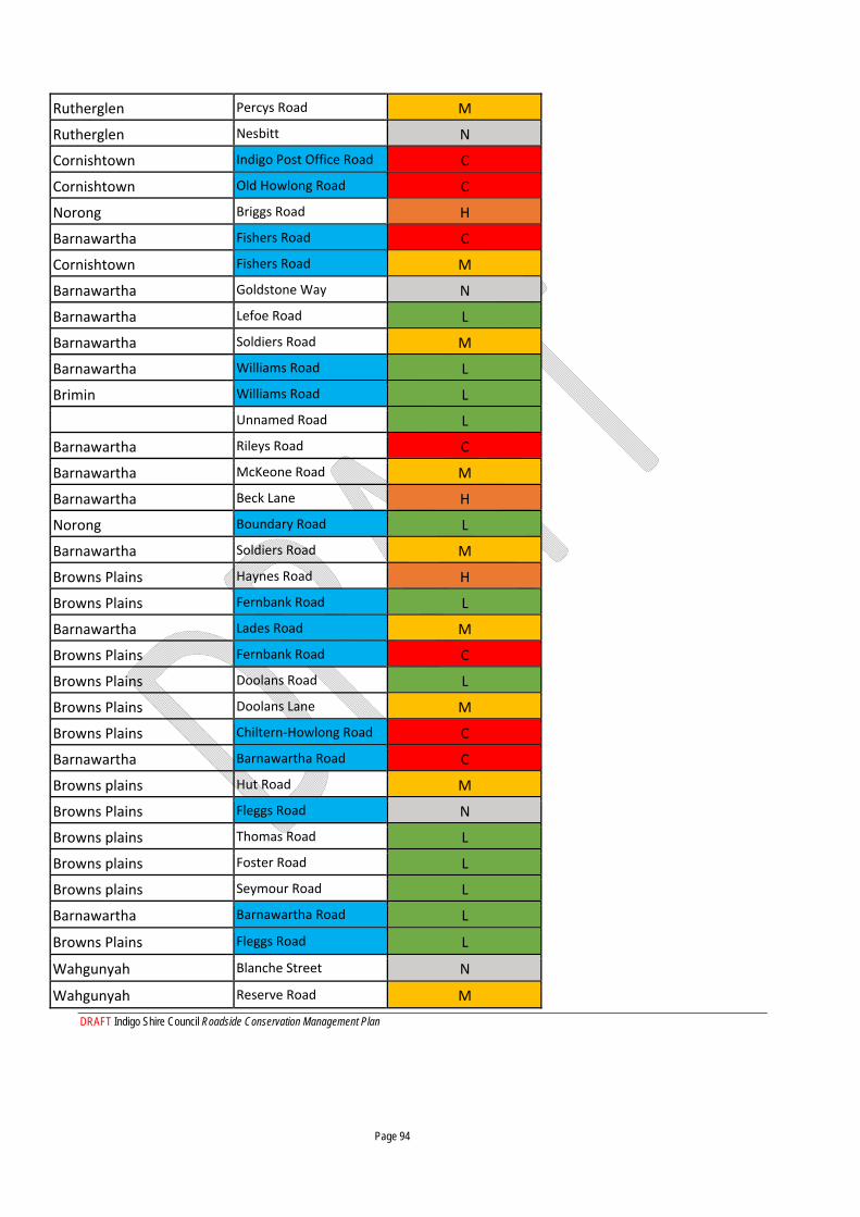
DRAFT Indigo Shire Council Roadside Conservation Management Plan Page 94
Rutherglen Percys Road M
Rutherglen Nesbitt N
Cornishtown Indigo Post Office Road C
Cornishtown Old Howlong Road C
Norong Briggs Road H
Barnawartha Fishers Road C
Cornishtown Fishers Road M
Barnawartha Goldstone Way N
Barnawartha Lefoe Road L
Barnawartha Soldiers Road M
Barnawartha Williams Road L
Brimin Williams Road L
Unnamed Road L
Barnawartha Rileys Road C
Barnawartha McKeone Road M
Barnawartha Beck Lane H
Norong Boundary Road L
Barnawartha Soldiers Road M
Browns Plains Haynes Road H
Browns Plains Fernbank Road L
Barnawartha Lades Road M
Browns Plains Fernbank Road C
Browns Plains Doolans Road L
Browns Plains Doolans Lane M
Browns Plains Chiltern‐Howlong Road C
Barnawartha Barnawartha Road C
Browns plains Hut Road M
Browns Plains Fleggs Road N
Browns plains Thomas Road L
Browns plains Foster Road L
Browns plains Seymour Road L
Barnawartha Barnawartha Road L
Browns Plains Fleggs Road L
Wahgunyah Blanche Street N
Wahgunyah Reserve Road M
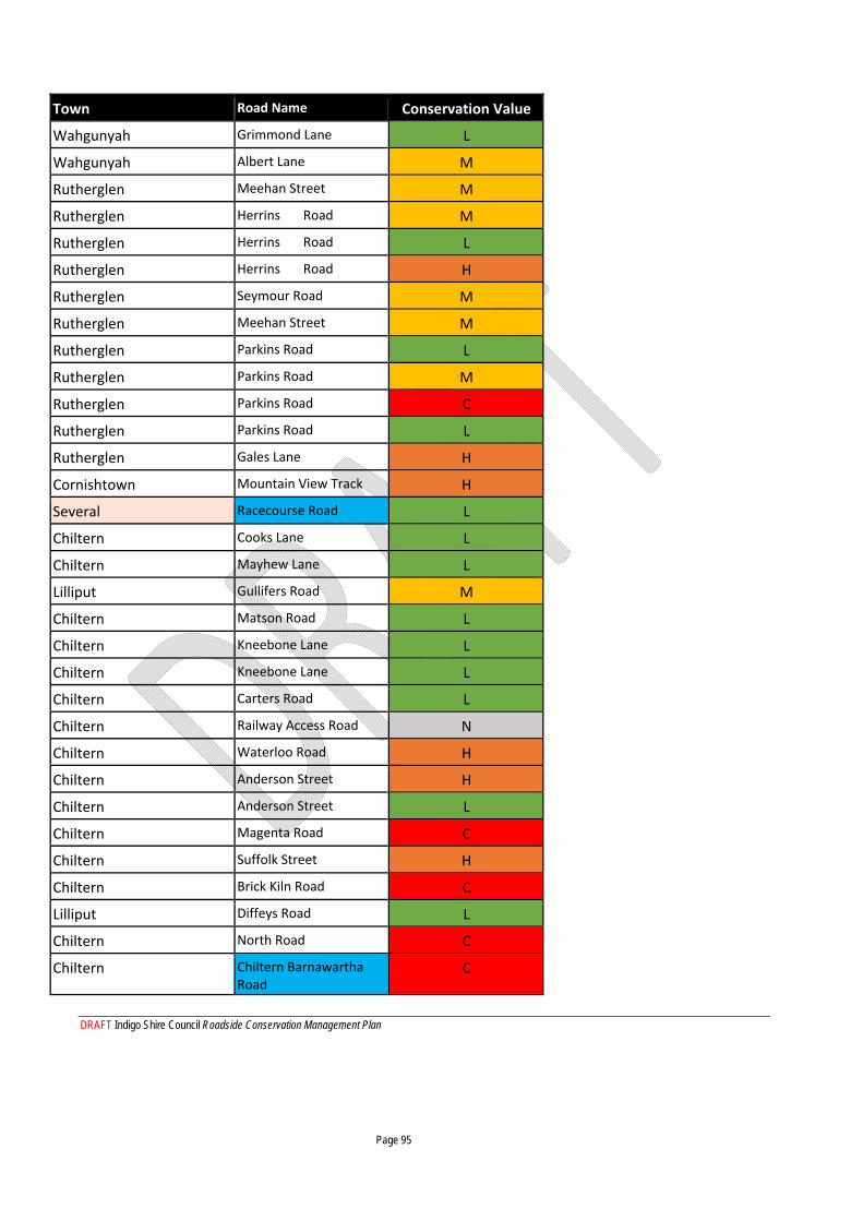
DRAFT Indigo Shire Council Roadside Conservation Management Plan Page 95
Town Road Name Conservation Value
Wahgunyah Grimmond Lane L
Wahgunyah Albert Lane M
Rutherglen Meehan Street M
Rutherglen Herrins Road M
Rutherglen Herrins Road L
Rutherglen Herrins Road H
Rutherglen Seymour Road M
Rutherglen Meehan Street M
Rutherglen Parkins Road L
Rutherglen Parkins Road M
Rutherglen Parkins Road C
Rutherglen Parkins Road L
Rutherglen Gales Lane H
Cornishtown Mountain View Track H
Several Racecourse Road L
Chiltern Cooks Lane L
Chiltern Mayhew Lane L
Lilliput Gullifers Road M
Chiltern Matson Road L
Chiltern Kneebone Lane L
Chiltern Kneebone Lane L
Chiltern Carters Road L
Chiltern Railway Access Road N
Chiltern Waterloo Road H
Chiltern Anderson Street H
Chiltern Anderson Street L
Chiltern Magenta Road C
Chiltern Suffolk Street H
Chiltern Brick Kiln Road C
Lilliput Diffeys Road L
Chiltern North Road C
Chiltern Chiltern Barnawartha Road
C
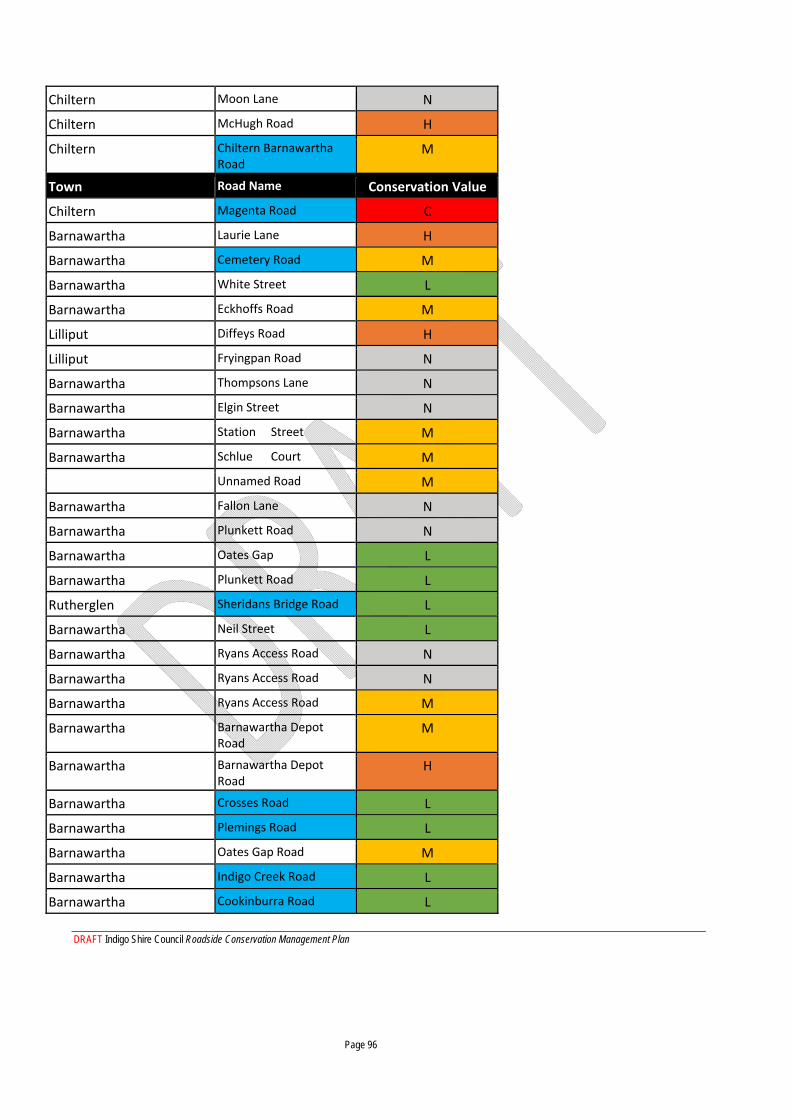
DRAFT Indigo Shire Council Roadside Conservation Management Plan Page 96
Chiltern Moon Lane N
Chiltern McHugh Road H
Chiltern Chiltern Barnawartha Road
M
Town Road Name Conservation Value
Chiltern Magenta Road C
Barnawartha Laurie Lane H
Barnawartha Cemetery Road M
Barnawartha White Street L
Barnawartha Eckhoffs Road M
Lilliput Diffeys Road H
Lilliput Fryingpan Road N
Barnawartha Thompsons Lane N
Barnawartha Elgin Street N
Barnawartha Station Street M
Barnawartha Schlue Court M
Unnamed Road M
Barnawartha Fallon Lane N
Barnawartha Plunkett Road N
Barnawartha Oates Gap L
Barnawartha Plunkett Road L
Rutherglen Sheridans Bridge Road L
Barnawartha Neil Street L
Barnawartha Ryans Access Road N
Barnawartha Ryans Access Road N
Barnawartha Ryans Access Road M
Barnawartha Barnawartha Depot Road
M
Barnawartha Barnawartha Depot Road
H
Barnawartha Crosses Road L
Barnawartha Plemings Road L
Barnawartha Oates Gap Road M
Barnawartha Indigo Creek Road L
Barnawartha Cookinburra Road L
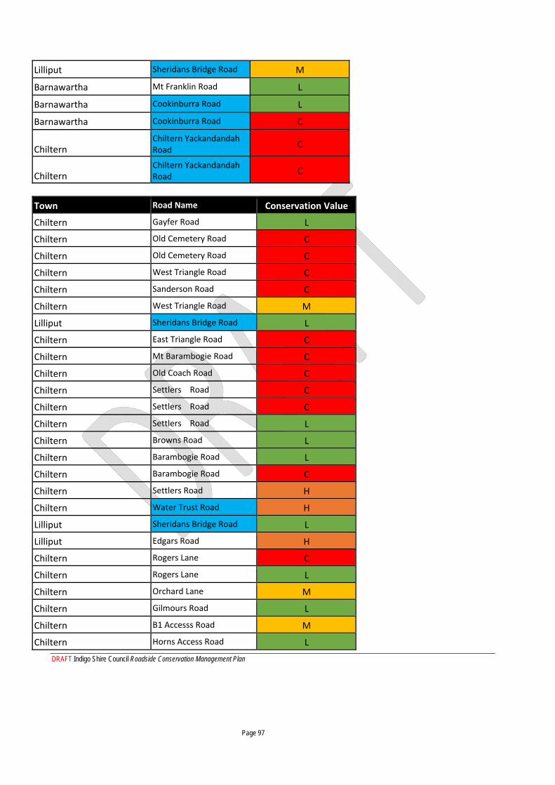
DRAFT Indigo Shire Council Roadside Conservation Management Plan Page 97
Lilliput Sheridans Bridge Road M
Barnawartha Mt Franklin Road L
Barnawartha Cookinburra Road L
Barnawartha Cookinburra Road C
Chiltern Chiltern Yackandandah Road
C
Chiltern Chiltern Yackandandah Road
C
Town Road Name Conservation Value
Chiltern Gayfer Road L
Chiltern Old Cemetery Road C
Chiltern Old Cemetery Road C
Chiltern West Triangle Road C
Chiltern Sanderson Road C
Chiltern West Triangle Road M
Lilliput Sheridans Bridge Road L
Chiltern East Triangle Road C
Chiltern Mt Barambogie Road C
Chiltern Old Coach Road C
Chiltern Settlers Road C
Chiltern Settlers Road C
Chiltern Settlers Road L
Chiltern Browns Road L
Chiltern Barambogie Road L
Chiltern Barambogie Road C
Chiltern Settlers Road H
Chiltern Water Trust Road H
Lilliput Sheridans Bridge Road L
Lilliput Edgars Road H
Chiltern Rogers Lane C
Chiltern Rogers Lane L
Chiltern Orchard Lane M
Chiltern Gilmours Road L
Chiltern B1 Accesss Road M
Chiltern Horns Access Road L
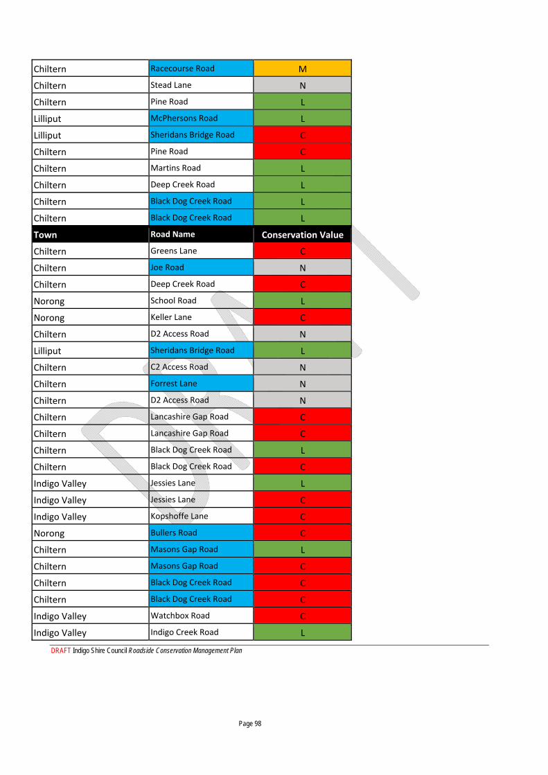
DRAFT Indigo Shire Council Roadside Conservation Management Plan Page 98
Chiltern Racecourse Road M
Chiltern Stead Lane N
Chiltern Pine Road L
Lilliput McPhersons Road L
Lilliput Sheridans Bridge Road C
Chiltern Pine Road C
Chiltern Martins Road L
Chiltern Deep Creek Road L
Chiltern Black Dog Creek Road L
Chiltern Black Dog Creek Road L
Town Road Name Conservation Value
Chiltern Greens Lane C
Chiltern Joe Road N
Chiltern Deep Creek Road C
Norong School Road L
Norong Keller Lane C
Chiltern D2 Access Road N
Lilliput Sheridans Bridge Road L
Chiltern C2 Access Road N
Chiltern Forrest Lane N
Chiltern D2 Access Road N
Chiltern Lancashire Gap Road C
Chiltern Lancashire Gap Road C
Chiltern Black Dog Creek Road L
Chiltern Black Dog Creek Road C
Indigo Valley Jessies Lane L
Indigo Valley Jessies Lane C
Indigo Valley Kopshoffe Lane C
Norong Bullers Road C
Chiltern Masons Gap Road L
Chiltern Masons Gap Road C
Chiltern Black Dog Creek Road C
Chiltern Black Dog Creek Road C
Indigo Valley Watchbox Road C
Indigo Valley Indigo Creek Road L
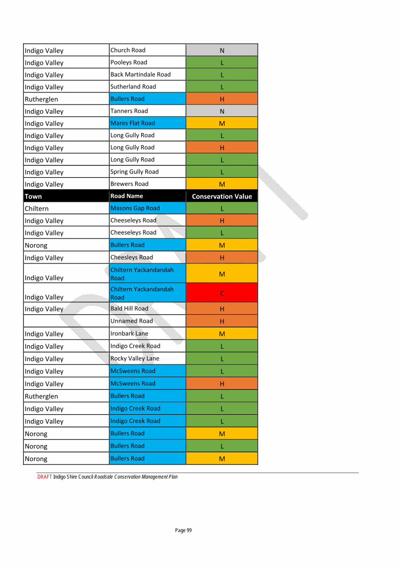
DRAFT Indigo Shire Council Roadside Conservation Management Plan Page 99
Indigo Valley Church Road N
Indigo Valley Pooleys Road L
Indigo Valley Back Martindale Road L
Indigo Valley Sutherland Road L
Rutherglen Bullers Road H
Indigo Valley Tanners Road N
Indigo Valley Mares Flat Road M
Indigo Valley Long Gully Road L
Indigo Valley Long Gully Road H
Indigo Valley Long Gully Road L
Indigo Valley Spring Gully Road L
Indigo Valley Brewers Road M
Town Road Name Conservation Value
Chiltern Masons Gap Road L
Indigo Valley Cheeseleys Road H
Indigo Valley Cheeseleys Road L
Norong Bullers Road M
Indigo Valley Cheesleys Road H
Indigo Valley Chiltern Yackandandah Road
M
Indigo Valley Chiltern Yackandandah Road
C
Indigo Valley Bald Hill Road H
Unnamed Road H
Indigo Valley Ironbark Lane M
Indigo Valley Indigo Creek Road L
Indigo Valley Rocky Valley Lane L
Indigo Valley McSweens Road L
Indigo Valley McSweens Road H
Rutherglen Bullers Road L
Indigo Valley Indigo Creek Road L
Indigo Valley Indigo Creek Road L
Norong Bullers Road M
Norong Bullers Road L
Norong Bullers Road M
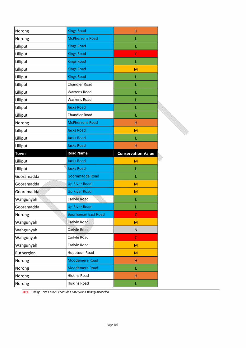
DRAFT Indigo Shire Council Roadside Conservation Management Plan Page 100
Norong Kings Road H
Norong McPhersons Road L
Lilliput Kings Road L
Lilliput Kings Road C
Lilliput Kings Road L
Lilliput Kings Road M
Lilliput Kings Road L
Lilliput Chandler Road L
Lilliput Warrens Road L
Lilliput Warrens Road L
Lilliput Jacks Road L
Lilliput Chandler Road L
Norong McPhersons Road H
Lilliput Jacks Road M
Lilliput Jacks Road L
Lilliput Jacks Road H
Town Road Name Conservation Value
Lilliput Jacks Road M
Lilliput Jacks Road L
Gooramadda Gooramadda Road L
Gooramadda Up River Road M
Gooramadda Up River Road M
Wahgunyah Carlyle Road L
Gooramadda Up River Road L
Norong Boorhaman East Road C
Wahgunyah Carlyle Road M
Wahgunyah Carlyle Road N
Wahgunyah Carlyle Road C
Wahgunyah Carlyle Road M
Rutherglen Hopetoun Road M
Norong Moodemere Road H
Norong Moodemere Road L
Norong Hiskins Road H
Norong Hiskins Road L
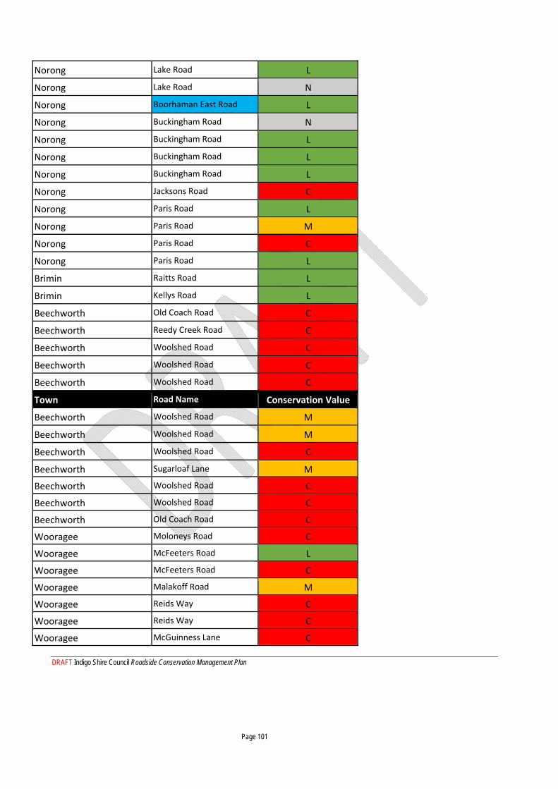
DRAFT Indigo Shire Council Roadside Conservation Management Plan Page 101
Norong Lake Road L
Norong Lake Road N
Norong Boorhaman East Road L
Norong Buckingham Road N
Norong Buckingham Road L
Norong Buckingham Road L
Norong Buckingham Road L
Norong Jacksons Road C
Norong Paris Road L
Norong Paris Road M
Norong Paris Road C
Norong Paris Road L
Brimin Raitts Road L
Brimin Kellys Road L
Beechworth Old Coach Road C
Beechworth Reedy Creek Road C
Beechworth Woolshed Road C
Beechworth Woolshed Road C
Beechworth Woolshed Road C
Town Road Name Conservation Value
Beechworth Woolshed Road M
Beechworth Woolshed Road M
Beechworth Woolshed Road C
Beechworth Sugarloaf Lane M
Beechworth Woolshed Road C
Beechworth Woolshed Road C
Beechworth Old Coach Road C
Wooragee Moloneys Road C
Wooragee McFeeters Road L
Wooragee McFeeters Road C
Wooragee Malakoff Road M
Wooragee Reids Way C
Wooragee Reids Way C
Wooragee McGuinness Lane C
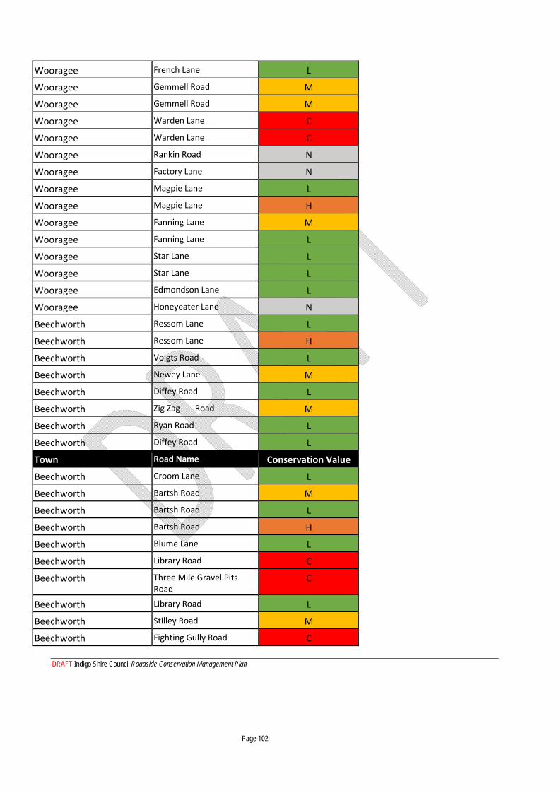
DRAFT Indigo Shire Council Roadside Conservation Management Plan Page 102
Wooragee French Lane L
Wooragee Gemmell Road M
Wooragee Gemmell Road M
Wooragee Warden Lane C
Wooragee Warden Lane C
Wooragee Rankin Road N
Wooragee Factory Lane N
Wooragee Magpie Lane L
Wooragee Magpie Lane H
Wooragee Fanning Lane M
Wooragee Fanning Lane L
Wooragee Star Lane L
Wooragee Star Lane L
Wooragee Edmondson Lane L
Wooragee Honeyeater Lane N
Beechworth Ressom Lane L
Beechworth Ressom Lane H
Beechworth Voigts Road L
Beechworth Newey Lane M
Beechworth Diffey Road L
Beechworth Zig Zag Road M
Beechworth Ryan Road L
Beechworth Diffey Road L
Town Road Name Conservation Value
Beechworth Croom Lane L
Beechworth Bartsh Road M
Beechworth Bartsh Road L
Beechworth Bartsh Road H
Beechworth Blume Lane L
Beechworth Library Road C
Beechworth Three Mile Gravel Pits Road
C
Beechworth Library Road L
Beechworth Stilley Road M
Beechworth Fighting Gully Road C
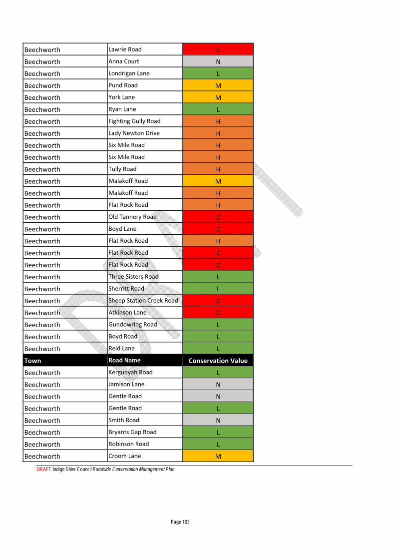
DRAFT Indigo Shire Council Roadside Conservation Management Plan Page 103
Beechworth Lawrie Road C
Beechworth Anna Court N
Beechworth Londrigan Lane L
Beechworth Pund Road M
Beechworth York Lane M
Beechworth Ryan Lane L
Beechworth Fighting Gully Road H
Beechworth Lady Newton Drive H
Beechworth Six Mile Road H
Beechworth Six Mile Road H
Beechworth Tully Road H
Beechworth Malakoff Road M
Beechworth Malakoff Road H
Beechworth Flat Rock Road H
Beechworth Old Tannery Road C
Beechworth Boyd Lane C
Beechworth Flat Rock Road H
Beechworth Flat Rock Road C
Beechworth Flat Rock Road C
Beechworth Three Sisters Road L
Beechworth Sherritt Road L
Beechworth Sheep Station Creek Road C
Beechworth Atkinson Lane C
Beechworth Gundowring Road L
Beechworth Boyd Road L
Beechworth Reid Lane L
Town Road Name Conservation Value
Beechworth Kergunyah Road L
Beechworth Jamison Lane N
Beechworth Gentle Road N
Beechworth Gentle Road L
Beechworth Smith Road N
Beechworth Bryants Gap Road L
Beechworth Robinson Road L
Beechworth Croom Lane M
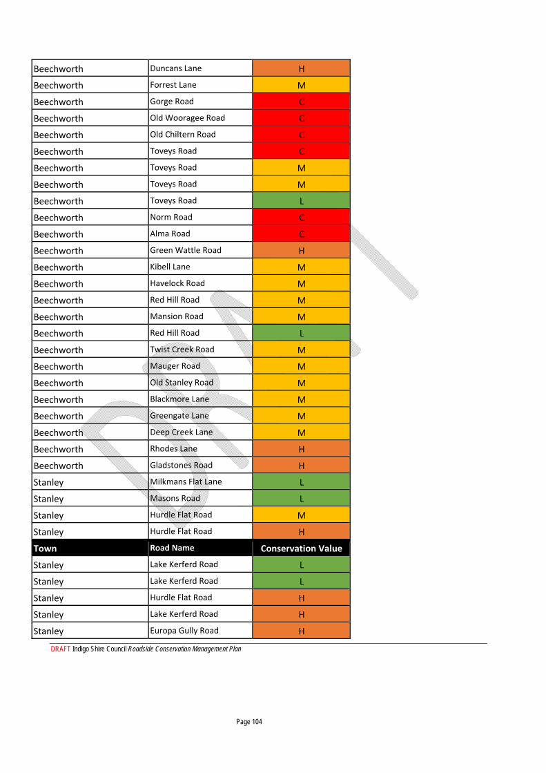
DRAFT Indigo Shire Council Roadside Conservation Management Plan Page 104
Beechworth Duncans Lane H
Beechworth Forrest Lane M
Beechworth Gorge Road C
Beechworth Old Wooragee Road C
Beechworth Old Chiltern Road C
Beechworth Toveys Road C
Beechworth Toveys Road M
Beechworth Toveys Road M
Beechworth Toveys Road L
Beechworth Norm Road C
Beechworth Alma Road C
Beechworth Green Wattle Road H
Beechworth Kibell Lane M
Beechworth Havelock Road M
Beechworth Red Hill Road M
Beechworth Mansion Road M
Beechworth Red Hill Road L
Beechworth Twist Creek Road M
Beechworth Mauger Road M
Beechworth Old Stanley Road M
Beechworth Blackmore Lane M
Beechworth Greengate Lane M
Beechworth Deep Creek Lane M
Beechworth Rhodes Lane H
Beechworth Gladstones Road H
Stanley Milkmans Flat Lane L
Stanley Masons Road L
Stanley Hurdle Flat Road M
Stanley Hurdle Flat Road H
Town Road Name Conservation Value
Stanley Lake Kerferd Road L
Stanley Lake Kerferd Road L
Stanley Hurdle Flat Road H
Stanley Lake Kerferd Road H
Stanley Europa Gully Road H

DRAFT Indigo Shire Council Roadside Conservation Management Plan Page 105
Stanley Pioneer Road M
Stanley Six Mile Road M
Stanley Flagstaff Road M
Stanley Little Scotland Road H
Stanley Little Scotland Road L
Stanley Thompson Lane L
Stanley O'Neil Road L
Stanley Griffiths Lane H
Stanley Cook Lane M
Stanley Johnson Road L
Stanley Cartin Road M
Stanley Sinclair Road M
Stanley Sinclair Road L
Stanley Johnson Road H
Stanley Chambeyron Road L
Stanley Chambeyron Road H
Stanley Hibberson Road L
Stanley Sandy Creek Road L
Stanley Sandy Creek Road M
Stanley Sandy Creek Road L
Stanley Egan Lane L
Stanley Turner Lane L
Stanley O'Dells Lane L
Stanley McClures Lane L
Stanley Schultz Lane N
Stanley O'Neill Lane N
Stanley McGrath Lane N
Stanley Springvale Lane N
Stanley Simpson Road N
Stanley Jarvis Lane L
Stanley Lumby Lane N
Stanley Cogdell Lane N
Town Road Name Conservation Value
Stanley Hellhole Creek Road L
Stanley Hellhole Creek Road C
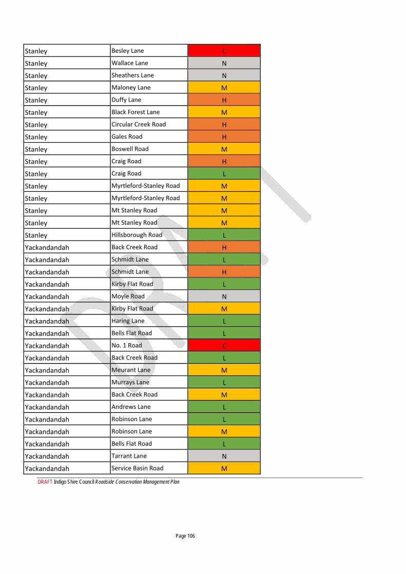
DRAFT Indigo Shire Council Roadside Conservation Management Plan Page 106
Stanley Besley Lane C
Stanley Wallace Lane N
Stanley Sheathers Lane N
Stanley Maloney Lane M
Stanley Duffy Lane H
Stanley Black Forest Lane M
Stanley Circular Creek Road H
Stanley Gales Road H
Stanley Boswell Road M
Stanley Craig Road H
Stanley Craig Road L
Stanley Myrtleford‐Stanley Road M
Stanley Myrtleford‐Stanley Road M
Stanley Mt Stanley Road M
Stanley Mt Stanley Road M
Stanley Hillsborough Road L
Yackandandah Back Creek Road H
Yackandandah Schmidt Lane L
Yackandandah Schmidt Lane H
Yackandandah Kirby Flat Road L
Yackandandah Moyle Road N
Yackandandah Kirby Flat Road M
Yackandandah Haring Lane L
Yackandandah Bells Flat Road L
Yackandandah No. 1 Road C
Yackandandah Back Creek Road L
Yackandandah Meurant Lane M
Yackandandah Murrays Lane L
Yackandandah Back Creek Road M
Yackandandah Andrews Lane L
Yackandandah Robinson Lane L
Yackandandah Robinson Lane M
Yackandandah Bells Flat Road L
Yackandandah Tarrant Lane N
Yackandandah Service Basin Road M
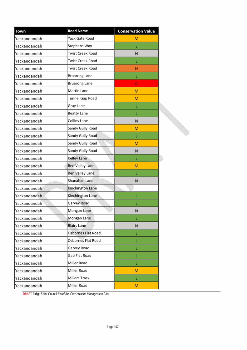
DRAFT Indigo Shire Council Roadside Conservation Management Plan Page 107
Town Road Name Conservation Value
Yackandandah Yack Gate Road M
Yackandandah Stephens Way L
Yackandandah Twist Creek Road N
Yackandandah Twist Creek Road L
Yackandandah Twist Creek Road H
Yackandandah Bruarong Lane L
Yackandandah Bruarong Lane C
Yackandandah Martin Lane M
Yackandandah Tunnel Gap Road M
Yackandandah Gray Lane L
Yackandandah Beatty Lane L
Yackandandah Collins Lane N
Yackandandah Sandy Gully Road M
Yackandandah Sandy Gully Road L
Yackandandah Sandy Gully Road M
Yackandandah Sandy Gully Road N
Yackandandah Kelley Lane L
Yackandandah Ben Valley Lane M
Yackandandah Ben Valley Lane L
Yackandandah Shanahan Lane N
Yackandandah Kinchington Lane
Yackandandah Kinchington Lane L
Yackandandah Garvey Road L
Yackandandah Mongan Lane N
Yackandandah Mongan Lane L
Yackandandah Blairs Lane N
Yackandandah Osbornes Flat Road L
Yackandandah Osbornes Flat Road L
Yackandandah Garvey Road L
Yackandandah Gap Flat Road L
Yackandandah Miller Road L
Yackandandah Miller Road M
Yackandandah Millers Track L
Yackandandah Miller Road M
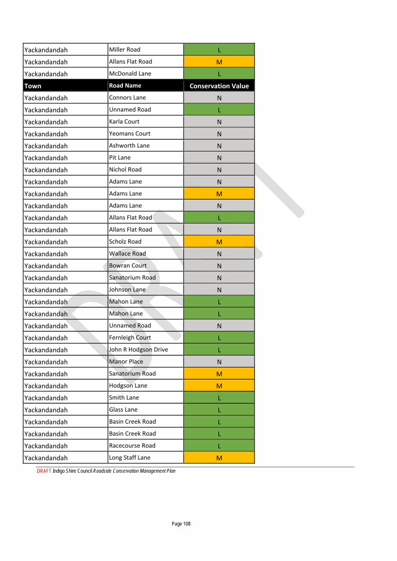
DRAFT Indigo Shire Council Roadside Conservation Management Plan Page 108
Yackandandah Miller Road L
Yackandandah Allans Flat Road M
Yackandandah McDonald Lane L
Town Road Name Conservation Value
Yackandandah Connors Lane N
Yackandandah Unnamed Road L
Yackandandah Karla Court N
Yackandandah Yeomans Court N
Yackandandah Ashworth Lane N
Yackandandah Pit Lane N
Yackandandah Nichol Road N
Yackandandah Adams Lane N
Yackandandah Adams Lane M
Yackandandah Adams Lane N
Yackandandah Allans Flat Road L
Yackandandah Allans Flat Road N
Yackandandah Scholz Road M
Yackandandah Wallace Road N
Yackandandah Bowran Court N
Yackandandah Sanatorium Road N
Yackandandah Johnson Lane N
Yackandandah Mahon Lane L
Yackandandah Mahon Lane L
Yackandandah Unnamed Road N
Yackandandah Fernleigh Court L
Yackandandah John R Hodgson Drive L
Yackandandah Manor Place N
Yackandandah Sanatorium Road M
Yackandandah Hodgson Lane M
Yackandandah Smith Lane L
Yackandandah Glass Lane L
Yackandandah Basin Creek Road L
Yackandandah Basin Creek Road L
Yackandandah Racecourse Road L
Yackandandah Long Staff Lane M
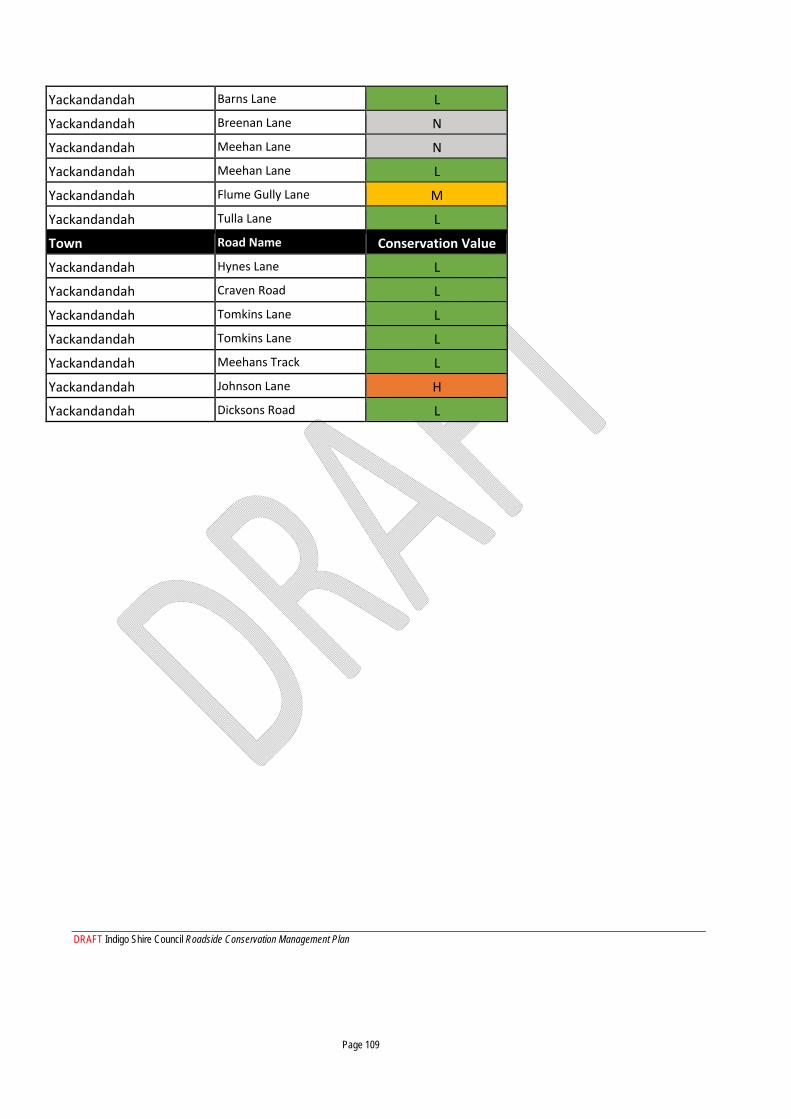
DRAFT Indigo Shire Council Roadside Conservation Management Plan Page 109
Yackandandah Barns Lane L
Yackandandah Breenan Lane N
Yackandandah Meehan Lane N
Yackandandah Meehan Lane L
Yackandandah Flume Gully Lane M
Yackandandah Tulla Lane L
Town Road Name Conservation Value
Yackandandah Hynes Lane L
Yackandandah Craven Road L
Yackandandah Tomkins Lane L
Yackandandah Tomkins Lane L
Yackandandah Meehans Track L
Yackandandah Johnson Lane H
Yackandandah Dicksons Road L
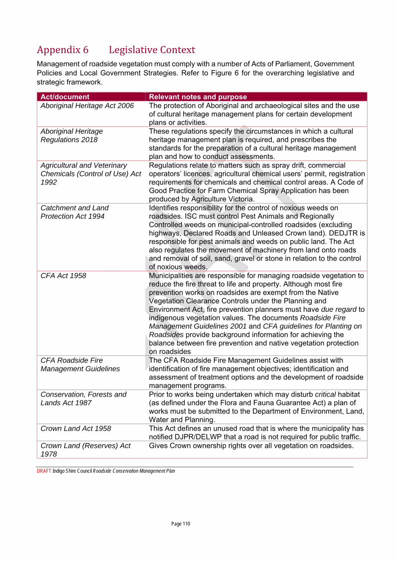
DRAFT Indigo Shire Council Roadside Conservation Management Plan Page 110
Appendix 6 Legislative Context Management of roadside vegetation must comply with a number of Acts of Parliament, Government Policies and Local Government Strategies. Refer to Figure 6 for the overarching legislative and strategic framework.
Act/document Relevant notes and purpose Aboriginal Heritage Act 2006
The protection of Aboriginal and archaeological sites and the use of cultural heritage management plans for certain development plans or activities.
Aboriginal Heritage Regulations 2018
These regulations specify the circumstances in which a cultural heritage management plan is required, and prescribes the standards for the preparation of a cultural heritage management plan and how to conduct assessments.
Agricultural and Veterinary Chemicals (Control of Use) Act 1992
Regulations relate to matters such as spray drift, commercial operators’ licences, agricultural chemical users’ permit, registration requirements for chemicals and chemical control areas. A Code of Good Practice for Farm Chemical Spray Application has been produced by Agriculture Victoria.
Catchment and Land Protection Act 1994
Identifies responsibility for the control of noxious weeds on roadsides. ISC must control Pest Animals and Regionally Controlled weeds on municipal-controlled roadsides (excluding highways, Declared Roads and Unleased Crown land). DEDJTR is responsible for pest animals and weeds on public land. The Act also regulates the movement of machinery from land onto roads and removal of soil, sand, gravel or stone in relation to the control of noxious weeds.
CFA Act 1958
Municipalities are responsible for managing roadside vegetation to reduce the fire threat to life and property. Although most fire prevention works on roadsides are exempt from the Native Vegetation Clearance Controls under the Planning and Environment Act, fire prevention planners must have due regard to indigenous vegetation values. The documents Roadside Fire Management Guidelines 2001 and CFA guidelines for Planting on Roadsides provide background information for achieving the balance between fire prevention and native vegetation protection on roadsides
CFA Roadside Fire Management Guidelines
The CFA Roadside Fire Management Guidelines assist with identification of fire management objectives; identification and assessment of treatment options and the development of roadside management programs.
Conservation, Forests and Lands Act 1987
Prior to works being undertaken which may disturb critical habitat (as defined under the Flora and Fauna Guarantee Act) a plan of works must be submitted to the Department of Environment, Land, Water and Planning.
Crown Land Act 1958
This Act defines an unused road that is where the municipality has notified DJPR/DELWP that a road is not required for public traffic.
Crown Land (Reserves) Act 1978
Gives Crown ownership rights over all vegetation on roadsides.
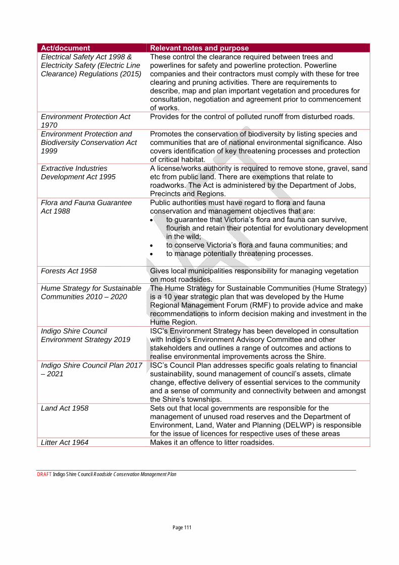
DRAFT Indigo Shire Council Roadside Conservation Management Plan Page 111
Act/document Relevant notes and purpose Electrical Safety Act 1998 & Electricity Safety (Electric Line Clearance) Regulations (2015)
These control the clearance required between trees and powerlines for safety and powerline protection. Powerline companies and their contractors must comply with these for tree clearing and pruning activities. There are requirements to describe, map and plan important vegetation and procedures for consultation, negotiation and agreement prior to commencement of works.
Environment Protection Act 1970
Provides for the control of polluted runoff from disturbed roads.
Environment Protection and Biodiversity Conservation Act 1999
Promotes the conservation of biodiversity by listing species and communities that are of national environmental significance. Also covers identification of key threatening processes and protection of critical habitat.
Extractive Industries Development Act 1995
A license/works authority is required to remove stone, gravel, sand etc from public land. There are exemptions that relate to roadworks. The Act is administered by the Department of Jobs, Precincts and Regions.
Flora and Fauna Guarantee Act 1988
Public authorities must have regard to flora and fauna conservation and management objectives that are: to guarantee that Victoria’s flora and fauna can survive,
flourish and retain their potential for evolutionary development in the wild;
to conserve Victoria’s flora and fauna communities; and to manage potentially threatening processes.
Forests Act 1958
Gives local municipalities responsibility for managing vegetation on most roadsides.
Hume Strategy for Sustainable Communities 2010 – 2020
The Hume Strategy for Sustainable Communities (Hume Strategy) is a 10 year strategic plan that was developed by the Hume Regional Management Forum (RMF) to provide advice and make recommendations to inform decision making and investment in the Hume Region.
Indigo Shire Council Environment Strategy 2019
ISC’s Environment Strategy has been developed in consultation with Indigo’s Environment Advisory Committee and other stakeholders and outlines a range of outcomes and actions to realise environmental improvements across the Shire.
Indigo Shire Council Plan 2017 – 2021
ISC’s Council Plan addresses specific goals relating to financial sustainability, sound management of council’s assets, climate change, effective delivery of essential services to the community and a sense of community and connectivity between and amongst the Shire’s townships.
Land Act 1958
Sets out that local governments are responsible for the management of unused road reserves and the Department of Environment, Land, Water and Planning (DELWP) is responsible for the issue of licences for respective uses of these areas
Litter Act 1964 Makes it an offence to litter roadsides.
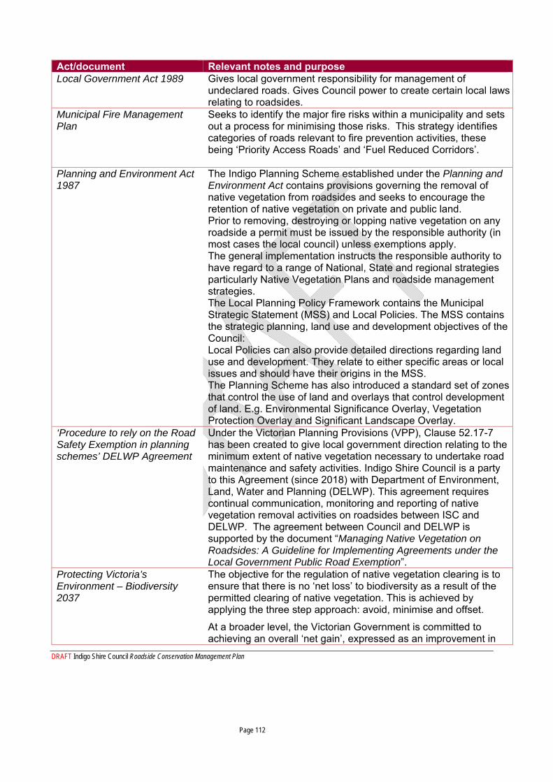
DRAFT Indigo Shire Council Roadside Conservation Management Plan Page 112
Act/document Relevant notes and purpose Local Government Act 1989
Gives local government responsibility for management of undeclared roads. Gives Council power to create certain local laws relating to roadsides.
Municipal Fire Management Plan
Seeks to identify the major fire risks within a municipality and sets out a process for minimising those risks. This strategy identifies categories of roads relevant to fire prevention activities, these being ‘Priority Access Roads’ and ‘Fuel Reduced Corridors’.
Planning and Environment Act 1987
The Indigo Planning Scheme established under the Planning and Environment Act contains provisions governing the removal of native vegetation from roadsides and seeks to encourage the retention of native vegetation on private and public land. Prior to removing, destroying or lopping native vegetation on any roadside a permit must be issued by the responsible authority (in most cases the local council) unless exemptions apply. The general implementation instructs the responsible authority to have regard to a range of National, State and regional strategies particularly Native Vegetation Plans and roadside management strategies. The Local Planning Policy Framework contains the Municipal Strategic Statement (MSS) and Local Policies. The MSS contains the strategic planning, land use and development objectives of the Council: Local Policies can also provide detailed directions regarding land use and development. They relate to either specific areas or local issues and should have their origins in the MSS. The Planning Scheme has also introduced a standard set of zones that control the use of land and overlays that control development of land. E.g. Environmental Significance Overlay, Vegetation Protection Overlay and Significant Landscape Overlay.
‘Procedure to rely on the Road Safety Exemption in planning schemes’ DELWP Agreement
Under the Victorian Planning Provisions (VPP), Clause 52.17-7 has been created to give local government direction relating to the minimum extent of native vegetation necessary to undertake road maintenance and safety activities. Indigo Shire Council is a party to this Agreement (since 2018) with Department of Environment, Land, Water and Planning (DELWP). This agreement requires continual communication, monitoring and reporting of native vegetation removal activities on roadsides between ISC and DELWP. The agreement between Council and DELWP is supported by the document “Managing Native Vegetation on Roadsides: A Guideline for Implementing Agreements under the Local Government Public Road Exemption”.
Protecting Victoria’s Environment – Biodiversity 2037
The objective for the regulation of native vegetation clearing is to ensure that there is no ‘net loss’ to biodiversity as a result of the permitted clearing of native vegetation. This is achieved by applying the three step approach: avoid, minimise and offset.
At a broader level, the Victorian Government is committed to achieving an overall ‘net gain’, expressed as an improvement in
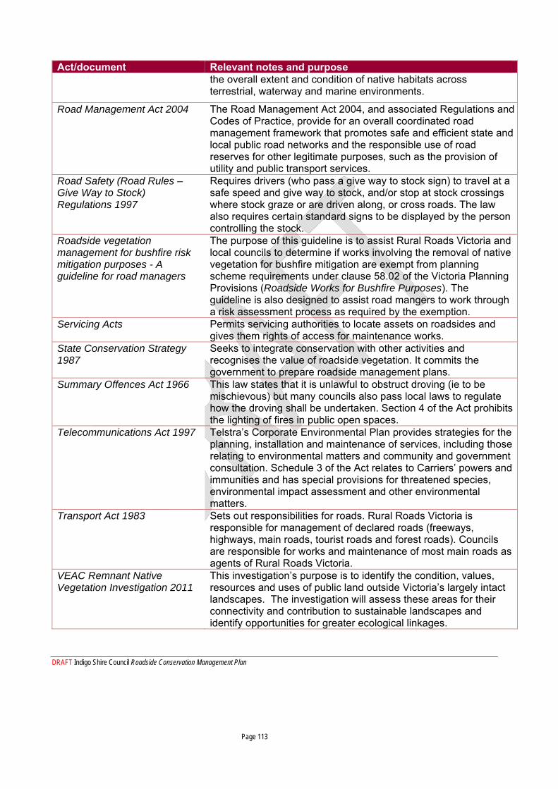
DRAFT Indigo Shire Council Roadside Conservation Management Plan Page 113
Act/document Relevant notes and purpose the overall extent and condition of native habitats across terrestrial, waterway and marine environments.
Road Management Act 2004
The Road Management Act 2004, and associated Regulations and Codes of Practice, provide for an overall coordinated road management framework that promotes safe and efficient state and local public road networks and the responsible use of road reserves for other legitimate purposes, such as the provision of utility and public transport services.
Road Safety (Road Rules – Give Way to Stock) Regulations 1997
Requires drivers (who pass a give way to stock sign) to travel at a safe speed and give way to stock, and/or stop at stock crossings where stock graze or are driven along, or cross roads. The law also requires certain standard signs to be displayed by the person controlling the stock.
Roadside vegetation management for bushfire risk mitigation purposes - A guideline for road managers
The purpose of this guideline is to assist Rural Roads Victoria and local councils to determine if works involving the removal of native vegetation for bushfire mitigation are exempt from planning scheme requirements under clause 58.02 of the Victoria Planning Provisions (Roadside Works for Bushfire Purposes). The guideline is also designed to assist road mangers to work through a risk assessment process as required by the exemption.
Servicing Acts
Permits servicing authorities to locate assets on roadsides and gives them rights of access for maintenance works.
State Conservation Strategy 1987
Seeks to integrate conservation with other activities and recognises the value of roadside vegetation. It commits the government to prepare roadside management plans.
Summary Offences Act 1966
This law states that it is unlawful to obstruct droving (ie to be mischievous) but many councils also pass local laws to regulate how the droving shall be undertaken. Section 4 of the Act prohibits the lighting of fires in public open spaces.
Telecommunications Act 1997
Telstra’s Corporate Environmental Plan provides strategies for the planning, installation and maintenance of services, including those relating to environmental matters and community and government consultation. Schedule 3 of the Act relates to Carriers’ powers and immunities and has special provisions for threatened species, environmental impact assessment and other environmental matters.
Transport Act 1983
Sets out responsibilities for roads. Rural Roads Victoria is responsible for management of declared roads (freeways, highways, main roads, tourist roads and forest roads). Councils are responsible for works and maintenance of most main roads as agents of Rural Roads Victoria.
VEAC Remnant Native Vegetation Investigation 2011
This investigation’s purpose is to identify the condition, values, resources and uses of public land outside Victoria’s largely intact landscapes. The investigation will assess these areas for their connectivity and contribution to sustainable landscapes and identify opportunities for greater ecological linkages.
DRAFT Indigo Shire Council Roadside Conservation Management Plan Page 114
Act/document Relevant notes and purpose VEAC River Red Gum Investigation 2008
The report contains complete details of the Investigation including all recommendations for public land use, details of public consultations and implications of the recommendations. The investigation area includes public land in Victoria from Lake Hume to the South Australian border and includes the lower reaches of the Avoca, Loddon, Campaspe, Goulburn, King, Ovens and Kiewa Rivers.
VicRoads Roadside Handbook 2006
An environmental guide for road construction and maintenance.
Victorian Firewood Strategy 2010
Victoria’s Firewood Strategy for Public Land will ensure the sustainable supply of firewood from public land for households in regional Victoria. The firewood strategy; Creates opportunities for community firewood suppliers to
supply firewood from State forest to Victorian communities Sets out a simple system for making firewood on public land
available to Victorian households Balances the needs of the environment with the needs of the
community Victorian Weeds Strategy 1999
Gives reference to the preparation of roadside management plans as a means of sharing responsibility for weed control. Other actions relate to greater enforcement provisions, self assessment procedures to reduce spread of weeds along roadsides by farm machinery and road maintenance equipment, development of regional action plans, public land management and role of local government in weed control.
Water Act 1989
Regional – Waterways Protection By-Law 2000/01
By Law No 3, By-law Implementing Drainage Management Plan for the Black Dog Creek Management District North East Regional Health Strategy.
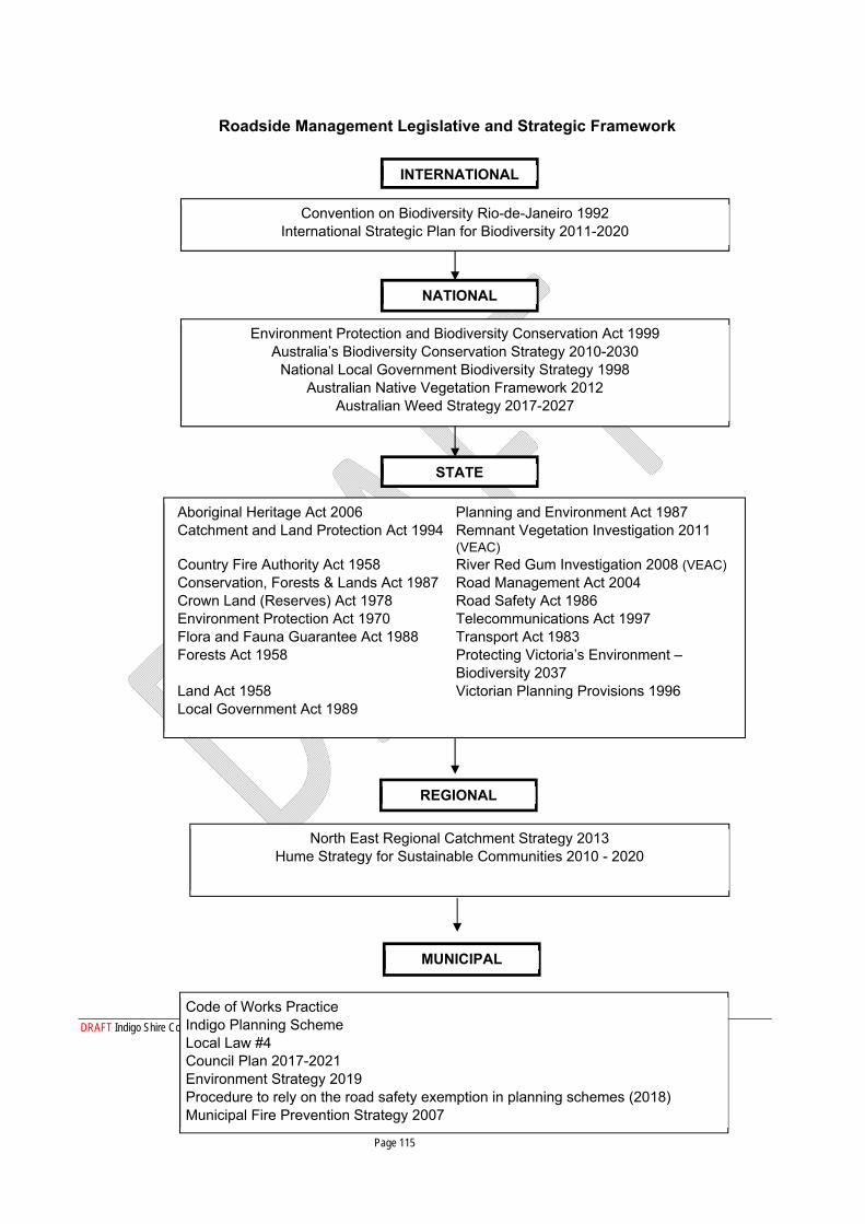
DRAFT Indigo Shire Council Roadside Conservation Management Plan Page 115
Convention on Biodiversity Rio-de-Janeiro 1992 International Strategic Plan for Biodiversity 2011-2020
INTERNATIONAL
Environment Protection and Biodiversity Conservation Act 1999 Australia’s Biodiversity Conservation Strategy 2010-2030
National Local Government Biodiversity Strategy 1998 Australian Native Vegetation Framework 2012
Australian Weed Strategy 2017-2027
NATIONAL
Aboriginal Heritage Act 2006 Planning and Environment Act 1987 Catchment and Land Protection Act 1994 Remnant Vegetation Investigation 2011
(VEAC) Country Fire Authority Act 1958 River Red Gum Investigation 2008 (VEAC) Conservation, Forests & Lands Act 1987 Road Management Act 2004 Crown Land (Reserves) Act 1978 Road Safety Act 1986 Environment Protection Act 1970 Telecommunications Act 1997 Flora and Fauna Guarantee Act 1988 Transport Act 1983 Forests Act 1958 Protecting Victoria’s Environment –
Biodiversity 2037 Land Act 1958 Victorian Planning Provisions 1996 Local Government Act 1989
STATE
North East Regional Catchment Strategy 2013 Hume Strategy for Sustainable Communities 2010 - 2020
REGIONAL
Code of Works Practice Indigo Planning Scheme Local Law #4 Council Plan 2017-2021 Environment Strategy 2019 Procedure to rely on the road safety exemption in planning schemes (2018) Municipal Fire Prevention Strategy 2007
MUNICIPAL
Roadside Management Legislative and Strategic Framework
DRAFT Indigo Shire Council Roadside Conservation Management Plan Page 116
Appendix 7 Details of specific legislation
Victorian Native Vegetation Regulations All native vegetation is protected under the Victorian Planning Provisions Clause 52.17 (see The Guidelines for the removal, destruction or lopping of native vegetation, 2017) unless specific exemptions apply.
A brief description of this legislation is as follows:
the term ‘remove vegetation’ includes to destroy or to lop native vegetation, including dead vegetation, trees, shrubs, herbs and grasses;
‘native vegetation’ means vegetation native to the region including areas of grasses and shrubs, small patches (three or more trees) or scattered isolated trees;
there is a three-step approach: avoid removal where possible, minimise the impacts of removal, and provide an offset for the removal;
the Indigo Shire Council administers the planning scheme including Clause 52.17. Therefore, ISC is responsible for assessment, approvals and compliance in most cases on freehold land and Shire managed land including roadsides;
approvals are based on (but not limited to) the following factors: o conservation status of the Ecological Vegetation Class (EVC); o number of large trees; o size of patch to be removed; o presence of habitat for threated species (based on Habitat Importance Maps); o the condition of the vegetation (based on the Habitat Hectares Condition Score); o the Strategic Biodiversity Value (as mapped and assessed by DELWP);
Exemptions to requiring a permit include (but are not limited to) the following: o Removal of small dead trees (less than 40cm dbh) or logs, or lopping a tree less
than 1/3rd of its canopy (excluding the main trunk) do not require a planning permit;
o For the maintenance or replacement of an existing boundary fence, native vegetation can be cleared to a total of 4 m, or, if there is 4 m or more of already cleared land on one side (i.e. a cleared paddock), then 1 m can be cleared into the road reserve, only if necessary;
o There are further exemptions which can apply, such as the agreements with DELWP which allows roadside maintenance, and fire management (these are described below).
The Shire must keep records of the amount of vegetation that has been lopped, removed or destroyed under these agreements, for annual reporting to DELWP.
Exemptions contained in Clause 52.17 (Native Vegetation) Refer to the Exemptions from requiring a planning permit to remove, destroy or lop native vegetation – Guidance, 2017. Briefly:
DRAFT Indigo Shire Council Roadside Conservation Management Plan Page 117
Vegetation should be removed to the minimum extent possible (particularly in areas of high value – see below);
Native vegetation can only be removed for the purpose specified in the exemption; Exemptions must be used sparingly; Use a vegetation removal method that minimises impact, e.g. removing manually rather
than using machinery or chemicals; Exemptions are available for the following activities:
o For conducting conservation works, where there is overall improvement for biodiversity;
o Removing smaller dead native vegetation (<40 cm dbh); o During an emergency or where it presents an immediate risk; o Within 10 m of an existing building in Farming Zone or Rural Activity Zones only; o To maintain or replace an existing boundary fence (4 m maximum width, but
where the paddock is cleared, then only 1 m is allowed to be cleared into the road reserve if necessary);
High value native vegetation is based on the following:
Areas of large extent; Good quality vegetation (Native Vegetation Condition Map score of 0.6 or above); Strategic Biodiversity Values score of 0.8 or above; Large or hollow-bearing trees; Habitats for rare or threatened species (based on Habitat Importance Maps – see
legislation for further details); Within 30 m of a waterway; Slope of greater than 20%; In salinity or erosion risk locations; Where Aboriginal cultural values have been identified.
Exemptions contained in Clause 52.48 (Bushfire Protection)
The DELWP document Roadside vegetation management for bushfire risk mitigation purposes – a guideline for road managers states that a permit is not required when native vegetation is to be removed, destroyed or lopped to reduce fuel loads on roadsides to minimise risk to life and property from bushfire on an existing public road (LPP Clause 52.48). This exemption includes a roadside risk assessment process which is based on the CFA Roadside Fire Management Guidelines. The guidelines have four relevant objectives including;
1. Prevent or reduce the risk of fires on roadsides
2. Reduce the risk of spread of fire from the road reserve
3. Manage safety of road users
4. Provide control lines.
DRAFT Indigo Shire Council Roadside Conservation Management Plan Page 118
This fire exemption document is an agreement between ISC and DELWP and outlines the roads that are a priority for fire mitigation action. Vegetation treatments that are likely to have ‘significant environmental impacts’ require a planning permit. No permit is required to remove fallen trees or branches, fine fuels, or hazardous trees or tree limbs that may fall during a fire or maintaining access tracks, control lines or firebreaks. Fire mitigation actions cannot be taken on listed threatened ecological communities or where there are listed threatened species (Federally or State listed). If works take place within 500 m of Victorian listed species or communities, further investigations must apply.
The exemptions under this Clause allow native vegetation removal in the following situations:
When fighting a fire, Planned burning by CFA or DELWP, Keeping native vegetation clear of powerlines,
For further details refer to the Act.
Relevant documents:
2009 Victorian Bushfires Royal Commission, Letters Patent issued 16 February 2009, Roads And Roadsides Submissions Of Counsel Assisting, SUBM.800.001.0001
Applications to remove, destroy or lop native vegetation – Applicant’s Guide, 2018
Applications to remove, destroy or lop native vegetation – Assessor’s Handbook, 2018
Compliance and enforcement strategy – native vegetation removal regulations, 2017
Exemptions from requiring a planning permit to remove, destroy or lop native vegetation – Guidance, 2017
Native vegetation gain scoring manual, 2017
Procedure to rely on the road safety exemption in planning schemes, 2018
Road Management Act, 2004
Roadside vegetation management for bushfire risk mitigation purposes – a guideline for road managers, 2012
The Guidelines for the removal, destruction or lopping of native vegetation, 2017
Other relevant documents can be found on the Victorian website at https://www.environment.vic.gov.au/native‐vegetation/native‐vegetation

DRAFT Indigo Shire Council Roadside Conservation Management Plan Page 119
Cultural Heritage regulations Victoria’s heritage includes archaeological sites, buildings and structures, created landscapes and community values and beliefs.
Activities on roadsides have the potential to impact on heritage sites, therefore it is important to identify heritage sites to enable impacts to be avoided, minimised or mitigated. Cultural heritage sites can be either listed in the Victorian Cultural Heritage Register (ISC has access, not publicly available) or may be ‘discovered’ during the course of conducting an activity.
Action required
Before any works that include disturbance, consult the Victorian Cultural Heritage Register to determine if there is a registered cultural site at the location of the works.
https://w.www.vic.gov.au/aboriginalvictoria/heritage/heritage‐tools‐and‐publications/victorian‐aboriginal‐
heritage‐register.html
If there is no registered cultural heritage site, then the action can proceed (subject to other requirements). Council staff and contractors should remain vigilant to any possible cultural heritage sites that may be observed that are unregistered. Cultural sites include mounds, middens, surface scatters, tools, stone quarries, burial sites, scar trees, etc.
If a cultural heritage site is present at the location of the intended works, and the works are a high impact activity (such as building a road, bicycle track or walking track), a Cultural Heritage Management Plan will be required under the Aboriginal Heritage Act 2006. This plan will be evaluated by Registered Aboriginal Parties operating under the auspices of the Aboriginal Heritage Council. If a Cultural Heritage Management Plan is required, other statutory authorisations cannot be given before the Plan is approved
Cultural Heritage Permits are required for activities that may harm Aboriginal cultural heritage, but are not subject to a Cultural Heritage Management Plan.
Legislation
All registered and unregistered Victorian Aboriginal archaeological sites are protected by the State Aboriginal Heritage Act 2006, Aboriginal Heritage Regulations 2007 and the Commonwealth Aboriginal and Torres Strait Islander Heritage Act 1995. All Victorian historical sites are protected by the State Heritage Act 1995. These Acts prohibit the wilful destruction or disturbance of any cultural heritage site, place or object, whether on private or public land.
The Heritage Council of Victoria and the Office of Aboriginal Affairs Victoria are the Victorian State Government instrumentalities that administer these Acts. The Aboriginal Heritage Council, Office of Aboriginal Affairs Victoria, Department of Premier and Cabinet, must be advised of any proposed works that may affect Aboriginal sites, or if any new sites are located.
In consultation with the relevant Registered Aboriginal Parties, a voluntary Cultural Heritage Agreement may be prepared, which will formalise long-term cultural heritage management partnerships
DRAFT Indigo Shire Council Roadside Conservation Management Plan Page 120
Roadside workers and contractors would benefit from training to increase awareness of heritage issues and to increase recognition skills of indigenous artefacts to assist in the identification and subsequent protection of new sites.
FFG Act Threatening processes
The Flora and Fauna Guarantee Act 1988 identifies flora, fauna and vegetation communities that need specific protection, but also lists a number of threatening processes which should be avoided where possible. Threatening processes pertinent to roadside vegetation works include (but are not limited to) the following:
Habitat fragmentation as a threatening process for fauna in Victoria;
High frequency fire resulting in disruption of life cycle processes in plants and animals and loss of vegetation structure and composition;
Inappropriate fire regimes causing disruption to sustainable ecosystem processes and resultant loss of biodiversity;
Invasion of native vegetation by ‘environmental weeds’;
Loss of coarse woody debris from Victorian native forests and woodland;
Loss of hollow-bearing trees from Victorian forests.
It is a requirement under the FFG Act to require a permit to take protected flora on crown land, including roadsides.
DRAFT Indigo Shire Council Roadside Conservation Management Plan Page 121
Appendix 8 Rare and Threatened Flora in Indigo Shire
Conservation Status in Australia (AROTS – Australian Rare or Threatened Species)
National conservation status is based on the Environment Protection and Biodiversity Conservation Act 1999 (EPBC Act) list of taxa considered threatened in Australia.
EX – Extinct
CR – Critically Endangered
E – Endangered
V – Vulnerable
Conservation Status in Victoria (VROTS – Victorian Rare or Threatened Species)
x – Presumed Extinct in Victoria
e – Endangered in Victoria
v – Vulnerable in Victoria
r – Rare in Victoria
k – Poorly Known in Victoria:
L – Listed as threatened under the under the provisions of the Flora and Fauna Guarantee Act 1988 (FFG).
Botanical Name Common Name FFG AROTS VROTS Acacia deanei Deane’s Wattle r Acacia deanei ssp. Deanei Deane’s wattle L e Acacia deanei ssp. Paucijuga Deane’s Wattle r Acacia doratoxylon Currawang r Acacia lanigera var. lanigera Woolly Wattle r Acianthus collinus Hooded Mosquito-orchid L v Allocasuarina luehmannii Buloke L Amphibromus fluitans River Swamp Wallaby-
grass V k
Amyema linophylla ssp. Orientale Buloke Mistletoe v Arachnorchis concolor Crimson Spider-orchid L V e Arachnorchis patersonii s.s. Cream Spider-orchid e Aristida calycina var. calycina Dark Wire-grass r Astrotricha linearis Narrow-leaf Star-hair r
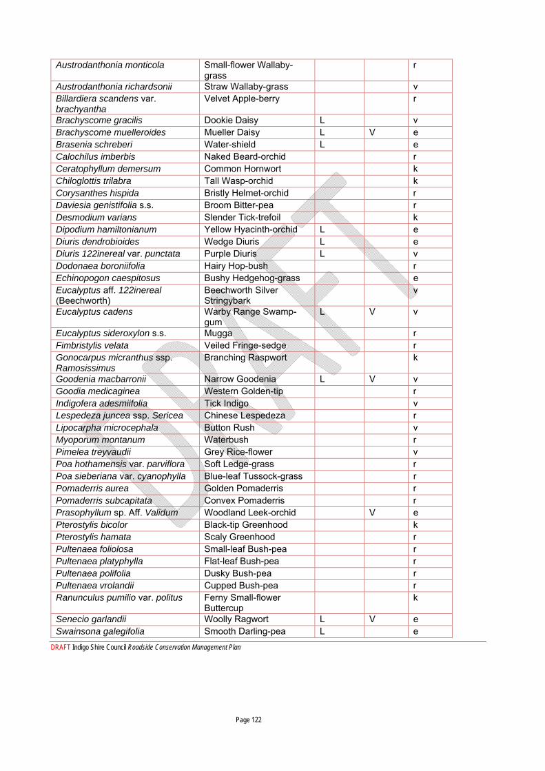
DRAFT Indigo Shire Council Roadside Conservation Management Plan Page 122
Austrodanthonia monticola Small-flower Wallaby-grass
r
Austrodanthonia richardsonii Straw Wallaby-grass v Billardiera scandens var. brachyantha
Velvet Apple-berry r
Brachyscome gracilis Dookie Daisy L v Brachyscome muelleroides Mueller Daisy L V e Brasenia schreberi Water-shield L e Calochilus imberbis Naked Beard-orchid r Ceratophyllum demersum Common Hornwort k Chiloglottis trilabra Tall Wasp-orchid k Corysanthes hispida Bristly Helmet-orchid r Daviesia genistifolia s.s. Broom Bitter-pea r Desmodium varians Slender Tick-trefoil k Dipodium hamiltonianum Yellow Hyacinth-orchid L e Diuris dendrobioides Wedge Diuris L e Diuris 122inereal var. punctata Purple Diuris L v Dodonaea boroniifolia Hairy Hop-bush r Echinopogon caespitosus Bushy Hedgehog-grass e Eucalyptus aff. 122inereal (Beechworth)
Beechworth Silver Stringybark
v
Eucalyptus cadens Warby Range Swamp-gum
L V v
Eucalyptus sideroxylon s.s. Mugga r Fimbristylis velata Veiled Fringe-sedge r Gonocarpus micranthus ssp. Ramosissimus
Branching Raspwort k
Goodenia macbarronii Narrow Goodenia L V v Goodia medicaginea Western Golden-tip r Indigofera adesmiifolia Tick Indigo v Lespedeza juncea ssp. Sericea Chinese Lespedeza r Lipocarpha microcephala Button Rush v Myoporum montanum Waterbush r Pimelea treyvaudii Grey Rice-flower v Poa hothamensis var. parviflora Soft Ledge-grass r Poa sieberiana var. cyanophylla Blue-leaf Tussock-grass r Pomaderris aurea Golden Pomaderris r Pomaderris subcapitata Convex Pomaderris r Prasophyllum sp. Aff. Validum Woodland Leek-orchid V e Pterostylis bicolor Black-tip Greenhood k Pterostylis hamata Scaly Greenhood r Pultenaea foliolosa Small-leaf Bush-pea r Pultenaea platyphylla Flat-leaf Bush-pea r Pultenaea polifolia Dusky Bush-pea r Pultenaea vrolandii Cupped Bush-pea r Ranunculus pumilio var. politus Ferny Small-flower
Buttercup k
Senecio garlandii Woolly Ragwort L V e Swainsona galegifolia Smooth Darling-pea L e

DRAFT Indigo Shire Council Roadside Conservation Management Plan Page 123
Swainsona murrayana Slender Darling-pea L V e Utricularia uniflora Single Bladderwort k Wurmbea biglandulosa ssp. Biglandulosa
Glandular Early Nancy r
Source: DELWP (b), 2007.
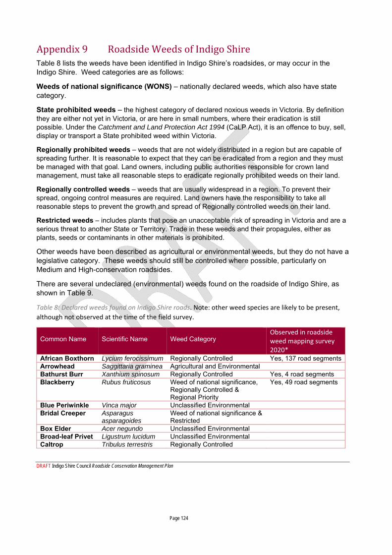
DRAFT Indigo Shire Council Roadside Conservation Management Plan Page 124
Appendix 9 Roadside Weeds of Indigo Shire Table 8 lists the weeds have been identified in Indigo Shire’s roadsides, or may occur in the Indigo Shire. Weed categories are as follows:
Weeds of national significance (WONS) – nationally declared weeds, which also have state category.
State prohibited weeds – the highest category of declared noxious weeds in Victoria. By definition they are either not yet in Victoria, or are here in small numbers, where their eradication is still possible. Under the Catchment and Land Protection Act 1994 (CaLP Act), it is an offence to buy, sell, display or transport a State prohibited weed within Victoria.
Regionally prohibited weeds – weeds that are not widely distributed in a region but are capable of spreading further. It is reasonable to expect that they can be eradicated from a region and they must be managed with that goal. Land owners, including public authorities responsible for crown land management, must take all reasonable steps to eradicate regionally prohibited weeds on their land.
Regionally controlled weeds – weeds that are usually widespread in a region. To prevent their spread, ongoing control measures are required. Land owners have the responsibility to take all reasonable steps to prevent the growth and spread of Regionally controlled weeds on their land.
Restricted weeds – includes plants that pose an unacceptable risk of spreading in Victoria and are a serious threat to another State or Territory. Trade in these weeds and their propagules, either as plants, seeds or contaminants in other materials is prohibited.
Other weeds have been described as agricultural or environmental weeds, but they do not have a legislative category. These weeds should still be controlled where possible, particularly on Medium and High-conservation roadsides.
There are several undeclared (environmental) weeds found on the roadside of Indigo Shire, as shown in Table 9.
Table 8: Declared weeds found on Indigo Shire roads. Note: other weed species are likely to be present,
although not observed at the time of the field survey.
Common Name
Scientific Name
Weed Category
Observed in roadside weed mapping survey 2020*
African Boxthorn Lycium ferocissimum Regionally Controlled Yes, 137 road segments Arrowhead Saggittaria graminea Agricultural and Environmental Bathurst Burr Xanthium spinosum Regionally Controlled Yes, 4 road segments Blackberry Rubus fruticosus Weed of national significance,
Regionally Controlled & Regional Priority
Yes, 49 road segments
Blue Periwinkle Vinca major Unclassified Environmental Bridal Creeper Asparagus
asparagoides Weed of national significance & Restricted
Box Elder Acer negundo Unclassified Environmental Broad-leaf Privet Ligustrum lucidum Unclassified Environmental Caltrop Tribulus terrestris Regionally Controlled
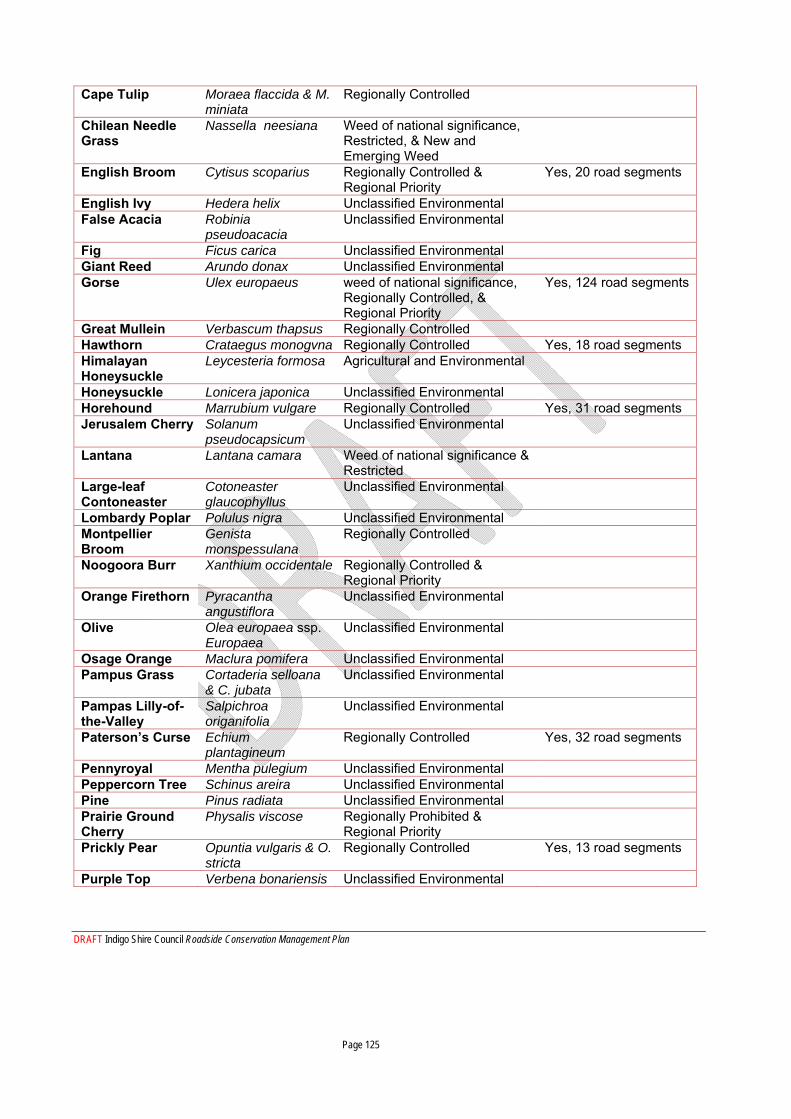
DRAFT Indigo Shire Council Roadside Conservation Management Plan Page 125
Cape Tulip Moraea flaccida & M. miniata
Regionally Controlled
Chilean Needle Grass
Nassella neesiana Weed of national significance, Restricted, & New and Emerging Weed
English Broom Cytisus scoparius Regionally Controlled & Regional Priority
Yes, 20 road segments
English Ivy Hedera helix Unclassified Environmental False Acacia Robinia
pseudoacacia Unclassified Environmental
Fig Ficus carica Unclassified Environmental Giant Reed Arundo donax Unclassified Environmental Gorse Ulex europaeus weed of national significance,
Regionally Controlled, & Regional Priority
Yes, 124 road segments
Great Mullein Verbascum thapsus Regionally Controlled Hawthorn Crataegus monogvna Regionally Controlled Yes, 18 road segments Himalayan Honeysuckle
Leycesteria formosa Agricultural and Environmental
Honeysuckle Lonicera japonica Unclassified Environmental Horehound Marrubium vulgare Regionally Controlled Yes, 31 road segments Jerusalem Cherry Solanum
pseudocapsicum Unclassified Environmental
Lantana Lantana camara Weed of national significance & Restricted
Large-leaf Contoneaster
Cotoneaster glaucophyllus
Unclassified Environmental
Lombardy Poplar Polulus nigra Unclassified Environmental Montpellier Broom
Genista monspessulana
Regionally Controlled
Noogoora Burr Xanthium occidentale Regionally Controlled & Regional Priority
Orange Firethorn Pyracantha angustiflora
Unclassified Environmental
Olive Olea europaea ssp. Europaea
Unclassified Environmental
Osage Orange Maclura pomifera Unclassified Environmental Pampus Grass Cortaderia selloana
& C. jubata Unclassified Environmental
Pampas Lilly-of-the-Valley
Salpichroa origanifolia
Unclassified Environmental
Paterson’s Curse Echium plantagineum
Regionally Controlled Yes, 32 road segments
Pennyroyal Mentha pulegium Unclassified Environmental Peppercorn Tree Schinus areira Unclassified Environmental Pine Pinus radiata Unclassified Environmental Prairie Ground Cherry
Physalis viscose Regionally Prohibited & Regional Priority
Prickly Pear Opuntia vulgaris & O. stricta
Regionally Controlled Yes, 13 road segments
Purple Top Verbena bonariensis Unclassified Environmental
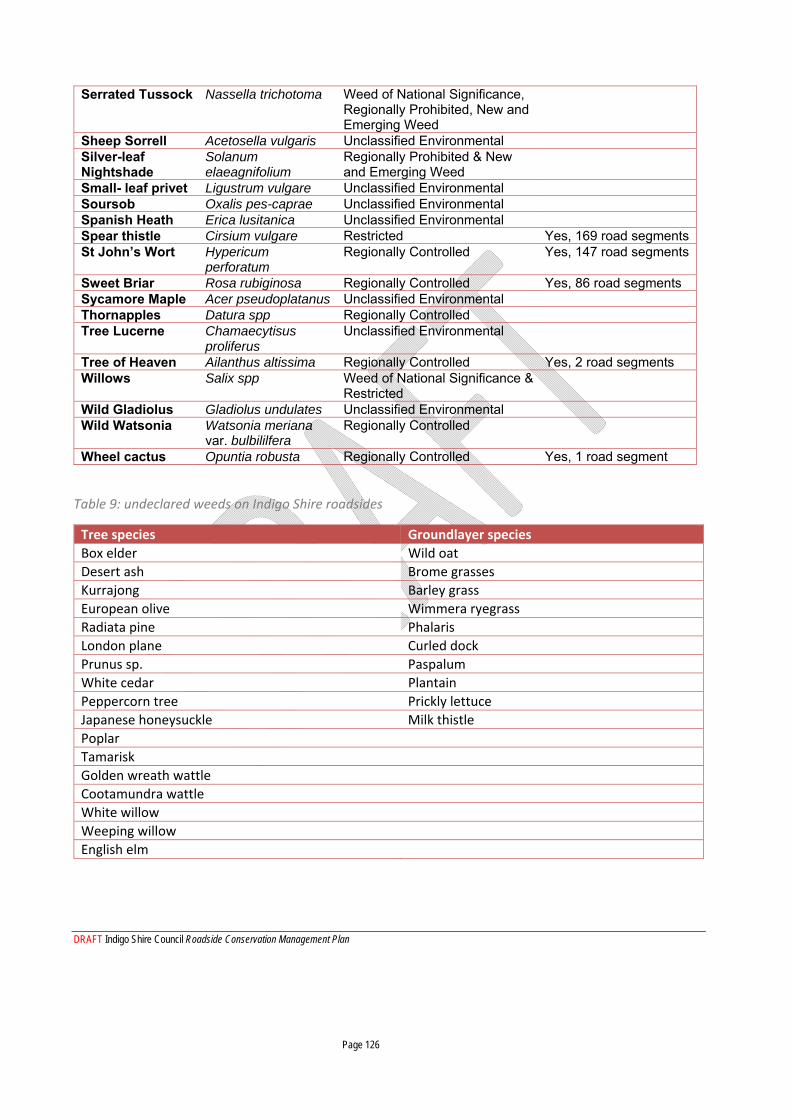
DRAFT Indigo Shire Council Roadside Conservation Management Plan Page 126
Serrated Tussock Nassella trichotoma Weed of National Significance, Regionally Prohibited, New and Emerging Weed
Sheep Sorrell Acetosella vulgaris Unclassified Environmental Silver-leaf Nightshade
Solanum elaeagnifolium
Regionally Prohibited & New and Emerging Weed
Small- leaf privet Ligustrum vulgare Unclassified Environmental Soursob Oxalis pes-caprae Unclassified Environmental Spanish Heath Erica lusitanica Unclassified Environmental Spear thistle Cirsium vulgare Restricted Yes, 169 road segments St John’s Wort Hypericum
perforatum Regionally Controlled Yes, 147 road segments
Sweet Briar Rosa rubiginosa Regionally Controlled Yes, 86 road segments Sycamore Maple Acer pseudoplatanus Unclassified Environmental Thornapples Datura spp Regionally Controlled Tree Lucerne Chamaecytisus
proliferus Unclassified Environmental
Tree of Heaven Ailanthus altissima Regionally Controlled Yes, 2 road segments Willows Salix spp Weed of National Significance &
Restricted
Wild Gladiolus Gladiolus undulates Unclassified Environmental Wild Watsonia Watsonia meriana
var. bulbililfera Regionally Controlled
Wheel cactus Opuntia robusta Regionally Controlled Yes, 1 road segment
Table 9: undeclared weeds on Indigo Shire roadsides
Tree species Groundlayer species Box elder Wild oat
Desert ash Brome grasses
Kurrajong Barley grass
European olive Wimmera ryegrass
Radiata pine Phalaris
London plane Curled dock
Prunus sp. Paspalum
White cedar Plantain
Peppercorn tree Prickly lettuce
Japanese honeysuckle Milk thistle
Poplar
Tamarisk
Golden wreath wattle
Cootamundra wattle
White willow
Weeping willow
English elm


![RCMP HQ Relocation Communications Plan [Excerpt]](https://img.pdfslide.net/doc/110x75/55cf8fa0550346703b9e25a0/rcmp-hq-relocation-communications-plan-excerpt.jpg)