Embed Size (px)
Citation preview
1
DRAFT OLD MILL DISTRICT OREGON SPOTTED FROG (Rana pretiosa) CANDIDATE CONSERVATION AGREEMENT WITH ASSURANCES (CCAA)
Between
William Smith Properties, Inc.; Fifteen SW Colorado; Mill A Associates Limited Partnership; River Bend Limited Partnership; Mill Shops LLC, Mill Shops Manager LLC Managing Member; River Shops II LLC Deschutes River Amphitheater LLC; River Bend Master Owners Association
And the
U.S Fish and Wildlife Service
2
Table of Contents I. Introduction ........................................................................................................................................... 3
Legal Authority ........................................................................................................................................... 3
II. Status and Background of Oregon spotted frog .................................................................................... 5
Existing Conditions on Covered Lands .................................................................................................... 10
IV. Covered Activities .......................................................................................................................... 15
Threats, Conservation Objectives and Measures ..................................................................................... 16
Monitoring, Evaluation, and Adaptive Management .................................................................................. 20
V. Anticipated Effects .............................................................................................................................. 23
VI. Implementation ............................................................................................................................... 27
Responsibilities of the Parties ..................................................................................................................... 27
Notification Requirement ......................................................................................................................... 30
Duration of CCAA and Permit ................................................................................................................ 30
Modifications and Amendments of the CCAA .......................................................................................... 30
Modification of the CCAA......................................................................................................................... 30
Amendment of the Permit ........................................................................................................................ 30
Permit Suspension or Revocation and Termination of the CCAA ...................................................... 31
Remedies .................................................................................................................................................... 31
Dispute Resolution .................................................................................................................................... 31
Succession and Transfer ........................................................................................................................... 32
Availability of Funds ................................................................................................................................ 32
No Third-Party Beneficiaries ................................................................................................................... 32
Notices and Reports .................................................................................................................................. 33
Exhibit A – Legal Description of the Covered Lands ................................................................................. 39
Exhibit B – Old Mill District Stormwater Key Map………………………………………………………44
3
I. Introduction
On November 1, 2012 the U.S. Fish and Wildlife Service (Service) met with William Smith, president of the parties to the agreement, to begin discussions about the creation of a candidate conservation agreement with assurances (CCAA) to protect the Oregon spotted frog (spotted frog), in the Old Mill District, within the city of Bend, Deschutes County, Oregon. A CCAA is a voluntary agreement whereby landowners agree to manage their lands to remove or reduce threats to species at risk in return for assurances against additional regulatory requirements should that species ever be listed under the ESA. The 170-acre Old Mill District is a mixed-use development complex including shops, galleries, restaurants, trails, and events. Activities covered under this Old Mill District Oregon Spotted Frog CCAA include a variety of conservation measures associated with management of the stormwater facilities and other areas of existing and potential spotted frog habitat. The duration of this CCAA is 20 years from the date of approval. Purpose of this CCAA The purpose of this CCAA is to protect and manage spotted frog habitat to maintain and/or enhance the existing spotted frog population while operating the 170-acre Old Mill District mixed-use development complex. The objectives for this agreement are:
• To provide the applicant(s) with regulatory assurances from the Service that if the spotted frog becomes listed under the ESA, the activities on the enrolled lands can continue as outlined in this agreement.
• To implement the conservation measures contained in this CCAA to provide a benefit to the spotted frog.
• To avoid and minimize take of spotted frogs while conserving and managing their habitats to benefit spotted frogs.
Legal Authority Sections 2, 7, and 10 of the ESA allow the Service to enter into this CCAA. Section 2 of the Act states that encouraging interested parties, through Federal financial assistance and a system of incentives, to develop and maintain conservation programs is a key to safeguarding the Nation’s heritage in fish, wildlife, and plants. Section 7 of the Act requires the Service to review programs that it administers and to utilize such programs in furtherance of the purposes of the ESA. The purposes of the ESA are “to provide a means whereby the ecosystems upon which endangered species and threatened species depend may be conserved,” and “to provide a program for the conservation of such endangered species and the use of all methods and procedures which are necessary to bring any endangered species or threatened
4
species to the point at which the measures provided pursuant to this Act are no longer necessary.” Section 10 of the ESA describes permits issued under the ESA, exempting certain prohibitions under Section 9 of the ESA. Section 10(a)(1)(A) of the ESA authorizes the issuance of permits to “enhance the survival” of a listed species. Enhancement means the permit activities benefit species in the wild. By entering into this CCAA, the Service is utilizing its Candidate Conservation Programs to further the conservation of the Nation’s fish and wildlife, consistent with the Service’s “Candidate Conservation Agreement with Assurances Final Policy” (64 FR 32706; June 17, 1999 and 69 FR 24084; May 3, 2004). CCAA Standard To be approved, all CCAAs must meet the CCAA standard: “The Services must determine that the benefits of the conservation measures implemented by a property owner under a Candidate Conservation Agreement with Assurances, when combined with those benefits that would be achieved it if is assumed that conservation measures were also to be implemented on other necessary properties, would preclude or remove any need to list the covered species.” (64 FR 32732, June 17, 1999) Permit Issuance Criteria CCAA permits are subject to both the Service’s General Permitting regulations in 50 Code of Federal Regulations (CFR) Part 13 and the CCAA specific regulations in 50 CFR Parts 17.22 and 17.32. In order for the Service to issue an enhancement of survival (EOS) permit, we must ensure that the following permit issuance criteria found at 50 CFR Part 17.32(d)(2) are met:
1. The take will be incidental to an otherwise lawful activity and will be in accordance with the terms of the CCAA.
2. The CCAA complies with the requirements of the CCAA policy (64 FR 32706 and 69 FR 24084).
3. The probable direct and indirect effects of any authorized take will not appreciably reduce the likelihood of survival and recovery in the wild of any species.
4. Implementation of the terms of the CCAA is consistent with applicable Federal, state, and tribal laws and regulations.
5. Implementation of the terms of the CCAA will not be in conflict with any conservation programs for species covered by the permit.
6. The applicant has shown capability for and commitment to implementing all of the terms of the CCAA.

5
Parties to the Agreement The following are the parties to the CCAA. Lands associated with tract letters identified below can be seen on Figure 1. William Smith Properties, Inc: This business is the owner of Tract E and current business association for Tracts A-F. In 2016, this business entity will become the business association for just tracts E and F north of the Colorado Street Bridge in Bend Oregon. Tract E south of the Colorado Street Bridge will be conveyed to River Bend Limited Partnership. Fifteen SW Colorado LLC: This business is the owner of Tract F. Mill A Associates Limited Partnership: This business is the owner of Tract A River Bend Limited Partnership: This business is the owner of Tract C Mill Shops LLC: This business is the owner of Tract B River Shops II LLC: This business is the owner of Tract D Deschutes River Amphitheater LLC: This business leases the Les Schwab Amphitheater, part of Tract C, from River Bend Limited Partnership and serves as the current manager of the Les Schwab Amphitheater Marsh. River Bend Master Owners Association, Inc.: This is non-profit mutual benefit corporation associated with Tracts A-D, which are south of the Colorado Street Bridge and part of the Old Mill District in Bend Oregon. They have the authority to collect fees from all the owners within the Old Mill District and in 2016 will become the owner of common areas including the Casting Pond, Les Schwab Amphitheater Marsh, and riparian areas where spotted frogs are known to occur. U.S. Fish and Wildlife Service: The Service designates the Bend Office Field Supervisor or another Service designee as the administrator of this CCAA. II. Status and Background of Oregon spotted frog The Oregon spotted frog is the only species covered under this CCAA. Listing Status On May 7, 1993, the Service published a 12-month finding in the Federal Register (58 FR 27260) indicating that the spotted frog (Rana pretiosa) warranted listing as threatened in some portions of its range, but was precluded by other higher priority listing actions. Subsequent
6
genetic analyses separated the spotted frog into two separate species, Rana pretiosa (Oregon spotted frog) and Rana luteiventris (Columbia spotted frog). The Service recognized these taxonomic changes in the Federal Register (62 FR 49398) on September 19, 1997. On August 29, 2013, the Oregon spotted frog was proposed for listing as threatened under the ESA (78 FR 53582). A final listing determination is anticipated in late summer of 2014. Species Description The spotted frog is named for the black spots that cover the head, back, sides, and legs. The dark spots are characterized by ragged edges and light centers that grow and darken with age (Hayes 1994, p. 14). Body color also varies with age. Juveniles are usually brown or, occasionally, olive green on the back and white, cream, or flesh-colored with reddish pigments on the underlegs and abdomen (McAllister and Leonard 1997, pp. 1–2). Adults range from brown to reddish brown but tend to become redder with age. The spotted frog is a medium-sized frog, ranging from 44 to 100 millimeters (1.74 to 4 inches) in body length. Females are typically larger than males and can reach up to100 millimeters or more (4 inches).
Life History Adult spotted frogs begin to breed by one to three years of age, depending on sex, elevation, and latitude. Male spotted frogs are not territorial and often gather in large groups of 25 or more individuals at specific locations (Leonard et al. 1993, p. 132). Breeding occurs in February or March at lower elevations and between early April and early June at higher elevations (Leonard et al. 1993, p. 132). Females may deposit their egg masses at the same locations in successive years, in shallow, often temporary, pools of water; gradually receding shorelines; on benches of seasonal lakes and marshes; and in wet meadows. These sites are usually associated with the previous year’s emergent vegetation, are generally no more than 14 in (35 centimeters (cm)) deep (Pearl and Hayes 2004, pp. 19–20), and most of these sites dry up later in the season (Joe Engler, FWS, pers. comm. 1999). Shallow water is easily warmed by the sun, and warmth hastens egg development (McAllister and Leonard 1997, p. 8). However, laying eggs in shallow water can result in high mortality rates for eggs and hatchling larvae due to desiccation or freezing. Eggs usually hatch within three weeks after egg-laying. Tadpoles are grazers, having rough tooth rows for scraping plant surfaces and ingesting plant tissue and bacteria. They also consume algae, detritus, and probably carrion. Tadpoles metamorphose into froglets during their first summer. Post-metamorphic spotted frogs feed on live animals, primarily insects. Habitat Requirements This species is the most aquatic native frog in the Pacific Northwest. It is almost always found in or near a perennial body of water that includes zones of shallow water and abundant emergent or floating aquatic plants, which the frogs use for basking and cover (USFWS 2014). Watson et al. (2003, p. 298) summarized the conditions required for completion of the Oregon spotted frog life cycle as shallow water areas for egg and tadpole survival, perennially deep, moderately
7
vegetated pools for adult and juvenile survival in the dry season, and perennial water for protecting all age classes during cold wet weather. Spotted frogs breed in shallow pools (2–12 in (5–30 cm) deep) that are near flowing water, or which may be connected to larger bodies of water during seasonally high water or at flood stage. Characteristic vegetation includes grasses, sedges, and rushes, although eggs are laid where the vegetation is low or sparse, such that vegetation structure does not shade the eggs (McAllister and Leonard 1997, p. 17). After breeding, during the dry season, spotted frogs move to deeper, permanent pools or creeks (Watson et al. 2003, p. 295). They are often observed near the water surface basking and feeding in beds of floating and submerged vegetation (Watson et al. 2003, pp. 292–298; Pearl et al. 2005a, pp. 36–37). Known overwintering sites are associated with flowing systems, such as springs and creeks, that provide well-oxygenated water (Hallock and Pearson 2001, p. 15; Hayes et al. 2001, pp. 20–23, Tattersall and Ultsch 2008, pp. 123, 129, 136) and sheltering locations protected from predators and freezing (Risenhoover et al. 2001b; Watson et al. 2003, p. 295). Oregon spotted frogs burrow in mud, silty substrate, clumps of emergent vegetation, woody accumulations within the creek, and holes in creek banks when inactive during periods of prolonged or severe cold (Watson et al. 2003, p. 295; Hallock and Pearson 2001, p. 16; McAllister and Leonard 1997, p. 17); however, they are intolerant of anoxic (absence of dissolved oxygen) conditions and are unlikely to burrow into the mud for more than a day or two (Tattersall and Ultsch 2008, p. 136) because survival under anoxic conditions is only a matter of 4–7 days (Tattersall and Ultsch 2008, p. 126). This species remains active during the winter in order to select microhabitats that can support aerobic metabolism and allow it to evade predators (Hallock and Pearson 2001, p. 15; Hayes et al. 2001, pp. 20–23; Tattersall and Ultsch 2008, p. 136). In central Oregon, where winters generally result in ice cover over ponds, Oregon spotted frogs follow a fairly reliable routine of considerable activity and movement beneath the ice during the first month following freeze-up. Little movement is observed under the ice in January and February, but activity steadily increases in mid-March, even when ice cover persists (Bowerman 2006, pers. comm.). Historic and Current Distribution The Oregon spotted frog has been lost from at least 78 percent of its former range. Precise historic data is lacking but this species has been documented in British Columbia, Washington, Oregon, and California (USFWS 2014). They no longer occur in California (USFWS 2014); the Willamette Valley in Oregon (Cushman et al. 2007, p. 14); and many other formerly occupied sites within their historic range. Currently, the spotted frog is found from extreme southwestern British Columbia south through the Puget Trough, and in the Cascades Range from south-central Washington at least to the Klamath Basin in southern Oregon. Spotted frogs occur in lower elevations in British Columbia and Washington and are restricted to high elevations in Oregon (Pearl et al. 2010 p. 7). In
8
British Columbia, spotted frogs currently are known to occupy four disjunct locations in a single sub-basin, the Lower Fraser River (Canadian Oregon Spotted Frog Recovery Team 2012, p. 6). In Washington, spotted frogs are known to occur only within six sub-basins/watersheds: the Sumas River, a tributary to the Lower Fraser River; the Black Slough in the lower South Fork Nooksack River, a tributary of the Nooksack River; Samish River; Black River, a tributary of the Chehalis River; Outlet Creek (Conboy Lake), a tributary to the Middle Klickitat River; and Trout Lake Creek, a tributary of the White Salmon River. The Klickitat and White Salmon Rivers are tributaries to the Columbia River. The spotted frogs in each of these sub-basins/watersheds are isolated from spotted frogs in other sub-basins (USFWS 2013, p. 53588). In Oregon, spotted frogs are known to occur only within eight sub-basins: Lower Deschutes River, Upper Deschutes River, Little Deschutes River, McKenzie River, Middle Fork Willamette, Upper Klamath, Upper Klamath Lake, and the Williamson River. The spotted frogs in most of these sub-basins are isolated from spotted frogs in other sub-basins, although spotted frogs in the lower Little Deschutes River are aquatically connected with those below Wickiup Reservoir in the Upper Deschutes River sub-basin. Spotted frog distribution west of the Cascade Mountains in Oregon is restricted to a few lakes in the upper watersheds of the McKenzie River and Middle Fork Willamette River sub-basins, which represent the remaining 2 out of 12 historically occupied sub-basins (USFWS 2013, p. 53588). Species Population and Distribution in the Upper Deschutes River Sub-basin The Old Mill District covered by this CCAA is within the Upper Deschutes River sub-basin. Population estimates conducted in 2012 indicate that there is a minimum breeding population of 3,530 adult spotted frogs in the Upper Descutes River sub-basin (USFWS 2013). Spotted frogs in this sub-basin occur in high-elevation lakes up to 5,000 ft (1,524 m), wetland ponds, and riverine wetlands and oxbows along the Deschutes River. There are less than 20 known breeding locations within four watersheds in the sub-basin: Charleton Creek, Browns Creek, Fall River, and North Unit Diversion Dam. Most of the known breeding locations are on the Deschutes National Forest in lakes, ponds, and riverine wetlands that drain into the Crane Prairie and Wickiup Reservoir complex. There are at least four known and one likely breeding location downstream of Wickiup Reservoir in riverine wetlands along the Deschutes River, extending to Bend, Oregon: Bull Bend, Dead Slough, Sunriver, Slough Camp, and the Old Mill District. It appears that the Old Mill District population is isolated from others in the sub-basin because Slough Camp, the next closest breeding location, is approximately 17 miles upstream from the Old Mill District. The spotted frog was historically known to occur 34 miles downstream of the Old Mill District where NW Lower Bridge Way crosses the Deschutes River (Hayes 1997). In 2013 breeding surveys were conducted downstream from the Old Mill District between the Colorado Street Bridge and Tumalo State Park, a distance of 7.8 miles (Biota Pacific Environmental Sciences, Inc. and Smayda Environmental Associates Inc. 2013). Spotted frogs were not detected during these surveys which confirmed that the Old Mill District is the most downstream extent of spotted frog distribution in the Upper Deschutes sub-basin.
9
Threats and limiting factors The Proposed Listing Rule (USFWS 2013) described range-wide threats and limiting factors to the spotted frog that include, but are not limited to: 1) loss and degradation of wetland habitat necessary to support all life stages of spotted frog; 2) hydrologic changes resulting from operation of existing water diversions/manipulation structures; 3) habitat modification and changes in water temperature and vegetation structure resulting from reed canarygrass and plant succession; 4) removal of beavers and beaver dams that support wetland hydrology; 5) vegetation changes resulting from timing and intensity of livestock grazing; and 6) predation by invasive nonnative fish and bullfrogs. Other threat factors include: remaining spotted frogs occur in small and isolated breeding locations, low connectivity, low genetic diversity within occupied sub-basins, and genetic differentiation between sub-basins. Survival and Recovery Needs A Recovery Plan for spotted frog has not yet been developed at the range-wide scale nor at the Oregon state scale and is therefore not available for identification of survival and recovery needs. However, based on the Proposed Listing Rule (USFWS 2013) the survival and recovery needs of the spotted frog include restoration and enhancement of habitat to support all life stages of the frog; re-establishing connectivity of habitat to improve gene flow between populations and reduction of all threats to essential habitat and the frog. Conservation and Recovery efforts to date Past and ongoing conservation efforts to benefit the spotted frog have occurred throughout the range of the spotted frog including habitat creation and restoration, reed canary grass management, livestock grazing management, water management, and efforts to control bull frog populations. In Washington, the Service has completed several wetland restoration projects at Conboy Lake National Wildlife Refuge (NWR, refuge) to restore natural hydrological processes to portions of the refuge. In Oregon, the Service has initiated an invasive weed management effort to benefit spotted frogs on Klamath Marsh NWR. The U.S. Forest Service has completed spotted frog site management plans that identify threats and management actions to reduce threats at eleven sites in Oregon. The Fremont-Winema National Forest has restored habitat along Jack Creek and has, in cooperation with a private landowner, released seven beavers into the Jack Creek watershed (USFWS 2013).
In the Deschutes River Basin, the Sunriver Nature Center has been managing water levels through the use of weirs to benefit spotted frogs and has been monitoring the population at Sunriver Resorts since 2000. The Deschutes National Forest has restored Big Marsh by closing perimeter ditches and BLM has repaired headcuts to benefit spotted frog habitat. The proposed rule to list the spotted frog as threatened found that these and other conservation efforts are not sufficient to ameliorate the habitats threats at the sub-basin scale (USFWS 2013).
10
III. Description of the Covered Lands For purposes of this agreement, the “Covered Lands” consist of properties in the Old Mill District as shown on Figure 1. The covered lands include 170 acres of land including 6,909 linear feet along both banks of the Deschutes River, upstream and downstream of the Colorado Street Bridge, in the City of Bend, Deschutes County, Oregon. Each property has a legal description associated with it (see Exhibit A). Figure 1 depicts the ownership of the lands and location of the Casting Pond and the LSA Marsh, key habitat for the Oregon spotted frog. The covered lands include the Casting Pond, the LSA Marsh, and the riparian habitat on the banks of the Deschutes River above the ordinary high water line. Existing Conditions on Covered Lands Urban Land Uses in the Old Mill District The Old Mill District land development history began almost 100 years ago when two sawmills opened on the Deschutes River. Today, the lumber business is gone and the same site is a full-scale mixed-use complex consisting of 170 acres of urban level development employing over 2,500 people. The Old Mill District attracts thousands of visitors to its shops, galleries, restaurants, trails, and events annually. Old Mill District Storm Water System The Old Mill District is served by a storm water drainage system. The Storm Water System Key Map is attached to this document (Exhibit B). Current system components include a large number of catch basins, pipes, bio-swales and three ponds which provide for collection, treatment and disposal of storm water. Occasional rainstorms during the summer months divert storm water into the various bio-swales/ponds, which quickly dissipates. Winter rains in conjunction with existing accumulations of snow is the typical major source of storm water collection. The bio-swales and ponds also serve as multi-use water features.
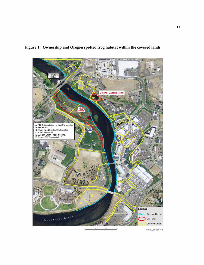
11
Figure 1: Ownership and Oregon spotted frog habitat within the covered lands
12
Casting Pond
One of the three ponds, known as the “Casting Pond,” is a man-made structure containing casting targets and a pathway leading into the pond. The trail leading to the casting ring area consists of gravels over a heavy fabric liner on top of boulders. The casting rings are made of close-cell rigid foam and are anchored by light chain. This pond is on the eastside of the Deschutes River and serves as an important part of the development’s storm water system and as a recreational feature for fly fisherman. The location of the Casting Pond is near trails, lawn, and other urban landscape areas that are maintained by the Old Mill District maintenance crew. A storage house abuts the Casting Pond and William Smith Properties Inc., stores landscape maintenance equipment and floatation equipment for a nearby kayak business. The Casting Pond is approximately 30 m x 20 m (100 x 65 ft). Maximum water depth varies seasonally but can range from 10 cm to 50 cm (4 in to 20 in) in depth. The Casting Pond was developed on what is called Lot 12 and was the end of a chain of bio-swales/ponds, each designed to overflow into the adjacent swale/pond as storm water accumulated. The Casting Pond is connected to the Deschutes River by way of a six-inch diameter pipe and valve, which could be opened in the event of a 50 to 100 year storm event to prevent over flow of the swale/pond. There is an overflow to the river at the edge of the pond that has a gate valve for isolating the pond from flowing into the river. The Casting Pond is approximately 20 ft. (6 m) from the channel of the Deschutes River. The water control devices are used to maintain pond water levels. The pond has a natural bank and natural silt base. The parking lot of the Mill "A" Building, situated adjacent to the bio-swale/pond, drains to a catch basin and pumping chamber, which pumps to the Casting Pond. Ground water also is diverted to this pumping basin, which contributes to year-round water in the swale creating the ponding, and makes possible the use of the pond for fly casting. Without the addition of ground water pumping and additional water from the irrigation system, this pond would be dry most of the year. Most all bio-swales/ponds within the Old Mill District are dry for much of the year. Westside Stormwater Ponds Stormwater ponds in the Old Mill District on the west side of the Deschutes River currently consist of two existing ponds and a drainage swale (see Exhibit B). The purpose of the ponds has two broad functions which are to provide management of stormwater quantities and water quality. Regulations and ordinances required to be followed for these stormwater parameters are established by the City of Bend and Oregon Department of Environmental Quality. There are two types of existing Westside ponds along Columbia Street at the Columbia Street Bridge. The pond north of Columbia is a wet pond that retains water year-round and the pond south of Columbia is a dry pond. The existing soil type at the two pond sites is the primary feature that determined whether the ponds hold water or allows the water to infiltrate fast enough to be a dry pond. In the future, these two ponds will need to be enlarged to contain stormwater
13
from undeveloped areas. When the ponds are enlarged and as they collect silt and organic material, the soils could lose sufficient permeability to the point that both ponds could eventually be wet year-round. Potential New Pond Areas Development of the storm water system for the Old Mill District is on-going and will continue as new planned urban development occurs in the Old Mill District. The Old Mill District is a dynamic and growing area. The Owners are currently developing other parts of the Old Mill District and these will be served with a storm water drainage system complete with bio-swales/ponds. Future ponds to manage stormwater from undeveloped or under-developed lands will need to be built as the area is developed. Some of these ponds will be adjacent to the Deschutes River (See Exhibit B). It is anticipated that these ponds will be seasonally wet during the irrigation season (April through October) and during stormwater events. For future land development the ponds’ types, either wet or dry, will be dependent on the type of soils encountered at each site. The area south of the amphitheater is most likely to have gravel-sand material that would have permeability over the long-term that would result in dry ponds. Soil types for land north of the amphitheater have not been determined and the ponds in this area could be either wet or dry. Two factors are the primary determinants to stormwater pond sizes. The first is the impervious area (building roof areas and paved parking lots) that could drain to individual ponds. The second is the pond soil permeability at initial construction and after the pond has been in operation for several years.
Old Mill District Maintenance Activities William Smith Properties, Inc. has a facility operations staff to manage and maintain a variety of Old Mill District facilities including the storm drainage bio-swales/ponds. The crew is trained and equipped to handle plant materials, debris and silt removal, pond enhancements, rock, and the water facilities related to the pond, and maintain landscaping in the vicinity of the Casting Pond and adjacent to the river banks. The facility operations staff are equipped and staffed to effectively monitor the pond and provide water when needed. A measuring device (staff gauge) is installed in the pond and provides a clear reading of the water level. Pond monitoring is scheduled to occur weekly throughout the winter. Spotted Frog presence and suitable habitat on Covered Lands In August 2012, spotted frogs were detected in the Old Mill District Casting Pond (described above) on the east side of the Deschutes River on the covered lands. Subsequently, Biologist Jay Bowerman began to study spotted frogs in the Casting Pond and nearby riparian habitat. Between October 2012 and February 2013, numerous juvenile and adult spotted frogs were detected in a large marsh known as the Les Schwab Amphitheater Marsh (LSA Marsh), on the
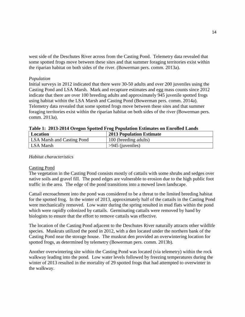
14
west side of the Deschutes River across from the Casting Pond. Telemetry data revealed that some spotted frogs move between these sites and that summer foraging territories exist within the riparian habitat on both sides of the river. (Bowerman pers. comm. 2013a). Population Initial surveys in 2012 indicated that there were 30-50 adults and over 200 juveniles using the Casting Pond and LSA Marsh. Mark and recapture estimates and egg mass counts since 2012 indicate that there are over 100 breeding adults and approximately 945 juvenile spotted frogs using habitat within the LSA Marsh and Casting Pond (Bowerman pers. comm. 2014a). Telemetry data revealed that some spotted frogs move between these sites and that summer foraging territories exist within the riparian habitat on both sides of the river (Bowerman pers. comm. 2013a). Table 1: 2013-2014 Oregon Spotted Frog Population Estimates on Enrolled Lands Location 2013 Population Estimate LSA Marsh and Casting Pond 100 (breeding adults) LSA Marsh >945 (juveniles)
Habitat characteristics Casting Pond The vegetation in the Casting Pond consists mostly of cattails with some shrubs and sedges over native soils and gravel fill. The pond edges are vulnerable to erosion due to the high public foot traffic in the area. The edge of the pond transitions into a mowed lawn landscape.
Cattail encroachment into the pond was considered to be a threat to the limited breeding habitat for the spotted frog. In the winter of 2013, approximately half of the cattails in the Casting Pond were mechanically removed. Low water during the spring resulted in mud flats within the pond which were rapidly colonized by cattails. Germinating cattails were removed by hand by biologists to ensure that the effort to remove cattails was effective.
The location of the Casting Pond adjacent to the Deschutes River naturally attracts other wildlife species. Muskrats utilized the pond in 2012, with a den located under the northern bank of the Casting Pond near the storage house. The muskrat den provided an overwintering location for spotted frogs, as determined by telemetry (Bowerman pers. comm. 2013b).
Another overwintering site within the Casting Pond was located (via telemetry) within the rock walkway leading into the pond. Low water levels followed by freezing temperatures during the winter of 2013 resulted in the mortality of 29 spotted frogs that had attempted to overwinter in the walkway.
15
LSA Marsh The LSA marsh is located on the west bank of the Deschutes River directly upstream of the Colorado Street Bridge. Vegetation within the marsh consists predominately of cattails. Water levels within the marsh fluctuate with storage and release of regulated flows from Wickiup Reservoir. However, the fluctuation of surface water in the marsh is relatively stable compared to upstream reaches of the river. According to hydrologists working on a proposed water park downstream of the bridge, the average fluctuation of the water level is approximately four inches. Openings within the dense cattails, created by beaver and muskrats, provide at least two breeding locations for Oregon spotted frogs (Bowerman pers. comm. 2014b). Riverine and Riparian Zone There are approximately 6,909 linear feet of river bank adjacent to the Deschutes River within the Old Mill District. The riparian area within this developed area is mostly fenced to limit access to the river, reduce erosion and protect the native vegetation along the river’s edge. The Owners occasionally enter the riparian area to pull weeds and remove garbage. There is very limited information regarding spotted frog overwintering and movement within river systems. Telemetry data on frog movement gathered by J. Bowerman during the winter of 2013 through 2014 shows that frogs utilize the river margins in the summer and overwinter in the banks of the river. Telemetry data also show that frogs move from overwintering locations into the river during the winter. The Owners may participate in future research studies on spotted frogs. Information collected at this location will inform adaptive management of this CCAA as well as unrelated restoration projects occurring adjacent to the Deschutes River upstream of the Old Mill District. Role of Covered Lands in the Conservation of Oregon spotted frog The covered lands contain habitat suitable for supporting all life stages of the spotted frog. The estimated adult breeding population (100) represents only 0.028 percent of the estimated population (3,530) within the Upper Deschutes River sub-basin. However, this Old Mill District breeding location is currently the most downstream extent of the known occupied range of the spotted frog in the sub-basin. Maintaining a healthy Old Mill District population is important to the conservation of the spotted frog because it could provide a source population for re-colonization of historically occupied habitat both downstream to Lower Bridge and upstream to Slough Camp. IV. Covered Activities Current and Proposed Land Uses and Activities “Covered activities” includes those activities carried out by the Owners or their authorized representative on covered lands that may result in Authorized Take (see definition of ‘Take’ on page 23) of Covered Species (spotted frog) consistent with the EOS permit during the term of this CCAA.
16
Covered Activities under this permit include:
• Management of Casting Pond water level.
• Vegetation control and management within the Casting Pond to maintain spotted frog habitat, storm water system functions, and recreational fly fishing casting opportunities.
• Maintenance of the Casting Pond base.
• Maintenance and enhancement to provide erosion protection of the perimeter of the Casting Pond and other bio-swales as needed.
• Maintenance of existing landscaping in the vicinity of the Casting Pond, other bio-swales, LSA Marsh, and the riparian zone.
• New bio-swale construction and any necessary maintenance.
• Vegetation control, treatment, and management within other existing and future bio-swales.
• Control and removal of non-native predators detected in the Casting Pond by the Old Mill District facilities maintenance crew or the Owners representative in coordination with the Service to determine the proper strategy for removal of non-native predators.
• Implementation of Conservation Measures 1 through 7, and Changed Circumstances Conservation Measures 1 through 3.
• Implementation of Compliance, Effectiveness, and Biological Monitoring.
Threats, Conservation Objectives and Measures Conservation measures and management of the enrolled lands is provided by the Owners and described below. Management of the covered lands include the Casting Pond and pond perimeter, LSA Marsh, Deschutes River riparian zone, and existing ponds and bioswales. Conservation measures and management may be applied to other riparian areas and bio-swales/ponds as they develop to supplement the Old Mill District storm water system. Key features and conservation measures include: • Maintain a consistent water level in the Casting Pond that enables breeding through
metamorphosis for spotted frog.
• Maintain adequate water levels in the Casting Pond to protect developing embryos and larvae during the breeding and summer season.
• Maintain adequate water level in the Casting Pond during the winter to help protect overwintering spotted frogs from freezing.
17
• Management of Casting Pond vegetation to support open water areas and hiding cover will provide habitat for breeding and rearing habitat.
• Improvement of Casting Pond perimeter to include natural barriers and sedges to manage human access where appropriate.
• Protection of the riparian zones and the continued biological successional changes of the river banks will provide cover used by the spotted frog during the summer active season.
• Protect and maintain the LSA Marsh to enable breeding through metamorphosis for spotted frog.
Outlined below are the threats to spotted frogs that are known to occur on the enrolled lands; each threat has a conservation measure or measures and a corresponding conservation objective. The conservation measures are designed to reduce or eliminate known threats. Conservation Measures for the Casting Pond Threat: Loss of water during the breeding season. Spotted frogs typically choose breeding sites that are shallow (e.g., less than 14 inches (35.5 cm)) with full solar exposure so that the water warms and hastens embryo development. If water drains rapidly from a breeding area, egg masses are vulnerable to desiccation and freezing. Furthermore, very shallow water may become overly warm during metamorphosis and result in mortality of tadpoles.
Conservation Objective: Monitor and maintain water levels in the spring and summer to decrease mortality to spotted frogs during the breeding and metamorphosis period in the Casting Pond.
Conservation Measure 1: Water levels in the Casting Pond will be maintained by William Smith Properties, Inc. at approximately 40-45 cm (according to a staff gauge installed in 2013) throughout the breeding and metamorphosis period (March through July) to prevent freezing of egg masses in the spring and excessive warming of the water that may kill developing tadpoles during the summer months. Water level will be maintained through the use of the water control devises. Pond monitoring will be conducted by William Smith Properties, Inc. and is scheduled to occur weekly throughout the breeding season (mid-March through mid-April).
Threat: Loss of water in the winter. Spotted frogs generally overwinter under water, typically in sites that have a source of some water flow that maintains adequate oxygen levels. However, some spotted frogs have been known to overwinter in small ponds lacking such flow. During periods of ice cover that restricts the exchange of oxygen with the water under the ice, such ponds can become extremely hypoxic. In such sites, spotted frogs will move periodically to find more oxygenated water that allows them to absorb oxygen through their skin. Adequate pond
18
water level is a critical factor to overwintering frogs in small shallow ponds. During unusually dry winters, as occurred in 2012-2013, there is risk that low water level combined with a heavy ice cover, can trap spotted frogs beneath the ice without a route of escape to suitable oxygenated water, can result in mortalities.
Conservation Objective: Monitor and maintain winter water levels in the Casting Pond to reduce spotted frog mortality during the overwintering period (December to February).
Conservation Measure 2: Water levels in the Casting Pond will be maintained by William Smith Properties, Inc. at approximately 40-45 cm (according to a staff gauge installed in 2013) throughout the overwintering period. The addition of extra water to maintain the 40 cm depth may be required to ensure safe overwintering within the Casting Pond. The current facility operations staff for William Smith Properties, Inc. are equipped and staffed to effectively monitor the pond and provide the water when needed. Pond monitoring is scheduled to occur weekly throughout the winter (December through February).
Threat: Vegetation control and treatments. Encroachment of cattails and other invasive plants can reduce the quality of habitat for spotted frogs within the Casting Pond. Spotted frogs require open water for breeding and cover during the post metamorphic period. In order to protect the integrity of the pond and frog habitat mechanical vegetation management will be necessary.
Conservation Objective: Reduce vegetation encroachment in the Casting Pond, when needed, to improve breeding, rearing, and overwintering conditions for spotted frog.
Conservation Measure 3: Vegetation removal will be conducted both manually and mechanically by the facility operations staff. Mechanical means should not include use of heavy machinery such as backhoes or tractors although a small excavator on rubber tracks or bobcat-type machines are acceptable as long as they do not alter the pond bank or puncture the silt seal of the pond bottom. Plant removal will be conducted to maintain approximately 30 percent of cattail/sedge vegetation. The facility operations staff shall notify the Service 30 days prior to vegetation removal to allow for any technical assistance.
Plant removal by machinery should be limited to the winter from December through February when spotted frogs are in overwinter refugia. Manual plant removal (hand pulling) can be conducted during the summer months without risk to the frogs.
Threat: Non-native predators. Introduced fish species prey on tadpoles and reduce overwintering survival of spotted frogs. Bullfrogs prey on juvenile and adult spotted frogs and bull frog larvae can outcompete or displace spotted frog larvae, effectively reducing all spotted frog life stages. Furthermore, the presence of warm water fish in spotted frog habitat creates more suitable habitat for bullfrogs as the fish feed on dragonfly larvae that would predate on bullfrogs tadpoles. The Casting Pond is not presently known to support non-native predators
19
such as warm water fish or bullfrogs. However these species are known to occur within the Upper Deschutes River subbasin.
Conservation Objective: Rapidly detect and remove non-native predators to help maintain a breeding population of spotted frogs in the Casting Pond
Conservation Measures 4: The Casting Pond will be annually surveyed via visual observation by a qualified individual for the presence of non-native predators such as bullfrogs, bass, and predatory freshwater fish species. If any of these non-native predators are detected in the Casting Pond then William Smith Properties, Inc. will notify the Service to determine the proper strategy for removal of non-native predators.
Threat: Erosion of the edges of the Casting Pond. The Casting Pond is located within an area of high use from the public. The vegetation along the banks of the Casting Pond consists of sedges, rushes, and grasses over native soils and gravel fill. Due to the public utilization of the area surrounding the casting pond, the edges of the pond are eroding, resulting in sedimentation within the water and lack of cover for tadpoles, juvenile, and adult spotted frogs.
Conservation Objective: Implementation of the conservation measure below will further stabilize the banks and provide additional refuge areas for the frogs year round.
Conservation Measure 5: Maintenance such as the addition of native plant materials and boulders along the edges of the Casting Pond are scheduled for 2014 and will continue periodically as needed as part of ongoing pond maintenance to maintain the edges of the pond and vegetation, and to reduce sedimentation.
Threat: Unintentional harm from visitors on site. Since the Casting Pond serves as an important part of the Old Mill District Storm Water System and as a recreational casting pond, it is important to retain these urban uses while providing spotted frog habitat.
Conservation Objective: Inform the general public via signage that the pond provides important habitat for spotted frog to minimize the impact to habitat and the spotted frog from overutilization.
Conservation Measure 6: Public information in the form of on-site signage and information on the Old Mill District website will help to advise visitors about the Old Mill area providing sensitive habitat for the spotted frog. Signage near the pond will be posted during the breeding season to protect egg masses. However, there is potential for signage to spark curiosity and attract people and their dogs to the pond. Temporary fencing and netting may be useful for physically keeping people and dogs out of the area, except for the path to the casting area which remains open year round. Temporary fencing will be installed by William Smith Properties, Inc. in coordination with the Service if overuse is resulting in adverse impacts to the spotted frog or the pond habitat. Adverse impacts will be determined
20
based on activities that harass or harm spotted frogs (e.g., trampling of pond vegetation, attempted capture or handling of spotted frogs or their egg masses by the public). Conservation Measures for the LSA Marsh and Riparian Zone The enrolled properties include 6,909 linear feet along both banks of the Deschutes River, upstream and downstream of the Colorado Street Dam. Water levels within the Deschutes River including the LSA Marsh fluctuate with storage and release of regulated flows from Wickiup Reservoir. However, the fluctuation of surface water in the LSA Marsh is relatively stable compared to upstream reaches of the river in part due to the presence of the Colorado Street Dam. The Owners have no jurisdiction over the flows within the Deschutes River and therefore it is not a covered activity. No adverse effects as a result of covered activities is anticipated in the LSA Marsh since there are no activities planned within the marsh that could result in take and the area receives little human use. The Old Mill District receives a lot of human use due to the shopping center, Les Schwab Amphitheater and other events. The owners have been protecting the river banks with fencing and installation of native plant materials in the years since the area was developed. The conservation measure below will continue to protect the river bank vegetation along the Deschutes River in the Old Mill District. Threats: Overutilization of river banks. Overutilization of river banks can lead to erosion and degradation of riparian vegetation that provides summer habitat for spotted frog.
Conservation Objective: Protection of the riparian zones within the covered lands will allow native riparian and wetland vegetation to provide cover for the spotted frog during the summer active season. Conservation Measure 7: Continue to protect the riparian zone along the banks of the Deschutes River within the enrolled lands through existing measures that maintain existing native riparian and wetland vegetation, and direct and manage visitor access to avoid impacts to the riparian and wetland vegetation. If riparian and wetland vegetation is damaged by overuse use signs and temporary fencing as described in Conservation Measure 6.
Monitoring, Evaluation, and Adaptive Management The Owners will be responsible for monitoring and reporting specified herein related to implementation of the CCAA and fulfillment of its provisions, including implementation of agreed-upon conservation measures, and take authorized by the permit. The Service, after reasonable prior notice to the Owners, may enter the covered lands to ascertain compliance with the CCAA.

21
Compliance and Effectiveness Monitoring Compliance monitoring is conducted to ensure that the conservation measures in the CCAA are being implemented. Effectiveness monitoring is conducted to determine if the conservation measures are effective at meeting the desired objective.
a. Monitoring for Conservation Measures 1 and 2: Water level monitoring shall be conducted weekly and recorded by the facility operations staff to maintain water level at 40-45 cm during breeding, rearing, and overwintering.
b. Monitoring for Conservation Measure 3: Facilities operations staff shall establish a
permanent photo point and take annual pre and post vegetation removal photos. Photos will document the desired open water to vegetation ratio and be included in the annual report. Follow up water level monitoring will be conducted to ensure that the silt seal of the pond bottom was not punctured.
c. Monitoring for Conservation Measure 4: Annual surveys will be conducted by
qualified individuals to determine if non-native predators (e.g., bull frog) are in the Casting Pond. Visual surveys will be conducted in the summer and information will be included in an annual report to the Service.
d. Monitoring for Conservation Measure 5 and 6: The annual report shall describe
ongoing maintenance on the Casting Pond as needed to stabilize the banks and provide additional refuge areas for the spotted frogs year round, and the effectiveness of signage or the need for temporary fencing to minimize impacts to habitat and the spotted frog.
e. Monitoring for Conservation Measure 7: Visually monitor the effectiveness of existing
measures to maintain existing native riparian and wetland vegetation and include this information in the annual report.
Biological Monitoring Biological monitoring will include:
1. Annual egg mass counts in the Casting Pond and LSA Marsh by qualified individuals or other designated biological research institutions contracted by William Smith Properties, Inc. and recognized as qualified by the Service. Egg mass counts will coincide with similar annual surveys conducted at known spotted frog sites within Deschutes County, typically in late-March to mid-April.
2. Breeding detection surveys in all of the ponds and bioswales within the covered lands.
22
3. Surveys for presence of bull frogs and other non-native predators in the Casting Pond. The Owners will grant the Service and/or responsible party, after reasonable prior notice, the right to enter the covered lands to conduct biological/effectiveness monitoring. Biological monitoring reports will be included with annual reporting to the Service by June 1 with a copy provided to all Parties of this agreement. Take Monitoring The implementation of Casting Pond maintenance and construction activities require monitoring for take of spotted frogs. Monitoring of frog mortality will be done visually by a trained or qualified individual during the maintenance activities. Furthermore, existing and future bio- swales will be monitored during the breeding season to determine use by spotted frogs and potential for take resulting from dropping water levels. Adaptive Management
The CCAA may need minor adjustments and/or refinements to meet maintenance objectives or in response to new information. Covered activities that may require adaptive management include vegetation management of the Casting Pond, design of future bio swales, and removal of non-native predators. It is anticipated that the CCAA will permit such minor adjustments and refinements without requiring a new CCAA. In addition we have identified two potential changed circumstances and appropriate conservation measures to address them. Changed Circumstances Changed circumstances are changes affecting spotted frog or its habitat within the covered lands that can reasonably be anticipated and can be planned for over the 20-year life of the EOS permit. This CCAA has identified and provided for the following potential changed circumstances: a) geotechnical failure of the Casting Pond base material; and b) future constructed stormwater ponds become occupied by spotted frogs. Conservation measures necessary to respond to the identified changed circumstances are set forth below as part of the CCAA’s operating conservation program. The Owners will implement the following Changed Circumstances Conservation Measures (CCCM) as applicable, or a mutually agreed upon approach to address the additional threat(s) created by the changed circumstance(s). Threat: Geotechnical failure of Casting Pond base material. Geotechnical failure of the Casting Pond base material results in failure of pond to maintain desired water levels.
23
Conservation Objective: Implementation of CCCM 1 will restore the Casting Pond’s ability to maintain desired water levels to support spotted frog breeding, rearing, and overwintering habitat. CCCM 1: Restore the natural bank and natural silt base of the Casting Pond to maintain desired water levels as described in Conservation Measures 1 and 2.
Conservation Objective: Minimizes direct mortality and injury by capturing frogs prior to construction activity.
CCCM 2: Cooperate with the Service to allow salvage of spotted frogs prior to maintenance work in the Casting Pond that may lower the water level (e.g., repair of pond base).
Threat: Spotted frogs occupy existing or newly constructed stormwater ponds that are not suitable resulting in mortalities: Future development requiring the construction of additional stormwater ponds may hold water sufficient to attract spotted frogs but do not provide suitable conditions for breeding and/or overwintering habitat and result in spotted frog mortalities.
Conservation Objective: Minimize mortality to Oregon spotted frog. CCCM 3: If the newly constructed stormwater pond(s) are occupied by spotted frogs, and hold water sufficient to support spotted frogs, monitor and manage these ponds similar to the Casting Pond as described above. If spotted frogs are using the site for breeding or overwintering but the water level fluctuates such that it is likely to result in desiccation or freezing of egg masses or overwintering mortality due to freezing, notify and cooperate with the Service on a salvage strategy (e.g., egg mass relocation).
V. Anticipated Effects
Anticipated Incidental Take Take is defined in the ESA to include a number of activities including harass, harm, pursue, hunt, shoot, wound, kill, trap, capture, or collect, or to attempt to engage in any such conduct. Harm includes significant habitat modification or degradation where it kills or injures the listed species by significantly impairing essential behavioral patterns, including breeding, feeding, or sheltering. Take that results from, but is not the purpose of, carrying out an otherwise lawful activity is known as incidental take. Incidental take will likely occur as a result of implementation of the CCAA covered activities, however it is not expected to nullify the conservation benefits.
We considered three primary types of incidental take: (1) injury or death; (2) harm in the form of habitat fragmentation, loss, or degradation; and (3) harassment in the form of human activities

24
that significantly disrupt normal behavioral patterns such as breeding, feeding, or sheltering. For each type of take we describe the associated covered activities and conservation measures that will minimize the take.
Injury and mortality
Casting Pond The implementation of the Old Mill District Casting Pond maintenance activities including the removal of cattails and temporary water reduction for pond repairs every three years may result in “take” of spotted frogs overwintering along the perimeter of the Casting Pond. Telemetry studies indicate that none to only a few frogs overwinter in the Casting Pond since 2012, when 29 frogs that were overwintering in a rock crevice within a path into the Casting Pond were killed when the water level dropped and temperatures were below freezing. Since that time, modifications have been made to the pathway to reduce the potential for overwintering in this unsafe area. Current conditions within the pond that support overwintering are limited to muskrat burrows in the bank. Telemetry studies indicate that most frogs leave the pond in the fall to overwinter in the banks of the Deschutes River. There is a slight chance that vegetation management activities could impact overwintering frogs; therefore, the Service anticipates that up to two frogs could be taken during Casting Pond Maintenance activities. These activities are scheduled to occur once every three years or approximately six times over the 20-year term of this agreement; therefore, take of up to 12 adult or juvenile frogs is anticipated. Take will be avoided or minimized by: 1) maintaining adequate water levels in the pond except for the 24-hour period of vegetation management and repairs; 2) conducting vegetation management and repairs during the spotted frog overwintering period from December to February on days when temperatures are above freezing; 3) limiting vegetation management and pond repairs to a 24-hour period once every 3 years; 4) refilling the Casting Pond with water immediately following the repairs; 5) maintaining the integrity of the geotechnical base material of the Casting Pond and protecting the edges of the pond from erosion; 6) managing for 30 percent aquatic vegetation and 70 percent open water habitat in the Casting Pond; and 7) avoiding known overwintering sites.
Other stormwater ponds and bioswales Although existing and future storm water ponds and bioswales do not currently provide habitat for the spotted frog, there is potential for them to be used by spotted frogs for breeding if there is standing water in the spring. The Service anticipates that a single egg mass will be stranded annually when water levels drop in existing or future ponds or bioswales over the 20-year period of this CCAA. We assume that each egg mass is comprised of 600 eggs with an embryonic survival rate of 70 percent during the first season (Licht 1974). Assuming that standing water remains long enough to allow the 420 surviving eggs to become tadpoles, the Service estimates that 420 tadpoles will be taken annually and 8,400 tadpoles will be taken over the 20-year period of this CCAA.
25
Take will be avoided or minimized through monitoring of stormwater ponds and bioswales during the breeding season. If breeding is detected, there are two options to avoid or minimize the likelihood of “take”: 1) Water levels will be maintained at levels similar to the Casting Pond to allow for successful breeding and metamorphosis; or 2) the Owner will work closely with the Service to develop a course of action for implementing a salvage plan. Harm The Service does not anticipate that take in the form of harm will occur through implementation of conservation and management measures at the Old Mill District. No habitat for Oregon spotted frog will be removed from covered lands under this CCAA. Harassment The Service does not anticipate that take in the form of harassment will occur through implementation of conservation and management measures at the Old Mill District. Although the Old Mill District is an area of high use by pedestrians, the areas inhabited by the spotted frog are not easily accessible. The riverine areas, including LSA Marsh are fenced and signed to be protective of the fragile riparian area. A buffer of vegetation surrounding the Casting Pond is protective of frog habitat and a rock walkway into the pond provides access to open water casting areas. The Service does not anticipate that spotted frogs will be harassed on the walkway or in open water areas where fly casting will occur. Activities that are not anticipated to cause take
• No take is anticipated in the LSA Marsh and the riparian zone of the Deschutes River within the Old Mill District covered lands since there are no activities planned within the marsh that could result in take and the area receives little human use. The Owners will continue to protect the riparian zone along the banks of the Deschutes River through existing measures and direct and mange visitor access to avoid impacts to the habitat.
• Egg mass surveys and other monitoring of spotted frogs in the Casting Pond, the LSA Marsh and other existing or future ponds or bioswales that may be utilized for breeding by spotted frogs are not likely to result in take.
Authorized Incidental Take As a part of the CCAA, specific authorization of incidental take from covered activities described in this CCAA is provided in the EOS permit issued by the Service, if the spotted frog is listed. Authorization for incidental take under the EOS permit is limited to the covered lands described in Section III and covered activities described in Section IV of this CCAA. Authorized take associated with this CCAA would be up to 12 adult or juvenile frogs and up to 8,400 tadpoles over the 20-year term of the EOS permit as described above. Impacts of taking The Service estimates that the following total amount of “take” of Oregon spotted frogs in the form of mortality over the 20 year period of this CCAA will be 12 adult/juvenile spotted frogs
26
and 8,400 tadpoles. Based on information gathered through mark-recapture and egg mass surveys since 2012, the population of frogs in the Old Mill District consists of approximately 100 breeding adults and 945 juveniles. Our estimated amount of take represents 1.1 percent (i.e., 12/1045) of the current adult/juvenile population of frogs in the vicinity of the Old Mill. Oregon spotted frogs occur throughout the Upper Deschutes River sub-basin. Population estimates conducted in 2012 indicated that there is a minimum breeding adult population of 3,530 frogs in the Upper Deschutes River sub-basin (USFWS 2013). A loss of up to 2 adults in one year due to vegetation work at the Casting Pond represents 2 percent of the estimated adult population at the Old Mill District and only 0.057 percent of the estimated adult population in the Upper Deschutes sub-basin. Authorizing this level of take will not adversely affect the population of frogs that occur in the vicinity of the Old Mill District because the majority of the population resides in the LSA marsh, which will be unaffected by management actions that result in take. The Service estimates that 50 egg masses are deposited by the Old Mill spotted frog population of 100 individuals. Assuming that that each egg mass is comprised of 600 eggs with an embryonic survival rate of 70 percent, there are approximately 21,000 tadpoles (30,000 x 0.7) following the breeding season. As stated above, we assume that 420 tadpoles could be stranded each year in bioswales. The loss of 420 tadpoles annually due to undetected breeding occurring in bioswales within the Old Mill District represents two percent of the current tadpole population. However, if breeding is detected in bioswales in the future, we assume that there would have been an increase in the adult population of spotted frogs in the Old Mill District. Authorizing this level of take will not adversely affect the population of frogs that occur in the vicinity of the Old Mill District because the majority of the population resides in the LSA marsh, which will be unaffected by management actions that result in take. Conservation Benefits and Basis for Meeting the CCAA Standard Implementation of the CCAA will protect and enhance spotted frog habitat on the covered lands including the Casting Pond, the LSA Marsh, and the riparian zone. This is expected to maintain the persistence of and possibly increase the size of the Old Mill District spotted frog population. This population is important to maintain because it represents the current downstream most extent of the species distribution in the Upper Deschutes River sub-basin and the next closest population is 17 miles upstream at Slough Camp on the Deschutes National Forest. Maintenance of this population will benefit the survival and recovery of the spotted frog by maintaining an important part of the distribution in this sub-basin and by providing a source population for the species future expansion into historically occupied habitat both upstream and downstream in the Upper Deschutes River sub-basin. These benefits meet the CCAA standard because they contribute to the survival and recovery of spotted frogs and when combined with those benefits that would be achieved if the conservation measures were also to be implemented on other necessary properties would preclude or remove any need to list the covered species.
27
VI. Implementation Responsibilities of the Parties William Smith Properties, Inc. has the majority of the responsibilities for implementation of the CCAA as identified below. They will turn over ownership of their lands and CCAA responsibilities to the River Bend Master Owners Association by 2016. Each party identified below agrees to be bound by and to the commitments of this CCAA. The William Smith Properties, Inc. will:
• Manage the enrolled properties identified in Figure 1 in a manner consistent with the requirements set forth in this document.
• Implement all conservation measures and changed circumstances conservation measures as applicable.
• Be responsible for activities required by this CCAA north of the Colorado Bridge including funding and providing the Master Association with information necessary for annual reports.
• Monitor management activities to ensure implementation of conservation measures.
• Avoid impacts to populations and individual spotted frogs on covered lands consistent with this agreement.
• Provide funding sufficient to implement agreed upon monitoring activities and conservation measures consistent with this agreement.
• Coordinate temporary water reduction to accommodate pond repair, removal of cattails and other maintenance activities with Service biologists and Cooperators.
• Immediately report to the Fish and Wildlife Service any observed or reported mortalities of spotted frogs within 24 hours.
• Allow FWS employees and or its agents, with reasonable prior notice (at least 48 hours) to enter the covered lands to complete agreed upon activities necessary to implement this agreement.
The River Bend Master Owners Association, Inc. (Master Association) will:
• Manage the covered lands identified in Figure 1 in a manner consistent with the requirements set forth in this document.
• Manage the common areas which include the Deschutes River banks, marsh areas, and drainage swales (Exhibit B) that provide habitat for spotted frog south of the Colorado Bridge consistent with the CCAA.
28
• Prepare and provide annual reports to the Service.
• Assume all responsibilities listed above for William Smith Properties, Inc. upon turnover of ownership and management responsibility by William Smith Properties, Inc. to the Master Association.
The Deschutes River Amphitheater LLC will:
• Maintain the quality of the LSA Marsh through removal of garbage and fence maintenance along the riverbank.
The Fifteen SW Colorado; Mill A Associates Limited Partnership; River Bend Limited Partnership; Mill Shops LLC, Mill Shops Manager LLC Managing Member; River Shops II LLC will:
• Conduct activities on the covered lands in a manner that does not adversely affect the implementation of the CCAA.
• Avoid impacts to populations and individual spotted frogs on covered lands consistent with the CCAA.
The Service will:
• Coordinate with the William Smith Properties, Inc. and the Master Association to provide technical assistance on issues related to the implementation of this CCAA and related issues including but not limited to temporary water reduction to accommodate pond repair, removal of cattails, and other maintenance activities.
• Monitor implementation of the CCAA through review of scheduled reports and periodic site visits as appropriate.
• Work with the owners to secure funding for implementation of conservation measures if outside funding sources are sought.
Assurances Provided Through this CCAA, the Service provides Owners with assurances that as long as the agreement is being properly implemented, no additional conservation measures or additional land, water, or resource use restrictions, beyond those voluntarily agreed to and described in this CCAA, will be required should the spotted frog, become listed as a threatened or endangered species in the future. Assurances involving incidental take will be authorized through issuance of a section 10(a)(1)(A) enhancement of survival permit which will allow the property owner to take individuals of the covered species so long as the level of take is consistent with those levels
29
agreed upon and identified in the agreement. The only exception is described below for unforeseen circumstances. Changed Circumstances
1) Changed circumstances provided for in the CCAA. Two changed circumstances have have been identified and are provided for in the plan. These are: geotechnical failure of Casting Pond base material and spotted frog occupancy of existing or newly constructed stormwater ponds that are not suitable to supporting their life cycle. Conservation measures associated with these changed circumstances have been included in the CCAA under Covered Activities.
2) Changed circumstances not provided for in the CCAA. If the Service determines that additional conservation measures not provided for in the CCAA’s operating conservation program are necessary to respond to changed circumstance(s), the Service will not require any conservation measures in addition to those provided for in the CCAA without the consent of the Owners, provided that the CCAA is being properly implemented. Unforeseen circumstances Unforeseen circumstances are changes in circumstances affecting the spotted frog or its habitat area covered by the CCAA that could not reasonably have been anticipated by the Owner and the Service at the time of the CCAA’s development and result in a substantial and adverse change in the status of the spotted frog.
a. If additional conservation measures are necessary to respond to unforeseen circumstances, the
Service may require additional measures of the Owners, but only if such measures are limited to modifications within the CCAAs conservation strategy for the spotted frog, and only if those measures maintain the original terms of the CCAA to the maximum extent possible. Additional conservation measures will not involve the commitment of additional land, water, or financial compensation, or additional restrictions on the use of land, water, or other natural resources available for development or use under the original terms of the CCAA without the consent of the Owners provided the CCAA is being properly implemented.
b. The Service will have the burden of demonstrating that unforeseen circumstances exist, using the best scientific and commercial data available. These findings must be clearly documented and based upon reliable technical information regarding the status and habitat requirements of the affected species. The Service will consider, but not be limited to, the following factors:
(1) Size of the current range of the affected species; (2) Percentage of range adversely affected by the CCAA; (3) Percentage of range conserved by the CCAA; (4) Ecological significance of that portion of the range affected by the CCAA;
30
(5) Level of knowledge about the affected species and the degree of specificity of the species’ conservation program under the CCAA; and,
(6) Whether failure to adopt additional conservation measures would appreciably reduce the likelihood of survival and recovery of the affected species in the wild.
Notification Requirement By signature of this CCAA, O wn e rs agree to provide the Service with an opportunity to rescue individuals and egg masses of the spotted frog before any authorized take occurs. The Service must be notified 30 days prior to implementation of Casting Pond maintenance activities that may result in take. The Service must be notified upon determination that frogs are breeding in other ponds or bioswales at the Old Mill District immediately so that proper plans can be developed to avoid and minimize take. Duration of CCAA and Permit The CCAA, will be for a duration of 20 years following its approval and signing by the Parties. The section 10(a)(1)(A) permit authorizing take of the species will become effective on the date of the final rule listing a species and will expire when this CCAA expires or is otherwise suspended or terminated by agreement of the Parties. The permit and CCAA may be extended beyond the specified terms prior to permit expiration through the permit renewal process and with agreement of the Parties. Modifications and Amendments of the CCAA Modification of the CCAA Any party may propose modifications or amendments to this CCAA by providing written notice to, and obtaining the written concurrence of all other Parties. Such notice shall include a statement of the proposed modification, the reason for it, and its expected results. The Parties will use their best efforts to respond to proposed modifications within 60 days of receipt of such notice. Proposed modifications will become effective upon the other Parties’ written concurrence. Amendment of the Permit The permit may be amended to accommodate changed circumstances in accordance with all applicable legal requirements, including but not limited to the Endangered Species Act, the National Environmental Policy Act, and the Service’s permit regulations at 50 CFR 13 and 50 CFR 17. The party proposing the amendment shall provide a statement describing the proposed amendment and the reasons for it.
31
Permit Suspension or Revocation and Termination of the CCAA Permit Suspension or Revocation The Service may suspend or revoke the permit for cause in accordance with the laws and regulations in force at the time of such suspension or revocation (50 CFR 13.28(a)). The Service may suspend the privileges of exercising some or all of the EOS permit authority at any time if the permittee is not in compliance with the conditions of the permit, or with any applicable laws or regulations governing the conduct of the permitted activity. Such suspension shall remain in effect until the issuing officer determines that the permittee has corrected the deficiencies. The Service may also, as a last resort, revoke the permit if continuation of permitted activities would likely result in jeopardy to covered species (50 CFR 17.22/32(d)(7)). Permit revocation may not occur until all practicable measures to remedy the jeopardy situation have been implemented. Termination of the CCAA As provided for in Part 8 of the Service’s CCAA Policy (64 FR 32726, June 17, 1999), the Owners may terminate implementation of the CCAA’s voluntary management actions prior to the CCAA’s expiration date, even if the expected benefits have not been realized. If the CCAA is terminated however, the Owners are required to surrender the enhancement of survival permit at termination, thus relinquishing his or her take authority (if the species has become listed) and the assurances granted by the permit. The Owner is required to give 30 days written notice to the other Parties of its intent to terminate the CCAA, and must give the Service an opportunity to relocate affected species within 90 days. Remedies Each party shall have all remedies otherwise available to enforce the terms of the CCAA and the permit. No party shall be liable in damages for any breach of this CCAA, any performance or failure to perform an obligation under this CCAA, or any other cause of action arising from this CCAA.
Dispute Resolution The Parties agree to work together in good faith to resolve any disputes, using dispute resolution procedures agreed upon by all Parties.

32
Succession and Transfer This CCAA shall be binding on and shall inure to the benefit of the Parties and their respective successors and transferees, (i.e., new owners) in accordance with applicable regulations (50 CFR 13.24 and 13.25). The rights and obligations under this CCAA shall run with the ownership of the enrolled property and are transferable to subsequent non-Federal property owners pursuant to 50 CFR 13.25. The EOS permit issued to the Owners is also transferable to the new owner(s) pursuant to 50 CFR 13.25. If the CCAA and permit are transferred, the new owner(s) will have the same rights and obligations with respect to the enrolled property as the original owner. The new owner(s) also will have the option of receiving CCAA assurances by signing a new CCAA and receiving a new permit. The Owners shall notify the Service in writing at least 60 days in advance of any transfer of ownership, so that the Service can attempt to contact the new owner, explain the baseline responsibilities applicable to the property, and seek to interest the new owner in signing the existing CCAA or a new one to benefit listed species on the property. Assignment or transfer of the permit shall be governed by Service regulations in force at the time. Availability of Funds Implementation of this CCAA is subject to the requirements of the Anti-Deficiency Act and the availability of appropriated funds. Nothing in this CCAA will be construed by the Parties to require the obligation, appropriation, or expenditure of any funds from the U.S. Treasury. The Parties acknowledge that the Service will not be required under this CCAA to expend any Federal agency’s appropriated funds unless and until an authorized official of that agency affirmatively acts to commit to such expenditures as evidenced in writing.
No Third-Party Beneficiaries This CCAA does not create any new right or interest in any member of the public as a third- party beneficiary, nor shall it authorize anyone not a party to this CCAA to maintain a suit for personal injuries or damages pursuant to the provisions of this CCAA. The duties, obligations, and responsibilities of the Parties to this CCAA with respect to third parties shall remain as imposed under existing law.
33
Notices and Reports Any notices and reports, including monitoring and annual reports, required by this CCAA shall be delivered to the persons listed below, as appropriate: William Smith Properties, Inc. 15 SW Colorado, Suite 1 Bend, Oregon 97702 Field Supervisor U.S. Fish and Wildlife Service Bend Field Office 63095 Deschutes Market Road, Bend, OR 97701
Signatures IN WITNESS WHEREOF, THE PARTIES HERETO have, as of the last signature date below, executed this Candidate Conservation Agreement with Assurances to be in effect as of the date that the Service issues the permit. ___________________________________________________________ William Smith, President of: Date William Smith Properties, Inc.; 15 SW Colorado a partnership; Mill A Associates Limited Partnership; River Bend Limited Partnership; Mill Shops LLC; River Shops II LLC; Deschutes River Amphitheater LLC; and River Bend Master Owners Association, Inc. ___________________________________________________________ Paul Hensen, State Supervisor, Date USFWS, Oregon Fish and Wildlife Office
34
LITERATURE CITED Adams, M.J., D. W. Miller, E. Muths, P. S. Corn, E.H. C. Grant, L. L. Bailey, G. M. Fellers, R.
N. Fisher, W. J. Sadinski, H. Waddle, and S. C. Walls. 2013. Trends in Amphibian Occupancy in the United States. PLoS ONE 8(5): e64347.
Baird, S.F., and C. Girard. 1853. Communication regarding Rana pretiosa and Bufo
columbiensis. Proceedings of the Academy of Natural Sciences Philadelphia 6:378–379. Biota Pacific Environmental Sciences, Inc. and Smayda Environmental Associates Inc. 2013.
Deschutes Basin Habitat Conservation Plan: Final Oregon Spotted Frog (Rana pretiosa) 2013 Survey Report – Spring Visual Encounter Survey Results. Prepared for the Deschutes Basin Board of Control. July 2013. 13 pp.
Blouin, M., I.C. Phillipsen, and K.J. Monsen. 2010. Population structure and conservation
genetics of the Oregon spotted frog, Rana pretiosa. Conservation Genetics 11:2179-2194.
Canadian Oregon Spotted Frog Recovery Team (COSFRT). 2012. Recovery strategy for the
Oregon Spotted Frog (Rana pretiosa) in British Columbia. Prepared for the B.C. Ministry of Environment, Victoria, BC. 59 pp.
Committee on the Status of Endangered Wildlife in Canada (COSEWIC). 2011. COSEWIC
assessment and status report on the Oregon spotted frog Rana pretiosa in Canada. COSEWIC. Ottawa. xi + 47 pp. (www. sararegistry.gc.ca/status/status_e.cfm).
Cushman, K.A. and C.A. Pearl. 2007. A conservation assessment for the Oregon spotted frog
(Rana pretiosa). U.S. Department of Agriculture Forest Service Region 6, U.S. Department of Interior Bureau of Land Management Oregon and Washington. 46 pp.
Funk, W.C., C.A. Pearl, H.M. Draheim, M.J. Adams, T.D. Mullins, and S.M. Haig. 2008.
Range-wide phylogeographic analysis of the spotted frog complex (Rana luteiventris and Rana pretiosa) in the northwestern North America. Molecular Phylogenetics and Evolution 46:198-210.
Green, D.M., T.F. Sharbel, J. Kearsley, and H. Kaiser. 1996. Postglacial range fluctuation,
genetic subdivision and speciation in the western North American spotted frog complex, Rana pretiosa. Evolution 50:374–390.
Green, D.M., H. Kaiser, T.F. Sharbel, J. Kearsley, and K.R. McAllister. 1997. Cryptic species
of spotted frogs, Rana pretiosa complex in western North America. Copeia 1997:1–8.
35
Hallock, L., and S. Pearson. 2001. Telemetry study of fall and winter Oregon spotted frog
(Rana pretiosa) movement and habitat use at Trout Lake, Klickitat County, Washington. Unpublished report to Washington State Department of Transportation and Washington Department of Natural Resources Natural Areas Program. 20 pp.
Hammerson, G.A. 2005. Population/Occurrence delineation for ranid frogs. Available on-line at
NatureServe Explorer http://www.natureserve.org. [Accessed 6 March 2012]. Hayes, M.P. 1994. The spotted frog (Rana pretiosa) in western Oregon. Part I. Background.
Part II. Current status. Oregon Department of Fish and Wildlife Technical Report 94–1–01. Unpublished Report.
Hayes, M.P. 1997. Status of the Oregon spotted frog (Rana pretiosa sensu stricto) in the
Deschutes basin and selected other systems in Oregon and northeastern California with a rangewide synopsis of the species’ status. Final report prepared for The Nature Conservancy under contract to the U.S. Fish and Wildlife Service, Portland, Oregon. Unpublished Report. 57 pp.
Hayes, M.P. 1998a. The Buck Lake Oregon spotted frog (Rana pretiosa) population (Spencer
Creek System, Klamath County, Oregon). Final report prepared for the Bureau of Land Management and The Nature Conservancy under contract to Winema National Forest. Unpublished Report. 22 pp.
Hayes, M.P., J.D. Engler, D.C. Friesz, and K. Hans. 2000. Oregon spotted frog (Rana pretiosa)
oviposition at Conboy National Wildlife Refuge (Klickitat County, Washington): management implications of embryonic mortality. Final report to U.S. Fish and Wildlife Service. Lacey, Washington. 14 pp.
Hayes, M.P., J.D. Engler, S.Van Leuven, D.C. Friesz, T. Quinn, and D.J. Pierce. 2001
Overwintering of the Oregon spotted frog (Rana pretiosa) at Conboy Lake National Wildlife Refuge, Klickitat County, Washington, 2000-2001. Final Report to Washington Department of Transportation. June 2001. 86 pp.
Lande, R. 1988. Genetics and demography in biological conservation. Science 241:1455-1460. Lavergne, S. and J. Molofsky. 2006. Control strategies for the invasive reed canarygrass
(Phalaris arundinacea L.) in North American Wetlands: the need for an integrated management plan. Natural Areas Journal 26(2): 208-214.
36
Licht, L.E. 1974. Survival of embryos, tadpoles, and adults of the frogs Rana aurora aurora and Rana pretiosa pretiosa sympatric in southwestern British Columbia. Canadian Journal of Zoology 52:613–627.
Leonard, W. P., H.A. Brown, L.L.C. Jones, K.R. McAllister, and R.M. Storm. 1993.
Amphibians of Washington and Oregon. Seattle Audubon Society, Seattle, Washington. 168 pp.
McAllister, K.R., and W.P. Leonard. 1997. Washington State status report for the Oregon
spotted frog. Washington Department of Fish and Wildlife, Olympia. 38 pp. McAllister, K.R. and H.Q. White. 2001. Oviposition ecology of the Oregon spotted frog at
Beaver Creek, Washington. Unpublished report. Washington Department of Fish and Wildlife, Olympia. 24 pp.
Pearl, C.A. and R.B. Bury. 2000. The Oregon spotted frog (Rana pretiosa) in the Three Sisters
Wilderness Area, Oregon: 1999 findings. Unpublished report to U.S. Fish and Wildlife Service, Portland, Oregon. 14 pp.
Pearl, C.A. and M.P. Hayes. 2004. Habitat associations of the Oregon spotted frog (Rana
pretiosa): A literature review. Final Report. Washington Department of Fish and Wildlife, Olympia, Washington, USA.
Pearl, C., D. Clayton, and L. Turner. 2010. Surveys for presence of Oregon spotted frog (Rana
pretiosa): background information and field methods. Unpublished report. 49 pp. Risenhoover, K.L., T.C. McBride, K. McAllister and M. Golliet. 2001b. Overwintering behavior
of the Oregon Spotted Frog (Rana pretiosa) along Dempsey Creek, Thurston County, Washington. Unpublished report submitted to Washington Department of Transportation, Olympia. 26 pp. + appendices.
Tattersall, G.J. and G.R. Ultsch. 2008. Physiological ecology of aquatic overwintering in ranid
frogs. Biological Reviews 83:119-140. USFWS. 2013. Endangered and threatened wildlife and plants; threatened status for Oregon
spotted frog. Federal Register Vol. 78, No. 168. August 29, 2013. Pp. 53582 – 53623. USFWS. 2014. Species Fact sheet, Oregon spotted frog, Rana pretiosa. Last updated January
2014, US Fish and Wildlife Service, Oregon Fish & Wildllife Office Home. Available at: http://www.fws.gov/oregonfwo/Species/Data/OregonSpottedFrog/
37
Watson, J.W., K.R. McAllister, D.J. Pierce, and A. Alvarado. 1998. Movements, habitat selection, and population characteristics of a remnant population of Oregon spotted frogs (Rana pretiosa). Annual Progress Report. Washington Department of Fish and Wildlife, Olympia, Washington. 19 pp.
Watson, J.W., K.R. McAllister, D.J. Pierce, and A. Alvarado. 2000. Ecology of a remnant
population of Oregon spotted frogs (Rana pretiosa) in Thurston County, Washington. Final Report. Washington Department of Fish and Wildlife, Olympia, Washington. 84 pp.
Watson, J.W., K.R. McAllister, and D.J. Pierce. 2003. Home ranges, movements, and habitat
selection of Oregon spotted frogs (Rana pretiosa). Journal of Herpetology 37:292−300. Personal Communications and In litt Bowerman, Jay. May 12, 2014a, email communication with Jennifer O’Reilly, USFWS Bend
Field Office, regarding population estimate for Old Mill District Oregon spotted frogs. Bowerman, Jay. May 14, 2014b, email communication with Jennifer O’Reilly, USFWS Bend
Field Office, regarding Oregon spotted frog breeding locations within the LSA Marsh. Bowerman, Jay. July 4, 2013a, email communication with Jennifer O’Reilly, USFWS Bend
Field Office, regarding Oregon spotted frog use of riverbanks within the Old Mill District.
Bowerman, Jay. February 17, 2013b, email communication with Jennifer O’Reilly, USFWS
Bend Field Office, regarding Oregon spotted frog use of muskrat den in Casting Pond. Bowerman, Jay. , 2013c, email communication with Jennifer O’Reilly, USFWS Bend Field
Office, regarding Oregon spotted frog use of muskrat den in Casting Pond. Bowerman, Jay. Sunriver Nature Center, October 4, 2006, email communications with Deanna
Lynch, USFWS Western Washington Fish and Wildlife Office, regarding Oregon spotted frog – update on activities.
Engler, Joe. USFWS Conboy Lake National Wildlife Refuge, July 22, 1999, written
communication with Dr. L. Karolee Owens, USFWS Western Washington Fish and Wildlife Office, comments on Oregon spotted frog proposed rule.

38
Hallock, Lisa. Washington Department of Natural Resources, February 11, 2009 email communications with Deanna Lynch, USFWS Western Washington Fish and Wildlife Office, Regarding Annual update of Oregon spotted frog species assessment.
39
Exhibit A – Legal Description of the Covered Lands
Parcel 1 (Tract B: Parcel 1 of Partition Plat No. 2006-19): All of Partition Plat No. 2006-19, recorded April 25, 2006 in Partition Cabinet 3, Page 249, Deschutes County, Oregon. Parcel 2 (Tract E): All of Partition Plat No. 2003-11, recorded March 14, 2003 in Partition Cabinet 2, Page 398, Deschutes County, Oregon. EXCEPTING THEREFROM that portion lying within the bounds of Partition Plat No. 2004-100, recorded December 10, 2004 in Partition Cabinet 3, Page 56, Deschutes County, Oregon. Parcel 3 (Tract C: private common ways designated as Columbia Street and Theater Drive of MILL VIEW): Lot One (1) and the private common ways designated as Columbia Street and Theater Drive of MILL VIEW, recorded May 9, 2003 in Cabinet F, Page 516, Deschutes County, Oregon. Parcel 4 (Tract C: Parcel Three (3) of Partition Plat No. 2003-10): Parcel Three (3) and the private common ways designated as Columbia Street and Shevlin-Hixon Drive of Partition Plat No. 2003-10, recorded March 14, 2003 in Partition Cabinet 2, Page 390, Deschutes County, Oregon. Parcel 5 (Tract C: Lot Two (2) and the private common way designated as Shevlin-Hixon Drive of WESTSIDE-NORTH, PHASE I): Lots Two (2), Three (3) and Four (4) and Tracts A and B and the private common way designated as Shevlin-Hixon Drive of WESTSIDE-NORTH, PHASE I, recorded November 23, 1998, in Cabinet E, Page 131, Deschutes County, Oregon. Parcel 6 (Tract C): All of Partition Plat No. 2002-14, recorded February 4, 2002 in Partition Cabinet 2, Page 247, Deschutes County, Oregon.
40
Parcel 7 (Tract F): Beginning at the corner common to Lots One (1) and Two (2) of Block Two (2) and Colorado Avenue of Shevlin Center, recorded July 23, 1981, in Cabinet C, Page 27, Deschutes County, Oregon; thence following the Southwesterly line of said Lot 2 North 47°40'14" West a distance of 215.86 feet to the true point of beginning; thence continuing along said Southwesterly line North 47°40'14" West, a distance of 248.86 feet; thence North 62°29'29" West, a distance of 441.07 feet to the North line of said Lot 2; thence following the North line of said Lot 2 North 89°43'48" East, a distance of 347.00 feet to a witness corner per the plat; thence continuing North 89°43'48" East, a distance of 722.32 feet to the Northeast corner of said Lot 2; thence continuing North 89°43'48" East along the South line of Lot 1, Block 8 of said Shevlin Center, a distance of 84.90 feet to a point on the Westerly right of way line of Colorado Avenue; thence following the said Westerly right of way South 12°20'42" West, a distance of 5.35 feet; thence around a 517.74 foot radius curve right, 172.16 feet (chord bears South 21°52'16" West, 171.37 feet) to the intersection of the Easterly line of said Lot 2 with the Northwesterly right of way line of Colorado Avenue; thence continuing along said Northwesterly right of way line around a 517.4 foot radius curve right, 59.32 feet (chord bears South 34°40'48" West, 59.290 feet); thence leaving said Colorado Avenue right of way North 35°14'02" West, a distance of 143.37 feet; South 54°45'58" West, a distance of 486.76 feet to a point on the Southwesterly line of said Lot 2 the true point of beginning; the terminus of this description. Parcel 8 (Tract E): Lot Two (2), Block Two (2), Shevlin Center, recorded July 23, 1981, in Cabinet C, Page 27, Deschutes County, Oregon. EXCEPTING THEREFROM THE FOLLOWING: Beginning at the corner common to Lots One (1) and Two (2) of Block Two (2) and Colorado Avenue of Shevlin Center, recorded July 23, 1981, in Cabinet C, Page 27, Deschutes County, Oregon; thence following the Southwesterly line of said Lot 2 North 47°40'14" West a distance of 215.86 feet to the true point of beginning; thence continuing along said Southwesterly line North 47°40'14" West, a distance of 248.86 feet; thence North 62°29'29" West, a distance of 441.07 feet to the North line of said Lot 2; thence following the North line of said Lot 2 North 89°43'48" East, a distance of 347.00 feet to a witness corner per the plat; thence continuing North 89°43'48" East, a distance of 722.32 feet to the Northeast corner of said Lot 2; thence continuing North 89°43'48" East along the South line of Lot 1, Block 8 of said Shevlin Center, a distance of 84.90 feet to a point on the Westerly right of way line of Colorado Avenue; thence following the said Westerly right of way South 12°20'42" West, a distance of 5.35 feet; thence around a 517.74 foot radius curve right, 172.16 feet (chord bears South 21°52'16" West, 171.37
41
feet) to the intersection of the Easterly line of said Lot 2 with the Northwesterly right of way line of Colorado Avenue; thence continuing along said Northwesterly right of way line around a 517.4 foot radius curve right, 59.32 feet (chord bears South 34°40'48" West, 59.290 feet); thence leaving said Colorado Avenue right of way North 35°14'02" West, a distance of 143.37 feet; South 54°45'58" West, a distance of 486.76 feet to a point on the Southwesterly line of said Lot 2 the true point of beginning; the terminus of this description Parcel 9 (Tract A): Lot Four (4) in Block Two (2) of MILL “A” AREA of SHEVLIN CENTER, SECOND ADDITION, recorded August 7, 1986, in Cabinet C, Page 207, Deschutes County, Oregon, and Lot One (1) in Block Three (3) of SHEVLIN CENTER, recorded July 23, 1981, in Cabinet C, Page 27, Deschutes County, Oregon. EXCEPTING THEREFROM that portion of Lot One (1), Block Three (3), SHEVLIN CENTER, recorded July 23, 1981, in Cabinet C, Page 27, Deschutes County, Oregon, and that portion of Lot Four (4), Block Two (2), MILL “A” AREA of SHEVLIN CENTER SECOND ADDITION, recorded August 7, 1986, in Cabinet C, Page 207, Deschutes County, Oregon, said parcel being more particularly described as follows: Beginning at the most Northerly corner of said Lot 1, Block 3, of SHEVLIN CENTER, said point being on the Easterly right of way line of Colorado Avenue; thence continuing along said East right of way line of Colorado Avenue the following three courses; thence along the arc of a 55.00 foot radius curve to the left, through a central angle of 32°25’59”, an arc distance of 31.13 feet (the long chord of which bears South 60°36’06” West, 30.72 feet) to a point of reverse curvature; thence along the arc of a 597.74 foot radius curve to the right, through a central angle of 03°00’08”, an arc distance of 31.32 feet (the long chord of which bears South 45°53’23” West, 31.32 feet) to a point of tangency; thence South 47°23’27” West, 358.94 feet to a point on said East right of way line of Colorado Avenue and to the thread of the Deschutes River; thence leaving said East right of way line, South 47°08’26” East, following up stream along the thread of the Deschutes River, 118.33 feet; thence leaving said thread of the stream North 47°23’00” East, 287.45 feet; thence North 63°42’28” East, 25.66 feet; thence North 14°16’07” East, 95.29 feet; thence South 75°43’53” East, 48.58 feet; thence North 14°24’55” East, 47.21 feet to a point on the South right of way line of Industrial Way and to a point of non-tangent curvature; thence along the arc of a 591.98 foot radius non-tangent curve to the right, through a central angle of 03°29’01”, an arc distance of 35.99 feet (the long chord of which bears North 55°43’19” West, 35.99 feet) to a point of tangency; thence North 53°58’59” West, 11.95 feet; thence South 36°01’12” West, 10.00 feet to a point of non-tangent curvature; thence along the arc of a 55.00 foot radius non-tangent curve to the left, through a central angle of 49°11’56”, an arc distance of
42
47.23 feet (the long chord of which bears North 78°34’56” West, 45.79 feet) to the point of beginning. ALSO EXCEPTING THEREFROM that portion of Lot Four (4), Block Two (2), MILL “A” area of SHEVLIN CENTER SECOND ADDITION, recorded August 7, 1986, in Cabinet C, Page 207, Deschutes County, Oregon, said tract being more particularly described as follows: Beginning at the Northeast corner of said Lot 4, said point lying on the South right of way line of Industrial Way; thence South 26°46’57” West, along the East line of said Lot 4, 98.03 feet to the most Northerly point of that tract of land described in deed to MILL “A” Associates Limited Partnership as recorded in Book 427, Page 2966 of the Deschutes County Official Records; thence along the East and South boundary of said tract the following three courses: South 13°40’04” West, 81.34 feet; thence South 27°42’14” West, 87.42 feet; thence North 46°40’24” West, 17.79 feet to a point on said East line of Lot 4; thence leaving said East line, North 46°40’24” West, 82.16 feet; thence North 61°02’01” West, 115.31 feet; thence North 13°27’04” East, 66.93 feet; thence South 76°19’56” East 59.35 feet; thence North 13°47’36” East, 100.45 feet to a point on the North line of said Lot 4, said point also being on the South right of way line of said Industrial Way; thence along the arc of a 591.98 foot radius non-tangent curve to the left, through a central angle of 03°06’06”, an arc distance of 32.05 feet (the long chord of which bears South 76°32’09” East, 32.04 feet) to a point of compound curvature; thence along the arc of a 1,192.72 foot radius curve to the left, through a central angle of 07°15’03”, an arc distance of 150.94 feet (the long chord of which bears South 81°45’23” East, 150.84 feet) the to point of beginning. ALSO EXCEPTING THEREFROM that portion of said property lying within the bounds of MILL A BUILDING CONDOMINIUM, Deschutes County, Oregon, recorded August 25, 2008, Instrument No. 2008-35221, Deschutes County Records. Parcel 10 (Tract B): All of Partition Plat No. 2005-9, recorded February 1, 2005 in Partition Cabinet 3, Page 81, Deschutes County, Oregon. Parcel 11 (Tract C: Lot Twelve (12) and Common Area Three (3), NORTHSIDE TERRACE): Lot s Ten (10) and Twelve (12), Common Areas One (1), Two (2) and Three (3) and the private common ways designated as Mill 'A' Drive and Powerhouse Drive, NORTHSIDE TERRACE, recorded June 30, 1998, in Cabinet E, Page 60, Deschutes County, Oregon.
43
Parcel 12 (Tract D): Lot Twenty-Seven (27), UPPER TERRACE, PHASE II, City of Bend, recorded January 15, 1999, in Cabinet E, Page 156, Deschutes County, Oregon. EXCEPTING THEREFROM any portion lying within the bounds of Partition Plat No. 2005-9, recorded February 1, 2005 in Partition Cabinet 3, Page 81, Deschutes County, Oregon. Parcel 13 (Tract D: Part of Lot Twenty-Six (26) and Tract D, UPPER TERRACE, PHASE II): Lots Twenty-Six (26) and Thirty-Two (32), Tracts B, C, D and E and the private common way designated as Powerhouse Drive, UPPER TERRACE, PHASE II, City of Bend, recorded January 15, 1999, in Cabinet E, Page 156, Deschutes County, Oregon.
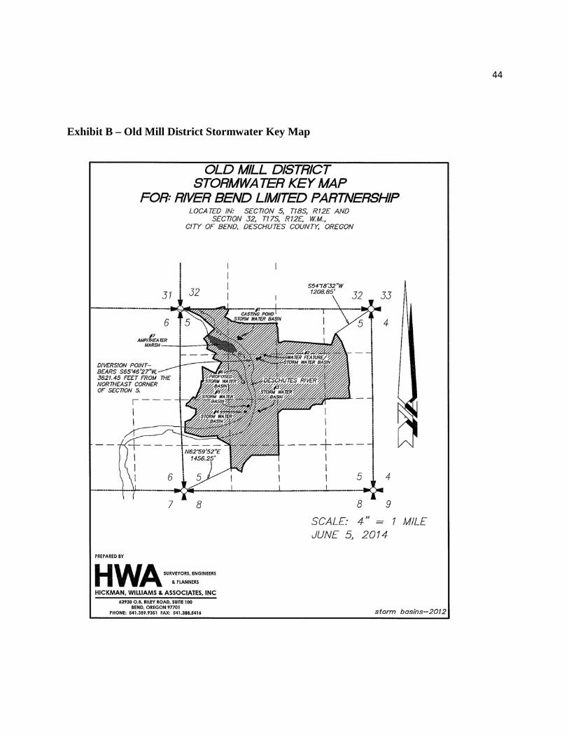
44
Exhibit B – Old Mill District Stormwater Key Map