Embed Size (px)
Citation preview

Draft Puerto Rico Coastal and Estuarine Land Conservation Plan
DRAFT
PUERTO RICO COASTAL AND ESTUARINE LAND CONSERVATION PLAN
March 2010
Puerto Rico Department of Natural and Environmental Resources

Draft Puerto Rico Coastal and Estuarine Land Conservation Plan
DRAFT
PUERTO RICO COASTAL AND ESTUARINE LAND CONSERVATION PLAN
Prepared for:
Puerto Rico
Department of Natural and Environmental Resources
Prepared by:
Ernesto Díaz
and
Craig G. Lilyestrom, Ph.D.
March, 2010

Draft Puerto Rico Coastal and Estuarine Land Conservation Plan
ACKNOWLEDGEMENT This plan was developed through the efforts and cooperation of numerous people, including the members of the Puerto Rico CELCP Advisory Committee, Mr. Ernesto Díaz and Dr. Craig Lilyestrom. We are grateful for the collaboration of everyone involved.

Draft Puerto Rico Coastal and Estuarine Land Conservation Plan
TABLE OF CONTENTS 1.0 INTRODUCTION 2.0 IDENTIFICATION OF COASTAL AND ESTUARINE AREAS 3.0 RESOURCE VALUES TO BE PROTECTED 4.0 EXISTING SUPPORTIVE PLANS AND PROGRAMS 5.0 IMPLEMENTATION OF THE PLAN 6.0 GUIDANCE FOR PROJECT EVALUATION 7.0 PUBLIC CONSULTATION AND INTER-AGENCY COOPERATION APPENDIX A: COASTAL DATA RESOURCES APPENDIX B: PUERTO RICO ADVISORY COMMITTEE APPENDIX C.: PUBLIC MEETING DATES AND LOCATIONS

Draft Puerto Rico Coastal and Estuarine Land Conservation Plan
1.0 INTRODUCTION
Coastal and estuarine areas in Puerto Rico provide habitat for a diverse range of vegetation and wildlife, and contain numerous recreational and historical resources that are valued by the Puerto Rico community, local residents and visitors. Coastal and estuarine areas are also highly favored for development and this has created a host of inter-connected problems including: land conversion, habitat loss, industrial, residential and agricultural based pollution, erosion and the over-exploitation of recreational areas. No point on the main island of Puerto Rico is more than 19 miles from the shoreline and thus almost any land disturbance or development activity can affect the integrity of coastal and estuarine resources. One of the greatest challenges facing Puerto Rico is how to conserve natural resources while providing for the needs of the ever-growing population on the limited lands of the island. In 1765, Puerto Rico’s census reported 44,830 inhabitants. Today, there are nearly 4,000,000 inhabitants, or around 428 inhabitants per square kilometer – the second highest density in America. Approximately 77% of the human population and 40% of the urbanized land is located in the coastal municipalities of Puerto Rico.
In recognition of the need to provide long-term protection for significant coastal
and estuarine resources, Congress created the Coastal and Estuarine Land Conservation Program (CELCP) in 2002. This initiative enables states to permanently protect coastal and estuarine lands by providing matching funds for community-based projects to acquire property from willing sellers either through fee simple purchase or through conservation easements. Lands acquired through the program are owned by the State or local agencies, and in this manner the Coastal and Estuarine Land Conservation Program shares similarities with the Federal Forest Legacy (FLP) program in which Puerto Rico has also been an active participant for many years. However, it should be noted that CELCP is not a working lands program and thus FLP is complementary to CELCP. Titles or interests in properties purchased under CELCP are held in perpetuity by the award recipient and public access is insured in the absence of legitimate environmental or public safety concerns.
Between 2002 and 2006, all CELCP awards were congressionally directed, but
beginning with grants awarded in fiscal year 2007, the program moved to a fully competitive format that allocates funding to projects based upon a set of uniform evaluation criteria. In order to qualify for competitive funding under CELCP, individual coastal states must meet specific eligibility requirements as outlined in guidelines prepared by NOAA. The preparation of an approved state CELCP Plan is the initial action that must take place. These state plans identify priority conservation needs and provide clear guidance for the process of nominating local coastal land conservation projects to the national competition. The Puerto Rico CELCP Plan is being developed by the Puerto Rico Department of Natural and Environmental Resources (PRDNER). A Puerto Rico CELCP Advisory Group (see Appendix B) has also been created to provide public input and direction during the preparation of the State plan.

Draft Puerto Rico Coastal and Estuarine Land Conservation Plan
Coastal Development in San Juan, Puerto Rico
State plans are intended to be concise documents that guide local participation in
the national CELCP. In keeping with guidelines developed by NOAA and the Office of Ocean and Coastal Resource Management, the Puerto Rico plan will provide the following information:
• a definition of the geographic extent of coastal and estuarine areas within Puerto Rico as defined for the purposes of the State plan;
• a description of the lands or values to be protected and the need for conservation through acquisition;
• a description of existing plans or programs that identify local conservation priorities and are supportive of the objectives of the Coastal and Estuarine Land Conservation Program.
• a list of State agencies or local agencies eligible to hold title to property acquired
under the CELCP; and • a description of public consultation and inter-agency coordination activities associated with the preparation of the state plan.
• Identification of “project areas” that represent the state’s priority areas for conservation, including areas threatened by conversion, based on state and national criteria for the program.
The development of the Puerto Rico CELCP plan will provide a framework for
identifying coastal and estuarine land conservation priorities, and will define the State’s process for preparing, evaluating and ranking qualified proposals that will be forwarded to the annual national funding competition administered by NOAA. 2.0 IDENTIFICATION OF COASTAL AND ESTUARINE AREAS

Draft Puerto Rico Coastal and Estuarine Land Conservation Plan
NOAA requires that the geographic extent of the coastal and estuarine areas included within Puerto Rico CELCP be determined to provide a focus for assessing coastal conservation priorities within the state. Generally speaking, the geographic scope of the state plan should be inclusive enough to provide a steady stream of high quality projects, but limits should be considered to insure that all proposed projects are competitive at the national level. This general objective is tempered by the fact that Puerto Rico is rich in diverse coastal and estuarine habitats and, besides the main island, includes the island municipalities of Culebra and Vieques, plus numerous smaller cays. The main island has approximately 310 miles of coast, and if the island municipalities and cays are included, the total coastline exceeds 600 miles.
Las Paulinas Beach, Luquillo, Puerto Rico
The Puerto Rico Coastal Zone Management Program has established as public
policy that the coastal zone is defined as: “…the coastal strip of land measuring 1,000 linear meters landward from the
coastline, as well as additional distances necessary to include key natural systems of the coast. It also includes the territorial waters of Puerto Rico and the submerged oceanic or marine lands beneath these (9 nautical miles or 10.35 terrestrial miles), the islands of Vieques, Culebra, Mona, Monito, Desecheo, Caja de Muerto and all the cays and small islands within them.”
In addition, DNER exerts full jurisdiction over the public trust and submerged
lands beneath the territorial waters as established by the Spanish Port Act of May 7, 1880, which was extended to Puerto Rico in 1886. This act defines the maritime-terrestrial zone (MTZ) as the area influenced by the ebb and flow of the sea, extending inland to where the tide is perceptible in rivers and streams, or the point reached by the highest storm waves where the tide is not perceptible. Under current laws, this zone is in the public domain and cannot be assigned or encumbered for private use on a long-term basis.

Draft Puerto Rico Coastal and Estuarine Land Conservation Plan
With respect to defining the geographic scope of coastal and estuarine areas eligible for participation in the CELCP, both exclusive and inclusive options were considered by the authors of this plan and the Puerto Rico Coastal and Estuarine Land Conservation Plan Advisory Group. The Maritime-Terrestrial Zone provides a potentially useful exclusive definition, since these coastal lands in practice experience the greatest developmental pressure and also are the focus of the most intense land conservation concerns within the Commonwealth. However, as explained above, by law MTZ is in the public domain, and thus purchase is not legally required for their protection.
The Puerto Rico Coastal and Estuarine Land Conservation Plan Advisory Group
supported the Coastal Zone Management Program definition of the geographic scope of coastal and estuarine areas eligible for consideration in the Commonwealth plan, which recognizes that national program priorities focus on shoreline environments and that this will be considered during the evaluation of project proposals.
Flamenco Beach, Culebra Island
3.0 RESOURCE VALUES TO BE PROTECTED
The coastal and estuarine resource values discussed below reflect local conditions
and priorities, but are also clearly guided by national program criteria established by Congress and NOAA. In general, the Puerto Rico Coastal and Estuarine Land Conservation Plan emphasizes the protection of shoreline areas threatened by development and conversion to a non-natural state. The population of Puerto Rico has grown tremendously over time. The census of 1765 reported only about 44,830 inhabitants on the island. By 1860, this had increased to 583,308. Since 1950, population grown has been very rapid, but much of this is due to a reduction in the mortality rate through improved health services. Given the limited geographic space of Puerto Rico, population growth results in increased population density. Currently, the population of Puerto Rico is around 4,000,000 inhabitants, and the greatest population densities are concentrated in the cities and coastal municipalities. However, another
Draft Puerto Rico Coastal and Estuarine Land Conservation Plan
population migration trend has been detected recently. An increase in population is noted in peripheral zones around traditional urban centers, which some refer to as “urban sprawl”. For example, recent population growth has been seen in municipalities around San Juan such as Guaynabo, Toa Baja, Trujillo Alto, Gurabo and Carolina. This migration has been facilitated in part by construction of new highways. As a consequence, additional coastal zones and associated upland areas are under increased development pressure. Land acquisition is the only truly effective way to preserve land for conservation. Even though lands within the maritime terrestrial zone are legally in the public domain, experience has shown that this is not a guarantee that they will be protected.
Priority is allotted to ecologically significant lands that can be effectively
managed or protected, and in particular, projects that advance the goals, objectives and implementation of existing land conservation programs already operating within the Commonwealth of Puerto Rico (see Section 5.0). Every project proposal must document the presence and significance of one or more of the following five resource values, but conserving lands with significant ecological and conservation values is the clear priority of both the national CELCP and this Puerto Rico plan. Recreational and aesthetic values are important, but proposals prepared under the Puerto Rico plan must highlight conservation or ecological values to insure their competitiveness in the national selection process.
Figure 1 shows the areas in Puerto Rico of application of the Coastal Zone Management Program.
Figure 1. Area of application of the Puerto Rico Coastal Zone Management
Program.

Draft Puerto Rico Coastal and Estuarine Land Conservation Plan
3.1 Ecological Values
Puerto Rico’s shoreline environments are logically subject to both terrestrial and marine influences, and include dry, mesic and wet communities depending on their location, elevation and orientation. Historically, these areas have been subject to significant alteration by human activities and continue to be affected by land conversion as a result of residential construction, resort development, marina construction and ongoing agricultural operations. Few undisturbed shorelines remain, and in most cases it is difficult to imagine Puerto Rico’s coastal environment prior to human contact. A recent study notes that the San Juan metropolitan zone could soon comprise a completely urbanized area from Fajardo to Arecibo. Non-native species such as Australian pine (Casuarina equisetifolia) are common in coastal sites and non-native animals such as feral ungulates, rats, dogs, cats and mongooses endanger native wildlife populations. The protection of threatened habitats and indigenous flora and fauna represents the core objective of the national CELCP, and numerous areas are potentially eligible to participate in the program given the large number of threatened or endangered species in Puerto Rico and the significant amount of habitat loss.
Coastal areas are natural ecotones and are typically rich in both species numbers and habitat diversity as a result of the interaction of land and sea environments. For the purposes of this plan, the principal habitats of concern in Puerto Rico’s coastal and estuarine environment are: shoreline, wetland and adjacent coastal upland areas. Each of these habitats provides a key contribution to the ecological integrity of the overall coastal environment and “ecological significance” is determined by the quality of existing natural habitats, the diversity of species present, and the existence of threatened or endangered species. Any proposed project submitted to the Puerto Rico DNER for evaluation as a nominee to the CELCP national competition must include one or more of these habitats to be eligible.
Shoreline habitats in an undisturbed state were once common in Puerto Rico, but
are now increasingly rare as a result of sustained development pressures. This category includes areas directly adjacent to the sea, such as beach or dune communities and coastal lagoons where fresh and saltwater mix. Sand beaches are increasingly threatened in all parts of Puerto Rico as a result of hotel and resort, residential and recreational development and human activities continue to impact the movement of sand and sustainability of shoreline habitats. It is hard to find dunes actively forming today, mostly because of human impingement on the shoreline and the interruption of natural eolian processes. Coastlines that possess natural vegetation such as bloodwood tree (Pterocarpus officinalis) and undisturbed dune vegetation are particularly rare. Historically, bloodwood trees dominated freshwater wetlands in the coastal plains of Puerto Rico, but deforestation has reduced its distribution to small patches adjacent to mangrove forests in areas of higher salinity. Retaining longer segments of undisturbed shoreline is essential to support long-term habitat viability and protect native coastal wildlife such as seabirds, migratory shorebirds, and leatherback and hawksbill sea turtles.

Draft Puerto Rico Coastal and Estuarine Land Conservation Plan
Puerto Del Rey Marina, Fajardo
Coastal wetland habitats in Puerto Rico are diverse and many inter-tidal estuaries have been lost to agricultural development in the past and resort and residential development more recently. Coastal wetlands in Puerto Rico support numerous unique plant and animal communities and species dependent on Puerto Rico estuaries are unusual in their ability to tolerate highly variable water quality conditions and significant sediment inputs. Native shrimp species that depend on estuaries for part of their amphidromous life cycle include the bigarm river shrimp Macrobrachium faustinum, the cinnamon river shrimp Macrobrachium acanthurus, as well as the recently discovered American grass shrimp, Palaemon pandaliformis.
The catadromous eel, Anguilla rostrata and native amphidromous fish such as the sirajo goby Sycidium plumieri and bigmouth sleeper Gobiomorus dormitor are well known to Puerto Rico fishermen. Coastal lagoons, most of which consist of mangrove habitat, provide essential habitat for a wide range of shorebirds and other wetland fauna, including endangered manatees Trichechus manatus and threatened grouper species such as goliath groupers Epinephelus itajarus. Coastal wetlands provide prey organisms for many marine species inhabiting coral reef and other offshore habitats, and their role in maintaining nearshore water quality is underappreciated. The buffering capacity of coastal wetlands protects coral reefs and other nearshore marine habitats from a variety of negative impacts such as sedimentation, turbidity and freshwater inputs produced by heavy rains.

Draft Puerto Rico Coastal and Estuarine Land Conservation Plan
Laguna Grande, Fajardo
Adjacent coastal upland habitats have not been exposed to quite the same level
of development pressure as shorelines in Puerto Rico, but these areas are also considered prime development sites. From an ecological perspective, adjacent uplands play both a direct and an indirect role in coastal conservation. Upland areas directly support a wide range of coastal flora and fauna, and also act as buffer zones that protect shoreline and wetland habitats. Intact upland riparian habitats can also limit the production of non-point source pollutants that can severely degrade coastal water quality. Quite simply, healthy shorelines and wetlands require healthy adjacent uplands. Increasingly, the Puerto Rico public demands attention to the impacts to upland riparian habitats as urban sprawl encroaches on previously undeveloped areas. In Puerto Rico, intact adjacent coastal upland habitats can be considered as potential project sites on the basis of the important role they plan as buffer zones protecting shoreline and wetland communities, and through the concept of ecological corridors. 3.2 Conservation Values
Conservation values must be considered because limited funds are available for land acquisition and protection efforts must be concentrated on areas with the highest values. Generally, conservation value relates to the potential of any individual coastal land parcel to protect biodiversity as an individual entity or in combination with adjoining conservation lands such as natural reserves, national parks, state forests, local protected areas or marine reserves (MPA). The conservation significance of proposed projects can be determined by characterizing sites as undisturbed habitat, core habitat, buffer zones or in terms of connectivity to other important habitats.
Relatively few large stretches of undisturbed habitat in coastal areas remain in
Puerto Rico, and these lands possess substantial conservation significance for the purposes of the Puerto Rico Coastal and Estuarine Land Conservation Plan. Lands that represent core habitats for rare or endangered coastal fauna such as native seabirds, sea turtles, or vegetation communities such as coastal dry forests, or old growth forests are a priority as a result of the immediate need to protect these areas. Coastal lands situated immediately adjacent to undisturbed or core habitats can serve as buffer zones.

Draft Puerto Rico Coastal and Estuarine Land Conservation Plan
Although buffer zones represent lower conservation values than undisturbed or core habitats, ecological benefits associated with these areas include providing a physical barrier to encroachment on core habitats, providing protection from storm damage, reducing edge effects, and improving the protection of highly mobile or migratory species. Upland buffer zones can provide benefits from a water quality perspective as limiting the input of pollutants to freshwater streams can positively impact coastal waters. Lands that provide connectivity to existing protected areas in shoreline or adjacent coastal areas also possess conservation significance. Improving connectivity can reduce habitat fragmentation and therefore enhance the preservation of biodiversity within the coastal environment. 3.3 Cultural Values
Although cultural values are not the focus of land conservation proposals developed under the Puerto Rico Coastal and Estuarine Land Conservation Plan, sites associated with pre-Columbian and other historic periods of Puerto Rico’s past are commonly found in coastal areas and the preservation of these resources is important to the cultural heritage of the island. Cultural values may include, but are not limited to, lands where archaeological artifacts associated with pre-Columbian tribes or peoples or other important historic artifacts or structures are located. The preservation of Puerto Rico cultural values is certainly compatible with the ecological conservation objectives of the CELCP, and the protection of these resources by fee simple purchase or through conservation easements can only enhance the overall potential of any proposed conservation site. Given this broad compatibility of ecological and cultural conservation goals within coastal areas of Puerto Rico, the CELCP may provide opportunities to support the development of uniquely Puerto Rican approaches to coastal conservation.
3.4 Recreational Values
Coastal lands that are solely or primarily used for active recreation are not eligible for funding under the Coastal and Estuarine Land Conservation Program, but certain recreational activities are compatible and can continue if these do not compromise conservation or ecological values. For example, lands adjacent to existing marine recreation areas could be protected while ensuring continued access to water-based recreational activities such as kayaking, surfing, scuba diving or snorkeling. Low-impact non-consumptive land-based recreational activities such as beach use, hiking, picnicking, mountain biking, horseback riding or birding could also be viewed as compatible with CELCP objectives and provide additional support for a proposed conservation site. Nevertheless, it is recognized that

Draft Puerto Rico Coastal and Estuarine Land Conservation Plan
some activities such as mountain biking and horseback riding will require extra measures such as being allowed only on marked trails to ensure they do not cause negative impacts to the other values being protected on CELCP properties. 3.5 Aesthetic Values
Protecting open space and scenic vistas is an important objective of the Puerto Rico Coastal and Estuarine Land Conservation Plan, and the preservation of aesthetically pleasing coastlines is important to the Puerto Rico economy, which is highly dependent on tourism. Puerto Rico is famous for its scenic coastal zone, and the aesthetic qualities of its coastline has created a desirable tourist destination. Although aesthetic values are of secondary concern to the national CELCP, almost any undeveloped coastal site in Puerto Rico will also possess important visual or aesthetic qualities. Aesthetic values can, therefore, play a highly supportive role when building the case for proposed conservation projects.
4.0 PROJECT AREAS
Puerto Rico’s priority areas for conservation reflect the values to be protected through the CELCP program and the areas most threatened by conversion. Thus, the Project Areas are represented within the three main resource values: shorelines, wetlands and adjacent coastal upland areas. Detailed descriptions of these habitats and associated wildlife are found in the publication “Puerto Rico Critical Wildlife Areas” (Ventosa-Febles et al. 2005).
In light of the fact that Puerto Rico is often described as an archipelago, or system of islands and cays, the shoreline resource is located around each landmass on all sides.
Wetlands (along with coral reefs) are the coastal ecosystems that are most abundant in Puerto Rico. One of the classifications that is made of wetlands groups them into three types: marine, estuarine and freshwater. The most frequent are the estuarine and freshwater wetlands, each of which comprises about 36% of the total area of wetlands. Examples of estuarine wetlands are those close to coastal rivers, salt flats and mangroves. Freshwater wetlands include swamps, ponds, marshes and humid grasslands. The marine wetlands represent 27% of the total. Sea grass beds are included in this category. Estuarine and freshwater wetlands are most abundant in the eastern 2/3 of the north coast of Puerto Rico, and all along the south coast, although examples are found on all coasts of the main island. Vieques and Culebra have no freshwater wetlands. In total, Puerto Rico has 87,255 ha. of coastal wetlands.
Adjacent coastal upland areas are those areas which provide habitat contiguous to the wetland ecosystems and whose conservation is critical to the protection of the wetland systems. Figure 2, adapted from Puerto Rico Critical Wildflife Areas, illustrates the location of priority areas for conservation through the CELCP program.

Draft Puerto Rico Coastal and Estuarine Land Conservation Plan
Figure 2. Priority areas for conservation, based on critical wildlife areas within the coastal zone.
5.0 EXISTING SUPPORTIVE PLANS AND PROGRAMS
NOAA guidelines for the CELCP require State plans to “…make use of work that has already been done.” With this directive in mind, the following information identifies existing national, State and local initiatives that share conservation objectives with the national program. The project proposal development process envisioned for the Puerto Rico plan recognizes that a significant amount of effort that has already been dedicated to identifying priority conservation sites within the Commonwealth of Puerto Rico, and the following national, State, county and private initiatives represent potential partner programs or sources of information. This list is not intended to identify every plan or program associated with land conservation in the Commonwealth of Puerto Rico, but to outline key activities and possible relationships with existing conservation programs that are supportive of CELCP objectives. The following list provides a brief description of each plan or program and how these could potentially interact with the Puerto Rico plan for the purpose of project site selection and proposal development.
5.1 Federal Government Plans and Programs United States Fish and Wildlife Service Coastal Program
The mission of the United States Fish and Wildlife (USFWS) Coastal Program is to identify “important coastal resource problems and solutions and develop partnerships for on-the-ground conservation in high priority coastal areas.” The Coastal Program focuses its efforts in bays, estuaries and watersheds to conserve fish, wildlife and their

Draft Puerto Rico Coastal and Estuarine Land Conservation Plan
habitats to support healthy coastal ecosystems. The program is guided by four goals: 1) serving coastal communities by providing assessment and planning tools to identify priority habitats that should be protected and restored; 2) conserving pristine coastal habitats through the support of locally-initiated conservation efforts; 3) restoring degraded coastal wetland, upland and stream habitats by working with partners to implement on-the-ground projects; and 4) focusing resources through conservation alliances that leverage the financial and technical resources of our partners and multiply the impact of the taxpayer’s dollar. The USFWS Coastal Program focus on identifying priority habitats and creating partnerships for conservation purposes is consistent with the objectives of the Puerto Rico Coastal and Estuarine Land Conservation Plan, and existing USFWS Coastal Program projects may provide important information and partnerships for proposed Puerto Rico conservation projects.
National Coastal Wetlands Conservation Grant Program
The Coastal Wetlands Planning, Protection and Restoration Act established the National Coastal Wetlands Conservation Grant Program (NCWCGP) to acquire, restore and enhance wetlands in the coastal United States and the Trust Territories. This program is active in Puerto Rico and Puerto Rico DNER has applied for funds to conserve wetland habitats within the Northeast Ecological Corridor. This program shares similar conservation goals with the CELCP, and coastal wetland projects submitted under the Puerto Rico Coastal and Estuarine Land Conservation Plan should identify unprotected areas identified as high priority sites by the NCWCGP or lands adjacent to existing NCWCGP projects. Wildlife Conservation and Restoration Program
The Wildlife Conservation and Restoration Program (WCR) is administered by the United States Fish and Wildlife Service as a sub-account of the Federal Aid in Wildlife Restoration Program. The primary focus of the program is to preserve, protect and restore wildlife through habitat management, population management, surveys, research and public education. Although Puerto Rico has never participated in this program, administration at the State level would be through the Puerto Rico Department of Natural and Environmental Resources and its relation with CELCP will be discussed in the section on State Government Plans and Programs. Forest Legacy Program
The Forest Legacy Program (FLP) is a federal program in partnership with state governments that supports local efforts to protect environmentally sensitive forest lands. Designed to encourage the protection of privately owned forest lands, the FLP is an entirely voluntary program that focuses on the acquisition of whole or partial interest in property to maximize public benefits. The FLP assists states in the development and implementation of forest conservation plans. It encourages and supports the acquisition of conservation easements and other agreements that control land use without necessarily removing the property from private ownership. Most FLP conservation easements

Draft Puerto Rico Coastal and Estuarine Land Conservation Plan
restrict development or require sustainable forestry practices to protect forest values. Although the FLP mainly focuses on upland areas, it does identify several coastal forest sites with significant conservation potential. These areas could potentially represent key habitat acquisitions or function as buffer zones that provide important habitat for certain species and limits downstream impacts on existing shoreline or estuarine conservation areas.
Guánica Coast
5.2 State Government Plans and Programs 5.2.1 Puerto Rico Coastal Zone Management Program
As lead agency for the purposes of the Puerto Rico CELCP (see Section 6.1) the Puerto Rico DNER is responsible for both administration and integration of this plan with the objectives of Puerto Rico’s Coastal Zone Management Act and other existing coastal projects. Current initiatives that may interact with the Puerto Rico Coastal and Estuarine Land Conservation Plan include:
Puerto Rico Heritage 100,000 (seeks to acquire at least 100,000 acres over the next 10 years)
Forest Legacy Program (DNER/Forest Service Bureau) Puerto Rico Natural Heritage Program (SAPI) Puerto Rico Conservation Trust GAP Analysis (Identifies conservation priorities) Puerto Rico Critical Wildlife Areas
Coastal Hazards
Puerto Rico’s coastlines are threatened by a variety of hazards ranging from erosion to tsunamis and hurricanes. Just north of Puerto Rico, we have the Puerto Rico Trench, which presents a potentially catastrophic submarine landslide tsunami threat to the north coast. The hurricane coastal hazard is basically due to the storm surge, and the accompanying surface gravity waves forced by the hurricane winds. Shoreline erosion is particularly relevant to the Puerto Rico Coastal and Estuarine Land Conservation Plan as this process could affect land purchased under the program over time. The coastal zone comprises a large part of the human population and the infrastructure of Puerto

Draft Puerto Rico Coastal and Estuarine Land Conservation Plan
Rico. Approximately 77% of the population and 40% of the urban soils in the island are found in the coastal municipalities. 5.2.2 Department of Natural and Environmental Resources
The Department of Natural and Environmental Resources (DNER) is responsible for the management of public and conservation lands in the Commonwealth of Puerto Rico. Given this responsibility, the Puerto Rico Coastal and Estuarine Land Conservation Plan could potentially interact with numerous existing conservation programs administered by this Department. A brief list of several important DNER initiatives is provided below.
• Conservation Easements – registration in favor of DNER or PR Conservation Trust
(PRCT) for conservation in perpetuity. • Auxiliary Forests – remains as privately owned, yet a commitment to conservation is
made by the owner with the DNER or PRCT, granting tax advantages and incentives.
• Co-management – same conditions as above.
Puerto Rico Comprehensive Wildlife Conservation Strategy
The recently completed (2005) Puerto Rico Comprehensive Wildlife Conservation Strategy (CWCS) can play a collaborative role with the Puerto Rico Coastal and Estuarine Land Conservation Plan, along with the GAP Analysis program which provides information regarding lands with priority for conservation. 5.2.3 Puerto Rico Legacy Lands Act
Law 268 (Legacy Lands Act) was passed by the Puerto Rico Legislature in 2003, and establishes a permanent, dedicated funding source for land conservation and specifically the acquisition and conservation of lands with ecological value in Puerto Rico. Funds are administered by the PR DNER and lands are acquired on the basis of recommendations from an advisory group. The Legacy Lands Act represents a potential source of matching funds for conservation proposals developed under the CELCP. 5.3 Municipal Government Plans and Programs Municipal governments use 4 land use classifications: 1.- Urban, 2.- Urban expansion, 3.- Rustic soils, and 4.- Specially protected rustic soils, which are the areas to be preserved/protected/conserved. Mitigation strategies under the Wildlife Law (Law 241) apply in the case of the Municipal Governments and may result in acquisition of properties for conservation.

Draft Puerto Rico Coastal and Estuarine Land Conservation Plan
5.4 Private Conservation Organizations
Private organizations are very active on conservation projects within Puerto Rico and frequently play a pivotal role in the acquisition and management of coastal conservation sites. For this reason, a list of private conservation groups that have been active in coastal land acquisition or have participated in recent CELCP funded projects is provided below.
The Trust for Public Land
The Trust for Public Land (TPL) is a national, nonprofit organization that conserves land for people to enjoy as parks, community gardens, historic sites, rural areas, and other natural places to ensure livable communities for generations to come. TPL has been instrumental in establishing 2 new conservation areas in Puerto Rico, including the San Miguel Natural Reserve in Luquillo and the Cabo Rojo Salt Flats on the west coast. TPL has also provided financial support for holding properties off the market while Commonwealth and federal funds were secured for the purchase. Puerto Rico Conservation Trust
The Conservation Trust of Puerto Rico is a private, non-profit organization whose mission is to protect and enhance the Island’s natural resources through the acquisition and donation of lands of great ecological, aesthetic, historic and/or cultural value, and the establishment of conservation easements. The Trust was established in 1970 by initiative of the governments of Puerto Rico and the United States. Since then, the Trust has acquired over 18.000 acres of land with great ecological, historic and cultural value in 20 different locations throughout the Island. 6.0 IMPLEMENTATION OF THE PLAN 6.1 State Lead Agency
NOAA guidelines require a state lead agency to be responsible for soliciting qualified conservation proposals, reviewing these documents for completeness, prioritizing proposals according to state criteria, and nominating qualified projects to the national competition. This model assumes substantial control at the State agency level, but significant flexibility exists with respect to the relationship between the lead agency and local partners. A consensus was reached at the initial meeting of the Puerto Rico Coastal and Estuarine Land Conservation Plan Advisory Committee that the lead agency for the purposes of administering the CELCP in Puerto Rico would be the Puerto Rico DNER. The Puerto Rico Department of Natural and Environmental Resources was created in 1972 and includes the Puerto Rico Coastal Zone Management Program and Puerto Rico Natural Heritage Program among other programs which cooperate among federal, state and local agencies and public advisory groups to address coastal issues and uphold environmental law through a variety of regulatory and non-regulatory techniques.
Draft Puerto Rico Coastal and Estuarine Land Conservation Plan
6.2 Agencies and Organizations Eligible to Hold Land Title
NOAA can make financial awards to the lead agency in the Commonwealth of Puerto Rico for the purposes of implementing the Puerto Rico Coastal and Estuarine Land Conservation Plan. The lead agency can then allocate grants or make sub-awards to other state agencies or local governments as defined under 15 CFR 24.3 or entities eligible for assistance under section 306A(e) of the CZMA (16 USC 1455a(e)). NOAA can also make grants directly available to any of these eligible entities at its discretion and in consultation with the lead agency to expedite completion of an approved project. Only state or local governmental agencies are eligible to hold title to lands acquired under the existing program guidelines unless directed by Congress and designated entities will hold title to the land (or interests in land) in perpetuity. Eligible organizations in Puerto Rico include Commonwealth agencies such as the Department of Natural and Environmental Resources (DNER), individual local government agencies such as any municipal government.
6.3 Eligible and Ineligible Use of Program Funds
The purpose of CELCP is to acquire properties or interests in properties from willing sellers, and the terms and conditions of the acquisition must ensure that the property will be administered for conservation purposes in perpetuity. Activities consistent with program objectives include: resource protection, restoration and enhancement, recreation, research and education. To be eligible for funding a project must:
• be located in a coastal or estuarine area deemed eligible within an approved state Coastal and Estuarine Conservation Plan.
• meet criteria outlined in the national CELCP guidelines, • match federal program funds with non-federal funds at a ratio of 1:1, • be held in public ownership (fee simple or conservation easements), • provide conservation in perpetuity, and • provide access to the general public as appropriate and consistent with protection
of project lands.
Each project must also develop a strategy for long-term stewardship that identifies the entity or entities responsible for on-going conservation management. Activities inconsistent with program objectives include: agriculture, aquaculture, shoreline armoring, construction of most roads, buildings or facilities (except to support conservation activities) and active recreation facilities. The federal share of program funds cannot be used for funding long-term operations, maintenance or management of land, construction (buildings, boat launches, docks or piers) shoreline armoring, or other acquisitions that completely restrict access. Acquisitions are not allowed for the sole

Draft Puerto Rico Coastal and Estuarine Land Conservation Plan
purpose of complying with habitat mitigation requirements resulting from agency, corporate or individual actions or for the primary purpose of enforcing fish, wildlife or other regulations. Land acquisitions for active recreation such as sports facilities, water parks or playgrounds are not allowed. Federal funds, funds previously used or proposed for use to match another federal grant, and mitigation funds are not allowable sources of matching funds for program purposes.
6.4 Project Review Process
Two models were discussed at the first meeting of the Puerto Rico Coastal and
Estuarine Land Conservation Plan Advisory Committee on March 2, 2010 facilitate the project review process at the state level. The first option was a “lead agency” model where the Puerto Rico DNER would both receive and review proposed projects. Potential benefits of the “lead agency” model could include program consistency and the availability of Commonwealth resources to support the evaluation of proposals. Drawbacks of this approach could include reduced local support for project applicants and the potential loss of an opportunity to enhance coastal land conservation within local land use planning processes.
The second option for project evaluation was a “local” model with each
municipality taking the responsibility for reviewing and subsequently nominating projects that would be forwarded to the Puerto Rico DNER for nomination to the national competition. Benefits associated with the “local” model could include enhanced local participation in the program and the potential for improved integration of coastal land conservation into local land use planning systems. Potential drawbacks could include the availability of adequate municipal staff and resources to manage the annual review of CELCP project proposals.
After a discussion of the relative merits of each approach with the Coastal and
Estuarine Land Conservation Plan Advisory Committee, it was agreed that the “lead agency” model was preferred. Project proposals developed by local partners would be forwarded prior to a specified deadline to the Puerto Rico DNER for evaluation and ranking. Commonwealth agencies and municipal agencies are expected to work closely with partners such as the Trust for Public Land and the Puerto Rico Conservation Trust to prepare high quality proposals that would be submitted to the Puerto Rico DNER for review prior to their consideration for submission to the national competition.

Draft Puerto Rico Coastal and Estuarine Land Conservation Plan
Relationship Between the Lead Agency and CELCP Partners
6.4.1 Project Solicitation
The Puerto Rico DNER will solicit CELCP proposals after notification from
NOAA that funds are available for projects under the competitive grants program. A list of agencies, organizations or individuals interested in coastal land conservation should be developed to facilitate these solicitations, and application instructions should be developed using information contained in this plan. Application instructions should describe the CELCP guidelines, applicant and project eligibility criteria, project information requirements, and the proposal review process. A contact list of state and local government staff or private organizations familiar with the CELCP and proposal development should also be included in the solicitation to assist new participants in successfully completing the application process.
6.4.2 Project Submission and Evaluation
All project proposals received by the Puerto Rico DNER prior to the specified submission deadline will be assessed for completeness and compliance with the CELCP eligibility criteria. Proposals will also be reviewed to insure the mandatory existence of a willing seller and existing property owners must understand any conservation restrictions or easement concepts being proposed. The appropriateness of designated matching funds will be assessed to insure that these are reasonable, available within the performance period, and consistent with CELCP guidelines that recognize cash contributions, donated land or land value from properties with similar coastal or estuarine attributes, or in-kind services such as restoration. Incomplete proposals or applications that do not meet program eligibility criteria will not be included in the project evaluation process as described below. Applicants will be notified in writing of a negative determination as soon as possible, and this notification should describe proposal deficiencies to allow applicants to re-submit if the solicitation has not closed.

Draft Puerto Rico Coastal and Estuarine Land Conservation Plan
Prior to the proposal submission closing date, the Puerto Rico DNER will nominate and assemble a Peer Review Committee to be charged with the evaluation and ranking of all acceptable proposals submitted to the open round of CELCP competitive funding. The Peer Review Committee should include members from relevant state and municipal agencies, resource managers and from local land conservation groups, but in no case should any individual directly associated with a current proposal be included to avoid conflict of interest. Puerto Rico DNER staff should provide the review committee with copies of each proposal and specific instructions regarding review criteria, scoring and ranking. Committee members will then assess the merits of each proposal individually and score projects based on the evaluation guidance outlined in Section 7.0 of this document. All evaluation decisions must be based solely on information contained in the written project proposals submitted by applicants.
After committee members have completed their individual assessments, the
Puerto Rico DNER will convene a meeting of the full Peer Review Committee at its offices in San Juan. At this meeting, the review committee members will discuss their individual assessments, address any inconsistencies or errors, and attempt to develop a consensus ranking of the proposals under consideration. If a consensus ranking cannot be agreed upon by the Peer Review Committee at this meeting, project proposals will be ranked according to the combined total points awarded by each individual reviewer. In either case, a ranked list of all proposals from highest to lowest and a copy of all evaluation comments will be forwarded to the Puerto Rico DNER, which will certify the evaluation process and final results.
6.4.3 Selection for the National Competition
After the Puerto Rico DNER has certified the recommendations of the Peer Review Committee, ranked project proposals and all necessary supporting materials will be forwarded to NOAA for the CELCP national competition. The Puerto Rico DNER may forward the single highest ranked proposal or any number of proposals based on NOAA guidelines and the amount of funding allocated to the competitive grants program for the relevant fiscal year. Applicants selected to proceed to the national competition will be notified and instructed to provide any additional information required to support their proposals.
7.0 GUIDANCE FOR PROJECT EVALUATION
As outlined in Section 3.0 and Section 4.0 of this plan, lands within Puerto Rico eligible for CELCP funding are those defined as within the coastal zone by the Puerto Rico DNER. These include ecologically significant shoreline habitats, coastal wetlands, and adjacent coastal upland areas that can be effectively managed and thus advance the goals and priorities of land conservation programs currently operating within Puerto Rico. The evaluation guidance provided below supports the emphasis on specific coastal habitats and reflects criteria used by NOAA to rank project proposals at the CELCP national competition. Resource values represent the most important single criteria in the evaluation guidance, but technical and scientific merit, qualifications of the applicant and

Draft Puerto Rico Coastal and Estuarine Land Conservation Plan
project costs are also considered. These evaluation criteria are intended to be used by the Peer Review Committee (described in Section 6.4.2) during its evaluation of project proposals, and provide the basis for ranking proposals in terms of overall conservation merit. Financial aspects are also considered during the preliminary review of proposed projects conducted by the Puerto Rico DNER after submission.
I) Project Resource Values (55 out of 100 points) Ecological Values (25 points)
Referees must assign priority to projects containing shoreline habitats, coastal wetlands, and adjacent coastal upland areas (as defined in Section 4.1 of this document) during their consideration of ecological values. Referees will evaluate the degree than projects contain intact natural habitats and examples of exceptional species diversity, should consider the occurrence of federal or state-listed threatened or endangered species and whether native or endemic species are represented on the site. Lands that possess intact ecological values are favored over areas that require significant restoration or remediation. Projects that provide core habitat for rare or endangered coastal species, or serve as buffer zones for adjacent conservation areas should be ranked above projects that do not provide these benefits. Other conservation values to consider include the ability of a proposed project to provide connective habitats, corridors, habitat linkages and other means of reducing biological isolation. The presence of invasive or exotic species should be minimal or capable of being managed. Coastal erosion is an increasingly serious concern in Puerto Rico, and proposals that include shoreline habitat must provide an evaluation of the potential impacts of coastal erosion on the long-term conservation of project lands. Referees must specifically consider:
• the type, quality and area of habitat types found on the proposed project site; • the regional ecological importance of the proposed project site in terms of
protecting species diversity, providing ecological connections or linkages among other important coastal and estuarine conservation areas;
• how acquisition of the site will help establish corridors or linkages among areas of
significant conservation, ecological, recreational or aesthetic values that are already protected;
• the potential success of restoration plans for the site if existing ecological values
are impaired (e.g., the existence of invasive or exotic species or alterations such as dikes, agricultural and silvicultural land uses);
• how the habitat supports (or may support) federal or state listed threatened
species, endangered species or species of concern.
Conservation Values (10 points)

Draft Puerto Rico Coastal and Estuarine Land Conservation Plan
Referees should consider whether a project represents a keystone acquisition within a larger conservation plan or if the project directly supports the priorities and objectives of any other municipal, state or federal land conservation initiative. The evaluation of conservation values must consider the ability of proposed projects to protect biodiversity as an individual entity or in combination with adjoining conservation lands such as natural reserves, national parks, state forests, or marine protected areas. Surrounding land uses should be compatible with long-term conservation of the site’s resource values. Referees must specifically consider how the property fits within any larger conservation strategy, comprehensive coastal zone management plan, or watershed protection initiative; and whether the project exhibits a mix of ecological, recreation, historic and aesthetic values that together contribute important benefits to the coastal and estuarine environment not provided by those values individually.
Cultural Values (10 points)
Referees must evaluate whether proposed project sites include the presence of a registered archaeological site or the documented presence of historic artifacts or structures. Referees must recognize features that are designated or could be nominated as a National Historical Landmark or listed on the National Register of Historic Places or a state or local Register of Historic Places. The potential existence of cultural, historical or archaeological features that have not been formally evaluated or documented must also be considered.
Recreational and Aesthetic Values (10 points)
The evaluation of aesthetic values must consider the contribution a proposed project site makes to the aesthetic character of surrounding areas, or the existence of vistas that complement existing scenic byway, trail or viewshed programs. Project sites that are within the viewshed of populated areas, visible from heavily utilized roadways, or identified as a scenic resource by a tourism or community land use plan should also be considered to possess significant aesthetic values. With respect to recreation values, referees must evaluate whether the proposed project site provides public access to coastal areas or opportunities for low-impact non-consumptive land-based recreational activities such as beach use, hiking, horseback riding, mountain biking, picnicking, nature study or birding. Lands adjacent to existing marine recreation areas also possess recreational values by providing access to water based activities such as kayaking, surfing, swimming, scuba diving or snorkeling. Referees must specifically consider whether the proposed project supports existing or potential recreational access needs identified in any state, county or community plan.
II) Technical and Scientific Merit (25 out of 110 points)
Long-Term Management and Use (15 points)
Evaluation of the long-term management plan must consider how the proposed project site will be maintained or improved in the future. This will include the suitability of rehabilitation or enhancement strategies required to restore ecological, conservation,

Draft Puerto Rico Coastal and Estuarine Land Conservation Plan
cultural, recreation and aesthetic values. Referees must assess whether the property is currently in the desired state for its intended conservation purpose, and if surrounding land uses are compatible with the long-term conservation of site values (as defined by existing development plans or land use designation). The proposed management plan must be evaluated to assure that it is technically sound and possesses innovative strategies for achieving conservation goals as well as if funding has been secured for proposed restoration activities, and whether identified public or private partners are willing to provide long-term management support.
Threat of Conversion (5 points)
Referees will consider the degree that the property is threatened by conversion from its existing state to uses that are inconsistent with the long-term conservation of existing ecological and conservation values. A significant threat of conversion is represented by the existence of an approved development plan or a standing offer to purchase the property for non-conservation purposes. A moderate threat of conversion could involve the property being situated in close proximity to other development activity or the property being listed for sale. A low threat of conversion could entail a lack of development approvals, local development trends that do not indicate a significant impending threat, or sites that are not readily developable because of physical factors such as the presence of steep slopes or access issues.
Project Readiness (5 points)
Project readiness will be evaluated by considering the likelihood that a proposed project can be completed during the identified performance award period. This assessment will include factors such as whether the proposed site is on the market, the stage of discussions with a willing seller, or the existence of a purchase or sale agreement. Assessment should be supported by documentation such as an appraisal or title opinion. Referees should also consider whether the site possesses any uncertainties or encumbrances such as liens, easements, litigations or judgments that are not likely to be resolved within the proposed award performance period, or if the site has any history of contamination or other environmental hazard that must be resolved prior to purchase. The award period for CELCP grants is 18 months, with an 18-month extension available should circumstanced warrant.
III) Qualifications of the Applicant (10 out of 110 points)
Referees must consider whether the applicant possesses the capacity and
experience to execute the proposed land transaction and manage the property in a manner consistent with the long-term conservation of identified resource values. Factors to consider include the applicant’s success with previous land conservation projects or long-term resource stewardship initiatives, and whether the applicant possesses the necessary education, experience, training, facilities and administrative resources to accomplish the proposed project. The applicant will be evaluated in terms of their capacity to complete the acquisition and manage property consistent with CELCP guidelines and state coastal zone management policies.
Draft Puerto Rico Coastal and Estuarine Land Conservation Plan
IV) Project Cost (20 out of 110 points)
The proposed project budget will be evaluated to determine if it is realistic and commensurate with the project needs and the award timeframe. The source of non-federal matching funds must be consistent with CELCP guidelines and likely to be available within the performance period. Requested direct and indirect costs for implementation of the project must be consistent with CELCP guidelines, and administrative costs associated with executing the land transaction (e.g., appraisals or title opinions) must be reasonable. Funds allocated for salaries and fringe benefits can be only allocated for personnel directly involved in implementing the proposed project. The evaluation of project costs must specifically consider:
• how direct land acquisition costs were estimated and if this was based on an
independent appraisal or other assessment of fair market value; • the source of matching funds and whether these are in the form of cash, in-kind
contribution, donated land, or other land values (e.g., easements); • whether matching funds are currently available or expected to be available within
the award performance period; • the suitability of any property proposed as a match for the federal share of funds
(defined by the values that the property contributes, suitability of acquired legal rights, and the basis of the purchase price);
• the appropriateness of any administrative costs, grants or in-kind services
associated with the matching funds; and • the viability of the proposed project if funding from other sources did not become
available within the award performance period.
8.0 PUBLIC CONSULTATION AND INTER-AGENCY COOPERATION
A Puerto Rico Coastal and Estuarine Land Conservation Plan Advisory Committee was organized to advise the authors of this document and the lead agency (Puerto Rico DNER) on the preparation of the Puerto Rico Coastal and Estuarine Land Conservation Plan. The committee includes representatives from:
• DNER/Terrestrial Resources Division • DNER/Fisheries and Wildlife Bureau • DNER/Marine Resources • DNER/Jobos Bay National Estuarine Research Reserve • Puerto Rico Coastal Zone Management Program • San Juan Bay National Estuary Program • University of Puerto Rico Marine Sciences Department

Draft Puerto Rico Coastal and Estuarine Land Conservation Plan
Public participation and inter-agency cooperation was built through Advisory Committee meetings, a website specifically devoted to the Puerto Rico Coastal and Estuarine Land Conservation Plan, and public presentations in several locations around the island. These presentations were arranged in consultation with advisory committee members. A list of the Puerto Rico Coastal and Estuarine Land Conservation Plan Advisory Committee members is provided in Appendix B and public consultation events are outlined in Appendix C.

Draft Puerto Rico Coastal and Estuarine Land Conservation Plan
APPENDIX A: COASTAL DATA RESOURCES The Puerto Rico DNER maintains a web portal with public access to various
interactive GIS-based maps at: http://www.drna.gobierno.pr/oficinas/asesoras/informatica/geoinformatica/drna-
mapas-interactivos/ The available maps include: • Interactive Map of Installed Mooring Buoys • Interactive Map of Protected Natural Areas • Interactive Topographic Map of Puerto Rico The interactive map of Protected Natural Areas was generated with current data
from DNER, as well as information generated by other government agencies. This map contains the information layers related to Administrative Limits such as municipalities and barrios, geographic limits such as the protected natural areas, special planning areas, areas with conservation priority, and critical elements among others.
The interactive topographic map was generated using current information from
DNER along with information generated by other government agencies. This map contains the information layers related to administrative limits such as municipalities, highways and barrios; geographic limits such as digitized topographic quadrangles, points of interest, and elevation, among others.
The interactive map of installed mooring buoys was generated using current data
from the DNER, along with information generated by other government agencies. This map contains information layers related to administrative limits such as municipalities, barrios, geographic limits such as the mooring buoy inventory from 2005, natural protected areas, special planning areas, areas with priority for conservation, critical wildlife areas, benthic habitat, wetlands, small islands and cays, and maritime limits, among others.
Draft Puerto Rico Coastal and Estuarine Land Conservation Plan
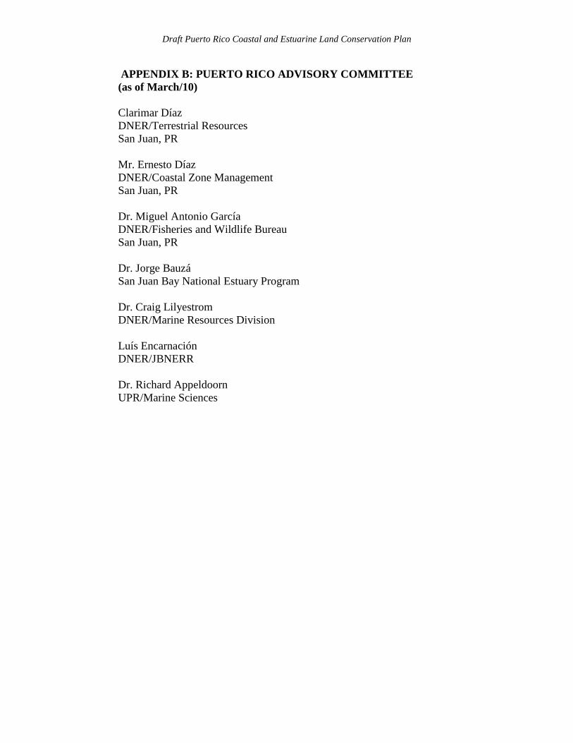
APPENDIX B: PUERTO RICO ADVISORY COMMITTEE (as of March/10) Clarimar Díaz DNER/Terrestrial Resources San Juan, PR Mr. Ernesto Díaz DNER/Coastal Zone Management San Juan, PR Dr. Miguel Antonio García DNER/Fisheries and Wildlife Bureau San Juan, PR Dr. Jorge Bauzá San Juan Bay National Estuary Program Dr. Craig Lilyestrom
DNER/Marine Resources Division
Luís Encarnación DNER/JBNERR
Dr. Richard Appeldoorn UPR/Marine Sciences
Draft Puerto Rico Coastal and Estuarine Land Conservation Plan
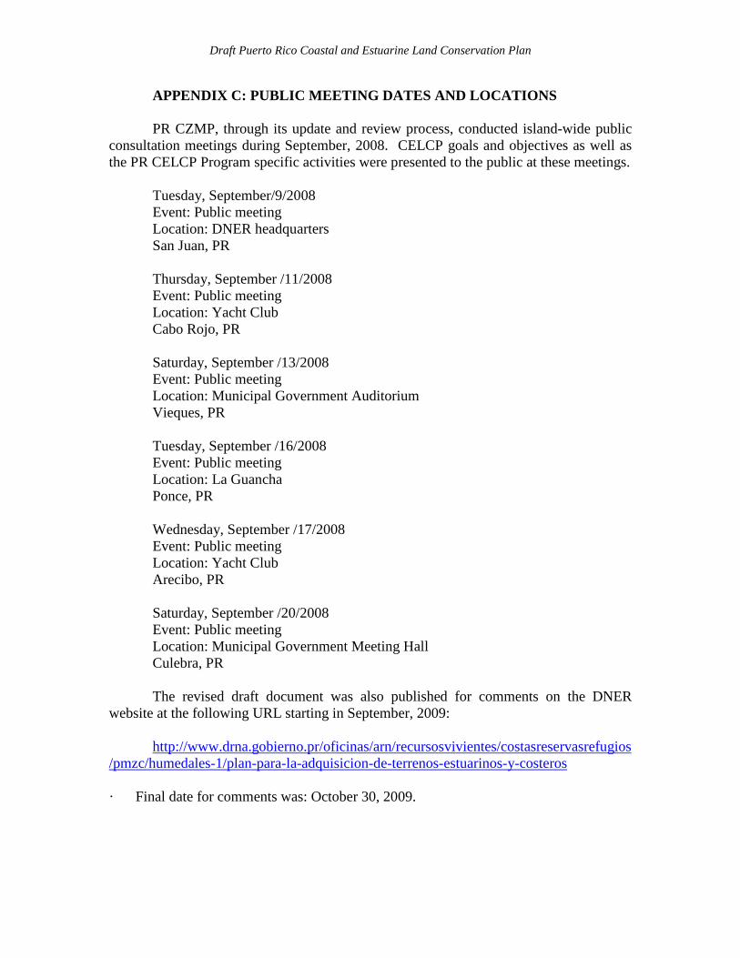
APPENDIX C: PUBLIC MEETING DATES AND LOCATIONS PR CZMP, through its update and review process, conducted island-wide public
consultation meetings during September, 2008. CELCP goals and objectives as well as the PR CELCP Program specific activities were presented to the public at these meetings.
Tuesday, September/9/2008 Event: Public meeting Location: DNER headquarters San Juan, PR Thursday, September /11/2008 Event: Public meeting Location: Yacht Club Cabo Rojo, PR
Saturday, September /13/2008 Event: Public meeting Location: Municipal Government Auditorium Vieques, PR Tuesday, September /16/2008 Event: Public meeting Location: La Guancha Ponce, PR
Wednesday, September /17/2008 Event: Public meeting Location: Yacht Club Arecibo, PR
Saturday, September /20/2008 Event: Public meeting Location: Municipal Government Meeting Hall Culebra, PR
The revised draft document was also published for comments on the DNER
website at the following URL starting in September, 2009: http://www.drna.gobierno.pr/oficinas/arn/recursosvivientes/costasreservasrefugios
/pmzc/humedales-1/plan-para-la-adquisicion-de-terrenos-estuarinos-y-costeros · Final date for comments was: October 30, 2009.