Embed Size (px)
Citation preview
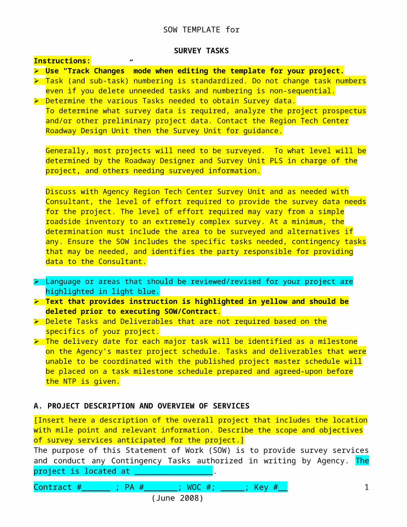
SOW TEMPLATE for
SURVEY TASKSInstructions: Use “Track Changes” mode when editing the template for your project. Task (and sub-task) numbering is standardized. Do not change task numbers even if you delete
unneeded tasks and numbering is non-sequential. Determine the various Tasks needed to obtain Survey data.
To determine what survey data is required, analyze the project prospectus and/or other preliminary project data. Contact the Region Tech Center Roadway Design Unit then the Survey Unit for guidance.
Generally, most projects will need to be surveyed. To what level will be determined by the Roadway Designer and Survey Unit PLS in charge of the project, and others needing surveyed information. Discuss with Agency Region Tech Center Survey Unit and as needed with Consultant, the level of effort required to provide the survey data needs for the project. The level of effort required may vary from a simple roadside inventory to an extremely complex survey. At a minimum, the determination must include the area to be surveyed and alternatives if any. Ensure the SOW includes the specific tasks needed, contingency tasks that may be needed, and identifies the party responsible for providing data to the Consultant.
Language or areas that should be reviewed/revised for your project are highlighted in light blue. Text that provides instruction is highlighted in yellow and should be deleted prior to
executing SOW/Contract. Delete Tasks and Deliverables that are not required based on the specifics of your project. The delivery date for each major task will be identified as a milestone on the Agency’s master
project schedule. Tasks and deliverables that were unable to be coordinated with the published project master schedule will be placed on a task milestone schedule prepared and agreed-upon before the NTP is given.
A. PROJECT DESCRIPTION AND OVERVIEW OF SERVICES[Insert here a description of the overall project that includes the location with mile point and relevant information. Describe the scope and objectives of survey services anticipated for the project.]The purpose of this Statement of Work (SOW) is to provide survey services and conduct any Contingency Tasks authorized in writing by Agency. The project is located at _________________.
Scope of Services: The overall scope of this project is_________________________.
Topographic Survey Limits:[Enter topo survey limits for the topographic data for this project here.]
Resolution Right-of-Way (R/W) and Property Boundaries:[Enter resolution R/W and Property Boundaries limits here.]
Background:[Describe why the project in this SOW is being pursued. Identify funding sources and other projects this work may be related to (such as a construction project, if applicable).]
Contract #______ ; PA #_______; WOC #; _____; Key #__ (June 2008) 1
Acronyms and Definitions – See SOW Appendix A
B. STANDARDS and GENERAL REQUIREMENTS 1. Standards
The standards, manuals, directives and other procedural guidance referenced in this SOW are not exhaustive and may not include all applicable standards for a given project. Consultant shall be responsible for determining and complying with all applicable standards and Agency practices in performing the Services. Following is a non-exhaustive list of applicable Agency manuals, policies, and standards and the links to their location on the Internet.
Manual on Uniform Traffic Control Devices (MUTCD)Oregon Temporary Traffic Control Handbookhttp://www.oregon.gov/ODOT/HWY/TRAFFIC-ROADWAY/publications_traffic.shtml#Work_Zone_Related
ODOT R/W Monumentation_PolicyHorizontal Control, Recovery and Retracement Survey StandardsSurvey Field Note StandardsBench Mark ResetsR/W Monumentation Survey Standards1998 Route Surveying ManualHistory of State Highways in Oregonhttp://www.oregon.gov/OD O T/HWY/GEOMETRONICS/documents.shtml/
RW_Eng_Manual2007-02.pdf(ftp://ftp.odot.state.or.us/ROW_Eng/RW_Manual)
http://www.oregon.gov/ODOT/HWY/GEOMETRONICS/RightOfWayEngineering.shtml/
Agency will provide the “Basemap Standard” guide to the Consultant.
2. Software Requirements Consultant shall comply with the following software requirements and shall submit all deliverables in formats fully compatible with Agency software:
Survey Software fully compatible with Bentley Inroads Survey MS Word & Excel in version fully compatible with Agency’s current version. Agency’s current version of Bentley Microstation, and Inroads programs. Agency’s current version of the ODOT Drafting menu (which runs inside of Microstation).
To download ODOT’s workspace, which includes the ODOT drafting menu, cell libraries, line styles, and pen tables for plotting use the link below.
ftp://ftp.odot.state.or.us/isb/appeng/MicroStation/Version8/
3. Licenses, Registrations and QualificationsConsultant is the Professional of Record for the work, which must be executed by a Profession Land Surveyor and other qualified professional with the following licenses, registrations, and qualifications:
Contract #______ ; PA #_______; WOC #; _____; Key #__ (June 2008) 2
The in process work, and the completed Survey Filing Map (SFM) must be reviewed and stamped by a Registered Professional Surveyor licensed to practice in Oregon.
A Registered Professional Photogrammetrist licensed to practice in Oregon must complete photogrammetry services.
4. General Requirements Unless stated otherwise in specific tasks, contingency tasks require written
approval (email acceptable) by Agency before Consultant commences work on task.
Agency is the owner of all field documents, permit applications, graphics, and other documents prepared under this SOW.
Consultant shall determine all federal, state, and local government requirements related to the SOW. These requirements may conflict at times and may affect project tasks performed by others. Consultant shall coordinate their work with others as needed throughout the project to ensure all permit requirements are met while avoiding conflicts and overlapping work areas.
Consultant shall regularly communicate with APM and other project team members as required to stay informed of changes affecting the work and shall be responsible for informing Agency of issues having the potential to interrupt the conduct of work.
Consultant shall notify Agency (prior to expending resources) of any required work that Consultant knows or reasonably should know has been or will be adequately conducted by others.
Notwithstanding Agency's approval of subcontractors, Consultant shall remain solely responsible for completing all tasks and providing all deliverables required in this SOW.
Consultant shall schedule enough on-site time as needed to perform the work as required for each task.
Consultant shall operate in conformance with the latest edition of the MUTCD and the ODOT’s latest edition of Oregon Temporary Traffic Control Handbook.
In addition to the final deliverables stated in this SOW, Consultant shall also provide specific interim deliverables produced throughout the project if requested by the Agency.
Consultant shall use Agency file naming convention for all electronic files. For example:
Key# e#.dtm, keynu?erw.dgn, keynu?ret.dgn
5. Compliance with Applicable Law Consultant and its licensed land surveyor(s) shall comply with all applicable federal, state and local statutes, regulations, ordinances and rules pertaining to surveying and land boundary laws, including but not limited to the following: ORS Chapter 92, Subdivisions and Partitions, ORS Chapter 93, Conveyancing and Recording, ORS Chapter 209, County Surveyors and map requirements, and ORS Chapter 672 Professional Engineers and Land Surveyors.
C. REVIEW, COMMENT and SCHEDULE OVERVIEW
Contract #______ ; PA #_______; WOC #; _____; Key #__ (June 2008) 3
The Task Schedule identifies the due date or number of days and or weeks from NTP for each deliverable in the SOW. The Contingency Tasks schedule identifies the number of days and or weeks form NTP issued for the respective contingency task, if any. All authorized contingency tasks and deliverables must be completed and submitted no later than the schedule identified for the contingency task.
Unless stated otherwise in specific tasks Consultant shall place all deliverables on the Agency incoming FTP site (ftp://ftp.odot.state.or.us/incoming) under company directory then job name directory. Use the project key number for files and directories. Consultant shall send an e-mail to the APM with notice that the files are ready for review and uploaded to the Agency FTP site (include directory with location of the files). Consultant shall also include contact information for questions about the deliverables. In addition to the electronic submittals, Consultant shall submit hard copies to the Region Tech Center Survey Unit as required in specific tasks throughout the SOW and notify the APM.
Consultant shall incorporate comments within the timeframe specified for specific tasks or otherwise agreed to in writing by Agency.
D. FORMAT REQUIREMENTS Consultant shall prepare all documents in conformance with the format and
level of detail per Agency Policies, Manuals, Guides, and Standards including, but not limited to, those referenced throughout this SOW.
Agency will not accept or make payment for Consultant work submitted in non Agency-approved format styles and will return this work to Consultant for revision in the correct format at Consultant’s expense.
Consultant shall provide each draft and final text-based or spreadsheet-based deliverable in MS Office file formats (i.e., MS Word, Excel, etc.) and must be fully compatible with version used by Agency. Reports must have all figures, tables, and appendices inserted in the appropriate order for final presentation.
All alpha coding used during topographic data collection must meet Agencies current format at time of submittal.
Tied features in Microstation files will be in their original coordinate correct positions. Features may be internally referenced into sheets (not moved) for Survey Filing Maps.
Symbology of tied features within Microstation will conform to the ODOT Drafting menu. Active scale of features and annotation text will be 1 for 1”=50’, 2 for 1”=100’, 4 for 1”=200’.
Consultant shall create “.pdf” of hard copy documents if electronic copy is not currently available.
Unless stated otherwise in specific tasks, 1 hard copy shall be submitted where hard copy deliverables are required.
Additional format requirements may be listed with specific tasks/deliverables throughout the SOW or in the PA/Contract.
E. TASKS AND DELIVERABLES Task Numbering: For purposes of standardization, task numbers in this SOW may be non-sequential and do not necessarily begin with “1” on the first task.
1. MANAGEMENT OF SERVICES
Contract #______ ; PA #_______; WOC #; _____; Key #__ (June 2008) 4
Objective/Scope: Consultant shall provide Management of the Services under this SOW including coordination and meetings (identified below) for successful and timely delivery of all deliverables in this SOW.
Consultant shall provide a single point of contact for Agency coordination. Changes to Consultant’s Project Manager (PM) as identified on page 2 are subject to Agency approval and require written notice to Agency. Consultant shall direct all communication and deliverables covered under this SOW to the APM assigned to this Project as identified on page 2 (or such other individual as designated in writing by Agency to Consultant).
Consultant shall notify the property owners prior to entering properties to conduct surveying services. Consultant shall inform the property owners of the extent of the survey work need, and of brush cutting necessary to gather the survey data.
1.1 ADMINISTRATION AND RECORD KEEPING To ensure that deliverables, scope, budget, and schedule objectives are met, Consultant’s Project Manager shall provide:
Quality Control (QC); Consultant shall perform QC procedures, coordination and oversight of Consultant’s activities included in the SOW. Consultant shall review all deliverables prior to being submitted to the Agency to ensure that deliverables meet the required standards.
Weekly Progress Reports Monthly Progress reports Development and maintenance of a project file for all documentation
related to these Services. Management of sub-consultants (if applicable) Project Closeout
Deliverables Consultant shall provide: [Select either Weekly or Monthly Progress Reports and delete the other; we should not need both.]
I. Weekly Progress Report due every Tuesday to report on the previous week’s work. The weekly report must be related to the Tasks in the SOW. The report must be an MS Word.doc and sent by email to the APM. Weekly progress reports must include, at a minimum:
Project status by task breakdown and percentage complete; Schedule changes, work products, proposed scope changes, team
personnel changes, unanticipated problems, any issues that will delay the delivery schedule, and other relevant events or information as applicable. Consultant shall submit a compilation of weekly progress reports with the monthly Invoice.
II. Monthly progress reports within 5_ business days following reporting period that:
include brief description of previous month’s activities and the planned activities for the next month;
Identify percentage completed of each Task/Deliverable;
Contract #______ ; PA #_______; WOC #; _____; Key #__ (June 2008) 5
Identify unresolved issues and/or concerns that may affect the SOW, schedule and/or budget for Services.
[Note: A copy of the Monthly Progress Report (or compilation of Weekly status reports) must be submitted with Consultant’s monthly invoice; both in hard copy and electronically.]
III. Closeout Documentation. Upon completion of the last Task (or within 10 business days of request by Agency, whichever is earlier) Consultant shall submit one electronic copy and hard copy of all project file documentation including, but not limited to:
Record of all pertinent contacts with Agency, other agency, and other Consultant staff;
Documentation of research, field notes, photos, maps, analysis, etc. Documentation of important information, decisions, and guidance
received; Meeting minutes and all Services/project related correspondence; i.e.,
email, invoices and progress reports.
1.2 COORDINATION The APM will provide the following applicable project-related information/documentation to Consultant at beginning of Services:
[List available info/documentation here] Project R/W map information
The APM is Agency’s primary contact; however, Consultant shall contact other Agency staff, other Consultants and regulatory agency staff as necessary throughout the Services to gather any additional information needed for the project, project site, regulations and guidance. This includes, but is not limited to:
Direct communication via phone, email, post, office visits; Arranging and attending joint field visits; Responding to FHWA and/or Agency questions as needed throughout the
Services; Contacting Agency’s Survey Manager or other staff in the Region Tech Center
Survey Unit for questions regarding methodology, and standards, etc.
DeliverablesI. As needed communications, field visits, and responses to Agency staff and
regulatory agency questions.
1.3 MEETINGS OPTIONAL TASK -[Instructions: Discussing the project needs must be completed during negotiations (prior to executing WOC/Contract) and is not billable (part of the cost of doing business/overhead). If meetings are necessary after WOC/Contract execution, enter the number of meetings you anticipate will be required, or delete if none are expected. If you want to allow for unexpected meetings or if it’s possible that additional meetings may be necessary, those should be done as a contingency (see C.1.3.1 below). If kick-off or project meeting(s) will be via conference call, include 0 hours for travel time.]
1.3.1 Project Meetings
Contract #______ ; PA #_______; WOC #; _____; Key #__ (June 2008) 6
Consultant shall attend and participate in __1_ project meeting(s) as scheduled by Agency or regulatory agencies. Consultant shall prepare minutes and distribute via email within 3 working days after the meeting. The meeting(s) will be held via conference call [or] at Agency’s offices in ___________, unless an alternate location is agreed to by both parties. For budget purposes, assume each meeting to have a duration of 1_ hours plus 0_ hours travel time, and 1_ Consultant staff member(s) shall attend the meeting.
DeliverablesI. Meeting minutes must include:
Discussion summary; Notes of any relevant written material on meeting room white board; Decisions made; and Next Steps/Action Items.
C.1.3.1 Project Meetings (CONTINGENCY TASK)[Instructions: If you think its possible additional meetings may be needed, enter the quantity and pricing in the Contingency Task Summary table in Section F. If you do not believe any contingency meetings will be necessary (for small, simple projects), then delete this contingency item.]Agency’s APM may authorize contingency meetings via NTP. The NTP will indicate the location, date, time, and meeting type. The number of contingency meetings that may be authorized are listed in Section F - Contingency Task Summary table.
Consultant shall attend and participate in __1_ project meeting(s) as scheduled by Agency or regulatory agencies. Consultant shall prepare minutes and distribute via email within 3 working days after the meeting. The meeting(s) will be held via conference call [or] at Agency’s offices in ___________, unless an alternate location is agreed to by both parties. For budget purposes, assume each meeting to have a duration of 1_ hours plus 0_ hours travel time, and 1_ Consultant staff member(s) shall attend the meeting.
DeliverablesI. Meeting minutes must include:
Discussion summary; Any written material on meeting room white board; Decisions made; and Next Steps/Action Items.
2.0 SURVEY[Instructions: The APM should contact the Region Tech Center Survey Unit before assigning survey tasks to Consultant for Agency projects.]
Consultant shall survey this project for the areas as described in Section A of this SOW unless otherwise noted in specific tasks.
2.1 RESEARC H [Instructions: If a control, recovery, and retracement Survey will be completed or R/W (temporary or permanent easements and/or fee) is to be acquired from a landowner then most tasks in 2.1 must be completed.]
Contract #______ ; PA #_______; WOC #; _____; Key #__ (June 2008) 7
Consultant shall obtain the research data for the area as described in Section A of this SOW.
Consultant shall perform data research as necessary to prepare for and support all project activities, and to produce project maps and reports as called for in subsequent tasks. The typical records required for research are, but not limited to; vesting deeds, land sales contracts, County assessor plats and road records, subdivision plats, General Land Office plats, ODOT R/W drawings, railroad maps, county surveys, road dedications and vacations.
2.1.1 Existing Vesting Deeds and Property Ownerships[Instructions: If R/W (temporary or permanent easements and/or fee) is to be acquired from a landowner then task 2.1.1 must be completed.]
Consultant shall obtain a “Trio listing kit” (typically provided by a Title Company).Consultant shall identify property ownership within and adjacent to the project site by investigating property deeds and county tax records. Consultant shall itemize and report property ownership and owner contact information to Agency in a spreadsheet provided by Agency. Consultant shall submit each deed in its own electronic file. Consultant shall include all vesting deeds referenced in the Property Vesting Deeds if needed to resolve the property boundary.
Deliverables:I. “Trio listing kit” with Property Vesting Deeds in electronic and hard copy format. II. Ownership List in Microsoft Excel spreadsheet.
2.1.2 Existing R/W Maps [Instructions: If a control and recovery Survey will be completed then task 2.1.2 must be completed.]
Consultant shall research and gather copies of all Agency, city, county, Forest Service, railroad, and any other government or private R/W Maps and drawings related to the project area. Consultant shall scan maps to make electronic version of discovered maps if no electronic version exists for R/W maps deliverable.
Deliverables:I. Hard copy & electronic version (*.jpg, *.dgn) of all existing R/W maps.
2.1.3 Existing Agency R/W Files[Instructions: If a control and recovery Survey will be completed then task 2.1.2 must be completed.]
Consultant shall obtain Agency R/W file numbers from the R/W Maps (Task 2.1.2) and order all existing Agency R/W files associated with the project area. Consultant shall order the existing files from Agency Files Coordinator in the Agency Right of Way Operations Section or through the Right of Way Data Management System.
Deliverables:I. Existing Agency R/W files in “.pdf” format.
Contract #______ ; PA #_______; WOC #; _____; Key #__ (June 2008) 8
2.1.4 Existing County Records [Instructions: APM should include task 2.1.4 if a survey monument (property corner or Section/DLC corner) might be disturbed or destroyed during project construction.]
Consultant shall research and obtain copies of all surveys, subdivision plats, and land partition plats filed in the county surveyor’s office related to the properties potentially impacted by the project. This information is used to find monuments that might be impacted from the project and establish property lines for area calculations when new R/W is acquired.
Consultant shall research and obtain copies of county assessor maps, General Land Office plats, and county road records related to the properties potentially impacted by the project.
Consultant shall research and obtain available data about Government Public Lands Survey Corners and their references in the project area as defined in the SOW.
Deliverables:I. All County Assessor Maps in “.pdf” and hard copy format.II. All General Land Office Plats in hard copy and “.pdf” format.III. All County Road establishment records in hard copy and electronic format.IV. All County Road vacation records in hard copy and electronic format.V. All Subdivision and Land Partition Plats in hard copy and electronic format.VI. All County Surveys of record in hard copy and electronic format.VII. All Maps and Data related to Government Public Lands – Survey Corners and any references.
2.1.5 Existing Field Survey Notes [Instructions: APM should include task 2.1.5 if a survey monument (property corner or Section/DLC corner) might be disturbed or destroyed during project construction.]
Consultant shall research and obtain copies of all field survey notes filed in Agency’s Map and Plans Center or other government agencies related to the properties potentially impacted by the project. This information is used to help find monuments that might be impacted from the project and establish existing highway R/W lines.
Deliverables:I. Copies of all field survey notes in electronic .pdf and hard copy format.
2.1.6 Existing Horizontal/Vertical Control Stations [Instructions: APM should include task 2.1.6 if tasks 2.4.2 and 2.5.2 will be completed for the project.]
Consultant shall research and obtain data about all horizontal and vertical control points as required for the project area including triangulation stations, GPS stations, benchmarks, and prior project control surveys from Agency, Federal, county, city, and other governmental agencies.
Deliverables:
Contract #______ ; PA #_______; WOC #; _____; Key #__ (June 2008) 9
I. Current maps, data sheets, surveys, etc in hard copy and electronic format.II. Data sheets in hard copy and electronic format.
2.1.7 Existing Utility Records(Instructions: APM should include task 2.1.7 if task 2.4.2 will be completed for the project.)
Consultant shall research and obtain available facility maps and as-built construction plan data pertaining to all utilities in or near the project area from the Agency, One-Call Service, county, city, or other governmental agencies and utility companies.
Deliverables:I. All maps and data pertaining to utilities in hard copy and electronic format.
2.1.8 Existing Water Way Data(Instructions: APM should include task 2.1.8 if the project includes bridge design work.)
Consultant shall research and obtain maps and data about all rivers, creeks, and streams, springs or flowing water in or near the project area from Agency, Federal, county, city, and other governmental agencies. Consultant shall include items such as but not limited to: FEMA Flood maps, tide gage data and stream navigability per Division of State Lands designation.
Deliverables:I. All maps and data pertaining to waterways in format, in which it was obtained,
2.1.9 Existing Aerial Photographs(Instructions: Include task 2.1.9 for most projects .If any historical data is required then add the additional in blue.)
Consultant shall obtain the best clarity photo from Agency to attach as a raster reference file to the Microstation files.
Consultant shall research and gather historical maps/data about existing aerial photographs in or near the project area from Agency, Federal, county, city, other governmental agencies. Data about the quality, scale and type (rectified or not) of the aerial photographs must accompany the delivered electronic files.
Deliverables:I. All aerial photo maps and data in electronic format (.ITIF,.JPG. .TIG,)
compatible for attachment to current Agency version of Microstation software.
2.2 CONTROL (Instructions - For every project, it must be known whether or not Control is needed. For projects where R/W is to be purchased, then this must be accomplished. R/W includes all easements. If the project construction will destroy R/W and property monuments then this must be accomplished. Control is needed on most projects, therefore for help in determining the
Contract #______ ; PA #_______; WOC #; _____; Key #__ (June 2008) 10
types of control, contact the Region Tech Center Survey Unit. If an SFM of the control network is to be filed separately, then task 2.5.2 needs to be accomplished. Consultant shall provide control for the area as described in Section A of this SOW.
The purpose of these tasks in 2.2 is to provide the means by which a project can be located relative to horizontal and vertical datum, map projection, and coordinate systems. Consultant shall establish a horizontal and vertical control network for Agency Projects using the latest datum available or as approved by the APM
2.2.1 Horizontal Control (Instructions: The Horizontal Control task will be needed when the Consultant is required to provide the Agency with coordinates such as Northings and Eastings.) Consultant shall establish horizontal control for the project area as described in Section A of this SOW. Consultant shall establish horizontal control according to Agency standards using Terrestrial (Theodolite and EDM), GPS (Static, Rapid Static and/or Real time Kinematics (RTK)) or a combination of both. Consultant shall set and adjust monuments in conformance with Agency guidelines. Guidelines are in the current “Route Surveying” and the “ODOT Right of Way Monumentation Policy”. Consultant shall submit the control report after completion to the Agency for review and acceptance. Consultant shall submit an SFM of the control network filed with the county surveyor’s office if submitted separately from the Retracement/Recovery SFM as per task 2.5.2.
Consultant shall use 5/8” Rebar with ODOT brass caps, or other Agency approved monument, for the GPS and network points. Consultant shall establish a minimum of 3 GPS control point through the length of the survey.
Deliverables: I. Monuments placed in the ground at the project location.II. An adjustment report for one or more of the following, Least Squares
adjustment for networks, an approved traverse adjustment method for traverses and/or a GPS adjustment report when using GPS.
III. An ASCII file containing the Local Datum Plane (LDP) coordinates for every network point set and found.
IV. An ASCII file containing the Oregon State Plane Coordinates (SPC), LDP coordinates, the conversion factor for converting from SPC to the LDP for all points in which a SPC was established and an Agency provided Excel spreadsheet that contains the LDP calculations.
V. The original field notes network and one scanned copy of the original field notes in “.pdf” format.
VI. A Microstation design file (*.dgn) containing all the tied monuments.
2.2.2 Vertical Control(Instructions: The Vertical Control task will be needed when the Consultant is required to provide any data that requires an elevation. If a DTM is going to be required, then this needs to be accomplished.)Consultant shall establish Vertical Control using differential leveling methods as defined in the Agency’s 1998 Route Surveying Manual. Consultant shall get Agency approval before using these other methods such as trigonometric leveling and elevations derived from GPS.
Contract #______ ; PA #_______; WOC #; _____; Key #__ (June 2008) 11
Consultant shall establish vertical control for horizontal control points needed for 3 dimensional terrain mapping as described in Section A of this SOW.
Deliverables:I. Original field notes and one scanned copy of the original field notes in
“.pdf” format.II. If the levels were electronically processed then one copy each of the
following: original raw level file as collected in the field, ASCII file showing level closure data, ASCII file with elevations on all network points and/or an ASCII file showing the level rod readings.
2.2.3 Aerial Photo Control Marks(Instructions: This Photo Marks task will need to be included when setting points for controlling photogrammatic mosaics. When photo marks are included in the SOW, then horizontal and vertical control tasks are needed for the photo points. Describe the area of Photogrammetry here if different than in Section A of the SOW.) Consultant shall set monuments surrounded with durable pre-marks made of sheet rock panels, painted stripes, or manufactured pre-mark material at a size seen in the aerial photography as specified by the registered photogrammetrist providing the photogrammetric products. The Premark control points shall be included in the overall project control network shown in the SFM. Consultant shall set these points according to Agency Geometronic’s Unit standards.
Consultant shall set Aerial Photo Control Marks for the area as described here between _________________.
Deliverables:I. Monuments in the ground with durable pre-marks.
2.3 MONUMENT RECOVERY Instructions: This task must be included for projects where:
R/W and/or easements is to be purchasd, or
project construction will destroy R/W and/or property monuments.
The APM will need to have task 2.1 accomplished by the Consultant in order to search for and find monuments. The APM should contact the Region Tech Center Survey Unit for help in determining the need for tasks in 2.3. The purpose of these tasks in 2.3 is to address the requirements of ORS 209.150 and 209.155, and other survey related statutes for Agency construction projects.
Consultant shall survey for but not limited to: Government corners, geodetic control stations, bench marks, R/W monuments, property boundary markers, and roadway alignment markers. Consultant shall complete the monument recovery for the project area as described in Section A of the SOW.
Consultant shall provide the monument recovery for the project area as described in Section A of this SOW.
Contract #______ ; PA #_______; WOC #; _____; Key #__ (June 2008) 12
2.3.1 Identify, Search and Recover Monuments Instructions: This task will be needed when the project construction is close to RW and may destroy or disturb R/W and property monuments. Consultant shall recover existing monuments to preserve monuments endangered by any activity related to a proposed or anticipated construction project and to resolve roadways and property lines. Consultant shall provide a record of all monuments searched for, the date of the search and the results of the search. Consultant shall document the monuments found and not found in the “Monument Search Book” and monuments found with the SFM. The “Monument Search Book” is a Microsoft spreadsheet.Deliverables:I. Monument Search Book (.xls) file.II. Mark Recovery Form (available from Agency) for all recovered marks owned
or appearing set by a government agency.
2.3.2 Field Survey of Recovered Monuments Instructions: This task will be needed when the project construction gets close to RW and will destroy or disturb R/W and property monuments.
Consultant shall take measurements (survey) to the monuments recovered and tied (surveyed) from the control network. Consultant shall provide in the field notes a detailed description of the monument including the physical condition and sketch of location. Consultant shall double tie the found monuments with conventional total station or GPS RTK methods. RTK methods include tying them the second time separated by a minimum 90 minutes or by using second base running at the same time to produce closing vector to each point.
Consultant shall locate, measure and document the location of all survey markers and monuments of record for property boundaries and/or R/W needed within the areas described in Section A of this SOW.
Deliverables:I. Original field notes and one scanned copy of the original field notes in
“.pdf” format.II. ASCII file containing the following information in this order, Point number,
Northing, Easting, Elevation, alpha feature code.III. A Microstation design file (*.dgn) containing all the tied monuments.
2.3.3 Reference Monuments(Instructions: This task may occur at any time during project development, delivery, construction, maintenance or for other Agency activities. This is usually for monuments that are going to be destroyed as a result of Agency or contractor activities and have not been surveyed previously to perpetuate their locations. In addition, this may be needed when monuments might need to be replaced such as Government corners and is the best method of the location of the monument to be put back in its original location after the activity. The APM should contact the Region Tech Center Survey Unit about this method and the needs.) The purpose of this Task is to Reference monuments such as centerline, R/W, property and PLSS corners prior to Agency activities.Consultant shall reference monuments that the Agency requests at:________________. Consultant shall set and relate the 4 reference monuments at the locations to preserve the monuments original location.
Contract #______ ; PA #_______; WOC #; _____; Key #__ (June 2008) 13
Deliverables:I. Original field notes and one scanned copy of the original field notes in
“.pdf” format.II. ASCII file containing the following information in this order, Point number,
Northing, Easting, Elevation, alpha feature code.III. A Microstation design file (*.dgn) containing all the tied monuments.
2.4 TOPOGRAPHIC DATA (Instructions: The tasks in 2.4 are needed for the design of projects. The Roadway Design Unit and other supporting units for design of a project should determine the design needs. The APM should contact, as applicable for the project, the Region Tech Center Survey, Roadway and other Units for help in determining needs for a project.) The purposes of these tasks in 2.4 are to collect the existing topographic features and create a base map used to design Agency construction projects.Consultant shall collect topographic data of man made and/or natural features using a variety of Agency approved methods. These methods include but are not limited to: collecting the data using terrestrial (Theodolite and EDM), GPS(RTK), High Definition Scanning (HDS), aerial photography, station and offset, by milepost and must conform to all file naming and coding formats that are in current use by the Agency. The Agency will provide examples of the current formats.
2.4.1 Roadside Inventory(Instructions: This task is mainly used for preservation projects collecting all data on the roadside inventory sheets. Full topographic and DTM projects usually need only the sign inventory sheet completed. Some projects may only require part of the roadside inventory list. This will need to be clarified in the SOW.) Consultant shall complete a roadside inventory using the Agency provided Excel spreadsheet. This data will typically be two-dimensional and require a digital picture taken of the feature tied. Consultant shall relate the digital picture to the feature in the roadside inventory spreadsheet. The roadside inventory will conform to Agency standards as defined in the highway design manual. Consultant shall fill out the “OPAL” spreadsheet to inventory the accesses. Consultant shall imbed the sign pictures in the Microstation Basemap file.
Consultant shall inventory only the items specifically listed in this SOW. These items may include the following: Signs, Roadway Width, Guard Rail, etc. Consultant shall conduct a roadside sign inventory (Traffic Hwy related) along ________ Hwy 200-feet in both directions from ________________.
Deliverables:I. One electronic copy of the Roadside Inventory with the required features
tied and recorded in the Agency approved Roadside Inventory spreadsheet.II. An electronic copy of the “OPAL” spreadsheet.III. An electronic copy of all digital pictures taken for features.IV. Microstation DGN with imbedded photos
2.4.2 Topographic Data Collection(Instructions: APM should contact the Region Tech Center Survey and Roadway Units for the project layout of design. This task is used for all projects using Microstation for design of a project. If it required by the designer of the project then most of the following, tasks should be requested.)
Contract #______ ; PA #_______; WOC #; _____; Key #__ (June 2008) 14
Consultant shall collect all topographic features, man made or natural, and must be tied within the limits of the project describe here in the SOW and have three dimensional coordinates associated with it. Consultant shall collect these tied features using Agency coding formats and accepted methods (terrestrial, RTK and or HDS).
Consultant shall collect topographic data between the boundaries described in Section A of this SOW.
Deliverables:I. The original notes taken in the field and one electronic copy, in “.pdf”
format, of the original field notes.II. ASCII file containing the following information in this order, Point number,
Northing, Easting, Elevation, alpha feature code and the letters ST if the code is the beginning of a line feature. This is required for all tied features.
III. A Microstation design file (*.dgn) containing all the tied topographic features and conforming to Agencies file naming conventions.
2.4.2.1 Utilities Features(Instructions: This task will be needed for all safety, modernization, bridge and signal projects. Other projects may need utilities located depending on the design requirements. For example when guardrail is to be replaced then utility locates are required.)The purpose of this task is locating and mapping of the utilities, to provide surface evidence of above and underground (u/g) features for inclusion in the Topographic Basemap or other mapping.
Field Utility Survey
Consultant shall survey utility location 200 feet along the roadways outside of the topographic survey area described in Section A of the this SOW.
Consultant shall record in the field notes the utility ownership when describing the line data points. Consultant shall record all visible utility identifications in the field notes. Such numbers shown on power and/or telephone poles, vault tags, telephone pedestals (aka risers), cabinets, meters, fences or screened enclosures for gas regulators, and sanitary sewer pump stations for example. This data is needed for the Agency or Consultant to communicate where the facility may be in conflict with the Project.
Consultant shall measure and record all utility facility structures (e.g. concrete pads, top slab of vaults, pump station housing, barrier screens or fenced enclosures). Consultant shall make a request to the utility owner to pull the cover whenever a manhole is found locked or bolted. Consultant shall have up to 10 utility locations potholed to determine precise location and elevation of utilities around the intersection where the new signal poles location could be placed and along ___________ in the area described in task 2.4. (Note: Utility Locates are required by law, if excavation is planned, or if survey markers will be set.) Consultant shall tie in the field all utility features including, but not limited to u/g and overhead power lines, u/g and overhead telephone lines, poles, risers, u/g and overhead cable television lines, u/g gas lines and u/g water lines. Lowest
Contract #______ ; PA #_______; WOC #; _____; Key #__ (June 2008) 15
wires that cross street or road intersections must be measured vertically and a true elevation of those wires calculated.
Consultant shall submit an Oregon Utility Notification Center Memorandum including, at a minimum, the locate request number and information of locate location requested. Consultant shall request plans and as-built plans of existing utilities from each of the various utility companies to aid in completing and verifying the utility locates.
Consultant shall send a copy of the field survey mapping (showing the utilities) to the utility companies to verify that all of their buried facilities were marked and tied. Consultant shall request written verification and response from the utility. Consultant shall provide documentation from the utility company verifying the mapping of that utility’s facilities.
Utility MappingConsultant shall place all surveyed utility facilities, both overhead and u/g, with the standard Agency symbology placed in the Microstation .dgn file:
Drafted line elements must not be used to depict aerial utility line alignments. Aerial line alignments must be indicated by rotating cell elements for pole, such that the small line that bisects the square or round symbol is arranged to the wire alignment.
All power transmission towers must have all footings located and separately tied. Ties to adjacent towers must be made and faint dashed lines (following the outer most wires) connecting each tower must be included. This is the only instance where drafted line elements are used to represent aerial wire alignment.
Deliverables:I. The original notes taken in the field and one electronic copy, in “.pdf”
format, of the original field notes.II. ASCII file containing the following information in this order, Point number,
Northing, Easting, Elevation, alpha feature code and the letters ST if the code is the beginning of a line feature. This is required for all tied features.
III. A Microstation design file (*.dgn) containing all the tied utility features and conforming to Agencies file naming conventions.
IV. Utility Location Documentation Narrative in word doc formatV. Utility Request Documentation (.pdf)VI. Provide written verification and response from the utility (.pdf)
2.4.2.2 Hydraulics Features(Instructions: The APM should consult with the Region Tech Center Hydraulics’ Unit Designer to determine the need and extent of the Hydraulic study. For all bridge projects, this will be accomplished. For some large culvert project, this will be accomplished.)Consultant shall collect all the hydraulic, bridge and culvert information requested by hydraulic engineer in accordance with the “ODOT Hydraulics Manual” on streams and rivers that pass under or are parallel to any highways in the area. Consultant shall provide for the hydraulic feature, a profile of the thread ______ feet up and ____ feet down stream of the project.________. Consultant shall provide cross sections _400 ft ________up and down stream of
Contract #______ ; PA #_______; WOC #; _____; Key #__ (June 2008) 16
the structure or utilize hydrographic surveying techniques to collect required data.
Deliverables:I. The original notes taken in the field and one electronic copy, in “.pdf”
format, of the original field notes.II. ASCII file containing the following information in this order, Point number,
Northing, Easting, Elevation, alpha feature code and the letters ST if the code is the beginning of a line feature. This is required for all tied features.
III. A Microstation design file (*.dgn) containing all of the tied hydraulic information and conforming to Agencies file naming conventions.
IV. Cross sections and profile provided in a Microstation .dgn file per the Agency Hydraulics Manual.
2.4.2.3 Drainage Features(Instructions: The APM should consult with the Roadway Designer to determine the need and extent of the drainage study. For all modernization, safety, and signal projects a Drainage Study will be accomplished.)Consultant shall tie all drainage features that drain water to and from the highway, measure inverts and take pictures of the drainage facilities. These features include, but are not limited to, ditches, culverts, storm sewers and inlets. Procedures for collecting this data are in the “ODOT Hydraulics Manual”. Consultant shall provide sketches of drainage facilities such as but not limited to manholes and inlets. Sketches must show orientation of pipes, manhole lid, manhole cone, and inverts.
Deliverables:I. The original notes taken in the field and one electronic copy, in “.pdf”
format, of the original field notes. II. ASCII file containing the following information in this order, Point number,
Northing, Easting, Elevation, alpha feature code and the letters ST if the code is the beginning of a line feature. This is required for all tied features.
III. A Microstation design file (*.dgn) containing all the tied drainage features and conforming to Agencies file naming conventions.
2.4.2.4 Environmental & Archaeological Features(Instructions: The APM should consult with the Region Tech Center Environmental Unit to determine the need and extent of any environmental and/or archaeology sites that need locating. For all modernation, intersection safety, and signal projects there will be some survey work needed.)Consultant shall tie all environmental and archaeology features that have been identified and marked up by the Agency or a Consultant acting for the Agency in environmental matters. These features include, but are not limited to, wetlands, high water mark, T&E species, hazmat sites, archaeology sites and sensitive plants. Agency will give notice when the marks are in place and provide a sketch of delineation.
Consultant shall place the Environmental features in a Microstation .dgn file, which can be submitted separately from the project Topographic basemap.
Deliverables:
Contract #______ ; PA #_______; WOC #; _____; Key #__ (June 2008) 17
I. The original notes taken in the field and one electronic copy, in “.pdf” format, of the original field notes.
II. ASCII file containing the following information in this order, Point number, Northing, Easting, Elevation, alpha feature code and the letters ST if the code is the beginning of a line feature. This is required for all tied features.
III. A Microstation design file (*.dgn) containing all the tied drainage features and conforming to Agencies file naming conventions.
2.4.3 Detailed Basemap(Instructions: The APM should have this task accomplished if any of the tasks listed in 2.4.2, 2.4.2.1, 2.4.2.2, 2.4.2.3, 2.4.2.4 and 2.4.2.5 are being assigned to a consultant.).Consultant shall take all applicable topographic data collected in tasks 2.4.2, 2.4.2.1, 2.4.2.2, 2.4.2.3, 2.4.2.4, 2.4.2.5 and create a detailed basemap file. A detailed basemap has all features drafted to Agency standards as defined in the “Basemap Standards”. The Agency will provide this standard. Consultant shall imbed the sign pictures in the Microstation Basemap file.
Deliverables:I. Detailed Base Map in Microstation design file (*.dgn)
2.4.4 Digital Terrain Model (DTM) (Instructions: The APM should contact the Region Tech Center Survey Unit with a description of the project and design area needed to help in determining this task’s needs. The APM should contact the Region Tech Center Roadway Design Unit for help in determining if this task is needed for the project. Most projects will need a DTM if an actual design is to be accomplished.)
Consultant shall create a three (3) dimensional digital terrain surface using all of the topographical data collected within the areas described in Section A of this SOW.
Consultant shall collect the topographical data to create points and break lines in adequate quantity and in proper placement, to accurately represent the surface of the ground. Consultant shall create the DTM that meets the Agency’s criteria for surface triangulation. Consultant shall collect confidence points in the field and generate a confidence point report. The topographical data and confidence points must meet Agency standards as defined in the “1998 Route Surveying Manual”. Consultant shall generate 0.2 foot minor contours and 1 foot major contours throughout the DTM for a QC analysis of the surface.
DTM shots must not exceed a 50-foot spacing to show the terrain. Topographic data for this Project must be gathered by techniques consistent with the construction of a DTM. A combination of survey data at break lines, features, and spot locations must be used to develop the DTM that will be used by Agency for design. Utility ties must not be used as part of the modeling.
Deliverables:I. InRoads .dtm file that is compatible with the Agency’s current version of
InRoads.II. Confidence point report in “.pdf” format.III. Microstation design file (*.dgn) with the contour lines and triangles as
specified above.Contract #______ ; PA #_______; WOC #; _____; Key #__ (June 2008) 18
2.5 EXISTING R/W & BOUNDARY RESOLUTION [Instructions - For every project, it must be known whether or not R/W will be impacted. This task must be accomplished for projects where R/W is to be purchased. R/W includes all easements temporary or permanent. If the project construction will destroy R/W and property monuments then this TASK must be accomplished. For help in determining this Task contact the Region Tech Center Survey Unit (RTCSU).]The purpose of these Tasks in 2.5 is to identify the location of the existing Centerline(s), R/W lines, Property line(s) (Resolve), to perpetuate the location of the monuments found and to document the control used for this project area. These tasks are to address the requirements of ORS 209.150 and 209.155 and other survey related statutes. Consultant shall resolve the location of the R/W between the boundaries described in Section A of this SOW.
2.5.1 Resolve R/W and Property BoundariesConsultant shall Resolve the location of the R/W between the boundaries described in Section A of this SOW.
Consultant shall resolve identified R/W centerlines alignments, R/W lines and property boundaries abutting the highway and or along the proposed route of construction, using accepted concepts and rationale methods of survey professional judgment. Consultant shall evaluate the available evidence for relevance, adequacy, and reliability; use professional judgment in determining the type and quantity of evidence available, and the influence given each factor; and determine a best-fit with the evidence and probable location of R/W alignments and property boundaries for the area as described. Consultant shall provide a detailed narrative of available evidence, desirable evidence not available, rationale for decisions made, and a summary of the conclusions in the establishment of the R/W centerline, R/W lines (including all jogs) and property boundary lines. The above description is also known as a Retracement. Consultant shall submit the resolve to the Agency for review prior to drafting the SFM.
Deliverables:I. Microstation .dgn file . This must have centerlines, R/W lines and property
lines. II. Bentley Inroads .alg file. This must consist of the centerlines, control and
monument data.III. Narrative .doc: This must explain the procedures used to accomplish the
resolve, using the examples in the SFM Drafting Standards as a guide to the type of content in the narrative.
IV. Bentley Inroads Reports of alignment(s) .xml. This must have alignment and curve reports that show coordinates, bearings, stations etc per Bentley Inroads standard reports.
V. Report of Monument Location. This is the station and offset report, which must show the relationship of the monuments to the retraced alignment(s).
2.5.2 Control, Recovery, Retracement Survey Filing Map (Instructions - For every project, it must be known whether or not Right of Way will be impacted. If Task 2.5.1 is accomplished then TASK 2.5.2 must be accomplished.)
Contract #______ ; PA #_______; WOC #; _____; Key #__ (June 2008) 19
Consultant shall create survey filing maps (SFM) in accordance with the Agency “Survey Filing Map Standards”, County and ORS requirements. Geodetic report(s) and survey(s) must meet the ORS requirements. The survey(s) must be prepared for 18-inch by 24-inch sheet plots. Consultant may file the Geodetic survey along with the “Control, Recovery and Retracement” survey. This SFM may be for a “Control” survey, a “Recovery” survey, or a “Retracement” survey. The “Control” survey may consist of Geodetic and or Terrestrial points set for the project. The “Recovery” is the documentation of the monuments recovered for a project. The “Retracement” is the resolve of the R/W centerlines, R/W lines and/or property boundaries. These surveys may be combined or separate surveys as needed or as directed in Section A of the SOW. Consultant shall submit the SFM for filing to the appropriate county in hard copy format using archival ink and mylar or acceptable media per county.
Consultant shall submit a 20% deliverable of the Control, Recovery and/or Retracement survey(s) for review of the first stages of drafting. This submittal must show the sheet layout with the portions of the survey cut out within the sheets, alignments, R/W lines, property lines etc. Consultant shall submit a monument station and offset report with the 20% review.
Consultant shall submit an 80% deliverable of the Control, Recovery and/or Retracement survey(s) for review of the last stages of drafting. This submittal must show the data for the survey filing as almost complete except details and R/W computed points.
Consultant shall submit a 99% deliverable to Agency a copy of the Control, Recovery and/or Retracement survey(s) sent to the county for review. If the county does not review before filing then this will be the Agency’s last review before filing with the county.
Deliverables:Consultant shall submit the following: Consultant shall provide the SFM(s) for review in accordance with the delivery schedule identified in the SOW.
I. 20% Draft SFM 20% draft of the Control, Recovery and/or Retracement Survey(s) in Bentley Microstation .dgn and Bentley Inroads “.alg” file format and hard copy 18-inch by 24-inch.
II. 80% Draft SFM 80% Draft SFM of the Control, Recovery and/or Retracement Survey(s) in Bentley Microstation .dgn and Bentley Inroads “.alg” file format and hard copy 18-inch by 24-inch.
III. 99% Final SFM of the Control, Recovery and/or Retracement Survey(s). This is the copy submitted to the county for review if that county does reviews. This must be in Bentley Microstation .dgn and Bentley Inroads “.alg” file format and hard copy 18-inch by 24-inch.
IV. FINAL SFM FINAL SFM of the Control, Recovery and/or Retracement Survey(s) filed with the county. This must be in Bentley Microstation .dgn and Bentley Inroads “.alg” file format and hard copy 18-inch by 24-inch. Consultant must submit this with the county recording number outside the boarder of the
Contract #______ ; PA #_______; WOC #; _____; Key #__ (June 2008) 20
survey sheets, but recording number must be printable. This is to be accomplished after the survey is filed and accepted by the county.
V. County Survey Filing Number. This is the number the county files the survey in the records. Submit this by email to the Agency APM and the Region Tech Center Survey Unit.
2.6 RIGHT OF WAY ENGINEERING (MAPPING & DESCRIPTIONS ) (Instructions: If R/W (temporary or permanent easements and fee) is to be acquired from a landowner then most of the following tasks must be completed.)The purpose of these tasks in 2.6 is to make a R/W basemap, determine the necessary R/W to accommodate project construction, develop the R/W acquisition maps, write property descriptions to support the project R/W acquisition, design a highway access strategy for the project, and complete the final deed recorded R/W map for archive. Consultant shall use the deliverables from sections 2.1.1 thru 2.1.9 and the appropriate roadway, traffic, sign, geo/hydro or other design files and project data to create these maps. Consultant shall prepare all deliverables using the Agency’s “R/W Engineering Manual” and “Highway Design Manual” (Right of Way Section) for examples, expectations, content and format for the following tasks.
Consultant shall obtain the Microstation seed file, Microsoft Word description templates, drafting menus, and other tools used to create the deliverables of Tasks in 2.6 available on the ODOT FTP site (ftp://ftp.odot.state.or.us/ROW_Eng/STANDARDS). Consultant shall use the seedRW2d.dgn to create the “key number”rw.dgn file to create the tasks in 2.6. The seedrw2d.dgn is a single Microstation file containing multiple models to produce the various R/W maps. The purpose of these models is to have all of the produced R/W maps contained within a single file. Consultant shall use the ODOT R/W Engineering Manual, describing how to design these deliverables. Consultant shall use the “ODOT Right of Way & Rail/Utility Coordination, Contractor Services Guide September 2005”, “Right of Way Engineering” Section 3 (C) (D) and (E).
Consultant shall draft all coordinate correct line work and elements in the “Design” model of the Bentley Microstation .dgn file, contained in the electronic R/W seed file. The scale of the R/W basemap, Active R/W Acquisition Map, R/W sketch map, and Railroad exhibit map will vary on whether it is an urban or rural area. The scale must be either 1 inch = 50 feet in an urban area or 1 inch = 100 feet in a rural area. A scale bar and north arrow must be shown on each type R/W map along with a centerline stationing. Consultant shall gray shade the existing topographic data when plotting the hardcopy of all the various types of the R/W maps. The existing topography must be in separate model attached as a reference file with a logical name containing the word “exist” or “shade”.
2.6.1 Right of Way Basemap(Instructions: If R/W (temporary or permanent easements and fee) is to be acquired from a landowner then task 2.6.1 must be completed.)Consultant shall prepare the R/W basemap using field survey data, vesting deeds, land sales contracts, County assessor plats, subdivision plats, General Land Office plats, existing ODOT R/W drawings, railroad R/W maps, County surveys, road dedications, and road vacations. Consultant shall create
Contract #______ ; PA #_______; WOC #; _____; Key #__ (June 2008) 21
coordinate correct mapping features in the “Design” model. The R/W basemap must include the existing property lines, General Land Office lines (GLO), city boundaries, property owners names with deed recording numbers, the R/W centerline, R/W boundaries, access control lines, project design centerlines, survey monuments, reference points. Consultant shall show the names of any features such as subdivisions, roads, streets, or rivers in the file. Consultant shall label each survey monument with a description and its coordinates or referenced in a table. Each centerline must include Engineer’s Stationing, curve data, bearings, and coordinates.
The R/W basemap should have the existing topography model referenced into it using a logical name containing “exist” or “shade”. This existing topography (buildings, structures, edges of pavement, existing utility lines and facilities, cultural features, and natural features) must be visible to check the proper R/W layout to see if there are any areas of concern such as an easement line going through a current building, which triggers the need for special language to be included in a description.
Consultant shall determine the correct deed reference for each parcel (and that the new deed purchase will reference) in the area impacted by the Project’s R/W.
Consultant shall utilize the deed and surveyed data to establish the location of property boundary lines. Consultant shall create the property shape for each property that R/W will be purchased from within the project area. The property lines must be determined using surveys, GLO Map and deeds to create each parcel shape. Consultant shall rotate this shape into place on a found monument or onto another parcel lot line that has been located to determine the parcel location. Consultant shall not break R/W lines, Centerlines and property lines. Consultant shall place property shapes on their own level named “Parcel Shapes” in the Microstation file. Consultant shall place these shapes created on other levels if not standard. Consultant shall solve the discrepancies when the shapes overlap or leave a gap and will place a single line for that property line per standards. Consultant shall make a note in the Microstation file for the property to document the decision made for the line placement. Each lot shape must have the deed number and survey(s) number used to create it noted within the shape of the property, or in a table related to the property.
Deliverables:I. The Microstation key#brw.dgn file containing the R/W basemap/“Design”
model. II. Narrative of property shape(s) and line placement in word .doc format.
2.6.2 New R/W Design/Layout For Project(Instructions: If R/W (temporary or permanent easements and/or fee) is to be acquired from a landowner then task 2.6.2 must be completed.)Consultant shall design/layout the new R/W required for the project using the data in the “Design” model created in section 2.6.1. Consultant shall rename the R/W basemap microstation file (*brw.dgn) after completing the design/layout of new R/W for the project to *rw.dgn for submittal to the Agency.
Contract #______ ; PA #_______; WOC #; _____; Key #__ (June 2008) 22
Consultant shall determine R/W necessary to accommodate project design and construction. Consultant shall consider in determining the R/W, the fee takings or easements for highway R/W purposes, slopes, drainage facilities, irrigation facilities, traffic control facilities, access only, sewer line facilities, slide correction, signs, channel changes, retaining walls, riprap and revetments, wetland mitigation, clear zones, sidewalks, illumination facilities, work areas, fill material, road approaches, detours, planting and maintaining vegetative areas, access and fish environment enhancement, water, gas, electric and communication service lines, fixtures and facilities.
Consultant shall include all the design and/or existing alignments that the project R/W has purchased. The R/W “Design” model for the project must also show the north arrow, design alignment, slope catches, and drainage facilities. It also must show any existing feature that will require consideration or compensation because of the Agency’s acquisition. Consultant shall place the file numbers, parcel numbers, areas of property acquisition, and the property remainder areas in the R/W .dgn file. Consultant shall identify all easements as either permanent or a temporary type of easement.
The R/W “Design” model must have the topographic model referenced into it. Any roadway, traffic, sign, geo/hydro or other design microstation files (*d.dgn), must also be referenced into the “Design” model of the *rw.dgn. These files must show where the project R/W needs are and will serve as evidence and information if there are questions about the R/W.
Deliverables:I. Microstation .dgn File (*rw.dgn).
II. INROADS Alignment File (.alg). This file must be submitted both in hard copy format and electronic format (*.alg).
2.6.3 Active R/W Acquisition Map(Instructions: If R/W (temporary or permanent easements and/or fee) is to be acquired from a landowner then task 2.6.3 must be completed.)Consultant shall prepare the R/W Acquisition Map using the appropriate Microstation model referencing the data created in R/W “Design” model in section 2.6.2 for the entire project. One of the following roll or sheet formats shall be used with a Microstation model of the same name: A Maps (36” wide roll maps; example drawing number 10A-21-3) B Maps (24” wide roll maps; example drawing number 10B-25-4) 1R3 Maps (12”x24” sheet map; example drawing number 1R-3-20) 1R4 Maps (11”x17” sheet map; example drawing number 1R-4-19)
The Active R/W Acquisition map must encompass the entire acquisition area of the project. Roll maps, including the borders, must be either 24 or 36 inches in width, and less than 25 feet in length. If the acquisition area of the project exceeds what can be shown on a single 25-foot long map, then additional maps will be necessary.
Consultant shall contact the ODOT Map and Plans Center, Engineering Documents Specialist, in the Geometronics Section to obtain the R/W drawing
Contract #______ ; PA #_______; WOC #; _____; Key #__ (June 2008) 23
number(s). Each Active R/W Acquisition Map must be assigned an ODOT R/W drawing number.
Consultant shall contact the Agency Right of Way Headquarters, R/W Project Coordinator for assigning a four-digit ODOT R/W project number. Consultant shall show both the R/W drawing number and the R/W project number on the R/W acquisition map. Each property owner to be impacted by the project must be assigned a three-digit file number starting with 001.
The Active R/W Acquisition Map must show all the elements included in the “Design” model of the R/W basemap (task 2.6.1) and the New R/W Design/Layout (task 2.6.2) except any roadway, traffic, sign, geo/hydro or other design microstation files (*d.dgn). Those are not plotted on the Active R/W Acquisition Map.
The Notes model shows project information and should be completely filled out. Models that are not used should be deleted.
Deliverables:I. Microstation .dgn file with the appropriate Microstation models that form
the Active R/W Acquisition Map must be submitted in electronic format (*rw.dgn).
II. A hard copy of the Active R/W Acquisition Map must be submitted.
2.6.4 Right of Way Descriptions(Instructions: If R/W (temporary or permanent easements and/or fee) is to be acquired from a landowner then task 2.6.4 must be completed for each landowner.)Consultant shall use the Active R/W acquisition map to develop the descriptions for _(quantity)___parcels. Consultant shall prepare strip type descriptions based upon centerline stationing. Consultant shall state the section, township, and range of the property in the description. Consultant shall cite the County recording information for the vesting documents in the new description. Consultant shall state the exact location of the centerline used in the property description, relative to a D.L.C. corner, section corner, quarter corner, sixteenth corner, or a lot corner of a recorded subdivision. Consultant shall state the basis of bearings and the area of each parcel in each description.
All temporary easements in a description must include a specified duration of time the easement will be needed.
Each property description must include an addendum page noting the existing highway access rights for the property, the access rights to be acquired with the conveyance, the area of any taking that is encumbered by an existing easement, the area of any parcel that is included in another parcel, the uniform width of any taking, the uniform width of the existing R/W, an Engineer’s Station for each parcel, the County tax lot number(s) of the property, the remainder area, the area of any remainder that is encumbered by an existing easement, and the file numbers of previous Agency acquisitions. The addendum must also include the location of the property by section, township and range.
Contract #______ ; PA #_______; WOC #; _____; Key #__ (June 2008) 24
If more than one parcel is to be acquired from a particular property owner(s) then each parcel must be numbered within the R/W file.
Consultant shall be responsible to obtain from the project access sub-team (Agency or Consultant) the access rights to be acquired with each conveyance for the project. Consultant shall coordinate with the Agency’s Right of Way and Access Management Sections to develop the specific access management strategy for the project.
Consultant shall submit an electronic and hard copy of the vesting documents for each property owner with each property description. These copies will be kept on file and then submitted with the final project descriptions to the Agency’s Right of Way Headquarters Section.
Consultant shall submit an electronic file for each property description, along with the R/W acquisition map, to the Region Tech Center Survey Unit for review and approval. Consultant shall notify the APM of deliverables to the Region Tech Center Survey Unit. Consultant shall provide a copy of the vesting deed documents for each property owner with each property description, unless previously submitted in task 2.1.1. The APM will notify the Consultant within 15 business days if the property description(s) and R/W acquisition map(s) are approved. If the Region Tech Center Survey Unit requires clarification, additional information, or corrections, then the 15-day period will be extended upon notification from the APM.
Consultant shall use the following procedure when a R/W file needs revising:
Consultant shall fill out the Region Revision Request Form. This form is available from the APM or the Region Tech Center Survey Unit’s Web site.
Agency will then need to review and/or approve the Revision Request and ensure it has been signed by the appropriate parties noted on the request form.
Consultant shall submit a revised electronic file for each property description along with a revised R/W acquisition map and exhibit/sketch map(s) to the Region Tech Center Survey Unit; notify the APM for review and approval.
After reviewing the description file(s) and/or map the Region Tech Center Survey Unit, via the APM, will send the Consultant an e-mail notice of revised description(s) and/or map(s) being accepted or rejected. The APM will notify the Consultant within 10 business days if the revised property description(s) and revised R/W acquisition map(s) are approved. If the Region Tech Center Survey Unit requires clarification, additional information, or corrections then the 10-day period will be extended.
Agency will submit the final revised files to R/W headquarters.
(Note: The Region Tech Center Survey Unit will then acquire any remaining reviews and approvals and the revised file.)
Deliverables:I. The electronic vesting documents for each property owner(s) submitted in
single and independent electronic file (*.doc). The description(s) submitted in hard copy and an electronic copy of each individual property description to the Region Tech Center Survey Unit with notification to the APM.
Contract #______ ; PA #_______; WOC #; _____; Key #__ (June 2008) 25
2.6.5 Right of Way Sketch Maps(Instructions: If R/W (temporary or permanent easements and/or fee) is to be acquired from a landowner then task 2.6.5 must be completed for each landowner.)Consultant shall prepare R/W sketch map(s) to support each property acquisition in the “Sketches” model drawing using the data created in R/W “Design Model Drawing” in section 2.6.2. Consultant shall place the acquisition area in the R/W sketch map border.
The R/W sketch map must encompass the entire R/W acquisition area for each individual file and may overlap other acquisition areas. The R/W sketch map, including the borders, is typically an 8.5” wide by 11” long sheet map. When an individual file will not be easily readable using 8.5” by 11”, then an 11-inch wide by 17 inch long sized sheet may be used (or 1”= 100’ scale may be used, confirm with APM). The length and width for R/W sketch map are interchangeable.
Deliverables:I. The R/W Sketch map must be submitted both in hard copy format and
electronic format (*.pdf). The R/W Sketch map must have the topographic model referenced into it.
2.6.6 Railroad Exhibit Maps(Instructions: If permanent easement or fee is to be acquired from a Railroad Company for the project then task 2.6.6 must be completed.)Consultant shall prepare a Railroad exhibit map to support each railroad acquisition in the “RR maps” model drawing using the data created in R/W “Design” model in section 2.6.2. Consultant shall place the acquisition area in the Railroad Exhibit map border.
Consultant shall submit to both the Region Tech Center Survey Unit & the Agencies Right of Way Railroad Liaison for review of the Railroad encroachment maps.
Consultant shall prepare the Railroad exhibit map to encompass the entire R/W acquisition area for an individual file. The Railroad exhibit map, including the borders, must be an 11 inches long by 17 inches wide size map. The length and width for the Railroad exhibit map are interchangeable.
Consultant shall relate the location of the Railroad centerline shown in the property description to a section corner or quarter corner.
The Railroad Exhibit Map must have the topographic microstation file (*e.dgn) referenced into it.
Deliverables:I. The Railroad Exhibit Map must be submitted both in hard copy format (11”
x 17” Sheet) and electronic format (*rw.pdf and *rw.dgn).
2.6.7 Forest Service Plat Maps(Instructions: If permanent easement is to be acquired from the Forest Service for the project then this task (2.6.7) must be completed in lieu of task 2.6.4 R/W Descriptions.)
Contract #______ ; PA #_______; WOC #; _____; Key #__ (June 2008) 26
Consultant shall prepare a Forest Service Plat Map to support any acquisition which extends into National Forest System Land. The plat must be prepared in the “FS maps” model drawing, using the data created in R/W “Design” model in section 2.6.2. Consultant shall place the acquisition area in the Forest Service Plat map border. This plat is used in lieu of a written description.
The Forest Service Plat Map, including the borders, must be an 8.5 inches long by 11 inch wide sized sheet map. The length and width for the Forest Service Plat map are interchangeable. The Forest Service plat map must have a title/cover sheet.
The scale of the Forest Service plat map is typically half the scale of the R/W acquisition map (2.6.B). The Forest Service Plat map will contain; a bar scale, north arrow, ownership labels of “Private” for privately owned land and “NFSL” for National Forest Service Lands, hatching or shading of each area of new property taking, existing easements from the Forest Service, and other items per the Agency’s “R/W Engineering” manual.
The Forest Service Plat Map must have the topographic microstation file (*e.dgn) referenced into it.
Deliverables:I. The Forest Service Plat Map must be submitted both in hard copy format
(8.5” x 11” Sheet) and electronic format (*rw.pdf and *rw.dgn).
2.6.8 Bureau of Land Management (BLM) Plat Maps(Instructions: If permanent easement is to be acquired from the BLM for the project then this task (2.6.8) must be completed in lieu of task 2.6.4 R/W Descriptions.)
Consultant shall prepare a BLM Plat map to support any acquisition which extends into land managed by the BLM. The plat must be prepared in the “FS maps” model drawing, using the data created in R/W “Design” model in section 2.6.2. Consultant shall place the acquisition area in the BLM Plat map border. The plat is used in lieu or a written description. (Note: there is no separate model drawing for BLM Plat Maps).
The BLM Plat Map, including the borders, must be an 8.5 inches long by 11 inch wide sized sheet map. The length and width for the BLM Plat map are interchangeable. The BLM Plat Map must have; a legend, hatching or shading of each area of new property taking, a cross reference between R/W drawing and BLM Plat Map, a text notation of the subdivision of the public lands and a signature block found in the Agency “R/W Engineering Manual”.
The BLM Plat Map must have the topographic microstation file (*e.dgn) referenced into it.
Deliverables:I. The BLM Plat Map must be submitted both in hard copy format (Sheet) and
electronic format (*rw.pdf and *rw.dgn).
2.6.9 Exhibit Drawings
Contract #______ ; PA #_______; WOC #; _____; Key #__ (June 2008) 27
(Instructions: This task may be required on every project that has r/w condemnation used in it. This task is normally used to aid DOJ attorney’s during condemnation trials, but can include other uses.)
An Exhibit Drawing is a specialized drawing or map prepared for special uses as directed by the APM.
2.6.9.1 Court Exhibit DrawingsConsultant shall prepare the court exhibit drawings for the Department of Justice attorneys for use during trial after a property is condemned. The court exhibits are large format color plots, usually 24 inches by 36 inches and mounted on ¼ thick inch foam board. A “Before” and “After” exhibit drawing is typically required with clear acetate overlays to show different items like existing and future easements. Consultant shall deliver in hard copy and electronic format.
Deliverables:I. The Exhibit drawing electronic and hard copy must be submitted in the
format as specified by the APM.
C.2.6.9.2 Special Exhibit Drawings [CONTINGENCY TASK]Consultant shall prepare special exhibit drawings for other Agency use (public meetings, team meetings, etc.). The format for these drawings will be indicated in the NTP for this Contingency Task. Consultant shall coordinate with the APM for submittal and review procedures.
Deliverables:I. The Exhibit drawing electronic and hard copy must be submitted in the format as specified by the APM.
2.6.10 Final R/W Acquisition Map (Instructions: If R/W (temporary or permanent easements and fee) has been acquired from a landowner then task 2.6.10 must be completed when the project deeds have been recorded with the county. This is commonly accomplished by Agency since the deed recordings take usually one to two years. This task would be used on rare occasions.)
Consultant shall prepare all deliverables in conformance with the Agency’s “R/W Engineering Manual” and “Highway Design Manual” (Right of Way Section) for examples, expectations, content and format of the Final R/W Acquisition Map.
Consultant shall use the Active R/W Acquisition Map (2.6.2) to develop the Final R/W Acquisition Map.
The Final R/W Acquisition Map must show the county recording information of the deeds for the property acquired or sold for the project and all access reservation information. This is called Deed Recording.
County Recording References must be included on the Final R/W Acquisition Map for the following types of documents including, but not limited to; Warranty Deeds, Contract Purchases, Easement Deeds, Indenture of Accesses, Correction Deeds, Bargain and Sale Deeds, Quitclaim Deeds, Leases and Land Use Permits, Jurisdictional Transfers, and Court Judgments.
Contract #______ ; PA #_______; WOC #; _____; Key #__ (June 2008) 28
The recorded documents must be checked for discrepancies with the Active R/W Acquisition Map. If any discrepancies are found the Consultant shall determine if it is an error on the Active R/W Acquisition Map or an error in the recorded document. If the error is on the R/W Acquisition map then the Consultant shall make the correction to the map. If the Consultant determines the error is in the recorded document then they shall contact the APM who will make the determination if the Consultant shall prepare and have a correction deed recorded.Consultant shall, upon completion of Deed Recording, place a revision date in the revision history block at the front title section of the Final R/W Acquisition Map and delete the “Active Copy” stamp at the front and end title areas and replace it with a “Final Copy” stamp.
The Final R/W Acquisition Map microstation drawing must have the topographic microstation file (*e.dgn) referenced into the R/W acquisition map, this gets gray shaded in the background when the map is plotted.
Any roadway, traffic, sign, geo/hydro or other design microstation files (*d.dgn), must also be referenced into the final R/W acquisition map, these files do not get plotted with the final map. These files are needed because they show where the project needs were for R/W and will serve as evidence and information if there are questions about the R/W.
Deliverables:I. This final map must be submitted both in hard copy format using archival
ink and mylar and electronic format (*rw.dgn).
C 2.6.11 Revisions Due to Project Changes [CONTINGENCY TASK, See Contingency Task Summary table in Section F](This Contingency Task is not applicable to revisions to correct deliverable deficiencies, errors or omissions; which must be corrected no cost to the Agency.)
Consultant shall contact APM to discuss needed revisions due to project changes. If Agency agrees and authorizes this task via email, Consultant shall make necessary revisions (to the R/W layout/design, Active R/W Acquisition Map, R/W descriptions, R/W sketch map, Railroad exhibit map, Forest Service or BLM plat map, as indicated in the NTP for this Contingency) due to project design changes, design additions, access control changes, ownership changes, uneconomic remnants identified by the ODOT Appraisal Review Unit, condemnation proceedings, cancellations, negotiations for acquisition. Revised maps require new submittals in both hard copy format and electronic format.
Deliverables:
I. Revised R/W layout/design, R/W descriptions, or Maps as indicated in the NTP. Revised deliverables require new submittals in both hard copy format and electronic format.
2.7 MONUMENTATION SURVEYS (Instructions - For every project, it must be known whether or not R/W was purchased or will be. Instructions: This task must be accomplished for projects, where R/W is to be purchased.
Contract #______ ; PA #_______; WOC #; _____; Key #__ (June 2008) 29
R/W includes all easements. If the project construction will destroy R/W and property monuments then this must be accomplished. For help in determining this contact the Region Tech Center Survey Unit.)The purpose of these Tasks in 2.7 is to document the location of the Centerline(s), R/W lines, at the end of construction. It is to perpetuate the location of the monuments found prior to construction and after the Tasks in 2.5. This task could be used to monument other property such as Quarry site, land partitions, large parcel, etc, purchased by the Agency. These tasks are to address the requirements of ORS 209.155.
Consultant shall document new Centerline(s) and R/W lines for the property purchased for a transportation project, maintenance work, other, Agency needs. This is typically accomplished after construction. There may be other situations where monumentation will be accomplished at other times and not associated with a particular project. Consultant may be assigned a control, recovery, retracement / R/W monumentation combination survey. A Control, Recovery, Retracement and or Network/Boundary R/W monumentation survey is required by ORS 209.155 when the Agency or its agents purchases R/W, or destroys or disturbs monuments. Therefore other purposes of this TASK are the Relocate, Recover, Replace, and or Reference monuments. The Consultant shall document this survey with a narrative that explains the methodologies used.
Consultant shall use Agency point number range for control points and monuments.
2.7.1 Relocate, Recover, Replace, Reference Monuments(Instructions - For every project, it must be known whether or not R/W will be purchased. Keep in mind that easements are R/W. If New R/W is purchased for a project then TASK 2.7.1 will most likely be needed. If monuments are disturbed or destroyed during the construction activities of this project then this will be needed. If the utility relocation or clearing activities disturb or destroy monuments prior and or during construction due to the project needs, then TASK 2.7.1 must be accomplished.Consultant shall Relocate, Recover, Replace and or Reference Monuments (as indicated below) in the location of the R/W identified in Section A of the SOW (unless otherwise specified here).
Consultant shall note on the survey, for monuments that were not destroyed, that the monuments were recovered on this new date, and or that all exist per the Retracement survey or have been reset in place or referenced, or are within new R/W and need not be reset. They may or may not be retied to confirm their original surveyed positions. This will be left up to the Consultant surveyor’s professional judgment. Consultant shall document Recovered, Replaced, and Referenced monuments in the monumentation SFM. Consultant shall conduct the following sub-tasks selected with an “X” in the corresponding checkbox:
a. Consultant shall Relocate monuments shown on the Retracement Survey and or preconstruction survey to confirm they still exist or were destroyed during construction. Consultant shall note destroyed monuments that are within the Agency’s project construction area.
b. The Consultant shall locate and Recover any new monumentation within the project work zone, since the original field search and survey ties. Agency
Contract #______ ; PA #_______; WOC #; _____; Key #__ (June 2008) 30
may provide monuments tied prior to construction not filed with the Recovery survey.
c. Consultant shall Replace destroyed monuments that are not within areas of new R/W purchased, according to ORS 209.150 and 209.155. These monuments may have been in or next to temporary or permanent construction easements. These monuments may need to be Reference if cannot be reset in previous location. Consultant shall place Consultant’s own cap on the monuments replaced and/or referenced.
Deliverables:I. Monument search book in Agency supplied format. Monument search book
is a Microsoft Excel spreadsheet. It is used for documenting the monuments found and not found during the search phase. This does not take the place of the field notes.
II. ASCII File of located monuments with monument point numbers and coordinates.
III. Survey Electronic Computer files. All files; .fwd, .alg, ASCII and any others created or produced for the project in the surveying of the monuments
IV. The original notes taken in the field and one electronic copy, in “.pdf” format, of the original field notes.
V. Draft and Final Narrative. These are in word document explaining the procedures used to document the new RW etc.
VI. Set monuments and reference monument. These are the physically set markers.
2.7.2 Right of Way Monumented(Instructions - For every project, it must be known whether or not R/W will be purchased . If New R/W is purchased for a project then TASK 2.7.2 must be accomplished.)
Consultant shall monument the new R/W per the Agency’s R/W Monumentation Policy, and SFM Drafting Standard. Consultant may be assigned the method of monumentation, which may be the Control method, or the Boundary method per the Agency’s policy and standards. There could be a combination method also assigned.
Deliverables:I. Set control and or R/W monuments.II. Bentley Microstation .dgn file displaying the control and or monumentsIII. Bentley Inroads .alg file with the centerlines, control and monument data.IV. Narrative in word document format.V. Report of alignment(s) showing coordinates, bearing, stations etc per
Bentley Inroads standard reports.VI. Draft and Final Report of monument station and offset relationship to the alignment(s).VII. Agency R/W files and copies of the deeds and court judgments, etc, from
the appropriate county.VIII. The original notes taken in the field and one electronic copy, in “.pdf”
format, of the original field notes.IX. Draft and Final an ASCII File of the control and monument points set.
2.7.3 Monumentation Survey Filing Map (SFM) Contract #______ ; PA #_______; WOC #; _____; Key #__ (June 2008) 31
(Instructions - For every project, it must be known whether or not R/W will be purchased. If Task 2.7, 2.7.1, and or 2.7.2 are accomplished then TASK 2.7.3 must be accomplished.)
Consultant shall create a SFM(s) in accordance with the Agency “Survey Filing Map Standards”, County and ORS requirements. Geodetic reports and survey must meet the ORS requirements. These surveys must be prepared for an 18-inch by 24-inch sheet plots. Consultant may file Geodetic surveys along with the “Monumentation” survey. This SFM may be for a “Control” survey, a “Relocate” survey, “Recover” survey, “Replace survey, and/or Reference” survey, and “Monumentation” survey. The “Control” survey may consist of Geodetic and or Terrestrial points set for the project. The “Relocate, Recover, Replace, and or Reference” is the documentation of the monuments recovered, and replaced for a project and or a described in this SOW. These surveys may be combined or separate surveys as needed (unless specified in the SOW). Consultant shall submit the survey to the appropriate county for filing in hard copy format using archival ink and mylar or acceptable media per county. The “Monumentation” survey is the documentation of the new R/W, which may be the Network method and/or the Boundary method.
Consultant shall submit a 20% deliverable of the Monumentation Survey(s) for review of the first stages of drafting. This submittal must show the sheet layout with the portions of the survey cut out within the sheets, and the monument tables.
Consultant shall submit an 80% deliverable of the Monumentation Survey(s) for review of the last stages of drafting. This submittal must show the data for the survey filing as almost complete except details and R/W computed points.
Consultant shall submit a 99% deliverable of the Monumentation Survey(s) as a copy of the survey sent to the county for review. If the county does not review before filing then this will be the Agency’s last review before filing with the county.
Deliverables:Consultant shall submit the following: Consultant shall provide the SFM(s) for review in accordance with the delivery schedule identified in the SOW.
I. 20% Draft SFM 20% Draft SFM of the Monumentation Survey(s) in Bentley Microstation .dgn and Bentley Inroads “.alg” file format and hard copy 18-inch by 24-inch or 11-inch by 17-inch (pdf).
II. 80% Draft SFM 80% Draft SFM of the Monumentation Survey(s). This must be in Bentley Microstation .dgn and Bentley Inroads “.alg” file format and hard copy 18-inch by 24-inch.
III. 99% Draft SFM 99% Draft SFM of the Monumentation Survey(s). This is the copy submitted to the county for review if that county does reviews. This must be in Bentley Microstation .dgn and Bentley Inroads “.alg” file format and hard copy 18-inch by 24-inch.
IV. FINAL SFM FINAL SFM of the Monumentation Survey(s) filed with the County. This must be in Bentley Microstation .dgn and Bentley Inroads “.alg” file format
Contract #______ ; PA #_______; WOC #; _____; Key #__ (June 2008) 32
and hard copy 18-inch by 24-inch. After SFM is filed and accepted by the county, Consultant must submit SFM to Agency with the county recording number outside the boarder of the survey sheets (recording number must be printable).
V. County Survey Filing Number. This is the number the county files the survey in the records. Submit this by email to the Agency APM.
2.8 SURVEY RELATED TASKS (Instructions: For special products that are needed the APM will need to contact the appropriate Agency Unit to develop the SOW. The tasks below will need additional detail and project specifics to describe the Task(s) and deliverables. Specific instructions including level of effort and deliverables will need to be elaborated on in the SOW if any of the tasks below are needed.)
Consultant shall perform survey related tasks for special product needs. The Agency may have need for work falling outside of the typical survey product or other assistance to complete work that has been requested. A wide variety of work conducted in the field of surveying services may be requested by the Agency. For each unique product or assistance, the following may potentially be needed during the life of the ATA.
2.8.1 Staking (Instructions: APM should contact the Region Tech Center Survey Unit prior to using this task. If using construction activities then a construction office should also be contacted for advice in developing this task and deliverables.)
Consultant shall place stakes during project development, construction or at other times of Agency need. This may include but is not limited to: existing R/W, proposed R/W, proposed easements, proposed environmental mitigation sites, construction grades and or slope staking, and utility location and relocations.
Deliverables:I. Physical stakes placed and or paint marks.II. Original field notes and one scanned copy of the original field notes in “.pdf” format.III. Grade calculations in electronic “.pdf” format.
2.8.2 Drafting(Instructions: For this task to be used would mean it does not fit with any of the above for
a specific project. Use this only when it cannot be fit with any of the above data. Ask the Region Tech Center Survey Unit for guidance.)
Consultant shall provide drafting that may include but is not limited to: Topographic Basemap, SFM, R/W Basemap, R/W Roll Map, Maintenance Site, Environmental site, Hydraulic data, and Court Exhibits.
Deliverables:I. Microstation .dgn file. This will have centerlines, R/W lines and property lines.
Contract #______ ; PA #_______; WOC #; _____; Key #__ (June 2008) 33
II. Bentley Inroads .alg file. This will consist of the centerlines, control and monument data.
2.8.3 Produce Secondary Data Consultant shall merge surfaces, produce cross sections, contours, rendering, extracting, reporting etc as directed in the SOW. These surfaces may come from a variety sources. Consultant shall create a file of the merged surfaces.
Deliverables:I. Microstation .dgn file. II. Bentley Inroads .alg file.III. Bentley Inroads .dtm
2.8.4 Special Technology (Instructions: APM will need the assistance of the survey unit to determine this usage. Some Consultants will have special equipment, experience and knowledge that the Agency does not have. This is to save time, for safety reasons, obtain data in a way that is more proficient, etc.)
(Scanning, underground camera usage, etc.) Consultant shall provide survey data using alternate survey technologies to save time and obtain data in a safer manner than the traditional survey methods. Agency may need survey data collected with equipment and software not readily available within the Agency. (Provide additional detail and specifics here)
Deliverables:I. Microstation .dgn file. II. Bentley Inroads .alg file. .III. Original field notes and one scanned copy of the original field notes in “.pdf” format.
2.8.5 Document Review(Instructions: the APM along with the unit that needs whatever data reviewed for this project will need to produce the scope of what the consultant needs to review.
Consultant shall review the documents requested and provide feedback. This Task may include but is not limited to the review of: Topographic Basemap, SFM, R/W Basemap, R/W Roll Map, R/W descriptions, Photogrammetry, Scanning, Construction Grades, Staking Notes, Confidence Points, Control, QA-QC, Utility, Flood data, Hydraulics, Survey Standards, Survey Manuals, Survey Policy, and Research.
Deliverables:I. Hard Copy red line marks ups with edits to make and comments.II. Microstation .dgn file. III. Bentley Inroads .alg file.
2.8.6 Photogrammetry(Instructions: the APM along with the Project Leader, Survey Unit and Roadway Design Unit need to decide if Photogrammetry is needed for this project and that the Geometronics Unit contracts can not provide this in time for use with surveying from a consultant. If it is determined that this is a cost benefit for the Agency to have a consultant that is doing the surveying on a project use Photogrammetry to assist in the data collect then use this task. It will
Contract #______ ; PA #_______; WOC #; _____; Key #__ (June 2008) 34
be the responsibility of the consultant providing the survey data to evaluate the sub consultant Photogrammetry work.)
Consultant shall provide Photogrammetry data for additional information to a project. Consultant shall take the responsibility for the aerial photogrammetry and products from the photogrammetry needed and used from this product.
Deliverables:I. Original field notes and one scanned copy of the original field notes in “.pdf” format.II. Microstation .dgn file. III. Bentley Inroads .alg file.IV. Aerial PhotosV. Aerial Mosaic
2.8.7 Testing and Exploratory Features Consultant shall survey testing and exploratory features such as but not limited to: drill holes, u/g utility locations, bore holes. Consultant shall add this data to the project mapping if directed by APM.
Deliverables:I. Original field notes and one scanned copy of the original field notes in “.pdf” format.II. Microstation .dgn file.III. Bentley Inroads .alg file. IV. Elevations Report in word document format.
2.8.8 Bench Mark Consultant shall establish, reestablish, reference and/or reset Bench Marks as described in a SOW.
Deliverables:I. Original field notes and one scanned copy of the original field notes in “.pdf” format.II. Physical monument in place.III. Elevation of Bench Mark in word document format.IV. Narrative of procedures used in word document formatV. If the levels were electronically processed then one copy each of the following: original raw level file as collected in the field, ASCII file showing level closure data, ASCII file with elevations on all network points and/or an ASCII file showing the level rod
2.8.9 Hydrographic SurveyConsultant shall provide a hydrographic survey of __________ creek, river, up and downstream of______________________.
Deliverables:I. Original field notes and one scanned copy of the original field notes in “.pdf” format.II. Microstation .dgn file.III. Bentley Inroads .alg file. IV. Elevations Report in word document format.
Contract #______ ; PA #_______; WOC #; _____; Key #__ (June 2008) 35
V. Cross Section in .dgn file.VI. Contours in .dgn file
2.8.10 Expert Surveying Opinion or Testimony.Consultant shall provide surveying opinion and/or expert testimony for court and property issues needed by the Agency. (Provide additional detail here)
Deliverables:I. Provide testimony or expert opinion at locations requested.
2.8.11 Training Consultant shall provide training to Agency personnel through demonstrations or seminars of new technology, and survey methods used by consultants. The training shall be for a period of _____hours over the course of ___day(s). The training will located in _________and the facility for the training will be provided by ____________. Consultant shall provide all necessary training materials for up to _____attendees.
Deliverables:I. Training Materials; The Training will occur on __(date)___________.
Contract #______ ; PA #_______; WOC #; _____; Key #__ (June 2008) 36
[NOTES: Following is a live Table of Contents. After deleting tasks in the above SOW that are not needed for your project, you can update the following table by right-clicking the far left column, select “Update Field”, select “Update Entire Table” and click “OK”.
After updating the table, any unused area at the bottom of the table can be deleted by highlighting the unneeded cells in the bottom of the two columns on the right side; right-click on the highlighted cells and select “Delete Cells”, select “Delete Entire Row” and click “OK”.]
Table 1 - TASK SUMMARY & SCHEDULE(See Tasks for Deliverable requirements)
Due Date or(wks from NTP)
Completed Date
1.1 ADMINISTRATION AND RECORD KEEPING.......31.2 COORDINATION...............................................31.3.1...............................................Project Meetings
Error! Bookmark not defined.2.1.1...............Existing Vesting Deeds and Property Ownerships.............................................................32.1.2.............................................Existing R/W Maps
32.1.3.................................Existing Agency R/W Files
32.1.4...................................Existing County Records
32.1.5...............................Existing Field Survey Notes
32.1.6.....Existing Horizontal/Vertical Control Stations
32.1.7.....................................Existing Utility Records
32.1.8..................................Existing Water Way Data
32.1.9..............................Existing Aerial Photographs
32.2.1............................................ Horizontal Control
32.2.2................................................ Vertical Control
32.2.3............................... Aerial Photo Control Marks
32.3.1........Identify, Search and Recover Monuments
32.3.2.............Field Survey of Recovered Monuments
32.3.3......................................Reference Monuments
32.4.1.......................................... Roadside Inventory
32.4.2............................ Topographic Data Collection
Contract #______ ; PA #_______; WOC #; _____; Key #__ (June 2008) 37
32.4.2.1 Utilities Features........................................32.4.2.2 Hydraulics Features....................................32.4.2.3 Drainage Features......................................32.4.2.4 Environmental & Archaeological Features..32.4.3.............................................Detailed Basemap
32.4.4 .............................Digital Terrain Model (DTM)
32.5.1..............Resolve R/W and Property Boundaries
32.5.2 Control, Recovery, Retracement Survey Filing Map 3I. 20% Draft SFM................................................3II. 80% Draft SFM................................................3III. 99% Final SFM.................................................3IV. FINAL SFM.......................................................3V. County Survey Filing Number.........................32.6.1......................................Right of Way Basemap
32.6.2..................New R/W Design/Layout For Project
32.6.3..............................Active R/W Acquisition Map
32.6.4.................................Right of Way Descriptions
32.6.5................................Right of Way Sketch Maps
32.6.6.......................................Railroad Exhibit Maps
32.6.7...................................Forest Service Plat Maps
32.6.8. Bureau of Land Management (BLM) Plat Maps
32.6.9...............................................Exhibit Drawings
32.6.9.1 Court Exhibit Drawings..............................32.6.10 Final R/W Acquisition Map..........................32.7.1...........Relocate, Recover, Replace, Reference Monuments.............................................................32.7.2................................Right of Way Monumented
32.7.3..........Monumentation Survey Filing Map (SFM)
3I. 20% Draft SFM................................................3II. 80% Draft SFM................................................3III. 99% Draft SFM................................................3IV. FINAL SFM.......................................................3V. County Survey Filing Number.........................32.8.1..............................................................Staking
Contract #______ ; PA #_______; WOC #; _____; Key #__ (June 2008) 38
32.8.2.............................................................Drafting
32.8.3...................................Produce Secondary Data
32.8.4...........................................Special Technology
32.8.5.............................................Document Review
32.8.6...............................................Photogrammetry
32.8.7.....................Testing and Exploratory Features
32.8.8.......................................................Bench Mark
32.8.9........................................Hydrographic Survey
32.8.10 Expert Surveying Opinion or Testimony.....32.8.11 Training......................................................3
F. CONTINGENCY TASKS [Include as contingency tasks any tasks that may be needed, but the need cannot be determined until after field work or preliminary tasks are done. The amount for a contingency task must include all labor and expenses for the task. Expenses for contingency tasks must not be included in an overall amount for direct non-labor expenses applied to the budget for the non-contingency tasks. Following negotiations, enter the agreed to unit and extended amounts for contingency tasks in the Contingency Task Summary table.]
[If no Contingency Tasks, delete text and table below and mark Section F as “Reserved”.]
The table below is a summary of contingency tasks that Agency, at its discretion, may authorize Consultant to produce. Details of the contingency tasks and associated deliverables are stated in the Task section of this SOW. Consultant shall complete only the specific contingency task(s) identified and authorized via written (email acceptable) Notice-to-Proceed (“NTP”) issued by Agency's APM. If requested by Agency, Consultant shall submit a detailed cost estimate (within the NTE amount identified for the task in the Contingency Task Summary table ) for the agreed to contingency Services within the scope of the contingency task.
If Agency chooses to authorize some or all of these tasks, Consultant shall complete the authorized tasks and deliverables per the schedule identified for each task. The NTP will include the contingency task name and number, agreed-to due date for completion and NTE for the authorized contingency task.
Each contingency task is only billable (up to the NTE amount identified for the task) if specifically authorized per NTP. In the table below, the “NTE for Each” amount for a contingency task includes all labor, overhead, profit, and expenses for the task. The funds budgeted for contingency tasks may not be applied to non-contingency tasks without an amendment to the WOC/Contract. The total amount for all contingency
Contract #______ ; PA #_______; WOC #; _____; Key #__ (June 2008) 39
tasks authorized shall not exceed the maximum identified in the table below. Each authorized contingency task must be billed as a separate line item on Consultant’s invoice.
Table 2--CONTINGENCY TASK SUMMARYContingency Task Description NTE for
EachMax
QuantityTotal NTE Amount
C.1.3.1 Project Meetings $_____ ___ $______C.2.6.9.2 Special Exhibit Drawings $_____ ___ $______C.2.6.11 Revisions Due to Project Changes
$_____ ___ $______
$_____ ___ $______
Total NTE For All Contingency Tasks $______
Contract #______ ; PA #_______; WOC #; _____; Key #__ (June 2008) 40
SOW Appendix A – Acronyms and DefinitionsAcronyms & Definitions3-R - Resurfacing, Restoration, and Rehabilitation4-R - ReconstructionAPM – Agency’s Project ManagerAgency – The Oregon Department of TransportationATA or AtA – Agreement to AgreeBasemap – The project digital mapping files that are used as a base for mapping
existing site features and proposed designs (also called "location" or "strip" maps).BOC – Breakdown of CostsCA - Contract AdministratorConfidence Points - Random points measured in the field within the boundary of a
digital terrain model, the purposes of which are to verify the accuracy of the DTM and to provide evidence just prior to construction that the DTM is a reasonable representation of the original ground. Utilized for computation and pay quantities. Similarly, confidence points are used to verify that a constructed grade has been built according to the design DTM.
Control Network - An array of control stations.Control Station - Any item identified in Project records as having a position and/or
elevation on the Project datum and intended to be used to control the many phases of construction work.
DBE - Disadvantaged Business EnterpriseDesign Model – A Bentley Microstation DrawingDLC - Donation Land ClaimDTM - Digital Terrain Model (an electronic computer model representing the shape of
the ground)EDM - Electronic Distance MeasuringFEMA - Federal Emergency Management AdministrationFHWA - Federal Highway AdministrationGLO - Government Land OfficeGPS - Global Positioning SystemHDS - High Definition ScanningLDPC - Local Datum Plane CoordinateNTP – Notice to ProceedOAR - Oregon Administrative RulesODOT – Oregon Department of TransportationORS - Oregon Revised StatutesPA – Price AgreementPCS - Project Control SystemPE - Preliminary Engineering or Professional EngineerPLS - Professional Land SurveyorPLSS - Public Land Survey SystemPM - Project ManagerP.O.T. - Point on TangentProject - A well-defined sequence of events with an identifiable beginning and ending
whose purpose is to achieve an identifiable goal.P.S.C. - Point of Spiral to CurveP.T. - Point of TangentQA/QC - Quality Assurance and Quality ControlR/W - Right of WayReference Stakes - Stakes set away from but with information relating back to the
intended location and/or grade.Contract #______ ; PA #_______; WOC #; _____; Key #__ (June 2008) 41
SFM – Survey Filing Maps; maps filed at the County Surveyors office (this includes Control, Recovery, Retracement maps & Right of Way Monumentation maps).
SI – International System of Units and Conversion Factors (abbreviated SI from Systeme Internationale d’Unites, the French version of the name)
Slope Catch - The location where a design slope intersects the existing ground and where excavation or embankment work should begin to provide the intended earthwork.
SOW – Statement of WorkSurvey Monument - Any natural or man-made item specified or identified in a property
deed, boundary survey, government document, or other instrument of public record, when the purpose of said item is to mark or reference a property boundary, geographical location, elevation, or other position.
Surveyor - The individual licensed in the State of Oregon as a Professional Land Surveyor, and designated by the Contractor as placed in "responsible charge" of the survey work as defined in ORS 672.002(6)(b).
WOC - Work Order Contract
Contract #______ ; PA #_______; WOC #; _____; Key #__ (June 2008) 42