Embed Size (px)
Citation preview

DRAFT SUPPLEMENTAL ENVIRONMENTAL ASSESSMENT
and
FINDING OF NO SIGNIFICANT IMPACT
OYSTER RESTORATION IN THE TRED AVON RIVER OYSTER
SANCTUARY, MARYLAND
U.S. ARMY CORPS OF ENGINEERS, BALTIMORE DISTRICT
July 2016
Oyster Recovery Project Draft Supplemental EA& FONSI
Tred Avon River Oyster Sanctuary
This Page Left Intentionally Blank.

ES-1
Oyster Recovery Project Draft Supplemental EA& FONSI
Tred Avon River Oyster Sanctuary
EXECUTIVE SUMMARY
The Baltimore District of the U.S. Army Corps of Engineers (USACE-Baltimore) is proposing to
expand oyster reef restoration efforts into water depths between 6.5 and 9 feet mean lower low
water (MLLW) within the Tred Avon River Oyster Sanctuary, Talbot County, Maryland. The
Tred Avon River Oyster Sanctuary encompasses all waters of the Tred Avon River upstream from
Oxford, Maryland1. For the purposes of this environment assessment (EA), ‘oyster reef restoration
efforts’ to be evaluated include 1) substrate reef restoration, 2) planting of spat-on-shell (seeding)
on substrate reefs, and 3) planting of spat-on-shell on existing oyster reef habitat. The Tred Avon
River Oyster Sanctuary Tributary Plan, developed by the Maryland Oyster Restoration Interagency
Workgroup (MIW) identifies a restoration target of 146 acres.
The restoration of reef habitat using substrate, typically alternate substrates, is a USACE action.
Maryland Department of Natural Resources (MD DNR), the non-federal sponsor for this project,
produces the spat-on-shell at the state-owned Horn Point Hatchery, and provides for the planting
of the spat-on-shell at restoration sites by the Oyster Recovery Partnership (ORP). The National
Oceanic and Atmospheric Administration (NOAA provides funding for hatchery operation,
planning expertise, and sonar surveys of bottom habitats.
This project is authorized under Section 704(b) of the Water Resources Development Act (WRDA)
of 1986, as amended by Section 505 of WRDA 1996, Section 342 of WRDA 2000, Section 113
of the Energy and Water Development Appropriations Act (EWDA) of 2002, Section 126 of the
EWDA of 2006, and Section 5021 of WRDA 2007, and Section 4010(b) of WRRDA 14. Section
704(b) is a Civil Works authority that authorizes USACE to construct alternative or beneficially
modified habitats for indigenous fish and wildlife, including man-made reefs for fish habitat in the
Chesapeake Bay. The non-Federal share of the cost for projects completed under Section 704(b)
is 25 percent. MD DNR is the non-Federal sponsor for this project, and is contributing their share
through in-kind services.
This EA is prepared in accordance with the National Environmental Policy Act (NEPA), 1969 as
amended. Previous NEPA documentation completed in 1996, 1999, 2002, and 2009 evaluated the
impacts of oyster reef restoration at water depths that maintained at least an 8 foot water column
(navigational clearance) above restored reefs, including 26 acres in the Tred Avon River. In 1996,
USACE-Baltimore produced a report entitled Chesapeake Bay Oyster Recovery Project, Maryland
that identified six Oyster Recovery Areas (ORA’s) including the Choptank River complex (which
includes the Tred Avon River). Three years later, a 1999 supplemental EA was conducted to
evaluate the impacts associated with constructing 18 acres of seed bar habitat in Eastern Bay
located in Queen Anne’s County, Maryland. In May 2002, the Baltimore District prepared the
Chesapeake Bay Oyster Recovery Project, Maryland Decision Document to include project
construction beyond 2000 and to increase the total project cost. This construction, known as Phase
1 MD DNR has designated the Tred Avon River Oyster Sanctuary as all of the waters of the Tred Avon River north
and east of a line beginning at a point on the shore on the east side of Town Creek, defined by Lat. 38⁰41.835’N,
Long. 76⁰9.923’W; then running 255⁰ True to a point defined by Lat. 38⁰41.823’N, Long. 76⁰9.981’W; then running
0⁰ True to a point on the shore of the east side of Plaindealing Creek, defined by Lat. 38⁰42.576’N, Long. 76⁰9.978’W (MD DNR 2010).

ES-2
Oyster Recovery Project Draft Supplemental EA& FONSI
Tred Avon River Oyster Sanctuary
II, continues today. In May 2009, the Baltimore District completed a separate stand-alone EA that
evaluated the use of alternate substrate materials for constructing reef habitat due to the shortage
of oyster shell entitled Chesapeake Bay Oyster Restoration Using Alternate Substrate, Maryland2.
These documents are available at
http://www.nab.usace.army.mil/Missions/Environmental/OysterRestoration.aspx.
Consistent with current NEPA documentation, up to 1 foot of material is placed on the bottom to
restore reef habitat, which limits restoration for substrate reef construction to water depths deeper
than 9 feet MLLW (depending on the amount of material placed) in order to maintain 8 feet of
navigational water clearance. Prior to large-scale restoration efforts, maintaining a standard 8 foot
navigational clearance for substrate reef placement was a straightforward way to address and avoid
navigational conflicts, and there was sufficient habitat in deeper waters to satisfy the smaller
restoration efforts. However, with the transition to large-scale oyster restoration to achieve
system-wide impacts (USACE 2012), expanding restoration efforts into shallower water depths
more fully represents the extent of historic reef habitat. Utilizing a broader range of the water
column seeks to maximize habitat coverage and diversity.
With this supplemental EA, USACE is proposing to expand USACE-conducted oyster reef
construction through substrate placement into water depths between 6.5 to 9 feet MLLW resulting
in at least 6 feet of navigational water clearance across a maximum of 57 acres. Additionally,
USACE is evaluating the MD DNR-led planting of spat-on-shell on constructed reefs and on
existing oyster reef within the sanctuary on 71 acres. The spat-on-shell plantings on existing oyster
reef can occur between 4 and 20 feet MLLW based on the natural location of the reef. Plantings
on existing reefs are not subject to navigational clearance requirements as these sites are current
reefs and a minor change in height will result from the project. The planting of spat-on-shell by
MD DNR serves as the sponsor’s in-kind contribution for the project, and therefore is evaluated
in this EA as part of the 704(b) oyster restoration program.
A minimum 6 foot water column would be maintained above restored substrate reefs within the
Tred Avon River oyster sanctuary following placement of up to 12 inches of substrate material
and spat-on-shell. Planting of spat-on-shell on existing bars (i.e., seed only sites) in water depths
between 4 to 20 feet MLLW and on newly constructed bars in water depths between 6.5 to 9 feet
MLLW will result in a minor change in reef height (1 to 3 inches).
Although, native oyster shell is the preferred substrate by many stakeholders and will be used for
reef restoration if it were to become available at a future time, the proposed reef restoration is
expected to be accomplished using alternate substrates such as stone and non-oyster shell, because
native oyster shell is currently unavailable. Stone to be used would be between 3 and 6 inches in
size. The proposed actions evaluated in this supplemental EA are a significant part of a multi-
2 These documents are incorporated by reference into this EA as USACE, 1996. Chesapeake Bay Oyster Recovery
Project Report, January 1996; USACE, 1999. Supplemental Environmental Assessment for the Construction of Seed
Bars in Eastern Bay as Part of the Chesapeake Bay Oyster Recovery Project, Maryland, July 1999; USACE2002.
Chesapeake Bay Oyster Recovery Project Maryland; May 2002; and USACE, 2009. Final Environmental Assessment
and Finding of No Significant Impact: Chesapeake Bay Oyster Restoration Using Alternate Substrate Maryland.

ES-3
Oyster Recovery Project Draft Supplemental EA& FONSI
Tred Avon River Oyster Sanctuary
agency restoration effort outlined in the Tred Avon River Oyster Restoration Tributary Plan: A
blueprint for sanctuary restoration (Maryland Oyster Restoration Interagency Workgroup 2015).
Based on the analysis conducted here, it is concluded that there would be no direct navigational
impacts from the proposed project. Any proposed restoration sites that appeared to pose a
navigational conflict were removed from the proposed plan or revised throughout the review
process.
Recreational boaters, commercial watermen, and commercial barging operations are the primary
users of the waterway. There are approximately 714 registered boats in the Tred Avon River.
Drafts were available for 297 of the 714 registered boats. On average, these boats draw 3.2 feet,
with a maximum of 11.8 feet. Of the registered boats with identified drafts, 26 boats have drafts
greater than or equal to 6 feet. This equates to 8.75 percent of registered boats. USACE-Baltimore
reached out to 500 residents along the Tred Avon River as well as to several marinas and the Tred
Avon Yacht Club to determine where boat users traverse within the Tred Avon River and what
common pathways are used. Further information on this outreach is discussed in the public
involvement section of the report.
There are also two federally-maintained channels in the area, the Tred Avon River and Town
Creek. No substrate placement is proposed within federally-maintained channels. At all substrate
reef restoration locations, water clearance depths would continue to be at least 6 feet including the
height of spat-on-shell. Substrate reef restoration sites cover a maximum of 57 acres across 33
sites. The water depth would be reduced between 7 to 15 inches following planting of spat-on-
shell at reef restoration sites and between 1 to 3 inches at seed-only sites, thereby reducing the
navigational clearance for boaters throughout the Tred Avon River in those areas.
Project impacts would be primarily positive. Oyster restoration efforts are expected to improve
water quality through their filtering capability resulting in reduced sedimentation, enhanced and
expanded habitat, and increased fisheries resources. Minor, temporary impacts from construction
activities are likely to affect benthic organisms, local turbidity, recreational and commercial
fishermen, some lifestages of fish (eggs, larval, and juvenile stages), noise, and aesthetics for
residents. The only negative impact identified by public coordination was 1) the potential to
negatively impact the ability of residents to safely navigate to and from their docks with boats that
have deep drafts, and 2) a concern that alternate reef restoration sites would disrupt trotlining for
crabs across those sites. During the public coordination process discussed in more detail in Section
8.1, USACE-Baltimore received input from over 50 residents within the Tred Avon watershed.
During this process, all proposed oyster restoration sites that posed any interference for safe
navigation to and from residents’ docks and public marinas were removed.

Oyster Recovery Project Draft Supplemental EA& FONSI
Tred Avon River Oyster Sanctuary
SUPPLEMENTAL ENVIRONMENTAL ASSESSMENT FOR THE TRED AVON RIVER
OYSTER SANCTUARY PROJECT
TABLE OF CONTENTS
1.0 INTRODUCTION ................................................................................................................................................. 1
1.1 AUTHORITY ......................................................................................................................................................... 1 1.2 STUDY AREA ....................................................................................................................................................... 3 1.3 RECENT AND PROPOSED FEDERAL ACTIONS ........................................................................................................ 5
1.3.1 Existing NEPA Analyses ............................................................................................................................. 5 1.3.2 Chesapeake Bay Protection and Restoration Executive Order ................................................................... 6
1.3.2.1Efforts to meet E.O. 13508 Oyster Goals ............................................................................................................... 6 1.3.3 Tred Avon River Oyster Restoration Target Establishment ........................................................................ 7
2.0 PURPOSE, NEEDS, AND OBJECTIVES......................................................................................................... 10
2.1 PURPOSE ............................................................................................................................................................ 11 2.2 NEEDS ................................................................................................................................................................ 12 2.3 PROBLEM IDENTIFICATION................................................................................................................................. 13
2.3.1 Brief Description of the Project ................................................................................................................ 14 2.3.2 Tred Avon Oyster Populations .................................................................................................................. 16
2.4 GOALS AND OBJECTIVE ..................................................................................................................................... 17
3.0 ALTERNATIVES ................................................................................................................................................ 17
3.1 ALTERNATIVES CONSIDERED ............................................................................................................................. 17 3.2 ECOSYSTEM BENEFITS ....................................................................................................................................... 18 3.3 EVALUATION OF ALTERNATIVES ....................................................................................................................... 20 3.4 PREFERRED ALTERNATIVE ................................................................................................................................. 27 3.5 IMPLEMENTATION .............................................................................................................................................. 27
4.0 AFFECTED ENVIRONMENT AND GENERAL EFFECTS ......................................................................... 28
4.1 PHYSICAL ENVIRONMENT .................................................................................................................................. 28 4.1.1 Substrate.................................................................................................................................................... 28 4.1.2 Sedimentation ............................................................................................................................................ 29 4.1.3 Water Depths and Circulation .................................................................................................................. 31
4.2 WATER QUALITY ............................................................................................................................................... 32 4.2.1 Salinity and Temperature .......................................................................................................................... 32 4.2.2 Dissolved Oxygen ...................................................................................................................................... 33 4.2.3 Nutrients and Harmful Algal Blooms ........................................................................................................ 33
4.3 BIOLOGICAL RESOURCES ................................................................................................................................... 34 4.3.1 Submerged Aquatic Vegetation ................................................................................................................. 34 4.3.2 Wetlands .................................................................................................................................................... 34 4.3.3 Benthic Macroinvertebrates ...................................................................................................................... 34
4.3.3.1 Eastern Oysters ................................................................................................................................................... 35 4.3.3.2 Clams .................................................................................................................................................................. 35 4.3.3.3 Phytoplankton ..................................................................................................................................................... 35 4.3.3.4 Zooplankton ........................................................................................................................................................ 37 4.3.3.5 Blue crab ............................................................................................................................................................. 37
4.3.4 Fish ........................................................................................................................................................... 37 4.3.5 Avifauna .................................................................................................................................................... 38
4.3.5.1 Avian Oyster Predators ....................................................................................................................................... 38 4.3.6 Essential Fish Habitat ............................................................................................................................... 39
4.3.6.1 Essential Fish Habitat Species in Study Area ...................................................................................................... 39

Oyster Recovery Project Draft Supplemental EA& FONSI
Tred Avon River Oyster Sanctuary
4.3.7 Rare, Threatened, and Endangered Species.............................................................................................. 40 4.4 COMMUNITY SETTING........................................................................................................................................ 44
4.4.1 Land Use ................................................................................................................................................... 44 4.4.2 Recreation ................................................................................................................................................. 44
4.4.2.1 Fishing ................................................................................................................................................................ 44 4.4.2.2 Waterfowl Hunting.............................................................................................................................................. 45 4.4.2.3 Boating and Navigation ....................................................................................................................................... 45 4.4.2.4 Swimming ........................................................................................................................................................... 48 4.4.2.5 Wildlife Viewing ................................................................................................................................................. 48
4.4.3 Cultural and Historic Resources ............................................................................................................... 48 4.4.4 Hazardous, Toxic, and Radioactive Waste ................................................................................................ 52 4.4.5 Socioeconomic Conditions ........................................................................................................................ 52 (a) Includes persons reporting only one race ................................................................................................. 53 (b) Hispanics may be of any race, so also are included in applicable race categories ................................. 53 4.4.6 Visual and Aesthetic Resources ................................................................................................................. 53 4.4.7 Public Health and Safety ........................................................................................................................... 53 4.4.8 Noise ......................................................................................................................................................... 54 4.4.9 Other Waterway Uses ............................................................................................................................... 54
4.4.9.1 Commercial Navigation ...................................................................................................................................... 54 4.4.9.2 Commercial Fishing ............................................................................................................................................ 54 4.4.9.3 Aquaculture ......................................................................................................................................................... 56
4.4.10 Sea Level Rise and Climate Change........................................................................................................ 56 4.4.10.1 Project Sensitivity to Sea Level Rise................................................................................................................. 56 4.4.10.2 Climate Change ................................................................................................................................................. 56
5.0 ENVIRONMENTAL CONSEQUENCES ......................................................................................................... 57
5.1 PHYSICAL ENVIRONMENT .................................................................................................................................. 57 5.1.1 Substrate.................................................................................................................................................... 57 5.1.2 Sedimentation ............................................................................................................................................ 58 5.1.3 Water Depth and Circulation .................................................................................................................... 58
5.2 PHYSIOCHEMICAL ENVIRONMENT ..................................................................................................................... 59 5.2.1 Water Quality ............................................................................................................................................ 59 5.2.2 Dissolved Oxygen ...................................................................................................................................... 59 5.2.3 Salinity and Temperature .......................................................................................................................... 59
5.3 BIOLOGICAL RESOURCES ................................................................................................................................... 60 5.3.1 Submerged Aquatic Vegetation (SAV) ....................................................................................................... 60 5.3.2 Wetlands .................................................................................................................................................... 60 5.3.3 Benthic Macroinvertebrates ...................................................................................................................... 61
5.3.3.1 Eastern Oysters ................................................................................................................................................... 61 5.3.3.2 Clams .................................................................................................................................................................. 61 5.3.3.3 Phytoplankton ..................................................................................................................................................... 62 5.3.3.4 Zooplankton ........................................................................................................................................................ 62 5.3.3.5 Blue Crab ............................................................................................................................................................ 62
5.3.4 Fish ........................................................................................................................................................... 63 5.3.5 Avifauna .................................................................................................................................................... 63 5.3.6 Essential Fish Habitat ............................................................................................................................... 63 5.3.7 Rare, Threatened, and Endangered Species.............................................................................................. 64
5.4 COMMUNITY SETTING........................................................................................................................................ 64 5.4.1 Land Use ................................................................................................................................................... 64 5.4.2 Recreation ................................................................................................................................................. 64
5.4.2.1 Fishing ................................................................................................................................................................ 64 5.4.2.2 Boating and Navigation ....................................................................................................................................... 64 5.4.2.3 Waterfowl Hunting.............................................................................................................................................. 73 5.4.2.4 Swimming ........................................................................................................................................................... 73 5.4.2.5 Wildlife viewing ................................................................................................................................................. 73
5.4.3 Cultural and Historic Resources ............................................................................................................... 74
Oyster Recovery Project Draft Supplemental EA& FONSI
Tred Avon River Oyster Sanctuary
5.4.4 Hazardous, Toxic, and Radioactive Waste ................................................................................................ 74 5.4.5. Socioeconomic Conditions ....................................................................................................................... 74 5.4.6 Visual and Aesthetic Resources ................................................................................................................. 75 5.4.7 Public Health and Safety ........................................................................................................................... 75 5.4.8 Noise ......................................................................................................................................................... 75 5.4.9 Commercial Waterway Uses ..................................................................................................................... 75
5.4.9.1 Commercial Navigation ...................................................................................................................................... 75 5.4.9.2 Commercial Fishing ............................................................................................................................................ 76
5.4.10 Climate Change ....................................................................................................................................... 76
7.0 ENVIRONMENTAL COMPLIANCE .............................................................................................................. 79
7.1 CLEAN WATER ACT ........................................................................................................................................... 79 7.2 COASTAL ZONE MANAGEMENT ACT ................................................................................................................. 80 7.3 ENDANGERED SPECIES ACT ............................................................................................................................... 80 7.4 FISH AND WILDLIFE COORDINATION ACT.......................................................................................................... 82 7.5 MAGNUSON-STEVENS ACT (ESSENTIAL FISH HABITAT) .................................................................................... 82
8.0 PUBLIC INVOLVEMENT AND AGENCY COORDINATION .................................................................... 82
8.1 PUBLIC INVOLVEMENT....................................................................................................................................... 82 8.2 AGENCY COORDINATION ................................................................................................................................... 84
APPENDICES
Appendix A – Tred Avon Tributary Plan
Appendix B – NOAA Restorable Bottom Analysis
Appendix C – USACE Shallow Water Permit and Water Quality Certificate
Appendix D – USACE Waterway Assessment Analysis for the Tred Avon River
Appendix E – Section 404(b)(1) Evaluation
Appendix F – Essential Fish Habitat Assessment
Appendix G – Agency Coordination and Pertinent Correspondence
Appendix H – USACE 2009. Final Environmental Assessment and Finding of No Significant
Impact: Chesapeake Bay Oyster Restoration Using Alternate Substrate Maryland
Appendix I – Public Coordination
LIST OF FIGURES
Figure 1. Tred Avon River within the Chesapeake Bay ................................................................. 4 Figure 2. Location of the Tred Avon River Oyster Sanctuary ........................................................ 5
Figure 3. Yates Bars in the Tred Avon River (provided by NOAA) .............................................. 8 Figure 4. Tred Avon River Tributary Plan BluePrint Map ............................................................. 9 Figure 5. Tred Avon River Spatfall Intensity 1985-2014 (MD DNR 2014) ................................ 16
Figure 6. Tred Avon Substrate Classification (provided by NOAA) ........................................... 30 Figure 7. Tred Avon River Oyster Abundance from 2012 MD DNR Patent Tong Survey (provided
by NOAA) ..................................................................................................................................... 36 Figure 8. Federal navigation channels in the Tred Avon River ................................................... 46
Figure 9. 2013 Total Vessel Density in the Tred Avon River ...................................................... 49 Figure 10. 2013 Pleasure Craft and Sailing Vessel Density in the Tred Avon River ................... 50

Oyster Recovery Project Draft Supplemental EA& FONSI
Tred Avon River Oyster Sanctuary
Figure 11. 2013 Tug and Towing Vessel Density in the Tred Avon River .................................. 51
Figure 12. Navigational Pathway Between Aids to Navigation with the Tred Avon River ......... 68 Figure 13. Focus Areas for Detailed Navigational Assessment ................................................... 69 Figure 14. Site Analysis of Navigation in the Lower Sanctuary .................................................. 70
Figure 15. Site Analysis of Navigation in the Mid-Sanctuary ...................................................... 71 Figure 16. Site Analysis of Navigation in the Upper Sanctuary (off Double Mills Point) ........... 72
LIST OF TABLES
Table 1. Calculation of the Tred Avon River Restoration Target ................................................. 10 Table 2. Summary of Restoration Acreage ................................................................................... 13 Table 3. Management Measures ................................................................................................... 18
Table 4. Alternatives Considered .................................................................................................. 18 Table 5. Ecosystem Benefits- Restored Acreage .......................................................................... 20
Table 6. Alternatives Evaluation................................................................................................... 26 Table 7. 2013-2105 Tred Avon Water Quality Data (Mid-shore Riverkeeper) .......................... 33 Table 8. Summary of EFH within Choptank River for 7 Federally Managed Species ................ 40 Table 9. Rare, Threatened, and Endangered Animals in Talbot County, MD .............................. 41
Table 10. Rare, Threatened, and Endangered Plants in Talbot, County, MD .............................. 42 Table 11. Talbot County Demographics Census 2014 ................................................................. 53 Table 12. Potential Climate Change Impacts to Oyster Resources ............................................. 57
Table 13. Compliance of the Proposed Action with Environmental Protection Statutes and Other
Environmental Requirements........................................................................................................ 81
ACRONYMS
ACHP Advisory Council on Historic Preservation
AIS Automatic Identification System
B-IBI benthic index of biotic integrity
BOEM Bureau of Ocean Energy Management
CBF Chesapeake Bay Foundation
CBP Chesapeake Bay Program
CERCLIS Comprehensive Environmental Response, Compensation and Liability
Information System
CFR Code of Federal Regulations
CMECS Coastal and Marine Ecological Classification Standard
DO dissolved oxygen
DPS distinct population segments
E.O. Executive Order
EA environmental assessment
EFH essential fish habitat
ERDC Engineer Research and Development Center
ESA Endangered Species Act
EWDA Energy and Water Development Appropriations Act
GIS geographic information systems

Oyster Recovery Project Draft Supplemental EA& FONSI
Tred Avon River Oyster Sanctuary
GIT Goal Implementation Team
HAB harmful algal blooms
m3 cubic meters
MD DNR Maryland Department of Natural Resources
MDE Maryland Department of the Environment
MGS Maryland Geological Survey
MHT Maryland Historical Trust
MIW Maryland Oyster Restoration Interagency Workgroup
MLLW mean lower low water
MLW mean low water
MRC Midshore Riverkeeper Conservancy
MSFCMA Magnuson-Stevens Fishery Conservation and Management Act
N nitrogen
NCBO NOAA Chesapeake Bay Office
NEPA National Environmental Policy Act
NMFS National Marine Fisheries Service
NOAA National Oceanic and Atmospheric Administration
NOB natural oyster bars
OMP Oyster Management Plan
OMW Oyster Metrics Workgroup
ORA Oyster Recovery Areas
ORET Oyster Restoration Evaluation Team
ORP Oyster Recovery Partnership
P phosphorus
ppt parts per thousand
RCRA Resource Conservation and Recovery Act
RCRIS Resource Conservation Recovery Information System
SAV submerged aquatic vegetation
SHPO State Historic Preservation Officer
TMDL total maximum daily load
TSS total suspended solids
USACE U.S. Army Corps of Engineers
USCG U.S. Coast Guard
USGS U.S. Geological Service
VIMS Virginia Institute of Marine Science
VMRC Virginia Marine Research Commission
WRDA Water Resources Development Act

1
Oyster Recovery Project Draft Supplemental EA& FONSI
Tred Avon River Oyster Sanctuary
1.0 INTRODUCTION
The Baltimore District of the U.S. Army Corps of Engineers (USACE-Baltimore) began native
Eastern oyster restoration (Crassostrea virginica) efforts in 1996 and is proposing to extend oyster
reef restoration into shallower water depths than has previously been performed by USACE-
Baltimore in the Tred Avon River Oyster Sanctuary, Talbot County, MD. This environmental
assessment (EA) evaluates constructing substrate reef habitat in waters between 6.5 to9 feet mean
lower low water (MLLW) and planting disease-free spat-on-shell, or oyster seed, from state-owned
hatcheries on those constructed oyster reefs as well as on existing reefs at water depths between 4
to 20 feet MLLW. Oyster seed is young-of-the-year oysters set on oyster shell in a hatchery.
Previously, National Environmental Policy Act (NEPA) documentation evaluated the impacts of
oyster reef restoration at water depths that maintain at least an 8 foot water column (MLLW) above
restored reefs, including many proposed sites in the Tred Avon River (USACE 1996, 1999, and
2009).
Currently, between 6 inches to 1 foot of substrate material is placed on the bottom to restore reef
habitat, which limits restoration to water depths deeper than 8.5 to9 feet MLLW in order to
maintain 8 feet of navigational water clearance. This supplemental EA will evaluate the placement
of reef habitat substrate in depths between 6.5 to9 feet MLLW and the planting of spat-on-shell on
constructed and existing oyster reefs in depth between 4 to20 feet MLLW. Oyster reef construction
through substrate placement at depths between 6.5 to9 feet MLLW would maintain at least a 6 foot
water column above restored reefs. Depending on water depth available, 6-inch or 12-inch reefs
are proposed for restoration. Restoration using the seed-only treatment, whereby spat-on-shell is
planted on existing oyster bars, is targeted in waters 4 to20 feet deep. Plantings on existing reefs
are not subject to navigational clearance requirements as these sites are current reefs and a minor
change in height will result from the project. By expanding oyster reef restoration to areas that
will provide a minimum 6-foot clearance, science-based oyster restoration goals for this tributary
could be achieved; ultimately restoring native oyster populations and improving local habitat
conditions throughout the tributary.
USACE’s primary role in oyster restoration is construction of substrate reefs. Maryland
Department of Natural Resources (MD DNR), the non-federal sponsor, is the primary lead for
spat-on-shell plantings on both substrate reefs and existing oyster bars. The planting of spat-on-
shell by MD DNR serves as the sponsor’s in-kind contribution for the project, and therefore is
evaluated in this EA as part of the 704(b) oyster restoration program.
1.1 Authority
This project is authorized under Section 704(b) of the Water Resources Development Act (WRDA)
of 1986, as amended by Section 505 of WRDA 1996, Section 342 of WRDA 2000, Section 113
of the Energy and Water Development Appropriations Act (EWDA) of 2002, Section 126 of the
EWDA of 2006, and Section 5021 of WRDA 2007. The authorization for the program is codified
at 33 U.S.C. 2263, entitled ‘Study of USACE Capability to Conserve Fish and Wildlife’. The full
text of this authority and amendments is provided below:
2
Oyster Recovery Project Draft Supplemental EA& FONSI
Tred Avon River Oyster Sanctuary
(b) Projects
(1) In general
The Secretary is further authorized to conduct projects of alternative or beneficially modified habitats for
fish and wildlife, including but not limited to man-made reefs for fish. There is authorized to be appropriated
not to exceed $60,000,000 to carry out such projects.
(2) Inclusions
Such projects shall be developed, and their effectiveness evaluated, in consultation with the Director of the
Fish and Wildlife Service and the Assistant Administrator for Fisheries of the National Oceanic and
Atmospheric Administration. Such projects shall include--
...
(D) the restoration and rehabilitation of habitat for fish, including native oysters, in the Chesapeake Bay
and its tributaries in Virginia and Maryland, including--
(i) the construction of oyster bars and reefs;
(ii) the rehabilitation of existing marginal habitat;
(iii) the use of appropriate alternative substrate material in oyster bar and reef construction;
(iv) the construction and upgrading of oyster hatcheries; and
(v) activities relating to increasing the output of native oyster broodstock for seeding and monitoring of
restored sites to ensure ecological success.
(3) Restoration and rehabilitation activities
The restoration and rehabilitation activities described in paragraph (2)(D) shall be--
(A) for the purpose of establishing permanent sanctuaries and harvest management areas; and
(B) consistent with plans and strategies for guiding the restoration of the Chesapeake Bay oyster resource
and fishery.
(4) Cost sharing
(A) In general
The non-Federal share of the cost of any project under this subsection shall be 25 percent.
(B) Form
The non-Federal share may be provided through in-kind services, including--
(i) the provision by the non-Federal interest of shell stock material that is determined by the Secretary to be
suitable for use in carrying out the project; and
(ii) in the case of a project carried out under paragraph (2)(D) after June 10, 2014, land conservation or
restoration efforts undertaken by the non-Federal interest that the Secretary determines provide water
quality benefits that--
(I) enhance the viability of oyster restoration efforts;
(II) are integral to the project; and
(III) are cost effective.
(C) Applicability
The non-Federal interest shall be credited with the value of in-kind services provided on or after October
1, 2000, for a project described in paragraph (1) completed on or after that date, if the Secretary determines
that the work is integral to the project.
(5) Definition of ecological success
In this subsection, the term “ecological success” means--
(A) achieving a tenfold increase in native oyster biomass by the year 2010, from a 1994 baseline; and
(B) the establishment of a sustainable fishery as determined by a broad scientific and economic consensus.
In carrying out paragraph (4), the Chief of Engineers may solicit participation by and the services of
commercial watermen in the construction of the reefs.
This supplemental EA is prepared in accordance with NEPA, 1969 as amended,as a separate and
concise document that builds upon prior NEPA documentation. The scope, however, is a tributary-
3
Oyster Recovery Project Draft Supplemental EA& FONSI
Tred Avon River Oyster Sanctuary
level assessment of impacts including project alternatives for federal oyster restoration to occur
within legally defined Natural Oyster Bars (NOBs) (as designated by the State of Maryland) of the
Tred Avon River Oyster Sanctuary. Targeted restoration involving reef construction, seeding, and
monitoring are proposed for up to 154 acres in the Tred Avon River based on the tributary plan
developed by the Maryland Oyster Restoration Interagency Workgroup (MIW) (Appendix A).
1.2 Study Area
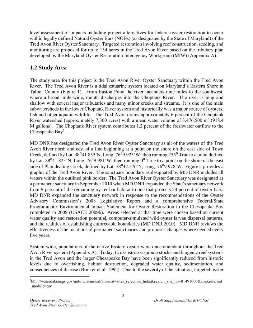
The study area for this project is the Tred Avon River Oyster Sanctuary within the Tred Avon
River. The Tred Avon River is a tidal estuarine system located on Maryland’s Eastern Shore in
Talbot County (Figure 1). From Easton Point the river meanders nine miles to the southwest,
where a broad, mile-wide, mouth discharges into the Choptank River. The river is long and
shallow with several major tributaries and many minor creeks and streams. It is one of the main
subwatersheds in the lower Choptank River system and historically was a major source of oysters,
fish and other aquatic wildlife. The Tred Avon drains approximately 6 percent of the Choptank
River watershed (approximately 7,300 acres) with a mean water volume of 3,476,500 m3 (918.4
M gallons). The Choptank River system contributes 1.2 percent of the freshwater outflow to the
Chesapeake Bay3.
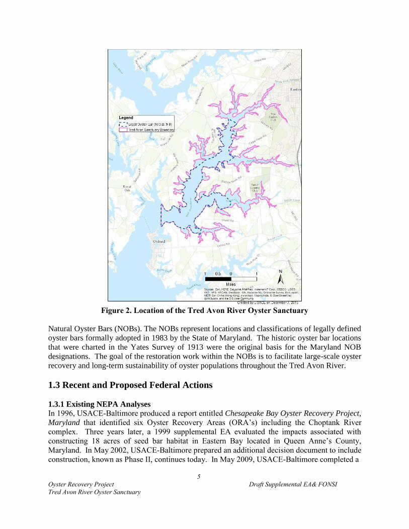
MD DNR has designated the Tred Avon River Oyster Sanctuary as all of the waters of the Tred
Avon River north and east of a line beginning at a point on the shore on the east side of Town
Creek, defined by Lat. 38⁰41.835’N, Long. 76⁰9.923’W; then running 255⁰ True to a point defined
by Lat. 38⁰41.823’N, Long. 76⁰9.981’W; then running 0⁰ True to a point on the shore of the east
side of Plaindealing Creek, defined by Lat. 38⁰42.576’N, Long. 76⁰9.978’W. Figure 2 provides a
graphic of the Tred Avon River. The sanctuary boundary as designated by MD DNR includes all
waters within the outlined pink border. The Tred Avon River Oyster Sanctuary was designated as
a permanent sanctuary in September 2010 when MD DNR expanded the State’s sanctuary network
from 9 percent of the remaining oyster bar habitat to one that protects 24 percent of oyster bars.
MD DNR expanded the sanctuary network in response to the recommendations of the Oyster
Advisory Commission’s 2008 Legislative Report and a comprehensive Federal/State
Programmatic Environmental Impact Statement for Oyster Restoration in the Chesapeake Bay
completed in 2009 (USACE 2009b). Areas selected at that time were chosen based on current
water quality and restoration potential, computer-simulated wild oyster larvae dispersal patterns,
and the realities of establishing enforceable boundaries (MD DNR 2010). MD DNR reviews the
effectiveness of the locations of permanent sanctuaries and proposes changes where needed every
five years.
System-wide, populations of the native Eastern oyster were once abundant throughout the Tred
Avon River system (Appendix A). Today, Crassostrea virginica stocks and biogenic reef systems
in the Tred Avon and the larger Chesapeake Bay have been significantly reduced from historic
levels due to overfishing, habitat destruction, degraded water quality, sedimentation, and
consequences of disease (Bricker et al. 1992). Due to the severity of the situation, targeted oyster
3http://waterdata.usgs.gov/md/nwis/annual/?format=sites_selection_links&search_site_no=01491000&referred
_module=qw

4
Oyster Recovery Project Draft Supplemental EA& FONSI
Tred Avon River Oyster Sanctuary
Figure 1. Tred Avon River within the Chesapeake Bay
restoration is being planned for the State of Maryland-designated Tred Avon River Oyster
Sanctuary. The Tred Avon River is one of three initial tributaries selected for federal restoration
work to be implemented by USACE-Baltimore in collaboration with the National Oceanic and
Atmospheric Administration (NOAA) and MD DNR. Restoration efforts discussed in this EA are
limited to the Tred Avon River Oyster Sanctuary established by MD DNR. To justify its
investment is in the federal interest, USACE undertakes oyster restoration efforts in areas
designated as sanctuaries by MD DNR.
Federal restoration investments in those sanctuaries are expected to be maintained as sanctuaries
in perpetuity. The Tred Avon River Oyster Sanctuary itself covers approximately 3,937 acres,
where no commercial harvest of oysters is allowed as of the 2010 sanctuary designation. Contained
within the sanctuary limits is 2,101 acres designated by the State of Maryland as legally defined
Tred
Avon
River
Choptank
River
Chesapeake
Bay
Harris
Creek
5
Oyster Recovery Project Draft Supplemental EA& FONSI
Tred Avon River Oyster Sanctuary
Figure 2. Location of the Tred Avon River Oyster Sanctuary
Natural Oyster Bars (NOBs). The NOBs represent locations and classifications of legally defined
oyster bars formally adopted in 1983 by the State of Maryland. The historic oyster bar locations
that were charted in the Yates Survey of 1913 were the original basis for the Maryland NOB
designations. The goal of the restoration work within the NOBs is to facilitate large-scale oyster
recovery and long-term sustainability of oyster populations throughout the Tred Avon River.
1.3 Recent and Proposed Federal Actions
1.3.1 Existing NEPA Analyses
In 1996, USACE-Baltimore produced a report entitled Chesapeake Bay Oyster Recovery Project,
Maryland that identified six Oyster Recovery Areas (ORA’s) including the Choptank River
complex. Three years later, a 1999 supplemental EA evaluated the impacts associated with
constructing 18 acres of seed bar habitat in Eastern Bay located in Queen Anne’s County,
Maryland. In May 2002, USACE-Baltimore prepared an additional decision document to include
construction, known as Phase II, continues today. In May 2009, USACE-Baltimore completed a

6
Oyster Recovery Project Draft Supplemental EA& FONSI
Tred Avon River Oyster Sanctuary
separate standalone EA that evaluated the use of alternate substrate materials for constructing reef
habitat due to the shortage of oyster shell entitled Chesapeake Bay Oyster Restoration Using
Alternate Substrate, Maryland. Most recently in 2014, USACE-Baltimore completed a
supplemental EA focused on shallow water oyster restoration in Harris Creek.
1.3.2 Chesapeake Bay Protection and Restoration Executive Order
In 2009, the Chesapeake Bay Protection and Restoration Executive Order (E.O. 13508) was
signed, calling on all federal agencies involved in Chesapeake Bay oyster restoration to formulate
comprehensive strategies and to set clear and measurable goals for restoring native oyster habitat
and populations in 10 tributaries by 2025 (revised from 20 tributaries). In response to the executive
order, USACE recognized that a more coordinated Bay-wide approach throughout the Maryland
and Virginia portions of the Chesapeake Bay was needed to guide future oyster restoration efforts
and the investment of federal funding. As a result, the 2012 USACE Native Oyster Restoration
Master Plan (Master Plan) evaluated problems and opportunities for oyster restoration in
tributaries of the Chesapeake Bay, formulated broad plans, and offered recommendations for
implementation of large-scale oyster restoration. A summary of past USACE restoration actions
prior to 2011 is included in the Master Plan (USACE 2012).
The Chesapeake Bay Program’s Sustainable Fisheries Goal Implementation Team (GIT) is
charged with advancing the oyster goal of E.O. 13508. The GIT convened the Oyster Metrics
Workgroup (OMW) to establish definitions and metrics to use in determining if restoration projects
and tributaries have been successfully restored (OMW 2011). The GIT then established
interagency workgroups in Maryland and Virginia to plan restoration work in each state, in
consultation with appropriate partners. The Maryland Oyster Restoration Interagency Workgroup
(MIW) is composed of representatives from NOAA, MD DNR, USACE-Baltimore, and the Oyster
Recovery Partnership. The MIW is charged with developing and implementing large-scale oyster
restoration plans to meet the oyster goal of E.O. 13508 and their respective agencies’ goals.
1.3.2.1Efforts to meet E.O. 13508 Oyster Goals
MIW, in consultation with Maryland oyster restoration partners, selected Harris Creek as its first
tributary for large‐scale oyster restoration based on consideration of salinity levels, available
restorable bottom, protection from harvest, historical spat set, and other factors. Harris Creek is a
tributary on the north shore of the Choptank River, near its confluence with the Bay’s mainstem.
MIW developed a tributary restoration plan that outlines an objective of restoring and
rehabilitating 377 acres of oyster reef habitat. Initial population surveys identified that 3 acres of
existing reef habitat met the metric goals for oyster density. Between 2011 – 2015, USACE
constructed 80 acres of 1-foot high oyster reefs using alternate substrates, composed primarily of
mixed shell and granite, under the 704(b) authority, and MD DNR provided spat-on-shell for those
sites as in-kind credit. These reefs were constructed within water depths 9 ft and deeper. In winter
2014 – 2015, USACE constructed an additional 55 acres of alternate substrate reefs in Harris Creek
that provide for a 5 foot navigational clearance under the 704(b) authority and MD DNR provided
spat-on-shell for those sites as in-kind credit. MD DNR also constructed and seeded 62 acres of
substrate reef habitat. Additionally, 150 acres of existing reef habitat (seed-only sites) were
rehabilitated with the addition of spat-on-shell plantings. All seeding and shell reefs were efforts
credited under the 704(b) program. Some acreage was determined to be unsuitable as the plan was

7
Oyster Recovery Project Draft Supplemental EA& FONSI
Tred Avon River Oyster Sanctuary
implemented, resulting in the final restoration of 350 acres (3 + 80 + 55 + 62 + 150), rather than
377 acres as initially identified in the Harris Creek Tributary Plan.
The Little Choptank River is the second tributary selected for restoration by the MIW. The Little
Choptank River Tributary Plan outlines a goal of restoring 440 acres. Initial pre-restoration
monitoring showed that 40 acres currently met the restoration targets. Between 2014 and 2015,
27.3 acres of reef habitat have been constructed by MD DNR and seeded. Another 124.5 acres
have been constructed by MD DNR and partially seeded or have not received spat-on-shell yet.
These reefs will be planted with seed oysters in 2016, as hatchery production allows.
The Tred Avon River, which is the focus of this document, is the third tributary selected for
restoration. As USACE-Baltimore has existing NEPA documentation to enable restoration efforts
in a portion of the Tred Avon (USACE 1996 and 2009), but not in the Little Choptank River, the
MIW made the decision that in order to use resources most efficiently, USACE resources would
be focused on reef restoration in the Tred Avon River, while MD DNR resources would be devoted
toward reef restoration efforts in the Little Choptank River to fulfill E.O. 13508 oyster goals and
the plans developed by MIW.
1.3.3 Tred Avon River Oyster Restoration Target Establishment
The oyster metrics report (OMW 2011) considered two criteria when establishing the definition
for a successfully-restored tributary: 1) the current bottom condition, and 2) the extent of historical
oyster reef habitat. A successfully-restored tributary is defined as a tributary where 50 – 100
percent of currently restorable bottom is restored. Additionally, the amount of restorable bottom
that is restored must be at least 8 – 16 percent of historic oyster habitat. The Tred Avon River
Oyster Sanctuary Restorable Bottom Assessment and Data Summary (NOAA 2013) identified
approximately 251 acres of currently-restorable bottom habitat based on data from the USACE
master plan, the oyster sanctuary boundaries, water quality data, and bottom survey data from
Maryland Geological Survey and NOAA. In order to meet the 50 – 100 percent of currently-
restorable bottom goal, 125 to 251 acres would need to be restored in the Tred Avon River
(Appendix B, Figure 8). The second part of the Oyster Metrics goal is that this amount—125 to
251 acres—must constitute at least 8 percent of historical oyster habitat. The Yates Survey of 1913
is used to represent historical oyster habitat since it is the oldest Maryland-wide survey. However,
Yates bars represent historical legal bars and not biological boundaries. Yates charted 851 acres
of legal oyster bar boundaries in the river; 8 to 16 percent of that is 68 to 136 acres (Yates 1913)
(Figure 3). Therefore, restoring between 125 and 251 acres would meet both of the Oyster Metrics
goals.
The 251 acres were analyzed in GIS to make more uniform polygons that could be feasibly
constructed, incorporate public input on waterway use conflicts, and provide for buffers around
navigational channels, aids to navigation, and private docks. This reduced the target to 182.4 acres.
An additional 28 acres were removed from the restoration target to serve as project controls (see
controls section). The result was a target of 154.4 acres (rounded to 154). A total of 71 of the 154
acres are planned as seed-only treatment (spat-sets) and the remaining 83 acres for the placement
of substrate and seeding. One final adjustment was made to reach the final Tred Avon restoration
8
Oyster Recovery Project Draft Supplemental EA& FONSI
Tred Avon River Oyster Sanctuary
Figure 3. Yates Bars in the Tred Avon River (provided by NOAA)
goal. Diver ground truthing has shown that sonar surveys may overestimate the area of shell
bottom suitable for placing oysters on existing bars. Based on restoration field experience, the
MIW assumed that the suitable area as determined by sonar will be reduced by 10 percent upon
examination by divers. Therefore, a 10-percent reduction of the area targeted for seed-only
provides for a range of 63 – 71 acres (rounded) of seed-only acreage and reduces the 154 acres
identified to 146 acres. This amount, 146 acres, is the actual oyster restoration goal for the Tred
Avon oyster sanctuary. [The current Tred Avon River Tributary Plan states 147 acres. The
9
Oyster Recovery Project Draft Supplemental EA& FONSI
Tred Avon River Oyster Sanctuary
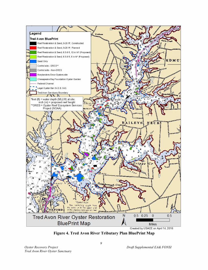
Figure 4. Tred Avon River Tributary Plan BluePrint Map

10
Oyster Recovery Project Draft Supplemental EA& FONSI
Tred Avon River Oyster Sanctuary
Tributary Plan is a living document, and as such will be updated to reflect the 146 acre target at a
future time.]
The complete 71 acres of seed-only treatment is evaluated because it is unknown which acreages
will be determined to be unsuitable with future investigations such as diver ground truthing. Figure
4 presents the Tred Avon Tributary Plan. Of the 83 acres planned as substrate reefs: 26 (25.8)
acres would provide 8 feet navigational clearance (>9 feet MLLW) and 57 (57.1) acres would
provide 6 feet navigational clearance (6.5 – 9 feet MLLW).
The workgroup considers new information as it develops to make any needed changes to the areas
designated in the Tributary Plan for substrate placement and seeding. Although the restoration
goal is set at 146 acres, this EA evaluates restoration and rehabilitation efforts throughout the
sanctuary to cover any minor adjustments to polygon boundaries that may be necessary in the
future. The total acreage that has been determined to be technically feasible for either substrate
placement in water depths between 6.5 and 9 feet MLLW (57 acres) or seed-only treatment on
existing bars (71 acres) is 130 acres based on current information in the Tred Avon River Tributary
Plan. The 130 acres plus the 24 acres of deep water alternate substrate restoration comprises the
total 154 acres of the Tred Avon River Tributary Plan. Build-out for the entire project is estimated
to take 3 to 5 years from initial construction. Table 1 provides a summary of the derivation of the
restoration target.
Table 1. Calculation of the Tred Avon River Restoration Target
Acres
Tred Avon Sanctuary 3,937
Restorable Bottom 251
Metrics Goal #1 - 50-100% of Restorable Bottom 125-251
Yates Bars 851
Metrics Goal #2 - 8-16% of Yates Bars 68-136
Accounting for navigation and dock buffers, irregularity of
boundaries, public input (68.6 ac) 182.4
Removal of Control Sites (28 ac) 154.4
ACREAGE AVAILABLE FOR RESTORATION 154
Reduce seed-onlys sites by 10% to account for groundtruthing
loss (8 acres) 63-71
RESTORATION TARGET 146
Substrate and seed sites, > 9 ft MLLW 26
Substrate and seed sites, 6.5-9 ft MLLW 57
Seed-only sites 71
2.0 PURPOSE, NEEDS, and OBJECTIVES
This supplemental EA is being prepared for the Tred Avon River Oyster Sanctuary to expand
oyster restoration and rehabilitation activities for reef bar construction and seeding into shallower
depths of the sanctuary. This supplemental EA evaluates the impacts of restoring oyster reef
11
Oyster Recovery Project Draft Supplemental EA& FONSI
Tred Avon River Oyster Sanctuary
habitat through substrate placement in water depths that maintain a 6-foot water column above
restored substrate reefs. The supplemental EA also evaluates spat-on-shell plantings on
constructed and existing oyster bars that will have a minor change in their elevation by
approximately 1 – 3 inches. The potential impacts of expanding substrate reef restoration work
into shallower depths have not been evaluated under existing NEPA documentation. As a result
of changing an 8-foot minimum navigational depth clearance to allow substrate reefs to be placed
in areas with a 6-foot minimum navigation depth clearance, the NEPA process provides the
opportunity for USACE-Baltimore to evaluate the effects of this action on the quality of the human
environment. Given the focus on large-scale tributary based restoration, it is necessary and
appropriate to consider restoring oyster reef habitat across broader depth contours within the
historic oyster habitat footprint. By removing the 8-foot minimum navigation depth clearance,
oyster restoration goals for this tributary could be achieved to help restore native oyster
populations and improve local habitat conditions throughout the tributary.
2.1 Purpose
The proposed activities that are the subject of this supplemental EA include 1) replacing the 8-foot
minimum navigational depth clearance for previously authorized activities under the 704(b)
Program with a 6-foot minimum navigational clearance for placement of substrate to restore reef
habitat, 2) the construction of oyster reef habitat, and 3) the planting of spat-on-shell on restored
reefs and on existing shell reefs.
Prior to large-scale restoration efforts, maintaining a standard 8 foot navigational clearance was a
straightforward way to address and avoid navigational conflicts from placement of substrate for
reef restoration, and there was sufficient habitat in deeper waters to satisfy the smaller restoration
efforts. However, with the understanding that large-scale oyster restoration was necessary to
achieve system-wide impacts (USACE 2012), shallower water depths are needed to utilize areas
for restoration that historically contained oyster habitat in order to maximize habitat coverage and
diversity. Maintaining a 6-foot minimum navigational clearance applies only to reefs that require
substrate placement for restoration, and not to augmentation of existing reefs with spat-on-shell.
Seeding of existing oyster reef is situated in water depths between 4 and 20 feet. As spat-on-shell
reduces water depths by 1 – 3 inches at seed-only sites, there would be no significant impact on
navigation. Reefs rehabilitated using shell (if available) or alternate substrate will also receive a
planting of spat-on-shell in the Tred Avon River.
The purpose of this supplemental EA is to evaluate the environmental impacts of the expansion of
oyster reef restoration between the depths of 6.5 to 9 feet MLLW within the Tred Avon River
oyster sanctuary. Expanding the potential area where oyster restoration activities can occur will
allow Chesapeake Bay Protection and Restoration Executive Order (E.O. 13508) outcomes and
2014 Chesapeake Bay Agreement goals to be met and implement restoration efforts over a broader
portion of historical habitat.

12
Oyster Recovery Project Draft Supplemental EA& FONSI
Tred Avon River Oyster Sanctuary
2.2 Needs
The Oyster Metrics Workgroup and the USACE team that developed USACE’s Oyster Restoration
Master Plan (USACE 2012) worked to define the scale needed to have a system-wide impact on a
tributary in order to achieve a sustainable long-term project. The USACE team considered the
size typically reserved for Marine Protected Areas (20 – 70%), the fact that sessile bivalves such
as the oyster would be expected to fall on the lower end of the Marine Protected Areas (MPA)
range, as well as past knowledge of the scale of restoration efforts in the Chesapeake Bay. This
information guided the decision to target 20 – 40% of historical oyster habitat within the sanctuary,
which equates to 8 – 16% of Yates Bars once adjustments were made for discrepancies in historical
boundaries (USACE 2012 provides a detailed explanation of the determination of scale). The
team recognized that one number will not fit every circumstance, and therefore included the
recommendation that the range should be revised to a more precise number by the follow-on
tributary plans. Further explanation on defining scale is available in USACE (2012).
Incorporating the Master Plan definition of scale, The Oyster Metrics Workgroup (OMW 2011)
defined success criteria for oyster restoration efforts in the Chesapeake Bay. The following metrics
were established:
A successfully‐restored reef should:
o have a minimum mean density of 50 oysters and 50 grams dry weight/square
meter (m2) covering at least 30 percent of the target restoration area at 6 years
post restoration;
o have two or more age classes present; and
o exhibit stable or increasing spatial extent, reef height and shell budget4.
A successfully‐restored tributary is one where 50 – 100 percent of the currently restorable
bottom has oyster reefs that meet the reef‐level metrics above. Restorable bottom is defined
as area that, at a minimum, has appropriate bottom quality and water quality for oyster
survival.
A suitable candidate tributary is one where 50 – 100 percent of the currently restorable
bottom is equivalent to at least 8 percent, and preferably more, of its historic oyster bottom.
These metrics are applicable for a tributary or a portion of a tributary based on the sanctuary
boundaries. For the Tred Avon River, these metrics will be applied to restoration efforts within
the Tred Avon River Oyster sanctuary boundaries.
The overall tributary plan for the Tred Avon River has identified 154 acres available for oyster
restoration within water depths of 4 and 20 feet MLLW (Table 2), with a resulting target of 146
4 Shell budget refers to the accounting of the material oyster shells are made from. That is, the processes to result in
the addition and subtraction of shell from a system. Failure to maintain existing shell quantities or continued loss of
shell is a signal that the project is not sustainable.
13
Oyster Recovery Project Draft Supplemental EA& FONSI
Tred Avon River Oyster Sanctuary
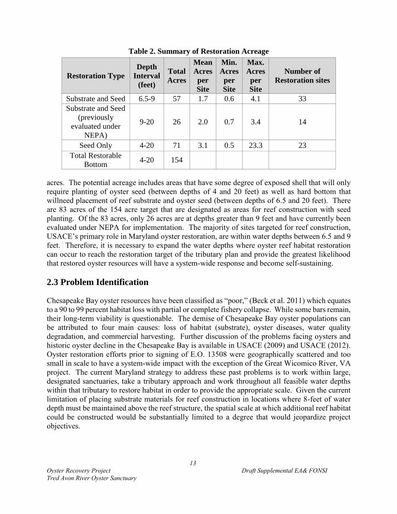
Table 2. Summary of Restoration Acreage
Restoration Type
Depth
Interval
(feet)
Total
Acres
Mean
Acres
per
Site
Min.
Acres
per
Site
Max.
Acres
per
Site
Number of
Restoration sites
Substrate and Seed 6.5-9 57 1.7 0.6 4.1 33
Substrate and Seed
(previously
evaluated under
NEPA)
9-20 26 2.0 0.7 3.4 14
Seed Only 4-20 71 3.1 0.5 23.3 23
Total Restorable
Bottom 4-20 154
acres. The potential acreage includes areas that have some degree of exposed shell that will only
require planting of oyster seed (between depths of 4 and 20 feet) as well as hard bottom that
willneed placement of reef substrate and oyster seed (between depths of 6.5 and 20 feet). There
are 83 acres of the 154 acre target that are designated as areas for reef construction with seed
planting. Of the 83 acres, only 26 acres are at depths greater than 9 feet and have currently been
evaluated under NEPA for implementation. The majority of sites targeted for reef construction,
USACE’s primary role in Maryland oyster restoration, are within water depths between 6.5 and 9
feet. Therefore, it is necessary to expand the water depths where oyster reef habitat restoration
can occur to reach the restoration target of the tributary plan and provide the greatest likelihood
that restored oyster resources will have a system-wide response and become self-sustaining.
2.3 Problem Identification
Chesapeake Bay oyster resources have been classified as “poor,” (Beck et al. 2011) which equates
to a 90 to 99 percent habitat loss with partial or complete fishery collapse. While some bars remain,
their long-term viability is questionable. The demise of Chesapeake Bay oyster populations can
be attributed to four main causes: loss of habitat (substrate), oyster diseases, water quality
degradation, and commercial harvesting. Further discussion of the problems facing oysters and
historic oyster decline in the Chesapeake Bay is available in USACE (2009) and USACE (2012).
Oyster restoration efforts prior to signing of E.O. 13508 were geographically scattered and too
small in scale to have a system-wide impact with the exception of the Great Wicomico River, VA
project. The current Maryland strategy to address these past problems is to work within large,
designated sanctuaries, take a tributary approach and work throughout all feasible water depths
within that tributary to restore habitat in order to provide the appropriate scale. Given the current
limitation of placing substrate materials for reef construction in locations where 8-feet of water
depth must be maintained above the reef structure, the spatial scale at which additional reef habitat
could be constructed would be substantially limited to a degree that would jeopardize project
objectives.
14
Oyster Recovery Project Draft Supplemental EA& FONSI
Tred Avon River Oyster Sanctuary
Restoration at diverse depths throughout the Tred Avon River will increase the spatial extent and
connectivity of restoration actions to maximize habitat and support larval retention and settlement
success, a particular focus of USACE’s Master Plan. Previous restoration efforts in the
Chesapeake Bay tributaries have been limited in scope and spatial connectivity (USACE 2012).
By removing the 8-feet minimum navigational depth clearance for placement of substrate to restore
reef habitat, two identified goals for a successfully-restored tributary are met in addition to
expanding federal activities into historically recognized zones of oyster spawning, transport, and
larval setting. Work in a broad range of water depths provides the best circumstances for
influencing stock/recruit relationships, which, in turn, will make on-the-ground restoration more
likely to achieve ecological success (USACE 2012).
Research supports expanding substrate reef restoration activities at the 6-foot bathymetric contour.
Seliger and Boggs (1988) studied oyster populations in Broad Creek and the Tred Avon River and
determined that the 6-foot MLLW zone is a zone that was highly supportive of oyster habitat where
it was associated with steep bathymetric gradients. Bathymetric gradients promote successful
restoration due to continuous influx of food and efflux of sediment and waste and are a targeted
area for construction of individual reefs and rehabilitation (USACE 2012).
Shallower areas may allow oyster larvae to take full advantage of flood tidal currents by timing
their vertical swimming activity (Boicourt 1982). Further, shallow-water oyster beds have a lower
risk of exposure to anoxic conditions (Seliger et al. 1982).
If the 8 feet depth restriction on substrate reef restoration is not changed to 6 feet MLLW,
restoration would only be capable of reaching 8 percent of historic Yates’s Bars surveyed (68
acres). In that situation, 26 acres of deep water substrate reefs would be restored as well as 63 –
71 acres of seed-only treatment. The goal of restoring 50 – 100 percent (125 – 251 acres) of
currently restorable bottom surveyed would not be attainable. Removing the 8-foot minimum
navigation depth clearance for placement of substrate to restore reefs meets both habitat goals and
allows for increased restoration acreage to be obtained (up to 154 acres). This, in turn, is
anticipated to support higher reproduction levels for larval transport models and retention rates
within the tributary contributing to a more sustainable restoration project long-term.
2.3.1 Brief Description of the Project
The Tred Avon River was selected as the third candidate tributary for large-scale oyster restoration
by MIW. The selection is predicated on the findings of the 2012 Master Plan, fall survey data
collected by MD DNR, existing Chesapeake Bay Program water quality monitoring data,
Maryland oyster sanctuary designations, and bottom survey data obtained by the Maryland
Geological Survey (MGS) and NOAA. Following identification of a tributary for restoration, a
detailed tributary plan is developed to determine the restoration target and specific locations for
restoration within the tributary. Restoration efforts are then carried out in subsequent years until
the restoration target is reached. Monitoring and adaptive management occur in the years
following completion of initial restoration efforts. Typical roles of oyster restoration partners
follow:

15
Oyster Recovery Project Draft Supplemental EA& FONSI
Tred Avon River Oyster Sanctuary
NOAA- pre- and post-restoration bottom surveying and GIS analysis,
USACE-Baltimore- substrate reef construction, monitoring,
MD DNR- hatchery operation/spat-on-shell production, monitoring, substrate reef
construction, acquire necessary permits for spat-on-shell planting, and
ORP (Oyster Recovery Partnership)5- spat-on-shell plantings, pre-restoration surveys,
post-planting surveys.
A number of surveys were conducted to develop the tributary plan and identify specific restoration
locations. Initially, MGS and NOAA Chesapeake Bay Office (NCBO) conducted side-scan sonar
surveys for the Tred Avon River in 2009 that provided baseline data identifying bottom type. A
more detailed multi-beam survey of the riverbed was completed by NCBO to determine the quality
of the bottom habitat and its ability to support restoration actions. Only the areas between minus
4 and 20 feet MLLW were considered suitable for restoration since deeper waters typically
experience lower dissolved oxygen (DO) levels and higher sedimentation rates that are not
conductive to reef community structure. After completing a waterways analysis for the Tred Avon
River, water depths in the range of minus 4 – 6 feet MLLW were determined to be unsuitable for
substrate additions due to concerns about navigational use conflicts on the waterway and for safe
vessel operation. Thus, only water depths between minus 6.5 and 20 feet MLLW are considered
suitable for reef construction. The 20 foot bathymetric cutoff was determined as the deepest zone
where restoration activities could occur due to concerns about potential hypoxia and anoxia typical
of deeper water (reference CBP OMP). The depth limit of minus 6.5 feet MLLW allows for safe
navigation over the substrate at vertical clearance of minus 6 feet MLLW to top of reef structures.
Areas at the 6.5 foot contour are suitable for placement of 6 inches of substrate material to restore
reefs, while areas greater than 7 feet MLLW are targeted to receive up to 12 inches (1 foot) of
substrate material. It is anticipated that when detailed plans are completed, some areas within
proposed sites near the 6.5 foot contour will prove to be too shallow to provide 6 inches of depth
for substrate placement plus 1 – 3 inches of depth for spat-on-shell. In those situations, the
boundaries of sites will be adjusted to remove these areas.
The more recent decline in overall Chesapeake Bay oyster populations has been attributed
primarily to the introduction of two diseases to which the Eastern oyster had no resistance: Dermo
and MSX. The Tred Avon River has been selected as part of an overall salinity-based strategy to
address disease and promote the development of disease resistance. Disease pressure and mortality
of adult oysters increase with increasing salinity (USACE 2012). Since the Tred Avon River is
classified as a mesohaline tributary, it is a prime candidate to encourage disease resistance to
potentially develop in the wild population. Focusing ecological restoration efforts in a large-scale,
interconnected fashion (river system wide) is the strategy most likely to allow large populations of
oysters to persist in the face of disease and other stressors (USACE 2012).
5 ORP is a non-profit organization that plans, promotes and implements science-based and sustainable shellfish
restoration, aquaculture and wild fishery activities to protect our environment, support our economy and preserve our
cultural heritage.

16
Oyster Recovery Project Draft Supplemental EA& FONSI
Tred Avon River Oyster Sanctuary
2.3.2 Tred Avon Oyster Populations
Historically, the Tred Avon River system supported large productive reefs where free-swimming
oyster larvae could colonize on oyster shell or other hard substrate habitats. Roughly 851 acres of
once active oyster beds were mapped as of the 1913 Yates Bars survey (Figure 3). By 1980, those
same areas saw a reduction in area by an estimated 86 percent bottom coverage (i.e. 14 percent of
historical charted acreage remained) in the lower reaches of the Tred Avon River (Seliger and
Boggs 1988). The major driver of those habitat losses prior to 1980 was higher levels of
sedimentation and siltation of upstream reefs and other hard bottom areas affecting natural spat-
sets (Seliger and Boggs 1988). Despite higher larval concentrations and high spat-sets measured
between the years of 1980 and 1981, mature oysters were not present in 1983 and 1984 suggesting
that siltation of once actively harvested reef sites was contributing to the lower oyster populations
observed. Shell removal by harvesting activities is also expected to have played a role in the
degradation of reefs in the Tred Avon River.
Past surveys by Federal and State biologists indicate the Tred Avon River has been an area with
very poor spat settlement success since the 1960s.6 Spat monitoring performed from 1961 to 1966
by Shaw (1967, 1969) showed numerically spat-set occurrence and intensity of settlement for
Broad Creek was higher than those levels measured in the Tred Avon River. A comparison study
conducted by Kennedy (1980) shows the average number of oyster spat settling on the bottom in
1978 was very low for the Tred Avon, but average numbers in 1977 and 1979 were comparable to
or slightly greater than the 1961 – 1966 values observed by Shaw. Generally, the Tred Avon River
has seen very low levels of natural spat-sets since 1985. Recently, only the years of 1985 and 1991
saw significant spat-sets (MD DNR 2012). Spatially explicit data collected by MD DNR (1985 to
2014) which assessed the location and quantity of existing oyster populations, indicates the Tred
Avon River continues to experience very low natural spat-sets (MD DNR 2014 (Figure 5).
0
50
100
150
200
250
300
350
Spat
fall
Inte
nsi
ty (
me
an)
(Nu
mb
er
of
spat
pe
r b
ush
el)
Year
Spatfall Intensity
Figure 5. Tred Avon River Spatfall Intensity 1985-2014 (MD DNR 2014)
6 Maryland Sea Grant – University of Maryland. Biology of the Oyster. 2013. Available online at:
http://nsgd.gso.uri.edu/aqua/ mdut81003.pdf

17
Oyster Recovery Project Draft Supplemental EA& FONSI
Tred Avon River Oyster Sanctuary
Research by Boicourt (1982) suggests the need for broodstock and hard bottom habitat restoration
since historical oyster population dynamics in the Tred Avon appear to be highly dependent on
local production of larvae for spat settlement versus reproductive input from the Choptank River.
Larvae in the Tred Avon River are dependent upon upriver oyster populations for broodstock
supply because circulation patterns at the confluence tend to block the entrance of larvae from
outside of the system to supplement the upriver populations (Boicourt 1982). This adds further to
the complexity and precipitous decline in oyster populations occurring in the Tred Avon.
The need for seeding and broodstock is further supported by a spatially-explicit population and
density survey conducted by MD DNR in May 2012 to determine the extent of currently restorable
oyster bottom. Only 29% of the total 161 samples taken contained live oysters. Oyster shell rubble
with sand contained live oyster densities of less than 5 oysters per square meter. Based on survey
results, the tributary plan calls for designating approximately 98% of the existing shelled bottom
surveyed as seed-only restoration. Coupled with the low spat-sets currently occurring in the river
and low existing broodstock, the need for elevated hard bottom habitat is critical to recover oyster
populations.
2.4 Goals and Objective
The goal of this project is to enable implementation of the Tred Avon Tributary Plan. Full
implementation of the Tred Avon Tributary Plan would provide 146 acres of restored oyster reef
habitat in the Tred Avon River. This level of implementation would provide for the greatest
potential scale of oyster restoration with the objective of producing a system-wide impact to oyster
populations. The approach of MIW is to restore all habitat that is deemed restorable given
available resources because habitat is drastically degraded and reduced from historic levels. The
objective of this EA is to evaluate the impacts that would result from reducing the navigational
clearance in the Tred Avon River above oyster reef restoration sites to a designated 6 feet MLLW
from 8 feet MLLW and the alternatives to that action. This will enable the goal to be achieved.
Adding spat-on-shell to existing oyster habitat in water depths between 4 and 20 feet is not subject
to the requirements to maintain a designated navigational clearance, but impacts from this action
are evaluated.
3.0 ALTERNATIVES
Alternative development and analysis is focused on 1) seeding existing oyster habitat between 4
and 20 feet MLLW, 2) substrate reef restoration in water depths between 6.5 and 9 feet MLLW,
and 3) planting spat-on-shell on restored substrate reefs.
3.1 Alternatives Considered
The alternatives were developed based on the following three management measures (Table 3):
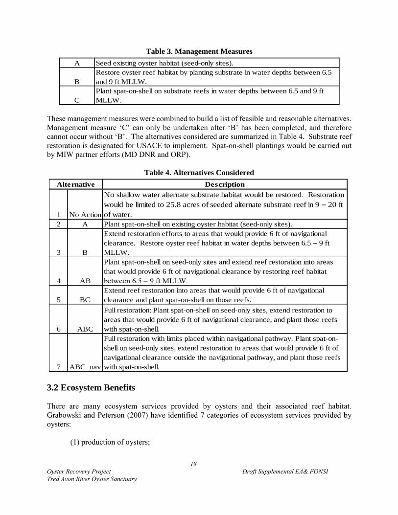
18
Oyster Recovery Project Draft Supplemental EA& FONSI
Tred Avon River Oyster Sanctuary
Table 3. Management Measures
A Seed existing oyster habitat (seed-only sites).
B
Restore oyster reef habitat by planting substrate in water depths between 6.5
and 9 ft MLLW.
C
Plant spat-on-shell on substrate reefs in water depths between 6.5 and 9 ft
MLLW.
These management measures were combined to build a list of feasible and reasonable alternatives.
Management measure ‘C’ can only be undertaken after ‘B’ has been completed, and therefore
cannot occur without ‘B’. The alternatives considered are summarized in Table 4. Substrate reef
restoration is designated for USACE to implement. Spat-on-shell plantings would be carried out
by MIW partner efforts (MD DNR and ORP).
Table 4. Alternatives Considered
Description
1 No Action
No shallow water alternate substrate habitat would be restored. Restoration
would be limited to 25.8 acres of seeded alternate substrate reef in 9 – 20 ft
of water.
2 A Plant spat-on-shell on existing oyster habitat (seed-only sites).
3 B
Extend restoration efforts to areas that would provide 6 ft of navigational
clearance. Restore oyster reef habitat in water depths between 6.5 – 9 ft
MLLW.
4 AB
Plant spat-on-shell on seed-only sites and extend reef restoration into areas
that would provide 6 ft of navigational clearance by restoring reef habitat
between 6.5 – 9 ft MLLW.
5 BC
Extend reef restoration into areas that would provide 6 ft of navigational
clearance and plant spat-on-shell on those reefs.
6 ABC
Full restoration: Plant spat-on-shell on seed-only sites, extend restoration to
areas that would provide 6 ft of navigational clearance, and plant those reefs
with spat-on-shell.
7 ABC_nav
Full restoration with limits placed within navigational pathway. Plant spat-on-
shell on seed-only sites, extend restoration to areas that would provide 6 ft of
navigational clearance outside the navigational pathway, and plant those reefs
with spat-on-shell.
Alternative
3.2 Ecosystem Benefits
There are many ecosystem services provided by oysters and their associated reef habitat.
Grabowski and Peterson (2007) have identified 7 categories of ecosystem services provided by
oysters:
(1) production of oysters;
19
Oyster Recovery Project Draft Supplemental EA& FONSI
Tred Avon River Oyster Sanctuary
(2) water filtration and concentration of biodeposits (largely as they affect local water
quality);
(3) provision of habitat for epibenthic fishes (and other vertebrates and invertebrates-
(Coen et a1. 1999; ASMFC 2007);
(4) sequestration of carbon;
(5) augmentation of fishery resources in general,
(6) stabilization of benthic or intertidal habitat (e.g. marsh); and
(7) increase of landscape diversity (see also reviews by Coen et a1. 1999, Coen et al.
2007, Coen and Luckenbach 2000, ASMFC 2007).
Additionally, Ulanowicz and Tuttle (1992) identified how oyster restoration would promote
beneficial food web dynamics in the Chesapeake system. These benefits are discussed in further
detail in USACE (2012).
Given existing knowledge, ecosystem benefits are closely tied to the acreage restored. Therefore,
the greater the acreage restored, the greater the connectivity of the oyster resources in a tributary,
and the greater the ecosystem benefits. Promoting connectivity is another reason for utilizing
suitable acreage throughout the entire extent of the sanctuary. Reef boundaries are set by the
location of suitable bottom or existing shell, and differ based on the shape and condition in any
individual tributary. The plan has purposefully included suitable areas throughout the entire
sanctuary. It is not known how far apart reefs should be situated. However, by maximizing the
reef footprint in the plan, the restoration effort will have the greatest likelihood of re-establishing
connectivity to the system. Additionally, the intent of large-scale oyster restoration is to increase
oyster biomass such that restoration projects become self-sustaining and able to provide oyster
recruits to suitable surrounding oyster habitat outside the restoration project area.
There is no existing model to adequately document the diverse benefits and value of oyster
restoration. However, USACE-Norfolk and USACE’s Engineer Research and Development
Center (ERDC) in coordination with VMRC are working to develop a model to estimate ecosystem
benefits and services from oyster restoration as part of their common ground activities.
Preliminary results have identified the high ecosystem outputs generated by sanctuary reefs in
Virginia (Swannack, personal communication). USACE (2012) also provides a summary of
documented efforts made toward quantifying the economic value of restored oyster habitat.
Recognizing the connection between acreage of healthy reef habitat and benefits, Table 5
summarizes the restored acreage that would be achieved by each alternative. An acre of reef is
not fully restored in the Tred Avon River until it has been planted with spat-on-shell due to the
lack of broodstock in the current river system. Therefore, there is a distinction made between reef
habitat that has been constructed and that which has also been seeded. Reef acreage that does not
receive spat-on-shell would provide reef structure for other organisms and benefit reef dwelling
species, but would not provide the ecosystem benefits and full restoration potential for oysters.
‘Acres Completed Toward Goal’ includes seed only sites as well substrate sites that have been
planted with spat-on-shell.

20
Oyster Recovery Project Draft Supplemental EA& FONSI
Tred Avon River Oyster Sanctuary
Acreage ranges are provided to capture the uncertainty in the natural environment. For seed-only
sites, groundtruthing prior to planting may identify that a small portion of the site has degraded
since data was collected and is no longer suitable for planting. Substrate placement sites could be
reduced if water depths no longer are available to provide for the planting of at least 6 inches of
substrate material plus spat-on-shell. This situation is most likely on the shoreward side (typical
area within a proposed site where water depths are shallowest) of some of the proposed sites where
navigational clearance would be reduced to 6 feet.
Table 5. Ecosystem Benefits- Restored Acreage
Reef Habitat
Constructed
Functioning
Oyster Reef
Restored
Acres
Completed
Toward
Goal*
1 No Action 0 0 26
2 A 0 63 – 71 89 – 97
3 B 52 – 57 0 26
4 AB 52 – 57 63 – 71 89 – 97
5 BC 52 – 57 52 – 57 78 – 83
6 ABC 52 – 57 115 – 128 141 – 154
7 ABC_nav 49 – 53 112 – 124 138 – 150
Alternative
*acres rounded to nearest whole number
3.3 Evaluation of Alternatives
As determined by the Restorable Bottom Analysis (NOAA 2013), there is a total of 251 acres of
bottom that could be restored in the Tred Avon River. However, following consideration of
navigational uses by the public; allowing for buffers around navigational channels, buoys, and
docks; setting area aside as controls; and incorporating public input, the potential bottom was
reduced to 154 acres. An alternative was not included that considered the restoration of the full
restorable bottom (251 acres) because that level of restoration was determined to not be feasible
as outlined in Section 1.3.3.
The alternatives are formulated and evaluated based on current information available to
differentiate reef construction sites from seed-only sites. These determinations are subject to
change as updated information is acquired. For example, if a good spatset were to occur prior to
construction, sites that are currently considered to be poor quality shell sites and, therefore,
targeted for substrate additions, may have sufficient shell to be switched to a seed-only site.
Additionally, groundtruthing prior to planting of spat-on-shell could reduce or expand boundaries.
For all these reasons, restoration sites and boundaries may undergo minor adjustments prior to
implementation.

21
Oyster Recovery Project Draft Supplemental EA& FONSI
Tred Avon River Oyster Sanctuary
Alternative 1: No action
This alternative would not replace the current 8 foot water depth navigational clearance with a 6
foot water depth navigational clearance at substrate reef locations. USACE-Baltimore would
continue activities to restore the 25.8 acres identified for alternate substrate reefs in water depths
greater than 9 feet MLLW, and DNR/ORP would seed that acreage. Under the No action
alternative, restoration work by MIW partners would achieve restoration of 25.8 acres of seeded
reef habitat in the Tred Avon River, but no additional reef habitat.
This level of restoration would not meet the project goal and objective, and therefore would satisfy
none of the restoration goals established by the Tred Avon Tributary Plan. This alternative would
provide for the fewest ecosystem benefits as the lowest level of reef restoration would be
undertaken. It would be expected that the 25.8 acres of alternate substrate reef habitat would not
be self-sustaining, and would degrade over time in the absence of more extensive restoration
efforts. Restoration of substrate reefs would be limited to deeper parts of the water column that are
at greatest risk to low dissolved oxygen conditions. Locations of only deep water reef habitat
would not provide resiliency to the project given that there would be no reefs in shallow water to
repopulate the deep water reefs in the event of a severe anoxic event. Although larval transport is
not entirely understood in the Tred Avon, implementation of this level of restoration would
minimize habitat that would provide for spat settlement, and therefore minimize reproductive
connectivity. Project objectives would not be met. Compared with historical habitat, the
population and reef network would still be significantly diminished.
Alternative 2: Restore seed-only sites (A)
This alternative would plant spat-on-shell on the 63 – 71 acres of existing reef habitat (seed-only
sites) that were identified to have minimal (<5 oysters/m2) oyster density. This alternative would
not expand oyster substrate reef restoration between the depths of 6.5 to 9 feet MLLW within the
Tred Avon River nor replace the current 8 foot water depth navigational clearance with a 6 foot
water depth navigational clearance at substrate reef locations. Navigational clearances and water
depths at the 63 – 71 acres of existing reef restoration sites (seed-only) would be reduced by 1 – 3
inches. The addition of spat-on-shell to sites is a practice that has been undertaken for decades
and is expected to have a minor, unrecognizable impact on navigation. USACE-Baltimore would
continue activities to restore the 25.8 acres identified for alternate substrate reefs in water depths
greater than 9 feet MLLW, and DNR/ORP would seed that acreage. This alternative would
provide 63 – 71 acres of functioning oyster habitat that would provide moderate resiliency and
connectivity to the oyster habitat network in the Tred Avon in addition to the 25.8 acres of deep
water reefs, for a total of 88.8 – 96.8 acres of restored habitat. The Tributary Plan target of 146
acres would not be met, neither would the goal of restoring 50 percent of restorable bottom (125
acres). However, 8 percent of the extent of Yates Bars would be achieved (68 acres). Compared
with historical habitat, the population and reef network would still be greatly diminished.

22
Oyster Recovery Project Draft Supplemental EA& FONSI
Tred Avon River Oyster Sanctuary
Alternative 3: Construct oyster reef habitat in water depths between 6.5 and 9 feet MLLW
(B)
This alternative would replace the current 8 foot water depth navigational clearance with a 6 foot
water depth navigational clearance at substrate reef sites and construct 52 – 57 acres of oyster reef
habitat in water depths between 6.5 and 9 feet MLLW in the Tred Avon River. Based on current
bathymetry, approximately 47.8 acres are planned for reef construction 1 foot in height (in waters
deeper than approximately 7.5 feet MLLW) and reefs 6 inches high would be established on 9.3
acres (in water depths between approximately 6.5 and 7.5 feet MLLW). To provide adequate relief
into the water column, restoration efforts target placement of at least a 6 inch high reef. Therefore,
if bathymetry changes, any areas determined to have less than 6 inches of available water depth
for reef placement prior to construction would be eliminated from final design plans. Substrate
reefs would not be planted with spat-on-shell under this alternative. Water depths would be
reduced between 6 and 12 inches (6 – 12 inches of substrate) by this proposed alternative.
Alternative 3 would affect the navigational clearance in the Tred Avon River. The water depth
would be reduced between 7 – 15 inches at 33 sites across 52.4 – 57.1 acres where substrate would
be placed, thereby reducing the navigational clearance for boaters in those areas.
USACE-Baltimore would continue activities to restore the 25.8 acres identified for alternate
substrate reefs in water depths greater than 9 feet MLLW, and DNR/ORP would seed those reefs
with spat-on-shell. Under Alternative 3, restoration work by MIW partners would achieve
construction of 78 – 83 acres of reef habitat in the Tred Avon River, but no additional functioning
oyster reef habitat beyond the 25.8 acres of deep water restoration would be provided because the
reefs in shallower water depths would not be seeded.
This level of restoration would satisfy none of the restoration goals. Providing reef structure
without seeding in the Tred Avon where current oyster densities are low, would likely result in the
reef habitat becoming degraded by sedimentation and other sessile organisms such as barnacles
and mussels. In the absence of broodstock additions, it is unlikely that wild spat sets would
increase over current levels. Therefore, it could be expected that in a short time, the reef habitat
would provide very little if any oyster habitat value. Reef habitat diversity would be improved as
reef structure would be in place across a variety of depths. Habitat connectivity would be
increased, but in the absence of spat-on-shell plantings, reproductive connectivity enhancement is
questionable. The Tributary Plan target and the restoration goals would not be met. Compared
with historical habitat, the population and reef network would still be diminished.
Alternative 4: Plant spat-on-shell on seed-only sites and extend reef restoration into
shallower water depth (AB)
This alternative would replace the current 8 foot water depth navigational clearance with a 6 foot
water depth navigational clearance at substrate reef sites and construct 52 – 57 acres of oyster reef
habitat in water depths between 6.5 and 9 feet MLLW in the Tred Avon River. Based on current
bathymetry, approximately 47.8 acres are planned for reef construction 1 foot in height (in waters
deeper than approximately 7.5 feet MLLW) and reefs 6 inches high would be established on 9.3

23
Oyster Recovery Project Draft Supplemental EA& FONSI
Tred Avon River Oyster Sanctuary
acres (in water depths between approximately 6.5 and 7.5 feet MLLW). To provide adequate relief
into the water column, restoration efforts target placement of at least a 6 inch high reef. Therefore,
if bathymetry changes, any areas determined to have less than 6 inches of available water depth
for reef placement prior to construction would be eliminated from final design plans. The substrate
reefs would not be seeded under this alternative.
Alternative 4 would also plant spat-on-shell on the 63 – 71 acres of existing reef habitat that was
identified to have minimal (<5 oysters/m2) oyster density. Water depths would be reduced between
1 and 12 inches (6 – 12 inches on substrate sites or 1 – 3 inches at seed-only sites) depending on
the restoration action taken at a site.
USACE-Baltimore would continue activities to restore the 25.8 acres identified for alternate
substrate reefs in water depths greater than 9 feet MLLW and DNR/ORP would seed that reef
acreage. In total, Alternative 4 would result in the seeding of 63 – 71 acres and the construction
of 52 – 57 substrate reef acres, in addition to the 25.8 acres of deep water reef. Providing reef
structure without seeding in the Tred Avon where current oyster densities are low, would likely
result in the reef habitat becoming degraded by sedimentation and sessile organisms such as
barnacles and mussels. In the absence of broodstock additions, it is unlikely that wild spat sets
would increase over current levels. Therefore, it could be expected that in a short time, the reef
habitat would provide very little or no oyster habitat value. The reef habitat structure would
provide benefits as habitat, nursery habitat, and foraging habitat to reef-dwelling species. USACE-
Baltimore would continue activities to restore the 25.8 acres identified for alternate substrate reefs
in water depths greater than 9 feet MLLW, and DNR/ORP would seed those reefs.
Alternative 4 would affect the water depths and navigational clearance at 33 sites across 52 – 57
acres of substrate planting areas in the Tred Avon River Oyster Sanctuary as presented by
Alternative 3. Furthermore, water depths and navigational clearance would be reduced between 1
– 3 inches on an additional 63 – 71 acres of the Tred Avon River Oyster Sanctuary for spat-on-
shell seeding activities of existing oyster reefs which is expected to have a minor, unrecognizable,
impact on navigation.
Under Alternative 4, restoration work by MIW partners would achieve construction of 89 – 97
acres of function oyster reef habitat (25.8 acres of deep water reefs plus 63 – 71 acres of seed only
reef restoration) in the Tred Avon River, as well as 52 – 57 acres of unplanted substrate reef
structure. This alternative would provide moderate resiliency and connectivity to the oyster habitat
network in the Tred Avon River. The Tributary Plan target of 146 acres would not be met, neither
would the goal of restoring 50% of restorable bottom. However, 8% of the extent of Yates Bars
would be achieved. Compared with historical habitat, the population and reef network would still
be diminished.
Alternative 5: Extend reef restoration to shallow water depths and plant those reefs with
spat-on-shell (BC)
This alternative would replace the current 8 foot water depth navigational clearance with a 6 foot
water depth navigational clearance at substrate reef locations and construct 52 – 57 acres of oyster
24
Oyster Recovery Project Draft Supplemental EA& FONSI
Tred Avon River Oyster Sanctuary
reef habitat in water depths between 6.5 and 9 feet MLLW in the Tred Avon River. These reefs
would then receive spat-on-shell. Based on current bathymetry, approximately 47.8 acres are
planned for reef construction 1 foot in height (in waters deeper than approximately 7.5 feet
MLLW) and reefs 6 inches high would be established on 9.3 acres (in water depths between
approximately 6.5 and 7.5 feet MLLW). To provide adequate relief into the water column,
restoration efforts target placement of at least a 6 inch high reef. Therefore, if bathymetry changes,
any areas determined to have less than 9 inches of available water depth (6 inches for substrate
and 1 – 3 inches for spat-on-shell) for reef placement prior to construction would be eliminated
from final design plans. USACE-Baltimore would continue activities to restore the 25.8 acres
identified for alternate substrate reefs in water depths greater than 9 feet MLLW, and DNR/ORP
would seed those reefs with spat-on-shell. This alternative would result in 78 – 83 acres (25.8
acres of deep water reefs plus 52 – 57 acres of shallow water reef restoration) of constructed and
functioning oyster habitat.
Alternative 5 would reduce water depths and navigational clearance between 7 – 15 inches at 33
sites across 52 – 57 acres in the Tred Avon River as a result of substrate placement and spat-on-
shell seeding activities of those areas.
This alternative would provide moderate resiliency and connectivity to the oyster habitat network
in the Tred Avon River. The Tributary Plan target of 146 acres would not be met, neither would
the goal of restoring 50% of restorable bottom. However, 8% of the extent of Yates Bars would
be achieved. Compared with historical habitat, the population and reef network would still be
diminished. Habitat connectivity and diversity would be increased from current levels, but the
scale is expected to be too little to provide a system-level change. Reproductive connectivity
enhancement is questionable. Compared with historical habitat, the population and reef network
would still be diminished.
Alternative 6: Full restoration- Plant spat-on-shell on 63 – 71 acres of seed-only sites, extend
restoration to shallow water depths and plant the 57 acres of shallow water reefs with spat-
on-shell (ABC)
This alternative would replace the 8 foot water depth navigational clearance with a 6 foot water
depth navigational clearance at substrate reef locations to construct 52 – 57 acres of oyster reef
habitat in water depths between 6.5 and 9 feet MLLW in the Tred Avon River. These reefs would
then receive spat-on-shell. Based on current bathymetry, approximately 47.8 acres are planned for
reef construction 1 foot in height (in waters deeper than approximately 7.5 feet MLLW) and reefs
6 inches high would be established on 9.3 acres (in water depths between approximately 6.5 and
7.5 feet MLLW). To provide adequate relief into the water column, restoration efforts target
placement of at least a 6 inch high reef. Therefore, if bathymetry changes, any areas determined
to have less than 9 inches of available water depth (6 inches for substrate and 1 – 3 inches for spat-
on-shell) for reef placement prior to construction would be eliminated from final design plans.
Additionally, DNR/ORP would plant spat-on-shell on 63 – 71 acres of seed-only sites. USACE-
Baltimore would continue activities to restore the 25.8 acres identified for alternate substrate reefs

25
Oyster Recovery Project Draft Supplemental EA& FONSI
Tred Avon River Oyster Sanctuary
in water depths greater than 9 feet MLLW, and DNR/ORP would seed those reefs with spat-on-
shell.
Alternative 6 would affect the water depths and navigational clearance at 33 sites across 52 – 57
acres of the Tred Avon River as presented in Alternative 5. Furthermore, alternative 6 would
reduce water depths and navigational clearance by 1 – 3 inches on an additional 63 – 71 acres of
the Tred Avon River Oyster Sanctuary as a result of seeding existing oyster reef activities with
spat-on-shell. Seeding is expected to have a minor, unrecognizable, impact on navigation.
This alternative would result in 141 – 154 acres of constructed and functioning oyster habitat.
Restoration efforts completed under Alternative 6 could achieve restoration of the full acreage
(146) targeted in the tributary plan in the Tred Avon River. This level of restoration would satisfy
the goal set to restore a minimum of 8 – 16 percent of historic habitat (68 acres) and the restorable
bottom goal (125 – 251 acres). Maximizing restoration effort is important to provide the best
foundation for long-term success and sustainability. This alternative would provide for maximum
habitat restoration and thereby, maximize (compared to other potential alternatives) ecosystem
benefits, resiliency, habitat diversity, and reproductive connectivity.
Alternative 7: Full restoration with limits placed within navigational pathway. Plant spat-
on-shell on seed-only sites, extend restoration to areas that would provide 6 feet of
navigational clearance outside the navigational pathway, and plant those reefs with spat-on-
shell.
USCG general guidance for oyster restoration plan design (see Section 5.4.2.2) includes a
recommendation to not site restoration efforts within identified channels. In the absence of a
maintained channel, USCG suggested maintaining a navigational pathway free of substrate reef
restoration efforts. As documented in Section 5.4.2.2, coordination with USCG identified three
sites that were located in the navigational pathway of the Tred Avon River that pose a likely
impediment to navigation of the waterway. USCG recommended removing sites SS_08 (1.58
acres) and SS_58 (1.47 acres) from restoration plans to avoid navigational impacts. USCG
recommended eliminating the portion of SS_13 that is channelward of the edge of the navigational
pathway to avoid navigational impacts. This reduction would result in a loss of approximately
0.65 acres from SS_13. Revising the tributary plan for these three sites would reduce restoration
efforts by approximately 3.7 acres, but would maintain the navigational pathway clear of sites that
would reduce navigational clearance to 6 feet. USCG raised no issues with pursuing seed-only
sites within the navigational pathway. See Section 5.4.2.2 for a full discussion of USCG
coordination and the navigational pathway analysis.
Alternative 7 is identical to Alternative 6 with the elimination of SS_08, SS_58, and the reduction
of SS_13. This alternative would replace the 8 foot water depth navigational clearance with a 6
foot water depth navigational clearance at substrate reef locations to construct 49 – 53 acres of
oyster reef habitat in water depths between 6.5 and 9 feet MLLW in the Tred Avon River. These
reefs would then receive spat-on-shell. Based on current bathymetry, approximately 44.1 acres
are planned for reef construction 1 foot in height (in waters deeper than approximately 7.5 feet
MLLW) and reefs 6 inches high would be established on 9.3 acres (in water depths between
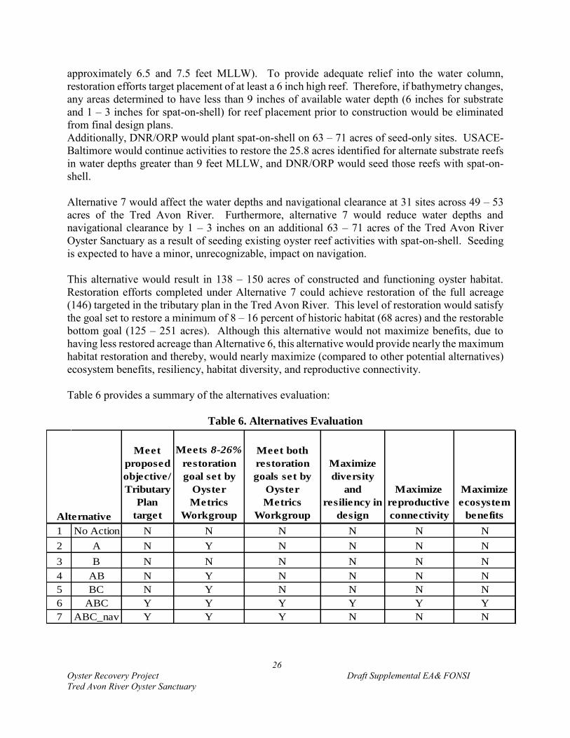
26
Oyster Recovery Project Draft Supplemental EA& FONSI
Tred Avon River Oyster Sanctuary
approximately 6.5 and 7.5 feet MLLW). To provide adequate relief into the water column,
restoration efforts target placement of at least a 6 inch high reef. Therefore, if bathymetry changes,
any areas determined to have less than 9 inches of available water depth (6 inches for substrate
and 1 – 3 inches for spat-on-shell) for reef placement prior to construction would be eliminated
from final design plans.
Additionally, DNR/ORP would plant spat-on-shell on 63 – 71 acres of seed-only sites. USACE-
Baltimore would continue activities to restore the 25.8 acres identified for alternate substrate reefs
in water depths greater than 9 feet MLLW, and DNR/ORP would seed those reefs with spat-on-
shell.
Alternative 7 would affect the water depths and navigational clearance at 31 sites across 49 – 53
acres of the Tred Avon River. Furthermore, alternative 7 would reduce water depths and
navigational clearance by 1 – 3 inches on an additional 63 – 71 acres of the Tred Avon River
Oyster Sanctuary as a result of seeding existing oyster reef activities with spat-on-shell. Seeding
is expected to have a minor, unrecognizable, impact on navigation.
This alternative would result in 138 – 150 acres of constructed and functioning oyster habitat.
Restoration efforts completed under Alternative 7 could achieve restoration of the full acreage
(146) targeted in the tributary plan in the Tred Avon River. This level of restoration would satisfy
the goal set to restore a minimum of 8 – 16 percent of historic habitat (68 acres) and the restorable
bottom goal (125 – 251 acres). Although this alternative would not maximize benefits, due to
having less restored acreage than Alternative 6, this alternative would provide nearly the maximum
habitat restoration and thereby, would nearly maximize (compared to other potential alternatives)
ecosystem benefits, resiliency, habitat diversity, and reproductive connectivity.
Table 6 provides a summary of the alternatives evaluation:
Table 6. Alternatives Evaluation
Meet
proposed
objective/
Tributary
Plan
target
Meets 8-26%
restoration
goal set by
Oyster
Metrics
Workgroup
Meet both
restoration
goals set by
Oyster
Metrics
Workgroup
Maximize
diversity
and
resiliency in
design
Maximize
reproductive
connectivity
Maximize
ecosystem
benefits
1 No Action N N N N N N
2 A N Y N N N N
3 B N N N N N N
4 AB N Y N N N N
5 BC N Y N N N N
6 ABC Y Y Y Y Y Y
7 ABC_nav Y Y Y N N N
Alternative

27
Oyster Recovery Project Draft Supplemental EA& FONSI
Tred Avon River Oyster Sanctuary
3.4 Preferred Alternative
The preferred alternative is Alternative 7. This alternative is able to fulfill all goals and objectives,
and achieve nearly the full extent of potential restoration, while addressing navigational concerns.
The large-scale of the proposed restoration across a variety of water depths in Alternative 7
provides for the greatest opportunity to achieve sustainability. Alternative 7 nearly maximizes
ecosystem benefits, diversity, resiliency, and reproduction potential.
3.5 Implementation
The tributary plan would be implemented by USACE-Baltimore District, NOAA, MD DNR, and
ORP. USACE-Baltimore’s role is to provide beneficial reef material and to place the substrate at
discrete locations. Substrate reef restoration efforts would be restricted to placement between
December and March based on coordination with NMFS to limit/avoid impacts to SAV, HAPC,
and EFH. NOAA supports the hatchery, and provides planning, mapping and surveying efforts.
MD DNR supports the hatchery-production of spat-on-shell, acquires the necessary permits for
planting spat-on-shell, and coordinates the planting of spat-on-shell by ORP.
Combined restoration techniques for the Tred Avon River would be system-wide to aid in the
rehabilitation of oyster habitat and the re-establishment of an abundant and self-sustaining
population. The implementation timeframe would depend primarily on the availability of funds.
The Tributary Plan identifies total estimated project costs of $11.4 million over a period of three
to five years, dependent on availability of funding, substrate, and spat-on-shell. These costs are
planned investments under the 704(b) program for USACE and sponsor in-kind credits.
Approximately $1.37 million has been spent on constructing 16 acres of alternate substrate reefs
in water depths below 9 feet MLLW, with additional costs ($0.36 million) for spat-on-shell. There
are 9.8 acres remaining in water depths below 9 feet MLLW which would require an investment
of $1.2 million ($0.98 million for substrate and $0.2 for seed), 15,800 cy of material, and 39.6
million spat-on-shell to complete.
For the proposed project, approximately $5.2 million will be required to purchase and place
approximately 88,000 cubic yards of substrate material over 57 acres of the sanctuary. Production
and planting of hatchery-produced seed (an estimated 558 million larvae) is estimated to cost $2.79
million. The oyster seed costs are around $5,000 per million seed planted (Oyster Restoration
Partnership, July 2013). Purchasing and placing reef material (1,613 cubic yards per acre), 1-foot
in height would cost around $62 per cubic yard of substrate. Monitoring is estimated for the full
Tributary Plan at a cost of $693,000 over 6 years. All material cost estimates are based on
deploying stone; however, costs could be higher or lower depending on availability of other
suitable materials such as mixed shell, oyster shell or reclaimed oyster shell. It is anticipated that
construction will extend for three years, through 2018. Both MD DNR and NOAA also anticipate
contributing funds in future years for the seeding activities. The timeline for USACE-Baltimore
to complete restoration of reef habitat in waters that would provide a 6 feet navigational clearance
is dependent upon available funding and the availability of suitable substrate. If either of these are
not available in the quantities needed to completed efforts, the remaining acreage would be

28
Oyster Recovery Project Draft Supplemental EA& FONSI
Tred Avon River Oyster Sanctuary
completed in the following year. With sufficient resources, construction would occur in 2016,
2017, and 2018; monitoring would extend through 2024.
4.0 AFFECTED ENVIRONMENT AND GENERAL EFFECTS
This section describes in more detail the relevant environmental areas affected by implementing
the alternatives in Section 3.0 including the proposed action. The affected environment is therefore
the existing environmental conditions of the area forming the baseline from which each project
alternative including the “no-action” alternative is evaluated. The relative severity of the
environmental consequence accrued to the ecosystem is later discussed in Section 5 of this report
forming the basis for the USACE-Baltimore decision making process. The following documents
are incorporated by reference in the report and are available at
http://www.nab.usace.army.mil/Missions/Environmental/OysterRestoration.aspx:
USACE 2009. Final Environmental Assessment and Finding of No Significant Impact:
Chesapeake Bay Oyster Restoration Using Alternate Substrate Maryland. (Appendix F)
USACE. 2009. Final Programmatic Environmental Impact Statement for Oyster Restoration in
Chesapeake Bay Including the Use of a Native and/or Nonnative Oyster.
(http://www.nao.usace.army.mil/Portals/31/docs/civilworks/oysters/FinalPEISOysterRest
oration.pdf)
USACE 2012. Chesapeake Bay Oyster Recovery: Native Oyster Restoration Master Plan,
Maryland and Virginia.
(http://www.nab.usace.army.mil/Missions/Environmental/OysterRestoration/OysterMaste
rPlan.aspx)
Draft Tred Avon River Oyster Restoration Tributary Plan: A blueprint for sanctuary restoration
dated April 3, 2015.
NOAA 2013.Draft Tred Avon River Oyster Sanctuary Restorable Bottom Assessment and Data
Summary.
4.1 Physical Environment
4.1.1 Substrate
Physical substrate conditions and quality are important determinates of oyster recruitment and
growth. In general, oysters survive best on bottoms that are firm, such as those of shell, rock, and
firm or sticky mud (Kennedy 1991). Loose, sandy bottoms are not conducive to reef establishment
since sand is subject to continual shifting activity and has been shown to result in oyster abrasion
and valve injury (Kennedy 1991).

29
Oyster Recovery Project Draft Supplemental EA& FONSI
Tred Avon River Oyster Sanctuary
To determine the existing physical substrate conditions occurring within the Tred Avon River,
seafloor conditions were mapped using sonar technology in conjunction with various ground-
truthing methods. Within the sanctuary limits, data collected by MGS in the winter of 2009 and
by the NCBO in the spring of 2013, identified existing bottom conditions, the quality of the bottom,
and its ability to support restoration actions. In addition to establishing a baseline from which to
evaluate restoration progress, hard substrates that will support the weight of the reef material must
be identified for alternate substrate placement. Hard benthic habitat was defined as areas that, per
the acoustic surveys, were found to have the Coastal and Marine Ecological Classification
Standard (CMECS) 7 classifications of artificial reef, aggregate patch reef, fringe reef, patch reef,
sand and scattered oyster shell, sandy mud, sand, and muddy sand. Survey results were then field
verified with data collected by MD DNR patent tong surveys (Appendices B, C). Based on these
spatially explicit data sets, areas suitable for seed-only restoration are classified as dense biogenic
and anthropogenic oyster shell rubble.
The final array of restorable bottom within the Tred Avon was comprised of hard sand (25 percent
of total restorable bottom), muddy sand (51 percent), sandy mud (14 percent), anthropogenic
oyster shell rubble (1 percent), biogenic oyster shell rubble with co-occurring sand (1 percent),
and unclassified sediments (9 percent) (NOAA 2013). Sub-bottom profiling sonar indicates the
sandy mud bottoms identified as restorable are located on hard base sediments. Unclassified
bottoms are presumed to be on hard base sediments because of their association with shallow
water, shorelines, and shoals (Figure 6).
Bottom surface sediments tend to be hard sand, shell, and sand or mud mixed with shell. The finer
sediments such as mud are found within the mainstem of the river channel, with sandier sediments
toward the shoreline and oyster rubble. Generally, bottom sediments are sand and clay mud in the
upper to middle region, within increasing amounts of sand near the mouth.
4.1.2 Sedimentation
Sedimentation is not only important to the growth rate in C. virginica, but to the species’ survival.
Rates of high sedimentation can blanket oyster bars and other hard bottom habitats essentially
smothering existing oyster communities and precluding free swimming larvae from finding
suitable hard bottom habitat to settle on (USACE 2012). High sedimentation rates have been
shown by researchers to be a major contributing factor to the historic loss of biogenic reefs
(Rothschild et al. 1994). It has also been hypothesized that siltation may be contributing to the
susceptibility of the Eastern oyster to disease due to flattening of oyster bar profile (Rothschild et
al. 1994). Thus the remaining low profile reefs existing today may be substantially poorer in
quality and possibly suboptimal for adults or new recruits (Rothschild et al. 1994). USACE (2012)
further discusses sedimentation and its negative impacts on oyster reefs.
7Full definition of Chesapeake Bay- CMECS is provided in the Tred Avon Tributary Plan.

30
Oyster Recovery Project Draft Supplemental EA& FONSI
Tred Avon River Oyster Sanctuary
Figure 6. Tred Avon Substrate Classification (provided by NOAA)
Total suspended solids (TSS) varies seasonally and interannually due mainly to variability in
freshwater inflow, and varies spatially, depending on proximity to shoreline, oceanic, and riverine
sources of sediment. Because the Tred Avon is an area of high sediment deposition, its basin is
characterized by predominately soft-sediments and is subject to continual sediment influx from
the surrounding watershed; which is typical of Coastal Plain rivers located on Maryland’s Eastern
Shore. In contrast to rivers with functioning riparian areas, the Tred Avon acts more as a pipeline
system (USGS Water-Resources Investigations Report 03-4123). As a result, its sediment budget
is more heavily influenced by the characteristics of the river system itself than by sub-watershed
size. Data available from the U.S. Geological Service (USGS) numerically shows the Tred Avon
receives a considerable amount of runoff from the surrounding landscape, which is predominately
agricultural land-use and urban development. This results in the higher suspended sediment loads
31
Oyster Recovery Project Draft Supplemental EA& FONSI
Tred Avon River Oyster Sanctuary
observed as compared to normal sediment loads encountered in nature from the effects or wind,
currents, runoff from land, etc. In the nearshore zone, sediment processes are mostly influenced
by waves and local shoreline erosion sources. The inshore sediments are therefore coarser in
nature. The finer grained sediments are found in the deeper waters of the river due to the stronger
influence by tidal currents.
4.1.3 Water Depths and Circulation
Water depths in the sanctuary range from minus 1- to 40-feet MLLW. The Tred Avon’s central
channel varies from minus 7 feet at the edge of the channel to over 38 feet in the deepest sections
of the channel. The greatest depth is mid-channel. The bathymetry shows 9 percent of the
sanctuary area within the NOB is between 4 and 6 feet in depth; 20 percent is between 6 and 9 feet
in depth and 45 percent is between 9 and 20 feet in depth.
Tides are semi-diurnal but sustained strong winds, both locally and over the Chesapeake Bay,
affect tidal frequency and amplitude in the Tred Avon. Distribution in the lower portions of the
river show a strong tendency of freshwater to enter the tributary from the Choptank on the eastern
side of the river, while surface layers on the western side are moving seaward (Boicourt 1982).
Water circulation patterns in addition to other hydrodynamics can explain specific tributary based
larval retention and transport rates observed in the Tred Avon. Circulation processes can also
account for the marked differences in spat settlement between tributaries of the same drainage
basin. Unlike its neighbor Broad Creek, the Tred Avon River has a weaker wind-driven
component of its circulation. This is due to the curvature of the main stem, which does not allow
for a consistent axial pressure gradient to build up over long reaches of the river (Boicourt 1982).
The weaker wind-driven component helps explain why the Tred Avon appears to be primarily
dependent on local production of larvae for spat settlement, while Broad Creek has a significantly
greater ability to augment its larvae supply with recruitment from the Choptank River (Boicourt
1982). These patterns, and larval behavior responses, influence the direction and distance that
larvae could be transported in the Tred Avon. Larvae produced within the system are generally
retained, whereas larvae outside the system from the mainstem Choptank would probably be
prevented from entering in any significant numbers. Thus, the Tred Avon River may be an area
of poor spat settlement because brood stock numbers on the upper river grounds are too low to
self-recruit and provide sufficient larvae downstream, and because there may be no recruitment of
larvae from outside the river.
An earlier survey dating from the 1980s identified that oyster bars in shallow depths that had not
been degraded by sedimentation in the river generally followed a 6-foot bathymetric depth contour
where steep gradients existed. Where they extended into deeper water, oyster bars are sharply
delineated by the 18-foot bathymetric contour (Seliger and Boggs 1988). There are 14 sites being
considered to reduce navigational clearance to 6 feet situated near the 6-foot contour. Of these,
nine exhibit the steep gradient identified by Seliger and Boggs (1988).
32
Oyster Recovery Project Draft Supplemental EA& FONSI
Tred Avon River Oyster Sanctuary
4.2 Water Quality
4.2.1 Salinity and Temperature
The eastern oyster is accustomed to water temperatures ranging annually from 28.4 – 96.9 degrees
Fahrenheit (F), and salinity ranging annually from 5 to 40 parts per thousand (ppt), although most
major populations occur in salinities between 10 and 30 ppt. USACE (2012) summarizes the
results of various investigations focused on defining suitable salinity ranges for various oyster life
stages. USACE (2012) identified suitable areas as those with a mean growing season salinity
greater than 5 ppt.
The Tred Avon is classified as a mesohaline system, partially to well-mixed with surface salinities
ranging from 5 to 18 ppt, with salinity stratification in the tributary varying seasonally (Appendix
B, Figure 1 and 2). The Tred Avon is a brackish salinity system that generally favors good
reproduction and relatively low disease rates (MD DNR 2013). Analysis performed by USACE
(2012) determined that salinity levels were suitable throughout the Tred Avon River for oysters.
Current water quality data for the Tred Avon River collected from May to October over the last
two seasons (2013 – 2015) by the Mid-shore Riverkeeper is provided in Table 7. Average summer
salinity in the Tred Avon River ranges from 7.9 ppt at the head of the river near Easton to 9.5 ppt
at the mouth.
The salinity dataset compiled in USACE (2012) was used to evaluate the Tred Avon River for the
potential risk from freshets. The risk of freshets to oysters increases with proximity to the
headwaters and typically is a greater concern for oysters in low salinity waters. Since the Tred
Avon River is a smaller mesohaline tributary on the Eastern Shore, it does not typically receive
large influxes of freshwater as does the Potomac River on the Western Shore, so freshets are less
of a concern in implementing the tributary specific restoration plan.
Temperature in the Tred Avon River does not appear to be a limiting factor as the temperature
ranges from 32 F to about 86F (MD DNR 2013). A summary of annual normal air temperature
(1981 – 2010) for the Royal Oak 2 SSW monitoring station shows a mean annual air temperature
minimum of 49F to a maximum 67F. The maximum observed mean monthly air temperature
was 88F in July and the minimum temperature was 28F in January. Ambient water temperatures
from fall through the winter range from a high of 57.2F to a low of 42.8F. From spring to
summer, water temperatures range from a low of 52.5F to high of 87.8F (NOAA National Data
Buoy Center 2014b). Average summer water temperatures vary slightly from head to mouth (76.2-
78.1 ⁰ F).

33
Oyster Recovery Project Draft Supplemental EA& FONSI
Tred Avon River Oyster Sanctuary
Table 7. 2013-2105 Tred Avon Water Quality Data (Mid-shore Riverkeeper)
average max min average max min average max min
TA1 head near Easton 7.9 11.4 4.8 78.1 88.5 65.7 4.9 8.9 1.1
TA2 mainstem near Dixon/Shipshead Cr 8.3 12.3 5 77.8 90.7 65.7 6.7 9.9 4.1
TA3 mainstem near Peachblossom Cr 8.9 13.2 5.5 77.2 92.3 64.8 6.9 9.5 4.7
TA4 mainstem near Goldsborough Cr 9.4 14.4 6.1 76.5 89.6 63.5 7.2 9.5 5.4
TA5 mainstem near Oxford 9.4 14.5 6.4 76.2 88.2 63 7.1 9.3 5.4
TA6 mouth 9.5 14.8 6.4 77.1 90.0 62.2 6.8 9.8 4.7
Salinity (ppt) Temperate (F) Bottom D.O. (mg/L)
Station
pH Total N (mg/L) Total P (mg/L)
average average average
TA1 head near Easton 7.8 0.91 0.14
TA2 mainstem near Dixon/Shipshead Cr 7.8
TA3 mainstem near Peachblossom Cr 7.8
TA4 mainstem near Goldsborough Cr 7.9 0.60 0.06
TA5 mainstem near Oxford 8.0 0.53 0.05
TA6 mouth 8.0 0.62 0.06
Station
4.2.2 Dissolved Oxygen
Hypoxia can directly affect shellfish via reduced recruitment and survival (Breitburg 1992) and
indirectly by altering community structure through predation or competition (Lenihan et al. 1998).
Initial analysis performed by USACE (2012) determined that DO levels were at suitable
concentrations throughout the Tred Avon River. Average summer bottom DO (Table 2) varies
between 4.9 – 7.2 mg/L throughout the length of the river. The minimum threshold was set at an
average summer DO level greater than or equal to 5 mg/L needed to support oysters and reef
community structure. No oyster restoration is planned for the head of the river near Easton where
the average summer DO was just under 5 mg/L. The 5 mg/L target concentration does not
represent a specific tolerance level for oysters, but was rather used to define those areas where DO
concentration is a limiting factor to habitat value and broader restoration outcomes. Therefore,
minimum levels just below 5 mg/L (4.1 to 4.7 mg/L) measured at some of the sites should not have
a significant negative impact on oysters in those areas.
4.2.3 Nutrients and Harmful Algal Blooms
The Tred Avon River is included in the segment designated as the Choptank River mesohaline
mouth 1 (CHOMH1) on Maryland’s 303(d) list. This segment is listed as a 303(d) waterbody for
nutrients (nitrogen and phosphorus), total suspended sediment, and biological impairments
(benthics). Current monitoring identifies average total nitrogen (TN) ranging from 0.53 – 0.91
mg/L and average total phosphorus (TP) ranging from 0.05 – 0.14 mg/L. These levels do not meet
the healthy TN standard set by Talbot County Creekwatchers of <0.02 mg/L, nor the TP standard
set at <0.05 mg/L. Both TN and TP levels are at impaired levels. Nitrogen and phosphorus are
not, by themselves, impairments to oysters. However, elevated N and P fuel algal blooms. When
algae die, large amounts of organic matter sink to the bottom which increases the demand for DO,

34
Oyster Recovery Project Draft Supplemental EA& FONSI
Tred Avon River Oyster Sanctuary
and subsequently hastens seasonal oxygen depletion which can impact oyster reproduction and
growth. Average pH ranges from 7.8 – 8.0. Chlorophyll a levels are <15μg/L (μg/L – micrograms
per liter) indicating impaired levels8. Chlorolphyll a is an indication of algal content. Elevated
levels can result in reduced DO levels as discussed above.
Harmful algal blooms (HAB) resulting from Prorocentrum minimum and Karlodinium veneficum
blooms have been documented in the Choptank River (Brownlee et al. 2005; Glibert et al. 2001),
but the Tred Avon River has not been identified to have significant HAB problems or
susceptibilities. Blooms of Prorocentrum minimum and Ulva lactuca have been documented in
the past (MD DNR 2013).
4.3 Biological Resources
4.3.1 Submerged Aquatic Vegetation
SAV data compiled for the CBP (VIMS 2012) was utilized to evaluate SAV resources in Tred
Avon River. From 2008 – 2013, no documented SAV was shown to be occurring where reef
construction and seeding activities would be undertaken. The following SAV are present in the
Tred Avon River system: Zannichellia palustris (horned pondweed); Ruppia maritima (widgeon
grass); Potamogeton perfoliatus (redhead-grass); and Stuckenia pectinata (sago pondweed).
However, the areal extent is found mainly in the shallow creeks outside the NOB limits. On
average, there have been 140 acres of SAV beds in the Tred Avon River in the past 10 years (2003
– 2012). SAV beds were more expansive in the decade prior to that, averaging 500 acres annually
(1993 – 2002). In 2011, a number of the small creeks within the Tred Avon system (Hudson
Creek, Back Creek, Phillips Creek, Beckwith Creek, and Smith Creek) supported SAV beds.
4.3.2 Wetlands
The Tred Avon watershed contains nearly100 acres of estuarine and marine intertidal wetlands9.
Wetland impact data since 1991 shows a net gain of 34.91 acres in the watershed10. Midshore
Riverkeeper Conservancy in Easton, Maryland has launched a new pilot project in the Tred Avon
River to improve water quality involving artificially constructed floating wetlands11. The artificial
floating wetlands are being used for nitrogen and phosphorus uptake.
4.3.3 Benthic Macroinvertebrates
Benthic communities play a central role in the transfer of materials from the water column to
higher levels in the food web. Much of the productivity of fisheries in the Chesapeake Bay is
linked directly to benthos through feeding (Virnstein 1977; Holland et al. 1988; Diaz and Schaffner
1990). In Chesapeake Bay, the distribution and kinds of benthic organisms (> 500 μm) are strongly
correlated with salinity and are further influenced by the kind of sediment, patterns of DO, and
other physical factors in a given location (Diaz and Schaffner 1990; Llansó et al. 2002). The
8 Talbot County Creekwatchers. 2009. Talbot County Creekwatchers 2009 Water Quality Report. 9 U.S. Fish and Wildlife Service - National Wetlands Inventory. 2013b. Available online at:
http://www.fws.gov/wetlands/Data/Mapper.html 10 Maryland’s Surf Your Watershed – Watershed Profile Lower Choptank.
http://mddnr.chesapeakebay.net/wsprofiles/surf/prof/wsprof.cfm?watershed=02130403 11 http://talbotspy.com/chesapeake-bay-floating-islands-launches-at-bay-street-ponds/
35
Oyster Recovery Project Draft Supplemental EA& FONSI
Tred Avon River Oyster Sanctuary
variety and density of organisms generally increases with increasing salinity. Generally
mesohaline (5 to 18 ppt) regions of the Bay such as the Tred Avon exhibit high densities of bivalves
(e.g., clams, oysters), except where low oxygen conditions prevail; segmented worms (i.e.,
polychaete annelids), small crustacea, and suspension-feeding bivalves (Rangia cuneata, Macoma
spp.) dominate these areas. Suspension feeding polychaetes and tunicates are important
contributors to biomass in high salinity environments of the Bay. The Chesapeake Bay benthic
index of biotic integrity (B-IBI) was developed to assess benthic community health and
environmental quality in the Chesapeake Bay. Large portions of the benthic habitat of the Bay are
considered degraded, including areas in the Tred Avon. As reported by the Chesapeake Bay
Program, 0 – 25 percent of B-IBI scores for the Choptank River complex which includes the Tred
Avon meet the goal set by the CBP12.
4.3.3.1 Eastern Oysters
Existing Eastern oyster resources in the Tred Avon River are discussed previously in Section 2.3.2.
Figure 7 provides the results of a patent tong survey conducted by MD DNR Shellfisheries
Division in May 2012. The dots show the sampling location. The color of the dots represents
oyster abundance. Only 29% of the samples contained live oysters. A total of 163 samples were
collected.
4.3.3.2 Clams
There are three clam species in the Maryland portion of the Chesapeake Bay that are or have been
of commercial importance: the soft-shell clam, Mya arenaria, the stout razor clam, Tagelus
plebeius, and the hard clam, Mercenaria mercenaria.
The soft-shell clam, M. arenaria and the hard-shell clam, M. mercenaria are the two primary
species historically observed in the Tred Avon River. Both can be found over a wide range of
bottom types, but prefer substrates of fine sand and silt mixes. Both bivalve mollusks are harvested
predominately in subtidal areas ranging in depth from 6 to 20 feet historically (2012 Master Plan).
However, there are currently no hard clams in the Tred Avon River. Soft-shell clams have been
documented and studied in the Tred Avon River system by Shaw (1962), but extensive current
surveys are lacking. M. arenaria are found throughout the Chesapeake Bay in water depths
ranging from 10 – 20 feet within a salinity range of 5 – 20 ppt. Commercial stocks of soft-shell
clams, like oysters, are today primarily found in the middle Bay area, with the highest
concentrations in Talbot, Dorchester and Queen Anne’s counties.
4.3.3.3 Phytoplankton
Phytoplankton provides food for oysters and small invertebrate animals called zooplankton, which
in turn provide food for fish and other animals in the Bay.
Anthropogenic nutrients and sediment that enter the Bay have fueled excessive phytoplankton
production (eutrophication). Coupled with the loss of oysters, eutrophication and the loss of the
Bay’s primary filter feeder has altered the system from one dominated by benthic production and
12 Chesapeake Bay Program – Benthic Habitat. 2012. Available online at:
http://www.chesapeakebay.net/indicators/indicator/bottom_habitat

36
Oyster Recovery Project Draft Supplemental EA& FONSI
Tred Avon River Oyster Sanctuary
Figure 7. Tred Avon River Oyster Abundance from 2012 MD DNR Patent Tong Survey
(provided by NOAA)
SAV to one heavily influenced by pelagic (water column) processes (mainly phytoplankton
production) (Newell 1988, Ulanowicz and Tuttle 1992). Although food for oysters is plentiful
under these conditions, failure of a reef to accrete shell because of overharvesting, disease, and
other factors allows otherwise favorable substrate to become covered with sediment from either
natural or anthropogenic sources, rendering it unsuitable for oyster habitat. Concomitant increased
suspended sediments and loss of SAV further degrades quality of the Bay as habitat for oyster.
Oysters interact with the phytoplankton community both directly and indirectly. The primary
interaction is direct: selective feeding reduces phytoplankton biomass and alters the species
composition of the community. Many studies have demonstrated that benthic suspension feeders
exert top-down control on phytoplankton production in freshwater, estuarine, and coastal waters
(Cohen et al. 1984; Riemann et al. 1988; Cloern and Alpine 1991). Indirectly, oyster filtration and
biodeposition work to sequester nutrients, thereby reducing phytoplankton production fueled by
excessive nutrients in the water column.

37
Oyster Recovery Project Draft Supplemental EA& FONSI
Tred Avon River Oyster Sanctuary
4.3.3.4 Zooplankton
Zooplankton communities in the freshwater and oligohaline regions of Chesapeake Bay are
diverse, and their abundance and biomass are usually high. Abundance, biomass, and diversity
are generally lower in the mesohaline and polyhaline zones, although high densities of larval
polychaetes, mollusks, and decapods occur in specific areas.
4.3.3.5 Blue crab
Mobile predators such as the blue crab produce strong direct effects of predation and disturbance
on the benthic communities in Chesapeake Bay (Hines et al. 1990). The blue crab occupies a
variety of aquatic habitats ranging from the mouth of the Bay to fresher rivers and creeks and
occupies different trophic levels during various stages of its life cycle.
The blue crab is an important predator of bivalves, such as young oysters, in the Bay. Although
adult oysters are too large for blue crabs to open and prey upon (White and Wilson 1996), crabs
do feed readily and opportunistically on juvenile oysters (Eggleston 1990). Oysters attain a partial
refuge from predation at low densities (Eggleston 1990), but predation by blue crabs might
increase with increasing oyster abundance.
4.3.4 Fish
Approximately 267 species of fish can be found in the Chesapeake Bay (White 1989). The fishes
of the Bay are either resident or migratory. Migratory fish fall into two categories: (1) anadromous
fish, which spawn in the Bay or its tributaries, and (2) catadromous fish, which spawn in the ocean.
Anadromous fish migrate varying distances to spawn in freshwater. Striped bass spawn in the
tidal freshwater areas of the Bay and major tributaries; younger fish remain in the Bay to feed
while many adults migrate to ocean waters after spawning. Shad and herring are truly anadromous,
traveling from the ocean to freshwater to spawn and returning to the ocean to feed. Eels are the
only catadromous species in Chesapeake Bay. Other migratory fish use the Bay strictly for
feeding. Some species, like croaker, drum, menhaden, weakfish, and spot, journey into the Bay
while still in their larval stage to take advantage of the rich supply of food. Bluefish generally enter
the Bay as juveniles or adults.
Fish in the Bay can also be categorized as planktivorous, reef-oriented, or piscivorous.
Planktivorous fish are a key part of the food web in Chesapeake Bay. They consume plankton,
and are preyed upon by larger fishes such as striped bass and bluefish (piscivores). The larval and
early juvenile stages of all fish species in the Bay feed on plankton; however, bay anchovy and
menhaden are the only two major species in Chesapeake Bay that feed primarily on plankton
throughout their life cycles. Although oysters and planktivorous fish both feed on phytoplankton,
competition is typically not an issue because phytoplankton are typically not limiting.
Oyster bars provide habitat for several species of fish (reef-oriented), many of which are important
in commercial and recreational fisheries. The naked goby resides on oyster bars throughout its
juvenile and adult lifestages (Breitburg 1991) and is considered an exclusively reef-dwelling
species. Black sea bass (Centropristis striata), which is considered to be a temperate reef fish, is
found seasonally on oyster bars and other hard substrate and structures in the middle and lower

38
Oyster Recovery Project Draft Supplemental EA& FONSI
Tred Avon River Oyster Sanctuary
Bay during warm months. Although black sea bass generally migrate to ocean waters during the
winter, they are reef dependent for a significant portion of each year. Other obligate reef dwellers
that inhabit oyster reefs are skilletfish and toadfish. Additional reef-oriented fish include species
such as the Atlantic croaker that use a variety of habitats but frequent hard-bottom habitat, such as
oyster bars.
4.3.5 Avifauna
Many avian piscivore species use the abundant fish populations of Chesapeake Bay as their
primary food sources including walking and wading shorebirds, raptors, and waterfowl. Two of
the species documented best in the literature are the bald eagle (Haliaeetus leucocephalus) and the
North American osprey (Pandion haliaetus) both of which frequent and nest along the Tred Avon
River. The U.S. Fish and Wildlife Service documents that over 30 nests occur along the shorelines
of the Tred Avon. The Chesapeake Bay also has one of the highest concentrations of bald eagles
in the lower 48 states.
Other avian species depend on hooked mussels, clams, and other species that inhabit oyster reefs.
Black ducks along with a number of sea ducks (surf scoter, black scoter, bufflehead, common
merganser, hooded merganser, common goldeneye, long-tailed duck, red-breasted merganser, and
white-winged scoter) use oyster reefs for foraging in the winter. The loss of oyster reefs is a likely
contributor to the decline sea duck populations.
The black duck (Anas rubripes) is a good representative of a benthic-feeding avian waterfowl
species. The black duck is a medium to large dabbling duck that is most similar to the mallard
(Anas platyrhynchos), but it lacks the male mallard’s characteristic green head and white collar.
Black ducks depend upon the condition of the bottom of the bays and wetlands in which they feed.
Black ducks feed on a combination of plants and animals. They forage underwater, primarily on
the seeds of grasses, sedges, pondweeds, and other aquatic vegetation. They will also readily eat
snails, Baltic clams, hooked mussels, and fish (Krementz 1991). Diving ducks such as
canvasbacks (Aythya valisineria) depend completely on aquatic habitats throughout their life
cycle. They feed on plants and animals in wetlands and shallow benthic habitats. At one time,
canvasbacks in Chesapeake Bay consumed wild celery almost exclusively, but the decline in wild
celery caused the species to shift its diet to small clams. As bottom feeders, canvasbacks are likely
to be able to forage on and around many oyster bars.
Neither black ducks nor canvasback ducks, nor any of the other waterfowl known to inhabit
Chesapeake Bay, feed directly on oysters to any significant extent; however, many feed on or
around oyster bars. The primary mechanism of interaction between oysters and these benthic-
feeding birds is indirect, through changes in the types, abundance, and distribution of benthic
invertebrates that could inhabit restored oyster reefs and provide food for benthic-feeding birds.
4.3.5.1 Avian Oyster Predators
Some avian species will feed directly on oysters such as the American oystercatcher (Haematopus
palliates). Oystercatchers are large shorebirds with strong white or black-and-white markings.
They consume oysters and other shellfish and have powerful, brightly colored bills that they use

39
Oyster Recovery Project Draft Supplemental EA& FONSI
Tred Avon River Oyster Sanctuary
to open the shells of bivalves. Oystercatchers were once hunted almost to extinction but are now
conspicuous shorebirds found throughout the Chesapeake Bay region.
Several studies have shown that a decrease in shellfish stocks negatively affects the oystercatcher
population (Goss-Custard et al. 2003; Atkinson et al. 2003; Tuckwell and Nol 1997). The primary
mechanism of interaction for oystercatchers is direct, through a change in the availability of oysters
as a food source. When the abundance of shellfish is low, the birds can survive on alternative prey
species, but these species often do not enable the birds to maintain good body condition (Smit et
al. 1998). Tuckwell and Nol (1997b) showed that kleptoparasitism by other species (e.g., gulls)
increases when oystercatchers are feeding on non-oyster shellfish.
4.3.6 Essential Fish Habitat
The Magnuson-Stevens Fishery Conservation and Management Act (MSFCMA), as amended by
the Sustainable Fisheries Act of 1996 (Public Law 04-267), requires all federal agencies to consult
with the National Marine Fisheries Service (NMFS) on all actions, or proposed actions, permitted,
funded, or undertaken by the agency that may adversely affect essential fish habitat (EFH).
The 1996 amendments to the MSFCMA strengthened the ability of NMFS to protect and conserve
the habitat of marine, estuarine, and anadromous finfish, mollusks, and crustaceans. Essential fish
habitat is defined in 50 Code of Federal Regulations (CFR) part 600 as “those waters and substrate
necessary to fish for spawning, breeding, feeding or growth to maturity.”
4.3.6.1 Essential Fish Habitat Species in Study Area
Previous consultation with John Nichols, NMFS, (email February 9, 2009) as part of the 2009
Chesapeake Bay Oyster Restoration Using Alternate Substrate, Maryland Environmental
Assessment determined that some areas of the Chesapeake Bay under consideration for oyster
restoration in Maryland lie within the general area that may provide EFH for some of the species
managed by NMFS. Species for which EFH is a concern are as follows: summer flounder
(Paralichthys dentatus), juvenile and adult life stages; bluefish (Pomatomus saltatrix), juvenile
and adult life stages; windowpane flounder (Scopthalmus aquosus), juvenile and adult life stages;
cobia (Rachycentron canadum), all life stages; red drum (Sciaenops ocellatus), all life stages; king
mackerel (Scomberomorus cavalla), all life stages; and Spanish mackerel (Scomberomorus
maculatus) (National Marine Fisheries Service, Northeast Region, Habitat Conservation Division
EFH web site; www.nero.nmfs.gov/ro/doc/hcd.htm).
Due to specific habitat needs, it is unlikely that cobia, king mackerel, Spanish mackerel, or
windowpane flounder would be in the project area (Murdy et al. 1994). Windowpane flounder
EFH habitat does not extend into the Tred Avon River oyster sanctuary. Cobia more commonly
inhabits areas of higher salinity than would be found at most of the project area. Spanish mackerel
are most abundant from the mouth of the Chesapeake Bay region to south Florida. They prefer
polyhaline regions (18 – 30 ppt) of the lower Bay. Finally, none of the life stages of king mackerel
are typically found within the project area. As a result, this EFH analysis will focus on bluefish,
summer flounder, and red drum (Table 8). Focusing on these three species for the Tred Avon

40
Oyster Recovery Project Draft Supplemental EA& FONSI
Tred Avon River Oyster Sanctuary
River EFH Assessment was confirmed in a phone conversation with David O’Brien, NMFS, on
December 12, 2013.
Table 8. Summary of EFH within Choptank River for 7 Federally Managed Species
Species Eggs Larvae Juveniles Adults
bluefish (Pomatomus saltatrix) M M
summer flounder (Paralicthys dentatus) M M
red drum (Sciaenops occelatus) X X X X
S º The EFH designation for this species includes the seawater salinity zone of this bay or estuary (salinity > 25.0‰).
M º The EFH designation for this species includes the mixing water / brackish salinity zone of this bay or estuary
(0.5 < salinity < 25.0‰).
F º The EFH designation for this species includes the tidal freshwater salinity zone of this bay or estuary
(0.0 < salinity < 0.5‰).
4.3.7 Rare, Threatened, and Endangered Species
The Endangered Species Act (ESA) of 1973 (16 USC 1531-1543) regulates activities affecting
plants and animals classified as endangered or threatened, as well as the designated critical habitat
of such species. There are no federally listed plants in the study area. Specific to animals, prior
coordination completed for the 2009 Alternate Substrate EA identified the potential presence of
the following rare, threatened, and endangered species: the threatened loggerhead turtle (Caretta
caretta), the endangered Kemp’s ridley turtle (Lepidochelys kempii), and the endangered
leatherback turtle (Dermochelys coriacea). These species can occasionally move into the central
and upper Chesapeake Bay during warm weather months. The Atlantic sturgeon (Acipenser
oxyrhynchus oxyrhynchus) may also be in the project area. The shortnose stugeon (Acipenser
brevirostrum) has been listed for the entire Chesapeake Bay and its tributaries. Additionally, there
are 9 animals (Table 9) and 15 plant species (Table 10) found in Talbot County on Maryland’s
rare, threatened, or endangered species list. Alewife (Alosa pseudoharengus) and blueback herring
(Alosa aestivalis) were listed as species of concern under the Endangered Species Act (ESA)
throughout all or a significant portion of their range or as specific distinct population segments
(DPS)13. Following Table 9 and 10 are explanations of the rank and status applicable to the species
shown in the tables. The explanation of all established rank and status criteria are provided in
Appendix G, or online at http://dnr2.maryland.gov/wildlife/Documents/rte_Animal_List.pdf.
13 NOAA Fisheries Service. ESA Species of Concern. Available online at:
http://www.nmfs.noaa.gov/pr/species/fish/bluebackherring.htm

41
Oyster Recovery Project Draft Supplemental EA& FONSI
Tred Avon River Oyster Sanctuary
Table 9. Rare, Threatened, and Endangered Animals in Talbot County, MD
Scientific NameGlobal
Rank
State
Rank
State
Status
Federal
Status
Acipenser brevirostrum G3 S1 E LE
Acipenser oxyrhynchus oxyrhynchus G3 S1 C
Alasmidonta heterodon G1G2 S1 E LE
Alasmidonta undulata G4 S1 E
Alosa aestivalis SOC
Alosa pseudoharengus SOC
Botaurus lentiginosus G4 S1S2B I
Caretta caretta G3 S1 T LT
Demochelys coriacea G2 S1 E LE
Gallinula chloropus G5 S2B I
Haliaeetus leucocephalus G5 S3B
Hoperius planatus GNR S2
Hydrochus spangleri G1 S1 E
Ixobrychus exilis G5 S2S3B I
Laterallus jamaicensis G4 S1 E
Lepidochelys kempii G1 S1N E LE
Sciurus niger cinereus G5T3 S1 E LE
Sternula antillarum G4 S2B T
Stygobromus tenuis tenuis G4T4 SU
Atlantic sturgeon
Alewife
Blueback herring
Kemp's Ridley sea turtle
Leatherback sea turtle
Loggerhead sea turtle
Seth Forest Water Scavenger Beetle
Least Bittern
Bald Eagle
A Dytiscid Beetle
American Bittern
Common Moorhen
Dwarf Wedge Mussel
Triangle Floater
Common Names
Least Tern
Slender Stygobromid
Black Rail
Delmarva Fox Squirrel
Animals
Shortnose sturgeon

42
Oyster Recovery Project Draft Supplemental EA& FONSI
Tred Avon River Oyster Sanctuary
Table 10. Rare, Threatened, and Endangered Plants in Talbot, County, MD
Note: There are no federally listed plants in the study area.
Scientific NameGlobal
Rank
State
Rank
State
Status
Federal
Status
Agalinis setacea Thread-leaved Gerardia G5? S1 E
Antennaria solitaria Single-headed Pussytoes G5 S2 T
Bidens coronata Tickseed Sunflower G5 S2S3
Boltonia asteroides Aster-like Boltonia G5 S1 E
Cardamine pratensis Cuckooflower G5 S1
Carex lacustris Lake-bank Sedge G5 S2
Carex silicea Sea-beach Sedge G5 S1 E
Carex tenera Slender Sedge G5 SH X
Carex venusta Dark Green Sedge G4 S2 T
Centrosema virginianum Spurred Butterfly-pea G5 S2
Croton capitatus G5 SU
Cuscuta coryli Hazel Dodder G5? SH X
Desmodium ochroleucum Cream-flowered T ick-trefoil G1G2 S1 E
Desmodium pauciflorum Few-flowered T ick-trefoil G5 S1 E
Dichanthelium oligosanthes Few-flowered Panicgrass G5 S2S3
Eupatorium maculatum Spotted Joe-pye-weed G5 SU X
Geranium robertianum G5 S1
Gymnocarpium dryopteris G5 S1 E
Hottonia inflata G4 S1 E
Hypericum drummondii Drummond's St. John's-wort G5 SH X
Leptochloa fusca ssp. fascicularis Long-awned Diplachne G5T5 SU
Linum intercursum Sandplain Flax G4 S2 T
Matelea carolinensis G4 S1 E
Morella caroliniensis Evergreen Bayberry G5 S1 E
Paspalum dissectum Walter's Paspalum G4? S2 T
Pedicularis lanceolata Swamp Lousewort G5 S1 E
Pluchea camphorata Marsh Fleabane G5 S1 E
Salix bebbiana Bebb's Willow G5 SH X
Schoenoplectus novae-angliae Salt-marsh Bulrush G5 S2
Sporobolus asper Long-leaved Rushgrass G5 S1
Triadenum tubulosum Large Marsh St. John's-wort G4? S1
Vitis cinerea G4G5 SU
Common Names
Plants
Graybark
Hogwort
Herb-robert
Oak Fern
Featherfoil
Anglepod
43
Oyster Recovery Project Draft Supplemental EA& FONSI
Tred Avon River Oyster Sanctuary
Explanation of Global Rank
Explanation of State Rank
S1 = Highly State rare. Critically imperiled in Maryland because of extreme rarity (typically 5 or fewer estimated occurrences or very few
remaining individuals or acres in the State) or because of some factor(s) making it especially vulnerable to extirpation. Species with this
rank are actively tracked by the Natural Heritage Program.
S2 = State rare. Imperiled in Maryland because of rarity (typically 6 to 20 estimated occurrences or few remaining individuals or acres in
the State) or because of some factor(s) making it vulnerable to becoming extirpated. Species with this rank are actively tracked by the
Natural Heritage Program.
S3 = Rare to uncommon with the number of occurrences typically in the range of 21 to 100 in Maryland. It may have fewer occurrences
but with a large number of individuals in some populations, and it may be susceptible to large-scale disturbances. Species with this rank
are not actively tracked by the Natural Heritage Program.
SH = Historically known from Maryland, but not verified for an extended period (usually 20 or more years), with the expectation that it
may be rediscovered.
SU = Possibly rare in Maryland, but of uncertain status for reasons including lack of historical records, low search effort, cryptic nature
of the species, or concerns that the species may not be native to the State. Uncertainty spans a range of 4 or 5 ranks as defined above.
-B = This animal species is migratory and the rank refers only to the breeding status of the species. Such a migrant may have a different
rarity rank for non-breeding populations.
Explanation of State Status
E = Endangered; a species whose continued existence as a viable component of the State's flora or fauna is determined to be in jeopardy.
I = In Need of Conservation; an animal species whose population is limited or declining in the State such that it may become threatened
in the foreseeable future if current trends or conditions persist.
T = Threatened; a species of flora or fauna which appears likely, within the foreseeable future, to become endangered in the State.
X = Endangered Extirpated; a species that was once a viable component of the flora or fauna of the State, but for which no naturally
occurring populations are known to exist in the State.
Explanation of Federal Status
LE = Taxa listed as endangered; in danger of extinction throughout all or a significant portion of their range.
LT = Taxa listed as threatened; likely to become endangered within the foreseeable future throughout all or a significant portion of their
range.
C = Candidate taxa for listing for which the Service has on file enough substantial information on biological vulnerability and threat(s) to
support proposals to list them as endangered or threatened.
SOC = Species of concern
G1 = Critically imperiled globally because of extreme rarity (5 or fewer occurrences or less than 1000 individuals) or because of extreme
vulnerability to extinction due to some natural or man-made factor.
G2 = Imperiled globally because of rarity (6 to 20 occurrences or less than 3000 individuals) or because of vulnerability to extinction due
to some natural or man-made factor.
G3 = Either very rare and local throughout its range (21-100 occurrences or less than 10,000 individuals) or found locally in a restricted
range or vulnerable to extinction from other factors.
G4 = Apparently secure globally (may be rare in parts of range).
G5 = Demonstrably secure globally.
G#? = Tentative rank (e.g., G2?).
G#G# = Range of rank; insufficient data to assign specific global rank (e.g., G2G3).
G#T# = Rank of a taxonomic subgroup such as a subspecies or variety; the G portion of the rank refers to the entire species and the T
portion refers to the specific subgroup; numbers have same definition as above (e.g., G3T1).
GNR = Element not yet ranked (temporary).

44
Oyster Recovery Project Draft Supplemental EA& FONSI
Tred Avon River Oyster Sanctuary
4.4 Community Setting
4.4.1 Land Use
Talbot County contains over 600 miles of tidal shoreline and is bounded on three sides by waters
of the Chesapeake Bay and the Choptank River. The Tred Avon River is a tidal estuarine system
that drains approximately 6 percent of the Lower Choptank River watershed. The land area is
approximately 48.5 square miles containing 107.2 miles of stream features. The river contains a
small drainage basin characterized by low topographic relief, with agriculture being the
predominant land use. The watershed covers roughly 7,932 acres with only 15.5 percent remaining
in forested cover (MDE 2004). Prior to European settlement in the last 17th Century, it is estimated
that the Choptank River basin was over 90 percent forested with the remainder as wetlands
(Benitez and Fisher 2004). There are 1,233 acres of forests and nearly 100 acres of wetlands in
the Tred Avon watershed (USFWS 2013b). The upper reaches are highly impacted by urban
stormwater runoff (Stack et al. 2013). Agricultural land-use is mostly cultivated crops and
pasture/hay with some forested, wetlands, and developed areas. Easton, situated at the head of the
Tred Avon River, is the densest and largest urban/suburban development in the watershed.
4.4.2 Recreation
Public landings in the County offer boat ramps, mooring facilities, fishing and crabbing piers,
picnic areas and parking facilities. Although public landings provide waterfront access
opportunities, most facilities are small in land area and limited in size.
4.4.2.1 Fishing
The Maryland portion of the Chesapeake Bay supports a significant recreational fishery.
According to data available from the Maryland Saltwater Sportfishermen’s Association, the value
of recreational fishing is estimated to be over $1 billion to the State’s economy. The key species
targeted in the lower reaches of the Choptank River complex which emcompasses the Tred Avon
are black seabass (Centropristis ocyurus); bluefish (Pomatomus saltatrix); Atlantic croaker
(Micropogonias undulates); spot (Leiostomus xanthurus); weakfish (Cynoscion regalis); striped
bass (Morone saxatilis); summer flounder (Paralichthys dentatus); perch (Pomoxis annularis);
tautog (Tautoga onitis); and yellowfin tuna (Thunnus albacares). Historically the striped bass has
been one of Maryland’s most valuable fisheries. Fishermen along the Tred Avon may fish for a
number of different species including striped bass, catfish and perch. They also use several
different methods, including using a charter boat, their own boat, or fishing from the shore.
Numerous saltwater species enter the river to spawn in springtime, starting with catfish and perch
in March and April, followed by croaker in April and May, and then bluefish and both grey and
speckled trout in the ensuing months. Many of the Chesapeake Bay's striped bass head up the river
on their spring spawn run as well. Recreational crabbers are also found in the Tred Avon River.
Recreational oystering is legal, but uncommon in the Bay today. However, it is not allowed in
sanctuaries. Many owners of shoreline property participate in oyster-rearing programs coordinated
by the State of Maryland. Under the State of Maryland Grow Oysters program initiated in 2008,
the Tred Avon River was the first tributary to carry out a public-private partnership to enhance
45
Oyster Recovery Project Draft Supplemental EA& FONSI
Tred Avon River Oyster Sanctuary
oyster reefs by waterfront property owners who volunteer to grow young oysters in cages
suspended from their private piers to be planted after one year onto local sanctuaries. Fish species
supported by oyster habitat are key elements in providing recreational opportunities.
4.4.2.2 Waterfowl Hunting
The eastern shore of Maryland is an important stopover for many migratory waterfowl species
along the Atlantic Flyway in addition to the home to numerous resident waterfowl. The
Chesapeake Bay is located along the Atlantic Flyway with the annual seasonal migration of
millions of waterfowl to the Bay. About 1 million swans, geese and ducks winter on the Bay14.
Four categories of waterfowl inhabit the Chesapeake Bay: dabbling ducks, diving ducks, geese,
and swans. All four kinds depend on agricultural areas, bay bottom, and wetlands for food and
nesting habitat.
Talbot County is steeped in a rich waterfowl hunting tradition and is an important wintering area
for many targeted species of waterfowl. American black ducks, mallards, canvasbacks, and
Canada geese are prized waterfowl species that frequent the Tred Avon River. At least 15
professional guide services and outfitters exist in the Tred Avon River vicinity providing services
to local area residents and travelers to the region contributing economic revenue to the local
economy and the State. The annual Waterfowl Festival is held in Easton which pays tribute to the
deep roots of waterfowl hunting in the area’s culture. The festival draws 18,000 to 20,000 visitors
each year. Also, The Talbot County Ducks Unlimited Chapter is very active in the area conserving
and restoring over 8,000 acres of wetland to date15. According to the 2006 National Survey of
Fishing, Hunting, and Wildlife-Associated Recreation, the average migratory bird hunter in
Maryland spends $1,104 per year on hunting-related expenses. Of that $1,104, $299 is spent on
hunting trip-related costs.
4.4.2.3 Boating and Navigation
There are two federally maintained navigation channels within proximity to the project area as
depicted in Figure 8. In the southern section of the Tred Avon River just north of the mouth is the
federal project in Town Creek. The Town Creek navigation channel is authorized to a width
varying from 60 to100 feet by 7 to10 feet in depth. Setbacks from the edge of the channel are 30
feet. A U.S. Army Corps of Engineers survey of the channel in 2011 found depths adjacent to the
Oxford Yacht Agency marina in the range of minus 6.1 feet MLLW to 6.7 feet MLLW. The Town
Creek channel was originally authorized in 1945 and no federal maintenance has occurred since
1985. The authorized project length is 4,800 feet. The Town Creek channel would not be impacted
as a result of undertaking the proposed restoration project since restoration work would be entirely
outside the limits of the federal channel and no work is within 150 feet horizontal limits of the
channel. Therefore, no interference with the structural integrity of USACE-Baltimore’s navigation
project and/or obstruction to navigation within the Town Creek Channel is proposed. In the upper
reaches of the Tred Avon River is another federally maintained channel authorized to a depth of
minus 12 feet which was last dredged in 1987.
14 FWS. Migratory Birds. 2013a. Available online at: http://www.fws.gov/chesapeakebay/migbird.html 15 Duck Unlimited. Talbot County. 2013. Available online at: http://www.ducks.org/how-to-help/chapter-
spotlights/talbot-county
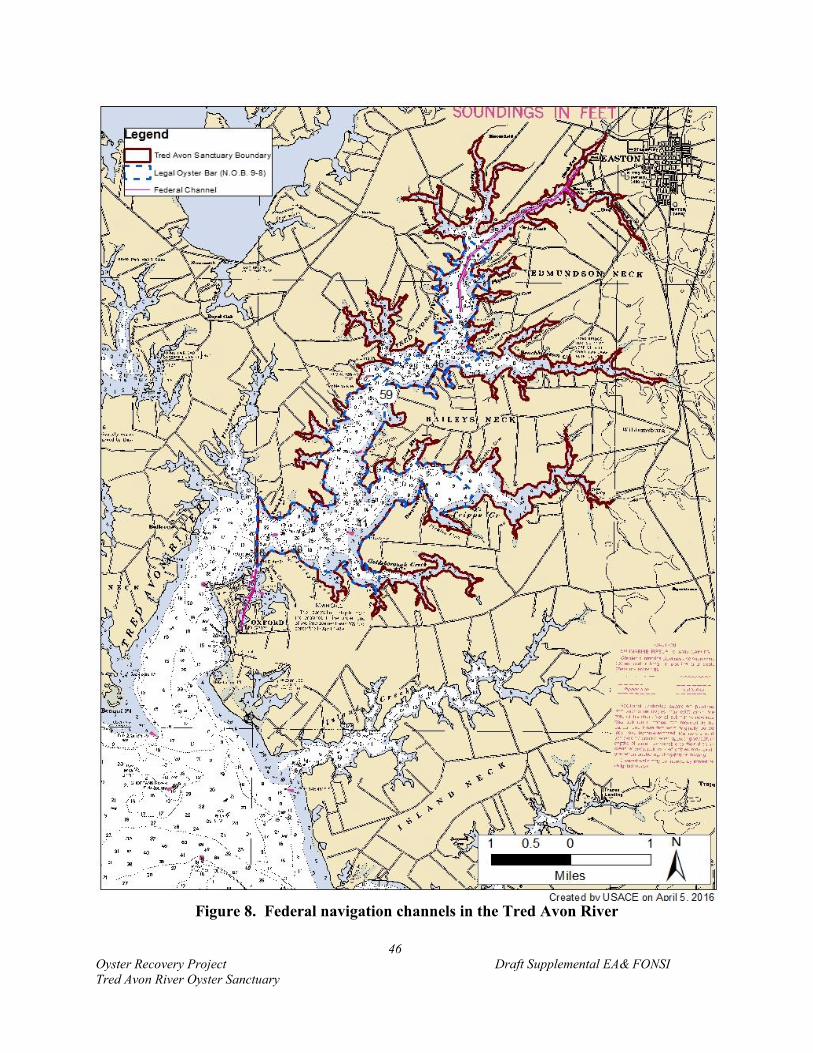
46
Oyster Recovery Project Draft Supplemental EA& FONSI
Tred Avon River Oyster Sanctuary
Figure 8. Federal navigation channels in the Tred Avon River
47
Oyster Recovery Project Draft Supplemental EA& FONSI
Tred Avon River Oyster Sanctuary
The Tred Avon River federal navigation project maintains a channel that is 150 feet wide from
Easton Point to the North Fork for 1,400 feet. A turning basin 12 feet deep by 250 feet wide and
600 feet long is provided for in the South Fork on the east side of the main channel at Easton Point.
The project length is 2 miles. Setbacks from the edge of the channel are 40-feet. Reef construction
is proposed in depth intervals of minus 6 to minus 9 feet in close proximity to the federal channel.
The Tred Avon River is used by commercial watermen, a ferry boat operation, recreational users,
and one commercial boating operation. Historically many steam boats from Baltimore drawing
more than 8-feet of water made regular trips as far as Easton Point, and many schooners and motor
boats also frequented the river16. The geographic setting of the Tred Avon is located in an area
prominent in shipping activities since the earliest colonial times. Today, there is one primary
commercial boating operation on the Tred Avon: Vulcan Materials, Inc. Coordination with Vulcan
identified that their barges typically draw 8.5 to 9 feet with a maximum draft of 9.5 feet. Just
outside the southern boundary of the Tred Avon River oyster sanctuary, the Town of Oxford leases
the ferry wharf to a ferry operator for the Oxford to Bellevue ferry service. This ferry service was
established in 1683 and is one of the oldest privately owned ferries in continuous operation in the
United States. Ferry departures and arrivals occur approximately every 45 minutes from Oxford
to Bellevue.
Many wharfs and remnants of old marine railways still occur along the shoreline. A majority of
the wharfs in Town Creek today are home to boatyards, marinas and boat repair facilities including
the Oxford Yacht Agency. Approximately 1.5 miles north from the entrance of the river is Town
Creek, a major anchorage area for pleasure craft near the Town of Oxford, south of the sanctuary
limits. Easton, to the north, is the county seat roughly 10 miles from the Town of Oxford.
Recreational boating activities include fishing, sailing, cruising, entertaining/socializing,
swimming, nature observation/sightseeing, waterskiing, tubing, racing, and other water-related
activities. Over the years, use of the waterway has changed from a mainly watermen’s to a
recreational boating community. Recreational boats are larger vessels approximately 40 to 50
feet long, 12 to 16 feet wide, and drafts of generally 1 to 9 feet compared to the working boats
used by watermen. Pleasure boating today serves as the basis for a number of industries in this
and neighboring tributaries. Recreational boaters spend money in the community and in the
process generate economic impacts for the local area. The annual summer regatta in Oxford is
held at the Tred Avon Yacht Club.
A survey of residents and local waterway users garnered input from 50 persons. Input received
included required drafts and navigational paths used. The responses reinforced the importance of
sail boating to the users of the Tred Avon River.
An additional source of data on navigational use of the Tred Avon River is Automatic
Identification System (AIS) data collected by the USCG through an onboard navigation safety
device. The Bureau of Ocean Energy Management (BOEM) and NOAA have made some of these
16 Department of Commerce. United States Coast Pilot: Atlantic Coast. Sandy Hook to Cape Henry. Section C. 1916.
Available online at: http://books.google.com

48
Oyster Recovery Project Draft Supplemental EA& FONSI
Tred Avon River Oyster Sanctuary
records available online (marinecadastre.gov). Passage densities (number of kilometers of
tracklines within a 100 yd x 100 yd cell per year; low can be loosely characterized as less than 1,
medium as 1 – 10, and high >10 – >7,500) are computed for all vessels, as well as for specific
uses: cargo, passenger, pleasure craft and sailing, tanker, tug and towing, and fishing. In 2013,
there were no vessels classified as cargo, passenger, tanker, or fishing that used the Tred Avon
River. There was passenger activity up to Oxford in 2011 and 2012 which is outside the study
area. Figure 9 shows the vessel density compilation of all uses in the Tred Avon River. The
compiled density is low to medium with some high use up to Oxford. Figures 10 – 11 portray
‘pleasure craft and sailing’ and ‘tug and towing’ density, respectively. Tug and towing use is
attributed to Vulcan Materials and is of low density. Based on vessels using AIS, pleasure craft
and sailing has a medium density presence in the Tred Avon River, with some high usage in the
Oxford area17.
4.4.2.4 Swimming
There are no official, monitored swimming beaches on the Tred Avon River. Given the ongoing
efforts to regulate and control pollutants and nutrients entering the Tred Avon River, the quality
of swimming and opportunities for recreational swimming may vary by location within the
waterway. The water quality of the Tred Avon is degraded by low oxygen, sediment, nutrients,
fecal coliform, and biological impairments. A Chesapeake Bay Foundation Report published in
2000 highlights the impact on public health in the Chesapeake Bay region due to the increased
presence of several pollutants that pose threats to human health18. These include vibrio,
cyanobacteria (blue green algae), cryptosporidium, mercury, and nitrates.
4.4.2.5 Wildlife Viewing
In addition to waterfowl viewing opportunities associated with the Tred Avon's location in the
Atlantic Flyway, the Chesapeake Bay Gateway Network connects visitors and locals to a network
of trails including waterway trails in the vicinity of the project. The network includes a waterway
trail in the Choptank River that passes the Tred Avon River. There are numerous community and
neighborhood parks primarily located in Easton and Oxford. There are County designated parks
that allow for wildlife viewing in the Tred Avon watershed.
4.4.3 Cultural and Historic Resources
The project, as a Federal undertaking, falls within the review requirements of the National Historic
Preservation Act of 1966, as amended, and its implementing regulations 36 CFR, Part 800. These
regulations require the USACE-Baltimore to identify, evaluate and mitigate impacts to National
Register eligible or listed cultural resources prior to project initiation, in consultation with the
appropriate State Historic Preservation Officer (SHPO), and at times, the Advisory Council on
Historic Preservation (ACHP). Talbot County has numerous listings on the National Register for
17 As AIS is not required on self-propelled vessels less than 65 feet in length and there is no legal requirement for
recreational sailboats to have an AIS transceiver or transponder, this is not a complete representation of all vessel
usage of the Tred Avon River. 18 Bad Water 2009: The Impact on Human Health in the Chesapeake Bay Region. (2010). Chesapeake Bay Foundation.
Available online at: http://www.cbf.org/document.doc?id=328.
Foundation. Available at http://www.cbf.org/document.doc?id=328.

49
Oyster Recovery Project Draft Supplemental EA& FONSI
Tred Avon River Oyster Sanctuary
Figure 9. 2013 Total Vessel Density in the Tred Avon River
(source: NOAA Office for Coastal Management http://marinecadastre.gov/data/)

50
Oyster Recovery Project Draft Supplemental EA& FONSI
Tred Avon River Oyster Sanctuary
Figure 10. 2013 Pleasure Craft and Sailing Vessel Density in the Tred Avon River
(source: NOAA Office for Coastal Management http://marinecadastre.gov/data/)

51
Oyster Recovery Project Draft Supplemental EA& FONSI
Tred Avon River Oyster Sanctuary
Figure 11. 2013 Tug and Towing Vessel Density in the Tred Avon River
(source: NOAA Office for Coastal Management http://marinecadastre.gov/data/)

52
Oyster Recovery Project Draft Supplemental EA& FONSI
Tred Avon River Oyster Sanctuary
Maryland in addition to maintaining an active Historic Preservation Commission since 197619.
Also, Section 101(b)(4) of NEPA requires Federal agencies to coordinate and plan their actions so
as to preserve important historic, cultural, and natural aspects of the country's national heritage.
This section focuses on aquatic historic resources that could potentially be impacted by the project.
National Historic Landmarks within Talbot County include the Rebecca R. Ruark, oldest vessel in
the skipjack oyster dredging fleet; The Kathryn, one of 16 surviving fore-and-aft planked
skipjacks; the Hilda M. Willing a skipjack originally built in 1905; and the Edna E. Lockwood, the
last bugeye to retain a sailing rig and unaltered working appearance.
Coordination with the Maryland Historical Trust (MHT) (the SHPO) has occurred since the
inception of the Chesapeake Bay Oyster Recovery Project (1996). Through coordination for the
2009 EA, MHT provided a list of recommended areas that should be avoided due to known or
suspected historical resources. There are no areas within the Tred Avon River on that list. In
October 2015, MHT reviewed the Tred Avon River Blueprint Map and determined that no cultural
resources reconnaissance, identification, or evaluation studies have been undertaken and no
historic properties or potential historic properties have been reported within any of the proposed
oyster restoration sites. A full archeological review of the river bottom has not been conducted,
nor was it recommended by MHT during the 2009 or 2015 coordination processes.
4.4.4 Hazardous, Toxic, and Radioactive Waste
The EPA EnviroFacts website was consulted to acquire a listing of Comprehensive Environmental
Response, Compensation and Liability Information System (CERCLIS) and Resource
Conservation Recovery Information System (RCRIS) sites within the project area. There are no
listed sites in the area proposed for restoration efforts.
4.4.5 Socioeconomic Conditions
The population estimate for Talbot County in 2014 was 37,643 with the demographic makeup for
the county as outlined in Table 11. According to the most recently adopted Comprehensive Plan
for Talbot County (2005) (currently being updated), the current and projected population and
household data for 2000 to 2030 prepared by the Maryland Department of Planning shows that by
2030, the County’s population would grow to 38,950 residents. Age distribution shows the largest
cohort in 2000 to be individuals aged 20 to 44 years of age. The median age was 43.3 years
compared to the statewide average of 36 years. In 2000, there were 1.36 jobs for every person in
the labor force with 76.1 percent of employed residents working in the county. The total number
of county jobs held by residents was 62 percent, with non-residents holding 38 percent of the jobs.
The major economic sectors include services, retail trade, and manufacturing. The agriculture,
fisheries, forestry, government, transportation, communication and public utilities sectors have
decreased their share of total employment over the last three decades.
19 Talbot County Comprehensive Plan. 2005. Available online at:
http://www.talbotcountymd.gov/uploads/File/P&Z/maps/MAP12-1%20Historic%20Districts%20and%20Sites.jpg
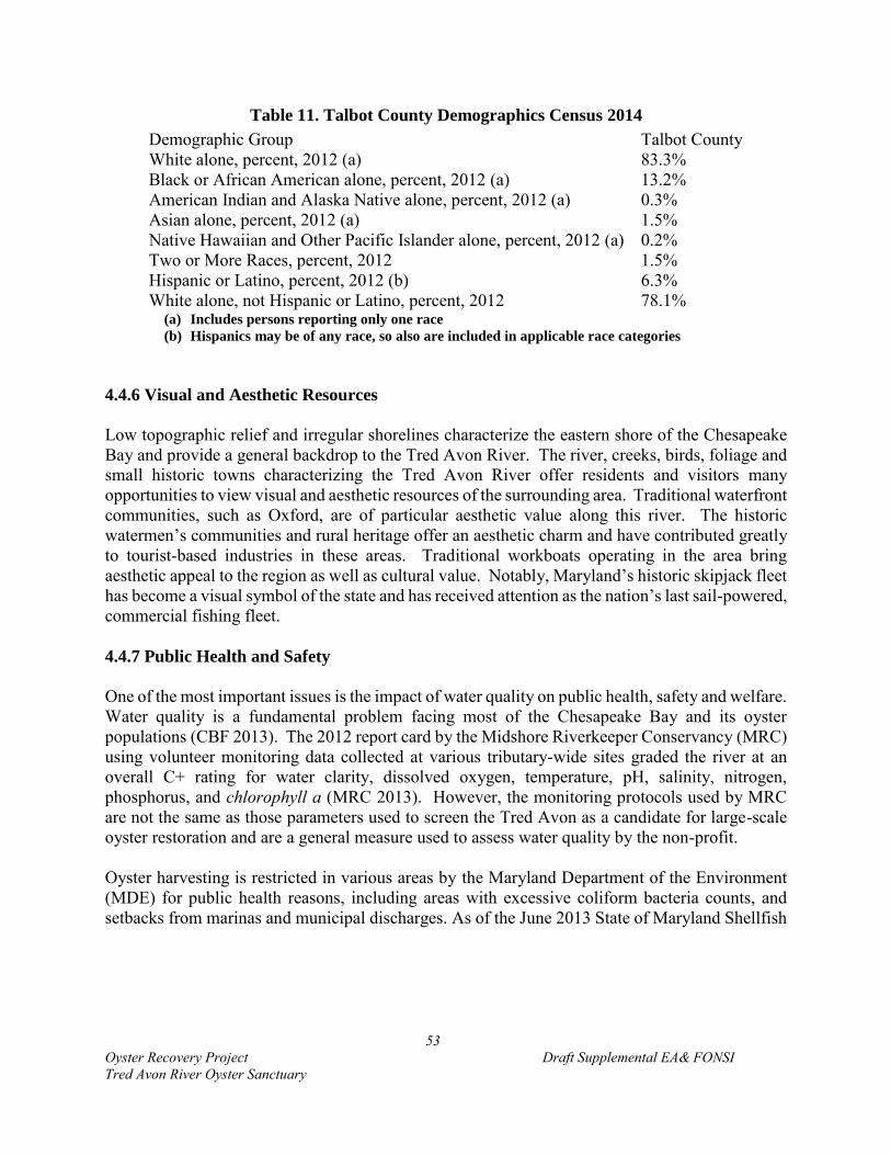
53
Oyster Recovery Project Draft Supplemental EA& FONSI
Tred Avon River Oyster Sanctuary
Table 11. Talbot County Demographics Census 2014
Demographic Group Talbot County
White alone, percent, 2012 (a) 83.3%
Black or African American alone, percent, 2012 (a) 13.2%
American Indian and Alaska Native alone, percent, 2012 (a) 0.3%
Asian alone, percent, 2012 (a) 1.5%
Native Hawaiian and Other Pacific Islander alone, percent, 2012 (a) 0.2%
Two or More Races, percent, 2012 1.5%
Hispanic or Latino, percent, 2012 (b) 6.3%
White alone, not Hispanic or Latino, percent, 2012 78.1% (a) Includes persons reporting only one race
(b) Hispanics may be of any race, so also are included in applicable race categories
4.4.6 Visual and Aesthetic Resources
Low topographic relief and irregular shorelines characterize the eastern shore of the Chesapeake
Bay and provide a general backdrop to the Tred Avon River. The river, creeks, birds, foliage and
small historic towns characterizing the Tred Avon River offer residents and visitors many
opportunities to view visual and aesthetic resources of the surrounding area. Traditional waterfront
communities, such as Oxford, are of particular aesthetic value along this river. The historic
watermen’s communities and rural heritage offer an aesthetic charm and have contributed greatly
to tourist-based industries in these areas. Traditional workboats operating in the area bring
aesthetic appeal to the region as well as cultural value. Notably, Maryland’s historic skipjack fleet
has become a visual symbol of the state and has received attention as the nation’s last sail-powered,
commercial fishing fleet.
4.4.7 Public Health and Safety
One of the most important issues is the impact of water quality on public health, safety and welfare.
Water quality is a fundamental problem facing most of the Chesapeake Bay and its oyster
populations (CBF 2013). The 2012 report card by the Midshore Riverkeeper Conservancy (MRC)
using volunteer monitoring data collected at various tributary-wide sites graded the river at an
overall C+ rating for water clarity, dissolved oxygen, temperature, pH, salinity, nitrogen,
phosphorus, and chlorophyll a (MRC 2013). However, the monitoring protocols used by MRC
are not the same as those parameters used to screen the Tred Avon as a candidate for large-scale
oyster restoration and are a general measure used to assess water quality by the non-profit.
Oyster harvesting is restricted in various areas by the Maryland Department of the Environment
(MDE) for public health reasons, including areas with excessive coliform bacteria counts, and
setbacks from marinas and municipal discharges. As of the June 2013 State of Maryland Shellfish
54
Oyster Recovery Project Draft Supplemental EA& FONSI
Tred Avon River Oyster Sanctuary
Closure Areas, the Tred Avon had three total closure areas20 that were established in October 2011.
None of the areas are within the project area.
4.4.8 Noise
The study area is open tidal waters of the Tred Avon River in depths ranging from a minus 4 to 20
feet depth contour in an area that includes residential buildings and marine waterfront centers.
Estuarine shorelines abutting specific restoration site are characterized as predominately private
homesteads with piers and other waterfront structures. Ambient noise levels are low, and typical
of those found in rural tributaries with low-density development. High noise levels experienced
near urban centers such as Easton, Trappe, and Oxford are an exception. While background noise
levels for residents within the vicinity of the project area might typically be 40 dBA, a resident
may also hear acute noise sources, particularly in the daytime, associated with suburban
neighborhoods such as a power mower, which will generate 65 – 95 dBA at 50 feet or a leafblower
(110 dBA at 50 feet). Route 333 traffic is in the range of 70 dBA at 50 feet, although large trucks
may typically generate 90 dBA (CHC 2014). Noise level of boats using the waterway vary from
approximately 72 dBA for a classic inboard motor to 109 dBA for racing boats (PWIA, accessed
2016).
Sensitive noise receptors in the vicinity include residents living near the water. Overwintering and
resident waterfowl are also sensitive to certain activities such as in-water pile driving and dredging
and many in-water construction activities are limited based on MD DNR time of year restrictions.
The proposed oyster restoration actions would result in temporary construction noise associated
with the initial reef build-out; however, BMPs will be employed to minimize the temporary noise
impact during construction including: limiting work to daytime hours. Twin 375 horsepower
diesel engines power the typical vessel used to construct oyster habitat. Cruising speeds are
generally 12.7 knots.
4.4.9 Other Waterway Uses
4.4.9.1 Commercial Navigation
As described in Section 4.4.2.2, there are two federally maintained navigation channels in
proximity to the project area. Commercial navigation includes charter boats, commercial
watermen, and barge traffic (Vulcan Materials, Inc.).
4.4.9.2 Commercial Fishing
Commercial species sought by Bay watermen include oysters, blue crabs, soft-shell clams, eels,
and several species of finfish (among them striped bass, bluefish, menhaden, and perch). The
2012 annual totals for commercial landings in Maryland were 33,300.8 metric tons (73,414,971
20 MDE. 2013. Notice of Opening to Shellfish Waters. Available online at:
http://www.mde.state.md.us/programs/PressRoom/PublishingImages/www.mde.state.md.us/assets/image/Tred_Avo
n_River_Reclassification_Map.jpg
55
Oyster Recovery Project Draft Supplemental EA& FONSI
Tred Avon River Oyster Sanctuary
lbs) generating $77,858,646 in revenue21. Prior to the 1920s the Tred Avon River system supported
large productive oyster reefs where commercial oystering was an important staple of the local
economy. Data available for the Choptank River complex which includes the Tred Avon River
from 1962 shows a little over 1.2 million lbs of commercial landings. By calendar year 1991, the
numbers were just under half at 552,208 lbs22 The history of commercial oyster harvests in the
Chesapeake Bay is discussed in prior NEPA documents (USACE 2009; USACE 2012). Canneries
and oyster packing houses associated with the oyster industry were once prolific on the Eastern
Shore. An oyster packing house was located in the village of Bellevue town on the west side of
the Tred Avon River, ¾ mile northward of Oxford. Today areas outside of the State designated
sanctuary limits are still commercially fished for oysters during the season from September to
April. The dockside value of oysters landed in 2013 was $7.36 million in Maryland (NMFS 2014).
This equates to 787,889 pounds caught. Oysters and striped bass have traded places a few times
over the last few decades for third- and fourth-most valuable Chesapeake Bay fisheries, behind
blue crabs and Atlantic menhaden (NOAA). The total commercial blue crab landings for the
Choptank River complex were 4.3 million pounds for calendar year 2008. Annual commercial
striped bass landings for the Choptank River were 33,532 lbs in 2004.
Other shellfish of commercial significance in the Chesapeake Bay include the soft-shell clam (Mya
arenaria), the hard-shell clam (Mercenaria mercenaria) and the blue crab (Callinectes sapidus).
The current soft-shell clam fishery in the Chesapeake Bay can be classified as remnant (MD DNR
2013). Soft-shell clams were first harvested intensely during the early 1950s to meet market
demands. Few in the clam industry target soft-shell clam species today with total landings now
measured in the hundreds of bushels. The use of a hydraulic clam dredge is prohibited in Talbot
County, between the shoreline and the center of the channel, except in the months of October and
November, where dredging is allowed within 1,200 feet of the Federal Research Laboratory at
Oxford (House Bill 1059). Also, as a result of sanctuary designation in the Tred Avon River by
the State of Maryland, the sanctuary protects non-oyster bottom habitat that surrounds the larger
areas of interconnected natural oyster bars. The 2010 sanctuary designation for the Tred Avon as
in other tributaries in Maryland permit oyster clamming within the new sanctuary boundaries, but
clamming is limited to existing clamming areas, and maintains the existing 150 foot buffer from
any natural or legal oyster bars further limiting their commercial viability. As a result of nearly
the entire Tred Avon River oyster sanctuary being designated as a legal oyster bar, there is
effectively no clamming activity in the study area. Based on communication with DNR, there is
one reported clam harvest record in the Tred Avon (NOAA Code 637) from 1990-present. In
2015, 2 bushels of soft clams were reported harvested.
Annual commercial blue crab harvests from Chesapeake Bay since 2004 have been approximately
60 million pounds, which is well below the 73-million-pound annual average for the period 1968
to 2004 (CBP 2007). This is attributed to low exploitable stock abundance and restrictive harvest
21 NMFS Annual Landings by Species for Maryland. 2013a. Available online at:
http://www.st.nmfs.noaa.gov/pls/webpls/mf_lndngs_grp.data_in 22 NMFS Landings. 2014. Available online at:
http://www.st.nmfs.noaa.gov/pls/webpls/MF_ANNUAL_LANDINGS.RESULTS

56
Oyster Recovery Project Draft Supplemental EA& FONSI
Tred Avon River Oyster Sanctuary
management measures enacted in 2001 and 2002. In 2006, the abundance of adult crabs was about
57 percent of the CBP’s interim restoration goal of 232 million crabs (CBP 2007).
4.4.9.3 Aquaculture
There are no current aquaculture leases (oysters) within the proposed project area.
4.4.10 Sea Level Rise and Climate Change
4.4.10.1 Project Sensitivity to Sea Level Rise
The ability of oysters to keep pace with sea level rise depends upon their capacity to grow upward
at a rate greater than the rate of sedimentation. Annual growth on restored reefs in Maryland
waters, at 25 to 30 mm/yr (greater than 1 inch), shows that oysters are capable of keeping pace
with sea level rise in less saline waters (Paynter 2008). Results of a recent investigation by
Rodriguez et al. (2014) suggest that intertidal reefs in North Carolina are capable of keeping pace
with sea level rise through 2100.
4.4.10.2 Climate Change
Climate change has the potential to alter many of the conditions for oyster restoration projects
proposed for the Tred Avon River. However, the specific risk from climate change and the
influence those impacts may have on restoration outcomes is uncertain at this time. Scientists at
the CBP are working to understand the possible effects of climate change on the Chesapeake Bay
and its watersheds, including how these changes may affect oyster restoration efforts. Relative
sea-level-rise, increasing temperatures, changes in species distribution, and altered water
chemistry are likely to produce both positive and negative benefits to oysters and expected
ecosystem services. USACE (2012) discusses potential climate change-driven impacts to
Chesapeake Bay resources. Table 12 summarizes the potential impacts. Alterations in the Tred
Avon River would be expected to be similar to those that occur Bay-wide.
One of the principal strategies in developing tributary-level restoration plans was to target initial
restoration actions in tributaries that provide the greatest potential to allow for adaptation to
climate change on behalf of the oyster. An overall salinity-based strategy to address disease and
promote the development of disease resistance was integral to initial screening criteria. The Tred
Avon River is a mesohaline salinity system and as such provides for the potential to develop
disease resiliency in response to disease challenges. In addition to the salinity-based strategy,
focusing ecological restoration tributary-wide is the strategy most likely to allow large populations
of oysters to persist in the face of disease and other stressors. However, the cumulative impacts
resulting from sea-level rise, temperature variability, extreme weather and precipitation, and
acidification are unknown.
57
Oyster Recovery Project Draft Supplemental EA& FONSI
Tred Avon River Oyster Sanctuary
Table 12. Potential Climate Change Impacts to Oyster Resources
Parameter Potential Climate
Change Alteration Impact to Oysters
Temperature
Higher winter
temperatures
longer growing season would
increase productivity, growth
rates, size, reduce time to
maturity
positive
Higher water
temperatures
decrease oxygen in water,
reduce habitat negative
Higher year round
temperatures
increase disease pressure negative
reduce surface freezing could
expand intertidal habitat positive
Salinity
Increase
higher reproduction/growth positive
higher disease pressure negative
expanded habitat positive
Decrease (localized)
reduced habitat negative
lower reproduction/growth negative
lower disease pressure positive
Rainfall
Increased freshwater
runoff from more
extreme storms
stronger stratification would
reduce oxygen levels in deep
waters
negative
decrease salinity
negative and
positive
effects
reduced habitat negative
Carbon
dioxide
levels in the
water
column
Increase
increase the dissolution of
shell reefs; reduce oyster's
ability to form shell
negative
5.0 ENVIRONMENTAL CONSEQUENCES
5.1 Physical Environment
5.1.1 Substrate
USACE-Baltimore would physically construct reef habitat on 57 acres at 33 unique sites
throughout the NOB limits by deploying substrate materials onto the seafloor thereby creating
relief. The mean site area is 1.7 acres, but sizes range from 0.6 – 4.1 acres. Reef construction
would occur only in depths ranging from minus 6.5 – 20 feet MLLW. The newly constructed bars

58
Oyster Recovery Project Draft Supplemental EA& FONSI
Tred Avon River Oyster Sanctuary
would then be planted with hatchery-produced oyster spat-on-shell throughout the NOB in
accordance with the tributary-level restoration plan. The underlying bottom hard substrate
composition would be overlain with no more than 12 inches of substrate, but would not otherwise
change as a result of undertaking the proposed project. These areas historically were oyster reefs.
In some cases, they are areas identified to contain some shell, but less than 5 oysters/m2.
Therefore, there is the possibility that there are small patches within the sites that contain shell or
a few oysters. In those situations, the shell and oysters would be replaced by substrate and spat-
on-shell. Current local sedimentation patterns will be altered by the underwater reef structures,
but minimally.
The proposed project would also place spat-on-shell on 63 – 71 acres of existing oyster reef habitat.
These areas are currently oyster shell with 0 – 14 oyster/m2. The substrate type in these areas
would not change. However, existing shell would be covered by 1 – 3 inches of shell with attached
spat.
5.1.2 Sedimentation
Current sedimentation patterns will be altered by the construction of oyster reef habitat deployed
on the existing river bottom. Turbidity levels would increase in the short-term due to temporary
suspension during construction, which is expected to settle within a short-period of time. Any
suspended matter will eventually settle out of the water column. Healthy oyster populations are
anticipated to improve sediment condition in the long-term through filtration and the production
of biodeposits. A functioning filtering oyster community is expected to reduce TSS levels,
improving local ecological conditions.
5.1.3 Water Depth and Circulation
Restoration will result in a direct and permanent impact on water depth at restoration sites. Water
depth above restored substrate habitat will be reduced by 7 to15 inches with a corresponding
reduction in the navigational clearance over a site. Existing oyster reef is located throughout the
Tred Avon River in water depths between 4 and 20 feet. Water depth above seed only sites will
be reduced by approximately 1to 3 inches. At all reef construction sites, at least 6 feet of
navigational clearance will remain.
Circulation is not expected to be altered at the larger, tributary-level. However, at the local scale,
on a reef, areas of deposition and erosion could be altered by reef establishment. Minimal changes
are expected. In areas where 1 foot reefs are placed, there could be increased circulation due to an
increase in bottom heterogeneity and gradient that would beneficially reduce sedimentation on the
reef habitat.

59
Oyster Recovery Project Draft Supplemental EA& FONSI
Tred Avon River Oyster Sanctuary
5.2 Physiochemical Environment
5.2.1 Water Quality
Oysters once contributed significantly to maintaining water quality and aquatic habitat in the
Chesapeake Bay ecosystem. Oysters both affect local water quality and are affected by water
quality. Restoring oyster reef communities in the Tred Avon River is expected to provide a direct
improvement to water quality in waters adjacent to restored reefs due to the filtration capacity of
oysters. Filtration rates increase with oyster size and vary based on season. Therefore, water
quality improvements will be minor initially following restoration, but will increase with time as
oysters increase in size. The greatest positive benefit to water quality is expected to occur in the
late spring through summer when temperature-driven filtration rates are highest (Newell 2004).
Oyster reef construction involves the placing of shells and/or alternative hard substrate (concrete,
granite or similar stone, limestone etc.) on the river bottom. Stone to be used would be between 3
and 6 inches in size. This placement can result in temporary, local increases in turbidity. This
increase is due to any soils or muds on the materials, as well as re-suspending recently settled
sediments on river bottom where the materials are placed. This disruption is expected to be
temporary and limited in extent. Background levels of local TSS are not expected to increase to
levels that negatively impact fish, shellfish, SAV or other estuarine life due to the placement of
reef base materials. Due to the limited time the construction materials will be in the water column
as well as the fact that materials used in construction are typically rinsed during their mining to
remove loose soils and sediments, little material is expected to be washed off the materials while
they are being lowered onto the bottom. Once on the bottom, the construction materials are
expected to lower TSS levels, even without oysters, due to the impermeable nature of the material,
as opposed to open bay bottom, which is typically loose sediments of varying size from fine silts
to coarse sands. However, this benefit will also be limited as it is the oysters themselves who are
expected to provide the great majority of the water quality improvements, not the materials making
up the initial reef base themselves. Negative impacts to water quality are expected to be short-
term and not significant.
5.2.2 Dissolved Oxygen
Increasing existing oyster populations in the Tred Avon River as a result of undertaking the
restoration project would remove DO from the water column through oyster respiration, but all
models indicate there is adequate DO concentration levels occurring in the tributary and the
restoration would not create oxygen-depleted conditions for other aquatic organisms in the water
column. Rather, oxygen improvements are anticipated due to removal of organic matter by oyster
filtration that would otherwise decompose in the benthos and consume dissolved oxygen.
5.2.3 Salinity and Temperature
No changes to ambient salinity or temperature would occur from undertaking the proposed
restoration project.
60
Oyster Recovery Project Draft Supplemental EA& FONSI
Tred Avon River Oyster Sanctuary
5.3 Biological Resources
5.3.1 Submerged Aquatic Vegetation (SAV)
No adverse impacts to SAV are anticipated as a result of USACE-Baltimore undertaking the
proposed oyster restoration project. The presence of SAV is considered during Tributary Plan
development and it was determined that no SAV occurs in the vicinity of the restoration footprint
and reefs. SAV is typically not found in areas greater than 6 feet in depth depending on water
clarity (2012 Master Plan). Substrate reef deployment would occur in waters deeper than 6.5 feet
MLLW. Therefore, SAV is not likely to occur within the proposed project areas based on VIMS
coverage data. Also, reefs would be constructed between December and March when SAV are
dormant. If SAV were to be found in the vicinity of a restoration site, additional pre-construction
groundtruthing for SAV prior to reef substrate deployment and seeding activities would occur.
There is a chance that SAV could be found adjacent to seeding sites at sites shallower than 6 feet
MLLW. It is unlikely that SAV would be located within seed-only sites as the sites have been
determined to be shell by bottom surveys, a bottom type that does not encourage SAV growth.
MD DNR would need to consider the presence of SAV per their seeding permit.
Previous coordination with NMFS in 2009 via email correspondence determined that time of year
restrictions may be necessary to protect SAV from elevated turbidity within 500 yards of the
substrate placement for reef restoration. Provided the placement of reef material occurs between
December and March of any year, as indicated in the EFH assessment, NMFS agreed that minimal
adverse impact to adjacent SAV or HAPC is anticipated.
SAV beds also have the potential to benefit oyster habitat by trapping suspended sediments in the
water column thus reducing the potential siltation of reef habitat and turbidity in the water affecting
free-swimming larvae. SAV and oysters both positively impact local water quality which in turn
benefits the entire estuarine ecosystem. The location of oyster bars adjacent to other estuarine
habitats such as shorelines and SAV has the potential to provide cumulative benefits to these
habitats and the Tred Avon River system. SAV is known to benefit from the presence of oyster
reefs, which dampen wave energy (Turner et al. 1999; Heiss and Bortone 1999). Although, not
anticipated to be a significant benefit in the Tred Avon River due to the targeted water depths,
constructing new oyster reefs may protect shorelines and SAV beds with greater ability to reduce
the force of approaching wave energy (2012 Master Plan). SAV may benefit from the proposed
project.
5.3.2 Wetlands
No wetlands would be impacted as a result of undertaking this project since no wetlands are in the
vicinity of the restoration footprint since restoration work would only occur in depths from minus
4- to 20-feet MLLW outside areas where estuarine intertidal wetlands occur. Therefore, the
proposed project achieves the national policy of “no-net-loss” of wetland functions and values
under the Clean Water Act.

61
Oyster Recovery Project Draft Supplemental EA& FONSI
Tred Avon River Oyster Sanctuary
5.3.3 Benthic Macroinvertebrates
Oyster habitat is a unique feature of Bay benthic habitats. The bars and reefs themselves provide
hard structure used by a diversity of macroinvertebrates (e.g., blue crabs and epifauna (organisms
that attach to hard bottom)) and fish. Some organisms eat various oyster life stages. For example,
sea nettle, anemones, and other filter feeders consume larvae, and flatworms and mud crabs feed
on spat. Blue crabs will eat older spat and first-year oysters.
Oyster reef establishment is expected to have positive benefits to adjacent benthic communities
and their predators. Rodney and Paynter (2006) showed that the total macrofaunal abundance (free
living macrofauna + fouling organisms) was an order of magnitude higher on restored bars
compared to unrestored reefs. Further, many organisms that were significantly more abundant on
restored reefs are also known to be important food items for several commercially and
recreationally important finfish species.
As a result of constructing substrate reef habitat in the sanctuary, benthic substrate would be
permanently shaded and buried by the proposed reef structures. The proposed actions would lead
to a permanent transformation of bare benthic bottom to reef habitat on 57 acres. This would be a
conversion to a more historic condition when extensive oyster reef habitat existed in the
Chesapeake Bay, although where alternate substrates are deployed, the composition of the reefs
would differ from natural shell reefs. Temporary displacement related to construction activities is
anticipated, but no more than minimal. Benthic biomass and community composition is likely to
significantly increase. The combined restoration work would provide an important food source
for benthos, particularly for deposit-feeding epifauna. The three-dimensional habitats associated
with oyster reefs are anticipated to build vertically overtime as individual oysters accumulate and
form increased community diversity and bottom floor structure. The vertical relief would greatly
affect benthic biomass at restoration sites, especially during the first year after deployment.
It is anticipated that benthic communities on seed-only sites would be enhanced in the long-term
by the addition of shell and oysters. However, there may be minor, temporary, impacts initially
following construction to sessile organisms from being covered by placed materials.
5.3.3.1 Eastern Oysters
Restoration efforts are expected to result in enhanced recruitment, settlement, and growth of
oysters. This is turn, over time, could increase the size of reef structures. Expanding restoration
actions into depths that would maintain 6 feet of navigational clearance provides for a high
likelihood of achieving sustainability, and provides significant ecosystem benefits, diversity,
resiliency, and reproduction potential. The only anticipated negative impact to oysters from the
proposed project is the potential for sparsely existing oysters within the footprint of substrate reefs
to be covered by placed materials.
5.3.3.2 Clams
The major potential mechanisms for these species to interact with oysters are through competition
for food and space. It is anticipated that as a result of undertaking the substrate reef restoration
work, direct competition for space could occur on a local scale if an increase in oyster populations
62
Oyster Recovery Project Draft Supplemental EA& FONSI
Tred Avon River Oyster Sanctuary
causes an expansion of hard-bottom habitat over existing soft-bottom habitat. Increased
competition between clams and oysters for food could result in a reduction in the abundance of
infaunal bivalves (2012 Master Plan). Soft-shell clams occupy sandy or sandy-mud bottoms,
unlike the harder bottoms preferred by oysters23. However, the habitat occupied by soft-shell
clams does overlap with that of oysters, and clams are frequently found beneath oyster cultch and
directly adjacent to oyster bars. However, the impact of competition for suitable bottom is
expected to be minimal. Areas not suitable for oysters in mud and silt bottoms would be available
for colonization by clam species since the oyster restoration polygons are targeted only to those
areas most preferential toward successful restoration outcomes including those areas that existed
historically.
5.3.3.3 Phytoplankton
Since oysters feed primarily on phytoplankton they may compete for food with other filter-feeding
invertebrates, planktivorous fish, and zooplankton (Kennedy et al. 1996; NRC 2004). The extent
of such competition resulting from restoration depends on the food preferences of the competing
species; moreover, significant competition is likely to occur only when the concentration of
phytoplankton in the water is low in relation to the number of consumers which is a condition not
anticipated. Currently, competition for phytoplankton is believed to be minimal because oyster
numbers are low compared with their historical abundance and because nutrient input and the
resultant production of phytoplankton are high (Newell 1988). The impact of competition for food
resulting from a successful restoration outcome is expected to be minimal. Increasing oyster
biomass in the Tred Avon River would likely result in greater cropping of phytoplankton
populations through increased filtration thereby improving local water quality and periods of
anoxia. Expansion of restoration into shallower waters will expose more of the water column to
the potential benefits of increased filtration by oysters.
5.3.3.4 Zooplankton
Using a simple quasi-equilibrium, mass-action model (Ulanowicz and Tuttle 1992), researchers
have predicted that an increase in the abundance of oysters in the Bay would decrease
phytoplankton productivity; the abundances of pelagic microbes, ctenophores, and medusae; and
particulate organic carbon. The model also predicted increases in benthic primary production and
fish stocks. Many reef-dwelling benthic invertebrates produce planktonic larvae; therefore, oyster
reefs might provide both sources of larvae and recruitment sites at the end of planktonic
development (Harding 2001). The primary mechanism of interaction between oysters and the
zooplankton community would be indirect, through competition for planktonic food. The impact
of competition for food resulting from a successful restoration outcome is expected to be minimal.
5.3.3.5 Blue Crab
Expanding oyster reef restoration into shallower habitats would directly benefit blue crab
populations by providing valuable habitat, increasing their food supply, and providing habitat for
blue crab prey species. If SAV increases due to oyster filtration, there could be a benefit to the
blue crab population. Expanded SAV could enhance blue crabs by providing more refuge for
23 Maryland’s Chesapeake Bay Commercial Fisheries. 1978. Available online at:
http://www.gpo.gov/fdsys/pkg/CZIC-sh222-m3-m3-1978/html/CZIC-sh222-m3-m3-1978.htm

63
Oyster Recovery Project Draft Supplemental EA& FONSI
Tred Avon River Oyster Sanctuary
juvenile crabs. Additionally, oyster bars and reefs provide valuable habitat for many organisms,
including the blue crab which is a commercially important species in the Bay. As the oyster
communities develop in the Tred Avon River to include dense seasonal populations of rapidly
growing recent recruits there is an expectancy of intensive blue crab predatory activity. Therefore
it is anticipated that oyster restoration actions in this river would provide synergistic and beneficial
effects to trophic interaction.
5.3.4 Fish
The proposed project is expected to result in beneficial impacts to aquatic resources as oysters at
different life stages are an import food source for some species of fish such as black drum and
cownose rays. In addition, these reef structures will provide shelter, cover, and foraging habitat
for mobile finfish that prefer reef structure such as oyster toadfish, skilletfish, tautog, spotted sea
trout, and naked gobies. Through the creation of new oyster bars and the rehabilitation of existing
nonproductive bars, a portion of historic oyster habitat will be restored. Placement of shell and
seeding activities will form an elevated reef structure with greatly increased surface area for the
attachment of sessile organisms (e.g. algae, barnacles, sponges, etc.) that could be used as forage
for finfish. The three-dimensional habitat of an oyster bar results in a higher level of benthic
primary and secondary production than is produced in most other benthic substrates that in turn,
enhance food supply for larger finfish.
Substrate and spat-shell placement may cause re-suspension of sediments and generate turbidity
which could potentially impact fish eggs, larvae, and juvenile stages. However, this impact would
be temporary, minor and confined to a limited area. In addition, most of the construction work
will be occurring in the late fall or winter during which time fish species in the area do not spawn
and they would still be mobile enough to not be impacted by the construction efforts.
5.3.5 Avifauna
The expansion of oyster restoration into shallow waters is expected to have a direct benefit on
avian piscivore species (e.g. raptors), benthic-feeding species (e.g. Black Duck, diving ducks), and
those such as oystercatchers that feed directly on oysters by providing additional foraging habitat.
5.3.6 Essential Fish Habitat
In a letter dated February 11, 2014, NMFS concurred with USACE-Baltimore’s determination
that shallow water oyster restoration (between 6 and 9 feet MLL W) in the Tred Avon River will
not have a significant adverse effect on EFH or habitat area of particular concern (HAPC), and
that over time the reefs will benefit water quality and aquatic habitat.
As indicated in the Shallow Water Oyster Restoration in the Tred Avon River Oyster Sanctuary
EFH assessment, the placement of natural shell or alternative substrate (non-shell) will be
conducted at existing oyster bars within the Tred Avon River at water depths between 6.5 and 9
feet MLLW. Some areas of substrate placement will occur adjacent (within 300 feet.) to existing
submerged aquatic vegetation (SAV), designated a HAPC for federally managed red drum and
64
Oyster Recovery Project Draft Supplemental EA& FONSI
Tred Avon River Oyster Sanctuary
summer flounder. Previous coordination with NMFS in 2009 via email correspondence
determined that time of year restrictions may be necessary to protect SAV from elevated turbidity
within 500 yards of the substrate placement for reef restoration. Provided the placement of reef
material occurs between December and March of any year, as indicated in our EFH assessment,
NMFS agreed that minimal adverse impact to adjacent SAV or HAPC is anticipated. NMFS
support efforts underway by the USACE, the Chesapeake Bay Program's Sustainable Fisheries
Goal Implementation Team (GIT) and MIW to restore oyster reef habitat, critically important to
various life stages of numerous state and federally managed species, in Maryland tributaries such
as the Tred Avon River.
5.3.7 Rare, Threatened, and Endangered Species (RTE)
Based on data compiled from the USFWS Information, Planning, and Conservation System, there
are no aquatic RTE species within the study area under the purview of USFWS. A letter dated
February 11, 2014, from USFWS confirmed this information. In a letter dated April 15, 2014,
NOAA confirmed that the proposed project would not affect the RTE species (sea turtles and
Atlantic sturgeon) under their jurisdiction. Further, NOAA stated that no further consultation in
accordance with Section 7 of the ESA is necessary. Based on this information, it is concluded that
there will be no detrimental or beneficial impacts to RTE species from the project.
5.4 Community Setting
5.4.1 Land Use
The proposed action will have no impact on land use. Sustainable land use policies and practices
within the Tred Avon River watershed and control of run-off will benefit the proposed project by
providing for suitable water quality.
5.4.2 Recreation
5.4.2.1 Fishing
It is anticipated that the proposed restoration work, if successful, would improve ecological
conditions with increasing oyster biomass and resulting benthic inveterate habitat. It is well-
recognized that three dimensional oyster reef habitats increases secondary finfish production
(Grabowski and Peterson 2007) and therefore the proposed action is expected to have a long-term
benefit to recreational and commercial fishing. Any temporary disturbance on the waterway would
be localized during reef placement and seeding actions.
5.4.2.2 Boating and Navigation
Recreational boaters, commercial watermen, and commercial barging operations are the primary
users of the waterway. As of 2014, there were approximately 714 registered boats in the Tred
Avon River. Drafts were available for 297 of the 714 registered boats. On average, these boats
draw 3.2 feet, with a maximum of 11.8 feet. Of the registered boats with identified drafts, 26 boats
have drafts greater than or equal to 6 feet. This equates to 8.75 percent of registered boats.
USACE-Baltimore reached out to over 500 residents along the Tred Avon River as well as to

65
Oyster Recovery Project Draft Supplemental EA& FONSI
Tred Avon River Oyster Sanctuary
several marinas and the Tred Avon Yacht Club to determine where boat users traverse within the
Tred Avon River and what common pathways are used. Further information on this outreach is
discussed in the public involvement section of the report. No impact is expected to use of the
waterway, including activities such as the summer regatta.
The Town Creek channel would not be impacted as a result of undertaking the proposed restoration
project since oyster restoration would occur entirely outside the limits of the federal channel. The
Tred Avon River channel south of Easton would not be impacted either, because no action
undertaken by USACE-Baltimore is proposed within 150 feet of the horizontal limits of the
channel. Therefore, no interference with the structural integrity of the USACE-Baltimore federal
navigation project and/or obstruction to general navigation within either federal channel in the
project vicinity is expected.
USACE-Baltimore solicited input from local residents and the boating community in September
2014 on the drafts required by waterway users of the Tred Avon River. A mailing was sent to over
500 residents, as well as flyers posted in 10 public places (see Appendix I). Based on input
received, the initial plan to provide 5 feet MLLW of navigational clearance following construction
was revised to provide the currently proposed 6 feet MLLW clearance at substrate reef restoration
sites. Due to this change, a number of sites were eliminated from the proposed project that fell
between the 6 and 6.5 feet depths. Additionally, sites in 6.5 feet MLLW depths were converted
from up to 12 inch to 6 inch in height to enable restoration in those areas while maintaining the
necessary navigational clearance that were identified by the waterway users.
The proposed project would not impact operations of the Oxford-Bellevue Ferry.
The USCG provided guidelines for all future oyster restoration plan development (during the initial
Harris Creek planning efforts) as listed below:
1. Establishment of oyster sanctuaries and reefs to remain a minimum of 250 feet from
established Aids to Navigation (AtoN) to allow for safe navigation and accessibility of
servicing units. Placement of sanctuary or reef material should allow servicing units
unobstructed ingress and egress access to the aid from the main channel;
2. Oyster sanctuaries and reefs remain a minimum of 150 feet outside/shoreward of
maintained channel limits (Note- maintained channel means Corps maintained channels-
pers. comm. from John Walters USCG to Woody Francis Corps.)
3. Where no established and maintained channel exists, establishment of oyster sanctuaries
and reefs are to remain outside/shoreward of line segments extended between adjacent
AtoN;
4. If it is not possible to adhere to the reef placement recommendations provided above,
conduct an Army Corps Waterways Risk Assessment to determine the effect of placing
reef-based obstructions in a waterway. This methodology is currently being incorporated
into the placement of renewable energy installations in the coastal marine environment and

66
Oyster Recovery Project Draft Supplemental EA& FONSI
Tred Avon River Oyster Sanctuary
is conducted by the renewable energy infrastructure owner/permit applicant. Reef
restoration projects should be assessed in a similar manner, since both reefs and offshore
energy installations are obstructions being introduced into a waterway, thereby changing
vessel operating conditions.
These guidelines have been incorporated to the extent possible to enable large-scale restoration
goals to be met. Recommendation #1 (AtoN buffers) was fully incorporated and depicted in Figure
12. With regards to #2, the Federal project is upriver of the restoration areas, thus that
recommendation is not applicable. With regards to #3, there is no established and maintained
dredged channel in the Tred Avon River within the boundaries of the restoration project scope,
although there is a connection downriver to non-Corps maintained channels. Therefore, USACE
conducted outreach with residents, commercial waterway users (as discussed above), and reviewed
the plan in detail with USCG to address recommendation #4. A navigational path between the
AtoN is depicted in Figure 12. This identifies the proposed restoration sites that fall within the
area that USCG requested restoration avoid. Proposed restoration sites are largely along the edge
of navigational path.
There are four locations where proposed restoration sites fall within the navigational path. Figure
13 depicts these areas within the sanctuary (outlined by pink circles). Figures 14 – 16 provide an
analysis of the focus areas. The analysis considered water depth, as well as the width of deep
water (>13 feet) passage that would exist around the restoration sites. For this analysis, deep water
is defined as greater than 13 feet because the controlling depth of the Tred Avon River channel at
the head of the River is 12 feet. Proposed substrate restoration sites at 13 feet would result in
bottom depths between 12 and 11.75 feet following restoration.
The proposed restoration sites in the lower portion of the sanctuary are shown in Figure 14. SS_08,
a proposed substrate restoration is situated in 7 – 9 feet MLLW of water. SO_05, a seed only site,
is located in water depths between 9 and 13 feet MLLW. Following restoration, there would
remain a navigational clearance of at least 6.5 feet MLLW at SS_08. Water depths at seed only
sites such as SO_05 would undergo a minimal change in water depth of 1 – 3 inches. There is a
wide path of deep water available for navigation around these two sites to their east within the
navigation pathway as shown in Figure 14.
In the middle of the sanctuary SS_13, SS_58, and SO_23 are within the navigation pathway. Water
depths at SS_13 range from 7 feet on the shoreward side to greater than 13 feet on its western most
edge. Water depths are greater than 9 feet above the proposed SS_58 and SO_23 with the
exception of a few points that are 7 feet along its western edge. There is greater than 225 feet or
more of deep water available for navigation around these two sites.
The greatest concentration of proposed activity is in the vicinity of Double Mills Point (Figure 16).
The navigational area off Double Mills Point in the middle of the sanctuary contains control sites
(not depicted) where no restoration will occur, seed areas (blue in Figure 16) that are currently
existing oyster reefs and would experience a depth change of only 1 – 3 inches following
restoration actions, and substrate placement sites within that area of the navigational pathway.
Most of the proposed restoration work in this area is in waters deeper than 13 feet. At SO_11,
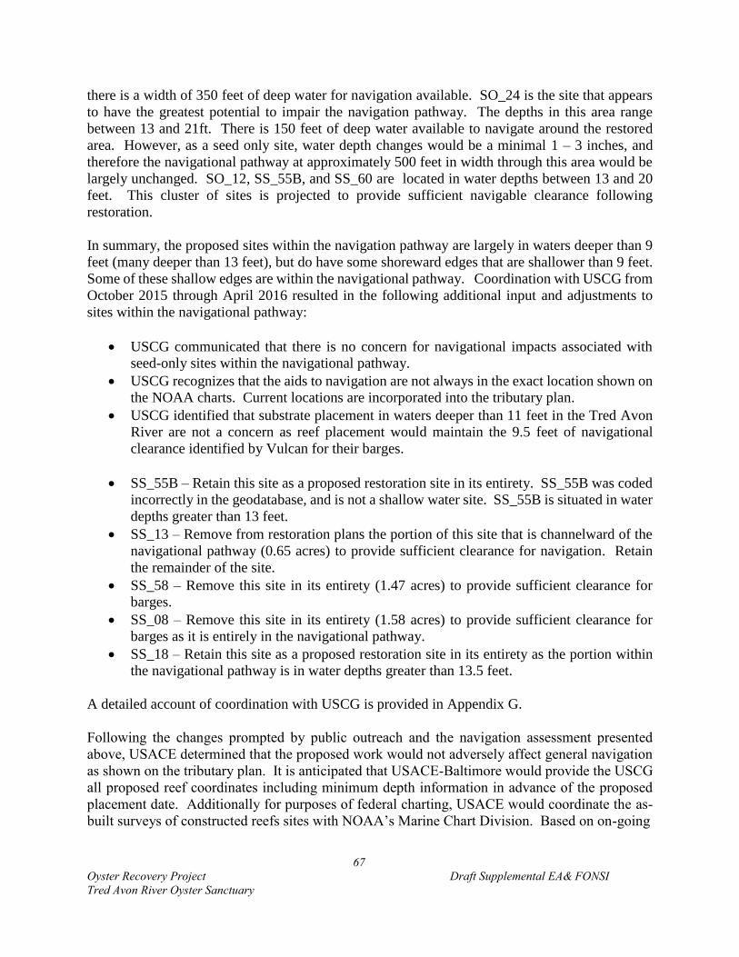
67
Oyster Recovery Project Draft Supplemental EA& FONSI
Tred Avon River Oyster Sanctuary
there is a width of 350 feet of deep water for navigation available. SO_24 is the site that appears
to have the greatest potential to impair the navigation pathway. The depths in this area range
between 13 and 21ft. There is 150 feet of deep water available to navigate around the restored
area. However, as a seed only site, water depth changes would be a minimal 1 – 3 inches, and
therefore the navigational pathway at approximately 500 feet in width through this area would be
largely unchanged. SO_12, SS_55B, and SS_60 are located in water depths between 13 and 20
feet. This cluster of sites is projected to provide sufficient navigable clearance following
restoration.
In summary, the proposed sites within the navigation pathway are largely in waters deeper than 9
feet (many deeper than 13 feet), but do have some shoreward edges that are shallower than 9 feet.
Some of these shallow edges are within the navigational pathway. Coordination with USCG from
October 2015 through April 2016 resulted in the following additional input and adjustments to
sites within the navigational pathway:
USCG communicated that there is no concern for navigational impacts associated with
seed-only sites within the navigational pathway.
USCG recognizes that the aids to navigation are not always in the exact location shown on
the NOAA charts. Current locations are incorporated into the tributary plan.
USCG identified that substrate placement in waters deeper than 11 feet in the Tred Avon
River are not a concern as reef placement would maintain the 9.5 feet of navigational
clearance identified by Vulcan for their barges.
SS_55B – Retain this site as a proposed restoration site in its entirety. SS_55B was coded
incorrectly in the geodatabase, and is not a shallow water site. SS_55B is situated in water
depths greater than 13 feet.
SS_13 – Remove from restoration plans the portion of this site that is channelward of the
navigational pathway (0.65 acres) to provide sufficient clearance for navigation. Retain
the remainder of the site.
SS_58 – Remove this site in its entirety (1.47 acres) to provide sufficient clearance for
barges.
SS_08 – Remove this site in its entirety (1.58 acres) to provide sufficient clearance for
barges as it is entirely in the navigational pathway.
SS_18 – Retain this site as a proposed restoration site in its entirety as the portion within
the navigational pathway is in water depths greater than 13.5 feet.
A detailed account of coordination with USCG is provided in Appendix G.
Following the changes prompted by public outreach and the navigation assessment presented
above, USACE determined that the proposed work would not adversely affect general navigation
as shown on the tributary plan. It is anticipated that USACE-Baltimore would provide the USCG
all proposed reef coordinates including minimum depth information in advance of the proposed
placement date. Additionally for purposes of federal charting, USACE would coordinate the as-
built surveys of constructed reefs sites with NOAA’s Marine Chart Division. Based on on-going
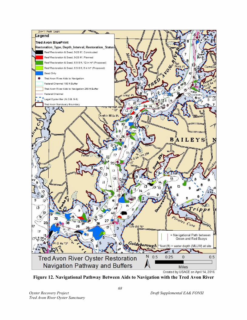
68
Oyster Recovery Project Draft Supplemental EA& FONSI
Tred Avon River Oyster Sanctuary
Figure 12. Navigational Pathway Between Aids to Navigation with the Tred Avon River

69
Oyster Recovery Project Draft Supplemental EA& FONSI
Tred Avon River Oyster Sanctuary
Figure 13. Focus Areas for Detailed Navigational Assessment

70
Oyster Recovery Project Draft Supplemental EA& FONSI
Tred Avon River Oyster Sanctuary
Figure 14. Site Analysis of Navigation in the Lower Sanctuary

71
Oyster Recovery Project Draft Supplemental EA& FONSI
Tred Avon River Oyster Sanctuary
Figure 15. Site Analysis of Navigation in the Mid-Sanctuary
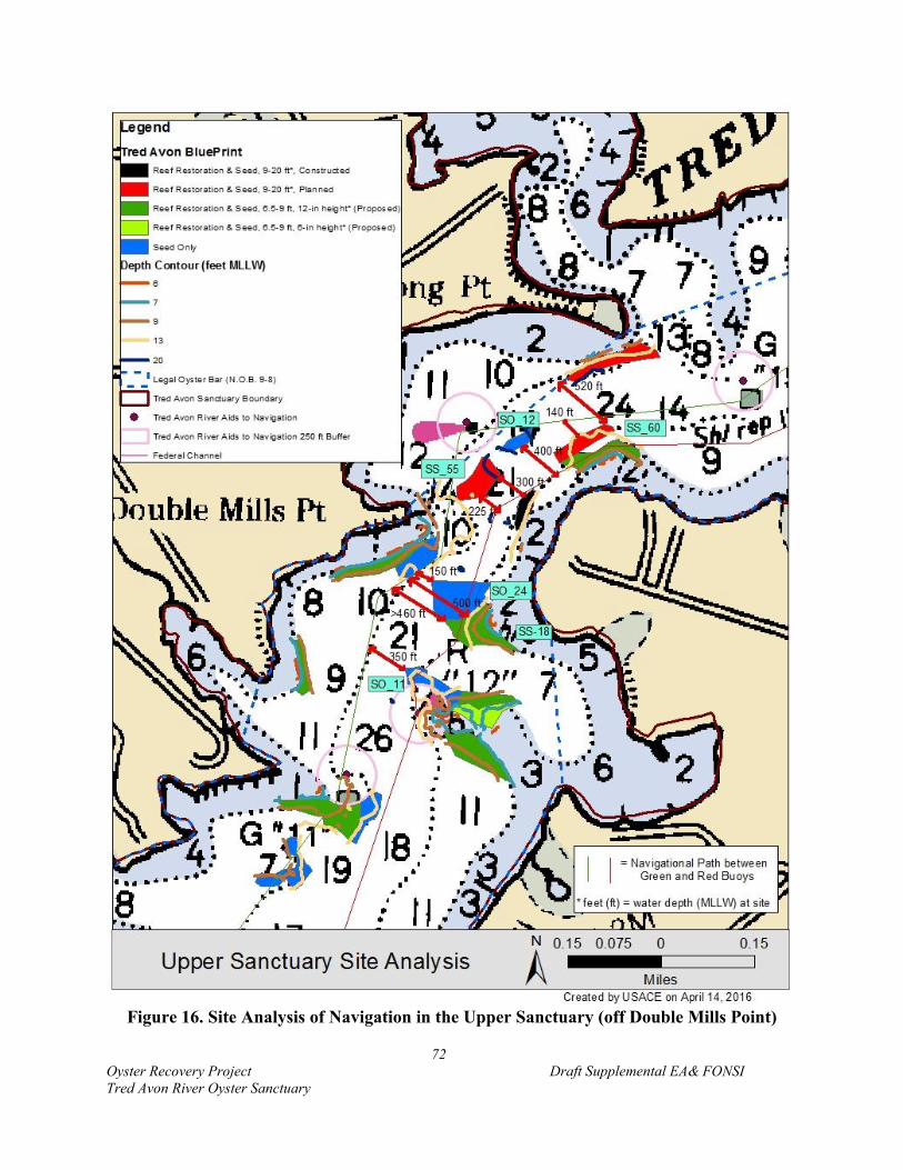
72
Oyster Recovery Project Draft Supplemental EA& FONSI
Tred Avon River Oyster Sanctuary
Figure 16. Site Analysis of Navigation in the Upper Sanctuary (off Double Mills Point)

73
Oyster Recovery Project Draft Supplemental EA& FONSI
Tred Avon River Oyster Sanctuary
coordination with USCG, a Local Notice to Mariners will be provided, as determined to be
appropriate.
If restored reefs should, in the future, upon growth of the oysters into the water column cause
unreasonable obstructions to navigation, the MIW will address the situation by incorporating
adaptive management strategies. Data collected at the 3 year and 6 year check-in, per the
established Oyster Monitoring Metrics, will be utilized to identify reef height and current water
depths. It is not anticipated, but should the situation arise where there are reefs within the
navigational pathway that are posing a problem by encroaching on the navigational clearance
within the navigational pathway, oysters could be removed from the reef and transplanted to other
sanctuary sites. This should be a minimal concern as the selected Alternative 7 has eliminated
reefs within the navigational pathway that would have reduced navigational clearance to 6 feet.
Those outside the navigational pathway will be evaluated as to whether these reefs can be left
alone to develop their natural structure and reef height if in areas where there is little navigational
passage. If so, revised bathymetry will be submitted to NOAA to update navigational charts with
current heights.
5.4.2.3 Waterfowl Hunting
There is the potential for waterfowl hunting to be enhanced with restoration of additional oyster
reef habitat that would provide further foraging habitat for hunted avian species. If the oyster
restoration activities as proposed are successful especially in the shallower water depths of the
NOB, the population of diving ducks may increase locally given a recognized relationship in the
region between healthy oyster populations and SAV habitat. It is anticipated that restoration
actions would stabilize and/or increase opportunities for SAV providing for increased numbers of
ducks, including canvasback and redhead ducks which feed on the SAV.
5.4.2.4 Swimming
The oysters’ contribution to improving water quality as a result of restoration actions when
combined with TMDL actions could contribute to an increase in recreational activities such as
swimming, and a reduction in the costs of water quality improvement measures. Restoration
efforts are likely to return reefs to functioning ecosystems in the Tred Avon River that provide
many benefits to people. A single oyster can filter up to 50 gallons of water a day (Newell et al.
2004, Luckenbach 2009) aiding in cleaner water and better opportunities for recreational
swimming due to fewer toxic blooms and hypoxic events.
5.4.2.5 Wildlife Viewing
As a result of undertaking the proposed project, a minor temporary disruption to wildlife viewing
may occur during reef placement at specific sites, but it is anticipated upon project completion that
oyster restoration efforts could provide better opportunities for wildlife viewing throughout the
Tred Avon River. Restoring healthy oyster populations is expected to draw waterfowl to the area
such as diving ducks that feed on oyster bars.

74
Oyster Recovery Project Draft Supplemental EA& FONSI
Tred Avon River Oyster Sanctuary
5.4.3 Cultural and Historic Resources
Oyster reef construction has the potential to affect underwater historic and/or archeological
resources; however, the proposed actions and alternatives do not impact any such resources since
there are no documented and/or undocumented historical and/or archeological properties including
shipwrecks in the vicinity of any restoration polygon. Placing 1-foot of relief through the tributary
at identified reef placement sites would not compromise the structure integrity of the bottom of
any potential historical or archeological site. The proposed reef structures would not be visible
from the waterway and “any prehistoric or historic district, site, building, structure, or object
included in, or eligible for inclusion” would not be affected by this undertaking. However, MHT
has requested that they be notified if materials or geophysical anomalies are known or discovered
which could indicate the presence of historic properties within the various project areas. USACE
will notify the MHT upon discovery of any previously unknown historic, cultural, or archeological
resources or remains within or immediately adjacent to the Tred Avon River oyster restoration
project areas during acoustic and diver led surveys conducted by project partners and associates.
USACE will inform the MHT of objects, structures, or geophysical anomalies that could indicate
the presence of a historic property (e.g., structural timbers, rigging, machinery, and glass, ceramic,
and/or metal artifacts that could indicate the presence of a historic shipwreck; concentrations of
bone, stone, and/or ceramic artifacts that could indicate the presence of a prehistoric archeological
site; or magnetic or bathymetric anomalies, side scan sonar contacts, or sub-bottom reflectors that
could indicate the presence of the aforementioned items), and avoid activities that may affect the
resources or remains until the required coordination with MHT has been completed. USACE will
initiate the Federal, Tribal, and state coordination necessary to determine if any such items or
remains warrant a recovery effort or if the site is eligible for listing in the National Register of
Historic Places.
5.4.4 Hazardous, Toxic, and Radioactive Waste
The proposed action will have no impact on CERCLIS or RCRA sites within the Tred Avon River.
5.4.5. Socioeconomic Conditions
No direct impacts are expected to socioeconomic conditions from the proposed project. However,
indirect positive and negative impacts may result. The action has the potential to negatively affect
commercial crabbers that use trotlines if certain alternate substrates are used. Alternatively, a
healthy oyster reef network may benefit the crab population by providing additional foraging
opportunities. The action has the potential to positively affect commercial fisherman that target
fish species benefited by reef habitat. Additionally, the proposed project has the potential to
positively impact watermen that harvest oysters by contributing to the oyster population (export
of larvae from sanctuary reefs to harvest areas) in areas open to harvest.
75
Oyster Recovery Project Draft Supplemental EA& FONSI
Tred Avon River Oyster Sanctuary
5.4.6 Visual and Aesthetic Resources
No detrimental or beneficial impacts to aesthetic resources are expected to occur as a result of
undertaking the proposed oyster restoration project. Reef construction and seeding activities
would involve waterway vessel equipment including operation of an onboard crane which would
be visible from the waterway and abutting shorelines during the construction period. A typical
oyster restoration vessel is 60-feet long with a beam width of 19-feet which draws 3.5- to 5-feet
of water. The vessel is used to transport and place hatchery-produced seed oysters onto designated
sanctuary sites. The vessel also carries oyster shell and other alternate materials for reef
construction. A 4,000 pound crane is onboard to deploy material. Twin 375 horsepower diesel
engines power the vessel. Cruising speeds are generally 12.7 knots. The extent and perception of
the aesthetic alteration would vary depending upon the nature of the surrounding area and the
values of the public using the waterway. Following completion of restoration actions, there would
be no changes to the existing visual or aesthetic resources.
5.4.7 Public Health and Safety
The proposed project would have no negative impacts on public health and safety. Expansion of
oyster restoration into shallow waters is anticipated to provide a positive impact to water quality,
at least in the vicinity of restored reefs. In addition, groups like MRC and other nonprofits are
working with landowners to reduce pollution from agricultural related land-uses which dominate
the watershed. Actions include the State of Maryland’s cover-crop program. Undertaking the
proposed restoration in the sanctuary may provide improved water quality conditions, however
threats from sewage and bacteria may present concerns throughout the tributary. There is an
important relationship between water quality and oyster restoration, where water quality has
declined precipitously due to a continual decline in oyster populations. The State of Maryland is
actively targeting fecal bacteria seeped from sewage and septic tank leaks, pet waste and boats. It
is anticipated that collective actions undertaken by the federal, state, and local governments in
addition to actions by environmental nonprofits and through citizen engagement would improve
public health and safety in project areas tributary-wide.
5.4.8 Noise
Noise would increase in the immediate vicinity of restoration work during placement of substrate
and spat-on-shell. No work would occur at night. It is not anticipated that the proposed project
would result in ambient noise levels outside those noise levels already experienced on the
waterway from existing navigational uses. Following completion of restoration actions, there
would be no impacts to noise levels.
5.4.9 Commercial Waterway Uses
5.4.9.1 Commercial Navigation
As described in Section 5.4.2.2, commercial navigation impacts were thoroughly considered.
Areas of potential conflict with navigational interests were removed from consideration for
restoration based on input received from local residents as well as USCG. No negative impacts
76
Oyster Recovery Project Draft Supplemental EA& FONSI
Tred Avon River Oyster Sanctuary
are expected for commercial navigation from expansion of oyster restoration into shallower water
depths as the existing channel will not be affected.
5.4.9.2 Commercial Fishing
No negative impacts are anticipated to commercial fishing of finfish, eels, or clams by expanding
oyster restoration into water depths between 6.5 – 9 feet MLLW. Throughout public coordination
for the Tred Avon restoration work, commercial crabbers identified a concern that alternate
substrate reefs posed a problem for crabbing with trotlines and could lead to a negative impact on
that industry. Crabbers were asked to provide input on site selection. Large stone was identified
as posing the greatest problem for trotliners. Stone to be used would be between 3 and 6 inches in
size. To minimize this impact, mixed shell was utilized to the maximum extent possible for reef
restoration of deep water sites. USACE and its partners will continue to work with the watermen
community to minimize or prevent this potential impact. However, it is anticipated that there will
not be sufficient shell available to restore the entire 57 acres. Other approaches could be pursued
such as using a base of stone with shell placed on top to prevent trotlines from snagging.
Commercial clamming operations would not be impacted as there is no clamming within 150 feet
of a legal NOB and most of the Tred Avon River oyster sanctuary is currently designated as a legal
NOB.
5.4.10 Climate Change
The specific risk from climate change and the influence those impacts may have on restoration
outcomes is uncertain at this time. Scientists at the CBP are working to understand the possible
effects of climate change on the Chesapeake Bay and its watersheds, including how these changes
may affect oyster restoration efforts. Relative sea-level-rise, increasing temperatures, changes in
species distribution, and altered water chemistry are likely to produce both positive and negative
benefits to oysters and expected ecosystem services. USACE (2012) discusses potential climate
change-driven impacts to Chesapeake Bay resources. The reefs restored in accordance with the
Master Plan (USACE 2012) are anticipated to be capable of growing vertically and keeping pace
with sea level rise in the Tred Avon River; however, monitoring will confirm that accretion and
reef growth is occurring at a pace that is positive in the face of climate-driven effects. In the event
that reefs are not keeping pace with sea level rise or are being negatively impacted by other climate
change related alterations, adaptive management measures will be taken. These measures would
likely consist of adding spat-on-shell plantings to the reef to increase height, add carbonate to the
system, and add broodstock. However, in more extreme cases, substrate could also be placed to
provide additional elevation. Table 10 summarizes the potential climate change impacts to oysters.
Alterations in the Tred Avon River would be expected to be similar to those that occur Bay-wide.
However, the cumulative impacts resulting from sea-level rise, temperature variability, extreme
weather and precipitation, and acidification are unknown.
6.0 CUMULATIVE EFFECTS ANALYSIS
Cumulatively, expanding oyster restoration into shallow water depths is expected to have a
positive, direct impact on the Tred Avon River ecosystem. The proposed work is a part of the
77
Oyster Recovery Project Draft Supplemental EA& FONSI
Tred Avon River Oyster Sanctuary
broader Tred Avon River Oyster Restoration Tributary Plan, which has set a target of restoring
146 acres of oyster reef habitat in the Tred Avon River. Thus far, restoration on 24 acres of reef
habitat has commenced with 16 acres of alternate substrate reef construction complete.
Implementation of the Tred Avon River Tributary Plan is part of a Chesapeake Bay-wide effort
focused on restoring sustainable oyster populations. The Tred Avon efforts, with those that have
been undertaken in Harris Creek and the Little Choptank River are aimed at meeting the oyster
outcome of E.O. 13508 and the oyster goals of the 2014 Chesapeake Bay Agreement. Additional
work is ongoing in Virginia. Maryland and Virginia are working towards restoring oyster
populations in five tributaries each with a combined goal of restoring ten tributaries in the Bay.
Tributary plans developed for each tributary look to achieve large-scale restoration that will be of
a sufficient scale to produce a system-wide impact. The tributary plans target restoration of 377
acres of oyster reef habitat in Harris Creek, 146 acres in the Tred Avon River, and 440 acres in the
Little Choptank River. In Harris Creek, initial restoration efforts have been completed on 350
acres out of 600 potentially restorable bottom acres. Although, the initial target of 377 acres has
not been reached, initial restoration efforts have been implemented on all available bottom.
(Acreage reductions from the 377 acre target occurred throughout implementation and led to a
feasible implementation of 350 acres rather than 377 acres.) Tred Avon River restoration plans
call for restoring 146 acres out of a total 251 restorable bottom acres, of which work on 16 acres
has been initiated. In the Little Choptank, a total of 685 acres of potentially restorable bottom was
identified. Thus far, 126 acres of alternate substrate reefs have been constructed and 34 of those
acres have been received spat-on-shell. Another 12 acres of seed-only sites have received spat-
on-shell plantings. Additionally, 40 acres met the oyster metrics for success and require no
restoration action. From these efforts, the Little Choptank River system has 178 acres with some
level of restoration or function.
Initial large-scale oyster restoration efforts in Harris Creek were completed in summer 2015.
Between 2011 and 2015, USACE-Baltimore restored 135 acres of 1-foot high oyster reef in Harris
Creek using alternate substrates, primarily mixed shell and granite. MD DNR has restored another
62 acres of alternate substrate reef habitat. Additionally, 150 acres of existing reef habitat were
designated seed-only sites in the Tributary Plan and planted with spat-on-shell. The result of
coordinated efforts in Harris Creek is the restoration of 347 acres of oyster reef habitat to augment
the 3 acres that supported a healthy oyster population prior to restoration for a combined 350 acres
of oyster reef habitat in Harris Creek. Over 2 billion spat-on-shell oysters were planted in Harris
Creek. Total restoration expenditures in Harris Creek $26.8 million across all partners.
In total, across the three tributaries in which Maryland has initiated oyster restoration work, 275
acres have been restored, another 112 acres constructed but unseeded, 1.71 billion spat-on-shell
planted, at an (state and federal) expense of $39.13 million through 2015 (MIW 2016).
Along with the oyster restoration work, monitoring efforts of oyster habitat and water quality are
being planned and implemented by USACE, NOAA, and MD DNR. NOAA is funding
coordinated research to investigate reef ecosystem services such as the nitrogen removal potential
of restored oyster reefs and finfish fish utilization of the expanded habitat network. USACE is
performing further work with the University of Maryland to better understand larval transport and

78
Oyster Recovery Project Draft Supplemental EA& FONSI
Tred Avon River Oyster Sanctuary
enhancement of oyster resources in adjacent non-restored areas. The first set of reefs (those
planted in 2012) underwent 3-year monitoring in Fall 2015. Preliminary results identified that all
reefs seeded (100 acres) in 2012 currently meet the threshold success criterion (15 oysters m-2 over
30 percent of the bottom), and 50 percent meet the higher target criterion (50 oysters m-2 over 30
percent of the bottom). Monitoring will continue to track the health and abundance of the oyster
population, as well as to understand the resulting anticipated benefits to the ecosystem.
All three Maryland tributaries (Harris Creek, Tred Avon River, and Little Choptank River) that
have or are undergoing large-scale oyster restoration efforts are considered part of the Choptank
Complex on the Eastern Shore of Maryland. In May 2014, NOAA designated the Choptank River
complex in Maryland and Delaware, which includes the Tred Avon River, as one of two Habitat
Focus Areas under their Habitat Blueprint. The Habitat Blueprint is NOAA’s strategy to integrate
habitat conservation throughout their agency, focus efforts in priority areas, and leverage internal
and external collaborations to achieve measureable benefits within key habitats (NOAA 2014a).
It enables them to prioritize long-term habitat science and conservation efforts in selected areas.
NOAA will be developing an implementation plan for the area. The intent is to successfully
protect and restore the ecological health of the watershed.
Cumulatively, the coordinated large-scale oyster restoration work along with the designation of
the Choptank Complex as a Habitat Focus Area is designed to have significant positive benefits
on the oyster resources in the region, and the Tred Avon River and lower Choptank ecosystem.
Broad ecosystem services as discussed in Section 3.2 are expected to be re-established or enhanced
due to the concerted efforts. Larval transport modeling suggests that there is interconnectedness
amongst these three tributaries. The restoration of expansive habitat should provide a connected
network of reef habitat to a large-scale that does not exist elsewhere in Maryland waters of the
Chesapeake Bay. This network is expected to provide foraging and refuge habitat for a diverse
assemblage of fish and estuarine fauna.
Other projects that need to be considered along with oyster restoration are SAV restoration,
shoreline stabilization efforts, watershed management, and various efforts to improve water
quality. In addition to oyster restoration, broad efforts are being undertaken by jurisdictions across
the Bay watershed to support the Chesapeake Bay Restoration and Protection Executive Order
13508 and the nutrient reduction goals established in the Chesapeake Bay TMDL that will help
address water quality issues. The oyster restoration work will further support ongoing Bay
restoration efforts by improving local water quality within the Tred Avon River. The Executive
Order goals targeting water quality, habitat, and fish and wildlife and the efforts of the various
GITs are directly related to achieving oyster restoration goals. Opportunities to match oyster
restoration efforts, spatially and temporally, with land management projects are anticipated as a
result of implementing specific watershed improvement plans for the county under these mandates.
The oyster restoration work being undertaken by the USACE and its partners will further support
these TMDL efforts by improving local water quality within the Tred Avon River.
The location of oyster bars adjacent to other estuarine habitats such as shorelines and SAV has the
potential to provide cumulative benefits to these habitats and the Tred Avon system. SAV beds
have the potential to benefit oyster habitat by trapping suspended sediments in the water column

79
Oyster Recovery Project Draft Supplemental EA& FONSI
Tred Avon River Oyster Sanctuary
thus reducing the potential siltation of reef habitat and turbidity in the water affecting free-
swimming larvae. SAV and oysters both positively impact local water quality which in turn
benefits the entire estuarine ecosystem. SAV is known to benefit from the presence of oyster reefs,
which dampen wave energy (Turner et al. 1999; Heiss and Bortone 1999). There is the potential
for SAV to increase once large-scale oyster restoration is complete due to water quality
improvements.
In addition, groups like MRC and other nonprofits are working with landowners to reduce
pollution from agricultural related land-uses that dominate the watershed through programs such
as the State of Maryland’s cover-crop program. Undertaking the proposed restoration in the
sanctuary may provide improved water quality conditions; however, threats from sewage and
bacteria may present concerns throughout the tributary. There is an important relationship between
water quality and oyster restoration. Although watershed development plays a large role, water
quality has declined precipitously as oyster populations continue to decline. The State of Maryland
is actively targeting fecal bacteria seeped from sewage and septic tank leaks, pet waste and boats.
It is anticipated that collective actions undertaken by the federal, state, and local governments in
addition to actions by environmental nonprofits and through citizen engagement would improve
public health and safety in project areas tributary-wide.
Restoration on such a large scale does have associated trade-offs. Commercial watermen may
experience negative impacts to crab trotlining on alternate substrate sites, but healthy oyster reefs
may benefit the crab population. Additionally, healthy oyster reefs are expected to provide habitat
for reef-dwelling fish, which will benefit commercial and recreational fisherman. Waterway users
are no longer accustomed to expansive three-dimensional reef networks. Re-establishing oyster
reefs could lead to changes in how people navigate the waters. Although 6 feet of navigational
clearance will remain above substrate reefs following construction, some people may choose to
avoid those areas. Additionally, healthy oyster reefs should continue to grow up into the water
column over time. This will be a slow process that occurs over long periods of time and it is
anticipated that waterway users will be able to co-exist, but it would alter the underwater
landscape.
7.0 ENVIRONMENTAL COMPLIANCE
In addition to the environmental impacts discussed in this EA, a review of the proposed action has
been made with regard to other potential areas of concern. Environmental compliance was fulfilled
through a number of avenues. Coordination through past NEPA documents for oyster restoration
was built upon for this supplemental EA. Table 13 summarizes the compliance status of the
proposed project.
7.1 Clean Water Act
Due to the expected impacts, a 404(b)(1) analysis of the proposed project on waters of the United
States was performed pursuant to the guidelines promulgated by the Administrator, U.S. EPA.,
under authority of Section 404 of the Clean Water Act. A report of that evaluation can be found in
80
Oyster Recovery Project Draft Supplemental EA& FONSI
Tred Avon River Oyster Sanctuary
Appendix E. All proposed work to construct reef habitat will be completed under the purview of
the Section 401 Water Quality Certification for Wetlands License 14-WQC-01 acquired by
USACE-Baltimore. This certification is provided in Appendix C. Per the Water Quality
Certification received, MD DNR will be required by MDE to obtain a separate Water Quality
Certification for their work to place spat-on-shell.
7.2 Coastal Zone Management Act
Through coordination with MDE, USACE-Baltimore received Wetlands License 14-WQC-01.
That license states that the Maryland Department of the Environment determined that the proposed
activities comply with, and will be conducted in a manner consistent with, the State's Coastal Zone
Management Program, as required by Section 307 of the Federal Coastal Zone Management Act
of 1972, as amended.
7.3 Endangered Species Act
Endangered Species Act coordination was fulfilled by the actions completed as part of the NEPA
process completed by USACE-Baltimore. No rare, threatened, or endangered species under the
purview of FWS were identified in the project area in a preliminary Endangered Species Act
species list generated using FWS’s Information, Planning, and Conservation decision support
system. This was communicated to FWS in a letter from January 2014. For those resources under
the purview of NOAA, USACE provide NOAA a Section 7 Endangered Species Act Assessment
in March 2014 concluding that USACE-Baltimore had determined that there would be no negative
impacts to rare, threatened, and endangered resources or critical habitat as a result of the proposed
oyster restoration efforts. In a letter dated April 15, 2014, NOAA provided their determination
that no species listed under their jurisdiction would be exposed to any direct or indirect effects of
the proposed project based on their review of the proposed action, the project location, and the
timing of the project activities. Additional coordination with NOAA in March 2015 confirmed
that the expansion of the scope of the project to include seeding of existing reef habitat and
substrate reef restoration does not require further consultation in accordance with Section 7
Endangered Species Act. All ESA documentation and correspondence is provided in Appendix
G.
7.4 Fish and Wildlife Coordination Act
Coordination for Section 7 of the ESA and Fish and Wildlife Coordination Act was initiated by a
letter sent to USFWS in January 2014 and a formal letter stating full compliance with FWCA and
FWS support for the project was received on February 11, 2014. Additional coordination with

81
Oyster Recovery Project Draft Supplemental EA& FONSI
Tred Avon River Oyster Sanctuary
Table 13. Compliance of the Proposed Action with Environmental Protection Statutes and
Other Environmental Requirements
Federal Statutes Level of Compliance1
Archeological and Historic Preservation Act Full
Clean Air Act Full
Clean Water Act Full
Coastal Barrier Resources Act N/A
Coastal Zone Management Act Full
Comprehensive Environmental Response, Compensation and Liability Act N/A
Endangered Species Act Full
Estuary Protection Act N/A
Farmland Protection Policy Act N/A
Federal Water Project Recreation Act N/A
Fish and Wildlife Coordination Act Full
Land and Water Conservation Fund Act N/A
Magnuson-Stevens Act Full
Marine Mammal Protection Act Full
Marine Protection, Research, and Sanctuaries Act Full
National Historic Preservation Act Full
National Environmental Policy Act Full
Resource Conservation and Recovery Act Full
Rivers and Harbors Act Full
Water Resources Planning Act Full
Watershed Protection and Flood Prevention Act Full
Wild and Scenic Rivers Act N/A
Executive Orders, Memoranda, etc.
Migratory Bird (E.O. 13186) Full
Protection and Enhancement of Environmental Quality (E.O. 11514) Full
Protection and Enhancement of Cultural Environment (E.O. 11593) Full
Floodplain Management (E.O. 11988) Full
Protection of Wetlands (E.O. 11990) Full
Prime and Unique Farmlands (CEQ Memorandum, 11 Aug 80) N/A
Environmental Justice in Minority and Low-Income Populations (E.O. 12898) Full
Protection of Children from Health Risks & Safety Risks (E. O. 13045) Full
Chesapeake Bay Protection and Restoration (E.O. 13508) Full
Invasive Species (E.O. 13112) Full
Indian Sacred Sites (E.O. 13007) Full
Stewardship of the Oceans, Our Coasts, and the Great Lakes (E.O. 13547) Full
Facilitation of Cooperative Conservation (E.O. 13352) Full
1 Level of Compliance:
Full Compliance (Full): Having met all requirements of the statute, E.O., or other environmental requirements for the
current stage of planning.
Non-Compliance (NC): Violation of a requirement of the statute, E.O., or other environmental requirement.
Not Applicable (N/A): No requirements for the statute, E.O., or other environmental requirement for the current stage
of planning.

82
Oyster Recovery Project Draft Supplemental EA& FONSI
Tred Avon River Oyster Sanctuary
NOAA in July 2015 confirmed that the expansion of the scope of the project to include seeding of
existing reef habitat and substrate reef restoration does not require further consultation.
7.4 Fish and Wildlife Coordination Act
Coordination for Section 7 of the ESA and Fish and Wildlife Coordination Act was initiated by a
letter sent to USFWS in January 2014 and a formal letter stating full compliance with FWCA and
FWS support for the project was received on February 11, 2014. Additional coordination with
NOAA in July 2015 confirmed that the expansion of the scope of the project to include seeding of
existing reef habitat and substrate reef restoration does not require further consultation.
7.5 Magnuson-Stevens Act (Essential Fish Habitat)
EFH coordination was continued from prior coordination via email sent to NMFS on January 6,
2014. Based on this coordination an EFH assessment was completed (Appendix F) and was
submitted to NMFS for review and approval. A letter documenting NFMS’s concurrence was
received in February 2014. Additional coordination with NOAA in July 2015 confirmed that the
expansion of the scope of the project to include seeding of existing reef habitat and substrate reef
restoration does not require further consultation.
8.0 PUBLIC INVOLVEMENT AND AGENCY COORDINATION
8.1 Public Involvement
Public involvement was initiated with an open house held by the MIW in Oxford, MD on
November 7, 2013. The intent of the open house was to present initial oyster restoration plans for
the Tred Avon River to the public and solicit public input to incorporate into potential plan
revisions. There were 43 registered attendees. Four comments were received during the open
house, which were largely supportive of the restoration efforts. There was one comment asking if
the Tred Avon River would ever be open again to public oyster harvesting. Although, the open
house was not completed as part of the NEPA process, the draft tributary plan presented for review
has matured into the existing plan that constitutes the activities planned for implementation under
the 704(b) program.
In an effort to identify navigational needs in the Tred Avon River, flyers requesting input were
mailed to 555 stakeholders on September 23, 2014. These flyers were also placed and/or posted
at the following locations on Sept. 12, 2014:
Tred Avon Yacht Club;
Oxford Boatyard Marina Store and Office;
Brewer Oxford Boat Yard and Marina;
Hinckley Yacht Services Ship Store;
Oxford Market;

83
Oyster Recovery Project Draft Supplemental EA& FONSI
Tred Avon River Oyster Sanctuary
the Oxford community news and info bulletin board;
the Oxford Community Center bulletin board;
Easton Point Marina;
Tred Avon Bait and Supplies, and
the Talbot County Community Center.
A press release discussing the proposed oyster restoration efforts in the Tred Avon also ran in the
Star Democrat (Easton, MD) and the notice was posted on USACE-Baltimore’s website as well as
the District’s various social media outlets 3 times reaching over 300 individuals. Out of the 555
flyers mailed to the various stakeholders within the Tred Avon watershed, USACE Baltimore
District received 10 letters and 40 emails. Each of the letters and emails were individually
responded to in order to ensure that concerns were addressed and planned restoration sites were
modified if necessary to allow for the safe navigation use of the Tred Avon River. USACE
Baltimore District also reached out to several marina owners in the Tred Avon watershed as well
as the Tred Avon Yacht Club to determine common paths sailing regattas take and common drafts
boats that traverse the Tred Avon River require. More detailed information from this
correspondence is provided in Appendix D. USACE additionally requested the list of boats
registered in the Tred Avon River from the MD DNR. USACE was able to determine the required
drafts for 297 of the 714 registered boats.
As a result of this outreach effort, USACE increased the proposed navigational clearance above
substrate reef restoration sites from 5 feet MLLW to 6 feet MLLW, revised restoration areas in the
shallowest areas to be 6 inch high reefs rather than 12 inch high reefs in order to maintain the
necessary navigational clearance, and cut nearly 20 acres of potential reef habitat from the draft
Tributary Plan that posed a direct impact to navigation.
In the Spring of 2015, USACE, MD DNR, and representatives from the watermen’s community
met over a series of meetings and site visits to work through concerns raised by the watermen on
the planned deep water restoration of 24 acres in waters deeper than 9 feet MLLW (This restoration
is covered by existing NEPA, and as such is not part of the work being evaluated by this
supplemental EA). Information generated through these meetings is relevant and beneficial to
incorporate in future Tred Avon oyster restoration work. Coordination with the watermen
community and other stakeholders will continue throughout the restoration process.
USACE communicated the proposed plans to a number of other entities including Delmarva Water
Transport Committee, Vulcan Materials Company, and Maryland Grows Oysters.
Public involvement is ongoing. A public review period is targeted for May/June 2016 which will
include a public meeting.
84
Oyster Recovery Project Draft Supplemental EA& FONSI
Tred Avon River Oyster Sanctuary
8.2 Agency Coordination
Agency coordination letters and correspondence are provided in Appendix G and summarized in
Section 7. In addition, coordination with USCG was undertaken throughout development of the
Tred Avon Tributary Plan and supplemental EA as presented below:
November 9, 2012: USCG provided USACE (via letter) recommendations to be used to implement
Harris Creek restoration plans as well as for developing future oyster restoration plans.
March 6, 2013: USCG contacted USACE (via letter) reiterating restoration recommendations in
light that there were two construction efforts (one by MDNR and one by USACE) ongoing in
Harris Creek.
February 11, 2014: USACE provided USCG via email the drafted Tred Avon River Oyster
Restoration Tributary Plan.
October 7, 2015: USACE provided USCG (Albert Grimes and Doug Simpson) via email an
updated Tred Avon River Oyster Restoration Tributary Plan for review.
November 10, 2015: USACE provided USCG via email the navigational pathway analysis. This
analysis focused on application of the USCG general oyster restoration guidelines to
implementation of the Tred Avon River Oyster Restoration Tributary Plan.
December 23, 2015: USACE (Angie Sowers) discussed (via phone) USCG (Doug Simpson)
review and projected date for an expectation of a date for comments to be submitted to USCG.
March 29, 2016: USCG provided USACE (via email) comments on the Tred Avon River Oyster
restoration proposed plan.
April 4, 2016: USCG (Doug Simpson) and USACE (Angie Sowers) met via
webinar/teleconference to discuss USCG comments, review GIS data, and come to agreement on
any adjustments needed to address navigation concerns in the proposed restoration plans.
April 5, 2016: USACE provided USCG a memorandum for the record of the discussion of the 4
April 2016 webinar.
April 11, 2016: USACE (Angie Sowers) and USCG (Doug Simpson) discussed (via phone) to
finalize the approach for SS_58, SS_13, and SS_18.
Detailed analyses performed with the USCG are documented in Section 5.4.2.2. These discussions
led to a clear understanding of the proposed work by USCG, as well as navigational concerns by
USACE. Two whole and one partial site were removed from proposed plans where these substrate
reefs sites occurred within the navigational pathway between aids to navigation. Additionally,
steps to communicate restoration efforts to boaters through the use of USCG notice to mariners
and NOAA charting services were outlined.
85
Oyster Recovery Project Draft Supplemental EA& FONSI
Tred Avon River Oyster Sanctuary
9.0 References
Atkinson D, Ciotti BJ, Montagnes DJS (2003) Protists decrease in size linearly with temperature:
ca. 2.5% °C–1. Proc R Soc Lond B Biol Sci 270: 2605–2611.
Bad Water 2009: The Impact on Human Health in the Chesapeake Bay Region. (2010).
Chesapeake Bay Foundation. Available online at:
http://www.cbf.org/document.doc?id=328.
Beck, M.W., R.D. Brumbaugh, L. Airoldi, A. Carranza, L.D. Coen, C. Crawford, O. Defeo, G.J.
Edgar, B. Hancock, M. Kay, H. Lenihan, M.W. Luckenbach, C.L. Toropova, G. Zhang,
and X. Guo. 2011. Oyster Bars at Risk and Recommendations for Conservation, Protection,
and Management. Bioscience. 61(2): 107–116.
Benitez, J.A., and T.R. Fisher. 2004. Historical Land-cover Conversion (1665-1820) in the
Choptank Watershed, Eastern United States. Ecosystems 7: 219-232.
Boicourt, W.C. 1982. Estuarine larval retention mechanisms on two scales. In Estuarine
Comparison. Kennedy, V. (ed). Academy Press: New York, 445–457.
Breitburg, D.L. 1991. Settlement patterns and presettlement behavior of the naked goby,
Gobiosoma bosci, a temperate oyster reef fish. Marine Biology 109: 213–221.
Breitburg, D.L. 1992. Episodic hypoxia in the Chesapeake Bay: interacting effects of recruitment,
behavior and a physical disturbance. Ecological Monographs 62: 525–546.
Brownlee, E.F., S.G. Sellner, and K.G. Sellner. 2005. Prorocentrum minimum blooms: potential
impacts on dissolved oxygen and Chesapeake Bay oyster settlement and growth. Harmful
Algae 4: 593–602.
Center for Hearing and Communication (CHC). 2014. Common environmental noise levels.
Available online at: http://chchearing.com/noise/common-environmental-noise-levels/.
Chesapeake Bay Foundation. 2013. CBF President Will Baker testifies on bay restoration.
Available online at: www.cbf.org/document.doc?id=1743.
Chesapeake Bay Program (CBP). 2007. Blue Crab Information Sheet. Available online at:
http://www.st.nmfs.noaa.gov/Assets/Nemo/documents/lessons/Lesson_21/Lesson_21-
Blue_crab_information_sheet.pdf.
CBP. 2012. Benthic Habitat. Available online at:
http://www.chesapeakebay.net/indicators/indicator/bottom_habitat
Cloern, J. E., and A. Alpine. 1991. Potamocorbula amurensis,,a recently introduced Asian clam,
has had dramatic effects on the phytoplankton biomass and production in northern San
Francisco Bay. J. Shellfish Re. 10: 258–259.
Coen, L.D. and M.W. Luckenbach. 2000. Developing success criteria and goals for evaluating
oyster reef restoration: ecological function or resource exploitation? Ecological
Engineering 15: 323–343.

86
Oyster Recovery Project Draft Supplemental EA& FONSI
Tred Avon River Oyster Sanctuary
Coen, L.D., M.W. Luckenbach, and D.L. Breitburg. 1999. The role of oyster reefs as essesntial
fish habitat: a review of current knowledge and some new perspectives. In: Benaka, L.R.
(ed) Fish habitat: essential fish habitat and rehabilitation. American Fisheries Society,
Symposium 22, Bethesda, MD, p. 438–454.
Coen, L.D., R.D. Brumbaugh, D. Bushek, R. Grizzle, M.W. Luckenbach, M. H. Posey, S. P.
Powers, and S.G. Tolley. 2007. Ecosystem services related to oyster restoration. Marine
Ecology Progress Series 342: 303–307.
Cohen Y., R.W. Castenholz, H.O. Halvorson (eds). 1984. Microbial Mats: Stromatolites. Alan R
Liss Inc., New York.
Department of Commerce. United States Coast Pilot: Atlantic Coast. Sandy Hook to Cape Henry.
Section C. 1916. Available online at: http://books.google.com.
Diaz, R.J. and L.C. Schaffner. 1990 The functional role of estuarine benthos. In: Haire, M. and
E.C. Krome (eds). Perspectives on the Chesapeake Bay, 1990. Advances in estuarine
sciences, Report no. CBP/TRS41/90. Chesapeake Research Consortium, Gloucester Point,
VA, p 25–56.
Ducks Unlimited (DU). Talbot County. 2013. Available online at: http://www.ducks.org/how-to-
help/chapter-spotlights/talbot-county.
Eggleston, D.B. 1990. Behavioural mechanisms underlying variable functional responses of blue
crabs, Callinectes sapidus, feeding on juvenile oysters, Crassostrea virginica. Journal of
Animal Ecology. 59: 615–630.
Executive Order No. 13508. Chesapeake Bay Protection and Restoration. 75(90) Fed. Reg. Doc
2010-11143 (May 12, 2009). Available online at:
http://www.thefederalregister.com/d.p/2010-05-11-2010-11143.
Glibert, P.M., R. Magnien, M.W. Lomas, J. Alexander, C. Fan, E. Haramoto, M. Trice, and T.M.
Kana. 2001. Harmful Algal Blooms in the Chesapeake and Coastal Bays of Maryland,
USA: Comparison of 1997, 1998, and 1998 Events. Estuaries 24(6A): 875–883.
Goss-Custard J.D., Stillman R.A., Caldow R.W.G., West A.D. & Guillemain M. 2003. Carrying
capacity in overwintering birds: when are spatial models needed? Journal of Applied
Ecology, 40, 176–187.
Grabowski, J.H. and C.H. Peterson. 2007. Restoring oyster bars to recover ecosystem services.
In: Cuddington K, Byers JE, Wilson WG, Hastings A (eds) Ecosystem engineers: concepts,
theory and applications. Elsevier-Academic Press, Amsterdam, p 281–298.
Harding, J.M. 2001. Temporal variation and patchiness of zooplankton around a restored oyster
reef. Estuaries 24(3): 453-466.
Heise, R. J., and S. A. Bortone. 1999. Estuarine artificial reefs to enhance seagrass plantings and
provide fish habitat. Gulf Mex. Sci. 17(2): 59–74.
Hines, A. H., A. M. Haddon, and L. A. Weichert. 1990. Guild structure and foraging impact of
blue crabs and epibenthic fish in a subestuary of Chesapeake Bay. Marine Ecology
Progress Series 67:105–126.

87
Oyster Recovery Project Draft Supplemental EA& FONSI
Tred Avon River Oyster Sanctuary
Holland, A.F., A.T. Shaughnessy, and M.H. Hiegel. 1987. Long-term variation in mesohaline
Chesapeake Bay benthos: spatial and temporal patterns. Estuaries. 10: 227–245.
Kennedy, V.S. 1980. Comparison of recent and past patterns of oyster settlement and seasonal
fouling in Broad Creek and Tred Avon River, Maryland. Proc. Natl. Shellfish. Assoc. 70:
36–46. Kennedy, V.S. 1991. Eastern oyster. Habitat requirements for Chesapeake Bay
Living Resources. 2nd ed. Living Resources Subcommittee, Chesapeake Bay Program.
U.S. Fish and Wildlife Service, Annapolis, MD.
Kennedy, V.S., and L.L. Breisch. 2001. Biology of the oyster. In: Rodgers, S. (ed). Maryland’s
oysters: research and management. University of Maryland Sea Grant Program and the
Tidewater Administration of the Maryland Department of Natural Resources. p. 1–96.
Kennedy, V.S., R.I.E. Newell, and A.F. Eble. 1996. The Eastern Oyster Crassostrea virginica.
College Park, MD: Maryland Sea Grant College, University of Maryland.
Krementz, D.G. 1991. American black duck. In S. Funderburk, S. Jordan, J. Mihursky, and D.
Riley (eds.), Habitat requirements for Chesapeake Bay living resources, 2nd ed., revised.
Chesapeake Research Consortium, Inc., Solomons, Maryland. Pages 16.1–16.7.
Lenihan, H.S., and C.H. Peterson. 1998. How habitat degradation through fishery disturbance
enhances impacts of hypoxia on oyster bars. Ecological Applications 8(1): 128–140.
Llansó, R.J., L.C. Scott, J.L. Hyland, D.M. Dauer, D.E. Russell, and F.W. Kutz. 2002. An estuarine
benthic index of biotic integrity for the mid-Atlantic region of the United States. II. Index
development. Estuaries 25:1231–1242.
Luckenbach, M.W. 2009. Interview on December 14, 2009, with Dr. Mark Luckenbach , Director
of the Eastern Shore Laboratory at the Virginia Institute of Marine Science excerpt from
CBF, 2010 On the brink: Chesapeake’s Native oysters.
Maryland Department of Natural Resources (MD DNR) Tidewater Administration Coastal
Resources Division. 1978. Maryland’s Chesapeake Bay Commercial Fisheries. In: Bundy
M. M., and J. B. Williams (eds). Available online at: http://www.gpo.gov/fdsys/pkg/CZIC-
sh222-m3-m3-1978/html/CZIC-sh222-m3-m3-1978.htm
MD DNR. 2005. Maryland's Commercial Fisheries Annual Landings Data Set. Available online
at http://mddnr.chesapeakebay.net/mdcomfish/mdcomfishery.html.
MD DNR. 2010. Oyster Sanctuaries of the Chesapeake Bay and Its Tidal Tributaries (September
2010). Available online at
http://dnr2.maryland.gov/fisheries/Documents/Oyster_Sanctuaries_of_the_Cheapeake_B
ay_and_Its_Tidal_Tributaries_September_2010.pdf.
MD DNR. 2011. Maryland’s surf your watershed - watershed profile: Lower Choptank. Available
online at http://mddnr.chesapeakebay.net/mdcomfish/mdcomfishery.html.
Maryland Department of Natural Resources. 2014. Annual fall oyster survey report.. Available
online at http://dnr2.maryland.gov/fisheries/Documents/FSR_2014.pdf.
MD DNR. 2013. Fixed station monthly monitoring: Choptank River - Outer Choptank (EE2.1).
Available online at: http://mddnr.chesapeakebay.net.

88
Oyster Recovery Project Draft Supplemental EA& FONSI
Tred Avon River Oyster Sanctuary
Maryland Department of the Environment (MDE). 2004. Total Maximum Daily Loads and Water
Quality Analyses of Fecol Coliform for Restricted Shellfish Harvesting Areas in the Lower
Choptank River Basin in Talbot and Dorchester Counties, Maryland. Available online at:
http://www.mde.maryland.gov/programs/Water/TMDL/ApprovedFinalTMDLs/Documen
ts/www.mde.state.md.us/assets/document/Lower%20Choptank%20River_092804_final.p
df.
MDE. 2013. Notice of Opening to Shellfish Waters. Available online at:
http://www.mde.state.md.us/programs/PressRoom/PublishingImages/www.mde.state.md.
us/assets/image/Tred_Avon_River_Reclassification_Map.jpg.
Maryland Oyster Restoration Interagency Workgroup (MIW). 2015. 2014 Oyster Restoration
Implementation Update: Progress in the Choptank Complex (Harris Creek, Little Choptank
River, and Tred Avon River). Available online at: http://chesapeakebay.noaa.gov/habitats-
hot-topics/choptank-complex-implementation-update-2014.
Midshore Riverkeeper Conservancy (MRC). 2013. 2012 Report Card – Eastern Bay, Choptank,
Miles and Wye Rivers. Available online at: http://midshoreriverkeeper.org/wp-
content/uploads/2013/02/MRC-Report-Card-2012-v11.pdf.
Murdy, E.O., R.S. Birdsong, and J.A. Musick. 1997. Fishes of Chesapeake Bay.
Smithsonian Institution Press, Washington D.C.
National Marine Fisheries Service (NMFS). 2013a. Annual Landings by Species for Maryland.
Available online at: http://www.st.nmfs.noaa.gov/pls/webpls/mf_lndngs_grp.data_in.
NMFS. 2013b. NOAA Fisheries Service: Habitat Conservation Division essential fish habitat.
Available online at: http://www.greateratlantic.fisheries.noaa.gov/hcd/.
NMFS. 2013c. ESA Species of Concern. Available online at:
http://www.nmfs.noaa.gov/pr/species/fish/bluebackherring.htm.
National Oceanic and Atmospheric Administration (NOAA). 2013. Tred Avon River Oyster
Sanctuary Restorable Bottom Assessment and Data Summary.
NOAA. 2014a. Habitat Blueprint. Available online at: http://www.noaa.gov/
habitatblueprint.html.
NOAA. 2014b. National Buoy Data Center. Available online at: http://www.ndbc.noaa.gov/.
National Research Council (NRC). 2004. Nonnative oysters in the Chesapeake Bay. Washington,
DC: The National Academies Press.
Newell, R.I.E. 1988. Ecological changes in Chesapeake Bay: Are they the result of overharvesting
the American oyster, Crassostrea virginica? In: Lynch, M.P. and E.C. Krome (eds).
Understanding the Estuary: Advances in Chesapeake Bay Research. Solomons, MD:
Chesapeake Research Consortium. Available online at: http://www.oyster-
restoration.org/wp-content/uploads/2012/06/Newell-1988-filtering.pdf.
Newell, R.I.E., T.R. Fisher, R.R. Holyoke and J.C. Cornwell, 2004. Influence of Eastern oysters
on nitrogen and phosphorus regeneration in Chesapeake Bay, USA. In: The comparative
Roles of Suspension Feeders in Ecosystems (eds. Richard Dame and Sergej Olenin), NATO

89
Oyster Recovery Project Draft Supplemental EA& FONSI
Tred Avon River Oyster Sanctuary
Science Series: IV - Earth and Environmental Sciences. Kluwer Academic Publishers,
Dordrecht, The Netherlands.
O’Brien, D. NMFS. Phone conversation on December 12, 2013.
Oyster Metrics Workgroup (OMW). 2011. Restoration goals, quantitative metrics and assessment
protocols for evaluating success on restored oyster reef sanctuaries. Report to the
Sustainable Fisheries Goal Implementation Team of the Chesapeake Bay Program.
Available online at:
http://www.chesapeakebay.net/channel_files/17932/oyster_restoration_success_metrics_f
inal.pdf.
Oyster Restoration Evaluation Team (ORET). 2009. Metadata Analysis of Restoration and
Monitoring Activity Database. J.G. Kramer and K.G. Sellner (eds.), Native Oyster
(Crassostrea virginica) Restoration in Maryland and Virginia. An evaluation of lessons
learned 1990–2007. Maryland Sea Grant Publication #UM-SG-TS-2009-02; CRC Publ.
No. 09-168, College Park, MD. 40 pp.
Oyster Recovery Partnership (ORP). 2013. Oyster larvae, seed, and shell sales. Available online
at: http://www.oysterrecovery.org.
Paynter, K.T. 2008. A 10-year review of Maryland’s hatchery-based oyster restoration program-
1997–2006: A summary of monitoring and research conducted by the Paynter Laboratory
at the University of Maryland.
Personal Watercraft Industry Association. Website accessed 2016. Sound Level Comparisons.
Data from NUI Report No. 8077.1, New Jersey State Police-Marine Division. Nov. 1,
1995.
Riemann, B., T.G. Nielsen, S.J. Horsted, P. Koefoed Bjoernsen, and J. Pock-Steen. 1988.
Regulation of phytoplankton biomass in estuarine enclosures. Marine Ecology-Progress
Series 48(3):205–215.
Rodney, W.S. and K.T. Paynter. 2006. Comparisons of macrofaunal assemblages on restored and
non-restored oyster bars in mesohaline regions of Chesapeake Bay in Maryland. Journal of
Experimental Marine Biology and Ecology 335: 39–51.
Rodriguez, A.B., F.J. Fodrie, J.T. Ridge, N.L. Lindquist, E.J. Theuerkauf, S.E. Coleman, J.H.
Grabowski, M.C. Brodeur, R.K. Gittman, D.A. Keller, and M.D. Kenworthy. 2014. Oyster
reefs can outpace sea-level rise. Nature Climate Change: Letters. Published online at
http://www.nature.com/nclimate/journal/vaop/ncurrent/full/nclimate2216.html.
Rothschild, B.J., J.S. Ault, P. Goulletquer, and M. Heral. 1994. Decline of the Chesapeake Bay
oyster population: a century of habitat destruction and overfishing. Marine Ecology
Progress Series 111: 29–39.
Seliger, H.H. and J. A. Boggs. 1988. Evidence for Loss of Suitable Benthic Habitats for Oysters
in Tributaries of the Chesapeake Bay. In: Understanding the Estuary: Advances in
Chesapeake Bay Research. Chesapeake Research Consortium, Publication 129. CBP/TRS
24/88: 111–127.
90
Oyster Recovery Project Draft Supplemental EA& FONSI
Tred Avon River Oyster Sanctuary
Seliger, H.H., J.A. Boggs, R.B. Rivken, W.H. Biggley, and K.R.H. Aspden. 1982. The transport
of oyster larvae in an estuary. Marine Biology 71: 57–72.
Shaw, W.N. 1962. Seasonal gonadal chnges in female soft-shell clams, Mya arenaria, in the Tred
Avon River, Maryland. Proc. Nat’l. Shellfish Assoc. 53: 121–132.
Shaw, W.N. 1967. Seasonal fouling and oyster setting on asbestos plates in Broad Creak, Talbot
County, Maryland, 1963–65. Chesapeake Science. 8(4): 228–236.
Shaw, W.N. 1969. Oyster setting in two adjacent tributaries of Chesapeake Bay. Transactions of
the American Fisheries Society. 2: 309–314.
Shaw, W.N. 1969. The past and present status of off-bottom oyster culture in North America.
Transactions of the American Fisheries Society. 98: 755–61.
Stack, B., N. Law, and S. Drescher. 2013. Gross solids characterization study in the Tred Avon
Watershed Talbot County, MD. Prepared for Talbot County Department of Public Works,
Center for Watershed Protection.
Swannack. Personal communication.
Talbot County. 2005. Talbot County Comprehensive Plan. Available online at:
http://www.talbotcountymd.gov/uploads/File/P&Z/maps/MAP12-
1%20Historic%20Districts%20and%20Sites.jpg.
Talbot County Creekwatchers. 2009. Talbot County Creekwatchers 2009 Water Quality Report.
The Talbot Spy. 2013. Chesapeake Bay Floating Islands launches at Bay Street Ponds. The Talbot
Spy [Internet]. 4 November 2014. Available online at: http://talbotspy.org/chesapeake-
bay-floating-islands-launches-at-bay-street-ponds/.
Tuckwell, J. and Nol, E. 1997a. Intra- and inter-specific interactions of foraging American
oystercatchers on an oyster bed. Can. J. Zool. 75: 182–187.
Tuckwell J. and Nol, E 1997b. Foraging behavior of American oystercatchers in response to
declining prey densities. Can. J. Zool. 75: 170–181.
Turner, S.J., S.F. Thrush, J.E. Hewitt, V.J. Cummings, and G. Funnell. 1999. Fishing impacts and
the degradation or loss of habitat structure. National Institute of Water and Atmospheric
Research. Fisheries Management and Ecology. 6: 401–420.
Ulanowicz, R.E. and J. Tuttle. 1992. The trophic consequences of oyster stock rehabilitation in
Chesapeake Bay. Estuaries. 15: 298–306.
U.S. Army Corps of Engineers (USACE). 1996. Chesapeake Bay Oyster Recovery Project Report,
January 1996.
USACE. 1999. Supplemental Environmental Assessment For The Construction Of Seed Bars In
Eastern Bay As Part Of The Chesapeake Bay Oyster Recovery Project, Maryland, July
1999.
USACE. 2002. Chesapeake Bay Oyster Recovery Project Maryland Decision Document, May
2002.

91
Oyster Recovery Project Draft Supplemental EA& FONSI
Tred Avon River Oyster Sanctuary
USACE. 2009a. Final Environmental Assessment and Finding of No Significant Impact:
Chesapeake Bay Oyster Restoration Using Alternate Substrate Maryland. Available online
at:
http://www.nab.usace.army.mil/Portals/63/docs/Environmental/Oysters/Final_Oyster_EA
%20_May_2009.pdf.
USACE. 2009b. Final Programmatic Environmental Impact Statement for Oyster Restoration in
Chesapeake Bay Including the Use of a Native and/or Nonnative Oyster.
USACE. 2012. Native Oyster Restoration Master Plan, Maryland and Virginia, September 2012.
U.S. Fish and Wildlife Service (USFWS). 2013a. Migratory Birds. Available online at:
http://www.fws.gov/chesapeakebay/migbird.html.
USFWS. 2013b. National Wetlands Inventory. Available online at:
http://www.fws.gov/wetlands/Data/Mapper.html.
Norton, G.A., and C.G. Groat. 2003. A summary report of sediment processes in Chesapeake Bay
and Watershed. Water-Resources Investigation Report 03-4123. In: Langland, M., and T.
Cronin (eds). New Cumberland (PA): U.S. Department of the Interior and U.S. Geological
Survey. Available online at: http://pa.water.usgs.gov/reports/wrir03-4123.pdf.
Virginia Institute of Marine Science (VIMS). 2012. Submerged Aquatic Vegetation (SAV) in
Chesapeake Bay and Delmarva Peninsula Coastal Bays. Available at:
http://web.vims.edu/bio/sav/?svr=www.
Virnstein, R.W. 1977. The importance of predation by crabs and fishes on benthic infauna in
Chesapeake Bay. Ecology. 58: 1199–1217.
White, C.P. 1989. Chesapeake Bay: Nature of the Estuary: A Field Guide. Tidewater Publishers.
212 p.
White, M.E. and E.A. Wilson-Ormond. 1996. Predators, pests, and competitors. In: Kennedy, V.S.,
R.I.E. Newell, and A.F. Eble, (eds). The Eastern Oyster Crassostrea virginica. College
Park, Maryland: Maryland Sea Grant College Program. pp 559–579.
Yates, C.C. 1913. Summary of survey of oyster bars in Maryland, 1906–1913. US Department of
Commerce, Washington, DC.