Embed Size (px)
Citation preview
Draft Proposal on the Nomination ofBismarck Solomon Seas Ecoregion
(BSSE) as Priority Seascape
August 2018
1

Table of Contents
Background................................................................................................................................................................................... 3
Overview of BSSE........................................................................................................................................................................3
Criteria of the Designation of BSSE as Priority Seascape..........................................................................................5
1. Ecological, Biological, and Economic Significance of BSSE.............................................................................6
2. Connectivity Significance of BSSE..............................................................................................................................8
3. Pressure and Threats....................................................................................................................................................11
4. Political Will, Governance, Stakeholders Collaboration and Opportunity............................................15
5. Regional Coordinating/Governance Mechanism of BSSE.............................................................................23
6. Global/Regional Benefits of BSSE...........................................................................................................................25
7. Available Data and Information...............................................................................................................................25
Conclusion and Recommendation....................................................................................................................................26
2
Draft Proposal on the Nomination of Bismarck Solomon Seas Ecoregion (BSSE)
as Priority Seascape
Background
The Regional Plan of Action of Coral Triangle Initiative for Coral Reefs, Fisheries and Food Security (CTI-CCF) translated the high-level political commitments of six Coral Triangle countries into a single sustainable management plan of action. The plan was developed around five explicit goals, namely: (1) Priority seascapes designated and effectively managed, (2) Ecosystem approach to management of fisheries and other marine resources fully applied, (3) Marine Protected Areas established and effectively managed, (4) Climate Change Adaptation measures achieved, and (5) Threatened species status improved.
Goal 1 of the RPOA, “’Priority Seascapes’ Designated and Effectively Managed”, directs CTI-CFF countries to prioritize large-scale geographies for investment and action and expand the use of best practices in these areas. Under this Goal, the first target includes ‘Priority Seascapes Designated, with Investment Plans Completed and Sequenced’. The Sulu Sulawesi Seascape was the first and only Priority Seascape already endorsed. Subsequently, the 13th CTI-CFF Senior Officials Meeting (SOM) held in Manila on 29-30 November 2017 had endorsed the decision to nominate the Lesser Sunda Seascape (LSS) and Bismarck-Solomon Sea Ecoregion (BSSE) as priority seascapes.
Based on the Seascapes General Model and Regional Framework for Priority Seascapes, the designation of a particular seascape can only be formally endorsed and adopted by CTI-CFF Committee of Senior Officials (CSO) and reported to Council of Minister (COM) only if it is jointly proposed by the concerned countries. Although during SOM-13 all relevant countries (Indonesia, Timor Leste, PNG and Solomon Islands) have officially supported the designation of LSS and BSSE as priority seascapes, it was also agreed that prior to jointly announcing both seascapes in the upcoming SOM-14, there is a need to prepare the data, information, and justification to support nomination, as well as to discuss strategic priorities and potential cooperation activities under the two seascapes.
The following information aimed to provide justification from Indonesia’s perspective as to why BSSE should be nominated as priority seascape in accordance with the criteria outlined on the document of Seascapes General Model and Regional Framework for Priority Seascapes. This document then should be enriched and integrated with information from the perspectives of Papua New Guinea and Solomon Islands for the three countries’ further consultation and discussion, in order to provide a comprehensive proposal for the nomination of BSSE as a priority seascape.
3
Overview of BSSE
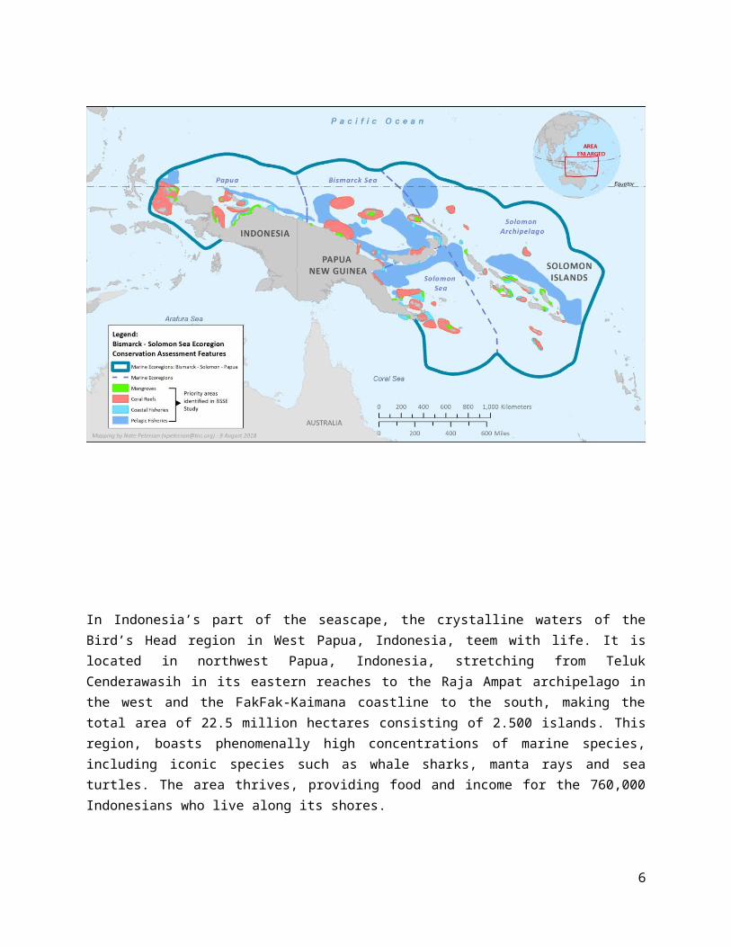
The BSSE is known as the “Western Indo-Pacific cradle of coral biodiversity”. Its seascape stretches from the Bird’ s Head (Doberai) Peninsula of West Papua (also known as Irian Jaya), across the Admiralty and Bismarck archipelagos of Papua New Guinea, to Makira Island of the Solomons (see Figure 1). The BSSE covers approximately 2 million km2 and is home to approximately 3 million people of which 80 percent rely on coastal resources for their livelihoods. The Bismarck Solomon Seas support a variety of ecosystems that include coastal lowland and swamp forests, mangroves, tidal estuaries, deltas, lagoons, coral reefs, atolls, fringing reefs, and barrier islands forming an ecological mosaic that has created a rich marine biodiversity and high degree of endemism. It is also home to numerous marine species, including the leatherback turtle, as well as hawksbill, green, olive ridley and loggerhead sea turtles, and Blainville's beaked whales, dugongs, giant clams and finless porpoises.
Figure 1. The region of Bismarck Solomon Seas Ecoregion
4
In Indonesia’s part of the seascape, the crystalline waters of the Bird’s Head region in West Papua, Indonesia, teem with life. It is located in northwest Papua, Indonesia, stretching from Teluk Cenderawasih in its eastern reaches to the Raja Ampat archipelago in the west and the FakFak-Kaimana coastline to the south, making the total area of 22.5 million hectares consisting of 2.500 islands. This region, boasts phenomenally high concentrations of marine species, including iconic species such as whale sharks, manta rays and sea turtles. The area thrives, providing food and income for the 760,000 Indonesians who live along its shores.
Papua New Guinea is home to coastal habitats encompassing 46,000 km2 of estuaries, bays, lagoons and coral reefs1 and as noted in Figure 1, globally outstanding marine biodiversity including pelagic fish, high densities of cetaceans and migratory species, turtle and seabird rookeries and hundreds of reef fish, mollusc and coral species. Marine assessments in 1997 and 2000 (Milne Bay) in the Solomon Sea component of the country have shown high levels of species richness and also endemism with 1284 currently known reef fish, 418 scleractinian corals and 463 species of mollusc2. This complements the Indian Ocean influenced marine association of Rajah Ampats in the far west with an increasingly more Pacific marine influenced association that also is linked to the eastern extent of the Solomon Islands. Papua New Guineas extensive continental shelf edge exhibits vast area of submarine canyons and sea mounds that though un-surveyed are anticipated to have high levels of biodiversity.
With over 900 islands, Solomon Islands covers more than two million square kilometers of ocean, making it one of the largest archipelagos in the world3. Nearly 500 species of coral were recorded during a 2004 Marine Assessment of the Solomon Islands, a richness of coral diversity second only to Raja Ampat in the Bird’s Head seascape. The survey also confirmed that the Solomon Islands possess one of the richest concentrations of reef fishes in the world. A total of 1019 fish species were recorded, of which 786 were observed during the survey and the rest were found from museum collections.
Criteria of the Designation of BSSE as Priority Seascape
In the document of Seascapes General Model and Regional Framework for Priority Seascapes, there are several criteria on the designation of CTI-CFF priority seascapes:1. Each Priority Seascape demonstrates high values that bind and give purpose to the
seascape. The specific high values of a Priority Seascape include at least three of the following:
1 Manoka, B. and Kolkolo, U. (2001). Fisheries Resource Development and Management in Papua New Guinea: Law, Biology and Economics. In Kwa, E.L. (ed), (2001). Natural Resources Law of Papua New Guinea. Lawbook Co. Sydney. 2 Allen, G. R., J. P. Kinch, S. A. McKenna, and P. Seeto. (Eds.). 2003. A Rapid Marine Biodiversity Assessment of Milne Bay Province, Papua New Guinea—Survey II (2000). RAP Bulletin of Biological Assessment 29. Conservation International, Washington, DC, USA.
3 Green, A., P. Lokani, W. Atu, P. Ramohia, P. Thomas and J. Almany (eds.) 2006. Solomon Islands Marine Assessment: Technical report of survey conducted May 13 to June 17, 2004. TNC Pacific Island Countries Report No. 1/06. 519pp
5
Ecological significance (Examples: EBSA, KBA, migratory routes, nesting sites for sea turtles, etc.)
Biological productivity Economic (Existing or potential) Cultural / heritage values Resilience
2. Demonstrates significant connectivity within and outside the Priority Seascape in at least three out of the following ways: Biological Socio-Cultural Institutional (local government networks, official or unofficial) Economic
3. There must be sustainable economic and/or other human activities overlapping with and adding pressure/potential threats on the high values. (This is the justification for triggering the creation of a Priority Seascape.)
4. The following key enabling factors are present: Political will Governance Stakeholder support, engagement Opportunity (This may include collaboration and partnership, financial support, etc.)
5. A political and/or institutional enabling coordinating/governance mechanism is present (newly initiated or existing) in order to move the process of creating a seascape forward. Examples of enabling coordinating/governance mechanisms: Bilateral formal cooperation, treaties, Memorandum of Understanding, international agreements, CTI-CFF, CTI-CFF Sub-group, project, etc.
6. Priority Seascapes should have and contribute to the regional and/or global benefit of the CTI. The regional and/or global benefit of a specific Priority Seascape can come from a wide variety of factors including: Ecological Factors Social and Cultural Factors Economic Factors Biological representation Regionally unique or significant phenomenon Geographic representation
7. Priority Seascapes have data and information available and accessible for decision making.
Aligning with the above criteria on Priority Seascapes, the following description reflects the information of the BSSE.1. Ecological, Biological, and Economic Significance of BSSE
The BSSE is defined by biogeographic, oceanographic, geophysical and climatic boundaries. It is one of the most geologically active and physically diverse marine environments on earth – a physical
6
setting that encourages evolution, accumulation and persistence of species. The BSSE is also one of the last tropical marine ecoregions that remains relatively unaffected by human activity.
Bound to the north and south by deep ocean trenches, the Bismarck-Solomon Seas contain numerous small islands. In close proximity to both the Great Barrier Reef and the highly diverse East Indian region, these waters potentially contain unique and complex species assemblages, including a number of endemic species. In addition to Hawksbill turtle (Eretmochelys imbricata) rookeries, also found here are Leatherback sea turtles (Dermochelys coriacea), Green sea turtles (Chelonia mydas), Olive ridley sea turtles (Lepidochelys olivacea), Loggerhead sea turtles (Caretta caretta), Blainville's beaked whales (Mesoplodon densirostris), Dugongs (Dugong dugon), Giant clams (Tridacnidae sp.), Giant tritons (Charonia tritonis), Wedge-tailed shearwaters (Puffinus pacificus), Black-naped terns (Sterna sumatrana), Lesser frigatebirds (Fregata ariel), and the Finless porpoise (Neophocaena phocaenoides). Fish families include butterfly fishes (Chaetodontidae), seabasses (Serranidae), pipefish (Sygnatidae), and sea horses (Hippocampus spp).
The BSSE is also a region of complex changes in sea depths, ranging from shallow sheltered reef flats to extremely deep channels that separate neighbouring islands. There are significant biodiversity features in this seascape, including: The longest island-protected lagoon in the world (Marovo Lagoon) The highest number of coral species ever recorded at one site (Raja Ampat Islands) The largest remaining leatherback turtle rookeries in the Indo-Pacific Region on the northern
coasts of West Papua, in and around the extremely ecological valuable Cendrawasih Bay Rare and unusual fish species such as the frogfish, pygmy seahorse, ghost pipefish, elegant
cuttlefish and merlots scorpion fish, in Papua New Guinea Major breeding and feeding grounds in Papua New Guinea for sharks such as hammerheads
and silvertips, dugongs, and turtle species such as the hawksbill, green and Olive Ridley which nest the whole year round
Migration paths for whales Tuna aggregation sites and migration paths Extraordinarily dense mangrove colonies in the Solomon Islands, accounting for 43% of the
world's mangrove species
The area encompassing New Guinea and the Solomon Islands contains eight of the Global 200 ecoregions (six terrestrial and two freshwater). PNG, together with the islands of the south west Pacific forms one of the richest clusters of terrestrial and marine biodiversity on earth. After the Amazon Basin and Central Africa, New Guinea and its Islands have the third largest remaining intact tropical forests on earth, while its marine environment, coral reefs, coastal ecosystems and habitats are the most diverse on the planet.
In Indonesia’s part of the region, the Bird’s Head Seascapes (BHS) covers a total area of 180,000 km2 and includes more than 2,500 islands and reefs (see Figure 2). The Seascape is home to over 1,200 species of coral reef fishes and nearly 600 species of scleractinian hard coral (approximately 75 percent of the world’s total)—the highest coral reef biodiversity recorded for an area of this size anywhere in the world. The BHS contains critical habitats for globally threatened marine species,
7
including the largest Pacific leatherback turtle nesting site in the world, green and hawksbill turtle nesting sites, and migratory populations of sperm and Bryde’s whales, orcas and numerous dolphin species. The Seascape also boasts healthy populations of dugongs, estuarine crocodiles, giant clams, and manta rays. It has large mangrove area, which is about 70 % of the total mangrove forest in Indonesia. The conducted surveys in the area uncovered 56 new species of fish, coral and mantis shrimp. Perhaps even more stunning for a Seascape of this relatively small size, up to 50 of the new species appear to be endemic to the Bird’s Head Seascape—found nowhere else in the world.
Figure 2. The region of Bird’s Head Seascape
2. Connectivity Significance of BSSE
Aligned with one of the criteria of priority seascapes, the BSSE demonstrates significant connectivity in the socio-cultural aspect. There are over 550 culture and language groups within the island and coastal communities of this Ecoregion (BSSE) and the lives, customs and knowledge of communities living here are linked inextricably with the ocean and island shores. At least 85% of communities within the BSSE live close to the sea and rely on the seas and coasts for their lifestyles and livelihood traditions and these institutions are a critical feature of this "seascape".
8

Many communities within the BSSE live close to the sea in dispersed village communities that depend on healthy marine life. The lifestyles and livelihood traditions of these people and their institutions are a critical feature of this ‘seascape’, as unique and valuable to future generations as the habitats and species that mark this place as an outstanding feature on the world’s map. In Papua New Guinea and the Solomon Islands, systems of customary tenure, recognized under institutional law, enable resource owners to control and utilize their resources. West Papua, however, follows a more centralized model of conservation and resource management and is currently grappling with issues of decentralization.
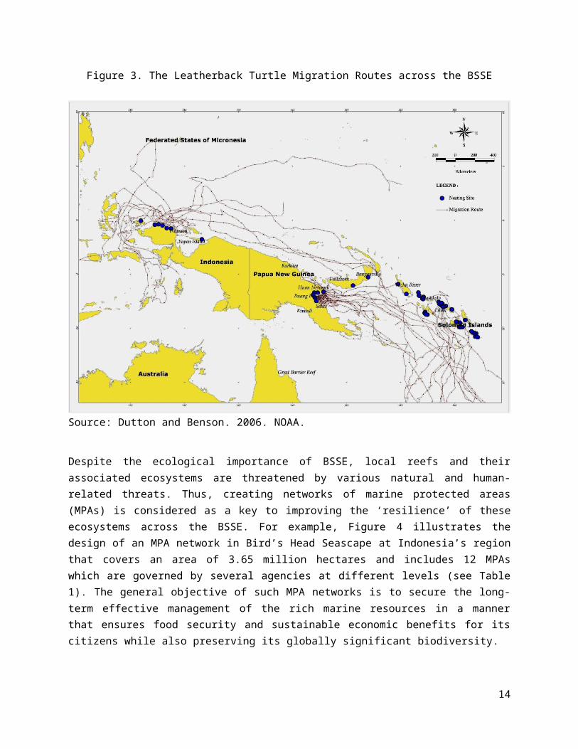
Further, in the context of connectivity, the waters north of Papua coastal areas notably in Sorong district is the greatest leatherback turtle habitat in the South Pacific. The leatherback turtles were found to have immigrated from Sorong waters through the Bismarck region in Solomon Islands to the United States.
Figure 3 illustrates the connectivity of the entire BSSE in relation to Leatherback Turtle Migration routes.
9
Figure 3. The Leatherback Turtle Migration Routes across the BSSE
Source: Dutton and Benson. 2006. NOAA.
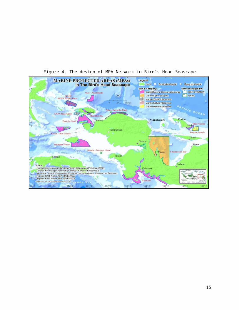
Despite the ecological importance of BSSE, local reefs and their associated ecosystems are threatened by various natural and human-related threats. Thus, creating networks of marine protected areas (MPAs) is considered as a key to improving the ‘resilience’ of these ecosystems across the BSSE. For example, Figure 4 illustrates the design of an MPA network in Bird’s Head Seascape at Indonesia’s region that covers an area of 3.65 million hectares and includes 12 MPAs which are governed by several agencies at different levels (see Table 1). The general objective of such MPA networks is to secure the long-term effective management of the rich marine resources in a manner that ensures food security and sustainable economic benefits for its citizens while also preserving its globally significant biodiversity.
10
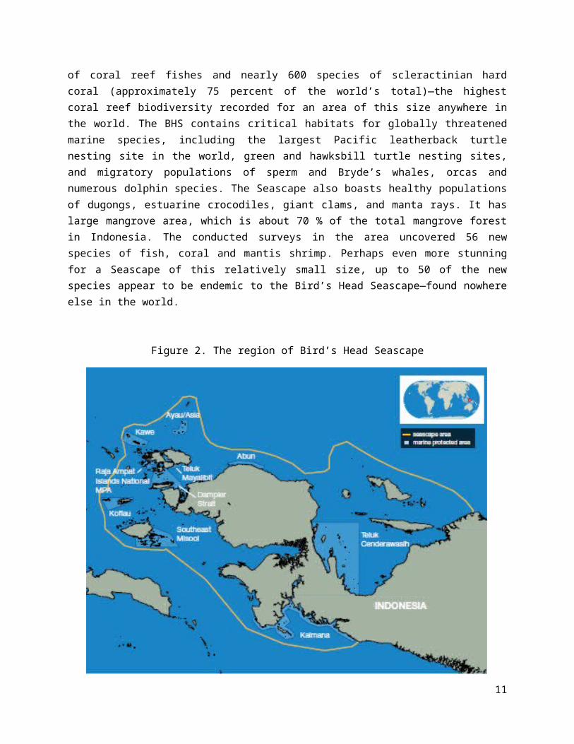
Figure 4. The design of MPA Network in Bird’s Head Seascape
11
Table 1. MPAs in Bird’s Head Seascape
Name of MPA District Management Body Legislation Area (Ha)Kaimana Kaimana Local Government of
KaimanaPerbup No. 4/ 2012 514.285
Pulau Venu Kaimana Ministry of Environment and Forestry
SK Menteri Kehutanan Nomor 783/Menhut-II/2014
14
Teluk Bintuni Teluk Bintuni
Ministry of Environment and Forestry
SK. Menteri Kehutanan Nomor 891/Kpts-II/1999
124.851
Sabuda Tuturuga
Fak-Fak Ministry of Environment and Forestry
SK. Menteri Kehutanan No. 82/Kpts-II/1993
5.000
Raja Ampat Raja Ampat Ministry of Marine Affairs and Fisheries
Kepmen KP No. 64/Men/2009 60.000
Waigeo Sebelah Barat
Raja Ampat Ministry of Marine Affairs and Fisheries
Kepmen KP No. 65/Men/2009 271.630
Raja Ampat Raja Ampat Local Government of Raja Ampat
Perbup No. 5/2009 1.125.940
Jeen Womom Tambraw Local Government of Tambraw
Kepmen KP No. 53/KEPMEN-KP/2017
32.250
Teluk Cendrawasih
Teluk Wondama & Nabire
Ministry of Environment and Forestry
SK Menteri Kehutanan No. 8009/Kpts-II/2002
1.453.500
Kepulauan Padaido
Biak Numfor
Ministry of Marine Affairs and Fisheries
Kepmen KP 68/Men/2009 183.000
12
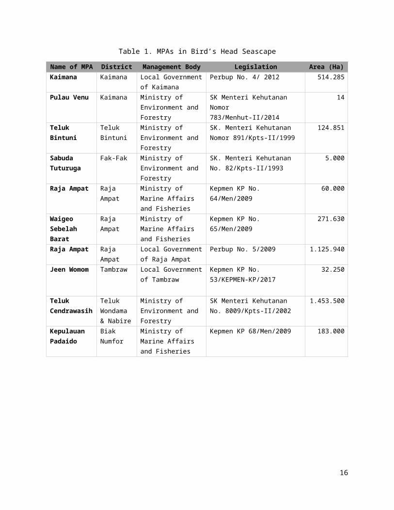
Papua New Guinea also has a number of Managed and Protected Areas, as illustrated in Figure 5 below.
Figure 5. Protected/Managed Areas of PNG
13
In May 2017, the Solomon Islands Government declared its first ever protected area, the Arnavon Community Marine Conservation Area.
Figure 6. Map of Arnavon Islands, Solomon Islands
3. Pressure and Threats
The Bismarck Solomon Seas are still in relatively pristine condition; however threats are increasing due to rapid population growth, expanding commercial interests and decision-making constrained by incomplete information. Events such as climate change and coral bleaching, cyclones and tidal waves have devastating impacts on the state of the region's biodiversity. These add to the effects of human activities, such as the irrevocable damage caused by destructive fishing practices (cyanide, dynamite, and traditional poisons), and inshore fisheries exploited both for commercial and subsistence use. The level of illegal, unregulated and unreported fishing is diminishing the stocks. These impacts are exacerbated by poorly planned coastal developments degrading the coast and inland waters, while ballast water discharges, oil and toxic spills contribute to pollution pressure from offshore.
Human consumption of marine turtles and their eggs, religious rites, handicraft and fish industry, as well as dwindling habitats have put a number of marine turtles such as leatherback and hawksbill turtles on the verge of extinction. Widespread logging activities and associated sedimentation, unregulated cutting of mangroves and clearing for coconut plantations, light industry residues and
14
sewage discharge, illegal dynamite fishing, hunting of crocodiles and turtles, increase in tourism activities and its associated impacts - all constitute major threats to the integrity of this ecoregion.
In the Pacific, nesting female hawksbill turtles have declined by more than 75% in the past century (IUCN Red List, 2008), with numbers still falling. Leatherback turtle populations have also dropped dramatically. In the 80s, there were about 90,000 females laying eggs every year, but now only 2,000. Scientists and conservationists are increasingly aware that marine turtle populations’ survival will largely depend on the decline of threats from direct harvesting and bycatch in the sea and stronger protections than just protecting their nesting habitats. Bycatch is a major threat to sea turtles as each year there are some 200,000 by-catch loggerheads. The leatherback turtles population declines is another serious issue in the western Pacific. In addition, productive fishing areas in which fishing activities are also increasing are found in northern Papua and PNG and around the South Pacific islands of Fiji and Solomon, which includes the BSSE region, overlap with migratory paths of leatherback turtle.
In Indonesia’s part of the region, the Bird’s Head Seascape’s rich coastal and marine resources make it extremely attractive to fisheries, marine tourism, oil and gas, mining, and forestry interests. Unfortunately, a combination of factors currently tends to favour poorly-controlled exploitation of natural resources at the expense of sustainable economic development and conservation. The Seascape is extensive, the islands and reefs are widely dispersed, and human population density is relatively low. Unregulated access to local resources, and recent policies supporting rapid exploitation of Papua’s natural resources and even transmigration of fishers from central and western Indonesia create other challenges to address.
4. Political Will, Governance, Stakeholders Collaboration and Opportunity
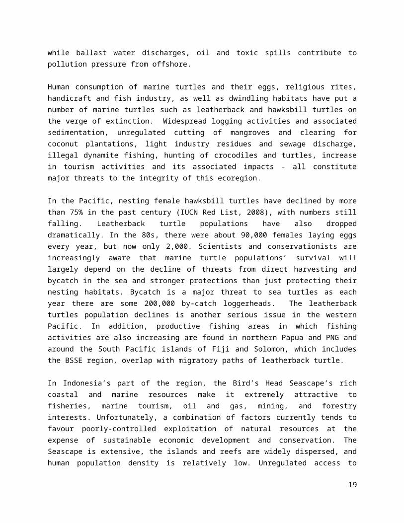
The CTI-CFF Seascapes General Model and Regional Framework for Priority Seascape has correctly identified stakeholders’ support and engagement as one of important key enabling factors that should exist in the area for a seascape to be designated as priority. Local communities, especially the customary communities which very much characterize the BSSE’s three-countries, are inevitably a crucial stakeholder as they are expected to have access to and sustainably use the natural assets accrued from coastal marine systems as part seascape. Therefore, customary community-based management leading to effective management of coastal community fisheries and local implementation of managed access and reserves (MPA in its loose form) is very important. There are some notable examples of where NGOs have worked with local communities to promote and incentivise behaviours that support the sustainable management of marine and coastal ecosystems in the BSSE. For example, RARE has worked with 11 villages of Maya tribe at Mayalibit Bay, Raja Ampat in the BHS, successfully generating and sustaining desired behaviours amongst customary communities . This has resulted in agreed and declared customary governance for compliance to MPA zoning (including customary fishery sub-zone), management plan, institutional framework, sustainable fishing regulation (gears, size seasonal closure, long-term closure or sasi
15
and limiting entry of fisher from other areas), and permit system on capping fishing efforts. (see Figure 7)4.
Figure 7. Customary Fishery Area of Mayalibit Bay, Raja Ampat MPA
Source: Maya Tribe Council, 2017
4 For more information see Management Plan and Technical Guideline of Customary Fishery Area in Mayalibit Bay, Maya Tribe Council, September 2017.
16
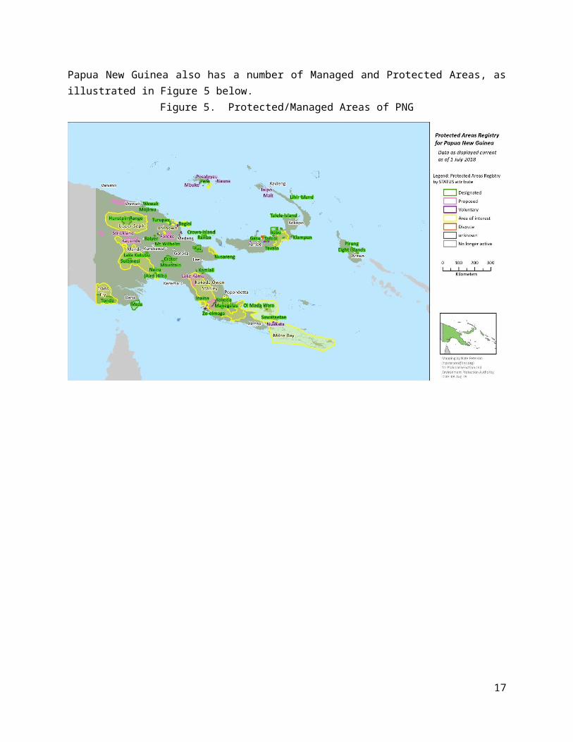
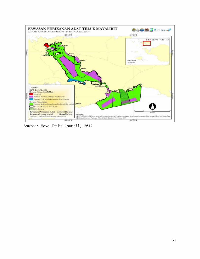
Figure 8. Spread of building on ‘gwala’ customary closure in the Western Louisidae archipelago fo Milne Bay Province
Figure 8 shows the spread of building on ‘gwala’ customary clsoure in the Western Louisidae archipelago fo Milne Bay Province. Community driven resource management in the Milne Bay Province, through customary ‘gwala’ closure, facilitated by Conservation International (CI) in partnership with Eco Custodian Advocates has spread across islands of approximately 2000 customary resource owners, that has lead to mainstreamed marine management on these islands under customary law. Communities’ experiential learning and management over generations has been enhanced by interactive learning in ecological understanding and youth trained in monitoring and evaluation of their resource’s health to inform communities in adaptive management needs. These youth then train their peers within other island communities, a very powerful approach that empowers all involved through a volunteer approach. Audio-visual materials that can be transferred on smart phones are becoming an integral part of spreading-the-reach of this approach to other islands, though interactions through customary trading networks are vital and how to best support this is currently being explored. The National Government is in the process of developing laws that can further reinforce custom through appropriate formalized agreements for Locally Managed Marine Areas. Current actions though has led to localized increases in marine stocks that support the subsistence livelihoods especially of the vulnerable such as children, widows through improved resource and availability from inshore fishing and gleaning. Significant species known to live in this marine ecosystem are, green and hawksbill turtles, giant clams, sea cucumber, bumphead
17
parrotfish, maori wrasse and trochus. The marine environment includes, fringing reef, ,reef blue holes, sand cays, islets, and coralline white-sand.
In 2008, the Lauru Land Conference of Tribal Communities (LLCTC) asked The Nature Conservancy (TNC) to assist Choiseul Province in Solomon Islands with conservation planning for the future. A 2009 participatory mapping workshop, involving community leaders from across the Province, identified threats to biodiversity (i.e. areas susceptible to climate change) and mapped areas of conservation opportunity, such as sites that were proposed (but not yet gazetted) as protected areas and sites already managed by communities for some natural resources (see Figure 8). This participatory process resulted in the establishment of the Lauru Ridges to Reefs Protected Area Network, the first locally managed marine area network in Melanesia5.
In another example of community based resource management in the Solomon Islands, in 2003, the Tetepare Descendants’ Association (TDA)6, representing approximately 4000 customary land owners, through a volunteer approach, declared a Marine Protected Area along 13 kms of Tetepare’s coastline, nowadays managed and enforced by TDA’s rangers who carry out important conservation programs for the area. Tetepare Island is the largest uninhabited tropical island in the Southern Hemisphere, located in the Western Province in the Solomon Islands, and is known as the ‘Last Wild Island’. At more than 27 km in length, 7 km wide with a mountain peak 350 m above sea level, and supporting exceptional biodiversity, the island has been recognized by the Solomon Islands government and many international organisations as of high conservation value. This raised coral island is home to several endemic and endangered species, and is of critical importance for subsistence of local people who are highly dependent on Tetepare’s marine resources for food as well as income. Some of the more significant species known to live in this marine ecosystem are leatherback, green and hawksbill turtles, dugongs, saltwater crocodiles, green snail, giant clams, sea cucumber, bumphead parrotfish, maori wrasse and trochus. Tetepare also supports highly biodiverse seagrass meadows, pristine coral reefs and extensive mangrove areas. The marine environment includes sheltered lagoons, wave-exposed fringing reef, soft-coral fields, black and white-sand beaches and limestone cliffs descending into rich coral walls. The TDA is now planning to register the entire island as a protected area.
Figure 9. Map of Choiseul, Solomon Islands, showing features identified by participants
5 For further detail, refer to Lipsett-Moore, G. et al (2010). Ridges to Reefs Conservation Plan for Choiseul Province, Solomon Islands. TNC Pacific Islands Countries Reports No.2/10. 53pp6 www.tetepare.org
18
in 2009 workshop, including conservation features, threats and opportunities
The Bird’s Head Seascape Initiative was launched in 2004 and is among the world’s most ambitious community-based conservation programs. Together with over 30 partners — including the people of West Papua, the 14 local governments, The Nature Conservancy, Conservation International, WWF, and academia (UNIPA), among others — the government of Indonesia created a network of 12 marine protected areas (MPAs) covering more than 3.6 million hectares (8.89 million acres). This MPA network aims to develop effective coastal and marine resource management that conserves biodiversity, sustains fisheries, and maintains marine tourism potential while generating sustained benefits for local communities and for the Seascape as a whole. To achieve this objective, the Initiative strongly believes a multiple-use network of ecologically connected and resilient marine protected areas is required. These must be supported by and embedded in local and national legislation, and co-managed by local communities and local government agencies. These MPAs employ local people to survey and protect coasts, reefs and fish, empowering communities to protect and sustainably manage their resources and their livelihoods. Since the initiative’s inception, fish populations have rebounded; sharks, whales and rays have returned; poaching by outside fishers is down 90%; coral is recovering; and ecotourism has flourished.
19
It is also important to note that the countries of the BSSE each have national policies and frameworks, to varying degrees, that support sustainable management of the area’s rich natural resources, such as the Papua New Guinea Policy on Protected Areas (2014)7.
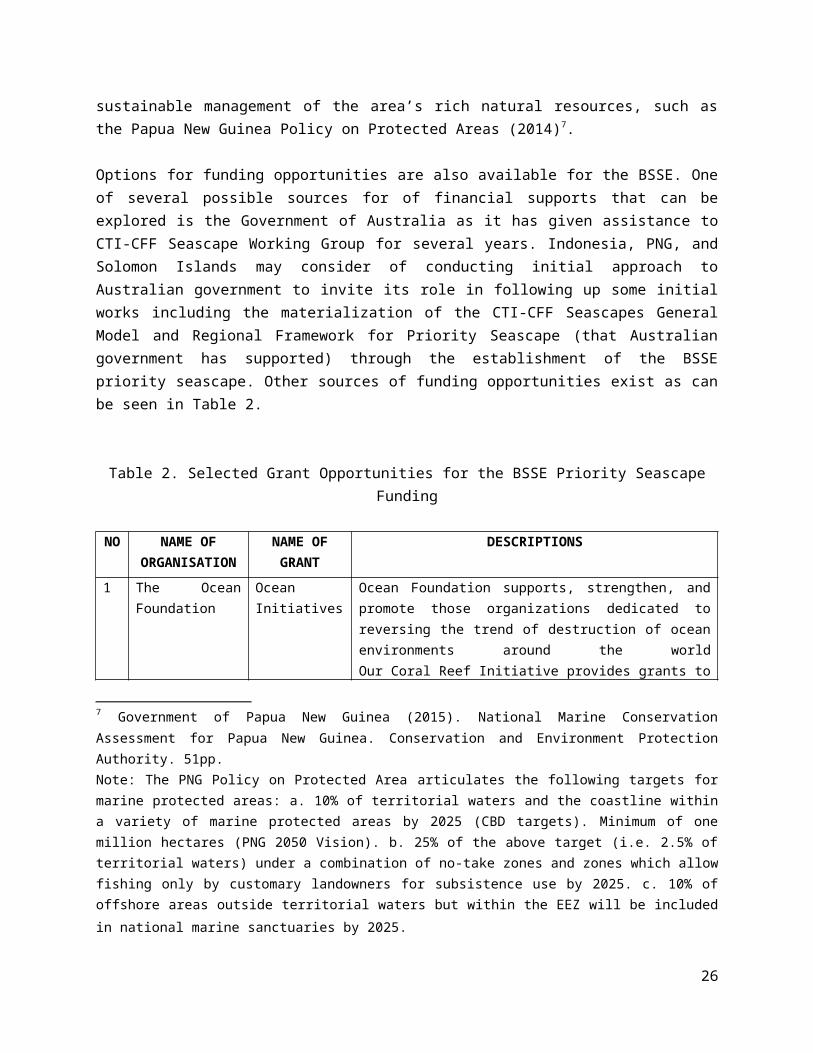
Options for funding opportunities are also available for the BSSE. One of several possible sources for of financial supports that can be explored is the Government of Australia as it has given assistance to CTI-CFF Seascape Working Group for several years. Indonesia, PNG, and Solomon Islands may consider of conducting initial approach to Australian government to invite its role in following up some initial works including the materialization of the CTI-CFF Seascapes General Model and Regional Framework for Priority Seascape (that Australian government has supported) through the establishment of the BSSE priority seascape. Other sources of funding opportunities exist as can be seen in Table 2.
Table 2. Selected Grant Opportunities for the BSSE Priority Seascape Funding
NO NAME OF ORGANISATION
NAME OF GRANT
DESCRIPTIONS
1 The Ocean Foundation
Ocean Initiatives
Ocean Foundation supports, strengthen, and promote those organizations dedicated to reversing the trend of destruction of ocean environments around the worldOur Coral Reef Initiative provides grants to projects that focus on better management of fisheries and tourism development, development of sustainable coral reef products, establishment of marine reserves, and scientific research that can lead to new breakthroughs in medicine and biotechnology.
2 Leonardo D'Caprio Foundation
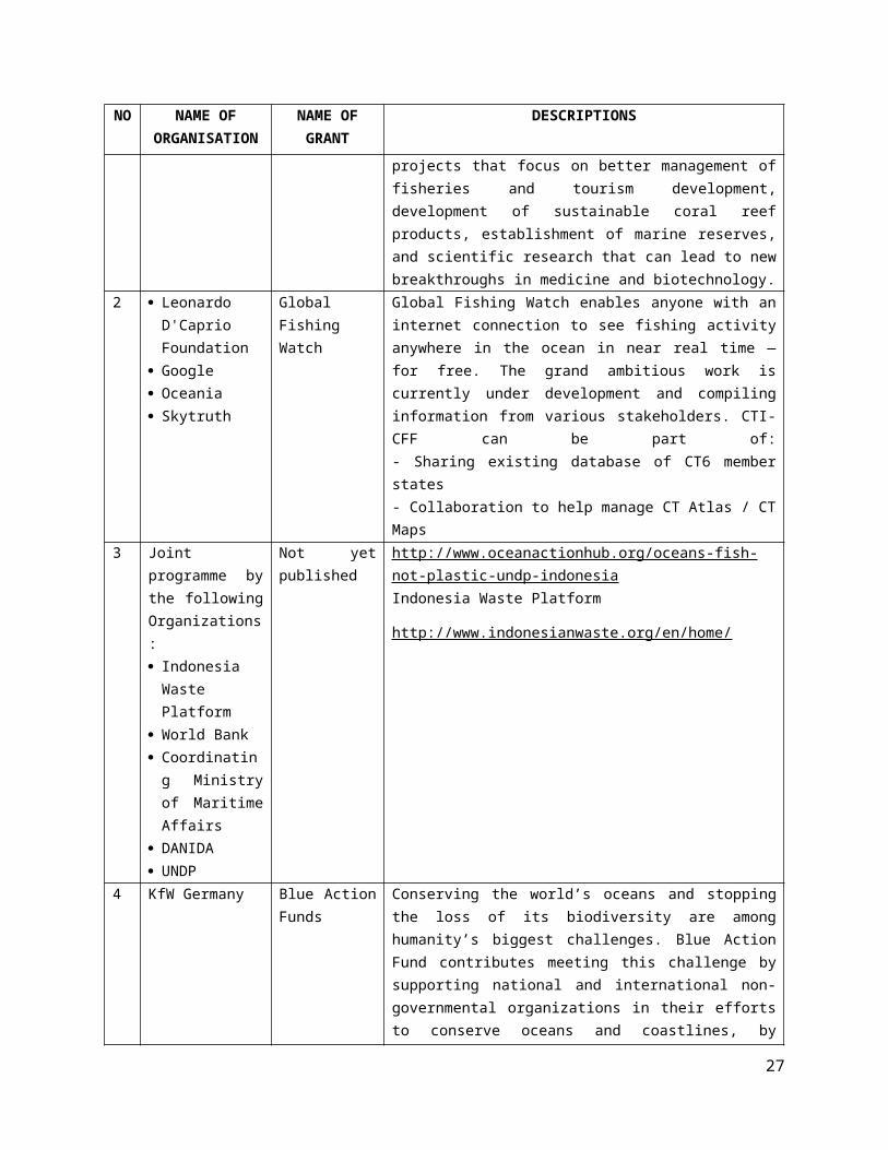
Google Oceania Skytruth
Global Fishing Watch
Global Fishing Watch enables anyone with an internet connection to see fishing activity anywhere in the ocean in near real time — for free. The grand ambitious work is currently under development and compiling information from various stakeholders. CTI-CFF can be part of:- Sharing existing database of CT6 member states- Collaboration to help manage CT Atlas / CT Maps
7 Government of Papua New Guinea (2015). National Marine Conservation Assessment for Papua New Guinea. Conservation and Environment Protection Authority. 51pp. Note: The PNG Policy on Protected Area articulates the following targets for marine protected areas: a. 10% of territorial waters and the coastline within a variety of marine protected areas by 2025 (CBD targets). Minimum of one million hectares (PNG 2050 Vision). b. 25% of the above target (i.e. 2.5% of territorial waters) under a combination of no-take zones and zones which allow fishing only by customary landowners for subsistence use by 2025. c. 10% of offshore areas outside territorial waters but within the EEZ will be included in national marine sanctuaries by 2025.
20
NO NAME OF ORGANISATION
NAME OF GRANT
DESCRIPTIONS
3 Joint programme by the following Organizations: Indonesia
Waste Platform World Bank Coordinating
Ministry of Maritime Affairs
DANIDA UNDP
Not yet published
http://www.oceanactionhub.org/oceans-fish-not-plastic-undp-indonesiaIndonesia Waste Platform
http://www.indonesianwaste.org/en/home/
4 KfW Germany Blue Action Funds
Conserving the world’s oceans and stopping the loss of its biodiversity are among humanity’s biggest challenges. Blue Action Fund contributes meeting this challenge by supporting national and international non-governmental organizations in their efforts to conserve oceans and coastlines, by promoting: The safeguarding of marine biodiversity: creating new
protected areas and improving the management of existing ones.
The sustainable use of marine biodiversity: in fisheries, aquaculture and tourism
5 KfW Germany Trust Fund or Endowment Fund
KFW is a German Development Bank that provides support for development related programmes and for some cases - Trust Fund - for environment / conservation work
6 Athelia Ecosphere Sustainable Ocean Fund
Althelia announces it is to launch a Sustainable Ocean Fund designed to scale sustainable fisheries, build value in the seafood supply chain and finance marine and coastal conservation. In Sustainable Ocean Fund, Athelia Ecosphere is in partnership with CI and EDF (Environmental Defence Funds). Conservation International and EDF are partners to the SOF providing technical expertise and project oversight.
7 SIDA(Swedish International Development Cooperation Agency)
Mangroves for the Future Project
Indonesia and East Asian countries are eligible to apply. SIDA has Asia office in Bangkok and maybe interested to support the gender mainstreaming capacity building aspect.
8 World Oceans Council (WOC)
Corporate Ocean Responsibility
The World Ocean Council is fostering the development of regional ocean business councils to engage Members’ input to regional policy processes, science efforts, and the development of solutions to operational and technical issues at the regional level. Engaging the Ocean Business Community is paramount for the success of these initiatives and to ensure
21
NO NAME OF ORGANISATION
NAME OF GRANT
DESCRIPTIONS
responsible, well-managed economic activities are part of the future of the regional seas. Areas of high priority continue to emerge, such as the Coral Triangle in South East Asia, which the WOC actively monitors and reports on to its Members and the Ocean Business Community.
9 JICA No information on regional program
JICA support development work to developing countries. JICA provides G to G assistance. Grants provided for CTI-CFF Pacific Member Countries in terms of education and capacity building (but on general sustainable livelihood and resilience issues)
Source: Project Initiation Specialist Deliverables for CTI-CFF Financial Resources Working Group Report in CTI-CFF Pre SOM Meeting, Manila, 27 November 2017 (adapted)
22

5. Regional Coordinating/Governance Mechanism of BSSE
Indonesia, Papua New Guinea (PNG) and Solomon Islands have signed a Memorandum of Understanding (MoU) on conservation and management of western Pacific leatherback turtle nesting sites, feeding areas and migratory routes in the three states. The three countries reached the agreement in a workshop of the 3rd Meeting of Tri-National Partnership to the Conservation and Management of Leatherback Turtles held in Bali on August 28-30, 2006. The tri-national partnership will allow the three countries to enhance conservation of leatherback turtles in the areas through information sharing, data exchange and cooperative research. However, this agreement was not followed up into further development and implementation.
The Coral Triangle Initiative (CTI) Plan of Actions is the manifestation of the bold and ambitious commitments made by the six CT countries in Manado in May 2009 to transform sustainable management of marine resources in the Coral Triangle (CT) region. This Plan of Actions encompasses six overarching goals, including a goal of designation and effective management of ‘priority seascapes’. The 13th CTI-CFF Senior Officials Meeting (SOM) held in Manila on 29-30 November 2017 had endorsed the decision to nominate BSSE as a priority seascape.
Several steps need to be conducted to meet the procedures for trans-boundary Priority Seascapes designation, as suggested in the document of Seascapes General Model and Regional Framework for Priority Seascapes. Following the SOM13 decision, a future coordinating mechanism needs to be established, such as bilateral formal cooperation and treaties. To initiate this process, Indonesia hosted a meeting on the Establishment of the BSSE as a Priority Seascape in Jakarta on 20 April 2018. Preceding this meeting, Indonesia visited the Embassy of Solomon Islands in Jakarta (and plan to visit the Embassy of Papua New Guinea) to conduct initial discussion and exchange of ideas on the BSSE. These efforts are expected to be starting activities in producing a form of coordinating and governance mechanism in the development of BSSE priority seascape.
Aside from the above mentioned trilateral cooperation instrument, Indonesia, Papua New Guinea, and Solomon Islands could formally request the CTI-CFF Regional Secretariat to give support to the BSSE priority seascape planning and implementation. At SOM-13 in Manila on October 2017, numerous cooperation activities involving travel, MOU signing, discussion and exchange activities have been reported by Regional Secretariat to CTI-CFF Committee of Senior Officials. However, a much larger scope and context for cooperation with other stakeholders are very much open to be explored as source for coordinating mechanism and project implementation under the framework of the BSSE priority seascape. Table 3 shows the many options of CTI-CFF cooperation with many organizations that the BSSE can take advantage of.
23
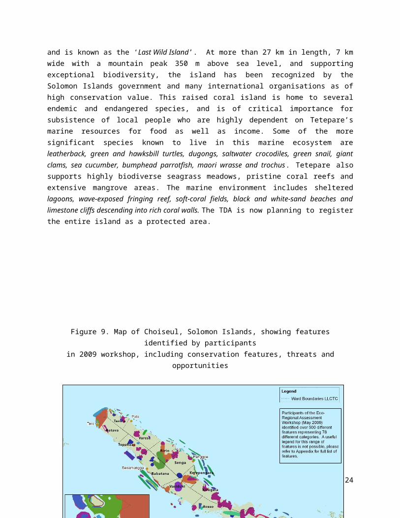
Table 3. List CTI-CFF Regional Secretariat’s of Cooperation Partners in Up to 2017 forOptimization of the BSSE Priority Seascape Coordination Mechanism
No
CTI-CFF Regional Secretariat Cooperation Partners
Place and Date of Cooperation Instrument Signing or Event
Field of Cooperation
1 Southeast Asian Fisheries Development Center (SEAFDEC)
Bangkok, Thailand 23-25 August 2017
Sustainability and replication of fisheries management initiatives.
2 Secretariat of the Pacific Regional Environment Programme (SPREP)
22 September 2015 Human resource development, research and development, consultancy and information management
4 Deutsche Gesellschaft tur Internationale Zusammenarbeit GmbH (GIZ)
Quezon City, Philippines, 12-13 January 2017
Learning from Sulu-Sulawesi priority seascape.
5 Padjadjaran University (UNPAD), Indonesia
Bandung, August 18, 2017 Marine environment, sustainable fisheries, and food security
6 Universiti Malaysia Terengganu (UMT), Malaysia
Terengganu, 11-13 September 2017
Artificial reef and related aquatic habitats
7 The University of Papua New Guinea (UPNG), Papua New Guinea
Manado, 8 August 2017 The framework of University Partnership
8 Solomon Islands of University (SINU), Solomon Islands
No Information Marine and coastal resource management including seascape management.
9 Universidade Nacional Timor Lorosa’e (UNTL) Timor-Leste
Dili, 5-7 December 2016
Manado, 8 August 2017
Coastal community developmentSustainable management of marine and coastal resources
10 Univercidade Oriental de Timor-Leste (UNITAL) Timor-Leste
13 March 2017 Research, capacity building, marine and coastal sustainable management
11 James Cook University (JCU), Australia
Canberra, 6-11 November 2017 Nature research management, marine debris
12 University of Queensland (UQ), Australia
Queensland, 16 September 2016 and Jakarta, 14 November 2016
Research and innovation
13 Universiti Malaysia Sabah Borneo Marine Research (UMS), Malaysia
Manado, 7-8 August 2017 Capacity building
14 University of the Philippines Diliman (UPD), Philippines.
Manado, around 28 February-1 March 2017
Capacity building, research and outreach
15 University of Maryland School Manado, 10 January 2017 Reef and fishery management
24

No
CTI-CFF Regional Secretariat Cooperation Partners
Place and Date of Cooperation Instrument Signing or Event
Field of Cooperation
of Public Policy and conservation16 Australian Consortium for ‘In-
Country’ Indonesian Studies (ACICIS)
Jakarta, 11 January 2017 Learning, living and studying experiences in Indonesia
17 Program for the Environmental Management of the Seas of East Asia (PEMSEA)
Manila, 20 January 2017 Cooperation
Source: Decision Document on CTI-CFF Regional Secretariat’s Cooperation Arrangement at the 13th CTI-CFF SENIOR OFFICIALS’ MEETING (SOM-13), 29 – 30 November 2017, Manila, Philippines and 2017 Activities Report of CTI-CFF Regional Secretariat, Manado, November 2017, both adapted.
6. Global/Regional Benefits of BSSE
Priority Seascapes should have and contribute to the regional and/or global benefit of the CTI. BSSE provides ecological and biological benefits, especially as it becomes the centre of biodiversity and endemism.
The global significance and value of the biodiversity of the BSSE is undisputed. Over recent years, areas within the BSSE have been identified as being unique and amongst the world's most rich marine environments, ranking it as a global priority for marine conservation.
The BSSE is defined by biogeographic, oceanographic, geophysical and climatic boundaries. It is one of the most geologically active and physically diverse marine environments on earth - a physical setting that encourages evolution, accumulation and persistence of species. The ecological value of these areas of sea vents and stacks is yet to be realised. The uniqueness of known biodiversity within the BSSE is exemplified an extraordinary diversity of reefs, seagrass, mangroves, deep sea and pelagic habitats. In addition, Bismarck Solomon Seas Ecoregion has been recognized for the following features:1) Global diversity centres of reef-building corals and reef fish2) The largest and most critical remaining Pacific leatherback turtle nesting sites3) The historic centre of sperm whale abundance in the tropics4) The major biogeographic transition zone between the Indonesian, Philippine, Micronesian,
Coral Sea and central Pacific regions.
7. Available Data and Information
BSSE can take advantage and be part of revitalization efforts of Coral Triangle Atlas (CT Atlas). CT Atlas provides a unique opportunity for any organization working in the Coral Triangle to share their data, and to create a growing, updated database for better management decisions and science including geographies of the BSSE. It showcases maps that highlight the diversity and uniqueness of the Coral Triangle region including the BSSE and the pressing issues that are threatening this very important resource. It is an online Geographical Information System (GIS) database providing scientists, governments and NGOs with a view of spatial data at the regional scale. The efforts in designating and formalizing BSSE as a priority seascape will be supported very much by the access
25
to biophysical and socioeconomic information in spatially explicit provided by CT Atlas. At the same time, the process of data sharing will be able to complete the gaps reducing duplicate data collection, providing the most complete and most current data available and improving information flow and access to the BSSE priority's best datasets.
CTI-CFF also has an established mechanism for restoring and accessing data including ones related with the BSSE. The CTI-CFF Monitoring and Evaluation System (M&E System) Operation Manual has been developed as a framework guide for the Regional Secretariat, the Technical Working Groups (TWGs) including Seascape Working Group in which the BSSE is currently discussed and prepared to be a priority seascape, the National Coordinating Committees (NCCs) and the implementing partners to stick with indicators for each of the five RPOA goals as well as the three higher level outcomes, to work in a flow in collecting, analyzing and reporting indicators against progress and to be adaptive in managing each TWG’s activities. The relevant data collection and transfer on the BSSE resulting from CT M&E System, if it works properly, should be able to inform and be solid analytic basis in planning and justifying the BSSE as a priority seascape and other necessary decision-making form the field to the top.
A range of data and information on BSSE in Indonesia’s region is available, including the aspects of ecological, biophysical, socio-economic, among others. These data are mostly generated for the needs of marine conservation, marine spatial planning, species protection, which are provided by central government, local government, and some non-profit organisations like World Wide Fund for Nature, Conservation International, and The Nature Conservancy. Within Papua New Guinea there is similarly quite extensive information which tends to be localised. These data are not yet fully collated and centralised by national government authorities, but are held by organisations, mainly NGOs who have compiled them.
Conclusion and Recommendations
Through the establishment of BSSE as a priority Seascape, the CTI-CFF can build a consistent regional framework for sustainable management and a platform for future investment in the area. The priority seascape can also serve as a main umbrella vehicle integrating other CTI-CFF five thematic RPOA goals’ activities. Functionally, the priority seascape will be able to provide a platform to coordinate various policies, laws, and regulations within the marine space such as navigation, fishing, mining, traditional and cultural uses and co-management approaches. Collaboration between the Government of Indonesia, Government of Papua New Guinea, and Government of Solomon Islands through the nomination of BSSE as priority seascape hopefully will facilitate an integrative approach among the three countries to reach effective management of marine resources in the region. Only with effective management, ecological functions of the system can be maintained and bring economic benefits to the community.
This document is a step to trigger further data and information sharing among the three countries, especially from Papua New Guinea and Solomon Islands that can complement the existing BSSE working proposal preparation led by Indonesia. Having data and information from Papua New
26
Guinea and Solomon Islands in the document will enrich the substantive scientific basis and strengthen the justification for the seascape nomination. Based on solid and convincing proposal that fulfils all necessary requirements and guidelines provided in the CTI-CFF Seascape General Model and Regional Framework for Priority Seascapes, the three neighbouring countries are expected to continue working together closely in the process of following the nomination procedure and steps. All of these will hopefully result in CTI-CFF Council of Minister’s acceptance of the BSSE priority seascape on November 2018 in its Ministerial Meeting in Manila.
27