Embed Size (px)
Citation preview

www.kent.gov.uk
Kent County Council
Drainage and Planning
Policy Statement
Local flood risk management strategy guidance
June 2017

June 2017 v.2 i
Drainage and Planning Policy Statement
1 Role of this Policy Statement 1
2 Introduction 2
2.1 Background 2
2.2 Legislative Framework 3
2.3 Sustainable Drainage in Planning 3
2.4 Drainage Strategies 4
2.5 Strategic Consultation 4
3 Planning policy and guidance for drainage 5
3.1 NPPF 5
3.2 Non-statutory technical standards for sustainable drainage 6
3.3 Local Authority Guidance 6
3.3.1 Local Plans and Neighbourhood Plans 6
3.3.2 Strategic Flood Risk Assessments (SFRA) 7
3.4 Kent County Council Guidance 7
3.4.1 Water. People. Places a guide for masterplanning sustainable drainage
into developments 7
3.4.2 Kent Design Guide: Making It Happen Sustainability (drainage systems)
7
3.4.3 Surface Water Management Plans 8
3.5 Other Guidance & Tools 8
3.5.1 CIRIA SuDS Manual (C753), 2015 8
3.5.2 BS 8582:2013 Code of practice for surface water management for
development sites 8
3.5.3 UK Sustainable Drainage Guidance 8
3.5.4 Long Term Flood Risk Information 9
3.6 Environmental Drivers 9
3.6.1 Water Framework Directive 10
3.6.2 Habitats Directive 10
3.6.3 Kent Environment Strategy 11
4 Drainage Consultation 12
4.1 Introduction 12
4.2 Other local flood risks 13
4.2.1 Critical Drainage Areas and Areas of High Local Flood Risk 13
4.2.2 Ordinary Watercourses 13
4.3 Consultation Process 15
4.3.1 Overview 15
4.3.2 Pre-application Advice 15

June 2017 v.2 ii
Drainage and Planning Policy Statement
4.3.3 Planning application submission 17
4.4 Drainage Strategy Development 17
4.4.1 Design Philosophy 17
4.4.2 Detailed Information 18
4.4.3 Large sites 19
4.4.4 Connection to a public sewer or other drainage system 20
4.4.5 Adoptable highways and drainage 20
4.4.6 Flood Risk and Groundwater 21
4.4.7 Adoption and Maintenance 21
4.4.8 Building Regulations 22
4.5 Consultation Submission Requirements 22
5 Policies for Sustainable Drainage 23
5.1 Introduction 23
5.2 Drainage policies 24
SuDS Policy 1: Follow the drainage hierarchy 24
SuDS Policy 2: Manage Flood Risk Through Design 25
SuDS Policy 3: Mimic Natural Flows and Drainage Flow Paths 27
SuDS Policy 4: Seek to Reduce Existing Flood Risk 29
SuDS Policy 5: Drainage Sustainability and Resilience 30
SuDS Policy 6: Design to be Maintainable 32
5.3 Environmental Policies 33
SuDS Policy 7: Safeguard Water Quality 33
SuDS Policy 8: Design for Amenity and Multi-Functionality 35
SuDS Policy 9: Enhance Biodiversity 36
SuDS Policy 10: Link to Wider Landscape Objectives 37
Glossary 38
Appendix A. National Planning Policy Framework (Extract) 40
Appendix B. Non-Statutory Technical Standards for Sustainable Drainage 41
Appendix C. Pre-application Advice Request Form 42
Appendix D. Drainage Strategy Summary Form 47
Date Revisions details Oct 2016 Clarification on technical matters; submission summary form.; pre-
application advice; post-construction verification reports; standard advice.
June 2017 Further clarification of technical matters and amendments to general wording including revised M5-60, 50% reduction for brownfield sites, runoff control per soil type, discharge to highway systems, off-site drainage improvements and developer contributions.

June 2017 v.2 1
Drainage and Planning Policy Statement
1 Role of this Policy Statement
This policy statement sets out how Kent County Council, as Lead Local Flood Authority and
statutory consultee, will review drainage strategies and surface water management
provisions associated with applications for major development. It is consistent with the
Non-Statutory Technical Standards for Sustainable Drainage (as published by Defra in
March 2015), and sets out the policy requirements Kent County Council has for sustainable
drainage. It should be read in conjunction with any other policies that promote sustainable
drainage, specifically:
the National Planning Policy Framework and,
any specific policy set out by the relevant Local Planning Authority in their Local
Plan.
The aim of this policy document is to clarify and reinforce their requirements. It also
includes references to other design considerations which impact sustainable drainage
design and delivery.
This policy statement should be used by:
Developers when considering their approach to the development of new sites or
redevelopment of brownfield sites,
Developers or their consultants when preparing submissions to support a planning
application for major development,
Professionals involved in developing drainage schemes including engineering and
urban and landscape professionals,
Development management officers when considering development applications,
Local Authorities when developing local planning and land-use policy.

June 2017 v.2 2
Drainage and Planning Policy Statement
2 Introduction
2.1 Background
Kent County Council was made Lead Local Flood Authority for Kent by the Flood and Water
Management Act 2010 (the Act). As Lead Local Flood Authority, Kent County Council has a
strategic overview of Local flooding is defined by the Act as flooding which
is caused by:
Surface water,
Groundwater, and
Ordinary Watercourses
The management of surface water within new development is a key factor in managing
local flooding.
At the time of its enactment, the Act did not provide a formal role within the planning
process for Lead Local Flood Authorities to influence how surface water was managed
within new development. However, it was always the G for Lead Local
Flood Authorities to have a role in the delivery of appropriate surface water management
provisions within new development by promoting and encouraging an increase in the
uptake of Sustainable Drainage Systems (SuDS), as recommended by the Pitt Review into
the Summer 2007 floods.1
Since commencement of the Act in 2010, the Government has assessed various means of
implementing the requirement for sustainable drainage systems. Following a consultation
period, the Department for Communities and Local Government issued a Ministerial
Statement on 18 December 2014 which outlined the intention to strengthen planning
policy and clarified for the provision of sustainable drainage
systems in new developments through the planning process. Subsequent changes have
been made to planning regulation to deliver this requirement.
Lead Local Flood Authorities have now been acting as statutory consultees within the
planning process since April 2015. Our understanding of local drainage and local flood risk
presents a strong platform from which to provide advice and guidance to Local Planning
Authorities on the management of surface water. In undertaking this role Kent County
and the Ebbsfleet Development Corporation. Where appropriate we will also liaise with
other relevant flood risk management authorities, such as the Environment Agency,
1 Schedule 3 of the Act established each LLFA as a Sustainable Drainage Approving Body. This section of the Act has not been commenced; therefore the requirements for adoption are not in place and are not mandatory.
June 2017 v.2 3
Drainage and Planning Policy Statement
2.2 Legislative Framework
As Lead Local Flood Authority within Kent, Kent County Council is required under Article 18
of the Town and Country Planning (Development Management Procedure) (England) Order
2015 ( the Development Management Procedure Order ) to provide consultation response
on the surface water drainage provisions associated with major development.
Major development is defined within the Development Management Procedure Order as
development that involves any one or more of the following:
(a) the winning and working of minerals or the use of land for mineral-working
deposits;
(b) waste development;
(c) the provision of dwelling houses where:
(i) the number of dwelling houses to be provided is 10 or more; or
(ii) the development is to be carried out on a site having an area of 0.5 hectares or
more and it is not known whether the development falls within sub-paragraph
(c)(i);
(d) the provision of a building or buildings where the floor space to be created by the
development is 1,000 square metres or more; or
(e) development carried out on a site having an area of 1 hectare or more.
As a statutory consultee, Kent County Council must provide a substantive response within
21 days of consultation (Article 22 of the Development Management Procedure Order). A
substantive response is one which:
(a) states that the consultee has no comment to make;
(b) states that, on the basis of the information available, the consultee is content with
the development proposed;
(c) refers the consultor to current standing advice by the consultee on the subject of the
consultation; or
(d) provides advice to the consultor.
The Planning and Compulsory Purchase Act 2004 describes the duty to respond as a
consultee, including the duty to report to the Secretary of State on compliance with the
provision of substantive responses.
2.3 Sustainable Drainage in Planning
Sustainable drainage systems are designed to control surface water as close to its source as
possible. Wherever possible they should also aim to closely mimic the natural, pre-
development drainage across a site. Well-designed sustainable drainage systems also
provide opportunities to:
reduce the causes and impacts of flooding,
remove pollutants from urban run-off at source,

June 2017 v.2 4
Drainage and Planning Policy Statement
combine water management with green space with benefits for amenity, recreation
and wildlife.
The purpose of the planning system is to contribute to the achievement of sustainable
development and deliver the requirements of the National Planning Policy Framework
(NPPF). The use of sustainable drainage systems helps to achieve the sustainability
objectives of the NPPF.
2.4 Drainage Strategies
Development has the potential to change surface water and ground water flows,
depending upon how the surface water is managed within the development proposed.
Planning applications for major development should therefore be accompanied by a site-
specific drainage strategy that demonstrates that the drainage scheme proposed is in
, as outlined within this
document.
The drainage strategy must also demonstrate that the proposed surface water management
proposal is consistent and integrated with any other appropriate planning policy and flood
risk management measures that are required.
2.5 Strategic Consultation
As Lead Local Flood Authority, Kent County Council has a consultation role in relation to the
preparation of local plans, neighbourhood plans, strategic flood risk assessments and other
planning instruments produced by Local Planning Authorities2.
Kent County Council will provide advice and guidance on local flood risks and appropriate
policy for any area upon request.
Kent County Council will also provide information to individuals and other organisations
with respect to drainage and local flood risk for use in the preparation of other relevant
planning documents upon request
2 National Planning Policy Guidance, Flood Risk and Coastal Change, paragraph 2.

June 2017 v.2 5
Drainage and Planning Policy Statement
3 Planning policy and guidance for drainage
This section sets out the sources of planning policy relevant to the management of surface
water. These policies any
submitted drainage strategy. The drainage strategy will need to demonstrate how the
development meets these requirements.
3.1 NPPF
The National Planning Policy Framework (NPPF) was published on 27 March 2012; it sets out
the Government planning policies for England and outlines how these are expected to be
applied. Planning law requires that applications for planning permission must be
determined in accordance with the relevant Local Planning development plan,
following public consultation and with due regard for other material considerations.
The NPPF is a material consideration in the determination of planning applications. At the
heart of the NPPF is a presumption in favour of sustainable development, excepting where
adverse impacts significantly outweigh the benefits (or where specific policies indicate that
development should be restricted). Flooding and drainage may also be considered material
considerations in the determination of planning applications as their management
contributes to sustainable development.
In summary, the NPPF states that planning authorities should:
direct development away from areas at highest flood risk;
take the predicted impacts of climate change into account;
use opportunities offered by new development to reduce the causes and impacts of
flooding;
ensure flood risk is not increased elsewhere;
give priority to the use of sustainable drainage systems;
enhance the natural and local environment; and,
prevent contributing to water pollution.
Paragraphs 100, 103 and 109 of the NPPF (Appendix A) have particular relevance to flooding
and drainage.
The NPPF is supported by the Planning Practice Guidance3 which provides further advice
on how planning can take account of the risks associated with flooding in plan-making and
the application process.
3 The Planning Practice Guidance is a web-based resources which can be accessed from the Planning Portal at: http://planningguidance.planningportal.gov.uk/?s=Drainage&post_type=guidance

June 2017 v.2 6
Drainage and Planning Policy Statement
3.2 Non-statutory technical standards for sustainable drainage
To support the Lead Local Flood consultee role, Defra published the
Non-Statutory Technical Standards for Sustainable Drainage Systems on 23 March
2015. These standards provide advice and guidance for the design, maintenance and
operation of sustainable drainage systems.4
Further guidance on the application of the Non-Statutory Technical Standards will be
provided by Defra and associated stakeholders.
A summary of the requirements of these non-statutory standards in provided in Appendix B.
The policies in this policy statement are consistent with the Non-Statutory Technical
Standards.
3.3 Local Authority Guidance
Local Planning Authorities are ultimately responsible for determining planning applications
and have numerous planning and policy documents to support the delivery of sustainable
development within their districts.
3.3.1 Local Plans and Neighbourhood Plans
National planning policy places Local Plans at the heart of the planning system. Local Plans
set out a vision and a framework for future development of the area. Local Plans should be
based upon and reflect the presumption in favour of sustainable development. They
should also address housing provision, the economy, community infrastructure and
environmental issues such as adapting to climate change and ensuring high quality design.
The management of flood risk and surface water can be dealt with through policies for
sustainable construction, flood risk, open space, landscape character and green
infrastructure. These policies may be supported by further Supplementary Planning
Documents or guidance notes.
Neighbourhood planning is a right for communities introduced through the Localism Act
2011. Communities can shape development in their areas through the production of
Neighbourhood Development Plans. These plans become part of the Local Plan and the
policies contained within them are then used in the determination of planning applications.
Any drainage strategy should make reference to relevant Local Plan and Neighbourhood
Plan policies; it may also have to provide evidence which supports delivery of biodiversity,
amenity and other benefits.
4 The Non-statutory Technical Standards are published at:
https://www.gov.uk/government/publications/sustainable-drainage-systems-non-statutory-technical-
standards

June 2017 v.2 7
Drainage and Planning Policy Statement
3.3.2 Strategic Flood Risk Assessments (SFRA)
Strategic Flood Risk Assessments are required to inform the development of Local Plans, as
stated within the NPPF. A SFRA assesses the risk to an area from flooding from all sources,
taking into account the effects of predicted climate change. They should also assess the
impact that land use changes and development will have on flood risk within the district in
question. Each Local Planning Authority in Kent has prepared and referenced a SFRA within
their planning documents. These documents provide key information on the potential
sources and magnitude of flooding and may provide information for specific site
allocations.
3.4 Kent County Council Guidance
The Local Flood Risk Management Strategy (the Local Strategy) for Kent sets out a
countywide strategy for managing the risks from local flooding. One of the five objectives
set out in the Local Strategy specifically states the importance of ensuring that development
in Kent takes account of flood risk issues and plans to effectively manage any impacts .
To support delivery of this objective, Kent County Council has developed guidance to
define the approach to planning and design of drainage. When considering surface water
drainage within new developments in Kent, it is therefore recommended that reference is
made to:
3.4.1 Water. People. Places a guide for masterplanning sustainable drainage
into developments
This guidance outlines the process for integrating sustainable drainage systems into the
masterplanning of large and small developments5. This guidance should be used as part of
the initial planning and design process for all types of development, with specific reference
made to the relevant development typologies.
3.4.2 Kent Design Guide: Making It Happen Sustainability (drainage
systems)
The Kent Design Guide was produced to ensure that all new development results in vibrant,
safe, attractive, liveable places. Making It Happen comprises technical appendices that
provide advice and guidance on the design and construction of systems for that Kent
County Council may be adopting.
5 The document can be found at: http://www.kent.gov.uk/waste-planning-and-land/flooding-and-
drainage/sustainable-drainage-systems

June 2017 v.2 8
Drainage and Planning Policy Statement
3.4.3 Surface Water Management Plans
Surface Water Management Plans (SWMPs) have been prepared by Kent County Council (in
partnership with other relevant stakeholders) to identify specific local actions to manage
local flood risk. They have been undertaken in areas which were identified as a potential risk
from local flooding in the Preliminary Flood Risk Assessment. These studies may provide a
greater understanding of the current flood risk. Any proposed development should include
consideration of any findings and recommendations of the relevant SWMP for the area. The
areas covered by SWMPs are regularly being updated and can be found on the Kent County
Council website6.
3.5 Other Guidance & Tools
In approaching or reviewing design, technical aspects may need clarification and
specification in order to satisfy Kent County Council that it meets the required standard.
Kent County Council will make reference to good practice presented within the following
documents, and would recommend that any designer also refers to:
3.5.1 CIRIA SuDS Manual (C753), 2015
This guidance document provides comprehensive information on the all aspects of the life
cycle of sustainable drainage from initial planning, design through to construction and
management including landscaping, waste management and costs.
3.5.2 BS 8582:2013 Code of practice for surface water management for
development sites
The British Standard gives recommendation on the planning, design, construction and
maintenance of surface water management systems for new development and
redevelopment sites in minimizing and/or mitigating flooding and maximizing the social
and environmental benefits.
3.5.3 UK Sustainable Drainage Guidance
The UK Suds Tools website which provides estimation tools for the design and evaluation of
surface water management systems. The website has been developed and is supported by
HR Wallingford. The web site can be accessed at http://www.uksuds.com/drainage-
calculation-tools/greenfield-runoff-rate-estimation. The website provides estimated for
greenfield runoff and storage analysis.
6 SWMPs can be found at: http://www.kent.gov.uk/about-the-council/strategies-and-policies/environment-
waste-and-planning-policies/flooding-and-drainage-policies/surface-water-management-plans
June 2017 v.2 9
Drainage and Planning Policy Statement
3.5.4 Long Term Flood Risk Information
In 2013 the Environment Agency, working with lead local flood authorities (LLFAs),
produced the Long Term Flood Risk map, which depicts the risk associated with surface
water flooding. The Risk of Flooding from Surface Water maps show flooding scenarios as a
result of rainfall with the following chance of occurring in any given year (annual probability
of flooding is shown in brackets): 1 in 30 (3.3%), 1 in 100 (1%), and 1 in 1000 (0.1%). It
provides the following data for each flooding scenario: extent, depth, velocity (including
flow direction at maximum velocity), and hazard (as a function of depth and velocity).
The Risk of Flooding from Surface Water map is published on the Gov.UK website on the 7
This mapping is key to assessing overland flow routes and to identifying any locations at high risk of surface water flooding.
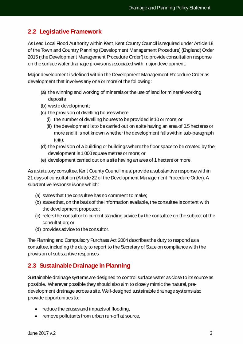
3.6 Environmental Drivers
There is an opportunity to add value to a site through an integrated approach to policy
goals. The manner in which drainage is delivered has a direct relationship to other policy
goals and it presents an opportunity to add value to these areas. In particular water quality
protection, biodiversity, open space provision, green infrastructure, amenity and landscape
can be enhanced by good drainage design. Policy for these areas is delivered through a
number of Acts and regulations as summarised in Figure 1.
FIGURE 1: INTER-RELATIONSHIPS BETWEEN DIFFERENT AREAS OF WATER POLICY (PLANNING ADVICE FOR INTEGRATED WATER
MANAGEMENT, CAMBRIDGE NATURAL CAPITAL LEADERS PLATFORM, 2014)
Through the assessment of drainage proposals, Kent County Council may wish to recognise
and identify opportunities to strengthen these other policy goals. Although these
7 https://flood-warning-information.service.gov.uk/long-term-flood-risk
Local Plans
Surface Water Management
Plans
Water Resource Management
Plans
River Basin Management
Plans
WFD
Water
Acts FWMA
NPPF

June 2017 v.2 10
Drainage and Planning Policy Statement
opportunities may fall outside of immediate statutory remit, we have
a duty to raise any issues that fall within these areas with the Local Planning Authority for
their consideration in determining the planning application.
3.6.1 Water Framework Directive
The Water Environment (Water Framework Directive) (England and Wales) Regulations 2003
(SI 3242) (WFD) became UK law in December 2003 and will remain in place until such time
as UK law is revised to reflect changes in EU membership.8 The aim of the WFD is to provide
the opportunity to plan and deliver a better water environment, focusing on ecology. The
WFD aims for the water environment emical and ecological status in
inland and coastal waters by 2015. Planning and programmes are continuing in six year
cycles until 2027.
The WFD drives water quality improvement planning along total river catchment areas, with
the production of River Basin Management Plans. The directive puts a duty on public bodies
to have regard to river basin management plans (and associated supplementary plans)
when exercising their functions where it may affect a river basin district.
flooding can cause unmanageable water quality problems. Sustainable drainage principles
are key to meeting the objectives of the WFD in its continuing cycles.
3.6.2 Habitats Directive
The EU Habitats Directive was adopted in 1992 (formally known as 92/43/EEC on the
Conservation of Natural Habitats and of Wild Fauna and Flora)9. It aims to provide protection
to habitats and species which have been designated as being of European significance and
sits alongside the EU Birds Directive adopted in 2009.
The sites where such habitats and species are legally protected due to their exceptional
importance are known as Natura 2000 sites; this network protects rare, endangered or
vulnerable habitats and species. The Natura 2000 network includes Special Areas of
Conservation (SACs, identified under the Habitats Directive), Special Protection Areas (SPAs,
identified under the Birds Directive) and Ramsar sites (wetlands of international importance
classified as Sites of Special Scientific Interest (SSSIs) but not all SSSIs are Natura 2000 sites.
8 More information on the WFD Directive can be found at: http://ec.europa.eu/environment/water/water-
framework/index_en.html
9 More information on the Habitats Directive can be found at:
http://ec.europa.eu/environment/nature/legislation/habitatsdirective/index_en.htm

June 2017 v.2 11
Drainage and Planning Policy Statement
3.6.3 Kent Environment Strategy
As part of a county wide partnership, Kent County Council has produced a Kent
Environment Strategy A strategy for environment, health and economy (KES) setting out how
Kent and their partners propose to address significant opportunities and challenges from
environmental change and development pressures (such as a need for improved air and
water quality, decline in biodiversity and the impacts of climate change)10. It is accompanied
by an implementation plan and includes partnership actions that will deliver against the
priorities set out in the strategy. Kent County Council adopted the strategy in January 2016
and has invited the District Councils to also adopt it to provide a basis for co-ordinated
action.
The KES recognises that the environment is a key part of the infrastructure supporting the
Kent economy. The strategy aims to make the most of environmental opportunities whilst
addressing challenges arising from development pressures, need for improved air and
water quality, decline in biodiversity and the effects of climate change.
10 The Strategy can be found at: http://www.kent.gov.uk/about-the-council/strategies-and-policies/environment-waste-and-planning-policies/environmental-policies/kent-environment-strategy

June 2017 v.2 12
Drainage and Planning Policy Statement
4 Drainage Consultation
4.1 Introduction
A drainage strategy should be submitted to the relevant Local Planning Authority along
with any planning application for any major development. It may either form part of a wider
Flood Risk Assessment, or it can be submitted as a separate and dedicated standalone
document.
Whilst consultation is not undertaken with Kent County Council for minor development,
applicants should be aware that the NPPF priorities for sustainable drainage apply to all
development, irrespective of scale. Developers of sites for minor development are
encouraged to consider the policies outlined in this document with respect to site drainage
design. Applicants for these smaller developments are directed to guidance and standing
advice on best practice to help minimise flood risk.
It is important that any consultation request we receive reflects the level of risk to a site (or
the risk that may result from its development). Consequently, consultation may also occur
for development, other than major development in areas of higher local flood risk, as
described in Section 4.2.
Consultation on flood risk will also occur with other risk management authorities. For
example, the management of tidal and fluvial flood risk and the prevention of inappropriate
development in the associated flood-plain remains the responsibility of the Environment
Agency. The Environment Agency is also responsible for the management of permitting
regulations which may affect discharge to water bodies or the ground. Similarly, if any
drainage scheme requires connection to a public sewer, additional approval will be required
from the appropriate sewerage undertaker.
A statutory consultation matrix for flood risk areas is shown in Table 1.
TABLE 1: statutory consultation matrix for flood risk areas
Flood Zone
1 Flood Zone
2 Flood Zone
3
Permitted development
Guidance notes from LLFA and EA
Minor development
Guidance notes from LLFA
Standing advice EA
EA
Major development
LLFA LLFA (surface water)
EA (river & sea) LLFA (surface water)
EA (river & sea)
Within Flood Zones 2 or 3 (areas of medium/high tidal or fluvial flood risk), a Drainage
Strategy should be a component of a wider Flood Risk Assessment and should outline how
the management of runoff will not exacerbate the existing flood risk to/from the
development proposed.

June 2017 v.2 13
Drainage and Planning Policy Statement
A Flood Risk Assessment should also be submitted with any application for planning
permission on sites in excess of 1 ha in Flood Zone 1 (low flood risk); in these instances the
Flood Risk Assessment/Drainage Strategy should be primarily concerned with the
management of surface water within the proposed development site.
4.2 Other local flood risks
As Lead Local Flood Authority, Kent County Council has a role to oversee local flood risk in
the county. This role includes overseeing the risks arising from surface water and ordinary
watercourses. Development at even a minor scale may have the potential to result in
significant increases in flood risk associated with ordinary watercourses or in areas of
existing drainage problems.
4.2.1 Critical Drainage Areas and Areas of High Local Flood Risk
The Town and Country Planning (General Development Procedure Amendment No. 2,
an area within
Flood Zone 1 which has critical drainage problems and which has been notified [to] the local
planning authority by the Environment Agency
been defined within Kent.
Areas of High
Local Flood Risk (where appropriate). These areas will be based upon the
Surface Water Management Plans that Kent County Council has developed in partnership
with other risk managing authorities, or other pertinent information. Where these areas are
identified, all planning applications with potential surface water management implications
will need to be submitted with a more rigorous justification of the chosen drainage system
and an assessment of its associated impact.
Any drainage strategy submitted to accompany a planning application for major
development should make full reference to the most recent available Surface Water
Management P
SWMPs can be found 11
4.2.2 Ordinary Watercourses
An 'ordinary watercourse' is defined as any channel capable of conveying water that is not
ditches, drains, cuts, culverts, dikes, sluices, sewers (other than public sewers within the
11 http://www.kent.gov.uk/about-the-council/strategies-and-
policies/environment-waste-and-planning-policies/flooding-and-drainage-policies/surface-water-
management-plans

June 2017 v.2 14
Drainage and Planning Policy Statement
When considering the development/redevelopment of any site, existing ordinary
watercourses should be identified and accommodated within any drainage strategy and
site masterplan. They should be preferably retained as an open feature within a designated
corridor, and ideally retained within public open space. Any outfall to an ordinary
watercourse should be designed to ensure there is adequate erosion protection for the
receiving channel and its banks.
It is recommended that any discharge to an ordinary watercourse or any modification to an
ordinary watercourse be identified and agreed in principle with Kent County Council prior
to the submission of any planning application. The ability of a watercourse to convey water
(and to function as an effective exceedance flow route, where appropriate) will always need
to be maintained.
For those watercourses where no flood mapping currently exists, developers should fully
consider the potential flood risk arising from them. Where a risk from flooding has been
identified, appropriate flood risk mitigation should be identified and agreed with the Local
Planning Authority/Kent County Council; development should be avoided in any area likely
Culverting of open watercourses will not normally be permitted (except where
demonstrably essential to allow highways and/or other infrastructure to cross). In such
cases culverts should be designed in accordance with CIRIA C689: Culvert Design and
Operation Guide, (2010).
If a culverted watercourse crosses a previously developed site, it should be reverted back to
open channel, wherever practicable. In any such case, the natural conditions deemed to
have existed prior to the culverting taking place should be re-instated.
Measures should be in place to ensure that any future owner of a property through which a
watercourse passes is aware of their maintenance responsibilities as a riparian owner.
Under the terms of the Land Drainage Act 1991, any work or structure that has the potential
to affect the flow within any ordinary watercourse will require land drainage consent. This
will be either from Kent County Council or from an Internal Drainage Board (in the areas
where they operate).
If land drainage consent is required in relation to the proposed development, we
recommend that the submission of any application for consent is delayed until planning
permission is granted, (excepting instances when consents are required to construct or
upgrade site access) as the proposed site layout may be subject to further change, Please
refer to Kent County Council web pages for guidance on ordinary watercourse consents. 12
12 http://www.kent.gov.uk/waste-planning-and-land/flooding-and-drainage/land-drainage-consent

June 2017 v.2 15
Drainage and Planning Policy Statement
4.3 Consultation Process
4.3.1 Overview
Consultation with Kent County Council will occur through the planning process. Kent
County Council will be notified of the submission of a major planning application by the
Local Planning Authorities within Kent (as defined in Section 1.2 above).
A substantive response to the LPA is legally required from Kent County Council within 21
days of consultation.
4.3.2 Pre-application Advice
Incorporating appropriate drainage is easier and more sustainable if it is planned and
designed in from the start of a development. Kent County Council encourages pre-planning
consultation to ensure that the issues are appropriately addressed at an early stage.
Pre-planning advice from KCC can provide the following benefits:
background information to identify constraints and matters in relation to flood risk
and drainage pertinent to the application;
an indication of whether a proposal would be acceptable in principle, saving time
and cost within the planning process;
reduced time to prepare the proposal;
provides clarification of the guidance and policies that will be applied to the
development proposal;
identifies whether specialist input is required; and,
identification and engagement of other key stakeholders.
If an application is submitted which does not comply with the Non-Statutory Technical
Standards and/or NPPF, Kent County Council may object to the application. Pre-planning
discussions are advocated to avoid this situation.
Relevant information recommended to be collected prior to any meeting and to support
pre-application discussions should address the following questions:
Has the means of outfall and location of the final discharge destination in relation to
the hierarchy of discharge been considered?
If the surface water infiltrates to the ground has permeability testing been
undertaken, with discussions having taken place with the EA and/or water company
in relation to pollution risk to any underlying aquifers?
If the surface water discharges to a water body, ordinary watercourse or main river,
has advice been sought from the Environment Agency/relevant Consenting
Authority over the requirement for an Environmental Permit and/or land
drainage/flood risk activity permit?
If the surface water discharge is to a sewer or highway drain, have discussions taken
place with the appropriate sewerage undertaker and Highways Authority?

June 2017 v.2 16
Drainage and Planning Policy Statement
Have any specific constraints which may have an impact on the drainage scheme
been identified including but not limited to soil type, geology, previous land uses,
topography, and ground water?
Within the development has the connectivity of the drainage system been
determined, for both the impermeable areas around the properties and outside of
the properties?
Are there any-off site issues for the surface water discharge which must be
considered within design, including but not limited to access across third party land,
or offsite works to water bodies?
As part of the development and the associated drainage scheme, are there any
environmental or ecological issues that may impact the proposals(e.g. poor water
quality, biodiversity constraints or landscape considerations) which have been
surveyed or assessed?
Will the drainage scheme require phasing and what is the anticipated development
programme for the site?
Will the site require any substantial re-grading which will affect the existing
drainage, existing overland flow routes to/from the site or the means of drainage
proposed?
Are there any temporary arrangements or interim works that need to be
implemented to enable drainage through construction and phasing?
Have matters surrounding accessibility and future maintenance needs been
incorporated into the design?
Will there be any flood risk features which will require designation under Schedule 1
of the Flood and Water Management Act?
-application planning advice in relation to new development is
discretionary and is provided as a chargeable service.13
We provide free advice to:
individual home owners who have specific drainage or flood related issues which
may impact their own house for development;
Local community groups, Parish councils or Flood Forums on works proposed to
improve local communities.
A drainage advice request form (Appendix C) should be completed and forwarded to Kent
County Council. This includes Flood Risk Enquiries for the preparation of Flood Risk
Assessments. -line form and
further details.14
13http://www.kent.gov.uk/waste-planning-and-land/flooding-and-drainage/sustainable-drainage-systems#tab-3 14 http://www.kent.gov.uk/waste-planning-and-land/flooding-and-drainage/sustainable-drainage-systems#tab-3

June 2017 v.2 17
Drainage and Planning Policy Statement
Standing advice for specific development scenarios and types is also available online from
kent.gov.uk.
4.3.3 Planning application submission
The Local Planning Authority will confirm that a Drainage Strategy has been submitted with
the planning application and pass it to Kent County Council for consultation. Kent County
Council will review the submitted material for adequacy and, depending upon the
submission, may request further information. This will be communicated to the applicant
via the Local Planning Authority.
In reviewing a drainage application, Kent County Council will, in the first instance, confirm
compliance with this policy statement, national planning policy (as defined in the NPPF),
and compliance with the Non-Statutory Technical Standards . Local planning requirements
(as set out in Local Plans or other local planning documents) and other site-specific land-use
factors that affect surface water management will also be referenced, where appropriate.
Additionally, Kent County Council will consider adherence to wider environmental
principles of the NPPF that may have a bearing on drainage design (for example, water
quality, biodiversity and landscape).
A consultation response will be prepared and returned to the Local Planning Authority
within the required 21 days following receipt of a suitably detailed submission. The
consultation response may result in a request for further information or for planning
conditions for subsequent determination.
4.4 Drainage Strategy Development
This section sets out the principles that should be considered when developing a drainage
strategy. The drainage strategy will need to incorporate the policies set out in Section 6.
4.4.1 Design Philosophy
Kent County Council recommends that sustainable drainage is considered from the
inception of any scheme as an interconnected system that provides additional benefits,
rather than as an individual, standalone drainage measure.
The drainage strategy should consider sustainable drainage techniques that work with the
natural drainage of the site to retain surface water within the site and manage the risk of
flooding during severe storms (both on and off site).
It is important to identify and consider constraints which may impact the manner in which
drainage is provided on site. The drainage strategy should take account of existing flow
routes, either by incorporating them into the drainage system or designing the layout
appropriately.
During the assessment of any site, full reference should be made to any existing flood risk
management information that may be available. Accordingly, evidence from both the
Water Management

June 2017 v.2 18
Drainage and Planning Policy Statement
Plan for the area in which the development is being planned should be taken into
consideration. If it has been previously identified that the site or its immediate surroundings
are susceptible to flooding from any source, the site layout and drainage design should take
the existing risk fully into account.
Similarly, if there are any constraints to the utilisation of infiltration (e.g. contaminated land,
source protection zones or high groundwater), the drainage design should take these into
account.
A recommended approach to masterplanning for sustainable drainage is included within
a guide for master planning sustainable drainage into developments
a guidance document which was produced by the Southeast Lead Local Flood Authorities,
of which Kent is a member (please refer to Section 3.4.1).
KCC recommends that shared drainage measures or drainage measures serving the wider
development are located within common land or public open space. Drainage measures
which serve more than one property should not be located within back gardens or other
private areas.
All elements of the proposed drainage strategy should be within the defined planning
application boundary as defined by the -line boundary. This ensures
that planning approval and any subsequent conditions will apply to the entirety of the
drainage measures. It would not be acceptable to have any drainage measures, most
notably attenuation basins or soakaways outside of the planning application site boundary.
4.4.2 Detailed Information
Detailed information may be required to demonstrate that a drainage design is appropriate
and will operate effectively. This information may be required for all drainage measures,
including (but not limited to) pipe networks, attenuation features, ponds and soakaways.
Key information which may be needed to demonstrate the feasibility or applicability of a
design philosophy includes:
Ground information and infiltration rates
Condition surveys of receiving watercourses and sewers
Ground level information
The lack of detailed technical information may increase the level of uncertainty we may
have about the effectiveness of a drainage strategy. It can also reduce the certainty that
flood risk will be managed appropriately. If the degree of uncertainty is great, then KCC will
have grounds to object to the drainage proposal. We therefore encourage pre-application
discussion to identity any areas which may need further investigation or clarification.

June 2017 v.2 19
Drainage and Planning Policy Statement
4.4.3 Large sites
Large phased developments or sites with multiple developers may require the development
of an overall Surface Water Management Strategy which sets out objectives and
parameters for the whole site. The strategy should set out the following for the whole site:
discharge destination,
discharge rate,
estimated contributing catchment areas per phase, and
estimated impermeable areas per phase and per catchment.
to depict
both the existing and proposed catchments, runoff rates/volumes and receiving systems, all
related to the overall phasing plan to define the requirements for each separate parcel of
land.
A Surface Water Management Strategy will be tied to a planning condition at the outline
stage. Pre-application discussions are encouraged in the case of phased development to
agree the level and detail of any strategic Surface Water Management Strategy and
subsequent Drainage Strategy which would be submitted.
Depending upon the level of detail submitted at outline planning, it may be necessary to
submit drainage information to accompany reserve matters associated with the layout to
demonstrate that surface water can be accommodated within the proposed layout.
Further details regarding the surface water management proposals should then be
provided within a detailed Drainage Strategy at each phase of development. Each phase
must remain consistent with the overall site strategy and drainage masterplan.
Supporting information must be submitted to demonstrate that any variations can be
accommodated within the site without exacerbating flood risk. The overall site Surface
Water Management Strategy may be reviewed as different phases are delivered.
Large sites in close proximity within a locality or catchment are encouraged to cooperate or
consult concurrently as there may be opportunities for combined solutions with mutual and
greater benefit.
A phasing plan is usually developed for sites greater than 150 units, it is important that the
drainage system is also considered in any phasing of the delivery of the development.
Any strategic drainage features that are required for the wider site drainage strategy to
function properly must be identified and delivered prior to the connection of the drainage
from any phase or sub-phase. If a single site within a wider development (e.g. school or
commercial site) is reliant upon the strategic trunk system, this must be clearly indicated
within the phasing plan.

June 2017 v.2 20
Drainage and Planning Policy Statement
4.4.4 Connection to a public sewer or other drainage system
The proposed point of connection and discharge rate to any receiving system must be
agreed with the relevant owner or responsible body including internal drainage boards,
highway authorities, sewerage undertakers, riparian owners, Environment Agency, Canals
and River Trust and others. Any connection or discharge must be compliant with regulation
or guidance governing the operation of the existing drainage system (e.g. IDB bye-laws or
standard specifications for public sewers). Correspondence with the relevant owner or
responsible body should be submitted to demonstrate agreement in principle to the
discharge and connection point as early in the development planning process as possible
Infrastructure for new development should ensure that surface water is always drained and
managed separately from foul water.
Combined sewer systems, which carry both foul and surface water, have limited capacity
and are more likely to lead to foul flooding; in our commitment to ensuring development is
sustainable, we will therefore seek to reduce surface water discharges to combined sewer
systems.
If we are aware of a capacity issue or a sewer flooding issue that a sewer connection is likely
to exacerbate, we will inform the Local Planning Authority and the sewerage undertaker.
We may oppose any such proposal until it can be adequately demonstrated that the
receiving authority has confirmed the acceptability of the intended rate of discharge.
Sewerage undertakers may require local capacity improvements for sewer connections or a
new sewer may need to be requisitioned to connect to the best point on the sewer network.
These should be negotiated with the sewerage undertaker directly; we will not address
details of potential requisitions or upgrades. It should be noted that any requirement for
additional capacity may have viability implications for any proposed development.
4.4.5 Adoptable highways and drainage
Most major development would normally include some aspect of highway improvement,
which may be adopted or require approval by Kent County Council as the Highway
Authority. The provision of drainage to adopted highways is normally subject to Section 38
Agreement, with approval and inspection by Kent County Council as the Highway
Authority.
Surface water from a private drive or private land must not discharge onto the highway. It is
usual that measures to prevent such discharge are required where vehicular accesses fall
towards the highway. It is important to ensure that design criteria for provision of drainage
do not conflict with highway objectives or significantly impact other highway arrangements
(e.g. adoptable construction standards, proximity to junctions, access widths, visibility
splays, pedestrian and vehicle visibility and parking).
These matters are best raised in pre-application discussion with Kent County Council to
ensure there will be appropriate arrangements in place for highways and drainage

June 2017 v.2 21
Drainage and Planning Policy Statement
adoption, where appropriate. Highways advice for planning applications is provided on the 15
Highway matters may be reviewed within the consultation by Kent County Council as Lead
Local Flood Authority. Kent County Council will endeavour to seek internal consultation on
such matters; however, the detail provided within a planning submission may not be
sufficient. The response from Kent County Council as Lead Local Flood Authority does not
commit Kent County Council as Highways Authority for any particular highways
arrangement. The nature and extent of adoption should be confirmed with the Highways
team at an appropriate time within the planning and design process.
4.4.6 Flood Risk and Groundwater
The drainage strategy may be constrained if the site is located wholly or partly within Flood
Zone 2 or 3 or if the drainage discharges to the ground via infiltration in a source protection
zone or area of low permeability.
Consultation with the Environment Agency early in the planning process is recommended
to identify any constraints or specific requirements in these areas.
4.4.7 Adoption and Maintenance
Drainage systems may be adopted by the highways authority as part of a highway drainage
provided the systems meet certain
standards and specification. Systems may also be adopted by other parties including local
councils and private management companies.16
The selection of adoption approach for the drainage system will impact the selection of
drainage measures for inclusion within a drainage strategy and the layout of the drainage
system. Early consideration of adoption extent is therefore recommended.
The design of any drainage system must take into consideration the construction, operation
and maintenance requirements of both surface and subsurface components, allowing for
any personnel, vehicle or machinery access required to undertake this work. This must be
demonstrated through appropriate site layout or noted through the need for further legal
agreement for access arrangements.
The continued operation of any drainage system is dependent upon ongoing maintenance
which may be undertaken by an adopting authority or management agent; it is therefore
necessary that any drainage proposal indicates the intended adopting authority or agent
and proposed maintenance requirements.
15 http://www.kent.gov.uk/waste-planning-and-land/planning-applications/planning-advice/highway-pre-
application-advice
16 Adoption as outlined in Schedule 3 of the Flood and Water Management Act is not available within Kent.
June 2017 v.2 22
Drainage and Planning Policy Statement
The Local Planning Authority will be responsible for determining the acceptability and
enforcing compliance with any maintenance schedule as required by relevant planning
conditions. Developers will be required to demonstrate that the drainage was constructed
according to the approved plans through post-construction verification reports.
4.4.8 Building Regulations
Building Regulations exist to ensure the health, safety, welfare and convenience of people
in an around buildings. Part H of the Building Regulations specifically covers drainage. The
consultation with the LLFA addresses flood risk to and from developments and does not
replace any requirement for Building Regulation approval.
4.5 Consultation Submission Requirements
At a minimum, a drainage strategy submission must comprise:
A location plan
A site layout
A drainage proposal schematic or sketch
A clear description of key drainage features within the drainage scheme (e.g.
attenuation volumes, flow control devices etc.)
Information to support any key assumptions (e.g. impermeable areas, infiltration
rates etc.)
Supporting calculations to demonstrate the drainage system operation and
drainage model network schematic
Drainage strategy summary form
Consideration of key questions.
Kent County Council recommends the inclusion of a summary sheet which contains
pertinent information to assist in ensuring sufficient detail is submitted and to simplify the
review process. A Drainage Strategy Summary Form is included in Appendix E.
The detail provided in the submission will reflect the type of planning application
(Surface Water Management Strategy) (Detailed
Drainage Strategy). We recommend that applicants confirm the submission requirements
through pre-application discussion with Kent County Council, particularly to identify any
needs for ground investigation. Kent County Council can be
contacted via email at:
Drainage Strategies must contain sufficient detail to enable an assessment of the drainage
proposals to be undertaken. Provision of insufficient information for Kent County Council to
assess the drainage strategy in accordance with the appropriate policies may delay return of
a substantive comment to the planning authority or result in an objection to the drainage
proposal

June 2017 v.2 23
Drainage and Planning Policy Statement
5 Policies for Sustainable Drainage
5.1 Introduction
A range of sustainable drainage techniques may be utilised across a site to manage the
surface water runoff from the planned development; the use of more than one technique
will often be appropriate to achieve the objectives of sustainable development on any
given site (notwithstanding situations which may still arise where a conventional solution
may be the most appropriate).
Given the range of design options to provide a drainage solution, Kent County Council has
defined:
Drainage Policies (SuDS Policy 1 through 6) that set out the requirements for a
drainage strategy to be compliant with the NPPF (Table 3) and guidance within the
Non-Statutory Technical Standards for Sustainable Drainage (Table 4).
Wider Environment Policies (SuDS Policy 7 through 10) that set out expectations to
be considered within a drainage strategy in response to environmental legislation
and guidance that Kent County Council and the Local Planning Authorities have a
duty to comply with.
These policies summarised in Table 5 reflect the requirements of the Local Flood Risk
Management Strategy, Surface Water Management Plans and Local Planning Authority
Local Plans. Sufficient information must be submitted to demonstrate that the drainage
proposals comply with these policies.
Table 5: Kent county council suds policies
Policy Summary
SuDS Policy 1 Follow the drainage hierarchy
SuDS Policy 2 Manage Flood Risk Through Design
SuDS Policy 3 Mimic Natural Flows and Drainage Flow Paths
SuDS Policy 4 Seek to Reduce Existing Flood Risk
SuDS Policy 5 Maximise Resilience
SuDS Policy 6 Design to be Maintainable
SuDS Policy 7 Safeguard Water Quality
SuDS Policy 8 Design for Amenity and Multi-Functionality
SuDS Policy 9 Enhance Biodiversity
SuDS Policy 10 Link to Wider Landscape Objectives

June 2017 v.2 24
Drainage and Planning Policy Statement
5.2 Drainage policies
These policies are specified from the NPPF and the guidance within the Non-Statutory
Technical Standards for Sustainable Drainage, as published by Defra.
When development occurs, the urbanisation process within a catchment affects the natural
hydrology; if the destination of the water is altered this may result in:
a reduced supply of rainfall to groundwater,
an accelerated passage of flow to the receiving watercourses, and
water directed away from existing receiving catchments.
In order to maintain the natural balance of the water cycle, the above discharge hierarchy
must be observed. Where development results in changes in runoff destinations, the design
must account for how the surface flows are managed and demonstrate it does not
exacerbate off-site flood risk.
Any development application would need to be accompanied by evidence from
appropriate authorities indicating the acceptability of a discharge location and consent to
connect.
An existing connection to a sewer does not automatically set a precedent and it must be
demonstrated why infiltration and/or a connection to a watercourse cannot be utilised.
There is a presumption against any discharge of surface water to a foul sewer.
If a combined sewer is the only available connection adjacent to the proposed
development, we will encourage consideration of connection to available surface water
systems within 90 m of the development site boundary to promote sustainable drainage
solutions.
SuDS Policy 1: Follow the drainage hierarchy
Surface runoff not collected for use must be discharged according to the
following discharge hierarchy:
to ground,
to a surface water body,
a surface water sewer, highway drain, or another drainage system, or
to a combined sewer where there are absolutely no other options,
and only where agreed in advance with the relevant sewage
undertaker.
The selection of a discharge point should be clearly demonstrated and
evidenced.

June 2017 v.2 25
Drainage and Planning Policy Statement
Where a surface water connection to an existing combined sewer is unavoidable, it must be
undertaken in such a manner and at such a location so as to facilitate future separation of
the surface water from that combined system.
With respect to connections to highway drains:
(a) KCC does not permit any increased flows into the highway drainage system unless
the developer/property owner is prepared to upgrade the entire system to the outfall point
(b) KCC only permit surface water to be drained into the highway drainage system
through proven existing connections.
Other consents by regulation may be required in relation to the discharge location (e.g.
Environmental Permit Flood Defence consent and Ordinary Watercourse consent). Kent
County Council may recommend consultation with other authorities in these instances.
The drainage system must be designed to operate without any flooding occurring during
any rainfall event up to (and including) the critical 1 in 30 year storm (3.33% AEP). The
system must also be able to accommodate the rainfall generated by events of varying
durations and intensities up to (and including) the critical, climate change adjusted 1 in 100
year storm (1% AEP) without any on-site property flooding and without exacerbating the
off-site flood-risk. Sufficient steps are to be taken to ensure that any surface flows between
the 1 in 30 and 1 in 100 year events are retained on site. The choice of where these volumes
are accommodated may be within the drainage system itself or within other areas
designated within the site for conveyance and storage.
All development should be preferentially located in the areas of lowest flood risk,
irrespective of the source of flooding. At the earliest stages of masterplanning, an
appropriate flood risk or drainage impact assessment should be undertaken to ensure that
any vulnerable forms of development are located outside Flood Zones 2 or 3 and/or those
areas identified as being at medium to high risk of surface water flooding. The Environment
Long Term Flood Risk pages should be referred to for
this information.
SuDS Policy 2: Manage Flood Risk Through Design
It is essential that the drainage scheme proposed:
protects people and property on the development site from flooding;
and,
does not create any additional flood risk outside of the development
in any part of the catchment, either upstream or downstream.
Any drainage scheme must manage all sources of surface water, including
exceedance flows and surface flows from offsite, provide for emergency
ingress and egress and ensure adequate connectivity.

June 2017 v.2 26
Drainage and Planning Policy Statement
If development is considered unavoidable within a surface water flood risk or flow route,
then the land use should be water compatible or designed and constructed to be floodable.
In some circumstances it may be considered appropriate to mitigate the risk identified (e.g.
re-routed through or around the development, provided the off-site flood risk is not
exacerbated).
Exceedance flows that cannot be contained within the drainage system shall be managed in
flood conveyance routes. The primary consideration shall be risks to people and property
on and off site.
Access should be maintained into and through the site for emergency vehicles during all
storms up to (and including) the critical, climate-change adjusted 1 in 100 year event. The
drainage application must give consideration to flood risk vulnerability classifications (as
defined through Planning Practice Guidance to the National Planning Policy Framework), as
specific measures or protections may be assessed and need to be agreed with the
appropriate authority.
The time required for the storage to accept further storm flows should be considered,
especially if downstream flood levels can affect the outfall. Attenuation storage volume17
provided by any drainage area should half empty within 24 hours so that it can receive
runoff from subsequent storms. If the drain down time (full to empty) is more than 24 hours,
then long duration events should be assessed to ensure that drainage is not compromised
by inundation (e.g. periods of wetting on vegetation or slope failure).
If the proposed system connects to an existing drainage system, whether it is a sewer,
highway drain, water body or sustainable drainage system, consideration must be given to
the operational capacity and functionality of the existing system to ensure that no adverse
impacts result or flood risk is increased on-site or off site. This would relate specifically for
public surface water sewers 1 in 30 year design criteria.
If the proposed system discharges to a watercourse or main river, consideration must also
be given to any requirements due to high water levels in the receiving watercourse due
either to tide (i.e. tide-locking) or flood flows. Attenuation volumes may be required onsite
to manage flows for the peak events within the waterway.
If the proposed site is immediately adjacent to a watercourse or main river, there may be
instances where direct discharge to the waterway is promoted without attenuation. This is
only likely to be a recommendation on or immediately upstream from tidal areas. Direct
discharge to a main river must be agreed in consultation with KCC and the Environment
Agency.
If a proposed development is to be delivered in phases, a commitment should be made for
a site-wide sustainable drainage scheme to be delivered with the first phase of
development, designed to be capable of accommodating the runoff from each of the
17 The requirement to comply with half-drain times applies to infiltrating measures as well as drainage measures which provide attenuation only without infiltration.

June 2017 v.2 27
Drainage and Planning Policy Statement
subsequent phases. If this is not possible, the runoff from each separate phase must be
controlled independently. Whichever approach is taken, the control of surface water runoff
during construction should be considered.
Runoff rates should match greenfield runoff rates, follow natural or existing drainage routes,
utilise existing natural low-lying areas or conveyance pathways, and match infiltration rates
and discharges as far as possible for all events up to and including the climate-change
adjusted 1 in 100 year (1% AEP) design event.
Infiltration should be maximised wherever possible within a drainage scheme, even if
underlying soils are relatively impermeable, the opportunities for infiltration should still be
utilised. This mimics the natural behaviour to the site.
Greenfield runoff rates may be calculated by any method (FEH, FSR or IoH124) but the rates
must reflect soil conditions specific to the site and applied to an appropriate drainage area
consistently through the drainage strategy.
Kent County Council will generally require the use of the more detailed and up-to date FEH
dataset within detailed drainage design submissions. Where FSR data is used to determine
the extreme rainfall intensity values for a site, we would expect the FSR/FEH ratios depicted 18 (Environment
Agency, 2013) to be used to adjust the calculated attenuation requirements. For a typical
present day 6 hour, 100 year rainfall event, the FSR values are around 80-90% of the FEH
value.
If FEH is unavailable (and unless otherwise calculated), we will accept a rainfall depth M5-60
of 26.25 mm to be utilised in appropriate modelling software to account for this variation.
Local planning policy may identify preferred discharge rates to be utilised in place of
greenfield rates based upon a strategic flood risk assessment. In these areas, the preferred
discharge rates should be utilised in the design.
Small sites are associated with low greenfield runoff rates. Given advances in technology
and design of flow controls, it is now possible to achieve controlled flow rates of 2 l/s. This
should be considered the minimum rate to be set for small sites, unless agreed with Kent
County Council.
18 http://evidence.environment-agency.gov.uk/FCERM/Libraries/FCERM_Project_Documents/Rainfall_Runoff_Management_for_Developments_-_Revision_E.sflb.ashx
SuDS Policy 3: Mimic Natural Flows and Drainage Flow Paths
Drainage schemes should be designed to match greenfield discharge rates,
volumes and follow natural drainage routes as far as possible.

June 2017 v.2 28
Drainage and Planning Policy Statement
Runoff volumes from the developed site will usually increase in comparison to the site in its
natural condition; this may increase flood risk in natural receiving systems. Controlling the
volume of runoff from the site is therefore vital to prevent flood risk in natural systems.
Within Kent, the need and type of volume control will vary according to the soil type
experienced, which can be broadly broken down into the following categories:
Highly permeable soils in areas underlain by chalk, we will expect that use of
infiltration will be maximised. With no off-site discharge, additional volume control
will not be required
Low permeability soils - areas underlain by largely impermeable soils (e.g. Weald
clay and London clay) to mimic existing greenfield
runoff rates from corresponding storm events, with long-term storage provided for
any additional volume above the pre-development volume
Intermediate permeability soils - in these areas infiltration should still be
maximised, with any residual discharge to watercourses or sewers requiring the
provision of long-term storage; offsite discharge should be limited to QBAR, (the
mean annual flood flow rate, equivalent to an approximate return interval of 2.3
years).
If the proposed development contributes to an area or network with known local flood risk
issues or capacity constraints then discharge rates and volume control specific to the local
conditions will be specified.
By mimicking the natural drainage flow paths and working within the landscape, more
effective and cost-efficient design can be developed. Working with existing natural
gradients also avoids any reliance on pumped drainage, with its associated energy use and
failure risk. The natural environment including woods, trees and hedgerows can play a part
in water management.
Some sites may lie in or near more than one hydrological catchment. Surface water flows
should be retained within the pre-development catchments and not diverted to adjacent
catchments, in order to preserve the hydrology of catchments and prevent an increase in
flood risk.
Kent County Council encourages maintenance of the existing flow paths and drainage
connectivity, specifically:
a) If the proposed development is reliant on an existing discharge point, then it is
recommended that the condition and conveyance capacity is confirmed through
CCTV or other survey and has its discharge capacity confirmed.
b) -
ditches and should be part of a wider and contiguous drainage network.
Many greenfield developments will incorporate natural field ditches and channels. We
would encourage the incorporation of any existing natural features within the landscape
proposal for the development proposal. It is not sufficient to undertake earthworks to the
top of the bank of a boundary ditch. Any site improvements should include the channel

June 2017 v.2 29
Drainage and Planning Policy Statement
itself. The land owner has riparian responsibilities for these ditches and new development
provides an opportunity to address any existing ditch issues such as excessive vegetation,
channel clogging, culvert improvements or bank stability.
Paragraph 100 of the National Planning Policy Framework outlines how flood risk
management bodies should seek to manage flood risk through using opportunities offered
by new development to reduce the causes and impacts of flooding, taking the predicted
effects of climate change into account.
As Lead Local Flood Authority, Kent County Council will endeavour to ensure that this
principle is applied across the County. Where a Surface Water Management
Strategy has identified that there are existing flood risks affecting a site or its surroundings,
there would be an expectation that the developer manages the identified risk appropriately
to ensure that there are no on/off site impacts as a result of any development. Similarly,
where there are opportunities to reduce the off-site flood risk through carefully considered
on-site surface water management, we will encourage developers to explore these fully.
Redevelopment on brownfield land has the potential to rectify or reduce flood risk. For
developments which were previously developed, the peak runoff rate from the
development must be as close to the greenfield runoff rate from the development as
reasonably practicable for the same rainfall event, but must not exceed the rate of discharge
from the development prior to redevelopment for that event. As a minimum we would
expect to see evidence that a 50% reduction in the peak runoff rate from the existing site
has been sought. Within all accompanying calculations, the post-redevelopment discharge
rate must take account of the predicted effects of climate change.
An assessment of the risk associated with surface water flood risk can be assessed through
review of the mapping prepared for Long Term Flood Risk19. No residential buildings should
be located within any area indicated to be at high risk from surface water flooding.
19 https://flood-warning-information.service.gov.uk/long-term-flood-risk
SuDS Policy 4: Seek to Reduce Existing Flood Risk
New development should be designed to take full account of any existing
flood risk, irrespective of the source of flooding.
Where a site or its immediate surroundings have been identified to be at
flood risk, all opportunities to reduce the identified risk should be
investigated at the masterplanning stage of design and subsequently
incorporated at the detailed design stage.
For brownfield sites, and unless demonstrated to be reasonably
impracticable, we would expect a 50% reduction in the peak runoff rate.

June 2017 v.2 30
Drainage and Planning Policy Statement
If the receiving system is in a poor condition and unable to convey flow effectively, we
would expect the developer to undertake remedial work prior to the commencement of the
approved development. We would expect to see a condition survey of the receiving system
within any associated discharge of conditions submission, along with a statement of works
required.
Drainage infrastructure normally has a defined design life. This varies depending upon the
nature of th components. The drainage must be designed to function properly to
protect the development and downstream from flooding over this timeframe. This includes
accommodating predictable changes, including climate change and urbanisation.
In 2016, the Environment Agency published new guidance on how to use climate change
allowances in flood risk assessments. The guidance can be found at:
https://www.gov.uk/guidance/flood-risk-assessments-climate-change-allowances
KCC require that the drainage design accommodates the 1 in 100 year storm with a 20%
allowance for climate change, with an additional analysis undertaken to understand the
flooding implication for a greater climate change allowance of 40%.
This analysis must determine if the impacts of the 40% allowance are significant and lead to
any unacceptable flood risks (it is not normally expected that the site would not flood in this
scenario, only that if this storm were to occur the impacts would be minimal). The design
may need to be modified to avoid any unacceptable risks, but may also need additional
mitigation allowances, for example a higher freeboard on attenuation features or provision
of exceedance routes. This will tie into designing for exceedance principles.
Flooding of the highway may be permitted in exceptional circumstances for rainfall events
between 1 in 30 year and 1 in 100 year events provided:
• Depths do not exceed the kerb height • No excessive or prolonged ponding, so that the highway primarily operates as a
conveyance route to another attenuation feature (not a highway system) • Emergency ingress and ingress is not impacted, i.e. not all intersections are impacted • Within site boundaries
SuDS Policy 5: Drainage Sustainability and Resilience
The proposed drainage system must consider life-time sustainability of the
drainage measures and components.
The design of the drainage system must account for the likely impacts of
climate change and changes in impermeable area over the design life of the
development. Appropriate allowances should be applied in each case.
A sustainable drainage approach which considers control of surface runoff at
the surface and at source is preferred and should be considered prior to
other design solutions.

June 2017 v.2 31
Drainage and Planning Policy Statement
Design of drainage systems utilising a sustainable drainage design approach and reducing
reliance on below grade systems in pipes and tanks, provides greater flexibility to
accommodate change in the peak and volumes of surface runoff. Sustainable measures
which control flow rates near to the source and which maximise natural losses through
infiltration and evaporation are preferred. Operation of surface systems is also more easily
observed and maintained.
Vegetated measures may also mitigate increased temperatures and reduce the urban heat
island effect within urban areas through shading and cooling. The ASCCUE Project25
(Adaptation Strategies for Climate Change in the Urban Environment) by Manchester
University found that an increase in green areas of 10% will keep temperatures at or below
current temperatures up until the 2080s.
A recent trend in development has also been the conversion of permeable surfaces to
impermeable over time (e.g. surfacing of front gardens to provide additional parking
spaces, extensions to existing buildings, creation of large patio areas). The consideration of
urban creep should be assessed on a site by site basis but is limited to residential
development only.
The appropriate allowance for the increase of impermeable area from urban creep must be
included in the design of the drainage system over the lifetime of the proposed
development. The allowances set out in Table 6 must be applied to the impermeable area
within the property curtilage according to the proposed development density.
Table 6: impermeable area allowances for urban creep
Residential development density
(Dwellings per hectare)
Change allowance (% of impermeable area)
10
30 8
35 6
45 4
2
Flats & Apartments 0

June 2017 v.2 32
Drainage and Planning Policy Statement
The drainage system must be designed to take account of the construction, operation and
maintenance requirements of both surface and subsurface components, allowing for any
personnel, vehicle or machinery access required to undertake this work. Without
maintenance, the function of drainage systems may alter. Increased leaf litter, sediments
and colonisation of vegetation may clog drainage measures or impact the characteristics of
operational controls.
The drainage strategy must demonstrate that adequate access is available and practicable
for personnel and equipment either through an appropriate layout or legal agreement to
provide agreed access arrangements in perpetuity. Consideration should also be given to
the Construction Design and Management regulations for health and safety purposes.
Wherever possible, it is preferable that drainage schemes should be designed at the surface
to allow easy inspection and maintenance. Drainage maintenance can usually be
incorporated as part of a typical landscape maintenance specification.
If the proposed development incorporates existing field ditches or ordinary watercourses,
we would normally require a minimum setback of 5 m to 8 m (depending upon the location,
and whether the ditch/watercourse falls within an IDB regulated area). This will allow the
safe access and operation of any tracked machinery that may be required to undertake any
maintenance works to the banks or channels, and provides a reasonable buffer for any flora
and fauna within the watercourse.
We would generally recommend that new development is designed to facilitate the
maintenance of existing watercourses, with roads or walkways being provided alongside at
least one bank for access. Closed fence-lines to the rear of properties bordering a
watercourse should be avoided owing to the maintenance difficulties and the potential for
the inappropriate deposition of material beyond property boundaries.
With surface water drainage systems, a careful balance must be struck over the creation of
habitats. The encouragement of certain protected species or creation of protected habitats
may conflict with the regular maintenance works essential to ensuring long term
functionality of the drainage measures. An awareness of any biodiversity objectives should
be considered as part of a maintenance plan for the drainage measures, specifically timing
of vegetation cuts and silt removal to ensure no conflict with nesting or specific life stages
of biota.
SuDS Policy 6: Design to be Maintainable
A drainage scheme maintenance plan should be prepared which
demonstrates a schedule of activities, access points, outfalls and any
biodiversity considerations.
The maintenance plan should also include an indication of the adopting or
maintaining authority or organisation and may require inclusion within a
register of drainage features.
June 2017 v.2 33
Drainage and Planning Policy Statement
Where, in particular circumstances, underground techniques are used, more extensive
inspection processes will be necessary, for example where longer pipe runs are used, CCTV
surveys may be required. All inlet, outlet and control structures must be indicated and
known to the appropriate adopting authority to be protected from blockage and located
near the surface, to allow for easy management during routine maintenance visits.
An operation and/or maintenance plan should be provided which indicates a schedule and
time of activities, as well as critical controls or components of the drainage scheme. This
plan should include an indication of the roles and responsibilities for each authority or
organisation which may have a responsibility for maintenance activities. Any inter-
connectivity with or reliance upon other drainage systems should be indicated. Where
automatic systems form part of the operational functionality of a drainage system, then
processes should be in place to allow immediate action in terms of restoration of
performance.
Kent County Council may work with LPAs to ensure that the drainage schemes associated
with large, strategic, potentially problematic or sensitive sites have been established and
are able to function in accordance with the approved plans and specifications.
As Lead Local Flood Authority, Kent County Council has a duty to maintain a register of
structures or features which are likely to have a significant effect on flood risk. Drainage
schemes within new developments may include structures or features that will be required
to be included within the register.
5.3 Environmental Policies
These policies are driven by environmental legislation and guidance that Kent County
Council and the Local Planning Authorities have a duty to comply with.
Paragraph 109 of the National Planning Policy Framework states that the planning system
should contribute to/enhance the natural and local environment by preventing both new
and existing development from contributing to (or being put at unacceptable risk from)
Additionally, the Water Framework Directive has been established to improve and integrate
the way water bodies are managed throughout Europe. It provides a legal framework to
protect and restore clean water throughout Europe to ensure its long-term sustainable use.
In particular it will help deal with diffuse pollution which remains a big issue following
improvements to most point source discharges.
SuDS Policy 7: Safeguard Water Quality
When designing a surface water management scheme, full consideration should
o the cleanliness of
the water being discharged from the site, irrespective of the receiving system.
Interception of small rainfall events should be incorporated into the design of the
drainage system.

June 2017 v.2 34
Drainage and Planning Policy Statement
The design of any drainage proposal should therefore ensure that surface water discharges
do not adversely impact the water quality of receiving water bodies, both during
construction and when operational. Sustainable drainage design principles have the
potential to reduce the risk of pollution, particularly through managing the surface water
runoff close to the source and on the surface. Below grade pipes and tanks which are
efficient for drainage purposes may not provide appropriate water quality treatment.
Runoff from small rainfall events can pose a particular problem for water quality.
of runoff contains the initial flush of pollutants that has built-up on surfaces during
the preceding dry period. It is possible to get a high initial pollution concentration for
relatively small rainfall events.
Rainfall events that are less than or equal to 5mm in depth also comprise more than half of
the rainfall events across the UK. The volume of runoff from these small events therefore
can cumulatively contribute significantly to total pollutant loadings from the site over a
specified period of time. Interception of an initial rainfall depth of 5 mm would mimic
greenfield response characteristics in that small rainfall event do not generally produce any
run-off.
Kent County Council would expect that developers demonstrate that the first 5 mm of any
rainfall event can be accommodated and disposed of on-site, rather than being discharged
to any receiving watercourse or surface water sewer. This can easily be achieved through
the inclusion of sustainable drainage measures such as infiltration systems, rain gardens,
bioretention systems, swales, and permeable pavement.
Where it proves exceptionally difficult to achieve this principle, it must be demonstrated
that any water leaving the site has been appropriately treated to remove any potential
pollutants.
When discharging to the ground, ground conditions and locations of any source protection
zones should be confirmed.
The management and control of erosion and sediment should be considered throughout
design and construction, operation and maintenance.
Any sites larger than 150 units or within a sensitive receiving catchment may require
additional information to demonstrate that appropriate management controls are in place
to protect off-site water quality.

June 2017 v.2 35
Drainage and Planning Policy Statement
Where land performs a range of functions it affords a far greater range of social,
environmental and economic benefits than might otherwise be delivered (Landscape
Institute Position Statement, Green Infrastructure). Open spaces are often multifunctional,
fulfilling several different valuable roles; for example, in the main they may be for
recreational use, but they may also provide valuable wildlife habitat, an attractive
landscape, paths for walking and cycling and space for community events.
Well-designed, open, sustainable drainage measures may also provide this degree of
opportunity, optimising all of these functions in a way which fits with the surrounding
landscape. For example, park areas which can be used as temporary flood storage during
heavy rainfall events, and wetlands being used to deliver amenity value and habitat as well
as water treatment. The aim should be to create networks of high quality open space which
adapt for attenuation of surface water, sports and play and enhancement of biodiversity.
Large open spaces are most appropriate for sustainable drainage features which can offer a
wider combined, multi-functional use; however, small spaces can be designed to offer
multiple benefits and all opportunities should be considered, regardless of site-size.
Permeable paving in town squares can be used to improve the design quality of the space
while increasing land permeability. Similarly, tree pits can improve amenity value while
delivering flood mitigation opportunities.
In designing open spaces and appropriate drainage, a key driver may be that efficiently
utilising the open space areas delivers drainage functions at the same time and therefore
does not result in any further reduction of developable area. A second advantage which has
been documented through residential surveys in Kent is the perceived increased value
when sustainable drainage measures are incorporated into landscaped areas.
The integration of sustainable drainage measures into open spaces can introduce open
water and variable ground surfaces into the public realm with associated risks of: drowning;
slips, trips and falls; waterborne disease; and bird strike if near airports. In the majority of
situations these potential risks can be assessed and removed through good site design.
Reference should be made to best practice for appropriate design is provided in
SuDS Manual .
SuDS Policy 8: Design for Amenity and Multi-Functionality
Drainage design should in the first instance consider opportunities for inclusion
of amenity and biodiversity objectives and thus provide multi-functional use of
open space with appropriate design for drainage measures within the public
realm.

June 2017 v.2 36
Drainage and Planning Policy Statement
Biodiversity is defined as the variety of life on Earth; designing to protect and enhance
biodiversity is therefore essential. As a direct result of human activity, the rate of species
extinction over the last 200 years is far higher than in any period of the preceding 65 million
years. In the UK, freshwater ecosystems are at the most risk and populations of key species
have declined significantly.
The NPPF requires that Local Planning Authorities set out a strategic approach to plan
positively for the creation, protection, enhancement and management of networks of
biodiversity and green infrastructure (NPPF para 114). Maximising the ecological value of
drainage systems is consistent with national and local policies which aim to conserve and
enhance biodiversity. This is underpinned by a variety of legislation including the
biodiversity duty for public bodies which is enshrined in the Natural Environment and
Rural Communities (NERC) Act 2006.
Kent County project (2014) has demonstrated that
drainage schemes within residential areas contribute to the biodiversity of the local area
and provide important habitats for animals and plants that would otherwise be absent. In
some cases invertebrate species of significant nature conservation value have been found.
A number of key factors were identified to strongly influence the biodiversity value of the
sustainable drainage features. These included:
connectivity with other waterbodies and habitats,
planting assemblage and cover,
waterbody design,
retained water,
fish/wild fowl presence, and
water quality.
The design of any drainage scheme can provide an opportunity for increasing biodiversity
value by including surface vegetated systems with some retained water and through
ensuring appropriate edge treatments and gradients. Review of engineering design by an
ecologist may identify simple improvements in pond design and planting specification that
would maximise the biodiversity potential.
SuDS Policy 9: Enhance Biodiversity
Drainage design should in the first instance consider opportunities for
biodiversity enhancement, through provision of appropriately designed surface
systems, consideration of connectivity to adjacent water bodies or natural
habitats, and appropriate planting specification.

June 2017 v.2 37
Drainage and Planning Policy Statement
The landscape character of Kent is defined by its topography, flora and fauna, land use and
cultural associations. Of particular importance are areas defined within Areas of Natural
Beauty, Ramsar sites, National Nature Reserves, Sites of Special Specific Interest as well as
local nature reserves, priority habitat and species areas, Kent Biodiversity Action Plan
species and habitats, and other conservation areas.
The form of drainage provision with any new development within or adjacent to any of
these areas has the potential to contribute or detract from the wider landscape. Working
with the landscape to provide drainage may promote other opportunities with greater
benefits for biodiversity but also provide greater attractiveness. The linear nature of many
SuDS features can help create green corridors through developments; these are important
for wildlife and ensure that the associated development is connected with its surrounding
environment.
When assessing drainage design, particularly surface systems, it is important to consider the
drainage scheme in the context of the surrounding landscape character area. Landscape
Character Assessments are valuable in understanding how to create a landscape with its
proposed sustainable drainage scheme for a development so it fits into the landscape and
townscape of the area. Effective integration will also require carefully researched and
selected plants, which work to improve the local green infrastructure.
SuDS Policy 10: Link to Wider Landscape Objectives
Drainage design should consider in the first instance opportunities to
contribute to the wider landscape and ensure proposals are coherent with the
surrounding landscape character area.

June 2017 v.2 38
Drainage and Planning Policy Statement
Glossary
Aquifer A source of groundwater compromising water-bearing rock, sand or gravel capable of yielding significant quantities of water.
Attenuation
Attenuation is the process of water retention on site and slowly releasing it in a controlled discharge to a surface water or combined drain or watercourse. The amount of discharge will vary depending whether it is a brown or greenfield site. For brownfield sites the developer must determine the likely run off and agree an acceptable discharge with the LLFA, environment agency or water authority.
Brownfield site Any land or site that has been previously developed.
Catchment The area contributing surface water flow to a point on a drainage or river system.
CIRIA Construction Industry Research and Information Association. www.ciria.org
Climate change
Long-term variations in global temperature and weather patterns both natural and as a result of human activity (anthropogenic) such as greenhouse gas emissions
Culvert A structure which fully contains a watercourse as it passes through an embankment or below ground.
Development The undertaking of building, engineering, mining or other operations in, on, over or under land or the making of any material change in the use of any buildings or other land.
EA Environment Agency. Government Agency responsible for flooding issues from main river, and strategic overview of flooding.
Flood event A flooding incident usually in response to severe weather or a combination of flood generating characteristics.
Flood risk The combination of the flood probability and the magnitude of the potential consequences of the flood event.
Flood Risk
Assessment
An appraisal of the flood risks that may affect development or increase flood risk elsewhere
Flood Zones Flood Zones provide a general indication of flood risk, mainly used for spatial planning.
Floodplain An area of land that would naturally flood from a watercourse, an estuary or the sea.
Freeboard A vertical distance that allows for a margin of safety to account for uncertainties.
Flood and Water
Management Act
The Flood and Water Management Act clarifies the legislative framework for managing surface water flood risk in England.
Flow control device
A device used to manage the movement of surface water into and out of an attenuation facility.
Geocellular storage
systems
Modular plastic systems with a high void ratio, typically placed below ground which allow for storage of storm water to infiltrate or discharge to another system.
Gravity drainage
Drainage which runs through pipework installed to a fall, and not therefore under pressure.
Greenfield
Undeveloped land.

June 2017 v.2 39
Drainage and Planning Policy Statement
Greenfield
runoff rate
The rate of runoff which would occur from a site that was undeveloped and undisturbed.
Groundwater Water that exists beneath the ground in underground aquifers and streams.
Groundwater
flooding
Flooding caused by groundwater rising and escaping due to sustained periods of higher than average rainfall (years) or a reduction in abstraction for water supply.
Impermeable Will not allow water to pass through it.
Impermeable surface
An artificial non-porous surface that generates a surface water runoff after rainfall.
Infiltration
Infiltration or soakaway is the temporary storage of water to allow it to naturally soak away into the ground. Because water soaks into the ground gradually, reduces the risk of flooding downstream. Infiltration may be used where there is no surface water sewer or where existing systems are at full capacity. Infiltration helps to recharge natural ground water levels.
Local Flood Risk Management Strategy
flood risk management as well as recording how this approach has been developed and agreed.
Main River
A watercourse designated on a statutory map of Main rivers, maintained by Department for Environment, Food and Rural Affairs (Defra).
Mitigation measure
A generic term used in this guide to refer to an element of development design which may be used to manage flood risk to the development, or to avoid an increase in flood risk elsewhere.
National Planning Policy
Framework
England and how these are expected to be applied. It provides a framework within which local people and their accountable councils can produce their own distinctive local and neighbourhood plans, which reflect the needs and priorities of their communities.
Overland Flow Flooding caused by surface water runoff when rainfall intensity exceeds the infiltration capacity of the ground, or when the soil is so saturated that it cannot accept any more water.
Permeability A measure of the ease with which a fluid can flow through a porous medium. It depends on the physical properties of the medium.
Pitt Review An independent review of the 2007 summer floods by Sir Michael Pitt, which provided recommendations to improve flood risk management in England.
Rainwater harvesting
Collection and Re-use or recycling of rainwater for the purpose of garden irrigation, car washing, toilet flushing etc.
Runoff Water flow over the ground surface to the drainage system. This occurs if the ground is impermeable, is saturated or if rainfall is particularly intense.
Source Protection Zone
Defined areas showing the risk of contamination to selected groundwater sources used for public drinking water supply.
Strategic Flood Risk
Assessment
A study to examine flood risk issues on a sub-regional scale, typically for a river catchment or local authority area during the preparation of a development plan.
Surface water
flooding
Flooding caused by the combination of pluvial flooding, sewer flooding, flooding from open channels and culverted urban watercourses and overland flows from groundwater springs
Surface Water Management Plan
A study undertaken in consultation with key local partners to understand the causes and effects of surface water flooding and agree the most cost effective way of managing surface water flood risk for the long term.
SUDS Sustainable (urban) drainage systems. A sequence of management practices and control structures that are designed to drain surface water in a more sustainable manner.
Watercourse A term including all rivers, streams, ditches drains cuts culverts dykes sluices and passages through which water flows.

June 2017 v.2 40
Drainage and Planning Policy Statement Drainage and Planning Policy Statement
Appendix A. National Planning Policy Framework (Extract)
100 Inappropriate development in areas at risk of flooding should be avoided by directing development away from areas at highest risk, but where development is necessary, making it safe without increasing flood risk elsewhere. Local Plans should be supported by Strategic Flood Risk Assessment and develop policies to manage flood risk from all sources, taking account of advice from the Environment Agency and other relevant flood risk management bodies, such as lead local flood authorities and internal drainage boards. Local Plans should apply a sequential, risk-based approach to the location of development to avoid where possible flood risk to people and property and manage any residual risk, taking account of the impacts of climate change, by:
applying the Sequential Test;
if necessary, applying the Exception Test;
safeguarding land from development that is required for current and future flood management;
using opportunities offered by new development to reduce the causes and impacts of flooding; and
where climate change is expected to increase flood risk so that some existing development may not be sustainable in the long-term, seeking opportunities to facilitate the relocation of development, including housing, to more sustainable locations
103 When determining planning applications, local planning authorities should ensure flood risk is not increased elsewhere and only consider development appropriate in areas at risk of flooding where, informed by a site-specific flood risk assessment following the Sequential Test, and if required the Exception Test, it can be demonstrated that:
within the site, the most vulnerable development is located in areas of lowest flood risk unless there are overriding reasons to prefer a different location; and
development is appropriately flood resilient and resistant, including safe access and escape routes where required, and that any residual risk can be safely managed, including by emergency planning; and it gives priority to the use of sustainable drainage systems.
109 The planning system should contribute to and enhance the natural and local environment by:
protecting and enhancing valued landscapes, geological conservation interests and soils;
recognising the wider benefits of ecosystem services;
minimising impacts on biodiversity and providing net gains in biodiversity where
in biodiversity, including by establishing coherent ecological networks that are more resilient to current and future pressures;
preventing both new and existing development from contributing to or being put at unacceptable risk from, or being adversely affected by unacceptable levels of soil, air, water or noise pollution or land instability; and
remediating and mitigating despoiled, degraded, derelict, contaminated and unstable land, where appropriate.

June 2017 v.2 41
Drainage and Planning Policy Statement
Appendix B. Non-Statutory Technical Standards for Sustainable Drainage
Flood risk outside the development
S1 Where the drainage system discharges to a surface water body that can accommodate uncontrolled surface water discharges without any impact on flood risk from that surface water body (e.g. the sea or a large estuary) the peak flow control standards (S2 and S3 below) and volume control technical standards (S4 and S6 below) need not apply.
Peak flow control
S2 For greenfield developments, the peak runoff rate from the development to any highway drain, sewer or surface water body for the 1 in 1 year rainfall event and the 1 in 100 year rainfall event should never exceed the peak greenfield runoff rate for the same event.
S3 For developments which were previously developed, the peak runoff rate from the development to any drain, sewer or surface water body for the 1 in 1 year rainfall event and the 1 in 100 year rainfall event must be as close as reasonably practicable to the greenfield runoff rate from the development for the same rainfall event, but should never exceed the rate of discharge from the development prior to redevelopment for that event.
Volume control
S4 Where reasonably practicable, for greenfield development, the runoff volume from the development to any highway drain, sewer or surface water body in the 1 in 100 year, 6 hour rainfall event should never exceed the greenfield runoff volume for the same event.
S5 Where reasonably practicable, for developments which have been previously developed, the runoff volume from the development to any highway drain, sewer or surface water body in the 1 in 100 year, 6 hour rainfall event must be constrained to a value as close as is reasonably practicable to the greenfield runoff volume for the same event, but should never exceed the runoff volume from the development site prior to redevelopment for that event.
S6 Where it is not reasonably practicable to constrain the volume of runoff to any drain, sewer or surface water body in accordance with S4 or S5 above, the runoff volume must be discharged at a rate that does not adversely affect flood risk.
Flood risk within the development
S7 The drainage system must be designed so that, unless an area is designated to hold and/or convey water as part of the design, flooding does not occur on any part of the site for a 1 in 30 year rainfall event.
S8 The drainage system must be designed so that, unless an area is designated to hold and/or convey water as part of the design, flooding does not occur during a 1 in 100 year rainfall event in any part of: a building (including a basement); or in any utility plant susceptible to water (e.g. pumping station or electricity substation) within the development.
S9 The design of the site must ensure that, so far as is reasonably practicable, flows resulting from rainfall in excess of a 1 in 100 year rainfall event are managed in exceedance routes that minimise the risks to people and property.
Structural Integrity
S10 Components must be designed to ensure structural integrity of the drainage system and any adjacent structures or infrastructure under anticipated loading conditions over the design life of the development taking into account the requirement for reasonable levels of maintenance.
S11 The materials, including products, components, fittings or naturally occurring materials, which are specified by the designer must be of a suitable nature and quality for their intended use.
Designing for maintenance considerations
S12 Pumping should only be used to facilitate drainage for those parts of the site where it is not reasonably practicable to drain water by gravity.
Construction
S13 The mode of construction of any communication with an existing sewer or drainage system just be such that the making of the communication would not be prejudicial to the structural integrity and functionality of the sewerage or drainage system.
S14 Damage to the drainage system resulting from associated construction activities must be minimised and must be rectified before the drainage system is considered to be completed.

June 2017 v.2 42
Drainage and Planning Policy Statement
Appendix C. Pre-application Advice Request Form

June 2017 v.2 43
Drainage and Planning Policy Statement
Flooding & Drainage
Pre-application Advice Request Form
Please complete all sections of the form and use block letters. Upon completion submit this form, plans and supporting information and the correct fee to Flood & Water Management, Invicta House, Maidstone, Kent ME14 1XX or email to [email protected].
Please read the Guidance Notes to help you complete this form.
1. Your Details
Applicant Name and Address: Agent Name and Address:
2. Contact Details
Name: Email:
Telephone: Mobile No:
3. Interest in Property /Land
Please state your interest in the property/land e.g. owner, developer, prospective purchaser
4. Location of Proposed Development Please provide the site address of the development site including postcode
Easting/Northing: Postcode:
5. Description of Proposal Please provide a description of the proposed development (if known)
6. What Advice are you seeking? Flood Risk Enquiry (written advice) Other enquiry (written advice) Meeting on Site or external to KCC Written advice after meeting Meeting at County Hall/KCC office
7. Planning Status
Pre-application Application approved Planning application number_____________ Reserved Matters Discharge of conditions
8. Attached Information If you are unsure about the level of detail to be submitted please refer to the guidance

June 2017 v.2 44
Drainage and Planning Policy Statement
notes for further advice. Details with an * are mandatory Site location plan (e.g. 1:1250 or 1:2500) with the site outlined in red * Area of site (hectares) Details of current use(s) Layout plan of proposal Proposed drainage discharge destination Available ground information Flood modelling or flood information Fee
9. Nature of enquiry and Other Additional Supporting Information
10. Freedom of Information Act If you consider your enquiry to be confidential, please set out the reasons why, and for what period any information should remain confidential.
12. Payment and Declaration Company to invoice: Purchase Order number:
I/We agree to pay the fees of: within 14 working days.
£
Signed: Name:
Dated:
Please note that all the information in this application will be shared with the Local Planning
Authority.

June 2017 v.2 45
Drainage and Planning Policy Statement
Flood & Drainage
Pre-Application Advice Charging Schedule
1 Free Advice Available to:
(1) individual home owners who have specific drainage or flood related issues which may impact their own house for development;
(2) Local community groups, Parish councils or Flood Forums on works proposed to improve local communities.
Standing advice for specific development scenarios and types will also be available on line from kent.gov.uk
No Charge
2 Site enquiry or Flood risk assessment enquiry where the site location is defined but development proposal is not detailed.
Written advice in response to written enquiry Review of a site location to identify geographical, geological and flood risk constraints; provision of bespoke comments and advice on preferred concept; sign-posting of further information sources; support and advice available. With a written response provided within 14 days of fee payment.
£200 + VAT
3 Site enquiry or Flood risk assessment enquiry for residential or commercial development where the development proposal is detailed
Meeting on site or at an office location external to KCC One officer attending one meeting on site or other office to review preliminary drainage strategy, provide bespoke comments and advice. This includes confirmation of agreed principles (does not include minutes of meeting) with a written response provided within 14 days of meeting. Total time including meeting and travel not to exceed 4 hours.
£400 + VAT
4 Site enquiry or Flood risk assessment enquiry for residential or commercial development where the development proposal is detailed
Meeting at County Hall or other KCC office if agreed One officer attending one meeting at an agreed KCC office to review preliminary drainage strategy, provide bespoke comments and advice. This includes confirmation of agreed principles (does not include minutes of meeting) with a written response provided within 14 days of meeting. Total meeting time not to exceed 2 hours.
£300 + VAT

June 2017 v.2 46
Drainage and Planning Policy Statement
5 Site enquiry or Flood risk assessment enquiry for residential or commercial development where the development proposal is detailed
Written advice after meeting Formal response to details or information submitted in direct response to meeting as follow up to KCC comments. Response provided within 21 days of submission of information.
£150 + VAT
6 Any additional correspondence requested beyond initial meeting
This includes reviews not within our statutory requirements, other follow up correspondence and applications already approved or previously submitted to LPA will be charged at an hourly rate. EIA Screening, scoping or any matters relating to master-planning or where other authorities are taking the lead may need to be charged outside the defined schedule.
Based upon hourly rate Depending upon complexity - price upon application
The type of pre-application advice that is provided will depend upon whether the development
proposals are at a generic or detailed stage. Where the site location is defined but the development
proposal is not detailed, then a written advice option as set out in (2) above is available. The County
Council can provide:
A review of the site location with respect to ground conditions and National surface water mapping
A summary of any historic flood incidents that have occurred on the site or within the related locality as held on KCC databases or reports
A review of drainage assets or natural drainage systems, including ordinary watercourse or known public sewers that are within the locality that require consideration
A statement of any other flood issues or ground conditions that should be considered within the proposed development
Advice on the type and nature of surface water drainage that could be designed into the relevant development
Information about flood risk consenting that may be required for the proposed development
Listing of other information sources that may be referenced but not sourced by KCC
If a detailed development layout has been developed then the enquirer is advised to arrange a pre-
application meeting.

June 2017 v.2 47
Drainage and Planning Policy Statement
Appendix D. Drainage Strategy Summary Form

June 2017 v.2 48
Drainage and Planning Policy Statement
Drainage Strategy Summary
1. Site details
Site/development name
Address including post code
Grid reference E N
LPA reference
Type of application Outline Full Discharge of Conditions Other
Has pre-application advice been sought from KCC? Yes No If so, KCC Reference Number: Pre-application Meeting Date:
Site condition Greenfield Brownfield
2. Existing drainage Document/Plan where information is stated:
Total site area (ha)
Impermeable area (ha)
Final discharge location Infiltration Watercourse Sewer Tidal reach/sea
Where applicable specify catchment runoff rates:
Greenfield runoff rates (l/s)
Existing brownfield runoff rates (l/s)
QBAR (l/s)
1 in 1 year (l/s)
1 in 30 year (l/s)
1 in 100 year (l/s)
3. Proposed drainage areas Document/Plan where information is stated:
Impermeable area (ha)
Roof
Highway/road
Other paved areas
Total
Permeable area (ha)
Open space
Other permeable areas
Total
Final discharge location Infiltration Infiltration rate ____________m/s Watercourse Sewer Tidal reach/sea
Climate change allowance included in design
20% 30% 40%
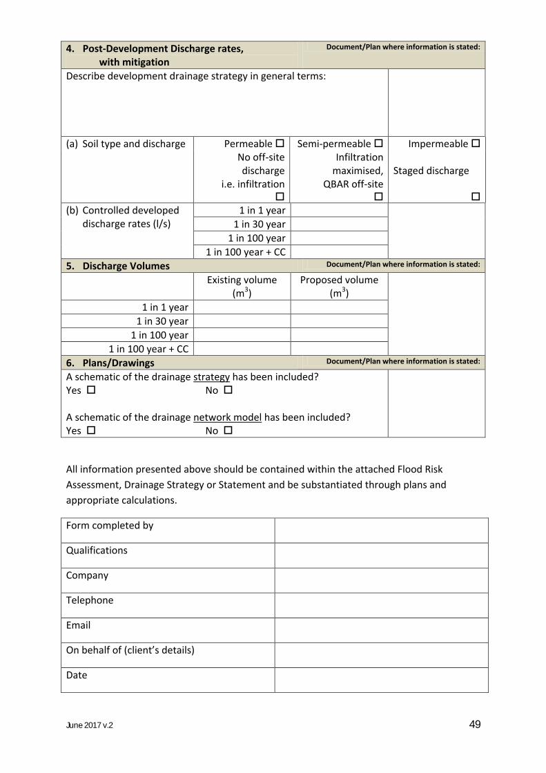
June 2017 v.2 49
Drainage and Planning Policy Statement
4. Post-Development Discharge rates, with mitigation
Document/Plan where information is stated:
Describe development drainage strategy in general terms:
(a) Soil type and discharge Permeable Semi-permeable Impermeable
No off-site discharge
i.e. infiltration
Infiltration maximised,
QBAR off-site
Staged discharge
(b) Controlled developed discharge rates (l/s)
1 in 1 year
1 in 30 year
1 in 100 year
1 in 100 year + CC
5. Discharge Volumes Document/Plan where information is stated:
Existing volume (m3)
Proposed volume (m3)
1 in 1 year
1 in 30 year
1 in 100 year
1 in 100 year + CC
6. Plans/Drawings Document/Plan where information is stated:
A schematic of the drainage strategy has been included? Yes No A schematic of the drainage network model has been included? Yes No
All information presented above should be contained within the attached Flood Risk
Assessment, Drainage Strategy or Statement and be substantiated through plans and
appropriate calculations.
Form completed by
Qualifications
Company
Telephone
On behalf of (client’s details)
Date