Embed Size (px)
Citation preview
Document Type: EA-Administrative Record Index Field: Environmental Assessment Project Name: Duck River Bank Stabilization RM 176.8 Project Number: 2015-14
DUCK RIVER BANK STABILIZATION RIVER MILE 176.8 ENVIRONMENTAL ASSESSMENT
Marshall County, Tennessee
Prepared by: TENNESSEE VALLEY AUTHORITY
KNOXVILLE, TENNESSEE
August 2015
For further information, contact: Matthew Higdon
Project Environmental Planning Tennessee Valley Authority 400 W. Summit Hill Drive
Knoxville, Tennessee 37902 Phone: (865) 632-8051 Email: [email protected]

This page intentionally left blank.
Duck River Bank Stabilization River Mile 176.8
1
Purpose and Need for Action The proposed project is to stabilize three sections of river bank along the right (facing downstream) bank of the Duck River, which provides known habitat for sensitive mussel species. The stabilization is needed to support efforts to reduce soil erosion and its impacts to water quality, and to protect sensitive aquatic species and their habitat in the river. The erosion of the river bank sites has been severe in the past year due to heavy rains, runoff, and lack of vegetation. The project would improve the water quality of the Duck River Watershed, one of the most vulnerable watersheds in the Tennessee River watershed, and would be consistent with the policies and goals for environmental stewardship that the Tennessee Valley Authority (TVA) has established in its 2011 Natural Resource Plan.
The proposed stream bank stabilization requires approval by TVA under Section 26a of the TVA Act. Therefore, TVA proposes to issue approval under Section 26a of the TVA Act for the installation of riprap and associated stabilization materials on the Elk River. Additionally, TVA proposes to contribute funds and agency resources in this partnership project which would be jointly funded by TVA, TNC, and NRCS.
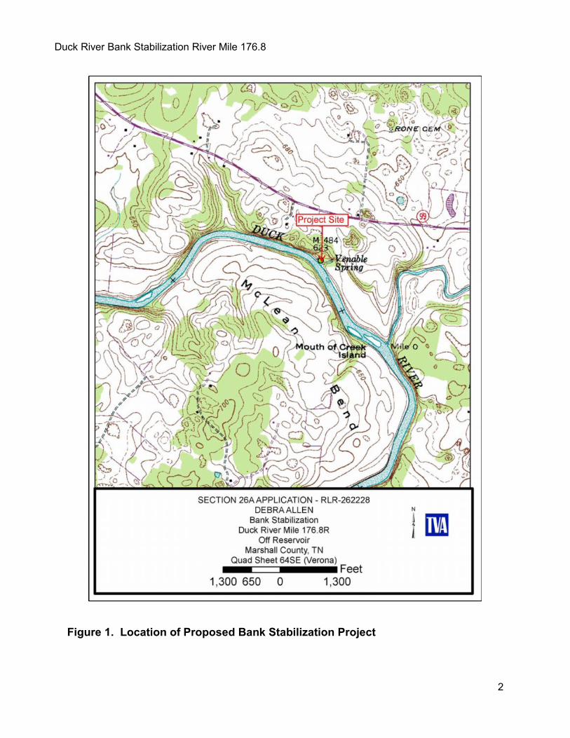
Background Ms. Debra Allen (land owner), in a partnership project with the Tennessee Valley Authority (TVA), the Nature Conservancy (TNC), and the U.S. Department of Agriculture’s Natural Resources Conservation Service (NRCS), has proposed to stabilize the eroding river bank of the Duck River near Lewisburg, Tennessee (Marshall County), River Mile 176.8 (Figure 1).
This partnership project would be jointly funded by TVA, TNC, and NRCS and was designed by the NRCS. The project would require permits from TVA and the U.S. Army Corps of Engineers (USACE). These permitting actions by federal agencies are subject to the requirements of the National Environmental Policy Act (NEPA). This environmental assessment (EA) has been prepared by TVA to meet NEPA requirements. The NRCS, as a project partner, is conducting a separate environmental review of the project.
The Duck River is a major tributary of the Tennessee River and flows approximately 248 miles, flowing generally in a westward direction and draining a large portion of Middle Tennessee. The project area lies in the upper Duck River basin, approximately 90 miles downstream from the river headwaters at Normandy Reservoir.
Necessary Permits or Licenses In addition to approvals required from TVA, the proposed action would require approval by USACE under Section 10 of the River and Harbors Act of 1899 (RHA) to allow alteration/construction within a navigable waterway and Section 404 of the Clean Water Act (CWA) for the proposed discharge of dredged or fill material into the Duck River. Additionally, approval is needed from the TNC of Tennessee, which holds a conservation easement 300 feet wide along the Duck River main channel at the proposed project site.
Duck River Bank Stabilization River Mile 176.8
2
Figure 1. Location of Proposed Bank Stabilization Project
Duck River Bank Stabilization River Mile 176.8
3
Alternatives TVA considered two alternatives in this EA: the No Action Alternative and the Action Alternative. The two alternatives are described in detail below.
No Action Alternative Implementation of the No Action Alternative would result in the denial or withdrawal of the applicant’s request for the installation of riprap along the river bank at the location. None of the three riprap sections would be installed and the soil erosion occurring at the proposed project area would continue. Under this alternative, the needs of the applicant and the objectives of TVA, NRCS, and TNC would not be met.
Action Alternative Under the Action Alternative, TVA would partner with the TNC and NRCS to jointly fund the stabilization of three sections of the Duck River. TVA would also issue a Section 26a approval for the proposed bank stabilization. A description of the Action Alternative is presented below and drawings of project layout are located in Appendix B.
The proposal would stabilize 74 feet of river bank in three sections of river bank (28 feet, 25 feet, and 21 feet) using riprap rock machined to a consistent size class. Two sections of riprap would be installed along the bank stabilization and, just downstream in the third section, a riprap chute extending over 100 feet up the river bank would be installed. Development of the site would include bank shaping and stabilization with riprap to prevent further erosion of river bank sites. Bare root shrub seedlings, Virginia wild rye and other native grasses would be seeded inside a heavy grass mat to reduce sheet erosion. These and other actions associated with stabilization would alter the existing natural environment within and near the site. Heavy construction equipment such as dump trucks, a bulldozer, and a track hoe would be used to complete the project. TVA also considered other stabilization methods (e.g. vegetation and bioengineering) but dismissed them from further consideration because the success of those methods in addressing critical erosion of such high banks is limited.
The total project area is less than one (1) acre and stabilization would occur on the right descending bank of the Duck River. The riprap (limestone rock machined to a consistent size range) revetments would have Class 1, nonwoven, 8-ounce-per-square-yard geotextile placed under the rock. The rock riprap for both revetments would have a D50 (50% of the mixture of stones by weight would be smaller than the diameter specified) of 15 inches in diameter and would range in size from 6 inches to 24 inches in diameter. There would be a smooth transition from the end of the rock riprap revetment to the existing slopes adjacent to the proposed revetments. The total volume of rock riprap necessary for stabilization is estimated to be 195.5 tons.
The first rock riprap revetment (1st site), which would be adjacent to the existing private boat ramp, would extend along the river bank a total of 28 feet in length. The first rock riprap revetment would have a height of 5 feet at a 1.5:1 slope transitioning quickly to 13 feet for 10 linear feet along the Duck River (Appendix B; pg. 2). For the remaining 18 feet, the revetment would be 13 feet in height and have a slope of 2:1. A track hoe would be used to excavate a 2 feet by 2 feet keyway at the toe of the bank. For the subgrade excavation at this site there would be 17.8 cubic yards (yd3) of rock riprap keyway excavation and 22 yd3 of excavated material for slopes resulting in a total volume excavation of 39.4 yd3.
The second rock riprap revetment (2nd site) is 23 feet downstream from the end of the first revetment site, and would extend 21 feet in length along the river bank, be 13 feet in height, and
Duck River Bank Stabilization River Mile 176.8
4
have a 2:1 slope. A track hoe would be used to excavate a 2 feet by 2 feet keyway along the toe of the bank. The subgrade excavation at the second site would be 13.1 yd3 for the keyway, with 16.5 yd3 of excavated material for slopes, resulting in 29.6 yd3 total volume of excavation. The slope above the rock riprap for both revetments would be constructed at a 2:1 slope, stabilized by planting shrub seedlings (e.g., stream alder, silky dogwood, and buttonbush) or other suitable alternatives specified by NRCS at a rate of 680 stems per acre.
The riprap chute (3rd site) would be 110.4 feet in length and 21 feet of top width from tip to tip, requiring a total of 425 tons of rock. The distance from the end of the 2nd revetment to the midpoint of the riprap chute would be 23 feet. The riprap chute would have class 1, nonwoven, 8 ounce per square yard geotextile placed under the rock riprap. The rock riprap chute would have 4 feet wide bottom width, 2:1 side slopes, and would be 2 feet in depth, 2.5 feet in thickness and 90.4 feet in length of slope length, plus an additional 20 feet of chute length including the chute entrance and exit. The body of the chute would be constructed on a 4:1 slope and total 341.1 square yards. The rock riprap for the chute would have a D50 of 15 inches and range in size from 6 inches to 24 inches in diameter.
In addition, there would be a 95 feet diversion constructed from the existing access road area to the entrance of the rock riprap chute. The diversion would be a minimum of 2 feet deep and 95 feet long, have a minimum of 13.8 of top width, and be constructed on a 1% slope. The diversion would receive concentrated stormwater flows and an Erosion Control Blanket (ECB) would assist with resisting erosion until the vegetation has time to become established. The 12-month straw ECB would be North American Green S75 or equivalent. The diversion berm would be constructed from excavated soil from the rock riprap chute and the bank stabilization revetments. All areas of soil disturbed during construction would be stabilized with a critical area seeding, limed, fertilized, and mulched with small grained straw mulch at the rate of 2.5 tons per acre as specified by the local NRCS District Conservationist. Any spoil material would be deposited on the property above the 100 year flood elevation for leveling purposes.
Equipment used in land clearing, construction, and bank stabilization activities would be stored and fueled in an equipment staging area approximately 270 ft2 in size, within a previously cleared area on the Allen property at an existing campsite, located a minimum of 100 feet away from the Duck River, Venable Spring, and any wetlands. All equipment used within the floodplain will have attached absorbent pads during both operation and non-operational activities to prevent the introduction of oils, coolants, or other petroleum products into aquatic features. As noted above, an existing private river access road which loops down to the private boat ramp would be used as a haul road for equipment and materials. Any stockpile areas used for fill would be located in upland areas away from the Duck River on the Allen property.
Other Alternatives Considered TVA also considered other stabilization methods (e.g. vegetation and bioengineering), but dismissed them from further consideration because the success of those methods in addressing critical erosion of such high banks is limited.
Preferred Alternative TVA’s preferred alternative is the Action Alternative where TVA would partner with the TNC and NRCS to jointly fund the stabilization of three sections of the Duck River. TVA would also issue a Section 26a approval for the proposed stream bank stabilization.
Affected Environment and Anticipated Impacts Site Description
Duck River Bank Stabilization River Mile 176.8
5
The proposed project site is on the Duck River at River Mile 176.8 (right descending bank) immediately downstream of the Venable Spring outflow. Ms. Allen, the project proponent, owns the property surrounding Venable Spring and the project area on the Duck River immediately downstream of the Venable Spring run. The Allen family, who own the property, maintained a dairy farm on the property for over a century (Corey Giles, TNC; personal communication), but no longer use the property for dairy production purposes. There is a primitive campsite adjacent to the private boat ramp used by the landowner, which is accessed by a private road leading from Tennessee State Highway 99 to the private ramp and campsite. The Nature Conservancy of Tennessee has a conservation easement 300 feet wide along the Duck River main channel at the proposed project site.
The area being considered for the bank stabilization project site has a very high cut bank (~20 feet). Venable Spring and Spring Run are located on the northeast side of the private boat ramp, and the proposed project begins on the southwest side of the private boat ramp and proceeds downstream on the Duck River for 74 linear feet. TVA has determined that 0.7 acres along the river may be potentially impacted by the proposed project; including a terrestrial area of riparian zone and floodplain, and that approximately 17.1 acres of aquatic habitat in the Duck River may be impacted. Therefore, the total area of potential impacts is approximately 17.8 acres.
The landscape on the property where the proposed project is located is generally low-gradient, and currently supports agricultural practices such as feed grass. A relatively small proportion of forested land (riparian buffer) serves as riparian cover for the mainstem Duck River and Venable Spring and its outflow into the Duck River. The property slopes toward the river near the riverbank and includes a variety of vegetation, which becomes generally non-vegetated with sand/gravel substrates near the riverbank.
Impacts Evaluated TVA has conducted an environmental review of the proposed project with input from resource specialists by completing a Categorical Exclusion Checklist (Appendix D). The checklist identifies the resources present in the project area and documents TVA’s determination that the proposal would not significantly affect these resources.
TVA conducted a review of its Natural Heritage Database and found that 16 state and 2 federal listed plant species (Leafy Prairie-clover and Tennessee Coneflower) have previously been identified within a 5-mile radius of project location (Appendix D). However, the habitat at and adjacent to the project site does not appear suitable for the identified species. Therefore the listed plant species would not be impacted by the project. No cultural resources or wetlands were identified in the project area. The proposed project location does not occur on a Nationwide Rivers Inventory (NRI) river segment or a tributary stream of an NRI. The majority of the project location has been made into a private camping site with no facilities other than a fire pit and the boat ramp. Since recreation amenities at the proposed project area are private, there would be no effects to recreation.
As documented in the Checklist, the proposal would have no effect to land use, wetlands, cultural resources, threatened and endangered plant species, recreation or navigation. The following environmental issues were identified by TVA in the checklist as needing additional analysis: aquatic ecology, floodplains, wildlife and aquatic threatened and endangered species, and water quality.
Duck River Bank Stabilization River Mile 176.8
6
Water Quality and Aquatic Ecology The Duck River is considered to be globally important for biological diversity, especially for aquatic species, with approximately 151 species of fish, 69 species of mussels, and 22 species of aquatic snails. The Duck River is recognized as the most biologically diverse river system in Tennessee and perhaps all of Eastern North America, supporting populations of species that are found nowhere else (Palmer 2005). Studies have documented recent aquatic faunal recovery in the Duck River from past disturbances in the watershed (Ahlstedt et al. 2004; Hubbs et al. 2010). This recovery is attributed to land protection and restoration efforts, improvements in Normandy reservoir releases by TVA, the settling of channel morphology from earlier destabilizing events, removal of historic point and nonpoint sources of pollution from phosphate and iron ore mining, wastewater treatment plant upgrades at Shelbyville, and the natural hardness of the water and abundance of groundwater inputs to the system (Johnson and Hubbs 2014; Palmer 2005).
Through routine monitoring, TVA has found the ecological health condition of the Duck River at White Ford rated “good”, indicating healthy, stable communities, consistently in four sampling events from 1997 through 2009. As in previous years, in 2012 ecological health indicator scores for the Duck River main channel sampling sites at DRM 22.5, 46.5, and 89 were among the highest observed for all rivers sampled by TVA throughout the Tennessee River system.
The Duck River is of tremendous importance to freshwater mollusks of the Cumberlandian mussel fauna, and it serves as a source and repository for state and federally listed species in need of conservation (Cumberlandian Region Mollusk Restoration Committee [CRMRC] 2010). Previous mussel surveys (Ahlstedt 1991; Jenkinson 1988; Isom and Yokley 1965; Ortmann 1924) near the project site and other areas of the Duck River upstream and downstream indicate this area of the river supports a relatively high density and a highly diverse native mollusk community compared to other rivers and streams of the Tennessee River drainage.
Alternative A – No Action Alternative Under the No Action Alternative, the proposed bank stabilization would not occur. Soil erosion occurring at the proposed project area would continue. Environmental conditions would remain unchanged. The beneficial impacts of reducing soil erosion and its impacts to water quality and ecology of the Action Alternative would not be realized. There would continue to be minor aquatic ecology impacts to the Duck River, but none that would be the result of TVA’s action.
Duck River Bank Stabilization River Mile 176.8
7
Alternative B – Action Alternative Under Alternative B, three sections of river bank along the right (facing downstream) bank of the Duck River would be stabilized to reduce soil erosion and its impacts to water quality and to protect sensitive aquatic species and their habitat in the river. Sediment runoff from soil disruption and construction would be minimized through implementation of best management practices (BMPs). Nonetheless, some disturbance of the river bank and some level of stormwater runoff from the disturbed area could temporarily suspend fine substrate particles into the water column. Changes in water quality and aquatic habitats are expected in the area at the toe of the bank where excavation is proposed. Altered flow patterns of water moving around the riprap could be expected to suspend fine particles and ultimately create areas where silt and fine sand could accumulate. While the extent of impacts on water quality, aquatic habitat, and aquatic ecology cannot be determined specifically, it is anticipated that these effects would be temporary and minor and would subside once work is completed.
The proposed riprap revetments and disturbance would not significantly alter existing flow patterns beyond the construction footprint such that erosion and sedimentation of the nearby bank or riverbed could occur. The proposed project is anticipated to provide long-term beneficial impacts to water quality, aquatic species and their habitats through stabilization and armoring of the river bank. Stabilization of eroding soils in the floodplain as well as filtration of stormwater would potentially lead to improvements in water quality in the Duck River in the vicinity of the project site. Overall, there would be minor direct, indirect and cumulative beneficial impacts to water quality and aquatic ecology.
Threatened and Endangered Species The Endangered Species Act (ESA) requires federal agencies to conserve listed species and to determine the effects of their proposed actions on endangered and threatened species and their critical habitat. Endangered species are those determined to be in danger of extinction throughout all or a significant portion of their range. Threatened species are those determined to be likely to become endangered within the foreseeable future. Section 7 of the ESA required federal agencies to consult with the USFWS when their proposed actions may affect endangered or threatened species and their critical habitats.
Aquatic Species An April 2014 review of the TVA Regional Natural Heritage Database indicated a total of 12 federally listed species and 28 state-listed aquatic species that may occur within 10 miles of the proposed project area (Appendix D). Of those species that may occur near the project action area, the oyster mussel, rabbitsfoot, slabside pearlymussel, Cumberland monkeyface, and birdwing pearlymussel are the federally listed species that may be affected by the proposed project. In addition records from the past 25 years show that there is evidence these species were found in the Duck River near the project action area at DRM 176 in surveys completed in 2002 (Ahlstedt et al. 2004), and 2010 (Hubbs et al. 2010). The federally endangered Cumberlandian combshell and fluted kidneyshell are not present near the project action area; however, designated critical habitat (DCH) for these two species could be affected.
Species Accounts Orangefoot Pimpleback (Plethobasus cooperianus): The orangefoot pimpleback was listed as an endangered species in 1976 and is currently restricted to the Tennessee River, Cumberland River and lower Ohio River mainstems where it is considered very rare. Records of this species in the Duck River have not been reported since 1924 (Ahlstedt 1991; Ortmann 1924).
Duck River Bank Stabilization River Mile 176.8
8
Pale Lilliput (Toxolasma cylindrellus): The pale lilliput pearlymussel was listed as an endangered species in 1976 and has recently been reintroduced directly upstream of the Venable Spring outflow in September 2014 (Johnson and Hubbs 2014). This species does not currently occur in the reach of the Duck River downstream of the private boat ramp at Venable Spring.
Rayed Bean (Villosa fabalis): The rayed bean was listed as an endangered species in 2012. Long considered extirpated from Tennessee, this species has been reintroduced into the Duck River at Slick Shoals approximately one river mile (1.6 km) upstream of the project area (Moles and Layzer 2009). However, the rayed bean has not been collected in the vicinity of the project area.
Snuffbox (Epioblasma triquetra): The snuffbox was listed as an endangered species in 2012. A single live individual was found in 2002 downstream from the project area at river mile 146 and relict shells have been collected at other sites on the Duck River mainstem (Ahlstedt et al. 2004). The snuffbox is a candidate for restoration in the river (CRMRC 2010). However, it was not collected near the project area in recent surveys (Hubbs et al. 2010).
Tan Riffleshell (Epioblasma florentina walkeri) = (Golden Riffleshell [Epioblasma florentina aureola]): The tan riffleshell was listed as an endangered species in 1977. Recent genetic analysis indicated that Epioblasma florentina walkeri currently exists only in the in the Big South Fork of the Cumberland River system, and the closely related golden riffleshell is what historically occurred in the Duck River system (Jones and Neves 2010). The tan riffleshell is the species currently recognized by the USFWS for federal protection purposes and was last collected alive in the Duck River system in 1964, and a single relic was collected in 1988 (Ahlstedt et al. 2004). The tan riffleshell does not currently occur in the Duck River.
Tuberculed Blossom Pearlymussel (Epioblasma torulosa torulosa): The tuberculed blossom was listed as an endangered species in 1976. Although the tuberculed blossom was historically abundant in the Duck River system, numerous recent and contemporary surveys have not documented its presence in the Duck River (Jenkinson 1988; Ahlstedt 1986; Ahlstedt et al. 2004; Hubbs et al. 2010).
Cumberlandian Combshell (Epioblasma brevidens): The Cumberlandian combshell was extirpated from the Duck River and has been reintroduced with broodstock from the Clinch River system. It continues to survive and reproduce below Lillard Mill approximately 3 river miles (4.8 km) upstream from Venable Spring (Hubbs et al. 2010). Forty-six miles of the Duck River are designated as critical habitat for this species. There is critical habitat for the Cumberlandian combshell designated in the Duck River mainstem adjacent to the project action area; however, the species has not been collected at or near Venable Spring in recent surveys (Ahlstedt et al. 2004; Hubbs et al. 2010).
Fluted Kidneyshell (Ptychobranchus subtentum): There is DCH for the fluted kidneyshell in the Duck River mainstem for 216 river miles. Critical habitat for this species is in the project area; however, this species has not been collected at Venable Spring in recent surveys (Ahlstedt et al. 2004; Hubbs et al. 2010); it is unlikely that this species has colonized the area since it was reintroduced to the Duck River in 2010 two miles upstream from the project.
Oyster Mussel (Epioblasma capsaeformis) (= Duck River Dartersnapper [Epioblasma ahlstedti]): The oyster mussel (Duck River dartersnapper) has DCH in the proposed project action area, and the Duck River represents the only population of this recently described species (Jones and
Duck River Bank Stabilization River Mile 176.8
9
Neves 2010). In 2010, Venable Spring upstream of the proposed project area represented the best sampling location for the Duck River dartersnapper of six sampling localities in the Duck River. It was the most abundant species, representing 21% of mussels encountered at the site.
Birdwing Pearlymussel (Lemiox rimosus): The birdwing pearlymussel population in the Duck River appears to be increasing and is the largest and best remaining population of the species (Ahlstedt et al. 2004; Hubbs et al. 2010). Recent research efforts in the Duck River have illustrated the importance of this population to recovery of the species (Jones et al. 2010). Birdwing pearlymussel abundance at Venable Spring has increased from 1988 to 2010 (Hubbs et al. 2010).
Cumberland Monkeyface (Quadrula intermedia): The Cumberland monkeyface was listed as an endangered species in 1976 (USFWS 1976), but does not have DCH. Since the early 1970s, the Cumberland monkeyface has been found alive in middle reaches of the Duck, Elk, and Powell rivers, but it currently exists only in the Duck and Powell Rivers (USFWS 2011). The Cumberland monkeyface population is considered significant and viable in the Duck River. The Duck River population has recovered to the point where this species has expanded its size and range and it is the largest and best remaining population (USFWS 2011). At Venable Spring in 2010 the Cumberland monkeyface densities had increased 26% from 1988 to 2010 (Hubbs et al. 2010).
Slabside Pearlymussel (Lexingtonia [= Pleuronaia] dolabelloides): The slabside pearlymussel was listed as an endangered species with DCH in 2013. There is DCH for the fluted kidneyshell in the Duck River mainstem for 216 river miles, and critical habitat is adjacent to the project action area. The slabside pearlymussel population in the Duck River is considered to be the largest and best remaining population of the species (Hubbs et al. 2010). In 2010 at Venable Spring the slabside pearlymussel had an estimated abundance of 1,200 individuals.
Rabbitsfoot (Quadrula cylindrica cylindrica): The rabbitsfoot was designated as a threatened species in 2013 and has DCH adjacent to the project area. Critical habitat for the rabbitsfoot in the Duck River is approximately 146 river miles. The rabbitsfoot population in the Duck River is considered to be one of the largest and best remaining populations of the species (Hubbs et al. 2010). In 2010 at Venable Spring the rabbitsfoot had an estimated abundance of 2,100 individuals.
Alternative A – No Action Alternative Under the No Action Alternative, TVA would not issue Section 26a approval for the proposed stream bank stabilization. Environmental conditions in the project area would remain unchanged. The beneficial impacts of reducing soil erosion and its impacts to water quality and ecology of the Action Alternative would not be realized. There would continue to be minor indirect impacts to threatened and endangered species under the No Action Alternative, but none that would be the result of TVA’s action.
Duck River Bank Stabilization River Mile 176.8
10
Alternative B – Action Alternative Due to the presence of federally-listed mussel species in the proposed project area, TVA completed a comprehensive analysis of effects on these resources in its December 2014 Biological Assessment (BA). In the BA, TVA concluded that the proposed action (including conservation measures) would have no effect on the mussel species Cumberlandian combshell, fluted kidneyshell, orangefoot pimpleback, tuberculed blossom, snuffbox, rayed bean, tan riffleshell, and pale lilliput. TVA also determined that the proposed bank stabilization may affect and is likely to adversely affect the federally endangered oyster mussel, Cumberland monkeyface, birdwing pearlymussel, slabside pearlymussel and the federally threatened rabbitsfoot.
TVA also determined that the proposed project may affect but would not result in destruction or adverse modification of critical habitat for the endangered oyster mussel, slabside pearlymussel, Cumberlandian combshell, fluted kidneyshell, and would not adversely modify proposed critical habitat for the threatened rabbitsfoot, provided measures to prevent adverse modification of critical habitat are followed.
By a letter dated April 13, 2015, the USFWS agreed with TVA’s determination except that the USFWS found that the Cumberlandian combshell would likely be adversely affected by the proposed action (TVA determined that the project would have no effect on this species). The USFWS’s rationale for these determinations is provided below and in its final BO for the proposed project (Appendix A).
The BO concluded that the proposed action is not likely to jeopardize the continued existence of the oyster mussel, Cumberland monkeyface, birdwing pearlymussel, slabside pearlymussel and rabbitsfoot, and is not likely to destroy or adversely modify DCH for the Cumberlandian combshell, oyster mussel, fluted kidneyshell and slabside pearlymussel because: 1) the action area would be small relative to individual range-wide distributions of these species and DCHs, and therefore, only small fractions of the individual species populations and DCHs would be affected by the action, 2) potential effects to these species and DCHs, as a result of construction activities during the project implementation phase, would be temporary and of short duration, 3) the likelihood of these species being affected would be low with properly engineered and correctly installed project components, adherence to BMPs, effectiveness monitoring to ensure the project is functioning as intended (i.e., with minimal or no apparent effects to any of the species), and maintenance, as needed, 4) the likelihood of fish host species being impacted would be low with properly engineered and correctly installed project components, adherence to BMPs, effectiveness monitoring to ensure the project is functioning as intended (i.e., with minimal or no apparent effects to suitable habitats for the Cumberland monkeyface, birdwing pearlymussel and rabbitsfoot DCHs for the Cumberlandian combshell, oyster mussel, fluted kidneyshell and slabside pearlymussel), and maintenance, as needed, and 5) the proposed action would provide beneficial effects to habitat for the listed mussel species because water quality necessary for the normal behavior, growth, and survival of all life stages of the mussels and their host fish species, should be improved as a result of stabilizing eroding soils in the floodplain and on the riverbank.
The BO included an Incidental Take Statement permitting take of the oyster mussel, Cumberland monkeyface; birdwing pearlymussel, slabside pearlymussel and rabbitsfoot. The conclusion of the BO is dependent upon the implementation of non-discretionary Terms and Conditions designed to minimize potential impacts to the species and DCHs (listed in Appendix A). The USFWS indicated that the BO completed formal consultation for the project as required by the ESA and fulfills the obligations in accordance with Section 7 of that act.
Duck River Bank Stabilization River Mile 176.8
11
Wildlife The federally listed as endangered gray bat, Indiana bat, and listed as threatened northern long-eared bat are known from or likely to occur within Marshall County.
Gray bats roost in caves year-round and migrate between summer and winter roosts during spring and fall (Brady et al. 1982, Tuttle 1976). Bats disperse over bodies of water at dusk where they forage for insects emerging from the surface of the water (Harvy 1992).
Indiana bats hibernate in caves in winter and use areas around them for swarming (mating) in the fall and staging in the spring, prior to migration back to summer habitat. During the summer, Indiana bats roost under the exfoliating bark of dead snags and living trees in mature forests with an open understory and a nearby source of water (Pruitt and TeWinkel 2007, Kurta et al. 2002).
Northern long-eared bats roosts in caves or cave-like structures (such as buildings and mines) in the winter, while summer roosts are typically in cave-like structures as well as live and dead trees with exfoliating bark and crevices. Northern long-eared bats tend to forage within the mid-story and canopy of upland forests on hillsides and ridges (USFWS 2014).
Alternative A – No Action Alternative Under the No Action Alternative, TVA would not issue Section 26a approval for the proposed stream bank stabilization. Environmental conditions in the project area would remain unchanged. Therefore, there would be no direct, indirect, or cumulative impacts to wildlife T&E species under the No Action Alternative.
Alternative B – Action Alternative Under Alternative B, three sections of river bank along the right (facing downstream) bank of the Duck River would be stabilized to reduce soil erosion and its impacts to water quality and to protect sensitive aquatic species and their habitat in the river. No caves were identified within a 3-mile radius per the TVA Natural Heritage Database. In the BA, TVA concluded that the gray bat, Indiana bat, and northern long-eared bat would not be affected by the proposed project because these species either have been extirpated from the area or do not have adequate or sufficient habitat available in the project action area. In addition, the project would not jeopardize the continued existence or adversely modify proposed critical habitat for either the northern long-eared bat or the Indiana bat. By a letter dated April 13, 2015, the USFWS agreed with this determination (Appendix A).
Floodplains Executive Order 11988 requires federal agencies to evaluate and minimize to the extent possible, impacts and modifications to floodplains. The proposed bank stabilization would be constructed with the floodplain associated with the Duck River.
Alternative A – No Action Alternative Under the No Action Alternative, TVA would not issue Section 26a approval for the proposed stream bank stabilization. Environmental conditions in the project area would remain unchanged. Therefore, there would be no direct or indirect impacts to floodplains under the No Action Alternative.
Alternative B – Action Alternative Under the Action Alternative, TVA would issue Section 26a approval for the stream bank stabilization. Consistent with Executive Order (E.O.) 11988, riprap is considered to be a
Duck River Bank Stabilization River Mile 176.8
12
repetitive action within the 100-year floodplain that should result in minor impacts. The project would comply with the TVA Flood Control Storage Loss Guideline because there would be no loss of flood control storage. Therefore, there would be minor direct and indirect impacts to floodplains under the Action Alternative.
Identification of Mitigation Measures The project has been designed to minimize adverse environmental impacts through routine and project-specific measures. Standard BMPs would be implemented during proposed construction in accordance with TVA 26a Standard Permit Conditions and NRCS Streambank and Shoreline protection Code 580 (Appendix C). These BMPs would be designed to control potential stormwater pollutants and would limit sediment runoff to the Duck River and direct effects to aquatic habitat.
To avoid impacts to federally listed aquatic species and DCH for federally listed aquatic species, TVA, NRCS, TNC, and the applicant must comply with the “terms and conditions” (T&C) identified in the USFWS Biological Opinion (Appendix A), developed as part of the formal ESA Section 7 consultation process.
TVA, as lead agency, would adhere to the following commitments to reduce potential effects of the proposed project on the following freshwater mussel species: oyster mussel, rabbitsfoot, slabside pearlymussel, Cumberland monkeyface, and birdwing pearlymussel. These commitments would also reduce impacts on DCH for the oyster mussel, slabside pearlymussel, Cumberlandian combshell and fluted kidneyshell, and to the proposed critical habitat for rabbitsfoot.
• Translocation: TVA, USFWS, and TWRA personnel would conduct pre-project translocations of the adjacent and downstream impact areas to move individuals of listed species (oyster mussel [Duck River dartersnapper], birdwing pearlymussel, slabside pearlymussel, Cumberland monkeyface, and rabbitsfoot mussels) out of areas directly impacted by the project. Collection and relocation of individuals would most likely take place in the late summer of 2015, though the exact timeframe would be dictated by project implementation schedules. Individuals collected would be released at appropriate habitats suitable for mussel survival upstream of the project area. Any federally protected mussels collected for relocation would be carefully maintained during collection, transported as quickly as possible to relocation sites, and acclimated to the new environment appropriately. The catch per unit effort and/or density of individuals collected would be documented and the deposition of relocated species would be reported to the USFWS Tennessee Field Office. Details reported would include habitat conditions such as water temperature, depth, substrate types and percentages, flow at substrate, number of individuals collected and moved, and location (latitude and longitude) of pre-approved release sites. In the event that dead, injured, or sick individuals of an endangered or threatened species is identified, the USFWS would be notified, and care would be taken in handling sick or injured individuals and in preserving specimens for later analysis of cause of death or injury.
• To prevent the adverse modification of DCH of these species, the following measures would be mandated:
- An NRCS representative as well as a TVA biologist would make at least one site visit during active construction to ensure that BMPs and water quality control measures are in place and properly functioning.
Duck River Bank Stabilization River Mile 176.8
13
- An onsite inspection would be completed by this individual and findings made available to the USFWS Tennessee Field Office and/or permitting agency(s) upon request.
- A properly designed and designated fueling and oil area for equipment an adequate distance from the channel would be established to ensure that oil, gas, or other petroleum pollutants do not enter the Duck River.
- Any construction activity that results in the introduction of potentially toxic materials into the Duck River would be stopped immediately by the project inspector, resource agencies contacted, and corrective action(s) implemented prior to resuming work.
- There would be no tree or shrub removal along the Duck River except within project limits, and then only if essential. When possible, trees and shrubs on streambanks would be cleared by hand rather than removed by mechanical means to ensure the roots are left in place. All areas disturbed during construction would be stabilized as soon as possible by use of riprap, seeding, or mulching, in compliance with permit specifications.
Agencies and Others Consulted The following agencies and Native American tribes were consulted.
• Tennessee Historical Commission, Nashville, Tennessee • Cherokee Nation, Tahlequah, Oklahoma • Absentee Shawnee Tribe of Oklahoma, Shawnee, Oklahoma • Kialegee Tribal Town, Wetumka, Oklahoma • Thlopthlocco Tribal Town, Weleetka, Oklahoma • Eastern Shawnee Tribe of Oklahoma, Seneca, Missouri • Eastern Band of Cherokee Indians, Cherokee, North Carolina • Muscogee (Creek) Nation of Oklahoma, Okmulgee, Oklahoma • Shawnee Tribe of Oklahoma, Miami, Oklahoma • Alabama-Quassarte Tribal Town, Wetumka, Oklahoma • Chickasaw Nation, Ada, Oklahoma • United Keetoowah Band of Cherokee Indians in Oklahoma, Tahlequah, Oklahoma
Duck River Bank Stabilization River Mile 176.8
14
TVA Preparers
Freddie Bennett Position: Water Resource Representative Education: B.S. Agricultural Economics Experience: 36 years in Land Management and Section 26a Permitting, Involvement: Section 26a Permitting Steve Cole Position: Archaeologist Education: Ph.D., Anthropology (Archaeology specialization); M.A., Anthropology Experience: 12 years in Cultural Resources Involvement: Cultural Resources Andrew Henderson Position: Aquatic Endangered Species Biologist Education: MS, Fisheries Biology (Conservation), BS, Fisheries Biology Experience: 10 years in aquatic monitoring, rare aquatic species surveys Involvement: Aquatic Ecology; Threatened and Endangered Species Matthew Higdon Position: NEPA Specialist Education: M.S., Environmental Planning; B.A., History Experience: 12 years in Natural Resources Planning and NEPA Compliance Involvement: NEPA Compliance and Document Preparation Marianne M. Shuler Position: Archaeologist Education: B.A., Religion/Middle Eastern Archaeology Experience: 10 years in Archaeology and Cultural Resource Management Involvement: Cultural Resources, National Historic Preservation Act Compliance Dana Vaughn Position: NEPA Specialist Education: M.A. Education; B.A., Biology Experience: 10 years in Natural Resources and Environmental Compliance Involvement: NEPA Compliance and Document Preparation
Duck River Bank Stabilization River Mile 176.8
15
References
Ahlstedt, S. A. 1991. Cumberlandian mollusk conservation program: mussel surveys in six Tennessee Valley streams. Walkerana 5(13) 123-160.
Ahlstedt, S.A., J.R. Powell, R.S. Butler, M.T. Fagg, D.W. Hubbs, S.F. Novak, S.R. Palmer, and P.D. Johnson. 2004. Historical and current examination of freshwater mussels (Bivalvia: Margaritiferidae, Unionidae) in the Duck River basin Tennessee. Final Report: Tennessee Wildlife Resource Agency contract FA-02-14725-00.
Brady, J., T.H. Kunz, M.D. Tuttle and D. Wilson, 1982. Gray bat recovery plan. U.S. Fish and Wildlife Service, Denver, Colorado. 143 pp.
Cumberland Region Mollusk Restoration Committee (CRMRC). 2010. Plan for the controlled propagation, augmentation, and reintroduction of freshwater mollusks of the Cumberlandian Region. 145 pp.
Griffith, G. E, J. M. Omernik, and S. Azevedo. 1998. Ecoregions of Tennessee (color poster with map, descriptive text, summary tables, and photographs). Reston, VA.: U.S. Geological Survey (map scale 1:1,250,000).
Harvy, M. J. 1992. Bats of the eastern United States. Arkansas Game and Fish Commission, Little Rock, Arkansas. 46 pp.
Hubbs, D., S. Chance, L. Colley, and R.S. Butler. 2010. Duck River Quantitative Mussel Survey. Tennessee Wildlife Resources Agency Fisheries Division Report 11-04. 48 pages.
Isom, B.G. and Yokley Jr., P. 1968. The Mussel fauna of Duck River in Tennessee. American Midland Naturalist. (1968) 34-42.
James, W. 2002. Nonnative, Noninvasive Species Suitable for Public Use Areas, Erosion Control/Stabilization, and Wildlife Habitat Plantings. Compiled by Wes James as a Result of Interdisciplinary Team for the Implementation of the Executive Order of Invasive Species. Lenoir City, Tennessee: TVA Watershed Team Office, unpublished report.
Jenkinson, J. J. 1988. Resurvey of freshwater mussel stocks in the Duck River, Tennessee. Tennessee Valley Authority, River Basin Operations, Water Resources, Knoxville, Tennessee. 28 pp.
Johnson, P.D., and D. Hubbs. 2014. Proposed Reintroduction of Pale Lilliput, Toxolasma cylindrellus (Lea, 1868), in the Duck River, Venable Spring, Marshall Co., Tennessee.
Jones, J.W. and R.J. Neves. 2010. Descriptions of a new species and a new subspecies of freshwater mussels, Epioblasma ahlstedti and Epioblasma florentina aureola (Bivalvia: Unionidae), in the Tennessee River drainage, USA. The Nautilus 124(2):77-92.
Jones, J.W., R.J. Neves, S.A. Ahlstedt, D. Hubbs, M. Johnson, H. Dan, and B.J.K. Ostby. 2010. Life History and Demographics of the Endangered Birdwing Pearlymussel (Lemiox rimosus) (Bivalvia: Unionidae). American Midland Naturalist 163(2):335-350.
Duck River Bank Stabilization River Mile 176.8
16
Knight, R.R., and J.A. Kingsbury. 2007. Water resources of the Duck River watershed, Tennessee: U.S. Geological Survey Scientific Investigations Report 2007–5105. 46 pp.
Moles, K.R., and J.B. Layzer. 2009. Reintroduction of the rayed bean (Villosa fabalis) into the Duck River. Unpublished report to the U.S. Fish & Wildlife Service. State College, PA.
Ortmann, A. E. 1924. The naiad-fauna of the Duck River in Tennessee. American Midland Naturalist 9(1):18-62.
Palmer, S.R. 2005. Conserving the Duck River: A Plan for Collaborative Action. The Nature Conservancy, Nashville, TN.
Pruitt, L., and L. TeWinkel, editors. 2007. Indiana Bat (Myotis sodalis) Draft Recovery Plan: First Revision. U.S. Fish and Wildlife Service, Fort Snelling, Minnesota.258 pages.
U.S. Fish and Wildlife Service. 2011. Cumberland Monkeyface (Quadrula intermedia) 5-year review: Summary and Evaluation. U.S. Fish and Wildlife Service, Asheville, North Carolina. 16 pp.
U.S. Fish and Wildlife Service. 2015. Biological Opinion for the Duck River Bank Stabilization, River Mile 176.8, Marshall County, Tennessee. 115 pp.
______. 2014. Northern Long-eared Bat Interim Conference and Planning Guidance. U.S.Fish and Wildlife Service.
Williams, J. D., A. E. Bogan, and J. T. Garner. 2008. Freshwater Mussels of Alabama and the Mobile Basin in Georgia, Mississippi and Tennessee. University of Alabama Press, Tuscaloosa, Alabama. 356 p.
Yeager, B.L., and C.F. Saylor. 1995. Fish hosts of four species of freshwater mussels (Pelecypoda: Unionidae) in the upper Tennessee River drainage. American Midland Naturalist. 133(1):1-7.