Embed Size (px)
Citation preview
Cleveland State Law Review Cleveland State Law Review
Volume 7 Issue 2 Article 14
1958
Due Care in Drafting Real Property Descriptions Due Care in Drafting Real Property Descriptions
Dean T. Lemley
Follow this and additional works at: https://engagedscholarship.csuohio.edu/clevstlrev
Part of the Property Law and Real Estate Commons
How does access to this work benefit you? Let us know! How does access to this work benefit you? Let us know!
Recommended Citation Recommended Citation Dean T. Lemley, Due Care in Drafting Real Property Descriptions, 7 Clev.-Marshall L. Rev. 324 (1958)
This Article is brought to you for free and open access by the Journals at EngagedScholarship@CSU. It has been accepted for inclusion in Cleveland State Law Review by an authorized editor of EngagedScholarship@CSU. For more information, please contact [email protected].
Due Care in Drafting Real PropertyDescriptions
Dean T. Lemley*
T HE UNDERTAKING OF AN ATTORNEY is not that he possessesperfect legal knowledge or the highest degree of skill in
relation to the business he undertakes, nor that he will conductit with the greatest degree of diligence, care and prudence, butthat he possesses the ordinary legal knowledge and skill commonto members of the profession and that in the discharge of hisduties, he will exercise ordinary and reasonable diligence, careand prudence.'
Robert Kratovil in "Real Estate Law" 2 states the generality:"A deed must describe the land conveyed. The land must be sodescribed that it can be located and identified. Otherwise thedeed is void. It is often difficult to determine whether a de-scription is good or bad.3 No particular method of describingland is required by law. Land may be described by the name bywhich it is generally known, by its lot number on a recordedplat, by its section, township and range number on the govern-ment survey, by metes and bounds, or even by general descrip-tion, as 'all land owned by the grantor in Tazewell County,Illinois.' "4
In the absence of a recent survey, the title examiner is con-fined to the record title only, and thus the legal description ofthe deed must be sufficient to describe the real estate intendedto be conveyed so that an examination of the record title alonewill disclose those elements of a description which will distin-guish the land conveyed from all other land in the world. It hasbeen held that a description in a deed which consists only of thewords, "a piece or parcel of land near Bacon Quarter Branch,"is too vague and indefinite to create a right of property in anyparticular parcel of land.5
* Preparation at Miami (Ohio) Univ. and Western Reserve Univ.; Specialstudent at Cleveland-Marshall Law School; Agent, Louisville Title Insur-ance Company, and formerly a title examiner with Lawyer's Title InsuranceCorporation and Land Title Guarantee and Trust Company.1 Gardner, Attorney's Malpractice, 6 Clev.-Mar. L. R. 264 (1957).2 Kratovil, Real Estate Law (1946).3 Richey v. Sinclair, 167 Ill. 184 (1897).4 Kratovil, n. 2, par. 78.5 6 Thompson on Real Property, Sec. 3268 (1940); also,
George v. Bates, 90 Va. 839, 20 S. E. 828 (1894).
1Published by EngagedScholarship@CSU, 1958
DRAFTING REALTY DESCRIPTIONS
An attorney, in drafting a legal description for the con-veyance of real property, must satisfy the bare legal require-ments and, furthermore, since the apparent purpose is the record-ing of the instrument, draft such a description as will precludeany confusion or misconception as to the identity of the realestate, from the public records alone.
In order to make a valid conveyance of land, it is essentialthat the land itself, the subject of the conveyance, be capableof identification, and if the conveyance does not describe theland with such particularity as to render this possible, the con-veyance is absolutely nugatory.6
It has been held that where the description on its face is soinaccurate as to make it impossible to identify the land con-veyed, the deed will be void.7 In other words, simply stated,the legal description is sufficient if the real estate describedtherein can be distinguished as against all the real estate in theworld.
Since the basis of every real estate conveyance is the landitself (n. 12 infra), it follows logically that the duty and obligationof every draftsman of a description for the conveyance of realproperty, is to prepare such a description as will in fact identifythe land as to the whole world.
6 4 Tiffany, Real Property, Sec. 990-993 (3rd ed. 1939).See 3 Pomeroy's Equity Jurisprudence, Sec. 871 N (5th ed. 1941).
The doctrine of "falsa demonstratio non nocet" permits the introductionof extrinsic evidence to enable the court to strike out or disregard the falseor erroneous part of a description in a will, and to apply the remaining partby determining the person or property designated thereby, where enoughremains of the description to form the basis of such identification. In orderto render this doctrine applicable, however, there must be a sufficient de-scription, after rejecting the false or erroneous portion, to identify theperson or property.
7 Strother v. Hamilton, 268 S. W. 529 (Tex. App. 1925).See Burby on Real Property, Sec. 249 (2nd ed. 1954).
Extrinsic evidence cannot be used to supply words essential to a de-scription. In Oatman v. Niemeyer, 207 Calif. 424, 278 P. 1043 (1929), a de-scription was admittedly inadequate, but the court granted reformation ofthe instrument. This relief is improper if the deed does not describe theland sought to be conveyed. If there exists a specifically enforceable con-tract to convey, then the remedy of the grantee should be specific per-formance rather than reformation. In this case the court seems to considerthe deficient deed as a sufficient writing to satisfy the Statute of Frauds. Itis, at times, stated that less certainty is required in a description of land inthe case of a contract to convey than is required in a deed. Wright v. L. W.Wilson Co., Inc., 212 Calif. 569, 299 P. 521 (1931). This position is not sound.The Statute of Frauds is as important a factor in a contract to convey landas is in the conveyance itself. In either case the writing should be complete.
2https://engagedscholarship.csuohio.edu/clevstlrev/vol7/iss2/14
CLEVELAND-MARSHALL LAW REVIEW
Procedure
Many of the difficulties encountered in the drafting of legaldescriptions may well be avoided if the attorney will follow afew simple rules of procedure in the procuring and preparationof the descriptions.
Ordinary care would suggest that he examine the deed bywhich the present owner of the premises derived title, in orderto secure a basis for his further search. This description shouldbe checked against the County Auditor's Map and the record ofconveyances of deeds, to determine if any conveyances havesince been made of part or all of the premises, and will be help-ful in determining if any part has been subject to road widening,vacation, or relocation by ordinance or appropriation proceed-ings. Such ordinances or proceedings are not always noted onthese maps, but in certain counties they appear often enoughto make the examination worthwhile.
If the premises are described as being in a recorded sub-division, check the plat reference in the office of the CountyRecorder as to the name and location of the subdivision, thevolume and page of the recorded plat, the sublot number, andthe street upon which the property fronts or abuts.
Where the description is by metes and bounds, and referenceis made to a survey by date, and number of a registered engineeror surveyor, this information should be noted as it may be ofimportance in checking the surveyor's field notes in the eventof litigation or clarification of a description problem. Premisesfronting on a state or county highway should be checked in theoffice of the County Engineer, where accurate and detailed platsof road records are available.
It should be noted that each of the County offices usually hascapable personnel available to assist the attorney, who devotetheir time and effort as a public service. This normally includesassistance in checking indexes, instruments of public record, andexplanations of any data appearing on maps.
In county seats where title insurance companies have officesor personnel, the above procedures can usually be omitted, sincethese companies normally provide free service to customers infurnishing legal descriptions. However, it must be rememberedthat the title insurance company cannot be responsible for theaccuracy of the description or the names of the apparent ownersuntil an examination of title has been made. Thus the attorney
3Published by EngagedScholarship@CSU, 1958
DRAFTING REALTY DESCRIPTIONS
is not relieved of his responsibility toward his client, yet thedevice is a time saving one in the event a sale or transfer willbe consummated and a title examination required.
Mechanics of Drafting Descriptions
(Engineering data and figures in this section examined andapproved by Burden, Slabe, and Mackay, Civil Engi-
neers and Surveyors, of Cleveland, Ohio.)
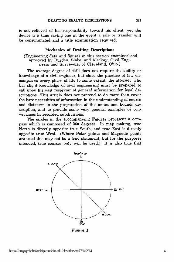
The average degree of skill does not require the ability orknowledge of a civil engineer, but since the practice of law en-compasses every phase of life to some extent, the attorney whohas slight knowledge of civil engineering must be prepared tocall upon his vast reservoir of general information for legal de-scriptions. This article does not pretend to do more than coverthe bare necessities of information in the understanding of courseand distances in the preparation of the metes and bounds de-scription, and to provide some very general examples of con-veyances in recorded subdivisions.
The circles in the accompanying Figures represent a com-pass which is composed of 360 degrees. In map making, trueNorth is directly opposite true South, and true East is directlyopposite true West. (Where Polar points and Magnetic pointsare used this may not be a true statement, but for the purposesintended, true courses only will be used.) It is also true that
N
t- 45 V-
Figure 1
4https://engagedscholarship.csuohio.edu/clevstlrev/vol7/iss2/14
CLEVELAND-MARSHALL LAW REVIEW
14a, C
Figure 2
w5
Figure 3
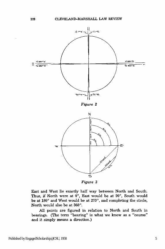
East and West lie exactly half way between North and South.Thus, if North were at 00, East would be at 90', South wouldbe at 1800 and West would be at 270', and completing the circle,North would also be at 3600.
All points are figured in relation to North and South inbearings. (The term "bearing" is what we know as a "course"and it simply means a direction.)
5Published by EngagedScholarship@CSU, 1958

DRAFTING REALTY DESCRIPTIONS
N
Figure 4
In checking a description and sketching it to see if it is cor-rect, it is easiest to represent North at the top of the page, andSouth at the bottom of the page, with East to the right and Westto the left. If a line is drawn from the bottom of the page to thetop of the page, we have gone from South to North and the di-rection, course, or bearing, is due North. If we go from the topof the page to the bottom of the page, we have gone from Northto South and the direction, course, or bearing is due South. Theline is in the same place but we have reversed our direction.
It follows then that South 450 East is the reverse of North450 West and although the line is the same, we have reversedour course or direction. (Known to campers and "old soldiers"as a back azimuth.) This is always true.
This circle is further divided into 4 sections known as quad-rants, and each contains 1/4 of a circle or 900. To further simplifyand to enable the writer to convert a graphic example into writteninstructions, the North-South Axis of the circle is determinedas the only starting point for all angular measurements, there-fore by rotating clockwise or counter clockwise from eitherNorth or South, your angular measurement will never exceed90'. The greater the angular measure of "bearing" the nearerit approaches East or West. It may be seen by this that a bearingof 890 will lie very close to the East-West Axis of our measuringcircle. The prefix of North or South determines which cardinalpoint was used as a starting point and the suffix of East or Westdetermines the direction in which it was measured.
6https://engagedscholarship.csuohio.edu/clevstlrev/vol7/iss2/14
CLEVELAND-MARSHALL LAW REVIEW
A further extension of bearings discloses that in each degreethere are 60 minutes (') and in each minute there are 60 seconds(") thus allowing for minute calculations in direction.
The arc is the curved distance between the quadrants and"radiates" from the center of the circle much like sound waves.As the distance of a quadrant extends outward from the centerof the circle, the arc distance between the straight lines increasesproportionately; thus arc A, 10 feet from the center of the circle,is not as wide as arc B, 40 feet from the center of the circle.
A working knowledge of cardinal points, quadrants, bear-ings, or courses, and arcs, is essential to the reading and draftingof a legal description.
Boundaries are indicated by naming natural or artificialmonuments to, from, or along which they are run, or with ref-erence to which corner points are established, or by stating thecourses and distances of the boundary lines, and frequently byall these elements of description, as they are termed.
A monument is a tangible landmark; and monuments, as ageneral rule, prevail over courses and distances for the purposeof determining the location of a boundary, even though thismeans either the shortening or lengthening of a distance, unlessthe result would be absurd and one not clearly intended, or allof the facts and circumstances show that the call for course anddistance is more reliable than the calls for monuments.8
A monument, for the purpose of description, may consist ofany object or mark on the land, whether natural or artificial,which serves to identify the location of a line constituting a partof the boundary, and it may be either a permanent naturalobject, such as a river, lake, ledge of rocks, or tree, or it maybe an artificial object, such as a highway, wall, ditch, or a postor an iron pin set in survey.
A course is the direction in which a line runs, stated withreference not to its terminus, but to its correspondence with acertain point of the compass, or at variation from the magneticor sidereal meridian.
8 Alabama-Marengo County v. Wilcox County, 215 Ala. 640, 112 S. 243(1927);
Arkansas-Davis v. Strong, 209 Ark. 254, 186 S. W. 2d 776 (1945);Calfornia-Wagner v. Blume, 71 Calif. App. 2d 94, 161 P. 2d 1001 (1945);Massachusetts-Morse v. Kelley, 305 Mass. 504, 26 N. E. 2d 326 (1940);Michigan-McMurtry v. Abbey, 296 Mich. 234, 295 N. W. 628 (1941);Ohio-Federspiel v. Mitchell Brick Co., 22 Ohio App. 13, 153 N. E. 279
(1926);Texas-Giles v. Kretzmeier, 239 S. W. 2nd 707 (Tex. Civ. App. 1951).
7Published by EngagedScholarship@CSU, 1958
DRAFTING REALTY DESCRIPTIONS
Check List for Legal Descriptions
(1) The city, county, state, original lot name or number,sublot number, subdivision name, and volume and page of re-corded plat must be checked and included.
(2) Lines run parallel with other lines and perpendicularto other lines.
(3) The terms Northerly, Southerly, Easterly, and Westerlyshould be used in relation to fixed, known lines.
(4) Where streets are located with a geographical descrip-tion, as Euclid Avenue, S. W., such descriptive words should beincluded.
(5) The dedication and acceptance of streets in a recordedsubdivision should be carefully noted. Some plats have beenaccepted for record only, and the streets have not been acceptedfor public use.
(6) Some lots are described in feet and inches, and someby feet and hundredths of feet. This becomes of paramount im-portance when the lot is split and sold in parcels.
(7) Be careful to determine whether the sideline distancesare measured from the center line of the street, or from theside line of the street. The plat heading will usually denotewhich beginning line is used, and it is customary to measurefrom the side line of the street.
(8) When the description includes part of a vacated streetor alley, the legislative authority granting such vacation mustbe determined and the proceedings examined.
(9) Where a road has been widened or relocated, the au-thority for such alteration must be investigated, and the platexamined for the new courses and distances used.
(10) It is suggested that a sketch be drawn at the court-house to verify the drafted description, and kept in the attorney'sfile for reference.
This is, of course, a bare list of requirements, but representsthose items which frequently lead to trouble when not carefullynoted.
Recorded Subdivision
In many of the states there are statutory provisions author-izing an owner of land to have it surveyed and laid off in lots,and blocks, streets, parks, and the like, and to file in the public
8https://engagedscholarship.csuohio.edu/clevstlrev/vol7/iss2/14
CLEVELAND-MARSHALL LAW REVIEW
records a plat or map of the land as thus laid off, authenticatedand certified as may be required.
Thereafter any one of these lots or blocks may be conveyedby mere reference to the number which it bears upon the re-corded plat; thus all necessity of a detailed description is ab-breviated.9
Where a reference is sufficiently made by a deed to a publicrecord, which specifically described the property sought to beconveyed, the description is sufficient,' 0 and where a deed refersto an authentic plat of land, such plat becomes a portion of thedeed as fully as if incorporated in it."
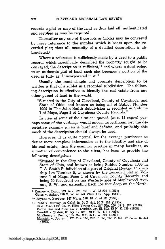
Usually the most simple and accurate description to bewritten is that of a sublot in a recorded subdivision. The follow-ing description is effective to identify the real estate from anyother parcel of land in the world:
"Situated in the City of Cleveland, County of Cuyahoga, andState of Ohio, and known as being all of Sublot Number1000 in The John Smith Subdivision as recorded in Volume1 of Maps, Page 1 of Cuyahoga County Records."
In view of some of the citations quoted (at n. 11 supra) per-haps some of the verbiage would appear superfluous, yet the de-scriptive example given is brief and definite, and probably thismuch of the description should always be used.
However, it is quite normal for the average purchaser todesire more complete information as to the identity and size ofhis real estate; thus the common practice in many localities, as
a matter of convenience to the client, has been to provide thefollowing description:
"Situated in the City of Cleveland, County of Cuyahoga andState of Ohio, and known as being Sublot Number 1000 inJ. A. Smith Subdivision of a part of Original Rockport Town-ship Lot Number 5, as shown by the recorded plat in Vol-ume 1 of Maps, Page 1 of Cuyahoga County Records, andbeing 50 feet front on the Westerly side of Maplewood Ave-nue, S. W., and extending back 150 feet deep on the North-
9 Carney v. Dunn, 221 Ark. 223, 252 S. W. 2d 827 (1952);Gates v. Asher, 280 S. W. 2d 247 (Tex. Civ. App. 1955).
10 Bryant v. Fordyce, 147 Kans. 586, 78 P. 2d 32 (1938).
11 Redd v. Murray, 95 Calif. 48, 24 P. 841, 30 P. 132 (1890);East Coast Lbr. Co. v. Ellis-Young Co., 557 Fla. 256, 45 S. 826 (1908);Peoria Gas and Elec. Co. v. Dunbar, 234 Ill. 502, 85 N. E. 229 (1908);Cundiff v. Staton, 20 Ky. L. 1271, 49 S. W. 179 (1899);McKinney v. Doane, 155 Mo. 287, 56 S. W. 304 (1900);Menstell v. Johnson, 125 Ore. 150, 262 P. 853, 266 P. 891, 57 A. L. R. 311
(1928).
9Published by EngagedScholarship@CSU, 1958

DRAFTING REALTY DESCRIPTIONS
erly line, 155 feet deep on the Southerly line, and having arear line of 52 feet, as appears by said plat, be the samemore or less, but subject to all legal highways."There can be no doubt as to the location and identity of the
above property, since the geographical and political subdivisions,and the plat itself are tied to record monuments by survey as acondition precedent to recording.
Where the front line is curved, the frontage must be com-puted by using the arc distance which appears on the plat.
Frequently, where monuments are set on the front line, theentire lot frontage may include one or more of these monuments,and the arc distances must be added together to compute thetotal frontage.
6 13.6
too .o
S,/L 3 lq. ' Foor
I A1'r -o SCALE)
Figure 5 Figure 6
Corner lots, or lots having a frontage on each of two inter-secting streets, where a curved turnout line exists, must be sodescribed as to include the frontage on both streets, and the arcdistance of the curve between the two streets.
EUCLID AVE.
V
L Fs CAo'r ro r ,LC)
Figure 7
"Situated in the City of Cleveland, County of Cuyahoga, andState of Ohio, and known as being Sublot Number 4 in theJohn Marshall Subdivision of a part of Original 10 Acre LotNumber 20, as shown by the recorded plat in Volume 15 ofMaps, Page 10 of Cuyahoga County Records, and being 50
10https://engagedscholarship.csuohio.edu/clevstlrev/vol7/iss2/14

CLEVELAND-MARSHALL LAW REVIEW
feet front on the Southerly side of Euclid Avenue, 25 feetfront on the curved turnout between the Southerly side ofEuclid Avenue and the Easterly side of Prospect Avenue,and extending back 100 feet deep on the Westerly line, whichis also the Easterly side of Prospect Avenue, 115 feet deepon the Easterly line, and having a rear line of 65 feet, asappears by said plat, be the same more or less, but subjectto all legal highways."
Where the corner is angular, that is, no curved turnoutexists, the description should be written as follows:
SUPE-RIOR AVE.
Figure 8
"Situated in the City of Cleveland, County of Cuyahoga, andState of Ohio, and known as being Sublot Number 5 in theLouisville Subdivision of a part of Original 100 Acre LotNumber 145, as shown by the recorded plat in Volume 39of Maps, Page 9 of Cuyahoga County Records, and being 50feet front on the Southerly side of Superior Avenue, andextending back 100 feet deep on the Westerly line, whichis also the Easterly side of Prospect Avenue, 100 feet deepon the Easterly line, and having a rear line of 50 feet, bethe same more or less, but subject to all legal highways."
Where a sublot abuts an alley, the description should tieinto the alley as follows:
HOLMIES RE.So,
S5o' (Mor ro SC^LF)
AL LL_ y/
Figure 9
"Situated in the City of Cleveland, County of Cuyahoga, andState of Ohio, and known as being Sublot Number 6 in theWilliams Subdivision of a part of Original Euclid TownshipLot Number 17 as shown by the recorded plat in Volume 38of Maps, Page 19 of Cuyahoga County Records, and being
11Published by EngagedScholarship@CSU, 1958
DRAFTING REALTY DESCRIPTIONS
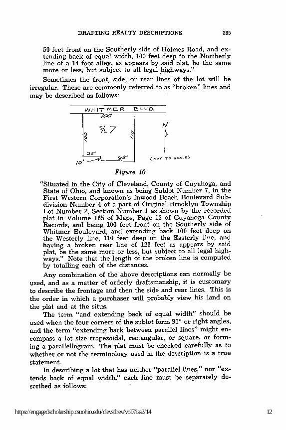
50 feet front on the Southerly side of Holmes Road, and ex-tending back of equal width, 100 feet deep to the Northerlyline of a 14 foot alley, as appears by said plat, be the samemore or less, but subject to all legal highways."
Sometimes the front, side, or rear lines of the lot will beirregular. These are commonly referred to as "broken" lines andmay be described as follows:
WH 1M- M ER 13 L\-J O.
/0
_ "o- scALE)
Figure 10
"Situated in the City of Cleveland, County of Cuyahoga, andState of Ohio, and known as being Sublot Number 7, in theFirst Western Corporation's Inwood Beach Boulevard Sub-division Number 4 of a part of Original Brooklyn TownshipLot Number 2, Section Number 1 as shown by the recordedplat in Volume 165 of Maps, Page 12 of Cuyahoga CountyRecords, and being 100 feet front on the Southerly side ofWhitmer Boulevard, and extending back 100 feet deep onthe Westerly line, 110 feet deep on the Easterly line, andhaving a broken rear line of 120 feet as appears by saidplat, be the same more or less, but subject to all legal high-ways." Note that the length of the broken line is computedby totalling each of the distances.
Any combination of the above descriptions can normally beused, and as a matter of orderly draftsmanship, it is customaryto describe the frontage and then the side and rear lines. This isthe order in which a purchaser will probably view his land onthe plat and at the situs.
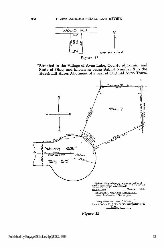
The term "and extending back of equal width" should beused when the four corners of the sublot form 90' or right angles,and the term "extending back between parallel lines" might en-compass a lot size trapezoidal, rectangular, or square, or form-ing a parallellogram. The plat must be checked carefully as towhether or not the terminology used in the description is a truestatement.
In describing a lot that has neither "parallel lines," nor "ex-tends back of equal width," each line must be separately de-scribed as follows:
12https://engagedscholarship.csuohio.edu/clevstlrev/vol7/iss2/14
CLEVELAND-MARSHALL LAW REVIEW
woo 00 R. D.so
\4
s-,q(/tCJOT -. SCA,-)
Figure 11
"Situated in the Village of Avon Lake, County of Lorain, andState of Ohio, and known as being Sublot Number 8 in theBeachcliff Acres Allotment of a part of Original Avon Town-
-. L. 7
LoulS"'Le -TiTLe "P--- ,If--C,
Figure 12
13Published by EngagedScholarship@CSU, 1958

DRAFTING REALTY DESCRIPTIONS
ship Section Number 4, as shown by the recorded plat inVolume 9 of Maps, Page 13 of Lorain County Records, andbeing 50 feet front on the Southerly side of Wood Road, ex-tending back 52 feet deep on the Westerly line, 65 feet deepon the Easterly line, and having a rear line of 54 feet, as ap-pears by said plat, be the same more or less, but subject toall legal highways."
Irregular Sublot (See Figure 12)
"Situated in the City of Cleveland, County of Cuyahoga andState of Ohio, and known as being part of Sublot No. 7 inthe Steve Hollo Re-subdivision of a part of Original Brook-lyn Township Lot No. 36 as shown by the recorded plat inVolume 164 of Maps, Page 42 of Cuyahoga County Records,and being further described as follows:Beginning at a point on a cul-de-sac at the Northeasterly endof West 63rd Street, at the most Westerly corner of saidSublot No. 7;Thence North 220 06' 40" East along the Northwesterly lineof Sublot No. 7, 117.40 feet to the Northwest corner thereof;Thence South 890 38' 00" East along the Northerly line ofSublot No. 7, 88.00 feet to a point;Thence South 00 22' 08" East, 85.81 feet to a point on theSoutheasterly line of Sublot No. 7;Thence South 650 36' 29" West along the Southeasterly lineof Sublot No. 7, 116.41 feet to a point on the said cul-de-sac;Thence Northwesterly along an arc of a circle deflecting tothe left 37.96 feet whose radius is 50 feet which chord bearsNorth 450 08' 26" West 37.05 feet to the place of beginning,be the same more or less, but subject to all legal highways."
It is not uncommon to be required to draft legal descriptionsof the following:
(a) More than one sublot
(b) Part of one sublot
(c) One sublot and part of another
(d) More than one sublot and parts of another or others
(e) Parts of more than one sublot
(f) Irregular parts of sublots.
The following examples each describe a suggested means ofwriting a description for the above:
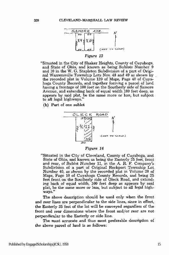
(a) More than one sublot
14https://engagedscholarship.csuohio.edu/clevstlrev/vol7/iss2/14
CLEVELAND-MARSHALL LAW REVIEW
SAtMORE AVE.
( oT I-o CAI )
Figure 13
"Situated in the City of Shaker Heights, County of Cuyahoga,and State of Ohio, and known as being Sublots Number 9and 10 in the W. G. Stapleton Subdivision of a part of Origi-nal Warrensville Township Lots Nos. 48 and 49 as shown bythe recorded plat in Volume 139 of Maps, Page 40 of Cuya-hoga County Records, and together forming a parcel of landhaving a frontage of 100 feet on the Southerly side of SamoreAvenue, and extending back of equal width 100 feet deep, asappears by said plat, be the same more or less, but subjectto all legal highways."
(b) Part of one sublot
OLECK ROAD
CA OT TO SAS
Figure 14
"Situated in the City of Cleveland, County of Cuyahoga, andState of Ohio, and known as being the Easterly 25 feet, frontand rear, of Sublot Number 11, in the A. R. F. Company'sSubdivision of a part of Original Rockport Township LotNumber 40, as shown by the recorded plat in Volume 28 ofMaps, Page 10 of Cuyahoga County Records, and being 25feet front on the Southerly side of Oleck Road, and extend-ing back of equal width, 100 feet deep as appears by saidplat, be the same more or less, but subject to all legal high-ways."The above description should be used only when the front
and rear lines are perpendicular to the side lines, since in effect,the Easterly 25 feet of the lot will be conveyed regardless of thefront and rear dimensions where the front and/or rear are notperpendicular to the Easterly or side line.
The most accurate and thus most preferable description ofthe above parcel of land is as follows:
15Published by EngagedScholarship@CSU, 1958
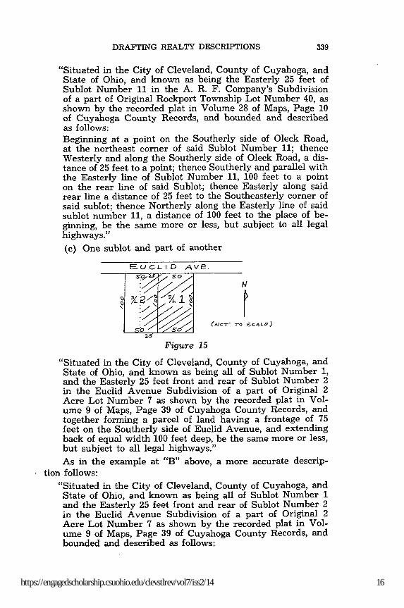
DRAFTING REALTY DESCRIPTIONS
"Situated in the City of Cleveland, County of Cuyahoga, andState of Ohio, and known as being the Easterly 25 feet ofSublot Number 11 in the A. R. F. Company's Subdivisionof a part of Original Rockport Township Lot Number 40, asshown by the recorded plat in Volume 28 of Maps, Page 10of Cuyahoga County Records, and bounded and describedas follows:Beginning at a point on the Southerly side of Oleck Road,at the northeast corner of said Sublot Number 11; thenceWesterly and along the Southerly side of Oleck Road, a dis-tance of 25 feet to a point; thence Southerly and parallel withthe Easterly line of Sublot Number 11, 100 feet to a pointon the rear line of said Sublot; thence Easterly along saidrear line a distance of 25 feet to the Southeasterly corner ofsaid sublot; thence Northerly along the Easterly line of saidsublot number 11, a distance of 100 feet to the place of be-ginning, be the same more or less, but subject to all legalhighways."
(c) One sublot and part of another
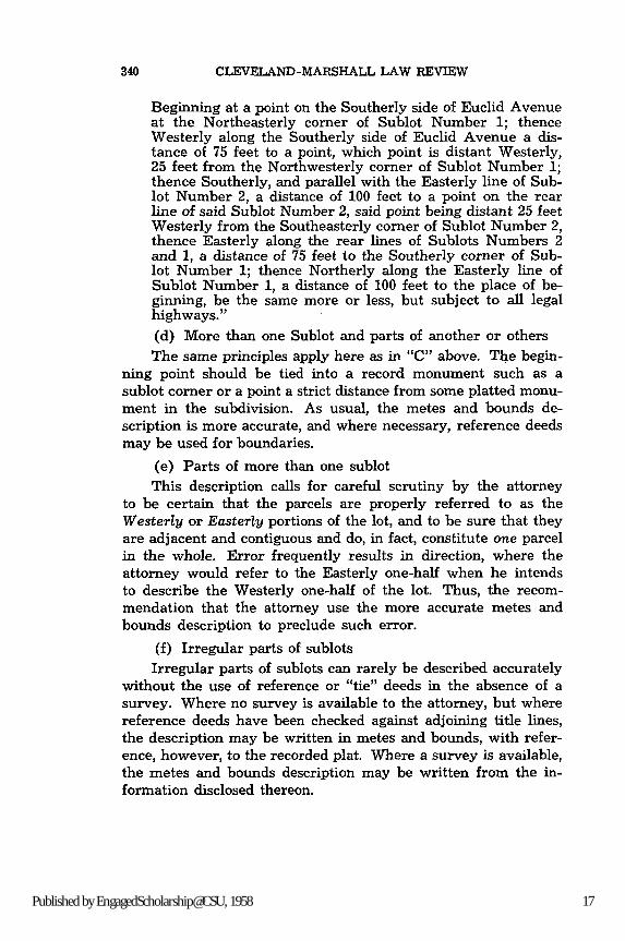
FEUCLID AVE.
, yJ,?,'1 "%.1
Figure 15
"Situated in the City of Cleveland, County of Cuyahoga, andState of Ohio, and known as being all of Sublot Number 1,and the Easterly 25 feet front and rear of Sublot Number 2in the Euclid Avenue Subdivision of a part of Original 2Acre Lot Number 7 as shown by the recorded plat in Vol-ume 9 of Maps, Page 39 of Cuyahoga County Records, andtogether forming a parcel of land having a frontage of 75feet on the Southerly side of Euclid Avenue, and extendingback of equal width 100 feet deep, be the same more or less,but subject to all legal highways."
As in the example at "B" above, a more accurate descrip-tion follows:
"Situated in the City of Cleveland, County of Cuyahoga, andState of Ohio, and known as being all of Sublot Number 1and the Easterly 25 feet front and rear of Sublot Number 2in the Euclid Avenue Subdivision of a part of Original 2Acre Lot Number 7 as shown by the recorded plat in Vol-ume 9 of Maps, Page 39 of Cuyahoga County Records, andbounded and described as follows:
16https://engagedscholarship.csuohio.edu/clevstlrev/vol7/iss2/14
CLEVELAND-MARSHALL LAW REVIEW
Beginning at a point on the Southerly side of Euclid Avenueat the Northeasterly corner of Sublot Number 1; thenceWesterly along the Southerly side of Euclid Avenue a dis-tance of 75 feet to a point, which point is distant Westerly,25 feet from the Northwesterly corner of Sublot Number 1;thence Southerly, and parallel with the Easterly line of Sub-lot Number 2, a distance of 100 feet to a point on the rearline of said Sublot Number 2, said point being distant 25 feetWesterly from the Southeasterly corner of Sublot Number 2,thence Easterly along the rear lines of Sublots Numbers 2and 1, a distance of 75 feet to the Southerly corner of Sub-lot Number 1; thence Northerly along the Easterly line ofSublot Number 1, a distance of 100 feet to the place of be-ginning, be the same more or less, but subject to all legalhighways."
(d) More than one Sublot and parts of another or othersThe same principles apply here as in "C" above. The begin-
ning point should be tied into a record monument such as asublot corner or a point a strict distance from some platted monu-ment in the subdivision. As usual, the metes and bounds de-scription is more accurate, and where necessary, reference deedsmay be used for boundaries.
(e) Parts of more than one sublotThis description calls for careful scrutiny by the attorney
to be certain that the parcels are properly referred to as theWesterly or Easterly portions of the lot, and to be sure that theyare adjacent and contiguous and do, in fact, constitute one parcelin the whole. Error frequently results in direction, where theattorney would refer to the Easterly one-half when he intendsto describe the Westerly one-half of the lot. Thus, the recom-mendation that the attorney use the more accurate metes andbounds description to preclude such error.
(f) Irregular parts of sublots
Irregular parts of sublots can rarely be described accuratelywithout the use of reference or "tie" deeds in the absence of asurvey. Where no survey is available to the attorney, but wherereference deeds have been checked against adjoining title lines,the description may be written in metes and bounds, with refer-ence, however, to the recorded plat. Where a survey is available,the metes and bounds description may be written from the in-formation disclosed thereon.
17Published by EngagedScholarship@CSU, 1958

DRAFTING REALTY DESCRIPTIONS
Proposed or Unrecorded Subdivisions
Some lots are physically staked out upon the ground bysurveyors, and a plat thereof prepared for use of the allotter, butsuch plat may never be recorded in the office of the CountyRecorder. Consequently, the plat references do not constituterecord monuments since the plat is not recorded.
In the absence of such record, mere reference to the sublotnumber and plat name is insufficient, and the "metes and bounds"description, so called, must be used to describe parcels of landin these "proposed" or "unrecorded" subdivisions.
It is important to note that reference to actual monuments,or recorded monuments, and tie-in-deeds, or a strict use ofcourses and distances as disclosed by the survey of the proposedsubdivision, should be used. The number of the survey, date pre-pared, and name of the registered surveyor who prepared itshould be used in the description. The purpose is, of course, todistinguish the property described from all the real estate in theworld.
The following examples are submitted as a guide:
"Situated in the City of Cleveland, County of Cuyahoga, andState of Ohio, and known as being Sublot No. 1 in the JohnSmith Subdivision, Proposed, of a part of Original Warrens-ville Township Lot Number 5 and bounded and describedas follows:Beginning at an iron monument at the intersection of theSoutherly side of Warrensville Road, and the Westerly sideof Green Road as shown by the Dedication plat of said War-rensville Road as recorded in Volume 102 of Maps, Page 10of Cuyahoga County Records; thence South 890 28' 16" Westalong the Southerly side of Warrensville Road a distance of500 feet to an iron monument and the principal place of be-ginning of the premises intended to be described; thenceSouth 10 10' 30" West a distance of 100 feet to an iron pinset; thence South 89' 28' 16" West, a distance of 50 feet toan iron pin set; thence North 10 10' 30" East a distance of 100feet to an iron pin set on the Southerly side of WarrensvilleRoad; thence North 890 28' 16" East a distance of 50 feetand along the Southerly side of Warrensville Road to theplace of beginning according to a survey dated December 1,1958, by Thomas A. Burden, Registered Surveyor No. 295,be the same more or less, but subject to all legal highways."
In the absence of a survey, and where reference deeds havebeen checked, the following example shows another method ofdescribing the same parcel of land as above:
"Situated in the City of Cleveland, County of Cuyahoga, andState of Ohio, and known as being Sublot No. 1 in the John
18https://engagedscholarship.csuohio.edu/clevstlrev/vol7/iss2/14
CLEVELAND-MARSHALL LAW REVIEW
Smith Subdivision, Proposed of a part of Original Warrens-ville Township Lot Number 5, and bounded and describedas follows:Beginning at an iron monument at the intersection of theSoutherly side of Warrensville Road and the Westerly sideof Green Road, as shown by the Dedication Plat of said War-rensville Road as recorded in Volume 102 of Maps, Page 10of Cuyahoga County Records; thence Westerly along theSoutherly side of Warrensville Road a distance of 500 feetto the Northwest corner of land conveyed to John Brown bydeed dated September 1, 1955, and recorded in Volume 8181,Page 2 of Cuyahoga County Records, and the principal placeof beginning of premises intended to be described; thenceSoutherly and along the Westerly line of premises conveyedto Brown as aforesaid, a distance of 100 feet to the North-easterly corner of land conveyed to Alfred Jones by deeddated August 1, 1955, and recorded in Volume 8080, Page 3of Cuyahoga County Records; thence Westerly and alongthe Northerly line of land conveyed to Jones, as aforesaid,a distance of 50 feet to the Southeasterly corner of land con-veyed to Louis W. Miller, by deed dated October 1, 1925 andrecorded in Volume 2502, Page 108 of Cuyahoga CountyRecords; thence Northerly and along the Easterly line ofland conveyed to Miller as aforesaid, a distance of 100 feetto the Northeasterly corner thereof, and a point on theSoutherly side of Warrensville Road; thence Easterly, andalong the Southerly side of Warrensville Road, a distance of50 feet to the place of beginning, be the same more or less,but subject to all legal highways."
A deed may constitute a sufficient description of the landconveyed by stating that it is bounded by, or adjoins lands be-longing to named persons. 12
Acreage
Acreage is usually described similarly as land in an un-recorded or proposed subdivision (Supra), omitting, of course,any reference to a subdivision name and sublot number, but in-cluding data as to a survey if available.
It is often desirable to disclose the amount of acreage con-veyed or intended to be conveyed by the deed, but for identifica-tion purposes, the parties should be able to rely upon the ac-curate description and not the amount of acreage as such.
12 Porter v. Paschal, 159 Ga. 416, 125 S. E. 846 (1924);Brenneman v. Dillan, 296 Ill. 140, 129 N. E. 564 (1920);Bayard v. Baldwin Lbr. Co., 157 La. 994, 103 S. 290 (1925);Campbell v. United Fuel Gas Co., 100 W. Va. 508, 130 S. E. 666 (1925).
19Published by EngagedScholarship@CSU, 1958
DRAFTING REALTY DESCRIPTIONS
Conclusion
A long, detailed description may be exasperating to the en-gineer, attorney, or title examiner when preparing and checkingthe deed, but it is not nearly so exasperating as is a long, de-tailed, and expensive law suit to the client.
Identity of land is the sole purpose of the description, andthe authorities are endless 13 that nothing will pass by a deed ex-cept what is described in it, whatever the intentions of the par-ties may have been.14
Yet it is only when it remains a matter of conjecture whatproperty was intended to be conveyed, after resorting to suchextrinsic evidence as is admissible, that the deed will be heldvoid for uncertainty in the description of the parcel. 15
If the starting point of a boundary line cannot be identified,the deed is necessarily void; and it is imperative that a metesand bounds description must close. This means that each courseor call, following the distance given, must meet the next courseat the proper point, so that by following each course along thegiven distance, the description eventually returns to the placeof beginning. A description which omits one or more boundariesand leaves the quantity of land undetermined, is insufficient. 16
It is suggested that in difficult descriptions the services of aprofessional engineer should be used, and that the survey, cor-related with record title deeds and a policy of title insurance,will enable the attorney to protect his client in his real estateownership to the maximum.
The ownership of land and the protection of land are singularin the events of world history, since the beginning of our historyof law. To each of us, his home is his castle. The attorney hasthe duty to support this valid desire for clarity of rights by hiscareful attention to the legal description which is the basis ofevery conveyance of land.
Each description of a single object must be conceived of asa single utterance, just as one cipher cable word may represent
13 Bissette v. Strickland, 131 S. E. 655 (No. Car., 1926);Powers v. Rawles, 119 So. Car. 134, 112 S. E. 78 (1922);Robinson v. Allison, 109 Ala. 409, 19 S. 837 (1896);Kyle v. Jordan, 187 Ala. 355, 65 S. 522 (1914).
14 Thayer v. Finton, 108 N. Y. 394, 15 N. E. 615 (1888).15 Los Angeles County v. Hannon, 159 Calif. 37, 112 P. 878 (1910);
Colton v. Lewis, 119 Ind. 181, 21 N. E. 475 (1889);Harkness v. Devine, 173 Tex. 628, 11 S. W. 872 (1889).
16 Sullivan v. Fant, 160 S. W. 612 (Tex. Civ. App., 1913).
20https://engagedscholarship.csuohio.edu/clevstlrev/vol7/iss2/14
344 CLEVELAND-MARSHALL LAW REVIEW
a message of forty words. We do it no violence by ignoring thenon-essential terms; for neither the omission nor the insertion ofnon-essential terms alters its essence as a whole. By conceivingclearly the singleness of each description as a symbol of a singleobject, we appreciate that the imperfections of either omissionor insertion do not destroy its character as a single effort at thedesignation of a single object.' 7
17 Island Coal Co. v. Streitlemeier, 139 Ind. 83, 37 N. E. 340 (1894).But see 7 A. L. R. 2d 1331 (1949). A deficiency in the quantity of land
or in the title which the vendor has agreed to convey has generally beenheld to entitle the purchaser to specifically enforce the conveyance of whatis actually available, with a decree allowing him an abatement in the pur-chase price or other compensation for the deficiency, at least where theamount of abatement may be readily computed and the rights of thirdpersons are not involved. See also 55 Am. Jur. 615, 139, Vendor and Pur-chaser.
21Published by EngagedScholarship@CSU, 1958


![1 General Principles of Drafting & Relevant Substantive Rules · [Chapter 1] General Principles of Drafting &... O 8.3 3. Drafting v/s Conveyancing Drafting Conveyancing Preparation](https://img.pdfslide.net/doc/110x75/5fc0b1a36d087d0ac8539e2c/1-general-principles-of-drafting-relevant-substantive-rules-chapter-1-general.jpg)