Embed Size (px)
Citation preview

Dundas Valley 50-Year Vision &
Strategy 2008-2058
Implementation Strategy Cycle 1:
Appendices A
2014-2019

Dundas Valley 50 Year Vision and Strategy ISC1
Table of Contents
1. Top 10 Strategic Directions/Action Item Work plans……………………………………………………………….3
2. Prioritization and Selection Tools………………………………………………………………………………………..180
3. Implementation Strategy Cycle 1 (ISC1) Core Budget…………………………………………………………..183
4. Dundas Valley 50 Year Vision and Strategy: 43 Strategic Directions…………………………………...184

Dundas Valley 50 Year Vision and Strategy ISC1
Dundas Valley 50-Year Vision and Strategy Implementation Strategy Cycle 1: 2014-2019
Work Plan
Strategic Directions: Preserve and enhance the connectivity of ecosystems in the Valley AND Explore the co-benefits of connecting with the Cootes to the Escarpment natural areas strategy

Table of Contents
Background…………..……………………………………………………………………………………………………………………………………………………….3
1.0 Dundas Valley 50-Year Vision and Strategy: Themes, Goals and Actions…………………………………………………………………………….4
2.0 Methodology and Work plan…………………………………………………………………………………………………………………………….......................5
3.0 Resources and Constraints……………………………………………………………………………………………………………………………………………...11
References
Appendix
© Hamilton Conservation Authority, 2013. All rights reserved. No part of this publication may be reproduced in any form or by any means, electronically, mechanically,
or by photocopying, recording, or otherwise, with the prior permission of the copyright owners.

Dundas Valley 50 Year Vision and Strategy ISC1
Background
Ecological connectivity is important for the health of our environment, and if it is maintained, it can add to the appeal and livability
of our communities. Ecological connectivity is maintaining a connected system of open space throughout an ecosystem (Streamlines,
2001). There are a myriad of factors that affect ecological connectivity such as habitat
fragmentation, deforestation, wide-scale commercial development, among others. Over time,
population increases and affiliated development pressures have exerted both positive and negative
impacts upon ecosystem linkages, function, and in turn species numbers, status, and distribution.
Ecological connections must be preserved through the integration of scientific skills with applied
management and policy in order to achieve practical outcomes with long-term benefits. For land
managers and environmental planners, the challenge is to design and implement land-use
strategies that will ensure the conservation of natural resources in the face of competing demands
for land use (IUCN, 2003).
The Dundas Valley area contains a number of potential natural areas that through the
formation of corridors can work towards ensuring ecological connectivity. To the east of the Dundas
Valley area are the Cootes Paradise and the Desjardins Canal that ultimately link to the Hamilton
Harbour. These areas are also of importance in relation to the Valley being part of the Spencer Creek
with sub watersheds that drain into this area. The Valley given its location serves as an influential
factor in terms of connectivity. The Cootes to the Escarpment Park System Strategy (CEPS) is a new,
visionary approach to protect, restore and connect more than 2,000 hectares (4,900 acres) of natural
lands between the Niagara Escarpment and Cootes Paradise/Hamilton Harbour. Two areas of connection between the Dundas Valley 50
Year Vision and Strategy and the Cootes to Escarpment Park System Strategy have been noted. One is the Niagara Escarpment with
anticipated connections between Rock Chapel and Borer’s Falls and Spencer Gorge-Webster’s Falls Conservation Area and the other is the
Spencer Creek between Cootes Paradise and Dundas Valley Conservation Area. With the development of this work plan, the strategic
directions of the Vision-‘Preserve and enhance the connectivity of ecosystems in the Valley’ and ‘Explore the co-benefits of connecting
with the Cootes to the Escarpment natural areas strategy’ can be put into action within the Vision’s first 5-Year implementation cycle.

Dundas Valley 50 Year Vision and Strategy ISC1
1.0 Dundas Valley 50-Year Vision & Strategy: Themes, Goals and Actions
Chart 1: Theme area, Goal, Strategic Direction, and Actions.
Goal 1: Protect and Enhance the Valley’s ecology
and natural areas
ACTIONS:
1. Create naturalized and green corridors to maintain and
enhance connectivity, including connecting HCA properties to
Lake Ontario and Cootes Paradise (along Spencer Creek) to
Webster’s Falls.
2. Look at the City of Hamilton Trails Master Plan to see what
linkages are shown.
3. Link in Cootes to Escarpment Strategy
4. HCA management to work with the Cootes to Escarpment
Project Team to identify benefits from combining the Vision
and Strategies.
5. Monitor biotic and abiotic parameters
6. Assess the vulnerability of ecological corridors to climate change and develop action strategies
Dundas Valley 50-Year Vision and Strategy
2008-2058
Strategic Directions: Preserve and enhance the connectivity of ecosystems in the Valley AND Explore the co-benefits of connecting with the Cootes to the
Escarpment natural areas strategy.
Theme Area: Protect and Enhance Dundas
Valley Lands
Dundas Valley 50 Year Vision and Strategy ISC1
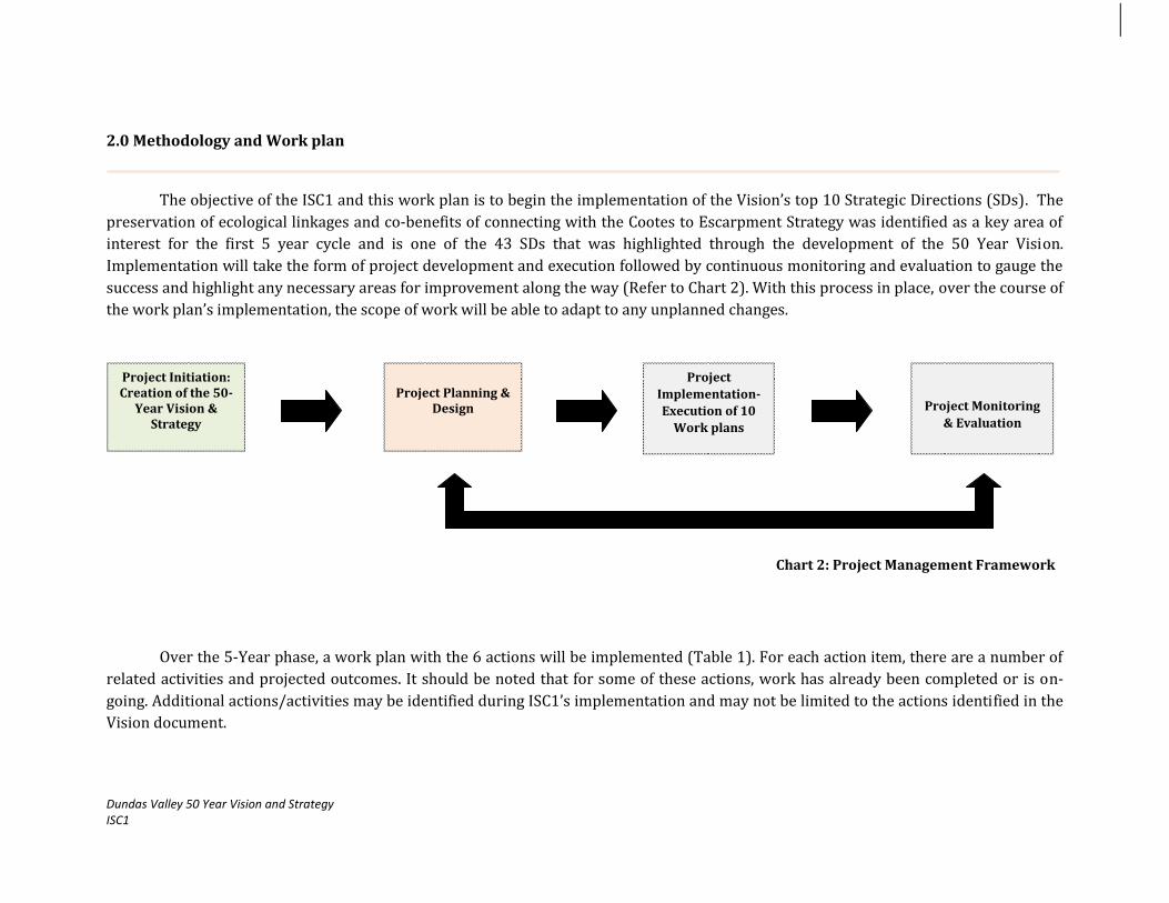
2.0 Methodology and Work plan
The objective of the ISC1 and this work plan is to begin the implementation of the Vision’s top 10 Strategic Directions (SDs). The
preservation of ecological linkages and co-benefits of connecting with the Cootes to Escarpment Strategy was identified as a key area of
interest for the first 5 year cycle and is one of the 43 SDs that was highlighted through the development of the 50 Year Vision.
Implementation will take the form of project development and execution followed by continuous monitoring and evaluation to gauge the
success and highlight any necessary areas for improvement along the way (Refer to Chart 2). With this process in place, over the course of
the work plan’s implementation, the scope of work will be able to adapt to any unplanned changes.
Over the 5-Year phase, a work plan with the 6 actions will be implemented (Table 1). For each action item, there are a number of
related activities and projected outcomes. It should be noted that for some of these actions, work has already been completed or is on-
going. Additional actions/activities may be identified during ISC1’s implementation and may not be limited to the actions identified in the
Vision document.
Project Planning &
Design
Project Initiation: Creation of the 50-
Year Vision & Strategy
Project
Implementation-
Execution of 10
Work plans
Project Monitoring
& Evaluation
Chart 2: Project Management Framework

Dundas Valley 50 Year Vision and Strategy ISC1
Table 1: Work plan
WP & E: Watershed Planning & Engineering LM: Land Management
Actions
Activities
Projected Outcomes
Lead
Time
Sub-Budget
Status Role Cost
1. Look at City of Hamilton Trails Master Plan to see what linkages are shown
Review the City of Hamilton’s Recreational Trails Master Plan- look specifically at wards 12 and 13 to see which areas have been outlined.
Reviewed the RTMP in relation to the Dundas Valley area.
HCA 2014-2019
Strategy Manager Overhead
Core Budget
(see appendix)
2. Link in with Cootes to Escarpment Strategy (CEPS)
AND 3. HCA
management to work with the Cootes to Escarpment Project Team to identify benefits from combining the Vision and Strategies areas strategy
Review Wong, Janet. 2009. Cootes to Escarpment Park System Conservation and Land Management Strategy. Burlington, Ontario: Royal Botanical Gardens and Galbraith, D. and Abel, K.M. 2009. Cootes to Escarpment Park System: A Conservation Vision. Burlington, Ontario: Royal Botanical Gardens, in addition to the Cootes to the Escarpment Park System Land Securement Strategy 2011.
Continuously work with the RBG and local
project partners to towards acquiring the identified areas through regular communication between both teams via project updates.
Ensure the promotion of the CEPS with the
Dundas Valley 50-Year Vision and Strategy’s public awareness programs through webpage, blog, and other outreach material.
Continuously work towards the creation of the identified linkages.
Promoted the CEPS with Dundas Valley 50-Year Vision and Strategy.
HCA 2014-2019
LM and WP & E Staff Overhead
HCA Annual Budget
HCA is a partner with the CEPS’s implementation. A staff representative currently serves on the CEPS committee and working collaboratively to ensure linkages between both strategies.
Dundas Valley 50 Year Vision and Strategy ISC1
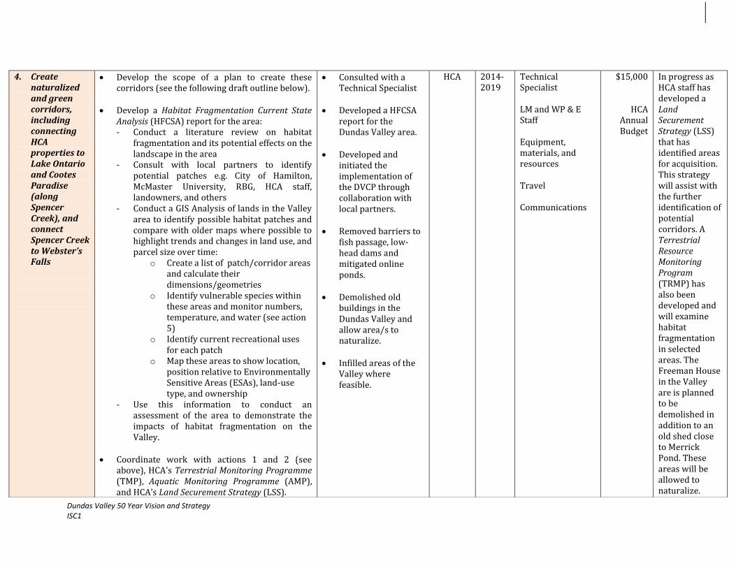
4. Create naturalized and green corridors, including connecting HCA properties to Lake Ontario and Cootes Paradise (along Spencer Creek), and connect Spencer Creek to Webster’s Falls
Develop the scope of a plan to create these corridors (see the following draft outline below).
Develop a Habitat Fragmentation Current State Analysis (HFCSA) report for the area: - Conduct a literature review on habitat
fragmentation and its potential effects on the landscape in the area
- Consult with local partners to identify potential patches e.g. City of Hamilton, McMaster University, RBG, HCA staff, landowners, and others
- Conduct a GIS Analysis of lands in the Valley area to identify possible habitat patches and compare with older maps where possible to highlight trends and changes in land use, and parcel size over time:
o Create a list of patch/corridor areas and calculate their dimensions/geometries
o Identify vulnerable species within these areas and monitor numbers, temperature, and water (see action 5)
o Identify current recreational uses for each patch
o Map these areas to show location, position relative to Environmentally Sensitive Areas (ESAs), land-use type, and ownership
- Use this information to conduct an assessment of the area to demonstrate the impacts of habitat fragmentation on the Valley.
Coordinate work with actions 1 and 2 (see above), HCA’s Terrestrial Monitoring Programme (TMP), Aquatic Monitoring Programme (AMP), and HCA’s Land Securement Strategy (LSS).
Consulted with a Technical Specialist
Developed a HFCSA report for the Dundas Valley area.
Developed and
initiated the implementation of the DVCP through collaboration with local partners.
Removed barriers to fish passage, low-head dams and mitigated online ponds.
Demolished old
buildings in the Dundas Valley and allow area/s to naturalize.
Infilled areas of the
Valley where feasible.
HCA 2014-2019
Technical Specialist LM and WP & E Staff Equipment, materials, and resources Travel Communications
$15,000
HCA Annual Budget
In progress as HCA staff has developed a Land Securement Strategy (LSS) that has identified areas for acquisition. This strategy will assist with the further identification of potential corridors. A Terrestrial Resource Monitoring Program (TRMP) has also been developed and will examine habitat fragmentation in selected areas. The Freeman House in the Valley are is planned to be demolished in addition to an old shed close to Merrick Pond. These areas will be allowed to naturalize.

Dundas Valley 50 Year Vision and Strategy ISC1
Develop and implement a Dundas Valley Corridor Plan (DVCP) for the area: Use identified target areas from the HFCSA to aid in the design of the corridor/s
Examine, evaluate, and prioritize the recreational
and ecological potential of each target area using a corridor prioritization matrix (see appendix)
Rank the top areas for securement Finalize a list of priority areas for connectivity Create a map to illustrate these areas Based on the identified target areas, use conduct
a GIS Analysis to design suitable corridors
Develop a Land Securement Strategy to guide securement activities-integrate with HCA’s existing Land Securement Strategy 2011 where possible.
Based on land identified, create a budget that will outline how much funds will be needed to secure these lands.
Apply for grants and to fund securement and source additional streams of revenue.
Commence acquisition of lands and work with
landowners and community partners to secure them.
Raise awareness in communities about project through 2 open houses and the distribution of promotional material to bolster support e.g. flyers, on HCA’s website.

Dundas Valley 50 Year Vision and Strategy ISC1
Work with the Hamilton-Halton Watershed Stewardship Program (HHWSP) and HCA staff to continuously: - Identify and modify barriers to fish passage
in Spencer Creek where possible - Remove low-head dams/ lower Spencer
Creek where feasible - Mitigate online ponds in Sulphur Creek
where feasible Coordinate efforts with the Lower Spencer Creek
Integrated Subwatershed Study (LSCS) data and recommendations (refer to SD ‘Protect and enhance the health of streams, watercourses, and waterfalls’).
Demolish old buildings in the Dundas Valley where possible and allow area/s to naturalize.
Infill plantings of forest and/or oak savannah
(trees and prairie) in feasible areas within the Valley.
5. Monitor
biotic and abiotic parameters
Use identified target areas from the HFCSA to set-up monitoring stations.
Monitor and collect data for species numbers, temperature, and precipitation for each station at selected intervals.
Create a data baseline and repeat the monitoring
process to gain more data to evaluate trends and changes for each habitat patch.
Monitored and collected data for biotic and abiotic parameters.
HCA 2014-2019
(see action 4)
6. Assess the vulnerability of ecological corridors to
Develop climate predictions for 25, 50, and 100 years scenarios for the Valley area.
Source existing data from other institutions
Conducted a Risk Assessment study of priority land parcels.
HCA 2014-2019
WP & E Staff Overhead
HCA Annual Budget

Dundas Valley 50 Year Vision and Strategy ISC1
climate change and develop action strategies.
where possible for these areas e.g. universities
Analyze collected data from the HFCSA study and existing data from other sources to pinpoint trends and changes in land parcel size/s, species distribution, temperature and precipitation.
Conduct a risk assessment- identify and establish possible climate change impacts on each of the top priority areas.
Compare and contrast data collected for various
locations in the Dundas Valley and determine the higher risk/ more vulnerable areas.
Work with the HCA Climate Change Task Force
and other partners to develop action strategies.
Created a report with recommended strategies.
TOTAL COST $ 15,000

Dundas Valley 50 Year Vision and Strategy ISC1
3.0 Resources and Constraints
RESOURCES:
Overlapping on-going programs- HCA currently possesses a number of active and future planned programs that overlap
significantly with the actions outlined under the SD. Some of these programs are:
1. Land Securement Strategy (LSS) - the LSS was created in 2011 and with its implementation will ensure that the environmentally
sensitive lands of the Valley will be secured and in turn protected from any form of degradation. 2. Cootes to the Escarpment Parks System (CEPS) - HCA is currently an active partner on the CEPS steering committee and is
providing input to the strategy’s implementation.
3. Terrestrial Monitoring Program (TMP) - in 2012, HCA developed a TMP that will track changes in ecosystem health (including
trends of habitat fragmentation) and help adapt to climate change.
Trained and experienced staff- HCA possesses highly trained and experienced staff members who are familiar with the
environmental and social conditions of the Dundas Valley.
Community partnerships- HCA has over the years established a number of working relationships with landowners and key
community partners across the Dundas Valley. In particular, the HHWSP and the LSS has created awareness and engaged landowners.
These relationships and connections will continue to be drawn upon for the implementation of this SD.
CONSTRAINTS:
Funding Availability and Timing- sourcing additional funding for work plan execution and for the hiring of a Project Coordinator
will needed for successful implementation and applying for funding by designated time lines while ensuring these align with the work
plan’s implementation time line as well.
Workload Management- implementing the SD’s work plan along with the other 10 SDs’ work plans under the 50-Year Vision within
the 5-Year timeframe could be a challenge for HCA as there are other multiple programs that also fall under the HCA’s mandate and
would require sufficient time, dedication, and effort.
Lack of specialized in-house knowledge in particular areas- there may be a need to consult with external professionals in selected
areas e.g. technical expert/specialist to aid with designing the corridors and the development of a land securement strategy that will
guide the acquisition of the identified areas.
Dundas Valley 50 Year Vision and Strategy ISC1
References
1. A checklist for evaluating impacts to wildlife movement corridors, 1992. Beier, P. and S. Loe-Wildlife Society Bulletin 20:434-440.
2. Best Management Practices for Wildlife Corridors, 2008. Paul Beier,
Dan Majka, Shawn Newell, Emily Garding-Northern Arizona University. http://corridordesign.org/dl/docs/corridordesign.org_BMPs_for_Corridors.pdf
3. Caring for your land and water: Management of Online ponds, 2011. Credit Valley Conservation (CVC)-Mississauga, Ontario. http://www.creditvalleyca.ca/wp-content/uploads/2011/02/FS05-ManagementofOnlinePonds.pdf
4. Cootes Paradise Marsh, 2012. Wetland Inventory for Research and Education Network (WIRE Net). Case Studies- Great Lakes Wetlands and McMaster University. http://wirenet.mcmaster.ca/casestudies/Cootes/cootesone.php
5. Cootes to Escarpment Park System Conservation and Land Management Strategy, 2009. Wong, Janet. Burlington, Ontario: Royal Botanical Gardens. http://archive.rbg.ca/greenbelt/reports/ceps_summary.pdf
6. Cootes to Escarpment Park System: A Conservation Vision, 2009. Galbraith, D. and Abel, K.M. Burlington, Ontario: Royal Botanical Gardens.
7. Cootes the Escarpment Park System Land Securement Strategy, 2011. Orland Conservation and the Royal Botanical Gardens http://archive.rbg.ca/greenbelt/reports/ceps_lss2011.pdf
8. Conceptual Steps for designing wildlife corridors, Unknown. Paul Beier, Dan Majka & Jeff Jeness. The CorridorDesigner Project,
Northern Arizona University. http://corridordesign.org/dl/docs/ConceptualStepsForDesigningCorridors.pdf
9. Corridor Ecology: The Science and Practice of Linking Landscapes for Biodiversity Conservation, 2006. Jodi A. Hilty, William Z. Lidicker Jr., and Adina M. Merenlender. Island Press
10. Dundas Valley Conservation Area Master Plan, 1997. Hamilton Conservation Authority (HCA)
11. Dynamic Reserve Site Selection, 2004. C. Costello and S. Polasky. Elsevier, Resource and Energy Economics 26- University of California, USA. http://www2.bren.ucsb.edu/~costello/research/papers/DynamicReserveSite.pdf
12. Forks in the Road: Choices in Procedure for Designing Wildland Linkages, 2008. Paul Beier, Daniel Majka & Wayne Spencer. Northern Arizona University. http://corridordesign.org/dl/docs/Beier.Majka.Spencer.2008.ConsBiol.LinkageDesigns.pdf
13. Hamilton-Burlington 7E-3 Conservation Action Plan, 2010. Conservation Action Plans (CAPs) for Carolinian Canadian Biodiversity Hotspots, Carolinian Canada. http://www.carolinian.org/Publications_CAP.htm#hamiltonburlingtoncap
14. Hamilton Harbour Remedial Action Plan Reports, 2012. Bay Area Restoration Council (BARC). http://www.hamiltonharbour.ca/rap/reports.htm
15. Human-modified ecosystems and future evolution, 2001. David Western-Wildlife Conservation Society, Kenya. http://www.pnas.org/content/98/10/5458.full.pdf+html

Dundas Valley 50 Year Vision and Strategy ISC1
16. Land Securement Strategy, 2010. Orland Conservation and the Hamilton Conservation Authority (HCA).
17. Linkages in the Landscape: The Role of Corridors and Connectivity in Wildlife Conservation, 2003. Andrew F. Bennett- International Union for the Conservation of Nature (IUCN).
The IUCN Forest Conservation Programme. http://app.iucn.org/dbtw-wpd/edocs/FR-021.pdf
18. McMaster University Campus Master Plan, 2008. McMaster University and Urban Strategies, MMM Group. http://brandtools.mcmaster.ca/misc/campusplan_pdf/fullplan.pdf
19. Ontario Power Generation (OPG) Forest Corridor Project, 2012. Long Point World Biosphere Reserve (LPWBR). http://www.discoverlongpoint.ca/programs-projects/sustainable-tourism/
20. Principles of Wildlife Corridor Design, 2003. Monica Bond, Center for Biological Diversity (CBD). http://www.biologicaldiversity.org/publications/papers/wild-corridors.pdf
21. Recreational Trails Master Plan, 2007. Public Works, City of Hamilton & G O’Connor Consultants Incorporated. http://www.hamilton.ca/CityDepartments/PublicWorks/Environment_Sustainable_Infrastructure/OpenSpace/Hamilton+Trails+Master+Plan+122007.htm
22. Restoration of Ecological Linkages (Long Point World Biosphere Reserve), 2011. Restoration Case Studies, National Parks. Parks Canada. http://www.pc.gc.ca/progs/np-pn/re-er/ec-cs/ec-cs07.aspx
23. Rural Hamilton Official Plan, 2012. City of Hamilton-Planning and Economic Division.
http://www.hamilton.ca/CityDepartments/PlanningEcDev/Divisions/StrategicServicesSpecialProjects/Policy+Planning/Hamilt onNewOfficialPlan/Rural-Hamilton-Official-Plan.htm?WT.mc_id=newruralop&WT.hamilton_redirect_friendly=1
24. Techniques for preserving ecological connectivity, 2001. Streamlines-the North Carolina Division for Water Quality. Volume 5, Issue 3 http://portal.ncdenr.org/c/document_library/get_file?uuid=c72bb8b1-8f1f-4a86-a1c0-75e8ec875a71&groupId=38364
25. Understanding the Ecological Linkages of Ecosystems to Conserve Wildlife, 2011. Z. B. Mirza-Journal of Animal and Plant Sciences. http://www.thejaps.org.pk/docs/21-2-suppl/JAPS-17(Final).pdf

Appendix
Attachment 1: Table 1: Corridor Prioritization Matrix
LAND PARCEL ATTRIBUTES
SELECTION CRITERIA
Weighting
Land Parcel A
Land Parcel B
Land Parcel C
1.Ease of securement i.e. already owned, private land 2. Size of habitat patch 3. Potential to connect > 1 ecosystem 4.Contains ESA and/or ANSI 5. Recreational potential 6.Probabilty of site loss if no action taken 7.Economic costs 8. Interior Forest Creation 9. Connectivity among sub-watersheds 10. Tax Exemption under CLTIP
Corridor Prioritization Ranking Criteria: On a scale of 0-4, assign an appropriate score based on the following categories: 1. Ease of securement
0- Does not apply 1- Mixed land ownership 2- Privately owned land 3- Publicly-owned land e.g. City of Hamilton, Niagara Escarpment Commission (NEC) 4- HCA-owned land
2. Size of habitat patch
0- Does not apply 1- Negligible < 500 hectares 2- Small 500-1000 hectares

Dundas Valley 50-Year Vision and Strategy ISC1
3- Large 1000-5000 hectares 4- Extensive > 5000 hectares
3. Potential to connect > 1 ecosystem
0- Does not apply 1- Habitat patch contains only one type of ecosystem and is very distant from another potential habitat patch 2- Habitat patch contains only one type of ecosystem and is close to another potential patch 3- Habitat patch contains more than one type of ecosystem and is very distant from another potential habitat patch 4- Habitat patch contains more than one type of ecosystem and is close to another potential patch
4. Contains ESA and/or ANSI
0- Does not apply 1- Habitat patch contains one or more Area of Natural and Scientific Interest (ANSIs) 2- Habitat patch contains one or more Environmentally Sensitive Areas (ESAs) 3- Habitat patch contains a mix of one or more ANSIs and ESAs 4- Habitat patch contains a mix of two or more ANSIs and ESAs
5. Recreational potential
0- Does not apply 1- Site contains no trail sections or networks or conservation area 2- Site contains trail sections at selected points 3- Site contains extensive trail networks through traverse a significant portion of its area 4- Site comprises part of a larger conservation area with extensive trail networks through traverse portions of its area
6. Probability of site loss if no action taken
0- Does not apply 1- Site currently being used for another purpose 2- Site has a defined purpose for a specific land use but not action has been taken in this regard 3- Site has a defined purpose for a specific land use and action will be taken within the coming months 4- Site currently being used by the HCA for another purpose
7. Economic costs
0- Does not apply 1- Fairly expensive to acquire 2- Expensive to acquire

Dundas Valley 50-Year Vision and Strategy ISC1
3- Fairly cheap to acquire 4- Cheap to acquire
8. Interior Forest Creation
0- Does not apply 1- Negligible area of forest block/s joined < 300 hectares 2- Small area of forest block/s joined 300-500 hectares 3- Large area of forest block/s joined 500-1000 hectares 4- Extensive area of forest block/s joined > 1000 hectares
9. Connectivity among sub-watersheds
0- Does not apply 1- Habitat patch found within one sub-watershed but does not connect to another sub-watershed 2- Habitat patch found within one sub-watershed but does connect to another sub-watershed 3- Habitat patch found within more than one sub-watershed and does connect to another sub-watershed 4- Habitat patch found within more than one sub-watershed and does connect to more than one sub-watershed
10. Tax Exemption under the Ontario Ministry of Natural Resources (OMNR) Conservation Lands Tax Incentive Program (CLTIP)
0- NO 4- YES How to use this matrix:
Use the ranking criteria, apply a score to each of the categories Find the sum of scores for each criteria Multiply the sum of score by the weighting applied The higher scores will be a higher priority for action

Dundas Valley 50-Year Vision and Strategy ISC1
Attachment 2: Implementation Strategy Cycle 1: 2014-2019
Core Operational Budget
EXPENSES PROJECT COSTS PER YEAR TOAL FIVE YEAR COST
Personnel
1. Strategy Manager at 100%, $28/hour + 20% Fringe Benefits $60, 480.00 $302, 400.00
Travel
2. Travel at HCA rate of $0.53/km $2,000.00 $10,000.00
Materials, Supplies & Equipment
3. Computer and office supplies $1,500.00 $7,500.00
4. Printed reports, surveys, and maps $1,500.00 $7,500.00
Communications Costs
5. Open Houses, public meetings, and outreach materials (brochures, flyers, and posters) $3,500.00 $17,500.00
6. Web page, press releases, newspaper advertisements $2,000.00 $10,000.00
Overhead (office space, phone, heat, hydro, internet)
7. Strategy Manager at 100% $10,000.00 $50,000.00
Other Expenses
8. Cost of attending related networking events, conferences, workshops, and training $1,000.00 $5,000.00
9. Refreshments e.g. committee meetings, stakeholder meetings, open houses $500.00 $2500.00
TOTAL $82,480.00 $412,400.00

Dundas Valley 50-Year Vision and Strategy ISC1
Dundas Valley 50-Year Vision and Strategy Implementation Strategy Cycle 1:2014-2019 Work Plan
Strategic Direction: Combat the impact of invasive and nuisance
species within the Valley

Table of Contents
Background…………...……………………………………………………………………………………………………………………………………………………..3
1.0 Dundas Valley 50-Year Vision and Strategy: Themes, Goals and Actions……………………………………………………………………………4
2.0 Methodology and Work plan……………………………………………………………………………………………………………………………......................5
3.0 Resources and Constraints……………………………………………………………………………………………………………………………………………...14
References
Appendix
© Hamilton Conservation Authority, 2013. All rights reserved. No part of this publication may be reproduced in any form or by any means, electronically, mechanically,
or by photocopying, recording, or otherwise, with the prior permission of the copyright owners.

Dundas Valley 50-Year Vision and Strategy ISC1
Background
Invasive Alien Species (IAS) are species of plants, animals, and micro-organisms introduced by human action outside their natural
past or present distribution, i.e., they originate from other continents, neighboring countries or provinces, or from other ecosystems. IAS
are those that after introduction, reach very high numbers and threaten the environment (GC, 2004).
Many times, IAS do not only threaten the environment, but also economy and human health. Many
species, native or alien, can also become nuisance species given the right conditions and being
menacing and problematic to their surroundings such as white-tailed deer in the Valley area.
In the Dundas Valley, there are a number of species that have become of concern being listed
as either as IAS or nuisance species (Appendix-Table 1 and 2). According to the Ontario Ministry of
Natural Resources (OMNR), IAS move into ecosystems and take over, displacing some native species
by disrupting food webs, degrading habitat, introducing parasites and disease, and ultimately causing
species to become of local extinction (OMNR, 2012). In addition to
threatening biodiversity, these species cost a significant amount of
money to be controlled and eradicated and threaten human safety in some instances.
It has been observed, that a number of plant and animal IAS and nuisance species have been
increasing and spreading across particular areas of the Dundas Valley (Appendix: Tables 1 and 2) e.g.
garlic mustard. There is a need for IAS data presence/absence, distribution, and abundance, IAS
management plans, programs or strategies, nuisance species for the Dundas Valley area. HCA has also
observed an increase in the number of white-tailed deer in the Dundas Valley. There have been over
browsing of vegetation, destruction of gardens and ornamental plants on private properties, vehicle collisions, and deer-human
interactions (IHCA, 2011). An HCA Deer Exclosure Monitoring Program is underway to determine whether the population of deer in the
Dundas Valley is exceeding the carrying capacity of these forested natural areas, therefore detrimentally influencing the forest’s overall
health and plant biodiversity. With the development of this work plan, the strategic direction of the Vision-‘Combat the impact of invasive
and nuisance species within the Valley’ can be put into action within the Vision’s first 5 year implementation cycle.

Dundas Valley 50-Year Vision and Strategy ISC1
1.0 Dundas Valley 50-Year Vision & Strategy: Themes, Goals and Actions
Chart 1: Theme area, Goal, Strategic Direction, and Actions.
Goal 1: Protect and Enhance the Valley’s ecology and natural
areas
ACTIONS:
1. Encourage and implement volunteer programs such as
annual native planting days and invasive plant picking days
(on HCA lands)
2. Identify, monitor and control invasive and nuisance species.
3. Investigate the impacts of climate change on invasive
species - develop and implement action strategies.
4. Implement a deer management strategy, including deer count; number of deer the Valley can support, and population control measures
5. Prevent the entry of new invasive species into the area
through targeted education and outreach
Dundas Valley 50-Year Vision and Strategy
2008-2058
Strategic Direction: Combat the impact of invasive and nuisance
species within the Valley.
Theme Area 1: Protect and Enhance Dundas
Valley Lands

Dundas Valley 50-Year Vision and Strategy ISC1
2.0 Methodology and Work plan
The objective of the ISC1 and this work plan is to begin the implementation of the Vision’s top 10 Strategic Directions (SDs). The
control of invasive and nuisance species in the Valley was identified as a key area of interest for the first 5 year cycle and is one of the 43
SDs that was highlighted through the development of the 50 Year Vision. Implementation will take the form of project development and
execution followed by continuous monitoring and evaluation to gauge the success and highlight any necessary areas for improvement
along the way (Refer to Chart 2). With this process in place, over the course of the work plan’s implementation, the scope of work will be
able to adapt to any unplanned changes.
Over the 5-Year phase, a work plan with the 5 actions will be implemented (Table 1). For each action item, there are a number of
related activities and projected outcomes. It should be noted that for some of these actions, work has already been completed or is on-
going. Additional actions/activities may be identified during ISC1’s implementation and may not be limited to the actions identified in the
Vision document.
Project Planning &
Design
Project Initiation: Creation of the 50-
Year Vision & Strategy
Project
Implementation-
Execution of 10
Work plans
Project Monitoring
& Evaluation
Chart 2: Project Management Framework

Dundas Valley 50-Year Vision and Strategy ISC1
Table 1: Work plan
WP & E: Watershed Planning & Engineering LM: Land Management
Actions
Activities
Projected Outcomes
Lead
Time
Sub-Budget Status
Role Cost
1. Encourage and implement volunteer programs such as annual native planting days and invasive plant picking days (on HCA lands)
Develop and implement a volunteer program: - Determine the mission and objectives of the
program - Research and create a list of native and/or
medicinal plants that should be planted in the Valley
- Determine key areas and their relevant IAS for picking and native species planting (Map areas- see Action 2). HCA Main office should be a starting point*
- Determine time of year e.g. spring-summer, just before peak seed production patterns of select invasive species or during favourable planting conditions for native plants.
- Bolster support for this initiative by creating HCA/Dundas Valley webpage, posters, and a pocket-book of invasives in the Valley and how to identify and remove them.
Design Volunteer Roles for the program’s implementation: - Role title - Duties and responsibilities - Time requirements - Orientation and training i.e. health and
safety procedures in the field, tips, things to look out for, how to properly remove invasive plants, tactics to engage fellow neighbours and landowners.
Created and implemented an annual volunteer program for native planting and invasive plant picking days.
Worked with local
nurseries to combat species
Conducted outreach
and schools, colleges, and universities.
HCA 2014-2019
Strategy Manager Overhead LM and WP & E Staff Overhead Equipment, materials, and resources Travel Communications
Core Budget
(see appendix)
HCA
Annual Budget

Dundas Valley 50-Year Vision and Strategy ISC1
- Other details
Recruit for Volunteer Roles - Review HCA’s existing volunteer contact list
and consider involving previous volunteers (if any) for this program.
- Create a new volunteer contact list for future use and program implementation
- Advertise throughout the Dundas Valley using the former mentioned communications strategies
- Host training/orientation sessions for recruited volunteers
Work with local landscaping companies, plant
nurseries, and schools to educate members of the public about removing IAS and planting native ones: - Create a contact database of community
partners in the area - Develop information-sharing material e.g.
flyers, posters, brochures, webpage on HCA main web site
- Distribute material to community partners - Education of local nurseries of invasive
species and suggest alternative non-invasive species to sell instead through the promotion of the ‘Grow Me Instead’ program and brochure.
- Conduct outreach and awareness campaigns about IAS at local schools, colleges, and universities through public presentations, brochures, and HCA’s web page
2. Identify, monitor and control invasive and nuisance
Review and update HCA’s listing of IAS and nuisance species (Appendix 1 and 2) for the Dundas Valley.
Conduct a Status Review for each IAS and create
Created a Dundas Valley Invasive and Nuisance Species Inventory.
HCA 2014-2019
WP & E Staff Overhead Equipment, materials, and
HCA Annual Budget
Some invasive species have been identified for the Valley area and

Dundas Valley 50-Year Vision and Strategy ISC1
species
a species profile and in turn a Dundas Valley IAS Inventory for each including:
- Species Description - Species Characteristics and Threats - Historical Account - Current Distribution and Geography
(Map species habitat/s and range where possible to determine priority areas)
- Survey Locations - Demographic Analysis - Habitat and Resource Assessment - Threat Analysis-Past, Current and
anticipated - Document past control and eradication
measures (if any) - Current Control/Eradication Measures
Prioritize IAS for management through a risk
analysis of each and pathways (See Appendix-Table 3).
Determine through site selection, which top 10
IAS should be tackled first- eliminating further spread of outliers, Species At Risk (SAR) habitats, Environmentally Sensitive Areas (ESAs) and Areas of Natural and Scientific Interest (ANSIs), protecting large blocks of un-invaded areas.
Monitor changes in the numbers and distribution
for the top 10 IAS and their associated abiotic conditions (water and precipitation) at selected stations over an initial 3-Year period in priority areas.
Create a data baseline and repeat the monitoring
process to get more data to evaluate trends and changes for each IAS and abiotic parameters.
Coordinate data analysis with that of SD ‘Protect
Mapped IAS ‘hotspot’ areas and potential entry points/pathways into the Valley.
Developed,
implemented individual invasive and nuisance species management plans in the Dundas Valley area.
resources Travel
monitoring has occurred e.g. Gypsy Moth monitoring

Dundas Valley 50-Year Vision and Strategy ISC1
rare, endangered and species at risk in the Valley area.
Map ‘hotspot’ areas in the Dundas Valley e.g.
Species at Risk habitat, forests and wetlands, native communities, ANSIs. Incorporate socio-economic GIS layers to determine entry points and aid in their control e.g. transportation corridors, agricultural expansion, recreation and tourism, urban development and others where applicable.
Use the individual species status reviews to
develop and implement individual IAS management. These strategies will entail:
- A documentation of the species’ background, characteristics, and geographical range i.e. identification of priority areas in the Dundas Valley (Use the species status review) and the issues/concerns faced due to their spread and increasing numbers.
- Research, development and implementation of control and preventative measures and techniques.
- Monitoring mechanisms e.g. periodic counts in priority areas for new invasions, and at control sites to assess the effectiveness of the implemented management plans.
- Public Education and Outreach- develop web page, brochures, trail signage, and fact sheets to create awareness about IAS in the Valley.
3. Investigate the impacts of climate change on
Expand the number of monitoring stations as needed in the Dundas Valley area to enhance data collection.
Conducted a Risk Assessment study for SAR.
HCA 2014-2019
WP & E Staff Overhead
HCA Annual Budget

Dundas Valley 50-Year Vision and Strategy ISC1
invasive species-develop and implement action strategies.
Develop climate predictions for 25, 50, and 100 years scenarios for the Valley area.
Source existing data from other institutions
where possible for these areas e.g. universities.
Establish monitoring parameters for data collection.
Monitor and collect data at selected intervals
during the year for 5 years intervals and evaluate results before monitoring for the following years is undertaken to assess the need for refinement.
Analyze collected data to deduce trends and
changes by parameter at appropriate intervals.
Assess vulnerabilities and associated risks to identify and establish possible climate change impacts and possible adaptation opportunities.
Work with the HCA Climate Change Task Force
and other partners to develop action strategies.
Initiate the implementation of these action strategies where possible.
Coordinate data analysis with that of SD ‘Protect
rare, endangered and species at risk in the Valley area.
Developed action strategies.
4. Implement a deer management strategy, including deer count; number of
Conduct a review of Iroquois Heights Conservation Area Management Plan (IHCA, 2011) and relevant deer surveys and counts for the Dundas Valley.
Conduct a Status Review of deer in the Valley: - Species Description
Created a deer species status review within the Valley.
Initiated the development, of a
HCA 2014-2019
LM and WP & E Staff Overhead Equipment, materials, and resources
HCA Annual Budget
Preliminary deer monitoring through aerial surveys, deer exclosures, and pellet counts

Dundas Valley 50-Year Vision and Strategy ISC1
deer the Valley can support, and population control measures
- Species Characteristics and Threats - Historical Account - Current Distribution and Geography (Map
species habitat/s and range where possible to determine priority areas*)
- Survey Locations - Current Distribution - Demographic Analysis - Habitat and Resource Assessment - Threat Analysis-Past, Current and
Anticipated - Response/s to Climate Change - Document past control and eradication
measures (if any). - Current Control/Eradication Measures
Monitor changes in the numbers and distribution
for deer over an initial 3-Year period in priority areas.
Create a data baseline and repeat the monitoring process to get more data to evaluate trends and changes for deer in response to climate changes.
Use the deer species status review to initiate the
development of a Valley-wide deer management plan. These strategies will entail:
- A documentation of the species’ background, characteristics, and geographical range i.e. identification of priority areas in the Dundas Valley (Use the species status review) and issues/concerns due to their growing numbers
- Research, development and implementation of control and preventative measures and techniques
- Investigate and select adaptation strategies to climate change and
Dundas Valley Deer Management Plan by the collection of deer data through monitoring.
Travel
are underway in the Valley to collect data.

Dundas Valley 50-Year Vision and Strategy ISC1
integrate into Deer management
Monitoring mechanisms e.g. periodic counts in priority areas for new invasions, and at control sites to assess the effectiveness of the implemented management plans.
5. Prevent the entry of new invasive species into the area through targeted education and outreach
*It is important to note that this action is not found in the original Vision document. Upon review by the OMNR, it was recommended this should also be a part of this plan.
Investigate the presence of other IAS in adjacent surrounding areas that have not yet been detected in the Dundas Valley area. Create a list of these species.
Using the IAS Ranking Matrix (see Appendix) to rank these species to order of priority determine their potential impacts on the Dundas Valley area.
Compile the information found into a final
report. Use the findings of the report to create
awareness among trail and road users in and out of the Valley through the development of:
- Informational boards along key access points into/out of the Valley i.e. along major trail routes
- Brochures about IAS - Webpage on HCA’s main page - Outreach/ promotional material at key
local events Develop an IAS sighting program ‘Eye on
Invasives’- use through social media. Encourage the public to use of cell phones and other means to record the presence/locations in the Valley area.
Created a final report with findings.
Developed outreach and educational materials for targeted groups e.g. trail users, schools, local residents, farmers, and others.
HCA 2014-2019
WP & E Staff Overhead Equipment, materials, and resources Travel
HCA Annual Budget
TOTAL COST HCA Annual Budget

Dundas Valley 50-Year Vision and Strategy ISC1
3.0 Resources and Constraints
RESOURCES:
Overlapping on-going programs- HCA currently possesses a number of active and future planned programs that overlap
significantly with the actions outlined under the SD. Some of these programs are:
1. Terrestrial Resource Monitoring Program (TRMP) - in 2012, HCA developed a TMP that will track changes in ecosystem health
(including trends of habitat fragmentation) and help adapt to climate change.
2. Deer Exclosure Monitoring Program- a number of exclosures have been set up across the Valley area to monitor the impacts of
deer.
3. Aquatic Resource Monitoring Program (ARMP) - has been an on-going initiative of the HCA with monitoring stations being set up
across the watershed.
4. Hamilton-Halton Watershed Stewardship Program (HHWSP)- the program works with landowners in the watersheds of Hamilton
Conservation Authority and Conservation Halton, providing advice on environmentally friendly ways of managing properties with
natural features such as woodlots, wetlands, meadows and creeks.
Data Availability- HCA has existing data for selected species e.g. monitoring of Gypsy Moths. A Deer Management Advisory
Committee (DMAC) is also in place and currently focused on the Iroquois Heights Conservation Area (IHCA). This area will be used as
a model for deer management in the Dundas Valley area. Information is also available from Land Information Ontario (LIO).
Trained and experienced staff- HCA possesses highly trained and experienced staff members who are familiar with the
environmental and social conditions of the Dundas Valley.
Community partnerships- HCA has over the years established a number of working relationships with landowners and key
community partners across the Dundas Valley. A large volunteer support from schools, universities, and research organizations will
be integral to meeting the goals of this plan.
CONSTRAINTS:
Funding Availability and Timing- sourcing additional funding for work plan execution and for the hiring of additional staff will
needed for successful implementation and applying for funding where by designated time lines and ensuring these align with the
work plan’s implementation time line as well.
Workload Management- implementing the SD’s work plan along with the other 10 SDs’ work plans of the 50-Year Vision within the
5-Year period. This could be a challenge for HCA as there will be other multiple programs in addition to the Vision that also fall under
the HCA mandate and would require sufficient time and effort.

Dundas Valley 50-Year Vision and Strategy ISC1
Lengthy monitoring period- for deer management, at least 10 years of data needs to be collected prior to the development and
implementation of a deer management plan for the Dundas Valley. In terms of the IAS, at least 3-5 years of monitoring needs to be
carried out to establish clear trends and patterns between different areas of the Valley.
Inadequate field staff- given the large extent of the Dundas Valley area, more staff members would be needed to carry out field work
at periodic intervals e.g. invasive species counts. Volunteers can be recruited for this as well as for plant picking days and planting
days.

Dundas Valley 50-Year Vision and Strategy ISC1
References
1. Ancaster Deer Census, 2009. Anne Yagi and Art Timmerman.
2. A Canadian Action Plan to Address the Threat of Aquatic Invasive Species, 2004. Canadian Council of Fisheries and Aquaculture Ministers- Aquatic Invasive Species Task Group. Government of Canada (GC). http://www.dfo-mpo.gc.ca/science/enviro/ais-eae/plan/plan-eng.pdf
3. Aquatic Invasive Species, 2012. Fisheries and Oceans Canada (DFO). Government of Canada, Canada. http://www.dfo-po.gc.ca/science /enviro/ais-eae/plan/plan-eng.htm
4. A Quick Reference Guide to Invasive Plant Species, (Unknown). Invasive Species Cards, Credit Valley Conservation (CVC), Toronto Region Conservation Authority (TRCA) and Ontario Invasive Plant Council (OIPC). http://www.ontarioinvasiveplants.ca/files/InvasiveSpeciesCards_CVC_HR_sm.pdf
5. An Invasive Species Strategy, 2008 (Draft). Credit Valley Conservation (CVC). http://www.creditvalleyca.ca/wp-content/uploads/2011/02/InvasiveSpeciesStrategy-draft.pdf
6. Biodiversity: How invasive species threaten Ontario’s Biodiversity, 2012. Ontario Ministry of Natural Resources (OMNR). http://www.mnr.gov.on.ca/en/Business/Biodiversity/2ColumnSubPage/STDPROD_068681.html
7. City of London City-Wide White-Tailed Deer Management Strategy, 2011. City of London and Natural Resource Solutions Inc.
8. Climate Ready: Ontario’s Adaptation Strategy and Action Plan, 2011- 2014. Government of Ontario, Ontario.
http://www.ontla.on.ca/library/repository/mon/25005/309554.pdf
9. Control Methods for the Invasive Plant Garlic Mustard within Ontario Areas, 2007. The Ontario Nature Conservancy-South Western Canada. http://www.weedinfo.ca/media/pdf/garlic_natureconservatory.pdf
10. Deer Exclusion Devices and Deterrent Techniques, 2000. Transport Canada, Government Canada (GC). http://www.tc.gc.ca/eng/civilaviation/standards/aerodromeairnav-standards-wildlifecontrol-deer-menu-977.htm
11. Deer Exclusion Guidelines, 2007. Bureau of Forestry- Pennsylvania Department of Conservation and Resources, USA. http://www.dcnr.state.pa.us/forestry/sfrmp/documents/TimberRegen_Deer_Fence_Guidelines_4_7_%202004.pdf
12. Dog-Strangling Vine-An Invasive Species Creeping into Agricultural Fields, 2012. Ontario Ministry of Agriculture, Food, and Rural Affairs (OMAFRA). http://www.omafra.gov.on.ca/english/crops/field/news/croptalk/2006/ct_0306a7.htm
13. Forest Health Landowner’s Guide-A Landowner’s Guide for Woodlots Threatened by Emerald Ash Borer, 2006. Ontario Ministry of Natural Resources (OMNR). http://www.mnr.gov.on.ca/stdprodconsume/groups/lr/@mnr/@forests/documents/document/248023.pdf
14. Forest Health Landowner’s Guide-When Invasive Species Threaten Your Woodlot, 2008. Ontario Ministry of Natural Resources (OMNR). http://www.mnr.gov.on.ca/stdprodconsume/groups/lr/@mnr/@forests/documents/document/253986.pdf

Dundas Valley 50-Year Vision and Strategy ISC1
15. Global Invasive Species Database, 2012. Invasive Species Specialist Group (ISSG) and the International Union for the Conservation of Nature (IUCN) Species Survival Commission. http://www.issg.org/database/welcome/
16. Grow Me Instead, 2011. A Guide for Southern Ontario-Beautiful Non-invasive plants for your garden. Landscape Ontario. http://www.landscapeontario.com/grow-me-instead
17. Hamilton-Burlington 7E-3 Conservation Action Plan, 2010. Conservation Action Plans (CAPs) for Carolinian Canadian Biodiversity Hotspots, Carolinian Canada. http://www.carolinian.org/Publications_CAP.htm#hamiltonburlingtoncap
18. Integrating Climate Change into Invasive Species Risk Assessment/Risk Management, 2008. PRI Project: Sustainable Development- Workshop Report. Government of Canada, Canada. http://www.horizons.gc.ca/doclib/WR_SD_InvasiveSpecies_200811_e.pdf
19. Invasive Alien Plants in Canada-summary Report, 2008. Canada
Food Inspection Agency (CFIA). Government of Canada,
Canada.
http://www.agrireseau.qc.ca/argeneral/documents/SIPC%20
Report%20-%20Summary%20Report%20
%20English%20Printed%20Version.pdf
20. Invasive Alien Species (IAS) Strategy for Canada, 2004. Environment Canada, Government of Canada. http://www.ec.gc.ca/Publications/26E24C67-2299-4E7A-8014-9FB6B80695C5/Final_IAS_Strategic_Plan_en.pdf In Text: (GC, 2004)
21. Invasive Exotic Species Ranking for Southern Ontario, 2002. Urban Forest Associates Incorporated, Ontario.
http://www.serontario.org/pdfs/exotics.pdf
22. Invasive Species and Climate Change, 2010. Franchine McDonald, Ontario Federation of Anglers and Hunter (OFAH). http://www.helpourfisheries.com/Annual_Workshop/2010/OFAH_Francine_MacDonald.pdf
23. Invading Species, 2012. Ontario Ministry of Natural Resources (OMNR) and the Ontario Federation of Angler and Hunters. http://www.invadingspecies.com/indexen.cfm In Text: (Invading Species, 2012)
24. Invading Species Awareness Program, 2012. Ontario Federation of Anglers and Hunters (OFAH). http://www.invadingspecies.com/
25. Invasive Species, 2012. Canadian Food Inspection Agency (CFIA), Government of Canada (GC). http://www.inspection.gc.ca/plants/plant-protection/invasive-species/eng/1328325263410/1328325333845
26. Invasive Species in Canada, 2010. Government of Canada (GC). http://www.invasivespecies.gc.ca/english/view.asp?x=1
27. Iroquoia Heights Conservation Area Final Report (IHCA), 2011. Final Report of the Deer Management Advisory Committee (DMAC) and the Hamilton Conservation Authority (HCA). In Text: (IHCA, 2011)
28. Iroquoia Heights Conservation Area Terrestrial Monitoring, 2008- 2010. Hamilton Conservation Authority (HCA).
29. Ontario Biodiversity Strategy, 2005. Ontario Ministry of Natural Resources (OMNR), Ontario. http://www.mnr.gov.on.ca/stdprodconsume/groups/lr/@mnr/@biodiversity/documents/document/mnr_e000066.pdf
30. Ontario Invasive Plant Council (OIPC) Strategic Plan 2011-2015,
Dundas Valley 50-Year Vision and Strategy ISC1
2011. OIPC. http://www.ontarioinvasiveplants.ca/index.php/strategicdocuments
31. Ontario Invasive Species Strategic Plan-Draft, 2011. Ontario Ministry of Natural Resources (OMNR). http://www.ontla.on.ca/library/repository/mon/25005/309554.pdf
32. Ontario Invasive Species Strategic Plan, 2012. Ontario Ministry of Natural Resources (OMNR) http://www.mnr.gov.on.ca/stdprodconsume/groups/lr/@mnr/@biodiversity/documents/document/stdprod_097634.pdf
33. Problem Weed of the Month-Garlic Mustard, 2011. Ontario Ministry of Agriculture, Food, and Rural Affairs (OMAFRA). http://www.omafra.gov.on.ca/english/crops/hort/news/hortmatt/2005/10hrt05a4.htm
34. Sifon Bog White-tailed Deer, 2003. Final Report of the Community Steering Committee. http://www.thamesriver.on.ca/Wetlands_and_Natural_Areas/Sifton_deer/Sifton_Bog_Deer_Report_web.pdf
35. Stop the Spread of Aquatic Invasive Species, 2012. Fisheries and Oceans Canada (DFO). Government of Canada, Canada. http://www.pac.dfopo.gc.ca/publications/pdfs/invasivesenvahissan tes-eng.pdf
36. Strategy for Preventing and Managing Human-Deer Conflicts in Southern Ontario, 2008. Ontario Ministry of Natural Resources (OMNR). http://www.mnr.gov.on.ca/stdprodconsume/groups/lr/@mnr/@fw/documents/document/244545.pdf
37. Sustaining Biodiversity: A Strategic Plan for Managing Invasive Species Plants in Southern Ontario, 2000. Havinga, Donna & Ontario Invasive Plants Working Group.
http://www.toronto.ca/trees/pdfs/sustain.pdf
38. The Landowner’s Guide to Controlling Invasive Woodland Plants, 2009. Kawartha Conservation, Victoria Stewardship Council and Ontario Federation of Anglers and Hunters. http://www.ontarioinvasiveplants.ca/files/LandownerGuideInvasives_web.

Appendix
Attachment 1: Table 1: List of Invasive Species Currently Present in the Dundas Valley
# Scientific Name
Common Name
1 Rhamnus cathartica Common buckthorn
2 Alliaria petiolata Garlic Mustard
3 Cynanchum rossicum Dog-strangling vine
4 Acer platanoides Norway Maple
5 Lythrum salicaria Purple Loosestrife
6 Agrilus planipennis Emerald Ash borer
7 Lymantria dispar Gypsy moth
8 Lonicera maackii, L. morrowii L. tatarica Amur, Morrow and Tatarian
9 Lonicera Caprifolium Honeysuckles and Glossy
10 Rhamnus frangula Glossy Buckthorn
11 Butomus umbellatus Flowering Rush
12 Heracleum mantegazzianum Giant Hogweed
13 Fallopia japonica Japanese knotweed
14 Cyprinus carpio Common carp
15 Phragmites Common Reed
16 Berbris thunbergii Japanese Bareberry
17 Acer pseudoplatanus Sycamore Maple
18 Poa nemoralis Wood Bluegrass

Dundas Valley 50-Year Vision and Strategy ISC1
Table 2: Dundas Valley Nuisance Species
# Scientific Name/Family
Common Name
1 Odocoileus virginianus White-Tailed Deer

Dundas Valley 50-Year Vision and Strategy ISC1
Attachment 2: Table 3: Invasive Species Ranking Matrix (Adapted from OIPC, 2011)
RANKING CRITERIA
COMMON INVASIVE SPECIES NAME
W
eigh
tin
g
Pu
rple
L
oo
setr
ife
Jap
anes
e K
no
twee
d
Em
eral
d A
sh-
Bo
rer
SUM
1. Extent of Distribution 2. Hazard/Risk Factor i.e. health impact 3. Rate/Ease of Spread 4. Length of Life Cycle 5. Ability to withstand harsh conditions 6. Biological control available 7. Data Availability 8. Proximity to ESA, ANSI, or protected area 9. Difficulty of Control 10. Landscape/Broader Environmental Impact
Ranking Criteria and Application: 1. Extent of Distribution- how far has the species spread? Rank on a scale of 0-4, where:
0- Does not apply 1- Not much observed, but the species can be found in other nearby locations e.g. outliers 2- Localized in certain selected spots 3- Expanding outwards being found in a number of various areas 4- Widespread as species have invaded a significant degree of the area and soon will be everywhere
2. Hazard/Risk Factor i.e. health impact- does the species exhibit negative impacts on humans and animals? Rank on a scale of 1-4,
where: 0- Does not apply

Dundas Valley 50-Year Vision and Strategy ISC1
1- No observed/recorded impacts can be noted 2- A low impact can be noted 3- A moderate impact can be noted 4- A significant impact can be noted
3. Rate/Ease of Spread- to what extent does the species spread quickly over large areas? Rank on a scale of 1-4, where:
0- Does not apply 1- No observable expansion 2- Slow rate of expansion 3- Moderate rate of expansion 4- Rapid rate of expansion
4. Length of Life Cycle- what is the length of the species’ life cycle? Rank on a scale of 1-4, where:
0- Does not apply 1- Very short (less than 1 year) 2- Short (less than 3 years) 3- Moderate (5-10 years) 4- Long (more than 10 years) 5. Ability to withstand harsh conditions- to what extent could the species tolerate adverse external conditions such as fire, flooding, and human interference? Rank on a scale of 1-4, where:
0- Does not apply 1- Very low tolerance 2- Low tolerance 3- Moderate tolerance 4- High tolerance 6. Biological control available- are there existing forms of biological control/s available for this species? Rank on a scale of 0-2 where:
0- Does not apply 1- Control available 2- No control available
7. Data Availability- how much information/resources do you currently have on this species for the area? Rank on a scale of 1-4, where:
0- Does not apply 1- Extensive data available
Dundas Valley 50-Year Vision and Strategy ISC1
2- Moderate amount of data available 3- Limited data available 4- No data available
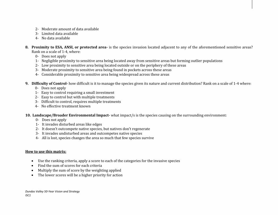
8. Proximity to ESA, ANSI, or protected area- is the species invasion located adjacent to any of the aforementioned sensitive areas?
Rank on a scale of 1-4, where: 0- Does not apply 1- Negligible proximity to sensitive area being located away from sensitive areas but forming outlier populations 2- Low proximity to sensitive area being located outside or on the periphery of these areas 3- Moderate proximity to sensitive area being found in pockets across these areas 4- Considerable proximity to sensitive area being widespread across these areas
9. Difficulty of Control- how difficult is it to manage the species given its nature and current distribution? Rank on a scale of 1-4 where:
0- Does not apply 1- Easy to control requiring a small investment 2- Easy to control but with multiple treatments 3- Difficult to control, requires multiple treatments 4- No effective treatment known
10. Landscape/Broader Environmental Impact- what impact/s is the species causing on the surrounding environment:
0- Does not apply 1- It invades disturbed areas like edges 2- It doesn’t outcompete native species, but natives don’t regenerate 3- It invades undisturbed areas and outcompetes native species 4- All is lost, species changes the area so much that few species survive
How to use this matrix:
Use the ranking criteria, apply a score to each of the categories for the invasive species Find the sum of scores for each criteria Multiply the sum of score by the weighting applied The lower scores will be a higher priority for action

Dundas Valley 50-Year Vision and Strategy ISC1
Attachment 3: Implementation Strategy Cycle 1: 2014-2019
Core Operational Budget
EXPENSES PROJECT COSTS PER YEAR TOAL FIVE YEAR COST
Personnel
11. Strategy Manager at 100%, $28/hour + 20% Fringe Benefits $60, 480.00 $302, 400.00
Travel
12. Travel at HCA rate of $0.53/km $2,000.00 $10,000.00
Materials, Supplies & Equipment
13. Computer and office supplies $1,500.00 $7,500.00
14. Printed reports, surveys, and maps $1,500.00 $7,500.00
15. Climate Change Components $10,000.00 $50,000.00
Communications Costs
16. Open Houses, public meetings, and outreach materials (brochures, flyers, and posters) $3,500.00 $17,500.00
17. Web page, press releases, newspaper advertisements $2,000.00 $10,000.00
Overhead (office space, phone, heat, hydro, internet)
18. Strategy Manager at 100% $10,000.00 $50,000.00
Other Expenses
19. Cost of attending related networking events, conferences, workshops, and training $1,000.00 $5,000.00
20. Refreshments e.g. committee meetings, stakeholder meetings, open houses $500.00 $2500.00
TOTAL $92,480.00 $462,400.00

Dundas Valley 50-Year Vision and Strategy ISC1
Dundas Valley 50-Year Vision and Strategy Implementation Strategy Cycle 1: 2014-2019 Work Plan
Strategic Direction: Protect and enhance the health of streams,
watercourses, and waterfalls

Dundas Valley 50-Year Vision and Strategy ISC1
Table of Contents
Background…………...………………………………………………………………………………………………………………………………………………………3
1.0 Dundas Valley 50-Year Vision and Strategy: Themes, Goals and Actions…………………………………………………………………………….4
2.0 Methodology and Work plan…………………………………………………………………………………………………………………………….......................5
3.0 Resources and Constraints………………………………………………………………………………………………………………………………………………11
References
Appendix
© Hamilton Conservation Authority, 2013. All rights reserved. No part of this publication may be reproduced in any form or by any means, electronically, mechanically,
or by photocopying, recording, or otherwise, with the prior permission of the copyright owners.

Background
Water is a critical to all aspects of our lives and it is important that we ensure there is a safe and reliable source of water for all our
uses - now and in the future. Our drinking water comes from lakes, rivers, streams or underground sources (aquifers) located across the
province. All of these sources of water are linked in a watershed through the water cycle. The best way to protect
sources of water is on a watershed basis because water flows across traditional boundaries such as towns and
cities (Conservation Ontario, 2009). The Hamilton Conservation Authority (HCA) is responsible for 479 square
kilometres (km2) of watershed area with a watershed population of almost 400,000 residents. The Dundas Valley
is a particularly unique natural area being comprised of a number of sub-watersheds that collectively forms part
of the Spencer Creek watershed system. The Spencer Creek is the prominent stream within the Dundas Valley
area. The Spencer Creek watershed is the largest watershed within the
jurisdiction of the HCA, or 59% of the HCA watershed, and outlets directly
to into the Cootes Paradise. The HCA notes this watershed as being
comprised of 15 sub-watersheds. The creek is characterized by wetlands,
rural land use and rural communities in the upper part of the watershed
and urban development in the lower portions. With the predominance of the Niagara Escarpment in
the Valley, this feature has resulted in the formation of a number of waterfall and cascade systems
throughout the area.
However, there are number of areas that could be enhanced and strengthened. Water
quality monitoring is done at only some locations across the Valley area. In addition to this, areas
like Spencer Creek are in need of restoration and naturalization while erosion and run-off are compromising water quality (HCA, 2009b).
There is a need for a clearer understanding about the features, their functions and linkages that exist in the Dundas Valley. Tools that will
assist with this include water budgets, stream form, water quality parameters of concern and the diversity and abundance of aquatic and
terrestrial communities. With the development of this work plan, the strategic direction of the Vision- ‘Protect and enhance the health of
streams, watercourses, and waterfalls through the Valley can be put into action within the Vision’s first 5-year implementation cycle.

Dundas Valley 50-Year Vision and Strategy ISC1
1.0 Dundas Valley 50-Year Vision & Strategy: Themes, Goals and Actions
Chart 1: Theme area, Goal, Strategic Direction, and Actions.
Goal 1: Protect and enhance the Valley’s ecology and natural
areas.
ACTIONS:
1. Protect surface and ground water (including wells and
aquifers)
2. Implement sub-watershed plans
3. Monitor water quality parameters at appropriate locations
4. Develop and implement long-term erosion prevention plan
5. Naturalize water channels where appropriate
6. Restore Spencer Creek
7. Continue to implement multi-year access and enhancement
plan (joint management approach) for Waterfalls and
Watercourses Plan (January, 2004)
8. Investigate the impacts of climate change on water resources and terrestrial and aquatic systems in the Valley- develop and implement action strategies
Dundas Valley 50-Year Vision and Strategy
2008-2058
Strategic Direction: Protect and enhance the health of streams, watercourses, and waterfalls.
Theme Area 1: Protect and Enhance Dundas
Valley Lands.

Dundas Valley 50-Year Vision and Strategy ISC1
2.0 Methodology and Work plan
The objective of the ISC1 and this work plan is to begin the implementation of the Vision’s top 10 Strategic Directions (SDs). The
protection and enhancement of the health of streams, watercourses, and waterfalls was identified as a key area of interest for the first 5
year cycle and is one of the 43 SDs that was highlighted through the development of the 50 Year Vision. Implementation will take the form
of project development and execution followed by continuous monitoring and evaluation to gauge the success and highlight any necessary
areas for improvement along the way (Refer to Chart 2). With this process in place, over the course of the work plan’s implementation, the
scope of work will be able to adapt to any unplanned changes.
Over the 5-Year phase, a work plan with the 8 actions will be implemented (Table 1). For each action item, there are a number of
related activities and projected outcomes. It should be noted that for some of these actions, work has already been completed or is on-
going. Additional actions/activities may be identified during ISC1’s implementation and may not be limited to the actions identified in the
Vision document.
Project Planning &
Design
Project Initiation: Creation of the 50-
Year Vision & Strategy
Project
Implementation-
Execution of 10
Work plans
Project Monitoring
& Evaluation
Chart 2: Project Management Framework

Dundas Valley 50-Year Vision and Strategy ISC1
Table 1: Work plan
WP & E: Watershed Planning & Engineering LM: Land Management
Actions
Activities
Projected Outcomes
Lead
Time
Sub-Budget Status
Role Cost
1. Protect surface and ground water (including wells and aquifers)
*It should be noted that the Hamilton Halton Source Water Protection Committee had developed a Source Water Protection Plan for this area in 2012. Only a small part of the Greensville well is within the study area.
Develop a Tier 3 analysis for the Greensville well
Continue to monitor ground water and source water through provincial monitoring programs such as the Provincial Water Quality Monitoring Network (PWQMN) and the Provincial Groundwater Monitoring Network (PGMN).
Coordinate efforts with the implementation of the Lower Spencer Creek Integrated Subwatershed Study.
Developed a Tier 3 analysis.
Monitored through PWQMN and PGMN.
HCA & Non-HCA
2014-2019
WP & E Staff Overhead Equipment, materials, and resources Travel
HCA Annual Budget
2. Implement sub-watershed plans
Conduct an integrated science-based study to assess the health of the Spencer creek, its watershed and how it responds to change: - Analyze historic data - Conduct on-going field work to characterize
the system - Develop a representative model that will aid
in anticipating how the creek will react to
Conducted an integrated science-based study and use the findings from this study to develop a management plan.
HCA 2014-2019
In progress as the Lower Spencer Creek Integrated Subwatershed Study is currently being undertaken by

Dundas Valley 50-Year Vision and Strategy ISC1
future changes - Investigate possible approaches that can
improve the health of the system e.g. remediation of existing erosion sites, removal of barriers to fish passage, and refining flooding problems through Dundas
Investigate how the watershed responds to
changes in future conditions such as climate change (see action 8) and future development and establish a strategy to mitigate negative impacts.
Use the data collected from this study to develop a management plan for the watershed for implementation.
(see action 1)
the HCA.
3. Monitor water quality parameters at appropriate locations
Review HCA’s existing monitoring programs for
the area.
Evaluate data collected over time to deduce
possible trends.
Identify ‘hot spots’ so that cause and effect could
be understood.
Collected and evaluated data over time.
Identified ‘hot spot’ areas in the watershed.
Improved water
quality.
HCA 2014-2019
(see action 1)
4. Develop and implement long-term erosion prevention plan
Review the City of Hamilton’s Storm Drainage Policy, 2004, Watercourse Erosion Assessment Study, 2010, in addition to the Lower Spencer Creek Integrated Subwatershed Study.
Identify and delineate priority area/s and their associated boundaries of land disturbance in the Valley.
Determine the best possible techniques and
Identified and delineated priority area/s in the Valley.
Determined the best possible actions for erosion prevention.
HCA & Non-HCA
2014-2019
(see action 1)

Dundas Valley 50-Year Vision and Strategy ISC1
actions that can be used to assess current erosion and how to prevent erosion within priority areas of the Valley.
Utilize current erosion and sediment control
techniques and best practices on identified lands. Identify stormwater discharge locations and add
outlet protection where needed. Determine if other best practices and measures
are needed and include into the plan. Provide input to future updates of the City of
Hamilton’s Watercourse Erosion Assessment Study and Lower Spencer Creek Integrated Subwatershed Study.
Developed a schedule for corrective works.
5. Naturalize water channels where appropriate AND
6. Restore Spencer Creek
Based on the data received from the Lower Spencer Creek Integrated Subwatershed Study: - Conduct an initial assessment of the study
area and determine the core data requirements (use data from actions 1, 2, and 3).
- Examine water channels in the Valley area, highlight the key problems and concerns, and determine priority areas for naturalization
- Establish the goals and objectives the project and discuss and finalize through stakeholder involvement.
- Design the a stream corridor naturalization plan
- Initiate the implementation of the plan - Evaluate the plan at selected locations where
necessary Review sub-watershed and Hamilton-Halton
Watershed Stewardship Program (HHWSP)
Developed a stream corridor naturalization plan for the area.
HCA 2014
(see action 1)

Dundas Valley 50-Year Vision and Strategy ISC1
plans and maps for the Dundas Valley and document restoration work where applicable.
Cross-coordinate implementation with SD
‘Protect rare, endangered and species at risk in the Valley area’ and SD ‘Combat the impact of invasive and nuisance species within the Valley.’
Review and summarize monitoring output,
assess progress of restoration relative to initial goals, and make adjustments, if necessary.
7. Continue to implement multi-year access and enhancement plan (joint management approach) for Waterfalls and Watercourses Plan (January, 2004).
Review the Waterfalls and Cascades of Hamilton: Research and Inventory 2012.
Continue to implement the outlined recommendations along with project partners when planning for future waterfall site access enhancements and visitor potential.
Coordinate efforts with SD ‘Develop a Valley-wide sustainable tourism business plan and marketing strategy to promote eco, cultural, culinary and recreational tourism’.
Implemented outlined recommendations along with project partners in all planning initiatives.
HCA & Non-HCA
2014-2019
WP & E Staff Overhead
HCA Annual Budget
In progress as the 3rd Edition of the Waterfalls and Cascades of Hamilton: Research and Inventory Report has been created in 2012.
8. Investigate the impacts of climate change on water resources and terrestrial and aquatic systems in the Valley- develop and implement action
Expand the number of monitoring stations as needed in the Dundas Valley area to enhance data collection.
Develop climate predictions for 25 years, 50 years, and 100 years scenarios for the Valley area.
Source existing data from other institutions
where possible for these areas e.g. universities.
Establish monitoring parameters for data collection (see action 3).
Conducted a Risk Assessment study for the Dundas Valley.
Developed action strategies and implemented where possible.
HCA 2014-2019
WP & E Staff Equipment, materials, and resources Travel
HCA Annual Budget
HCA has already developed a Climate Change Strategy and is currently implementing. HCA has also signed Hamilton’s Climate Change Strategy and working with

Dundas Valley 50-Year Vision and Strategy ISC1
strategies.
Monitor and collect data at selected intervals during the year for 5 years intervals and evaluate results before monitoring for the following years is undertaken to assess the need for refinement.
Analyze collected data to deduce trends and
changes by parameter at appropriate intervals.
Assess vulnerabilities and associated risks to identify and establish possible climate change impacts and possible adaptation opportunities for water resources.
Work with the HCA Climate Change Task Force
and other partners to develop action strategies.
HCA to participate in and support NEC, City of Hamilton and other local Climate Change investigative monitoring plots
Identify ‘quick start’ actions to address climate
change Participate in a Climate Change Adaptation
Strategy Encourage Climate Change awareness for
businesses and residents in the Valley area Encourage and drive public dialogue on the
impact of climate change
the City of Hamilton among other local partners to implement the strategy
TOTAL COST HCA Annual Budget
Dundas Valley 50-Year Vision and Strategy ISC1
3.0 Resources and Constraints
RESOURCES:
• Trained and experienced staff- HCA possesses highly trained and experienced staff members who are familiar with the
environmental conditions of the Dundas Valley.
• Community partnerships- HCA has over the years established a number of working relationships with landowners and key
community partners across the Dundas Valley. In particular, HCA has a good relationship with the NEC and the City of Hamilton.
CONSTRAINTS:
• Workload Management- implementing the SD’s work plan along with the other 10 SDs’ work plans of the 50-Year Vision within
the 5-Year period. This could be a challenge for HCA as there will be other multiple programs in addition to the Vision that also fall under
the HCA mandate and would require significant time and effort.

Dundas Valley 50-Year Vision and Strategy ISC1
References
1. Bowker Creek Restoration Plan, 2009. Bowker Creek Restoration
Project- University of Victoria, British Columbia.
http://web.uvic.ca/enweb/undergraduate/pdf/BowkerCreekR
estoration.pdf
2. Clean Water Act, 2010. Ontario Ministry of the Environment
(OMOE), Ontario.
http://www.ene.gov.on.ca/environment/en/legislation/clean_
water_act/STD01_078394.html
3. Developing a Municipal Source Water Protection Plan, 2009. Nova
Scotia Environment-Water and Wastewater Branch, Nova
Scotia.
http://www.gov.ns.ca/nse/water/docs/WaterProtectionPlanS
ummary.pdf
4. Dundas Valley 50-Year Vision and Strategy 2008-2058. Final Report.
Hamilton Conservation Authority (HCA).
In Text: (HCA, 2009a)
5. Dundas Valley 50-Year Vision and Strategy 2008-2058: Final Draft
for Review- Appendices- Appendix E: Current State Matrix. LURA
Consulting and the Hamilton Conservation Authority (HCA).
6. Dundas Valley Conservation Area Master Plan, 1997. Hamilton
Conservation Authority (HCA).
7. Ecological Restoration Guidelines, 2001. Forest Renewal British
Columbia (B.C.), B.C.
http://www.env.gov.bc.ca/fia/documents/restorationguidelin
es.pdf
8. Erosion and Sediment Control Guidelines for Urban Construction,
2005. Working Document- Workshop on Erosion and Sediment
Control. Greater Toronto Area’s (GTA’s) Conservation
Authority.
9. Guidelines for Naturalized River Channel Design and Bank
Stabilization, 2007. Department of Environmental Services and
Department of Transportation. New Hampshire, USA.
10. Hamilton Waterfalls and Cascades: Research and Inventory Report,
2012. Hamilton Conservation Authority (HCA)
11. Lower Spencer Creek Integrated Subwatershed Study, 2012.
Hamilton Conservation Authority (HCA).
http://www.conservationhamilton.ca/lower-spencer-creek-
integrated-subwatershed-study-2
12. Ontario Drinking Water Stewardship Program, 2010. Ontario
Ministry of the Environment (OMOE), Ontario.
http://www.ene.gov.on.ca/environment/en/subject/protectio
n/STDPROD_080599.html
13. Principles and Guidelines for Ecological Restoration in Canada’s
Protected Natural Areas, 2008. Parks Canada and the Canadian
Parks Council- Gatineau, Quebec.
http://www.pc.gc.ca/docs/pc/guide/resteco/guide_e.pdf
14. Proposed Source Water Protection Plans, 2012. Hamilton-Halton
Source Water Protection Region, Campbellville, Ontario.
http://www.protectingwater.ca/uploads/Reports/HHSPR%20
Proposed%20Plans%20Final%20submitted%2020120809%2
0for%20website.pdf
15. Protect Water, 2009. Source Water Protection. Conservation

Dundas Valley 50-Year Vision and Strategy ISC1
Ontario, Ontario.
http://conservation-ontario.on.ca/source_protection/
In Text: (Conservation Ontario, 2009)
16. Rural Official Plan, 2012. City of Hamilton, Hamilton.
http://www.hamilton.ca/CityDepartments/PlanningEcDev/Di
visions/StrategicServicesSpecialProjects/Policy+Planning/Ha
miltonNewOfficialPlan/Rural-Hamilton-Official-
Plan.htm?WT.mc_id=newruralop&WT.hamilton_redirect_frien
dly=1
17. Selected tools to Evaluate Water Monitoring networks for Climate
Change Adaptation, 2011. Canadian Council of Ministers of the
Environment (CCME).
http://www.ccme.ca/assets/pdf/pn_1464_wmcc_tools_en.pdf
18. Source Water Protection Plan, 2006. Planning- Drinking Water
Protection Act for Clean Water, Ontario.
http://www.protectingwater.ca/planning.cfm?smocid=1372
19. Spencer Creek Restoration Action Plan, in Response to the
Biedermann Packaging Fire Dowse Water Runoff and Resulting
Mortality of Fish and Benthic Invertebrates, 2008. Ontario
Ministry of the Enviroment (OMOE), Ontario.
http://www.ene.gov.on.ca/stdprodconsume/groups/lr/@ene/
@resources/documents/resource/std01_076619.pdf
20. Spencer Creek Watershed Plan, 1997. Hamilton Conservation
Authority (HCA).
21. Storm Drainage Policy, 2004. City of Hamilton-Hamilton.
http://www.hamilton.ca/NR/rdonlyres/CD4FE3EB-8504-
433D-88EB7B8507AC2B7F/0/StormDrainagePolicyReport.pdf
22. Watercourse Erosion Assessment Study, 2010. City of Hamilton-
Hamilton.
http://www.hamilton.ca/CityDepartments/PublicWorks/Envi
ronment_Sustainable_Infrastructure/StrategicPlanning/Strate
gicEnvironmentalPlanningProjects/WatercourseErosion/
23. Water Resources Protection Master Plan: Guiding Source Water
Protection, 2008. Region of Waterloo, Ontario.
http://www.regionofwaterloo.ca/en/aboutTheEnvironment/r
esources/RMOW%20water%20resources%20protection%20
master%20plan%20summary.pdf

Appendix
Attachment 1: Implementation Strategy Cycle 1: 2014-2019- Core Operational Budget
EXPENSES PROJECT COSTS PER YEAR TOAL FIVE YEAR COST
Personnel
21. Strategy Manager at 100%, $28/hour + 20% Fringe Benefits $60, 480.00 $302, 400.00
Travel
22. Travel at HCA rate of $0.53/km $2,000.00 $10,000.00
Materials, Supplies & Equipment
23. Computer and office supplies $1,500.00 $7,500.00
24. Printed reports, surveys, and maps $1,500.00 $7,500.00
25. Climate Change Components $10,000.00 $50,000.00
Communications Costs
26. Open Houses, public meetings, and outreach materials (brochures, flyers, and posters) $3,500.00 $17,500.00
27. Web page, press releases, newspaper advertisements $2,000.00 $10,000.00
Overhead (office space, phone, heat, hydro, internet)
28. Strategy Manager at 100% $10,000.00 $50,000.00
Other Expenses
29. Cost of attending related networking events, conferences, workshops, and training $1,000.00 $5,000.00
30. Refreshments e.g. committee meetings, stakeholder meetings, open houses $500.00 $2500.00
TOTAL $92,480.00 $462,400.00

Dundas Valley 50 Year Vision and Strategy ISC1
Dundas Valley 50-Year Vision and Strategy Implementation Strategy Cycle 1: 2014-2019 Work Plan
Strategic Direction: Protect Rare, Endangered and Species at Risk
within the Valley area

Dundas Valley 50 Year Vision and Strategy ISC1
Table of Contents
Background…………..………………………………………………………………………………………………………………………………………………………..3
1.0 Dundas Valley 50-Year Vision and Strategy: Themes, Goals and Actions……………………………………………………………………………..4
2.0 Methodology and Work plan……………………………………………………………………………………………………………………………………………..5
3.0 Resources and Constraints……………………………………………………………………………………………………………………………………………….13
References
Appendix
© Hamilton Conservation Authority, 2013. All rights reserved. No part of this publication may be reproduced in any form or by any means, electronically, mechanically,
or by photocopying, recording, or otherwise, with the prior permission of the copyright owners.

Dundas Valley 50 Year Vision and Strategy ISC1
Background
According to the Ontario Ministry of Natural Resources (OMNR), a Species At Risk (SAR) is any naturally-occurring plant or animal
in danger of extinction or of disappearing from the province. The Dundas Valley area is a unique natural area within Hamilton, forming
part of Ontario’s Greenbelt as well as one of the province’s most significant geological features-the Niagara Escarpment. In addition to this,
the Valley comprises a part of the Carolinian Life Zone, making it an ecologically important
habitat for a number of species at risk. Over the last few years, the Dundas Valley has been
experiencing pressures from development, visitor impacts, and invasive species.
It has been recognized by the Dundas Valley 50-Year Vision and Strategy, that action must
be taken to address these issues in the Valley. The Valley is home to over 100 species of birds
and fish, amphibians, reptiles, mammals, butterflies, and an abundance of native trees, and flora.
The area has an unusually high diversity of biological communities and associated plants and
animals due to a variety of geomorphological features, soils, water, sunlight, vegetation, and
associated microclimates. It possesses a number of Environmentally Sensitive Areas (ESAs),
serves as an Important Bird Area (IBAs), and possesses protected Greenbelt areas. At the provincial
level, the Valley has been identified as both a Life Science and Earth Science Area of Natural and
Scientific Interest (ANSI), and also as part of the Niagara Escarpment Plan (NEP) and at the
international level it has been recognized as part of the Niagara Escarpment World Biosphere Site,
and was examined under the International Biological Programme (IBP).
Even with the recognition provided, SAR are still under considerable pressure. These species
are threatened due to development, increasing numbers of visitors to natural areas, climate change,
invasive species among other factors e.g. the Eastern Milk Snake and the Jefferson Salamander. While
there is extensive knowledge of the ecological attributes of the Dundas Valley, there is a need for species presence and absence,
designations for species, and continuous SAR protection and monitoring programs. With the development of this work plan, the strategic
direction of the Vision-‘Protect rare, endangered and species at risk within the Valley area’ can be put into action within the Vision’s first 5
year implementation cycle.

Dundas Valley 50 Year Vision and Strategy ISC1
1.0 Dundas Valley 50-Year Vision & Strategy: Themes, Goals and Actions
Chart 1: Theme area, Goal, Strategic Direction, and Actions.
Goal 1: Protect and Enhance the Valley’s ecology and natural
areas
ACTIONS:
1. Develop and implement protection plans for individual species (based
on Natural Areas Inventory (NAI))
2. Inquire about how the Hamilton-Halton Watershed Stewardship
Program (HHWSP) can assist to do SAR work with landowners
3. Implement protection policies and plans
4. Focus HCA Land acquisition and protection in priority areas
5. Develop landowner/awareness/protection/stewardship program (look
at HHWSP)
6. Develop visitor management/awareness/protection/stewardship
program
7. Ensure Niagara Escarpment Commission (NEC) motorised vehicles
policy in natural area parks is implemented to minimize detriment to
species
8. Investigate the impacts of climate change on SAR- develop and
implement action strategies
Dundas Valley 50-Year Vision and Strategy
2008-2058
Strategic Direction: Protect rare, endangered and species at risk
within the Valley
Theme Area: Protect and Enhance Dundas
Valley Lands

Dundas Valley 50 Year Vision and Strategy ISC1
2.0 Methodology and Work plan
The objective of the ISC1 and this work plan is to begin the implementation of the Vision’s top 10 Strategic Directions (SDs). The
protection of rare, endangered, and species at risk was identified as a key area of interest for the first 5 year cycle and is one of the 43 SDs
that was highlighted through the development of the 50 Year Vision. Implementation will take the form of project development and
execution followed by continuous monitoring and evaluation to gauge the success and highlight any necessary areas for improvement
along the way (Refer to Chart 2). With this process in place, over the course of the work plan’s implementation, the scope of work will be
able to adapt to any unplanned changes.
Over the 5-Year phase, a work plan with the 8 actions will be implemented (Table 1). For each action item, there are a number of
related activities and projected outcomes. It should be noted that for some of these actions, work has already been completed or is on-
going. Additional actions/activities may be identified during ISC1’s implementation and may not be limited to the actions identified in the
Vision document.
Project Planning &
Design
Project Initiation: Creation of the 50-
Year Vision & Strategy
Project
Implementation-
Execution of 10
Work plans
Project Monitoring
& Evaluation
Chart 2: Project Management Framework

Dundas Valley 50 Year Vision and Strategy ISC1
Table 1: Work plan
WP & E: Watershed Planning & Engineering LM: Land Management
DVCA: Dundas Valley Conservation Area
Actions
Activities
Projected Outcomes
Lead
Time
Sub-Budget Status
Role Cost
1. Develop and implement protection plans for individual species (based on Natural Areas Inventory (NAI)).
Review existing data e.g. the NAI and revise listing of SAR for the Dundas Valley area.
Commence field surveying and monitoring for each species to determine location, distribution, and numbers in the Dundas Valley.
Conduct a status review for each species and use
this information to compare and contrast trends and create a species profile for each SAR and create a Dundas Valley Species Inventory using this data: - Species Description - Species Functions and Values - Historical Account (where available) - Current Distribution and Geography (Map
species habitat/s where possible) - Survey Locations - Demographic Analysis - Habitat and Resource Assessment - Threat Analysis-past, current and
anticipated - Current Conservation Methods (if any)
Determine species with recovery potential- Review the Endangered Species Act, Final Ontario Recovery Strategies and make a list of species with recovery potential for the Valley.
Developed and initiated the implementation of individual species protection plans.
HCA 2014-2019
WP & E Staff Overhead Equipment, materials, and resources Travel Strategy Manager Overhead
HCA Annual Budget
Core Budget
(see appendix)

Dundas Valley 50 Year Vision and Strategy ISC1
Monitor numbers and distribution for the SAR, in addition to temperature and precipitation changes over an initial 3-Year period in priority areas.
Create a data baseline and repeat the monitoring
process to get more data to evaluate trends and changes.
Coordinate data analysis with that of SD ‘Combat
the impact of invasive species within the Valley’. Use the information from the species status
review and field monitoring to develop and implement individual Species Protection Plans (SPPs) with each having an educational/awareness component.
2. Investigate
the impacts of climate change on SAR- develop and implement action strategies.
Expand the number of monitoring stations as needed in the Dundas Valley area to enhance data collection.
Develop climate predictions for 25 years, 50 years, and 100 years scenarios for the Valley area.
Source existing data from other institutions
where possible for these areas e.g. universities.
Establish monitoring parameters for data collection.
Monitor and collect data at selected intervals
during the year for 5 years intervals and evaluate results before monitoring for the following years is undertaken to assess the need for refinement.
Analyze collected data to deduce trends and
Conducted a Risk Assessment study for SAR.
Developed action strategies and implemented where possible.
HCA 2014-2019
WP & E Staff Overhead
HCA Annual Budget

Dundas Valley 50 Year Vision and Strategy ISC1
changes by parameter at appropriate intervals.
Assess vulnerabilities and associated risks to identify and establish possible climate change impacts and possible adaptation opportunities for water resources.
Work with the HCA Climate Change Task Force
and other partners to develop action strategies.
Initiate the implementation of these action strategies where possible.
Coordinate data analysis with that of SD ‘Combat
the impact of invasive species within the Valley’.
3. Inquire about how the HHSWP funding can assist to do SAR work with landowners.
Determine how HHWSP funding for water quality and habitat improvement projects currently available to Dundas Valley landowners can be used towards the action plans.
Identify source of funding grants and donations
available to the HHWSP to undertake the above.
Inquired about HHWSP funding with HCA’s Watershed Stewardship team.
Investigated an annual source of funding to enable HCA to deliver HHWSP in Dundas Valley.
HCA 2014- 2mths
WP & E Staff Overhead
HCA Annual Budget
4. Implement protection policies and plans.
Implement activities as outlined above (Refer to Action Item 1 above).
Implement project work plans in accordance with provincial and federal policies i.e. Species at Risk in Ontario (SARO) List (OMNR, 2012), the Ontario Endangered Species Act, and the federal Species at Risk Act (SARA).
Implemented project work plans in accordance with related policies.
HCA 2014-2019
(refer to Action 1 above)
5. Focus HCA Review HCA’s Land Securement Strategy (LSS) in Reviewed HCA’s LSS HCA 2014- WP & E Staff HCA In progress

Dundas Valley 50 Year Vision and Strategy ISC1
Land acquisition and protection in priority areas.
particular the sub-target areas that have been outlined for potential securement in the Dundas Valley area and the Natural Areas Inventory (NAI).
Prioritize the identified sub-target areas in order of importance e.g. Environmentally Sensitive Areas (ESAs), areas close to developing sites.
Coordinate with on-going LSS activities to ensure
that these priority areas are secured. Create a policy document that will guide land
securement to ensure best possible outcomes for land securement and biodiversity protection in the Valley area.
Document the progress of land securement in the
Dundas Valley.
and NAI.
Created a policy document.
Documented the
progress of land securement in the Valley to date.
2019 Overhead
Annual Budget
through implementation of HCA’s Land Securement Strategy (LSS) in the Dundas Valley and the Cootes to the Escarpment Park System (CEPS) Land Securement Strategy. A policy document has already been created and added to the information repository.
6. Develop landowner/awareness/protection/stewardship program
Review applicable completed work from the HHWSP for the Dundas Valley and its relation to the Ontario Species at Risk Stewardship Program.
Document the progress and status of the stewardship program specifically the actions that promote SAR protection in the Dundas Valley area, using pre-existing work done by the HHWSP for the Spencer Creek sub-watersheds. The following activities should be examined: - Objectives for the program - Target area/s for program’s implementation
and delivery within Dundas Valley area sub-watersheds.
- Landowners, groups and associations that were consulted for collaboration.
- Type of information that was shared/being shared with Dundas Valley landowners e.g. SAR status, program funding and incentives,
Reviewed HHWSP work as it relates to SAR awareness and protection.
Created a summary of HHWSP activity in Dundas Valley.
HCA 2014- 4mths
WP & E and DVCA Staff Overhead Equipment, materials, and resources
HCA Annual Budget
In progress through the implementation of the Spencer Creek watershed action plans by HCA staff in sub-watersheds of the Dundas Valley: Ancaster, Chedoke, Lower Spencer, Tiffany, Spring, and Mineral Springs creeks of the Spencer Creek

Dundas Valley 50 Year Vision and Strategy ISC1
what they can do to help. - Tools and techniques that were/are being
harnessed to share information and engage landowners in the program e.g. webpage, workshops, program brochure, local events (Review HHWSP tactics).
- Monitoring and evaluation indicators to assess the progress of the program overtime e.g. landowner surveys, interviews, site visits.
Compile a summary of the above information describing the activities and progress of the HHWSP as it relates to SAR awareness and protection in the Valley, along with recommendations for future work.
watershed.
7. Develop visitor management/awareness/protection/stewardship program
Review applicable work conducted by HCA e.g. the Dundas Valley Master Plan, Spencer Gorge Webster’s Falls Master Management Plan, and other relevant data.
Develop a Visitor Impact Management Program (VIMP) that promotes SAR awareness and protection for the Dundas Valley area with a strong focus on trail systems. The following activities should be undertaken: - Use the visitor impact management matrix
(see appendix) to determine priority area/s for further analysis by looking at:
1. Type of activities e.g. biking, sight-seeing, hiking, picnicking
2. Permitted use/s of area 3. Environmental impact indicators
where possible e.g. vegetation loss, compaction, trail deterioration
4. Cause of impact 5. Possible mitigation strategies 6. Additional observations where
Reviewed applicable work conducted by HCA to date.
Developed and initiated the implementation of a VIMP for the Valley area.
Created and distributed a brochure to visitors.
HCA 2014-2019
WP & E, LM, and DVCA Staff Equipment, materials, and resources Travel Communications
HCA Annual Budget

Dundas Valley 50 Year Vision and Strategy ISC1
applicable e.g. origination of visitors, frequency of activities, high visitor/vehicle area/s, interviews with visitors about why they value the site.
- Map these areas of high impact/concern to highlight the Dundas Valley area trail systems in relation to the main recreational areas and their position relative to ESAs and high density SAR habitat areas.
- Determine the best techniques that can be used to collect this data e.g. surveys, GIS mapping, digital/photo-monitoring visitor interviews.
- Based on data collected, the current-state situation and problems of the Dundas Valley can be used to develop a VIMP.
- Establish objectives for the program - Develop mitigation actions that can be
implemented in the Valley through the VIMP matrix and public consultation.
- Initiate the implementation the VIMP actions for priority areas where feasible
Create and distribute a brochure that targets
visitors to create awareness and demonstrate actions they can adopt to minimize their impact.
8. Ensure NEC motorized vehicles policy in natural areas parks is implemented to minimize detriment to species.
Review the Niagara Escarpment Plan (NEP) in particular the ‘motorized vehicles policy’ in the natural areas parks.
Review existing methods and map the locations where enforcement is currently being implemented.
Investigate the feasibility of new enforcement strategies for the Dundas Valley areas e.g. information boards/signs, creating public
Reviewed the NEC motorized vehicle policy.
Mapped areas of existing enforcement.
Investigated and implemented the policy in priority
HCA 2014-2016
WP & E Staff DVCA Staff Overhead Equipment, materials, and resources
HCA Annual Budget
In progress as the NEC motorized vehicles policy is enforced within selected areas of the Valley area.

Dundas Valley 50 Year Vision and Strategy ISC1
awareness, enforcement of fines and penalties and create a table.
Determine other priority areas in the Valley for enforcement e.g. high/multiple use areas, or sensitive habitats such as breeding ponds. Create a map of these areas.
Write a report with findings and recommendations for further action where necessary.
Implement actions where possible.
areas of the Dundas Valley.
Mapped other priority areas for potential enforcement.
Created a report with actions.
Implemented outlined actions.
TOTAL COST HCA Annual Budget

Dundas Valley 50 Year Vision and Strategy ISC1
3.0 Resources and Constraints
RESOURCES:
Overlapping on-going programs- HCA currently possesses a number of active and future planned programs that overlap
significantly with the actions outlined under the SD. Some of these programs are:
1. Terrestrial Resource Monitoring Program (TRMP) - in 2012, HCA developed a TMP that will track changes in ecosystem health
(including trends of habitat fragmentation) and help adapt to climate change.
2. Aquatic Resource Monitoring Program (ARMP) - has been an on-going initiative of the HCA with monitoring stations being set up
across the watershed.
3. Hamilton-Halton Watershed Stewardship Program (HHWSP)- the program works with landowners in the watersheds of Hamilton
Conservation Authority and Conservation Halton, providing advice on environmentally friendly ways of managing properties with
natural features such as woodlots, wetlands, meadows and creeks.
4. Spencer Gorge Webster’s Falls Master Management Plan- the plan is the principal guiding policy document for the planning,
development and resource management of the Spencer Gorge-Webster’s Falls Conservation Area.
5. Natural Areas Inventory (NAI)- is a complete inventory of natural areas in Hamilton (including the Dundas Valley area), created so
that current information on plant and wildlife species, vegetation communities, and site boundaries is available for agencies which
are responsible for protecting and enhancing natural features.
Data Availability- the NAI and data collected from the TMP and AMP will greatly aid in the formation of the Dundas Valley Species
Repository and development of individual SPPs.
Trained and experienced staff- HCA possesses highly trained and experienced staff members who are familiar with the
environmental and social conditions of the Dundas Valley.
Community partnerships- HCA has over the years established a number of working relationships with landowners and key
community partners across the Dundas Valley.
CONSTRAINTS:
Funding Availability and Timing- sourcing additional funding for work plan execution will be needed for successful implementation
and applying for funding where by designated time lines and ensuring these align with the work plan’s implementation time line as
well.

Dundas Valley 50 Year Vision and Strategy ISC1
Workload Management- implementing the SD’s work plan along with the other 10 SDs’ work plans of the 50-Year Vision within the
5-Year period. This could be a challenge for HCA as there will be other multiple programs in addition to the Vision that also fall under
the HCA mandate and would require sufficient time and effort.
Lack of specialized in-house knowledge in particular areas- there would be a need to consult with external professionals in select
areas e.g. ornithologists, herpetologist.
Inadequate staff- given the large extent of the Dundas Valley area, more staff members would be needed to carry out field work at
periodic intervals e.g. visitor counts to natural areas.

Dundas Valley 50 Year Vision and Strategy ISC1
References
1. An Overview of Species Conservation Strategic Planning (SCSP), 2008. The Species Conservation Planning Task Force Species Survival Commission, International Union for Conservation of Nature (IUCN) - The World Conservation Union. http://intranet.iucn.org/webfiles/doc/SSC/SSCwebsite/SSC_Chairs_Meeting/An_Overview_of_Species_Conservation_Strategic_Planning.pdf
2. Canadian Biodiversity Strategy-Canada’s response to the Convention on Biological Diversity, 1995. Environment Canada, Government of Canada (GC). http://www.ijc.org/rel/pdf/coast_guard/PDFS/APPK.PDF
3. Carolinian Canada, 2012. The Uniqueness of Carolinian Canada, Fact Sheets. http://www.carolinian.org/FactSheets_CCUniqueness.htm
4. Dundas Valley 50-Year Vision and Strategy 2008-2058, 2009. Hamilton Conservation Authority (HCA).
5. Dundas Valley and Dundas Marsh, 2012. Site Summary-Important Bird Areas (IBA). http://www.bsc-eoc.org/iba/site.jsp?siteID=ON005
6. Dundas Valley Conservation Area Master Plan, 1997. Hamilton
Conservation Authority (HCA).
7. Habitat Stewardship Program for Species at Risk, 2012. Environment Canada, Government of Canada. http://www.ec.gc.ca/hsppih/default.asp?lang=En&n=59BF488F-1
8. Hamilton-Burlington 7E-3 Conservation Action Plan, 2010.
Conservation Action Plans (CAPs) for Carolinian Canadian Biodiversity Hotspots, Carolinian Canada.
http://www.carolinian.org/Publications_CAP.htm#hamiltonburlingtoncap
9. Land Securement Strategy, 2010. Orland Conservation and the Hamilton Conservation Authority (HCA).
10. Developing a natural resource inventory and monitoring program for visitor impacts on recreation sites: A procedural manual, 1991. Marion, J.L.-Report no. NPS/NRVT/NRR91/06. Denver, CO: USDI National Park Service, Denver Service Center.
11. Natural Areas Inventory, 2003. Hamilton Naturalists Club and the Hamilton Conservation Authority (HCA).
12. Ontario Biodiversity Strategy, 2005. Ontario Ministry of Natural Resources (OMNR), Ontario. http://www.mnr.gov.on.ca/stdprodconsume/groups/lr/@mnr/@biodiversity/documents/document/mnr_e000066.pdf
13. Ontario Endangered Species Act, 2007, Ministry of Natural Resources (MNR), Ontario. http://www.search.e-laws.gov.on.ca/en/isysquery/9a1f6cdf-d2cd-40e6-8df7 18e0cee34e18/5/doc/?search=browseStatutes&context=#hit1
14. Planning and Design standards for Trails in Environmentally Significant Areas (ESAs), 2012. Parks, Planning and Design, City of London, Ontario.
15. Report on Phegopteris hexago noptera, for the Committee on the Status of Endangered Wildlife in Canada (COSEWIC), 1981. G. Vincent
16. Species at Risk Act (SARA), 2006. Government of Canada, Canada.

Dundas Valley 50 Year Vision and Strategy ISC1
http://www.sararegistry.gc.ca/approach/strategy/default_e.cfm#sar
17. Species at Risk in Ontario (SARO) List, 2012. Ministry of Natural Resources (OMNR), Ontario. http://www.mnr.gov.on.ca/en/Business/Species/2ColumnSubPage/276722.html
18. Strategic Planning for Species Conservation: A Handbook, 2008. The Species Conservation Planning Task Force Species Survival Commission, International Union for Conservation of Nature (IUCN). http://www.cbsg.org/cbsg/content/files/scptf_handbook.pdf
19. Sustainable Tourism in Protected Areas, Guidelines for Planning and Management, 2002. Chapter 7-Tools for Visitor Management. World Commission on Protected Areas (WCPA). International Union for Conservation of Nature (IUCN). http://www.unep.fr/shared/publications/other/3084/BP8-7.pdf
20. Tourism Insights, 2008. 2H: Developing Visitor Management Plans. http://www.insights.org.uk/destinationmanagementguideitem.aspx?title=2H%3A+Developing+Visitor+Management+Plans
21. Convention on Biological Diversity, 1992. United Nations (UN) http://www.cbd.int/doc/legal/cbd-en.pdf
22. M.E.M Van Der Donk, 2000. Framework for a Visitor Management Plan- Visitor Management PAN Parks. http://www.panparks.org/sites/default/files/docs/publications-resources/visitor_management_pan_parks_-framework_for_a_visitor_management_plan.doc.pdf

Appendix
END- Endangered SC- Special Concern THR- Threatened COSEWIC- Committee on the Status of Endangered Wildlife in Canada OMNR- Ontario Ministry of Natural Resources
Attachment 1: Table 1-Dundas Valley Current Species at Risk (SAR)
Year Species Code Scientific Name Common Name COSEWIC
OMNR
Status
1994 B-ACFL Empidonax virescens Acadian Flycatcher END END
2001 B-BARS Hirundo rustica Barn Swallow THR
1990 B-BOBO Dolichonyx oryzivorus Bobolink THR
1990 B-CERW Dendroica cerulea Cerulean Warbler END THR
1991 B-CHSW Chaetura pelagica Chimney Swift THR THR
1983 B-EAME Sturnella magna Eastern Meadowlark THR
1990 B-GWWA Vermivora chrysoptera Golden-winged Warbler THR SC
2002 B-HOWA Wilsonia citrina Hooded Warbler
SC
1992 B-LOWA Seiurus motacilla Louisiana Waterthrush SC SC
1990 H-JESA Ambystoma jeffersonianum Jefferson Salamander END END
2001 H-MISN Lampropeltis triangulum triangulum Eastern Milk Snake SC SC
1987 H-RISN Thamnophis sauritus Ribbon Snake SC SC
1989 H-SNTU Chelydra serpentina Snapping Turtle SC SC
1989 L-MONA Danaus plexippus Monarch SC SC
2001 P-CASDENT Castanea dentata American Chestnut END END
1983 P-CORFLOR Cornus florida Eastern Flowering Dogwood END END
2005 P-JUGCINE Juglans cinerea Butternut END END
N/A Arisaema dracontium Green Dragon SC SC
2011 P-MORRUBR Morus rubra Red Mulberry END END
1991,2002,2005 M-LBBA Myotis lucifugus Little Brown Bat END
1972-1991 P-PHEHEXA Phegopteris hexagonoptera Broad Beech Fern SC SC

Dundas Valley 50-Year Vision and Strategy ISC1
Attachment 2: Implementation Strategy Cycle 1: 2014-2019
Core Operational Budget
EXPENSES PROJECT COSTS PER YEAR TOAL FIVE YEAR COST
Personnel
6. Strategy Manager at 100%, $28/hour + 20% Fringe Benefits $60, 480.00 $302, 400.00
Travel
7. Travel at HCA rate of $0.53/km $2,000.00 $10,000.00
Materials, Supplies & Equipment
8. Computer and office supplies $1,500.00 $7,500.00
9. Printed reports, surveys, and maps $1,500.00 $7,500.00
Communications Costs
10. Open Houses, public meetings, and outreach materials (brochures, flyers, and posters) $3,500.00 $17,500.00
11. Web page, press releases, newspaper advertisements $2,000.00 $10,000.00
Overhead (office space, phone, heat, hydro, internet)
12. Strategy Manager at 100% $10,000.00 $50,000.00
Other Expenses
13. Cost of attending related networking events, conferences, workshops, and training $1,000.00 $5,000.00
14. Refreshments e.g. committee meetings, stakeholder meetings, open houses $500.00 $2500.00
TOTAL $82,480.00 $412,400.00

Dundas Valley 50-Year Vision and Strategy ISC1
Attachment 3: Table 2: Visitor Impact Management Matrix (HCA, 2012)
Activity Permitted Use-Area/s
Environmental Impacts Cause of Impacts Possible Mitigation Strategies Additional Observations
1. Horse-back riding
2. Hiking
3. Cycling
4. Picnicking

Dundas Valley 50-Year Vision and Strategy ISC1
Dundas Valley 50-Year Vision and Strategy Implementation Strategy Cycle 1: 2014-2019
Work Plan
Strategic Directions: Develop farmer-generated mechanisms to develop public support for agriculture AND Increase awareness of the local agriculture as both an activity and a lifestyle AND Support the promotion of locally grown and processed crops in close proximity to residents

Dundas Valley 50-Year Vision and Strategy ISC1
Table of Contents
Background…………...………………………………………………………………………………………………………………………………………………………3
1.0 Dundas Valley 50-Year Vision and Strategy: Themes, Goals and Actions…………………………………………………………………………….4
2.0 Methodology and Work plan…………………………………………………………………………………………………………………………….......................5
3.0 Resources and Constraints………………………………………………………………………………………………………………………………………………14
References
Appendix
© Hamilton Conservation Authority, 2013. All rights reserved. No part of this publication may be reproduced in any form or by any means, electronically, mechanically,
or by photocopying, recording, or otherwise, with the prior permission of the copyright owners.

Dundas Valley 50-Year Vision and Strategy ISC1
Background
Hamilton is an area with a long standing history of agriculture particularly in rural communities. Given that only 5% of the
Canadian land mass constitutes prime agricultural land, the importance of this Hamilton resource is significant. When other factors such
as climate, proximity to water and access to market and service infrastructure are also factored in,
the agricultural value of the land base in Hamilton becomes even more striking (City of Hamilton,
2003). One of the largest challenges for the agricultural community is to ensure that there is
informed understanding of modern agriculture in society. As Canada has moved from a rural to an
urban-based society the general understanding of rural lifestyle have declined and this acts as a
natural barrier to the involvement of non-rural residents in the agricultural industry (City of
Hamilton, 2003). There was a consistent decline in the number of farms across Ontario during the
period from 1971 to 2001. In Hamilton, between 1971 and 2001, 837 farms disappeared. This
represents a 45% decline as compared to a 37% decline at the provincial level and a 40% decline for
the Southern Ontario Region (City of Hamilton, 2003).
Dundas Valley farms and food producers provide essential food supplies to the surrounding
urban areas. The agricultural business provides nurseries and sod, cash crops, poultry, fruit,
vegetables, horse/pony and greenhouse operations to Ontario’s economy (HCA, 2009). In some areas
of the Valley, farming is becoming less viable as development pressures drive land prices up. Should
the current trend continue, and the threat to viable and sustainable agriculture be realized over the
next decade, the rural culture of the area will significantly diminish. It is a priority of the Vision to
encourage the restoration and appreciation of agriculture as both an activity and a lifestyle. A
general lack of understanding about the profession and lifestyle of farming, is contributing to the
erosion of this vital form of livelihood in the area (HCA, 2009). With the development of this work
plan, the strategic directions of the Vision-‘Develop farmer-generated mechanisms to develop public
support for agriculture’, ‘Increase awareness of the importance of local agriculture as both an activity and lifestyle’, and ‘Support the
promotion of locally grown and processed crops in close proximity to residents’ can be put into action within the Vision’s first 5-Year
implementation cycle.

Dundas Valley 50-Year Vision and Strategy ISC1
1.0 Dundas Valley 50-Year Vision & Strategy: Themes, Goals and Actions
Chart 1: Theme area, Goal, Strategic Direction, and Actions.
Goal 6: Instill agricultural
stewardship, protect the viability of agriculture
and encourage local food production in the
Dundas Valley
ACTIONS:
1. Provide incentives for farmers to use sustainable and green agricultural practices
2. Strengthen and promote Environmental Farm plans and agricultural leadership
3. Strengthen and promote Environmental Stewardship Programs
4. Promote low impact, organic agriculture
5. Promote the Greenbelt and participate in its program
6. Educate the public about the importance of agricultural land, farming as a lifestyle
and as a profession
7. Promote urban food production and hobby farms
8. Incorporate opportunities for agricultural knowledge and best practice sharing
between youth and seniors
9. Reintroduce a farmer’s market in the Valley’s adjacent communities
10. Develop a marketing strategy for locally grown food
11. Expand agriculture and encourage people to grow food in their yards
12. Promote low carbon farming
Dundas Valley 50-Year Vision and Strategy 2008-
2058
Strategic Directions: Develop Farmer generated mechanisms to develop support for agriculture, Increase awareness of the importance of local
agriculture as both an activity and a lifestyle and Support the promotion of locally grown and processed
crops in close proximity to residents.
Theme Area 2: Enhancing the Economic Sustainability
and Vibrancy of Dundas Valley Communities

Dundas Valley 50-Year Vision and Strategy ISC1
2.0 Methodology and Work plan
The objective of the ISC1 and this work plan is to begin the implementation of the Vision’s top 10 Strategic Directions (SDs). The
promotion of agricultural stewardship was identified as a key area of interest for the first 5 year cycle and is one of the 43 SDs that was
highlighted through the development of the 50 Year Vision. Implementation will take the form of project development and execution
followed by continuous monitoring and evaluation to gauge the success and highlight any necessary areas for improvement along the way
(Refer to Chart 2). With this process in place, over the course of the work plan’s implementation, the scope of work will be able to adapt to
any unplanned changes.
Over the 5-Year phase, a work plan with the 12 actions will be implemented (Table 1). For each action item, there are a number of
related activities and projected outcomes. It should be noted that for some of these actions, work has already been completed or is on-
going. Additional actions/activities may be identified during ISC1’s implementation and may not be limited to the actions identified in the
Vision document.
Project Planning &
Design
Project Initiation: Creation of the 50-
Year Vision & Strategy
Project
Implementation-
Execution of 10
Work plans
Project Monitoring
& Evaluation
Chart 2: Project Management Framework

Dundas Valley 50-Year Vision and Strategy ISC1
Table 1: Work plan
Actions
Activities
Projected Outcomes
Lead
Time
Sub-Budget Status
Role Cost
1. Provide incentives for farmers to use sustainable and green agricultural practices
Research and promote existing member programs in the Valley area to the community e.g. Ontario Soil and Crop Improvement Association (OSCIA), the Greenbelt Foundation, and the Ontario Ministry of Agriculture, Food, and Rural Affairs (OMAFRA), Hamilton-Halton Watershed Agricultural Advisory Panel, and Ontario Federation of Agriculture (OFA).
Provide input to the City of Hamilton’s Food Strategy development.
Promoted member programs in the Valley.
Non-HCA 2014-2019
Strategy Manager Overhead
Core Budget
(see appendix)
2. Strengthen and promote Environmental Farm plan (EFP) and agricultural leadership
AND
3. Strengthen and promote Environmental Stewardship Programs
Encourage the distribution of information about the EFP program and Environmental cost-share programs for EFP implementation e.g. Canada-Ontario Farm Stewardship Program (COFSP) and the Ontario Drinking Water Stewardship Program (ODWSP) through website, brochures, farm visits, and local outreach e.g. Greenbelt Harvest picnic, Ancaster Fair, and local farmers markets.
Encourage farmers to attend OSCIA
workshops in the area by demonstrating the advantages of EFB by use of case studies and available incentives and associated benefits e.g. Greenbelt Foundation, Species at Risk Farm Incentive Program.
Encouraged farmers to develop EFPs and created awareness of the COFSP and ODWSP.
Connected interested farmers with resources and experts.
Non-HCA 2014-2019
4. Promote low - Educate local farmers and the community Supported the Non-HCA 2014-

Dundas Valley 50-Year Vision and Strategy ISC1
impact, organic agriculture
through promotion of partner programs: - HCA’s educational programs - Environment Hamilton’s Rural Routes and
Fruit Tree Project - Farm Crawl Hamilton - Promote Community-Shared Agriculture
(CSA) and farms who are involved - Ancaster Agricultural Society (AAS)’s
Ancaster Fair and related educational programs
- Create awareness of Canadian Young Farmers’ Forum (CYFF) and their Best Management Practices (BMPs) workshops
- Promotion of Junior Farmers Association of Ontario (JFAO) and their programs
- Mustard Seed-Co-op - HCA’s Climate Change Strategy’s Eat Local
Exhibition - Other current programs
promotion of partner programs.
2019
5. Promote the Greenbelt and participate in its program
Continue to promote the Greenbelt program to the Dundas Valley community by linking all project-related initiatives to the foundation’s:
- Friends of the Greenbelt Foundation web page: http://greenbelt.ca/
- Greenbelt Fresh web page: http://www.greenbeltfresh.ca/
Continued promotion of the Greenbelt program.
Non-HCA 2014-2019
In progress as the 18-month implementation stage was funded by the Greenbelt and their programs are continuously promoted.
6. Educate the public about the importance of agricultural land, farming as a lifestyle and as a
Collaborate with local farmers, schools, and other groups to educate and engage people through: - Promote Farm Smart, FarmStart and
encourage use of FarmLINK and other organizations at the Dundas Valley Trail Centre e.g. flyers, posters, and other materials
- HCA Educational programs: Soil Ecology,
Educated the community (in particular the youth) about the importance of farming.
Collaborated with
local farmers in the
Non-HCA 2014-2019

Dundas Valley 50-Year Vision and Strategy ISC1
profession Growth & Changes in Plants, Grow Green Project, and Conservation Projects.
- Promote Environment Hamilton’s Rural Routes and the Fruit Tree Project
- Farm Crawl Hamilton - Royal Botanical Gardens (RBG) Children
Garden Program - Ancaster Agricultural Society (AAS)’s
Ancaster Fair and related educational programs.
- Junior Farmers of Ontario Association (JFAO) Annual Ontario’s Young Farmers Association
- Ancaster and Dundas Farmers Markets - Create awareness of Canadian’s Young
Farmers’ Forum (CYFF) and their Best Management Practices (BMPs) workshops
- Other current programs
Facilitate the creation of a school-farm network and work with schools and universities to encourage students to volunteer on farms for work experience and research opportunities.
Create an inventory of current organizations, programs, resources, and contacts in the Valley area.
Valley area and other groups.
Created an
inventory.
7. Promote urban food production and hobby farms
AND
8. Expand
Encourage landowners in urban areas to showcase their gardens as demonstration sites. Coordinate with the Hamilton-Halton Watershed Stewardship Program (HHWSP), Rural Routes program and Farm Crawl Hamilton.
Work with local partners to support and
promote their programs:
Successfully worked with partners to promote workshops, and community events.
Non-HCA 2014-2019

Dundas Valley 50-Year Vision and Strategy ISC1
agriculture and encourage people to grow food in their yards
- Ancaster Discovery Gardens - Dundas Valley Sunrise Rotary Garden - McMaster Teaching & Community Garden - Hamilton Community Garden Network
(HCGN) - Other current programs
9. Incorporate
opportunities for agricultural knowledge and best practice sharing between youth and seniors
Research current programs targeted towards youth.
Promote Youth Engagement /Mentorship programs at local community events, job fairs, libraries, and schools through workshops and brochures e.g. farm internships/volunteer programs.
Work with job/training agencies to explore
the promotion of agricultural opportunities to youth at job fairs and local schools.
Facilitate the creation of a school-farm
network that will: - Encourage local farms in the Valley to
offer/increase internship opportunities - Encourage students to volunteer on farm
for work experience and research opportunities
- Promote farming programs and organizations at the Dundas Valley Trail Centre e.g. flyers, posters, and other materials
- Create awareness of the Junior Farmers of Ontario Association (JFAO) and their Annual Ontario’s Young Farmers Association through online and outreach avenues e.g. schools and universities
- Create awareness of Canadian’s Young Farmers’ Forum (CYFF) and their Best Management Practices (BMPs)
Promoted engagement /mentorship programs at local community events and schools.
Non-HCA 2014-2019
Dundas Valley 50-Year Vision and Strategy ISC1
workshops through online and outreach avenues e.g. schools and universities
- Promote the Worldwide Opportunities for Organic Farms (WWOOF)
- Other current programs
10. Reintroduce a farmer’s market in the Valley’s adjacent communities
Business Improvement Areas (BIAs) of Ancaster and Dundas have already reintroduced farmers markets in both areas.
11. Develop a marketing strategy for locally grown food
Encouraged area groups to develop a marketing strategy for locally grown food.
Develop a project committee of at least 8 members to oversee the development of this strategy.
Conduct a preliminary local food/agricultural audit of the Dundas Valley area to determine the agricultural resources and local food that the Valley area has to offer through a literature review, site study, and consultation with stakeholder groups.
Conduct a Strengths Weaknesses
Opportunities and Threats (SWOT) analysis using the data collected with the project’s committee and other community stakeholders.
Undertake a market evaluation of the area to
assess: - Number and type of local food products
Developed a project committee of at least 8 members.
Created a local food marketing strategy for the Dundas Valley area.
Initiated the
implementation of the strategy where possible.
Assisted with
securing funds to drive this initiative.
Non-HCA 2014-2019

Dundas Valley 50-Year Vision and Strategy ISC1
available in the Valley - Locations of major farms in and around
the Valley area and their proximity to Ancaster and Dundas downtown areas
- Communal spaces that are available for the sale of local food
- Primary reason for people wanting to have access to local food
Using the findings from the market
evaluation, identify the specific niche markets offered by the Valley to consumers. Examine and highlight possible trends and main areas that relate to each niche market.
Determine the key marketing/customer profile, demographics, and the overall marketing position of the Dundas Valley area.
Mainstream the strategy’s functioning with
regional and provincial partners where applicable e.g. the Greenbelt. Examine issues such as competition from competing services.
From the on-going stakeholder consultations, identify gaps where possible.
Explore and finalize through consultation with stakeholder groups a marketing strategy for the Dundas Valley area: - Objectives and Goals - Priority areas - Action items- determine approaches,
techniques and tools that can be used to market the area’s local produce
- Budget allocation and funding - Monitoring and evaluation of strategy’s
progress - Implementation partners

Dundas Valley 50-Year Vision and Strategy ISC1
Initiate the implementation of the strategy where possible.
Assist with applying for funding to drive this initiative
12. Promote low carbon farming
Research low carbon farming techniques and consult with the Ecological Farmers of Ontario (EFOA), other groups, and local farmers in the Valley about best management practices.
Develop a best practices user guide that demonstrates how farmers can practice low carbon farming and work towards developing a strategy to aid farmers in adapting to climate change on farms.
Partner with other local organizations to
develop this guide.
Developed a best practices user/information guide.
Partnered with local groups.
Non-HCA 2014-2019
TOTAL COST Core Budget (See Appendix)

Dundas Valley 50-Year Vision and Strategy ISC1
3.0 Resources and Constraints
RESOURCES:
Community partnerships- HCA has over the years established a number of working relationships with landowners and key
community partners across the Dundas Valley. In particular, HCA has a good relationship with the City of Hamilton.
On-going and overlapping initiatives- there are already a number of on-going programs and projects in progress or in development
within and around the Valley area. At the local level, some programs include FarmCrawl Hamilton, Rural Routes and Eat Local
Hamilton initiatives by Environment Hamilton. At a municipal level, the City of Hamilton is working towards the development of a
Food Strategy for the region. The City of Hamilton’s Community Food Security Stakeholders Committee (CFSSC) have also put forward
a Farmers Market White Paper Policy and have worked with a number of partners to develop a Community Garden Policy for Hamilton.
At a regional level the Greenbelt Foundation and the provincial government have spear headed the creation and implementation of a
myriad of initiatives while the Ontario Soil and Crop Improvement Association (OSCIA) have a number of educational programs and
workshops that designed to assist farmers in conducting EFPs on their properties, as well as best stewardship practices for their
lands.
CONSTRAINTS:
Funding Availability and Timing- sourcing additional funding for work plan execution.
Workload Management- implementing the SD’s work plan along with the other SDs’ work plans of the Vision within the 5-Year
period. This could be a challenge for HCA as there will be other multiple programs in addition to the Vision that also fall under the HCA
mandate and would require sufficient time and effort.

Dundas Valley 50-Year Vision and Strategy ISC1
References
1. A Home-grown Strategy for Ontario Agriculture, 2007. Wally Seccombe. Toronto Food Policy Council, Toronto. http://www.toronto.ca/health/tfpc/pdf/omafra_policy_shift.pdf
2. Accessing Land for farming in Ontario, 2011. FarmStart, Everdale Environmental Learning Centre & Metcalf Foundation. http://farmertraining.everdale.org/files/2011/11/Land-Access-Guidebook_FINAL.pdf
3. Agricultural Economic Impact and Development Study: Executive Summary, 2003. City of Hamilton, Hamilton and Planscape. http://www.investinhamilton.ca/wp-content/uploads/2011/06/AgReportExecSum.pdf
4. Agricultural Environmental Stewardship Program, 2012. Ontario Federation of Agriculture (OFA), Ontario. http://www.ofa.on.ca/issues/overview/Agricultural-Environmental-Stewardship-Initiative
5. Ancaster Discovery Gardens, 2012. http://www.ancasterdiscoverygardens.ca/
6. Black Creek Community Farm, 2012. Everdale Organic Farm and Environmental Learning Centre, Hillsburgh http://everdale.org/blackcreek/blackcreek-project/
7. Business Development for Farm Businesses (BDFB), 2012. Ontario Soil and Crop Improvement Association (OSCIA), Ontario. http://www.ontariosoilcrop.org/en/bdfbapplications/default.htm
8. Canadian Young Farmers’ Forum, 2012. http://cyff.ca/cyff/
9. Canada-Ontario Farm Stewardship Program, 2012. Ontario Soil and Crop Improvement Association (OSCIA), Ontario. http://www.ontariosoilcrop.org/docs/greenhousebrochure_final.pdf AND http://www.ontariosoilcrop.org/en/programs/cost_share_opportunities.htm
10. Canadian Agricultural Skills Services, 2012. Treasury Board of Canada Secretariat. Government of Canada, Canada. http://www.tbs-sct.gc.ca/hidb-bdih/initiative-eng.aspx?Org=1&Hi=18
11. Canada-Environmental Farm Plan, 2012. Ontario Ministry of Agriculture, Food, and Rural Affairs (OMAFA), Ontario. http://www.omafra.gov.on.ca/english/environment/efp/efp.htm
12. Children’s Garden Program, 2012. Royal Botanical Gardens (RBG). http://www.rbg.ca/Page.aspx?pid=290
13. Community Gardening, 2012. . Ontario Ministry of Agriculture, Food and Rural Affairs (OMAFRA), Ontario. http://www.omafra.gov.on.ca/english/livestock/urbanagbib/communitygardening.htm
14. Community Garden Policy, 2010. City of Hamilton, Hamilton. http://www.hamilton.ca/NR/rdonlyres/F8B4672C-6E0D-4A5B-8A52-C2556C7914B7/0/Apr19EDRMS_n86758_v1_7_1__PW10044.pdf
15. Community Shared Agriculture Primer: the ins and outs of running a CSA farm in Ontario, 2008. Ecological Farmers Association of Ontario.

Dundas Valley 50-Year Vision and Strategy ISC1
http://www.farmstart.ca/wp-content/uploads/ON-CSA-Manual-Nov-09.pdf
16. Developing a marketing plan, 2010. Ontario Ministry of Agriculture, Food, and Rural Affairs (OMAFA), Ontario. http://www.omafra.gov.on.ca/english/busdev/facts/10-029.htm
17. Environmental Education- Adventures In Education Outdoor for Schools, 2012. Hamilton Conservation Authority (HCA). http://www.conservationhamilton.ca/environmental-education-home
18. Environmental Farm Plan, 2012. Government of Canada, Canada et. al. http://www.ontariosoilcrop.org/docs/2012_efp_brochure_%28web%29.pdf
19. Farmers growing Farmers, 2012. Everdale Organic Farm and Environmental Learning Centre, Hillsburgh. http://farmertraining.everdale.org/
20. Farm Crawl Hamilton, 2012. http://www.farmcrawlhamilton.ca/15.
21. FarmLINK.net, 2012. Ontario Farmland Trust, Guelph. http://www.farmlink.net/en/about-farmlink/
22. Farm Smart, 2013. University of Guelph, Ontario. http://www.uoguelph.ca/farmsmart/index.html
23. Farmer Training Programs, 2012. City of Hamilton. http://www.hamilton.ca/NR/rdonlyres/45594A27-9712-4F27-9680-E67648018092/0/FarmerTrainingPrograms.pdf
24. Hamilton Eat Local, 2012. Environment Hamilton (EH), Hamilton. http://environmenthamilton.org/view/page/hamilton_eat_local
25. Hamilton Fruit Tree Project, 2012. Environment Hamilton (EH), Hamilton. http://environmenthamilton.org/view/page/hamilton_eat_local
26. Junior Farmers Association of Ontario, 2012. http://www.jfao.on.ca/
27. McMaster Teaching and Community Garden, 2012. McMaster University, Hamilton. http://www.mcmaster.ca/sustainability/gs_campus_garden.html
28. Mustard Seed: Hamilton’s Cooperative Grocery, 2012. http://mustardseed.coop/
29. Niagara Escarpment Plan, 2005. Niagara Escarpment Commission (NEC). http://www.escarpment.org/_files/file.php?fileid=fileqoQkPglXij&filename=file_NEP_updated_April_2011.pdf
30. Niagara Escarpment Planning and Development Act, 1990. Niagara Escarpment Commission (NEC), Ontario. http://www.escarpment.org/landplanning/index.php
31. Opportunities and Challenges Facing Farmers in Transitioning to a Green Economy Agriculture Practice, 2012. Patrick Binns, United Nations Environment Program (UNEP). Perspectives, Issue 5- Environment Discussion Paper. http://www.unep.org/civil-society/Portals/59/Documents/perspectives/ENVIRONMENT_PAPERS_DISCUSSION_5.pdf
32. Ontario Drinking Water Stewardship Program, 2010. Ontario Soil and Crop Improvement Association (OSCIA), Ontario. http://www.ontariosoilcrop.org/docs/odwsp_brochure_2010-2011.pdf
33. Ontario Farmland Trust, 2012. Guelph.

Dundas Valley 50-Year Vision and Strategy ISC1
http://www.ontariofarmlandtrust.ca/
34. Organic Farming in Canada, 2004. Frédéric Forge, Science and Technology Division- Parliament of Canada, Canada. http://www.parl.gc.ca/Content/LOP/ResearchPublications/prb0029-e.htm#TOP
35. Places to Grow, 2012. Ontario Ministry of Infrastructure (OMI),
Ontario. https://www.placestogrow.ca/index.php?option=com_content&task=view&id=9&Itemid=12
36. Protecting the Greenbelt: the Greenbelt Plan, 2010. Ontario Ministry of Municipal Affairs and Housing (OMAFH), Ontario. http://www.mah.gov.on.ca/Page189.aspx#intro
37. Rural Official Plan, 2012. City of Hamilton, Hamilton. http://www.hamilton.ca/CityDepartments/PlanningEcDev/Divisions/StrategicServicesSpecialProjects/Policy+Planning/HamiltonNewOfficialPlan/Rural-Hamilton-Official-Plan.htm?WT.mc_id=newruralop&WT.hamilton_redirect_friendly=1
38. Rural Routes, 2012. Environment Hamilton (EH), Hamilton. http://environmenthamilton.org/view/page/ruralroutes
39. So You Want to be a Farmer, 1999. Canadian Farm Business Management Council (CFBMC), Ottawa. http://www.smallfarm.org/uploads/uploads/Files/SoWantFarmr.pdf
40. Species at Risk Farm Incentive Program, 2012. Ontario Ministry of Natural Resources (OMNR), Canada. http://www.mnr.gov.on.ca/stdprodconsume/groups/lr/@mnr/@species/documents/document/260037.pdf
41. Starting a Farm in Ontario- Business Information Bundle for New Farmers. Ontario Ministry of Agriculture, Food and Rural Affairs (OMAFRA), Ontario.
http://www.omafra.gov.on.ca/english/busdev/newentrant/newent.htm
42. Urban Agriculture Business Bundle, 2012. Ontario Ministry of Agriculture, Food and Rural Affairs (OMAFRA), Ontario. http://www.omafra.gov.on.ca/english/livestock/urbanagbib/welcome.htm
43. Worldwide Opportunities for Organic Farms (WWOOF), 2012. http://www.wwoof.org/

Appendix
Attachment 1: Implementation Strategy Cycle 1: 2014-2019- Core Operational Budget
EXPENSES PROJECT COSTS PER YEAR TOAL FIVE YEAR COST
Personnel
31. Strategy Manager at 100%, $28/hour + 20% Fringe Benefits $60, 480.00 $302, 400.00
Travel
32. Travel at HCA rate of $0.53/km $2,000.00 $10,000.00
Materials, Supplies & Equipment
33. Computer and office supplies $1,500.00 $7,500.00
34. Printed reports, surveys, and maps $1,500.00 $7,500.00
35. Climate Change Components $10,000.00 $50,000.00
Communications Costs
36. Open Houses, public meetings, and outreach materials (brochures, flyers, and posters) $3,500.00 $17,500.00
37. Web page, press releases, newspaper advertisements $2,000.00 $10,000.00
Overhead (office space, phone, heat, hydro, internet)
38. Strategy Manager at 100% $10,000.00 $50,000.00
Other Expenses
39. Cost of attending related networking events, conferences, workshops, and training $1,000.00 $5,000.00
40. Refreshments e.g. committee meetings, stakeholder meetings, open houses $500.00 $2500.00
TOTAL $92,480.00 $462,400.00

Dundas Valley 50-Year Vision and Strategy ISC1
Attachment 2: Map of Agricultural Properties in the Dundas Valley study area

Dundas Valley 50-Year Vision and Strategy ISC1
Dundas Valley 50-Year Vision and Strategy Implementation Strategy Cycle 1: 2014-2019 Work Plan Strategic Direction: Develop a Valley-wide sustainable tourism business plan and marketing strategy to promote eco, cultural, culinary, and recreational tourism

Dundas Valley 50-Year Vision and Strategy ISC1
Table of Contents
Background…………...……………………………………………………………………………………………………………………………………………………….3
1.0 Dundas Valley 50-Year Vision and Strategy: Themes, Goals and Actions……………………………………………………………………………..4
2.0 Methodology and Work plan……………………………………………………………………………………………………………………………........................5
3.0 Resources and Constraints……………………………………………………………………………………………………………………………………………….12
References
Appendix
© Hamilton Conservation Authority, 2013. All rights reserved. No part of this publication may be reproduced in any form or by any means, electronically, mechanically,
or by photocopying, recording, or otherwise, with the prior permission of the copyright owners.

Dundas Valley 50-Year Vision and Strategy ISC1
Background
The Dundas Valley is a spectacular natural and cultural area that attracts a large number of visitors from many places for a variety
of reasons. In particular, the Dundas Valley Conservation Area (DVCA) has a number interest points such as the historical Sulphur Springs
fountain, the Hermitage Ruins, Gatehouse Museum, Apple Orchard, Old Oak Tree, Hemlock Grove, the
Dundas Valley Trail Centre, the Griffin House, and the Thomas A. Beckett Living Forest. Other natural
attractions that draw visitors to this area include the Borer’s Falls Conservation Area, the Spencer
Gorge (Tews Falls, Webster’s Falls, and Dundas Peak) as well as Tiffany’s Falls. In the wider Valley area,
there are approximately 16 waterfalls and cascades, scenic natural routes and a number of trails along
the Niagara Escarpment that offer stunning vistas and nature appreciation opportunities. Visitors are
attracted to the Dundas Valley primarily to visit the waterfalls as well as historical and cultural sites
while partaking in a myriad of outdoor activities such as hiking, biking, horse-back riding, and sight-
seeing.
The interest in sustainable tourism and ecotourism reflects a rising tide of social concern about
the quality of the natural environment and the effects of tourism. Activities closely associated with experiencing natural environments are
very popular (Tourism Canada, 1995). In the Dundas Valley area, there is an opportunity to promote not
only eco-tourism but also cultural, culinary, and recreational forms of enjoyment to visitors. Eco-tourism
has the potential to further protect environmental and cultural resources as they could be used to create
a memorable visitor experience and be available for future generations in addition to added resiliency
over the long term. The Dundas Valley area has the potential to support culinary tourism as it could
foster a tourism experience in which one learns about, appreciates, and consumes food and drink that
reflects the local, regional, or national cuisine, heritage, culture, tradition or culinary techniques. This
will in turn assist with the protection and appreciation of cultural heritage while at the same time
promotes agricultural stewardship by encouraging people to buy and eat local food. With the development of this work plan, the Strategic
Direction of the Vision-‘Reduce the impact of increasing numbers of visitors to the natural areas over time’ can be put into action within
the Vision’s first 5-Year implementation cycle.

Dundas Valley 50-Year Vision and Strategy ISC1
1.0 Dundas Valley 50-Year Vision & Strategy: Themes, Goals and Actions
This SD does not fall directly within the mandate of HCA, therefore implementation will be a collaborative effort through the
assistance of stakeholders such as the City of Hamilton and Tourism Hamilton.
Chart 1: Theme area, Goal, Strategic Direction, and Actions.
Goal 9: Promote sustainable tourism
in the Valley.
ACTIONS:
1. Support and coordinate with Tourism Hamilton (advocate for
TH to give higher priority to Outdoor Tourism Strategy)
2. Develop and Escarpment trails and waterfalls marketing plan
for waterfall project partners (HCA, BTC, TH, HNC)
3. Create partnerships for long-term promotion of tourism and
culinary tourism
4. Coordinate a bus or shuttle that can transport people into the
Valley
5. Create tourism programs that do not require automobile
transportation to participate-rethink tourism without the car
6. Circulate books, and articles to let people know about the
Valley’s environment, culture, history, and agriculture
7. Explore the relation between climate change and
emergency/disaster planning in the Dundas Valley
Conservation Area (DVCA)
Dundas Valley 50-Year Vision and Strategy
2008-2058
Strategic Direction: Develop a Valley-wide sustainable tourism business
plan and marketing strategy to promote eco, cultural, culinary, and
recreational tourism.
Theme Area 2: Enhancing the Economic
Sustainability and Vibrancy of Dundas
Valley Communities.

Dundas Valley 50-Year Vision and Strategy ISC1
2.0 Methodology and Work plan
The objective of the ISC1 and this work plan is to begin the implementation of the Vision’s top 10 Strategic Directions (SDs). The
development of a Valley-wide tourism business plan and marketing strategy was identified as a key area of interest for the first 5 year
cycle and is one of the 43 SDs that was highlighted through the development of the 50 Year Vision. Implementation will take the form of
project development and execution followed by continuous monitoring and evaluation to gauge the success and highlight any necessary
areas for improvement along the way (Refer to Chart 2). With this process in place, over the course of the work plan’s implementation, the
scope of work will be able to adapt to any unplanned changes.
Over the 5-Year phase, a work plan with the 7 actions will be implemented (Table 1). For each action item, there are a number of
related activities and projected outcomes. It should be noted that for some of these actions, work has already been completed or is on-
going. Additional actions/activities may be identified during ISC1’s implementation and may not be limited to the actions identified in the
Vision document. Additional actions/activities may be identified during ISC1’s implementation and may not be limited to the actions
identified in the Vision document.
Project Planning &
Design
Project Initiation: Creation of the 50-
Year Vision & Strategy
Project
Implementation-
Execution of 10
Work plans
Project Monitoring
& Evaluation
Chart 2: Project Management Framework

Dundas Valley 50-Year Vision and Strategy ISC1
Table 1: Work plan
Actions
Activities
Projected Outcomes
Lead
Time
Sub-Budget Status
Role Cost
1. Support and coordinate with Tourism Hamilton (advocate for TH to give higher priority to Outdoor Tourism Strategy)
Explore the feasibility of Hamilton’s outdoor tourism product using the Dundas Valley as an example with Tourism Hamilton (TH) and the Hamilton Halton Brant Regional Tourism Association (RTA)
Explored the development of an outdoor tourism product.
HCA 2013 Strategy Manager Overhead
Core Budget
(see appendix)
Completed and on-going as both TH and RTA have been consulted. The RTA has already conducted an outdoor adventure product assessment for the area and is currently developing an outdoor tourism product that should be launched in Fall 2013.
2. Develop an Escarpment trails and waterfalls marketing plan for waterfall project partners (HCA, BTC, TH, HNC)
Work with HCA staff to determine how the Dundas Valley area should be marketed. Share ideas with the RTA and other groups for product development.
Encourage partners to develop a marketing plan for the area through board presentations and meetings.
Review the recommendations for marketing and promotion in the latest edition of the Hamilton Waterfalls and Cascades Research and Inventory Report and Tourism Hamilton’s Strategy Plan.
Conduct a preliminary tourism audit of the
Dundas Valley area to determine the natural attractions/resources and associated activities that the Valley area has to offer
Encouraged partners to develop a marketing plan.
Created an Escarpment trails and waterfalls marketing plan for the Dundas Valley area.
Initiated the
implementation of the strategy where possible.
Non-HCA 2014-2019

Dundas Valley 50-Year Vision and Strategy ISC1
through a literature review, site study, and consultation with stakeholder groups.
Conduct a Strengths Weaknesses
Opportunities and Threats (SWOT) analysis using the data collected from the tourism audit with the project’s committee and other community stakeholders.
Undertake a market evaluation of the
Dundas Valley area to assess: - Number of visitors to the Dundas Valley
area at key areas i.e. major waterfalls, popular trail entry points
- Primary reason for visit - Collect data for 1 year and create a
baseline for monitoring - Continue annual monitoring until
sufficient data is attained Using the findings from the market
evaluation, identify the specific niche markets offered by the Valley to visitors i.e. Eco-Tourism, Natural or Cultural Heritage Tourism, or other forms. Examine and highlight possible trends and main areas that relate to each niche market.
Determine the key marketing/customer profile, demographics, and the overall marketing position of the Dundas Valley area.
Mainstream the draft marketing plan’s
functioning with regional and provincial partners where applicable. Examine issues such as competition from competing services.

Dundas Valley 50-Year Vision and Strategy ISC1
From the on-going stakeholder consultations, identify gaps where possible.
Explore and finalize through consultation with stakeholder groups a marketing plan for the Dundas Valley area: - Objectives and Goals - Priority areas - Action items- determine approaches,
techniques and tools can be used to market the Valley’s assets
- Budget Allocation and funding - Monitoring and evaluation of strategy’s
progress - Implementation partners
3. Create
partnerships for long-term promotion of tourism and culinary tourism
Identify and encourage possible partnerships to promote culinary tourism
Create an inventory of possible
partnerships and explore ways of working together with them. Create connections among partners where possible.
Formed at least 4 partnerships.
Created and tracked an inventory.
Non-HCA 2014-2019
Partnerships have already been formed with the RTA and TH.
4. Coordinate a bus or shuttle that can transport people into the Valley
Investigate the feasibility of having a shuttle in the Dundas Valley area.
If feasible, proceed to explore options of having the Hamilton Street Railway (HSR) and other service providers to develop and implement a bus/shuttle service for the Valley area.
Explored the development of a bus/shuttle service for the Valley area.
Developed an
assessment/feasibility report.
HCA 2014-2019
5. Create tourism programs
Encourage people to see the Valley’s beauty through passive means that foster healthy lifestyles and promote natural and cultural
Developed programs for cycling, hiking,
Non-HCA 2014-2019

Dundas Valley 50-Year Vision and Strategy ISC1
that do not require automobile transportation to participate-rethink tourism without the car
heritage tourism along trails in the Valley area: - Cycling program - Hiking program - Walking program - Horse-back riding program
walking program, and horse-back riding.
6. Circulate books, and articles to let people know about the Valley’s environment, culture, history, and agriculture
Create an inventory of material that should be shared with the community.
Work with community partners: - Hamilton Public Library branches in
Dundas, Ancaster, and Greensville - Local schools - Community Centres - Town Halls - Dundas and Fieldcote Museums - Dundas Valley Historical Society - Tourism Hamilton Information Centre to increase awareness of books, articles and other information about the Valley.
Integrate applicable findings from SDs
‘Preserve the escarpment and rural countryside, including selected vistas’, and ‘Maintain and protect architectural and natural heritage’ into this circulation where appropriate.
Created inventory of materials.
Established partnerships with local libraries, town halls, and community centres.
HCA/Non-HCA 2014-2019
7. Explore the relation between climate change and emergency/di
Source existing data from other institutions where possible for this study where applicable.
Analyze collected data from monitoring stations in the Valley and pinpoint trends
Conducted a Risk Assessment study for the Dundas Valley.
Developed action
HCA 2014-2019
Watershed Planning & Engineering, Dundas Valley Conservation Area, and Land
Core Budget
(see appendix)
Dundas Valley 50-Year Vision and Strategy ISC1
saster planning in the Dundas Valley Conservation Area (DVCA)
and changes in temperature and precipitation. Refer to data collected from SD ‘Protect and enhance the health of streams, watercourses, and waterfalls.’
Conduct a risk assessment- identify and
establish possible climate change impacts on tourism in relation to extreme/high risk events e.g. storms, high winds, microbursts, flooding.
Compare data collected for various
locations in the Dundas Valley and determine high risk/ vulnerable areas.
Work with the HCA Climate Change Task
Force and other partners to develop risk management action strategies for emergency/disaster response.
Initiate the implementation of these action
strategies in the DVCA where possible.
strategies and implemented where possible.
Management Staff Overhead
TOTAL COST Core Budget (see appendix)
Dundas Valley 50-Year Vision and Strategy ISC1
3.0 Resources and Constraints
RESOURCES:
Community partnerships- HCA has over the years established a number of working relationships with key community partners
across the area such as Tourism Hamilton, the Giant Ribs Discovery Centre, and Bruce Trail Conservancy among others.
On-going local work- through consultation with various stakeholder groups across the Valley area, it was found that there are a
number of related programs and projects that are currently underway. Instead of duplicating the efforts of these groups, it would be
useful to collaborate with these organizations to support and further promote their work in the Valley area.
CONSTRAINTS:
Workload Management- implementing the work plan along with the other ten work plans of the fifty year Vision within the five year
period. This could be a challenge for HCA as there will be other multiple programs in addition to the Vision that also fall under the HCA
mandate and would require sufficient time and effort.
Non-HCA mandate- the actions that lie outside of HCA’s mandate will rely upon the support and interest of other community
partners. In order for this initiative to be successful, consideration would have to be given to the partner’s budget, resources, and time
to ensure as much overlap where possible. Volunteer support could potentially be a good way to gain support from the community in
this respect while fostering awareness of the project.

Dundas Valley 50-Year Vision and Strategy ISC1
References
1. Adventure Travel in Canada: An Overview of Product, Market and Business Potential, 1995. Tourism Canada, Industry Canada, Ottawa, Canada.
2. Building a National Model for Sustainable Tourism 2006-2009, 2012. Frontenac Arc Biosphere Reserve (FABR), Ontario. http://www.fabr.ca/SustainableTourism.html
3. Disaster Mitigation and Preparedness in a Changing Climate, 2006. James P. Bruce et. al. Global Change Strategies International Inc. http://www.iclr.org/images/Disaster_mitigation_and_preparedness_in_a_changing_climate.pdf
4. Discovering Ontario: A Report on the future of Tourism, 2009. Ontario Tourism Competitiveness Study, Ontario Ministry of Tourism and Culture (OMTC). http://www.mtc.gov.on.ca/en/publications/Discover_Ontario_en.pdf
5. Environmental Impacts of Tourism, 2001. United Nations Environment Programme (UNEP). http://www.gdrc.org/uem/eco-tour/envi/index.html
6. Integration of Biodiversity and Tourism: Canada Case Study. Wight, P. UNEP’s Biodiversity Planning Support Program. http://www.unep.org/bpsp/tourism/case%20studies%20(pdf)/canada%20(tourism).pdf
7. Niagara Escarpment Plan, 2005. Niagara Escarpment Commission (NEC). http://www.escarpment.org/_files/file.php?fileid=fileBomCrnlIRG&filename=file_NEP_January_25__2012.pdf
8. Ontario’s Four-Year Culinary Tourism Strategy and Action Plan
2011-2015, 2010. Ontario Ministry of Tourism and Culture (OMTC). http://www.mtc.gov.on.ca/en/publications/Culinary_web.pdf
9. Regional Tourism Strategy (RTO) the Heart of Ontario: A three year regional tourism strategy, 2011. The Tourism Company and Sierra Planning and management. Ontario Ministry of Tourism and Culture (OMTC), Ontario. http://region3tourism.ca/documents/RTO3TourismStrategyFinal.pdf
10. Sustainable Tourism: Conceptual Definition, 2012. Sustainable Development of Tourism, World Tourism Organization (WTO). http://sdt.unwto.org/en/content/about-us-5
11. Spencer Gorge-Webster’s Falls Conservation Area Master Plan, 2012. Hamilton Conservation Authority (HCA).
12. Sustainable Tourism in Protected Areas: Guidelines for Planning and Management, 2002. World Commission on Protected Areas (WCPA). Best Practice Protected Area Guidelines Series No. 8. International Convention on the Conservation of Nature (IUCN)- the World Conservation Union. http://turismo-sostenible.rds.hn/documet/iniciativas/tourismguidelines.pdf
13. Tourism Marketing Strategy, 2002. Growing Business, Coorong District Council and Limestone Coast Tourism. Australia. http://www.coorong.sa.gov.au/webdata/resources/files/Coorong_Tourism_Marketing_plan1.pdf

Appendix
Attachment 1: Implementation Strategy Cycle 1: 2014-2019- Core Operational Budget
EXPENSES PROJECT COSTS PER YEAR TOAL FIVE YEAR COST
Personnel
41. Strategy Manager at 100%, $28/hour + 20% Fringe Benefits $60, 480.00 $302, 400.00
Travel
42. Travel at HCA rate of $0.53/km $2,000.00 $10,000.00
Materials, Supplies & Equipment
43. Computer and office supplies $1,500.00 $7,500.00
44. Printed reports, surveys, and maps $1,500.00 $7,500.00
45. Climate Change Components $10,000.00 $50,000.00
Communications Costs
46. Open Houses, public meetings, and outreach materials (brochures, flyers, and posters) $3,500.00 $17,500.00
47. Web page, press releases, newspaper advertisements $2,000.00 $10,000.00
Overhead (office space, phone, heat, hydro, internet)
48. Strategy Manager at 100% $10,000.00 $50,000.00
Other Expenses
49. Cost of attending related networking events, conferences, workshops, and training $1,000.00 $5,000.00
50. Refreshments e.g. committee meetings, stakeholder meetings, open houses $500.00 $2500.00
TOTAL $92,480.00 $462,400.00

Dundas Valley 50-Year Vision and Strategy ISC1
Dundas Valley 50-Year Vision and Strategy Implementation Strategy Cycle 1: 2014-2019
Strategic Work Plan
Strategic Direction: Maintain and protect architectural and
natural heritage

Table of Contents
Background…………..………………………………………………………………………………………………………………………………………………………3
1.0 Dundas Valley 50-Year Vision and Strategy: Themes, Goals and Actions……………………………………………………………………………8
2.0 Methodology and Work plan……………………………………………………………………………………………………………………………......................9
3.0 Resources and Constraints……………………………………………………………………………………………………………………………………………...16
References
Appendix
© Hamilton Conservation Authority, 2013. All rights reserved. No part of this publication may be reproduced in any form or by any means, electronically, mechanically,
or by photocopying, recording, or otherwise, with the prior permission of the copyright owners.

Dundas Valley 50-Year Vision and Strategy ISC1
Background
The ‘heritage’ of a particular place can be referred to as the aesthetic, historic, scientific, cultural, social or spiritual importance or
significance for past, present and future generations. The ‘heritage value’ of an historic place is embodied in its character-defining
materials, forms, location, spatial configurations, uses and cultural associations or meanings
(Canada’s Historic Places, 2010). An area’s character-defining elements must be retained in
order to preserve its heritage value i.e. the materials, forms, location, spatial configurations, uses
and cultural associations or meanings that contribute to the heritage value of an historic place.
The conservation of cultural heritage landscapes and archaeological sites often involves
constituent natural heritage resources such as streams, lakefronts, and woodlands. Protection of
the Niagara Escarpment is a prime example: it is a cultural heritage landscape, containing natural
heritage features, and numerous archaeological resources (City of Hamilton, 2008).
The Dundas Valley area contains a rich and diverse physical environment resulting from
past and ongoing influences between local culture and the natural environment. The area
encompasses a variety of both natural and cultural features- the Darnley Mill Ruins, the Thomas
Beckett Memorial Forest, the Merrick Apple Orchard, the Griffin house among others. In addition to
these features, the Valley’s surrounding areas of Ancaster and Dundas each possess traditional
downtown cores with many commercial “main streets”, suburban areas with the Greensville and
Flamborough having small hamlets and villages, and an extensive rural area that supports a thriving
agricultural economy. The area possesses a few roads that bear special character and scenic
qualities that warrant protection. With a unique cultural heritage landscape the areas has been
modified by human activities and is deeply valued by the local community. Given the presence of
structures, spaces, archaeological sites and natural elements in the Valley, together these form a
specific type of heritage form, distinctive from its constituent elements or parts that should be celebrated and preserved to keep the
uniqueness of the area in tact but more importantly ensure its sustainable protection. With the development of this work plan, the
strategic direction of the Vision-‘Maintain and protect local architectural and natural heritage’ through the Valley can be put into action
within the Vision’s first 5-Year implementation cycle.

Dundas Valley 50-Year Vision and Strategy ISC1
1.0 Dundas Valley 50-Year Vision & Strategy: Themes, Goals and Actions
Chart 1: Theme area, Goal, Strategic Direction, and Actions.
Goal 2: Maintain and protect the Valley’s
cultural heritage and historical features.
ACTIONS:
1. Implement the Dundas Valley Visitor Services Plan and create a distinct and
promotional program for the Dundas Valley and neighbouring communities with the
natural and cultural heritage theme
2. Undertake and evaluation of properties/buildings for consideration of designation
under the Ontario Heritage Act
3. Promote the historic role of the Spencer Creek in the development of the Dundas
community
4. Identify and ensure the long term sustainability of historic buildings and resources
(e.g. Hermitage Ruins, Darnley Mill Ruins, and Griffin House)
5. Utilize area heritage designation to preserve local heritage. Maintain and protect
local heritage sites and buildings
6. Work with local galleries and Dundas Valley School of Art
7. Limit building heights
8. Seek and provide financial incentives to property owners to maintain their buildings
in keeping with its heritage
9. Investigate the impacts of climate change on cultural heritage programs in the Valley
Dundas Valley 50-Year Vision and Strategy
2008-2058
Strategic Direction: Maintain and protect local architectural and
natural heritage.
Theme Area 1: Protect and Enhance Dundas
Valley Lands.

Dundas Valley 50-Year Vision and Strategy ISC1
2.0 Methodology and Work plan
The objective of the ISC1 and this work plan is to begin the implementation of the Vision’s top 10 Strategic Directions (SDs). The
maintenance and protection of local architectural and natural heritage was identified as a key area of interest for the first 5 year cycle and
is one of the 43 SDs that was highlighted through the development of the 50 Year Vision. Implementation will take the form of project
development and execution followed by continuous monitoring and evaluation to gauge the success and highlight any necessary areas for
improvement along the way (Refer to Chart 2). With this process in place, over the course of the work plan’s implementation, the scope of
work will be able to adapt to any unplanned changes.
Over the 5-Year phase, a work plan with the 9 actions will be implemented (Table 1). For each action item, there are a number of
related activities and projected outcomes. It should be noted that for some of these actions, work has already been completed or is on-
going. Additional actions/activities may be identified during ISC1’s implementation and may not be limited to the actions identified in the
Vision document.
Project Planning &
Design
Project Initiation: Creation of the 50-
Year Vision & Strategy
Project
Implementation-
Execution of 10
Work plans
Project Monitoring
& Evaluation
Chart 2: Project Management Framework

Dundas Valley 50-Year Vision and Strategy ISC1
Table 1: Work plan
Actions
Activities
Projected Outcomes
Lead
Time
Sub-Budget Status
Role Cost
1. Implement the Dundas Valley Visitor Services Plan and create a distinct and promotional program for the Dundas Valley and neighbouring communities with the natural and cultural heritage theme.
Review the Dundas Valley Visitor Services Plan 2006 (Dundas Valley Escarpment Centre Visitor Services Plan) and initiate the implementation of the actions outlined.
Work with the Hamilton Conservation Foundation to secure funding to implement this plan.
Encourage interested partners to develop a
promotional program for the Valley through presentations and outreach to councils and related committees.
Develop a project committee of at least 8
members to oversee the development of a promotional program (Tourism Hamilton, HCA, City of Hamilton, Bruce Trail Conservancy, Royal Botanical Gardens, Ancaster Business Improvement Area (BIA), Dundas BIA, Giant Ribs Discovery Centre (GRDC), and two citizen representatives).
Conduct a preliminary heritage audit of the
Dundas Valley area to determine the natural attractions/resources and associated activities that the Valley area has to offer through a literature review, site study, and consultation with stakeholder groups.
Conduct a Strengths Weaknesses Opportunities and Threats (SWOT) analysis using the data
Initiated the implementation of the Dundas Valley Visitor Services Plan.
Developed and
implemented a natural and cultural heritage promotional program.
HCA & Non-HCA
2014-2019
Strategy Manager Overhead
Core Budget
(see appendix)
In progress as a Dundas Valley Escarpment Centre Visitor Services Plan has already been created by HCA.

Dundas Valley 50-Year Vision and Strategy ISC1
collected with the project’s committee and other community stakeholders.
Undertake a market evaluation of the area to
assess: - Number of visitors to the Valley at key
areas i.e. distinct natural and cultural heritage features and locations
- Primary reason for visit - Collect data for 1 year and create a baseline
for monitoring - Continue annual monitoring until sufficient
data is attained Using the findings from the market evaluation,
identify the specific niche markets offered by the Valley to visitors i.e. Eco-Tourism, Natural or Cultural Heritage Tourism, or other forms. Examine and highlight possible trends and main areas that relate to each niche market.
Determine the key marketing/customer profile, demographics, and the overall marketing position of the Dundas Valley area.
Mainstream the strategy’s functioning with
local and provincial partners where applicable.
From the on-going stakeholder consultations, identify gaps in existing natural and cultural heritage programs where possible.
Explore and finalize through consultation with
stakeholder groups a promotional program for the Dundas Valley area: - Objectives and Goals - Priority areas - Action items- determine approaches,
techniques and tools can be used to market
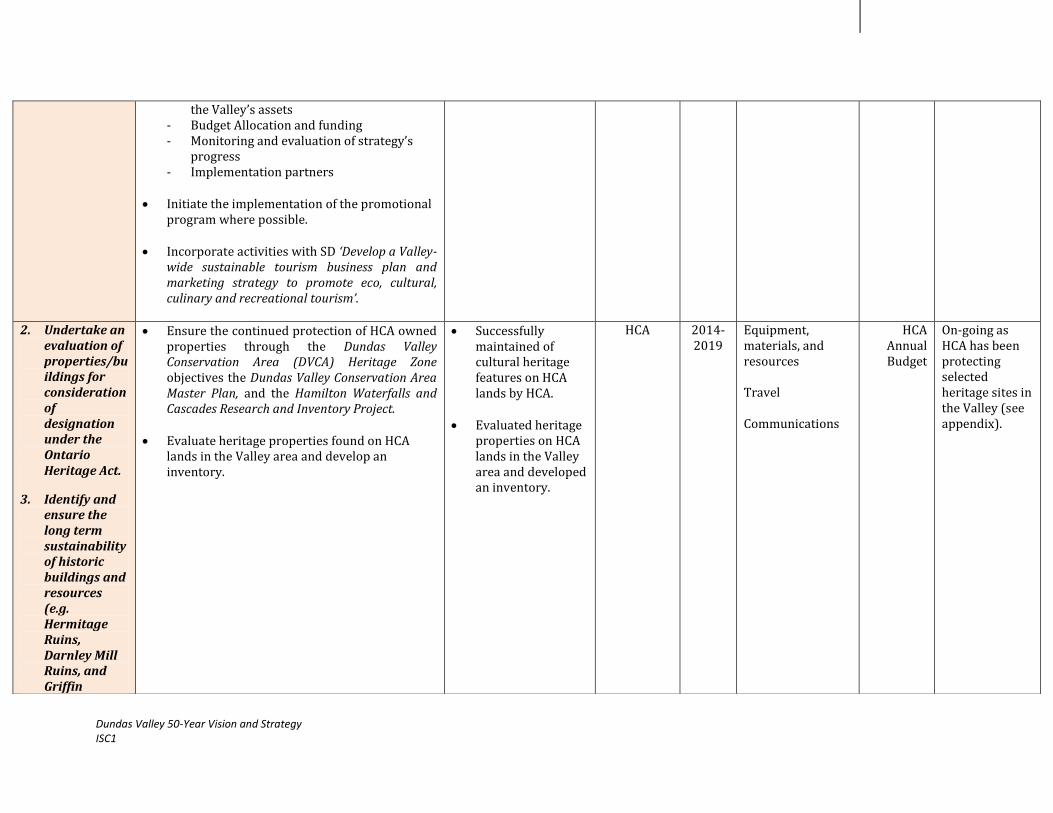
Dundas Valley 50-Year Vision and Strategy ISC1
the Valley’s assets - Budget Allocation and funding - Monitoring and evaluation of strategy’s
progress - Implementation partners
Initiate the implementation of the promotional
program where possible.
Incorporate activities with SD ‘Develop a Valley-wide sustainable tourism business plan and marketing strategy to promote eco, cultural, culinary and recreational tourism’.
2. Undertake an
evaluation of properties/buildings for consideration of designation under the Ontario Heritage Act.
3. Identify and ensure the long term sustainability of historic buildings and resources (e.g. Hermitage Ruins, Darnley Mill Ruins, and Griffin
Ensure the continued protection of HCA owned properties through the Dundas Valley Conservation Area (DVCA) Heritage Zone objectives the Dundas Valley Conservation Area Master Plan, and the Hamilton Waterfalls and Cascades Research and Inventory Project.
Evaluate heritage properties found on HCA lands in the Valley area and develop an inventory.
Successfully maintained of cultural heritage features on HCA lands by HCA.
Evaluated heritage properties on HCA lands in the Valley area and developed an inventory.
HCA 2014-2019
Equipment, materials, and resources Travel Communications
HCA Annual Budget
On-going as HCA has been protecting selected heritage sites in the Valley (see appendix).

Dundas Valley 50-Year Vision and Strategy ISC1
House).
4. Promote the historic role of the Spencer Creek in the development of the Dundas community.
Assess possible ‘heritage/industrial ‘trail routes on HCA-owned lands and determine how they can be celebrated and communicated to the public: - Highlight important natural heritage
features along trails i.e. birds, trees, Niagara Escarpment, Carolinian species by display boards and signage
- Explore the feasibility of having cue codes for scanning by devices
Document and map the Dundas Valley Portage
in addition to other possible heritage features/routes across the Valley. On this map include: - Location and marking of significant
heritage trees in the Valley - Highlight the historical legacy of
outstanding waterfalls in the area and its connection to the natural heritage of its surroundings e.g. the Niagara Escarpment
- Archeological features - Outstanding Vistas and Viewsheds
Develop and host ‘Guided Heritage Landscape’ and ‘House Tours’ along these routes.
Develop promotional material to assist in
creating awareness to the local community: - Brochure - Facebook group/web page
Work with the Dundas Valley Historical Society (DVHS), Fieldcote Museum (FM), and the Dundas Museum (DM) to develop an exhibit about the creek for display in the museum and other public spaces.
Assessed potential heritage trails in the Valley area.
Created a map/s of the Dundas Valley Portage.
Supported the implementation of activities with local partners.
Created
promotional materials.
HCA & Non-HCA
2014-2019

Dundas Valley 50-Year Vision and Strategy ISC1
Collaborate with local libraries to promote the Spencer Creek display in the library and at events and promote books about the Spencer Creek.
Work with Tourism Hamilton to have a ‘Doors open’ day for the public to visit local heritage sites within the Valley area. Coordinate and apply for event with the Ontario Heritage Trust.
Promote the following programs and initiatives
in the Valley area: - ‘Dundas- A timeline’ website - Ancaster Heritage Days event - Hamilton Postcards - Monumental Hamilton
Work with the Disappearing History initiative
to write stories about heritage sites in the Valley.
Work with Historical Hamilton to develop a map of historical and heritage features of the Dundas Valley area.
Incorporate activities with SD ‘Develop a Valley-
wide sustainable tourism business plan and marketing strategy to promote eco, cultural, culinary and recreational tourism’.
5. Utilize area
heritage designation to preserve local heritage. Maintain and protect local heritage sites
Under the City of Hamilton’s Heritage Landscape Study 2013, conduct a field evaluation of the potential heritage area/s in the Dundas Valley.
Create a listing of potential area/s in Hamilton and in turn the Valley area and rank in order of priority areas to be acted upon.
Developed a Cultural Heritage Landscape Evaluation report for selected area/s in the Dundas Valley.
Non-HCA 2014-2019
In progress as the City of Hamilton are planning to carry out a Cultural Landscape Assessment for potential areas.

Dundas Valley 50-Year Vision and Strategy ISC1
and buildings.
Conduct a background study and develop a Cultural Heritage Landscape Evaluation report: - Assess the significance and importance of
the area i.e. historical, cultural, and physical values
- Conduct an evaluation of the integrity of the area’s landscape i.e. design, setting, feeling, association
- Potential of the area as an educational and celebratory medium for local heritage
- Continuity i.e. ability of the landscape to retain its character with time
Based on the evaluation, determine if a Cultural
Heritage Landscape plan is appropriate and should be developed.
If so, then: Define potential study area and study zones/Cultural Heritage Landscape (CHL) within the Valley area using a map.
Draft an initial CHL plan.
Consult with local stakeholders about the draft CHL plan through public open houses and surveys. Use the information gathered to describe impacts, and refine preservation / mitigation strategies for protection, and study boundaries.
Prepare a final CHL plan and guidelines for the
proposed area.
Implement recommended strategies of the CHL plan to ensure protection of heritage features.
Incorporate the inclusion of the activities
outlined under SD ‘Support the implementation

Dundas Valley 50-Year Vision and Strategy ISC1
of the City of Hamilton’s special character roads through the Valley’ within the CHL plan.
Incorporate identified viewshed areas from SD
‘Preserve the escarpment and rural countryside, including selected vistas.
6. Work with
local galleries and Dundas Valley School of Art.
Work with the Dundas Valley School of Art (DVSA), the Giant Ribs Discovery Centre (GRDC), DM, FM, and the Carnegie Gallery (CG) to promote the historical, natural and cultural heritage of the Valley by supporting on-going initiatives and creating new programs: - Theme-based exhibitions within communal
spaces e.g. storefront art exhibits with exhibits at the CG joint-exhibit between CG and HCA.
- Lecture series at the Carnegie gallery - Book club between the Dundas Museum
and local libraries - GRDC ‘s ‘Bruce Duncan Memorial Lecture
Series’ - GRDC’s ‘Art and Photography of the
Heritage of the Niagara Escarpment’ at the DVCA Trail Centre
- CG’s ‘Arts Dundas’ annual event - CG’s Canada Culture Day Celebration
‘Dundas Culture’ - CG’s ‘Emerging Artists’ competition - CG’s Eco-Art Contest - DM’s ‘My Dundas!’ photography contest - DM’s ‘Your Dundas Stories’ - Work with the DM and Dundas Library to
promote the Natural Areas Inventory (NAI) and photographs of the Spencer Creek to the public
Supported the implementation of these activities with local partners.
Non-HCA 2014-2019
Strategy Manager Overhead
Core Budget
7. Limit Building
Review the findings of the Viewshed study in SD ‘Preserve the escarpment and rural
Created and submitted a report
HCA & Non- 2014- Strategy Manager
Core Budget

Dundas Valley 50-Year Vision and Strategy ISC1
Heights countryside, including selected vistas’ and the findings of the Cultural Heritage Landscape Evaluation report (see action 5).
Review the following key documents: - Niagara Escarpment Plan (NEP) - Niagara Escarpment Planning and
Development Act (NEPDA) - Other
Use the information obtained to compile a
report that will demonstrate: - Unique natural, historical, and cultural
features of the Valley - Current challenges faced in the Valley with
respect to housing development - Reasons as to why building heights and
mass should be limited in the Valley area - Recommendations for actions to ensure
future protection Submit report to the Niagara Escarpment
Commission (NEC) in timing with the 2015 NEP review period.
to the NEC. HCA 2019 Overhead
8. Seek and provide financial incentives to property owners to maintain their buildings in keeping with its heritage.
Research federal and provincial grants as incentives for local artists e.g. Canadian Council for Arts and the Ontario Arts Council (OAC).
Examine examples of funding programs from municipal heritage committees in Ontario e.g. Hamilton, Kingston, London, Markham, and Toronto.
Use this information to create a guidebook that
will foster awareness of funding, support, and contacts and on-going local programs and events in the Valley.
Created a guidebook.
Non-HCA 2014-2019

Dundas Valley 50-Year Vision and Strategy ISC1
9. Investigate the impacts of climate change on cultural heritage programs in the Valley.
Develop climate predictions for 25 years, 50 years, and 100 years scenarios for the Valley area.
Source existing data from other institutions where possible for these areas e.g. universities.
Monitor and collect data at selected intervals
during the year for a few years. Conduct a risk assessment- identify and
establish possible climate change impacts on cultural programs.
Compare information collected for various
locations within the Dundas Valley and also the watershed to determine higher risk/ more vulnerable areas.
Work with the HCA Climate Change Task Force
and other partners to develop action strategies.
Integrate collected data with monitoring data from SDs ‘Preserve the escarpment and rural countryside, including selected vistas’ and ‘Protect and enhance the health of streams, watercourses, and waterfalls’ to deduce trends and patterns.
Conducted a Risk Assessment study for the Dundas Valley.
Developed action strategies and implemented where possible.
HCA 2014-2019
WP & E Staff
HCA Annual Budget
TOTAL COST Core Budget (see appendix)

Dundas Valley 50-Year Vision and Strategy ISC1
3.0 Resources and Constraints
RESOURCES:
Community partnerships- HCA has over the years established a number of working relationships with key community partners
across the area such as the Dundas Valley School of Art, Carnegie Gallery, and the City of Hamilton among others.
HCA Heritage site protection- HCA has been ensuring the protection and maintenance of a number of cultural and natural heritage
sites in the Dundas Valley (see appendix). Through HCA’s Strategic Plan, the Dundas Valley Conservation Area (DVCA) Heritage Zone
Objectives the Dundas Valley Conservation Area Master Plan, the Spencer Gorge Webster’s Falls Master Management Plan and the
Hamilton Waterfalls and Cascades Research and Inventory Project, protection for each of these sites will be an on-going initiative.
On-going local work- through consultation with various stakeholder groups across the Valley area, it was found that there are a
significant number of related programs and projects that are currently underway. Instead of duplicating the efforts of these groups, it
would be better to collaborate with these organizations to support and further promote their work in the Valley area.
CONSTRAINTS:
Workload Management- implementing the work plan along with the other ten work plans of the fifty year Vision within the five year
period. This could be a challenge for HCA as there will be other multiple programs in addition to the Vision that also fall under the HCA
mandate and would require sufficient time and effort.
Non-HCA mandate- the actions that lie outside of HCA’s mandate will rely upon the support and interest of other community
partners. In order for this initiative to be successful, consideration would have to be given to the partner’s budget, resources, and time
to ensure as much overlap where possible. Volunteer support could potentially be a good way to gain support from the community in
this respect while fostering awareness of the project.
Limiting Building Heights- currently less than one-third of the area is protected from development through HCA’s land ownership.
Another seventy two percent lies within the Greenbelt, Escarpment Natural, Protection, and Parks and Open Space System. The NEC is
the main body that enforces the NEP and NEPDA to the Niagara Escarpment and its surrounding areas of the Dundas Valley. This
includes policies that address the height and location of structures. The HCA with the community’s support can only provide comment
and possible recommendations to ameliorate the issues of building height and scale in the Valley in timing for the NEP’s review in
2015. It would ultimately be the decision of the NEC to place restrictions on the height, location, and scale of structures in the Valley
area.

Dundas Valley 50-Year Vision and Strategy ISC1
References
1. Ancaster Heritage Days, 2012. http://www.ancasterheritagedays.com/
2. Built Heritage and Cultural Heritage Landscapes- Environmental Standards and Practices User Guide (2006). Ministry of Transportation, Ontario. http://www.raqsa.mto.gov.on.ca/techpubs/eps.nsf/9ea013f0de8096ba8525729700557ad1/8f0a4ff8826c3228852572b300578e03/$FILE/MTO%20ESP%20User%20Guide%20Sec%2010%20BHCHL.pdf
3. Climate change-buildings, cities, landscapes and other cultural heritage sites are at stake, 2006. Icomos News. Paris, France. Volume 16, December. http://www.international.icomos.org/newsicomos/news1991/2006-12-2.pdf
4. Climate Change and Cultural Heritage, 2008. Michelle Berenfield, the George Wright Forum. Word Monuments Fund. Volume 25 # 2. http://www.georgewright.org/252berenfeld.pdf
5. Climate Change and World Heritage Sites, 2007. United Nations Educational, Scientific and Cultural Organization (UNESCO). http://whc.unesco.org/documents/publi_wh_papers_22_en.pdf
6. Criteria for the identification of Cultural Heritage Landscapes, 2003. Town of Caledon, Caledon, Ontario. http://www.town.caledon.on.ca/contentc/townhall/departments/planningdevelopment/Criteria_for_the_ID-of_Cultural_Heritage_Landscapes.pdf
7. Cultural Heritage Landscape Resource Document, 2004. Heritage Resource Centre and Region of Waterloo, Ontario.
http://www.env.uwaterloo.ca/research/hrc/documents/12%20Region%20CHL%20-%20with%20title%20page.pdf
8. Cultural Heritage Resources Policies-Background Paper, 2008. Official Plan, City of Hamilton, Hamilton, Ontario. http://www.hamilton.ca/NR/rdonlyres/FFA34FA1-4981-4409-BC46-F722F2B662E7/0/CultHertBckgdPpr.pdf
9. Disappearing History, 2012. Haunted Hamilton, Hamilton. http://www.hauntedhamilton.com/disappearinghistory/
10. Draft Cultural Heritage Resources Policy Paper-Official Plan Review, 2011. City of Cambridge, Cambridge, Ontario. http://www.cambridge.ca/relatedDocs/Cultural%20Heritage%20Resources%20Policy%20Paper.pdf
11. Dundas- A Timeline, 2012. http://www.dundasatimeline.com/
12. Dundas Valley Escarpment Centre- Visitor Services Plan, 2006. Hamilton Conservation Authority (HCA) and the Giant Ribs Discovery Centre (GRDC)
13. Dundas Valley Portage: Interim Report, 2006. John Bryden
14. Environmental Guide for built Heritage and Cultural Heritage Landscapes, 2007. Ontario Ministry of Transportation (MTO), Ontario. http://www.ontla.on.ca/library/repository/mon/20000/277764.pdf
15. Exploring the connection between built and natural heritage, 2001. Research Report- Heritage Canada Foundation.
http://www.heritagecanada.org/sites/heritagecanada.org/files/GreenReport2Eng-Read.pdf

Dundas Valley 50-Year Vision and Strategy ISC1
16. Grants, 2012. Heritage Canada, Canada. http://www.heritagecanada.org/en/issues-campaigns/financial-incentives/municipal/grants
17. Greenbelt Plan, 2005. Ontario Ministry of Municipal Affairs and Housing (OMAH). http://www.mah.gov.on.ca/Page189.aspx#greenbelt
18. Guidelines for Identifying, Researching, and Evaluating Cultural Heritage Landscapes in Thorold, Ontario, 2011. Saundra Neale, Heritage Thorold. http://www.heritagethorold.com/Guidelines%20for%20Identifying%20Nov%20Jan%2013.pdf
19. Hamilton Heritage Community Fund Loan Program, 2011. Planning and Economic Development. City of Hamilton, Hamilton, Ontario. http://www.hamilton.ca/NR/rdonlyres/CB257E0C-0388-4A56-904E-7606C86E15D8/0/CPHamiltonCommunityHeritageFundApplication.pdf
20. Hamilton Heritage Property: Grant Program, 2011. Planning and Economic Development. City of Hamilton, Hamilton, Ontario. http://www.investinhamilton.ca/wp-content/uploads/2012/01/PD-Heritage.pdf
21. Hamilton’s Heritage Vol. 5 Reasons for Designation Part IV of the Ontario Heritage Act, 2005. City of Hamilton, Hamilton, Ontario. http://www.hamilton.ca/NR/rdonlyres/5DE78C57-32E2-4F73-92B0-523790A8D8B0/0/ReasonsForDesignationUnderPartIVOntarioHeritageAct.pdf
22. Hamilton Waterfalls and Cascades: Research and Inventory Report, 2007. Hamilton Conservation Authority (HCA), Hamilton, Ontario.
23. Heritage and Climate Change: Protection at any cost? 2011. UCL
Environment Institute Workshop, University College of London (UCL), UK. http://www.ucl.ac.uk/environment-institute/research/heritage2
24. Heritage Conservation Districts: A Guide to District Designation under the Ontario Heritage Act, 2006. .Ontario Heritage toolkit. Ontario Ministry of Tourism, Culture and Sport (OMTC), Province of Ontario, Ontario. http://www.mtc.gov.on.ca/en/publications/Heritage_Tool_KitHCD_English.pdf
25. Heritage Districts Work! Heritage Conservation District Study Cross- Melville- City of Hamilton, 2009. The Architectural Conservancy, Ontario et al. http://www.env.uwaterloo.ca/research/hrc/projects/documents/Cross-Melville_HCD_Hamilton.pdf
26. Heritage Grant Program, 2011. Planning, Development and Design, City of Brampton- Brampton, Ontario. http://www.brampton.ca/en/Arts-CultureTourism/heritage/Documents/Grant_Guidelines_and_Application_Form.pdf
27. Heritage Property Evaluation: A Guide to listing, researching, and evaluating, Cultural Heritage Properties in Ontario Communities, 2006. Ontario Heritage Toolkit. Ontario Ministry of Tourism, Culture and Sport (OMTC), Province of Ontario, Ontario. http://www.mtc.gov.on.ca/en/publications/HPE_Eng_large.pdf
28. The Impact of Climate Change on Historic Buildings and Cultural Properties, 2011. Johanna Liessner. United Nations Educational, Scientific and Cultural Organization (UNESCO) Today, UNESCO. http://www.climateforculture.eu/pdf/UNESCO_today_%203-2011_CfC.pdf
Dundas Valley 50-Year Vision and Strategy ISC1
29. Inventory of Ontario Heritage Incentive Programs, 2011. Jenna Langdale, Ryerson University, Toronto, Ontario. http://cms.burlington.ca/AssetFactory.aspx?did=19778
30. Manual of Aesthetic Design Practice (1991). Environmental Management Branch. Province of British Columbia, Ministry of Transportation. http://www.th.gov.bc.ca/publications/eng_publications/environment/design_practice.htm
31. Monumental Hamilton, 2012. http://www.monumentalhamilton.com/
32. Natural Heritage Manual- for Natural Heritage Policies of the Provincial Policy Statement, 2010. Ontario Ministry of Natural Resources (OMNR), Ontario. http://www.mnr.gov.on.ca/stdprodconsume/groups/lr/@mnr/@lueps/documents/document/289522.pdf
33. Niagara Escarpment Plan, 2005. Niagara Escarpment Commission (NEC). http://www.escarpment.org/_files/file.php?fileid=fileqoQkPglXij&filename=file_NEP_updated_April_2011.pdf
34. Niagara Escarpment Planning and Development Act, 1990. Niagara Escarpment Commission (NEC). http://www.escarpment.org/landplanning/index.php
35. Ontario Heritage Act, 1990. Ontario Ministry of Tourism, Culture and Sport (OMTC), Province of Ontario, Ontario. http://www.e-laws.gov.on.ca/html/statutes/english/elaws_statutes_90o18_e.htm
36. Policy Document on the impacts of Climate Change on World Heritage Properties, 2008. United Nations Educational, Scientific and Cultural Organization (UNESCO). http://whc.unesco.org/uploads/activities/documents/activity-393-2.pdf
37. Rural Official Plan, 2012. City of Hamilton, Hamilton.
http://www.hamilton.ca/CityDepartments/PlanningEcDev/Divisions/StrategicServicesSpecialProjects/Policy+Planning/HamiltonNewOfficialPlan/Rural-Hamilton-Official-Plan.htm?WT.mc_id=newruralop&WT.hamilton_redirect_friendly=1
38. Scenic Roads and Special Character Streets, 2011. Resource Document by the Region of Waterloo Heritage Planning Advisory Committee- Region of Waterloo, Waterloo, Ontario. http://www.regionofwaterloo.ca/en/discoveringTheRegion/resources/SCENIC_ROADS_AND_SPECIAL_CHARACTER_STREETS_RESOURCE.pdf
39. Standards and Guidelines for the conservation of historic places in Canada-A Federal, Provincial and Territorial Collaboration, 2010. Canada’s Historic Places, Canada. http://www.historicplaces.ca/media/18072/81468-parks-s+g-eng-web2.pdf
40. Strengthening Ontario’s Heritage: Identify, Protect, and Promote, 2005. Ontario Ministry of Tourism, Culture and Sport (OMTC), Province of Ontario, Ontario. http://www.mtc.gov.on.ca/en/publications/Strength_Heritage.pdf
41. Vintage Postcards of Hamilton- Dundas, 2012. Hamilton Postcards. http://www.hamiltonpostcards.com/
Appendix:
Attachment 1: Implementation Strategy Cycle 1: 2014-2019: Core Operational Budget
EXPENSES PROJECT COSTS PER YEAR TOAL FIVE YEAR COST
Personnel
51. Strategy Manager at 100%, $28/hour + 20% Fringe Benefits $60, 480.00 $302, 400.00
Travel
52. Travel at HCA rate of $0.53/km $2,000.00 $10,000.00
Materials, Supplies & Equipment
53. Computer and office supplies $1,500.00 $7,500.00
54. Printed reports, surveys, and maps $1,500.00 $7,500.00
55. Climate Change Components $10,000.00 $50,000.00
Communications Costs
56. Open Houses, public meetings, and outreach materials (brochures, flyers, and posters) $3,500.00 $17,500.00
57. Web page, press releases, newspaper advertisements $2,000.00 $10,000.00
Overhead (office space, phone, heat, hydro, internet)
58. Strategy Manager at 100% $10,000.00 $50,000.00
Other Expenses
59. Cost of attending related networking events, conferences, workshops, and training $1,000.00 $5,000.00
60. Refreshments e.g. committee meetings, stakeholder meetings, open houses $500.00 $2500.00
TOTAL $92,480.00 $462,400.00

Dundas Valley 50-Year Vision and Strategy ISC1
Attachment 2: Table 1: Listing of HCA-owned Heritage Properties
Name of Property Additional Details Photo
1. Griffin House Griffin house now owned by HCA since 1988, was the home of first black settler in the area from the US – designated by the Ancaster Local Architectural Conservation Advisory Committee for its unique historical and architectural significance
45-acre land, four-room farmhouse built in 1827, currently open from May to October on holiday Mondays
Member of Central Ontario Network of Black History Motion put forward to designate as Parks Canada National Historic
Site (plaque ceremony in 2010) Over 3,000 artifacts have been unearthed including stoneware, porcelain, clay pipe and masonry
2. Hermitage Ruin & Gatehouse
1855 home now ruin owned by HCA, consideration for stabilization Tails on this property include sections of the Headwaters, Main Loop
and Bruce Trails

Dundas Valley 50-Year Vision and Strategy ISC1
3. Thomas A Beckett Living Forest
Each year supporters of the Conservation Foundation Living Forest Fund are invited to help plant trees and shrubs in the Thomas A. Beckett Forest. Named after well-known conservationist and the first chairman of HCA. Under his leadership from 1966-1972 the HCA began a major land acquisition program including the Dundas Valley
4. Woodend House Donated to HCA in 1971,currently part of HCA administrative offices
5. Darnley Grist Mill Ruins Located in Crooks Hollow, founded by James Crooks, a Scottish immigrant who came to the area in 1805. The Hollow had its industrial beginnings in 1801, when Jonathan Morden built a sawmill on Spencer Creek. James Crooks built the area’s first gristmill, completed in 1813, and named it after his hero, Lord Darnley. By 1829, this area contained the Darnley gristmill and buildings such as a woollen mill, tannery, a distillery, linseed oil mill, cooperage, a general store, clothing factory, foundry, paper mill, agricultural implement factory, log cabins for workers and an inn. The cascade was named after the Darnley Mill, which was destroyed by fire in 1934, leaving only the ruins.

Dundas Valley 50-Year Vision and Strategy ISC1
Dundas Valley 50-Year Vision and Strategy Implementation Strategy Cycle 1:2014-2019 Work Plan
Strategic Direction: Preserve the escarpment and rural countryside,
including selected vistas
Table of Contents
Background…………..………………………………………………………………………………………………………………………………………………………3
1.0 Dundas Valley 50-Year Vision and Strategy: Themes, Goals and Actions……………………………………………………………………………4
2.0 Methodology and Work plan……………………………………………………………………………………………………………………………......................5
3.0 Resources and Constraints……………………………………………………………………………………………………………………………………………..11
References
Appendix
© Hamilton Conservation Authority, 2013. All rights reserved. No part of this publication may be reproduced in any form or by any means, electronically, mechanically,
or by photocopying, recording, or otherwise, with the prior permission of the copyright owners.

Dundas Valley 50-Year Vision and Strategy ISC1
Background
The most conspicuous geological feature of the Dundas Valley is the Niagara escarpment. The Niagara Escarpment is recognized as
one of the world's unique natural wonders and is the most prominent topographical feature of southern Ontario. The Escarpment area
encompasses a rich mosaic of forests, farms, recreation areas, scenic views, cliffs, streams,
wetlands, rolling hills, waterfalls, mineral resources, wildlife habitats, historic sites, villages, towns
and cities. Some of the area’s most characteristic features include the Dundas Valley Conservation
Area, the Spencer Gorge (Webster’s Falls, Tews Falls, and the Dundas peak), the Borer’s Falls
Conservation Area and Rock Chapel, and the Tiffany Falls area). The Dundas Valley is a re-entrant
valley in the escarpment system, being characterized by many forest types on the wide variety of
slopes, exposures and moisture regimes, significant wildlife populations and various portions
(Carolinian Canada, 1998). The Valley resulted from pre-glacial erosion which cut deeply into the
Niagara Escarpment.
The escarpment is protected by the Niagara Escarpment Commission (NEC)’s Niagara Escarpment Plan (NEP) and the Niagara
Escarpment Planning and Development Act (NEPDA). Despite these policies and guidelines, further protection should be considered to
preserve areas that fall outside these jurisdictions and their associated lands and ecosystems as development pressures will continue to
increase the stress on Valley lands (HCA, 2009). In the Dundas Valley, there are potential vista and
scenic areas that should be protected and maintained. A vegetative management and naturalization
plan could potentially address how historic and existing views and vistas will be recreated and
maintained-specifically valley vista Trail North of the Old Ancaster Road parking lot, valley vista Trail
on top of the Hill West of Old Ancaster Road, various locations along the Rail Trail and the
escarpment, and lookout trail towards Martins Road (HCA, 2009). A Dundas Valley Viewsheds
Analysis if conducted could provide guidelines vista identification and site selection and will strive to
provide a detailed and objective analysis of the visual resources of the valley, develop visual impact
guidelines to be used in evaluation of proposals, record the methods used to allow for replication, map the results in a form which will
enable widespread use, vistas from Regional Roads 299 and 399 along the Bruce Trail and strategic points along public roads were
assessed and criteria developed to ensure vistas are included in site planning activities (HCA, 2009). With the development of this work
plan, the strategic direction of the Vision-‘Preserve the escarpment and rural countryside, including selected vistas’ can be put into action
within the Vision’s first 5-Year implementation cycle.

Dundas Valley 50-Year Vision and Strategy ISC1
2.0 Dundas Valley 50-Year Vision & Strategy: Themes, Goals and Actions
Chart 1: Theme area, Goal, Strategic Direction, and Actions.
Goal 1: Protect and Enhance the Valley’s ecology and natural
areas
ACTIONS:
1. Conduct a “Viewsheds” study for Dundas Valley that includes
developing criteria for identifying areas of Visual Significance for
viewsheds in areas excluded from NEC development controls (i.e.
urban areas).
2. Check OHF Component B funding for early 90’s to identify
lookouts & interpretation sites on Hamilton escarpment (was
done for Bob Chrystian).
3. Identify existing protection measures (e.g. within and outside of
NEC jurisdiction).
4. Identify protection policy for inclusion in City of Hamilton’s
zoning by-law review in 2013 (e.g. height control by-laws) (City
of Hamilton to develop protection prinicples within its 2009
zoning by-law).
5. Develop community groups to support work to preserve areas.
6. Investigate climate change impacts on the Niagara Escarpment in
the Dundas Valley area.
Dundas Valley 50-Year Vision and Strategy
2008-2058
Strategic Direction: Preserve the escarpment and rural countryside,
including selected vistas
Theme Area 1: Protect and Enhance Dundas
Valley Lands

Dundas Valley 50-Year Vision and Strategy ISC1
2.0 Methodology and Work plan
The objective of the ISC1 and this work plan is to begin the implementation of the Vision’s top 10 Strategic Directions (SDs). The
preservation of the escarpment, rural countryside, and vistas was identified as a key area of interest for the first 5 year cycle and is one of
the 43 SDs that was highlighted through the development of the 50 Year Vision. Implementation will take the form of project development
and execution followed by continuous monitoring and evaluation to gauge the success and highlight any necessary areas for improvement along the way (Refer to Chart 2). With this process in place, over the course of the work plan’s implementation, the scope of work will be
able to adapt to any unplanned changes.
Over the 5-Year phase, a work plan with the 6 actions will be implemented (Table 1). For each action item, there are a number of
related activities and projected outcomes. It should be noted that for some of these actions, work has already been completed or is on-
going. Additional actions/activities may be identified during ISC1’s implementation and may not be limited to the actions identified in the
Vision document.
Project Planning &
Design
Project Initiation: Creation of the 50-
Year Vision & Strategy
Project
Implementation-
Execution of 10
Work plans
Project Monitoring
& Evaluation
Chart 2: Project Management Framework

Dundas Valley 50-Year Vision and Strategy ISC1
Table 1: SD Work plan
WP & E: Watershed Planning & Engineering LM: Land Management
Actions
Activities
Projected Outcomes
Lead
Time
Sub-Budget
Status Role Cost
1. Conduct a “Viewsheds” study for Dundas Valley that includes developing criteria for identifying areas of Visual Significance for viewsheds in areas excluded from NEC development controls (i.e. urban areas).
2. Check OHF Component B funding for early 90’s to identify lookouts & interpretation sites on Hamilton
Consult with a Technical Specialist e.g. Landscape Architect
Work with the Niagara Escarpment Commission (NEC) to develop a Terms of Reference document that will define the scope of the Viewsheds study.
Develop identification criteria for areas of visual significance using an analytical approach.
Review the OHF Component B funding, the
Dundas Valley Viewshed Analysis 1985, Dundas Valley Conservation Area Master Plan 1997 for identified lookouts and interpretation sites on the Dundas Valley escarpment area.
Conduct a field check and apply criteria to
determine the number of scenic vistas and lookouts (significant visual units) in the Valley and their geographical coordinates.
Determine data requirements and identify
possible data gaps. Select specific viewpoints points for each of
the identified spots and illustrate these on a map of the study area.
Developed identification criteria for areas of visual significance
Mapped locations of each specific area.
Created listing of
scenic vistas and lookouts in the Dundas Valley with specific points and calculated elevations for each.
Created a composite map showing rural countryside protection areas as well as identified views and vistas.
Compiled a final
Viewsheds Analysis study for the Valley.
HCA & Non-HCA
2014
Technical Specialist WP & E Staff Overhead Equipment, materials, and resources Travel Strategy Manager Overhead
$20,000
HCA Annual Budget
Core Budget
(see appendix)

Dundas Valley 50-Year Vision and Strategy ISC1
escarpment (was done for Bob Chrystian).
Conduct an analysis for each viewpoint and field check.
Undertake a second field check to validate data obtained from the viewshed analysis and document each area through photography.
For each specific point, calculate the elevation
i.e. determine the estimated height of each point in the study area for the viewshed analysis and create a listing with specific points and elevations.
Determine the percentage or acreage of rural
countryside (from Escarpment Rural Area, Protected countryside from Greenbelt Plan, overlaps) for the area.
Create a composite map to show protected
rural countryside, viewshed of visual significance.
Compile all information and maps into a final
Dundas Valley Viewsheds Analysis report. Coordinate and incorporate findings into the
Cultural Heritage Landscape plan for the Valley under SD ‘Maintain and protect local architectural and natural heritage’ where applicable.
3. Identify
existing protection measures (e.g. within and outside of NEC
The following documents have been reviewed: - Niagara Escarpment Plan (NEP) - Niagara Escarpment Planning and Development Act (NEPDA) - The Greenbelt Plan - The Places to Grow Act - City of Hamilton’s Rural Official Plan - City of Hamilton’s Zoning By-law 05-200 - City of Hamilton’s Natural Heritage System (NHS)
Completed as Executive Summaries for each of these documents have been created and added to the

Dundas Valley 50-Year Vision and Strategy ISC1
jurisdiction).
- HCA’s Planning & Regulation Policy and Guidelines Dundas Valley information repository.
4. Identify protection policy for inclusion in City of Hamilton’s zoning by-law review in 2013 (e.g. height control by-laws) (City of Hamilton to develop protection principles within its 2009 zoning by-law).
Examine height control by-laws from other cities/municipalities in Ontario/Canada.
Develop a report that recommends the inclusion of a Viewshed Protection Policy within NEC protection policies and City of Hamilton’s zoning-by-laws to protect significant areas where applicable by outlining:
- Viewsheds within the Valley area that should be preserved
- The importance of each site in terms of its values and benefits offered to the community e.g. environmental, social.
- Recommended actions that should be taken to ensure that these Viewsheds are safeguarded.
HCA to recommend identified actions on
planning applications (where applicable).
Developed a report with recommendations.
HCA & Non-HCA
2014-2019
Strategy Manager Overhead
Core Budget
(see appendix)
5. Investigate climate change impacts on the Niagara Escarpment in the Dundas Valley area.
Develop climate predictions for 25 years, 50 years, and 100 years scenarios for the Valley area.
Source existing data from other institutions where possible for these areas e.g. universities.
Select a number of monitoring stations in the
Dundas Valley area for data collection. Monitor and collect data at selected intervals
during the year for a few years for: - Temperature
Monitored and collected data for key parameters in the area.
Conducted a Risk Assessment study for the Dundas Valley.
Integrated
collected monitoring data with data from the Vision’s related
HCA 2014-2019
WP & E Staff Overhead
HCA Annual Budget

Dundas Valley 50-Year Vision and Strategy ISC1
- Precipitation
Analyze collected data to deduce trends and changes.
Conduct a risk assessment- identify and
establish possible climate change impacts. Compare data collected for various locations
within the Dundas Valley and also the watershed to determine higher risk/ more vulnerable areas.
Integrate collected data with monitoring data
from SDs ‘ Protect rare, endangered and species at risk in the Valley’, ‘Combat the impact of invasive and nuisance species within the Valley’, and ‘Protect and enhance the health of streams, watercourses, and waterfalls’ to deduce trends and patterns.
strategic directions.
6. Develop community groups to support work to preserve areas.
Identify existing local community groups in the Valley area and support on-going work: - Giant Ribs Discovery Centre (GRDC) - Coalition on the Niagara Escarpment (CONE) - MACGreen of McMaster University
Work with local partners to promote
community awareness and support local community events in the area : 1. GRDC ‘s ‘Bruce Duncan Memorial Lecture
Series’ 2. GRDC’s ‘Art and Photography of the Heritage of the Niagara Escarpment’ at the DVCA Trail Centre
3. GRDC’s ‘Awards/Recognition Program’ development and distribution of educational material i.e. poster, flyer
Collaboration with existing community groups.
Creation of outreach and promotional materials, hosting of local events to rally support.
HCA & Non-HCA
2014-2019
Strategy Manager Overhead
Core Budget
(see appendix)

Dundas Valley 50-Year Vision and Strategy ISC1
4. CONE’s awareness campaigns
Encourage the development of new strategies that will highlight the historical and cultural importance of the Niagara Escarpment.
TOTAL COST $20,000

Dundas Valley 50-Year Vision and Strategy ISC1
3.0 Resources and Constraints
RESOURCES:
Data Availability:
1. Dundas Valley Viewshed Analysis that was developed by the NEC in 1985 along with a landscape evaluation and assessment of the
area. This information can be used as a starting point for the creation of a new study of the Valley.
2. Dundas Valley Conservation Area Master Management Plan was develop by HCA in 1997 and had identified a few areas that could
potentially be a viewshed point.
Community partnerships- HCA has over the years established a number of working relationships with landowners and key
community partners across the Dundas Valley. In particular, HCA has a good relationship with the NEC, City of Hamilton and other
community groups such as the CONE and the GRDC.
CONSTRAINTS:
Workload Management- implementing the SD’s work plan along with the other 10 SDs’ work plans of the 50-Year Vision within the
5-Year period. This could be a challenge for HCA as there will be other multiple programs in addition to the Vision that also fall under
the HCA mandate and would require sufficient time and effort.
Funding Availability and Timing- sourcing additional funding for work plan execution and for the hiring of an external consultant
will needed for successful implementation and applying for funding where by designated time lines and ensuring these align with the
work plan’s implementation time line as well.
Limiting Building Heights- currently less than one-third of the area is protected from development through HCA’s land ownership.
Another seventy two percent lies within the Greenbelt, Escarpment Natural, Protection, and Parks and Open Space System. The NEC is
the main body that applies the NEP and NEPDA to the Niagara Escarpment and its surrounding areas of the Dundas Valley. This
includes policies that address the height and location of structures. The HCA with the community’s support can only provide comment
and possible recommendations to ameliorate the issues of building height and scale in the Valley in timing for the NEP’s review in
2015. It would ultimately be the decision of the NEC to place restrictions on the height, location, and mass of structures in the Valley
area.
Dundas Valley 50-Year Vision and Strategy ISC1
References
1. About the Niagara Escarpment, 2012. Niagara Escarpment Commission (NEC) http://www.escarpment.org/about/index.php
2. Biodiversity & Me: Your guide to the biodiversity of the Bruce Trail and the Niagara Escarpment, 2011. The Bruce Trail Conservancy and the Ontario Power Generation. http://brucetrail.org/system/downloads/0000/0250/BTC-OPG_Biodiversity_Booklet_web.pdf
3. Climate Change Trends along the Niagara Escarpment Biosphere
Reserve, 1999. James Hamilton and Graham Whitelaw. Leading Edge 99. http://www.escarpment.org/_files/file.php?fileid=fileRiKfhRuycr&filename=file_hamilton.pdf
4. Coalition on the Niagara Escarpment, 2012.
http://www.niagaraescarpment.org/
5. Critical Unprotected Natural Areas in the Carolinian Life Zone of
Canada, 1985. Eagles, P.F.J. and T.J. Beechey (eds.) Final Report,
Identification Subcommittee, Carolinian Canada. The Nature
Conservancy of Canada, the Ontario Heritage Foundation and
World Wildlife Fund (Canada); Dundas Valley, Carolinian
Canada.
http://www.carolinian.org/CarolinianSites_Dundas.htm
6. Dundas Valley Viewsheds Analysis, 1985. Niagara Escarpment
Commission (NEC)
7. Escarpment Biosphere Conservancy, 2012. http://www.escarpment.ca/
8. Greenbelt Plan, 2005. Ontario Ministry of Municipal Affairs and Housing (OMAH)
http://www.mah.gov.on.ca/Page189.aspx#greenbelt
9. Giant Ribs Discovery Centre, 2012. http://www.giantsrib.ca/
10. Hamilton’s Vulnerability to Climate Change: GRIDS Background Study, 2004. City of Hamilton, Hamilton. http://www.hamilton.ca/NR/rdonlyres/F88CE2B4-A24D-4BE7-B4C8-C12247CE5992/0/BackgroundStudyFinal.pdf
11. Niagara Escarpment Commission, 2012.
http://www.escarpment.org/home/index.php
12. Niagara Escarpment Plan, 2005. Niagara Escarpment Commission
(NEC)
http://www.escarpment.org/_files/file.php?fileid=fileqoQkPgl
Xij&filename=file_NEP_updated_April_2011.pdf
13. Niagara Escarpment Planning and Development Act, 1990. Niagara
Escarpment Commission (NEC)
http://www.escarpment.org/landplanning/index.php
14. Niagara Escarpment Parks and Open Space System (NEPOSS), 2012.
Niagara Escarpment Commission (NEC), 2012
http://www.escarpment.org/travel/parks/index.php
15. Rural Official Plan, 2012. City of Hamilton, Hamilton.
http://www.hamilton.ca/CityDepartments/PlanningEcDev/Di
visions/StrategicServicesSpecialProjects/Policy+Planning/Ha
miltonNewOfficialPlan/Rural-Hamilton-Official-
Plan.htm?WT.mc_id=newruralop&WT.hamilton_redirect_frien
dly=1
16. Places to Grow Act, 2005. Ontario Ministry of Infrastructure (OMI),

Dundas Valley 50-Year Vision and Strategy ISC1
Ontario.
https://www.placestogrow.ca/index.php?option=com_content
&task=view&id=4&Itemid=9
17. Zoning By-law, 2012. City of Hamilton, Planning and Economic
Division, Hamilton.
http://www.hamilton.ca/CityDepartments/PlanningEcDev/Di
visions/StrategicServicesSpecialProjects/ZoningBy-
law?WT.mc_id=zoningbylawreform&WT.hamilton_redirect_fri
endly=1
and
http://www.hamilton.ca/CityDepartments/PlanningEcDev/Di
visions/StrategicServicesSpecialProjects/ZoningBy-
law/RuralZoning.htm

Appendix
Attachment 1: Implementation Strategy Cycle 1: 2014-2019: Core Operational Budget
EXPENSES PROJECT COSTS PER YEAR TOAL FIVE YEAR COST
Personnel
7. Strategy Manager at 100%, $28/hour + 20% Fringe Benefits $60, 480.00 $302, 400.00
Travel
8. Travel at HCA rate of $0.53/km $2,000.00 $10,000.00
Materials, Supplies & Equipment
9. Computer and office supplies $1,500.00 $7,500.00
10. Printed reports, surveys, and maps $1,500.00 $7,500.00
11. Climate Change Components $10,000.00 $50,000.00
Communications Costs
12. Open Houses, public meetings, and outreach materials (brochures, flyers, and posters) $3,500.00 $17,500.00
13. Web page, press releases, newspaper advertisements $2,000.00 $10,000.00
Overhead (office space, phone, heat, hydro, internet)
14. Strategy Manager at 100% $10,000.00 $50,000.00
Other Expenses
15. Cost of attending related networking events, conferences, workshops, and training $1,000.00 $5,000.00
16. Refreshments e.g. committee meetings, stakeholder meetings, open houses $500.00 $2500.00
TOTAL $92,480.00 $462,400.00

Dundas Valley 50-Year Vision and Strategy ISC1
Dundas Valley 50-Year Vision and Strategy Implementation Strategy Cycle 1: 2014-2019
Work Plan
Strategic Direction: Promote green business practices within
the community

Table of Contents
Background…………..……………………………………………………………………………………………………………………………………………………….3
1.0 Dundas Valley 50-Year Vision and Strategy: Themes, Goals and Actions…………………………………………………………………………….4
2.0 Methodology and Work plan…………………………………………………………………………………………………………………………….......................5
3.0 Resources and Constraints………………………………………………………………………………………………………………………………………………10
References
Appendix
© Hamilton Conservation Authority, 2013. All rights reserved. No part of this publication may be reproduced in any form or by any means, electronically, mechanically,
or by photocopying, recording, or otherwise, with the prior permission of the copyright owners.
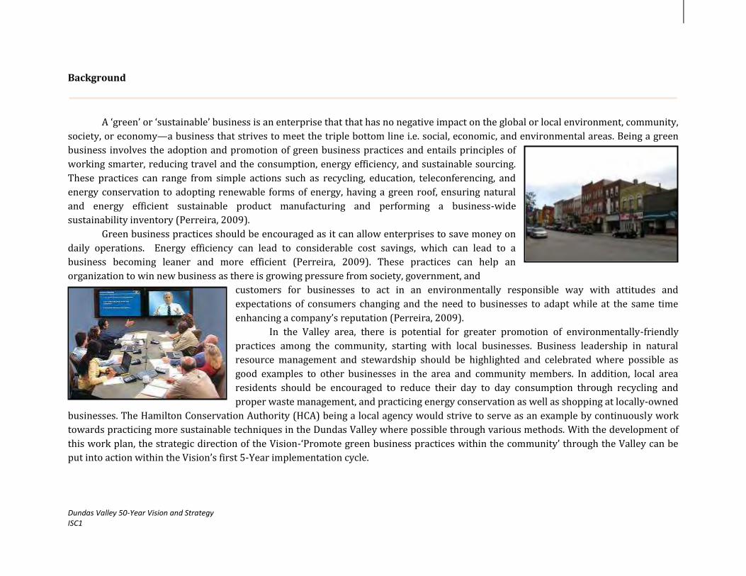
Dundas Valley 50-Year Vision and Strategy ISC1
Background
A ‘green’ or ‘sustainable’ business is an enterprise that that has no negative impact on the global or local environment, community,
society, or economy—a business that strives to meet the triple bottom line i.e. social, economic, and environmental areas. Being a green
business involves the adoption and promotion of green business practices and entails principles of
working smarter, reducing travel and the consumption, energy efficiency, and sustainable sourcing.
These practices can range from simple actions such as recycling, education, teleconferencing, and
energy conservation to adopting renewable forms of energy, having a green roof, ensuring natural
and energy efficient sustainable product manufacturing and performing a business-wide
sustainability inventory (Perreira, 2009).
Green business practices should be encouraged as it can allow enterprises to save money on
daily operations. Energy efficiency can lead to considerable cost savings, which can lead to a
business becoming leaner and more efficient (Perreira, 2009). These practices can help an
organization to win new business as there is growing pressure from society, government, and
customers for businesses to act in an environmentally responsible way with attitudes and
expectations of consumers changing and the need to businesses to adapt while at the same time
enhancing a company’s reputation (Perreira, 2009).
In the Valley area, there is potential for greater promotion of environmentally-friendly
practices among the community, starting with local businesses. Business leadership in natural
resource management and stewardship should be highlighted and celebrated where possible as
good examples to other businesses in the area and community members. In addition, local area
residents should be encouraged to reduce their day to day consumption through recycling and
proper waste management, and practicing energy conservation as well as shopping at locally-owned
businesses. The Hamilton Conservation Authority (HCA) being a local agency would strive to serve as an example by continuously work
towards practicing more sustainable techniques in the Dundas Valley where possible through various methods. With the development of
this work plan, the strategic direction of the Vision-‘Promote green business practices within the community’ through the Valley can be
put into action within the Vision’s first 5-Year implementation cycle.
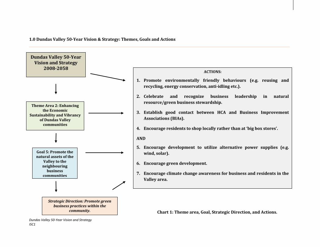
Dundas Valley 50-Year Vision and Strategy ISC1
1.0 Dundas Valley 50-Year Vision & Strategy: Themes, Goals and Actions
Chart 1: Theme area, Goal, Strategic Direction, and Actions.
Goal 5: Promote the natural assets of the
Valley to the neighbouring
business communities
ACTIONS:
1. Promote environmentally friendly behaviours (e.g. reusing and
recycling, energy conservation, anti-idling etc.).
2. Celebrate and recognize business leadership in natural
resource/green business stewardship.
3. Establish good contact between HCA and Business Improvement
Associations (BIAs).
4. Encourage residents to shop locally rather than at ‘big box stores’.
AND
5. Encourage development to utilize alternative power supplies (e.g.
wind, solar).
6. Encourage green development.
7. Encourage climate change awareness for business and residents in the
Valley area.
Dundas Valley 50-Year Vision and Strategy
2008-2058
Strategic Direction: Promote green business practices within the
community.
Theme Area 2: Enhancing the Economic
Sustainability and Vibrancy of Dundas Valley
communities

Dundas Valley 50-Year Vision and Strategy ISC1
2.0 Methodology and Work plan
The objective of the ISC1 and this work plan is to begin the implementation of the Vision’s top 10 Strategic Directions (SDs). The
promotion of green business practices was identified as a key area of interest for the first 5 year cycle and is one of the 43 SDs that was
highlighted through the development of the 50 Year Vision. Implementation will take the form of project development and execution
followed by continuous monitoring and evaluation to gauge the success and highlight any necessary areas for improvement along the way
(Refer to Chart 2). With this process in place, over the course of the work plan’s implementation, the scope of work will be able to adapt to
any unplanned changes.
Over the 5-Year phase, a work plan with the 7 actions will be implemented (Table 1). For each action item, there are a number of
related activities and projected outcomes. It should be noted that for some of these actions, work has already been completed or is on-
going. Additional actions/activities may be identified during ISC1’s implementation and may not be limited to the actions identified in the
Vision document.
Project Planning &
Design
Project Initiation: Creation of the 50-
Year Vision & Strategy
Project
Implementation-
Execution of 10
Work plans
Project Monitoring
& Evaluation
Chart 2: Project Management Framework

Dundas Valley 50-Year Vision and Strategy ISC1
Table 1: Work plan
WP & E: Watershed Planning & Engineering LM: Land Management
Actions
Activities
Projected Outcomes
Lead
Time
Sub-Budget Status
Role Cost
1. Promote environmentally friendly behaviours (e.g. reusing and recycling, energy conservation, anti-idling etc.).
AND
2. Encourage green development.
AND
3. Encourage development to utilize alternative power supplies (e.g. wind, solar).
Work with HCA’s Sustainability Committee and Climate Change Task Force to continue implementation of actions identified by the S-CORE report and HCA’s Climate Change Strategy
Implement actions outlined in the HCA’s Sustainability Audit
Implement actions outlined in HCA’s
Climate Change Strategy: - Integrate solar panels where possible - National Sweater Day - Adapt the ‘Slow it, Spread it, Sink it’
Homeowner’s guide to using rain as a resource for Hamilton
- Wrap and HCA vehicle in environmental messaging
- Corporate: Renewable Energy/Water Use and Management
- Investigate HCA subscribing to Bullfrog Power
- Review existing policies on water quality and quantity
- Mobile Neighborhood Greening project - Eat Local Exhibition - Add ‘No-Idling’ stickers to HCA vehicles
and for public giveaways and ‘No-Idling’ signage at high traffic areas at
Continued to implement actions of the S-CORE report
Promoted partner programs and initiative in the Valley area.
Fostered awareness of local programs.
Created a Green
Business Guidebook.
HCA & Non-HCA
2014-2019
Strategy Manager Overhead
Core Budget
(see appendix)
An S-CORE Report was created for the HCA in 2012. The green team/Sustainability committee has already been formed and are working towards the implementation of the outlined actions in the report. A Sustainability Audit was developed for HCA in 2012 with recommendations for action. HCA is moving towards ensuring more sustainable practices in the Dundas Valley

Dundas Valley 50-Year Vision and Strategy ISC1
conservation areas
Review on-going initiatives from the City of Hamilton’s Clean and Green Strategy, Neighbourhood Clean Team program, Hamilton Economic Development office Corporate Energy Policy, and Green Business Zone Certification program from Green Venture and Clean Air Hamilton, and Horizon Utilities.
Encourage local partners to promote initiatives in the Dundas Valley area: - Green Venture’s Green Business Zone
Certification program and Energy Wise initiatives
- City of Hamilton’s Green roof, Living walls program and anti-idling by-law
- Promotion of LEED and BOMA Best- Canadian Green Building Council (CaGBC)
- Ontario Power Authority (OPA)’s FIT and MicroFIT programs
- Support Horizon Utility’s Conservation for myBusiness, Conservation for myHome programs, and Peaksaver programs
- Connect local businesses with the REefficient program
- Connect local businesses with the Sustainability Learning Centre and it’s programs
- Other current programs
Work with the City, local groups, Chambers of Commerce, and BIAs to develop: -Green Business Guidebook highlighting why/how enterprises can go green, programs/incentives available to them, and
by relocation of its workshop out of the Valley and to a more appropriate area in Millgrove and demolition of older structures in the area e.g. Merrick Pond Shed and the Freeman House allowing for the naturalization of lands. HCA has also developed a Climate Change Strategy and is working towards its implementation.

Dundas Valley 50-Year Vision and Strategy ISC1
case studies Work with the Sustainable Communities
Research Group of McMaster University and the Canadian Green Building Council (CaGBC) to investigate methods to promote green development in the Valley area
Promote renewable energy generation among businesses through targeted outreach and presentations.
4. Celebrate and
recognize business leadership in natural resource/green business stewardship.
Work with the City of Hamilton, local BIAs, and Chambers of Commerce to explore the potential of developing a green business/stewardship recognition awards program.
Determine: - Investigate the coordination of the
Hamilton Community Awards - Activities/programs that should be
recognized- e.g. recycling initiatives, renewable energy projects, and the adoption of green building standards.
- How often awards should be given- annually or bi-annually.
- Funding and sponsors for local awards and award ceremonies
- How businesses should be rewarded- an award plaque presentation at a ceremony/networking event, local newspaper highlight, business profile recognition and advertisement on the local BIA webpage, green hall of fame.
Explored the potential of developing a green business/stewardship recognition program.
HCA & Non-HCA
2014-2019
Strategy Manager Overhead
Core Budget
(see appendix)
5. Establish good contact between HCA
HCA N/A Completed as HCA’s Business development,

Dundas Valley 50-Year Vision and Strategy ISC1
and Business Improvement Associations (BIAs).
communications staff and the Hamilton Conservation Foundation (HCF) already possess working relationships with local BIAs in Dundas and Ancaster.
6. Encourage residents to shop locally rather than at ‘big box stores’.
Research information about the benefits of shopping locally and local businesses in the area.
Work with the City, local groups, chambers of commerce, and BIAs where possible to develop the following materials: - Information page on BIA’s website for
the sharing of information and to facilitate discussion among community residents about why and how they can shop local
- Create a shop-local campaign to educate residents (see Monroe County campaign)
- A Shop-Local guidebook and directory of local businesses in the area
Created a community webpage.
Developed a shop-local campaign/program and guidebook with directory of local businesses.
HCA & Non-HCA
2014-2019
Strategy Manager Overhead
Core Budget
(see appendix)
7. Encourage climate change awareness for business and residents in the Valley area.
Create a fact sheet about climate change and businesses.
Make fact sheet available for HCA staff, at local town halls, libraries, community centres, and schools.
Created a fact sheet
HCA 2014-2019
Strategy Manager Overhead
Core Budget
(see appendix)

Dundas Valley 50-Year Vision and Strategy ISC1
TOTAL COST Core Budget (see appendix)

Dundas Valley 50-Year Vision and Strategy ISC1
3.0 Resources and Constraints
RESOURCES:
Community partnerships- HCA has over the years established a number of working relationships with key community partners
across the area such as local BIAs, Green Venture, and the City of Hamilton among others.
On-going local work- through consultation with various stakeholder groups across the Valley area, it was found that there are a
significant number of related programs and projects that are currently underway. Instead of duplicating the efforts of these groups, it
would be better to collaborate with these organizations to support and further promote their work in the Valley area.
CONSTRAINTS:
Workload Management- implementing the work plan along with the other ten work plans of the fifty year Vision within the five year
period. This could be a challenge for HCA as there will be other multiple programs in addition to the Vision that also fall under the HCA
mandate and would require sufficient time and effort.
Non-HCA mandate- the majority of these actions lie outside of HCA’s mandate will rely upon the support and interest of other
community partners in Dundas and Ancaster. In order for this initiative to be successful, consideration would have to be given to the
partner’s budget, resources, and time to ensure as much overlap where possible. Volunteer support could potentially be a good way to
gain support from the community in this respect while fostering awareness of the project.
Funding Availability and Timing- sourcing additional funding to support this work plan’s execution will be needed for successful
implementation and applying for funding where by designated time lines and ensuring these align with the work plan’s
implementation time line as well.

Dundas Valley 50-Year Vision and Strategy ISC1
References
1. Benefits of Buying Local Food, 2012. Green Living ‘Food’. Toronto, Ontario. http://www.greenlivingonline.com/article/benefits-buying-local-food
2. The Benefits of Shopping Local, 2009. Regional Community Bulletin, District of Commerce, St. Malo, Manitoba. http://www.jadorestmalo.ca/files/November09newsletter.pdf
3. Build a Small Green Business: Profitable ways to become an entrepreneur, 2009. S. Cooney; Sustainable Business, 2012. Wikipedia. http://en.wikipedia.org/wiki/Sustainable_business
4. Business and Climate Change Adaptation: Towards Resilient and Companies and Communities, 2012. United Nations Environment Programme (UNEP) http://www.unglobalcompact.org/docs/issues_doc/Environment/climate/Business_and_Climate_Change_Adaptation.pdf
5. Buy Local think Global, 2011. Buy Local Network, Canada. http://www.buylocalthinkglobal.com/ and http://www.buylocalthinkglobal.com/Hamilton_ON.php
6. Carbon Footprint calculators for businesses, 2012. Ontario Centre for Environmental Technology Advancement (OCETA). Province of Ontario, Ontario. http://techassist.bloomcentre.com/docs/Carbon-Calculators-Business-LR.pdf
7. CEPP Project Grant Overview, 2010. Community Energy Partnerships Program (CEPP). Ontario. http://www.communityenergyprogram.ca/AboutCPCEPP/AboutCEPP_MainPage.aspx
8. Clean and Green Hamilton Strategy, 2012. Public Works-City of Hamilton, Hamilton. http://www.hamilton.ca/ProjectsInitiatives/CleanCityStrategy/
9. Commercial Market Analysis- Ancaster Heritage Village, 2010. Urban Marketing Collaborative, Toronto, Ontario. http://www.investinhamilton.ca/wp-content/uploads/2012/10/Ancaster-BIA-2010.pdf
10. Commercial Market Analysis- Downtown Dundas, 2010. Urban Marketing Collaborative, Toronto, Ontario. http://www.investinhamilton.ca/wp-content/uploads/2012/10/Dundas-2010.pdf
11. Conservation for myBusiness, 2012. Horizon Utilities, Hamilton. http://www.horizonutilities.com/Conservation/business-conservation/Pages/default.aspx AND https://saveonenergy.ca/Business/Programs-By-Sector.aspx
12. Corporate Energy Policy, 2007. Public Works-City of Hamilton, Hamilton. http://www.hamilton.ca/NR/rdonlyres/9AE3EB17-0A39-4650-B333-8E1CE27B3F0B/0/Jun13EDRMS_n180476_v1_8_3__PW11037.pdf
13. Energy Wise, 2011. Green Venture, Hamilton. http://energy.greenventure.ca/
14. Feed-in-Tariff (FIT) and Micro Feed-in-Tariff (MicroFIT) Program, 2010. Ontario Power Authority (OPA), Ontario, Canada. http://fit.powerauthority.on.ca/
15. Funding and Incentive Program for greening your business, 2012.

Dundas Valley 50-Year Vision and Strategy ISC1
Canadian Business Network. Government of Canada, Canada. http://www.canadabusiness.ca/eng/page/2815/
16. Going Green, 2012. Hamilton Economic Development. City of Hamilton, Hamilton. http://www.investinhamilton.ca/incentives-programs/going-green/
17. Green Development Program, 2012. Town of Caledon. Caledon, Ontario. http://www.town.caledon.on.ca/contentc/greendevelopment/Caledon_Green_Development_Brochure.pdf
18. Green Development Strategy, 2010. Planning and Building Department, City of Mississauga. Mississauga, Ontario. http://www6.mississauga.ca/onlinemaps/planbldg/UrbanDesign/5-GDS-Standards-website.pdf
19. Green Energy Act (GEA), 2009. Ontario Ministry of Energy (OME). Ontario, Canada. http://www.energy.gov.on.ca/en/green-energy-act/
20. Green Municipal By-laws, 2011. Federation of Canadian Municipalities (FCM), Canada. http://fcm.ca/home/programs/green-municipal-fund/program-resources/green-municipal-bylaws.htm
21. Green Roofs and Living Walls, 2011. City of Hamilton, Hamilton. http://www.hamilton.ca/NR/rdonlyres/9AE3EB17-0A39-4650-B333-8E1CE27B3F0B/0/Jun13EDRMS_n180476_v1_8_3__PW11037.pdf
22. Greening your business, 2012. Canada Business Ontario. http://www.cbo-eco.ca/en/index.cfm/guides/greening-your-business/
23. Green Zone Business Certification, 2011. Green Venture, Hamilton.
http://air.greenventure.ca/green-zone-business-certification
24. Guide to Action Framework for Green Zone Businesses, 2011. Green Venture, Hamilton. http://air.greenventure.ca/sites/air.greenventure.ca/files/GZB%20Guide%20for%20Action%20Framework.pdf
25. Hamilton LEEDING the way Community Improvement Plan, 2002. Planning and Economic Department, City of Hamilton. Hamilton, Ontario. http://www.hamilton.ca/NR/rdonlyres/37C6C33D-421B-4E29-9BFB-DF52DBAE01DA/0/Sep02PED08169.pdf
26. Leadership in Energy and Environmental Design (LEED), 2012. Canadian Green Building Council (CaGBC) Greater Toronto Chapter (GTA), Ontario. http://www.cagbc.org/Content/NavigationMenu/Programs/LEED/default.htm
27. Monroe County ‘I Buy Moco.com’, 2012. Tomah, Wisconsin, USA. http://www.ibuymoco.com/index.php
28. Neighbourhood Clean Team Program, 2012. Public Works-City of Hamilton, Hamilton. http://www.hamilton.ca/NR/rdonlyres/4C4601FB-610A-41A9-9027-FBFE509EFDCA/0/NeighbourhoodCleanTeamFlyer.pdf
29. Neighbourhood Development Strategy, 2011. City of Hamilton, Hamilton, http://www.hamilton.ca/ProjectsInitiatives/NeighbourhoodDevelopment/
30. One Simple Act: Greening your business, 2012. Government of Alberta, Alberta. http://www.onesimpleact.alberta.ca/docs/greenorg.pdf
31. Ontario’s Long-term Energy Plan, 2010. Ontario Ministry of Energy

Dundas Valley 50-Year Vision and Strategy ISC1
(OME). Ontario, Canada. http://www.energy.gov.on.ca/en/ltep/
32. Passport Hamilton, 2012. Environment Hamilton, Hamilton. http://www.environmenthamilton.org/view/page/passport_t o_hamilton
33. Peaksaver, 2012. Horizon Utilities, Hamilton. http://www.horizonutilities.com/Conservation/home-conservation/Pages/saveONenergy-peaksaver-PLUS-.aspx
34. REefficient, 2012. Hamilton. http://www.refficient.com/contact_us.aspx
35. Shop Local, 2010. Town of Halton Hill, Halton Hills, Ontario. http://www.haltonhills.ca/ShopLocal/pdf/10reasons.pdf
36. Small Business-Save on Energy, 2010. Horizon Utilities, Ontario Power Authority (OPA). Hamilton, Ontario. https://saveonenergy.ca/Business/Small-Business.aspx?ldc=horizonutilities
37. Sustainability Learning Centre, 2012. Ontario. http://www.sustainabilitylearningcentre.com/
38. Toronto Green Standard: Making a Sustainable City happen. 2010. City of Toronto. Toronto, Ontario. http://www.toronto.ca/planning/environment/pdf/mr_hr_tech.pdf
39. Understanding Green Business Practices, 2009. Melvin Perreira- Slideshare. http://www.slideshare.net/misterjester/green-business-practices In Text: (Perreira, 2009)

Appendix:
Attachment 1: Implementation Strategy Cycle 1: 2014-2019- Core Operational Budget
EXPENSES PROJECT COSTS PER YEAR TOAL FIVE YEAR COST
Personnel
40. Strategy Manager at 100%, $28/hour + 20% Fringe Benefits $60, 480.00 $302, 400.00
Travel
41. Travel at HCA rate of $0.53/km $2,000.00 $10,000.00
Materials, Supplies & Equipment
42. Computer and office supplies $1,500.00 $7,500.00
43. Printed reports, surveys, and maps $1,500.00 $7,500.00
44. Climate Change Components $10,000.00 $50,000.00
Communications Costs
45. Open Houses, public meetings, and outreach materials (brochures, flyers, and posters) $3,500.00 $17,500.00
46. Web page, press releases, newspaper advertisements $2,000.00 $10,000.00
Overhead (office space, phone, heat, hydro, internet)
47. Strategy Manager at 100% $10,000.00 $50,000.00
Other Expenses
48. Cost of attending related networking events, conferences, workshops, and training $1,000.00 $5,000.00
49. Refreshments e.g. committee meetings, stakeholder meetings, open houses $500.00 $2500.00
TOTAL $92,480.00 $462,400.00

Dundas Valley 50-Year Vision and Strategy Implementation Strategy Cycle 1: 2014-2019 Work Plan
Strategic Direction: Support the implementation of the City of Hamilton’s
‘special character’ roads through the Valley

Table of Contents
Background…………...………………………………………………………………………………………………………………………………………………………4
1.0 Dundas Valley 50-Year Vision and Strategy: Themes, Goals and Actions…………………………………………………………………………….8
2.0 Methodology and Work plan…………………………………………………………………………………………………………………………….......................9
3.0 Resources and Constraints………………………………………………………………………………………………………………………………………………14
References
Appendix
© Hamilton Conservation Authority, 2013. All rights reserved. No part of this publication may be reproduced in any form or by any means, electronically, mechanically,
or by photocopying, recording, or otherwise, with the prior permission of the copyright owners.
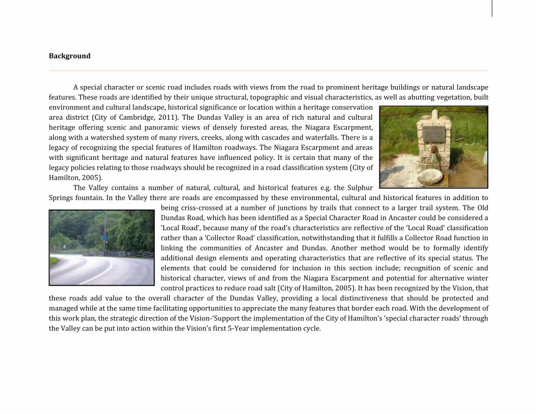
Background
A special character or scenic road includes roads with views from the road to prominent heritage buildings or natural landscape
features. These roads are identified by their unique structural, topographic and visual characteristics, as well as abutting vegetation, built
environment and cultural landscape, historical significance or location within a heritage conservation
area district (City of Cambridge, 2011). The Dundas Valley is an area of rich natural and cultural
heritage offering scenic and panoramic views of densely forested areas, the Niagara Escarpment,
along with a watershed system of many rivers, creeks, along with cascades and waterfalls. There is a
legacy of recognizing the special features of Hamilton roadways. The Niagara Escarpment and areas
with significant heritage and natural features have influenced policy. It is certain that many of the legacy policies relating to those roadways should be recognized in a road classification system (City of
Hamilton, 2005).
The Valley contains a number of natural, cultural, and historical features e.g. the Sulphur
Springs fountain. In the Valley there are roads are encompassed by these environmental, cultural and historical features in addition to
being criss-crossed at a number of junctions by trails that connect to a larger trail system. The Old
Dundas Road, which has been identified as a Special Character Road in Ancaster could be considered a
‘Local Road’, because many of the road's characteristics are reflective of the ‘Local Road’ classification
rather than a ‘Collector Road’ classification, notwithstanding that it fulfills a Collector Road function in
linking the communities of Ancaster and Dundas. Another method would be to formally identify
additional design elements and operating characteristics that are reflective of its special status. The
elements that could be considered for inclusion in this section include; recognition of scenic and
historical character, views of and from the Niagara Escarpment and potential for alternative winter
control practices to reduce road salt (City of Hamilton, 2005). It has been recognized by the Vision, that
these roads add value to the overall character of the Dundas Valley, providing a local distinctiveness that should be protected and
managed while at the same time facilitating opportunities to appreciate the many features that border each road. With the development of
this work plan, the strategic direction of the Vision-‘Support the implementation of the City of Hamilton’s ‘special character roads’ through
the Valley can be put into action within the Vision’s first 5-Year implementation cycle.
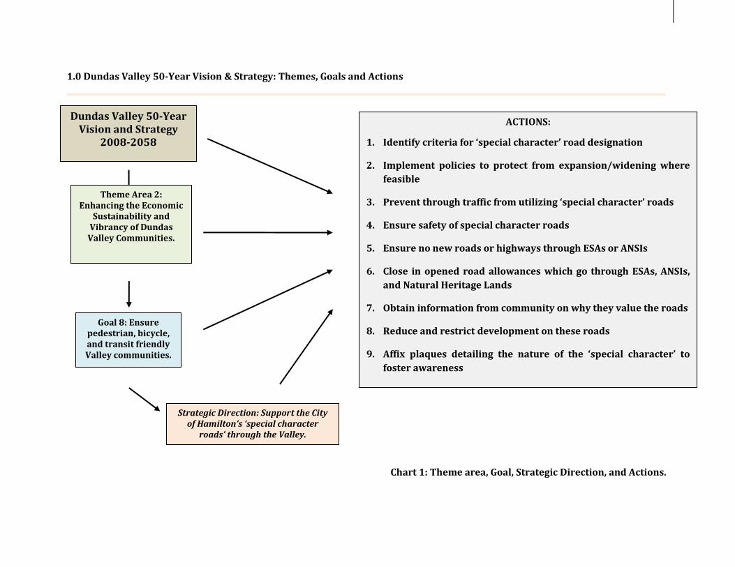
1.0 Dundas Valley 50-Year Vision & Strategy: Themes, Goals and Actions
Chart 1: Theme area, Goal, Strategic Direction, and Actions.
Goal 8: Ensure pedestrian, bicycle, and transit friendly Valley communities.
ACTIONS:
1. Identify criteria for ‘special character’ road designation
2. Implement policies to protect from expansion/widening where
feasible
3. Prevent through traffic from utilizing ‘special character’ roads
4. Ensure safety of special character roads
5. Ensure no new roads or highways through ESAs or ANSIs
6. Close in opened road allowances which go through ESAs, ANSIs,
and Natural Heritage Lands
7. Obtain information from community on why they value the roads
8. Reduce and restrict development on these roads
9. Affix plaques detailing the nature of the ‘special character’ to
foster awareness
Dundas Valley 50-Year Vision and Strategy
2008-2058
Strategic Direction: Support the City of Hamilton’s ‘special character
roads’ through the Valley.
Theme Area 2: Enhancing the Economic
Sustainability and Vibrancy of Dundas
Valley Communities.

2.0 Methodology and Work plan
The objective of the ISC1 and this work plan is to begin the implementation of the Vision’s top 10 Strategic Directions (SDs). The
notion to support the implementation of the City of Hamilton’s ‘special character’ roads was identified as a key area of interest for the first
5 year cycle and is one of the 43 SDs that was highlighted through the development of the 50 Year Vision. Implementation will take the
form of project development and execution followed by continuous monitoring and evaluation to gauge the success and highlight any
necessary areas for improvement along the way (Refer to Chart 2). With this process in place, over the course of the work plan’s
implementation, the scope of work will be able to adapt to any unplanned changes.
Over the 5-Year phase, a work plan with the 9 actions will be implemented (Table 1). For each action item, there are a number of
related activities and projected outcomes. It should be noted that for some of these actions, work has already been completed or is on-
going.
Project Planning &
Design
Project Initiation: Creation of the 50-
Year Vision & Strategy
Project
Implementation-
Execution of 10
Work plans
Project Monitoring
& Evaluation
Chart 2: Project Management Framework

Table 1: Work plan
Actions
Activities
Projected Outcomes
Lead
Time
Sub-Budget Status
Role Cost
1. Obtain information from community on why they value the roads
2. Identify criteria for ‘special character’ road designation
Design and distribute a community survey (see Appendix for Attachment 2).
Obtain information from the public to determine which roads should become designated and why.
Develop and refine criteria to analyze
potential roads in the Dundas Valley (see Appendix for Attachment 3)
Create a draft list of potential ‘special
character’ roads in the area. Conduct a physical assessment of each road
i.e. document main features through photography and analyze each road based on the criteria and the community survey results (see Appendix for Attachment 3).
Create a profile for each road-noting
characteristic features along its way i.e. historical, cultural, environmental features, photos.
Use the information to create a map of the
Dundas Valley area showing designated roads and their associated features.
Based on the map of ‘special character’
roads, review existing policies of the area/s
Development of a community survey.
Creation of road
analysis criteria. Creation of a final
report with findings.
HCA & Non-HCA
2014-2019
Strategy Manager Overhead
Core Budget
(see appendix)

that applies to each road. Creation of a final report with findings and
recommendations for their preservation. Incorporate findings in the City of
Hamilton’s 2013 Heritage Landscape Study and merge with activities under SD ‘Maintain and protect local architectural and natural heritage’ where possible.
3. Implement
policies to protect from expansion/widening where feasible
4. Prevent through traffic from utilizing ‘special character’ roads
5. Ensure safety of special character roads
6. Ensure no new roads or highways through ESAs or ANSIs
7. Close in opened road
Research related scenic road studies done by other cities and municipalities.
Work with the City of Hamilton and other organizations where applicable e.g. Niagara Escarpment Commission (NEC) to investigate the feasibility of developing a Scenic Roads Protection Policy.
Incorporate findings in the City of
Hamilton’s 2013 Heritage Landscape Study and merge with activities under SD ‘Maintain and protect local architectural and natural heritage’ where possible.
Researched related scenic road studies.
Investigated the
feasibility of
developing a Scenic
Roads Protection
Policy.
HCA & Non-HCA
2014-2019
HCA is working towards maintaining the cultural heritage character of roads in the Dundas Valley by relocation of its workshop out of the Valley and to a more accessible area in Millgrove. This will reduce the degree of traffic in and out of the Valley and increase public safety.

allowances which go through ESAs, ANSIs, and Natural Heritage Lands
8. Reduce and restrict development on these roads
9. Affix plaques detailing the nature of the ‘special character’ to foster awareness
Apply for funding to purchase plaques e.g. Ontario Heritage Trust
Determine locations where plaques should be affixed and the number that would be necessary and create a listing with associated map to depict positioning.
Determine the size, layout, and what
information (text, figures, maps etc.) should be displayed on each plaque e.g. historical, cultural, and environmental information about characteristic features.
Locate a plaque manufacturer/supplier to
create and install the plaques.
Applied and secured funding for plaques.
Created of a listing and map.
Successfully created and installed of plaques.
Non-HCA 2014- 2019
TOTAL COST Core Budget (see appendix)

3.0 Resources and Constraints
RESOURCES:
• Trained and experienced staff- HCA possesses highly trained and experienced staff members who are familiar with the
environmental conditions of the Dundas Valley.
• Community partnerships- HCA has over the years established a number of working relationships with landowners and key
community partners across the Dundas Valley. In particular, HCA has a good relationship with the NEC and the City of Hamilton.
CONSTRAINTS:
• Workload Management- implementing the SD’s work plan along with the other 10 SDs’ work plans of the 50-Year Vision within
the 5-Year period. This could be a challenge for HCA as there will be other multiple programs in addition to the Vision that also fall under
the HCA mandate and would require sufficient time and effort.

References
1. A Guide to Heritage Roads of Singapore, 2012. National Parks Board. Singapore Government, Singapore http://www.nparks.gov.sg/cms/docs/eguide_Heritage_Roads.pdf
2. Ancaster Transportation Master Plan (ATMP), 2011. City of Hamilton, Hamilton. http://www.hamilton.ca/NR/rdonlyres/FC43B4F9-1814-42A1-AEFA-37D88A7F7F44/0/AncasterTransportationMasterPlanStudyReport_Final_Jun2011withoutAppendices.pdf
3. Built Heritage and Cultural Heritage Landscapes- Environmental Standards and Practices User Guide (2006). Ministry of Transportation, Ontario. http://www.raqsa.mto.gov.on.ca/techpubs/eps.nsf/9ea013f0de8096ba8525729700557ad1/8f0a4ff8826c3228852572b300578e03/$FILE/MTO%20ESP%20User%20Guide%20Sec%2010%20BHCHL.pdf
4. Cultural Heritage Resources Policies-Background Paper, 2008. Official Plan, City of Hamilton, Hamilton, Ontario. http://www.hamilton.ca/NR/rdonlyres/FFA34FA1-4981-4409-BC46-F722F2B662E7/0/CultHertBckgdPpr.pdf
5. Road Classification System- Criteria Table, 2000, City of Toronto, Toronto. http://www.toronto.ca/transportation/road_class/pdf/criteria_table.pdf
7. Draft Cultural Heritage Resources Policy Paper-Official Plan Review,
2011. City of Cambridge, Cambridge, Ontario http://www.cambridge.ca/relatedDocs/Cultural%20Heritage%20Resources%20Policy%20Paper.pdf
8. Dundas Valley Viewsheds Analysis, 1985. Niagara Escarpment
Commission (NEC).
9. Geometric Design Guide for Canadian Roads (1999). Transportation Association of Canada (TAC). http://www.tac-atc.ca/english/bookstore/pdfs/2011-gdg-revisions.pdf
10. Greenbelt Plan, 2005. Ontario Ministry of Municipal Affairs and Housing (OMAH). http://www.mah.gov.on.ca/Page189.aspx#greenbelt
11. Hamilton Master Transportation Plan, 2007. City of Hamilton, Hamilton. http://www.hamilton.ca/NR/rdonlyres/5FDCEC6A-58D0-4BBA-8115-85C78B0BF710/0/3Chapters1and2.pdf
12. Heritage Roads, 2012. National Parks Board. Singapore Government, Singapore. http://www.nparks.gov.sg/cms/index.php?option=com_content&view=article&id=75&Itemid=65
13. Heritage Routes, 2011. Michigan Highways, Michigan, US. http://www.michiganhighways.org/other/heritage.html#Scenic
14. Manual of Aesthetic Design Practice (1991). Environmental Management Branch. Province of British Columbia, Ministry of Transportation. http://www.th.gov.bc.ca/publications/eng_publications/environment/design_practice.htm
15. Niagara Escarpment Plan, 2005. Niagara Escarpment Commission (NEC).
http://www.escarpment.org/_files/file.php?fileid=fileqoQkPglXij&filename=file_NEP_updated_April_2011.pdf
16. Niagara Escarpment Planning and Development Act, 1990. Niagara
Escarpment Commission (NEC). http://www.escarpment.org/landplanning/index.php
17. Road Classification Policy Paper: Development of Policy Papers for Phase Two of the Transportation Master Plan for the City of Hamilton, 2005. City of Hamilton, IBI Group and Stantec Consulting. http://www.hamilton.ca/NR/rdonlyres/8B22B9EC-8D68-4421-8D4E AEC25997E853/0/14Road_Classification_1815109.pdf
18. Rural Official Plan, 2012. City of Hamilton, Hamilton. http://www.hamilton.ca/CityDepartments/PlanningEcDev/Divisions/StrategicServicesSpecialProjects/Policy+Planning/HamiltonNewOfficialPlan/Rural-Hamilton-Official-Plan.htm?WT.mc_id=newruralop&WT.hamilton_redirect_friendly=1
19. Rural Roads at Risk: Saving the Character of Country Roads, 2005. Friends of the Lake District, Cumbria, UK. http://theihe.org/knowledge-network/uploads/rural%20roads%20summary.pdf
20. Places to Grow Act, 2005. Ontario Ministry of Infrastructure (OMI),
Ontario. https://www.placestogrow.ca/index.php?option=com_content&task=view&id=4&Itemid=9
21. Saving Historic Roads: Design and Policy Guidelines (1998) Mariott, Paul Daniel.
22. Selection Criteria, 1993. Michigan Department of Transportation, Michigan, US. http://www.michigan.gov/documents/mdot/MDOT-Heritage_ANHA_RequestForm_309189_7.pdf
23. Scenic Roads Handbook (1995) Elizabeth A. Alder and Robert Joshua Voight.
24. Scenic Roads and Special Character Streets, 2011. Resource Document by the Region of Waterloo Heritage Planning Advisory Committee- Region of Waterloo, Waterloo, Ontario. http://www.regionofwaterloo.ca/en/discoveringTheRegion/resources/SCENIC_ROADS_AND_SPECIAL_CHARACTER_STREETS_RESOURCE.pdf
25. Scenic Road Study, 1974-1975 (1979). Regional Municipality of Waterloo. Prepared by the Regional Planning and Development Department for Regional Heritage Foundation. Dr. George Priddle, University of Waterloo, Study Consultant.
26. Scenic Heritage Drives, 2012. Island East Tourism Group, Points East Coastal Drive. Halifax, Nova Scotia. http://pointseastcoastaldrive.com/things-do/type/category/scenic-heritage-drives
27. Scenic Heritage Roads, 2006. Island Information, Government of Prince Edward Island (PEI). http://www.gov.pe.ca/infopei/index.php3?number=3541

Appendix
Attachment 1: Implementation Strategy Cycle 1: 2014-2019: Core Operational Budget
EXPENSES PROJECT COSTS PER YEAR TOAL FIVE YEAR COST
Personnel
17. Strategy Manager at 100%, $28/hour + 20% Fringe Benefits $60, 480.00 $302, 400.00
Travel
18. Travel at HCA rate of $0.53/km $2,000.00 $10,000.00
Materials, Supplies & Equipment
19. Computer and office supplies $1,500.00 $7,500.00
20. Printed reports, surveys, and maps $1,500.00 $7,500.00
21. Climate Change Components $10,000.00 $50,000.00
Communications Costs
22. Open Houses, public meetings, and outreach materials (brochures, flyers, and posters) $3,500.00 $17,500.00
23. Web page, press releases, newspaper advertisements $2,000.00 $10,000.00
Overhead (office space, phone, heat, hydro, internet)
24. Strategy Manager at 100% $10,000.00 $50,000.00
Other Expenses
25. Cost of attending related networking events, conferences, workshops, and training $1,000.00 $5,000.00
26. Refreshments e.g. committee meetings, stakeholder meetings, open houses $500.00 $2500.00
TOTAL $92,480.00 $462,400.00

Attachment 2: Community Survey- Designation of ‘Special Character’ Roads in the Dundas Valley (HCA, 2013)
1- What does the term ‘special character’ mean to you?
2-Which roads in the Dundas Valley area do you think possess ‘special’, ‘scenic’, or heritage characteristics?
24.
3-What feature/s of the road/s do you value most? (E.g. environmental, cultural, historical, other).

4-What are the main threats or current issues facing these roads in the Dundas Valley area?
5-Why do you think they should be protected?
6-What action/s do you think should be taken to ensure their protection?

Attachment 3: Table 1: Criteria for the Analysis of Potential Roads for ‘Special Character’ Designation (Adapted from Region of
Waterloo, 2011-Scenic Road Evaluation Tool)
‘SPECIAL CHARACTER’ ROADS ANALYSIS TABLE: RURAL/NATURAL AREAS
Identification Criteria for areas of ‘special character’ in Rural/Natural Areas
Road Scoring 0-3
Weighting
Road Y Name:
Location: Length:
Road Z Name:
Location: Length:
1. Tree-scapes 3
2. Diversity of vegetation 3
3. Structure of vegetation 3
4. Road layout and design 1
5. Landform 2
6. Traffic 1
7. Infrastructure and development 1
8. Watercourses 3
9. Orientation 3
10. Views of the Niagara Escarpment 3
11. Panorama 3
12. Connectivity 2
13. Cultural built environment 2
14. Social Community Value 2
TOTAL SCORE
Scoring criteria: 1. Tree-scapes
0- Does not apply 1- Forested area with no tree-scapes close to the road 2- Forested area with partial or broken patches of tree-scapes on either side of the road

3- Forested area with continuous tree-scapes on either side of the road for more than 1km 2. Diversity of vegetation
0- Does not apply 1- Low diversity of trees and undergrowth with a visibly dominant tree type 2- Moderate diversity of trees and undergrowth with a visibly dominant tree type 3- High diversity of trees and undergrowth with more than 2-3 different tree types visible
3. Structure of vegetation
0- Does not apply 1- Vegetation exhibits a minimal degree of variable heights, complex arrangements, and visual texture 2- Vegetation exhibits a moderate degree of variable heights, complex arrangements, and visual texture 3- Vegetation exhibits a maximum degree of variable heights, complex arrangements, and visual texture
4. Road layout and design
0- Does not apply 1- Winding road with ditches, official signage and a paved surface 2- Winding road with noticeable changes in terrain at selected points in addition to ditches, official signage and a paved surface 3- Winding road with noticeable changes in terrain at selected points in addition to ditches, official signage and an unpaved
surface
5. Landform 0- Does not apply 1- No observable rocky outcrops or changes in terrain, but presence of valleys and hills 2- No observable rocky outcrops, but evident changes in terrain and the presence of valleys and hills 3- Observable rocky outcrops at selected sites with evident changes in terrain and the presence of valleys and hills
6. Traffic 0- Does not apply 1- Four-three lane road that switches to two lanes at certain points 2- Two lane road with paved surface 3- Two lane road with unpaved surface
7. Infrastructure and Development

0- Does not apply 1- High presence of utility poles, high distribution of housing, signage, and other structures e.g. fences, safety railings, gates 2- High presence of utility poles, low distribution of housing, signage, and other structures e.g. fences, safety railings, gates 3- Low presence of utility poles, low distribution of housing, signage, and other structures e.g. fences, safety railings, gates
8. Watercourses
0- Does not apply 1- View of a river and a cascade 2- View of more than one river and multiple cascade 3- View of a river and/or cascade and waterfall
9. Orientation
0- Does not apply 1- In close proximity to a natural protected/conservation area 2- In close proximity to a natural protected/conservation area and protected farmland and countryside of the Greenbelt 3- In close proximity to a natural protected/conservation area, protected farmland and countryside of the Greenbelt, and the
Carolinian Life Zone
10. View of the Niagara Escarpment 0- Does not apply 1- Escarpment is visible from < 1 view point and obscured by vegetation or other structure to a limited extent 2- Escarpment is visible from > 1 viewpoint and obscured by vegetation or other structures to a limited extent 3- Escarpment is visible from > 1 viewpoint and not obscured by vegetation or other structures
11. Panorama
0- Does not apply 1- Unbroken view offered from 1 site in the Valley 2- Unbroken view offered from 2-3 sites in the Valley 3- Unbroken view offered from > 4 sites in the Valley
12. Connectivity
0- Does not apply 1- Road offers linkages to a protected/conservation area 2- Road offers linkages to a protected/conservation area and another special character road

3- Road offer linkages to a protected/conservation area, another special character road, and connects with trail network/s
13. Cultural Built Environment 0- Does not apply 1- Facilitates access to a historical/cultural feature 2- Facilitates access to more than one historical/cultural features 3- Facilitates access to more than one historical/cultural features and a portage trail
14. Social Community Value
0- Does not apply 1- Allows opportunities for natural and cultural appreciation 2- Allows opportunities for natural and cultural appreciation, education and interpretation 3- Allows opportunities for natural and cultural appreciation, education and interpretation and encourages passive forms of
recreation e.g. hiking, cycling How to use this matrix:
Use the ranking criteria, apply a score to each of the categories Find the sum of scores for each criteria Multiply the sum of score by the weighting applied The higher scores will be a higher priority for action

‘SPECIAL CHARACTER’ ROADS ANALYSIS TABLE: URBAN/BUILT UP AREAS
Identification Criteria for areas of ‘special character’ in Urban/Built-up areas
Road Scoring 0-3
Weighting
Road Y Name:
Location: Length:
Road Z Name:
Location: Length:
1. View of the Niagara Escarpment 2
2. Vegetation 1
3. Road layout and design 2
4. Landform 2
5. Traffic 2
6. Orientation and Connectivity 1
7. Cultural Built Environment 3
8. Infrastructure and development 3
9. Social Community Value 3
10. Community Feel 3
TOTAL SCORE
Scoring Criteria: 1. View of the Niagara Escarpment
0- Does not apply 1- Escarpment is visible from < 1 view point and obscured by buildings, vegetation or other structure to a limited extent 2- Escarpment is visible from > 1 viewpoint and obscured by buildings, vegetation or other structures to a limited extent 3- Escarpment is visible from > 1 viewpoint and not obscured by buildings, vegetation or other structures
2. Vegetation
0- Does not apply 1- Low coverage of trees/undergrowth, with little or no variations in height 2- Low coverage of trees/undergrowth, with little or no variations in height, arrangements, and visual texture

3- Low coverage of trees/undergrowth, with little or no variations in height, arrangements, and visual texture with some degree of visual continuity
3. Road layout and design 0- Does not apply 1- Paved road surface with official signage and utility poles 2- Paved road surface with official signage, utility poles, and lighting e.g. lampposts 3- Paved road surface with official signage, utility poles, lighting e.g. lampposts and street furniture e.g. benches
4. Landform 0- Does not apply 1- Absence of street-scapes and/or wall art in some areas with an unsteady rhythm that presents itself on a fairly small scale 2- Absent-negligible degree of street-scapes and/or wall art in some areas with an unsteady rhythm that presents itself on a
fairly small scale 3- Considerable degree of street-scapes and/or wall art covering most of the area with a steady rhythm that presents itself on a
larger and more continuous scale
5. Traffic 0- Does not apply 1- Four-three lane road that switches to two lanes at certain points 2- Two lane road with paved surface 3- > Two lanes with paved surface
6. Orientation and Connectivity
0- Does not apply 1- In close proximity to another urban area 2- In close proximity to another urban area and a natural protected/conservation area, feature or heritage district, and connects
with a trail system 3- In close proximity to another urban area, a natural protected/conservation area, feature or heritage district, and connects with
a trail system and another special character road
7. Cultural Built Environment 0- Does not apply 1- Facilitates access to a historical/cultural feature

2- Facilitates access to more than one historical/cultural features e.g. town halls, civic squares, monuments 3- Facilitates access to more than one historical/cultural features e.g. town halls, civic squares, monuments
and a heritage conservation district
8. Infrastructure and development 0- Does not apply 1- Presence of curbs, sidewalks, and localised landscaped surroundings e.g. flower beds, tree plantings, outdoor tiles and/or
stone surfaces 2- Presence of curbs, sidewalks, and expansive landscaped surroundings e.g. flower beds, tree plantings, outdoor tiles and/or
stone surfaces in addition to green spaces and parks (both formal and informal) 3- Presence of curbs, sidewalks, and expansive landscaped surroundings e.g. flower beds, tree plantings, outdoor tiles and/or
stone surfaces in addition to green spaces and parks (both formal and informal) with continuous low-rise development
9. Social Community Value 0- Does not apply 1- Allows opportunities for historical/heritage appreciation, education and interpretation 2- Allows opportunities for historical/heritage appreciation, education and interpretation and encourages passive forms of
recreation e.g. walking, cycling 3- Allows opportunities for historical/heritage appreciation, education and interpretation and encourages passive forms of
recreation e.g. walking, cycling, and tourism
10. Community Feel 0- Does not apply 1- Provides a quaint atmosphere and a small-town feel with a mix of small-scale, local shops and businesses and larger/national
and international stores 2- Provides a mix of a quaint atmosphere and a small-town feel with some existing contemporary elements 3- Provides a quaint atmosphere and a small-town feel with predominantly small-scale and local shops and businesses
How to use this matrix:
Use the ranking criteria, apply a score to each of the categories Find the sum of scores for each criteria Multiply the sum of score by the weighting applied The higher scores will be a higher priority for action


1. Data Availability
How much information do we already have versus how much more is needed for implementation? (LURA’s Current State Matrix and HCA’s Current State Analysis 2012).
2. Urgency or Risk Factor To what extent does this strategic direction require that action be taken now to prevent future negative impacts?
3. Time Investment Would this strategic direction require a significant/prolonged time frame for implementation?
4. Social Importance To what extent does the implementation of this strategic direction directly address the social issues and needs of the Dundas Valley?
5. Economic Importance To what extent does the implementation of this strategic direction directly address the economic issues and needs of the Dundas Valley?
6. Environmental Importance To what extent does the implementation of this strategic direction directly address the environmental issues and needs of the Dundas Valley?
7. Overlap with HCA mandate To what degree will the implementation of this strategic direction strengthen the HCA mandate?
8. Local management scope Does implementation of this strategic direction entail working with local community partners and local agencies e.g. NEC, Greenbelt?
9. Municipal management scope Does implementation of this strategic direction entail working directly with the City of Hamilton?
10. Provincial & Federal management
scope
Does implementation of this strategic direction entail working directly with the provincial government?
11. Existing Local partnerships
and connections
To what extent are there pre-existing contacts or relationships that we can draw upon for implementation?
12. Facilitates linkages to the Cootes to
the Escarpment Park System
To what level will implementation aid in the preservation and protection of the Cootes Paradise and ultimately contribute to the Cootes to the Escarpment Project?
SD PSM Criteria Sheet

1. For each Strategic Direction (SD) listed on the left-a weighting will be
applied from 1 to 3 where:
1 refers to the lowest significant level
3 refers to the highest significant level
2 Each SD will then be scored against the 12 criteria at the top e.g.
Data Availability. A score of 1 to 5 will be applied where:
1 is the lowest impact level
5 is the highest impact level
3. A total score for each SD will then be determined
4. The average score will then be found for each SD
5. Using the average score, this will be then be multiplied by the
weighting factor to produce a final weighted score
6. The final weighted scores for the 43 SDs will be then be sorted from
highest to lowest to give the Top 10 SDs.
SD PSM Instruction Sheet

Implementation Strategy Cycle 1: 2014-2019 Draft Operational Budget
EXPENSES PROJECT COSTS PER YEAR TOAL FIVE YEAR COST
Personnel
15. Strategy Manager at 100%, $28/hour + 20% Fringe Benefits $60, 480.00 $302, 400.00
Travel
16. Travel at HCA rate of $0.53/km $2,000.00 $10,000.00
Materials, Supplies & Equipment
17. Computer and office supplies $1,500.00 $7,500.00
18. Printed reports, surveys, and maps $1,500.00 $7,500.00
19. Climate Change Components $10,000.00 $50,000.00
Communications Costs
20. Open Houses, public meetings, and outreach materials (brochures, flyers, and posters) $3,500.00 $17,500.00
21. Web page, press releases, newspaper advertisements $2,000.00 $10,000.00
Overhead (office space, phone, heat, hydro, internet)
22. Strategy Manager at 100% $10,000.00 $50,000.00
Other Expenses
23. Cost of attending related networking events, conferences, workshops, and training $1,000.00 $5,000.00
24. Refreshments e.g. committee meetings, stakeholder meetings, open houses $500.00 $2500.00
TOTAL $92,480.00 $462,400.00

Dundas Valley 50 Year Vision and Strategy: 43 Strategic Directions- Excerpt from main Vision document.


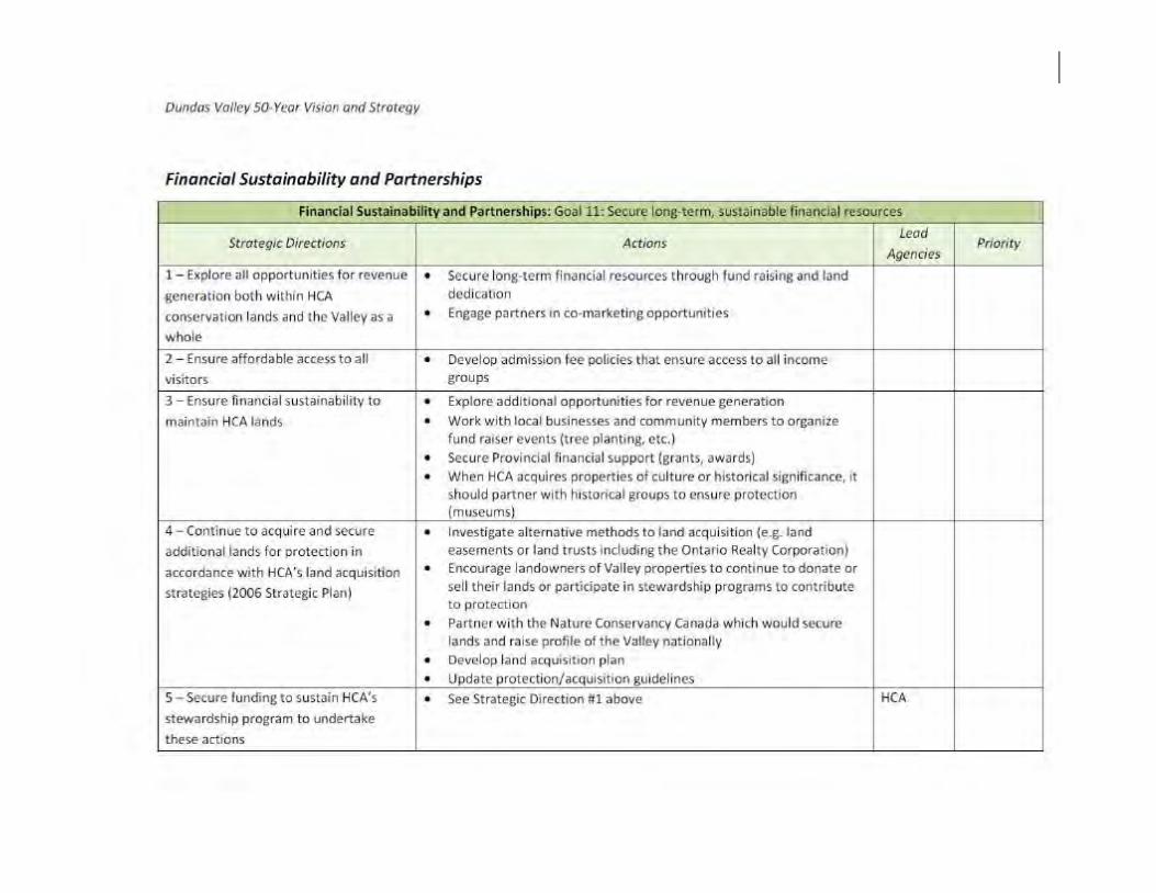


![The Forgery [2058]](https://img.pdfslide.net/doc/110x75/577c7eae1a28abe054a21ea1/the-forgery-2058.jpg)