Embed Size (px)
Citation preview

Durham at WarLidar Landscapes
Project Report
December 2017

Front cover.
Lidar image of the site of Deerbolt Training Camp, now occupied by Deerbolt Prison, justwest of Barnard Castle (Area 1 in this survey). Little if any sign of the First World War campsurvives above ground, though earthworks of a contemporary rifle range do survive, andhave been recorded on lidar, on the south bank of the Deepdale Beck, to the west. Thisimage demonstrates something of the time-depth of the historic landscape here, with ridge-and-furrow field-systems, some of which date from medieval times, clearly visible.

Durham at WarLidar Landscapes Project Report
1
Contents
Acknowledgements
1. Introduction
2. Methodology
3. Results
4. Discussion
Appendix
References

Durham at WarLidar Landscapes Project Report
2
Acknowledgements
First and foremost, thanks are due to the volunteers who undertook the surveywork: D Armstrong, Chris and Audrey Battersby, Barbara Chipchase, PaulCordes, David Donkin, John Goldsborough, and J P Merrington.
This report has been written by Project Consultant, Paul Frodsham (ORACLEHeritage Services). The Project Management Team for Durham CountyCouncil was Victoria Oxberry (Durham at War Project Officer), Liz Bregazzi(County Archivist) and Nick Boldrini (County Durham Historic EnvironmentRecord Officer).

Durham at WarLidar Landscapes Project Report
3
1. Introduction
This project was completed as part of Durham County Council’s HLF-fundedDurham at War project (www.durhamatwar.org.uk), which works with localvolunteers to commemorate the centenary of the First World War. It wasdesigned to serve two purposes. First, to enable volunteers with an interest inlandscape archaeology to familiarise themselves with lidar and its use inarchaeological survey. Second, to examine a series of areas where it wasknown or suspected that features relating to the First World War survived, andto carefully study the lidar in order to record any remnants of these sites, andany other features of potential archaeological importance, that survive aboveground.
The project was designed by Project Consultant Paul Frodsham (ORACLEHeritage Services) working in close consultation with a Project ManagementTeam consisting of Victoria Oxberry (Durham at War Project Officer), LizBregazzi (County Archivist) and Nick Boldrini (County Durham HistoricEnvironment Record Officer).
Working in partnership with Professor Stewart Ainsworth of Chester University(an expert on lidar survey, best known for his role as landscape archaeologistwith TV’s Time Team), the Project Consultant has recently overseen thedesign and delivery of large-scale lidar landscape surveys of Upper Teesdale,Weardale and the Upper Derwent Valley in County Durham, along withHexhamshire and the Allen Valleys in south-west Northumberland (Ainsworth2015; Frodsham 2017). These projects, managed by the North PenninesAONB Partnership, involved the participation of some 200 volunteers, andresulted in the discovery of several hundred previously unknownarchaeological sites within the often complex historic landscapes of the NorthPennines. This First World War project differs from these projects in that it wasnot aimed at blanket coverage of large landscapes, but at survey of smallerareas with specific targets in mind. The appropriateness of the methodologyemployed in this project, which is based on that of the North Penninessurveys, will be considered in the Discussion towards to the end of this report.
ALSM (or ‘airborne laser swath mapping’) data, more commonly referred to as‘lidar’ (originally a portmanteau of ‘light’ and ‘radar’) is a relatively newinformation source being used by archaeologists to discover, interpret andrecord archaeological sites (Crutchley & Crow 2009). The data for this project,provided free of charge by the Environment Agency, was gathered usingsensors mounted on an aircraft. This data can be processed to make acomputerised 3D model of the ground and all the features on it at the time ofcapture and can be precisely referenced to the OS National Grid, in effectproducing what is termed a ‘lidarmap’. For this project the 3D data collectedhas been processed to produce 2D ‘hillshaded’ images which replicate the 3Ddata; this technique emphasises features on the ground, including survivingearthworks of archaeological sites and allows the data to be used as imagefiles which can be viewed on home computers. Although the images look likeaerial photographs they are not – they are computer models of everything on
Durham at WarLidar Landscapes Project Report
4
the ground that the laser pulses hit. For the lidar to be used in this project the3D coordinates of approximately 5 million points were collected in each kmsquare.
The degree of detail revealed about the historic landscape by this techniquecan be staggering, often far more informative than aerial photography, but itstill needs human eyes to spot it and interpret it. This is the role of the projectvolunteers. Only two skills were required to make a contribution to the project –interest and inquisitiveness (coupled with access to a computer). Involvementin the project not only allowed volunteers to develop new archaeological andrecording skills, but also provided them with opportunities to understand moreabout the development of the often complex archaeological landscapes ofparts of County Durham.
As noted above, the project methodology was developed during recentvolunteer projects in the North Pennines, derived ultimately from that used inthe Miner-Farmer project on Alston Moor undertaken by English Heritage(Oakey et al 2012). It was designed to enable volunteers with little or noarchaeological background to make meaningful contributions to the recordingand understanding of the historic landscape, while providing the tantalisingprospect of significant, even spectacular, new discoveries. The recordingmethod used software that is either commonly available on most homecomputers or is freely available on the internet, enabling contributors to workat home at a pace that suits their own circumstances.
The project provided training for volunteers in the process of interpretation andrecording using digital lidarmap images on home computers with commonlyavailable programs such as Microsoft Paint and Word. The project wasdesigned to be as paperless as possible and all file exchanges were by email.After participation in this project, the volunteers now have the skills necessaryto continue to explore the use of lidar as an aid to landscape analysis,interpretation and recording. The project archive will be incorporated into theCounty Durham (in a couple of cases Tyne and Wear) Historic EnvironmentRecord (HER). Here, it will be available for anyone planning new researchprojects, while also potentially contributing to future landscape management.
In some cases it has not been possible to state the form or age of a site withany degree of certainty. Volunteers were encouraged to try and identify allsites by reference to a standard ‘site type’ list; in some cases suchidentifications might be certain, while in others they may be little more thaninformed guesses. In all cases, sites have been recorded in outline, enablingcloser analysis later where appropriate. Many different types of site werediscussed at the project workshops, helping volunteers to improve theirgeneral knowledge of the types of site that survive throughout CountyDurham, in addition to sites relating directly to the First World War.

Durham at WarLidar Landscapes Project Report
5
2. Methodology
The basic methodology is based on that developed for recent lidar surveys oflarge landscape areas undertaken by teams of volunteers in the NorthPennines (Ainsworth 2015; Frodsham 2017). This project is different in that itcovers several small areas rather than a large continuous landscape area.However, the basic approach, enabling volunteers to undertake useful surveywork with only minimal initial training, was considered appropriate.
2.1 Survey areasTen separate survey areas were chosen by the Project Management Teameight in County Durham and two in Tyne and Wear. These vary in size from asingle km sq to 5 km sqs. Each was chosen because of the known orsuspected presence of features relating to the First World War, such astraining camps, PoW camps or training trenches. There were several otherpotential sites which unfortunately had no Environment Agency lidar coverage,so could not be featured in the project. The ten areas are:
1. West of Barnard Castle. 2 sq kms.2. Weardale, south of Wolsingham. 5 sq kms.3. Weardale, Old Park / Heights Quarry. 1 sq km.4. Weardale, East of Stanhope. 1 sq km.5. Cocken Hall. 4 sq kms.6. South Shields. 3 sq kms. (Tyne & Wear).7. Whitburn. 4 sq kms. (Tyne & Wear).8. Easington Colliery. 2 sq kms.9. West of Peterlee. 1 sq km.10.East of Peterlee. 1 sq km.
2.2 Lidar processingProcessed lidar data for the ten project areas was commissioned from anappropriately experienced consultant. The background to the processingmethodology is discussed at some length in the recent Allen Valleys andHexhamshire Lidar Landscapes project report (Ainsworth 2016) so will not berepeated here. In short, the data was processed to produce Digital SurfaceModel (DSM – showing all surfaces including trees, buildings, walls etc) andDigital Terrain Model (DTM – with above-ground features such as trees,buildings walls etc removed) tiles for each km sq within the project area. Thelidar was processed using Principal Components Analysis (PCA) tools toproduce 8-direction hillshade models as single greyscale images that could beeasily circulated to volunteers as jpegs. These images provided the basis onwhich the volunteers undertook their survey work.
2.3 Volunteer training and guidanceEffective volunteer training was an essential element of the project. Anintroduction to lidar and its use in archaeological survey, an outline of theproject and its methodology, and practical training exercises were provided at

Durham at WarLidar Landscapes Project Report
6
an initial ‘start-up’ workshop at which there was ample opportunity for peopleto ask questions. All volunteers were subsequently sent guidance notes byemail; these gave clear guidance regarding the project methodology. Thesenotes are reproduced here in the Appendix.
2.4 Data circulation and submission of resultsFollowing attendance at a training workshop, all signed-up contributors weresent a copy of the guidance notes, together with blank recording forms, byemail. They were also sent the relevant digital data (DTM and DSM lidar, OSmap, and recent colour vertical air photograph) for their first km sq. Thecontributors then worked through their allocated km squares using the lidarimages and recording forms supplied. The results were then returned by emailto the Project Consultant, checked, and entered into the project archive. Inorder to maximise the potential value of the project, from the point of view ofvolunteer experience as well as project results, participants were encouragedto record all visible archaeological or historic features within their km sqs, notjust those potentially associated with the First World War, and to consult withother available sources (eg aerial imagery and historic mapping) to help withthe interpretation of the lidar imagery.
2.5 Validation and archiving of resultsAll results were inspected by the Project Consultant following submission andare filed within the digital project archive along with the original DSM and DTMimages, aerial photo and OS map. Brief summaries of all results are includedwithin the archive on an excel spreadsheet; this is effectively an index to allthe results. The Project Consultant did not make any changes to thevolunteers’ completed data forms, but comments on some are provided withinthe spreadsheet and this report.
2.6 Results workshopsA results workshop was held for participating volunteers. At this, the ProjectConsultant presented a selection of the results, which were discussed by all.This event also gave volunteers the opportunity to discuss the methodologyand any follow up work that they might like to do (a possible follow-up project,looking at different parts of County Durham using processed lidar held withinthe HER, is in development).
2.7 Project reportThis report presents a summary of the project methodology and results.Anyone interested in the results should study the original lidar data as well asthis report, as much of the interpretation presented here is to an extentspeculative and alternatives may be equally valid.

Durham at WarLidar Landscapes Project Report
7
3. Results
Brief summaries of each study area, together with comments on what thevolunteers found relating specifically to First World War installations and alsoany other features of note recorded from the lidar are set out here. Furtherdetails of all sites recorded, together with the volunteers’ completed dataforms and record maps, and the original DSM and DTM lidar maps, areincluded in the site archive which is structured to tie in with this section, with aseparate sub-folder for each area.
All work was done by volunteers who had varying levels of experience andskill, so anyone studying these areas in future is encouraged to consult withthe original lidar maps as well as checking what was found during this project.
(Note: 5 or 6 figure numbers in brackets in the following account are theindividual site numbers allocated by volunteers during this project and relate tothe project database and archive).
Area 1.W of Barnard Castle, Teesdale(2 km sqs: NZ0316, NZ0416).
This area covers the site of the Deerbolt training camp, Startforth, BarnardCastle, used from the 1890s through to the mid twentieth century. A series ofpostcards in Durham County Record Office indicate that the 3rd Battalion ofthe Durham Light Infantry was active here in 1909-1910, prior to the FirstWorld War, and that the camp was tented at that time.
Fig 1.1. Photograph of the band and the eight companies of the 3rd BattalionThe Durham Light Infantry, on parade, taken at Deerbolt Camp, BarnardCastle,1909. Image reproduced from Durham County Record Office website,ref no: D/DLI 2/3/16(13).
Durham at WarLidar Landscapes Project Report
8
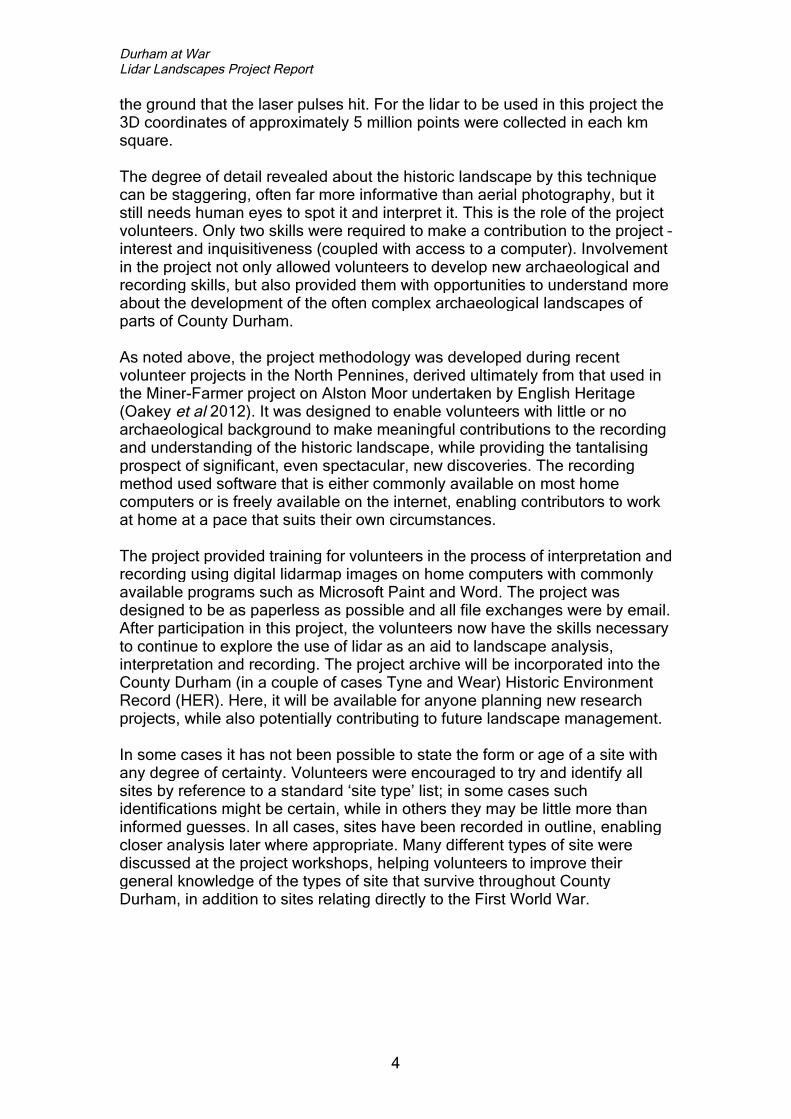
Fig 1.2. Two aerial views of Deerbolt Camp (undated but probably takenduring the Second World War). Reproduced from the website of the King’sOwn Royal Regiment Museum, Lancaster (www.kingsownmuseum.com).
Fig 1.3. DSM lidar image of the site, now largely occupied by Deerbolt Prison.Note Barnard Castle, on the east bank of the Tees towards the right margin ofthe image, and the medieval field patterns north and south-west of the prison.(See front cover image for a wider view of this area).
The site of the camp lies largely beneath the present-day Deerbolt Prison.Given the development of the site following the First World War, it is perhapsnot surprising that no remnants of the original camp were noted on the lidar.Part of the site of the original camp remains open ground, however, so it is

Durham at WarLidar Landscapes Project Report
9
possible that some features relating to original camp may survive within theground.
In addition to the camp, a rifle range existed on the south bank of theDeepdale Beck, as shown on the 2nd edn OS map. Today this is largelywooded, but some earthworks in the right location, so presumably associatedwith it, have been recorded from the lidar. The site is recorded on the HER asD47390. the HER notes that: ‘The range remains marked on OS mapping dataright the way through to ….. the 1970's, after which the land shows up as pathsthrough woodland by the beck. The targets are on the south side of the beckwith markers leading 660yds away to the north-east on the opposite side ofthe beck. The range is likely to have been associated with Deerbolt MilitaryCamp to the immediate south, the lifespan of the range suggesting it mightwell have been used as a training site in both the WWI and WW2.’
The military history of the area extends back many centuries prior to the FirstWorld War, as demonstrated by the presence of the great Norman Castle, thelocation of which reflects the strategic importance of the site. Volunteersrecorded some areas of ridge-and-furrow, some of which may well date backto the time of the castle; some of this in km sq 0316 is very well-preserved,though parts of it have clearly been damaged and in places destroyed by laterploughing. Other than this, and a few unclassified earthworks none of whichlooks particularly important, nothing else of interest was recorded. This areawas included within the recent North Pennines AONB Lidar landscapesproject, so any features of potential interest visible on lidar should be includedwithin that project’s report and archive.
Area 2South of Wolsingam, Weardale(5 km sqs: NZ0734, NZ0834, NZ0835, NZ0935, NZ0936).
This area was included in the survey because documents dated Nov 1918 andMarch 1919, held by the National Archives of Canada, refer to activity here bythe Canadian Forestry Corps; copies of these documents are held by theDurham County Record Office. These documents make reference to whatappear to be two separate light railways, presumably for the movement oftimber. An extract in a company diary dated 30 Nov 1918 (ref: RG9 III D-3 Vol5018 file 764) refers to the armistice of a few days earlier and notes that‘railway construction is finished for the present, the immediate requirementsbeing satisfied. The bridge over the River Wear is completed, ready for theshipping of lumber when the N.E.Ry siding is put in.’ It also notes ‘Allproposed buildings are now erected, except the Carpenter-shop andBlacksmith’s shop.’ A letter (ref: RG9 III B-1 Vol 2475) dated March 4th 1919,refers to a light railway on which work commenced on 29 Jan 1919; at the timethe letter was written a bridge over the Harthope Beck had been completedand the track was laid ‘well on the way to Harthope Wood’. This letter alsonotes that the railway was ‘the only means by which the timber can betransported form the Harthope and Lyloe (presumably Kyloes) woods.’

Durham at WarLidar Landscapes Project Report
10
A glance at the pre-war 2nd edition OS map shows how heavily this area wasforested in the years leading up to the War; recent air photos and the lidardata show a comparatively open landscape. Careful analysis of all availableold maps, lidar, aerial photos and other sources might provide informationabout the activities of the Canadian Forestry Corps, and the possible locationof the railways mentioned above, but unfortunately the lidar has not providedany new information. This might be because the main area of activity couldhave been to the west of the area chosen for analysis; Harthope and Kyloeswoods are shown on the OS 2nd edition map at NY064340 and NY063334,which is to the west of the area specified for survey. The railway(s)presumably headed north from this general area to a junction with themainline near Wolsingham.
A rifle range and targets are shown on the OS 2nd edition map, so may wellhave been operational during the First World War, at NY08963510, onKnitsley (or Nitsley) Fell. This location puts it in the SE corner of km sqNY0835, but frustratingly this area has no lidar coverage. To date, the siteappears to have escaped incorporation into the HER. There is no sign of it onthe OS 3rd edition map, which does show a tramway (presumably linked toforestry and/or quarrying, and potentially linked to the work of the CanadianForestry Corps) in this general area, part of which is visible on the lidar(08356).
Fig 2.1. Rifle range on Knitsley Fell, shown on OS 2nd edn map. (Not on HER).
Other than this, the lidar analysis has recorded little other than field systemsand industrial remains of post-medieval date. The area is studded withquarries and mines, many of which are shown on historic OS maps. This areawas included within the recent North Pennines AONB Lidar Landscapesproject, so most of these features should have be included within that project’sreport and archive.
Durham at WarLidar Landscapes Project Report
11
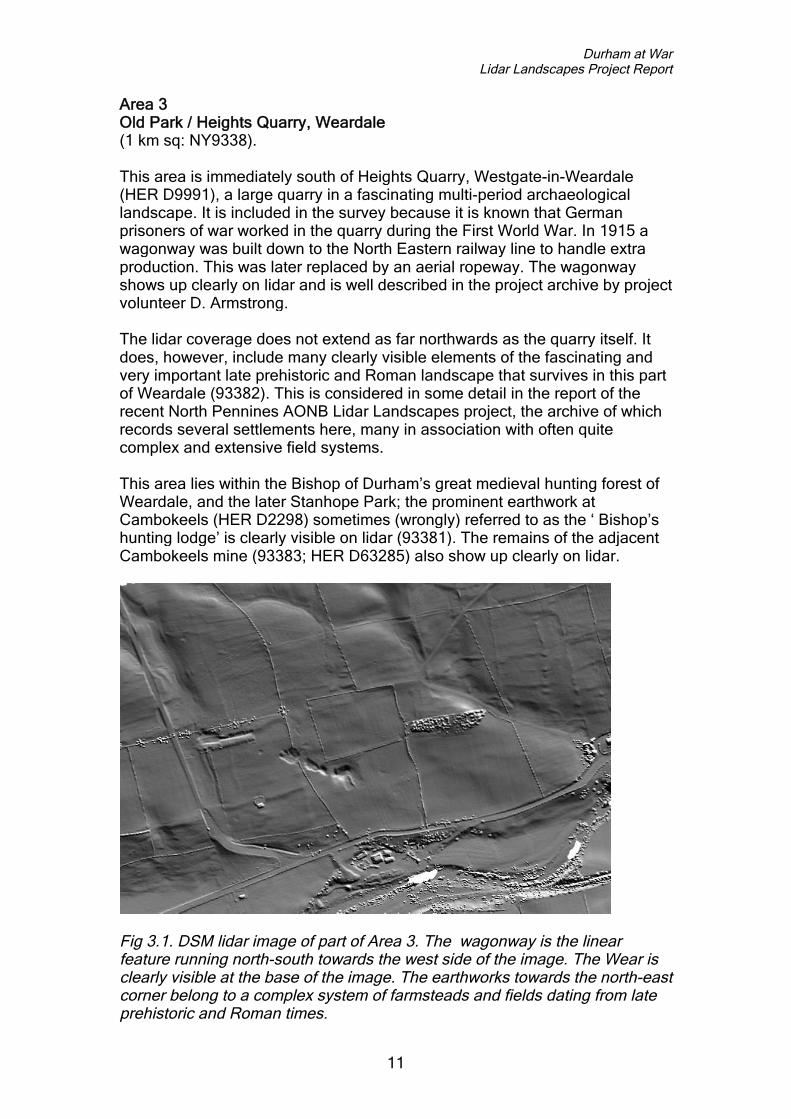
Area 3Old Park / Heights Quarry, Weardale(1 km sq: NY9338).
This area is immediately south of Heights Quarry, Westgate-in-Weardale(HER D9991), a large quarry in a fascinating multi-period archaeologicallandscape. It is included in the survey because it is known that Germanprisoners of war worked in the quarry during the First World War. In 1915 awagonway was built down to the North Eastern railway line to handle extraproduction. This was later replaced by an aerial ropeway. The wagonwayshows up clearly on lidar and is well described in the project archive by projectvolunteer D. Armstrong.
The lidar coverage does not extend as far northwards as the quarry itself. Itdoes, however, include many clearly visible elements of the fascinating andvery important late prehistoric and Roman landscape that survives in this partof Weardale (93382). This is considered in some detail in the report of therecent North Pennines AONB Lidar Landscapes project, the archive of whichrecords several settlements here, many in association with often quitecomplex and extensive field systems.
This area lies within the Bishop of Durham’s great medieval hunting forest ofWeardale, and the later Stanhope Park; the prominent earthwork atCambokeels (HER D2298) sometimes (wrongly) referred to as the ‘ Bishop’shunting lodge’ is clearly visible on lidar (93381). The remains of the adjacentCambokeels mine (93383; HER D63285) also show up clearly on lidar.
Fig 3.1. DSM lidar image of part of Area 3. The wagonway is the linearfeature running north-south towards the west side of the image. The Wear isclearly visible at the base of the image. The earthworks towards the north-eastcorner belong to a complex system of farmsteads and fields dating from lateprehistoric and Roman times.

Durham at WarLidar Landscapes Project Report
12
Area 4East of Stanhope, Weardale(1 km sq: NZ0038).
This area was included in the survey as it includes the site of NewlandsideWorking Camp, a prisoner of war camp established in August 1916. Itsresidents worked in the nearby Newlandside Quarry. By September 1916 italready held 220 German prisoners, all apparently within 24 tents. Somefascinating documentary records are discussed on the Durham at Warwebsite. The site is shown on the 3rd edition Ordnance Survey map (below),but had gone by the 1940s.
Fig 4.1. Newlandside POW camp shown on OS map dated 1923.
Fig 4.2 DSM lidar image of the site of Newlandside camp.
If all accommodation was in tents then traces left on today’s ground surfacemay well be ephemeral at best, although the tents may have stood on levelledbases, which may have been concreted, so some trace could survive on theground surface. There are feint traces of earthworks on the lidar and whilethese do not appear to correspond entirely to the cartographic evidence, onclose analysis there certainly are some areas of apparent correspondence. It

Durham at WarLidar Landscapes Project Report
13
does therefore seem as though remnants of some of the camp structures dosurvive within the ground. This is a case where it would be useful to be able tomanipulate the lidar data in 3D.
Also visible on lidar in this km sq are some very well preserved agriculturalstrip lynchets or terraces that could well be of Roman date, perhaps reused inmedieval times. In some places, such as towards the centre of the km sq,these have been flattened by later ploughing. There is also evidence for post-medieval settlement and agriculture, for example at Shittlehopeside Farm.Parts of two vast post-medieval old quarries can be seen on the lidar. Theimage clearly illustrates how this part of Weardale was a landscape ofquarrying and agriculture during the nineteenth century; putting prisoners ofwar to work in the quarries was the obvious way to keep them usefully busy.
Like the other areas in Weardale and Teesdale discussed above, this areawas included within the North Pennines AONB Lidar Landscapes project, andfeatures noted here are included within that project’s archive.
Area 5Cocken Hall(4 km sqs: NZ2746, NZ2747, NZ2846, NZ2847).
This area includes Cocken Hall, the site of an important First World Wartraining camp. The following background information is taken from the Durhamat War website, where much further information is available. Cocken Hall,which had extensive landscaped gardens (evidence of which can be seen onlidar and must not be confused with evidence of the First World War camp),was originally built in the seventeenth century and was demolished in 1928, bywhich time the camp had already been dismantled. A fascinating overview ofCocken, from medieval times through to the twentieth century, can be seen onthe Chester-le-Street Heritage Group website. Survey and excavation worktook place here as part of a No-Man’s Land project in 2015/16 (see:www.plugstreet-archaeology.com/blog/?cat=142).
In early September 2014, only a few weeks after Britain declared war onGermany and Lord Kitchener called for volunteers to join a New Army, acommittee was formed in County Durham, headed by the Earl of Durham, toraise and equip a County battalion as part of the Durham Light Infantry. Over£10,000 was quickly raised and permission given by the War Office to beginrecruiting a County battalion that was formally numbered as the 18th BattalionDLI, but more popularly known as the Durham Pals.
The Durham Pals, however, had no home until Lord Durham loaned thebattalion his house and land at Cocken Hall, north east of Durham City. Therethe first recruits from across the county arrived in late September. Soon a newhutted camp was built in the fields near the old house, new khaki uniformsarrived, and over 1,000 men began their long months of training. It was duringthis time that a remarkable set of photographs was taken of the Durham Palsat Cocken, giving a fascinating insight into the world of volunteer soldiers in

Durham at WarLidar Landscapes Project Report
14
1914 and early 1915. No comparable set of photographs of Durham soldiersfrom this time is known to have been taken, and, sadly, for some battalionshardly a single photograph has survived.
The site of Cocken Hall is now largely wooded, so analysis of this areaconcentrated on the DTM rather than the DSM lidar. D Armstrong hasrecorded a number of features here that seem to correspond to knownfeatures of the hall complex, in addition to some outlying features that couldpossibly relate to the First World War camp. These features should becompared with the results of other recent fieldwork in the attempt to establishwhether they do relate to the camp. To the west, on the opposite bank of theWear, some linear earthworks (27471, 27465, 27466) visible on lidar wereinterpreted as possible training trenches, but this interpretation is far fromcertain. In short, the lidar must be used along with other data, rather than inisolation, in the attempt to recognise possible surviving features of the camp.
A few features of possible interest, in addition those discussed above, wererecorded by volunteers in the km sqs surrounding Cocken Hall, but most fieldsin this area have been ploughed quite heavily over recent decades and arenow featureless in terms of surviving earthworks. Most features recorded byproject volunteers are recent in date and of minimal, if any, archaeologicalsignificance.
Fig 5.1. Exterior of miniature rifle range and drying room at Cocken Hall Camp.(DCRO ref: D/DLI 2/18/24(137)).

Durham at WarLidar Landscapes Project Report
15
Fig 5.2. Cocken Hall in the 18th century. Image reproduced from the Chester-le-Street Heritage Group website.
Fig 5.3. DTM lidar image (with trees and buildings removed) of the site ofCocken Hall.

Durham at WarLidar Landscapes Project Report
16
Area 6South Shields(3 km sqs: NZ3866, NZ3965, NZ3966).
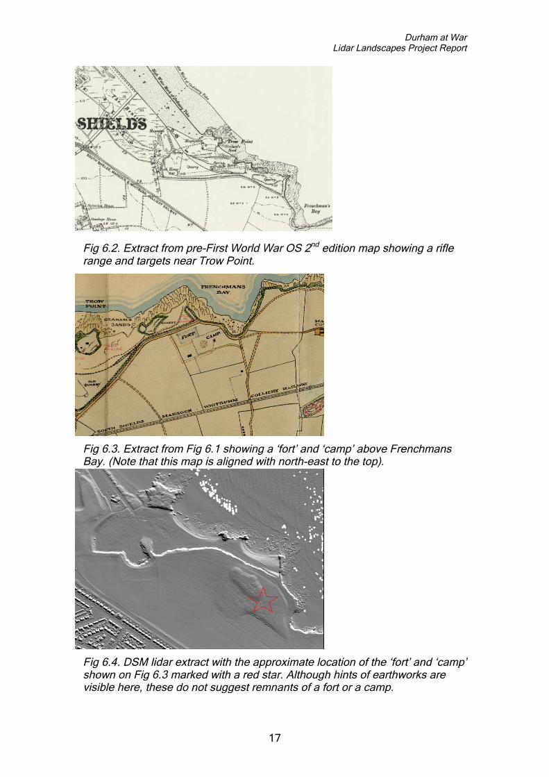
This area was included within the survey due to the suspected presence ofcoastal defence installations associated with the 3rd Battalion, The DurhamLight Infantry during the First World War (fig 6.1). Much of the survey area isnow built up, so survey concentrated on the coastal strip between this and theNorth Sea.
No clear trace of the ‘fort’ and ‘camp’ shown on the 1918 map was noted onthe lidar (figs 6.3, 6.4), and nothing else of certain First World War date wasnoted. Slight remains of ploughing of apparent post-medieval date cover muchof the ground, and a few possible earthwork features were noted by thevolunteers though it is impossible to be sure on the basis of lidar alone whatthese might be – some could just be natural features, disturbed by ploughing.There is also much industrial activity in this area, including quarrying, recordedon historic OS maps. Some of the recorded features are old field boundaries,of minimal archaeological interest. Perhaps the most interesting, andpotentially worthy of investigation on the ground, is what could be a small zig-zag trench system at NZ39056555 (396513).
While checking old OS maps along with the lidar of this area, a rifle range wasnoted near Trow Point. This may have been in use during the War. No sign ofit is visible on the lidar. In addition, some curious rectilinear and very regularparchmarks were noted on Google Maps aerial imagery south of the GypsiesGreen Recreation Ground, immediately north of the survey area (NZ379666).These are of unknown origin; they do look potentially military but could be aresult of recent activity (though one appears to underlie the wall around theadjacent stadium).
Fig 6.1. Map held by the Durham County Record Office, dated May 1918,showing the coastal defences of the 3rd Battalion, The Durham Light Infantry(DCRO ref: D/DLI 2/3/10). Note that the area labelled ‘THE BENTS TrainingGround’ is now largely built over. This map relates to Areas 6 and 7 in thissurvey.
Durham at WarLidar Landscapes Project Report
17
Fig 6.2. Extract from pre-First World War OS 2nd edition map showing a riflerange and targets near Trow Point.
Fig 6.3. Extract from Fig 6.1 showing a ‘fort’ and ‘camp’ above FrenchmansBay. (Note that this map is aligned with north-east to the top).
Fig 6.4. DSM lidar extract with the approximate location of the ‘fort’ and ‘camp’shown on Fig 6.3 marked with a red star. Although hints of earthworks arevisible here, these do not suggest remnants of a fort or a camp.

Durham at WarLidar Landscapes Project Report
18
Area 7Whitburn(4 km sqs: NZ4063, NZ4064, NZ4162, NZ4163).
This area was included in the survey because of the presence here of a riflerange and also First World War practice trenches (see fig 6.1). The followinguseful background information is reproduced fromwww.28dayslater.co.uk/whitburn-rifle-range-sunderland-feb-13.t78174.
Five firing ranges, one of 40yds, one of 600yds and three of 500yds. This ispossibly associated with a group of buildings on Mill Lane which may bebarrack blocks. The earliest representation of these ranges seen so far is onthe 1921 OS 6" map. This area was once part of the medieval field systemassociated with Whitburn village (HER 887). Sections of the medieval ridgeand furrow earthworks were scraped away to create the ranges but elsewherewithin the site boundary, evidence of the former cultivation system can beclearly seen. World War One practice trenches can be seen on aerialphotographs. The land for the range was bought from Sir John Sherburn bythe Territorial Force Association in 1912. The camp was occupied by theRegular Army throughout the First World War and wooden huts were built fora garrison approaching battalion strength. A trench system was dug using thecharacteristic ‘Greek Key’ pattern of firing bays and communication trenches.After the war the camp reverted to the Territorial Association until the RegularArmy returned between1939-45. During this period, some of the trenches ofthe earlier war were re-excavated. By 1953 the wooden huts of the First Warwere replaced by the modern brick bungalows which today stand on therange. This work was carried out between 1954 and 1962, providingaccommodation for approximately 250 troops. During the 1960s the RoyalEngineers carried out ground clearance works, eliminating the ‘bumps andhollows’ between the butts and the camp and removing almost all traces of thetrench system. At the same time concrete pillboxes were demolished anddestroyed.
The five firing ranges are clearly visible on lidar (fig 7.1), but no sign ofpractice trenches or other features relating to the First World War has beennoted (figs 7.2, 7.3).
The landscape throughout this area is largely either built up or has clearlybeen heavily ploughed over recent decades, while the massive MarsdenQuarry has also removed a large area of the ground surface – there is thuslittle chance of survival of significant earthworks liable to discovery throughlidar survey. The only ancient feature recorded is the ridge-and-furrow, whichcould well be medieval, in the area of the rifle ranges. This has presumablybeen preserved here due to the lack of recent ploughing owing to thepresence of the rifle ranges. The fact that it survives here, albeit only now as afew isolated fragments, suggests that there must have been much more ridge-and-furrow here back in medieval times, and that there may also have beenother earthworks in the local landscape. But anything that was here has nowbeen ploughed flat, so is not detectable by lidar.

Durham at WarLidar Landscapes Project Report
19
Fig 7.1.DSM lidarimage ofcoastalfiringranges atWhitburn
Fig 7.2 Extract from Fig 6.1showing apparentdepiction of trenches (inred) above the coast aboveWhitburn Rocks.. (Notethat this map is alignedwith north-east to the top).
Fig 7.3, DSM lidar map of the coast atWhitburn Rocks, as shown on Fig 7.2. Nosign of the trenches shown on the map hasbeen noted on the lidar.

Durham at WarLidar Landscapes Project Report
20
Area 8Easington Colliery(2 km sqs: NZ4344, NZ4445).
This area was included in the survey due to the supposed presence ofpractice trenches. However, the possible trenches actually recorded on theHER, at White Lea, are not within either of the two areas hallmarked forsurvey (it could be that a simple error was made when initially defining thoseareas to include in the survey). The HER records a cropmark of ‘Zig-ZagLines, could be World War 1 practice trenches’ (D53832) at White Lea,Easington Colliery. Lidar is available for this area, so might be worth checking,though whatever this feature is, if it only survives as a cropmark rather than anearthwork then it will not show up on lidar.
A curious zig-zagging earthwork (44451) is visible right on the coast. The HERrecords a ‘rocket station’ at this location, but notes nothing is visible on theground. The area was included within the ‘Turning the Tide’ project (1997-98),so anything surviving here may previously have been noted. Perhaps this isjust a track, albeit an unusual one? It should be checked on the ground incase it is of archaeological interest.
Km sq 4344 is partly built up, with much of its eastern half having been heavilyploughed in post-medieval and/or recent times and largely devoid of featuresof potential interest. A few possible features were recorded and are includedin the archive, but nothing of potential First World War interest.
Area 9East of Peterlee(1km sq: NZ4540).
This area was included within the survey due to the presence of trenches atCastle Eden Dene which it is thought could date from the time of the FirstWorld War (HER D8293).
Several possible trenches were recorded on the lidar, most of which may betracks and are probably not actually of archaeological significance (thoughthey should be checked on the ground). One of these (45401) looksparticularly promising and may well be First World War trenches.
Nothing else of significance was noted on this km sq, which includes two largeheavily ploughed fields, a built up area, allotments and woodland – none ofwhich is conducive to the survival of earthworks that might be seen on lidar.

Durham at WarLidar Landscapes Project Report
21
Area 10West of Peterlee(1km sq: NZ4142).
This area includes the site of Little Thorpe Hospital (HER D60586), builtbetween 1898 and 1919 and demolished in 1995, about which projectvolunteer D. Armstrong has collated much information (see the detailed reportin the project archive). He also found this image (below), which is undated(reproduced from www.rhdixon.com/2017/01/16/fever-hospital) but may datefrom the first half of the twentieth century.
The footprint of the hospital buildings can be clearly seen on the lidar.
Just west of the hospital site is the site of an Anglo-Saxon cemetery onAndrew’s Hill (NGR NY41704270). This area has been heavily ploughed nofeatures of potential archaeological interest are visible on the lidar.
Nothing else of potential significance was noted within this area.
Historic photograph of Little Thorpe Hospital. (Reproduced fromwww.rhdixon.com).
DSM lidar image of the site (towards the right margin) of Little ThorpeHospital, within a largely featureless sea of heavily ploughed fields that retainlittle visible sign of archaeological features of any date.
Durham at WarLidar Landscapes Project Report
22
4. Discussion
This small-scale project has been rather different from other recent lidarlandscapes surveys, principally because it was designed primarily toinvestigate small areas for remnants of specific sites. This means the resultswere always going to be a bit ‘hit and miss’ - either evidence of these siteswould be found, or it wouldn’t. In contrast, other projects have been designedto investigate extensive landscape areas for any evidence of archaeologicalsites of any period, and these have consistently resulted in large numbers ofimportant new discoveries, even in areas previously thought to be of lowpotential. A general search of the areas included in this project wasundertaken, alongside the search for First World War features, but given thesmall size of the areas, and the fact that several of the km sqs included built-up areas, extensive heavily ploughed fields and areas of sea, the potential forimportant new discoveries from the outset was not particularly high. Also,some of the areas chosen for analysis had already been covered by other lidarlandscapes surveys (Frodsham 2017), so any important discoveries withinthese areas should already have been made. That said, it should not beforgotten that this was also a training exercise for volunteers; whether or notimportant remains were found, the volunteers received training andexperience in using lidar for archaeological survey which hopefully they willuse elsewhere in future projects.
The results, as set out in this report and in the project archive, may appear alittle disappointing as no spectacular new finds were made. However, in mostcases, some evidence of the target sites has been recorded on the lidar maps,although the nature of this evidence is often unclear. For example, the site ofthe PoW camp of Newlandside at Stanhope, Weardale, still retains earthworkevidence of structures, although it is not easy to equate the visible remainswith the cartographic evidence for the form of the camp. In such cases, fieldvisits, or even perhaps geophysical survey or the excavation of trial trenches,may be necessary to clarify the nature and condition of sites.
In some cases (eg Trow Point, South Shields; Knitsley Fell, Weardale),features relating to the First World War were noted on historic OS maps eventhough no obvious trace of them was noted on the lidar maps. This illustratesthe fact that lidar should only be used as one tool amongst many, along withhistoric mapping, aerial photography, the HER and other available sources,when undertaking landscape research.
The volunteers all had differing degrees of relevant experience, and somewere better able to notice and record archaeological features from lidar thanothers. Consequently the nature of volunteer results is inevitably variable;some recorded post-medieval, modern and natural features in great detail,while others struggled to identify quite obvious features of potentialarchaeological interest. None of this is a problem – all were requested torecord what they thought they could see, and offer their best interpretations ofwhat they thought different features might be. In future, with the experience of

Durham at WarLidar Landscapes Project Report
23
having taken part in this project, volunteers will be better informed as to whatis worth recording when doing this kind of work.
Given the project’s basic aims, and the restricted budget, the methodology (asdescribed in Section 2, above) is considered to have been generally sound,though it would perhaps have made sense to explore wider areas, if only toenable sites of potential interest to be seen in their landscape context. Ideally,more time would have been available to discuss individual km sqs withvolunteers while work was in progress, either at a progress workshop or byemail. Given the small scale of this particular exercise, and the fact that allresults were discussed in some detail at the results workshop, this was not aproblem, but if undertaking larger-scale lidar landscapes projects in futurethen thought should be given to arranging ‘work in progress’ workshops atwhich volunteers can ask questions and discuss things they have found.
A further potential benefit would have been the facility to use 3D lidar models,but this would have necessitated further training and the acquisition ofdedicated software. Had this been available it would have enabled theexamination of potentially interesting areas in greater detail, and would havebeen of potential interest to the volunteers. It is possible that the lidar datacould be subjected to 3D analysis at a later date, though there is no guaranteethat the results would be substantially different to those presented here.
The project database, along with this report, has been presented to theCounty Durham HER and the results, as appropriate, will be incorporated intothe HER, making them publicly available. The project archive, in digital form,has been passed to the Durham County Record Office.
The results of this project, in terms of volunteer training and in establishing theextent to which surface traces of the target sites still survive, has beengenerally successful, and the methodology could certainly be adapted toenable the undertaking of further projects in future. It is hoped that a follow-upproject can be undertaken to enable many of the participants involved in thisproject to develop and enhance their important work to date, and thus makefurther significant contributions to our understanding of County Durhamarchaeology.
Durham at WarLidar Landscapes Project Report
24
Appendix
The guidance notes sent to participating volunteers were as follows.
Durham County CouncilDurham at War project – lidar workshop
The use of lidar to record archaeological features, in particular featuresrelating to a number of First World War sites, was discussed at a workshop forvolunteers, led by Paul Frodsham, at County Hall on 28 January 2017.Following that event, lidar maps are being distributed to volunteers, who willrecord features on them using a standard methodology developed during theLidar Landscapes project in the North Pennines AONB. For that project (whichhas resulted in the discovery of many hundreds of previously unknownarchaeological sites by volunteers with no previous experience) participantsare sent a comprehensive Project Manual, but the purposes of this small-scaleexercise the following notes (based on the Project Manual) should suffice.
The basic object of the exercise is simple: to study the lidar maps verycarefully and record everything you can see that you think might be ofarchaeological significance. Everything you decide is worth recording shouldbe highlighted and numbered on a copy of the lidar map, and a record form foreach site should be completed. Don’t worry about getting anything ‘wrong’ –the idea is to record everything you think might be of interest, so you can’treally be ‘wrong’! The plan is to study all the results at a follow-up workshop,where potential further lidar survey work will also be discussed.
So, the basic methodology is as follows.
1. For each km sq you will be sent a DSM lidar map, DTM lidar map, OSmap, and aerial photo.
2. Make a copy of the DSM lidar map – this is to be your working copy onwhich you will record what you find. (Note – do the same for the DTMlidar map only if you can see something on the DTM that doesn’t showup on the DSM; in most cases this will not be necessary).
3. Using a basic drawing package (most people use ‘Windows Paint’),highlight and number your sites using a simple colour scheme. Small‘point’ sites (eg single mine shafts, or burial mounds) should besurrounded with a small yellow circle. Straight lines (eg roads, railways,linear boundaries) should be marked using a blue line. Larger areas ofinterest (ie sites that are not small ‘point’ sites and not linear features)should be drawn around in red, creating a red polygon that surroundsthe site. Please save the completed workmap as a jpeg, with a filenameconsisting of the OS map number followed by ‘workmap’ (eg‘NY7788workmap’).
4. Each site should be given a number, the numbers being addedsequentially for each km sq, regardless of the colour of each site.
5. For each site, a Recording Form must be completed. This may initiallyappear complicated, but it isn’t! Most of the fields should be self-

Durham at WarLidar Landscapes Project Report
25
explanatory. Don’t worry if you aren’t sure what to put in some of theboxes, as all will be explained at the follow-up workshop.
6. The bits to concentrate on are Table 2 and Table 6. In Table 2, don’tworry about the first 3 lines, but please try to complete the final four.Under monument type, record what you think the thing is (eg ‘ridge andfurrow’). Under monument period, say which of the following generalperiods you think it belongs to: Prehistoric, Roman, Medieval, Post-medieval, Unknown). Under monument form, record the current form ofthe site (eg ‘Earthwork’, which will cover the vast majority for sites).Under ‘Feature’, place a cross in the relevant box according to whichcolour you have drawn it on the workmap (see above). In Table 6,please describe the site – say as much or as little as you like.Speculative interpretation, saying what you think the site might be andwhy, is encouraged!
7. Elsewhere on the form, put an ‘X’ in table 3 according to whether thesite can be seen on DSM, DTM and/or the aerial photo. And put an ‘X’in the relevant box of table 4 – box ‘A’ if you are confident you haveidentified the site correctly, box ‘C’ if you haven’t really got a clue! Putyour name in table 5. And if you like (most people don’t bother) includea scanned sketch of the site in Table 7.
8. Each form should be saved (ideally as a Word file) in the format: mapnumber_site number (eg NY7788_1.doc).
9. Please send your completed workmaps and record forms to (EMAILADDRESS TO BE INSERTED HERE)
And that’s pretty much that. Remember, you are just recording what youthink you can see, so you can’t get it ‘wrong’. Just do your best, and all willbe discussed at the next workshop. Good luck!
Durham at WarLidar Landscapes Project Report
26
References
Ainsworth, S. 2015. Shedding Light on the North Pennines. The Allen Valleysand Hexhamshire Lidar Landscape Survey. Unpublished report, available onthe Altogether Archaeology website: www.altogetherarchaeology.org
Crutchley, S. & Crow, P. 2009. The Light Fantastic: Using airborne lidar inarchaeological survey. Swindon: English Heritage.
Frodsham, P. 2017. Lidar Landscapes – North Pennines (East). ProjectReport. Unpublished report for North Pennines AONB Partnership.
Oakey, M., Radford, S. & Knight, D. 2012. Alston Moor, North Pennines.Miner-Farmer Landscapes of the North Pennines AONB. English HeritageResearch Report Series no. 4-2912. Portsmouth: English Heritage.


Harnessing the spirit of our past…..…..enhancing prospects for our future
www.ORACLEheritageservices.com