Embed Size (px)
Citation preview

All rights reserved by www.ijaresm.net ISSN : 2394-1766 1
DYNAMICS OF RIVER, IMPACT AND ASSESSMENT – CASE
STUDY OF KOSI RIVER Patel Sahid Alli
1, Bhasker Vijaykumar Bhatt
2
M.E., Civil Engg., Sarvajanik College of Engg. & Tech., Surat, Gujarat, India
Assistant Professor, Civil Engg., Sarvajanik College of Engg. & Tech., Surat, Gujarat, India
Abstract: This research paper is prepared to understand the river morphology and its
impact on the area through which it is flowing. The effects of major Single River compared
with other rivers of the same state to understand prioritization of any river draining work
or any flood impact reduction work. After comparing the effect of Kosi river with another
stream effect in different sectors, provide the significant impression that show the high
level of dynamicity of Kosi River.
Keywords: Impact Assessment, Planning, River Morphology.
INTRODUCTION
The Kosi river is one of the major tributaries of river Ganga situated on the
northern plain of Bihar state.The movement of the river from its nodal point has not
been gradual but of avulsive nature (sudden change in the river course) (Wells and
Dorr, 1987). The average avulsion frequency was recorded as lowest in the world
compared to 1400 years for the Mississippi River (Slingerland and Smith, 2004). A
number of Paleo channels on the satellite image of the Kosi basin observed as the
migratory behavior of the river. The river has typically braided in nature and has
formed a colossal alluvial fan shape catchment due to a large sediment supply from the
Himalaya and aggradation regime. Other complications are very high rainfall in the
catchment measured 1200-2000 mm in most parts and high seismicity in the hinterland.
Whose consequences are causing landslides and large sediment production which
eventually fill up the basin.
The Kosi River is often called “Sorrow of Bihar.” Initial suggestions for flood
control for the Kosi River during late 19th century included construction of marginal
embankments, high dam at upstream section, river training in lower reaches and a
series of barrages and canals. No action is done in the direction till 1953. A very severe
flood in 1953-54 and the subsequent social and political pressure led to the first serious
attempts towards flood control in the Kosi basin and the formulation of the „Kosi
project‟ in 1954. This project was primarily aimed at flood control and to provide
irrigation for increasing agricultural productivity. The project started in 1959, and the
river was diverted through the barrage in 1963. The embankments on both sides were
designed to protect ~2800 km2 of land in north Bihar and Nepal. Although the
embankments have checked the lateral movements of the Kosi, the flooding problem
continues in the Kosi basin, and the objectives envisaged in the Kosi project have been

IJARESM
All rights reserved by www.ijaresm.net ISSN : 2394-1766 2
only partially met. Several large floods and frequent breaches in the embankments have
continued to occur in the region. In addition, several adverse effects of the Kosi project
have been noted viz. Drainage congestion and waterlogging, rise of river bed level, and
reduction in crop productivity due to reduced silt flux on the floodplains (Ghani, 2001).
THE KOSI RIVER AND ITS CATCHMENT
Kosi originates at 7000 m above mean the sea level (MSL) in the Himalayas. It enters
India at Hanuman Nagar, Nepal and drains into the Ganga in Bihar, India. Its total catchment
is 74,030 sq km of which 11,410 sq km is in India. The catchment area is home to 6.6 million
people. The catchment has an annual average rainfall of 1456 mm and total discharge of
52219 million cubic meters. Its principal tributaries are Bagmati, Kamala Balan, Bhutahi
Balan, Trijuga, Fariani Dhar and Dhemama Dhar.
Tectonic forces are elevating Kosi‟s gradient by 1 cm per year, aggravating erosion,
inundation, and sedimentation. Its annual sediment load is estimated as 100 million cubic
meters. Sediment load is projected to grow the six-fold to the gradient elevation. As the
gradient flattens in north Bihar, the river decelerates and deposits the sediment to on its bed.
Sediment load elevates the bed progressively, forcing the river to break out to lower terrain,
which it again begins to elevate by siltation. Thus, one of the world‟s largest conical alluvial
fan over 15,000 Sq. Km. has evolved over centuries. Kosi records a flow of over 25,000 Cu.
Mt. per second (cumecs) where it exits the Himalayan foothills – enough to flood the entire
alluvial fan with 1.5 Mt. in a week that is a rough index of the flood vulnerability of the Kosi
catchment.
Figure 1. The geographic location map of the Kosi River basin
(Source: Nat. Hazards Earth Syst. Sci., 13, 795–808, 2013)
AGREEMENT ON THE KOSI PROJECT The 1954 Agreement on the Kosi Project (as revised in 19 December 1996)
Amended Agreement between His Majesty‟s Government of Nepal (hereinafter referred to as
„HMG‟) and the Government of India (hereinafter referred to as the „Union‟) concerning the
Kosi Project.
• Whereas the Union was desirous of constructing a barrage, head works and other
appurtenant works about three miles upstream of Hanuman Nagar town on the Kosi River
with afflux and flood banks, and canals and protective works on land lying within the
territories of Nepal for the purpose of flood control, irrigation, generation of hydro-electric
power and prevention of erosion of Nepal areas on the right side of the river, upstream of the
barrage (hereinafter referred to as the 'Project‟)

IJARESM
All rights reserved by www.ijaresm.net ISSN : 2394-1766 3
The parties agree as follows:-
1. Details of the project
2. Investigations and surveys
3. Authority for execution of works and use of land and another property
4. Use of power and water
5. Lease of the project areas
6. Royalties
7. Customs duties
8. Compensation for land and property and land revenue
9. Communications
10. Navigation rights
11. Fishing rights
12. Use of Nepali labor
13. Civic amenities in the project area
14. Arbitration
15. Establishment of Indo-Nepal Kosi Project Commission
TIMELINE OF PAST FLOODS AND DAMAGE REPORTS
The Timeline of past floods in Bihar are as follows:
1998: Embankment damage along Burhi Gandak, Bagmati, Adware and Kosi rivers
accounted for 381 deaths, asset damage worth INR 1 billion and crops damage of INR 3.67
billion.
1999: Excessive precipitation in the catchments caused flooding of Kamala Balan and Kosi
rivers. Crop damage was estimated at INR 2.5 billion and property damage another INR 0.5
billion.
2000: Eastern Kosi Afflux Bund breached due to excessive discharge caused by the rain.
Affected villages were 12351 and crop damage was estimated at INR 0.8 billion.
2001: Breaches in Kosi, Bhutahi Balan, Bagmati and Burhi Gandak embankments. Crop and
property damages were estimated at INR 2.6 billion and INR 1.8 billion respectively.
2002: Kamala Balan left, and Khiroi right embankment overtopped. The floods caused 489
deaths. Crop and property damages estimate stood at INR 5 billion and INR 4 billion
respectively.
2003: Ganga surpassed the 1978 HFL at Bhagalpur and the 1994 HFL at Patna.
2004: Heavy rainfall caused 53 embankment breaches in Bagmati, Burhi Gandak, Kamala
Balan, Bhutahi Balan and Adhwara rivers. 885 deaths were reported. Crop and property
damages were assessed at INR 5 billion and INR 10 billion respectively.
2007: Heavy rainfall caused 28 breaches in Burhi Gandak and Bagmati embankments causing
extensive damage to life and property.
2008: Eastern Kosi Afflux Bund breaches upstream, and Kosi River floods five districts in
North Bihar

IJARESM
All rights reserved by www.ijaresm.net ISSN : 2394-1766 4
Historical flood years for river Kosi
Figure 2. Annual maximum discharge of the Koshi River, 1968-2008.
(Source: A Journal of Rural Infrastructure Development, Society of Engineers' for Rural
Development, Nepal (SERDeN), Vol 3. Issue 3, 2012 pp. 124-132)
A. History of Kosi Embankment Breaches
The Kosi River presents a challenge in terms of prolonged and recurring flood hazard.
A major flood in 1953-54 led to the “Kosi project” that was aimed at flood control and
irrigation. The project resulted in the creation of a barrage and embankments on each side
were designed to protect approximately 2800 km2 of land in north Bihar and Nepal. Despite
this intervention and a long history of flood control management in the basin for more than
five decades, the river continues to cause extensive flooding due to breaches.
I. 1963: THE FIRST BREACH OF THE WESTERN EMBANKMENT IN NEPAL
1968: Five breaches in north Bihar
1971: Collapse of the 1969-built Bhatania Approach Bund
1980: Eastern embankment breach
1984: Eastern embankment breach
1991: Breach in the western embankment near Joginia in Nepal
2008: Breach in the eastern embankment.
B. Event on 18th August 2008
On 18, August 2008, the Kosi River burst through its eastern embankment about 13
Km. upstream of the Kosi Barrage in Nepal, 8 Km. north of the Indian border. At its peak, the
intensity of water force went up to 166,000 cubic feet per second (cusec) compared with the
regular 25,744 cusec. Flow of water running straight down south through a new course 15-20
Km. wide and 150 Km. long north to the south that created significant flooding in Nepal and
India and particular in Bihar. According to official sources, a total of 3.3 million people were
affected in Bihar alone.
The flood severely hit the districts of Supaul, Saharsa, Madhepura, Araria and Purnia in
Bihar. Total affected area of close to 3700 Sq. Km, 30 percent of the affected areas districts,
was inundated, affecting 412 Panchayats and 993 villages. Approximately 493 lives were
lost, and 3,500 were reported missing after the disaster.
The Government of Bihar (GoB) was extremely proactive in relief operations in the
immediate aftermath of the flood. An emergency response effort was initiated by the State
government in association with the Indian Army, Air Force, Navy, National Disaster
Response Force (NDRF), as well as a number of international and national relief

IJARESM
All rights reserved by www.ijaresm.net ISSN : 2394-1766 5
organizations. An extensive evacuation operation was undertaken to bring approximately 1
million evacuees to safety. The State Government set up 360 relief camps within school and
college buildings and tents to house evacuees. At peak, more than 440,000 people were living
in camps.
The floods impacted to already vulnerable communities with small human and economic
development indicators and relatively little coping capacities. Bihar‟s poverty rate is 42
percent compared with India‟s average of 28 percent. Rural poverty in Bihar was 45 percent
in 2004, the second highest after Orissa. The population in Bihar is perennially affected by
floods. In 30 of its 38 districts (73 percent of its geographical area) are flood-prone and
afflicted by floods almost annually, especially from the rivers west of the Kosi. The state is
the most flood-prone in the country. Bihar‟s hydrological vulnerability is aggravated by its
flat topography, high rainfall (more than 2,500 mm annually and up to 80 percent of annual
precipitation from June to September) and high sediment loads of rivers.
The Government of Bihar‟s institutional capacity, to manage the disaster, was particularly
challenged with the preceding large-scale flood of 2007 followed by the Kosi floods of 2008.
In addition, the affected districts were not exposed to inundation from the Kosi River since its
embankment in 1963. The population, as well as local and state government structures, was
not fully prepared for such a level of disaster. Hence, recovery from these two consecutive
“unprecedented” disasters have stretched public infrastructure, public services, and fiscal
resources beyond limits. While GOB was extremely proactive in the emergency response,
there has not been any significant reconstruction, and recovery needs are still enormous and
beyond present capacity.
Figure 3. Visual image of an event on August 2008
(Source: “BIHAR FLOOD AND ASSESMENT REPORT (2008) – prepared by Government
of Bihar, World Bank Global Facility for Disaster Reduction & Recovery)
DAMAGE OVERVIEW OF YEAR 2008
Housing: According to GOB figures, 236,632 houses were wholly or partially destroyed
across the districts of Supaul, Madhepura, Saharsa, Araria, and Purnea. The estimated
damage is INR 5,935 million (US$ 134.9 million). Of these, the first three districts were the
worst hit with over 95 percent of the reported damage.
Roads and Bridges: About 1800 Km. of paved and unpaved roads and about 1100 bridges
and culverts were damaged in the floods. Maximum damages were reported in Supaul,
Madhepura, and Saharsa.

IJARESM
All rights reserved by www.ijaresm.net ISSN : 2394-1766 6
Water Resources (Irrigation and Flood Protection): Extensive structural damage to the
irrigation and flood protection infrastructure, including the Kosi barrage. More than 6 Km. of
the main Eastern Kosi Canal was fully damaged, 3 Km. of the branch, and 1 Km. partially are
damaged. Over 150 Km. of the distributaries and sub-distributaries were fully damaged, as
well as 730 Km. of the water courses, 151 canal bridges, and 138 regulators.
Agriculture and Livestock: Over 350,000 acres of paddy, 18,000 acres of maize and
240,000 of other crops were adversely affected, impacting close to 500,000 farmers.
Approximately 10,000 milk animals, 3000 draught animals, and 2500 small ruminants
perished in the disaster.
Table 1. Reported Damages and Needs by Sectors
Sector Sub-Sector Disaster Damages Reconstruction Needs
INR Million US$ Million INR Million US$ Million
Infrastructure
Housing 5935 134.9 99000 225
Roads and bridges 5695 129 13936 317
Water Resources - - 26828 591.4
Productive sectors
Agriculture - - - -
Livelihoods - - 1622.5 36.9
Social sectors
Education - - 1251 28.4
Health - - 730.2 16.6
Social - - - -
Cross-cutting
Environment - - - -
(Source: “BIHAR FLOOD AND ASSESMENT REPORT (2008) – prepared by Government
of Bihar, World Bank Global Facility for Disaster Reduction & Recovery)
Following are the chart showing the impact of river Kosi along with another river before
2008 in green color, while the data of year 2008 indicate the effects of river Kosi only. The
blue color in the chart shows the impact of all another river in the respective year.
Figure 4 Number of districts affected by floods in Kosi river

IJARESM
All rights reserved by www.ijaresm.net ISSN : 2394-1766 7
Figure 5 Number of villages affected by floods in Kosi river
Figure 6 Ground area affected by floods in Kosi river
Figure 7 Kosi flood affected human
Figure 8 Crop areas affected by Kosi floods
Figure 9 Kosi floods effect on houses

IJARESM
All rights reserved by www.ijaresm.net ISSN : 2394-1766 8
OVERVIEW OF RECOVERY AND RECONSTRUCTION NEEDS
Housing: Immediate reconstruction requirements in the housing sector calculated at INR 9.9
billion (US$ 225 million) for 157,428 houses declared eligible for assistance under current
GOB interventions. Particular attention needs to be paid to the landless, to affordable
availability of quality construction materials and re-verification of eligible beneficiaries.
Roads and Bridges: The need for reconstruction for roads and bridges estimated at INR 13.9
billion (US$317 million). Also taking into account the time elapsed since the disaster, the
need for multi-hazard resistant construction, and better quality construction to “build back
better” after the catastrophe.
Water Resources (Irrigation and Flood Protection): A comprehensive assessment of long-
term needs for water resources has not been complete. However, GOB figures estimate the
need for reconstruction in the sector to be INR 26828 million (US$ 591.4 million). This
approximate value is for reconstruction needs of the bund, barrage, embankments, and Kosi
Main canal and related irrigation networks.
Agriculture and livestock: With long-term damage to the agricultural sector. The needs
assessment has identified a set of technological and agricultural measures to be taken in the
medium and long-term to restore fertility. This technical measures will help to assist
populations to transition to alternative livelihoods wherever reclamation is not feasible.
The Assessment also identified a number of priority areas for recovery in the
livelihoods, health, education, social, and environmental sectors. There is a need to build a
strategy that includes increasing agricultural productivity as well as developing alternative
livelihood options in the non-farming sector. Other requirements include reconstructing
destroyed academic institutions, putting in place counseling programs for students and
teachers, re-distributing pedagogic materials, strengthening primary health services in
communities, and maintaining the vector and water-borne disease control.
A. Challenges
Recovery of flood affected areas in Bihar should be an opportunity to initiate
improvements in quality of life and changes in attitudes about risk while undertaking
reconstruction tasks. Sustainable reconstruction efforts after a disaster can help revive the
local economy, restore livelihoods, and improve access to housing, housing quality, and
safety, as well as social and community infrastructures. People‟s participation in
reconstruction activities in processes such as owner-driven reconstruction reinforces the
equity and strengthens community networks. While the Needs Assessment points to a number
of specific interventions and activities for future recovery. The real challenge in a vulnerable
State such as Bihar is ultimately to achieve policy and institutional paradigm shifts towards
mainstreaming disaster risk management into the overall development process. This shift is
much better than one-time initiatives focusing on small groups of people or led to short-term
project approaches. There is an urgent need for long-term transformations on how risk is
managed. Shift is specifically entailed measures for risk reduction from future flooding of the
Kosi through a combination of structural and non-structural measures as well as the
development of an overall state-wide holistic flood risk management master plan. In the long
term, measures should include scaling up of Kosi-specific measures to the entire State of
Bihar. The interventions need to be supported by institutional and structural measures for
enhanced disaster risk reduction and better disaster response preparedness to ensure that the
Bihar growth story remains sustainable, in the long run.

IJARESM
All rights reserved by www.ijaresm.net ISSN : 2394-1766 9
RECOVERY FRAMEWORK
A two-phased approach for reconstruction is recommended to address the short,
medium, and long-term needs of recovery. The objective of Phase I would be to provide
timely and focused support to Bihar‟s reconstruction efforts in the short-term with World
Bank assistance for reconstruction and restoration of priority infrastructure, housing
reconstruction and livelihoods restoration of the affected population in the Kosi Command
Area. The objective of Phase II would be to enlarge the interventions of Phase I. Phase II
work also has an objective is to address the entire disaster-prone areas of Bihar in and beyond
the Kosi Command Area, including support for the State‟s longer-term needs for overall
disaster management, in flood risk management. The presented assessment report should be
understood as a significant contribution to identifying key priority areas in support of long-
term sustainable development in the State of Bihar.
Table 2. Draft Framework for World Bank Assistance
Draft Framework for World Bank Assistance
Phase I: Short and Medium Term Phase II: Medium and Long Term
• Housing
• Roads / Bridges
• Livelihood Support
• Kosi related Flood Management
• Technical Assistance & Capacity
Building, Project Management
Support
• Gaps from Phase I
• Statewide Flood Risk Management
• Disaster Management
• Agriculture Productivity
• Roads
(Source: “Bihar flood and assesment report (2008) – prepared by Government of Bihar,
World Bank Global Facility for Disaster Reduction & Recovery)
A. Objectives
1. To guide the design and investment prioritization of the proposed Kosi Flood
Recovery Project.
2. Provide a damage overview in key sectors including water resources and flood
management, roads and bridges, housing, agriculture, social, environmental, and
health.
3. To identify current recovery initiatives, and progress made in the phase.
4. To identify short, medium, and long-term needs and priority interventions.
B. Methodology
1. Obtaining government damage data from the relevant government departments.
2. Review of reports on damage and recovery needs from GOB and other sources.
3. Limited cross-verification of the centrally obtained data through focused sample
surveys, field visits and the aggregation of the requirements in the relevant sectors as
derived from the verified damages.
C. Limitations
1. A large structural limitation to verification of disaster damage.
2. Availability of data.
3. The Assessment Team used the empirical methodology of assessing damages and
determining needs based on disaster risk reduction elements.
IJARESM
All rights reserved by www.ijaresm.net ISSN : 2394-1766 10
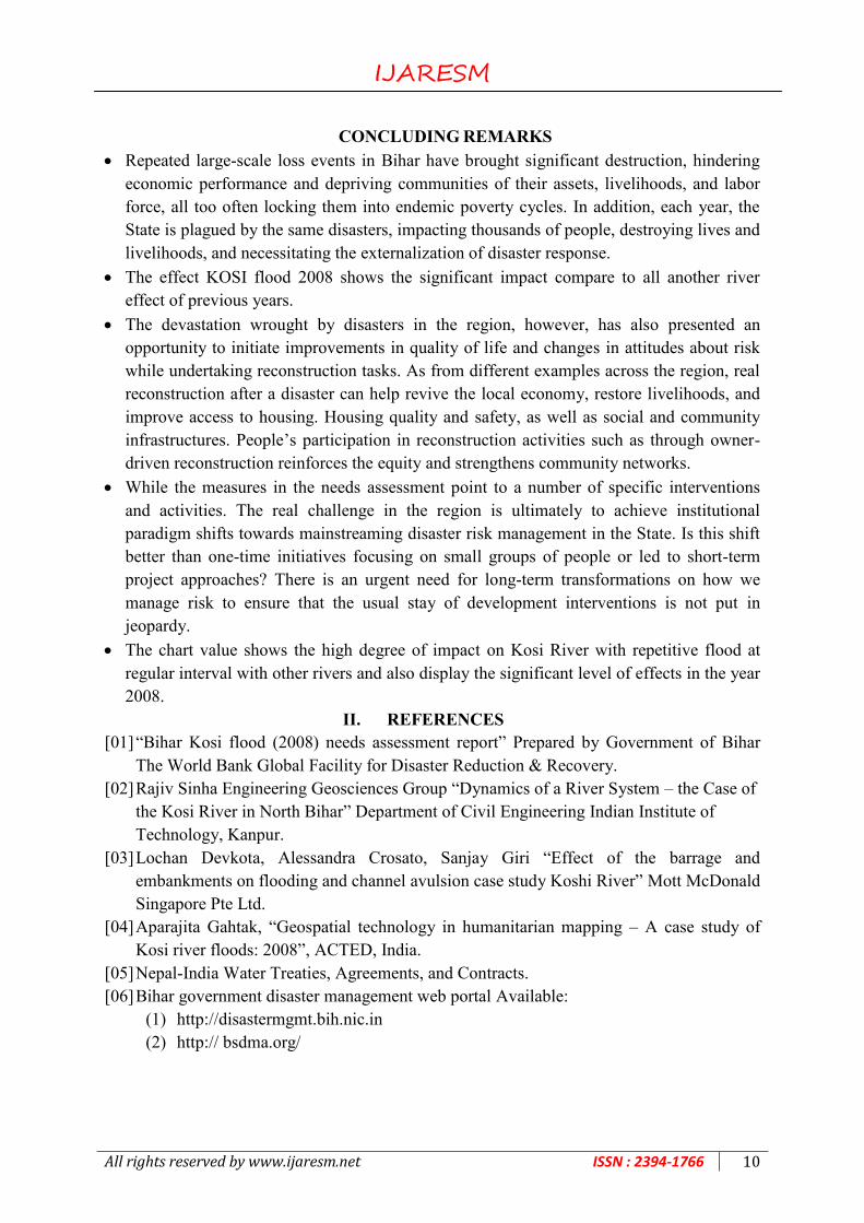
CONCLUDING REMARKS
Repeated large-scale loss events in Bihar have brought significant destruction, hindering
economic performance and depriving communities of their assets, livelihoods, and labor
force, all too often locking them into endemic poverty cycles. In addition, each year, the
State is plagued by the same disasters, impacting thousands of people, destroying lives and
livelihoods, and necessitating the externalization of disaster response.
The effect KOSI flood 2008 shows the significant impact compare to all another river
effect of previous years.
The devastation wrought by disasters in the region, however, has also presented an
opportunity to initiate improvements in quality of life and changes in attitudes about risk
while undertaking reconstruction tasks. As from different examples across the region, real
reconstruction after a disaster can help revive the local economy, restore livelihoods, and
improve access to housing. Housing quality and safety, as well as social and community
infrastructures. People‟s participation in reconstruction activities such as through owner-
driven reconstruction reinforces the equity and strengthens community networks.
While the measures in the needs assessment point to a number of specific interventions
and activities. The real challenge in the region is ultimately to achieve institutional
paradigm shifts towards mainstreaming disaster risk management in the State. Is this shift
better than one-time initiatives focusing on small groups of people or led to short-term
project approaches? There is an urgent need for long-term transformations on how we
manage risk to ensure that the usual stay of development interventions is not put in
jeopardy.
The chart value shows the high degree of impact on Kosi River with repetitive flood at
regular interval with other rivers and also display the significant level of effects in the year
2008.
II. REFERENCES
[01] “Bihar Kosi flood (2008) needs assessment report” Prepared by Government of Bihar
The World Bank Global Facility for Disaster Reduction & Recovery.
[02] Rajiv Sinha Engineering Geosciences Group “Dynamics of a River System – the Case of
the Kosi River in North Bihar” Department of Civil Engineering Indian Institute of
Technology, Kanpur.
[03] Lochan Devkota, Alessandra Crosato, Sanjay Giri “Effect of the barrage and
embankments on flooding and channel avulsion case study Koshi River” Mott McDonald
Singapore Pte Ltd.
[04] Aparajita Gahtak, “Geospatial technology in humanitarian mapping – A case study of
Kosi river floods: 2008”, ACTED, India.
[05] Nepal-India Water Treaties, Agreements, and Contracts.
[06] Bihar government disaster management web portal Available:
(1) http://disastermgmt.bih.nic.in
(2) http:// bsdma.org/