Embed Size (px)
Citation preview
Dynamics of the Marginal Late Wisconsin Miami Sublobe, Cincinnati, Ohio1
KKVIN M. SAVAGE2 AND THOMAS V. LOWELL, Department of Geology, University of Cincinnati, Cincinnati, OH 45221-0013
ABSTRACT. Physical characteristics and stratigraphic relationships of glacigenic diamictons in southwesternOhio have permitted interpretation of local activity and thermal regime of the ice margin beginning at about19,700 yr BP. At the Sharonville site near Cincinnati, pre-late Wisconsin sediments are overlain by four lateWisconsin lithofacies (three diamictons, one sand and gravel). At the base of the sequence, pre-late Wisconsinsediments are incorporated as blocks and lenses in the overlying diamictons, indicating erosion andentrainment, probably by freezing onto the glacier base. Facies 1 contains sand-filled shear planes and"smudges" of underlying sediments; the diamicton is interpreted to be a deformation till, which indicates achange in basal thermal regime to overall melting. Facies 2 contains blocks of clay, silt, and sorted sand andgravel, and is interpreted to be a subglacial meltout till, which represents deposition from melting, butstagnant, ice. Facies 3 is massive, with variable clast fabrics, and is interpreted to be a sediment flow deposit,reflecting continued marginal melting and recession. The uppermost facies is comprised of poorly sortedsand and gravel, and is interpreted to represent fluvial deposition. Portions of this sequence are stacked atthe southern end of the site, and indicate ice-marginal deformation associated with a reactivation of ice witha freezing basal regime in the study area. This sequence indicates at least two periods of active late Wisconsinice at Sharonville, and a number of fluctuations in basal thermal regime.
Ohio J. Sci. 92 (4): 107-118, 1992
INTRODUCTIONSouthwestern Ohio provides a unique opportunity to
study glacigenic sediment sequences at the margin of thesouthernmost advance of the Laurentide ice sheet (MiamiSublobe). The purpose of this study is to make aninterpretation of glacier conditions at this ice marginbeginning about 19,700 yrs BP based on sedimentologic,stratigraphic, and structural data. To accomplish this,presented here are descriptions of late Wisconsin sedimentsat Sharonville, OH, and the stratigraphic relationships ofthese facies, together with the physical conditions necessaryfor the formation of each facies. On the basis of theserelationships and characteristics, we propose a sequenceof changes in glacier activity and thermal regime of the ice-sediment system of the Laurentide ice sheet near itssouthern margin in Ohio.
Studies of glacigenic sediments have traditionallybeen three-part: 1) description of physical characteristics,2) interpretation of genesis, and 3) interpretation of glacierconditions. Within any single "set" of conditions, however,a variety of deposition processes can occur. Detailedanalyses of the structural and textural features within asedimentologic unit may narrow the number of likelyorigins for that unit, permitting an interpretation of thegenesis. Equally likely, however, is that different geneticprocesses may produce sediments with common charac-teristics, making genetic interpretations, in some cases,suspect (Boulton 1968, 1970; Dardis and McCabe 1987).
Shaw (1987) has recently used a two-part approach of:1) description of physical characteristics, and 2) interpretationof glacier conditions. He demonstrates how physicalcharacteristics within glacigenic sediments provide
'Manuscript received 15 January 1991 and in revised form 22 May1992 (#91-02).
2Present address: University of Cincinnati, Center Hill Facility, 5995Center Hill Rd., Cincinnati, OH 45224
specific clues about the glacier and environmentalconditions (i.e., frozen vs. freezing vs. melting thermalregimes; active vs. stagnant ice; subglacial vs. supra- orproglacial) necessary, or responsible, for their formation.This two-part approach emphasizes identification of glacierconditions, and lessens the necessity for interpretation ofa specific genesis for each unit. We use here the two-partapproach of Shaw (1987), interpreting genesis wherepossible, to develop a history of changes in marginalthermal regimes and ice activity near Cincinnati, OH.
MATERIALS AND METHODSDescription of the Sharonville Site
The study site is located in Sharonville, OH,approximately 20 km north of downtown Cincinnati, nearthe southern limit of the late Wisconsin Miami Sublobe(Fig. 1), and outside of the Hartwell Moraine, which istraditionally mapped as the southern limit of late Wisconsinglaciation (Gray et al. 1972). Recently-developedradiocarbon age-control on in situ stumps rooted inorganic silt (Lowell et al. 1990) indicates that the site wasoverrun by late Wisconsin ice. The site consists of outcropsin a north-trending stream valley incised into a drift-filledembayment in the bedrock uplands east of Mill CreekValley. Extensive stream erosion has provided numerousfresh exposures of unconsolidated sediment and bedrock.The units closest to stream level are the best exposed; theupper units remain slumped and covered. Nine of theseoutcrops have been studied in detail (Fig. 2). Theseoutcrops range from 2-5 m in height, and from 5-15 m inlength, and extend laterally over 700 m.
The generalized stratigraphic sequence exposed in thevalley includes Ordovician shale and limestone bedrockoverlain by both pre-late Wisconsin and late Wisconsinsediments. The bedrock surface within the embaymentslopes to the northwest (Fig. 2); strike and dip of thebedrock surface within the embayment, calculated from

108 MIAMI SUBLOBE DYNAMICS VOL. 92
48
/ASHARONVILLE SITE
;Prev ious lymapped late
Wisconsin limit
10 km
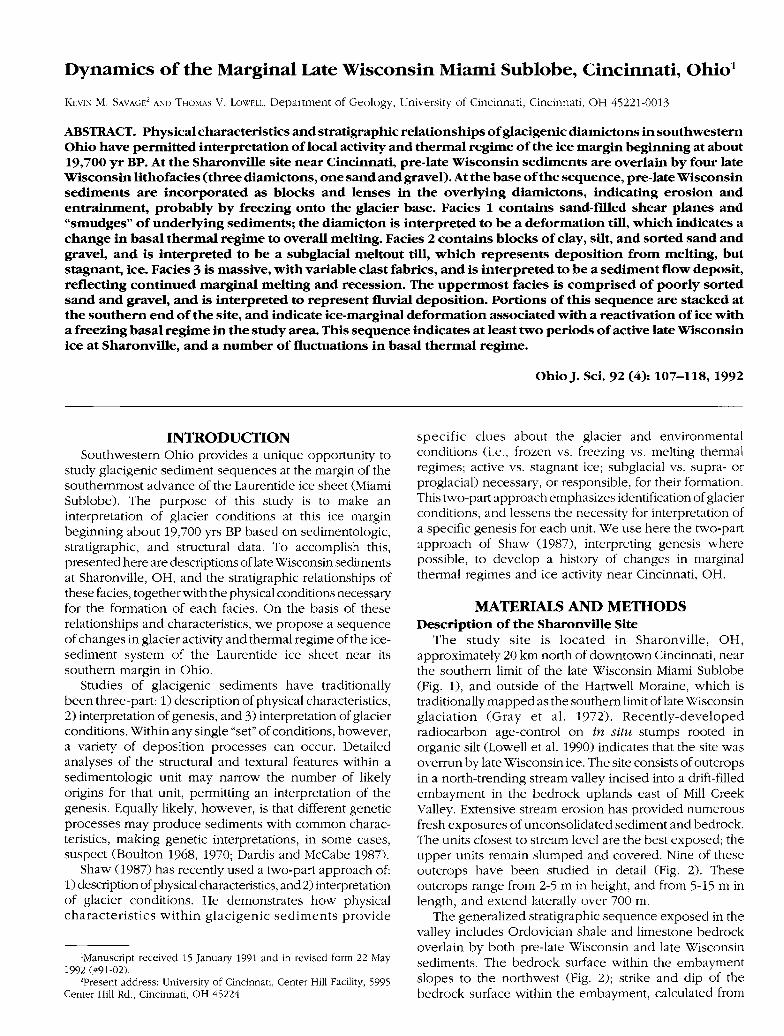
FIGURE 1. Location of the Sharonville site at the southern margin of the Miami sublobe of the Laurentide ice sheet. The site is on the dissected uplandeast of the Mill Creek Valley. A portion of the Hartwell moraine (the previously-mapped late Wisconsin limit) crosses the valley. Late Wisconsin icelimits after Dyke and Prest (1987), and Gray et al. (1972). (Figure reprinted with permission from Quaternary Research, Lowell et al. 1990.)
OHIO JOURNAL OF SCIENCE K. M. SAVAGE AND T. V. LOWELL 109
0 50
Contour Interval
TABLE 1
Summary of methodologies.
m
= 5 m
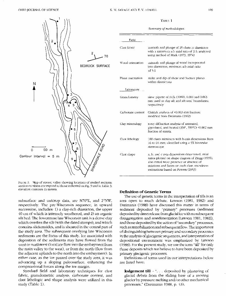
FIGURE 2. Map of stream valley showing locations of studied sections;section numbers correspond to those indicated on Fig. 9 and in Table 3;elevation contours in meters.
subsurface and outcrop data, are N70°E, and 2°NW,respectively. The pre-Wisconsin sequence, in upwardsuccession, includes: 1) a clay-rich diamicton, the upper40 cm of which is intensely weathered, and 2) an organicsilt bed. The lowermost late Wisconsin unit is a dense claywhich overlies the silt (with the dated stumps), and whichcontains slickensides, and is sheared in the central part ofthe study area. The subsequent overlying late Wisconsinsediments are the focus of this study. Ice associated withdeposition of the sediments may have flowed from thewest or northwest (local ice flow into the embayment fromthe main valley to the west), or from the north (flow fromthe adjacent uplands to the north into the embayment). Ineither case, as the ice passed over the study area, it wasadvancing up a sloping paleosurface, enhancing thecompressional forces along the ice margin.
Standard field and laboratory techniques for clastfabric, granulometric analysis, carbonate content, andclast lithologic and shape analysis were utilized in thisstudy (Table 1).
Field
Clast fabric
Wood orientation
Plane orientation
Laboratory
Granulometry
Carbonate content
Clay mineralogy
Clast lithology
Clast shape
azimuth and plunge of 25 clasts in diamictonwith a minimum a:b axial ratio of 2:1; analyzedusing method of Mark (1973, 1974)
azimuth and plunge of wood incorporatedinto diamicton; minimum a:b axial ratioof 5:1
strike and dip of shear and fracture planeswithin diamictons
sieve-pipette of Folk (1980); 0.004 and 0.063mm used as clay-silt and silt-sand boundaries,respectively
Chittick analysis of <0.063 mm fraction;modified from Dreimanis (1962)
x-ray diffraction analysis of untreated,glycolated, and heated (350°, 55O°C) <0.002 mmfraction of matrix
100 clasts miminum with b-axis dimensions from16 to 64 mm; identified using a 5X binocularstereoscope
a, b, and c axis dimensions determined; axialratios plotted on shape diagram of Zingg (1935);also noted were presence or absence ofstriations and facets on each clast; roundnessestimations based on Powers (1953)
Definition of Genetic TermsThe use of genetic terms in the interpretation of tills is an
area open to much debate. Lawson (1981, 1982) andDreimanis (1988) have discussed this matter in terms ofsediment deposited by "primary" processes (sedimentdeposited by direct release from glacial ice with no subsequentdisaggregation and resedimentation [Lawson 1981, 1982]),and those deposited by the action of "secondary" processes,such as remobilization and subsequent flow. The importanceof distinguishing between primary and secondary processesin the analysis of glacigenic sequences, and interpretation ofdepositional environment was emphasized by Lawson(1988). For the present study, we use the term "till" for onlythose deposits which we believe to have been deposited byprimary glacigenic processes.
Definitions of terms used in our interpretations beloware listed here:
lodgement t i l l - " . . . deposited by plastering ofglacial debris from the sliding base of a movingglacier by pressure melting and/or other mechanicalprocesses." (Dreimanis 1988, p. 43);
110 MIAMI SUBLOBE DYNAMICS VOL. 92
deformation till-"... weak rock or unconsolidatedsediment that has been detached from its source, theprimary sedimentary structures distorted or destroyed,and some foreign matter admixed . . .." (Elson 1988,p. 85);
meltout till - ". . . deposited by a slow release ofglacial debris from ice that is not sliding or deforminginternally . . .." (Dreimanis 1988, p. 45).
For resedimented materials, which may be the result ofseveral secondary processes (Lawson 1979,1981; Dreimanis1988), we use the term "sediment flow deposit" todescribe deposits resulting from those processes. Thesedeposits, while not providing direct information on theglacier itself, may provide information on the local climateand hydrology, as well as other factors affecting thedepositional processes (Lawson 1988).
RESULTSFacies Descriptions
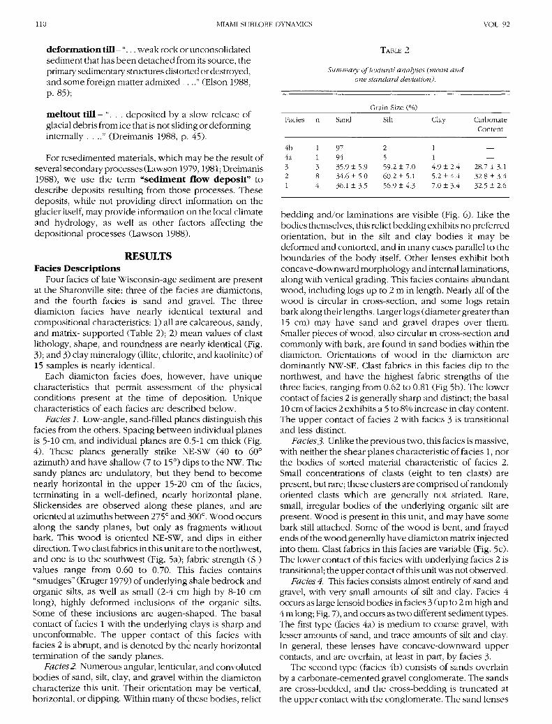
Four facies of late Wisconsin-age sediment are presentat the Sharonville site; three of the facies are diamictons,and the fourth facies is sand and gravel. The threediamicton facies have nearly identical textural andcompositional characteristics: 1) all are calcareous, sandy,and matrix- supported (Table 2); 2) mean values of clastlithology, shape, and roundness are nearly identical (Fig.3); and 3) clay mineralogy (illite, chlorite, and kaolinite) of15 samples is nearly identical.
Each diamicton facies does, however, have uniquecharacteristics that permit assessment of the physicalconditions present at the time of deposition. Uniquecharacteristics of each facies are described below.
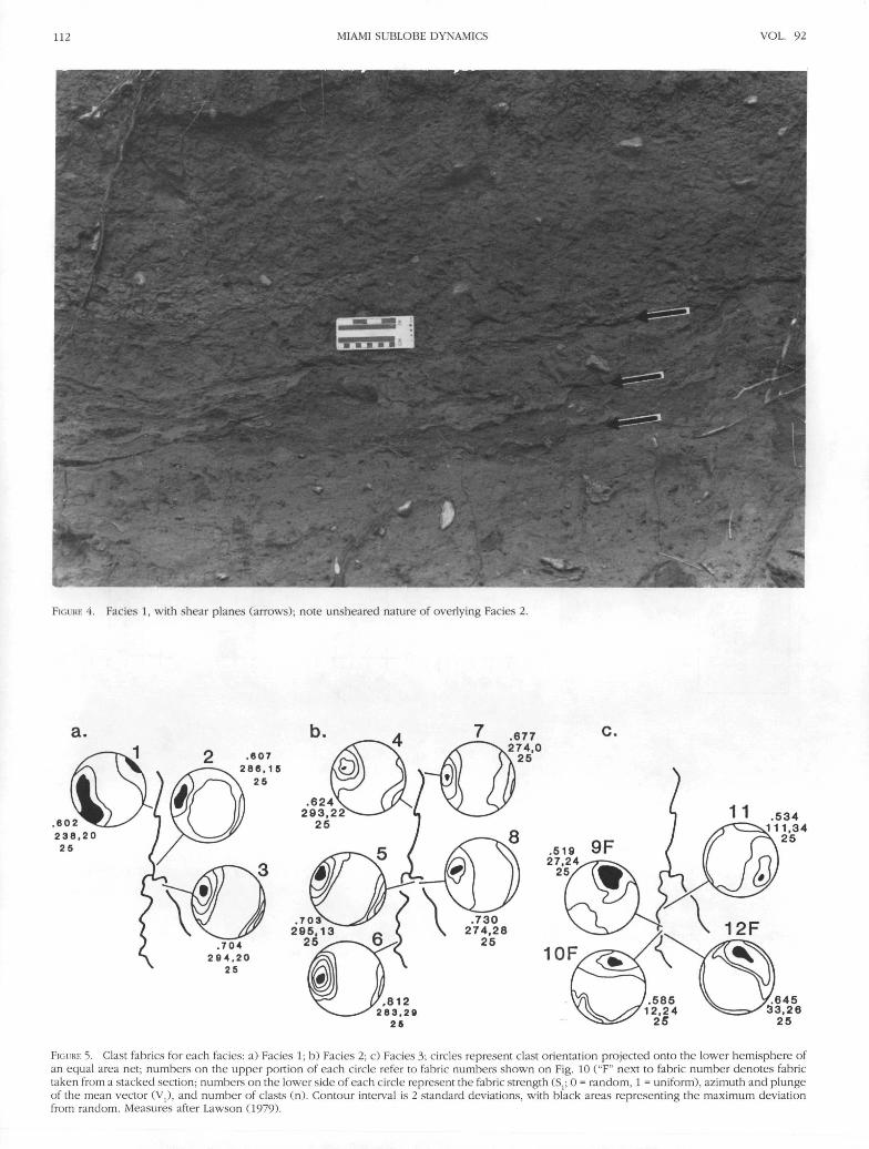
Facies 1. Low-angle, sand-filled planes distinguish thisfacies from the others. Spacing between individual planesis 5-10 cm, and individual planes are 0.5-1 cm thick (Fig.4). These planes generally strike NE-SW (40 to 60°azimuth) and have shallow (7 to 15°) dips to the NW. Thesandy planes are undulatory, but they bend to becomenearly horizontal in the upper 15-20 cm of the facies,terminating in a well-defined, nearly horizontal plane.Slickensides are observed along these planes, and areoriented at azimuths between 275° and 300°. Wood occursalong the sandy planes, but only as fragments withoutbark. This wood is oriented NE-SW, and dips in eitherdirection. Two clast fabrics in this unit are to the northwest,and one is to the southwest (Fig. 5a); fabric strength (S:)values range from 0.60 to 0.70. This facies contains"smudges" (Kruger 1979) of underlying shale bedrock andorganic silts, as well as small (2-4 cm high by 8-10 cmlong), highly deformed inclusions of the organic silts.Some of these inclusions are augen-shaped. The basalcontact of facies 1 with the underlying clays is sharp andunconformable. The upper contact of this facies withfacies 2 is abrupt, and is denoted by the nearly horizontaltermination of the sandy planes.
Facies2. Numerous angular, lenticular, and convolutedbodies of sand, silt, clay, and gravel within the diamictoncharacterize this unit. Their orientation may be vertical,horizontal, or dipping. Within many of these bodies, relict
TABLE 2
Summary of textural analyses (mean andone standard deviation).
Facies
4b4a321
n
11384
Sand
979435.9 ±5.934.6 ± 5.036.1 ± 3.5
Grain Size (%)
Silt
2559.2 ±60.2 ±56.9 ±
754
.0
.1
.3
Clay
114.9 ± 2.45.2 ± 4.47.0 ±3.4
CarbonateContent
_
—28.7 ± 3.132.8 + 3.432.5 ± 2.6
bedding and/or laminations are visible (Fig. 6). Like thebodies themselves, this relict bedding exhibits no preferredorientation, but in the silt and clay bodies it may bedeformed and contorted, and in many cases parallel to theboundaries of the body itself. Other lenses exhibit bothconcave-downward morphology and internal laminations,along with vertical grading. This facies contains abundantwood, including logs up to 2 m in length. Nearly all of thewood is circular in cross-section, and some logs retainbark along their lengths. Larger logs (diameter greater than15 cm) may have sand and gravel drapes over them.Smaller pieces of wood, also circular in cross-section andcommonly with bark, are found in sand bodies within thediamicton. Orientations of wood in the diamicton aredominantly NW-SE. Clast fabrics in this facies dip to thenorthwest, and have the highest fabric strengths of thethree facies, ranging from 0.62 to 0.81 (Fig 5b). The lowercontact of facies 2 is generally sharp and distinct; the basal10 cm of facies 2 exhibits a 5 to 8% increase in clay content.The upper contact of facies 2 with facies 3 is transitionaland less distinct.
Facies3- Unlike the previous two, this facies is massive,with neither the shear planes characteristic of facies 1, northe bodies of sorted material characteristic of facies 2.Small concentrations of clasts (eight to ten clasts) arepresent, but rare; these clusters are comprised of randomlyoriented clasts which are generally not striated. Rare,small, irregular bodies of the underlying organic silt arepresent. Wood is present in this unit, and may have somebark still attached. Some of the wood is bent, and frayedends of the wood generally have diamicton matrix injectedinto them. Clast fabrics in this facies are variable (Fig. 5c).The lower contact of this facies with underlying facies 2 istransitional; the upper contact of this unit was not observed.
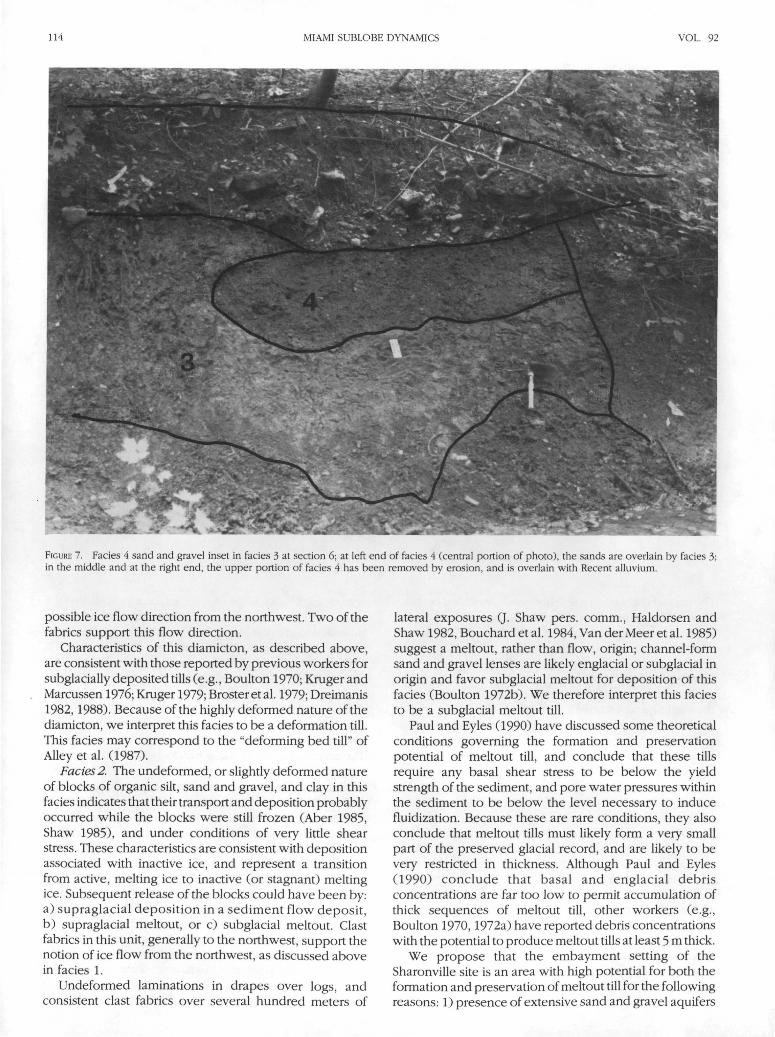
Facies 4. This facies consists almost entirely of sand andgravel, with very small amounts of silt and clay. Facies 4occurs as large lensoid bodies in facies 3 (up to 2 m high and4 m long; Fig. 7), and occurs as two different sediment types.The first type (facies 4a) is medium to coarse gravel, withlesser amounts of sand, and trace amounts of silt and clay.In general, these lenses have concave-downward uppercontacts, and are overlain, at least in part, by facies 3-
The second type (facies 4b) consists of sands overlainby a carbonate-cemented gravel conglomerate. The sandsare cross-bedded, and the cross-bedding is truncated atthe upper contact with the conglomerate. The sand lenses
OHIO JOURNAL OF SCIENCE K. M. SAVAGE AND T. V. LOWELL 111
LITH0L0GY
75-i
SHAPE FEATURES ROUNDNESS
LOCAL
10—1
FIGURE 3- Clast characteristics, including lithologic composition, shape, features, and roundness for facies 1, 2, 3, and 4; lithologies include limestone(LS), green shale (GRSH), dolomite (DOL), black shale (BLSH), chert (CHT), sandstone (SS), undifferentiated igneous (IGN), and undifferentiatedmetamorphics (MET); fossiliferous limestone and calcareous green shale comprise the locally-derived lithologies; dolomite, chert, and black shale areregionally-derived lithologies, and represent a minimum clast transport distance of 45 to 50 km; all other lithologies are distally-derived, and representa minimum transport distance of 240 km. Roundness categories are very angular (VA), angular (A), subangular (SA), subrounded (SR), rounded (R),and well-rounded (WR).
are less than one meter thick, and range from 2 to 3 m inlateral extent. The conglomerate is 0.35 to 0.45 m thick,and its lateral extent is the same as the underlying sand atall locations.
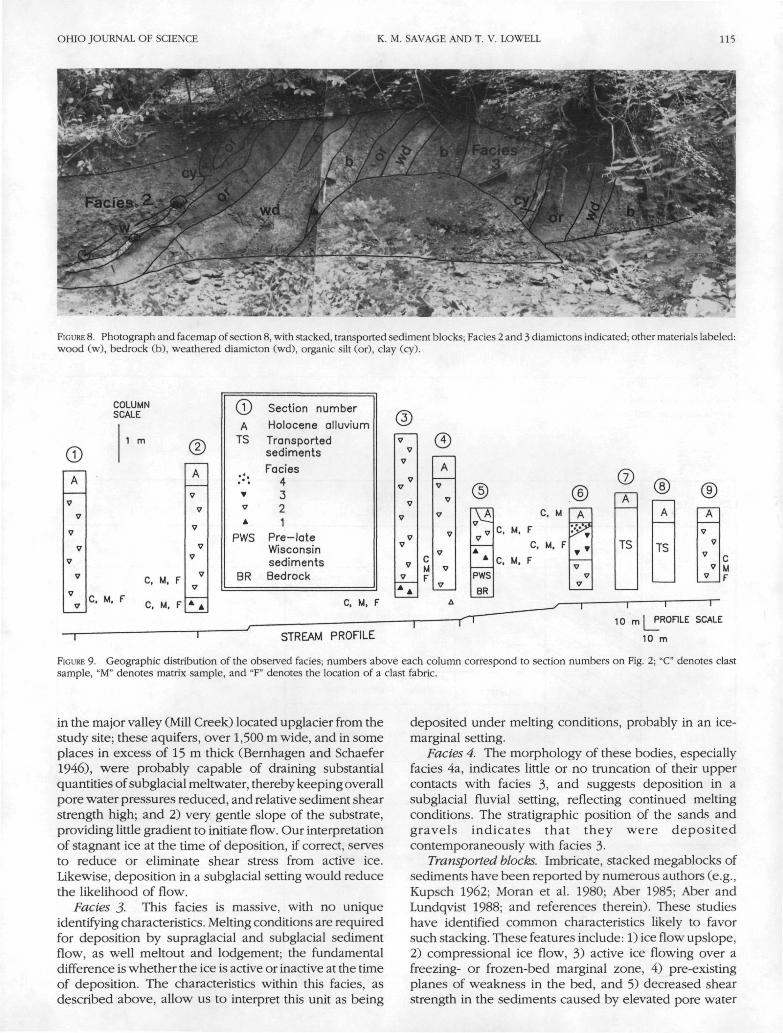
Transported blocks. In two exposures at the southernend of the study area, the entire assemblage of pre-lateWisconsin sediments (weathered shale bedrock, alteredand leached diamicton, organic silt, and massive clay), aswell as facies 2 and/or 3, occur as transported blocks, orfloes. A key characteristic of this package of sediments isthat they have been transported, rotated, and deposited as
a series of imbricate blocks.At section 7, two blocks are observed; at the contact
between the two blocks, weathered shale bedrock (theoldest exposed unit in the valley) overlies the massivediamicton of facies 3 (the youngest observed diamicton inthe valley). At section 8 (Fig. 8), the older sediments repeatthree times: once as a "partial" sequence (only theweathered shale and organic-rich silt are present), andtwice as "complete" sequences (weathered bedrock throughfacies 2 or 3 diamictons). At each contact between blocks,older sediments are observed to overlie younger sediments.
PE
RC
EN
T
OF
T
OT
AL
CU
\ST
S
IN
FA
CE
S
FA
CE
S
4FL
UV
IAL
n =
10
6
FA
CE
S
3SE
DIM
ENT
FLO
W
n =
33
7
FA
CIE
S
2M
ELTO
UT
n =
79
4
FA
CIE
S
1D
EF
OR
MA
TIO
N
n =
3
10
112 MIAMI SUBLOBE DYNAMICS VOL. 92
FIGURE 4. Fades 1, with shear planes (arrows); note unsheared nature of overlying Facies 2.
a.
FIGURE 5. Clast fabrics for each facies: a) Facies 1; b) Facies 2; c) Facies 3; circles represent clast orientation projected onto the lower hemisphere ofan equal area net; numbers on the upper portion of each circle refer to fabric numbers shown on Fig. 10 ("F" next to fabric number denotes fabrictaken from a stacked section; numbers on the lower side of each circle represent the fabric strength (S,; 0 = random, 1 = uniform), azimuth and plungeof the mean vector (Vj), and number of clasts (n). Contour interval is 2 standard deviations, with black areas representing the maximum deviationfrom random. Measures after Lawson (1979).

OHIO JOURNAL OF SCIENCE K. M. SAVAGE AND T. V. LOWELL 113
FIGURE 6. Sand and gravel lens in fades 2; note bedding preserved within this lens.
The contacts between these sequences have strikes between0 and 35° azimuth. Clast fabrics from facies 3 diamictonwithin the stacked sequences (Fig. 5; fabrics 9, 10, 12) areall to the northeast.
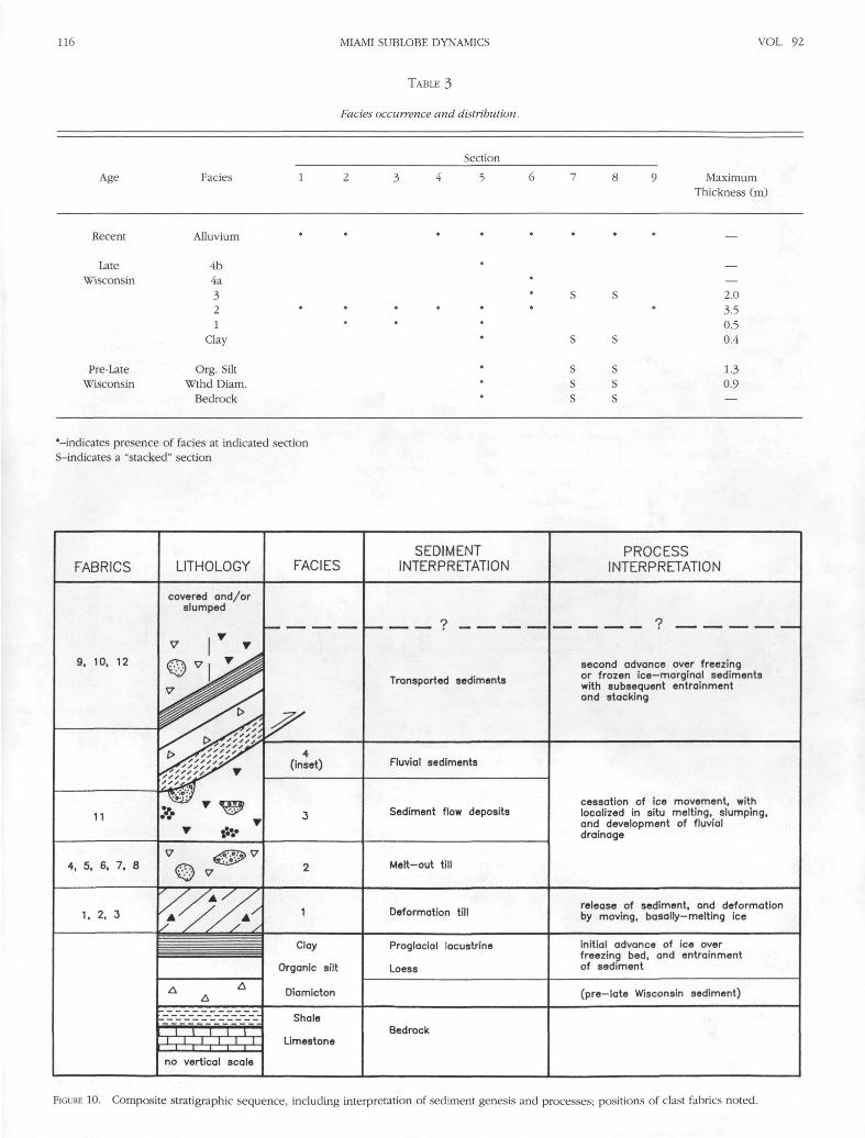
Composite StratigraphyStratigraphic relationships observed at four sections in
the central and southern portions of the valley (Fig. 9;Table 3, sections 5-8) were used to construct a compositestratigraphy for the site (Fig. 10). These sites were usedbecause they contain the best exposures of multiple unitsequences. Pre-late Wisconsin sediments observed in atrench at section 5 were in situ, and are the oldest units. Alsoat section 5, massive clays, and facies 1 and 2 form the baseof the late Wisconsin sequence. At section 6, approximately80 m south of section 5, facies 2,3, and 4a were found; thesesediments represent the next portion of the sequence. Atsections 7 and 8, the incorporation of facies 3 in the blocksof transported sediments indicates that this transport/deformation occurred after facies 3 deposition. Eight of thenine sections are capped by Recent alluvium.
Interpretation of Glacier Conditions andDiamicton Genesis
Pre-late Wisconsin sediments. Angular blocks of thesesediments within the diamicton facies provide informationabout the first late Wisconsin advance over the site. The
organic silt blocks in the overlying facies indicate that thesubstratum was probably initially unfrozen, and wassubjected to erosion by net basal freezing associated withthe overriding of active ice (Weertman 1961; Shaw 1971,1987; Boulton 1979; Wickham and Johnson 1981). Thisoccurred prior to, or contemporaneous with the depositionof the parent material for facies 1. The paucity of blocksof the pre-late Wisconsin diamicton or bedrock in theoverlying diamictons suggests that the depth ofincorporation was restricted to the organic silt horizon.The angular nature of these blocks suggests transport asfrozen blocks, and may be the result of brittle fracture.
Facies 1. The sandy planes are interpreted to be shearplanes; these shears, together with the highly deformedinclusions of the underlying organic silt reflect the deformednature of this unit. Deposition of this facies, and itssubsequent deformation may have been contemporaneouswith a change from frozen/freezing to melting basalconditions associated with still-active ice. Deformation ofthe underlying clays supports the idea of a frozen (freezing)to basal melting transition (Boulton 1972b, Hansel et al.1987, A. Dreimanis pers. comm.), and a thawing of theunderlying sediments. Shearing, such as that noted in thisfacies, has been interpreted by Boulton et al. (1974) to bean ice-marginal process. Orientations of the shear planes,interpreted to be dipping upglacier (Hicock and Dreimanis1985), and the slickensides along the planes, indicate a
114 MIAMI SUBLOBE DYNAMICS VOL. 92
FIGURE 7. Facies 4 sand and gravel inset in facies 3 at section 6; at left end of facies 4 (central portion of photo), the sands are overlain by facies 3;in the middle and at the right end, the upper portion of facies 4 has been removed by erosion, and is overlain with Recent alluvium.
possible ice flow direction from the northwest. Two of thefabrics support this flow direction.
Characteristics of this diamicton, as described above,are consistent with those reported by previous workers forsubglacially deposited tills (e.g., Boulton 1970; Kruger andMarcussen 1976; Kruger 1979; Broster et al. 1979; Dreimanis1982,1988). Because of the highly deformed nature of thediamicton, we interpret this facies to be a deformation till.This facies may correspond to the "deforming bed till" ofAlley et al. (1987).
Facies 2. The undeformed, or slightly deformed natureof blocks of organic silt, sand and gravel, and clay in thisfacies indicates that their transport and deposition probablyoccurred while the blocks were still frozen (Aber 1985,Shaw 1985), and under conditions of very little shearstress. These characteristics are consistent with depositionassociated with inactive ice, and represent a transitionfrom active, melting ice to inactive (or stagnant) meltingice. Subsequent release of the blocks could have been by:a) supraglacial deposition in a sediment flow deposit,b) supraglacial meltout, or c) subglacial meltout. Clastfabrics in this unit, generally to the northwest, support thenotion of ice flow from the northwest, as discussed abovein facies 1.
Undeformed laminations in drapes over logs, andconsistent clast fabrics over several hundred meters of
lateral exposures (J. Shaw pers. comm., Haldorsen andShaw 1982, Bouchard et al. 1984, Van der Meer et al. 1985)suggest a meltout, rather than flow, origin; channel-formsand and gravel lenses are likely englacial or subglacial inorigin and favor subglacial meltout for deposition of thisfacies (Boulton 1972b). We therefore interpret this faciesto be a subglacial meltout till.
Paul and Eyles (1990) have discussed some theoreticalconditions governing the formation and preservationpotential of meltout till, and conclude that these tillsrequire any basal shear stress to be below the yieldstrength of the sediment, and pore water pressures withinthe sediment to be below the level necessary to inducefluidization. Because these are rare conditions, they alsoconclude that meltout tills must likely form a very smallpart of the preserved glacial record, and are likely to bevery restricted in thickness. Although Paul and Eyles(1990) conclude that basal and englacial debrisconcentrations are far too low to permit accumulation ofthick sequences of meltout till, other workers (e.g.,Boulton 1970,1972a) have reported debris concentrationswith the potential to produce meltout tills at least 5 m thick.
We propose that the embayment setting of theSharonville site is an area with high potential for both theformation and preservation of meltout till for the followingreasons: 1) presence of extensive sand and gravel aquifers
OHIO JOURNAL OF SCIENCE K. M. SAVAGE AND T. V. LOWELL 115
FIGURE 8. Photograph and facemap of section 8, with stacked, transported sediment blocks; Facies 2 and 3 diamictons indicated; other materials labeled:wood (w), bedrock (b), weathered diamicton (wd), organic silt (or), clay (cy).
COLUMNSCALE
1 m
C. M, F
C, M, F
C, M. F
©A
TS
A
PWS
BR
Section number
Holocene alluvium
Transportedsediments
Facies4321
Pre-lateWisconsinsedimentsBedrock
C, M, F
(3J7
V
7
77
V
7
Vy
V
7
AA
cMF
A
V
©\ A
AA
PWS
BR
C, M
C, M. F
C, M, F
C. M. F
A
TS
A
TS
A
V
7
V
7V
STREAM PROFILE
10 m l PROFILE SCALE
10 m
FIGURE 9. Geographic distribution of the observed facies; numbers above each column correspond to section numbers on Fig. 2; "C" denotes clastsample, "M" denotes matrix sample, and "F" denotes the location of a clast fabric.
in the major valley (Mill Creek) located upglacier from thestudy site; these aquifers, over 1,500 m wide, and in someplaces in excess of 15 m thick (Bernhagen and Schaefer1946), were probably capable of draining substantialquantities of subglacial meltwater, thereby keeping overallpore water pressures reduced, and relative sediment shearstrength high; and 2) very gentle slope of the substrate,providing little gradient to initiate flow. Our interpretationof stagnant ice at the time of deposition, if correct, servesto reduce or eliminate shear stress from active ice.Likewise, deposition in a subglacial setting would reducethe likelihood of flow.
Facies 3- This facies is massive, with no uniqueidentifying characteristics. Melting conditions are requiredfor deposition by supraglacial and subglacial sedimentflow, as well meltout and lodgement; the fundamentaldifference is whether the ice is active or inactive at the timeof deposition. The characteristics within this facies, asdescribed above, allow us to interpret this unit as being
deposited under melting conditions, probably in an ice-marginal setting.
Facies 4. The morphology of these bodies, especiallyfacies 4a, indicates little or no truncation of their uppercontacts with facies 3, and suggests deposition in asubglacial fluvial setting, reflecting continued meltingconditions. The stratigraphic position of the sands andgravels indicates that they were depositedcontemporaneously with facies 3-
Transported blocks. Imbricate, stacked megablocks ofsediments have been reported by numerous authors (e.g.,Kupsch 1962; Moran et al. 1980; Aber 1985; Aber andLundqvist 1988; and references therein). These studieshave identified common characteristics likely to favorsuch stacking. These features include: 1) ice flow upslope,2) compressional ice flow, 3) active ice flowing over afreezing- or frozen-bed marginal zone, 4) pre-existingplanes of weakness in the bed, and 5) decreased shearstrength in the sediments caused by elevated pore water
116 MIAMI SUBLOBE DYNAMICS VOL. 92
TABLE 3
Fades occurrence and distribution.
Age Facies
Section
MaximumThickness (m)
Recent
LateWisconsin
Pre-LateWisconsin
Alluvium
4b4a321
Clay
Org. SiltWthd Diam
Bedrock
2.03.50.50.4
1.30.9
•-indicates presence of facies at indicated sectionS-indicates a "stacked" section
FABRICS LITHOLOGY FACIESSEDIMENT
INTERPRETATIONPROCESS
INTERPRETATION
9, 10, 12
11
covered and/orslumped
Transported sediments
4(inset) Fluvial sediments
Sediment flow deposits
4, 5, 6, 7, 8 Melt-out till
second advance over freezingor frozen ice—marginal sedimentswith subsequent entrainmentand stacking
cessation of ice movement, withlocalized in situ melting, slumping,and development of fluvialdrainage
1, 2, 3 1 Deformation tillrelease of sediment, and deformationby moving, basally--melting ice
Clay
Organic silt
Diamicton
Proglacial lacustrine
Loess
Shale
LimestoneBedrock
no vertical scale
initial advance of ice overfreezing bed, and entrainmentof sediment
(pre-late Wisconsin sediment)
FIGURE 10. Composite stratigraphic sequence, including interpretation of sediment genesis and processes; positions of ciast fabrics noted.
OHIO JOURNAL OF SCIENCE K. M. SAVAGE AND T. V. LOWELL 117
pressure. The first two factors are readily applicable to thissite because of the geomorphic setting and interpreted iceflow direction. Factor 3 is consistent because it is near theterminus of the late Wisconsin advance, and ice flow mayhave been over a freezing or frozen bed. Weathered,highly fissile shale bedrock is the basal unit affected by thestacking; the fissility of the shale is consistent with thefourth factor. Moreover, the unweathered bedrock is likelyless permeable than the overlying weathered bedrock andunlithified sediments, and may act to promote localizedzones of high pore water pressures, consistent with factor5. The mechanism discussed above has been termed"glacial-thrust" (Moran et al. 1980), or "ice-thrust."
The youngest unit obviously affected by the stacking isfacies 3; therefore, the interpreted reactivation of ice flowover the site had to have occurred after deposition of facies3 from stagnant ice. We interpret the stacking at Sharonvilleto be the result of ice-marginal deformation processesassociated with reactivation of ice in the embayment.
DISCUSSION AND CONCLUSIONSOn the basis of sedimentologic, structural, and
stratigraphic data, we are able to reconstruct a sequenceof changes in the activity and basal thermal regime of theice at this site, beginning at about 19,700 yr BP. Theinterpreted sequence of glacier conditions, from oldest toyoungest, is:
1) active ice flow over a freezing bed (entrainment ofpre-late Wisconsin sediments);
2) basally-melting, active ice (facies 1 deposition anddeformation);
3) melting, inactive ice (facies 2,3, and 4 deposition);4) active ice flow over a freezing bed ("thrusting" and
stacking of megablocks of ice-marginal sediment);and
5) melting, inactive ice (deposition of megablocks).
It is important to note that the thermal "zones" describedin previous sections are generally margin parallel, andmay be quite narrow (e.g., Kupsch 1962; Moran et al. 1980;Wickham and Johnson 1981).
The proposed sequence lends itself to the formulationof two hypotheses to account for the origin of thelithofacies and associated deformation. The primarydifference between the two hypotheses lies in the causefor ice stagnation responsible for facies 2 and 3 deposition.In the first hypothesis, the observed stratigraphic sequencereflects only changes in the character of the ice lyingwithin the bedrock embayment. In this hypothesis, icewithin the embayment became detached from the main,still-active ice mass in the Mill Creek Valley, and stagnated,resulting in deposition of facies 2 meltout till and facies 3sediment flow sediments. After some time, ice within theembayment again became active, mobilizing oldersediments. This hypothesis is testable by description of thepresence or absence of similar sequence of changes in theactivity and basal thermal regime at sites outside of theembayment. If this sequence is not observed elsewhere,the changes in the nature of the ice may be restricted toa small area, and likely represent only a reactivation of
locally stagnant ice. It must be emphasized that it is thesequence of changes in ice behavior, not the specificsedimentary sequence, that must be identified to test thehypothesis.
In the second hypothesis, facies 2 and 3 representregional cessation of ice movement and subsequentmelting. Entrainment and transport of older sedimentsrepresents regional reactivation of ice, and implies regionalchanges in boundary conditions of the glacier. Thishypothesis is testable by additional study across the MiamiSublobe.
We offer the following site-specific and generalconclusions: 1) sedimentologic, structure, and stratigraphicdata from a glacigenic sequence at the southern margin ofthe Miami sublobe of the Laurentide ice sheet reflect asequence of ice advance — stagnation/recession —readvance, beginning about 19,700 yr BP; 2) these dataalso indicate complex changes in the thermal regime of theice at a marginal setting; 3) the sediments reflect active,subglacial deposition at a site outside of the traditionally-mapped late Wisconsin limit; and 4) preservation of asignificant thickness of meltout till may be attributed to aspecific set of local geologic and geomorphic conditions.
ACKNOWLEDGEMENTS. This work was supported by a University ResearchCouncil Summer Fellowship and by a Fenneman Summer ResearchFellowship. A. Dreimanis, A. Hansel, S. Brockman, J. Shaw, andanonymous reviewers critically reviewed early drafts of this manuscript.C. Dietsch and K. Dejong provided laboratory advice and review. N.Baker and M. Ekberg assisted in the field. L. Messick drafted the figures.
LITERATURE CITEDAber, J. S. 1985 The character of glaciotectonism. Geol. Mijn. 64: 389-
395.and J. Lundqvist 1988 Glaciotectonic structures in central
Sweden and their significance for glacial theory. Geog. Phys. Quat.42: 315-323.
Alley, R. B., D. D. Blankenship, S. T. Rooney, and C. R. Bentley 1987Continuous till deformation beneath ice sheets. The Physical Basisof Ice Sheet Modelling. IAHS Publ. 170: 81-91.
Bemhagen, R. J. and E. J. Schaefer 1946 Ground-water conditions inButler and Hamilton Counties, Ohio. Ohio Dept. Nat. Res. Div. WaterBull. 8: 35.
Bouchard, M. A., B. Cadieux, and F. Goutier 1984 L'Origine et lescaracteristiques des lithofacies du till dans le secteur nord du LacAlbanel, Quebec: une etude de la dipersion glaciaire clastique. In.J. Guha and E. H. Chown, eds., Chibougamau, Stratigraphy andMineralization. Can. Inst. Min. Metall., Spec. Vol. 34. pp. 244-260.
Boulton, G. S. 1968 Flow tills and related deposits on someVestspitsbergen glaciers. Jour. Glaciology 7: 391-412.
1970 On the deposition of subglacial and meltout tills at themargins of certain Svalbard glaciers. Jour. Glaciology 9: 231-245.
1972a Modern Arctic glaciers as depositional models for formerice sheets. Jour. Geol. Soc. London 128: 361-393-
1972b The role of thermal regime in glacial sedimentation. In:R. J. Price and D. E. Sugden, eds., Polar Geomorphology. Spec. Publ.,Inst. Brit. Geog. 4. pp. 1-19.
1979 Processes of glacier erosion on different substrata. Jour.Glaciology 23: 15-38.
_, D. L. Dent, and E. M. Morris 1974 Subglacial shearing and therole of water pressures in tills from south-east Iceland. Geogr. Annl.56A: 135-145.
Broster, B. E., A. Dreimanis, andj. C. White 1979 A sequence of glacialdeformation, erosion, and deposition at the ice-rock interface duringthe last deglaciation: Cranbrook, British Columbia, Canada. Jour.Glaciology 23: 283-295.
Dardis, G. F. and A. M. McCabe 1987 Subglacial sheetwash and debrisflow deposits in late-Pleistocene drumlins, Northern Ireland. In:J. Menzies and J. Rose, eds., Drumlin Symposium. A. A. Balkema,Rotterdam, pp. 225-240.

118 MIAMI SUBLOBE DYNAMICS VOL. 92
Dreimanis, A. 1962 Quantitative gasometric determination of calciteand dolomite by using Chittick apparatus. Jour. Sed. Pet. 32: 520-529.
1982 Two origins of the stratified Catfish Creek Till at PlumPoint, Ontario. Boreas 11: 173-180.
1988 Tills: Their genetic terminology and classification. In: R.
1982 Mobilization, movement, and deposition of activesubaerial sediment flows, Matanuska Glacier, Alaska. Jour. Geol. 90:279-300.
1988 Glacigenic resedimentation: classification concepts and
P. Goldthwait and C. L. Matsch, eds., Genetic Classification ofGlacigenic Deposits. A. A. Balkema, Rotterdam, pp. 17-84.
Dyke, A. S. andV. K. Prest 1987 Late Wisconsinan and Holocene retreatof the Laurentide ice sheet. Geological Survey of Canada Map 1702A.1:5,000,000.
Elson, J. 1988 Comment on glaciotectonite, deformation till, andcomminution till. In: R. P. Goldthwait and C. L. Matsch, eds., GeneticClassification of Glacigenic Deposits. A. A. Balkema, Rotterdam.pp. 85-88.
Folk, R. L. 1980 Petrology of Sedimentary Rocks. Hemphill Publ. Co.,Austin, TX.
Gray, H. H., J. L. Forsyth, A. F. Schneider, and A. M. Gooding 1972Geologic map of the 1° X 2° Cincinnati Quadrangle, Indiana andOhio, showing bedrock and unconsolidated deposits. Indiana Geol.Surv., Regional Map 7, Part B. 1:250,000.
Haldorsen, S. and J. Shaw 1982 The problem of recognizing meltouttill. Boreas 11: 261-277.
Hansel, A. K., W. H. Johnson, and B. J. Socha 1987 Sedimentologicalcharacteristics and genesis of basal tills at Wedron, Illinois. Geol.Surv. Finland, Spec. Paper 3: 11-21.
Hicock, S. R. and A. Dreimanis 1985 Glaciotectonic structures as usefulice movement indicators in glacial deposits: four Canadian casestudies. Can. Jour. Earth Sci. 22: 339-346.
Kruger, J. 1979 Structures and textures in till indicating subglacialdeposition. Boreas 8: 323-340.
andl.Marcussen 1976 Lodgement till and flow till: a discussion.Boreas 5: 61-64.
Kupsch, W. O. 1962 Ice-thrust ridges in western Canada. Jour. Geology70: 582-594.
Lawson, D. E. 1979 Sedimentologic analysis of the western terminusregion of the Matanuska Glacier, Alaska. CRREL Rept. 79-9: 112.
1981 Sedimentologic characteristics and classification ofdepositional processes and deposits in the glacial environment.CRREL Rept. 81-27: 16.
application to mass-movement processes and deposits. In: R. P.Goldthwait and C. L. Matsch, eds., Genetic Classification of GlacigenicDeposits. A. A. Balkema, Rotterdam, pp. 147-169.
Lowell, T. V., K. M. Savage, C. S. Brockman, and R. Stuckenrath 1990Radiocarbon analyses from Cincinnati, Ohio and their implicationsfor glacial stratigraphic interpretations. Quat. Res. 34: 1-11.
Mark, D. M. 1973 Analysis of axial orientation data including till fabrics.Geol. Soc. America Bull. 84: 1369-1373.
1974 On the interpretation of till fabrics. Geology 2: 101-104.Moran, S., L. Clayton, R. Hooke, M. Fenton, and L. Andriashek 1980
Glacier-bed landforms of the prairie region of North America. Jour.Glaciology 25: 457-476.
Paul, M. A. and N. Eyles 1990 Constraints on the preservation of diamictfacies (meltout tills) at the margins of stagnant glaciers. Quat. Sci.Rev. 9: 51-69.
Powers, M. C. 1953 A new roundness scale for sedimentary particles.Jour. Sed. Pet. 23: 117-119.
Shaw, J. 1971 Mechanism of till deposition related to thermal conditionsin a Pleistocene glacier. Jour. Glaciology 10: 363-373.
1985 Subglacial and ice-marginal environments. In: G. M.Ashley, J. Shaw, and N. D. Smith, eds., Glacial Sedimentary Environ-ments. S.E.P.M., Short Course 16. pp. 7-84.
1987 Glacial sedimentary processes and environmentalreconstruction based on lithofacies. Sedimentology 34: 103-116.
Van derMeer,J. J .M., M. Rappol, andj . Semeijn 1985 Sedimentologyand genesis of glacial deposits in the Goudsberg, central Nether-lands. Meded. Rijks Geol. Dienst. 39-2: 1-29.
Weertman, J. 1961 Mechanism for the formation of inner morainesfound near the edge of cold ice caps and ice sheets. Jour. Glaciology3: 965-978.
Wickham, S. S. and W. H. Johnson 1981 The Tiskilwa Till, a regionalview of its origin and depositional processes. Ann. Glaciology 2: 176-182.
Zingg, T. 1935 Beitrage zurSchotteranalyse. Schweiz. Mineral. Petrogr.Mitteil. 15: 39-140.