Embed Size (px)
Citation preview
E-navigation requires new methods of training for deck officers
Eugen Barsan, Codrut Muntean Constantza Maritime Uni1;ersity Constantza, Rошапiа
Abstract
Techпologica1 developments requiгe IMO to take actions in ordeг to dгaw definitions, standaгds and guidelines fог tJ1e emerging teгm of ''e-Navigation''. In accoгdance with IALA definition, e-Navigation integгation and preseпtation of maritime information on Ьоагd Ьу electгonic means must iпсгеаsе safety апd secuгity at sea and protect the mш·ine enviгonment. The key element in а]] this pгocess is, agaiп , the l1шnan factor and the level of tгaining of the maгitime officers.
Iп 0L1г рарег vve stress the пеw challenges tl1at tl1e deck officeгs face wheп they have to chaпge the ship and became familiaг with а totally different e]ectronic equipшent opeгation system. Only 3 to4 уеагs ago, two or thгee consecutive watches wеге enougl1 for the deck officer to Ье accustomed witl1 the L1se of ARPA, GPS, bridge consoles configшation апd display ofthe maiл types of nautical апd шaneL1veгing information. Today, we think tl1at the proceduгes tl1at must Ье applied on а sophisticated electгonic ship, upon the aггival of а new deck officer, must Ье гevised and well-balaпced fгom the poiпt of view of duгation and bгiefiпg topics.
We undeгlined tl1e "upgrades" that nшst Ье made to the maгitime academ ic cuггicllla iл огdег to deveiop пеw conтpetencies tог the deck officeгs iл огdег to l1elp them Jess stressflllly аЬsогЬ the technoJogicaJ ргеssше ln this context, а пеw couгse called '"lntegгatioп of Nautical lnformation'' was developed, with 75% of the time allotted to pгactica\ appllcatioп on the fн\1 mission ship l1andling sin1t1latoг iл огdег to accommodate studeпts with the use of integгated bгidges апd simultaneoнs reception of а gгeat amoнnt ot' nautical iлformation .
In огdег to efficiently and safe1y use the high volume of digital апd
gгaphical infoгmatioп pгoduced апd disp]ayed Ьу tl1ese пеw types of bгidge eqL1ipmeпt, the OOW has to Ье propeгly trained iп school and поt опlу Ьу on Ьоагd practical meш1s.
1 Introduction
Navigatiпg the seas as а mean for tгanspoгtiпg goods, livestock, and реор]е has always been ал impoгtaпt aspect of human civilizatioп . Indeed, empires wеге foгged апd floшished due to commeгce becaL1se there is по геаl substitute
29
to cargo transportation by water, due to its low cost and the high volume ofcargo that can be shipped this way. Nowadays, in many parts of the world, wecan't even imagine life without this important mean of trade that linkscontinents and countries economically and politically.
An example for this reality are the ships themselves: in modern days, theyare being assembled in a port, but their engines may come from a differentcountry, their electronic equipment itself might originate from a countrydifferent from the previous two, and the owner may be from a different part ofthe world; not to mention that the crews that will be manning the ships could beinternationals ones.
An interesting question that we could ask our selves is: what changes havethe ships that have shaped our society as a whole, undergone (Wadsworth B.,2005)? The answer would be a very complex one. Since the Second World War,ships have begun to have an ever more important place in global economy: newconcepts like Multi Modal Transport and the specialization of ships furtherasserted their importance. Their efficiency improved as new and powerfulengines were developed and used which allowed greater speeds to be achieved,as well as new management ideas to be put into effect, such as ISM.
In the last fifteen years a fundamental change in the global economy,including the shipping industry, was dictated by the extensive use of computers.Today the computer is part of every day life for almost each of us; we find it inour homes, at our desks, and in our cars because it greatly increases our workingefficiency and greatly improves the communication between two distantpersons. The use of the computer is a fundamental change to our society, and ithas already changed navigation, as it was perceived only 25 years ago.
This paper is about how the training of the deck maritime officer will beaffected by this new concept that is emerging: "E-Navigation".
2 IMO-IALA policy for implementing E-NavigationIf we try to define E-Navigation beginning from the acronym itself, we will
realize that we will not achieve an exhaustive definition, because the letter "e"stands not only for "Electronic" or "Enhanced" Navigation, it is only the nameofa concept that includes those expressions written above.
In an effort to have a comprehensive definition, the InternationalAssociation of Marine Aids to Navigation Lighthouse Association (IALA)proposed the following definition, in 2006:
"E-Navigation is the harmonized collection, integration, exchange,presentation and analysis of maritime information on board and ashore byelectronic means to enhance berth to berth navigation and related services, forsafety and security at sea and protection of the marine environment". In otherwords, this concept includes the equipment used for navigational purposes andfor communication, the entire electronic equipment that is to be found on thebridge of a ship and on shore, and this includes the technology that is already
30

available and the future one (IALA, 2008). We must also understand that ifaboard a ship only part of the equipment stated above is to be found, that ship isnot "e-navigating" (IMO, 2005), simply because it is necessary that the entirerange of data should be available to the officer of the watch (00W).
IALA committee has agreed that E -Navigation should have the followingnotable outcomes (IALA, 2008):
a. "On board navigation systems will be developed that benefit fromintegration of own ship sensors, supporting information, a standard userinterface, and a comprehensive system for managing guard zones andalerts. Core element of such a system will include high integrityelectronic positioning, electronic navigational eharts(ENC) and systemfunctionality with analysis reducing human error, actively engaging themariner in the process of navigation while preventing distraction andoverburden ing
b. The management of vessel traffic and related services from ashore willbe enhanced through better provision, coordination, and exchange ofcomprehensive data in formats that will be more easily understood anutilized by shore-based operators in support of vessel safety andefficiency
c. E-Navigation will thus provide an infrastructure designed to enableauthorized seamless information transfer on board ships, between ships,between ship and shore and between shore authorities and other partieswith many attendant benefits, including a reduction of single personerror."
Furthermore, IALA states that the key goals for this concept should be:à"To improve the safety of maritime navigation for all vessels and protection
of the environment.à"To improve the efficiency of marine navigation and vessel traffic services.à"To provide opportunities for improving the efficiency of transport and
logistics.à"To improve the monitoring of communication with sea-borne transport
therefore enabling competent authorities to provide enhanced security andother allied services.
à"To support SAR services and incident management.à"To provide improved tools to facilitate optimum support and to engage
mariners and shore based users whilst maintaining high levels of attentionwithout causing distraction or undue burden.
3 On board E-navigation users' interface
It has been stated that the equipment provides information to the maritimeofficer: what exactly is this equipment?
Wecan start with the electronic positioning-fixing system. This includes(but is not limited to) the GPS, DGPS, or the still working LORAN-C that are
31
crucial for the safety of navigation and for reducing the risk of accidents. Theisequipment is so important on board ships that most ships usually work with twoor more in parallel: should one fail to perform, there will always be a spare.With regard to inshore navigation it has been observed that the GPS does nothave the necessary accuracy to provide reliable information, and so the need fora position fixing system with redundancy lead to the development of systemslike the European GALILEO satellite and radio navigation system and thePeople's Republic ofChina's COMPASS.
The next equipment is the ECN (Electronic Navigational Chart), or ECDIS(Electronic Chart). This equipment actually summarizes the data from all theequipment on the bridge, and from other services such as Vessel TrafficManagement and Information Service (VTMIS). It gives a visual representationof the information provided by the Radar GPS, AIS, GMDSS, VTS, whileproviding the same data as a chart does. It also allows route planning andsimplifies watch keeping. One important aspect is that information correctionson these systems are being made electronically, both on CD formats and throughthe Internet (Weintrit et al., 2007). Although tide tables are the responsibility ofthe countries that are required to ensure adequate provision of information toensure the safety of navigation in their national waters, traditionally the UKHydrographic Office provided a global coverage of tide table data. Nowadays,due to global wanning, the tidal stream atlases are still based on rudimentarytidal chart data and more importantly the Pilot publications are increasinglyoutdated. Advances in ocean modeling have led to radically improvedperformance in ocean tide and sea level forecasting and current predictions incertain regions of the globe. The GOOS (Global Ocean Observing System), aglobal system for observations, modeling and analysis of marine and ocean data(Graff2007), is slowly emerging as operational support for ocean services worldwide, and it can be predicted that in the near future reliable information will bereadily available for the seafarers.
ARPA is one of the most crucial pieces of equipment found on the bridge.Used to determine if there is a collision risk, the traffic situation around the ship,and her position, radar remains the most valuable tool in low visibility and bynight. It usually functions in close relation with the GPS, so at any time itdisplays the position of the position of the ship.
The next to be discussed is the AIS (Automatic Identification System), asystem that allows for easier ship-to-ship communication, because it ensuresautomatic and direct access to a ship's call sign and name, its IMO number, andother information necessary for safe and secure navigation, while also helpingshore based systems like the VTS in their traffic management operation. Itusually functions in close relation with the GPS and it communicates to thesurrounding ships the main call sign of its own ship, the IMO number, the lastport of call and destination port, as well as the position while receiving the sameinformation. Furthermore, it offers the possibility of transmitting messages
32

between ships or from ship to shore, as well as between shore operations andauthorities; thus, it can also function as a source of information.
The radio communication services allowing communication from ship toship and ship to shore are playing a major role in e-Navigation. It is of vitalimportance for transmitting and receiving distress alerts, coordinating search andrescue efforts, and receiving signals for locating and for receiving MaritimeSafety Information (MSI). Moreover, its importance is underlined by other e-services it provides, such as the service via a satellite system like INMARSAT(Internet communication and satellite-telephony). INMARSAT B was the firstdigital service (launched in 1993) and remains the core service for maritimeindustry. It provides fax, telex, and data services at rates as up to 64Kbps, aswell as GMDSS - compliant distress and safety functions. This system can beused for data transfer, Internet, E-mail, fax, videoconference, remotemonitoring, weather updates, telemedicine, and GMDSS. INMARSAT C is amore flexible satellite message communication system, via a low cost, light-weight terminal (Korcz 2007). While offering the same functions asINMARSAT B, it also may also provide chart and weather updates, maritimesafety information, SafetyNet and FleetNet.
4 Training requirements for operating an e-Navigation shipWemust ask ourselves why weneed this new concept and why we expect it
to improve.From a simple look on the bridges of two or more ships we can see that the deckofficer has a multitude of information presented to him at the same time theECDIS, the Radar, the GPS - and the most important issue of all is that eachequipment has features that will distinguish itself from others that are to befound on different ships.
Even though information is readily available on almost every console (forexample the position information provided by the GPS can be found at the radardisplay and at the ECDIS), operating this equipment at a first glance andknowing where on the display is the information that is required should a crisissituation occur and a quick decision needs to be made, the situation as a wholebecomes very problematic (Patraiko 2007).
That means that each officer will need some time to find out how to operatethe systems efficiently at the same time: there is the risk of accidents ormisinterpretation of data due to fatigue or tiredness that is not all thatuncommonin this line of activity. With E-Navigation we see an important stepbeing made towards standardization while leaving with regard that sufficientroom is left to equipment producers while leaving sufficient room forimprovement. It is also under debate whether an S-Mode (Standard Mode)should be introduced for each equipment to be found on board a standard modeto which every officer and pilot should be familiarized, so to prevent anymisinterpretation of data.
33
Wemust remember that e-navigating meansthat the OOWhas a completelyautonomous and fully working system on board for a safe voyage, but also hasthe possibility to be fed with a wide variety of information from shore-basedfacilities (Bibik et al., 2007). That means E-navigation requires a highly efficientdata communication network that allows a constant flux of information betweenthe ship and shore systems like VTS, ship to ship communication. This higherefficiency is needed because services like the VTS find themselves having tocope with a greater and greater number of ships and, as a result an increasingamount of time has to be spent on organizing the traffic flow and on securityoperations. Also the ships owners and charters will benefit because of improvedcommunication with the ship allowing them to be up to date with her generaloperation.
But the e-Navigation concept is not limited to the equipment on board aship it also includes the officer as an integral part of the system, because basedon all the information available to him, he is expected to make decisions thatcould make the difference between safe navigation and maritime disasters. Butwemust realize that every equipment has its limitations and its inherent flaws,and could fail to perform. Thus, it is a very dangerous trend that in modern daysan OOWshould rely only on the information provided by the GPS or RADARor the ECDIS. Indeed, many masters consider for a good reason that on boardtheir ships the most important equipment are the eyes, ears, and the mind of theOOW,and that the most important consoles are the windows of the ships(Barsan et al., 2007b).
COLREG states under Rule 5 that "a good every vessel shall at all timemaintain a proper look out by sight and hearing as well as by all available meansappropriate in prevailing circumstances and conditions so as to make a fullappraisal of the situation and of the risk of collision", and under Rule number 7it is stated: "every vessel shall use all available means appropriate to prevailingcircumstances to determine if risk of collision exists" also it warns that"assumptions shall not be made on the basis of scanty information, especiallyscanty radar information". With this in mind we must realize that with thetechnological advancement in navigation equipment we expect the naval officersto exercise their profession in a safer manner. And indeed it should be so, butnowadays most of the naval accidents and naval disasters are due to human error(Hanzu-Pazara et al., 2008). However, along with the STCW convention, e-Navigation should make a great impact on safety levels and prevention ofpollution.
Wethink that it will be compulsory that upon arrival on a new ship (whichhas an integrated bridge system), the OOW must have special time allocated toreading the user manuals for the IBS equipment (Barsan 2007a). After that, adiscussion and practical explanation session must be arranged under thesupervision of senior officers, before the ship will leave the port.
34
More than that, at least the first 4 to 6 watches of the new OOWmust besupervised by a senior deck officer (master) by day and night, in order to teach,assist and monitor the OOWin the proper use of the IBS equipment.
Special attention must be paid to the different alarms settings, which mustbe explained to the OOW. Moreover, the supervisor must monitor the reactionsof the OOW when such an alarm starts. In the same time, the meaning of thealarms and the triggering parameters must be explained to the new OOW.
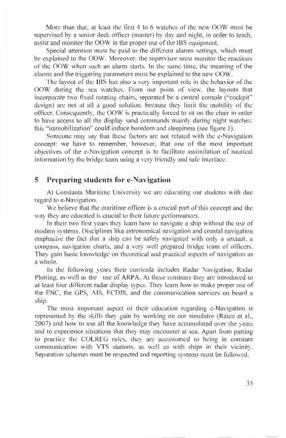
The layout of the IBS has also a very important role in the behavior of theOOW during the sea watches. From our point of view, the layouts thatincorporate two fixed rotating chairs, separated be a central console ("cockpit"design) are not at all a good solution, because they limit the mobility of theofficer. Consequently, the OOW is practically forced to sit on the chair in orderto have access to all the display sand commands mainly during night watches:this "immobilization'" could induce boredom and sleepiness (see figure 1).
Someone may say that these factors are not related with the e-Navigationconcept: we have to remember, however, that one of the most importantobjectives of the e-Navigation concept is to facilitate assimilation of nauticalinformation by the bridge team using a very friendly and safe interface.
5 Preparing students for e-NavigationAt Constanta Maritime University we are educating our students with due
regard to e-Navigation.Webelieve that the maritime officer is a crucial part of this concept and the
waythey are educated is crucial to their future performances.In their two first years they learn how to navigate a ship without the use of
modern systems. Disciplines like astronomical navigation and coastal navigationemphasize the fact that a ship can be safely navigated with only a sextant, acompass, navigation charts, and a very well prepared bridge team of officers.They gain basic knowledge on theoretical and practical aspects of navigation asawhole.
In the following years their curricula includes Radar Navigation, RadarPlotting, as well as the use ofARPA. At these seminars they are introduced toat least four different radar display types. They learn how to make proper use ofthe ENC, the GPS, AIS, ECDIS, and the communication services on board aship.
The most important aspect of their education regarding e-Navigation isrepresented by the skills they gain by working on our simulator (Raicu et al.,2007) and how to use all the knowledge they have accumulated over the yearsand to experience situations that they may encounter at sea. Apart from puttingto practice the COLREG rules, they are accustomed to being in constantcommunication with VTS stations, as well as with ships in their vicinity.Separation schemes must be respected and reporting systems must be followed.
35
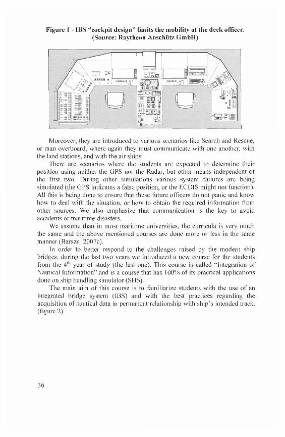
Figure 1 - IBS "cockpit design" limits the mobility of the deck officer.(Source: Raytheon Anschutz GmbH)
Moreover, they are introduced to various scenarios like Search and Rescue,or manoverboard, where again they must communicate with one another, withthe land stations, and with the air ships.
There are scenarios where the students are expected to determine theirposition using neither the GPS nor the Radar, but other means independent ofthe first two. During other simulations various system failures are beingsimulated (the GPS indicates a false position, or the ECDIS might not function).All this is being done to ensure that these future officers do not panic and knowhowto deal with the situation, or how to obtain the required information fromother sources. We also emphasize that communication is the key to avoidaccidents or maritime disasters.
Weassume than in most maritime universities, the curricula is very muchthe same and the above mentioned courses are done more or less in the samemanner(Barsan 2007c).
In order to better respond to the challenges raised by the modern shipbridges, during the last two years we introduced a new course for the studentsfrom the 4th year of study (the last one). This course is called 'integration ofNautical Information" and is a course that has 100% of its practical applicationsdone on ship handling simulator (SHS).
The main aim of this course is to familiarize students with the use of anintegrated bridge system (IBS) and with the best practices regarding theacquisition of nautical data in permanent relationship with ship's intended track,(figure2).
36

Figure 2 - Students' team during "Integration of Nautical Information"course laboratory
It is true that nowadays, due to technological advances, navigating a shiphas become theoretically easier; thus, the burden on the maritime officer hasbeen decreased, allowing him to concentrate on safe navigation, while futuretechnologies are going to improve safety standards and ease the navigationeffort even more. However, weencourage students not to rely too much on theinformation available from electronic sources like the ECDIS or the radar, butrather to "look out the window" and "take a look around", to use their senses, aswell as making good use of what today's technology has to offer them
Wealso teach them what they have to do and how often they must do therequired checks in order to determine if the information provided by theelectronic equipment is still accurate (figure 3).
Figure 3 - "Integration of Nautical Information" course laboratory
37
Most of the scenarios that we play on the SHS during this course simulate anormal watch environment with medium traffic and near coast navigation. Thescenarios are long (2-2.5 hours) in order to create the feeling of a routine watch,but in a specific moment there will be a triggering event that ""will make thedifference" and will require direct actions from the bridge team (Barsan et al,2007b). The main purpose of the initial event is to distract attention of the OOWfrom the normal routine, while some of the nautical equipment will start tomalfunction -, not very conspicuously, but introducing faulty data into thesystem.
6 Conclusion
A large-scale implementation of the e-Navigation features is inevitable inthe near future.
The impact of electronics and computers on the ships' bridges is wellknownfor at least 10 years. Despite this, there are still a lot of debates regardingthe real improvement of safety based on electronics.Because the future means e-Navigation, we have to start to prepare our studentsand cadets to face the challenges raised by an increasing amount of navigationinformation that must be absorbed, processed and analyzed in a proper way, inorder to determine the right actions.
In order to achieve this goal, to traditional methods to teach navigation mustbe added a new kind of module able to integrate the main information from allthe nautical sciences. We have to develop the student's habitude to generate hisownoverall image of the surrounding situation, based on as much informationavailable as possible.
Wealso have to create our students' culture for a self-learning process whenconfronted with new types of nautical equipment and a new layout/configurationof the integrated bridge system. They have to ask for a proper on board trainingperiod, starting with enough time to learn and understand the user manuals ofthe navigation equipment installed in the IBS.
The setback in the training of deck officers to meet the e-Navigationchallenges may also be related to the lack of mobility of IMO. On one hand, the1MO MSC is promoting the e-Navigation concept, but on the other hand theSTCW provision were not updated for more than 10 years. We still have to dealwith compulsory courses of radar plotting, but teaching the use of ECD1S, A1S,IBS, Bridge Team Management or Bridge Resources Management are stilloptional (Barsan et al., 2007b). If at least some of these courses will becomecompulsory for the basic training of deck officers, we assume that the bridgeteam will be better prepared to face the upcoming e-Navigation "tide ofinformation".
38
References[1] E. Barsan, 2007a, New technologies for maritime safety - ISBN: 978-973-
7872-64-7, Editura Nautica, Constanta
[2] Barsan E., Arsenie P., Hanzu-Pazara R., 2007b, New navigationcompetencies required for an updated STCW Convention, Journal ofMaritime Studies, vol. 21, nr.2/2007, ISSN 13320718, pag.151-161,
Croatia
[3] Barsan E., 2007c, Key roles played by shipping companies in the METprocess, 8*" General Assembly of International Association of MaritimeUniversities - Odessa, Ukraine, published in World Maritime Excellence,ISBN 978-966-8783-1 1-1, Ukraine
[4] Bibik L., Krolikowski A., Czaplewski K., Duda D., 2007, Vision of the
decision support model on board of the vessel with use of the shore basedIT tools, 7tn TransNav 2007 Conference - Gdynia, Polnad, published inAdvances in marine navigation and safety of sea transportation, ISBN 978-83-7421-0 18-8
[5] Graff J., 2007, The role of operational ocean forecasting in e-navigation,
7* TransNav 2007 Conference - Gdynia, Polnad, published in Advancesin marine navigation and safety of sea transportation, ISBN 978-83-7421-018-8
[6] Hanzu-Pazara R., Barsan E., Arsenie P., 2008, Reducing of maritime
accidents caused by human factors using simulators in training process,Journal of Maritime Research, Volume 5, No 1, 2008, ISSN 16974840,Spanish Society of Maritime Research (SEECMAR), Santander, Spain
[7] IALA, 2008, e-Navigation Frequently Asked Questions, St Germain-en-Laye - France, http://www.iala-aism.org/
[8] IMO, 2005, IMO E-Navigation strategy, Maritime SafetyCommittee, MSC 81/23/10, London, UK
[9] Korcz K., 2007, GMDSS as a Data Communication Network for E-Navigation, 7"1 TransNav 2007 Conference - Gdynia, Polnad, published inAdvances in marine navigation and safety of sea transportation, ISBN 978-83-7421-018-8
[10] Patraiko D., 2007, The development of e-navigation, 7th TransNav 2007
Conference - Gdynia, Polnad, published in Advances in marine navigationand safety of sea transportation, ISBN 978-83-742 1 -0 1 8-8
[ll] Raicu G., Barsan E., Arsenie P., Hanzu-Pazara R., 2007, Realisticenvironments for online maritime simulators, 8tn EUROSIM 2007 -
39

Ljubljana, Slovenia, published in Proceedings of the 6th EUROSIMCongress on Modeling & Simulation, ISBN 978-3-901608-32-2, Pub.ARGE Simulation News, Vienna, Austria
[12] Wadsworth B., 2005, MARINE eNAVIGATION, Maritim Faggruppe, ITSNorwey
[13] Weintrit A., Wawruch R., Gucma L. Pietrzykowski Z., Specht C, 2007,Polish Approach to e-Navigation Concept, 7tn TransNav 2007 Conference-Gdynia, Polnad, published in Advances in marine navigation and safetyof sea transportation, ISBN 978-83-7421 -01 8-8
40


![Deep Visual MPC-Policy Learning for Navigation · visual navigation. Learning-based methods including Deep Reinforcement Learning (DRL) [4, 35, 36] and Imitation Learning (IL) [37]](https://img.pdfslide.net/doc/110x75/5fc872b0080011749f542f19/deep-visual-mpc-policy-learning-for-navigation-visual-navigation-learning-based.jpg)