Embed Size (px)
Citation preview

Early India-Australia spreading history revealed by newly detectedMesozoic magnetic anomalies in the Perth Abyssal Plain
Simon E. Williams,1 Joanne M. Whittaker,1,2 Roi Granot,3 and Dietmar R. Müller 1
Received 22 February 2013; revised 31 May 2013; accepted 6 June 2013.
[1] The seafloor within the Perth Abyssal Plain (PAP), offshoreWestern Australia, is the onlysection of crust that directly records the early spreading history between India and Australiaduring the Mesozoic breakup of Gondwana. However, this early spreading has been poorlyconstrained due to an absence of data, including marine magnetic anomalies and dataconstraining the crustal nature of key tectonic features. Here, we present new magneticanomaly data from the PAP that shows that the crust in the western part of the basin was part ofthe Indian Plate—the conjugate flank to the oceanic crust immediately offshore the Perthmargin, Australia. We identify a sequence of M2 and older anomalies in the west PAP withincrust that initially moved with the Indian Plate, formed at intermediate half-spreading rates(35mm/yr) consistent with the conjugate sequence on the Australian Plate. Morespeculatively, we reinterpret the youngest anomalies in the east PAP, finding that the M0-agecrust initially formed on the Indian Plate was transferred to the Australian Plate by a westwardjump or propagation of the spreading ridge shortly after M0 time. Samples dredged from theGulden Draak and Batavia Knolls (at the western edge of the PAP) reveal that thesebathymetric features are continental fragments rather than igneous plateaus related toBroken Ridge. These microcontinents rifted away from Australia with Greater Indiaduring initial breakup at ~130Ma, then rifted from India following the cessation ofspreading in the PAP (~101–103Ma).
Citation: Williams, S. E., J. M. Whittaker, R. Granot, and D. R. Muller (2013), Early India-Australia spreading historyrevealed by newly detected Mesozoic magnetic anomalies in the Perth Abyssal Plain, J. Geophys. Res. Solid Earth, 118,doi:10.1002/jgrb.50239.
1. Introduction
[2] Reconstructing the early spreading history of the EasternIndian Ocean is difficult, since much of the oceanic crustformed between India and Australia has been subsequentlysubducted beneath Southeast Asia. Remaining oceanic crustrecording the earliest motions between India, Antarctica, andAustralia is found in the Enderby Basin offshore WilkesLand, Antarctica, the Bay of Bengal, offshore eastern India,and the Perth Abyssal Plain (PAP). Interpretation of thespreading history in the PAP has been hampered by a lack ofship track data in the western part of the basin, while compat-ible interpretations of the Enderby Basin [Gaina et al., 2007;Gibbons et al., 2012] and the Bay of Bengal [Krishna et al.,2009] have proved elusive due to the difficulties in interpretingmagnetic and gravity data that have been severely overprinted
by plume-related magmatism and buried beneath a thick sedi-mentary package, respectively.[3] The PAP (Figure 1) formed at the nexus of rifting and
breakup between three major Gondwanan continents—India,Australia, and Antarctica. Oceanic crust within the PAP isthe only region of preserved seafloor that directly records thehistory of Early Cretaceous seafloor spreading between Indiaand Australia. However, despite the clear importance of theseafloor spreading history of the PAP, little attention has beenpaid to this basin, particularly the west PAP, since the earlyinterpretations of Markl [1974, 1978], largely due to a lackof magnetic data in this region.[4] Up until now, insufficient evidence has existed in the
western part of the PAP to validate tectonic models of thePAP. The exact location of the conjugate (Indian Plate)Mesozoic section of crust has remained unresolved. Somemodels predict that the crust in the west PAP formed entirelywithin the Cretaceous Normal Superchron (Figure 2) [Markl,1974; Johnson et al., 1976; Mihut, 1997]. Other modelspredict that some Mesozoic spreading anomalies should beobserved in the west PAP [Powell et al., 1988; Gibbons et al.,2012], but no evidence has been available to support this hy-pothesis. To date, due to the lack of data, no magneticinterpretation is available for the west PAP.[5] In this paper, we present new evidence for the early
seafloor spreading history between India and Australiawithin the PAP. This work is based on new total-field surface
1Earthbyte Group, School of Geosciences, University of Sydney,Sydney, New South Wales, Australia.
2Now at: The Institute of Marine and Antarctic Studies, University ofTasmania, Hobart, Tasmania, Australia.
3Department of Geological and Environmental Sciences, Ben GurionUniversity of the Negev, Beer Sheva, Israel.
Corresponding author: S. E. Williams, Earthbyte Group, School ofGeosciences, University of Sydney, Madsen Building F09, Sydney, NSW2006, Australia. ([email protected])
©2013. American Geophysical Union. All Rights Reserved.2169-9313/13/10.1002/jgrb.50239
1
JOURNAL OF GEOPHYSICAL RESEARCH: SOLID EARTH, VOL. 118, 1–10, doi:10.1002/jgrb.50239, 2013

marine magnetic anomaly data collected across the PAP inOctober–November 2011 onboard the R/V SouthernSurveyor. These new magnetic profiles reveal previouslyunrecognized M-series anomalies in the western PAP,
20°S
30°S
40°S
20°S
30°S
40°S
90°E 100°E 110°E
(a)
(b)
Figure 1. (a) Tectonic features in and around the PerthAbyssal Plain. (b) Magnetic isochron interpretations from thecompilation ofCande et al. [1989]. Three alternative interpreta-tions for the area shown in the dashed box are presented inFigure 2. The underlying image in all three panels is free-airgravity derived from satellite altimetry [Sandwell and Smith,2009]. Dots with red labels are ocean drilling sites.Abbreviations: EPAP, East Perth Abyssal Plain; WPAP, WestPerth Abyssal Plain; CAP, Cuvier Abyssal Plain; GAP,Gascoyne Abyssal Plain; WB, Wharton Basin; BK, BataviaKnoll; GDK, Gulden Draak Knoll; DHR, Dirck HartogRidge; BR, Broken Ridge; NP, Naturaliste Plateau; WP,Wallaby Plateau; ZP, Zenith Plateau; FT, Folau Trough; dGT,de Gonneville Triangle; NFZ, Naturalite Fracture Zone; BFZ,Batavia Fracture Zone; WZFZ, Wallaby-Zenith FractureZone; FZB, Fracture Zone Bends; DZ, Diamantina Zone.
Figure 2. Alternative interpretations for the distribution ofseafloor ages in the west Perth Abyssal Plain and adjacentpart of the Wharton Basin. (a) Markl [1974], (b) Mihut[1997], (c)Gibbons et al. [2012], and (d) anomaly picks fromthis study. Gray lines show tracks of new magnetic profiles.XR, Extinct ridges; PF, pseudofault.
WILLIAMS ET AL.: PERTH ABYSSAL PLAIN SPREADING HISTORY
2

conjugate to the sequence in the eastern PAP, and lead us toreinterpret the youngest anomalies in the eastern PAP.Further evidence for the spreading history comes fromdredge samples collected from a series of bathymetricknolls and ridges in the PAP.We conclude with a discussionof the implications of our results for the spreading historyoceanic crust within the PAP.
2. Tectonic Setting of the Perth Abyssal Plain
[6] The PAP spans the area between the western continen-tal margin of Australia and the southern section of theWharton Basin (Figure 1). Free-air gravity anomalies derivedfrom satellite altimetry [Sandwell and Smith, 2009] help todefine structural elements of the PAP.[7] During the Late Jurassic to Early Cretaceous, Australia
and Antarctica formed one continuous continent (Figure 3),albeit with some slow continental rifting occurring through-out this period [Totterdell et al., 2000]. Both the EnderbyBasin and the PAP formed during Early Cretaceous motionof India away from Australia-Antarctica. To the north ofthe PAP, submerged continental fragments (the Zenith andWallaby Plateaus [Symonds et al., 1998]) (Figure 1) provideevidence for a transform margin between northern greaterIndia and Australia during Gondwana breakup [Ali andAitchison, 2005]. East of these continental fragments, theCuvier Abyssal Plain records early Cretaceous seafloorspreading (anomalies M0–M10) (Figure 1b). The originalextent of Greater India is much argued over, and uncertaintysurrounds whether the crust in the Cuvier Abyssal Plainformed following breakup between the northernmost part ofgreater India [e.g., Hall, 2012] or a separate continentalfragment [e.g., Gibbons et al., 2012]. If the Wallaby-ZenithFracture Zone (WZFZ) does represent the northernmost limitof Greater India adjacent to Australia within Gondwana, thenthe PAP is the only region of seafloor that directly recordsEarly Cretaceous Australia-India plate motions.
[8] The orientation of the WZFZ, together with theNaturaliste and Batavia Fracture Zones (Figure 1), suggeststhat the spreading direction in the PAP is broadly WNW-ESE. This is also consistent with the orientation ofinterpreted magnetic lineations adjacent to the westAustralian margin [Markl, 1974; Veevers and Li, 1991].Within the PAP, the Naturaliste and Batavia Fracture Zonesfollow trends broadly parallel to theWZFZ. Aside from thesestructures, the gravity data provide little clear evidence forthe locations of fracture zones within the PAP itself—in com-mon with other ocean basins of a similar age, such as theEnderby Basin and West Somali Basin. Where the PAPmeets the Wharton Basin, bends in the fracture zone trendsobserved in free-air gravity data record a major change in rel-ative plate motion estimated at 99Ma [Veevers, 2000] or100–105Ma [Matthews et al., 2012].[9] The western margin of the PAP is defined by two
prominent bathymetric knolls, the Batavia and GuldenDraak Knolls, where the shallowest seafloor lies more than3000m above the surrounding seafloor (Figure 1). TheFolau Trough, a prominent linear bathymetric low, links theBatavia Knoll with the WZFZ. In the southeastern part ofthe PAP, the Naturaliste Plateau is another bathymetricfeature which also lies several kilometers shallower thanthe adjacent ocean crust. The crustal nature of this plateauhas been debated as oceanic or continental by many previousworks, but recent dredge samples have demonstrated that thebasement within much of the plateau is of continental origin[Beslier et al., 2004; Halpin et al., 2008].[10] Within the PAP, a series of bathymetric highs follow-
ing a NNE-SSW trend between the WZFZ and the deGonneville Triangle, collectively referred to as the DirkHartog Ridge (DHR, Figure 1). This ridge has been previ-ously interpreted as an extinct spreading center, with esti-mates of cessation of spreading from 96Ma [Powell et al.1988] to 108Ma [Gibbons et al., 2012]. Alternatively,Mihut [1997] interpreted the DHR as a pseudofault formed
India
EB
EPAP
CAP
GDK
BK
Australia
WPAP
BoB
Figure 3. Reconstruction of Australia, India, and Antarctica at 83Ma [after Gibbons et al., 2012;Whittaker et al., 2013]. EB, Enderby Basin; GDK, Gulden Draak Knoll; BK, Batavia Knoll; PAP,Perth Abyssal Plain; CAP, Cuvier Abyssal Plain; BoB, Bay of Bengal. Solid black lines show active plateboundaries; dashed black lines within the EB, PAP, and CAP represent extinct spreading ridges. Color ofocean areas represent age of the ocean floor; light purple> 120.4Ma, dark purple 108–120.4Ma, blue100–108Ma, and green 83–100Ma.
WILLIAMS ET AL.: PERTH ABYSSAL PLAIN SPREADING HISTORY
3

during an eastward jump in the spreading axis betweenAustralia and India. However, the morphology of the DHRis not typical of either an extinct midocean ridge orpseudofault, and it is likely that the original feature has beenmodified by subsequent tectonic and/or magmatic activity.[11] The southern limit of the PAP is marked by Broken
Ridge and the Diamantina Zone (Figure 1). The morphologyof this southern boundary largely reflects the location of theAustralia-Antarctica plate boundary in the Late Cretaceous,after the PAP had formed and around the time seafloorspreading initiated between Australia and Antarctica. Areconstruction of India-Australia-Antarctica at 83Ma(Figure 3) [Whittaker et al., 2013] illustrates the juxtaposi-tion of these plates at the end of the Cretaceous NormalSuperchron (CNS).
2.1. Existing Constraints on Seafloor Age of the PAP
[12] Magnetic anomaly profiles crossing the PAP availablewithin the National Geophysical Data Center (NGDC) data-base are shown in Figure 4. The east PAP is well-coveredby magnetic profiles, on the basis of which several authorshave produced broadly consistent interpretations of anomaliesM9 to M0 [Markl, 1974; Veevers and Li, 1991;Gibbons et al.,2012]. Southwest of the Batavia Fracture Zone, Markl [1978]
(a)
(b)
Figure 4. (a) Ship track magnetic anomaly profile data forthe Perth Abyssal Plain, displayed as wiggle plots projectedusing an azimuth of N30°E. Data from ss2011/v06 are plot-ted in red, data from the NGDC database are plotted in blue.Circles denote dredge sites on the Batavia and Gulden DraakKnolls. (b) Ship tracks plotted with bathymetry profiles de-rived from ss2011/v06 swath data, and free-air gravityextracted from gravity grid derived from satellite altimetry[Sandwell and Smith, 2009].
(a)
Figure 5. Stacked plots of ship track magnetic anomaliesfor (a) the west PAP and (b) the east PAP. The top panelshows the locations of the plotted profiles in an obliqueMercator projection. Anomaly picks are symbolizedaccording to the legend shown in Figures 2 and 6. Theanomaly profiles are projected such that the distance alongprofile is measured in a direction S120°E (for the westPAP) and N300°W (for the east PAP) and are plotted in orderfrom north to south based on their location at the eastern endsof the profiles. The red and blue profiles show syntheticmagnetic anomaly sequences generated assuming a half-spreading rate of 35mm/yr. Synthetic profiles were createdusing modmag [Mendel et al., 2005] and generated assuminga magnetic source layer at a depth of 4 km, with a thickness of0.5 km, magnetization of 10A/m, and a contaminationcoefficient of 0.5. The anomaly profiles are plotted such thatprofiles parallel to the inferred spreading direction are plottedas black lines, while profiles more oblique to the spreadingdirection are plotted in increasingly lighter shades of gray.See text for discussion of features labeled A and B. XRdenotes extinct ridge; PF denotes pseudofault.
WILLIAMS ET AL.: PERTH ABYSSAL PLAIN SPREADING HISTORY
4

identified anomalies M0 to M5, offset by ~90 km from theequivalent isochrons on the other side of the BFZ.[13] The location of the conjugate, Indian Plate anomalies,
is thus-far unresolved as magnetic data are sparse over thewestern section of the PAP. Markl [1974] proposed that theconjugate crust lies to the west of the Batavia and GuldenDraak Knolls based on widely spaced magnetic profiles(Figure 2a). Subsequent plate reconstructions have shownthat the Perth margin was adjacent to greater India—these
models predict that much of the crust accreted to the IndianPlate conjugate to the Perth M-series would have since beensubducted beneath southeast Asia (Figure 2b) [e.g., Johnsonet al., 1980; Mihut, 1997]. Powell et al. [1988] predictedthat some of M-series anomalies should be observed eastof the Batavia and Gulden Draak Knolls, truncated byyounger spreading systems. Recent plate reconstructionsof Gibbons et al. [2012] predict that a full sequence ofanomalies conjugate to the Perth sequence should beobserved east of these knolls. These authors produced aset of synthetic isochrons for the west PAP based on thishypothesis (Figure 2c).[14] Additional constraints on the age of the crust in the
PAP come from sediments sampled at sites on Deep SeaDrilling Project (DSDP) legs 26 and 27 [Heirtzler et al.,1973; Luyendyk and Davies, 1974; Veevers and Heirtzler,1974]. The minimum basement age at Site 256, on thewestern flank of the Folau Trough (Figure 1), is esti-mated to be late Albian (~101Ma) based on nanofossilsin the sediments overlying the basement. At site 257,located in the eastern PAP, the oldest sediment is middleAlbian (~106Ma).
2.2. New Data
[15] New magnetic anomaly profiles were obtained alongflow line-parallel profiles traversing the PAP (Figure 4).Data were acquired using a total-field Seaspy magnetometertowed 200m behind the survey vessel. The contribution fromthe geomagnetic field was removed from the data using the11th generation of the International Geomagnetic ReferenceField [Finlay et al., 2010].[16] Dredge samples were collected from seven sites—two
sites on the northwest flank of the Batavia Knoll, two sites onthe north and west flanks of the Gulden Draak Knoll, andthree sites on the DHR (Figures 1 and 4). Samples recoveredfrom dredge sites 1 and 2 on the Batavia Knoll comprisedgranite, granite gneiss and schist, and fossiliferous sandstone.Samples from the Gulden Draak Knoll comprised granite,garnet gneiss, sandstones, and siltstones (dredge site 3),and highly altered basalts (dredge site 4). Basement rocksrecovered from the Dirck Hartog Ridge are igneous innature—gabbros and basalts. A full listing of the samplescan be found in Williams [2011].
3. Interpretation of Magnetic Anomalies
[17] A general issue for interpreting ship track magneticanomaly data for the PAP is that only a few ship tracks areavailable, and many of those are oblique to the likelyspreading direction. We include all available data, but withthe caveat that some profiles from the NGDC database maycross fracture zones and so should be treated with caution.
3.1. Western PAP—Batavia Knoll
[18] Our new magnetic data provide constraints on thecrustal age of the western PAP. The crust east of the BKexhibits a series of large (>500 nT) amplitude magneticanomalies which can be traced confidently between profiles.Further east (>300 km, Figure 5a), the anomaly profiles aregenerally subdued, and major anomalies show no obviouscorrelations with adjacent profiles. Subdued anomalies inCretaceous crust characterize the edges of the quiet zones
(b)
Figure 5. (continued)
WILLIAMS ET AL.: PERTH ABYSSAL PLAIN SPREADING HISTORY
5
(CNS-aged crust [Granot et al., 2012]). Therefore, a simpleexplanation for these first-order observations is that the edgeof the quiet zone lies about 300 km east of the BK. Dredgesamples reveal that the BK and GDK are continentalfragments [Williams, 2011], with the implication that thesefragments originally rifted from Australia as part of theIndian Plate. The sequence observed in the west PAP adja-cent to the BK must therefore be conjugate to the anomaliesin the east PAP. Our profiles therefore young toward the eastand cross into the quiet zone.[19] In Figure 5a, we plot two alternative magnetic forward
models for the spreading sequence east of the BK, using thetimescale of Gee and Kent [2007]. The blue line shows amodel containing a continuous sequence of M4 to M0 anom-alies leading into quiet zone crust. This model implies arelatively simple spreading history, with a sequence that isthe mirror image of the sequence previously interpreted in thewest PAP [Markl, 1974; Veevers and Li, 1991] withcomparable spreading rates. However, the shapes of theobserved anomalies do not show a clear correspondence withthe model, and the M4 anomalies on profiles S1, P1, andv1811 would lie within the continental crust of the BataviaKnoll (assuming a constant half-spreading rate of ~35mm/yr).[20] An alternative interpretation is constructed where the
first large anomaly is assigned to M2 (half-spreading rate of35mm/yr, red curve in Figure 5a). This model matches wellthe distinctive shapes of the M2 andM4 anomalies in profilesP1, S1, and S2 as well as profiles v1811 and dsdp26gc, ineach case with anomaly amplitudes of several hundred nano-teslas. Assuming a continuous spreading rate after M2, wewould expect to observe M0 ~90 km further east alongthese profiles. Of the four profiles that cross the expectedlocation of M0 profile dsdp26gc contains an anomaly(Figure 5a where shown) that could be interpreted as
M0. A phase-shifted M0 may be seen in ss2011v06profile 2, adjacent to a major positive anomaly (labeledA in Figure 5a). Similar high amplitude positive anoma-lies (each labeled A) are observed east of our preferredM2 interpretation on all four profiles that span regionbetween here and the Dirck Hartog Ridge. These anoma-lies, labeled A in Figure 5a, follow a linear trend whoseorientation differs by >20° the M2 and M4 lineationsin the WPAP. Further, they follow the trend of a linearfeature observed in free-air gravity and features inbathymetry profiles (Figure 5a, also Figure 4).[21] The lack of any clear M0 identifications raises the
possibility that the crust of M0 age is missing from the westPAP. If this model is correct, then we ought to observeanomaly M0 doubled in the east PAP.
3.2. East PAP Revisited
[22] Magnetic anomaly profile data for the east PAP areshown in Figure 5b. The synthetic anomaly curve showsthe sequence of anomalies reinterpreted from other authors'M9 to the CNS [Markl, 1974; Veevers and Li, 1991;Gibbons et al., 2012]. The observed anomalies can bereasonably modeled using a uniform half-spreading rateof 35mm/yr. Veevers and Li [1991] inferred a decreasein spreading rate around the time of M4o using the sameanomaly identifications but an older timescale [Berggrenet al., 1985; Kent and Gradstein, 1985]. The interpretedM2–M4 anomalies show a clear linear continuity within theavailable profiles. The anomalies interpreted as M0 have a lessdistinctive shape but are still apparent, and they are locatedwhere we would expect them to be based on spreading ratesimplied by the M2 and M4 anomalies.[23] The previously interpreted anomaly sequence implies
that the crust in the east PAP youngs continuously to the westand that all crust to the west of the M0 anomaly formed dur-ing the CNS. Based on our observations from the WPAP, wepropose that both our new and archival data reveal seafloorspreading magnetic anomalies to the west of and parallel tothe previously identified magnetic lineations. The syntheticprofile in Figure 5b shows one possible interpretation, inwhich a series of anomalies observed in all profiles can bemodeled as an isolated, reversely magnetized block withthe same width as the M0 block modeled to the east. It isimportant to stress that this interpretation is considerablymore speculative than the new M2 and M4 identificationsin the WPAP. The amplitude of both the eastern andwestern M0 anomalies is small compared to the olderanomalies. Alternative interpretations are possible—forexample, the eastern M0 identified on line rc0909 inFigure 5b could alternatively be interpreted as a single wideM0, separating conjugate M1 anomalies that progressivelydisappear to the south. This scenario would be consistentwith a gradual ridge propagation event rather than a discreteridge jump, as interpreted for example across the CarlsbergRidge [Dyment, 1998] and in the Cuvier Abyssal Plain[Mihut and Müller, 1998].[24] While the delineation of M0 anomalies in the EPAP
remains uncertain, it is likely that some of the crust formedat M0 time on the Indian Plate, conjugate to the crust of theAustralian Plate M0 anomaly already identified <100 km tothe east. Such an anomaly sequence can be explained by amodel in which an extinct ridge lies between the conjugate
Figure 6. Magnetic anomaly picks for the PAP. Red linesshow southern surveyor ship tracks, orange lines show shiptracks from the NGDC database for which magnetic anoma-lies are available. Also plotted are synthetic isochronspredicted by the reconstruction model of Gibbons et al.[2012]. The coloring of the isochron lines for the young endsof M0, M2, and M4 is consistent with the pick symbols.Black dashed line shows approximate path of ~119Maextinct spreading center proposed in this study. Black dottedline shows extinct spreading center along DHR proposed byGibbons et al. [2012].
WILLIAMS ET AL.: PERTH ABYSSAL PLAIN SPREADING HISTORY
6
M0 anomalies. We note, however, that no clear gravity signa-ture is observed that would indicate the existence of a singleburied fossil spreading center beneath the sediments.Spreading ceased, possibly progressively, at this ridgeshortly after the beginning of the CNS (~119Ma, taking35mm/yr half-spreading rate). The India-Australia plateboundary jumped westward, into the M1-aged crust of theIndian Plate. In addition to accounting for possible doubleM0 anomalies in the east PAP, this scenario also providesan explanation for the lack of M0 anomalies in the west PAP.[25] In common with the WPAP, the Quiet zone within the
EPAP contains several magnetic anomalies with amplitudesgreater than 500 nT (labeled B in Figure 5b). Also, as in theWPAP, these anomalies are not aligned parallel to theEPAP M-series anomalies, although in this case, there is noassociated feature within the satellite-derived gravity data.
Magnetic anomalies with amplitudes of several hundrednanoteslas are observed within similar parts of quiet zonesin other ocean basins [Granot et al., 2012] and thereforeprobably reflect an increase in the fluctuation of the dipolargeomagnetic field strength. Alternatively, these anomaliesmay reflect local variations in the thickness and/or ironcontent of the magnetic source layer, which in turn couldbe due to variations in magma supply during additional ridgejump/propagation events within the CNS.
4. Discussion
4.1. Implications for ReconstructingGondwana Breakup
[26] Our new data allow us to interpret an entire sequenceof M-series magnetic anomalies formed on the Indian Plate
Figure 7
WILLIAMS ET AL.: PERTH ABYSSAL PLAIN SPREADING HISTORY
7

conjugate to the Australian plate sequence identified in thePerth Basin (Figure 6). We identify Indian Plate anomaliesM2–M4 in the west PAP, east of the Batavia Knoll. Ourpreferred interpretation places the Indian Plate M0 anomaly<100 km west of the Australian Plate M0 anomaly, withincrust left on the Australian Plate following a westward ridgejump shortly afterward, although this aspect of the interpreta-tion is less well constrained. Together with continentalbasement rocks dredged from both the Batavia and GuldenDraak Knolls, the new magnetic data have importantimplications for the early spreading history between India,Australia, and Antarctica.[27] Our interpretation for the location of M-series anoma-
lies is plotted in Figure 6. The anomaly locations are incom-patible with earlier interpretations, which identified the crustin the west PAP as having formed within the CNS (Figure 2)[Markl, 1974; Mihut, 1997]. The locations of our picks forM2 and M4 differ by 20–90 km from the synthetic isochronsof Gibbons et al. [2012]. This model differs from ourinterpretation of a westward ridge jump shortly after M0time, instead predicting the existence of M0 anomalies inthe west PAP that are not observed. Interestingly, there isa systematic orientation difference between our magneticanomaly interpretations and the synthetic isochrons ofGibbons et al. [2012]. The offset, which is not observed inthe east PAP implies a counterclockwise rotation of the westPAP. This may help explain the unusual morphology of theDHR and western WZFZ. A relatively small counterclock-wise change in spreading direction between India andAustralia is also inferred from seafloor fabric in theWharton Basin, initiating around 108.4–105.8Ma, prior to
the major clockwise change that resulted in N-S spreading[Matthews et al., 2012]. The morphology of the DHR isnot typical of an undisturbed fossil spreading center, suchas those observed in the Wharton Basin, Coral Sea,Labrador Sea, or Tasman Sea [Jonas et al., 1991; Gainaet al., 1998]. If the DHR does represent an extinct spreadingcenter, then its morphology may be the result of similarprocess to what we see in other fossil spreading centerswhere postspreading deformation took place [Müller et al.,2005; Granot et al., 2010; Livermore et al., 2000].[28] Our new data confirm that the Batavia and Gulden
Draak Knolls are continental fragments, thus requiring amajor westward jump in the India-Australia plate boundaryto rift these fragments from India as hypothesized byGibbons et al. [2012].
4.2. Westward Plate Boundary Jumps—Influence of theKerguelen Plume?
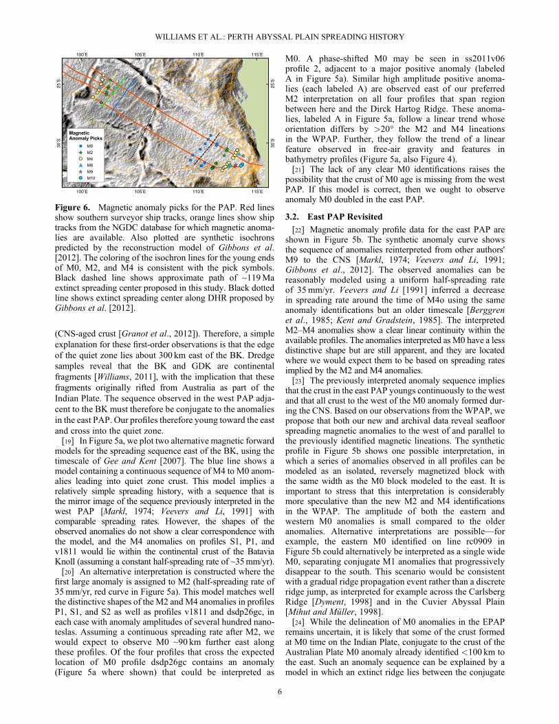
[29] Our data provide evidence for two westward jumpsof the India-Australia plate boundary during the evolutionof the PAP. These jumps are summarized in Figure 7, wherewe illustrate our revised spreading history within theregional plate configuration from Gibbons et al. [2012]—as discussed above, of the available published models forthe region, this model is the most consistent with ourobservations for the west PAP with mismatches <100 kmin magnitude. For simplicity, the ridge jumps are illustratedas discrete events rather than gradual propagations. The firstridge jump is shown by the sequence of magnetic anomaliesand occurred entirely within oceanic crust shortly after M0time (~119Ma). Ridge jumps and asymmetry in crustal
Figure 7. (a) Regions of ocean crust within and adjacent to the Perth Abyssal Plain classified by the spreading ridge at whichthey formed. Within the PAP, green regions contain crust formed prior to a ridge jump shortly after M0 time, while regions inblue formed between this ridge jump and cessation of spreading in the PAP around 101–103Ma. The gray region between theGulden Draak Knoll and the Naturaliste Plateau formed during the same period, but the details of the spreading history are lessclear. The yellow crust in the Cuvier and Gascoyne Abyssal plains formed during the Early Cretaceous as a result of riftingbetween Australia and West Argoland [Gibbons et al., 2012]. The Wharton Basin formed as part of India-Australia spreadingafter cessation of spreading in the PAP during the CNS, while the light brown region south of Broken Ridge shows crust formedduring Australia-Antarctica spreading following chron 34. Dashed red lines are extinct ridges, dashed blue lines arepseudofaults, solid red lines are fracture zones [Matthews et al., 2011], and solid black lines are isochrons (not shown for thePAP and selected chrons in adjacent basins). The pink hatched area shows the extent of the Broken Ridge Large IgneousProvince from Coffin and Eldholm [1994]. The underlying texture is derived from the gradient of Smith and Sandwellbathymetry [Smith and Sandwell, 1997]. (b–e) Plate tectonic reconstruction illustrating our revised spreading history for thePerth Abyssal Plain. Relative positions of Australia, Antarctica, and India and isochrons for the Enderby Basin and CuvierAbyssal Plain are adapted from Gibbons et al. [2012]. Reconstructions are presented with Australia fixed to its present-dayposition. Red lines represent extinct ridges, blue lines are pseudofaults, black lines are isochrons from this study, and gray linesoutside the PAP are isochrons from Gibbons et al. [2012]. Filled gray regions show the extent of continental crust. TheKerguelen hot spot locations based on a fixed hot spot reference frame (solid circle) [Müller et al., 1993] and the most recentmoving hot spot reference frame (dashed circle) [Doubrovine et al., 2012]. The hot spot reference frames are linkedto the reconstruction that uses Africa-Antarctica rotations from Marks and Tikku [2001] and Müller et al. [2008],and Australia-Antarctica rotations from Whittaker et al. [2013]. Circles with radius 400 km are plotted around thehot spot center after Montelli et al. [2004]. The pink hatched area shows the extent of the Broken Ridge Large IgneousProvince from Coffin and Eldholm [1994]. In Figure 7a, at 126Ma, a >250 km-wide ocean basin has formed in the PAP.Around this time, the Batavia Knoll (labeled BK) and Gulden Draak Knoll (labeled GDK) rift away from theNaturaliste Plateau (labeled NP). In Figure 7b, shortly after M0 time, the India-Australia plate boundary in thePAP jumps toward India, transferring M0-age crust formed on the Indian plate to the Australian plate. In Figure 7c, ataround 101–103Ma, spreading ceases in the PAP, and the India-Australia plate boundary jumps to the passive margin ofgreater India, resulting in the rifting the BK and GDK. In Figure 7d, after 100Ma, the BK and GDK are isolated continentalfragments within the Australian plate. Divergence between the Indian and Australian plates is accommodated at a spreadingridge in the Wharton Basin.
WILLIAMS ET AL.: PERTH ABYSSAL PLAIN SPREADING HISTORY
8
accretion are common features of oceanic crust, and ridgejumps are often associated with hot spots [Small, 1995;Müller et al., 1998; Mittelstaedt et al., 2011]. In Figure 7,we illustrate the spatial relationship between the crust inthe PAP around the time of the ridge jump and the locationof the Kerguelen Plume, the closest plume to the PAP dur-ing this period. Hot spot locations are plotted using a fixedKerguelen plume with a fixed hot spot reference frame[Müller et al., 1993] and a moving Kerguelen plume andmatching moving hot spot reference frame [Doubrovineet al., 2012].[30] The interpreted ridge jump is consistent with the
notion that ridges typically jump toward hot spots and intorelatively young (<4Ma old) ocean crust [Small, 1995;Müller et al., 1998;Mittelstaedt et al., 2011]. The reconstruc-tion implies the plume center is located between 700 and900 km from the newly initiating ridge. Plume-ridge interac-tion over similar length scales has been inferred betweenReunion hot spot and the Central Indian Ridge [Morgan,1978; Dyment et al., 2007].[31] The second and major ridge jump in the India-Australia
plate boundary occurred when seafloor spreading ceased inthe PAP and a new plate boundary initiated along thecontinental margin of greater India. As this new plateboundary developed, fragments of the continental marginwere rifted from greater India and became isolatedmicrocontinents on the Australian Plate, now observed asthe Batavia and Gulden Draak Knolls. A link betweenmicrocontinent formation and plumes has been proposed[Müller et al., 2001;Gaina et al., 2003], although the detailsof the mechanisms by which microcontinents form are stilldebated [Péron-Pinvidic and Manatschal, 2010]. The timingof the jump in spreading from the PAP to the Wharton Basinis uncertain since it occurred during the CNS. Half-spreadingrates in the PAP prior to M0 are roughly 35mm/yr—if weassume a similar spreading rate for the CNS crust, then theentire PAP would have formed by ~107Ma. However,based on the ages of the oldest sediments that were drilledin DSDP site 256 (~101Ma), drilled on top of the oldestcrust in the Wharton Basin, we speculate that spreadingrates decreased toward the middle part of the PAP quietzone, and spreading has ceased sometime between 103and 101Ma. A slowdown toward cessation of spreadingwas observed near other fossil spreading systems [e.g.,Cande et al., 2000; Livermore et al., 2000]. A detailed anal-ysis of spreading history during the quiet zone of the PAPwill be presented elsewhere. Figure 7b shows that the twonewly discovered microcontinents lie between 300 and600 km from the Kerguelen plume center around the timea new plate boundary initiated within this part of the greaterIndian margin. Although the plate tectonic model suggeststhat both knolls formed within the region of influence of amajor plume, in common with other microcontinents such asJan Mayen, the Seychelles, and Elan Bank [Müller et al.,2001], basaltic rocks were recovered from only one of thefour dredge sites on the Batavia and Gulden Draak Knolls,suggesting that the formation of these microcontinentsmay not have been accompanied by plume-relatedvoluminous magmatism.[32] The time period between the two plate boundary
jumps illustrated in Figure 7 are separated by 16–18Ma,and we speculate that interaction between material from
the Kerguelen plume and the spreading system in the PAPmay have continued throughout this period. Indeed, satellitegravity data (Figure 1) and bathymetry data show that thequiet zone crust contains several anomalous features,notably the DHR and a subparallel structure to the west,which may represent extinct ridges or pseudofaults asproposed by previous authors (Figure 2) [Markl, 1974;Mihut, 1997; Gibbons et al., 2012; Matthews et al., 2012].The west PAP contains several other significant free-airgravity and bathymetric highs whose origins remainenigmatic. We hypothesize that some or all of these featuresformed as part of ongoing ridge-plume interaction duringseafloor spreading in the PAP.
[33] Acknowledgments. This work was only possible with the supportof the crew and scientific party aboard voyage ss2011/v06 of the CSIROR/VSouthern Surveyor. We also thank Statoil for providing additional financialsupport to for this voyage. Our coprincipal investigators for this project wereNathan Daczko and Jacqui Halpin. We thank Geoscience Australia forallowing us to use their marine magnetometer. Figures in this paper were cre-ated using Wessel and Smith's GMT software, and ArcGIS. S.W. and R.D.M. were supported by ARC grant FL0992245. J.W. would like to gratefullyacknowledge support received from Statoil. R.G. was supported by theEuropean Union Seventh Framework Program (FP7/2007–2013) undergrant agreement 320496 (GEOPLATE). The FAST project (23212VF)allowed RG to meet RDM, JW, and SW and become involved in the cruise.We thank editor André Revil, Jerome Dyment and an anonymous reviewerfor their helpful suggestions.
ReferencesAli, J. R., and J. C. Aitchison (2005), Greater India, Earth Sci. Rev., 72,169–188.
Berggren, W. A., D. V. Kent, J. J. Flynn, and J. A. Van Couvering (1985),Cenozoic geochronology, Geol. Soc. Am. Bull., 96, 1407–1418.
Beslier, M. O., J. Y. Royer, J. Girardeau, P. J. Hill, E. Boeuf, C. Buchanan,F. Chatin, G. Jacovetti, A. Moreau, and M. Munschy (2004), A wideocean-continent transition along the south-west Australian margin: Firstresults of the MARGAU/MD110 cruise, Bull. Soc. Geol. Fr., 175,629–641.
Cande, S. C., J. L. LaBrecque, R. L. Larson, W. C. Pittman, X. Golovchenko,and W. F. Haxby (1989), Magnetic Lineations of the World's Ocean Basins,Am. Assoc. of Pet. Geol., Tulsa, Okla.
Cande, S. C., J. M. Stock, R. D. Müller, and T. Ishihara (2000), Cenozoicmotion between east and west Antarctica, Nature, 404, 145–150.
Coffin, M. F., and O. Eldholm (1994), Large igneous provinces: Crustalstructure, dimensions, and external consequences, Rev. Geophys., 32,1–36.
Doubrovine, P. V., B. Steinberger, and T. H. Torsvik (2012), Absolute platemotions in a reference frame defined by moving hot spots in the Pacific,Atlantic, and Indian oceans, J. Geophys. Res., 117, B09101,doi:10.1029/2011JB009072.
Dyment, J. (1998), Evolution of the Carlsberg Ridge between 60 and 45Ma:Ridge propagation, spreading asymmetry, and the Deccan-Reunionhotspot, J. Geophys. Res., 103, 24,067–24,084.
Dyment, J., J. Lin, and E. T. Baker (2007), Ridge-hotspot interactions: Whatmid-ocean ridges tell us about deep Earth processes, Oceanography, 20,102–115.
Finlay, C., S. Maus, C. Beggan, T. Bondar, A. Chambodut, T. Chernova,A. Chulliat, V. Golovkov, B. Hamilton, and M. Hamoudi (2010),International geomagnetic reference field: The eleventh generation,Geophys. J. Int., 183, 1216–1230.
Gaina, C., D. R. Müller, J.-Y. Royer, J. Stock, J. Hardebeck, and P. Symonds(1998), The tectonic history of the Tasman Sea: A puzzle with 13 pieces,J. Geophys. Res., 103, 12,413–12,433.
Gaina, C., R. Müller, B. Brown, and T. Ishihara (2003), Microcontinentformation around Australia, Spec. Pap. Geol. Soc. Am., 372, 405–416.
Gaina, C., R. D. Müller, B. Brown, T. Ishihara, and S. Ivanov (2007),Breakup and early seafloor spreading between India and Antarctica,Geophys. J. Int., 170, 151–169.
Gee, J. S., and D. V. Kent (2007), Source of oceanic magnetic anomalies andthe geomagnetic polarity time scale, in, Treatise on Geophysics, vol. 5,Geomagnetism, pp. 455–507, Elsevier, Amsterdam.
Gibbons, A. D., U. Barckhausen, P. van den Bogaard, K. Hoernle,R. Werner, J. M. Whittaker, and R. D. Müller (2012), Constraining
WILLIAMS ET AL.: PERTH ABYSSAL PLAIN SPREADING HISTORY
9
the Jurassic extent of Greater India: Tectonic evolution of the WestAustralian margin, Geochem. Geophys. Geosyst., 13, Q05W13,doi:10.1029/2011GC003919.
Granot, R., S. Cande, J. Stock, F. Davey, and R. Clayton (2010),Postspreading rifting in the Adare Basin, Antarctica: Regional tectonicconsequences, Geochem. Geophys. Geosyst., 11, Q08005, doi:10.1029/2010GC003105.
Granot, R., J. Dyment, and Y. Gallet (2012), Geomagnetic field variabilityduring the Cretaceous Normal Superchron, Nat. Geosci., 5, 220–223.
Hall, R. (2012), Late Jurassic and Cenozoic reconstructions of theIndonesian region and the Indian Ocean, Tectonophysics, 570-571,1–41.
Halpin, J. A., A. J. Crawford, N. G. Direen, M. F. Coffin, C. J. Forbes, andI. Borissova (2008), Naturaliste Plateau, offshore Western Australia: Asubmarine window into Gondwana assembly and breakup, Geology, 36,807–810.
Heirtzler, J. R., J. V. Veevers, H. M. Bolli, A. N. Carter, P. J. Cook,V. A. Krasheninnikov, B. K. McKnight, F. Proto-Decima, G. Renz, andP. T. Robinson (1973), Age of the floor of the eastern Indian Ocean,Science, 180, 952.
Johnson, B., C. M. A. Powell, and J. Veevers (1976), Spreading history ofthe eastern Indian Ocean and Greater India's northward flight fromAntarctica and Australia, Geol. Soc. Am. Bull., 87, 1560–1566.
Johnson, B., C. M. A. Powell, and J. Veevers (1980), Early spreading historyof the Indian Ocean between India and Australia, Earth Planet. Sci. Lett.,47, 131–143.
Jonas, J., S. Hall, and J. F. Casey (1991), Gravity anomalies over extinctspreading centers: A test of gravity models of active centers, J. Geophys.Res., 96, 11,759–11,777.
Kent, D. V., and F. M. Gradstein (1985), A Cretaceous and Jurassic geochro-nology, Geol. Soc. Am. Bull., 96, 1419–1427.
Krishna, K., L. Michael, R. Bhattacharyya, and T. Majumdar (2009), Geoidand gravity anomaly data of conjugate regions of Bay of Bengal andEnderby Basin: New constraints on breakup and early spreading historybetween India and Antarctica, J. Geophys. Res., 114, B03102,doi:10.1029/2008JB005808.
Livermore, R., J. C. Balanyá, A. Maldonado, J. M. Martínez,J. Rodríguez-Fernández, C. S. de Galdeano, J. G. Zaldívar, A. Jabaloy,A. Barnolas, and L. Somoza (2000), Autopsy on a dead spreading center:The Phoenix Ridge, Drake Passage, Antarctica, Geology, 28, 607–610.
Luyendyk, B., and T. Davies (1974), Results of DSDP Leg 26 and thegeologic history of the southern Indian Ocean, Initial Rep. Deep SeaDrill. Proj., 26, 909–943.
Markl, R. G. (1974), Evidence for the breakup of eastern Gondwanaland bythe Early Cretaceous, Nature, 251, 196–200.
Markl, R. G. (1978), Further evidence for the Early Cretaceous breakup ofGondwanaland off Southwestern Australia, Mar. Geol., 26, 41–48.
Marks, K., and A. Tikku (2001), Cretaceous reconstructions of EastAntarctica, Africa and Madagascar, Earth Planet. Sci. Lett., 186, 479–495.
Matthews, K. J., Müller, R. D., Wessel, P., and Whittaker, J. M. (2011), Thetectonic fabric of the ocean basins, J. Geophys. Res., 116, B12109,doi:10.1029/2011JB008413.
Matthews, K. J., M. Seton, and R. D. Müller (2012), A global-scale platereorganization event at 105–100Ma, Earth Planet. Sci. Lett., 355, 283–298.
Mendel, V.,M.Munschy, and D. Sauter (2005),MODMAG, aMATLABpro-gram to model marine magnetic anomalies, Comput. Geosci., 31, 589–597.
Mihut, D. (1997), Breakup and Mesozoic seafloor spreading between theAustralian and Indian plates, PhD thesis, Univ. of Sydney, Sydney,N. S. W., Australia.
Mihut, D., and R. D. Müller (1998), Volcanic margin formation andMesozoic rift propagators in the Cuvier Abyssal Plain off WesternAustralia, J. Geophys. Res., 103, 27,135–27,149.
Mittelstaedt, E., G. Ito, and J. van Hunen (2011), Repeat ridge jumpsassociated with plume-ridge interaction, melt transport, and ridgemigration, J. Geophys. Res., 116, B01102, doi:10.1029/2010JB007504.
Montelli, R., G. Nolet, F. Dahlen, G. Masters, E. R. Engdahl, and S.-H. Hung(2004), Finite-frequency tomography reveals a variety of plumes in themantle, Science, 303, 338–343.
Morgan, W. J. (1978), Rodriguez, Darwin, Amsterdam, a second type ofhotspot island, J. Geophys. Res., 83, 5355–5360.
Müller, R. D., J. Y. Royer, and L. A. Lawver (1993), Revised plate motionsrelative to the hotspots from combined Atlantic and Indian Ocean hotspottracks, Geology, 21, 275–278.
Müller, R. D., W. R. Roest, and J. Y. Royer (1998), Asymmetric sea-floorspreading caused by ridge-plume interactions, Nature, 396, 455–459.
Müller, R. D., C. Gaina, W. R. Roest, and D. L. Hansen (2001), A recipe formicrocontinent formation, Geology, 29, 203–206.
Müller, R. D., S. C. Cande, J. M. Stock, and W. R. Keller (2005), Crustalstructure and rift flank uplift of the Adare Trough, Antarctica, Geochem.Geophys. Geosyst., 6, Q11010.
Müller, R., M. Sdrolias, C. Gaina, and W. R. Roest (2008), Age, spreadingrates, and spreading asymmetry of the world's ocean crust, Geochem.Geophys. Geosyst., 9, Q04006, doi:10.1029/2007GC001743.
Péron-Pinvidic, G., and G. Manatschal (2010), From microcontinents toextensional allochthons: Witnesses of how continents rift and break apart?,Pet. Geosci., 16, 189–197.
Powell, C. M. A., S. Roots, and J. Veevers (1988), Pre-breakup continentalextension in East Gondwanaland and the early opening of the easternIndian Ocean, Tectonophysics, 155, 261–283.
Sandwell, D. T., and W. H. F. Smith (2009), Global marine gravity fromretracked Geosat and ERS-1 altimetry: Ridge segmentation versus spread-ing rate, J. Geophys. Res., 114, B01411, doi:10.1029/2008JB006008.
Small, C. (1995), Observations of ridge-hotspot interactions in the SouthernOcean, J. Geophys. Res., 100, 17,931–17,946.
Smith, W. H. F., and D. T. Sandwell (1997), Global sea floor topographyfrom satellite altimetry and ship depth soundings, Science, 277,1956–1962.
Symonds, P. A., S. Planke, O. Frey, and J. Skogseid (1998), Volcanic evolu-tion of the Western Australian continental margin and its implications forbasin development, in The Sedimentary Basins of Western Australia 2:Proceedings of the PESA Symposium, edited by P. G. R. R. Purcell,p. 33–54, Pet. Explor. Soc., Perth, West. Aust., Australia.
Totterdell, J., J. Blevin, H. Struckmeyer, B. Bradshaw, J. Colwell, andJ. Kennard (2000), Petroleum frontiers, systems and plays—A newsequence framework for the Great Australian Bight: Starting with a cleanslate, APPEA J., 40, 95–120.
Veevers, J. (2000), Change of tectono-stratigraphic regime in the Australianplate during the 99Ma (mid-Cretaceous) and 43Ma (mid-Eocene) swervesof the Pacific, Geology, 28, 47–50.
Veevers, J. J., and J. R. Heirtzler (1974), Tectonic and paleogeographic syn-thesis of leg 27, Initial Rep. Deep Sea Drill. Proj., 27, 1049–1054.
Veevers, J., and Z. Li (1991), Review of seafloor spreading around Australia.II. Marine magnetic anomaly modelling, Aust. J. Earth Sci., 38, 391–408.
Whittaker, J. M., S. E. Williams, and R. D. Müller (2013), Timing ofKerguelen Plateau formation: Constraints from plate kinematics and triplejunction migration, Geochem. Geophys. Geosyst., in press.
Williams, S. E. (2011), RV Southern Surveyor ss2011/06 Voyage Summary,CSIRO Mar. Natl. Facil., Hobart, Tasmania, Australia.
WILLIAMS ET AL.: PERTH ABYSSAL PLAIN SPREADING HISTORY
10