Embed Size (px)
Citation preview

Early Medieval settlements along the Rhine:precursors and contemporaries of Dorestad
W.A. van Es & W.J.H. Verwers
Review data:Submission //Revision //nd submission //
available online at www.jalc.nl and www.jalc.be
Abstract
From the sixth century onwards, the northernmost branch of the Rhine in the Netherlands regained thetransport-geographical importance that it had partially lost during the Migration Period. The high pointof this development was the rise of Dorestad at the fork of the Rhine and the Lek in the mid-seventhcentury. This article examines a number of Early Medieval settlements situated along the Rhine, someof which were the immediate precursors of Dorestad. They are settlements of differing character andancestry. Some go back to the days when the Rhine formed the frontier of the Roman Empire. Othersemerged in Merovingian times, when the Franks and the Frisians came to oppose each other in the Rhinedelta. The frontier character of this zone persisted into the eighth century. In these days, all settlementsalong the Rhine were part of a vast, international exchange network, with Dorestad evolving into one ofthe principal ports of the Carolingian realm. For this period, pottery is an important source of archae-ological evidence.
Keywords: Dorestad, Roman Period, Early Middle Ages, settlement systems, pottery
Introduction
For several centuries in the early part of the Christian era, the Lower Rhine – continuing asKromme Rijn and Oude Rijn – formed part of the limes of the Imperium Romanum and this situa-tion remained a determining factor in the history of the Netherlands for a long time after theend of the empire. This was evident in the Early Middle Ages, with the rise of Dorestad in thisformer frontier zone. At the same time, a missionary episcopate charged with converting theFrisians was established at Utrecht, which in the subsequent Middle Ages was to evolve intothe town that became the first capital of the Netherlands. Another example is Nijmegen, wherewhile Dorestad flourished became the northernmost residence of the Carolingian rulers.Utrecht and Nijmegen were granted more enduring success than Dorestad but in the EarlyMiddle Ages none would predicted such an outcome. Dorestad made an overwhelming im-pression on its visitors and even though its name has vanished from today’s map of the Nether-lands, its fame has abided.
Journal of Archaeology in the Low Countries - (May ) © Verwers & Van Es and AUP
Fig. Location of sites mentioned in the text: . Katwijk/Brittenburg; . Katwijk-zanderij Westerbaan; . Valken-burg-village and Valkenburg-De Woerd; . Rijnsburg and Oegstgeest; . Roomburg/Matilo; . Koudekerk; .Utrecht; . Vechten; . Wijk bij Duurstede-Dorestad and De Geer; . Rijswijk; . Tiel-Passewaaij; . Maurik;. Rossum; . Bennekom; . Wageningen; . Rhenen and Elst; . Arnhem-Meinerswijk; . Deventer; .Wijster; . Leeuwarden-Oldehoofsterkerkhof; . The Hague-Frankenslag; ; a. Rhine; b. Kromme Rijn; c. OudeRijn; d. Vecht.
In the Roman period, the northernmost branch of the Rhine was not only a frontier river butalso one of Europe’s main traffic arteries. The Roman frontier defences in this zone consisted ofa line of almost twenty castella alternating with smaller watchtowers and a road that intercon-nected the forts. Establishing such a system in this low-lying delta landscape required numer-ous labour intensive constructions and although less impressive than Hadrian’s Wall or thelimes in Germania Superior, this frontier too formed a monumental ensemble of great symbolicsignificance (Hessing ).The defences were well maintained until c. AD . From then on, decay set in, starting with
destruction during the Frankish incursions in the rd century, followed by neglect. Some of thecastella were reoccupied from time to time, which presumably implies that some repair wascarried out. Nothing is known about the state of the forts in the fifth century. By this time, theRoman Empire had retreated from the Rhine delta and the walls and buildings of many formerfrontier forts are likely to have been in a more or less ruinous condition. What did survive was
W.A. van Es & W.J.H. Verwers
Journal of Archaeology in the Low Countries - (May ) © Verwers & Van Es and AUP

the Empire’s glorious renown, perpetuated by the remains of these colossal stone structures.Subsequent rulers of these regions were happy to appropriate both.What also survived was the river’s importance in terms of transport geography. In the politi-
cal constellation of the Merovingian and Carolingian eras, the Rhine was once more a shippingroute of international significance, which linked the regions around the North Sea, the GermanRhineland and the middle Meuse region of Belgium and northern France. The importance ofthe shipping route had only increased since Roman times, as after losing its frontier functionthe limes road had lost much of its serviceability. In these parts lack of maintenance would soonbring on disintegration. By the Early Middle Ages the Roman road may at best have been oflocal significance.In the micro-region that gave rise to Dorestad, the Lower Rhine divided into two streams, the
Lek (giving access to the Schelde region in the southwest) and the Kromme Rijn (through theOude Rijn and Vecht providing a link to the North Sea coast). This transport and economicasset offered the local Early Medieval settlements, including Levefanum/Rijswijk, De Geer andpossibly Lote (or Leut), special opportunities. Levefanum was one of the limes castella, De Geera centuries-old farming settlement and Leut is as yet an archaeologically unknown quantitywhose existence at the time of Dorestad is only documented in contemporary written sources.The aim of this article is twofold. First, we present a summary of the current state of (mainly
archaeological) knowledge about the settlements that made up the local roots of Dorestad. Thesecond part presents a comparison of these sites with some other Early Medieval settlementsalong the Rhine, mainly Roomburg near Leiden, a castellum site like Levefanum/Rijswijk andnearby Koudekerk, which is a good parallel to De Geer (fig. ). In recent times both have drawnthe attention of archaeologists. Pottery plays a large part in these comparisons as in the relevantexcavations this has been the most prominent, or indeed the only, category of finds.
Settlements in the Dorestad micro-region
. De Geer near Wijk bij Duurstede
.. Location
The site is situated to the northwest of the fourteenth-century town centre of Wijk bij Duur-stede (fig. ). Its name De Geer refers to the tapering shape of a residual plot of land in amedieval field system. The excavation site lies on the western edge of a broad river basin im-mediately beyond the bifurcation of the Rhine in which the meandering Kromme Rijn, afterbranching northward, has gradually shifted its bed from west to east. An early part of theriverbed survived until the early Roman Period, when it filled up with sediment. By the timeDorestad was built, the Kromme Rijn had shifted some metres eastward. A natural leveeformed along its left riverbank and this must have been habitable from at least the early phaseof Dorestad, around AD /. Maybe the main stream had been following roughly the samecourse from as early as the Late Roman Period, but there are no indications that Dorestad’slevee was occupied before the seventh century. As long as this levee was not too high, habita-tion would have remained concentrated on the older levee of De Geer. The zone between thetwo levees was unoccupied, this low lying, wet zone is where the Kromme Rijn had twisted itsway in intervening centuries.Before the rivers were flanked by dikes, first built in the Wijk bij Duurstede area in the
twelfth century, only the relatively high lying parts of the natural landscape were habitable.Apart from the De Geer levee, these included De Horden, a site just south of the levee. Thisfield name is thought to refer to a ‘corner’ or ‘angle’. The subsoil at De Horden contains rem-
Early Medieval settlements along the Rhine: precursors and contemporaries of Dorestad
Journal of Archaeology in the Low Countries - (May ) © Verwers & Van Es and AUP

nants of an older river system, predating that of the Kromme Rijn, which after the Early MiddleAges was entirely covered by clay deposited by the river Lek. Here too, long habitation hasbeen attested, but this settlement, in contrast with that at De Geer, failed to survive into theMiddle Ages. Some Carolingian finds and the imprints of many cows’ hooves, well preservedby the Lek sediments, tell us that during Dorestad’s heyday the area was used as pasture. Yetthe actual settlement here had been abandoned in the late nd or early rd century AD. For thisreason, De Horden will not be discussed further in this article.
.. Occupation phases
The excavations at De Geer, which took place between and , produced a vast quantityof data. These have not yet been studied in every detail but the outlines of the settlement his-tory are clear. The use of metal detectors meant the recovery of a considerable number of metalfinds. These include about brooches, which have been dated by J. van der Roest. Table
shows their chronological distribution and offers a first impression of the periods during whichDe Geer was occupied. The High Middle Ages, which at De Geer constitute the final occupa-tion phase (not counting modern times), are not represented by brooches.
W.A. van Es & W.J.H. Verwers
Journal of Archaeology in the Low Countries - (May ) © Verwers & Van Es and AUP
Fig. The excavations at Wijk bij Duurstede. . phosphate concentration; . excavated areas: De Geer, Dorestad,De Horden; . prehistoric riverbed of the Rhine; . Carolingian period riverbed of the Rhine; . modern riverbed.
occupation phase % (ca.)
Late Bronze Age (c. -) .Middle to Late Iron Age (c. -) .Late Iron Age to Early Roman Period (c. BC-AD ) .Middle Roman Period (c. -) .Late Roman Period (c. -) .Merovingian Period (c. -) .Late Merovingian to Early Carolingian Period (c. -) .Carolingian Period (c. -) .total .
Table . De Geer: percentual distribution of the brooches over the various occupation phases (N = c. ); after J.van der Roest.
.. Prehistory
The Bronze Age and Iron Age in the Netherlands are poor in brooches and the oldest broochesat De Geer are indistinct fragments. The first settlement traces at De Geer and De Horden dateto the Middle Bronze Age (- BC) (Arnoldussen ). No finds are known from theensuing half millennium. Settlement at De Horden resumed in the Early Iron Age (- BC)(Hessing , ; Hessing & Steenbeek ).An initial survey of the handmade pottery suggests that people returned to De Geer in the
Middle Iron Age (from +/- BC) (Linnemeyer ). By then, De Horden seems to be de-serted once more, though there are thought to be burials dating to the Middle and Late IronAges. This site also shows how parts of the landscape changed through time. From the LateIron Age on, both De Horden and De Geer were inhabited again and the amount of broochesincreased steadily.
.. The Roman Period
An important feature shown in table is that there is roughly an equal amount of broochesfrom the Middle and Late Roman periods. As the two periods were of roughly equal durationand both rich in brooches, this must mean that De Geer was a substantial settlement in the LateRoman Period. This conclusion is supported by a comparison with De Horden. There
brooches came to light, dated by Van der Roest the final decades BC to the final quarter of thend century AD (Van der Roest ). Late Roman brooches are absent from De Horden as thelocal settlement had by then been deserted. The Roman coins complete this picture. From atotal of coins at De Horden, % predate AD . Late Roman coins there are no morethan incidental finds, reflecting occasional activities at a deserted dwelling site. At De Geer theratio is quite different, c. % of the coins predate AD and % date from between
and (Aarts , , ; see also Vos , notes and ). Moreover, De Geer yieldednumerous other metal finds from the so-called Foederatenhorizont, such as hairpins with facetedornamentation and belt fittings (fig. ). A very unusual find is a Byzantine coin weight datingfrom around AD (Van Es ). All in all, the Late Roman period turns out to be particu-larly well represented at De Geer, making this a rather special site.De Geer and De Horden were both inhabited during the first half of the Roman period. In his
doctoral thesis, W.K. Vos recently devoted an extensive and most illuminating discussion tothese settlements (Vos , -). He convincingly argues that since Flavian times thesetwo, together other settlements, were united in a single system of field division which hadbeen laid out by some higher authority (fig. ). Within it, De Horden formed the principal localelement. Here an estate developed comprising one or more farmsteads, which must have be-longed in the top echelon of rural settlements in the Batavian Kromme Rijn region. At De Geer,
Early Medieval settlements along the Rhine: precursors and contemporaries of Dorestad
Journal of Archaeology in the Low Countries - (May ) © Verwers & Van Es and AUP

Fig. De Geer: Late Roman pins and belt fittings.
Fig. Field systems at De Geer and De Horden; after Vos , fig. ..
W.A. van Es & W.J.H. Verwers
Journal of Archaeology in the Low Countries - (May ) © Verwers & Van Es and AUP

the second century saw the construction of an ‘enclosure’, smaller than that at De Horden,which probably was a continuation of Iron Age and Early Roman Period habitation. AroundAD De Horden had to be abandoned because of increasing drainage problems but habita-tion at De Geer continued into the third century.Vos reckons that habitation in this area may have been interrupted between AD and .
There certainly was a discontinuity in this period due to the first Frankish incursions into thefrontier zone of Germania Inferior. Around /, and often even earlier, all known Bataviansettlements sank below the horizon of archaeological visibility. Were they completely aban-doned or did a remnant population stay on? This answer is not crucial to the current discus-sion. Even if De Geer was temporarily abandoned at this time, we may still safely speak ofcontinuity (the briefer the abandonment, the better, of course). Order was restored by Constan-tine (the Great) in the early fourth century. Any settlement abandonment would not have lastedfor more than a generation and traces of the Middle Roman-period field system would stillhave been clearly visible when the site was re-occupied.
.. Frankish pottery: Frankish colonisation
Pottery is among the most important finds from De Geer. The archaeological potential of thismaterial is evident from E. Taayke’s authoritative study of the local ware from De Horden(Taayke ). From this study it emerged that De Horden initially maintained contacts withthe north-western coast of Frisia. Soon, however, the ‘Batavian’ component in the potteryeclipsed the Frisian ware. This reflects the development of the civitas Batavorum as a socio-economic entity. The limes increasingly became a cultural border.After the mid-third century, Germanic handmade pottery once more found its way south of
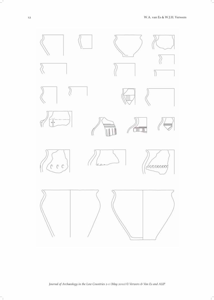
the Rhine and even into Belgium through breaches in the frontier line (De Paepe & Van Impe; Rogge & Van Doorselaer ). De Geer yielded many potsherds of the Rhine-WeserGermanic (RWG) style group. The coarse ware category is especially well represented mostlyvia large pots (cauldrons) tempered with crushed shell (the shell now has mostly disintegrated,leaving just cavities) and globular neckless bowls or pots with an S-shaped profile whose rimand/or shoulder may be decorated with (fingertip) impressions (fig. ). By contrast, fine wares,especially the Von Uslar II situla, are very rare (Von Uslar ). There are some fragments in acomparatively thin and smooth walled, fine sandy fabric but these are more reminiscent ofAnglo-Saxon Schalenurnen, or they are sherds of situlae of the types Wijster IA (especially ICand ID) (Van Es ).Good parallels for the coarser ware have been found at Bennekom, a Free Germanic settle-
ment on the far side of the Rhine a small distance east of De Geer (Van Es et al. ). There arejust a few Wijster-type situlae there. These point to links with the coastal region of Germanyand the northern Netherlands. Possibly the suppliers of this ware at De Geer came fromDrenthe, where the pottery styles of the RWG group and the North Sea coast are found to-gether. However, the provenance of the Late Roman handmade ware at De Geer may be any-where along the western flank of the RWG region on the sandy soils north of the Rhine fromGelderland up to Drenthe. It is impossible to date this handmade pottery at De Geer moreclosely than to the third-fifth centuries AD.This kind of handmade pottery is associated with settlements in which rectangular long-
houses were the principal components. Unfortunately, there are no distinct house plans, a prob-lem that affects all settlement periods at De Geer as a result of long habitation in a fairly con-fined area and medieval and later tilling. So far, it is only at Tiel-Passewaaij, not far from DeGeer on the Roman side of the Rhine, that two distinct plans of Germanic houses of the LaterRoman period have been uncovered (Heeren , -). One of these two is a short structureof the special type Wijster IIa, which is known from the sandy soils from Drenthe all the waydown to the Rhine and thus is a positive indication of settlers from those parts (Van Es &
Early Medieval settlements along the Rhine: precursors and contemporaries of Dorestad
Journal of Archaeology in the Low Countries - (May ) © Verwers & Van Es and AUP
W.A. van Es & W.J.H. Verwers
Journal of Archaeology in the Low Countries - (May ) © Verwers & Van Es and AUP

Fig. De Geer: Late Roman handmade pottery. Scale :.
Taayke ). The plans at Tiel are attributed to Phase , i.e. between AD / and .Similar houses would also have been introduced by Germanic settlers at De Geer. There, farm-stead sites rather than house plans can be recognised, but the size of the settlement cannot beascertained. It appears to be centred on an older Roman ‘enclosure’.The conditions under which Germanic settlers recolonised the frontier zone are unclear. Did
they settle on their own terms or under Roman supervision? Probably it was a bit of both. Evenin the case of autonomous colonisation, some form of accommodation with the Roman author-ities would have been inevitable, certainly during episodes of revived Roman authority. In anycase, people were happy to make use of what remained of the Roman infrastructure. Evidenceof this is the presence of Late Roman coinage and ceramics. Not only did fourth-century cook-ing pots of Mayen ware reach De Geer, but also rouletted sigillata ware, painted ware in ‘d’technique and terra nigra-like drinking cups of the type Chenet , although the latter can nolonger be confidently traced to truly Roman production centres (Bakker ).Near the Kromme Rijn and upstream, in the eastern river region, fourth-century settlements
like that at De Geer were much less numerous than their predecessors from the Middle Romanperiod, but still far from rare. As in Batavian times, they would have had an agrarian basis butmany of their young men are likely to have opted for a warrior’s life in the Roman legions orelsewhere. In this respect too, very little had in fact changed. However, the inhabitants of thefrontier zone now no longer called themselves Batavians, but Franks, and they were largelymade up of (possibly) expressly invited Germanic colonists from beyond the Rhine. Not all ofthese Late Roman period settlements withstood the ravages of time. At Tiel-Passewaaij, forinstance, habitation abruptly ceased in the first half of the fifth century but at De Geer thesequence of archaeological finds continues unbroken right into the days of Dorestad. Althougharchaeological finds never offer total certainty, we can rule out long periods without any occu-pation between the fifth and ninth centuries (fig. ). Why continuity of habitation is clearlyevident at De Geer and not throughout the region is a question that the current state of researchcannot yet answer. Its location in the principal corridor of the Rhine system and close to a (for-mer) Roman frontier fort may have played a part.
Early Medieval settlements along the Rhine: precursors and contemporaries of Dorestad
Journal of Archaeology in the Low Countries - (May ) © Verwers & Van Es and AUP

Fig. De Geer: Merovingian rough-walled wheel thrown pottery (Wölbwandtöpfe). Scale :.
.. Early Middle Ages
The origin of the Early Medieval settlement at De Geer is as yet unclear. No clear-cut plans ofdwellings have been identified. They must have been rectangular, timber-built farmhouses,probably quite like those of the types Odoorn A to C in Drenthe (Waterbolk ). Similarhouses are known elsewhere in the Rhine delta, for instance at Rijnsburg and Oegstgeest (VanEs ; Hamburg & Hemminga ). Comparisons are also provided by Dorestad itself,where colossal timber houses were built (fig. ) (Van Es & Verwers ). The sites of the actualhouses at De Geer are often recognisable by rows of pits running parallel to the gable ends, aphenomenon also known from Dorestad where multiple rows of pits may accompany the same
W.A. van Es & W.J.H. Verwers
Journal of Archaeology in the Low Countries - (May ) © Verwers & Van Es and AUP

Fig. Excavation plans of . Rijnsburg, . Oegstgeest, . Dorestad. Scale :.
Early Medieval settlements along the Rhine: precursors and contemporaries of Dorestad
Journal of Archaeology in the Low Countries - (May ) © Verwers & Van Es and AUP

Fig. Dorestad: plan of a timber farmhouse with pits. Scale :. . house phase ; . house phase ; . houseX; . wattle fencing?; . house Y phase ; . house Y phase ; . house Z; . Well; . spicarium, granary.
house (fig. ). These pits may have served a variety of functions, such as rubbish pits or latrines.When the gable ends were moved in the event of refurbishment or extension, it seems that the
W.A. van Es & W.J.H. Verwers
Journal of Archaeology in the Low Countries - (May ) © Verwers & Van Es and AUP

Fig. De Geer: topography. . western levee along riverbed remnant; . Roman complex; . Carolingian complex;. moated dwelling site; . limits of excavated area; . phosphate concentration.
pits were also relocated. Moreover wells, lined with wine casks or hollowed tree trunks, werecommonly used at De Geer (Verwers & Botman ). Their position relative to the farms is,however, difficult to ascertain. The latter seem to focus on the site of the Roman ‘enclosure’,which included the highest part of the site. Here, clusters of pits point to the presence of ten,possibly twenty, houses (the picture is quite uncertain), which of course need not have existedsimultaneously. However, the settlement was not limited to this part of the site and has notbeen fully excavated. The settlement’s size therefore remains uncertain but it must have been afairly large complex comprising at least five, and probably more farmsteads. In as far as can beascertained, the farmsteads were oriented roughly north-south, parallel to the axis of the levee,and were built on the levee and the sediment-filled riverbed remnant beside it.Major changes occurred at De Geer towards the end of the Dorestad’s lifespan or perhaps
somewhat later. An elongated ‘enclosure’measuring x mwas laid out partly on the leveeand partly on the former riverbed beside it (fig. ). The surrounding ditches were mostly over
Early Medieval settlements along the Rhine: precursors and contemporaries of Dorestad
Journal of Archaeology in the Low Countries - (May ) © Verwers & Van Es and AUP

Fig. De Geer and Dorestad: plans of timber-farmhouses. Scale :. . De Geer; . Dorestad (Van Es &Verwers , no. ).
m wide and it seems likely that the excavated soil was made into a bank. No traces of anybank could be identified, however, since the excavation level lay below the Early Medieval sur-face. The ‘enclosure’ consisted of at least two parts which connected at a slight angle. Thenorthern part was c. m long and the southern part, c. m. Possibly the two parts werenot constructed at the same time and the fact that the join coincides with the old Roman ‘en-closure’ can hardly be coincidental. A ditch running parallel to the complex on the west sideand disappearing beneath associated ditches hints at an even more complex site biography. Theditches of the large ‘enclosure’ cut across Early Medieval habitation features in several places.One of the very few distinct house plans at De Geer possibly belongs to the ‘enclosure’. It is atimber structure of to x m and these dimensions match the large and comparatively latefarmhouses at Dorestad (fig. ) (Van Es & Verwers , e.g. fig. ). The distinctive plan at DeGeer also indicates a late date. That this building, most probably a farmhouse, is coeval withthe system of drainage ditches is suggested by its position parallel to the longitudinal axis ofthe ditch system and in line with the kink where the two parts of the system link up. This doesnot mean that the house was the only one within the ditch system but no other clearly asso-ciated features were distinguished.The dating and interpretation of the large ‘enclosure’ remain problematic. The earliest pottery
in the ditches is Carolingian but many or all of these sherds may have been brought to the sur-face from older settlement features as the ditches were dug. Among this pottery the youngestvarieties are late Badorf/early Pingsdorf ware dating from the latter half of the ninth century,
W.A. van Es & W.J.H. Verwers
Journal of Archaeology in the Low Countries - (May ) © Verwers & Van Es and AUP

possibly even the early tenth. There doesn’t seem to be very much of this late material. Youngerpottery is absent from the ‘enclosure’s’ ditches. All of this suggests that the ditch system datesfrom the ninth century, possibly contemporary with late Dorestad or even somewhat later.After the Carolingian occupation phase, De Geer seems to have been abandoned for about
three centuries. This was followed by a final occupation phase between c. and . Thena moated dwelling site (begraven hofstad) arose at De Geer: a small, brick-built castle with afarmhouse surrounded by a system of moats which, in contrast to the older system, was laidout in a neatly rectangular fashion (Van Doesburg ). The east side of the dwelling siteexactly coincides with the centre of the older enclosure.Just as may have happened in the Middle Roman period, after the Carolingian period De
Geer temporarily changes from a ‘site’ into an ‘off-site’ without there necessarily being a breakin the chain of owners or users. The founder of the thirteenth-century moated dwelling mayhave been a descendant or some other legal successor of the owner of the large ditch complex.The seigneurial (knightly) status of the High Medieval owner is beyond doubt. Might his pre-decessor also have belonged to the elite of his day? The huge array of ditches (and possiblybanks) seems to suggest this. Thus far we have regarded this complex as a fortified refugecoeval with the (final) phase of Dorestad (Van Es & Hessing , fig. ). We now considerthis explanation a little fanciful. The defensive potential of the ditches and possible banks can-not have been very great. We are now more inclined to regard it as a demesne, the seat of a richlandowner or his representative. At any rate it is evident that at the end of the Dorestad epochor shortly after, a far-reaching reorganisation took place at the settlement of De Geer but it ishard to archaeologically determine what happened with a degree of precision. Unfortunately,we lack any documentary evidence that might shed light on the course of events.
. Rijswijk and Leut near Wijk bij Duurstede
.. The castellum Levefanum
It had long been assumed that the name Levefanum on the Peutinger Map referred to a Romanfrontier castellum in the vicinity of Rijswijk (province of Gelderland). This hypothesis was cor-roborated in , when dredging in the floodplain of the Lower Rhine at Rijswijk brought uplarge numbers of Roman finds among the sand and gravel. In conjunction with our excavationsat Dorestad, archaeologists aboard the dredgers over a period of about six months collectedsamples of these finds. However voluminous, the gathered material represents just a fractionof what must have been dredged up in the way of artefacts (Van Es ). The vast majoritywere lost and others were dispersed in poorly accessible private collections. Our findings relat-ing to Levefanum are largely based on the material from the sample. This consists mainly ofpotsherds but also includes parts of Roman military equipment, especially fragments of hel-mets, which demonstrate the military character of the site. Moreover, the composition of theceramic assemblage points to a fully Roman rather than a Batavian settlement (Table ).Thanks to the dredging finds, the castellum Levefanum has now been approximately located.
In all probability, the actual fort was eroded away by the Rhine as the finds came from a deepsandy deposit covered by three metres of clay. The strategic location of Levefanum, where therivers Lek and Rhine diverge, is comparable to that of Vechten and Utrecht, the next frontierforts downstream which guarded the forking of the Kromme Rijn and Vecht. On this basis wemay assume that Levefanum covered about the same area as these two castella, between and
hectares. The history of Levefanum will in the main have matched that of the other forts in theDutch frontier zone. Hence this castellum would also have been rebuilt in brick and stone dur-ing the third century. The defensive wall and the (main) buildings within are likely to havebeen kept in a more or less serviceable state right into the early fifth century.
Early Medieval settlements along the Rhine: precursors and contemporaries of Dorestad
Journal of Archaeology in the Low Countries - (May ) © Verwers & Van Es and AUP

A standard feature of every frontier fort was the vicus, the ‘civilian’ service settlement adjoin-ing the fort on two or three sides and covering an area at least equal to it. The name Levefanumhas been emended by Stolte to ‘Haevae Fanum’, the sanctuary of the otherwise unknown andpossibly regional goddess Haeva (Stolte ). If this is correct, her temple may have stoodwithin the vicus of the castellum or in its immediate vicinity. In that case, this area was of morethan local significance, maybe even from before the arrival of the Romans. The dredged-uphelmets may have belonged to a deposit of votive gifts.The third century must have also resulted in great changes at Levefanum. Our Roman dred-
ging finds mainly date to the Middle Roman period. Late Roman finds are absent from ourcollection. We are unaware of any fourth-century potsherds or other finds, such as coins, inprivate collections.Given the conditions under which the archaeological documentation of Levefanum took
place, a lack of certain finds does not justify the conclusion that the site was deserted. Hence itremains an open question whether the castellum Levefanum cum annexis ever accommodated aLate Roman or Frankish settlement, like those so clearly evident at De Geer and arguably pre-sent at the nearby castellum of Traiectum (Utrecht) (Van Lith de Jeude ).There are no other dredging finds for subsequent periods until the Merovingian period. It is
difficult to tell exactly when, but in the course of the seventh century at the latest there defi-nitely was habitation at the site of Levefanum and sherds indicate that this occupation phasecontinued beyond the days of Dorestad. A comparison with the pottery excavated at Dorestadsuggests that the castellum site was reoccupied before the middle of the seventh century.Whether the site was unoccupied throughout the intervening centuries remains a moot pointbecause of the scarcity of the available evidence. The name Levefanum at any rate was lost, asat the end of the seventh century the written sources speak of ‘castrum Dorestad’, which mustrefer to the former Roman frontier fort.
rim sherds rims, % wall and base sherds total number overall %
Terra sigillata , ,Terra nigra(-like) , ,colour-coated , ,smooth-walled , ,rough-walled , ,Dolium ,Amphora , ,Mortar , ,total Roman , ,
native , ,Roman , ,total , ,
Table . Rijswijk/Levefanum: sample of Roman pottery (dredging finds ); after Van Es .
.. Rijswijk / villa Risuuic
In a List of Landed Property of the diocese of Utrecht, Rijswijk features as ‘villa Risuuic’ (Hen-derikx , especially , ). This list was compiled in the late ninth and first half of thetenth century in an attempt to reclaim lost possessions of the Chapter of St Martin’s, and hencereflects an earlier situation. It relates to the Utrecht diocese’s landed property acquired betweenthe first quarter of the eighth century and the years of Viking domination (c. -). At Rijs-wijk this included part of a villa, comprising a church with its land and three other mansa. Thelist tells us nothing about the full size and the layout of the settlement. The presence of a churchsuggests a fair-sized habitation, which we might envisage as an ordered complex of farms,
W.A. van Es & W.J.H. Verwers
Journal of Archaeology in the Low Countries - (May ) © Verwers & Van Es and AUP
comparable to that of De Geer, but with a church. If we presume that the latter stood at roughlythe same spot as the present-day village church of Rijswijk, the villa would have been at adistance of no more than a few hundred metres from the castellum. Maybe it was even locatedwithin the vicus. We might indeed speculate that the first (wooden?) church Christianised theold pagan cult site of Haeva. Such a (private) chapel is unlikely to have been founded beforethe late eighth century. The founder is unknown. It is generally assumed that the territories ofthe Roman castella became royal estates. Might the villa have been part of this?There are two main possibilities for the origins of the villa. Either it was a new foundation in
Merovingian times or it developed from an older habitation, going back to at least the LateRoman period. In the latter case, it may have evolved from the Roman vicus, possibly with aconnecting Frankish phase. The parallels to De Geer would in that case be very strong, butwithout further evidence this must remain mere conjecture. Nor do we have any indication asregards the donor’s identity.
.. Leut / Lote villa
Archaeologically nothing is known about the Lote villa. Not a single find can be attributed to itwith certainty. Even the location of Leut has never been pinpointed as it ceased to exist as aseparate settlement when it was incorporated into the town of Wijk bij Duurstede. It is believedto have occupied the opposite (right-hand) bank of the Kromme Rijn but survives only in thefield name ‘Leuterveld’ (Dekker ). There is no doubt about its existence as a contemporaryof Dorestad as it is mentioned in the Utrecht List of Landed Property. Therefore it merits con-sideration as one of the possible roots of Dorestad. At the Lote villa, the chapter of St Martinspossessed a church with its land and seven other mansa, but not the royal tithe (Henderikx, especially , ). Much of what was said about Risuuic may also apply to Lote. In anycase, the presumably private chapel also points to high-ranking donors.
Other Early Medieval settlements along the Rhine
. Roomburg / Matilo
Close to present-day Roomburg lay the Roman frontier fort Matilo which guarded the FossaCorbulonis where it joined the Rhine. Thus the site is a parallel to Rijswijk/Levefanum. Recentexcavations have shed light on Matilo. This research focused mainly on the canal banks and onthe vicus to the west of the fort. We still know very little about the castellum itself and sincewhat remained of the site after the building of a housing estate has been declared an archaeolo-gical monument, there is little prospect of new evidence emerging in the near future. Theoccupation history of Matilo will on the whole be quite similar to that of other castella alongthe limes in the Netherlands. This means a transition from timber construction to building instone and brick and regular use well into the third century.So far, finds from the fourth and fifth centuries are rare at Roomburg. Only one brooch dates
to the fifth century and the fourth is represented by one coin, a few brooches and some pottery.W.A.M. Hessing, the excavator at Roomburg, considers this insufficient evidence to prove con-tinuous habitation at or close to the castellum. He believes the finds to reflect the occasionalpresence of small numbers of ‘visitors’, but in fact it is rather premature to rule out more inten-sive activity. The excavations have so far been quite small-scale and the fifth century in particu-lar is notoriously hard to detect in this part of the world. We are dependent on handmade‘Frankish’ or ‘Anglo-Saxon’ pottery, which is difficult to date and interpret. As regards Matilo,it would be prudent to suspend judgment for the time being.
Early Medieval settlements along the Rhine: precursors and contemporaries of Dorestad
Journal of Archaeology in the Low Countries - (May ) © Verwers & Van Es and AUP

The same problem occurs with other frontier forts that have yielded fourth- and/or fifth-cen-tury finds. The survey by W.J.H. Willems remains an excellent overview (Willems ,-). Evidence of Roman military use in the fourth century at the castella is mostly limitedto the stretches of the limes upstream from Utrecht. One of these is the fort Maurik/Mannari-cium, situated near Wijk bij Duurstede not far east of Rijswijk. This also supports the likelihoodof a Late Roman phase at Levefanum. Downstream from Utrecht, only the mouth of the Rhineseems to have remained fortified at the castella of Valkenburg (province of Zuid-Holland) andpresumably also Brittenburg, which was subsequently lost to the sea. The rich river region eastof the Utrecht-Rossum line remained more markedly Roman during the fourth century, beingmore closely linked to the Belgian-German hinterland.There are only two castella where fifth-century and possibly also Merovingian finds might
point to continuous habitation, Utrecht/Traiectum, and Meinerswijk/Castra Herculis near Arn-hem. In both cases, the evidence results from comparatively small excavations. Therefore fullcontinuity can be warranted in neither case or, as Willems concludes in the case of Meinerswijk,the finds are ‘evidence for either continued, renewed or intermittent occupation’. But he ishopeful: ‘... future research will undoubtedly produce evidence for several Early and Late Med-ieval phases’ (Willems , -). Given its position not far from the mouth of the Rhine,there may yet be hope for Matilo in this respect, but any verification will require more diggingthere. At Nijmegen, which can boast a huge volume of excavations, there is no longer anydoubt as to the continuous transition from the local Late Roman fort, via a Frankish and aMerovingian phase to the Carolingian imperial palace (Willems & Van Enckevoort , -).From the sixth century onwards, habitation at Roomburg is no longer a matter of debate. Its
start is impossible to pinpoint closely. A pseudo-coin brooch found close to the castellum datesfrom the end of the sixth century at the earliest, but habitation is likely to have started beforethen. The number of Early Medieval pottery finds is quite large, suggesting a settlement ofsome significance. These were mainly recovered from confined areas on both banks of the FossaCorbulonis immediately west of the castellum. Clearly the former vicus site was in use duringMerovingian and Carolingian days (possibly without interruption). This definitely applies forseventh and early eighth centuries, as new revetments are shown to have been put in along theFossa between and , between and , and between and . Evidently the set-tlement was oriented on the waterway. One of the definite attractions of castellum sites was thatthey offered good access to the Rhine. The old harbour facilities apparently were still quiteserviceable after a few repairs.There is not enough evidence to determine the nature and the extent of the Early Medieval
settlement at Roomburg. Neither do we know whether it included the actual fort. Early Medie-val reuse of a former castellum site on the limes has been attested at Utrecht and at Valkenburg(province of Zuid-Holland), not coincidentally two of the very few Dutch castellawhere excava-tions have taken place. Utrecht became the seat of the Frisian missionary and Valkenburg mayhave been a manorial centre. This may also have been the case with the Roomburg castellum.The pits at the former vicus site contained evidence of artisanal activity but this does not neces-sarily mean that the settlement specialised in trade and industry. Artisans were also active atmainly agrarian villae. The harbour precinct on the Rhine and the Fossa Corbulonis would havebelonged a larger complex which undoubtedly also included a number of farms and maybe theactual castellum. Its location and facilities made it possible for Early Medieval Roomburg tooperate as one of the smaller trading settlements in the Dutch river delta that coexisted withDorestad. Other examples are Utrecht, where a commercial district evolved beside the eccle-siastical precinct, and Meinerswijk near Arnhem, possibly the vicus where, according to a writ-ten source, Frisian traders vainly sought refuge against raiding Norsemen (Lebecq , (cor-pus), & ).
W.A. van Es & W.J.H. Verwers
Journal of Archaeology in the Low Countries - (May ) © Verwers & Van Es and AUP

Fig. Reconstruction of the Carolingian settlement at Koudekerk (after Van Grinsven & Dijkstra ).
All of this of course is strongly reminiscent of Rijswijk/Levefanum. Maybe we should also vi-sualize Rijswijk/Levefanum as a complex encompassing a castellum, a revitalised vicus and anumber of farmsteads in the background. Hessing (Brandenburgh & Hessing ) makes asimilar argument for Roomburg. He surmised that in the eighth to tenth centuries Roomburgincluded ‘several dispersed farms under the supervision of a steward, who was a member ofthe local elite, and whose home was on the site of the former castellum’. At Levefanum suchfarms may have occupied the site of today’s Rijswijk (the Risuuic villa). It is hoped that thelocation of the farms at Roomburg will be revealed in the future. Maybe they were not all thatdispersed after all. A clearer picture of an Early Medieval is offered at Koudekerk.One final note about Roomburg, it is said that original crown land there had been donated to
the church at Utrecht only to have been embezzled by the count of Holland during or in thewake of the Viking raids. Rodenburg castle was built here in the thirteenth century and it isreminiscent of the moated dwelling site at De Geer. However, the developments that promptedits construction fall outside the scope of this article.
. Koudekerk
The archaeological evidence relating to Koudekerk is comparatively plentiful, mainly thanks toan excellent recent publication (Van Grinsven & Dijkstra ). Excavations in - cov-ered an area of . hectares. The earliest habitation was found to date from around the begin-ning of the Christian era. This settlement is thought to have been abandoned as a result of theestablishment of the Rhine limes. It lay on the opposite side of the river but probably still fellunder the prata legionis, a fiscal zone where people might visit but not settle. On this basis, thechain of habitation and use may be extended into at least the third century and possibly thezone’s Roman imperial status cast an even longer shadow. The thread of continuous use, how-ever, is a thin one, as the next Merovingian-Carolingian habitation phase is thought not to havestarted until around AD . Maybe this starting date, given the presence of some fifth-centurybrooches and mortar fragments, could be brought forward a little but it still leaves a gap of twocenturies or more. Continuous occupation from Roman times onwards is ruled out, at any ratein the excavated area. Interestingly, the Early Medieval habitation occupied roughly the samesite as that of the beginning of the first century AD.The Early Medieval settlement lay midway between two former limes forts, km upstream
from Roomburg (fig. ). Thus there was no direct link with a castellum site. Neither was it
Early Medieval settlements along the Rhine: precursors and contemporaries of Dorestad
Journal of Archaeology in the Low Countries - (May ) © Verwers & Van Es and AUP

located on the bank of the Rhine, with which it had no navigable connection. An ancient cre-vasse gully connected to the Rhine bisected the habitation sit, but by Merovingian times mostof it had already become filled with sediment and was merely used for drainage. The distanceto the river was just a few hundred meters. This geography is reminiscent of De Geer andparallels are also found in the nature of the settlements. Merovingian-Carolingian Koudekerkwas a complex of farms laid out on a rectangular grid system on either side of the rudimentarygully (fig. ). The complex consisted of six farmsteads, each with a farmhouse, a well and theusual outhouses. There were six farms and maybe more since the excavation did not cover theentire settlement. No house plans were recorded but the evidence of their clearly recognizablesites indicates that they were rectangular longhouses measuring about x meters. All six ormore are thought to have been occupied contemporaneously.This evidence pertains to the Merovingian period. It is, however, doubtful that the excava-
tions fully cover this period. No habitation traces of Carolingian times were found, thoughthere were finds of the period. Could it be that the Carolingian settlement lay just outside theexcavated area or were its traces obliterated by subsequent land use such as clay digging? Un-fortunately, Koudekerk resembles De Geer even in the poor preservation of its archaeologicalfeatures. Therefore we can only assume that the settlement pattern remained essentially un-changed. It is the finds which make it plausible that occupation at Koudekerk was continuousbetween AD and /.
. Oegstgeest, Rijnsburg, The Hague-Frankenslag, Katwijk-zanderij Westerbaan andValkenburg-De Woerd
Parts of similar settlements have been uncovered near the mouth of the Oude Rijn (Hamburg &Hemminga ; ). Oegstgeest-Rijnfront and Rijnsburg are fine examples. Oegstgeest isdated between / and and Rijnsburg from the seventh to the tenth centuries. No Ro-man precursors were found, probably because these Early Medieval settlements, like Koude-kerk, lay on the opposite side of the Rhine in the former Roman military zone. Both had director indirect access to the river. It is clear that the excavations revealed parts of farmstead clusterslaid out on a grid. Rijnsburg is thought to have been much larger than the excavated area. Thesame structure was observed at The Hague-Frankenslag. The excavations at Katwijk-zanderijWesterbaan were fairly extensive. Still, the recently published detailed excavation report doesnot manage to answer all the questions (Van der Velde ).The sand quarry (zanderij) Westerbaan lies on the Roman side of the Rhine and here an ear-
lier occupation phase did precede the Early Medieval settlement. The situation parallels that ofDe Geer in several respects. The Roman occupation phase ended in the second half of the thirdcentury and here too was followed by an episode marked by a lack of evidence either of occu-pation or of abandonment. This quandary is due in part to the difficulty of dating importedpottery from the late third and early fourth centuries and the fact that its production went intocrisis in the second half of the fourth century (Steures ). At any rate, the Early Medievalsettlement in the north of the excavated area immediately adjoins the Roman settlement.The beginning of the Early Medieval phase at this site is dated to about /. From then
on it was intensively occupied right into Carolingian times. Its heyday is thought to have beenbetween AD and . The layout of the settlement is hard to reconstruct. There seem tohave been several habitation nuclei in a methodically parcelled landscape. The largest exca-vated settlement fragment is a complex of three or four adjoining farmsteads presumably laidout along a road. The full extent of this settlement site is unknown. The area as a whole mayhave accommodated some to farms, allowing . to hectares of arable and grassland foreach. Apart from farmhouses – longhouses – of normal length, there also were short houseswith little byre space, which may indicate a differentation in terms of wealth and/or occupation
W.A. van Es & W.J.H. Verwers
Journal of Archaeology in the Low Countries - (May ) © Verwers & Van Es and AUP

among the occupants. The number of inhabitants of Katwijk-zanderij Westerbaan is estimatedto have been about to . There is no doubt as to their (mainly) agrarian way of life.
According to Blok, the Early Medieval name for Katwijk was Houerathorp, which is believedto mean ‘village of farmhouse dwellers’ and maybe this name referred to one or more of thehabitation nuclei uncovered at the sand quarry (Van der Velde , -).It remains unclear whether the Early Medieval farms of Katwijk-zanderij Westerbaan were
part of any villa or villae. The settlements were of a fairly dynamic nature and in the course ofthe Merovingian-Carolingian era at least partially shifted their location. The origin of the set-tlers is uncertain. Those who exploited the third-century farms are called newcomers, arrivingeither from north of the limes or from elsewhere within the region. Given the problem of con-tinuity in the Late Roman period, the question arises whether the fifth-century inhabitants canalso be branded as newcomers. On the basis of his analysis of the metal finds, Knol’s conclusionis that initially Frankish connections prevailed, followed by strong Frisian links (Knol ).Thus far, all excavations around the mouth of the Rhine have only revealed settlements made
up of multiple dwellings. There seem to have been no scattered, isolated farmsteads.Imports and traces of artisanal production have been found in all of these settlements. This
implies that they were part of a (supra-)regional, indeed international socio-economic exchangenetwork (Van Es ) but not that they were specialised trading or production sites. Artisanalactivities up to a certain point were an everyday part of the farming economy. There is noevidence that the settlements in question exceeded the agrarian ‘standard’. The excavated partof Oegstgeest-Rijnfront does not appear to warrant the conclusion that that it ‘occupied an im-portant position in the region and functioned as a trading and (production) site of regionalsignificance’ (Hamburg & Hemminga , ). Such places without doubt did exist in thisregion and, in our opinion, are sooner to be expected at the former vicus sites near castella, as atRoomburg. Another good candidate is the (also very partially excavated) Early Medieval site ofValkenburg-De Woerd.The history of Valkenburg-De Woerd begins at the establishment of the Roman limes. In the
mid-first century AD a military entrepot harbour was laid out here, which must have been partof the vicus of castellum Valkenburg. The distance between the two is just over half a kilometre.After studying the recovered terra sigillata stamps, J.H.F. Bloemers and H. Sarfatij believe thatthe larger settlement which in the second century replaced the port, became more ‘civilian’ incharacter (Bloemers & Sarfatij ). Yet this is unlikely to mean that De Woerd ceased to befiscal territory and that we are now dealing with a purely civilian vicus. Roman occupationceased around AD . Between that year and the seventh century there is a lack of finds. If wewant to propose any kind of continuity between the Roman and the Early Medieval occupationphases, this must again be on the strength of Early Medieval princes harking back to Romanimperial prerogatives.Our image of Early Medieval Valkenburg-De Woerd can only be based on the very provi-
sional evidence published in and , immediately after the excavations (Bult & Halle-was ; Bult et al. ). The results were not very clear-cut, the reconstructed house plans inparticular being quite different from what might be expected. In our opinion the settlement isbest characterised as a miniature Dorestad. Its physiography perfectly matches the part of Dor-estad excavated along the Hoogstraat. In both cases the settlement was laid out along the innercurve of a Rhine meander, on a natural levee originating in or directly after the Roman periodin a river basin in which the meandering river shifted its bed from west to east. This naturalprocess continued after the Early Middle Ages. At Valkenburg-De Woerd, the habitation mighthave reoccupied part of the site of the Roman settlement behind it (i.e., west of it). The layout ofEarly Medieval Valkenburg-De Woerd also seems to parallel that of Dorestad. The shore wasdivided into fairly narrow plots at right angles to the river. The width of the plots it still diffi-cult to ascertain but a riverside abutment is thought to have been about metres wide. Ac-cording to the excavators, the houses were rectangular, measured . x to metres, and in
Early Medieval settlements along the Rhine: precursors and contemporaries of Dorestad
Journal of Archaeology in the Low Countries - (May ) © Verwers & Van Es and AUP

some cases were aligned one behind the other, all at right angles to the river, like the plots.Their plans are so unusual, however, that one wonders whether these posthole patterns are notmore likely to represent substructures of houses. Just as at Dorestad, wells are remarkablynumerous and often placed in rows. There is evidence of bone and antler working and of live-stock rearing or, at any rate, the butchering of fairly young livestock.If anywhere, it is at Valkenburg-De Woerd that archaeology has hit upon one of those small,
secondary trading settlements of which there must have been many in the delta and which areoccasionally referred to in written sources, e.g. at Meinerswijk. It is an interesting possibilitythat De Woerd and the castellum were still part of a single estate even in the Early MiddleAges. The church in the castellum is believed to have been one of the earliest in the westernNetherlands and according to the List of Landed Property it belonged to St Martin’s at Utrecht.The donor must have been none less than the king. It is possible that De Woerd was also crownland. The List of Landed Property expressly mentions the church cum omnibus appendiciis ...totum et integrum, but it is unclear whether this included De Woerd (Bult et al. , ). Forthe early church of Oegstgeest, a foundation date ‘in the first quarter of the eighth century or alittle later’ has been suggested as part of a donation to St. Willibrord (Bult & Hallewas , ;Halbertsma , -, -). That Oegstgeest-Rijnfront was anything other than a ruralsettlement is unlikely, if only because of its location on the Rhine across from Valkenburg-DeWoerd but on the bank that started to be eroded in the Early Middle Ages. It is imaginable thatDe Woerd and Rijnfront were complementary settlements, which would present an interestingparallel to Leut situated across the river from Dorestad.The farming settlement at Rijnsburg is one of those rare cases where the archaeological evi-
dence is supplemented by the names and social background of its owners. In an importantstudy, Sarfatij demonstrated that the excavated remains belong to the Rothulfuashem villamentioned in the List of Landed Property, the precursor of today’s Rijnsburg (Sarfatij ).
According to Henderikx it was an early donation dating from the early years or the first half ofthe eighth century. The donors were probably relatives, among whom Rothulf, presumably adescendant of the villa’s original name-giver, seems to have been the most important. Alsomentioned are Aldberga (Rothulf’s wife?) and one Erulf. The family possessed more landedproperty in the region than just Rothulfuashem and donated other properties to Utrecht. Theyclearly were major landowners. The information about Rijnsburg in the document is exception-ally elaborate. It says that Rothulf and Aldberga lived locally at their villa. Did they move outafter donating it or was their family line dying out? Of course we remain ignorant of most ofthe story. However, we do learn that the actual settlement (ofstedi) lay at Rijnsburg south of theriver Vliet and the associated farmland (a total of mansa) on the opposite side. This coveredan area of about hectares. Of the ofstedi Rothulfuashem, three houses (i.e. three farm-steads?) have been excavated. There must have been far more indeed, in order to farm such anexpanse of land. We do not know whether the family’s possessions included harbourage on theRhine. If so, it was not immediately connected with Rothulfuashem as the distance to the riveris about half a kilometre. The nearest harbour presumably was at Valkenburg-De Woerd.There is a possibility that the villa excavated at Koudekerk belonged to a larger complex. It
has been suggested that Koudekerk was one of the toll ports of the Carolingian realm (Verkerk). If this was the case, it cannot have been at the excavated site, which lacked access to theRhine. On the riverbank today we do find the church and it cannot be ruled out that this churchhad an Early Medieval predecessor. Harbour facilities might then be sought in the vicinity of thechurch, together with any dwelling for the owner or the steward of the estate. In the Early Mid-dle Ages Koudekerk was known by a different name, now lost. It has been suggested that Kou-dekerk should be identified with a place called Holtlant, or with yet another still enigmaticplace name mentioned in the Utrecht List of Landed Property (Van der Linden ). Thiswould mean that Koudekerk had been wholly or in part donated to the diocese by wealthylandowners. Thus there are several pointers to suggest that in the Early Middle Ages Koude-
W.A. van Es & W.J.H. Verwers
Journal of Archaeology in the Low Countries - (May ) © Verwers & Van Es and AUP

kerk was an estate comprising various elements, the excavated farmhouses representing theagrarian component.
. Upstream from Rijswijk / Levefanum
To date, no Early Medieval farming settlements have been excavated upstream from Rijswijk/Levefanum. However, some cemeteries in the area attest to a fourth- and fifth-century Frankishphase, followed by Merovingian and (early) Carolingian phases. The principal cemeteries arethose of Rhenen, Wageningen and Elst, all located on the northern bank of the Rhine. Rhenenand Wageningen are at strategic locations where land routes from Free Germanic territorycrossed the river (Rhenen: Ypey ; Wageningen: Van Es ; Hulst & Van Es ; Elst:Verwers & Van Tent in prep.). South of the Rhine, continuous development from Roman intoMerovingian and Carolingian times may be expected at several sites, such as the castellum atMeinerswijk. Yet such developments did not occur without a hitch and problems are encoun-tered in the fifth century. Just north of the Lower Rhine, the farming settlement at Bennekom inFree Germany but with close links to the neighbouring Roman province, was deserted (or atany rate vanishes from sight archaeologically) (Van Es et al. ). In the cemetery of Rhenenwe see a shift, though not a break, in the abandonment of the old Frankish part (Van Es &Wagner ). Such changes are not a local phenomenon but occur throughout the sandy re-gions of the north-eastern Netherlands and adjacent Westphalia, where settlements ‘disappear’(relocated) and funerary rites are altered.No definite explanation has yet been proposed but there might be a link with the early stir-
rings of Merovingian ascendancy. The Franks from the eastern part of the Rhine corridor weretrying their luck elsewhere, supporting Childeric and Clovis and their campaigns in northernGaul. In the sixth century the Merovingian elite remembered the importance of the Lower Rhineand moved in from Ripuarian Cologne to put things straight here. From c. until the earlyseventh century are represented in the cemetery of Rhenen by three generations of rich graves,probably belonging to a single family (Wagner ). Putting things straight meant that the(family) estates along the Lower Rhine were newly laid out, staffed and in some cases (tem-porarily?) reoccupied by their owners. After a dip in the fifth century, this may be what startedthe development of the agricultural estates which in later written sources appear as villae. In theeastern part of the river delta, many, but not necessarily all of these, might have had a LateRoman and fifth-century origin. Indeed, at De Geer some gold finds date to the sixth century.At the same time, the Frisian newcomers in the western Rhine delta behaved in a similar
fashion. They too set about organising their newly acquired estates. Ambitious leaders gainedpolitical power. Gradually the two power blocks came to oppose each other as Franks andFrisians started to vie for the Rhine delta. These power politics provided the backdrop againstwhich we see the emergence of Dorestad in the mid-seventh century.
The pottery
. The Early Medieval pottery at De Geer and Roomburg
This is the first publication of the Early Medieval pottery at De Geer and Roomburg (see tables and ). Two phases have been distinguished. The first covers the Merovingian period fromthe fifth century up to about the mid-seventh century. This is followed by the Dorestad periodwhich ends between and with late Badorf and early Pingsdorf ware.
Early Medieval settlements along the Rhine: precursors and contemporaries of Dorestad
Journal of Archaeology in the Low Countries - (May ) © Verwers & Van Es and AUP

De GeerMerovingian total
Wölbwandtopf
Biconical pot
Dish
Miscellaneous
Total Merovingian
Carolingian H H- H- H- subtotalH IA
H IB
H IC
Subtotal H I
H I
H II
H III
H IV
Total H
Table a. The rim sherds of Early Medieval pottery from De Geer (typology: see Van Es & Verwers ).W = wheel thrown; H = handmade.
De GeerCarolingian W w- w-b w-e w-x w- w-b w- w- w- w- w-b w- w-b w- w- w- w- subtotal total
W IA
W IB
W IC ?
W IIA
W IIB
W IIC
W IID
W IIE
W IIIA
W IIIB
W IIIC
W IIID
W IVA
W IVB
W IVC
W IVD
WVA
WVB
WVIA
WVIIA
WVIIB
WVIII
W IXA
W IXC
Table b. The rim sherds of Early Medieval pottery from De Geer (typology: see Van Es & Verwers ).W = wheel thrown; H = handmade. (Cont. on next page).
W.A. van Es & W.J.H. Verwers
Journal of Archaeology in the Low Countries - (May ) © Verwers & Van Es and AUP

De GeerCarolingian W w- w-b w-e w-x w- w-b w- w- w- w- w-b w- w-b w- w- w- w- subtotal total
WXA
WXB
WXD
WXE
WXIIB
WXIII
WXIVA
WXIVB
WXIVC
WXIVD
WXIVE
WXIVF
WXIVG
WXIVK
Late Badorf B
Late Badorf C
Early Pingsdorf A
Early Pingsdorf B
total W
Table b. The rim sherds of Early Medieval pottery from De Geer (typology: see Van Es & Verwers ).W = wheel thrown; H = handmade.
The sherds from the latter period were determined in detail as to (sub-)type and fabric usingthe typology presented in Van Es & Verwers (; ). For the Merovingian period we stilllack a detailed pottery typology that can be applied more generally to the settlement assem-blages in these parts. We shall distinguish just three principal forms which comprise several(sub-)types and fabrics. For a more detailed classification of the pottery from De Geer the read-er is referred to Bakker .
. Comparison of the Early Medieval pottery from settlements along the Rhine
In table the wheel-thrown pottery from the Dorestad period is divided into three groups. Thisdistinction is in part chronological. The earliest group, comprising types W V-VII, IX, X andXIV, dates from between c. / and / and the two others are dated between ca./ and /. There may be a slight chronological difference between these two, in the sensethat W IIIA and B occurred widely even in the second half of the eighth century while theBadorf ware of types W I, I/II, II and IV is mainly ninth century (Van Es & Verwers , ,table ). However, the difference is a mainly functional one: types W IIIA and B representcooking pots, which are always a major constituent of crockery, while the Badorf ware, madeup of amphoras, jugs and drinking cups (type W IV), will on the whole have served for thestorage and serving of wine and other liquids.
Early Medieval settlements along the Rhine: precursors and contemporaries of Dorestad
Journal of Archaeology in the Low Countries - (May ) © Verwers & Van Es and AUP

RoomburgMerovingian: total total
Wölbwandtöpfe
biconical pot
dish
total
Carolingian:handmade (H) H- H-H IA
H IB
H IC
subtotal H I
H II
H III
total H
wheel-thrown (W) w- w-b w- w-b w- w- w- w- w- w- w- w- total total
W IB
W IIA
W IIB
W IIC
W IID
W IIIA
W IIIB
W IIIC
W IIIE
WVA
WVIA
WVIIA
W IXA
W IXB
WX?
WXIVA
WXIVB
WXIVC
WXIVF
WXIVK
total W
Table . The rim sherds of Early Medieval pottery from Roomburg/Matilo (typology: see Van Es H = handmade.
The assemblages presented in the tables are very different in size. In fact, they all pale intoinsignificance compared with the roughly , rim sherds that we recovered at Dorestad.The finds from the harbour zone along the Hoogstraat (HS) and those from the settlement areaoutside it are presented separately. In addition, the finds from the harbour are listed by excava-tion area (HS to IV).
W.A. van Es & W.J.H. Verwers
Journal of Archaeology in the Low Countries - (May ) © Verwers & Van Es and AUP

The pottery assemblage at De Geer is of such a size that it may well be regarded as represen-tative. In the case of Roomburg this probably is no longer so and the finds from Rijswijk are justa sample. The data relating to Katwijk-zanderij Westerbaan are taken from Dijkstra’s ()description of the pottery.Most of the other columns present data only for the Dorestad period. These are data that we
gathered from different contexts (Van Es & Verwers ; Van Es & Verwers ). The ab-sence of data relating to the Merovingian Period in these columns does not mean that Merovin-gian pottery was lacking in these assemblages. Apart from assemblages from individual sitesthere also are provincial pottery collections, comprising finds from various sites. The number ofDutch sites yielding wheel-thrown pottery from the Dorestad period is considerable (Van Es, fig. ).
..Wheel-thrown pottery from the Merovingian period
The Merovingian wheel-thrown pottery was distributed over large parts of the Netherlands.Apart from the central Netherlands, it is found along the coast right up to the province of Fries-land, where fairly large amounts were recovered from Wijnaldum (Gerrets & De Koning ,-). It is thought to constitute almost % of the pottery dated between and . Re-cently it was also encountered at Leeuwarden-Oldehoofsterkerkhof (Dijkstra & Nicolay ,-) although the quantity here is far smaller. Moreover, in Merovingian and Carolingiantimes there is an overwhelming preponderance of handmade pottery. The wheel-thrown waresdid also occur in the sandy regions to the north and south of the Rhine delta, but in Drenthethey are almost entirely absent. A comprehensive study of Merovingian pottery in the Nether-lands is an urgent desideratum. In the present context, suffice it to say that wheel-thrown pot-tery fulfilled an important part of pottery requirements especially in the Rhine delta and cer-tainly from the fifth century onwards. It is unclear to what extent handmade pottery was alsoin use here at these times. At any rate it does not seem to have played a significant role.De Geer, Koudekerk, Katwijk-zanderij Westerbaan and Roomburg show similar pottery as-
semblages in Merovingian times. The rough-walled cooking pot (the so-calledWölbwandtopf) inits various manifestations accounts for about three-quarters or more of the total, and thesmooth-walled biconical pots are extremely sparsely represented. The latter are overrepre-sented at Katwijk because there the wall sherds were also counted.The differences between the four assemblages are fairly minor. We will refrain from broad
conclusions until the material has been analysed in greater detail. The assemblages from DeGeer, Koudekerk and Katwijk-zanderij Westerbaan appear to be somewhat older than thatfrom Roomburg. For De Geer we assume continuity from the Late Roman period onwards.The category ‘various’ of Koudekerk, which is remarkably voluminous, contains some com-paratively early sherds of Alzei types and pitchers that probably date from the fifth century. AtKatwijk, the rim sherds of Wölbwandtöpfe include some of types Alzey and /. Such earlysherds are unknown from Roomburg. Yet this assemblage is too small and from too limited anexcavation to permit any definite conclusions. The foundation date of Roomburg remains un-certain, while for Koudekerk the fifth century is plausible. The Merovingian potsherds fromRijswijk are of course too few to present a proper pottery assemblage, let alone to reveal afoundation date.Against the background of the widespread occurrence of Merovingian wheel-thrown pottery
in the region, its absence in (the excavated part of) Dorestad is significant. Apart from perhapsa few potsherds, there is no wheel-thrown ware older than roughly the mid-seventh century.
On the banks of the Kromme Rijn east of De Geer (and west of Leut?), the earliest habitationappears to have coincided with the start of Dorestad.
Early Medieval settlements along the Rhine: precursors and contemporaries of Dorestad
Journal of Archaeology in the Low Countries - (May ) © Verwers & Van Es and AUP

Merovingian Dorestad W Dorestad HWölb-wand-topf
biconicalpot
dish miscel-laneous
totalMero-vingian
W V, VI, VII,IX, X, XIV
W IIIAand B
W I, II,I/II, IV
subtotal,theseW types
otherW
H totalDorestadW and H
Dorestad total n
% , , , ,west of Hoogstraat n
% , , , ,Hoogstraat -IV n
% , , , ,HS n
% , , , ,HS I n
% , , , ,HS II n
% , , , ,HS III n
% , , , ,HS IV n
% , , , ,De Geer n
% , , , , , , , , ,Koudekerk n
% , , , , , , , , ,Valkenburg-zanderij n
% , , , , , , ,Roomburg n
% , , , , , , , ,Rijswijk n
% , , , ,Utrecht n
% , , , ,Vlaardingen n
% , , , ,Texel n
% , , , ,North Holland excl. Texel n
% , , , ,Zeeland n
% , , , ,Gelderland excl. Nijmegen n
% , , , ,Overijssel n
% , , , ,Groningen and Friesland n
% , , , ,
Table . Comparison of some Early Medieval pottery assemblages from sites near the Rhine and from the northern Netherlands(typology: see Van Es H = handmade; HS -IV = Dorestad, excavation areas Hoogstraat to IV.
..Wheel-thrown and handmade pottery from the days of Dorestad
In the overall assemblage of wheel-thrown pottery from Dorestad, the early types are the leastwell represented (c. %), while the cooking pots W IIIA and B and the Badorf ware areroughly balanced and together overwhelmingly predominate. When the pottery from the var-ious excavation areas is considered separately, the proportions of the three categories of wheel-thrown ware are found to fluctuate. We shall not seek to explain these differences in this papersince they do not fundamentally deviate from the overall spectrum. The cooking pots W IIIAand B and the Badorf ware jointly account for three-quarters and locally even more of the
W.A. van Es & W.J.H. Verwers
Journal of Archaeology in the Low Countries - (May ) © Verwers & Van Es and AUP

wheel-thrown pottery. The fact that these two groups are roughly contemporary and coverabout half of Dorestad’s chronology prompts the conclusion that pottery imports significantlyincreased from the mid-eighth century onwards. This is connected to the transition from thesmall-scale and scattered production of Merovingian times, of which our ‘early’ group repre-sents the final stage, to production on a more ‘industrial’ scale in the German Vorgebirge.As might be expected, the pottery assemblage from De Geer, which was part of the Dorestad
agglomeration, parallels that of Dorestad. The difference compared to Roomburg and Koude-kerk is obvious. There, the early types make up % or more of the Dorestad-period assem-blage and very clearly outnumber the Badorf ware. The increase of pottery imports in Carolin-gian times is far less evident at Roomburg and Koudekerk. The difference is mainly due to theBadorf ware, the ‘drinking ware’. For a farming community such as Koudekerk this is only tobe expected. At Roomburg, a former vicus beside the Fossa Corbulonis, this is more surprising.However, this pottery assemblage is not very voluminous and from a restricted area and is thusunlikely to be representative of the entire settlement beside (and within?) the castellum. Thisgoes a fortiori for Rijswijk, which shares its high proportion of ‘early’ wares with Roomburgand Koudekerk. At both Roomburg and Koudekerk this ‘early’, i.e. Late Merovingian group isthe tail end of a flow of Merovingian imports starting at an earlier date. The contacts pre-ex-isted and did not need to be newly established in the second half of the seventh century. Thismust also apply to De Geer, but here the ‘early’ wheel-thrown wares have, in manner of speak-ing, been wholly overtaken by the subsequent spate of imports. The explanation may in part liein changing relations between different types of settlement. During the heyday of Dorestad anordinary villa may have had less direct access to the flow of imports monopolised by Dorestad.Koudekerk and Roomburg have a far greater proportion of handmade pottery than Dorestad
and De Geer: almost % against less than %. This is a Frisian feature. Whereas in the vicinityof Dorestad and upstream the handmade pottery seems to have become virtually extinct inMerovingian times, along the North Sea coast the Kugeltopf vessels continued to competeagainst the wheel-thrown cooking pots from the German Rhineland throughout the eighth cen-tury. The Kugeltopf vessels in Dorestad are presumably Frisian imports. They occur compara-tively often in the harbour zone (Hoogstraat to IV). Their high values around the mouth of theRhine match those in other Frisian regions.The right-hand half of table (from the ‘Utrecht city’ column) should be regarded as an
extra, relating only to the wheel-thrown pottery of the Dorestad period. The city of Utrechtand the coastal provinces from Zeeland right up to the isle of Texel show assemblages that areroughly comparable to that of Dorestad but the proportions of the ‘early’ category are ratherlow. This could mean that here too the flow of imported, wheel-thrown pottery acceleratedduring the heyday of Dorestad, i.e. the mid-eighth to the mid-ninth centuries. Yet as long asthe Merovingian pottery from the region in question is not better understood, we should re-frain from drawing conclusions. For the northern coastal zone (of Friesland and Groningen)and the sandy regions in the provinces of Gelderland and Overijssel, such an increment inpottery imports in Carolingian times is certainly plausible. Merovingian wheel-thrown potteryis rare there. Yet it appears that the western margin of Friesland (Westergo) is an exception,where at any rate locally this pottery does occur in some quantity. Westergo lay closest to theRhine delta but here too the beginning and volume of Merovingian imports are yet to be deter-mined. Dorestad must have played a major role in the exportation of Carolingian wheel-thrown pottery to the downstream Rhine delta and along the Dutch coast. For the interior,particularly the province of Overijssel, Deventer is a more likely transit port. This trading set-tlement on the IJssel emerged in the late eighth century, flourished in the ninth century and, incontrast to Dorestad, did survive the Viking raids (Bartels ). The wheel-thrown pottery inthe province of Overijssel anyhow comes from excavations at Deventer. The assemblage ofwheel thrown pottery at Deventer is somewhat ‘younger’ than that of Dorestad since it con-tains a larger proportion of Badorf ware (Van Es & Verwers ).
Early Medieval settlements along the Rhine: precursors and contemporaries of Dorestad
Journal of Archaeology in the Low Countries - (May ) © Verwers & Van Es and AUP

Conclusions
. When Dorestad emerged in the mid-seventh century, there were already settlements of var-ious types and origins along the Rhine.
In the first place, there were the former Roman castella. These combined the prestige of theirRoman origin with the practical advantage of their location directly on the international water-way and were sites eminently suitable for the development of settlements of supra-local impor-tance. The old (harbour) facilities, however dilapidated, were still present.
Second, there were rural settlements consisting of several farmsteads clustered together in anorderly arrangement. So far, no isolated farmsteads are known.
Castella and nearby farming settlements may have operated in a complementary fashion. Thisis what we presume for Levefanum and the Risuuic villa, which together seem to have consti-tuted one of the precusors to Dorestad. Such a symbiosis may also have existed at Roomburg.Other known farming settlements lay too far from a castellum to make close relations likely. DeGeer, another precursor to Dorestad, is an example of such ‘autonomous’ settlements, andmaybe also Lote/Leut.
A third type is the smaller ‘trading settlement’ situated on the bank of the main stream, ofwhich so far Valkenburg-De Woerd is the only excavated example. We imagine that it operatedlike a minor version of Dorestad. In this case too, there may have been operational links with acastellum. These smaller Early Medieval vici – Dorestad being a vicus famosus (‘of renown’) –probably incorporated an agrarian component, as did their illustrious example, but may alsohave maintained economic relations with surrounding farming communities.
. In many cases, several settlements of similar or different types might be in the hands of asingle landowner. Apart from the king and the church, whose landownership steadily in-creased, there were also large private landowners. At Rijnsburg we caught a glimpse of one ofthese families who lived on one of their estates in the region. Whether this was the usual stateof affairs, we do not know. It is likely to have varied through time.
The castella are regarded as royal estates. If Levefanum belonged to the (Merovingian) king,might De Geer, separated from the castellum site by the river Lek, then have been in the posses-sion of one or several regional potentates? As Dorestad emerged, two kings reigned in theRhine region: a Merovingian king and a Frisian one. This situation goes back to the sixth cen-tury, following a fifth-century power vacuum in the Rhine delta. In the context of Frisian-Frankish antagonism, landed properties probably changed hands quite frequently.
. The beginnings of the settlements that we know of in the seventh century are also quitevaried. Some, like De Geer, went back to the (Late) Roman period. Others, such as Koudekerk,did not emerge until the Merovingian period. For the castella, continuity from Roman times isusually hard to prove, yet often quite plausible.
Upstream from Utrecht there seems to be more continuity of occupation than downstream inthe delta, with the exception of the Rhine mouth, where the castella of Roomburg, Valkenburgand Brittenburg (now submerged) are sites of potential continuity.
East of Utrecht, we find evidence of Frankish colonisation in the Late Roman period whichreversed at least part of the depopulation that marked the third century. Theoretically, in the
W.A. van Es & W.J.H. Verwers
Journal of Archaeology in the Low Countries - (May ) © Verwers & Van Es and AUP

Late Roman period the area around the Rhine mouth could have accommodated a similar re-population by Frisians, but so far archaeological evidence of this is rare. Any remaining popu-lation in the fifth century might have been outnumbered by an adventus Frisionum similar intime and process to the adventus Saxonum in Brittannia, an influx of groups of newcomers un-der their own leaders. This could have laid the basis for the subsequent Frisian expansion in theRhine delta.
. In the central Netherlands, from the fifth century onwards imported wheel-thrown potterywholly or largely replaced the native handmade pottery. As yet, little is known about the pro-venance of these Merovingian products but the German Rhineland must have played an im-portant part even then. A reorganisation of production methods in the Eifel mountains and theVorgebirge resulted in an increased stream of exports, which through the facilities offered byDorestad was mainly directed towards the Rhine delta and the Dutch North Sea coast. Thehinterland in the north-eastern Netherlands obtained these wares mostly through the port ofDeventer.
Acknowledgements
The text was translated by Ms drs. Xandra Bardet (Groningen).The illustrations are by Ms drs. M. Haars (Maio’s Enterprise, Amsterdam).
Pim Verwers
Wim van Es
Notes
. ‘Batavian’ ware was not principally associated with the core of the gens Batavorum, which had splitfrom the Chatti and was relocated near Nijmegen by the Romans in c. BC. It was essentially acontinuation of the regional (Eburonian) pottery tradition.
. See also Van Es , table .. Maybe the finds recovered from a former school site on the northeastern edge of the medieval town
centre of Wijk bij Duurstede relate to Leut. Closer examination of this excavation might clarify thematter.
. In his article on Rijnsburg, Sarfatij draws attention to the fact that mansusmay refer either to a farm orto farmland (Sarfatij , ). At Rijnsburg, where the word certainly has the second meaning, themansus was found to be c. hectares in size, which for the entire villa in question would amount toalmost hectares. At Katwijk-zanderij Westerbaan, the area of farmland available to each farm isestimated at . to hectares. Six hectares is roughly the area of farmland that one farming unit (afarm occupied by one extended family) could manage. In this way, the two meanings may coincideagain. It should be noted that in the passages about Risuuic and Lote the land belonging with thechurch is referred to as terrae (‘cum terris’).
. For an overview of the research results, see Brandenburgh & Hessing .. In the Dutch situation archaeological monuments are seldom submitted to research, since the govern-
mental policy is to protect monuments as much as possible for the future.. What, for instance, to make of the fourth/fifth century ‘Anglo-Saxon’ pot found at the site of the Ro-
man town of Forum Hadriani near Voorburg-Den Haag (De Jonge )? Is the pot itself an importor does it point to the arrival of immigrants from the northern Netherlands who settled in the whollyor largely deserted urban area and thus formed a link in the (unbroken?) chain of local occupants?The latter interpretation is the more likely as there is further evidence of Frisian-Anglo-Saxon immi-gration in the coastal part of the province of Zuid-Holland. Waasdorp & Eimermann () envisage
Early Medieval settlements along the Rhine: precursors and contemporaries of Dorestad
Journal of Archaeology in the Low Countries - (May ) © Verwers & Van Es and AUP

a sparse remnant population in the fourth and fifth centuries which was augmented by an influx of‘newcomers’ of ‘Frisian’ stock in the late fifth century. They date the Anglo-Saxon urns from Solleveld(Waasdorp & Eimermann , and ) to the sixth century, which for an urn like Peeters VIIIstrikes us as rather late. They date the fragmentary urns of Tritsum ware very broadly: fourth to sev-enth centuries
. For Utrecht see Van Lith de Jeude .. The excavations at Utrecht were quite limited in scope so the number of Early Medieval finds is
rather small. However, the reuse of the castellum as the seat of the Frisian missionary episcopate ishistorically documented. Early Medieval reuse of the castellum at Valkenburg (Zuid-Holland) is evi-denced by just one grave from the early eighth century (Stein , , Liste , Tafel ). The excava-tions failed to shed much light on the history of this castellum after the Middle Roman period. Theo-retically, the single rich grave may belong to a cemetery around a (private) chapel in a manorialcentre.
.Maybe a closer examination of the handmade pottery from Katwijk will succeed in filling this void.. The recovery of two (possible) touchstones and part of a bronze plaque bearing what has been inter-
preted as a trial impression of a pseudo-Madelinus Dorestad tremissis has suggested the presence of ajeweller’s or minter’s workshop: Van der Velde , -. Conclusive evidence for this hypoth-esis is of course hard to come by.
. See also Henderikx , -, especially notes and .. After the mid-eighth century, graves only contain grave goods in exceptional instances, rendering
them undatable. The associated settlements definitely continued.. This table wrongly suggests that types W IIIA and B did not continue into the ninth century.. There is a small proportion of Roman sherds dating to the Dorestad period.
References
Aarts, J.G. , Coins or money? Exploring the monetization and functions of Roman coinage in Belgic Gauland Lower Germany B.C.-A.D. , PhD thesis VU University Amsterdam.
Bakker, A.M. , Laat-Romeins en Merovingisch draaischijfaardewerk van De Geer in Wijk bij Duurstede,unpublished MA thesis, VU University Amsterdam.
Bartels, M. , De Deventer wal tegen de Vikingen: archeologisch en historisch onderzoek naar de vroegmidde-leeuwse wal en stadsmuren (-) en een vergelijking met andere vroegmiddeleeuwse omwalde nederzet-tingen, Deventer (Rapportages Archeologie Deventer ).
Bloemers, J.H.F. , Rijswijk (Z.H.), ‘De Bult.’ Eine Siedlung der Cananefaten, Amersfoort (NederlandseOudheden ).
Bloemers, J.H.F. & H. Sarfatij , A Roman settlement at De Woerd, Valkenburg (South Holland),Report I: The potters’ stamps, Berichten van de Rijksdienst voor het Oudheidkundig Bodemonderzoek ,-.
Botman, A. , De Domburgfibula, een Fries type?, unpublished MA thesis, VU University Amsterdam).Brandenburgh, C.R. & W.A.M. Hessing , Matilo – Rodenburg – Roomburg. De Roomburgerpolder: van
Romeins castellum tot moderne woonwijk, Leiden.Bult, E.J. & D.P. Hallewas , Graven bij Valkenburg II, het archeologisch onderzoek in , Delft.Bult, E.J. & D.P. Hallewas , Archaeological evidence for the early-medieval settlement around the
Meuse and Rhine deltas up to ca AD . In: J.C. Besteman, J.M. Bos & H.A. Heidinga (eds), Medie-val archaeology in the Netherlands. Studies presented to H.H. van Regteren Altena, Assen/Maastricht, -.
Bult E.J., J. van Doesburg & D.P. Hallewas , De opgravingscampagne in de Vroeg- Middeleeuwsenederzetting op de Woerd bij Valkenburg (Z.H.) in en . In: E.J. Bult & D.P. Hallewas Gravenbij Valkenburg III, het archeologisch onderzoek in en , Delft, -.
De Jonge, W. , Niet zo maar een aardewerk pot. In: W. de Jonge, J. Bazelmans & D. de Jager (eds),Forum Hadriani. Van Romeinse stad tot monument, Utrecht, -.
De Jonge, W., J. Bazelmans & D. de Jager (eds) , Forum Hadriani. Van Romeinse stad tot monument,Utrecht.
Dekker, C. , Het Kromme Rijngebied in de middeleeuwen. Een institutioneel-geografische studie, Zutphen(Stichting Historische Reeks ).
De Paepe, P. & L. van Impe , Historical context and provenancing of Late Roman handmade potteryfrom Belgium, the Netherlands and Germany, Archeologie in Vlaanderen , -.
W.A. van Es & W.J.H. Verwers
Journal of Archaeology in the Low Countries - (May ) © Verwers & Van Es and AUP

Dijkstra, J. & J.A.W. Nicolay (eds) , Een terp op de schop. Archeologisch onderzoek op het Oldehoofsterker-khof te Leeuwarden, Amersfoort/Groningen (ADC monografie ).
Dijkstra, M.F.P. , Aardewerk uit de vroege middeleeuwen. In: H. van der Velde (ed.), Cananefaten enFriezen aan de monding van de Rijn. Tien jaar archeologisch onderzoek op de Zanderij-Westerbaan te Katwijk(-), Amersfoort, - (ADC monografie/ADC Rapport ).
Doesburg, J. van , De begraven hofstad op De Geer bij Wijk bij Duurstede. In: W.A. van Es & W.A.M. Hessing (eds)Romeinen. Friezen en Franken in het hart van Nederland. Van Traiectum naar Dorestad
v.C.- n.C., Utrecht/Amersfoort, -.Gerrets, D. & J. de Koning , Settlement development on the Wijnaldum-Tjitsma terp. In: J.C. Beste-
man, J.M. Bos, D.A. Gerrets, H.A. Heidinga & J. de Koning The excavations at Wijnaldum, Rotterdam/Brookfield (Reports on Friesland in Roman and Medieval times), -.
Grinsven, P.F.A. van & M.F.P. Dijkstra , De vroeg-middeleeuwse nederzetting te Koudekerk aan den Rijn.Een bijna vergeten opgraving in de Lagewaarder Polder, Leiden.
Halbertsma, H. , Frieslands oudheid. Het rijk van de Friese koningen, opkomst en ondergang, Utrecht.Hamburg, T. & M. Hemminga , Vroegmiddeleeuwse handel aan de Rijnmonding - n.Chr. In:
R. Jansen & L.P. Louwe Kooijmans (eds), Van contract tot wetenschap. Tien jaar archeologisch onderzoekdoor Archol BV, -, -.
Heeren, S. , Romanisering van rurale gemeenschappen in de civitas Batavorum. De casus Tiel Passewaaij,Amersfoort (Nederlandse Archeologische Rapporten ).
Hemminga, M. & T. Hamburg , Een Merovingische nederzetting op de oever van de oude Rijn, Leiden(Archol-report ).
Henderikx, P.A. , De beneden-delta van Rijn en Maas, landschap en bewoning van de Romeinse tijd tot ca, Hilversum.
Hessing, W.A.M. , Wijk bij Duurstede ‘De Horden’: Besiedlung und Bestattungen aus der frühenEisenzeit, Berichten van de Rijksdienst voor het Oudheidkundig Bodemonderzoek , -.
Hessing, W.A.M. , Bewoningssporen uit de midden-bronstijd en de vroege ijzertijd op ‘‘De Horden’te Wijk bij Duurstede. In: H. Fokkens & N. Roymans (eds), Nederzettingen uit de bronstijd en de vroegeijzertijd, Amersfoort (Nederlandse Archeologische Rapporten ), -.
Hessing, W.A.M. , Building programmes for the Lower Rhine limes. The impact of the visits ofTrajan and Hadrian to the Lower Rhine. In: H. Sarfatij, W.J.H. Verwers & P.J. Woltering (eds), Indiscussion with the past. Archaeological studies presented to W.A. van Es, Zwolle/Amersfoort, -.
Hessing, W.A.M. & R. Steenbeek , Landscape and habitation history of ‘De Horden’ at Wijk bijDuurstede, an overview, Berichten van de Rijksdienst voor het Oudheidkundig Bodemonderzoek , -.
Hulst, R.S. & W.A. van Es , Wageningen, Reallexikon der Germanischen Altertumskunde, Berlin/NewYork, Band , -.
Knol, E. , Metaal uit de vroege middeleeuwen in Katwijk-Zanderij. In: H. van der Velde (ed.), Cana-nefaten en Friezen aan de monding van de Rijn. Tien jaar archeologisch onderzoek op de Zanderij-Westerbaante Katwijk (-), Amersfoort (ADC monografie/ADC Rapport ), -.
Lebecq, S. , Marchands et navigateurs frisons du Haut Moyen Age, Corpus des sources écrites vol. ,-.
Linnemeyer, N. , Een ijzertijdnederzetting op De Geer, Wijk bij Duurstede (unpublished MA thesis, VUUniversity Amsterdam).
Rogge, M. & A. van Doorselaer , Handgevormd aarden vaatwerk uit de Laat-Romeinse en deVolksverhuizingstijd in Scheldevallei en kustgebied, Westvlaamse Archaeologica , -.
Sarfatij, H. , Die Frühgeschichte von Rijnsburg (.-. Jahrhundert), ein historisch-archäologischerBericht. In: B.L. van Beek, R.W. Brandt & W. Groenman-van Waateringe (eds), Ex Horreo, -.
Stein, F. , Adelsgräber des achten Jahrhunderts in Deutschland, Berlin.Steures, D.C. : Aardewerk, continuïteit en oriëntatie in laat-Romeins Nijmegen, Westerheem , -
.Stolte, B.H. , De Nederlandse plaatsnamen uit de Romeinse tijd, Mededelingen van de Vereniging voor
Naamkunde te Leuven en de Commissie voor Naamkunde te Amsterdam -, -.Taayke, E. , Hand-made pottery from a Roman period settlement at Wijk bij Duurstede-De Horden, Berichten van deRijksdienst voor het Oudheidkundig Bodemonderzoek , -.
Uslar, R. von , Westgermanische Bodenfunde der ersten bis dritten Jahrhunderts nach Christus aus Mittel-und Westdeutschland (Germanische Denkmäler der Frühzeit ), Berlin.
Van der Linden, H. , Het ontstaan van de dorpen in de Rijnstreek. In: P. Leeflang et al. (eds), In deRijnvaart der volkeren. Lezingen uitgesproken ter gelegenheid van het -jarig bestaan van de HistorischeVereniging Alphen aan de Rijn, Alphen aan de Rijn, -.
Early Medieval settlements along the Rhine: precursors and contemporaries of Dorestad
Journal of Archaeology in the Low Countries - (May ) © Verwers & Van Es and AUP
Van der Roest, J. , Die römischen Fibeln von ‘De Horden’, Fibeln aus einer Zivilsiedlung am nieder-germanischen Limes, Berichten van de Rijksdienst voor het Oudheidkundig Bodemonderzoek , -.
Van der Velde, H. (ed.) , Cananefaten en Friezen aan de monding van de Rijn. Tien jaar archeologischonderzoek op de Zanderij-Westerbaan te Katwijk (-), Amersfoort (ADC monografie/ADC Rap-port ).
Van Es, W.A. , Het rijengrafveld van Wageningen, Palaeohistoria , -.Van Es, W.A. , Wijster, a native village beyond the imperial frontier / A.D., PhD thesis Groningen.Van Es, W.A. , Early medieval settlements, Berichten van de Rijksdienst voor het Oudheidkundig Bode-
monderzoek , -.Van Es, W.A. , Romeinse helmen uit de Rijn bij Rijswijk. In: A.O. Kouwenhoven, G.A. de Bruijne &
G.A. Hoekveld (eds), Geplaatst in de tijd, liber amicorum aangeboden aan Prof. Dr. M.W. Heslinga, -.
Van Es, W.A. , Dorestad centred. In: J.C. Besteman, J.M. Bos & H.A. Heidinga (eds), Medieval archae-ology in the Netherlands. Studies presented to H.H. van Regteren Altena, Assen/Maastricht, -.
Van Es, W.A. , Van Maastricht naar Rhenen, een wandeling in de laat-Romeinse tijd, e Kroonvoor-dracht.
Van Es, W.A. & W.J.H. Verwers , Excavations at Dorestad . Hoogstraat I, Amersfoort (NederlandseOudheden ).
Van Es, W.A. & W.J.H. Verwers , Karolingisch draaischijfaardewerk uit Deventer. In: V.T. van Vil-steren & D.J. de Vries (eds), Van beek en land en mensenhand, Feestbundel voor R. van Beek, Utrecht, -(ROB-overdrukken ).
Van Es, W.A., M. Miedema & S.L. Wynia , Eine Siedlung der römischen Kaiserzeit in Bennekom,Provinz Gelderland, Berichten van de Rijksdienst voor het Oudheidkundig Bodemonderzoek , -.
Van Es, W.A. & W.J.H. Verwers , Dorestad: l’archéologie d’un port médiéval, La Recherche , no., mars , (ROB-overdrukken ), -.
Van Es, W.A. & W.A.M. Hessing (eds) , Romeinen. Friezen en Franken in het hart van Nederland. VanTraiectum naar Dorestad v.C.- n.C., Utrecht/Amersfoort.
Van Es, W.A. & W.J.H. Verwers , Handel in Karolingische potten. In: W.A. van Es & W.A.M. Hes-sing (eds) Romeinen. Friezen en Franken in het hart van Nederland. Van Traiectum naar Dorestad v.C.- n.C., Utrecht/Amersfoort, -.
Van Es, W.A. & W.J.H. Verwers , House plans from Dorestad, Berichten van de Rijksdienst voor hetOudheidkundig Bodemonderzoek , -.
Van Es, W.A. & W.J.H. Verwers , De voorgeschiedenis van Wijk bij Duurstede. In: M.A. van derEerden-Vonk, J. Hauer & G.W.J. van Omme (eds), Wijk bij Duurstede jaar stad, ruimtelijke structuuren bouwgeschiedenis, Hilversum, -.
Van Es, W.A. & A. Wagner , Vijfde eeuw op de Donderberg. Begraven in Rhenen tussen Romeinenen Franken. In: D. Kicken, A.M. Koldeweij & J.R. ter Molen (eds), Gevonden voorwerpen. Opstellen overmiddeleeuwse archeologie voor H.J.E. van Beuningen, Rotterdam (Rotterdam Papers ), -.
Van Es, W.A. & E. Taayke , Shorthouse Wijster BIIa: the smith’s secret. In: M. Lodewijckx (ed.)Belgian archaeology in a European setting II.Album Amicorum Josef Mertens, Leuven (Acta ArchaeologicaLovaniensia Monographiae ), -.
Van Es, W.A. & W.J.H. Verwers , Excavations at Dorestad . Hoogstraat , II-IV, Amersfoort (Neder-landse Oudheden ).
Van Lith de Jeude, W.F. , Traiectum na . Een studie naar laat-Romeinse bewoning van het castellumUtrecht, unpublished MA thesis, University of Amsterdam.
Verkerk, C.L. , Het tolsysteem in het mondingsgebied van Rijn, Maas en Schelde tot in de e eeuw.In: A. Carmiggelt (ed.) A contribution to Medieval archaeology. Teksten van lezingen gehouden tij-dens het symposium ‘Handel, handelsplaatsen en handelswaar vanaf de Vroege Middeleeuwen in deLage Landen’, te Rotterdam van - november , Rotterdam (Rotterdam Papers ), -.
Vermeulen, F. , Céramique non-tournée du Haut et du Bas-Empire en Flandre sablonneuse (Belgi-que), S.F.E.C.A.G., actes du Congrès de Tournai.
Verwers, W.J.H. , Roman period settlement traces and cemetery at Wijk bij Duurstede, Berichten vande Rijksdienst voor het Oudheidkundig Bodemonderzoek , -.
Verwers, W.J.H. -, North Brabant in Roman and early medieval times V: habitation history, Ber-ichten van de Rijksdienst voor het Oudheidkundig Bodemonderzoek , -.
Verwers, W.J.H. & A. Botman , Absolute dating of early medieval wells in Wijk bij Duurstede. In: H.Sarfatij, W.J.H. Verwers & P.J. Woltering (eds), In discussion with the past., Archaeological studies pre-sented to W.A. van Es, Zwolle/Amersfoort, -.
W.A. van Es & W.J.H. Verwers
Journal of Archaeology in the Low Countries - (May ) © Verwers & Van Es and AUP

Verwers, W.J.H. & W.J. van Tent in prep., Het Merovingisch grafveld van Elst (gem. Rhenen) (NederlandseArcheologische Rapporten).
Vos, W.K. , Bataafs platteland. Het Romeinse nederzettingslandschap in het Nederlandse Kromme-Rijnge-bied, Amersfoort (Nederlandse Archeologische Rapporten ).
Waasdorp, J.A. & E. Eimermann , Solleveld, een opgraving naar een Merovingisch grafveld aan de randvan Den Haag, Den Haag (Haagse Oudheidkundige Publicaties ).
Wagner, A. , Rijke mannengraven in Rhenen. In: W.A.van Es & W.A.M. Hessing (eds) Romeinen.Friezen en Franken in het hart van Nederland. Van Traiectum naar Dorestad v.C.- n.C., Utrecht/Amersfoort, -.
Waterbolk, H.T. , Getimmerd verleden. Sporen van voor- en vroeghistorische houtbouw op de zand- enkleigronden tussen Eems en IJssel, Groningen (Groningen Archaeological Studies ).
Willems, W.J.H. , Romans and Batavians. A regional study in the Dutch Eastern river area, Amersfoort.Willems, W.J.H. & H. van Enckevoort , VLPIA NOVIOMAGVS. Roman Nijmegen. The Batavian capital
at the imperial frontier, Portsmouth.Ypey, J. , Das fränkische Gräberfeld zu Rhenen, Prov. Utrecht, Berichten van de Rijksdienst voor het
Oudheidkundig Bodemonderzoek , -.
Early Medieval settlements along the Rhine: precursors and contemporaries of Dorestad
Journal of Archaeology in the Low Countries - (May ) © Verwers & Van Es and AUP