Embed Size (px)
Citation preview
EARLY MODERN JAPAN 2006
4
Polyvocal Portolans: Nautical Charts and Hybrid
Maritime Cultures In Early Modern East Asia*
© Peter D. Shapinsky, University of
Illinois at Springfield
Scholarship on cartographical and other forms of technological exchange in Japanese studies is beset by a continuum of dangers ranging from simply describing it as adoption to reifying the essentialist Nihonjinron shibboleth that character-izes Japan as an isolated island-nation that when necessary borrows from abroad and perfects oth-ers’ technologies. In large part, these problems are the result of two pernicious narratives. The first centers on the nation—here understood as a modern conception of a people tied to a geography projected backwards in time1—as the proper ob-ject of historical inquiry. The second narrative tells the history of that nation’s science and tech-nology teleologically,2 a historical trajectory that from premodern beginnings culminates in modern western science.
*This paper began as a project in a
cartographic history class at the University of Michigan taught by Diane Hughes. I am grateful to Philip Brown for the opportunity to turn it into a conference presentation and to then submit it for publication in Early Modern Japan. I would like to express thanks for helpful comments received from Philip Brown, Adam Clulow, Tom Nelson, Watanabe Miki, Kären Wigen, Michael Wood, and two anonymous reviewers. All errors are of course my own.
1This idea is drawn from Benedict Anderson’s notion of nationality as partly being the perception of a shared history. See Benedict Anderson, Imagined Communities, Rev. ed. (London; New York: Verso, 1992).
2 The classic exposition that science does not progress as a teleological narrative—the incremental accretion of discoveries—can be found in Thomas Kuhn, The Structure of Scientific Revolutions, 2nd ed. (Chicago: University of Chicago Press, 1970).
This paper offers an alternative to these narra-tives by de-centering the state and by exploring cultural exchange as a non-linear series of transla-tions. To do so, I focus on a series of exchanges that occurred among individuals whose decisions to adapt a particular technology were not necessar-ily connected to the interests of a state—the par-ticipation of individuals from Japan in the devel-opment of cartography and other nautical tech-nologies in the sixteenth- and seventeenth-century maritime world. The increased interaction and growth of commercial networks throughout mari-time Eurasia in the early modern period stimulated innovation and borrowing in fields such as naviga-tion, cartography, and ship design among seafarers from both Europe and Asia. However, the lack of a universally recognized hegemonic paradigm3 for navigation and other nautical matters in early modern maritime East Asia rendered technological exchange in these areas idiosyncratic and prag-matic. Seafarers from both Europe and Asia seem to have been particularly eclectic, sampling nautical practices from around the world and try-ing anything that might ensure a safe passage.
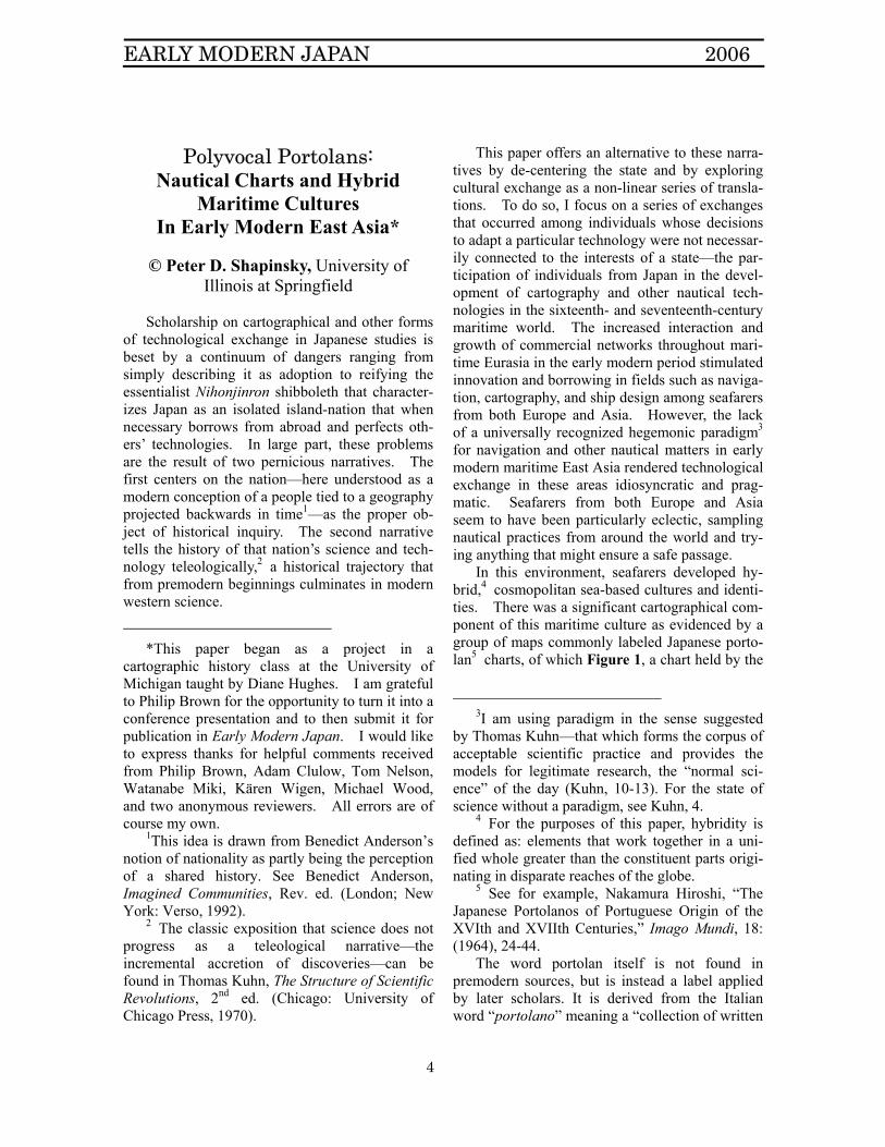
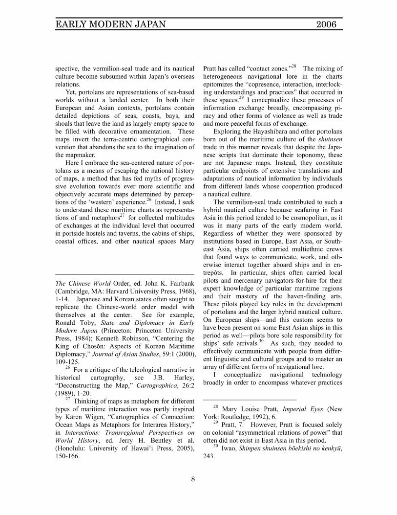
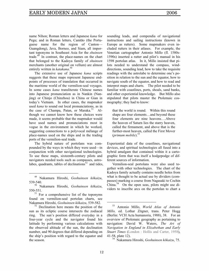
In this environment, seafarers developed hy-brid,4 cosmopolitan sea-based cultures and identi-ties. There was a significant cartographical com-ponent of this maritime culture as evidenced by a group of maps commonly labeled Japanese porto-lan5 charts, of which Figure 1, a chart held by the
3I am using paradigm in the sense suggested
by Thomas Kuhn—that which forms the corpus of acceptable scientific practice and provides the models for legitimate research, the “normal sci-ence” of the day (Kuhn, 10-13). For the state of science without a paradigm, see Kuhn, 4.
4 For the purposes of this paper, hybridity is defined as: elements that work together in a uni-fied whole greater than the constituent parts origi-nating in disparate reaches of the globe.
5 See for example, Nakamura Hiroshi, “The Japanese Portolanos of Portuguese Origin of the XVIth and XVIIth Centuries,” Imago Mundi, 18: (1964), 24-44.
The word portolan itself is not found in premodern sources, but is instead a label applied by later scholars. It is derived from the Italian word “portolano” meaning a “collection of written
EARLY MODERN JAPAN 2006
5
Hayashibara Museum is one of four extant origi-nals.
Figure 1: Ajia kōkaizu (Navigational Chart of Asia) in the holdings of the Hayashibara Museum6
Portolans, including those made in East Asia,
are palimpsests containing infinite maritime itin-eraries. To make them, heterogeneous forms of local navigational knowledge—often coastlines of basins charted with compasses and calculations of speed and distance—were collected, synthesized and inscribed atop a grid of blossoming compass vectors (rhumb lines). 7 This design enabled navigators to trace almost limitless trajectories using portolans in conjunction with written in-
sailing directions.” Tony Campbell, “Portolan Charts from the Late Thirteenth Century to 1500,” History of Cartography, vol. 1, Cartography in Prehistoric, Ancient, and Medieval Europe, ed. J.B. Harley et al. (Chicago: University of Chicago Press, 1987), 375.
6 I am grateful to the Hayashibara Museum, Okayama, Japan for permission to reproduce this image here. The map was originally part of the holdings of the Ikeda family, daimyo of Okayama domain.
7 Campbell, 390. Mollat du Jourdin and others tie the appearance of the chart in Europe directly to the almost contemporaneous appearance of the receptacle used to hold the lodestone. Michel Mollat du Jourdin et al., Sea Charts of the Early Explorers, trans. L. le R. Dethan (London: Thames and Hudson, 1984), 12.
structions (i.e., pilots’ books, rutters, etc.), com-passes, and other instruments. Portolans origi-nated in the medieval Mediterranean world, were brought to East Asia by Portuguese mariners in the sixteenth century (along with other navigational technologies), and underwent extensive processes of adaptation and translation before emerging as charts like the Hayashibara.
The Hayashibara chart measures approxi-mately 52 cm by 76 cm and is drawn in ink on vellum. It depicts a region extending from Japan in the east to the eastern coast of the Arabian Pen-insula and Africa in the west. Its size is consis-tent with other extant contemporary portolans of similar design.8 The styles of the equator, tropics lines, latitude bars, scale of miles, fleur-de-lis, compass rose, decorative motifs like Christian flags that embellish the empty inland areas on the map, and other iconography indicate Portuguese influence.9 The compass vectors are divided by color into black for the eight primary compass points, gold for the half-winds and red for the quarter-winds. Befitting a nautical chart, the Ha-yashibara portolan also has helpful descriptive devices such as red and black dots lining the coasts pointing out shoals, shallows, and rocks. The coastlines are shaded to exaggerate their size, providing additional detail. Place names are (for the most part) inscribed perpendicular to the coasts in Chinese characters, Japanese phonetic scripts, and Roman letters. Labels identify not just ports and anchorages, but also larger territorial units such as countries, islands, and regions. It is thought that the Hayashibara chart dates from the 1590’s due to the absence of Edo (capital of Japan from 1600) and the presence of Osaka— Toyotomi Hideyoshi’s capital from 1583-1598—on the
8 One previously owned by the vermilion-seal
merchant Sueyoshi Magozaemon measures 51.5 cm x 77.3 cm. An 1833 copy of a map owned by the shuinsen merchant Itoya Zuiemon of a similar geography is 56 x 80 cm.
9 For a useful summary of portolan icon-ography, see Heinrich Winter, “A Late Portolan Chart at Madrid and Late Portolan Charts in General,” Imago Mundi 7 (1950), 38.
EARLY MODERN JAPAN 2006
6
map.10 Definitive analyses of the Hayashibara and
other East Asian portolans have been hindered by a dearth of reliable information. Drafters, dates, and places of production for these charts all re-main unknown. However, scholars are relatively certain about one aspect of these maps’ prove-nance. Charts such as the Hayashibara were ex-tensively adapted and adopted for use by the pilots and shipmasters who conned the hundreds of shuinsen, cosmopolitan trading vessels licensed with passes stamped with vermilion seals for trade in East and Southeast Asia. These licenses were issued by both the Toyotomi and Tokugawa re-gimes from the 1590’s11 until the Tokugawa Ba-kufu abrogated the shuinsen system in the late 1630’s.12 The Hayashibara and other similar por-tolans all depict potential itineraries from major ports in Japan to East and Southeast Asian en-trepôts frequented by shuinsen. Many of the sur-viving charts are known to have belonged to prominent vermilion-seal merchants such as Itoya Zueimon (1585-1650), Kadoya Shichirō Hyōei Eikichi (1610-1672), Sueyoshi Magozaemon Yo-shiyasu (1570-1617), and William Adams, an Eng-lish pilot who sailed variously for Dutch, English, and Japanese sponsors. Itoya Zueimon made twenty-four licensed voyages to Southeast Asia between 1601 and 1632 and the Itoya family seems to have been prominent in Japanese diaspo-ras in Cochin China and Siam.13 Kadoya Eikichi
10 Unno Kazutaka, “Waga kuni ni okeru
porutorāno kaizu no juyō,” in Tōzai chizu bunka kōshōshi kenkyū (Osaka: Seibundō, 2003), 217.
11 For a review of the state of the debate over the beginning of the Shuinsen trade, see Nagazumi Yōko, Shuinsen (Yoshikawa Kōbunkan, 2001), 2-5.
12 To give a sense of the scale of this trade, in the 30-odd years in which shuin were issued, Iwao has calculated that upwards of 130 people received licenses for 370 ships (Iwao Seiichi, Shinpen shuinsen bōekishi no kenkyū (Yoshikawa Kōbunkan 1985, 220)), over half in the first 12 years.
13 Nakamura Hiroshi, Goshuinsen kōkaizu (Nihon Gakujutsu Shinkōkai, 1965), 71; Unno,
married a Siamese noblewoman and became head of the Japanese community there.14
The toponomy of these marine maps also sug-gests a shuinsen context. For example, although the Hayashibara chart has labels for important Japanese ports like Sotogahama, Sakai, Shimo-noseki, Nagasaki, and Hirado and larger seaboard regions like Shikoku, Hizen, Hyūga, Satsuma, Kii, and the Gotō islands, most of the map is dedicated to depicting the destinations of the vermilion-seal ships: Ryūkyū, Korea, and, on the Ming Chinese coast, Takasago [Taiwan], Nanjing, Fujian, Chin-zhou [Zhangzhou], and Macao. Inscriptions of major Southeast Asian ports frequented by trading vessels listed on the chart include Tonkin, Champa, Cochin, Siam, Borneo, Melaka, Patani, and Lu-zon.15
Otherwise, the small number of surviving ex-amples has made typological analysis difficult—only four original vellum charts survive, along with several eighteenth and nineteenth-century paper copies.16 By comparing shapes and iconog-raphy of surviving vermilion-seal portolans, Unno Kazutaka has concluded that a single Portuguese progenitor map is the most likely source for these portolans.17 Indeed, the Hayashibara Museum
“Waga kuni ni okeru portorāno kaizu no juyō,” 217.
14 Nakamura Hiroshi, Goshuinsen kōkaizu, 72; Unno, “Waga kuni ni okeru portorāno kaizu no juyō,” 220.
15 Nakamura Hiroshi, Goshuinsen kōkaizu, 539. For a list and description of the ports visited by the vermilion-seal ships, see Iwao, Shinpen shuinsen bōekishi no kenkyū, 149-176; Nagazumi, 48-54.
16 Nakamura Hiroshi’s extensive research only uncovered four original and ten copies of East Asian charts and another 5 charts of Japan alone. See his comprehensive opus Goshuinsen kōkaizu; Unno Kazutaka, “Waga kuni ni okeru portorāno kaizu no juyō.” For portolan technology being used to create domestic charts of Japan alone see Unno Kazutaka, “‘Nihon karuta’ no shutsugen to teitai,” in Tōzai chizu bunka kōshōshi kenkyū, 271-304.
17 Unno Kazutaka, “Cartography in Japan,” 382.
EARLY MODERN JAPAN 2006
7
chart closely resembles the 1833 copy of a chart owned by the Itoya family whose Portuguese in-scription along one edge, “SEBÃSTIO AFEZ [created by Sebãstio],” may indicate one Portu-guese mapmaker who influenced the development of vermilion-seal portolans.18 Surviving designs also suggest that at least two varieties of vermil-ion-seal portolans were drafted: a) from charts like the Hayashibara map that depicts a broad swathe from Japan in the East to Africa in the west, and b) others that only include East and Southeast Asia.19 The scope of maps in the first group like the Ha-yashibara extends to India, Africa, and Arabia, regions where no Japanese ships are recorded as having visited. This geographic scope has puz-zled cartographic historians, some of whom have speculated that such inclusions may be a result of latent Portuguese influence.20 It is also possible that vermilion-seal seafarers of the early 1600’s did not foresee a contraction in overseas trade and instead envisioned a time when they might travel as far as Africa. I suggest that the inclusion of geographies of no immediate concern to Japanese becomes much easier to comprehend if we view the Hayashibara-type portolans as less a product of Japan and more a creation of the cosmopolitan hybrid nautical cultures of ships and ports of East Asian seafaring. In contrast, the design of the second variety seems directly related to the shuin-sen trade as its scope is limited to the range of the vermilion-seal ships—it is bordered on the East by Japan and on the west by the straits of Melaka.
In any case, the relative paucity of extant ex-amples does not negate the historical significance of these charts. Such maps were among the dominant navigational cartographical forms in sixteenth- and seventeenth-century East Asia as
18 The Portuguese phrase “Sebãstio Afez” is
also found on a chart from Lisbon dated 1618 (Unno, “Cartography in Japan,” 382).
19 Unno Kazutaka includes a helpful table of possible families of vermilion-seal portolans in “Waga kuni ni okeru portorāno kaizu no juyō,” 240.
20 Unno, “Waga kuni ni okeru portorāno kaizu no juyō,” 233.
well as in Europe and the Middle East21—part of many a pilot’s navigational toolbox. As utilitar-ian devices, maps may have simply been discarded when they deteriorated or became obsolete,22 es-pecially after the Tokugawa Bakufu’s interdiction of Japanese traveling overseas in 1635. That said, in order to demonstrate the significance of these charts for seafarers in the vermilion-seal trade, it is necessary to overcome the limitations in historical evidence by exploring the charts in wider contexts.
While acknowledging the maritime usage of these portolans, most scholars have tended to em-ploy classical cartographical and nation-centered contexts. Some have performed exhaustive toponymic and comparative analyses to create a genealogy of these nautical charts as an isolated entity.23 Others situate vermilion-seal portolans within the context of a linear, teleological geneal-ogy of Japanese mapping.24 To some extent, this school of thought is characteristic of the larger historiographical traditions that focus on the state as the fundamental historical subject and the pri-mary interlocutors in overseas relations. Many historians of East Asia have focused on the diplo-matic and commercial relations conducted under the rubric of a tribute system adopted by China, Korea, or Japan for example.25 From this per-
21 The Ottoman admiral Piri Reis is known to
have incorporated European information into portolans that he drafted (Gregory C. McIntosh, The Piri Reis Map of 1513 (Athens, GA: University of Georgia Press, 2000)).
22 Tony Campbell has argued that the majority of extant Mediterranean portolans survived because they were also considered works of art. More utilitarian charts would have been discarded once obliterated by constant use and seawater (Campbell, 436).
23 Nakamura Hiroshi, Goshuinsen kōkaizu; “The Japanese Portolanos of Portuguese Origin of the XVIth and XVIIth Centuries.”
24 Unno Kazutaka, “Cartography in Japan,” in History of Cartography, vol. 2: Cartography in the Traditional East and Southeast Asian Societies, ed. J.B. Harley et al (Chicago: University of Chicago Press, 1987), 346-467.
25 The classical exposition of the tribute trade is John K. Fairbank, “A Preliminary Framework,”
EARLY MODERN JAPAN 2006
8
spective, the vermilion-seal trade and its nautical culture become subsumed within Japan’s overseas relations.
Yet, portolans are representations of sea-based worlds without a landed center. In both their European and Asian contexts, portolans contain detailed depictions of seas, coasts, bays, and shoals that leave the land as largely empty space to be filled with decorative ornamentation. These maps invert the terra-centric cartographical con-vention that abandons the sea to the imagination of the mapmaker.
Here I embrace the sea-centered nature of por-tolans as a means of escaping the national history of maps, a method that has fed myths of progres-sive evolution towards ever more scientific and objectively accurate maps determined by percep-tions of the ‘western’ experience.26 Instead, I seek to understand these maritime charts as representa-tions of and metaphors27 for collected multitudes of exchanges at the individual level that occurred in portside hostels and taverns, the cabins of ships, coastal offices, and other nautical spaces Mary
The Chinese World Order, ed. John K. Fairbank (Cambridge, MA: Harvard University Press, 1968), 1-14. Japanese and Korean states often sought to replicate the Chinese-world order model with themselves at the center. See for example, Ronald Toby, State and Diplomacy in Early Modern Japan (Princeton: Princeton University Press, 1984); Kenneth Robinson, “Centering the King of Chosŏn: Aspects of Korean Maritime Diplomacy,” Journal of Asian Studies, 59:1 (2000), 109-125.
26 For a critique of the teleological narrative in historical cartography, see J.B. Harley, “Deconstructing the Map,” Cartographica, 26:2 (1989), 1-20.
27 Thinking of maps as metaphors for different types of maritime interaction was partly inspired by Kären Wigen, “Cartographies of Connection: Ocean Maps as Metaphors for Interarea History,” in Interactions: Transregional Perspectives on World History, ed. Jerry H. Bentley et al. (Honolulu: University of Hawai’i Press, 2005), 150-166.
Pratt has called “contact zones.”28 The mixing of heterogeneous navigational lore in the charts epitomizes the “copresence, interaction, interlock-ing understandings and practices” that occurred in these spaces.29 I conceptualize these processes of information exchange broadly, encompassing pi-racy and other forms of violence as well as trade and more peaceful forms of exchange.
Exploring the Hayashibara and other portolans born out of the maritime culture of the shuinsen trade in this manner reveals that despite the Japa-nese scripts that dominate their toponomy, these are not Japanese maps. Instead, they constitute particular endpoints of extensive translations and adaptations of nautical information by individuals from different lands whose cooperation produced a nautical culture.
The vermilion-seal trade contributed to such a hybrid nautical culture because seafaring in East Asia in this period tended to be cosmopolitan, as it was in many parts of the early modern world. Regardless of whether they were sponsored by institutions based in Europe, East Asia, or South-east Asia, ships often carried multiethnic crews that found ways to communicate, work, and oth-erwise interact together aboard ships and in en-trepôts. In particular, ships often carried local pilots and mercenary navigators-for-hire for their expert knowledge of particular maritime regions and their mastery of the haven-finding arts. These pilots played key roles in the development of portolans and the larger hybrid nautical culture. On European ships—and this custom seems to have been present on some East Asian ships in this period as well—pilots bore sole responsibility for ships’ safe arrivals.30 As such, they needed to effectively communicate with people from differ-ent linguistic and cultural groups and to master an array of different forms of navigational lore.
I conceptualize navigational technology broadly in order to encompass whatever practices
28 Mary Louise Pratt, Imperial Eyes (New
York: Routledge, 1992), 6. 29 Pratt, 7. However, Pratt is focused solely
on colonial “asymmetrical relations of power” that often did not exist in East Asia in this period.
30 Iwao, Shinpen shuinsen bōekishi no kenkyū, 243.
EARLY MODERN JAPAN 2006
9
and tools mariners of the time may have consid-ered necessary for ensuring safe passage. It is not my intention to trace a teleology of nautical techniques that engages in a debate over the supe-riority of one technology over another. In six-teenth and seventeenth-century East Asia, naviga-tion was often an idiosyncratic hybrid system of apparatuses, rituals, and experiential knowledge derived from practices that originated in China, Japan, Korea, Southeast Asia, the Arab world, and Europe. Yin-Yang theory, prayers and rituals for safe passage, watching the color of the water, as-tronomical observations made using astrolabes and cross-staves, incense sticks for measuring time, sounding leads to dredge the bottom and determine position by the color and type of sedi-ment, and the use of compasses and maps all mixed with equal potentialities of use. These devices and practices were then melded with infi-nite varieties of local navigational lore including landmarks, the locations of shoals and havens, storm seasons, tides, and currents., Designed to be both repositories of this lore and used in conjunc-tion with other technologies, portolans epitomize the hybrid nature of this nautical culture.
Studying these maps as part of a hybrid nauti-cal culture developed by mariners in East Asia in this period also highlights the common fallacy of state-centered histories that identify a seafarer’s primary identity by his or her31 land of origin.
31 Although commonly assumed to be
primarily a man’s world, the histories of women like Cornelia von Nijenroode (a half-Dutch, half-Japanese wealthy merchant of Batavia in the mid-seventeenth century), families of boat-people in premodern East Asia, and the nineteenth-century pirate admiral Zheng Yi Sao demonstrate that maritime enterprises were not completely closed to women. For Nijenroode, see Leonard Blussé, “Butterfly or Mantis,” in Strange Company (Dordrecht, Holland; Riverton, N.J.: Foris Publications, 1986), 179-253. For an account of women among boat-people pirates, see Chungjong taewang sillok, (Chungjong 5) 1510 8.24 (丁未), ed. Kuksa P’yŏnch’an Wiwŏnhoe (Seoul: T’amgudang 1986); For Zheng Yi Sao, see Dian Murray, “One Woman’s Rise to Power: Cheng I’s
Seafarers whose livelihoods required them to spend months and years at sea developed identities and cultures as seafarers that set them apart from what land-based populations often considered normal. According to Greg Dening, distinctive shipboard social worlds emerged out of necessity as crews banded together against the deadly world outside the ship’s vulnerable, wooden shell in or-der to survive the sea voyage.32
For example, Murai Shōsuke argues that we should understand the seafarers who lived on Tsu-shima, Iki, and the Kyushu and Korean littorals in the premodern period as “people of the margins” whose maritime livelihoods took them between Korea and Japan and caused them to develop a distinctive culture that included language and styles of dress.33 Seafarers such as these also played roles similar to communities called “trade diasporas” by Philip Curtin, “cross-cultural bro-kers” who facilitated “trade between the host soci-ety and people of their own origin who moved along the trade routes.”34 Seafarers and mapmak-ers who lived and worked in such environments were responsible for the development of portolans like the Hayashibara.
I contextualize the Hayashibara and other vermilion-seal portolans in the seafarers’ culture of early modern East Asia in four settings. First, I compare the Hayashibara to Mediterranean por-tolans created in the cross-cultural traditions of European seafaring and to other forms of East Asian maritime itinerary cartography. Second I highlight the agency of individual pilots and navi-gators-for-hire such as William Adams and Ikeda Kōun in directing the creation of vermilion-seal charts and the wider nautical culture. Third, I ex-amine the wider environment in which the Haya-shibara chart would have been created and used—
Wife and the Pirates,” Historical Reflections 8:3 (1981): 147-161.
32 Greg Dening, Islands and Beaches (Honolulu: University of Hawaii Press, 1980), 157-158.
33 Murai Shōsuke, Chūsei Wajinden (Iwanami Shoten, 1993), 34-58.
34 Philip Curtin, Cross-Cultural Trade in World History (Cambridge: Cambridge University Press, 1984), 6.
EARLY MODERN JAPAN 2006
10
the hybrid nautical culture of sixteenth- and seven-teenth-century East Asian seafarers. In addition to mapping and navigational practices, mariners developed distinctive hybrid argots, ship-designs, and religious rituals. By way of conclusion, I meditate on the study of cultural exchange with a short examination of how, in the Edo period, the polyvocal vermilion-seal charts were domesticated and transformed into ‘Japanese’ portolans.
The Hayashibara Chart as a Portolan Chart Placing the Hayashibara chart within the larger
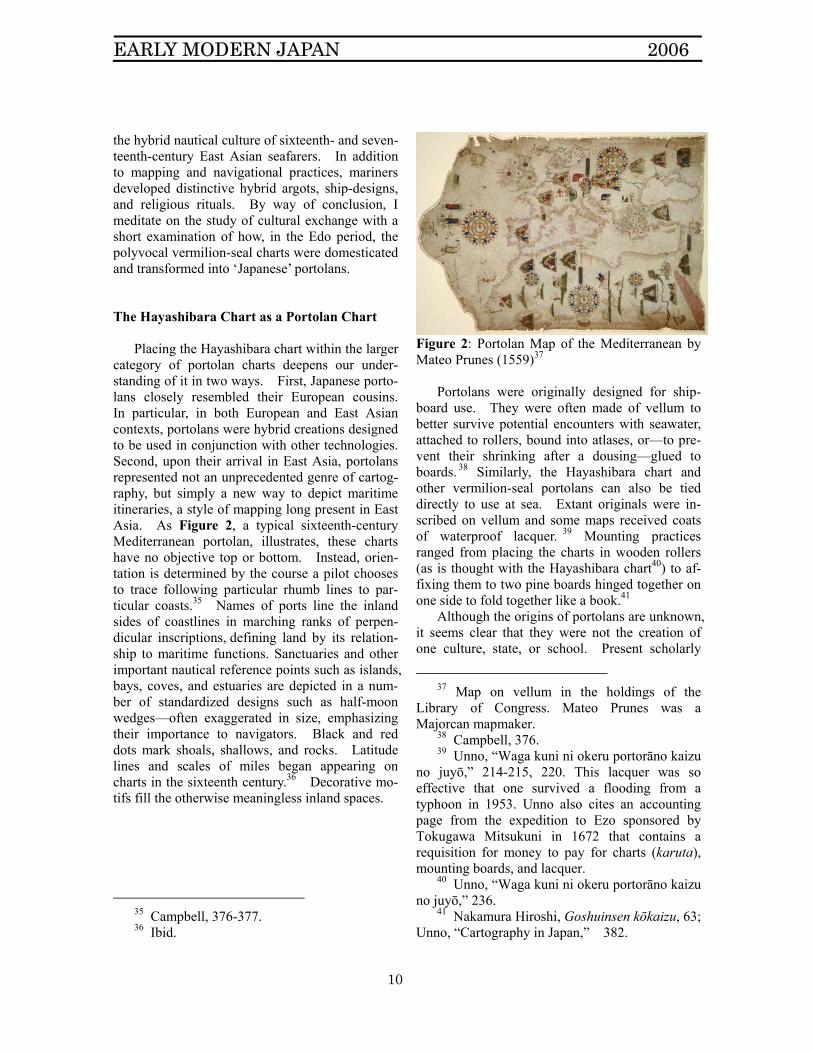
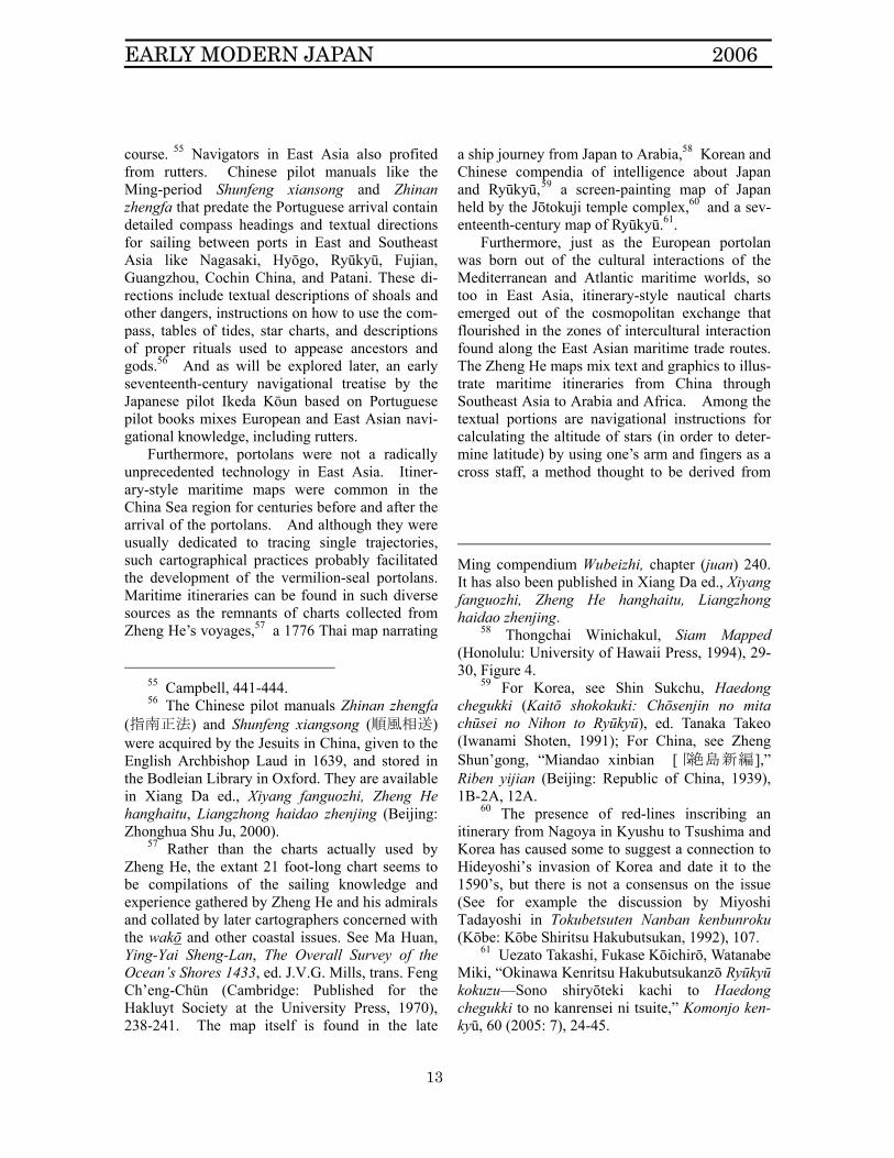
category of portolan charts deepens our under-standing of it in two ways. First, Japanese porto-lans closely resembled their European cousins. In particular, in both European and East Asian contexts, portolans were hybrid creations designed to be used in conjunction with other technologies. Second, upon their arrival in East Asia, portolans represented not an unprecedented genre of cartog-raphy, but simply a new way to depict maritime itineraries, a style of mapping long present in East Asia. As Figure 2, a typical sixteenth-century Mediterranean portolan, illustrates, these charts have no objective top or bottom. Instead, orien-tation is determined by the course a pilot chooses to trace following particular rhumb lines to par-ticular coasts.35 Names of ports line the inland sides of coastlines in marching ranks of perpen-dicular inscriptions, defining land by its relation-ship to maritime functions. Sanctuaries and other important nautical reference points such as islands, bays, coves, and estuaries are depicted in a num-ber of standardized designs such as half-moon wedges—often exaggerated in size, emphasizing their importance to navigators. Black and red dots mark shoals, shallows, and rocks. Latitude lines and scales of miles began appearing on charts in the sixteenth century.36 Decorative mo-tifs fill the otherwise meaningless inland spaces.
35 Campbell, 376-377. 36 Ibid.
Figure 2: Portolan Map of the Mediterranean by Mateo Prunes (1559)37
Portolans were originally designed for ship-
board use. They were often made of vellum to better survive potential encounters with seawater, attached to rollers, bound into atlases, or—to pre-vent their shrinking after a dousing—glued to boards. 38 Similarly, the Hayashibara chart and other vermilion-seal portolans can also be tied directly to use at sea. Extant originals were in-scribed on vellum and some maps received coats of waterproof lacquer. 39 Mounting practices ranged from placing the charts in wooden rollers (as is thought with the Hayashibara chart40) to af-fixing them to two pine boards hinged together on one side to fold together like a book.41
Although the origins of portolans are unknown, it seems clear that they were not the creation of one culture, state, or school. Present scholarly
37 Map on vellum in the holdings of the
Library of Congress. Mateo Prunes was a Majorcan mapmaker.
38 Campbell, 376. 39 Unno, “Waga kuni ni okeru portorāno kaizu
no juyō,” 214-215, 220. This lacquer was so effective that one survived a flooding from a typhoon in 1953. Unno also cites an accounting page from the expedition to Ezo sponsored by Tokugawa Mitsukuni in 1672 that contains a requisition for money to pay for charts (karuta), mounting boards, and lacquer.
40 Unno, “Waga kuni ni okeru portorāno kaizu no juyō,” 236.
41 Nakamura Hiroshi, Goshuinsen kōkaizu, 63; Unno, “Cartography in Japan,” 382.
EARLY MODERN JAPAN 2006
11
consensus argues that portolans were piecemeal assemblages—first of various collections of local knowledge of Mediterranean coastlines, and later the North Atlantic, Red Sea, Indian Ocean, China Sea, and other basins.42 According to the carto-graphic historian David Turnbull, portolans are “a mosaic of elements loosely assembled from sepa-rate but related navigational traditions.”43 He ar-gues that the charts were not composed using any form of coordinate geometry or other quantifiable, mathematically rational system, but instead were conglomerations of linear notations of distance and wind and compass directions.44 Often there was no standard scale of distances, even within a single chart, and rhumb lines were not aligned between charts, even those assembled together.
These European patchworks were produced in the maritime world. Prominent drafters of porto-lans emerged in shipping hubs and entrepôts like Majorca, Genoa, and Venice. 45 Mapmakers in these centers collected charts and information from the navigators and seafarers that gravitated to these ports from around the Mediterranean and Atlantic worlds. Some pilots also drafted porto-lan charts while on their travels.46
42 Campbell, 383-391. 43 David Turnbull, “Cartography and Science
in Early Modern Europe: Mapping the Construction of Knowledge Spaces,” Imago Mundi, 48: (1996), 9. Turnbull further points out that because they were such agglomerations of local knowledge, portolans proved incapable of providing the rational, universal geographical representation needed to geographically catalog an empire Turnbull (esp. 8-14). Although the Mercator projection was invented in 1569 and provided a feasible mathematical-cartographic rubric for regularizing an imperial cartographic catalog, it would be another century before even single European states underwent comprehensive coordinate mapping, let alone far-flung reaches of the ocean (Turnbull, 14).
44 Turnbull, 9-10. 45 Campbell, 389-398. 46 Among portolan draftsmen of the
Mediterranean, Grazioso Benincasa also sailed as captain of a ship and Andrea Bianco self-identified on one of his charts as a senior officer
The hybrid origins of European portolans are mirrored by the processes of exchange that led to the development of vermilion-seal portolans. Analyses of place names as well as the shape of landmasses on the Hayashibara reveal that these marine charts were not the result of Japanese car-tographers simply copying European maps. In-stead, the maps resulted from diverse and com-pound influences. First, the European charts that constituted the base maps for vermilion-seal porto-lans were also derived from local Chinese, Korean, and Japanese knowledge. Second, East Asian mapmakers corrected those regions found to be in error with their own geographical or cosmographi-cal world-views. For instance, Unno Kazutaka has demonstrated possible Korean influence in the depiction of the Korean peninsula in some porto-lans.47 In addition, some Portuguese imaginary geographies popular on European charts of Asia are left off of the vermilion-seal charts. For ex-ample, the Hayashibara chart lacks Portuguese favorites such as “the pirate islands (ilhas dos ladrones)” and “island of gold (ilha de Ouro),” although it does have a notation for the “island of silver (ilha de prata).”48
A wide variety of writing systems was used to inscribe place-names on the Hayashibara and other vermilion-seal charts, raising the possibility that pilots of several different reading backgrounds may have read the maps as well as the possibility that there may have been a permeable argot of commonly understood words and place names from several linguistic traditions. On the Haya-shibara portolan, most place names are written in Japanese kana scripts, but these toponyms are mixed with Portuguese names in Roman letters, Chinese character transliterations of Iberian place-names, and the use of original Chinese and Japa-nese place-names. For example, the Hayashibara’s drafter used Roman and Chinese characters for the
on a galley (Campbell, 432-433). Piri Reis was an Ottoman admiral as well as cartographer (see McIntosh, Chapters 1-2). As will be seen below, this tradition carried over into East Asian seas.
47 Unno, “Waga kuni ni okeru portorāno kaizu no juyō,” 247.
48 Nakamura Hiroshi, Goshuinsen kōkaizu, 539.
EARLY MODERN JAPAN 2006
12
name Nihon; Roman letters and Japanese kana for Pegu; and in Roman letters, Camtão (the Portu-guese name for the region of Canton—Guangdong), Java, Borneo, and Siam, all impor-tant toponyms in Southeast Asia for the shuinsen trade.49 In contrast, the place-names on the chart that belonged to the Kadoya family of shuinsen merchants (another original on vellum) are almost entirely written in katakana.50
The extensive use of Japanese kana scripts suggests that these maps represent Japanese end-points of processes of translation that occurred in the maritime world of the vermilion-seal voyages. In some cases kana transliterate Chinese names into Japanese pronunciation as in Nankin (Nan-jing) or Chinjo (Chinzhou) in China or Gian in today’s Vietnam. In other cases, the mapmaker used kana to sound out local pronunciations, as in the case of Champa, Patan, or Maraka.51 Al-though we cannot know how these choices were made, it seems probable that the mapmaker would have used names and pronunciations most in vogue in the environment in which he worked, suggesting connections to a polyvocal mélange of place-names used on the ships and in the trading ports of the vermilion-seal trade.
The hybrid nature of portolans was com-pounded by the ways in which they were used—in conjunction with other navigational technologies. To use these maps, sixteenth-century pilots and navigators needed tools such as compasses, astro-labes, quadrants, tables of declinations52 and tides,
49 Nakamura Hiroshi, Goshuinsen kōkaizu,
539-540. 50 Nakamura Hiroshi, Goshuinsen kōkaizu,
550-551. 51 For a comprehensive list of the toponyms
found on vermilion-seal portolan charts, see Nakamura Hiroshi, Goshuinsen kōkaizu, 539-582.
52 Declination here means the position of the sun as its ecliptic course intersects the zodiacal ring. The sun’s position differed everyday in a four-year cycle and the navigator found his latitude by performing various calculations with the observed altitude of the sun, the declination number, and 90 degrees that differed depending on the ship’s position with regard to the equator and the season.
sounding leads, and compendia of navigational instructions and sailing instructions (known in Europe as rutters). Some mapmakers even in-cluded rutters in their atlases. For example, the Venetian cartographer Antonio Millo (fl. 1580s-1590s) inserted a rutter and pilot’s manual in his 1598 portolan atlas. In it, Millo insisted that pi-lots needed to understand the compass, wind-directions, sounding lead, how to take the requisite readings with the astrolabe to determine one’s po-sition in relation to the sun and the equator, how to navigate south of the equator, and how to read and interpret maps and charts. The pilot needed to be familiar with coastlines, ports, shoals, sand banks, and other experiential knowledge. But Millo also stipulated that pilots master the Ptolemaic cos-mography; they had to know:
that the world is round. Within this round shape are four elements…and beyond these four elements are nine heavens….Above the heaven of Saturn lies the starry heaven, called the firmament, and above that is the further-most heaven, called the First Mover (primum mobile).53
Experiential data of the coastlines, navigational devices, and spiritual technologies all fused into a hybrid amalgam that contained within it a carto-graphic form that was itself a hodgepodge of dif-ferent sources of information.
Vermilion-seal portolans were also used to-gether with other technologies. The chart of the Kadoya family actually contains needle holes from what is thought to be actual use by dividers (com-passes) marking a course from Nagasaki to Cochin China.54 On the open seas, pilots might use di-viders to inscribe arcs on the portolan to chart a
53 Antonio Millo, World Atlas of Antonio
Millo, ed. Lothar Zögner, trans. Peter Hogg (Berlin: VCH Acta humanoria, 1988), 38. For an overview of Ptolemaic geography as pertaining to navigation: David W. Waters, The Art of Navigation in England in Elizabethan and Early Stuart Times (London : Hollis and Carter, 1958), 41-58, plate 12).
54 Nakamura Hiroshi, Goshuinsen kōkaizu, 75.
EARLY MODERN JAPAN 2006
13
course. 55 Navigators in East Asia also profited from rutters. Chinese pilot manuals like the Ming-period Shunfeng xiansong and Zhinan zhengfa that predate the Portuguese arrival contain detailed compass headings and textual directions for sailing between ports in East and Southeast Asia like Nagasaki, Hyōgo, Ryūkyū, Fujian, Guangzhou, Cochin China, and Patani. These di-rections include textual descriptions of shoals and other dangers, instructions on how to use the com-pass, tables of tides, star charts, and descriptions of proper rituals used to appease ancestors and gods.56 And as will be explored later, an early seventeenth-century navigational treatise by the Japanese pilot Ikeda Kōun based on Portuguese pilot books mixes European and East Asian navi-gational knowledge, including rutters.
Furthermore, portolans were not a radically unprecedented technology in East Asia. Itiner-ary-style maritime maps were common in the China Sea region for centuries before and after the arrival of the portolans. And although they were usually dedicated to tracing single trajectories, such cartographical practices probably facilitated the development of the vermilion-seal portolans. Maritime itineraries can be found in such diverse sources as the remnants of charts collected from Zheng He’s voyages,57 a 1776 Thai map narrating
55 Campbell, 441-444. 56 The Chinese pilot manuals Zhinan zhengfa
(指南正法) and Shunfeng xiangsong (順風相送) were acquired by the Jesuits in China, given to the English Archbishop Laud in 1639, and stored in the Bodleian Library in Oxford. They are available in Xiang Da ed., Xiyang fanguozhi, Zheng He hanghaitu, Liangzhong haidao zhenjing (Beijing: Zhonghua Shu Ju, 2000).
57 Rather than the charts actually used by Zheng He, the extant 21 foot-long chart seems to be compilations of the sailing knowledge and experience gathered by Zheng He and his admirals and collated by later cartographers concerned with the wakō and other coastal issues. See Ma Huan, Ying-Yai Sheng-Lan, The Overall Survey of the Ocean’s Shores 1433, ed. J.V.G. Mills, trans. Feng Ch’eng-Chün (Cambridge: Published for the Hakluyt Society at the University Press, 1970), 238-241. The map itself is found in the late
a ship journey from Japan to Arabia,58 Korean and Chinese compendia of intelligence about Japan and Ryūkyū,59 a screen-painting map of Japan held by the Jōtokuji temple complex,60 and a sev-enteenth-century map of Ryūkyū.61.
Furthermore, just as the European portolan was born out of the cultural interactions of the Mediterranean and Atlantic maritime worlds, so too in East Asia, itinerary-style nautical charts emerged out of the cosmopolitan exchange that flourished in the zones of intercultural interaction found along the East Asian maritime trade routes. The Zheng He maps mix text and graphics to illus-trate maritime itineraries from China through Southeast Asia to Arabia and Africa. Among the textual portions are navigational instructions for calculating the altitude of stars (in order to deter-mine latitude) by using one’s arm and fingers as a cross staff, a method thought to be derived from
Ming compendium Wubeizhi, chapter (juan) 240. It has also been published in Xiang Da ed., Xiyang fanguozhi, Zheng He hanghaitu, Liangzhong haidao zhenjing.
58 Thongchai Winichakul, Siam Mapped (Honolulu: University of Hawaii Press, 1994), 29-30, Figure 4.
59 For Korea, see Shin Sukchu, Haedong chegukki (Kaitō shokokuki: Chōsenjin no mita chūsei no Nihon to Ryūkyū), ed. Tanaka Takeo (Iwanami Shoten, 1991); For China, see Zheng Shun’gong, “Miandao xinbian [阝絶島新編],” Riben yijian (Beijing: Republic of China, 1939), 1B-2A, 12A.
60 The presence of red-lines inscribing an itinerary from Nagoya in Kyushu to Tsushima and Korea has caused some to suggest a connection to Hideyoshi’s invasion of Korea and date it to the 1590’s, but there is not a consensus on the issue (See for example the discussion by Miyoshi Tadayoshi in Tokubetsuten Nanban kenbunroku (Kōbe: Kōbe Shiritsu Hakubutsukan, 1992), 107.
61 Uezato Takashi, Fukase Kōichirō, Watanabe Miki, “Okinawa Kenritsu Hakubutsukanzō Ryūkyū kokuzu—Sono shiryōteki kachi to Haedong chegukki to no kanrensei ni tsuite,” Komonjo ken-kyū, 60 (2005: 7), 24-45.
EARLY MODERN JAPAN 2006
14
Arab seafarers in the Indian Ocean.62 Another lineage of maritime itinerary maps with inscrip-tions of shipping lanes seems to have resulted from the exchange linking the Japanese port of Hakata with Ryūkyū and Korea in the fifteenth century. Both the collection of itinerary maps found in a 1471 Korean handbook on Japan and Ryūkyū, Haedong chegukki,63 and a 1696 Japa-nese map of Ryūkyū64 are thought to be derived from a base map associated with the mid fifteenth-century Hakata monk-merchant Dōan who was active in trade and diplomacy connecting Japan, Ryūkyū, and Korea.65
Thus, the portolan was probably an attractive tool for East Asian seafarers, once improved in light of East Asian local knowledge. It provided navigators in East Asia a cartographical form that was both familiar in its itinerary design and an improvement upon earlier itinerary-map models because it was designed for use in combination with other navigational technologies in order to depict infinite itineraries instead of just one. Be-cause of their adaptability, portolans in combina-tion with texts such as rutters provided a perfect receptacle for the largely experiential forms of knowledge that characterized navigational practice in the vermilion-seal trade.
62 Zheng He hanghaitu, 63-66 in Xiang Da ed.,
Xiyang fanguozhi, Zheng He hanghaitu, Liangzhong haidao zhenjing; Iida, 51. I am grateful to Tom Nelson for helping with this information.
63 Shin Sukchu, Haedong chegukki (Kaitō shokokuki: Chōsenjin no mita chūsei no Nihon to Ryūkyū), ed. Tanaka Takeo (Iwanami Shoten, 1991).
64 The map was drafted by the Chikuzen domainal scholar Takemori Dōetsu. See Uezato Takashi, Fukase Kōichirō, Watanabe Miki, “Okinawa Kenritsu Hakubutsukan shozō Ryūkyū kokuzu.”
65 Nakamura Hidetaka, 1: 361-362; Kenneth Robinson, “The Haedong chegukki (1471) and Korean-Ryūkyūan Relations (1389-1471): Part I,” Acta Koreana, 2 (2000), 94-97; Saeki Kōji, “Muromachi kōki no Hakata shōnin Dōan to Higashi Ajia,” Shien 140 (2003): 31-49.
Pilots’ Roles in the Development of Hybrid Nautical Cultures and Portolan Charts
Pilots played crucial roles in the development of navigational practice, the larger nautical culture, and nautical charts like the Hayashibara in large part because, like their European counterparts, they bore sole responsibility for the safe passage of many of the vermilion-seal ships. Pilots were at the center of many types of exchange that led to the development of the portolans and were also the primary users of the sea charts. Some drafted charts on their voyages, while others created many of the written sources that remain from the vermil-ion-seal trade—rutters, sailing manuals, logbooks, etc. On shuinsen, chief pilots might be Chinese, Portuguese, Dutch, English, Scottish, as well as Japanese. 66 Local pilots were often hired to navigate unfamiliar waterways on these trading ventures as well. Pilots originating in different linguistic, cultural, and navigational traditions mixed in trading ports and ships to exchange knowledge, and portolans were among the media used to document the results of those encounters.
To demonstrate the important role of pilots in the processes of exchange that led to the develop-ment of a distinctive nautical culture in the shuin-sen trade, we next examine the histories of two pilots: William Adams (1564-1620) and Ikeda Yōemon Nyūdō Kōun (1st half of 17th c.). The case of William Adams illustrates how carto-graphical innovation might occur in the hybrid nautical culture of the vermilion-seal ships. Ikeda Kōun wrote a pilot book entitled Genna kō-kaisho [Genna-era Navigational Treatise] that demonstrates how the interchange of the vermil-ion-seal trade enabled the creation of idiosyncratic, hybrid nautical cultures.
William Adams. As is well known, William Adams was an Englishman who arrived in Japan in 1600 as pilot of the Dutch vessel, Liefde.67 He
66 Iwao, Shinpen shuinsen bōekishi no kenkyū,
243-261. . 67 Anthony Farrington, The English Factory in
Japan 1613-1623, 2 vols. (London: The British Library, 1991),p. 1542-1546. For convenience, documents from this collection will be cited by the
EARLY MODERN JAPAN 2006
15
settled in Japan for the rest of his life, became a trusted advisor to Tokugawa Ieyasu, made a living as a one-man trade diaspora,68 and was a pilot active in the vermilion-seal trade. Among other projects, Adams seems to have been involved in collecting and synthesizing cartographical and navigational information about Japan and East Asia. On behalf of patrons such as Tokugawa Ieyasu, the English East India Company, and Chi-nese merchants,69 Adams piloted ships across East and Southeast Asia that all carried diverse crews, providing Adams the opportunity to participate in exchanges of nautical lore with many different groups of seafarers. Adams piloted vessels to Cochin China, Tonkin, and two other voyages that ended prematurely in the Ryūkyūs. These ships carried English, Chinese, and Japanese crewmem-bers.70 Dealing with multiethnic crews required
number Farrington assigned documents and the page number
68 Curtin, chapter 1. 69 See Farrington, p. 1544-1545 for a
summary of Adams’ voyages on behalf of various patrons.
70 See for example, a ledger listing money lent to members of the crew in William Adams’ journal of his voyage to the Ryukyu Islands in the Sea Adventure, with related accounts and notes, and miscellaneous accounts, November 1614-1616, in Farrington no. 409, p. 1067. Names include Englishmen such as Edward Sarris and Richard Wickham, Japanese such as Shinssemon, Shingero, and Yakeo, and perhaps a Chinese man known as “Chinna Tiquan.” Several Chinese involved in the vermilion-seal trade were known with the appellation Iquan (一官), Niquan (二官), Sanquan (三官), etc. (see Iwao, Shinpen shuinsen bōekishi no kenkyū, table 7). The head of the Chinese community in Hirado had sons known as both Iquan and Niquan and Cheng Zhilong was known for a time as Iquan (See Iwao Seiichi, “Li Tan 李旦, Chief of the Chinese Residents at Hirado, Japan in the Last Days of the Ming Dynasty,” Memoirs of the Tōyō Bunko, 17 (1958), 38-39, 73). During the 1616 Ryūkyū voyage, the Sea Adventure carried “58 Japones marines,” (“Richard Wickham at Edo to Sir Thomas Smythe in London, 23 October 1615,” in Farrington no.
that Adams have methods by which he and his crew could communicate, and in his journals for these voyages, Adams habitually appended lists of useful foreign words he picked up on the trip in addition to entries about sailing directions, weather, and daily events. Phrases included numbers, salutations, and terms related to naviga-tion and sailing,71 Such entries conjure images of Adams conversing and trading information and tales with a diverse array of seafarers.
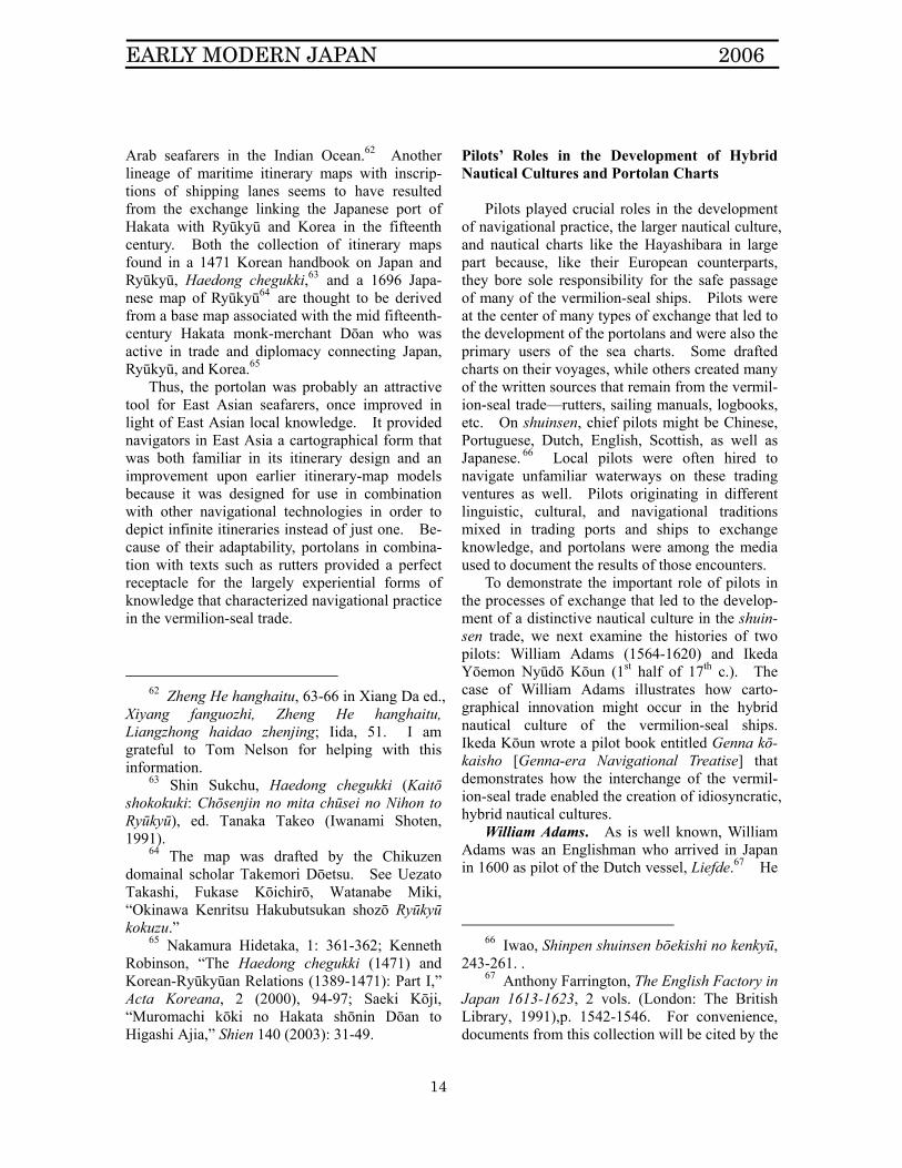
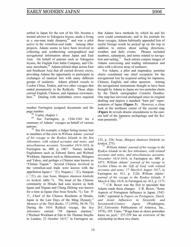
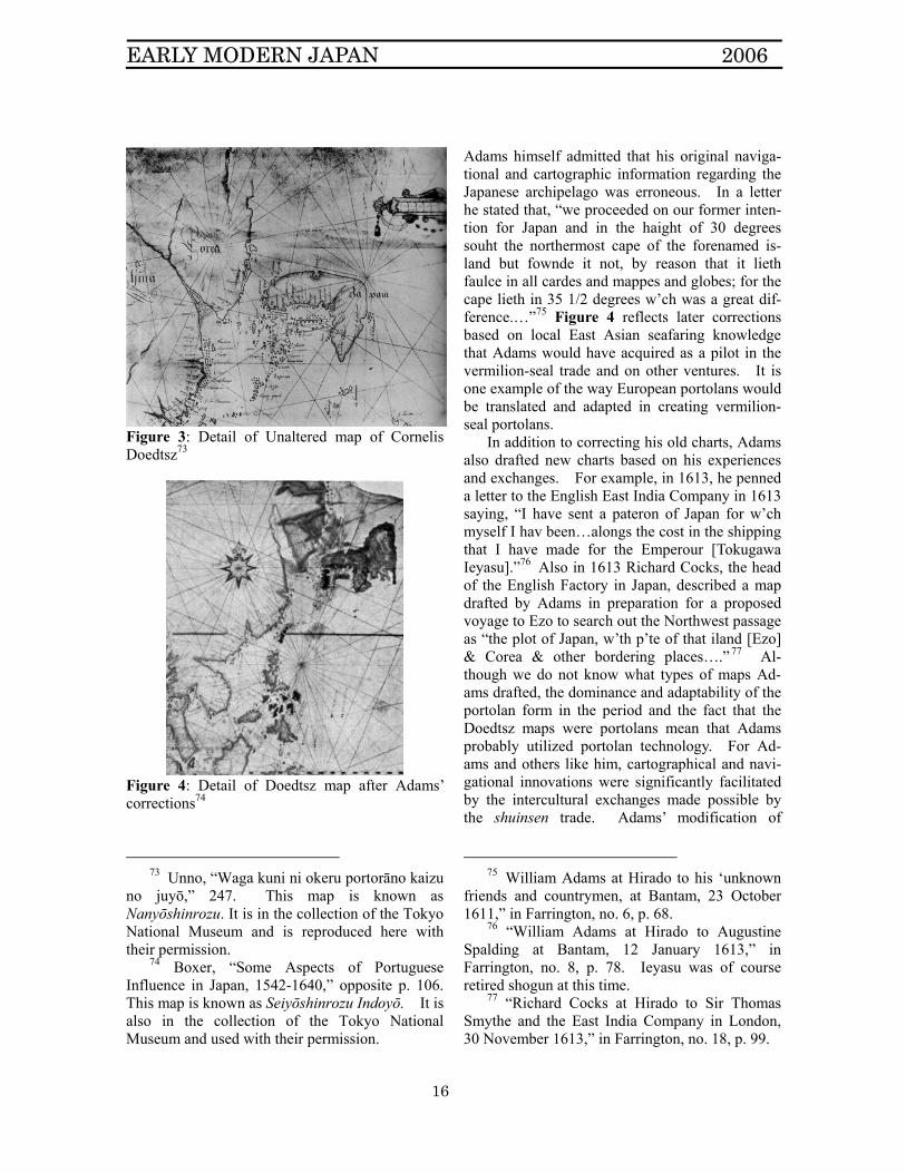
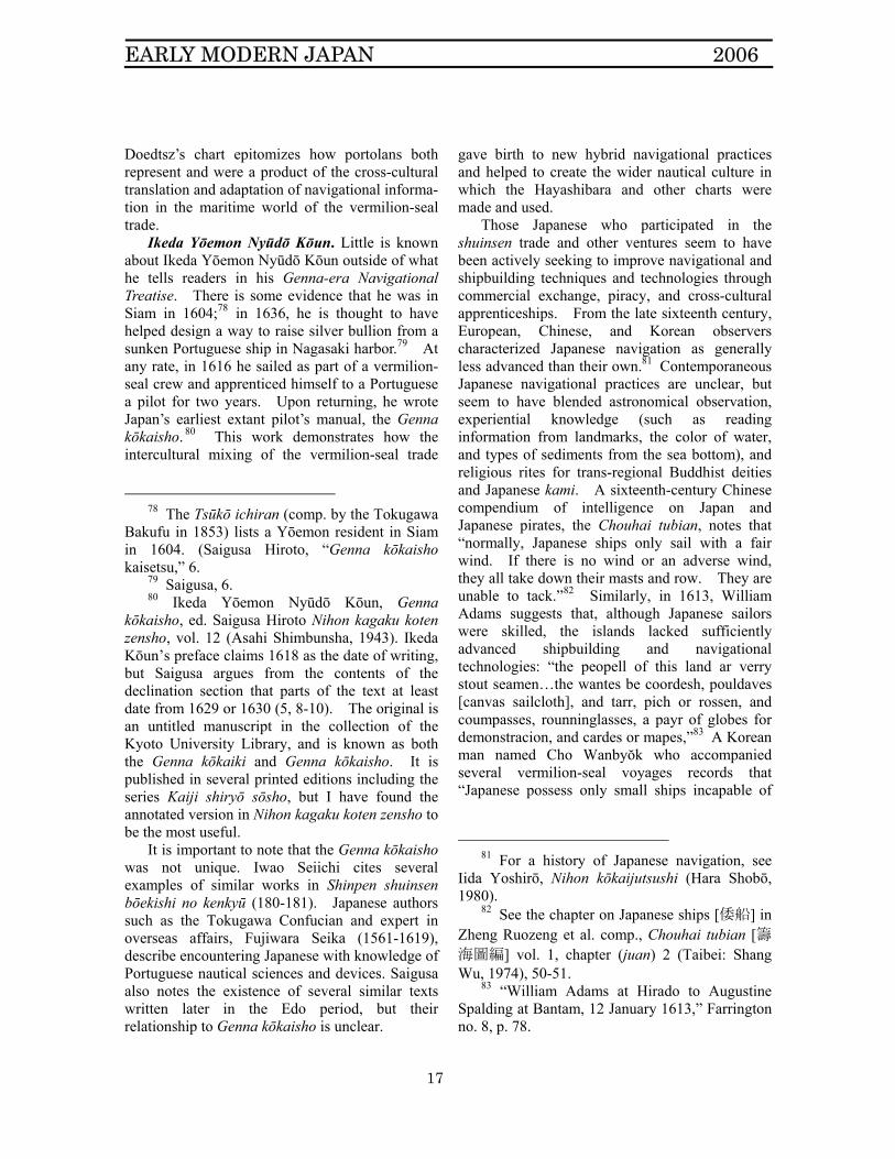
For Adams, a pilot and mapmaker, portolan charts constituted one chief receptacle for the navigational lore he acquired sailing for Japanese, Chinese, English, and other sponsors. Among the navigational instruments thought to have been brought by Adams to Japan are two portolan charts by the Dutch cartographer Cornelis Doedtsz. One map has survived unchanged since its original drafting and depicts a standard “bent pin” repre-sentation of Japan (Figure 3). However, a close look at the northeast corner of the second map (Figure 4) reveals drastic emendations to the east-ern half of the Japanese archipelago and the Ko-rean peninsula. 72
125, p. 326; Iwao, Shinpen shuinsen bōekishi no kenkyū, 275).
71 William Adams’ journal of his voyage to the Ryukyu Islands in the Sea Adventure, with related accounts and notes, and miscellaneous accounts, November 1614-1616, in Farrington no. 409, p. 1071; William Adams’ journal of his voyage to Cochin China in the Gift of God, with related accounts and notes, 17 March-6 August 1617, in Farrington no. 411, p. 1126; William Adams’ journal of his voyage to the Ryukyu Islands, 9 March-6 May 1618, in Farrington no. 413, p. 1171.
72 C.R. Boxer was the first to speculate that Adams made these changes. C.R. Boxer, “Some Aspects of Portuguese Influence in Japan, 1542-1640,” reprinted in Papers on Portuguese, Dutch, and Jesuit Influences in Sixteenth- and Seventeenth-Century Japan (Washington, D.C.:University Publications of America, Inc., 1979), 105. Unno, “Waga kuni ni okeru portorāno kaizu no juyō,” 257-259 has an overview of the scholarship on these two charts.
EARLY MODERN JAPAN 2006
16
Figure 3: Detail of Unaltered map of Cornelis Doedtsz73
Figure 4: Detail of Doedtsz map after Adams’ corrections74
73 Unno, “Waga kuni ni okeru portorāno kaizu
no juyō,” 247. This map is known as Nanyōshinrozu. It is in the collection of the Tokyo National Museum and is reproduced here with their permission.
74 Boxer, “Some Aspects of Portuguese Influence in Japan, 1542-1640,” opposite p. 106. This map is known as Seiyōshinrozu Indoyō. It is also in the collection of the Tokyo National Museum and used with their permission.
Adams himself admitted that his original naviga-tional and cartographic information regarding the Japanese archipelago was erroneous. In a letter he stated that, “we proceeded on our former inten-tion for Japan and in the haight of 30 degrees souht the northermost cape of the forenamed is-land but fownde it not, by reason that it lieth faulce in all cardes and mappes and globes; for the cape lieth in 35 1/2 degrees w’ch was a great dif-ference.…”75 Figure 4 reflects later corrections based on local East Asian seafaring knowledge that Adams would have acquired as a pilot in the vermilion-seal trade and on other ventures. It is one example of the way European portolans would be translated and adapted in creating vermilion-seal portolans.
In addition to correcting his old charts, Adams also drafted new charts based on his experiences and exchanges. For example, in 1613, he penned a letter to the English East India Company in 1613 saying, “I have sent a pateron of Japan for w’ch myself I hav been…alongs the cost in the shipping that I have made for the Emperour [Tokugawa Ieyasu].”76 Also in 1613 Richard Cocks, the head of the English Factory in Japan, described a map drafted by Adams in preparation for a proposed voyage to Ezo to search out the Northwest passage as “the plot of Japan, w’th p’te of that iland [Ezo] & Corea & other bordering places….” 77 Al-though we do not know what types of maps Ad-ams drafted, the dominance and adaptability of the portolan form in the period and the fact that the Doedtsz maps were portolans mean that Adams probably utilized portolan technology. For Ad-ams and others like him, cartographical and navi-gational innovations were significantly facilitated by the intercultural exchanges made possible by the shuinsen trade. Adams’ modification of
75 William Adams at Hirado to his ‘unknown
friends and countrymen, at Bantam, 23 October 1611,” in Farrington, no. 6, p. 68.
76 “William Adams at Hirado to Augustine Spalding at Bantam, 12 January 1613,” in Farrington, no. 8, p. 78. Ieyasu was of course retired shogun at this time.
77 “Richard Cocks at Hirado to Sir Thomas Smythe and the East India Company in London, 30 November 1613,” in Farrington, no. 18, p. 99.
EARLY MODERN JAPAN 2006
17
Doedtsz’s chart epitomizes how portolans both represent and were a product of the cross-cultural translation and adaptation of navigational informa-tion in the maritime world of the vermilion-seal trade.
Ikeda Yōemon Nyūdō Kōun. Little is known about Ikeda Yōemon Nyūdō Kōun outside of what he tells readers in his Genna-era Navigational Treatise. There is some evidence that he was in Siam in 1604;78 in 1636, he is thought to have helped design a way to raise silver bullion from a sunken Portuguese ship in Nagasaki harbor.79 At any rate, in 1616 he sailed as part of a vermilion-seal crew and apprenticed himself to a Portuguese a pilot for two years. Upon returning, he wrote Japan’s earliest extant pilot’s manual, the Genna kōkaisho. 80 This work demonstrates how the intercultural mixing of the vermilion-seal trade
78 The Tsūkō ichiran (comp. by the Tokugawa
Bakufu in 1853) lists a Yōemon resident in Siam in 1604. (Saigusa Hiroto, “Genna kōkaisho kaisetsu,” 6.
79 Saigusa, 6. 80 Ikeda Yōemon Nyūdō Kōun, Genna
kōkaisho, ed. Saigusa Hiroto Nihon kagaku koten zensho, vol. 12 (Asahi Shimbunsha, 1943). Ikeda Kōun’s preface claims 1618 as the date of writing, but Saigusa argues from the contents of the declination section that parts of the text at least date from 1629 or 1630 (5, 8-10). The original is an untitled manuscript in the collection of the Kyoto University Library, and is known as both the Genna kōkaiki and Genna kōkaisho. It is published in several printed editions including the series Kaiji shiryō sōsho, but I have found the annotated version in Nihon kagaku koten zensho to be the most useful.
It is important to note that the Genna kōkaisho was not unique. Iwao Seiichi cites several examples of similar works in Shinpen shuinsen bōekishi no kenkyū (180-181). Japanese authors such as the Tokugawa Confucian and expert in overseas affairs, Fujiwara Seika (1561-1619), describe encountering Japanese with knowledge of Portuguese nautical sciences and devices. Saigusa also notes the existence of several similar texts written later in the Edo period, but their relationship to Genna kōkaisho is unclear.
gave birth to new hybrid navigational practices and helped to create the wider nautical culture in which the Hayashibara and other charts were made and used.
Those Japanese who participated in the shuinsen trade and other ventures seem to have been actively seeking to improve navigational and shipbuilding techniques and technologies through commercial exchange, piracy, and cross-cultural apprenticeships. From the late sixteenth century, European, Chinese, and Korean observers characterized Japanese navigation as generally less advanced than their own.81 Contemporaneous Japanese navigational practices are unclear, but seem to have blended astronomical observation, experiential knowledge (such as reading information from landmarks, the color of water, and types of sediments from the sea bottom), and religious rites for trans-regional Buddhist deities and Japanese kami. A sixteenth-century Chinese compendium of intelligence on Japan and Japanese pirates, the Chouhai tubian, notes that “normally, Japanese ships only sail with a fair wind. If there is no wind or an adverse wind, they all take down their masts and row. They are unable to tack.”82 Similarly, in 1613, William Adams suggests that, although Japanese sailors were skilled, the islands lacked sufficiently advanced shipbuilding and navigational technologies: “the peopell of this land ar verry stout seamen…the wantes be coordesh, pouldaves [canvas sailcloth], and tarr, pich or rossen, and coumpasses, rounninglasses, a payr of globes for demonstracion, and cardes or mapes,”83 A Korean man named Cho Wanbyŏk who accompanied several vermilion-seal voyages records that “Japanese possess only small ships incapable of
81 For a history of Japanese navigation, see
Iida Yoshirō, Nihon kōkaijutsushi (Hara Shobō, 1980).
82 See the chapter on Japanese ships [倭船] in Zheng Ruozeng et al. comp., Chouhai tubian [籌海圖編] vol. 1, chapter (juan) 2 (Taibei: Shang Wu, 1974), 50-51.
83 “William Adams at Hirado to Augustine Spalding at Bantam, 12 January 1613,” Farrington no. 8, p. 78.
EARLY MODERN JAPAN 2006
18
traversing the great ocean. So, with 80 pieces of silver, they purchase passage on Chinese ships.” 84
To offset these navigational limitations, Japanese ship owners—especially in the vermilion-seal trade—regularly hired Chinese, Spanish, Portuguese, Dutch, English, and Scottish pilots.85 The commander of a fleet of Dutch ships in 1609, Francois Wittert, wrote of encountering a Japanese ship near Luzon carrying a Spanish pilot. Upon interviewing the captain, Wittert wrote, “Knowing that Japanese navigation is not advanced and that as a result many ships were being lost, the Japanese court [Bakufu] ordered [the employ of foreign pilots]. According to the captain, this ship carried a crew of 200, 20 being Spanish….”86 The Chouhai tubian also records that Japanese hired Chinese pilots and bought deep-keeled boats that could travel in the deep ocean and tack into the wind.87 Alternately, by taking passage on Chinese ships, Japanese could watch Chinese shipmasters “who used the compass to determine east and west and who used large ropes to drop a hook [sounding lead] down to dredge the bottom and determine distance and direction by the color [of the sediment].” 88 Japanese seafarers who sailed as part of these heterogeneous crews could master and help spread different navigational techniques and technologies.
Ikeda Kōun fit this mold. In the introduction to Genna kōkaisho, Ikeda writes, “This is the way of the navigator. In the second year of the Genna era [1616], I apprenticed myself to Manuel Gonzalo and for two years accompanied him on
84 See the text by Cho Wanbyŏk printed in full
in Iwao Seiichi, “Annankoku tokō Chōsenjin Cho Wanbyŏk den ni tsuite,” Chōsen gakuhō, 6 (1954), 12. Cho Wanbyŏk was captured in the Japanese invasion of Korea in 1597 and was brought to live in Kyōto for a time. In order to buy his release, he sought a position on a ship trading with Southeast Asia (Cho, 10-12, as well as Iwao’s analysis on 2).
85 Iwao, Shinpen shuinsen bōekishi no kenkyū, 243-261.
86 Quoted in Iwao, Shinpen shuinsen bōekishi no kenkyū, 247.
87 Chouhai tubian, 51. 88 Cho, 12.
his crossings to Luzon. During that time, I mastered those aspects of the arts that he knew.”89 Gonzalo was a Portuguese navigator who is known to have received trading licenses for Siam, Cochin China, and the Philippines in 1613, 1614, and 1618 respectively. 90 Despite stringent statutes issued by the Iberian crowns against the sharing of navigational intelligence and charts,91 Gonzalo willingly imparted all he knew to Ikeda.
By labeling these techniques and technologies as a “way” [J. michi], Ikeda sought to demonstrate their significance, identifying them as a skill that when mastered could lead one to universal knowl-edge.92 Ikeda also emphasized the importance of these navigational ideas by exalting their wide-spread adoption: “[t]oday, what country’s mariners do not know these ideas?”93 At the same time, Ikeda did not hesitate to highlight their weak points. He describes how,
Once, I put to him [Gonzalo] three ques-
tions. The first was how to measure the sun before and after midday; the second was how to know one’s degree of latitude when the Southern Cross was to the right or left and one lay to the East or West. The third concerned one’s position in rela-tion to the North Star. Although the an-cient treatises diagramed eight methods [for the third issue]—four pertaining to the day, one to morning and evening, and the remaining three to darkness—when clouds cover the sky, they are meaningless even if one knows the time. For this third problem, I wondered if, when I want to accurately gauge altitude and distance, there was per-haps a method not dependent upon time.
My teacher answered, “in all likelihood, you will find no other teachings on these
89 Ikeda, 21. 90 Iwao, Shinpen shuinsen bōekishi no kenkyū,
231-232. 91 Nakamura Hiroshi, Goshuinsen kōkaizu,159. 92 Jin’ichi Konishi, A History of Japanese Lit-
erature, vol. 3, The High Middle Ages, trans. Aileen Gatten and Mark Harbison, ed. Earl Miner (Princeton University Press, 1991), 146-157.
93 Ikeda, 21, 24.
EARLY MODERN JAPAN 2006
19
three issues. Regarding your first question about measuring the sun: even though it is said that there is only the one time during the day—the moment the sun reaches its zenith between East and West—if during this time of measurement, [the sun] cannot be measured, that day is wasted. So there really is no method for measuring the sun before or after noon. As for your second query, the star at the base of the Southern Cross resides thirty degrees away from the South Pole. When the star is straightly aligned with the pole, measurements can be taken. If it is even slightly askew, it is difficult to measure. You can do nothing if the star is at an angle or off to one side. As for the third issue—whether I think there are methods for measuring the North Star other than those recorded in the classic texts—if you want to calculate down to the minute, then, most assuredly, there is not. Though you can pose these three questions to a navigator anywhere, I doubt you will come to any greater understanding of them.”94
However, for Ikeda, these limitations were not overly disheartening; they meant only that there was more to learn. He advised those who came after him to “forget the ignorant sections and throw away the mistakes to await the emendations of those who follow.”95 From Ikeda’s perspec-tive, mariners in East Asia left room to adapt and improve technologies and techniques through in-terpersonal interactions in the maritime world, a mind-set clearly at work in the cartographical and navigational practice of William Adams as well. In fact, Saigusa Hiroto argues that because the dates of the declination table that Ikeda included in the treatise range from 1629-1685, Ikeda may have added this information at a later date in order to mitigate some of the difficulties.96 Ikeda’s decli-nation tables show the altitude of the sun at noon for everyday of every year in that period, allowing one to estimate one’s position even if the sun were
94 Ikeda, 21. 95 Ikeda, 21-24. 96 Saigusa, 8-10.
obscured. Ikeda devoted much of the remainder of the
work to explicating some of the mechanics of navigation. In addition to the declination chart with instructions on its use, the Genna kōkaisho contains translations and explanations of conversions between Iberian and Japanese distances and calendars, including astronomical derivation of the European calendars and the mathematics behind leap years. Using both diagrams and text, Ikeda described the use of navigational devices such as the compass, astrolabe, quadrant, and sounding lead. As with any good pilot’s manual, Genna kōkaisho also includes rutters—in this case directions for sailing between Nagasaki and ports in East and Southeast Asia such as Macao and Siam—that contain compass directions and depth-measures as well as experiential elements such as landmarks and the meanings of the colors and forms of sediments from the seafloor.
Although usually understood as a translation of Portuguese knowledge,97 Genna kōkaisho is actually a representation of how Ikeda assimilated the diverse array of hybrid practices that characterized navigation aboard the vermilion-seal trade ships, creating a new, idiosyncratic totality. Scholars’ over-emphasis on the ‘western science’ portions of the text mirrors the traditional focus on portolans as part of a national teleology of ever-more scientific mapping. However there are significant portions of the Genna kōkaisho that are representations of, if not Chinese, then broader East Asian nautical practice.
Ikeda included mnemonic songs for the four seasons and the four directions that are almost character for character the same as those in the Ming pilot book, Shunfeng xiangsong.98 And, just as in the Shunfeng xiangsong and the Zhinan zhengfa, Ikeda provided a table instructing the reader in the identification of those days on which setting sail was inauspicious and inadvisable due
97 Scholars including Saigusa Hiroto,
Nakamura Hiroshi, Iwao Seiichi, and Unno Kazutaka concentrate on those sections of the text that deal with European navigation.
98 Ikeda 101; Shunfeng xiangsong, 28.
EARLY MODERN JAPAN 2006
20
to the presence of evil winds. 99 In addition, Nakamura Hiroshi notes that Ikeda’s measurement of the degree comes from Chinese sources.100 Lastly, navigational devices such as sounding leads and compasses and the experiential knowledge included in Ikeda’s rutters can be found in both Portuguese and Chinese sources. However, it is also possible that the information found in Ming sources had by the early seventeenth century been adopted as common sense by Japanese mariners, especially given the extensive maritime exchange among seafarers from across East Asia who sailed with cosmopolitan pirate crews in the fifteenth and sixteenth centuries. The hybrid character of Ikeda’s navigational methodology is most visible in a series of maritime maxims (of which only a few are here translated):
• When choosing sailors, old, middle-aged, and
young, it is good to intermix them. • In one day it is easy to find 1,000 ignoramuses,
but in 1,000 days, you may never get one wise person.
• With those navigators who are able to study, it is like being in a room with four sold walls. Sailing with ignorant navigators is like sitting on a lake covered by thin ice.
• Traveling from desire makes it hard to go 1 mile, but traveling righteously makes it easy to go 1,000 miles.
• Waves and billows do not destroy a ship, care-lessness causes ships to be lost.
• Tie up ships during a typhoon, but do not de-pend on the anchor cables to save you.
• High and low tides occur differently because of the proximity of the moon in its movements.
• The needle points north the same way in 10,000 countries.
99 Ikeda, 102; Shunfeng xiangsong, 26; Zhinan
zhengfa, 112. The dates identified by Ikeda and in the Ming manuals do not always correspond. However, there is at least a century separating the works, suggesting that the idea retained currency and that the calendar may have required updating.
100 Nakamura Hiroshi, “The Japanese Portolanos of Portuguese Origin of the XVIth and XVIIth Centuries,” 41.
• Do not place iron next to the needle. Do not use iron nails to make the compass box. Use wood or copper.
• Do not place garlic, onions, leeks, and other types of strong-smelling things by the needle. If they are placed by the compass, it will not register properly.
• When there are red clouds during a Yang month, there will be no rain for three days (Yang months last from the 3rd to the 8th months).
• When red clouds mount during a Yin month, there will be 3 days of misfortune (From the ninth month to the next second month is known as the Yin months).101
If Genna kōkaisho had been a simple transla-
tion of a European pilot book, Yin-Yang cosmol-ogy and Confucian rhetoric presumably would have been replaced by the Ptolemaic cosmology that we saw in Millo’s account. Had it been a purely Chinese text, there would have been de-scriptions of the proper rites necessary to propiti-ate ancestors, the Yellow Emperor, and other dei-ties.102 Instead, Ikeda seems to have compiled the types of knowledge most useful to him, sug-gesting the testing of different types of knowledge based on experiences gained sailing on vermilion-seal vessels. These nautical aphorisms mix naviga-tional aids with Confucian maxims, Yin-Yang sci-ence, and experience-based advice. Like Antonio Millo, Ikeda seems to insist that a true mariner should master a wide array of knowledge-forms extending from what we would label the experien-tial, to the scientific, to the spiritual. When Ikeda wrote, “[t]oday, what country’s mariners do not know these ideas,”103 he referred not only to Por-tuguese devices and technology, but the hybrid, multiform practices of navigation common across East Asia in this period. These navigational ge-stalts might also be idiosyncratic as individual mariners decided what mix of spiritual technolo-gies, astronomical science, and locally determined experience worked best for them.
101 Ikeda, 113-118. 102 See for example the Shunfeng xiangsong,
26. 103 Ikeda, 21, 24.
EARLY MODERN JAPAN 2006
21
Although Ikeda does not mention maps in the Genna kōkaisho, the processes of interpersonal exchange, learning, and testing of knowledge clearly at work in the text’s production provide us a possible model with which to understand the processes by which the Hayashibara and other charts were created in the hybrid cultures of the sixteenth and seventeenth-century East Asian maritime world. Furthermore, C.R. Boxer has argued that the style of this text resembles European pilot-manuals and rutters that were meant to be used in conjunction with charts. 104 In fact, there are labels on the Hayashibara and other charts for places like Gotō and Meshima in the Japanese archipelago or Lamao off the coast of China that were not ports, but instead appear as landmarks in rutters such as are found in Genna Kōkaisho. 105 Another surviving chart actually contains a written description of the sites listed on the chart, 106 further indicating that Japanese portolans may have been used together with written accounts such as rutters.
Examination of Adams’ cartography and Ikeda’s navigational treatise thus reveal how the practical desire to maximize the variety and efficacy of navigational technologies as well as the personalities and idiosyncrasies of individual pilots stimulated adaptation of portolan maps and profoundly shaped the development of the hybrid nautical culture in sixteenth and seventeenth-century East Asia.
The Hayashibara Chart and the Broader Hy-brid Nautical Cultures of the Vermilion-Seal Trade
In this section, we expand our perspective
from the pilots who exemplify the individual agency involved in the creation of the portolans to the wider nautical cultures that gave birth to the vermilion-seal portolans, in particular its seafaring
104 Boxer, “Some Aspects of Portuguese
Influence in Japan, 1542-1640,” 107. 105 Nakamura Hiroshi, Goshuinsen kōkaizu,
539; Ikeda, 100-101. 106 Nakamura Hiroshi, Goshuinsen kōkaizu,
39.
argots, belief systems, ships, and ports. These examples further demonstrate how portolans like the Hayashibara are best understood as part of a hybrid seafaring culture that existed between land-based states and not as part of a national tradition of mapping.
Language. In the vermilion-seal trade, a single ship’s crew could be composed of mariners of many lands and languages. Mary Louise Pratt argues that this type of multicultural situation of-ten led to the development of “contact lan-guages”—“improvised languages that develop among speakers of different native languages.”107 On vermilion-seal ships, this diversity began at the top of the ship’s hierarchy and extended through the ranks of the mariners. Recipients of goshuin-sen licenses included one Ryūkyūan, eleven Chi-nese, and twelve Europeans in addition to Japa-nese.108 Mercenary pilots like William Adams and Ikeda’s teacher Manuel Gonzalo swarmed the trading ports of East Asia, feeding a market for experienced navigators whatever their homeland. Sponsors of vermilion-seal ships usually hired Chinese or European pilots, 109 and European ships as a matter of practice used local pilots in foreign waters. 110 Sailors from China, Japan, Southeast Asia, and Europe, not to mention count-less mariners of mixed heritage, congregated in entrepôts from Nagasaki to Melaka and consti-tuted crews for ships from many lands.111 Portu-guese vessels especially seem to have been un-dermanned and so augmented their crews with local sailors from across Asia.112 The need to
107 Pratt, 6. 108 Iwao, Shinpen shuinsen bōekishi no kenkyū,
224. 109 See Iwao’s chart of known pilots for
Japanese vermilion-seal voyages in Shuinsen bōekishi no kenkyū, 256-257.
110 Nakamura Hiroshi, “The Japanese Portolanos of Portuguese Origin of the XVIth and XVIIth Centuries,” 34; C.R. Boxer, The Christian Century in Japan (Berkeley: University of California Press, 1967), 410.
111 Iwao, Shinpen shuinsen bōekishi no kenkyū, 278-279.
112 C.R. Boxer, The Portuguese Seaborne Empire (New York:Alfred A. Knopf, 1969), 52-53.
EARLY MODERN JAPAN 2006
22
form a cohesive crew among disparate linguistic groups stimulated development of a seafaring lin-gua franca and distinctive nautical culture in six-teenth- and seventeenth-century East Asia.
Nagazumi Yōko has speculated that the Chi-nese, Japanese, Koreans, Portuguese, and others who crewed the wakō ships in the sixteenth cen-tury coupled with the spread of Chinese, European, and Japanese diasporas throughout East and Southeast Asia encouraged the development of a maritime lingua franca, possibly some hybrid form of Fujianese mixed with Portuguese and Malay.113 Her theory about the importance of southern Chi-nese dialects in at least parts of this trade is given further credence by the “bouk of Rememberanc” William Adams appended to his journal to Cochin China. Adams recorded Cantonese equivalents for thirty words including the ordinal numbers one through ten, north, south, east, west, northeast, and southwest [inclusion of these last two may reflect an awareness of the directions of the monsoons], compass, boatswain, captain, and “a bare wind.”114 Although the fact that Adams felt it necessary to record these terms indicates that he was not famil-iar with them prior to traveling to the South China seas, there may have been regional differences in languages used in the trade and the large percent-age of maritime terms in his list implies that he recognized the importance of that dialect in the maritime world.
Much textual evidence suggests that a mixture of Japanese, Portuguese, and Chinese was used on vermilion-seal ships, matching the multi-lingual textuality of the Hayashibara and other charts. Tokubei Tenjiku monogatari (1707) purports to contain the reminiscences of journeys made by a monk named Sōshin to Southeast Asia on shuinsen sponsored by the Dutchman Jan Joosten and the
113 Nagazumi, 24. Nagazumi’s speculation
derives in part from Murai Shōsuke’s argument about wajin and wakō as “mājinaru man” (Nagazumi, 22-23); Murai, Chūsei Wajinden, 34-58.
114 William Adams’ journal of his voyage to Cochin China in the Gift of God, with related accounts and notes, 17 March-6 August 1617, in Farrington, no. 411, p. 1126.
wealthy merchant Suminokura Yoichi.115 At the end of the narrative Sōshin listed the words used for numbers and measures one through ten, hun-dred, thousand, and ten thousand: “inya, arasu, teresu, kuwatro, shinku, se’in, seiku, wobira, nobi, ten, tehen,116 raki, han.”117 The numbers one through ten seem to be Japanese transliterations of Portuguese numerals, but the word for thousand, raki, may derive from the Sanskrit lacasa widely used in Southeast Asia, including by Malay speak-ers for either 10,000 or 100,000.118 The word han for ten-thousand is clearly derived from the Chinese or Japanese. Tokubei Tenjiku monoga-tari and similar texts also allow us to compile a list of some of the terms used to refer to jobs on a ship. The original languages for these terms seem to have been Portuguese, Chinese, and Japa-nese (see Table 1).
Religion. In addition to language, religious traditions held in common helped unite crews. Throughout the premodern period, rituals per-formed to ensure safe passage formed one part of the continuum of navigational practices in East Asia. Many sea travelers commonly worshipped trans-East Asian Buddhist deities, especially Avalokitesvara (C. Guanyin, J. Kannon).119 In the sixteenth century, the popularity of Christianity and the worship of Tianhou (also called Mazu, the
115 See Sōshin, Tokubei Tenjiku monogatari,
in Edo hyōrūyki sōshū, vol. 1 ed. Yamashita Tsuneo (Heibunsha, 1992), 488-504, hereafter TTM.
116 As yet unknown. 117 TTM, 503. 118 For an explanation of lacasa, see Glossary
1 at the end of Fernão Mendes Pinto, The Travels of Mendes Pinto, ed. trans. Rebecca D. Catz (Chicago: University of Chicago Press, 1989), 644.
119 The Korean official Ch’oe Pu depicted an interesting twist to this religiosity in his diary when, after being shipwrecked off the coast of China in 1487, he describes an encounter with a pirate who claimed “I am the Buddha Kuan-yin.” Ch’oe Pu, Ch’oe Pu’s Diary, ed., trans. John Meskill (Tucson: University of Arizona Press, 1965), 41. See also Ennin, Ennin’s Diary, ed., trans. E.O. Reischauer (The Ronald Press Co., 1955), 2, 6, 94, 125 for shipboard Buddhism.
EARLY MODERN JAPAN 2006
23
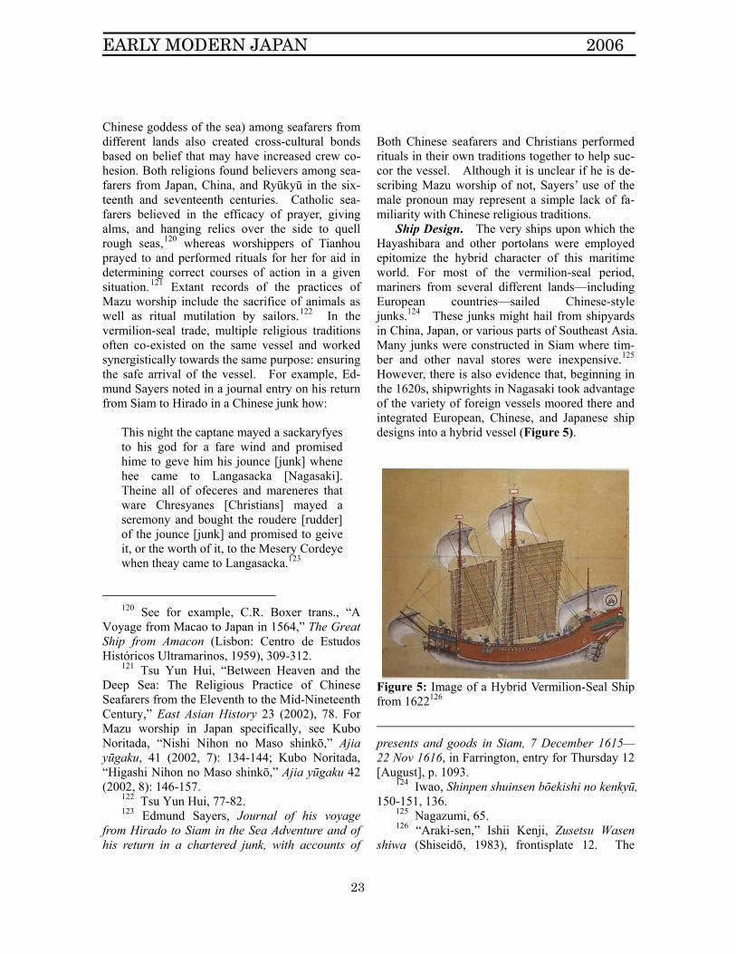
Chinese goddess of the sea) among seafarers from different lands also created cross-cultural bonds based on belief that may have increased crew co-hesion. Both religions found believers among sea-farers from Japan, China, and Ryūkyū in the six-teenth and seventeenth centuries. Catholic sea-farers believed in the efficacy of prayer, giving alms, and hanging relics over the side to quell rough seas,120 whereas worshippers of Tianhou prayed to and performed rituals for her for aid in determining correct courses of action in a given situation.121 Extant records of the practices of Mazu worship include the sacrifice of animals as well as ritual mutilation by sailors.122 In the vermilion-seal trade, multiple religious traditions often co-existed on the same vessel and worked synergistically towards the same purpose: ensuring the safe arrival of the vessel. For example, Ed-mund Sayers noted in a journal entry on his return from Siam to Hirado in a Chinese junk how:
This night the captane mayed a sackaryfyes to his god for a fare wind and promised hime to geve him his jounce [junk] whene hee came to Langasacka [Nagasaki]. Theine all of ofeceres and mareneres that ware Chresyanes [Christians] mayed a seremony and bought the roudere [rudder] of the jounce [junk] and promised to geive it, or the worth of it, to the Mesery Cordeye when theay came to Langasacka.123
120 See for example, C.R. Boxer trans., “A
Voyage from Macao to Japan in 1564,” The Great Ship from Amacon (Lisbon: Centro de Estudos Históricos Ultramarinos, 1959), 309-312.
121 Tsu Yun Hui, “Between Heaven and the Deep Sea: The Religious Practice of Chinese Seafarers from the Eleventh to the Mid-Nineteenth Century,” East Asian History 23 (2002), 78. For Mazu worship in Japan specifically, see Kubo Noritada, “Nishi Nihon no Maso shinkō,” Ajia yūgaku, 41 (2002, 7): 134-144; Kubo Noritada, “Higashi Nihon no Maso shinkō,” Ajia yūgaku 42 (2002, 8): 146-157.
122 Tsu Yun Hui, 77-82. 123 Edmund Sayers, Journal of his voyage
from Hirado to Siam in the Sea Adventure and of his return in a chartered junk, with accounts of
Both Chinese seafarers and Christians performed rituals in their own traditions together to help suc-cor the vessel. Although it is unclear if he is de-scribing Mazu worship of not, Sayers’ use of the male pronoun may represent a simple lack of fa-miliarity with Chinese religious traditions.
Ship Design. The very ships upon which the Hayashibara and other portolans were employed epitomize the hybrid character of this maritime world. For most of the vermilion-seal period, mariners from several different lands—including European countries—sailed Chinese-style junks.124 These junks might hail from shipyards in China, Japan, or various parts of Southeast Asia. Many junks were constructed in Siam where tim-ber and other naval stores were inexpensive.125 However, there is also evidence that, beginning in the 1620s, shipwrights in Nagasaki took advantage of the variety of foreign vessels moored there and integrated European, Chinese, and Japanese ship designs into a hybrid vessel (Figure 5).
Figure 5: Image of a Hybrid Vermilion-Seal Ship from 1622126
presents and goods in Siam, 7 December 1615—22 Nov 1616, in Farrington, entry for Thursday 12 [August], p. 1093.
124 Iwao, Shinpen shuinsen bōekishi no kenkyū, 150-151, 136.
125 Nagazumi, 65. 126 “Araki-sen,” Ishii Kenji, Zusetsu Wasen
shiwa (Shiseidō, 1983), frontisplate 12. The
EARLY MODERN JAPAN 2006
24
In the ship depicted in Figure 5, the designs for the rear portion of the ships including the rudder, aft cabins, and aftcastles were derived from Euro-pean galleons and galiots. In contrast, the prow’s shape and its stations for rowers closely resemble the front ends of late sixteenth-century Japanese warships known as atakebune. The foremast and mainmast carry Chinese junk-style ribbed sails whereas the design of the bowsprit, cloth spritsail, topsails, and mizzen all suggest European influ-ence.127 Textual evidence for these ships is scare, but Willem Jansz, a member of the Dutch East India Company, wrote in his record of a sojourn in Nagasaki in 1630 that,
“in the shallow sea in front of the town, two new ships rode at anchor built in the galiot style with pennants flying at the stern. One was bought by a Chinese mer-chant hoping to sail for Cochin China and another is owned by a Japanese, but char-tered to a Chinese setting sail for Tonkin. Sailing as pilot is Vicent Romeijn, a Dutch resident of Nagasaki.”128
Viewed from the rear, these new hybrid ships would have resembled a galiot, suggesting that at the very least, Japanese shipwrights were incorpo-rating European hull designs into their ships. Furthermore, the passage suggests that ship de-signs were not necessarily tied to particular lands.
Entrepôts. The hybrid character of the ships used in the trade also marked the major trading ports. Many of the entrepôts labeled on the Japanese portolans were cosmopolitan centers of exchange where mariners and merchants from
image is known as “Araki Sōtarō ikokusen tokaisen no zu” and is in the holdings of the Nagasaki City Museum. Similar hybridity of ship design can also be seen in shuinsen ema held by the Kiyomizu Temple.
127 Ishii, 70-71; Nagazumi, 58-60. 128 Quoted in Iwao, Shinpen shuinsen bōekishi
no kenkyū, 250. We should also notice the combination of a Dutch pilot, a Japanese shipowner, and a Chinese merchant all involved with this vessel.
many different countries gathered and exchanged information, the perfect place to acquire new car-tographic knowledge. Because sailing in this pe-riod was dictated by the seasonal monsoon winds, sailors might have to wait several months in port for winds to change, providing ample opportuni-ties for rich intercultural exchange. In the Japa-nese archipelago, ports like Nagasaki and Hirado were home to Portuguese, Spanish, English, Dutch, and Chinese. In Hirado for example, the English rented their quarters from the “China Captain,” a Chinese merchant-pirate and vermilion-seal re-cipient named Li Tan.129
This cosmopolitanism is even more evident in the ports visited by vermilion-seal ships. For example, in addition to being a major center of ship-construction, Ayutthya—the capital of Siam—was a bustling trading center conveniently located at the junction of rivers tying together oce-anic basins and overland trade routes connecting the Indian Ocean and the Gulf of Siam.130 Be-tween 1604 and 1635, fifty-six shuin were issued for Siam,131 recipients of which included William Adams.132 In addition, Ayutthya contained sepa-rate wards for peoples from Japan, China, Pegu, Laos, Makassar, Tonkin, Cochin China, Cambodia, and Malaya.133 A permanent population of ap-proximately 1500 Japanese merchants and merce-naries inhabited the Japanese ward. These wards were not isolated ghettoes; opportunities abounded for cross-cultural interaction: battalions of Japa-nese and Chinese served the Siamese King and Japanese sailors and merchants sailed on Dutch,
129 Iwao, “Li Tan 李旦, Chief of the Chinese
residents at Hirado,” 32-45. 130 Nagazumi, 99. Nagazumi notes that due
to the necessity of waiting for the monsoon, it was sometimes faster to portage overland across the short isthmus between the Gulf of Siam and the Indian Ocean on the roads from the coastal towns of Phetburi, Tenasserim, and Mergui.
131 See Iwao Seiichi’s chart breaking down extant references to licenses by year and destination on p. 127 of Shinpen shuinsen bōekishi no kenkyū.
132 Nagazumi, 106. 133 Nagazumi, 112-113.
EARLY MODERN JAPAN 2006
25
Portuguese, and Chinese ships.134 Mapmakers in these cosmopolitan entrepôts could draw on the navigational knowledge of mariners from many lands.
Thus, in maritime East Asia, ships and ports constituted spaces of cross-cultural interaction, translation, and innovation, especially of new navigational techniques and knowledge. Records of hybrid linguistic and religious practices in these spaces give further credence to the idea that car-tography and other navigational technologies were developed to be usable by pilots from disparate regions of the world. Portolans like the Hayashi-bara provide records of the processes of transla-tion and adaptation and epitomize the hybrid mari-time cultural forms that evolved in these nautical spaces.
Conclusion: Beaching the Portolan
The weight of evidence from varied cultural artifacts such as portolans and other forms of maritime itinerary mapping, the Genna kōkaisho, terminology, belief systems, ship design, ports, and other elements of the nautical culture of late sixteenth and early seventeenth-century mariners in East Asia all suggest that vermilion-seal porto-lan charts like the Hayashibara should not be seen as belonging to one particular land-based national history. Instead, they were products and tools of individual seafarers living and working in a com-mon hybrid, polyvocal maritime culture born out of the vermilion-seal trade.
The Hayashibara and other charts designed for use on vermilion-seal licensed merchant ships ex-emplify the hybrid nature of these cultures. Not merely transplanted and copied, these marine charts depict improved coastlines, different writ-ing systems, different measuring systems, and perhaps even different motives all successfully melded into a single cartographic form. Through the idiosyncratic agencies of individual pilots and mapmakers, these former amalgams of Mediterra-nean and Atlantic navigational processes were absorbed and filtered through a larger East Asian collection of navigational ideas to form new hy-
134 Nagazumi, 24, 37-44, 114.
brid unities. Study of these charts demonstrates that—
especially for the premodern period—it is neces-sary to transcend national paradigms of interaction and focus on regional and interpersonal levels of exchange to understand the dynamics of intercul-tural exchange in East Asia in this period. At the same time, it is also important not lose one’s self in binaries of East and West, Europe and Asia. From the maps, texts, and histories of figures like Antonio Millo and Mateo Prunes in the Mediter-ranean to the anonymous authors of Shunfeng xiangsong and Zhinan zhengfa; from the globe-trotting William Adams, to the student of naviga-tion Ikeda Yōemon Nyūdō Kōun, to the unnamed draftsmen of the vermilion-seal portolans, com-monalities deriving from shared maritime liveli-hoods transcended differences in cultures of the lands of origin. Furthermore, a universally ac-cepted definitively hegemonic paradigm for navi-gation had yet to be established. Instead, ex-perimentation, holistic methodologies, and hybrid-ity characterized seafaring across cultures and oceans in the time of the vermilion-seal trade.
Last, by focusing on hybrid communities of seafarers instead of their lands of origin, an ex-amination of these portolans pushes us to consider intercultural exchange as idiosyncratic, non-linear processes. Pilots and maritime mapmakers par-ticipated as individuals in the creation of portolans and hybrid nautical cultures during the vermilion-seal trade. However, after the Tokugawa Ba-kufu’s abrogation of that program, the hybrid character of the maps and the maritime world largely lost its utility.
After the 1630’s, Japanese could only legally participate in overseas relations via the ‘four gates’ (Satsuma, Nagasaki, Tsushima, and Matsumae),135 through observation, consumption, imitation, and imagination,136 and by extra-legal means such as
135 For the four gates in English see Tsuruta
Kei, “The Establishment and Characteristics of the ‘Tsushima Gate,’” Acta Asiatica 67 (1994) 30-48; Bruce L. Batten, To the Ends of Japan (Honolulu: University of Hawaii Press, 2003), 44-45.
136 See for example Ronald Toby, “Carnival of the Aliens,” Monumenta Nipponica 41:4 (1986),
EARLY MODERN JAPAN 2006
26
smuggling or being castaway.137 During this pe-riod, portolan charts were not considered to have much value as nautical devices. By the end of the seventeenth century, the Nagasaki resident and scholar Nishikawa Jōken could describe portolan charts in his Ka’i tsūshō kō as “maps used aboard ship, not commodities.”138
Instead, as Unno Kazutaka has elaborated, there seems to have been a sea-change in percep-tion of the charts in the Edo period that shifted from understanding them as part of the maritime world to associating them with the land of Japan. Portolan technology was used by Bakufu-sponsored cartographers to draft maps of Japan based on detailed soundings of the coastline from Northern Honshu to Kyushu to the Bonin Is-lands.139 At the same time, charts of East and Southeast Asia continued to be copied as evidence of draftsmen’s skill, but were given as certifica-tions of land surveyors’ skills. There were some who even equated being a pilot (pirōto) with being a land surveyor, not a seafarer.140 Charts of sea routes tended to be confined to coastal regions defined by ‘land-marks’ and reproducing the style of land-itinerary maps. The archipelago’s coastal reaches and nearby seas became incorporated into the early modern terra-centric order and the outer ocean became a place where the imagination held sway.141 Japanese portolans only became Japa-
415-56; Marcia Yonemoto, Mapping Early Mod-ern Japan (Berkeley: University of California Press, 2003).
137 Michael Wood, "Literary Subjects Adrift: A Cultural History of Japanese Castaway Narratives in Edo and Early Meiji (ca. 1633-1880) Japan," Ph.D. Dissertation, University of Oregon, 2006.
138 Quoted in Unno, “Waga kuni ni okeru portorāno kaizu no juyō,” 212. Nishikawa used the Japanese pronunciation of the Portuguese word carta (karuta-zu) to identify these charts.
139 Unno, “Cartography in Japan,” 384-386. 140 Unno, “Cartography in Japan,” 393-394.
The equation of pilots with surveyors comes from Hosoi Kōtaku’s Hiden chiiki zuhō daizensho.
141 Marcia Yonemoto, “Maps and Metaphors of the ‘Small Eastern Sea” in Tokugawa Japan
nese after they were dragged ashore and domesti-cated.
However, use of portolans in East Asia did not die out with the cessation of the vermilion-seal trade. Vermilion-seal portolans sometimes un-derwent re-adoption by European cartographers who recognized the improved Japanese depictions of East Asia over European ones.142 Furthermore, there is some evidence that Chinese merchant mariners traversing seas between China, Southeast Asia, and Japan also carried portolan charts of similar design into the eighteenth century.143
(1603-1868),” The Geographical Review, 89:2 (1999:4): 169-187.
142 Nakamura Hiroshi, “The Japanese Portolanos of Portuguese Origin of the XVIth and XVIIth Centuries,” 44. João Teixeira in 1649 and Capt. John Kempthorne in 1680 used copies of Japanese portolans as the basis for their designs of East Asia in their own charts
143 Unno, “Waga kuni ni okeru portorāno kaizu no juyō,” 213. The information comes from an eighteenth-century work by Nishikawa Jōken, but, as Unno relates, none of the Chinese portolans are extant, perhaps indicating that they may have used vermilion-seal charts.


![[01]UNCOPUOS SentinelAsia Final · Sep. 1993 Tokyo, Japan Tokyo, Japan Tokyo, Japan Tokyo, Japan Ulanbator, Mongolia Tsukuba, Japan Tokyo, Japan Kuala Lumpur, Malaysia Daejeon, Korea](https://img.pdfslide.net/doc/110x75/600d276b3d3e78250500e5e2/01uncopuos-sentinelasia-final-sep-1993-tokyo-japan-tokyo-japan-tokyo-japan.jpg)