Embed Size (px)
Citation preview

Earth Observation for Ocean-Atmosphere Interactions Science 2014 – Frascati, 28-31 October 2014 1
http://www.esurge-venice.eu
The ESA eSurge-Venice project: how satellite data can improve the storm surge forecasting in the Gulf of Venice
S.Zecchetto, F. De Biasio, A. della ValleCNR-ISAC, Padova, Italy
G. Umgiesser, M. BajoCNR-ISMAR, Venezia, Italy
C. DonlonESA ESTEC, Noordwijk, The Nederlands
S. VignudelliCNR-IBF, Pisa, Italy
A. PapaIstituzione Centro Previsioni e Segnalazioni Maree, Venice Municipality, Venezia, Italy
Contacts: [email protected]

Earth Observation for Ocean-Atmosphere Interactions Science 2014 – Frascati, 28-31 October 2014 2
http://www.esurge-venice.eu
The ESA eSurge and eSurge-Venice projects
The Data User Element (DUE) program of the European Space Agency (ESA) is funding two projects (eSurge and eSurge-Venice) aimed to demonstrate the improvement of the storm surge forecasting through the use of Earth Observation (EO) data.
eSurge-Venice is specifically focused on the Gulf of Venice.
Project objectives: Select a number of Storm Surge Events occurred in the Venice lagoon; Provide the available EO, in situ and model data related to the Storm Surge Events; Provide a demonstration NRT service of EO data products and services in support
of operational and experimental forecasting and warning services; Run a number of re-analysis cases to demonstrate the usefulness of EO data.

Earth Observation for Ocean-Atmosphere Interactions Science 2014 – Frascati, 28-31 October 2014 3
http://www.esurge-venice.eu
The eSurge-Venice project: team and website homepage
http://www.esurge-venice.euScatterometer wind
Storm surge modelling
Altimeter data
In situ data
CNR-ISAC, Padova, Italy
CNR-ISMAR, Venice, Italy
CNR-IBF, Pisa, Italy
Istituzione Centro Previsioni e Segnalazioni Maree, Venice Municipality, Venezia, Italy

Earth Observation for Ocean-Atmosphere Interactions Science 2014 – Frascati, 28-31 October 2014 4
http://www.esurge-venice.eu
Storm surges in the Gulf of Venice
Storm surges in the Gulf of Venice are induced by:
Strong southeasterly winds (sirocco) along the Adriatic Sea main axis, resulting from the passage of low atmospheric pressure and the basin orography (duration: 3 days; level up to 90 cm)
Inverse barometer effect resulting from the MSL air pressure pattern (roughly 1 cm /1 mb; duration 10 days; level up to 20 cm)
Basin seiches caused by meteorological forcing (duration: 5 days; level up to 40 cm)
Other phenomena (wave set-up, non-linear interactions between storm surge, astronomical tide and waves, baroclinic forces and river discharges) are negligible
Mediterranean Sea
Adriatic Sea
Earth Observation for Ocean-Atmosphere Interactions Science 2014 – Frascati, 28-31 October 2014 5
http://www.esurge-venice.eu
High water
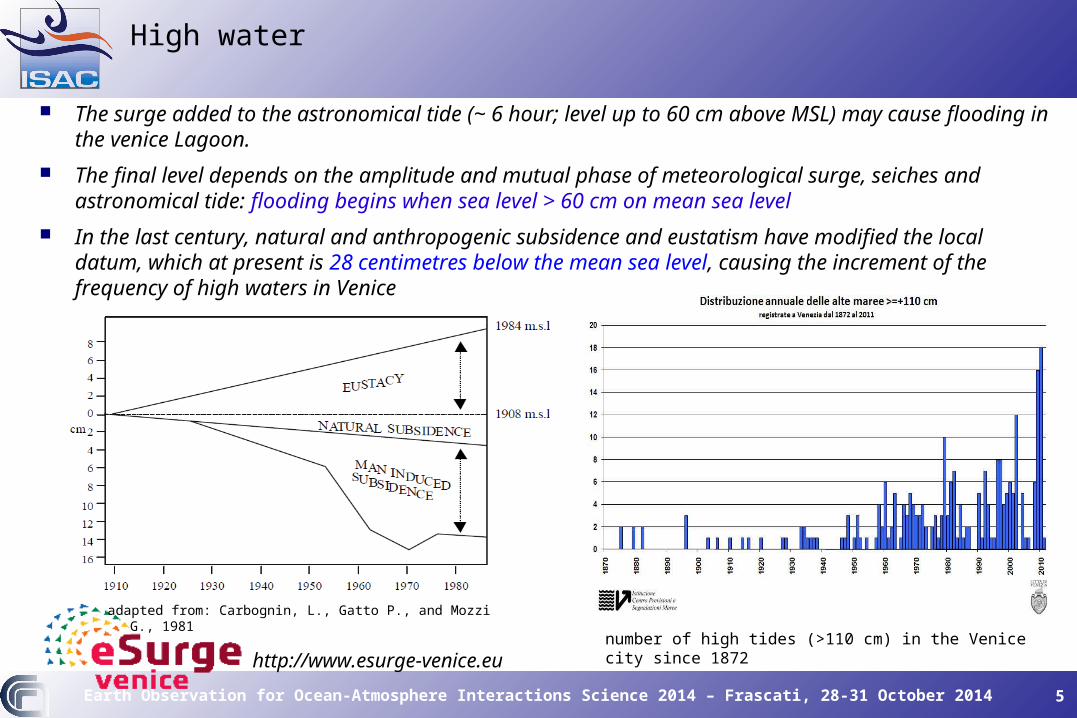
The surge added to the astronomical tide (~ 6 hour; level up to 60 cm above MSL) may cause flooding in the venice Lagoon.
The final level depends on the amplitude and mutual phase of meteorological surge, seiches and astronomical tide: flooding begins when sea level > 60 cm on mean sea level
In the last century, natural and anthropogenic subsidence and eustatism have modified the local datum, which at present is 28 centimetres below the mean sea level, causing the increment of the frequency of high waters in Venice
number of high tides (>110 cm) in the Venice city since 1872
adapted from: Carbognin, L., Gatto P., and Mozzi G., 1981

Earth Observation for Ocean-Atmosphere Interactions Science 2014 – Frascati, 28-31 October 2014 6
http://www.esurge-venice.eu
The role of Earth Observation in the eSurge-Venice project
The main purpose of the eSurge-Venice project is to improve the sea level forecast in the Adriatic Sea by using Earth Observation (EO) data.
In an operative context, the sea surface wind field needed to force storm surge models (SSM) is supplied by numerical weather prediction (NWP) models, whose accuracy may be reduced in semi-enclosed basins surrounded by complex orography as the Adriatic Sea.
The initial sea surface elevation is generally supplied by previous simulations of the SSM itself.
Our objective is to use satellite data to improve the NWP sea surface wind forcing accuracy and the description of the SSM initial sea surface elevation, in order to supply more accurate initial conditions and forcing to SSMs.

Earth Observation for Ocean-Atmosphere Interactions Science 2014 – Frascati, 28-31 October 2014 7
http://www.esurge-venice.eu
How scatterometer wind can be used?
Satellite wind datasets: QuikSCAT L2B 12.5 km (1999-2009) OCEANSAT-2 L2 12.5 km (2010-2014) ASCAT A L2 12.5 km (2009-present) ASCAT B L2 12.5 km (2012-present)
What we Know:
Atmospheric models in general underestimate the wind speed with respect to satellite winds
The differences between models and satellite data are variable in space and time
What we want to do:
Modify the NWP model wind fields of today according to the scatterometer-model biases found in the previous 3 days

Earth Observation for Ocean-Atmosphere Interactions Science 2014 – Frascati, 28-31 October 2014 8
http://www.esurge-venice.eu
1. The mean scatt-model wind speed relative bias Δws and direction Δθ bias, are computed over a 3-day window before the day of forecast.
2. The two biases are used to modify the NWP forecast wind field the day after the 3-day window, according to these formulae:
3. The storm surge model is run with the modified NWP field as forcing. The process is repeated day by day, shifting the 3-day window ahead.
NWP Wind Bias Mitigation (WBM)
>ji,θj)θ(i,=<j)Δθ(i,
>j)ws(i,
j)ws(i,j)ws(i,=<j)Δws(i,
modelscatt
scatt
modelscatt
j)Δθ(i,+j)θ(i,=ji,θ
j))Δws(i,+(j)ws(i,=j)ws(i,
modelmodel
modelmodel
'
' 1
(i,j) indicates the position of the node on the grid
The average <…> is made on any grid node over the available observations during the 3 day window

Earth Observation for Ocean-Atmosphere Interactions Science 2014 – Frascati, 28-31 October 2014 9
http://www.esurge-venice.eu
NWP Wind Mitigation Bias (WBM)
Graphical representation of the mean wind speed relative bias (left) and wind direction bias (right) between ECMWF wind forecast and scatterometer OVW during 3 days before the surge event of 02/02/2009 23:00 GMT
The mean duration of the sirocco-type wind in the Adriatic Sea during the SEVs (asterisks) is around 2,5 days. This justifies the use of a 2-3 day window for the calculation of the biases.

Earth Observation for Ocean-Atmosphere Interactions Science 2014 – Frascati, 28-31 October 2014 10
http://www.esurge-venice.eu
Results of hydrodinamical modelling (S.HY.FEM model) with respect to WBM
S.HY.F.E.M. (CNR-ISMAR, http://www.ismar.cnr.it/shyfem/): 3D shallow water hydrodynamic model results
the peak error (obs-mod surge difference on the maximum peak) drops to 6 cm from 10 cm;
the RMSE between observed and modeled surge decreases by 8%;
the correlation between observed and modeled surge rises by 1%;

Earth Observation for Ocean-Atmosphere Interactions Science 2014 – Frascati, 28-31 October 2014 11
http://www.esurge-venice.eu
Use of satellite data to improve the SSM model initial conditions through Altimeter data Assimilation (AA)
Satellite altimeters measure the sea level along the satellite subtrack over the ellipsoid
SSMs (SHYFEM) compute the sea level over the geoid The lack of a common reference frame prevents the direct
comparison of the two absolute quantities Their profiles should have comparable shapes, up to an
additive constant
Objective:
Assimilation into SHYFEM of the differences between (zero-mean) modelled and measured sea surface profiles along the altimeter tracks as model errors with a dual 4d-VAR (4d-PSAS) assimilation technique
snapshot of the satellite sea level anomaly tracks in an eight day window around the
storm surge event of 31 October 2004
Satellite altimeter datasets:
Topex/Poseidon: 1992 to 2005
Geosat Follow On: 2000 to 2008
ENVISAT: 2002 to 2010
Jason 1: 2002 to present
Jason 2: 2008 to present
AltiKa, Jason 3, Cryosat-2...

Earth Observation for Ocean-Atmosphere Interactions Science 2014 – Frascati, 28-31 October 2014 12
http://www.esurge-venice.eu
Results of hydrodinamical modelling with AA
Results:
Assimilation of long altimeter tracks (track along the Adriatic Sea major axis) has more impact on the SSM results (experiment n. 1, observed-modeled surge = 5 cm without assimilation, 3 cm with assimilation), while in the opposite case (satellite track crossing the Adriatic Sea along its minor dimension) the impact is less evident.
Limitations: Poor spatial and temporal coverage in the Adriatic Sea Altimeter data only along the satellite track Long latency for high quality altimeter data

Earth Observation for Ocean-Atmosphere Interactions Science 2014 – Frascati, 28-31 October 2014 13
http://www.esurge-venice.eu
Results (in terms of skew surge: difference between the max. observed and the max. predicted sea level during a tidal cycle)
Reanalysis experiments (22 SEVs in 2004-2012) performed with respect to the standard forecaststandard forecast:
surge forecast with wind bias mitigation (WBM) – Exp.1
surge forecast with altimeter assimilation (AA) – Exp. 2
surge forecast with WBM+AA – Exp. 3
Exp. 1 resulted in lower skew surges in 18 out of 22 SEVs
Exp. 2 resulted in lower skew surges in 8 out of 18 SEVs.
Together, (Exp. 3) WBM and AA grant lower skew surge in 14 out of 18 SEVs.
Overall results for the skew surge RMSD (cm):
Standard forecast (22 SEVs):Standard forecast (22 SEVs): 14.914.9
WBM alone (22 SEVs): 9.7
AA alone (18 SEVs): 13.8
WBM+AA (18 SEVs): 9.3
The observed-model skew surge for the 22 reanalysis experiments.Green: skew surge of standard forecastGreen: skew surge of standard forecastRed: with wind forecast mitigation alone (Exp. 1)Blue: with altimeter assimilation alone (Exp. 2)Black: with both WBM and AA (Exp. 3).
No data for AA for SEV #12, #14, #17 and #20.

Earth Observation for Ocean-Atmosphere Interactions Science 2014 – Frascati, 28-31 October 2014 14
http://www.esurge-venice.eu
Conclusions
Three reanalysis experiments conducted on ~ 20 storm surge events: modified wind forcing: the RMSD passed from 14.9 cm to 9.7 cm direct altimeter data assimilation: RMSD passed from 14.9 cm to 13.8 cm modified wind+altimeter assimilation: RMSD passed from 14.9 cm to 9.3 cm
Open issues: there is an optimal form of the factor (now it is: 1+Δws) to modify the NWP wind
speed?
Future directions: assimilation of altimeter into SSMs will be extended to the Mediterranean Sea

Earth Observation for Ocean-Atmosphere Interactions Science 2014 – Frascati, 28-31 October 2014 15
http://www.esurge-venice.eu
Conclusions
Thank you for your attention!
http://www.esurge-venice.eu