Embed Size (px)
Citation preview

Earth Observations for SustainableDevelopment and Disaster Risk Reduction
Francisco Delgado Olivares
Geospatial IT Lead, NASA/SERVIR Program
MSFC, Huntsville
NOVEMBER 2018
Presentation Outline
• NASA Earth Observation Data
• Applications for Sustainable Development
• Applications for Disaster Risk Reduction
• Capacity Building
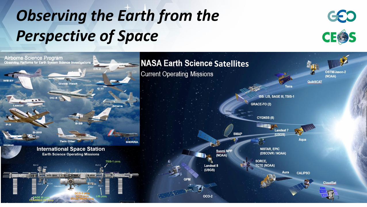
Observing the Earth from the Perspective of Space
Satellites
3
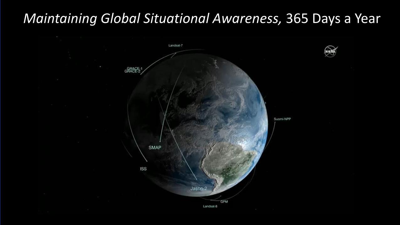
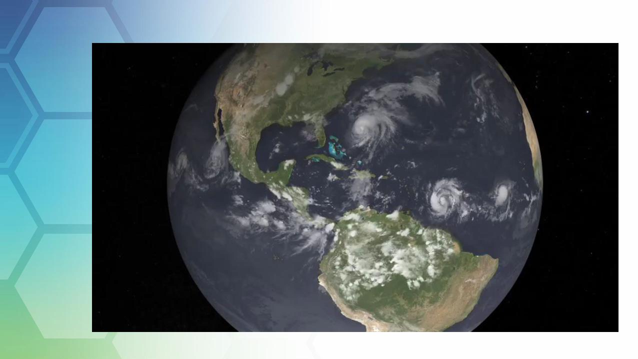
Maintaining Global Situational Awareness, 365 Days a Year

Visible Infrared Imaging Radiometer Suite (VIIRS)http://viirsland.gsfc.nasa.gov/index.html
by day and by night
Maintaining Global Situational Awareness, 365 Days a Year

ASF DAACSAR ProductsSea Ice, Polar
Processes
SEDACHuman Interactions
in Global Change
LP DAACLand Processes
& Features
PO.DAACOcean Circulation
Air-Sea Interactions
ASDCRadiation Budget,Clouds, Aerosols,Tropo Chemistry
ORNL DAACBiogeochemical
Dynamics, EOS Land Validation
GES DISCAtmos Composition &
Dynamics, GlobalModeling, Hydrology,
Radiance
LAADS/MODAPS
Atmosphere
OBPGOcean Biology &Biogeochemistry
GHRCHydrological Cycle &
Severe Weather
CDDISCrustal Dynamics
Solid Earth
NCAR, U of Col.HIRDLS, MOPITT,
SORCE
GSFCGLAS, MODIS,
OMI, OBPG
LaRCCERES,
SAGE III
GHRCAMSR-E, LIS
JPLMLS, TES
San DiegoACRIM
NSIDC DAACCryosphere, Polar
Processes
SIPSs
KeyData
Center
The Earth Observing System Data and Information System
(EOSDIS) is one of the largest civilian Science Information
Systems in the world
Data centers, collocated with centers of science discipline expertise, archive and distribute standard data
NASA Earth Science Data Centershttp://earthdata.nasa.gov
6
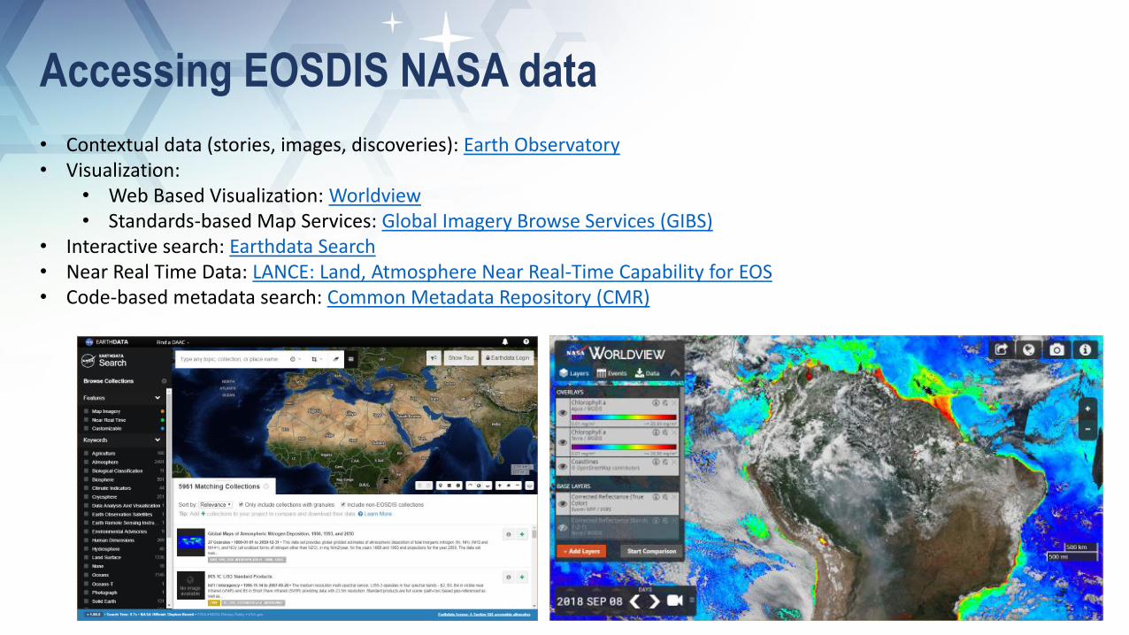
Accessing EOSDIS NASA data
• Contextual data (stories, images, discoveries): Earth Observatory• Visualization:
• Web Based Visualization: Worldview• Standards-based Map Services: Global Imagery Browse Services (GIBS)
• Interactive search: Earthdata Search• Near Real Time Data: LANCE: Land, Atmosphere Near Real-Time Capability for EOS• Code-based metadata search: Common Metadata Repository (CMR)
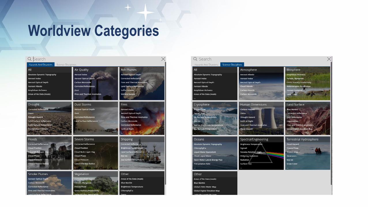
Worldview Categories
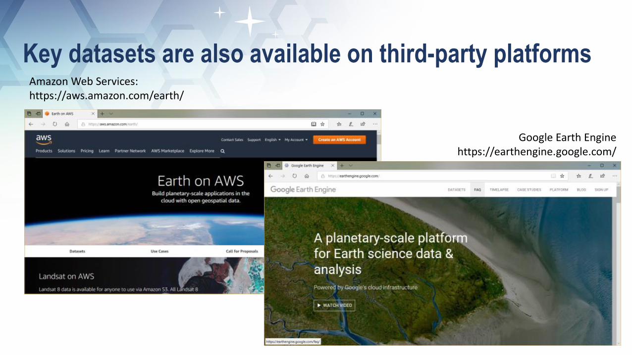
Key datasets are also available on third-party platformsAmazon Web Services: https://aws.amazon.com/earth/
Google Earth Enginehttps://earthengine.google.com/

Presentation Outline
• NASA Earth Observation Data
• Applications for Sustainable Development
• Applications for Disaster Risk Reduction
• Capacity Building
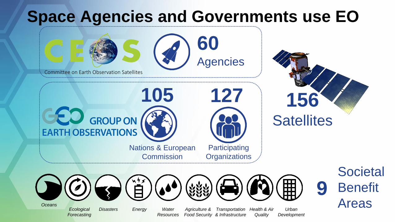
Space Agencies and Governments use EO
156Satellites
Societal
Benefit
Areas
60Agencies
Participating
Organizations
Nations & European
Commission
127105
OceansEcological
Forecasting
Disasters Energy Water
Resources
Agriculture &
Food Security
Transportation
& Infrastructure
Health & Air
Quality
Urban
Development
9
Committee on Earth Observation Satellites
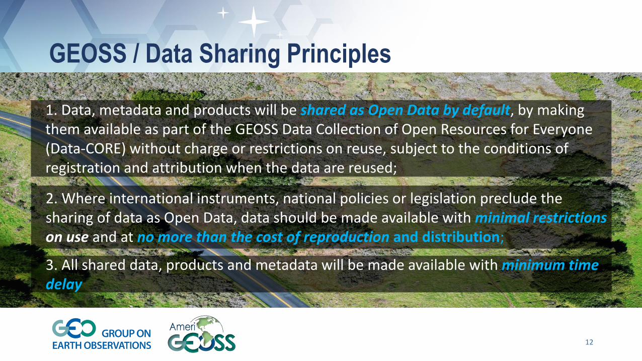
GEOSS / Data Sharing Principles
12
1. Data, metadata and products will be shared as Open Data by default, by making them available as part of the GEOSS Data Collection of Open Resources for Everyone (Data-CORE) without charge or restrictions on reuse, subject to the conditions of registration and attribution when the data are reused;
3. All shared data, products and metadata will be made available with minimum time delay
2. Where international instruments, national policies or legislation preclude the sharing of data as Open Data, data should be made available with minimal restrictionson use and at no more than the cost of reproduction and distribution;
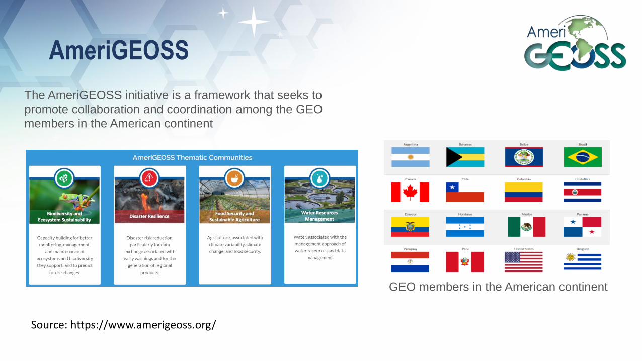
AmeriGEOSS
Source: https://www.amerigeoss.org/
The AmeriGEOSS initiative is a framework that seeks to
promote collaboration and coordination among the GEO
members in the American continent
GEO members in the American continent
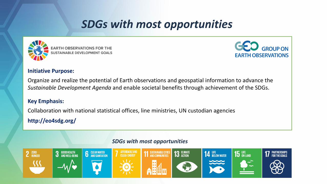
SDGs with most opportunities
Initiative Purpose:
Organize and realize the potential of Earth observations and geospatial information to advance the Sustainable Development Agenda and enable societal benefits through achievement of the SDGs.
Key Emphasis:
Collaboration with national statistical offices, line ministries, UN custodian agencies
http://eo4sdg.org/
SDGs with most opportunities
1
5
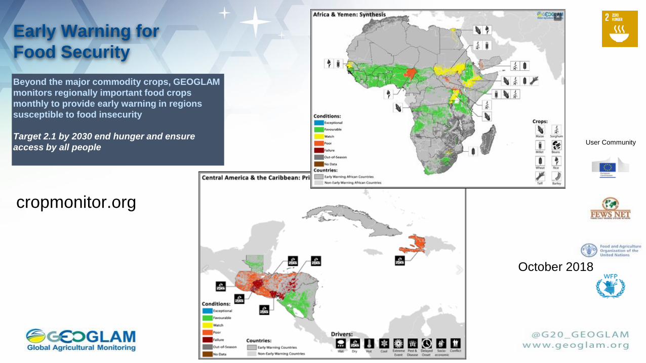
User Community
October 2018
Early Warning for
Food Security
cropmonitor.org
Beyond the major commodity crops, GEOGLAM
monitors regionally important food crops
monthly to provide early warning in regions
susceptible to food insecurity
Target 2.1 by 2030 end hunger and ensure
access by all people
16
Sentinel-2ASentinel-2B Landsat-8
17th July 201729th June 2017 13th August 2017
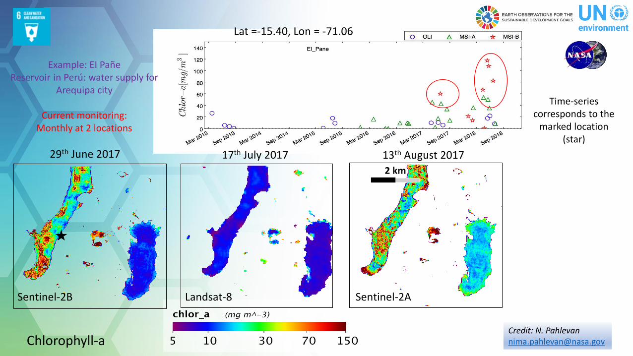
Lat =-15.40, Lon = -71.06
Example: EI PañeReservoir in Perú: water supply for
Arequipa city
Current monitoring: Monthly at 2 locations
Time-series corresponds to the
marked location (star)
Chlorophyll-a
2 km
Credit: N. [email protected]
Earth Sciences Division – Hydrosphere, Biosphere, and
Geophysics
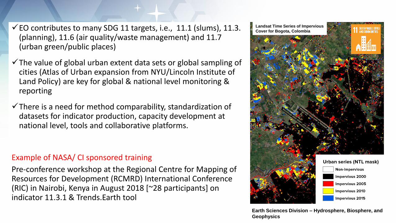
Landsat Time Series of Impervious
Cover for Bogota, Colombia EO contributes to many SDG 11 targets, i.e., 11.1 (slums), 11.3. (planning), 11.6 (air quality/waste management) and 11.7 (urban green/public places)
The value of global urban extent data sets or global sampling of cities (Atlas of Urban expansion from NYU/Lincoln Institute of Land Policy) are key for global & national level monitoring & reporting
There is a need for method comparability, standardization of datasets for indicator production, capacity development at national level, tools and collaborative platforms.
Example of NASA/ CI sponsored training
Pre-conference workshop at the Regional Centre for Mapping of Resources for Development (RCMRD) International Conference (RIC) in Nairobi, Kenya in August 2018 [~28 participants] on indicator 11.3.1 & Trends.Earth tool
http://eo4sdg.org
@EO4SDG
SDGs provide a unique opportunity to define roles of EO for sustainable development. Through SDGs, EO can monitor, assess and enable evidence-based decision making on sustainable development, and help project its impacts towards a more resilient, sustainable and secure society.
It is necessary to strengthen governance frameworks at the national level to link the Earth observation community with the geospatial and statistical communities, in order to enrich the data ecosystems in countries; co-design user friendly data platforms and tools; and develop reliable, open and scalable knowledge.
Presentation Outline
• NASA Earth Observation Data
• Applications for Sustainable Development
• Applications for Disaster Risk Reduction
• Capacity Building
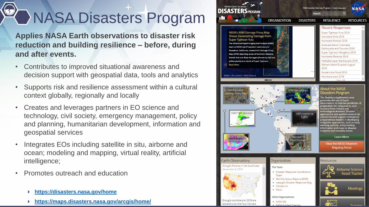
NASA Disasters ProgramApplies NASA Earth observations to disaster risk
reduction and building resilience – before, during
and after events.
• Contributes to improved situational awareness and
decision support with geospatial data, tools and analytics
• Supports risk and resilience assessment within a cultural
context globally, regionally and locally
• Creates and leverages partners in EO science and
technology, civil society, emergency management, policy
and planning, humanitarian development, information and
geospatial services
• Integrates EOs including satellite in situ, airborne and
ocean; modeling and mapping, virtual reality, artificial
intelligence;
• Promotes outreach and education
https://disasters.nasa.gov/home
https://maps.disasters.nasa.gov/arcgis/home/

Answering Key Questions
What is the extent, severity and impact
from hurricane, fire, quake ..!• Awareness of pre-existing conditions
• Monitoring evolving weather and water impacts;
• Tropical winds and water extremes, soil moisture…
• Flood and inundation extent
• Socio-economic exposure and vulnerability
• Transport, supply chain and power disruptions
• Ecosystem, big city and community impacts
• Damage mapping and loss estimation
• Humanitarian and development assistance
Financial Loss Potential Index for
Hurricane Harvey
GPM's Radar Measures
Intense Rain In Hurricane
Harvey
Damage Proxy Map of the M7.1
Raboso, Mexico, earthquake was
created from the Copernicus
Sentinel-1 satellite SAR High resolution nighttime maps
combined data from six satellites
(Suomi-NPP, Landsat-8, Sentinel 2A &
2B, TerraSAR-X/TanDEM-X)

23
Informing Preparedness, Response, Relief
24
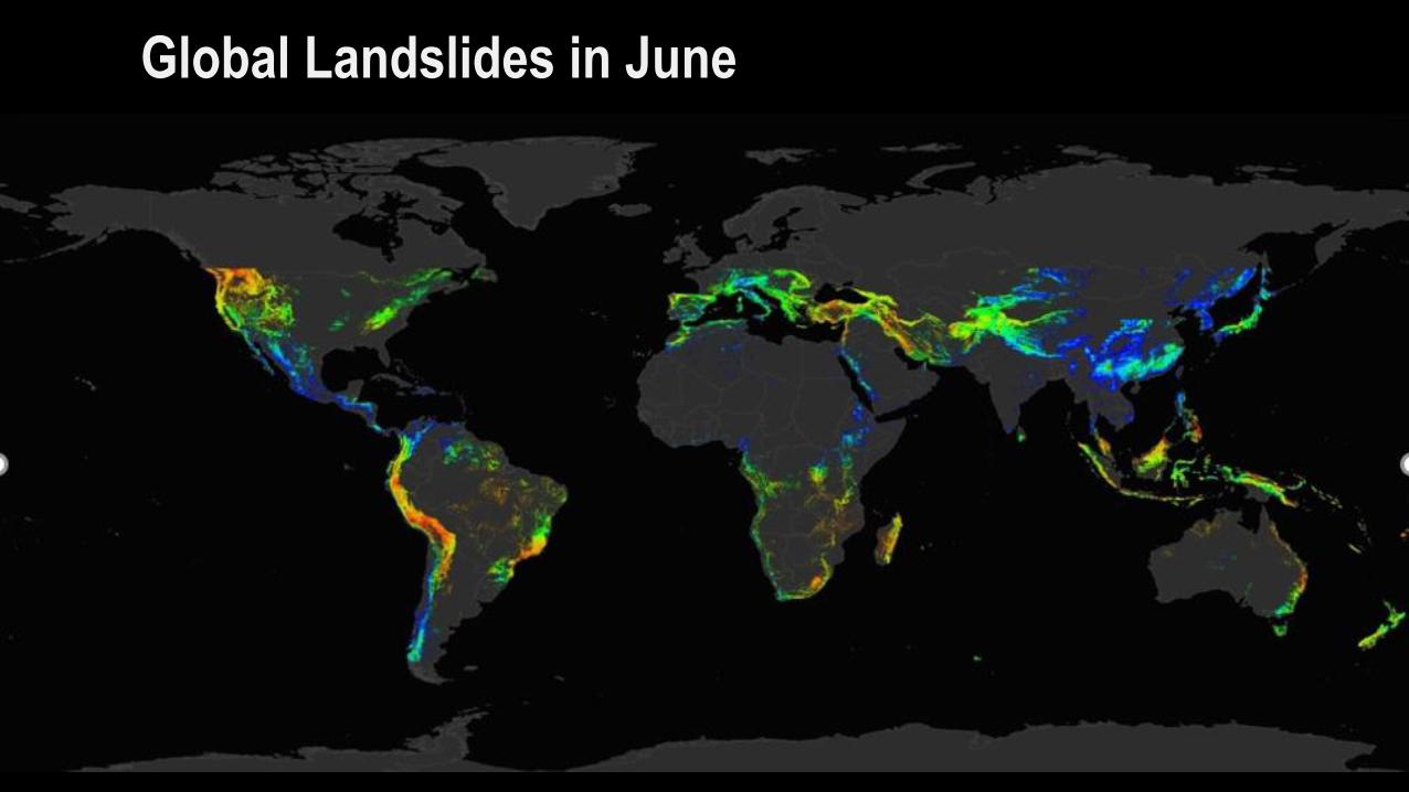
Global Landslides in June
25
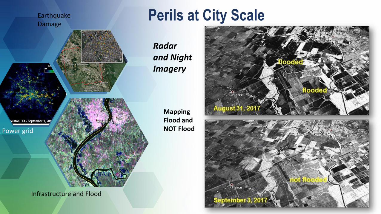
Power grid
Mapping Flood and NOT Flood
EarthquakeDamage
Infrastructure and Flood
Radar and Night Imagery
Perils at City Scale
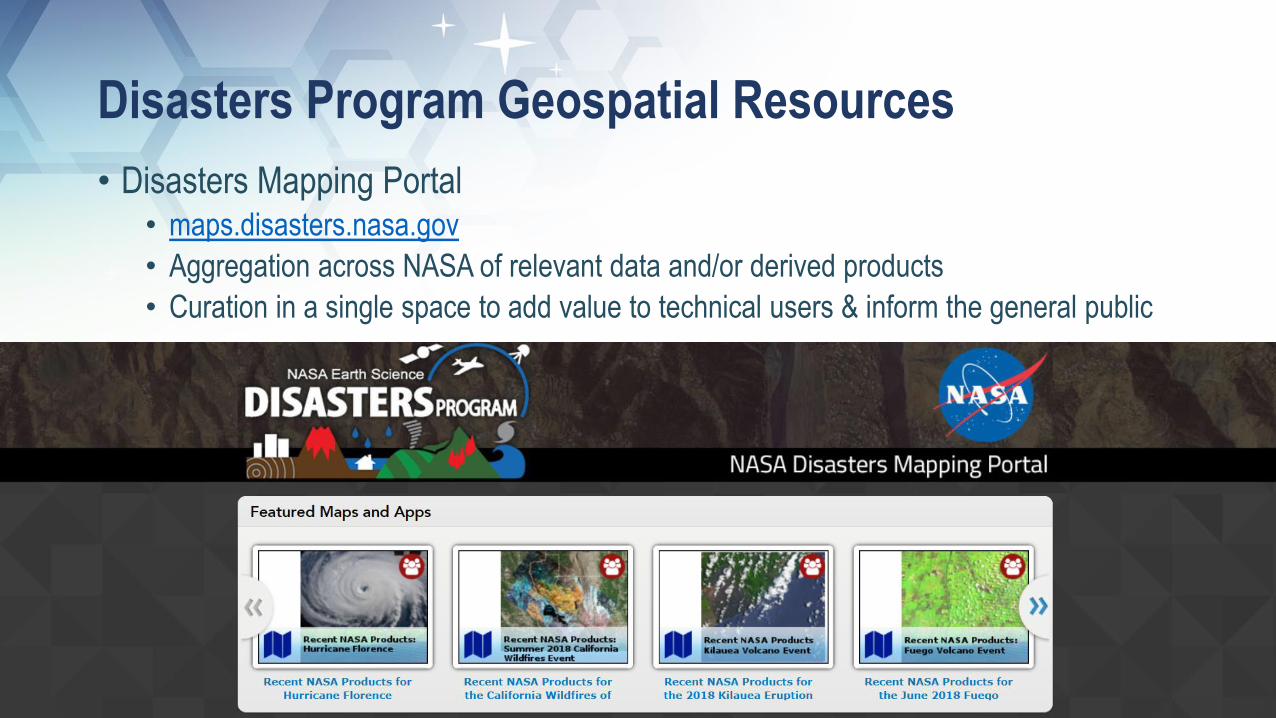
Disasters Program Geospatial Resources
• Disasters Mapping Portal• maps.disasters.nasa.gov
• Aggregation across NASA of relevant data and/or derived products
• Curation in a single space to add value to technical users & inform the general public
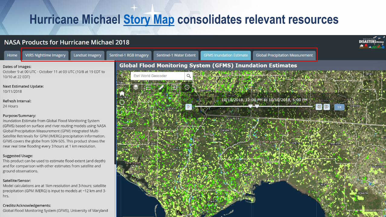
Hurricane Michael Story Map consolidates relevant resources
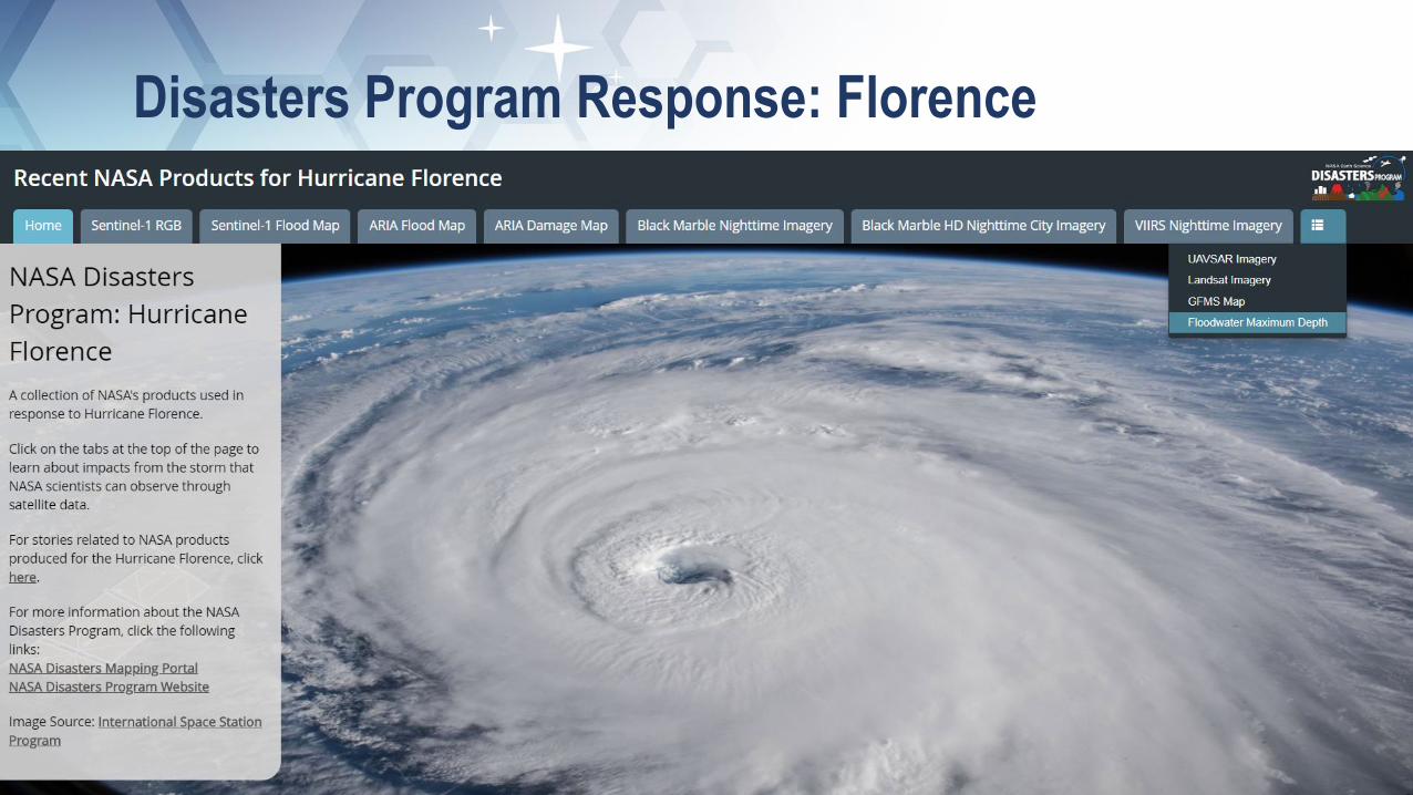
Disasters Program Response: Florence• Leveraged Mid-Atlantic CAIR stakeholder network
• Virginia Department of Emergency Management
• North Carolina Department of Public Safety, Emergency Management

How could NASA disasters program information
contribute to improving your countries resilience to
disasters?
29
China FloodingJun-Jul 2017
Indonesia Landslide Feb 2017
Mongolia desertification and drought June 2017

Presentation Outline
• NASA Earth Observation Data
• Applications for Sustainable Development
• Applications for Disaster Risk Reduction
• Capacity Building

Capacity Building Engages current and future decision makers
Improves skills and capabilities to access and apply NASA Earth science
Three lines of business: trainings, product co-development, and relationship brokering
Works through both program and element activities
Identifies partnership opportunities to reach new end users
Participates in both domestic and international capacity building groups, such as GEO and CEOS
Supports three Elements (ARSET, DEVELOP, and SERVIR) and initiatives focused on indigenous peoples in North America and an interactive mapper
2017 Achievements Programmatic Engagement:
104Trainings
2,369Institutions
6,622Individuals
142Countries
Impacted Not Impacted
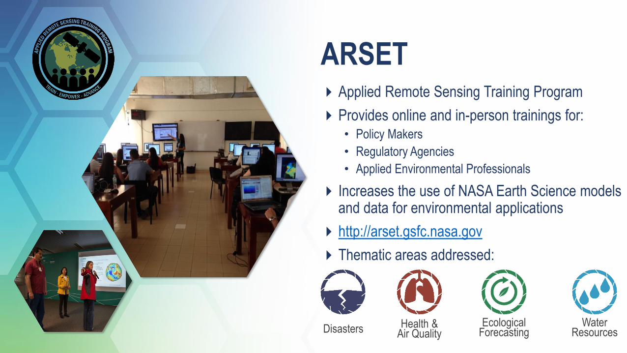
ARSETApplied Remote Sensing Training Program
Provides online and in-person trainings for:• Policy Makers
• Regulatory Agencies
• Applied Environmental Professionals
Increases the use of NASA Earth Science models and data for environmental applications
http://arset.gsfc.nasa.gov
Thematic areas addressed:
Disasters Health & Air Quality
Ecological Forecasting
Water Resources

ARSET Trainings: Meeting Attendees at Their Level
33
Fundamentals (Level 0)
Assumes no prior knowledge of remote sensing
Fundamentals of Remote Sensing
Basic (Level 1)
Requires level 0 training or equivalent knowledge
Covers specific applications
Introduction to Synthetic Aperture Radar
Advanced (Level 2)
Requires level 1 training or equivalent knowledge
In-depth and highly focused topics
Advanced Webinar: SAR Image and Data Processing
ARSET trainings are offered at different levels, both online and in-person, and many training materials are available in English & Spanish
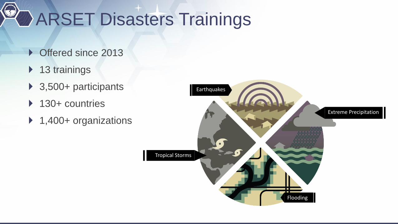
ARSET Disasters Trainings
Offered since 2013
13 trainings
3,500+ participants
130+ countries
1,400+ organizations
Earthquakes
Flooding
Extreme Precipitation
Tropical Storms
Imaged Credit: NASA Earth Observatory, Joshua Stevens, using Landsat data from the USGS

https://develop.larc.nasa.gov
DEVELOP Bridges the gap between NASA Earth
Science and society
Addresses environmental and public policy issues around the globe
Conducts 10-week long interdisciplinary feasibility studies (3 terms per year)
Builds capacity to use Earth observations in both participants (students, recent grads & transitioning career professionals) and partner organizations
Works within all 8 thematic areas
Disasters
Health & Air Quality
Ecological Forecasting
Agriculture & Food Security
Energy
Urban Development
Transportation & Infrastructure
Water Resources
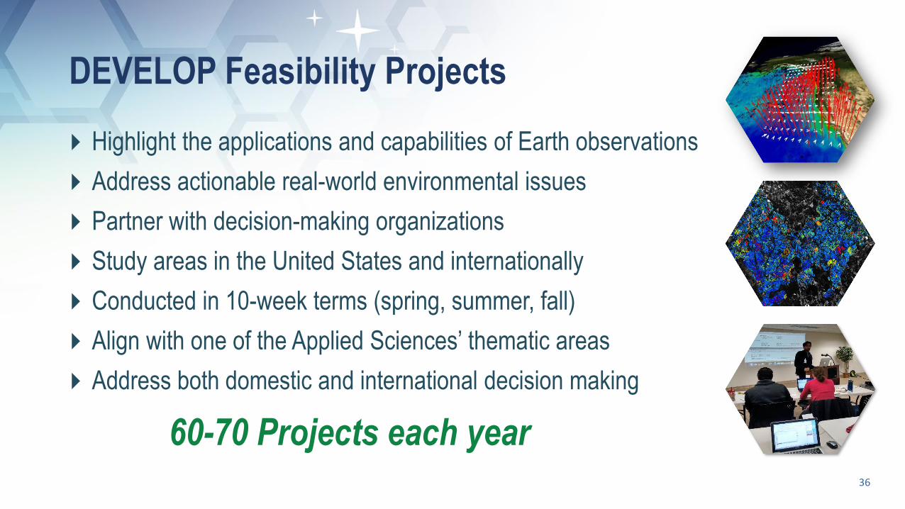
DEVELOP Feasibility Projects
36
Highlight the applications and capabilities of Earth observations
Address actionable real-world environmental issues
Partner with decision-making organizations
Study areas in the United States and internationally
Conducted in 10-week terms (spring, summer, fall)
Align with one of the Applied Sciences’ thematic areas
Address both domestic and international decision making
60-70 Projects each year
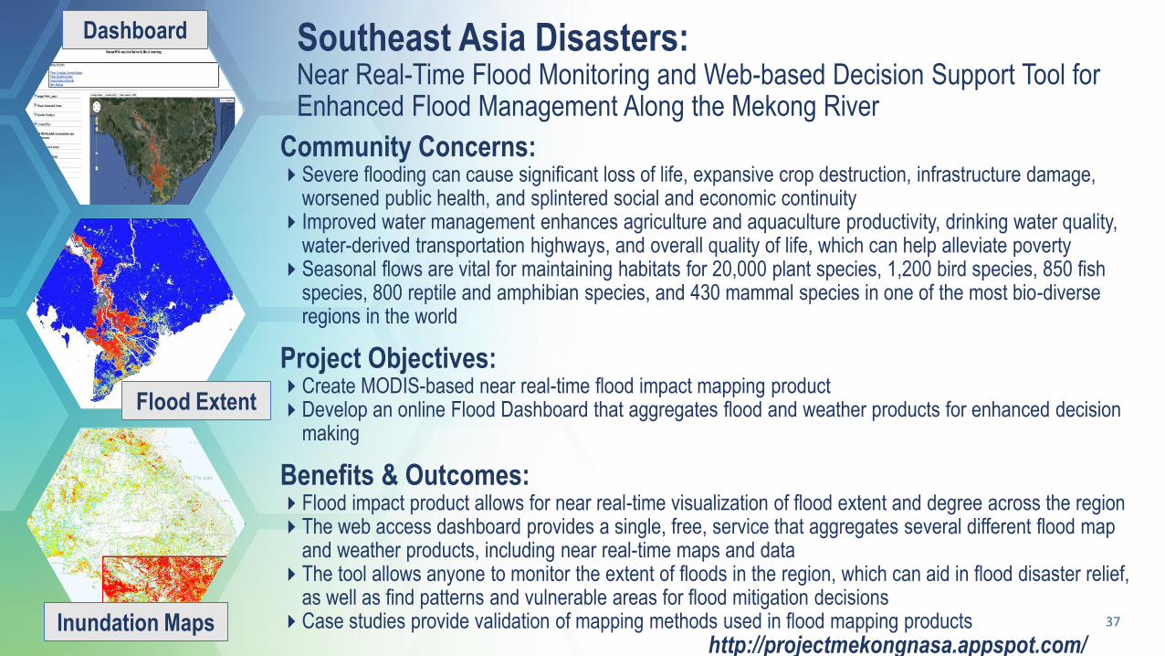
Southeast Asia Disasters: Near Real-Time Flood Monitoring and Web-based Decision Support Tool for Enhanced Flood Management Along the Mekong River
37
Community Concerns:Severe flooding can cause significant loss of life, expansive crop destruction, infrastructure damage,
worsened public health, and splintered social and economic continuityImproved water management enhances agriculture and aquaculture productivity, drinking water quality,
water-derived transportation highways, and overall quality of life, which can help alleviate povertySeasonal flows are vital for maintaining habitats for 20,000 plant species, 1,200 bird species, 850 fish
species, 800 reptile and amphibian species, and 430 mammal species in one of the most bio-diverse regions in the world
Project Objectives:Create MODIS-based near real-time flood impact mapping productDevelop an online Flood Dashboard that aggregates flood and weather products for enhanced decision
making
Benefits & Outcomes:Flood impact product allows for near real-time visualization of flood extent and degree across the regionThe web access dashboard provides a single, free, service that aggregates several different flood map
and weather products, including near real-time maps and dataThe tool allows anyone to monitor the extent of floods in the region, which can aid in flood disaster relief,
as well as find patterns and vulnerable areas for flood mitigation decisionsCase studies provide validation of mapping methods used in flood mapping products
Dashboard
Flood Extent
http://projectmekongnasa.appspot.com/Inundation Maps

SERVIR Joint development initiative of NASA & USAID
Works in partnership with leading regional organizations world-wide
Helps developing countries use information provided by Earth observing satellites and geospatial technologies for managing climate risks and land use
Empowers decision-makers with tools, products, and services to act locally on climate-sensitive issues
Works within thematic topics such as:
Disasters Ecological Forecasting
Agriculture & Food Security
Water Resources
https://www.servirglobal.net/

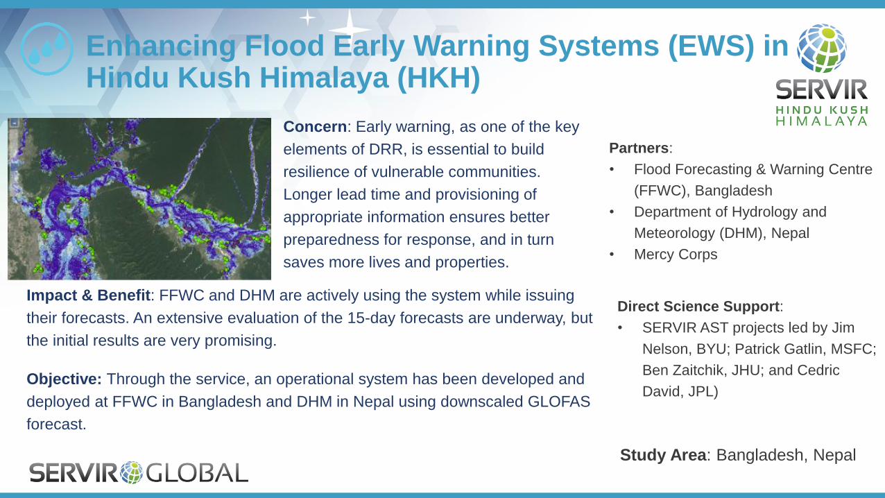
Impact & Benefit: FFWC and DHM are actively using the system while issuing
their forecasts. An extensive evaluation of the 15-day forecasts are underway, but
the initial results are very promising.
Objective: Through the service, an operational system has been developed and
deployed at FFWC in Bangladesh and DHM in Nepal using downscaled GLOFAS
forecast.
Enhancing Flood Early Warning Systems (EWS) in Hindu Kush Himalaya (HKH)
Partners:
• Flood Forecasting & Warning Centre
(FFWC), Bangladesh
• Department of Hydrology and
Meteorology (DHM), Nepal
• Mercy Corps
Study Area: Bangladesh, Nepal
Direct Science Support:
• SERVIR AST projects led by Jim
Nelson, BYU; Patrick Gatlin, MSFC;
Ben Zaitchik, JHU; and Cedric
David, JPL)
Concern: Early warning, as one of the key
elements of DRR, is essential to build
resilience of vulnerable communities.
Longer lead time and provisioning of
appropriate information ensures better
preparedness for response, and in turn
saves more lives and properties.
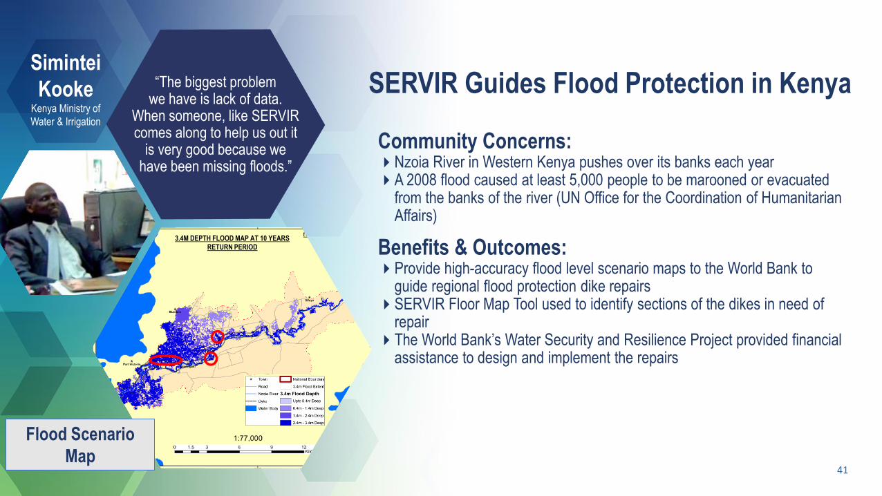
SERVIR Guides Flood Protection in Kenya
41
“The biggest problem we have is lack of data.
When someone, like SERVIR comes along to help us out it
is very good because we have been missing floods.”
Community Concerns:Nzoia River in Western Kenya pushes over its banks each yearA 2008 flood caused at least 5,000 people to be marooned or evacuated
from the banks of the river (UN Office for the Coordination of Humanitarian Affairs)
Benefits & Outcomes:Provide high-accuracy flood level scenario maps to the World Bank to
guide regional flood protection dike repairsSERVIR Floor Map Tool used to identify sections of the dikes in need of
repairThe World Bank’s Water Security and Resilience Project provided financial
assistance to design and implement the repairs
Simintei
KookeKenya Ministry of
Water & Irrigation
3.4M DEPTH FLOOD MAP AT 10 YEARS
RETURN PERIOD
Flood Scenario
Map
Francisco Delgado
Geospatial Information Technology Lead
SERVIR Global
Thanks! Questions?