Embed Size (px)
Citation preview
Second Edition
How Is the Earth Changing?
Student Edition
Earth Science
I WST
IQWST LEADERSHIP AND DEVELOPMENT TEAM
Joseph S. Krajcik, Ph.D., Michigan State UniversityBrian J. Reiser, Ph.D., Northwestern University
LeeAnn M. Sutherland, Ph.D., University of MichiganDavid Fortus, Ph.D., Weizmann Institute of Science
Unit Leaders
Strand Leader: Joseph S. Krajcik, Ph.D., Michigan State UniversityLead Developer: Molly Yunker, Ph.D., Weizmann Institute of Science
Unit Contributors
Jon Boxerman, Northwestern UniversityDaniel C. Edelson, Ph.D., National Geographic Society
Lou- Ellen Finn, Northwestern UniversityLara Hulbert, University of Michigan
Bridget Quinn Maldonado, University of MichiganLeeAnn Sutherland, Ph.D., University of Michigan
Unit Pilot Teachers
Kristie Hannon, Highlander Way Middle School, Howell, MIMarisa Fisher, Highlander Way Middle School, Howell, MI
Unit Reviewer
Jill Wertheim, Ph.D., Project 2061, American Association for the Advancement of Science
Investigating and Questioning Our World through Science
and Technology (IQWST)
HOW IS THE E ARTH C HANGING?
Large- Scale Geological Processes on EarthLarge- Scale Geological Processes on Earth
Student EditionEarth Science 3 (ES3)
ES3 Earth SE 2.0.3ISBN-13: 978-1-937846-92-3
Earth Science 3 (ES3)How Is the Earth Changing?Large- Scale Geological Processes on Earth
ISBN- 13: 978-1-937846-92-3
About the Publisher
IQWST (Investigating and Questioning Our World through Science and Technology) was developed with funding from the National Science Foundation grants 0101780 and 0439352 awarded to the University of Michigan, and 0439493 awarded to Northwestern University. The ideas expressed herein are those of members of the development team and not necessarily those of NSF.
Copyright © 2013 by SASC LLC. All rights reserved. No part of this book may be reproduced, by any means, without permission from the publisher. Requests for permission or information should be addressed to SASC LLC, 44 Amogerone Crossway #7862 Greenwich, CT 06836
Activate Learning is a mission-driven company that is passionate about STEM education. We make it easy for teachers to teach with quality, investigation-centeredscience curriculum, tools, and technology. For more information about what we do, please visit our website at http://www.activatelearning.com.
ES3 CONTENTS
Scientifi c Principles vi
Driving Question Notes viii
Lesson 1 – Where Is the Earth Changing? 1
Lesson 2 – How Did the Earth Look in the Past? 11
Lesson 3 – What Is the Composition of the Earth’s Surface? 27
Lesson 4 – What Makes the Plates Move? 29
Lesson 5 – How Do Plates Interact with Each Other? 37
Lesson 6 – What Causes Volcanoes? 45
Lesson 7 – How Are Plates Moving? 53
Lesson 8 – How Does New Plate Material Form? 55
Lesson 9 – What Do We Know about Plate Tectonics? 59
Lesson 10 – What Is Happening at the Case Study Sites? 73
SCIENTIFIC PRINCIPLESSCIENTIFIC PRINCIPLES
A scientific principle states a scientific idea that is believed to be true based on evidence. As your class decides on new principles in this unit, add them to the list.
SCIENTIFIC PRINCIPLESSCIENTIFIC PRINCIPLES

DRIVING QUESTION NOTESDRIVING QUESTION NOTESUse these sheets to organize and record ideas that will help you answer the Driving Question or your own original questions.

DRIVING QUESTION NOTESDRIVING QUESTION NOTES

DRIVING QUESTION NOTESDRIVING QUESTION NOTES

DRIVING QUESTION NOTESDRIVING QUESTION NOTES

DRIVING QUESTION NOTESDRIVING QUESTION NOTES

DRIVING QUESTION NOTESDRIVING QUESTION NOTES
ART
Every effort has been made to secure permission and provide appropriate credit for the photographic materials in this program. The publisher will correct any omission called to our attention in subsequent editions. We acknowl-
edge the following people and institutions for the images in this book.
Lesson 1Mt. St. Helens Erupting – U.S. Geological Survey,
Department of the InteriorAge of Crust – Courtesy National Oceanic and
Atmospheric Administration, U.S. Department of Commerce
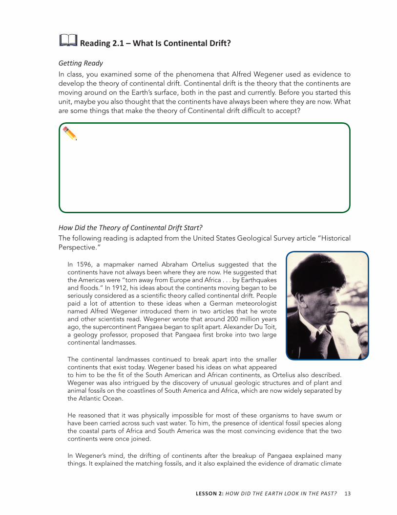
Lesson 2Alfred Wegener – U.S. Geological Survey, Department
of the InteriorGlossopteris Leaf Fossils – Wikipedia, The Free
EncyclopediaOld Antarctica – Courtesy Robert Nicholls
Lesson 5Continental Collision – Wikipedia, The Free
EncyclopediaConvergent Plate Boundaries – Wikipedia, The Free
EncyclopediaRing of Fire – U.S. Geological Survey, Department of
the Interior
Lesson 9Cross Section – Wikipedia, The Free EncyclopediaEmpty Ring of Fire – U.S. Geological Survey,
Department of the Interior
1
L 1
Where Is the Earth Changing?
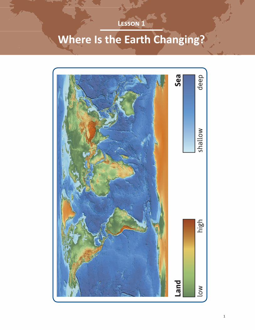
Land
Sea
low
high
shal
low
deep
2 HOW IS THE EARTH CHANGING?
ACTIVITY 1.1 WORLDWIDE PATTERN OF VOLCANOESACTIVITY 1.1 WORLDWIDE PATTERN OF VOLCANOES
What Will We Do?We will identify patterns in the location of volcanoes around the world.
Procedure 1. Your teacher will give you a world map showing data about the location of volcanoes
on Earth.
2. First, look for patterns in where volcanoes are found.
3. Then, look for places in which no volcanoes are found.
4. Talk with your group about the patterns you see and about data (volcano locations) that do not seem to fit the patterns.
Making Sense 1. What patterns do you notice in areas where volcanoes are located on Earth?
2. What ideas do you have about why there might be patterns in the volcano data (where volcanoes have erupted)?
LESSON 1: WHERE IS THE EARTH CHANGING? 3
ACTIVITY 1.2 WORLDWIDE PATTERN OF EARTHQUAKESACTIVITY 1.2 WORLDWIDE PATTERN OF EARTHQUAKES
What Will We Do?We will identify patterns in the location of earthquakes around the world.
PredictWhere do you think earthquakes usually occur?
Procedure 1. Your teacher will give you a world map showing data about where earthquakes have
occurred on Earth.
2. As you did with the volcanoes data, look for patterns in relation to where earthquakes are found and not found.
3. Talk with your group about the patterns you observe and about data (earthquake locations) that do not seem to fit the patterns.
4. Answer Making Sense questions 1–3.
5. After you have examined volcano and earthquake data separately, compare the two maps.
6. Talk with your group about the patterns you see in areas where volcanoes and earthquakes occur. Also discuss any data that do not seem to fit the patterns.
7. Answer questions 4–7.
4 HOW IS THE EARTH CHANGING?
Making Sense 1. How does your prediction compare with what you found when you looked at the
earthquake data map?
2. What patterns do you notice in areas where earthquakes have occurred around the world?
3. Why do you think earthquakes appear in the places they do?
4. How do patterns in earthquake and volcano data compare?
5. What ideas do you have about why there are patterns in earthquake and volcano data?
6. What ideas do you have about why some earthquake and volcano data do not fit the patterns you observed?
7. The Driving Question for this unit is How Is the Earth Changing?
a. How do you think volcanoes and earthquakes relate to the earth changing?
b. What questions do you have about how the earth is changing?
LESSON 1: WHERE IS THE EARTH CHANGING? 5
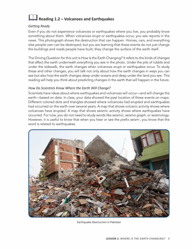
Reading 1.2 – Volcanoes and EarthquakesGetting ReadyEven if you do not experience volcanoes or earthquakes where you live, you probably know something about them. When volcanoes erupt or earthquakes occur, you see reports in the news. This photograph shows the destruction that can happen. Homes, cars, and everything else people own can be destroyed, but you are learning that these events do not just change the buildings and roads people have built; they change the surface of the earth itself.
The Driving Question for this unit is How Is the Earth Changing? It refers to the kinds of changes that affect the earth underneath everything you see in the photo. Under the pile of rubble and under the sidewalk, the earth changes when volcanoes erupt or earthquakes occur. To study these and other changes, you will talk not only about how the earth changes in ways you can see but also how the earth changes deep under oceans and deep under the land you see. This reading will help you think about predicting changes in the earth that will happen in the future.
How Do Scientists Know Where the Earth Will Change?Scientists have ideas about where earthquakes and volcanoes will occur—and will change the earth—based on data. In class, your data showed the past location of these events on maps. Different colored dots and triangles showed where volcanoes had erupted and earthquakes had occurred on the earth over several years. A map that shows volcanic activity shows where volcanoes have erupted. A map that shows seismic activity shows where earthquakes have occurred. For now, you do not need to study words like seismic, seismo graph, or seismology. However, it is useful to know that when you hear or see the prefix seism-, you know that the word is related to earthquakes.
Earthquake Destruction in Pakistan
6 HOW IS THE EARTH CHANGING?
Earth science often uses maps and visualizations of data that can be placed on maps. Data—put on top of a map—can help you make predictions about phenomena. If you were trying to predict where volcanoes or earthquakes would occur, the maps you looked at in class would be helpful. In fact, maps are an important kind of model that scientists use to represent phenomena and to predict phenomena.
Look at the maps you used in class. If you did not want to live where volcanoes or earthquakes could occur, where would you choose to live?
Predicting Where and When Events Will HappenScientists use maps like the ones you used in class to help them think about where earthquakes might occur. Meteorologists watch for changes in weather conditions to help them be more precise and to help them make predictions about what the weather will be like in the near future. The same is true with earthquakes. Scientists do not know exactly when an earthquake will occur. They use data to help them predict, but they cannot be very precise. For example, scientists know that earthquakes are more likely to occur in certain areas, and they are more likely to happen in places if it has been a long time since an earthquake occurred. They are less likely to occur in areas where an earthquake has happened more recently, and earthquakes are not very likely to happen in certain areas. You have already begun to think about locations of earthquakes and volcanoes by looking at patterns in class. How well do you think scientists can predict where a volcano will erupt? How well do you think scientists can predict when a volcano will erupt? Explain.
LESSON 1: WHERE IS THE EARTH CHANGING? 7
Do you think it is ever possible for an earthquake to occur or for a volcano to erupt in a place that is unexpected? Explain.
In this reading, you will learn some of the methods scientists use to help them make predictions. You do not need to know the names of these methods, but you should focus on the kind of information scientists use to make predictions.
Volcano Alert
Adapted from Karen Lurie
ScienCentral Archive, July 11, 2003
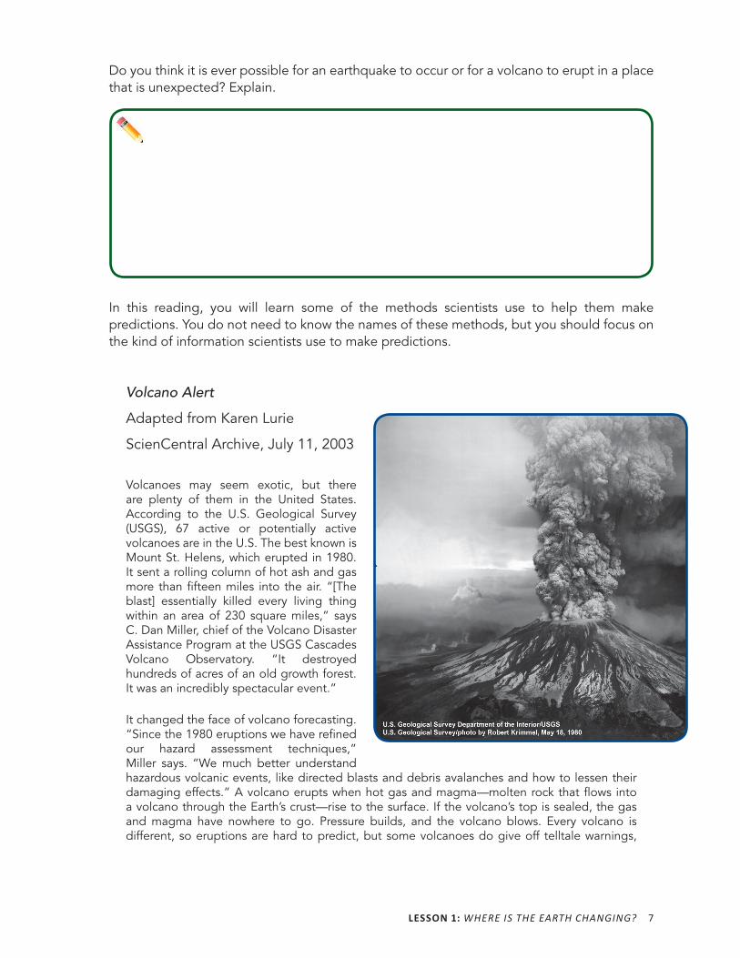
Volcanoes may seem exotic, but there are plenty of them in the United States. According to the U.S. Geological Survey (USGS), 67 active or potentially active volcanoes are in the U.S. The best known is Mount St. Helens, which erupted in 1980. It sent a rolling column of hot ash and gas more than fifteen miles into the air. “[The blast] essentially killed every living thing within an area of 230 square miles,” says C. Dan Miller, chief of the Volcano Disaster Assistance Program at the USGS Cascades Volcano Observatory. “It destroyed hundreds of acres of an old growth forest. It was an incredibly spectacular event.”
It changed the face of volcano forecasting. “Since the 1980 eruptions we have refi ned our hazard assessment techniques,” Miller says. “We much better understand hazardous volcanic events, like directed blasts and debris avalanches and how to lessen their damaging effects.” A volcano erupts when hot gas and magma—molten rock that fl ows into a volcano through the Earth’s crust—rise to the surface. If the volcano’s top is sealed, the gas and magma have nowhere to go. Pressure builds, and the volcano blows. Every volcano is different, so eruptions are hard to predict, but some volcanoes do give off telltale warnings,
8 HOW IS THE EARTH CHANGING?
and today there is technology to help detect them. “We have developed some very exciting new monitoring tools that allow us to do a much better job of forecasting the onset of explosive eruptive activity,” says Miller.
When a volcano is just about to erupt, there may be hundreds, possibly thousands, of small earthquakes, and they are detected by seismic activity. Samples of gases gathered on site reveal changes in volcanoes—for example, sulfur dioxide emissions increase during an eruption. Satellites and radar can detect even minute changes in the volcano’s shape, and a technique called interferometry can highlight shifts in elevation of the volcano over time. Researchers are also working on a technique called seismic tomography, which provides them with essentially an x- ray of the inside of a volcano. More than 20 years after Mount St. Helens erupted, scientists still cannot predict eruptions precisely, but they are better equipped to help determine when it is time to evacuate an area in a way that is safer for the scientists, too. “Our strategy now is to take out a bunch of monitor equipment, install these stations all over the volcano, and then go back to a safe place and watch these data come in, in real time,” says Miller.
“When one looks at these kinds of natural phenomena, [such as] volcanic eruption, you always think of the impact on human lives,” said Bernard Chouet, a seismologist at the USGS. “The ultimate quest is to understand enough about the activity in that volcano to be in a position to make a prediction, predict the occurrence of an eruption.”
What data do scientists use to determine when a volcano might erupt?
LESSON 1: WHERE IS THE EARTH CHANGING? 9
ACTIVITY 1.3 EARTHQUAKES, VOLCANOES, AND WORLD ELEVATIONACTIVITY 1.3 EARTHQUAKES, VOLCANOES, AND WORLD ELEVATION
What Will We Do?We will compare patterns in elevation with patterns of earthquakes and volcanoes.
PredictWhat do you think the earth looks like in areas with larger numbers of earthquakes and volcanoes? (Hint: Think about where you think the earth is higher and lower in relation to where earthquakes and volcanoes occur.)
Procedure 1. Your teacher will give you a world map showing the elevation (height) of different areas
of Earth. In general, darker areas are lower elevation, and lighter areas are higher elevation. However, all parts of the continents are higher than any part of the ocean.
2. First, look at the map for patterns in elevation.
a. Where do you see particularly high or low areas in the oceans?
b. Where do you see particularly high or low areas on the continents?
3. Talk with your group about your observations.
4. Next, compare the elevation map with the volcanoes and earthquakes maps. Look carefully at areas with a lot of volcanic and earthquake activity. What is the elevation like in those areas?
5. Talk with your group about the patterns that you observe, as well as examples that do not seem to fit the patterns.
10 HOW IS THE EARTH CHANGING?
Making Sense 1. What patterns do you notice in elevation in areas with high volcanic and earthquake
activity?
2. What ideas do you have about why there are these patterns?
3. Why do you think there are such large areas with relatively few volcanoes and earthquakes?
Procedure 1. Your teacher will give you one more world map.
2. Look at all four maps together.
Conclusions 1. What can you conclude based on the patterns you observe across all four maps?
2. What have you heard about plate tectonics?
3. What new questions do you have about the Driving Question based on the data you have looked at on the four maps?
11
L 2
How Did the Earth Look in the Past?
ACTIVITY 2.1 PART 1A THE THEORY OF CONTINENTAL DRIFTACTIVITY 2.1 PART 1A THE THEORY OF CONTINENTAL DRIFT
Exploring Wegener’s Evidence
What Will We Do?We will examine evidence that scientists used to understand what has happened on Earth in the past. Describe the map of the earth posted in your classroom. (Pretend you are describing it to a person who cannot see it.)
The Driving Question for this unit is How Is the Earth Changing? How would you answer this question now?
Procedure 1. Your teacher will give you an information sheet about one of Wegener’s phenomenon.
2. Each group will be assigned one phenomena to examine carefully. Your group needs to become experts about your type of geological phenomenon.
3. What phenomenon is your group examining?
4. Each member of your group should read the page before discussing.
12 HOW IS THE EARTH CHANGING?
Making SensePart 1 1. What does your phenomenon show?
2. List three main ideas from your information.
3. How might scientists use this phenomenon as evidence to understand the earth?
4. What did scientists conclude about what the earth was like long ago?
5. Is this information by itself enough to understand the earth’s past? Explain.
6. What new questions do you have about the Driving Question: How Is the Earth Changing?
LESSON 2: HOW DID THE EARTH LOOK IN THE PAST? 13
Reading 2.1 – What Is Continental Drift?
Getting ReadyIn class, you examined some of the phenomena that Alfred Wegener used as evidence to develop the theory of continental drift. Continental drift is the theory that the continents are moving around on the Earth’s surface, both in the past and currently. Before you started this unit, maybe you also thought that the continents have always been where they are now. What are some things that make the theory of Continental drift difficult to accept?
How Did the Theory of Continental Drift Start?The following reading is adapted from the United States Geological Survey article “Historical Perspective.”
In 1596, a mapmaker named Abraham Ortelius suggested that the continents have not always been where they are now. He suggested that the Americas were “torn away from Europe and Africa . . . by Earthquakes and floods.” In 1912, his ideas about the continents moving began to be seriously considered as a scientific theory called continental drift. People paid a lot of attention to these ideas when a German meteorologist named Alfred Wegener introduced them in two articles that he wrote and other scientists read. Wegener wrote that around 200 million years ago, the supercontinent Pangaea began to split apart. Alexander Du Toit, a geology professor, proposed that Pangaea first broke into two large continental landmasses.
The continental landmasses continued to break apart into the smaller continents that exist today. Wegener based his ideas on what appeared to him to be the fi t of the South American and African continents, as Ortelius also described. Wegener was also intrigued by the discovery of unusual geologic structures and of plant and animal fossils on the coastlines of South America and Africa, which are now widely separated by the Atlantic Ocean.
He reasoned that it was physically impossible for most of these organisms to have swum or have been carried across such vast water. To him, the presence of identical fossil species along the coastal parts of Africa and South America was the most convincing evidence that the two continents were once joined.
In Wegener’s mind, the drifting of continents after the breakup of Pangaea explained many things. It explained the matching fossils, and it also explained the evidence of dramatic climate
14 HOW IS THE EARTH CHANGING?
changes on some continents. For example, the discovery of fossils of tropical plants in Antarctica led to the conclusion that the frozen land of Antarctica must once have been closer to the equator, where the climate would allow lush, swampy vegetation to grow. Other mismatches of geology and climate included distinctive fossil ferns (green plants) discovered in areas that are now polar regions. Also, glacial deposits were discovered in what are now arid (dry) parts of South Africa.
The theory of continental drift ignited a new way of viewing the earth, but at the time that Wegener introduced the theory, most scientists fi rmly believed that the continents and oceans were permanent features on the earth’s surface. Many, many scientists did not like his ideas, even though his theory seemed to agree with the scientifi c evidence available at the time. One big weakness in the theory of continental drift was that it could not answer the most basic and important question raised by people who criticized Wegener: What kind of forces could be strong enough to move such large masses of solid rock over such great distances? Wegener suggested that the continents simply plowed through the ocean fl oor. Harold Jeffreys, a geophysicist, argued correctly that it was physically impossible for a large mass of solid rock to plow through the ocean fl oor without breaking apart.
Wegener devoted the rest of his life to pursuing additional evidence to defend his theory. He froze to death in 1930 during an expedition crossing the Greenland ice cap, but the controversy continued. After he died, new evidence from ocean fl oor exploration and other studies interested scientists in the theory once again. The ideas Wegener wrote about led to scientists developing the theory of plate tectonics.
As you read, see how your ideas compare with people who first heard the theory. Why was the scientific community dissatisfied with the theory of continental drift?
LESSON 2: HOW DID THE EARTH LOOK IN THE PAST? 15
ACTIVITY 2.1 PART 1B THE THEORY OF CONTINENTAL DRIFTACTIVITY 2.1 PART 1B THE THEORY OF CONTINENTAL DRIFT
Phenomenon Presentations
What Will We Do?We will share information with the rest of the class about our phenomenon, so everyone can begin to understand how scientists have pieced together Earth’s distant past.
Procedure 1. Your group is the expert on your phenomenon. Most of the other groups have
probably not read the information that your group studied. With the class, prepare to share three ideas about what you read.
a. Explain the phenomenon to someone who is not reading the article you are reading.
b. What are the three most important things to think about based on what you read?
c. How does this phenomenon help you understand what the earth was like in the past and how it has changed over time?
2. You should already have answers to these questions on your activity sheet. Plan how your group will make its presentation.
3. With your group, prepare to share three ideas.
16 HOW IS THE EARTH CHANGING?
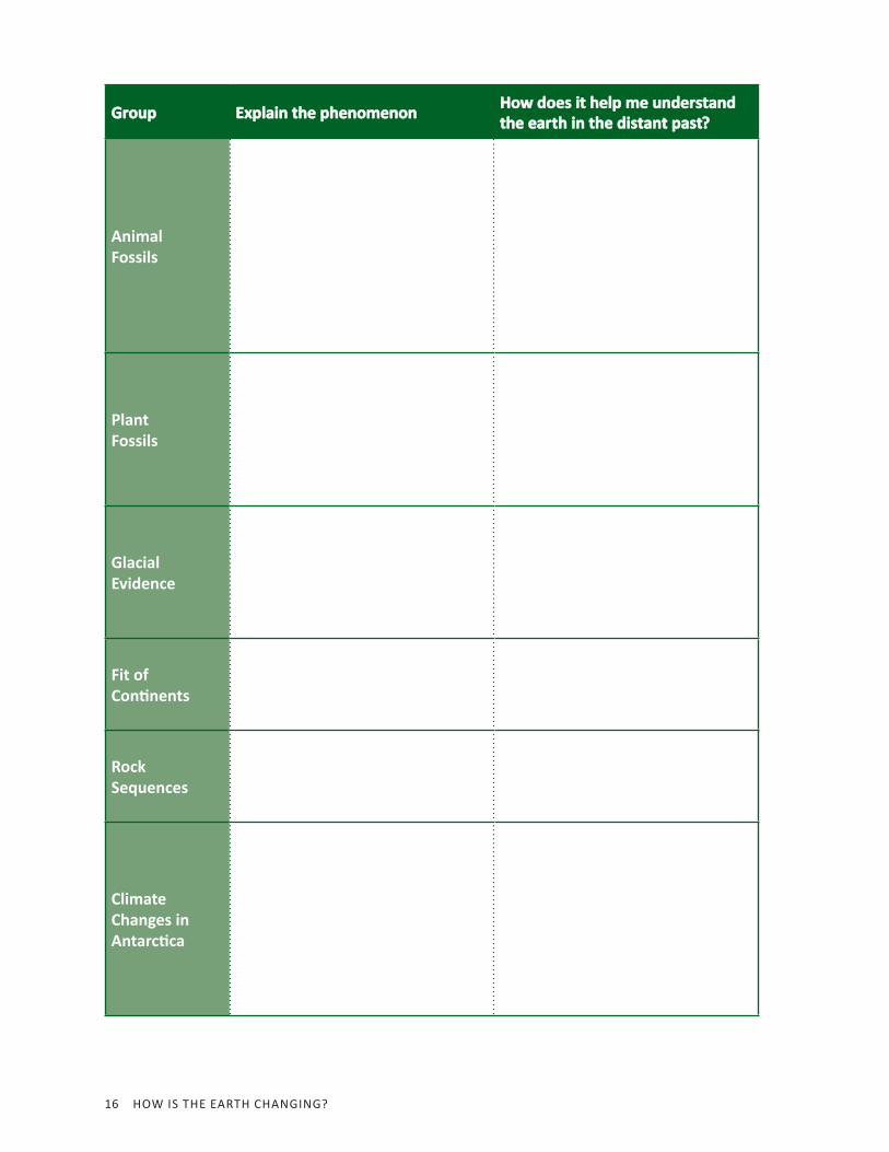
GroupGroup Explain the phenomenonExplain the phenomenon How does it help me understand How does it help me understand the earth in the distant past?the earth in the distant past?
Animal Fossils
Plant Fossils
Glacial Evidence
Fit of Con nents
Rock Sequences
Climate Changes in Antarc ca
LESSON 2: HOW DID THE EARTH LOOK IN THE PAST? 17
Making Sense 1. When you consider all six types of phenomena, which piece of information seems
most convincing to support the theory of continental drift?
2. What questions do you have about the theory of continental drift?
18 HOW IS THE EARTH CHANGING?
ACTIVITY 2.1 PART 2 THE THEORY OF CONTINENTAL DRIFTACTIVITY 2.1 PART 2 THE THEORY OF CONTINENTAL DRIFT
Building Pangaea
What Will We Do?We will use scientific evidence to consider what Earth might have looked like in the past and construct a model of Pangaea.
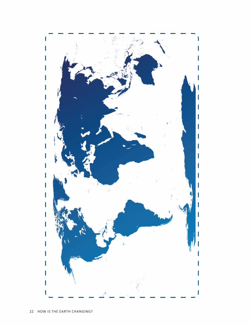
Procedure 1. You have two world maps with the continents shown in different colors. Write Present
on the top of one of the maps. This map represents what Earth looks like today. Do not do anything else to this map.
2. Use scissors to cut the other map apart according to the rough shapes of the continents.
3. Fit the continents together (like a puzzle) based on their shapes and on other evidence that Wegener used to develop his theory.
4. When you are finished, glue or tape the continents in place on a sheet of paper labeled Past. This represents your prediction about how the world may have looked 250 million years ago.
5. Once your map is complete, answer the following questions.
LESSON 2: HOW DID THE EARTH LOOK IN THE PAST? 19
Making Sense 1. Look at all the ways the past and the present maps are different. What caused these
changes? List as many possibilities as you can.
2. Is the theory of continental drift a reasonable explanation that continents move over the surface of the earth? Why?
3. Explain another way that you think continents could have changed position over Earth’s history.

20 HOW IS THE EARTH CHANGING?
Present

LESSON 2: HOW DID THE EARTH LOOK IN THE PAST? 21
22 HOW IS THE EARTH CHANGING?

LESSON 2: HOW DID THE EARTH LOOK IN THE PAST? 23
24 HOW IS THE EARTH CHANGING?
ACTIVITY 2.2 THE EXPLORATION OF THE OCEAN FLOORACTIVITY 2.2 THE EXPLORATION OF THE OCEAN FLOOR
What Will We Do?We will analyze additional data involving the ocean floor and determine how this evidence fit into Wegener’s theory of continental drift.
Procedure 1. Your teacher will show images that match the pictures in the table.
2. As you view each slide, describe your observations in the Notes column.
Making Sense 1. After looking at this new data, what did scientists conclude about how continents
appeared to be moving on the surface of the earth?
2. Explain ocean floor spreading and how this process is related to the mid- ocean ridge.
LESSON 2: HOW DID THE EARTH LOOK IN THE PAST? 25
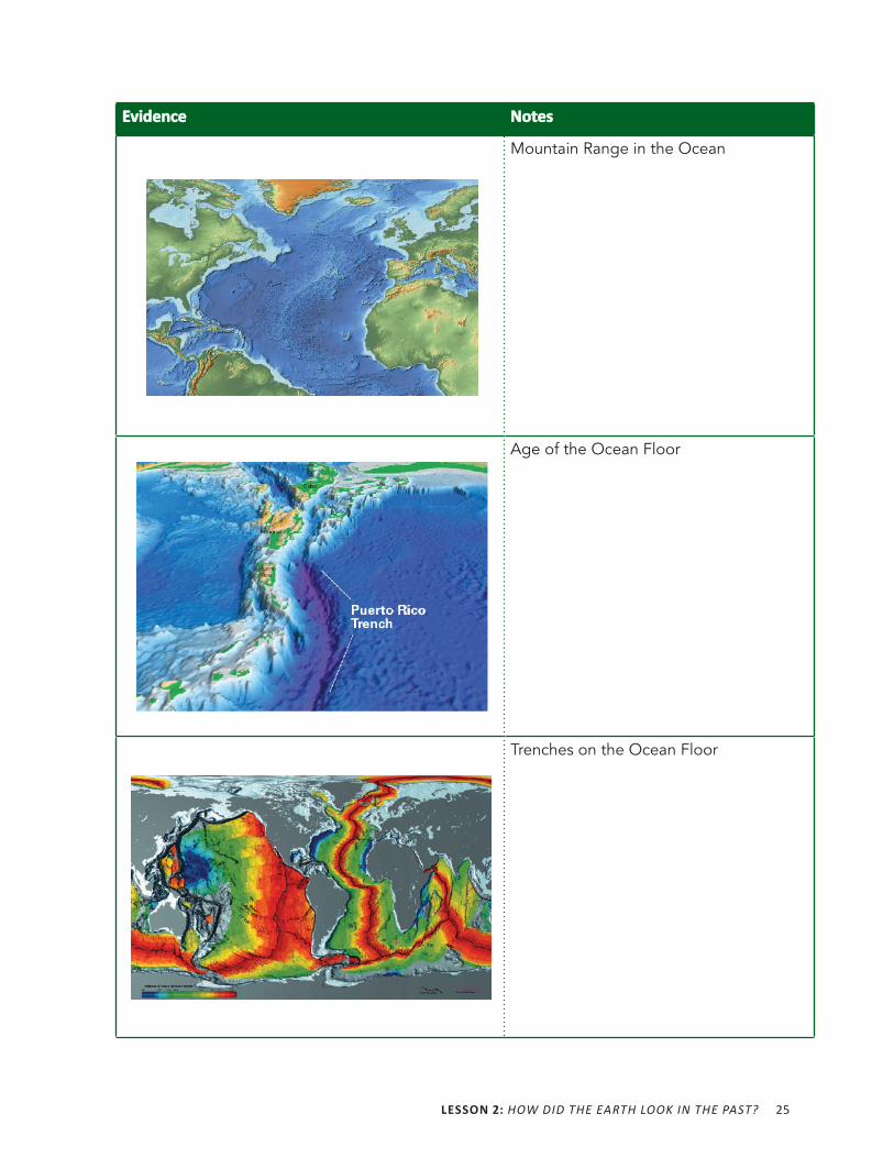
EvidenceEvidence NotesNotes
Mountain Range in the Ocean
Age of the Ocean Floor
Trenches on the Ocean Floor

27
L 3
What Is the Composition of the Earth’s Surface?
ACTIVITY 3.1 THE THEORY OF PLATE TECTONICSACTIVITY 3.1 THE THEORY OF PLATE TECTONICS
What Will We Do?We will create models to represent Earth’s plates.
Background Information 1. What do you know or what have you heard about plate tectonics?
2. What data taken from the ocean floor lead to the theory of plate tectonics?
3. How can Wegener’s phenomena and data help you answer the Driving Question: How Is the Earth Changing?
4. What do we know so far about plates that would be important to include in constructing a model to explain what they are?
28 HOW IS THE EARTH CHANGING?
ProcedureYou will be building several models of Earth’s plates. You will also talk about the advantages and limitations of each model.
1. Your teacher will give you cards with instructions for creating your model of the earth’s plates.
2. Follow your teacher’s directions for obtaining the materials you will need.
3. Construct your model. When you complete your first model, your teacher may give you a card with another set of instructions.
Making Sense 1. What are the important features of a model of Earth’s plates? (Note: We are not
focusing on continents here but rather plates.)
After all groups have shared their models, answer the following questions:
2. Which model do you think was the best model of Earth’s plates? Why is this a good model?
3. What are the two advantages of this model?
4. What are the two limitations of this model?
29
L 4
What Makes the Plates Move?
ACTIVITY 4.1 CONVECTION IN LIQUIDSACTIVITY 4.1 CONVECTION IN LIQUIDS
What Will We Do?We will simulate the reason that plates move on the earth’s surface.
Predictions 1. The Driving Question for this unit is How Is the Earth Changing? How would you
answer this question at this point?
2. Why do you think Earth’s plates move on the surface?
Red and Blue Water Demonstration (Demo #1)ProcedureYour teacher will conduct a demonstration. Observe closely, and answer the questions that follow.
Making Sense 1. Record your observations of the first red and blue water from the demonstration.
In the following space, draw a diagram of the setup for this demonstration. You may draw on the diagram and also use words to describe your observations.
30 HOW IS THE EARTH CHANGING?
2. Explain what happened with the hot and cold water.
3. What did the tank look like after 10 minutes?
Convection with a Drop of Food Coloring Demonstration (Demo #2)ProcedureYour teacher will conduct a second demonstration. Observe closely, and answer the questions that follow.
Making Sense 1. Record your observations about the water and drops of food coloring demonstration.
2. Why do you think this happened?
3. Relate this activity to the first demonstration with the red and blue water.
4. Record your observations about the cardboard in the water.
5. Why do you think this happened?
6. What do you think the cardboard and water represent in this demonstration?
LESSON 4: WHAT MAKES THE PLATES MOVE? 31
ACTIVITY 4.2 SILLY PUTTYACTIVITY 4.2 SILLY PUTTY® ROCKS ROCKS
What Will We Do?We will use Silly Putty® to simulate the formation of metamorphic rocks in order to draw conclusions about the nature of rock in Earth’s mantle.
Prior Knowledge about Metamorphic RocksRecord everything you know about metamorphic rocks.
Procedure 1. You will be given two different metamorphic rocks. Draw a sketch of each rock
sample. (Ignore the shape and texture of the rock and focus on the banding patterns.) Next, write a hypothesis about how you think each one may have formed.
Rock Sample #Rock Sample # Sketch of SampleSketch of Sample HypothesisHypothesis
Sample #1
Sample #2
32 HOW IS THE EARTH CHANGING?
2. Obtain Silly Putty®, and play around with this material. Do you think it is more like a solid or a liquid? Why?
3. Stretch the Silly Putty® slowly. Describe its behavior.
4. Now, stretch the Silly Putty® quickly. Describe what happens.
5. Next, you will design an experiment. The goal of your experiment is to determine the following: How does temperature affect the behavior of Silly Putty®?
6. Work in groups of two or three. Each pair will have a ball of Silly Putty®.
7. Determine how you will design your experiment (be sure you control for variables as you have learned previously), and record your ideas in the following table. Conditions may be hot and cold, for example.
Conditions Conditions ➞
How will you achieve these two conditions? (How will you make a “hot” environment?)
What variables will you need to control? (Line? Size of putty? Shape of putty?)
Predictions—What do you expect will happen to your Silly Putty’s® form?
LESSON 4: WHAT MAKES THE PLATES MOVE? 33
8. Carry out your designed experiment. This may take more than one class period or day.
9. Record your findings and conclusions. (Answer this question: How does temperature affect the behavior of the putty?
10. Use the following space to record any data/diagrams/measurements you collect.
11. Answer the Making Sense questions that follow once you have completed your experiment.
Making Sense 1. How do you think Silly Putty® might be used as a model for metamorphic rocks?
2. What does this simulation suggest about what happens to metamorphic rock as it is formed?
3. What does this activity help you to understand about the earth’s mantle and convection?
34 HOW IS THE EARTH CHANGING?
Reading 4.2 – Formation of Metamorphic Rocks
Getting ReadyPreviously, you learned about different types of rocks, including metamorphic rocks. What do you already know about how rocks are formed?
As you put together what you have learned in the past, what you did in class today, and this reading, you will know a lot about metamorphic rocks and changes in the earth.
Metamorphic RocksMetamorphic rocks are formed from other previously formed rocks. In other words, a metamorphic rock is a rock that has been changed. The most common ways that rocks are changed is through pressure and heat. In class, you designed an experiment to determine how temperature affects the behavior of Silly Putty®. In this activity, the Silly Putty® was supposed to represent rock material that makes up the mantle of the earth (immediately beneath the surface). This is very similar to how rocks deform in the earth. Real rocks need much higher temperatures to deform than your Silly Putty® rock required.
At places where Earth’s plates meet, and deep places within the Earth’s rock layers, the conditions are very hot. Where do you think the heat comes from?
LESSON 4: WHAT MAKES THE PLATES MOVE? 35
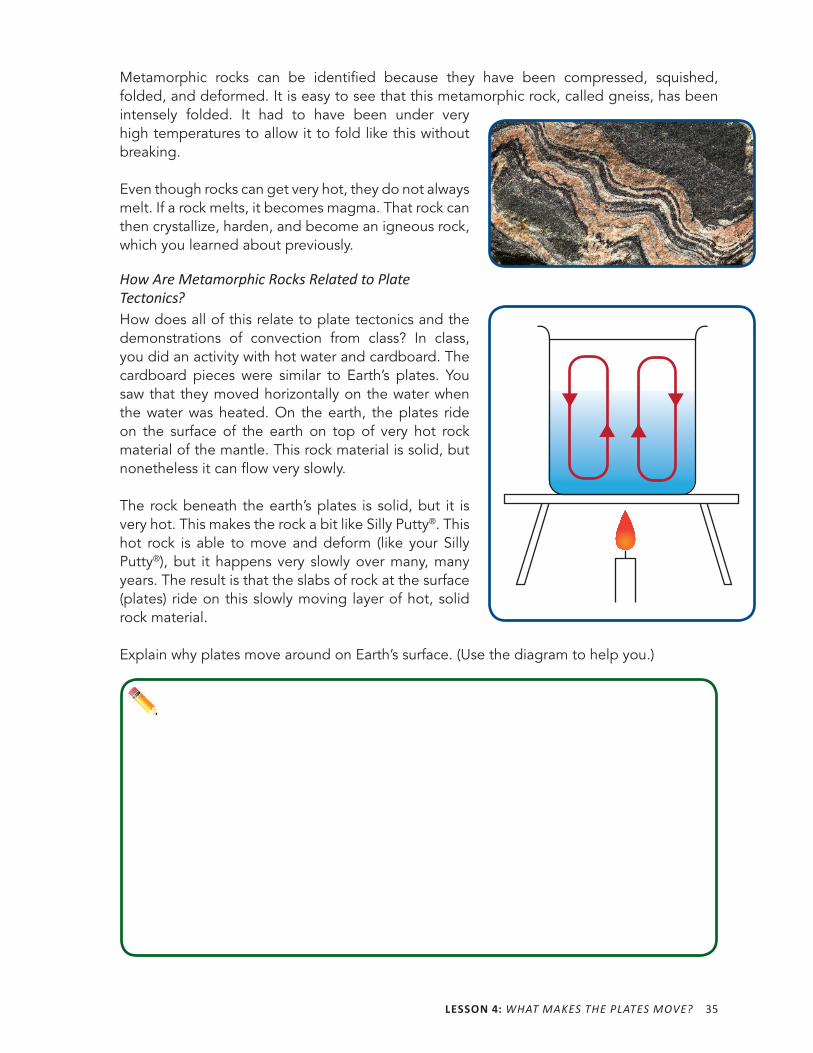
Metamorphic rocks can be identified because they have been compressed, squished, folded, and deformed. It is easy to see that this metamorphic rock, called gneiss, has been intensely folded. It had to have been under very high temperatures to allow it to fold like this without breaking.
Even though rocks can get very hot, they do not always melt. If a rock melts, it becomes magma. That rock can then crystallize, harden, and become an igneous rock, which you learned about previously.
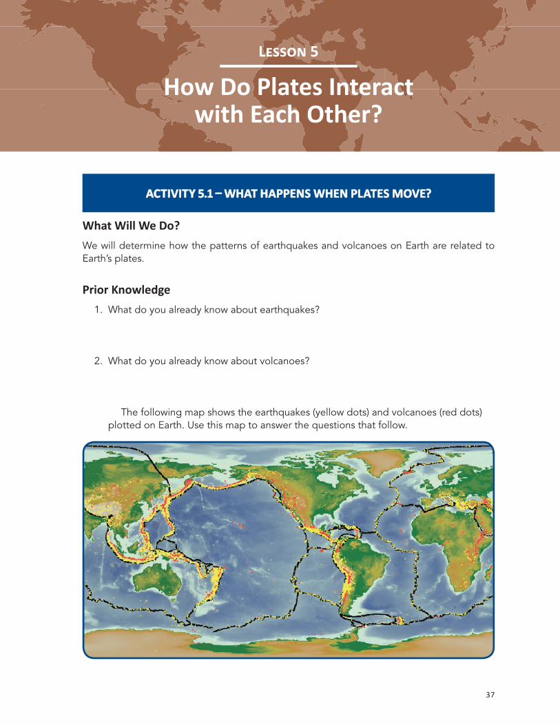
How Are Metamorphic Rocks Related to Plate Tectonics?How does all of this relate to plate tectonics and the demonstrations of convection from class? In class, you did an activity with hot water and cardboard. The cardboard pieces were similar to Earth’s plates. You saw that they moved horizontally on the water when the water was heated. On the earth, the plates ride on the surface of the earth on top of very hot rock material of the mantle. This rock material is solid, but nonetheless it can flow very slowly.
The rock beneath the earth’s plates is solid, but it is very hot. This makes the rock a bit like Silly Putty®. This hot rock is able to move and deform (like your Silly Putty®), but it happens very slowly over many, many years. The result is that the slabs of rock at the surface (plates) ride on this slowly moving layer of hot, solid rock material.
Explain why plates move around on Earth’s surface. (Use the diagram to help you.)

37
L 5
How Do Plates Interact with Each Other?
ACTIVITY 5.1 WHAT HAPPENS WHEN PLATES MOVE?ACTIVITY 5.1 WHAT HAPPENS WHEN PLATES MOVE?
What Will We Do?We will determine how the patterns of earthquakes and volcanoes on Earth are related to Earth’s plates.
Prior Knowledge 1. What do you already know about earthquakes?
2. What do you already know about volcanoes?
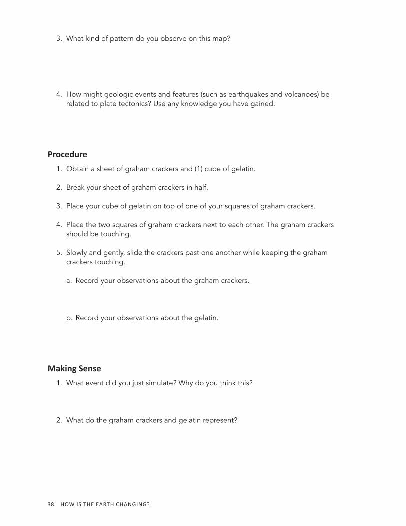
The following map shows the earthquakes (yellow dots) and volcanoes (red dots) plotted on Earth. Use this map to answer the questions that follow.
38 HOW IS THE EARTH CHANGING?
3. What kind of pattern do you observe on this map?
4. How might geologic events and features (such as earthquakes and volcanoes) be related to plate tectonics? Use any knowledge you have gained.
Procedure 1. Obtain a sheet of graham crackers and (1) cube of gelatin.
2. Break your sheet of graham crackers in half.
3. Place your cube of gelatin on top of one of your squares of graham crackers.
4. Place the two squares of graham crackers next to each other. The graham crackers should be touching.
5. Slowly and gently, slide the crackers past one another while keeping the graham crackers touching.
a. Record your observations about the graham crackers.
b. Record your observations about the gelatin.
Making Sense 1. What event did you just simulate? Why do you think this?
2. What do the graham crackers and gelatin represent?
LESSON 5: HOW DO PLATES INTERACT WITH EACH OTHER? 39
3. What are the similarities of this simulation to the real world? What are the differences?
Volcano SimulationYou will watch a short video clip several times. Watch closely and list some of your observations as you watch.
Making Sense 1. What happens when two plates move toward each other?
2. What happens when two plates move away from each other?
3. Why do you think this happens?
4. What happens when two plates move along side each other? (Hint: Think about the graham cracker and gelatin activity.)
40 HOW IS THE EARTH CHANGING?
Reading 5.1 – Ring of Fire
Getting ReadyAt the beginning of this unit, you looked at a map of volcanic activity on Earth. One of the patterns you noticed is that volcanoes are often found in a line. Why do you think volcanoes are found in a line?
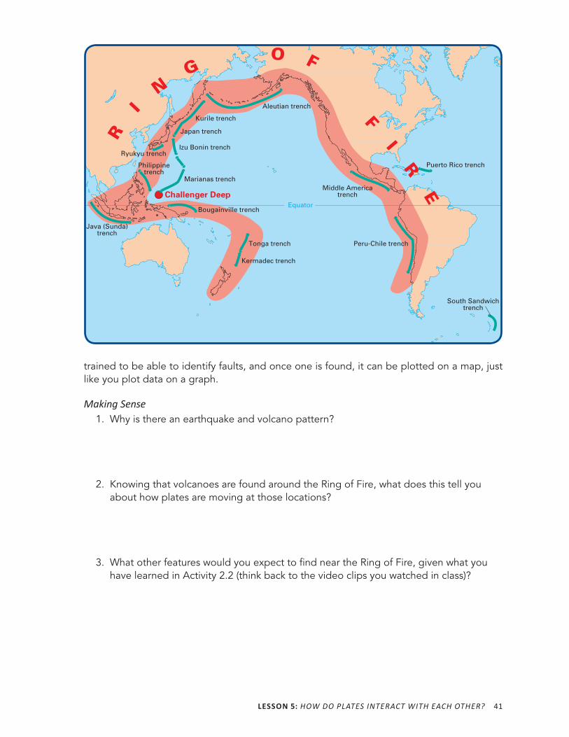
What Is the Ring of Fire?What shape does the earthquake and volcano pattern look like to you? You might say it looks like an upside-down letter U. Maybe it looks like a horseshoe to you. Scientists say it is ring- shaped. Scientists call this pattern the Ring of Fire. The Ring of Fire is the line reaching from Australia, along the coast of Asia and down the western coast of the Americas, where there are many volcanoes and earthquakes. There are many more earthquakes here than in other areas not along the Ring of Fire. As you may have guessed, this Ring is a plate boundary. It is where many pieces of the earth’s crust meet and rub against each other. The blue lines represent oceanic trenches. The thick red area identifies the general shape of the Ring of Fire, centered on the major Pacific plate.
You can see that the pattern of volcanoes and earthquakes matches the plate boundary line that circles the Pacific Ocean. It is called the Ring of Fire because when volcanoes erupt it looks like they are on fire.
The Ring of Fire is just one example of this phenomenon of earthquakes and volcanoes occurring in similar locations on Earth. Most plate boundaries around the world have similar patterns of geologic phenomena because these features and events occur at most plate boundaries.
How Did Scientists Figure Out Where the Fault Lines Are?Scientists can use two methods to figure out where fault lines are located. A fault can be a plate boundary, such as the one found between two plates that rub alongside one another, resulting in earthquakes. One method is to simply look at the pattern of earthquakes (just as you did in class). This will show where the faults are located because faults and earthquakes often coincide and are found in the same places. A second method to find fault lines is to walk around outside with a map, compass, and other geological tools. Geologists know how to spot a fault and are able to find them with their eyes as they walk through a region. Finding a fault requires that the geologist know what signs to look for. These scientists have been
LESSON 5: HOW DO PLATES INTERACT WITH EACH OTHER? 41
trained to be able to identify faults, and once one is found, it can be plotted on a map, just like you plot data on a graph.
Making Sense 1. Why is there an earthquake and volcano pattern?
2. Knowing that volcanoes are found around the Ring of Fire, what does this tell you about how plates are moving at those locations?
3. What other features would you expect to find near the Ring of Fire, given what you have learned in Activity 2.2 (think back to the video clips you watched in class)?
Challenger Deep
South Sandwichtrench
Puerto Rico trench
Middle Americatrench
Peru-Chile trench
Java (Sunda)trench
Philippinetrench
Bougainville trench
Tonga trench
Kermadec trench
Kurile trench
Japan trench
Aleutian trench
Izu Bonin trench
Marianas trench
O F
F I R E
Equator
Ryukyu trench
R
I N
G
42 HOW IS THE EARTH CHANGING?
ACTIVITY 5.2 TWO TYPES OF ROCK COMPRISE PLATESACTIVITY 5.2 TWO TYPES OF ROCK COMPRISE PLATES
What Will We Do?We will investigate what happens at different plate boundaries and why.
Observations 1. What did you observe when your teacher moved the towel plates toward each other?
2. Compare this simulation to the formation of mountains.
3. When plates move toward each other, why do you think one plate sometimes slides underneath the other, while sometimes they do not move in this way?
LESSON 5: HOW DO PLATES INTERACT WITH EACH OTHER? 43
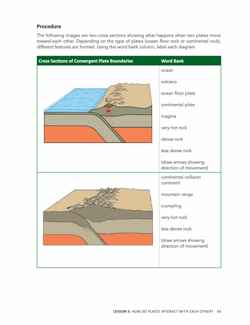
ProcedureThe following images are two cross sections showing what happens when two plates move toward each other. Depending on the type of plates (ocean floor rock or continental rock), different features are formed. Using the word bank column, label each diagram.
Cross Sections of Convergent Plate BoundariesCross Sections of Convergent Plate Boundaries Word BankWord Bank
ocean
volcano
ocean floor plate
continental plate
magma
very hot rock
dense rock
less dense rock
(draw arrows showing direction of movement)
continental collision continent
mountain range
crumpling
very hot rock
less dense rock
(draw arrows showing direction of movement)
44 HOW IS THE EARTH CHANGING?
Making Sense 1. Explain why ocean floor plates subduct beneath continental plates.
2. At this point, how would you answer the Driving Question: How Is the Earth Changing?
45
L 6
What Causes Volcanoes?
ACTIVITY 6.1 VOLCANO FORMATIONACTIVITY 6.1 VOLCANO FORMATION
What Will We Do?We will simulate a volcanic eruption to determine how Earth is changing.
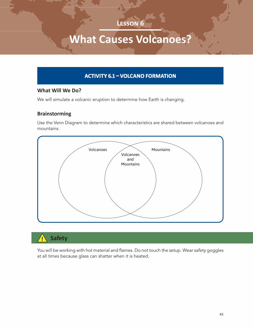
BrainstormingUse the Venn Diagram to determine which characteristics are shared between volcanoes and mountains.
! Safety
You will be working with hot material and flames. Do not touch the setup. Wear safety goggles at all times because glass can shatter when it is heated.
Volcanoes MountainsVolcanoes
andMountains
46 HOW IS THE EARTH CHANGING?
Procedure 1. One member of your group should get a beaker with wax, sand, and water already
set up. You will also need a ring stand and a flame source provided by your teacher.
2. Set up your materials as your teacher demonstrated. Place the beaker on the ring stand, with the heat source below the beaker.
3. Draw a simple diagram, labeling the parts of your setup.
4. Ask your teacher to check your setup. Once your setup is approved, your teacher will light your flame source for you.
5. At this point, you will be observing your beaker for up to 10 minutes. Do not touch any part of the setup. It will burn you! You must wear safety goggles.
6. Record your observations in the table.
7. Once the materials in your beaker have stopped moving, your teacher will remove your heat source.
Your materials are still hot. Do not touch the setup.
8. Answer the follow- up questions. Be sure to label your drawing.
Diagram of Beaker before ActivityObservations
WaxWax SandSand WaterWater
LESSON 6: WHAT CAUSES VOLCANOES? 47
1. Describe what happens in the beaker as it is heated.
2. Draw a diagram that shows what your beaker looked like at the end of the activity. Label your diagram so that another student could understand what it is showing.
Diagram of Beaker after Activity(Be sure to label your drawing.)
1. What does the wax represent in your model?
2. What kind of feature(s) did you create in this model?
3. Explain how the hot wax moved in the beaker.
48 HOW IS THE EARTH CHANGING?
Making Sense 1. Why did the wax move this way? (Hint: Think about what happens to materials as they
heat up.)
2. How is this model different from an actual volcano?
3. How does this activity help you answer the Driving Question: How Is the Earth Changing?
LESSON 6: WHAT CAUSES VOLCANOES? 49
ACTIVITY 6.2 HOTSPOT FORMATIONACTIVITY 6.2 HOTSPOT FORMATION
What Will We Do?We will simulate the formation of a hotspot volcano.
In previous lessons, you learned that volcanoes form at plate boundaries, but the chain of Hawaiian volcanoes are in the middle of the Pacific plate. How do you think the hotspot your teacher described might have been involved in their formation?
Procedure 1. Working in pairs, have one partner hold a pencil point up on the desk. The other
should hold the paper flat a couple of inches over the point.
2. Move the paper slowly sideways. As it moves, bring the pencil point up until it pokes through the paper, and then bring it down again. Repeat this process several times as the paper continues to move.
Making Sense 1. In what ways did this activity show important ideas about how hotspots form island
chains?
2. What important ideas did this activity not show as well?
3. How would you design a simulation that would show these ideas more effectively?
4. Look at a map that shows Hawaii, and note the pattern of volcanoes that make up these islands.
Describe their pattern.
50 HOW IS THE EARTH CHANGING?
Reading 6.2 – Is a Hotspot Lurking beneath the Continental United States?
Getting ReadyToday, you learned about hotspots. There are not many locations on Earth where hotspots have been found. Using what you have learned this far, do you think it is likely that a major volcanic eruption will occur on the mainland of the United States? Explain your ideas.
Yellowstone National ParkYellowstone National Park, the first national park in the United States, is located in the northwest corner of Wyoming. It is home to a fascinating array of geologic wonders: geysers that shoot steam and water high into the air, brightly colored pools of water, and ponds of mud that bubble continuously. Each of these aspects of Yellowstone points to something beneath the surface, something hot, something that cannot be seen, but we know it is there because of what it causes on Earth—the Yellowstone Hotspot.
In class today, you simulated a type of volcanic eruption in a beaker using red wax, sand, and water.
What led to the eruption in your beaker?
The eruption occurred because of heating from below. You could see that your beaker was being heated because it was not hidden. However, in the earth it is an entirely different story. The core of the earth (the center) is very hot. It is so hot that some areas of the core are composed of liquid metal. You have learned that thermal energy can be transferred from one material to another. This happens continuously in the earth as energy is transferred from the core to the other layers deep within the earth. Eventually, that heat is transferred all the way out toward the more shallow parts of the earth that are closer to the surface where humans live and breathe.
Sometimes, thermal energy is not transferred equally in all places. Scientists do not really understand why this happens yet, but when this occurs, hotspots form. These are places in the earth’s mantle that are much hotter than their surroundings. These hotspots tend to stay in one place. In other words, they remain fixed at one location in the interior of the earth.
You know that not everything on Earth is fixed. You have been studying how plates can slide around on the surface of the earth as rigid slabs of rock. This happens very slowly, as plates have been found to move only a few inches each year. The presence of a hotspot can be
LESSON 6: WHAT CAUSES VOLCANOES? 51
determined by collecting evidence. Volcanoes, often in a linear patterns are rows, provide visible evidence of hotspots. These volcanoes differ in age from old to young, as a plate moves over the stationary hotspot. This leads to volcanic eruptions and the formation of mountains. You observed the famous Hawaiian Islands on the Driving Question Board in class and noticed the chain of islands. The biggest island is currently volcanically active, which is evidence that the hotspot is located directly below this island.
What is happening on the mainland U.S.? Scientists have found interesting evidence that points to the presence of a hotspot under the Yellowstone area. When volcanoes erupt, they spew out large quantities of molten rock and ash, which settle on the surface of the earth and can even cover the land. Evidence suggests that this hotspot has been around for approximately 17 million years and is responsible for burying many states (Washington, Oregon, California, Nevada, and Idaho) with huge volumes of lava.
As the North American plate has moved throughout Earth’s history, evidence has been accumulating in the northwest. A caldera is a volcanic feature that is formed when a volcano collapses, leaving a crater or depression in the earth’s surface. A string of calderas has been found in a line, pointing straight to Yellowstone National Park. The ages of the lava rock found at each caldera tells geologists when those calderas formed. The farthest caldera is the oldest, and the youngest is the one closest to the park. There is so much activity under this area of the United States, that the entire region is raised slightly, forming a plateau.
What does this evidence mean? The geologic features related to heat (geysers, hydrothermal pools, and volcanic rock) suggest that the hotspot responsible for all of this is currently sitting underneath Yellowstone National Park, even though there is no apparent evidence of volcanic eruptions at the surface, just geothermal phenomena—for now. As the North American plate has slowly glided over this hotspot, it has left evidence along its path. Eventually, this hotspot will erupt again, and when it does, it will be accompanied by much rumbling and unrest within the earth in the form of earthquakes and volcanoes. Large volumes of lava will pour out of the earth, and gases and ash will be released into the atmosphere. This is likely the greatest geologic threat to the entire United States, yet we cannot even see what is causing it. The hotspot remains hidden beneath the plate.
How would a volcanic eruption on the mainland of the U.S. affect your daily life?

53
L 7
How Are Plates Moving?
ACTIVITY 7.1 DETERMINING PLATE MOVEMENTACTIVITY 7.1 DETERMINING PLATE MOVEMENT
What Will We Do?We will discuss plate movement.

55
L 8
How Does New Plate Material Form?
ACTIVITY 8.1 HOW DOES THE EARTH CYCLE ROCK MATERIAL?ACTIVITY 8.1 HOW DOES THE EARTH CYCLE ROCK MATERIAL?
What Will We Do?We will write a scientific explanation about how Earth’s material is recycled.
Scientific ExplanationExplain the origin of plate material (including the ocean floor and continents). Be sure to support your claim with evidence from this unit, your prior knowledge, and reasoning.
56 HOW IS THE EARTH CHANGING?
Reading 8.1 – Recycling for Earth and Cycling within EarthWhat does the principle of conservation of matter say? How is this related to Earth’s plates?
Why Do People Recycle?Recycling is important and has become increasingly popular in the United States. Humans produce large amounts of trash, most of which ends up in landfills. This is a problem, not only for the health of people, but also for the health of the earth and the environment. When you were young, you may have learned about recycling in school or because your family recycles at home. Recycling is the practice of reusing material for another purpose. Many people recycle newspaper, mail, and other paper, plastic containers, cardboard, bottles, and cans. By recycling, humans reduce the amount of material that ends up buried in landfills.
For example, if you were to drink a can of soda and throw the can away, it would end up going to a trash center, being compressed into a smaller volume, and then eventually being buried in the earth. Instead, after drinking the can of soda, imagine if you were to put the aluminum can in a recycling bin. The can would then go to a recycling center where it might be melted down, and the metal would be used again to form another soda can. By recycling a single can, you have (1) kept the can out of the landfill, and (2) allowed the can to be recycled to form a new product that can then be used and then recycled again. People recycle when they recognize that the Earth has limited natural resources. Items that are thrown away can never be used again, but recycling allows natural resources to be used over and over.
It is important to note that when material is taken from the Earth and used (as in the case of the aluminum soda can), if placed into a landfill, it can still be a resource on Earth. However, in its current form, it is not very useful. The materials become less accessible in landfills. If, instead, materials are recycled, they are more easily accessible and less expensive to obtain. This is analogous to the rock cycle—if one step in the cycle is changed (for example, the earth eventually cools down and less rock is being melted), this will have an effect on the rest of the cycle (less volcanism would occur, meaning new rock material would not be formed).
How Does the Earth Cycle?Cycling has been occurring for as long as Earth’s plates have been subducting. Plates float on top of an almost entirely solid layer of rock. In some places, the plates move toward each other. This is called convergence and can occur at a subduction boundary. Other times, magma from the mantle rises up to force a space to form in the plate. This can result in the plate breaking apart, with the sides moving away from each other. This is known as ocean floor spreading, which you learned about in Lesson 1. You know that magma comes from the earth’s interior. Magma also erupts from volcanoes. Does the earth have an unlimited supply of magma?
LESSON 8: HOW DOES NEW PLATE MATERIAL FORM? 57
The earth is actually cycling its plate material and making more magma. When an oceanic plate subducts (slides underneath another plate), rock material melts and rises upward. According to the principle of conservation of matter, magma, plates, and all matter on and within the earth cannot be created nor destroyed. Therefore, while it seems that new ocean floor is forming, it is actually existing rock material beneath the surface that was melted and recrystallized to form new ocean floor plate material. At subduction zones, existing rock material moves deeper into the earth. Rock material from the interior melts and may one day form part of the ocean floor at a divergent boundary. Due to Earth processes such as convection and differences in density, the earth cycles its rock material. The rock material can take on different forms and be found in different locations.
How Else Is the Earth Cycling?Water also moves through a cycle, in which the form of water can change between three phases: solid, liquid, and gas. The changing environmental conditions (temperatures rising and falling) are what moves the water through this cycle. For example, a snowstorm brings large amounts of water in the solid phase (snow and ice) to the surface of the earth out of the atmosphere. If the snow melts a week later due to an increase in air temperature, the solid water becomes liquid water. If that water collects in a lake or sits on the surface of the earth in a different reservoir, it can evaporate and become a gas or soak into the ground to become groundwater.
These are some of the ways that the Earth cycles its materials, including plates (made of rock) and water. Explain your ideas about why humans need to recycle.
Explain plate tectonics as one way that the Earth cycles.

59
L 9
What Do We Know about Plate Tectonics?
ACTIVITY 9.1 CREATING A LIST OF IMPORTANT IDEAS AND ACTIVITY 9.1 CREATING A LIST OF IMPORTANT IDEAS AND ANNOTATING A CROSS SECTION OF EARTHANNOTATING A CROSS SECTION OF EARTH
What Will We Do?We will use what we have learned to create a clear and organized description of the theory of plate tectonics.
BrainstormingIn each of the following clouds, write one concept, one principle, one feature, or one idea that you have learned in this unit.
60 HOW IS THE EARTH CHANGING?
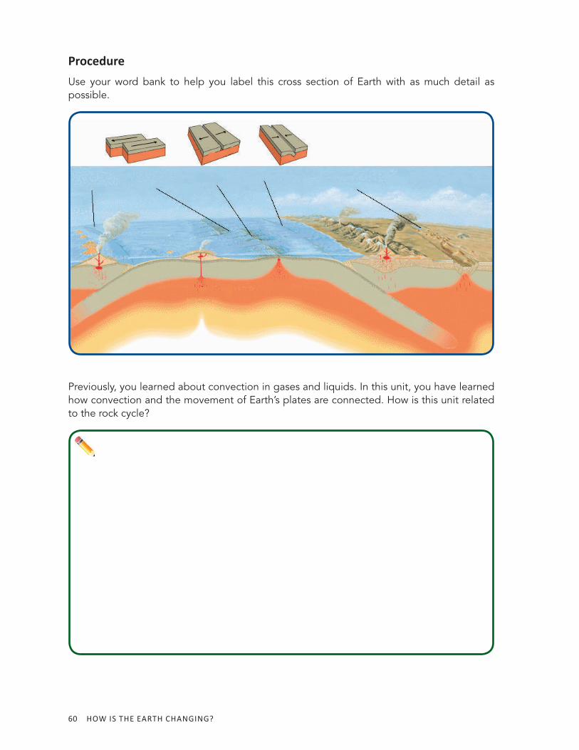
ProcedureUse your word bank to help you label this cross section of Earth with as much detail as possible.
Previously, you learned about convection in gases and liquids. In this unit, you have learned how convection and the movement of Earth’s plates are connected. How is this unit related to the rock cycle?
LESSON 9: WHAT DO WE KNOW ABOUT PLATE TECTONICS? 61
Reading 9.1 – How Well Do Scientists Understand Plate Tectonics?
Getting ReadyYou have learned that Earth’s plates move on the surface of the earth, as they glide on a softened layer of hot mantle rock. Many scientists agree that this slow movement of the mantle rock is responsible for the movement of plates. In 1968, J. Tuzo Wilson declared, “The Earth, instead of appearing as an inert statue, is a living, mobile thing.” Not only do the outer and visible parts of the earth move, but the interior of the earth also moves.
What evidence have you gathered in this unit that the outer Earth moves? What evidence do you have that the interior portion of the earth is in motion?
What are the interrelationships between the movement of different parts of the earth (plate tectonics) and the rock cycle?
62 HOW IS THE EARTH CHANGING?
In class, you used Silly Putty® to represent how solid rock can deform over time and at higher temperatures. You also looked at rock samples that showed evidence of past deformation. The appearance of metamorphic rock is one piece of evidence that solid rock can flow when it has been subjected to very high temperatures and large amounts of pressure in the interior of the earth over millions of years.
Although it may seem that the theory of plate tectonics is a fact and that scientists know all there is to know about this topic, this is not the case. Scientists examine existing knowledge and understanding about a theory and then look for alternative explanations. They also pursue unanswered questions, or they ask new questions.
One question that scientists have and that you may have raised in class is “How does mantle convection really work?” Scientists have a good sense of the characteristics of how hot and cold matter behaves in the earth’s interior. Some of this understanding comes from experiments, such as those you did in Lesson 2, but scientists are still unsure of how mantle convection might look in the earth. Since no one can actually see it occurring, scientists must make hypotheses based on evidence. They also use computers to help estimate what might be happening in places that are inaccessible, like deep inside the earth. Scientists do not yet agree on how exactly mantle convection works within the earth’s interior. Additional evidence is needed to deepen scientists’ understanding of the theory of plate tectonics.
Another unanswered question is “Why do hotspots form?” This question may have also been raised in class. You have studied how a hotspot leads to the formation of a chain of volcanoes, but why are there not hotspots everywhere? Rather, they are only in certain locations. This is a puzzle for scientists. Some believe that hotspots originate very deep in the mantle, at the boundary between the mantle and the earth’s core. These super- heated plumes (sections of the mantle that are much hotter than the surrounding area) are then thought to rise up through the mantle, leading to the features visible on Earth’s surface. Others believe that hotspots are not fixed as we think they are based on gathered evidence, but they can migrate slowly over time.
We may never fully understand all of the details associated with the existing theory of plate tectonics. This is why scientists continue studying these concepts. Earth science deals with many phenomena that are difficult to observe, such as those taking place within the interior of the earth. Not all aspects of the theory of plate tectonics can be tested, and experiments are hard to design, given the large scale of these processes. We know that plates have moved in the past and that they continue to move today. The exact methods of movement and the cause of this motion are still puzzling to scientists today. What unanswered questions do you have about plate tectonics? Why do you think Earth scientists continue to study plate tectonics?
LESSON 9: WHAT DO WE KNOW ABOUT PLATE TECTONICS? 63
ACTIVITY 9.2 FILLING OUT THE SUMMARY CHARTACTIVITY 9.2 FILLING OUT THE SUMMARY CHART
What Will We Do?
Procedure
We will synthesize and organize the concepts and processes we have been learning to better understand plate tectonics.
Your teacher will provide you with the chart for this activity. Complete the summary chart. You will find it helpful to use the word/concept bank (Activity 9.1) and cross section (Activity Sheet 9.1) that you have already created. Be as descriptive and detailed as possible.
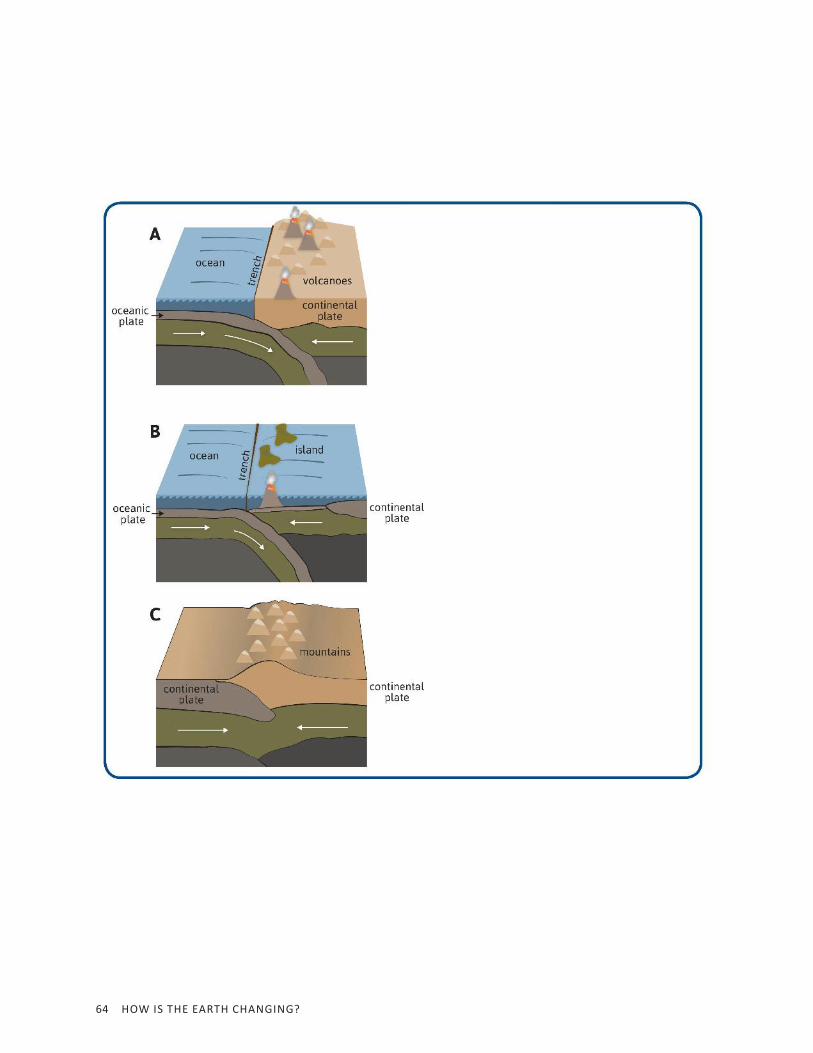
Making SenseUse the drawings of boundary types to answer the following questions.
1. Which cross section(s) represent a convergent boundary? What makes the three cross sections different?
2. Which cross section(s) show the formation of a volcano? Explain at least two ways that volcanoes can form.
64 HOW IS THE EARTH CHANGING?

LESSON 9: WHAT DO WE KNOW ABOUT PLATE TECTONICS? 65
66 HOW IS THE EARTH CHANGING?
Reading 9.2 – How Does Plate Tectonics Affect Me?
Getting Ready
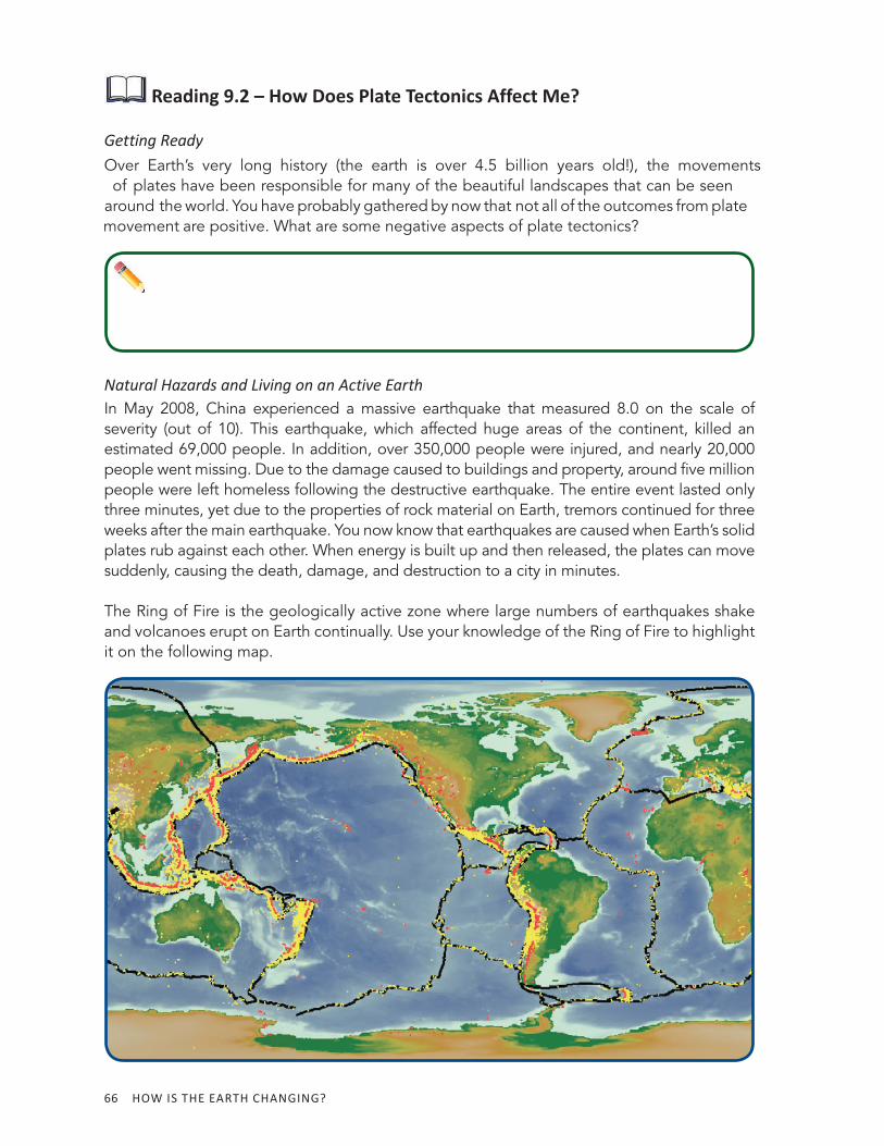
Natural Hazards and Living on an Active EarthIn May 2008, China experienced a massive earthquake that measured 8.0 on the scale of severity (out of 10). This earthquake, which affected huge areas of the continent, killed an estimated 69,000 people. In addition, over 350,000 people were injured, and nearly 20,000 people went missing. Due to the damage caused to buildings and property, around five million people were left homeless following the destructive earthquake. The entire event lasted only three minutes, yet due to the properties of rock material on Earth, tremors continued for three weeks after the main earthquake. You now know that earthquakes are caused when Earth’s solid plates rub against each other. When energy is built up and then released, the plates can move suddenly, causing the death, damage, and destruction to a city in minutes.
The Ring of Fire is the geologically active zone where large numbers of earthquakes shake and volcanoes erupt on Earth continually. Use your knowledge of the Ring of Fire to highlight it on the following map.
Over Earth’s very long history (the earth is over 4.5 billion years old!), the movements of plates have been responsible for many of the beautiful landscapes that can be seen around the world. You have probably gathered by now that not all of the outcomes from plate movement are positive. What are some negative aspects of plate tectonics?
LESSON 9: WHAT DO WE KNOW ABOUT PLATE TECTONICS? 67
What do the black lines on the map represent?
Explain why geologic hazards such as earthquakes and volcanoes follow the black lines.
Because plate boundaries are zones of hazardous activities such as earthquakes and volcanoes, millions of people have been affected by plate tectonics if they happen to live near a plate boundary.
Find the United States on the map. Which areas of the United States are most geologically active (meaning regions that experience earthquake tremors and/or volcanic eruptions), and how do you know this?
As the Pacific Plate (just west of the United States) moves northwest, the location where it rubs against the United States experiences a large amount of earthquake activity. What kind of plate boundary is present along the west coast of the United States, where the plates move alongside each other?
Many people believe that a large earthquake, often referred to as “the Big One,” will hit California within the next 100 years. Due to a lack of understanding about the earth’s plates, some wrongly believe that “the Big One” will cause California to break off of the continent and fall into the Pacific Ocean. Others fear that the transform boundary running through California will open up and the earth will swallow buildings, people, and cars.
Why are these people wrong?
68 HOW IS THE EARTH CHANGING?
Why do you think scientists try to predict when earthquakes will occur?
You have already learned about some unanswered questions about the theory of plate tectonics. Another problem that scientists continue to research is prediction. They now understand where earthquakes occur and how earthquakes happen, but scientists still do not have a good method for predicting when they will occur.
Why do you think it might be difficult to predict when earthquakes will occur, given what you know about how earthquakes happen?
Scientists are now working to solve this problem by studying one particular fault (faults are features used to determine where plate boundaries are located). The San Andreas fault is the name of a major fault near the plate boundary that runs through California. Scientists are gathering data to better understand the changes that happen on the earth’s surface, and beneath the surface, just before an earthquake happens.
You are aware of some of the ways that changes to Earth’s surface can harm humans. What changes to the earth’s surface might benefit humans?
LESSON 9: WHAT DO WE KNOW ABOUT PLATE TECTONICS? 69
ACTIVITY 9.3 BUILDING PHYSICAL MODELSACTIVITY 9.3 BUILDING PHYSICAL MODELS
What Will We Do?We will build a physical model synthesizing what we have learned about plate boundaries.
Procedure 1. The location I will build a physical model of is
2. First, you will need to carefully plan how you will build your model.
3. Fill out the following Model Plans, detailing the features of the model you intend to build and the concepts that you will teach to others in class. Remember, this model should help another student learn about your assigned plate boundary or location on Earth.
4. Draw a diagram that shows how you will build your model.
70 HOW IS THE EARTH CHANGING?
Model PlansThe features of the model should show the following:
The concepts that I want to teach other students include
Draw and label a diagram after planning your model with your group. Be sure to include the materials you want to use.
LESSON 9: WHAT DO WE KNOW ABOUT PLATE TECTONICS? 71
Model DescriptionChecklist
(These aspects need to be included in your description.)
• Advantages of your model
• Limitations of your model
• Describe what the model shows
• Describe the underlying mechanism for plate movement
• Key/legend
• The physical model
Making Sense 1. What aspects of your model are similar to the real world?
2. What aspects of your model are different from the real world?
3. How could your model be improved?

73
L 10
What Is Happening at the Case Study Site?
ACTIVITY 10.1 EXPLORATION OF CASE STUDY SITESACTIVITY 10.1 EXPLORATION OF CASE STUDY SITES
What Will We Do?
Procedure
1. Find a partner, and divide the 10 case study sites into two groups of five. You and your partner will fill out the table for five of the sites. The other pair in your small group will fill out the other five sites.
2. Use any available data from activity sheets and the Driving Question Board to help you fill out the table.
We will use evidence to support the type of plate activity occurring at various locations on Earth. Your teacher will provide you with the chart for this activity.
74 HOW IS THE EARTH CHANGING?
Making Sense
1. Did you and all of your classmates always agree on what type of boundary was found at each site?
Why?
2. If scientists disagree on the meaning of data, how do you think they decide who is correct?
LESSON 10: WHAT IS HAPPENING AT THE CASE STUDY SITE? 75
Reading 10.1 – How Are Case Studies Useful?
Getting ReadyIn class, you began to talk about several locations around the world that you are calling Case Study Sites. What makes case studies useful for studying science?
What are some of the landforms you are aware of?
76 HOW IS THE EARTH CHANGING?
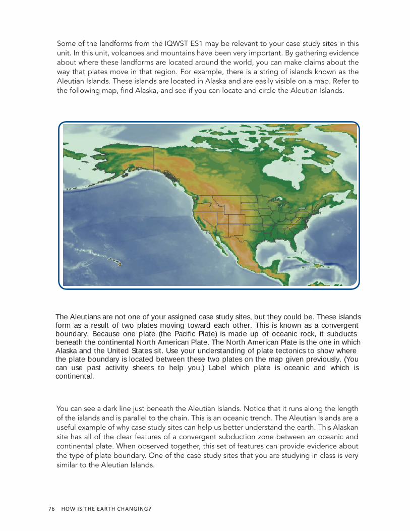
Some of the landforms from the IQWST ES1 may be relevant to your case study sites in this unit. In this unit, volcanoes and mountains have been very important. By gathering evidence about where these landforms are located around the world, you can make claims about the way that plates move in that region. For example, there is a string of islands known as the Aleutian Islands. These islands are located in Alaska and are easily visible on a map. Refer to the following map, find Alaska, and see if you can locate and circle the Aleutian Islands.
You can see a dark line just beneath the Aleutian Islands. Notice that it runs along the length of the islands and is parallel to the chain. This is an oceanic trench. The Aleutian Islands are a useful example of why case study sites can help us better understand the earth. This Alaskan site has all of the clear features of a convergent subduction zone between an oceanic and continental plate. When observed together, this set of features can provide evidence about the type of plate boundary. One of the case study sites that you are studying in class is very similar to the Aleutian Islands.
The Aleutians are not one of your assigned case study sites, but they could be. These islandsform as a result of two plates moving toward each other. This is known as a convergentboundary. Because one plate (the Pacific Plate) is made up of oceanic rock, it subducts beneath the continental North American Plate. The North American Plate is the one in whichAlaska and the United States sit. Use your understanding of plate tectonics to show where the plate boundary is located between these two plates on the map given previously. (You can use past activity sheets to help you.) Label which plate is oceanic and which is continental.
LESSON 10: WHAT IS HAPPENING AT THE CASE STUDY SITE? 77
Which site do you think is most similar? Why is it similar?
In the middle of the Pacific Ocean, you will see another small chain of islands. This is Hawaii. What are some ways that Hawaii and the Aleutian Islands (which you have just learned about) are similar and different? Fill out the following table. You may need to use previously collected evidence and maps to help you.
Hawaiian Islands Hawaiian Islands (Differences)(Differences)
Hawaiian Islands and Hawaiian Islands and Aleutian Islands Aleutian Islands (Similarities)(Similarities)
Aleutian Islands Aleutian Islands (Differences)(Differences)
Both of these sites are useful as case study sites because they have certain characteristics that can be seen in other locations on Earth. Therefore, by studying one site in depth and gathering evidence about what features and characteristics are present at that site, you can gain a better and deeper understanding of many sites on Earth.
78 HOW IS THE EARTH CHANGING?
Making Sense 1. Why do you think the 10 case study sites that you are studying in this unit were
chosen?
2. How can an understanding of one case study site help you understand other places on Earth?

LESSON 10: WHAT IS HAPPENING AT THE CASE STUDY SITE? 79
80 HOW IS THE EARTH CHANGING?
ACTIVITY 10.2 SCIENTIFIC EXPLANATION OF ONE SITEACTIVITY 10.2 SCIENTIFIC EXPLANATION OF ONE SITE
What Will We Do?We will explain how the earth is changing at a single case study site.
Procedure 1. What case site are you studying?
2. For your site, conduct a more in- depth exploration using outside resources. Specifically try to answer the following questions.
• How have geologic events impacted life at that site? How has that site has changed over geologic time?
• How quickly are the plates moving at that site?
• Discuss anything else that interests you.
3. Write a scientific explanation to justify which boundary type is found at your site. Remember a scientific explanation includes a claim (type of boundary), supporting evidence, and reasoning (scientific principles).
Scientific Explanation = Claim + Evidence + Reasoning
Scien fi c Explana on
LESSON 10: WHAT IS HAPPENING AT THE CASE STUDY SITE? 81
4. Pair up with another student who is studying the same site as you. Compare your scientific explanations, and discuss any differences that arise.
5. You and your partner should now compare your explanations with another pair of students who also studied your site.
6. With the members of your group, come to a consensus about the type of plate movement at your site, the evidence in support of that claim, and the scientific principles that explain your evidence.
7. Record any changes to your scientific explanation.
Making Sense 1. What questions do you still have about your case study site?
2. What types of pictures, diagrams, or other additional information are you going to include that will help support your scientific explanation?
82 HOW IS THE EARTH CHANGING?
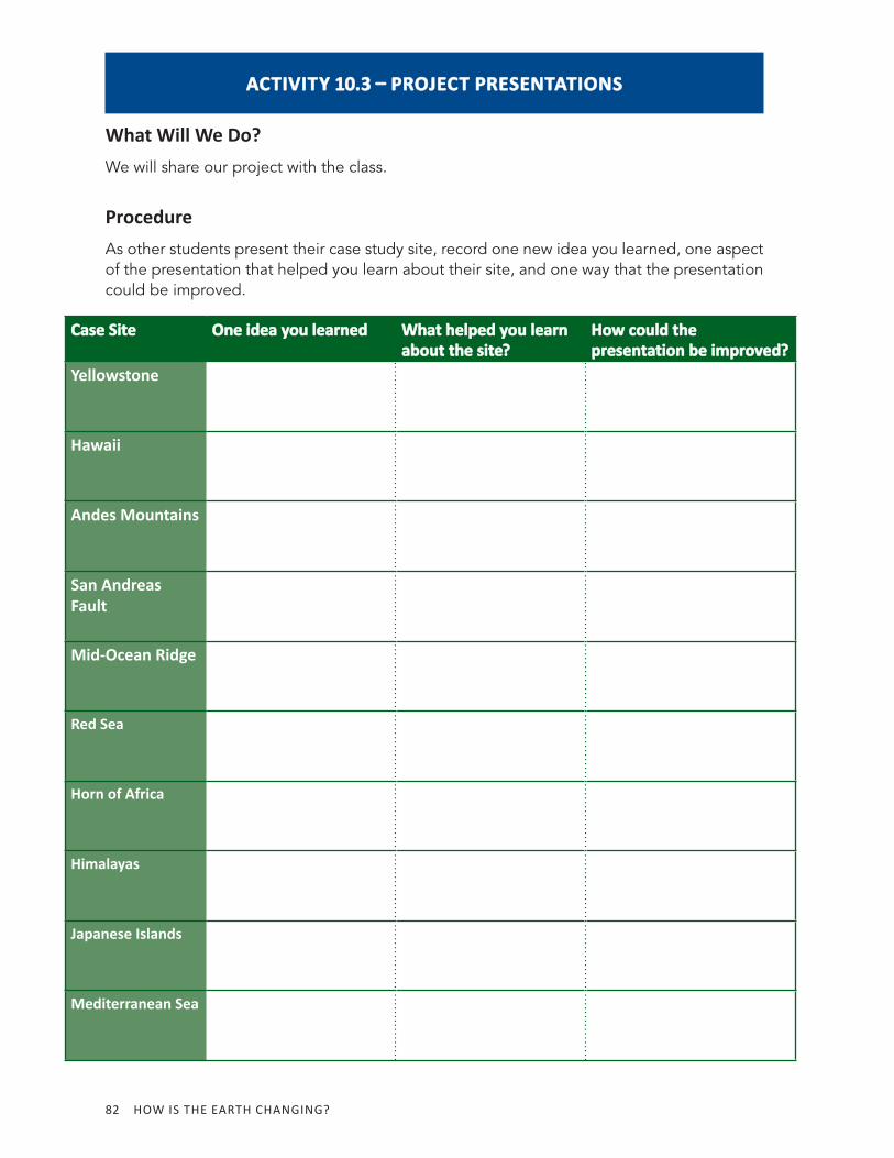
ACTIVITY 10.3 PROJECT PRESENTATIONSACTIVITY 10.3 PROJECT PRESENTATIONS
What Will We Do?We will share our project with the class.
ProcedureAs other students present their case study site, record one new idea you learned, one aspect of the presentation that helped you learn about their site, and one way that the presentation could be improved.
Case SiteCase Site One idea you learnedOne idea you learned What helped you learn What helped you learn about the site?about the site?
How could the How could the presentation be improved?presentation be improved?
Yellowstone
Hawaii
Andes Mountains
San Andreas Fault
Mid-Ocean Ridge
Red Sea
Horn of Africa
Himalayas
Japanese Islands
Mediterranean Sea
LESSON 10: WHAT IS HAPPENING AT THE CASE STUDY SITE? 83
Making Sense 1. Answer the Driving Question for the unit: How Is the Earth Changing?
2. If convection were to stop, would the earth continue to change? Explain your answer.


![[MS-ES3]: Internet Explorer ECMA-262 ECMAScript Language ...jibbering.com/faq/res/[MS-ES3].pdf · association with any real company, organization, product, domain name, email address,](https://img.pdfslide.net/doc/110x75/5f1428d857b81a61b80ca2a6/ms-es3-internet-explorer-ecma-262-ecmascript-language-ms-es3pdf-association.jpg)