Embed Size (px)
Citation preview
Geoscience and Remote Sensing Society
Slide 1
Earth Science Informatics - Overview
H. K. Ramapriyan Science Systems and Applications, Inc.
& NASA Goddard Space Flight Center
USA December 1, 2015
December 1, 2015 IEEE GRSS Chapter, Ahmedabad, India
https://ntrs.nasa.gov/search.jsp?R=20150022472 2018-05-13T14:29:35+00:00Z
Geoscience and Remote Sensing Society
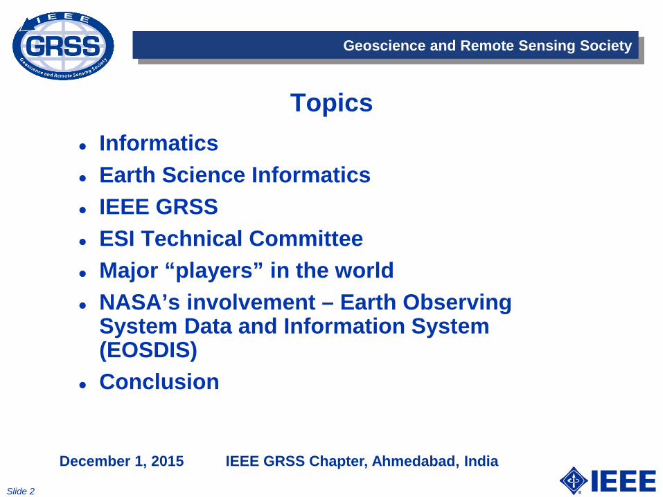
Topics Informatics Earth Science Informatics IEEE GRSS ESI Technical Committee Major “players” in the world NASA’s involvement – Earth Observing
System Data and Information System (EOSDIS)
Conclusion
Slide 2
December 1, 2015 IEEE GRSS Chapter, Ahmedabad, India

NASA’s Earth Science Data Systems
“Advance understanding of Earth and develop technologies to improve the quality of life on our home planet.” -- 2014 NASA Strategic Plan NASA’s Earth Science Data Systems directly support this strategic goal by providing end-to-end capabilities to deliver data and information products to users NASA’s Earth Science Data and Information Policy promotes usage of data by the community • No period of exclusive access - Data are available after initial
checkout • Data available at no cost to all users on a non-discriminatory
basis except where agreed upon with international partners
3
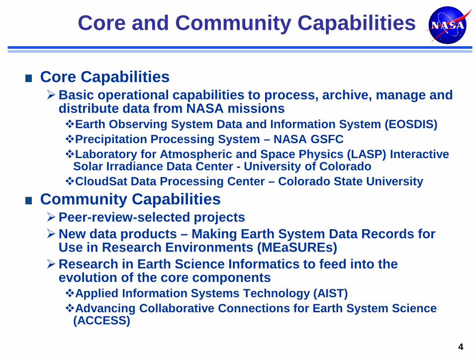
Core and Community Capabilities
Core Capabilities Basic operational capabilities to process, archive, manage and
distribute data from NASA missions Earth Observing System Data and Information System (EOSDIS) Precipitation Processing System – NASA GSFC Laboratory for Atmospheric and Space Physics (LASP) Interactive
Solar Irradiance Data Center - University of Colorado CloudSat Data Processing Center – Colorado State University
Community Capabilities Peer-review-selected projects New data products – Making Earth System Data Records for
Use in Research Environments (MEaSUREs) Research in Earth Science Informatics to feed into the
evolution of the core components Applied Information Systems Technology (AIST) Advancing Collaborative Connections for Earth System Science
(ACCESS)
4

Earth Observing System Data and Information System (EOSDIS)
Major core capability in NASA’s Earth Science Data Systems Program. In operation since August 1994 Provides end-to-end capabilities for managing NASA’s Earth science data. Science Operations Science data processing Data management Interoperable distributed data archives On-line data access services Earth science discipline-oriented user services
Network Data Transport to distributed system elements
5
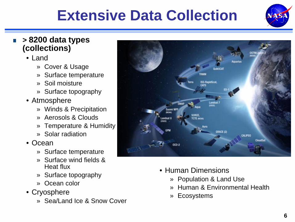
Extensive Data Collection > 8200 data types (collections) • Land
» Cover & Usage » Surface temperature » Soil moisture » Surface topography
• Atmosphere » Winds & Precipitation » Aerosols & Clouds » Temperature & Humidity » Solar radiation
• Ocean » Surface temperature » Surface wind fields &
Heat flux » Surface topography » Ocean color
• Cryosphere » Sea/Land Ice & Snow Cover
6
• Human Dimensions » Population & Land Use » Human & Environmental Health » Ecosystems
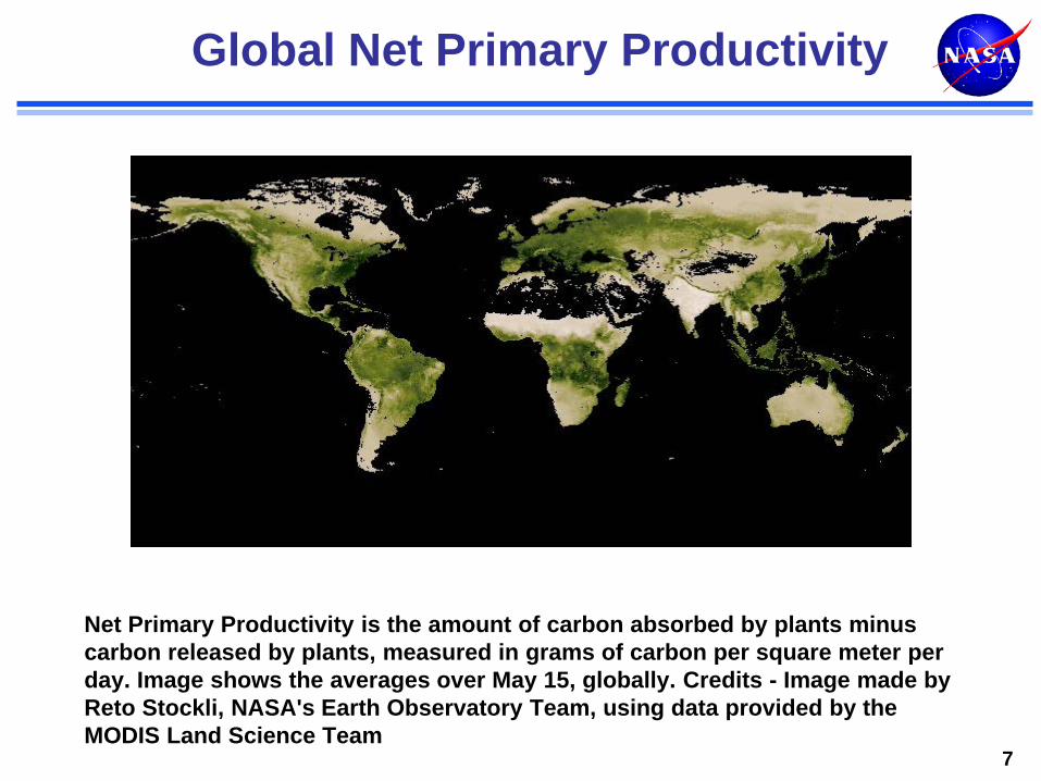
Global Net Primary Productivity
7
Net Primary Productivity is the amount of carbon absorbed by plants minus carbon released by plants, measured in grams of carbon per square meter per day. Image shows the averages over May 15, globally. Credits - Image made by Reto Stockli, NASA's Earth Observatory Team, using data provided by the MODIS Land Science Team
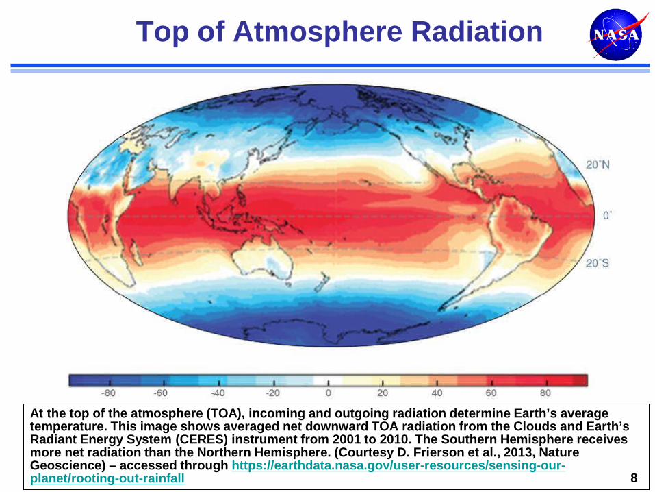
Top of Atmosphere Radiation
At the top of the atmosphere (TOA), incoming and outgoing radiation determine Earth’s average temperature. This image shows averaged net downward TOA radiation from the Clouds and Earth’s Radiant Energy System (CERES) instrument from 2001 to 2010. The Southern Hemisphere receives more net radiation than the Northern Hemisphere. (Courtesy D. Frierson et al., 2013, Nature Geoscience) – accessed through https://earthdata.nasa.gov/user-resources/sensing-our-planet/rooting-out-rainfall 8
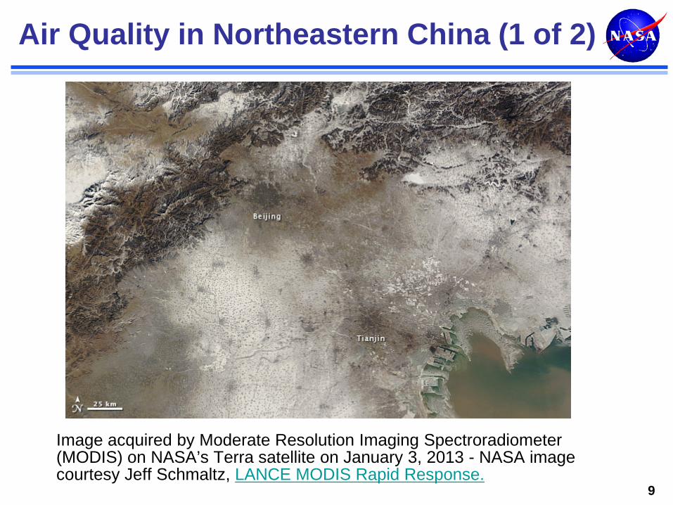
Air Quality in Northeastern China (1 of 2)
Image acquired by Moderate Resolution Imaging Spectroradiometer (MODIS) on NASA’s Terra satellite on January 3, 2013 - NASA image courtesy Jeff Schmaltz, LANCE MODIS Rapid Response.
9
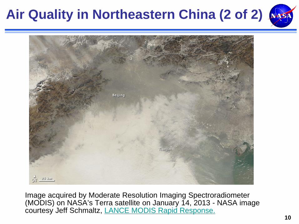
Air Quality in Northeastern China (2 of 2)
10
Image acquired by Moderate Resolution Imaging Spectroradiometer (MODIS) on NASA’s Terra satellite on January 14, 2013 - NASA image courtesy Jeff Schmaltz, LANCE MODIS Rapid Response.
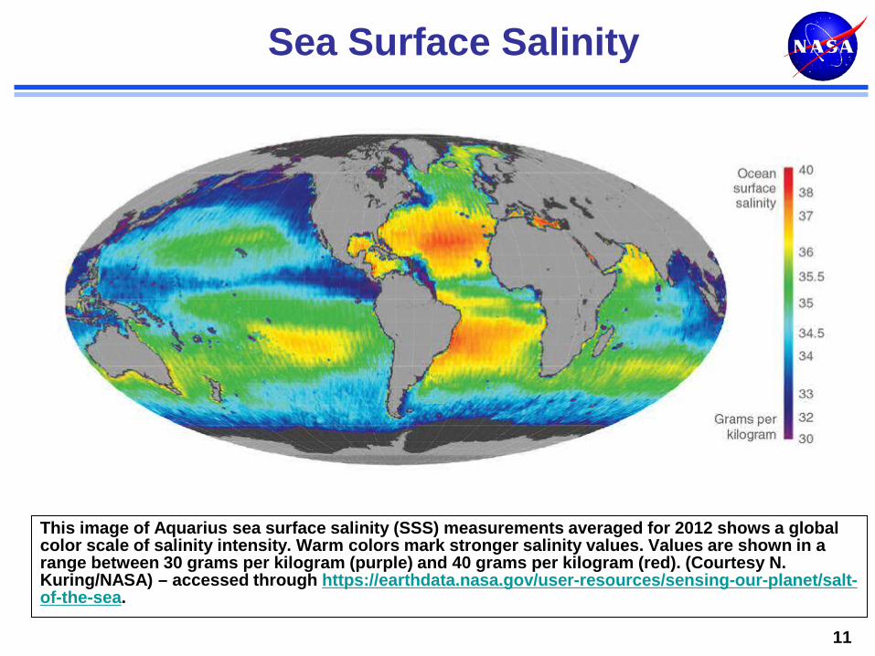
Sea Surface Salinity
This image of Aquarius sea surface salinity (SSS) measurements averaged for 2012 shows a global color scale of salinity intensity. Warm colors mark stronger salinity values. Values are shown in a range between 30 grams per kilogram (purple) and 40 grams per kilogram (red). (Courtesy N. Kuring/NASA) – accessed through https://earthdata.nasa.gov/user-resources/sensing-our-planet/salt-of-the-sea.
11
12
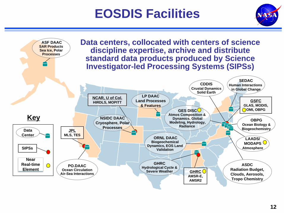
EOSDIS Facilities
Data centers, collocated with centers of science discipline expertise, archive and distribute
standard data products produced by Science Investigator-led Processing Systems (SIPSs)
ASF DAAC SAR Products Sea Ice, Polar
Processes
SEDAC Human Interactions
in Global Change
LP DAAC Land Processes
& Features
PO.DAAC Ocean Circulation
Air-Sea Interactions
ASDC Radiation Budget, Clouds, Aerosols, Tropo Chemistry
ORNL DAAC Biogeochemical
Dynamics, EOS Land Validation
GES DISC Atmos Composition &
Dynamics, Global Modeling, Hydrology,
Radiance
LAADS/ MODAPS
Atmosphere
OBPG Ocean Biology & Biogeochemistry
GHRC Hydrological Cycle &
Severe Weather
CDDIS Crustal Dynamics
Solid Earth NCAR, U of Col. HIRDLS, MOPITT GSFC
GLAS, MODIS, OMI, OBPG
GHRC AMSR-E, AMSR2
JPL MLS, TES
NSIDC DAAC Cryosphere, Polar
Processes
SIPSs
Key Data
Center
Near Real-time Element
050
100150200250300350400450500550600650700750800850900950
1,0001,0501,100
FY00 FY01 FY02 FY03 FY04 FY05 FY06 FY07 FY08 FY09 FY10 FY11 FY12 FY13 FY14 todate Sep
Millions
13
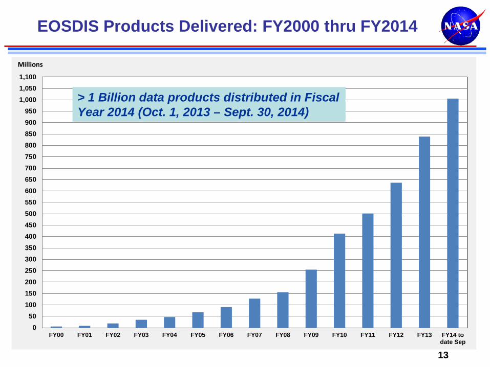
EOSDIS Products Delivered: FY2000 thru FY2014
> 1 Billion data products distributed in Fiscal Year 2014 (Oct. 1, 2013 – Sept. 30, 2014)

Recent and On-Going Developments (1 of 2)
Land and Atmosphere Near real-time Capability for EOS (LANCE) Coherent Web Interface: http://earthdata.nasa.gov is operational • Provides a unified view of NASA Earth science data system
resources • Consolidates 14 web sites, and provides links to various ways
to access data and to related external sites User Registration System – uniform approach to registration across EOSDIS components Global Imagery Browse Services (GIBS) • Standards-based, full resolution, interactive browse capability • Accessible from http://earthdata.nasa.gov wiki
14
Recent and On-Going Developments (2 of 2)
Metadata Architecture Study • Initial Study made recommendations on adopting a common
approach to metadata to improve user experience and reduce efforts by data providers
• Phased approach to implementing recommendations Unified Metadata Model and Common Metadata Repository Big Earth Data Initiative (BEDI) Preservation Content Specification Digital Object Identifiers • ESDIS Project is a registration authority (prefix 10.5067) • DOI assignments to datasets in progress
15
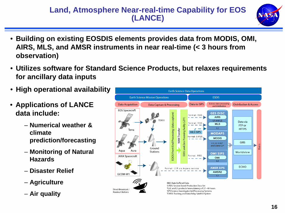
• Building on existing EOSDIS elements provides data from MODIS, OMI, AIRS, MLS, and AMSR instruments in near real-time (< 3 hours from observation)
• Utilizes software for Standard Science Products, but relaxes requirements for ancillary data inputs
• High operational availability
Land, Atmosphere Near-real-time Capability for EOS (LANCE)
16
• Applications of LANCE data include:
– Numerical weather & climate prediction/forecasting
– Monitoring of Natural Hazards
– Disaster Relief
– Agriculture
– Air quality
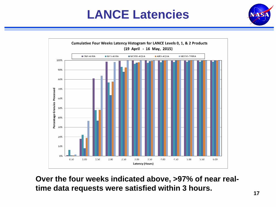
LANCE Latencies
17
Over the four weeks indicated above, >97% of near real-time data requests were satisfied within 3 hours.
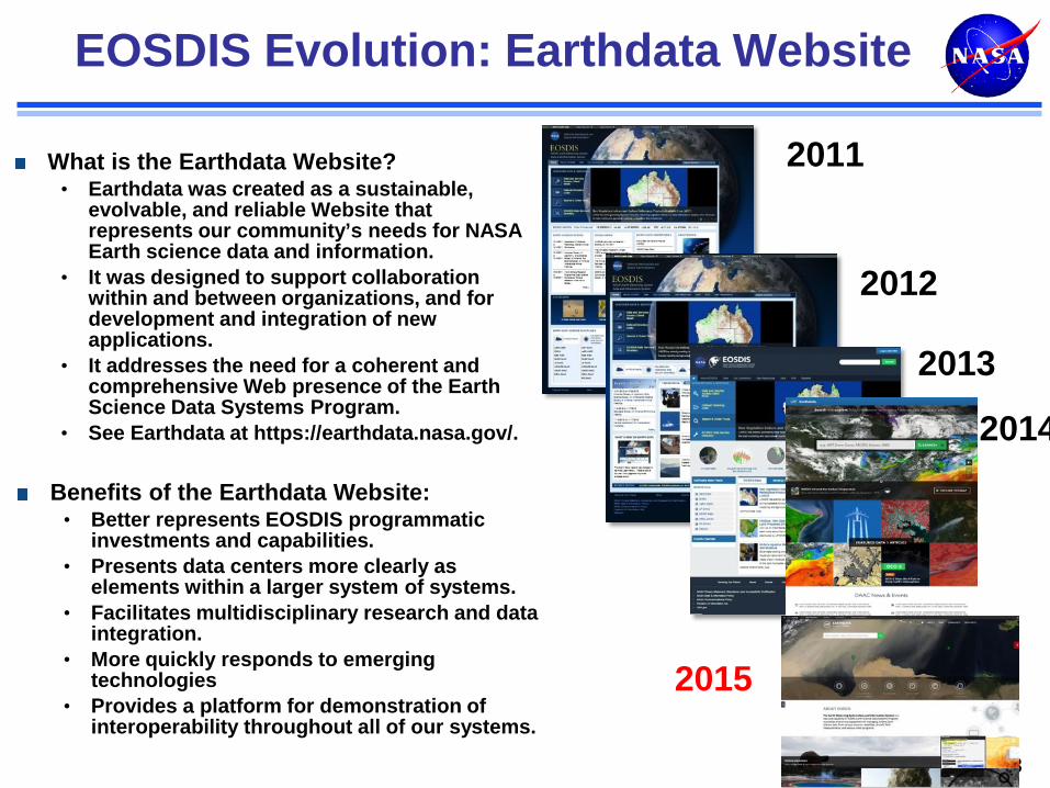
EOSDIS Evolution: Earthdata Website
18
What is the Earthdata Website? • Earthdata was created as a sustainable,
evolvable, and reliable Website that represents our community’s needs for NASA Earth science data and information.
• It was designed to support collaboration within and between organizations, and for development and integration of new applications.
• It addresses the need for a coherent and comprehensive Web presence of the Earth Science Data Systems Program.
• See Earthdata at https://earthdata.nasa.gov/.
Benefits of the Earthdata Website: • Better represents EOSDIS programmatic
investments and capabilities. • Presents data centers more clearly as
elements within a larger system of systems. • Facilitates multidisciplinary research and data
integration. • More quickly responds to emerging
technologies • Provides a platform for demonstration of
interoperability throughout all of our systems.
2011
2012
2013
2014
2015
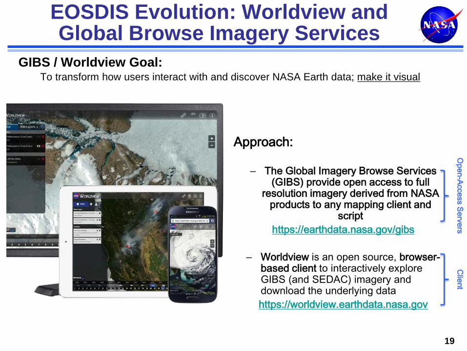
EOSDIS Evolution: Worldview and Global Browse Imagery Services
19
GIBS / Worldview Goal: To transform how users interact with and discover NASA Earth data; make it visual
Approach:
– The Global Imagery Browse Services (GIBS) provide open access to full
resolution imagery derived from NASA products to any mapping client and
script https://earthdata.nasa.gov/gibs
– Worldview is an open source, browser-
based client to interactively explore GIBS (and SEDAC) imagery and download the underlying data https://worldview.earthdata.nasa.gov
Open-Access Servers
Client
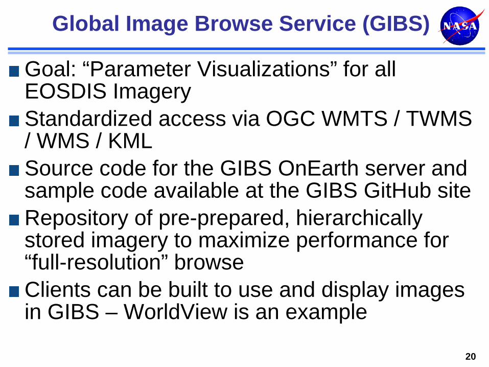
Global Image Browse Service (GIBS)
Goal: “Parameter Visualizations” for all EOSDIS Imagery Standardized access via OGC WMTS / TWMS / WMS / KML Source code for the GIBS OnEarth server and sample code available at the GIBS GitHub site Repository of pre-prepared, hierarchically stored imagery to maximize performance for “full-resolution” browse Clients can be built to use and display images in GIBS – WorldView is an example
20
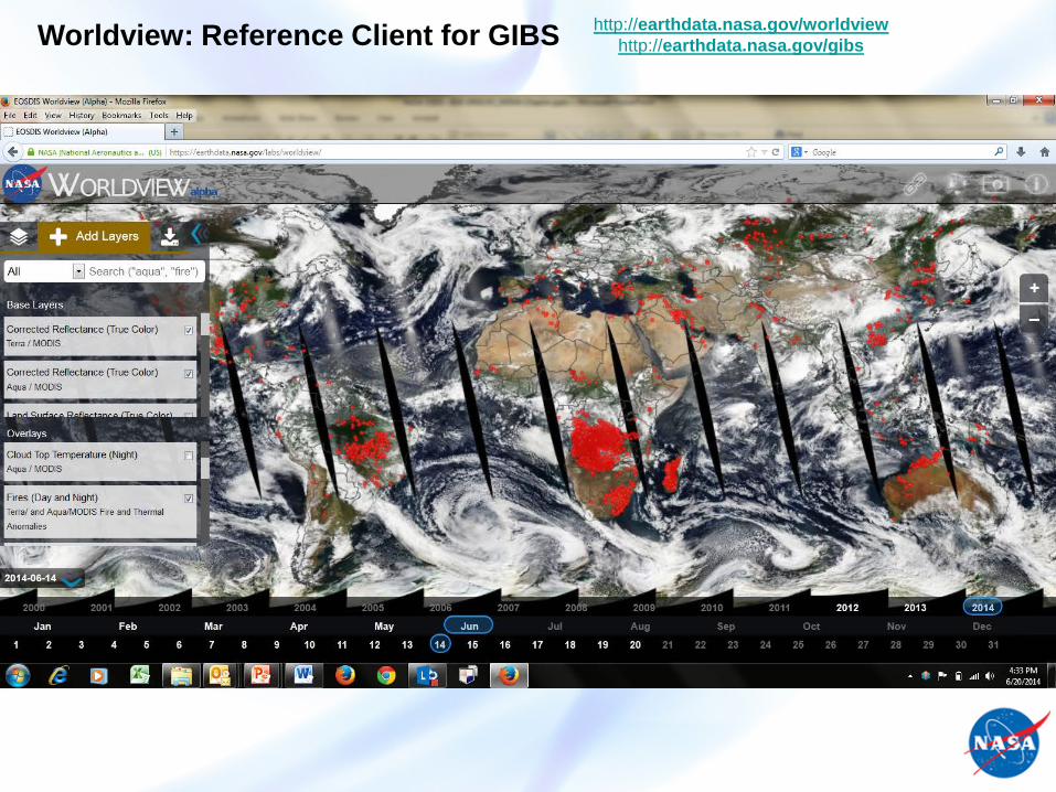
Worldview: Reference Client for GIBS http://earthdata.nasa.gov/worldview http://earthdata.nasa.gov/gibs
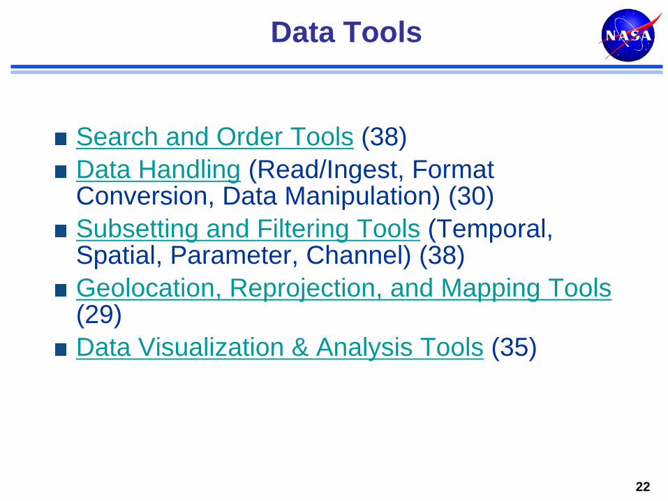
Data Tools
Search and Order Tools (38) Data Handling (Read/Ingest, Format Conversion, Data Manipulation) (30) Subsetting and Filtering Tools (Temporal, Spatial, Parameter, Channel) (38) Geolocation, Reprojection, and Mapping Tools (29) Data Visualization & Analysis Tools (35)
22
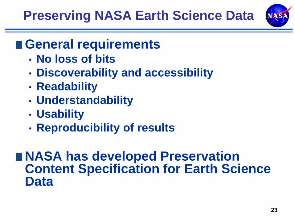
Preserving NASA Earth Science Data
General requirements • No loss of bits • Discoverability and accessibility • Readability • Understandability • Usability • Reproducibility of results
NASA has developed Preservation Content Specification for Earth Science Data
23
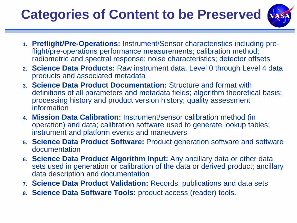
Categories of Content to be Preserved
1. Preflight/Pre-Operations: Instrument/Sensor characteristics including pre-flight/pre-operations performance measurements; calibration method; radiometric and spectral response; noise characteristics; detector offsets
2. Science Data Products: Raw instrument data, Level 0 through Level 4 data products and associated metadata
3. Science Data Product Documentation: Structure and format with definitions of all parameters and metadata fields; algorithm theoretical basis; processing history and product version history; quality assessment information
4. Mission Data Calibration: Instrument/sensor calibration method (in operation) and data; calibration software used to generate lookup tables; instrument and platform events and maneuvers
5. Science Data Product Software: Product generation software and software documentation
6. Science Data Product Algorithm Input: Any ancillary data or other data sets used in generation or calibration of the data or derived product; ancillary data description and documentation
7. Science Data Product Validation: Records, publications and data sets 8. Science Data Software Tools: product access (reader) tools.
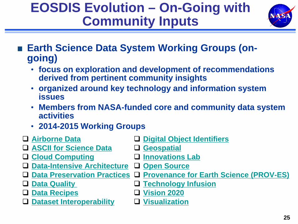
EOSDIS Evolution – On-Going with Community Inputs
Earth Science Data System Working Groups (on-going) • focus on exploration and development of recommendations
derived from pertinent community insights • organized around key technology and information system
issues • Members from NASA-funded core and community data system
activities • 2014-2015 Working Groups
25
Digital Object Identifiers Geospatial Innovations Lab Open Source Provenance for Earth Science (PROV-ES) Technology Infusion Vision 2020 Visualization
Airborne Data ASCII for Science Data Cloud Computing Data-Intensive Architecture Data Preservation Practices Data Quality Data Recipes Dataset Interoperability
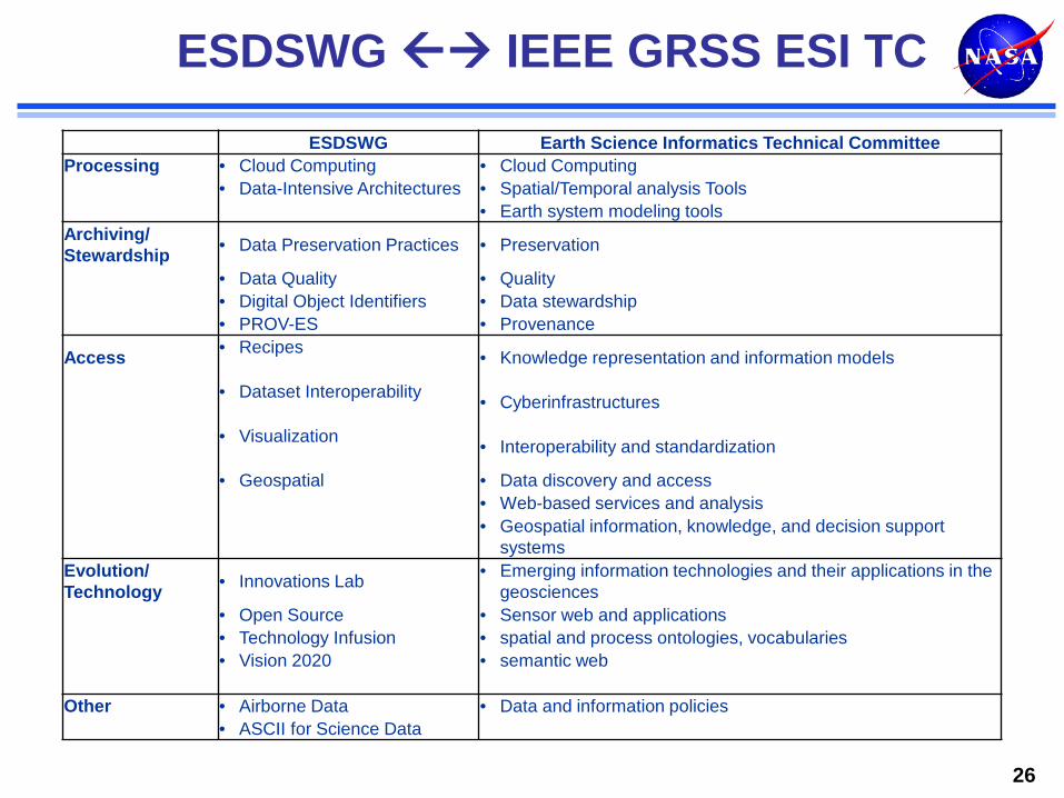
ESDSWG IEEE GRSS ESI TC
26
ESDSWG Earth Science Informatics Technical Committee Processing • Cloud Computing • Cloud Computing • Data-Intensive Architectures • Spatial/Temporal analysis Tools • Earth system modeling tools Archiving/ Stewardship • Data Preservation Practices • Preservation
• Data Quality • Quality • Digital Object Identifiers • Data stewardship • PROV-ES • Provenance
Access • Recipes • Knowledge representation and information models
• Dataset Interoperability • Cyberinfrastructures
• Visualization • Interoperability and standardization
• Geospatial • Data discovery and access • Web-based services and analysis
• Geospatial information, knowledge, and decision support systems
Evolution/ Technology • Innovations Lab • Emerging information technologies and their applications in the
geosciences • Open Source • Sensor web and applications • Technology Infusion • spatial and process ontologies, vocabularies • Vision 2020 • semantic web Other • Airborne Data • Data and information policies • ASCII for Science Data
Geoscience and Remote Sensing Society
Conclusion
Earth Science Informatics is a rapidly developing discipline
Many organizations around the world are actively pursuing ESI R & D
Considerable commonality of interests among these organizations
IEEE GRSS ESI TC, ESIP Federation, Research Data Alliance (RDA) are examples of groups promoting collaboration
Slide 27