Embed Size (px)
Citation preview

Earth Science
Regents Questions: Plate Tectonics
Name:_______________________________________________________Date:_____________Period:___
Due Date: _____________
August 2014
16 Rifting of tectonic plates in eastern North America during the Jurassic Period was responsible for the
(1) formation of the Catskill delta (3) Alleghenian orogeny
(2) first uplift of the Adirondack Mountains (4) opening of the Atlantic Ocean
21 Oceanic crust is sliding beneath the Aleutian Islands in the North Pacific Ocean, forming the Aleutian Trench
at a
(1) convergent plate boundary between the Pacific Plate and the North American Plate
(2) convergent plate boundary between the Pacific Plate and the Juan de Fuca Plate
(3) divergent plate boundary between the Pacific Plate and the North American Plate
(4) divergent plate boundary between the Pacific Plate and the Juan de Fuca Plate
35 On the map below, points A through D represent locations on Earth’s surface.
Which location is positioned over a mantle hot spot?
(1) A (3) C
(2) B (4) D
Base your answers to questions 83 through 85 on the maps and table below and on your knowledge of
Earth science. The maps show earthquake intensities (IV to IX), according to the table of the Modified Mercalli
Intensity Scale, for the 1906 and 1989 earthquakes at several locations in California.

The asterisk( * ) on each map is the location of each epicenter. The dashed line represents the location of a major
fault.
85 Explain why Santa Rosa experienced a lower Modified Mercalli intensity shaking than Salinas experienced
during the 1989 earthquake. [1]
83 Name the major fault along which both of these earthquakes occurred and identify the type of plate tectonic
boundary that is located along this fault. [1]
84 Based on the Modified Mercalli Intensity Scale, identify the perceived shaking and the observed damage
that occurred in the San Francisco area during the 1906 earthquake. [1]
85 Explain why Santa Rosa experienced a lower Modified Mercalli intensity shaking than Salinas experienced
during the 1989 earthquake. [1]

June 2014 18 The map below shows California and a section of the San Andreas Fault.
What is the primary geologic process occurring
along the San Andreas Fault?
(1) transform movement (3) subduction
(2) spreading movement (4) convergence
19 Compared to the oceanic crust, the continental crust is usually
(1) thicker, with a less dense granitic composition
(2) thicker, with a more dense basaltic composition
(3) thinner, with a less dense granitic composition
(4) thinner, with a more dense basaltic composition
20 Which mantle hot spot is located directly below a mid-ocean ridge plate boundary?
(1) Yellowstone (2) Iceland (3) Canary Islands (4) Hawaii
Base your answers to questions 32 and 33 on the cross section below and on your knowledge of Earth
science. The cross section represents the distance and age of ocean-floor bedrock found on both sides of the
Mid-Atlantic Ridge.

32 According to the cross section, every 1 million years, the ocean floor bedrock moves approximately
(1) 20 km toward the Mid-Atlantic Ridge (3) 40 km toward the Mid-Atlantic Ridge
(2) 20 km away from the Mid-Atlantic Ridge (4) 40 km away from the Mid-Atlantic Ridge
33 Which map best represents the pattern of magnetic polarity in the minerals of ocean-floor bedrock on each side
of the Mid-Atlantic Ridge?
Base your answers to questions 81 through 83 on the data table below, on the graph in your answer booklet, and on
your knowledge of Earth science. The data table shows the velocity of seismic S-waves at various depths below
Earth’s surface. The graph shows the velocity of seismic P-waves at various depths below Earth’s surface. Letter A
is a point on the graph.
81 On the graph below, plot the S-wave velocity at each depth given on the data table. Connect the plots with a
line. [1]

82 What property of Earth’s interior causes the S-waves to stop at 2900 km, but allows the P-waves to
continue? [1]
83 State the pressure and temperature of Earth’s interior at the depth indicated by point A on the graph. [1]
January2014 19 A P-wave takes 5 minutes to travel from the epicenter of an earthquake to a seismic station.
Approximately how many minutes will it take an S-wave to travel that same distance?
(1) 15 min (2) 12 min (3) 9 min (4) 4 min
20 Which two Earth layers are separated by the Moho boundary?
(1) rigid mantle and plastic mantle (3) stiffer mantle and asthenosphere
(2) outer core and stiffer mantle (4) crust and rigid mantle

31 The map below shows changes in the position of the tsunami wave front produced by the 1964 Alaskan
earthquake. The numbers indicate the time, in hours, for the wave front to reach the positions indicated by
the isolines.
If the wave front reached the Hawaiian Islands at 10:30 p.m., at approximately what time did the
earthquake occur?
(1) 1:30 p.m. (2) 5:30 p.m. (3) 3:30 a.m (4) 4:30 a.m.
32 The diagram below represents the analysis of a seismogram used to calculate an earthquake’s magnitude on
the Richter Scale. This seismogram shows the difference in arrival times, in seconds, of the first P-wave and
S-wave and the amplitude of the S-wave in millimeters.

The diagram below represents how the earthquake’s magnitude is determined by drawing a line connecting
the difference in arrival times of the P-wave and the S-wave, and the S-wave amplitude.
What is the magnitude of a recorded earthquake if the difference in arrival times of the first P-wave and
S-wave is 2 seconds and the S-wave amplitude is 20 millimeters?
(1) 3.8 (2) 2.0 (3) 3.0 (4) 4.8
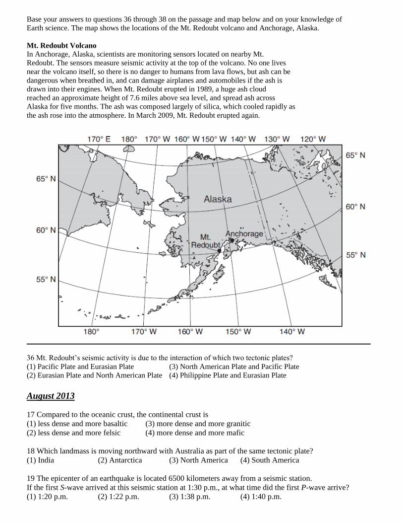
Base your answers to questions 36 through 38 on the passage and map below and on your knowledge of
Earth science. The map shows the locations of the Mt. Redoubt volcano and Anchorage, Alaska.
Mt. Redoubt Volcano
In Anchorage, Alaska, scientists are monitoring sensors located on nearby Mt.
Redoubt. The sensors measure seismic activity at the top of the volcano. No one lives
near the volcano itself, so there is no danger to humans from lava flows, but ash can be
dangerous when breathed in, and can damage airplanes and automobiles if the ash is
drawn into their engines. When Mt. Redoubt erupted in 1989, a huge ash cloud
reached an approximate height of 7.6 miles above sea level, and spread ash across
Alaska for five months. The ash was composed largely of silica, which cooled rapidly as
the ash rose into the atmosphere. In March 2009, Mt. Redoubt erupted again.
36 Mt. Redoubt’s seismic activity is due to the interaction of which two tectonic plates?
(1) Pacific Plate and Eurasian Plate (3) North American Plate and Pacific Plate
(2) Eurasian Plate and North American Plate (4) Philippine Plate and Eurasian Plate
August 2013
17 Compared to the oceanic crust, the continental crust is
(1) less dense and more basaltic (3) more dense and more granitic
(2) less dense and more felsic (4) more dense and more mafic
18 Which landmass is moving northward with Australia as part of the same tectonic plate?
(1) India (2) Antarctica (3) North America (4) South America
19 The epicenter of an earthquake is located 6500 kilometers away from a seismic station.
If the first S-wave arrived at this seismic station at 1:30 p.m., at what time did the first P-wave arrive?
(1) 1:20 p.m. (2) 1:22 p.m. (3) 1:38 p.m. (4) 1:40 p.m.

Base your answers to questions 42 and 43 on the map below and on your knowledge of Earth science. The
map shows the coast of the northwestern United States. The Explorer and Gorda ridges and plates are parts of the
Juan de Fuca tectonic system.
42 The arrow on which map best shows the direction of movement of the Juan de Fuca Plate in relation to the Juan
de Fuca Ridge?
43 The Explorer Ridge is the boundary between the Explorer Plate and the
(1) North American Plate (2) Pacific Plate (3) Juan de Fuca Plate (4) Gorda Plate

Base your answers to questions 77 through 79 on the passage below and on your knowledge of Earth
science. The passage describes unusual lava from a volcano in Africa.
Unusual Volcano
Nyiragongo, located at 2° S 29° E, is an active African volcano. It has the most fluid lava on Earth. The lava has a
composition unlike any other lava in the world. The rare isotopes found in the lava are similar to those found in
ancient asteroids. This fact leads scientists to infer that the lava may be as old as our solar system and that it comes
from deep inside the mantle near Earth’s outer core. Nyiragongo is one volcano in a ring of many volcanoes
surrounding an area that is domed upward nearly a mile above sea level, causing scientists to infer that a new
mantle hot spot is forming there.
77 Two rocks, scoria and basalt, have formed from the cooled lava that erupted from Nyiragongo. Describe the
texture of each rock. [1]
78 Identify the type of tectonic plate boundary found in the vicinity of Nyiragongo. [1]
79 Identify two other locations on Earth, not on a plate boundary, where mantle rock is rising to Earth’s
surface. [1]
June 2013
6 Which hot spot location on Earth’s surface usually receives the greatest intensity of insolation on June 21?
(1) Iceland (2) Hawaii (3) Easter Island (4) Yellowstone
20 Earth’s internal heat is the primary source of energy that
(1) warms the lower troposphere (3) moves the lithospheric plates
(2) melts glacial ice at lower altitudes (4) pollutes deep groundwater with radioactivity
21 The cross section of Earth below represents a P-wave moving away from an earthquake epicenter. Seismic
station A is shown on Earth’s surface.
At station A, the first P-wave arrives 11 minutes 40 seconds after the earthquake. How long after
the first P-wave arrives will the first S-wave arrive?
(1) 5 minutes 00 second (3) 9 minutes 40 seconds
(2) 8 minutes 40 seconds (4) 21 minutes 20 seconds

22 The Aleutian Islands extend westward from southern Alaska to form the northern boundary of the Pacific
Ocean. These volcanic islands were formed by the nearby
(1) subduction of a continental plate (3) divergence of a continental plate
(2) subduction of an oceanic plate (4) divergence of an oceanic plate
35 The cross section below represents a pattern of magnetic field reversals preserved in the igneous bedrock
of the oceanic crust east of the Mid-Atlantic ridge.
Which cross section best represents the magnetic field pattern west of the Mid-Atlantic ridge?
Base your answers to questions 69 through 73 on the map below and on your knowledge of Earth
science. The map shows the major islands in the Galapagos Island chain. These islands were formed by volcanic
eruptions as the tectonic plate passed over the Galapagos Hot Spot. The age of the volcanic bedrock on certain
islands is shown in millions of years (my).

69 During what geologic epoch did the bedrock on the island of San Cristóbal form? [1]
70 Based on the age of the bedrock of the Galapagos Islands, in which direction does the tectonic plate
containing the islands appear to be moving away from the Galapagos Hot Spot? [1]
71 The Galapagos Hot Spot is located closest to what type of tectonic plate boundary? [1]
72 Describe what caused a vesicular texture in some of the volcanic rocks that formed when lava cooled on
these islands. [1]
73 Some of the magma at the Galapagos Hot Spot is believed to originate 1000 kilometers below Earth’s
surface. What is the approximate temperature of Earth’s interior at that depth? [1]