Embed Size (px)
Citation preview

EARTHQUAKES AND TSUNAMI IN HAWAI‘I (GG104)
2006
1975
~50 years ofHawai‘i seismicity

From: 2006 Kiholo Bay, Hawaii Earthquake, RMS Event Report

http://hvo.wr.usgs.gov/earthquakes/hazards/hazardmap.gif
Earthquake hazard zones, used mainly for building codes

The most numerous Hawai‘i earthquakes arecaused by propagatingdikes in rift zones. But they are very small.
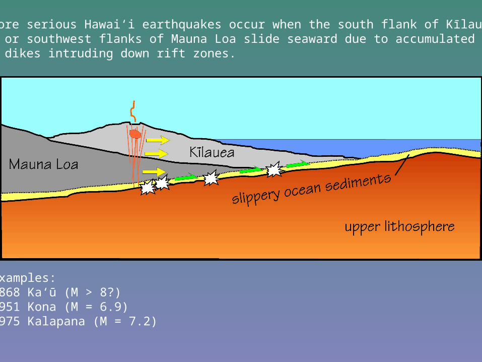
Bigger, more serious Hawai‘i earthquakes occur when the south flank of Kīlauea and thesoutheast or southwest flanks of Mauna Loa slide seaward due to accumulated straincaused by dikes intruding down rift zones.
Examples:1868 Ka‘ū (M > 8?)1951 Kona (M = 6.9)1975 Kalapana (M = 7.2)

“About ten o’clock A.M. on the 28th (Saturday), a series ofearthquakes began…From this time until the 10th of April the earthwas in an almost constant tremor. In the district of Kona as manyas fifty or sixty distinct shocks were counted in one day; in Kauover three hundred in the same time; while near Kilauea andabout Kapapala it was difficult to count them…The culminatingshock came on Thursday, April 2nd, at twenty minutes before fourin the afternoon. Every stone wall, almost every house, in Kauwas overturned, and the whole was done in an instant. A gentleman riding found his horse lying flat underhim before he could think of the cause, and persons were thrown to the groundin an equally unexpected manner…
-Brigham (1909) The Volcanoes of Kilauea and Mauna Loa on theIsland of Hawaii, Bishop Museum Press.
An account of the 1868 Ka‘ū earthquake

Slide by Carolina Anchieta and Cecily Wolfe
The third major type of Hawai‘i earthquake occurs as the lithosphere flexes under theWeight of the islands. The 2006 Kīholo Bay earthquake (M 6.9) was one of these.

http://hvo.wr.usgs.gov/earthquakes/destruct/1975Nov29/75eqHoriz.gif
Displacements associated with the 1975 M 7.2 Kalapana earthquake

http://hvo.wr.usgs.gov/earthquakes/destruct/1975Nov29/75eqVert.gif
Subsidence associated with the 1975 Kalapana earthquake

http://volcanoes.usgs.gov/Imgs/Jpg/Photoglossary/fault1_large.jpg
The south flank of Kīlauea, showing numerous down-dropped blocks
Halapē

http://www.tsunami.org/archives1975.html
Troop 77, heading out for Halapē, November 27, 1975

Senior patrol leader of his Hilo, Hawaii, scout troop, eighth-grader Dylan looks forward to camping on the coast in the shadow of a volcano. But when he hears that Louie, a tough, troubled kid, will be joining the scouts on the trip, Dylan remembers when their paths crossed once before, and his anticipation turns to dread. Dylan's sense of foreboding is justified tenfold. After a difficult trek to their campsite, an earthquake jolts the ground and shakes boulders down from the cliff. Then a tsunami engulfs the area. Even in the midst of disaster, Dylan finds that support can come from unexpected directions. A strong sense of place informs the plot as well as the setting of this convincing story. In an unusually compelling author's note, Salisbury writes of camping on the site of the 1975 natural disaster at Halape with his cousin, who lived through it as a Boy Scout. Inspired by that earthquake and tsunami, this vivid adventure soon strips away every vestige of normality, leaving characters dependent on their wits, their skills, and the mysterious spirits of land and sea for their survival. Salisbury weaves Hawaiian legend into the modern-day narrative to create a haunting, unusual novel that will practically booktalk itself.--Phelan, Carolyn Copyright 2007 Booklist
http://syndetics.com/index.php?isbn=0385731221/blreview.html&client=pricp&type=rn12

http://hvo.wr.usgs.gov/earthquakes/destruct/1975Nov29/30424303_005_L.jpg
Halapē before the 1975 earthquake

http://hvo.wr.usgs.gov/earthquakes/destruct/1975Nov29/30424303_006_L.jpg
Halapē after the 1975 earthquake

From: Reconnaissance Following the October 15th, 2006 Earthquakes on the Island of Hawai`iBy Ian Robertson, Peter Nicholson, Horst Brandes (UH Mānoa School of Engineering)
The October 15, 2006 Kīholo Bay and Hāwī earthquakes

Slide by Carolina Anchieta and Cecily Wolfe

Seismic record from HVO, showing the 2006Kiholo Bay earthquake
http://hvo.wr.usgs.gov/archive/HUA_EHZ_HV.2006101512.gif

[Watts and Ten Brink, 1989]
Slide by Carolina Anchieta and Cecily Wolfe

USGS “Shake map”, showing peak ground acceleration
From: 2006 Kiholo Bay, Hawaii Earthquake, RMS Event Report
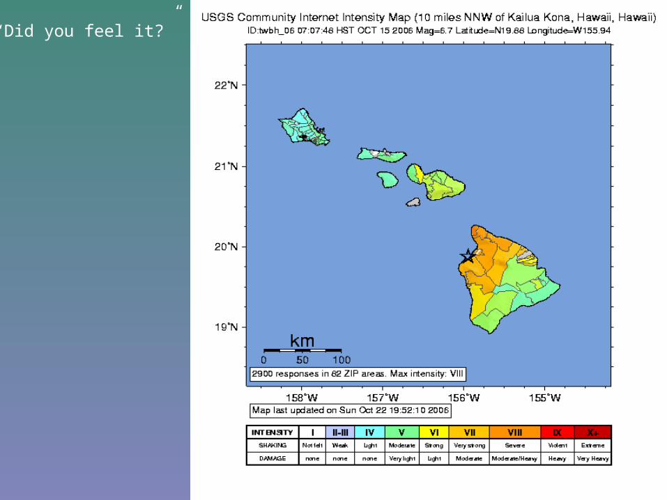
“Did you feel it?”

Ground accelerations recorded at Waimea Fire Station during the Mw 6.7 KiholoBay (top) and Mw 6.0 Hawi (bottom) earthquakes. Note: gravitational acceleration(i.e., the force of gravity that we feel) is 980 cm s-2 (red lines).
From: Reconnaissance Following the October 15th, 2006 Earthquakes on the Island of Hawai`iBy Ian Robertson, Peter Nicholson, Horst Brandes (UH Mānoa School of Engineering)

Kalahikiola Church in Hāwī
From: Reconnaissance Following the October 15th, 2006 Earthquakes on the Island of Hawai`iBy Ian Robertson, Peter Nicholson, Horst Brandes (UH Mānoa School of Engineering)

Mauna Kea Beach hotel
From: Reconnaissance Following the October 15th, 2006 Earthquakes on the Island of Hawai`iBy Ian Robertson, Peter Nicholson, Horst Brandes (UH Mānoa School of Engineering)

From: Reconnaissance Following the October 15th, 2006 Earthquakes on the Island of Hawai`iBy Ian Robertson, Peter Nicholson, Horst Brandes (UH Mānoa School of Engineering)
Mauna Kea Beach hotel

From: Reconnaissance Following the October 15th, 2006 Earthquakes on the Island of Hawai`iby Ian Robertson, Peter Nicholson, Horst Brandes (UH Mānoa School of Engineering)
Typical timber framed residence at Pololū Valley Lookout on pier-and-beamconstruction

Shear failure of bolts securing girt to corner column
From: Reconnaissance Following the October 15th, 2006 Earthquakes on the Island of Hawai`iby Ian Robertson, Peter Nicholson, Horst Brandes (UH Mānoa School of Engineering)

Example of discontinuous geology where dense ‘a‘ā core overlies weakerand less stable clinker
From: Reconnaissance Following the October 15th, 2006 Earthquakes on the Island of Hawai`iby Ian Robertson, Peter Nicholson, Horst Brandes (UH Mānoa School of Engineering)

Rockslides from pali near Waipi‘o Valley lookout, shortly after (during?) Kīholo Bay EQ
Hilo Tribune Herald

From: Reconnaissance Following the October 15th, 2006 Earthquakes on the Island of Hawai`iby Ian Robertson, Peter Nicholson, Horst Brandes (UH Mānoa School of Engineering)
Collapse of un-mortared and unreinforced retaining wall in Honoka‘a