Embed Size (px)
Citation preview

East Central Regional Rail Trail Management Plan
Managed Jointly by
Brevard County and Volusia County
August 2009 – August 2019
Prepared by: County of Volusia
in partnership with the Space Coast Transportation Planning Organization
and the Brevard County Parks and Recreation Department


DSL Approval Letter
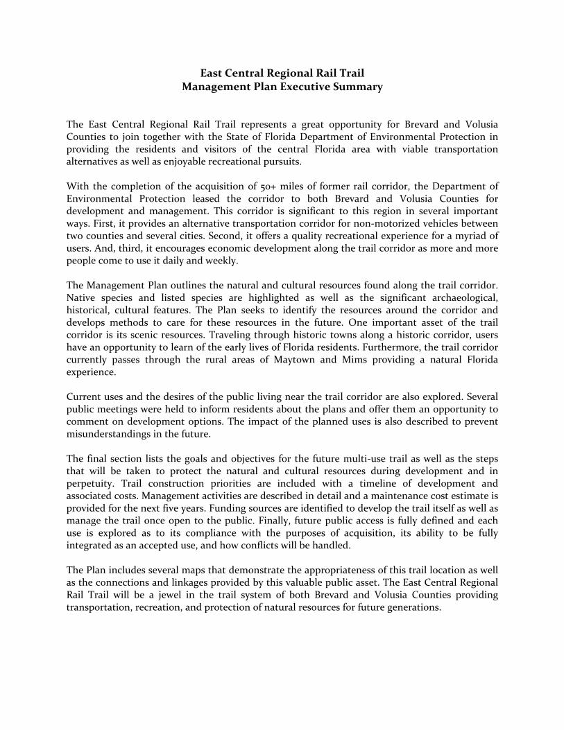
East Central Regional Rail Trail Management Plan Executive Summary
The East Central Regional Rail Trail represents a great opportunity for Brevard and Volusia Counties to join together with the State of Florida Department of Environmental Protection in providing the residents and visitors of the central Florida area with viable transportation alternatives as well as enjoyable recreational pursuits. With the completion of the acquisition of 50+ miles of former rail corridor, the Department of Environmental Protection leased the corridor to both Brevard and Volusia Counties for development and management. This corridor is significant to this region in several important ways. First, it provides an alternative transportation corridor for non‐motorized vehicles between two counties and several cities. Second, it offers a quality recreational experience for a myriad of users. And, third, it encourages economic development along the trail corridor as more and more people come to use it daily and weekly. The Management Plan outlines the natural and cultural resources found along the trail corridor. Native species and listed species are highlighted as well as the significant archaeological, historical, cultural features. The Plan seeks to identify the resources around the corridor and develops methods to care for these resources in the future. One important asset of the trail corridor is its scenic resources. Traveling through historic towns along a historic corridor, users have an opportunity to learn of the early lives of Florida residents. Furthermore, the trail corridor currently passes through the rural areas of Maytown and Mims providing a natural Florida experience. Current uses and the desires of the public living near the trail corridor are also explored. Several public meetings were held to inform residents about the plans and offer them an opportunity to comment on development options. The impact of the planned uses is also described to prevent misunderstandings in the future. The final section lists the goals and objectives for the future multi‐use trail as well as the steps that will be taken to protect the natural and cultural resources during development and in perpetuity. Trail construction priorities are included with a timeline of development and associated costs. Management activities are described in detail and a maintenance cost estimate is provided for the next five years. Funding sources are identified to develop the trail itself as well as manage the trail once open to the public. Finally, future public access is fully defined and each use is explored as to its compliance with the purposes of acquisition, its ability to be fully integrated as an accepted use, and how conflicts will be handled. The Plan includes several maps that demonstrate the appropriateness of this trail location as well as the connections and linkages provided by this valuable public asset. The East Central Regional Rail Trail will be a jewel in the trail system of both Brevard and Volusia Counties providing transportation, recreation, and protection of natural resources for future generations.

This page intentionally left blank.

Table of Contents Section Page I. Introduction ........................................................................................ 1 Location of Property ..............................................................................................1 Land Acquisition History ......................................................................................1 Nearby Public Lands and Designated Water Resources .................................... 2 Regional Significance ............................................................................................ 2 Purpose and Scope of Plan ................................................................................... 3 II. Natural and Cultural Resources .........................................................4 Climate ...................................................................................................................4 Physiography .........................................................................................................4 Topography and Geomorphology ....................................................................4 Geology ..............................................................................................................4 Soils .................................................................................................................... 5 Hydrology/Water Management ...................................................................... 5 Natural Communities ...........................................................................................6 Forest Resources ...................................................................................................6 Mineral Resources .................................................................................................6 Native Species ........................................................................................................ 7 Listed Species ........................................................................................................ 7 State Listed Plant Species .................................................................................8 State Listed Animal Species .............................................................................8 Invasive Non‐native Species .................................................................................8 Invasive Non‐native Plant Species ...................................................................8 Invasive Non‐native Animal Species ...............................................................8 Problem Native Species ........................................................................................8 Archaeological, Historical, and Cultural Resources ...........................................8 Scenic Resources ...................................................................................................9 III. Public Use and Public Input ............................................................. 10 Past and Current Uses of the Corridor ...............................................................10 Existing Land Uses Surrounding the Corridor ....................................................11 Adjacent Conflicting Land Uses ...........................................................................11 Determination of Public Uses Consistent with Acquisition Purposes ..............11 Alternative‐ and Multiple‐Use Potential ............................................................ 12 Planned Uses of the Property .............................................................................. 12 Impact Assessment of Planned Uses .................................................................. 12 Public Involvement .............................................................................................. 12 IV. Management Goals and Objectives ................................................. 13 Overview of Management Goals and Objectives ............................................... 13 Management Authority and Responsibilities ....................................................16 Trail Planning and Management ........................................................................16 Potential Surplus Lands ....................................................................................... 17
i

Prospective Land Acquisitions ............................................................................ 17 Partnerships and Regional Coordination ........................................................... 17 Compliance with State and Local Government Requirements .........................18 On‐going Research and Monitoring ...................................................................18 Natural Resource Management and Protection ................................................18 Soil Management .............................................................................................18 Hydrology/Water Management .....................................................................18 Natural Communities Management ...............................................................18 Forest Resources Management .......................................................................18 Fire Management .............................................................................................19 Mineral Resources Management ....................................................................19 Native Species Management ...........................................................................19 Listed Species Management ............................................................................19 Invasive Non‐native Species Management ....................................................19 Problem Native Species Management ............................................................19 Archaeological, Historical and Cultural Resource Management .................19 Scenic Resources Management ...................................................................... 20 Trail Construction Priorities .............................................................................. 20 Development Timeline ................................................................................... 20 Construction Funding Sources ...................................................................... 22 Trail Management Priorities .............................................................................. 22 Management Activities ................................................................................... 22 Operational Activities ..................................................................................... 22 Operating Funds ............................................................................................. 22 Security Management ..................................................................................... 22 Potential to Contract with Private Vendors .................................................. 22 Citizen Support Organization ........................................................................ 22 State Designation ............................................................................................ 23 Public Access and Use ........................................................................................ 23 Access/Parking/Disabled Access ................................................................... 23 Transportation Alternatives ........................................................................... 23 Walking/Hiking .............................................................................................. 24 Jogging ............................................................................................................. 24 Bicycling .......................................................................................................... 24 Inline Skating .................................................................................................. 24 Equestrian Use ................................................................................................ 24 Paddling ........................................................................................................... 24 Boating ............................................................................................................. 24 Camping .......................................................................................................... 24 Fishing ............................................................................................................. 25 Hunting ........................................................................................................... 25 Picnicking ........................................................................................................ 25 Interpretive Opportunities ............................................................................. 25 Visitor/Educational/Cultural Centers ........................................................... 25 Pet Policies ...................................................................................................... 25 Managing Multi‐use Conflicts ....................................................................... 26
ii

V. Maps Map 1: East Central Regional Rail Trail ‐ Location Map ................................... 27 Map 2A: East Central Regional Rail Trail (West) ‐ Public Lands and Designated Water Resources .................................................................. 28 Map 2B: East Central Regional Rail Trail (South) ‐ Public Lands and Designated Water Resources .................................................................. 29 Map 2C: East Central Regional Rail Trail (East) ‐ Public Lands and Designated Water Resources .................................................................. 30 Map 3: St. Johns River to the Sea Loop ............................................................... 31 Map 4A: East Central Regional Rail Trail (West) ‐ Soils .................................. 32 Map 4B: East Central Regional Rail Trail (South) ‐ Soils ................................. 33 Map 4C: East Central Regional Rail Trail (East) ‐ Soils .................................... 34 Map 4 Legend: Soil Classification Key .............................................................. 35 Map 5A: East Central Regional Rail Trail (West) ‐ Natural Communities ..... 36 Map 5B: East Central Regional Rail Trail (South) ‐ Natural Communities ..... 37 Map 5C: East Central Regional Rail Trail (East) ‐ Natural Communities ....... 38 Map 5 Legend: Natural Communities Classification Key ................................ 39 Map 6: East Central Regional Rail Trail ‐ Forest Resources .............................40 Map 7A: East Central Regional Rail Trail (West) ‐ Existing Land Use .............41 Map 7B: East Central Regional Rail Trail (South) ‐ Existing Land Use ........... 42 Map 7C: East Central Regional Rail Trail (East) ‐ Existing Land Use .............. 43 Map 7 Legend: Existing Land Use Classification Key ...................................... 44 Map 8: East Central Regional Rail Trail ‐ Development Segments .................46 VI. References .........................................................................................47
iii

List of Tables Table 1. Most Prevalent Soils Classifications Adjacent to the East Central Regional Rail Trail Table 2. Most Common Natural Communities Surrounding the East Central Regional Rail Trail Table 3. Existing Land Use Categories Surrounding the East Central Regional Rail Trail Table 4. East Central Regional Rail Trail ‐ Estimated Costs and Construction Schedule Table 5. Multi‐Use Trail Operational Costs per Mile
iv

Appendices
Appendix 1: DEP/OGT Sublease Agreements with Brevard and Volusia Counties for management of the East Central Regional Rail Trail and legal description. Appendix 2: Complete List of Soils Immediately Adjacent to the East Central Regional Rail Trail and Color‐coded Key. Appendix 3: Complete List of Natural Communities Surrounding the East Central Regional Rail Trail and Color‐coded Key. Appendix 4: Florida Natural Areas Inventory (FNAI) Letters. Appendix 5: Florida Exotic Pest Plant Council’s 2007 List of Invasive Plant Species. Appendix 6: Complete List of Existing Land Uses Surrounding the East Central Regional Rail Trail and Color‐coded Key. Appendix 7: Documentation of Public Involvement in the development of the East Central Regional Rail Trail Management Plan. Appendix 8: Verification of Compliance with Local Comprehensive Plans for the East Central Regional Rail Trail. Appendix 9: Management Procedures for Archaeological and Historical Sites and Properties on State‐owned or Controlled Lands.
v

I. Introduction The East Central Regional Rail Trail represents the most extensive rail corridor purchase in the state of Florida. At over 50 miles in length, the trail will soon become part of a five‐county, 260 mile, loop trail that is anticipated to be completed by 2013 to commemorate the 500 year anniversary of the landing of Juan Ponce de Leon in Florida. Being the longest stand‐alone multi‐use trail segment along this historic trail project, the exceptional East Central Regional Rail Trail creates a focal point for regional connectivity in central Florida and is poised to become a distinctive eco‐ and heritage‐tourism destination. Location of Property Located within two central Florida counties, the trail corridor traverses northern Brevard County and southern Volusia County (see Map 1). The common name for this property is East Central Regional Rail Trail. The trail corridor spans 50.8 miles from the community of Enterprise in southwestern Volusia County to the City of Titusville in northern Brevard County with an additional spur from the former community of Maytown to the City of Edgewater. Communities near the trail corridor include Enterprise, Deltona, Osteen, Scottsmoor, Mims, Titusville, Edgewater and New Smyrna Beach. Passing through Enterprise and into Osteen, the trail crosses SR 415, continues east and passes under I‐95 in Brevard County. Land Acquisition History Purchase of the East Central Regional Rail Trail was explored for nearly 20 years. In late 2001, the East Central Florida Regional Planning Council assisted the counties of Volusia and Brevard in submitting an Application for Acquisition of Land to the Office of Greenways and Trails of the Florida Department of Environmental Protection (“OGT”). Fortunately, this project was ranked high enough to be slated for purchase and OGT began the long and arduous process of surveying the corridor and having it appraised. Due to the nature of such a long‐standing corridor, many title issues had to be resolved. Although the railroad tracks were removed over 50 years ago in many places except in the Titusville/Mims area, where they were only removed two years ago, title to the corridor itself remained in the hands of the Florida East Coast Railway Company (“FEC”). With such a long history of ownership, the railroad right‐of‐way has been left off of title searches hence several private buildings have encroached on the right‐of‐way. Negotiations to deal with these encroachments will be handled fairly and compassionately by seeking win‐win solutions. Ultimately, nearly the entire corridor was purchased from the FEC for $16 million using Florida Forever funds. Being the longest rail‐to‐trail acquisition in the state of Florida, the final corridor is 50.8 miles long and ranges from 35 to 200 feet wide for a total of 668.35 acres. The purchase closed on December 31, 2007 with the Board of Trustees of the Internal Improvement Trust Fund of the State of Florida (“Trustees”) acquiring fee simple title. Once in public ownership, the trail corridor was leased to OGT for 50 years on April 25, 2008; in September 2008 OGT subsequently provided Volusia County and Brevard County a 50 year sublease to develop and manage the proposed multi‐use trail (see Appendix 1).

East Central Florida Regional Rail Trail Management Plan August 20, 2009
Nearby Public Lands and Designated Water Resources Nearby public lands consist of several large parcels of conservation land owned by federal, state and local agencies such as Canaveral National Seashore, Merritt Island National Wildlife Refuge, and Kennedy Space Center Reserve (Federal); Lake Monroe Conservation Area, Buck Lake Conservation Area, and Salt Lake Wildlife Management Area (St. Johns River Water Management District); Wiregrass Prairie Preserve (St. Johns River Water Management District/Volusia County): and Hickory Bluff and Turnbull Bay Conservation Area (Volusia County). Nearby parks include Green Springs Park, Mariner’s Cove Park, and Beck Ranch Park (Volusia County), Deltona Community Center, Deltona Festival Grounds and Lake Butler Recreation Complex (City of Deltona), Chain of Lakes, Harry T. and Harriette V. Moore Memorial Park, Holder Park, Cuyler Park, Marina Park, and Sand Point Park (Brevard County), Parrish Park and Space View Park (City of Titusville), and Rotary Park (City of Edgewater). At the eastern terminus of the trail corridor is Lake Monroe which is fed by the St. Johns River, one of the first of only 14 federally designated American Heritage Rivers. The headwaters of the St. Johns River then turn east and parallel the trail corridor for several miles. The southernmost terminus in Titusville is close to the Indian River Lagoon, a “national treasure” which is one of 28 national estuary programs funded by the U.S. Environmental Protection Agency and considered “the most biologically diverse estuary in North America” (SJRWMD, 2008). At the northeastern terminus of the trail corridor in Edgewater lays the Mosquito Lagoon, the northernmost water body in the Indian River Lagoon system. Maps 2A, 2B and 2C depict the proximity of the trail corridor to nearby public lands and designated water resources (due to the length of the trail corridor, more detailed maps are presented in a series of three separate maps: west, south and east). Although the trail is close to many acres of public lands and the Indian River Lagoon, the property itself is not within an Aquatic Preserve nor is any of the property designated as an Area of Critical State Concern. Regional Significance The East Central Regional Rail Trail is significant to east central Florida for several reasons. First, the trail will link Brevard County to Volusia County mirroring a historic path of commerce and travel. Second, the trail will eventually link to the Seminole County trails system via a short distance along SR 415 as well as via the Spring‐to‐Spring Trail connection to the Rinehart Road/Riverwalk Connector along the west side of Lake Monroe. There is also the potential for a connection to Seminole County’s natural surface Flagler Wilderness Trail in the vicinity of Maytown should a crossing of the St. Johns River be constructed just north of Lake Harney. And third, is its ability to connect the eastern and western population centers in Volusia County, a path commonly referred to as the “palmetto curtain” which is perceived to separate the county. Other significant aspects of this trail corridor are the provision of recreational opportunities for nearly 200,000 residents and outstanding eco‐ and heritage‐tourism opportunities for communities adjacent to the trail. Once connected to the future 28‐mile Spring‐to‐Spring Trail in western Volusia County, the East Central Regional Rail Trail will become a critical part of the commemorative 260‐mile St. Johns River to the Sea Loop (see Map 3). Due to the nature of the destinations on either end of the East Central Regional Rail Trail, the potential for alternative transportation uses are very exciting. Active bicyclists, for example, could
2
East Central Florida Regional Rail Trail Management Plan August 20, 2009
use the trail as a means to travel to work. Also, extensive corridors such as this provide significant preservation of sensitive environmental habitats and offer a green option to mitigate run‐off problems associated with highways. Purpose and Scope of Plan In both Brevard and Volusia Counties, the mission of the Trails Program is “to provide trails for non‐motorized transportation, recreation, linkages to public sites, and conservation of Florida fauna and wildlife habitat”. The major purpose of this acquisition was to create an extensive public corridor which could be developed as a multi‐use trail thus offering the public alternative, non‐motorized transportation options and outdoor recreational activities such as walking, hiking, jogging, bicycling, inline skating, equestrian activities, and historical and archaeological appreciation, as well as resource‐based activities like bird watching, nature viewing, and cultural resource appreciation. In the spirit of providing trail access for all people, access for individuals with disabilities will be an integral part of the design. In order to manage the East Central Regional Rail Trail for the greatest public benefit, this Management Plan outlines the setting and operational constraints of the trail corridor. The location, land acquisition history, nearby public lands and designated water resources, and the trail’s regional significance are discussed above. The second section provides an overview of the existing natural and cultural resources found along the trail corridor while the third section outlines existing public use and a description of how public input into planning the trail was achieved. The fourth section outlines the management strategy including the goals and objectives for natural resource protection, construction priorities, and public access plans. General management of the trail is dictated by various statutes and rules with the purpose and intended use providing the overall guiding principles. This Management Plan is submitted for review by the Board of Trustees of the Internal Improvement Trust Fund of the State of Florida (“Trustees”) through the Division of State Lands of the Florida Department of Environmental Protection (“DSL”). This plan complies with Section 253.034, Florida Statutes (F.S.); Subsection 18‐2.021(4), Florida Administrative Code (FAC), and paragraph 7 of the subleases between OGT and Volusia and Brevard Counties. The form and content of this management plan for the East Central Regional Rail Trail are in accordance with the Acquisition and Restoration Council (“ARC”) recommendations for management plans. Furthermore, each planned use of the property will comply with the State Lands Management Plan. All development and resource alteration encompassed in this plan is subject to the granting of applicable permits, easements, licenses, and other required legal instruments. Approval of the management plan does not constitute an exemption from complying with all local, state, and federal agency regulations. Nor does approval of this Management Plan obligate either Brevard or Volusia Counties to build the trail if funding falls short of the amount needed.
3

East Central Florida Regional Rail Trail Management Plan August 20, 2009
II. Natural and Cultural Resources
This section describes the natural and cultural resources of the East Central Regional Rail Trail property. Given that the trail corridor is an abandoned rail bed comprised of compacted soil and gravel usually flanked by parallel drainage ditches, the natural resources actually within the corridor property itself are limited to what has grown there since the rail line was abandoned such as grasses, shrubs and other herbaceous material. Culturally the rail bed itself represents a chapter of history in the central Florida area. Section IV details how these resources will be managed and how any outstanding issues will be resolved. Climate The East Central Regional Rail Trail corridor has a subtropical climate with an average temperature of 71oF and an average rainfall of 53 inches per year. June, July, and August are the warmest months with a comfortable average temperature of around 80°F while December, January, and February are the coldest months cooling off to an average temperature around 60°F. In the long term, rainfall has been lower near the coast than it is inland (United States & Baldwin, et al., 1980). Since the trail corridor extends from the east coast to the inland area, users can expect varied conditions. Physiography Topography and Geomorphology The subject area’s topography is underlain by lower marine and estuarine terrace deposits (alluvium, marl, peat) (Brown, Stone and Carlisle, 1990, p. 36) and karst topography “the undulating, pitted land surface that occurs where sinkholes are numerous and drainage is primarily downward” (United States & Baldwin, 1980). Volusia County contains two major areas of karst topography known as the DeLand Ridge and the Crescent City Ridge which also are the highest in elevation throughout the county. The remaining subject land areas of Volusia County and northern Brevard County are leveled terraces which are “expanses of land of relatively uniform altitude which were the sea floor when the sea level stood higher than present sea level” and are characterized by surface drainage (United States & Baldwin, 1980). The East Central Regional Rail Trail begins in western Volusia County within the Deland Ridge and travels eastward through the leveled terraces; therefore, the majority of the trail corridor is on relatively level ground. The highest point along the centerline of the corridor is at Sta 401+59 (near SR 415) at 51.1134 ft. The lowest point along the centerline of the corridor is at Sta 2821+55 (west of Dale St in Edgewater) at 2.2266 ft. However, since the rail bed was artificially raised to be level, it is mainly of an even slope throughout its extent. Geology The entire area beneath the East Central Regional Rail Trail is considered part of the lower Atlantic Coastal Plain characterized by a surface of sandy marine sediments which were deposited during the Pleistocene to Recent age. The inland areas were also created during the Pleistocene age while the areas adjacent to the St. Johns River and Atlantic Ocean were created more recently. “The geologic material can be divided into an upper sequence of unconsolidated or poorly consolidated clastic deposits and a lower sequence of carbonate rocks” (United States & Baldwin,
4

East Central Florida Regional Rail Trail Management Plan August 20, 2009
1980). The depth to rock is much less at the western terminus of the trail corridor than the two eastern termini. Soils As noted above, the actual East Central Regional Rail Trail corridor was filled and covered with sand, gravel (often mined from Indian mounds) and ballast to provide a suitable surface for the rail road tracks; therefore, the soil of the corridor itself consists mostly of these imported materials. In general, the area around the corridor is made up of two major soil orders – entisols and spodosols. Entisols are “[d]ominated by nearly level to sloping, excessively drained thick sands; [e]cosystems generally are sandhill and sand pine scrub” (Brown, Stone and Carlisle, 1990, p. 44). Spodosols are “[d]ominated by nearly level, somewhat poorly to poorly drained sandy soils with dark sandy subsoil layers; [e]cosystems generally are flatwoods and wet to dry prairies with ponds and cypress domes interspersed” (Brown, Stone and Carlisle, 1990, p. 45). There are 51 different soil classes adjacent to the trail corridor with nine of these soil classifications making up over 80 percent of the total. Table 1 below lists these nine most prevalent soil types in order of the most common first. Maps 4A, 4B and 4C show the soils around the corridor; a complete list of soils adjacent to the trail corridor can be found in Appendix 2. Table 1: Most Prevalent Soil Classifications Adjacent to the East Central Regional Rail Trail
SOIL CLASSIFICATION PERCENT Samsula muck 22.08 Paola fine sand 19.54 Myakka sand 12.28 Chobee fine sand 7.91 Smyrna fine sand 7.79 Tuscawilla fine sand 3.95 Immokalee sand 2.71 Pomona fine sand 2.36 Wabasso fine sand 2.21
Source: SJRWMD Soil GIS Layer, 2008. Hydrology/Water Management The trail corridor crosses two significant tributaries/wetland systems associated with the St. Johns River. The easternmost of these is Cow Creek, which drains much of the southeastern quadrant of Volusia County west of the Atlantic Ridge into the St. Johns River. The other watercourse is Deep Creek, including the Deep Creek diversion canal, which is the main drainage way for the south‐central portion of Volusia County (see Map 1). “Most of the county [Volusia] is underlain by a three‐aquifer system. The primary source of water is a limestone artesian aquifer of Eocene age known as the Floridan aquifer, which is divided into an upper and lower part. It is overlain by confining beds of low‐permeability clay of Miocene or Pliocene age. These are overlain by a water‐table aquifer that is composed of sand beds of Pleistocene and Recent age and the uppermost sand and shell beds of Miocene and Pliocene age” (Mercer, Thomas, Lester, & Broome, 1984, p. 1).
5

East Central Florida Regional Rail Trail Management Plan August 20, 2009
Water management is overseen by the St. Johns River Water Management District whose mission is to preserve water for future generations while still providing enough water for current and future development. Natural Communities Since the East Central Regional Rail Trail corridor has been abandoned for 50 years, any natural communities that have grown up on the rail bed itself are, therefore, of recent origin. The western and eastern termini are located in the relatively urban areas of Deltona, Titusville, and Edgewater. However, the middle portion of the trail corridor travels through a very rural area with large open stands of natural vegetation and the expansive Farmton timber lands creating a canopy of trees over much of this section. Adjacent to the built‐up rail bed are 24 different natural vegetative communities. The most common natural communities, in descending order of their prevalence, are shown in Table 2 below (identified by their four‐digit Florida Land Use, Cover, and Forms Classification System (FLUCCS) code). Maps 5A, 5B and 5C depict these natural communities surrounding the corridor; a complete list of the natural communities adjacent to the trail corridor can be found in Appendix 3. Table 2: Most Common Natural Communities Surrounding the East Central Regional Rail Trail NATURAL COMMUNITY PERCENT 4410: Coniferous pine 27.874 6170: Mixed wetland hardwoods 23.655 6210: Cypress 14.694 6300: Wetland forested mixed 8.256 4430: Forest regeneration 5.626 4340: Upland mixed coniferous/hardwood 5.271 3200: Shrub and brushland (wax myrtle or saw palmetto, occasionally scrub oak) 3.706 4110: Pine flatwoods 2.942 Source: SJRWMD Natural Communities GIS Layer, 2008. Forest Resources Nearly all of the commercial forest resources on both sides of the East Central Regional Rail Trail corridor are owned by the Miami Corporation which manages the Farmton Tree Farm (See Map 6). “Farmton Tree Farm is a 59,000 acre silviculture operation situated in both Volusia and Brevard counties in east central Florida. It was accumulated by the Deering Family of Chicago in the 1920s and benefits from their careful stewardship of the land for over 80 years. Today, Farmton includes timbering operations using best management practices, a mitigation bank restoring thousands of acres of wetlands, and quality wildlife management” (Farmton Tree Farm, 2008). Mineral Resources The Florida Geological Society (2008) describes generalized mineral mining areas in Florida for areas that have mineral extraction for Clay, Coquina, Phosphate, Limestone, Dolomite, Sand and Gravel, Oil and Gas, and Peat. There are no active mining operations near the East Central
6

East Central Florida Regional Rail Trail Management Plan August 20, 2009
Regional Rail Trail corridor except for two small sand and gravel pits in Mims. However, in the past there were Coquina mining areas in Brevard County as well as to the north in Flagler County. Native Species The most predominant of the terrestrial ecosystems around the East Central Regional Rail Trail are the pine flatwoods. Native species include three dominant trees: longleaf pine (Pinus palustris), typical slash pine (P. elliottii var. elliottii), and pond pine (P. serotina), as well as smaller areas of live oak (Quercus virginiana), water oak (Q. nigra), sweet gum (Liquidambar styraciflua), cabbage palm (Sabal palmetto), and red maple (Acer rubrum). Understory shrub species include saw palmetto (Serenoa repens), gallberry (Ilex glabra), fetterbush (Lyonia lucida), rusty lyonia (Lyonia ferruginea), staggerbush (L. fruticosa), dwarf huckleberry (Gaylussacia dumosa), wax myrtle (Myrica cerifera), dwarf live oak (Q. minima), and tarflower (Befaria racemosa). In more open areas grasses include wiregrass (Aristida stricta) (Abrahamson & Hartnett, 1990). A specialized report requested from the Florida Natural Areas Inventory (FNAI, 2008) also includes titusville balm (Dicerandra thinicola), nodding pinweed (Lechea cernua), large‐flowered rosemary (Conradina grandiflora), and celestial lily (Nemastylis floridana). Three large mammals common to nearby habitats are the white‐tailed deer, Florida black bear (Ursus americanus floridanus), and Florida Panther (Felis concolor coryi). Smaller mammals include the Florida mouse (Podomys floridanus), Florida long‐tailed weasel (Mustela frenata peninsulae), least shrew (Cryptotis parva), cotton mouse (Peromyscus gossypinus), cotton rat (Sigmodon hispidus), gray fox (Urocyon cinereoargenteus), and fox squirrel (Sciurus niger). Numerous bird species include the Florida scrub‐jay (Aphelocoma coerulescens), bald eagle (Haliaeetus leucocephalus), Bachman’s sparrow (Aimophila aestivalis), pine warbler (Dendroica pinus), brown‐headed nuthatch (Sitta pusilla), red‐cockaded woodpecker (Picoides borealis), great horned owl (Bubo virginianus), Florida sandhill crane (Grus Canadensis pratensis), wood stork (Mycteria americana), brown pelican (Pelecanus occidentalis), little blue heron (Egretta caerulea), tricolored heron (Egretta tricolor), great egret (Ardea alba), reddish egret (Egretta rufescens), snowy egret (Egretta thula), glossy ibis (Plegadis falcinellus), white ibis (Eudocimus albus), osprey (Pandion haliaetus), black skimmer (Rynchops niger), american oystercatcher (Haematopus palliatus), least tern (Sterna antillarum), and royal tern (Sterna maxima). Other vertebrates include the gopher tortoise (Gopherus polyphemus), eastern indigo snake (Drymarchon couperi), Florida pine snake (Pituophis melanoleucus mugitus), pine woods snake (Rhadinaea flavilata), eastern diamondback rattlesnake (Crotalus adamanteus), black racer (Coluber constrictor), Atlantic salt marsh snake (Nerodia clarkia taeniata), six‐lined race runner (Cnemidophorus sexlineatus), scrub lizard (Sceloporus woodi), blue‐tailed mole skink (Eumeces egregious lividus), sand skink (Neoseps reynoldsi), pine woods tree frog (Hyla femoralis), oak toad (Bufo quercicus), box turtle (Terrapene carolina), blue purse‐web spider (Sphodros abboti), Florida cebrionid beetle (Selonodon floridensis), shining ball scarab beetle (Ceratocanthus aeneus), enterprise siltsnail (Floridobia monroensis), and mountain mullet (Agonostomus monticola) (FNAI, 2008; Abrahamson & Hartnett, 1990). Listed Species In order to clearly establish the occurrences of potential listed species, both Brevard and Volusia Counties ordered reports from the Florida Natural Areas Inventory (FNAI). Although the following potential Listed Species have been provided by FNAI, their reports specifically
7
East Central Florida Regional Rail Trail Management Plan August 20, 2009
recommend that “professionals familiar with Florida’s flora and fauna should conduct a site‐specific survey to determine the current presence or absence of rare, threatened, or endangered species” (see Appendix 4). State Listed Plant Species The following listed plant species (Endangered, Threatened, or Species of Special Concern) are potentially located on or near the East Central Regional Rail Trail: Titusville Balm, Large‐flowered Rosemary, Nodding Pinweed, and Celestial Lily. State Listed Animal Species The following listed animal species (Endangered, Threatened, or Species of Special Concern) are potentially located on or near the East Central Regional Rail Trail: Florida Mouse, Florida Black Bear, Gopher Tortoise, Eastern Indigo Snake, Florida Pine Snake, Atlantic Salt Marsh Snake, Florida Scrub‐jay, Florida Sandhill Crane, Wood Stork, Brown Pelican, Reddish Egret, Little Blue Heron, Least Tern, Tricolored Heron, Osprey, Snowy Egret, Black Skimmer, and American Oystercatcher. Invasive Non‐native Species Invasive Non‐native Plant Species A complete list of invasive plant species developed by the Florida Exotic Pest Plant Council is attached as Appendix 5. Although exotic invasive plants are less prevalent along the central portion of the trail corridor from Mims to Maytown, the following exotic invasive plants are likely to be found along the trail corridor in the more urbanized areas: air‐potato (Dioscorea bulbifera), Australian cajeput (Melaleuca quinquenervia), Australian‐pine (Casuarina equisetifolia), Brazilian pepper (Schinus terebinthifolius), camphor tree (Cinnamomum camphora), coral ardisia (Ardisia crenata), lantana (Lantana camara), old world climbing fern (Lygodium microphyllum), rosary pea (Abrus prectatorius), and tropical soda apple (Solanum viarum). Invasive Non‐native Animal Species Invasive non‐native animal species include feral hogs, coyotes, and brown anoles. Problem Native Species Problem native species include camphor trees and coral ardisia. Archaeological, Historical and Cultural Resources The Florida East Coast railroad corridor is in itself a historical/cultural feature. Constructed in 1885 as the Indian River Railway, the line originally was used to transport citrus from the famous Indian River groves located in Brevard County to Enterprise, a community located on the northern shore of Lake Monroe on the St. Johns River. Lake Monroe was the “end of the line” for St. Johns River steamship traffic, and the large dock at Enterprise was outfitted with rails to accommodate the transfer of fruit from rail to steamer transport. The fruit was then shipped by steamship to Jacksonville and distributed to cities along the eastern seaboard. When Henry Plant began construction in 1887 of the Jacksonville, Tampa and Key West railroad, the local line was extended two miles to the west to a railhead referred to as Enterprise Junction in what is now the
8

East Central Florida Regional Rail Trail Management Plan August 20, 2009
City of DeBary. This connection integrated the local line into the larger statewide rail network and eventually became a part of Florida East Coast railroad holdings. Within Volusia County, the corridor passes through the small, historic communities of Enterprise, Osteen and Maytown. A few privately‐owned buildings in these settlements constructed between 1870 and 1940 remain adjacent to, or accessible from the corridor, though some are vacant and in a state of demolition by neglect. Most notable of the historic resources is the Cobb House in Enterprise (ca. 1870) which is potentially eligible for the National Register of Historic Places. Other buildings have associations with historic agricultural practices and settlement patterns, but are in dilapidated conditions and lack architectural integrity and historical significance to meet the criteria for listing on the National Register. The World War I memorial erected by the citizens of Osteen is worthy of preservation. Within Brevard County, the only noted archaeological and historical feature is the rail bed itself. Although railroad infrastructure (rails, ties, semaphores, etc.) on most of the corridor were removed in the 1960s, several historic features are still associated with the corridor, including the original earthen berm of soil and lime rock ballast. A systematic archaeological survey has not been conducted along the corridor although several prehistoric sites have been recorded in the Florida Master Site Files. The Enterprise midden site, once one of the largest prehistoric shell middens on the St. Johns, is protected within the boundaries of Green Springs Park which is managed by Volusia County. Scenic Resources The scenic resources of the East Central Regional Rail Trail corridor are its most impressive assets. Traveling through the historic towns of Enterprise and Mims, users are introduced to the sights and sounds of an earlier time. Entering the urbanized areas of Deltona, Titusville and Edgewater, users will have access to parks and commercial centers making these portions amenable to alternative transportation trips. The middle area through Osteen and historic Maytown is heavily forested with limited rural development. This portion of the corridor allows users a glimpse into the natural central Florida landscape and provides a superior recreational experience. The River of Lakes Heritage Corridor, in which the East Central Regional Rail Trail is included, was created to preserve, protect and promote the intrinsic resources of the region through its programs and partnerships according to their Executive Director, Renee Tallevast. An example is the Florida Scenic Highway Designation that many community volunteers have worked on over the past three and a half years. The Heritage Corridor was officially designated in mid‐February, 2009, which will provide the opportunity to obtain funding for numerous community projects. The U.S. Travel Data Center estimates that for every mile of a Scenic Highway, between $30,000 to $35,000 worth of economic benefits are generated annually. This scenic highway is 120 miles long which equates to approximately $3.6 billion of annual economic stimulus. Other programs of the heritage corridor include River Quest, a place‐based educational program designed to tell the stories of our cultural heritage, and the annual Florida Wildflower Festival that provides education on the use and benefits of native plants and growing wildflowers as alternative crops.
9

East Central Florida Regional Rail Trail Management Plan August 20, 2009
III. Public Use and Public Input Past and Current Uses of the Corridor The Mims to Enterprise portion of the East Central Regional Rail Trail corridor was originally constructed in 1885 and was known as the Indian River Railway. This railroad was used to transport citrus fruit from the famous Indian River groves located in Brevard County to Enterprise, a community located on the northern shore of Lake Monroe on the St. Johns River. Eventually, this line became part of the Florida East Coast Railway Company holdings which expanded south into Titusville and also included a spur from Maytown to Edgewater. In the 1960s, most of the railroad infrastructure in Volusia County was removed including the rails, ties, depots, and semaphores. On the other hand, the infrastructure from Titusville to Mims remained in place until 2007. The corridor has remained undeveloped since this time; however, some nearby homeowners have constructed various buildings on the right‐of‐way (including a few houses) and some use the rail bed as a road to access their property. Specific encroachments will be detailed in the upcoming Project Development and Environmental (PD&E) study being completed by the Florida Department of Transportation in prelude to funding trail development. Although some sections of the corridor have been in continuous use by local residents, since OGT purchased the East Central Regional Rail Trail corridor, “No Trespassing” signs have been erected until the property is studied and officially opened for public use. Local residents have traditionally used the corridor as a multi‐use trail in various sections; however, the dominant use is by off‐road vehicle users and hunters, especially in the middle section. In spite of the fact that there are currently no designated access points or parking areas along the trail corridor, several sections of the corridor are amenable to hiking day trips and people have been observed hiking along the rail bed. Like these hikers, a small group of local joggers also have been seen using the cleared portions of the trail corridor. Most of the trail corridor is too overgrown for regular bicycles; however, mountain bikes have been known to use the trail corridor on occasion. Local equestrians have become quite fond of some segments of the trail corridor and can often be seen using the more cleared areas especially around Osteen. For decades, the trail corridor has been used by hunters around Maytown and northern Brevard County to access privately leased hunting lands. The northern third of the Brevard portion of the trail corridor passes through the Brevard County Game Refuge where the Miami Corporation lands support a private hunt club. “In the 1950’s, Miami Corporation executed a wildlife management area agreement with The Florida Game and Freshwater Fish Commission (now known as the Florida Fish and Wildlife Conservation Commission) covering a majority of the tract. The Commission managed the area as a wildlife management area, with hunting open to the public, until 2000. Other smaller areas of the tract are and have been under private leases. In 2001, due to concerns about the effects of impacts large numbers of hunters were having on wildlife and the natural features of the land, the company placed the wildlife management area under a private hunting lease. The smaller number of hunters has allowed a rebound in the wildlife population partially from hunter management and hunter‐imposed restrictions on the taking of wildlife (that are over State rules). The private hunters are a beneficial presence on the
10
East Central Florida Regional Rail Trail Management Plan August 20, 2009
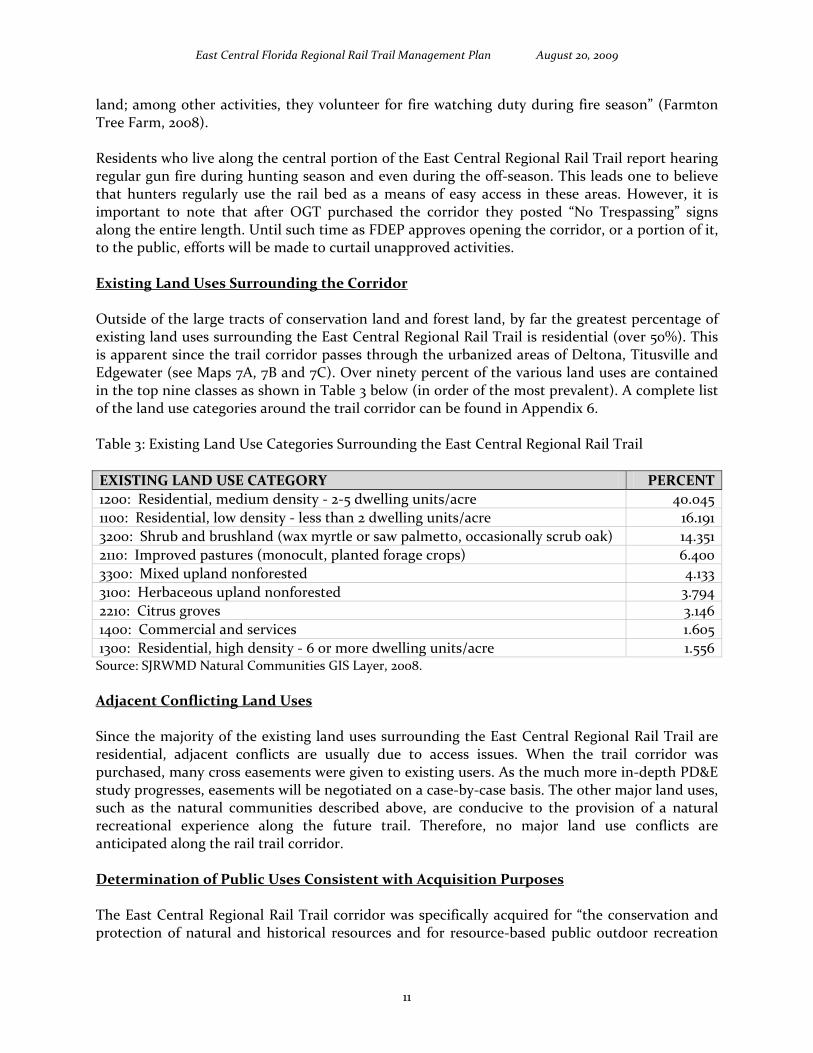
land; among other activities, they volunteer for fire watching duty during fire season” (Farmton Tree Farm, 2008). Residents who live along the central portion of the East Central Regional Rail Trail report hearing regular gun fire during hunting season and even during the off‐season. This leads one to believe that hunters regularly use the rail bed as a means of easy access in these areas. However, it is important to note that after OGT purchased the corridor they posted “No Trespassing” signs along the entire length. Until such time as FDEP approves opening the corridor, or a portion of it, to the public, efforts will be made to curtail unapproved activities. Existing Land Uses Surrounding the Corridor Outside of the large tracts of conservation land and forest land, by far the greatest percentage of existing land uses surrounding the East Central Regional Rail Trail is residential (over 50%). This is apparent since the trail corridor passes through the urbanized areas of Deltona, Titusville and Edgewater (see Maps 7A, 7B and 7C). Over ninety percent of the various land uses are contained in the top nine classes as shown in Table 3 below (in order of the most prevalent). A complete list of the land use categories around the trail corridor can be found in Appendix 6. Table 3: Existing Land Use Categories Surrounding the East Central Regional Rail Trail
EXISTING LAND USE CATEGORY PERCENT 1200: Residential, medium density ‐ 2‐5 dwelling units/acre 40.045 1100: Residential, low density ‐ less than 2 dwelling units/acre 16.191 3200: Shrub and brushland (wax myrtle or saw palmetto, occasionally scrub oak) 14.351 2110: Improved pastures (monocult, planted forage crops) 6.400 3300: Mixed upland nonforested 4.133 3100: Herbaceous upland nonforested 3.794 2210: Citrus groves 3.146 1400: Commercial and services 1.605 1300: Residential, high density ‐ 6 or more dwelling units/acre 1.556 Source: SJRWMD Natural Communities GIS Layer, 2008. Adjacent Conflicting Land Uses Since the majority of the existing land uses surrounding the East Central Regional Rail Trail are residential, adjacent conflicts are usually due to access issues. When the trail corridor was purchased, many cross easements were given to existing users. As the much more in‐depth PD&E study progresses, easements will be negotiated on a case‐by‐case basis. The other major land uses, such as the natural communities described above, are conducive to the provision of a natural recreational experience along the future trail. Therefore, no major land use conflicts are anticipated along the rail trail corridor. Determination of Public Uses Consistent with Acquisition Purposes The East Central Regional Rail Trail corridor was specifically acquired for “the conservation and protection of natural and historical resources and for resource‐based public outdoor recreation
11

East Central Florida Regional Rail Trail Management Plan August 20, 2009
which is compatible with the conservation and protection of these public lands” (OGT, 2008). Therefore, the planned public use as a non‐motorized, resource‐based, recreational “linear park” is fully consistent with the original purpose of this acquisition. Alternative‐ and Multiple‐Use Potential The alternative‐use potential of this extensive corridor is for private property owners to continue to use it to access their property as well as for the hunting community to access their hunting leases. However, any alternative uses are still limited to non‐motorized modes of transportation only with the exception of authorized perpendicular crossings. Once developed as a 12’ wide, paved, two‐way trail, the East Central Regional Rail Trail will be well suited for multiple‐use potential. Planned Uses of the Property As noted above, until the proposed trail is officially opened, use of the corridor will be restricted. Planned uses of the proposed trail may include active recreational activities such as walking, hiking, jogging, inline skating, bicycling, and horseback riding. Passive uses include bird watching and wildlife viewing. In the more urban areas, the East Central Regional Rail Trail also provides non‐automobile‐based transportation options for Volusia and Brevard residents and visitors. Furthermore, the proposed trail facility is being specifically designed to be accessible for individuals with disabilities thus providing equitable access for all segments of the population. However, in keeping with our current policies, motorized vehicles will be prohibited on the trail. Naturally, this prohibition does not include motorized wheel chairs. While the actual rail bed will be developed into a paved, multi‐use trail, the surrounding public conservation habitats will be preserved for natural resource‐based recreation and trailhead access. Impact Assessment of Planned Uses The planned public uses will be limited to non‐motorized trail uses as outlined above. Impacts of these activities include the need for regular safety checks, clearing of debris, and trash removal. Run‐off associated with the trail will be minimal as no motorized vehicles will be permitted other than safety/cleaning vehicles. Neighborhood impacts will include additional traffic and more activity. Planning for parking and traffic will be done up front with community input to avoid conflicts at a later date. Impacts to the adjacent environment will be minimized through the use of educational signage and the provision of ample waste containers and recycling bins. Public Involvement Public involvement is critical to ensuring that communities embrace the trail concept and, therefore, create a successful project. Public involvement has been specifically cultivated for the development of this Management Plan. Pursuant to the statutes noted in Section I, an Advisory Group was formed from members of the community to include representatives from the lead managing agencies, co‐managing agencies, local private property owners, Soil and Water Conservation District, local conservation organizations, and local elected officials. Since this trail project is located in two counties, representatives were invited from each county. The lead managing agency representatives were made up of Brevard County and Volusia County trails staff while OGT provided staff members to represent the co‐managing agency. Several local property
12

East Central Florida Regional Rail Trail Management Plan August 20, 2009
owners were invited to join the group including the official representative of the largest single private land owner adjacent to the trail corridor, the Miami Corporation. Soil and Water Conservation District representation was filled by staff from the St. Johns River Water Management District (SJRWMD). Local conservation organization representation was provided by members of the Florida Trail Association and the Florida Freewheelers. The local elected officials were former County Commissioner Truman Scarborough (Brevard County) and Council Member Pat Northey (Volusia County). The Advisory Groups held their organizational meetings on August 26, 2008 in Brevard County and August 28, 2008 in Volusia County. Subsequently, public meetings were held in September in both Brevard and Volusia Counties (September 17, 2008 and September 24, 2008, respectively). Both public meetings were well attended and gathered many interesting and useful comments. Advisory Group member list, advertisements, agendas, sign‐in sheets, and a list of comments are attached as Appendix 7. In addition, participant contact information has been entered into a database so that they can be kept up‐to‐date on the progress of the Management Plan and the design and development of the trail segments. Additionally, the Management Plan has been posted on our web site for public comment and the PD&E Study allows for additional public involvement with public workshops scheduled for the Spring and Fall of 2009.
IV. Management Goals and Objectives Overview of Management Goals and Objectives To meet FS 253.034(5)(b), the following short‐term and long‐term management goals, including measurable objectives, are made part of this Management Plan. The overall management goals and objectives for the development, operation, and maintenance of the trail are the responsibility of Brevard County and Volusia County. Every effort will be made to secure funding, however, the implementation of the following goals and objectives will be accomplished as funding and resources become available. Goal 1: Habitat Restoration and Improvement As managers of the trail corridor, Brevard County and Volusia County are tasked with restoring and improving any damaged or impacted habitats within the corridor. However, it is important to note that this property is a highly disturbed railroad corridor which is too narrow to exhibit normal ecological functioning and was specifically purchased for the primary purpose of outdoor recreation and alternative transportation rather than native habitat conservation. Therefore, although habitat restoration often requires the use of prescribed burning, due to the configuration of the property as a long, narrow corridor, this management tool is not applicable. Furthermore, most habitat restoration and improvement will be achieved by eliminating current detrimental activities occurring along the corridor such as ATV use and dumping. The elimination of these act ivies will allow the natural communities to restore or improve on their own.
13
East Central Florida Regional Rail Trail Management Plan August 20, 2009
Objective 1.1: Conduct habitat/natural community improvement on 100 acres during the construction phase. Measure 1.1.1: 10 acres with habitat/natural community improvement underway in 2 years. Measure 1.1.2: 50 acres of habitat/natural communities improved in 10 years.
Objective 1.2: Conduct habitat/natural community restoration on 100 acres during the construction phase.. Measure 1.2.1: 10 acres with habitat/natural community restoration underway in 2 years. Measure 1.2.2: 50 acres of habitat/natural communities restored in 10 years.
Goal 2: Public Access and Recreational Opportunities As managers of the trail corridor, Brevard County and Volusia County are tasked with providing equitable public access to the property.
Objective 2.1: Develop public access and recreational opportunities to allow for a recreational carrying capacity of 100 visitors per day.
Measure 2.1.1: 50 recreational‐visitor opportunities/day after 2 years. Measure 2.1.2: 100 recreational‐visitor opportunities/day after 10 years.
Objective 2.2: Create and install 15 new interpretive panels throughout the corridor.
Measure 2.2.1: 5 interpretive panels placed within 2 years. Measure 2.2.2: 10 interpretive panels placed within 10 years.
Objective 2.3: Actively enforce the “No motorized vehicles” rule.
Measure 2.3.1: 10 citations for motorized vehicles issued annually after 2 years. Measure 2.3.2: 0 citations for motorized vehicles issued annually after 10 years.
Objective 2.4: Eliminate illegal dumping along the trail corridor. Measure 2.4.1: 20 dumping sites discovered and cleaned up after 2 years. Measure 2.4.2: 0 dumping sites discovered and cleaned up after 10 years.
Goal 3: Hydrological Preservation and Restoration Although there are no significant water bodies within the trail corridor itself, there are several areas that could benefit from improved drainage across the corridor. These areas will be identified as part of the current PD&E Study.
Objective 3.1: Conduct or obtain a site assessment to identify potential hydrological restoration needs.
Measure 3.1.1: Assessment conducted within 2 years.
14

East Central Florida Regional Rail Trail Management Plan August 20, 2009
Objective 3.2: Restore natural hydrologic conditions and functions to 20 acres on the property.
Measure 3.2.1: 2 acres for which hydrologic restoration is underway in 2 years. Measure 3.2.2: 10 acres for which hydrologic restoration is underway in 10 years. Measure 3.2.3: 2 acres for which natural hydrologic conditions and function are restored in 2 years. Measure 3.2.4: 10 acres for which natural hydrologic conditions and function are restored in 10 years.
Goal 4: Sustainable Forest Management
There are no silviculture activities proposed within the corridor, thus, this goal is not applicable.
Goal 5: Exotic and Invasive Species Maintenance and Control Due to the former use as a rail bed, the property does contain invasive exotic plant species; however, in light of its narrow, linear configuration, exotic and nuisance animals only use the site for movement.
Objective 5.1: Eliminate EPPC Category I and Category II invasive exotic plant species encountered during construction.
Measure 5.1.1: Remove 5 acres of invasive exotic plant species within 2 years. Measure 5.1.2: Remove 10 acres of invasive exotic plant species within 10 years.
Goal 6: Capital Facilities and Infrastructure The rail corridor was purchased with the intention of developing a paved, multi‐use trail. Both Brevard County and Volusia County are currently seeking funds for the design and development of the trail.
Objective 6.1: To construct 50.8 miles of multi‐use trails, 9 trailheads, and 20 access points.
Measure 6.1.1: 8.4 miles of multi‐use trails, 3 trailheads, and 8 access points constructed within 2 years. Measure 6.1.2: 50.8 miles of multi‐use trails, 9 trailheads, and 20 access points constructed within 10 years.
Objective 6.2: To maintain 50.8 miles of multi‐use trails, 9 trailheads, and 20 access points existing on site.
Measure 6.2.1: 8.4 miles of multi‐use trails, 3 trailheads, and 8 access points maintained within 2 years. Measure 6.2.2: 50.8 miles of multi‐use trails, 9 trailheads, and 20 access points maintained within 10 years.
15

East Central Florida Regional Rail Trail Management Plan August 20, 2009
Goal 7: Cultural and Historic Resources Both Brevard County and Volusia County are cognizant of the potential for cultural and historic resources on the site due to its age and use patterns.
Objective 7.1: Continually seek previously unknown cultural and historic resources during the construction phase.
Measure 7.1.1: 2 sites recorded in the Florida Master Site File in 2 years. Measure 7.1.2: 4 sites recorded in the Florida Master Site File in 10 years.
Goal 8: Imperiled Species Habitat Maintenance, Enhancement, Restoration, or Population Restoration Due to the disturbed nature of the site and its linear configuration, there are virtually no imperiled species habitats on the site.
Objective 8.1: Ensure any imperiled species that may be found on the site during construction are documented and protected.
Measure 8.1.1: 1 imperiled species discovered in 2 years. Measure 8.1.2: 2 imperiled species discovered in 10 years.
Management Authority and Responsibilities The Trustees hold title to the East Central Regional Rail Trail corridor but overall management authority remains in the hands of OGT. The subleases between OGT and Brevard and Volusia Counties establish development and daily management authority for the trail through implementation of this Management Plan. Although overall policy management of the East Central Regional Rail Trail lies with OGT, the design and construction phases in Brevard County will be managed by the Brevard County Parks and Recreation Department/Public Works Department within their appropriate jurisdictions and, in Volusia County, by the Volusia County Engineering & Construction Division. Maintenance in Brevard County will be the responsibility of the Brevard County Parks and Recreation Department while maintenance of the Volusia County portion will be the responsibility of the Volusia County Parks, Recreation and Culture Division. Trail Planning and Management Trail planning first requires resolution of all easements and claims for access. The second most important condition that must be addressed is any arsenic contamination. Volusia and Brevard Counties are actively working in concert with DEP’s Bureau of Waste Cleanup, Office of Greenways and Trails, and Division of State Lands, as well as with environmental consulting firm WRS Infrastructure & Environment, Inc., to ensure that any arsenic containing media within the State‐owned former railroad corridor is thoroughly and accurately assessed and managed in accordance with all Federal, State, and local regulations. The Phase 2 Environmental Site Assessment is currently in progress. All arsenic‐related issues will be resolved prior to opening the multi‐use trail for public recreational use.
16
East Central Florida Regional Rail Trail Management Plan August 20, 2009
Once the trail is designed and built, the trail will provide residents and visitors with a 50.8 mile multi‐use, paved trail that is 12 feet wide, attractively landscaped, and accessible from several waysides and trailheads along the way. Benches and rest areas will be included as well as interpretive signage where significant features are located. The East Central Regional Rail Trail will be managed to provide resource‐based outdoor recreation for the public while ensuring the conservation and protection of the natural and historical resources within the corridor. Therefore, a holistic planning approach will be utilized to bring the most important qualities to bear in the development of this trail. Attention and respect will be given to public sentiment and the user’s needs and desires will be taken into consideration during the planning of the trail. Cultivating public buy‐in will ensure future public support for the trail concept and increase the chances for funding. Potential Surplus Lands No known surplus lands have been identified thus far in the planning process. Prospective Land Acquisitions The Thornby property in Enterprise provides a link to the trail corridor as well as access to Lake Monroe. When the Trail Corridor was purchased by OGT, this historically and ecologically significant property was under consideration for purchase. In early 2009, the City of Deltona, in partnership with the County of Volusia, purchased the property for public access as a future park and trailhead. The City of Deltona also owns two other parcels adjacent to the trail corridor which may be used as trailheads in partnership with the city’s park planning efforts. Partnerships and Regional Coordination The East Central Regional Rail Trail is an example of the best in agency cooperation. The Board of Trustees purchased the corridor on recommendation from the Office of Greenways and Trails which continues to hold an overall management interest in the future trail as well as the ability to eventually designate the trail as a state recreation and transportation resource. Since the trail corridor travels through two central Florida counties: Brevard and Volusia, these two county governments have combined their resources to provide a seamless multi‐use trail for public enjoyment. In the past, many other regional agencies have contributed to the realization of this project and will continue to play a role as future development progresses. These agencies include the East Central Florida Regional Planning Council, St. Johns River Water Management District, Florida Department of Transportation, Space Coast Transportation Planning Organization, Volusia/Flagler Metropolitan Planning Organization, Merritt Island National Wildlife Refuge, and Canaveral National Seashore. By far the largest private organization both benefitting and impacted by the future trail is the Miami Corporation. During acquisition negotiations, Miami Corporation representatives assisted in the location of easements and provided access through their property. Due to the fact that much of the land area surrounding the trail corridor is in public ownership set aside for conservation and recreation, land use coordination will focus on preserving these areas for quality outdoor recreation. In the more urban areas of Titusville, Deltona and Edgewater, easy access for the most people will be the driving force.
17

East Central Florida Regional Rail Trail Management Plan August 20, 2009
Compliance with State and Local Government Requirements The preparation and subsequent approval of this Management Plan is the first step in complying with government regulations. Once this plan is approved by the Board of Trustees, development of the trail will commence as funding and resources become available. Various permits from the Florida Department of Environmental Protection and the St. Johns River Water Management District will be obtained for wetland alterations and the rebuilding of several small bridges. Local government requirements include land development approval as well as adherence to all local environmental and building codes. Local code variations between Brevard County and Volusia County will use the more stringent requirements for consistency. Development of the East Central Regional Rail Trail has been found to be in compliance with both the Brevard County and Volusia County Comprehensive Plans as evidenced by the letters from both agencies attached in Appendix 8. On‐going Research and Monitoring After the trail has been built and is in operation, research and monitoring will be conducted as deemed necessary to address any issues that may present themselves. With the help of our staff experts and volunteers, issues will be dealt with on a fair and equitable basis with conservation of the resource being of the highest priority and provision of access to all users being the next highest priority. Online surveys will be made available so that the public can comment on the trail and make suggestions for upgrades and improvements. Natural Resource Management and Protection Soil Management Soils of the trail corridor itself will be managed to provide a safe and long‐lasting surface for the 12 foot wide asphalt multi‐use trail. Soils on either side of the trail corridor may be managed by installing silt fencing where necessary to protect wetland areas and installing drainage structures to avoid trail washouts while at the same time preventing excessive drainage onto nearby lands. Hydrology/Water Management The hydrology of the corridor itself will be constrained once the asphalt is in place. Water management will remain the responsibility of the St. Johns River Water Management District and will be implemented through permitting activities and local inspections. Natural Communities Management Any natural communities within the trail corridor itself will be marked for preservation as appropriate. Development of the trail will take into consideration specimen trees and any protected plants or animals. The shoulders of the trail surface may be planted with native plants/wildflowers to prevent the encroachment of invasive plants into the surrounding natural communities. Forest Resources Management The forest resources surrounding the trail corridor are either in public ownership or owned by Farmton Tree Farm. Public lands are managed under the same conditions as the trail corridor: for
18

East Central Florida Regional Rail Trail Management Plan August 20, 2009
protection of the natural resources balanced with sustainable resource‐based recreational usage. Private forest resources are managed for logging operations by their respective owners. Fire Management Fire management is critical to the health of several communities such as long‐leaf pine, scrub, and flatwoods. Fire management will be coordinated between each county’s environmental division and the local Division of Forestry. The trail does provide a natural fire break and access point in the case of a wildfire. Mineral Resources Management Mineral resources belong to the underlying property owner and are not a significant factor in this planning process. Native Species Management Habitat requirements for native species will be maintained and managed to ensure that native species survive and are able to sustain a large enough breeding population to remain viable thereby preserving the natural biodiversity found along the trail corridor. Listed Species Management “Based on the information available, this site appears to be located on or very near a significant region of scrub habitat, a natural community in decline that provides important habitat for several rare species within a small area. Additional consideration should be given to avoid and/or mitigate impacts to these natural resources, and to design land uses that are compatible with these resources” (FNAI, 2008). Therefore, habitat for listed species such as scrub jays and gopher tortoises will be carefully managed so that they can continue to flourish. Invasive Non‐native Species Management According to the Florida Exotic Pest Plant Council, Category I plants (those that are altering and displacing native plant communities) will require constant vigilance to prevent their spreading to other areas of the trail corridor. Management will require regular maintenance as typical for a corridor. Invasive plants commonly spread along the corridor will be removed through both mechanical and chemical means to prevent further disbursement. Where possible, volunteers trained in exotic identification and removal will be enlisted to help control the spread of non‐native species. Problem Native Species Management Problem native species will be treated as invasive non‐native species and removed when encountered while strictly adhering to state, federal, and local governmental guidelines. Archaeological, Historical and Cultural Resource Management The majority of historic structures along the trail corridor are clustered in the Osteen and Maytown settlement areas. The trail is not expected to impact these structures. Volusia County Code of Ordinances, Chapter 62, Historic Preservation requires review for demolition of properties built prior to 1945. Properties of local historical significance would require a Certificate of Appropriateness for Demolition from the Volusia County Historic Preservation Board decided in public hearing. Despite this “safeguard”, many of these buildings are in poor condition and there is no concerted effort for preservation of these privately owned resources. The construction of the trail and greater exposure may inspire the owners to take greater interest in the
19

East Central Florida Regional Rail Trail Management Plan August 20, 2009
maintenance and preservation of these modest frame vernacular buildings that tell the story of life in rural Volusia County. Also in a state of decline is the Cobb House (privately owned) in Enterprise, the oldest remaining residence in Enterprise. Should the owners consent, this property would qualify for historic resource designation and protection through the Volusia County Historic Preservation Board. All archaeological and historical resource management will follow the “Management procedures for Archaeological and Historical Sites and Properties on State‐owned or Controlled Properties” (see Appendix 9). No systematic archeological survey has been conducted along the railroad corridor. Construction of the rail bed may have substantially disturbed sites; however, a phase one archeological survey would be completed prior to construction. Plans to locate unknown resources include future systematic archaeological and cultural surveys; however, since the rail bed consists of foreign shell/rock, actual development is not expected to affect any significant resources. Scenic Resources Management The scenic resources along the trail corridor are one of the main reasons people will come back and use the trail many times. The preservation of the scenic resources in the public lands will be ensured. In addition, private land owners can be encouraged to maintain their scenic resources through land development regulations and incentive programs such as Transfer of Development Rights and cluster development. Trail Construction Priorities Once this Management Plan is approved, Brevard and Volusia Counties will move forward to design and construct an attractive and inviting multi‐use trail as funding and resources become available. The trail corridor has been conceptually divided into logical and manageable segments to facilitate an orderly and equitable progression of development (see Map 8). Trail construction priorities start with the most easily accessible segments that serve the most people, i.e. on each terminus, and work toward the middle segments and the Edgewater spur. Development Timeline The most important accomplishment was the successful purchase of the FEC corridor by a state agency dedicated to the preservation of natural resources and the provision of recreational access. The next phase of the East Central Regional Rail Trail project will be to complete this Management Plan and the Project Development & Environment study. Developing a plan to deal with any arsenic contamination will be the next order of business followed by the design and subsequent construction of a paved, multi‐use trail open to the public. The East Central Regional Rail Trail will be developed in segments to spread the fiscal impact over several years. Brevard County will be responsible for developing their segments (14.9+ miles) and Volusia County will develop their segments (35.9+ miles). Preliminary trailhead locations include Green Springs Park, two potential Deltona parcels, Osteen Civic Center, Gobblers Lodge, Chain of Lakes, and the Maytown Spur area. Traveling from the western terminus in Enterprise to the east, Map 8 depicts the extent of each segment as follows:
• Segment 1 ‐ Providence Boulevard (Enterprise) to Garfield Road (Deltona) • Segment 2 ‐ Garfield Road to SR 415 (Deltona)
20

East Central Florida Regional Rail Trail Management Plan August 20, 2009
• Segment 3 ‐ SR 415 to Guise Road (Osteen) • Segment 4 ‐ Guise Road to Gobblers Lodge Road (Osteen) • Segment 5 ‐ Gobblers Lodge Road to Maytown Spur • Segment 6 ‐ Maytown Spur to County Line • Segment 7 ‐ County Line to Aurantia Road • Segment 8 ‐ Aurantia Road to Kingman Road • Segment 9 ‐ Kingman Road to Canaveral Road (Titusville) • Segment 10 ‐ Maytown Spur to Volco Road • Segment 11 ‐ Volco Road to Park Avenue (Edgewater)
The targeted schedule of development, subject to funding availability is detailed in Table 4 below (ordered by completion date). Cost estimates are based on the current average market price of $453,244 per mile for design and construction for the segments to be completed by 2010. For the segments scheduled for completion after 2010, the cost estimate per mile of trail has been increased by 10% to $498,568 based on anticipated inflation. Table 4: East Central Regional Rail Trail – Estimated Costs and Construction Schedule Map Seg. Trail Extent/Facility Miles Cost
Estimate Targeted Year of Completion
1 Providence Blvd to Garfield Rd * 1.4 $635,000 2010 2 Garfield Rd to SR 415 * 4.3 $1,949,000 2010 3 SR415 to Guise Rd * 2.7 $1,224,000 2011 3 Pedestrian Bridge over SR 415 $5,000,000 2013 4 Guise Rd to Gobblers Lodge Rd 3.5 $1,745,000 2013 4 Seg. 4 ‐ 2 Bridges $1,012,000 2013 9 Kingman Rd to Canaveral Rd 2.2 $997,000 2013 11 Volco Rd to Park Ave 7.0 $3,490,000 2014 11 Seg. 11 ‐ 2 Bridges $506,000 2014 8 Aurantia Rd to Kingman Rd 7.2 $3,590,000 2014 5 Gobblers Lodge Rd to Maytown Spur 6.8 $3,390,000 2015 5 Seg. 5 ‐ 2 Bridges $1,012,000 2015 10 Maytown Spur to Volco Rd 8.6 $4,288,000 2015 10 Seg. 10 ‐ 1 Bridge $506,000 2015 7 County Line to Aurantia Rd 5.5 $2,742,000 2015 7 Seg. 7 ‐ 1 Bridge $506,000 2015 6 Maytown Spur to County Line 1.6 $798,000 2015 Totals 50.8 $33,390,000
* Funded in the 5 Year Capital Program
21
East Central Florida Regional Rail Trail Management Plan August 20, 2009
Construction Funding Sources This timeline assumes that the Volusia County Council will continue the $1 million annual ECHO allocation for the Trails Program in each of the successive fiscal years and the Florida Department of Transportation will continue funding Enhancement activities for multi‐use trails in both counties. Volusia County and the Brevard County Parks and Recreation Department/Public Works Department will also continue to seek additional trail construction funding from grant sources such as the annual Volusia ECHO competitive grant and DEP’s Recreational Trails Program. Trail Management Priorities Management Activities Management activities are prioritized as follows: (1) ensure the safety of all patrons; (2) provide equal access for patrons; (3) protect the surrounding environment; (4) present a clean, comfortable, and enjoyable experience; (5) encourage user feedback; (6) provide maps and brochures; (7) promote a “share the trail” ethic; and (8) celebrate our successes. Operational Activities Brevard County Parks and Recreation Department and Volusia County Parks, Recreation and Culture Division staff will maintain the trails once they are constructed utilizing park maintenance staff and volunteers. County staff will be responsible for routine maintenance including periodic safety checks as well as the removal of large tree limbs. As the trail system grows, additional staff and equipment may need to be budgeted to meet these needs. Operating Funds In both counties, funds to operate and maintain the trail system may be allocated from the General Fund budgets and other sources each fiscal year. Operational expenses may be offset somewhat with the assistance of a “Friends Group” to help with the maintenance of the trail. Security Management Security management is by far the greatest concern to users of the trail as well as trail neighbors. Intense use of a trail, the presence of “trail rangers”, an army of trained volunteers, and well‐maintained trails, statistically leads to fewer security issues on trails throughout the country. Brevard County and Volusia County may designate staff members to maintain the trail and report to law enforcement should the need arise. Potential to Contract with Private Vendors Public/private partnerships are natural in trail development. As a trail is built through an area, private individuals and companies have an opportunity to capitalize on the visitors that use the trail and the provision of goods and services is only limited by the creativity and drive of local business owners. The Trails Programs will seek ways to contract with private vendors to provide services that are better handled in a market economy; however, these services would never be allowed to weaken safety considerations. Citizen Support Organization For many years, state parks have depended on their Citizen Support Organizations (CSO’s) to help with planning, assist in maintenance, build new amenities, provide a security presence, and raise private funds to improve their sites. The East Central Regional Rail Trail is poised to attract a
22
East Central Florida Regional Rail Trail Management Plan August 20, 2009
myriad of devoted users who will take a personal interest in the trail. A CSO can be incorporated as a non‐profit entity to take advantage of donations often missed by government agencies. The beginnings of an active CSO are already contained in our database of interested people involved in this Management Plan. In light of current fiscal constraints, both Brevard and Volusia Counties intend to pursue the creation of dedicated East Central Regional Rail Trail CSO groups. State Designation “In order to be designated, lands or waterways must:
• Protect and/or enhance natural, recreational, cultural or historic resources; and • Provide linear open space or a hub or a site; or • Promote connectivity between or among conservation lands, communities, parks, other
recreational facilities, cultural sites, or historic sites” (OGT, 2008). Once the trail is developed and opened to the public, Brevard and Volusia Counties may apply to OGT for state designation of the East Central Regional Rail Trail. Public Access and Use Access/Parking/Disabled Access Providing access to such an extensive trail is a challenge for all agencies in light of the high cost of land. It is expected that people living near the trail will access it through their neighborhoods; however, the plans do include formal trailheads for parking access for users that live further away from the trail. Fortunately, there are several parcels adjacent to the East Central Regional Rail Trail corridor that are well suited to trailhead development. Volusia County has just opened Green Springs Park in Enterprise. This resource‐based park is adjacent to the eastern terminus of the trail corridor and will be the first developed trailhead. The second trailhead slated for development is the parcel next to the Osteen Civic Center. This trailhead has been preliminarily designed and Volusia is currently seeking funding to build this facility. The City of Deltona has identified two city‐owned parcels that could be developed as trailheads. In Brevard County, the Chain of Lakes will serve as the first trailhead in Titusville. All of the trailheads and waysides will be designed to be ADA compliant and, more than that, friendly to persons with disabilities. The trail itself will be built according to ADA standards so that people of all abilities can enjoy this community asset. Smaller waysides will seek to take advantage of compost restroom facilities to keep cleaning and maintenance costs manageable while preserving precious resources such as electricity and water. Transportation Alternatives Development of the East Central Regional Rail Trail will impart several critical multi‐modal transportation benefits: namely the provision of alternative routes for non‐motorized transportation to connect population centers to the proposed Central Florida Commuter Rail project, Amtrak lines, bus service, Park & Ride lots, employment centers, schools, and parks. Residents and visitors would then have several alternatives to using the traditional road network for their active transportation needs. Offering commuters viable multi‐modal alternatives to highway travel is vital to reducing traffic on I‐4 and other major highways. By linking bicycle travel on trails to buses with bike racks and, in turn, to active rail lines, commuters will have these practical options.
23
East Central Florida Regional Rail Trail Management Plan August 20, 2009
Walking/Hiking Walking and hiking will most likely be the most prevalent use of the East Central Regional Rail Trail. However, it will be planned as a multi‐use trail so other users will expect equal access. Seniors are especially attracted to trails for daily walking exercise that gets them out of the house and into the natural environment. Parents with small children also enjoy taking brief walks along trails. Jogging Joggers prefer the asphalt surface to concrete sidewalks due to its consistency and slightly more giving surface. The East Central Regional Rail Trail will most likely attract more joggers in the urbanized areas. Bicycling For the two major groups of on‐road bicyclists, weekend riders and serious long‐distance riders, the East Central Regional Rail Trail will offer both groups a preferred alternative. Bicyclists seeking recreation and daily exercise will be able to travel short distances on a smooth, paved surface. Long‐distance bicyclists, on the other hand, will enjoy the fact that this trail will eventually be over 50 miles long, therefore, meeting their desire for a longer ride. Inline Skating Inline skaters enjoy using multi‐use trails due to the smooth, continuous surface and the clear sight distances. Some inline skaters skate very fast and the wide trail adds to their enjoyment as well as the safety of others. The East Central Regional Rail Trail will be specifically designed to handle this use. Equestrian Use Equestrian use, if provided for, is expected to be more favored in the rural areas of the trail system and a separate parallel path would have to be constructed for horseback riders. Equestrian users will desire a trail long enough to be worth transporting their horses. Trailheads would also need to have a parking area large enough and with adequate turning radii for horse trailers. Paddling Paddling opportunities will be available near the East Central Regional Rail Trail and users could use the trail to complete a non‐motorized multi‐modal trip. Water bodies with paddling access include Lake Monroe, the upper reaches of the St. Johns River (via Guise Road), Mosquito Lagoon, and Indian River Lagoon. Boating Boating is likewise not directly related to the East Central Regional Rail Trail project. However, the trail does come near several boating areas and access points such as Mariner’s Cove Boat Ramp and Deltona’s Boat Ramp on Lake Monroe, Lemon Bluff Boat Ramp on the upper reaches of the St. Johns River, Menard‐May Park boat ramp in Edgewater on Mosquito Lagoon, and Sand Point Park in Titusville on the Indian River Lagoon. Camping There are several areas where the East Central Regional Rail Trail corridor expands to nearly 200 feet. These areas, as well as several municipally‐owned lands, may accommodate camping in the future. Camping is currently available at Gemini Springs Park and Lake Ashby Park.
24
East Central Florida Regional Rail Trail Management Plan August 20, 2009
Fishing Fishing opportunities are the same as the paddling and boating options noted above. The Mosquito Lagoon, which is near the Park Avenue terminus of the East Central Regional Rail Trail, is known as “the Redfish Capital of the World”. Likewise, at the southern terminus in Titusville, the Indian River Lagoon offers abundant fishing prospects. Hunting In the central, more rural sections of the East Central Regional Rail Trail, both public and private hunting areas have been in use for decades. Hunting is one of the activities that must be carefully managed near a recreational trail. In accordance with Ch. 62S‐3.002(5)(c), F.A.C., “Shooting into or across lands under the management of the Office [OGT] from beyond said lands’ boundaries is prohibited.” In light of this, while planning the daily access and operation schedule for the trail, annual hunting seasons will be taken into consideration and signage will be posted to (a) alert trail users that hunting occurs on adjacent lands, (b) encourages trail users to wear blaze orange articles of clothing during hunting season, and (c) educates hunters as to the restrictions regarding hunting on or across OGT properties. In addition, a copy of Ch. 62S‐3.002(5)(c), F.A.C. will be provided to the adjacent private property owners as well as the local hunting club officers to educate them as to the hunting restrictions on or adjacent to State‐owned trails. Picnicking Picnicking will no doubt be a popular activity along the East Central Regional Rail Trail. Numerous benches and rest areas interspersed with trailheads will provide many serene locations for picnicking. Interpretive Opportunities The East Central Regional Rail Trail takes its users on a trip through history. From the historic town of Enterprise (once the county seat of Volusia) to Maytown (which only exists in memory) through Mims and down to Titusville where the original train lines picked up famous Indian River Fruit, the trail corridor abounds in opportunities to provide interpretive displays. Future funding requests will include an interpretive component to complete the trail and attract both daily local users as well as heritage tourists visiting the area. Green Springs Park, the first western trailhead, already has a wonderful interpretive component that educates while instilling an appreciation for the history of the area and the natural environment. Visitor/Educational/Cultural Centers As described above, the East Central Regional Rail Trail corridor has much to offer in the way of visitor education; therefore, educational and cultural centers will be planned along with the design of the actual trail itself. Current opportunities exist at the Osteen Civic Center and Deltona Civic Center on Lakeshore Drive. Pet Policies The East Central Regional Rail Trail will in essence be a linear park facility to be operated under the same rules. Volusia County parks currently allow dogs on six‐foot leashes. Pets may be allowed on the trail as long as they are leashed and their owners pick up after them. A “Pets in Parks” brochure may be promulgated to educate the public about pet policies.
25

East Central Florida Regional Rail Trail Management Plan August 20, 2009
Managing Multi‐use Conflicts “Share the Trail” brochures, developed to encourage respect and politeness among trail users, may be placed in all trailhead kiosks. Suggestions include: be courteous, be predictable, don’t block the trail, obey traffic and trail signs, control your bicycle, keep pets on a leash and children by your side, respect private property, and keep your trail clean. The general rule is “wheels yield to heels”. In addition, to educate trail users on appropriate trail etiquette, signage may be posted along the trail listing the general suggestions as well as a depiction of the wheels yield to heels hierarchy symbol. Safe and courteous multi‐use can be accomplished on trails through education and a positive presence on the trail.
26
East Central Florida Regional Rail Trail Management Plan August 20, 2009
V. References Abrahamson, W. G. & Hartnett, D. C. (1990). Pine Flatwoods and Dry Prairies. In R. L. Myers and
J. J. Ewel (Eds.), Ecosystems of Florida (pp. 103‐149). Gainesville, FL: The University of Central Florida Press.
Brown, R. B., Stone, E. L. and Carlisle, V. W. (1990). Soils. In R. L. Myers and J. J. Ewel (Eds.),
Ecosystems of Florida (pp. 35‐69). Gainesville, FL: The University of Central Florida Press. Farmton Tree Farm. 2008. Retrieved December 16, 2008, from http://www.farmtontreefarm.com/. Farmton Tree Farm. 2008. Retrieved December 17, 2008, from
http://www.farmtontreefarm.com/ab‐hunting.html. FNAI. (2008). Specialized Reports for the East Central Regional Rail Trail. Florida Natural Areas
Inventory. Florida Resources and Environmental Analysis Center. The Florida State University.
Mercer, J. W., Thomas, S. D., Lester, B. H., & Broome, R. W. (1984). Saltwater Intrusion in Volusia
County, Florida, Due to Ground Water Withdrawals‐Technical Summary (Technical Publication SJ 85‐1). Prepared For St. Johns River Water Management District. Palatka, FL: Geotrans, Inc. Retrieved November 28, 2008, from http://www.sjrwmd.com/technicalreports/pdfs/TP/SJ85‐1.pdf.
OGT. (2008). Office of Greenways and Trails of the Florida Department of Environmental
Protection. SJRWMD – St. Johns River Water Management District. (2008). Indian River Lagoon Basin.
Retrieved December 29, 2008, from http://www.sjrwmd.com/indianriverlagoon/. The Florida Geological Society. (2008). Retrieved November 12, 2008, from
http://www.clas.ufl.edu/users/query/gly4155/sp35/fgs35.htm. United States & Baldwin, R. (1980). Soil survey of Volusia County, Florida. [Washington, D.C.]:
The Service.
47