Embed Size (px)
Citation preview
March 2021
Columbia Gulf Transmission, LLC Docket No. CP20-527-000
East Lateral XPress Project
Environmental Assessment
Washington, DC 20426
Office of Energy Projects
1
FEDERAL ENERGY REGULATORY COMMISSION
WASHINGTON, D.C. 20426 OFFICE OF ENERGY PROJECTS In Reply Refer To:
OEP/DG2E/Gas 1 Columbia Gulf Transmission, LLC East Lateral XPress Project Docket No. CP20-527-000
TO THE INTERESTED PARTY: The staff of the Federal Energy Regulatory Commission (FERC or Commission) has
prepared an environmental assessment (EA) for the East Lateral XPress Project, proposed by Columbia Gulf Transmission, LLC (Columbia Gulf) in the above-referenced docket. Columbia Gulf requests authorization to construct and operate two new compressor stations, a new meter station, and other appurtenant facilities, to provide 725 million standard cubic feet per day of firm transportation capacity to supply feed gas for Venture Global Plaquemines LNG, LLC’s liquefied natural gas facility in Plaquemines Parish.
The EA assesses the potential environmental effects of the construction and operation of
the East Lateral XPress Project in accordance with the requirements of the National Environmental Policy Act. The FERC staff concludes that approval of the proposed project, with appropriate mitigating measures, would not constitute a major federal action significantly affecting the quality of the human environment.
The proposed East Lateral XPress Project includes the following facilities: • 8.1 miles of 30-inch-diameter pipeline lateral within Barataria Bay in Jefferson
and Plaquemines Parish, Louisiana; • 23,470-horsepower (hp) compressor station at an abandoned Columbia Gulf
compressor station site in St. Mary Parish, Louisiana (Centerville Compressor Station);
• 23,470-hp compressor station adjacent to an existing tie-in facility in Lafourche Parish, Louisiana (Golden Meadow Compressor Station);
• point of delivery meter station in Plaquemines Parish, Louisiana; and • tie-in facility with two mainline valves and other appurtenances on a new
platform in Barataria Bay, Jefferson Parish, Louisiana.
The Commission mailed a copy of the Notice of Availability to federal, state, and local government representatives and agencies; elected officials; environmental and public interest groups; Native American tribes; potentially affected landowners and other interested individuals
2
and groups; and newspapers and libraries in the project area. The EA is only available in electronic format. It may be viewed and downloaded from the FERC’s website (www.ferc.gov), on the natural gas environmental documents page (https://www.ferc.gov/industries-data/natural-gas/environment/environmental-documents). In addition, the EA may be accessed by using the eLibrary link on the FERC’s website. Click on the eLibrary link (https://elibrary.ferc.gov/eLibrary/search), select “General Search” and enter the docket number in the “Docket Number” field (i.e. CP20-527). Be sure you have selected an appropriate date range. For assistance, please contact FERC Online Support at [email protected] or toll free at (866) 208-3676, or for TTY, contact (202) 502-8659.
The EA is not a decision document. It presents Commission staff’s independent analysis
of the environmental issues for the Commission to consider when addressing the merits of all issues in this proceeding. Any person wishing to comment on the EA may do so. Your comments should focus on the EA’s disclosure and discussion of potential environmental effects, reasonable alternatives, and measures to avoid or lessen environmental impacts. The more specific your comments, the more useful they will be. To ensure that the Commission has the opportunity to consider your comments prior to making its decision on this project, it is important that we receive your comments in Washington, DC on or before 5:00pm Eastern Time on April 15, 2021.
For your convenience, there are three methods you can use to file your comments to the
Commission. The Commission encourages electronic filing of comments and has staff available to assist you at (866) 208-3676 or [email protected]. Please carefully follow these instructions so that your comments are properly recorded.
(1) You can file your comments electronically using the eComment feature on the
Commission’s website (www.ferc.gov) under the link to FERC Online. This is an easy method for submitting brief, text-only comments on a project;
(2) You can also file your comments electronically using the eFiling feature on the Commission’s website (www.ferc.gov) under the link to FERC Online. With eFiling, you can provide comments in a variety of formats by attaching them as a file with your submission. New eFiling users must first create an account by clicking on “eRegister.” You must select the type of filing you are making. If you are filing a comment on a particular project, please select “Comment on a Filing”; or
(3) You can file a paper copy of your comments by mailing them to the Commission.
Be sure to reference the project docket number (CP20-527-000) on your letter. Submissions sent via the U.S. Postal Service must be addressed to: Kimberly D. Bose, Secretary, Federal Energy Regulatory Commission, 888 First Street NE, Room 1A, Washington, DC 20426. Submissions sent via any other carrier must be addressed to: Kimberly D. Bose, Secretary, Federal Energy Regulatory Commission, 12225 Wilkins Avenue, Rockville, Maryland 20852.

3
Filing environmental comments will not give you intervenor status, but you do not need
intervenor status to have your comments considered. Only intervenors have the right to seek rehearing or judicial review of the Commission’s decision. At this point in this proceeding, the timeframe for filing timely intervention requests has expired. Any person seeking to become a party to the proceeding must file a motion to intervene out-of-time pursuant to Rule 214(b)(3) and (d) of the Commission’s Rules of Practice and Procedures (18 CFR 385.214(b)(3) and (d)) and show good cause why the time limitation should be waived. Motions to intervene are more fully described at https://www.ferc.gov/ferc-online/ferc-online/how-guides.
Additional information about the project is available from the Commission’s Office of
External Affairs, at (866) 208-FERC, or on the FERC website (www.ferc.gov) using the eLibrary link. The eLibrary link also provides access to the texts of all formal documents issued by the Commission, such as orders, notices, and rulemakings.
In addition, the Commission offers a free service called eSubscription which allows you
to keep track of all formal issuances and submittals in specific dockets. This can reduce the amount of time you spend researching proceedings by automatically providing you with notification of these filings, document summaries, and direct links to the documents. Go to https://www.ferc.gov/ferc-online/overview to register for eSubscription.

i
TABLE OF CONTENTS
A. PROPOSED ACTION.................................................................................................. 1 1. INTRODUCTION ............................................................................................ 1 2. PURPOSE AND NEED .................................................................................... 2 3. PROPOSED FACILITIES................................................................................. 2 4. PUBLIC PARTICIPATION AND COMMENT ................................................. 7 5. LAND REQUIREMENTS ................................................................................ 7
5.1 Pipeline Facilities .................................................................................. 8 5.2 Aboveground Facilities .......................................................................... 9 5.3 Construction and Operation Access ...................................................... 10
6. CONSTRUCTION SCHEDULE AND WORKFORCE.................................... 11 7. CONSTRUCTION, OPERATION, AND MAINTENANCE PROCEDURES ... 11 8. NON-JURISDICTIONAL FACILITIES .......................................................... 14 9. PERMITS, APPROVALS, AND REGULATORY REQUIREMENTS ............. 15 10. ENVIRONMENTAL TRENDS AND PLANNED ACTIVITIES...................... 16
B. ENVIRONMENTAL ANALYSIS .............................................................................. 19 1. GEOLOGY AND SOILS ................................................................................ 19
1.1 Geology .............................................................................................. 19 1.2 Soils .................................................................................................... 25
2. WATER RESOURCES................................................................................... 30 2.1 Waterbodies ........................................................................................ 30 2.2 Wetlands ............................................................................................. 34 2.3 Fisheries and Aquatic Resources (Including Oyster Leases) .................. 35
3. VEGETATION AND WILDLIFE ................................................................... 39 3.1 Vegetation ........................................................................................... 39 3.2 Wildlife ............................................................................................... 40 3.3 Special Status Species .......................................................................... 41
4. LAND USE, RECREATION, AND VISUAL RESOURCES ........................... 45 4.1 Land Use ............................................................................................. 45 4.2 Public Land, Recreation, and Other Designated Areas ........................... 48 4.3 Coastal Zone Management Areas ......................................................... 49 4.4 Visual Resources ................................................................................. 49
5. SOCIOECONOMICS ..................................................................................... 51 5.1 Employment ........................................................................................ 51 5.2 Transportation ..................................................................................... 52 5.3 Housing............................................................................................... 54 5.4 Public Services .................................................................................... 54 5.5 Economy and Tax Revenue .................................................................. 55 5.6 Environmental Justice .......................................................................... 56
6. CULTURAL RESOURCES ............................................................................ 60 6.1 Area of Potential Effects ...................................................................... 61 6.2 Cultural Resources Investigation .......................................................... 61 6.3 Tribal Consultation .............................................................................. 62
ii
6.4 Unanticipated Discoveries Plan ............................................................ 63 6.5 Compliance with the National Historic Preservation Act ....................... 63
7. AIR QUALITY AND NOISE.......................................................................... 63 7.1 Air Quality .......................................................................................... 63 7.2 Climate Change ................................................................................... 70 7.3 Noise................................................................................................... 73
8. RELIABILITY AND SAFETY ....................................................................... 77 8.1 Safety Standards .................................................................................. 77 8.2 Station Design ..................................................................................... 77 8.3 Pipeline Safety..................................................................................... 78 8.4 Project Operations ............................................................................... 79 8.5 Emergencies ........................................................................................ 80
C. ALTERNATIVES ...................................................................................................... 81 1. NO ACTION ALTERNATIVE ....................................................................... 82 2. SYSTEM ALTERNATIVES ........................................................................... 82 3. PIPELINE ROUTE ALTERNATIVES ............................................................ 83 4. COMPRESSOR STATION SITE ALTERNATIVES ....................................... 83
D. CONCLUSIONS AND RECOMMENDATIONS ....................................................... 85
LIST OF TABLES TABLE 1: PROPOSED EAST LATERAL XPRESS PROJECT FACILITIES.............................................. 2 TABLE 2: LAND REQUIREMENTS FOR THE EAST LATERAL XPRESS PROJECT ................................ 7 TABLE 3: MAJOR PERMITS AND APPROVALS FOR THE PROJECT.................................................. 15 TABLE 4: SUMMARY OF MAJOR SOIL LIMITATIONS FOR THE EAST LATERAL XPRESS PROJECT
AREA ............................................................................................................................. 26 TABLE 5: WATERBODIES WITHIN THE EAST LATERAL XPRESS PROJECT AREA........................... 31 TABLE 6: CALCULATED DISTANCES TO UNDERWATER NOISE THRESHOLDS FROM IN-WATER PILE
DRIVING ......................................................................................................................... 37 TABLE 7: LIFE STAGE OCCURRENCE FOR SPECIES WITH EFH IN THE PROJECT AREA .................. 38 TABLE 8: EXISTING SOCIOECONOMIC CHARACTERISTICS IN THE PROJECT AREA ........................ 51 TABLE 9: TRAFFIC COUNTS AND AVERAGE DAILY ROUND TRIPS ESTIMATES FOR CONSTRUCTION
WORK ............................................................................................................................ 53 TABLE 10: EXISTING PUBLIC SERVICES AND FACILITIES IN THE VICINITY OF THE PROJECT AREA 55 TABLE 11: MINORITY POPULATIONS AND POVERTY LEVELS FOR THE EAST LATERAL XPRESS
PROJECT AREA ................................................................................................................ 58 TABLE 12: TOTAL CONSTRUCTION-RELATED EMISSIONS FOR THE EAST LATERAL XPRESS
PROJECT ......................................................................................................................... 66 TABLE 13: POTENTIAL TO EMIT AT THE CENTERVILLE AND GOLDEN MEADOW COMPRESSOR
STATIONS ....................................................................................................................... 68 TABLE 14: AIR MODELING RESULTS AND NAAQS COMPLIANCE SUMMARY ............................. 69 TABLE 15: NOISE ANALYSIS FOR CENTERVILLE AND GOLDEN MEADOW COMPRESSOR STATION 75

iii
LIST OF FIGURES Figure 1: General Project Location LIST OF APPENDICES
Appendix A: List of Preparers Appendix B: References Appendix C: Detailed Aboveground Facility Maps Appendix D: Birds of Conservation Concern Appendix E: Federal and State Listed Threatened and Endangered Species Appendix F: Summary of Land Use Impacts

iv
TECHNICAL ABBREVIATIONS AND ACRONYMS
ADT average daily traffic APE Area of Potential Effect BCC Birds of Conservation Concern CAA Clean Air Act CEQ Council on Environmental Quality Certificate Certificate of Public Convenience and Necessity CFR Code of Federal Regulations CO carbon monoxide CO2 carbon dioxide CO2e carbon dioxide equivalents Columbia Gulf Columbia Gulf Transmission, LLC Commission Federal Energy Regulatory Commission dB decibels dBA A-weighted decibels EA environmental assessment ECD erosion control devices ECS Environmental Construction Standards EEM estuarine emergent EFH essential fish habitat EI environmental inspector FERC Federal Energy Regulatory Commission FEMA Federal Emergency Management Agency GHG greenhouse gas GWP global warming potential HAP hazardous air pollutants hp horsepower IPaC Information for Planning and Consultation LDEQ Louisiana Department of Environmental Quality LDWF Louisiana Department of Wildlife and Fisheries Ldn day-night sound level Leq equivalent sound level MBTA Migratory Bird Treaty Act MLV mainline valve NAAQS National Ambient Air Quality Standards NEPA National Environmental Policy Act NGA Natural Gas Act NMFS National Marine Fisheries Service NO2 nitrogen dioxide NOx nitrogen oxides NOS Notice of Scoping Period Requesting Comments on Environmental Issues
for the Proposed East Lateral XPress Project NRCS Natural Resources Conservation Service

v
NRHP National Register of Historic Places NSA noise sensitive area NWR National Wildlife Refuge OCM Office of Coastal Management PEM palustrine emergent PHMSA Pipeline and Hazardous Materials Safety Administration Plan Commission’s Upland Erosion Control, Revegetation, and Maintenance
Plan PM10 particulate matter with an aerodynamic diameter less than or equal to 10
microns PM2.5 particulate matter with an aerodynamic diameter less than or equal to 2.5
microns POD Point of Delivery Procedures Commission’s Wetland and Waterbody Construction and Mitigation
Procedures Project East Lateral XPress Project SHPO State Historic Preservation Officer SLOSH Sea, Lake, and Overland Surges from Hurricanes SO2 sulfur dioxide SPCC Plan Spill Prevention, Containment, and Control Plan Teamsters Teamsters National Pipeline Labor Management Cooperation Trust TPH total petroleum hydrocarbon USACE U.S. Army Corps of Engineers USDOT U.S. Department of Transportation USEPA U.S. Environmental Protection Agency USFWS U.S. Fish and Wildlife Service USGS U.S. Geological Survey VOC volatile organic compounds

1
A. PROPOSED ACTION
1. Introduction
The staff of the Federal Energy Regulatory Commission (Commission or FERC) prepared this environmental assessment (EA) to assess the environmental impacts of the construction of certain natural gas facilities proposed by Columbia Gulf Transmission, LLC (Columbia Gulf). FERC is the lead federal agency for authorizing interstate natural gas transmission facilities under the Natural Gas Act (NGA), and the lead federal agency for preparation of this EA. We1 prepared this EA in compliance with the requirements of the National Environmental Policy Act (NEPA), the Council on Environmental Quality’s (CEQ) regulations for implementing NEPA (Title 40 of the Code of Federal Regulations (CFR), Parts 1500-1508 [40 CFR 1500-1508])2, and with the Commission’s implementing regulations under 18 CFR 380.
On September 24, 2020, Columbia Gulf filed an application with the Commission in
Docket No. CP20-527-000 under section 7(c) of the NGA and Part 157 of the Commission’s regulations. Columbia Gulf seeks authorization to construct two new compressor stations, a new point of delivery (POD) meter station, approximately 8 miles of 30-inch-diameter pipeline lateral, two new mainline valves (MLV), a tie-in facility, pig launcher and receiver facilities,3 and other auxiliary facilities in St. Mary, Lafourche, Jefferson, and Plaquemines Parishes, Louisiana. The project is referred to as the East Lateral XPress Project (Project).
Under section 7(c) of the NGA, the Commission determines whether interstate natural
gas transportation facilities are in the public convenience and necessity and, if so, grants a Certificate of Public Convenience and Necessity (Certificate) to construct and operate them. The Commission bases its decisions on both economic issues, including need, and environmental impacts.
Our EA is an integral part of the Commission’s decision on whether to issue Columbia
Gulf a Certificate to construct and operate the proposed facilities. Our principal purposes in preparing this EA are to:
• identify and assess potential impacts on the natural and human environment that
could result from implementation of the proposed action; • identify and recommend reasonable alternatives and specific mitigation measures,
as necessary, to avoid or minimize Project-related environmental impacts; and • facilitate public involvement in the environmental review process.
1 “We,” “us,” and “our” refer to environmental staff of the Office of Energy Projects. 2 On July 16, 2020, CEQ issued a final rule, Update to the Regulations Implementing the Procedural Provisions
of the National Environmental Policy Act (Final Rule, 85 Fed. Reg. 43,304), which was effective as of September 14, 2020. Therefore, we are using the new regulations in the preparation of this EA.
3 A “pig” is a tool that the pipeline company inserts into and pushes through the pipeline for cleaning the pipeline, conducting internal inspections, or other purposes.
2
2. Purpose and Need Columbia Gulf states that the purpose of the Project is to provide a total of 725 million
standard cubic feet per day of firm transportation capacity, through a combination of incremental and existing capacity on Columbia Gulf’s interstate natural gas pipeline system, to supply feed gas for Venture Global Plaquemines LNG, LLC facility in Plaquemines Parish.
3. Proposed Facilities
Columbia Gulf is proposing to construct the facilities as summarized in table 1 and
depicted on figure 1. Appendix C includes detailed maps of the aboveground facilities, and detailed maps of the 30-inch-diameter pipeline lateral can be found in appendix 1A of the application.4
Table 1: Proposed East Lateral XPress Project Facilities
Facility Parish Pipeline Milepost Location
Description
Pipeline Facilities 30-inch-diameter Pipeline Lateral
Jefferson 0.00 – 2.47 Install 8.14 miles of new 30-inch-diameter pipeline lateral. Plaquemines 2.47 – 8.14
Aboveground Facilities Centerville Compressor Station
St. Mary 66.50a, 66.70b, 67.00c Construct a new 23,470-horsepower (hp) natural gas-fired compressor station and suction/discharge lines and other piping, which would interconnect with Columbia Gulf’s existing EL-100, EL-200, and EL-300 pipelines.
Golden Meadow Compressor Station
Lafourche 149.50c Construct a new 23,470-hp natural gas-fired compressor station and suction/discharge lines, which would interconnect with Columbia Gulf’s existing EL-300 pipeline.
POD Meter Station and Pig Receiver
Plaquemines 8.14d Construct one POD Meter Station and pig receiver at the terminus of the new 30-inch-diameter pipeline lateral on an existing platform shared with Venture Global Gator Express, LLC. .
Tie-in Facility and Pig Launcher
Jefferson 0.00 Install a Tie-in Facility and pig launcher on a new platform at the intersection of the new 30-inch-diameter pipeline lateral and Columbia Gulf’s existing EL-300 pipeline.
MLVs Jefferson 0.00, 1.71c Install one new 30-inch-diameter MLV assembly on the new 30-inch pipeline lateral and one new 24-inch-diameter MLV assembly on Columbia Gulf’s existing EL-300 pipeline. Both MLV assemblies would be situated on the new Tie-in Facility platform.
a Milepost is associated with Columbia Gulf’s existing East Lateral (EL) 100 pipeline. b Milepost is associated with Columbia Gulf’s existing EL-200 pipeline. c Milepost is associated with Columbia Gulf’s existing EL-300 pipeline. d Milepost is associated with Columbia Gulf’s proposed 30-inch-diamter pipeline lateral.
4 FERC eLibrary accession number 20200924-5066.

3
Pipeline Facilities
Columbia Gulf would install 8.1 miles of new 30-inch-diameter pipeline lateral within Barataria Bay. The proposed pipeline lateral would commence at a new interconnect with Columbia Gulf’s existing EL-300 pipeline (Tie-in Facility) in Jefferson Parish, Louisiana, and terminate at the new POD Meter Station in Plaquemines Parish, Louisiana. Aboveground Facilities
Aboveground facilities associated with the Project include two new compressor stations (Centerville Compressor Station and Golden Meadow Compressor Station), one new POD Meter Station, and one new tie-in facility that would include two new MLVs,5 new pig launcher/receiver facilities, and other ancillary facilities. These facilities are described in the following sections.
Centerville Compressor Station
Columbia Gulf proposes to construct a new 23,470-hp compressor station, the Centerville Compressor Station in St. Mary Parish, Louisiana, to compress gas from west to east on Columbia Gulf’s existing EL-200 and EL-300 pipelines and flow gas into the existing EL-100 pipeline. The existing EL-100, EL-200, and EL-300 pipelines are all co-located west of Columbia Gulf’s existing MLV site V1207, which is where the EL-200 pipeline terminates. EL-100 and EL-300 pipelines continue east approximately 1,200 feet to the proposed interconnect at the Centerville Compressor Station.
The Centerville Compressor Station would be on the same property as an abandoned Columbia Gulf compressor station facility. All existing equipment on the property would be left in place and would not be modified as part of the Project, with the exception of one existing building and warehouse that Columbia Gulf would restore and reuse as an operations field office. The Centerville Compressor Station would include one new fully enclosed natural gas-driven compressor unit, a new motor control center modular building, filter separators, gas coolers, valves, condensate and utility air tanks, utility and fuel gas skids, unit and station blowdown silencers, and other ancillary equipment.
The new compressor unit and associated equipment (with the exception of below ground piping, gas coolers, condensate tank, and filter separators) at the Centerville Compressor Station would be situated on a new 14,800 square-foot elevated platform. The proposed elevated platform base would be approximately 12 feet above existing grade (equivalent to approximately 13 feet above mean sea level) and supported by approximately 225 16-inch square concrete piles, each approximately 60 feet in length. The Solar Titan 130 unit (23,470-hp) would be packaged in an acoustically insulated enclosure supplied by the original equipment manufacturer. New cathodic protection equipment would be installed at the Centerville Compressor Station.
5 MLVs allow the associated pipeline to be segmented for safety, operations, and maintenance purposes.

4
Figure 1: General Project Location

5
The Centerville Compressor Station would connect with Columbia Gulf’s existing EL-100 and EL-300 pipelines via the installation of new 30-inch-diameter suction and discharge piping within the proposed permanent compressor station footprint. The suction piping would extend approximately 250 feet from the existing EL-100 and EL-300 pipelines to the filter separators. The discharge piping would extend approximately 200 feet from the gas coolers to the existing EL-100 and EL-300 pipelines.
Columbia Gulf’s existing EL-200 pipeline would connect to EL-300 via the installation of a 24-inch-diameter crossover line at the existing Columbia Gulf MLV facility adjacent to the proposed Centerville Compressor Station. New piping proposed for installation at the Centerville Compressor Station, including suction/discharge lines and other piping, would total approximately 2,200 feet, including approximately 400 feet of aboveground piping and approximately 1,800 feet of below ground piping.
Golden Meadow Compressor Station
Columbia Gulf proposes to construct a new 23,470-hp compressor station, the Golden Meadow Compressor Station, along the existing EL-300 pipeline in Lafourche Parish, Louisiana, to compress gas west to east on Columbia Gulf’s existing EL-300 pipeline. The compressor station would include one fully enclosed natural gas-driven compressor unit (Solar Titan 130 unit, totaling 23,470-hp), a motor control center modular building, an operations office building, a warehouse building, filter separators, gas coolers, valves, condensate and utility air tanks, unit and station blowdown silencers, and other ancillary equipment.
The new compressor unit and associated equipment (with the exception of below ground piping, gas coolers, and filter separators) at the Golden Meadow Compressor Station would be installed on a new 17,760 square-foot elevated platform. The proposed elevated platform base would be approximately 12 feet above existing grade (equivalent to approximately 13.4 feet above mean sea level) and supported by approximately 467 18-inch square concrete piles, each approximately 170 feet in length. The Solar Titan 130 unit would be packaged in an acoustically insulated enclosure supplied by the original equipment manufacturer. Columbia Gulf would install new cathodic protection equipment at the proposed Golden Meadow Compressor Station.
The Golden Meadow Compressor Station would connect with Columbia Gulf’s existing EL-300 pipeline via the installation of a new 30-inch-diameter suction line and new 24-inch-diameter discharge line. The suction and discharge lines would extend approximately 365 feet north to an existing tie-in facility, which is along the EL-300 pipeline and adjacent to the proposed Golden Meadow Compressor Station site. New piping proposed for installation at the Golden Meadow Compressor Station, including suction/discharge lines and other piping, would total approximately 1,400 feet, including approximately 400 feet of aboveground piping and approximately 1,000 feet of below ground piping.
Point of Delivery Meter Station
Columbia Gulf proposes to construct one new delivery meter station at the interconnect between the proposed 30-inch-diameter pipeline lateral and the approved Gator Express Pipeline.

6
The POD Meter Station would consist of a filter separator, a triple 16-inch-diameter ultrasonic metering skid, a double walled liquid containment tank, a flow control valve skid, and an electronic gas measurement building. In addition, a 30-inch-diameter pig receiver would be installed at the POD Meter Station.
With the exception of a portion of one new 30-inch-diameter riser, which Columbia Gulf would install underwater, the new POD Meter Station would be installed on a platform to be built by Venture Global Gator Express, LLC and shared with facilities associated with the Gator Express Pipeline.6 The Project would also require the installation of four 18-inch square concrete piles to protect the 30-inch-diameter riser at the approved platform. Columbia Gulf and Venture Global Gator Express, LLC would be responsible for the operation and maintenance of their respective facilities on the shared platform.
Tie-in Facility
Columbia Gulf would construct one new Tie-in Facility in Barataria Bay at the intersection of the new 30-inch pipeline lateral and Columbia Gulf’s existing EL-300 pipeline. The new Tie-in Facility would consist of a 24-inch-diameter barred tee, 24-inch-diameter tap valve, and 24-inch-diameter by 30-inch-diameter reducer to connect the 30-inch pipeline lateral to the existing EL-300 pipeline, 30-inch-diameter pig launcher, and other ancillary facilities. Approximately 240 feet of the existing EL-300 pipeline would be removed and replaced to accommodate the proposed tie-in with the new 30-inch-diameter pipeline lateral. Additionally, permanent bolt-on concrete weights would be installed below the mudline within Barataria Bay in the event the concrete coating of the existing EL-300 pipeline is damaged during installation of the new Tie-in Facility and additional buoyancy control is required.
With the exception of a portion of two new 24-inch-diameter risers and one new 30-inch-
diameter riser, which would be underwater, the new Tie-in Facility would be situated on a new 180-foot-long by 80-foot-wide platform supported by 104, 36-inch-diameter spun cast and 4 18-inch-diameter concrete piles. Columbia Gulf would install an additional 12, 18-inch-diameter concrete piles to protect the two 24-inch-diameter and one 30-inch-diameter risers. The new platform would also be equipped with a boat landing, which would measure 10 feet long by 10 feet wide, and be used for maintenance activities during operation of the Project.
Valves and Other Ancillary Facilities
Columbia Gulf would install two new MLVs on the proposed Tie-in Facility platform along with the tie-in and pig launcher facilities. One new MLV would be installed for the existing 24-inch-diameter EL-300 pipeline, and the other for the new 30-inch-diameter pipeline lateral.
6 Venture Global Gator Express, LLC’s Gator Express Pipeline was approved by the Commission on September 30, 2019 under Docket Nos.
CP17-66 and CP17-67, which includes the POD Meter Station platform. As of the issuance of this EA, construction of the platform has not yet begun.

7
4. Public Participation and Comment
On October 21, 2020, the Commission issued a Notice of Scoping Period Requesting Comments on Environmental Issues for the Proposed East Lateral XPress Project (NOS). The NOS was published in the Federal Register and was mailed to federal, state, and local officials; agency representatives; affected landowners; environmental and public interest groups; Native American tribes; and local libraries and newspapers. This notice opened the scoping period for 30 days. We received comments in response to the NOS from the National Oceanic and Atmospheric Administration National Marine Fisheries Service (NMFS), the U.S. Environmental Protection Agency (USEPA), Louisiana Department of Wildlife and Fisheries (LDWF), and the Teamsters National Pipeline Labor Management Cooperation Trust (Teamsters). Comments received were in regard to essential fish habitat, wetland impacts, fish and wildlife resources, Native American tribes, minority and low-income populations, air quality, and construction personnel. All substantive comments are addressed in the relevant resource sections of the EA. 5. Land Requirements
Columbia Gulf would require approximately 348.9 acres during construction, including 104.3 acres which would be within the operational right-of-way. Table 2 summarizes the land requirements for the Project.
Table 2: Land Requirements for the East Lateral XPress Project Facility Land Affected During
Constructiona Land Affected During Operationb
Pipeline Facilities Right-of-Way 291.0 97.5
Pipeline Facilities Subtotal 291.0 97.5 Aboveground Facilities Centerville Compressor Station 18.9c 2.7 Temporary Access Road 0.3 0.0 Golden Meadow Compressor Station
9.5 3.2
Station Pipeline Permanent Right-of-Way
0.6 0.6
Point of Delivery Meter Station 6.9 0.0d
Tie-in Facility 3.1 0.3 Existing EL-300 Pipeline 18.6 0.0 Valves and Other Ancillary Facilities
0.0e 0.0e
Aboveground Facilities Subtotal 57.9 6.8 Project Total 348.9 104.3 a Land affected during construction is inclusive of temporary and permanent impacts. b Land affected during operation consists only of new permanent impacts and operational right-of-way. c Of the 18.9 acres of land required during construction of the Centerville Compressor Station, 16.0 acres is within the existing facility fence line. d The four 18-inch square concrete piles (riser guards) to protect the 30-inch-diameter riser at the POD Meter Station would be within the permanent right-of-way associated with the 30-inch pipeline lateral; therefore, the corresponding operation impacts (permanent) for the riser guards at the POD Meter Station are accounted for in the impacts presented for the pipeline facilities right-of-way. e The pig launcher and receiver facilities and MLV would be on the POD Meter Station and Tie-in Facility platforms; therefore, the corresponding land use impacts for these facilities are included in the POD Meter Station and Tie-in Facility impacts.

8
The facility locations and land requirements identified in this EA should be sufficient for construction and operation (including maintenance) of the Project. However, minor refinements sometimes continue into the construction phase. These changes could involve minor route realignments, shifting or adding new workspace or staging areas, adding additional access roads, or modifications to construction methods. We have developed a procedure for assessing impacts on areas that have not been evaluated in this EA and for approving or denying their use following any Certificate issuance. Such requests would be reviewed using a variance request process described in our recommended environmental conditions no. 1 and no. 5 that are presented in section D of this EA.
5.1 Pipeline Facilities
Pipeline Right-of-Way
Columbia Gulf would use the barge lay method in Barataria Bay and require a typical construction right-of-way width of 300 feet for the new 30-inch-diameter pipeline lateral. This 300-foot-wide construction right-of-way would accommodate an approximately 120-foot-wide flotation channel for a spud barge (a barge that is anchored in place via a rigid pole, or spud, versus a traditional anchor) and supply barge access, and up to about 80 feet on either side of the flotation channel. An additional 20 feet of clearance is necessary for construction workspace and stationing of barges with living quarters for accommodation of personnel during Project construction, which may occur on a 24-hour per day, 7-day per week schedule until completion of the 30-inch-diameter pipeline lateral and associated facilities. Although a 300-foot-wide construction right-of-way is required for installation of the 30-inch-diameter pipeline lateral, a maximum width of only 47 feet of sea floor would be disturbed by construction, comprised of the 20-foot-wide jetted or dredged trench and 27-foot-wide temporary spoil pile. The 300-foot-wide construction right-of-way would provide adequate spacing for the safe passage for multiple barges during construction.
Following construction, Columbia Gulf would retain a 100-foot-wide permanent
easement centered on the new pipeline lateral route. Because the 30-inch-diameter pipeline lateral is entirely within open water, there would be no permanent land impacts associated with maintenance of the new pipeline right-of-way. The total acreage of open water that would be affected by pipeline construction (not including workspace associated with aboveground facilities at the Project platforms and access routes) is 291.0 acres, of which 97.5 acres are associated with the new permanent easement and 193.6 acres are associated with the temporary construction right-of-way. The proposed permanent right-of-way width of 100 feet would accommodate future maintenance work, and protect the pipeline from water bottom-disturbing work that may occur in proximity to the pipeline in the future. Cathodic Protection
Columbia Gulf would install cathodic protection units to prevent external corrosion along the proposed 30-inch-diameter pipeline lateral. All areas disturbed during installation of these systems would be limited to the construction right-of-way.

9
5.2 Aboveground Facilities
Land requirements for the aboveground facilities associated with the Project compressor stations and Project facilities in Barataria Bay are summarized in table 2 and described in the following sections. Centerville Compressor Station
Columbia Gulf currently leases the land within the existing abandoned compressor station facility fence line, and the 2.8 acres outside of the existing facility fence line (including 2.5 acres of temporary workspace and 0.3 acre of permanent workspace), that would be impacted during construction and operation of the new compressor station.
Construction of the proposed Centerville Compressor Station would require a total of
18.9 acres of land, of which 2.7 acres would be utilized for operation of the compressor station facility. Temporary workspace required during construction of the Project would be primarily used for staging, parking, and storage of construction equipment and materials. The fence line of the existing abandoned facility would be expanded to include the new permanent footprint. Land within the new facility fence line not covered by rock or facility foundations would be maintained in an herbaceous state. Following the completion of construction, Columbia Gulf would restore the 2.5 acres outside of the new facility fence line to pre-construction contours in accordance with Columbia Gulf’s Environmental Construction Standards (ECS) and landowner requests.
Golden Meadow Compressor Station
Construction of the proposed Golden Meadow Compressor Station and associated facilities, including the new suction/discharge pipelines, new blowdown facility, and modifications to the existing tie-in facility, would require a total of 10.1 acres of land, of which 3.8 acres would be utilized for operation. The remaining 6.3 acres would be utilized as temporary workspace during construction primarily for staging, parking, and storage of construction equipment and materials. Columbia Gulf plans to obtain a lease on the parcel of land proposed for construction and operation of the compressor station. Land within the new permanent facility footprint would be fenced and covered in gravel, asphalt, or concrete.
In addition, Columbia Gulf would install new parallel 30-inch-diameter suction and 24-
inch-diameter discharge pipelines connecting the proposed Golden Meadow Compressor Station to the existing EL-300 pipeline. Columbia Gulf would also install blowdown piping, which would consist of three parallel pipes, including one 6-inch-diameter and two 8-inch-diameter pipes. Construction of the new suction and discharge pipelines and blowdown piping would require a construction right-of-way width of 50 feet and the adjacent temporary workspace associated with the compressor station facility. Following construction, Columbia Gulf would retain a shared 50-foot-wide permanent easement for the parallel suction/discharge pipelines and a shared 50-foot-wide permanent easement for the parallel blowdown piping. In total, construction and operation of the proposed suction and discharge pipelines and blowdown piping (i.e., the proposed 50-foot-wide permanent easements) would impact 0.6 acre, all of which would be maintained as a new permanent easement.

10
Following completion of construction, Columbia Gulf would restore the temporary workspace outside of the permanent compressor station in accordance with its ECS and landowner requests.
Point of Delivery Meter Station
The proposed POD Meter Station would be constructed on the approved Venture Global Gator Express, LLC platform at the terminus of the new 30-inch-diameter pipeline lateral. Construction of the POD Meter Station would require a total of 6.9 acres, including the entirety of Venture Global Express, LLC’s platform. Areas of open water/seafloor below and adjacent to the platform would be required to install four 18-inch-square concrete piles (riser guards) to protect the 30-inch-diameter riser. With the exception of these piles, no new permanent impacts would be required for operation of the POD Meter Station.
Tie-in Facility
The proposed Tie-in Facility would be constructed and situated on a new platform in Barataria Bay at the intersection of the new 30-inch-diameter pipeline lateral and MP 168.64 of Columbia Gulf’s existing EL-300 pipeline. Construction of the new Tie-in Facility would require a total of 3.1 acres of open water to facilitate installation of the concrete piles supporting the new platform. In addition, Columbia Gulf would require a total of 18.6 acres of open water/seafloor during construction to complete necessary tie-ins and connections to the existing EL-300 pipeline and associated facilities.
Operation of the Tie-in Facility would require a total of 0.3 acre representing the entirety
of the new 180-foot by 80-foot platform.
Valves and Other Ancillary Facilities
Columbia Gulf would construct the two MLVs on the new Tie-in Facility platform. In addition, the pig launcher and pig receiver would be on the platforms for the Tie-in Facility and POD Meter Station, respectively.
5.3 Construction and Operation Access
All materials necessary to construct the Project facilities in Barataria Bay would be transported by approximately eight support vessels. Existing public barge channels and waterways southeast of Lafitte, Louisiana, would provide access to the proposed pipeline route. Columbia Gulf has identified a total of four barge access routes for construction and operation of the 30-inch-diameter pipeline lateral and aboveground facilities in Barataria Bay.7 Columbia Gulf designed these routes to avoid the need for dredging or prop washing; therefore, no water bottom disturbance is anticipated.
In addition, one existing access road (0.3 acre) owned by Columbia Gulf would be
utilized for construction and operation of the Centerville Compressor Station. Columbia Gulf
7 Maps of the access routes can be viewed in Columbia Gulf’s application, appendix 1A under accession number 20200924-5066.

11
would repave the existing facility road to accommodate Project construction and operation activities; however, all road improvements would be limited to the existing road limits. Therefore, no new permanent impacts would occur. Construction and operation access to the Golden Meadow Compressor Station are captured within the temporary and permanent workspaces presented for the facility in table 2.
6. Construction Schedule and Workforce
Columbia Gulf plans to begin construction of the Project by January 31, 2022, or upon receipt of all applicable authorizations, and complete construction activities and place the Project in service by January 1, 2023.
Columbia Gulf anticipates construction at each compressor station would require 75 workers and construction of the Project facilities in Barataria Bay would require 100 workers. Therefore, the total average construction workforce for the Project is 250 workers. Columbia Gulf anticipates two new operations personnel at the Centerville Compressor Station and three new operations personnel at the Golden Meadow Compressor Station. Existing personnel would perform maintenance of the remaining Project facilities.
7. Construction, Operation, and Maintenance Procedures
Columbia Gulf would design, construct, operate, and maintain the Project in accordance with applicable requirements defined by the U.S. Department of Transportation’s (USDOT) regulations in 49 CFR 192, Transportation of Natural and Other Gas by Pipeline: Minimum Federal Safety Standards; by 18 CFR 380.15, Siting and Maintenance Requirements; and by other applicable federal and state safety regulations. Additionally, Columbia Gulf would construct, operate, and maintain the proposed pipeline and other facilities in accordance with the requirements of permits issued to the Project.
Columbia Gulf would follow its ECS, which adopts and incorporates the requirements of the FERC’s Upland Erosion Control, Revegetation, and Maintenance Plan (Plan) and Wetland and Waterbody Construction and Mitigation Procedures (Procedures)8 and applicable state regulations and requirements. Columbia Gulf’s ECS also incorporates a Spill Prevention, Containment, and Control Plan (SPCC Plan). Columbia Gulf proposes a 300-foot-wide construction corridor for the pipeline lateral. As described in section A.5.1, Columbia Gulf states this width is necessary to safely accommodate installation of the 30-inch-diameter pipeline with 3-inch-thick concrete coating, a flotation channel for spud barge and supply barge access, and channels on either side of the flotation channel for barges with living quarters for construction personnel. However, only 47 feet of seafloor would be directly impacted by pipeline installation. Following construction, Columbia Gulf would restore the open water/seafloor to pre-construction contours. This is not a modification of the FERC Plan because the FERC Plan allows for and anticipates evaluating project-specific rights-of-way in the EA. We have reviewed Columbia Gulf’s construction, restoration, and mitigation plans and have found them acceptable.
8 Copies of the Plan and Procedures may be accessed on our website (https://www.ferc.gov/industries-data/natural-
gas/environment/environmental-guidelines).
12
Pipeline Facilities in Barataria Bay
At the start of Project construction in Barataria Bay, a crew would stake the outside limits of the proposed temporary and permanent workspace areas and the centerline of the proposed 30-inch pipeline lateral using poles or buoys. Columbia Gulf would locate and mark existing utility lines (e.g., cables, conduits, and pipelines) with buoys or poles to prevent accidental damage during construction.
The trench would be excavated to a sufficient depth to allow for a minimum 3 feet of
cover between the top of the pipe and the final water bottom after backfilling, as required by 49 CFR 192. Columbia Gulf would install the 30-inch-diameter pipeline lateral below the existing mud line (typically 6-8 feet below the water surface) in Barataria Bay using a combination of two methods: jetting and dredging. Jetting involves the use of highly pressurized water and air to “jet out” and displace the soils below the laid pipe so that the pipe is allowed to settle below the mudline to the required depth. Spoil displaced via jetting would be dispersed into the water column and allowed to settle naturally on the seafloor.
In areas where dredging is utilized, the pipeline trench would be excavated using a barge-
mounted clam bucket and/or excavator. Columbia Gulf would deposit trench spoil adjacent to the trench within the construction work areas in 500-foot-long segments with 50 feet between each spoil pile to allow for the passage of local watercraft. Trench spoil would remain below the surface of the water, where feasible, to minimize wave-generated turbidity.
Steel pipe used for the 30-inch-diameter pipeline lateral would be protected with an epoxy coating applied at the factory (the beveled ends would be left uncoated for welding). In addition to the epoxy coating, the 30-inch-diameter pipeline lateral would have a 3-inch-thick concrete coating, which would also be installed prior to delivery to the site, to counter the negative buoyancy of the water. Columbia Gulf would load the concrete-coated steel pipes onto supply barges for transport to the Project workspaces in Barataria Bay. The 30-inch-diameter pipeline lateral would be fabricated onsite, onboard a string of shallow-draft spud barges, which would be connected together in a line to form the lay barge. Columbia Gulf would offload the pipe from tugboat-towed cargo barges and align each pipe joint end-to-end with the previous joint. The pipe joints would be assembled into one continuous pipeline by passing through multiple welding, inspection, repair, and coating stations. Prior to lowering the pipe off the spud barge, the open end of the first joint of pipeline would be installed with a cap to prevent water from getting into the pipeline. The fabricated pipeline would then be lifted off of the spud barge and either laid in the dredged trench or lowered to the seafloor and allowed to settle, after which Columbia Gulf would jet the trench. The concrete coating on the pipe would counter the negative buoyancy as the pipeline is lowered into the water, bringing the laid pipe to the seafloor and below the mudline, and a dead man anchor would be utilized to keep the laid pipeline in position.9
The 30-inch-diameter pipeline lateral would cross 25 major utilities in Barataria Bay. Columbia Gulf (or the existing utilities) would locate and mark the lines with buoys or other floating devices to prevent accidental damage during construction. In addition, Columbia Gulf
9 A dead man anchor is a buried object like a log or rock.

13
would obtain all necessary state and local permits for utility crossings and would install the new 30-inch-diameter pipeline lateral below or above the foreign pipelines with a minimum of 2 feet of separation in accordance with agreements established with each utility owner/operator and maintain a minimum 3 feet cover below the mud line. Therefore, we do not anticipate any impacts on the existing utilities that would be crossed by the Project.
Columbia Gulf would perform hydrostatic testing of the new pipeline prior to placing the
Project facilities into service. Hydrostatic test water used for the 30-inch-diameter pipeline lateral would be withdrawn from Barataria Bay, UV-treated, and held in tanks on the barges. Following the completion of hydrostatic testing, the water would be discharged back into Barataria Bay. Following installation of the pipeline, the trench would be backfilled with the previously excavated material or backfilled naturally by allowing the seabed to settle. Above Water Facilities in Barataria Bay
Columbia Gulf would install concrete piles to support the proposed platform associated with the Tie-in Facility in Barataria Bay. Once the piles are in place, caps would be installed and the platform would be placed on top of the support piles. With the exception of a portion of the two 24-inch-diameter risers and one 30-inch-diameter riser that would be underwater, all new equipment associated with the Tie-in Facility, MLVs, and pig launcher would be placed on the new platform. All new equipment associated with the POD Meter Station and pig receiver (with the exception of the portion of the 30-inch-diameter riser that would be underwater) would be installed on the platform shared with Venture Global Gator Express, LLC.
In addition to using jetting and dredging for installation of the 30-inch-diameter pipeline lateral, jetting and dredging would also be used at localized sites at the existing and new platforms, as well as along Columbia Gulf’s existing EL-300 pipeline near the new platform to expose the existing facilities and to facilitate the necessary tie-ins and connections with the proposed Project components. Aboveground Facilities
Construction of the Project compressor stations would begin with grading, leveling, and compacting the soils for placement of permanent fill. Silt fence or other erosion control devices (ECD) would be installed where necessary to minimize soil erosion and sedimentation in stormwater runoff from disturbed areas. Any soil excavated for the placement of the permanent fill material would be compacted in place, and excess soil would be used elsewhere on site or disposed of at a state-approved off-site location.
Following completion of clearing, grading, and soil compaction, clean aggregate fill material would be placed on geotextile fabric within the proposed permanent workspace below and adjacent to the new elevated platforms to provide a safe and stable work area for heavy construction equipment. At the Golden Meadow Compressor Station, temporary board mats would also be placed on top of the new permanent fill material and in adjacent temporary workspaces to prevent rutting and provide even distribution of weight for vehicular traffic, as needed.

14
Construction of elevated platforms and equipment associated with the Project compressor stations would begin with the installation of driven precast pre-stressed concrete piles. The piles would be positioned and installed using an impact hammer, after which concrete pile caps would be poured and the elevated platform would be placed or poured. Columbia Gulf would install the compressor units and associated equipment (with the exception of below ground piping, gas coolers, and filter separators) on the new elevated platforms at their respective compressor stations.
At the Project compressor stations, Columbia Gulf would construct roads and parking areas using gravel, asphalt, or concrete, and it would install fencing surrounding the site. Once construction is complete, all temporarily disturbed areas would be graded, restored, and reseeded in accordance with Columbia Gulf’s ECS, landowner requests, or the Coastal Use Permit for the Project.
Conventional open-cut pipeline construction techniques would be used for the majority of the below ground station and yard piping at the Project compressor stations, including: surveying and staking; clearing and grading; trenching; fabrication, coating, and welding; pipe lowering; padding and backfilling; hydrostatic testing; and cleanup and restoration. Wetland and Waterbody Crossings
Columbia Gulf would utilize the conventional lay or push/float crossing method through wetlands and the open-cut method across an open pond to install the suction and discharge pipelines and other station piping at the compressor stations in accordance with all applicable permits and the ECS, which adopts and incorporates the FERC Procedures. For more detailed construction method information, see Columbia Gulf’s application10 and for more information on water resources, see section B.2 of this EA. 8. Non-jurisdictional Facilities
Non-jurisdictional facilities are those associated facilities related to a proposed project that are constructed, owned, and operated by other entities that do not come under the jurisdiction of FERC. These non-jurisdictional facilities may be integral to the project objective (e.g., a new or expanded power plant that is not under the jurisdiction of FERC at the end of a pipeline) or they may be merely associated as minor, non-integral components of the jurisdictional facilities that would be constructed and operated with the proposed facilities (e.g., a meter station constructed by a customer of the pipeline to measure gas off-take). Non-jurisdictional facilities necessary to operate the Project are anticipated to include new overhead power lines, water lines, and a septic treatment system within the Centerville and Golden Meadow Compressor Station facility fence lines.
The Centerville Compressor Station would require the addition of new electrical power
lines, which would interconnect to Cleco Power LLC’s existing 34.5-kilovolt overhead power line approximately 50 feet north of the proposed Centerville Compressor Station. The incoming power would originate at an existing power pole directly adjacent to the existing facility fence
10 Available in Resource Report 2 of accession number 20200924-5066.
15
line via an overhead power line, which would enter the compressor station and connect to a new pad mounted service transformer, which would be installed within the proposed permanent footprint of the Centerville Compressor Station. In addition, a water line would be installed within the proposed facility fence line. All ground disturbance associated with the installation of the proposed non-jurisdictional facilities would occur within the proposed workspace for the Centerville Compressor Station.
The Golden Meadow Compressor Station would require the addition of new electrical power lines, which would interconnect to Entergy Louisiana LLC’s existing 34.5 kilovolt overhead power line approximately 200 feet southeast of the Golden Meadow Compressor Station. The incoming power would originate at an existing power pole directly adjacent to the LA-1 road easement via an overhead power line, which would enter the compressor station and connect to a new pad mounted service transformer, which would be installed within the proposed permanent footprint of the Golden Meadow Compressor Station. In addition, a water line and mechanical septic treatment system would be installed within the proposed facility fence line. All ground disturbance associated with the installation of the proposed non-jurisdictional facilities would occur within the proposed workspace for the Golden Meadow Compressor Station.
There would be no land disturbance associated with these non-jurisdictional facilities beyond what is proposed for the Project, which is discussed throughout this EA. Therefore, the non-jurisdictional facilities are not addressed further.
9. Permits, Approvals, and Regulatory Requirements
Table 3 lists the major federal and state permits, approvals, and consultations for the Project and provides the current status of each. Columbia Gulf would be responsible for obtaining and abiding by all permits and approvals required for the Project regardless if they appear in table 3. Columbia Gulf stated that all relevant permits and approvals would be provided to the respective contractors who would be required to be familiar with and adhere to applicable requirements.
Table 1: Major Permits and Approvals for the Project
Issuing Agency
Permit/Approval
Filing Date (Anticipated)
Receipt Date (Anticipated)
Federal
Federal Energy Regulatory Commission
Section 7 of the NGA, Certificate 9/24/20 Pending
U.S. Army Corps of Engineers- New Orleans District
Clean Water Act- Section 404 Permit Section 14 of the Rivers and Harbors Act of 1899 “Section 408” Permission
June 19, 2020 Pending

16
Table 1: Major Permits and Approvals for the Project
Issuing Agency
Permit/Approval
Filing Date (Anticipated)
Receipt Date (Anticipated)
U.S. Fish and Wildlife Service- Louisiana Ecological Services Field Office
Endangered Species Act- Section 7 Consultation, Bald and Golden Eagle Protection Act, and Migratory Bird Treaty Act
May 1, 2020 May 8, 2020
National Marine Fisheries Service – Protected Resources Division
Endangered Species Act, Section 7 July 31, 2020 Pending
National Marine Fisheries Service – Habitat Conservation Division
Magnuson-Stevens Fisheries Conservation and Management Act – Essential Fish Habitat Consultation
August 7, 2020 November 9, 2020
National Marine Fisheries Service – Protected Resources Division
Marine Mammal Protection Act – Incidental Harassment Authorization
Pending Pending
State
Louisiana Department of Natural Resources – Office of Coastal Management
Joint Application for a Coastal Use Permit June 19, 2020 Pending
Louisiana Department of Environmental Quality
Clean Water Act Section 401 Water Quality Certification June 19, 2020 Pending
Hydrostatic Test Water Discharge Permit (LAG-67)
Notification to be provided prior to discharge in accordance with Columbia Gulf’s Statewide General Permit
N/A
Title V Air Permit (Centerville CS) September 4, 2020 Pending
Title V Air Permit (Golden Meadow CS) September 4, 2020 Pending
Louisiana Department of Wildlife and Fisheries
Threatened and Endangered Species Consultation/Clearance May 1, 2020 May 7, 2020
Louisiana Office of Cultural Development Division of Historic Preservation
National Historic Preservation Act Section 106 Consultation May 15, 2020 June 15, 2020
Note: A Letter of No Objection from the Louisiana Coastal Protection and Restoration Authority was determined to not be required because the Project would not impact the Federal Levee System or flood control structures.
10. Environmental Trends and Planned Activities
Louisiana shares the general physiographic characteristics common to the Gulf Coast states of the southern United States, with the exception of the Mississippi River, which borders

17
and then flows through the state and extends its delta into the Gulf of Mexico. The changing course of the Mississippi River has created the Atchafalaya River basin and deposited sediment along the coast. However, in recent decades, the coast of Louisiana has been eroding at a rate of about 24 square miles (62 square km) per year. This loss has been caused in part by the system of levees (or embankments) constructed to keep the Mississippi in a central channel, which left side channels open to erosion. In 2005, Hurricane Katrina eroded an additional 73 square miles (189 square km) of the Louisiana coastland (Britannica). The rising of the sea level, caused by climate change, would likely accelerate coastal erosion and land loss (USEPA, 2016).
Louisiana is also subject to wetland degradation and loss. Louisiana’s wetlands today
represent about 40 percent of the wetlands of the continental United States. Louisiana’s 3 million acres of wetlands are lost at the rate of about 75 square kilometers annually. The degradation and loss of wetlands in Louisiana can be attributed to natural processes; construction of levees that channel the Mississippi River; an extensive system of dredged canals and flood-control structures; and fill to accommodate development and agriculture (USGS).
The Project facilities are in predominantly rural and uninhabited settings throughout
southern Louisiana in St. Mary and Lafourche Parishes and within open water in Jefferson and Plaquemines Parishes. Population densities for St. Mary and Lafourche Parishes are approximately 98.4 persons per square mile and 90.2 persons per square mile, respectively. Population densities for Jefferson and Plaquemines Parish are approximately 1,463.1 persons per square mile and approximately 29.5 persons per square mile, respectively (U.S. Census Bureau, 2019). However, the nearest residence to the Project would be 0.1 mile from Project construction. Educational, health, and social services comprise the largest percentage of industry in the Project parishes (U.S. Census Bureau, 2020a).
General past activities on the lands in the Project parishes have included construction of natural gas and oil facilities and commercial and residential development projects. Planned activities in the vicinity of the Project include construction of natural gas and oil facilities, commercial and residential development projects, and the non-jurisdictional electrical facilities associated with this Project.
Several reasonably foreseeable planned activities have been identified that may influence
the environmental baseline in which the Project would be constructed. The Gator Express Pipeline Project includes a new platform to be built by Venture Global Gator Express, LLC, on which Columbia Gulf would construct the new POD Meter Station. The platform would be constructed prior to construction of the proposed Project; therefore, it is considered to be part of the affected environment.11 The Wax Lake Project, also proposed by Columbia Gulf, which includes an upgrade of an existing natural gas pipeline either by the horizontal directional drill or aerial span method, would be within the same hydrologic unit code (HUC) as the Centerville Compressor Station and is approximately 4.8 miles from the Project construction work areas. Columbia Gulf anticipates commencing construction of the Wax Lake Project in May or July
11 The affected environment, as defined in NEPA (40 CFR 1502.15), includes a succinct description of the environment of the area to be
affected or created by the alternatives under consideration, including the reasonably foreseeable environmental trends and planned actions in the area.
18
2022 (depending on the construction method determined), and would occur concurrently with the proposed Project. The Wax Lake Project would contribute to temporary impacts on transportation, wetlands, water resources, fish, wildlife, and vegetation in the vicinity of the Project during Project construction. All impacts on wetlands associated with the Wax Lake Project would be temporary, and no waterbody impacts are anticipated. However, the Centerville Compressor Station would permanently impact (fill) 0.09 acre of wetland.
Three natural gas and oil facilities, and nine residential development projects are within
the same parishes as the proposed Project and would contribute to temporary impacts on traffic, and short- and long-term increased tax revenues.
Columbia Gulf provided an air quality analysis incorporating the Golden Meadow
Compressor Station and the Plaquemines LNG Terminal (45 miles apart), which indicated there would be no exceedance of the National Ambient Air Quality Standards (NAAQS) due to the combined air modeling concentrations from operation of both projects. 12 Section B.7 below provides additional information on the air quality analysis that was completed specifically for the Project compressor stations.
The specific environmental resources and land uses affected by the Project activities are
discussed in section B below.
12 Available in Resource Report 9 of accession number 20200924-5066 and response to question 5 of Resource Report 9 of accession number
20201221-5245.

19
B. ENVIRONMENTAL ANALYSIS
Construction and operation of the Project would have temporary, short-term, long-term, and permanent impacts. As discussed throughout this EA, temporary impacts are defined as occurring only during the construction phase up to a few months after construction. Short-term impacts are defined as lasting up to three years. Long-term impacts would eventually recover, but require more than three years. Permanent impacts are defined as lasting throughout the life of the Project.
1. Geology and Soils
1.1 Geology
The proposed Project is within the Mississippi Alluvial Plain Section of the Coastal Plain physiographic province. The topography of the terrestrial Project area is nearly level with an elevation of approximately 2 to 5 feet above mean sea level. The proposed 30-inch-diameter pipeline lateral and associated aboveground facilities are within Barataria Bay, which is characterized as open water with depths of approximately 5 to 10 feet in the Project area. The Project area crosses three geologic formations, including the Natural Levees formation which underlies the Project area at the Golden Meadow Compressor Station, the Alluvium geologic formation which underlies the Centerville Compressor Station, and the Delta Plain, which underlies a portion of the 30-inch-diameter pipeline lateral and barge access routes. The remaining portion of the 30-inch-diameter pipeline lateral and barge access routes would not cross a geologic formation.
There are no soils that are characterized by shallow bedrock (less than 5 feet) within the
Project area. If consolidated rock is encountered during construction and requires removal, Columbia Gulf would utilize conventional (i.e., non-explosive) techniques such as:
• conventional excavation with a backhoe; • ripping with a dozer followed by backhoe excavation; or • hammering with a pointed backhoe attachment followed by backhoe excavation. While no blasting is proposed, if blasting is determined to be necessary, Columbia Gulf
would conduct appropriate pre- and post-blasting surveys and develop and file with the Commission a Project-specific Blasting Plan. Blasting activities would adhere to all local, state, and federal regulations and appropriate notifications and permits would be obtained prior to any blasting activities. Mineral Resources
Louisiana’s primary non-fuel mineral resource is construction salt. Other mineral
resources found in Louisiana include construction sand and gravel, industrial sand and gravel, clay, crushed stone, natural gemstones, gypsum, and lime. A total of 46 wells associated with oil and natural gas activities are within 0.25 mile of the Project area, none of which occur within the
20
Project area.13 Columbia Gulf would field verify the presence/absence of oil and gas wells within the Project workspace prior to the start of construction. If an oil or natural gas well is encountered during construction of the Project, Columbia Gulf would determine an appropriate buffer and construction procedure around the well based on site-specific conditions and coordination with the well owner. If an oil or gas well is unexpectedly impacted during construction, Columbia Gulf would stop work immediately, contain any spilled product in accordance with its SPCC Plan, secure the area, and notify FERC as well as the appropriate state and/or local agency. Although not anticipated, should an oil or gas well be damaged by construction of the Project, Columbia Gulf has stated it would compensate the owner for the repair or replacement of the well.
There are no underground natural gas storage reservoirs within 1 mile of the Project area. There are no active or historic quarries, mines, or mine spoil areas within 1 mile of the Project area. Therefore, we conclude impacts on mineral resources, underground natural gas storage reservoirs, quarries, historic mines, or mine spoil areas would not occur as a result of construction or operation of the Project facilities. Geologic Hazards
Geologic hazards are natural physical conditions that can, when active, result in damage to land or structures, or injuries to people. The following potential geologic or other natural hazards as they apply to the Project are discussed in the subsequent sections: seismic hazards, landslides, subsidence and karst terrain, and flash flooding.
Seismic Hazards
Seismic hazards include earthquakes, surface faulting, and soil liquefaction. According to the U.S. Geological Survey (USGS) Seismic Hazards maps for the U.S., the Project is in areas of very low seismic probability. Based on historical seismic activity in the area, the USGS estimates that the 500-year earthquake (an earthquake with a 10 percent probability of occurring within any 50-year interval) would result in peak ground accelerations between 1 to 2 percent gravity (USGS, 2015). Peak ground accelerations between 0 and 1 percent gravity are associated with the weakest ground motions; therefore; it is not anticipated that seismic hazards would impact the Project facilities.
The Project is within the Gulf-margin normal fault system, comprised of several east-west trending subsurface growth fault systems, some of which intersect St. Mary and Lafourche Parishes. The closest fault line to the Centerville Compressor Station is approximately 6 miles northwest. The closest fault to the Golden Meadow Compressor Station is about 3 miles north. These subsurface growth fault systems throughout southern Louisiana are designated as Class B features, which require further study to determine their potential for earthquake-induced ground motion. However, the ability for a Class B subsurface growth fault system to cause significant earthquakes is questionable due to the composition of sediments and rocks that underlie the fault
13 Appendix 6A of Columbia Gulf’s application filed on September 24, 2020 under Accession No. 20200924-5066 provides a list of all oil and
gas wells within 0.25 mile of the Project area, including the well serial number, owner, status, and approximate distance and direction from the Project.

21
system. These sediments are likely unable to generate the energy required to produce significant seismic events.
The epicenter of the nearest USGS-recorded earthquake to the Project is approximately 32 miles northeast of the Centerville Compressor Station. This earthquake occurred on October 19, 1930 and had a magnitude of 4.2. According to the Abbreviated Modified Mercalli Intensity Scale, an earthquake with a magnitude of 4.2 would cause light to moderate vibrations that may be felt by the public with dishes, windows, and doors being disturbed; however, it would not cause structural damage. Therefore, due to the distance from the Project area, it is reasonable to assume that this earthquake was not felt in the Project area.
Induced seismicity, or induced earthquakes, are those that result from human activity,
most commonly the disposal of wastewater from oil and natural gas production through its injection in deep underground wells. The closest incidence of induced seismicity occurred approximately 26 miles northeast of the Centerville Compressor Station in 2012 with a magnitude of 1.6. Due to the distance and low magnitude of the nearest recorded event from the Project area, we conclude induced seismicity would not impact the Project facilities.
Soil liquefaction is a condition that typically occurs when loose, saturated soil is subjected to vibration or shockwaves, typically from a seismic event. During liquefaction, pore water inhibits grain-to-grain contact, and the strength of the soil is greatly reduced such that soil may act like a viscous liquid with the ability to move and flow. The low probability of a significant seismic event occurring within the Project area makes the occurrence of soil liquefaction unlikely.
Landslides
Landslides occur when unconsolidated soils and sediments on steep slopes become
saturated, usually from a flooding event. As discussed previously, the topography in the Project area is generally flat. According to the USGS Landslide Susceptibility Map of the U.S., the Project area is in an area with a moderate susceptibility to landsliding and a low landslide incidence (USGS, 2020k). Therefore, we conclude the Project would not be impacted by landslides.
Karst Terrain and Subsidence
Karst terrain results from the dissolution of highly soluble bedrock, such as limestone and dolomite. Land subsidence is the sinking of the earth’s surface, either gradually or abruptly, due to subsurface movement of materials such as water or soil. Areas with karst terrain may be more susceptible to subsidence events, as are areas where there is aquifer system compaction, drainage of organic soils, underground mining, or thawing of permafrost (Galloway et al., 1999). The Project does not occur in areas where karst terrain is present or where significant subsidence events are likely to occur (USGS, 2004b); therefore, it is not anticipated that karst terrain would adversely impact the Project.

22
The Project occurs within a region of evaporite rock. Evaporite rocks are usually composed of salt and gypsum and can become hazards when large amounts of groundwater are pumped from wells. The pumping of water from underground aquifers can cause cavities to form below the ground surface, which can collapse and cause sinkholes (USGS, 2000a).
The presence of evaporite rock in the region has also led to the formation of salt domes.
During the exploitation of salt domes, large volumes of subsurface material are removed and no materials are inserted to replace that which is removed, thus leaving a void. In return, the strata above the site where materials were removed weaken and, consequently, the risk of surface subsidence and collapse increases (Bureau of Economic Geology, 1985). According to the Louisiana Department of Natural Resources (LDNR), the closest salt dome to the Project area is the Clovelly Salt Dome, which is approximately 10 miles north of Golden Meadow Compressor Station (LDNR, 2020b). Due to the distance of the nearest salt dome from the Project area, we conclude Project activities would not impact or be impacted by salt domes.
Columbia Gulf is proposing to utilize deep auger-cast piles, driven piles, and/or drilled piers in the designs of the aboveground structures proposed for installation at the new Centerville Compressor Station, Golden Meadow Compressor Station, and Tie-in Facility, which would avoid potential impacts associated with destabilization, settling, or subsidence. Columbia Gulf is designing the pile and pier configurations for the proposed Project aboveground facilities based on data obtained from site-specific geotechnical investigations conducted for the Project.14 With these construction measures, we conclude the Project facilities would not be impacted by subsidence.
Flash Flooding
The Project could be impacted by flash flooding due to its proximity to streams, rivers, and other nearby waterbodies. According to the Federal Emergency Management Agency (FEMA), the Project facilities and associated workspaces at the Centerville and Golden Meadow Compressor Stations are entirely within the 100-year floodplain (Zone AE) (FEMA, 2020a; Louisiana State University, 2020). The AE zone is subject to inundation by the 1 percent chance of an annual flood event (FEMA, 2020b).
The proposed 30-inch-diameter pipeline lateral and associated aboveground facilities within Barataria Bay are recorded within Zone VE of the 100-year floodplain (Louisiana State University, 2020). However, the Project area is within open water and is not in the vicinity of any landforms; therefore, the new 30-inch-diameter pipeline lateral and associated aboveground facilities are not within a 100-year floodplain.
The area of new impervious and semi-permeable surfaces associated with the proposed aboveground facilities at the Centerville and Golden Meadow Compressor Stations total 5.7 acres. These new impervious and semi-permeable areas are not anticipated to adversely impact the function of the floodplain, as the area of new impervious surfaces proposed for the Project is
14 Reports documenting the results of the geotechnical investigations for the Project areas at the Centerville Compressor Station, Golden
Meadow Compressor Station, and 30-inch-diameter pipeline lateral and associated aboveground facilities in Barataria Bay are provided in appendix 6B of Columbia Gulf’s application under accession no. 20200924-5066.

23
relatively minor when compared to the floodplain as a whole. In addition, the proposed facilities would be placed on piles, which would reduce the potential impacts of floodplain storage. Further, the area outside the proposed compressor station sites is also within floodplains and Columbia Gulf states the compressor stations must be within a certain proximity of the existing EL-300 pipeline to comply with engineering and design requirements; therefore, locating the facilities outside of the floodplain is not practicable. Columbia Gulf would obtain all necessary permits and/or approvals from applicable authorities for construction within the floodplain.
Therefore, we do not anticipate that flooding would impact the Project facilities or that flood storage capacity would be permanently displaced as a result of the Project. Additional information regarding potential flooding-related impacts associated with coastal processes is provided below. Coastal Processes
Coastal processes are changes in landforms due to tides, waves, and winds. The following potential coastal processes as they apply to the Project are discussed in the subsequent sections: shoreline erosion and sedimentation, hurricane-related flooding, and tsunami-related flooding.
Shoreline Erosion and Sedimentation
The Project is in the Mississippi River Delta. The shoreline at the mouth of Bayou Lafourche, is approximately 16.4 miles south of the Golden Meadow Compressor Station. The Project area at the Golden Meadow Compressor Station is directly adjacent to Highway 1, which extends between the Project area and Bayou Lafourche. The Centerville Compressor Station is in the vicinity of existing industrial infrastructure, approximately 10 miles from the Gulf of Mexico shoreline. Therefore, construction and operation of the Centerville and Golden Meadow Compressor Stations are not anticipated to impact or be impacted by shoreline erosion.
To protect the new 30-inch-diameter pipeline lateral from flood-induced erosion in
Barataria Bay, the buried pipeline would have a depth of cover of 3 feet minimum and have a concrete coating. The new Tie-in Facility platform would be built on deep piles, and the POD Meter Station would be built on Venture Global’s platform with deep piles. Due to the distance of Project facilities from the Gulf, and proposed depth of cover and deep piles, we conclude construction and operation of the Project facilities in Barataria Bay would not impact or be impacted by flood-induced erosion.
Hurricane-related Flooding
Storm surge is the abnormal rise of water that is pushed by a storm towards shore in addition to the normal predicted astronomical tides, which can cause extreme flooding in coastal areas and particularly affect areas with normally high tides. Storm records from Grand Isle, Louisiana, which is approximately 4 miles and 15 miles from the 30-inch-diameter pipeline lateral and Golden Meadow Compressor Station, respectively, indicate that between 1871 and 2019, Grand Isle has been within or near the core of approximately 65 tropical storms or

24
hurricanes of varying intensities. Storm records from Morgan City, Louisiana, which is approximately 14 miles from the Centerville Compressor Station, indicate that between 1877 and 2019, Morgan City has been within or near the core of approximately 54 tropical storms or hurricanes of varying intensities.
The National Weather Service developed the Sea, Lake, and Overland Surges from Hurricanes (SLOSH) model to estimate the storm surge height resulting from historical, hypothetical, or predicted hurricanes by utilizing information on atmospheric pressure, size, forward speed, and track data. This model indicates that the Golden Meadow Compressor Station is in an area where the storm surge could be greater than 3 feet above ground for a Category 1 hurricane; however, the storm surge increases to greater than 9 feet above ground for Categories 3, 4, and 5 hurricanes (NOAA, 2020d). The base flood elevation,15 which is the floodwater elevation that is projected during a base flood, for the Golden Meadow Compressor Station location is 11.5 feet above ground (FEMA, 2020c, 2008; Louisiana State University, 2020).
According to the SLOSH model, the Centerville Compressor Station is in an area where the storm surge could be greater than 3 to 6 feet for a Category 1 hurricane; however, the storm surge increases to greater than 9 feet above ground for Categories 2, 3, 4, and 5 hurricanes (NOAA, 2020d). The base flood elevation for the Centerville Compressor Station location is 9 feet above ground (FEMA, 2020a; Louisiana State University, 2020). The proposed facility foundations at the Centerville and Golden Meadow Compressor Stations would be constructed on platforms elevated via piles and piers to approximately 13 feet and 13.4 feet above mean sea level, respectively, which is above the maximum base flood elevation and storm surge elevation set by FEMA.
According to the SLOSH Display Program, the Project facilities within Barataria Bay are
in an area where the storm surge could be approximately 4 to 5 feet during a Category 1 hurricane and increases to approximately 16 to 26 feet in a Category 5 hurricane (NOAA, 2020e). The 30-inch-diameter pipeline lateral and related facilities would be constructed in accordance with the USDOT-Pipeline and Hazardous Materials Safety Administration (PHMSA) regulations. To protect the new 30-inch-diameter pipeline lateral in Barataria Bay from flood-induced erosion, the buried pipeline would have a minimum depth of cover of 3 feet and 3 inches of concrete coating. The new Tie-in Facility would be constructed in open water that has a depth of 8 feet, and the FEMA flood surge elevation for the area is 12 feet above ground. Therefore, the Tie-in Facility would be elevated via piles and piers to 15 feet and 4 inches above the 8-foot water line (i.e., 23 feet and 4 inches from the water bottom), which is the height set by the American Society of Civil Engineers 24-14 flood resistance design for the area. The platform would be designed to withstand a 100-year hurricane, and the deck, piles, caps, equipment, and tie-downs would be designed to withstand these forces. Further, the POD Meter Station facilities would be installed on Venture Global’s platform in open water at the terminus of the 30-inch-diameter pipeline lateral, which would also be constructed to the appropriate deck height (i.e., 33 feet from the water bottom, or 25 feet above the water line) to account for potential storm surges. Therefore, we do not anticipate that hurricane-related flooding would impact the Project facilities.
15 The base flood elevation is the elevation at which the FEMA 100-year flood zone occurs.

25
Tsunami-related flooding
The Project area is on the North American tectonic plate, which is a large plate with highly active boundaries on the Pacific margin contributing to all the earthquakes in the western U.S; however, the Gulf of Mexico is on an area that is generally considered a stable zone (Franco et al., 2013; Pacific Northwest Seismic Network, 2020b). Although significant seismic activity has been recorded in the southwestern region of the gulf near the Yucatan Peninsula, only 19 earthquakes have occurred in the northern Gulf of Mexico, where the Project is located, since 1978 (Dokka et al., 2006; Franco et al., 2013; USGS, 2020m). The seismic potential for the Project area is low, with a lack of recorded tsunamis present in the Project area. Therefore, we do not anticipate that tsunami-related flooding would impact the Project facilities. Paleontological Resources
Marine fossil fragments may occasionally be found within sedimentary rock deposited during the Holocene and Pleistocene, including the geologic formations in the area; however, these fragments have little scientific value (Stringer, 2002).
The State of Louisiana does not have any protected fossils, and according to the Louisiana Geological Survey, it is not likely that noteworthy fossils would be common in the Project area (McCulloh, 2020). In the unlikely event that paleontological resources are discovered during construction of the Project, Columbia Gulf would temporarily cease excavation in the area and would notify the state geological survey or natural history museum as well as FERC, so that all finds may be properly documented. With implementation of these mitigation measures, we conclude that impacts on paleontological resources would not be significant.
1.2 Soils
The Project area includes four soil map units, Baldwin silty clay loam, Galvez silt loam, Iberia clay, and Scatlake muck. The Project area in Jefferson and Plaquemines Parishes is mapped by the Natural Resources Conservation Service (NRCS) as “Water” and are not discussed further in this section. Table 4 lists the summary of major soil limitations for the Project area. Hydric Soils and Compaction Potential
Hydric soils are defined as “soils that are formed under conditions of saturation, flooding, or ponding long enough during the growing season to develop anaerobic conditions in the upper part” (U.S. Army Corps of Engineers, 1987). Soils that are artificially drained or protected from flooding (e.g., by levees) are still considered hydric if the soil, in its undisturbed state, would meet the definition of hydric soil. Generally, hydric soils are those that are poorly drained or very poorly drained. Due to extended periods of saturation, hydric soils can be prone to compaction and rutting.
Approximately 27.34 acres of the soils within the Project area are classified as hydric. If construction activities, particularly the operation of heavy equipment, occur when soils are

26
saturated, soil compaction and rutting could result. Columbia Gulf would minimize rutting and compaction of hydric soils through the use of timber mats, as necessary, and by implementing the measures according to its ECS.
Table 4: Summary of Major Soil Limitations for the East Lateral XPress Project Area Facilitya Prime
Farmlandb Hydric Soilsb
Soil Rutting Hazardb,c
Compaction Potentiald
K Factor b, e
Shrink-Swell Potentialb, i
Revegetation Potentialj
St. Mary Parish, Louisiana Centerville CS
18.9 17.3 18.9 17.3 1.9 17.3 0.0
Lafourche Parish, Louisiana Golden Meadow CS
0.00 10.1 10.1 10.1 0.0 10.1 10.1
Project Totals
18.9 27.4 29.0 27.4 1.9 27.3 10.1
Notes: The Project facilities in Jefferson and Plaquemines Parishes, including the 30-inch-diameter pipeline lateral, Tie-in Facility, POD Meter Station, and associated barge access routes, are within “Water,” as designated by the NRCS and, therefore, are not presented in this table. All impact numbers are presented in acres. a Area affected includes construction workspace (inclusive of permanent impacts). b As designated by the NRCS. c Includes soils that have a high soil rutting hazard. d Includes soils that have a high compaction potential. e Includes soils that have a high erodibility potential due to water. f Includes soils that have a high erodibility potential due to wind. g Includes soils with slopes greater than 8 percent. h Includes soils with unconsolidated rock 60 inches or less from the surface. i Includes soils with high and very high shrink-swell potential. j Includes soils with a low revegetation potential.
Erosion
Soils with high erosion potential due to water within the Project area were identified based on the soil erodibility factor (K). None of the soil map units within the Project area have a high erodibility due to wind. However, 1.9 acres of the Project area contain soils that are considered highly erodible due to water.
Clearing, grading, excavating, backfilling, and equipment movement has the potential to
accelerate the erosion process and, without adequate protection, result in discharge of sediment to waterbodies and wetlands. To minimize impacts on soil resources, Columbia Gulf would implement the measures outlined in its ECS as well as applicable federal and state guidance. Columbia Gulf would install temporary ECDs, such as interceptor diversions and sediment filter devices (e.g., filter socks and silt fence) following initial ground disturbance. As required, temporary trench breakers would be installed immediately following trench excavation for the new suction/discharge and blowdown lines at the Centerville and Golden Meadow Compressor Stations. Temporary ECDs would be inspected on a regular basis, as well as after each rainfall event of 0.5 inch or greater, to ensure that the controls are functioning properly. During construction, the effectiveness of temporary ECDs would be monitored by Columbia Gulf’s Environmental Inspector (EI).

27
In order to minimize the potential for erosion, Columbia Gulf may install permanent ECDs, such as riprap, rock outlet protection, trench breakers (for the new suction/discharge lines), or French drains, in addition to performing regular restoration and revegetation activities. Permanent ECDs would be installed in accordance with revegetation measures outlined in the FERC Plan and Procedures and specific landowner requests. Columbia Gulf would monitor the effectiveness of revegetation and permanent ECDs throughout the operation and maintenance of the Project facilities. Through implementation of its ECS (including stabilization with gravel/pavement or revegetation), we conclude impacts on soils due to erosion would be short-term and not significant.
Revegetation
The major factors considered when determining the revegetation potential of a soil include the prime farmland and hydric soil classifications, soil rutting hazard, compaction potential, wind and water erosion potentials, and the presence of steep slopes. Soils with low revegetation potential typically have high compaction and/or erosion potentials, slopes greater than eight percent, are generally not classified as prime farmland, and/or are usually hydric in nature. Soils with low revegetation potential consist of 10.1 acres of the total Project area (hydric soils with high rutting and compaction potential), including the entirety of the Project area at the Golden Meadow Compressor Station.
Columbia Gulf would restore all temporary workspaces in accordance with the ECS,
which adopts and incorporates the FERC Procedures (including consulting with appropriate federal or state agencies to develop project-specific wetland restoration plans and ensuring that all disturbed areas successfully revegetate with wetland species). In addition, Columbia Gulf would implement the exotic and invasive species control measures described in section B.3.1. Through implementation of these measures, we conclude that impacts on soils would be short-term, and not significant. In addition, Columbia Gulf would restore these areas in accordance with any conditions included by the Louisiana Office of Coastal Management in its Coastal Use Permit, once issued. Prime Farmland and Farmland of Statewide Importance
The U.S. Department of Agriculture defines prime farmland as land that “has the best combination of physical and chemical characteristics for producing food, feed, fiber, and oilseed crops” (NRCS, 2017a). This designation includes cultivated land, pasture, woodland, or other lands that are either used for food or fiber crops or are available for these uses. Urbanized land and open water are excluded from prime farmland.
Approximately 19.2 acres of soils that are considered prime farmland occur in the Project
area, including the entirety of the Project area at the Centerville Compressor Station. A total of 2.7 acres of the soils would be impacted by the new Centerville Compressor Station are considered to be prime farmland and would be converted to or retained for industrial uses following the completion of construction. However, a majority of this land is within Columbia Gulf’s existing fenced facility and therefore, already classified as industrial land and not

28
currently utilized as farmland. Of the 2.7 acres, only 0.3 acre occurs outside of the existing facility fence line and is currently available for use as prime farmland.
Columbia Gulf would minimize impacts on land, including agricultural and prime farmland, by implementing the best management practices identified in Columbia Gulf’s ECS. Columbia Gulf would coordinate with the applicable agencies and landowners in these areas to ensure the proper restoration of any disturbed agricultural areas, including replacement of segregated topsoil, stone removal, and compliance with reseeding recommendations. During construction activities, the topsoil from cultivated and rotated cropland and managed pasture would be stripped from the Project temporary workspaces and segregated from the subsoil in accordance with the FERC Plan. Any topsoil segregated during clearing and grading would be returned following backfilling of the subsoil, ensuring preservation of topsoil within the construction area.
Following the completion of construction, agricultural areas temporarily disturbed by construction of the Project would be allowed to return to pre-construction uses; therefore, we conclude construction activities in these areas would not adversely impact prime farmland. Shrink-Swell Soils
Soil expansion occurs when soils consisting primarily of clay and silt expand as a result of increased moisture content and shrink upon drying. Expansion and shrinking of soils due to moisture fluctuations can cause damage to concrete slabs, foundations, and other confining structures. Approximately 27.3 acres of soils in the Project area have a high or very high shrink-swell potential.
In order to mitigate for the possibility of swelling and destabilization of the new platform
and aboveground facility foundations at the Golden Meadow and Centerville Compressor Stations, Columbia Gulf would utilize driven foundation piles to help transfer the structural load from an unstable soil to a deeper, more structurally sound stratum. Stormwater drainage systems would also be constructed to ensure proper drainage of the permanent compressor station sites, which would minimize the swell of soils following rain events.
Additionally, Columbia Gulf would construct the Project compressor stations in accordance with all applicable federal, state, and local building codes and standards. Therefore, we conclude impacts on building foundations would not occur as a result of the presence of soils with shrink-swell potential. Soil Contamination
Columbia Gulf conducted a review of the USEPA and Louisiana Department of Environmental Quality (LDEQ) online databases to identify recent or historic sources of contamination within 0.50 mile of the Project area. Based on this review, there are no contaminated sites within 0.50 mile of the Project area (LDEQ, 2020a; 2020b; UAEPA, 2020a; 2020b).

29
However, Columbia Gulf has identified total petroleum hydrocarbon (TPH) and mercury in the Centerville Compressor Station Project area that was remediated in the 1990s. Within the Project area, six sites have been identified that were impacted by TPH, and one site that was additionally impacted by mercury. TPH impacted soils were bioremediated and mercury impacted soils were excavated with off-site disposal. In 1994, confirmation sampling was conducted to determine if the TPH levels at the six sites and mercury levels at one site were below LDEQ’s cleanup levels at the time (100 ppm for TPH and 20 ppm for mercury). The 1994 report did not breakdown the sample results, but only indicated if the results were above or below 100 ppm (TPH) or 20 ppm (mercury). Three of the TPH sites indicated levels below 100 ppm and remediation confirmation samples at the mercury impacted site were below 20 ppm. Therefore, these sites are considered remediated, as they measure below the current LDEQ cleanup levels for TPH and mercury in industrial land (510 ppm and 61 ppm, respectively) per the Risk Evaluation/Corrective Action Program. The remaining three sites indicated TPH levels above 100 ppm. During initial investigative sampling, two of these three remaining sites indicated TPH levels of 110 and 250 ppm. Although these levels were above the LDEQ cleanup level in 1994, they are below the current LDEQ cleanup level for TPH in industrial land (510 ppm). Due to the ongoing natural bioremediation process since 1994, the last site may also currently contain TPH levels below 510 ppm.
Additionally, Columbia Gulf has also discovered a gasoline underground storage tank adjacent to a facility within the Centerville Compressor Station fence line and a stormwater pond/potential pit utilizing Google Earth. There is no historical information on the stormwater pond/potential pit or its closure; however, it was discovered utilizing Google Earth aerial imagery from the early 1990s and is no longer present. There are additionally no historical records available for the former gasoline underground storage tank, and a closure report has not been located.
If evidence of residual TPH impacts (stained soil, petroleum odors) are noted during construction, construction activities would cease, and the area would be assessed by the EI and the Safety Specialist via air monitoring with a Photoionization detector to determine if personnel protective equipment is required to continue construction in accordance with applicable Columbia Gulf Operating Procedures. Columbia Gulf would segregate soil disturbed within the Project area with evidence of petroleum impacts from non-impacted soil, and collect waste characterization samples to determine off-site disposal options.
In the event that contaminated media is discovered during construction, Columbia Gulf would implement its Plan for the Unanticipated Discovery of Contaminated Environmental Media and adhere to all applicable federal, state, and local regulations. The plan identifies the steps to be followed in the event that contaminated sediments or soils, as identified by evidence of subsoil discoloration, odor, sheen, or other such indicators, are encountered during construction. In addition, Columbia Gulf would implement measures in its ECS, which contains a SPCC Plan to prevent and contain accidental spills of any material that may contaminate soils, and to ensure that inadvertent spills of fuels, lubricants, or coolants are contained, cleaned up, and disposed of in an appropriate manner, during construction, operation, and maintenance. With implementation of these measures, we conclude that impacts on soils from existing soils contamination would not be exacerbated by construction of the Project.

30
2. Water Resources
2.1 Waterbodies
Five waterbodies were identified within the Project area during field surveys, two ephemeral ditches and three open water features (two ponds and Barataria Bay) (table 5).
One source Water Protection Area, St. Mary Parish Waterworks District #5, is 1.7 miles
north of the Project area at the Centerville Compressor Station. However, there are no public surface water intakes within 3 miles of the Project area.
Columbia Gulf would cross one of the ephemeral ditches at the Centerville Compressor
Station using an existing culvert, not requiring improvements, modifications, and the other would be avoided during construction. No impacts are proposed on these waterbodies; therefore, this compressor station will not be discussed further in this section. At the Golden Meadow Compressor Station, temporary workspace for equipment operation, installation of station blowdown piping, and new operational workspaces impacts would require temporary impacts and permanent fill impacts on two ponds. Columbia Gulf would install the 30-inch-diameter pipeline lateral in Barataria Bay using the barge lay method, and pipeline cover would be achieved by jetting or dredging. Jetting and dredging would also be utilized at localized sites at the existing EL-300 pipeline and new Tie-in Facility platform to expose the existing facilities and to facilitate the necessary tie-ins and connections with the proposed Project components. Construction of the Tie-in Facility platform in Barataria Bay would require pile driving to install the piles (16, 18-inch-diameter and 104, 36-inch-diameter) utilized to support the proposed structures. Because equipment utilized in Barataria Bay would operate at a distance from the nearest upland refueling location, Columbia Gulf would refuel equipment using barges in Barataria Bay.
Construction activities, including jetting, dredging, refueling of heavy machinery,
pipeline installation, pile installation, placement of fill material, and construction-related impacts due to marine traffic could result in impacts on surface water resources. Potential impacts include stream bank erosion, increased sedimentation and turbidity, modification of aquatic habitat, decreased dissolved oxygen concentrations, release of chemical and nutrient pollutants from sediments, and introduction of chemical contaminants such as fuels or lubricants.

31
Table 5: Waterbodies within the East Lateral XPress Project Area
Feature ID
Waterbody Name
State Water Quality Classification a
Fisheries Classification a
FERC Classification
Flow Regime
Project Facility
Proposed Crossing Method
Temporary Impacts (acres)
Permanent Impacts (acres)
SP1001
Drainage Ditch
Secondary Contact Recreation
Warmwater
Minor
Ephemeral
Centerville CS
Existing Permanent Culvert
0.00 c
0.00 c
SP1002 Drainage Ditch
Secondary Contact Recreation
Warmwater Minor Ephemeral Centerville CS N/A d 0.00 0.00
OWP1001
Natural Pond
N/A
Warmwater
Major
Natural Pond
Golden Meadow CS
Timber Mat 0.02 0.00
Golden Meadow CS Blowdown Facility
Timber Mat / Fill
0.007
0.01 e
Golden Meadow CS Blowdown Piping right-of- way (ROW)
Open-cut
0.08 f
0.00 f
OWP1002
Natural Pond N/A
Warmwater
Major
Natural Pond Golden Meadow CS Tie-in
Timber Mat
0.002
0.00
OWP1003
Barataria Bay
N/A
Warmwater
Major
Bay
30-in Pipeline Lateral ROW
Barge Vessel(s) / Jetting / Dredging
291.02 f
0.00 f
Tie-in Facility Platform
Barge Vessel(s) / Fill
2.79
0.02 g
Tie-in Facility Platform Risers
Fill
0.00
<0.01 h
Existing EL- 300 Pipeline
Barge Vessel(s) / Jetting
18.59
0.00
32
POD Meter Station Platform
Barge Vessel(s) / Jetting / Dredging
6.89
<0.01 i
POD Meter Station Platform Riser
Fill
0.00 i
<0.01 j
Project subtotals 319.4 0.03 Project total 319.4
N/A – not applicable a . State Water Quality Classification and Fisheries Classification were obtained from the State Water Quality Classifications in Louisiana (LDEQ, 2018). b. Approximate waterbody width is based on the ordinary high watermark, as verified by field survey. c. Waterbody would be crossed via existing permanent culvert, which would not require modifications or improvements. Therefore, no impacts on this waterbody would be required. d. Waterbody is located within temporary workspaces, but would not be crossed. e. Waterbody would be permanently impacted by placement of new fill material to accommodate construction and operation activities at the Golden Meadow Compressor Station. f. Impacts on waterbodies within the Golden Meadow Compressor Station blowdown piping ROW, 30-inch-diameter pipeline lateral ROW, and barge access routes would be temporary, as the waterbodies would be allowed to revert back to pre-existing conditions following construction. g. Waterbody would be permanently impacted by installation of 104 36-inch-diameter spun cast piles for the main deck, 4 18-inch-diameter piles for the boat landing, and a total of 12 18-inch-diameter piles for the riser guards at the Tie-in Facility Platform. h. Waterbody would be permanently impacted by installation of 2 24-inch-diameter risers and 1 30-inch-diameter riser at the Tie-in Facility Platform. i. Waterbody would be permanently impacted by installation of 4 18-inch square concrete piles. j. Waterbody would be permanently impacted by the installation of 1 30-inch-diameter riser at the POD Meter Station Platform.
33
Temporary increases in sedimentation and turbidity would occur during in-water work; however, these increases are expected to be localized and only last for the duration of construction. If the jetting method is used in lieu of dredging, displaced soil would be allowed to naturally settle to the seafloor. In areas where dredging would be used, trench spoil would remain below the surface of the water to minimize wave-generated turbidity. Columbia Gulf would implement measures in its ECS, including the use of ECDs such as silt fence in areas of ground surface disturbance, to prevent erosion and runoff into waterbodies. Additionally, Columbia Gulf would implement its ECS to prevent inadvertent spills of hazardous materials, such as fuels and lubricating oils. These measures include use of secondary containment, parking or refueling equipment within 100 feet of a waterbody only when there is no reasonable alternative as determined by the EI, and supplying refueling barges with spill kits. At the Golden Meadow Compressor Station, permanent fill would be required in a natural pond to accommodate construction and operation activities (0.01 acre). Additionally, the installation of piles and risers in Barataria Bay for the Tie-in Facility Platform and POD Meter Station Platform would permanently impact the water bottom (0.03 acre). Columbia Gulf would be required to obtain Clean Water Act Section 401 authorization from the LDEQ prior to construction.
Given Columbia Gulf’s proposed mitigation measures, the limited area of disturbance of
sea floor in the Barataria Bay, and the limited extent of permanent impacts, we conclude that the Project’s impacts on surface waters would be mostly temporary and would not be significant. Further, Columbia Gulf would implement any conditions imposed by the LDEQ in its water quality certificate.
Hydrostatic Test Water Withdrawal and Discharge
In compliance with the USDOT regulations (49 CFR 192, Subpart J), Columbia Gulf would perform hydrostatic testing of the new piping and aboveground facilities prior to placing the Project facilities into service. A total of 1,482,670 gallons of water would be required to test the new project facilities.16 All hydrostatic test water for the compressor station facilities would be from clean municipal water sources brought in by trucks, water would be held in tanks, and reused until all tests are complete. Following testing, the water would be discharged through an energy dissipation device either in a well-vegetated upland area or on clean timber mats.
Columbia Gulf would withdraw, filter, UV-treat, and hold hydrostatic test water from
Barataria Bay in tanks on barges for the 30-inch-diameter pipeline lateral from Barataria Bay. Following the completion of hydrostatic testing, the test water would be analyzed in accordance with Columbia Gulf’s Statewide general permit (LAG-67) and discharged back into Barataria Bay. Columbia Gulf would dewater into a diffuser, which would have a filter bag(s) affixed to reduce the rate of discharge and prevent jetting or scouring of the water bottom. Dewatering would also be limited to a rate of approximately 2,000 gallons per minute. The POD Meter Station, Tie-in Facility, and appurtenant aboveground facilities in Barataria Bay would be hydrostatically tested at fabrication shops prior to delivery to the Project area. Interconnecting piping between skids at the POD Meter Station and Tie-in Facility would be hydrostatically
16 Columbia Gulf’s table 2.3-3 in Resource Report 2 shows the breakdown of water requirements for hydrostatic testing by facility and
identifies proposed water withdrawal and discharge locations. It can be accessed in eLibrary here: https://elibrary.ferc.gov/eLibrary/filelist?document_id=14894052.

34
tested on site with municipal or local well water held in tanks. Upon completion, the hydrostatic test water would be collected in tanks and brought back to shore for disposal at an authorized facility.
Columbia Gulf would follow all applicable federal, state, and local permit requirements
with regard to water withdrawal and discharge. No chemicals would be added to any of the hydrostatic test water. In addition to the water needed for hydrostatic testing, Columbia Gulf would utilize a maximum of 40,000 gallons per day during construction to control fugitive dust. All water utilized for dust control would be acquired from municipal water sources. If necessary, hydrostatic test water may be containerized and used for dust control purposes within the Project areas. Given Columbia Gulf’s proposed measures, we conclude that hydrostatic test water withdrawal and discharge would not result in significant impacts.
2.2 Wetlands
Columbia Gulf conducted wetland delineations for the Project in November 2019, January 2020, and May 2020.17 One palustrine emergent (PEM) wetland was identified within the permanent workspace for the Centerville Compressor Station. Two estuarine emergent (EEM) wetlands were identified within the temporary and permanent workspaces for the Golden Meadow Compressor Station. Construction of the Project would result in a total of 8.4 acres of impacts on wetlands, of which 3.1 acre would be within the operational footprint of the Project. Approximately 0.09 acre of PEM wetlands would be filled for the operation of the Centerville Compressor Station and 3.0 acres of EEM would be permanently filled for operation of the Golden Meadow Compressor Station and associated facilities. Temporarily impacted PEM and EEM would be restored to preconstruction conditions following construction.
Columbia Gulf would construct the Project in accordance with its ECS, which contains
measures to minimize potential impacts on wetlands, such as limiting the amount of equipment; segregating topsoil over the trenchline in unsaturated wetlands; restoring wetland contours in temporary workspaces; and conducting post-construction monitoring to ensure each wetland becomes re-established successfully. The ECS also contains measures to minimize inadvertent spills of hazardous materials, such as storing hazardous materials and refueling and parking equipment a minimum of 100 feet from wetlands. Given Columbia Gulf’s proposed mitigation measures, the limited area of wetlands permanently filled, and the short-term impacts on vegetation within the temporarily impacted areas, we conclude that the Project’s impacts on wetlands would not be significant.
Columbia Gulf anticipates that the US Army Corps of Engineers (USACE) and the
LDNR Office of Coastal Management (OCM) would require the purchase of brackish marsh credits from the Louisiana In-Lieu Fee Purchase Program or the Chef Menteur Pass Mitigation Bank to offset the unavoidable waterbody impacts required by the Project. Columbia Gulf plans to purchase the appropriate amount of mitigation credits, as determined by the USACE and
17 Columbia Gulf conducted wetland delineations in accordance with the Regional Supplement to the Corps of Engineers Wetland Delineation
Manual: Atlantic and Gulf Coast Region (Version 2.0) and the routine determination guidelines provided in the USACE Wetland Delineation Manual (Technical Report Y-87-1).

35
LDNR OCM. Columbia Gulf would be required to obtain authorizations from the USACE and LDNR OCM prior to construction, which could further minimize wetland impacts.
2.3 Fisheries and Aquatic Resources (Including Oyster Leases)
Two ephemeral streams were identified at the Centerville Compressor Station with low water quality that limits the establishment of diverse fish populations. Two ponds within the Golden Meadow Compressor Station would be impacted by construction and operation: a natural pond within wetland marsh and a natural pond associated with a canal. The proposed 30-inch-diameter pipeline lateral, POD Meter Station, Tie-in Facility, valves, and other ancillary facilities would be within Barataria Bay, entirely in open water that is brackish to saline. All waterbodies in Louisiana are classified as warmwater. Game fish species common to the region include black and white crappies; bluegill; blue, channel, and flathead catfish; common carp; freshwater drum; and largemouth, white, and striped bass. Other fish species common to the area include skipjack herring, gizzard shad, threadfin shad, spotted gar, and paddlefish. Fish that prefer the southern salty areas of Barataria Bay include red drum, sauger, walleye, spotted seatrout, grass carp, bowfin, and redear sunfish. No submerged aquatic vegetation or reef habitats are present within the Project area.
Several shrimping and crabbing fisheries are within the vicinity of the proposed Golden
Meadow Compressor Station and Project facilities in Barataria Bay. Oyster leases are present within the Project area in Barataria Bay. Additionally, Barataria Bay is popular for recreational fishing (see section B.4.2).
In general, impacts on oyster leases are not anticipated to extend beyond 500 feet from
Project activities. The Project activities are not anticipated to increase turbidity above what typically occurs during high wind events, normal oyster dredging operations, and recreational and commercial boating activities. As such, the oysters in these areas are already continuously filtering and clearing themselves of sediment and generally, can clear up to an inch of sediment without undue stress (Wilber and Clarke, 2010). Therefore, we conclude the minimal amount of sediment that could be deposited as a result of Project activities would have a negligible effect on oysters leases. Overall, impacts on oysters and oyster leases outside of the directly impacted sea floor are anticipated to be minor. Columbia Gulf would coordinate with any potentially impacted lease holders as necessary to ensure they are compensated for any impacts resulting from Project activities.
Artificial light sources can alter the behavior of fish. Artificial lighting is critical for the
safe construction and operation of the Golden Meadow Compressor Station. In order to minimize impacts on aquatic resources, Columbia Gulf would implement mitigation measures, such as the use of diffusers, lenses, and shields to reduce glare and artificial light pollution. Artificial lighting is also necessary for safe operation of the barges that would be utilized for housing the construction personnel in Barataria Bay. Minor amounts of artificial lighting may also be necessary during operation at the Tie-in Facility. However, the localized nature of this lighting would result in minimal impacts on fish. However, most artificial lighting within Barataria Bay would be temporary (lasting only the 11 months that construction within the bay would be anticipated) and consistent with the surrounding boats that frequently utilize the bay.

36
Potential impacts on fisheries and aquatic resources include increases in turbidity and inadvertent spills of hazardous materials. Measures previously discussed in section B.2.1 for surface waters, would also be protective of fisheries and aquatic resources, such as the spill prevention measures in Columbia Gulf’s ECS. Columbia Gulf anticipates a total of 704 barge trips (or approximately 16 trips per week) to the Project site during construction. Columbia Gulf’s proposed barge access routes have sufficient water depth and dredging is not required for access. Columbia Gulf would limit vessel traffic by housing construction personnel on barges that would be staged in Barataria Bay, when feasible, so that personnel would not have to be repeatedly chartered to and from the Project area. Columbia Gulf would use tugboats and barges equipped with spuds (a rigid pole that pins the vessel in place) ranging in 18 to 36 inches in diameter, rather than anchors, which lessens the amount of disturbance of the water bottom that would be caused by anchor sweeps. Mobile aquatic species, such as fish, would likely temporarily relocate to nearby suitable habitat during construction. Large, more mobile invertebrates such as crabs would likely be temporarily displaced during the Project activities; however, direct mortality of less mobile invertebrates such as mollusks could occur through smothering or removal of individuals encrusted on the facilities. Due to the naturally turbid waters typical of the region, it is anticipated that turbidity associated with the Project would remain within a localized area, quickly returning to ambient conditions following the completion of Project activities. Further, there is similar habitat surrounding the Project and it is anticipated that aquatic species, including displaced invertebrates, would quickly return to the area following the completion of Project activities. Following construction, areas of disturbance would be restored to pre-construction conditions.
The presence of barges would provide shading that would be temporary, lasting the
duration of construction. The new platform for the tie-in facility would permanently shade the underlying water column. However, given the naturally turbid water in the area, relatively small profile of the platform footprint, and height range of the platforms, the potential effects of shading would be minor. The platforms would be about 13 feet above mean sea level and the supporting pilings would provide a substrate for marine algae, invertebrates, and other potential food sources for fish. The relative proximity of multiple pilings may also provide an area of refuge and protection for fish and other motile biota, while the platforms may offer some shading.
Pile Driving
In-water pile driving would be required in Barataria Bay and for construction of the
Golden Meadow Compressor Station. Columbia Gulf would install a total of 16, 18-inch-diameter concrete piles and 104, 36-inch-diameter spun cast concrete piles within Barataria Bay. At the Golden Meadow Compressor Station, 467 18-inch square concrete piles would be installed. All piles would be installed using an impact hammer. Pile driving activities will take place from 7 a.m. to 7 p.m. (adjusted as appropriate to conduct work during daylight hours), 7 days per week for about 47 days (10 piles per day) at the Golden Meadow Compressor Station and about 24 days (5 piles per day) in Barataria Bay. Driving piles in aquatic environments creates sound waves that can adversely impact marine life. Sound waves from pile driving may result in injury or trauma to fish, sea turtles, and other animals with gas-filled cavities such as swim bladders, lungs, sinuses, and hearing structures (USFWS, 2012; Popper et al., 2009).

37
Underwater sound pressure levels generated by pile driving could cause decreased auditory sensitivity, loss of hearing, behavioral changes (primarily avoidance, which can increase energy expenditure and thus reduce fitness), or mask acoustic cues that are important for evading predators or anthropogenic hazards (e.g., vessels, fishing equipment). The intensity of the sound pressure levels produced during pile driving depends on a variety of factors, such as the type and size of the pile, the substrate into which the pile is being driven, the depth of water, and the type of pile driving equipment that is being used. The threshold for behavioral changes for fish is 150 decibels (dB) root mean square (RMS). The threshold for physical injury of fish greater than or equal to two grams is 187 cumulative sound exposure level (SELcum) and less than two grams is 183 dB SELcum. Fish of all sizes, have an injury threshold of 206 dB peak sound pressure (Peak). Distances to underwater noise thresholds from in-water pile driving (calculated using the NMFS Southeast Regional Office Pile Driving Noise Calculator [2017]) are presented in table 6.
Table 6: Calculated Distances to Underwater Noise Thresholds from In-water Pile Driving
Location of Pile Driving
Marine Fauna
Distance from Source in which Threshold would be Exceeded a
Injury due to Peak Pressure
Injury due to Accumulated Sound Exposure (SELcum)
Behavioral Disturbance (RMS)
Barataria Bay b
Fish ≥ 2 grams 7.6 feet
761.4 feet 6,530.6 feet Fish < 2 grams 761.4 feet
Golden Meadow Compressor Station c
Fish ≥ 2 grams 0 feet
70.7 feet 382.5 feet
Fish < 2 grams 70.7 feet a Sound levels were based on those presented for 36-inch-diameter concrete piles in MacGillivray et al. (2007), per consultation with NMFS on September 3, 2020. b Impacts were calculated based on the use of an impact hammer on 36-inch-diameter concrete piles with use of bubble curtains (estimated 5 dB reduction, per consultations with NMFS). c Impacts were calculated based on the use of an impact hammer on 18-inch concrete piles without the use of noise abatement measures.
To minimize impacts on fish during pile driving activities, Columbia Gulf would
implement the use of soft starts, gradually increasing the intensity of pile driving activities, to allow fish to leave the area. In addition, Columbia Gulf would use bubble curtains to suppress pile driving noise in Barataria Bay, where impacts on fish would be anticipated to be greater due to larger piles, water depth, and lack of vegetation. Impacts associated with pile driving at the Golden Meadow Compressor Station would likely be less than estimated, as natural marsh vegetation and shallow water would allow for greater attenuation of underwater noise.
Given Columbia Gulf’s proposed measures, we conclude that the Projects impacts on
fisheries and aquatic resources would be adequately minimized.
Essential Fish Habitat
Essential Fish Habitat (EFH) is within Project workspaces associated with temporary workspace at the Golden Meadow Compressor Station and activities within Barataria Bay and
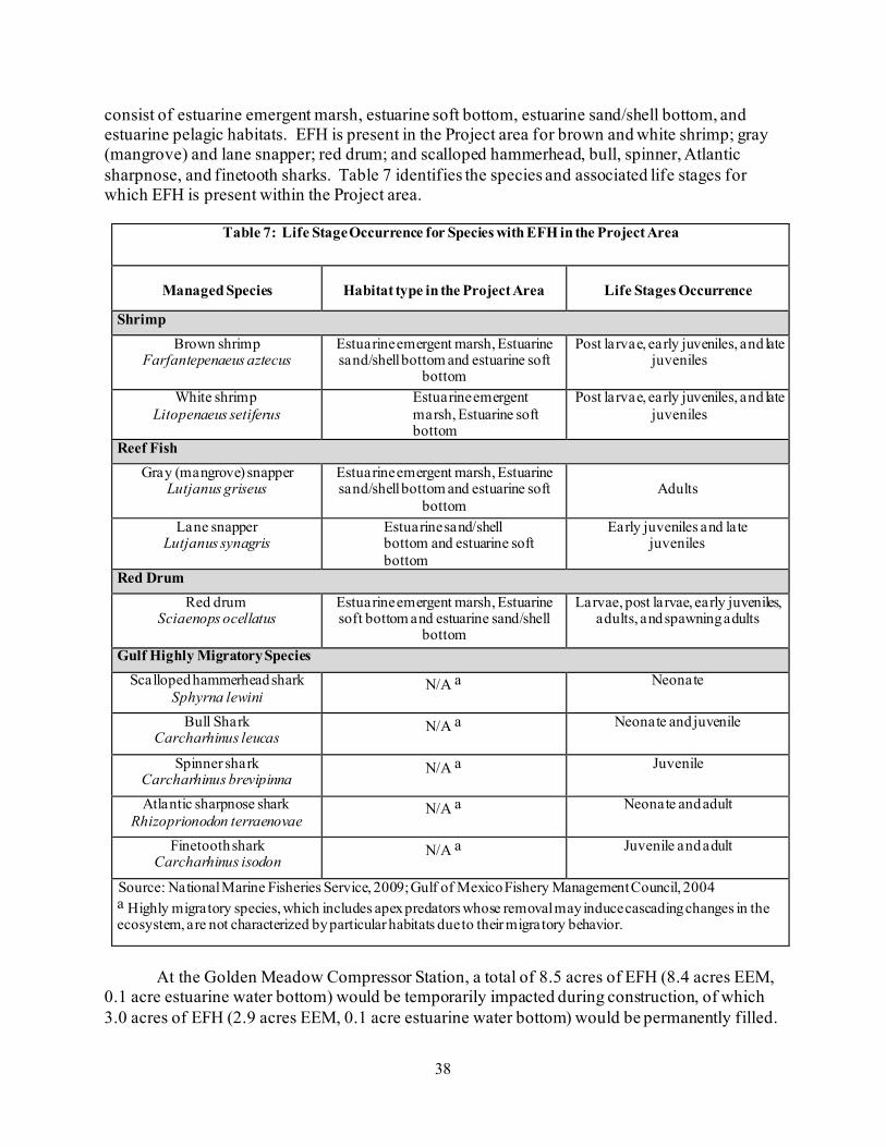
38
consist of estuarine emergent marsh, estuarine soft bottom, estuarine sand/shell bottom, and estuarine pelagic habitats. EFH is present in the Project area for brown and white shrimp; gray (mangrove) and lane snapper; red drum; and scalloped hammerhead, bull, spinner, Atlantic sharpnose, and finetooth sharks. Table 7 identifies the species and associated life stages for which EFH is present within the Project area.
Table 7: Life Stage Occurrence for Species with EFH in the Project Area
Managed Species
Habitat type in the Project Area
Life Stages Occurrence
Shrimp Brown shrimp
Farfantepenaeus aztecus Estuarine emergent marsh, Estuarine sand/shell bottom and estuarine soft
bottom
Post larvae, early juveniles, and late juveniles
White shrimp Litopenaeus setiferus
Estuarine emergent marsh, Estuarine soft bottom
Post larvae, early juveniles, and late juveniles
Reef Fish Gray (mangrove) snapper
Lutjanus griseus Estuarine emergent marsh, Estuarine sand/shell bottom and estuarine soft
bottom
Adults
Lane snapper Lutjanus synagris
Estuarine sand/shell bottom and estuarine soft bottom
Early juveniles and late juveniles
Red Drum Red drum
Sciaenops ocellatus Estuarine emergent marsh, Estuarine soft bottom and estuarine sand/shell
bottom
Larvae, post larvae, early juveniles, adults, and spawning adults
Gulf Highly Migratory Species Scalloped hammerhead shark
Sphyrna lewini N/A a Neonate
Bull Shark Carcharhinus leucas
N/A a Neonate and juvenile
Spinner shark Carcharhinus brevipinna
N/A a Juvenile
Atlantic sharpnose shark Rhizoprionodon terraenovae
N/A a Neonate and adult
Finetooth shark Carcharhinus isodon
N/A a Juvenile and adult
Source: National Marine Fisheries Service, 2009; Gulf of Mexico Fishery Management Council, 2004 a Highly migratory species, which includes apex predators whose removal may induce cascading changes in the ecosystem, are not characterized by particular habitats due to their migratory behavior.
At the Golden Meadow Compressor Station, a total of 8.5 acres of EFH (8.4 acres EEM,
0.1 acre estuarine water bottom) would be temporarily impacted during construction, of which 3.0 acres of EFH (2.9 acres EEM, 0.1 acre estuarine water bottom) would be permanently filled.

39
In Barataria Bay, about 319 acres of EFH (estuarine water bottom) would be temporarily impacted during construction, of which, 0.1 would be permanent. Permanent impacts resulting from the Project on EFH are minor when compared to the abundant amount of similar habitat adjacent to the Project areas at the Golden Meadow Compressor Station and within Barataria Bay. Potential impacts on EFH would be similar to those previously discussed. Given Columbia’s proposed construction and mitigation measures, we conclude that the Project’s impacts on EFH would not be significant.
In a letter dated November 9, 2020, in response to our NOS for the Project, NMFS stated
that, based on the Project location and minimal impacts on EFH, NMFS does not object to the Project as proposed. NMFS further stated that the Project does not appear to have significant adverse impacts on EFH and no further consultation on effects to EFH is necessary unless modifications to this proposal are made.
3. Vegetation and Wildlife
3.1 Vegetation
Vegetation types in the Project area are characterized as wetland, developed land, agricultural land, and open land. Dominant vegetation associated with the PEM wetland at the Centerville Compressor Station consists of seedbox, sand spikerush, and alligator weed; and dominant vegetation associated with the EEM wetlands at the Golden Meadow Compressor Station consists of saltmarsh cordgrass, eastern baccharis, and saltgrass. Impacts on wetlands were previously discussed in section B.2.2. Developed land is typically sparsely vegetated (e.g. large crabgrass, St. Augustine grass, white clover) or lack vegetation due to the presence of impervious surfaces such as cement foundations, pavement, or gravel pads. Agricultural land consists of areas actively cultivated with sugarcane at the Centerville Compressor Station. Open land is non-forested areas that are not otherwise classified as agricultural land. A total of 22.0 acres of upland vegetation would be temporarily impacted during construction. Of this, 2.8 acres would be permanently impacted by operation. Columbia Gulf would restore and revegetate temporary workspaces following construction. Vegetation impacts by the Project are expected to be short-term and recover relatively quickly (1-3 growing seasons).
Areas disturbed during construction provide ideal conditions for the establishment of
invasive plant species. Typically, invasive species rapidly dominate and out-compete native species. To minimize the introduction or spread of invasive plant species to the Project area, Columbia Gulf would implement measures recommended by the NRCS which include: following Columbia Gulf’s ECS to ensure that soil movement and the associated movement of non-native seeds are minimized; using construction techniques that minimize the time that bare soil is exposed; controlling non-native or invasive species within the footprint of permanent facilities using mechanical removal, as necessary; segregating topsoil in temporary workspaces within agricultural land where conditions allow to maintain the existing seed bank; and monitoring disturbed areas following construction to verify that revegetation has been successful and that invasive species have not become widely established.
Given Columbia Gulf’s proposed construction and mitigation measures, we conclude
impacts on vegetation would mostly be short-term and would not be significant.
40
3.2 Wildlife
Wildlife species common to this region of Louisiana include the coyote, swamp rabbit, river otter, fulvous harvest mouse, eastern wood rat, nutria, reddish egret, tricolored heron, white-faced ibis, white-fronted goose, olivaceous cormorant, gulf coast toad, pig frog, American alligator, bottlenose dolphin, diamondback terrapin, and Mediterranean gecko.
Potential impacts on wildlife could occur due to clearing and grading, increased lighting,
and noise. Minimal impacts on wildlife and vegetation are anticipated at the Centerville Compressor Station because it consists primarily of developed land and agricultural land and does not currently support diverse vegetative or wildlife communities. Construction activities could result in direct mortality of some small, less mobile mammals, reptiles, and amphibians. More mobile individuals could be displaced to similar, adjacent habitats during construction activities. Temporary workspaces would be restored and revegetated following construction. Increased lighting and noise during operation of the new Golden Meadow Compressor Station could cause wildlife in the area to disperse to adjacent habitats; however, there is abundant similar habitat available in the surrounding area. Because the Centerville Compressor is in a developed area, wildlife in the area is expected to be habituated to noise and lighting. For these reasons, we conclude that the Project would not significantly impact wildlife.
The Centerville Compressor Station is between two Bayou Teche National Wildlife
Refuge (NWR) management units with one unit approximately 0.3 mile west and one unit approximately 0.3 mile east of the compressor station; however, impacts on this NWR are not anticipated. The Tie-in Facility is approximately 1.9 miles northeast from Queen Bess Island, which is a known brown pelican rookery. However, we conclude impacts on this rookery would be negligible due to its distance from the Project area.
Migratory Birds
Migratory birds are protected under the Migratory Bird Treaty Act of 1918 (MBTA), 16 U.S.C. 703-712. Executive Order 13186 (66 Federal Register 3853) directs federal agencies to identify where unintentional take is likely to have a measurable negative effect on migratory bird populations and to avoid or minimize adverse impacts on migratory birds. Executive Order 13186 states that emphasis should be placed on species of concern, priority habitats, and key risk factors, and that particular focus should be given to addressing population-level impacts.
On March 30, 2011, the U.S. Fish and Wildlife Service (USFWS) and the Commission
entered into a Memorandum of Understanding that focuses on avoiding or minimizing adverse effects on migratory birds and strengthening migratory bird conservation through enhanced collaboration between the two agencies. This voluntary Memorandum of Understanding does not waive legal requirements under the MBTA, Bald and Golden Eagle Protection Act of 1940, ESA, NGA, Federal Power Act, or any other statutes and does not authorize the take of migratory birds. Birds of Conservation Concern (BCC) are a subset of protected birds under the MBTA and include all species, subspecies, and populations of migratory nongame birds that are likely to become candidates for listing under the ESA without additional conservation actions.

41
The Project falls within Bird Conservation Region 37, the Gulf Coast Prairie region of the United States. No BCCs occur within the vicinity of the Centerville Compressor Station. Of the 36 BCCs with potential to occur in the vicinity of the Golden Meadow Compressor Station, 30-inch-diameter pipeline lateral, POD Meter Station, Tie-in Facility, valves and other ancillary facilities, 13 species only occur as occasional migrants or during winter, 1 occurs during the breeding season, and 22 occur year-round within the Project area (appendix D).
Columbia Gulf would implement measures outlined in the ECS during construction and
operation of the Project facilities to reduce impacts on migratory birds. Project activities and initial habitat disturbance are anticipated to commence prior to the start of the primary bird nesting season (April 15 through August 1). Therefore, it is anticipated that migratory birds with suitable nesting or breeding habitat in the vicinity of the Project would avoid the Project area when selecting locations to nest, as construction activities would be underway at the time of nesting season (including pile driving and lighting activities that may be a deterrent for migratory birds). Additionally, BCC species that winter in the Project area or occur as an occasional migrant would be able to relocate to similar adjacent habitats and would likely avoid the construction areas. However, if there is a shift in the construction schedule, construction could occur during the primary nesting season. Even so, most of the Project’s impacts would be underwater in Barataria Bay and the Centerville Compressor Station would be constructed in a developed and agricultural area.
While some permanent impacts associated with reduction of habitat and increased noise
and lighting from the aboveground facilities would occur as a result of the Project, given Columbia Gulf’s limited disturbance to potential nesting areas and measures to minimize impacts during operation of the facilities (e.g., vegetation maintenance outside of the primary bird nesting season), we conclude impacts on migratory birds would be largely short-term (until vegetation is re-established) and that these impacts would not be significant.
Columbia Gulf’s May 1, 2021 letter to the USFWS requested comments on the Project’s
potential impacts on migratory birds. The USFWS has not provided any comments regarding the Project’s impacts on migratory birds to date.
3.3 Special Status Species
Marine Mammals
Marine mammals are federally protected under the Marine Mammal Protection Act.
Actions that have the “potential to injure” are Level A harassment, and those actions that have the “potential to disturb” are Level B harassment.18
Bottlenose dolphins commonly occur in Barataria Bay and could primarily be affected by
pile driving. To determine the potential for Level A and Level B harassment to occur as a result of the Project, Columbia Gulf estimated the distance at which the permanent threshold shift (i.e., injury threshold) and behavioral threshold would be exceeded, respectively. Injury thresholds (i.e., Level A harassment) are not anticipated to be exceeded beyond 142.1 feet from pile driving
18 50 CFR 216.3
42
activities and the behavioral threshold (Level B harassment) is not anticipated to be exceeded beyond 1,407 feet from pile driving activities.19
Although bottlenose dolphins would be expected to largely avoid the Project area during
pile driving activities, the potential exists for bottlenose dolphins to be present when pile driving begins. In accordance with recommendations from the NMFS, Columbia Gulf would utilize biological monitors to ensure that dolphins do not come within 1,407 feet of pile driving activities and are not present within that radius when pile driving activities begin. Columbia Gulf would use bubble curtains to minimize underwater noise. Soft starts would also be used to allow dolphins and other marine life to leave the general Project vicinity prior to the start of full impact pile driving. In the event dolphins are observed entering the area in which the injury threshold would be exceeded (i.e., Level A), Columbia Gulf would cease pile driving until the dolphins leave the area of their own accord. Through the implementation of these measures, Columbia Gulf would ensure that dolphins are not present within areas where Level A harassment is likely to occur. Columbia Gulf would apply for and obtain an Incidental Harassment Authorization from the NMFS for Level B harassment in the event dolphins are observed entering the area in which the behavioral threshold would be exceeded during pile driving activities. Given Columbia Gulf’s proposed measures, we conclude that underwater noise impacts on bottlenose dolphins would be temporary and minor. In addition, Columbia Gulf plans to apply for and obtain an Incidental Harassment Authorization from NMFS in the event that dolphins are observed entering the area in which the behavioral threshold is exceeded during pile driving activities (1,407 feet from pile driving).
Federally Threatened and Endangered Species
Review of the USFWS Information for Planning and Consultation online database (IPaC)
identified only one federally listed species with the potential to occur in the Project area under the USFWS’ jurisdiction, the West Indian manatee (appendix E).
West Indian manatees could be impacted by dredging, trenching, excavation, backfilling
and pile installation. Construction vessels could strike a manatee if encountered in the Project area. However, given manatee maneuverability and the very slow nature of barge movement, impacts on manatees are unlikely as they would likely disperse in advance of construction activities. Columbia Gulf would implement measures recommended by the USFWS to minimize impacts on manatees including:
• All work, equipment, and vessel operation would cease if a manatee is spotted
within a 50-foot radius (buffer zone) of the active work area. Once the manatee has left the buffer zone on its own accord (the species must not be herded or harassed into leaving), or after 30 minutes have passed without additional sightings of manatee(s) in the buffer zone, in-water work would resume under careful observation for manatee(s).
• If a manatee(s) is sighted in or near the Project area, all vessels associated with the Project would operate at “no wake/idle” speeds within the construction area
19 Columbia Gulf’s assessment of distances to underwater sound thresholds for in-water pile driving can be found in on eLibrary in Resource
Report 3 at https://elibrary.ferc.gov/eLibrary/filelist?document_id=14894052.

43
and at all times while in waters where the draft of the vessel provides less than a 4-foot clearance from the bottom. Vessels would follow routes of deep water whenever possible.
• If used, siltation or turbidity barriers would be properly secured, made of material in which manatees or sea turtles cannot become entangled, and be monitored to avoid entrapment of these species or impeding their movement.
• Columbia Gulf would post temporary signs at the vessel control station or in a prominent location, visible to all employees operating the vessel, concerning manatees prior to and during all in-water Project activities.
• Columbia Gulf would report collisions with, injury to, or sightings of manatees to the USFWS and LDWF.
Occurrence data provided by LDWF’s Wildlife Diversity Program identified a known occurrence of the West Indian manatee 2.5 miles from the Project area in Barataria Bay. Columbia Gulf assessed the distance to underwater noise thresholds for in-water pile driving and are the same as those previously discussed for dolphins. All in-water pile driving within Barataria Bay would be conducted with the use of soft starts and bubble curtains; thereby, minimizing impacts on manatees from pile driving. Further, biological monitors would be present in the area to ensure that manatees do not come within 1,407 feet of pile driving activities (distance to which the behavioral threshold is exceeded). If a manatee is identified within that radius, pile driving would cease until the manatee leaves of its own accord. Although one manatee occurrence was recorded in Bayou Lafourche which is about 330 feet from the Golden Meadow Compressor Station, this occurrence was on the opposite side of a highway and manatees are not anticipated to be present within the Golden Meadow Compressor Station area because water access on the west side of Highway 1 is limited. Given Columbia Gulf’s proposed construction, monitoring, and mitigation measures, we conclude that the Project is not likely to adversely affect the West Indian manatee.
As our non-federal representative, Columbia Gulf submitted a letter dated May 1, 2020 to
the USFWS Louisiana Ecological Field Office requesting concurrence that the Project is not likely to adversely affect the West Indian manatee. The USFWS concurred in a letter dated May 8, 2020. No additional consultation with the USFWS required.
Consultation with NMFS identified the fin whale, sei whale, sperm whale, Gulf of
Mexico Bryde’s whale, oceanic whitetip shark, giant manta ray, and gulf sturgeon as occurring in marine waters in Louisiana. However, the Project area does not contain suitable habitat for, or is outside the range, of these species and the Project would have no effect on these species. Consultation with NMFS also identified five federally listed species with the potential to occur in the Project area: hawksbill sea turtle, Kemp’s ridley sea turtle, leatherback sea turtle, green sea turtle, and loggerhead sea turtle.
The Project’s potential impacts on sea turtles would be similar to those previously
described for the West Indian manatee and bottlenose dolphin, including pile installation, dredging, trenching, excavation and back-filling, and vessel strikes. Based on range and habitat, there is potential for sea turtles to occur within the Project area in Barataria Bay; however, only foraging adults are anticipated to occur, as no nesting habitat is present within the vicinity of the

44
Project. Sea turtles are highly mobile and are anticipated to leave the area if present at the start of Project activities, or avoid the area if Project activities are already underway within Barataria Bay. To minimize impacts on sea turtles, Columbia Gulf would adhere to the NMFS’ Sea Turtle and Smalltooth Sawfish Construction Conditions (2006). Columbia Gulf would ensure that if a sea turtle is observed within 100 yards of the active daily construction operation, all appropriate precautions would be implemented to ensure its protection. These precautions include cessation of operation of any moving equipment within 50 feet of a sea turtle. Operation of moving equipment would not resume until the sea turtle has left the area of its own accord. Columbia Gulf would also operate at “no wake/idle” speeds at all times while in the construction area and while in water depths where the draft of the vessel provides less than 4 feet of clearance from the water bottom, where practicable.
Underwater sound pressure levels generated by pile driving within Barataria Bay could
affect sea turtles by causing decreased auditory sensitivity; loss of hearing; behavioral changes such as avoidance, which can increase energy expenditure, reducing overall fitness; or by masking acoustic cues that are import for evading predators or anthropogenic hazards (e.g., vessels). Columbia Gulf assessed the anticipated distances at which the thresholds for physical injury or behavioral impacts are expected to be exceeded. It is anticipated that injury and behavioral thresholds would be exceeded within approximately 761 feet and 1,407 feet of pile driving activities, respectively with the use of bubble curtains. Columbia Gulf would stop Project activities if a sea turtle is observed within 761 feet of pile driving and 50 feet of other construction activities, in accordance with the NMFS Sea Turtle and Smalltooth Sawfish Construction Conditions. In order for sea turtles to be injured during pile driving activities, they would have to be within 8 feet of a single strike (peak) or spend 24 hours within 761 feet of the pile driving activities. As sea turtles are prone to avoid construction activities, it is anticipated that sea turtles would quickly leave the area prior to or immediately following commencement of construction activities, including pile driving. Further, Columbia Gulf would implement the use of soft starts to allow sea turtles additional time to leave the area if present prior to initiation of full impact pile driving.
Given Columbia Gulf’s proposed construction, monitoring, and mitigation measures and
the likelihood that sea turtles would avoid the area during construction, we conclude that the Project is not likely to adversely affect the hawksbill, Kemp’s ridley, leatherback, green, or loggerhead sea turtles.
As our nonfederal representative, Columbia Gulf submitted a letter to NMFS requesting
concurrence that the Project is not likely to adversely affect the hawksbill, Kemp’s ridley, leatherback, green, and loggerhead sea turtles and that the Project would have no effect on the fin whale, sei whale, sperm whale, Gulf of Mexico Bryde’s whale, oceanic whitetip shark, giant manta ray, and gulf sturgeon. No response has been received to date. To ensure compliance with section 7 of the ESA, we recommend that:
• Columbia Gulf should not begin construction of the Project until:
a. FERC staff receives comments from NMFS regarding the proposed action;
b. FERC staff completes ESA consultation with the NMFS; and

45
c. Columbia Gulf has received written notification from the Director of the Office of Energy Projects (OEP), or the Director’s designee, that construction or use of mitigation may begin.
State-listed Species
Columbia Gulf consulted with the LDWF to determine the state-listed or protected
species that could potentially occur within the Project vicinity. Six state-listed species were identified as potentially occurring within the Project area: the West Indian manatee, piping plover, red knot, pallid sturgeon, gulf sturgeon, and smalltooth sawfish. All six state-listed species are also federally listed. However, the official species list generated by the IPaC and the NMFS species list do not list the piping plover, red knot, pallid sturgeon, or smalltooth sawfish as potentially present in the Project vicinity. The gulf sturgeon is also federally listed and was identified in the NMFS species list; however, as discussed previously, the Project is outside the range of this species.
Columbia Gulf submitted a letter to the LDWF on May 1, 2020 requesting concurrence
that the Project is not likely to impact the West Indian manatee and that the Project would not impact any other state listed species. In a letter dated May 7, 2020, the LDWF indicated that no impacts on state-listed, rare, threatened, or endangered species or critical habitats are anticipated to occur as a result of the Project and that no additional state-listed species consultation is required for the Project.
4. Land Use, Recreation, and Visual Resources
4.1 Land Use
The Project would impact a total of 348.9 acres, including 104.3 acres of permanent impacts (about 97.5 acres of which are in open water) associated with the new permanent pipeline easement, access roads, and aboveground facilities. The land within the Project area is characterized as open water, industrial, wetlands, open land, and agricultural land. Appendix F summarizes the land use impacts associated with the construction and operation of the Project.
Open Water
Open water includes natural ponds within the Project area at the Golden Meadow Compressor Station and the Project area in Barataria Bay. Open water accounts for approximately 83.4 percent of the Project area, with 291 acres being utilized for construction of the Project. Although a 300-foot-wide construction right-of-way is required for installation of the 30-inch-diameter pipeline lateral in Barataria Bay, a maximum width of only 47 feet of sea floor would be disturbed by construction, resulting in 46.1 acres of sea floor disturbance. With the exception of 0.1 acre of open water associated with the proposed blowdown facility at the Golden Meadow Compressor Station, open water impacted during operation of the Project facilities (104.3 acres) would not result in a change of land use designation. During construction, Columbia Gulf would implement best management practices and adhere to its ECS, which adopts and incorporates the FERC Procedures. Additional information regarding impacts on water resources is provided in section B.2.

46
Industrial
Industrial land encompasses most developed land that is not characterized as residential. Industrial areas within the Project area consist of the existing abandoned compressor station and associated access driveways at the Centerville Compressor Station, as well as existing roads and energy infrastructure within the Project area at the Golden Meadow Compressor Station. These existing facilities mostly lack vegetation due to the presence of impervious structures, such as cement foundations, pavement, gravel pads, or bare, compacted land with a hard surface. Industrial land accounts for approximately 2.5 percent of the Project area. A total of 18.3 acres of industrial land would be utilized during construction of the Project, of which 2.5 acres would be required for operation of the Centerville and Golden Meadow Compressor Stations. Wetlands
Wetlands represent approximately 1.1 percent of the Project area and include estuarine intertidal emergent and palustrine emergent wetlands. A total of 8.4 acres of wetlands would be utilized for construction of the Project, and 3.1 acres would be permanently impacted (filled) by the installation of aboveground facilities and utilized for operation of the Golden Meadow and Centerville Compressor Stations. In addition, the permanent easements for station piping at the Golden Meadow Compressor Station encompass 0.4 acre of wetlands. However, because the wetland crossed by the station piping is classified as estuarine emergent, there would be no permanent wetland conversion associated with maintenance of the permanent easements.
Following the completion of construction activities, all wetlands associated with temporary workspace and not filled within the permanent easements would be allowed to revegetate and revert to pre-construction conditions, in accordance with the ECS, which incorporates the FERC Procedures. Impacts on wetlands from construction and operation of the Project, as well as restoration and mitigation measures are further described in section B.2.2. In addition, Columbia Gulf would implement any additional permit conditions required by the LDNR OCM to mitigate wetland fill impacts. Open Land
Open land is comprised of non-forested areas that are not otherwise classified as agricultural land and accounts for approximately 0.3 percent of the Project area. Columbia Gulf would use a total of 2.5 acres of open land for construction of the Project, including 1.6 acres associated with the Centerville Compressor Station and 0.9 acre associated with the Golden Meadow Compressor Station. A total of 0.2 acre of open land would be converted to industrial land following construction to allow for permanent operation of the Centerville Compressor Station. Following the completion of construction activities, Columbia Gulf would revegetate open land associated with temporary workspace in accordance with its ECS and the FERC Plan. Agricultural Land
Agricultural land accounts for approximately 0.2 percent of the total Project area and is limited to the workspace at the Centerville Compressor Station (sugar cane). A total of 1.2 acres

47
of agricultural land would be utilized for construction of the Project, of which 0.1 acre would be permanently removed from agricultural production by the installation of aboveground facilities and utilized for operation of the new Centerville Compressor Station. With the exception of permanent workspaces, all agricultural land impacted by the Project would either be restored per the ECS or restored in accordance with landowner recommendations.
Columbia Gulf would minimize adverse impacts on agricultural land by implementing its ECS and the FERC Plan. Columbia Gulf would work with landowners in these areas to ensure that proper restoration of any impacted agricultural area occurs, including replacement of segregated topsoil, stone removal, and decompaction. Columbia Gulf would restore all agricultural land impacted by construction to appropriate contours to maintain pre-construction hydrology. Should construction result in any new drainage or ponding issues, Columbia Gulf would work with the landowner to resolve the problem.
Given Columbia Gulf’s implementation of the measures in its ECS, which includes the
FERC Plan and Procedures, we conclude that the Project would not significantly impact the land uses described above. Existing Residential Land
Residential land is described as existing residential areas that include single and multiple family dwellings, as well as landscaped areas or driveways associated with an immediate residence. Abandoned uninhabitable structures are within the temporary workspace for the Golden Meadow Compressor Station; however, these structures are not occupied as an immediate residence, nor are they believed to be suitable for occupancy. Therefore, the structures and associated land are classified as open land. The closest residential structure to the Centerville Compressor Station is 0.1 mile east of the proposed temporary workspace. The closest occupied residential structure to the Golden Meadow Compressor Station is 0.5 mile north of the temporary workspace.
Overall construction of the Project facilities could result in short-term impacts on nearby residential areas, including increased construction-related traffic on local roads, as well as dust and noise generated during construction. Columbia Gulf would minimize impacts on nearby residences through implementing the following measures during construction activities:
• limiting construction activities to daytime hours whenever feasible; • ensuring (to the best of their abilities) that utilities would not be disrupted during
construction. If the need to disrupt utilities arises, Columbia Gulf would provide as much advanced notice as possible to the landowner;
• notifying affected and adjacent landowners prior to the start of construction; • maintaining traffic flow and emergency vehicle access on residential roadways, and
using traffic detail personnel and/or detour signs where appropriate; and • inspecting and cleaning road surfaces periodically of any soil and debris.
Prior to initiating construction activities, Columbia Gulf would provide information
regarding procedures to follow in the event that a landowner has any concerns or problems

48
during construction. In addition to the measures listed above, Columbia Gulf would implement its Project-specific Fugitive Dust Control Plan to reduce dust during construction. As presented in section B.7.2, with implementation of the recommended noise mitigation measures, the predicted sound levels from operation of the new Centerville and Golden Meadow Compressor Stations are estimated to be lower than 55 decibels on the A-weighted scale (dBA), day-night sound level (Ldn), at the closest noise sensitive areas (NSA). Visual resources are discussed in section B.4.4. With Columbia Gulf’s proposed mitigation and our recommendation for visual resources, we conclude that no residences or residential land would be significantly impacted by construction or operation of the Project facilities.
Planned Residential and Commercial Areas
No planned residential or commercial developments have been identified within 0.25 mile of the Project area.
4.2 Public Land, Recreation, and Other Designated Areas
Public or Conservation Land
The Centerville Compressor Station is in the Atchafalaya National Heritage Area, which is made up of 14 parishes in south-central Louisiana. In 2006, this area was designated by Congress as a region with significant natural, scenic, cultural, historical, and recreational resources while offering a conglomeration of many cultures (Louisiana Department of Culture, Recreation and Tourism, 2020a). The Centerville Compressor Station is primarily within an existing industrial facility surrounded by other natural gas facilities and agricultural land. Therefore, construction and operation of the Centerville Compressor Station is not anticipated to impact the national heritage area.
The Project is not within 0.25 mile of any other national parks, monuments, preserves, historic sites, historical parks, memorials, battlefields, military parks, cemeteries, recreation areas, seashores, lakeshores, boat launches, banks and piers, parkways, trails, and other designations. Additionally, the Project is not within 0.25 mile of any Indian reservations, National Wildlife Refuges, National Wilderness Areas, or registered National Landmarks. Further, the Project is not within 0.25 mile of any state park, forest, or wildlife management area.
The Centerville Compressor Station is 0.3 mile from two management units of the Bayou Teche NWR. This refuge is not one large wildlife refuge, but rather a composition of 6 non-contiguous management units that range from 81 acres to 3,619 acres. Although Project construction would occur in the vicinity of the Bayou Teche NWR, construction within the Project area at the Centerville Compressor Station is predominantly within the existing facility fence line. In addition, the facility is in the vicinity of at least three other industrial facilities in a predominantly rural and agricultural area. Therefore, we conclude construction and operation of the Project would not adversely impact the Bayou Teche NWR.
The Project would not cross and is not within any land designated as Conservation Reserve Program, Conservation Reserve Enhancement Program, Agricultural Conservation Easement Program, Healthy Forests Reserve Program, or Wetlands Reserve Program land.

49
Natural, Recreational, or Scenic Areas
Natural, recreational, or scenic areas are those which are included in or designated for study for inclusion in the Nationwide Rivers Inventory, National Wild and Scenic Rivers System, the National Trails System, wilderness areas designated under the Wilderness Act, or natural areas designated by state agencies (LDWF, 2020c, 2020d; National Recreation Trail, 2020; NPS, 2020e, 2020f, 2020g; Wilderness Connect, 2020).
The Project is not within 0.25 mile of any National Scenic Byways; however, State Highway (SH) 1, which would be utilized for access to the Project area at the Golden Meadow Compressor Station during construction and operation activities, is designated as the Wetlands Cultural Byway under the Louisiana Scenic Byways Program (Louisiana Byways, 2020; USDOT, 2020). No road modifications or improvements are proposed, and the majority of impacts would be temporary and associated with the construction phase of the Project. Therefore, we conclude no adverse impacts on the Wetlands Cultural Byway would occur. Visual impacts associated with construction and operation of the Golden Meadow Compressor Station are not anticipated to be significant or adverse, as further discussed in section B.4.4. Traffic may increase along SH-1 during construction; however, Columbia Gulf would minimize impacts on traffic, as discussed in section B.5.2 Additionally, Columbia Gulf would notify the Lafourche Parish Tourist Commission, which is responsible for managing the Wetlands Cultural Byway, when construction has commenced. Barataria Bay is also popular for recreational fishing. Impacts on recreational and commercial fisheries would be temporary and only occur during construction activities. Further, Columbia Gulf would implement measures, such as bubble curtains, to minimize impacts on local fisheries. Therefore, we conclude that impacts on recreational fishing would not be significant.
4.3 Coastal Zone Management Areas
All of the Project facilities are within a Coastal Management Zone. However, the Project area at the Centerville Compressor Station is within state-designated fastlands, which are exempt from Coastal Use Permitting requirements in the State of Louisiana (LDNR, 2020b, 2012). Columbia Gulf submitted its Coastal Use Permit application form for the Project facilities at the Golden Meadow Compressor Station and in Barataria Bay on June 19, 2020. The Coastal Use Permit for the Project is pending and will be filed with FERC upon receipt. Because Columbia Gulf has not yet received its Coastal Use Permit, we recommend that:
• Columbia Gulf should not begin construction of the Project until it files with the
Secretary of the Commission (Secretary) a copy of the determination of consistency with the Coastal Zone Management Plan issued by the LDNR.
4.4 Visual Resources
With the exception of the Bayou Teche NWR and the Wetlands Cultural Scenic Byway, the Project would not be within the vicinity of any other federal, state, or locally designated
50
scenic areas, such as National Wild and Scenic Rivers. Impacts on visual and/or aesthetic resources as a result of construction and operation of the Project facilities in Barataria Bay have been minimized to the extent practicable and are anticipated to be negligible due to the locations within open water, and in the case of the POD Meter Station, being located on an already approved platform. Impacts on visual and/or aesthetic resources would primarily occur during construction and operation of the Centerville and Golden Meadow Compressor Stations due to the presence of construction equipment and installation of the new aboveground structures.
The new Centerville Compressor Station is proposed 0.1 mile east from the nearest sensitive visual area (residence) and 0.3 mile from the Bayou Teche NWR; however, the Project area is in the vicinity of existing industrial infrastructure and in a predominantly rural and agricultural area. The proposed buildings and equipment at the Centerville Compressor Station would be adjacent to the existing office/utility building and existing compressor building. The heights of the existing office/utility building and Remote Terminal Unit (RTU) building are slightly shorter, and the heights of the existing compressor building, condensate tanks, and flare are taller than the proposed Project facilities. The proposed equipment and buildings at the Centerville Compressor Station would be more than 400 feet from the nearest public road (Parish Road 16). Further, due to the distance of the station from public roads, the viewshed of the existing and new facilities does not extend above the tree lines to the southeast and west of the station. In addition, a large existing industrial facility is directly south of the Centerville Compressor Station, and other industrial development is in the vicinity. However, the Centerville Compressor Station would be visible from residences 0.1 mile west and 0.5 mile north of the compressor station. There is no existing vegetative buffer and Columbia Gulf does not propose any vegetative screening. Section 380.15(g)(5) of our regulations (Siting and Maintenance Requirements) states for NGA projects, the site of aboveground facilities which are visible from nearby residences or public areas, should be planted in trees and shrubs, or other appropriate landscaping and should be installed to enhance the appearance of the facilities, consistent with operating needs. Therefore, we recommend that:
• Prior to construction of the Centerville Compressor Station, Columbia Gulf
should file a visual screening plan for review and written approval by the Director of OEP, or the Director’s designee, to minimize visual impacts on the residences 0.1 mile west (NSA 1) and 0.5 mile north (NSA 3) at the Centerville Compressor Station. At a minimum, the plan should include vegetative plantings to provide a visual buffer.
The Golden Meadow Compressor Station is adjacent to SH-1, which is designated as the
Wetlands Cultural Scenic Byway, and 0.5 mile from the nearest sensitive visual area (residence). The Golden Meadow Compressor Station would be constructed in a predominantly rural area in the vicinity of other industrial facilities, and no direct impacts on the byway are anticipated to occur. Construction of the Project facilities would be consistent with the surrounding landscape, which would minimize any visual or aesthetic impairment. Additionally, existing infrastructure would likely obscure the compressor station from view of the nearest residence. Therefore, we conclude impacts on visual and/or aesthetic resources associated with the Project would not be anticipated.

51
Minor amounts of artificial lighting would be necessary during construction and to a lesser extent during operation of the Project facilities. The localized nature of this lighting, in addition to the proximity of the nearest sensitive visual areas from the Project facilities, would result in minimal impacts on visual resources from artificial lighting. Columbia Gulf would utilize light shields in order to reduce the effects of lighting on neighboring areas during Project construction and operation activities at the Centerville and the Golden Meadow Compressor Stations. Overall, we conclude with Columbia Gulf’s proposed construction methods, siting, and our recommendation, visual impacts from construction and operation of the Centerville and Golden Meadow Compressor Stations would be minimal.
5. Socioeconomics
Project construction would occur within St. Mary, Lafourche, Jefferson, and Plaquemines Parishes, Louisiana, and is scheduled to take approximately 11 months, beginning in January 2022. Socioeconomic impacts resulting from the construction and operation of the proposed Project would be related to the number of construction workers that would work in the Project area and their impact on population, public services, and employment during construction. Other potential effects include an increase in local traffic, decreased available housing, increased tax revenue, and possible disproportionate impacts on environmental justice communities.
5.1 Employment
Table 8 provides demographic information for the State of Louisiana and for St. Mary, Lafourche, Jefferson, and Plaquemines Parishes within which any socioeconomics effects would be expected to occur.
Table 8: Existing Socioeconomic Characteristics in the Project Area
State/Parish
2019 Population Estimate
Median Household Income
Civilian Labor Force
Unemployment Rate
Top Three Major Industriesa
Louisiana 4,648,794 $47,942 2,152,802 6.9 E St. Mary Parish 54,650 $40,485 27,125 9.0 E Lafourche Parish 96,318 $53,089 46,849 6.9 E Jefferson Parish 432,552 $52,386 222,629 5.7 E Plaquemines Parish
23,042 $42,573 10,415 3.6 E, M, C
a E = Educational services, and health care and social assistance; M = Manufacturing; C = Construction. Sources: U.S. Census Bureau, 2019 and U.S. Bureau of Labor Statistics. 2019.
During construction, the Project would require an average of 45 workers per week.
Columbia Gulf estimates 50 percent of the construction workers hired would be local residents, and it would hire 5 new permanent personnel to operate the new facilities.

52
Given the population of the parishes, the size of the civilian labor force, and the relatively short duration of construction, we anticipate that the Project would have a temporary and negligible positive impact on unemployment rates in the Project area and a negligible impact on the population and industries within the Project area.
The Teamsters stated that Local Union 5 would have work jurisdiction on the Project
area, and they have specialized contractors for pipeline work that involve wetlands and waterways. The Teamsters stated that Local Union 5 also fish and hunt in the state and would value protecting the environment. In addition, by using Pipe Line Contractors Association contractors, the Teamsters state the majority of workers would be local, and qualified. The Teamsters also stated there is language in the collective bargaining agreement codifying the use of local workers, in addition to a drug and alcohol policy. As stated above, Columbia Gulf estimates 50 percent of the construction workers hired would be local residents. Columbia Gulf, or its contractor, would be responsible for hiring appropriately trained workers.
5.2 Transportation
Construction of the Project may result in minor, temporary impacts on roadways due to construction and the movement of workers and heavy equipment to and from the Project area. Once equipment and materials reach the construction workspace, a majority of construction traffic would be confined to the designated workspace for the Project.
Columbia Gulf anticipates that workers would carpool to the sites to minimize traffic, and
Columbia Gulf would establish parking areas at the sites for the workers. Appropriate traffic control measures, such as flagmen and signs, would be used as necessary to ensure safety of local traffic. Columbia Gulf would minimize the amount of heavy traffic, including oversize/overweight loads, during the peak travel times of the day. During the school year, Columbia Gulf has committed to work with the local school districts to minimize heavy traffic during school bus pick-up and drop-off times in the vicinity of the Project.
Prior to construction, Columbia Gulf would discuss with local officials ways to minimize
short-term, localized impacts on roadways. Columbia Gulf would work with state and local agencies to obtain all necessary permits for temporary construction-related impacts on roadways. Further, Columbia Gulf would direct its construction contractors to comply with local road weight limitations and restrictions and remove any soil that falls from equipment onto roadway surfaces.
Table 9 identifies the number of average daily round trips from each site, the main access
road and average daily traffic count, and the average increase in traffic that would occur during construction. It is estimated there would be a maximum of 115 trips per day along each of the transportation routes during the peak of construction; therefore, the average daily traffic (ADT) count for the roadways in the Project vicinity would increase by 0.48 percent during construction and less than 0.1 percent during operation. The maximum number of cars associated with construction of the Project would not exceed the capacity of any of the roads used by the Project.

53
Table 9: Traffic Counts and Average Daily Round Trips Estimates for Construction Work
Compressor
Station
Primary Access
Road
ADT
(Year Last Assessed)
a
Construction
Percent Increase in ADT
Operational
Percent Increase in
ADT
Capacity of
Roadway (LOS D) b
Current Percent
Capacity
Centerville Compressor
Station
LA-317
1,958 (2017)
5.87%
0.05%
24,200
8.09%
Golden Meadow
Compressor Station
LA-1
9,260 (2018)
1.24%
0.03%
24,200
38.26%
a Louisiana Department of Transportation and Development, 2020 b Federal Highway Administration, 2017
Impacts from construction and operational activities include potential traffic delays
associated with workers arriving on site and delivery of construction equipment and materials. Five new workers would be hired to operate the facilities, but any increases in operational traffic would be negligible. Because of the limited size and duration of construction and Columbia Gulf’s proposed traffic management strategies (including use of the roads outside of peak periods), we conclude impacts on transportation would be temporary, and not significant.
During construction of the Project facilities in Barataria Bay, barges would deliver large
equipment and materials to the Project sites. Columbia Gulf anticipates a total of 704 barge trips to the Project area in Barataria Bay during construction. The frequency of deck boat runs would average 20 trips per day, 6 days per week for the construction period of 11 months. Tugboats would be used to transport barges through the Barataria Waterway to the Project area within Barataria Bay.
Columbia Gulf would use Barataria Bay Waterway solely for initial Project access to the
workspace within the waterway. Columbia Gulf would provide up to three 30-person living quarter barges, which measure approximately 130 feet in length by 30 feet in width, as needed during the full duration of Project construction activities within Barataria Bay. In addition, each of the spud barges for laying the pipeline and/or setting the tie-in platform are equipped with their own accommodations to house the contractor’s personnel. On average, the Barataria Bay Waterway ranges in width from approximately 500 feet to approximately 1,050 feet. The barges would not be stopping within the waterway for construction, as no construction activities within the waterway itself would be required. The living quarter barges for the Project would measure approximately 130 feet in length by 30 feet in width; therefore, there would be maneuverability for other boat passage as the living quarter barges travel down the waterway to Barataria Bay. Barataria Bay itself, which is where Project construction activities would occur and the vessels would remain, is approximately 15 miles long and 12 miles wide. Therefore, construction vessels would not restrict access nor hinder maneuverability within Barataria Bay.

54
Columbia Gulf would take all reasonable measures to limit vessel traffic to the maximum extent possible. Before construction commences, Columbia Gulf would initiate discussions with local officials about minimizing the short term, localized impacts on waterways. As a result of these measures, we conclude traffic on the waterway would be minimized to the extent practicable and would not be significant during construction of the Project.
5.3 Housing
Construction of the Project would require a peak workforce of about 260 workers within the Project area. Columbia Gulf estimates it would hire about 50 percent of workers from outside the Project area and 30 percent of those would provide their own housing units (e.g., recreational vehicles). Therefore, up to 39 workers from outside the Project area may require temporary housing during the construction period. There are approximately 12 hotels or motels available within St. Mary Parish, 14 within Lafourche Parish, 27 within Jefferson Parish, and 26 within Plaquemines Parish. In addition, there are a total of 43 recreational vehicle parks within St. Mary, Lafourche, Jefferson, and Plaquemines Parishes. Furthermore, there are approximately 770 units available for seasonal, recreational, or occasional use near the Project in St. Mary Parish, 433 in Lafourche Parish, 2,553 in Jefferson Parish, and 688 in Plaquemines Parish. In addition, Columbia Gulf would house construction personnel, when possible, on up to three 30-men living quarter barges, that would be staged in Barataria Bay so that personnel would not have to be repeatedly chartered to and from the Project area. In addition, each of the spud barges for laying the pipeline and/or setting the tie-in platform are equipped with their own accommodations to house the personnel.
Based on the number of available rental units and hotels and motels in the Project area,
along with other recreation vehicle parks in the Project area, we conclude that the presence of the construction crews could cause a minor, temporary impact on housing in the Project area. Given the availability of housing, we conclude the addition of 5 new workers to the existing workforce would have only a negligible effect on housing in the Project area.
5.4 Public Services
Columbia Gulf identified 2 hospitals in St. Mary Parish with a total of 182 beds, 3 hospitals in Lafourche Parish with a total of 218 beds, 14 hospitals in Jefferson Parish with a total of 1,641 beds, and 1 hospital in Plaquemines Parish with 47 beds. Columbia Gulf also identified 53 community medical services, 24 emergency medical services facilities, 23 police services facilities, and 40 fire services facilities within the Project area parishes (see table 10).
Columbia Gulf maintains a program of coordination with public authorities, including
fire departments and emergency providers, for all facility locations. Although the need for medical, fire, and police services may increase slightly due to the 130 workers who would temporarily relocate to the Project area during the 11-month construction period, based on the information above, we conclude adequate public safety services exist in the Project area to handle any Project-related emergency event and no significant impacts on these resources would occur as a result of the Project.
55
Table 10: Existing Public Services and Facilities in the Vicinity of the Project Area
Parish
Community Medical Services a
Emergency Medical
Services a
Police Services a
Fire Services a
Schools b, c, d, e
Major Transportation
Routes a
St. Mary Parish 3 2 6 6 21 US-90; State Rte 317
Lafourche Parish
20
10
5
16
30
LA-1; S Alex Plaisance
Blvd Jefferson Parish 22 8 7 15 79 LA-39; LA-23
Plaquemines Parish 8 4 5 3 11 Jean Lafitte Blvd
Nearest Emergency
Service Facility to the
Project (Distance
from Project [miles])
Centerville Compressor
Station
Franklin
Health Care Center (5.72)
Franklin Foundation
Hospital (6.30)
St. Mary Parish Sheriff’s Office (0.43)
Centerville Volunteer
Fire Department
(1.65)
N/A
N/A
Golden Meadow
Compressor Station
Lady of the Sea Medical Clinic (4.06)
Lady of the Sea General
Hospital (9.42)
Golden Meadow Chief of Police (4.70)
Golden Meadow
Fire Department
(4.11)
N/A
N/A
30-inch Lateral,
POD meter station, and
Tie-in Facility
The Family
Doctors Grand Isle
Clinic (7.44)
Lady of the Sea General
Hospital (23.15)
Grand Isle
Police Department
(7.36)
Grand Isle
Fire Department
(7.45)
N/A
N/A
N/A – Not Applicable Source: a Google Maps, 2020 b https://www.stmaryk12.net/Page/246 c https://www.lpsd.k12.la.us/directory/school d https://www.jpschools.org/domain/895 e https://www.ppsb.org/
There are 141 schools near the Project area. It is anticipated that 130 people (during peak
construction) would temporarily relocate for the Project. However, Columbia Gulf anticipates that only 50 percent of non-local workers (65 people) would be accompanied by their families. Therefore, due to the number of schools available in St. Mary, Lafourche, Jefferson, and Plaquemines Parishes and the limited number of school-aged children expected to relocate to the Project vicinity (during construction and operation), we conclude only temporary and no significant impacts on class size or school enrollment are anticipated as a result of the Project.
5.5 Economy and Tax Revenue
The Project would contribute to the local and regional economy directly and indirectly through spending by construction workers, purchases of goods and materials, and from taxes collected on purchases, payroll, and property. Columbia Gulf estimates the total construction payroll for the Project to be approximately $96 million; local expenditures for Project

56
construction materials and fuel to be approximately $11.5 million; and local expenditures by construction personnel for goods, services, and entertainment to be approximately $33.6 million. Approximately 17.6 percent of the total construction payroll would occur within St. Mary Parish, approximately 21.4 percent within Lafourche Parish, approximately 30.5 percent within Jefferson Parish, and approximately 30.5 percent within Plaquemines Parish. In addition, when in service, the Project would pay annual property taxes of approximately $537,000 for the Centerville Compressor Station in St. Mary Parish and $637,000 for the Golden Meadow Compressor Station in Lafourche Parish. Therefore, the Project would have a positive, although minor, impact on the local economy.
5.6 Environmental Justice
USEPA’s environmental justice policies are directed, in part, by the recent Executive Order 14008, Tackling the Climate Crisis at Home and Abroad, and by Executive Order 12898, Federal Actions to Address Environmental Justice in Minority Populations and Low Income Populations, as amended, which requires federal agencies to consider if impacts on human health or the environment would be disproportionately high and adverse for environmental justice communities in the surrounding community resulting from the programs, policies, or activities of federal agencies.20 The term “environmental justice community” could encompass (i) populations of color; (ii) communities of color; (iii) Native communities; and (iv) and low-income rural and urban communities, who are exposed to a disproportionate burden of the negative human health and environmental impacts of pollution or other environmental hazards.21 In this EA, a disproportionately high and adverse effect on a environmental justice community means the adverse effect is predominantly borne by such population or is appreciably more severe or greater in magnitude on the minority or low-income population than the adverse effect suffered by the non-minority or non-low-income population. The USEPA’s Federal Interagency Working Group on Environmental Justice and NEPA Committee’s publication entitled Promising Practices for EJ Methodologies in NEPA Reviews (USEPA 2016) provides methodologies for conducting environmental justice analyses. Items considered in the evaluation of environmental justice include human health or environmental hazards, the natural physical environment, and associated social, economic, and cultural factors.
According to the CEQ environmental justice guidance under NEPA (CEQ 1997) and
Promising Practices for EJ Methodologies in NEPA Reviews (USEPA 2016), minorities are those groups that include American Indian or Alaskan Native; Asian or Pacific Islander; Black, not of Hispanic origin; or Hispanic. Minority populations are defined where either: (a) the minority population of the affected area exceeds 50 percent; or (b) the minority population of the affected area is meaningfully greater (10 percent greater) than the minority population percentage in the general population or other appropriate unit of geographic analysis. The guidance also directs low-income populations to be identified based on the annual statistical poverty thresholds from the U.S. Census Bureau. Low-income populations are identified as block groups where the low-income populations are less than or equal to that of the county.
20 USEPA’s recommendation for the Commission to fully implement the NEPA requirements of Executive Order 12898, was made prior to
the issuance of Executive Order 14008. As both executive orders inform current USEPA policies, FERC staff considered both in this EA. 21 Cf. Exec. Order No. 14008, § 219, 86 FR 7619, at 7629 (2021); see also EPA, EJ 2020 Glossary (Aug. 2, 2019),
https://www.epa.gov/environmentaljustice/ej-2020- glossary.

57
According to U.S. Census Bureau information, low-income and minority populations exist within the Project area.
Table 11 below identifies the demographic characteristics of the State of Louisiana, the
parishes affected by the Project, and census block groups within 1 mile of Project aboveground facilities and those crossed by the Project for pipeline facilities.
Census block group data in this table is compared to the reference parish-wide data to
determine the presence or absence of environmental justice communities. None of the census block groups within 1 mile of the Project have minority populations that are higher than 50 percent of the population nor are the block group minority populations meaningfully greater than the minority population of the state or of the parish as a whole. The percentage of low-income individuals living in all four block groups within 1 mile of the Project’s major aboveground facilities and those crossed by the Project’s pipeline facilities are greater than the state and parish levels; therefore, they would be considered environmental justice communities. The pipeline facilities are proposed in open water and would not have an impact on environmental justice communities. Therefore, the pipeline facilities will not be discussed further.
As described throughout the EA, potentially adverse environmental effects on
surrounding communities associated with the Project, including environmental justice communities, would be minimized and/or mitigated, as applicable.
As discussed in section B.4.4, the Centerville Compressor Station would be constructed
in a predominately rural and agricultural area. The nearest sensitive visual area (a residence) is about 0.1 mile from the Centerville Compressor Station. The Centerville Compressor Station would be visible from residences 0.1 mile west and 0.5 mile north of the compressor station. The equipment and facilities proposed for installation at the Centerville Compressor Station are anticipated to be consistent in height with the existing facilities, with all new buildings and equipment anticipated to be shorter than the existing compressor building. However, there is no existing vegetative buffer, and Columbia Gulf does not propose any vegetative screening. Therefore, we are recommending that Columbia Gulf file a visual screening plan for review and approval by the Director of OEP to minimize visual impacts on these residences.
The Golden Meadow Compressor Station would be constructed in a predominantly rural
area in the vicinity of other industrial facilities. The nearest sensitive visual area (residence) is 0.5 mile from the station. The new Golden Meadow Compressor Station would add a new element to the viewshed; however, construction of the Project facilities would be consistent with the surrounding landscape. Additionally, an existing building would screen the view from the closest residence.

58
Table 11: Minority Populations and Poverty Levels for the East Lateral XPress Project Area
Percent of Persons Below
Poverty Level
White Non-
Hispanic (%)
African
American (%)
Hispanic (%)
Asian (%)
Native
American (%)
Pacific
Islander (%)
Some Other
Race (%)
Two or More
Races (%)
Minority
Population
United States
14.1 61.6 12.3 17.8 5.4 0.7 0.2 0.0 2.4 38.4
Louisiana 19.4 58.8 32.0 5.0 1.7 0.5 0.0 0.0 1.7 47.2
St. Mary Parish 19.0 56.1 31.0 6.9 1.5 1.2 0.0 0.0 3.1 43.9
Lafourche Parish
15.7 76.8 13.3 4.4 0.7 2.3 0.0 0.0 2.3 23.2
Jefferson Parish
15.5 53.1 26.2 14.4 4.1 0.3 0.0 0.0 1.6 46.9
Plaquemines Parish
19.5 64.5 20.2 7.1 3.6 0.9 0.0 0.0 3.6 35.5
Centerville Compressor Station (St. Mary Parish) Tract 0409.00 Block Group 1
35.0 68.0 23.0 2.0 0.0 0.0 0.0 0.0 7.0 32.0
Tract 0409.00 Block Group 2
32.0 60.0 28.0 1.0 1.0 0.0 0.0 0.0 10.0 40.0
Golden Meadow Compressor Station (Lafourche Parish) Tract 0211.00 Block Group 1
40.0 76.0 13.0 9.0 0.0 0.0 0.0 0.0 2.0 24.0
Tract 0212.00 Block Group 2
24.0 78.0 1.0 19.0 0.0 0.0 0.0 0.0 2.0 22.0
30-inch Pipeline Lateral and Associated Facilities

59
Tract 0504.00 Block Group 1
63.0
61.0
30.0
3.0
1.0
3.0
0.0
0.0
2.0
39.0
Source: U.S. Census, 2013; USEPA, 2019

60
Visual impacts on environmental justice communities near the Centerville Compressor Station and Golden Meadow Compressor Station may be disproportionately high and adverse as that adverse impact would be predominantly borne by an environmental justice community. However, based on the fact that the compressor stations would be consistent with the existing viewsheds; a visual screening plan would be completed for the Centerville Compressor Station; and the residence closest to the Golden Meadow Compressor Station would be screened by an existing building, we conclude the Project would not result in significant visual impacts on local residents, including environmental justice communities.
Area residents may be affected by minor traffic delays during construction of the Project
(the addition of an average of approximately 115 trips [maximum] per day on nearby roadways). However, with Columbia Gulf’s commitment to implementing mitigation measures to alleviate any potential road congestion during construction in consultation with local officials and the capacity of the existing roadways, we conclude these impacts would be minor and temporary.
Potential pollution emissions from the Project, when considered with background
concentrations, would be below the NAAQS, which are designated to protect public health and welfare, including sensitive populations such as children, the elderly, and those with compromised respiratory function, i.e. asthmatics. Therefore, we conclude the Project would not have significant adverse air quality impacts on the environmental justice communities in the Project area. Air quality impacts are discussed in more detail within section B.7.1.
Temporary construction impacts on residences and businesses in proximity to
construction work areas could include noise. As discussed in section B.7.2, noise levels resulting from construction would vary over time and would depend upon the number and type of equipment operating, the level of operation, and the distance between sources and receptors. Alternatively, operational noise associated with the new compressor station would be persistent. Noise from the Centerville Compressor Station would be perceptible from the closest NSA only and noise from the Golden Meadow Compressor Station would not be perceptible from any NSAs. Impacts on environmental justice communities near the Centerville Compressor Station may be disproportionately high and adverse as that adverse impact would be predominantly borne by an environmental justice community. However, with Columbia Gulf’s proposed mitigation measures and our recommendation (in section B.7.2), the Project would not result in significant noise impacts on local residents, including environmental justice communities.
As described throughout this EA, the proposed Project would not have a significant
adverse impact on the environment or on individuals living in the Project area, including environmental justice communities. Based on our analysis, we conclude that impacts on environmental justice communities may be disproportionately high and adverse as impacts in the Project area would be predominantly borne by environmental justice communities. However, as previously described, impacts on environmental justice communities would be less than significant and mostly temporary.
6. Cultural Resources
In addition to accounting for impacts on cultural resources under NEPA, Section 106 of the National Historic Preservation Act, as amended, requires FERC to consider the effects of its

61
undertakings on historic properties listed, or eligible for listing on the National Register of Historic Places (NRHP),22 and to afford the Advisory Council on Historic Preservation an opportunity to comment. Columbia Gulf, as a non-federal party, is assisting FERC in meeting our obligations under Section 106 and its implementing regulations at 36 CFR 800.
6.1 Area of Potential Effects
The Project area of potential effects (APE) is the “geographic area or areas within which an undertaking may directly or indirectly cause alterations in the character or use of historic properties, if any such properties exist” (36 CFR 800.16(d)). The Project APE includes the footprint for the Golden Meadow and Centerville Compressor Stations, as well as the 30-inch-diameter pipeline lateral, POD Meter Station, Tie-in Facility, and barge access routes in Barataria Bay. Further, to account for potential viewshed effects to historic properties, Columbia Gulf examined all visible historic structures within a 1.0-mile radius of permanent aboveground Project facilities, specifically the proposed Centerville and Golden Meadow Compressor Stations. A viewshed analysis was not warranted for the new Tie-in Facility or the POD Meter Station in Barataria Bay due to their remote locations and negligible visible range.
6.2 Cultural Resources Investigation
In an effort to identify historic properties within the Project APE and to account for any direct or indirect effects to those properties by the proposed Project, Columbia Gulf completed a Phase I cultural resources investigation which included background research with terrestrial and marine cultural resources surveys (Payton and Basse 2020). Based on the results of the background research, no previously recorded archeological sites are within, or directly adjacent to the terrestrial Project components. A total of four documented historic-age structures are within the 1.0-mile radius for the proposed Centerville and Golden Meadow Compressor Stations.
Columbia Gulf completed a Phase I terrestrial survey that consisted of airboat survey and
pedestrian transects that were supplemented with systematic shovel testing. Columbia Gulf surveyed 47 acres across greenfield settings at the Centerville and Golden Meadow Compressor Stations. No archaeological resources were identified during the terrestrial survey; however, two residential structures dating to around 1935-1940, were documented. Columbia Gulf evaluated the two structures and concluded that they do not meet the eligibility criteria for listing in the NRHP, as neither structure retains integrity with respect to design, materials, and workmanship. Columbia Gulf also visited the locations of the four previously identified historic structures. None of the four structures could be located in the field.
Columbia Gulf also conducted a marine archaeological survey within a 600-foot-wide
corridor centered along the 30-inch pipeline lateral centerline, a 150-foot-wide corridor centered on the proposed barge access routes, and associated temporary workspace areas, surveying a total of 1,483 acres. Marine survey efforts did not result in the identification of any significant
22 In accordance with 36 CFR 800.16(l)(1), a historic property is any prehistoric or historic district, site, building, structure, object, or property
of traditional religious and cultural importance to an Indian tribe or Native Hawaiian organization, included in, or eligible for inclusion in, the NRHP. This term includes artifacts, records, and remains that are related to and located within such properties.
62
magnetic anomalies used to determine archaeological resources. No significant geophysical targets were interpreted from either side-scan sonar or magnetometer data.
On May 15, 2020, Columbia Gulf submitted the Phase I cultural resources survey report
to the Louisiana State Historic Preservation Officer (SHPO) for review and concurrence. Columbia Gulf requested concurrence that the proposed Project would have no effect on historic properties listed, or eligible for listing in the NRHP. In a letter dated June 15, 2020, the SHPO concurred with Columbia Gulf’s recommendation; however, the SHPO requested some minor revisions to the survey report. Columbia Gulf revised the report with requested changes and submitted the final to the SHPO and FERC. We agree that the proposed Project will not affect historic properties.
6.3 Tribal Consultation
Columbia Gulf contacted the following Native American tribes regarding the proposed Project: Alabama-Coushatta Tribe of Texas; Chitimacha Tribe of Louisiana; Choctaw Nation of Oklahoma; Coushatta Tribe of Louisiana; Jena Band of Choctaw Indians; Mississippi Band of Choctaw Indians; and Tunica-Biloxi Indian Tribe. On May 27, 2020, Columbia Gulf sent Project notification letters to the tribes to inform them about the Project and to request information on any concerns they may have with respect to possible impacts on properties of traditional religious and cultural significance. Columbia Gulf followed up with the tribes via email on June 22 and July 24, 2020.
On August 6, 2020, Columbia Gulf received a request from the Coushatta Tribe of Texas
for the cultural resources survey report and a copy of Columbia Gulf’s Categorical Exemption Agreement. Columbia Gulf sent the requested documents to the tribe on August 12, 2020. On November 12, 2020, Columbia Gulf received a response via email from the tribe indicating that the Project would not have a negative impact on any archaeological, historic, or cultural resources of the Coushatta people and that no further consultation is warranted. The Jena Band of Choctaw Indians contacted Columbia Gulf via letter indicating there would be no effect to tribal resources by the Project; however, if any inadvertent discoveries or unanticipated impacts occur, the Jena Band of Choctaw Indians requested Columbia Gulf contact all tribes with interest in this area. Columbia Gulf received an email from the Seminole Tribe of Florida on June 23, 2020 stating that they would not be providing any comments on the undertaking as the Project does not overlap their area of interest. Columbia Gulf also received a response from the Choctaw Nation of Oklahoma on November 20, 2020 requesting copies of the Phase I cultural resources survey report and associated Geographic Information Systems (GIS) files. On December 8, 2020, Columbia Gulf sent the requested materials to the tribe.
On October 21, 2020, FERC sent the Project NOS to these same tribes. FERC also
contacted the tribes by email on December 8, 2020 regarding the Project. On January 7, 2021, the Choctaw Nation of Oklahoma sent an email to FERC indicating that portions of the Project lie within their area of historic interest and asking about the process for submitting comments. FERC replied via email on January 8, 2020, requesting that the tribe submit any comments they may have to the Project docket. FERC has not received responses from any of the other tribes contacted.

63
6.4 Unanticipated Discoveries Plan
Columbia Gulf developed a Project-specific plan for the unanticipated discovery of cultural resources and/or human remains. The plan outlines the procedures to follow, in accordance with state and federal laws, if unanticipated cultural resources or human remains are discovered during construction of the Project. The plan was submitted to FERC and we requested minor changes to the plan. Columbia Gulf provided copies of the revised plan with the requested revisions to FERC and the Louisiana SHPO. We find the plan to be acceptable.
6.5 Compliance with the National Historic Preservation Act
FERC has completed its compliance requirements with Section 106 of the National Historic Preservation Act for the proposed Project. 7. Air Quality and Noise
7.1 Air Quality
Local and regional air quality in the Project area would potentially be affected by construction and operation of the Project. This section characterizes potential impacts the facilities may have on air quality regionally and locally.
The term air quality refers to relative concentrations of pollutants in the ambient air.
Pollutants of concern are primarily ground-level ozone (ozone), carbon monoxide (CO), nitrogen oxides (NOx), sulfur dioxide (SO2), and respirable and fine particulate matter (inhalable particulate matter with an aerodynamic diameter less than or equal to 10 microns [PM10] and less than or equal to 2.5 microns [PM2.5]). Ozone is not directly emitted into the atmosphere from an emissions source, but rather, ozone develops as a result of a chemical reaction between NOx and volatile organic compounds (VOC) in the presence of sunlight.
As well as being the reactant to form ozone, VOCs are a subset of organic compounds
that are emitted during fossil-fuel combustion and can cause a variety of health effects, from irritation to more serious health impacts. Columbia Gulf would use fossil fuels in its Project construction equipment and during operation of the compressor stations. Hazardous air pollutants (HAP) are also emitted during fossil-fuel combustion and contain compounds that are known or suspected of causing cancer and other serious health effects.
Additionally, fugitive dust would be generated during Project construction from earth-
moving, wind-blown dust from stockpiles, and road dust. The majority of fugitive dust would be particulate matter in excess of 10 microns, but a portion would be PM10 and PM2.5.
The term “greenhouse gases” (GHG) refers to the gases and aerosols that occur in the
atmosphere both naturally and as a result of human activities, such as the burning of fossil fuels. GHGs produced by fossil-fuel combustion are primarily carbon dioxide (CO2), methane, and nitrous oxide. GHGs’ status as a pollutant is not related to toxicity, as they are non-hazardous to health at normal ambient concentrations. GHGs absorb infrared radiation in the atmosphere, and

64
an increase in emissions of these gases is the primary cause of warming of the climatic system.23 Construction and operation of the Project would result in GHG emissions.
Existing Air Quality
The proposed Centerville Compressor Station would be in St. Mary Parish, Louisiana, near the town of Centerville. The proposed Golden Meadow Compressor Station would be in Lafourche Parish, Louisiana, near the town of Golden Meadow.
Ambient air quality is protected by the Clean Air Act (CAA) of 1970, as amended in
1977 and 1990. The USEPA oversees the implementation of the CAA and establishes the NAAQS to protect human health and welfare (USEPA 2020e).24 NAAQS have been developed for seven “criteria air pollutants,” including nitrogen dioxide (NO2), CO, ozone, SO2, PM2.5, PM10, and lead, and include levels for short-term (acute) and long-term (chronic) exposures. The NAAQS include two standards, which are primary and secondary. Primary standards establish limits that are considered to be protective of human health and welfare, including sensitive populations such as children, the elderly, and those with compromised respiratory function, i.e. asthmatics. Secondary standards set limits to protect public welfare, including protection against reduced visibility and damage to crops, vegetation, animals, and buildings (USEPA 2020e).
The USEPA, state, and local agencies have established a network of ambient air quality
monitoring stations to measure concentrations of criteria pollutants across the United States. The data are then averaged over a specific time period and used by regulatory agencies to determine compliance with the NAAQS and to determine if an area is in attainment (criteria pollutant concentrations are below the NAAQS), nonattainment (criteria pollutant concentrations exceed the NAAQS), or maintenance (area was formerly nonattainment and is currently in attainment). St. Mary, Lafourche, Jefferson, and Plaquemines Parishes, Louisiana are all in attainment for all criteria pollutants.
The USEPA defines air pollution to include GHGs, finding that the presence of GHGs in
the atmosphere may endanger public health and welfare through climate change. GHGs occur in the atmosphere both naturally and as a result of fossil-fuel combustion and land use change. The primary GHGs that would be emitted by the Project are CO2, methane, and nitrous oxide. Emissions of GHGs are typically quantified and regulated in units of CO2 equivalents (CO2e). The CO2e takes into account the global warming potential (GWP) of each GHG. The GWP is the measure of a particular GHG’s ability to absorb solar radiation as well as its residence time within the atmosphere. The GWP allows comparison of global warming impacts between different gases; the higher the GWP, the more that gas contributes to climate change in comparison to CO2. Thus, CO2 has a GWP of 1, methane has a GWP of 25, and nitrous oxide has a GWP of 298.25 There are no applicable ambient standards or emission limits for GHG under the CAA.
23 Further information regarding GHGs and increasing levels of CO2 can be found at https://www.epa.gov/climate-indicators and
https://archive.epa.gov/epa/climate-change-science/causes-climate-change.html#:~:text=Since%20the%20Industrial%20Revolution% 20began,Earth’s%20surface%20temperature%20to%20rise.
24 The current NAAQS are listed on the USEPA’s website at https://www.epa.gov/criteria-air-pollutants/naaqs-table. 25 These GWPs are based on a 100-year time period. We have selected their use over other published GWPs for other timeframes because
these are the GWPs the USEPA has established for reporting of GHG emissions and air permitting requirements. This allows for a consistent comparison with these regulatory requirements.
65
State and Federal Air Quality Requirements
The provisions of the CAA that are applicable to the Project are discussed in Columbia Gulf’s application.26 Appendix 9A of Columbia Gulf’s application contains the air permit application to the state; that Columbia Gulf would be required to obtain prior to operation. Table 3 in this EA also summarizes the air quality permit(s) that Columbia Gulf would be required to obtain for operation of the new compressor stations.
Air Quality Impacts and Mitigation Measures
Construction
Project construction would result in temporary, localized emissions that would last the duration of construction activities (i.e., 11 months at each site). Exhaust emissions would be generated by the use of heavy equipment and trucks powered by diesel or gasoline engines. Exhaust emissions would also be generated by delivery vehicles, tug boats, marine vessels, and construction workers commuting to and from work areas.
Construction activities would also result in the temporary generation of fugitive dust due
to vegetation clearing and grading, ground excavation, and driving on unpaved roads. The amount of dust generated would be a function of construction activity, soil type, soil moisture content, wind speed, precipitation, vehicle traffic and types, and roadway characteristics. Emissions would be greater during dry periods and in areas of fine-textured soils subject to surface activity.
Construction emissions were estimated based on the fuel type and anticipated frequency,
duration, capacity, and levels of use of various types of construction equipment. Detailed construction emissions are available in Columbia Gulf’s application.27 Estimated emissions for each Project construction activity are summarized by Project facility for each county in table 12. These estimated emissions include exhaust emissions and fugitive dust from on-road and off-road construction equipment, vehicles and exhaust emissions from construction worker commutes and vehicles used to deliver equipment/materials to the site, and fugitive methane emissions and commissioning blowdowns.
26 Available in Resource Report 9 and appendix 9A of accession number 20200924-5066. 27 Available in Resource Report 9 of accession number 20200924-5066.

66
Table 12: Total Construction-Related Emissions for the East Lateral XPress Project
Construction Activity Emissions (tpy)
CO NOX VOC PM10 PM2.5 SO2 HAP CO2e
St. Mary Parish, Louisiana 2021 Emissions
Diesel non-road equipment 1.60 2.28 0.26 0.35 0.35 0.16 0.04 1,079 Diesel and gas on-road equipment 11.61 4.17 0.70 0.16 0.16 0.02 0.19 452
Construction activity fugitive dust
N/A N/A N/A 2.31 0.34 N/A N/A N/A
Roadway fugitive dust N/A N/A N/A 0.00 0.00 N/A N/A N/A
Fugitive Components N/A N/A 1.07 N/A N/A N/A N/A 426 Commissioning Blowdowns N/A N/A 0.01 N/A N/A N/A N/A 10.2 Subtotal 13.21 6.45 2.04 2.82 0.85 0.18 0.23 1,967
Lafourche Parish, Louisiana 2021 Emissions
Diesel non-road equipment 2.92 3.96 0.44 0.59 0.59 0.26 0.07 1,641 Diesel and gas on-road equipment 17.61 6.94 1.16 0.27 0.27 0.03 0.31 753
Construction activity fugitive dust N/A N/A N/A 1.65 0.24 N/A N/A N/A
Roadway fugitive dust N/A N/A N/A 0.00 0.00 N/A N/A N/A Fugitive Components N/A N/A 1.07 N/A N/A N/A N/A 426 Commissioning Blowdowns N/A N/A 0.01 N/A N/A N/A N/A 7 Subtotal 20.53 10.90 2.68 2.51 1.10 0.29 0.38 2,827
Jefferson Parish, Louisiana 2021 Emissions Diesel non-road equipment 47.65 61.04 6.30 8.52 8.52 3.57 0.95 25,189 Diesel and gas on-road equipment 2.43 0.34 0.09 0.01 0.01 0.01 0.03 71.75
Construction activity fugitive dust N/A N/A N/A 21.28 2.88 0.00 0.00 N/A
Roadway fugitive dust N/A N/A N/A 0.00 0.00 0.00 0.00 N/A Fugitive Components N/A N/A 0.14 N/A N/A N/A N/A 57 Subtotal 50.08 61.38 6.53 29.81 11.41 3.58 0.98 25,318
Plaquemine Parish, Louisiana 2021 Emissions
Diesel non-road equipment 52.95 67.82 7.00 9.46 9.46 3.97 1.05 27,988 Diesel and gas on-road equipment 0.00 0.00 0.00 0.00 0.00 0.00 0.00 0.00
Construction activity fugitive dust N/A N/A N/A 49.93 6.69 0.00 0.00 N/A
Roadway fugitive dust N/A N/A N/A 0.00 0.00 0.00 0.00 N/A Fugitive Components N/A N/A 0.48 N/A N/A N/A N/A 193 Subtotal 52.95 67.82 7.48 59.39 16.15 3.97 1.05 28,181 Total Construction Emissions 136.77 146.55 18.73 94.53 29.51 8.02 2.64 58,293
N/A not applicable

67
Construction emissions shown in table 12 would be temporary and are not expected to result in a degradation of ambient air quality. Columbia Gulf also stated that it would minimize construction emissions through federal design standards imposed at the time of manufacture and through compliance with USEPA mobile and non-road emissions regulations. Columbia Gulf also stated they would purchase commercial gasoline and diesel fuel products, specifications of which are controlled by federal air pollution regulations. Columbia Gulf would also take measures outlined in its Fugitive Dust Control Plan to reduce fugitive emissions, including:
• application of water to disturbed work areas and unpaved access roads; • maintenance of roadways; • removal of spilled or tracked dirt and construction debris from paved streets; • covering open-bodied trucks; and • minimizing soil disturbance.
Construction emissions would occur over the duration of construction and would be
emitted at different times and locations throughout the Project area. The USEPA recommended that Columbia Gulf develop and implement a Construction Emissions Mitigation Plan; however, Columbia Gulf stated that because construction would occur in an attainment area, it was not necessary. While the USEPA did recommend additional construction emission mitigation measures that Columbia Gulf has not committed to implement (e.g, limitation of vehicle idling, maintenance of engines to perform at USEPA certification levels, and administrative controls such as a traffic/parking management plan), given the temporary nature of construction, the scope of the Project, Columbia Gulf’s proposed mitigation above, and that expected emissions would not result in a degradation of ambient air quality, we conclude it is not necessary to require Columbia Gulf to implement these additional construction emission mitigation measures. Construction emissions would be minor and would result in short-term, localized impacts in the immediate vicinity of the Project facilities. With the mitigation measures proposed by Columbia Gulf, we conclude that air quality impacts from construction would be temporary and would not result in significant impacts on local or regional air quality.
Operations
Project operation would result in air emissions due to combustion at the proposed Centerville and Golden Meadow Compressor Stations, as well as fugitive emissions from storage tanks, piping and related components, and vented emissions. Fugitive emissions are minor leaks that would occur at valves, seals, and other piping components at the compressor stations.
Columbia Gulf is planning to install the following equipment at both the Centerville and
Golden Meadow Compressor Stations: • one new Solar Turbine Titan 130 (21,999 hp); • one new Waukesha emergency generator (1,175 hp); • one new fuel gas (i.e., process) heater (0.67 MMBtu/hr); • one space heater (0.048 MMBtu/hr); and • one new 2,056-gallon pipeline liquids storage tank.
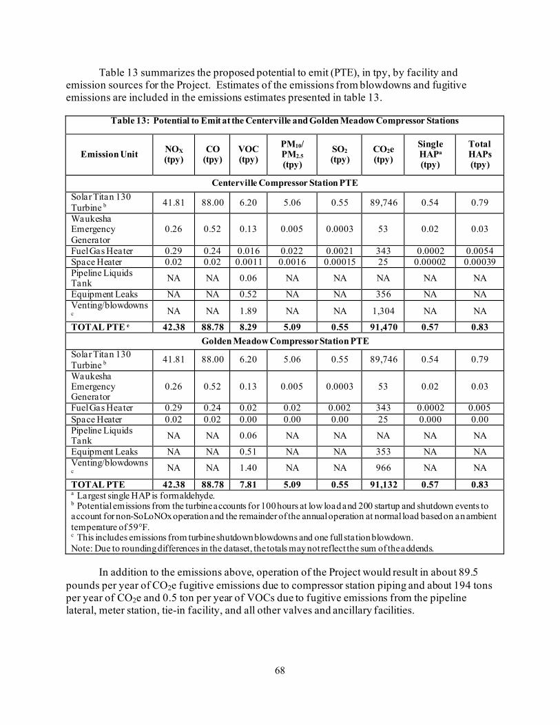
68
Table 13 summarizes the proposed potential to emit (PTE), in tpy, by facility and emission sources for the Project. Estimates of the emissions from blowdowns and fugitive emissions are included in the emissions estimates presented in table 13.
Table 13: Potential to Emit at the Centerville and Golden Meadow Compressor Stations
Emission Unit NOX (tpy)
CO (tpy)
VOC (tpy)
PM10/ PM2.5 (tpy)
SO2 (tpy)
CO2e (tpy)
Single HAPa
(tpy)
Total HAPs (tpy)
Centerville Compressor Station PTE Solar Titan 130 Turbine b 41.81 88.00 6.20 5.06 0.55 89,746 0.54 0.79
Waukesha Emergency Generator
0.26 0.52 0.13 0.005 0.0003 53 0.02 0.03
Fuel Gas Heater 0.29 0.24 0.016 0.022 0.0021 343 0.0002 0.0054 Space Heater 0.02 0.02 0.0011 0.0016 0.00015 25 0.00002 0.00039 Pipeline Liquids Tank NA NA 0.06 NA NA NA NA NA
Equipment Leaks NA NA 0.52 NA NA 356 NA NA Venting/blowdowns c NA NA 1.89 NA NA 1,304 NA NA
TOTAL PTE e 42.38 88.78 8.29 5.09 0.55 91,470 0.57 0.83 Golden Meadow Compressor Station PTE
Solar Titan 130 Turbine b 41.81 88.00 6.20 5.06 0.55 89,746 0.54 0.79
Waukesha Emergency Generator
0.26 0.52 0.13 0.005 0.0003 53 0.02 0.03
Fuel Gas Heater 0.29 0.24 0.02 0.02 0.002 343 0.0002 0.005 Space Heater 0.02 0.02 0.00 0.00 0.00 25 0.000 0.00 Pipeline Liquids Tank NA NA 0.06 NA NA NA NA NA
Equipment Leaks NA NA 0.51 NA NA 353 NA NA Venting/blowdowns c NA NA 1.40 NA NA 966 NA NA
TOTAL PTE 42.38 88.78 7.81 5.09 0.55 91,132 0.57 0.83 a Largest single HAP is formaldehyde. b Potential emissions from the turbine accounts for 100 hours at low load and 200 startup and shutdown events to account for non-SoLoNOx operation and the remainder of the annual operation at normal load based on an ambient temperature of 59°F. c This includes emissions from turbine shutdown blowdowns and one full station blowdown. Note: Due to rounding differences in the dataset, the totals may not reflect the sum of the addends.
In addition to the emissions above, operation of the Project would result in about 89.5
pounds per year of CO2e fugitive emissions due to compressor station piping and about 194 tons per year of CO2e and 0.5 ton per year of VOCs due to fugitive emissions from the pipeline lateral, meter station, tie-in facility, and all other valves and ancillary facilities.

69
Columbia Gulf would implement measures to reduce fugitive emissions, including voluntary measures outlined by the Interstate Natural Gas Association of America.28 In addition, Columbia Gulf participates in the USEPA Natural Gas STAR Program.
Air Quality Modeling
To assess air quality impacts from the proposed Centerville and Golden Meadow
Compressor Stations on regional air quality, Columbia Gulf conducted an ambient air quality analysis for NO2, PM2.5, PM10, CO, and SO2 using the USEPA’s AERMOD program. The model estimates the predicted concentrations of criteria pollutants emitted from the compressor stations using conservative assumptions consistent with USEPA guidelines. Background concentrations from representative air monitors were then added to the predicted concentrations from the AERMOD analysis and the total was compared to the NAAQS. The results of the air quality modeling analysis are presented in table 14. The results of Columbia Gulf’s modeling analysis indicate that the combined total of background and emissions from the new compressor stations would not exceed the NAAQS, which are established to be protective of human health, including sensitive populations such as children, the elderly, and those with compromised respiratory function, i.e. asthmatics.
Table 14: Air Modeling Results and NAAQS Compliance Summary
Pollutant Averaging Period
Project Impact (μg/m3)
Background (μg/m3)
Total (μg/m3)
NAAQS (μg/m3)
Percent of NAAQS
Centerville Compressor Station Air Modeling Summary
NO2 1-hour 5.47 38.35 43.82 188 23.3 Annual 0.29 7.09 7.38 100 7.4
CO 1-hour 5.48 2,508.0 2,513.5 40,000 6.3 8-hour 4.04 1,345.2 1,349.2 10,000 13.5
PM10 24-hour 0.20 67.20 67.40 150 44.9
PM2.5 24-hour 0.12 16.46 16.58 35 47.4 Annual 0.02 7.21 7.23 12 60.2
SO2 1-hour 2.73 38.72 41.45 196 21.2 3-hour 2.95 46.79 49.74 1,300 3.8
Golden Meadow Compressor Station Air Modeling Summary
NO2 1-hour 3.34 62.42 65.76 188 35.0 Annual 0.22 12.41 12.63 100 12.6
CO 1-hour 9.16 2,508.0 2,517.2 40,000 6.3 8-hour 2.82 1,345.2 1,348.0 10,000 13.5
PM10 24-hour 0.15 67.20 67.35 150 44.9
PM2.5 24-hour 0.10 18.20 18.30 35 52.3 Annual 0.02 7.28 7.30 12 60.2
SO2 1-hour 2.92 38.72 41.69 196 21.3 3-hour 5.28 46.79 52.08 1,300 4.0
Based on the estimated emissions from operation of the proposed Project facilities and review of the modeling analyses, we find that the Project would not cause or contribute to an
28 Additional information can be found here: https://www.ingaa.org/File.aspx?id=37866&v=bb0282ca

70
exceedance of the NAAQS. While the Project would have minor impacts on local air quality during operation, we have determined that the Project would not result in significant impacts on air quality.
7.2 Climate Change
Climate change is the variation in climate (including temperature, precipitation, humidity,
wind, and other meteorological variables) over time, whether due to natural variability, human activities, or a combination of both, and cannot be characterized by an individual event or anomalous weather pattern. For example, a severe drought or abnormally hot summer in a particular region is not a certain indication of climate change. However, a series of severe droughts or hot summers that statistically alter the trend in average precipitation or temperature over decades may indicate climate change. Recent research has begun to attribute certain extreme weather events to climate change (U.S. Global Change Research Program [USGCRP], 2018).
The leading U.S. scientific body on climate change is the USGCRP, composed of
representatives from 13 federal departments and agencies.29 The Global Change Research Act of 1990 requires the USGCRP to submit a report to the President and Congress no less than every 4 years that “1) integrates, evaluates, and interprets the findings of the USGCRP; 2) analyzes the effects of global change on the natural environment, agriculture, energy production and use, land and water resources, transportation, human health and welfare, human social systems, and biological diversity; and 3) analyzes current trends in global change, both human-induced and natural, and projects major trends for the subsequent 25 to 100 years.” These reports describe the state of the science relating to climate change and the effects of climate change on different regions of the United States and on various societal and environmental sectors, such as water resources, agriculture, energy use, and human health.
In 2017 and 2018, the USGCRP issued its Climate Science Special Report: Fourth
National Climate Assessment, Volumes I and II (Fourth Assessment Report; USGCRP 2017, and USGCRP 2018, respectively). The Fourth Assessment Report states that climate change has resulted in a wide range of impacts across every region of the country. Those impacts extend beyond atmospheric climate change alone and include changes to water resources, transportation, agriculture, ecosystems, and human health. The U.S. and the world are warming, global sea level is rising and acidifying, and certain weather events are becoming more frequent and more severe. These changes are driven by accumulation of GHG in the atmosphere through combustion of fossil fuels (coal, petroleum, and natural gas), combined with agriculture, clearing of forests, and other natural sources. These impacts have accelerated throughout the end of the 20th and into the 21st century (USGCRP 2018).
GHGs were identified by the USEPA as pollutants in the context of climate change.
GHG emissions do not result in proportional local and immediate impacts; it is the combined concentration in the atmosphere that affects the global climate system. These are fundamentally
29 The USGCRP member agencies are: Department of Agriculture, Department of Commerce, Department of Defense, Department of Energy,
Department of Health and Human Services, Department of the Interior, Department of State, Department of Transportation, Environmental Protection Agency, National Aeronautics and Space Administration, National Science Foundation, Smithsonian Institution, and U.S. Agency for International Development.
71
global impacts that feedback to local and regional climate change impacts. Thus, the geographic scope for cumulative analysis of GHG emissions is global, rather than local or regional. For example, a project 1 mile away emitting 1 ton of GHGs would contribute to climate change in a similar manner as a project 2,000 miles distant also emitting 1 ton of GHGs.
Climate change is a global phenomenon; however, for this analysis, we will focus on the
existing and potential cumulative climate change impacts in the general Project area. The USGCRP’s Fourth Assessment Report notes the following observations of environmental impacts are attributed to climate change in the Southeast region of the United States (USGCRP 2017, USGCRP 2018):
• The decade of 2010 through 2017 has been warmer than any previous decade
since 1920 for average daily maximum and average daily minimum temperature; • since 1960, there have been lower numbers of days above 95°F compared to the
pre-1960 period but during the 2010’s the number of nights above 75°F has been nearly double the average over 1901 – 1960. The length of the freeze free season was 1.5 weeks longer on average in the 2010s compared to any other historical period on record;
• number of days with 3 or more inches of rain has been historically high over the past 25 years. The 1990s, 2000s and 2010s rank first, third and second, respectively in number of events;
• summers have been either increasingly dry or extremely wet, depending on location;
• due to a combination of sea level rise and soil subsidence, approximately 2,006 square miles of land has been lost in Louisiana between 1932 and 2016, or about 23 square miles per year; and
• in southeast Louisiana, relative sea level is rising at a rate of 1 to 3 feet per 100 years.
The USGCRP’S Fourth Assessment Report notes the following projections of climate change impacts in the Project region (Southeast US) with a high or very high level of confidence30 (USGCRP, 2018):
• climate models project nighttime temperatures above 75°F and daytime maximum
temperatures above 95°F become the summer norm. Nights above 80°F and days above 100°F, which are now relatively rare, would become common;
• lowland coastal areas are expected to receive less rainfall on average but experience more frequent intense rainfall events followed by longer drought periods;
• coastal areas along the Gulf of Mexico are flat; therefore, expected sea level rises may cause inundation in certain low lying areas;
30 The report authors assessed current scientific understanding of climate change based on available scientific literature. Each “Key Finding”
listed in the report is accompanied by a confidence statement indicating the consistency of evidence or the consistency of model projections. A high level of confidence results from “moderate evidence (several sources, some consistency, methods vary and/or documentation limited, etc.), medium consensus.” A very high level of confidence results from “strong evidence (established theory, multiple sources, consistent results, well documented and accepted methods, etc.), high consensus.” https://science2017.globalchange.gov/chapter/front-matter-guide/

72
• drought and sea level rise will create stressful conditions for coastal trees that are not adapted to higher salinity levels;
• other coastal species may also be stressed by sea level rise and warmer temperatures, prompting migration out of the area; and
• tropical storms and hurricanes may become more intense. It should be noted that while the impacts described above taken individually may be
manageable for certain communities, the impacts of compound extreme events (such as simultaneous heat and drought, or flooding associated with high precipitation on top of saturated soils) can be greater than the sum of the parts (USGCRP, 2018).
The GHG emissions associated with construction and operation of the Project were
identified and quantified in section B.7.1 of the EA. The construction and operation of the Project would increase the atmospheric concentration of GHGs, in combination with past and future emissions from all other sources and would contribute incrementally to future climate change impacts. In order to assess impacts on climate change associated with the Project, Commission staff considered whether it could identify discrete physical impacts resulting from the Project’s GHG emissions or compare the Project’s GHG emissions to established targets designed to combat climate change.
To date, Commission staff has not identified a methodology to attribute discrete, quantifiable, physical effects on the environment resulting from the Project’s incremental contribution to GHGs. We have looked at atmospheric modeling used by the EPA, National Aeronautics and Space Administration, the Intergovernmental Panel on Climate Change, and others, and we found that these models are not reasonable for project-level analysis for a number of reasons. For example, these global models are not suited to determine the incremental impact of individual projects, due to both scale and overwhelming complexity. We also reviewed simpler models and mathematical techniques to determine global physical effects caused by GHG emissions, such as increases in global atmospheric CO2 concentrations, atmospheric forcing, or ocean CO2 absorption. We could not identify a reliable, less complex model for this task and thus staff could not determine specific localized or regional physical impacts from GHG emissions from the Project. Without the ability to determine discrete resource impacts, Commission staff are unable to assess the Project’s contribution to climate change through any objective analysis of physical impact.
Additionally, we have not been able to find any GHG emission reduction goals
established at the federal level that we can use as comparative criteria for project level emissions.31 We note that there have been a series of recent administrative changes and we continue to evaluate their impact on our review process. For example, on January 20, 2021, President Biden issued the Executive Order on Protecting Public Health and the Environment and Restoring Science to Tackle the Climate Crisis (EO 13990) and on January 27, 2021, the Executive Order on Tackling the Climate Crisis at Home and Abroad (EO 14008). Amongst
31 The national emissions reduction targets expressed in the EPA’s Clean Power Plan were repealed, Greenhouse Gas Emissions From
Existing Electric Utility Generating Units; Revisions to Emissions Guidelines Implementing Regulations, 84 Fed. Reg. 32,250, 32,522-32, 532 (July 8, 2019), and the targets in the Paris Climate Accord were withdrawn (November 2020).

73
other objectives, the Executive Orders call for a net-zero emission economy and a carbon-free electricity sector. In addition, on January 20, 2021, President Biden announced that the U.S. will rejoin the Paris Climate Agreement (Agreement), and the U.S. became a party to the Agreement on February 19, 2021. The Agreement is a binding international agreement to reduce GHG emissions and impacts due to climate change that was signed by 196 parties on December 12, 2015 and entered into force on November 4, 2016. The Agreement aims to limit global warming to well below 2 degrees Celsius, and preferably to 1.5 degrees Celsius, compared to pre-industrial levels.32 Prior to the U.S. withdrawal from the Agreement in November 2020, the U.S. initially proposed a 26 to 28 percent domestic reduction in GHG by 2025 compared to 2005.33 It is not yet clear if the U.S. would retain or modify these goals upon rejoining the Agreement.
The state of Louisiana has established executive targets in 2020 to reduce net GHG
emissions 26 to 28 percent by 2025 and 40 to 50 percent by 2030, compared to 2005 levels. The targets also aim for net-zero GHG emissions by 2050. As indicated in table 13 in section B.7.1 above, direct GHG emissions from the operation of the Centerville and Golden Meadow Compressor Station’s would result in an annual increase in CO2e emissions of about 182,602 tons per year (equivalent to 165,654 metric tons). 34 This would represent 0.11 percent and 0.15 percent of Louisiana’s 2025 and 2030 projected GHG emission levels, assuming the reductions from 2005 levels summarized above.35
7.3 Noise
Noise is generally defined as sound with intensity greater than the ambient or background
sound pressure level. Construction and operation of the Project would affect overall noise levels in the Project area. The magnitude and frequency of environmental noise may vary considerably over the course of the day, throughout the week, and across seasons, in part due to changing weather conditions and the effects of seasonal vegetative cover. Two measures that relate the time-varying quality of environmental noise to its known effect on people are the 24-hour equivalent sound level (Leq) and Ldn. The Leq is an A-weighted sound level containing the same energy as the instantaneous sound levels measured over a specific time period. Noise levels are perceived differently, depending on length of exposure and time of day. The Ldn takes into account the duration and time the noise is encountered. Specifically, the Ldn is the Leq plus a 10 dBA penalty added to account for people’s greater sensitivity to nighttime sound levels (typically considered between the hours of 10:00 p.m. and 7:00 a.m.). The A-weighted scale is used to assess noise impacts because human hearing is less sensitive to low and high frequencies than mid-range frequencies. The human ear’s threshold of perception for noise change is considered to be 3 dBA; 5 dBA is clearly noticeable to the human ear, and 10 dBA is perceived as a doubling of noise (Bies and Hansen 1988).
32 Additional information is available at https://unfccc.int/process-and-meetings/the-paris-agreement/the-paris-agreement 33https://www4.unfccc.int/sites/ndcstaging/PublishedDocuments/United%20States%20of%20America%20First/U.S.A.%20First%20NDC%20Su
bmission.pdf 34 A metric ton is approximately equal to 1.1 ton. 35 Based on data found in table 1, state energy-related carbon dioxide emissions by year at https://www.eia.gov/environment/emissions/state/.

74
Regulatory Noise Requirements In 1974, the USEPA published Information on Levels of Environmental Noise Requisite
to Protect Public Health and Welfare with an Adequate Margin of Safety (USEPA 1974). This document provides information for state and local regulators to use in developing their own ambient noise standards. The USEPA has indicated that an Ldn of 55 dBA protects the public from indoor and outdoor activity interference. We have adopted this criterion and use it to evaluate the potential noise impacts from the proposed Project at NSAs. NSAs are defined as homes, schools, churches, or any location where people reside or gather. FERC does not have noise requirements relevant to typical facility construction, but does require that the noise attributable to any new compressor engine or station modifications during full-load operation not exceed an Ldn of 55 dBA at any NSAs. Due to the 10 dBA nighttime penalty added prior to the logarithmic calculation of the Ldn, for a facility to meet the 55 dBA Ldn limit, it must be designed such that actual constant noise levels on a 24-hour basis do not exceed 48.6 dBA Leq at any NSA.
Operation of the Project would comply with applicable noise ordinances as described
above. FERC’s noise requirements are specific to individual NSAs, which are described below. Ambient Noise Conditions
Ambient sound levels were collected at the NSAs nearest to the proposed Centerville and
Golden Meadow Compressor Stations in order to establish ambient sound levels for use in the noise impact analysis. The results of the ambient survey are shown in table 15. As there are no NSAs within 0.5 mile of the proposed POD Meter Station and proposed Tie-in Facility in Barataria Bay, these facilities are not discussed further.
Noise Impacts and Mitigation Measures Construction
Noise would be generated during construction of the Project. Construction activities
would be concurrent over a 11-month period at each compressor station site and would result in an increase in ambient noise. Construction noise is highly variable as equipment operates intermittently. The type of equipment operating at any location changes with each construction phase. While individuals in the immediate vicinity of the construction activities would experience an increase in noise, this impact would be temporary and local. Columbia Gulf proposes to conduct pile driving during construction, which would result in the greatest noise impacts during construction. Columbia Gulf estimates that noise levels during pile driving would be 74.9 dBA equivalent sound level at NSA 1 near the Centerville Compressor Station and 49.9 dBA equivalent sound level at NSA 1 near the Golden Meadow Compressor Station. Pile driving activities would take place from 7 a.m. to 7 p.m. (adjusted as appropriate to conduct work during daylight hours), 7 days per week for about 47 days (10 piles per day) at the Golden Meadow Compressor Station and about 24 days (5 piles per day) in Barataria Bay. Columbia Gulf was not able to estimate an approximate duration of pile driving activities for the Centerville Compressor Station, but did commit to conduct all pile driving activities during daytime hours only. Lastly, the compressor stations would require two station blowdowns and

75
two unit blowdowns during commissioning, each lasting up to 10 minutes. Because Columbia Gulf did not propose any measures to mitigate or minimize construction noise impacts due to pile driving activities at the Centerville Compressor Station that greatly exceed 55 dBA Ldn, we recommend that:
• During impact pile-driving activities at the Centerville Compressor Station,
Columbia Gulf should utilize wooden pile cushion/caps, noise curtains, or other comparable technology to mitigate noise impacts on NSAs. During the pile-driving activities, Columbia Gulf should monitor noise levels and document the noise levels in the bi-weekly status reports, and make all reasonable efforts to restrict the noise attributable to the pile-driving operations to no more than a Ldn of 55 dBA at the NSAs.
Columbia Gulf anticipates that the majority of Project construction would occur during
the daytime between the hours of 7:00 a.m. to 7:00 p.m, Monday through Saturday. However, weather and site conditions, specialized construction techniques, emergencies, or other atypical circumstances may necessitate extended work on Sundays and holidays. Columbia Gulf also states that limited nighttime construction activities, which may include x-ray testing, hydrostatic testing, electrical work, or other commissioning activities may occur. These proposed activities would not generate significant noise and would not likely result in impacts on NSAs at night. In the event of nighttime work, Columbia Gulf would develop noise mitigation measures to limit construction noise to 55 dBA Ldn at nearby NSAs and would periodically measure nighttime noise activities to verify mitigation measures are functioning properly. Columbia Gulf would provide these nighttime construction noise activity reports to FERC in its construction status reports.
Based on the temporary nature of construction, Columbia Gulf’s commitment to limit the
majority of construction activities to daytime only, and our recommendation, we conclude construction noise due to the Project would not result in significant noise impacts on nearby residents or communities.
Operations
The proposed compressor stations would generate sound on a continuous basis (i.e., up to
24 hours per day) when operating. Noise impacts associated with the operation of these aboveground facilities would be limited to the vicinity of the facilities. The noise analysis shows the estimated noise impact of operation of the compressor stations on nearby NSAs and is shown below in table 15.
Table 15: Noise Analysis for Centerville and Golden Meadow Compressor Station
NSA
Distance and Direction
from Proposed
Compressor Stations
Calculated Ambient
Sound (dBA Ldn)
Estimated Sound
Levels of Station at Full Load (dBA Ldn)
Station Noise and Ambient
Sound Levels
(dBA Ldn)
Potential Increase
Over Ambient Sound Level (dBA)

76
Centerville Compressor Station NSA 1
(residences) 1,050 ft east 48.4 51.3 53.1 4.7
NSA 2 (residences)
3,000 ft southeast 58.9 39.1 58.9 0
NSA 3 (jail) 2,600 ft. north 48.4 40.6 49 0.6 Golden Meadow Compressor Station
NSA 1 (residence)
3,300 feet north 46.7 43.8 48.5 1.8
As shown in table 15, noise due to operation of the Centerville and Golden Meadow
Compressor Station is not predicted to exceed 55 dBA Ldn at any nearby NSA. Most NSAs would not experience a perceptible increase in noise levels over ambient; however, one cluster of NSAs (1,050 feet east of the Centerville Compressor Station) would experience a 4.7 dBA increase in overall noise levels during Project operation. The residents at these NSAs would be impacted by noise from the Centerville Compressor Station. Columbia Gulf has committed to install all of the noise control measures recommended by their noise consultant, which include:
• skid mounted standard acoustical enclosure for turbine and compressor unit; • silenced air inlet and exhaust systems; • low noise lube oil coolers and gas coolers; • acoustical pipe lagging (insulation) for aboveground natural gas pipelines; and • unit blowdown silencers, among others. Based on the results in table 15, and the noise mitigation measures committed to by
Columbia Gulf, operation of the proposed compressor stations would meet FERC’s sound level requirements at the nearest NSAs. To ensure Project-related noise level impacts do not exceed our criterion, we recommend that:
• Columbia Gulf should file with the Secretary noise surveys for the Centerville
and Golden Meadow Compressor Stations no later than 60 days after placing each station into service. If full power load condition noise surveys are not possible, Columbia Gulf should file an interim survey at the maximum possible power load within 60 days of placing the stations into service and file the full power load survey within 6 months. If the noise attributable to operation of all equipment at any station under interim or full power load conditions exceeds an Ldn of 55 dBA at any nearby NSA, Columbia Gulf should: a. file a report with the Secretary, for review and written approval by the
Director of OEP, or the Director’s designee, on what changes are needed; b. install additional noise controls to meet that level within 1 year of the in-
service date; and c. confirm compliance with this requirement by filing a second full power
load noise survey with the Secretary no later than 60 days after it installs the additional noise controls.

77
In addition to the operational sound level impacts discussed above, there would also be blowdown events during which the compressor stations would generate additional sound for short periods of time. Noise impacts on the NSAs would be limited to the duration of the release relative to the specific emergency situation. Given the non-routine nature and short-term duration of these blowdown events, we do not believe that they would result in significant impacts on nearby residents or that they would be a significant contributor to operational sound levels from the Project.
Based on the analyses conducted, Columbia Gulf’s proposed mitigation measures, and
our recommendation, we conclude that operation of the Project would not result in significant noise impacts on residents or the surrounding communities.
8. Reliability and Safety
The pressurization of natural gas at a compressor station involves some incremental risk
to the public due to the potential for accidental release of natural gas. The greatest hazard is a fire or explosion following a major pipeline rupture.
Methane, the primary component of natural gas, is colorless, odorless, and tasteless. It is
not toxic, but is classified as a simple asphyxiate, possessing a slight inhalation hazard. If breathed in high concentration, oxygen deficiency can result in serious injury or death. Methane has an auto-ignition temperature of 1,000°F and is flammable at concentrations between 5.0 and 15.0 percent in air. An unconfined mixture of methane and air is not explosive; however, it may ignite and burn if there is an ignition source. A flammable concentration within an enclosed space in the presence of an ignition source can explode. It is buoyant at atmospheric temperatures and disperses rapidly in air.
8.1 Safety Standards
The USDOT-PHMSA is mandated to prescribe minimum safety standards to protect
against risks posed by natural gas facilities under Title 49 of the U.S. Code, Chapter 601. The USDOT-PHMSA administers the USDOT’s national regulatory program to ensure the safe transportation of natural gas and other hazardous materials by pipeline. It develops safety regulations and other approaches to risk management that ensure safety in the design, construction, testing, operation, maintenance, and emergency response of natural gas facilities. Many of the regulations are written as performance standards, which set the level of safety to be attained and allow the operator to use various technologies to achieve safety. USDOT-PHMSA ensures that people and the environment are protected from the risk of incidents. This work is shared with state agency partners and others at the federal, state, and local levels.
8.2 Station Design
The piping and aboveground facilities associated with the Project would be designed,
constructed, operated, and maintained in accordance with the USDOT-PHMSA Minimum Federal Safety Standards in 49 CFR 192. The regulations are intended to ensure adequate protection for the public and to prevent natural gas facility accidents and failures. The USDOT-

78
PHMSA specifies material selection and qualification; minimum design requirements; and protection from internal, external, and atmospheric corrosion.
Part 192 of 49 CFR establishes safety guidelines for the design and construction of
compressor stations in addition to pipeline safety standards. Part 192.163 requires the location of each main compressor building of a compressor station be on a property under the control of the operator. The station must also be far enough away from adjacent property, not under control of the operator, to minimize the possibility of fire spreading to the compressor building from structures on adjacent properties. Part 192.163 also requires each building on a compressor station site be made of specific building materials and to have at least two separate and unobstructed exits. The station must be in an enclosed fenced area and must have at least two gates to provide a safe exit during an emergency.
8.3 Pipeline Safety
In addition to the requirements reviewed above, the USDOT-PHMSA also defines area
classifications, based on population density near the pipeline and specifies more rigorous safety requirements for populated areas. The class location unit is an area that extends 220 yards on either side of the centerline of any continuous 1-mile-length of pipeline. The four area classifications are defined below:
• Class 1: Location with 10 or fewer buildings intended for human occupancy; • Class 2: Location with more than 10 but less than 46 buildings intended for human
occupancy; • Class 3: Location with 46 or more buildings intended for human occupancy or where
the pipeline lies within 100 yards of any building, or small well-defined outside area occupied by more than 20 or more people on at least 5 days a week for 10 weeks in any 12-month period; and
• Class 4: Location where buildings with four or more stories aboveground are prevalent.
Class locations representing more populated areas require higher safety factors in
pipeline design, testing, and operations. For instance, pipelines constructed in Class I locations must be installed with a minimum depth cover of 18 inches in consolidated rock and 30 inches in normal soil. Class 2, 3, and 4 locations, as well as drainage ditches of public roads and railroad crossings require a minimum cover of 24 inches in consolidated rock and 36 inches in normal soil.
Class locations also specify the maximum distance to a sectionalizing block valve (i.e.,
10.0 miles in Class 1, 7.5 miles in Class 2, 4.0 miles in Class 3, and 2.5 miles in Class 4). Pipe wall thickness and pipeline design pressures, hydrostatic test pressures, MAOP; inspection and testing of welds, and the frequency of pipeline patrols and leak surveys must also conform to higher standards in more populated areas.
79
The 30-inch-diameter pipeline lateral, Tie-in Facility, and POD Meter Station would be designed to meet Class 3 specifications, while the spacing of the MLVs would meet Class 1 location requirements.
The Pipeline Safety Improvement Act of 2002 requires operators to develop and follow a
written integrity management program that contains all of the elements described in 49 CFR 192.911, and addresses the risks on each transmission pipeline segment. More specifically, the law establishes an integrity management program that applies to all high consequence areas (HCAs), which are defined as areas where a gas pipeline accident could cause considerable harm to people and their property and that require an integrity management program to minimize the potential for an accident. There are no HCAs within the proposed Project area; therefore, HCAs will not be further discussed.
8.4 Project Operations
Parts 192.731 through 192.736 of 49 CFR establish safety guidelines for inspection,
testing, and monitoring at compressor stations. Columbia Gulf would inspect the fire detection, gas detection, and emergency shutdown systems quarterly and valves would be inspected annually. Inspections would ensure that the facilities and pipeline systems are in good mechanical condition, set to control or relieve at the correct pressure consistent with the pressure limits in Part 192.201(a), and are properly installed and protected from dirt, liquids, or other conditions that might prevent proper operation.
Part 192.163 of 49 CFR requires that each compressor station have an emergency
shutdown system that meets several specifications, including: • flame detection that uses ultraviolet sensors; • gas detection for detecting low concentrations of natural gas; • emergency shutdowns to isolate the gas piping, stop equipment, and safely vent
station gas; • individual unit shutdown systems in case of mechanical or electrical failure of a
compressor unit system or component; • automated control systems to maintain safe MAOPs (including over-pressure
protection systems); • automated emergency shut down systems to evacuate gas from the system at a safe
location; • compressor unit enclosure fire suppression systems; and • hazardous gas and fire detection alarm systems.
During operation of the Project, Columbia Gulf would utilize its Supervisory Control and
Data Acquisition and Gas Control system, which allows remote staff to monitor the stations 24 hours a day and shut down the units as needed.

80
8.5 Emergencies The USDOT-PHMSA prescribes the minimum standards for operating and maintaining
pipeline and aboveground natural gas facilities, including the requirement to establish a written plan governing these activities. Each operator is required under 49 CFR 192.615 to establish an emergency plan that includes procedures to minimize the hazards of a natural gas emergency. Columbia Gulf would integrate the new facilities into its existing facility Emergency Response Plan for the corresponding compressor station, in accordance with the regulation, which requires that a plan be prepared prior to commencing operations. Columbia Gulf would make the plan available to emergency responders. Key elements of the plan include procedures for:
• receiving, identifying, and classifying emergency events, gas leakage, fires,
explosions, and natural disasters; • establishing and maintaining communications with local fire, police, and public
officials, and coordinating emergency response; • emergency system shutdown and safe restoration of service; • making personnel, equipment, tools, and materials available at the scene of an
emergency; and • protecting people first and then property and making them safe from actual or
potential hazards. The USDOT-PHMSA requires that each operator establish and maintain liaison with
appropriate fire, police, and public officials to learn the resources and responsibilities of each organization that may respond to a natural gas pipeline or facility emergency, and to coordinate mutual assistance. Columbia Gulf must also establish a continuing education program to enable customers, the public, government officials, and those engaged in excavation activities to recognize a gas emergency and report it to the appropriate public officials. Columbia Gulf would provide the appropriate training to local emergency service personnel before the Project is placed in service.
With continued compliance with USDOT-PHMSA safety standards, operation, and
maintenance requirements, the Project would be constructed and operated safely.

81
C. ALTERNATIVES
In accordance with NEPA and Commission policy, we identified and evaluated alternatives to the Project to determine whether they would be reasonable and environmentally preferable to the proposed action. These alternatives include the no action alternative, system alternatives, pipeline route alternatives, and aboveground facility site alternatives. The criteria used for selecting potentially environmentally preferable alternatives are: (1) the ability to meet the Project’s objectives; (2) technical and economic feasibility and practicality; and (3) whether it provides a significant environmental advantage over the proposed Project. Alternatives that would not meet the Project’s objective or would not be feasible were not brought forward to the next level of review (i.e., the third evaluation criterion).
Our evaluation of the identified alternatives is based on Project-specific information
provided by the applicant; publicly available information; and our expertise and experience regarding the siting, construction, and operation of natural gas transmission facilities and their potential impact on the environment. We did not receive any comments about alternatives from the landowners, stakeholders, or any state or federal resource agencies.
Evaluation Process
Through environmental comparison and application of our professional judgement, each alternative is considered to a point where it becomes clear if the alternative could or could not meet the three evaluation criteria. To ensure a consistent environmental comparison and to normalize the comparison factors, we generally use desktop sources of information (e.g., publicly available data, GIS data, aerial imagery) and assume the same right-of-way widths and general workspace requirements. As described previously, our environmental analysis and this evaluation only considers quantitative data (e.g., acreage or mileage) and uses common comparative factors such as total length, amount of collocation, and land requirements. Our evaluation also considers impacts on both the natural and human environments. Impacts on the natural environment include open water, wetlands, forested lands, geology, and other common environmental resources. Impacts on the human environment include residences, roads, utilities, and industrial and commercial development near construction workspaces. In recognition of the competing interests and the different nature of impacts resulting from an alternative that sometimes exist (i.e., impacts on the natural environment versus impacts on the human environment), we also consider other factors that are relevant to a particular alternative or discount or eliminate factors that are not relevant or may have less weight or significance.
The purpose of the Project, which is described in greater detail in section A.2, is to
provide 725 million standard cubic feet per day of firm transportation capacity on Columbia Gulf’s interstate natural gas pipeline system, to supply feed gas for Venture Global Plaquemines LNG, LLC’s LNG facility in Plaquemines Parish. Therefore, a preferable alternative must also accomplish the same goal of the proposed action.
Determining if an alternative provides a significant environmental advantage requires a
comparison of the impacts on each resource as well as an analysis of impacts on resources that are not common to the alternatives being considered. The determination must then balance the overall impacts and all other relevant considerations. In comparing the impact between
82
resources (factors), we also considered the degree of impact anticipated on each resource. Ultimately, an alternative that results in equal or minor advantages in terms of environmental impact would not compel us to shift the impacts from the current set of landowners to a new set of landowners.
One of the goals of an alternatives analysis is to identify alternatives that avoid
significant impacts. In section B, we evaluated each environmental resource potentially affected by the Project and concluded that constructing and operating the Project would not significantly impact these resources. Consistent with our conclusions, the value gained by further reducing the (not significant) impacts of the Project when considered against relocating the route/facility to a new set of landowners was also factored into our evaluation.
1. No Action Alternative
The no-action alternative would result in not implementing the proposed action and would avoid the potential environmental impacts associated with the Project; however, the Project objectives would not be met. Under the no-action alternative, an alternative project would likely need to be constructed to meet the project purpose. It is purely speculative to predict the resulting effects and actions that could be taken by another company or Venture Global Plaquemines LNG, LLC and any associated environmental impacts. However, this alternative project would result in its own environmental impacts and potentially larger construction efforts, including new or expanded pipelines and associated aboveground facilities. Therefore, we do not recommend the no-action alternative.
2. System Alternatives
The purpose of identifying and evaluating system alternatives is to determine whether the environmental impacts associated with the construction and operation of the proposed Project could be avoided or reduced by using existing, modified, or other proposed facilities rather than constructing new facilities. However, a viable system alternative must be technically and economically feasible as well as practicable and must satisfy interconnect requirements and be reasonably close to the anticipated in-service date to fulfill commitments made to the Project customers.
We did not identify any reasonable system alternatives within Columbia Gulf’s existing system. Columbia Gulf evaluated the following existing foreign pipeline systems operated by third party companies to determine the feasibility of those systems to meet Venture Global Plaquemines LNG, LLC’s need for the additional 725 million standard cubic feet per day of natural gas to its LNG facility:
• Tennessee Gas Pipeline Company, LLC (TGP); • Texas Eastern Transmission, LP (TETLP); • American Midstream Partners, LP (American Midstream); • Gulf South Pipeline Company, LLC (Gulf South); and • EnLink Midstream.

83
These system alternatives, while potentially feasible, would likely result in equal or greater environmental impacts than the proposed Project and may still require Columbia Gulf to construct additional facilities. Therefore, these system alternatives were not considered further.
3. Pipeline Route Alternatives
We did not identify any alternatives which would result in a shorter pipeline route to potentially reduce open water impacts. Further, there are no unresolved resource conflicts which would present a need to examine further alternatives. Additionally, no comments were received regarding resources that would be impacted by the Project. Therefore, because the impacts associated with the proposed Project are not significant, we did not evaluate additional alternatives. 4. Compressor Station Site Alternatives
We identified two alternative sites for the Centerville Compressor Station, and two alternative sites for the Golden Meadow Compressor Station, as viable options for the proposed Project compressor stations based on proximity to Columbia Gulf’s existing pipeline system, as described below. Centerville Compressor Station
We evaluated two alternative sites for the Centerville Compressor Station, one generally
south and west of the proposed site with a portion overlapping with Columbia Gulf’s existing abandoned facility, and the other generally north of the proposed site with a portion overlapping with Columbia Gulf’s existing abandoned facility. The majority of both alternative sites is within agricultural land. Both alternative sites contain multiple below grade foreign pipelines, and operators would require open access to the associated pipeline rights-of-way for maintenance and repairs. Security fencing and restricted access to authorized personnel is required for the Centerville Compressor Station; however, the easements that would grant the operator open access to the associated pipeline for maintenance preclude Columbia Gulf from constructing the fencing. Because both alternative sites would restrict the foreign operator from open access to their pipeline facilities, neither site is a practical option and we did not consider them further. Golden Meadow Compressor Station
We evaluated two alternative sites for the Golden Meadow Compressor Station, both
along Louisiana SH-1. Both sites would require additional suction and discharge pipelines to connect the Golden Meadow Compressor Station to Columbia Gulf’s existing EL-300 pipeline, and require greater impacts on wetlands and waterbodies. Alternative Site 1 and the proposed site have the same number of NSAs within 1 mile; however, the compressor unit and overall operational footprint of Alternative Site 1 is closer in distance to the NSAs than the proposed site. Therefore, potential impacts on nearby NSAs resulting from operational noise at Alternative Site 1 would likely be greater than the proposed site. In addition, Alternative Site 1 would have an additional 0.4 acre of impact on open water and an additional 2.3 acres of impact on wetlands. Alternative Site 2 has six additional NSAs within 1 mile than the proposed site and is closer to those nearby NSAs resulting in increased disturbance on residential areas. In

84
addition, Alternative Site 2 would have an additional 5.1 acres of impact on wetlands. Due to the additional length of piping required to connect to Columbia Gulf’s existing system, increased wetland and open water impacts, and increased noise disturbance to nearby residences, we conclude that these alternative sites would not provide a significant environmental advantage over the proposed site, and we did not considered them further.
Columbia Gulf has not yet obtained a lease on the parcel of land proposed for
construction and operation of the Golden Meadow Compressor Station; therefore, we requested Columbia Gulf provide additional information on the status of these negotiations.36 Columbia Gulf stated that 68 landowners have interest in the proposed Golden Meadow Compressor Station property. Columbia Gulf has attempted to contact all landowners, and confirmed that 64 of these landowners (94 percent) are willing to lease their interest in the property to Columbia Gulf for the new compressor station.
Columbia Gulf states it is limited in options to lease or buy any alternative sites, because
the compressor station must be within a certain proximity of the existing EL-300 pipeline to comply with engineering and design requirements. This same group of landowners owns the property north and south of the proposed Golden Meadow Compressor Station site; therefore, Columbia Gulf would likely face the same position if it moved the site in either direction. Further, Columbia Gulf is limited in options to the east and west of the proposed site due to natural and physical barriers, including Bayou Lafourche, SH-1, and open water. Therefore, no feasible alternative sites exist, and Columbia Gulf will continue its efforts to locate and obtain permission from the four outstanding landowners.
We did not identify any unresolved resource conflicts which would present a need to
examine further alternatives. Additionally, no comments were received regarding resources that would be impacted by the Project. Therefore, because the impacts associated with the proposed Project are not significant, we did not evaluate additional alternatives.
36 FERC staff’s environmental information request can be viewed on eLibrary under accession number 20210105-3021. Columbia Gulf’s data
response can be viewed on eLibrary under accession number 20210122-5153.
85
D. CONCLUSIONS AND RECOMMENDATIONS
Based on the analysis in this EA, we have determined that if Columbia Gulf constructs and operates the proposed facilities in accordance with its application and supplements, and staff’s recommended mitigation measures below, approval of this proposal would not constitute a major federal action significantly affecting the quality of the human environment. We recommend that the Commission’s Order (Order) contain a finding of no significant impact and include the mitigation measures listed below as conditions to any Certificate/Authorization the Commission may issue.
1. Columbia Gulf shall follow the construction procedures and mitigation measures
described in its application and supplements (including responses to staff data requests) and as identified in the EA, unless modified by the Order. Columbia Gulf must: a. request any modification to these procedures, measures, or conditions in a filing
with the Secretary; b. justify each modification relative to site-specific conditions; c. explain how that modification provides an equal or greater level of environmental
protection than the original measure; and d. receive approval in writing from the Director of OEP, or the Director’s designee,
before using that modification.
2. The Director of OEP, or the Director’s designee, has delegated authority to address any requests for approvals or authorizations necessary to carry out the conditions of the Order, and take whatever steps are necessary to ensure the protection of environmental resources during construction and operation of the project. This authority shall allow:
a. the modification of conditions of the Order; b. stop-work authority; and c. the imposition of any additional measures deemed necessary to ensure continued
compliance with the intent of the conditions of the Order as well as the avoidance or mitigation of unforeseen adverse environmental impact resulting from project construction and operation.
3. Prior to any construction, Columbia Gulf shall file an affirmative statement with the Secretary, certified by a senior company official, that all company personnel, EIs, and contractor personnel will be informed of the EI’s authority and have been or will be trained on the implementation of the environmental mitigation measures appropriate to their jobs before becoming involved with construction and restoration activities.
4. The authorized facility locations shall be as shown in the EA, as supplemented by filed
alignment sheets. As soon as they are available, and before the start of construction, Columbia Gulf shall file with the Secretary any revised detailed survey alignment maps/sheets at a scale not smaller than 1:6,000 with station positions for all facilities approved by the Order. All requests for modifications of environmental conditions of the Order or site-specific clearances must be written and must reference locations designated on these alignment maps/sheets.

86
Columbia Gulf’s exercise of eminent domain authority granted under NGA section 7(h) in any condemnation proceedings related to the Order must be consistent with these authorized facilities and locations. Columbia Gulf’s right of eminent domain granted under NGA section 7(h) does not authorize it to increase the size of its natural gas pipeline/facilities to accommodate future needs or to acquire a right-of-way for a pipeline to transport a commodity other than natural gas.
5. Columbia Gulf shall file with the Secretary detailed alignment maps/sheets and aerial
photographs at a scale not smaller than 1:6,000 identifying all route realignments or facility relocations, and staging areas, pipe storage yards, new access roads, and other areas that would be used or disturbed and have not been previously identified in filings with the Secretary. Approval for each of these areas must be explicitly requested in writing. For each area, the request must include a description of the existing land use/cover type, documentation of landowner approval, whether any cultural resources or federally listed threatened or endangered species would be affected, and whether any other environmentally sensitive areas are within or abutting the area. All areas shall be clearly identified on the maps/sheets/aerial photographs. Each area must be approved in writing by the Director of OEP, or the Director’s designee, before construction in or near that area. This requirement does not apply to extra workspace allowed by the Commission’s Upland Erosion Control, Revegetation, and Maintenance Plan and/or minor field realignments per landowner needs and requirements which do not affect other landowners or sensitive environmental areas such as wetlands. Examples of alterations requiring approval include all route realignments and facility location changes resulting from:
a. implementation of cultural resources mitigation measures; b. implementation of endangered, threatened, or special concern species mitigation
measures; c. recommendations by state regulatory authorities; and d. agreements with individual landowners that affect other landowners or could
affect sensitive environmental areas.
6. Within 60 days of the acceptance of the authorization and before construction begins, Columbia Gulf shall file an Implementation Plan with the Secretary for review and written approval by the Director of OEP, or the Director’s designee. Columbia Gulf must file revisions to the plan as schedules change. The plan shall identify:
a. how Columbia Gulf will implement the construction procedures and mitigation
measures described in its application and supplements (including responses to staff data requests), identified in the EA, and required by the Order;
b. how Columbia Gulf will incorporate these requirements into the contract bid documents, construction contracts (especially penalty clauses and specifications),

87
and construction drawings so that the mitigation required at each site is clear to onsite construction and inspection personnel;
c. the number of EIs assigned, and how the company will ensure that sufficient personnel are available to implement the environmental mitigation;
d. company personnel, including EIs and contractors, who will receive copies of the appropriate material;
e. the location and dates of the environmental compliance training and instructions Columbia Gulf will give to all personnel involved with construction and restoration (initial and refresher training as the project progresses and personnel change);
f. the company personnel (if known) and specific portion of Columbia Gulf’s organization having responsibility for compliance;
g. the procedures (including use of contract penalties) Columbia Gulf will follow if noncompliance occurs; and
h. for each discrete facility, a Gantt or PERT chart (or similar project scheduling diagram), and dates for: (1) the completion of all required surveys and reports; (2) the environmental compliance training of onsite personnel; (3) the start of construction; and (4) the start and completion of restoration.
7. Columbia Gulf shall employ at least one EI per construction spread. The EI shall be:
a. responsible for monitoring and ensuring compliance with all mitigation measures
required by the Order and other grants, permits, certificates, or other authorizing documents;
b. responsible for evaluating the construction contractor's implementation of the environmental mitigation measures required in the contract (see condition 6 above) and any other authorizing document;
c. empowered to order correction of acts that violate the environmental conditions of the Order, and any other authorizing document;
d. a full-time position, separate from all other activity inspectors; e. responsible for documenting compliance with the environmental conditions of the
Order, as well as any environmental conditions/permit requirements imposed by other federal, state, or local agencies; and
f. responsible for maintaining status reports.
8. Beginning with the filing of its Implementation Plan, Columbia Gulf shall file updated status reports with the Secretary on a biweekly basis until all construction and restoration activities are complete. On request, these status reports will also be provided to other federal and state agencies with permitting responsibilities. Status reports shall include:
a. an update on Columbia Gulf’s efforts to obtain the necessary federal
authorizations;

88
b. the construction status of the project, work planned for the following reporting period, and any schedule changes for stream crossings or work in other environmentally-sensitive areas;
c. a listing of all problems encountered and each instance of noncompliance observed by the EI(s) during the reporting period (both for the conditions imposed by the Commission and any environmental conditions/permit requirements imposed by other federal, state, or local agencies);
d. a description of the corrective actions implemented in response to all instances of noncompliance;
e. the effectiveness of all corrective actions implemented; f. a description of any landowner/resident complaints which may relate to
compliance with the requirements of the Order, and the measures taken to satisfy their concerns; and
g. copies of any correspondence received by Columbia Gulf from other federal, state, or local permitting agencies concerning instances of noncompliance, and Columbia Gulf’s response.
9. Columbia Gulf must receive written authorization from the Director of OEP, or the Director’s designee, before commencing construction of any project facilities. To obtain such authorization, Columbia Gulf must file with the Secretary documentation that it has received all applicable authorizations required under federal law (or evidence of waiver thereof).
10. Columbia Gulf must receive written authorization from the Director of OEP, or the Director’s designee, before placing the project into service. Such authorization will only be granted following a determination that rehabilitation and restoration of the right-of-way and other areas affected by the project are proceeding satisfactorily.
11. Within 30 days of placing the authorized facilities in service, Columbia Gulf shall file an affirmative statement with the Secretary, certified by a senior company official:
a. that the facilities have been constructed in compliance with all applicable
conditions, and that continuing activities will be consistent with all applicable conditions; or
b. identifying which of the conditions in the Order Columbia Gulf has complied with or will comply with. This statement shall also identify any areas affected by the project where compliance measures were not properly implemented, if not previously identified in filed status reports, and the reason for noncompliance.
12. Within 5 days of receipt of a water quality certification issued by the LDEQ, Columbia Gulf shall file the complete certification, including all conditions, and all conditions attached to the water quality certification constitute mandatory conditions of this Certificate Order. Prior to construction, Columbia Gulf shall file, for review and written approval by the Director of OEP, or the Director’s designee, any revisions to its project design necessary to comply with the water quality certification conditions.

89
13. Columbia Gulf shall not begin construction of the Project until:
a. FERC staff receives comments from NMFS regarding the proposed action; b. FERC staff completes ESA consultation with the NMFS; and c. Columbia Gulf has received written notification from the Director of OEP, or the
Director’s designee, that construction or use of mitigation may begin.
14. Columbia Gulf shall not begin construction of the Project until it files with the Secretary a copy of the determination of consistency with the Coastal Zone Management Plan issued by the LDNR.
15. Prior to construction of the Centerville Compressor Station, Columbia Gulf shall file a visual screening plan for review and written approval by the Director of OEP, or the Director’s designee, to minimize visual impacts on the residences 0.1 mile west (NSA 1) and 0.5 mile north (NSA 3) at the Centerville Compressor Station. At a minimum, the plan shall include vegetative plantings to provide a visual buffer.
16. During impact pile-driving activities at the Centerville Compressor Station,
Columbia Gulf shall utilize wooden pile cushion/caps, noise curtains, or other comparable technology to mitigate noise impacts on NSAs. During the pile-driving activities, Columbia Gulf shall monitor noise levels and document the noise levels in the bi-weekly status reports, and make all reasonable efforts to restrict the noise attributable to the pile-driving operations to no more than a Ldn of 55 dBA at the NSAs.
17. Columbia Gulf shall file with the Secretary noise surveys for the Centerville and Golden Meadow Compressor Stations no later than 60 days after placing each station into service. If full power load condition noise surveys are not possible, Columbia Gulf shall file an interim survey at the maximum possible power load within 60 days of placing the stations into service and file the full power load survey within 6 months. If the noise attributable to operation of all equipment at any station under interim or full power load conditions exceeds an Ldn of 55 dBA at any nearby NSA, Columbia Gulf shall:
a. file a report with the Secretary, for review and written approval by the Director of
OEP, or the Director’s designee, on what changes are needed; b. install additional noise controls to meet that level within 1 year of the in-service
date; and c. confirm compliance with this requirement by filing a second full power load noise
survey with the Secretary no later than 60 days after it installs the additional noise controls.

APPENDIX A
LIST OF PREPARERS

LIST OF PREPARERS Crosley, Shannon – Project Manager; Proposed Action; Geology and Soils; Land Use; and
Alternatives B.S., Natural Resources Management, 1999, University of Maryland, College Park
Crumpton, Christine – Vegetation, Wildlife, Migratory Birds, Special Status Species
M.S., Environmental Management, 2013, Samford University B.S., Biology, 2012, Stillman College
Ferrara, Kylee – Air Quality and Noise; Reliability and Safety
M.S., Environmental Engineering, Johns Hopkins University, 2016 B.A.& Sc., Biology and Geography, McGill University, 2005
Griffin, Robin – Socioeconomics
M.S., Environmental Management, 1999, Illinois Institute of Technology B.A., English Composition (Minor in Geology), 1992, DePauw University
Ramsey, Dawn – Cultural Resources
Ph.D. Candidate, Anthropology, University of Florida M.A., Anthropology, 2000, University of Memphis B.A., History and Anthropology, 1997, Texas State University

APPENDIX B
REFERENCES

REFERENCES Bureau of Economic Geology. 1985. Phase III: Examination of Texas Salt Domes as Potential Sites for Permanent Storage of Toxic Chemical Waste. http://www.twdb.texas.gov/publications/reports/contracted_reports/doc/5551012.pdf. Accessed August 2020. Dokka, R.K., Sella, G.F., Dixon, T.H. 2006. Tectonic control of subsidence and southward displacement of southeast Louisiana with respect to stable North America. https://agupubs.onlinelibrary.wiley.com/doi/pdf/10.1029/2006GL027250. Accessed August 2020. Federal Emergency Management Agency. 2020a. FEMA Flood Map Service Center: Search by Address. https://msc.fema.gov/portal/search#searchresultsanchor. Accessed August 2020. Federal Emergency Management Agency. 2020b. Definitions of FEMA Flood Zone Designations. https://snmapmod.snco.us/fmm/document/fema-flood-zonedefinitions. pdf. Accessed August 2020. Franco, I., Iglesias, A., Canet, C., Gonzalez, C.M.V. 2013. Seismic activity in the Gulf of Mexico. A preliminary analysis. https://www.researchgate.net/publication/260909586_Seismic_activity_in_the_Gulf_of_ Mexico_A_preliminary_analysis. Accessed August 2020. Galloway, D., Jones D.R., Ingebritsen S.E. 1999. Land Subsidence in the United States. U.S. Geological Survey Circular 1182. http://pubs.usgs.gov/circ/circ1182/#pdf. Accessed August 2020. Howard, Perry. Louisiana. 1999. https://www.britannica.com/place/Louisiana-state. Accessed February 2021. Louisiana Byways. 2020. Louisiana Scenic Byways Program. https://byways.louisianatravel.com/. Accessed August 2020. Louisiana Department of Culture, Recreation and Tourism. 2020. Atchafalaya National Heritage Area. https://www.crt.state.la.us/atchafalaya/. Accessed August 2020. Louisiana Department of Environmental Quality. 2020a. Underground Storage Tank Program – List of Leaking Underground Storage Tank Site. https://internet.deq.louisiana.gov/portal/DIVISIONS/UNDER-GROUND-STORAGETANK/ LUST-SITE-UNIVERSE. Accessed August 2020. Louisiana Department of Environmental Quality. 2020b. Superfund Sites. http://www1.deq.louisiana.gov/portal/DIVISIONS/UndergroundStorageTankandRemediat

ionDivision/RemediationServices/SuperfundSitesinLouisiana.aspx. Accessed August 2020. Louisiana Department of Natural Resources. 2020. Salt Dome Cavern Facilities. http://sonris-www.dnr.state.la.us/gis/OC/#cavernDiv. Accessed August 2020. Louisiana Department of Natural Resources. 2012. Coast-It Notes. http://www.dnr.louisiana.gov/index.cfm?md=communication&tmp=viewcampaign&nowra p=1&msgid=162&uid=e1. Accessed August 2020. Louisiana Department of Wildlife and Fisheries. 2020a. Louisiana Natural and Scenic Rivers Descriptions and Map. https://www.wlf.louisiana.gov/page/scenic-rivers-descriptionsand- map. Accessed August 2020. Louisiana Department of Wildlife and Fisheries. 2020b. Scenic River Interactive Permit Map. https://www.wlf.louisiana.gov/page/scenic-rivers-permits-interactive-map. Accessed August 2020. Louisiana State University. 2020. Louisiana’s Flood Maps. http://maps.lsuagcenter.com/floodmaps/. Accessed August 2020. MacGillivray, A., Ziegler, E. and Laughlin, J., 2007. Underwater Acoustic Measurements from Washington State Ferries 2006 Mukilteo Ferry Terminal Test Pile Project. Technical report prepared by JASCO Research, Ltd for Washington State Ferries and Washington State Department of Transportation, 27 pp. McCulloh, Richard. February 3, 2020. Research Associate, Louisiana Geological Survey. Personal communication with Michelle Cortez (Environmental Specialist, Perennial Environmental Services, LLC).
National Marine Fisheries Service. 2017. Acoustics Tool for SERO: Calculate the effects of pile driving noise on ESA-listed species. https://www.fisheries.noaa.gov/content/section-7-consultation-guidance. Accessed June 2020. National Marine Fisheries Service. 2006. Sea Turtle and Smalltooth Sawfish Construction Conditions. https://www.fisheries.noaa.gov/southeast/consultations/regulations-policies-and-guidance. Accessed August 2020. National Oceanic and Atmospheric Administration. 2020a. National Storm Surge Hazard Maps. http://noaa.maps.arcgis.com/apps/MapSeries/index.html?appid=d9ed7904dbec441a9c4 dd7b277935fad&entry=1. Accessed August 2020. National Oceanic and Atmospheric Administration. 2020b. Sea Lake and Overland Surge from Hurricanes (SLOSH). https://slosh.nws.noaa.gov/slosh/#sloshDsp. Accessed August 2020.
National Park Service. 2020a. Nationwide Rivers Inventory. https://www.nps.gov/maps/full.html?mapId=8adbe798-0d7e-40fb-bd48-225513d64977. Accessed August 2020. National Park Service. 2020b. National Wild and Scenic Rivers System. https://www.rivers.gov/map.php. Accessed August 2020. National Park Service. 2020c. National Trails System. https://www.nps.gov/subjects/nationaltrailssystem/index.htm. Accessed August 2020. Payton, Abby and Karissa Basse. 2020. East Lateral Xpress Project Jefferson, Lafourche, Plaquemines, and St. Mary Parishes, Louisiana Phase I Cultural Resources Report. Perennial Environmental Services, LLC. Austin, Texas. National Recreation Trail. 2020. NRT Database. http://www.nrtdatabase.org/#one. Accessed August 2020. National Resources Conservation Service. 2017. National Soil Survey Handbook (NSSH). https://www.nrcs.usda.gov/wps/portal/nrcs/detailfull/soils/ref/?cid=nrcs142p2_054242. Accessed August 2020. Pacific Northwest Seismic Network. 2020. Plate Tectonics. https://pnsn.org/outreach/aboutearthquakes/plate-tectonics. Accessed August 2020. Popper, A.N., M.C. Hastings. 2009. The Effects of Anthropogenic Sources of Sound on Fishes. Journal of Fish Biology 75:455-489. https://users.ece.utexas.edu/~ling/3A_US1.pdf. Accessed August 2020. Stringer, Gary L. 2002. 46-Million-Year-old Marine Fossils from the Cane River Site, Northcentral Louisiana. Louisiana Geological Survey, Public Information Series No. 10, April 2002. https://www.lsu.edu/lgs/publications/products/Free_publications/CaneRiverfossils. pdf. Accessed August 2020. U.S. Army Corps of Engineers. 2010. Regional Supplement to the Corps of Engineers Wetland Delineation Manual: Atlantic and Gulf Coastal Plain Region (Version 2.0). https://www.nrcs.usda.gov/Internet/FSE_DOCUMENTS/stelprdb1046490.pdf. Accessed August 2020. U.S. Army Corps of Engineers. 1987. Corps of Engineers Wetlands Delineation Manual. Technical Report Y-87-1, U.S. Army Engineers Waterways Experiment Station, Vicksburg, MS. https://usace.contentdm.oclc.org/digital/collection/p266001coll1/id/4532/. Accessed August 2020.

U.S. Census Bureau. 2020. Explore Census Data. https://data.census.gov/cedsci/. Accessed August 2020. U.S. Census Bureau. 2019. QuickFacts. https://www.census.gov/quickfacts/fact/table/US/PST045219. Accessed August 2020. U.S. Department of Transportation. 2020. America’s Byways. https://www.fhwa.dot.gov/byways/byways/. Accessed August 2020. U.S. Environmental Protection Agency. 2020a. Cleanups in My Community Map. https://ofmpub.epa.gov/apex/cimc/f?p=cimc:map::::71. Accessed August 2020. U.S. Environmental Protection Agency. 2020b. NEPAssist. https://nepassisttool.epa.gov/nepassist/nepamap.aspx. Accessed August 2020. U.S. Fish and Wildlife. 2012. Evaluating the Effects of Underwater Sound from Pile Driving on the Marbled Murrelet and the Bull Trout. https://www.fws.gov/wafwo/Documents/EffectsofAction/Underwater%20Effects%20of%20Pile%20Driving%201.pdf. Accessed August 2020. U.S. Geological Survey. 2020a. Landslide Susceptibility. https://www.arcgis.com/home/webmap/viewer.html?useExisting=1&layers=b3fa4e3c494 040b491485dbb7d038c8a. Accessed August 2020. U.S. Geological Survey. 2020b. Search Earthquake Catalog. https://earthquake.usgs.gov/earthquakes/search/. Accessed August 2020. U.S. Geological Survey. 2015. Seismic-Hazards Maps for the Conterminous United States – Peak Horizontal Acceleration with 10 Percent Probability of Exceedance in 50 years. https://pubs.usgs.gov/sim/3325/. Accessed August 2020. U.S. Geological Survey. 2004. Digital Engineering Aspects of Karst Map: A GIS Version of Davies, W.E., Simpson, J.H., Ohlmacher, G.C., Kirk, W.S., and Newton, E.G., 1984, Engineering Aspects of Karst: U.S. Geological Survey, National Atlas of the United States of America, Scale 1:7,500,000. http://pubs.usgs.gov/of/2004/1352/. Accessed August 2020. U.S. Geological Survey. 2000. Land Subsidence in the United States. http://water.usgs.gov/ogw/pubs/fs00165/. Accessed August 2020. Wilber, D.H., and D.G. Clarke. 2010. Dredging activities and the potential impacts of sediment resuspension and sedimentation on oyster reefs. https://www.westerndredging.org/phocadownload/ConferencePresentations/2010_SanJuanPR/Session2A-EnvironmentalAspectsOfDredging/1%20-%20Wilber%20-%20Dredging%20Activities%20and%20Potential%20Impacts%20of%20Sedimentation%20and%20Resuspension%20on%20Oyster%20Reefs.pdf. Accessed August 2020.

https://19january2017snapshot.epa.gov/sites/production/files/2016-09/documents/climate-change-la.pdf Wilderness Connect. 2020. Wilderness Areas of the United States. https://umontana.maps.arcgis.com/apps/webappviewer/index.html?id=a415bca07f0a4be e9f0e894b0db5c3b6. Accessed August 2020. Williams, S. Jeffress. (n.d.) Louisiana Coastal Wetlands: A Resource At Risk. https://pubs.usgs.gov/fs/la-wetlands/. Accessed February 2021.

APPENDIX C
DETAILED ABOVEGROUND FACILITY MAPS


APPENDIX D
BIRDS OF CONSERVATION CONCERN

Appendix D Birds of Conservation Concern with Potential to Occur in the
Project Vicinity
Species Season Present Preferred Habitat Assessment of Potential
Impacts American Golden-
plover Pluvialis dominica
Migration
Occurs in prairies, mudflats, shores; tundra (summer). During migration, usually found on short-grass prairies, flooded pastures, plowed fields; less
often on mudflats, beaches. Breeds on Arctic tundra. Nests on the ground at
higher elevations, on more barren tundra slopes.
Suitable migration habitat is not present in the Project area.
American Oyster
Catcher Haematopus palliatus
Year-Round
Occurs in tidal flats and coastal habitats, including saltmarsh, marsh islands, sand or shell beaches, dunes, mudflats, and dredge spoil islands made of sand or
gravel. Nests among dunes, on dredge spoil islands, or on islands in salt marsh. Migrates and winters in mud or sandflats
exposed by tide or on shellfish beds.
Suitable habitat is not present in the Project area.
Bald Eagle Haliaeetus
leucocephalus
Year-Round
Occurs in rivers, large lakes, and coasts.
Nests in forested areas near large waterbodies. During migration, stops
near water in mountains and open country. Typically roosts in trees.
Suitable habitat exists in the Project area; however, individuals potentially
present during construction would likely avoid the area
or displace to similar adjacent habitats.
Black Scoter
Melanitta americana
Wintering Occurs on the seacoasts in the summer.
Winters mostly on bays in coastal waters, especially over rocky bottoms.
Breeds in low-lying wet tundra and higher slopes in treeless terrain, as well
as lakes. Nests in the ground near water.
Suitable wintering habitat exists in the Project area;
however, individuals potentially present during construction would likely
avoid the area or displace to similar
adjacent habitats. Black Skimmer Rynchops niger
Year-Round
Occurs in inlets, sheltered bays,
tidewater, lagoons, estuaries, gravel or shell bars with sparse vegetation, and open, sandy ocean beaches. Nests on
shell banks, sandy islands, and beaches
Suitable habitat exists in the Project area; however, individuals potentially
present during construction would likely avoid the area
or displace to similar adjacent habitats.
Bonaparte’s Gull Chroicocephalus philadelphia
Year-Round
Occurs in ocean bays and lakes. Breeds in edges of northern forest, where
coniferous trees are near lakes. During migration and wintering utilizes many kinds of waters including rivers and lakes inland, coastal estuaries and
lagoons, sometimes far offshore.
Suitable habitat exists in the Project area; however, individuals potentially
present during construction would likely avoid the area
or displace to similar adjacent habitats.

Appendix D Birds of Conservation Concern with Potential to Occur in the
Project Vicinity
Species Season Present Preferred Habitat Assessment of Potential
Impacts
Brown Pelican Pelecanus
occidentalis
Year-Round Occurs in salt bays, beaches, and
oceans. Prefers shallow waters along the coast, especially in sheltered bays. Nests on islands, which may be bare, rocky, or covered with mangroves or
other trees.
Suitable habitat exists in the Project area; however, individuals potentially
present during construction would likely avoid the area
or displace to similar adjacent habitats.
Buff-brea sted
Sandpiper Calidris subruficollis
Migration
Occurs in shortgrass prairies. Breeds on ridges with nearby streams or ponds and dry, grassy tundra. Migrates and winters in short, dry grasslands; stubble fields, airports, pastures, plowed fields, and
mudflats.
Suitable migration habitat is not present in the Project area.
Clapper Rail
Rallus crepitans
Year-Round
Occurs in salt marshes, rarely brackish
salt marshes. Occurs locally in mangroves in the southeast.
Occasionally occurs in brackish marsh
Suitable habitat exists in the Project area; however, individuals potentially
present during construction would likely avoid the area
or displace to similar adjacent
habitats. Common Loon Gavia immer
Wintering Occurs in wooded lakes, tundra pools, and coastal waters. During the summer
the species is mainly on lakes in coniferous forests. Winters on the
ocean, close to the shore or on large lakes that remain ice free.
Suitable wintering habitat exists in the Project area;
however, individuals potentially present during construction would likely
avoid the area or displace to
similar adjacent habitats. Common Tern Sterna hirundo
Migration
Occurs in lakes, oceans, bays, and
beaches. Uses both coastal and inland waters during the summer. Winters
along coastline in warm subtropical or tropical waters.
Suitable migration habitat exists in the Project area;
however, individuals potentially present during construction would likely
avoid the area or displace to similar
adjacent habitats.
Double-crested Cormorant
Phalacrocorax auritus
Year-Round
Occurs on coasts, bays, lakes, and rivers. May be found in almost any
aquatic habitat. Nests in trees near or over water, on sea cliffs, or on
islands.
Suitable habitat exists in the Project area; however, individuals potentially
present during construction would likely avoid the area
or displace to similar adjacent habitats.
Appendix D Birds of Conservation Concern with Potential to Occur in the
Project Vicinity
Species Season Present Preferred Habitat Assessment of Potential
Impacts
Dunlin Calidris alpina arcticola
Year-Round
Occurs in tidal flats, beaches, muddy pools, and wet tundra in the summer.
During migration and winter, widespread in coastal habitats; mainly mudflats, but also sand beaches, and
rocky shores. Inland, occurs on lake shores, sewage
ponds, and flooded fields. Breeds on wet tundra, especially areas with hummocks,
tussocks, and low ridges interspersed with ponds and marshy spots and nests
on the ground.
Suitable habitat is not present in the Project area
Gull-billed Tern Gelochelidon
nilotica
Year-Round
Occurs in fields, coastal bays, saltmarshes, farmland, pastures, and
open country near coast. Breeding and nesting occurs on islands and beaches.
Winters in plowed fields, estuaries, lagoons, and salt marshes and
occasionally around lakes, along rivers, and in freshwater marshes.
Suitable habitat exists in the Project area; however, individuals potentially
present during construction would likely avoid the area
or displace to similar adjacent habitats.
Herring Gull
Larus argentatus
Year-Round
Occurs on ocean coasts, bays, beaches,
lakes, piers, farmlands, and dumps. Breed near lakes in forests across
Canada to Alaska. Nests on islands and sometimes on gravel roofs.
Suitable wintering habitat exists in the Project area;
however, individuals potentially present during construction would likely
avoid the area or displace to similar
adjacent habitats.
King Rail Rallus elegans
Year-Round
Occurs on fresh and brackish marshes, rice fields, and swamps. Breeds in both
freshwater marshes and brackish marshes.
Suitable habitat is not present in the Project area
Least Tern Sternula
antillarum
Year-Round
Occurs in estuaries, seacoasts, lagoons, beaches, salt flats, lakes, bays, and large
rivers. Breeds on gravelly or sandy beaches, flat rooftops of buildings, and
banks of rivers or lakes. Nests in colonies on the ground in sand, soil or pebbles or on gravel rooftops. Winters
along tropical coasts.
Suitable habitat exists in the Project area; however, individuals potentially
present during construction would likely avoid the area
or displace to similar adjacent habitats.
Lesser Yellowlegs Tringa flavipes
Year-Round
Occurs in marshes, mudflats, shores, and ponds. During migration occurs in
coastal estuaries, salt and fresh marshes, and the edges of lakes and
ponds. Winters in a variety of shallow fresh and saltwater habitats. Breeds in clearings such as burned areas, near
ponds in the northern forests.
Suitable habitat is not present in the Project area.
Appendix D Birds of Conservation Concern with Potential to Occur in the
Project Vicinity
Species Season Present Preferred Habitat Assessment of Potential
Impacts
Magnificent Frigatebird Fregata
magnificens
Year-Round Occurs on oceanic coasts and islands. Prefers warm waters, usually along the coast, but also offshore at times. Soars inland occasionally. Nests on islands,
usually small islands with a dense growth of mangroves or other trees and
shrubs.
Suitable habitat exists in the Project area; however, individuals potentially
present during construction would likely avoid the area
or displace to similar adjacent habitats.
Marbled Godwit Limosa fedoa
Year-Round
Found on tidal flats, shores, prairies, and pools. Breeds in prairie, marshes,
and flooded plains. Migrates and winters in marshes, tidal mudflats,
ponds, and beaches.
Suitable habitat is not present in the Project area
Nelson’s Sparrow
Ammodramus nelsoni
Wintering
Occurs in freshwater marshes and wet meadows in interior and brackish
marshes along the coast. Winters mostly on the coast in salt and brackish
marshes. Nests in marsh, usually in raised dense grass clumps. Nests in coastal marshes usually placed just
above normal high tide mark.
Suitable wintering habitat exists in the Project area;
however, individuals potentially present during construction would likely
avoid the area or displace to similar adjacent habitats.
Northern Gannet Morus bassanus
Wintering
Occurs in oceanic habitat, often well
offshore. During the summers stays in cold-water, but winters to the edge of the tropics. Breeds colonially on sea cliffs and nests on cliffs and edges.
Suitable wintering habitat exists in the Project area;
however, individuals potentially present during construction would likely
avoid the area or displace to
similar adjacent habitats.
Pomarine Jaeger Stercorarius pomarinus
Wintering
Occurs in open sea, coasts, and tundra
during the summer. Species spends most of the year at sea. Breeds in the
high Arctic on extensive tundra.
Suitable wintering habitat exists in the Project area;
however, individuals potentially present during construction would likely
avoid the area or displace to similar
adjacent habitats.
Prothonotary Warbler
Protonotaria citrea
Breeding
Found in wooded swamps. Breeds in flooded river bottom hardwoods or
wooded swamps. Nests near borders of rivers, lakes, and ponds. During
migration, found in marshes, citrus groves, coastal areas, and scrub.
Winters in lowland tropical woods and dry forest as well as mangrove swamps.
Suitable breeding habitat is not present in the Project area.

Appendix D Birds of Conservation Concern with Potential to Occur in the
Project Vicinity
Species Season Present Preferred Habitat Assessment of Potential
Impacts
Red-breasted Merganser Mergus
serrator
Wintering
Occurs in lakes and open water. During the winter can be found in coastal bays, estuaries, and open ocean. Nests around lakes and rivers, with northern forest
and northward in tundra regions.
Suitable wintering habitat exists in the Project area;
however, individuals potentially present during construction would likely
avoid the area or displace to
similar adjacent habitats.
Reddish Egret Egretta rufescens
Year-Round Occurs in coastal tidal flats, salt marshes,
and lagoons. The species breeds in colonies and generally breeds in Texas.
Nesting habitat is mostly in red mangrove swamps in Florida or arid
coastal islands covered with thorny brush in Texas.
Suitable habitat exists in the Project area; however, individuals potentially
present during construction would likely avoid the area
or displace to similar adjacent habitats.
Ring-billed Gull
Larus delawarensis
Year-Round
Occurs in lakes, bays, coasts, piers,
dumps, and plowed fields. Prefers fresh water as much as salt water, but is often found along the coast along harbors and
estuaries.
Suitable habitat exists in the Project area; however, individuals potentially
present during construction would likely avoid the area
or displace to similar adjacent habitats.
Royal Tern Thalasseus maximus
Year-Round
Occurs in coasts, sandy beaches, and
salt bays. Prefers warm coastal waters, especially bays, estuaries, and lagoons.
Nests on low-lying sandy islands.
Suitable habitat exists in the Project area; however, individuals potentially
present during construction would likely avoid the area
or displace to similar adjacent
habitats. Ruddy Turnstone Arenaria interpres
Wintering
Occurs on beaches, mudflats, jetties, rocky shores, and in the summer on
tundra. Mostly coastal in migration and wintering, favoring rocky shorelines, rock jetties, or beaches covered with seaweed and debris. Nests on open
ground in the artic.
Suitable wintering habitat is not present in the Project area.
Seaside Sparrow
Ammodramus maritimus
Year-Round
Occurs in salt marshes, especially spartina grass, rushes, and tidal reeds. Nest site is in low marsh vegetation, a few inches above level of highest tides.
Nests in an open cup of grass, lined with finer grasses. Usually has at least a partial cover or canopy built by bird or
provided by surrounding plants.
Suitable habitat exists in the Project area; however, individuals potentially
present during construction would likely avoid the area
or displace to similar adjacent habitats.

Appendix D Birds of Conservation Concern with Potential to Occur in the
Project Vicinity
Species Season Present Preferred Habitat Assessment of Potential
Impacts
Semipalmated Sandpiper Calidris
pusilla
Migration
Occurs in beaches, mudflats; tundra in summer. During migration occurs along the coast, found on mudflats in intertidal
zones, shallow estuaries, and inlet beaches. Inland, occurs on edges of
lakes and marshes next to very shallow water. Breed on open tundra, near water.
Nests on the ground on low arctic tundra, near water.
Suitable migration habitat exists in the Project area;
however, individuals potentially present during construction would likely
avoid the area or displace to similar adjacent habitats.
Short-billed Dowitcher
Limnodromus griseus
Year-Round
Occurs in mudflats, tidal marshes, and pond edges. Migrants and wintering
birds favor coastal habitats, including tidal flats on protected estuaries and
bays, salt marshes, lagoons, and sandy beaches. Breeds in the far north, mostly
in muskegs and edges of lakes within coniferous forest zone.
Suitable habitat exists in the Project area; however, individuals potentially
present during construction would likely avoid the area
or displace to similar adjacent habitats.
Swallow-tailed Kite
Elanoides forficatus
Migration
Occurs in wooded river swamps, cypress swamps, and open pine woods near
marsh or prairie. Nests in tall trees near open country with abundant prey,
including slash pine wetlands, edges of pine forest, freshwater or brackish
marshes, wet prairies, cypress swamps, mangrove forests, and hardwood
hammocks. Winters in forests mixed with
savanna, humid lowland forests, and riparian forests.
Suitable migration habitat is not present in the Project area.
Whimbrel Numenius phaeopus
Migration
Inhabits mudflats, tundra, shores, and marshes. Breeds in Arctic tundra,
including dry heath and wet lowlands habitat. During migration, stops in mudflats, sandy beaches, flooded
agricultural fields, rocky shores, salt marshes, and grassy fields. Winters
along shorelines, tidal flats, and occasionally inland.
Suitable migration habitat is not present in the Project area.
Willet
Tringa semipalmata
Year-Round
Occurs along seacoasts, open beaches, bayshores, marshes, mudflats, and rocky
coastal zones. Has a widespread wintering habitat. Breeds far inland and nests on the ground near marshes and
other wetlands, prairie pothole ponds, and wet fields.
Suitable habitat is not present in the Project area.
Wilson’s Plover
Charadrius wilsonia
Year-Round
Inhabits very open areas in coastal regions, including estuaries, white
sand and shell beaches, lagoons, sandy islands, offshore barrier beaches, tidal and salt flats, dredge spoil islands, and
open ocean beaches.
Suitable habitat is not present in the Project area.

Appendix D Birds of Conservation Concern with Potential to Occur in the
Project Vicinity
Species Season Present Preferred Habitat Assessment of Potential
Impacts Sources: USFWS, 2020a; National Audubon Society, 2020; Cornell Lab of Ornithology, 2020

APPENDIX E
FEDERAL AND STATE LISTED THREATENED AND ENDANGERED SPECIES

Appendix E Federal and State Listed Threatened and Endangered Species Potentially Occurring within the East Lateral XPress Project
Common Name
Scientific Name State Status
Federal Status Parish Species Habitat Assessment Project Impact Assessment Determination
of Effect Mammals West Indian Manatee
Trichechus manatus
E
T
St. Mary,
Lafourche, Jefferson,
Plaquemines
Occurs in warm, shallow coastal waters, estuaries, lagoons, and rivers with a slow
current and shallow seagrass beds for foraging.
Suitable habitat is present in the Project area within Barataria
Bay (Jefferson and Plaquemines parishes); however, Columbia Gulf will implement measures, as recommended by USFWS, to minimize potential impacts on
this species.
Not likely to adversely affect
Birds
Red Knot
Calidris canatus
T
T a
Lafourche, Jefferson,
Plaquemines
Occurs in tidal flats, shores, and tundra (summer). In migration and winter occurs
on coastal mudflats and tidal zones, sometimes on open sandy beaches favored
by sanderlings. Nests on Arctic tundra, usually on high and barren areas inland
from coast, but typically found near a pond or stream.
No suitable habitat is present in the Project area.
No effect
Piping Plover
Charadrius melodus
T
Ta
St. Mary,
Lafourche, Jefferson,
Plaquemines
Winter habitat along the Gulf Coast
includes barrier islands, mudflats, sand beaches, or other areas containing sparse or
no vegetation.
No suitable habitat is present in the Project area.
No effect
Fishes Pallid Sturgeon
Scaphirhynchu s albus
E
E a
St. Mary, Jefferson,
Plaquemines
The species is a bottom dweller of the Missouri and Mississippi River drainages.
Prefers silty rivers with a natural hydrograph, diversity of depths, and
velocities formed by braided channels, sand bars, sand flats, and
gravel bars.
No suitable habitat is present in the Project area.
No effect

Appendix E Federal and State Listed Threatened and Endangered Species Potentially Occurring within the East Lateral XPress Project
Common Name
Scientific Name State Status
Federal Status Parish Species Habitat Assessment Project Impact Assessment Determination
of Effect Smalltooth Sawfish
Pristis pectinata
E
E a
Plaquemines
Smalltooth sawfish are found in the tropical seas and estuaries of the Atlantic Ocean off the coast of Florida. Preferred
habitat consists of shallow, coastal waters, and occasionally the lower reaches of
freshwater river systems.
This species does not occur west of Florida.
No impact
Reptiles Green Sea Turtle
Chelonia mydas
-
T b
-
Inhabits warm estuaries, oceans and bays,
seagrass beds, coral reefs, and rocky outcrops. Foraging habitat includes
seagrass and algae pastures.
Suitable marine habitat may be present in the Project area;
however, Columbia Gulf will implement measures, as
recommended by USFWS, to minimize potential impacts on
this species.
Not likely to
adversely affect
Hawksbill Sea Turtle
Eretmochelys imbricata
-
E b
-
Found in coral reefs, lagoons or oceanic islands, rocky areas, and narrow creeks and passes, although habitat use varies with life stage. Post-hatchlings inhabit algal mats,
flotsam, and jetsam of pelagic environment. Juveniles shift to coastal
foraging zones, feeding on sponges, invertebrates, and algae.
Suitable marine habitat may be present in the Project area;
however, Columbia Gulf will implement measures, as
recommended by USFWS, to minimize potential impacts on
this species.
Not likely to
adversely affect
Kemp’s Ridley
Sea Turtle
Lepidochelys kempii
-
E b
-
Inhabits the nearshore and inshore waters of the Gulf of Mexico. Hatchlings swim offshore to areas with floating sargassum seaweed, where they remain as juveniles.
Sub-adult and adult turtles inhabit nearshore habitats with muddy or
sandy bottoms.
Suitable marine habitat may be present in the Project area;
however, Columbia Gulf will implement measures, as
recommended by USFWS, to minimize potential impacts on
this species.
Not likely to
adversely affect
Leatherback Sea Turtle
Dermochelys coriacea
-
E b
-
Mostly occurs in the open ocean, although
occasionally forages in coastal waters. Species is the most migratory and wide-
ranging of all sea turtles.
Suitable marine habitat may be present in the Project area;
however, Columbia Gulf will implement measures, as
recommended by USFWS, to
Not likely to
adversely affect

Appendix E Federal and State Listed Threatened and Endangered Species Potentially Occurring within the East Lateral XPress Project
Common Name
Scientific Name State Status
Federal Status Parish Species Habitat Assessment Project Impact Assessment Determination
of Effect minimize potential impacts on
this species.
Loggerhead Sea Turtle
Caretta caretta
-
T b
-
Post-hatchlings swim away from shore to areas where surface waters converge to form local downwelling’s, often having
accumulations of seaweed. Juveniles occupy the oceanic, then nearshore coastal
zones. Adults found in relatively shallow continental shelf waters.
Suitable marine habitat may be present in the Project area;
however, Columbia Gulf will implement measures, as
recommended by USFWS, to minimize potential impacts on
this species.
Not likely to
adversely affect
Sources: USFWS, 2020a, 2019; Cornell Lab of Ornithology, 2020; LDWF, 2020c; NMFS, 2018a, 2020b Federal/State Status Abbreviations: E – endangered T – threatened a Species is also federally listed; however, the USFWS IPaC range for the species does not include the Project area. b Sea turtles’ marine habitat is under the jurisdiction of the NMFS. Designations were obtained from the NMFS Louisiana Threatened and Endangered Species List. Sea turtle nesting habitat is under the jurisdiction of the USFWS; however, according to the USFWS IPaC, the Project is not located within any turtle nesting habitat. Note: Determinations of effect for state listed species that are not federally listed species include no impact and not likely to impact. These determinations correlate to the no effect and not likely to adversely affect determinations for federally listed species.

APPENDIX F
SUMMARY OF LAND USE IMPACTS

Appendix F Summary of Land Use Impacts
Facility Open Water Industrial Wetland Open Land Ag Land Project Total
Const.a Op.b Const.a Op.b Const.a Op.b Const.a Op.b Const.a Op.b Const.a Op.b
Pipeline Facilities
Right-of-Way 291.02 97.45 0.0 0.0 0.0 0.0 0.0 0.0 0.0 0.0 291.0 97.5
Pipeline Facilities Subtotal
291.02 97.45 0.0 0.0 0.0 0.0 0.0 0.0 0.0 0.0 291.0 97.5
Aboveground Facilities
Centerville Compressor Station
0.0 0.0 15.95 2.28 0.09 0.09 1.6 0.2 1.2 0.1 18.9 2.67
Temporary Access Road
0.0 0.0 0.31 0.0 0.0 0.0 0.0 0.0 0.0 0.0 0.3 0.0
Golden Meadow Compressor Station
0.04 0.02 0.68 0.21 7.90 2.98 0.9 0.0 0.0 0.0 9.5 3.2
Station Piping Permanent Right-of-Way
0.08 0.08 0.04 0.04 0.44 0.44 0.0 0.0 0.0 0.0 0.6 0.6
POD Meter Station
5.59 0.0 1.31 0.0 0.0 0.0 0.0 0.0 0.0 0.0 6.9 0.0
Tie-in Facility 3.12 0.33 0.0 0.0 0.0 0.0 0.0 0.0 0.0 0.0 3.1 0.3
Existing EL-300 Pipeline
18.59 0.0 0.0 0.0 0.0 0.0 0.0 0.0 0.0 0.0 18.6 0.0

Valves and Other Ancillary Facilitiesc
0.0 0.0 0.0 0.0 0.0 0.0 0.0 0.0 0.0 0.0 0.0 0.0
Aboveground Facilities Subtotal
27.42 0.43 18.29 2.53 8.43 3.51 2.5 0.2 1.2 0.1 57.9 6.8
PROJECT TOTAL
318.44 97.88 18.29 2.53 8.43 3.51 2.5 0.2 1.2 0.1 348.9 104.3
a Land affected during construction is inclusive of operation impacts (permanent). b Land affected during operation consists only of new permanent impacts. c The launcher and receiver facilities and MLV will be located on the POD Meter Station and Tie-in Facility platforms; therefore, the corresponding land use impacts for the launcher and receiver facilities and MLV are accounted for in the impacts presented for the POD Meter Station and Tie-in Facility.