Embed Size (px)
Citation preview
CA•,•W¥
15
SUSQUEHANNA RIVER BASIN
EAST SIDNEY RESERVOIR
OULEOUT CREEK,NEW YORK
DESIGN MEMORANDUM NO. 1
MASTER PLAN
U. S. ARMY ENGINEER DISTRICT, BALTIMORE
CORPS OF ENGINEERS
BALTIMORE 3, MARYLAND
DECEMBER 1961
ADDRESS REPLY TO
THE DISTRICT ENGINEER U. S. ARMY ENGINEER DISTRICT, BALTIMORE
CORPS OF ENGINEERS
P 0 Box 1715
Baltimore 3, Maryland
REFER TO FILE NO
NABEN-R 8 December 1961
SUBJECT: East Sidney Reservoir, New York, Design Memorandum No. 1Master Plan
THRU: Division EngineerU. S. Army Engineer Division,' North AtlanticATTN: NADEN-R
New York, N. Y.
TO: Chief of EngineersATTN: ENGCW-0
Department of the ArmyWashington, D. C.
1. Inclosed for review and approval,- in accordance with EM 1130-2-320,paragraph 9. b., are six copies of the Master Plan for East Sidney Reservoir,New York.
2. As provided by EM 405-2-835, paragraph 7.b., the Master Plan hasbeen reviewed-by the Real Estate Division of the District, and recommenda-tions of that Division have been incorporated in the plan.
FOR THE DISTRICT ENGINEER:
5-0 k j «3 -- - D- ee=c-' F (11 >'•,0,4'N. r¥1•b
1 Incl t€,/ ORIN A. FAYLEas (sext) Lt. Col., Corps of Engineers
Deputy District Engineer
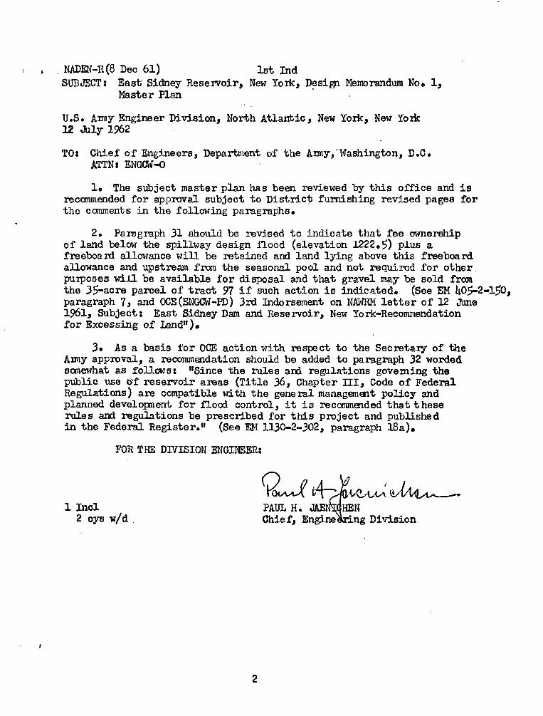
NADEN-R(8 Dec 61) 1st Ind
SUBJECT: East Sidney Reservoir, New York, Design Memorandum No. 1,Master Plan
U.S. Army Engineer Division, North Atlantic, New York, New York12 July 1962
TO: Chief of Engineers, Department of the Amy,-Washington, D.C.ATTN: ENGCW-0
1. The subject master plan has been reviewed by this office and isrecommended for approval subject to District furnishing revised pages forthe camments in the following paragraphs.
2. Paragraph 31 should be revised to indicate that fee ownershipof land below the spillway design flood (elevation 1222.5) plus afreeboard allowance will be retained and land lying above this freeboardallowance and upstream fram the seasonal pool and not required for otherpurposes will be available for disposal and that gravel may be sold fromthe 35-acre parcel of tract 97 if such action is indicated. (See EM 405-2-150,paragraph 7, and OCE (ENGCW-PD) 3IW Indorsement on NAWRM letter of 12 June1961, Subject: East Sidney Dam and Rese rvoir, New York-Recommendationfor Excessing of Land").
3. As a basis for OCE action with respect to the Secretary of theArmy approval, a recommendation should be added to paragraph 32 wordedsomewhat as follows: "Since the rules and regulations governing thepublic use @f reservoir areas (Title 36, Chapter III, Code of FederalRegulations) are compatible with the gene ral management policy andplanned development for flood control, it is recommended that theserule s and regulations be prescribed for this project and publishe din the Federal Register." (See EM 1130-2-302, paragraph 18a).
FOR THE DIVISION ENGINEER:
QU 04 .64 91 Incl PAUL H. JAE N
2 cys w/d Chie f, Engi ng Division
2

ENGCW-OM (8 Dec 61) 2d Ind
SUBJECT: East Sidney Reservoir, New York, Design Memorandum No. 1,Master Plan
Office, Chief of Engineers, Washington 25, D. C., 10 October 1962
TO: Division Engineer, U. S. Army Engineer Division, North AtlanticNew York, New York
1. The Master Plan is approved subject to the comments of theDivision Engineer as°contained in the preceding 1st Indorsement, exceptas noted below and to the following additional comments:
2. Reference Par. 262. The use of power boats on certain days isnot believed a desirable type of regulation. However, a regulation torestrict boating to non-power boat use is desirable at some projects.
3. Reference Par. 27. For pools the size of subject project all
lands should be designated Priority 1 lands, with other uses, such asgrazing, as an interim use.
4. Reference Par. 31, and Par. 2 of the preceding lot Ind. Concurin the statement contained in Par. 2 subject to compliance with instruc-tions contained in ENGCW-OM Multiple Letter, 24 August 1962, subject:"Acquisition of Supplemental Reservoir Lands."
5. Reference Par. 3 of the preceding lot Indorsement. Upon receiptof your further recommendations regarding use of power boats, the Rulesand Regulations will be recommended to the Secretary of the Army to coverEast Sidney Reservoir.
FOR THE CHIEF OF ENGINEERS:
9
1 Incl w/dChief, Operations DivisionCivil Works
MARK . GURNEE
3

NADEN-R(8 Dec 61) 3d Ind
SUBJECT : East Sidney Reservoir, New York, Design Memorandum No. 1,Master Plan
U.S. Anny Engineer Division, North Atlantic, New York, New York15 October 1%2
TO: District Engineer, U.S. Amy Engineer District, BaltimoreBaltimore, Md. ATTN: NABEN-R
Forwarded noting OCE approval subject to the comments in the1st and 2nd Indo rsements.
POR THE DIVISION ENG[NEER:
(3 0 41 (•41/1 FT- 1,4/I/I/1 G'(4-
) CI
le
PAUL H. JAE] IEN
Chie f, Engi] ring Division
4

NABEN-R (8 Dec 61) 4th Ind
SUBJECT: East Sidney Reservoir, New YorkMaster Plan
, Design Memorandum No. 1,
U. S. Army Engineer District, Baltimore, Baltimore, Md., 22 January 1963
TO: Division Engineer, U. S. Army Engineer Division, North Atlantic,ATTN: NADEN-R
1. References in the following subparagraphs,pertain to NADEN-Rcomments in the 1st indorsement to the basic letter.
a. Paragraph 2. Paragraph 31 and subparagraph 32. e have beenrevised in accordance with the suggestions in this paragraph.
b. Paragraph 3. The recommendation as worded in this para-graph has been added to paragraph 32 of the subject Design Memorandum.
2. References in the following subparagraphs.pertain to ENGCW-OMcomments in the 2nd indorsement to the basic letter.
a. Paragraph 2. The use of power boats will be permitted,subject to the regulations contained in the Federal Code, title 36,part 311; and subparagraph 26.a of the design memorandum has been re-vised accordingly.
b. Paragraph 3. Paragraph 27 of the subject Design Memoran-dum has been revised in accordance with the suggestion in this paragraph.
c. Paragraph 4. See subparagraph 1.a of this indorsement. Thereference to ENGCW-OM Multiple Letter dated 24 August 1962 is noted.
d. Paragraph 5· See subparagraph 2.a of,this indorsement.
FOR THE DISTRICT ENGINEER:
/ Ijt. Col., Ccl>eputy Disti
1 Incl LCCI
2. Revisions (sext) rps of Engineers
ict Engineer
5
SUSQUEHANNA RIVER BASIN
EAST SIDNEY RESERVOIR
OULEOUT CREEK, NEW YORK
DESIGN MEMORANDUM HO. 1
MASTER PLAN
U. S. ARMY ENGINEER DISTRICT, BALTIMORE
CORPS OF ENGINEERS
BALTIMORE 3, MARYLAND
DECEMBER 1961
U. S. ARMY ENGINEER DISTRICT, BALTIMORE
BALTIMORE 3, MARYLAND
SUSQUEHANNA RIVER BASIN
EAST SIDNEY RESERVOIR
OULEOUT CREEK, NEW YORK
DESIGN MEMORANDUM NO. 1
MASTER PLAN
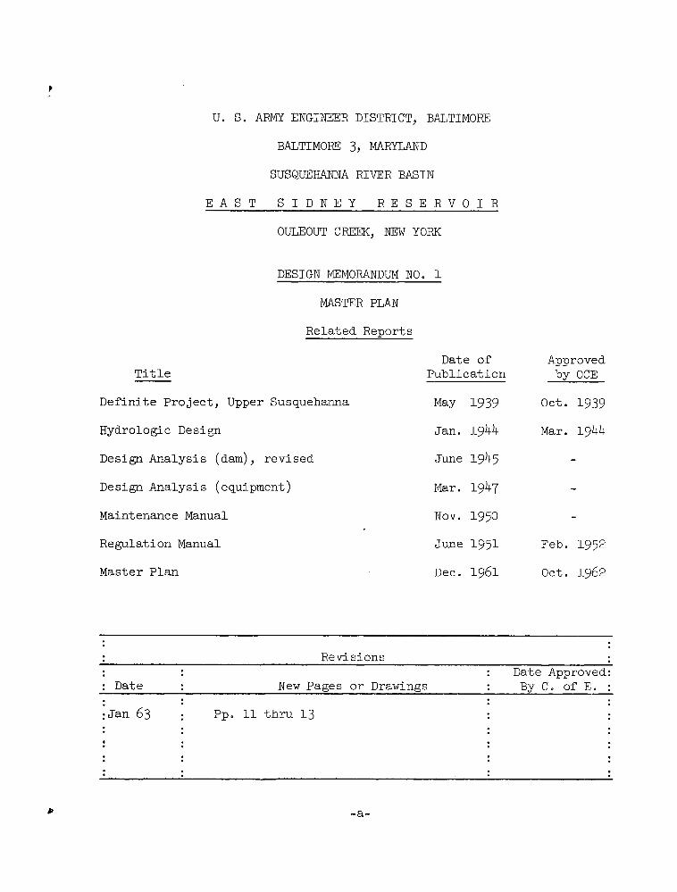
Related Reports
Date of ApprovedTitle Publication by OCE
Definite Project, Upper Susquehanna May 1939 Oet. 1939
Hydrologic Design Jan. 1944 Mar. 1944
Design Analysis (dam), revised June 1945 -
Design Analysis (equipment) Mar. 1947 -
Maintenance Manual Nov. 1950 -
Regulation Manual June 1951 Feb. 1952
Master Plan Dec. 1961 Oct. 1962
Revisions
: : Date ApprovedDate : New Pages or Drawings : By C. of E.
:Jan 63 Pp. 11 thru 13
..
/.
..
..
..
..
•e
..
-a-

,,f·;4-
i + : , f 36. I.-.-' 7= ..t MM-'-
I ...../6
, 6/11/1.gi.4t :* 9>,1 %.»
i..
1 It {i,f 'f +2*tz: i Li i I©1'1*. c '14 4.
. 24 -*fi 1 ik . -c, 1/.. 1 . •1 / 4 ..t I .F-,r*< W 34-1.- 9- 2 I -
1.44.4 1 , 4¥* * ul'' 1 0 . .=J 4-I.P.-
7'Nx, ' .A V¥.
41,4'' Cultht' 6/1 411 il\ , , 1
41+ 4,# .1 L .. + .i 0 .l
, , 4'' 1 11,
'Ar 1 91 1/1 *·1. \ 1 \ 1 2 +
1
Et *,4 th- 6 I
Ii t,\li. I.
- 1 I. 1.- %Al!46 , 1 Il, 11
Frontispiece -- EAST SIDNEY RESERVOIR AT ELEVATION 1.150. VIEW UPSTREAM FROM LEFT ABUTMENT OF DAM.
2.4 1e,
L *224/1

SUSQUEHANNA RIVER BASIN
EAST SIDNEY RESERVOIR
OULEOUT CREEK, NEW YORK
DESIGN MEMORANDUM NO. 1
MASTER PLAN
1961
CONTENTS
Paragraph Heading Page
Frontispiece .................. b
A. GENERAL INFORMATION
Project authorization ..............
Project purpose............'.....
History...........Scope ......................
B. GENERAL CHARACTERISTICS OF PROJECT AREA
5· Location ...................0 1
Topography ...................
7. Engineering features .............. 28. ' Description of reservoir area .......... 49. Accessibility .................. 4
10. Population of surrounding area (1960 census) .. 411. Existing public recreation facilities ...... 5
C. RECREATIONAL USE OF RESERVOIR
12. Past and present land usage ..........
13. Use of storage ................14. Present recreational use ...........
15. Availability of lands for recreation .....16. Feasibility of seasonal recreation pool ....
17. Hydrologic studies ..............18. Winter pool ...........19. Gate operations ................20. Reservoir clearing ..............
-C-

CONTENTS (Cont'd)
Paragraph -Heading Page
21. Roads ......................
22. Local cooperation ................23. Village of Franklin ...............24. Federal agencies ................25. Attendance ...................
26. Plan of administration .............
27. Priority ....................28. Costs ......................
29. Conclusions ...................
D. OTHER RESERVOIR LAND USE
30 0 Outlease program ................ 12
31, Land disposal .................. 12
E. RECOMMENDATIONS
32, Approval of Master Plan ...... 12
33. Change in reservoir regulation plan ....... 1334. Low-flow control ......... ....... 1335· Construction design memorandum ......... 13
-d-

CONTENTS (Cont'd)
TABLES
No. Title Page
1 Pertinent data ....... 2-4
2 Urban areas within fifty miles of reservoir . 53 Public recreation areas within fifty miles of
reservoir ................. 6
4 Pool area and capacity ........... 8
PLATES
No. Title
1 Map -- Related facilities and highway system
ZA,
3
4
2B
2D,
Real estate maps
Map -- Additional fee acquisition required
Map -- Proposed recreational facilities
APPENDICES
Designation Title Pages
A Cost estimate A-1
B Hydrologic and economic data B-1 thru B-4
-e-

SUSQUEHANNA RIVER BASIN
EAST SIDNEY RESERVOIR
OULEOUT CREEK, NEW YORK
DESIGN MEMORANDUM NO. 1
MASTER PLAN
1961
A. GENERAL INFORMATION
1. Project authorization. The East Sidney Reservoir project isa part of the general plan for the control of floods in the upper Sus-quehanna River basin, authorized by the Flood Control Act of 22 June1936. The project was included in the Definite Project for Flood Pro-tection, Upper Susquehanna River Basin, approved by the Chief ofEngineers on 13 October 1939·
2. Project purpose. East Sidney Reservoir is a unit of a compre-hensive system of dams and reservoirs designed to provide flood protectionalong the main streains in the upper Susquehanna River basin. The reservoir
provides immediate flood protection for the valley downstream from the damand assists in controlling floods on the Susquehanna River.
3. History. Constfuction of East Sidney Dam commenced in April1947, and the project was operationally completed in June 1950.
4. Scope. The purposes of this Master Plan are to:
(a) present a sound, coordinated plan for the administrationand development of the reservoir for all desirable uses so far as such
uses are consistent with the operation and maintenance of the project
for its primary purpose;
(b) present data on the type of development which will returnmaximum sustained public benefits;
(c) assure coordination with interested Federallocal agencies; and
State and
(d) furnish design data on those facilities to be constructedat Federal expense.
B. GENERAL CHARACTERISTICS OF PROJECT AREA
5. Location. East Sidney Reservoir is located on Ouleout Creek inDelaware County, New York, about 5 miles above the confluence of the creek

with the Susquehanna River near the village of Unadilla, Otsego County,New York. The location of this reservoir is shown on plate 1.
6. Topography. The general topography of the area is rolling,with relatively deep valleys having moderately steep side slopes. Thereservoir area is composed of inactive farm and pasture land with seat-
tered wooded and brushed areas. The timber cover is generally sparseand confined mainly to the upper valley slopes.
7. Engineering features.
a. The dam at crest is 2,010 feet long. It is 130 feet highabove streambed and 146 feet above firm rock. The dam consists of a
concrete gravity type section with compacted earth dike sections at the
abutments. The right bank dike section is 1,140 feet long, the-leftbank dike section is 120 feet long, and the concrete gravity type sec-tion is 750 feet long and contains the spillway, located in the center,and the outlet works. The outlet works consists of 5 rectangular conduits
each 3.5 feet by 5.83 feet by 105 feet long. Flow through the conduitsis regulated by 5 sluice gates, 3 feet 6 inches by 5 feet 10 inches.
; b. The reservoir, at spillway crest, has a flood-water storagecapacity of 33,500 acre-feet and will form a lake having a surface area
of 1,100 acres and a main valley length of about 5.5 miles. The drainagearea controlled by East Sidney Dam is approximately 102 square miles whichis 93 percent of the Ouleout Creek drainage area.
c. Engineering data pertaining to the dam and reservoir are
given in table 1.
TABLE 1
PERTINENT DATA
LOCATION OF DAM
Stream
Distance above confluence of
Ouleout Creek & Susquehanna R.
Ouleout Creek
5 miles
DRAINAGE AREA
Ouleout Creek 109 sq. miles
Controlled by reservoir 102 sq. miles
ELEVATIONS
Top of dam 1,228.5Spillway design flood 1,222.5Spillway crest 1,203.0Five-year flood . 1,185
2

TABLE 1 (Cont'd)
ELEVATIONS
Upper limit of clearing 1,151Proposed summer pool 1, 150Future winter pool 1,140Top of conduit at entrance 1,120.8Invert of conduit at entrance (dead storage pool) 1,115.0
RESERVOIR
Length at elev. 1,150 (summer pool)Length at elev. 1,203 (spillway crest)Shoreline at elev. 1,150 (summer pool)
2.5 miles
5.5 miles6 miles
Acre-feelStorage:
Dead storage (elev. 1,115)Future winter pool (elev. 1,140)Summer pool (elev. 1,150)Flood control (elev. 1,203)Spillway surcharge (elev. 1,222.5)
Net Cumulative
50 50
1,650 1,7001,650 3,350
30,200 33,55024,800 58,350
Surface area, dead storage
Surface area, future winter poolSurface area, summer poolSurface area at spillway crestFlowage easementsLands acquired in fee
10 acres
130 acres210 acres
1,100 acres863 acres402 acres
DAM
Type -- Rolled earth with concrete gravity central portion
including spillway overflow section
Length at crest
Right bank earth section 1,140 feetCentral concrete gravity section,
including spillway 750 feetLeft bank earth section 120 feet
Total 2,010 feet
Top widthEarth section
Concrete section
Maximum heightAbove streambed
Above firm rock
25 feet12 feet
130 feet146 feet
3
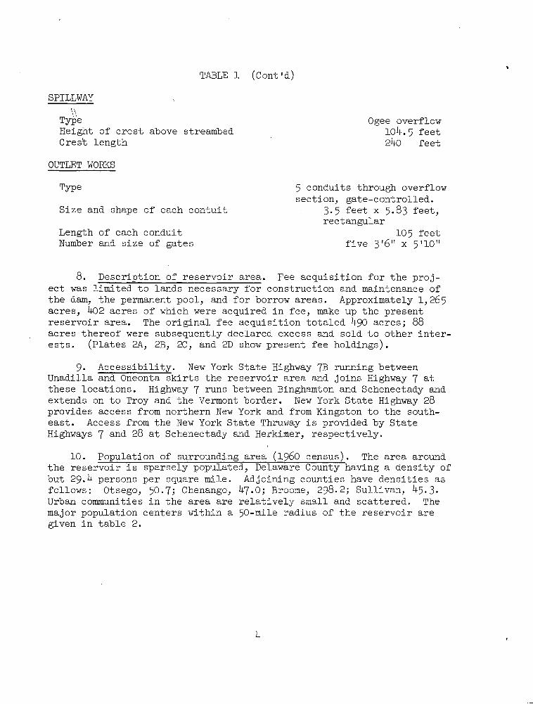
TABLE 1 (Cont'd)
SPILLWAY
Type Ogee overflowHeight of crest above streambed 104.5 feetCrest length 240 feet
OUTLET WORKS
Type 5 conduits through overflow
section, gate-controlled.Size and shape of each contuit 3.5 feet x 5.83 feet,
rectangular
Length of each conduit 105 feetNumber and size of gates five 3 '6" x 5 '10"
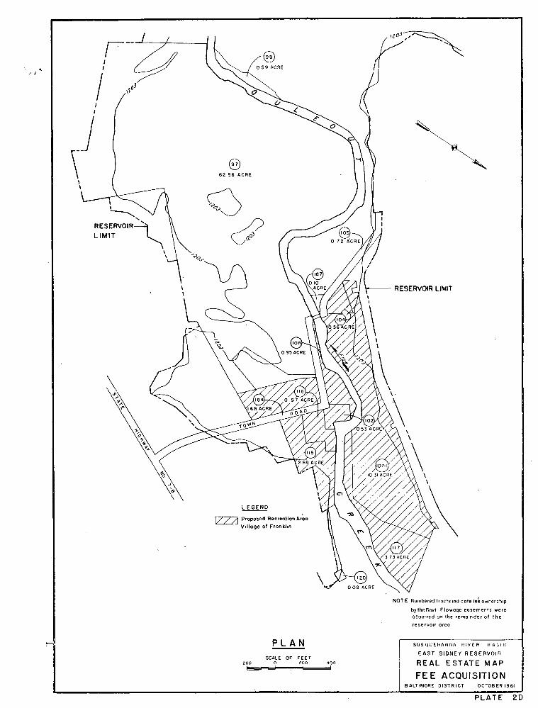
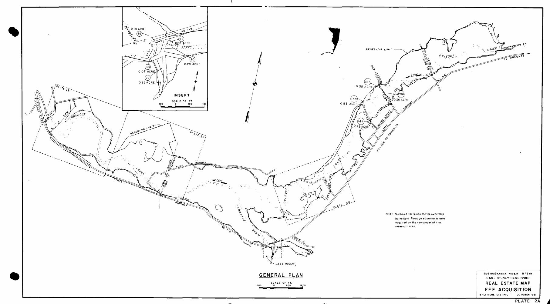
8. Description of reservoir area. Fee acquisition for the proj-ect was limited to lands necessary for construction and maintenance ofthe dam, the permanent pool, and for borrow areas. Approximately 1,265acres, 402 acres of which were acquired in fee, make up the presentreservoir area. The original fee acquisition totaled 490 acres; 88acres thereof were subsequently declared excess and sold to other inter-ests. (Plates 2A, 2B, 2C, and 2D show present fee holdings) .
9. Accessibility. New York State Highway 7B running betweenUnadilla and Oneonta skirts the reservoir area and joins Highway 7 at
these locations. Highway 7 runs between Binghamton and Schenectady andextends on to Troy and the Vermont border. New York State Highway 28provides access from northern New York and from Kingston to the south-east. Access from the New York State Thruway is provided by State
Highways 7 and 28 at Schenectady and Herkimer, respectively.
10. Population of surrounding area (1960 census). The area aroundthe reservoir is sparsely populated, Delaware County having a density ofbut 29.4 persons per square mile. Adjoining counties have densities asfollows: Otsego, 50·7; Chenango, 47.0; Broome, 298.2; Sullivan, 45.3.Urban communities in the area are relatively small and scattered. The
major population centers within a 50-mile radius of the reservoir are
given in table 2.
4
TABLE 2
URBAN AREAS WITHIN FIFTY MILES OF RESERVOIR
(Population of 2,000 or greater)
Population Airline mileageCommunity (1960 Census) from reservoir
Oneonta 13, 310 11
Sidney 5,142 11
Walton 3,827 11
Delhi 2,294 14
Norwich 9,150 22
Cooperstown 2,514 29
Susquehanna, Pa. 2,571 35
Binghamton Metropolitan Area 158,141 41
Cobleskill 3,467 44
Liberty 4,635 - 44.
Ilion 10,115 48
Mohawk 3,516 48
Frankfort 3,871 49
Herkimer 9,368 49
Fort Plain 2,786 50
Canajoharie . 2,675 59
Montrose, Pa. 2,327 50
11. Existing public recreation facilities. The recreation needsof the area are served by the State-operated facilities shown in table 3.
5

TABLE 3
PUBLIC RECREATION AREAS WITHIN FIFTY MILES OF RESERVOIR
Facilities available
Airline
mileage
from
reservoir Acres
Gilbert Lake State Park 17 1,569 XXXXX X
Chenango Valley State Park 35 926 XXXXX X
State Forest Preserves
Catskill'Park--Beaverskill 30 - x x x x'
Catskill,Park--Woodland
Valley 48 - x x X X
C. RECREATIONAL USE OF RESERVOIR
12. Past and present land usage. Since completion of the dam andreservoir in June 1950, a program of outleasing of project lands foragriculture and grazing purposes has been instituted. At present, 166acres are under lease to 1 lessee at an annual rental of $200. Thislease is for a term of five years. Hunting and fishing have been per-mitted throughout the reservoir area. No organized recreational activ-ities have been carried on.
13. Use of storage. To date the reservoir has been used for flood
control storage only. About 1952 a plan for storage of about one inch of
runoff for low-flow control was considered in connection with a general
plan for low-flow control on the North Branch. This would have requiredstorage to a maximum stage of 1,159, nine feet higher than now recommended
for the seasonal recreational pool. The matter was presented to OCE in
connection with review of a draft of the North Branch survey report, anda decision was made that such use was possible under existing authority.
The plan was never put into effect, and there has been no recent requestfor its adoption. While the adoption of the plan for a recreation poolwould detract from the practicability of releases for low-flow control,
future studies might develop the need for some releases from the poolunder exceptional conditions of natural low flow. The possibility of
such a requirement should not be overlooked. Particularly during Septem-ber and October, after the principal recreational season in the area,releases could be made in accordance with a future low-flow control planwithout adverse results to recreational interests.
6
14. Present recreational use.
a. Hunting and fishing. There is considerable use of the
reservoir by local sportsmen for small game hunting and fishing. There
is also fishing in the stream downstream from the dam, and even duringperiods of impoundment one gate is kept partially open (0.6 foot mini-mum opening)to support fish life in the creek.
b. Overlook. An overlook with space for 10 or 12 cars isprovided on the left bank in the vicinity of the dam.
15: Availability of lands for recreation. When the project wasacquired it was the intent of the Government to operate the reservoir
for flood control purposes only. Consequently, flowage easements wereacquired for the greater part of the project and, as previously stated,fee acquisition was limited. To flood the land for a recreation poolwill require fee ownership. Lands presently owned in fee are not suf-ficient for a recreational pool nor for development of access roads,parking areas, beach areas or other recreational facilities. An addi-
tional fee acquisition of a minimum of 250 acres will be required toprovide a recreational pool to elevation 1,150, to permit the develop-ment of recreational facilities and to protect against undesirable en-
croachments. Of the above mentioned 250 acres, flowage easements arenow held on all except about 16,acres. The required additional feeacquisition is shown on plate 3.
16. Feasibility of seasonal recreation pool. Maintaining a recrea-tion pool at elevation 1,150 during the period from 15 May.to 15 Septemberwill have little effect on the reservoirls use for flood control since
such use is at a minimum during the recreation season and the proposedpool (equivalent to 0.62 inch of runoff) will occupy only 10 percent ofthe storage capacity.
17. Hydrologic studies.
a. Under the present plan of regulation, three of the fivegates are normally kept closed, and the other two are closed as required·to prevent flood damage: Duting the recreation season (15 May to 15September) in the period of 12 years since the gates became operable inNovember 1949, they have been operated only once for flood storage, on29 July 1961, and the maximum storage used was equal to 0.47 inch ofrunoff. Maximum annual stages have all occurred during the months ofNovember through April, inclusive. The greatest of thuse occurred inApril 1960, when storage reached a maximum of 4.66 inches. Other thanthe localized July 1961 storm which produced a rapid rise in the reser-voir with a computed peak inflow of 7,700 c.f.s. and a peak reservoirstage of 1,146, the only known recreation season flood at the site isthe July 1935 flood, which produced the greatest known peak flow at thesite. It is estimated that this flood would have caused peak storageof 4.2 inches under the present plan of regulation and 4.6 inches withthe proposed recreation pool. Downstream flood reductions would have
been equal under both plans.7

b. The proposed pool will increase peak storage used duringfloods by an amount somewhat less than the 0.62 inch in the recreationpool, since about one-third to two-thirds of this amount is generallyimpounded before gates are closed under the present plan of regulation.The increase in total storage would therefore be about 0.2 to 0.4 inchif there were no change in downstream flow affecting the timing of gateoperations. However, under the proposed operation, gates would beadjusted to make outflow equal to inflow during the early part of any
rise, and this outflow would exceed the outflow under the present plan.The result would be slightly faster rises at downstream points, andslightly earlier closing of gates. The increased storage from thiscause is estimated to approximate 0.1 inch, making a total increase of0.3 to 0.5 inch of storage resulting from the recreation pool.
210 acres
miles.
c. A pool at elevation 1,150 will provide a surface area of, will be 2.5 miles in length, and will have a shoreline of 6
d. Additional hydrologic data and an economic analysis ofthe recreational development are presented in appendix B.
18. Winter pool. It is planned to maintain the recreation poolonly during the period from 15 May to 15 September. If demand for a
pool through the remainder of the year should develop, it is believed
that a pool with half the summer capacity, or to elevation 1,140, wouldbe adequate. Its effect on flood storage capacity would be insignificant.
Such a pool will not be established unless requested by a responsible
local agency for fish propagation or other use in the, public interest.
Statistics on the proposed pools are given in table 4.
TABLE 4
POOL AREA AND CAPACITY
Percent Inches of Surface
Elevation, Storage, of total runoff area,
ft., m. s.1. acre ft. capacity used acres . Remarks
1,203 33,550 100 6.15 1,100 Spillway crest
1,150 3,350 10 0.62 210 Seasonal recrea-
tion pool
1,140 1,700 5.1 0.31 130 Future permanent(winter) pool
8
19. Gate operation.
a. No structural changes are necessary in order to establishand maintain the proposed summer and future winter pools. Limitedoperational tests made during 1960 indicate that satisfactory controlof the pool level can be maintained through operation·of.the existingservice gates. The Commonwealth of Pennsylvania maintains a conserva-
tion pool at George B. Stevenson Dam, where regulation is accomplishedby use of the main gates - two 8- by 16-foot slide gates. Pool fluctua-tions usually amount to less than one. foot. Forty weekly readingsreported'to this office during the past year (excluding periods offlood control storage) show an average conservation pool elevation of920.2 as compared to the adopted level of 920.0. Only four of these40 readings exceeded 921,5 and only four were less than 919.0 Thedam tender reports that during periods of fairly constant runoff, gatesettings are changed every second day, while during periods of rapidfluctuations in stream flow, it may be necessary to adjust gate settingstwo or three times during a 24-hour period.
b. The proposed future permanent (winter) pool at elevation1,140 would provide 19 feet of water oVer the top of the gate openings.This amount of submergence is more than adequate to prevent the gatesfreezing in position.
20. Reservoir clearing.
a. Clearing of the reservoir will be in accordance withpolicies established in EM 415-2-301. The upper limit of clearingwill be elevation 1,151, which will permit one foot of fluctuation inthe summer recreation pool above its nominal elevation, 1,150. It isbelieved that the occasional flood above elevation 1,151 will not re-sult in killing the remaining timber. The only additional clearing
will be in areas required for roads, parking lots, or other operationalpurposes. Approximately 140 acres of the reservoir on both banks werecleared of all timber in 1949. Hence no large timber should be encount-ered in this area, but stumps may require removal.
b. Where the ground surface is below elevation 1,135 (5 feetbelow surface of-future permanent pool), no stumps will be permitted toextend above elevation 1,135· Where the ground surfate is between 1,135and 1,151, no stumps will be permitted to extend above ground surface.The beach area will be grubbed to remove all vegetation.
c. Submerged shoal areas above elevation 1,135 will be markedby buoys or other means for the safety of tha boating public.
21. Roads. Access and circulation roads will have a 20-foot pave-ment with 4-foot shoulders. Maximum grades will be .in accordance with
9
appendix A to EM 1130-2-312, and, the roads and parking area will bedesigned in accordance with the- standard plans for recreation facil-ities referred to therein.
22. Local cooperation.
a. State of New York. The Conservation Department of theState of New York informed the Baltimore District that State agenciesare not desirous of developing East Sidney Reservoir for recreation orgame management. The department indicated that due to its limited area
the reservoir is not suitable for development as a State park, butrecommended its development by local agencies.
b. Local participation. Many local government officials,civic and fraternal organizations, and individuals have stated thatadditional recreational facilities are desired for the area. The
town of Sidney, in which most of the proposed recreational pool wouldbe located and in which all of the proposed recreational facilities,such as picnic areas, bathing beach, and boat dock, would be located,informally agreed, at a meeting held in the village of Sidney on19 October 1961, to sponsor the recreational development of the reser-voir. The town of Sidney would provide the facilities listed as non-Federal on page A-1 of appendix A, would maintain and operate therecreational area, and would hold and save the United States free fromdamages which might result from use of the recreational facilities.
23. Village of Franklin. The village of Franklin, located 4 milesupstream from the dam, has requested permission to develop approximately22 acres of the reservoir as a village park. This area lies immediatelydownstream from the village. It is remote from the proposed recreational
pool and will not interfere with any future recreational development.Development of the area will be limited to picnicking and playground.facilities. A Boy Scout day camp area is proposed on the right bank.See plate 2D for location of this area.
24. Federal agencies. No other Federal agency has indicated inter-est in the development of East Sidney Reservoir. Since the New York
Conservation Department has declined to participate in the proposed plan,the U. S. Fish and Wildlife Service has not been asked to cooperate in
formation of a General Plan for fish and wildlife management.
25. Attendance. It is estimated that an annual attendance of at
least 15,000 can be expected to visit this reservoir upon completion.Recreational facilities should be provided ultimately to care for a
design load of 375 visitors at any one time.
26. Plan of administration.
a. Agreements and licensing. After approval of this memorandumand receipt of formal assurances from the town of Sidney covering theitems given in subparagraph 22.b. above, a license will be issued granting
10

·use of the pool for boating, fishing, and swimming and use of selectedland areas for beach and picnic areas. The use of power boats will be
*permitted. The license will require the sponsoring agency to assumeall costs of operation and maintenance and to hold the Federal Govern-ment free of claims for damages resulting from the recreational use.Regulations for public use of the reservoir will be compatible withthose contained .in the Federal Code, title 36, part 311.
b. Personnel. All personnel for operations, maintenance, andpolicing of the recreational area will be furnished by the sponsoring·agency. No increase in Federal personnel is anticipated as a result ofadopting the plans recommended in this Master Plan. Some additional
work will be involved as the plan will require frequent adjustment of
the gate opening and there will be more visitors requesting information
in the operating area, but it is believed that these duties can behandled by the-present staff.
27. Priority. All reservoir lands are designated for priority 1
use as defined in EM 1130-2-302 and EM 405-2-835. Other uses, such as*agriculture and grazing, are designated as interim uses.
28. Costs. A preliminary cost estimate, with various items allot-
ted between the Federal Government and local interests is given in
appendix A. The items shown as non-Federal costs may not be forthcoming
at one time, but it is believed local interests can provide the most
essential features the first year and complete the program within three
years. It is anticipated that fees charged for various services will
defray a major portion of the operating expenses.
29. ·Conclusions. The development of East Sidney Reservoir for re-
creation will consist primarily of the following:
a) Provision of a seasonal recreational pool to elevation 1
b) Bathing beach and dressing room facilities.
c) Access roads and parking areas.
d) Picnic areas.
e) Boat launching and docking facilities.
f) Separate -park area near village of Franklin.
g) Future winter pool when demand developes.
'150.
R-1
11 Jan. 63
D. OTHER RESERVOIR LAND USE
30. Outlease program. Where consistent with the recreational
development of the reservoir, any.land not required for other uses will
be made available for outleasing for ag r icultural crop production or
grazing purposes. The proposed recreation plan will require modification
or cancellation of the one existing lease. Little additional land, if
any, will be made available for leasing as a result of the fee acquisi-
tion redommended herein because it is planned to acquire only those areasrequired for the proposed summer pool or for recreational areas:
31, Land disposal. The lands of this reservoir acquired in -fee
consist of isolated parcels, varying in area from as little as 0.06 acreto 130 acres, surrounded by lands on which flowage rights only have been
*obtained. (See plates 2A, 2B, 2C, and 2D.) Fee ownership of land belowthe spillway design flood (elevation 1,222.5) plus a freeboard allowanceof 7.5 feet will be retained. Land lying above this freeboard allowanceand upstream from the seasonal pool and not required for either purposeswill be available for disposal. In the past, local officials have
indicated an interest in sand and gravel deposits that are located ontract 97· This area is largely bare ground and has no immediate valuefor recreation. The sale of sand or gravel from this area would not
preclude possible future development, and such deposits will be made*available for local needs.
E. RECOMMENDATIONS
32. Approval of Master Plan. It is recommended that this Master
Plan, embracing the following proposals and plans be approved. The MasterPlan provides:
, a. Summer pool and recreation area. That as soon as a respon-
sible local agency agrees to cooperate in such development, a seasonalrecreation pool (15 May to 15 September) be provided at elevation 1,150with cost participation by the Government as shown in appendix A.
b. Winter pool. That, when the need develops, a permanent
pool be established to elevation 1,140.
c. Village park. That the village of Franklin be granted a
license for the development, operation, and maintenance of a village park.
d. Outlease program. That lands not set aside for recreational
development be offered for outlease, the leases so granted to allow theaccess and management activities necessary under the game management pro-gram.
R-1
Jan. 63 12
* e. Land disposal. That lands owned in fee above the freeboard
*elevation (1,230) and not required for recreational or other project pur-poses be made available for disposal.
* f. Federal Register. Since the rules and regulations governing
the public use of reservoir areas (Title 36, Chapter III, Code of FederalRegulations) are compatible with the general management policy and planneddevelopment for flood control, it is recommended that these rules and
regulations be prescribed for this project and published in the Federal*Register.
33. Change in reservoir regulation plan. It is recommended that
approval be given for a change in the regulation plan as required byER 1110-2-240, paragraph 5, to provide for the recreation and conserva-tion pools recommended by this Master Plan.
34. Low-flow control. It is recommended that in establishing arecreational pool, any agreements pertaining thereto retain for theGovernment the right to make releases for low flow regulation or other
purposes, if and when required.
35· Construction design memorandum. Since most of the planned
recreational facilities will be provided by the cooperating agenciesand since this memorandum includes information on reservoir clearing
and roads - the two principal items of Federal expense - it is recommen-ded that the requirement of EM 1130-2-302, paragraph 9.C. (7) for aseparate construction design memorandum be waived.
R-1
13 Jan. 63

1

31 7 1*27·12 11101.„ 4 !0
- UTICA'O 00'.-m
• Hai. 6ZE Acc
--13Syficu '.
E G.
Clin:o Franlfort 1*49 #i{•,emer #1'roadalbin.
.1
Mill 9•hile'an.4 Ch.
V.1,1
t wicksI 3 4 p,lry,Illi
Illon . f st.AhnsvilleSauquoi onawk 01...M
10 4 .1 Fonda -4?Ek.AUS»SU
12 -Chatcn /
W,ll,1 26"18 / Cl•ill• r:.
28C tno¥11 ivatenille Jor-
SU.kwilli V.U.,Falli
2G20 24721,Mid Wwln
Momiville
01,1,•nd,Il
i 20 8 30
Ef,-11, E.to
IJ
Tornh•floch
N Broo. Richll,Id
:7<2/0.31 Cik
.Sh,3, IHam tton ...4 / Foi.
8
W"
16
12 arc,ok ..11. Fou80 6 1.10EM,milt Ch Co es
Pool.,11.C.
Vali 1 11. tnon 112 E,per,c. 'O
S 10W Peen1 Di Rei cor. town
38 I .,On
Culer
; Ti I Ro,boom
I . Fly C' / -an sri
Ce' C' Wat ¥Ilet
oc /15/0,0 15
01••U 80 4 Wew,1, gill14
or@9OO
O@r $,1
T./InEdmest fil
Smy' 22 * 80Inv.117
14Sherburne 80
war - , Coblask,11 0 hohar
JO
r.= war &
£U Firchir# "'Grow
Re selaer -
E-Wo.cest. RC ,61
C.0Middl url /
Summit AI M 11.0 War ter
& Grolon ' 4," , Cert! d32
NIVI,-P,tch, 0M.
CO,, i 238 1/'|.'
9L Morris 2 Poftiand•,1 • s ae,ler'.'...Cincinna
Norw12h S 14 .rlinHolrnesville
M8,land 10 1
t 0'.0..012,11 /,b AP 5hICDOnough Oaeontas ,-wGil
1
oom,
W on.On 6 302
Ox'ord 2
'1 22L Mt ....
23 \S....
E Iii. th .*F, Stamford q:„u,G . /I
03'-Ar. Otagoe I. mlth*be tham
Up..s!• , Flti Hot)art
30Mi R
IS €a,J o.
0 ,
#Unadilla Fnklin
t• dn,mCe ck,e.
I.i,nf.Id
Windhirn ,9
1 Covintry 9 2586 S'
YS,dne,Mo PW, g ;
Inbridgeyvil e Delhi1 6 a.w. R©Abul, Il,XiJe 79 0 Ma,onvll Sow,na n
41 7 i9
30
Pinglon A C+11 4ChHunterC. I C./ C•-,• .... O,0'ki flon11 V I 6
3 126Hal I Soruc... 20 "MA
Tiout¢re
Hargurivill.V.110.1. · watton PROJECT ... 6 j..61/
Flei,chmani
JG,'
SITE kvT le
2113 / Port likinson 8-/ on0
Eri c 1 Rock Rift26
Vestal10
Ma¢/
4, ch Zi, Deposit10 Carmon' Downsville . Phoer Cia
% 10.
7 1 e ./
SIOckohor Q 001•-•• Wood 1El.
Mcclurl
2- 1. " 730mghamtpn *„ Ml Ticm- Glasco ; 141;H Corb,tl Middl, Mi. DOUJ/•lap
"40]0 I/lu 1,004
MAlflumm R,idbufn
NEW YORK i
tlead "
09'al. Eddy
4 /7 A,hok,M
4 ur.... ENNSYLVANA1.415
HOIJo, i
Cadcs,3Slelen: I Shok,nPo nt
A.,0.
L.1...1 . 14 9
Susq,ali# 31 Hancock '2'4 Cook.Fill. D•M•: 4 HU'oicoe
M ilil•.F
2.
11 *.WOO Pei #i Kt st,!lowemoc, 660®il•49 '37 U. Uv.ng,ton
30,S.m.on.1,
Ne•M lford 7SUSQUEHANNA RIVER BASIN
10•,
P,chivn Glahams.nlle. Equ,nunh C,11 Cen
20'troseEAST SIDNEY RESERVOIR
5YOUME
9 Gbson N
W
. t •e.o#„. SP,In.Laert,
I TF .MO, 1 RELATED FACILITIES AND j'247
H flord Bu.MwoodCallicocn • 'rhonkson
Fe.ndale Woo urne92
0.0Hurrer I Nal.noc. i Ple'unt...1
.Id VIlle F.114 S&-) h' HIGHWAY SYSTEM 1t, #·Dmol 106 6 South
W ....Gibson Wood'Idge Cilinrild * Ellen¥1113
MomostorMI- S ™Is •2
Le·0*3 0 0m, U SCALE OF MILES
71 Pli29
C,•,imoor Gic,r
Tholl' nvill
o0 I 0 20
5/,11. MouticellDunC4fl I
' -]Fofest Cilt,f
•21 Summil
Pine Bus>
8.... CORPS OF ENGINEERS106 WJ U.0,0.'...
¥la'rran
Me .•Pa y Hones¢ale 84# 1'..Plurri 9{ BALTIMORE DISTRICT OCT 1961*cod
dPLATE I

2 66 *CRE J,f 10.4 ACRE
\
.- \ 1 /3€
i ievi Ip . W f35/ /-
/ 1 ACR¥ /4) /
RESERVOIR ACRE \\LIMIT
'2 44 /
031 96 ACRE . 1
2
1 -RE
67 -CONCRETElk ACRE j jf 10, 2,1® j 11 \ -\ X
144
3. f (0* 1 @\ 1 ®236 ACRE 8 13 ACRE
ACRE I V
05196 ACRE
/
37
{20)
018 ACRE5RE \41/L LREMS'tRVOIR
1/\ A- /' \\ 4 4
4124 ACRE \ L B°02211-Hib
1
49043 ACRE
CE>---008 ACRE
-'006ACRE
=9 003 ACRE
010'*RE -62) )+1 1 ;.007 ACRE
/4,/4:fh /1 - 001 ACRE// n1 IM 001'KEREE 006 ACRE
(38-1 -A 1-132)
O,08 ACRE
Al 41008-ACRE )My -
\f§%)%2735,il.VD
0 2 4 ACRE/ 52*KCREr
U0/- 1 1\
-- , / t.2\ 1 I
20 51 ACRE
NOTE Numbered tracts Indicate fee ownersh,p
bylhe Govt Flowage easements wereacquired on the remainder of lhe
1 \1 / reservoir area.
/01
P LLAJ1 -AL':4"
SUSQUEHANNA RIVER BASIN
4124 ACRE PLAN EAST SIDNEY RESERVOIR
REAL ESTATE MAPSCALE OF FEET
200 0 200 oo FEE ACQUISITIONIll I
BALTIMORE DISTRICT 0CT0BERI961
PLATE 2B
h -h

04 RESERVLIMIT--
1 3 1 1
(•8)
\ 2/ 20 51 ACRE /3 \l%l
ty C .12990 ACRE
i/
0,9 ACREP
1 1 DICIES 8.100, -%-
tr«-11703\
--RESERVOIR
LIMIT
/01
\
4
.L/- -
1 fOWN
' ---Ill----joiN
0'
oF 1 /1 ,/-/
- i \ \\ / 21
e 1,11- ,5 91 ACRINOT E Numbered lic,cli,rld,cole fee ownership
by lhe Govl Flowage eosemenis were
ocquifed on Ihe iemointer of lhe
] 1 reservoir orea
9\4« / // Rf>x //
1 011l101 ACRF
1
, Clil
PLAN SUSQUE„ANNA RIVER BASIN
EAST SIDNEY RESERVOIR
SCALE OF FEEt200 0 mo 4/0 REAL ESTATE MAP
FEE ACQUISITIONBALTIMORE DISTRICT OCTOBER 1961
PLATE 2C
. I0
R I
Re:-CE=:X/n
\ (33 44\ O 59 ACRE ,1403 Yi\( U.\ aNe\ 1 -t.
»\ 9it P
62 56 ACRE
-1 i/Y k j
RESERVOIR--2 /ZZL,,--001LIMIT 0103 0 72 A'CRE)\\\LA *0-
{187)LJ \ 53WE/h RESERVOIR LIMIT
/11
404\ 1 Dfit
t'/ 1
I 0 95 ACRE \ 1 .·©5%6 \\ k .034 \
0 184 0 97 ACRE ,
ROAD
1 // 102 TOWN053 ACRE
\1 'Ii, X(tiilll \\\V,\ n /
-,32)/ 7-A0 5,RE// /,/ .,/607-iY
\4\ V-- ph/' If, :/10*/4 0%\ \-\
?\ \951 - 2544'7/.,toN,t\
LEGEND
Proposed Recreation AreaVillage of Franklin
\
*11 117/ /\ 373AGRE/,
120009 ACRE<NOTE Numbered liocts,ndicate fe6ownership
bytheGovt Flowage eosement5 were
acquired on the remainder of thereservoir oreo
PLAN SUSQUEHANNA RIVER BASIN
EAST SIDNEY RESERVOIRSCALE OF FEET
200 0 200 400 REAL ESTATE MAP
FEE ACQUISITIONBALTIMORE DISTRICT 0CT0BERI961
PLATE 2D
Ul-'371·S.
·6,010 ACRL <NO1-82
.
·1. -3€52-1(63 7 \h. D//fl-" 79-9 [2710-1QRE , p JA ,- 1-1- ), 1 70-7 bRobk
-1 l\/ C1 -'I. 0..
RESERVOIR LIMIT- CREE Ic
0.07 ACRE
--1O.20 ACRE
*...I-/ I
+ee / 4 0».1%\\O
=si:fafr
er . n \\0 ,40 ./ Flow--- .Wfp,
'9242 28- - - 025 ACRE t81-- 112;f#0 35 ACREAl- (/74
- - --- ly INSERT /- c/ (144« / i ¥¥)0 26 ACRE- SCALE OF FT
0 53 ACRE ,/71
- 9/JA 644- 200 0 200 400
L-/ 9\»1203
1 1
-0- n / 71>#DU-OU.7- N / *% in - 2,8.9 94 /'7# 6 4 4-*3I 400 /00 . f 01 20 ./ 0
0.22 ACR 4 ' / t., v.
«RESERVOIR LIMIT-·1 €4,€--- --0 -A /
1 4 19 y//1 -- 1 i / r 'II / il
\0 : / y
1 =U---420 · Z -fl
. -- eli1 -... 63 -LHIGHWAY .31 2/2 03
. ' TO*IN -< //0 0.1
54 203 -- -/ h 90 /1 -
I -- .,
''\
24 ' . <.eek. 4I \ . 0
ili..7 . .1 \/ 1
, , /4 /
0. \
G g ,\ 41.02 \\ 9 0 -
\ 0 29,3\.
C 01 .1 ./. ,-,-E«5 -/LU) LA
60·1 -O»413«NOTE: Numbered troclsindicale fee ownership
bythe Govt Flowage eosements were
ocquired on the remainder of the
\ reservoir area.P<6\
14, ..0 P4 :..0
F.---2*V-m - 61UJ»
_SEE INSERT
GENERAL PLAN
SCALE OF FT.
800 0 800 600
1 1
SUSQUEHANNA RIVER BASIN
EAST SIDNEY RESERVOIR
REAL ESTATE MAP
FEE ACQUISITIONBALTIMORE DISTRICT OCTOBER 1961
PLATE 2A
N.
X
h\..
/
< /Ss/i\ON.---glks»*
11
//10\4

SUSQUEHANNA RIVER BASIN
EAST SIDNEY RESERVOIR
NEW YORK
DESIGN MEMORANDUM NO. 1
MASTER PLAN
APPENDIX A
COST ESTIMATE
L-
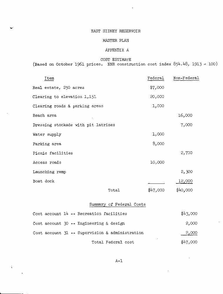
EAST SIDNEY RESERVOIR
MASTER PLAN
APPENDIX A
COST ESTIMATE
(Based on October 1961 prices. ENR construction cost index 854.48, 1913 = 100)
Item Federal Non-Federal
Real estate, 250 acres $7,000
Clearing to elevation 1,151 20,000
Clearing roads & parking areas 1,000
Beach area 16,000
Dressing stockade with pit latrines 7,000
Water supply 1,000
Parking area 8,000
Picnic facilities 2,700
Access roads 10,000
Launching ramp 2,300
Boat dock 12,000
Total $47,000 $40,000
Summary of Federal Costs
Cost account 14 -- Recreation facilities $43,000
Cost account 30 -- Engineering & design 2,000
Cost account 31 -- Supervision & administration 2,000
Total Federal cost $47,000
A-1

SUSQUEHANNA RIVER BASIN
EAST SIDNEY RESERVOIR
NEW YORK
DESIGN MEMORANDUM NO. 1
MASTER PLAN
APPENDIX B
HYDROLOGIC AND ECONOMIC DATA

ADDRESG REPLY TO·
DIVISION ENGINEER
U. 9 ARMY ENGINEER DIVISION
NORTH ATLANTIC
NEW YORK 7. NEW YORK
U. S. ARMY ENGINEER DIVISION. NORTH ATLANTIC
CORPS OF ENGINEERS
90 CHURCH STREET
NEW YORK 7. NEW YORK
REFER TO FILE NO
NADEN-R 28 August 1961
SUBJECT. East Sidney Reservoir - Recreation Pool
TO: District EngineerU. S. Army Engineer District, BaltimoreBaltimore, Maryland
1. Inclosed teletype fram OCE is forwarded for appropriateaction.
2. In your analysis of the effect of the recreation pool onflood control. it is requested that particular attention be paidto the practicable measurability of differences in s tages anddamages derived by conventional methods.
FOR THE DIVISION ENGINEER:
(2,j + Ie.ti..1 Incl PAUL H. JAE
1. Cy TT Chief, EngiENGCU-P 295
dtd 8/25/61
BEN
ring Di
8-/

NABEN-R (28 Aug 61) 1st Ind
SUBJECT:_ East Sidney Reservoir - Recreation Pool
U. S. Army Engineer District, Baltimore, Baltimore, Md., 19 October 1961
TO: Division Engineer, U. S. Army Engineer Division, North Atlantic,ATTN: NADEN-R, New York, N. Y.
1. The March 1936 flood is considered the project design flood forEast Sidney Reservoir. It is the greatest flood of record at most loca-tions along the Susquehanna River and would have used 5.22 inches of the6.15 inches of available storage in the reservoir under the present planof operation. A flood about 15 percent larger than the 1936 flood wouldjust fill the reservoir, and floods up to about 35 percent larger than1936 would not cause spillway flow early enough to contribute to peak flowat any point on the Susquehanna.
2. It is not planned to maintain the proposed recreation pool toelevation 1,150 during the winter and spring seasons which include the1936 flood and a high percentage of floods on Ouleout Creek and the Sus-quehanna River. If, however, there were a recurrence of the 1936 floodwith the recreation pool at elevation 1,150, the flood would not fill thereservoir. With a 15 percent larger flood, the recreation pool wouldcause spillway flow too late to add to peaks on the Susquehanna. With aflood about 35 percent larger than 1936, the recreation pool would causespillway flow to begin early enough to add slightly to peak flow at Unadillaand possibly at other locations down to Conklin. Floods of this magnitudehave an estimated exceedence interval of 1,000 years.
3. The standard project flood (SPF) for East Sidney has a peak inflowof 41,000 c.f. s. Under 'the present plan of regulation it would fill thereservoir and produce a peak outflow of 4,200 c.f. s. over the spillway. Arecreation pool at elevation 1,150 would cause spillway flow to begin soonerand reach a peak of 6,400 c.f. s. The maximum difference between the twooutflow hydrographs is about 4,000 c.f. s. The nearest downstream point forwhich an SPF has been developed is Vestal, 81 miles downstream from EastSidney Dam. The SPF peak at Vestal occurs too early to be affected byspillway flow from East Sidney, even when advanced by the recreation pool.
4. Rough estimates of the SPF at gages at Unadilla, Bainbridge, andConklin under present conditions have been made by assuming that it exceedsthe 1936 flood by the same percentage as at Vestal. These floods have anestimated exceedence interval of about 10,000 years. While it is possiblefor the recreation pool to increase peaks by 4,000 c.f. s., it is highlyimprobable that this maximum effect would apply at each location. Accord-
ingly, it was assumed that each peak was increased by 3,000 c.f.s., resultingin a stage increase on the order of O.5 foot. The resulting floods, tabulated
8- 2

NABEN-R (28 Ang 61) 1st,IndSUBJECT: East Sidney Reservoir - Recreation Pool
19 October 1961
on inclosure 2, are 6 to 8 feet higher than the maximum floods of record.The increment of flood damage, or reduction of flood control benefits,caused by the 0.5-foot increment of stage is estimated to be about $500,000.The average annual reduction of flood control benefits is estimated to be
on the order of $500.
5. The estimated average annual recreation benefits are $24,000.There will also be some benefit from supplementing low flows during thedrawdown period, but this benefit has not been evaluated. In addition
to increasing total project benefits, it is believed that extensive useof the proposed recreation pool will help to reduce the present, wide-spread opposition to other authorized reservoirs in this District,partitularly in the central New York area.
6. A Master Plan including a recreation pool at elevation 1,150is being prepared and will be submitted in the near future.
7. In the *th indorsement (21 July 1961) to letter of 22 June 1961,cited in inclosure 1, it was stated that the gates had never been operatedfor flood control during the recreation season and that the maximum storage
ever reached during the recreation season was equal to 0.17 inch of runoff.
During a very severe thunderstorm on 29 July 1961 the gates were closedas a precautionary measure until .more information on the extent of the
storm could be obtained. The operation proved to be unnecessary as the
storm covered a very small area, and stages on the Susquehanna did notapproach flood stage. Maximum storage used was equal to 0.47 inch ofrunoff.
FOR THE DISTRICT ENGINEER:
umal 0-u-i
Lt. Clong€, CorDeputy District
2 Incl
1. n/c ps of EngineersAdded 1 Incl Engineer
2. Table (trip)
8-'3

CR/DE T07 06231
WNNNAIJCe44
CTB 176Rn RBEGIJC
DE RUEPDA ? 1 HZNR R 2422.39 2 - 1 94" 5 4/PM COLENGRS WASHDC
TO NOI:.0NT DIVEMOR HYLDA GRAw9.1,7%
t_21
UNCLASS ENSCW-P 299REFERENCE ENCOW-05 1.FT:,2
RECREATION FOOL, E4ST 21 1*viU·]CORSEMENTS THERETO. THUM?10.-4
VALENT DUPING THE BEAEol PHEWBE MAINTAINED THAN AT AMY ATMFACT THAT EITHER T YPE 31(9/THIS SMALL DRAIN AGE 8 HE 4 THANSHORT PERIOD .OF RECORDs IT ·7FURVIS XED : C A ) E STI FATKID T ; ' r K
AUG
L/1. ·*-DIVENGR NORLANT
SUBJ, "ESTABLISHMENTLENE.:Unige NEW YORK7, AND SUBSEQUENT:- FO 96 1%D HURRICANES ARE MORE PRE.-
ET , 13 FROPOSED .THAT A RECREATION POOL .ER TIME OF'THE YEAR. IN VIEW OF THECOUND FF: 9DUCE MORE INTENSE RAINFALL ON
Er,9 2..TEN EXPERIENCED IN THF RELATIVELYlinbUFFFED THAT ,THE FOLLOWING BE\76 (bi.€ TO RECREATION POOL) IN
FLOOD STACEE OM OBLEOUT El·n· FK '.i ./,Vfk! BRANCH- SUSQUEHANNA RIVER
NON THE PRO/ECT D ..... -·::11 .]71.GOD 43' m:'1 1.,ARGER FLOODS UP TO THE-STANb-G ':T r,
Aic D Pit {3.11(Cl-' Fl. (.,OD 3, ( El ) K,ST It·) A'i, .,( iJ. t ';t L „ ASE :,I N FLOOD DAMAGES FOR CORRES+PONDING FLODS: (C: ESTYMATED EXCEE )ENCE PERIOD FOR THESE FL@41.)St .(D) ENT101/GED 1)'FOREASE IN 41/FRAG}:., KINUAL FLOOD CONTPOL BENEFff:4 AND,(F> 1:,21'It,1 4,TED AV j'LAGE ANNUAL, M'-111 -ET f ·:Y BENEFITS FOR RECREATION 14?THOf (}loOKED .Popl„ .14 ('Vtj'.,I T Nfs}-tr :. -4 , 7 3 0.)2·. BE BASED ON READITY AVA.L-ABLe. t) 413. A ''Al 5'(' :;'1' J '51) CITC' - 4, '...
/1
2.5/ 03 31 2 RUE PDA
u inf.· L, 0---C_. B-+

EFFECT OF RECREATION POOL AT EAST SIDNEY RESERVOIR
Design Flood (1936)(60-year exceedence interval)
Standard Project Flood
(10,000-year exceedence interval)
Susquehanna River : Susquehanna RiverOuleout Cr. Unadilla Bainbridge Conklin : Ouleout Cr. Unadilla Bainbridge Conklin
Max. discharge, in c.f.s.:
Present conditions 1,900 26,900 36,000 58,300 4,200 54,000 72,000 116,000m
c With recreation pool 1,900 26,900 36,000 58,300 6,400 57,000 75,000 119,000
Max. stage, in feet:
Present conditions 4.3 14.7 21.5 19.65 5.8 22 29 28
With recreation pool 4.3 14.7 21.5 19.65 6.6 22.5 29.5 28.5
Change in stage, in feet 0 0 ' 0 0 0.8 0.5 0.5 0.5
T C DN I

NADEN-R;(28 Aug 61) . 2nd Ind
SUBJECT: East Si dney Reservol r - Recreation Pool
U. S. Army Engineer Division, North Atlantic, New York 7, N. Y.,
OCT 27 1961TO: Chief of Engineers, Department of the Army, Washington 25, D. C.
ATTN: ENGCW-P
1. Information requested In your teletype 24 August 1961 Is furnishedin Ist Indorsement.
2. It Is believed that Information previously furnished togethe rwith that given In this correspondence essentially meets the requirementsof EM 1165-2-303.
3. The data furnished Indicates that the effect of the proposedrecreation pool would be within practicable measurable limits only inthe area immediately below the dam and then only for an extremely rareoccurrence.
4. Approval is recommended for establishment of the rec reationpool proposed at East Sidney Rer--"-'-
2 Inch - 7. H.- C¥19OBBTrip cy Inc] 2 w/d Brlgadle/General
Division Engineer
",1 Vwl I ,
.uy
r
8-6

ENGCW-OM (28 Aug 61 Baltimore) - 3d IndSUBJECT: East Sidney Reservoir - Recreation Pool
Office, Chief of Engineers, Washington 25, D. C., 12 December 1961
TO: Division Engineer, U. S. Army Engineer Division, North AtlanticNew York, New York
1. The establishment of a recreation pool at East Sidney Reservoiris approved as recommended in the preceding 2d Indorsement.
2. Operation to maintain a seasonal pool should not be initiated
until revisions to the yteservoir Regulation Manual, East Sidney, coveringthe seasonal pool have been approved. -
3. A Master Plan should be submitted to this office for review and
approval. - -
FOR THE CHIEF OF ENGINEERS:
/
I.- -
22-4
2 Incls w/d WILLIAM F. CASSIDY t. 1
Major General, USA /'Director of Civil Morks
n,
Fulk
5-7

NADEN-R (28 Aug 61) 4th Ind.SUBJECT: East Sidney Reservoir - Recreation Pool
U. S. Army Engineer Division, North Atlantic, New York 7, No Y.,18 December 1961
TO: District Engineer, U. S. Army Engineer District, BaltimoreBaltimore, Md. ATTN: NABEN-R
.
L__] Approved.
L- J For review and comment.
L__j For necessary action.
X For your infonnation and gold=,¤m necessary action.
I For the information requested.L---1 ,
I Request reply not later than .
L___I For information on which to base a reply.
For compliance.
Direct reply is authorized, copy to this office.
1 1
i i
FOR THE DIVISION ENGINEER:
(44 ,NlCHENnering Dj
PAUL H. JAE
Chief. Engi .vision«
NAD FL 0-199 (15-9) Edition of 1 Apr 57 may be used until exhausted.1 Jun 58
GPO 953725
8-8

CORPS OF ENGINEERS U. S. ARMY
RECREATION FACILITIES.
GALTIMORE DISTRICT OCT 1961
PLATE 3
1
3 MATCH LINE
6 8 E
m
0Z
fi
B Z0
0
G TOWN OL_f RANKLIN \
TOWN OF SIDNEYW
0
3
r
./ 0
F
Q0
0
0
1/50
0
Lj
N
W 47
00 'P
0 0
fO
0
\ \ 0/
CO
1
4 /604/.
ONCRETE0
MAT C HLINE
LEGEND
AREA REQUIRED
MATCH LINE AEAST SIDNEY RESERVOIR
ADDITIONAL FEE ACQUISITION REQUIRE[
l FOR SEASONAL RECREATION POOL ANCSCALE OFFEET

CORPS OF ENGINEERS ,- . U. S ARMY
HIGHWAY ROUTE 78
I I
t
LEGEND
RETAINED FOR OPERATION ANDMAINTENANCE OF DAM
PROPOSED SEASONAL RECREATION POOL200
I-
EAST SIDNEY RESERVOIR
PROPOSED RECREATIONALSCALE OF FEET
20 490 FACILITIES
BALTIMORE DISTRICT OCT. 1961
PLATE 4
y
r ;/flt)' > 0
/ 1\
it
t
it
/ '44 MyX
1
i i 11 dpi , ,
1 \\ \
f I
F 1
X THINGi AREA 4,1 1
iE
9
PICNIC- j \\\ \f 41 AREA . 1-4
t
/1 1./ J V ,
\\ ' ./r / :): f42<- //f PION CA OREP . BOAT DOCK & ,/t
1STOCKADE> f/- no Lgk LAUNCHING RAM
A
PICN C /4
l
f AREA :6.i
,TOILET 1--'A / 1' r 71"PA1J PARKING'-AREA
%
i#15- PROPOSED
ACCESS ROAD
.-V
ELCNIC----/ARE€1200-
STATE

.
0


![The Sidney herald (Sidney, Mont.), 1955-11-17, [p 20]](https://img.pdfslide.net/doc/110x75/619b7c35ab34023d1f563fab/the-sidney-herald-sidney-mont-1955-11-17-p-20.jpg)