Embed Size (px)
Citation preview
4
Published September 2017
East Staffordshire Local Plan Planning for Change
Annual Monitoring Report - Covering April 2016 to March 2017
Monitoring Period

This page is intentionally left blank
Contents
1. Introduction 1
2. Local Plan Milestones 1
3. Neighbourhood Plans Progress 2
4. Local Plan Monitoring
- Strategic Policies
Completions -
- Detailed Policies
Housing and Affordable Housing
Gypsies and Travellers Employment Retail
Other Employment
3
4
5
6
7
36
Appendix - Glossary Contact Details
41
44
Alternative formats of this publication are available on request. Please contact us to discuss an appropriate format.

This page is intentionally left blank
1
1 Introduction
1.1 This Annual Monitoring Report (AMR) covers the 2016-2017 monitoring period (1st April 2016 to 31st March 2017). LPAs do not have to produce data for national indicators that were outlined in former guidance. This has given LPAs greater freedom on reporting on data and trends which they consider to be most relevant and appropriate for their local authority and local circumstances.
1.2 This report focuses on progress in relation to the indicators prescribed in the adopted Local Plan and provides data on the core elements of planning including housing, employment and retail, data which is generally requested by stakeholders.
2 Key Local Plan Milestones 2.1 The Council submitted the Local Plan for examination in April 2014 and it
was adopted in October 2015.
2.2 A new Local Development Scheme (LDS) will be published prior to any Local Plan review.
2.3 The council adopted the revised Housing Choice SPD in April 2016. In addition a consultation was carried out on the Parking Standards SPD in June and July 2017. It is expected a new Open Space SPD will be prepared in 2018 following completion of evidence base gathering in 2017.
2
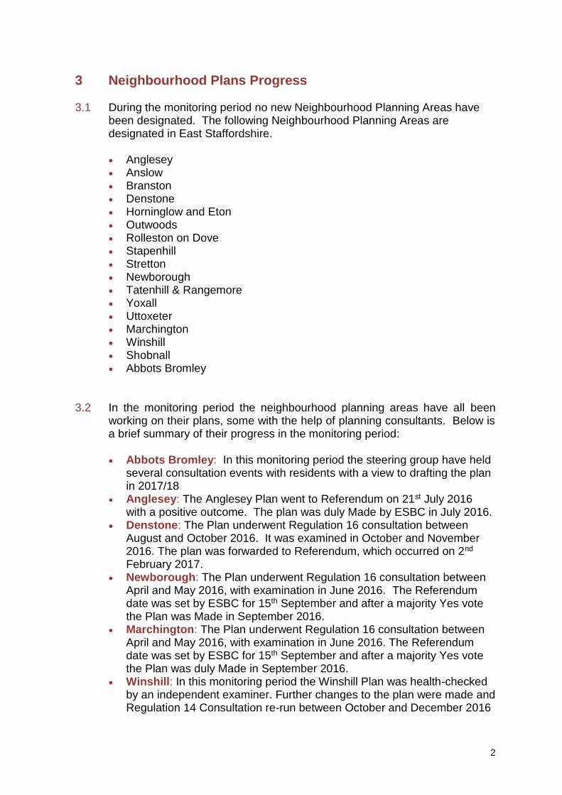
3 Neighbourhood Plans Progress 3.1 During the monitoring period no new Neighbourhood Planning Areas have
been designated. The following Neighbourhood Planning Areas are designated in East Staffordshire.
Anglesey Anslow Branston Denstone Horninglow and Eton Outwoods Rolleston on Dove Stapenhill Stretton Newborough Tatenhill & Rangemore Yoxall Uttoxeter Marchington Winshill Shobnall Abbots Bromley
3.2 In the monitoring period the neighbourhood planning areas have all been working on their plans, some with the help of planning consultants. Below is a brief summary of their progress in the monitoring period:
Abbots Bromley: In this monitoring period the steering group have held several consultation events with residents with a view to drafting the plan in 2017/18
Anglesey: The Anglesey Plan went to Referendum on 21st July 2016 with a positive outcome. The plan was duly Made by ESBC in July 2016.
Denstone: The Plan underwent Regulation 16 consultation between August and October 2016. It was examined in October and November 2016. The plan was forwarded to Referendum, which occurred on 2nd February 2017.
Newborough: The Plan underwent Regulation 16 consultation between April and May 2016, with examination in June 2016. The Referendum date was set by ESBC for 15th September and after a majority Yes vote the Plan was Made in September 2016.
Marchington: The Plan underwent Regulation 16 consultation between April and May 2016, with examination in June 2016. The Referendum date was set by ESBC for 15th September and after a majority Yes vote the Plan was duly Made in September 2016.
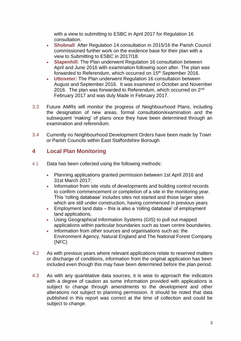
Winshill: In this monitoring period the Winshill Plan was health-checked by an independent examiner. Further changes to the plan were made and Regulation 14 Consultation re-run between October and December 2016
3
with a view to submitting to ESBC in April 2017 for Regulation 16 consultation.
Shobnall: After Regulation 14 consultation in 2015/16 the Parish Council commissioned further work on the evidence base for their plan with a view to Submitting to ESBC in 2017/18.
Stapenhill: The Plan underwent Regulation 16 consultation between April and June 2016 with examination following soon after. The plan was forwarded to Referendum, which occurred on 15th September 2016.
Uttoxeter: The Plan underwent Regulation 16 consultation between August and September 2016. It was examined in October and November 2016. The plan was forwarded to Referendum, which occurred on 2nd February 2017 and was duly Made in February 2017.
3.3 Future AMRs will monitor the progress of Neighbourhood Plans, including the designation of new areas, formal consultation/examination and the subsequent ‘making’ of plans once they have been determined through an examination and referendum.
3.4 Currently no Neighbourhood Development Orders have been made by Town or Parish Councils within East Staffordshire Borough
4 Local Plan Monitoring 4.1 Data has been collected using the following methods:
Planning applications granted permission between 1st April 2016 and
31st March 2017; Information from site visits of developments and building control records
to confirm commencement or completion of a site in the monitoring year. This ‘rolling database’ includes sites not started and those larger sites which are still under construction, having commenced in previous years
Employment land data – this is also a ‘rolling database’ of employment land applications.
Using Geographical Information Systems (GIS) to pull out mapped applications within particular boundaries such as town centre boundaries.
Information from other sources and organisations such as: the Environment Agency, Natural England and The National Forest Company (NFC)
4.2 As with previous years where relevant applications relate to reserved matters
or discharge of conditions, information from the original application has been included even though this may have been determined before the plan period.
4.3 As with any quantitative data sources, it is wise to approach the indicators
with a degree of caution as some information provided with applications is subject to change through amendments to the development and other alterations not subject to planning permission. It should be noted that data published in this report was correct at the time of collection and could be subject to change.
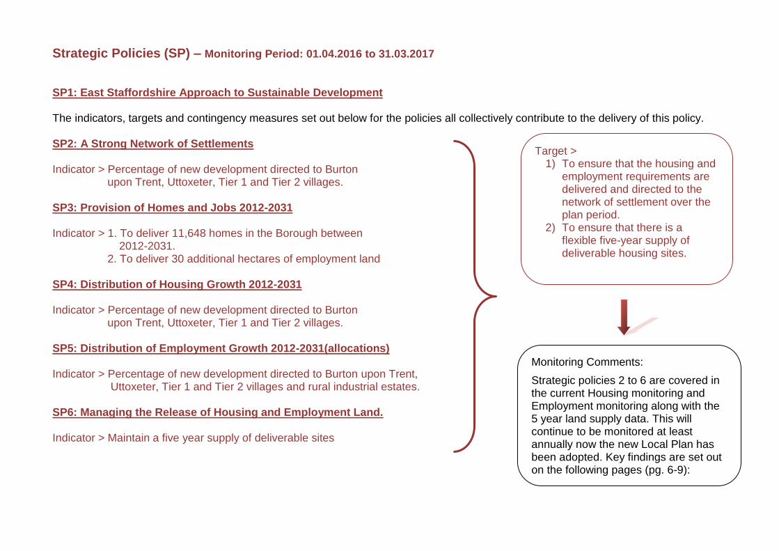
Strategic Policies (SP) – Monitoring Period: 01.04.2016 to 31.03.2017 SP1: East Staffordshire Approach to Sustainable Development The indicators, targets and contingency measures set out below for the policies all collectively contribute to the delivery of this policy. SP2: A Strong Network of Settlements Indicator > Percentage of new development directed to Burton
upon Trent, Uttoxeter, Tier 1 and Tier 2 villages. SP3: Provision of Homes and Jobs 2012-2031 Indicator > 1. To deliver 11,648 homes in the Borough between
2012-2031. 2. To deliver 30 additional hectares of employment land
SP4: Distribution of Housing Growth 2012-2031 Indicator > Percentage of new development directed to Burton upon Trent, Uttoxeter, Tier 1 and Tier 2 villages. SP5: Distribution of Employment Growth 2012-2031(allocations) Indicator > Percentage of new development directed to Burton upon Trent,
Uttoxeter, Tier 1 and Tier 2 villages and rural industrial estates. SP6: Managing the Release of Housing and Employment Land. Indicator > Maintain a five year supply of deliverable sites
Target > 1) To ensure that the housing and
employment requirements are delivered and directed to the network of settlement over the plan period.
2) To ensure that there is a flexible five-year supply of deliverable housing sites.
Monitoring Comments:
Strategic policies 2 to 6 are covered in the current Housing monitoring and Employment monitoring along with the 5 year land supply data. This will continue to be monitored at least annually now the new Local Plan has been adopted. Key findings are set out on the following pages (pg. 6-9):
5
0% 20% 40% 60% 80% 100%
2012-13
2013-14
2014-15
2015-16
2016-17
88%
84%
72%
69%
73%
12%
16%
28%
31%
27%
Percentage of Completions on
Brown/Greenfield Land.
% of completions onBrownfield sites
% of completions onGreenfield sites
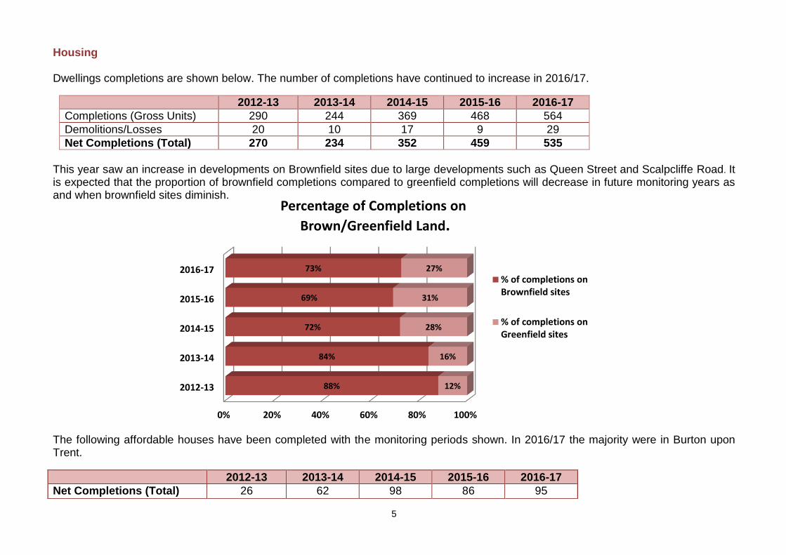
Housing Dwellings completions are shown below. The number of completions have continued to increase in 2016/17.
2012-13 2013-14 2014-15 2015-16 2016-17
Completions (Gross Units) 290 244 369 468 564
Demolitions/Losses 20 10 17 9 29
Net Completions (Total) 270 234 352 459 535
This year saw an increase in developments on Brownfield sites due to large developments such as Queen Street and Scalpcliffe Road. It is expected that the proportion of brownfield completions compared to greenfield completions will decrease in future monitoring years as and when brownfield sites diminish.
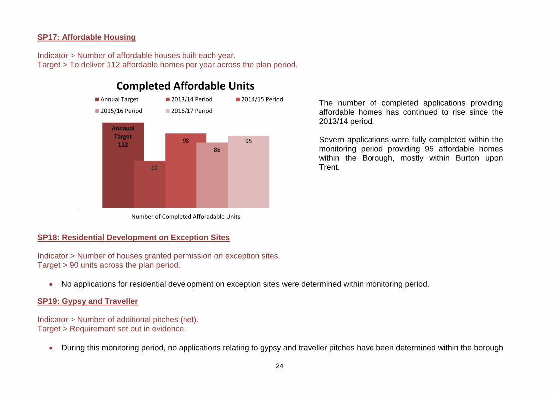
The following affordable houses have been completed with the monitoring periods shown. In 2016/17 the majority were in Burton upon Trent.
2012-13 2013-14 2014-15 2015-16 2016-17
Net Completions (Total) 26 62 98 86 95
6
Gypsies and Travellers The completions figure for gypsy and traveller pitches continues to be nil during the 2016-2017 period. This is mainly due to the current evidence that states that there is no prescribed need for such pitches within the Borough. Employment
The following table shows a comparison of the overall employment site completions between the 2016/17 monitoring period and previous years. A more detailed breakdown of completed floorspace is set out in the retail and other employment section below.
2012-13 2013-14 2014-15 2015-16 2016-17
Completions (Site Area ha) 25.60 2.91 14.34 22.80 6.80
Completed Floor Space (m)1 3,940 15,437 16,198 65,992 38,385
. Retail
The following table shows a comparison of net floorspace completions for retail (both convenience and comparison) between the 2016/17 monitoring period and previous years.
Completions 2012-13 2013-14 2014-15 2015-16 2016-17
A1 (m²) 4,287 33.60 5,222.30 4382.22 314.00
A3, A4 or A5 (m²) 13,900 0 22.36 737.50 1108.78
Mixed Retail Types (m²)2 237,815 6494.00 459.50 1714.00 224.00
Net Completions (Total m²) 256,002 6527.60 5704.06 6833.72 1646.78
There has been an increase in the A3, A4 or A5 types due to the change of use from two retail units to Mircopubs and the creation of a drive thru facility in Burton.
1 This figure includes the floor space given at the time of the application, which can change and in some instances has not been captured for all of the sites. 2 The 2012-13 figures for the mixed types included both retail and other employment therefore totalling the completions site area (256,002 sqm). Since 2013-14 this has been split to show retail and other
types of employment in a different table.
7
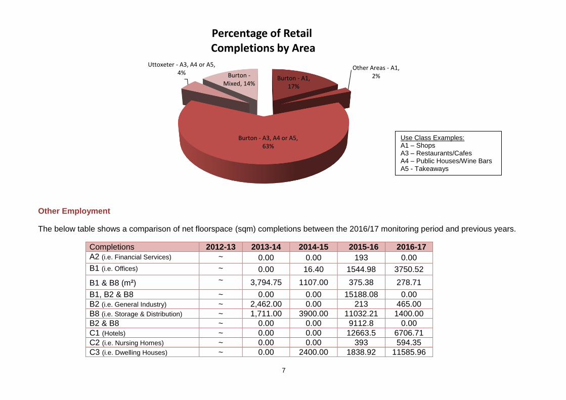
Burton - A1, 17%
Other Areas - A1, 2%
Burton - A3, A4 or A5, 63%
Uttoxeter - A3, A4 or A5, 4% Burton -
Mixed, 14%
Percentage of RetailCompletions by Area
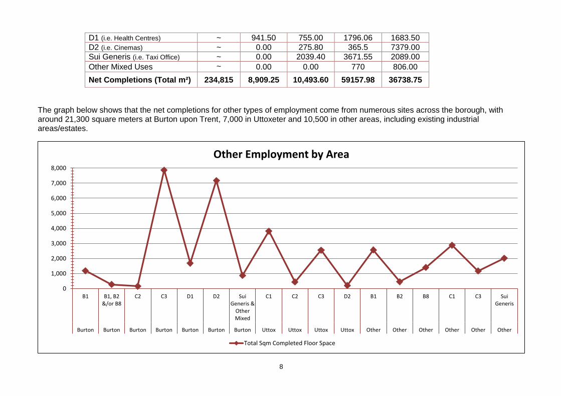
Other Employment
The below table shows a comparison of net floorspace (sqm) completions between the 2016/17 monitoring period and previous years.
Completions 2012-13 2013-14 2014-15 2015-16 2016-17
A2 (i.e. Financial Services) ~ 0.00 0.00 193 0.00
B1 (i.e. Offices) ~ 0.00 16.40 1544.98 3750.52
B1 & B8 (m²) ~ 3,794.75 1107.00 375.38 278.71
B1, B2 & B8 ~ 0.00 0.00 15188.08 0.00
B2 (i.e. General Industry) ~ 2,462.00 0.00 213 465.00
B8 (i.e. Storage & Distribution) ~ 1,711.00 3900.00 11032.21 1400.00
B2 & B8 ~ 0.00 0.00 9112.8 0.00
C1 (Hotels) ~ 0.00 0.00 12663.5 6706.71
C2 (i.e. Nursing Homes) ~ 0.00 0.00 393 594.35
C3 (i.e. Dwelling Houses) ~ 0.00 2400.00 1838.92 11585.96
Use Class Examples: A1 – Shops A3 – Restaurants/Cafes A4 – Public Houses/Wine Bars A5 - Takeaways
8
0
1,000
2,000
3,000
4,000
5,000
6,000
7,000
8,000
B1 B1, B2&/or B8
C2 C3 D1 D2 SuiGeneris &
OtherMixed
C1 C2 C3 D2 B1 B2 B8 C1 C3 SuiGeneris
Burton Burton Burton Burton Burton Burton Burton Uttox Uttox Uttox Uttox Other Other Other Other Other Other
Other Employment by Area
Total Sqm Completed Floor Space
The graph below shows that the net completions for other types of employment come from numerous sites across the borough, with around 21,300 square meters at Burton upon Trent, 7,000 in Uttoxeter and 10,500 in other areas, including existing industrial areas/estates.
D1 (i.e. Health Centres) ~ 941.50 755.00 1796.06 1683.50
D2 (i.e. Cinemas) ~ 0.00 275.80 365.5 7379.00
Sui Generis (i.e. Taxi Office) ~ 0.00 2039.40 3671.55 2089.00
Other Mixed Uses ~ 0.00 0.00 770 806.00
Net Completions (Total m²) 234,815 8,909.25 10,493.60 59157.98 36738.75
9
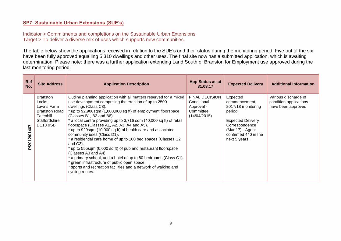
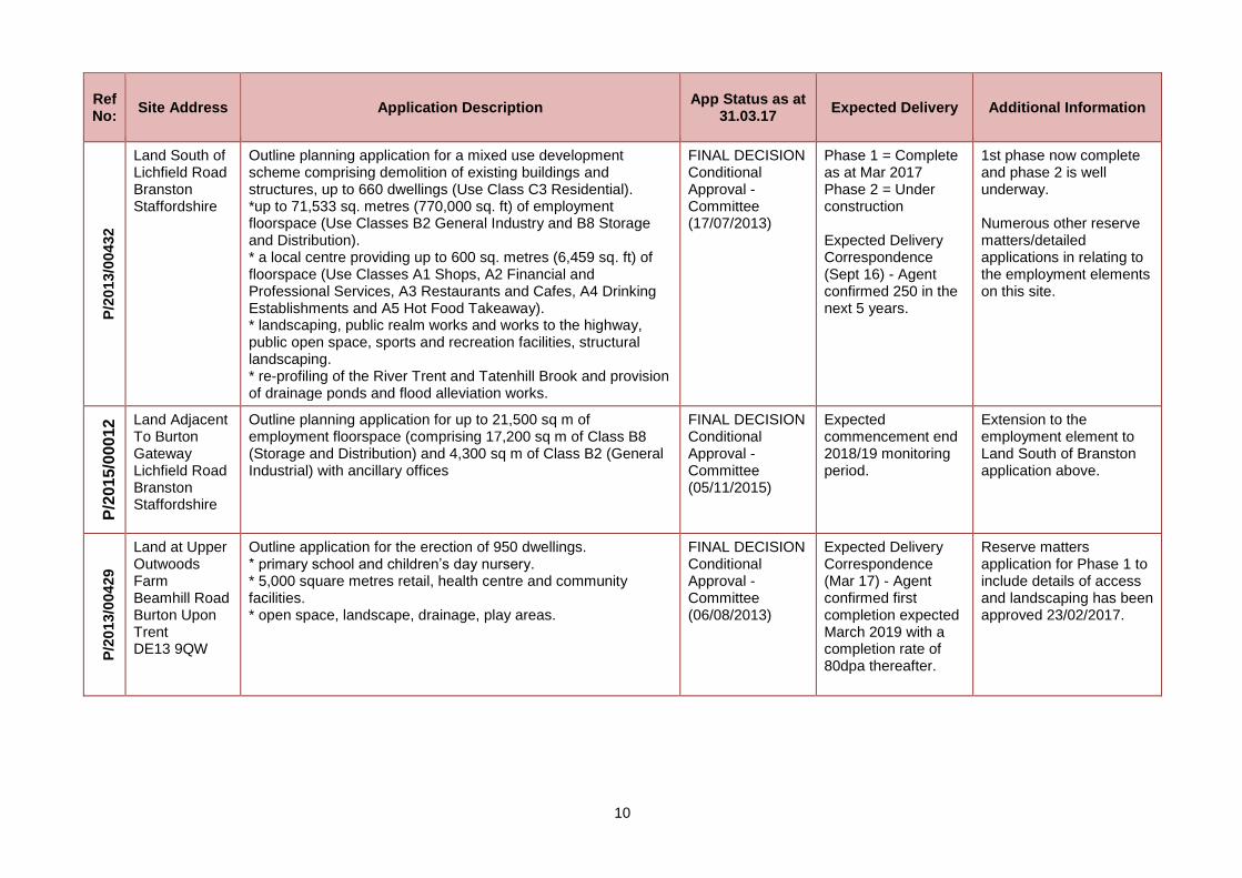
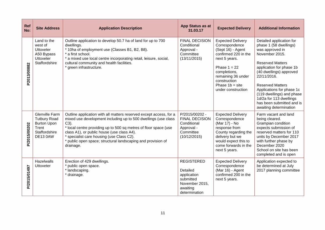
SP7: Sustainable Urban Extensions (SUE’s) Indicator > Commitments and completions on the Sustainable Urban Extensions. Target > To deliver a diverse mix of uses which supports new communities. The table below show the applications received in relation to the SUE’s and their status during the monitoring period. Five out of the six have been fully approved equalling 5,310 dwellings and other uses. The final site now has a submitted application, which is awaiting determination. Please note: there was a further application extending Land South of Branston for Employment use approved during the last monitoring period.
Ref No:
Site Address Application Description App Status as at
31.03.17 Expected Delivery Additional Information
P/2
012/0
14
67
Branston Locks Lawns Farm Branston Road Tatenhill Staffordshire DE13 9SB
Outline planning application with all matters reserved for a mixed use development comprising the erection of up to 2500 dwellings (Class C3). * up to 92,900sqm (1,000,000 sq ft) of employment floorspace (Classes B1, B2 and B8). * a local centre providing up to 3,716 sqm (40,000 sq ft) of retail floorspace (Classes A1, A2, A3, A4 and A5). * up to 929sqm (10,000 sq ft) of health care and associated community uses (Class D1). * a residential care home of up to 160 bed spaces (Classes C2 and C3). * up to 555sqm (6,000 sq ft) of pub and restaurant floorspace (Classes A3 and A4). * a primary school, and a hotel of up to 80 bedrooms (Class C1). * green infrastructure of public open space. * sports and recreation facilities and a network of walking and cycling routes.
FINAL DECISION Conditional Approval - Committee (14/04/2015)
Expected commencement 2017/18 monitoring period. Expected Delivery Correspondence (Mar 17) - Agent confirmed 440 in the next 5 years.
Various discharge of condition applications have been approved
10
Ref No:
Site Address Application Description App Status as at
31.03.17 Expected Delivery Additional Information
P/2
013/0
04
32
Land South of Lichfield Road Branston Staffordshire
Outline planning application for a mixed use development scheme comprising demolition of existing buildings and structures, up to 660 dwellings (Use Class C3 Residential). *up to 71,533 sq. metres (770,000 sq. ft) of employment floorspace (Use Classes B2 General Industry and B8 Storage and Distribution). * a local centre providing up to 600 sq. metres (6,459 sq. ft) of floorspace (Use Classes A1 Shops, A2 Financial and Professional Services, A3 Restaurants and Cafes, A4 Drinking Establishments and A5 Hot Food Takeaway). * landscaping, public realm works and works to the highway, public open space, sports and recreation facilities, structural landscaping. * re-profiling of the River Trent and Tatenhill Brook and provision of drainage ponds and flood alleviation works.
FINAL DECISION Conditional Approval - Committee (17/07/2013)
Phase 1 = Complete as at Mar 2017 Phase 2 = Under construction Expected Delivery Correspondence (Sept 16) - Agent confirmed 250 in the next 5 years.
1st phase now complete and phase 2 is well underway. Numerous other reserve matters/detailed applications in relating to the employment elements on this site.
P/2
01
5/0
00
12 Land Adjacent
To Burton Gateway Lichfield Road Branston Staffordshire
Outline planning application for up to 21,500 sq m of employment floorspace (comprising 17,200 sq m of Class B8 (Storage and Distribution) and 4,300 sq m of Class B2 (General Industrial) with ancillary offices
FINAL DECISION Conditional Approval - Committee (05/11/2015)
Expected commencement end 2018/19 monitoring period.
Extension to the employment element to Land South of Branston application above.
P/2
013/0
04
29
Land at Upper Outwoods Farm Beamhill Road Burton Upon Trent DE13 9QW
Outline application for the erection of 950 dwellings. * primary school and children’s day nursery. * 5,000 square metres retail, health centre and community facilities. * open space, landscape, drainage, play areas.
FINAL DECISION Conditional Approval - Committee (06/08/2013)
Expected Delivery Correspondence (Mar 17) - Agent confirmed first completion expected March 2019 with a completion rate of 80dpa thereafter.
Reserve matters application for Phase 1 to include details of access and landscaping has been approved 23/02/2017.
11
Ref No:
Site Address Application Description App Status as at
31.03.17 Expected Delivery Additional Information
P20
13/0
08
82
Land to the west of Uttoxeter A50 Bypass Uttoxeter Staffordshire
Outline application to develop 50.7 ha of land for up to 700 dwellings. * 10ha of employment use (Classes B1, B2, B8). * a first school. * a mixed use local centre incorporating retail, leisure, social, cultural community and health facilities. * green infrastructure.
FINAL DECISION Conditional Approval - Committee (13/11/2015)
Expected Delivery Correspondence (Sept 16) - Agent confirmed 220 in the next 5 years. Phase 1 = 22 completions, remaining 36 under construction Phase 1b = site under construction
Detailed application for phase 1 (58 dwellings) was approved in November 2015. Reserved Matters application for phase 1b (40 dwellings) approved 22/11/2016. Reserved Matters Applications for phase 1c (119 dwellings) and phase 1d/2a for 113 dwellings has been submitted and is awaiting determination
P/2
015/0
02
02
Glenville Farm Tutbury Road Burton Upon Trent Staffordshire DE13 0AW
Outline application with all matters reserved except access, for a mixed use development including up to 500 dwellings (use class C3). * local centre providing up to 500 sq metres of floor space (use class A1), or public house (use class A4). * specialist care housing (use Class C2). * public open space; structural landscaping and provision of drainage.
P/2015/00202 - FINAL DECISION Conditional Approval - Committee (10/12/2015)
Expected Delivery Correspondence (Mar 17) - No response from County regarding the delivery but we would expect this to come forwards in the next 5 years.
Farm vacant and land being cleared. Grampian condition expects submission of reserved matters for 110 units by December 2017 with further phase by December 2020 School on site has been completed and is open
P/2
015/0
14
97
Hazelwalls Uttoxeter
Erection of 429 dwellings. * public open space. * landscaping. * drainage.
REGISTERED Detailed application submitted November 2015, awaiting determination
Expected Delivery Correspondence (Mar 16) - Agent confirmed 200 in the next 5 years.
Application expected to be determined at July 2017 planning committee
12
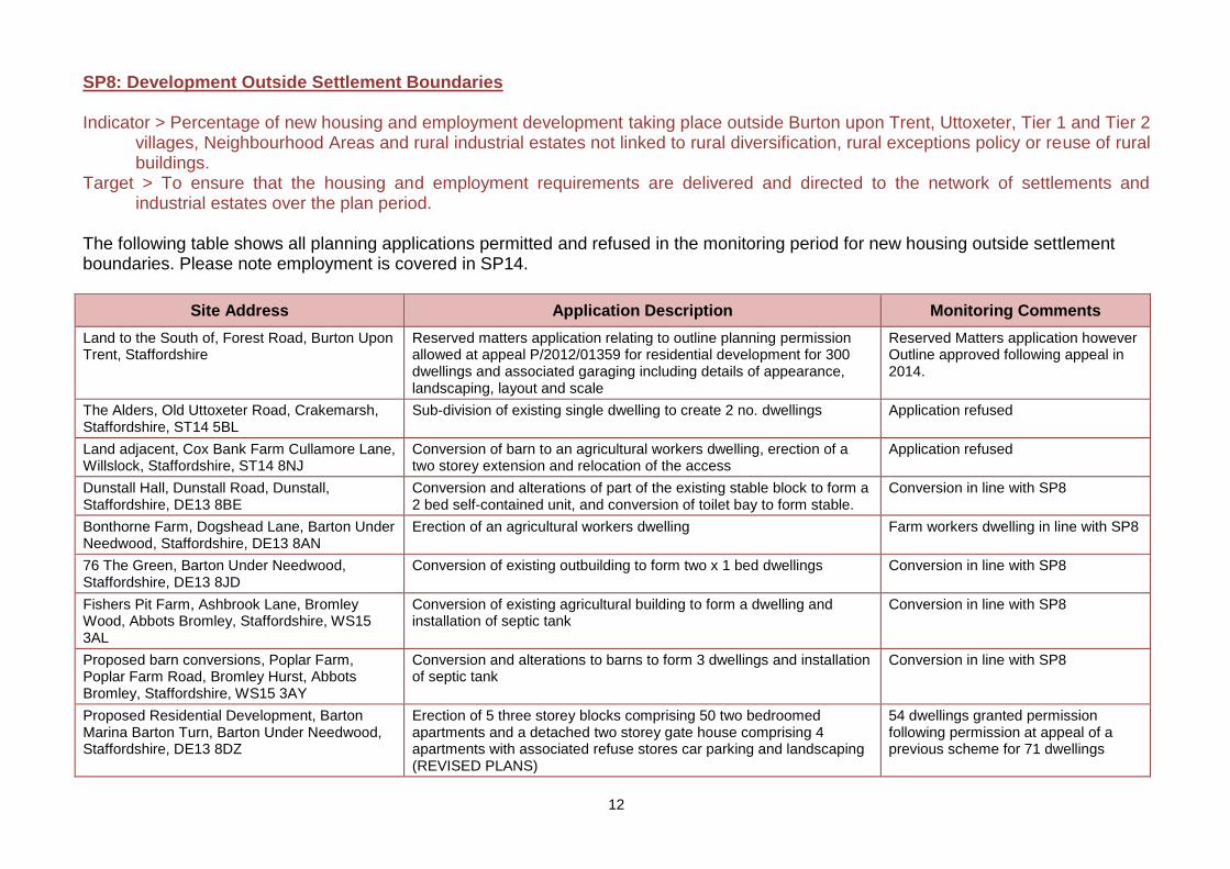
SP8: Development Outside Settlement Boundaries Indicator > Percentage of new housing and employment development taking place outside Burton upon Trent, Uttoxeter, Tier 1 and Tier 2
villages, Neighbourhood Areas and rural industrial estates not linked to rural diversification, rural exceptions policy or reuse of rural buildings.
Target > To ensure that the housing and employment requirements are delivered and directed to the network of settlements and industrial estates over the plan period.
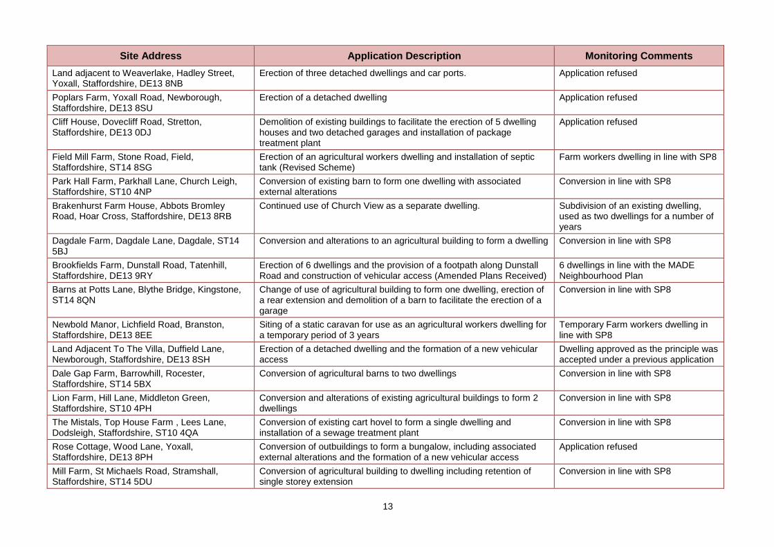
The following table shows all planning applications permitted and refused in the monitoring period for new housing outside settlement boundaries. Please note employment is covered in SP14.
Site Address Application Description Monitoring Comments
Land to the South of, Forest Road, Burton Upon Trent, Staffordshire
Reserved matters application relating to outline planning permission allowed at appeal P/2012/01359 for residential development for 300 dwellings and associated garaging including details of appearance, landscaping, layout and scale
Reserved Matters application however Outline approved following appeal in 2014.
The Alders, Old Uttoxeter Road, Crakemarsh, Staffordshire, ST14 5BL
Sub-division of existing single dwelling to create 2 no. dwellings Application refused
Land adjacent, Cox Bank Farm Cullamore Lane, Willslock, Staffordshire, ST14 8NJ
Conversion of barn to an agricultural workers dwelling, erection of a two storey extension and relocation of the access
Application refused
Dunstall Hall, Dunstall Road, Dunstall, Staffordshire, DE13 8BE
Conversion and alterations of part of the existing stable block to form a 2 bed self-contained unit, and conversion of toilet bay to form stable.
Conversion in line with SP8
Bonthorne Farm, Dogshead Lane, Barton Under Needwood, Staffordshire, DE13 8AN
Erection of an agricultural workers dwelling Farm workers dwelling in line with SP8
76 The Green, Barton Under Needwood, Staffordshire, DE13 8JD
Conversion of existing outbuilding to form two x 1 bed dwellings Conversion in line with SP8
Fishers Pit Farm, Ashbrook Lane, Bromley Wood, Abbots Bromley, Staffordshire, WS15 3AL
Conversion of existing agricultural building to form a dwelling and installation of septic tank
Conversion in line with SP8
Proposed barn conversions, Poplar Farm, Poplar Farm Road, Bromley Hurst, Abbots Bromley, Staffordshire, WS15 3AY
Conversion and alterations to barns to form 3 dwellings and installation of septic tank
Conversion in line with SP8
Proposed Residential Development, Barton Marina Barton Turn, Barton Under Needwood, Staffordshire, DE13 8DZ
Erection of 5 three storey blocks comprising 50 two bedroomed apartments and a detached two storey gate house comprising 4 apartments with associated refuse stores car parking and landscaping (REVISED PLANS)
54 dwellings granted permission following permission at appeal of a previous scheme for 71 dwellings
13
Site Address Application Description Monitoring Comments
Land adjacent to Weaverlake, Hadley Street, Yoxall, Staffordshire, DE13 8NB
Erection of three detached dwellings and car ports. Application refused
Poplars Farm, Yoxall Road, Newborough, Staffordshire, DE13 8SU
Erection of a detached dwelling Application refused
Cliff House, Dovecliff Road, Stretton, Staffordshire, DE13 0DJ
Demolition of existing buildings to facilitate the erection of 5 dwelling houses and two detached garages and installation of package treatment plant
Application refused
Field Mill Farm, Stone Road, Field, Staffordshire, ST14 8SG
Erection of an agricultural workers dwelling and installation of septic tank (Revised Scheme)
Farm workers dwelling in line with SP8
Park Hall Farm, Parkhall Lane, Church Leigh, Staffordshire, ST10 4NP
Conversion of existing barn to form one dwelling with associated external alterations
Conversion in line with SP8
Brakenhurst Farm House, Abbots Bromley Road, Hoar Cross, Staffordshire, DE13 8RB
Continued use of Church View as a separate dwelling. Subdivision of an existing dwelling, used as two dwellings for a number of years
Dagdale Farm, Dagdale Lane, Dagdale, ST14 5BJ
Conversion and alterations to an agricultural building to form a dwelling Conversion in line with SP8
Brookfields Farm, Dunstall Road, Tatenhill, Staffordshire, DE13 9RY
Erection of 6 dwellings and the provision of a footpath along Dunstall Road and construction of vehicular access (Amended Plans Received)
6 dwellings in line with the MADE Neighbourhood Plan
Barns at Potts Lane, Blythe Bridge, Kingstone, ST14 8QN
Change of use of agricultural building to form one dwelling, erection of a rear extension and demolition of a barn to facilitate the erection of a garage
Conversion in line with SP8
Newbold Manor, Lichfield Road, Branston, Staffordshire, DE13 8EE
Siting of a static caravan for use as an agricultural workers dwelling for a temporary period of 3 years
Temporary Farm workers dwelling in line with SP8
Land Adjacent To The Villa, Duffield Lane, Newborough, Staffordshire, DE13 8SH
Erection of a detached dwelling and the formation of a new vehicular access
Dwelling approved as the principle was accepted under a previous application
Dale Gap Farm, Barrowhill, Rocester, Staffordshire, ST14 5BX
Conversion of agricultural barns to two dwellings Conversion in line with SP8
Lion Farm, Hill Lane, Middleton Green, Staffordshire, ST10 4PH
Conversion and alterations of existing agricultural buildings to form 2 dwellings
Conversion in line with SP8
The Mistals, Top House Farm , Lees Lane, Dodsleigh, Staffordshire, ST10 4QA
Conversion of existing cart hovel to form a single dwelling and installation of a sewage treatment plant
Conversion in line with SP8
Rose Cottage, Wood Lane, Yoxall, Staffordshire, DE13 8PH
Conversion of outbuildings to form a bungalow, including associated external alterations and the formation of a new vehicular access
Application refused
Mill Farm, St Michaels Road, Stramshall, Staffordshire, ST14 5DU
Conversion of agricultural building to dwelling including retention of single storey extension
Conversion in line with SP8
14
Site Address Application Description Monitoring Comments
Former Stables/Outbuildings, Church Farm, Wychnor Lane, Wychnor, Staffordshire, DE13 8BY
Demolition of existing stables, tack room and viewing room to facilitate the erection of a detached dwelling
Application refused
Mayfield Hall, Hall Lane, Middle Mayfield, Staffordshire, DE6 2JU
Conversion and alteration of existing outbuildings to form 3 dwelling houses, including a single storey extension and detached garage to The Stables and a porch and detached garage to the Coach House
Conversion in line with SP8
Kingstanding Hall, Burton Road, Needwood, Staffordshire, DE13 9PE
Demolition of existing link building to facilitate the conversion of existing dwelling to form two dwellings, extension to existing dwelling into part of existing stable block and conversion of remaining stable block to form dwelling including the erect
Conversion in line with SP8
Anslow Eggs, Main Road, Anslow, Staffordshire, DE13 9QE
Siting of a mobile home in connection with free range egg production units for a further temporary period of 24 months
Temporary Farm workers dwelling in line with SP8
Smithy Cottage, Alton Lane, Greatgate, Staffordshire, ST10 4HF
Conversion of barn to dwelling including single storey extension on south elevation and installation of package treatment plant (revised description)
Conversion in line with SP8
The Alders, Old Uttoxeter Road, Crakemarsh, Staffordshire, ST14 5BL
Sub-division of existing single dwelling to create 2 no. dwellings Conversion in line with SP8
rear garden of Herons Reach, Craythorne Road, Stretton , DE13 0AZ
Erection of a detached dwelling Application refused
Land to the rear of Croft House, Main Street, Tatenhill, Staffordshire, DE13 9SD
Erection of a detached dwelling, widening of existing vehicular access and formation of car parking for Croft House
1 dwelling in line with the MADE Neighbourhood Plan
Land adjacent Grange Farm, Ashbrook Lane, Bromley Wood, Abbots Bromley, Staffordshire, WS15 3AL
Retention of two static caravans for residential use while converting the barns already on site
Application refused
Yeatsall Farm, Yeatsall Lane, Abbots Bromley, Staffordshire, WS15 3DY
Conversion and alterations of pigsty to form a dwelling including installation of roof lights
Application refused
Proposed Residential Development, Ashbourne Road, Rocester, Staffordshire, ST14 5LF
Outline application for the erection of up to 53 dwellings with associated parking, children’s play area, creation of vehicular and pedestrian access and connection to the footpath network
Permission granted permission on the 5YLS at the point of decision making
Wallash Farm, Wallash, Mayfield, Staffordshire Outline application for the erection of a detached dwelling and partial demolition of existing outbuildings including details of access and layout
Application refused
Land At, Bondfield Lane, Yoxall, Staffordshire Outline application for residential development for up to 35 dwellings including means of access with some matters reserved
Application refused
Land at, Roycroft Farm , Bramshall Road, Uttoxeter, Staffordshire, ST14 7PF
Outline application for the erection of up to 45 dwellings including details of access
Application refused
15
Site Address Application Description Monitoring Comments
The Annexe, Radmore Wood Farm, Radmore Lane, Abbots Bromley, Staffordshire, WS15 3AS
Conversion and alterations to existing annexe to form to dwelling house
Application refused
Land opposite, Popinjay Farm Stafford Road, Uttoxeter, Staffordshire
Change of use of barn for residential dwelling along with the proposed use of land for residential curtilage (Revised Description)
Conversion in line with SP8
Eaton Villa , 11 Broomyclose Lane, Stramshall, Staffordshire, ST14 5AN
Conversion of existing attached garage to form a single dwelling including associated external alterations
Application refused but since allowed at appeal as the inspector concluded it was a sustainable site and the benefit of the scheme outweighed the conflict with the plan
The Old Smithy, Sandy Lane, Greatgate, Staffordshire
Change of use of Holiday Let to form a single dwelling Increase in dwelling and loss of holiday let
Brown Egg Barn, Folly Farm, Alton Road, Denstone, Staffordshire, ST14 5DH
Continued use of holiday let as a dwelling house Increase in dwelling and loss of holiday let
Proposed barn conversion, Caverswall Lane, Lower Loxley, Staffordshire, ST14 8RZ
Prior approval for the conversion of an agricultural building to form a dwelling
Conversion in line with SP8
Agricultural Building at Field 3800, Belmot Road, Needwood, Staffordshire
Prior approval for the conversion of an agricultural building to form a dwelling
Application refused and appeal dismissed
Sweet Meadow Farm, Dagdale Lane, Dagdale, Staffordshire, ST14 5BJ
Prior approval for the part conversion of an agricultural building to form dwelling
Conversion in line with SP8
Land opposite Elms Farm, Dodsleigh Lane, Godstone, Staffordshire, ST10 4QB
Prior approval for the conversion of existing agricultural building into farm workers detached dwelling
Conversion in line with SP8
Proposed conversion , adjacent to Moors Farm, Radmore Lane, Abbots Bromley, Staffordshire, WS15 3AN
Prior approval for the conversion of agricultural building to form a dwelling
Application refused
Stable Conversion, Lower Hoar Cross Road, Hoar Cross, Staffordshire
Prior approval for the conversion of an agricultural building to form a dwelling
Conversion in line with SP8
Bank House Farm, Blythe Bridge Bank, The Blythe, Stowe By Chartley, Staffordshire, ST18 0LT
Prior approval for the conversion of agricultural building to form a dwelling
Conversion in line with SP8
Radmorewood Farm, Radmorewood Lane, Abbots Bromley, Staffordshire, WS15 3AS
Prior approval for the change of use of a storage building (Class B8) to form a dwelling (Class C3)
Application refused
16
SP9: Infrastructure Delivery & Implementation Indicator > Number of developments with legal agreements for infrastructure contributions and what the contributions deliver. Target > Contributions in line with the Infrastructure Delivery Report (IDP).
See individual policy results for the relevant Section 106 agreements.
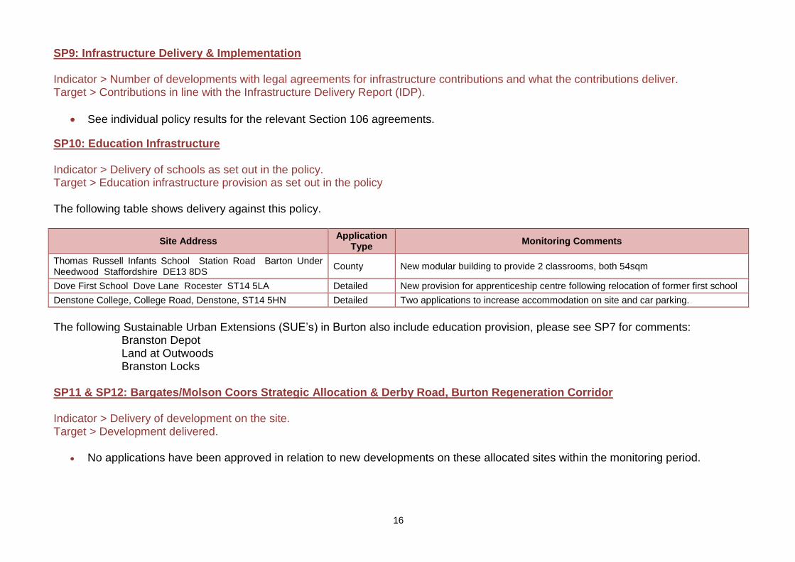
SP10: Education Infrastructure Indicator > Delivery of schools as set out in the policy. Target > Education infrastructure provision as set out in the policy The following table shows delivery against this policy.
Site Address Application
Type Monitoring Comments
Thomas Russell Infants School Station Road Barton Under Needwood Staffordshire DE13 8DS
County New modular building to provide 2 classrooms, both 54sqm
Dove First School Dove Lane Rocester ST14 5LA Detailed New provision for apprenticeship centre following relocation of former first school
Denstone College, College Road, Denstone, ST14 5HN Detailed Two applications to increase accommodation on site and car parking.
The following Sustainable Urban Extensions (SUE’s) in Burton also include education provision, please see SP7 for comments: Branston Depot Land at Outwoods Branston Locks SP11 & SP12: Bargates/Molson Coors Strategic Allocation & Derby Road, Burton Regeneration Corridor Indicator > Delivery of development on the site. Target > Development delivered.
No applications have been approved in relation to new developments on these allocated sites within the monitoring period.
17
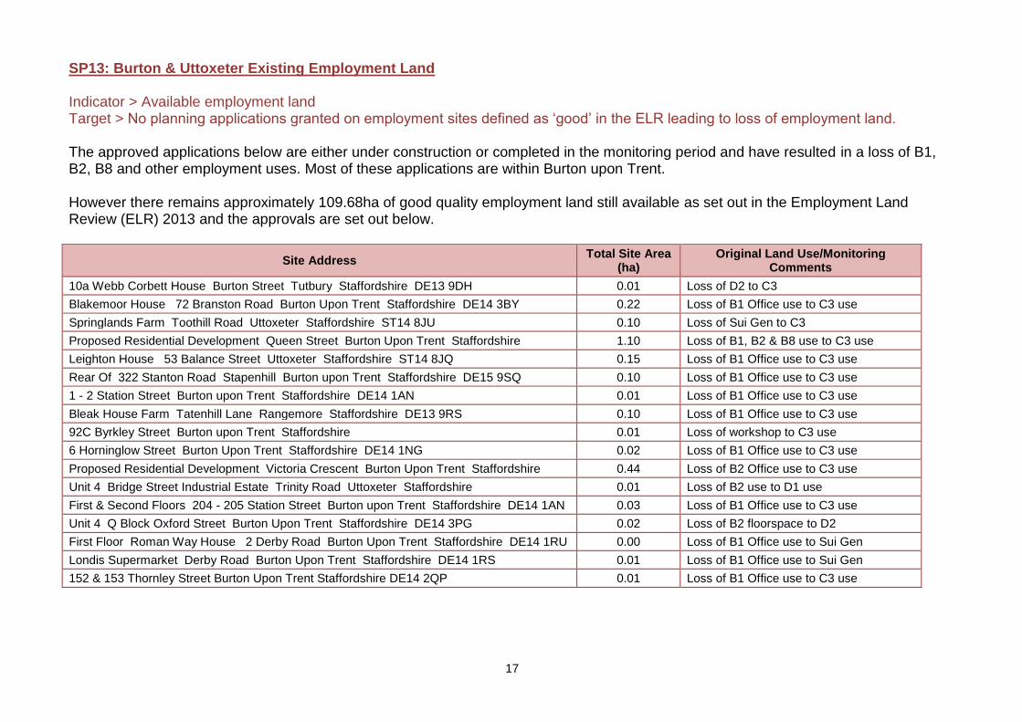
SP13: Burton & Uttoxeter Existing Employment Land Indicator > Available employment land Target > No planning applications granted on employment sites defined as ‘good’ in the ELR leading to loss of employment land. The approved applications below are either under construction or completed in the monitoring period and have resulted in a loss of B1, B2, B8 and other employment uses. Most of these applications are within Burton upon Trent. However there remains approximately 109.68ha of good quality employment land still available as set out in the Employment Land Review (ELR) 2013 and the approvals are set out below.
Site Address Total Site Area
(ha) Original Land Use/Monitoring
Comments
10a Webb Corbett House Burton Street Tutbury Staffordshire DE13 9DH 0.01 Loss of D2 to C3
Blakemoor House 72 Branston Road Burton Upon Trent Staffordshire DE14 3BY 0.22 Loss of B1 Office use to C3 use
Springlands Farm Toothill Road Uttoxeter Staffordshire ST14 8JU 0.10 Loss of Sui Gen to C3
Proposed Residential Development Queen Street Burton Upon Trent Staffordshire 1.10 Loss of B1, B2 & B8 use to C3 use
Leighton House 53 Balance Street Uttoxeter Staffordshire ST14 8JQ 0.15 Loss of B1 Office use to C3 use
Rear Of 322 Stanton Road Stapenhill Burton upon Trent Staffordshire DE15 9SQ 0.10 Loss of B1 Office use to C3 use
1 - 2 Station Street Burton upon Trent Staffordshire DE14 1AN 0.01 Loss of B1 Office use to C3 use
Bleak House Farm Tatenhill Lane Rangemore Staffordshire DE13 9RS 0.10 Loss of B1 Office use to C3 use
92C Byrkley Street Burton upon Trent Staffordshire 0.01 Loss of workshop to C3 use
6 Horninglow Street Burton Upon Trent Staffordshire DE14 1NG 0.02 Loss of B1 Office use to C3 use
Proposed Residential Development Victoria Crescent Burton Upon Trent Staffordshire 0.44 Loss of B2 Office use to C3 use
Unit 4 Bridge Street Industrial Estate Trinity Road Uttoxeter Staffordshire 0.01 Loss of B2 use to D1 use
First & Second Floors 204 - 205 Station Street Burton upon Trent Staffordshire DE14 1AN 0.03 Loss of B1 Office use to C3 use
Unit 4 Q Block Oxford Street Burton Upon Trent Staffordshire DE14 3PG 0.02 Loss of B2 floorspace to D2
First Floor Roman Way House 2 Derby Road Burton Upon Trent Staffordshire DE14 1RU 0.00 Loss of B1 Office use to Sui Gen
Londis Supermarket Derby Road Burton Upon Trent Staffordshire DE14 1RS 0.01 Loss of B1 Office use to Sui Gen
152 & 153 Thornley Street Burton Upon Trent Staffordshire DE14 2QP 0.01 Loss of B1 Office use to C3 use
18
Loss of otheremployment
use to C3
Loss of B1 -Offices to C3
Loss of B1, B2& B8 - Offices
to C3
Loss of B2 -Offices to C3
Loss of B2 use- still in
employmentuse
Increased B1,B2 or B8
Floorspace
Loss of B1 use- still in
employmentuse
Total Site Area(ha)
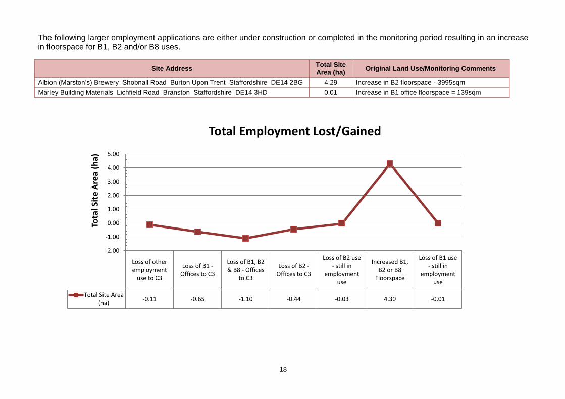
-0.11 -0.65 -1.10 -0.44 -0.03 4.30 -0.01
-2.00
-1.00
0.00
1.00
2.00
3.00
4.00
5.00
Tota
l Sit
e A
rea
(ha)
Total Employment Lost/Gained
The following larger employment applications are either under construction or completed in the monitoring period resulting in an increase in floorspace for B1, B2 and/or B8 uses.
Site Address Total Site Area (ha)
Original Land Use/Monitoring Comments
Albion (Marston’s) Brewery Shobnall Road Burton Upon Trent Staffordshire DE14 2BG 4.29 Increase in B2 floorspace - 3995sqm
Marley Building Materials Lichfield Road Branston Staffordshire DE14 3HD 0.01 Increase in B1 office floorspace = 139sqm
19
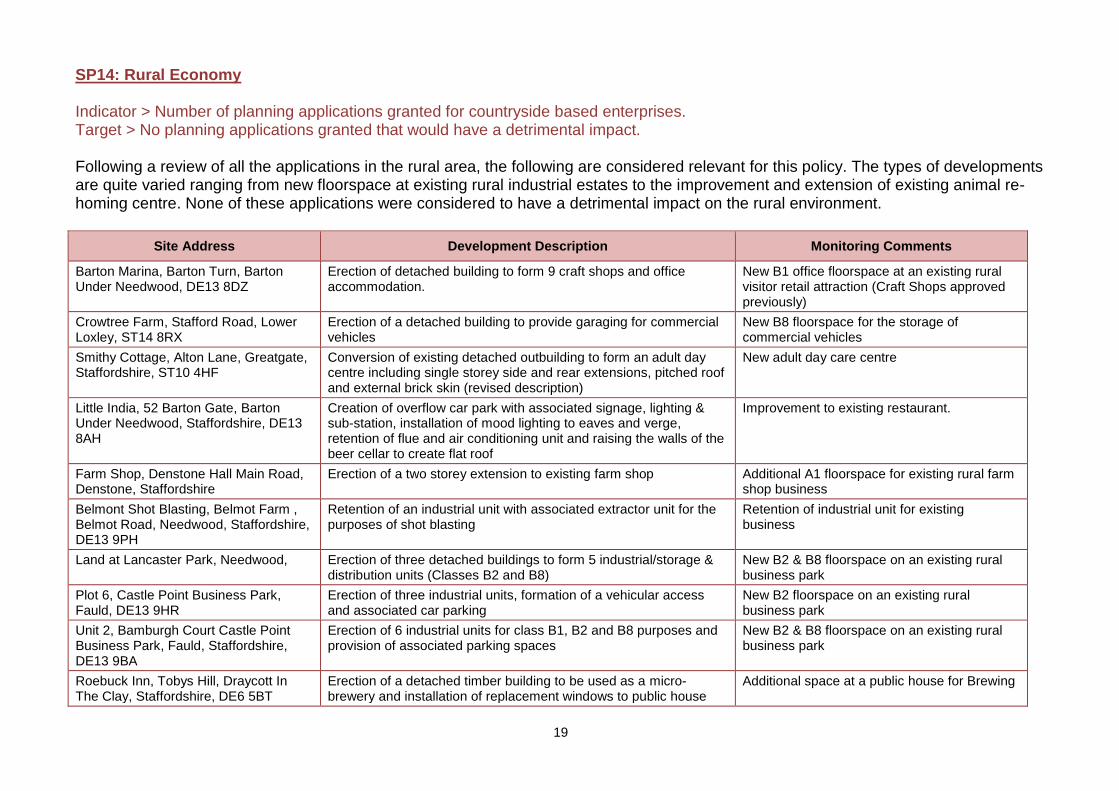
SP14: Rural Economy Indicator > Number of planning applications granted for countryside based enterprises. Target > No planning applications granted that would have a detrimental impact. Following a review of all the applications in the rural area, the following are considered relevant for this policy. The types of developments are quite varied ranging from new floorspace at existing rural industrial estates to the improvement and extension of existing animal re-homing centre. None of these applications were considered to have a detrimental impact on the rural environment.
Site Address Development Description Monitoring Comments
Barton Marina, Barton Turn, Barton Under Needwood, DE13 8DZ
Erection of detached building to form 9 craft shops and office accommodation.
New B1 office floorspace at an existing rural visitor retail attraction (Craft Shops approved previously)
Crowtree Farm, Stafford Road, Lower Loxley, ST14 8RX
Erection of a detached building to provide garaging for commercial vehicles
New B8 floorspace for the storage of commercial vehicles
Smithy Cottage, Alton Lane, Greatgate, Staffordshire, ST10 4HF
Conversion of existing detached outbuilding to form an adult day centre including single storey side and rear extensions, pitched roof and external brick skin (revised description)
New adult day care centre
Little India, 52 Barton Gate, Barton Under Needwood, Staffordshire, DE13 8AH
Creation of overflow car park with associated signage, lighting & sub-station, installation of mood lighting to eaves and verge, retention of flue and air conditioning unit and raising the walls of the beer cellar to create flat roof
Improvement to existing restaurant.
Farm Shop, Denstone Hall Main Road, Denstone, Staffordshire
Erection of a two storey extension to existing farm shop Additional A1 floorspace for existing rural farm shop business
Belmont Shot Blasting, Belmot Farm , Belmot Road, Needwood, Staffordshire, DE13 9PH
Retention of an industrial unit with associated extractor unit for the purposes of shot blasting
Retention of industrial unit for existing business
Land at Lancaster Park, Needwood, Erection of three detached buildings to form 5 industrial/storage & distribution units (Classes B2 and B8)
New B2 & B8 floorspace on an existing rural business park
Plot 6, Castle Point Business Park, Fauld, DE13 9HR
Erection of three industrial units, formation of a vehicular access and associated car parking
New B2 floorspace on an existing rural business park
Unit 2, Bamburgh Court Castle Point Business Park, Fauld, Staffordshire, DE13 9BA
Erection of 6 industrial units for class B1, B2 and B8 purposes and provision of associated parking spaces
New B2 & B8 floorspace on an existing rural business park
Roebuck Inn, Tobys Hill, Draycott In The Clay, Staffordshire, DE6 5BT
Erection of a detached timber building to be used as a micro-brewery and installation of replacement windows to public house
Additional space at a public house for Brewing
20
Site Address Development Description Monitoring Comments
Blue Cross Equine Centre, Rolleston Centre, Dovecliff Road, Rolleston On Dove, Staffordshire, DE13 9AU
Erection of a detached single storey cattery building and detached of timber framed storage building
Improvement and extension of existing animal re-homing centre
Spath Cottage, Ashbourne Road, Spath, Stramshall, Staffordshire, ST14 5AP
Continued use of double garage as Dog Grooming Parlour Continued use of double garage as Dog Grooming Parlour
Barton Fields Patio and Garden Centre, Lichfield Road, Barton under Needwood, DE13 8ED
Change of use of part of the existing garden and patio centre to form an area for the open sale of motor caravans
Broadening the type of sales at existing garden centre on the outskirts of Burton
Bell House Gate Farm, Bell House Lane, Anslow Gate, Staffordshire, DE13 9PA
Change of use of land for the storage of 12 caravans New caravan storage business in rural area
Brown Egg Barn Folly Farm Alton Road Denstone Staffordshire ST14 5DH
Continued use of holiday let as a dwelling house Loss of Holiday Let
The Old Smithy Sandy Lane Greatgate Staffordshire
Change of use of Holiday Let to form a single dwelling Loss of Holiday Let
21
Holiday Lets, B&Bs or Hotels
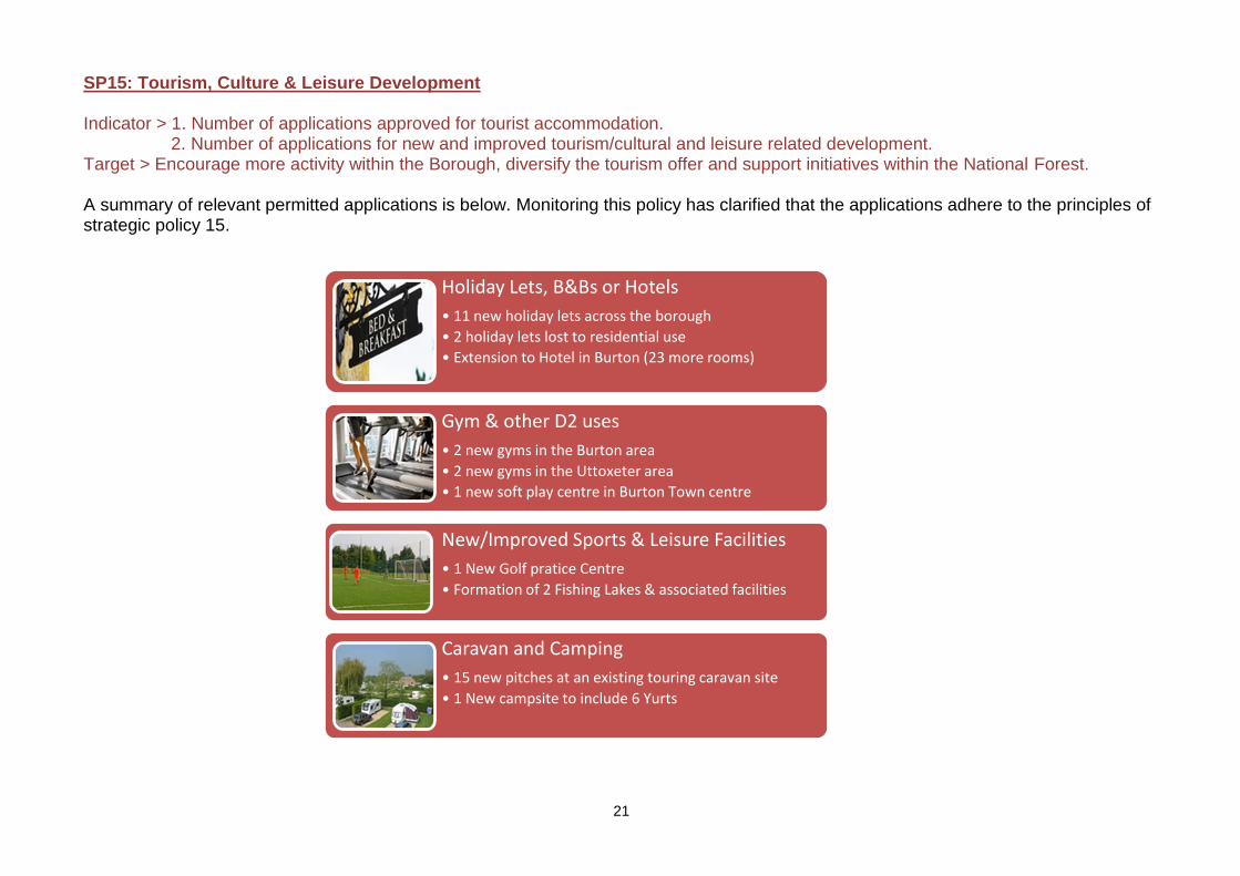
• 11 new holiday lets across the borough
• 2 holiday lets lost to residential use
• Extension to Hotel in Burton (23 more rooms)
Gym & other D2 uses
• 2 new gyms in the Burton area
• 2 new gyms in the Uttoxeter area
• 1 new soft play centre in Burton Town centre
New/Improved Sports & Leisure Facilities
• 1 New Golf pratice Centre
• Formation of 2 Fishing Lakes & associated facilities
Caravan and Camping
• 15 new pitches at an existing touring caravan site
• 1 New campsite to include 6 Yurts
SP15: Tourism, Culture & Leisure Development Indicator > 1. Number of applications approved for tourist accommodation.
2. Number of applications for new and improved tourism/cultural and leisure related development. Target > Encourage more activity within the Borough, diversify the tourism offer and support initiatives within the National Forest. A summary of relevant permitted applications is below. Monitoring this policy has clarified that the applications adhere to the principles of strategic policy 15.
22
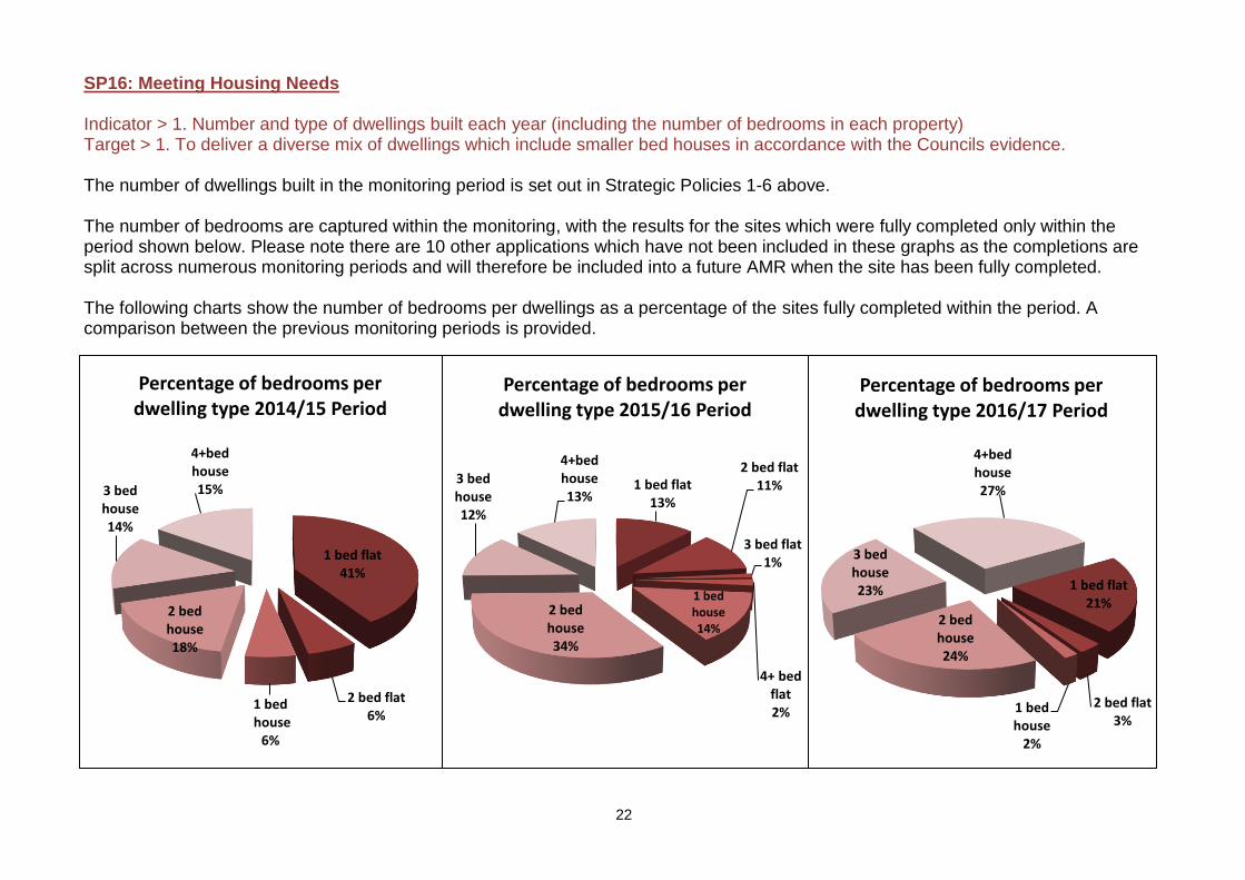
SP16: Meeting Housing Needs Indicator > 1. Number and type of dwellings built each year (including the number of bedrooms in each property) Target > 1. To deliver a diverse mix of dwellings which include smaller bed houses in accordance with the Councils evidence. The number of dwellings built in the monitoring period is set out in Strategic Policies 1-6 above. The number of bedrooms are captured within the monitoring, with the results for the sites which were fully completed only within the period shown below. Please note there are 10 other applications which have not been included in these graphs as the completions are split across numerous monitoring periods and will therefore be included into a future AMR when the site has been fully completed. The following charts show the number of bedrooms per dwellings as a percentage of the sites fully completed within the period. A comparison between the previous monitoring periods is provided.
1 bed flat13%
2 bed flat11%
3 bed flat1%
4+ bed flat2%
1 bed house14%
2 bed house34%
3 bed house12%
4+bed house13%
Percentage of bedrooms per dwelling type 2015/16 Period
1 bed flat41%
2 bed flat6%
1 bedhouse
6%
2 bed house18%
3 bed house14%
4+bed house15%
Percentage of bedrooms per dwelling type 2014/15 Period
1 bed flat21%
2 bed flat3%
1 bed house
2%
2 bed house24%
3 bed house23%
4+bed house27%
Percentage of bedrooms per dwelling type 2016/17 Period
23
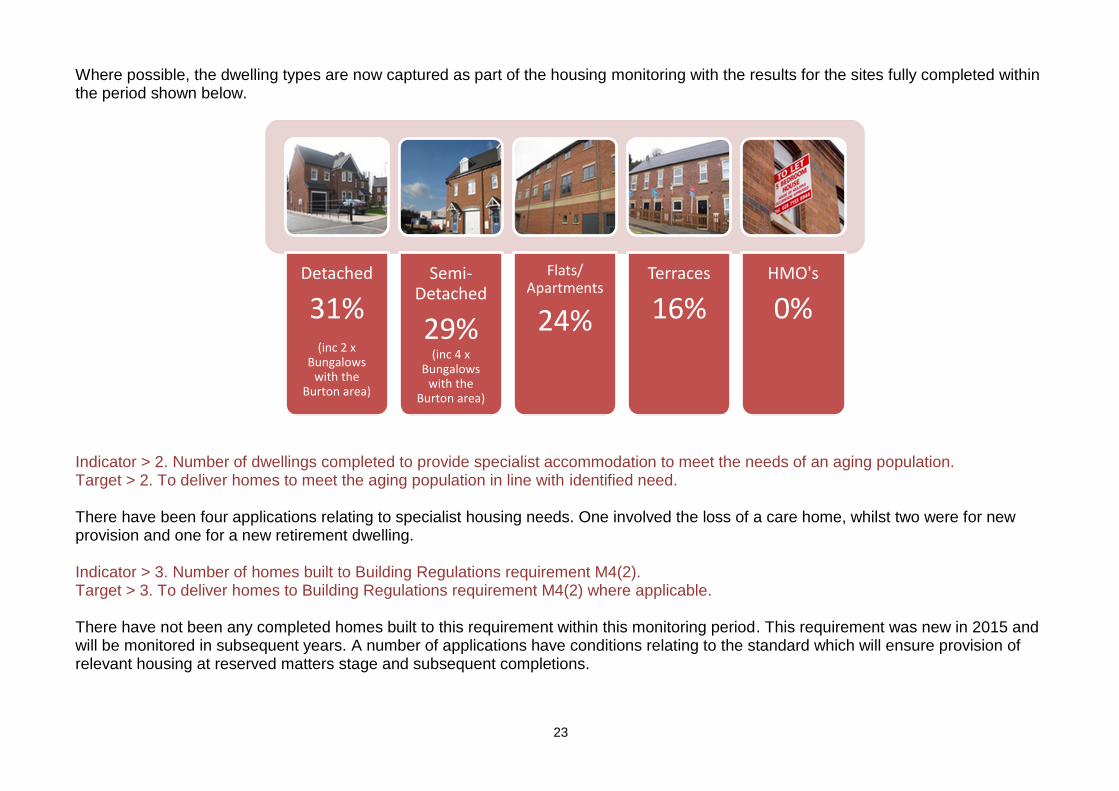
Where possible, the dwelling types are now captured as part of the housing monitoring with the results for the sites fully completed within the period shown below.
Indicator > 2. Number of dwellings completed to provide specialist accommodation to meet the needs of an aging population. Target > 2. To deliver homes to meet the aging population in line with identified need. There have been four applications relating to specialist housing needs. One involved the loss of a care home, whilst two were for new provision and one for a new retirement dwelling. Indicator > 3. Number of homes built to Building Regulations requirement M4(2). Target > 3. To deliver homes to Building Regulations requirement M4(2) where applicable. There have not been any completed homes built to this requirement within this monitoring period. This requirement was new in 2015 and will be monitored in subsequent years. A number of applications have conditions relating to the standard which will ensure provision of relevant housing at reserved matters stage and subsequent completions.
Detached
31%(inc 2 x
Bungalows with the
Burton area)
Semi-Detached
29% (inc 4 x
Bungalows with the
Burton area)
Flats/ Apartments
24%
Terraces
16%HMO's
0%
24
Annaual Target
112
62
98
86
95
Number of Completed Afforadable Units
Completed Affordable UnitsAnnual Target 2013/14 Period 2014/15 Period
2015/16 Period 2016/17 Period
SP17: Affordable Housing Indicator > Number of affordable houses built each year. Target > To deliver 112 affordable homes per year across the plan period.
SP18: Residential Development on Exception Sites Indicator > Number of houses granted permission on exception sites. Target > 90 units across the plan period.
No applications for residential development on exception sites were determined within monitoring period.
SP19: Gypsy and Traveller Indicator > Number of additional pitches (net). Target > Requirement set out in evidence.
During this monitoring period, no applications relating to gypsy and traveller pitches have been determined within the borough
The number of completed applications providing affordable homes has continued to rise since the 2013/14 period. Severn applications were fully completed within the monitoring period providing 95 affordable homes within the Borough, mostly within Burton upon Trent.
25
1 x Improvement
to Town Centre Shop front, with
new external seating
1 x Loss of Retail use
to Residential
use
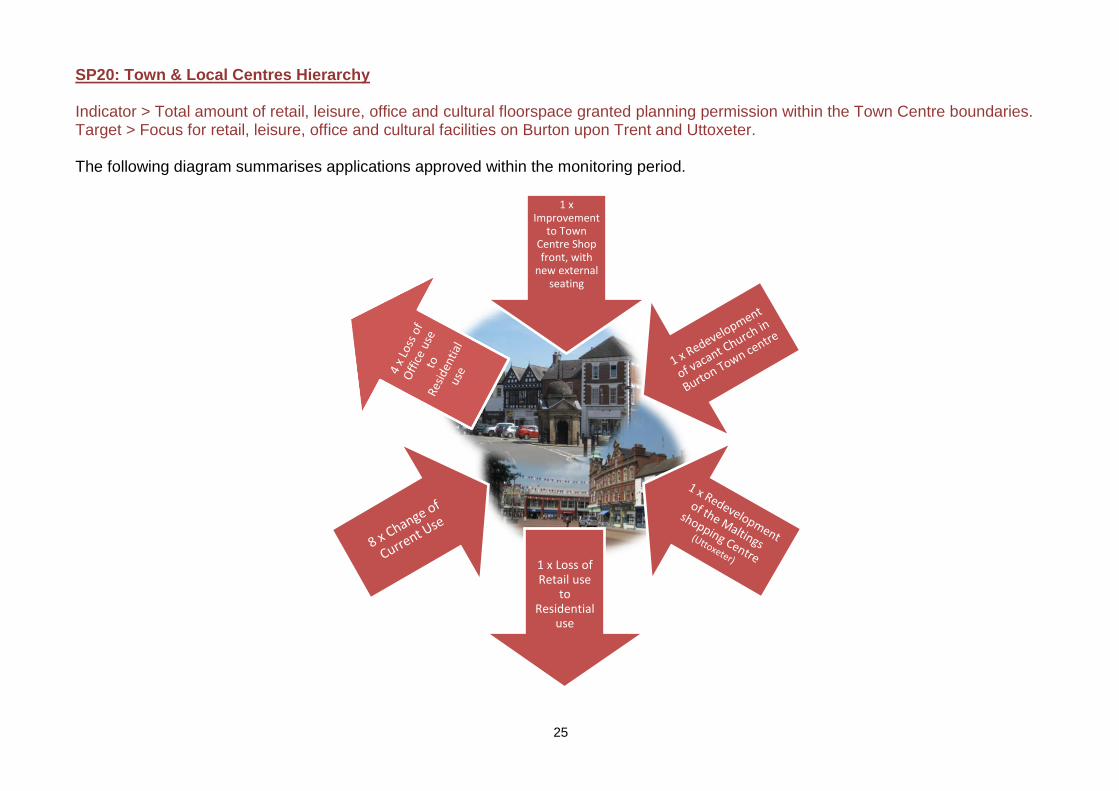
SP20: Town & Local Centres Hierarchy Indicator > Total amount of retail, leisure, office and cultural floorspace granted planning permission within the Town Centre boundaries. Target > Focus for retail, leisure, office and cultural facilities on Burton upon Trent and Uttoxeter. The following diagram summarises applications approved within the monitoring period.
26
Loss of Facility to Dwellings
Regeneration of long term vacant
facility
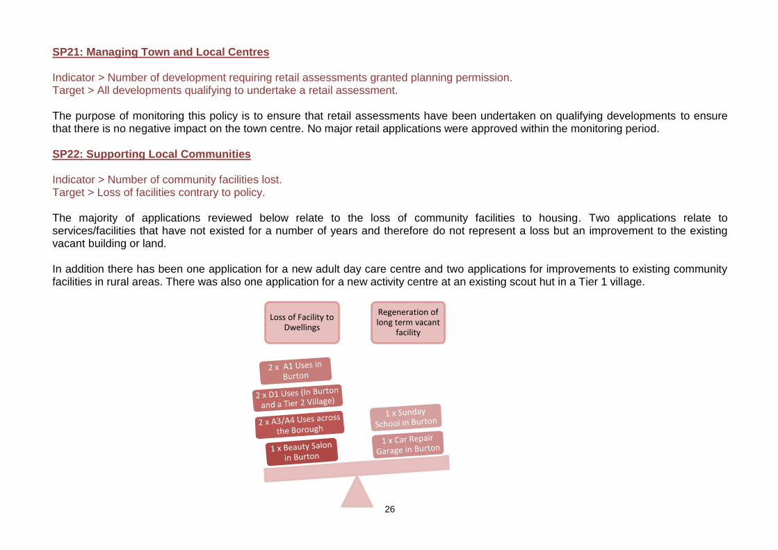
SP21: Managing Town and Local Centres Indicator > Number of development requiring retail assessments granted planning permission. Target > All developments qualifying to undertake a retail assessment. The purpose of monitoring this policy is to ensure that retail assessments have been undertaken on qualifying developments to ensure that there is no negative impact on the town centre. No major retail applications were approved within the monitoring period. SP22: Supporting Local Communities Indicator > Number of community facilities lost. Target > Loss of facilities contrary to policy. The majority of applications reviewed below relate to the loss of community facilities to housing. Two applications relate to services/facilities that have not existed for a number of years and therefore do not represent a loss but an improvement to the existing vacant building or land. In addition there has been one application for a new adult day care centre and two applications for improvements to existing community facilities in rural areas. There was also one application for a new activity centre at an existing scout hut in a Tier 1 village.
27
26%
4%19%
51%
42%
1%
1%
56%
40%10%
51%
Design Reasons Historic Reasons Design & HistoricReasons
Other Reasons
Refused Application Reasons
2014/15 Data 2015/16 Data 2016/17 Data
SP23: Green Infrastructure Indicator > Major developments to provide green infrastructure and link to existing green corridors. Target > Rural and urban development will provide green infrastructure and link existing green corridors. Having reviewed completed major sites within the monitoring period, two applications specifically contribute to green infrastructure by providing public access links to Shobnall Leisure centre and 1,683m2 of public open space.
SP24 & SP25: High Quality Design & Historic Environment Indicator > Number of proposals refused on design principles and historic environment impacts. Target > 1. Ensure good design in decision making.
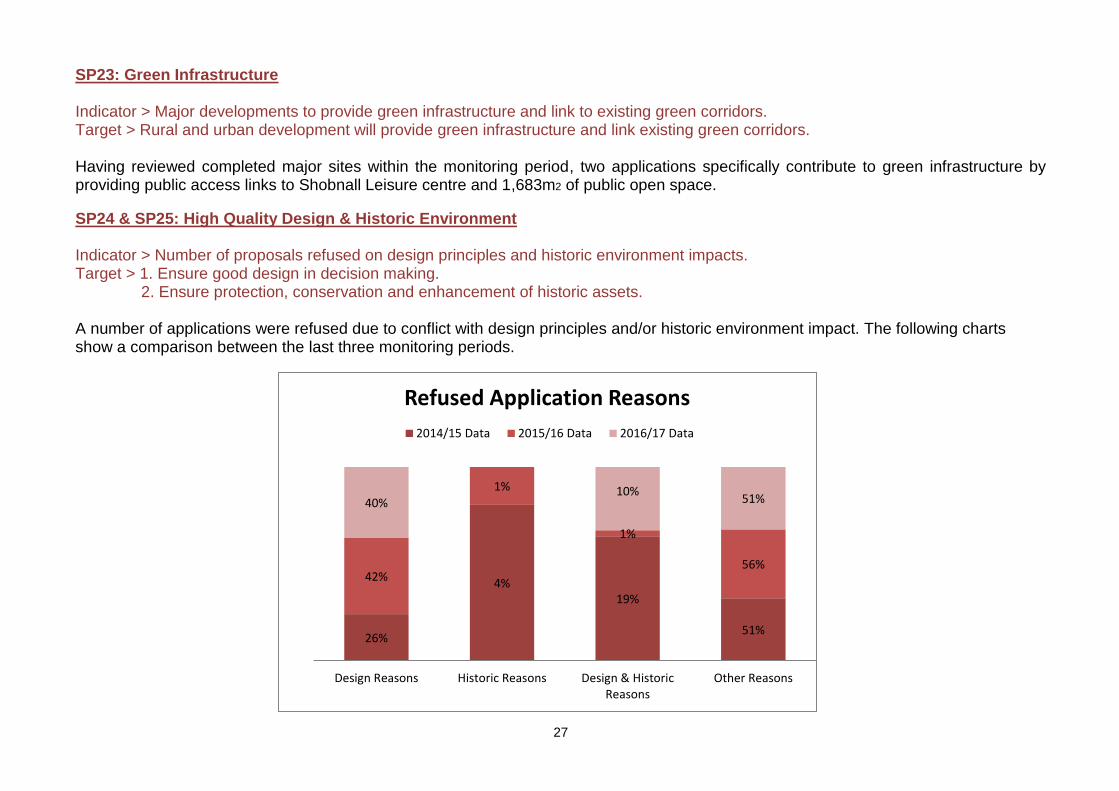
2. Ensure protection, conservation and enhancement of historic assets. A number of applications were refused due to conflict with design principles and/or historic environment impact. The following charts show a comparison between the last three monitoring periods.
28
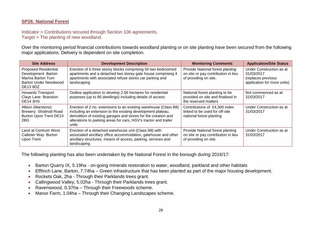
SP26: National Forest Indicator > Contributions secured through Section 106 agreements. Target > The planting of new woodland.
Over the monitoring period financial contributions towards woodland planting or on site planting have been secured from the following major applications. Delivery is dependent on site completion.
Site Address Development Description Monitoring Comments Application/Site Status
Proposed Residential Development Barton Marina Barton Turn Barton Under Needwood DE13 8DZ
Erection of 5 three storey blocks comprising 50 two bedroomed apartments and a detached two storey gate house comprising 4 apartments with associated refuse stores car parking and landscaping
Provide National forest planting on site or pay contribution in lieu of providing on site.
Under Construction as at 31/03/2017 (replaces previous application for more units)
Howards Transport Clays Lane Branston DE14 3HS
Outline application to develop 2.56 hectares for residential purposes (up to 86 dwellings) including details of access
National forest planting to be provided on site and finalised in the reserved matters
Not commenced as at 31/03/2017
Albion (Marstons) Brewery Shobnall Road Burton Upon Trent DE14 2BG
Erection of 2 no. extensions to an existing warehouse (Class B8) including an extension to the existing development plateau, demolition of existing garages and stores for the creation and alterations to parking areas for cars, HGV's tractor and trailer units
Contributions of £4,300 index linked to be used for off-site national forest planting
Under Construction as at 31/03/2017
Land at Centrum West Callister Way Burton Upon Trent
Erection of a detached warehouse unit (Class B8) with associated ancillary office accommodation, gatehouse and other ancillary structures, means of access, parking, services and landscaping
Provide National forest planting on site or pay contribution in lieu of providing on site.
Under Construction as at 31/03/2017
The following planting has also been undertaken by the National Forest in the borough during 2016/17:
Barton Quarry IX, 5.19ha - on-going minerals restoration to water, woodland, parkland and other habitats
Efflinch Lane, Barton, 7.74ha – Green infrastructure that has been planted as part of the major housing development.
Rockets Oak, 2ha - Through their Parklands trees grant.
Callingwood Valley, 5.02ha - Through their Parklands trees grant.
Ravenswood, 0.37ha – Through their Freewoods scheme.
Manor Farm, 1.04ha – Through their Changing Landscapes scheme.
29
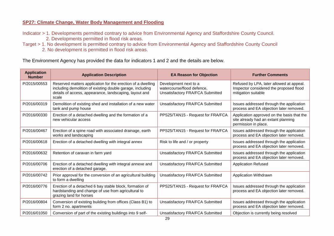
SP27: Climate Change, Water Body Management and Flooding Indicator > 1. Developments permitted contrary to advice from Environmental Agency and Staffordshire County Council. 2. Developments permitted in flood risk areas. Target > 1. No development is permitted contrary to advice from Environmental Agency and Staffordshire County Council 2. No development is permitted in flood risk areas. The Environment Agency has provided the data for indicators 1 and 2 and the details are below.
Application Number
Application Description EA Reason for Objection Further Comments
P/2015/00553 Reserved matters application for the erection of a dwelling including demolition of existing double garage, including details of access, appearance, landscaping, layout and scale
Development next to a watercourse/flood defence, Unsatisfactory FRA/FCA Submitted
Refused by LPA, later allowed at appeal. Inspector considered the proposed flood mitigation suitable
P/2016/00319 Demolition of existing shed and installation of a new water tank and pump house
Unsatisfactory FRA/FCA Submitted Issues addressed through the application process and EA objection later removed.
P/2016/00330 Erection of a detached dwelling and the formation of a new vehicular access
PPS25/TAN15 - Request for FRA/FCA Application approved on the basis that the site already had an extant planning permission in place.
P/2016/00467 Erection of a spine road with associated drainage, earth works and landscaping
PPS25/TAN15 - Request for FRA/FCA Issues addressed through the application process and EA objection later removed.
P/2016/00618 Erection of a detached dwelling with integral annex Risk to life and / or property Issues addressed through the application process and EA objection later removed.
P/2016/00632 Retention of caravan in farm yard Unsatisfactory FRA/FCA Submitted Issues addressed through the application process and EA objection later removed.
P/2016/00706 Erection of a detached dwelling with integral annexe and erection of a detached garage.
Unsatisfactory FRA/FCA Submitted Application Refused
P/2016/00742 Prior approval for the conversion of an agricultural building to form a dwelling
Unsatisfactory FRA/FCA Submitted Application Withdrawn
P/2016/00776 Erection of a detached 6 bay stable block, formation of hardstanding and change of use from agricultural to grazing land for horses
PPS25/TAN15 - Request for FRA/FCA Issues addressed through the application process and EA objection later removed.
P/2016/00804 Conversion of existing building from offices (Class B1) to form 2 no. apartments
Unsatisfactory FRA/FCA Submitted Issues addressed through the application process and EA objection later removed.
P/2016/01050 Conversion of part of the existing buildings into 9 self- Unsatisfactory FRA/FCA Submitted Objection is currently being resolved
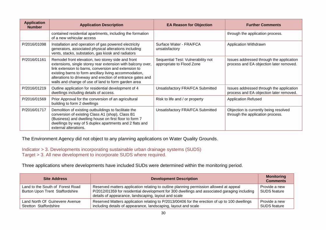
30
Application Number
Application Description EA Reason for Objection Further Comments
contained residential apartments, including the formation of a new vehicular access
through the application process.
P/2016/01098 Installation and operation of gas powered electricity generators, associated physical alterations including vents, stacks, substation, gas kiosk and radiators
Surface Water - FRA/FCA unsatisfactory
Application Withdrawn
P/2016/01161 Remodel front elevation, two storey side and front extensions, single storey rear extension with balcony over, link extension to barns, conversion and extension to existing barns to form ancillary living accommodation, alterations to driveway and erection of entrance gates and walls and change of use of land to form garden area
Sequential Test: Vulnerability not appropriate to Flood Zone
Issues addressed through the application process and EA objection later removed.
P/2016/01219 Outline application for residential development of 4 dwellings including details of access.
Unsatisfactory FRA/FCA Submitted Issues addressed through the application process and EA objection later removed.
P/2016/01569 Prior Approval for the conversion of an agricultural building to form 2 dwellings
Risk to life and / or property Application Refused
P/2016/01717 Demolition of existing outbuildings to facilitate the conversion of existing Class A1 (shop), Class B1 (Business) and dwelling house on first floor to form 7 dwellings by way of 5 duplex apartments and 2 flats and external alterations.
Unsatisfactory FRA/FCA Submitted Objection is currently being resolved through the application process.
The Environment Agency did not object to any planning applications on Water Quality Grounds. Indicator > 3. Developments incorporating sustainable urban drainage systems (SUDS) Target > 3. All new development to incorporate SUDS where required. Three applications where developments have included SUDs were determined within the monitoring period.
Site Address Development Description Monitoring Comments
Land to the South of Forest Road Burton Upon Trent Staffordshire
Reserved matters application relating to outline planning permission allowed at appeal P/2012/01359 for residential development for 300 dwellings and associated garaging including details of appearance, landscaping, layout and scale
Provide a new SUDS feature
Land North Of Guinevere Avenue Stretton Staffordshire
Reserved Matters application relating to P/2013/00406 for the erection of up to 100 dwellings including details of appearance, landscaping, layout and scale
Provide a new SUDS feature
31
Site Address Development Description Monitoring Comments
Land to the South of Forest School Street Rolleston on Dove Burton upon Trent Staffordshire
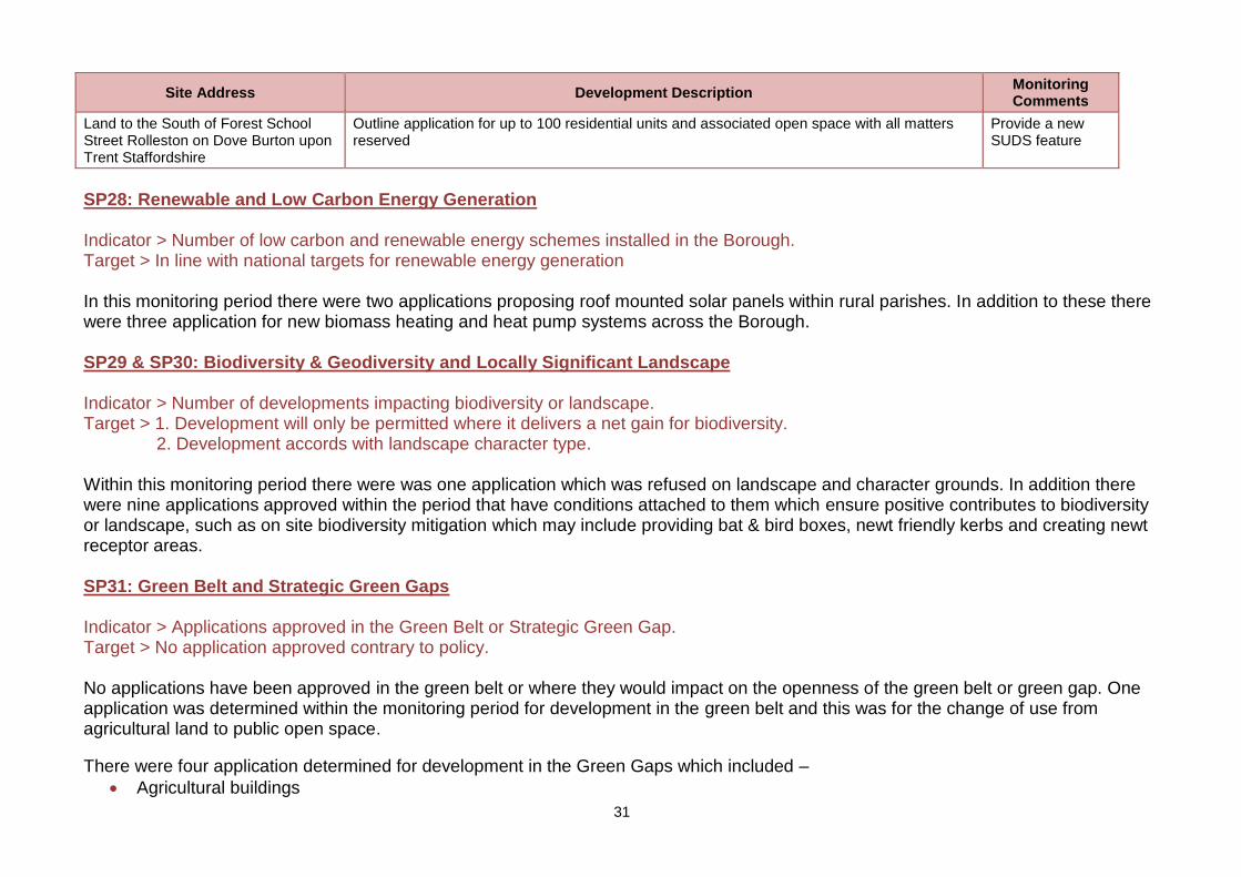
Outline application for up to 100 residential units and associated open space with all matters reserved
Provide a new SUDS feature
SP28: Renewable and Low Carbon Energy Generation Indicator > Number of low carbon and renewable energy schemes installed in the Borough. Target > In line with national targets for renewable energy generation In this monitoring period there were two applications proposing roof mounted solar panels within rural parishes. In addition to these there were three application for new biomass heating and heat pump systems across the Borough. SP29 & SP30: Biodiversity & Geodiversity and Locally Significant Landscape Indicator > Number of developments impacting biodiversity or landscape. Target > 1. Development will only be permitted where it delivers a net gain for biodiversity. 2. Development accords with landscape character type. Within this monitoring period there were was one application which was refused on landscape and character grounds. In addition there were nine applications approved within the period that have conditions attached to them which ensure positive contributes to biodiversity or landscape, such as on site biodiversity mitigation which may include providing bat & bird boxes, newt friendly kerbs and creating newt receptor areas. SP31: Green Belt and Strategic Green Gaps Indicator > Applications approved in the Green Belt or Strategic Green Gap. Target > No application approved contrary to policy. No applications have been approved in the green belt or where they would impact on the openness of the green belt or green gap. One application was determined within the monitoring period for development in the green belt and this was for the change of use from agricultural land to public open space.
There were four application determined for development in the Green Gaps which included –
Agricultural buildings
32
Extension to stables and new storage building
New cattery building
Change of use from golf course to agricultural land.
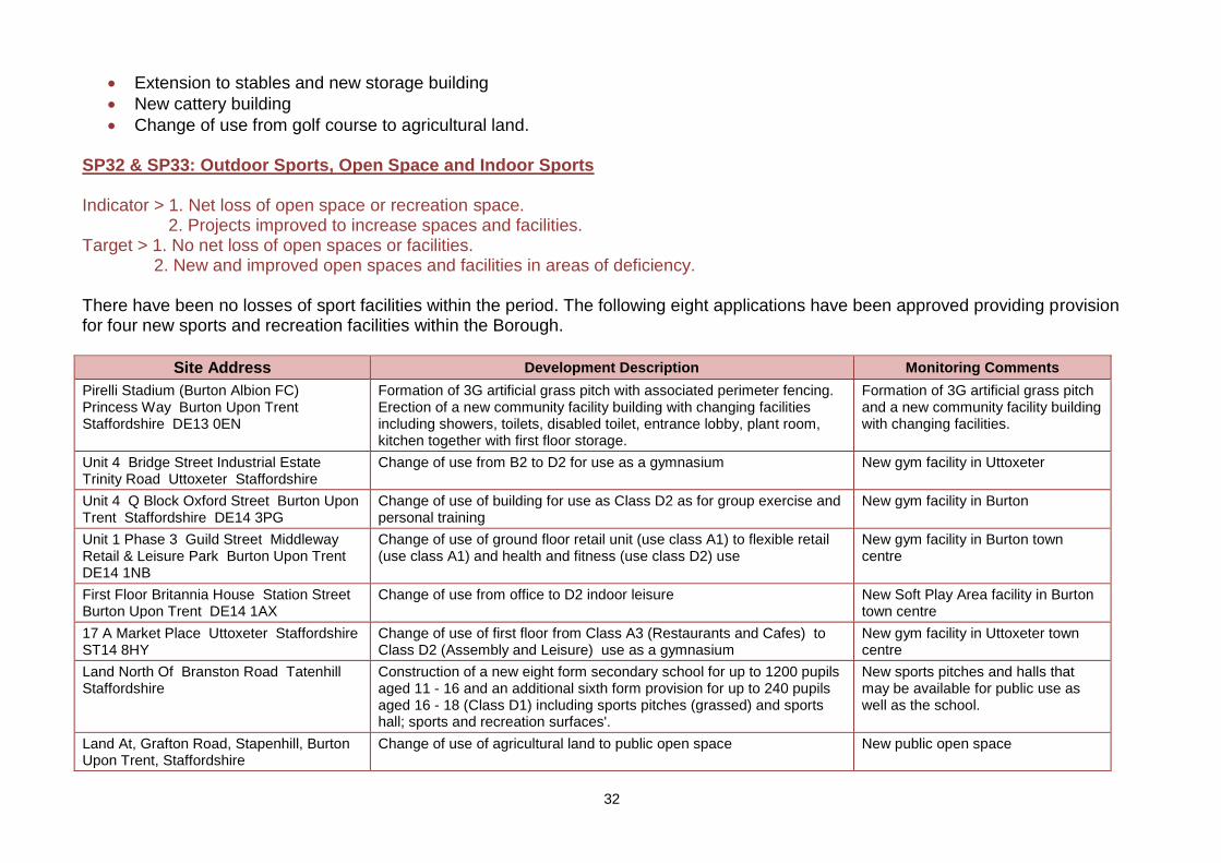
SP32 & SP33: Outdoor Sports, Open Space and Indoor Sports Indicator > 1. Net loss of open space or recreation space. 2. Projects improved to increase spaces and facilities. Target > 1. No net loss of open spaces or facilities. 2. New and improved open spaces and facilities in areas of deficiency. There have been no losses of sport facilities within the period. The following eight applications have been approved providing provision for four new sports and recreation facilities within the Borough.
Site Address Development Description Monitoring Comments
Pirelli Stadium (Burton Albion FC) Princess Way Burton Upon Trent Staffordshire DE13 0EN
Formation of 3G artificial grass pitch with associated perimeter fencing. Erection of a new community facility building with changing facilities including showers, toilets, disabled toilet, entrance lobby, plant room, kitchen together with first floor storage.
Formation of 3G artificial grass pitch and a new community facility building with changing facilities.
Unit 4 Bridge Street Industrial Estate Trinity Road Uttoxeter Staffordshire
Change of use from B2 to D2 for use as a gymnasium New gym facility in Uttoxeter
Unit 4 Q Block Oxford Street Burton Upon Trent Staffordshire DE14 3PG
Change of use of building for use as Class D2 as for group exercise and personal training
New gym facility in Burton
Unit 1 Phase 3 Guild Street Middleway Retail & Leisure Park Burton Upon Trent DE14 1NB
Change of use of ground floor retail unit (use class A1) to flexible retail (use class A1) and health and fitness (use class D2) use
New gym facility in Burton town centre
First Floor Britannia House Station Street Burton Upon Trent DE14 1AX
Change of use from office to D2 indoor leisure New Soft Play Area facility in Burton town centre
17 A Market Place Uttoxeter Staffordshire ST14 8HY
Change of use of first floor from Class A3 (Restaurants and Cafes) to Class D2 (Assembly and Leisure) use as a gymnasium
New gym facility in Uttoxeter town centre
Land North Of Branston Road Tatenhill Staffordshire
Construction of a new eight form secondary school for up to 1200 pupils aged 11 - 16 and an additional sixth form provision for up to 240 pupils aged 16 - 18 (Class D1) including sports pitches (grassed) and sports hall; sports and recreation surfaces'.
New sports pitches and halls that may be available for public use as well as the school.
Land At, Grafton Road, Stapenhill, Burton Upon Trent, Staffordshire
Change of use of agricultural land to public open space New public open space
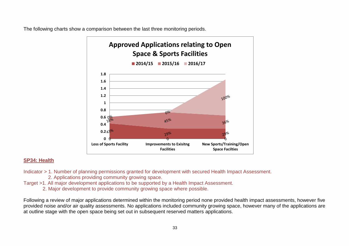
33
0
0.2
0.4
0.6
0.8
1
1.2
1.4
1.6
1.8
Loss of Sports Facility Improvements to ExisitngFacilities
New Sports/Training/OpenSpace Facilties
Approved Applications relating to Open Space & Sports Facilities
2014/15 2015/16 2016/17
The following charts show a comparison between the last three monitoring periods. SP34: Health Indicator > 1. Number of planning permissions granted for development with secured Health Impact Assessment. 2. Applications providing community growing space. Target >1. All major development applications to be supported by a Health Impact Assessment. 2. Major development to provide community growing space where possible. Following a review of major applications determined within the monitoring period none provided health impact assessments, however five provided noise and/or air quality assessments. No applications included community growing space, however many of the applications are at outline stage with the open space being set out in subsequent reserved matters applications.
34
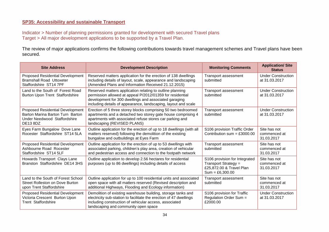
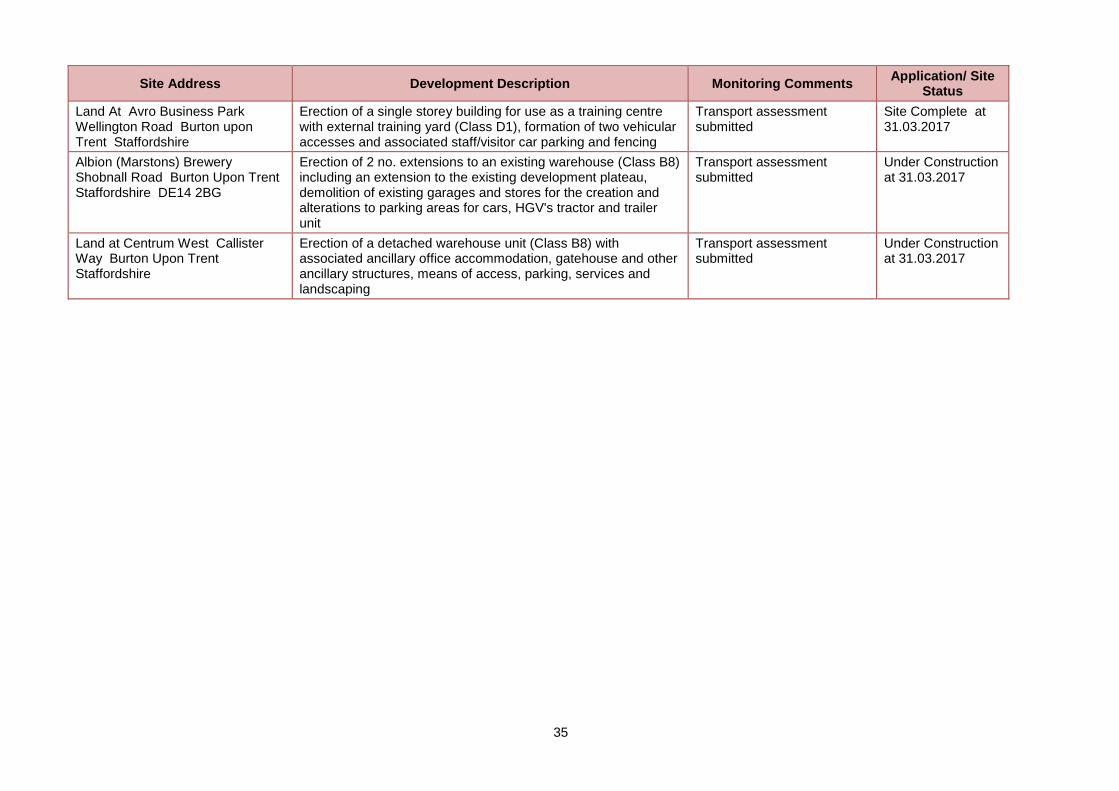
SP35: Accessibility and sustainable Transport Indicator > Number of planning permissions granted for development with secured Travel plans Target > All major development applications to be supported by a Travel Plan. The review of major applications confirms the following contributions towards travel management schemes and Travel plans have been secured.
Site Address Development Description Monitoring Comments Application/ Site
Status
Proposed Residential Development Bramshall Road Uttoxeter Staffordshire ST14 7PF
Reserved matters application for the erection of 138 dwellings including details of layout, scale, appearance and landscaping (Amended Plans and Information Received 21.12.2015)
Transport assessment submitted
Under Construction at 31.03.2017
Land to the South of Forest Road Burton Upon Trent Staffordshire
Reserved matters application relating to outline planning permission allowed at appeal P/2012/01359 for residential development for 300 dwellings and associated garaging including details of appearance, landscaping, layout and scale
Transport assessment submitted
Under Construction at 31.03.2017
Proposed Residential Development Barton Marina Barton Turn Barton Under Needwood Staffordshire DE13 8DZ
Erection of 5 three storey blocks comprising 50 two bedroomed apartments and a detached two storey gate house comprising 4 apartments with associated refuse stores car parking and landscaping (REVISED PLANS)
Transport assessment submitted
Under Construction at 31.03.2017
Eyes Farm Bungalow Dove Lane Rocester Staffordshire ST14 5LA
Outline application for the erection of up to 18 dwellings (with all matters reserved) following the demolition of the existing bungalow and outbuildings at Eyes Farm
S106 provision Traffic Order Contribution sum = £3000.00
Site has not commenced at 31.03.2017
Proposed Residential Development Ashbourne Road Rocester Staffordshire ST14 5LF
Outline application for the erection of up to 53 dwellings with associated parking, children’s play area, creation of vehicular and pedestrian access and connection to the footpath network
Transport assessment submitted
Site has not commenced at 31.03.2017
Howards Transport Clays Lane Branston Staffordshire DE14 3HS
Outline application to develop 2.56 hectares for residential purposes (up to 86 dwellings) including details of access
S106 provision for Integrated Transport Strategy = £25,872.00 & Travel Plan Sum = £6,300.00
Site has not commenced at 31.03.2017
Land to the South of Forest School Street Rolleston on Dove Burton upon Trent Staffordshire
Outline application for up to 100 residential units and associated open space with all matters reserved (Revised description and additional Highways, Flooding and Ecology information)
Transport assessment submitted
Site has not commenced at 31.03.2017
Proposed Residential Development Victoria Crescent Burton Upon Trent Staffordshire
Demolition of existing warehouse building, storage tanks and electricity sub-station to facilitate the erection of 47 dwellings including construction of vehicular access, associated landscaping and community open space
S106 provision for Traffic Regulation Order Sum = £2000.00
Under Construction at 31.03.2017
35
Site Address Development Description Monitoring Comments Application/ Site
Status
Land At Avro Business Park Wellington Road Burton upon Trent Staffordshire
Erection of a single storey building for use as a training centre with external training yard (Class D1), formation of two vehicular accesses and associated staff/visitor car parking and fencing
Transport assessment submitted
Site Complete at 31.03.2017
Albion (Marstons) Brewery Shobnall Road Burton Upon Trent Staffordshire DE14 2BG
Erection of 2 no. extensions to an existing warehouse (Class B8) including an extension to the existing development plateau, demolition of existing garages and stores for the creation and alterations to parking areas for cars, HGV's tractor and trailer unit
Transport assessment submitted
Under Construction at 31.03.2017
Land at Centrum West Callister Way Burton Upon Trent Staffordshire
Erection of a detached warehouse unit (Class B8) with associated ancillary office accommodation, gatehouse and other ancillary structures, means of access, parking, services and landscaping
Transport assessment submitted
Under Construction at 31.03.2017
36
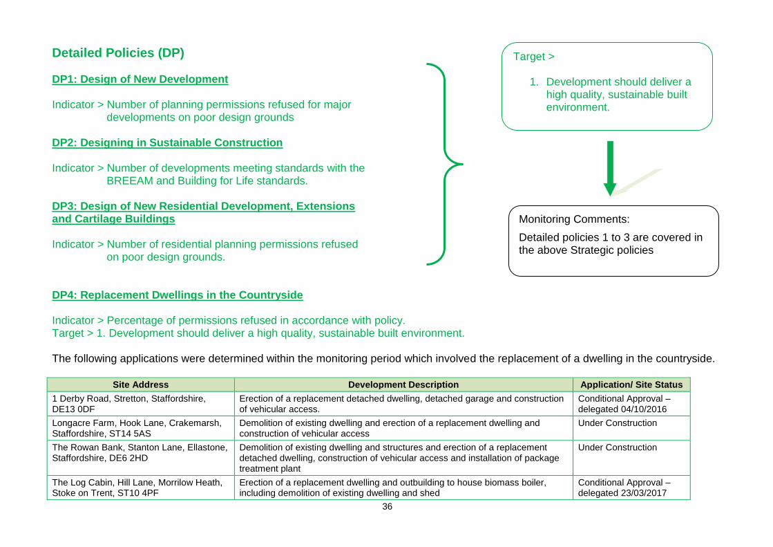
Detailed Policies (DP) DP1: Design of New Development Indicator > Number of planning permissions refused for major
developments on poor design grounds
DP2: Designing in Sustainable Construction Indicator > Number of developments meeting standards with the
BREEAM and Building for Life standards. DP3: Design of New Residential Development, Extensions and Cartilage Buildings Indicator > Number of residential planning permissions refused
on poor design grounds. DP4: Replacement Dwellings in the Countryside Indicator > Percentage of permissions refused in accordance with policy. Target > 1. Development should deliver a high quality, sustainable built environment. The following applications were determined within the monitoring period which involved the replacement of a dwelling in the countryside.
Site Address Development Description Application/ Site Status
1 Derby Road, Stretton, Staffordshire, DE13 0DF
Erection of a replacement detached dwelling, detached garage and construction of vehicular access.
Conditional Approval – delegated 04/10/2016
Longacre Farm, Hook Lane, Crakemarsh, Staffordshire, ST14 5AS
Demolition of existing dwelling and erection of a replacement dwelling and construction of vehicular access
Under Construction
The Rowan Bank, Stanton Lane, Ellastone, Staffordshire, DE6 2HD
Demolition of existing dwelling and structures and erection of a replacement detached dwelling, construction of vehicular access and installation of package treatment plant
Under Construction
The Log Cabin, Hill Lane, Morrilow Heath, Stoke on Trent, ST10 4PF
Erection of a replacement dwelling and outbuilding to house biomass boiler, including demolition of existing dwelling and shed
Conditional Approval – delegated 23/03/2017
Target >
1. Development should deliver a high quality, sustainable built environment.
Monitoring Comments:
Detailed policies 1 to 3 are covered in the above Strategic policies
37
Site Address Development Description Application/ Site Status
Fairfields, Parkhall Lane, Church Leigh, Staffordshire, ST10 4NP
Demolition of existing bungalow, erection of a replacement dwelling and continued use of agricultural land to domestic curtilage
Conditional Approval – delegated 04/10/2016
Blackpits Farm, Blythe Bridge Bank, Kingstone, Staffordshire, ST14 8QW
Demolition of existing dwelling to facilitate the erection of a replacement dwelling and installation of a septic tank
Under Construction
DP5 & DP6: Protecting the Historic Environment Indicator > Number of Conservation Area Appraisals and management plans. Target > 1. Ensure development has a positive impact on the natural and historic environment 2. Protect and enhance the Borough’s heritage assets, historic character and
designated Conservation Areas.
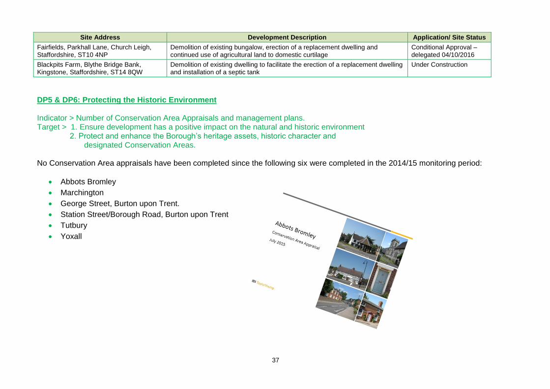
No Conservation Area appraisals have been completed since the following six were completed in the 2014/15 monitoring period:
Abbots Bromley
Marchington
George Street, Burton upon Trent.
Station Street/Borough Road, Burton upon Trent
Tutbury
Yoxall
38
DP7: Pollution, DP8: Tree Protection & DP9: Advertisements Indicator > Number of planning permissions approved contrary to policy. Target > No permissions granted which would be contrary to policy. DP10: Water recreation and Blue Infrastructure Indicator > Number of proposals coming forward. Target > Ensure development has a positive impact on the water environment. Two applications were determined where water recreation will be provided. In addition many of the SUDS features, referenced under strategic policy 27 may provide local opportunities for water recreation when completed.
Site Address Development Description Monitoring Comments
Wood Farm, Wood Lane, Gratwich, Staffordshire, ST14 8SB
Formation of 2 fishing lakes, fishing shelter, bin store, cycle store, 3 portaloos, car parking and alterations to existing access
Formation of 2 fishing lakes and fishing shelter
Land North Of Dunstall Lane Hadley End Staffordshire
Formation of an access track, parking area and wildlife pond Formation of a wildlife pond
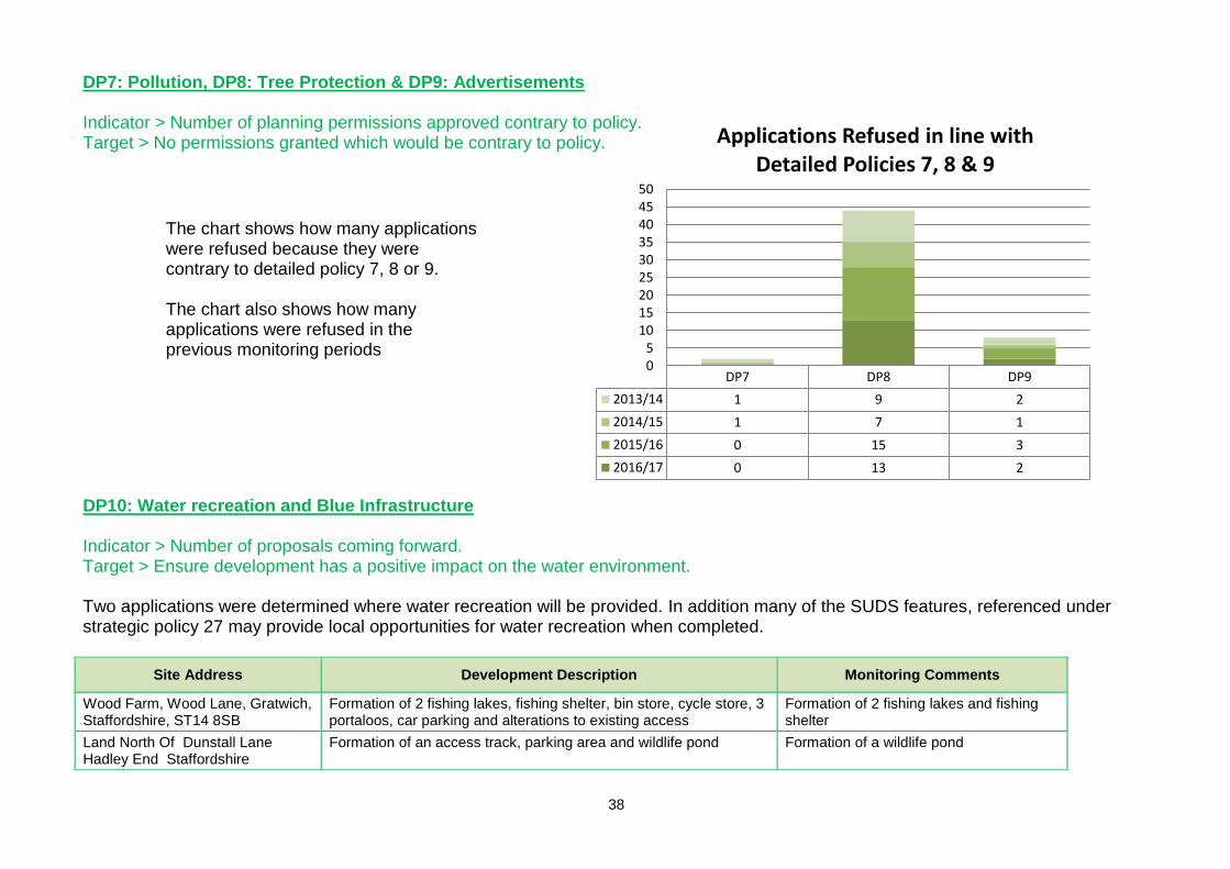
DP7 DP8 DP9
2013/14 1 9 2
2014/15 1 7 1
2015/16 0 15 3
2016/17 0 13 2
05
101520253035404550
Applications Refused in line withDetailed Policies 7, 8 & 9
The chart shows how many applications were refused because they were contrary to detailed policy 7, 8 or 9. The chart also shows how many applications were refused in the previous monitoring periods
39
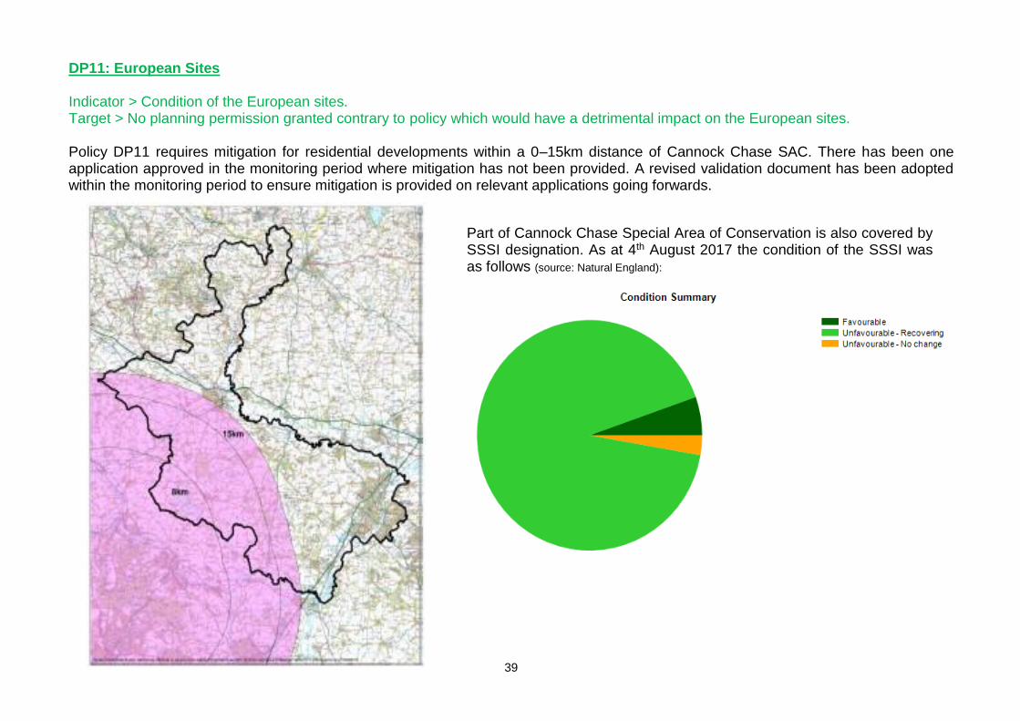
DP11: European Sites Indicator > Condition of the European sites. Target > No planning permission granted contrary to policy which would have a detrimental impact on the European sites. Policy DP11 requires mitigation for residential developments within a 0–15km distance of Cannock Chase SAC. There has been one application approved in the monitoring period where mitigation has not been provided. A revised validation document has been adopted within the monitoring period to ensure mitigation is provided on relevant applications going forwards.
Part of Cannock Chase Special Area of Conservation is also covered by SSSI designation. As at 4th August 2017 the condition of the SSSI was as follows (source: Natural England):

40
DP12: St Georges Park Indicator > Applications in relation to St Georges Park. Target > Number of applications in accordance with policy. There were two applications determined within the monitoring period at St Georges Park, all assisting with improving the existing facilities and the operation of the site. The council adopted a development brief for St Georges Park in September 2014. The document can be viewed via this link.
41
Appendix
Glossary
Adopted Local Plan: A local plan that has been through all of the stages of preparation, including Local Plan Examination, and has been formally adopted by the Local Planning Authority.
Development: Defined in section 55 of the Town and Country Planning Act 1990 as ‘The carrying out of a building, engineering, mining or other operations in, on, over or under land; or the making of any material change in the use of any building or land.’
Development Plan: A development plan sets out the policies and proposals for the development, conservation and use of land and buildings in a particular local planning authority area. The development plan is the most important consideration for local planning authorities when they decide on a planning application. The development plan generally includes Development Plan Documents (DPDs) that are part of a local planning authority’s Local Plan. This includes waste and minerals documents prepared by county councils. The Localism Act 2011 made two key changes to the development plan. Neighbourhood Plans that have been prepared covering any part of the local planning authority area will become part of the development plan when they have been adopted.
Evidence Base: The information gathered by a planning authority to support the preparation of development documents. It includes quantitative (numerical values) and qualitative (feelings and opinions) data.
Examination in Public: The method of considering public views on a draft Local Plan or proposed changes to it.
Government Planning Policy: National planning policies that local planning authorities should take into account when drawing up development plans and other documents and making decisions on planning applications. These policies are mostly included in the National Planning Policy Framework (NPPF), with some also included in Minerals Planning Policy Statements and Guidance notes.
Local Enterprise Partnership: A body, designated by the Secretary of State for Communities and Local Government, established for the purpose of creating or improving the conditions for economic growth in an area.
Local Plan: A portfolio or folder of documents setting out the planning strategy for a local planning authority area. Since the Planning and Compulsory Purchase Act 2004 and until recently, this type of plan was known as a Local Development Framework. The Government now uses the simpler description ‘Local Plan’. The Planning and Compulsory Purchase Act 2004 replaced old-style local plans, structure plans and unitary development plans. The key difference between the pre- and post-2004 systems is that new-style local plans are really a ‘folder’ of Development Plan Documents (DPDs) and Supplementary Planning Documents (SPDs), each addressing different issues. This is in contrast to the old-style plans
42
which consisted of one Development Plan Document, supported by supplementary guidance. The Local Plan identifies where future development should take place to meet local needs for homes, businesses, shops and other services, plus the infrastructure to support them. It also decides which areas should be protected from development because they are important to local people or have environmental or heritage qualities that should be conserved.
Local Strategic Partnership: Local Strategic Partnerships are bodies with representatives of the community, public, private sector and other agencies that work to encourage greater public participation in local governance by drawing together local community plans and producing an overall community strategy for each local authority area. Local Plans must have regard to, and should be the spatial expression of, the community strategy.
Localism Act 2011: A major piece of new legislation, which includes wide-ranging changes to local government, housing and planning. Significantly, the Act abolishes regional planning, and introduces the possibility of Neighbourhood Plans as part of the development plan.
Neighbourhood Plan: Neighbourhood Plans, or Neighbourhood Development Plans, were introduced by the Localism Act 2011. The term may also be used by some to refer to Neighbourhood Development Orders, which were also introduced by the Localism Act 2011 and are a second tool to enable neighbourhood planning. Communities will be able to prepare neighbourhood planning documents, outlining how they envisage their area developing in the future.
Planning permission: Needed before carrying out most types of development. To obtain planning permission it is necessary to make a planning application to the local planning authority.
Policies map: A map illustrating each of the detailed site specific policies and proposals in the written statement, defining sites for particular developments or land uses, or for protection. The Proposals Maps also includes more detailed Inset Maps.
Secretary of State: The secretary of state is the most senior Government minister responsible for the work of his or her department. The Government department responsible for planning is the Department for Communities and Local Government (DCLG).
Spatial Strategy: The spatial strategy identifies what and how much development is needed to meet local needs, and broadly where it should be concentrated.
Statutory Agencies: Government agencies that are established by statute, or law. There are four environmental statutory agencies: English Heritage, the Environment Agency and Natural England.
43
Supplementary Planning Documents (SPD): Non statutory supporting information and advice which amplifies the policies and proposals of the Local Plan. SPD’s will be taken into account as a material consideration in deciding planning applications or appeals if it is consistent with the Development Plan and has been subject to consultation.
Sustainability appraisal: A systematic review of the Borough Council’s Local Plan policies, in order to evaluate their impacts on achieving sustainable development. The appraisal is an integral part of the plan making and review process, which allows for the valuation of alternatives and is based on a quantifiable baseline of environmental, social and economic aspects of achieving sustainable development.
Sustainable development: The Bruntland Report provides the accepted definition of sustainable development as ‘Development that meets the needs of the present without compromising the ability of future generations to meet their own needs’ (WCED, 1987). The principle of sustainable development may be broadly described as encompassing social, environmental and economic issues, and also entailing concern with intra-generational and inter-generational themes.
44
Contact Details
For more information about the new system of plan making or about how to make a planning application, some useful contact details are listed below.
Planning Policy Team The Maltsters Wetmore Road Burton upon Trent DE14 1LS
Provide advice on general planning policy, the Local Plan and this Annual Monitoring Report.
Email: [email protected]
Authors of the Annual Monitoring Report Naomi Perry Principal Planning Policy Officer and Rebecca Slinn Planning Information Officer
Tel: 01283 508611 Email:[email protected] Tel: 01283 508616 Email:[email protected]
Alternative formats of this publication are available on request. Please contact us to discuss an appropriate
format.