Embed Size (px)
Citation preview
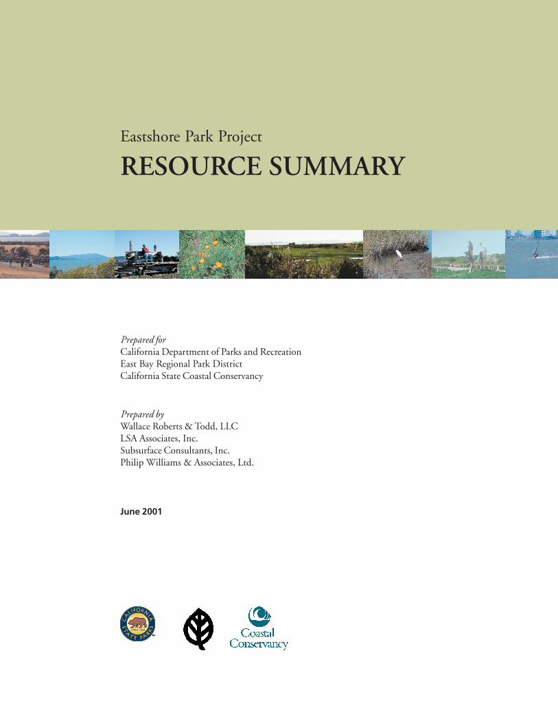
Prepared byWallace Roberts & Todd, LLCLSA Associates, Inc.Subsurface Consultants, Inc.Philip Williams & Associates, Ltd.
June 2001
Eastshore Park Project
RESOURCE SUMMARY
Prepared forCalifornia Department of Parks and RecreationEast Bay Regional Park DistrictCalifornia State Coastal Conservancy

RS-ii
RS-ii
EASTSHORE PARK PROJECTRESOURCE SUMMARYTABLE OF CONTENTS
PAGE
INTRODUCTION......................................................................................................................RS-1
HABITAT ISSUES
PLANT LIFE ...........................................................................................................................RS-13
ANIMAL LIFE ........................................................................................................................RS-15
MARINE LIFE ........................................................................................................................RS-17
RECREATION, SCENIC, AND CULTURAL RESOURCES
RECREATION ........................................................................................................................RS-20
SCENIC RESOURCES ...........................................................................................................RS-21
CULTURAL RESOURCES ....................................................................................................RS-22
ENVIRONMENTAL CONDITIONS
HYDROLOGY AND TOPOGRAPHY...................................................................................RS-23
CLIMATE/AIR QUALITY .....................................................................................................RS-27
GEOLOGY/SOILS ..................................................................................................................RS-28
NOISE......................................................................................................................................RS-29
HAZARDOUS MATERIALS .................................................................................................RS-30
LAND USE, TRAFFIC/CIRCULATION, AND UTILITIES
LAND USE ..............................................................................................................................RS-31
TRAFFIC/CIRCULATION .....................................................................................................RS-32
UTILITIES/PUBLIC SERVICES............................................................................................RS-32
RS-iv
FIGURES
FIGURE 1: Regional Location........................................................................................................6FIGURE 2: Project Site...................................................................................................................7FIGURE 3: Project Site (North)......................................................................................................8FIGURE 4: Project Site (Central) ...................................................................................................9FIGURE 5: Project Site (South)....................................................................................................10FIGURE 6: Project Site (Features)................................................................................................11
RS-1
INTRODUCTION
PURPOSE
The Eastshore Park Project, commonly referred to as Eastshore State Park, is a collaborative effortbetween the California Department of Parks and Recreation (DPR), the East Bay Regional ParkDistrict (EBRPD), and the Coastal Conservancy (Conservancy), to plan for a park of statewidesignificance along the shoreline of San Francisco Bay. At present the park shall be referred to asEastshore Park Project, until it is officially classified by the State Park and Recreation Commission,when it will officially become a unit within the State Park system.
The purpose of the Eastshore Park Project Site Resource Summary is to provide a concise butthorough summary of the unit’s natural, cultural, aesthetic and recreational resources. This summaryis based on the completed Draft Resource Inventory (April 2001), which can be viewed online1. Thesummary includes information on all resources but emphasizes the most significant resources. Itprovides the necessary resource information for the classification of the park and to establish a basisfor the decision process related to acquisition, facility development, recreation, interpretive, andresource management objectives of the park.
The attached Resource Summary follows the Guidelines for Resource Documents prepared by theCalifornia Department of Parks and Recreation, Resource Protection Division (September 1991).Information is organized by major subjects such as geology, climate and plant life within thefollowing major headings: Habitat Issues; Recreation, Scenic and Cultural Issues; EnvironmentalConditions; and Land Use, Circulation, Utilities.
This document does not include recommendations. Specific recommendations that might result froman analysis of the information included in the Resource Inventory and the Resource Summary will beincluded in the Resource Element to be prepared as the next step in this planning process.
BACKGROUND
Eastshore Project is a partnership of the California Department of Parks and Recreation (Department),East Bay Regional Park District (District) and California State Coastal Conservancy (Conservancy).Public Resource Code Section 5003.3 as summarized below, describes the extent of the shorelinepark, clarifies the participating agency roles and outlines the initial planning sequence in which aplanning document will be presented to the Department by the District:
.....The state park project shall consist of a contiguous shoreline park and bay trail along the eastshore of the San Francisco Bay from the Bay Bridge to the Marina Bay Trail in Richmond,serving as a recreational facility within its natural setting developed in concert with a publicplanning process agreeable to the state and the East Bay Regional Park District..... For thepurpose of the acquisition, planning, and development of the shoreline park, the district shall actas agent for the state and, as the state’s agent, shall have the authority to exercise all of thedistrict’s powers for the purposes of acquiring, planning, and developing the shorelinepark......The district, in consultation with the affected cities and their citizens, shall develop, inaccordance with its master plan process, a land use development plan for the shoreline park,which, upon completion, shall be submitted to the department for approval.........
1 Website address is http:\\www.eastshorestatepark.com
RS-2
PROJECT DESCRIPTION
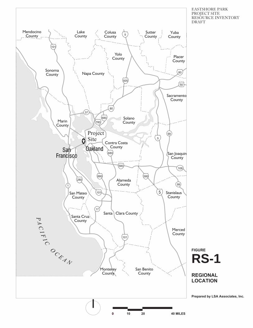
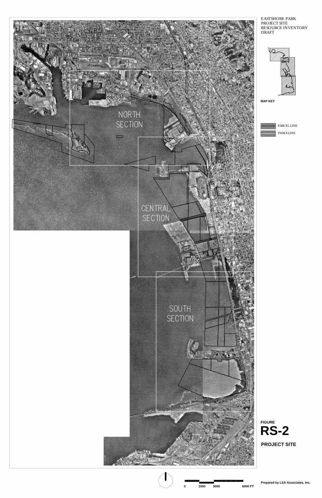
The Eastshore Park Project extends approximately eight and a half miles on the bay-shoreline alongthe eastern shoreline of Central San Francisco Bay (Figure RS-1), extending from the Bay Bridge tothe Shoreline Trail in Richmond. The project site could draw from a regional San Francisco BayArea population of 4.5 million, and a more local population of 2.4 million from Alameda and ContraCosta Counties. With 1800 acres, including 185 acres of upland, this stretch of San Francisco Bayrepresents a significant portion of the Emeryville, Berkeley and Albany waterfront. Portions ofOakland and Richmond are also included.
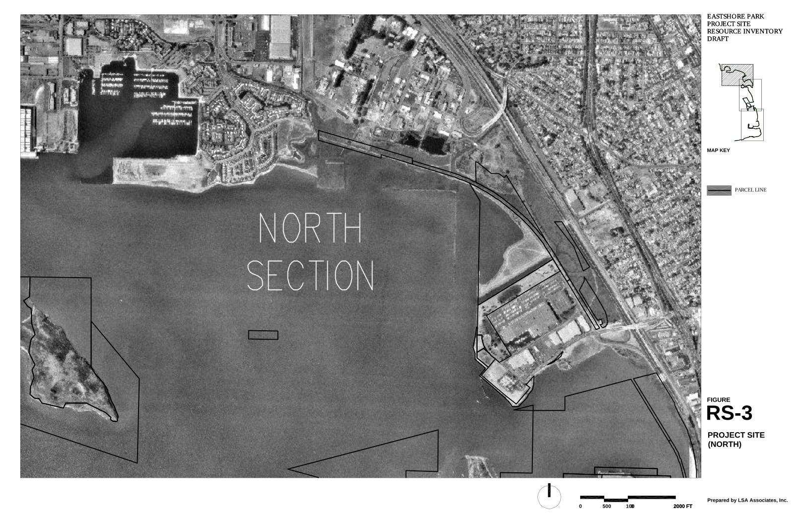
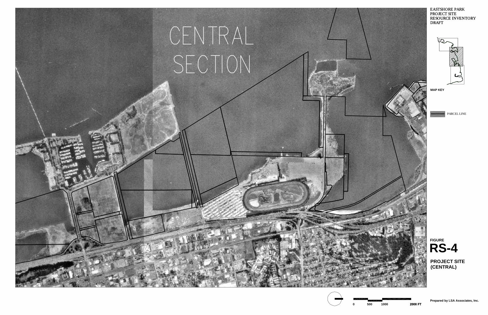
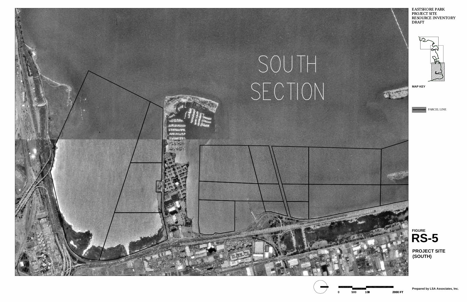
Figure RS-2 shows the different parcels purchased by the State, which comprise the Project Site,including a majority of Bay or submerged lands. Figures RS-3, RS-4, and RS-5 provide an enlargedaerial view of the North, Central and South segments of the project site. The study area addressed inthe Resource Inventory and Resource Summary includes the entire project site and some specificadjacent lands.
PROJECT SITE
Regional Setting
The San Francisco Bay region extends across a portion of the Coast Ranges in the central portion ofthe State and into the west edge of the Central Valley. The project site is located in Contra Costa andAlameda Counties along the shoreline from the southern portion of the City of Richmond to thenorthernmost portion of the City of Oakland. The San Francisco Bay borders the site on the west andgenerally Interstate Highways 80 and 580 border the site on the east. The project site is adjacent tocity-owned lands in five different municipalities: Richmond, Albany, Berkeley, Emeryville, andOakland.
Site Description
The upland portion of the project site is comprised of approximately 1,800 acres of land (somediscontinuous parcels) that are owned by the California Department of Parks and Recreation andmanaged by East Bay Regional Park District. The project site is comprised of open water, tidalmarshlands, and relatively flat lowland areas that form the San Francisco Bay depression (USGS1979). Approximately 185 acres of land is dry upland with the remainder being wetlands and subtidalareas. Most of the project site is underlain by artificial fill placed over decades of development. Ninelocal creeks drain into the project site: Baxter Creek, Central Creek, Cerrito Creek, Codornices Creek,Schoolhouse Creek, Strawberry Creek, Potter Creek, Derby Creek, and Temescal Creek.
The San Francisco Bay is the continuous linking element to the project site. The park includes avariety of environments and distinctive landmarks (see Figure RS-6). The environments within thepark include subtidal and intertidal flats, tidal marshes, mudflats, stream channel systems, and openwater.
Historic filling that occurred through the late 1970s changed historic shallow subtidal and intertidalflats and tidal marsh to the current shoreline, characterized by extensive reaches of engineered rockrevetment and non-engineered dumped construction debris. Much of the park shoreline is more than1,000 feet west of its historic location. Shoreline conditions comprise rock revetment, constructiondebris, gravel beach, sand beach, mudflats, and tidal marsh including the more prominent site featureslisted below as they occur from north to south.
RS-3
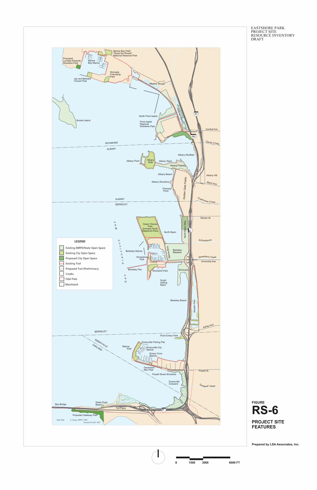
PARK PROJECT SITE FEATURES
Water, Underwater or Subtidal areas comprise ninety percent of the project site or 1,615 acres of thetotal 1,800 acre Eastshore Park Project.
Outer Hoffman Marsh, a southwest facing shoreline consists of gravel beaches in the southernsections and tidal marsh to the north behind the seawall. The Hoffman Marsh is a remnant of theformer marsh area where several creeks converged near San Pablo Avenue to the southwest of the ElCerrito Plaza Building along the Contra Costa and Alameda County border. Much of this area wasfilled at various times to create the current I-580 Freeway alignment and existing Point Isabel fill.Eastshore Park project includes two discontinuous parcels within Hoffman Marsh (see Figure RS-6.)
North Point Isabel, formerly called Battery Point, is located adjacent to Point Isabel and separated bya channel
Albany Mudflats consists of broad mudflats, a tidal marsh and the outfall for Cerrito and CodornicesCreeks to the north and east of the Albany Plateau. Portions of this area were restored by Caltrans aspart of the mitigation required for the I-80 Improvements.
Albany Bulb is a large and isolated landfill area with edges steeply sloped from the Bay to uplandareas. The shoreline is armored with concrete debris around the entire perimeter of the landfill.
Albany Plateau is located to the north of Golden Gate Fields near the Buchanan Street Interchange atInterstate 80 (I-80). The plateau is part of a peninsula fill that extends westward out to the AlbanyBulb. The Albany Neck connects the plateau with the Golden Gate Fields parking lot. The AlbanyBeach is located at the southwest portion of the Albany Plateau.
North Basin Strip shoreline is defined by a steep, gravel beach, semi-protected from the Bay withSchoolhouse Creek outfalling through a large culvert at the southern end. The North Basin Strip is arectangular shaped area bound by Gilman Street to the north, Virginia Street to the south, WestFrontage Road and I-80 to the east, and the San Francisco Bay to the west. The site is relatively leveland was created by filling open water and tidal marsh areas. A narrow shoreline strip extends north toGilman Street.
Berkeley Meadow is a trapezoidal shaped area bound by the North Basin waterfront and North BasinStrip to the north, University Avenue to the south, West Frontage Road to the east, and MarinaBoulevard/Berkeley Marina to the west. The Meadow is a relatively level site created by placing fillover mud flats and open water and has north and south shorelines with rock revetment and concretedebris, protected to the north by Cesar Chavez Park and exposed to the Bay to the south adjacent toUniversity Avenue.
Brickyard is a large irregular shaped peninsula area of bay fill extending south into the Bay, with anouter west face armored with concrete debris and an eastern edge consisting almost entirely of bricksthat protects a large mudflat and sand beach. The Brickyard area is located to the south of UniversityAvenue and west of I-80 and West Frontage Road. The San Francisco Bay and tidal mud flats lieadjacent to its other boundaries.
Berkeley Beach is straight and narrow, armored with rock revetment and faces the Bay across fromthe Golden Gate. At lower tides a long strand beach is exposed and is a popular recreation area.
RS-4
Emeryville Frontage along the Frontage Road and Bay trail is constructed rock revetment and semi-protected from the Bay.
Powell Street Shoreline is southfacing and armored with rock revetment
Emeryville Crescent is a distinctive, highly visible, tidal marsh, with extensive mudflats and theoutfall for Temescal Creek. Tidal marsh and mudflats continue around to the south toward the BayBridge Toll Plaza and Radio Beach. The Emeryville Crescent is a horseshoe shaped area along the I-80 corridor stretching from the Bay Bridge Toll Plaza at its southwest extent to the Powell StreetInterchange and Emeryville Peninsula at its northernmost extent. This area was restored by Caltransas part of the mitigation required for the I-80 Improvements.
Freshwater creeks flow from the coastal hills of Richmond, El Cerrito, Albany, Berkeley, Emeryvilleand Oakland and enter the Bay through the Project Site, linking the East Bay Hills to the flatlands andthe Bay. Most of these nine creeks have been piped and culverted underground with local storm drainnetworks. A description of each of these creeks can be found in the Eastshore Park Project SiteResource Inventory.
ADJACENT LANDS INCLUDED IN STUDY AREA
The areas described in this section are not currently part of the park project site, but are linkedthrough proximity or related physical processes and may play an important role in the ultimatestructure or management of the park project. These areas were included in the Resource Inventory.
Point Emery is a peninsula constructed of bay fill, highly exposed to wave action on the north andwest edges, and protected with rock revetment and concrete debris.
Fleming Point is defined by an outcropping of bedrock, west facing and exposed to the Bay withsmall tide pools and two sand beaches to the north. The Fleming Point area is located to the west andsouthwest of the Grandstand area at Golden Gate Fields.
ADJACENT LANDS NOT INCLUDED IN THE STUDY AREA
Several other adjacent areas are not part of the park project site. These areas were not formallysurveyed in the Resource Inventory, but they were described briefly because of their importance tothe Eastshore Park Project:
Brooks Island is a natural, exposed bedrock outcropping just off the Richmond shoreline and is animportant resource to birds and other wildlife. Brooks Island Regional Preserve is located one halfmile from the Richmond shore, consisting of 77 acres, including 45 acres upland. The shorelineincludes small areas of tide pools, gravel and sand beaches.
Point Isabel is a large developed landfill site including a variety of shoreline conditions such asconcrete debris on the west face of the point, coarse gravel beaches and a channel linking HoffmanMarsh with the bay. Point Isabel, in part, was constructed from crushed battery casings sometime inthe 1960s and later capped.
Berkeley Aquatic Park, made up of three different lagoons is the Bay’s historic eastshore, located tothe east of Interstate 80. The west edge of the lagoons and the freeway are built on landfill in areasthat were open water. Preliminary studies and plans for Aquatic Park, including the City of
RS-5
Berkeley’s Natural Resources Management Plan for Aquatic Park are in progress and providevaluable information.
Cesar Chavez Park and The Nature Center is a large open park in the City of Berkeley, built on topof landfill with the eastshore defined by concrete debris with rock revetment along the exposedshoreline to the west. Cesar Chavez Park provides many recreational resources and is host to severallarge events and festivals.
Golden Gate Fields is located to the south of the Albany Plateau and includes the grandstand,racetrack, stables and parking lot areas. The site is relatively level except near Fleming Point, wherethere is an elevation change of about 60 feet due to outcropping bedrock. The Buchanan StreetExtension bounds the site to the north, the North Basin Strip to the south, I-80 to the east, and the SanFrancisco Bay to the west.
Interstate 80, (I-80), runs in an east-west direction from the Bay Bridge to the MacArthur Maze,where it merges with I-880 and I-580, and heads north along the eastern shore of the San FranciscoBay. The I-80 Freeway was originally filled from 1929 to 1937 for the old Route 69 highway, whichlater became I-80, between the northern extent of the Powell Street Interchange and UniversityAvenue. During this time, a portion of the bay was closed in creating Aquatic Park, situated to theeast of the freeway between Ashby and University Avenues. The widening of the freeway created thebulge at the Ashby Avenue Interchange (Ashby “Bump”) and added the Frontage Road along thewest side of I-80. The entire stretch of freeway is built upon land reclaimed by filling mud flat areasand open water between the early 1900s up to about the mid 1970s.
Marinas. The city-owned Emeryville City Marina and the privately owned Emery Cove Marina arelocated adjacent to each other on the north side of the Emeryville Peninsula. The Berkeley Marinaoccupying about 60 acres of upland area and 40 acres of water, is one of the largest marinas in theEast Bay, with recreational facilities including: the 3,000-foot Berkeley Pier; the Nature Center, aneducation and interpretive center; and the Bay Trail. On the Richmond waterfront, the Marina BayEsplanade and the Point Isabel-to-Marina Bay Trail link the Marina Bay Marina and Boat Launchsouth to other areas of the Eastshore Park Project.
The Bay Trail is well supported by all cities, park agencies (DP&R and EBRPD), bay agencies(ABAG and BCDC), and transportation agencies (Caltrans and MTC). The Bay Trail represents avery important element in linking the non-contiguous parts of the Project Site. Currently, the BayTrail is not continuous through the planning area (having breaks in Berkeley and Oakland, and atemporary alignment through Albany).
Radio Point Beach, a small park owned and operated by the Port of Oakland, is located on the northside of the Bay Bridge just west of the Toll Plaza. The westward facing beach sits adjacent to radiotransmission uses including transmission towers, support buildings, and a parking area. Access isprovided via a small paved road that exits I-80 near the West Grand off-ramp.
UC Berkeley Richmond Field Station, a cluster of research uses operated by the University ofCalifornia, is located between the Hoffman Marsh and Marina Bay, and abuts Meeker Creek Sloughat the north end. Formerly consisting of more industrial and manufacturing uses, the area appears tobe transitioning toward cleaner, higher tech uses.
Contra CostaCounty
SanFrancisco
SanFrancisco
17
99
108
99
MarinCounty
MendocinoCounty
LakeCounty
ColusaCounty
SutterCounty
YubaCounty
YoloCounty
SonomaCounty Napa County
Placer County
SacramentoCounty
SolanoCounty
San JoaquinCounty
Alameda County
Stanislaus County
Santa Clara County
San MateoCounty
Santa CruzCounty
Merced County
MontereyCounty
San Benito County
1
OaklandOakland
37
101
5
505
80
50
780
680
80
680
580
880280
101
5
5
580
101
Project Siter
PA
CI
FI
C O
CE A N
Prepared by LSA Associates, Inc.
FIGURE
RS-1
20100 40 MILES0
EASTSHORE PARKPROJECT SITERESOURCE INVENTORYDRAFT
REGIONAL LOCATION
PARCEL LINE
INDEX LINE
PROJECT SITE
FIGURE
RS-2
EASTSHORE PARK PROJECT SITE RESOURCE INVENTORY DRAFT
Prepared by LSA Associates, Inc.
MAP KEY
6000 FT0 1500 3000
PARCEL LINE
(NORTH)PROJECT SITE
EASTSHORE PARK PROJECT SITE RESOURCE INVENTORY DRAFT
FIGURE
RS-3
EASTSHORE PARK PROJECT SITE RESOURCE INVENTORY DRAFT
2000 FT10005000 2000 FTPrepared by LSA Associates, Inc.
MAP KEY
PARCEL LINE
(CENTRAL)PROJECT SITE
EASTSHORE PARK PROJECT SITE RESOURCE INVENTORY DRAFT
FIGURE
RS-4
EASTSHORE PARK PROJECT SITE RESOURCE INVENTORY DRAFT
2000 FT10005000 2000 FTPrepared by LSA Associates, Inc.
MAP KEY
PARCEL LINE
(SOUTH)PROJECT SITE
EASTSHORE PARK PROJECT SITE RESOURCE INVENTORY DRAFT
FIGURE
RS-5
EASTSHORE PARK PROJECT SITE RESOURCE INVENTORY DRAFT
2000 FT10005000 2000 FTPrepared by LSA Associates, Inc.
MAP KEY
Prepared by LSA Associates, Inc.
FIGURE
RS-6
300015000 6000 FT0
PROJECT SITEFEATURES
EASTSHORE PARKPROJECT SITERESOURCE INVENTORYDRAFT
N
Tidal Flats
Marshland
LEGEND
Existing EBRPD/State Open Space
Existing City Open Space
Proposed City Open Space
Existing Trail
Proposed Trail (Preliminary)
Creeks
Gol
den
Gat
e F
ield
s
Base Map: R. Keagy EBRPD 1996Revised 03 2001 WRT
80
580
80
80
Bay Bridge
Emeryville CityMarina
Powell St.
Ashby Ave.
Aqu
atic
Par
k
Berkeley Pier
Berkeley Marina
SouthSailingBasin
Brickyard
BerkeleyMeadow
North Basin
Cesar ChavezPark
(formerly NorthWaterfront Park)
Gilman St.
Albany Hill
Albany Point
Central Ave.
Point Emery Park
OAKLAND
EMERYVILLE
BERKELEY
ALBANY
RICHMOND
BERKELEY
ALBANY
Shorebird Park
Horseshoe Park
Marina Park
Fleming Point
AlbanyBulb Albany Neck
Albany Mudflats
Point IsabelRegionalShoreline Park
Hoffm
an MarshBrooks Island
Cerrito Creek
Codornices Creek
Temescal Creek
Strawberry Creek
Schoolhouse
University Ave.
Berkeley Beach
Marin Ave.
EmeryvilleCrescent
Radio PointBeach
Toll Plaza
DavenportMini Park
Mar
ina
Blv
d.
Sa
nF
ra
nc
is
co
Ba
y
Nor
th B
asin
Str
ip
MarinaBay Marina
ShimadaFriendshipPark
Marina Bay Park/�Rosie the Riveter�National Historical Park
Albany Plateau
Albany Beach
Emery CoveMarina
North Point Isabel
Jay and BarbaraVincent Park
Meeker Slough
Emeryville Fishing Pier
Proposed Gateway Park
ProposedLucretia EdwardsShoreline Park
Albany Shoreline
Powell Street Shoreline
RS-12
HABITAT ISSUES
PLANT LIFE
The Plant Life section of the Resource Inventory focuses on the uplands and marshes of the EastshorePark study area, while the Marine Life and Ecology section describes the plants of other marinehabitats. Historically, extensive salt marshes surrounded San Francisco Bay. Between 75% and 90%of these salt marshes are estimated to have been filled or diked since 1850 (Association of Bay AreaGovernments 1991). The majority of The uplands and marshes of the study area are mostly locatedon manmade fill material that has extended the shoreline an average of 1,000 feet into San FranciscoBay. Due to the recent creation of the substrate, little is left of the historic, natural plant communities.Even with these changes, some marsh communities have survived within the Eastshore Park studyarea, and combined with the newly vegetated fill areas, form valuable shoreline habitats.
Upland and marsh vegetation of the study area is classified into ten plant communities. Speciescomposition within these plant communities reflects climatic and physical conditions of the projectregion, as well as historical and current human-caused disturbances. The primary plant communitiesare summarized below.
Coastal Salt Marsh is restricted to the upper intertidal zone of protected shallow bays, lagoons, andestuaries. The salt marsh plant community is composed of low-growing plants, ranging in heightfrom a few inches to about three feet. Typically, mudflats are bordered by pure stands of cordgrassthat are replaced at the mean high water level by a dense cover of pickleweed. Characteristic speciesof the upper marsh zone include saltgrass, alkali heath, marsh gumplant, sand-spurrey and other salt-tolerant native and non-native plants. Lower zones of San Francisco Bay salt marshes supportmostly native species, but an invasive species, , saltwater cordgrass has invaded the Eastshore Parkstudy area and many other portions of San Francisco Bay in the last decade.
Coastal salt marsh vegetation is present along the shoreline of the study area. Extensive salt marshvegetation occurs at the Emeryville Crescent marsh, Hoffman Marsh, and the south Richmondmarshes. Smaller salt marshes have formed along the eastern shore of the Albany Bulb, and the entireshoreline of the Albany Mudflat, and at the mouth of Codornices Creek. Historically, salt marshesgraded into brackish/freshwater marsh and then into grassland or scrub communities. The majority ofthe salt marshes within the study area end abruptly at riprapped shorelines, dikes or berms.
Brackish marsh occurs in shallow, standing or slow-moving water, where fresh water enters an areathat is influenced by saline tidal waters. Brackish marsh has formed in a roadside ditch or basinbetween the eastern portion of the Brickyard and the frontage road to the east. A small brackish marshwas also observed at the northwestern corner of the Albany Bulb and brackish marsh was reported tooccur at the Liquid Gold site near Hoffman Marsh.
Northern foredunes are typically dominated by perennial grasses and low, often succulent, perennialherbs and subshrubs. These plants, which provide a scattered to nearly complete vegetative cover, areadapted to moving sands and salt-laden winds. Typical northern foredunes vegetation with itscharacteristic native plant associations is absent from the study area. However two stretches of beachwith some dune formation (Albany Beach and north of Pt. Emery) support two foredune indicatorspecies: a relatively dense cover of bursage interspersed with sea-rocket, a non-native species.Invasive, non-native species such as ripgut brome, iceplant, Kikuyu grass, and a European daisy arepresent on, or are starting to invade the dunes.
RS-13
Sandy beaches with some dune formation are located at Albany Beach and north of Point Emery.Other sandy areas are present in the study area, but these areas abut riprap along roads, trails, andparking lots, and support little or no dune/beach vegetation. Such sandy beaches are present along theEmeryville and Berkeley shorelines, at the outfalls of Strawberry Creek and Schoolhouse Creek,north of Fleming Point, and other locations. A large sandy beach is present at the south shore of theBrickyard. Both upland and wetland vegetation is present on the beach. Sandy beaches in and near thestudy area are critical for the recovery of California seablite, a federally endangered species.
Ruderal Scrub, is a plant community growing in disturbed areas and consists mostly of non-nativeshrubs, broadleaved species, and grasses. Coyote-brush is the dominant shrub that occupies largeportions of the study area, including the Berkeley Meadow, Albany Bulb, Point Isabel, , and uplandareas adjacent to Hoffman Marsh and the south Richmond marshes. Coyote-brush forms an absolutecover ranging from 25% to 75%. French broom, cotoneaster, and other non-native shrubs provide anextensive cover (up to 25%) in some areas.
The Ruderal/Non-native Grassland community is typically composed of a dense cover of annualgrasses and broad-leaved plants adapted to colonizing and persisting in disturbed areas. Thevegetation is approximately three feet tall. This community is dominated by non-native species, butnative grasses and wildflowers are commonly present in varying densities.
As most uplands in the study area are on fill material, it is highly unlikely that native plant speciesdiversity was ever high, except at Fleming Point and Point Isabel (which are remnants of the historicshoreline). Open fields, road- and trail-banks, and other disturbed areas support a dense cover ofweedy, non-native grasses, forbs, shrubs, and trees. Because of the relatively recent fill and becausethese areas have been subjected to repeated disturbance of various kinds, upland communities areweedy in nature.
Non-tidal Wetland vegetation occurs in areas where soils remain ponded and/or saturated for aprolonged period of time during the winter season. Two types of non-tidal wetlands were located inthe study area: seasonal wetlands and seeps. Seasonal wetlands are present in several areas in theBerkeley Meadow, the North Basin Strip, the Brickyard, and the Albany Landfill. Species known tooccur in the Berkeley Meadow include rabbit’s-foot grass, Italian wildrye, Mediterranean barley,nutsedge, fathen, cut-leaf plantain, and bristly oxtongue. Most of these plants are non-native speciesthat have invaded wetlands in disturbed areas in California.
The most important botanical resources of the Eastshore Park study area are:
Χ The large coastal salt marshes at Emeryville Crescent, South Richmond Marshes, and HoffmanMarsh, and a smaller salt marsh fringing the Albany Mudflat. These marshes are relativelynatural plant communities and potentially support two rare or endangered plant species, the softbird’s-beak and Point Reyes bird’s-beak.
Χ The small area of northern coastal scrub at Fleming Point. This is the only relatively naturalupland plant community present in the study area, and Fleming Point is the only remainingportion of the historic shoreline (except for the heavily disturbed Point Isabel).
$ Sandy beaches in and near the study area. These beaches are critical for the recovery ofCalifornia seablite, an endangered species that has been extirpated from San Francisco Bay as aresult of development and other disturbances. The U.S. Fish and Wildlife Service has identifiedthe Eastshore Park shoreline as one of only three locations in San Francisco Bay with beachesthat are suitable habitat for restoring California seablite.
RS-14
ANIMAL LIFE
The Animal Life section focuses on the terrestrial, freshwater, and salt marsh habitats along theEastshore Park shoreline, while the Marine Life and Ecology section describes the wildlife use of thetidal flats and open waters of the Bay.The major terrestrial habitat types within the Eastshore Parkstudy area are coastal salt and brackish marshes, sandy beaches and foredunes, ruderal/non-nativegrassland vegetation, ruderal scrub, trees, non-tidal wetlands, and manmade habitat features. Thewetland habitats include large areas of coastal salt marsh (tidal marsh), scattered seasonal wetlands, afew small seeps, and two small brackish marshes. No creeks are present in the study area, except fortheir outfalls; nor are there any lakes or permanent ponds.
Coastal salt and brackish marshes, commonly referred to as tidal marshes, provide habitat forinvertebrates, birds, small mammals, and fish. Tidal salt and brackish marshes provide refuge,forage, and breeding habitat for many different organisms, including a number of threatened andendangered species. Birds are the most conspicuous members and include wading birds such as greatblue heron, great egret, and snowy egret; shorebirds such as willet, marbled godwit, and Americanavocet; and other water birds such as American wigeon, mallard, American coot, and pied-billedgrebe. Tidal marshes, particularly the South Richmond Marshes, Hoffman Marsh, and EmeryvilleCrescent, provide habitat for many different organisms, including special-status species such asCalifornia clapper rail, Alameda song sparrow, and saltmarsh common yellowthroat.
Sandy beaches are extensions of the marine environment but are not inhabited exclusively by marinespecies. Various terrestrial insects, especially flies, bees, butterflies, and beetles are often present inthese habitats. Reptiles such as garter snakes and western fence lizard, and mammals includingseveral species of mice, black-tailed hare, and raccoon may also be present. Numerous birds such aswater pipit, sparrows, gulls, and shorebirds often forage, rest, and preen in these habitats. The sandybeach and foredunes, especially at Albany Beach, Brickyard, and just north of Fleming Point andPoint Emery, are rare habitat types in the Bay and, if undisturbed, provide roosting areas thatshorebirds require during high tide periods.
Ruderal/non-native grassland vegetation provides refuge and foraging habitat for many animalspecies, although fewer species use the habitat for breeding or nesting. Amphibian and reptilespecies may include Pacific treefrog, western fence lizard, western terrestrial garter snake, and gophersnake. Birds, foraging primarily on seeds, include white-crowned sparrow, song sparrow, Californiatowhee, and mourning dove. Savannah sparrow and western meadowlark may also nest within thishabitat. The vegetation provides good foraging habitat for predatory birds, such as American kestrel,red-tailed hawk, northern harrier, white-tailed kite, and burrowing owl. Numerous mammals inhabitthis area including meadow voles, house mice, California ground squirrel, and Botta’s pocket gopher.
Trees, scattered throughout the study area, provide important perch sites for raptors such as red-tailedhawk, white-tailed kite, and Cooper’s hawk, and habitat for a variety of other birds such as songbirdsand northern flicker. Trees, particularly the native willows, are important habitat features thatenhance the wildlife values of other habitat types. In some cases, trees are not considered a desirablehabitat feature; for instance, trees adjacent to tidal salt marsh provide perch sites for raptors that mayprey on endangered species such as clapper rails and black rails.
Ruderal scrub typically supports a higher diversity of animal species than ruderal grassland becausethe shrubs increase protective cover and provide potential nest sites for birds, such as northernmockingbird, Brewer’s blackbird, red-winged blackbird, Anna’s hummingbird, American goldfinch,and lesser goldfinch. Loggerhead shrike, northern harrier, and even white-tailed kite may nest in
RS-15
ruderal scrub habitat. Birds of prey are most likely to nest at Berkeley Meadow and the Albany Bulband Neck, where large patches of relatively undisturbed, ruderal scrub habitat are still intact.Additional areas of ruderal scrub occur adjacent to the South Richmond Marshes and HoffmanMarsh, and at the Albany Plateau, North Basin Strip, and the Brickyard.
Non-tidal wetlands in the study area consist of numerous seasonal wetlands and several seeps.Seasonal wetlands provide drinking water to birds, raccoons, and other mammals, and foraginghabitat for great blue herons and great egrets. Depending on the location and amount of disturbance,mallards and other water birds may rest, forage, and possibly even nest near the seasonal wetlands.Pacific treefrog and western toad probably breed in some of the seasonal wetlands, particularly thosethat pond water for longer periods of time, such as at the Albany Plateau and Berkeley Meadow. Theabundance of smaller or juvenile amphibians and the moist conditions of seasonal wetlands providesuitable habitat for garter snakes. Suitable habitat for similar wildlife may also be present at theisolated seeps, depending on their salinity.
Manmade features such as breakwaters, abandoned piers, constructed islands, and remote leveesprovide important wildlife habitat values along the highly modified, urbanized shoreline of the studyarea. Water birds use these features as perch sites that are relatively free from disturbance by people,dogs, and other predators. Shorebirds, in particular, require undisturbed roost sites at high tide, whentheir foraging areas are inundated. California sea lions have also been observed in the offshoreportions of the study area and may occasionally haul out on the breakwaters near the northern end ofthe site. The two islands at the Albany Mudflat, constructed by Caltrans as mitigation for the I-80/I-580 interchange project, were designed as shorebird roost sites and are also used as nest sites forCalifornia least terns, American avocets, black-necked stilts, and killdeer. The riprapped shorelinesserve as foraging habitat for several shorebird species, including black turnstone, ruddy turnstone,spotted sandpiper, black oystercatcher, and surfbird.
Sixteen species of rare, threatened, or endangered wildlife have been observed, or could occur, in thestudy area. Seven key resource species deserve special attention. In 2000, the endangered Californialeast tern nested on the manmade islands in the Albany Mudflat, a significant event, as least terns nestin only a few locations in northern California. Three threatened or endangered species, the Californiaclapper rail, California black rail, and salt marsh harvest mouse, are found primarily in tidal marshes.Both the clapper rail and the black rail have been observed at Emeryville Crescent; the clapper railprobably nests in the South Richmond marshes; and the salt marsh harvest mouse is potentiallypresent in the Eastshore Park area. Other key resource species, the burrowing owl, white-tailed kite,and northern harrier, have been observed repeatedly in ruderal scrub and grasslands of the study area.
The Eastshore Park study area supports an abundance and diversity of wildlife species in proximity toan urban setting. The most important wildlife habitats (other than marine habitats) are:
Χ Large Tidal marshes at the Emeryville Crescent, South Richmond Marshes, and Hoffman Marsh,which provide habitat for a diversity of animal life including, three threatened or endangeredspecies and many water birds.
Χ Upland and seasonal wetland habitats at Berkeley Meadow, Albany Bulb and Neck, the northslope of the Albany Plateau, North Basin Strip, and the Brickyard. Due to their large size, lowlevel disturbance, and proximity to the Bay, these areas support a high diversity of wildlife andare often used by burrowing owls and wide-ranging predators such as white-tailed kites andnorthern harriers; and harriers nested at Berkeley Meadow in 2001.
Χ Manmade islands at the Albany Mudflat, which provide nesting habitat for the endangeredCalifornia least tern and other water birds, as well as roosting habitat for shorebirds.
RS-16
Χ Other manmade habitat features such as breakwaters, abandoned piers, and remote levees thatserve as relatively undisturbed roost-sites for shorebirds and other water birds.
Χ Small clumps of trees, particularly native willows, that are scattered throughout the study areaand provide important perch-sites for birds of prey and songbirds.
MARINE LIFE AND ECOLOGY
The Marine Life and Ecology section describes the marine environment and associated plant andanimal species of the Eastshore Park study area. Seven different marine habitats have been identifiedin the study area: rocky intertidal, tidal flats, tidal salt marsh, sandy beach, shallow subtidal, piers andbreakwaters, and eelgrass beds. A large proportion of the study area is comprised of shallow subtidal(open water) and tidal flats (including mudflats and sand flats).
The Rocky intertidal zone is comprised mostly of riprap and occurs along a large portion of theshoreline. In some locations, such as just south of Pt. Isabel, and along the east side of the NorthBasin, the rocky intertidal zone is strewn with fill debris. The predominant plant species within therocky intertidal habitat are seaweeds or macro-algae, such as green algae and red algae. The riprap,pebbles, cobbles, and miscellaneous debris also provide substrate and refuges for invertebrate species.Mussels and barnacles were observed throughout the rocky zone along with beach hoppers andshorecrabs. At low tide, birds prey on rocky intertidal invertebrates while nearshore fish prey onthese species at high tide. American crow, western gull, black oystercatchers, ruddy turnstones, andblack turnstones were observed in the study area foraging among the cobbles and pebbles, feeding onmussels and crabs.
Fleming Point is the only naturally occurring bit of rocky shoreline in the study area, and it supportsa diversity of rocky intertidal organisms that is among the highest in the region. Red algae andmarine invertebrates such as littorine, snails, bryozoans, polychaete worms, encrusting sponges, andsplash zone isopods that are present at Fleming Point were not observed at any other location withinthe study area.
Tidal flats lie between the vegetated tidal marshes (or rocky intertidal) and the permanentlysubmerged subtidal habitat further offshore. Vegetation is usually limited to seasonal blooms ofmicroscopic algae such as diatoms, golden browns, and blue-greens, and scattered patches of greenmacro-algae. Invertebrates are abundant and include annelid worms, bivalves, tube-dwellingcrustaceans, shrimp, crabs, and gastropods.
Tidal flats are a prominent habitat type at low tide and are well-developed at Albany Mudflat,Emeryville Crescent, and along the South Richmond Marshes. Less extensive, yet still importanttidal flats also occur in the smaller, protected embayments at the Brickyard and in the North Basin.Collectively, the tidal flats of the study area are valuable, productive areas that support an abundanceand diversity of organisms.
At low tides,. large concentrations of shorebirds forage on tidal flats during July through early May,and especially during fall and spring migrations. Thousands of western and least sandpipers, dunlins,marbled godwits, willets, curlews, plovers, avocets, and dowitchers forage in the mud for worms,small crustaceans and bivalves. Peregrine falcons (a state endangered species) may occur in the tidalflat areas. Various species of gulls also gather on tidal flats, and wading birds such as snowy egretsand great blue herons search for small fish that occur at the water’s edge. During high tides, when themuddy substrate is submerged, birds such as grebes, loons, cormorants, and terns (including
RS-17
California least tern, a state and federal endangered species) feed on nearshore fish. Diving ducks(goldeneye, bufflehead, scaup, ruddy duck, redhead, and canvasback) and dabbling ducks (mallard,American wigeon, and gadwall) rest or feed on the vegetation and small invertebrates of the tidalflats.
Tidal salt marshes, particularly the South Richmond Marshes, Hoffman Marsh, and EmeryvilleCrescent, are ecologically very important areas because they contribute to the nearshore and coastalecosystems, and provide habitat for many organisms, including many of the aforementionedshorebirds. More details are provided in the Animal Life and Plant Life sections.
Sandy beach is an intertidal habitat that merges at the upper limit with northern foredunes or rocky,riprap habitat and at the lower limit with shallow subtidal habitat. Invertebrate organisms burrowdeeply into the sediment to avoid displacement by passing waves, permanent burial by movingsediment, desiccation, or predation. Crustaceans, especially sand crabs, beach hoppers, sow bugs,polychaete worms, and bivalve mollusks are present. At low tide, foraging shorebirds, such assanderlings, black-bellied plovers, and willets, prey on intertidal invertebrates. At high tide, nearshorefish prey on intertidal species. The sandy beaches within the Eastshore Park, especially at AlbanyBeach, Brickyard, just north of Fleming Point, and at Point Emery, are important habitats because oftheir limited distribution within the East Bay and potential use by roosting shorebirds.
The shallow subtidal zone is seaward of the intertidal zone and is continually submerged. Althoughthe subtidal plant community is limited, this habitat harbors a diversity of animal species.Crustaceans, tube-dwelling polychaetes, clams, and gastropods have been collected during benthicsampling. Fish species such as American shad, bat ray, brown rockfish, chinook salmon, leopardshark, striped bass, white croaker, smelt, northern anchovy, shiner perch, starry flounder, andspeckled sanddab are present. Subtidal habitats provide foraging and/or resting areas for many birds,including loons, grebes, cormorants, terns, gulls, California brown pelican, scoter, red-breastedmerganser, and other diving ducks. Marine mammals, primarily harbor seal and California sea lion,also occur in the shallow subtidal habitat.
Piers, pilings, and breakwaters provide substrate for many species of algae and invertebrates. Fish,especially perch, are also members of the “piling community.” Old piers, remnant dock structures,and breakwaters are important roost sites for shorebirds, gulls, and other water birds. Californiabrown pelicans and California sea lions may also occasionally use these offshore structures.The oldpilings north of the Albany Neck provide perch sites, often being used by terns and double-crestedcormorants.
A few “beds” of eelgrass - a rooted, flowering plant - occur in the shallow subtidal and lowerintertidal zones of the study area. Eelgrass beds are an important habitat type for a variety ofinvertebrates and fish.
Six special-status marine species have been observed, or could occur, in the study area (in addition tothe species discussed in the Animal Life and Plant Life sections). The chinook salmon and steelheadare anadromous fish species that may transit through the study area during their seasonal migrations.The tidewater goby, an endangered fish species, could be present, but is thought to be extirpated inSan Francisco Bay. The harbor seal and California sea lion have been observed in the study area, anda southern sea otter was observed in January, 2002 near the western tip of the Albany Bulb.
The most important marine resources in the Eastshore Park study area are:
RS-18
Χ The special-status species, including three marine mammals, possibly the chinook salmon, andpotentially the steelhead, which may transit through the marine environment on its way to andfrom the creek mouths in the study area.
Χ The great abundance and diversity of shorebirds, particularly at the Albany Mudflat and theEmeryville Crescent mudflat. These two sites provide foraging habitat for about 60% of theshorebirds in North San Francisco Bay, between the Bay Bridge and the Richmond-San RafaelBridge. Other important mudflats for shorebirds are located northeast of Battery Point and at thesouth side of the Brickyard.
Χ Undisturbed roost-sites for shorebirds at high tides. In this highly urbanized shoreline, suitableundisturbed roost sites appear to be in short supply, and shorebirds often roost on manmadestructures such as abandoned piers, remote levees, breakwaters, and manmade islands.
Χ The large flocks of diving ducks, including three species B canvasback, redhead, and commongoldeneye B that are more common in this area than in most other parts of the Bay.
Χ The natural rocky intertidal habitat at Fleming Point, which supports a high diversity ofinvertebrates and macro-algae.
$ The eelgrass beds, which provide a distinctive habitat for many species of invertebrates and fishand are potential spawning habitat for Pacific herring.
RS-19
RECREATION, SCENIC, AND CULTURAL RESOURCES
RECREATION
The significance of the Eastshore Park Project Site as a recreational resource is exceedingly high.Few urban areas enjoy such a high level of physical and visual access to shoreline open space. TheProject Site offers a combination of both upland and aquatic areas with significant recreational valuethat is rare in the Bay Area. The ability to create a consolidated recreational open space that is over8.5 miles in length, and offers connections to miles of additional shoreline beyond, is fairly unique.The Project Site also provides a significant opportunity to enhance the public’s understanding andappreciation of the Bay ecology while also expanding opportunities for public recreation. Finally, thepresence of a diverse range of recreational resources that are outside, but in the immediate vicinity of,the Project Site, provides opportunities to more creatively and sensitively address uses within theProject Site.
Other recreational facilities in the surrounding vicinity include:� Marinas (i.e., the Richmond Marina Bay, Berkeley Marina, Emery Cove Marina and the
Emeryville City Marina);� Fishing piers;� Play areas and community parks (i.e., Vincent Park, Shimada Friendship Park and the Rosie the
Riveter National Historic Park in Richmond; Cesar Chavez Park, Horseshoe Park, and ShorebirdPark in Berkeley, and Marina Park in Emeryville);
� Picnic areas;� Interpretive centers and exhibits (e.g., the Shoreline Trail signage system and the Shorebird
Nature Center in Berkeley); and� The Bay Trail, which serves to link the discontinuous parcels of the unit.
Although there are currently few recreational improvements within the Project Site, it is frequentlyused for recreation. Current recreational uses in the upland areas tend to be primarily passive andinformal in character, and more individual- than group-oriented. This reflects both the wealth ofnatural resources to be enjoyed (e.g., bay views, shorebirds) and the absence of facilities for activerecreation. The most common upland activities in the Project Site include dog-walking, birdwatching, hiking and strolling, and taking in the views.
While on- and off-leash dog use occurs throughout the Project Site, the Pt. Isabel Regional Shoreline,an improved EBRPD facility, and the adjacent North Point Isabel, lying within the Project Site, areintensively used for off-leash dog activities. Point Isabel Regional Shoreline is the largest of only afew off-leash dog parks in the East Bay region. As a result, it experiences a high volume of use.According to estimates from EBRPD and the Point Isabel Dog Owners Association and Friends, Inc.(PIDO), Point Isabel accommodates roughly 900,000 to 1 million visitors annually.
The main areas for bird watching are the Emeryville Crescent, Albany Mudflats, Brickyard Cove andHoffman Marsh. Other important upland uses include surf fishing (primarily along the BerkeleyBeach area) and BMX bike riding (on a volunteer-constructed track) at the southern boundary of theNorth Basin Strip.
In addition to the upland areas, aquatic areas in the unit are also an important recreation resource. TheSouth Sailing Basin is the most actively used aquatic area in the Project Site, accommodating water-dependent activities such as sailing, windsurfing and kayaking. For the most part, these aquaticactivities are only possible because users can access the South Sailing Basin from municipal facilities
RS-20
in the Berkeley Marina. Generally, the unit’s rugged shoreline conditions (e.g., steep slopes,construction rubble) restrict water access throughout much of the Project Site.
The presence of municipal and private recreation facilities in the vicinity is an important factor whenconsidering the recreational resource. Well-used municipal and private recreational facilities such asparks, marinas, interpretive facilities, and support concessions are geographically interspersed alongthe length of the unit (see Figure RS-6). Opportunities exist for providing more effective recreationservices by coordinating uses and facilities.
One such facility is the Bay Trail. Given the linear nature of the Project Site and the limited accessfrom the east due to the freeway, the Bay Trail represents a very important element in linking the non-contiguous parts of the unit and creating a seamless recreational experience. The majority of the BayTrail (both built and planned) in the vicinity of the Project Site will be in adjoining municipalities,rather than in the unit itself. Only the segment of Bay Trail between Point Isabel and Marina Bay iswithin the study area. The construction of the Berkeley segment from Ashby Avenue to UniversityAvenue during 2001 (summer/fall), along with the construction of the City’s bicycle/pedestrianfreeway overpass at University Avenue, will greatly enhance use of the trail and access to the ProjectSite. Not only will this segment of the Bay Trail create a continuous connection between Emeryvilleand Richmond, the overpass will create an important link to urban areas east of the freeway.
SCENIC RESOURCES
The Project Site’s visual resources are a unique and irreplaceable scenic resource of world-classvalue. The site’s most significant visual resources are the dramatic views provided outward from theunit. The unit’s shoreline location offers visitors panoramic west-facing views of the San FranciscoBay and the distant skyline, as well as panoramas of the Richmond/Berkeley/Oakland Hills to theeast. Numerous distinctive natural and man-made features are visible from the project site, including:Yerba Buena, Alcatraz, and Angel Islands, Mt. Tamalpais and the Marin Headlands, the Oakland BayBridge, the San Francisco skyline, and the Golden Gate Bridge.
Since most of the upland area within the unit was created by landfill operations, there are limitedscenic features of significance (e.g., dramatic topographic changes, unique geologic formations, ormature stands of trees) in the upland areas within the project site. The most visually distinctive areasinside the unit are the coastal marshes that have established in the Emeryville Crescent, the AlbanyMudflats, and the Hoffman Marsh. These marshlands are valuable visual resources that provide anattractive contrast to the Bay views and adjacent urban setting.
Together, the 8.5-mile length of the project site and the varied shoreline created by the numerouspeninsulas that punctuate the unit’s landscape, provide significant variety in both viewpointorientation and available views, creating a wealth of viewing conditions and opportunities for thevisitor. In fact, while there are some locations that provide extremely high quality views, there arefew areas within the project site that do not provide positive viewing experiences. Those areas thatprovide the highest quality views and panoramas include the Berkeley Beach area, the Brickyard,Albany Beach, and the Bay Trail through the Meeker Slough in Richmond between Hoffman Marshand Marina Bay. In addition, areas such as the Albany Mudflat and the Emeryville Crescent providesome of the best opportunities for viewing wildlife (i.e., shorebirds) in the Bay Area.
While the scenic quality of visual resources is generally quite high, the urban setting also affordsvisitors with views of less scenic elements, including elements such as the busy I-80 and 580freeways, industrial development adjacent to the freeways, and the parking lots at the Golden GateFields race track.
RS-21
CULTURAL RESOURCES
Cultural History
The Eastshore Park Project Site’s location on the San Francisco Bay shoreline is an area rich inhistory – a history that began as much as 6,500 years ago. Prehistorically, bay shore resources suchas shellfish and waterfowl were used heavily by native peoples, who settled along the shoreline at themouths of creeks. In the late eighteenth and early nineteenth centuries, Euro-American missionaries,settlers, and gold-seekers settled in northern California, transforming the lives of native people andthe landscape they occupied. These new inhabitants developed industrial, shipping, andtransportation areas along the shoreline. The intensive prehistoric and historical occupation of thenorthern East Bay shoreline has left behind a variety of cultural resources.
Although few tangible resources are readily visible within the park today, The bay shore area retainstraces of the past for interested visitors. From the creek mouths where Ohlone gathered shellfish andplant resources, to the massive piers of the Bay Bridge, to the industrial waterfronts of Richmond,Berkeley, and Emeryville, to the dramatic art objects of the Albany Bulb, the Eastshore’s ProjectSite’s cultural heritage connects the bay’s past with its present. North of the park, and connected to itby the San Francisco Bay Trail, is the recently designated Rosie the Riveter World War II HomeFront National Historical Park, which recognizes America’s wartime shipbuilding and industrialachievements.
The Project Site provides a unique opportunity for potential cultural interpretation of topics includingOhlone history and culture, nineteenth century industrial activity, water transportation, bay ferries,and modern activities in the park.
Descriptions of Cultural Features
Two cultural resources were recorded in the proposed park during the Resource Inventory process.Both resources are piers associated with larger complexes of buildings and structures, which areoutside the study area. The first pier, built before 1915, is located west of the pedestrian pathwaythrough Hoffman Marsh in Richmond, south of Shimada Friendship Park and west of the Universityof California Richmond Field Station. This pier is associated with the California Cap Company, anexplosives manufacturer whose plant was purchased by the university in the 1950s. The second pieris at Fleming Point, immediately west of Golden Gate Fields. It appears to have been associated witha water taxi service, which ran between San Francisco and the racetrack. It is at least 44 years old.While these resources may not, in and of themselves, meet the criteria of the National or CaliforniaRegisters of Historic Places, it is possible that they would be eligible for listing as features of thelarger resources with which they are associated.
Two Several modern cultural features were observed within the study area. These include consist ofa round seating and fire pit structure built from concrete blocks, and a large elevated bench made ofdriftwood, (both located south of the Albany Neck and north of Fleming Point) and a number of artobjects installed within the Albany Bulb area.
Six other cultural resources of indeterminate age were also identified within the study area and arediscussed in more detail in the Resource Inventory. There is no evidence that these resources, whichinclude a partially submerged boat in the Richmond mud flats and pilings off Fleming Point, meet thecriteria of the National or California Registers of Historic Places. If future park plans could effect the
RS-22
resources, further investigation and evaluation of their potential for listing on the historic registerswould be appropriate.
RS-23
ENVIRONMENTAL CONDITIONS
HYDROLOGY
The Eastshore Park Project Site includes the bay-shoreline interface along an eight and a half-milereach of the eastern shoreline of Central San Francisco Bay. From a resource perspective, SanFrancisco Bay (Bay) is normally considered to include four subregions: Suisun Bay, the North Bay,the Central Bay, and the South Bay. The Central Bay consists of about 33,000 acres of baylands; theproject site is included in what is called the “Berkeley Segment” of the Central Bay (Goals Project,1999) that consists of 6700 acres.
The project site has limited vertical topography. The elevation of the project site ranges from sealevel to a maximum of 50 feet above mean sea level (MSL). Most of the upland portions of theproject site are within the elevation range of 5 to 15 feet MSL.
Hydrologic Features
The major hydrologic features of the project site are the nearshore zone, which includes subtidal andintertidal flats; the shoreline; the uplands; and the creeks/channels. The project site consists of acomplex shoreline fronted by an extensive zone of subtidal and intertidal flats, which include bothbay mud (fine-grained clay) and sandy deposits. The direct, western exposure of much of the site towaves propagating through the Golden Gate and wind-waves developed within the Bay createmoderately erosive shoreline environments that limit the formation and restoration of tidal marshes tothe more quiescent locations as well as protected areas that support a shoreline more resistant toerosion (beaches, dunes, etc.). Inland of the shoreline, nine small east-west flowing streams that drainlocal watersheds create a gently sloping alluvial plain: Baxter Creek, Central Creek, Cerrito Creek,Codornices Creek, Schoolhouse Creek, Strawberry Creek, Potter Creek, Derby Creek, and TemescalCreek.
Important existing physical features of the nearshore zone include shallow open water and mud andsand flats in the intertidal or subtidal zones that extend bayward from the shoreline to the project siteboundaries in the Bay. This boundary along the shoreline edge is highly variable and influencedsignificantly by tidal fluctuation. The nearshore zone accounts for approximately 85 percent (roughly1500 acres) of the entire project site.
The shoreline represents the edge or interface between the Bay and uplands, and extends for abouteight and a half miles along the project site. Much of the current shoreline was created as a result offill placement west of the historic shoreline. It includes a diversity of forms, including naturalsystems such as the tidal marshes in the Emeryville Crescent and fringing the Albany Mudflats, andvarious treated reaches including both engineered rock revetment and dumped construction debris. Inspecific areas without armor material, wave action has developed sand and/or gravel beaches at theshoreline. For this Resource Inventory, the shoreline conditions are characterized by the followingclassifications: Rock Revetment (engineered), Construction Debris, Gravel Beach, Sand Beach,Mudflats/Sandflats, and Tidal Marsh. Please see Figure RS-7 for Shoreline Conditions.
Most of the upland area of the project site was created by the placement of fill along and baywardfrom the historic shoreline. As a result, a considerable portion of the modern shoreline represents theinteraction between the fill (including such characteristics as configuration of fill placement,composition of fill material, subsequent disturbance, etc.) and the hydrologic processes (wave action,stream flows).
RS-24
The series of small east-west trending watersheds and associated creeks provide drainage for thecoastal hills of Richmond, El Cerrito, Albany, Berkeley, Emeryville, and Oakland. As the adjacenturban areas developed, most of the creeks were channelized and culverted through their middle andlower reaches and currently enter the project site in pipes.
Hydrologic Processes
While the project site “features” are evident to most visitors, it is the ongoing hydrologic, geologic,and climatic processes that act to shape these features and determine habitat functions and quality.The major hydrologic processes of importance to the site include the Bay processes/characteristics(waves, tides and currents), the creek processes, the climatic regime, and groundwater conditions. Allof these processes influence the physical characteristics of the project site and determine habitatcharacteristics and quality, and affect the opportunities for various land uses and human activities inthe project site.
Wind and wave action affect the shoreline and directly influence shoreline conditions, protectionrequirements and applications. The placement and content of fill material are other important factorsguiding the determination of appropriate protection measures. Shoreline exposure to wind and waveaction are generally classified as follows:
� Protected – Shoreline is not exposed to the open bay and significant wave action. Beach,mudflat, and tidal marsh conditions could be expected to persist in this context.
� Semi-protected – Shoreline is indirectly exposed to the open bay and receives moderate waveaction. These areas are more susceptible to erosion and other geomorphic change than theprotected areas.
� Exposed – Shoreline is exposed to the open bay and receives significant and consistent waveaction. These areas are vulnerable to erosion and impacts from wave action.
Orientation of the shoreline to areas of open water is another critical factor in considering shorelinecondition. Together exposure and orientation to areas of open water are major influences, whichdictate local wave climate and ultimately shoreline condition.
In the project site, freshwater and seasonal wetlands are generally a result of direct precipitation(climatic regime) and surficial and groundwater flows from the local catchment. While supportingbiological resources, the wetlands can also allow groundwater recharge. At certain periods during theyear, the Meadow, Point Isabel, and the Brickyard all appear to support significant wetland areas.
Generally, the watersheds of the creeks within the project site have undergone significant change as aresult of development, although sections of individual creeks have remained open and in someinstances have been daylighted and ‘restored.’ Many of the watersheds, while relatively small, drainsignificant amounts of storm and urban run-off and, when viewed collectively, represent an importanthydrologic element to the project. In addition to freshwater inflow, the creeks are a source ofsediment to the wetlands at the shoreline. The creeks are also factors in considering habitat and waterquality issues for the project site. The creeks link the picturesque ridgeline of the East Bay Hills tothe flatlands and ultimately the Bay itself, functionally and ecologically.
RS-25
Water Quality
The San Francisco Bay and the freshwater creeks within the project site represent importantenvironmental and recreational aquatic resources. Existing and potential aquatic habitats andresources are sensitive to changes in water quality. These impacts can be assessed through changes intemperature, salinity, organic, and chemical elements. Similarly, water quality is an important factorin planning and developing water recreation opportunities for park visitors. There have been noongoing programs to monitor water quality in either the creeks or the portions of the Bay within theproject site. Information specific to water quality within the project site is very limited and will berequired as park uses and designs are considered.
Periodic occurrences of compromised water quality from sewage discharges and other spills havebeen documented within the project site, with postings to discourage water contact recreation.Likewise, monitoring of creek water quality in municipalities adjacent to the project site hasdocumented the occurrence of typical urban runoff pollutants. The frequency, duration, location andsources of impacts to water quality are critical parameters for landuse planning and design decisions.Therefore, further investigation on water quality issues is recommended. Coordination with the fivemunicipalities will be necessary to review water quality monitoring programs and priorities.
Bathymetry
The nearshore project areas consist of intertidal and subtidal mud and sandflats with elevationsranging between -5 and +3 feet NGVD. Bathymetry consists of mapping of subtidal surfaceconditions of the Bay, including topography, tidal affects on the subtidal surface, and generalcharacterization of the nature of open water areas.
Bathymetric information and conditions will be important factors to consider in the project planningeffort. Shoals and other subtidal conditions may directly influence a range of project assumptions andpriorities including shoreline protection and recreation opportunities.
Limited bathymetric information is currently available. General characterization of nearshore zoneexists, but for design purposes such uses as docks, boating, and shoreline protection, site-specificbathymetric data collection will be required as park uses and designs are considered.
CLIMATE/AIR QUALITY
The project is located within the Northern Alameda and Western Contra Costa County climatologicalsubregion, which stretches from Richmond to San Leandro. The San Francisco Bay defines its westernboundary and the Oakland-Berkeley Hills define its eastern boundary. The Oakland-Berkeley Hills have aridgeline height of approximately 1,500 feet, a significant barrier to airflow. The most densely populated areaof the subregion lies in a strip of land between the bay and the lower hills.
Winds in the unit display several characteristics. During the day, especially in summer, winds arefrom the southwest and west as air is dispersed throughout the Bay Area. At night especially inwinter, an offshore wind develops, blowing from the Central Valley toward the ocean. The prevailingwind distribution results in rapidly ventilating the area in the daytime with clean marine air andcorresponding good air quality. The unit’s wind is persistent and pervasive and microclimatesbecome a major factor in either seeking shelter or finding those areas with the strongest, most steadybreeze. Shelter from the wind, in places with less exposure to the Bay, can include the North Basin,Brickyard or the Albany Mudflats. Enthusiasts of kite flying, sailing or windsurfing find windier
RS-26
conditions at Cesar Chavez Park, the Berkeley Beach, Marina Bay in Richmond, Berkeley Marina,and Emeryville Marina.
Maximum temperatures in summer average in the mid-70s, with minimums in the mid-50s. Winterhighs are in the mid- to high-50s, with lows in the low to mid-40s. The unit typical experiencesmoderately wet winters and dry summers with Winter rains accounting for about 75 percent of theaverage annual rainfall. In late spring and summer, the unit has a high incidence of fog. The fog rollseastward into the unit from the Bay and fluctuates with daily, weekly, and seasonal cycles. Thesecycles directly affect views, humidity and comfort.
The Eastshore Park Project is subject to the general weather conditions described above, however,areas of the project site allow slightly more protection from prevailing winds than other more exposedareas. Within the project site, this protection can result in warmer temperatures and shelter from coolbreezes or exposure to the strong winds and cold air from the San Francisco Bay.
The air pollution potential is lowest for the parts of the unit that are closest to the Bay, due largely togood ventilation and less influx of pollutants from upwind sources. The occurrence of light winds inthe evenings and early mornings occasionally causes elevated pollutant levels. The air pollutionpotential at the northern (Richmond) and southern (Oakland) parts of this unit is marginally higherthan the central part of the unit because of the lower frequency of strong winds.
The major pollutants of concern in the San Francisco Bay AreaCozone, carbon monoxide, andparticulate matterCare monitored at stations in Oakland, San Leandro-County Hospital, and Fremont-Chapel Way. Pollutant monitoring results for the years 1995 to 2000 at these monitoring stationsindicate that air quality in the Richmond/Berkeley/Oakland area has generally been good. However,there are a variety of industrial air pollutant sources in the vicinity of the Project Site and frequentlycongested major freeways also traverse the unit. Traffic congestion and accompanying motor vehicleemissions is increasing with population growth, therefore potential impacts of emissions on potentialfuture park uses would require further investigation.
REGIONAL GEOLOGY
The site is located in the Coast Ranges Geomorphic Province of California. East of the site, thehistoric shoreline comprises alluvial fan deposits of the Temescal Formation. At the site, bedrock islocally overlain by marine deposits and sediments of Pleistocene and Holocene age, includingartificial fill. The sedimentary deposits include alluvial and colluvial soil deposits, as well as bay andmarsh deposits. Subsequent erosion and deposition of sediments from the Berkeley Hills formed thealluvial plain of the East Bay shoreline. The land portions of the site consist primarily of artificial fillplaced to the west of the historic shoreline. Filling activities have extended the shoreline as much as1,000 feet into the bay from its original (1850’s) position. In general, the artificial fill comprisessand, gravel, and clay with varying amounts of construction debris and garbage. Artificial fill isunderlain by a variable thickness of soft, compressible young Bay Mud. Bay mud generally consistsof clayey, sandy silt with shells and other organic material and lenses of fine sand.
In some areas the young bay mud is underlain by remnants of the Pleistocene to Recent Merritt Sand,which is reported to be up to 30 feet thick. The Merritt sand is a silty, clayey fine-grained sand withlenses of sandy clay and clay. The bay mud and Merritt sand are underlain by the PleistoceneAlameda Formation that includes several hundred feet of sediment underlying the bay and bay shoreplain and is made up of continental and marine gravels, sands, silts, and clays, with some shells andorganic materials. The Alameda Formation is underlain by Mesozoic Franciscan Assemblagebedrock consisting of fractured and sheared arkosic to greywacke sandstone with some shells. The
RS-27
irregular erosional surface of the bedrock probably occurs at depths in excess of 300 feet below sealevel beneath the park and is mapped as an outcrop at Fleming Point and Point Isabel.
The project site, like the rest of the San Francisco Bay Area, is one of the most seismically activeregions in the United States. The site’s seismic setting is dominated by the Hayward fault, about 2miles to 3.5 miles northeast from Point Isabel and Emeryville Crescent, respectively, and the SanAndreas fault, about 14.5 miles southwest of the site. The Healdsburg-Rogers Creek fault (whichmay be an extension of the Hayward fault) lies about 18 miles northeast of the site. The HaywardFault is the closest known active fault. The maximum credible earthquakes for the Hayward, SanAndreas, and Healdsburg-Rogers Creek faults are 7.5, 8.3, and 7.2 (Richter Magnitude), respectively.The site could be affected by strong ground shaking due to movement along one of these or any oneof a number of other active faults in the region.
The four major hazards associated with earthquakes include fault surface rupture, ground shaking,ground failure, and inundation due to earthquake-generated waves or dam failures. The project islikely to experience ground shaking from a major earthquake within its lifespan. The U.S. GeologicalSurvey has estimated that there is a 70 percent probability that there will be one or more earthquakesof magnitude 6.7 or greater in the Bay Area in the next 30 years.
Liquefaction, or ground failure, is the sudden loss of strength in loose, saturated materials, such assands, during an earthquake, which results in the temporary fluid-like behavior of these materials.Liquefaction typically occurs in areas where groundwater is shallow, and materials consist of clean,poorly consolidated, fine sands. Liquefaction Susceptibility Maps of the San Francisco Bay Areashow that the entire upland portion of the site may have very high liquefaction susceptibilitydepending on the type of material and placement methods used to create the land fill. The State ofCalifornia has identified the southern portion of the Emeryville Crescent and the Bay BridgeApproach fills as being a liquefaction hazard zone where the soils have a potential for permanentground displacements such that mitigation would be required. The State of California has notcompleted evaluating the liquefaction potential of areas north of Oakland and thus these areas are notcurrently included in liquefaction hazard zones. Evidence of liquefaction was observed after the 1989Loma Prieta earthquake along the frontage road south of University Avenue, along the EmeryvilleCrescent and Bay Bridge Approach, and in Cesar Chavez Park. Specific hazard evaluations for thesite are discussed in the Resource Inventory.
NOISE
Most of the existing noise within the project site is generated from Interstates 80 and 580, that arelocated in close proximity to much of the eastern edge of the project site. Traffic noise alongInterstates 80/580 is relatively loud, with the eastern portion of the project site being exposed tohigher vehicular traffic noise than the western portion of the project site. A similar degree of noisedisturbance is also present along site areas located near Bay Area Rapid Transit lines. The GoldenGate Fields racetrack, located in the Cities of Albany and Berkeley, is also an existing use thatcontributes to high noise levels. However, since use is sporadic and the amount of traffic generatedby events is not significant, the project site is unlikely to be significantly affected by noise related tohorse racing events at Golden Gate Fields.
The five municipalities within the project site area have different noise standards for acceptable noiselevels. The Cities of Richmond and Emeryville list normally acceptable noise level limits for openspace areas. The City of Berkeley has no noise standards for parks and recreational uses, but its
RS-28
Municipal Code lists an acceptable minimum noise level. The Cities of Albany and Oakland have noset noise limits for park areas.
According to the freeway noise contour lines depicted in the Resource Inventory, parts of the NorthBasin Strip, the Berkeley Meadow, and the Brickyard in the City of Berkeley and Radio Point Beachin the City of Oakland fall within the acceptable noise level limit. For the project sites within the Cityof Berkeley, this noise level would exceed the recommended noise limit set in the City of Berkeley’sMunicipal Code. These areas in the Cities of Berkeley and Oakland would experience noise levelsnormally unacceptable for park and recreational uses. Portions of the wetlands adjacent to Interstate80/580, such as the Hoffman Marsh, Albany Mudflats, Berkeley Beach, Point Emery Park, and theEmeryville Crescent, also exceed the acceptable noise level limits.
HAZARDOUS MATERIALS
Historical site uses include the placement of fill, municipal waste, and/or construction debris atcertain locations within the site. Based on the historical site uses and various filling activities,numerous environmental investigations have been conducted throughout the site. At certainlocations, remediation efforts have been completed in accordance with Regional Water QualityControl Board (RWQCB) requirements. Landfill gases were also of concern at the former landfillareas, including the Albany Plateau, North Basin Strip, and the Berkeley Meadow. Details regardingthe historical uses, investigation, and remediation activities are described in the Resource Inventory.
In 1998, under the terms of the March 1997 land transfer agreement between Catellus DevelopmentCorporation (Catellus), EBRPD, and the California Department of Parks and Recreation, the RWQCBissued Order No 98-072 (July 1998), which indicated that sediment, soil and groundwater at the listedsites were adequately investigated and adopted Site Cleanup Requirements for portions of the ESPsite, including the Berkeley Brickyard, Berkeley Meadow, Berkeley North Basin, Albany Plateau,Point Isabel, and Hoffman Marsh. The RWQCB issued Order No 97-069 (May 1997) adopting SiteCleanup Requirements for the Emeryville Crescent Property.
As part of the transfer agreement, Catellus completed remediation work at 19 locations, wheredetected chemicals of potential concern (COPCs) in shallow soil exceeded site-specific action levelsestablished for the planned project site. Typically, COPCs included elevated concentrations of leadand, to a lesser degree, arsenic, zinc, extractable lead, PCBs, and petroleum hydrocarbons resultingfrom fill materials, slag, refuse, used battery casings, and/or aerial deposition of vehicular emissions.Accordingly, certain contaminated soils were remediated by excavating the upper 1 to 1.5 feet of soilfor off-haul, as well as by placing a 2-foot cap to reduce potential exposure to the area. The RWQCBissued a Certificate of Completion for the remediation activities completed at the project site. TheRWQCB’s Certification is subject to ongoing risk management measures that include annualinspection of the remediation areas and notification should site change to non-recreational uses.
COPCs in offshore sediments include petroleum hydrocarbons, PCBs, DDT, and several metals.Results of previous studies concluded that sediments at the project site were typical of sedimentsencountered in the San Francisco Bay and did not present a probable risk to potential biologicalreceptors.
Currently, some areas of the shoreline are lined with non-engineered revetments consisting ofconstruction debris. See Figure RS-7 for Shoreline Conditions. Debris and extruded fill materialscan pose public safety risks if there is increased access to the Project Site. These potential riskswould need to be investigated further.
RS-29
LAND USE, TRAFFIC/CIRCULATION, AND UTILITIES
LAND USE
The urban setting for the project presents a complex mosaic of land uses that extends over eight and ahalf miles of shoreline and includes land within five different cities. The project site, while beinglargely undeveloped, is non-contiguous and thus interspersed with lands under different ownershipand uses of varied compatibility. In several instances, the project site’s relatively undevelopedcondition is in sharp contrast to adjacent urban development.
Within the site proper, the primary existing land use is best described as recreation (see section onRecreation). There are, however, a couple of other uses within the unit that are conducted by short-term leaseholders. In the Brickyard Cove area, the flat upland area near the University Avenue/WestFrontage Road intersection, is currently leased for two different uses. The largest part of this area isused as a site for the temporary storage of clean construction fill material. Activities include thehauling and dumping of off-site excavations onto the property. The material is stored until a suitablefill location is found. Heavy trucks enter the area on a regular basis and heavy earthmovers arecontinually moving soil around. The second use is the Seabreeze Market, which is both a producemarket and café. Through its years of existence it has established itself as a popular destination andsupport facility for waterfront visitors and as a convenient rest stop for travelers on I-80. Thetemporary facility consists of several large storage container units assembled into a single cluster.Picnic tables provide outdoor seating in the front of the market. Parking and portable restroomfacilities are provided at the rear of the market. Other uses in the unit include two commercialconcessions that seasonally lease the open area on the North Basin Strip just north of the VirginiaStreet right-of-way to sell pumpkins and Christmas trees respectively. These operations, which wereall in existence prior to DPR ownership of the unit, are maintained as interim uses.
The unit’s land use context is not static. The urban area surrounding the project site continues toevolve as the economy of the Bay Area changes. Specific land uses and land use trends within thelarger area of influence are likely to have implications for the unit. Generally, the historic industrialand manufacturing land use base that once occupied the westernmost portions of the adjoiningcommunities is changing. Many of these older areas are experiencing an infusion of new retail andcommercial uses, as well as new residential and mixed-use development. The master plannedresidential communities and waterfront parks in the Marina Bay area in Richmond and the high-riseand high-tech development in Emeryville are only the most extreme examples of how historicindustrial and institutional uses have yielded to new land use patterns. The redevelopment and re-useof the Oakland Army Base for civilian purposes is likely to significantly change land use patterns andopen up public access to the Bay shoreline immediately south of the Project Site.
Due to a number of factors, including its size, its shoreline location in the middle of the unit, and theavailability of additional development potential, the Golden Gate Fields (Magna Corporation)properties have the potential to significantly influence the character of the unit. Under the City ofBerkeley’s General Plan, the privately owned land immediately north of the North Basin can beredeveloped with waterfront-oriented commercial uses. This includes up to 50,000 square feet ofwaterfront-oriented retail uses (retail and restaurant) and 200 parking spaces on the area south ofGilman Street, and a 165,000 square foot hotel complex, a 10,000 square-foot restaurant, and 360parking spaces on the area north of Gilman Street (i.e., in the horse stable area). The City’s plan alsorequires the property owner to provide a continuous 100-foot shoreline setback for public accesspurposes in conjunction with such development.
RS-30
TRAFFIC/CIRCULATION
The unit is accessed by Interstate 580 and 80. Interstate 580 and 80 are the same freeway fromBuchanan Street to Powell Street to the south. Within the unit, Interstate 580/80 is oriented in anorth-south direction and would provide access via interchanges at Central Avenue, Buchanan Street,Gilman Street, University Avenue, Ashby Avenue, and Powell Street. These interchanges intersectthe Eastshore Frontage Road, a north-south frontage road immediately west of Interstate 580/80.Some of the interchanges (i.e., Central, Gilman, and Powell) provide direct access from the freewayinto the Project Site. Other interchanges (i.e., Buchanan, University, and Ashby) do not provide full,direct access. In most cases, these interchanges require travelling on the Frontage Road to reach apark entrance, and in the case of University, freeway travelers extends exiting from the north have tomake a U-turn to reach the park entrance. On-street parking is limited along the west side of thefrontage road. However, off-street parking lots are provided at the major activity areas such asMarina Park, the Berkeley Marina, and the Albany Trail.
Public transportation is currently provided to the vicinity via rapid rail transit and train, and to the sitevia bus. There are currently no water ferry routes serving the unit, although the Metropolitan TransitCommission has identified the area at the foot of Gilman Street in Berkeley as a potential site for aferry terminal.
Bicycle and pedestrian access to the unit is currently limited because of its location in relation to theInterstate 80 freeway and is available only at the interchanges of Powell Street, University Avenueand Gilman Street. These east-west connections to the Bay Trail alignment from Albany, Berkeleyand Emeryville are difficult and uninviting for pedestrians and bicyclists. West of the Interstate 80,the Bay Trail is a critical north/south bicycle and pedestrian facility for unifying the shoreline andlinking the different parcels within the unit.
Existing daily traffic volumes on the State Highways within the unit range from 78,000 to 239,000average daily trips, with the greater traffic volumes existing in the southern part of the unit. Existingdaily and weekday peak commute hour intersection traffic volumes at the unit were analyzed for 21intersections. According to criteria used for the Resource Inventory study, the Interstate 80westbound and eastbound ramps, as well as the West Frontage Road/University Avenue intersection,are currently operating at unsatisfactory levels of service during the p.m. peak hour. All otheranalyzed intersections where data are available currently operate with satisfactory levels of service.
Other future approved roadway and/or intersection improvements may affect future circulation in thevicinity of the project site including: a bicycle/pedestrian overcrossing at I-80 at University Avenuein the City of Berkeley (currently under construction), a Gilman/I-80 traffic roundabout, an AshbyAvenue/Bay Interchange in the cities of Berkeley and Emeryville, construction of high occupancyvehicle lanes on I-80 from the Oakland Bay Bridge to the Contra Costa County line, and interchangemodifications at the I-80/Buchanan Street/Eastshore Highway interchange (including bicycle lanes).
UTILITIES/PUBLIC SERVICES
The unit’s utilities and public services are provided by the five municipalities, the East Bay MunicipalWater District, the Pacific Gas and Electric Company, and Pacific Bell. Additionally, the StegeSanitary District also serves the Richmond Annex and parts of the City of Oakland’s portion of theunit are also served by Caltrans and the Oakland Base Re-use Authority.
RS-31
Existing water supply, wastewater, electric and gas, and telephone lines are concentrated in thedeveloped sections of the unit, such as the areas surrounding the Marina Bay of Richmond, PointIsabel, Golden Gate Fields, Berkeley Marina, Emeryville City Marina, the Bay Bridge toll plaza, andthe Oakland Army Base. (See Resource Inventory for details on specific locations of utilities.)According to staff representatives of the respective utility districts and companies, the existingutilities in these more developed areas would have capacity to accommodate additional facilities thatare typical of regional shoreline parks (e.g., interpretive center, shower and restroom facilities).Recycled water would also be available to the Project Site from the East Bay Municipal UtilityDistrict.
Existing storm drains are located along most of the unit. (See Resource Inventory for specificlocations.) There are no storm water facilities at the Albany Point/Buchanan Street Extension areas,Point Emery Park, or along Emeryville’s portion of West Frontage Road. The existing storm watersystem would have the capacity to accommodate additional runoff from potential park facilities.
In general, the lesser-developed areas of the unit contain little or no public utilities. Some of theseareas include the wetland areas within the City of Richmond, the Albany Point/Buchanan StreetExtension area, Berkeley Aquatic Park, areas west of Interstate 80 between University Avenue andthe Berkeley-Emeryville city limit, Point Emery Park, Emeryville Crescent, Radio Point Beach, andthe areas north of the Bay Bridge toll plaza. Construction of public utilities infrastructure in this areaof the unit could be very expensive. In some areas such as the Albany Point/Buchanan Extension, aless expensive alternative would be to connect to the existing private utilities infrastructure that serveGolden Gate Fields. The connection of power lines to proposed park facilities located in areas withno existing service points could also be very expensive because power lines would have to be builtunder Interstate 80. Since the franchise agreement between Pacific Bell Company and the State ofCalifornia requires that Pacific Bell provide service to all new developments within the franchisearea, the connection of telephone service would not be a major constraint to development.
Police and Fire Protection Services to the unit are provided by the East Bay Regional Park District(police protection for their own District parks) and the respective municipal police and firedepartments of each municipality within the unit area.


![A national parkless Northern Ireland: the tourism resource ... · national parks were recognised for their vast tourism potential [15, 16]. Many national parks have become key economic](https://img.pdfslide.net/doc/110x75/5e82fb671f36a34ced224671/a-national-parkless-northern-ireland-the-tourism-resource-national-parks-were.jpg)