Embed Size (px)
Citation preview
Ecological Characterization of Stormwater Detention Ponds inVirginia’s Coastal Plain
Assistance # CD983028-01
Final Report Submitted To:United States Environmental Protection Agency
Region III1650 Arch Street
Philadelphia, PA 19103-2029
Submitted By:
Rebecca Jo Thomas and Carl HershnerCenter for Coastal Resources Management
Virginia Institute of Marine ScienceCollege of William and Mary
Gloucester Point, Virginia
12/19/2001
Ecological Characterization of Stormwater Detention Ponds inVirginia’s Coastal Plain
Introduction
The Ecological Characterization of Stormwater Detention Ponds in Virginia’sCoastal Plain project has two main objectives: 1) to develop a database of existingstormwater ponds, both wet and dry, and 2) to characterize these ponds as to their designand their ability to perform the wetland functions of habitat, sediment stabilization andwater quality. Underlying objectives of this project included 1) the selection of adatabase application that can be utilized on the Internet and an evaluation tool for thesespecific wetland functions, 2) perform the field assessments, and 3) display the datathrough an interactive web page.
Methods
The wildlife (habitat), sediment stabilization and water quality functionalassessments included in Environmental Concern’s Evaluation of Planned Wetlands(EPW) were selected as the evaluation criteria for this project. These assessments werechosen because they were designed specifically for the evaluation of created wetlands.However, some of the criteria had to be adjusted to be compatible with stormwater ponddesign. For example, the Hydrologic Condition factor of the Water Quality assessmentwas modified to include constricted outlets versus unrestricted outlets in that one of thefunctions of stormwater ponds is to constrict the outflow of water into the surroundinglandscape.
A Microsoft Access relational database was developed to integrate six elements:
1. The 3 assessments: Habitat, Sediment Stabilization and Water Quality,2. Stormwater pond Location, to include city or county and watershed,3. Stormwater pond Design information,4. Digital pictures of the Plans,5. Site Universal Transverse Mercator (UTM) coordinates, and6. Digital Photographs of the sites.
The first three elements required tables to hold the data as well as forms to facilitate datacollection. The digital picture of the plans element was incorporated into the Designform. The final two elements required tables to be linked to the other information in thedatabase.
To populate the database, local governments were contacted for information onstormwater pond locations in their jurisdiction. Most localities only had this informationincluded in there development projects files, but a few had digital data that could bereadily manipulated and incorporated into the Location table of this database. Theselocalities were chosen for pilot sites to test the functionality of the database. As a bonus,
the chosen localities provided a variation in community types, from rural to suburban, aswell as differences in tidal regimes. The form that was developed to input locationinformation into the table was designed so that upon entry of the city or county, a listingof the 11-digit hydrologic units possible in that area appeared in the watershed field forselection. This would allow the data to be sorted by county, city or watershed. Inaddition to location information, stormwater pond design details were collected from thedevelopment project files of the localities.
The initial database was developed to encompass stormwater pond designinformation based on the requirements of Virginia’s Department of Conservation andRecreation’s 1999 edition of the Virginia Stormwater Management Handbook. As mostof the sites being evaluated were designed and built prior to this Handbook’s guidelines,the design plans did not consistently contain the information needed for this project.Discussions with the Handbook’s authors and locality managers revealed information thatshould be available on all ponds and adjustments were incorporated into the databaseprior to collecting additional design information. Even though the exact details of thestormwater pond design may not have been discernable from the project plans, digitalphotographs of those plans were incorporated in the database for review. Additionalinformation of interest collected through the use of the Design form includes maintenanceagreement status of the stormwater pond with the locality.
Following the collection of location and design information, field surveys wererequired to perform the functional assessments, take a digital photograph of the site andcollect UTM coordinates with a Global Positioning System (GPS). To facilitate the datacollection, the database was further designed to be compatible with Pendragon Formssoftware for PALM® organizers. This upgrade allowed these field compatibleinstruments to be used to record the answers to the assessment questions in the field andthen download them directly into the database, eliminating the need for data sheets andsubsequent data entry. The forms themselves were created to be as quick and easy tocomplete as possible. For the most part, the questions consisted of yes/no check boxes orfields where the possible choices were incorporated as a drop down list where only onechoice could be selected. A data entry manual (Appendix A) was written to assist fieldresearchers in performing the assessments, as well as gathering site location and designinformation.
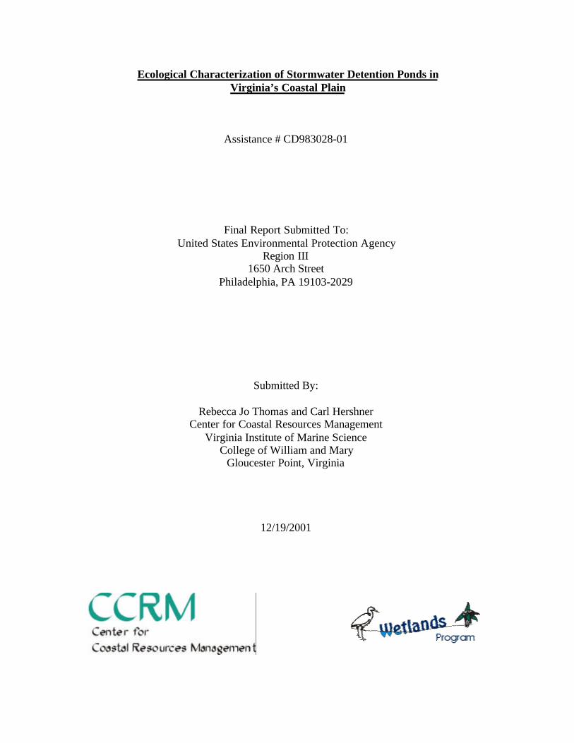
The database and related data were then manipulated with MY Structured QueryLanguage and Hypertext Preprocessor so that the information could be accessed throughthe Internet. In order to associate the information to the locality of interest, an ESRIArcView map of Virginia’s coastal plain was created labeling the counties and prominentcities. The UTM coordinates of the evaluated sites were processed into a shape file andadded to the map so that their locations are visualized (cover page).
Results
The results of this project are two fold. First, there is an online database thatallows the general public to view the location, design criteria, photograph and wetland
functional assessment of the stormwater ponds of Virginia’s coastal plain. Second, aseries of database queries have been developed to follow EPW’s scoring criteria thatresult in a score for each of the assessed functions. These scores can be used as a meansof ranking the stormwater ponds, as compared to each other, by their ability to performwetland functions.
The online database is located at http://ccrm.vims.edu/stormwater/. This pageopens with an introduction to the site with links to this report, the data entry manual and amap of Virginia’s Coastal Plain, labeled with counties and prominent cities. The map isthe take off point for the database information. Orange dots on the map indicate thelocation of stormwater ponds that have been evaluated and included in the database. Theplacement of these markers comes directly from the UTM coordinates collected at thesite. A single click on the city or county of interest will bring up a listing of thestormwater pond sites and a checklist of the information that is available for each site asindicated by the symbol: . The possible information available, as indicated by thecolumn headings, includes Location, Habitat, Sediment Stabilization, Water Quality,Design and Pictures. Clicking on the symbol in a column for the site of interest will bringup the listing for the entire county, but the site of interest is highlighted, scrolling may berequired to locate the desired row. Using the browser’s “Back” button will take you backto the initial listing where additional information for the first site can be retrieved or anew site can be selected.
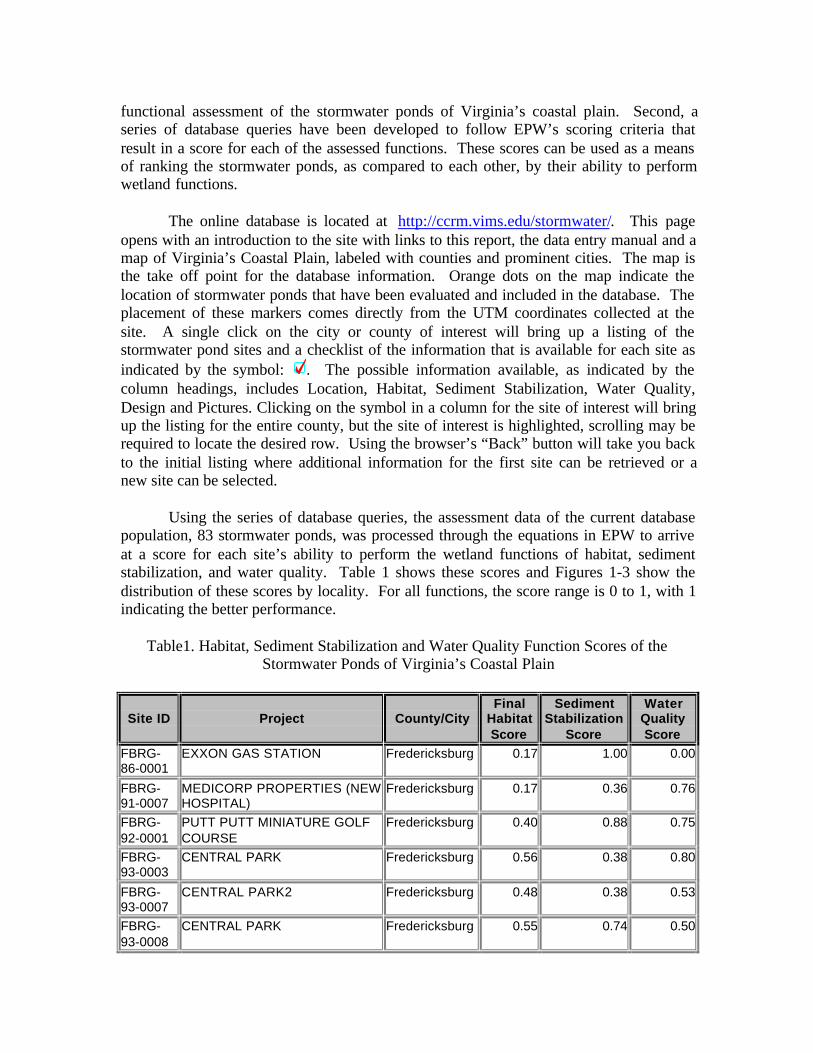
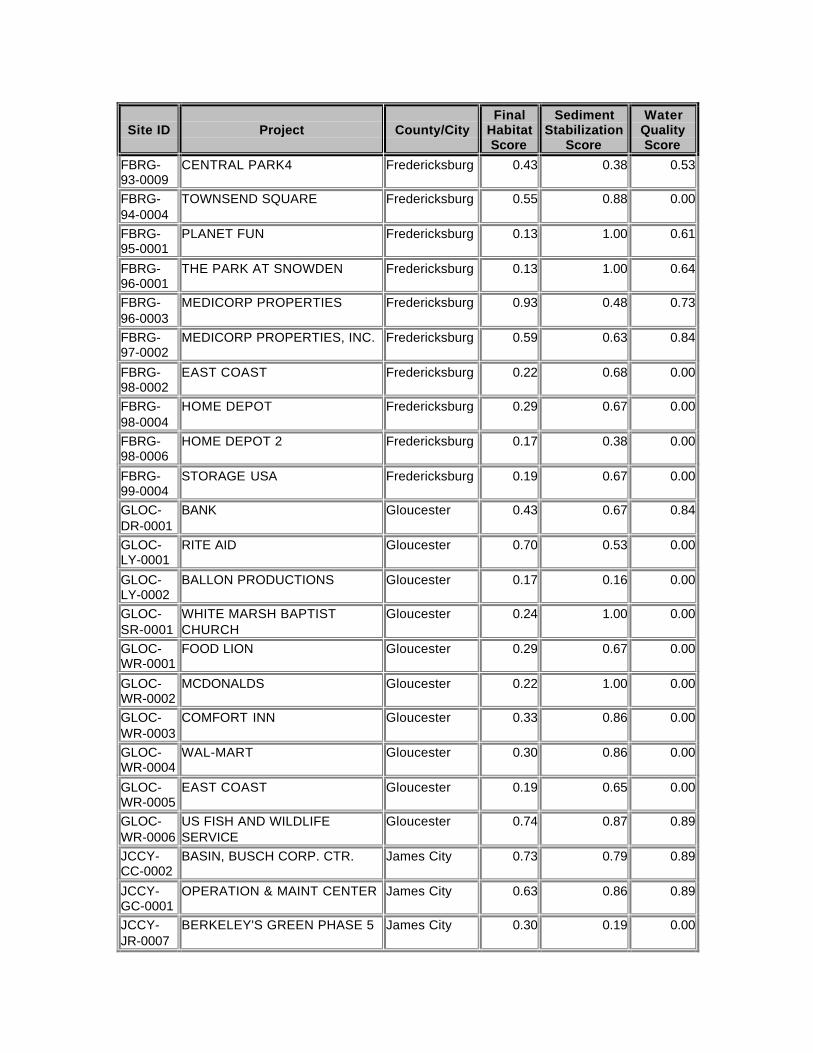
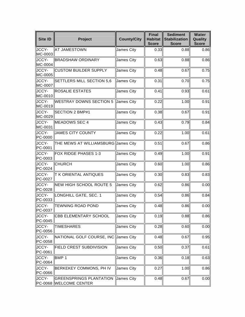
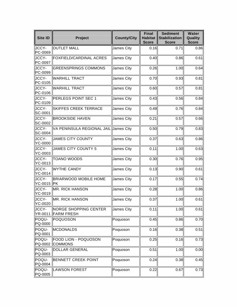
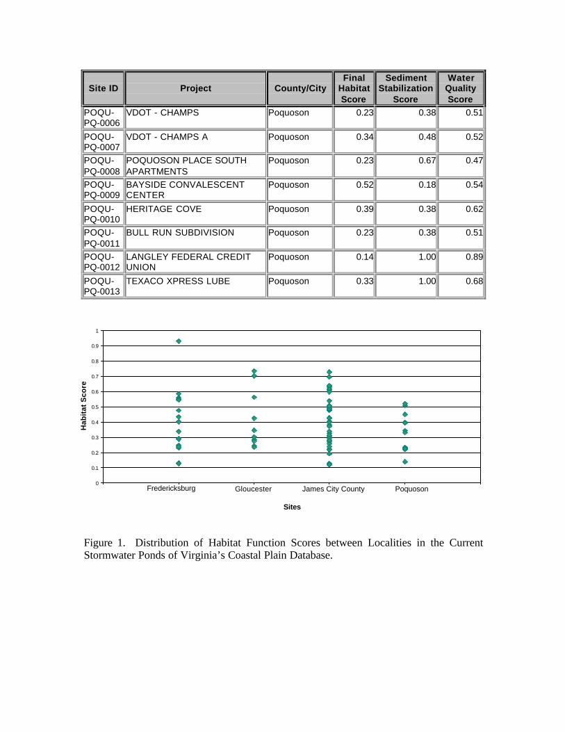
Using the series of database queries, the assessment data of the current databasepopulation, 83 stormwater ponds, was processed through the equations in EPW to arriveat a score for each site’s ability to perform the wetland functions of habitat, sedimentstabilization, and water quality. Table 1 shows these scores and Figures 1-3 show thedistribution of these scores by locality. For all functions, the score range is 0 to 1, with 1indicating the better performance.
Table1. Habitat, Sediment Stabilization and Water Quality Function Scores of theStormwater Ponds of Virginia’s Coastal Plain
Site ID Project County/CityFinal
HabitatScore
SedimentStabilization
Score
WaterQualityScore
FBRG-86-0001
EXXON GAS STATION Fredericksburg 0.17 1.00 0.00
FBRG-91-0007
MEDICORP PROPERTIES (NEWHOSPITAL)
Fredericksburg 0.17 0.36 0.76
FBRG-92-0001
PUTT PUTT MINIATURE GOLFCOURSE
Fredericksburg 0.40 0.88 0.75
FBRG-93-0003
CENTRAL PARK Fredericksburg 0.56 0.38 0.80
FBRG-93-0007
CENTRAL PARK2 Fredericksburg 0.48 0.38 0.53
FBRG-93-0008
CENTRAL PARK Fredericksburg 0.55 0.74 0.50
Site ID Project County/CityFinal
HabitatScore
SedimentStabilization
Score
WaterQualityScore
FBRG-93-0009
CENTRAL PARK4 Fredericksburg 0.43 0.38 0.53
FBRG-94-0004
TOWNSEND SQUARE Fredericksburg 0.55 0.88 0.00
FBRG-95-0001
PLANET FUN Fredericksburg 0.13 1.00 0.61
FBRG-96-0001
THE PARK AT SNOWDEN Fredericksburg 0.13 1.00 0.64
FBRG-96-0003
MEDICORP PROPERTIES Fredericksburg 0.93 0.48 0.73
FBRG-97-0002
MEDICORP PROPERTIES, INC. Fredericksburg 0.59 0.63 0.84
FBRG-98-0002
EAST COAST Fredericksburg 0.22 0.68 0.00
FBRG-98-0004
HOME DEPOT Fredericksburg 0.29 0.67 0.00
FBRG-98-0006
HOME DEPOT 2 Fredericksburg 0.17 0.38 0.00
FBRG-99-0004
STORAGE USA Fredericksburg 0.19 0.67 0.00
GLOC-DR-0001
BANK Gloucester 0.43 0.67 0.84
GLOC-LY-0001
RITE AID Gloucester 0.70 0.53 0.00
GLOC-LY-0002
BALLON PRODUCTIONS Gloucester 0.17 0.16 0.00
GLOC-SR-0001
WHITE MARSH BAPTISTCHURCH
Gloucester 0.24 1.00 0.00
GLOC-WR-0001
FOOD LION Gloucester 0.29 0.67 0.00
GLOC-WR-0002
MCDONALDS Gloucester 0.22 1.00 0.00
GLOC-WR-0003
COMFORT INN Gloucester 0.33 0.86 0.00
GLOC-WR-0004
WAL-MART Gloucester 0.30 0.86 0.00
GLOC-WR-0005
EAST COAST Gloucester 0.19 0.65 0.00
GLOC-WR-0006
US FISH AND WILDLIFESERVICE
Gloucester 0.74 0.87 0.89
JCCY-CC-0002
BASIN, BUSCH CORP. CTR. James City 0.73 0.79 0.89
JCCY-GC-0001
OPERATION & MAINT CENTER James City 0.63 0.86 0.89
JCCY-JR-0007
BERKELEY'S GREEN PHASE 5 James City 0.30 0.19 0.00
Site ID Project County/CityFinal
HabitatScore
SedimentStabilization
Score
WaterQualityScore
JCCY-MC-0003
AT JAMESTOWN James City 0.33 0.88 0.86
JCCY-MC-0004
BRADSHAW ORDINARY James City 0.63 0.88 0.86
JCCY-MC-0005
CUSTOM BUILDER SUPPLY James City 0.48 0.67 0.75
JCCY-MC-0007
SETTLERS MILL SECTION 5,6 James City 0.31 0.70 0.75
JCCY-MC-0010
ROSALIE ESTATES James City 0.41 0.93 0.61
JCCY-MC-0019
WESTRAY DOWNS SECTION 5 James City 0.22 1.00 0.91
JCCY-MC-0029
SECTION 2 BMP#1 James City 0.38 0.67 0.91
JCCY-MC-0031
MEADOWS SEC 4 James City 0.43 0.79 0.84
JCCY-PC-0000
JAMES CITY COUNTY James City 0.22 1.00 0.61
JCCY-PC-0001
THE MEWS AT WILLIAMSBURG James City 0.51 0.67 0.86
JCCY-PC-0003
FOX RIDGE PHASES 1-3 James City 0.49 1.00 0.91
JCCY-PC-0024
CHURCH James City 0.60 1.00 0.86
JCCY-PC-0027
T K ORIENTAL ANTIQUES James City 0.30 0.83 0.83
JCCY-PC-0028
NEW HIGH SCHOOL ROUTE 5 James City 0.62 0.86 0.00
JCCY-PC-0033
LONGHILL GATE, SEC. 1 James City 0.54 0.86 0.84
JCCY-PC-0037
TEWNING ROAD POND James City 0.48 0.86 0.00
JCCY-PC-0045
CBB ELEMENTARY SCHOOL James City 0.19 0.88 0.86
JCCY-PC-0056
TIMESHARES James City 0.28 0.60 0.00
JCCY-PC-0058
NATIONAL GOLF COURSE, INC James City 0.48 0.67 0.95
JCCY-PC-0061
FIELD CREST SUBDIVISION James City 0.50 0.37 0.61
JCCY-PC-0064
BMP 1 James City 0.36 0.18 0.63
JCCY-PC-0066
BERKEKEY COMMONS, PH IV James City 0.27 1.00 0.86
JCCY-PC-0068
GREENSPRINGS PLANTATIONWELCOME CENTER
James City 0.48 0.67 0.00
Site ID Project County/CityFinal
HabitatScore
SedimentStabilization
Score
WaterQualityScore
JCCY-PC-0069
OUTLET MALL James City 0.16 0.71 0.86
JCCY-PC-0097
FOXFIELD/CARDINAL ACRES James City 0.40 0.86 0.61
JCCY-PC-0099
GREENSPRINGS COMMONS James City 0.26 1.00 0.64
JCCY-PC-0105
WARHILL TRACT James City 0.70 0.93 0.81
JCCY-PC-0106
WARHILL TRACT James City 0.60 0.57 0.81
JCCY-PC-0109
PERLEGS POINT SEC 1 James City 0.43 0.56 0.84
JCCY-SC-0001
SKIFFES CREEK TERRACE James City 0.49 0.76 0.84
JCCY-SC-0002
BROOKSIDE HAVEN James City 0.21 0.57 0.66
JCCY-SC-0004
VA PENINSULA REGIONAL JAIL James City 0.50 0.79 0.83
JCCY-YC-0000
JAMES CITY COUNTY James City 0.37 0.63 0.86
JCCY-YC-0003
JAMES CITY COUNTY 5 James City 0.11 1.00 0.63
JCCY-YC-0013
TOANO WOODS James City 0.30 0.76 0.95
JCCY-YC-0014
WYTHE CANDY James City 0.13 0.90 0.61
JCCY-YC-0015
BRIARWOOD MOBILE HOMEPK
James City 0.17 0.55 0.74
JCCY-YC-0019
MR. RICK HANSON James City 0.28 1.00 0.86
JCCY-YC-0020
MR. RICK HANSON James City 0.37 1.00 0.61
JCCY-YR-0011
NORGE SHOPPING CENTERFARM FRESH
James City 0.11 1.00 0.61
POQU-PQ-0000
POQUOSON Poquoson 0.45 0.86 0.70
POQU-PQ-0001
MCDONALDS Poquoson 0.16 0.38 0.51
POQU-PQ-0002
FOOD LION - POQUOSONCOMMONS
Poquoson 0.25 0.16 0.73
POQU-PQ-0003
DOLLAR GENERAL Poquoson 0.51 1.00 0.00
POQU-PQ-0004
BENNETT CREEK POINT Poquoson 0.24 0.38 0.45
POQU-PQ-0005
LAWSON FOREST Poquoson 0.22 0.67 0.73
Site ID Project County/CityFinal
HabitatScore
SedimentStabilization
Score
WaterQualityScore
POQU-PQ-0006
VDOT - CHAMPS Poquoson 0.23 0.38 0.51
POQU-PQ-0007
VDOT - CHAMPS A Poquoson 0.34 0.48 0.52
POQU-PQ-0008
POQUOSON PLACE SOUTHAPARTMENTS
Poquoson 0.23 0.67 0.47
POQU-PQ-0009
BAYSIDE CONVALESCENTCENTER
Poquoson 0.52 0.18 0.54
POQU-PQ-0010
HERITAGE COVE Poquoson 0.39 0.38 0.62
POQU-PQ-0011
BULL RUN SUBDIVISION Poquoson 0.23 0.38 0.51
POQU-PQ-0012
LANGLEY FEDERAL CREDITUNION
Poquoson 0.14 1.00 0.89
POQU-PQ-0013
TEXACO XPRESS LUBE Poquoson 0.33 1.00 0.68
Figure 1. Distribution of Habitat Function Scores between Localities in the CurrentStormwater Ponds of Virginia’s Coastal Plain Database.
0
0.1
0.2
0.3
0.4
0.5
0.6
0.7
0.8
0.9
1
Sites
Hab
itat
Sco
re
Fredericksburg Gloucester James City County Poquoson
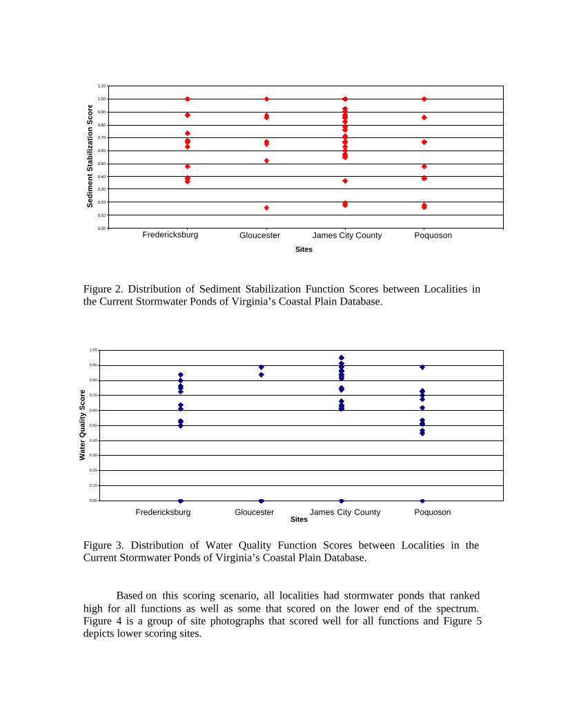
Figure 2. Distribution of Sediment Stabilization Function Scores between Localities inthe Current Stormwater Ponds of Virginia’s Coastal Plain Database.
Figure 3. Distribution of Water Quality Function Scores between Localities in theCurrent Stormwater Ponds of Virginia’s Coastal Plain Database.
Based on this scoring scenario, all localities had stormwater ponds that rankedhigh for all functions as well as some that scored on the lower end of the spectrum.Figure 4 is a group of site photographs that scored well for all functions and Figure 5depicts lower scoring sites.
0.00
0.10
0.20
0.30
0.40
0.50
0.60
0.70
0.80
0.90
1.00
1.10
Sites
Sed
imen
t S
tab
iliza
tio
n S
core
Fredericksburg Gloucester James City County Poquoson
0.00
0.10
0.20
0.30
0.40
0.50
0.60
0.70
0.80
0.90
1.00
Sites
Wat
er Q
ual
ity
Sco
re
Fredericksburg Gloucester James City County Poquoson
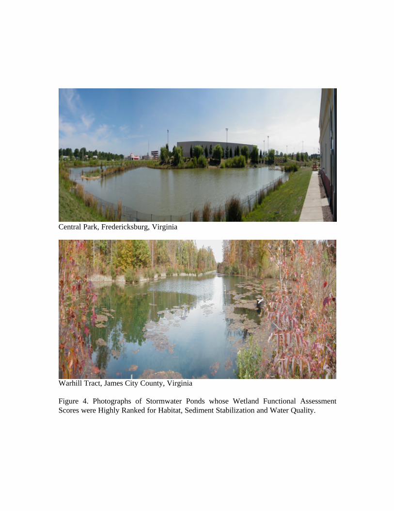
Central Park, Fredericksburg, Virginia
Warhill Tract, James City County, Virginia
Figure 4. Photographs of Stormwater Ponds whose Wetland Functional AssessmentScores were Highly Ranked for Habitat, Sediment Stabilization and Water Quality.
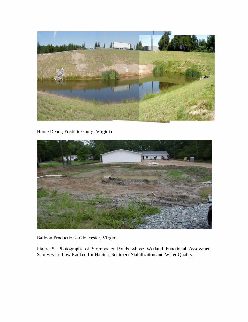
Home Depot, Fredericksburg, Virginia
Balloon Productions, Gloucester, Virginia
Figure 5. Photographs of Stormwater Ponds whose Wetland Functional AssessmentScores were Low Ranked for Habitat, Sediment Stabilization and Water Quality.
Acknowledgements
Pamela Mason for her functional assessment expertise, Dave Weiss for hisinformation technology support and Tamia Rudnicky and Daniel Schatt for theirassistance with ArcView .
References
Bartoldus, C.C., E.W. Garbisch, and M.L. Kraus. 1994. Evaluation for Planned Wetlands(EPW). Environmental Concern Inc., St. Michaels, MD. 327 pp. and appendices.
United States Department of Agriculture. 1986. Urban Hydrology for Small Watersheds.U.S. Government Printing Office, Washington, DC.
Virginia Department of Conservation and Recreation. 1999. Virginia StormwaterManagement Handbook. Richmond, VA.