Embed Size (px)
Citation preview
Ecological Constraints Assessment:
Project:
Northern Gateway Development, part Lot 1&2 DP 733715, Lot 1 DP1096868, and Lot 16 DP613107, Cundletown
Client:
Coastplan Consulting Pty Ltd
April 2016
Ecological Constraints Assessment | Northern Gateway Project | April 2016
2
Document Status
Rev 1 Draft Karl Robertson Jason Berrigan Luke Bowden 30/10/2015
Rev 2 Draft Jason Berrigan Jason Berrigan Luke Bowden 18/42016
Document Control
1 30/10/2015 Electronic/
Coastplan
Consulting
Gavin Maberly-
Smith Client Copy
2 30/10/2015 Electronic/
Email Naturecall Ashley Parker File Copy
3 18/4/2016 Electronic/
Coastplan
Consulting
Gavin Maberly-
Smith Client Copy
4 18/4/2016 Electronic/
Email Naturecall Ashley Parker File Copy
Project Number: EC1090
Our Document Reference: EC1090-BEC-REP-0001-CundletownBypassCA-rev2.0
This document has been prepared to the requirements of the client identified on the cover page and
no representation is made to any third party. It may be cited for the purposes of scientific research
or other fair use, but it may not be reproduced or distributed to any third party by any physical or
electronic means without the express permission of the client for whom it was prepared or
Biodiversity Australia Pty Ltd.
Version Purpose Author Reviewed By Approved By Date
Copy No. Date Type/Via Issued to Name Purpose
Ecological Constraints Assessment | Northern Gateway Project | April 2016
3
Contents
1.0 Introduction 11
2.0 Background Information 11
2.1. Location of the Study Site and Access 11
2.2. Key Definitions 11
2.3. Previous Ecological Assessments 12
Terra Consulting 2003 12
Naturecall 2014 15
2.4. Soils, Topography and Geology 15
2.5. Landuse and Disturbance History 17
Fire History and Weed Invasion 19
3.0 Statutory Framework 19
3.1. Commonwealth 19
Environment Protection and Biodiversity Conservation Act 1999 19
3.2. New South Wales 20
Environmental Planning and Assessment Act 1979 20
Threatened Species Conservation Act 1995 22
4.0 Flora Survey 23
4.1. Survey and Assessment Methodology 23
Vegetation Communities 23
Threatened Flora Species Searches and Occurrence Assessment 24
Survey Limitations 24
4.2. Flora Survey Results 25
Site Vegetation Communities 25
4.3. Threatened Ecological Communities 35
Site and Study Area EECs 35
Study Area Endangered Populations 46
Other listed Threatened Ecological Communities and Populations 47
4.4. Threatened Flora 51
Survey Results 51
Potential Occurrence Assessment 51
5.0 Fauna and Habitat Survey and Assessment 51
5.1. Survey Methods 51
Habitat Evaluation 52
Ecological Constraints Assessment | Northern Gateway Project | April 2016
4
Koala Survey 53
Spotlighting, Torch Searches and Stag Watching 53
Call Playback, Identification and Recording 53
Diurnal Bird Survey 54
Herpetofauna and Secondary Evidence Searches 54
Hollow Bearing Tree Survey 54
Limitations 54
5.2. Corridors and Key Habitats 55
Regional Corridors 55
Sub-regional Corridors 55
Local Corridors and Habitat Links 55
Key Habitat 58
5.3. Fauna Survey Results 58
Habitat Evaluation 58
Call Playback, Identification and Recording 66
Spotlighting 67
Secondary Evidence 67
Opportunistic observations 68
Total Fauna Observed 68
Locally Recorded Threatened Fauna 70
5.4. Potential Occurrence Assessment 71
New South Wales 72
Commonwealth 73
Migratory Species 76
6.0 SEPP 44 - Koala Habitat Assessment 80
6.1. Potential Koala Habitat 80
Introduction 80
Methods and Results 80
Conclusion 80
6.2. Core Koala Habitat Assessment 80
Overview of Koala Ecology 80
Site Core Koala Habitat Assessment 85
Discussion and Conclusion 94
7.0 Constraints Identification 95
7.1. Constraints 95
Ecological Constraints Assessment | Northern Gateway Project | April 2016
5
Nil Constraint 95
Low Constraint 96
Medium Constraint 96
High Constraints 100
8.0 Recommendations and Mitigation Measures 101
8.1. Vegetation Clearing 101
Clearing Timing 101
Hollow-bearing Tree Marking and Two Stage Clearing 101
Hollow-bearing Tree Felling Protocol 102
Clearing Monitoring 103
Fencing 104
Street Lighting 104
Stormwater Management 104
9.0 Conclusion 104
10.0 References 105
Appendix 1: Potential Occurrence Assessment 115
Appendix 2: Site flora species list 140
Ecological Constraints Assessment | Northern Gateway Project | April 2016
6
List of Figures
Figure 1: Location of the study site .................................................................................................................. 13 Figure 2: Study site .......................................................................................................................................... 14 Figure 3: Quaternary geology .......................................................................................................................... 16
Figure 4: GTCC LEP zoning map. ................................................................................................................... 18 Figure 5: Vegetation communities of the site .................................................................................................. 28
Figure 6: 1:100 ARI and vegetation communities on site ................................................................................ 36 Figure 7: OEH Corridors and Key Habitats ..................................................................................................... 56 Figure 8: Approximate location of hollow-bearing trees .................................................................................. 65 Figure 9: Local Koala records .......................................................................................................................... 87 Figure 10: SAT locations ................................................................................................................................. 88 Figure 11: GTCC LGA Koala records 2015 ..................................................................................................... 91 Figure 12: Coastal GTCC Koala records 2015 ................................................................................................ 92 Figure 13: Ecological constraints mapping of the site ..................................................................................... 98 Figure 14: Potential development and conservation areas ............................................................................. 99
List of Tables
Table 1: Exotic Pasture 25
Table 2: Derived Forest Red Gum woodland 26
Table 3: Swamp Oak swamp forest 29 Table 4: Tall Open/Paperbark Swamp Forest 31
Table 5: Immature swamp forest regrowth 32 Table 6: Aquatic vegetation 33 Table 7: Evaluation of the EEC – Freshwater Wetlands on Coastal Floodplains 37
Table 8: Evaluation of the EEC – Subtropical Coastal Floodplain Forest on Coastal Floodplains 41
Table 9: Evaluation of the EEC – Swamp Oak Floodplain Forest on Coastal Floodplains 43 Table 10: Evaluation of the EEC – Swamp Sclerophyll Forest on Coastal Floodplains 45
Table 11: Threatened flora species recorded in the locality 51
Table 12: Habitat evaluation summary 58 Table 13: Yangochiropteran bat call identification 66
Table 14: Fauna recorded on and adjacent to the site 69
Table 15: Threatened species recorded in the locality 70
Table 16: Threatened fauna potentially occurring in the locality 71
Table 17: Threatened species potentially occurring on the site/study area 72
Table 18: EPBC Act threatened fauna species potential occurrence assessment 74
Table 19: EPBC Act migratory species potential occurrence assessment 77
Table 20: Preferred Koala browse species in the GTCC coastal LGA 83 Table 21: Likelihood of occurrence - Flora 117
Table 22: Threatened flora unlikely to occur 118 Table 23: Eligibility for Seven Part Test Assessment – Fauna 126
Table 24: Fauna unlikely to occur on site 137
Table 25: Site hollow-bearing tree data 142
Ecological Constraints Assessment | Northern Gateway Project | April 2016
7
List of Photos
Photo 1: Derived Forest Red Gum Open Woodland 29 Photo 2: Swamp Oak swamp forest in south 30 Photo 3: Paperbark swamp forest 31
Photo 4: Regenerating swamp forest on western half of Lot 16 33 Photo 5: Main dam 34
Photo 6: Billabong on northern boundary. 34 Photo 7: Typical hollow bearing trees in pastoral areas 63 Photo 8: Eastern Osprey nest on Lot 16 64
Ecological Constraints Assessment | Northern Gateway Project | April 2016
8
Executive Summary
Naturecall Environmental were requested by Coastplan Consulting to undertake an ecological
constraints assessment for the proposed Northern Gateway development precinct, Cundletown, to aid
in making informed planning decisions for a rezoning application for the subject land.
The ~67.09ha study site (which comprises part Lot 1 & 2 DP 733715, Lot 1 DP 1096868, Lot 681 DP
617842, Lot 1 DP 1139255 and Lot 16 DP 613107) is located immediately west of Cundletown and
shares its northwestern boundary with the Taree Airport.
The subject land has been identified as part of a greater planning strategy by Greater Taree City Council
as potentially suitable for the establishment of a new employment/industrial precinct interlinked with the
Pacific Highway and Greater Taree airport. The future development envelope will necessitate some filling
due to flooding constraints. No concept plan has been derived as yet, as the objective of this assessment
is identify potential constraints and identify land suitable for development.
The study site is largely flat with elevation of ~1.5-3.5m above sea level, and forms part of and is adjunct
to the Manning River floodplain. Approximately 25% of the land is mapped at risk of inundation during
1:100 ARI floods, and drainage has been established in the study area to modify the inundation period
in low lying areas.
The site has been extensively cleared in the past for agricultural practices, and much of the land is
expected to have been cultivated for improved pasture and crops in the past given the high agricultural
capability. Agricultural practices still continue throughout the site, with some recent (last 5 years at least)
relaxation of maintenance in the far west where lack of slashing has allowed regeneration of a tall
shrubland from the seedbank and adjacent remnants.
Aside from pasture with scattered trees, the site contains the following vegetation communities:
• Derived open Forest Red Gum woodland: This occurs as two small non-viable small remnant
patches in a very derived state on the northern boundary of Lot 1 & 2 DP733715, and eastern
end of Lot 1 DP1096868; and one small patch of regrowth in very good condition on the mid-
south boundary of Lot 681. The non-viable patches simply consist of senescent trees which
are all that remain of the original forest, with recruitment prevented by pastoralism. The small
patch in the south has a simple assemblage and is insufficient in size to be viable in long
term.
• Swamp Oak swamp forest: Patch of immature regrowth on southeast boundary of site and
partially within the proposed Cundletown bypass on Lot 681; and a narrow linear band along
a drain in the west on Lot 16. More common to northwest study area outside the site.
• Paperbark swamp forest: Small remnant clump in northwest corner of site, near the barn on
Lot 16; in very good condition despite grazing.
• Tall shrubland/immature swamp forest regrowth: Dominates western end of site/half of Lot
16. Comprised of remnant trees mixed with at times dense regrowth about 5 years old. Will
develop into a swamp forest mixed with an ecotone of eucalypts in the south.
• Aquatic vegetation: Native aquatic vegetation occurs in partly artificial, artificial and natural
habitats comprising a large dam on Lot 681 and Lot 2, and associated drainage line and
Ecological Constraints Assessment | Northern Gateway Project | April 2016
9
billabong/dam; and the drains from Lot 681 to Lot 1, and on Lot 16. Generally dominated by
sedges with common herbs.
No threatened flora species were recorded on the site, however the Eucalyptus seeana population in the
Greater Taree local government area was considered to potentially occur in the western study area
adjacent to the airport due to a few trees in the open forest strips to the west and southwest containing
several trees whose identity could not be confirmed without further investigation.
The site and study area contains examples in varying condition of the following Coastal Floodplain
Endangered Ecological Communities listed under the TSC Act 1995:
• Swamp Sclerophyll Forest on Coastal Floodplains of the NSW North Coast, Sydney Basin
and South East Corner Bioregions.
• Swamp Oak Floodplain Forest on Coastal Floodplains of the NSW North Coast, Sydney
Basin and South East Corner Bioregions.
• Subtropical Coastal Floodplain Forest of the NSW North Coast, Sydney Basin and South
East Corner Bioregions.
• Freshwater Wetlands on Coastal Floodplains of the NSW North Coast, Sydney Basin and
South East Corner Bioregions.
The site occurrences of these EECs range from clearly non-viable in the medium to long term, to viable
but with limited biodiversity due to isolation and edge effects. Limitations of the 1:100 ARI modelling
compared with other Final Determination criteria suggested the EECs may be more extensive than
indicated by the 1:100 ARI. The extent of occurrence of the Freshwater Wetlands EEC is particularly
unclear due to the large dam being artificial but constructed on previous EEC habitat, and vagueness of
the Final Determination in resolving situation such as this instance.
No Threatened Ecological Communities listed under the EPBC Act occur on site or in the study area.
Surveys have previously been conducted on the land adjacent to the site. Previous survey by Terra
Consulting Pty Ltd identified the area of Melaleuca/Eucalyptus tereticornis open forest immediately to
the southwest of the site and in the study area as Core Koala Habitat; but survey of the site and derived
open forest woodland to the southeast failed to detect any Koala activity. This result suggested the
presumably small local aggregate may have become extinct since their last record in 2003/2004. Further
investigations is required to confirm this fact.
This survey detected the Grey-headed Flying Fox, Little Bentwing Bat and the Eastern Osprey on site.
The Osprey was present as a nesting pair in the open paddock on Lot 16 in the west, which poses a key
constraint to potential development in this area. Possible mitigation measures including 100m buffer
zones, erecting and artificial nest pole self-relocation and manual relocation options have been detailed
depending on desired development outcomes and statutory approvals.
The two detected bats would only be using the site as a minute part of their seasonally variable local
range for foraging. Another 14 threatened species listed under the TSC Act were considered mostly low
potential occurrences, mostly likely using the western study area as a small part of their local range, or
the local floodplain under suitable conditions. Usage of this area and the study area overall however is
critically constrained by the isolation and limited extent of the habitat. These species were generally not
considered to pose any key constraint on future development.
Ecological Constraints Assessment | Northern Gateway Project | April 2016
10
The exceptions were the Squirrel Glider and Varied Sittella, which have at best low potential to occur in
the remnant open forest in the western study area (albeit non-viable vestigial populations due to isolation
and edge effects), hence further targeted survey may be required for these species if maximum
development is desired and habitat is to be removed in the western study area.
This report assessed the ecological constraints of the subject site and study area, and categorised the
site into nil, low, medium and high levels of constraint. The latter was limited to the Osprey nest and an
isolated example of the EEC – Freshwater Wetlands on Coastal Floodplains.
Development of the nil and low and a lesser constrained part of the medium constraint areas would see
the majority of the site developed, with regeneration in the northwest to achieve a good balance of
development opportunity and ecological sustainability.
Ecological Constraints Assessment | Northern Gateway Project | April 2016
11
1.0 Introduction
Biodiversity Australia Pty Ltd trading as Naturecall Environmental (hereafter referred to as ‘Naturecall’)
has been requested by Coastplan Consulting to undertake an ecological constraints assessment for the
proposed Northern Gateway development precinct, Cundletown, to aid in making informed planning
decisions for a rezoning application for the subject land.
The subject land has been identified as part of a greater planning strategy by Greater Taree City Council
as potentially suitable for the establishment of a new employment/industrial precinct interlinked with the
Pacific Highway and Greater Taree airport. The nominal area is shown in Figure 2.
This future development envelope will necessitate some filling due to flooding constraints. No concept
plan has been derived as yet, as the objective of this assessment is identify potential constraints and
identify land suitable for development.
The ecological constraints assessment considers relevant statutory constraints under the Environmental
Planning and Assessment Act 1979, as amended by the Threatened Species Conservation (TSCA) Act
1995 which in turn has been amended by the Threatened Species Conservation Legislation
Amendments Act 2002 (Seven Part Test for Significance); NSW SEPP 44 - Koala Habitat Protection;
and the Commonwealth Environment Protection and Biodiversity Conservation (EPBCA) Act 1999 -
Matters of National Environmental Significance (MNES).
The survey and assessment was performed in consideration of the draft Threatened Species Survey
and Assessment – Guidelines for Developments and Activities (DEC 2004). The assessment has also
been undertaken in accordance with the Ecological Consultants Association of NSW – Code of Ethics
(2002) available at www.ecansw.org.au.
2.0 Background Information
2.1. Location of the Study Site and Access
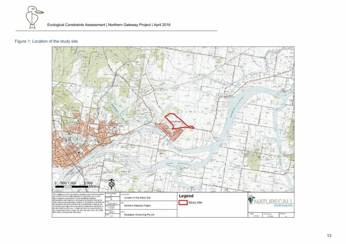
As shown in Figure 1, the study site, which is approximately 67.09ha in size, is located southeast of
the Taree Airport and northeast of the residential area of Cundletown, within the central-coastal area
of the Greater Taree City Council Local Government Area (GTCC LGA). The Pacific Highway is
situated <400m to the east of the site.
Current access is via Emerton Close off Princes Street to the eastern and central areas, and via
Denison St to the western areas.
2.2. Key Definitions
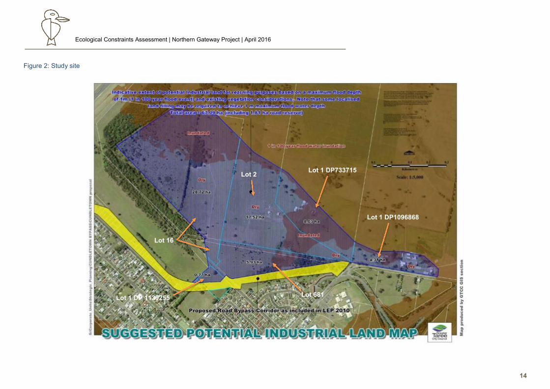
The study site is defined as the area shown in Figure 2, which comprises part Lot 1 & 2 DP 733715,
Lot 1 DP 1096868, Lot 681 DP 617842, Lot 1 DP 1139255 and Lot 16 DP 613107; and is ~67.09ha
in area.
The study area is land within an at least 100m radius of the site (minimum extent to which indirect
impacts such as edge effects will be detectable). These key definitions are in line with DECC (2007).
Ecological Constraints Assessment | Northern Gateway Project | April 2016
12
The locality is land within a 10km radius of the site, and places the site in a landscape context from
an ecological point of view.
2.3. Previous Ecological Assessments
Terra Consulting 2003
Terra Consulting Pty Ltd undertook previous surveys for GTCC for the rezoning of the Cundletown
Bypass Corridor area in 2003. Terra surveyed the bypass corridor area and a potential residential
precinct located along the southeastern and southwestern boundaries of the current site assessed
in this report.
Terra’s study site was reported to be dominated (70%) by land cleared for grazing and agricultural
uses. Melaleuca/Red Gum closed forest, Low Melaleuca shrubland, Red Gum/Ironbark open forest,
Casuarina woodland and aquatic communities were described as dominating the remaining parts of
the site.
The largest and most important native vegetation community located on the site was the
Melaleuca/Red Gum Closed Forest, which was identified as Core Koala Habitat under SEPP 44.
This vegetation is a strip located along and adjunct to the current site’s southwestern boundary, and
is mainly comprised of several Melaleuca species (M.nodosa, M.quinquenervia, M.ericifolia,
M.styphelioides), emergent Forest Red Gums (Eucalyptus tereticornis) and a miscellaneous mix of
other eucalypts, with a very sparse to open grass/sedge groundcover.
No threatened flora species found on the Terra study site, with only Asperula asthenes (Vulnerable –
TSCA, V-EPBCA) considered to have generic potential habitat in the wettest portions of Lot 681.
Terra recorded a total of 39 vertebrate species. Of these, two were Vulnerable species listed under the
TSC Act and EPBC Act: the Koala (Phascolarctos cinereus) and the Grey-headed Flying Fox (Pteropus
poliocephalus). Scat searches suggested high Koala activity levels in the Melaleuca/Red Gum forest,
with a sub-adult Koala detected.
Due to Core Koala Habitat being present, Terra advised that a Koala Management of Plan (KPoM) will
be required for future proposed development of their site.
Ecological Constraints Assessment | Northern Gateway Project | April 2016
13
Figure 1: Location of the study site
Ecological Constraints Assessment | Northern Gateway Project | April 2016
14
Figure 2: Study site
Lot 681
Lot 1 DP1096868
Lot 1 DP733715 Lot 2
Lot 16
Lot 1 DP 1139255

Ecological Constraints Assessment | Northern Gateway Project | April 2016
15
Naturecall 2014
Naturecall Environmental undertook a statutory ecological assessment (SEA) for a proposed truck stop
development on Lot 17 DP86662, and Lots 44 & 46 DP 1191326 in 2014. This land adjoins the current
site to the immediate southeast, and will essentially form part of the Northern Gateway precinct.
This study site totalled an approximately area of 7.5ha of vegetation which is very similar to that found
on much of the study site. The vegetation consisted of pasture and associated weeds, ~30 scattered
trees, and some limited understorey which was mostly around the two dwellings as landscaping. The
land is currently grazed by cattle and horses, and is likely to have been cultivated in the past to improve
pasture as part of a dairy enterprise which formerly operated there.
No threatened flora species were detected or were considered likely occurrences. A few Forest Red
Gums and some representative herbs comprised the vestiges of formerly extensive local Coastal
Floodplain EECs which would have originally covered the local floodplain prior to clearing for agriculture.
The site readily qualified as Potential Koala Habitat, but not Core Koala Habitat due to lack of evidence
indicating Koalas regularly use the site, hence a KPoM was not required. The lack of Koala activity was
contributed to the very poor connectivity to near identified Core Koala Habitat or other local known habitat
(eg west of the airport) due to extensive open pasture, and possible decline of the Koala population in
the Cundletown area.
The fauna survey found most of the site’s trees to contain hollows to advanced senescence and lack of
recruitment, but no threatened fauna species were detected. Brushtailed Possums were the only
arboreal fauna on site, with only common woodland birds (native and exotic) comprising the remainder
of the simple fauna assemblage.
A handful of mostly wide ranging threatened species were considered to have potential to use the site
as a small part of their home range (Yangochiropteran bats, Square-tailed Kite, and Grey-headed Flying
Fox). The Koala was considered only a low chance of being a rare transient most likely dispersing from
a likely very small aggregate in the Cundletown area, due to major landscape connectivity limitations.
No referral to the Commonwealth Department of the Environment (DotE) or a Species Impact Statement
(SIS) was considered to be required for the development application.
2.4. Soils, Topography and Geology
The study site is largely flat with a uniform elevation of ~1.5-3.5m above sea level, and forms part of and
is adjunct to the Manning River floodplain. Approximately 25% of the land is mapped at risk of inundation
during 1:100 ARI floods (Figure 2). The higher land is on the south which occurs on slightly elevated
terraces adjacent to a very low hill and associated ridgelines on which Cundletown is centred.
Ecological Constraints Assessment | Northern Gateway Project | April 2016
16
Figure 3: Quaternary geology
Ecological Constraints Assessment | Northern Gateway Project | April 2016
17
One well defined watercourse (a paleochannel infilled by more recent historical flooding, and reduced to
an open drainage depression) headed by a dam occurs in the central area on Lot 1 & 2 DP733715; with
a poorly defined head of another drainage line in the northwest end of the site on Lot 16. Both drain north
onto the lower floodplain.
The dam at the head of the main watercourse on Lot 1 & 2 DP733715 is about 2ha in extent and is at
least several decades old (as suggested by vegetation within the dam and on the embankments). Below
the dam, the original channel of the paleo-watercourse appears to have been artificially formalised and
deepened into a uniformly wide channel to facilitate drainage both from local flooding and from
stormwater directed onto the property from Cundletown. Another small dam or possibly originally a
natural billabong occurs in this watercourse on the northern boundary of the study site.
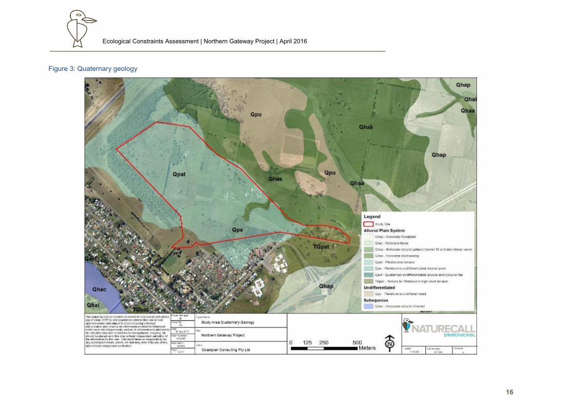
Quaternary soil landscape mapping (see Figure 3) and other sources (eSPADE) show the site lies on
an alluvial plain, with the eastern end on a high level terrace. The soil profile is reportedly slowly
permeable and poorly drained in some areas, as evidenced by waterlogging especially in the western
end (eSPADE). The site is underlain by carboniferous bedrock (about 300 million years old) (Byabarra
beds), comprising of lithic sandstone, siltstone, tuff, shale and limestone (R.A.S.C. 1966).
2.5. Landuse and Disturbance History
As shown in Figure 4, the site is currently zoned as RU1 Primary Production under the GTCC Local
Environmental Plan (LEP) 2010.
As stated previously the site has been extensively cleared in the past for agricultural practices, and much
of the land is expected to have been cultivated for improved pasture and crops in the past given the high
agricultural capability. Agricultural practices still continue throughout the site, with some recent (last 5
years at least) relaxation of maintenance in the far west of the study site where lack of seasonal slashing
has allowed regeneration of tall shrubland from the seedbank and adjacent remnants. Maintenance and
improved pasture prevent any regeneration in other areas of the site, and exhausted in situ seedbanks.
Four dwellings currently occur on the site, with one formerly pursuing dairying. Currently, beef cattle and
horses are grazed on improved pasture mostly comprising Kikuyu, Paspalum and Carpet Grass, with
some cultivation of rye.
Land to the north, southeast and east of the Pacific Highway are also used for grazing on improved
pasture over land with very limited native vegetation.
As noted above, the large dam was formed by establishment of an earthen wall about 1m high several
decades ago across the head of a former drainage line/vestigial creek which was previously cleared
(evidenced by lack of any dead trees in the dam). Remnant infrastructure indicates that although the
dam was shallow, it was used for irrigation of nearby land for cropping.
Downstream of the main dam, a channel appears to have artificially established/formalised within the
original drainage line probably within the last 30 years (lack of direct connection to the main dam indicate
it was not previously present), with aerial photographs showing reshaping in the last 5 years. This widens
to a billabong, or possibly a small dam (photos in the last 5 years show excavation presumably to widen
and deepen the waterbody for stock watering) on Lot 1 DP733715, and degenerates to a shallow,
Ecological Constraints Assessment | Northern Gateway Project | April 2016
18
ephemeral channel which appears to be part natural watercourse, and then becomes modified to a
narrow drainage channel linked to another drain.
This channel built along the original natural watercourse which was probably once an ephemeral creek
infilled during the floodplain’s formation, is connected to a drain (with adjacent spoil heaps) dug to the
west of the dam which interlinks to stormwater drainage discharged from Cundletown south of Lot 681.
Based on regrowth on spoil adjacent to this drain (about 2m wide and >1m deep), this drain appears to
have been constructed within the last 20-30 years, for the purpose of channelling excess water (which
would have impacted exotic pasture) to the lower floodplain to the north, and eventual off-site drainage
via a network of flood mitigation drains which eventually link to the Manning River.
Another drain indicated by a linear band of Swamp Oak forest also occurs on Lot 16 in the west. This
drain is very shallow (<30cm deep) and <1m wide.
The entire drainage network in the study area has altered the hydrological regime of the local floodplain
(ie reduced standing water times) with associated impacts on vegetation and also water quality (eg
oxidation of materials releasing elevated levels of iron and aluminium).
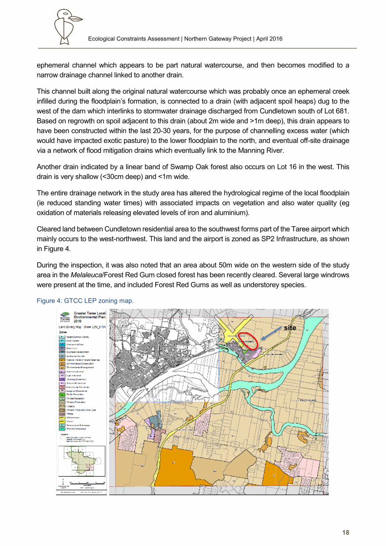
Cleared land between Cundletown residential area to the southwest forms part of the Taree airport which
mainly occurs to the west-northwest. This land and the airport is zoned as SP2 Infrastructure, as shown
in Figure 4.
During the inspection, it was also noted that an area about 50m wide on the western side of the study
area in the Melaleuca/Forest Red Gum closed forest has been recently cleared. Several large windrows
were present at the time, and included Forest Red Gums as well as understorey species.
Figure 4: GTCC LEP zoning map.
site

Ecological Constraints Assessment | Northern Gateway Project | April 2016
19
Fire History and Weed Invasion
The previous fire history of the site was not obtained from landowners, but the vegetation on site
showed no signs of a recent fire.
The groundcover over almost the entire site aside from the dams and swamp forest is dominated by
exotic pasture and associated agricultural weeds eg Carpet Grass (*Axonopus spp), Rhodes Grass
(*Chloris gayana), *Paspalum sp., White Clover (*Trifolium repens), Fireweed (*Senecio
madagascariensis), Kikuyu (*Pennisetum clandestinum), Verbena sp. etc. Lantana (Lantana
camara) and Camphor Laurel occurred along some fences or isolated patches where they escaped
slashing, and widely in the Swamp Oak forest in the south of the site.
3.0 Statutory Framework
The following key statutory provisions apply in considering the ecological constraints of the site for
development.
3.1. Commonwealth
Environment Protection and Biodiversity Conservation Act 1999
The Environment Protection and Biodiversity Conservation Act 1999 (EPBC Act) is Australia’s
central piece of environmental legislation. It provides the legal framework to manage and protect,
nationally important flora, fauna, ecological communities and heritage places (DotE 2015).
The objectives of the EPBC Act are to:
• Provide streamlined national environmental assessment and approvals process,
• Provide for the protection of the environment, especially matters of national environmental
significance,
• Control international movement of plants and animals,
• Promote ecologically sustainable development through the conservation and ecologically
sustainable use of natural resources
• Recognise the role of the Indigenous people in the conservation and ecologically sustainable
use of Australia’s biodiversity
• Promote the use of indigenous peoples knowledge of biodiversity with the involvement of,
and in cooperation with, the owners of the knowledge
Under the EBPC Act, actions that are likely to have a significant impact on Matters of National
Environmental Significance (MNES) require approval from the Commonwealth Minister of the
Environment. There are 9 MNES protected under the EPBC Act 1999:
• World heritage properties,
• National heritage places,
• Wetlands of international importance,
Ecological Constraints Assessment | Northern Gateway Project | April 2016
20
• Listed threatened species and ecological communities,
• Migratory species,
• Commonwealth marine areas,
• The Great Barrier Reef Marine Park,
• Nuclear action,
• A water resource in relation to coal seam gas development and large coal mining
development.
3.2. New South Wales
Environmental Planning and Assessment Act 1979
The Environmental Planning and Assessment Act 1979 (E&PA Act) established a system of
environmental planning and assessment in NSW, and is accompanied by a range of Environmental
Planning Instruments (EPIs) which include:
• State Environmental Planning Policies (SEPP),
• Regional Environmental Plans (REP),and
• Local Environmental Plans (LEP)
EPIs which may be relevant to this proposal include:
• State Environmental Planning Policy No. 44 - Koala Habitat Protection,
• State Environmental Planning Policy No. 14 - Coastal Wetlands
• State Environmental Planning Policy No. 26 - Littoral Rainforest
• Hunter Regional Environmental Plan 1989, and
• Greater Taree City Council, Local Environmental Plan 1995.
Consideration of the EPIs is provided as follows.
3.2.1.1. State Environmental Planning Policy No. 44 - Koala Habitat Protection
State Environmental Planning Policy No. 44 (SEPP 44) is designed to encourage the proper
conservation and management of area of natural vegetation that provide habitat for Koalas to ensure
that present habitat is preserved, and current declining trends in Koala populations are reversed.
The SEPP intends to achieve this:
• By encouraging the identification of areas of Core Koala Habitat.
• By encouraging the inclusion of areas of Core Koala Habitat in environmental protection
zones.
• By requiring the preparation of management before the development consent can be granted
when Core Koala Habitat is identified.
Ecological Constraints Assessment | Northern Gateway Project | April 2016
21
3.2.1.2. State Environmental Planning Policy No. 14 - Coastal Wetlands
State Environmental Planning Policy 14 (SEPP 14) aims to ensure the preservation and protection
of coastal wetland areas in the environmental and economic interests of the NSW.
There are no SEPP 14 wetlands on site or the study area. In the locality, the nearest SEPP 14
wetlands are #576a (“The Basin”) located 1.5km to the west, and #576 located 1.2km south on the
Manning River.
3.2.1.3. State Environmental Planning Policy No. 26 - Littoral Rainforest
State Environmental Planning Policy No. 26 (SEPP 26) is aimed at providing a mechanism to assess
applications for development that are likely to impact littoral rainforest areas, with the goal of
preserve such areas in their natural state.
SEPP 26 applies to:
• Land enclosed within SEPP 26 mapped areas
• Land not enclosed by SEPP mapping however falls within 100m of the SEPP 26 mapped
area. Excluding residential land and land to which SEPP 14 applies
• This policy does not apply to land reserved under the National Parks and Wildlife Act 1974 as
an Aboriginal area, historic site, national park, nature reserve, state game reserve, state
recreation area, karst conservation reserve or regional park or land dedicated or set apart
under section 25A of the Forestry Act 1916 as a flora reserve.
There are no mapped areas of SEPP 26 on site or in the study area.
3.2.1.4. Hunter Regional Environmental Plan 1989
The Hunter Regional Environmental Plan 1989 (HREP) has provided a strategy for development of
the Hunter Region for over 25 years. The Greater Taree Local Government Area is the most northerly
government area under HREP.
The aims of the strategy are to:
• Provide for changing agricultural practices,
• Allow for development of small rural holdings and multiple occupancy on land capably of
such developments,
• Protect prime crop and pasture land from degradation,
• Recognise environmental limitations to developments,
• Concentrate populations in major existing centres to make best use of public and private
investments, and
• Permit urban extension around the perimeter of those centres which can expand
economically without environmental degradation.
Detailed planning consideration of the HREP is provided in the planning proposal for the site prepared
by Coastplan, which utilises information collated in this assessment to demonstrate compliance with the
HREP.
Ecological Constraints Assessment | Northern Gateway Project | April 2016
22
3.2.1.5. Greater Taree Local Environmental Plan 2010
The Greater Taree Local Environmental Plan 2010 (LEP) aims to make local environmental planning
provisions for land in the Greater Taree City area in accordance with standard environmental planning
instruments under section 33A of the EPA Act 1979.
The key aims of the LEP are to:
• Promote and encourage the ecologically sustainable development of the Greater Taree City
area,
• Encourage the proper management, development and conservation of natural and human
made resources for the purpose of promoting the social and economic welfare of the
community, protecting ecological and cultural heritage,
• Promote and co-ordinate the orderly and economic use and development of land, and
minimise conflict between adjacent land uses,
• Facilitate the provision and co-ordination of community service facilities,
• Encourage the protection of the environment, including the protection and conservation of
native animals and plants, threatened species and endangered ecological communities and
their habitats,
• Minimise the exposure of development to natural hazards and natural risks,
• Seek the provision of adequate and appropriate infrastructure to meet the needs of future
development, and
• Encourage a strong, growing and diversified economy that promotes local self-reliance, and
recognises and strengthens the local community and its social capital in ways that safeguard
the quality of the future generations.
This ecological constraints assessment assists the planning proposal to address these key aims of the
GTCC LEP.
Threatened Species Conservation Act 1995
In NSW, the key piece of legislation in relation to the protection and management of biodiversity and
threatened species is the Threatened Species Conservation Act 1995 (TSC Act).
The TSC Act aims to:
• Conserve biological diversity and promote ecologically sustainable development,
• Prevent the extinction and promote the recovery of threatened species, populations and
ecological communities,
• Protect the critical habitat of endangered species, populations and ecological communities,
• Eliminate or management certain Key Threatening Processes (KTP’s) that threaten the
survival or evolutionary development of threatened species, populations and ecological
communities
• Ensure that the impact of any action affecting threatened species, populations and ecological
communities is properly assessed
Ecological Constraints Assessment | Northern Gateway Project | April 2016
23
• Encourage the conservation of threatened species, populations and ecological communities
through cooperative management.
In a planning context, the key influence of the TSC Act is amendment of Section 5A of the EP&A Act via
the Seven Part Test. The identification of land suitable for development is preferred to avoid a significant
impact on any threatened species, Endangered Population, Endangered Ecological Community (EEC)
or their habitats.
Where a significant impact is identified in the Seven Part Tests or the proposed development lies within
land defined as Critical Habitat under Part 3 of the TSC Act, a Species Impact Statement (SIS) must be
prepared and considered by the Director General of the Office of Environment and Heritage (OEH).
The constraints assessment in section 7 of this report considers a range of development outcomes which
may avoid the requirement for an SIS, or require an SIS for a higher level of yield.
4.0 Flora Survey
4.1. Survey and Assessment Methodology
The flora survey essentially routinely consists of three components:
• Identification, description and mapping of the major vegetation communities on the property.
• Identification, mapping and condition assessment of any Endangered Ecological
Communities listed under the TSC Act, and EPBC Act.
• Searches for and (if found) mapping of threatened species listed under the TSC Act, and
EPBC Act.
Vegetation Communities
4.1.1.1. Vegetation Community Description and Mapping
Vegetation communities on site were surveyed by a foot traverse of the entire site, rather than via
plots and transects. This was the most effective survey method due to the simplified nature of the
vegetation present and limited site extent.
Sub-formation names for vegetation types were adapted from the classification proposed by Keith
(2004) e.g. ‘Dry Sclerophyll Forest’ to assist the fauna habitat evaluation, and the structural
classification used by Walker and Hopkins (1990). Biometric classifications were determined by
reference to the Biometric Vegetation Types Database
(http://www.environment.nsw.gov.au/vegetation/eoam/index.htm).
Species identification was made with the assistance of PlantNET, GTCC (2007), Bale (1993), Beadle
(1982), Harden (1990, 91, 92, 93, 2000), Williams and Harden (1984), Williams and Harden (1980),
Robinson (1994), and Brooker and Kleinig (1999). Plant species were identified to species or
subspecies level and nomenclature conforms to that currently recognized by the Royal Botanic
Gardens and follows Harden and PlantNET for changes since Harden (1990-1992, 2000).
Ecological Constraints Assessment | Northern Gateway Project | April 2016
24
4.1.1.2. Conservation Status Assessment
Identification of possible Threatened Ecological Communities (TECs) was based on the data
collected by the survey and review of the relevant listings on the OEH website
(www.environment.nsw.gov.au) and Department of Environment – MNES SPRAT website (DotE
2015a).
Threatened Flora Species Searches and Occurrence Assessment
4.1.2.1. Searches
Searches for the locally recorded threatened flora recorded in the LGA and regionally (OEH 2015a,
DotE 2015b) in similar habitats to those occurring on the site (see Appendix 1), were carried out over
the survey period.
The site was intensively searched over 3 dedicated person days, and incidentally during other survey
activities. Survey methods consisted of undertaking random meanders throughout all habitats on
site, with targeted searches of potential habitat for locally and regionally recorded threatened
species. A targeted search was made for Asperula asthenes in all wetland habitats.
4.1.2.2. Potential Occurrence Assessment
Potential occurrence assessment of threatened flora species is provided in Appendix 1. This section
assesses all considered threatened species listed under the TSCA 1995 and EPBCA 1999 for their
potential to occur on site based on the following factors (DEC 2004, Forest Fauna Surveys 1997,
DECC 2007):
• Presence/absence of suitable habitat.
• Condition and disturbance history of habitat.
• Local and regional records.
• Location of site within known distribution of the species.
• Connectivity with habitat where species is known to occur.
Survey Limitations
The study site was intensively traversed by foot during specific flora surveys and during other survey
activities throughout the survey period. This ensured maximum detection of the diversity of flora
present.
The survey was undertaken in spring when most plants are generally flowering. Weather conditions
for the previous month were moderately wet and provided good growth conditions for aquatic plants.
Overall, the extremely high accessibility of the site and limited diversity resulted in a very high
detection rate of plants present.
Regardless, any short-term survey will only provide a list of plants detected during a brief interval of
time (DEC 2004). The total species list of an area is usually much greater than can be detected in
such a short time and it can be influenced by factors such as: size of the property, fire history, time
since disturbance, flowering season (particularly orchids), and presence of reproductive material
Ecological Constraints Assessment | Northern Gateway Project | April 2016
25
(DEC 2004). As the focus was on detection of threatened species, a comprehensive inventory of all
species present was not obtained.
4.2. Flora Survey Results
Site Vegetation Communities
Six generally highly modified and often derived vegetation communities were recorded on the study
site, most of which were in poor condition due to disturbance associated the current and historical
landuses. A description of their floristics and structure is provided in the following tables.
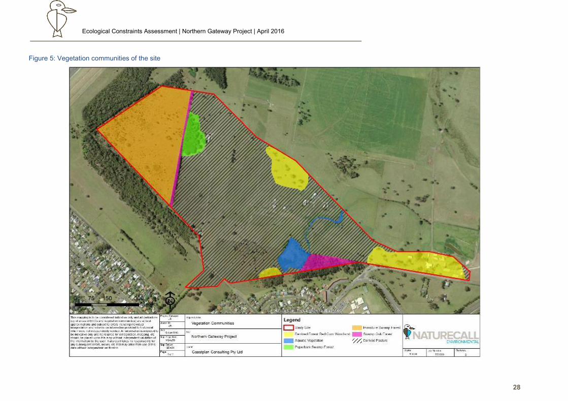
Refer to the Figure 5 and site photos following the descriptions for illustration, the flora species list
provided in Appendix 2.
Table 1: Exotic Pasture
Vegetation Community
Derived Pasture (exotic pasture)
Biometric Vegetation Type
Other/Disturbed/NA
Keith (2000) Formation and
Class
N/A
Location Dominates the site aside from small patches of remnant woodland, swamp forest and
immature swamp forest regrowth. Also includes lawns around houses.
Description
(a) Canopy:
Structure and Species:
Variable with location. Usually absent, but may include single trees and stags to small
clumps of young Swamp Oak or paperbarks. Few senescent Forest Red Gum (Eucalyptus
tereticornis).
Trunk diameter at breast height (DBH) ranges from 20-120cm, with height ~10-25m.
(b) Understorey:
Structure and Species:
Not a true stratum. Limited to a few planted or self-sown Weeping Bottlebrush
(Callistemon salignus), melaleucas, patches to single Camphor Laurel, and Swamp Oaks,
often along fencelines, around 3-8m tall with trunk DBH 10-20cm.
(c) Shrub Layer:
Structure and Species:
Absent apart from a localised patch of sparse regrowth and Leptospermum spp in the
west adjacent to a narrow band of swamp forest; and Lantana, Camphor Laurels and
young Swamp Oak along drains and fences, and in unmaintained paddocks in the
southern central area.
Ecological Constraints Assessment | Northern Gateway Project | April 2016
26
Vegetation Community
Derived Pasture (exotic pasture)
(d) Ground Layer
Structure and Species:
Dominated by exotic pasture grasses such as Kikuyu (*Pennisetum clandestinum),
Paspalum spp., *Axonopus spp., *Lolium spp Setaria spp. with White Clover (Trifolium
repens). Fireweed (*Senecio madagascariensis) and at times Tussock Rush (Juncus
usitatus) are commonly scattered throughout the site. A number of other common native
sedges occur mixed with pasture in the wetter, low-lying portions on the northern margins.
Mostly <10-30cm high due to grazing, with an unmaintained paddock in the central south
dominated by tall rank, dead grass about 1.5m high.
(e) Lianas, scramblers, etc:
Structure and Species :
Absent
Condition
Converted into improved pasture based on exotic pasture species. Likely to have been
widely cultivated at various times for various purposes eg winter pastures and cropping.
Artificial fertilisers likely to have been added at times, and irrigated. Some areas not
recently maintained eg paddock southwest of dam is tall rank and dead, and not grazed.
Wet areas subject to compaction and soil disturbance by stock, especially around hay
feeding stations.
Threatened plants recorded or
potential habitat
Long history of modification has modified the habitat to a point where it is extremely
unlikely that threatened species may occur
Conservation Value
Some areas form part of highly degraded Coastal Floodplain EECs, however regrowth is
suppressed by grazing and maintenance. Some areas have no seedbank to support
regeneration and are too distant from seed sources. See section 4.3.
Table 2: Derived Forest Red Gum woodland
Vegetation Community
Derived Tall Very Open/Forest Red Gum Woodland.
Biometric Vegetation Type
Forest Red Gum Grassy Open Forest of the Coastal Ranges of the North Coast
Keith (2000) Formation and Class
Dry Sclerophyll: Hunter-Macleay Dry Sclerophyll Forest (highly modified).
Location
Occurs as two small non-viable small remnant patches in a very derived state on the
northern boundary of Lot 1 & 2 DP733715, and eastern end of Lot 1 DP1096868, and
one patch of regrowth in very good condition on the mid-south boundary of Lot 681.
Description
(a) Canopy:
Structure and Species:
Dominated by Forest Red Gum (Eucalyptus tereticornis) with crowns well separated
and foliage cover about 50%. Trunk diameter at breast height (DBH) ranges from 65-
230cm, with height ~20-25m. Most of the trees are senescent or in the final stages of
senescence i.e. crown-shedding.
Ecological Constraints Assessment | Northern Gateway Project | April 2016
27
Vegetation Community
Derived Tall Very Open/Forest Red Gum Woodland.
(b) Understorey:
Structure and Species:
Present only in southern clump where it is semi-closed. Dominated by dense
Melaleuca nodosa and M. styphelioides with some Callistemon salignus. These are
about 3-5m tall with trunk DBH 10-20cm.
(c) Shrub Layer:
Structure and Species:
Absent apart from some Leptospermum spp in the southern patch
(c) Ground Layer
Structure and Species:
Dominated by exotic pasture grasses as previously detailed in the northern and eastern
areas. Southern patch is a sparse mix of pasture and native species such as Bladey
Grass (Imperata cylindrica) and Wiry Panic (Entolasia spp).
(d) Lianas, scramblers, etc:
Structure and Species :
Absent
Condition
Northern and eastern areas are highly modified into pastoral woodland. No recruitment
other than artificial plantings and a localised area adjacent to swamp forest stands in
the west.
Southern patch is immature regrowth essentially comprising an island established by
self-colonisation from remnant trees, and lax maintenance.
Threatened plants recorded or potential
habitat
Long history of modification has modified the habitat to a point where it is unlikely that
threatened species may occur.
Conservation Value
Floristic and soils match for Coastal Floodplain EEC, but above 1:100 ARI (see section
4.3). Northern and eastern stands are senescent with no recruitment – will become
extinct due to natural attrition. Southern stand has no diversity and isolated from similar
forest off southwest of site.
Ecological Constraints Assessment | Northern Gateway Project | April 2016
28
Figure 5: Vegetation communities of the site
Ecological Constraints Assessment | Northern Gateway Project | April 2016
29
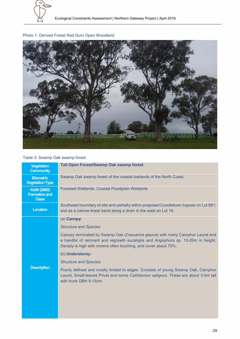
Photo 1: Derived Forest Red Gum Open Woodland
Table 3: Swamp Oak swamp forest
Vegetation Community
Tall Open Forest/Swamp Oak swamp forest
Biometric Vegetation Type
Swamp Oak swamp forest of the coastal lowlands of the North Coast.
Keith (2000) Formation and
Class
Forested Wetlands: Coastal Floodplain Wetlands
Location Southeast boundary of site and partially within proposed Cundletown bypass on Lot 681;
and as a narrow linear band along a drain in the west on Lot 16.
Description
(a) Canopy:
Structure and Species:
Canopy dominated by Swamp Oak (Casuarina glauca) with many Camphor Laurel and
a handful of remnant and regrowth eucalypts and Angophora sp. 10-20m in height.
Density is high with crowns often touching, and cover about 70%.
(b) Understorey:
Structure and Species:
Poorly defined and mostly limited to edges. Consists of young Swamp Oak, Camphor
Laurel, Small-leaved Privet and some Callistemon salignus. These are about 3-5m tall
with trunk DBH 5-15cm.
Ecological Constraints Assessment | Northern Gateway Project | April 2016
30
Vegetation Community
Tall Open Forest/Swamp Oak swamp forest
(c) Shrub Layer
Structure and Species:
Absent apart from Lantana occurring in open patches and edges in the main patch. Some
horticultural Callistemon cultivars have established on the eastern edge in a stormwater
drain. Height ranges from ~1-5m.
(c) Ground Cover
Structure and Species:
Groundcover ranges from sparse to quite dense (80-90%). Within the forest, it is
generally a mix of native grasses with occasional Kidney Weed (Dichondra repens),
Common Groundfern (Hypolepis muelleri) and Tassel Sedge (Carex fascicularis). This
grades to a mix of exotic grasses such as Setaria and Paspalum species on the edge,
especially along the eastern and southern boundaries.
Western linear remnant is a mix of sedges and pasture grasses.
Condition
Southern remnant in generally good condition, despite being regrowth over former
pasture. Limited senescent trees suggest previous community was more likely to have
been an ecotone of swamp forest and eucalypts like the remnant forest in the far west.
Western linear band is regrowth along a drain where has escaped maintenance. Very
low diversity and exposed to edge effects.
Threatened plants recorded or
potential habitat
Previous clearing suggests any such species would have been long displaced and
unable to recruit given state of surrounding habitat.
Conservation Values
Floristic and soils match for Coastal Floodplain EEC, but mostly of the occurrences are
above 1:100 ARI (see section 4.3).
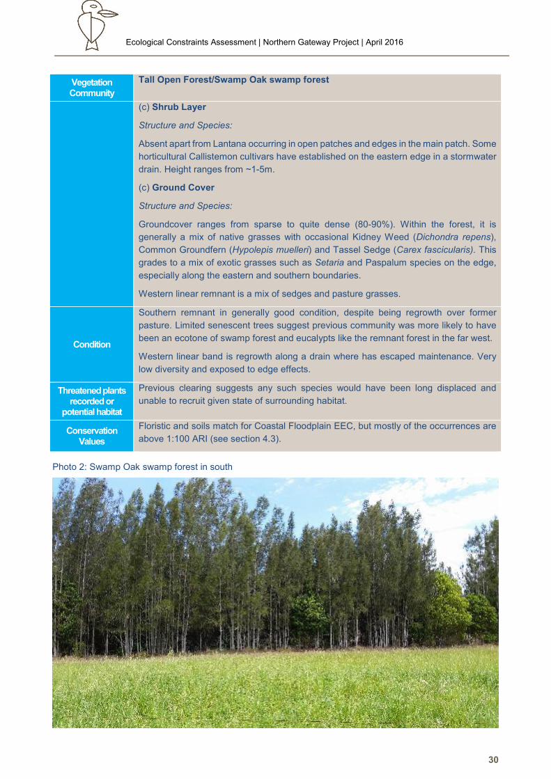
Photo 2: Swamp Oak swamp forest in south
Ecological Constraints Assessment | Northern Gateway Project | April 2016
31
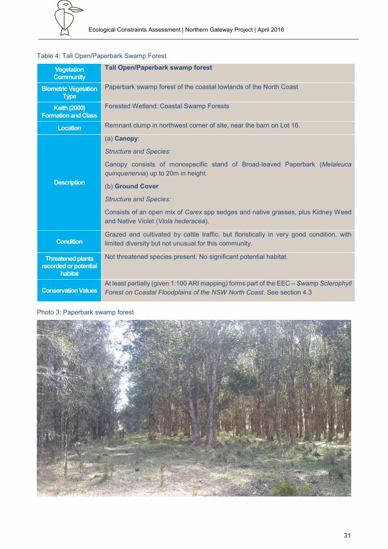
Table 4: Tall Open/Paperbark Swamp Forest
Vegetation Community
Tall Open/Paperbark swamp forest
Biometric Vegetation Type
Paperbark swamp forest of the coastal lowlands of the North Coast
Keith (2000) Formation and Class
Forested Wetland: Coastal Swamp Forests
Location Remnant clump in northwest corner of site, near the barn on Lot 16.
Description
(a) Canopy:
Structure and Species:
Canopy consists of monospecific stand of Broad-leaved Paperbark (Melaleuca
quinquenervia) up to 20m in height.
(b) Ground Cover
Structure and Species:
Consists of an open mix of Carex spp sedges and native grasses, plus Kidney Weed
and Native Violet (Viola hederacea).
Condition Grazed and cultivated by cattle traffic, but floristically in very good condition, with
limited diversity but not unusual for this community.
Threatened plants recorded or potential
habitat
Not threatened species present. No significant potential habitat.
Conservation Values At least partially (given 1:100 ARI mapping) forms part of the EEC – Swamp Sclerophyll
Forest on Coastal Floodplains of the NSW North Coast. See section 4.3
Photo 3: Paperbark swamp forest
Ecological Constraints Assessment | Northern Gateway Project | April 2016
32
Table 5: Immature swamp forest regrowth
Vegetation Community
Tall Shrubland/Very Tall Very Open Woodland (immature swamp forest regrowth)
Biometric Vegetation Type
Paperbark swamp forest of the coastal lowlands of the North Coast
Keith (2000) Formation and
Class
Forested Wetland: Coastal Swamp Forests
Location Western half of Lot 16. Adjoined to west and south by Melaleuca/Red Gum Closed Forest
(Terra 2003), and bound by linear band of Swamp Oak forest along eastern side.
Description
(a) Canopy:
Structure and Species:
Canopy consists of low density (<10% total cover) remnant Swamp Oak and Broad-
leaved Paperbarks with a few Forest Red Gum and Red Mahogany (E. resinifera) up to
23m in height. Present as widely scattered trees or small clumps. Scattered large stags
are also present.
(b) Shrub Layer
Structure and Species:
Shrub layer is moderately dense (50-60% total cover) and is dominated by Sieber’s
Paperbark (Melaleuca sieberi) and Flax-leaved Paperbark (M. linariifolia), with scattered
Swamp Oak, Broad-leaved Paperbark and Forest Red Gum. Leptospermum spp also
common to at times locally dense in small patches.
Height ranges from ~1-5m.
(c) Ground Cover
Structure and Species:
Very well developed, with 80-90% cover, 0.1-1.3m in height.
Groundcover is quite dense (80-90%) and is dominated by Carpet Grass (*Axonopus
fissifolius) and Whisky Grass (*Andropogon virginicus) with occasional Kidney Weed and
a range of sedges including Tassel Sedge, Juncus spp, Isolepis spp. Agricultural weeds
such as Fireweed (Senecio madagascariensis) are also common. Floristics varies with
local relief, with sedges dominating waterlogged areas.
Condition
Previously cleared and converted to improved pasture, but limited by poor drainage and
waterlogging, as evident by co-dominance with sedges. Lax maintenance has seen
regeneration from seedbank and colonisation from adjacent forest leading to advanced
regrowth. Closing in of canopy coupled with grazing pressure is slowly seeing shift in
groundcover floristics to native sedges and grasses.
Threatened plants recorded or
potential habitat
Not threatened species present. No significant potential habitat given disturbance
history. Potential habitat for the Endangered Population - Eucalyptus seeana Population,
Greater Taree Local Government Area.
Conservation Values
Forms part of local occurrence of Coastal Floodplain EECs.
Inspection of the adjacent Melaleuca/Red Gum Closed Forest (especially to west) noted
a few Red Gums which could not be confidently to be either E. tereticornis or E. seeana.
If present, the latter would as the Endangered Population - Eucalyptus seeana
Population, Greater Taree Local Government Area.
Ecological Constraints Assessment | Northern Gateway Project | April 2016
33
Photo 4: Regenerating swamp forest on western half of Lot 16
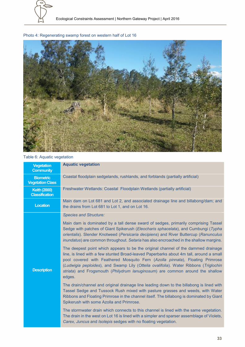
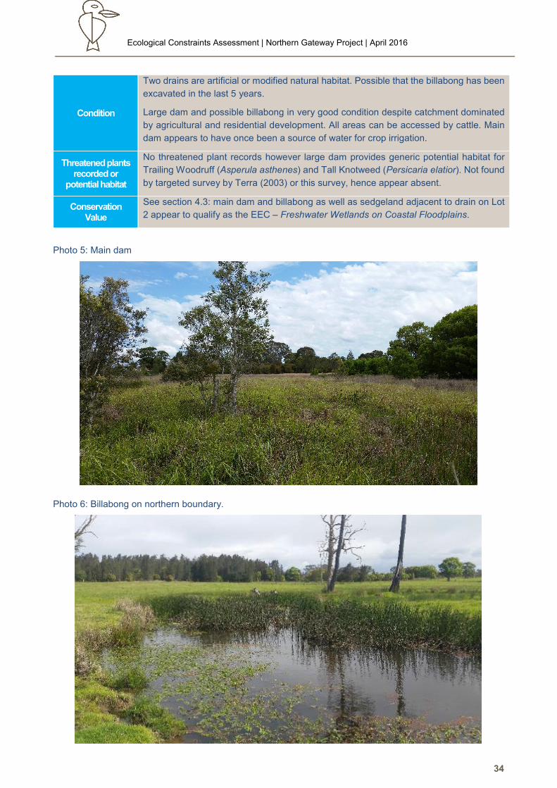
Table 6: Aquatic vegetation
Vegetation Community
Aquatic vegetation
Biometric Vegetation Class
Coastal floodplain sedgelands, rushlands, and forblands (partially artificial)
Keith (2000) Classification
Freshwater Wetlands: Coastal Floodplain Wetlands (partially artificial)
Location Main dam on Lot 681 and Lot 2, and associated drainage line and billabong/dam; and
the drains from Lot 681 to Lot 1, and on Lot 16.
Description
Species and Structure:
Main dam is dominated by a tall dense sward of sedges, primarily comprising Tassel
Sedge with patches of Giant Spikerush (Eleocharis sphacelata), and Cumbungi (Typha
orientalis). Slender Knotweed (Persicaria decipiens) and River Buttercup (Ranunculus
inundatus) are common throughout. Setaria has also encroached in the shallow margins.
The deepest point which appears to be the original channel of the dammed drainage
line, is lined with a few stunted Broad-leaved Paperbarks about 4m tall, around a small
pool covered with Feathered Mosquito Fern (Azolla pinnata), Floating Primrose
(Ludwigia peploides), and Swamp Lily (Ottelia ovalifolia). Water Ribbons (Triglochin
striata) and Frogsmouth (Philydrum lanuginosum) are common around the shallow
edges.
The drain/channel and original drainage line leading down to the billabong is lined with
Tassel Sedge and Tussock Rush mixed with pasture grasses and weeds, with Water
Ribbons and Floating Primrose in the channel itself. The billabong is dominated by Giant
Spikerush with some Azolla and Primrose.
The stormwater drain which connects to this channel is lined with the same vegetation.
The drain in the west on Lot 16 is lined with a simpler and sparser assemblage of Violets,
Carex, Juncus and Isolepis sedges with no floating vegetation.
Ecological Constraints Assessment | Northern Gateway Project | April 2016
34
Condition
Two drains are artificial or modified natural habitat. Possible that the billabong has been
excavated in the last 5 years.
Large dam and possible billabong in very good condition despite catchment dominated
by agricultural and residential development. All areas can be accessed by cattle. Main
dam appears to have once been a source of water for crop irrigation.
Threatened plants recorded or
potential habitat
No threatened plant records however large dam provides generic potential habitat for
Trailing Woodruff (Asperula asthenes) and Tall Knotweed (Persicaria elatior). Not found
by targeted survey by Terra (2003) or this survey, hence appear absent.
Conservation Value
See section 4.3: main dam and billabong as well as sedgeland adjacent to drain on Lot
2 appear to qualify as the EEC – Freshwater Wetlands on Coastal Floodplains.
Photo 5: Main dam
Photo 6: Billabong on northern boundary.
Ecological Constraints Assessment | Northern Gateway Project | April 2016
35
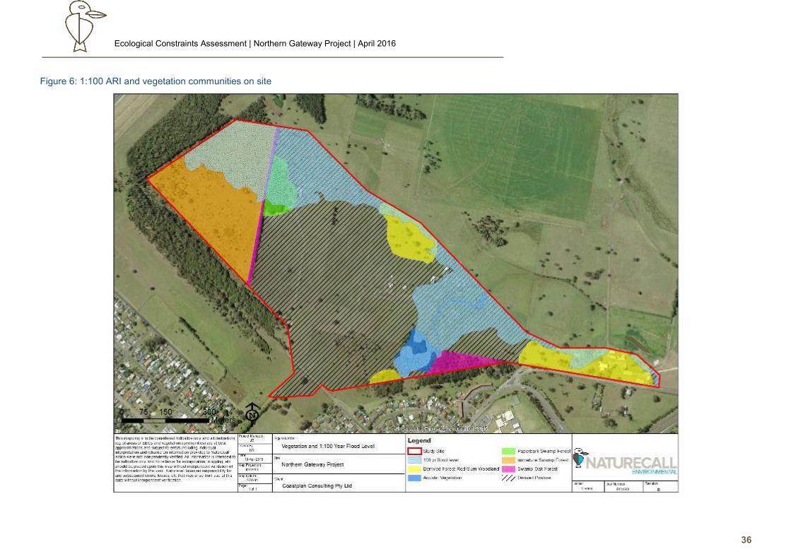
4.3. Threatened Ecological Communities
Site and Study Area EECs
As detailed in the following analysis and Figure 6, this site and study area contains examples in varying condition of the following Coastal Floodplain
Endangered Ecological Communities listed under the TSC Act 1995:
• Swamp Sclerophyll Forest on Coastal Floodplains of the NSW North Coast, Sydney Basin and South East Corner Bioregions, and
• Swamp Oak Floodplain Forest on Coastal Floodplains of the NSW North Coast, Sydney Basin and South East Corner Bioregions, and
• Subtropical Coastal Floodplain Forest of the NSW North Coast, Sydney Basin and South East Corner Bioregions, and
• Freshwater Wetlands on Coastal Floodplains of the NSW North Coast, Sydney Basin and South East Corner Bioregions.
No Threatened Ecological Communities listed under the EPBC Act occur on site or in the study area.
4.3.1.1. EEC - Freshwater Wetland on Coastal Floodplains
The following table demonstrates that an occurrence of the EEC - Freshwater Wetland on Coastal Floodplains, occurs on site in some form, with extent
subject to uncertainty due a range of factors.
Ecological Constraints Assessment | Northern Gateway Project | April 2016
36
Figure 6: 1:100 ARI and vegetation communities on site
Ecological Constraints Assessment | Northern Gateway Project | April 2016
37
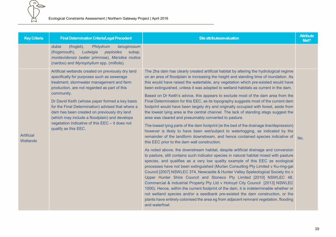
Table 7: Evaluation of the EEC – Freshwater Wetlands on Coastal Floodplains
Key Criteria Final Determination Criteria/Legal Precedent Site attributes/evaluation Attribute
Met?
Soils
Typically occur on silts, muds or humic loams.
Legal precedents (Gales Holdings Pty Limited v
Tweed Shire Council [2008] NSWLEC 209,
Motorplex (Australia) Pty Limited v Port Stephens
Council [2007] NSWLEC 7474) have also clarified
that the soils of the Coastal Floodplain EECs must
be fluvial in origin (as per the ecological processes
responsible for defining the physiognomic
character of the supported vegetation) and hence
alluvial; and that this should dominate the overall
character of the soil profile to be considered an
influence.
Confirmed – entire site falls on Quaternary alluvial soils (Troedson & Hashimoto
2008).
Yes
Landform
Typically occurs on depressions, flats, drainage
lines, back swamps, lagoons and lakes
associated with coastal floodplains.
Legal precedents (Gales Holdings Pty Limited v
Tweed Shire Council [2008] NSWLEC 209,
Motorplex (Australia) Pty Limited v Port Stephens
Council [2007] NSWLEC 7474) have clarified that
‘associated with’ can indicate ecological
processes associated with this EEC (eg fluvial
deposition, etc), as well as hydrological (flooding,
drainage, groundwater, waterlogging, etc) and
vegetation linkages. Hence a particular feature
does not have to be on a major floodplain, but
may be directly connected to such a landform eg
fingers of alluvial soils extending off the main
floodplain into drainage lines which flow onto the
A paleochannel which is now a drainage line or possibly an open depression runs
from Lot 681 to Lot 1 DP 733715, and onto the lower floodplain to the north. This
topographical feature meets the landform feature described in the Final
Determination.
This landform has been modified by establishment of the 2ha dam in the head, and
downstream via excavation of a formal natural channel to increase drainage and
reduce inundation periods. A possible pre-existing natural billabong in the northern
end may have also been converted to a dam, or a dam was created via excavation
of the original bed of the watercourse. As the origin of this feature is indeterminable,
the Precautionary Principle applies and it is assumed to originally be a natural feature
which has been subject to modification.
Notwithstanding the change to the natural hydrological regime and lowering of the
watertable by the drain, main dam and changes to the original landform: this has not
effectively extinguished ecological processes associated with the natural landform ie
flooding and waterlogging, as indicated by the sedges lining the channel. Similarly,
Yes
Ecological Constraints Assessment | Northern Gateway Project | April 2016
38
Key Criteria Final Determination Criteria/Legal Precedent Site attributes/evaluation Attribute
Met?
floodplain. as subsequently detailed, habitat suitable for the EEC would have occurred in the
large dam footprint prior to its establishment.
Associated
with a Coastal
Floodplain
Floodplains are level landform patterns on which
there may be active erosion and aggradation by
channelled and overbank stream flow with an
average recurrence interval of 100 years or less
(adapted from Speight 1990)
Figure 2 shows the 1:100 year flood occurrence includes the majority of the main
dam, and the entire drainage depression/line.
Yes
Latitudinal and
regional range
Generally occurs below 20m (rarely above 10m)
elevation in the NSW North Coast, Sydney Basin
and South East Corner bioregions.
Site elevation ranges from 1-4m
Yes
Structure/
indicator
species
The structure and composition of the community
varies both spatially and temporally depending on
the water regime, but overall is dominated by
herbaceous plants and has very few woody
species.
Wetlands or parts of wetlands that lack standing
water most of the time are usually dominated by
dense grassland or sedgeland vegetation, often
forming a turf <0.5m tall and dominated by
amphibious plants including Paspalum distichum
(water couch), Leersia hexandra (swamp rice-
grass), Pseudoraphis spinescens (mud grass) and
Carex appressa (tussock sedge). Wetlands or
parts of wetlands subject to regular inundation and
drying may include large emergent sedges >1m
tall, such as Baumea articulata, Eleocharis
equisetina and Lepironia articulata, as well as
emergent or floating herbs such as Hydrocharis
The current vegetation of the constructed dam, drain and billabong/small dam
consisted of indicator species such as Juncus usitatus, Eleocharis sphacelata,
Ludwigia peploides, Ottelia ovalifolia, Philydrum lanuginosum, Persicaria decipiens,
Triglochin striata, Typha orientalis, Ranunculus inundatus, etc. Hence all areas show
a strong floristic and structural match with the Final Determination.
While some or all of these species could have colonised the dams after construction,
the original habitat within the centre of the dam preceding this event is likely to have
contained these species (as indicated by remnant species in the same habitat
downstream), and hence in situ seedbanks are likely to have existed, and hence
formed part of the recolonization. Legal precedents have determined that this must
be considered in the absence of evidence to the contrary (Murlan Consulting Pty
Limited v Ku-ring-gai Council [2007] NSWLEC 374, Newcastle & Hunter Valley
Speleological Society Inc v Upper Hunter Shire Council and Stoneco Pty Limited
[2010] NSWLEC 48, Commercial & Industrial Property Pty Ltd v Holroyd City Council
[2013] NSWLEC 1000).
Despite the excavation of the drainage channel and the lowering of the water table,
as well as pastoralism, the bed of the drainage line contains a strip of common sedges
and wetland herbs eg Dichondra repens, Carex appressa, Juncus usitatus, etc.
Yes
Ecological Constraints Assessment | Northern Gateway Project | April 2016
39
Key Criteria Final Determination Criteria/Legal Precedent Site attributes/evaluation Attribute
Met?
dubia (frogbit), Philydrum lanuginosum
(frogsmouth), Ludwigia peploides subsp.
montevidensis (water primrose), Marsilea mutica
(nardoo) and Myriophyllum spp. (milfoils).
Artificial
Wetlands
Artificial wetlands created on previously dry land
specifically for purposes such as sewerage
treatment, stormwater management and farm
production, are not regarded as part of this
community.
Dr David Keith (whose paper formed a key basis
for the Final Determination) advised that where a
dam has been created on previously dry land
(which may include a floodplain) and develops
vegetation indicative of this EEC – it does not
qualify as this EEC.
The 2ha dam has clearly created artificial habitat by altering the hydrological regime
on an area of floodplain ie increasing the height and standing time of inundation. As
this would have raised the watertable, any vegetation which pre-existed would have
been extinguished, unless it was adapted to wetland habitats as current in the dam.
Based on Dr Keith’s advice, this appears to exclude most of the dam area from the
Final Determination for this EEC, as its topography suggests most of the current dam
footprint would have been largely dry and originally occupied with forest, aside from
the lowest lying area ie the central channel. The lack of standing stags suggest the
area was cleared and presumably converted to pasture.
The lowest lying parts of the dam footprint (ie the bed of the drainage line/depression)
however is likely to have been wet/subject to waterlogging, as indicated by the
remainder of the landform downstream, and hence contained species indicative of
this EEC prior to the dam wall construction.
As noted above, the downstream habitat, despite artificial drainage and conversion
to pasture, still contains such indicator species in natural habitat mixed with pasture
species, and qualifies as a very low quality example of this EEC as ecological
processes have not been extinguished (Murlan Consulting Pty Limited v Ku-ring-gai
Council [2007] NSWLEC 374, Newcastle & Hunter Valley Speleological Society Inc v
Upper Hunter Shire Council and Stoneco Pty Limited [2010] NSWLEC 48,
Commercial & Industrial Property Pty Ltd v Holroyd City Council [2013] NSWLEC
1000). Hence, within the current footprint of the dam, it is indeterminable whether or
not wetland species and/or a seedbank pre-existed the dam construction, or the
plants have entirely colonised the area eg from adjacent remnant vegetation, flooding
and waterfowl.
No.
Ecological Constraints Assessment | Northern Gateway Project | April 2016
40
Key Criteria Final Determination Criteria/Legal Precedent Site attributes/evaluation Attribute
Met?
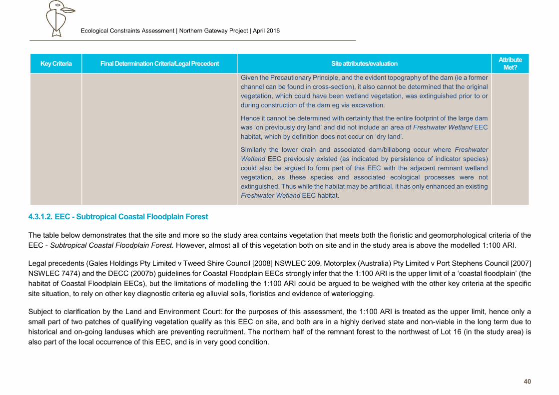
Given the Precautionary Principle, and the evident topography of the dam (ie a former
channel can be found in cross-section), it also cannot be determined that the original
vegetation, which could have been wetland vegetation, was extinguished prior to or
during construction of the dam eg via excavation.
Hence it cannot be determined with certainty that the entire footprint of the large dam
was ‘on previously dry land’ and did not include an area of Freshwater Wetland EEC
habitat, which by definition does not occur on ‘dry land’.
Similarly the lower drain and associated dam/billabong occur where Freshwater
Wetland EEC previously existed (as indicated by persistence of indicator species)
could also be argued to form part of this EEC with the adjacent remnant wetland
vegetation, as these species and associated ecological processes were not
extinguished. Thus while the habitat may be artificial, it has only enhanced an existing
Freshwater Wetland EEC habitat.
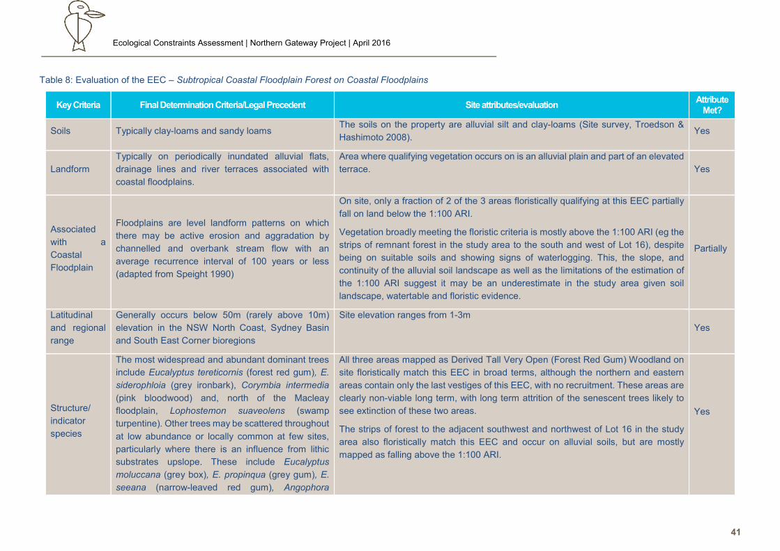
4.3.1.2. EEC - Subtropical Coastal Floodplain Forest
The table below demonstrates that the site and more so the study area contains vegetation that meets both the floristic and geomorphological criteria of the
EEC - Subtropical Coastal Floodplain Forest. However, almost all of this vegetation both on site and in the study area is above the modelled 1:100 ARI.
Legal precedents (Gales Holdings Pty Limited v Tweed Shire Council [2008] NSWLEC 209, Motorplex (Australia) Pty Limited v Port Stephens Council [2007]
NSWLEC 7474) and the DECC (2007b) guidelines for Coastal Floodplain EECs strongly infer that the 1:100 ARI is the upper limit of a ‘coastal floodplain’ (the
habitat of Coastal Floodplain EECs), but the limitations of modelling the 1:100 ARI could be argued to be weighed with the other key criteria at the specific
site situation, to rely on other key diagnostic criteria eg alluvial soils, floristics and evidence of waterlogging.
Subject to clarification by the Land and Environment Court: for the purposes of this assessment, the 1:100 ARI is treated as the upper limit, hence only a
small part of two patches of qualifying vegetation qualify as this EEC on site, and both are in a highly derived state and non-viable in the long term due to
historical and on-going landuses which are preventing recruitment. The northern half of the remnant forest to the northwest of Lot 16 (in the study area) is
also part of the local occurrence of this EEC, and is in very good condition.
Ecological Constraints Assessment | Northern Gateway Project | April 2016
41
Table 8: Evaluation of the EEC – Subtropical Coastal Floodplain Forest on Coastal Floodplains
Key Criteria Final Determination Criteria/Legal Precedent Site attributes/evaluation Attribute
Met?
Soils Typically clay-loams and sandy loams The soils on the property are alluvial silt and clay-loams (Site survey, Troedson &
Hashimoto 2008). Yes
Landform
Typically on periodically inundated alluvial flats,
drainage lines and river terraces associated with
coastal floodplains.
Area where qualifying vegetation occurs on is an alluvial plain and part of an elevated
terrace. Yes
Associated
with a
Coastal
Floodplain
Floodplains are level landform patterns on which
there may be active erosion and aggradation by
channelled and overbank stream flow with an
average recurrence interval of 100 years or less
(adapted from Speight 1990)
On site, only a fraction of 2 of the 3 areas floristically qualifying at this EEC partially
fall on land below the 1:100 ARI.
Vegetation broadly meeting the floristic criteria is mostly above the 1:100 ARI (eg the
strips of remnant forest in the study area to the south and west of Lot 16), despite
being on suitable soils and showing signs of waterlogging. This, the slope, and
continuity of the alluvial soil landscape as well as the limitations of the estimation of
the 1:100 ARI suggest it may be an underestimate in the study area given soil
landscape, watertable and floristic evidence.
Partially
Latitudinal
and regional
range
Generally occurs below 50m (rarely above 10m)
elevation in the NSW North Coast, Sydney Basin
and South East Corner bioregions
Site elevation ranges from 1-3m
Yes
Structure/
indicator
species
The most widespread and abundant dominant trees
include Eucalyptus tereticornis (forest red gum), E.
siderophloia (grey ironbark), Corymbia intermedia
(pink bloodwood) and, north of the Macleay
floodplain, Lophostemon suaveolens (swamp
turpentine). Other trees may be scattered throughout
at low abundance or locally common at few sites,
particularly where there is an influence from lithic
substrates upslope. These include Eucalyptus
moluccana (grey box), E. propinqua (grey gum), E.
seeana (narrow-leaved red gum), Angophora
All three areas mapped as Derived Tall Very Open (Forest Red Gum) Woodland on
site floristically match this EEC in broad terms, although the northern and eastern
areas contain only the last vestiges of this EEC, with no recruitment. These areas are
clearly non-viable long term, with long term attrition of the senescent trees likely to
see extinction of these two areas.
The strips of forest to the adjacent southwest and northwest of Lot 16 in the study
area also floristically match this EEC and occur on alluvial soils, but are mostly
mapped as falling above the 1:100 ARI.
Yes
Ecological Constraints Assessment | Northern Gateway Project | April 2016
42
Key Criteria Final Determination Criteria/Legal Precedent Site attributes/evaluation Attribute
Met?
subvelutina (broad-leaved apple), E. robusta
(swamp mahogany), Eucalyptus resinifera subsp.
hemilampra (red mahogany), E. acmenoides (white
mahogany), Angophora woodsiana, A. paludosa and
rainforest trees such as Ficus spp. (figs) and
Cupaniopsis spp (tuckeroos).
4.3.1.3. EEC - Swamp Oak Floodplain Forest on Coastal Floodplains
This EEC occurs as a single line of trees along a drain on Lot 16, where it falls below the 1:100 ARI, and in forest to the north of Lot 16 in the study area. The
largest stand of vegetation which floristically matches this EEC on site (in the southeast) also falls on alluvial soils, but appears to mostly be above the 1:100
ARI, and hence legally does not appear to qualify as this EEC.
The local occurrence of this EEC may be a derivation of the EEC – Swamp Sclerophyll Forest on Coastal Floodplains due to being regrowth, and not a true
occurrence of the EEC, but the Final Determination allows for such seral stages and complex intergrades of all the Coastal Floodplain EECs.
The EEC is considered generally viable due to the co-occurrence with swamp sclerophyll on Lot 16 which provides genetic diversity, and the extent of Swamp
Oak forest in the southeast occurrence and in the northwest study area. Limited floristic and fauna diversity and ongoing weed invasion (especially in the
southeast stand) however limits value.
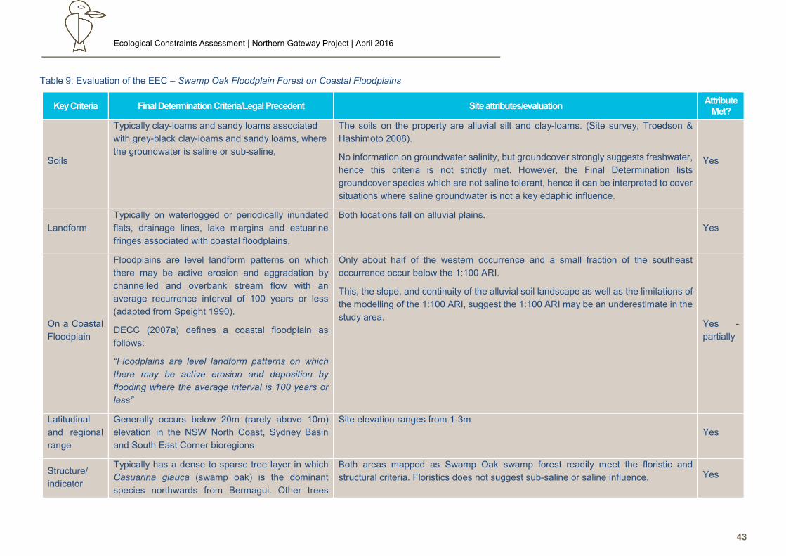
Ecological Constraints Assessment | Northern Gateway Project | April 2016
43
Table 9: Evaluation of the EEC – Swamp Oak Floodplain Forest on Coastal Floodplains
Key Criteria Final Determination Criteria/Legal Precedent Site attributes/evaluation Attribute
Met?
Soils
Typically clay-loams and sandy loams associated
with grey-black clay-loams and sandy loams, where
the groundwater is saline or sub-saline,
The soils on the property are alluvial silt and clay-loams. (Site survey, Troedson &
Hashimoto 2008).
No information on groundwater salinity, but groundcover strongly suggests freshwater,
hence this criteria is not strictly met. However, the Final Determination lists
groundcover species which are not saline tolerant, hence it can be interpreted to cover
situations where saline groundwater is not a key edaphic influence.
Yes
Landform
Typically on waterlogged or periodically inundated
flats, drainage lines, lake margins and estuarine
fringes associated with coastal floodplains.
Both locations fall on alluvial plains.
Yes
On a Coastal
Floodplain
Floodplains are level landform patterns on which
there may be active erosion and aggradation by
channelled and overbank stream flow with an
average recurrence interval of 100 years or less
(adapted from Speight 1990).
DECC (2007a) defines a coastal floodplain as
follows:
“Floodplains are level landform patterns on which
there may be active erosion and deposition by
flooding where the average interval is 100 years or
less”
Only about half of the western occurrence and a small fraction of the southeast
occurrence occur below the 1:100 ARI.
This, the slope, and continuity of the alluvial soil landscape as well as the limitations of
the modelling of the 1:100 ARI, suggest the 1:100 ARI may be an underestimate in the
study area. Yes -
partially
Latitudinal
and regional
range
Generally occurs below 20m (rarely above 10m)
elevation in the NSW North Coast, Sydney Basin
and South East Corner bioregions
Site elevation ranges from 1-3m
Yes
Structure/
indicator
Typically has a dense to sparse tree layer in which
Casuarina glauca (swamp oak) is the dominant
species northwards from Bermagui. Other trees
Both areas mapped as Swamp Oak swamp forest readily meet the floristic and
structural criteria. Floristics does not suggest sub-saline or saline influence. Yes
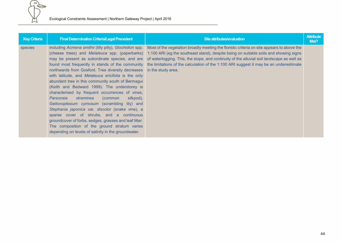
Ecological Constraints Assessment | Northern Gateway Project | April 2016
44
Key Criteria Final Determination Criteria/Legal Precedent Site attributes/evaluation Attribute
Met?
species including Acmena smithii (lilly pilly), Glochidion spp.
(cheese trees) and Melaleuca spp. (paperbarks)
may be present as subordinate species, and are
found most frequently in stands of the community
northwards from Gosford. Tree diversity decreases
with latitude, and Melaleuca ericifolia is the only
abundant tree in this community south of Bermagui
(Keith and Bedward 1999). The understorey is
characterised by frequent occurrences of vines,
Parsonsia straminea (common silkpod),
Geitonoplesium cymosum (scrambling lily) and
Stephania japonica var. discolor (snake vine), a
sparse cover of shrubs, and a continuous
groundcover of forbs, sedges, grasses and leaf litter.
The composition of the ground stratum varies
depending on levels of salinity in the groundwater.
Most of the vegetation broadly meeting the floristic criteria on site appears to above the
1:100 ARI (eg the southeast stand), despite being on suitable soils and showing signs
of waterlogging. This, the slope, and continuity of the alluvial soil landscape as well as
the limitations of the calculation of the 1:100 ARI suggest it may be an underestimate
in the study area.
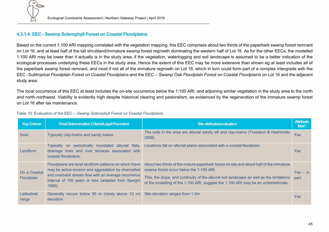
Ecological Constraints Assessment | Northern Gateway Project | April 2016
45
4.3.1.4. EEC - Swamp Sclerophyll Forest on Coastal Floodplains
Based on the current 1:100 ARI mapping correlated with the vegetation mapping, this EEC comprises about two thirds of the paperbark swamp forest remnant
on Lot 16, and at least half of the tall shrubland/immature swamp forest regrowth dominating the western half of Lot 16. As for the other EECs, the modelled
1:100 ARI may be lower than it actually is in the study area, if the vegetation, waterlogging and soil landscape is assumed to be a better indication of the
ecological processes underlying these EECs in the study area. Hence the extent of this EEC may be more extensive than shown eg at least includes all of
the paperbark swamp forest remnant, and most if not all of the immature regrowth on Lot 16, which in turn could form part of a complex intergrade with the
EEC -Subtropical Floodplain Forest on Coastal Floodplains and the EEC – Swamp Oak Floodplain Forest on Coastal Floodplains on Lot 16 and the adjacent
study area.
The local occurrence of this EEC at least includes the on-site occurrence below the 1:100 ARI, and adjoining similar vegetation in the study area to the north
and north-northwest. Viability is evidently high despite historical clearing and pastoralism, as evidenced by the regeneration of the immature swamp forest
on Lot 16 after lax maintenance.
Table 10: Evaluation of the EEC – Swamp Sclerophyll Forest on Coastal Floodplains
Key Criteria Final Determination Criteria/Legal Precedent Site attributes/evaluation Attribute
Met?
Soils Typically clay-loams and sandy loams The soils in the area are alluvial sandy silt and clay-loams (Troedson & Hashimoto
2008). Yes
Landform
Typically on periodically inundated alluvial flats,
drainage lines and river terraces associated with
coastal floodplains.
Locations fall on alluvial plains associated with a coastal floodplain.
Yes
On a Coastal
Floodplain
Floodplains are level landform patterns on which there
may be active erosion and aggradation by channelled
and overbank stream flow with an average recurrence
interval of 100 years or less (adapted from Speight
1990)
About two thirds of the mature paperbark forest on site and about half of the immature
swamp forest occur below the 1:100 ARI.
This, the slope, and continuity of the alluvial soil landscape as well as the limitations
of the modelling of the 1:100 ARI, suggest the 1:100 ARI may be an underestimate.
Yes – in
part.
Latitudinal
range
Generally occurs below 50 m (rarely above 10 m)
elevation
Site elevation ranges from 1-3m Yes
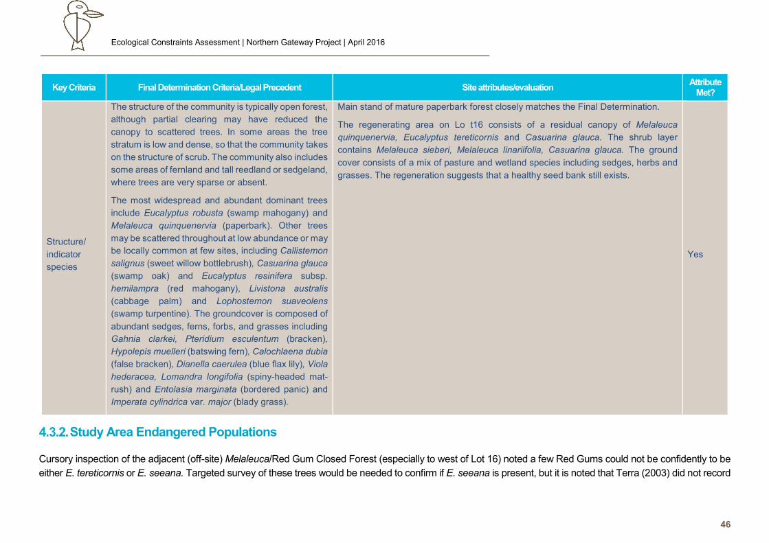
Ecological Constraints Assessment | Northern Gateway Project | April 2016
46
Key Criteria Final Determination Criteria/Legal Precedent Site attributes/evaluation Attribute
Met?
Structure/
indicator
species
The structure of the community is typically open forest,
although partial clearing may have reduced the
canopy to scattered trees. In some areas the tree
stratum is low and dense, so that the community takes
on the structure of scrub. The community also includes
some areas of fernland and tall reedland or sedgeland,
where trees are very sparse or absent.
The most widespread and abundant dominant trees
include Eucalyptus robusta (swamp mahogany) and
Melaleuca quinquenervia (paperbark). Other trees
may be scattered throughout at low abundance or may
be locally common at few sites, including Callistemon
salignus (sweet willow bottlebrush), Casuarina glauca
(swamp oak) and Eucalyptus resinifera subsp.
hemilampra (red mahogany), Livistona australis
(cabbage palm) and Lophostemon suaveolens
(swamp turpentine). The groundcover is composed of
abundant sedges, ferns, forbs, and grasses including
Gahnia clarkei, Pteridium esculentum (bracken),
Hypolepis muelleri (batswing fern), Calochlaena dubia
(false bracken), Dianella caerulea (blue flax lily), Viola
hederacea, Lomandra longifolia (spiny-headed mat-
rush) and Entolasia marginata (bordered panic) and
Imperata cylindrica var. major (blady grass).
Main stand of mature paperbark forest closely matches the Final Determination.
The regenerating area on Lo t16 consists of a residual canopy of Melaleuca
quinquenervia, Eucalyptus tereticornis and Casuarina glauca. The shrub layer
contains Melaleuca sieberi, Melaleuca linariifolia, Casuarina glauca. The ground
cover consists of a mix of pasture and wetland species including sedges, herbs and
grasses. The regeneration suggests that a healthy seed bank still exists.
Yes
Study Area Endangered Populations
Cursory inspection of the adjacent (off-site) Melaleuca/Red Gum Closed Forest (especially to west of Lot 16) noted a few Red Gums could not be confidently to be
either E. tereticornis or E. seeana. Targeted survey of these trees would be needed to confirm if E. seeana is present, but it is noted that Terra (2003) did not record
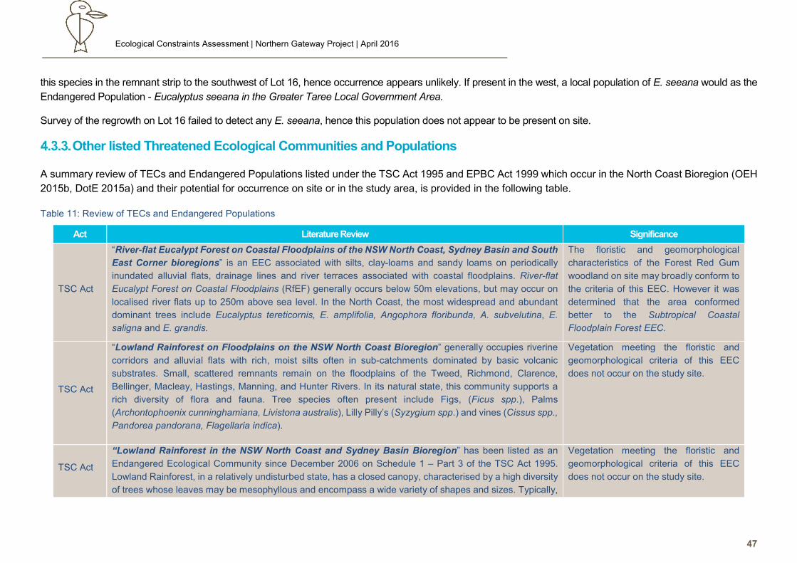
Ecological Constraints Assessment | Northern Gateway Project | April 2016
47
this species in the remnant strip to the southwest of Lot 16, hence occurrence appears unlikely. If present in the west, a local population of E. seeana would as the
Endangered Population - Eucalyptus seeana in the Greater Taree Local Government Area.
Survey of the regrowth on Lot 16 failed to detect any E. seeana, hence this population does not appear to be present on site.
Other listed Threatened Ecological Communities and Populations
A summary review of TECs and Endangered Populations listed under the TSC Act 1995 and EPBC Act 1999 which occur in the North Coast Bioregion (OEH
2015b, DotE 2015a) and their potential for occurrence on site or in the study area, is provided in the following table.
Table 11: Review of TECs and Endangered Populations
TSC Act
“River-flat Eucalypt Forest on Coastal Floodplains of the NSW North Coast, Sydney Basin and South
East Corner bioregions” is an EEC associated with silts, clay-loams and sandy loams on periodically
inundated alluvial flats, drainage lines and river terraces associated with coastal floodplains. River-flat
Eucalypt Forest on Coastal Floodplains (RfEF) generally occurs below 50m elevations, but may occur on
localised river flats up to 250m above sea level. In the North Coast, the most widespread and abundant
dominant trees include Eucalyptus tereticornis, E. amplifolia, Angophora floribunda, A. subvelutina, E.
saligna and E. grandis.
The floristic and geomorphological
characteristics of the Forest Red Gum
woodland on site may broadly conform to
the criteria of this EEC. However it was
determined that the area conformed
better to the Subtropical Coastal
Floodplain Forest EEC.
TSC Act
“Lowland Rainforest on Floodplains on the NSW North Coast Bioregion” generally occupies riverine
corridors and alluvial flats with rich, moist silts often in sub-catchments dominated by basic volcanic
substrates. Small, scattered remnants remain on the floodplains of the Tweed, Richmond, Clarence,
Bellinger, Macleay, Hastings, Manning, and Hunter Rivers. In its natural state, this community supports a
rich diversity of flora and fauna. Tree species often present include Figs, (Ficus spp.), Palms
(Archontophoenix cunninghamiana, Livistona australis), Lilly Pilly’s (Syzygium spp.) and vines (Cissus spp.,
Pandorea pandorana, Flagellaria indica).
Vegetation meeting the floristic and
geomorphological criteria of this EEC
does not occur on the study site.
TSC Act
“Lowland Rainforest in the NSW North Coast and Sydney Basin Bioregion” has been listed as an
Endangered Ecological Community since December 2006 on Schedule 1 – Part 3 of the TSC Act 1995.
Lowland Rainforest, in a relatively undisturbed state, has a closed canopy, characterised by a high diversity
of trees whose leaves may be mesophyllous and encompass a wide variety of shapes and sizes. Typically,
Vegetation meeting the floristic and
geomorphological criteria of this EEC
does not occur on the study site.
Act Literature Review Significance
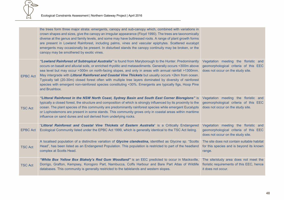
Ecological Constraints Assessment | Northern Gateway Project | April 2016
48
the trees form three major strata: emergents, canopy and sub-canopy which, combined with variations in
crown shapes and sizes, give the canopy an irregular appearance (Floyd 1990). The trees are taxonomically
diverse at the genus and family levels, and some may have buttressed roots. A range of plant growth forms
are present in Lowland Rainforest, including palms, vines and vascular epiphytes. Scattered eucalypt
emergents may occasionally be present. In disturbed stands the canopy continuity may be broken, or the
canopy may be smothered by exotic vines.
EPBC Act
“Lowland Rainforest of Subtropical Australia” is found from Maryborough to the Hunter. Predominantly
occurs on basalt and alluvial soils, or enriched rhyolitic and metasediments. Generally occurs <300m above
sea level but may occur >300m on north-facing slopes, and only in areas with annual rainfall >1300mm.
May intergrade with Littoral Rainforest and Coastal Vine Thickets but usually occurs >2km from ocean.
Typically tall (20-30m) closed forest often with multiple tree layers dominated by diversity of rainforest
species with emergent non-rainforest species constituting <30%. Emergents are typically figs, Hoop Pine
and Brushbox.
Vegetation meeting the floristic and
geomorphological criteria of this EEC
does not occur on the study site.
TSC Act
“Littoral Rainforest in the NSW North Coast, Sydney Basin and South East Corner Bioregions” is
typically a closed forest, the structure and composition of which is strongly influenced by its proximity to the
ocean. The plant species of this community are predominantly rainforest species while emergent Eucalypts
or Lophostemons are present in some stands. This community grows only in coastal areas within maritime
influence on sand dunes and soil derived from underlying rocks.
Vegetation meeting the floristic and
geomorphological criteria of this EEC
does not occur on the study site.
EPBC Act
“Littoral Rainforest and Coastal Vine Thickets of Eastern Australia” is a Critically Endangered
Ecological Community listed under the EPBC Act 1999, which is generally identical to the TSC Act listing.
Vegetation meeting the floristic and
geomorphological criteria of this EEC
does not occur on the study site.
TSC Act
A localised population of a distinctive variation of Glycine clandestina, identified as Glycine sp. “Scotts
Head”, has been listed as an Endangered Population. This population is restricted to part of the headland
complex at Scotts Head.
The site does not contain suitable habitat
for this species and is beyond its known
range.
TSC Act
“White Box Yellow Box Blakely’s Red Gum Woodland” is an EEC predicted to occur in Macksville,
Dorrigo, Grafton, Kempsey, Korogoro Part, Nambucca, Coffs Harbour and Bare Part Atlas of Wildlife
databases. This community is generally restricted to the tablelands and western slopes.
The site/study area does not meet the
floristic requirements of this EEC, hence
it does not occur.
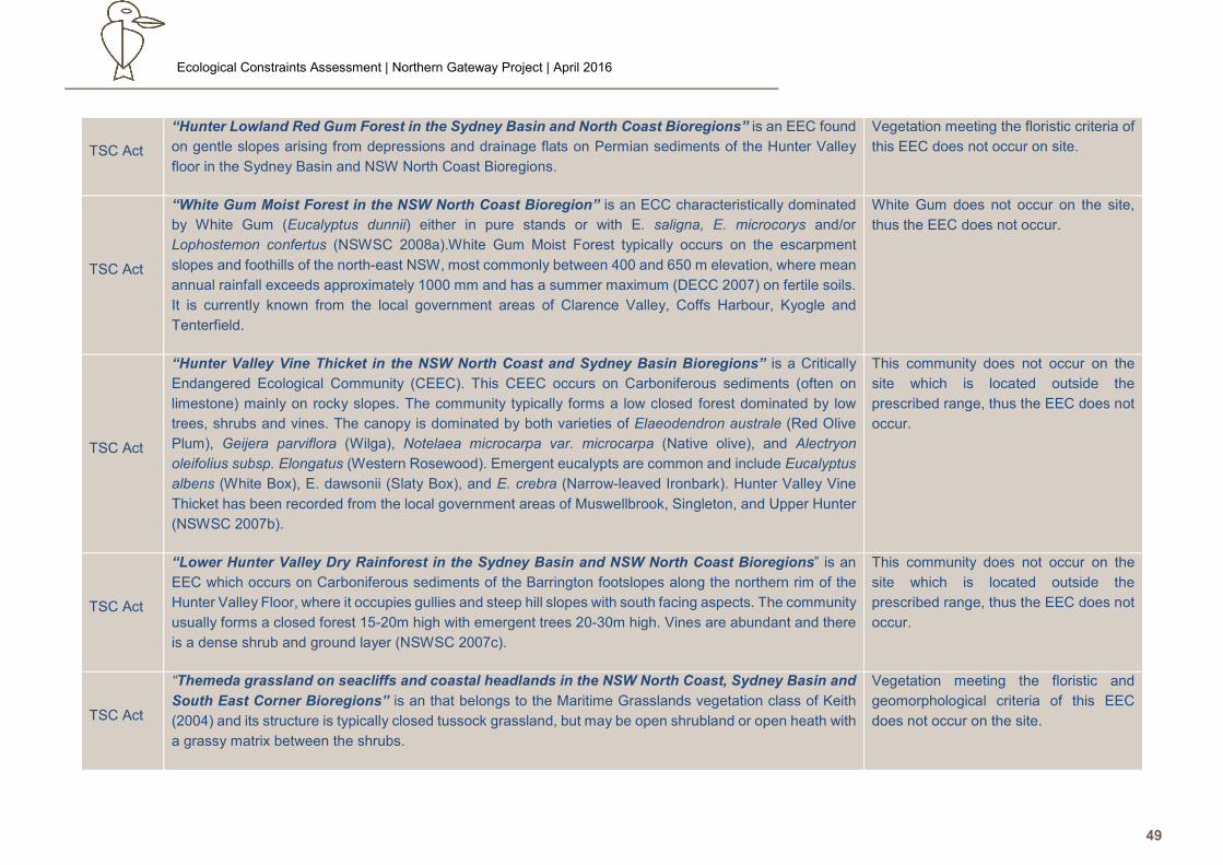
Ecological Constraints Assessment | Northern Gateway Project | April 2016
49
TSC Act
“Hunter Lowland Red Gum Forest in the Sydney Basin and North Coast Bioregions” is an EEC found
on gentle slopes arising from depressions and drainage flats on Permian sediments of the Hunter Valley
floor in the Sydney Basin and NSW North Coast Bioregions.
Vegetation meeting the floristic criteria of
this EEC does not occur on site.
TSC Act
“White Gum Moist Forest in the NSW North Coast Bioregion” is an ECC characteristically dominated
by White Gum (Eucalyptus dunnii) either in pure stands or with E. saligna, E. microcorys and/or
Lophostemon confertus (NSWSC 2008a).White Gum Moist Forest typically occurs on the escarpment
slopes and foothills of the north-east NSW, most commonly between 400 and 650 m elevation, where mean
annual rainfall exceeds approximately 1000 mm and has a summer maximum (DECC 2007) on fertile soils.
It is currently known from the local government areas of Clarence Valley, Coffs Harbour, Kyogle and
Tenterfield.
White Gum does not occur on the site,
thus the EEC does not occur.
TSC Act
“Hunter Valley Vine Thicket in the NSW North Coast and Sydney Basin Bioregions” is a Critically
Endangered Ecological Community (CEEC). This CEEC occurs on Carboniferous sediments (often on
limestone) mainly on rocky slopes. The community typically forms a low closed forest dominated by low
trees, shrubs and vines. The canopy is dominated by both varieties of Elaeodendron australe (Red Olive
Plum), Geijera parviflora (Wilga), Notelaea microcarpa var. microcarpa (Native olive), and Alectryon
oleifolius subsp. Elongatus (Western Rosewood). Emergent eucalypts are common and include Eucalyptus
albens (White Box), E. dawsonii (Slaty Box), and E. crebra (Narrow-leaved Ironbark). Hunter Valley Vine
Thicket has been recorded from the local government areas of Muswellbrook, Singleton, and Upper Hunter
(NSWSC 2007b).
This community does not occur on the
site which is located outside the
prescribed range, thus the EEC does not
occur.
TSC Act
“Lower Hunter Valley Dry Rainforest in the Sydney Basin and NSW North Coast Bioregions” is an
EEC which occurs on Carboniferous sediments of the Barrington footslopes along the northern rim of the
Hunter Valley Floor, where it occupies gullies and steep hill slopes with south facing aspects. The community
usually forms a closed forest 15-20m high with emergent trees 20-30m high. Vines are abundant and there
is a dense shrub and ground layer (NSWSC 2007c).
This community does not occur on the
site which is located outside the
prescribed range, thus the EEC does not
occur.
TSC Act
“Themeda grassland on seacliffs and coastal headlands in the NSW North Coast, Sydney Basin and
South East Corner Bioregions” is an that belongs to the Maritime Grasslands vegetation class of Keith
(2004) and its structure is typically closed tussock grassland, but may be open shrubland or open heath with
a grassy matrix between the shrubs.
Vegetation meeting the floristic and
geomorphological criteria of this EEC
does not occur on the site.
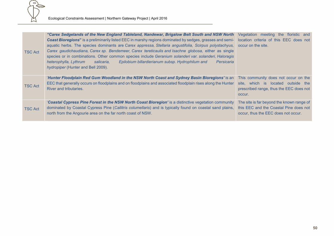
Ecological Constraints Assessment | Northern Gateway Project | April 2016
50
TSC Act
“Carex Sedgelands of the New England Tableland, Nandewar, Brigalow Belt South and NSW North
Coast Bioregions” is a preliminarily listed EEC in marshy regions dominated by sedges, grasses and semi-
aquatic herbs. The species dominants are Carex appressa, Stellaria angustifolia, Scirpus polystachyus,
Carex gaudichaudiana, Carex sp. Bendemeer, Carex tereticaulis and Isachne globosa, either as single
species or in combinations. Other common species include Geranium solanderi var. solanderi, Haloragis
heterophylla, Lythrum salicaria, Epilobium billardierianum subsp. Hydrophilum and Persicaria
hydropiper (Hunter and Bell 2009).
Vegetation meeting the floristic and
location criteria of this EEC does not
occur on the site.
TSC Act
‘Hunter Floodplain Red Gum Woodland in the NSW North Coast and Sydney Basin Bioregions’ is an
EEC that generally occurs on floodplains and on floodplains and associated floodplain rises along the Hunter
River and tributaries.
This community does not occur on the
site, which is located outside the
prescribed range, thus the EEC does not
occur.
TSC Act
‘Coastal Cypress Pine Forest in the NSW North Coast Bioregion’ is a distinctive vegetation community
dominated by Coastal Cypress Pine (Callitris columellaris) and is typically found on coastal sand plains,
north from the Angourie area on the far north coast of NSW.
The site is far beyond the known range of
this EEC and the Coastal Pine does not
occur, thus the EEC does not occur.
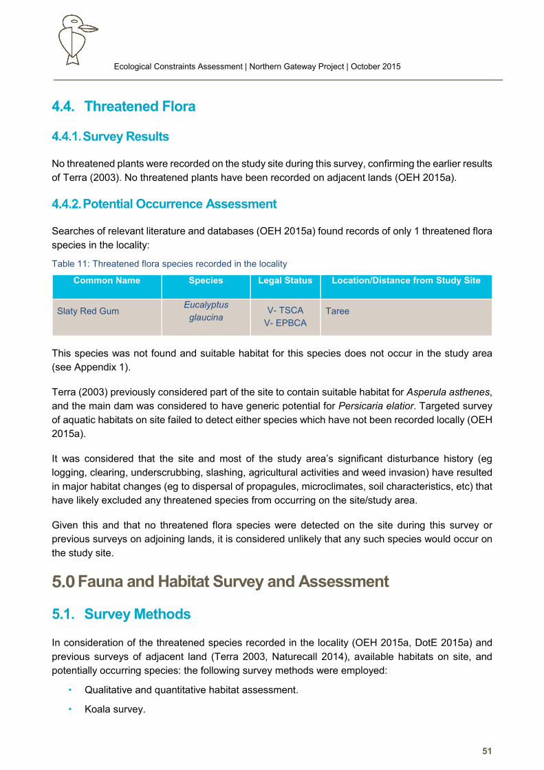
Ecological Constraints Assessment | Northern Gateway Project | October 2015
51
4.4. Threatened Flora
Survey Results
No threatened plants were recorded on the study site during this survey, confirming the earlier results
of Terra (2003). No threatened plants have been recorded on adjacent lands (OEH 2015a).
Potential Occurrence Assessment
Searches of relevant literature and databases (OEH 2015a) found records of only 1 threatened flora
species in the locality:
Table 11: Threatened flora species recorded in the locality
Common Name Species Legal Status Location/Distance from Study Site
Slaty Red Gum Eucalyptus
glaucina V- TSCA
V- EPBCA
Taree
This species was not found and suitable habitat for this species does not occur in the study area
(see Appendix 1).
Terra (2003) previously considered part of the site to contain suitable habitat for Asperula asthenes,
and the main dam was considered to have generic potential for Persicaria elatior. Targeted survey
of aquatic habitats on site failed to detect either species which have not been recorded locally (OEH
2015a).
It was considered that the site and most of the study area’s significant disturbance history (eg
logging, clearing, underscrubbing, slashing, agricultural activities and weed invasion) have resulted
in major habitat changes (eg to dispersal of propagules, microclimates, soil characteristics, etc) that
have likely excluded any threatened species from occurring on the site/study area.
Given this and that no threatened flora species were detected on the site during this survey or
previous surveys on adjoining lands, it is considered unlikely that any such species would occur on
the study site.
5.0 Fauna and Habitat Survey and Assessment
5.1. Survey Methods
In consideration of the threatened species recorded in the locality (OEH 2015a, DotE 2015a) and
previous surveys of adjacent land (Terra 2003, Naturecall 2014), available habitats on site, and
potentially occurring species: the following survey methods were employed:
• Qualitative and quantitative habitat assessment.
• Koala survey.
Ecological Constraints Assessment | Northern Gateway Project | October 2015
52
• Spotlighting and stag watching over 4 nights.
• Call playback and detection over 4 nights.
• Hollow-bearing tree survey.
• Diurnal reptile and bird survey.
• Physical searches of habitat e.g. leaf litter, etc.
• Opportunistic sightings, scratches and scats.
• Anabat surveys
It is acknowledged that the full range of techniques (e.g. pitfall trapping and harp trapping) which could
have been used and extent of effort for some methods (eg owl call playback) is less than specified by
the DEC (2004) guidelines. However, as provided for in the guidelines, use of these techniques and effort
is not considered warranted in this instance given the previous surveys on adjacent land, lack of habitat
for some locally recorded species, and the consultant’s high level of ecological knowledge of the area.
In contrast, effort was expended well above DEC (2004) minimum standards for species would which
would be at risk of the greatest impact if present eg Koala.
Survey was undertaken by Naturecall’s principal ecologist and an ecologist under Naturecall’s scientific
license and animal research authority.
Habitat Evaluation
The site was surveyed to determine the available potential habitats, and the support value of these
habitats for threatened species. Habitats were defined according to parameters such as:
• Structural and floristic characteristics of the vegetation e.g. understorey type and
development, crown depth, groundcover density, etc.
• Degree and extent of disturbance e.g. fire, logging, weed invasion, modification to structure
and diversity, etc.
• Soil type and suitability e.g. for digging and burrowing.
• Presence of water in any form e.g. dams, creeks, drainage lines, soaks.
• Size and abundance of hollows and fallen timber.
• Availability of shelter e.g. rocks, logs, hollows, undergrowth.
• Wildlife corridors, refuges and proximate habitat types.
• Presence of mistletoe, nectar, gum, seed, sap, etc. sources.
Species identification was assisted by Morcombe and Stewart (2010), Pizzey and Knight (2003),
Tyler and Knight (2009), Wilson and Knowles (1992), Strahan (2008), Triggs (1996), Robinson
(1996), Swan et al (2004) and Schodde and Tideman (1990).
Ecological Constraints Assessment | Northern Gateway Project | October 2015
53
Koala Survey
Survey for Koalas consisted of diurnal searches of all trees on site and within at least 50m adjacent
over 3 days, and Spot Assessment Technique (SAT) surveys on site. Koalas were also surveyed by
spotlighting and call playback over 4 nights for a total effort of 10hrs of nocturnal survey.
The SAT surveys consisted of checking the ground and leaf litter for Koala scats in a 2m radius
around 30 trees tree per sample site for a period of two minutes per tree or until a scat was found.
This technique is recognised as a very efficient method of detecting Koala presence, and in some
instances, is a method used to identify areas of major Koala activity/significance eg Core Koala
Habitat (Phillips and Callahan 2011, Jurskis and Potter 1997, NPWS 2001, DECC 2008, Biolink
2013b).
Spotlighting, Torch Searches and Stag Watching
Spotlighting was conducted for at least 1.5 hours over 4 separate sessions with the first within 45
mins of dusk and others after 8pm, over 4 nights. This was more than sufficient to cover the majority
to all of the site’s limited tree cover per session; and minimise disturbance to surrounding residents
caused by barking dogs. The procedure involved walking with a hand held 50-100 watt spotlight over
the site, targeting the trunks and branches of canopy trees and understorey, and periodically
scanning the ground.
Torch searches for frogs were undertaken in conjunction with spotlighting around the detention
basins on and adjacent to the site, and the drainage depression on Lot 681 to Lot 1 & 2. A total of 4
hours was dedicated to this activity.
Conditions were overcast with showers on the first night and fourth nights, and clear on the other
nights. Wind ranged from placid to moderate.
Call Playback, Identification and Recording
Recorded calls of the following species were routinely played in the site and study area:
• Wallum Froglet
• Masked, Barking and Powerful Owls
• Yellow Bellied Glider
• Squirrel Glider
• Koala
Calls for the birds and arboreal mammals were played through a portable MP3 player via a 30W PA
system from a vehicle at a level approximating natural intensities of the species. The general
methodology involved an initial period of listening and spotlighting; followed by playback of the calls
simulating a natural pattern. This was followed by 10 minutes of listening and 10-15 minutes
spotlighting for fauna attracted by the calls (but not responding vocally), within 100m radius of the
Ecological Constraints Assessment | Northern Gateway Project | October 2015
54
playback point. Calls were played during each spotlighting session at a different location at the
southern and northern end of the site.
Calls were generally played soon after dusk, when such calls are normally heard. Playback was
utilised over the area over 4 nights for a total of 4 hours of this activity.
Diurnal Bird Survey
Birds were surveyed by detecting calls and searching by binoculars during area searches over the
whole site and actively listening/searching for birds in the morning before 8am and in the afternoon
from 4pm.
Bird surveys were also conducted opportunistically during other activities (e.g. flora survey and
habitat evaluation) as transects and spot surveys were redundant given the limited habitat. Binocular
scans were also periodically undertaken over the adjacent saltmarsh for waders.
This information provided short-term data on bird occurrences in the area for the particular season
(DEC 2004).
Herpetofauna and Secondary Evidence Searches
Physical habitat searches of the site were undertaken during the survey which involved:
• Lifting up of debris (eg logs) to search for reptiles and frogs.
• Inspection of dense vegetation for bird nests.
• Raking of leaf litter for frogs and reptiles.
• Observation of likely basking sites (i.e. reptiles and frogs).
• Searches for scats, tracks, digging, sap incisions and scratches (e.g. Koala, gliders, etc.)
over the site.
• Searches for scats, owl regurgitation pellets and guano deposits.
A total of 4 hours was specifically spent on general habitat searches with opportunistic searches
also undertaken during other activities.
Hollow Bearing Tree Survey
All hollow bearing trees and stags on the study site were located and recorded via hand held GPS.
Each tree was quantified (height, trunk diameter, number of hollows, location in tree and aperture
diameter), marked with pink spray paint, and assigned an identifier number.
Limitations
Fauna detectability is limited by seasonal, behavioural or lifecycle characteristics of each species,
and even by habitat variations (e.g. flowering periods), which can occur within a year, between years,
decades, etc. (DEC 2004).
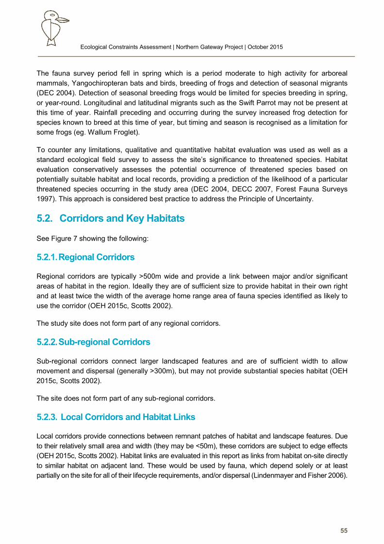
Ecological Constraints Assessment | Northern Gateway Project | October 2015
55
The fauna survey period fell in spring which is a period moderate to high activity for arboreal
mammals, Yangochiropteran bats and birds, breeding of frogs and detection of seasonal migrants
(DEC 2004). Detection of seasonal breeding frogs would be limited for species breeding in spring,
or year-round. Longitudinal and latitudinal migrants such as the Swift Parrot may not be present at
this time of year. Rainfall preceding and occurring during the survey increased frog detection for
species known to breed at this time of year, but timing and season is recognised as a limitation for
some frogs (eg. Wallum Froglet).
To counter any limitations, qualitative and quantitative habitat evaluation was used as well as a
standard ecological field survey to assess the site’s significance to threatened species. Habitat
evaluation conservatively assesses the potential occurrence of threatened species based on
potentially suitable habitat and local records, providing a prediction of the likelihood of a particular
threatened species occurring in the study area (DEC 2004, DECC 2007, Forest Fauna Surveys
1997). This approach is considered best practice to address the Principle of Uncertainty.
5.2. Corridors and Key Habitats
See Figure 7 showing the following:
Regional Corridors
Regional corridors are typically >500m wide and provide a link between major and/or significant
areas of habitat in the region. Ideally they are of sufficient size to provide habitat in their own right
and at least twice the width of the average home range area of fauna species identified as likely to
use the corridor (OEH 2015c, Scotts 2002).
The study site does not form part of any regional corridors.
Sub-regional Corridors
Sub-regional corridors connect larger landscaped features and are of sufficient width to allow
movement and dispersal (generally >300m), but may not provide substantial species habitat (OEH
2015c, Scotts 2002).
The site does not form part of any sub-regional corridors.
Local Corridors and Habitat Links
Local corridors provide connections between remnant patches of habitat and landscape features. Due
to their relatively small area and width (they may be <50m), these corridors are subject to edge effects
(OEH 2015c, Scotts 2002). Habitat links are evaluated in this report as links from habitat on-site directly
to similar habitat on adjacent land. These would be used by fauna, which depend solely or at least
partially on the site for all of their lifecycle requirements, and/or dispersal (Lindenmayer and Fisher 2006).
Ecological Constraints Assessment | Northern Gateway Project | October 2015
56
Figure 7: OEH Corridors and Key Habitats
Ecological Constraints Assessment | Northern Gateway Project | October 2015
57
As evident in Figure 7, remaining forest habitat in the study area (and the locality) is both limited in extent
and highly fragmented by rural land uses, major linear infrastructure, the airport, and urban growth. This
poses a major constraint in terms of both carrying capacity and local connectivity from a local corridor
and habitat linkage perspective, and hence critical limitation on biodiversity in term of species diversity
and population viability
The most significant body of habitat in the study area is the approximately 30ha of mixed forest to the
south and west of Lot 16, however this vegetation is effectively isolated for virtually all non-flying terrestrial
species by the airport to the west, cleared pasture to the north and east (and the Pacific Highway); and
an open paddock and residential area (and then the Manning River) to the south. These physical and
behavioural barriers are thus a major constraint on both migration and immigration from other habitat in
the landscape eg Brimbin.
Connectivity between the main remnants in the study area and the much smaller remnants on site is
also constrained by extensive areas of open pasture, and hence gap shy species and those vulnerable
to predation would avoid these areas (Elkin and Possimgham 2008, Ford 1993, Lindenmayer and Fisher
2006, Deacon and MacNally 1998, Johnson et al 2007, Law and Dickman 1998) eg due to fox predation
risk (May and Norton 1996, NPWS 2001). This thus severely limits the diversity of fauna potentially
recolonising regrowth on Lot 681, and use of the hollows in the Forest Red Gums and other scattered
trees across the pastoral area to highly mobile habitat generalists and exotic species eg birds, bats,
introduced rodents and the Brushtailed Possum. This has been demonstrated by previous survey of
adjoining land off Emerton Close (Naturecall 2014).
The wetland habitats on site are only tentatively connected via the drainage network to other wetland
habitats in drains, with dispersal likely to be only during major flooding periods due predator exposure.
While floods could be extensive over the wider floodplain, refuge habitats for frogs are very limited in and
beyond the study area due to pastoralism and drainage networks which significantly modified both the
hydrological regime and wetland habitats. Hence only the most common habitat generalist species are
expected to occur.
Habitat links and corridors in the study area are however also subject to extreme edge effects, which
is a further major limitation on their effectiveness, and the biodiversity and long term viability of
populations in the remaining remnants (Fisher and Lindenmayer 2006).
Overall, the site offers very little value in regards to local corridors and habitat links due to a long
history of clearing for agricultural practices; and the remaining remnants in the study area are subject
to processes and threats which will progressively undermine their ability to support biodiversity in
the long term (Fisher and Lindenmayer 2006).
If allowed to mature, the area of regeneration in the site’s west on Lot 16 offers some potential value
for fauna moving throughout the remaining forest remnants which surrounds this area, mitigating
some of the edge effects, and increasing carrying capacity. The regenerating area also contains
species common with the EEC and contains primary Koala browse species. However, this area and
adjacent remnant vegetation will continue to be bound by the aforementioned constraints and subject
to those identified threats, with consequently limitations on its ability to support a diverse fauna
assemblage in the long term.
Ecological Constraints Assessment | Northern Gateway Project | October 2015
58
Key Habitat
Key Habitats are areas of predicted high conservation value for forest faunal assemblages, endemic
forest vertebrates or endemic invertebrates; spatially depicted as a merging of mapped assemblage
hubs, assemblage hot spots and centres of endemism (OEH 2015c, Scotts 2002).
The site is not mapped as key habitat.
5.3. Fauna Survey Results
Habitat Evaluation
The following table summarises the results of the habitat evaluation survey:
Table 12: Habitat evaluation summary
Habitat Attribute/Type
Site/Study Area Potential Values to Threatened Species
Occurrence
Groundcover
Virtually all of site is dominated by pasture
grasses, pasture weeds and scattered
Tussock Rush. This offers no significant
cover; and no significant seeds for
granivores.
Some dense cover in parts of the Swamp
Oak forest in southeast, but dominated by
exotic species. Offers habitat (cover and
forage) for exotic and perhaps common
native rodents, reptiles and frogs.
Cover noted to be sparse to open in the
adjacent forest to west and southwest – not
suitable cover for dependent species.
No significant value for cover-dependent
mammals such as Common Planigale and
Eastern Chestnut Mouse.
No significant source of seeds for
granivorous woodland birds.
Leaf litter
Very sparse and limited to proximity of large
trees. This increases slightly in the small
patch of M. quinquenervia in the west of the
site and in the Swamp Oak swamp forest.
No potential value to dependant species such
as Green-thighed Frog and Three-toed
Snake-toothed Skink; or fossorial threatened
species such as Long-nosed Potoroo.
Logs and debris
Mostly removed for firewood. Some
scattered old stumps etc.
Limited debris such as roofing iron on
ground, but abandoned dairy and feeding
shed contained a range of debris suitable for
common reptiles and exotic rodents.
No specific value to any threatened species
for refuge.
Ecological Constraints Assessment | Northern Gateway Project | October 2015
59
Habitat Attribute/Type
Site/Study Area Potential Values to Threatened Species
Occurrence
Hollows
As shown in Appendix 3 and the following
figure, at least 62 hollow-bearing trees occur
on site with hollows ranging from chimneys
extending from near ground level to the
crown; to hollows in limbs and trunk. Most
trees have multiple hollows. Many hollows
are a single extensive cavity (a pipe) with
several entrances. These are of limited value
and undermine structural integrity.
The relative abundance of hollow-bearing
trees on site is reflection of the fact that these
trees are vestigial remnants of the original
forest historically cleared to establish
pasture, and subsequently exposed to
processes which have encouraged hollow-
formation eg wind damage, stress due to
watertable and fertility changes, etc
(Gibbons and Lindenmayer 2002). Most of
these trees, especially the Forest Red
Gums, are in the last or approaching the last
stages of senescence ie beginning to shed
crown limbs. This and the extreme exposure
(via being in a very open woodland situation)
will see natural attrition of many of the trees
in the short to medium term especially via
storms.
As there is no recruitment, this will see
eventual loss of this habitat component
under the current landuse, with associated
impacts on local biodiversity ie increased
competition for a limited resource.
Hollows range in size to potentially suit a
broad range of threatened species, from
Yangochiropteran bats through the forest
owls.
However most are isolated from sufficient
support habitat, and competition in the
pastoral woodland is extreme, with common
woodland birds (Rainbow Lorikeets, Scaly-
breasted Lorikeets, Kookaburra, Wood
Duck), non-indigenous natives (eg Sulphur-
crested Cockatoo), Brushtail Possums, and
especially exotic birds (ie Starling and Indian
Mynas) clearly dominating the hollows.
Nest predation risk also likely to be very high
from Brushtailed Possums due to limited
forage options for these generalist
omnivores.
Ecological Constraints Assessment | Northern Gateway Project | October 2015
60
Habitat Attribute/Type
Site/Study Area Potential Values to Threatened Species
Occurrence
Nectar Sources
Forest Red Gum is key winter-spring
flowering tree for nectarivores, but their
location is likely to see dominance by
common woodland species eg lorikeets and
Noisy Miner. In the adjacent remnant forest
strips, other species occur in low abundance
including Tallowwood, Red Mahogany, Pink
Bloodwood, Grey Ironbark and Grey Gum.
These are mainly spring-summer flowering
species but provide some other support.
Broad-leaved paperbark flowers prolifically
in late summer to early winter (usually early
autumn).
Weeping Bottlebrush is a low value (limited
size flowers) spring nectar source. River
Bottlebrush occurs as a few shubs and small
trees established from adjacent residential
areas in the drain near the dam. These offer
low value only to agricultural woodland
specialists.
Range of foraging resources for Grey-headed
Flying Fox (recorded on site foraging) which
may form small part of local seasonal range.
Number of potential nectar sources for Little
Lorikeet, and Forest Red Gum is preferred by
the migratory Swift Parrot and Regent
Honeyeater, but likelihood of threatened birds
using site trees is limited by extreme
competition with common woodland birds
and harassment by Noisy Miner and Indian
Myna.
Nests
A number of bird nests were found
throughout the study area, including a large
raptor nest. The vast majority of these were
contributed to crow, magpie and butcherbird
nests due to their size and shape as well as
the abundance of these species in the area.
The large raptor nest in the west of the study
site was identified as an Eastern Osprey
(Pandion cristatus) nest, due to the presence
of two Osprey’s actively defending the nest
during the latter part of the survey (see
photos below).
Wattles, Melaleucas, Callistemons and Banksias
(shrub layer)
The site contains only a small number of
Sydney Wattles (Acacia longifolia) and
horticultural escapee River Bottlebrush
(Callistemon viminalis).
Some small tree/tall shrub varieties of
Melaleuca as well as Leptospermums also
occur, offering an insect attractant.
Due to low abundance of these species as
well as the high fragmentation, isolation and
small size of the remnant, these resources
have no likely value for threatened species
such as Squirrel Gliders.
Sap and gum sources
Forest Red Gums and Red Mahogany are
preferred sap source for gliders on site, but
no evidence of sap incisions were noted.
Adjacent to the site are other species eg Pink
Bloodwood, Grey Ironbark and Grey Gum.
No potential gum sources on site or in study
area (non-preferred wattle species).
No active sap incisions on site, and trees in
pastoral area far too isolated to be used.
Some old incisions noted in remnant forest
strips in western study area, but isolation of
this collective habitat from other forest and
insufficient extent precludes Yellow-bellied
Glider and severely limits Squirrel Glider -
which was not detected by previously survey
(Terra 2003).
Ecological Constraints Assessment | Northern Gateway Project | October 2015
61
Habitat Attribute/Type
Site/Study Area Potential Values to Threatened Species
Occurrence
Primary preferred
Koala browse trees
There are ~70-80 large Forest Red Gums
present on site, with more in the adjacent
strips of remnant forest to the southwest
and west.
Tallowwood occurs as a few trees in the
study area (southwest closed forest strip).
The Forest Red Gums found on the site were
searched for evidence of Koala scat, however
no scats of this species were found,
confirming survey of adjacent land to the
southeast which has similar habitat also
isolated from known Koala habitat.
The Melaleuca/Eucalyptus tereticornis
Closed Woodland in the study area has
previously been identified as Core Koala
Habitat (Terra 2003).
Allocasuarinas
Absent on site.
Few Black Oak (Allocasuarina littoralis)
found in the southwest strip of forest in the
study area.
Some potential foraging value for the Glossy
Black Cockatoo but very isolated from other
habitat. Unlikely to be used, although
potential nest sites offered by large tree
hollows in the remnant strips could be an
attraction if habitat occurred within sufficient
distance to the west. Brushtail Possum
predation however would be a key limitation
on breeding.
Aquatic
Comprised by the 2ha dam, and the
associated drain and dam/billabong, as well
the western drain.
Main dam offers excellent frog habitat due to
dense emergent vegetation and connectivity
to small remnant of swamp forest, but is
isolated from other significant habitat by
extensive pastoralism. Water quality was
good, but indeterminable if Plague Minnow
present. Only likely to be used by habitat
generalist frogs capable of persisting in
agricultural woodlands and urban areas.
Dam/billabong and associated drain offers
potential habitat for common frogs and
waterfowl, but exposed to edge effects eg
predation.
Western drain was shallow and prone to
drying out, and had minimal vegetative
cover. Not considered significant to frogs or
waterfowl.
Main dam and less so the drains and
billabong offer potential foraging habitat for a
number of migratory species such as Great
Egret (Ardea alba), Latham’s Snipe
(Gallinago hardwickii), and Cattle Egret
(Bubulcus ibis).
These areas also provides potential foraging
habitat for the Black-necked Stork
(Ephippiorhynchus asiaticus).
Marginal generic potential habitat for Green
and Golden Bell Frog in main dam but lack of
historical records in locality (OEH 2015a) and
failure by any survey to detect strongly
evidences not present. Similar for Green-
thighed Frog.
Area overall has been too modified to support
Wallum Froglet – no refuge habitat to north
on lower floodplain as converted to pasture.
Main dam too heavily vegetated, and drains
and billabong probably too low in quality and
too vegetated to be used by Southern Myotis.
Fruiting species
Nil aside from Camphor Laurel. Small potential for few larger trees to be used
by Grey-headed Flying Fox, but more likely to
be used by common woodland frugivores eg
Noisy Miner.
Ecological Constraints Assessment | Northern Gateway Project | October 2015
62
Habitat Attribute/Type
Site/Study Area Potential Values to Threatened Species
Occurrence
Passerine bird habitat
Understorey and dense shrub layer best
developed in western regrowth area, which if
allowed to regenerate, will expand the
carrying capacity of the habitat in the
adjacent closed forest which is the best
habitat in the study area. Rest of site
unsuitable or small isolates of habitat subject
to extreme edge effects.
Edge effects and isolation are however
overall major limitations on the potential
occurrence of passerine birds in the study
area, especially threatened species
(Lindenmayer and Fisher 2006).
No grassy woodland habitat nor significant
extent of coarse woody debris.
Very low abundance and diversity of small
passerines observed. Area dominated by
medium to large passerines typical of
agricultural woodland habitats.
Poor prey potential for raptors dependant on
smaller passerines.
Lack of sufficient habitat for threatened
passerines such as Varied Sittella.
No suitable habitat for grassy woodland
specialists.
Caves, cliffs, overhangs,
culverts, bridges, unused
buildings
Limited to agricultural sheds eg former
dairy, barn and various small sheds.
Very limited value for bats as most have
open roof hence offer limited cavities for
roosting.
Wader habitat
Main dam, drains and billabong on site offers
some marginal potential habitat for habitat
generalist species but not mudflats or
estuarine habitat.
Limited wader habitat on site. During wetter
seasons, the low lying portions of the
floodplain to the north would be more likely to
support these birds.
Terrestrial prey
Arboreal Prey
The site is largely void of potential habitat for
common terrestrial mammals, or at very high
predation risk if present (eg foxes). May be
Black Rats and House Mouse using sheds
and colonised the swamp forest in
southeast.
Arboreal prey on site likely to be limited to
Brushtail Possums, exotic rats and possibly
Sugar Glider in western study area.
Isolation of the habitat in the western study
area and associated edge effects suggests
terrestrial diversity would be very low.
Minimal prey for forest owls and Quoll.
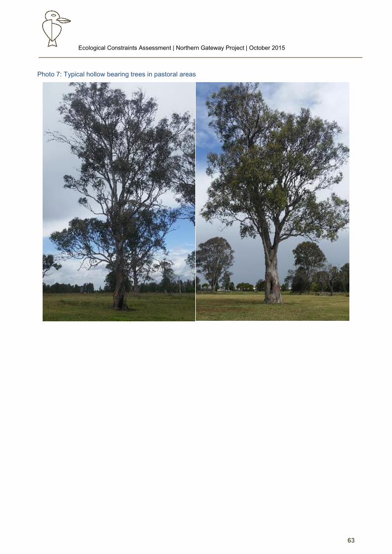
Ecological Constraints Assessment | Northern Gateway Project | October 2015
63
Photo 7: Typical hollow bearing trees in pastoral areas
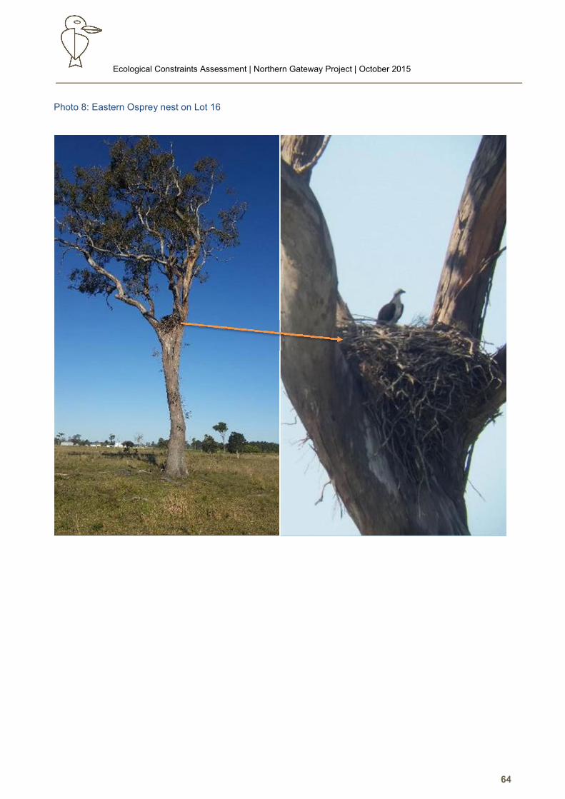
Ecological Constraints Assessment | Northern Gateway Project | October 2015
64
Photo 8: Eastern Osprey nest on Lot 16
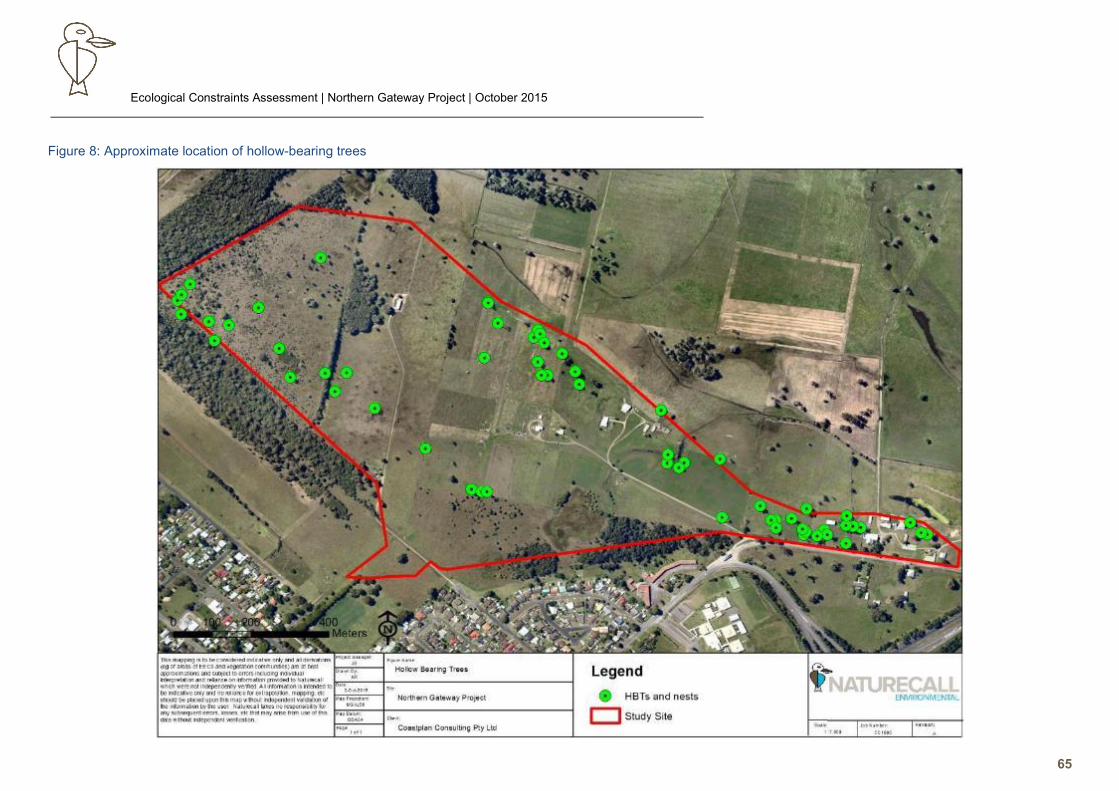
Ecological Constraints Assessment | Northern Gateway Project | October 2015
65
Figure 8: Approximate location of hollow-bearing trees
Ecological Constraints Assessment | Northern Gateway Project | October 2015
66
Call Playback, Identification and Recording
5.3.2.1. Birds
Call playback failed to gain a response from any of the target species. A number of common birds were
detected by call identification (see following table).
5.3.2.2. Frogs
Frogs were observed and heard calling in relatively low abundance in the main wetland and from the
billabong, and around the former dairy in the east. Only the following common species were heard:
• Common Sedge Frog (Litoria fallax)
• Peron’s Tree Frog (Litoria peroni)
• Australian Green Tree Frog (Litoria caerulea)
5.3.2.3. Arboreal Mammals
No mammal species responded to call playback.
5.3.2.4. Yangochiropteran Bats
Bat activity was low, with most activity noted in the western end over the immature regrowth and the
interface with the adjacent remnant forest.
Yangochiropteran bat calls recorded during the survey were sent to Dr Anna McConville, Echo Ecology,
a recognised Yangochiropteran bat ecologist for identification. The results are shown in the table below.
Table 13: Yangochiropteran bat call identification
Note: # indicates species listed as Vulnerable on Schedule 2 of the TSCA Act 1995
Scientific Name Common Name Confidently
Identified
Not Confidently Identified
Gould’s Wattled Bat Chalinolobus gouldii ✓
Chocolate Wattled Bat Chalinolobus morio ✓
#Little Bentwing Bat Miniopterus australis ✓
Eastern Forest Bat Vespadelus pumilus ✓
Eastern Bentwing Bat Miniopterus schreibersii oceanensis ✓
#East Coast Freetail Bat Mormopterus norfolkensis ✓
Eastern Freetail Bat Mormopterus ridei ✓
Large Forest Bat Vespadelus darlingtoni ✓
Southern Forest Bat Vespadelus regulus ✓
Little Forest Bat Vespadelus vulturnus ✓
Ecological Constraints Assessment | Northern Gateway Project | October 2015
67
As shown in the table above, the Little Bentwing Bat ((V-TSCA) was confirmed foraging on the site during
the survey. The East-coast Freetail Bat (V-TSCA) was only a precautionary ‘possible’ due to the limited
sample and similarity with sister species, associated limitation of call identification (Reinhold et al 2001).
This species has been recorded in similar habitats (Churchill 2009, pers. obs.), and is considered a likely
potential occurrence.
Spotlighting
The occasional Grey-headed Flying Fox (Vulnerable TSCA & EPBCA) was observed flying over the site
during spotlighting and foraging in flowering eucalypts on the site.
Other fauna recorded during spotlighting were common species including Brushtail Possum, Eastern
Grey Kangaroo, Red-necked Wallaby, rabbits and a number of sleeping birds. Most of these species
were observed along the southern or western edges of the site.
Secondary Evidence
5.3.4.1. Trunk Scratches
Trunk scratches were very prevalent on almost all of the Forest Red Gums throughout the site. Due to
the size, depth and spread of the scratches present it was considered likely that these were from Brushtail
Possums and not from Koala’s.
5.3.4.2. Scats, Tracks and Bones
All Forest Red Gums found in the open pasture lands swamp forest were searched for Koala scats
without result. Brushtail Possum scats were found under the Forest Red Gums in the east, confirming
with previous survey of the adjoining land in Emerton Close.
For reference, 3 SAT surveys were conducted in the Melaleuca/Eucalyptus tereticornis woodlands in the
west of the study area as well as around the few mature Forest Red Gums which in the regenerating
swamp forest area. The SAT surveys resulted in zero scats being found and therefore a 0% activity
recorded.
The only other scats detected were of Eastern Grey Kangaroo and rabbit.
5.3.4.3. Chewed Allocasuarina Cones
Allocasuarina and Casuarina stands were searched throughout the field survey. No chewed cones
were recorded.
5.3.4.4. Sap Incisions
Al eucalypts on site were opportunistically searched however no sap incisions were found on site.
Old and some possibly active incisions were noted on gums in the strips of remnant forest in the
western study area. The Sugar Glider is considered likely to be the causal species given this species
Ecological Constraints Assessment | Northern Gateway Project | October 2015
68
can persist in more marginal habitats, but the isolation of this area will see eventual loss of any glider
species via inbreeding or stochastic events.
Opportunistic observations
5.3.5.1. Birds
A total of 24 bird species were recorded, either observed or identified from calls during the bird
surveys and opportunistically. No threatened species were recorded, however a few EPBCA
Migratory were recorded. Cattle Egret and Great Egret were observed around the dams and drains;
an Osprey nest on Lot 16; and a few Latham’s Snipe were flushed from the main dam during surveys.
The most significant record was of the Eastern Osprey (V-TSCA, M-EPBCA) nesting in a large,
isolated Forest Red Gum on Lot 16. This tree also had a crow nest with crows and an Australian
Kestrel roosting, however a pair of Osprey’s returned to defend the nest over the survey period.
Some fresh materials were noted on the nest, indicating it is active.
An abundance of Indian Mynas were noted around the dwelling and sheds in the eastern end of the
site, and these would be expected to dominate nesting opportunities in hollows. Two non-indigenous
Cacatua species were noted – one nesting. These have been established by artificial releases and
now compete with local indigenous natives for hollows.
Noisy Miners were noted in abundance. This species is listed as a Key Threatening Process
(NSWSC 2013), and hence is a strong negative influence on the occurrence of threatened woodland
and forest passerines eg Regent Honeyeater.
5.3.5.2. Reptiles
The Eastern Water Dragon, Dark-flecked Garden Sun Skink and Red-bellied Black Snake were
recorded opportunistically whilst conducting other surveys within the study site.
Reptile diversity and abundance was as expected very low due to the extent of habitat modification
and historical clearing, as well as very limited microhabitat eg fallen logs for refuge. Such features
are more common in the remnant strips in the western study area.
5.3.5.3. Mammals
A resident mob of Eastern Grey Kangaroo were noted in the western study area, and a Red-necked
Wallaby was disturbed in the southeast Swamp Oak forest.
Total Fauna Observed
The following table lists all the species confidently detected by this survey on and adjacent to the study
site (excluding Yangochiropteran bats due to call identification limitations).
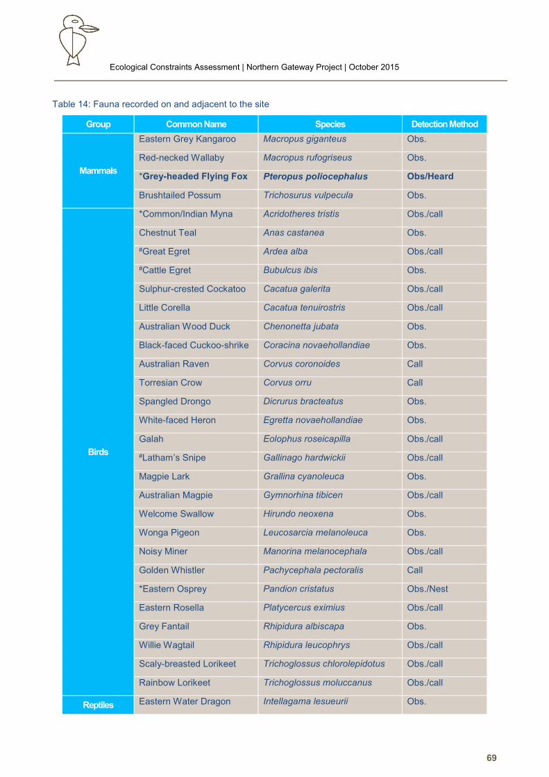
Ecological Constraints Assessment | Northern Gateway Project | October 2015
69
Table 14: Fauna recorded on and adjacent to the site
Group Common Name Species Detection Method
Mammals
Eastern Grey Kangaroo Macropus giganteus Obs.
Red-necked Wallaby Macropus rufogriseus Obs.
*Grey-headed Flying Fox Pteropus poliocephalus Obs/Heard
Brushtailed Possum Trichosurus vulpecula Obs.
Birds
*Common/Indian Myna Acridotheres tristis Obs./call
Chestnut Teal Anas castanea Obs.
#Great Egret Ardea alba Obs./call
#Cattle Egret Bubulcus ibis Obs.
Sulphur-crested Cockatoo Cacatua galerita Obs./call
Little Corella Cacatua tenuirostris Obs./call
Australian Wood Duck Chenonetta jubata Obs.
Black-faced Cuckoo-shrike Coracina novaehollandiae Obs.
Australian Raven Corvus coronoides Call
Torresian Crow Corvus orru Call
Spangled Drongo Dicrurus bracteatus Obs.
White-faced Heron Egretta novaehollandiae Obs.
Galah Eolophus roseicapilla Obs./call
#Latham’s Snipe Gallinago hardwickii Obs./call
Magpie Lark Grallina cyanoleuca Obs.
Australian Magpie Gymnorhina tibicen Obs./call
Welcome Swallow Hirundo neoxena Obs.
Wonga Pigeon Leucosarcia melanoleuca Obs.
Noisy Miner Manorina melanocephala Obs./call
Golden Whistler Pachycephala pectoralis Call
*Eastern Osprey Pandion cristatus Obs./Nest
Eastern Rosella Platycercus eximius Obs./call
Grey Fantail Rhipidura albiscapa Obs.
Willie Wagtail Rhipidura leucophrys Obs./call
Scaly-breasted Lorikeet Trichoglossus chlorolepidotus Obs./call
Rainbow Lorikeet Trichoglossus moluccanus Obs./call
Reptiles Eastern Water Dragon Intellagama lesueurii Obs.
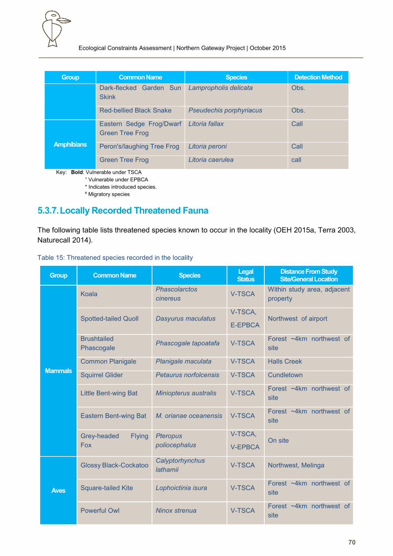
Ecological Constraints Assessment | Northern Gateway Project | October 2015
70
Group Common Name Species Detection Method
Dark-flecked Garden Sun
Skink
Lampropholis delicata Obs.
Red-bellied Black Snake Pseudechis porphyriacus Obs.
Amphibians
Eastern Sedge Frog/Dwarf
Green Tree Frog
Litoria fallax Call
Peron's/laughing Tree Frog Litoria peroni Call
Green Tree Frog Litoria caerulea call
Key: Bold: Vulnerable under TSCA + Vulnerable under EPBCA
* Indicates introduced species. # Migratory species
Locally Recorded Threatened Fauna
The following table lists threatened species known to occur in the locality (OEH 2015a, Terra 2003,
Naturecall 2014).
Table 15: Threatened species recorded in the locality
Group Common Name Species Legal Status
Distance From Study Site/General Location
Mammals
Koala Phascolarctos
cinereus V-TSCA
Within study area, adjacent
property
Spotted-tailed Quoll Dasyurus maculatus V-TSCA,
E-EPBCA Northwest of airport
Brushtailed
Phascogale Phascogale tapoatafa V-TSCA
Forest ~4km northwest of
site
Common Planigale Planigale maculata V-TSCA Halls Creek
Squirrel Glider Petaurus norfolcensis V-TSCA Cundletown
Little Bent-wing Bat Miniopterus australis V-TSCA Forest ~4km northwest of
site
Eastern Bent-wing Bat M. orianae oceanensis V-TSCA Forest ~4km northwest of
site
Grey-headed Flying
Fox
Pteropus
poliocephalus
V-TSCA,
V-EPBCA On site
Aves
Glossy Black-Cockatoo Calyptorhynchus
lathamii V-TSCA Northwest, Melinga
Square-tailed Kite Lophoictinia isura V-TSCA Forest ~4km northwest of
site
Powerful Owl Ninox strenua V-TSCA Forest ~4km northwest of
site
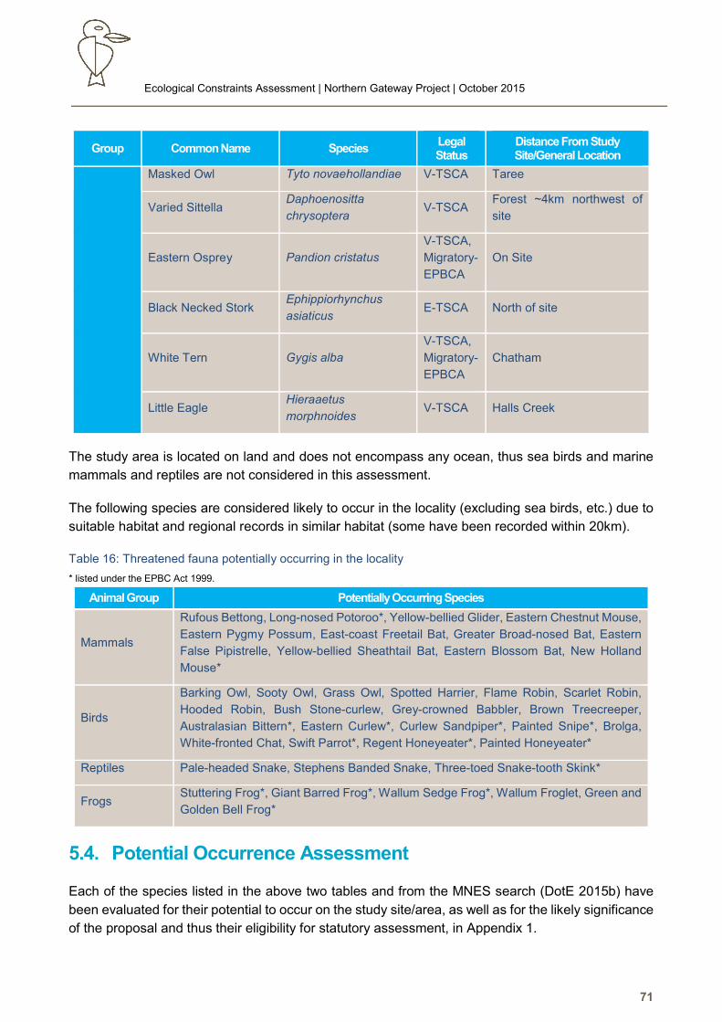
Ecological Constraints Assessment | Northern Gateway Project | October 2015
71
Group Common Name Species Legal Status
Distance From Study Site/General Location
Masked Owl Tyto novaehollandiae V-TSCA Taree
Varied Sittella Daphoenositta
chrysoptera V-TSCA
Forest ~4km northwest of
site
Eastern Osprey Pandion cristatus
V-TSCA,
Migratory-
EPBCA
On Site
Black Necked Stork Ephippiorhynchus
asiaticus E-TSCA North of site
White Tern Gygis alba
V-TSCA,
Migratory-
EPBCA
Chatham
Little Eagle Hieraaetus
morphnoides V-TSCA Halls Creek
The study area is located on land and does not encompass any ocean, thus sea birds and marine
mammals and reptiles are not considered in this assessment.
The following species are considered likely to occur in the locality (excluding sea birds, etc.) due to
suitable habitat and regional records in similar habitat (some have been recorded within 20km).
Table 16: Threatened fauna potentially occurring in the locality
* listed under the EPBC Act 1999.
Mammals
Rufous Bettong, Long-nosed Potoroo*, Yellow-bellied Glider, Eastern Chestnut Mouse,
Eastern Pygmy Possum, East-coast Freetail Bat, Greater Broad-nosed Bat, Eastern
False Pipistrelle, Yellow-bellied Sheathtail Bat, Eastern Blossom Bat, New Holland
Mouse*
Birds
Barking Owl, Sooty Owl, Grass Owl, Spotted Harrier, Flame Robin, Scarlet Robin,
Hooded Robin, Bush Stone-curlew, Grey-crowned Babbler, Brown Treecreeper,
Australasian Bittern*, Eastern Curlew*, Curlew Sandpiper*, Painted Snipe*, Brolga,
White-fronted Chat, Swift Parrot*, Regent Honeyeater*, Painted Honeyeater*
Reptiles Pale-headed Snake, Stephens Banded Snake, Three-toed Snake-tooth Skink*
Frogs Stuttering Frog*, Giant Barred Frog*, Wallum Sedge Frog*, Wallum Froglet, Green and
Golden Bell Frog*
5.4. Potential Occurrence Assessment
Each of the species listed in the above two tables and from the MNES search (DotE 2015b) have
been evaluated for their potential to occur on the study site/area, as well as for the likely significance
of the proposal and thus their eligibility for statutory assessment, in Appendix 1.
Animal Group Potentially Occurring Species
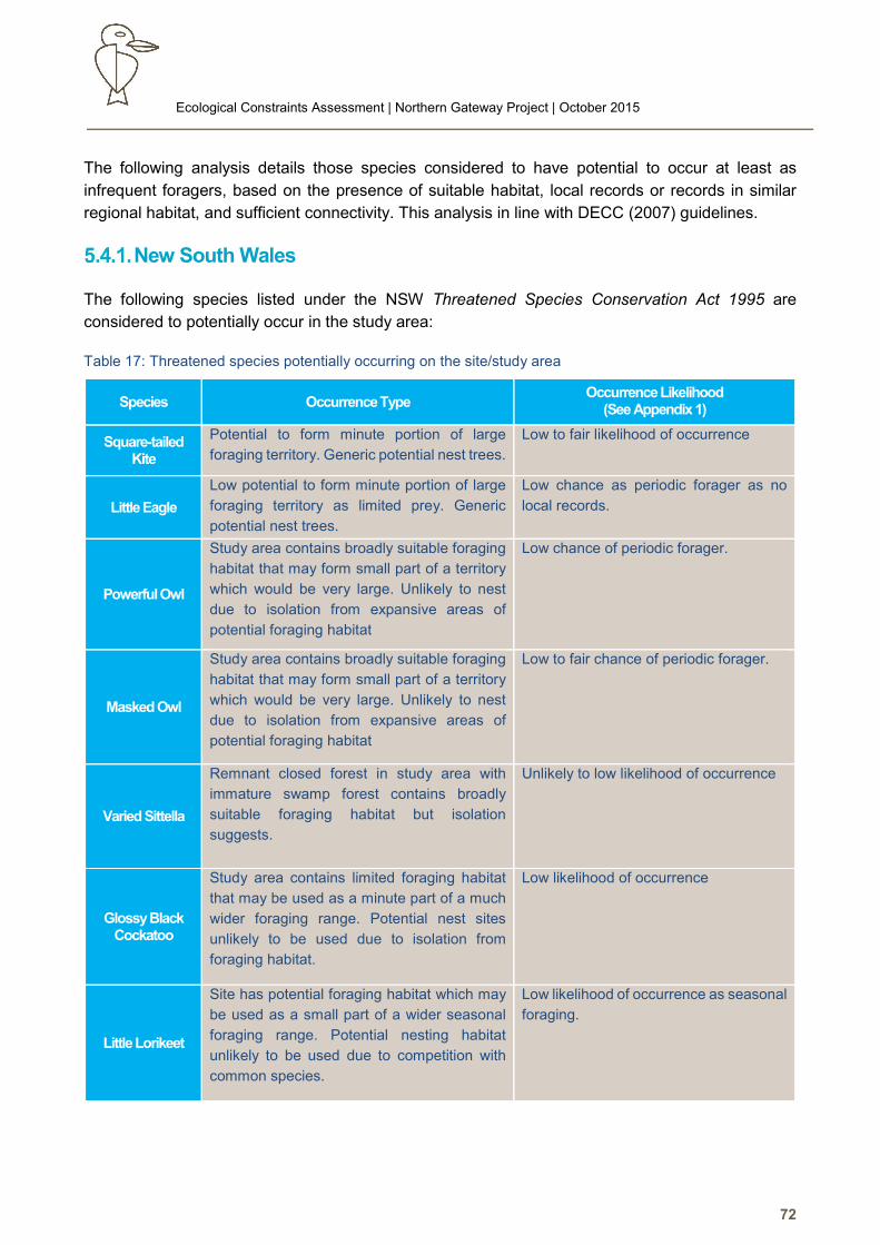
Ecological Constraints Assessment | Northern Gateway Project | October 2015
72
The following analysis details those species considered to have potential to occur at least as
infrequent foragers, based on the presence of suitable habitat, local records or records in similar
regional habitat, and sufficient connectivity. This analysis in line with DECC (2007) guidelines.
New South Wales
The following species listed under the NSW Threatened Species Conservation Act 1995 are
considered to potentially occur in the study area:
Table 17: Threatened species potentially occurring on the site/study area
Species Occurrence Type Occurrence Likelihood
(See Appendix 1)
Square-tailed Kite
Potential to form minute portion of large
foraging territory. Generic potential nest trees.
Low to fair likelihood of occurrence
Little Eagle
Low potential to form minute portion of large
foraging territory as limited prey. Generic
potential nest trees.
Low chance as periodic forager as no
local records.
Powerful Owl
Study area contains broadly suitable foraging
habitat that may form small part of a territory
which would be very large. Unlikely to nest
due to isolation from expansive areas of
potential foraging habitat
Low chance of periodic forager.
Masked Owl
Study area contains broadly suitable foraging
habitat that may form small part of a territory
which would be very large. Unlikely to nest
due to isolation from expansive areas of
potential foraging habitat
Low to fair chance of periodic forager.
Varied Sittella
Remnant closed forest in study area with
immature swamp forest contains broadly
suitable foraging habitat but isolation
suggests.
Unlikely to low likelihood of occurrence
Glossy Black Cockatoo
Study area contains limited foraging habitat
that may be used as a minute part of a much
wider foraging range. Potential nest sites
unlikely to be used due to isolation from
foraging habitat.
Low likelihood of occurrence
Little Lorikeet
Site has potential foraging habitat which may
be used as a small part of a wider seasonal
foraging range. Potential nesting habitat
unlikely to be used due to competition with
common species.
Low likelihood of occurrence as seasonal
foraging.
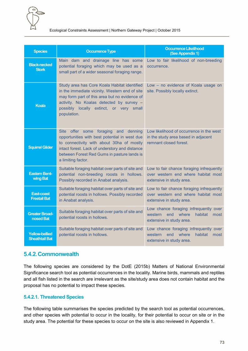
Ecological Constraints Assessment | Northern Gateway Project | October 2015
73
Species Occurrence Type Occurrence Likelihood
(See Appendix 1)
Black-necked Stork
Main dam and drainage line has some
potential foraging which may be used as a
small part of a wider seasonal foraging range.
Low to fair likelihood of non-breeding
occurrence.
Koala
Study area has Core Koala Habitat identified
in the immediate vicinity. Western end of site
may form part of this area but no evidence of
activity. No Koalas detected by survey –
possibly locally extinct, or very small
population.
Low – no evidence of Koala usage on
site. Possibly locally extinct.
Squirrel Glider
Site offer some foraging and denning
opportunities with best potential in west due
to connectivity with about 30ha of mostly
intact forest. Lack of understory and distance
between Forest Red Gums in pasture lands is
a limiting factor.
Low likelihood of occurrence in the west
in the study area based in adjacent
remnant closed forest.
Eastern Bent-wing Bat
Suitable foraging habitat over parts of site and
potential non-breeding roosts in hollows.
Possibly recorded in Anabat analysis.
Low to fair chance foraging infrequently
over western end where habitat most
extensive in study area.
East-coast Freetail Bat
Suitable foraging habitat over parts of site and
potential roosts in hollows. Possibly recorded
in Anabat analysis.
Low to fair chance foraging infrequently
over western end where habitat most
extensive in study area.
Greater Broad-nosed Bat
Suitable foraging habitat over parts of site and
potential roosts in hollows.
Low chance foraging infrequently over
western end where habitat most
extensive in study area.
Yellow-bellied Sheathtail Bat
Suitable foraging habitat over parts of site and
potential roosts in hollows.
Low chance foraging infrequently over
western end where habitat most
extensive in study area.
Commonwealth
The following species are considered by the DotE (2015b) Matters of National Environmental
Significance search tool as potential occurrences in the locality. Marine birds, mammals and reptiles
and all fish listed in the search are irrelevant as the site/study area does not contain habitat and the
proposal has no potential to impact these species.
5.4.2.1. Threatened Species
The following table summarises the species predicted by the search tool as potential occurrences,
and other species with potential to occur in the locality, for their potential to occur on site or in the
study area. The potential for these species to occur on the site is also reviewed in Appendix 1.
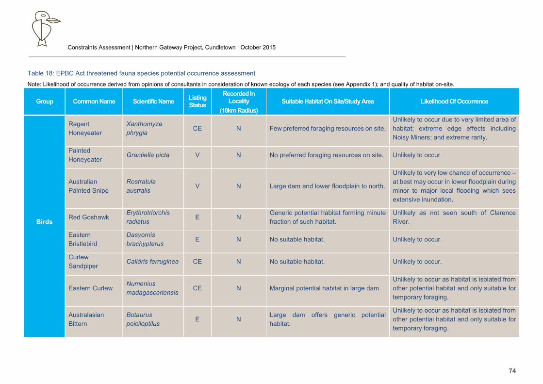
Constraints Assessment | Northern Gateway Project, Cundletown | October 2015
74
Table 18: EPBC Act threatened fauna species potential occurrence assessment
Note: Likelihood of occurrence derived from opinions of consultants in consideration of known ecology of each species (see Appendix 1); and quality of habitat on-site.
Birds
Regent
Honeyeater
Xanthomyza
phrygia CE N Few preferred foraging resources on site.
Unlikely to occur due to very limited area of
habitat; extreme edge effects including
Noisy Miners; and extreme rarity.
Painted
Honeyeater Grantiella picta V N No preferred foraging resources on site. Unlikely to occur
Australian
Painted Snipe
Rostratula
australis V N Large dam and lower floodplain to north.
Unlikely to very low chance of occurrence –
at best may occur in lower floodplain during
minor to major local flooding which sees
extensive inundation.
Red Goshawk Erythrotriorchis
radiatus E N
Generic potential habitat forming minute
fraction of such habitat.
Unlikely as not seen south of Clarence
River.
Eastern
Bristlebird
Dasyornis
brachypterus E N No suitable habitat. Unlikely to occur.
Curlew
Sandpiper Calidris ferruginea CE N No suitable habitat. Unlikely to occur.
Eastern Curlew Numenius
madagascariensis CE N Marginal potential habitat in large dam.
Unlikely to occur as habitat is isolated from
other potential habitat and only suitable for
temporary foraging.
Australasian
Bittern
Botaurus
poiciloptilus E N
Large dam offers generic potential
habitat.
Unlikely to occur as habitat is isolated from
other potential habitat and only suitable for
temporary foraging.
Group Common Name Scientific Name Listing Status
Recorded In Locality
(10km Radius)
Suitable Habitat On Site/Study Area Likelihood Of Occurrence
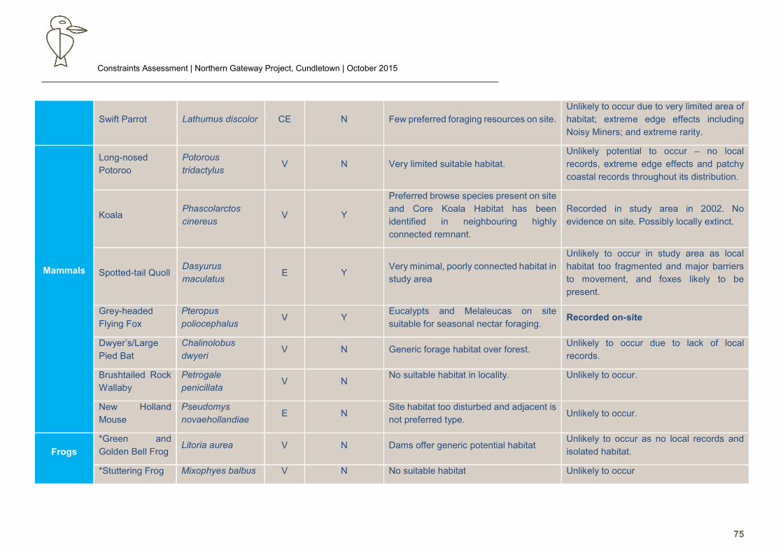
Constraints Assessment | Northern Gateway Project, Cundletown | October 2015
75
Swift Parrot Lathumus discolor CE N Few preferred foraging resources on site.
Unlikely to occur due to very limited area of
habitat; extreme edge effects including
Noisy Miners; and extreme rarity.
Mammals
Long-nosed
Potoroo
Potorous
tridactylus V N Very limited suitable habitat.
Unlikely potential to occur – no local
records, extreme edge effects and patchy
coastal records throughout its distribution.
Koala Phascolarctos
cinereus V Y
Preferred browse species present on site
and Core Koala Habitat has been
identified in neighbouring highly
connected remnant.
Recorded in study area in 2002. No
evidence on site. Possibly locally extinct.
Spotted-tail Quoll Dasyurus
maculatus E Y
Very minimal, poorly connected habitat in
study area
Unlikely to occur in study area as local
habitat too fragmented and major barriers
to movement, and foxes likely to be
present.
Grey-headed
Flying Fox
Pteropus
poliocephalus V Y
Eucalypts and Melaleucas on site
suitable for seasonal nectar foraging. Recorded on-site
Dwyer’s/Large
Pied Bat
Chalinolobus
dwyeri V N Generic forage habitat over forest.
Unlikely to occur due to lack of local
records.
Brushtailed Rock
Wallaby
Petrogale
penicillata V N
No suitable habitat in locality. Unlikely to occur.
New Holland
Mouse
Pseudomys
novaehollandiae E N
Site habitat too disturbed and adjacent is
not preferred type. Unlikely to occur.
Frogs
*Green and
Golden Bell Frog Litoria aurea V N Dams offer generic potential habitat
Unlikely to occur as no local records and
isolated habitat.
*Stuttering Frog Mixophyes balbus V N No suitable habitat Unlikely to occur
Constraints Assessment | Northern Gateway Project, Cundletown | October 2015
76
Wallum Sedge
Frog
Litoria
olongburensis V N
Large dam offers some marginal
potential but isolated from any suitable
habitat.
Unlikely to occur as no local records, not
recorded south of Coffs Harbour, and
isolated habitat.
*Giant Barred
Frog M. iteratus E Y No suitable habitat Unlikely to occur
Migratory Species
Four EPBC Act migratory species recorded on the site by the survey: Great Egret, Eastern Osprey, Little Egret and Latham’s Snipe.
A significant number of other EPBC Act 1999 listed migratory bird species are known (OEH 2015a) or considered potential occurrences in the locality (DotE
2015a). A search of the MNES website and literature review (Readers Digest 1990, DotE 2015b) also produced a list of likely occurrences.
All of these species plus some considered by the consultant as potential occurrences in the LGA in similar habitat to that on the site are also shown in the
following table, with an evaluation made on likelihood of occurrence based on cited ecology. Note this list excludes seabirds, etc, due to lack of habitat in the
study area, as detailed above.
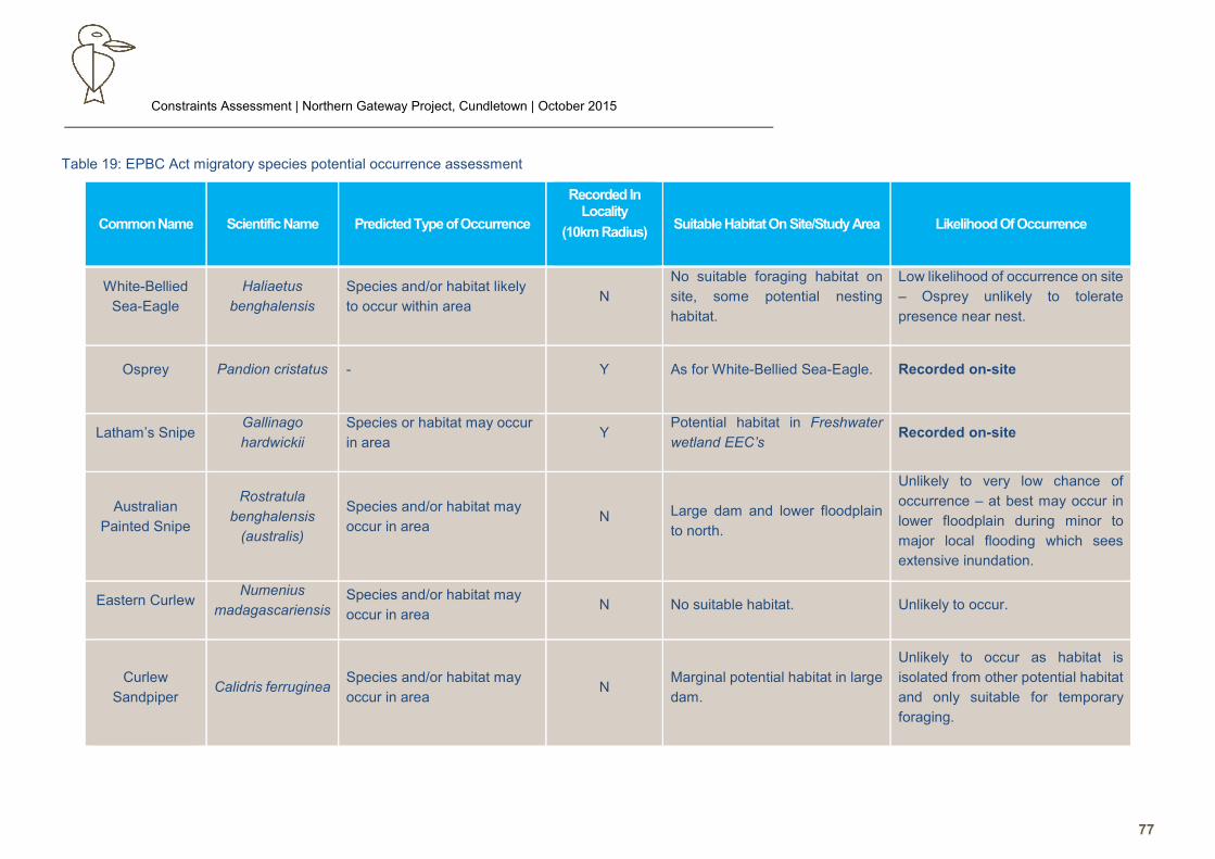
Constraints Assessment | Northern Gateway Project, Cundletown | October 2015
77
Table 19: EPBC Act migratory species potential occurrence assessment
White-Bellied
Sea-Eagle
Haliaetus
benghalensis
Species and/or habitat likely
to occur within area N
No suitable foraging habitat on
site, some potential nesting
habitat.
Low likelihood of occurrence on site
– Osprey unlikely to tolerate
presence near nest.
Osprey Pandion cristatus - Y As for White-Bellied Sea-Eagle. Recorded on-site
Latham’s Snipe Gallinago
hardwickii
Species or habitat may occur
in area Y
Potential habitat in Freshwater
wetland EEC’s Recorded on-site
Australian
Painted Snipe
Rostratula
benghalensis
(australis)
Species and/or habitat may
occur in area N Large dam and lower floodplain
to north.
Unlikely to very low chance of
occurrence – at best may occur in
lower floodplain during minor to
major local flooding which sees
extensive inundation.
Eastern Curlew Numenius
madagascariensis Species and/or habitat may
occur in area N No suitable habitat. Unlikely to occur.
Curlew
Sandpiper
Calidris ferruginea Species and/or habitat may
occur in area N
Marginal potential habitat in large
dam.
Unlikely to occur as habitat is
isolated from other potential habitat
and only suitable for temporary
foraging.
Common Name Scientific Name Predicted Type of Occurrence
Recorded In Locality
(10km Radius)
Suitable Habitat On Site/Study Area Likelihood Of Occurrence
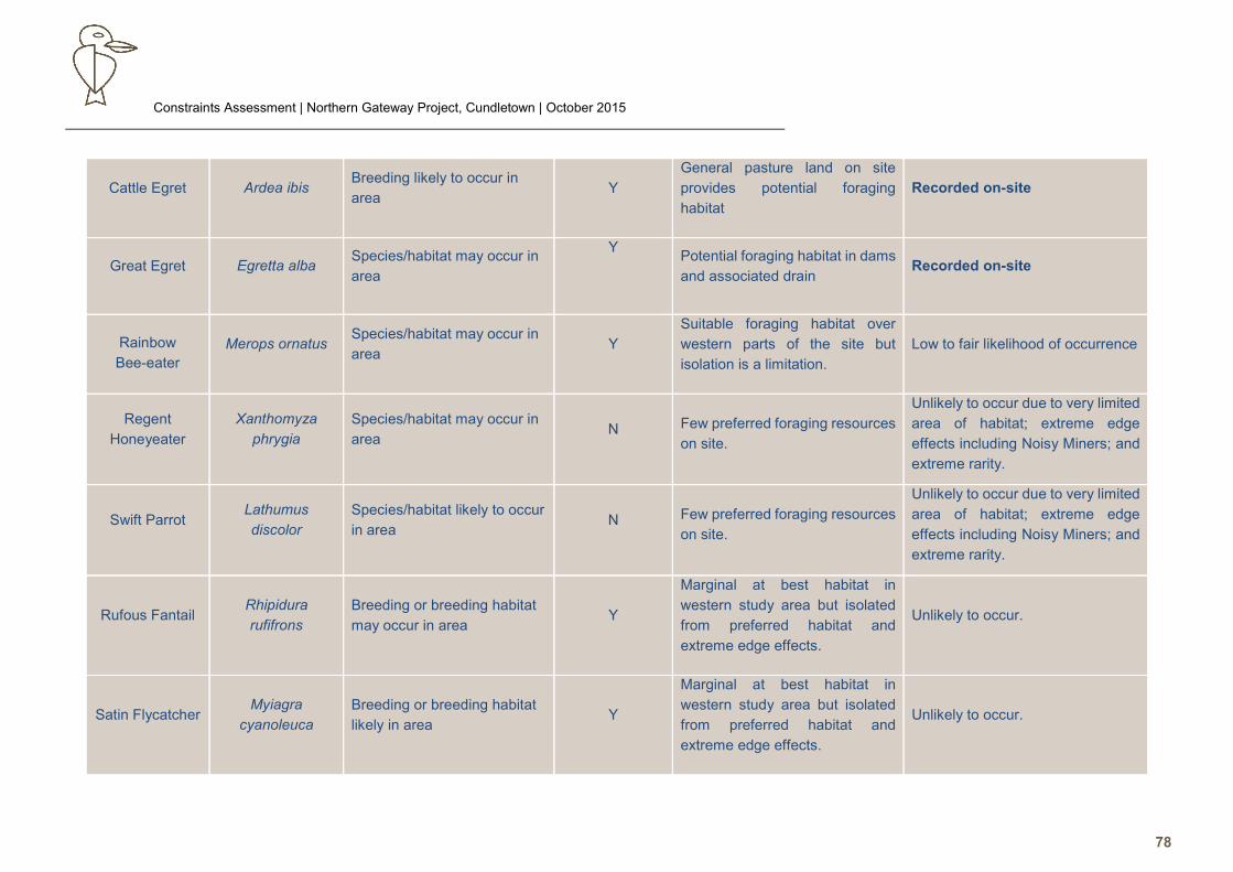
Constraints Assessment | Northern Gateway Project, Cundletown | October 2015
78
Cattle Egret Ardea ibis Breeding likely to occur in
area Y
General pasture land on site
provides potential foraging
habitat
Recorded on-site
Great Egret Egretta alba Species/habitat may occur in
area
Y
Potential foraging habitat in dams
and associated drain Recorded on-site
Rainbow
Bee-eater
Merops ornatus Species/habitat may occur in
area Y
Suitable foraging habitat over
western parts of the site but
isolation is a limitation.
Low to fair likelihood of occurrence
Regent
Honeyeater
Xanthomyza
phrygia
Species/habitat may occur in
area N Few preferred foraging resources
on site.
Unlikely to occur due to very limited
area of habitat; extreme edge
effects including Noisy Miners; and
extreme rarity.
Swift Parrot Lathumus
discolor
Species/habitat likely to occur
in area N Few preferred foraging resources
on site.
Unlikely to occur due to very limited
area of habitat; extreme edge
effects including Noisy Miners; and
extreme rarity.
Rufous Fantail Rhipidura
rufifrons
Breeding or breeding habitat
may occur in area Y
Marginal at best habitat in
western study area but isolated
from preferred habitat and
extreme edge effects.
Unlikely to occur.
Satin Flycatcher Myiagra
cyanoleuca
Breeding or breeding habitat
likely in area Y
Marginal at best habitat in
western study area but isolated
from preferred habitat and
extreme edge effects.
Unlikely to occur.
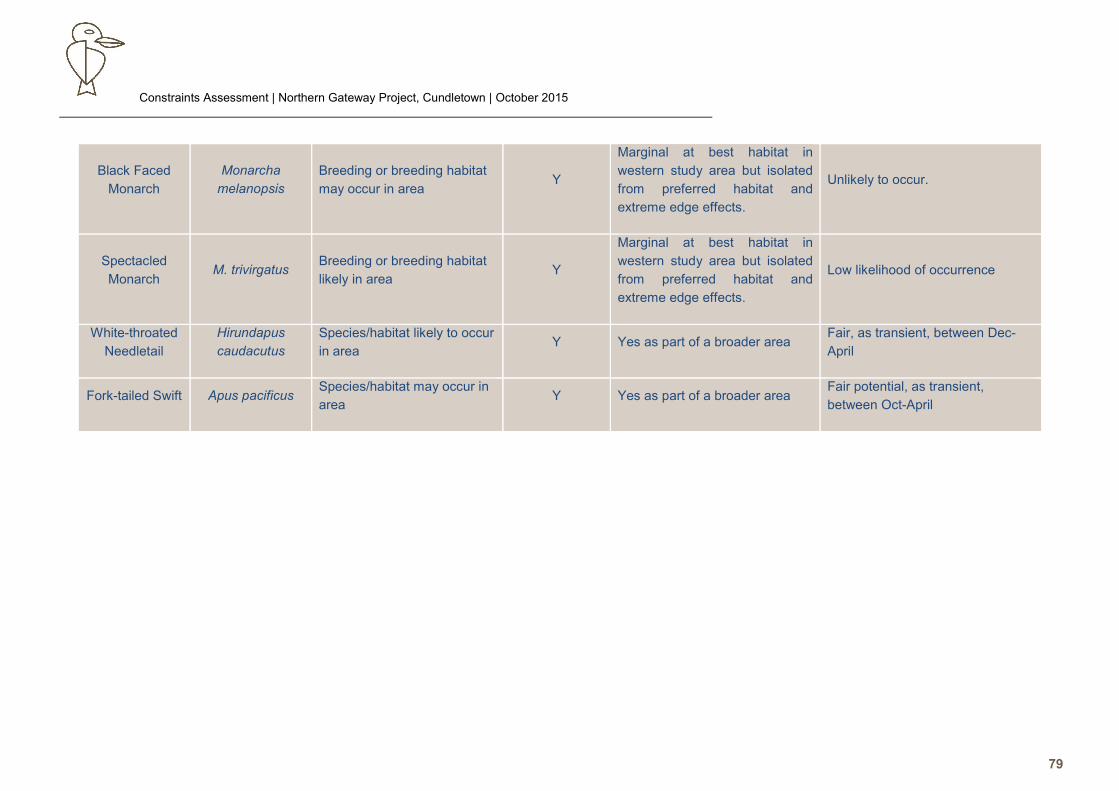
Constraints Assessment | Northern Gateway Project, Cundletown | October 2015
79
Black Faced
Monarch
Monarcha
melanopsis
Breeding or breeding habitat
may occur in area Y
Marginal at best habitat in
western study area but isolated
from preferred habitat and
extreme edge effects.
Unlikely to occur.
Spectacled
Monarch M. trivirgatus
Breeding or breeding habitat
likely in area Y
Marginal at best habitat in
western study area but isolated
from preferred habitat and
extreme edge effects.
Low likelihood of occurrence
White-throated
Needletail
Hirundapus
caudacutus
Species/habitat likely to occur
in area Y Yes as part of a broader area
Fair, as transient, between Dec-
April
Fork-tailed Swift Apus pacificus Species/habitat may occur in
area Y Yes as part of a broader area
Fair potential, as transient,
between Oct-April
Constraints Assessment | Northern Gateway Project, Cundletown | October 2015
80
6.0 SEPP 44 - Koala Habitat Assessment
6.1. Potential Koala Habitat
Introduction
The identification of an area of land as Potential Koala Habitat is determined by the sufficient
presence of primary preferred Koala food tree species. These species are listed under Schedule 2
of SEPP 44: Koala Habitat Protection. Potential Koala Habitat is defined as areas where the tree
species listed under Schedule 2 constitute at least 15% of the total number of trees in the upper and
lower strata of the tree component.
The Schedule 2 Primary Preferred food species occurring in GTCC are: Tallowwood (Eucalyptus
microcorys), Swamp Mahogany (E. robusta), Scribbly Gum (E. signata), Grey Gum (E. punctata),
and Forest Red Gum (E. tereticornis).
Methods and Results
A Koala habitat assessment was carried out on the site during the field survey. A visual inspection
of the composition of canopy trees found that Forest Red Gum (Eucalyptus tereticornis) comprised
100% the upper tree stratum within at least 1ha of habitat eg the remnant trees in the southeast.
Conclusion
The site vegetation has readily met the 15% criterion to qualify as Potential Koala Habitat.
Consequently, Part 2 of the Policy legally applies, and formal assessment for presence of Core Koala
Habitat is required.
6.2. Core Koala Habitat Assessment
Overview of Koala Ecology
6.2.1.1. Diet
General
Koalas feed primarily but not exclusively on (and also intra-specifically, depending on poorly understood
edaphic, chemical and socio-behavioural factors) selected species of the genus Eucalyptus. Nationally,
they have been observed feeding or resting in at least 120 eucalypt species (~ 66 in NSW) and many
non-eucalypt species. In the Hastings and Macleay regions, a number of eucalypt species that are not
listed on Schedule 2 of SEPP 44 appear to be of some importance to Koalas including: E. amplifolia, E.
seeana and E. propinqua. Non-endemic species also used by Koalas in the area include E. nicholii and
Corymbia citriodora. Some non-eucalypt species reported to be used for feeding or shelter (some in this
region) include Angophora costata, Acacia mearnsii, A. melanoxylon, Allocasuarina torulosa, Bombax
malabrica, Lophostemon confertus, L. suaveolens, Exocarpus cupressiformis, Leptospermum
laevigatum, Melaleuca ericifolia, M. quinquenervia, Pinus radiata and Cinnamonum camphora (Martin
and Lee 1984, Kel Mackay pers. comm.). Koalas have also been observed using trees with dense foliage
Constraints Assessment | Northern Gateway Project, Cundletown | October 2015
81
or retreating to rainforest during adverse weather such as high temperatures, strong wind or heavy rain
(Jurskis and Potter 1997).
In general though, Koalas generally utilise a wide variety of non-preferred eucalypt species and non-
eucalypt species for supplementary food and shelter resources in any given area (as long as the
preferred browse species are present in the area). Work by Phillips and Callaghan (2001, 1995, 2011,
etc) and Phillips (eg Phillips 2005a, 2005b) have recorded a far wider range of non-eucalypt species via
faecal pellet surveys and field observations than reported by Martin and Lee (1984), although generally
with relatively low strike rates, with the exception of a small number of key shelter and/or supplementary
browse species.
Research by the Australian Koala Foundation (AKF) suggests that usage of habitat by Koalas may be a
function of the abundance of the preferred species. The AKF describes Primary Habitat as areas where
primary browse species are dominant, with their usage being independent of the species’ density.
However, in areas where primary tree species are poorly represented, secondary browse species and
Secondary Habitat may play the most significant role in sustaining local Koala populations (Mr John
Callaghan, pers. comm.).
A Koala food tree can often be identified by the presence of scats at its base, though such trees may
also be used for roosting. Contrary to a long held assumption though, observation of Koalas resting in a
tree does not always indicate it is a feed tree (Phillips 2000b, Biolink 2008, DECC 2008).
Koalas sometimes appear to prefer young leaves over mature leaves, and preferred foliage is thought
to have a threshold for minimum moisture content (which may vary seasonally) and nitrogen content
(Jurskis and Potter 1997, Pahl and Hume 1990). Other studies have also shown threshold levels for
essential oils, with preferred species having more volatile oils and less heavy oils (Hume 1995);
preferences for higher concentrations of crude protein, phosphorous and potassium, and lower
concentrations of fibre (Ullrey et al 1981); and more simple sugars and less complex sugars (Osawa
1993). These components all vary interspecifically and intraspecifically, and factors such as species,
age, size and crown condition also influence the physiological processes that ultimately affect nutritional
quality and palatability, especially in a suboptimal environment (Jurskis and Potter 1997). Other research
suggests that concentrations of plant chemical defences (especially diformyl-phloroglucinols or DFPs)
may be a key factor. Koalas may be selecting trees with lower concentrations of DFPs. This may help to
explain why Koalas appear to not only prefer particular Eucalyptus species, but also particular individual
trees, as DFP levels have been shown to vary intraspecifically as well as interspecifically (eg Anon 1999;
Moore et al. 2004).
Species, individual tree and foliage selection for browsing by Koalas hence, is still poorly understood. In
addition to the above, it also varies with season (which may be an indication of varying nutritional value),
as well as location (Koalas may feed on one particular species at a specific location, and ignore it at
another); and may also be influenced by local abundance of food species, as well as social organisation
of the population (Hindell and Lee 1990; Reed, Lunney and Walker 1990). As mentioned above,
nutritional quality of individual trees may also be a factor, with nutrition shown to vary inter and
intraspecifically (Braithwaite, Turner and Kelly 1983, Anon 1999).
Usage may also be determined by site-dependant edaphic factors eg soil type (Sharp and Phillips 1999;
Phillips and Callaghan 2000), which affects the nutrient quality of forage. A gradient in nutrient
concentration in soils and foliage is a major determinant of the distribution of arboreal fauna (Anon 1999,
Gibbons and Lindenmayer 2002). Forest consisting of primary browse species associations located on
Constraints Assessment | Northern Gateway Project, Cundletown | October 2015
82
deep, fertile soils on floodplains, in gullies and along watercourses are generally considered to provide
the highest quality Koala habitat.
Structural features may also be important in individual tree selection eg on hot days, Koalas are often
observed in trees with greater foliage cover. Large trees are thought by some researchers to be preferred
for their greater amount of foliage which reduces the need for returning to the ground to move to another
tree, and thus risking predator attack (Hindell and Lee 1990; Reed, Lunney and Walker 1990) although
research in other areas has found highest activity on younger trees eg 20-30cm trunk DBH (Mackay
1996) which could be a function of nutrition (eg varies with vigour/health or age) or forest structure (eg
age classes may have been modified by logging) (Jurskis and Potter 1997).
Research for the Pine Creek State Forest KPOM (Smith and Andrews 1997) found a preference for trees
with trunk DBH 40-100cm (and a dislike for <20cm DBH), while Lunney et al (1999) found a preference
for trees from 50-60cm DBH in the Coffs Harbour area.
Jurskis and Potter (1997) suggest that climbing “mechanics” may be a factor, as they found Koalas near
Eden to prefer trees 30-90cm diameter. They suggest Koalas climb more efficiently if tree diameter is
close to the combined reach of the forelegs, and are physically/mechanically disadvantaged when tree
width is significantly less than the Koala’s reach.
North Coast Preferred Species
Phillips (2000a) produced a list of Primary, Secondary and Tertiary preferred browse species per Koala
Management Area for NSW, which are detailed in the Koala Recovery Plan (DECC 2008). For the North
Coast Management area, the following table lists the species considered as Primary, Secondary and
Tertiary Species that occur in the LGA. Species used to map Koala habitat in the GTCC LGA in the draft
CKPoM (AKF 2002) are also listed.
The significance of this information is that several of the species previously considered (mostly on the
basis of observation of Koalas within these trees) to be Primary Preferred Browse Species in some areas
of the mid-north coast (eg Connell Wagner 2000a, 2000b), such as Blackbutt and Melaleuca
quinquenervia, are not listed even as Tertiary species in the Recovery Plan. Most significantly, Scribbly
Gum (E. signata), currently listed as a Primary Preferred Browse Species under SEPP 44, is not listed,
while two other species not listed in Schedule 2 are considered Primary Browse.
The basis of the Koala Recovery Plan food tree species list also refutes the assumption that the
observation of a Koala within a specific tree can be considered a reliable indicator of the tree being a
preferred food species (DECC 2008e, Phillips 2000a, 2000b). This dismissal of such species has been
further reiterated in studies for UIA 13 – Thrumster (Biolink 2008, 2003) and other areas (Biolink 2013,
2005a, 2005b, 2005c). Personal communication with Dr Phillips led to advice following extensive work
in the Hastings Valley, that species such as Blackbutt and Melaleuca quinquenervia are often in
association with preferred species such as Tallowwood and Swamp Mahogany, and hence Koala use
of these non-browse species was considered to be either due to non-foraging purposes (eg shelter) or
detection of scats falling from the adjacent food tree.
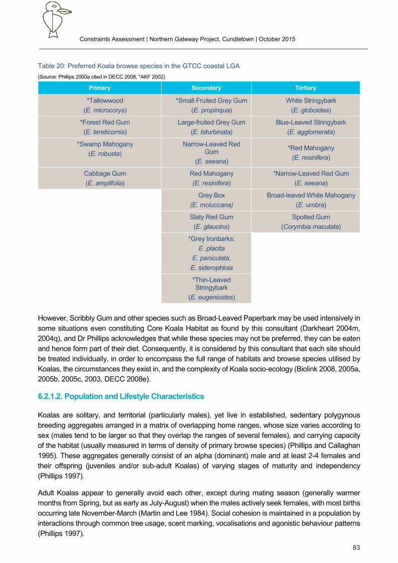
Constraints Assessment | Northern Gateway Project, Cundletown | October 2015
83
Table 20: Preferred Koala browse species in the GTCC coastal LGA
(Source: Phillips 2000a cited in DECC 2008, *AKF 2002)
However, Scribbly Gum and other species such as Broad-Leaved Paperbark may be used intensively in
some situations even constituting Core Koala Habitat as found by this consultant (Darkheart 2004m,
2004q), and Dr Phillips acknowledges that while these species may not be preferred, they can be eaten
and hence form part of their diet. Consequently, it is considered by this consultant that each site should
be treated individually, in order to encompass the full range of habitats and browse species utilised by
Koalas, the circumstances they exist in, and the complexity of Koala socio-ecology (Biolink 2008, 2005a,
2005b, 2005c, 2003, DECC 2008e).
6.2.1.2. Population and Lifestyle Characteristics
Koalas are solitary, and territorial (particularly males), yet live in established, sedentary polygynous
breeding aggregates arranged in a matrix of overlapping home ranges, whose size varies according to
sex (males tend to be larger so that they overlap the ranges of several females), and carrying capacity
of the habitat (usually measured in terms of density of primary browse species) (Phillips and Callaghan
1995). These aggregates generally consist of an alpha (dominant) male and at least 2-4 females and
their offspring (juveniles and/or sub-adult Koalas) of varying stages of maturity and independency
(Phillips 1997).
Adult Koalas appear to generally avoid each other, except during mating season (generally warmer
months from Spring, but as early as July-August) when the males actively seek females, with most births
occurring late November-March (Martin and Lee 1984). Social cohesion is maintained in a population by
interactions through common tree usage, scent marking, vocalisations and agonistic behaviour patterns
(Phillips 1997).
Primary Secondary Tertiary
*Tallowwood
(E. microcorys)
*Small Fruited Grey Gum
(E. propinqua)
White Stringybark
(E. globoidea)
*Forest Red Gum
(E. tereticornis)
Large-fruited Grey Gum
(E. biturbinata)
Blue-Leaved Stringybark
(E. agglomerata)
*Swamp Mahogany
(E. robusta)
Narrow-Leaved Red Gum
(E. seeana)
*Red Mahogany
(E. resinifera)
Cabbage Gum
(E. amplifolia)
Red Mahogany
(E. resinifera)
*Narrow-Leaved Red Gum
(E. seeana)
Grey Box
(E. moluccana)
Broad-leaved White Mahogany
(E. umbra)
Slaty Red Gum
(E. glaucina)
Spotted Gum
(Corymbia maculata)
*Grey Ironbarks:
E. placita
E. paniculata,
E. siderophloia
*Thin-Leaved Stringybark
(E. eugenioides)
Constraints Assessment | Northern Gateway Project, Cundletown | October 2015
84
A Koala may live for around 15 years (especially females), with breeding for most females occurring at
3 years, and for males about 4 years (when they reach a sufficient size to defend a territory) (Martin and
Lee 1984). Young remain in the pouch for 5-6 months, and associate with the mother until at least about
11 months (and up to 2 years), after which they disperse into a population.
Female Koalas do not necessarily breed every year; perhaps due to the dependence on quality foraging
resources (dependant on a variety of factors eg seasonality and condition of habitat), density of other
breeding females/competition for resources, demand for high site philopatry (movement is restricted to
known areas within their home range with high quality forage potential required for lactation), and the
physiological demand of raising offspring (Phillips 1997).
Young, sub-dominant and senescent males are often forced into secondary habitats by dominant males.
Such habitat is generally located on the outer periphery of the core breeding/high quality habitat, and
characterised by poorer soils, greater disturbance, and lower frequency/poorer condition of preferred
browse species (Martin and Lee 1984). These animals have more ephemeral home ranges, sometimes
moving between established populations, which is desirable for maintaining genetic flow. Consequently
though, this group has a higher mortality rate (Phillips 1997).
6.2.1.3. Home Range and Home Range Trees
Home Range
A home range is the territory of a single Koala, usually occupied for at least several years, or more
commonly throughout its life (Phillips 1997, Sharp and Phillips 1999). Size may vary from a hectare to
hundreds of hectares (eg Jurskis and Potter 1997 report home ranges of 38-520ha, with average of
169ha, near Eden); varying with habitat quality (eg if primary browse species dominate the tree
component, home range size is expected to be small and carrying capacity high), sex (males have larger
territories and may make forays into other areas), age of the animals (eg sub-adults versus adults), and
location (Jurskis and Potter 1997, Phillips 1997, Sharp and Phillips 1999).
Home range and hence Koala density varies per region due to the above factors. For example, Jurskis
and Potter (1997) collated Koala densities from Queensland to Victoria, and showed Koala density
ranging from 0.006-7.5 Koalas/ha. Koalas have been recorded at very low densities in areas as a result
of dispersed food resources, semi-arid climatic conditions, and possibly due to historical disturbances eg
clearing of fertile lands for agriculture (eg Jurskis and Potter 1997). Within such large home ranges, a
few specific areas may be subject to a relatively higher level of use, while others are less commonly used
(Jurskis and Potter 1997).
As mentioned previously, the alpha male would be expected to have a relatively large home range to
overlap with those of several females, thus he may include secondary (lower quality) habitat within his
home range to achieve this. The alpha male’s home range is also vigorously defended from other males
to ensure rights to food resources and females (Phillips 1997).
Dispersing individuals of both sexes may travel and are also capable of traversing large distances,
depending on demand (eg up to 50km over a few weeks or months), which is more often driven by the
need to find other Koalas (ie to mate), than potential habitat (Phillips 1997). Movements, distances and
reasons for such are considered complex and poorly understood (Dr Steven Phillips, pers. comm.).
Distance travelled per day will vary with many factors such as topography, distance between forage
trees, season/climate, breeding state, and threats. Koalas have been recorded moving from 10m to
several hundred metres during the day, and >1.3km overnight when they are typically more active
Constraints Assessment | Northern Gateway Project, Cundletown | October 2015
85
(Jurskis and Potter 1997, Kel Mackay pers. comm.). Movement is greatest during the breeding season,
especially by males (Kel Mackay, pers. comm.), with a female recorded moving 2.6km out of its range
to mate, presumably in response to male territorial calls, and returned to its home range (Lee and Martin
1998, Lee et al 1998).
Home Range Trees
Within a home range, a few specific trees (home range trees) are used by Koalas to mark territories and
identify individual Koalas. Such trees are recognisable by heavy scratching and collections of scats close
to the tree base, and may also have significant forage value (Phillips and Callaghan 1995, Hume 1989).
Male Koalas may leave their scent by rubbing the gland on their chest against the bark. Koalas frequently
return to these trees, or deliberately seek them out during travel (Koalas have been recognised to have
the ability to know where they are and return to a discrete location (Phillips 1997).
Such trees are very important as they maintain social cohesion through identification of population
members and assist geographical location (Phillips 1997, Sharp and Phillips 1999).
Site Core Koala Habitat Assessment
Information to determine if a resident population of Koalas exists on the site was obtained by direct survey
of the site using standard survey techniques (direct survey of Koalas, call playback, scat searches, and
tree usage/activity assessment) and review of other relevant published information and database
records.
6.2.2.1. Literature Review
Database Records
Bionet (OEH 2015a) records 60 Koalas in the locality (see Figure 9). The overwhelming majority are
located north of Taree, and considered remote to the site due to physical barriers including the river,
extensive pastoral land, and urban areas.
There are 7 records within the Cundletown area. All but one are from a community survey, and are listed
as having a 10km accuracy, hence have limited precision, and may be multiple sightings of the same
Koala/s, which is a limitation of such surveys (Wilkes and Snowden 1998, Connell Wagner 2000a,
Lunney et al 2009, Biolink 2013).
The single record from an OEH license dataset is from 2002, and is the Terra (2003) record, adjacent to
which is a community record detailing Koala sightings from 1980-2004. All of the community records
range from 1980 to 2006, with most recording sighting Koalas in 2004-2006.
Other Sources
A review of Koalas In Care (KiC) newsletters noted two females being recorded in Cundletown in 2012.
This suggests that a small aggregate may still be persisting in the Cundletown area, despite apparent
habitat limitations and high risks eg vehicle strike.
Constraints Assessment | Northern Gateway Project, Cundletown | October 2015
86
The southern half of the adjacent remnant of Melaleuca/Forest Red Gum closed forest to the south of
Lot 16 has been previously identified by Terra Consulting (2003) as Core Koala Habitat. Terra reported
survey of 52 trees for evidence of Koala usage, and recorded high activity levels (assumedly based on
application of the Spot Assessment Technique). They also recorded a single male Koala, and suggested
that smaller scats indicated a sub-adult Koala.
In survey of Lot 17 DP 856622, and Lots 44 & 46 DP 1191326 to the southeast of the site (Naturecall
2014), and the eastern end of the current site, numerous scats were found of varying ages and sizes,
but all were considered to be of a resident colony of Brushtail Possums due to the shape, content and
often smell. It was noted than some scats could be confused with the Koala, but microscope inspection
detected materials such as hair and insect residues, and fresh scats were collected for review the
morning after possums were seen. This confirmed the scats were not of the Koala via their consistency
in shape, content and smell with the range of scats found.
6.2.2.2. Methods and Field Survey Results
Methods
The site was surveyed for Koalas by the following methods:
• Opportunistic observations over 3 days and 4 nights,
• Scat searches under a majority of potential Koala food trees,
• Spot Assessment Technique (SAT) at 2 locations over the site and one reference site in the
study area (latter chosen due to local concentration of key food trees eg Tallowwood, and
hence best chance of detecting Koala activity).
• Spotlighting and call playback over 4 nights,
• Searches for definitive Koala scratches.
Searches for scats consisted of checking the ground and leaf litter in a 2m radius around a designated
tree. This technique is recognised as a very efficient method of detecting Koala presence, and in some
instances, is a method used to identify areas of major Koala activity/significance eg Core Koala Habitat
(Phillips and Callahan 1995, 2000, Biolink 2009, 2005a, 2005b, Jurskis and Potter 1997, NPWS 2001,
2004a).
The survey was intended to be prolonged to maximise potential for detection. The survey also occurred
in the early stages of the Koala breeding season, which is the peak period for Koala activity and likelihood
of detection.
This technique is limited by the following factors:
• Scat life – scats naturally deteriorate over time due to insect attack, weather condition (eg
rain), fire (though scats have been recorded surviving wildfire) and other disturbances eg
mowing and slashing, bulldozing, etc.
• Groundcover/leaf litter density: Scats may be hidden in dense groundcover or leaf litter, or
searches may be physically impossible in areas of tall, dense groundcover, or
waterlogged/swampy areas.
• Identification: The observer must be able to identify Koala scats and scratches from other
scats and scratches.
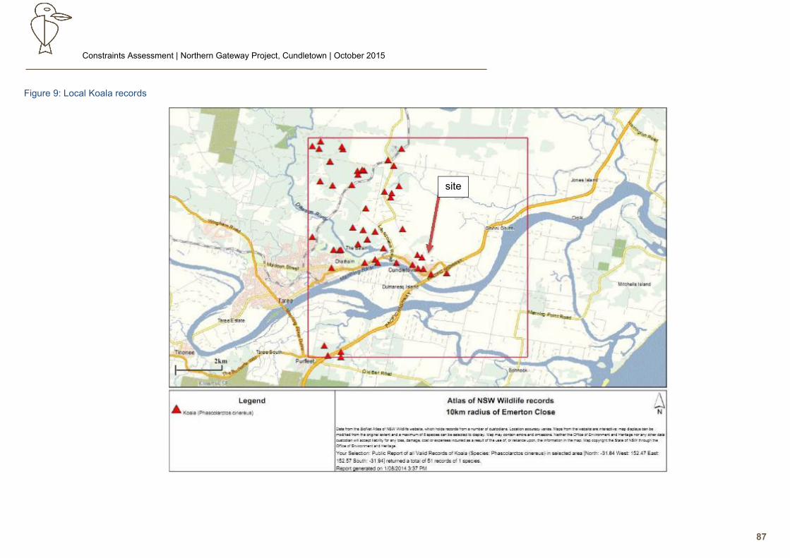
Constraints Assessment | Northern Gateway Project, Cundletown | October 2015
87
Figure 9: Local Koala records
site
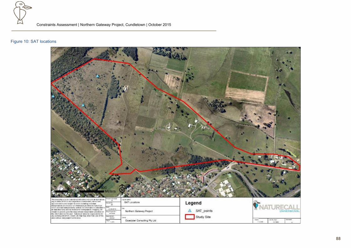
Constraints Assessment | Northern Gateway Project, Cundletown | October 2015
88
Figure 10: SAT locations
Constraints Assessment | Northern Gateway Project, Cundletown | October 2015
89
• Bark type: Rough barked trees do not show evidence of scratch marks like smooth barked
gums, thus identification or even detection of climbing may not be determinable. Scratch
marks are not usually obvious on Tallowwood unless the tree is heavily used, for example a
home range tree
Koala Observations and Call Playback Response
As noted above, the site and study area was surveyed for Koalas via spotlighting for 4 nights and 3 days
spread over 2 weeks, which coincided with the Koala breeding season.
No Koalas were observed on site or in the study area, nor was any response made to call playback,
which was undertaken to ensure all habitat on site and in the study area was sampled. Similarly,
spotlighting included a check of emergent canopy trees visible from the immature swamp regrowth edge
for Koalas. Residents on site also reported a lack of sighting any Koalas.
Scats and Scratches/Activity Levels
(i) Scats:
Every Koala food tree on site was searched for scats within a 2m radius of the trunk base.
Numerous scats were found mostly in the eastern pastoral woodland adjacent to Emerson Close, but
these were all considered to be of the resident Brushtail Possums due to their irregular shape, tendency
to clump together, smell, and presence of hairs and occasional insect remnants.
No Koala scats were found in the SAT sample in the study area.
(ii) Scratches:
As for scats, several trees in the eastern end were well-scratched, suggesting Koala usage. These trees
however were den trees of the Brushtail Possum, as confirmed by stag watches.
(iii) Activity Levels:
Standard procedure when assessing a site for Core Koala Habitat is to utilise the Spot Assessment
Technique (Phillips and Callaghan 2011) to determine if the site contains and area of major activity (an
indication of resident Koalas).
Failure to detect Koala scats determined that an activity level of 0% was recorded.
6.2.2.3. Distribution of Koala Populations, Site Context and Linkages
Regional and Local Government Area Distribution of Koalas
(i) Regional Distribution of Koalas
Koala numbers have declined throughout most of their previous range in NSW, with the main
occurrences being in the northeast of the state (DECC 2008). Most coastal populations now persist in
fragmented and isolated areas of habitat (predominantly secondary class A with some localised primary
areas supporting high density populations), with extensive areas of potential habitat appearing to be
devoid of Koalas (DECC 2008). In contrast, some well-known western populations appear to be
increasing. The difference is considered to primarily be due to increasing development pressure eg from
agriculture and urban expansion in the coastal region (DECC 2008, AKF 2008, 2007).
Constraints Assessment | Northern Gateway Project, Cundletown | October 2015
90
In the north coast and mid-north coast regions, areas with large numbers of records are restricted to
localities such as Ballina, Port Stephens, Port Macquarie, Coffs Harbour, Tweed and Lismore (Connell
Wagner 2000b, Lunney et al 1999, Port Stephens Council 2001, DECC 2008, AKF 2008, 2007). The
NSW Koala Recovery Plan (DECC 2008) notes that in addition to these major population centres are
numerous small populations many of which are disjunct to urban and rural development, as well as
natural barriers (DECC 2008).
(ii) Distribution and Abundance of Koalas in the GTCC LGA:
Figures 11 and 12 shows Koala records in the Greater Taree LGA have a contagious distribution, with
the highest number of records coinciding with human settlement patterns (including roads). This pattern
is typical of Koala records (Lunney et al 2009, Lunney et al 1999, Connell Wagner 2000a), often being a
combination of observer bias (eg high density of observers, multiple records of same Koalas) and human
settlement occurring in prime Koala habitat (eg fertile soils). Other records are centred in State Forests
and state conservation reserves, with scant records in the more heavily cleared rural areas.
This figure suggests that the GTCC Koala populations are generally in the following localised areas:
• West and north Taree to Wingham to Brimbin, and Yarratt State Forest/Goonook National
Park.
• Kiwarrak State Forest/Talawahl Nature Reserve.
• Nowendoc National Park and associated State Forests.
• Lansdowne State Forest
• Crowdy Bay National Park
• Halliday’s Point area
Connectivity between the GTCC Koala metapopulation however is clearly constrained by large areas of
cleared land, and natural physical barriers such as the Manning River.
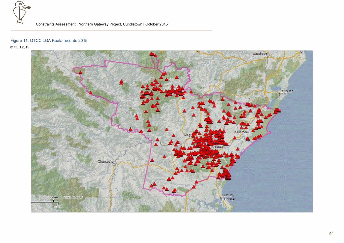
Constraints Assessment | Northern Gateway Project, Cundletown | October 2015
91
Figure 11: GTCC LGA Koala records 2015
© OEH 2015
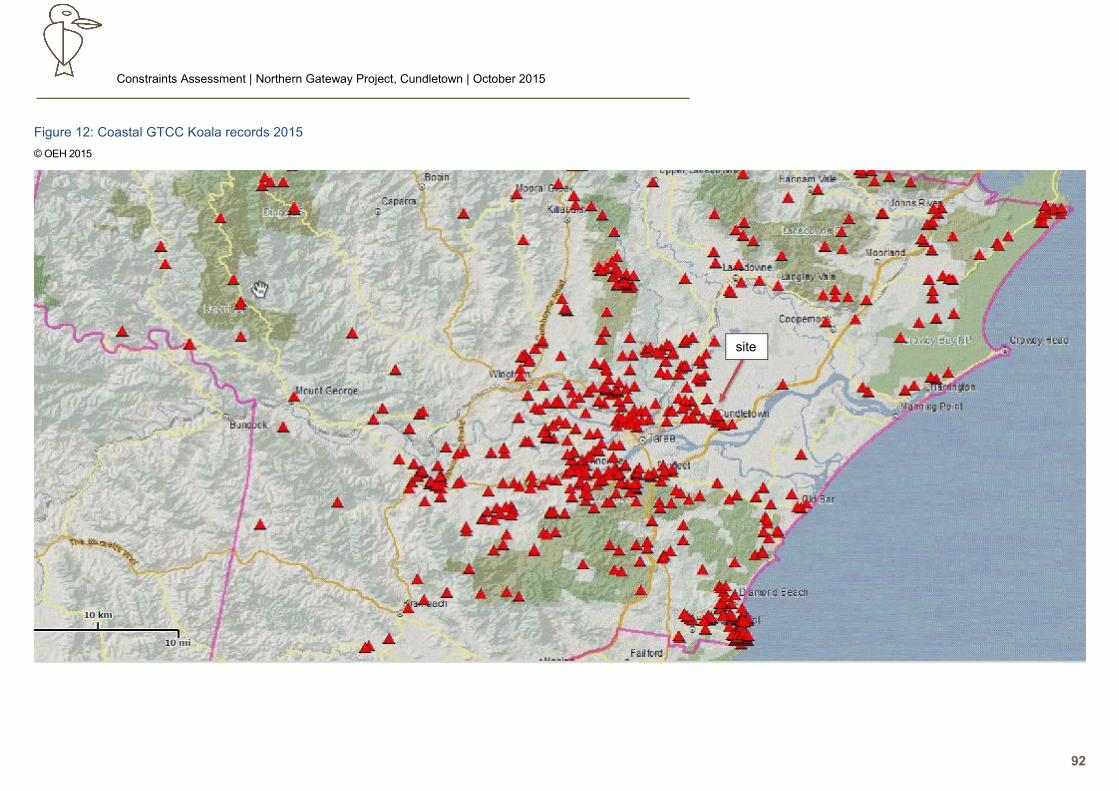
Constraints Assessment | Northern Gateway Project, Cundletown | October 2015
92
Figure 12: Coastal GTCC Koala records 2015
© OEH 2015
site
Constraints Assessment | Northern Gateway Project, Cundletown | April 2016
93
Linkages and Site Context
Figure 12 shows the coastal distribution of Koalas in the GTCC LGA. This figure further reinforces the
clustering of records associated with human settlement patterns, but also illustrates both the key
population centres and the contagious nature of records. The latter as noted above, also reflects the
history of habitat and hence population fragmentation and isolation of Koalas in the GTCC LGA, as noted
by the AKF (2002).
The key linkage in this coastal context for the largest GTCC population is clearly to the west and north
of Taree to Wingham via the Brimbin to Yarratt State Forest/Goonook National Park corridor, which links
to the upper Hastings. Some regional connectivity also occurs along the northern boundary of the LGA
to the coast, but hinterland to coast linkages west and south of Taree are constrained by cleared rural
land and physical barriers.
In a local context from the point of view of a local breeding aggregate, it is very clear from aerial photos
that habitat east of the airport is effectively limited by poor local connectivity to the chevron-shaped strip
of remnant forest and associated pastoral woodland in the study area, and the urban woodland of
Cundletown village itself.
The approximately 30ha remnant in the study area is the relatively more significant area in this context,
as demonstrated by previous findings of Terra (2003) of significant activity levels and an adult male
Koala; and an inspection noted Forest Red Gum to dominate the emergent tree layer, with a few other
Koala browse species scattered on the southern margins eg Grey Ironbark, Red Mahogany and
Tallowwood. This remnant is however effectively separated from habitat west of the airport by at least
400m of open land and security fencing around the airport; and a gap about 200m of open ground from
Cundletown to the south. The gap to the south while exposed, is considered reasonable for a Koala to
cross, but to navigate around the airport, Koalas would have to get around the northern end of the airport
and use remnants and pastoral woodland in the small acreage area on the western side of the airport,
with associated risks of dogs and traffic.
While the Koala will use scattered trees in a pastoral woodland in some situations (eg intervening trees
between proximate remnants), the majority of primary browse species on site occur over 800m east
across mostly open paddock with scattered trees, aside from two small forest remnants in the southeast
which could offer temporary refuge. A Koala crossing such expanse of open ground would be exposed
to predation risk eg Wedge-tailed Eagles, foxes and domestic dogs; and also very visible to human
detection. This and the lack of a residential Koala population thus provide limited incentive for Koalas to
move east.
Urban woodland within Cundletown was also noted via a drive-by inspection to contain only very limited
preferred browse species (with the most significant being a clump of Tallowwoods on the northwest
corner within range of the nearby area of known Koala habitat), and hence a very low carrying capacity.
This is in stark contrast to urbanised Koala populations in areas such as Port Macquarie and Coffs
Harbour which have a range of urban remnants enclosed within the township and an urban woodland
with numerous Koala food trees. This reinforces the likelihood that the Melaleuca/Forest Red Gum
closed forest remnant in the west of the study area is likely to comprise the majority of habitat used by a
local Koala aggregate; but also that the local area has extremely limited capacity to support viable Koala
aggregate in the long term.
Constraints Assessment | Northern Gateway Project, Cundletown | April 2016
94
Aside from attempting to directly cross the airstrip or circle around its northern end, an alternative but
very tenuous route for dispersing Koalas to leave or enter the area would be along Lansdowne Rd to
Main Street in Cundletown. There are however very few trees here until the western side of Cundletown
is reached (and here they are rare and mostly non-browse). In addition to walking over open ground for
some time, a Koala would have to navigate the roundabout a busy road. The KiC 2012 newsletter records
a Koala being retrieved due to risk of vehicle strike in Cundletown, indicating the mortality threat.
Another also tenuous option would be for Koalas to follow the increasingly sparse riparian vegetation
from the northern limits of Dawson River, to Cundletown. Barriers to this route comprise fences and
Manning River Drive/Main St, and this route is slightly less arduous than coming down Lansdowne Rd.
Overall thus, movement across or around the airport and across extensive pasture to Cundletown from
other Koala habitat to the far west and northwest, would thus be unlikely to be regular: at most being a
sub-adult male seeking a new home range after being driven out of Core Koala Habitat to the west.
In summation, the study area and Cundletown area have both limited carrying capacity and very poor
connectivity to known Koala habitat. This means that resident Koalas would be significantly challenged
in maintaining long term viability by both genetic bottlenecks and maintaining recruitment/mortality
equilibrium in an environment of low carrying capacity and high mortality threat from vehicles and dogs
(DECC 2008, McAlpine et al 2007, AKF 2007, Smith and Smith 1990, Lunney et al 2002, Lunney et al
2007, DEC 2003)
Discussion and Conclusion
SEPP 44 defines Core Koala Habitat as “an area of land with a resident population of Koalas, as
evidenced by attributes such as breeding females (that is, females with young) and recent sightings of
and historical records of a Koala population”. The attributes are provided as examples of only some of
characteristics a Core Koala Habitat may demonstrate, and thus to meet the definition of Core Koala
Habitat, a site does not necessarily need to show all of these attributes, and may even show other
evidence indicating the site is Core Koala Habitat.
In regards to the two identified attributes though, the following is provided:
1. “Breeding females (that is, females with young)”. No female with young were recorded by this
survey, nor are there other records indicating previous sightings. No territorial calls of Koalas
have been reported, and no response was made to call playback despite playback occurring in
the Koala breeding season, and the most significant local habitat in the Cundletown area being
surveyed (ie the strips of remnant forest in the western study area). This suggests breeding does
not occur on site or in the study area.
2. “Recent sightings and historical records of a Koala population”. Koala records in the Cundletown
area are limited in age and extent, and localised: suggesting Koalas may occur in low abundance
or appear sporadically, and are at high risk of local extinction. No evidence of Koalas was found
on site, and the last reported sighting in the study area was 2003.
In addition to the above, the failure to detect Koala scats led to the default finding of no activity via the
Spot Assessment Technique.
Constraints Assessment | Northern Gateway Project, Cundletown | April 2016
95
This combined evidence thus leads to the conclusion that the site is not Core Koala Habitat.
Consequently, a Koala Plan of Management is not required.
The other outcome of this assessment suggests that the remnant strips of forest in the study area no
longer support a Koala population and are no longer Core Koala Habitat. This would need to be
confirmed by a corresponding survey of Cundletown and a systematic search for Koala scats in the
remnant strips, but it is possible that the local aggregate has become extinct due to gradual attrition (eg
old age, vehicle strike, relocation), and lack of new recruits eg lack of a dominant male could prevent
breeding (DECC 2008, Phillips 2000b, AKF 2007). Such outcomes for small populations have occurred
in other areas and are typical of Koala decline (DECC 2008, AKF 2007, 2002).
7.0 Constraints Identification and Development Opportunities
As detailed previously, the objective of this assessment was to identify ecological constraints of the
site and study area, to assist in identification of development opportunities over the approximately
67.09ha site.
The identified constraints to future development are described and categorised below.
7.1. Constraints Assessment
Based on ecological values (or lack of) as detailed, the study site has been separated into nil, low,
medium and high constraint, as shown in Figure 13. Figure 14 shows the potential maximum
development which may occur with cognisance of the key constraint and current statutory
exemptions and controls.
Nil Constraint
Land mapped as nil constraint is of very low to no ecological value as it:
• Is simply pasture.
• Is not EEC (occurs above the 1:100 ARI).
• Is not used by Koalas, or likely to be used as part of previously identified Core Koala Habitat.
• Does not contain critical breeding habitat ie Osprey nest.
• Lacks hollow-bearing trees, or such trees are isolated single trees in a paddock isolated from any
support habitat.
• Recovery potential is negligible due to historical and on-going landuses and management
practices on site and in the study area.
• Edge effects and Key Threatening Processes are extreme.
Constraints Assessment | Northern Gateway Project, Cundletown | April 2016
96
Low Constraint
The area of low constraint generally runs along the northern site boundary, within the 1:100 ARI.
This area is characterised by open improved pasture with scattered old growth Forest Red Gums,
Swamp Oak and Broad-leaved Paperbark. Some parts of this area are very highly disturbed Coastal
Floodplain EECs, with floristic elements reduced to single trees and/or a few common herbs and
sedges, and insufficient recruitment. These areas are currently subject to grazing, pasture
improvement and maintenance which effectively prevents effective regeneration. Consequently
floristic and fauna diversity is minimal and limited to generalist species. Hence despite the underlying
edaphic conditions associated with this EEC, ecological processes are disrupted. The EEC here is
thus considered dysfunctional and non-viable in the long term, and will progressively decline to
extinction under the current landuse
Potential Koala Habitat occurs in parts of this area, but consists of isolated or scattered trees, and
many are senescent trees. All show no usage (most likely due to isolation). Most of these trees are
located hundreds of metres from reported Core Koala Habitat, with minimal if any likelihood of being
used by Koalas due to a range of limitations and threats eg exposure to predators such as dogs and
raptors.
Hollow-bearing trees also occur in this area, but are highly senescent trees with limited life span with no
recruitment, hence this habitat component will progressively become extinct in the short to medium term
via natural attrition eg storms. Only common and introduced species (eg Indian Myna) are known or
expected to use this habitat component due to their location and extent of local habitat modification.
Several Key Threatening Processes are active here (eg NSWSC 2013, 2004j, 2000b); and edge
effects are extreme (Lindenmayer and Fisher 2006, Ford 1993).
Medium Constraint
An area in the far west of the study site has been identified as having medium constraint.
There are two key factors which contribute to this area being mapped as medium level of constraint:
• Includes a patch of relatively good condition Swamp Sclerophyll Forest on Coastal
Floodplains EEC.
• The northwestern part of this area has been identified as a complex of regenerating Coastal
Floodplain EECs, demonstrating excellent resilience to historical disturbances, a viable
seedbank, and functioning ecological processes. The regeneration in the area includes E.
tereticornis, which is a Schedule 2 primary browse species for the Koala, and lies adjacent
to the area identified as containing Core Koala Habitat. Hence if the latter status remains
valid, this area could be important to increasing the viability of this aggregate.
Notwithstanding these values, aside from a handful of remnant trees, the patch of Paperbark swamp
forest and perhaps the line of Swamp Oak along the drain, the regrowth can be cleared and the area
cultivated under the Routine Agricultural Management Activities exemptions under the Native Vegetation
Act 2003. This would see the area relegated to low constraint aside from the mature swamp forest patch.
Constraints Assessment | Northern Gateway Project, Cundletown | April 2016
97
7.1.3.1. Maintenance of Coastal Floodplain EECs Diversity and Viability
The northern half of the area mapped as medium constraint fits the floristic and geomorphological
criteria of the EEC - Subtropical Coastal Floodplain Forest and the EEC – Swamp Sclerophyll Forest
on Coastal Floodplains. This area, unlike the area mapped as low constraint, shows excellent
regeneration potential despite historical pastoralism, and it is clear that a seedbank is still present
and ecological processes which define this EEC are functional.
The regeneration of this area provides an offset to development of the remainder of the medium
constraint area which as noted above, can be re-cleared and cultivated under the current zoning (as
can the northern area). Hence allowing the northern and western area to regenerate is a
compromise.
This regeneration will assist long term genetic viability by increasing both the extent and genetic
diversity of the floristic assemblage of these EECs in the west, and providing more functional support
habitat for fauna indicative of this EEC.
7.1.3.2. Koala Food Trees and Core Koala Habitat
As noted above, part of the Melaleuca/Forest Red Gum closed forest in the study area has been
previously identified as Core Koala Habitat. Assuming this remains a fact, it is necessary to address
the objectives of SEPP 44 and address factors which threaten the viability of the local population
and assist recovery.
The medium constraint area adjoins the identified Core Koala Habitat, and adjacent areas contain
many regenerating E. tereticornis and other Eucalyptus sp. Allowing the regeneration of this area
adjacent to the existing remnant will both increase connectivity and also carrying capacity, hence
potentially increasing carrying capacity for the local Koala population.
This issue may not be a constraint in this aspect however if further survey is undertaken to re-
evaluate the assessment of Core Koala Habitat in the adjacent forest remnants. As noted above,
this assessment found no signs of the Koala by methods which should have detected Koalas in the
study area eg call playback in the breeding season. This suggests the local aggregate may have
become locally extinct, or was using habitat in another part of its range at the time eg in Cundletown.
Hence should further study determine the local population is extinct, there is limited justification for
regenerating this area for the Koala, as given the limited carrying capacity, isolation and threats (eg
vehicle strike and domestic dog attack), long term viability is unlikely, and the area would only
function as a sink for recruits (Lunney et al 2007, DECC 2008).
Notwithstanding these potential values, it also has to be acknowledged that this regrowth can be cleared at any given time under RAMA exemptions under the Native Vegetation Act 2003.
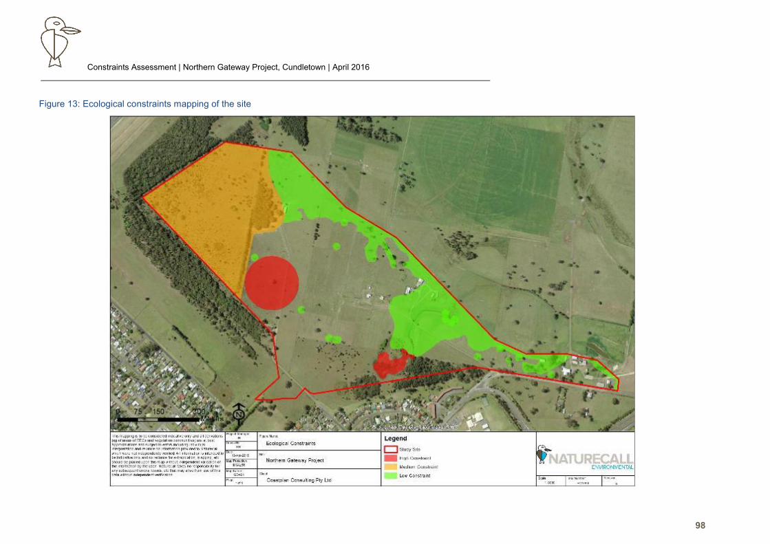
Constraints Assessment | Northern Gateway Project, Cundletown | April 2016
98
Figure 13: Ecological constraints mapping of the site

Constraints Assessment | Northern Gateway Project, Cundletown | April 2016
99
Figure 14: Potential development and conservation areas
Constraints Assessment | Northern Gateway Project, Cundletown | April 2016
100
High Constraints
High constraint areas are as follows:
• Eastern Osprey nest and associated buffer zone.
• EEC with high value and unable to be offset on site.
7.1.4.1. EEC - Freshwater Wetland on Coastal Floodplains
This EEC appears to occur within at least part of the large dam where it is very high quality condition;
and in very low condition in the downstream drainage line/depression which has been degraded by
drainage and grazing, and hence unlikely to recover.
Based on current information, the local occurrence of this EEC is largely restricted to the site, hence
the most intact and viable portion is mapped as high constraint primarily for this reason..
Should the high value EEC area be retained on site, indirect impacts and edge effects must be
controlled. Stormwater runoff can pose a potential impact to the Freshwater Wetland EEC, and
hence any stormwater runoff which flows into the EEC must be of sufficient quality to ensure that
elevated nutrient levels and eutrophication does not occur.
Rehabilitation around the margins of the dam to provide biological and mechanical filtration of water
before it enters the EEC is also recommended. A fully vegetated buffer (at least 30m from top of
bank each side) to increase resilience against edge effects is suggested.
7.1.4.2. Eastern Osprey Nest
The Eastern Osprey is listed a Vulnerable under the Threatened Species Conservation Act 1995
and as a Migratory species under the Commonwealth Environment Protection and Biodiversity Act
1999.
A standard buffer generally comprising a 100m radius of the nest with no buildings or source of
disturbance is preferred for nests (Clancy 1991), and hence this buffer is mapped as high constraint.
The Osprey has a demonstrated acceptance of utilising artificial nest sites and successful relocation.
It is noted that the nest tree is senescent, and hence will eventually succumb to natural attrition.
Further investigations can be made into relocating the nest (or establishing an alternative) to a site
where a buffer will not be impacted by disturbances such as artificial lighting, but still satisfies Osprey
site selection preferences eg northeast aspect. This may potentially see delayed development of the
current affected area ie when the pair has been successfully relocated.
There are two options which could be undertaken following specialist advice.
Passive Relocation of Eastern Osprey Nest
This option involves the construction of an alternative nesting site for the Eastern Osprey in a better
location (ie. closer to the river) in order for the Osprey to potentially use the structure either as a
better nesting site or once the current nest succumbs to attrition from severe weather events.
Constraints Assessment | Northern Gateway Project, Cundletown | April 2016
101
This option is expected to take a number of years to achieve success, but there is no guarantee that
the Eastern Osprey pair will take to the new site under their own accord, and has the risk that another
pair or the White-breasted Sea-eagle may claim the artificial nest site.
The following minimum specifications should be used in relation to the artificial nesting site (Clancy
1991, Poole 1989, Martin et al 1986):
• Top platform not less than 1m²;
• Use strong, durable wood;
• Platform support should be made of lumber no less than 2.5 x 7.5cm thickness, with the
nesting platform itself being no less than 1.9cm thick;
• Platform may be solid or form a frame; and
• Fixing a base of sticks from Melaleuca quinquenervia and/or Casuarina glauca to encourage
Eastern Osprey settlement.
Active Re-location of Eastern Osprey
There have been many examples of successful relocation of active Eastern Osprey nests both in
Australia and the USA (eg GoWA 2013, GCCC 2012, Ewins 1996).
This option involves the manual relocation of the entire osprey nest to a suitable artificial nest
structure during the non-breeding season; or erection of the new nest site, and destruction of the
current nest site in the non-breeding season.
This process may require a Species Impact Statement, or at least a S91 licence under the
Threatened Species Conservation Act 1995, after specialist advice sought and a management plan
has been approved.
8.0 Recommendations and Mitigation Measures
The following are recommended to be included as conditions of consent where relevant to future
development proposals in order to mitigate general ecological impacts.
8.1. Vegetation Clearing
Clearing Timing
Clearing should be planned to be undertaken outside the peak breeding season and torpor seasons
ie winter to late summer. This will minimise the potential mortality risk of fauna within tree hollows
and nests.
Hollow-bearing Tree Marking and Two Stage Clearing
Once the proposed development has been marked at the pre-construction stage, all hollow-bearing
trees are to be physically marked (eg marking paint).
Constraints Assessment | Northern Gateway Project, Cundletown | April 2016
102
This information will be used to easily identify hollow trees during clearing supervision and quantify
the amount of hollows to be removed.
All vegetation except for the hollow-bearing trees is to be cleared first. The hollow-bearing trees are
to be left for a maximum of 48hrs (minimum 12hrs), preferably over-night at least. The two stage
clearing encourages fauna to abandon hollows within the development envelope via disturbance
(RMS 2011). This process has demonstrably reduced the occurrence and injury risk of fauna during
hollow-bearing tree felling (Darkheart 2010, pers. obs.).
Hollow-bearing Tree Felling Protocol
The hollow bearing trees that may be removed could contain fauna at the time of clearing. Such
fauna may be placed under stress, injured or killed during tree felling via:
• Being nocturnal or in torpor, and unable to escape prior to the tree falling.
• Collapse of the hollow when it impacts the ground.
• Collision with internal walls or via being thrown out when the tree falls.
• Being present as young eg eggs.
Any hollow bearing tree removal must be undertaken via a method that will minimise the risk of
injury/mortality of potentially denning/roosting fauna within the limitations of Workplace Health and
Safety (WH&S) Guidelines. Undertaken with due care, this practice can demonstrably avoid mortality
of common and threatened species during felling of hollow-bearing trees, thereby substantially
reducing the potential significance of development impacts. The following general guidelines are
recommended:
1. Clearing should occur in two stages. Stage 1 should see removal of all non-habitat (hollow-
bearing) trees and all lower stratums, with habitat trees left standing for at least 24hrs after
Stage 1 clearing to allow voluntary evacuation of resident fauna. Stage 2 is the removal of
the habitat trees. This strategy is widely employed by NSW RMS and throughout Qld with
high levels of success.
2. Hollow-bearing trees are to be removed via a method that does not require traditional tree
felling methods i.e. clear-drop chainsaw cut or bulldozer/excavator “rip and push” methods
are not to be utilised due to the violence of tree-ground impact and associated high risk of
injury/mortality to fauna (e.g. via hollow collapse, collision with walls, etc). Options include:
• The use of an excavator or similar machine with a pincer/harvester head
attachment, which can hold the trunk while the tree base is sawn, and then the
lowers the tree to the ground for inspection (preferred method but limited by
practicality to only small to medium trees).
• Employment of an arborist to lop hollow-bearing limbs or tree sections, and lower
to the ground with ropes and pulleys or crane, with the non-hollow bearing
remainder of the tree later felled by traditional methods (preferred method but
limited by WH&S constraints).
Constraints Assessment | Northern Gateway Project, Cundletown | April 2016
103
• An ecologist and arborist to use a man-box, and be lifted by crane to inspect the
hollows (eg with torches and inspection cameras). If hollows are vacant, the
entrance is to be blocked (eg trunk hollow) or the hollow-limb felled (limited
practicality for trunk hollows and very long pipes). If fauna can be removed, the
ecologist is to remove the fauna.
• If the above is not practical, an excavator can cut the roots and slowly push over
the tree, counterbalancing the fall rate by pushing down on the root ball to
minimise acceleration and final impact (least preferred method).
3. If a ‘rip and push’ method is employed, the tree is to be bumped at least 3-5 times at
approximately one-minute intervals to initiate evacuation of any residents. Caution will be
required not to risk personal injury via falling branches.
4. An ecologist/fauna spotter-catcher must be present during felling of the hollow bearing trees
to monitor clearing, capture any resident animals injured or not evacuating, and undertake
appropriate emergency actions if required e.g. transport animal to veterinary treatment (care
at proponent’s cost) or care by FAWNA (with a donation by proponent to cover costs).
Hollows are to be immediately inspected once the tree is felled (within WH&S guidelines) for
injured individuals or abandoned offspring, and appropriate measures undertaken. All
rehabilitated animals are to be released in the retained habitat directly on/or adjacent to the
site.
A report detailing dates, personnel, qualifications, licenses and results is to be provided to GTCC
within 14 days of the monitoring event.
Clearing Monitoring
In addition to the hollow-bearing tree removal protocol, the following is recommended to be
implemented to minimise impacts on native fauna:
• The area of clearing work is to be inspected for Koalas and other fauna (eg bird nests) by an
ecologist immediately prior to commencement of any vegetation removal involving machinery
and/or tree-felling. Pre-clearing checks will include searches of habitat eg lifting and
destruction of logs, searches for bird nests, and raking of leaf litter. Other than Koalas, any
detected fauna is to be relocated off-site to nearby suitable areas (preferably within their
natural home range) prior to clearing.
• If practical in terms of WH&S restrictions, any bird nest considered active is to be removed
in a manner that allows retrieval of eggs/young, and these are to be taken into care by
FAWNA/WIRES.
• If a Koala is present in the proposed clearing envelope, works are to be suspended until the
Koala moves along on its own volition. If the Koala is located in a position that a 25m buffer
may be established, works may proceed outside this buffer.
• The ecologist is to remain on site to supervise clearing to retrieve any fauna detected during
works, undertake appropriate action (eg euthanize severely injured animals), and ensure
Koalas do not enter the site during clearing works.
Constraints Assessment | Northern Gateway Project, Cundletown | April 2016
104
• A report detailing the results of the clearing monitoring is to be provided to GTCC within 14
days of works completion.
Fencing
Lots which back onto any offset areas, retained habitat or the areas of Core Koala Habitat adjacent
to the study site are recommended to use sheet metal fencing for boundaries. This is recommended
to minimise native fauna entering the industrial areas and being at risk of injury.
Street Lighting
Artificial lighting will likely be required for security reasons as well as for street lights etc.
In general, lighting design and location must ensure lighting is directed to the ground within the site
and not onto retained or adjacent vegetation to minimise impacts on fauna potentially using this
habitat. This is particularly important in relation to the Eastern Osprey nest if it is retained on site. If
retained, lighting must not impact this nest.
Stormwater Management
Standard soil and sedimentation control measures will be required by Council in the construction
stage of the proposal to ensure that habitats on the site and in the study area, as well as subsequent
wetlands/aquatic habitats nearby are not substantially affected by the proposed development.
Stormwater management systems need to be adequately designed and effectively established to
prevent the risk of any substantial impacts (eg erosion and sedimentation) on EECs retained on site
and in the study area. This is of particular concern to the Freshwater Wetland EEC if it is retained.
Any stormwater runoff which enters any EEC must be of suitable quality and not introduce an
excessive sediment or nutrient load and cause eutrophication.
9.0 Conclusion
This report has identified a number of ecological constraints for the subject site, which have been
categorised into nil, low, medium and high levels.
The constraints map takes into consideration both development potential and impacts on the
ecological values of the study area; current exclusions under the Native Vegetation Act 2003; and
the role of the study area habitat in the local context given identified limitations.
Development of the majority of the study site is permissible with adequate mitigation (eg offsets and
stormwater management).
Constraints Assessment | Northern Gateway Project, Cundletown | April 2016
105
10.0 References
Andrews, A. (1990). Fragmentation of habitat by roads and utility corridors: A review. Aust. Zool. 26(3&4):
Australian Koala Foundation (2007). Planning Guidelines for Koala Conservation and Recovery: A Guide to Best Planning
Practice. Australian Koala Foundation, Brisbane. Website: www.savethekoala.com.au
Australian Koala Foundation (2002). Greater Taree City Council Draft Comprehensive Koala Plan of Management. Part 1:
The CKPoM. Australian Koala Foundation, Brisbane.
Belcher, C.A. (1994). Studies on the Diet of the Tiger Quoll (Dasyurus maculatus). M. Sc. Thesis, LaTrobe University,
Melbourne.
Belcher, C.A. (1995). Diet of the Tiger Quoll (Dasyurus maculatus) in East Gippsland, Victoria. Wildlife Research, 22: 341-
357.
Bennet, A., Kimber, S., and Ryan, P. (2000). Revegetation and wildlife: A guide to enhancing revegetated habitats for
wildlife conservation in rural environments. Bushcare – National Projects Research and Development Program.
Environment Australia, Canberra.
Biosis Research (2004) Terrestrial Flora and Fauna Report – Pacific Highway Upgrade Moorland to Herons Creek.
Birds Australia (2009). Swift Parrot Lathumus discolor. www.birdsaustralia.com
Bischoff, T., Lutter, H. and Debus, S. (2000). Square-tailed Kites breeding on the mid north coast of NSW. Aust. Bird
Watcher. 18:133-152.
Bowen, M. and Goldingay, R. (2000). Distribution and status of the Eastern Pygmy Possum (Cercartetus nanus) in NSW.
Aust. Mamm. 21: 153-164.
Braithwaite, L.W., Turner, T. and Kelly, J. (1984). Studies on the arboreal marsupial fauna of eucalypt forests being
harvested for woodpulp at Eden, NSW. III. Relationship between faunal densities, eucalypt occurrence and foliage
nutrients, and soil parent materials. Aust. Wildlife Res. 11:41-48.
Briggs, B. (1996). Tracks, Scats and Other Traces. Oxford University Press, Melbourne.
Brown, C.L., Hall, F., and Mill, J. (2003). Plant conservation: approaches and techniques from an Australian perspective.
Australian Network for Plant Conservation, Canberra.
Cann, B., Williams, J. and Shields, J.M (2000). Monitoring Large Forest Owls and Gliders After Recent Logging in
Production Regrowth Forests of the Mid-North Coastal Region of NSW. In: Ecology and Conservation of Owls. Newton, I.,
Kavanagh, R., Olsen, J. and Taylor, I. (Editors) (2002). CSIRO Publishing, Collingwood.
Churchill, S. (2008) Australian Bats. Reed-New Holland, Sydney.
Clancy, P, Greg. (1991) The biology and management of the Osprey (Pandion haliartus cristatus) in NSW. NSW National
Parks and Wildlife Services.
Clout, M.N. (1989). Foraging behaviour of Glossy Black Cockatoos. Aust. Wildl. Res. 16: 467-73.
Cogger, H.G. (1992). Reptiles and Amphibians of Australia. Reed, Sydney.
Connell Wagner Pty Ltd (2000a). Koala Plan of Management – Coastal Area. Part A: The KPOM – Hastings Council.
Connell Wagner Pty Ltd, Neutral Bay.
Connell Wagner Pty Ltd (2000b). Koala Plan of Management – Coastal Area. Part B: Resource Study – Hastings Council.
Connell Wagner Pty Ltd, Neutral Bay.
Cooke, R., Wallis, R. and Webster, A. (2000). Urbanisation and the Ecology of Powerful Owls (Ninox strenua) in Outer
Melbourne, Victoria. In: Ecology and Conservation of Owls. Newton, I., Kavanagh, R., Olsen, J. and Taylor, I. (Editors)
(2002). CSIRO Publishing, Collingwood.
Corben, C.J. (1991). Comments on frog decline in southeast Qld. In: Report of a Workshop on Declining Frog Populations
in Qld. Unpublished report to QNPWS, Brisbane.
Constraints Assessment | Northern Gateway Project, Cundletown | April 2016
106
Craig, S.A. (1985) Social Organization, Reproduction and Feeding Behaviour of a Population of Yellow-bellied Gliders,
Petaurus Australis (Marsupialia: Petauridae). Australian Wildlife Research 12 : 1 – 18.
Dadds, B. (2000). Reproductive, population and movement ecology of adult Litoria brevipalmata (Anura: Hylidae) in a
heterogeneous dry eucalypt forest in southeast Queensland. Honours Thesis, Science, Griffith University.
Date, E.M., Recher, H.F and Ford, H. (1992). Status of Rainforest Pigeons in northern NSW. Unpublished Report to NPWS.
Davey, S.M. (1984). Habitat preferences of arboreal marsupials within a coastal forest in southern NSW. pp 509-16. In:
Smith, A. and Hume, I.D. (Eds) (1984). Possums and Gliders. Australian Mammal Society.
Davis, W.E. and Recher, H.F. (1993). Notes on the breeding biology of the Regent Honeyeater. Corella, 17(1): 1-4.
Deacon, J.N. and MacNally, R. (1998). Local extinction and nestedness of small mammal faunas in fragmented forest of
central Victoria. Pacific Conservation Biology 4: 122-131.
Debus, S. (2012). Birds of Prey of Australia: A Field Guide. CSIRO publishing, Collingwood.
Debus, S. (1994). Aspects of the Biology, Conservation and Management of the Threatened Forest Owls and Raptors in
NSW. Thesis, Master of Science (Zool.), University of New England, Armidale.
Debus, S. and Czechura, G.V. (1989). The Square Tailed Kite, Lophoictinia isura in Victoria. Aust. Bird. Watcher 13:118-
123.
DECCW (2009). Draft National Recovery Plan for the Grey-headed Flying Fox. NSW DECCW, Hurstville.
DECC (2008). Recovery Plan for the Koala (Phascolarctos cinereus). NSW DECC, Hurstville.
DECC (2007a). Threatened Species Assessment Guidelines: The Assessment of Significance. NSW DECC, Hurstville.
DECC (2007b). Identification Guidelines for Threatened Species - Swamp Oak Floodplain Forest. NSW DECC, Hurstville.
Dept of the Environment (2015a). Environment Protection and Biodiversity Conservation Act – Matters of National
Environment Significance Search Tool. www.environment.gov.au
DotE (2015b). Species Profile and Threats Database - Homepage. www.environment.gov.au
DotE (2013). Matters of National Environmental Significance – Significant Impact Guidelines 1.1 – Environment Protection
and Biodiversity Conservation Act 1999. DoE, Canberra.
Dept of Environment, Water, Heritage and the Arts (2013). Conservation Advice for Subtropical and Temperate Coastal
Saltmarsh. Department of Environment, Water, Heritage and the Arts, Canberra.
Dept of Environment, Water, Heritage and the Arts (2009). Littoral Rainforest and Vine Thickets of Eastern Australia: EPBC
Act 1999 – Policy Guide 3.9. Department of Environment, Water, Heritage and the Arts, Canberra.
Dickman, C. (1996). Overview of the Impacts of Feral Cats on Australian Native Fauna. Report prepared for the Australian
Nature Conservation Agency, Canberra.
Dique, D.S., Preece, H.J., Thompson, K. and de Villiers, D.L. (2004). Determining the distribution and abundance of a
regional koala population in southeast Queensland for conservation management. Wildlife Research 31(3): 109-119.
Dique, D.S., de Villiers, D.L. and Preece, H.J. (2003). Evaluation of line transect sampling for estimating koala abundance
in Pine Rivers Shire, southeast Queensland. Wildlife Research 30(2): 127-135.
Dwyer, D. (1968). The biology, origin and adaptation of Miniopterus australis in NSW. Aust. J. Zool. 16: 49-68.
Dwyer, D. (1966). The population pattern of Miniopterus schreibersii in northeastern NSW. Aust. J. Zool; 14: 1073-1137.
Eby, P. (2000a). A Case for Listing Grey-Headed Flying Fox (Pteropus poliocephalus) as Threatened in NSW Under IUCN
Criterion A2. In: Proceedings of a Workshop to Assess the Status of the Grey-Headed Flying Fox in NSW. Richards, G.
(Ed.). Australasian Bat Society, Sydney.
Eby, P. (2000b). Low Reproductive Periods in Grey-Headed Flying Foxes Associated With a Short Period of Food Scarcity.
In: Proceedings of a Workshop to Assess the Status of the Grey-Headed Flying Fox in NSW. Richards, G. (Ed.).
Australasian Bat Society, Sydney.
Constraints Assessment | Northern Gateway Project, Cundletown | April 2016
107
Eby, P. (2002). Using NSW planning instruments to improve conservation and management of Grey-Headed Flying Fox
(Pteropus poliocephalus) camps. In: Managing the Grey-Headed Flying Fox as a Threatened Species in NSW. Eby, P and
Lunney, D. (Eds.). Royal Zoological Society of NSW, Sydney.
Ehmann, H. (1996). Green-Thighed Frog. In: Ehmann, H. (Ed.). Threatened Frogs of NSW: Habitats, Status and
Conservation. Frog and Tadpole Study Group of NSW Inc.
Elkin, C.M. and Possingham, H. (2008). The Role of Landscape-Dependent Disturbance and Dispersal in Metapopulation
Persistence. The American Naturalist 172 (4). 563-575.
Ewins J Peter. 1996. The Use of Artificial Nest Sites by an Increasing Population of Ospreys in the Canadian Great Lakes
Basin. Academic Press Ltd.
Ford, H.A. (1993). The role of birds in ecosystems: Risks from eucalypt forest fragmentation and degradation. Pp 33-40
in: Birds and Their Habitats: Status and Conservation in Queensland. Catterall, C.P., Dricoll, P.V., Hulsman, K. Muir, D
and Taplin, A. (eds_). Qld Ornithological Society, Brisbane.
Garnett, S.T. and Crowley, G.M (2000). The Action Plan for Australian Birds 2000. Environment Australia Website.
Garnett, S.T., Pedler, L.P. and Crowley, G.M. (1999). The breeding biology of the Glossy Black Cockatoo, Calyptorhynchus
lathamii, on Kangaroo Island, South Australia. Emu, 99: 262-279.
Gibbons, P. and Lindenmayer, D. (2002). Tree Hollows and Wildlife Conservation in Australia. CSIRO Publishing,
Collingwood.
Gill, A.M., Woinarski, J.N.Z., and York, A. (1999). Australia’s Biodiversity – Response to Fire: Plants, Birds and
Invertebrates. Biodiversity Technical Paper No. 1. Dept. of Environment and Heritage, Canberra.
Gilmore, A. and Parnaby, H. (1994). Vertebrate fauna of conservation concern in northeast NSW forests. Northeast Forests
Biodiversity Study Report No. 3e. Unpublished report, NSW NPWS.
Goldingay, R.L. and Kavanagh, R.P. (1991). The Yellow-bellied Glider: a review of its ecology, and management
considerations. In: Lunney, D. (Ed.) (1991). Conservation of Australia’s Forest Fauna. Royal Zoological Society of NSW,
Mosman.
Goosem, M. (2002). Effects of tropical rainforest roads on small mammals: fragmentation, edge effects and traffic
disturbance. Wildl. Res. 2: 1035-3712.
Government of Western Australia (GoWA) (2013). Osprey nest relocation at Point Samson.
http://www.dpaw.wa.gov.au/news/item/106-osprey-nest-relocated-at-point-samson. Taken 6.10.2015
Hall, L and Richards, G. (2000). Flying Foxes: Fruit and Blossom Bats of Australia. Australian Natural History Series.
University of NSW, Sydney.
Harden, G.J. (Editor). Flora of NSW. Vols 1-4. NSW Press, Sydney.
Harden, G.J, McDonald, B. and Williams, J.B. (2007).Rainforest Climbing Plants – A field guide to their identification. Gwen
Harden Publishing, Nambucca Heads.
Hero, J.M., Hines, H., Meyer, E., Lemckert, F. and Newell, D. (2002). AmphibiaWeb: Information on amphibian biology
and conservation [web application]. http://amphibiaweb.org/. Accessed Nov 20, 2002.
Hindell, M.A. and Lee, A.K. (1990). Tree preferences of the Koala. pp117-21 In: Biology of the Koala. Ed. by A.K. Lee,
K.A. Handayde and G.D. Sanson. Surrey Beatty and Sons, Sydney.
Hourigan, C.L., Catterall, C.P., Jones, D. and Rhodes, M. (2009). A comparison of the effectiveness of bat detectors and
harp traps for surveying bats in an urban landscape. Aust. Wildl. Res. 35: 768-774.
Hulm, C. (1994). The status and distribution of Miniopterus australis in northern NSW. Integrated Project, Faculty of
Resource Science and Management, Southern Cross University.
Johnson, C., Cogger, H., Dickman, C. and Ford, H. (2007). Impacts of Land Clearing: The Impacts of Approved Clearing
of Native Vegetation on Australian Wildlife in New South Wales. WWF -Australia Report. WWF Australia, Sydney.
Jones, M. E. (2000). Road upgrade, road mortality and remedial measures: Impacts on a population of Eastern Quolls and
Tasmanian Devils. Wildlife Research 27: 289-296.
Constraints Assessment | Northern Gateway Project, Cundletown | April 2016
108
Jurskis, V. and Potter, M. (1997). Koala Surveys, Ecology and Conservation at Eden. Research Paper No. 34. State
Forests, Sydney.
Jurskis, V., Rowell, D. and Ridley, D. (1994). Survey Techniques and Aspects of the Ecology of the Koala Near Eden.
Research Paper No. 22. State Forests, Sydney.
Kavanagh, R.P. (2000a). Comparative diets of the Powerful Owl (Ninox strenua), Sooty Owl (Tyto tenebricosa) and Masked
Owl (T. novaehollandiae) in Southeastern Australia. In: Ecology and Conservation of Owls. Newton, I., Kavanagh, R.,
Olsen, J. and Taylor, I. (Editors) (2002). CSIRO Publishing, Collingwood.
Kavanagh, R.P. (2000b). Conservation and Management of large forest owls in Southeastern Australia. In: Ecology and
Conservation of Owls. Newton, I., Kavanagh, R., Olsen, J. and Taylor, I. (Editors) (2002). CSIRO Publishing, Collingwood.
Kavanagh, R.P. (1997). Ecology and Management of Large Forest Owls in Southeastern Australia. PhD Thesis. School of
Biological Sciences, University of Sydney, Sydney.
Kavanagh, R.P. and Stanton, M.A. (2000). Response to Habitat Fragmentation by the Powerful Owl (Ninox strenua), Sooty
Owl (Tyto tenebricosa) and Masked Owl (T. novaehollandiae)and Other Nocturnal Fauna in Southeastern Australia. In:
Ecology and Conservation of Owls. Newton, I., Kavanagh, R., Olsen, J. and Taylor, I. (Editors) (2002). CSIRO Publishing,
Collingwood.
Keith (2004). Ocean shores to desert dunes: the native vegetation of New South Wales and the ACT. NSW Department
of Environment and Conservation, Sydney.
Keith, D. and Scott, J. (2005). Native vegetation of coastal floodplains – a diagnosis of the major plant communities in New
South Wales. Pacific Conservation Biology, 11: 81-104.
Lae Kortner, G, Gresser, S., Mott, B., Tamayo, P, Pisanu, P., Bayne, P. and Harden, R.H. (2004). Population structure,
turnover and movement of Spotted-Tailed Quolls on the New England Tablelands. Wildl. Res 31(5):475-484.
Klaphake, V. (2006). Guide to the Grasses of Sydney. Van Klaphake, Byabarra.
Klaphake, V. (2004). Key to the Commoner Species of Sedges and Rushes of the Sydney and Blue Mountains. Van
Klaphake, Byabarra.
Law, B., Chidel, M. and Turner, G. (2000). The use by wildlife of paddock trees. Pacific Conservation Biology, 6: 130-143.
Law, B.S and Dickman. C.R. (1998). The use of habitat mosaics by terrestrial vertebrate fauna: implications for
conservation and management. Biodiversity and Conservation 7:323-333.
Law, B.S. (1994a). Banksia nectar and pollen: Dietary items affecting the abundance of the Common Blossom Bat
(Syconycteris australis): in southeastern Australia. Australian Journal of Ecology 19: 425-434.
Law, B.S. (1994b). Climatic limitations of the southern distribution of the Common Blossom Bat (Syconycteris australis) in
NSW. Australian Journal of Ecology 19: 366-374.
Law, B.S. (1993). Roosting and foraging ecology of the Queensland Blossom Bat (Syconycteris australis) in northeastern
NSW: Flexibility in response to seasonal variation. Wildl. Res. 20: 419-431.
Lee, A.K. and Martin, R.W. (1998). The Koala – A Natural History. NSW University Press, Kensington.
Lindenmayer, D. and Fisher, J. (2006). Habitat fragmentation and Landscape Change: An ecological and
conservation synthesis. CSIRO Publishing, Collingwood.
Lindenmayer, D. (2002). Gliders of Australia – A Natural History. University of NSW Press, Sydney.
Lindenmayer, D.B. (1998). The Design of Wildlife Corridors in Wood Production Forests – Forest Issues 4. NSW NPWS,
Hurstville.
Lunney, D. Gresser, S. O’Neill, L.E., Matthews, A. and Rhodes, J. (2007). The impact of fire and dogs on Koalas at Port
Stephens, New South Wales, using population viability analysis. Pacific Conservation Biology 125: 243-258.
Luo, J., Fox, B.J. and Jeffreys, E. (1994). Diet of the Eastern Chestnut Mouse (Pseudomys gracilicaudatus) I: Composition,
Diversity and Individual Variation. Wildl. Res. 21: 401-17.
Luo, J., and Fox, B.J. (1995). Competitive effects of Rattus lutreolus presence on the resource use by Pseudomys
gracilicaudatus. Aust. J. Ecol.. 21: 556-564.
Constraints Assessment | Northern Gateway Project, Cundletown | April 2016
109
Luo, J., and Fox, B.J. (1994). Diet of the Eastern Chestnut Mouse (Pseudomys gracilicaudatus) II: Seasonal and
Successional Patterns. Wildl. Res. 21: 419-31.
Mackowski, C.M (1988). Characteristics of eucalypts incised by the Yellow-bellied Glider in northeastern NSW. Aust.
Mamm. 11(1) pp 1-13.
Mahony, M. (1996a). Draft Final Report: Great Barred River Frogs Research Plan. Unpublished report to the ANCA,
Canberra and NSW NPWS, Hurstville.
Mahony, M. (1996b). Survey of the distribution and abundance of declining frogs in northern NSW. Unpublished report to
Australian Nature Conservation Agency.
Martin, C.O. Mitchell W.A & Hammer.D.A. (1986). Osprey nest platforms. Section 6.1.6. US Army Corps of Engineers
Wildlife Management Manual. Technical Report EL-86-21.31 (Dept. of Army, Waterways Experiment Station, Corps of
Engineers, Environment Library, P.O. Box 631, Vicksburg, MS 39180 USA).
Marchant, S. and Higgins, P.J. (eds) (1990). The Handbook of Australian, New Zealand and Australian Birds. Oxford
University Press, Melbourne.
Martin, R.W. and Lee, A. (1984). The Koala, Phascolarctos cinereus, The Largest Marsupial Folivore. In: Possums and
Gliders. Smith, A.P. and Hume, I.D. (Eds). Australian Mammal Society, Sydney.
McAlpine, C., Bowen, M., Callaghan, J., Rhodes, J. Mitchell, D., Pullar, D. and Possingham, H. (2006). Testing alternative
models for the conservation of Koalas in fragmented rural-urban landscapes. Austral Ecology 31:529-544.
McIntyre, A.D. and Henry, S.R. (2000). Large Forest Owl Conservation in East Gippsland Forest Management Area,
Victoria. In: Ecology and Conservation of Owls. Newton, I., Kavanagh, R., Olsen, J. and Taylor, I. (Editors) (2002). CSIRO
Publishing, Collingwood.
May, S.A. and Norton, T.W. (1996). Influence of fragmentation and disturbance on the potential impact of feral predators
on native fauna in Australian forest ecosystems. Aust. Wildl. Res. 23: 387-400.
McDonald, R.C., Isbell, R.F, Speight, J.G., Walker, J. and Hopkins, M.S. (1990). Australian Soil and Land Survey Field
Handbook. 2nd Edition. Goanna Printing, Canberra
Menkhorst, P., Schedvin, N. ad Geering, D. (1999). Regent Honeyeater (Xanthomyza phrygia) Recovery Plan 1999-2003.
Dept of Natural Resources and Environment, Melbourne.
Menkhorst P.W. and Collier M. (1987) Diet of the squirrel glider Petaurus norfolcensis (Marsupialia: Petauridae), in Victoria.
Aust. Mamm. 11: 109-16.
Menkhorst, P.W., Weavers, B.W. and Alexander, J.S.A. (1988). Distribution of habitat and conservation status of the
Squirrel Glider in Victoria. Aust. Mamm. 11: 109-16
Milledge, D., Palmer, C. and Nelson, J. (1991). “Barometers of Change”: The distribution of large owls and gliders in
montane ash forests of the Victorian Central Highlands and their potential as management indicators. In: Conservation of
Australia’s Forest Fauna. Lunney, D. (Ed.). The Royal Zoological Society of NSW, Sydney, pp. 53-65.
Naturecall (2014). Statutory Ecological Assessments for Proposed Truck Stop Lot 17 DP 856622, and Lots 44 & 46 DP
1191326, Cundletown. Naturecall Environmental, Port Macquarie.
Noske, R.A (2008). Social Organisation and Nesting Biology of the Cooperatively Breeding Varied Sittella Daphoenositta
chrysoptera in North-eastern New South Wales. Emu 98: 85-96.
NRE (2000). Powerful Owl, Ninox strenua – Action Statement No. 92. Victorian Dept Natural Resources and Environment,
Melbourne.
NSW National Parks and Wildlife Service (2003a). Recovery Plan for the Bush Stone-Curlew (Burchinus grallaris). NSW
NPWS, Hurstville.
NSW National Parks and Wildlife Service (2003b). Recovery Plan for the Yellow-bellied Glider (Petaurus australis). NSW
NPWS, Hurstville.
NSW National Parks and Wildlife Service (2003c). Recovery Plan for the Barking Owl (Ninox connivens). NSW NPWS,
Hurstville.
Constraints Assessment | Northern Gateway Project, Cundletown | April 2016
110
NSW National Parks and Wildlife Service (2002a). Recovery Plan for the Red Goshawk. NSW NPWS, Hurstville.
NPWS (2001). Threat Abatement Plan: Predation By the Red Fox (Vulpes vulpes). NSW NPWS, Hurstville.
NPWS (2000a). Threatened Species of the Lower North Coast. NSW NPWS, Hurstville.
NPWS (2000b). Threatened Species of the Upper North Coast. NSW NPWS, Hurstville.
NSW National Parks and Wildlife Service (1999a). Integrated Forest Ecosystem Classification And Mapping For Upper
And Lower North East CRA Region. NSW NPWS, Coffs Harbour.
NSW National Parks and Wildlife Service (1999b). Threatened Species Management – Species Information. NPWS,
Hurstville.
NSW National Parks and Wildlife Service (1995). Integrated faunal information for public lands in northeastern NSW. NSW
NPWS.
NSW Scientific Committee (2013). Decline in woodland and forest birds due to aggressive exclusion by
abundant Noisy Miners. Key Threatening Process. www.environment.nsw.gov.au.
NSW Scientific Committee (2011). Loss and degradation of native plant and animal habitat by invasion of
escaped garden plants, including aquatic plants. Key Threatening Process. www.environment.nsw.gov.au.
NSW Scientific Committee (2010a). Final Determination to list the Little Eagle (Hieraaetus morphnoides) (Gould 1841), as
a Vulnerable Species. www.environment.nsw.gov.au.
NSW Scientific Committee (2010b). Final Determination to list the Flame Robin (Petroica phoenicea) Gould 1837, as a
Vulnerable Species. www. environment.nsw.gov.au.
NSW Scientific Committee (2010c). Final Determination to list the Varied Sittella (Daphoenositta chrysoptera) (Latham
1802), as a Vulnerable Species. www environment.nsw.gov.au.
NSW Scientific Committee (2009a). Final Determination to list the Little Lorikeet (Glossopsitta pusilla) (Shaw, 1790), as a
Vulnerable Species. www.environment.nsw.gov.au.
NSW Scientific Committee (2007a). Loss of hollow-bearing trees: final determination. www environment.nsw.gov.au.
NSW Scientific Committee (2004a). Subtropical coastal floodplain forest of the NSW North Coast bioregion - endangered
ecological community listing: final determination. www environment.nsw.gov.au
NSWSC (2004b). Swamp Oak Floodplain Forest of the NSW North Coast, Sydney Basin and South East Corner bioregions
- endangered ecological community listing: final determination. www environment.nsw.gov.au
NSWSC (2004c). River-flat eucalypt forest on coastal floodplains of the NSW North Coast, Sydney Basin and South East
Corner bioregions - endangered ecological community listing: final determination. www environment.nsw.gov.au
NSWSC (2004d). Swamp Sclerophyll Forest on Coastal Floodplains of the NSW North Coast, Sydney Basin and South
East Corner bioregions - endangered ecological community listing: final determination. www environment.nsw.gov.au.
NSWSC (2004e). Freshwater wetlands on coastal floodplains of the NSW North Coast, Sydney Basin and South East
Corner bioregions - endangered ecological community listing: final determination. www environment.nsw.gov.au.
NSWSC (2004f). Coastal saltmarsh in the NSW North Coast, Sydney Basin and South East Corner bioregions -
endangered ecological community listing: final determination. www environment.nsw.gov.au
NSWSC (2004g). Littoral rainforest in the NSW North Coast, Sydney Basin and South East Corner bioregions - endangered
ecological community listing: final determination. www environment.nsw.gov.au
NSWSC (2004h). Alteration to the natural flow regimes of rivers, streams, floodplains & wetlands - key threatening process
declaration. www environment.nsw.gov.au
NSWSC (2004i). Removal of dead wood and dead trees - key threatening process declaration. www
environment.nsw.gov.au
NSWSC (2004j). Invasion of native plant communities by exotic perennial grasses - key threatening process declaration.
www environment.nsw.gov.au
Constraints Assessment | Northern Gateway Project, Cundletown | April 2016
111
NSWSC (2002a). Lowland rainforest on floodplain in the NSW North Coast Bioregion - endangered ecological community
listing: final determination. www environment.nsw.gov.au
NSW Scientific Committee (2002b). Final Determination f21206g – Infection by Psittacine Circoviral (beak and feather)
Disease affecting endangered psittacine species and populations. www environment.nsw.gov.au
NSW Scientific Committee (2002c). Final Determination f021213s –Infection of native plants Phytophthora cinnamomi.
www environment.nsw.gov.au
NSWSC (2002d). Final Determination f021213s –Infection of native plants Phytophthora cinnamomi. www
environment.nsw.gov.au
NSWSC (2001a). Hooded Robin (south-eastern form) Melanodryas cucullata cucullata (Latham 1802), as a VULNERABLE
SPECIES on Schedule 2 of the Act – Final Determination. Gazetted 26/10/01. www environment.nsw.gov.au
NSWSC (2001b). Brown Treecreeper (eastern subspecies) Climacteris picumnus victoriae (Mathews, 1912), as a
VULNERABLE SPECIES on Schedule 2 of the Act – Final Determination. Gazetted 26/10/01. www
environment.nsw.gov.au
NSWSC (2001c) Grey-Crowned Babbler (eastern subspecies), Pomatostomus temporalis temporalis (Vigors and
Horsfield, 1827), as a VULNERABLE SPECIES on Schedule 2 of the Act – Final Determination. Gazetted 26/10/01. www
environment.nsw.gov.au
NSWSC (2007). Loss of Hollow-Bearing Trees - Key Threatening Process declaration. www environment.nsw.gov.au
NSWSC (2001d) Final Determination - Clearing of native vegetation” as a Key Threatening Process under Schedule 3 of
the TSC Act 1995. www environment.nsw.gov.au
NSWSC (2000a). Predation by feral cats - Key Threatening Process declaration. www environment.nsw.gov.au
NSWSC (2000b). Predation by the European red fox - Key Threatening Process declaration. www environment.nsw.gov.au
NSWSC (2000c). Human-caused climate change - key threatening process declaration. www environment.nsw.gov.au
NSWSC (2000d). Ecological consequences of high frequency fires - key threatening process declaration. www
environment.nsw.gov.au
NSWSC (1999). Predation by the plague minnow (Gambusia holbrooki) - Key Threatening Process declaration. www
environment.nsw.gov.au
Office of Environment and Heritage (2015a). BIONET (http://www.bionet.nsw.gov.au/)
OEH (2015b) Threatened Species. http://www.environment.nsw.gov.au/threatenedSpeciesApp/
OEH (2015c) Regional Corridors and Key Habitats. www.environment.nsw.gov.au
Olivier, D.L. (1998). The breeding behaviour of the endangered Regent Honeyeater, Xanthomyza phrygia, near Armidale,
NSW. Aust. J. Zool. 46: 153-170.
O’Neill, M. and Williams, J. (2003). Species Impact Statement for Proposed Residential Subdivision on Lot 223 DP 754396
and Lot 511 DP 1048157. Prepared for Machro Pty Ltd and Eric Norman Developments. Northern NSW Forestry Services,
Casino.
Phillips, S., Callaghan, J. and Thompson, V. (2000). The tree preferences of Koalas (Phascolarctos cinereus) inhabiting
forest and woodland communities on Quaternary deposits in the Port Stephens area, NSW. Wildl. Res. 27: pp 1-10.
Phillips, S.S. (2000a). Tree species preferences of the Koala (Phascolarctos cinereus) as a basis for the delineation of
management areas for recovery planning in NSW. Unpublished report for the Koala Recovery Plan.
Phillips, S.S. (2000b). Population trends and the Koala conservation debate. Conservation Biology, 14 (3): 650-659.
Poole, A. (1989). Ospreys, A natural and unnatural history. Cambridge University Press, Cambridge England.
Port Stephens Council (2001). Port Stephens Council Comprehensive Koala Plan of Management (CKPoM) – June 2001).
Prepared by Port Stephens Council with the Australian Koala Foundation.
Priest, B., Straw, P. and Weston, M. (2002). Shorebird conservation in Australia. Supplement to Wingspan 12(4).
Constraints Assessment | Northern Gateway Project, Cundletown | April 2016
112
Preston, B.J. and Adam, P. (2004a). Describing and listing threatened ecological communities under the Threatened
Species Conservation Act 1995 (NSW): Part 1 – the assemblage of species and the particular area. Environmental and
Planning Law Journal, 21:250-263
Preston and Adams (2004b). Describing and listing threatened ecological communities under the Threatened Species
Conservation Act 1995 (NSW): Part 2 – the role of supplementary descriptors and the listing process. Environmental and
Planning Law Journal, 21:372-390
Pyke, G.H. and White, A.W. (1996). Habitat requirements of the Green and Golden Bell Frog (Litoria aurea). In: Pyke, G.H.
and Osborne, W.S. (eds: The Green and Golden Bell Frog (Litoria aurea) – Biology and Conservation. Aust Zool 30(2)
218-224
Quin D.G. (1995) Population ecology of the squirrel glider (Petaurus norfolcensis).Aust. Zool.
Quin, D.G. (1993). Socioecology of the Squirrel Glider and the Sugar Glider. PhD Thesis. University of New England,
Armidale.
Radle, A.L. (undated). The Effect of Noise on Wildlife: A Literature Review. University of Oregon, Eugene.
Recher, H.F., Date, E.M. and Ford, H. (1995). The Biology and Management of Rainforest Pigeons in NSW. Species
Management Report Number 16. NSW NPWS, Hurstville.
Rhind, P.C. (1996). Habitat requirements and the effects of removal during logging on the marsupial Brushtailed
Phascogale in Western Australia. The Western Australian Naturalist, 21: 1-22.
Rhind, S. (1998). Ecology of the Brushtailed Phascogale in Jarrah Forest of south-western West Australia. PhD Thesis,
Murdoch University, Perth, W.A.
Rhodes, J.R., Callaghan, J.G., McAlpine, C.A., de Jong, C., Bowen, M.E., Mitchell, D.L., Lunney, D. and Possingham, H.P.
(2008). Regional variation in habitat–occupancy thresholds: A warning for conservation planning. Journal of Applied
Ecology 45: 549–557
Richards, G.C. (1991a). Forest bat conservation: Do we know the problems and solutions? In: Conservation of Australia’s
Forest Fauna. Lunney, D. (Ed). Royal Zoological Society of NSW.
Robinson, L. (1994) Field Guide to the plants Native Plants of Sydney. 2nd Edition. Kangaroo Press, NSW.
Robinson, M. (1996). A Field Guide To Frogs of Australia. Australian Museum/Reed, Sydney.
Royal Botanical Gardens. Plantnet website (www.plantnet.rbgsyd.nsw.gov.au/search)
Sainty, G.R. and Jacobs, S.W.L. (1994). Waterplants in Australia. CSIRO, Collingwood.
Scotts, D. (2002) editor. Key Habitats and Corridors for Forest Fauna of North-East NSW: A regional landscape to focus
conservation, planning, assessment and management. NSW NPWS, Hurstville.
Simpson, K. and Day, N. (1996). Field Guide to the Birds of Australia. Viking, Sydney.
Sinclair Knight Mertz (2010). Warrell Creek to Urunga: Upgrading the Pacific Highway Environmental Assessment Volume
1. Sinclair Knight Mertz, St Leonards.
Small Planet Environmental Consulting Specialists (2002). Flora and Fauna Impact Assessment for Possible Rezoning of
DP 512170, Valla Beach, NSW. SPEC, Maroubra.
Smith A.P. and Murray M. (2003) Habitat requirements of the Squirrel Glider on the New South Wales central coast. Wild.
Res. 30: 291-301.
Smith, A.P., Andrews, S.P. and Moore, D.W. (1995). Coffs Harbour-Urunga Management Area - Proposed Forestry
Operations - Fauna Impact Statement. State Forests Of NSW
Smith, M. (2002). Management of Roost Sites of the Grey-Headed Flying Fox (Pteropus poliocephalus) on the north coast
of NSW: A National Parks and Wildlife Perspective. In: Managing the Grey-Headed Flying Fox as a Threatened Species
in NSW. Eby, P and Lunney, D. (Eds.). Royal Zoological Society of NSW, Sydney.
Sinclair Knight Merz (2010) Warrell Creek to Urunga Environmental Assessment Volume 2 – Flora and Fauna. SKM,
Sydney.
Constraints Assessment | Northern Gateway Project, Cundletown | April 2016
113
Soderquist, T.R and Ealey, L. (1994). Social interactions and mating strategies of a solitary carnivorous marsupial,
Phascogale tapoatafa, in the wild. Wildl. Res. 21: pp 527-42
Soderquist, T.R. (1993a). Maternal strategies of Phascogale tapoatafa. 2. Juvenile thermoregulation and maternal
attendance. Aust. J. Zool., 41: 567-576.
Soderquist, T.R. (1993b). Maternal strategies of Phascogale tapoatafa. 1. Breeding seasonality and maternal investment.
Aust. J. Zool., 41: 549-566.
Soderquist, T.R., Lowe, K.W., Loyn, R.H and Price, R. T. (2000). Habitat quality of Powerful Owl territories in the box-
ironbark forests of Victoria, Australia. Proceedings of International Owl Conference. Canberra, 2000.
Soderquist, T.R., Traill, B.J., Faris, F. and Beasley, K. (1996). Using nest boxes to survey for the Brushtailed Phascogale.
Victorian Naturalist, 113: 256-261.
Strahan, D. (Editor) (2000). Complete Book of Australian Mammals. Cornstalk Publishing, Sydney.
Swan, G., Shea, G. and Sadlier, R. (2004). Field Guide to the reptiles of NSW, New Holland Sydney.
Swift Parrot Recovery Team (2001). Swift Parrot Recovery Plan. Dept of Primary Industries, Water and Environment,
Hobart.
Terra Consulting (2003). Abandonment of Cundletown Bypass Corridor and Taree Airport – Local Environmental Study for
Greater Taree City Council. Terra Consulting, Tuncurry.
Thompson, B.(2002).Australian Handbook for the Conservation of Bats in Mines and Artificial Cave-Bat Habitats. Australian
Centre for Mining Environmental Research.
Tidemann, C. R. (2002). Sustainable management of the Grey-headed Flying Fox Pteropus poliocephalus. In: Managing
the Grey-Headed Flying Fox as a Threatened Species in NSW. Eby, P and Lunney, D. (Eds.). Royal Zoological Society of
NSW, Sydney.
Townplanning Consultants and Drafting (2002). Statement of Environmental Effects, Lot 31 DP 1044587, Valla Beach.
Townplanning Consultants and Drafting, Hope Island.
Traill, B.J. (1995). Coexistence and competition in a community of forest vertebrates. PhD Thesis, Monash University,
Melbourne.
Traill, B.J. and Coates, T.D. (1993). Field observations on the Brushtailed Phascogale (Phascogale tapoatafa). Aust. Mam.
16: pp61-65
Triggs, B. (1996). Scat, track and other traces. New Holland, Sydney.
Troedson A.L. & Hashimoto T.R. (2008). Coastal Quaternary Geology – north and south coast of NSW. Geological Survey
of New South Wales, Bulletin 34.
Tyler, M.J. (1992). Encyclopaedia of Australian Animals: Frogs. Angus and Robertson, Sydney
Tyler, M.J. (1997). The Action Plan for Australian Frogs – Recovery Outline No. 18: Southern Barred Frog. Environment
Australia Website.
Tyler, M.J. (1997). The Action Plan for Australian Frogs – Recovery Outline No. 18: Southern Barred Frog. Environment
Australia Website.
Vallee, L., Hogbin, T., Monks, L., Makinson, B., Matthes, M., and Rossetto, M. (2004). Guidelines for the Translocation of
Threatened Plants in Australia. Australian Network for Plant Conservation, Canberra.
van der Ree, R., Clarkson, D.T., Holland, K, Gulle, N. Budden, M (2008). Review of Mitigation Measures Used to Deal
With the Issues of Habitat Fragmentation by Linear Infrastructure. Report for Dept of Environment, Water, Heritage and
the Arts, Canberra.
van der Ree, R. (2002) The population ecology of the squirrel glider(Petaurus norfolcensis) within a network of remnant
linear habitats. PhD Thesis. School of Ecology and Environment, Deakin University, Victoria.
van der Ree, R., Soderquist, T. and Bennet, A.F. (2001). Home range use by the Brushtailed Phascogale (Phascogale
tapoatafa) in high quality, spatially limited habitat. Wildl. Res. 28: pp 517-525
Constraints Assessment | Northern Gateway Project, Cundletown | April 2016
114
Ward, S.J. (1990). Life history of the Eastern Pygmy Possum, Cercartetus nanus in Southeastern Australia. Aust. J. Zool.
38: 287-304
Watson, J., Watson, A., Paull, D. and Freudenberger, D. (2003). Woodland fragmentation is causing the decline of species
and functional groups in southeastern Australia. Pacific Conservation Biology 8: 261-70.
White, A.W. and Burgin, S. (2004). Current status and future prospects of reptiles and frogs in Sydney’s urban-impacted
bushland reserves. In: Urban Wildlife- more than meets the eye. Lunney, D. and Burgin, S. (eds). NSW Royal Zoological
Society of NSW, Sydney.
White, A.W. and Burgin, S. (2004). Current status and future prospects of reptiles and frogs in Sydney’s urban-impacted
bushland reserves. In: Urban Wildlife- more than meets the eye. Lunney, D. and Burgin, S. (eds). NSW Royal Zoological
Society of NSW, Sydney.
Williams, J.B, Harden, G.J, and McDonald. (1984).Trees and Shrubs in Rainforests of NSW and Southern Qld. University
of New England, Armidale.
Woodford, J (1999). How our fences fell our precious birds of prey. The Age (15/9/99): 9
World Wildlife Fund (2002). Threatened Species Network Fact Sheets: Brushtailed Phascogale and Spotted-Tailed Quoll.
www.wwf.org.au. Accessed 21/11/02.
Land and Environment Court Citations:
CBD Prestige Holdings Pty Ltd v Lake Macquarie City Council [2005] NSWLEC 367
Commercial & Industrial Property Pty Ltd v Holroyd City Council [2013] NSWLEC 1000
Dazdon Pty Ltd v Ku-ring-gai Council [2009] NSWLEC 1147
Gales Holdings Pty Limited v Tweed Shire Council [2008] NSWLEC 209
Motorplex (Australia) Pty Limited v Port Stephens Council [2007] NSWLEC 7474
Murlan Consulting Pty Limited v Ku-ring-gai Council [2007] NSWLEC 374
Newcastle & Hunter Valley Speleological Society Inc v Upper Hunter Shire Council and Stoneco Pty Limited [2010]
NSWLEC 48
Constraints Assessment | Northern Gateway Project, Cundletown | April 2016
115
Appendix 1: Potential Occurrence Assessment
A1.0 Methodology
The following tables are used as a summary of determining the potential occurrence of a threatened
species in the study area. Threatened species are assessed as a potential occurrence if it is:
a) Recorded within a 10km radius (the locality), and may occur to some degree on-site or in the
study area (land within 100m of site) due to potential habitat, key habitat component, etc.;
b) Not recorded in the locality as yet, but recorded in the bioregion, and thus may occur in the
locality, and possibly to some extent, may occur on the site, due to potential habitat.
The “habitat requirements” column is derived from the previously listed references. Likelihood of
occurrence is based on the probability of occurrence in terms of:
• Habitat extent (e.g. sufficient to support an individual or the local population; comprises all of
home range; forms part of larger territory, etc.); quality (i.e. condition, including an
assessment of threats, historical land uses on and off-site, and future pressures);
interconnectivity to other habitat; and ability to provide all the species life-cycle requirements
(either the site alone, or other habitat within its range);
• Occurrence frequency (i.e. on-site resident; portion of larger territory; seasonal migrant or
transitory opportunist and thus when and how often, etc.)
• Usage ie breeding or non-breeding; opportunistic foraging (e.g. seasonal, migratory or
opportunistic); marginal fringe of core range; refuge; roosts; etc.
An indicative 1-5 scale used by the author to indicate the likelihood of the species to potentially occur
in the habitat on the study site (if they have not been recorded in the locality) is as follows:
• 0: Unlikely (<1% probability) - no potentially suitable habitat; too disturbed; or habitat is very
poor. No or few records in region or records/site very isolated eg by pastoral land,
urbanisation, etc.
• 1: Low (1-10%)- few minor areas of potential habitat; highly modified site/habitat; or few
habitat parameters present, but others absent or relatively insignificant (sub-optimum
habitat). Usually very few records in locality.
• 2: Fair (11-25%) - some significant areas of potential habitat, but some habitat parameters
limited. Potential for occasional foraging eg from nearby more optimal areas or known
habitat. Records at least within 10-15km radius of site.
• 3: Good (26-50%) - significant abundance of habitat parameters/areas of habitat, and more
locally e.g. adjacent. Potential part of larger territory, but probably unable to support breeding
in isolation. Recorded within 10km in similar habitat/environs.
• 4: Moderate (51-75%) - quite good potentially suitable habitat on and adjacent to the site,
and/or good quality and abundance of some vital habitat parameters. Records within <10km,
or adjacent to site, or adjacent to high quality habitat where species likely to occur.

Constraints Assessment | Northern Gateway Project, Cundletown | April 2016
116
• 5: High (>75%) - very good to optimum habitat occurring on or adjacent to the site (support
breeding pair or population). Recorded within 5-10km of site in same or similar habitat.
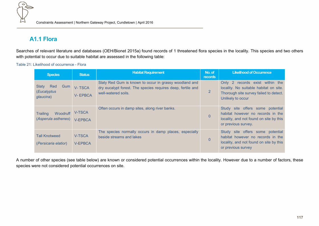
Constraints Assessment | Northern Gateway Project, Cundletown | April 2016
117
A1.1 Flora
Searches of relevant literature and databases (OEH/Bionet 2015a) found records of 1 threatened flora species in the locality. This species and two others
with potential to occur due to suitable habitat are assessed in the following table:
Table 21: Likelihood of occurrence - Flora
Species Status Habitat Requirement No. of
records Likelihood of Occurrence
Slaty Red Gum
(Eucalyptus
glaucina)
V- TSCA
V- EPBCA
Slaty Red Gum is known to occur in grassy woodland and
dry eucalypt forest. The species requires deep, fertile and
well-watered soils.
2
Only 2 records exist within the
locality. No suitable habitat on site.
Thorough site survey failed to detect.
Unlikely to occur
Trailing Woodruff
(Asperula asthenes)
V-TSCA
V-EPBCA
Often occurs in damp sites, along river banks.
0
Study site offers some potential
habitat however no records in the
locality, and not found on site by this
or previous survey.
Tall Knotweed
(Persicaria elatior)
V-TSCA
V-EPBCA
The species normally occurs in damp places, especially
beside streams and lakes 0
Study site offers some potential
habitat however no records in the
locality, and not found on site by this
or previous survey
A number of other species (see table below) are known or considered potential occurrences within the locality. However due to a number of factors, these
species were not considered potential occurrences on site.
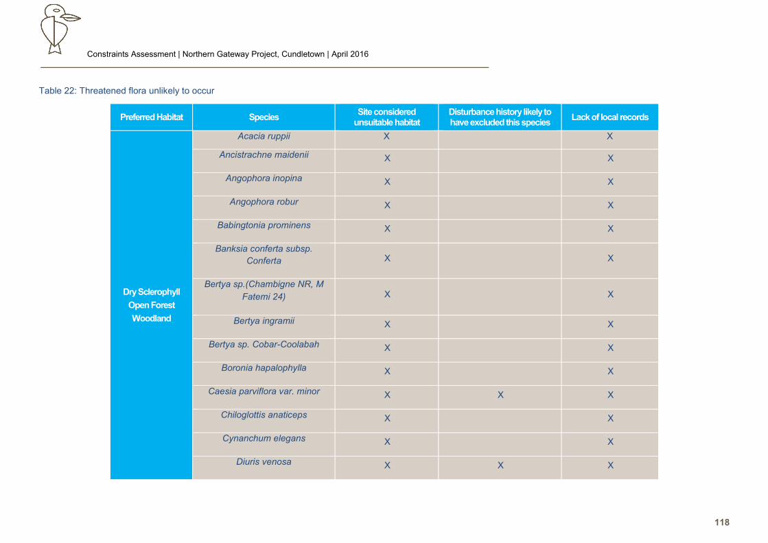
Constraints Assessment | Northern Gateway Project, Cundletown | April 2016
118
Table 22: Threatened flora unlikely to occur
Preferred Habitat Species Site considered
unsuitable habitat Disturbance history likely to have excluded this species
Lack of local records
Dry Sclerophyll
Open Forest
Woodland
Acacia ruppii X X
Ancistrachne maidenii X X
Angophora inopina X X
Angophora robur X X
Babingtonia prominens X X
Banksia conferta subsp.
Conferta X X
Bertya sp.(Chambigne NR, M
Fatemi 24) X X
Bertya ingramii X X
Bertya sp. Cobar-Coolabah X X
Boronia hapalophylla X X
Caesia parviflora var. minor X X X
Chiloglottis anaticeps X X
Cynanchum elegans X X
Diuris venosa X X X
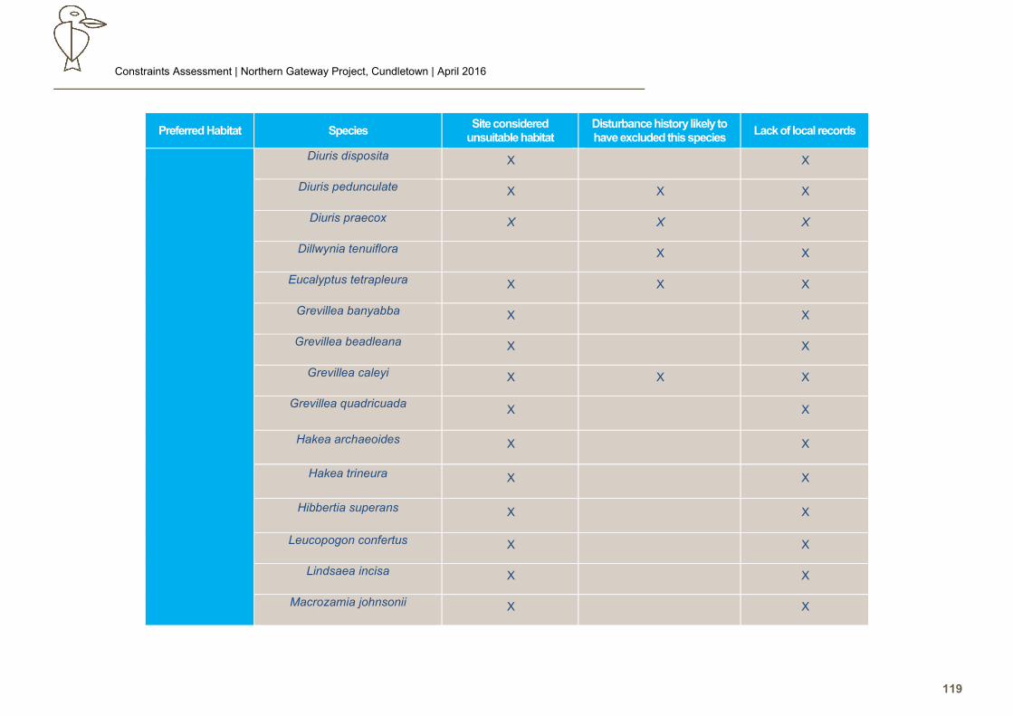
Constraints Assessment | Northern Gateway Project, Cundletown | April 2016
119
Preferred Habitat Species Site considered
unsuitable habitat Disturbance history likely to have excluded this species
Lack of local records
Diuris disposita X X
Diuris pedunculate X X X
Diuris praecox X X X
Dillwynia tenuiflora X X
Eucalyptus tetrapleura X X X
Grevillea banyabba X X
Grevillea beadleana X X
Grevillea caleyi X X X
Grevillea quadricuada
X X
Hakea archaeoides X X
Hakea trineura X X
Hibbertia superans X X
Leucopogon confertus X X
Lindsaea incisa X X
Macrozamia johnsonii X X
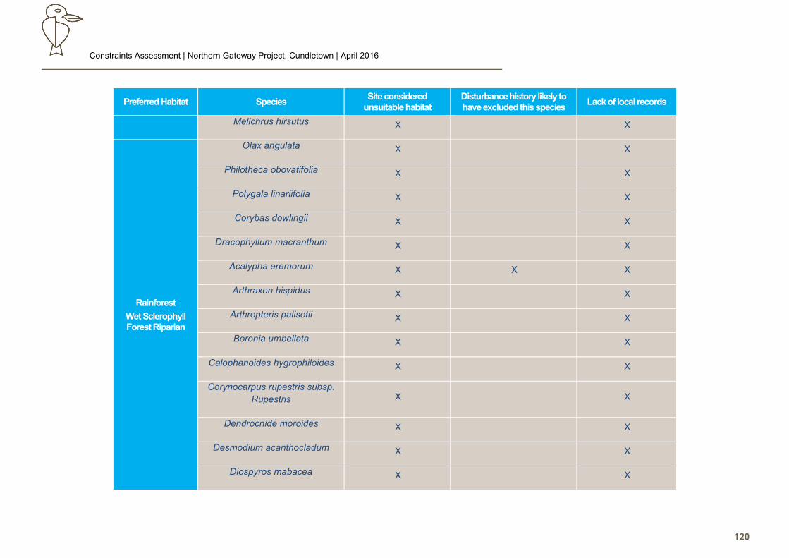
Constraints Assessment | Northern Gateway Project, Cundletown | April 2016
120
Preferred Habitat Species Site considered
unsuitable habitat Disturbance history likely to have excluded this species
Lack of local records
Melichrus hirsutus X X
Rainforest
Wet Sclerophyll Forest Riparian
Olax angulata X X
Philotheca obovatifolia X X
Polygala linariifolia X X
Corybas dowlingii X X
Dracophyllum macranthum X X
Acalypha eremorum X X X
Arthraxon hispidus X X
Arthropteris palisotii X X
Boronia umbellata X X
Calophanoides hygrophiloides X X
Corynocarpus rupestris subsp.
Rupestris X X
Dendrocnide moroides X X
Desmodium acanthocladum X X
Diospyros mabacea X X
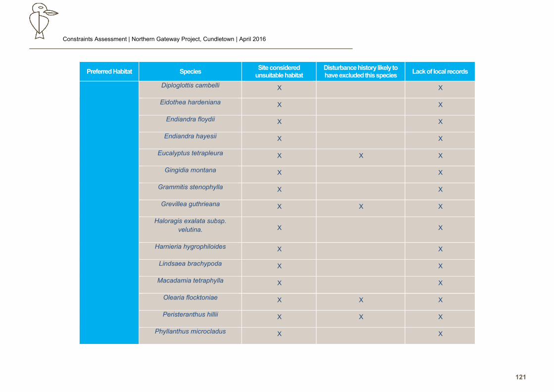
Constraints Assessment | Northern Gateway Project, Cundletown | April 2016
121
Preferred Habitat Species Site considered
unsuitable habitat Disturbance history likely to have excluded this species
Lack of local records
Diploglottis cambelli X X
Eidothea hardeniana X X
Endiandra floydii X X
Endiandra hayesii X X
Eucalyptus tetrapleura X X X
Gingidia montana X X
Grammitis stenophylla X X
Grevillea guthrieana X X X
Haloragis exalata subsp.
velutina. X X
Harnieria hygrophiloides X X
Lindsaea brachypoda X X
Macadamia tetraphylla X X
Olearia flocktoniae X X X
Peristeranthus hillii X X X
Phyllanthus microcladus X X

Constraints Assessment | Northern Gateway Project, Cundletown | April 2016
122
Preferred Habitat Species Site considered
unsuitable habitat Disturbance history likely to have excluded this species
Lack of local records
Plectranthus nitidus X X
Pomaderris queenslandica X X
Psilotum complanatum X X
Quassia sp. Moonee Creek X X
Sarcochilus dilatatus X X
Sarcochilus fitzgeraldii X X
Sarcochilus hartmannii X X
Siah’s Backbone (Streblus
pendulinus/brunonianus ) X X X
Syzygium paniculatum X X
Tinospora smilacina X X
Tinospora tinosporoides X X
Triplarina imbricata (formerly
Baeckea camphorata) X X X
Swamp Forest
Aquatic
Freshwater Wetland Estuarine
Alexfloydia repens X X
Maundia triglochinoides X X
Oberonia titania X X
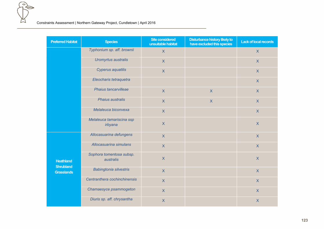
Constraints Assessment | Northern Gateway Project, Cundletown | April 2016
123
Preferred Habitat Species Site considered
unsuitable habitat Disturbance history likely to have excluded this species
Lack of local records
Typhonium sp. aff. brownii X X
Uromyrtus australis X X
Cyperus aquatilis X X
Eleocharis tetraquetra X
Phaius tancarvilleae X X X
Phaius australis X X X
Melaleuca biconvexa X X
Melaleuca tamariscina ssp
irbyana X X
Heathland
Shrubland
Grasslands
Allocasuarina defungens X X
Allocasuarina simulans X X
Sophora tomentosa subsp.
australis X X
Babingtonia silvestris X X
Centranthera cochinchinensis X X
Chamaesyce psammogeton X X
Diuris sp. aff. chrysantha X X
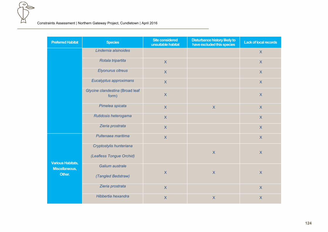
Constraints Assessment | Northern Gateway Project, Cundletown | April 2016
124
Preferred Habitat Species Site considered
unsuitable habitat Disturbance history likely to have excluded this species
Lack of local records
Lindernia alsinoides X
Rotala tripartita X X
Elyonurus citreus X X
Eucalyptus approximans X X
Glycine clandestina (Broad leaf
form) X X
Pimelea spicata X X X
Rutidosis heterogama X X
Zieria prostrata X X
Various Habitats,
Miscellaneous,
Other.
Pultenaea maritima X X
Cryptostylis hunteriana
(Leafless Tongue Orchid) X X
Galium australe
(Tangled Bedstraw) X X X
Zieria prostrata X X
Hibbertia hexandra X X X
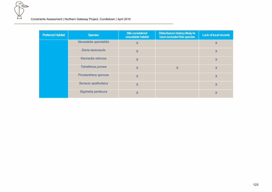
Constraints Assessment | Northern Gateway Project, Cundletown | April 2016
125
Preferred Habitat Species Site considered
unsuitable habitat Disturbance history likely to have excluded this species
Lack of local records
Neoastelia spectabilis X X
Zieria lasiocaulis X X
Kennedia retrorsa X X
Tetratheca juncea X X X
Prostanthera spinosa X X
Senecio spathulatus X X
Styphelia perileuca X X
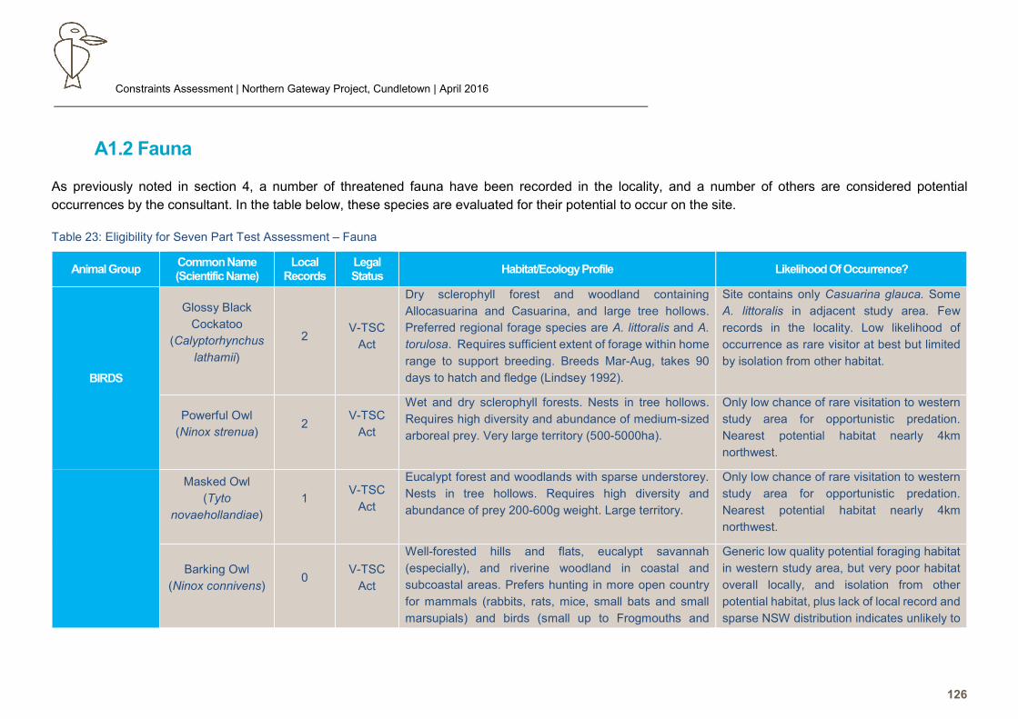
Constraints Assessment | Northern Gateway Project, Cundletown | April 2016
126
A1.2 Fauna
As previously noted in section 4, a number of threatened fauna have been recorded in the locality, and a number of others are considered potential
occurrences by the consultant. In the table below, these species are evaluated for their potential to occur on the site.
Table 23: Eligibility for Seven Part Test Assessment – Fauna
Animal Group Common Name (Scientific Name)
Local Records
Legal Status
Habitat/Ecology Profile Likelihood Of Occurrence?
BIRDS
Glossy Black
Cockatoo
(Calyptorhynchus
lathamii)
2 V-TSC
Act
Dry sclerophyll forest and woodland containing
Allocasuarina and Casuarina, and large tree hollows.
Preferred regional forage species are A. littoralis and A.
torulosa. Requires sufficient extent of forage within home
range to support breeding. Breeds Mar-Aug, takes 90
days to hatch and fledge (Lindsey 1992).
Site contains only Casuarina glauca. Some
A. littoralis in adjacent study area. Few
records in the locality. Low likelihood of
occurrence as rare visitor at best but limited
by isolation from other habitat.
Powerful Owl
(Ninox strenua) 2
V-TSC
Act
Wet and dry sclerophyll forests. Nests in tree hollows.
Requires high diversity and abundance of medium-sized
arboreal prey. Very large territory (500-5000ha).
Only low chance of rare visitation to western
study area for opportunistic predation.
Nearest potential habitat nearly 4km
northwest.
Masked Owl
(Tyto
novaehollandiae)
1 V-TSC
Act
Eucalypt forest and woodlands with sparse understorey.
Nests in tree hollows. Requires high diversity and
abundance of prey 200-600g weight. Large territory.
Only low chance of rare visitation to western
study area for opportunistic predation.
Nearest potential habitat nearly 4km
northwest.
Barking Owl
(Ninox connivens) 0
V-TSC
Act
Well-forested hills and flats, eucalypt savannah
(especially), and riverine woodland in coastal and
subcoastal areas. Prefers hunting in more open country
for mammals (rabbits, rats, mice, small bats and small
marsupials) and birds (small up to Frogmouths and
Generic low quality potential foraging habitat
in western study area, but very poor habitat
overall locally, and isolation from other
potential habitat, plus lack of local record and
sparse NSW distribution indicates unlikely to
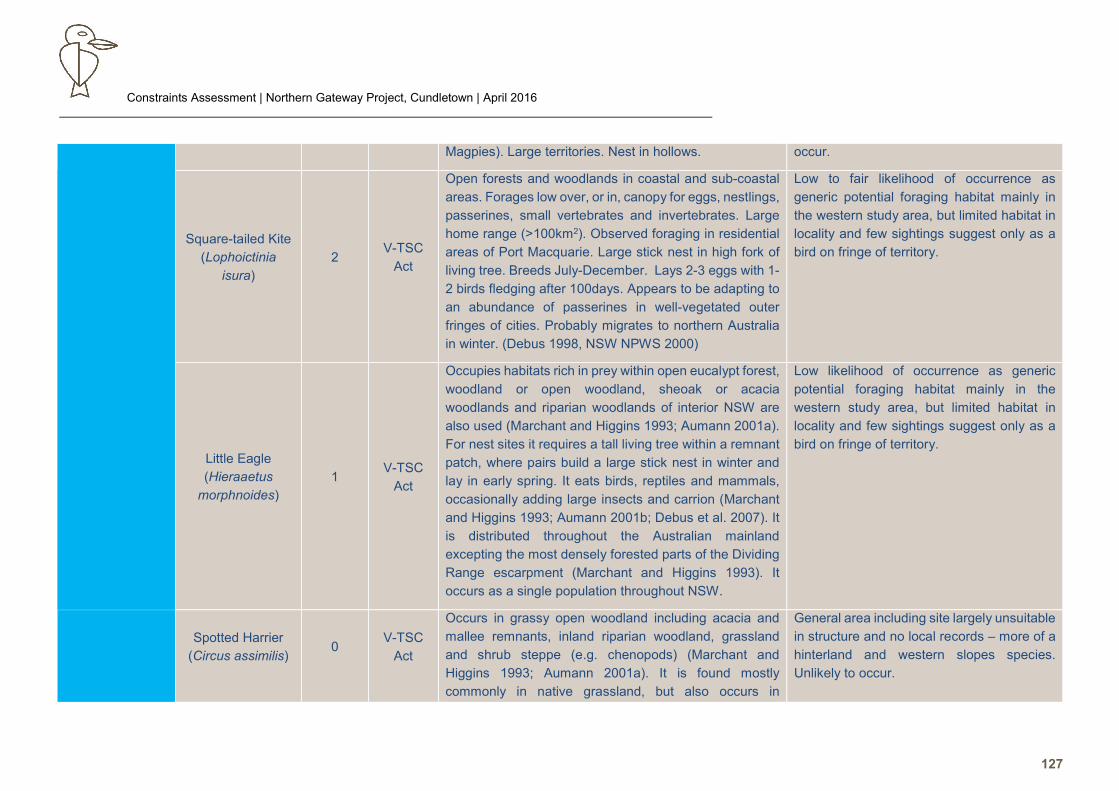
Constraints Assessment | Northern Gateway Project, Cundletown | April 2016
127
Magpies). Large territories. Nest in hollows. occur.
Square-tailed Kite
(Lophoictinia
isura)
2 V-TSC
Act
Open forests and woodlands in coastal and sub-coastal
areas. Forages low over, or in, canopy for eggs, nestlings,
passerines, small vertebrates and invertebrates. Large
home range (>100km2). Observed foraging in residential
areas of Port Macquarie. Large stick nest in high fork of
living tree. Breeds July-December. Lays 2-3 eggs with 1-
2 birds fledging after 100days. Appears to be adapting to
an abundance of passerines in well-vegetated outer
fringes of cities. Probably migrates to northern Australia
in winter. (Debus 1998, NSW NPWS 2000)
Low to fair likelihood of occurrence as
generic potential foraging habitat mainly in
the western study area, but limited habitat in
locality and few sightings suggest only as a
bird on fringe of territory.
Little Eagle
(Hieraaetus
morphnoides)
1 V-TSC
Act
Occupies habitats rich in prey within open eucalypt forest,
woodland or open woodland, sheoak or acacia
woodlands and riparian woodlands of interior NSW are
also used (Marchant and Higgins 1993; Aumann 2001a).
For nest sites it requires a tall living tree within a remnant
patch, where pairs build a large stick nest in winter and
lay in early spring. It eats birds, reptiles and mammals,
occasionally adding large insects and carrion (Marchant
and Higgins 1993; Aumann 2001b; Debus et al. 2007). It
is distributed throughout the Australian mainland
excepting the most densely forested parts of the Dividing
Range escarpment (Marchant and Higgins 1993). It
occurs as a single population throughout NSW.
Low likelihood of occurrence as generic
potential foraging habitat mainly in the
western study area, but limited habitat in
locality and few sightings suggest only as a
bird on fringe of territory.
Spotted Harrier
(Circus assimilis) 0
V-TSC
Act
Occurs in grassy open woodland including acacia and
mallee remnants, inland riparian woodland, grassland
and shrub steppe (e.g. chenopods) (Marchant and
Higgins 1993; Aumann 2001a). It is found mostly
commonly in native grassland, but also occurs in
General area including site largely unsuitable
in structure and no local records – more of a
hinterland and western slopes species.
Unlikely to occur.
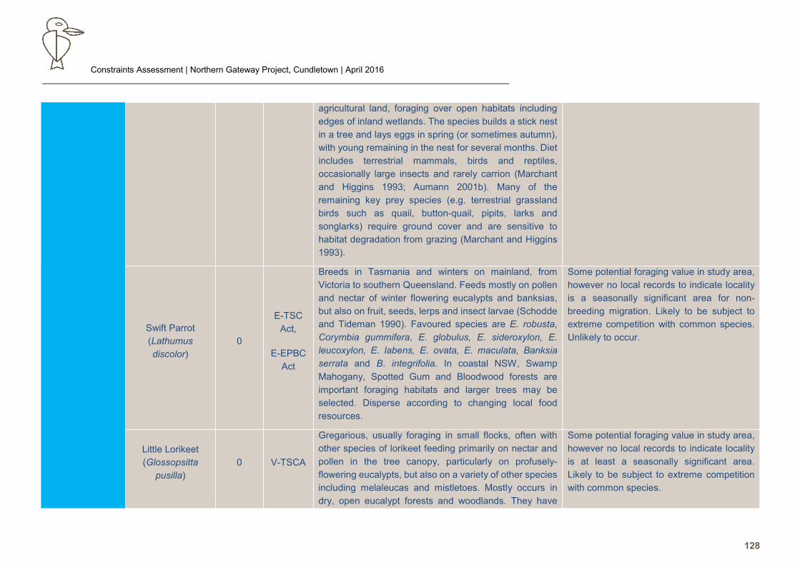
Constraints Assessment | Northern Gateway Project, Cundletown | April 2016
128
agricultural land, foraging over open habitats including
edges of inland wetlands. The species builds a stick nest
in a tree and lays eggs in spring (or sometimes autumn),
with young remaining in the nest for several months. Diet
includes terrestrial mammals, birds and reptiles,
occasionally large insects and rarely carrion (Marchant
and Higgins 1993; Aumann 2001b). Many of the
remaining key prey species (e.g. terrestrial grassland
birds such as quail, button-quail, pipits, larks and
songlarks) require ground cover and are sensitive to
habitat degradation from grazing (Marchant and Higgins
1993).
Swift Parrot
(Lathumus
discolor)
0
E-TSC
Act,
E-EPBC
Act
Breeds in Tasmania and winters on mainland, from
Victoria to southern Queensland. Feeds mostly on pollen
and nectar of winter flowering eucalypts and banksias,
but also on fruit, seeds, lerps and insect larvae (Schodde
and Tideman 1990). Favoured species are E. robusta,
Corymbia gummifera, E. globulus, E. sideroxylon, E.
leucoxylon, E. labens, E. ovata, E. maculata, Banksia
serrata and B. integrifolia. In coastal NSW, Swamp
Mahogany, Spotted Gum and Bloodwood forests are
important foraging habitats and larger trees may be
selected. Disperse according to changing local food
resources.
Some potential foraging value in study area,
however no local records to indicate locality
is a seasonally significant area for non-
breeding migration. Likely to be subject to
extreme competition with common species.
Unlikely to occur.
Little Lorikeet
(Glossopsitta
pusilla)
0 V-TSCA
Gregarious, usually foraging in small flocks, often with
other species of lorikeet feeding primarily on nectar and
pollen in the tree canopy, particularly on profusely-
flowering eucalypts, but also on a variety of other species
including melaleucas and mistletoes. Mostly occurs in
dry, open eucalypt forests and woodlands. They have
Some potential foraging value in study area,
however no local records to indicate locality
is at least a seasonally significant area.
Likely to be subject to extreme competition
with common species.
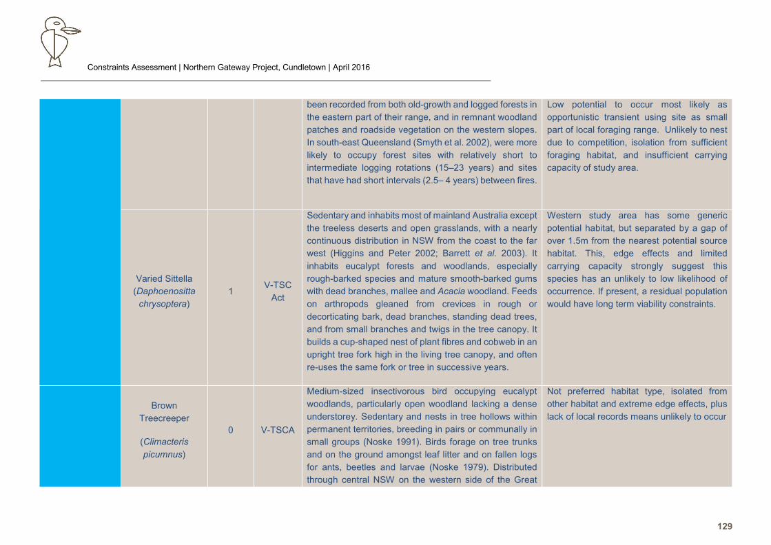
Constraints Assessment | Northern Gateway Project, Cundletown | April 2016
129
been recorded from both old-growth and logged forests in
the eastern part of their range, and in remnant woodland
patches and roadside vegetation on the western slopes.
In south-east Queensland (Smyth et al. 2002), were more
likely to occupy forest sites with relatively short to
intermediate logging rotations (15–23 years) and sites
that have had short intervals (2.5– 4 years) between fires.
Low potential to occur most likely as
opportunistic transient using site as small
part of local foraging range. Unlikely to nest
due to competition, isolation from sufficient
foraging habitat, and insufficient carrying
capacity of study area.
Varied Sittella
(Daphoenositta
chrysoptera)
1 V-TSC
Act
Sedentary and inhabits most of mainland Australia except
the treeless deserts and open grasslands, with a nearly
continuous distribution in NSW from the coast to the far
west (Higgins and Peter 2002; Barrett et al. 2003). It
inhabits eucalypt forests and woodlands, especially
rough-barked species and mature smooth-barked gums
with dead branches, mallee and Acacia woodland. Feeds
on arthropods gleaned from crevices in rough or
decorticating bark, dead branches, standing dead trees,
and from small branches and twigs in the tree canopy. It
builds a cup-shaped nest of plant fibres and cobweb in an
upright tree fork high in the living tree canopy, and often
re-uses the same fork or tree in successive years.
Western study area has some generic
potential habitat, but separated by a gap of
over 1.5m from the nearest potential source
habitat. This, edge effects and limited
carrying capacity strongly suggest this
species has an unlikely to low likelihood of
occurrence. If present, a residual population
would have long term viability constraints.
Brown
Treecreeper
(Climacteris
picumnus)
0 V-TSCA
Medium-sized insectivorous bird occupying eucalypt
woodlands, particularly open woodland lacking a dense
understorey. Sedentary and nests in tree hollows within
permanent territories, breeding in pairs or communally in
small groups (Noske 1991). Birds forage on tree trunks
and on the ground amongst leaf litter and on fallen logs
for ants, beetles and larvae (Noske 1979). Distributed
through central NSW on the western side of the Great
Not preferred habitat type, isolated from
other habitat and extreme edge effects, plus
lack of local records means unlikely to occur
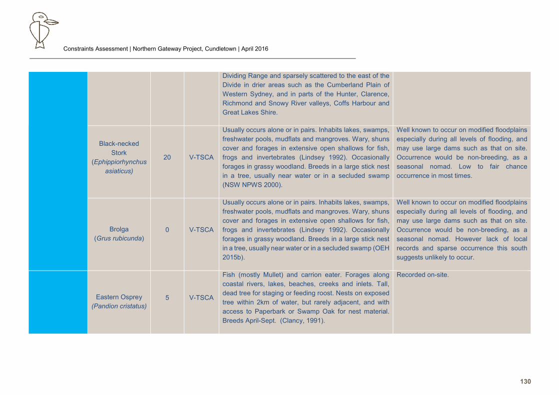
Constraints Assessment | Northern Gateway Project, Cundletown | April 2016
130
Dividing Range and sparsely scattered to the east of the
Divide in drier areas such as the Cumberland Plain of
Western Sydney, and in parts of the Hunter, Clarence,
Richmond and Snowy River valleys, Coffs Harbour and
Great Lakes Shire.
Black-necked
Stork
(Ephippiorhynchus
asiaticus)
20 V-TSCA
Usually occurs alone or in pairs. Inhabits lakes, swamps,
freshwater pools, mudflats and mangroves. Wary, shuns
cover and forages in extensive open shallows for fish,
frogs and invertebrates (Lindsey 1992). Occasionally
forages in grassy woodland. Breeds in a large stick nest
in a tree, usually near water or in a secluded swamp
(NSW NPWS 2000).
Well known to occur on modified floodplains
especially during all levels of flooding, and
may use large dams such as that on site.
Occurrence would be non-breeding, as a
seasonal nomad. Low to fair chance
occurrence in most times.
Brolga
(Grus rubicunda)
0 V-TSCA
Usually occurs alone or in pairs. Inhabits lakes, swamps,
freshwater pools, mudflats and mangroves. Wary, shuns
cover and forages in extensive open shallows for fish,
frogs and invertebrates (Lindsey 1992). Occasionally
forages in grassy woodland. Breeds in a large stick nest
in a tree, usually near water or in a secluded swamp (OEH
2015b).
Well known to occur on modified floodplains
especially during all levels of flooding, and
may use large dams such as that on site.
Occurrence would be non-breeding, as a
seasonal nomad. However lack of local
records and sparse occurrence this south
suggests unlikely to occur.
Eastern Osprey
(Pandion cristatus)
5 V-TSCA
Fish (mostly Mullet) and carrion eater. Forages along
coastal rivers, lakes, beaches, creeks and inlets. Tall,
dead tree for staging or feeding roost. Nests on exposed
tree within 2km of water, but rarely adjacent, and with
access to Paperbark or Swamp Oak for nest material.
Breeds April-Sept. (Clancy, 1991).
Recorded on-site.
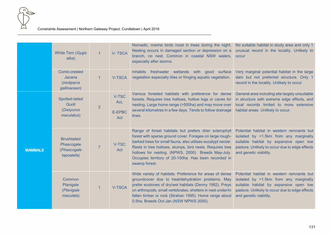
Constraints Assessment | Northern Gateway Project, Cundletown | April 2016
131
White Tern (Gygis
alba)
1 V- TSCA
Nomadic, marine birds roost in trees during the night.
Nesting occurs in damaged section or depression on a
branch, no nest. Common in coastal NSW waters,
especially after storms.
No suitable habitat in study area and only 1
unusual record in the locality. Unlikely to
occur
Comb-crested
Jacana
(Irediparra
gallinacean)
1 V-TSCA
Inhabits freshwater wetlands with good surface
vegetation especially lilies or fringing aquatic vegetation.
Very marginal potential habitat in the large
dam but not preferred structure. Only 1
record in the locality. Unlikely to occur
MAMMALS
Spotted-tailed
Quoll
(Dasyurus
maculatus)
2
V-TSC
Act,
E-EPBC
Act
Various forested habitats with preference for dense
forests. Requires tree hollows, hollow logs or caves for
nesting. Large home range (>500ha) and may move over
several kilometres in a few days. Tends to follow drainage
lines.
General area including site largely unsuitable
in structure with extreme edge effects, and
local records limited to more extensive
habitat areas. Unlikely to occur.
Brushtailed
Phascogale
(Phascogale
tapoatafa)
7 V-TSC
Act
Range of forest habitats but prefers drier sclerophyll
forest with sparse ground cover. Forages on large rough-
barked trees for small fauna, also utilises eucalypt nectar.
Rests in tree hollows, stumps, bird nests. Requires tree
hollows for nesting. (NPWS, 2000) Breeds May-July.
Occupies territory of 20-100ha. Has been recorded in
swamp forest.
Potential habitat in western remnants but
isolated by >1.5km from any marginally
suitable habitat by expansive open low
pasture. Unlikely to occur due to edge effects
and genetic viability.
Common
Planigale
(Planigale
maculata)
1 V-TSCA
Wide variety of habitats. Preference for areas of dense
groundcover due to heat/dehydration problems. May
prefer ecotones of dry/wet habitats (Denny 1982). Preys
on arthropods, small vertebrates, shelters in nest under/in
fallen timber or rock (Strahan 1995). Home range about
0.5ha. Breeds Oct-Jan (NSW NPWS 2000).
Potential habitat in western remnants but
isolated by >1.5km from any marginally
suitable habitat by expansive open low
pasture. Unlikely to occur due to edge effects
and genetic viability.
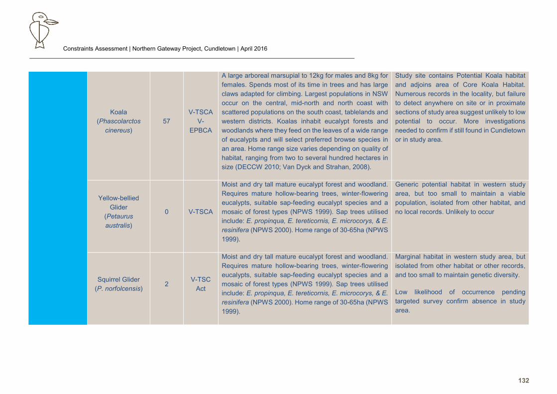
Constraints Assessment | Northern Gateway Project, Cundletown | April 2016
132
Koala
(Phascolarctos
cinereus)
57
V-TSCA
V-
EPBCA
A large arboreal marsupial to 12kg for males and 8kg for
females. Spends most of its time in trees and has large
claws adapted for climbing. Largest populations in NSW
occur on the central, mid-north and north coast with
scattered populations on the south coast, tablelands and
western districts. Koalas inhabit eucalypt forests and
woodlands where they feed on the leaves of a wide range
of eucalypts and will select preferred browse species in
an area. Home range size varies depending on quality of
habitat, ranging from two to several hundred hectares in
size (DECCW 2010; Van Dyck and Strahan, 2008).
Study site contains Potential Koala habitat
and adjoins area of Core Koala Habitat.
Numerous records in the locality, but failure
to detect anywhere on site or in proximate
sections of study area suggest unlikely to low
potential to occur. More investigations
needed to confirm if still found in Cundletown
or in study area.
Yellow-bellied
Glider
(Petaurus
australis)
0 V-TSCA
Moist and dry tall mature eucalypt forest and woodland.
Requires mature hollow-bearing trees, winter-flowering
eucalypts, suitable sap-feeding eucalypt species and a
mosaic of forest types (NPWS 1999). Sap trees utilised
include: E. propinqua, E. tereticornis, E. microcorys, & E.
resinifera (NPWS 2000). Home range of 30-65ha (NPWS
1999).
Generic potential habitat in western study
area, but too small to maintain a viable
population, isolated from other habitat, and
no local records. Unlikely to occur
Squirrel Glider
(P. norfolcensis) 2
V-TSC
Act
Moist and dry tall mature eucalypt forest and woodland.
Requires mature hollow-bearing trees, winter-flowering
eucalypts, suitable sap-feeding eucalypt species and a
mosaic of forest types (NPWS 1999). Sap trees utilised
include: E. propinqua, E. tereticornis, E. microcorys, & E.
resinifera (NPWS 2000). Home range of 30-65ha (NPWS
1999).
Marginal habitat in western study area, but
isolated from other habitat or other records,
and too small to maintain genetic diversity.
Low likelihood of occurrence pending
targeted survey confirm absence in study
area.
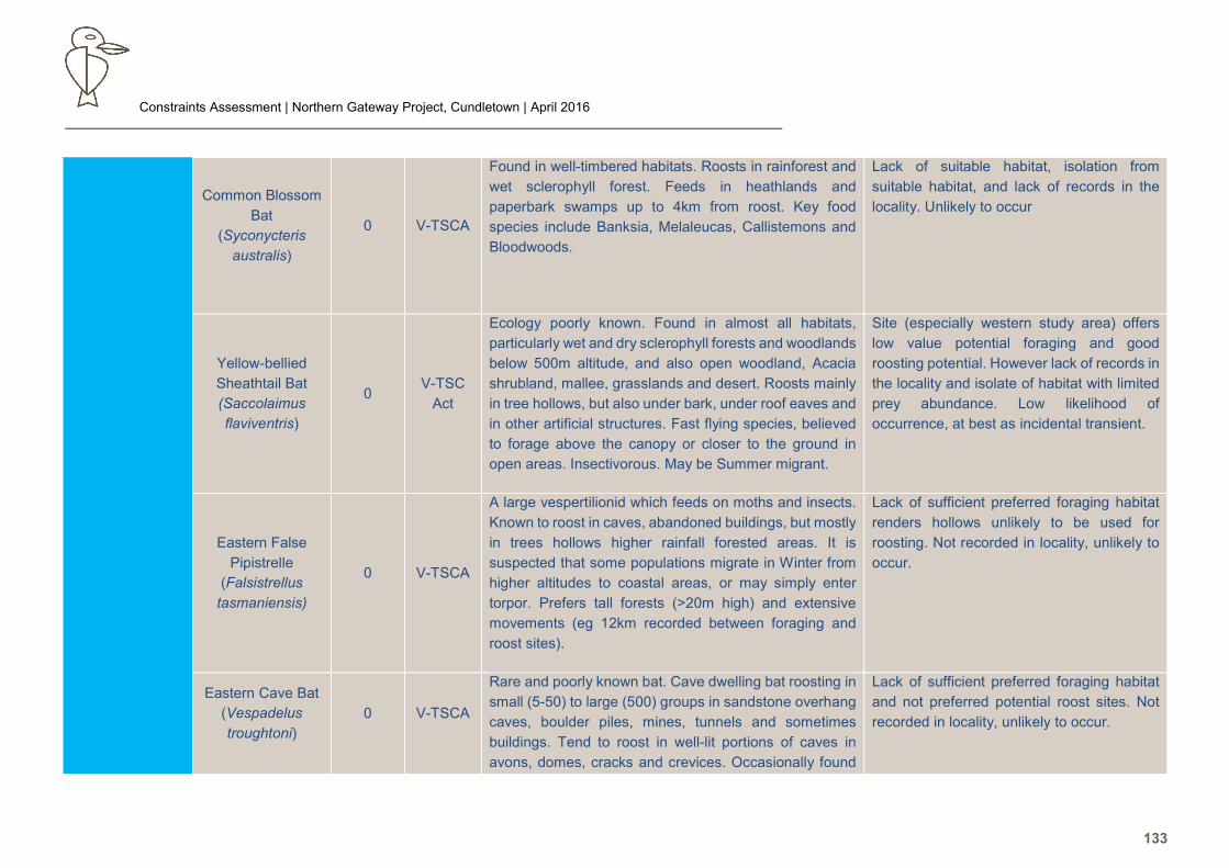
Constraints Assessment | Northern Gateway Project, Cundletown | April 2016
133
Common Blossom
Bat
(Syconycteris
australis)
0 V-TSCA
Found in well-timbered habitats. Roosts in rainforest and
wet sclerophyll forest. Feeds in heathlands and
paperbark swamps up to 4km from roost. Key food
species include Banksia, Melaleucas, Callistemons and
Bloodwoods.
Lack of suitable habitat, isolation from
suitable habitat, and lack of records in the
locality. Unlikely to occur
Yellow-bellied
Sheathtail Bat
(Saccolaimus
flaviventris)
0 V-TSC
Act
Ecology poorly known. Found in almost all habitats,
particularly wet and dry sclerophyll forests and woodlands
below 500m altitude, and also open woodland, Acacia
shrubland, mallee, grasslands and desert. Roosts mainly
in tree hollows, but also under bark, under roof eaves and
in other artificial structures. Fast flying species, believed
to forage above the canopy or closer to the ground in
open areas. Insectivorous. May be Summer migrant.
Site (especially western study area) offers
low value potential foraging and good
roosting potential. However lack of records in
the locality and isolate of habitat with limited
prey abundance. Low likelihood of
occurrence, at best as incidental transient.
Eastern False
Pipistrelle
(Falsistrellus
tasmaniensis)
0 V-TSCA
A large vespertilionid which feeds on moths and insects.
Known to roost in caves, abandoned buildings, but mostly
in trees hollows higher rainfall forested areas. It is
suspected that some populations migrate in Winter from
higher altitudes to coastal areas, or may simply enter
torpor. Prefers tall forests (>20m high) and extensive
movements (eg 12km recorded between foraging and
roost sites).
Lack of sufficient preferred foraging habitat
renders hollows unlikely to be used for
roosting. Not recorded in locality, unlikely to
occur.
Eastern Cave Bat
(Vespadelus
troughtoni)
0 V-TSCA
Rare and poorly known bat. Cave dwelling bat roosting in
small (5-50) to large (500) groups in sandstone overhang
caves, boulder piles, mines, tunnels and sometimes
buildings. Tend to roost in well-lit portions of caves in
avons, domes, cracks and crevices. Occasionally found
Lack of sufficient preferred foraging habitat
and not preferred potential roost sites. Not
recorded in locality, unlikely to occur.
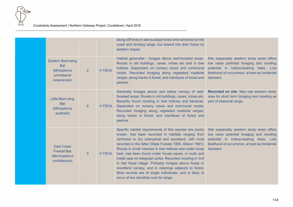
Constraints Assessment | Northern Gateway Project, Cundletown | April 2016
134
along cliff lines in wet eucalypt forest and rainforest on the
coast and dividing range, but extend into drier forest on
western slopes.
Eastern Bent-wing
Bat
(Miniopterus
schreibersii
oceanensis)
2 V-TSCA
Habitat generalist - forages above well-forested areas.
Roosts in old buildings, caves, mines etc and in tree
hollows. Dependant on nursery caves and communal
roosts. Recorded foraging along vegetated roadside
verges; along tracks in forest, and interfaces of forest and
pasture.
Site (especially western study area) offers
low value potential foraging and roosting
potential in hollow-bearing trees. Low
likelihood of occurrence, at best as incidental
transient.
Little Bent-wing
Bat
(Miniopterus
australis)
6 V-TSCA
Generally forages above and below canopy of well-
forested areas. Roosts in old buildings, caves, mines etc.
Recently found roosting in tree hollows and bananas.
Dependant on nursery caves and communal roosts.
Recorded foraging along vegetated roadside verges;
along tracks in forest, and interfaces of forest and
pasture.
Recorded on site. May use western study
area for short term foraging and roosting as
part of seasonal range.
East Coast
Freetail Bat
(Mormopterus
norfolkensis)
0 V-TSCA
Specific habitat requirements of this species are poorly
known. Has been recorded in habitats ranging from
rainforest to dry sclerophyll and woodland, with most
recorded in the latter (State Forests 1995, Allison 1991).
Roosts in small colonies in tree hollows and under loose
bark; has been found under house eaves, in roofs and
metal caps on telegraph poles. Recorded roosting in roof
in Hat Head village. Probably forages above forest or
woodland canopy, and in clearings adjacent to forest.
Most records are of single individuals, and is likely to
occur at low densities over its range.
Site (especially western study area) offers
low value potential foraging and roosting
potential in hollow-bearing trees. Low
likelihood of occurrence, at best as incidental
transient.
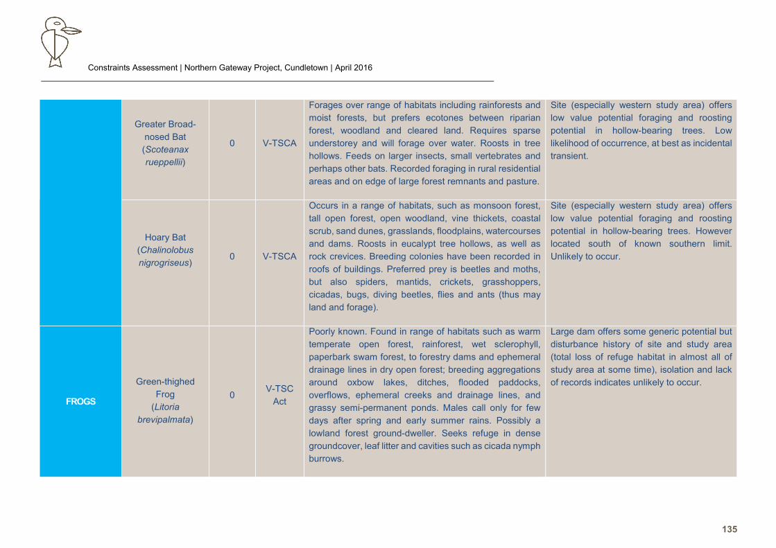
Constraints Assessment | Northern Gateway Project, Cundletown | April 2016
135
Greater Broad-
nosed Bat
(Scoteanax
rueppellii)
0 V-TSCA
Forages over range of habitats including rainforests and
moist forests, but prefers ecotones between riparian
forest, woodland and cleared land. Requires sparse
understorey and will forage over water. Roosts in tree
hollows. Feeds on larger insects, small vertebrates and
perhaps other bats. Recorded foraging in rural residential
areas and on edge of large forest remnants and pasture.
Site (especially western study area) offers
low value potential foraging and roosting
potential in hollow-bearing trees. Low
likelihood of occurrence, at best as incidental
transient.
Hoary Bat
(Chalinolobus
nigrogriseus)
0 V-TSCA
Occurs in a range of habitats, such as monsoon forest,
tall open forest, open woodland, vine thickets, coastal
scrub, sand dunes, grasslands, floodplains, watercourses
and dams. Roosts in eucalypt tree hollows, as well as
rock crevices. Breeding colonies have been recorded in
roofs of buildings. Preferred prey is beetles and moths,
but also spiders, mantids, crickets, grasshoppers,
cicadas, bugs, diving beetles, flies and ants (thus may
land and forage).
Site (especially western study area) offers
low value potential foraging and roosting
potential in hollow-bearing trees. However
located south of known southern limit.
Unlikely to occur.
FROGS
Green-thighed
Frog
(Litoria
brevipalmata)
0 V-TSC
Act
Poorly known. Found in range of habitats such as warm
temperate open forest, rainforest, wet sclerophyll,
paperbark swam forest, to forestry dams and ephemeral
drainage lines in dry open forest; breeding aggregations
around oxbow lakes, ditches, flooded paddocks,
overflows, ephemeral creeks and drainage lines, and
grassy semi-permanent ponds. Males call only for few
days after spring and early summer rains. Possibly a
lowland forest ground-dweller. Seeks refuge in dense
groundcover, leaf litter and cavities such as cicada nymph
burrows.
Large dam offers some generic potential but
disturbance history of site and study area
(total loss of refuge habitat in almost all of
study area at some time), isolation and lack
of records indicates unlikely to occur.
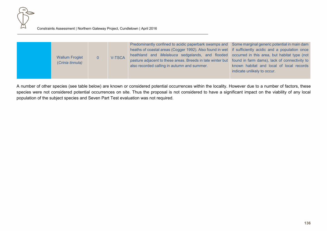
Constraints Assessment | Northern Gateway Project, Cundletown | April 2016
136
A number of other species (see table below) are known or considered potential occurrences within the locality. However due to a number of factors, these
species were not considered potential occurrences on site. Thus the proposal is not considered to have a significant impact on the viability of any local
population of the subject species and Seven Part Test evaluation was not required.
Wallum Froglet
(Crinia tinnula)
0 V-TSCA
Predominantly confined to acidic paperbark swamps and
heaths of coastal areas (Cogger 1992). Also found in wet
heathland and Melaleuca sedgelands, and flooded
pasture adjacent to these areas. Breeds in late winter but
also recorded calling in autumn and summer.
Some marginal generic potential in main dam
if sufficiently acidic and a population once
occurred in this area, but habitat type (not
found in farm dams), lack of connectivity to
known habitat and local of local records
indicate unlikely to occur.
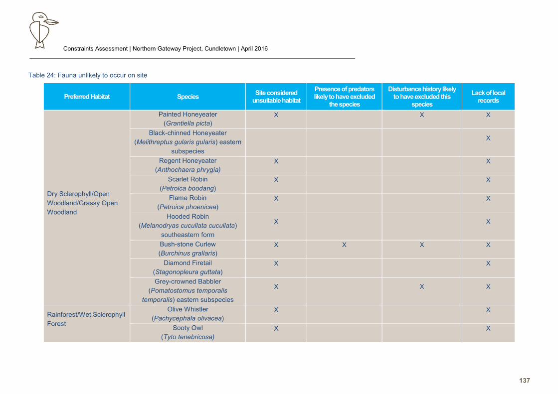
Constraints Assessment | Northern Gateway Project, Cundletown | April 2016
137
Table 24: Fauna unlikely to occur on site
Preferred Habitat Species Site considered
unsuitable habitat
Presence of predators likely to have excluded
the species
Disturbance history likely to have excluded this
species
Lack of local records
Dry Sclerophyll/Open
Woodland/Grassy Open
Woodland
Painted Honeyeater
(Grantiella picta)
X X X
Black-chinned Honeyeater
(Melithreptus gularis gularis) eastern
subspecies
X
Regent Honeyeater
(Anthochaera phrygia)
X X
Scarlet Robin
(Petroica boodang)
X X
Flame Robin
(Petroica phoenicea)
X X
Hooded Robin
(Melanodryas cucullata cucullata)
southeastern form
X X
Bush-stone Curlew
(Burchinus grallaris)
X X X X
Diamond Firetail
(Stagonopleura guttata)
X X
Grey-crowned Babbler
(Pomatostomus temporalis
temporalis) eastern subspecies
X X X
Rainforest/Wet Sclerophyll
Forest
Olive Whistler
(Pachycephala olivacea)
X X
Sooty Owl
(Tyto tenebricosa)
X X
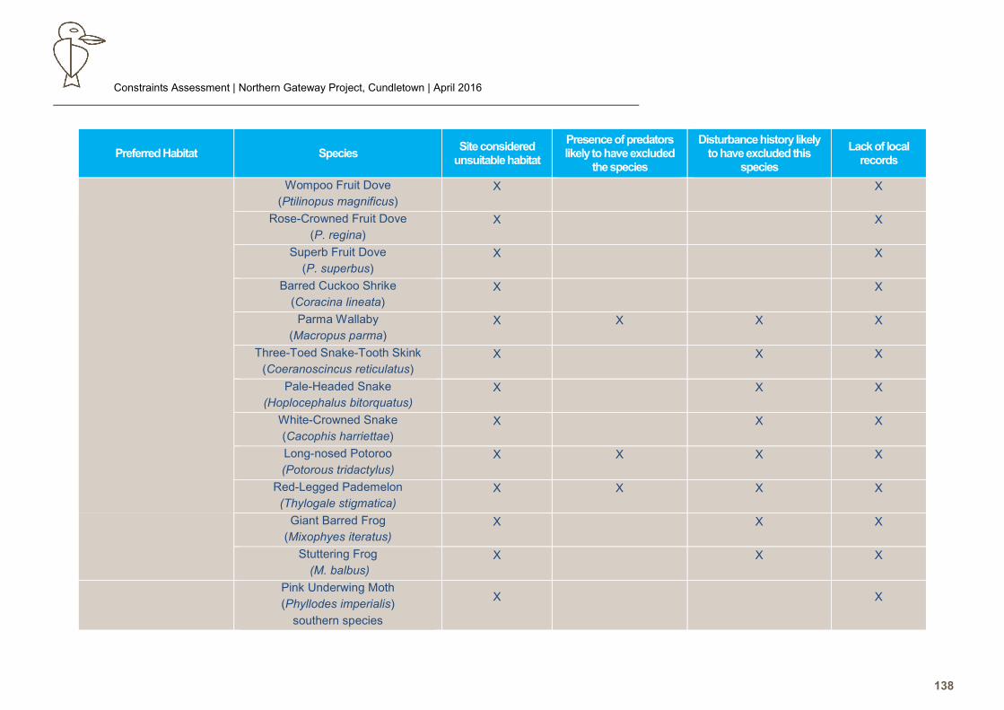
Constraints Assessment | Northern Gateway Project, Cundletown | April 2016
138
Preferred Habitat Species Site considered
unsuitable habitat
Presence of predators likely to have excluded
the species
Disturbance history likely to have excluded this
species
Lack of local records
Wompoo Fruit Dove
(Ptilinopus magnificus)
X X
Rose-Crowned Fruit Dove
(P. regina)
X X
Superb Fruit Dove
(P. superbus)
X X
Barred Cuckoo Shrike
(Coracina lineata)
X X
Parma Wallaby
(Macropus parma)
X X X X
Three-Toed Snake-Tooth Skink
(Coeranoscincus reticulatus)
X X X
Pale-Headed Snake
(Hoplocephalus bitorquatus)
X X X
White-Crowned Snake
(Cacophis harriettae)
X X X
Long-nosed Potoroo
(Potorous tridactylus)
X X X X
Red-Legged Pademelon
(Thylogale stigmatica)
X X X X
Giant Barred Frog
(Mixophyes iteratus)
X X X
Stuttering Frog
(M. balbus)
X X X
Pink Underwing Moth
(Phyllodes imperialis)
southern species
X X
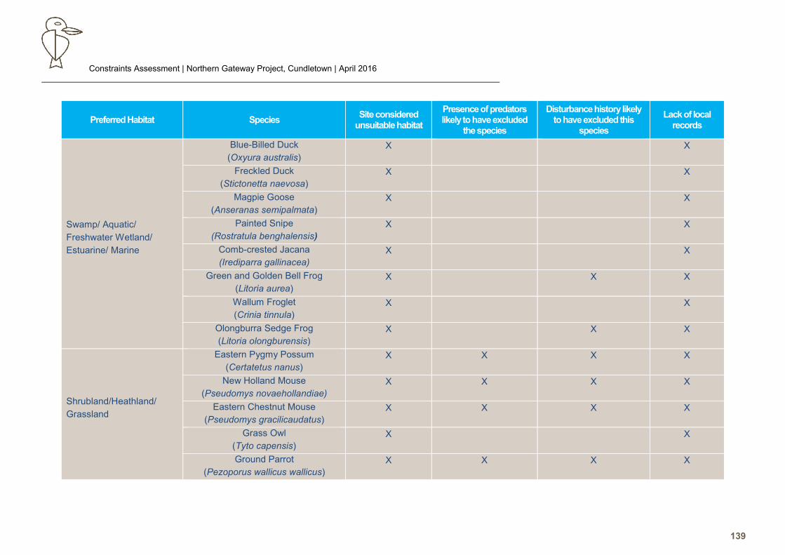
Constraints Assessment | Northern Gateway Project, Cundletown | April 2016
139
Preferred Habitat Species Site considered
unsuitable habitat
Presence of predators likely to have excluded
the species
Disturbance history likely to have excluded this
species
Lack of local records
Swamp/ Aquatic/
Freshwater Wetland/
Estuarine/ Marine
Blue-Billed Duck
(Oxyura australis)
X X
Freckled Duck
(Stictonetta naevosa)
X X
Magpie Goose
(Anseranas semipalmata)
X X
Painted Snipe
(Rostratula benghalensis)
X X
Comb-crested Jacana
(Irediparra gallinacea)
X X
Green and Golden Bell Frog
(Litoria aurea)
X X X
Wallum Froglet
(Crinia tinnula)
X X
Olongburra Sedge Frog
(Litoria olongburensis)
X X X
Shrubland/Heathland/
Grassland
Eastern Pygmy Possum
(Certatetus nanus)
X X X X
New Holland Mouse
(Pseudomys novaehollandiae)
X X X X
Eastern Chestnut Mouse
(Pseudomys gracilicaudatus)
X X X X
Grass Owl
(Tyto capensis)
X X
Ground Parrot
(Pezoporus wallicus wallicus)
X X X X
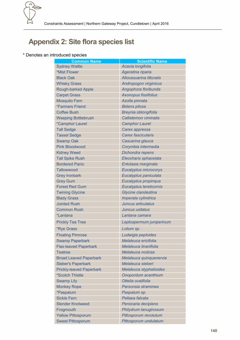
Constraints Assessment | Northern Gateway Project, Cundletown | April 2016
140
Appendix 2: Site flora species list
* Denotes an introduced species
Common Name Scientific Name Sydney Wattle Acacia longifolia
*Mist Flower Ageratina riparia
Black Oak Allocasuarina littoralis
Whisky Grass Andropogon virginicus
Rough-barked Apple Angophora floribunda
Carpet Grass Axonopus fissifolius
Mosquito Fern Azolla pinnata
*Farmers Friend Bidens pilosa
Coffee Bush Breynia oblongifolia
Weeping Bottlebrush Callistemon viminalis
*Camphor Laurel Camphor Laurel
Tall Sedge Carex appressa
Tassel Sedge Carex fascicularis
Swamp Oak Casuarina glauca
Pink Bloodwood Corymbia intermedia
Kidney Weed Dichondra repens
Tall Spike Rush Eleocharis sphacelata
Bordered Panic Entolasia marginata
Tallowwood Eucalyptus microcorys
Grey Ironbark Eucalyptus paniculata
Grey Gum Eucalyptus propinqua
Forest Red Gum Eucalyptus tereticornis
Twining Glycine Glycine clandestina
Blady Grass Imperata cylindrica
Jointed Rush Juncus articulatus
Common Rush Juncus usitatus
*Lantana Lantana camara
Prickly Tea Tree Leptospermum juniperinum
*Rye Grass Lolium sp.
Floating Pimrose Ludwigia peploides
Swamp Paperbark Melaleuca ericifolia
Flax-leaved Paperbark Melaleuca linariifolia
Teatree Melaleuca nodosa
Broad Leaved Paperbark Melaleuca quinquenervia
Sieber's Paperbark Melaleuca sieberi
Prickly-leaved Paperbark Melaleuca styphelioides
*Scotch Thistle Onopordum acanthium
Swamp Lily Ottelia ovalifolia
Monkey Rope Parsonsia straminea
*Paspalum Paspalum sp.
Sickle Fern Pellaea falcata
Slender Knotweed Persicaria decipiens
Frogmouth Philydrum lanuginosum
Yellow Pittosporum Pittosporum revolutum
Sweet Pittosporum Pittosporum undulatum
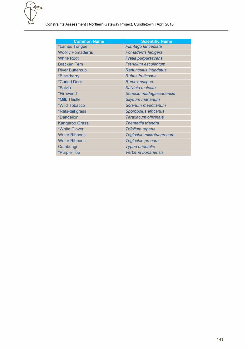
Constraints Assessment | Northern Gateway Project, Cundletown | April 2016
141
Common Name Scientific Name *Lambs Tongue Plantago lanceolata
Woolly Pomaderris Pomaderris lanigera
White Root Pratia purpurascens
Bracken Fern Pteridium esculentum
River Buttercup Ranunculus inundatus
*Blackberry Rubus fruticosus
*Curled Dock Rumex crispus
*Salvia Salvinia molesta
*Fireweed Senecio madagascariensis
*Milk Thistle Silybum marianum
*Wild Tobacco Solanum mauritianum
*Rats-tail grass Sporobolus africanus
*Dandelion Taraxacum officinale
Kangaroo Grass Themedia triandra
*White Clover Trifolium repens
Water Ribbons Triglochin microtuberosum
Water Ribbons Triglochin procera
Cumbungi Typha orientalis
*Purple Top Verbena bonariensis
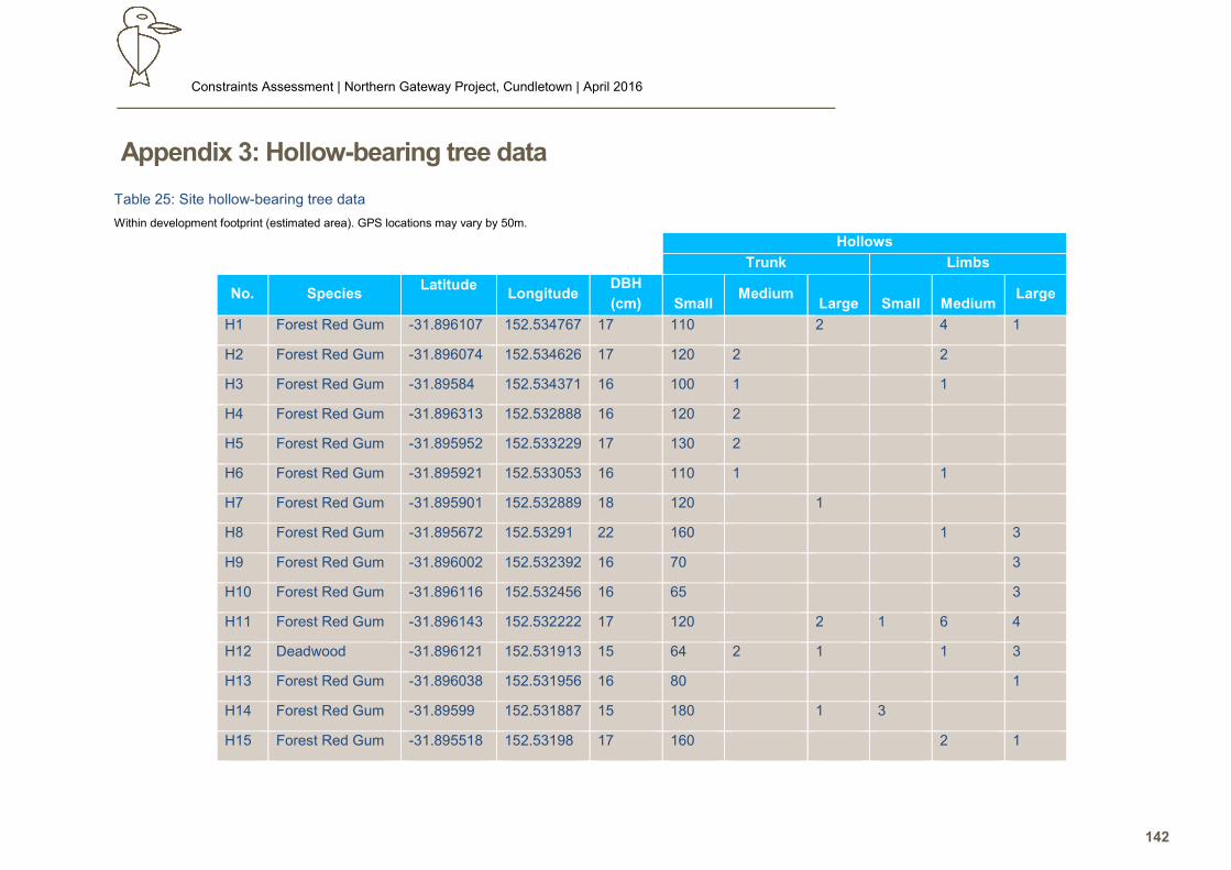
Constraints Assessment | Northern Gateway Project, Cundletown | April 2016
142
Appendix 3: Hollow-bearing tree data
Table 25: Site hollow-bearing tree data
Within development footprint (estimated area). GPS locations may vary by 50m.
Hollows
Trunk Limbs
No. Species Latitude
Longitude DBH
(cm)
Small Medium
Large
Small
Medium Large
H1 Forest Red Gum -31.896107 152.534767 17 110 2 4 1
H2 Forest Red Gum -31.896074 152.534626 17 120 2 2
H3 Forest Red Gum -31.89584 152.534371 16 100 1 1
H4 Forest Red Gum -31.896313 152.532888 16 120 2
H5 Forest Red Gum -31.895952 152.533229 17 130 2
H6 Forest Red Gum -31.895921 152.533053 16 110 1 1
H7 Forest Red Gum -31.895901 152.532889 18 120 1
H8 Forest Red Gum -31.895672 152.53291 22 160 1 3
H9 Forest Red Gum -31.896002 152.532392 16 70 3
H10 Forest Red Gum -31.896116 152.532456 16 65 3
H11 Forest Red Gum -31.896143 152.532222 17 120 2 1 6 4
H12 Deadwood -31.896121 152.531913 15 64 2 1 1 3
H13 Forest Red Gum -31.896038 152.531956 16 80 1
H14 Forest Red Gum -31.89599 152.531887 15 180 1 3
H15 Forest Red Gum -31.895518 152.53198 17 160 2 1
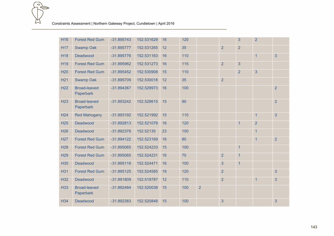
Constraints Assessment | Northern Gateway Project, Cundletown | April 2016
143
H16 Forest Red Gum -31.895743 152.531629 16 120 3 2
H17 Swamp Oak -31.895777 152.531265 12 35 2 2
H18 Deadwood -31.895776 152.531163 16 110 1 3
H19 Forest Red Gum -31.895962 152.531273 16 115 2 3
H20 Forest Red Gum -31.895452 152.530908 15 110 2 3
H21 Swamp Oak -31.895709 152.530018 12 35 2
H22 Broad-leaved
Paperbark
-31.894367 152.529973 16 100 2
H23 Broad-leaved
Paperbark
-31.893242 152.528615 15 90 2
H24 Red Mahogany -31.893192 152.521992 15 110 1 3
H25 Deadwood -31.892813 152.521078 16 120 1 2
H26 Deadwood -31.892378 152.52135 23 150 1
H27 Forest Red Gum -31.894122 152.523169 16 80 1 2
H28 Forest Red Gum -31.895065 152.524233 15 100 1
H29 Forest Red Gum -31.895065 152.524231 16 70 2 1
H30 Deadwood -31.895118 152.524471 16 100 3 1
H31 Forest Red Gum -31.895125 152.524585 18 120 2 3
H32 Deadwood -31.891809 152.519787 12 110 2 1 3
H33 Broad-leaved
Paperbark
-31.892484 152.520038 15 100 2
H34 Deadwood -31.892383 152.520848 15 100 3 3
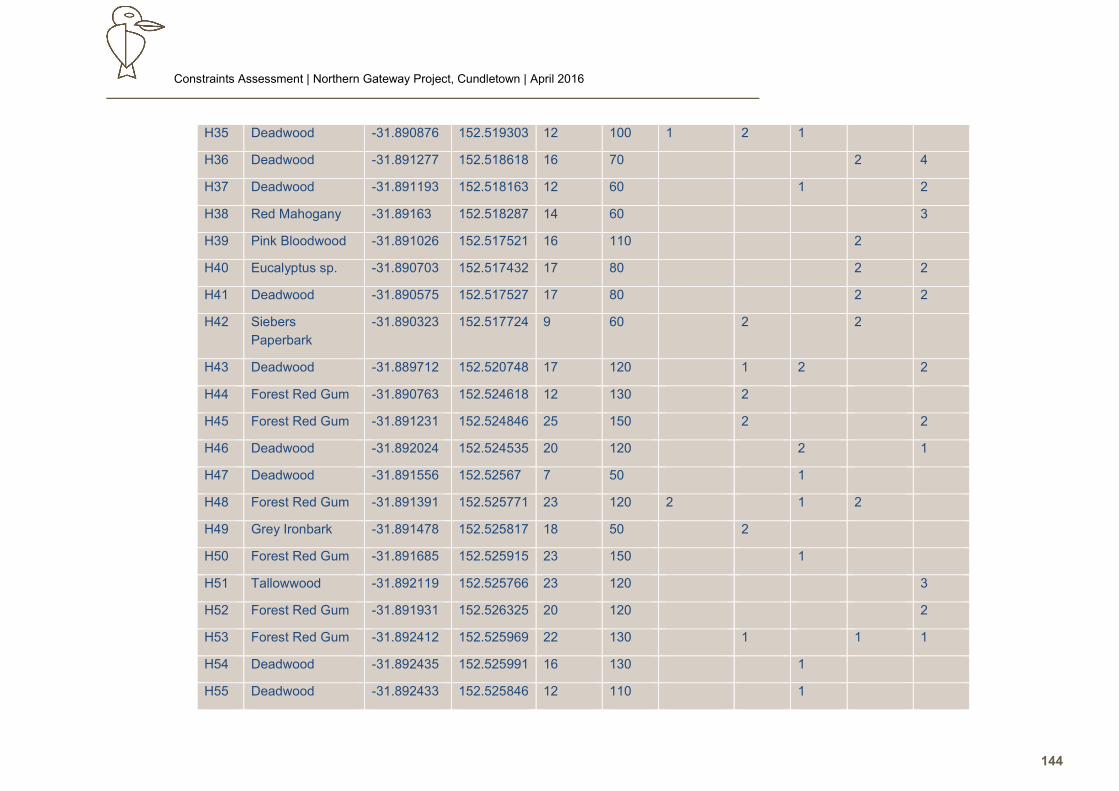
Constraints Assessment | Northern Gateway Project, Cundletown | April 2016
144
H35 Deadwood -31.890876 152.519303 12 100 1 2 1
H36 Deadwood -31.891277 152.518618 16 70 2 4
H37 Deadwood -31.891193 152.518163 12 60 1 2
H38 Red Mahogany -31.89163 152.518287 14 60 3
H39 Pink Bloodwood -31.891026 152.517521 16 110 2
H40 Eucalyptus sp. -31.890703 152.517432 17 80 2 2
H41 Deadwood -31.890575 152.517527 17 80 2 2
H42 Siebers
Paperbark
-31.890323 152.517724 9 60 2 2
H43 Deadwood -31.889712 152.520748 17 120 1 2 2
H44 Forest Red Gum -31.890763 152.524618 12 130 2
H45 Forest Red Gum -31.891231 152.524846 25 150 2 2
H46 Deadwood -31.892024 152.524535 20 120 2 1
H47 Deadwood -31.891556 152.52567 7 50 1
H48 Forest Red Gum -31.891391 152.525771 23 120 2 1 2
H49 Grey Ironbark -31.891478 152.525817 18 50 2
H50 Forest Red Gum -31.891685 152.525915 23 150 1
H51 Tallowwood -31.892119 152.525766 23 120 3
H52 Forest Red Gum -31.891931 152.526325 20 120 2
H53 Forest Red Gum -31.892412 152.525969 22 130 1 1 1
H54 Deadwood -31.892435 152.525991 16 130 1
H55 Deadwood -31.892433 152.525846 12 110 1
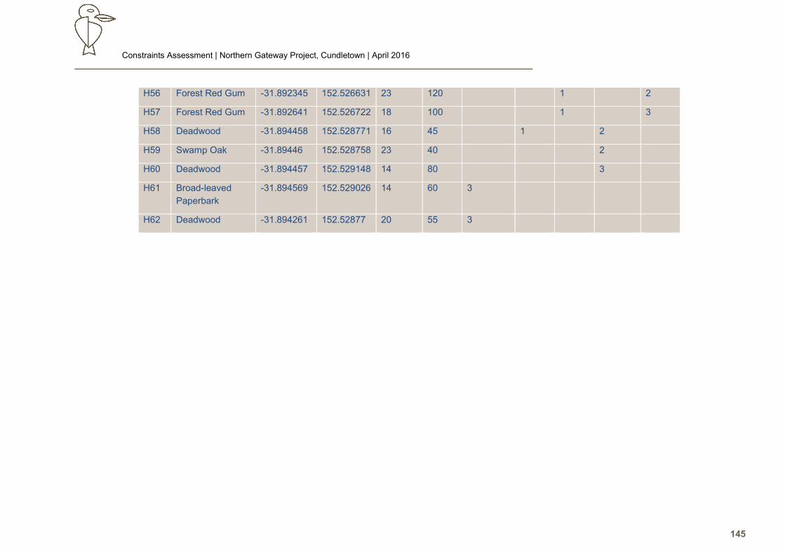
Constraints Assessment | Northern Gateway Project, Cundletown | April 2016
145
H56 Forest Red Gum -31.892345 152.526631 23 120 1 2
H57 Forest Red Gum -31.892641 152.526722 18 100 1 3
H58 Deadwood -31.894458 152.528771 16 45 1 2
H59 Swamp Oak -31.89446 152.528758 23 40 2
H60 Deadwood -31.894457 152.529148 14 80 3
H61 Broad-leaved
Paperbark
-31.894569 152.529026 14 60 3
H62 Deadwood -31.894261 152.52877 20 55 3

Constraints Assessment | Northern Gateway Project, Cundletown | April 2016
146