Embed Size (px)
Citation preview

Ecological Information System Data Users Manual
ECOSYS
Version 1
Nov 3, 2016
Revision History
Version Date Author/Organization Description 1 Oct 2016 AEP Original Document
Nov 3, 2016 Ecological Information System Data Users Manual
© 2016 Government of Alberta
Page 2 of 39

Table of Contents 1.0 Preface 5
1.1 Version 5
2.0 Introduction 6 2.1 Background 6
2.2 Data Source 6
3.0 System Overview, Requirements and Data Accuracy 8 3.1 System Overview 8
3.2 System Requirements 8
3.3 Data Accuracy 8
4.0 Accessing ECOSYS Raw Data 9 4.1 Plot/Locations 9
4.2 Vegetation Totals 19
4.3 Vegetation Species 21
4.4 Soil Horizon 23
4.5 Soils 29
4.6 Site 36
4.7 Forage Production 39
5.0 Literature cited 39
List of Tables Table 1. Attributes for the Plot/Location Report from ECOSYS 10
Table 2. Attributes for the Vegetation Totals Report from ECOSYS 19
Table 3. Attributes for the Vegetation Species Report from ECOSYS 21
Table 4. Attributes for the Soil Horizons Report from ECOSYS 23
Table 5. Attributes for the Soils Report from ECOSYS 29
Table 6. Attributes for Site Information Report from ECOSYS 36
Table 7. Site Disturbance Factor Categories and Types. 38
Table 8. Attributes for the Forage Production Report from ECOSYS 39
List of Figures Figure 1. External Access Screen to Ecological Information System (ECOSYS) data 5
Figure 2. Site Exposure Code and Name 12
Figure 3. Soil Drainage Class Types 13
Figure 4. Local Landform Class Types 14
Figure 5. Regional Landform Class Types 15
Nov 3, 2016 Ecological Information System Data Users Manual
© 2016 Government of Alberta
Page 3 of 39

Figure 6. Macro Site Position Types 15
Figure 7. Soil Moisture Regime Types 16
Figure 8. Soil Nutrient Type Codes 16
Figure 9. Precipitation Zone Type Codes 16
Figure 10. Subregion Codes and Names 17
Figure 11. GVI Site Types and Codes 18
Figure 12. Species Stratum Types 22
Figure 13. Species Density Distribution Types 22
Figure 14. Soil Textures and Codes 26
Figure 15. Methods for collection pH 27
Figure 16. Soil Aspect Codes 27
Figure 17. Soil Hue Codes 28
Figure 18. Soil Clay Location Codes 28
Figure 19. Soil Organic Matter Decomposition Codes 28
Figure 20. Soil Humus Form Codes 31
Figure 21. Soil Bedrock Source Codes 32
Figure 22. Soil Type Codes and Description 33
Figure 23. Wetland Local Life Form Modifier 33
Figure 24. Parent Material Class Type Codes 34
Figure 25. Parent Material Surface Expression Codes 36
Figure 26. Parent Material Modifier Codes. 36
Nov 3, 2016 Ecological Information System Data Users Manual
© 2016 Government of Alberta
Page 4 of 39
1.0 Preface
1. Version Data User Guide v1.0
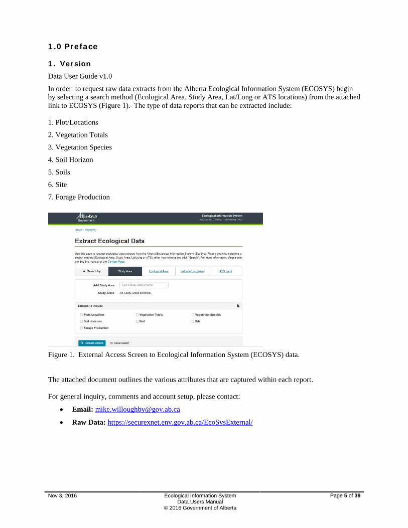
In order to request raw data extracts from the Alberta Ecological Information System (ECOSYS) begin by selecting a search method (Ecological Area, Study Area, Lat/Long or ATS locations) from the attached link to ECOSYS (Figure 1). The type of data reports that can be extracted include: 1. Plot/Locations
2. Vegetation Totals
3. Vegetation Species
4. Soil Horizon
5. Soils
6. Site
7. Forage Production
Figure 1. External Access Screen to Ecological Information System (ECOSYS) data.
The attached document outlines the various attributes that are captured within each report. For general inquiry, comments and account setup, please contact:
• Email: [email protected]
• Raw Data: https://securexnet.env.gov.ab.ca/EcoSysExternal/
Nov 3, 2016 Ecological Information System Data Users Manual
© 2016 Government of Alberta
Page 5 of 39

2. Introduction
2.1 Background In 1976, following the lead of the biogeoclimatic site classification program in British Columbia, a joint project was initiated, by Canadian Forestry Service and the Alberta Forest Service, to establish a framework for describing and classifying land for resource management. The main objectives of the Biogeoclimatic Ecosystem Classification of Alberta project were:
• to classify Alberta into biogeoclimatic zones • to classify the forests of the Province into plant associations • to analyze forest environment relationships • to provide basic information on the plant associations on terms of their structure, ecological
characteristics and potential for forest production • to promote application of this classification in forest management practices and research
programs. Data collection commenced in 1977 and a computer based system was established to store, retrieve and analysis the data.
The project was initially staffed by S. Kojima and G.J. Krumlik of the Canadian Forestry Service with further resources provided by J. Soos of the Research Branch of the Alberta Forest Service. In the late 1970’s the Resource Evaluation and Planning Division joined the project providing data collection and analysis support. The data was stored and reports created at the University of Alberta Computer Center. In the early years of the project, the data was processed using methodologies and programs obtained from BC Ministry of Forests. Programs such as the Klinka-Phelps vegetation tabulation programs were modified for use in Alberta. The complete information set for a field plot consisted of four parts: site description, vegetation description, soil description and mensuration data.
Currently, the ECOSYS (Ecological Information System) database is a provincial database that stores over 26,000 vegetation and soil plots described in the province of Alberta. This information is used in the development of management tools (plant community guides, ecosite guides, natural subregion maps, range health tools etc.) to ensure Alberta’s public lands are being managed sustainably. ECOSYS also summarizes the raw plot information into Ecosite Guides for each subregion in the province.
2.2 Data Source The database was initially set up as the repository for the Biogeoclimatic Forest Site program and data from all regions of the province was collected from 1977-95 and stored in the database. Data for the following projects were stored in ESIS: An Ecosystem Classification of the Boreal Cordilleran Ecozone-Sundre and Ecological Zonation of North Western Alberta. Later, data from the following projects were added: Field Guide for West Central Alberta in 1986, Field Guide for Southwest Alberta and Field Guide to Ecosites of Northern Alberta 1996 and a replacement for West Central Guide in 1996.ESIS was not developed until 1992 when funding for Site classification field guides was made available through the Canada Alberta Partnership Agreement in Forestry (CAPAF). To do the field guides it was necessary to standardize the existing data sets that had been collected since 1976 for both biogeoclimatic and Ecological Land Classification studies. Data from the field guides was not added – the field guides were based largely on existing data that was collected through ELC projects and Integrated Resource Inventory projects. A limited amount of new data was collected.
As part of the Biogeoclimatic Forest Site program procedures for describing ecosites in the field were established. In addition data terminology, definitions and standards were adopted. With the cooperation of the British Columbia Ministry of Forests the manual “Describing Ecosystem in the Field” was modified and became the standard for Alberta. The establishment of standards, definitions and manuals for ecological data collection was a significant as other departmental inventories adopted or modified the Nov 3, 2016 Ecological Information System
Data Users Manual © 2016 Government of Alberta
Page 6 of 39
procedures in later years. Most of all it this work provided the foundation for a provincial ecological data collection and facilitated inter agency data sharing.
During the 1980’s the ecological inventory methods and standards were adopted for the integrated resources inventories. These inventories were conducted as part of the Integrated Resource Planning program. Data was collected throughout the Province and entered into ESIS. ESIS did not exist at that time. Data was collected and entered into the university system or later into a government supported database. Ecological Reports were prepared and printed for numerous planning areas including Coal Branch, Keg River, Berland and Fox Creek.
Also the Canadian Forestry Service made available the data from 4000 plots, collected as part of the Ecological Surveys of the Alberta National Parks (Jasper and Banff) in the late 1970’s and this data was added to ESIS in about 1994 after the database was developed
The Alberta Forest Service completed site descriptions for the 650 forest inventory permanent sample plots that are part of growth and yield studies. The data collected included the site description, soil and vegetation. In addition 200 Stand Dynamic Plots, established by the Alberta Forest Service for monitoring growth of young stand, were visited, site description completed and the data added to the system.
In 2008 a project was initiated to accommodate over 5000 plots in the Prairie (PARADOX) database. New fields were added to the Location screen, Site Screen, Vegetation Screen and Soil Description screen to accommodate the prairie data. In addition a new screen was created (Range Management) to capture specific management information used to manage rangeland dispositions. A description of all the attributes in the ESIS database is outlined in the ESIS Attribute Description Manual (Metadata) (2011).
From the time of commencement of data collection in 1977 until today, over 26,000 site descriptions have been carried out and the plot data entered in the database. The value represented by this work is well over ten million dollars.
This database has been invaluable in a number of key resource management initiatives in Alberta in particular the 3 field guides to Ecosites for the province (This project was the driving force behind developing ESIS). In 1999 this database also supported the development of the Ecological Succession Description database (ESD) within Rangeland Management Branch. The primary objective of the database was the development of a plant community classification system that can be used by field staff and the public to assess the ecology and succession of ecological sites within each subregion. Plant communities in the database are organized within each ecological site where an ecological site is defined as a “distinctive kind of land with specific physical characteristics that differs from other kinds of land in its ability to produce a distinctive kind and amount of vegetation” (Task Group on Unity and Concepts 1995). All of the plot information stored in ESIS is used to develop the plant community descriptions outlined in the ESD website.
In 1994 various Department agencies cooperated in developing a single uniform provincial eco-region map. Previously each resource management agency, had its own individual map (ecoregions and Natural subregions) which created difficulties for interagency consultation and decision making. The ESIS data was used to develop the 1994 and 2006 Natural Regions and Subregions map of Alberta. This subregion map is the framework for dealing with issues of sustainability and conservation throughout the province.
In 2010 funding was provided by Policy and Planning Division, Alberta Environment and Parks to redevelop the original ESIS and ESD databases into one database and produce hard copy pdf documents from the ECOSYS website.
This database also provides the background data for interpreting GVI (Grassland Vegetation Inventory), PLVI (Primary Land Vegetation Inventory) and DEP (Derived Ecosite Phase). PLVI, GVI and DEP are spatial ecologically based land cover inventories and provide information that fits within the provinces ecological classification hierarchy. These types of inventories allow us to predict ecological changes on the landscape based on successional information outlined in the (ECOSYS) website rather than re-inventorying. Providing these choices of ecological inventories is more cost effective in supporting our clients and partners, and provides support to future challenges dealing with biodiversity, climate change, and balanced economic, social, and environmental decision making. Nov 3, 2016 Ecological Information System
Data Users Manual © 2016 Government of Alberta
Page 7 of 39
3. System Overview, Requirements and Data Accuracy 3.1 System Overview ECOSYS uses Microsoft SQL Server as the database, runs on Windows 2012 servers, and is written in MVC.NET.
3.2 System Requirements ECOSYS is run 100% inside Windows Server. ECOSYS external access has been tested to work in the following browsers/environments:
PC:
• Internet Explorer 11 (both native and via Citrix)
• Internet Explorer 10 (emulated)
• Internet Explorer 9 (emulated)
• Firefox 47.0.1
• Chrome 54.0.2840.71
Mobile (Apple iPhone 7):
• Chrome Mobile
• Safari Mobile your computer must be able to run Internet Explorer.
3.3 Data Accuracy
Location accuracy of plot data for the data collected in the 1970s and 1980s is only accurate to the center of an ATS section or Township. Newer data was collected with GPS units and is only accurate to the GPS unit that was used. The extent of the data is within Alberta.
Nov 3, 2016 Ecological Information System Data Users Manual
© 2016 Government of Alberta
Page 8 of 39

4. Accessing ECOSYS Raw Data: ECOSYS is currently available to department employees only via a web service. For external users only raw data can be downloaded into one of five reports. The type of data reports that can be extracted include:
1. Plot/Locations
2. Vegetation Totals
3. Vegetation Species
4. Soil Horizon
5. Soils
6. Site
7. Forage Production
In order to request raw data extracts from the Alberta Ecological Information System (ECOSYS) begin by selecting a search method (Ecological Area, Study Area, Lat/Long or ATS locations) from the attached link to ECOSYS (Figure 1).
The rest of this manual describes the attributes for each data report.
4.1 Plot/Locations A study area is a code unique to the project being conducted. It consists of a 2 digit number followed by a 2 or 3 letter acronym, which identifies the geographical location of the study area, The use of a sequential numbering system permits for the unique identification of projects that have taken place in the same geographical location (eg 72CAP). Usually the first number of the study area will refer to the project the user is assigned too. The various project codes include: 1 – Former AFS Research Branch
2 – LFS Forest Research Management Branch
3 – LISD Resource Information Division
4 – Universities
5 – Other
6 – BGC Plots
7 – LFS Range Management
8 – Former Reforestation Branch
9 – Parks Canada
10 – Tourism, Parks and Recreation The second number will usually refer to the information that is being collected in that study area. The various codes for information collected include: 0 – Location
1 – Site, Soils
2 – Site, Vegetation
Nov 3, 2016 Ecological Information System Data Users Manual
© 2016 Government of Alberta
Page 9 of 39
3 - Site, Mensuration
4 – Site, Soils, Vegetation
5 – Site, Soils, Mensuration
6 – Site, Vegetation, Mensuration
7 – Site, Soils, Vegetation, Mensuration
8 – Site
9 – Soils
An example for rangeland (project code7) and collection of only site and vegetation information (code 2) would be 72ALO where the three letter code is unique for the disposition (in this case ALLOTMENT). Table 1. Attributes for the Plot/Location report from ECOSYS
Field Name Column
Program_Description CODE where Event Type is Ecological Assessment
Study_Area_Code ECOLOGICAL_ASSESSMENT_STUDY_AREA _CODE
Study_Area_Description NAME
PLOT_NUMBER PLOT_NUMBER
Field_PLOT_NUMBER OTHER_PLOT_NUMBER
Original_Other_Plot_Number ORIGINAL_OTHER_PLOT_NUMBER (Field versions of plot number)
Assessment_Date ASSESSMENT_DATE
LEGAL_SUB_DIVISION LEGAL_SUBDIVISION_NUMBER (ATS)
ATS_QUARTER_SECTION QUARTER_SECTION
ATS_SECTION SECTION
ATS_TOWNSHIP TOWNSHIP
ATS_RANGE RANGE
ATS_MERIDIAN MERIDIAN
LATITUDE_DEGREES LATITUDE (Decimal Degrees)
LONGITUDE_DEGREES LONGITUDE (Decimal Degrees)
Map_Datum_Type MAP_DATUM_TYPE_CODE (NAD 83)
Measurement_Type LAT_LONG_MEASUREMENT_TYPE_CODE (1=GPS, 2=ATS centroid)
Nov 3, 2016 Ecological Information System Data Users Manual
© 2016 Government of Alberta
Page 10 of 39
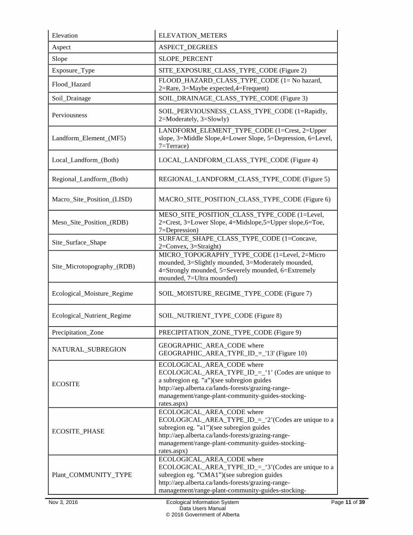
Elevation ELEVATION_METERS
Aspect ASPECT_DEGREES
Slope SLOPE_PERCENT
Exposure_Type SITE_EXPOSURE_CLASS_TYPE_CODE (Figure 2)
Flood_Hazard FLOOD_HAZARD_CLASS_TYPE_CODE (1= No hazard, 2=Rare, 3=Maybe expected,4=Frequent)
Soil_Drainage SOIL_DRAINAGE_CLASS_TYPE_CODE (Figure 3)
Perviousness SOIL_PERVIOUSNESS_CLASS_TYPE_CODE (1=Rapidly, 2=Moderately, 3=Slowly)
Landform_Element_(MF5) LANDFORM_ELEMENT_TYPE_CODE (1=Crest, 2=Upper slope, 3=Middle Slope,4=Lower Slope, 5=Depression, 6=Level, 7=Terrace)
Local_Landform_(Both) LOCAL_LANDFORM_CLASS_TYPE_CODE (Figure 4)
Regional_Landform_(Both) REGIONAL_LANDFORM_CLASS_TYPE_CODE (Figure 5)
Macro_Site_Position_(LISD) MACRO_SITE_POSITION_CLASS_TYPE_CODE (Figure 6)
Meso_Site_Position_(RDB) MESO_SITE_POSITION_CLASS_TYPE_CODE (1=Level, 2=Crest, 3=Lower Slope, 4=Midslope,5=Upper slope,6=Toe, 7=Depression)
Site_Surface_Shape SURFACE_SHAPE_CLASS_TYPE_CODE (1=Concave, 2=Convex, 3=Straight)
Site_Microtopography_(RDB)
MICRO_TOPOGRAPHY_TYPE_CODE (1=Level, 2=Micro mounded, 3=Slightly mounded, 3=Moderately mounded, 4=Strongly mounded, 5=Severely mounded, 6=Extremely mounded, 7=Ultra mounded)
Ecological_Moisture_Regime SOIL_MOISTURE_REGIME_TYPE_CODE (Figure 7)
Ecological_Nutrient_Regime SOIL_NUTRIENT_TYPE_CODE (Figure 8)
Precipitation_Zone PRECIPITATION_ZONE_TYPE_CODE (Figure 9)
NATURAL_SUBREGION GEOGRAPHIC_AREA_CODE where GEOGRAPHIC_AREA_TYPE_ID_=_'13' (Figure 10)
ECOSITE
ECOLOGICAL_AREA_CODE where ECOLOGICAL_AREA_TYPE_ID_=_‘1’ (Codes are unique to a subregion eg. ”a”)(see subregion guides http://aep.alberta.ca/lands-forests/grazing-range-management/range-plant-community-guides-stocking-rates.aspx)
ECOSITE_PHASE
ECOLOGICAL_AREA_CODE where ECOLOGICAL_AREA_TYPE_ID_=_‘2’(Codes are unique to a subregion eg. ”a1”)(see subregion guides http://aep.alberta.ca/lands-forests/grazing-range-management/range-plant-community-guides-stocking-rates.aspx)
Plant_COMMUNITY_TYPE
ECOLOGICAL_AREA_CODE where ECOLOGICAL_AREA_TYPE_ID_=_‘3’(Codes are unique to a subregion eg. ”CMA1”)(see subregion guides http://aep.alberta.ca/lands-forests/grazing-range-management/range-plant-community-guides-stocking-
Nov 3, 2016 Ecological Information System Data Users Manual
© 2016 Government of Alberta
Page 11 of 39

rates.aspx)
AGRASID_Polygon_Number AGRASID_POLYGON_NUMBER (from Agrasid http://www4.agric.gov.ab.ca/agrasidviewer/)
AGRASID_Soil_Landscape_Model AGRASID_SOIL_LANDSCAPE_MODEL (from Agrasid http://www4.agric.gov.ab.ca/agrasidviewer/)
Soil_Correlation_Area SOIL_CORRELATION_TYPE_CODE (from Agrasid http://www4.agric.gov.ab.ca/agrasidviewer/)
Soil_Series_Agrasid_Poly_Type SOIL_SERIES_TYPE_CODE (from Agrasid http://www4.agric.gov.ab.ca/agrasidviewer/)
Field_Verified SOIL_SERIES_FIELD_VERFIED_INDICATOR (yes or no)
Percent PERCENTAGE
GVI_Site_Type GRASSLAND_VEGETATION_INVENTORY_SITE_TYPE_CODE (Figure 11)
GVI_Site_Type_Field_Verified AGRASID_SOIL_LANDSCAPE_MODEL_FIELD_VERIFIED_INDICATOR (yes or no)
Modifier_1 GRASSLAND_VEGETATION_INVENTORY_MODIFIER_1_TYPE_CODE (from Agrasid http://www4.agric.gov.ab.ca/agrasidviewer/)
Modifier_2 GRASSLAND_VEGETATION_INVENTORY_MODIFIER_2_TYPE_CODE (from Agrasid http://www4.agric.gov.ab.ca/agrasidviewer/)
Nov 3, 2016 Ecological Information System
Data Users Manual © 2016 Government of Alberta
Page 12 of 39
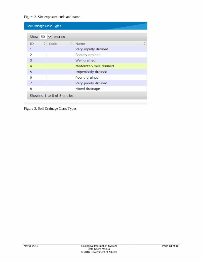
Figure 2. Site exposure code and name
Figure 3. Soil Drainage Class Types
Nov 3, 2016 Ecological Information System Data Users Manual
© 2016 Government of Alberta
Page 13 of 39

Figure 4. Local Landform Class Types
Nov 3, 2016 Ecological Information System Data Users Manual
© 2016 Government of Alberta
Page 14 of 39

Figure 5. Regional Landform Class Types
Figure 6. Macro Site Position Types
Nov 3, 2016 Ecological Information System Data Users Manual
© 2016 Government of Alberta
Page 15 of 39

Figure 7. Soil Moisture Regime Types
Figure 8. Soil Nutrient Type Codes
Figure 9. Precipitation Zone Type Codes
Nov 3, 2016 Ecological Information System Data Users Manual
© 2016 Government of Alberta
Page 16 of 39
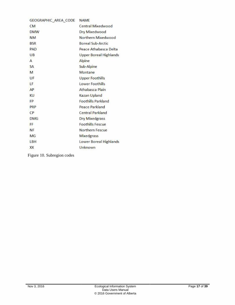
Figure 10. Subregion codes
Nov 3, 2016 Ecological Information System Data Users Manual
© 2016 Government of Alberta
Page 17 of 39
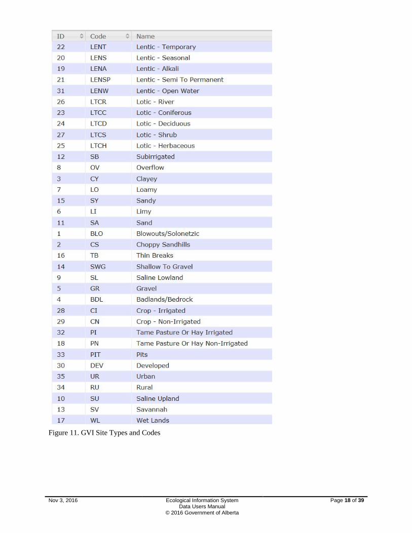
Figure 11. GVI Site Types and Codes
Nov 3, 2016 Ecological Information System Data Users Manual
© 2016 Government of Alberta
Page 18 of 39

4.2 Vegetation Totals Table 2. Attributes for Vegetation Totals report for ECOSYS
Field Name Column
Program Description CODE where Event Type is Ecological Assessment
Study Area Code ECOLOGICAL_ASSESSMENT_STUDY_AREA _CODE
Study Area Description NAME
PLOT_NUMBER PLOT_NUMBER
Field_PLOT_NUMBER OTHER_PLOT_NUMBER
Original Other Plot Number ORIGINAL_OTHER_PLOT_NUMBER
Assessment Date ASSESSMENT_DATE
TOTAL_PERCENTAGE_COVER_EPIPHYTES
PERCENTAGE_COVER where SPECIES_STRATUM_TYPE.SPECIES_STRATUM_TYPE_CODE = 'E'
STRATUM_HEIGHT_EPIPHYTES (meters)
STRATUM_HEIGHT where SPECIES_STRATUM_TYPE.SPECIES_STRATUM_TYPE_CODE = 'E'
TOTAL_PERCENTAGE_COVER_FUNGI PERCENTAGE_COVER where SPECIES_STRATUM_TYPE.SPECIES_STRATUM_TYPE_CODE = 'FU'
STRATUM_HEIGHT_FUNGI (meters) STRATUM_HEIGHT where SPECIES_STRATUM_TYPE.SPECIES_STRATUM_TYPE_CODE = 'FU'
TOTAL_PERCENTAGE_COVER_GRAMINOID
PERCENTAGE_COVER where SPECIES_STRATUM_TYPE.SPECIES_STRATUM_TYPE_CODE = 'G'
STRATUM_HEIGHT_GRAMINOID (meters)
STRATUM_HEIGHT where SPECIES_STRATUM_TYPE.SPECIES_STRATUM_TYPE_CODE = 'G'
TOTAL_PERCENTAGE_COVER_LICHEN
PERCENTAGE_COVER where SPECIES_STRATUM_TYPE.SPECIES_STRATUM_TYPE_CODE = 'L'
STRATUM_HEIGHT_LICHEN (meters) STRATUM_HEIGHT where SPECIES_STRATUM_TYPE.SPECIES_STRATUM_TYPE_CODE = 'L'
TOTAL_PERCENTAGE_COVER_LOW_FORB
PERCENTAGE_COVER where SPECIES_STRATUM_TYPE.SPECIES_STRATUM_TYPE_CODE = 'F2'
Nov 3, 2016 Ecological Information System Data Users Manual
© 2016 Government of Alberta
Page 19 of 39
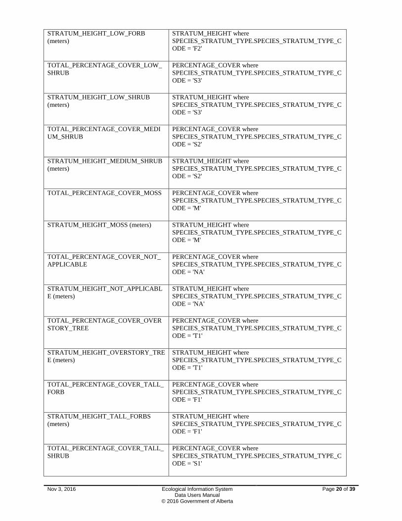
STRATUM_HEIGHT_LOW_FORB (meters)
STRATUM_HEIGHT where SPECIES_STRATUM_TYPE.SPECIES_STRATUM_TYPE_CODE = 'F2'
TOTAL_PERCENTAGE_COVER_LOW_SHRUB
PERCENTAGE_COVER where SPECIES_STRATUM_TYPE.SPECIES_STRATUM_TYPE_CODE = 'S3'
STRATUM_HEIGHT_LOW_SHRUB (meters)
STRATUM_HEIGHT where SPECIES_STRATUM_TYPE.SPECIES_STRATUM_TYPE_CODE = 'S3'
TOTAL_PERCENTAGE_COVER_MEDIUM_SHRUB
PERCENTAGE_COVER where SPECIES_STRATUM_TYPE.SPECIES_STRATUM_TYPE_CODE = 'S2'
STRATUM_HEIGHT_MEDIUM_SHRUB (meters)
STRATUM_HEIGHT where SPECIES_STRATUM_TYPE.SPECIES_STRATUM_TYPE_CODE = 'S2'
TOTAL_PERCENTAGE_COVER_MOSS PERCENTAGE_COVER where SPECIES_STRATUM_TYPE.SPECIES_STRATUM_TYPE_CODE = 'M'
STRATUM_HEIGHT_MOSS (meters) STRATUM_HEIGHT where SPECIES_STRATUM_TYPE.SPECIES_STRATUM_TYPE_CODE = 'M'
TOTAL_PERCENTAGE_COVER_NOT_APPLICABLE
PERCENTAGE_COVER where SPECIES_STRATUM_TYPE.SPECIES_STRATUM_TYPE_CODE = 'NA'
STRATUM_HEIGHT_NOT_APPLICABLE (meters)
STRATUM_HEIGHT where SPECIES_STRATUM_TYPE.SPECIES_STRATUM_TYPE_CODE = 'NA'
TOTAL_PERCENTAGE_COVER_OVERSTORY_TREE
PERCENTAGE_COVER where SPECIES_STRATUM_TYPE.SPECIES_STRATUM_TYPE_CODE = 'T1'
STRATUM_HEIGHT_OVERSTORY_TREE (meters)
STRATUM_HEIGHT where SPECIES_STRATUM_TYPE.SPECIES_STRATUM_TYPE_CODE = 'T1'
TOTAL_PERCENTAGE_COVER_TALL_FORB
PERCENTAGE_COVER where SPECIES_STRATUM_TYPE.SPECIES_STRATUM_TYPE_CODE = 'F1'
STRATUM_HEIGHT_TALL_FORBS (meters)
STRATUM_HEIGHT where SPECIES_STRATUM_TYPE.SPECIES_STRATUM_TYPE_CODE = 'F1'
TOTAL_PERCENTAGE_COVER_TALL_SHRUB
PERCENTAGE_COVER where SPECIES_STRATUM_TYPE.SPECIES_STRATUM_TYPE_CODE = 'S1'
Nov 3, 2016 Ecological Information System Data Users Manual
© 2016 Government of Alberta
Page 20 of 39

STRATUM_HEIGHT_TALL_SHRUB (meters)
STRATUM_HEIGHT where SPECIES_STRATUM_TYPE.SPECIES_STRATUM_TYPE_CODE = 'S1'
TOTAL_PERCENTAGE_COVER_UNDERSTORY_TREE
PERCENTAGE_COVER where SPECIES_STRATUM_TYPE.SPECIES_STRATUM_TYPE_CODE = 'T2'
STRATUM_HEIGHT_UNDERSTORY_TREE (meters)
STRATUM_HEIGHT where SPECIES_STRATUM_TYPE.SPECIES_STRATUM_TYPE_CODE = 'T2'
4.3 Vegetation Species Table 3. Attributes for Vegetation Species report for ECOSYS
Field Name Column
Program Description CODE where Event Type is Ecological Assessment
Study Area Code ECOLOGICAL_ASSESSMENT_STUDY_AREA _CODE
Study Area Description NAME
PLOT_NUMBER PLOT_NUMBER
Field_PLOT_NUMBER OTHER_PLOT_NUMBER
Original Other Plot Number ORIGINAL_OTHER_PLOT_NUMBER
Assessment Date ASSESSMENT_DATE
GENUS_CODE TAXON_CODE (first four letters latin name)
SPECIES_CODE TAXON_CODE (first three letters latin name)
VEGETATION_STRATUM_CODE SPECIES_STRATUM_TYPE_CODE (Figure 12)
AVERAGE COVER
VIGOR SPECIES_VIGOR_TYPE_CODE (1=Excellent vigor, 2=Fair vigor, 3=Good vigor, 4=Poor vigor, 5=Species dead)
DENSITY_DISTRIBUTION SPECIES_DENSITY_DISTRIBUTION_TYPE_CODE (Figure 13)
Nov 3, 2016 Ecological Information System Data Users Manual
© 2016 Government of Alberta
Page 21 of 39

Figure 12. Species stratum types
Figure 13. Species Density Distribution Types
Nov 3, 2016 Ecological Information System Data Users Manual
© 2016 Government of Alberta
Page 22 of 39

4.4 Soil Horizons Table 4. Attributes for Soil Horizons Report from ECOSYS
Field Name Column
Program Description CODE where Event Type is Ecological Assessment
Study Area Code ECOLOGICAL_ASSESSMENT_STUDY_AREA _CODE
Study Area Description NAME
PLOT_NUMBER PLOT_NUMBER
Field_PLOT_NUMBER OTHER_PLOT_NUMBER
Original Other Plot Number ORIGINAL_OTHER_PLOT_NUMBER
Assessment Date ASSESSMENT_DATE
HORIZON_LEVEL HORIZON_LEVEL (0,II,III,…VIII) (8 levels)
DISCONTINUITY NAME
HORIZON_CODE NAME (A,AB,AC, C,C+H, CA,CB, F, FH, H, L, LF, LFH, H, O, R, W)
HORIZON_SUFFIX NAME (b,c,ca,cc,e,f,g,h,j,k,m,n,p,s,sa,t,u,x,y,z)
SUBDIVISION SUBDIVISION (number)
UPPER_DEPTH UPPER_DEPTH (cm)
LOWER_DEPTH LOWER_DEPTH (cm)
MINIMUM_THICKNESS MINIMUM_THICKNESS (cm)
MAXIMUM_THICKNESS MAXIMUM_THICKNESS (cm)
BOUNDARY_DISTINCTNESS_CLASS NAME (Abrupt, Clear, Gradual, Diffuse, None)
BOUNDARY_FORM_CODE NAME (S=Smooth, W=Wavy, I=Irregular, B=Broken)
SOIL_TEXTURE_CLASS NAME (Figure 14)
VON_POST_TYPE NAME (Fibric, Mesic, Humic)
VON_POST_DECOMP NAME (1=Undecomposed, 2=Almost undecomposed, 3=Very Weakly decomposed, 4=Weakly decomposed,5=Moderately decomposed,6=Moderately Strongly decomposed, 7=Strongly decomposed, 8=Very Strongly decomposed, 9=Almost completely decomposed, 10=Completely decomposed)
Nov 3, 2016 Ecological Information System Data Users Manual
© 2016 Government of Alberta
Page 23 of 39

COARSE_FRAGMENT_PERCENTAGE COARSE_FRAGMENT_PERCENTAGE
GRAVEL_PERCENTAGE PERCENTAGE where SOIL_HORIZON_COARSE_FRAGMENT_TYPE.SOIL_HORIZON_COARSE_FRAGMENT_TYPE_CODE = 'G'
GRAVEL_TYPE NAME where SOIL_HORIZON_COARSE_FRAGMENT_TYPE.SOIL_HORIZON_COARSE_FRAGMENT_TYPE_CODE = 'G'
COBBLES_PERCENTAGE PERCENTAGE where SOIL_HORIZON_COARSE_FRAGMENT_TYPE.SOIL_HORIZON_COARSE_FRAGMENT_TYPE_CODE = 'C'
COBBLES_TYPE NAME where SOIL_HORIZON_COARSE_FRAGMENT_TYPE.SOIL_HORIZON_COARSE_FRAGMENT_TYPE_CODE = 'C'
STONES_PERCENTAGE PERCENTAGE where SOIL_HORIZON_COARSE_FRAGMENT_TYPE.SOIL_HORIZON_COARSE_FRAGMENT_TYPE_CODE = 'S'
STONES_TYPE NAME where SOIL_HORIZON_COARSE_FRAGMENT_TYPE.SOIL_HORIZON_COARSE_FRAGMENT_TYPE_CODE = 'S'
STRUCTURE_GRADE NAME (Weak, Weak to Moderate, Moderate, Moderate to Strong, Strong)
STRUCTURE_CLASS NAME (Very fine, Very fine to fine, Fine, Fine to Medium, Medium to Coarse, Coarse, Very Coarse)
STRUCTURE_KIND NAME (Singular grain, Massive, Angular Blocky, Subangular Blocky, Granular, Platy, Prismatic, Columnar)
STRUCTURE_MOD NAME (Not applicable, Pseudo)
CONSISTENCY_DRY NAME (Loose, Soft, Slightly hard, Hard, Very hard, Extremely hard, Rigid)
CONSISTENCY_MOIST NAME (Loose,Very friable, Friable, Firm, Very firm, Extremely firm)
CONSISTENCY_WET NAME (Non-sticky, Slightly sticky, Sticky, Very sticky)
CONSISTENCY_PLASTICITY NAME (Non-plastic, Slightly plastic, Plastic, Very plastic)
PH_REACTION PH_VALUE (0-9)
PH_METHOD NAME (Figure 15)
EFFERVESCENCE_DEGREE NAME (None, Very weak, Weak, Moderate, Strong)
COLOUR_1_ASPECT NAME (Figure 16)
Nov 3, 2016 Ecological Information System Data Users Manual
© 2016 Government of Alberta
Page 24 of 39

COLOUR_1_HUE SOIL_HUE_TYPE_CODE (Figure 17)
COLOUR_1_VALUE VALUE (2.0,2.5,3.0,3.5,4.0,4.5,5.0,5.5,6.0,6.5,7.0,7.5,8.0)
COLOUR_1_CHROMA CHROMA (1.0,1.5,2.0,2.5,3.0,3.5,4.0,4.5,5.0,5.5,6.0,6.5,7.0,7.5,8.0, N, 10Y,5GY,10GY,5G,10G,5BG,10BG,5B,10B,5PB)
MOTTLES_ABUND NAME (None, Few, Common, Many)
MOTTLES_SIZE NAME (Fine, Medium, Course)
MOTTLES_CONTRAST NAME (Faint, Distinct, Prominent)
MOTTLES_CLR_ASPECT NAME (Figure 16)
MOTTLES_CLR_HUE SOIL_HUE_TYPE_CODE (Figure 17)
MOTTLES_CLR_VALUE VALUE (2.0,2.5,3.0,3.5,4.0,4.5,5.0,5.5,6.0,6.5,7.0,7.5,8.0)
MOTTLES_CLR_CHROMA CHROMA (1.0,1.5,2.0,2.5,3.0,3.5,4.0,4.5,5.0,5.5,6.0,6.5,7.0,7.5,8.0, N, 10Y,5GY,10GY,5G,10G,5BG,10BG,5B,10B,5PB)
ROOTS_ABUND NAME (None, Very few, Few, Plentiful, Abundant)
ROOTS_SIZE NAME (Very fine, Fine, Medium, Coarse)
ROOTS_ORIENT NAME (Vertical, Horizontal, Oblique, Random)
ROOTS_DIST NAME (Inped, Exped, Matrix)
CLAY_FREQUENCY NAME (None (0%), Few (<2%), Common (2-20%), Many (20-80%), Continuous (>80%))
CLAY_THICKNESS NAME (Thin, Moderately thick, Thick, Very thick)
CLAY_LOCATION NAME (Figure 18)
ORGMAT_MATCOMP_COMP1 NAME (Figure 19)
ORGMAT_MATCOMP_COMP2 NAME (Figure 19)
ORGMAT_MATCOMP_DECOMP NAME (None, Slight, Moderate, High)
ORGMAT_WOOD_HARD NAME (Soft, Slightly hard, Hard, Very hard)
ORGMAT_WOOD_VOL NAME (0=None, 1=<10%, 2=10 to20% , 3=20 to 50%, 4=>50%)
SALINITY NAME (Non-saline, Weakly saline, Moderately saline, Strongly saline)
SAMPLE LABORATORY_SAMPLE (yes or no)
Nov 3, 2016 Ecological Information System Data Users Manual
© 2016 Government of Alberta
Page 25 of 39
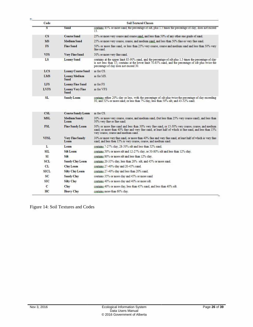
Figure 14: Soil Textures and Codes
Nov 3, 2016 Ecological Information System Data Users Manual
© 2016 Government of Alberta
Page 26 of 39

Figure 15. Method for collecting pH.
Figure 16. Soil Aspect Codes
Nov 3, 2016 Ecological Information System Data Users Manual
© 2016 Government of Alberta
Page 27 of 39

Figure 17. Soil Hue Codes
Figure 18. Soil Clay Location Codes
Figure 19. Soil Organic Matter Decomposition codes.
Nov 3, 2016 Ecological Information System Data Users Manual
© 2016 Government of Alberta
Page 28 of 39

4.5 Soils Table 5. Attributes for the Soils Report from ECOSYS
Field Name Column
Program Description CODE where Event Type is Ecological Assessment
Study Area Code ECOLOGICAL_ASSESSMENT_STUDY_AREA _CODE
Study Area Description NAME
PLOT_NUMBER PLOT_NUMBER
Field_PLOT_NUMBER OTHER_PLOT_NUMBER
Original Other Plot Number ORIGINAL_OTHER_PLOT_NUMBER
Assessment Date ASSESSMENT_DATE
HUMUS_FORM NAME (Figure 20)
SURFACE_TEXTURE NAME accessed through ECOLOGICAL_PLOT_ASSESSMENT_SOIL.SOIL_TEXTURE_CLASS_TYPE_ID (Figure 14)
SURFACE_NON_TEXTURE NAME accessed through ECOLOGICAL_PLOT_ASSESSMENT_SOIL.SOIL_NON_TEXTURE_CLASS_TYPE_ID (Gravels, Cobbles, Stones, Bedrock, Ice, Water)
SURFACE_TEXTURE_MOD NAME accessed through ECOLOGICAL_PLOT_ASSESSMENT_SOIL.SOIL_TEXTURE_MODIFIER_TYPE_ID (Mucky)
EFFECTIVE_TEXTURE NAME accessed through ECOLOGICAL_PLOT_ASSESSMENT_SOIL.EFFECTIVE_SOIL_TEXTURE_CLASS_TYPE_ID (Figure 14)
EFFECTIVE_NON_TEXTURE NAME accessed through ECOLOGICAL_PLOT_ASSESSMENT_SOIL.EFFECTIVE_SOIL_NON_TEXTURE_CLASS_TYPE_ID (Gravels, Cobbles, Stones, Bedrock, Ice, Water)
EFFECTIVE_TEXTURE_MOD NAME accessed through ECOLOGICAL_PLOT_ASSESSMENT_SOIL.EFFECTIVE_SOIL_TEXTURE_MODIFIER_TYPE_ID (Mucky)
SOIL_PH SOIL_PH (0-9)
LFH_THICKNESS LFH_THICKNESS (cm)
ORGANIC_THICKNESS ORGANIC_THICKNESS (cm)
PRIMARY_WATER_SOURCE NAME (Precipitation, Precipitation and Seepage, Seepage, Seepage and Permanent water, Permanent water table)
SEEPAGE_INFLUENCE NAME (None, Permanent, Temporary)
BEDROCK_SOURCE NAME (Figure 21)
Nov 3, 2016 Ecological Information System Data Users Manual
© 2016 Government of Alberta
Page 29 of 39
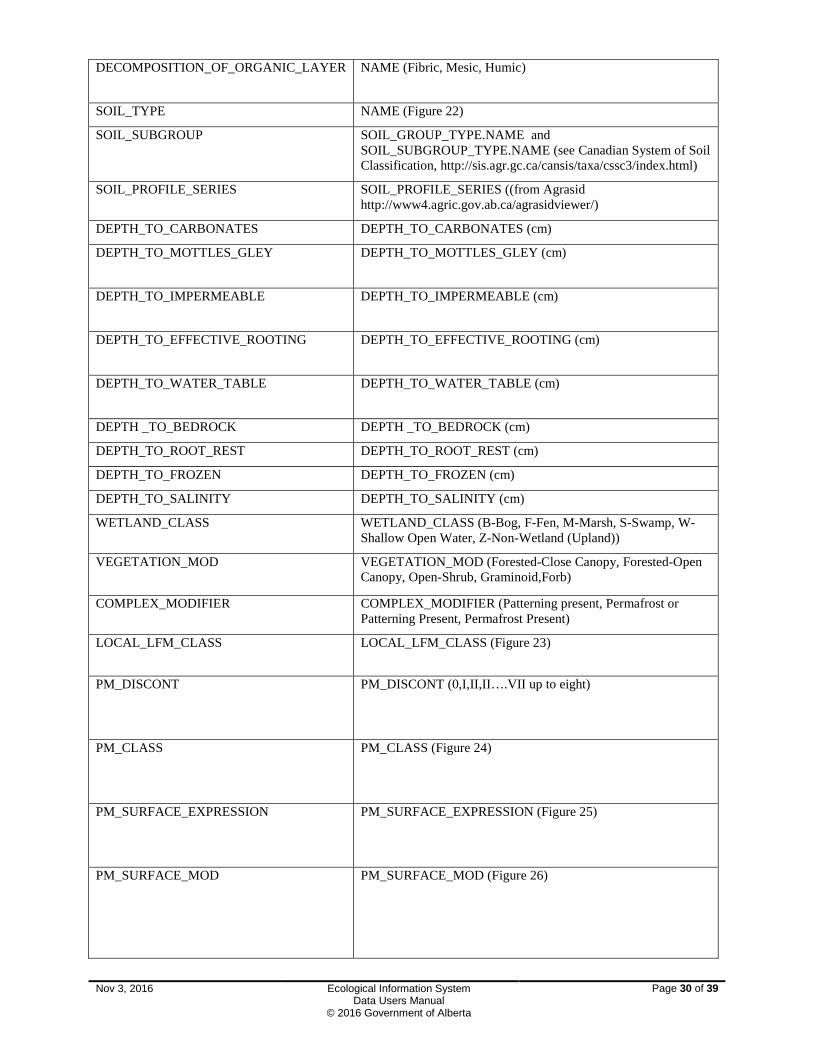
DECOMPOSITION_OF_ORGANIC_LAYER NAME (Fibric, Mesic, Humic)
SOIL_TYPE NAME (Figure 22)
SOIL_SUBGROUP SOIL_GROUP_TYPE.NAME and SOIL_SUBGROUP_TYPE.NAME (see Canadian System of Soil Classification, http://sis.agr.gc.ca/cansis/taxa/cssc3/index.html)
SOIL_PROFILE_SERIES SOIL_PROFILE_SERIES ((from Agrasid http://www4.agric.gov.ab.ca/agrasidviewer/)
DEPTH_TO_CARBONATES DEPTH_TO_CARBONATES (cm)
DEPTH_TO_MOTTLES_GLEY DEPTH_TO_MOTTLES_GLEY (cm)
DEPTH_TO_IMPERMEABLE DEPTH_TO_IMPERMEABLE (cm)
DEPTH_TO_EFFECTIVE_ROOTING DEPTH_TO_EFFECTIVE_ROOTING (cm)
DEPTH_TO_WATER_TABLE DEPTH_TO_WATER_TABLE (cm)
DEPTH _TO_BEDROCK DEPTH _TO_BEDROCK (cm)
DEPTH_TO_ROOT_REST DEPTH_TO_ROOT_REST (cm)
DEPTH_TO_FROZEN DEPTH_TO_FROZEN (cm)
DEPTH_TO_SALINITY DEPTH_TO_SALINITY (cm)
WETLAND_CLASS WETLAND_CLASS (B-Bog, F-Fen, M-Marsh, S-Swamp, W-Shallow Open Water, Z-Non-Wetland (Upland))
VEGETATION_MOD VEGETATION_MOD (Forested-Close Canopy, Forested-Open Canopy, Open-Shrub, Graminoid,Forb)
COMPLEX_MODIFIER COMPLEX_MODIFIER (Patterning present, Permafrost or Patterning Present, Permafrost Present)
LOCAL_LFM_CLASS LOCAL_LFM_CLASS (Figure 23)
PM_DISCONT PM_DISCONT (0,I,II,II….VII up to eight)
PM_CLASS PM_CLASS (Figure 24)
PM_SURFACE_EXPRESSION PM_SURFACE_EXPRESSION (Figure 25)
PM_SURFACE_MOD PM_SURFACE_MOD (Figure 26)
Nov 3, 2016 Ecological Information System Data Users Manual
© 2016 Government of Alberta
Page 30 of 39

PM_UPPER_DEPTH PM_UPPER_DEPTH (cm)
PM_LOWER_DEPTH PM_LOWER_DEPTH (cm)
PM_TEXTURE PM_TEXTURE (Figure 14)
PM_TEXTURE_MOD PM_TEXTURE_MOD (Mucky)
PM_COARSE_FRAG PM_COARSE_FRAG (Cobbles, Gravel, Blocky, Rubble, Bouldery)
PM_PERCENT_COARSE_FRAG PM_PERCENT_COARSE_FRAG
Figure 20. Soil Humus Form Codes
Nov 3, 2016 Ecological Information System Data Users Manual
© 2016 Government of Alberta
Page 31 of 39

Figure 21. Soil Bedrock Source
Nov 3, 2016 Ecological Information System Data Users Manual
© 2016 Government of Alberta
Page 32 of 39

Figure 22. Soil Type Codes and Description
Figure 23. Wetland Local Life Form Modifer
Nov 3, 2016 Ecological Information System Data Users Manual
© 2016 Government of Alberta
Page 33 of 39

Figure 24: Parent Material Class Type Codes
Nov 3, 2016 Ecological Information System Data Users Manual
© 2016 Government of Alberta
Page 34 of 39

Nov 3, 2016 Ecological Information System Data Users Manual
© 2016 Government of Alberta
Page 35 of 39

Figure 25. Parent Material Surface Expression codes
Figure 26. Parent material Modifier Codes
4.6 Site Information Table 6. Attributes for the Site Information Report from ECOSYS
Field Name Column
Program Description CODE where Event Type is Ecological Assessment
Study Area Code ECOLOGICAL_ASSESSMENT_STUDY_AREA _CODE
Nov 3, 2016 Ecological Information System Data Users Manual
© 2016 Government of Alberta
Page 36 of 39

Study Area Description NAME
PLOT_NUMBER PLOT_NUMBER
Field_PLOT_NUMBER OTHER_PLOT_NUMBER
Original Other Plot Number ORIGINAL_OTHER_PLOT_NUMBER
Assessment Date ASSESSMENT_DATE
SURFACE SUBSTRATE BEDROCK
BEDROCK PERCENTAGE
SURFACE SUBSTRATE COBBLES STONES
COBBLES STONES PERCENTAGE
SURFACE SUBSTRATE DECAYING WOOD
DECAYING WOOD PERCENTAGE
SURFACE SUBSTRATE MINERAL SOIL
MINERAL SOIL PERCENTAGE
SURFACE SUBSTRATE ORGANIC MATTER
ORGANIC MATTER PERCENTAGE
SURFACE SUBSTRATE WATER WATER PERCENTAGE
SUCCESSIONAL STATUS 1-5 SUCCESSIONAL STATUS NAME (1=Pioneer Seral, 2=Young Seral, 3=Maturing Seral, 4=Old Seral, 5=Young Edaphic Climax, 6=Mature Edaphic Climax, 7=Young Climatic Climax, 8=Mature Climatic Climax, 9=Disclimax, 10=Non-vegetated, 11=Cutblock, 12=Cultivated Pasture, 13=Old Field, 14=Reclaimed
DISTURBANCE FACTOR 1-5 CATEGORY
DISTURBANCE FACTOR CATEGORY NAME (1=Atmosphere related, 2=Cutting and Soil Disturbance, 3=Dumping, disposal and spills, 4=Fires, 5=Plant and Animal Related Effects, 6=Terrain Related Effects, 7=Vegetation and Site Improvement Related Effects, 8=Water Related Effects)
DISTURBANCE FACTOR 1-5 TYPE
DISTURBANCE FACTOR TYPE NAME (Table 7)
REGENERATING TREE SPECIES 1-5
REGENERATING TREE SPECIES NAME (Alpine fir, Alpine larch, Balsam fir, Balsam poplar, Black spruce, Dead conifer, Dead deciduous, Douglas fir, Engelman spruce, Engelman X White spruce, Jack pine, Limber pine, Lodgepole pine, Tamarack, Trembling aspen, White spruce, Whitebark pine)
REGENERATING TREE SPECIES PERCENTAGE
REGENERATING TREE SPECIES PERCENTAGE
REGENERATING TREE SPECIES HEIGHT
REGENERATING TREE SPECIES HEIGHT (m)
Nov 3, 2016 Ecological Information System
Data Users Manual © 2016 Government of Alberta
Page 37 of 39

Table 7. Site Disturbance Factor Categories and Types.
1. Atmosphere – related effects 1. Atmospheric pollution (specify type) 2. Climate extremes (specify type) 3. Windthrow
2. Cutting and soil disturbances: 1. Abandoned construction sites (road-bed, railway, etc.)
2. Clearcut logging (no slash burn unless indicated) 3. Cultivation (continued disturbance of the vegetation and/or the soil,
excluding harvesting of native crop) 4. Excavation 5. Harvesting of native crop (haying, berry picking, etc.) 6. Land clearing (includes grubbing and/or other forms of disturbance of the
natural soil as for pipeline construction etc. 7. Scarification 8. Selective logging (including shelter cut) 9. Soil compaction (including effects from foot traffic, machinery traffic and
animal traffic)
3. Dumping, disposal and spills 1. Chemical spill or disposal (specify type) 2. Effluent disposal 3. Mine spoils 4. Oil spill or disposal 5. Radioactive waste disposal or exposure
4. Fires: 1. Intensive fires (consuming trees and larger shrubs) 2. Light fire (primarily ground fire) 3. Repeated intensive fire 4. Repeated light fire 5. Slash burn (following logging)
5. Plant and animal-related effects: 1. Beaver tree cutting 2. Disease (excluding insects: specify type) 3. Domestic grazing/browsing (specify animal) 4. Excrement accumulation (other than that normally associated with grazing
or browsing) 5. Insect kill (specify insect) 6. Succession (generation of vegetation including climax stands) 7. Wildlife grazing/browsing (specify animals)
6. Terrain-related effects: 1. Avalanching 2. Eolian (active deflation or deposition) 3. Recent deglaciation 4. Rock quarrying (including open mine pits) 5. Terrain failures (active or recent slumps, slides, solifluction. etc.) 6. Volcanic activity
7. Vegetation and site improvement-related effects
1. Fertilization (specify fertilizer) 2. Irrigation 3. Planted trees or shrubs 4. Seeded or planted to grass or herbs 5. Seeded to trees or shrubs
8. Water-related effects: 1. Inundation (including temporary inundation resulting from beaver activity) 2. Temporary seepage (usually man-induced seepage; this excludes
intermittent seepage resulting from climate patterns. 3. Water table control (diking, damming) 4. Water table depression (associated with extensive water extraction from wells.
Nov 3, 2016 Ecological Information System Data Users Manual
© 2016 Government of Alberta
Page 38 of 39
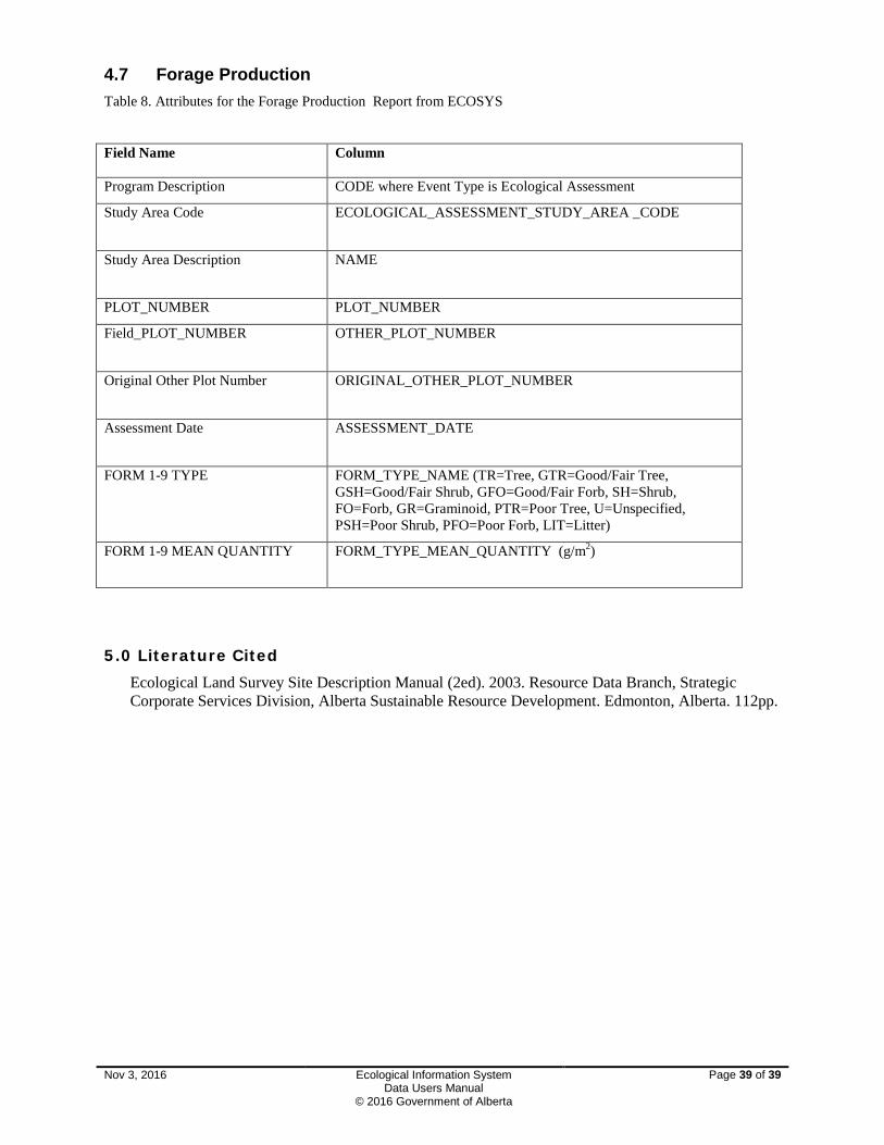
4.7 Forage Production Table 8. Attributes for the Forage Production Report from ECOSYS
Field Name Column
Program Description CODE where Event Type is Ecological Assessment
Study Area Code ECOLOGICAL_ASSESSMENT_STUDY_AREA _CODE
Study Area Description NAME
PLOT_NUMBER PLOT_NUMBER
Field_PLOT_NUMBER OTHER_PLOT_NUMBER
Original Other Plot Number ORIGINAL_OTHER_PLOT_NUMBER
Assessment Date ASSESSMENT_DATE
FORM 1-9 TYPE FORM_TYPE_NAME (TR=Tree, GTR=Good/Fair Tree, GSH=Good/Fair Shrub, GFO=Good/Fair Forb, SH=Shrub, FO=Forb, GR=Graminoid, PTR=Poor Tree, U=Unspecified, PSH=Poor Shrub, PFO=Poor Forb, LIT=Litter)
FORM 1-9 MEAN QUANTITY FORM_TYPE_MEAN_QUANTITY (g/m2)
5.0 Literature Cited
Ecological Land Survey Site Description Manual (2ed). 2003. Resource Data Branch, Strategic Corporate Services Division, Alberta Sustainable Resource Development. Edmonton, Alberta. 112pp.
Nov 3, 2016 Ecological Information System Data Users Manual
© 2016 Government of Alberta
Page 39 of 39


![ECOSYS M2530dn ECOSYS M2535dn - Kyoceradownloads.kyoceradocumentsolutions.com.au/Documentation... · ECOSYS M2530dn ECOSYS M2535dn. i ... Print all at once [Batch Print] ... 2 Eviter](https://img.pdfslide.net/doc/110x75/5adf88647f8b9afd1a8cd1d4/ecosys-m2530dn-ecosys-m2535dn-m2530dn-ecosys-m2535dn-i-print-all-at-once.jpg)