Embed Size (px)
Citation preview
Ecological Risk Assessment for
the Paraguay River BasinArgentina, Bolivia, Brazil and Paraguay
January 2012
©
THIS PUBLICATIONWAS PREPARED UNDERA PARTNERSHIP BY

1st Edition
Prepared byThe Nature Conservancy, WWF-Brazil
With support fromPantanal Research Centre (CPP)/Sinergia, TNC Latin America (TNC/LAR),
Caterpillar, HSBC, WWF-Bolivia and WWF-Paraguay
Associated partnersEmbrapa Pantanal and Ecoa
Brasília, Brazil 2012
Ecological Risk Assessment
for the Paraguay River BasinArgentina, Bolivia, Brazil and Paraguay
WWF-BRAZIL
CEO
Maria Cecília Wey de Brito
Conservation Director
Carlos Alberto de Mattos Scaramuzza
Cerrado-Pantanal Programme
Programme Coordinator
Michael Becker
Water for Life Programme
Programme Coordinator
Samuel Barreto
Landscape Ecology Laboratory
Coordinator
Sidney Rodrigues
THE NATURE CONSERVANCY
Country Representative for Brazil
Ana Cristina Fialho Barros
Atlantic Forest and Central Savannas Conservation Programme
Programme Director
João Santo Campari
Atlantic Forest and Central Savannas Conservation
Programme’s Freshwater Strategy
Coordenador
Albano Araújo
PRODUCTION CREDITS
Authors
Paulo Petry (TNC)
Sidney T. Rodrigues (WWF-Brazil)
Mario Barroso Ramos Neto (WWF-Brazil)
Marcelo H. Matsumoto (TNC)
Glauco Kimura (WWF-Brazil)
Michael Becker (WWF-Brazil)
Pamela Rebolledo (WWF-Bolivia)
Albano Araújo (TNC)
Bernardo Caldas De Oliveira (WWF-Brazil)
Mariana da Silva Soares (WWF-Brazil)
Magaly Gonzales de Oliveira (WWF-Brazil)
João Guimarães (TNC)
Technical Review
Carlos Padovani (Embrapa Pantanal)
Supporting Team
Adolfo Moreno (WWF-Bolívia)
Angelo J. R. Lima (WWF-Brazil)
Anita Diederichsen (TNC)
Bart Wickel (WWF-US)
Cesar Balbuena (WWF-Paraguay)
Claudia T. Callil (Federal University of Mato Grosso – UFMT)
Débora F. Calheiros (Embrapa Pantanal)
Federico Monte Domeq (IPH- Sinergia)
Juan Jose Neiff (CECOAL/CONICET Argentina)
Leandro Baumgarten (TNC)
Leon Merlot (FCB- Bolivia)
Lucy Aquino (WWF-Paraguay)
Lunalva Schwenk (Federal University of Mato Grosso – UFMT)
Peter Zeilhofer (Federal University of Mato Grosso – UFMT)
Pierre Girard (Sinergia)
Samuel Roiphe Barreto (WWF-Brazil)
International data for cataloguing in publication (CIP)
A532 Ecological Risk Assessment for the Paraguay River Basin: Argentina, Bolivia, Brazil, and
Paraguay/ Petry, Paulo; Rodrigues, Sidney...[et al.]; The Nature Conservancy;
WWF-Brazil. Brasilia, DF: The Nature Conservancy Brazil, October 2011.
54 pages; First edition
1. Ecological Risk 2. Paraguay River Basin 3. Regional Vulnerability 4.
Climate Change
ISBN 978-85-60797-10-3
CDD –
Introduction - - - - - - - - - - - - - - - - - - - - - - - - - - - - - - - - - - - - - - - - - - - - - -
06
Background - - - - - - - - - - - - - - - - - - - - - - - - - - - - - - - - - - - - - - - - - - - - - - -
09
Scope - - - - - - - - - - - - - - - - - - - - - - - - - - - - - - - - - - - - - - - - - - - - - - - - - - - - -
10
Methods - - - - - - - - - - - - - - - - - - - - - - - - - - - - - - - - - - - - - - - - - - - - - - - - - -
15
Ecological Risk Index – ERI - - - - - - - - - - - - - - - - - - - - - - - - - - - - - -
16
Steps of the ERI - - - - - - - - - - - - - - - - - - - - - - - - - - - - - - - - - - - - - - - - - -
18
Hydrological analyses - - - - - - - - - - - - - - - - - - - - - - - - - - - - - - - - - - - -
22
Results - - - - - - - - - - - - - - - - - - - - - - - - - - - - - - - - - - - - - - - - - - - - - - - - - - - -
24
Discussion and Recommendations - - - - - - - - - - - - - - - - - - - - -
38
Conclusions - - - - - - - - - - - - - - - - - - - - - - - - - - - - - - - - - - - - - - - - - - - - - - -
50
Bibliography - - - - - - - - - - - - - - - - - - - - - - - - - - - - - - - - - - - - - - - - - - - - - -
53
Contents
Introduction
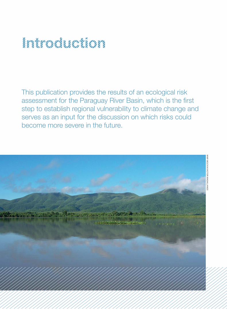
This publication provides the results of an ecological risk
assessment for the Paraguay River Basin, which is the fi rst
step to establish regional vulnerability to climate change and
serves as an input for the discussion on which risks could
become more severe in the future.
WW
F-BO
LÍVIA
/VIC
TOR
MA
GA
LLAN
ES
76
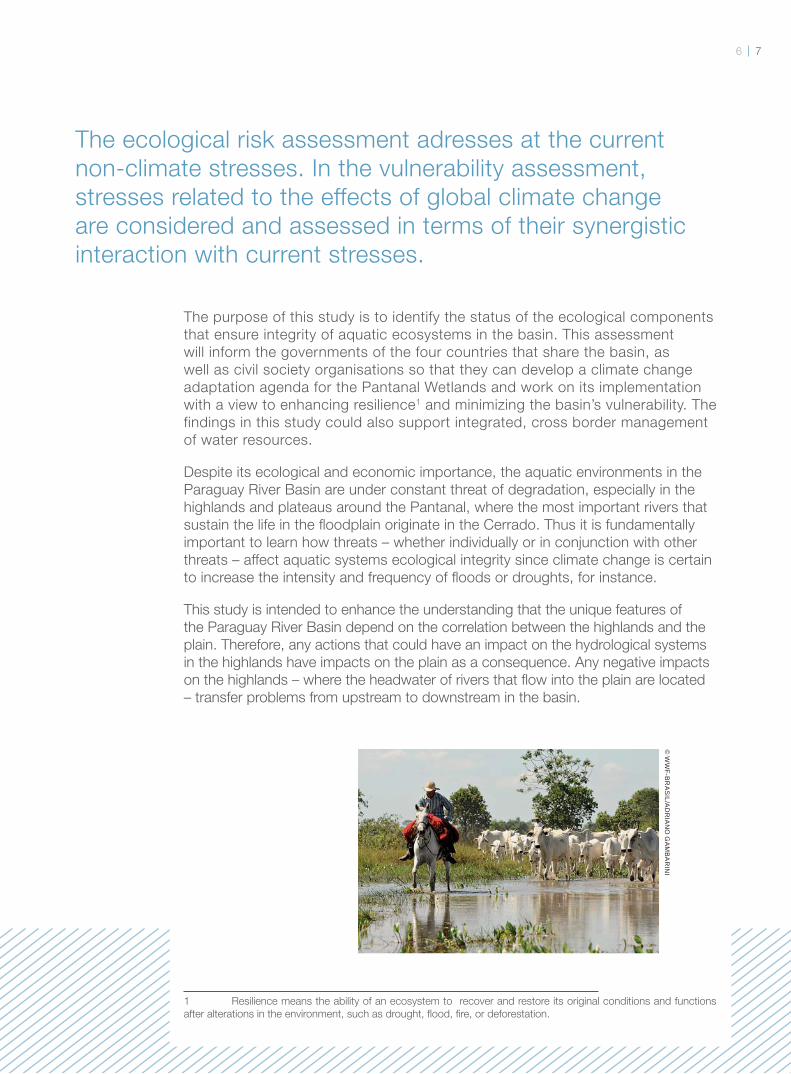
The ecological risk assessment adresses at the current
non-climate stresses. In the vulnerability assessment,
stresses related to the effects of global climate change
are considered and assessed in terms of their synergistic
interaction with current stresses.
The purpose of this study is to identify the status of the ecological components
that ensure integrity of aquatic ecosystems in the basin. This assessment
will inform the governments of the four countries that share the basin, as
well as civil society organisations so that they can develop a climate change
adaptation agenda for the Pantanal Wetlands and work on its implementation
with a view to enhancing resilience1 and minimizing the basin’s vulnerability. The
findings in this study could also support integrated, cross border management
of water resources.
Despite its ecological and economic importance, the aquatic environments in the
Paraguay River Basin are under constant threat of degradation, especially in the
highlands and plateaus around the Pantanal, where the most important rivers that
sustain the life in the fl oodplain originate in the Cerrado. Thus it is fundamentally
important to learn how threats – whether individually or in conjunction with other
threats – affect aquatic systems ecological integrity since climate change is certain
to increase the intensity and frequency of fl oods or droughts, for instance.
This study is intended to enhance the understanding that the unique features of
the Paraguay River Basin depend on the correlation between the highlands and the
plain. Therefore, any actions that could have an impact on the hydrological systems
in the highlands have impacts on the plain as a consequence. Any negative impacts
on the highlands – where the headwater of rivers that fl ow into the plain are located
– transfer problems from upstream to downstream in the basin.
1 Resilience means the ability of an ecosystem to recover and restore its original conditions and functions
after alterations in the environment, such as drought, fl ood, fi re, or deforestation.
© W
WF-B
RA
SIL/A
DR
IAN
O G
AM
BA
RIN
I
We must bear in mind that
the Paraguay River Basin
is home to the largest
fl oodplain in the planet –
the Pantanal – where the
annual cycles of fl oods and
droughts dictate the lives
of thousands of species.
The seasonal variation in
water levels imposes natural
limits on large scale human
settlement in the area. The
basin covers the extensive
plains of Chaco and part of
the Andes Mountain Range,
and it is exposed to severe
drought spells due to the
prevailing arid climate.
Beef cattle production
has been one of the most
traditional economic activities
in the Pantanal for over two
centuries. However, yields
are low if compared with the
upper located in the Cerrado.
This is because during the
fl ood season the fl ooded
pasture lands the cattle is
forced to seek shelter on
higher lands. As a result,
cattle ranchers have no
extensive pasture lands for
a period of the year, which is
a problem since large tracts
of land are required for this
business to be viable.
On the other hand, the
receding and fl ooding cycle
accounts for the ecological
wealth of the region and
for high value ecosystem
services, such as fertilisation
of fi elds. It also provides
optimal conditions for
the reproduction of fi sh
and other species, and
with the help of aquatic
plants, purifi es the waters
and attracts a myriad of
waterfowl in search for food.
Every year, such natural
wealth attracts nearly one
million tourists who come
to experience wildlife and
to engage in sport fi shing.
A recent study by Moraes
(2008) estimates that
ecosystem services in
the Pantanal amount to US$
112 billion (approximately
R$ 180 billion) annually.
Therefore, it may make much
more sense to preserve a
part of this region than fully
convert it into livestock and
crop areas, whose estimated
annual earnings would
total only US$ 414 million.
This is particularly so due
to the fact that ecosystem
services benefi t the wider
society, while agricultural
earnings only go to ranchers/
growers and some of the
people directly or indirectly
involved in the business with
the remainder of society
only benefi ting from the
consumption of associated
products.
© W
WF-B
RA
SIL/A
DR
IAN
O G
AM
BA
RIN
I©
TNC
-ALB
AN
O A
RA
ÚJO
98
This report is part of the
Iniciativa Água e Clima
(Water and Climate Initiative),
which is the result of a global
partnership between the
WWF Network and HSBC to
support adaptation of river
basins to climate change.
Likewise, the Aliança dos Grandes Rios (Great Rivers
Alliance) is the culmination
of a partnership between
The Nature Conservancy
(TNC) and the Caterpillar
Foundation, whose goal is
to change management of
major river basins around the
world by developing a new
sustainability model for those
large aquatic systems.
To that end, WWF-Brazil and
TNC have partnered in order
to identify the environmental
risks in the Paraguay River
Basin using an approach
developed by Mattson &
Angermeier (2007). This
method is based on a multi-
criteria participatory approach
that takes into consideration
knowledge of the basin
by local stakeholders – an
ecological risk index is
developed according to the
severity of the impacts on
ecosystems, their frequency
in the basin and the basin’s
sensitivity to them.
Background
This report is also part of
the Synergy Project, which
is managed by the Pantanal
Research Centre (CPP)
and is intended to develop
climate change scenarios for
the Pantanal until 2100. The
CPP is a Mato Grosso based
Civil Society Organization
of Public Interest (OSCIP, in
the Portuguese acronym)
devoted to promoting
the welfare of Pantanal
dwellers and environmental
sustainability in the
region. With support from
the National Council for
Scientifi c and Technological
Development (CNPq),
the Synergy Project has
a network of integrated
research and management
for the Paraguay River Basin
– the Synergy Network –
which brings together over
ten research institutions
and approximately 40
researchers. The Network
held international meetings
involving Brazil, Bolivia,
Argentina and Paraguay
to establish six research
topics and nine projects
for implementation,
including the ecological
risk assessment for the
Paraguay River Basin2.
1
2 www.portalsinergia.org.br
© T
NC
-RE
BE
CC
ATH
AR
ME
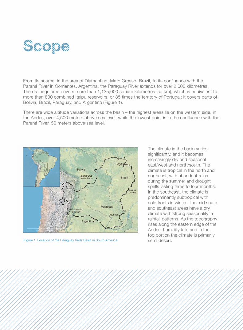
From its source, in the area of Diamantino, Mato Grosso, Brazil, to its confl uence with the
Paraná River in Corrientes, Argentina, the Paraguay River extends for over 2,600 kilometres.
The drainage area covers more than 1,135,000 square kilometres (sq km), which is equivalent to
more than 800 combined Itaipu reservoirs, or 35 times the territory of Portugal; it covers parts of
Bolivia, Brazil, Paraguay, and Argentina (Figure 1).
There are wide altitude variations across the basin – the highest areas lie on the western side, in
the Andes, over 4,500 meters above sea level, while the lowest point is in the confl uence with the
Paraná River, 50 meters above sea level.
Scope
Figure 1. Location of the Paraguay River Basin in South America.
The climate in the basin varies
signifi cantly, and it becomes
increasingly dry and seasonal
east/west and north/south. The
climate is tropical in the north and
northeast, with abundant rains
during the summer and drought
spells lasting three to four months.
In the southeast, the climate is
predominantly subtropical with
cold fronts in winter. The mid south
and southeast areas have a dry
climate with strong seasonality in
rainfall patterns. As the topography
rises along the eastern edge of the
Andes, humidity falls and in the
top portion the climate is primarily
semi desert.
1110
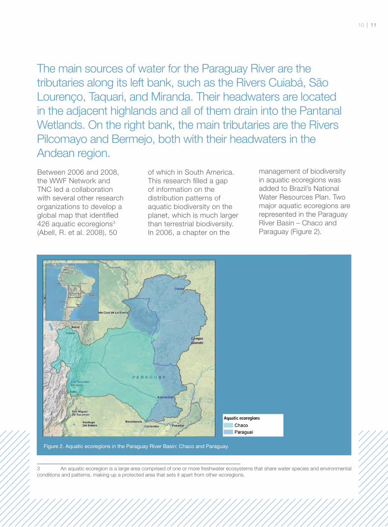
The main sources of water for the Paraguay River are the
tributaries along its left bank, such as the Rivers Cuiabá, São
Lourenço, Taquari, and Miranda. Their headwaters are located
in the adjacent highlands and all of them drain into the Pantanal
Wetlands. On the right bank, the main tributaries are the Rivers
Pilcomayo and Bermejo, both with their headwaters in the
Andean region.
Between 2006 and 2008,
the WWF Network and
TNC led a collaboration
with several other research
organizations to develop a
global map that identifi ed
426 aquatic ecoregions3
(Abell, R. et al. 2008), 50
of which in South America.
This research fi lled a gap
of information on the
distribution patterns of
aquatic biodiversity on the
planet, which is much larger
than terrestrial biodiversity.
In 2006, a chapter on the
management of biodiversity
in aquatic ecoregions was
added to Brazil’s National
Water Resources Plan. Two
major aquatic ecoregions are
represented in the Paraguay
River Basin – Chaco and
Paraguay (Figure 2).
Figure 2. Aquatic ecoregions in the Paraguay River Basin: Chaco and Paraguay.
1
3 An aquatic ecoregion is a large area comprised of one or more freshwater ecosystems that share water species and environmental
conditions and patterns, making up a protected area that sets it apart from other ecoregions.
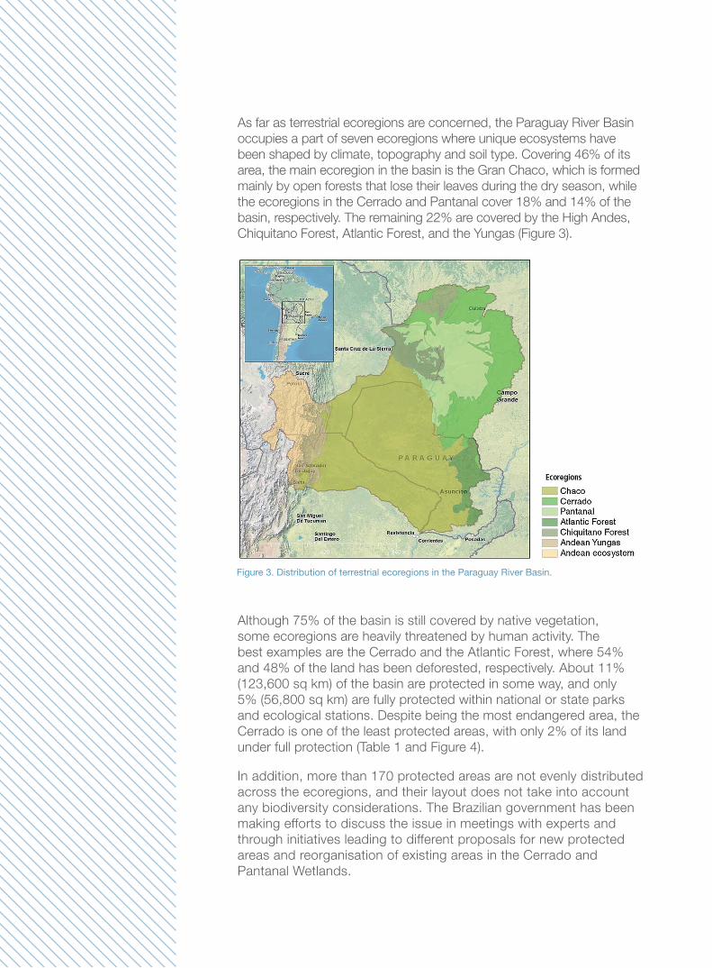
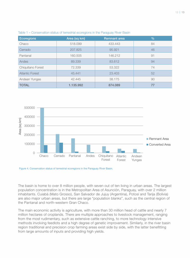
As far as terrestrial ecoregions are concerned, the Paraguay River Basin
occupies a part of seven ecoregions where unique ecosystems have
been shaped by climate, topography and soil type. Covering 46% of its
area, the main ecoregion in the basin is the Gran Chaco, which is formed
mainly by open forests that lose their leaves during the dry season, while
the ecoregions in the Cerrado and Pantanal cover 18% and 14% of the
basin, respectively. The remaining 22% are covered by the High Andes,
Chiquitano Forest, Atlantic Forest, and the Yungas (Figure 3).
Figure 3. Distribution of terrestrial ecoregions in the Paraguay River Basin.
Although 75% of the basin is still covered by native vegetation,
some ecoregions are heavily threatened by human activity. The
best examples are the Cerrado and the Atlantic Forest, where 54%
and 48% of the land has been deforested, respectively. About 11%
(123,600 sq km) of the basin are protected in some way, and only
5% (56,800 sq km) are fully protected within national or state parks
and ecological stations. Despite being the most endangered area, the
Cerrado is one of the least protected areas, with only 2% of its land
under full protection (Table 1 and Figure 4).
In addition, more than 170 protected areas are not evenly distributed
across the ecoregions, and their layout does not take into account
any biodiversity considerations. The Brazilian government has been
making efforts to discuss the issue in meetings with experts and
through initiatives leading to different proposals for new protected
areas and reorganisation of existing areas in the Cerrado and
Pantanal Wetlands.
1312
Ecoregions Area (sq km) Remnant area %
Chaco 518.099 433.443 84
Cerrado 207.825 95.921 46
Pantanal 160.505 146.212 91
Andes 89.339 83.612 94
Chiquitano Forest 72.339 53.322 74
Atlantic Forest 45.441 23.403 52
Andean Yungas 42.445 38.175 90
TOTAL 1.135.992 874.089 77
Chaco
Are
a (sq
km
)
Cerrado Pantanal
Remnant Area
500000
400000
300000
200000
100000
0
Converted Area
Andes Chiquitano
ForestAtlantic
Forest
Andean
Yungas
Figure 4. Conservation status of terrestrial ecoregions in the Paraguay River Basin.
The basin is home to over 8 million people, with seven out of ten living in urban areas. The largest
population concentration is in the Metropolitan Area of Asunción, Paraguay, with over 2 million
inhabitants. Cuiabá (Mato Grosso), San Salvador de Jujuy (Argentina), Potosí and Tarija (Bolivia)
are also major urban areas, but there are large “population blanks”, such as the central region of
the Pantanal and north-western Gran Chaco.
The main economic activity is agriculture, with more than 30 million head of cattle and nearly 7
million hectares of croplands. There are multiple approaches to livestock management, ranging
from the most rudimentary, such as extensive cattle ranching, to more technology intensive
methods involving feedlots and a high degree of genetic improvement. Similarly, in the river basin
region traditional and precision crop farming areas exist side by side, with the latter benefi tting
from large amounts of inputs and providing high yields.
Table 1 – Conservation status of terrestrial ecoregions in the Paraguay River Basin
The Paraguay River is navigable during a portion of the year, from Cáceres (Mato Grosso) to the
confl uence with the Paraná River and along the latter up to the mouth of the Plata River and into the
Atlantic Ocean. This waterway was traditionally used for passenger traffi c, but now it concentrates
the transport of ore and grains. A discussion has been ongoing since the 1990s to make navigation
a constant activity throughout the year in the upper stretch of the river, which would require
dredging, construction of canals and dikes, and straightening of the river bed. All of this would
severely affect water patterns and survival of aquatic species in the Pantanal fl oodplain. Despite
these potential impacts, there is constant pressure to push through these changes.
Besides agriculture, the basin has key mining areas, in
particular Andean regions such as that of Potosí (Bolivia),
which provides natural gas and lies in the transition area
between Chaco and the Andes; Mato Grosso, where gold
and diamonds are prospected; and also Mato Grosso do Sul,
where iron, manganese and limestone can be found.
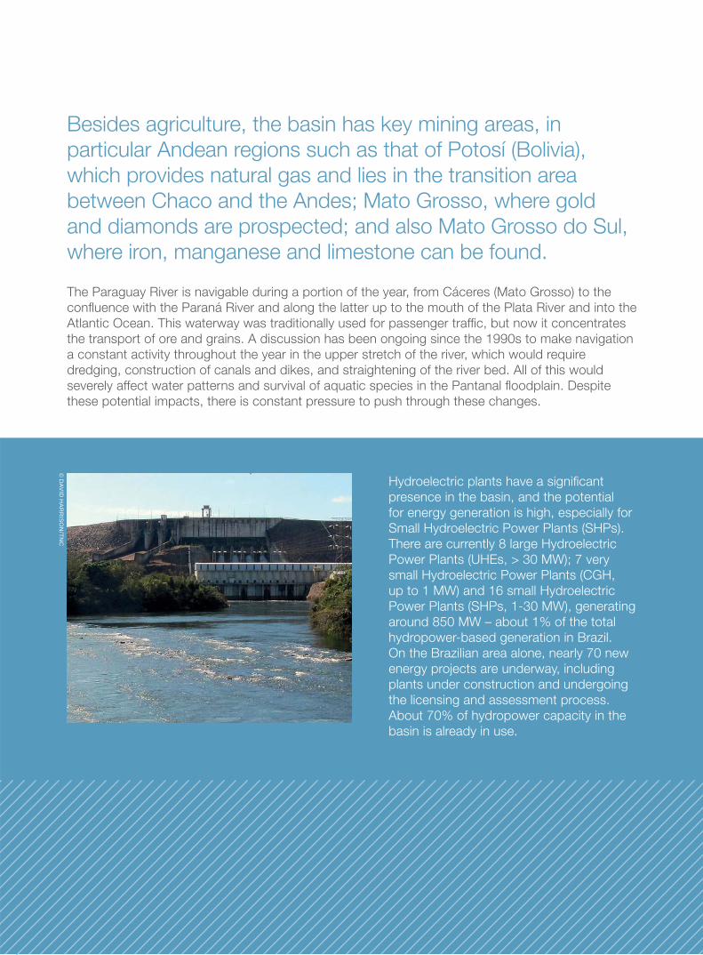
Hydroelectric plants have a signifi cant
presence in the basin, and the potential
for energy generation is high, especially for
Small Hydroelectric Power Plants (SHPs).
There are currently 8 large Hydroelectric
Power Plants (UHEs, > 30 MW); 7 very
small Hydroelectric Power Plants (CGH,
up to 1 MW) and 16 small Hydroelectric
Power Plants (SHPs, 1-30 MW), generating
around 850 MW – about 1% of the total
hydropower-based generation in Brazil.
On the Brazilian area alone, nearly 70 new
energy projects are underway, including
plants under construction and undergoing
the licensing and assessment process.
About 70% of hydropower capacity in the
basin is already in use.
© D
AVID
HA
RR
ISO
N/TN
C
1514
Methods
The purpose of nature conservation planning is to inform
actions meant to preserve a representative and functional
set of ecosystems that ensures the long-term existence of
animal and plant species and the products resulting from
environmental services while minimising confl icts between
the different legitimate interests of the production sector and
society in general.
This process depends on the
ecological assessment of the
areas to establish which are,
or are not, essential to the
health of ecosystems and
for maintaining biodiversity.
However, because of
the scarce resources for
conservation, it is also
necessary to assess the
degree of ecological risk
involved in these areas in
order to establish where
conservation actions have
the best chance of success.
Understanding the ecological
risks in an area also helps
to defi ne the sort of action
necessary to avoid or
minimise adverse impacts,
whether by adopting
rehabilitation measures or
acting quickly to prevent
its degradation. Human
activities cause changes
in the environment that
usually affect the integrity
of ecosystems, leading
to reduced populations
or extinction of plant and
animal species at local level,
reduced water quality and
other ecosystem services
that are important to society.
Evidence shows that
complete removal of natural
vegetation along river
banks, due to agricultural
activity, for instance,
increases soil erosion and
sediment load into the water
since the protective function
of the riparian forest is lost.
As a result, the sediments
carried by water cause the
decline or disappearance
of aquatic plants and
algae that rely on light for
photosynthesis. With the
removal of trees, less fruit
will fall, thus reducing the
supply of energy and food
for fish, which could affect
the size of their populations
or even drive them to
extinction, especially
those that depend on a
particular food.
Ecological Risk
Index – ERI
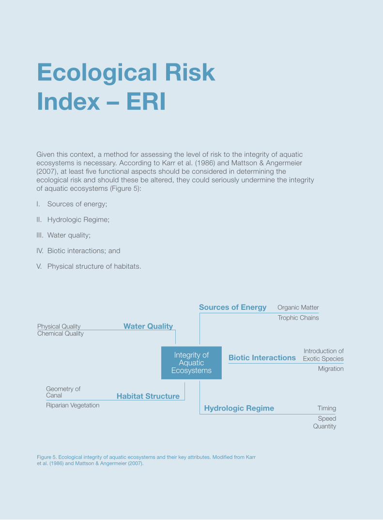
Given this context, a method for assessing the level of risk to the integrity of aquatic
ecosystems is necessary. According to Karr et al. (1986) and Mattson & Angermeier
(2007), at least fi ve functional aspects should be considered in determining the
ecological risk and should these be altered, they could seriously undermine the integrity
of aquatic ecosystems (Figure 5):
I. Sources of energy;
II. Hydrologic Regime;
III. Water quality;
IV. Biotic interactions; and
V. Physical structure of habitats.
Habitat Structure
Hydrologic Regime
Biotic InteractionsIntegrity of Aquatic
Ecosystems
Organic Matter
Trophic Chains
Sources of Energy
Introduction of
Exotic Species
Migration
Physical QualityChemical Quality
Geometry of Canal
Riparian Vegetation
Water Quality
Timing
Speed
Quantity
Figure 5. Ecological integrity of aquatic ecosystems and their key attributes. Modifi ed from Karr et al. (1986) and Mattson & Angermeier (2007).
1716
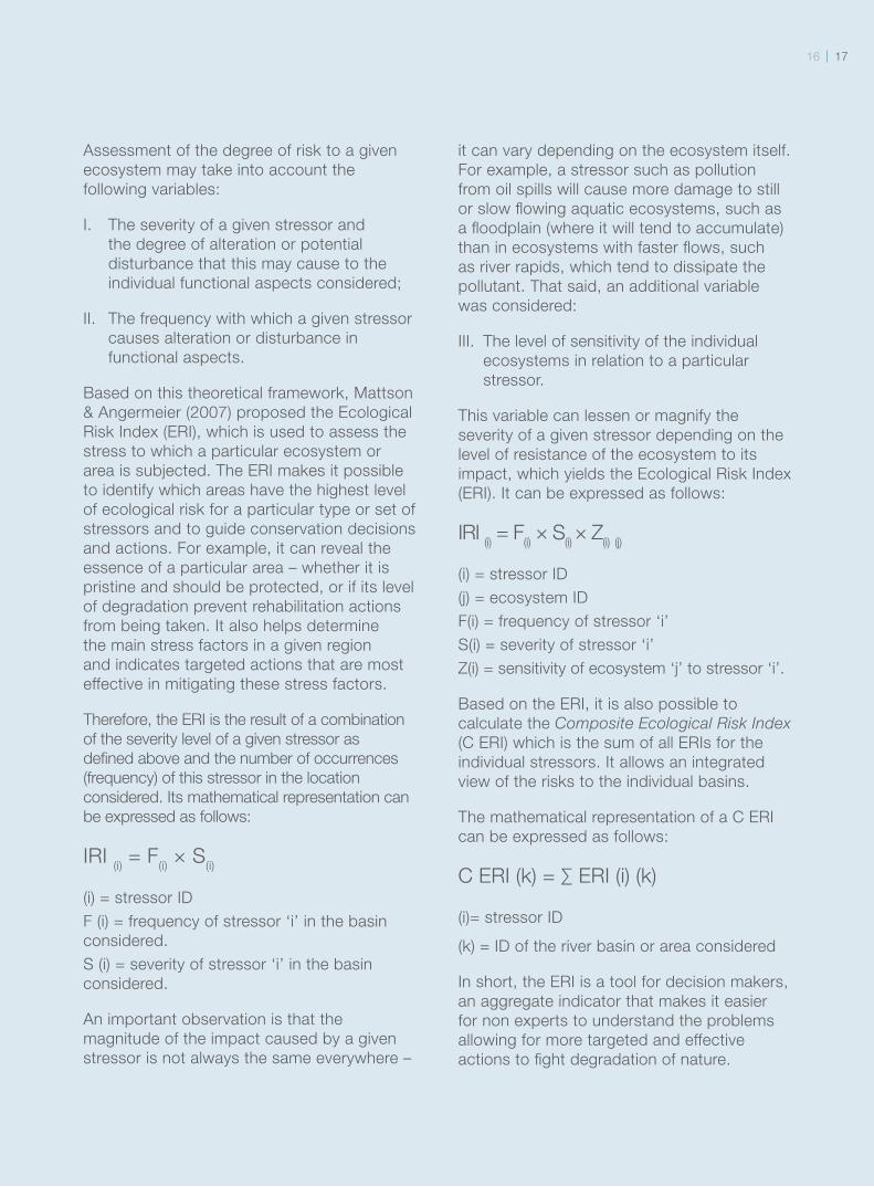
Assessment of the degree of risk to a given
ecosystem may take into account the
following variables:
I. The severity of a given stressor and
the degree of alteration or potential
disturbance that this may cause to the
individual functional aspects considered;
II. The frequency with which a given stressor
causes alteration or disturbance in
functional aspects.
Based on this theoretical framework, Mattson
& Angermeier (2007) proposed the Ecological
Risk Index (ERI), which is used to assess the
stress to which a particular ecosystem or
area is subjected. The ERI makes it possible
to identify which areas have the highest level
of ecological risk for a particular type or set of
stressors and to guide conservation decisions
and actions. For example, it can reveal the
essence of a particular area – whether it is
pristine and should be protected, or if its level
of degradation prevent rehabilitation actions
from being taken. It also helps determine
the main stress factors in a given region
and indicates targeted actions that are most
effective in mitigating these stress factors.
Therefore, the ERI is the result of a combination
of the severity level of a given stressor as
defi ned above and the number of occurrences
(frequency) of this stressor in the location
considered. Its mathematical representation can
be expressed as follows:
IRI (i) = F
(i) × S
(i)
(i) = stressor ID
F (i) = frequency of stressor ‘i’ in the basin
considered.
S (i) = severity of stressor ‘i’ in the basin
considered.
An important observation is that the
magnitude of the impact caused by a given
stressor is not always the same everywhere –
it can vary depending on the ecosystem itself.
For example, a stressor such as pollution
from oil spills will cause more damage to still
or slow fl owing aquatic ecosystems, such as
a fl oodplain (where it will tend to accumulate)
than in ecosystems with faster fl ows, such
as river rapids, which tend to dissipate the
pollutant. That said, an additional variable
was considered:
III. The level of sensitivity of the individual
ecosystems in relation to a particular
stressor.
This variable can lessen or magnify the
severity of a given stressor depending on the
level of resistance of the ecosystem to its
impact, which yields the Ecological Risk Index
(ERI). It can be expressed as follows:
IRI (i) = F
(i) × S
(i) × Z
(i) (j)
(i) = stressor ID
(j) = ecosystem ID
F(i) = frequency of stressor ‘i’
S(i) = severity of stressor ‘i’
Z(i) = sensitivity of ecosystem ‘j’ to stressor ‘i’.
Based on the ERI, it is also possible to
calculate the Composite Ecological Risk Index
(C ERI) which is the sum of all ERIs for the
individual stressors. It allows an integrated
view of the risks to the individual basins.
The mathematical representation of a C ERI
can be expressed as follows:
C ERI (k) = ∑ ERI (i) (k)
(i)= stressor ID
(k) = ID of the river basin or area considered
In short, the ERI is a tool for decision makers,
an aggregate indicator that makes it easier
for non experts to understand the problems
allowing for more targeted and effective
actions to fi ght degradation of nature.
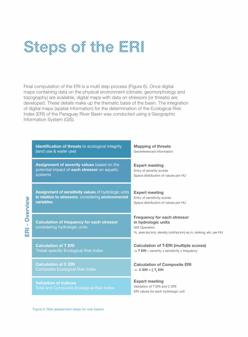
Steps of the ERI
Final computation of the ERI is a multi step process (Figure 6). Once digital
maps containing data on the physical environment (climate, geomorphology and
topography) are available, digital maps with data on stressors (or threats) are
developed. These details make up the thematic basis of the basin. The integration
of digital maps (spatial information) for the determination of the Ecological Risk
Index (ERI) of the Paraguay River Basin was conducted using a Geographic
Information System (GIS).
Identification of threats to ecological integrity (land use & water use)
Mapping of threats
Georeferenced information
Expert meeting
Entry of severity scores
Space distribution of values per HU
Expert meeting
Entry of sensitivity scores
Space distribution of values per HU
Frequency for each stressor
in hydrologic units
GIS Operation
%, area (sq km), density (unit/sq km) sq m, ranking, etc. per HU
Expert meeting
Validation of T ERI and C ERI
ERI values for each hydrologic unit
Calculation of T-ERI (multiple scores)
-> T ERI = severity x sensitivity x frequency
Calculation of Composite ERI
-> C ERI = ∑ Ti ERI
ER
I -
Ove
rvie
w
Assignment of severity values based on the potential impact of each stressor on aquatic systems
Assignment of sensitivity values of hydrologic units in relation to stressors, considering environmental
variables
Calculation of frequency for each stressor considering hydrologic units
Calculation of T ERI
Threat specific Ecological Risk Index
Calculation of C ERI
Composite Ecological Risk Index
Validation of indexes
Total and Composite Ecological Risk Index
Figure 6. Risk assessment steps for river basins
1918
In the absence of ecosystem maps
refl ecting the region’s environmental
diversity, ecological units were identifi ed
by crossing the following environmental
variables: climate, geomorphology,
vegetation, and hydrologic units. Basin
qualitative assessments and stressors
were also included, such as the
attributes of spatial information obtained
through consultation with experts.
Computation of the ERI was based on
information on the spatial distribution
and frequency of the main stressors
of aquatic ecosystems in the basin.
A preliminary list of stressors was put
together by looking at the literature.
The list helped create a georeferenced
database for preliminary analyses.
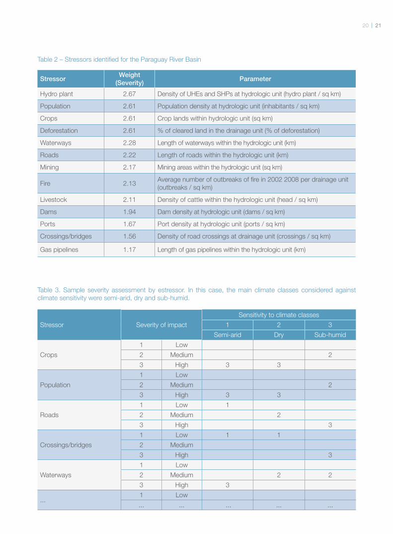
Local experts were consulted for the
selection and evaluation of major
stressors (Table 2). To accomplish this,
experts of various scientifi c domains
from Brazil, Paraguay and Boliva met.
The selection of stressors was based
on a list covering 13 relevant sources of
stress to the aquatic ecosystems of the
Paraguay River Basin.
The stressors were assessed
individually by the experts as to their
severity as a source of direct impact
on the functional aspects of aquatic
ecosystems, as mentioned earlier.
The sensitivity of these functional
aspects against the impacts of
stressors was also assessed. Each
of the environmental variables was
assigned a class, such as low impact
(1), medium impact (2) or high impact
(3). The final value of severity and
sensitivity for a specific stressor
and the sensitivity of the individual
environmental variables is equal to the
sum of all values assigned.
The assessment process involved
tables that were given to each expert,
which were then analysed and validated
by the group. The responses provided
by the experts were checked for
consistency in order to determine the
number of contradictory answers. The
fi nal result is shown in Table 2, which
covers 13 selected stressors. It shows
that hydropower plants, people and
agriculture are the most important
stressors as a source of impacts to
aquatic systems.
The experts evaluated how each
environmental variable is impacted in
terms of the severity of stressors. The
sensitivity was calculated from the
values assigned to each environmental
variable, with respect to each of the 13
stressors. Table 3 provides an example
of the classes assigned to a particular
environmental variable in terms of the
severity of some stressors and of the
sensitivity of this variable against some
stressors under various climate regimes.
This table was subsequently added to
the spatial database, which allowed to
establish the location of sensitivity by
stressor.
Once the list of stressors and the
associated values of sensitivity
and severity were established, the
frequencies of occurrence of stressors
for the individual hydrologic units were
calculated. This involved crossing the
distributions of occurrence for each
stressor with the hydrologic units. The
resulting values were then scaled to
“0” (not found in the hydrologic unit);
“1” (low occurrence); “2” (medium

occurrence); and “3”
(high occurrence). For the
separation of the occurrence
values in these four classes,
the frequency distribution
curve and the Jenks
algorithm (1977) were used.
The idea was to identify a
set of classes with the least
possible variance within
group variance.
Once the frequency has
been calculated and the
severity and sensitivity
are available, it is possible
to calculate the ERI for
each stressor by simply
multiplying the three factors.
To ensure that the result is a
true refl ection of the basin, a
meeting was held to validate
the results with experts from
the four countries involved –
Argentina, Brazil, Paraguay,
and Bolivia. On that
occasion, the results were
presented for each stressor
and at the aggregate level.
The experts described the
necessary corrections and
adjustments. The results
provided here refl ect the
adjustments made after the
validation meeting.
© TN
C-A
LBA
NO
AR
AÚ
JO
2120
StressorWeight
(Severity)Parameter
Hydro plant 2.67 Density of UHEs and SHPs at hydrologic unit (hydro plant / sq km)
Population 2.61 Population density at hydrologic unit (inhabitants / sq km)
Crops 2.61 Crop lands within hydrologic unit (sq km)
Deforestation 2.61 % of cleared land in the drainage unit (% of deforestation)
Waterways 2.28 Length of waterways within the hydrologic unit (km)
Roads 2.22 Length of roads within the hydrologic unit (km)
Mining 2.17 Mining areas within the hydrologic unit (sq km)
Fire 2.13Average number of outbreaks of fi re in 2002 2008 per drainage unit
(outbreaks / sq km)
Livestock 2.11 Density of cattle within the hydrologic unit (head / sq km)
Dams 1.94 Dam density at hydrologic unit (dams / sq km)
Ports 1.67 Port density at hydrologic unit (ports / sq km)
Crossings/bridges 1.56 Density of road crossings at drainage unit (crossings / sq km)
Gas pipelines 1.17 Length of gas pipelines within the hydrologic unit (km)
Table 2 – Stressors identifi ed for the Paraguay River Basin
Stressor Severity of impact
Sensitivity to climate classes
1 2 3
Semi-arid Dry Sub-humid
Crops
1 Low
2 Medium 2
3 High 3 3
Population
1 Low
2 Medium 2
3 High 3 3
Roads
1 Low 1
2 Medium 2
3 High 3
Crossings/bridges
1 Low 1 1
2 Medium
3 High 3
Waterways
1 Low
2 Medium 2 2
3 High 3
...1 Low
... ... ... ... ...
Table 3. Sample severity assessment by estressor. In this case, the main climate classes considered against
climate sensitivity were semi-arid, dry and sub-humid.
Hydrological
analyses
For the results of the ERI to
be obtained at multiple scales,
different thresholds for sub-basins
in a hierarchical system have
been established. The data set
used for these determinations
was the digital elevation model
Shuttle Radar Topography Mission
(SRTM/2000), which is processed
and available from a database
called HydroSHEDS (Hydrological
Data and Maps Based on Shuttle
Elevation Derivatives at Multiple
Scales). The HydroSHEDS
database was developed by
WWF and contains river basin
information on a global basis and
at various resolutions (Lehner et
al. 2008). It is used to perform
global and regional assessment of
watersheds, hydrologic modelling,
and freshwater planning and
conservation with a level of quality,
resolution and coverage that was
previously impossible.
The fi rst assessment was the
delimitation of sub-basins in different
size classes based on the SRTM
data (2000). The minimum unit
of assessment adopted in this
study were catchments basins
ranging from 100 to 1,000 sq km.
Computation of the ERI was then
based on these units.
From the altimetry data, a series
of hydrologic units based on the
catchment area was obtained
using the method of nested
watersheds developed by Fitzhugh
(2005). This series includes fi ve
different basin size classes – the
smallest basins ranging from 100
to 1,000 sq km, and the largest
ones ranging from 1 to 10 million
sq km. The different size classes
have a hierarchical structure
where the smallest unit will always
be under the subsequent larger
size unit so that work can be
performed at multiple scales, and
also allowing headwaters as well
as small and large river beds to be
delineated.
Moreover, each hydrologic unit
was assigned abiotic attributes,
e.g. climate, geology or
geomorphology, which were used
to defi ne existing ecological units
(ecosystems) and estimate the
sensitivity levels of the individual
hydrologic unit to different threats.
Considering the altimetry data
together with other hydrological
data from HydroSHEDS,
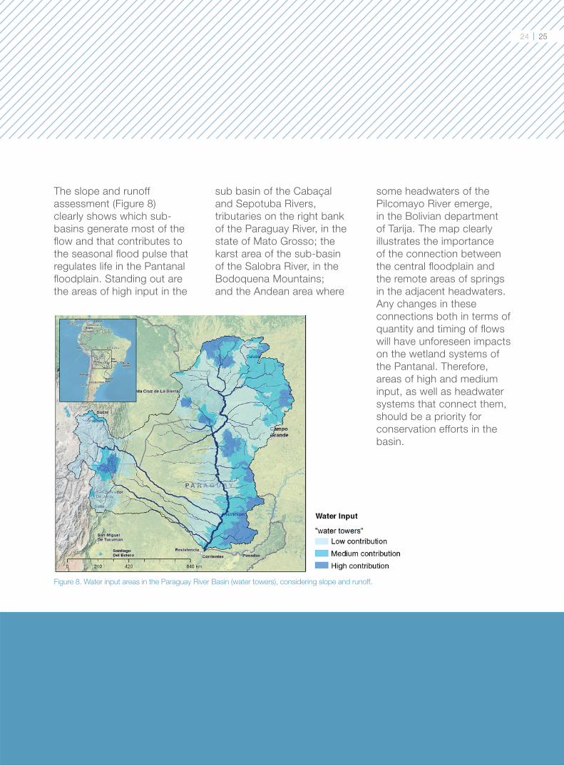
analyses of cumulative runoff
were carried out and the average
annual fl ow per sub-basin was
calculated. Thus, the water input
from the basins was divided
into the following types: high,
medium, low, and minimal. This
assessment resulted in the map
of water towers for the Paraguay
River Basin, which identifi es
the sub-basins with the most
signifi cant inputs in terms runoff
volume (Figure 8).
2322© W
WF-B
RA
SIL/B
EN
TO V
IAN
A
Results
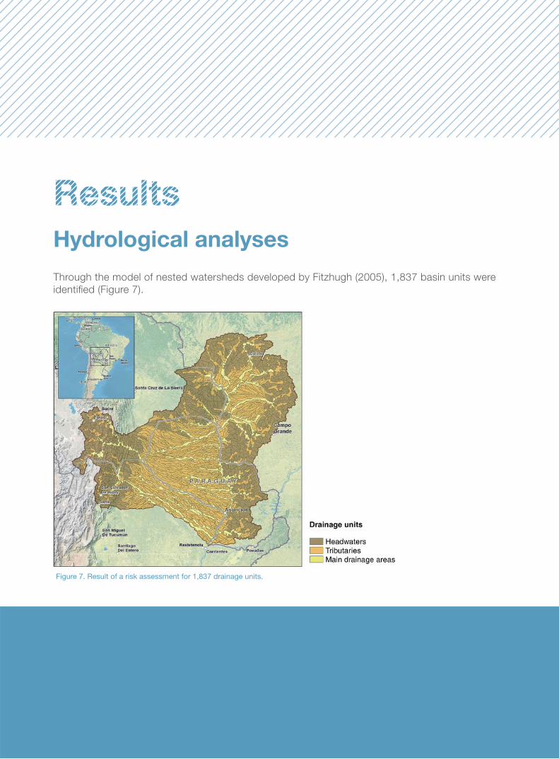
Hydrological analyses
Through the model of nested watersheds developed by Fitzhugh (2005), 1,837 basin units were
identifi ed (Figure 7).
Figure 7. Result of a risk assessment for 1,837 drainage units.
24 25
The slope and runoff
assessment (Figure 8)
clearly shows which sub-
basins generate most of the
fl ow and that contributes to
the seasonal fl ood pulse that
regulates life in the Pantanal
fl oodplain. Standing out are
the areas of high input in the
Figure 8. Water input areas in the Paraguay River Basin (water towers), considering slope and runoff.
sub basin of the Cabaçal
and Sepotuba Rivers,
tributaries on the right bank
of the Paraguay River, in the
state of Mato Grosso; the
karst area of the sub-basin
of the Salobra River, in the
Bodoquena Mountains;
and the Andean area where
some headwaters of the
Pilcomayo River emerge,
in the Bolivian department
of Tarija. The map clearly
illustrates the importance
of the connection between
the central fl oodplain and
the remote areas of springs
in the adjacent headwaters.
Any changes in these
connections both in terms of
quantity and timing of fl ows
will have unforeseen impacts
on the wetland systems of
the Pantanal. Therefore,
areas of high and medium
input, as well as headwater
systems that connect them,
should be a priority for
conservation efforts in the
basin.
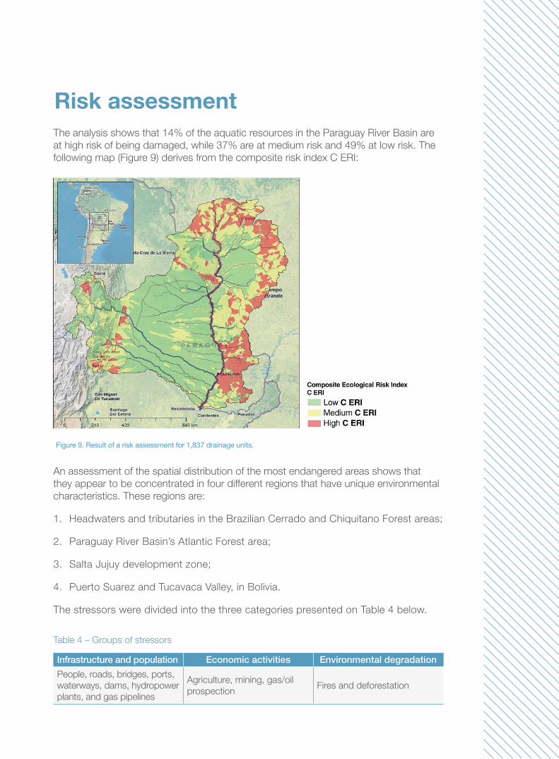
The analysis shows that 14% of the aquatic resources in the Paraguay River Basin are
at high risk of being damaged, while 37% are at medium risk and 49% at low risk. The
following map (Figure 9) derives from the composite risk index C ERI:
Risk assessment
An assessment of the spatial distribution of the most endangered areas shows that
they appear to be concentrated in four different regions that have unique environmental
characteristics. These regions are:
1. Headwaters and tributaries in the Brazilian Cerrado and Chiquitano Forest areas;
2. Paraguay River Basin’s Atlantic Forest area;
3. Salta Jujuy development zone;
4. Puerto Suarez and Tucavaca Valley, in Bolivia.
The stressors were divided into the three categories presented on Table 4 below.
Table 4 – Groups of stressors
Infrastructure and population Economic activities Environmental degradation
People, roads, bridges, ports,
waterways, dams, hydropower
plants, and gas pipelines
Agriculture, mining, gas/oil
prospectionFires and deforestation
Figure 9. Result of a risk assessment for 1,837 drainage units.
2726
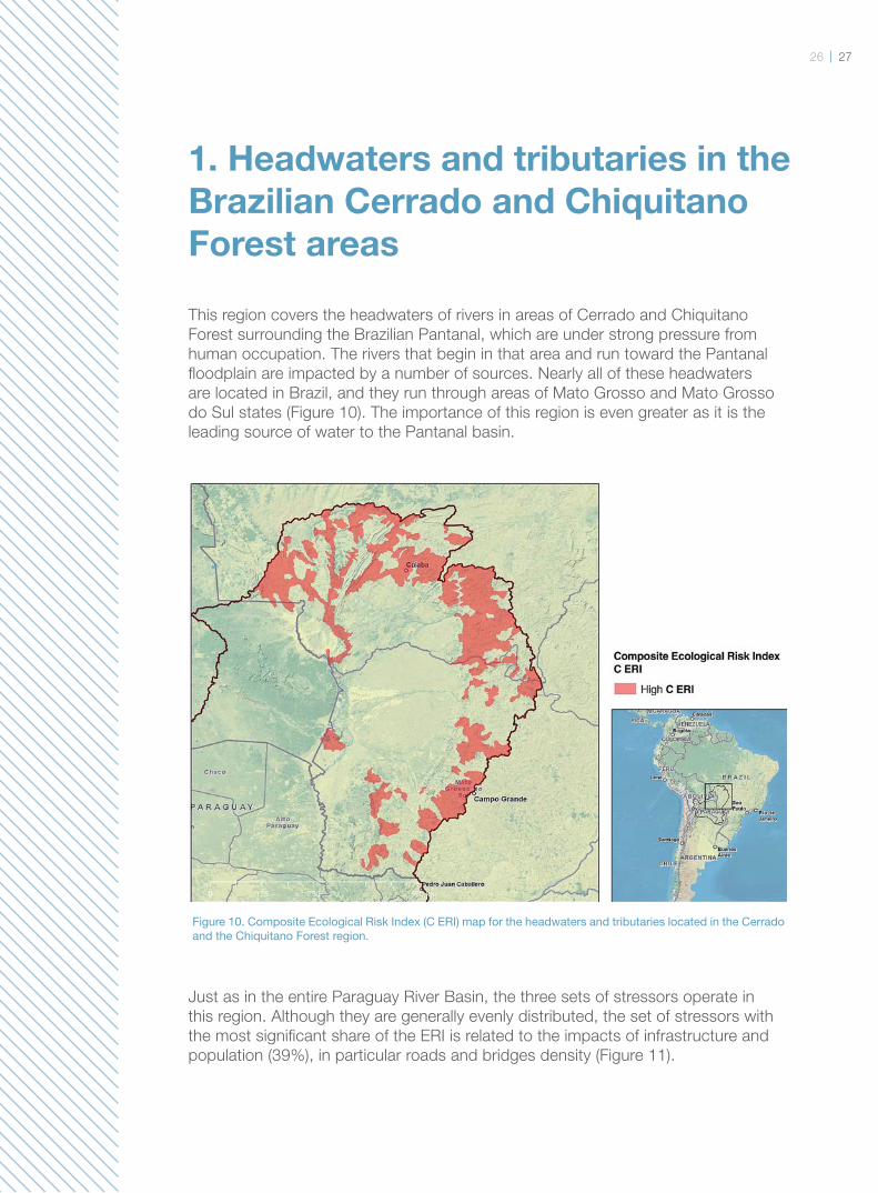
1. Headwaters and tributaries in the
Brazilian Cerrado and Chiquitano
Forest areas
This region covers the headwaters of rivers in areas of Cerrado and Chiquitano
Forest surrounding the Brazilian Pantanal, which are under strong pressure from
human occupation. The rivers that begin in that area and run toward the Pantanal
fl oodplain are impacted by a number of sources. Nearly all of these headwaters
are located in Brazil, and they run through areas of Mato Grosso and Mato Grosso
do Sul states (Figure 10). The importance of this region is even greater as it is the
leading source of water to the Pantanal basin.
Just as in the entire Paraguay River Basin, the three sets of stressors operate in
this region. Although they are generally evenly distributed, the set of stressors with
the most signifi cant share of the ERI is related to the impacts of infrastructure and
population (39%), in particular roads and bridges density (Figure 11).
Figure 10. Composite Ecological Risk Index (C ERI) map for the headwaters and tributaries located in the Cerrado and the Chiquitano Forest region.
Roads have a major potential
impact on water resources,
especially unpaved
backroads built without
the technical precautions
required to prevent erosion,
damming or alteration of
water courses (Photo on
page 29). Roads built without
any technical procedures
are likely to be major
drivers of sediments and
contaminants. Intersections
of roads and water courses
are supposed to be the areas
under greatest pressure
since they are the primary
entry points of materials into
water courses.
With regard to the
headwater region in the
Cerrado, in some areas
hydroelectric plants are a
key infrastructure stressor.
However, considering the
potential establishment of
tens of Small Hydroelectric
Power Plants (SHPs) in the
region, their impacts may
increase considerably. Data
on planned SHPs were
not included in this study
because they were not
available for its entire scope.
The second set of stressors
is related to economic
activities, especially
cattle ranching (23%) and
agriculture (13%) (Figure
14). Cattle ranching is a
traditional economic activity
both in the headwaters
area and in the Pantanal
fl oodplain. In the recent
past, there was a closer
relationship between cattle
ranching in these regions
and rearing and breeding
herds in the plain, and
fattening herds in the
highlands, with constant and
seasonal displacement of
the cattle. Nowadays, with
the improvement of planted
pastures and livestock
genetics, rearing takes place
entirely in the headwaters
area, thus increasing the
number of cattle per hectare
in these pastures.
This process caused
the herd to increase
greatly over the past few
decades, resulting in a
bovine population that is
three times larger than the
human population in the
area (IBGE, 2011). The
impact associated with this
activity is largely due to
mismanagement of cattle
and pastures. Examples of
mismanagement include
allowing the herd to drink
directly from water courses
and overgrazing, which
exposes the soil to the
erosive effects of rain, which
in turn causes the soil to
degrade. Large scale erosion
results in sedimentation of
the water and siltation of
rivers and streams.
Agricultural activities are
conducted in the plateaus,
which are fl atter and high,
have deep soils and are
less vulnerable to erosion
since they have low
concentrations of sand
and high concentrations
of silt and clay. Despite
this location, failing to
use adequate agricultural
techniques for soil
conservation causes
serious impacts on water
resources, affecting water
clarity in particular. Silt
and clay grains are smaller
and lighter than sand, and
they tend to be more easily
removed from these soils
and be suspended in water
for longer times and larger
distances.
This hinders photosynthesis
in water bodies altering the
aquatic food chain.
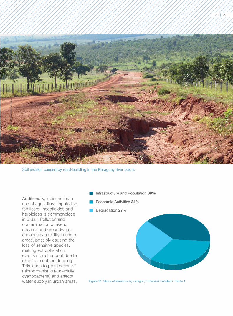
Soil erosion caused by road-building in the Paraguay river basin.
Infrastructure and Population 39%
Economic Activities 34%
Degradation 27%
Figure 11. Share of stressors by category. Stressors detailed in Table 4.
© C
AR
LOS
PAD
OVA
NI/E
MB
RA
PA
Additionally, indiscriminate
use of agricultural inputs like
fertilisers, insecticides and
herbicides is commonplace
in Brazil. Pollution and
contamination of rivers,
streams and groundwater
are already a reality in some
areas, possibly causing the
loss of sensitive species,
making eutrophication
events more frequent due to
excessive nutrient loading.
This leads to proliferation of
microorganisms (especially
cyanobacteria) and affects
water supply in urban areas.
28 29
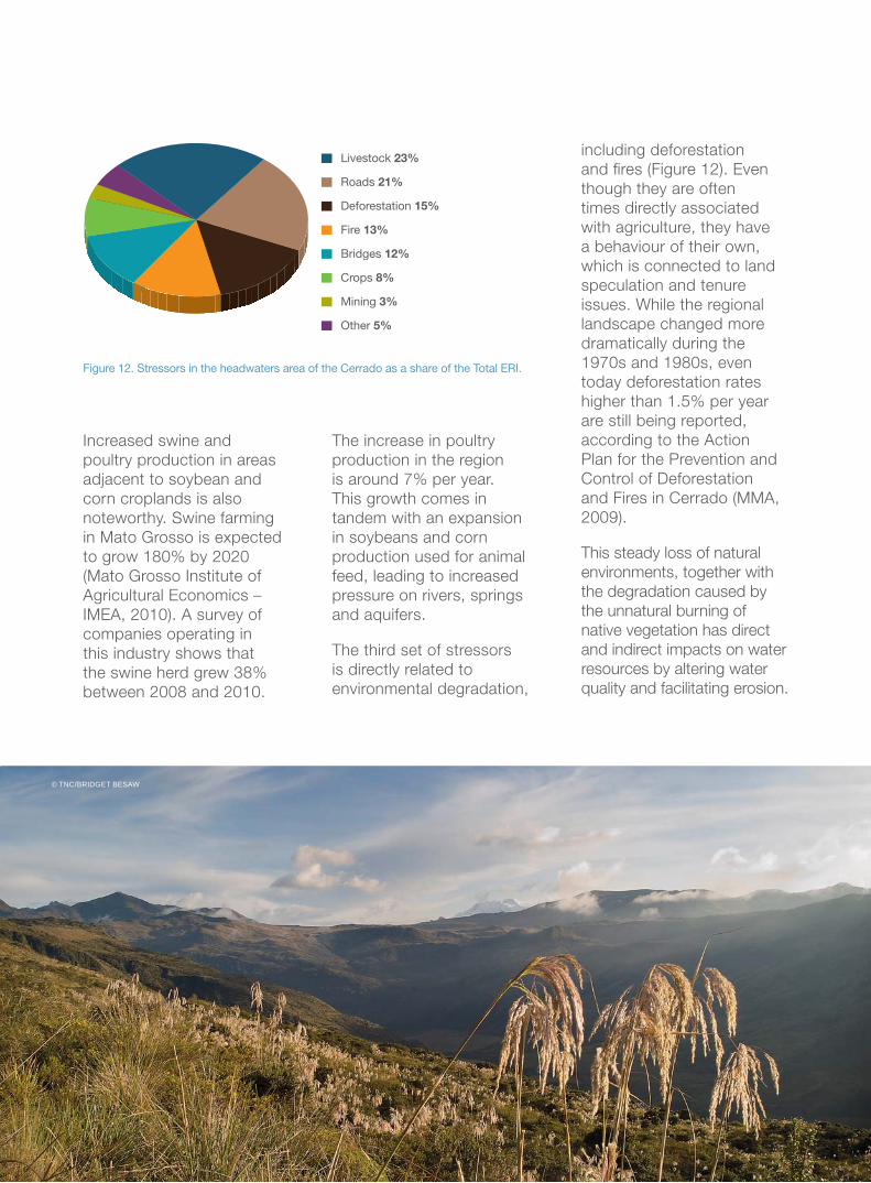
Increased swine and
poultry production in areas
adjacent to soybean and
corn croplands is also
noteworthy. Swine farming
in Mato Grosso is expected
to grow 180% by 2020
(Mato Grosso Institute of
Agricultural Economics –
IMEA, 2010). A survey of
companies operating in
this industry shows that
the swine herd grew 38%
between 2008 and 2010.
The increase in poultry
production in the region
is around 7% per year.
This growth comes in
tandem with an expansion
in soybeans and corn
production used for animal
feed, leading to increased
pressure on rivers, springs
and aquifers.
The third set of stressors
is directly related to
environmental degradation,
including deforestation
and fi res (Figure 12). Even
though they are often
times directly associated
with agriculture, they have
a behaviour of their own,
which is connected to land
speculation and tenure
issues. While the regional
landscape changed more
dramatically during the
1970s and 1980s, even
today deforestation rates
higher than 1.5% per year
are still being reported,
according to the Action
Plan for the Prevention and
Control of Deforestation
and Fires in Cerrado (MMA,
2009).
This steady loss of natural
environments, together with
the degradation caused by
the unnatural burning of
native vegetation has direct
and indirect impacts on water
resources by altering water
quality and facilitating erosion.
Crops 8%
Mining 3%
Other 5%
Fire 13%
Livestock 23%
Deforestation 15%
Roads 21%
Bridges 12%
12%
Figure 12. Stressors in the headwaters area of the Cerrado as a share of the Total ERI.
© TNC/BRIDGET BESAW
3130
2. Paraguay River Basin’s
Atlantic Forest area
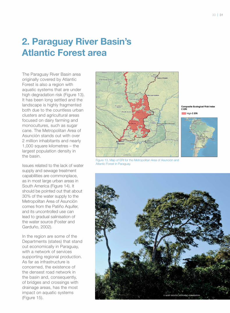
The Paraguay River Basin area
originally covered by Atlantic
Forest is also a region with
aquatic systems that are under
high degradation risk (Figure 13).
It has been long settled and the
landscape is highly fragmented
both due to the countless urban
clusters and agricultural areas
focused on dairy farming and
monocultures, such as sugar
cane. The Metropolitan Area of
Asunción stands out with over
2 million inhabitants and nearly
1,000 square kilometres – the
largest population density in
the basin.
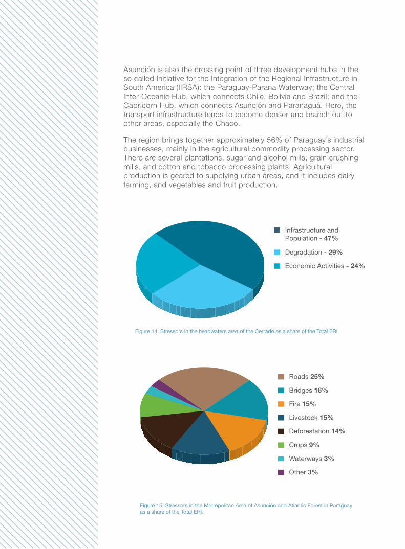
Issues related to the lack of water
supply and sewage treatment
capabilities are commonplace,
as in most large urban areas in
South America (Figure 14). It
should be pointed out that about
30% of the water supply to the
Metropolitan Area of Asunción
comes from the Patiño Aquifer,
and its uncontrolled use can
lead to gradual salinisation of
the water source (Foster and
Garduño, 2002).
In the region are some of the
Departments (states) that stand
out economically in Paraguay,
with a network of services
supporting regional production.
As far as infrastructure is
concerned, the existence of
the densest road network in
the basin and, consequently,
of bridges and crossings with
drainage areas, has the most
impact on aquatic systems
(Figure 15). © WWF-BRASIL/ADRIANO GAMBARINI
Figure 13. Map of ERI for the Metropolitan Area of Asunción and
Atlantic Forest in Paraguay.
Asunción is also the crossing point of three development hubs in the
so called Initiative for the Integration of the Regional Infrastructure in
South America (IIRSA): the Paraguay-Parana Waterway; the Central
Inter-Oceanic Hub, which connects Chile, Bolivia and Brazil; and the
Capricorn Hub, which connects Asunción and Paranaguá. Here, the
transport infrastructure tends to become denser and branch out to
other areas, especially the Chaco.
The region brings together approximately 56% of Paraguay´s industrial
businesses, mainly in the agricultural commodity processing sector.
There are several plantations, sugar and alcohol mills, grain crushing
mills, and cotton and tobacco processing plants. Agricultural
production is geared to supplying urban areas, and it includes dairy
farming, and vegetables and fruit production.
Infrastructure and Population - 47%
Economic Activities - 24%
Degradation - 29%
Crops 9%
Waterways 3%
Other 3%
Livestock 15%
Roads 25%
Fire 15%
Bridges 16%
Deforestation 14%
Figure 14. Stressors in the headwaters area of the Cerrado as a share of the Total ERI.
Figure 15. Stressors in the Metropolitan Area of Asunción and Atlantic Forest in Paraguay as a share of the Total ERI.
3332
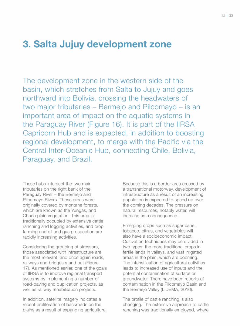
3. Salta Jujuy development zone
The development zone in the western side of the
basin, which stretches from Salta to Jujuy and goes
northward into Bolivia, crossing the headwaters of
two major tributaries – Bermejo and Pilcomayo – is an
important area of impact on the aquatic systems in
the Paraguay River (Figure 16). It is part of the IIRSA
Capricorn Hub and is expected, in addition to boosting
regional development, to merge with the Pacific via the
Central Inter-Oceanic Hub, connecting Chile, Bolivia,
Paraguay, and Brazil.
These hubs intersect the two main
tributaries on the right bank of the
Paraguay River – the Bermejo and
Pilcomayo Rivers. These areas were
originally covered by montane forests,
which are known as the Yungas, and
Chaco plain vegetation. This area is
traditionally occupied by extensive cattle
ranching and logging activities, and crop
farming and oil and gas prospection are
rapidly increasing activities.
Considering the grouping of stressors,
those associated with infrastructure are
the most relevant, and once again roads,
railways and bridges stand out (Figure
17). As mentioned earlier, one of the goals
of IIRSA is to improve regional transport
systems by implementing a number of
road-paving and duplication projects, as
well as railway rehabilitation projects.
In addition, satellite imagery indicates a
recent proliferation of backroads on the
plains as a result of expanding agriculture.
Because this is a border area crossed by
a transnational motorway, development of
infrastructure as a result of an increasing
population is expected to speed up over
the coming decades. The pressure on
natural resources, notably water, will
increase as a consequence.
Emerging crops such as sugar cane,
tobacco, citrus, and vegetables will
also have a socioeconomic impact.
Cultivation techniques may be divided in
two types: the more traditional crops in
fertile lands in valleys, and vast irrigated
areas in the plain, which are booming.
The intensifi cation of agricultural activities
leads to increased use of inputs and the
potential contamination of surface or
groundwater. There have been reports of
contamination in the Pilcomayo Basin and
the Bermejo Valley (LIDEMA, 2010).
The profi le of cattle ranching is also
changing. The extensive approach to cattle
ranching was traditionally employed, where
seasonal grazing areas in
the plains or mountains
were used. Today,
planted pastures have
been expanding in large
properties on the plain.
It should be stressed
that this region is a major
producer of gas and oil. In
spite of being an occasional
activity, both exploration
and prospecting should
be considered important
sources of impact. In
addition to prompting
the creation of trails for
prospecting activities –
which support logging
activities –, oil desalination
causes huge amounts of
water to be contaminated
with hydrocarbons and
chemicals, such as SO2 and
SH2. In concentrations of a
mere 0.01 parts per million
(ppm), they make water unfi t
for human consumption.
Research studies on the
environmental conservation
status of Bolivia (LIDEMA,
2010) warn that
contamination by organic
compounds is severe in oil
and gas exploration and
prospecting areas. These are
low solubility contaminants
that are only partially
degraded, and they can
generate even more toxic
compounds. As the local
rainfall regime is extremely
concentrated, dissolution
of these substances risks
contaminating water
courses.
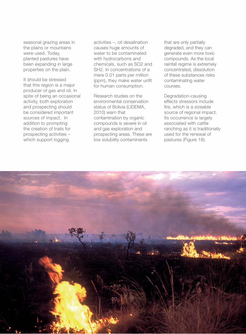
Degradation-causing
effects stressors include
fi re, which is a sizeable
source of regional impact.
Its occurrence is largely
associated with cattle
ranching as it is traditionally
used for the renewal of
pastures (Figure 18).
© LEANDRO BAUMGARTEN/TNC
3534
Infrastructure and Population 40%
Degradation 23%
Economic Activities 37%
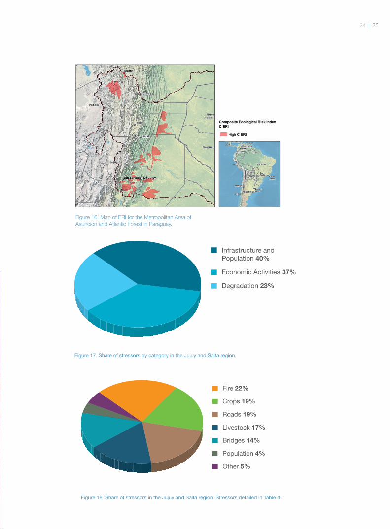
Figure 17. Share of stressors by category in the Jujuy and Salta region.
Population 4%
Other 5%
Livestock 17%
Fire 22%
Roads 19%
Crops 19%
Bridges 14%
Figure 18. Share of stressors in the Jujuy and Salta region. Stressors detailed in Table 4.
Figure 16. Map of ERI for the Metropolitan Area of
Asuncion and Atlantic Forest in Paraguay.
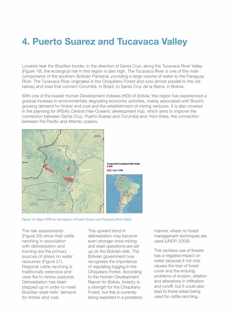
Located near the Brazilian border, in the direction of Santa Cruz, along the Tucavaca River Valley
(Figure 19), the ecological risk in this region is also high. The Tucavaca River is one of the main
components of the southern Bolivian Pantanal, providing a large volume of water to the Paraguay
River. The Tucavaca River originates in the Chiquitano Forest and runs almost parallel to the old
railway and road that connect Corumbá, in Brazil, to Santa Cruz de la Sierra, in Bolivia.
With one of the lowest Human Development Indexes (HDI) of Bolivia, this region has experienced a
gradual increase in environmentally degrading economic activities, mainly associated with Brazil’s
growing demand for timber and coal and the establishment of mining ventures. It is also covered
in the planning for IIRSA’s Central Inter-Oceanic development hub, which aims to improve the
connection between Santa Cruz, Puerto Suarez and Corumbá and, from there, the connection
between the Pacifi c and Atlantic oceans.
4. Puerto Suarez and Tucavaca Valley
The risk assessments
(Figure 20) show that cattle
ranching in association
with deforestation and
burning are the primary
sources of stress on water
resources (Figure 21).
Regional cattle ranching is
traditionally extensive and
uses fi re to renew pastures.
Deforestation has been
stepped up in order to meet
Brazilian steel mills´ demand
for timber and coal.
This upward trend in
deforestation may become
even stronger once mining
and steel operations are set
up on the Bolivian side. The
Bolivian government now
recognises the importance
of regulating logging in the
Chiquitano Forest. According
to the Human Development
Report for Bolivia, forestry is
a strength for the Chiquitano
Forest, but this is currently
being exploited in a predatory
manner, where no forest
management techniques are
used (UNDP, 2009).
This reckless use of forests
has a negative impact on
water because it not only
causes the loss of forest
cover and the ensuing
problems of erosion, siltation
and alterations in infi ltration
and runoff, but it could also
lead to these areas being
used for cattle ranching,
Figure 19. Map of ERI for the regions of Puerto Suarez and Tucavaca River Valley.
3736
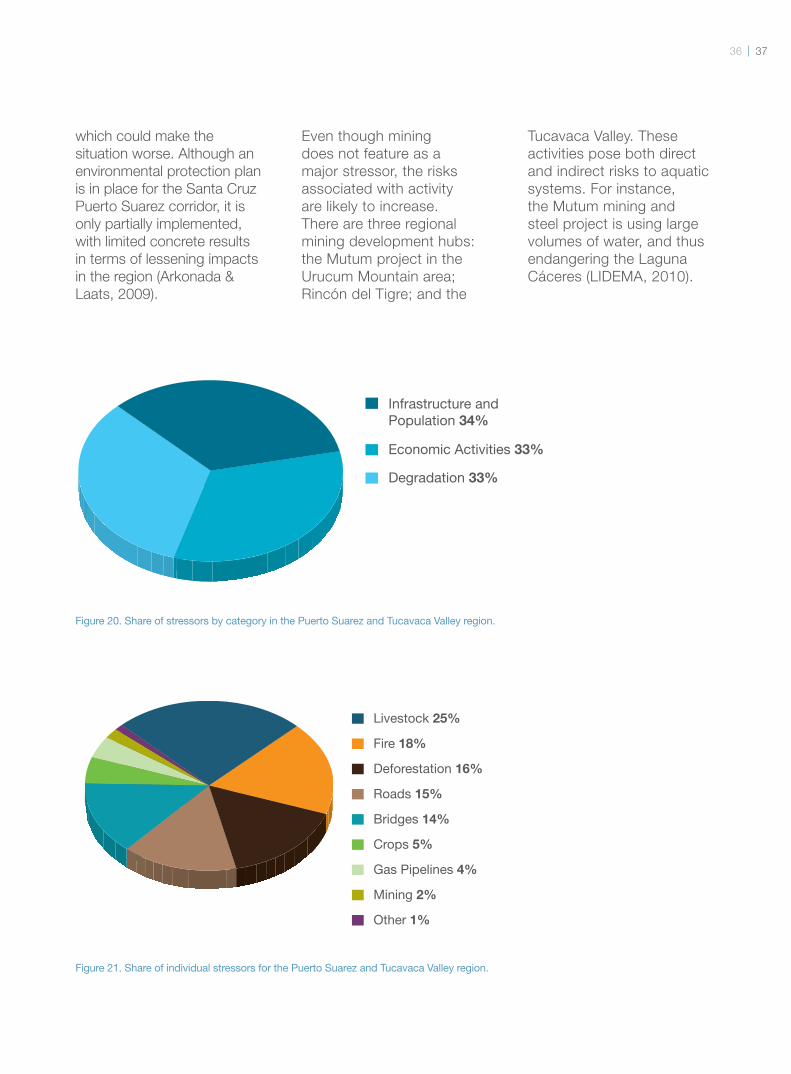
Infrastructure and Population 34%
Degradation 33%
Economic Activities 33%
Crops 5%
Gas Pipelines 4%
Mining 2%
Other 1%
Roads 15%
Livestock 25%
Deforestation 16%
Fire 18%
Bridges 14%
which could make the
situation worse. Although an
environmental protection plan
is in place for the Santa Cruz
Puerto Suarez corridor, it is
only partially implemented,
with limited concrete results
in terms of lessening impacts
in the region (Arkonada &
Laats, 2009).
Even though mining
does not feature as a
major stressor, the risks
associated with activity
are likely to increase.
There are three regional
mining development hubs:
the Mutum project in the
Urucum Mountain area;
Rincón del Tigre; and the
Tucavaca Valley. These
activities pose both direct
and indirect risks to aquatic
systems. For instance,
the Mutum mining and
steel project is using large
volumes of water, and thus
endangering the Laguna
Cáceres (LIDEMA, 2010).
Figure 20. Share of stressors by category in the Puerto Suarez and Tucavaca Valley region.
Figure 21. Share of individual stressors for the Puerto Suarez and Tucavaca Valley region.
It is important to look at the
maps in time and space,
and not as a static item.
In view of the above, the
Paraguay River Basin has
a high potential ecological
risk, and requires immediate
and priority action to
protect its headwaters.
However, the management
and care of the basin
Discussion and
Recommendations
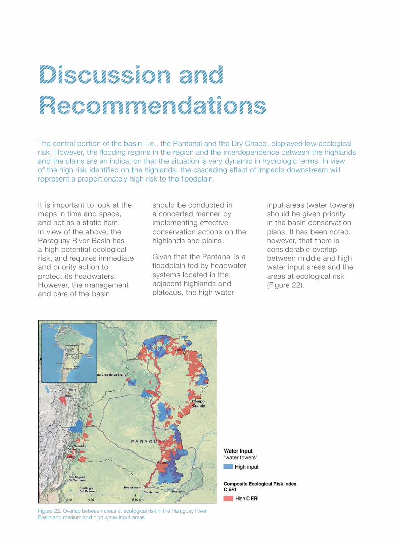
Figure 22. Overlap between areas at ecological risk in the Paraguay River
Basin and medium and high water input areas.
should be conducted in
a concerted manner by
implementing effective
conservation actions on the
highlands and plains.
Given that the Pantanal is a
floodplain fed by headwater
systems located in the
adjacent highlands and
plateaus, the high water
The central portion of the basin, i.e., the Pantanal and the Dry Chaco, displayed low ecological
risk. However, the fl ooding regime in the region and the interdependence between the highlands
and the plains are an indication that the situation is very dynamic in hydrologic terms. In view
of the high risk identifi ed on the highlands, the cascading effect of impacts downstream will
represent a proportionately high risk to the fl oodplain.
input areas (water towers)
should be given priority
in the basin conservation
plans. It has been noted,
however, that there is
considerable overlap
between middle and high
water input areas and the
areas at ecological risk
(Figure 22).
38 39
Protecting middle and
high water input areas in
the highlands is key to
supporting the seasonal
flood pulse in the Pantanal.
Considering future
climate change scenarios,
adaptation measures that
enhance the resilience of
the basin would support
the flood pulse and the
connectivity between the
highlands and the plains,
and would also protect the
headwaters.
For this reason, WWF-
Brazil and several partner
institutions have started
the Waters of Cabaçal
Movement and have been
developing a project to
restore springs and fight
erosion in the Cabaçal River
Basin, which is a region that
feeds a significant amount
of water into the Pantanal
Wetlands in Mato Grosso.
TNC also runs the
Sustainable Cerrado
demonstration project in the
São Lourenço River Basin –
one of the main tributaries
of the Paraguay River,
which plays a key role in the
amount of sediments carried
to the Pantanal Wetlands.
Another TNC-run Pantanal
protection project is being
implemented in partnership
with the Pantanal
Research Centre (CPP)
and will include several
technical studies and
social engament actions.
It will include several
technical studies and social
engagement actions. The
results of this project will be
used to inform conservation
and sustainable
development actions in the
area, including ecosystem
based actions for climate
change adaptation.
In collaboration with its
strategic partners, WWF
Bolivia has been pursuing
land use planning actions
based on municipal
development plans in
areas that provide a high
water input to the basin
as a whole, such as the
Correreca and Curichi
Grande River Basins.
© W
WF-B
RA
SIL/TU
I DE
RO
Y &
MA
RK
JON
ES
The social and political
mobilisation, as well as the
involvement of the residents
in the basin area with the
environmental issues were
important to kick off the
movement. To strengthen
the movement, WWF-Brazil
set up an alliance with the
University of Mato Grosso
(UNEMAT); the Mato Grosso
Rural Extension Agency
(Empaer); the Municipality
of Reserva do Cabaçal;
Intermunicipal Consortium
for the Economic, Social,
Environmental, and Tourism
Development of the
Pantanal Springs Complex;
and local schools.
The movement has been
in existence for two
The Waters of Cabaçal Movement
years and has been a
transformational force in
town. The Environmental
Education programme has
reached about 60% of
the population, including
students, public authorities
and citizens. In the teaching
environment, 75 teachers
from two local public
schools and one state
school have been trained,
benefi ting pre-school,
primary and secondary
shcool students, as well as
university students in the
region. It has involved the
City Council with lectures
and drama workshops.
Other citizens have also
been directly involved,
for example a physical
education teacher who has
started working with solid
waste recycling.
And the movement went
on to involve farmers –
about 50 of them became
involved in activities and
workshops on the recovery
of water sources and the
development of organic
cattle ranching.
Recovery of the Dracena
River – a secondary tributary
of the Cabaçal River – was
selected as a demonstration
action that allows farmers
to learn about soil and
spring recovery techniques.
Six thousand seedlings
have already been planted
in 12 springs, and a large
crater is being repaired – all
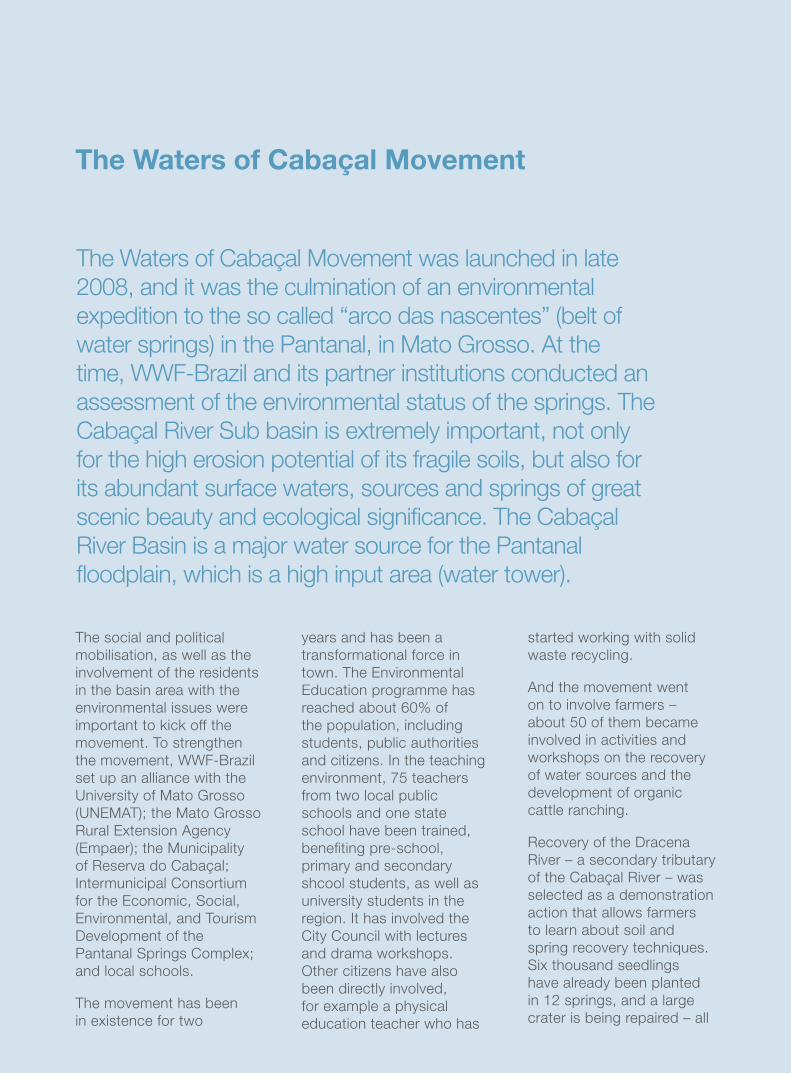
The Waters of Cabaçal Movement was launched in late
2008, and it was the culmination of an environmental
expedition to the so called “arco das nascentes” (belt of
water springs) in the Pantanal, in Mato Grosso. At the
time, WWF-Brazil and its partner institutions conducted an
assessment of the environmental status of the springs. The
Cabaçal River Sub basin is extremely important, not only
for the high erosion potential of its fragile soils, but also for
its abundant surface waters, sources and springs of great
scenic beauty and ecological signifi cance. The Cabaçal
River Basin is a major water source for the Pantanal
fl oodplain, which is a high input area (water tower).
4140
© W
WF-B
RA
SIL/A
DR
IAN
O G
AM
BA
RIN
I
supported by a seedling
nursery. Women at social
risk were trained to make
crochet hammocks and
became involved in erosion
restoration efforts by making
contention screens and
nets. In return, they receive
baskets of staple food from
the local government.
The movement is now being
expanded and replicated in
other sub-basins along the
belt of water springs. The
efforts involve:
• A publication on the
lessons learned in Cabaçal
that will focus on low cost
techniques to restore
degraded areas, taking
into consideration local
solutions;
• Training of residents
from other towns on the
environmental recovery
techniques employed in
the Dracena micro basin;
• Technical visits and fi eld
activity days for farmers.
to anthropogenic
uses – especially
cattle ranching. Any
actions that would
reduce this impact
should be a priority.
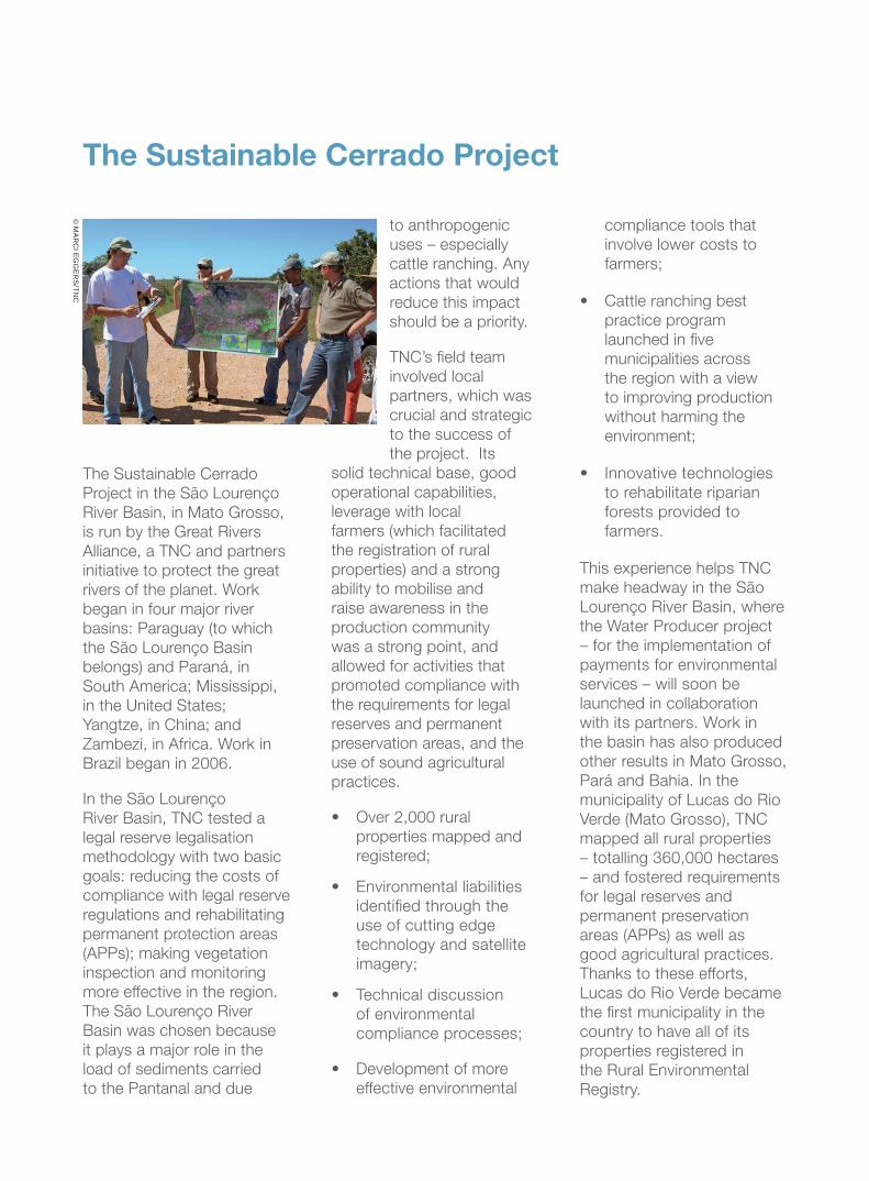
TNC’s fi eld team
involved local
partners, which was
crucial and strategic
to the success of
the project. Its
solid technical base, good
operational capabilities,
leverage with local
farmers (which facilitated
the registration of rural
properties) and a strong
ability to mobilise and
raise awareness in the
production community
was a strong point, and
allowed for activities that
promoted compliance with
the requirements for legal
reserves and permanent
preservation areas, and the
use of sound agricultural
practices.
• Over 2,000 rural
properties mapped and
registered;
• Environmental liabilities
identifi ed through the
use of cutting edge
technology and satellite
imagery;
• Technical discussion
of environmental
compliance processes;
• Development of more
effective environmental
The Sustainable Cerrado Project
The Sustainable Cerrado
Project in the São Lourenço
River Basin, in Mato Grosso,
is run by the Great Rivers
Alliance, a TNC and partners
initiative to protect the great
rivers of the planet. Work
began in four major river
basins: Paraguay (to which
the São Lourenço Basin
belongs) and Paraná, in
South America; Mississippi,
in the United States;
Yangtze, in China; and
Zambezi, in Africa. Work in
Brazil began in 2006.
In the São Lourenço
River Basin, TNC tested a
legal reserve legalisation
methodology with two basic
goals: reducing the costs of
compliance with legal reserve
regulations and rehabilitating
permanent protection areas
(APPs); making vegetation
inspection and monitoring
more effective in the region.
The São Lourenço River
Basin was chosen because
it plays a major role in the
load of sediments carried
to the Pantanal and due
© M
AR
CI E
GG
ER
S/TN
C
compliance tools that
involve lower costs to
farmers;
• Cattle ranching best
practice program
launched in fi ve
municipalities across
the region with a view
to improving production
without harming the
environment;
• Innovative technologies
to rehabilitate riparian
forests provided to
farmers.
This experience helps TNC
make headway in the São
Lourenço River Basin, where
the Water Producer project
– for the implementation of
payments for environmental
services – will soon be
launched in collaboration
with its partners. Work in
the basin has also produced
other results in Mato Grosso,
Pará and Bahia. In the
municipality of Lucas do Rio
Verde (Mato Grosso), TNC
mapped all rural properties
– totalling 360,000 hectares
– and fostered requirements
for legal reserves and
permanent preservation
areas (APPs) as well as
good agricultural practices.
Thanks to these efforts,
Lucas do Rio Verde became
the fi rst municipality in the
country to have all of its
properties registered in
the Rural Environmental
Registry.
4342
Vulnerability assessment and land use
planning in Bolivia
The vulnerability assessment
helped identify the most
susceptible basins in the
Bolivian portion of the
Paraguay River Basin.
Two of them are key to
maintaining water fl ows
of the southern Bolivian
Pantanal – Tucavaca and
Cáceres –, just like the
Correreca and Curichi
Grande River Basins,
which provide water to the
northern Pantanal.
While these basins are
offi cially considered
protected areas, at municipal
level in the case of Tucavaca,
and at federal level in the
case of Cáceres, – within
the Otuquis protected area,
and Integrated Management
Natural Area of San Matías
in the case of the Correreca
and Curichi Grande Basin –,
their conservation is at risk,
particularly due to lack of a
comprehensive development
proposal that includes land
use plans, but also due
to the ever accelerating
expansion of the agricultural
frontier and charcoal
production.
The data provided by the
vulnerability assessment
make a compelling case
for the need to conserve
these basins, not only for
the biodiversity to which
they are home, but also for
the environmental services
they provide to the local
population and regional
economic activities, mainly
through water concentration
and distribution.
In the municipality of San
Matías, in the Correreca
Curichi Grande Basin, WWF
is working on a municipal
development plan, where
it identifi ed, through the
vulnerability assessment, the
need to include adaptation
and risk management
strategies in this planning
tool. Therefore, incorporating
these items, including in
the municipal land use
plan, will make it easier for
municipalities to implement
them autonomously
through public investments
while respecting rights of
possession and use.
Local capacities are
strengthened in this process
for the development and
allowing for subsequent
implementation of this
planning tool, and helping
generate and collect technical
and social information
so that the strategic
lines of development of
the municipality have
sustainable development
as pillars, climate change
adaptation and mitigation,
and appreciation of the
knowledge and customs
of indigenous peoples and
communities living in the
region, such as Chiquitano
and Ayoreo.
© W
WF-B
OLÍV
IA/V
ICTO
R M
AG
ALLA
NE
S
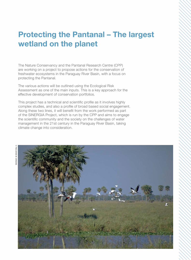
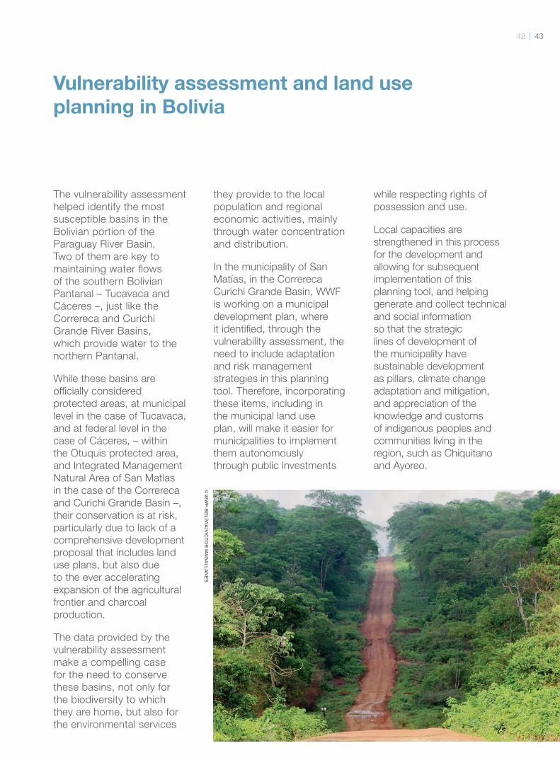
Protecting the Pantanal – The largest
wetland on the planet
The Nature Conservancy and the Pantanal Research Centre (CPP)
are working on a project to propose actions for the conservation of
freshwater ecosystems in the Paraguay River Basin, with a focus on
protecting the Pantanal.
The various actions will be outlined using the Ecological Risk
Assessment as one of the main inputs. This is a key approach for the
effective development of conservation portfolios.
This project has a technical and scientifi c profi le as it involves highly
complex studies, and also a profi le of broad based social engagement.
Along these two lines, it will benefi t from the work performed as part
of the SINERGIA Project, which is run by the CPP and aims to engage
the scientifi c community and the society on the challenges of water
management in the 21st century in the Paraguay River Basin, taking
climate change into consideration.
© TN
C/JA
NIE
M. G
RE
EN
E
4544
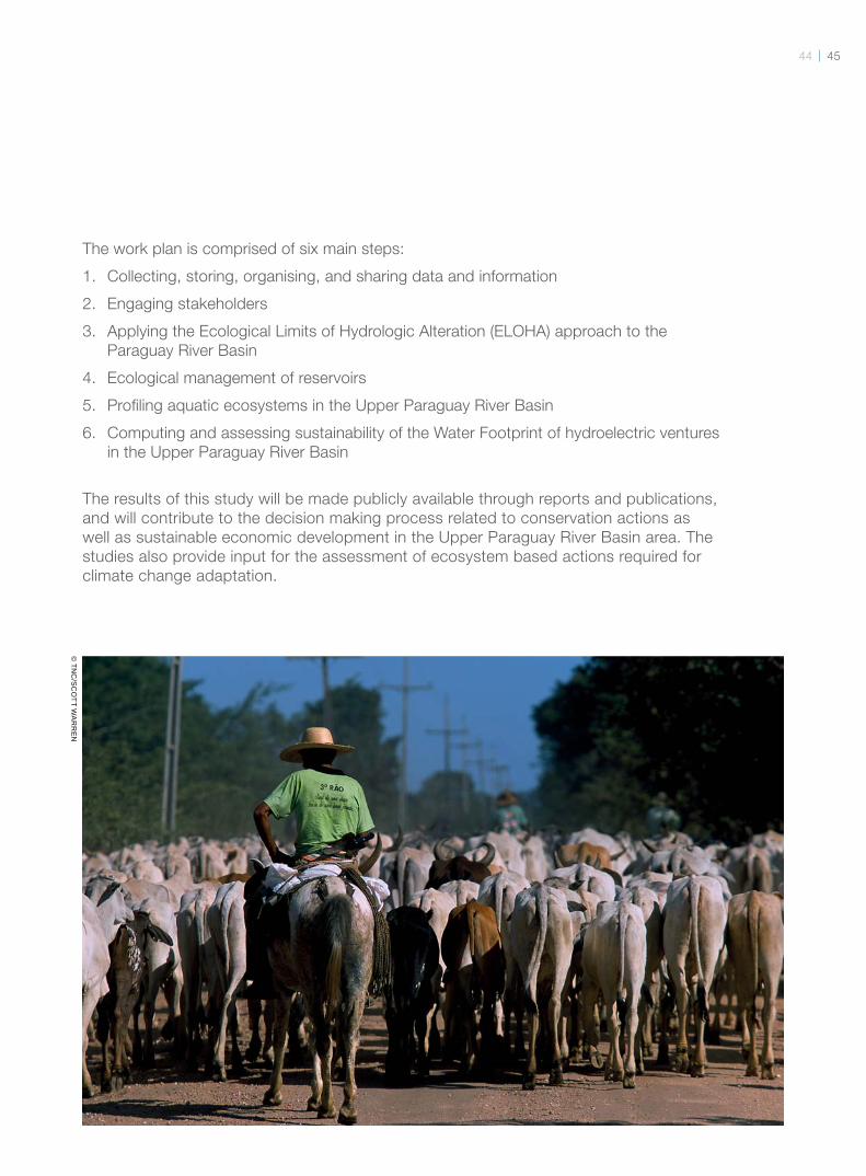
The work plan is comprised of six main steps:
1. Collecting, storing, organising, and sharing data and information
2. Engaging stakeholders
3. Applying the Ecological Limits of Hydrologic Alteration (ELOHA) approach to the
Paraguay River Basin
4. Ecological management of reservoirs
5. Profi ling aquatic ecosystems in the Upper Paraguay River Basin
6. Computing and assessing sustainability of the Water Footprint of hydroelectric ventures
in the Upper Paraguay River Basin
The results of this study will be made publicly available through reports and publications,
and will contribute to the decision making process related to conservation actions as
well as sustainable economic development in the Upper Paraguay River Basin area. The
studies also provide input for the assessment of ecosystem based actions required for
climate change adaptation.
© TN
C/S
CO
TT WA
RR
EN
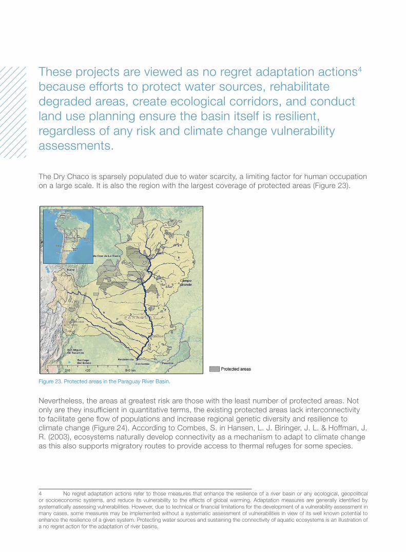
The Dry Chaco is sparsely populated due to water scarcity, a limiting factor for human occupation
on a large scale. It is also the region with the largest coverage of protected areas (Figure 23).
These projects are viewed as no regret adaptation actions4
because efforts to protect water sources, rehabilitate
degraded areas, create ecological corridors, and conduct
land use planning ensure the basin itself is resilient,
regardless of any risk and climate change vulnerability
assessments.
1
4 No regret adaptation actions refer to those measures that enhance the resilience of a river basin or any ecological, geopolitical
or socioeconomic systems, and reduce its vulnerability to the effects of global warming. Adaptation measures are generally identifi ed by
systematically assessing vulnerabilities. However, due to technical or fi nancial limitations for the development of a vulnerability assessment in
many cases, some measures may be implemented without a systematic assessment of vulnerabilities in view of its well known potential to
enhance the resilience of a given system. Protecting water sources and sustaining the connectivity of aquatic ecosystems is an illustration of
a no regret action for the adaptation of river basins.
Nevertheless, the areas at greatest risk are those with the least number of protected areas. Not
only are they insuffi cient in quantitative terms, the existing protected areas lack interconnectivity
to facilitate gene fl ow of populations and increase regional genetic diversity and resilience to
climate change (Figure 24). According to Combes, S. in Hansen, L. J. Biringer, J. L. & Hoffman, J.
R. (2003), ecosystems naturally develop connectivity as a mechanism to adapt to climate change
as this also supports migratory routes to provide access to thermal refuges for some species.
Figure 23. Protected areas in the Paraguay River Basin.
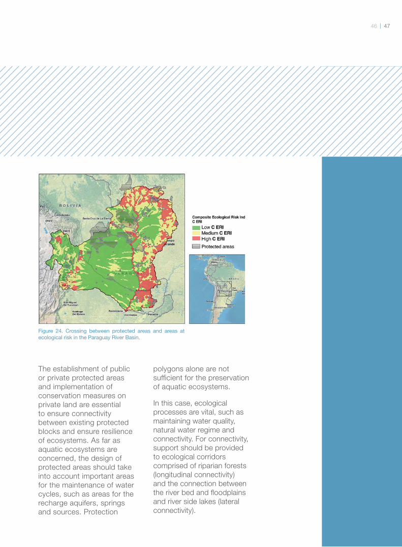
4746
The establishment of public
or private protected areas
and implementation of
conservation measures on
private land are essential
to ensure connectivity
between existing protected
blocks and ensure resilience
of ecosystems. As far as
aquatic ecosystems are
concerned, the design of
protected areas should take
into account important areas
for the maintenance of water
cycles, such as areas for the
recharge aquifers, springs
and sources. Protection
polygons alone are not
suffi cient for the preservation
of aquatic ecosystems.
In this case, ecological
processes are vital, such as
maintaining water quality,
natural water regime and
connectivity. For connectivity,
support should be provided
to ecological corridors
comprised of riparian forests
(longitudinal connectivity)
and the connection between
the river bed and fl oodplains
and river side lakes (lateral
connectivity).
Figure 24. Crossing between protected areas and areas at ecological risk in the Paraguay River Basin.
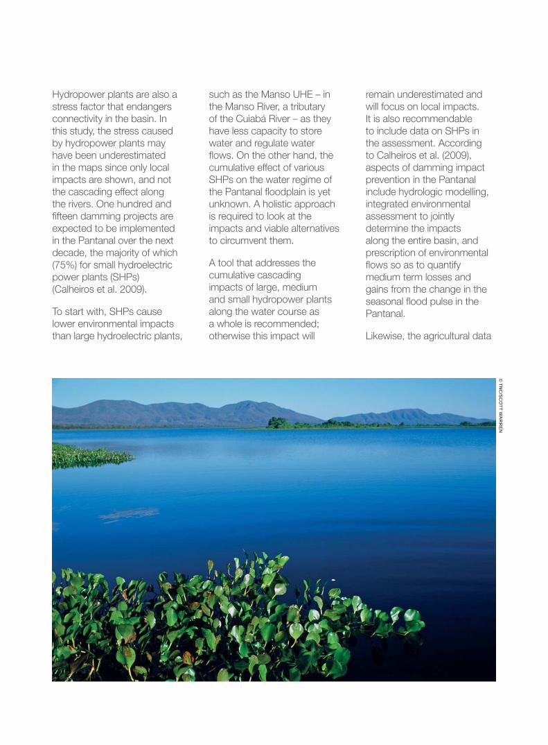
Hydropower plants are also a
stress factor that endangers
connectivity in the basin. In
this study, the stress caused
by hydropower plants may
have been underestimated
in the maps since only local
impacts are shown, and not
the cascading effect along
the rivers. One hundred and
fi fteen damming projects are
expected to be implemented
in the Pantanal over the next
decade, the majority of which
(75%) for small hydroelectric
power plants (SHPs)
(Calheiros et al. 2009).
To start with, SHPs cause
lower environmental impacts
than large hydroelectric plants,
such as the Manso UHE – in
the Manso River, a tributary
of the Cuiabá River – as they
have less capacity to store
water and regulate water
fl ows. On the other hand, the
cumulative effect of various
SHPs on the water regime of
the Pantanal fl oodplain is yet
unknown. A holistic approach
is required to look at the
impacts and viable alternatives
to circumvent them.
A tool that addresses the
cumulative cascading
impacts of large, medium
and small hydropower plants
along the water course as
a whole is recommended;
otherwise this impact will
remain underestimated and
will focus on local impacts.
It is also recommendable
to include data on SHPs in
the assessment. According
to Calheiros et al. (2009),
aspects of damming impact
prevention in the Pantanal
include hydrologic modelling,
integrated environmental
assessment to jointly
determine the impacts
along the entire basin, and
prescription of environmental
fl ows so as to quantify
medium term losses and
gains from the change in the
seasonal fl ood pulse in the
Pantanal.
Likewise, the agricultural data
© TN
C/S
CO
TT WA
RR
EN
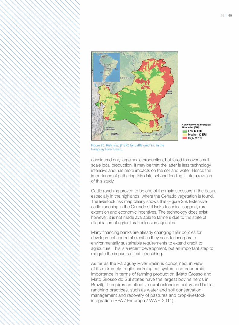
4948
considered only large scale production, but failed to cover small
scale local production. It may be that the latter is less technology
intensive and has more impacts on the soil and water. Hence the
importance of gathering this data set and feeding it into a revision
of this study.
Cattle ranching proved to be one of the main stressors in the basin,
especially in the highlands, where the Cerrado vegetation is found.
The livestock risk map clearly shows this (Figure 25). Extensive
cattle ranching in the Cerrado still lacks technical support, rural
extension and economic incentives. The technology does exist;
however, it is not made available to farmers due to the state of
dilapidation of agricultural extension agencies.
Many fi nancing banks are already changing their policies for
development and rural credit as they seek to incorporate
environmentally sustainable requirements to extend credit to
agriculture. This is a recent development, but an important step to
mitigate the impacts of cattle ranching.
As far as the Paraguay River Basin is concerned, in view
of its extremely fragile hydrological system and economic
importance in terms of farming production (Mato Grosso and
Mato Grosso do Sul states have the largest bovine herds in
Brazil), it requires an effective rural extension policy and better
ranching practices, such as water and soil conservation,
management and recovery of pastures and crop-livestock
integration (BPA / Embrapa / WWF, 2011).
Figure 25. Risk map (T ERI) for cattle ranching in the Paraguay River Basin.
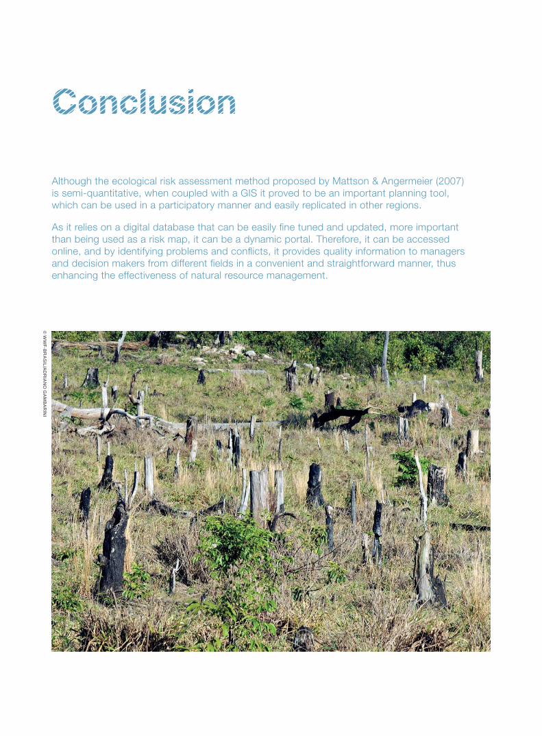
Conclusion
Although the ecological risk assessment method proposed by Mattson & Angermeier (2007)
is semi-quantitative, when coupled with a GIS it proved to be an important planning tool,
which can be used in a participatory manner and easily replicated in other regions.
As it relies on a digital database that can be easily fi ne tuned and updated, more important
than being used as a risk map, it can be a dynamic portal. Therefore, it can be accessed
online, and by identifying problems and confl icts, it provides quality information to managers
and decision makers from different fi elds in a convenient and straightforward manner, thus
enhancing the effectiveness of natural resource management.
© W
WF-B
RA
SIL/A
DR
IAN
O G
AM
BA
RIN
I
5150
The ecological risk assessment is the
fi rst step in understanding the Pantanal´s
vulnerability to climate change. As noted
earlier, in order to outline climate change
scenarios for a river basin one must fi rst
identify and assess existing stressors
(i.e., non-climate stressors). The next
step is to develop a projection based on
the information from the global climate or
climate variability models in order to identify
which existing stressors will be intense to
a greater or lesser extent in the future, and
also where and how these stressors will
occur. This makes it possible to design and
implement effective adaptation actions.
Therefore, an essential step in this
sense will be to complement the results
from this study with an assessment of
climate change scenarios for the basin.
These scenarios will be developed
in collaboration with the scientifi c
community and key stakeholders, such as
governments, the private sector and civil
society organisations.
In addition, socioeconomic and political/
institutional vulnerability assessments
will be conducted, and the ecological
vulnerability assessment presented here
will be the third pillar in this broader
assessment. The socioeconomic
assessment will look at the vulnerability
of inhabitants in the basin area, from
indigenous communities, traditional
fi shermen and farmers to major industries,
such as navigation, tourism, fi shing,
agriculture, etc. Recommendations will
be drawn for the individual industries and
communities, and they will make up the
climate change adaptation plan.
The political/institutional vulnerability
assessment is now underway, and it
is looking at criteria for good water
governance and integrated water
resources management based on regional
management indicators. Just a few
examples of political/institutional resilience
indicators include aspects such as the
existence of river basin forums, boards
or committees; presence or absence of
natural and water resource management
bodies at state and municipal levels;
arenas for public participation; progress
of offi cial programme and project
implementation; and level of technical
capacity of state and municipal
governments.
The underlying assumption is that a
consistent, active and participatory
“social fabric”, and well prepared, trained
and well equipped governments will help
attenuate the impacts of climate change
in the basin. This political institutional
arrangement will also be an integral part
of the adaptation plan.
TNC will develop a conservation portfolio
for the Paraguay River Basin by identifying
priority areas and actions for conservation
based on the principles of Systematic
Conservation Planning. This “Blueprint”
also starts with the mapping of risks
and vulnerabilities in the basin so that
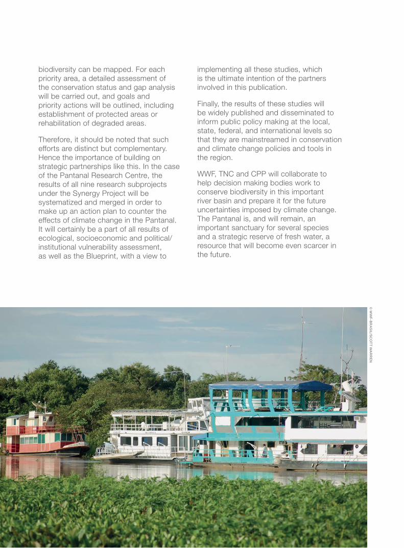
biodiversity can be mapped. For each
priority area, a detailed assessment of
the conservation status and gap analysis
will be carried out, and goals and
priority actions will be outlined, including
establishment of protected areas or
rehabilitation of degraded areas.
Therefore, it should be noted that such
efforts are distinct but complementary.
Hence the importance of building on
strategic partnerships like this. In the case
of the Pantanal Research Centre, the
results of all nine research subprojects
under the Synergy Project will be
systematized and merged in order to
make up an action plan to counter the
effects of climate change in the Pantanal.
It will certainly be a part of all results of
ecological, socioeconomic and political/
institutional vulnerability assessment,
as well as the Blueprint, with a view to
implementing all these studies, which
is the ultimate intention of the partners
involved in this publication.
Finally, the results of these studies will
be widely published and disseminated to
inform public policy making at the local,
state, federal, and international levels so
that they are mainstreamed in conservation
and climate change policies and tools in
the region.
WWF, TNC and CPP will collaborate to
help decision making bodies work to
conserve biodiversity in this important
river basin and prepare it for the future
uncertainties imposed by climate change.
The Pantanal is, and will remain, an
important sanctuary for several species
and a strategic reserve of fresh water, a
resource that will become even scarcer in
the future.
© W
WF-B
RA
SIL/S
CO
TT WA
RR
EN
5352
Abell, R. et.al. 2008. Freshwater Ecoregions of the World: A New Map of Biogeographic Units for Freshwater
Biodiversity Conservation. BioScience, 58 (5): 403-414. [May 2008]
Arkonada & Laats, 2009. El Caso de La Carretera Puerto Suarez – Santa Cruz.
BPA/EMBRAPA/WWF, 2011. Conservando Água e Solo: pecuária de corte no Cerrado. 1ª edição. Brasília, 2011.
Calheiros, D. F. et al. 2009. Infl uências de usinas hidrelétricas no funcionamento hidro-ecológico do Pantanal
Mato-Grossense: recomendações [recurso eletrônico] / Corumbá: Embrapa Pantanal, 2009. http://www.cpap.
embrapa.br/publicacoes/online/DOC102.pdf
Combes, S. 2003. Protecting Freshwater Ecosystems in the Face of Global Climate Change. In Hansen, L. J.,
J. L. Biringer, and J. R. Hoffman. 2003. Buying Time: A User’s Manual for Building Resistance and Resilience to
Climate Change in Natural Systems. Island Press: Washington, D.C.
Fitzhugh, T. W. 2005. GIS Tools for Freshwater Biodiversity Conservation Planning. Transactions in GIS, 9:247-263.
Foster, S. & Garduño, H. 2002 Paraguay: El uso de Água subterrânea en Gran Asuncion – Problemas Actuales
y Regulación Proposta – Colección de Casos Esquemático 3, Gestion Sustentable Del Agua Subterranea, GW-
Mate, Banco Mundial. Disponivel em www.worldbank.org/gwmate
IMEA (2010). Projeções para produção agropecuária em Mato Grosso. (http://www.imea.com.br/upload/pdf/
arquivos/2010_02_04_Paper_Previsao_de_Producao_Mato_Grosso.pdf)
Jenks, G. (1977) Optimal Data Classifi cation for Choropleth Maps. Kansas City, KS: Department of Geography,
University of Kansas
Karr, J. R., K. D. Fausch, P. L. Angermeier, P. R. Yant, I. J. Schlosser. 1986. Assessing biological integrity in running
waters: A method and its rationale. Illinois Natural History Survey Special Publication 5.
Lehner, B., K. Verdin & A. Jarvis. 2008. New Global Hydrography Derived From Spaceborne Elevation Data. Eos,
Transactions, AGU, 89(10): 93-94. http://www.worldwildlife.org/science/projects/freshwater/item1991.html and
http://hydrosheds.cr.usgs.gov/
LIDEMA. 2010. Informe del Estado Ambiental de Bolivia 2010. LIDEMA. La Paz, Bolívia. Eixos de Integração e
Desenvolvimentos – Red Geospacial de America do Sur HTTP://www.geosur.info/geosur/iirsa/mapas_po.php
Mattson, K. M. & Angermeier, P. L. 2007. Integrating Human Impacts and Ecological Integrity into a Risk-Based
Protocol for Conservation Planning. Environ Manage (2007) 39: 125–138
MMA (2009) Plano de Ação para Prevenção e Controle do Desmatamento e das Queimadas no Cerrado –
PPCerrado. Brasilia, 152 paginas.
Moraes, André Steffens. 2008. Pecuária e conservação do Pantanal: análise econômica de alternativas
sustentáveis – o dilema entre benefícios privados e sociais / André Steffens Moraes. – Recife: O Autor, 2008. 265
folhas: fi g., tab. e quadro. Tese (Doutorado) – Universidade Federal de Pernambuco. CCSA. Economia, 2008.
PNUD 2009. La otra frontera - Informe temático sobre Desarrollo Humano – Usos alternativos de recursos
naturales em Bolivia.
Bibliography
Editing
Aldem Bourscheit e Geralda Magela (WWF-Brasil)
Ayla Tiago (TNC)
English Translation
Marsel N. G. de Souza
Layout
Henrique Macêdo (Supernova Design)
Printed by
Prepared by
With support from
CPP/Sinergia, TNC/LAR, Caterpillar, HSBC, WWF-Bolivia and WWF-Paraguay
Supporting organisations
Embrapa Pantanal and Ecoa
©

53 55
WWF-Brasil
SHIS EQ 6/8 Conjunto E
Cep 71620-430 - Brasília/DF - Brasil
Tel: (55+61) 3364-7400
www.wwf.org.br
The Nature Conservancy - TNC
SRTVS Qd. 701, Conj. D, Bl. B - Lj. 246
Brasília Design Center
70.340-907, Brasília - DF- Brasil
(55+61) 3421-9100
www.tnc.org.br
With support from
CPP/Sinergia, TNC/LAR, Caterpillar, HSBC, WWF-Bolivia and WWF-Paraguay
Supporting organisations
Embrapa Pantanal and Ecoa
©
Prepared by