Embed Size (px)
Citation preview
Schedule A
Directive PNG013: Well Data Submission Requirements
Directive PNG013
October 12, 2016
Version 1.0
Governing Legislation:
Act: The Oil and Gas Conservation Act
Regulation: The Oil and Gas Conservation Regulations, 2012
Minister’s Order: MRO 194‐16

Directive PNG013: Well Data Submission Requirements
October 2016 Page 2 of 31
Record of Change
Version Date Author Description
1.0 October 12, 2016 Thomas Schmidt Initial Approved Version authorized by Minister’s Order 194‐16
Directive PNG013: Well Data Submission Requirements
October 2016 Page 3 of 31
Table of Contents
1 Introduction ................................................................................................................................. 6
2 Definitions .................................................................................................................................... 6
3 Legislation and Compliance .......................................................................................................... 8
3.1 Governing Legislation .................................................................................................................... 8
3.2 Compliance and Enforcement ....................................................................................................... 9
3.3 Licensees’ Responsibilities ............................................................................................................ 9
4 Reporting Structured Data and Submission of Supporting Documentation ................................. 10
4.1 IRIS Reporting Timelines .............................................................................................................. 10
4.2 Acceptable Format for Submission of Attachments into IRIS ..................................................... 10
5 Spud Date and Finished Drilling Date .......................................................................................... 10
6 Drilling Activity Reporting ........................................................................................................... 10
6.1 Immediate Reporting: Within one day of the drilling start date ................................................ 11
6.2 Immediate Reporting: Within seven days of the finished drilling date ...................................... 11
6.3 Immediate Reporting: Within seven days of the finished drilling date ...................................... 11
6.4 Immediate Reporting: Within seven days of the rig release date .............................................. 12
6.5 Reporting within 30 Days of the Drilling Activity End Date ......................................................... 13
6.5.1 Casing and Liners ............................................................................................................ 13
6.5.2 Tour Reports ................................................................................................................... 13
6.5.3 Wellbore Depths and Co‐ordinates ................................................................................ 14
6.5.4 Markers/Formations ...................................................................................................... 15
6.5.5 Sidetracks/Ghost Holes .................................................................................................. 16
6.5.6 Open Hole Well Logs ...................................................................................................... 16
6.5.7 Cased Hole Logs .............................................................................................................. 17
6.5.8 Cement Bond Logs and Interpretation ........................................................................... 17
6.5.9 Drill Cutting Data ............................................................................................................ 17
6.5.10 ‘As Drilled’ Survey Plan ................................................................................................... 17
6.5.11 Revised ‘As Drilled Survey’ Plan ..................................................................................... 18
6.5.12 Directional Survey .......................................................................................................... 18
Directive PNG013: Well Data Submission Requirements
October 2016 Page 4 of 31
6.5.13 Geological Report ........................................................................................................... 18
6.5.14 Lithological Description Log/Strip Log ............................................................................ 19
6.6 Reporting Within 90 Days of Drilling Activity End Date .............................................................. 19
7 Reporting Well Completion Activity Information ........................................................................ 19
7.1 Immediate Reporting of an Initial Well Completion (within seven days of the well completion
date) ............................................................................................................................................ 20
7.2 Immediate Reporting of a Subsequent Well Completion (within seven days of the well
completion date) ......................................................................................................................... 20
7.3 Immediate Reporting of a Well Completion Change (within seven days of the well completion
date) ............................................................................................................................................ 20
7.4 Well Completion Reporting within 30 Days ................................................................................ 21
7.4.1 Contact Intervals ............................................................................................................ 21
7.4.2 Treatments ..................................................................................................................... 22
7.4.3 Packers and Plugs ........................................................................................................... 22
8 Reporting Abandonment Activity Information ............................................................................ 23
8.1 Reporting a Wellbore Abandonment .......................................................................................... 23
8.2 Reporting a Downhole Abandonment and a Cut and Cap Abandonment .................................. 23
8.3 Reporting a Well Completion Abandonment .............................................................................. 23
8.3.1 Immediate Reporting of Well Completion, Wellbore or Downhole Abandonment
(within seven days of the Abandonment Date) ............................................................. 24
8.3.2 Immediate Reporting of Cut and Cap Abandonment (within seven days of the Cut and
Cap Date) ........................................................................................................................ 24
8.3.3 Within 30 Days of the Abandoned date, Well Completion, Wellbore or Downhole
Abandonment ................................................................................................................ 24
9 Reporting of other Information (Tests and Analysis) ................................................................... 24
9.1 Drill Stem Test ............................................................................................................................. 25
9.2 Gas Test ....................................................................................................................................... 25
9.2.1 Gas Well Test .................................................................................................................. 25
9.2.2 Annulus Test ................................................................................................................... 25
9.3 Fluid Analysis ............................................................................................................................... 25
Directive PNG013: Well Data Submission Requirements
October 2016 Page 5 of 31
9.4 Bottom Hole Pressure Survey ..................................................................................................... 26
9.5 Drill Core ...................................................................................................................................... 26
9.6 Core Analysis and Special Core Analysis...................................................................................... 27
9.7 Thin Section Data ........................................................................................................................ 27
Appendix 1: Naming Convention for File Attachments ....................................................................... 28
Appendix 2: Acceptable Document Types .......................................................................................... 29
Appendix 3: Electronic Well Log Submission Standards ...................................................................... 30
Appendix 4: Well and Wellbore Document Attachments Diagrams .................................................... 31

Directive PNG013: Well Data Submission Requirements
October 2016 Page 6 of 31
1 Introduction
Directive PNG013: Well Data Submission Requirements (Directive PNG013) sets out the requirements for the submission of well data for drilling, completion, workover and abandonment activities using the Integrated Resource Information System (IRIS). Saskatchewan’s Ministry of the Economy (the Ministry) requires this well data to be submitted in order to maintain an accurate record of information and activities for each well drilled in the province. The data is used by both the Ministry and by the oil and gas industry.
Questions on Directive PNG013 can be directed to Petroleum and Natural Gas (PNG) Support at 1‐855‐219‐9373 or [email protected].
2 Definitions
Business associate (BA) is any entity that conducts business activities with the Government of Saskatchewan through IRIS. In some instances, the term licensee is also used to represent the BA.
Boss wellbore is the wellbore that has been assigned by IRIS to which data or in the case of multiple wellbores can report common data elements such as casing and marker/formations to be reported into IRIS. In addition, it is the only wellbore where the surface coordinates can be changed.
Bottom hole (depth) is the end depth in metres of a wellbore where drilling operations has ended.
Canadian Well Identifier (CWI) is a system generated reference number (e.g. SK1234567) from IRIS that is assigned at the time of well licensing for the purpose to rapidly and unambiguously identify and retrieve information about a specific well, wellbore or well completion.
Drilling activity is an activity that includes the activities from spud or re‐entry of a wellbore by a drilling rig through to the rig release date and includes preset drilling activities. A single drilling activity may include the drilling of multiple wellbores as part of the same drilling activity for the drilling rig.
Drilling activity end date is, for any one specific drilling activity, the date that there is no longer any drilled meterage being added.
Drilling start date is the date at which drilling operations have commenced.
Finished drilling date is a date derived from the first wellbore drilling activity associated with a well, and is equal to the drilling activity end date for that activity. In a situation where the first wellbore drilling activity includes multiple wellbores, the drilling activity end date is the date that the last wellbore was drilled by the rig prior to the rig release date for the well. A finished drilling date is assigned by IRIS to every well at the end of the first wellbore drilling activity, and does not change when a subsequent drilling activity is performed on the same well. Note: a finished drilling date does not typically derive from a preset drilling activity.
Sidetracks/ghost hole is a secondary wellbore drilled from an wellbore that is less than 100 metres in length. A sidetrack operation may be done intentionally or may occur accidentally. Intentional sidetracks might bypass an unusable section of the original wellbore or explore a geologic feature

Directive PNG013: Well Data Submission Requirements
October 2016 Page 7 of 31
nearby. In cases where a sidetrack operation is done, the secondary wellbore is usually drilled substantially parallel to the original wellbore, which may be inaccessible due to an irretrievable fish, junk in the hole, or a collapsed wellbore. These sidetrack/ghost hole do not require prior approval from the ministry and are not previously set up in IRIS.
Intermediate casing point (ICP) is the point at which the production casing in a horizontal wellbore has landed within the stratigraphic unit or zone of interest. The ICP has reference points related to depth, expressed in metres (true vertical depth and measured depth), and geographical coordinates
Kick off point is the point at which the drilling string has been pulled back on a horizontal well to begin drilling of a subsequent wellbore.
Measured depth (MD) is the distance, expressed in metres, measured from the Kelly Bushing of the drilling rig to the bottom or end of the wellbore. A measured depth is not corrected for wellbore deviation.
Monobore horizontal well is a horizontal well where the inside diameter of the entire drill string is the same from the surface to the bottom or end of the wellbore. No intermediate casing is set in these wells. Instead, a production casing or liner is run from surface to the bottom or end of the wellbore.
Landing point (LP) is the measured depth in a monobore horizontal well at which the wellbore has intersected the targeted stratigraphic unit.
Preset drilling activity is the activity related to drilling and setting surface or intermediate casing by a drilling rig that is released after the surface casing or intermediate casing has been set. The rig may return to the site at a later date and drill to the licensed depth of the wellbore as part of a separate drilling activity.
Rig release date is the date a rig last conducted drilling operations at a specific well site or moved from the well site. Every drilling activity associated with a well has a rig release date.
Spud date is a date derived from the drilling start date of the first drilling activity reported for the well in IRIS:
If there is a preset surface casing drilling ac vity, the spud date for the well is the drilling start date of that drilling ac vity.
If there are no preset surface casing or preset intermediate casing drilling ac vi es and the first ac vity is a wellbore drilling ac vity, the spud date for the well is the drilling start date of that drilling ac vity.
True vertical depth (TVD) is the vertical distance, expressed in metres, measured from the Kelly Bushing of the drilling rig to the horizontal plane containing the bottom or end of the wellbore. Due to intentional or unintentional deviations in the path of the wellbore, its MD is always greater than its TVD.

Directive PNG013: Well Data Submission Requirements
October 2016 Page 8 of 31
Well is a proposed or actual drilled hole in the ground designed to exchange, or facilitate the exchange of, fluids between a subsurface reservoir and the surface or another subsurface reservoir, or to enable the detection and measurement of rock properties.
Well origin is the location on the surface of the earth where the drill bit is planned to penetrate or does penetrate the earth to establish or rework a well.
Well set is a grouping mechanism for well components used to maintain an end‐to‐end link through all stages of the well life cycle (i.e. planning to disposal).
Wellbore is the drilled opening in the ground created by means of a drilling activity and includes the entire path of the drilled opening from the well origin (top/start) to a terminating point (bottom/end).
Wellbore completion is a set of one or more wellbore contact Intervals that function as a unit to produce or inject fluids.
Wellbore contact interval is a measured depth range within a wellbore that is intended to put the wellbore into contact with one or more stratigraphic units for the purpose of production, injection or service.
3 Legislation and Compliance
It is the responsibility of all licensees, as specified in the legislation, to be aware of Ministry requirements, and to ensure compliance with these requirements throughout the life‐cycle of any well licensed in Saskatchewan.
Data or submission requirements may be amended or waived upon application and approval by the Ministry.
3.1 Governing Legislation
The requirements in this Directive are authorized under and supplemented by:
The Oil and Gas Conserva on Act (OGCA)
The Oil and Gas Conserva on Regula ons, 2012 (OGCR)
Minister’s Order 508‐16
Associated Direc ves
Direc ve PNG003: Well Survey Requirements
Direc ve PNG005: Casing and Cemen ng Requirements
Direc ve PNG010: Well Logging Requirements
Direc ve PNG014: Incident Repor ng Requirements
Direc ve PNG015: Well Abandonment Requirements
Direc ve PNG017: Measurement Requirements for Oil and Gas Opera ons

Directive PNG013: Well Data Submission Requirements
October 2016 Page 9 of 31
Licensees should review the provisions of the OGCA and OGCR and other applicable Directives in conjunction with Directive PNG013.
3.2 Compliance and Enforcement
All compliance events and enforcement measures related to Directive PNG013 are set out in the OGCA or the OGCR.
The term “must” used in this Directive indicates when compliance is required and may be subject to enforcement action. The terms “should” and “expects” indicates recommended practices but are not subject to enforcement action.
The Ministry expects all licensees to proactively monitor their IRIS obligations to ensure compliance. If a licensee identifies a situation that is not compliant, they should inform the Ministry immediately. The Ministry will make an assessment and consider the most appropriate action to take.
In assessing a licensee’s compliance with Directive PNG013 requirements, the Ministry, may, at any time, request a licensee to produce required documents, records, or reports.
3.3 Licensees’ Responsibilities
Licensees are responsible for monitoring the IRIS obligations and notifications for their Business Associate (BA).
IRIS Obligations
IRIS obligations identify data or documents the licensee must submit in IRIS in order to be compliant with the OGCA, the OGCR and Directive PNG013. IRIS automatically generates obligations for most well data submission requirements. Many of the IRIS obligations are triggered by the submission of specific information such as a drilling activity end date or a well completion date. The Ministry may also add manual obligations for data submissions. In addition, new IRIS obligations may be added when there’s a change in drilling, completion or abandonment activity.
Once an obligation is created in IRIS, notice is considered served, and the BA is required to comply with the obligation. IRIS obligations that are not fulfilled by the specified date will result in non‐compliance penalties.
IRIS obligations do not represent every requirement needed for compliance. It’s the licensee’s responsibility to review all the requirements in the OGCA, the OGCR and relevant directives.
Notifications
Notifications are communications from the Ministry that are delivered electronically in IRIS. Notifications advise the licensee, BA or IRIS user of the successful submission of well information in response to an IRIS obligation.

Directive PNG013: Well Data Submission Requirements
October 2016 Page 10 of 31
4 Reporting Structured Data and Submission of Supporting Documentation
The licensee of each well must populate specific structured data fields in IRIS as well as submit electronic documents associated with the well.
4.1 IRIS Reporting Timelines
Timelines for submitting well data in IRIS depend on the specific activity type. Submission timelines are either:
immediate
within one day of the drilling start date of a well or wellbore;
within seven days of the drilling ac vity end date, rig release date, comple on date or abandoned date.
within 30 days; or
within 90 days.
Note: No changes to already submitted data or attachments can be made after a rig release date is submitted. Please contact the PNG Support desk at [email protected] or 1‐855‐219‐9373 if changes are required to any data or attachments already submitted and accepted.
4.2 Acceptable Format for Submission of Attachments into IRIS
The maximum file size that IRIS will accept is 500 MB per attachment. Refer to:
Appendix 1 for the acceptable naming conven on for a achments; and
Appendix 2 for acceptable a achment types.
Note: If a document that is being attached to an application and should be confidential outside of the well’s confidential period, contact PNG Support at 1‐855‐219‐9373 or [email protected] before attaching the document.
5 Spud Date and Finished Drilling Date
The spud date and finished drilling date are not specifically submitted by a licensee. These dates are derived in IRIS from the drilling activity information the licensee submits. Every well in IRIS requires a spud date and a finished drilling date. The spud date for the well is the drilling start date of the first drilling activity reported for the well in IRIS. The finished drilling date of the well is the drilling activity end date of the first wellbore drilling activity reported for the well in IRIS.
6 Drilling Activity Reporting
Each time a drilling rig performs a new wellbore drilling activity, immediate reporting is required in IRIS

Directive PNG013: Well Data Submission Requirements
October 2016 Page 11 of 31
6.1 Immediate Reporting: Within one day of the drilling start date
The licensee must submit the following information in IRIS within one day of the drilling start date:
Drilling Contractor name;
Well Site Supervisor name, phone number and email address;
Drilling Start Date; and
Rig Number.
Submitting the drilling start date for the first drilling activity that occurs at a well, results in the well status in IRIS being changed from ‘Planned’ to ‘Drilling’.
6.2 Immediate Reporting: Within seven days of the finished drilling date
The licensee must submit the following information in IRIS within seven days of the drilling activity end date:
Drilling ac vity end date.
Note: For a preset drilling activity, in addition to requirements of sections 6.1 and 6.2, the rig release date must be reported within seven days of the drilling activity end date in accordance with section 6.4. This will result in the well status in IRIS being changed from ‘Planned’ to ‘Drilling’.
6.3 Immediate Reporting: Within seven days of the finished drilling date
If the licensee has indicated that a drill core has been taken, the following core data elements must be entered into IRIS within seven days after the finished drilling date:
Core interval ‐ top and base (MD and TVD);
Core type;
Recovered amount %;
Interval(s) (top and base) of any missing core;
Depth of core interval within the wellbore ‐ from, to;
Slab type;
Box number ‐ from, to;
Core analysis done Y/N; and
Missing core comment box.
Note: Although core data must be submitted in IRIS within seven days of the finished drilling date, submission of the physical core to the Ministry is not required until 30 days after the drilling activity end date.

Directive PNG013: Well Data Submission Requirements
October 2016 Page 12 of 31
6.4 Immediate Reporting: Within seven days of the rig release date
The licensee must submit the following information in IRIS within seven days of the rig release date:
Rig release date;
Kelly bushing eleva on (not applicable to prese ng surface casing); and
Yes/No answers to the following ques ons:
Core Taken?
Drill Cu ngs Sample Submission Required?
DST Performed?
Kick? (Did a kick occur during drilling?)
Lost Circula on?
Proposed trajectory a ained?
Is the measured depth of the bo om hole greater than planned?
The following information with respect to additional drilled segments (e.g. sidetracks/ghost hole, etc.) associated with the wellbore drilling activity must be submitted into IRIS during immediate reporting (i.e. within seven days of the Rig Release Date) or can be submitted under the “Sidetracks/Ghosts” tab on the wellbore screen (i.e. within 30 days of the Drilling Activity End Date):
depth pulled back to MD (in metres); and
depth drilled to MD (in metres).
Notes:
1. A er the data for a preset drilling ac vity is fully submi ed in IRIS, the status of the wellbore is changed from “Proposed” to “Drilling”.
2. A er the data for the first wellbore drilling ac vity for a well is fully submi ed in IRIS:
IRIS assigns the ‘Finished Drilling Date’ of the well based on the Drilling Ac vity End Date of that wellbore drilling ac vity. IRIS will addi onally confirm or change the boss wellbore assignment for the well.
IRIS automa cally cancels any remaining wellbores that were licensed but not drilled within that wellbore drilling ac vity.
IRIS changes the status of the wellbore:
o from “Proposed” to “Drilled” if the licensee does not check off the flag to indicate that the wellbore is cased. In this case the licensee can submit additional information associated with the wellbore in IRIS , such as depths, co‐ordinates and casings; or

Directive PNG013: Well Data Submission Requirements
October 2016 Page 13 of 31
o from “Proposed” to “Cased” if the licensee does check off the flag to indicate that the wellbore is cased.
6.5 Reporting within 30 Days of the Drilling Activity End Date
The licensee must report or attach in IRIS the following data types within 30 days of the Drilling Activity End Date of a drilling activity:
6.5.1 Casing and Liners
The licensee must submit in IRIS surface casing data within 30 days of the Drilling Activity End Date of the preset surface casing drilling activity.
Surface casing information cannot be entered in IRIS until the Drilling Start Date for the preset surface casing drilling activity has been submitted. Information related to surface casing must be submitted at the well level.
Surface casing details must be included in the Tour Report and information that is required to be entered in IRIS related to casing includes:
Date the surface casing is set;
Base measured depth reached;
Outside casing diameter; and
Is casing cemented? Y/N.
The licensee must submit intermediate and production casing data and liner data in IRIS, within 30 days of the drilling activity end date of a wellbore drilling activity.
Note: If a well has multiple wellbores, information related to any casing or liners that are common among the wellbores must be submitted under the boss wellbore.
6.5.2 Tour Reports
The licensee must report or attach in IRIS the following data types within 30 days of the Drilling Activity End Date of a drilling activity:
The licensee must maintain a Tour Report at the drilling rig during all drilling activity operations. The Tour Report must be a complete accounting of the drilling activity and contain the following:
Any cemen ng opera on conducted, including:
Name of the cementing company;
Method of cementing;
Type and amount of cement and additives used;
Weight and volume of slurry;
Directive PNG013: Well Data Submission Requirements
October 2016 Page 14 of 31
Volume of cement returned to surface;
Time of plug down
Any kick or flow encountered;
Any log, drill stem test cored interval or other survey performed;
Any abandonment plug used, including:
Length;
Setting depth;
Amount and type of cement;
Weight and volume of slurry; and
Depth felt.
The eleva on of the Kelly Bushing of the drilling rig; and
The date and me of the rig release.
Tour reports in PDF form must be in a standard format as outlined by the Canadian Association of Oil Well Drilling Contractors.
A licensee can submit the Tour Report at the same time as the drilling activity information is submitted in IRIS or it can be submitted within 30 days of the Drilling Activity End Date. When entering the drilling activity details in IRIS, the “Attachments” tab on the screen can be used to attach the Tour Report.
6.5.3 Wellbore Depths and Co‐ordinates
As part of the well licence application, the licensee is required to provide the proposed depths and co‐ordinates of all the wellbores associated with the well in IRIS. Once a wellbore has been drilled, the actual depths and coordinates of the wellbore must be edited, as necessary, and confirmed in IRIS within 30 day of the Drilling Activity End Date of the wellbore. The information must be confirmed from the data contained within the Tour Report, the ‘as drilled’ survey plan and the directional survey.
The licensee must enter/confirm the following information in IRIS for vertical, directional, slant and horizontal wells:
ground eleva on;
measured depth of the bo om hole for all wellbores and ICP/KOP for horizontal well;
true ver cal depth for wellbores;
wellbore surface land loca on (LSD, SEC, TWP, RGE, meridian);
bo om hole land loca on (LSD, SEC, TWP, RGE, meridian);
la tude and Longitude – ver cal – surface only;

Directive PNG013: Well Data Submission Requirements
October 2016 Page 15 of 31
la tude and Longitude for direc onal, slant or horizontal bo om holes;
surface boundary co‐ordinates for all wells;
bo om hole boundary coordinates for direc onal, slant and horizontal wells (for ver cal wells, the surface co‐ordinates will also be shown as the bo om hole co‐ordinates); and
rectangular coordinates for direc onal, slant and horizontal wells.
Horizontal wells also require entering or confirming in IRIS:
land Loca on (LSD, SEC, TWP, RGE, meridian) for ICP/KOP/LP;
la tude/Longitude for ICP/KOP/LP; and
boundary coordinates for ICP/KOP/LP rectangular Coordinates for ICP/KOP/LP.
Note: On a multi‐leg well, only the boss wellbore will allow editing of the surface co‐ordinates, but those same co‐ordinates will also be displayed for each wellbore associated with the well.
Monobore horizontal wells must have:
surface co‐ordinates;
LP; and
bo om hole co‐ordinates.
Note: The LP coordinates from the “as drilled” survey must be entered in IRIS in place of the ICP.
6.5.4 Markers/Formations
The licensee must enter into IRIS information related to geological markers/formations that are associated with the well. The following information must be submitted in IRIS:
Top/base indicator;
Stra graphic unit; and
TVD and MD (in metres).
All major stratigraphic markers/formations are to be identified and reported on all vertical and directionally drilled wells from below surface casing to the total drilled depth of the well/wellbore. Horizontal wells require a minimum of two geological markers/formations to be submitted in IRIS on the boss wellbore; namely:
marker/forma on above the target zone of interest;
marker/forma on with respect to the zone of interest; and

Directive PNG013: Well Data Submission Requirements
October 2016 Page 16 of 31
the marker/forma on below the zone interest, if it is penetrated.
6.5.5 Sidetracks/Ghost Holes
The Licensee must enter into IRIS details related to any additional metres drilled that do not have prior approval within IRIS (e.g., sidetrack/ghost holes). These Sidetrack/Ghost Holes do not receive any prior approval and are not previously set up in IRIS.
The following details must be included in the tour report and must be entered on the wellbore that the sidetrack/ghost was drilled from:
Depth pulled back to; and
Depth drilled to.
Note: If the additional drilled meterage is more than 100 metres in a productive reservoir, then the licensee should contact the ministry to set up an additional wellbore.
6.5.6 Open Hole Well Logs
A licensee must submit into IRIS well logs that are associated with individual wellbores. Submissions of the logs (as attachments) are due within 30 days of the drilling activity end date of the wellbore drilling activity.
Logs must be run from the total depth of the wellbore to the base of the surface casing and the licensee must submit the following information into IRIS within 30 days after the logs have been run:
Type of log;
Well ID of the wellbore in which the log was run;
Date the log was run;
Top and bo om in measured depth of the interval logged; and
Depth type: MD or TVD.
The following types of open hole logs must be run, unless there is an open hole waiver:
Resis vity or standard electric log; and
Radioac vity log, including either a:
natural and induced radioactivity, from total depth to the base of the surface casing; or
porosity curve, from total depth to the base of the surface casing.
Directive PNG013: Well Data Submission Requirements
October 2016 Page 17 of 31
The suite includes but is not limited to an Electronic Induction log and either a Sonic or Neutron log, all of which must be submitted in MD and TVD depths for directional or slant wells in both TIFF and LAS formats must be submitted.
Note: See Directive PNG008 and Directive PNG010 for well logging requirements.
6.5.7 Cased Hole Logs
A licensee must submit into IRIS separate copies of cased hole well logs within 30 days of the initial completion. Both TIFF and LAS file formats must be submitted in both MD and TVD.
Note: See Directive PNG010 for details on well logging requirements.
6.5.8 Cement Bond Logs and Interpretation
In accordance with Directive PNG008, a licensee must submit into IRIS copies of separate cased hole Cement Bond logs and Interpretation within 30 days of the completion or conversion date of the well. Required attachments must conform to the file naming convention as set out in Appendix 1 and Appendix 2.
6.5.9 Drill Cutting Data
The licensee must submit the following Drilling Cutting interval data into IRIS:
Top MD;
Base MD;
Top TVD; and
Base TVD.
The physical drill cutting samples must be submitted to the Ministry within 30 days of the drilling activity end date of the wellbore drilling activity. The physical drill cuttings must be submitted prepaid at the following address as required by Guideline PNG023: Submission of Drill Cuttings: Oil, Gas and Potash Wells:
The Subsurface Geological Laboratory 201 Dewdney Avenue East
Regina, Saskatchewan S4N 6N6
6.5.10 ‘As Drilled’ Survey Plan
The licensee must submit wellbore depth and co‐ordinates data fields listed in IRIS from the ‘as drilled’ survey plan and submit a copy of the ’as drilled’ survey plan which must include representations of all wellbores and sidetracks/ghost holes drilled. See section 6.1.4.3 for required fields to be entered in IRIS.
Directive PNG013: Well Data Submission Requirements
October 2016 Page 18 of 31
The information must be submitted within 30 days of the drilling activity end date of the wellbore drilling activity.
Note: Please refer to Directive PNG003 for details on survey plan requirements.
6.5.11 Revised ‘As Drilled Survey’ Plan
A licensee must submit into IRIS a copy of the revised ‘as drilled’ survey plan in pdf format which must be submitted within 30 days of the drilling activity end date of the wellbore drilling activity or due date assigned by the Ministry.
If additional wellbores are added after the initial wellbore drilling, a revised ‘as drilled’ survey plan must show all wellbores and sidetracks/ghost holes for the well.
6.5.12 Directional Survey
The licensee must submit into IRIS a copy of the directional survey in pdf format. Directional surveys must be run to at least 30 metres above the bottom of the wellbore and show a final extrapolation to where the wellbore has reached its total depth.
For each directionally‐drilled well, slant well, approved horizontal section or any additional Ghost holes/Sidetracks, directional surveys must be submitted within 30 days of the drilling activity end date of the wellbore drilling activity.
6.5.13 Geological Report
The licensee must attach and upload the required copy of the Geological Report prepared by an on‐site geologist within 30 days of the drilling activity end date of the wellbore drilling activity. The report must contain, but is not limited to, the following information within a single PDF document:
Well data summary;
Iden fica on of forma on tops;
Mud proper es;
Wellbore survey;
Bit record;
Daily summary report;
Reservoir summary report;
Summary report of well logs run; and
Detailed descrip ons of samples/core.
An accompanying lithological description log for each wellbore and sidetrack/ghost hole must be submitted into IRIS at the same time.

Directive PNG013: Well Data Submission Requirements
October 2016 Page 19 of 31
6.5.14 Lithological Description Log/Strip Log
The licensee must attach and upload the required Lithologic logs for both the Build, Lateral wellbore sections and any ghost holes/sidetracks sections in IRIS within 30 days of the drilling activity end date of the wellbore drilling activity.
The lithological description log must be TVD. Lithology/strip log files must be contained within a single PDF and TIFF if taken for each horizontal wellbore and/or wellbore and sidetrack/ghost hole drilled. The boss wellbore requires a lithological log for the build portion of the wellbore and for the lateral of that wellbore.
6.6 Reporting Within 90 Days of Drilling Activity End Date
The licensee must submit the required A1‐form found in from Guideline GL99‐01 Guideline in IRIS for each drilling activity within 90 days of the drilling activity end date of the wellbore drilling activity.
7 Reporting Well Completion Activity Information
The following completion activities require the submission of data in IRIS using the Immediate Reporting screen:
Ini al Well Comple on;
Subsequent Well Comple on or
Well Comple on Change.
In order to use the Immediate Reporting screen to report the completion date, a licensee must have either:
an issued well licence on which drilling has been reported; or
an authoriza on from the Ministry that approves a new comple on or approves changes to an exis ng comple on.
The well licence or the authorization creates the ability to report completion information in IRIS if either of the above criteria is met.
Note: To add a new completion to an existing well or to change an existing completion, the licensee must submit an application in IRIS and receive authorization from the Ministry.
Applications that may require a new completion on an existing well include:
Enhanced Oil Recovery (EOR);
Waterflood;
Spacing Modifica on;
Commingling;
Directive PNG013: Well Data Submission Requirements
October 2016 Page 20 of 31
Reclassifica on;
Recomple on; or
Well Test.
7.1 Immediate Reporting of an Initial Well Completion (within seven days of the well completion date)
The licensee must submit the following information in IRIS within seven days of the well completion date:
Comple on date; and
A response to the ques on “Was the well completed as planned?”
If the response is ‘No, the licensee must indicate what changed from the original authoriza on, including:
o Well Completion Type;
o Pool;
o Pool Top TVD;
o Unit and project links; and
o Drainage Area/Unit.
7.2 Immediate Reporting of a Subsequent Well Completion (within seven days of the well completion date)
The licensee must submit the following information in IRIS within seven days of the well completion date:
Comple on Date; and
A response to the ques on: “Was the well completed as planned?”
If the response is ‘No’, IRIS will not accept the submission.
7.3 Immediate Reporting of a Well Completion Change (within seven days of the well completion date)
The licensee must submit the following information in IRIS within seven days of the well completion date:
Comple on Date; and
A response to the ques on: “Was the well completed as planned?”
If the response is ‘No’, IRIS will not accept the submission.

Directive PNG013: Well Data Submission Requirements
October 2016 Page 21 of 31
7.4 Well Completion Reporting within 30 Days
The licensee must submit in IRIS the following data within 30 days of a completion, treatment or activity:
7.4.1 Contact Intervals
The licensee must submit into IRIS the following information related to contact intervals that are associated with individual wellbores within 30 days of the end of a completion activity:
Date the contact interval was created. For an open hole comple on, use the drilling ac vity end date of the wellbore ;
Status of the contact intervals (contact intervals will default to ‘open’ when being created)
Top and base of the contact interval in measured depth;
The Canadian Well Iden fier associated with the comple on (also known as the comple on number) that the contact interval is associated with (a list of possible comple on numbers is provided); and
‘Remedial’ comple on types are to recognize that remedial perfora ons are done to repair/pump cement behind the casing, and are closed immediately a er the work is completed.
At least one contact interval must be submitted per completion. The Ministry also requires the submission of information related to the gross contact interval as it relates to each pool.
Additional actions:
maintenance of the contact interval(s) will be required if a plug or packer is set in the well or if the well is abandoned; and
a comple on report, casing repair report or a workover report must be submi ed within 30 days of the comple on.
The licensee must also submit the following into IRIS within 30 days of the workover:
Date of the change;
Contact interval;
Comple on number; and
If the well is plugged or squeezed.

Directive PNG013: Well Data Submission Requirements
October 2016 Page 22 of 31
7.4.2 Treatments
The licensee must submit into IRIS the following information related to treatments that are associated with individual wellbores within 30 days after the treatment occurs:
Date of the treatment;
Treatment type (acidized or chemical, CO2, hydraulic or sand fracture); and
Top and base of the contact interval in measured depth which the treatment was applied to.
Note: Treatments are associated with the wellbore in which they belong and relate to existing contact intervals that were previously reported.
The licensee must also submit into IRIS the following reports within 30 days of the date of the activity:
Comple on Report ‐ The licensee must submit a copy of the comple on report within 30 days a er the comple on is done.
Workover Report ‐ The licensee must submit a copy of the workover report within 30 days a er the workover is done.
Fracture Report ‐ This submission requirement includes submission of detailed informa on related to hydraulic fracturing opera ons and fractured fluid disclosure. If a comple on is fractured, the licensee must submit a copy of the fracture report, the A‐2 Form, and the No fica on of Flowback Fluid and Frac Sand Disposal within 30 days a er the fracture treatment date. The Informa on Guideline GL 2000‐01 provides details and the A‐2 Form that must accompany the fracture report submi ed.
7.4.3 Packers and Plugs
The licensee must submit into IRIS the following information within 30 days after a plug or packer is set or removed, as it relates to the specific wellbore in which the plug or packer exists:
Date the plug or packer was set;
Type (either a packer or plug);
Top of the plug or packer in measured depth or in the case where cement is on top, the top of the cement; and
Removal date of the packer or plug.
Additional actions:
maintenance of the contact interval(s) will be required if a plug or packer is set in the well or if the well is abandoned.

Directive PNG013: Well Data Submission Requirements
October 2016 Page 23 of 31
Licensee must submit a comple on/workover report within 30 days of se ng the plug or packer.
Note: The requirement to submit information related to plugs or packers only applies to those plugs or packers that are considered permanent (i.e. they are used in the wellbore for injection or production purposes and not just temporarily set in order to perform a workover). Information related to packers that are used to hold a liner is required to be submitted with the casing information.
Information related to casing and liners that are installed after the Drilling Activity End Date of a drilling activity (e.g. casing installed as part of a well workover, etc.) is required to be submitted by the licensee within 30 days of the conclusion of the workover.
8 Reporting Abandonment Activity Information
All abandonments are considered non‐routine and require authorization from the Ministry. The authorization may be specific to the abandonment, or, in the case of a well completion abandonment, may be part of an authorization to recomplete or reclassify a wellbore.
For more information on well abandonment activities and requirements see Directive PNG015: Well Abandonment Requirements.
8.1 Reporting a Wellbore Abandonment
Wellbore abandonment occurs when the licensee plans to abandon a wellbore of a multi‐leg horizontal multi‐leg well, but plans to continue to produce from the same completion. A licensee must apply through IRIS to abandon a wellbore. A Wellbore Abandonment Application is considered non‐routine and requires Ministry authorization.
8.2 Reporting a Downhole Abandonment and a Cut and Cap Abandonment
A licensee must apply through IRIS to downhole abandon and cut and cap a well through a Non‐Routine Abandonment Application. Authorization requires Ministry review and approval. The plan for both the downhole abandonment and the cut and cap abandonment are approved in the same authorization.
8.3 Reporting a Well Completion Abandonment
Well Completion Abandonment refers to situations where the licensee plans to plug or cement squeeze an existing completion in order to complete the well within another pool rather than downhole abandon the well. Authorization for a Well Completion Abandonment may be made as part of the following applications to the Ministry:
Reclassifica on;
Recomple on;
Waterflood;
Directive PNG013: Well Data Submission Requirements
October 2016 Page 24 of 31
Enhanced Oil Recovery (EOR);
Commingling; or
Spacing Modifica on.
The above applications require the licensee to attach a workover plan, which includes the plan for abandonment of the existing completion. The authorization is used for reporting the abandonment of that completion.
8.3.1 Immediate Reporting of Well Completion, Wellbore or Downhole Abandonment
(within seven days of the Abandonment Date)
The Licensee must submit the following into IRIS:
Abandoned Date;
Abandonment authoriza on number and report.
8.3.2 Immediate Reporting of Cut and Cap Abandonment (within seven days of the Cut
and Cap Date)
The Licensee must submit the following into IRIS:
Cut and Cap Date;
Final Cut and Cap Report; and
Gas Migra on and Surface Vent Flow Form.
8.3.3 Within 30 Days of the Abandoned date, Well Completion, Wellbore or Downhole
Abandonment
The Licensee must submit the following into IRIS within 30 days:
Detailed Abandoned Report
Note: A Cut and Cap abandonment does not require an authorization number to be submitted when the Cut and Cap Date is entered in IRIS. The authorization for this activity is provided in the downhole abandonment authorization. For more information on well abandonment activities see Directive PNG015: Well Abandonment Requirements. For more information on reclassification or recompletion see Guideline PNG024: Reclassification and Recompletion.
9 Reporting of other Information (Tests and Analysis)
The licensee must submit information into IRIS within 30 days of the date of a test or analysis being performed:
Directive PNG013: Well Data Submission Requirements
October 2016 Page 25 of 31
9.1 Drill Stem Test
The licensee must submit into IRIS the following within 30 days of the test being performed:
DST number;
Test date;
Test interval top and bo om in measured depth;
Misrun (Y/N);
Times‐ Ini al, Final and Open Tool Time;
Pressures;
Flow volume‐ Ini al Flow Pressure and Final Flow Pressure;
Es mated Gas Produc on;
Type of Gas Produc on;
Fluid Cushion Type (mud or water) and quan ty;
Gas to Surface (Y/N);
Closed Chamber Analysis (Y/N);
DST test recovery fields and quan ty; and
DST report (a achment), unless the test is a ‘misrun’.
9.2 Gas Test
The licensee must submit into IRIS a copy of the 4 Point Isochronal or modified Isochronal tests within 30 days after the test is performed.
9.2.1 Gas Well Test
The licensee must submit into IRIS a copy of the Gas Well pressure test within 30 days after any completion. Please refer to Directive PNG017: Measurement Requirements for Oil and Gas Operations for additional reporting requirements.
9.2.2 Annulus Test
Reporting must be done in accordance with Guideline PNG 029: Annulus Test Reporting and the licensees are required to keep records of the tests for 5 years. Tests must be provided upon request by ministry.
9.3 Fluid Analysis
The licensee must submit into IRIS the following within 30 days of the analysis being completed (see oil analysis exception in the Note below), with respect to any fluid analysis test (oil, gas and water):
Directive PNG013: Well Data Submission Requirements
October 2016 Page 26 of 31
Test date;
Origin of fluid analysis;
Scanned electronic copy of the fluid analysis;
The following specific data elements must be submi ed for an oil analysis:
Oil density;
Oil API Gravity; and
Oil sulphur test.
The following specific data elements must be submi ed for a gas analysis:
Gas heat content; and
Gas hydrogen sulphide test.
The following specific data elements must be submi ed for a water analysis:
Water resis vity;
Water dissolved solids;
Water specific gravity; and
PH level.
Note: Oil fluid analysis is required for oil or condensate completions and must be submitted within 30 days after the on production date.
The ministry will consider an application to waive the oil analysis test obligation if the applicant can demonstrate that there is another well where the boss wellbore bottom hole is located with 1.6 km of the boss wellbore bottom hole location of the new well and for which the Ministry has an oil analysis not older than 10 years for the target stratigraphic unit. In the application for waiver, the applicant must provide the location of the well within 1.6 km for which an oil analysis has previously been performed and submitted for the target stratigraphic unit.
Please refer to Directive PNG017: Measurement Requirements for Oil and Gas Operations for additional reporting requirements.
9.4 Bottom Hole Pressure Survey
The licensee must submit into IRIS the following Bottom Hole Pressure Survey (reservoir survey) report within 30 days after the test is performed.
9.5 Drill Core
Licensee must submit in IRIS the following within seven days of the drilling activity end date of the wellbore drilling activity:
Top MD;
Base MD;
Directive PNG013: Well Data Submission Requirements
October 2016 Page 27 of 31
Core Type;
Missing Core (Y/N);
Core number from;
Core number to;
Slab Type;
Box number from;
Box number to; and
Core Analysis (Y/N).
Note: The physical core must be submitted prepaid to the Ministry at the following address within 30 days of the drilling end date:
The Subsurface Geological Laboratory 201 Dewdney Avenue East
Regina, Saskatchewan S4N 6N6
9.6 Core Analysis and Special Core Analysis
The licensee must submit into IRIS the following within 30 days of the analysis being completed:
Scanned electronic copy of the core analysis;
UWI for the wellbore from which it was taken;
Date of the analysis;
Analyzed interval from Core # to Core #;
Core Gamma Ray? Y/N;
Any special analysis done flag; and
PDF copy of the analysis report.
9.7 Thin Section Data
The licensee must submit into IRS the following within 30 days of the thin section being taken, or any thin section that is made from a sample taken from a wellbore:
Stra graphic unit from which the sample was taken;
Depth of stra graphic unit (TVD and MD);
Thin sec on reference number (generally the number given by a licensee to the sec on); and
PDF copy of the Thin Sec on Report.

Directive PNG013: Well Data Submission Requirements
October 2016 Page 28 of 31
Appendix 1: Naming Convention for File Attachments
The format for naming attachment files is determined by ECON and must be followed by all clients submitting data in IRIS. The format for attachments will be:
Licence Number ‐ Data Type ‐ Well Type
Data Type examples include Survey Plan, ‘as drilled’ Plan, Tour Report, Comple on Report, Drill Stem Test, Geological Report, Core Analyses, Fluid Analyses, Pressure Survey, etc.
Well Types include DD for direc onal, HZ for horizontal or leg, and a blank for a ver cal well
Examples of the subject line and file name for a Geological Report on the three well types are:
15H123 ‐ Geological Report ‐ HZ.pdf, or
15H123 ‐ Geological Report ‐ DD.pdf; or
15H123 ‐ Geological Report.pdf
All surveys, forms, tests, analyses, and reports must be attached and submitted in IRIS by industry to fulfill of requirements of Sections 10(a), 31, 73, 84, 85, 87, 88, 89 and 95 of the OGCR. The attachments shall be provided in PDF or other file format as specified in Appendix 2.

Directive PNG013: Well Data Submission Requirements
October 2016 Page 29 of 31
Appendix 2: Acceptable Document Types
The following formats and file extensions are acceptable for submission in IRIS:
DOC or DOCX
JPEG or JPG
PNG
TIF or TIFF
XLS or XLSX
ZIP
LAS
DWG
DXF

Directive PNG013: Well Data Submission Requirements
October 2016 Page 30 of 31
Appendix 3: Electronic Well Log Submission Standards
LAS format means LAS (Version 3.0) format or later (h p://www.cwls.org/wp‐content/uploads/2014/09/LAS_3_File_Structure.pdf)
TIFF format means the format specified in accordance with the Canadian Well Logging Society standards as proposed September 28, 2004.
All electronic well log submissions must include the well loca on UWI, the Canadian well iden fier (CWI) and licence number.
Directive PNG013: Well Data Submission Requirements
October 2016 Page 31 of 31
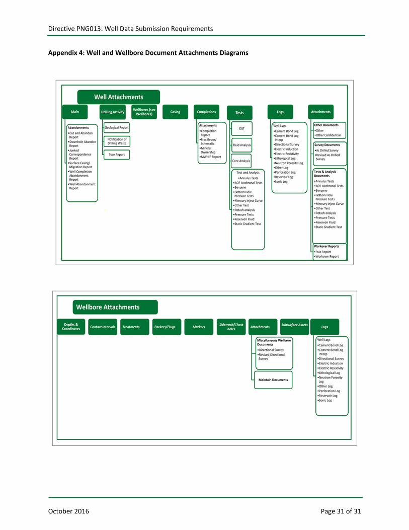
Appendix 4: Well and Wellbore Document Attachments Diagrams