Embed Size (px)
Citation preview
Document Type: EA-Administrative Record Index Field: Environmental Document Project Name: ED Grant - Alcorn County, MS Project Number: 2015-7
ECONOMIC DEVELOPMENT GRANT FOR SITE
PREPARATION AND ACCESS ROAD CONSTRUCTION ENVIRONMENTAL ASSESSMENT
Alcorn County, Mississippi
Prepared by: TENNESSEE VALLEY AUTHORITY
Knoxville, Tennessee
March 2015

This page intentionally left blank
Environmental Assessment
1
Purpose and Need for Action An integral part of the mission of the Tennessee Valley Authority (TVA) is to promote economic development within the Tennessee Valley. TVA provides financial assistance for projects within the TVA service area for economic development. The multi-year economic development program is designed to bring to market new/improved sites and facilities within the TVA area and position communities to compete successfully for new jobs and investment.
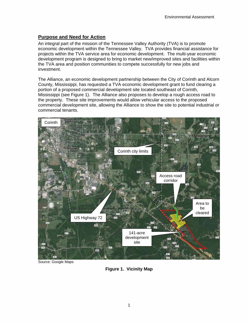
The Alliance, an economic development partnership between the City of Corinth and Alcorn County, Mississippi, has requested a TVA economic development grant to fund clearing a portion of a proposed commercial development site located southeast of Corinth, Mississippi (see Figure 1). The Alliance also proposes to develop a rough access road to the property. These site improvements would allow vehicular access to the proposed commercial development site, allowing the Alliance to show the site to potential industrial or commercial tenants.
Source: Google Maps
Figure 1. Vicinity Map
Corinth
Corinth city limits
US Highway 72
Access road corridor
Area to be
cleared
141-acre development
site
Economic Development – Alcorn County, Mississippi
2
Proposed Action
TVA proposes to provide an economic development grant to the Alliance for the purpose of conducting preliminary site improvements on a portion of an approximately 141-acre parcel planned for industrial development. Additionally, grant funding would be used to construct a preliminary access road to the site. These actions are summarized below.
Conduct site preparations, including clearing, grubbing, and stump removal, on approximately 42 acres of the 141-acre development site. The area to be cleared is identified in yellow in Figure 1.
Rough in an access road to the site (shown in green in Figure 1). This road would provide vehicular access to the site from Barnstable Road (County Road 220).
Conduct an on-ground topographic survey of the 141-acre parcel.
Background
The Alliance purchased an approximately 421-acre property in September, 2013. Currently, the Alliance is considering developing the approximately 141-acre parcel shown in Figure 1. This 141-acre parcel is contained within the larger 421-acre holding. Because there are no current plans for developing the balance of the 421-acre holding, an analysis of potential effects from developing the remaining acreage was considered beyond the scope of this environmental review.
The 141-acre property, which includes the site to be cleared and the corridor for the proposed access road, is bordered by the Norfolk Southern railroad line to the east and the Pioneer Rail short line railroad (also known as the Redmont Railroad) to the west. U.S. Highway 72 (US 72) lies a short distance to the west and generally parallels the two railroads. A creek and its associated floodplain lie at the northern end of the property. A wetland complex associated with Bucks Branch has developed at the southern end of the 141-acre property. However, the floodplain and wetland areas would be avoided and are not considered part of the developable area on the overall 141-acre property.
Other Environmental Reviews and Documentation Prior to purchase, the community performed appropriate due diligence studies on the entire 421-acre property to ensure no recognized environmental concerns or hazards existed on the property. Studies conducted on the proposed commercial development site are documented in the following reports.
Phase I Environmental Site Assessment (Cook Coggin Engineers, Inc. 2013a)
Wetland and Other Waters Assessment Report (Spencer 2013)
Phase I Cultural Resources Survey (Alvey and Baca 2013)
Custom Soil Resource Report for Alcorn County, Mississippi – Strickland Property (Natural Resources Conservation Service 2013)
Soils Investigation (Cook Coggin Engineers, Inc. 2013b)
Additionally, Headwaters, Inc. was retained by Cook Coggin Engineers, Inc. and the Alliance to perform preliminary coordination with the U.S. Fish and Wildlife Service (USFWS) concerning the Price’s potato bean, Mitchell’s satyr butterfly, and the Indiana bat.
Environmental Assessment
3
Permits, Licenses, and Approvals The provision of financial assistance to the Alliance for the proposed activities is not subject to any TVA permits or licenses. Only internal approval by TVA management would be required to provide the requested assistance. However, the actions that would be taken by the Alliance to clear and prepare the approximately 42-acre site and create the access road would require the following permits from other governmental agencies.
A permit pursuant to Section 404 of the Clean Water Act from the U.S. Army Corps of Engineers for the placement of fill within waters of the United States associated with the installation of the culverts for the proposed access road.
A Large Construction General Permit for Land Disturbing Activities of Five (5) or More Acres from the Mississippi Department of Environmental Quality under Section 402 of the Clean Water Act. This permit requires the preparation of a Stormwater Pollution Prevention Plan (SWPPP).
Construction of the access road would be subject to local floodplain regulations.
The Alliance has indicated that open-air burning is not planned, as vegetation debris would be mulched and spread onsite to prevent erosion. However, should burning become necessary, an open-air permit from the Mississippi Forestry Commission would be required, as well as any other applicable local permits.
Alternatives Scoping by TVA determined that from the standpoint of NEPA, two viable alternatives are available. These are the Action Alternative and the No Action Alternative. These alternatives are described below.
No Action Alternative
Under the No Action Alternative, TVA would not provide funding to the Alliance. In this case, the Alliance could pursue funding elsewhere or, perhaps, postpone or cancel the project. If alternate funding were secured, the proposed site clearing and access road construction would proceed, and potential environmental effects would likely be comparable to those anticipated from implementing the Action Alternative. In the event the project is postponed, environmental effects comparable to those expected under the Action Alternative would be delayed for the duration of the postponement. If the project were cancelled, no direct environmental effects are anticipated, as environmental conditions on the site would remain essentially unchanged from current conditions.
Action Alternative
Under the Action Alternative, TVA would provide the requested funding to the Alliance. Consequently, approximately 42 acres of the proposed 141-acre development site would be cleared of trees and brush. Remaining roots and stumps would be removed by grubbing on about 30 acres of the cleared area. Because the area has been subjected to previous timber harvests, most of the timber onsite is small. Thus, most of the clearing operations would be accomplished with a forestry mulcher. The resulting mulch would be spread on the site to prevent erosion. Grubbing operations would be used to remove trees, stumps, roots and other objectionable matter to a minimum depth of 8 inches. Heavy equipment such as bulldozers, backhoes, and trackhoes would be used to remove any remaining stumps. Stump holes and depressions caused by the grubbing would be backfilled, and soil fill would be compacted. Topsoil from clearing and grubbing would be spread over the disturbed areas. Burning of woody debris would be prohibited unless so authorized by the
Economic Development – Alcorn County, Mississippi
4
property owner (the Alliance) and local fire officials and meets requirement of applicable local, state, and federal laws and regulations.
Additionally, the Alliance would establish an approximately 1,600-foot long access road to the proposed development site. This access road would provide vehicular access to the site from Barnstable Road (County Road 220) and would parallel the existing Norfolk Southern railroad tracks. The road would be approximately 20 feet wide. However, a corridor approximately 150 feet wide would be cleared to accommodate the road. Clearing this corridor would be accomplished in the same manner as clearing the 42-acre site. The road bed would be leveled, and approximately 700 cubic yards of clay gravel would be used to overlay the road. Construction of this access road would involve the installation of two 60-inch diameter culverts (side by side) in an unnamed tributary of Clear Creek. The area at the mouths of the culverts would be armored by placing approximately 50 tons of stone riprap.
The Alliance would also contract for a topographic survey of the developable portion of the 141-acre property. This survey would utilize total station survey1 equipment and GPS2 survey equipment as applicable. Survey points would be collected in a gridded fashion to gain an accurate representation of the site topography for future design purposes. Such surveys are very non-intrusive on the landscape and typically cause no environmental effects. Thus, potential environmental effects of the topographic survey are not discussed further in this document.
The Alliance has indicated that proper erosion control measures would be implemented during earth-disturbing activities. Thus, the Alliance is responsible for ensuring that its contractors use appropriate and practicable measures, such as best management practices (BMPs) and best construction practices, to prevent or minimize erosion and the subsequent movement of sediment offsite during and following site clearing and the construction of the proposed access road. Likewise, the Alliance is responsible for ensuring that its contractors implement appropriate and practicable precautionary measures to prevent spills or accidental releases of fuels, lubricants, petroleum products or other materials or chemicals.
Additionally, the Alliance is responsible for securing all necessary federal, state, and local permits and licenses. TVA assumes that the Alliance will comply with all applicable federal, state, and local laws and regulations in undertaking the proposed clearing and road construction.
Preferred Alternative
TVA’s preferred alternative is the Action Alternative.
Affected Environment and Anticipated Impacts Site Description
The approximately 42-acre site to be cleared and the proposed access road lie within a larger, approximately 141-acre site located southeast of Corinth, Mississippi. The wedge-shaped 141-acre property is located east of US 72, between the Norfolk Southern railway
1 A total station survey uses an electronic/optical theodolite (transit) to measure distances and slope. 2 Global Positioning System, a navigation system that uses satellites to accurately determine positions and elevations on the earth’s surface.
Environmental Assessment
5
and the Pioneer Rail shortline railroad. The site consists of rolling hills, and the land was used previously for timber production and as a borrow area. At its northern end, the larger, 141-acre site is crossed by a creek bottom floodplain formed by an unnamed tributary to Clear Creek. The 42-acre area to be cleared does not contain any floodplains. However, the proposed access road would cross this bottom land floodplain. A forested wetland has developed at the southern end of the 141-acre property due to impoundment by the railroad beds. However, the area to be cleared does not contain any wetlands. Onsite wetlands and floodplains within the larger 141-acre site would be avoided and are not considered part of the developable area onsite.
A site reconnaissance of the entire 421-acre Alliance property was performed as part of a Phase I Environmental Site Assessment (Cook Coggin Engineers 2013a) to determine the presence of any recognized environmental condition (REC), including any pollutants or wastes on the site. That study indicated that no hazardous substances or petroleum products; storage tanks; pungent or noxious odors; pooled liquids; drums; petroleum or unidentified substance containers; polychlorinated biphenyls; waste generation, storage, and disposal sites; septic systems or evidence of such RECs were observed onsite. The reconnaissance located two abandoned wells on the 421-acre property; however, both were located outside the 141-acre property planned for development. A small farm pond is located on the 141-acre property immediately south of the 42-acre site to be cleared.
Impacts Evaluated
Several environmental resources would not be affected by undertaking the proposed site preparation or effects, if any, would be negligible. The site to be cleared is not near a navigable stream, and the proposed work would not involve navigational interests. Thus, there would be no effects to navigation.
TVA consulted with the Corinth Service Center of the Natural Resources Conservation Service (NRCS) regarding the presence of any prime farmlands on the 141-acre site. The NRCS confirmed TVA’s determination that no prime farmland would be impacted by the proposed site improvements.
There would be no impacts to natural areas including managed areas, ecologically significant sites, and streams listed on the Nationwide Rivers Inventory. A review of the TVA Regional Natural Heritage database indicated there are no natural areas within 5 miles of the project site. The site is near the Corinth Speedway, a dirt racetrack. However, no effects to the operation of this racetrack are anticipated. The proposed site preparation is not expected to adversely affect any public recreation opportunities, including visitation to parks, historic sites or other recreational resources in Corinth.
During the proposed site preparation, most of the woody debris from clearing would be mulched and spread on the site to prevent erosion. Burning of cleared and grubbed materials would be prohibited unless proper authorization is made by the Alliance and the proposed burning meets the requirements of applicable local, state, and federal laws. No other sources of solid wastes on the site were identified in the Phase I document (Cook Coggin Engineers 2013a). Thus, the proposed site preparations are not expected to generate any significant amounts of solid wastes that would require disposal in landfills or other offsite facilities.
Economic Development – Alcorn County, Mississippi
6
Water Resources and Water Quality At its northern end, the 141-acre property is drained by an unnamed tributary to Clear Creek. The proposed access road would cross this stream. Likewise, a small tributary to this stream parallels the Norfolk Southern railway and is situated within a portion of the 42-acre property. Bucks Branch and a small tributary to Bucks Branch drain the 141-acre property at its southern end. Bucks Branch joins Clear Creek west of US 72. A small farm pond is located immediately south of the 42-acre area to be cleared.
Section 303(d) of the Clean Water Act requires the state to identify water bodies that do not meet one or more applicable water quality standards and for which Total Maximum Daily Loads are needed. Clear Creek, Bucks Branch, and all tributaries are classified by the state for fish and wildlife. None of the streams are classified as impaired on the State 303 (d) List of Impaired Waters for biological impairment.
The Alliance has indicated that reasonable control measures would be implemented during earth-disturbing activities to prevent or minimize erosion and the subsequent movement of sediment offsite during and following site clearing and the construction of the proposed access road. The Alliance is also responsible for implementing any measures stipulated by its Construction Stormwater Permit, including the development and implementation of a Stormwater Pollution Prevention Plan. Thus, any effects to local surface water quality and quantity are expected to be minor.
Site reconnaissance of the 421-acre Alliance property revealed the presence of two abandoned wells. However, neither of these wells is located within the 42-acre site to be cleared or on the 141-acre proposed development area. No withdrawal of groundwater associated with the proposed site preparation is expected.
Contamination of groundwater supplies can potentially occur from the introduction of contaminants into areas that serve as recharge areas for groundwater. Contaminants include soil sediment from construction, spilled fuel, petroleum products, and chemicals. Because appropriate BMPs and best construction practices would be employed and because activities would be in compliance with applicable storm water permitting requirements, any direct effects to local surface water quality or groundwater supplies or quality are expected to be temporary and minor.
Biological Resources Headwaters, Incorporated, retained by Cook Coggin Engineers, Inc., and the Alliance, conducted field surveys of the entire 421-acre Alliance property in July, 2013. These surveys included the 42-acre area to be cleared and the proposed access road corridor. The field survey consisted of the inventory of all vegetative components occurring within the project site for each habitat type found, except developed agricultural lands and excavated areas.
The Headwaters report indicated that the (141-acre) parcel proposed for development is comprised of hardwood and evergreen stands in various stages of succession. Much of the site has been heavily disturbed by previous land uses including timber production and gravel extraction. A portion of the 141-acre area was previously logged and contains thick brush and scrub timber that was sprayed with herbicide by the previous landowner with the intent of planting pine seedlings. The 42-acre site proposed for clearing overlaps this brushy section and much of an old gravel pit. The proposed access road corridor would

Environmental Assessment
7
cross an upland pine/hardwood forest. The different habitat types offer suitable habitat for terrestrial plant and animal species common to the region both seasonally and year-round.
Wetlands found in the southern portion of the 141-acre site contain species indicative of saturated habitats. Common plant species in the wetlands include eastern cottonwood, red maple, sweetgum, water oak, American elm, loblolly pine, Frank’s sedge and a Mississippi state-listed species, pin oak. Because these forested wetlands would not be disturbed, the native plant communities they contain would not be impacted by the proposed development.
Executive Order (EO) 13112 serves to prevent the introduction of invasive species and provides for their control to minimize the economic, ecological, and human health impacts that those species potentially cause. In this context, invasive species are nonnative species that invade natural areas, displace native species, and degrade ecological communities or ecosystem processes (Miller et al. 2010). Much of the project area is currently dominated by invasive species, which reflects the frequency and magnitude of disturbance present on site. Disturbances associated with agriculture, mining, and timber production can encourage invasion and establishment of weedy plants.
Most forested and herbaceous communities currently found on the site do not support native plant communities with conservation value. Portions of the project area would be permanently converted, but these areas do not support unique plant communities. The implementation of the proposed project would have a negligible impact on the terrestrial ecology of the region.
Deciduous forests and mixed deciduous-evergreen forests provide habitat for an array of terrestrial animal species. Birds typically found in this type of habitat include chuck-will’s-widow, downy and hairy woodpecker, eastern screech-owl, eastern wood-pewee, red-tailed hawk, white-breasted nuthatch, wood thrush, and yellow-billed cuckoo (National Geographic 2002; Turcotte and Watts 1999). This area also provides foraging and roosting habitat for several bat species, particularly in areas where the forest understory is more open. Some examples of bat species likely found within this habitat include big brown bat, little brown bat, eastern red bat, evening bat, hoary bat, Rafinesque’s big-eared bat, silver-haired bat, and tricolored bat. Coyote, eastern chipmunk, eastern woodrat, North American deermouse, and woodland vole are other mammals that may be present within this habitat (Kays and Wilson 2002; Reid 2006). Gray rat snake and midland brown snake, as well as scarlet kingsnake, are all common reptiles of this habitat (Conant and Collins 1998).
Evergreen forests reported from field surveys were typically pine forests. These forests provide habitat for several common terrestrial wildlife species. Barred owl, brown creeper, golden-crowned kinglet, hermit thrush, pine siskin, pine warbler, red-breasted nuthatch, summer tanager, wild turkey, yellow-rumped warbler, and yellow-throated warblers all utilize this habitat (National Geographic 2002; Turcotte and Watts 1999). Cotton deermouse and white-footed deermouse, eastern fox squirrel, Seminole bat and wild boar are mammals that may utilize resources found in pine forests (Kays and Wilson 2002; Reid 2006). Eastern coachwhip, eastern hognose snake, northern red-bellied snake, red corn snake, and northern scarlet snakes are found in open pine forests (Conant and Collins 1998). Additionally, eastern narrowmouth toad, eastern spadefoot road, and Fowler’s toad may all be present in pine forests (Niemiller and Reynolds 2011).
Economic Development – Alcorn County, Mississippi
8
Review of the TVA Regional Natural Heritage database on February 3, 2015, indicated that no recorded caves occur within 3 miles of the project area, and no caves were reported by Headwaters, Inc., during field reviews. No other unique or important terrestrial habitats were documented in the project area. Additionally, no aggregations of migratory birds or colonial wading bird colonies are known from the project area. The nearest wading bird colony occurs approximately 18.5 miles from the project area. No other indications of migratory bird aggregations or colonial wading bird colonies were reported from the field reviews.
Under the Action Alternative, approximately 40-acres of thick brush and scrub timber would be cleared in an area that was treated previously with herbicide. Because ground disturbance would occur, potential effects to wildlife habitat would be limited to the project area, including the access road corridor. Construction-associated disturbances and habitat removal would force onsite wildlife (primarily common species habituated to human disturbance) to move into surrounding areas to find new food sources, shelter sources, and to reestablish territories. In the event that the surrounding areas are already overpopulated, further stress to wildlife populations could occur to those species presently utilizing these areas as well as those attempting to relocate. Much of the project area is already disturbed by dirt roads, developed agricultural fields, and excavated areas. Species currently occupying habitat in the project area are unlikely to be affected negatively by the displacement of individuals. Over time any displaced individuals able to utilize early-successional (i. e., thick brush and scrub timber, in this case) habitat may return to the area upon completion of actions.
The 42-acre project site is located near Clear Creek and Bucks Creek in the Pollys Creek-Tuscumbia River Canal watersheds, in the Blackland Prairie section of the Southeastern Plains Ecoregion. As mentioned above, a small farm pond is located immediately to the south of the site. The access road corridor would cross an unnamed tributary to Clear Creek at the northern side of the project area. Additionally, a small permanent stream runs along the west side of the Norfolk Southern railroad bed for a distance of about 2,400 feet. This unnamed stream originates about 700 feet east of the farm pond and crosses under the railroad bed before paralleling the railroad in a northwest direction. It joins the unnamed tributary to Clear Creek immediately upstream of the point where the proposed access road would cross the creek. Two areas of the proposed clearing would involve short segments of this stream. Ephemeral streams are those waterways that convey surface water during and immediately following storm events. The 141-acre property and the 42-acre area to be cleared may contain such ephemeral drainages.
Aquatic life could be affected by the proposed site preparation actions either directly by the alteration of habitat conditions or indirectly from the modification of the riparian zone and uncontrolled storm water runoff. The Alliance would ensure that measures to protect water quality as outlined in its Construction Stormwater Permit and applicable storm water permitting requirements are implemented appropriately. With these measures in place, effects to aquatic life would be temporary and minor.
The federal Endangered Species Act (ESA) provides broad protection for species of fish, wildlife, and plants that are listed as threatened or endangered in the United States or elsewhere. Endangered species are those determined to be in danger of extinctions through all or a significant portion of their range. Threatened species are those determined to likely become endangered within the foreseeable future. Section 7 of the ESA requires

Environmental Assessment
9
federal agencies to consult with the USFWS when proposed actions may affect endangered or threatened species or Designated Critical Habitat.
The State of Mississippi provides protection for species considered threatened, endangered or deemed in need of management within the state other than those federally listed under the ESA. The listing is handled by the Mississippi Department of Wildlife, Fisheries, and Parks. Additionally, the Mississippi Natural Heritage Program and TVA both maintain databases of species considered threatened, endangered, special concern or tracked in Mississippi.
Review of the TVA Regional Natural Heritage database (queried February 2015) indicates that one candidate for federal listing and one state rare plant species have been previously documented within a 5-mile vicinity of the project area (Table 1). No additional federally listed plant species are known to occur in Alcorn County, and no designated critical habitat for plant species occurs in the project area. One state-listed species, pin oak, was reported from wetlands located on the southern portion of the 141-acre property and would not be affected by the proposed work. No state-listed or federally listed plant species occur on the 42-acre site. Thus, adoption of the Action Alternative would not affect any state-listed or federally listed plant species.
Table 1. State-listed and Federally Listed Species with Potential to Occur Within the Vicinity of the Proposed Project
Common Name Scientific Name Federal Status1
State Status1 (Rank2)
Plants3 White turtlehead Chelone glabra SLNS (S3)
Monkey-face orchid Platanthera integrilabia C SLNS (S1)
Pin oak Quercus palustris SLNS (S2?)
Mammals Northern long-eared bat4 Myotis septentrionalis PE TRKD (S1N)
Indiana bat4 Myotis sodalis3 END END (S1B)
Insects
Mitchell’s satyr butterfly4 Neonympha mitchellii mitchellii END END (S1)
Fishes Northern madtom Noturus stigmosus END (S1)
Steelcolor shiner Cyprinella whipplei TRKD (S2)
Suckermouth minnow Phenacobius mirabilis END (S1) Source: TVA Regional Natural Heritage Database and USFWS Environmental Conservation Online System
(http://ecos.fws.gov/ecos/home.action) extracted 02/03/2015. 1 Status Codes: C = Candidate; END = Endangered; PE = Proposed Endangered; SLNS = State listed but
no status; TRKD = Tracked. 2 State Ranks: S1 = Critically Imperiled; S#B = rank of breeding population; S#N = rank of a non-breeding
population; ? = Uncertainty in the exact rarity of the species. 3 Mississippi has no status concerning endangered plants. 4 USFWS has determined this species has the potential to exist in Alcorn County, Mississippi, although no
records are known to date.
A review of the TVA Regional Heritage database on February 3, 2015, did not indicate records of occurrence for any state-listed, federally listed, or federally protected terrestrial

Economic Development – Alcorn County, Mississippi
10
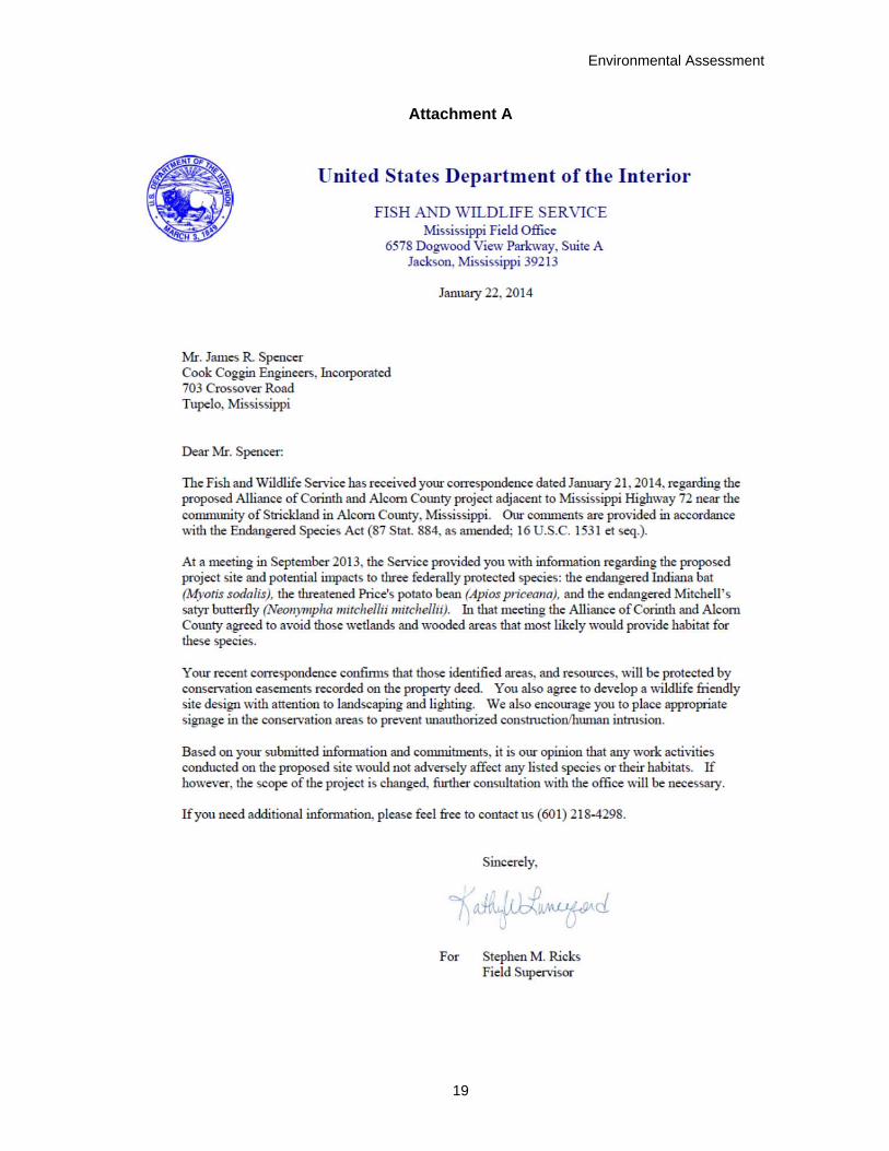
animal species within 3 miles of the project site or from Alcorn County. However, the federally listed as endangered Indiana bat and the northern long-eared bat (currently proposed for federal listing) both have the potential to occur statewide. The northern long-eared bat was proposed for listing as federally endangered by the USFWS in October 2013. Until it is listed, federal action agencies are required to make determinations with respect to whether proposed actions would result in jeopardy to the species based on guidance provided by the USFWS. Further, the USFWS considers there to be potential for Mitchell’s satyr butterfly to occur within the project area, although there are no current records for this species in Alcorn County (see Attachment A).
Indiana bats hibernate in caves in winter and use areas around caves for swarming (mating) in the fall and staging in the spring, prior to migration back to summer habitat. During the summer, Indiana bats roost under the exfoliating bark of dead snags and living trees located in mature forests with an open understory and a nearby source of water (Pruitt and TeWinkel 2007, Kurta et al. 2002). Indiana bats are known to change roost trees frequently throughout the season, yet still maintain site fidelity, returning to the same summer roosting areas in subsequent years (Dickenson 2001). No known caves exist within 3 miles of the project area, and none were reported from the field reviews. The nearest documented cave record (i.e., winter occurrence) occurs just over 20 miles to the east of the project in Tishomingo County, Mississippi. Indiana bat summer roosts have been documented approximately 38 miles to the west in Benton County, Tennessee. Foraging habitat exists throughout much of the 421-acre Alliance property and surrounding areas along forest edges, over forest fragments, fence rows and other corridors. Based on field surveys conducted in July, 2013 by Headwaters, Inc., approximately 260 acres of potential Indiana bat exist on the 421-acre Alliance property. However, only a small proportion of this occurs on the 141-acre parcel to be developed, and only 5.25 acres of potential Indiana bat habitat occur within the 42-acre site to be cleared. The vast majority of suitable Indiana bat habitat occurs on forested portions of the Alliance property located east of the Norfolk Southern railroad tracks.
Northern long-eared bat roosts in caves, abandoned mines, and cave-like structures during the winter. During the fall and spring they utilize entrances of caves and the surrounding forested areas for swarming (mating). In the summer, northern long-eared bats roost singly or in colonies beneath exfoliating bark or in crevices of both live trees and snags. This species is also known to roost in abandoned buildings and under bridges, although their primary summer roosting sites appear to be trees. Roost selection by northern long-eared bat is similar to that of the Indiana bat. It is thought, however, that northern long-eared bats are more opportunistic in their roost site selection. Northern long-eared bats emerge at dusk to forage below the canopy of mature forests on hillsides and ridges, and occasionally over forest clearings and along riparian areas (USFWS 2013, 2014). No known caves exist within 3 miles of the project area, and none were reported by Headwaters, Inc. The nearest documented cave record occurs just over 20 miles east of the project in Tishomingo County, Mississippi. No records of northern long-eared bats exist for Alcorn County. According to the USFWS, this species has the potential to exist statewide in Mississippi and therefore has the potential to occur within the project area. Foraging habitat exists along forest edges, over forest fragments, fence rows and other corridors. Suitable summer roosting habitat for the northern long-eared bat exists on the property and possibly within the project area.
Because no caves or other winter hibernating sites for either Indiana or northern long-eared bats exist in the project area, no such habitats would be impacted by the proposed clearing
Environmental Assessment
11
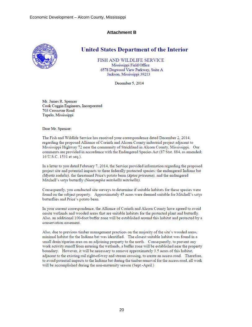
or road construction. Foraging opportunities along forest fragments, dirt roads and other corridors would remain available for both species, either within the adjacent landscape, or along newly created forest edges within the project area. Proposed site work would result in the removal of approximately 40 acres of brush and scrub timber. Due to previous timber management practices on the majority of the site’s wooded areas, potentially suitable summer roost habitat for Indiana bat within the 42-acre area to be cleared was limited to 5.25 acres. This habitat is likely to be suitable for northern long-eared bat also. The USFWS recommended that timber removal of suitable bat habitat for the road construction should be accomplished during the non-maternity season, i.e., September 1 through April 30 (see Attachment B) to avoid any potential direct impacts to Indiana bat. Subsequently, the Alliance removed this potential habitat in the recommended timeframe. Therefore, TVA determined that undertaking the proposed actions may affect but would not adversely affect the Indiana bat and would not jeopardize the existence of the northern long-eared bat.
The endangered Mitchell’s satyr butterfly is a medium sized butterfly with an overall rich brown color. A distinctive series of orange-ringed black circular eyespots with silvery centers are located on the lower surfaces of both pairs of wings. This butterfly is one of the most geographically restricted eastern butterflies. It occurs in wetlands where low nutrient systems receive carbonate-rich ground water from seeps and springs. In Mississippi, Mitchell’s satyr has been found in small upland wetlands created by beaver dams and in wetlands formed by road culverts. A major threat to the Mitchell’s satyr is habitat destruction caused by beaver control, draining and filling of wetlands, invasion from exotic weeds, and contamination of wetlands by pesticides, fertilizer, and nutrient runoff from adjacent agriculture. Site surveys in summer 2013 indicated that 14.37 acres of the 421-acre Alliance property were suitable habitat for Mitchell’s satyr butterfly. However, no suitable habitat for this butterfly occurs within the 42-acre site to be cleared or along the proposed access road corridor.
Following discussions with the USFWS (see Attachments A and B), the Alliance agreed to avoid wetlands on the 141-acre property and wooded areas that are suitable habitat for Mitchell’s satyr butterfly. Additionally, the Alliance would establish a 100-foot buffer zone around these wetland habitats, and implement a conservation easement to protect habitat suitable for this species. None of these avoidance or buffer areas were on the 42-acre parcel or new roadway. Therefore, TVA determined that no adverse effects to Mitchell’s satyr butterfly are expected to occur as a result of implementing the proposed actions on the 42-acre parcel or road corridor.
Three state-listed aquatic species are known to occur within Alcorn County or in potentially affected local watersheds (see Table 1). Because no listed aquatic species or designated critical habitat are known from the Alliance site, and appropriate measures would be implemented during site preparation activities to protect aquatic habitats, no impacts to federal or state-listed aquatic species are anticipated to occur as a result of implementing the proposed action.
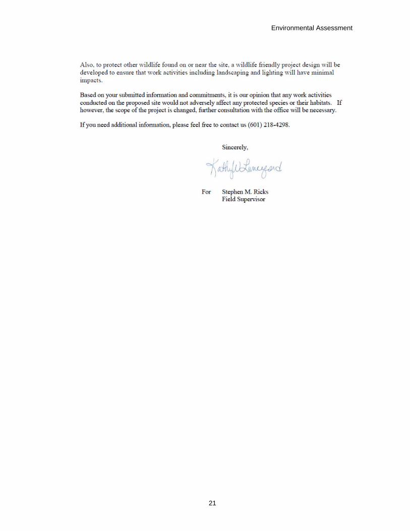
Cook Coggin Engineers, Inc., representing the Alliance, received a letter dated December 5, 2014, from the USFWS Mississippi field office (Attachment B), stating that the proposed work activities would not adversely affect any federally listed species or their habitats.
Wetlands Wetlands are those areas inundated by surface water or groundwater such that vegetation adapted to saturated soil conditions is prevalent. Examples include swamps, marshes,
Economic Development – Alcorn County, Mississippi
12
bogs, and wet meadows. Wetland fringe areas also are found along the edges of most watercourses and impounded waters (both natural and man-made). Field surveys were conducted in August 2013 (Cook Coggin Engineers, Inc. 2013a) to identify wetland areas within the approximately 421-acre Alliance property containing the parcel to be cleared. That survey indicated that five wetland areas totaling approximately 27.8 acres occur within the 421-acre Alliance property. However, no wetland areas occur within the developable portion of the 141-acre site, which includes the 42-acre area to be cleared and the access road corridor. Thus, no direct effects to wetlands are anticipated. Because precautions, such as the implementation of best management practices, would be used to prevent erosion and the movement of sediment from runoff, any indirect or long-term effects to local wetlands from the proposed clearing and access road work would be minimal.
Floodplains A floodplain is the relatively level land area along a stream or river that is subjected to periodic flooding. The area subject to a one-percent chance of flooding in any given year is normally called the 100-year floodplain. The proposed access road would cross a floodplain associated with a tributary of Clear Creek. According to the Alcorn County Flood Insurance Rate Maps, the 100-year floodplain at this location is that area located below approximate elevation 480 feet, mean sea level. Alcorn County participates in the national Flood Insurance Program, and any development in a floodplain is subject to regulations.
As a federal agency, TVA is subject to the requirements of Executive Order (EO) 11988 (Floodplain Management). EO 11988 requires federal agencies to avoid to the extent possible the long- and short-term adverse impacts associated with the occupancy and modification of floodplains and to avoid direct and indirect support of floodplain development wherever there is a practicable alternative. This EO is not intended to prohibit floodplain development in all cases, but rather to create a consistent government policy against such development under most circumstances. The EO requires federal agencies to avoid the 100-year floodplain unless there is no practicable alternative.
Under EO 11988, clearing brush and trees is considered an agricultural use of the land, and agricultural use is considered a repetitive action in the 100-year floodplain. A road is also considered a repetitive action in the 100-year floodplain, provided adverse impacts are minimized by taking actions such as revegetating disturbed areas, implementing appropriate BMPs, and constructing the access road such that upstream flood elevations would not be increased. Because these measures would be implemented, the potential impacts to flood elevations and increased flood damages from the placement of the access road across the 100-year floodplain would be minor.
Cultural Resources Historic and cultural resources, including archaeological resources, are protected under various federal laws. These include the Archaeological Resources Protection Act, the native American Graves Protection and Repatriation Act, and the National Historic Preservation Act (NHPA). Section 106 of NHPA requires federal agencies to consult with the respective State Historic Preservation Officer (SHPO) when proposed federal actions could affect these resources.
Prior to TVA’s involvement, a Phase I Cultural Resources Survey was conducted on the entire 421-acre Alliance property (Alvey and Baca 2013). Shovel testing and visual ground inspection identified 11 previously-unrecorded archaeological sites and two standing buildings associated with one of these sites. Due to scant presence of artifacts and poor
Environmental Assessment
13
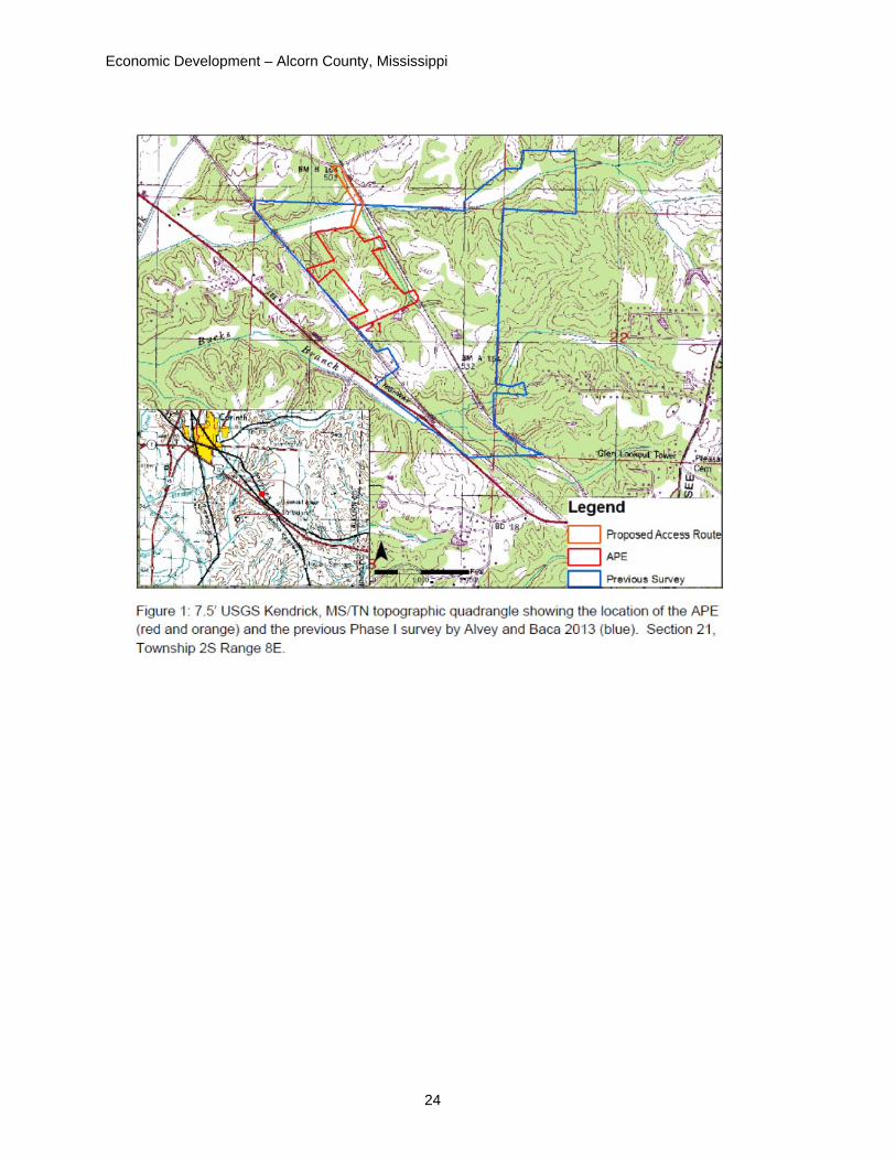
preservation, eight of these sites were considered to be ineligible for inclusion on the National Register of Historic Places (NRHP). However, three sites have the potential to contribute to understanding of the prehistory of the region and were considered to be potentially eligible for inclusion on the NRHP. Two of these sites are located well beyond the borders of the 141-acre property planned for development. However, the third site, identified as 22AL716, is located within the 141-acres. This site is situated on the undevelopable portion of the property and is not located within the 42-acre area to be cleared.
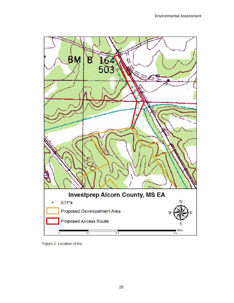
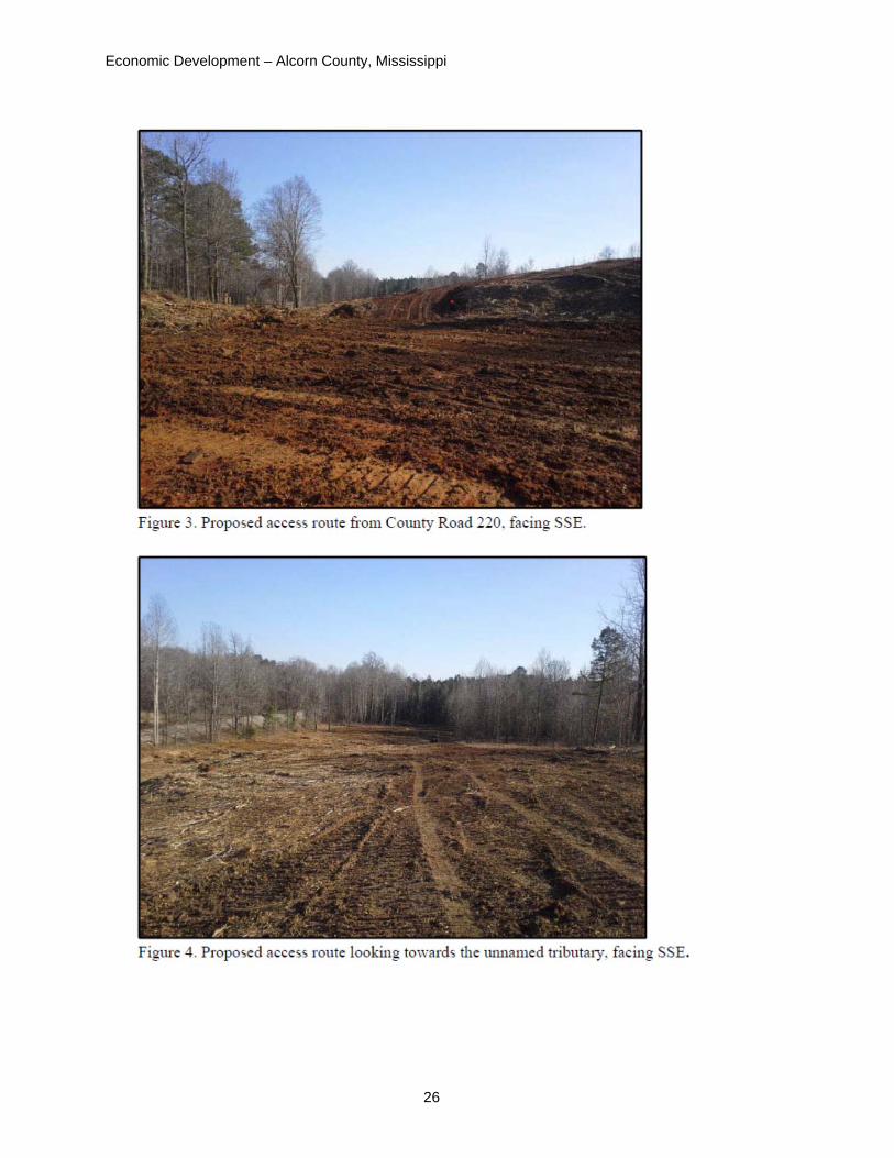
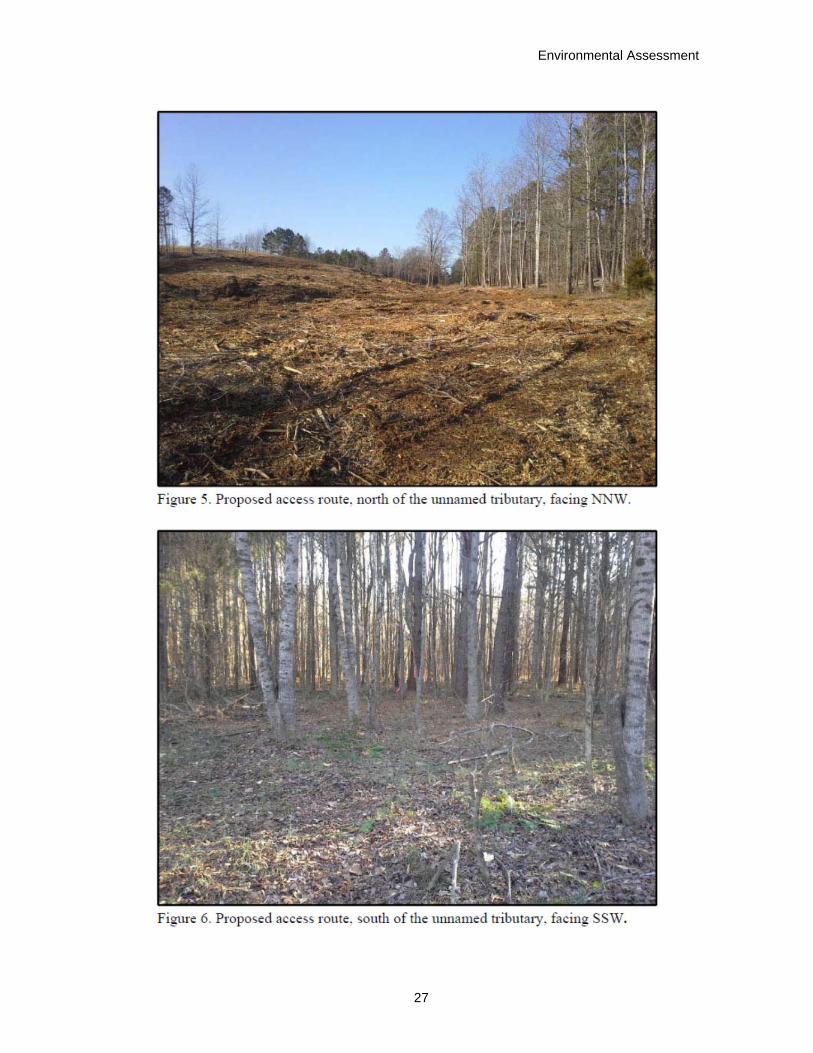
TVA determined the Area of Potential Effects (APE) with respect to its undertaking to be the area of disturbance associated with the clearing and construction of the access road. This APE is located within a portion of the area surveyed in 2013. No archaeological sites were identified within TVA’s current APE during the 2013 survey. A portion of the proposed access road falls outside of the 2013 survey. On January 29, 2015, TVA archaeologists surveyed the remaining portion (approximately 3 acres). The entirety of the proposed access route had been logged previously, prior to TVA’s involvement, from County Road 220 southeasterly up to the unnamed tributary, and logging had just commenced along the opposite side of the creek. Thirteen shovel test pits were excavated during the field review; none were positive for cultural material.
TVA finds that no historic properties would be affected by the proposed undertaking. TVA consulted with the SHPO in a letter dated February 13, 2015 (Attachment C) regarding TVA’s findings of no effect to historic properties. The SHPO failed to respond within 30 days of receipt of request to review TVA’s determination of no effect. Pursuant to 36 CFR § 800.3(f) (2), TVA also consulted with federally recognized Indian tribes regarding properties that may have religious and cultural significance to those tribes and that are eligible for listing on the National Register of Historic Places. TVA received no responses from federally recognized tribes. Therefore, pursuant to 36 CFR § 800.5(c) 1, TVA’s responsibilities under Section 106 of NHPA are fulfilled.
Socioeconomic Conditions and Environmental Justice According to estimates from the United States Census Bureau (2015), the population of Corinth is 14,573, while the population of Alcorn County is 37,057. Within Corinth, Caucasians comprise approximately 71.4 percent of the populations, and blacks or African Americans comprise approximately 23.2 percent. In the county, Caucasians and blacks or African Americans comprise approximately 85.4 percent and 11.4 percent, respectively. Hispanics account for approximately 2.7 percent of the county population and about 5.3 percent of Corinth’s population.
Within Corinth, the median and mean household incomes are $31,347 and $47,426, respectively. Approximately 23.1 percent of all persons living within Corinth are considered to be living on incomes below the poverty level. The unemployment rate for persons over the age of 16 years in Corinth is 11.1 percent. For Alcorn County, the unemployment rate is 10.2 percent, while 20.8 percent of the county population lives below the poverty level. Estimated mean and median household incomes for Alcorn County are $33,600 and $46,875, respectively. Per capita income in Alcorn County is $19,003, which is comparable to that of the state ($20,670) but lower than the U.S. average of $28,051.
The proposed site preparation and access road construction for the 42-acre site is expected to require a small workforce. No more than 30 workers are expected to be onsite at any one time, and work is expected to take 6 months or less, depending on weather conditions.
Economic Development – Alcorn County, Mississippi
14
The entire expenditure for the proposed site work is estimated to be less than $125,000. Thus, the proposed site preparation actions are expected to have only minor direct effects to the local economy or workforce. Likewise, no disproportionate effects are anticipated to any minority or economically disadvantaged populations.
Aesthetic Resources The landscape of the 42-acre area to be cleared and the surrounding area is gently rolling hills. The surrounding area is generally forested, mainly with loblolly pines and mixed hardwoods. Although the property is near US 72, intervening forest cover blocks views of the site to be cleared from the highway and from nearby residences along US 72. The proposed access road would connect to County Road 220 (Barnstable Road) adjacent to the rail crossing by the Norfolk Southern Railroad. The road access point is currently a cleared, graded area that has been partially graveled. Thus, perceived changes in the visual quality of the local area are expected to be minor.
Clearing and road construction would create some noise, mainly from construction equipment. However, noise levels are not expected to be excessive, and work would be conducted during normal working hours. No sensitive receptors (e.g., schools, hospitals) are located near the 42-acre area to be cleared or near the access road. Thus, noise-related effects are expected to be minor. The proposed work is not expected to be a source of any unpleasant odors.
Air Quality The United States Environmental Protection Agency (EPA) establishes the National Ambient Air Quality Standards (NAAQS), which are health standards with respect to levels of six criteria air pollutants (i.e., carbon monoxide, lead, nitrogen dioxide, ozone, particulate matter, and sulfur dioxide. Alcorn County is considered to be in attainment with the NAAQS (EPA 2015).
The EPA uses an Air Quality Index (AQI) to characterize air quality at a given location. AQI categories range from Good (i.e., values from 0 to 50) to Hazardous (values from 301 to 500). Between 1999 to 2009 (the latest year data are available), the AQI for Alcorn County improved, dropping from a high of about 63 in 1999 to less than 40 in 2009 (USA.Com 2015).
Clearing of the 42-acre area and construction of the access road would generate some air pollution in the form of fugitive dust from clearing operations and from vehicular movements. Additionally, low levels of carbon monoxide, sulfur dioxide, and nitrogen oxides would be generated by equipment exhaust. Burning of debris is not planned, as most vegetation would be mulched and spread onsite. However, if onsite burning is required, it would be accomplished in accordance with all applicable regulations. Because of the short time period required to complete clearing and road construction any effects to local air quality are expected to be temporary and minor.
Transportation The proposed access road would connect to Barnstable Road. Vehicular access from the site to US 72, a four-land divided highway, would be via an approximately quarter-mile segment of Barnstable Road, which connects to a half-mile segment of the recently completed Kimberly-Clark Parkway, which connects to US 72. Counts of annual average daily traffic (AADT) are not available for Barnstable Road or Kimberly-Clark Parkway. AADT on US 72 at its intersection with Kimberly-Clark Parkway is 16,000, and this number
Environmental Assessment
15
increases steadily to 25,000 as the highway enters the main business district of Corinth (Mississippi Department of Transportation 2015). Because of the temporary nature of the proposed clearing and the small number of workers onsite, any direct, indirect or cumulative effects to the local transportation system from the proposed site preparation are expected to be minor.
Cumulative and Reasonably Foreseeable Long-term Effects Because of the limited size of the proposed site preparation (about 42 acres) and access road corridor and the short duration of the proposed activities, any cumulative effects to local water quality, biological resources, wetlands, floodplains, cultural resources, aesthetic character or the local transportation system are expected to be minor.
Additional site preparation associated with future site development, including cutting, filling, and leveling, could cause minor changes in onsite drainage patterns. Likewise, the placement of buildings on the property would likely increase the amount of impermeable surface and possibly lead to faster runoff of onsite precipitation. Nevertheless, activities that could affect surface water and groundwater resources are subject to state and federal regulations. Thus, long-term effects to water resources are expected to be minor.
Eventual development of the Alliance property would result in the loss of much of the available wildlife habitat on the site. However, similar available habitats are available on adjoining properties in the immediate area, and displaced mobile wildlife would likely relocate to nearby areas. Likewise the vegetative cover on the site would likely change from a mixture of scattered woodlands and brush to an industrial or commercial setting. Nevertheless, populations of terrestrial species common to the area are not likely to be affected adversely to any noticeable extent, as similar habitat exists in the surrounding landscape.
The proposed site preparation would involve 5.25 acres of potential Indiana bat habitat. However, future development of the larger, 421-acre Alliance property has the potential to involve the removal of as much as 260 acres of potential Indiana bat and northern long-eared bat habitat. In this event, the Alliance would be responsible under the Endangered Species Act for working with the USFWS to determine measures to avoid or minimize impacts to these species should suitable bat habitat need to be removed.
Those areas of the Alliance property containing wetlands and floodplains would not be developed. Thus, no direct effects to onsite wetlands are anticipated from the long-term development of the Alliance property. Indirect long-term effects to wetland areas, such as changes in drainage or recharge patterns or siltation could potentially occur. However, with adherence to applicable federal, state, and local laws and regulations, such adverse effects to local wetlands are expected to be minor. Development of any new infrastructure in a floodplain, such as construction of an improved access road and stream crossing, would be subject to local floodplain regulations. Therefore, no measureable cumulative or long-term effects to floodplains are expected.
Mitigation Measures To minimize or reduce the environmental effects of the proposed project, the Alliance will ensure that its construction contractors are in compliance with storm water permitting requirements, and the Alliance will be responsible for ensuring that applicable BMPs to minimize and control erosion and fugitive dust are implemented during construction. TVA
Economic Development – Alcorn County, Mississippi
16
has not determined the need for any non-routine measures to reduce potential environmental effects.
TVA Preparers Rachel B. Crickmar, Program Manager – Project Management
Adam J. Dattilo, Botanist – Biological Resources, Terrestrial Ecology and Threatened and Endangered Species
Patricia B. Ezzell, Program Manager – Tribal Relations
Elizabeth Burton Hamrick, Biologist – Terrestrial Animals
Michaelyn S. Harle, Archaeologist – Cultural Resources, National Historic Preservation Act Compliance
Andrew R. Henderson, Aquatic Endangered Species Biologist – Aquatic Ecology and Aquatic Threatened and Endangered Species
Amy B. Henry, Manager – NEPA Compliance and Document Review
Holly G. LeGrand, Biologist – Biological Resources, Terrestrial Resources, and Terrestrial Threatened and Endangered Species
Carrie C. Mays, Civil Engineer – Floodplains
Craig L. Phillips, Aquatic Biologist – Biological Resources, Aquatic Ecology
Kim Pilarski-Hall, Wetlands and Natural Areas Specialist, Natural Areas and Wetlands
James F. Williamson, Contract Senior NEPA Specialist – Document Preparation
Agencies and Others Consulted The following federal and state agencies and Native American Tribes were consulted.
Mississippi Department of Archives and History, Jackson, Mississippi
United States Fish and Wildlife Service, Jackson, Mississippi
Natural Resources Conservation Service, Corinth, Mississippi
Chickasaw Nation
Choctaw Nation of Oklahoma
Jena Band of Choctaw Indians
Mississippi Band of Choctaw Indians
References Alvey, J. S. and K. A. Baca. 2013. A Phase I Cultural Resources Survey of the Proposed
Alliance Southeast Corinth Commercial Development Site, Alcorn County, Mississippi. Cobb Institute of Archaeology, Mississippi State University, Mississippi State, Miss. Unpublished Report.
Environmental Assessment
17
Conant, R. and J. T. Collins. 1998. A Field Guide to Reptiles and Amphibians of Eastern and Central North America. Fourth edition. Houghton Mifflin Harcourt.
Cook Coggin Engineers, Inc. 2013a. Phase I Environmental Site Assessment, The Alliance, Proposed SE Corinth Commercial Property. Cook Coggin Engineers, Inc., Tupelo, Miss. Unpublished Report.
Cook and Coggin Engineers, Inc. 2013b. Soils Investigation, Proposed Industrial Site, Alcorn County, Mississippi. Cook Coggin Engineers, Inc. Tupelo, Miss. Unpublished Report.
Dickenson, J. G. 2001. Wildlife of Southern Forests: Habitat and Management. House Publishers. Blaine, Washington.
Kays, R. W. and D. E. Wilson. 2002. Mammals of North America. Princeton University Press, Princeton, New Jersey.
Kurta, A., S. W. Murray, and D. H. Miller. 2002. Roost selection and movements across the summer landscape. Pages 118-129 in A. Kurta and J. Kennedy (eds.). The Indiana Bat: Biology and Management of an Endangered Species. Bat Conservation International. Austin, Texas.
Miller, J. H., S. T. Manning, and S. F. Enloe. 2010. A management guide for invasive plants in the Southern forests. General Technical Report SRS-131. Asheville, North Carolina. US Department of Agriculture, Forest Service, Southern Research Station.
Mississippi Department of Transportation. 2015. MDOT Traffic Count Application. Available online at: <http://sp.mdot.ms.gov/Office%20of%20Highways/Planning/Maps/Pages/Traffic-Volume-Maps.aspx>. Accessed January 29, 2015.
National Geographic. 2002. A Field Guide to the Birds of North America. 4th ed. National Geographic Society Washington, D.C.
Natural Resources Conservation Service. 2013. Custom Soil Resource Report for Alcorn County, Mississippi - Strickland Property. Unpublished Report.
Niemiller, M. L. and R. G. Reynolds. 2011. The Amphibians of Tennessee. The University of Tennessee Press, Knoxville.
Pruitt, L. and L. TeWinkel (editors). 2007. Indiana Bat (Myotis sodalis) Draft Recovery Plan: First Revision. U.S. Fish and Wildlife Service, Fort Snelling, Minnesota.
Reid, F. A. 2006. Mammals of North America. 4th ed. Houghton Mifflin Company, New York, New York.
Spencer, J. R. 2013. Wetland and Other Waters Assessment Report – Proposed Commercial Development Site, Southeast Corinth, Alcorn County, MS, Project Number 6-08891-13L. Cook Coggin Engineers, Inc. Tupelo, Miss. Unpublished report.

Economic Development – Alcorn County, Mississippi
18
Turcotte, W. H. and D. L. Watts. 1999. Birds of Mississippi. University Press of Mississippi, Jackson, Mississippi.
United States Census Bureau. 2015. American Factfinder. Available online at: <http://factfinder.census.gov/faces/nav/jsf/pages/community_facts.xhtml>. Accessed January 19, 2015.
United States Environmental Protection Agency. 2015. Mississippi Nonattainment/Maintenance Status for Each County by Year for All criteria Pollutants. Green Book. Available online at: <http://www.epa.gov/airquality/greenbook/anayo_ms.html>. Accessed January 27, 2015.
United States Fish and Wildlife Service. 2013. Listing the Northern Long-Eared Bat as an Endangered Species; 12-month finding. Federal Register, 78 (191): 61054-61057.
__________. 2014. Northern Long-eared Bat Interim Conference and Planning. Available online at: <http://www.fws.gov/midwest/endangered/mammals/nlba/pdf/NLEBinterimGuidance6Jan2014.pdf>. (Accessed February 2, 2015).
USA.Com. 2015. Alcorn County Air Quality. Available online at: <http://www.usa.com/alcorn-county-ms-air-quality.htm>. Accessed January 20, 2015.
Attachments Attachment A - U.S. Fish and Wildlife Service Letter of January 22, 2014
Attachment B - U.S. Fish and Wildlife Service Letter of December 5, 2014
Attachment C – Letter of February 13, 2015 to Mississippi State Historic Preservation Officer
Environmental Assessment
19
Attachment A
Economic Development – Alcorn County, Mississippi
20
Attachment B
Environmental Assessment
21

Economic Development – Alcorn County, Mississippi
22
Attachment C
Environmental Assessment
23
Economic Development – Alcorn County, Mississippi
24
Environmental Assessment
25
Economic Development – Alcorn County, Mississippi
26
Environmental Assessment
27
Economic Development – Alcorn County, Mississippi
28